Embed Size (px)
Citation preview

Yue Zhang
INSTITUTIONEN FÖR GEOVETENSKAPER
Examensarbete i Hållbar Utveckling 8
The Chinese Future Eco-city - A SpecializedAnalysis of Caofeidian International Eco-city


The Chinese Future Eco‐city
A Specialized Analysis of Caofeidian International Eco‐city
Yue Zhang
Uppsala University
Supervised by
Per G Berg Swedish University of Agricultural Sciences (SLU)
Submitted in Partial Fulfillment of Master of Science in Sustainable Development
Faculty of Technology and Science Uppsala University
Fall 2010

Abstract: Over the next decades, China will face various thorny issues caused by the fast urbanization progress. Therefore, Caofeidian eco-city, being the most prominent eco-city project in China, is currently in the course of planning and construction, thereby providing a sound model for future urban development. The master plan of 30 square kilometers area and current situation is fully analyzed by the PEBOSCA interdisciplinary framework based on the UN Habitat agenda. To better realize the eco-city in a Chinese context, a series of interdisciplinary problems and potential challenges of Caofeidian eco-city are identified and corresponding interdisciplinary solutions are presented in this paper. Deferring to the different city development stages, a tentative schedule and back casting goals are set to assess the Ecocity performance in the next 50 years. Keywords: Caofeidian international eco-city, PEBOSCA, interdisciplinary analysis

This page intentionally left blank

i
Table of Content
1. Introduction ................................................................................................................ 1 1.1 China’s urban progress ..................................................................................... 1 1.2 Caofeidian Eco-city ......................................................................................... 1 1.3 Previous Eco-city Projects in China ................................................................ 4
1.3.1 Rizhao ................................................................................................... 4 1.3.2 Huangbaiyu ........................................................................................... 5 1.3.3 The Sustainable Cities Programme ....................................................... 6
2. Aim ............................................................................................................................. 8 3. Methodology .............................................................................................................. 8 4. Limitations ................................................................................................................. 9 5. Boundaries ................................................................................................................. 9 6. Inventory Analysis ................................................................................................... 10
6.1 Physical Resources......................................................................................... 10 6.1.1 Energy Model ...................................................................................... 11 6.1.2 Wastewater System ............................................................................. 19 6.1.3 Solid Waste Management .................................................................... 22
6.2 Economic Resources ...................................................................................... 24 6.2.1 Bohai Economical Sphere and Caofeidian Industrial District Economical Resources ................................................................................. 24 6.2.2 Caofeidian Eco-city Economy Resources ........................................... 25
6.3 Biological Resources ..................................................................................... 27 6.3.1 Surrounding Environment ................................................................... 27 6.3.2 Design concepts of green and blue structure ...................................... 28 6.3.3 Blue structure: The integrated water system ....................................... 30 6.3.4 Green structure .................................................................................... 31
6.4 Organizational Resources .............................................................................. 34 6.4.1 Superimposition of urban layers ......................................................... 34 6.4.2 Gridiron block structure and Chinese courtyard ................................. 34 6.4.3 Transportation ..................................................................................... 38 6.4.4 Resource Management Center ............................................................ 46
6.5 Social Resources ............................................................................................ 48 6.6 Cultural Resources ......................................................................................... 52 6.7 Aesthetic Resources ....................................................................................... 54
6.7.1 Interior and outer design of sustainability centre ................................ 54 6.7.2 Aesthetic resources in B3 community ................................................. 59
7. Interdisciplinary analysis and solution ..................................................................... 62 7.1 Building Structure and Architecture .............................................................. 62 7.2 Energy and Building Maintenance ................................................................. 65
7.2.1 Building maintenance and improvement ............................................ 65 7.2.2 Energy ................................................................................................. 68

ii
7.3 Transportation ................................................................................................ 69 7.3.1 Transportation analysis ....................................................................... 69 7.3.2 Hybrid car ........................................................................................... 71 7.3.3 Parking strategy .................................................................................. 72
7.4 Gridiron block structure ................................................................................. 73 7.5 Infrastructure Administration ......................................................................... 76
8. Sustainable goals and sustainability indicators ........................................................ 82 9. Conclusion ............................................................................................................... 85 References .................................................................................................................... 86 Appendices ................................................................................................................... 89

1
1. Introduction
1.1 China’s urban progress The urbanization progress in China is taking unprecedented pace. China’s urbanization rate has risen from 30 percent in 1995 and to 39 percent in 2002 and is expected to reach to 48 percent in 2010 (Song, 2007). Over the next decades, China will face many issues caused by the fast urbanization progress. Excessively use of limited resources, land and energy, which should be managed in a sustainable way to meet the future generations’ needs, is impairing our environment as well as human health and living quality in local communities. Therefore, how to make strategic and long-term urban planning approach to fulfill the needs of future urban living according to the requirements of sustainable development is a major issue in China. Moreover, the existing building stock has huge potential in the means of improving building energy efficiency and minimizing primary material consumption.
1.2 Caofeidian Eco-city Following Chinese urbanization progress, various brand eco-cities have sprung up. Within these initiatives, Caofeidian eco-city, together with Sino-Singapore Eco-City in Tianjin and Dongtan eco-city on Chongming Island near Shanghai are the most well-known sustainable projects. “Caofeidian, located offshore to the south of Tangshan, was a small belt-like alluvial sandy isle formed over 5,500 years ago under the lashing force from inlet flows of the ancient Luan River into the sea. Caofeidian has the best condition to build coastal harbor in the area of Bohai Sea” (Ma, 2009, p. 513). The overall planning area of Caofeidian eco-city is 150 square kilometers. The newly planned city is adjacent to Beijing, only 220 kilometers, and Tianjin, merely 120 kilometers. Furthermore, the eco-city center is only 5 kilometers west from Caofeidian industrial area, 15 kilometers west from harbor development area, which is positive for the close corporation between local authorities.
Figure 1.The location of Caofeidian Ecocity in the Bohai economical sphere. Beijing, Tianjin and Tangshan adjoin the Caofeidian eco-city (Boberg et al., 2010, p. 5).

2
Figure 2 master plan of Caofeidian eco-city for 150 km², on the left is the 30 km² area on which this paper is focused

3
B3 community, marked with a black cross in the figure, locates in the southwest of the city. (Sweco)

4
1.3 Previous Eco-city Projects in China
1.3.1 Rizhao
Rizhao City, means the city of sunshine in Chinese, is a coastal city locating at the southeastern Shandong province in northern China, with an area of 5,310 square kilometers and a population of 2.85 million. The average annual sunshine hour is near 2533 hours (Institute, 2007). In 2009, the United Nations gave the honor, one of the most habitable cities in the world, to Rizhao. Beginning the installation of solar water heaters in 1992, by 2007, 99 percent of household in the Rizhao central district use solar water heaters and most of the public illumination uses photovoltaic solar power as the energy resource (Hald, July 2009). Moreover, more than 30 percent of the households in the suburb have installed solar water heaters and around 6000 households using solar energy for their cooking (Hald, July 2009). Until 2007, Rizhao has installed over 0.5 million square meters of solar panels, which is equal to a half-megawatt-electrical water heaters.
Unlike grand eco-city, such as Dongtan and Sino-Singapore Tianjin Eco-City, Rizhao chooses to convert the energy supply into renewable energy source at small scale as much as possible, thereby making great differences in people’s lives. As May Hald summarized: “This achievement was made possible by three key factors: a government policy that encourages solar energy use and financially supports research and development, local solar panel industries that seized the opportunity and improved their products and the strong political will of the city’s leadership to adopt it.” (Hald, July 2009). Although, it causes about 1000 to 2000 CNY to buy and install a solar water heater, the machine can save around 800 to 1500 CNY yearly on dwellers’ utility bill. As the average income level in Rizhao is relatively low than the neighboring cities, a solar water heater can save 10% to 15% of local people’s total income annually (French, 28 Jan 2009). In addition, there are tangible benefits: Rizhao used to be on the top ten most polluted cities in China, but now, because of the clear and fresh air, several Chinese universities have opened campuses in Rizhao and Rizhao even won the sailing training venue for the 2008 Beijing Olympic
Figure 3 the location of Rizhao in Shandong Province in China
Figure 4 the location of Shandong Province

5
Games, as well as attracts foreign investment to support the city development. All these were done without the help of a grand sustainable city project or the use of advanced foreign urban planning methodology and shows that cheap and high-efficiency sustainable technology, local municipality’s support and neighborhood committee bonded the residents together, promoted the solar panel to every household then won the argument on a personal economical basis, can come a long way in addressing pressing issues related to sustainable urban development (Hald, July 2009). Although solar water heaters are now mandatory in all new buildings, since GDP plays a decisive role in official’s promotion, how can Rizhao be a city only with solar water heater and the reputation of green? Thus, even after being taken as a green city model, in 2008, Rizhao municipality planned to build a large iron and steel plant with an annual production of 20 million tons. Having such a close relationship with these traditional industries, Local municipality takes a compromise attitude on them when Rizhao is developing co-city construction plan. Therefore, Rizhao has to move these traditional industries out of the city center district to protect the city environment, but at the same time maintains iron and steel plants, pulp mills and coal mines and other traditional terminal industrial strength to complete the local GDP growth target set by the central government. Therefore, Rizhao city provides an interesting case as attraction of iron and steel, pulp, oil and chemical industries have continued alongside strong promotion of solar energy.
1.3.2 Huangbaiyu
Huangbaiyu is a village located in Benxi, Liaoning province in northeastern China. The village covers an area of total 40 square kilometers, with a population of about 1500. In 2003, Huangbaiyu was chosen as the China-U.S. Center for Sustainable Development demonstration village, constructed by authorities including William McDonough and Partners, Tongji University in Shanghai, the Benxi Design Institute, and China-U.S. Center for Sustainable Development. However, the outcome of the project is disappointing because the lack of fully participation of local people, thereby presenting a case for contemplation (Toy, August 26, 2006, Boberg et al., 2010). According to the plan, the major building material should be hay and pressed-earth bricks,
Figure 5 the location of Huangbaiyu Village, (Freire)

6
an eco-friendly material. All the buildings should integrate complete insulation and face south, maximizing the usage of solar energy (Hald, July 2009). The house price was expected to be approximate 36,000 CNY, affordable for local farmers. However, by 2006, among all of 42 newly built houses, only three used the initial planed brick material and as no house faced south, only one house was installed vacuum solar collector (Hald, July 2009). Due to lack of governmental subsidize, the house price doubled, about 100,000 CNY. Because of high house price and bad location for farming, none of the villagers bought the house. In conclusion, complete lack of consultation with local people during the planning period is the major cause of the Huangbaiyu project failure (French, 28 Jan 2009). Even the houses were affordable and well situated for farming; nevertheless, the local people would still refuse to buy these so-called eco houses. What the local people really need are good public education, basic medical security especially for the elderly and increasing the income of peasants.
1.3.3 The Sustainable Cities Programme
Based on the corporation between administrative centre for China’s agenda 21 and UN-Habitat, the sustainable cities programme is set up in heavily industrialized Chinese cities, such as Shenyang, Wuhan and Panzhihua, to tackle the issue of deteriorating environment by promoting innovative participation of various stakeholders in urban governance. Wuhan, being the capital of Hubei province, provides some positive lessons. Having a population of approximately 7 million, Wuhan is the transportation, economical, political center in the central China. In 1995, prior to Sustainable Wuhan Project, a two year study of Wuhan’s environmental situation and evaluation of environmental policies had been carried out by the U.K. Economic and Social Research Council and the Wuhan Environmental Protection Bureau (Taylor, 2000). The team has made 3 main conclusions, from which I quote directly:
1. The city's environment is seriously degraded, with an urgent need to treat high concentrations of sulphur dioxide, nitrogen oxides and dust fall levels. Much of its surface waters are highly polluted, resulting largely from poor treatment of wastewater. In all areas there is an urgent need for improvement. Although the pollution from rural industries will increase in coming years, the main polluters remain the city's state-owned enterprises. 2. Wuhan has a detailed and complex system of laws and regulations covering most areas, combined with a framework of environmental monitoring and a system of rewards, sanctions and environmental funding. 3. This system is inadequate for meeting the city's current environmental needs dissemination is poor advice given by environmental departments is often ignored [by enterprises] . . . the impact of environmental planning is limited by being implemented at too general a level...
7
environmental impact assessment seems to be of poor quality... lack of funds . . . lack of clarity in requirements . .. pollution fines are set too low . . . limited funds are available for pollution control (Taylor, 2000).
Although these conclusions are specific to environmental conditions in Wuhan, they can also be well applied to the other industrialized cities in China (Friedkmann, 2005). Then, in 1997, the Wuhan municipality together with representatives from UNEP China, UN-Habitat set up the Sustainable Wuhan Project. To begin with, project group completed the Wuhan Environment Profile, which formulates a systematic and comprehensive view of the city’s development activities and the interaction with local environment as well as promotes the corporation of different stakeholders (United Nations Human Settlements Programme., 2006). In 1998, the city consultation meeting was held by Wuhan municipality. After identifying the major environmental issues, four working groups, water pollution control group, air pollution management group, solid waste management group and urban transportation working group are formulated for further action plans (Li and Pan, 2009). The water pollution control group made the elaborated action plan to reduce the pollution in Han River and Moshui Lake. As a result, Hanyang industry wastewater treatment plant with a daily effluent treating capacity of 10 tons was completed in 2000. Even though there are approximately 21 million tons of industrial wastewater was released into the lake, the water quality in Moshui Lake was greatly improved (Li and Pan, 2009). The overall objective of solid waste management group is to solve serious environmental problems caused by the improperly treated solid waste. Consequently, as one of the demonstration projects, Daishan organic composting plant was built. The plant composts 400 tons of organic material daily, and during the composting process, it can produce almost 82 tons of high-quality compost from 100 tons organic waste. According to the local market, 82 tons of high-quality compost can sold almost 5740 CNY, which means every year local government can gain nearly 8 million CNY. Let alone the reduction of energy consumption for producing fertilizer, the government estimates that would save approximately 300,000CNY annually. That is an annual sale of around 8.3million CNY. Since the government spent only 6 million CNY to built Daishan organic composting plant, the benefit, thus, greatly overweight the cost (Li and Pan, 2009).

8
2. Aim
• To assess the sustainability of the master plan of Caofeidian international eco-city based on POBESCA framework, Un-Habitat and theories of sustainable community development.
• To identify potential gaps between the master plan and an ideal sustainable city in Chinese urban context.
• To address a series of interdisciplinary problems of the master plan • To improve the Caofeidian eco-city master plan by suggesting potential
interdisciplinary solutions.
3. Methodology
According to the Habitat agenda, a sustainable community or city should involve physical as well as biological, social, organizational, economic, cultural and aesthetic aspects. These aspects should be fully realized during the planning period to all the stakeholders, including local authorities, the private sectors and dwellers (United Nations Human Settlements Programme., 2006). "Future communities in urban and rural settings must rely on a completely new bio-systems technology and on ecologically adapted construction." (Berg, 2009) Therefore, based on the Habitat agenda, PEBOSCA interdisciplinary framework assesses every dimension of urban sustainability, such as physical, biological, social, organizational, economic, cultural as well as aesthetic, thereby providing equal emphasizes on social, economical and biological sustainable objectives. The symbiocity concept, the Sweco’s interdisciplinary approach, is another basis of this paper. Based on the SWECO concept of symbiocity, the energy, water and waste systems will be integrated in a mutually beneficial union. The holistic symbiocity planning approach tries to efficiently making use of synergies between energy, water, waste systems and urban gridiron block structure that promotes long-term environmental sustainability as well as improving energy and economical efficiency (SWECO, 2009).

9
4. Limitations
Currently, the whole Caofeidian Ecocity (150 km²) is still in the planning phase, and the construction of infrastructure has just started. In the long term, though, the POBESCA framework analysis results so dependent on the primary design details, by Sweco and Tsinghua University, are bound to be uncertain. Furthermore, during my study, there is a lack of reliable information about Caofeidian eco-city with respect to various dimensions in POBESCA analysis. Even official plan by Caofeidian administrative commission has published and urban design information are released by SWECO and Tsinghua University. More detail design information is lacking. These, together with a regular number of unforeseen events that one may normally encounter, such as the rapid increase of oil price and the gradual decreasing costs of renewable energies, add up to a considerable unpredictable influence on the study.
5. Boundaries
The boundary of my study will be defined to the B3 community in the 12 km² initial area, sustainability centre and infrastructure subsystems will be fully operationalised in the 30 km² Ecocity. The master plan of 30 km² Caofeidian eco-city will be evaluated and the potential effects of surrounding Caofeidian industry area, farm lands, surrounding beach area and wetlands will also be fully analyzed. Then under the POBESCA inventory analysis, interdisciplinary suggestions are provided, as well as a 50-year-plan, from 2010 to 2060, together with sustainable indicators is also presented.

10
6. Inventory Analysis
6.1 Physical Resources According to POBESCA framework, physical resources mainly contain clean water, air, energy, matter and land available to the residents of the community (Berg, 2009).A climate neutral city is the ultimate environmental objective of Caofeidian international eco-city. Thus, in a city plan which consists of large-scale urbanization of an otherwise scarcely populated area, it is imperative to follow the steps below, in order to establish sustainable physical resource management: (Berg, 2009) 1) Build maximally efficient production-consumption cycles 2) Develop and popularize renewable energy 3) Significantly reduce nutrient losses to lakes and streams
Figure 6 the illustration shows the overall flow chart for integrated handling of the eco-cycle model based on eco-cycle models for energy, waste, water subsystems. These separated subsystems closely connect with each other at resource management center (RMC), thereby largely increasing the ecological model efficiency (Millers-Dalsjö and Ullman, 2009, p. 67).
11
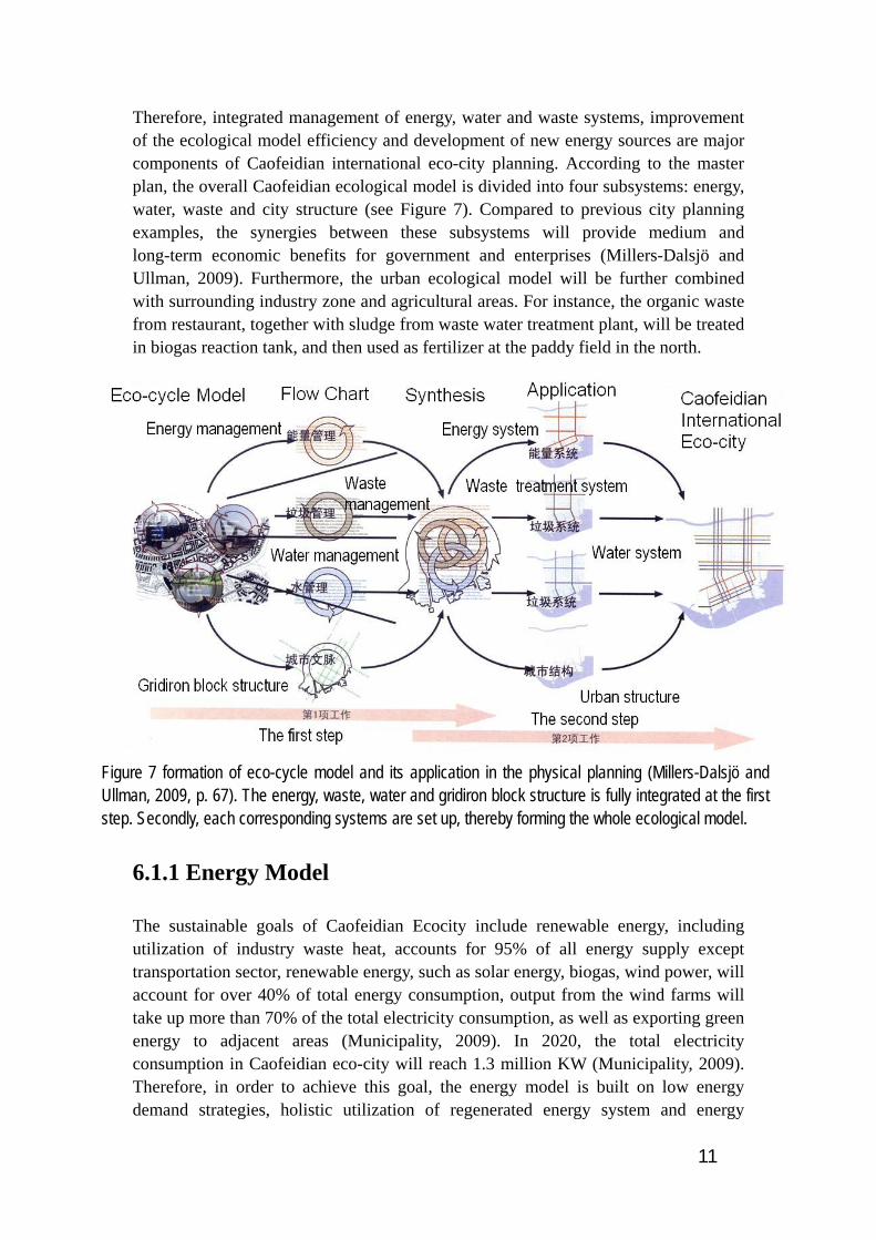
Therefore, integrated management of energy, water and waste systems, improvement of the ecological model efficiency and development of new energy sources are major components of Caofeidian international eco-city planning. According to the master plan, the overall Caofeidian ecological model is divided into four subsystems: energy, water, waste and city structure (see Figure 7). Compared to previous city planning examples, the synergies between these subsystems will provide medium and long-term economic benefits for government and enterprises (Millers-Dalsjö and Ullman, 2009). Furthermore, the urban ecological model will be further combined with surrounding industry zone and agricultural areas. For instance, the organic waste from restaurant, together with sludge from waste water treatment plant, will be treated in biogas reaction tank, and then used as fertilizer at the paddy field in the north.
Figure 7 formation of eco-cycle model and its application in the physical planning (Millers-Dalsjö and Ullman, 2009, p. 67). The energy, waste, water and gridiron block structure is fully integrated at the first step. Secondly, each corresponding systems are set up, thereby forming the whole ecological model.
6.1.1 Energy Model
The sustainable goals of Caofeidian Ecocity include renewable energy, including utilization of industry waste heat, accounts for 95% of all energy supply except transportation sector, renewable energy, such as solar energy, biogas, wind power, will account for over 40% of total energy consumption, output from the wind farms will take up more than 70% of the total electricity consumption, as well as exporting green energy to adjacent areas (Municipality, 2009). In 2020, the total electricity consumption in Caofeidian eco-city will reach 1.3 million KW (Municipality, 2009). Therefore, in order to achieve this goal, the energy model is built on low energy demand strategies, holistic utilization of regenerated energy system and energy
12
conservation buildings.
6.1.1.1 Energy Conservation Buildings
The energy conservation for the building stock is necessary. Since 85% of energy in building and management is consumed during the operational phase, while only 14% is consumed during the construction phase (Bokalders and Block, 2009). Therefore, building services must be carefully planned to achieve a healthy, comfortable interior climate while simultaneously compatible with the overall requirements of energy efficient building. Generally, an energy conservation building is built based on following criteria. Design the buildings according to the physical location and local climate. Amply advantages in respect to sun shading, sun exposure, wind exposure and wind protection can be realized by attentively architecture composition design. Renewable energy resources systems, such as solar panel, wind mills and geothermal energy, will be embedded in the community. For instance, solar heat will be gained by means of well thought-out, high-efficient glazing and effective shading devices.
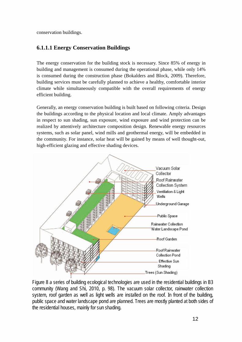
Figure 8 a series of building ecological technologies are used in the residential buildings in B3 community (Wang and Shi, 2010, p. 98). The vacuum solar collector, rainwater collection system, roof garden as well as light wells are installed on the roof. In front of the building, public space and water landscape pond are planned. Trees are mostly planted at both sides of the residential houses, mainly for sun shading.

13
Minimize energy demand and operating costs through equipping low energy demand electrical equipments and latest passive house building structure design. For example, having great effect on interior climate, advanced ventilation system, insulation system and the professional design of windows will be used in Caofeidian eco-city. Besides building envelope made extremely airtight and well insulated (average u-value 0.4 W/m²K) with minimized thermal bridges. Air handling unit including heat/cool recovery; heating/cooling and dehumidification of outside air; and recirculation during off-time periods will be installed, thereby providing comfortable indoor climate. Besides, each building is equipped with heat exchangers and energy control room, in order to facilitate connection with other possible energy sources in the future. Gas boiler will be used as emergency heating system. Theoretically, Eco-city does not recommend use individual air-condition (Millers-Dalsjö and Ullman, 2009).
The proposed energy conservation standard for buildings is conceived as higher than Swedish building standard, and the target will be optimized according to the Caofeidian local climate. Generally, the standard total energy consumption per capita is 10 000kWh, which includes energy consumption in transportation sector (Millers-Dalsjö and Ullman, 2009). This standard is higher than the current average
Figure 9 installation and pipe lines at apartment level, (Millers-Dalsjö and Ullman, 2009, p. 74). The grey water and black water pipe lines are separated. The ventilation model is also illustrated. The recovered heat is used to heat the tap water.
14
Swedish standard, but still less than passive house standard, which will be implemented as the minimum house energy consumption standards since 2015 in EU. While for sustainability centre, the total energy demand is estimated that the electricity demand is at most 1 000 MWH/year, the heat is 300 MWH/year, and cooling is less than 400 MWH/year, which is lower than the city average level (Hessle, 2009).
6.1.1.2 Renewable Energy
In the medium or long term, the Caofeidian Eco-city will be powered mainly by wind energy, supplemented by solar energy, combined heat and power (CHP) plant and regional power network. In the south of Caofeidian eco-city, coastline and coastal regions have great potential to harness wind energy. Thus, wind farm, contains 200 sets of 3500 kilowatt wind power generating units, will be completed in 2020. And the total installed generating capacity is 0.7 million kilowatt. The annual energy production of the wind farm is 2.24 billion kilowatt hour, which will be further connected to the 220 kilovolt power network and provide at least 18% of Caofeidian’s total energy needs (Ma, 2009). The wind farm covers an area of 50 km² and the substation takes up 100ha. Therefore, Caofeidian Ecocity could become an electricity producer for the neighboring cities in the future. This can be further considered to be the climate compensation of the energy consumption in transportation sector, which is still using fossil fuels (Municipality, 2009). Furthermore, the electricity will be produced by way of incineration. A refuse incineration plant, with a daily domestic waste treatment capacity of 1080 tons, will be fully operated in 2020. Equipped with a set of 12,000 kilowatt cogeneration unit, the plant can produce 0.15 million kilowatt hour electricity daily and the total annual output is approximate 60 million kilowatt hour, which will be connected to 110 kilovolt power network (Municipality, 2009). Produced through anaerobic digestion process, biogas, after purification, will be upgraded into biological methane and then be further compressed into compressed biogas (CBG), which is a good vehicle fuel with extremely low emission (Millers-Dalsjö and Ullman, 2009). Therefore, Purified biogas is suggested to be used in Caofeidian International Ecocity, while liquefied natural gas as a backup energy source. Theoretically, methane production should be able to meet the energy need of the BRT system. Besides, since solar energy is already a mature, low-cost technology in China, Caofeidian also receives enough sunlight (3000- 3200 hours annually) to make solar energy a feasible and efficient endeavor (Ma, 2009, Boberg et al., 2010) However, taking into account the whole eco-city energy supply system, the solar energy, instead of district heating, can be mainly used for heating tap water in the street level (Wang and Shi, 2010). Wind and PV hybrid street lights system will be established in the roadway illumination system. Geothermal heat will be introduced as the major heating and cooling source of all the three-story buildings, while air sauce cooling pump and industrial waste heat will be used in buildings of more than three
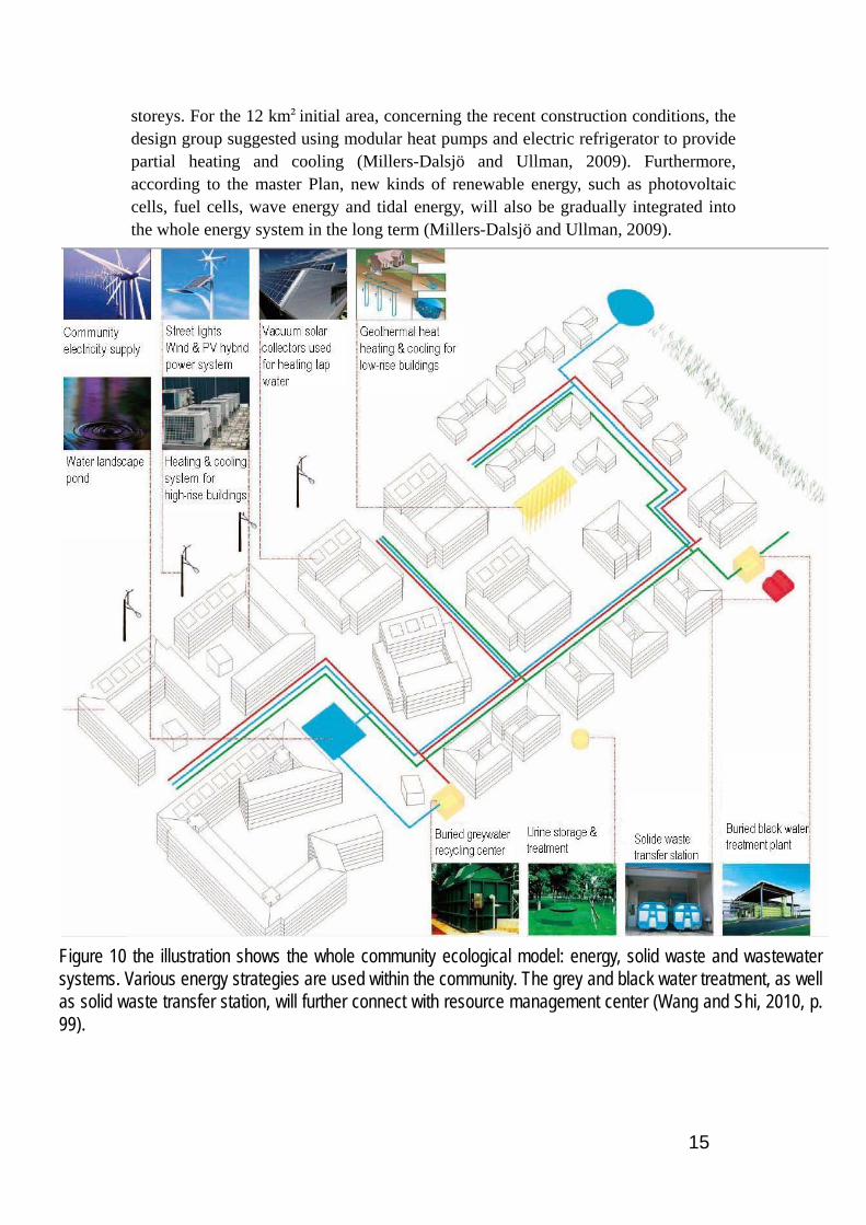
15
storeys. For the 12 km²initial area, concerning the recent construction conditions, the design group suggested using modular heat pumps and electric refrigerator to provide partial heating and cooling (Millers-Dalsjö and Ullman, 2009). Furthermore, according to the master Plan, new kinds of renewable energy, such as photovoltaic cells, fuel cells, wave energy and tidal energy, will also be gradually integrated into the whole energy system in the long term (Millers-Dalsjö and Ullman, 2009).
Figure 10 the illustration shows the whole community ecological model: energy, solid waste and wastewater systems. Various energy strategies are used within the community. The grey and black water treatment, as well as solid waste transfer station, will further connect with resource management center (Wang and Shi, 2010, p. 99).
16
6.1.1.3 The Energy Model in Sustainability Centre
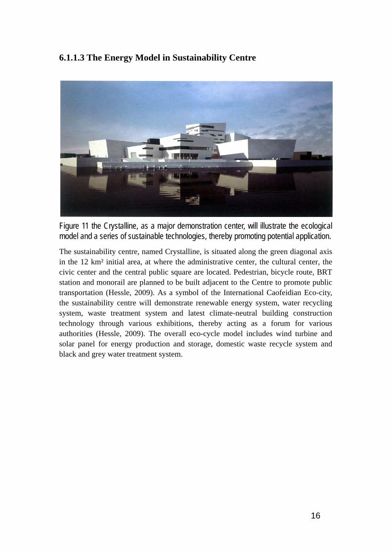
Figure 11 the Crystalline, as a major demonstration center, will illustrate the ecological model and a series of sustainable technologies, thereby promoting potential application.
The sustainability centre, named Crystalline, is situated along the green diagonal axis in the 12 km² initial area, at where the administrative center, the cultural center, the civic center and the central public square are located. Pedestrian, bicycle route, BRT station and monorail are planned to be built adjacent to the Centre to promote public transportation (Hessle, 2009). As a symbol of the International Caofeidian Eco-city, the sustainability centre will demonstrate renewable energy system, water recycling system, waste treatment system and latest climate-neutral building construction technology through various exhibitions, thereby acting as a forum for various authorities (Hessle, 2009). The overall eco-cycle model includes wind turbine and solar panel for energy production and storage, domestic waste recycle system and black and grey water treatment system.

17
Figure 12 the Sit plan of the Sustainability Centre and its surrounding landscape shows the location of the center, the urban carpet as well as the nearby green structure, (Hessle, 2009, p. 77).
Due to the climate is fairly mild in winter and rather hot in summer, a borehole system, including 50 boreholes each at 50 meters deep and a seasonal storage tank, is introduced as the major cooling and heating source of the Sustainability Centre. It is estimated that 180 MWH heating and almost the same amount of cooling will be provided to the centre annually, which is economical effective for the municipality. Furthermore, an ‘energy trio’ system is that using renewable energy sources such as a combination of biomass and solar energy together with and accumulation tank to store the heat to heat buildings (Bokalders and Block, 2009). Similar with ‘energy trio’ system, a combination of solar cells and a small-scale wind turbine with an electricity storage system, which uses an electrolyser to produce hydrogen, will be established to supply electricity to a telecom station in the centre. Closing to the beach, the sustainability centre’s location bodes well for the potential to utilize wind energy. Basically, the solar energy is mainly used to power the fuel cells. While during the low sun period, the system is supplemented with wind power. Additional, vacuum solar collectors will be installed to heat the tap water (Hessle, 2009).
18
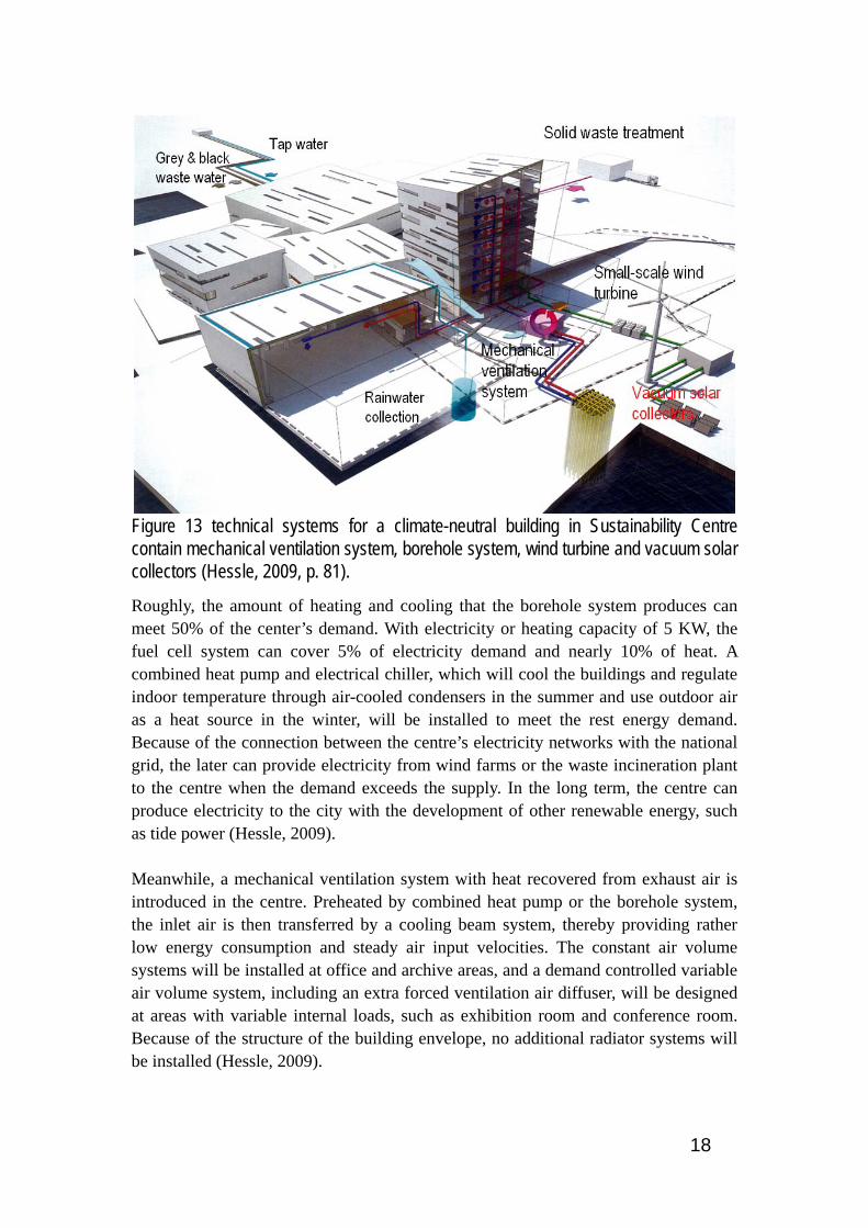
Figure 13 technical systems for a climate-neutral building in Sustainability Centre contain mechanical ventilation system, borehole system, wind turbine and vacuum solar collectors (Hessle, 2009, p. 81).
Roughly, the amount of heating and cooling that the borehole system produces can meet 50% of the center’s demand. With electricity or heating capacity of 5 KW, the fuel cell system can cover 5% of electricity demand and nearly 10% of heat. A combined heat pump and electrical chiller, which will cool the buildings and regulate indoor temperature through air-cooled condensers in the summer and use outdoor air as a heat source in the winter, will be installed to meet the rest energy demand. Because of the connection between the centre’s electricity networks with the national grid, the later can provide electricity from wind farms or the waste incineration plant to the centre when the demand exceeds the supply. In the long term, the centre can produce electricity to the city with the development of other renewable energy, such as tide power (Hessle, 2009). Meanwhile, a mechanical ventilation system with heat recovered from exhaust air is introduced in the centre. Preheated by combined heat pump or the borehole system, the inlet air is then transferred by a cooling beam system, thereby providing rather low energy consumption and steady air input velocities. The constant air volume systems will be installed at office and archive areas, and a demand controlled variable air volume system, including an extra forced ventilation air diffuser, will be designed at areas with variable internal loads, such as exhibition room and conference room. Because of the structure of the building envelope, no additional radiator systems will be installed (Hessle, 2009).

19
6.1.2 Wastewater System
In Caofeidian, a major challenge is lack of fresh water, caused by water salinization and inadequate precipitation. The master plan proposes water re-use strategies, rain water collection, freshwater conservation measurements as well as efficient water management system to make full use of limited water resource (Millers-Dalsjö and Ullman, 2009). In 2020, the disposal rate of sewage and the rate of recycle water use will reach 100%, and also the reuse of treated water (e.g. waste water and rainwater) will account for at least 35% of the entire city’s water supply. The peak of daily water consumption will be nearly 0.29 million m3.
6.1.2.1 Water Recycle System at Community Level
Supplemented by reclaimed wastewater, the domestic water supply of Caofeidian eco-city mainly depends on Taolinkou reservoir, having an annual water transmission capacity of 55 million m3. In the southwest of the city, water work with designed capacity of 0.18 million m3 per day will be completed in 2020. Besides, two sewage treatment plants will be completed. One has a designed capacity of 85,000 m3 per day, covering 16 hectares in the northwest of the city. While the other is designed to treat 85,000 m3 wastewater daily, taking up 10 hectares in the northeast of the city. According to the master plan, the average water demand per person is 120L/d. while taking tourists, visitors, small businesses and companies into account, fresh water demand per person is estimated 150L /d (Millers-Dalsjö and Ullman, 2009). Meanwhile, due to the large precipitation in very short period time in summer, rain water collection and storage is rather important for alleviating Caofeidian’s fresh water shortage. At community level, rain water will be collected by special channels with filtration equipment, thereby improving the collected rainwater quality. Afterwards, treated rainwater and recycled water will be stored within the building, underground or at rainwater storage pond which connects with nearby water landscape. The water will be fully used on the spot, such as flushing, irrigation and infiltration. Within the B3 community, the grey and black water treatment system will be separated. Grey water system collects sanitary waste water, together with collected rainwater, and then transfers the grey water to sewage treatment plant for biological (aerobic) treatment trough gravity pipeline (Wang and Shi, 2010). Gray water together with collected rain water will be treated at buried water recycling center (see Figure 14). Based on the World Health Organization’s guiding principles of safe use of wastewater, the master plan encourages that all waste water, after treated in the sewage treatment plant in community or resource management centre (RMC), should be first used in agricultural irrigation (Millers-Dalsjö and Ullman, 2009). Thus, part of the treated grey water is used for irrigation, toile flush and the rest goes into the water landscape.

20
Figure 14 the illustration shows the water recycle system at community level. The collected storm water together with the grey water is treated at water recycling center. Black water and grinded food waste is treated at black water treatment. While the only the urine from the office buildings is treated separately (Wang and Shi, 2010, p. 100).
While, for black water system, grinded household food waste and toilet flushing water are collected and directly sent to the biogas plant through the vacuum pipeline (Figure 14). Afterwards, the treated black water will be further processed in the wetland, and then supplements the landscape water. The yellow water treatment plant is used for urine storage and treatment, and treated urine is used as green fertilizer. Furthermore, the planning group estimates that, due to system disturbance and changes of water reception in the agricultural areas, there is always temporary or permanent risk in water recycling and reuse. Therefore, the planning group proposes that an advanced treatment plant, such as the artificial wetland in the northwest eco-city, should be constructed to further process treated waste water, and then released to the nearby rivers or sea (Millers-Dalsjö and Ullman, 2009).
6.1.2.2 Water recycle system in the sustainability centre
Since the lake of freshwater in the whole Tangshan area, water-saving faucets will be installed to reduce the use of tap water, and water-saving and urine diverting toilet with dry handling of feces, which is not fully adaptable to high rise buildings, will be proposed by SWECO as a demonstration unit in the centre. The black water from water-saving toilets together with food residuals from kitchen and fat from cooking oils will be treated in the anaerobic digester tank at RMC. After pretreated by using sieves or sedimentation, the grey water is naturally cleaned in a constructed sub-surface flow wetland which reduces evaporation, eradicates pathogens and removes oxygen consuming organic material, as well as some nutrients (Hessle, 2009).

21
Figure 15 the gray water system in Sustainability Centre mainly includes three treating processes: wetlands treatment, riparian area treatment, estuarine area treatment (Hessle, 2009, p. 82).
Though summer rains provide plentiful fresh water in the Tangshan Area, cold winters can be very dry. Thus storm water retention, purification and storage are necessary. The Sustainability Centre aims to function as a pedagogic and educational resource for the Caofeidian community, highlighting the importance of a visible storm water system that connects the building and landscape. Large sculptural basins collect rainfall from the roof and landscape areas, and overflow is routed to cisterns underneath the main entry plaza. The basins will aerate and cleanse storm water as it flows through them. Cleansed water is transferred, using solar-powered pumps, to the crystalline pools, water features situated throughout the landscape (Hessle, 2009).

22
Figure 16 the illustration shows the storm water system in Sustainability Centre. The storm water will be treated in the storm water basin and further stored at underground storage and crystalline pools (Hessle, 2009, p. 82).
6.1.3 Solid Waste Management
According to the master plan, an automated waste collection system from Envac will be established in B3 community. Similar with Hammarby sjöstad, it is an enclosed vacuum system, collects and separates waste without odorous fumes, waste collection rooms and containers in the street (Bokalders and Block, 2009). Waste is sorted at source by using one inlet for each fraction: organic waste, combustible waste and recyclable waste. While in Hammarby sjöstad, the waste categories are organic waste, paper and the rest.

23
Figure 17, the illustration shows the vacuum garbage transportation system in Caofeidian international eco-city. Organic waste, combustible waste and recyclable waste are separated within the community. Then all kinds of solid waste will be transferred by the vacuum pipelines and further treated at resource management centre (Millers-Dalsjö and Ullman, 2009, p. 72).
Treated by food waste grinder, food waste from kitchen, together with black water, biological sludge generated from septic tank (if using any) and restaurant food slurry, will be pumped directly into the sludge digestion container in RMC. Sludge digestion container is responsible for sludge collection, sludge pretreatment, biogas storage and upgrading biogas to compacted biogas, which will be used as vehicle fuel in Bus Rapid Transit system (BRT). In respect to the sludge from the anaerobic digestion, concentrated high oxygen content liquid and solid bio-fertilizer is stored at agricultural areas, and the area of the storage should meet the seasonal changes in fertilizer demand. Combustible waste, through separate vacuum tube, is transferred to containers at local transfer station. Without pretreatment, the compacted combustible waste is then transferred to combined heat and power plant (CHP) by truck. This approach reduces nearly 95% of waste volume, and avoids the gas releasing during land filling process. The fly ash, generated from the incinerator in CHP, becomes residues after harden and will be buried at special spot. Waste incineration flue gas is rich in heavy metals, therefore it is not recommended to be used as building materials (Millers-Dalsjö and Ullman, 2009). Recyclable waste is collected in mixed form and transferred to the local transfer station, where it will be stored in the container with 7-10t loading capacity, and then transported by trucks to the material recycling facilities (MRF) in resource management center (RMC) for pretreatment (Millers-Dalsjö and Ullman, 2009). After classification, recyclable materials are transported to the recycling industry. Additional, bulk waste and inert waste will be collected to large containers, or in barrels, and then transported to MRF for further separation and treatment.
24
6.2 Economic Resources The development of Shougang Jingtang steel factory brings with it the development of Caofeidian international eco-city. Thus, the prudent management of economical resources both inside and outside the community is central in terms of sustainable community development (Berg, 2009). Furthermore, sustainable community economics bridge the gap between economic values of goods and services, and the qualitative values of natural ecosystems, of social relations, and the role of traditions for achieving sustainability in urban and rural communities (Berg, 2009). Therefore, having far-reaching influence on eco-city, the economical resources of the Bohai Economical Sphere, especially Shougang Jingtang steel factory, will be analyzed at the first place. Based on the municipal development plan, macro-economic processes, relating to sustainable community development, are addressed to generally analyze the economic management outside the community (Boberg et al., 2010). Then, on the other side, microeconomic processes within the local community, closely relating to ‘monetary activities and transactions between private companies, individuals and organizations on different free markets’ (Berg, 2009) will be further analyzed.
6.2.1 Bohai Economical Sphere and Caofeidian Industrial
District Economical Resources
Bohai economical sphere refers to the Bohai coastal economical zone surrounded by Liaodong Peninsula, Shandong Peninsula, Beijing and Tianjin. At the end of 2007, the population of Bohai economical sphere was 231 million, nearly 18% of China’s total population and its land area is about 11,20,000 km², making up about 20% of China’s total area (Boberg et al., 2010, NBSC, 2007). In the 12 years from 1995 to 2007, Bohai economical sphere’s economy has been expanding rapidly, its GDP has increased from 1.3 trillion Yuan to 6.48 trillion Yuan, with an average annual growth rate of 14.3%, and also its share of China’s GDP has steadily grown from 21.4% to 26.3%. Bohai economical sphere, together with the Pearl River Delta and the Yangtze River Delta, is referred as China’s three economical growth engines. In 2007, Bohai economical sphere’s GDP was about 1.15 times as that of the Yangtze River delta, and more than double the Pearl River delta’s GDP (Boberg et al., 2010, NBSC, 2007). Therefore, being the base of heavy and chemistry industries with a concentration of nationally well-known enterprises, the Bohai economical sphere, in the long run, will remain economically the most dynamic part of northern China, even the whole East Asian area. Having been placed in the Bohai economical sphere, the Caofeidian economical area will act as a direct stimulus to the regional development. Shougang Jingtang steel industry is the most important enterprise in Caofeidian. In 2010, the company will

25
have the annual productivity of 4.85 million tons steel. When the factory is completed, the annual productivity will be 9.7 million tons steel. Resonating with the overall requirement of sustainable development, circular economy and cutting carbon dioxide emission is central in terms of the design of Shougang Jingtang steel production process. Plenty of well-planned features are worth drawing on in the circular economical model. In the steel production, there is a great deal of waste gas of chemistry matter, such as coal oven gas, blast furnace gas and converter gas, will be produced. Instead of sending out toxic fumes, the steel factory uses the waste gas to produce electricity and the annual energy production can reach 5.5 billion kilowatt-hours, accounting 94% of steel factory’s total energy consumption. Furthermore, by using low temperature reservoir for sea water desalination, Shougang Jingtang steel industry can produce 18 million tons of freshwater annually, accounting nearly 50% of total water consumption. Additional, Shougang Jingtang steel industry can provide 3.3 million tons of steel slag every year, which will be further used in producing building materials. Until the end of 2006, the total investment is Caofeidian has sharply increased to 16 billion CNY. While in 2007, the investment has increased to 30 billion CNY and almost doubled in one year. It is estimated that the total investment will exceed 200 billion CNY and the annual revenue of Caofeidian is about 20 billion CNY (Zhang et al., 2007, Boberg et al., 2010). With vigorous growth of governmental investment, many related industries and facilities are planned and constructed in Caofeidian industrial district in support of the development of Shougang Jingtang steel industry. Chemical industry, equipment manufacturing and building and construction industry will also be built to make the Caofeidian industrial district an important center of production and investment for both foreign and domestic companies (CIZM, 2010, Boberg et al., 2010). The comprehensive functions of logistic industry as the Caofeidian industrial harbor will be given full play. The industrial harbor admits ships with a rating of 250,000 tons, thus slashes raw material and products transportation cost for the Shougang Jingtang steel industry.
6.2.2 Caofeidian Eco-city Economy Resources
Currently, neither the Caofeidian administrative commission nor SWECO provides any planning details with regard to the organization of economic activities at community level. It is suggested that ‘from a bottom-up perspective, sustainable economic development is a feasible community-based alternative to the economy we are familiar with - an economy focused on growth rather than development, on global trade and currency rather than people and ecosystems’ (Roseland, 2005). Many economical benefits will be achieved by the synergies of different infrastructure, which enhances the truly community economical development. Taking integrated waste water management for example: Concerning sewage nutrients, the sludge from black and grey water treatment will be used as agricultural fertilizer

26
in the agricultural area on the north of Caofeidian eco-city. Through the anaerobic digestion in waste water treatment plant (WWTP), the treated grey water is rich in nutrients such as nitrogen and phosphorus. Therefore, an 84 hm² cistern will be built to store the treated grey water for the 30 km² urban area. Moreover, the total annual supply of nitrogen fertilizer is 200 kg/hm², which means 16,800 kg nitrogen per year. According to the international market, nitrogen fertilizer price is 1.5 euro/kg. Then the water recycle can save about 25,200 euro annually, about 215,460 CNY (Millers-Dalsjö and Ullman, 2009). According to the eco-city plan made by the Caofeidian administrative commission, Tsinghai University and SWECO, Caofeidian international eco-city will grow from 30 km² with a population of 400,000 to 500,000 in 2020 to 150 km² for a population of 1.5 million (Hessle, 2009). Therefore, for 150 km² with a population of 1.5 million, the integrated waste water management can save, at least, 1 million CNY every year. Furthermore, we can obtain nitrogen and phosphorus from the food waste generated from the community. Theoretically, we can gain about 1.9g nitrogen and 0.33g phosphorus from the food waste by one person each day. For the 500,000 future residents in 30 km², RMC can obtain around 0.95 tons nitrogen and 0.165 tons phosphorus yearly. The Caofeidian eco-city can save approximately 20,000 CNY every year. And for 1.5 million residents in 150 km², the city can save nearly 60,000 CNY annually. In addition, produced through anaerobic digestion process, biogas, after purification, will be upgraded into biological methane and then be further compressed into compressed biogas (CBG), which is used in BRT system. Averagely, each person can produce 90 KWH per year. Totally, for the 500,000 future residents in 30 km², it is almost 45 million KWH. To calculate with the Tangshan power price in 2010, which is 0.55 CNY per KWH, the biogas can save 24.8 million CNY each year, while for 1.5 million future residents in 150 km², it can save as much as 74.3 million CNY annually (Millers-Dalsjö and Ullman, 2009).

27
6.3 Biological Resources According to PEBOSCA framework, biological resources can be simply defined as ‘Species, biotopes and ecosystems services in natural and culturally moulded sifes and landscapes in or connected to the community’ (Berg, 2009). Based on the major patterns for biological resources, the surrounding environment of Caofeidian eco-city will be analyzed at the first place, thereby preserving and developing functional diversity in rural green area. Then, the blue and green structure will be analyzed separately, as well as design concepts.
6.3.1 Surrounding Environment
The Caofeidian site is located in an area of wetlands abutting the Bohai Sea, with the Caofeidian wetlands park covering some 11,000 hectares located immediately inland to the port (Ranhagen and Jacobs, 2008). The site is a typical tidal beach, and the tide can go into the flat coast area as far as 4km. Therefore, there is a high degree of soil salinization and the level of ground water is rather high. However, the ground water is impregnated with salt and the quality of ground water is also threatened by the local oil refineries. Nevertheless, the site has great biological richness:
238 species of wild plants, including four species of newly-discovered second-grade state protected plants, ginkgo, lotus, wild soybean, and wild water caltrop. It also boasts 107 species of phytoplankton, 17 species of wild terrestrial animals, 49 species of crustaceans, 63 of mollusks, 286 of insects, 124 of fish and 307 species of birds (Ranhagen and Jacobs, 2008).
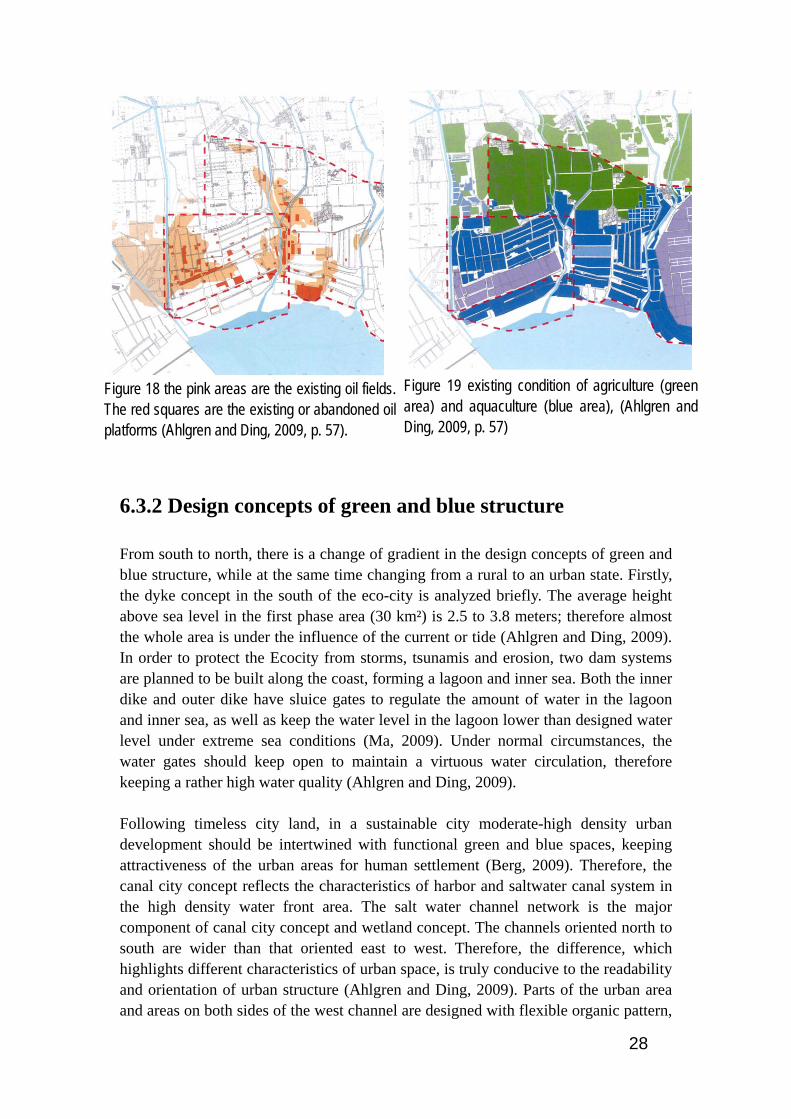
Within Caofeidian site, the first phase 30 km² planning area is bordered by Qinglong River to the west, Su River to the east, existing paddy field to the north and sea coast to the south (Figure 19). According to the planning requirements, no farmland should be used for urban development; therefore the boundary of eco city is determined by abutting paddy fields and nearby rivers. Within the first phase area, the greater portion of existing land is fish farms and salt ponds and the whole area upon where the city itself will be built is studded with oil drilling platforms and other oil refinery facilities (Figure 18). Recently, the sea salt industries, oil refinery and fish farms that made intensive use of lands caused serious ecological damages to Su River. Moreover, continuing upstream irrigation activities diminish the amount of water in Su River. Despite of water pollution and lack of fresh water, Su River plays an important role in urban green space planning, and in the future will be built as a major green structure for residents both aesthetically and as a leisure facility. Based on the existing forest at the west of eco-city, a large urban forest is planned to be build on the banks of Qinglong River. Also, a new wetland, next to the urban forest, is under planning for future recreational activities and water storage. Furthermore, the channel system connecting Su River and Qinglong River are under construction to play a critical role in water storage and preventing flood (Ahlgren and Ding, 2009).
28
6.3.2 Design concepts of green and blue structure
From south to north, there is a change of gradient in the design concepts of green and blue structure, while at the same time changing from a rural to an urban state. Firstly, the dyke concept in the south of the eco-city is analyzed briefly. The average height above sea level in the first phase area (30 km²) is 2.5 to 3.8 meters; therefore almost the whole area is under the influence of the current or tide (Ahlgren and Ding, 2009). In order to protect the Ecocity from storms, tsunamis and erosion, two dam systems are planned to be built along the coast, forming a lagoon and inner sea. Both the inner dike and outer dike have sluice gates to regulate the amount of water in the lagoon and inner sea, as well as keep the water level in the lagoon lower than designed water level under extreme sea conditions (Ma, 2009). Under normal circumstances, the water gates should keep open to maintain a virtuous water circulation, therefore keeping a rather high water quality (Ahlgren and Ding, 2009). Following timeless city land, in a sustainable city moderate-high density urban development should be intertwined with functional green and blue spaces, keeping attractiveness of the urban areas for human settlement (Berg, 2009). Therefore, the canal city concept reflects the characteristics of harbor and saltwater canal system in the high density water front area. The salt water channel network is the major component of canal city concept and wetland concept. The channels oriented north to south are wider than that oriented east to west. Therefore, the difference, which highlights different characteristics of urban space, is truly conducive to the readability and orientation of urban structure (Ahlgren and Ding, 2009). Parts of the urban area and areas on both sides of the west channel are designed with flexible organic pattern,
Figure 18 the pink areas are the existing oil fields. The red squares are the existing or abandoned oil platforms (Ahlgren and Ding, 2009, p. 57).
Figure 19 existing condition of agriculture (green area) and aquaculture (blue area), (Ahlgren and Ding, 2009, p. 57)

29
supplements strict and right-angle gridiron block structure (Ahlgren and Ding, 2009). The diversity of the urban spatial structure and the natural adaptive approach is also reflected in the specific design of local community.
Figure 20 the illustration shows the distribution of different features in urban area. The design concept changes from urban farming concept, wetland concept, canal city concept to dyke concept (Ahlgren and Ding, 2009, p. 61).
Although due to salinity of the land and scarcity of fresh water, it is rather difficult to build large scale parks and green space. By using the collected rainwater for irrigation, the plan proposed building smaller parks along the costal line and city channels. Additional, either salt tolerance plants will be selected or isolating the vegetation from the ground salt water reverse osmosis will be used to create a hydrophilic city canal attraction (Ma, 2009). While the reason why wetland concept is used is that there is a great possibility to build large- and middle-scale green parks in the middle of the Ecocity, due to the potential of utilizing rainwater and recycle water to supplement the wetland and water landscape. While, the rice field inspired concept and urban farming concept is basically based on the existing paddy fields, which are potential recreational resource. According to PEBOSCA framework, in a sustainable community the relationship between productive and consumptive areas should be redefined, with periurban or urban agriculture contributing to a city's food supply, and the majority of food consumed

30
produced at the regional rather than global level (Berg, 2009). Therefore, the urban agriculture area, together with resource management center (RMC), can be further developed as a link, thereby providing a grounding in a symbiotic coexistence of urban and rural life (Ahlgren and Ding, 2009). Furthermore, with the cooperation between local university and innovative companies, the urban agriculture area can be used for future research on sustainable urban agriculture.
6.3.3 Blue structure: The integrated water system
In the first phase of international Caofeidian eco-city, the integrated water system is mainly formed by the open sea, surrounding rivers, the two lagoons and the urban drainage system. Fully adapting to existing environment, waterscape in the urban area mainly consists of salt water drainage network which joins on to a newly built sweet water channel system in the north (SWECO, 2009).
Figure 21 fully adapted into the existing environment, the integrated water system contains open sea, two lagoons, saltwater drainage system and sweet water drainage system (Ahlgren and Ding, 2009, p. 58).
The existing fish farms and salt ponds are the foundation of salt water channel network, which directly connects with the sea and spreads throughout the whole 30 km² first phase area. By integrating the sea water into the urban structure, the planning group supposes water evaporation can bring natural cooling system to the local communities (Ahlgren and Ding, 2009). Besides, tide movement with the height difference 1 meter can prevent water stagnant in the saltwater channels, thereby greatly improving the water quality. Additionally, integrated with water collection system, various kinds of freshwater landscape will be constructed within the community and city parks. In the north of eco-city, the sweet water system, isolated from the salt water channel system, is mainly used for irrigation and domestic water. Within the sweet water system, a sluice gate system regulates the amount of water in the river, thus, stores freshwater as much

31
as possible in order to ensure the water supply. Along the rivers in the north, a few emergency exits will be constructed to ensure the extra water smoothly discharge from emergency exits to the lagoons and sea in the south. Therefore, the emergency exits system can prevent the floods, caused by excessive rain, in the north paddy fields (Ahlgren and Ding, 2009).
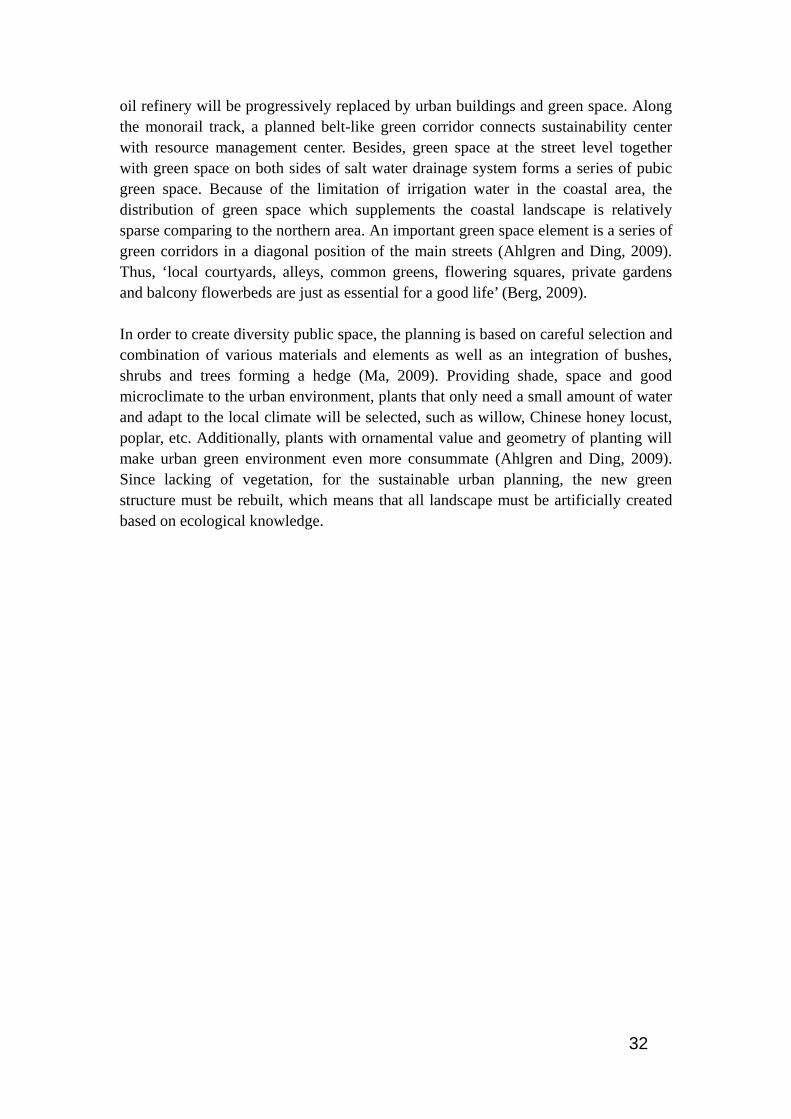
6.3.4 Green structure
In a sustainable city, green areas should be available to residents at entrance, garden, district, and wilderness levels of distance (Berg, 2009). Therefore, multiple levels of green space are proposed in the first phase area master plan: such as City Park, district green space, street greens and courtyard. Large and medium-sized parks, which connect to each other by the capillary network-like green corridors, will be built mainly based on the existing oil platforms. During the urban development process, the oil platforms will be gradually reduced, and further concentrated. Simultaneously, the
Figure 22 the illustration shows the blue system in Caofeidian. A series of emergency exits, connecting salt and sweet water drainage system, are set up (Ahlgren and Ding, 2009, p. 59).
32
oil refinery will be progressively replaced by urban buildings and green space. Along the monorail track, a planned belt-like green corridor connects sustainability center with resource management center. Besides, green space at the street level together with green space on both sides of salt water drainage system forms a series of pubic green space. Because of the limitation of irrigation water in the coastal area, the distribution of green space which supplements the coastal landscape is relatively sparse comparing to the northern area. An important green space element is a series of green corridors in a diagonal position of the main streets (Ahlgren and Ding, 2009). Thus, ‘local courtyards, alleys, common greens, flowering squares, private gardens and balcony flowerbeds are just as essential for a good life’ (Berg, 2009). In order to create diversity public space, the planning is based on careful selection and combination of various materials and elements as well as an integration of bushes, shrubs and trees forming a hedge (Ma, 2009). Providing shade, space and good microclimate to the urban environment, plants that only need a small amount of water and adapt to the local climate will be selected, such as willow, Chinese honey locust, poplar, etc. Additionally, plants with ornamental value and geometry of planting will make urban green environment even more consummate (Ahlgren and Ding, 2009). Since lacking of vegetation, for the sustainable urban planning, the new green structure must be rebuilt, which means that all landscape must be artificially created based on ecological knowledge.
33
Figure 23 the layout illustrates the city park, district green space and street greens in Caofeidian international eco-city (Ahlgren and Ding, 2009, p. 59).

34
6.4 Organizational Resources
6.4.1 Superimposition of urban layers
The urban pattern of Caofeidian international eco-city is multilayer stack structure and mainly contains three different urban layers (Appendices 3): • Urban drainage system, which mainly consists of salt water drainage network
that is joining on to a newly built sweet water channel system at the back of the development, will form a large part of the green-blue urban structures. Based on the geological analysis, the existing fish ponds and wetlands are used as the foundation of the drainage system (Ahlgren and Ding, 2009, SWECO, 2009).
• The gridiron block structure, an orthogonal system, is the foundation of the urban community’s structure and transportation system. Usage of Grid-like structure is not only Chinese tradition, but also is based on local flat terrain conditions, as well as meeting both transportation and land development future needs (Joachim, 2009). Based on 220m×220m large-scale neighborhood unity, the layout of public transportation network and the distribution of large scale intensive blocks adjacent to the major urban nodes are determined (Ahlgren and Ding, 2009, SWECO, 2009).
• The green structure which distributes within and between the city blocks is the third urban layer. Between communities, large scale City Park and district green space, which connects to each other by the capillary network-like green corridors, will be built mainly based on the existing oil platforms. Green space at the community level together with green space on both sides of salt water drainage system forms a series of pubic green space. These different green spaces will build up the overall green structure in Caofeidian (Ahlgren and Ding, 2009, SWECO, 2009).
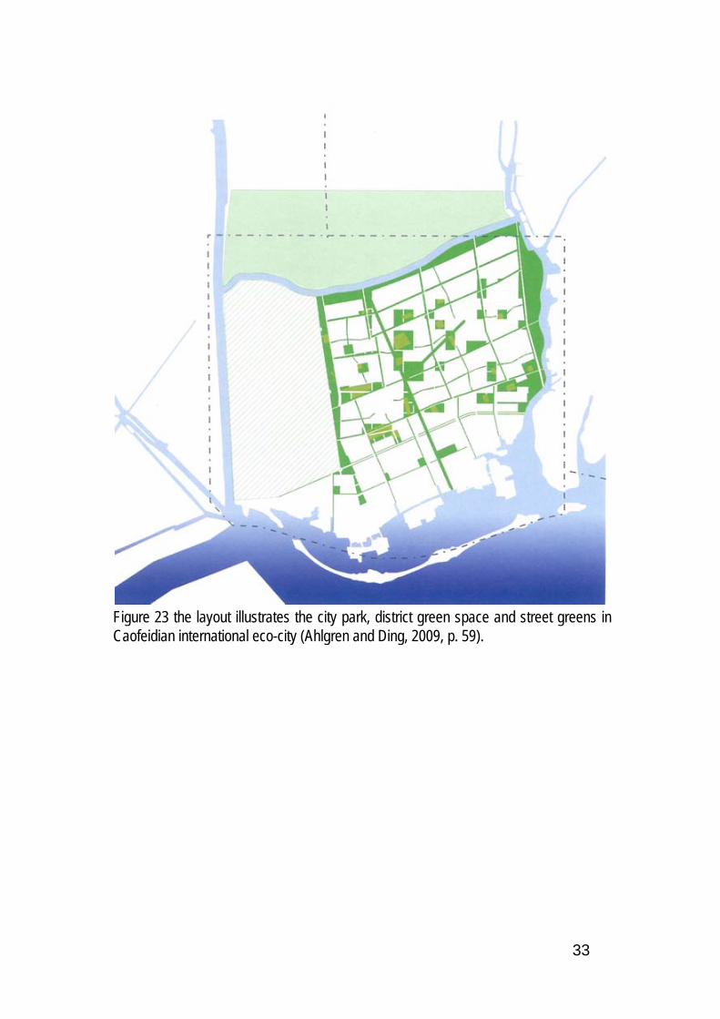
6.4.2 Gridiron block structure and Chinese courtyard
Since the 1950s, China imported a large number of high-rise, row house models; therefore, traditional courtyard building structure gradually disappears. After World War II, in the Western countries, especially in the U.S., lots of residents moved from large cities to the suburbs, forming tree branch layout, which results in monotonous building structure, public facilities scattered throughout the urban area, increasing the urban commuting distance and time, and even leading to a phenomenon of residential division (Wang and Shi, 2010).
35
Figure 24 the illustration is the bird view of B3 community, in which the gridiron block structure and Chinese courtyard are used (Wang and Shi, 2010, p. 99).
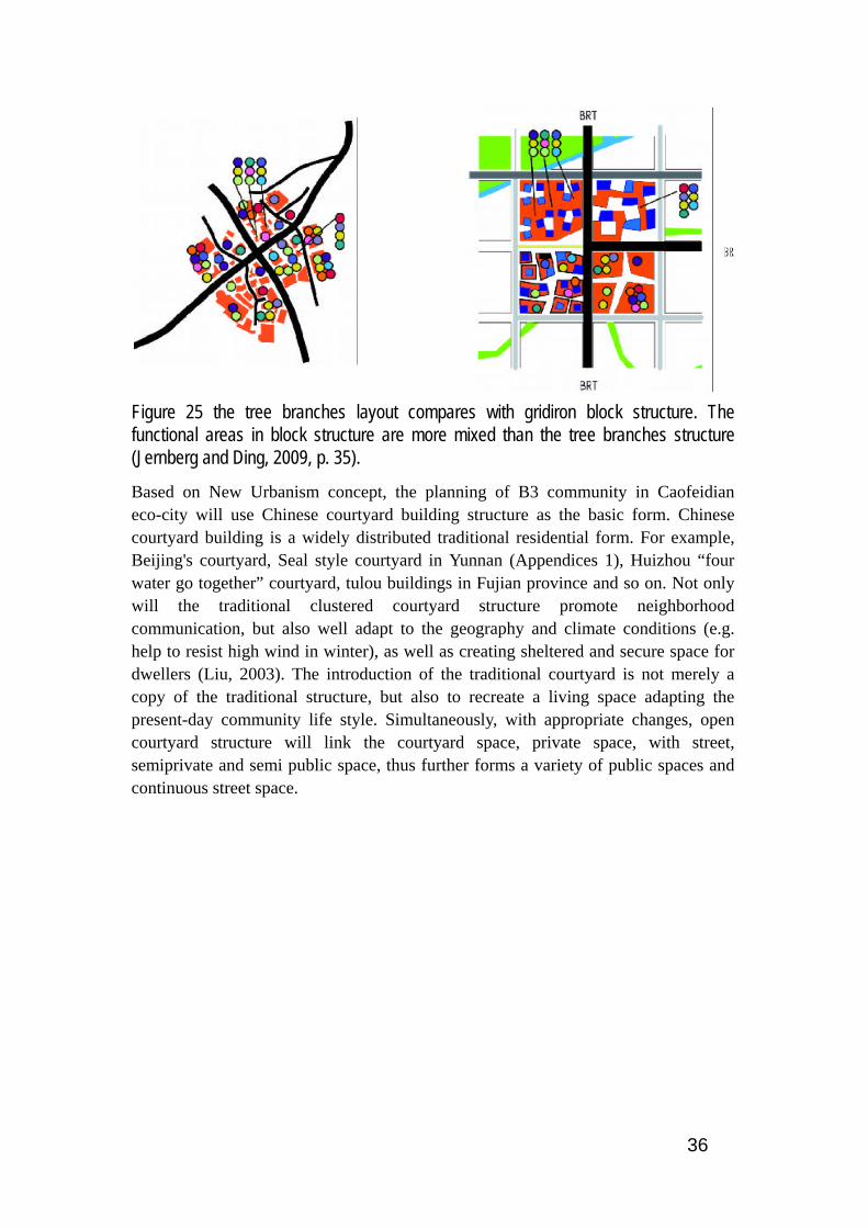
From the 1990s, the New Urbanism began to reflect on these issues – instead of encourage the spread of suburban development, we should promote a compact community with vivid urban life atmosphere, advocate the net structure of street within the community in order to promote pedestrian. Besides, based on traditional neighborhood structure, a discernible community center and borders will be formed. Thus instead of promoting the tree branch like layout, the gridiron block structure has brought a high degree of integration to the city, as well as providing the multiple transportation choices for the local people, which is conducive for the public transportation and will reduce the congestion and commuting time (Jernberg and Ding, 2009). The tree branches layout is function oriented and different function districts are connected by a small amount of main roads, which causes increasing congestion and longer commuting time (Figure 25). While in the gridiron block system, the communication and transportation between different neighborhood blocks will be more flexible (Figure 25). Moreover, most of the urban unity can accommodate a variety of different functions, but also easy to change the function in the light of future needs.
36
Figure 25 the tree branches layout compares with gridiron block structure. The functional areas in block structure are more mixed than the tree branches structure (Jernberg and Ding, 2009, p. 35).
Based on New Urbanism concept, the planning of B3 community in Caofeidian eco-city will use Chinese courtyard building structure as the basic form. Chinese courtyard building is a widely distributed traditional residential form. For example, Beijing's courtyard, Seal style courtyard in Yunnan (Appendices 1), Huizhou “four water go together” courtyard, tulou buildings in Fujian province and so on. Not only will the traditional clustered courtyard structure promote neighborhood communication, but also well adapt to the geography and climate conditions (e.g. help to resist high wind in winter), as well as creating sheltered and secure space for dwellers (Liu, 2003). The introduction of the traditional courtyard is not merely a copy of the traditional structure, but also to recreate a living space adapting the present-day community life style. Simultaneously, with appropriate changes, open courtyard structure will link the courtyard space, private space, with street, semiprivate and semi public space, thus further forms a variety of public spaces and continuous street space.

37
Based on the design of multi-scale courtyard structure, B3 community includes 5 different types of courtyard buildings (Figure 26, Appendices 2). The total area of B3 community is 70,965㎡, and the gross building area is 94, 507㎡. Besides, the planning of B3 community will re-examine and integrate urban public transportation with land use patterns, as well as promoting mixed land use and combination of residential area with different public facilities, such as commercial, service and office. Within the 7hm² area B3 community, various kinds of buildings, such as residential, office, commercial and social service buildings, are fully integrated. Normal office buildings and small office home office (SOHO) each accounts for 6.1% of the total building area, while commercial and social service together accounts for 14.5%. There are mainly 5 kinds of residential buildings: quarters for the single and couple, 43.4%, general residential buildings, 12.4%, luxury residential buildings, 6.0%, and villas, 3.9%. The building density is approximate 29% and the plot ratio is 1.24. Therefore, integration of different types of residential buildings can effectively reduce residential division, provide various kinds of public place and meeting place for residence and ensure the diversity of neighborhood activities, increase opportunities for interaction between people.
Figure 26 multi-scale courtyard system is one of the marked characteristics of B3 community plan. Totally, 5 different kinds of courtyard building types are designed within the community (Wang and Shi, 2010, p. 98).

38
Figure 27 mixed function is another significant feature of B3 community planning. Different types of residential houses, commercial service, offices as well as underground garage is designed within the community (Wang and Shi, 2010, p. 97).
6.4.3 Transportation
A well-organized sustainable transportation system depends on the integration between urban land planning and transportation planning. Therefore, the sustainable traffic network in Caofeidian is based on superimposition of urban layers, transit oriented development (TOD), location strategy as well as transportation demand management (Joachim, 2009, SWECO, 2009). (See Appendices 7)

39
The Caofeidian sustainable transportation network mainly includes public transportation system, private vehicle transportation system and non-motorized transport system. High capacity and high efficiency public transportation network acts as the backbone of the urban structure. The public transportation network includes BRT system, light rail system, monorail system, ferry system and future commuter train system (See Figure 28 and Appendices 4).
Figure 28 the illustration shows the public transportation structure for 30 km². Seven city nodes are connected by BRT system, light rail system, monorail system as well as highway, thereby largely facilitating the urban transportation. Additional, different types of streets are applied in the urban transport structure (Joachim, 2009, p. 46).
40
6.4.3.1 Bus rapid transit system (BRT)
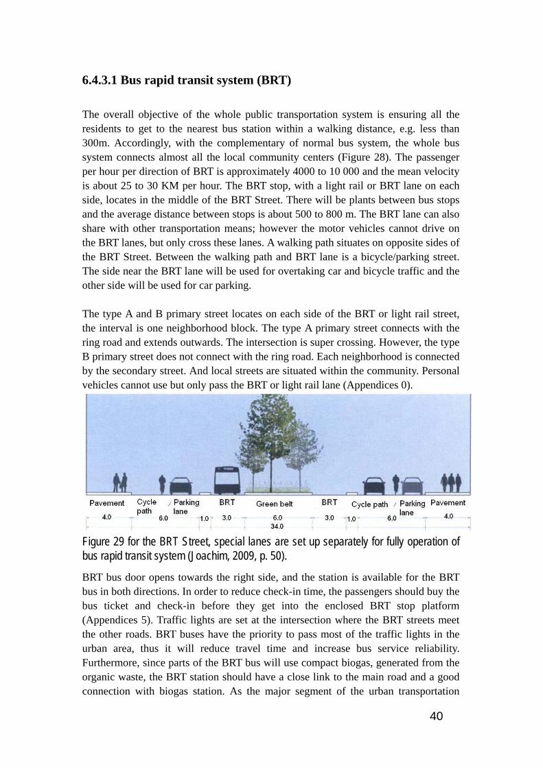
The overall objective of the whole public transportation system is ensuring all the residents to get to the nearest bus station within a walking distance, e.g. less than 300m. Accordingly, with the complementary of normal bus system, the whole bus system connects almost all the local community centers (Figure 28). The passenger per hour per direction of BRT is approximately 4000 to 10 000 and the mean velocity is about 25 to 30 KM per hour. The BRT stop, with a light rail or BRT lane on each side, locates in the middle of the BRT Street. There will be plants between bus stops and the average distance between stops is about 500 to 800 m. The BRT lane can also share with other transportation means; however the motor vehicles cannot drive on the BRT lanes, but only cross these lanes. A walking path situates on opposite sides of the BRT Street. Between the walking path and BRT lane is a bicycle/parking street. The side near the BRT lane will be used for overtaking car and bicycle traffic and the other side will be used for car parking. The type A and B primary street locates on each side of the BRT or light rail street, the interval is one neighborhood block. The type A primary street connects with the ring road and extends outwards. The intersection is super crossing. However, the type B primary street does not connect with the ring road. Each neighborhood is connected by the secondary street. And local streets are situated within the community. Personal vehicles cannot use but only pass the BRT or light rail lane (Appendices 0).
Figure 29 for the BRT Street, special lanes are set up separately for fully operation of bus rapid transit system (Joachim, 2009, p. 50).
BRT bus door opens towards the right side, and the station is available for the BRT bus in both directions. In order to reduce check-in time, the passengers should buy the bus ticket and check-in before they get into the enclosed BRT stop platform (Appendices 5). Traffic lights are set at the intersection where the BRT streets meet the other roads. BRT buses have the priority to pass most of the traffic lights in the urban area, thus it will reduce travel time and increase bus service reliability. Furthermore, since parts of the BRT bus will use compact biogas, generated from the organic waste, the BRT station should have a close link to the main road and a good connection with biogas station. As the major segment of the urban transportation
41
network, BRT system is flexible to adapt the Caofeidian eco-city’s future development, and, if needed, part of the system can be transformed into light rail system. Therefore, the flexibility of BRT system resonates with the overall requirements of continuously urban development (Joachim, 2009, SWECO, 2009).
6.4.3.2 Light rail
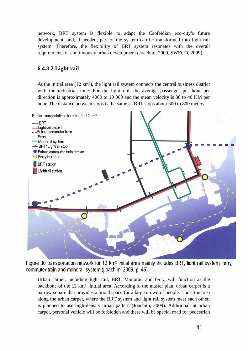
At the initial area (12 km²), the light rail system connects the central business district with the industrial zone. For the light rail, the average passenger per hour per direction is approximately 4000 to 10 000 and the mean velocity is 30 to 40 KM per hour. The distance between stops is the same as BRT stops about 500 to 800 meters.
Figure 30 transportation network for 12 km² initial area mainly includes BRT, light rail system, ferry, commuter train and monorail system (Joachim, 2009, p. 46).
Urban carpet, including light rail, BRT, Monorail and ferry, will function as the backbone of the 12 km² initial area. According to the master plan, urban carpet is a narrow square that provides a broad space for a large crowd of people. Thus, the area along the urban carpet, where the BRT system and light rail system meet each other, is planned to use high-density urban pattern (Joachim, 2009). Additional, at urban carpet, personal vehicle will be forbidden and there will be special road for pedestrian

42
and bicycle (Ahlgren and Ding, 2009). Therefore, the urban carpet closely connects eastern part, including recreation facilities and international maritime clubs, with intermediate area, at where the Caofeidian municipality, cultural center, citizen center and sustainability center locates. Furthermore, Swedish demonstration area, main waterfront and western part of initial area are well connected with eastern area through urban carpet.
Figure 31 according to the design of initial area, urban carpet closely connects different parts in initial area, thereby ensuring the transportation structure fully adapt into the urban structure (Jernberg and Ding, 2009, p. 40).
6.4.3.3 Monorail system
As a safe and comfortable public transportation mode, monorail system carries an average 2000 to 3000 one way passenger per hour, much less than that of BRT and light rail. In addition, monorail system is elevated in the air, which reduces the use of urban space. Therefore, monorail system is used in the city center area and density node areas. Yet the average speed is rather low, only 15 KM per hour. Connecting the northwest corner with southeast corner, the diagonal layout of the monorail system forms two closed loops in the 30 km² area and links the major function areas with the tourism areas. The elevated monorail in turn passes through the sustainable development center, administrative center, high-level vertical greenhouse, major city parks, dark green residential area, Sino-Swedish innovation area, resource management centre, as well as the railway station (Figure 32). Parts of these places are the major green landscapes and green architecture showcases projects, thus have important symbolic value. In addition, as a complementary traffic system, monorail also saves space for the infrastructures at the ground level. The distance between monorail stops is the same as BRT and light rail about 500 to 800 meters (Joachim,

43
2009, SWECO, 2009).
Figure 32, monorail system in Caofeidian eco-city has three major stations, the resource management centre, city park and the sustainability centre. Additional, the monorail system links the major function areas with the tourism areas (Joachim, 2009, p. 49).
The trial operation of private rapid transportation (PRT) will be held at the university area in the northwest of Caofeidian Ecocity. That is, 4 computer controlled small electric vehicles will be ran at a special single track, and directly travel to the final station, railway station. PRT plays a subsidiary role and, by connecting with other transportation systems, enhances the communication between university area, nearby city nodes and sino-swedish creative park (Joachim, 2009).
6.4.3.4 Ferry
Learning from the Hammarby Sjöstad, the ferry, connecting lagoon area and industrial area, is a highly efficient and environmental friendly transportation. And the ferry system acts as a buffer zone to transfer people from initial area to lagoon area. The ferry ports set at the southwest and northwest of initial area are close to the BRT and light rail stations, which form an integrated transportation network at the

44
initial area. Ferry carries one-way traffic of about 700-1000 people every hour with an interval time around 10 to 15 minutes. Not only does ferry service for the local residents, but also for the tourist, allowing people to enjoy the beauty scenery of the lagoon area (Joachim, 2009).
6.4.3.5 Commuter train and regional train
As the city further sprawl into eastern area, the commuter train system can meet the increasing transport demands from eco-city to industrial area. The traffic capacity of commuter train is approximately 8000 to 10000 people one way per hour. According to the master plan, at the destinations of commuter train, people can easily get access to the BRT and light rail system (Figure 28). According to the master plan, the railway station will be planned at the northeastern part of the eco-city. Regional train facilitates connection with the major cities of Beijing, Tangshan and Tianjin. Moreover, the regional train station closely links with the elevated monorail system, BRT and light rail system, forming a comprehensive urban transportation network (Joachim, 2009).
6.4.3.6 Parking management
In the 12 km² initial area, most parking lots for private and commercial vehicles are arranged within the neighborhood blocks and a small amount of parking lots are placed along the roads, mainly for short-term visitor and freight transportation. At community level, the average parking space is 0.7 per household. While along the BRT lane, the average parking space is 0.5 cars per household. Mainly due to the high accessibility to public transportation, the average parking space of the commercial and office buildings situating near the BRT lane is even lower, only 0.1 parking space per employee (or garage space for 3 cars per 1000 m²) (Joachim, 2009, SWECO, 2009). At community level, the major parking facilities are semi underground garage, small or large scale parking structure. In Caofeidian international eco-city, the building ground level is 5 meters higher than the reclamation ground level. Therefore, construction semi underground garage is economical effective, as well as ensuring high utilization of space. By optimizing the design, the average parking area per vehicle can reach 35 to 40㎡ (Joachim, 2009, SWECO, 2009).
6.4.3.7 Non-motor vehicle transportation system
Non-motorized transportation network consists of two parts, first is the pedestrian and bicycle paths set on both sides of the roads, the second is walking and cycling road system at neighborhood level ,which is an integration of green space and existing
45
river system and is independent of the motor vehicle road system. Therefore, the second type of non motorized transportation greatly increases the convenience, flexibility and comfortableness of walking and cycling, reduces private vehicle usage (Joachim, 2009, SWECO, 2009). Pedestrian and bicycle should be prioritized in terms of road system. The construction of pedestrian bridges or tunnels should be taken into consideration at busy intersection. To ensure safety, the special protection design is needed along the BRT line in order to avoid bus and pedestrian conflict. The fence should be set along the BRT lane between the two junctions to prevent the potential dangerous when pedestrians try to cross BRT lane. In the ecological city, not only the transportation network, but also all the buildings and the entire public facilities should be designed to be fully accessible for children, the elderly and the people with disabilities (Sarkissian, 1986). Thus more attention should be paid to the building details. For instance, the pavement slope should be less than 5% without any steps. The road edge should not be too high. The light system in the street should also meet the needs of the disabled. Concerning sight impaired, they need a strong color contrast and rugged material used on the road junctions, However lower limb disabilities like a relatively smooth surface (Joachim, 2009, SWECO, 2009). Various measurements are made to promote the bicycle transportation to be the preferred travel means for short distance (0.5 to 5 KM), such as establishment of broad, comfortable and safe bicycle path network throughout the entire eco-city. Neighborhood and downtown area will have bicycle parking area and rental service system. For instance, traffic management center locates at the nodes along the BRT and light rail lane and provides people with bicycle service, car pooling service, public transport information and convenient parking facilities. Additionally, the cycling network will be, to some extent, combined with walking system and connect to the industrial area and neighboring town bicycle network (Joachim, 2009, SWECO, 2009).

46
6.4.4 Resource Management Center
In the north of the Ecocity, the under planning resource management center (RMC) locates between the Ecocity urban area and existing paddy fields. Through monorail and bus rapid transit (BRT), resource management center are connected with sino-swedish innovation area, local university, sino-swedish innovation square. Because RMC connects the university and city node through ecological bridge, there is potential development space for RMC. Therefore, the location reflects the close connection between urban and rural areas in the long term, and facilities the close corporation between RMC, innovation institutions, local university and companies.
Figure 33 The RMC is connected to the university area and sino-swedish innovation square by monorail and BRT in the northeast of the city (SWECO, 2009, P. 8-9).
Being the "heart" of eco-city infrastructure, RMC includes used material reclamation facility, combined heat and power plant, biogas treatment plant and waste water treatment plant. Thus, within an ecological circulation model display area, RMC supports the city's public facilities through integration of different treatment plants. Additional, the recycling rate can be improved by the close corporation between these plants (Figure 34). To sum up, RMC can not only optimize different systems in order to intensify the interdepartmental coordination, but also is accessible to the non professional people to understand the whole Caofeidian ecological model. According to the master plan, RMC is responsible for serving 60,000 residents in the first phase project (12km²) and later 400,000 to 500,000 residents in the second phase project (30km²) (Millers-Dalsjö and Ullman, 2009).

47
Figure 34 the resource management center contains various infrastructure facilities of eco city, such as combined heat and power plant, used material reclamation facility as well as water treatment plant (SWECO, 2009, P. 17).
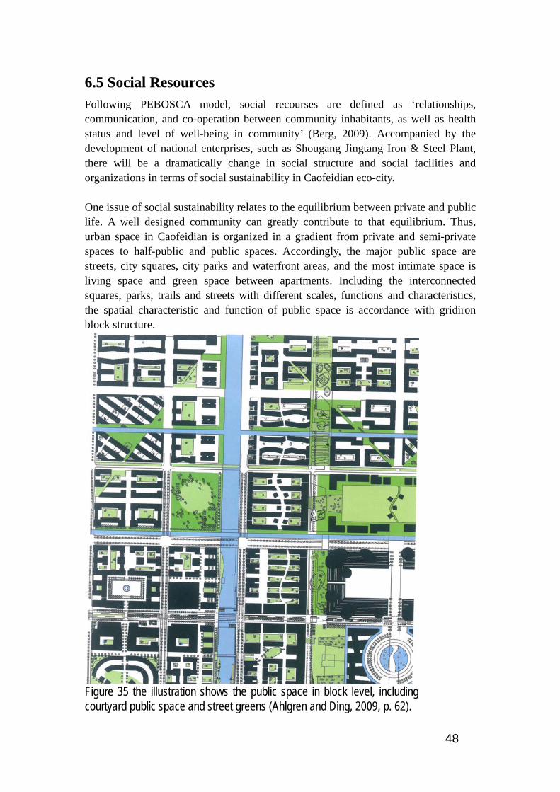
48
6.5 Social Resources Following PEBOSCA model, social recourses are defined as ‘relationships, communication, and co-operation between community inhabitants, as well as health status and level of well-being in community’ (Berg, 2009). Accompanied by the development of national enterprises, such as Shougang Jingtang Iron & Steel Plant, there will be a dramatically change in social structure and social facilities and organizations in terms of social sustainability in Caofeidian eco-city. One issue of social sustainability relates to the equilibrium between private and public life. A well designed community can greatly contribute to that equilibrium. Thus, urban space in Caofeidian is organized in a gradient from private and semi-private spaces to half-public and public spaces. Accordingly, the major public space are streets, city squares, city parks and waterfront areas, and the most intimate space is living space and green space between apartments. Including the interconnected squares, parks, trails and streets with different scales, functions and characteristics, the spatial characteristic and function of public space is accordance with gridiron block structure.
Figure 35 the illustration shows the public space in block level, including courtyard public space and street greens (Ahlgren and Ding, 2009, p. 62).
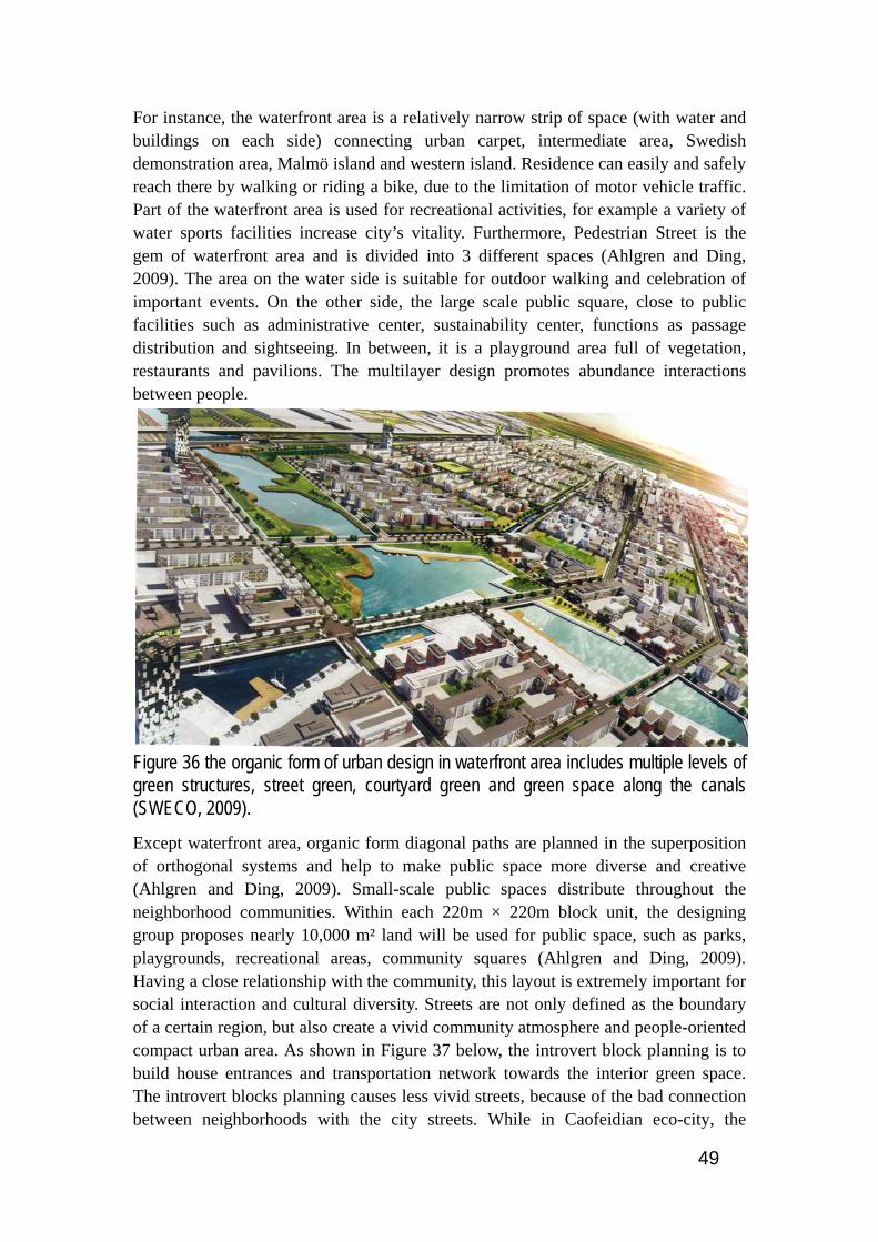
49
For instance, the waterfront area is a relatively narrow strip of space (with water and buildings on each side) connecting urban carpet, intermediate area, Swedish demonstration area, Malmö island and western island. Residence can easily and safely reach there by walking or riding a bike, due to the limitation of motor vehicle traffic. Part of the waterfront area is used for recreational activities, for example a variety of water sports facilities increase city’s vitality. Furthermore, Pedestrian Street is the gem of waterfront area and is divided into 3 different spaces (Ahlgren and Ding, 2009). The area on the water side is suitable for outdoor walking and celebration of important events. On the other side, the large scale public square, close to public facilities such as administrative center, sustainability center, functions as passage distribution and sightseeing. In between, it is a playground area full of vegetation, restaurants and pavilions. The multilayer design promotes abundance interactions between people.
Figure 36 the organic form of urban design in waterfront area includes multiple levels of green structures, street green, courtyard green and green space along the canals (SWECO, 2009).
Except waterfront area, organic form diagonal paths are planned in the superposition of orthogonal systems and help to make public space more diverse and creative (Ahlgren and Ding, 2009). Small-scale public spaces distribute throughout the neighborhood communities. Within each 220m × 220m block unit, the designing group proposes nearly 10,000 m² land will be used for public space, such as parks, playgrounds, recreational areas, community squares (Ahlgren and Ding, 2009). Having a close relationship with the community, this layout is extremely important for social interaction and cultural diversity. Streets are not only defined as the boundary of a certain region, but also create a vivid community atmosphere and people-oriented compact urban area. As shown in Figure 37 below, the introvert block planning is to build house entrances and transportation network towards the interior green space. The introvert blocks planning causes less vivid streets, because of the bad connection between neighborhoods with the city streets. While in Caofeidian eco-city, the

50
extrovert block planning is used to plan the neighborhoods. The extrovert block planning creates a lively, open city street environment. The structure of neighborhood creates a positive link between the neighborhood and the city, as well as a clear relationship between the two (Ahlgren and Ding, 2009).
Figure 37 comparison between introvert and extrovert block planning shows the later can create a more lively and open street environment (Jernberg and Ding, 2009, p. 37).
Thus, the integrated public space creates conditions for the mixed use of neighborhood community and links between various parts of the eco-city. An inclusive, sustainable and holistic public space, opens to any gender, race, ethnicity, age and socioeconomic status people, is an essential condition for creating a sustainable development urban environment (SWECO, 2009). Without interrupting the view, clear boundaries between the different spaces are set and will benefit the public and visitors to understand and make use of various urban spaces (Ahlgren and Ding, 2009). Meanwhile, the planning contribute equal opportunities for the two types of individuals, thereof respecting the being individual and social beings (Berg, 2009). ‘To create socially sustainable communities, we need to organize a conglomeration of tram stops, bike racks, communication facilities, viewing points, shops……library rooms and storehouses’ (Berg, 2009). Therefore, one the important aspect of social sustainability is education. The planning of an 11 km² university park has started since early 2008. The experts and scholars from Chinese society of educational development strategy and national center for education development research are researching on plans for achieving a more sustainable education system. Many features are worth drawing on in the planning. For instance, the university area will be a conglomeration of postgraduate education, undergraduate education, advanced vocational education and a system of life-long education. Except with multiple educational hierarchies, not only will Caofeidian University Park absorb parts of existing education institutions in Tangshan, such as Tangshan Collage, Hebei Polytechnic University and Tangshan normal university, but also formulate Joint education program between local and foreign university (Wang and Liu, 2008). In addition, to promote the social welfare, Caofeidian Hospital, about 1500m², has been

51
established in September, 2005. According to the conceptual physical planning of 30 km², before 2020, the population will be 4-500,000 people and approximately 250,000 workplaces will be provided (SWECO, 2009).

52
6.6 Cultural Resources A sustainable community is achieved by pondering cultural, social, economical and environmental factors collaboratively. ‘Community may still not be fully sustainable if they haven´t been adapted to its local culture’ (Berg, 2009). Therefore, addressing the cultural sustainability in the plan is important for Caofeidian to achieve the aim of becoming the world leading eco-city. As David Throsby states, ‘we can propose that cultural capital can exist in two forms’ in the context of sustainability: physical capital and intellectual capital (Throsby, 1995). While the former includes tangible entities such as artworks, buildings, sites, objects, the second can be represented in the body of ideas, practices, beliefs, together with artworks existing in intangible form like music, literature, etc (Throsby, 1995). In the case of Caofeidian, the lighthouse, in terms of physical capital, is the only building on the island before the eco-city development. The historical and literary materials relating to the lighthouse are briefly summarized below. In 1860, the Anglo-French Allied Forces invaded Beijing and signed the unequal treaty, Sino-French Convention of Peking of 1860, with Chinese government. Accordingly, on January 20th 1861, Tianjin Port was forced to open. Monopolized by the imperialist powers, Tianjin Port and British shipping company proposed building lighthouse, as navigation signal, on Caofeidian Island. However, the lighthouse had not been completed due to lack of construction techniques, means of transportation and funds. Until 1886, Li Hung-chang, zhili governor-general, allocated funds to build the lighthouse and commissioned the monks to take care of it. Having been reconstructed many times afterwards, the lighthouse, locating in Caofeidian sand barrier, was changed to light steel frame pile structure. The lighthouse was demolished by Japanese aggression army in 1944 and, after the founding of the People’s Republic of China, was rebuilt in November 1986 (Chinanews, 2006). Additional, Caofeidian inherits rich historical and cultural heritage in terms of intellectual cultural capital from its mother city Tangshan. There is evidence of human remains as early as 40,000 years ago. About 5,000 years ago, Huangdi - the bestowed Yellow Emperor, considered the ancestor of the Chinese nation, left behind signs of human settlements in this area. Emperor Li Shimin of the Tang Dynasty about 1,300 years ago garrisoned his troop in this place, and gave the royal name “Tang” to the city. ‘Over 300 years ago, the Eastern Tombs in the Qing Dynasty was confirmed as the imperial cemeteries where five emperors in the Qing Dynasty were buried, and now has become a world culture heritage’ (Chen). The Tangshan area, where Caofeidian locates in, is famous for its splendid cultures. As stated in Caofeidian forum:
It is the ancestral home of Cao Xueqin who wrote the Dream of Red Mansion, and is the place where Cheng Zhaocai, a main founder of Pingju Opera, was born. Besides, many cultural forms originated here, of which the Pingju Opera, Shadow Play and Laoting Drum,

53
are honored as the “Three Flowers in East Hebei Province”. Also, it was one of the revolution sources in the northern China, and the hometown of Comrade Li Dazhao, a van revolutionist (Chen).
Additional, Chen guoying well summarized the spiritual forces in Tangshan area
many spiritual forces were fostered, e.g. the ‘Iron-liked shoulders taking up morality and justice’ spirit of Li Dazhao, the spirit of ‘special enthusiasm for hard working’ of Kailuan workers, the “Qiongbangzi (poor but strong)” spirit of Wang Guofan Association, the “Modern Yugong” spirit in Shashiyu area, Tangshan’s spirit in earthquake relief, Caofeidian’s spirit in construction, as well as new Tangshan people’s humanistic spirit of ‘gratitude, universal brotherhood, openness and transcendence’, all powerfully unites people in Tangshan to strive forward (Chen).
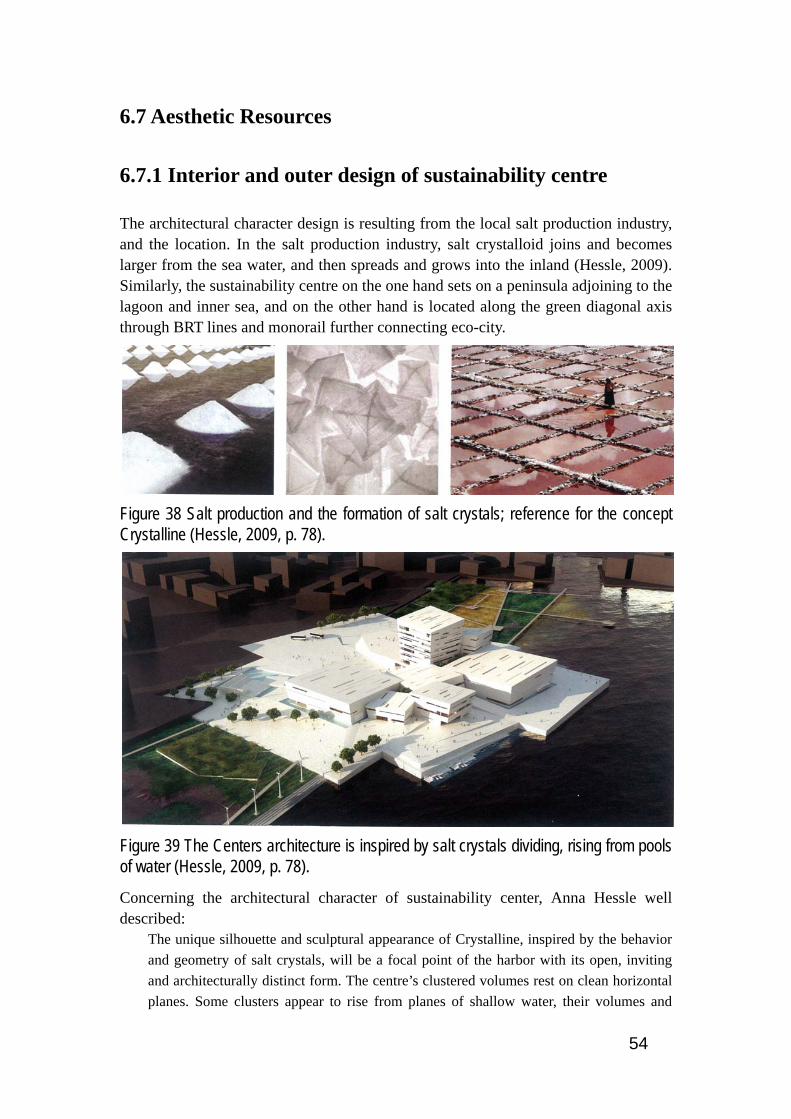
54
6.7 Aesthetic Resources
6.7.1 Interior and outer design of sustainability centre
The architectural character design is resulting from the local salt production industry, and the location. In the salt production industry, salt crystalloid joins and becomes larger from the sea water, and then spreads and grows into the inland (Hessle, 2009). Similarly, the sustainability centre on the one hand sets on a peninsula adjoining to the lagoon and inner sea, and on the other hand is located along the green diagonal axis through BRT lines and monorail further connecting eco-city.
Figure 38 Salt production and the formation of salt crystals; reference for the concept Crystalline (Hessle, 2009, p. 78).
Figure 39 The Centers architecture is inspired by salt crystals dividing, rising from pools of water (Hessle, 2009, p. 78).
Concerning the architectural character of sustainability center, Anna Hessle well described:
The unique silhouette and sculptural appearance of Crystalline, inspired by the behavior and geometry of salt crystals, will be a focal point of the harbor with its open, inviting and architecturally distinct form. The centre’s clustered volumes rest on clean horizontal planes. Some clusters appear to rise from planes of shallow water, their volumes and

55
tilted roof planes mirrored on the reflective surface. Their facades and skylights evoke a light and crystalline character with the use of light natural stone cladding and irregularly placed horizontal openings (Hessle, 2009, p. 84).
Besides, about interior design, Anna Hessle well summarized:
The interior design is inspired by Tangshan culture and local natural ecosystems: delta, salt wetlands, and heather fields. Bird and sea life lends inspiration to patterns and textiles, as do the masks and colors of the Chinese Peking opera, traditional Chinese textiles and wallpapers, and a long local history of fine porcelain production. Filtering these local patterns and colors through a Scandinavian design philosophy marries simplicity with the richness and beauty of the Chinese heritage, creating a unique interior atmosphere (Hessle, 2009, p. 84-85).
Each interior function is represented by a unique building volume and composition. The size, shape and character of the volumes adapt according to considerations of daylight, views, microclimate, roof height, and use (Hessle, 2009).The building’s entrance square is located in the north of the centre, directly connects the main lobby and reception. On both sides of the main lobby are the two main exhibition halls. On the left side, the exhibition hall contains a large city model, sustainable planning exhibition and model hall, historical exhibition, two media walls and a flexible exhibition space. While the one on the right side contains a children’s demonstration and experimentation and expo technological solutions and companies which are divided into five aspects: energy, building, water, transportation and earth, corresponding to five basic elements in Chinese tradition, fire, wood, water, metal and earth (see Figure 40 below).

56
Figure 40 two major exhibition halls and office building are planned at Ground floor plan of sustainability center (Hessle, 2009, p. 79).

57
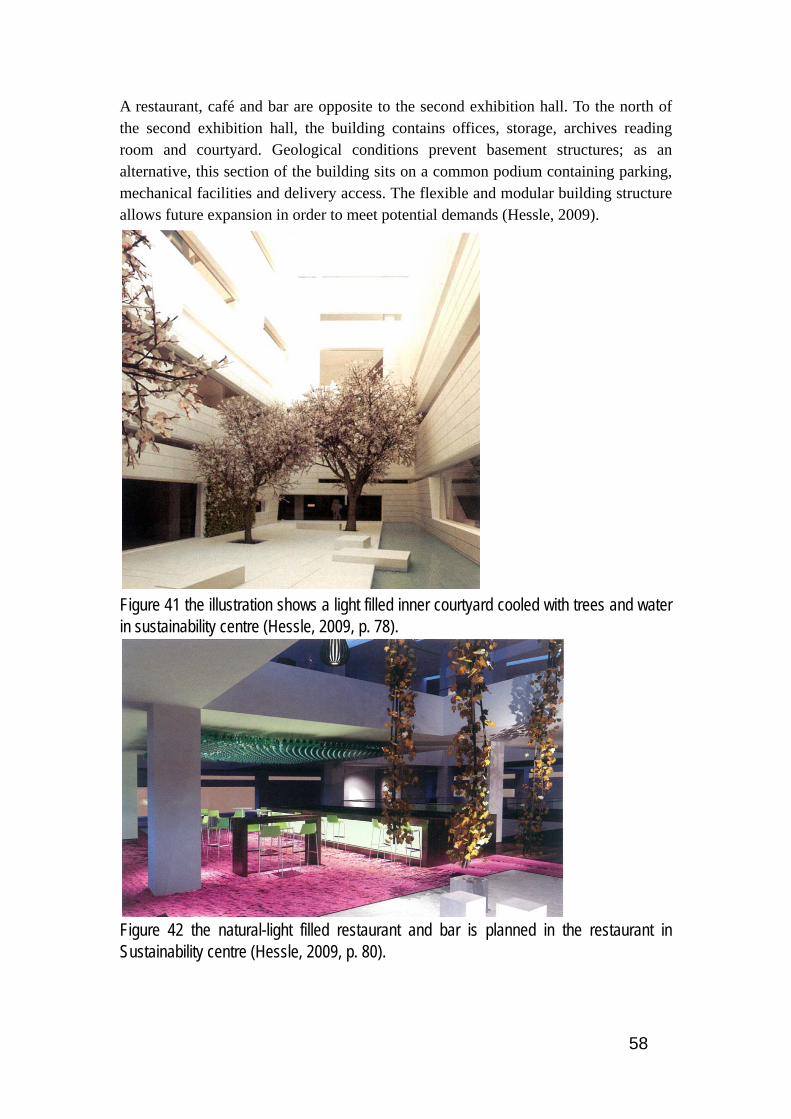
58
A restaurant, café and bar are opposite to the second exhibition hall. To the north of the second exhibition hall, the building contains offices, storage, archives reading room and courtyard. Geological conditions prevent basement structures; as an alternative, this section of the building sits on a common podium containing parking, mechanical facilities and delivery access. The flexible and modular building structure allows future expansion in order to meet potential demands (Hessle, 2009).
Figure 41 the illustration shows a light filled inner courtyard cooled with trees and water in sustainability centre (Hessle, 2009, p. 78).
Figure 42 the natural-light filled restaurant and bar is planned in the restaurant in Sustainability centre (Hessle, 2009, p. 80).

59
6.7.2 Aesthetic resources in B3 community
To achieve a sustainable management of aesthetic resources, visual, auditive, olfactory and tactile resources should be attached importance. Generally, the planning of building architectures, city landmarks, green and blue structure, city nodes should be based on a conscious inter sensory design (Berg, 2009). ‘Protect, inform about and develop intersensory valuable places and the public space to become more attractive to all senses’ (Berg, 2009).
Figure 43 Bird view of B3 community shows the basic aesthetic elements (Wang and Shi, 2010, p. 99).
The planning of community should also ‘avoid strong negative sensory impacts: noise, stench, strong wind exposure and uncomfortable paving of streets’ (Berg, 2009). Because the annual wind direction is south and southwest and the Caofeidian international eco-city locates at the northeast side of the industrial area, the environmental impact of stench air from the steel industry is rather low. The green belt, surrounding the B3 community, can set the community resident apart from the hectic urban environment visually and auditively (see Figure 43 above). Additional, not only can the Chinese courtyard structure buildings prevent visual and sound disturbance from outside, but also prevent the strong wind in the winder, thus forming a snug, comfortable and warm micro climate.

60
Figure 44 the illustration shows the perspective on the east side of E building. In picture, there are building E and the salt water canals (Wang and Shi, 2010, p. 98).
Furthermore, the small green areas in the community can add a pleasing, agreeable scent or odor to the semi private and semi public environment. And the color in the vicinity delicious gardens will possess resident (see Figure 44). The wind blows in delightful odors from the green belt and the water channel at the east of community. ‘Room should be given, active protection should be created, and conscious proposals should be developed for the following parts: olfactorial, vestibular, thermo receptive, tactile habitats and recreation sites’ (Berg, 2009). Thus, the water canal together with the green structure will provide an intersensory experience to the local people (see Figure 44). Integrating different scales of green structure and external public environment, providing various sensory experiences, with the spatial structure strengthens the identity of the B3 community.
Figure 45 Perspective on community entrance, the independent white building is the guard building. The building at the left side is building A (Wang and Shi, 2010, p. 98).

61
Figure 46 building D on the both side of the road forms a semi-public and semi-private space (Wang and Shi, 2010, p. 100).
Figure 47 inner garden of building B is the semi-private public space (Wang and Shi, 2010, p. 100).
62
7. Interdisciplinary analysis and solution
7.1 Building Structure and Architecture The building structure standard should be given special attention due to its location at the Beijing, Tianjin and Tangshan seismic zone. During the interview with SWECO, it seems like Caofeidian situates out of potential seismic zone and the preventive measurements of the earthquake disaster haven’t been executed in the detailed planning. However, due to the disastrous earthquake in Tangshan and following research, precautionary measures are of significant importance, which could eliminate potential negative effect on the whole Ecocity infrastructure systems. Moreover, the law of the people's republic of China on protecting against and mitigating earthquake disasters states ‘all construction projects shall be designed in compliance with the requirements for fortification against earthquakes and in conformity with the standard aseismatic design and shall be constructed in accordance with the design’ ((NPCC), 2009). According to the national law, the seismic basic intensity of Caofeidian eco-city is eight degree. Hence, not only will the residence meet the corresponding building structure safety requirements, but also the infrastructures should adopt homologous preventive measures, resonating with the general requirements of sustainability, on potential earthquake. It is suggested that the learning process of national laws and building codes is rather important for the international design group during planning process. New Zealand’s construction technologies and building experiences on earthquake resistance can be used for reference by Caofeidian eco-city. Examples are ‘lead dampers and lead or rubber bearings in building foundations, which can resist damage under smaller stresses and to protect human in larger quakes even if the building is damaged’ (Teara.gov, 2005, Boberg et al., 2010). Building architecture in Caofeidian eco-city should embody the style of Chinese traditional architecture and the romance of European architecture. The Chinese traditional architecture is an enormous and complicated system, closely relating to the ethical ideology the harmony of man with nature. Hence, some Chinese architecture ideologies can be shared for possible improvements of the buildings in Caofeidian. Usually, the Chinese traditional buildings have large size of door, window, hall and the eaves of roof. Instead of making one worry about being swallowed, the broadness and boundlessness of traditional buildings is marked by peaceful and serene feeling. Because the Chinese courtyard community structure is used in B3 community, the size of eave can be further increased to form a security and comfortable community environment.

63
Figure 48 perspective on building A from inner garden of building B, (Wang and Shi, 2010, p. 100)
Generally, the exterior impression of a house affects how residents feel about their homes and even their own worthiness as human beings (Sarkissian, 1986). Hence, in Chinese context, the opulent roof represents owner’s power, social status and wealth. Therefore, roof decoration is recommended to bring vivid and aesthetic feeling to the facde of the buildings. Besides, building decoration is more than advisable. For instance, stone lions guarding gates and entrances, believed by the Chinese to avoid bad luck, could also be incorporated easily at the guard room and community entrance (Boberg et al., 2010). The design of dwellings should be compatible with the local norms of “home”, thereby creating a feeling of superior and worthy for its residents. Another characteristic of Chinese traditional building relates to Fengshui, the harmony between surrounding environment, either natural or manmade, and human community life. According to the ideology of Fengshui, building should be placed beside hills and rivers or water channel should be, at least, in front of the houses. Thus, building can take advantage of broadness of hills and vitality of water to improve the living environment and even bring good luck and fortune to the people. See Figure 49 below, a private outdoor space, a yard or a garden, should be provided in the rear of the building E, facing the water canal. ‘Privacy can be provided with plantings, and if at some point residents need to install fences, they will have a better idea of where and how high they should be’ (Durrett, 1995). Besides, the backyard acts as the transitions between the private and common areas, e.g. riverbank, and facilities community activities and helps form good relationships among people. Therefore, minor changes can be made to the buildings beside the water channel to create a vivid
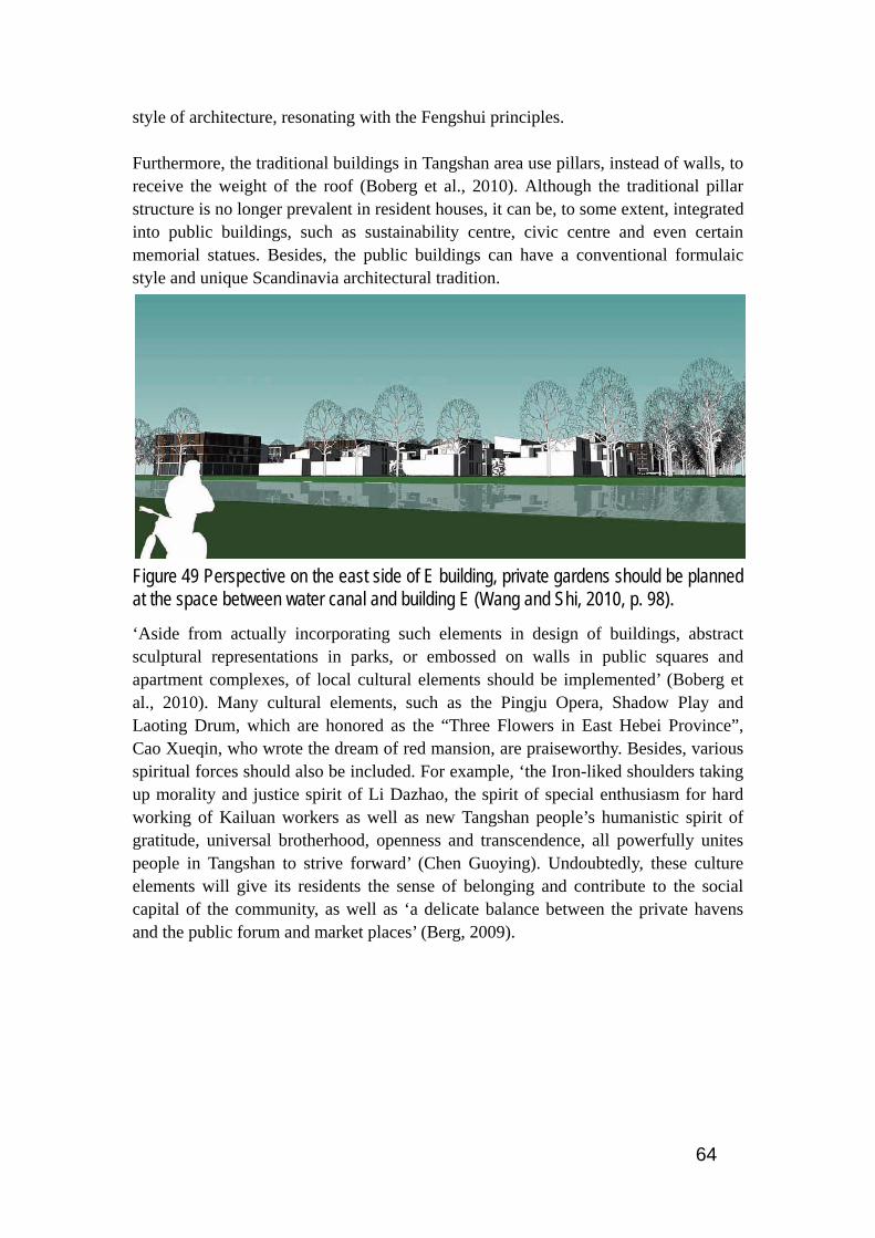
64
style of architecture, resonating with the Fengshui principles. Furthermore, the traditional buildings in Tangshan area use pillars, instead of walls, to receive the weight of the roof (Boberg et al., 2010). Although the traditional pillar structure is no longer prevalent in resident houses, it can be, to some extent, integrated into public buildings, such as sustainability centre, civic centre and even certain memorial statues. Besides, the public buildings can have a conventional formulaic style and unique Scandinavia architectural tradition.
Figure 49 Perspective on the east side of E building, private gardens should be planned at the space between water canal and building E (Wang and Shi, 2010, p. 98).
‘Aside from actually incorporating such elements in design of buildings, abstract sculptural representations in parks, or embossed on walls in public squares and apartment complexes, of local cultural elements should be implemented’ (Boberg et al., 2010). Many cultural elements, such as the Pingju Opera, Shadow Play and Laoting Drum, which are honored as the “Three Flowers in East Hebei Province”, Cao Xueqin, who wrote the dream of red mansion, are praiseworthy. Besides, various spiritual forces should also be included. For example, ‘the Iron-liked shoulders taking up morality and justice spirit of Li Dazhao, the spirit of special enthusiasm for hard working of Kailuan workers as well as new Tangshan people’s humanistic spirit of gratitude, universal brotherhood, openness and transcendence, all powerfully unites people in Tangshan to strive forward’ (Chen Guoying). Undoubtedly, these culture elements will give its residents the sense of belonging and contribute to the social capital of the community, as well as ‘a delicate balance between the private havens and the public forum and market places’ (Berg, 2009).

65
Figure 50 the residential building in the front is building A. The independent building at the left side is the guard building in B3 community (Wang and Shi, 2010, p. 98).
Besides, Building height is central in terms of forming proper connecting between buildings and the health of its residents. In B3 community, the building height ranges from 4 to 7 storeys. Building A is a seven-storey employ dormitory and building B and C are six-storey ordinary residential buildings. The rest are four to five floor buildings. Hence, it is highly suggested that high buildings create mental disorder and social alienation for its residents, because ‘high-rise living takes people away from the ground, and away from the casual, everyday society that occurs on the streets’ (Alexander et al., 1977). Unless they have some particular social events and activities, people tend to stay at home, and then the forced isolation then causes individual breakdowns (Alexander et al., 1977). Therefore, I suggested that the height of general residential buildings should not exceed 4 storeys. Since building A is a 7-storey dormitory, I suggested that a roof garden should be constructed to provide social gathering places for the people. Hence, they would have a closer connection with social gathering places and higher tendency to leave the self-enclosed world created by high building.
7.2 Energy and Building Maintenance
7.2.1 Building maintenance and improvement
Generally, multiple energy strategies will be used in B3 community and also the whole Ecocity to reduce the energy demand. According to the master plan, energy strategies include establishment new building standard, optimizing maintenance structure, efficient ventilation, high-efficiency lighting, etc. in the end, the total amount of energy consumption will be reduced almost two thirds.
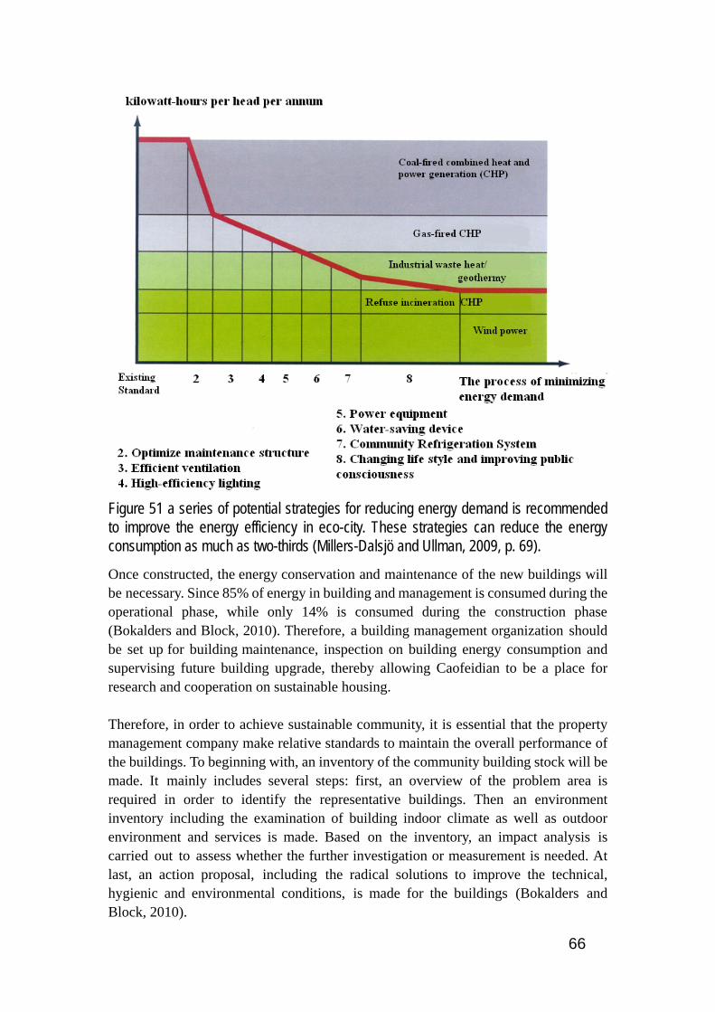
66
Figure 51 a series of potential strategies for reducing energy demand is recommended to improve the energy efficiency in eco-city. These strategies can reduce the energy consumption as much as two-thirds (Millers-Dalsjö and Ullman, 2009, p. 69).
Once constructed, the energy conservation and maintenance of the new buildings will be necessary. Since 85% of energy in building and management is consumed during the operational phase, while only 14% is consumed during the construction phase (Bokalders and Block, 2010). Therefore, a building management organization should be set up for building maintenance, inspection on building energy consumption and supervising future building upgrade, thereby allowing Caofeidian to be a place for research and cooperation on sustainable housing. Therefore, in order to achieve sustainable community, it is essential that the property management company make relative standards to maintain the overall performance of the buildings. To beginning with, an inventory of the community building stock will be made. It mainly includes several steps: first, an overview of the problem area is required in order to identify the representative buildings. Then an environment inventory including the examination of building indoor climate as well as outdoor environment and services is made. Based on the inventory, an impact analysis is carried out to assess whether the further investigation or measurement is needed. At last, an action proposal, including the radical solutions to improve the technical, hygienic and environmental conditions, is made for the buildings (Bokalders and Block, 2010).

67
To illustrate an environmental inventory, every function is rated on a scale from good to bad (the scale can be divided into 10 steps, where 0 is the worst and 10 the best) (French, 28 Jan 2009), thereby allowing possible comparisons among different building stocks. The inventory is organized into several categories, It is organized into categories such as resource consumption (e.g. how much electricity per square meter is used monthly), waste management (e.g. how much sorted household waste is averagely generated in relation to the number of residences), sewage (e.g. liters of water are used per square meter), transportation (e.g. how many liters of fuel does each residence use, number of trips using renewable energy), the outdoor environment (e.g. air pollution and noise), green building and the indoor environment (e.g. what proportion of the flats have had their ventilation inspected), indoor climate (light, noise and vibration) (Bokalders and Block, 2010, Boberg et al., 2010).
Figure 52 Example of a results compilation for the sub-area indoor environment, according to the evaluation method Miljöstatus för byggnader 1999 by Jacobson & Widmark. Various criterions in terms of indoor climate are provided in the model.
The inventory of the existing buildings is then used as the foundation for the energy conservation measures and maintenance. To begin with, an inspection is used to find out the weak point which causes large energy loses in the building. Additional, the ventilation systems in the building are also inspected. Then, the inspection provides a basic for the adjustment of the heating and ventilation systems. The adjustment of ventilation systems should also be adapted to local climate conditions. Since the summer is rather hot and humid and the winter is comparatively cold and arid, more

68
ventilation is needed during the summer and winter. The average annual rainfall is about 620-750mm, which means the relative humid is high during the summer. Therefore, the ventilation systems should be controlled by the relatively humid and outdoor temperature (Bokalders and Block, 2010). In addition, a regularly cleaning plan should be made for the well performance of the ventilation system. Because of high energy consumption during the cold winter, the supplementary insulation, sealing and window improvement measures are effective solutions for this problem. For instance, a smoke gun or smoke puffer is used to detect the draughty points. Then, EPDM rubber can be used for the weak space between window casements and frames. And eco-packing material can be used to seal the draughty place between the windows and the walls (Bokalders and Block, 2010). For the supplementary insulation, it is cost-effective to install an insulation to loft floor without damaging the ventilation system. The joint place where Spandrel beams conjunct with slab foundations can cause large, unintended energy loses and should be added special insulation. Most families in the China use most common windows with only one layer and the U-value is as high as 3.93 W/m²K, which causes large, unintended energy loses. To improve the energy efficiency, a second pane can be installed to the older windows system. One example is that an inside 4mm hard-coated energy-efficient glass is added to the existing casement and sealed, which also improves the sound insulation. Therefore, the U-value could be as low as 1.8 W/m²K, only half of the older windows U-value. Moreover, the inside window can be taken off during the hot summer, adapting to the local climate. And the appearance of the building keeps the same after the window improvement measures.
7.2.2 Energy
More attention should be paid on solar energy heating device especially vacuum solar collector, the most common type in China. As demonstrated by Rizhao, the prevalence of vacuum solar collector, promoted by local enterprise, has brought economic benefits to local people and reveals vigor of the city. Although it costs about 1500 to 3000 CNY to buy and install a vacuum solar collector, the vacuum solar collectors will save around 800 to 1200 CNY a year on their utility bill. For the average families in the community, it is about 5% of their total annual income, 24,000 CNY to 80000 CNY. Besides, most buildings, such as building B to the right, should be placed towards south, thus to maximize the natural lighting for the buildings, thereby allowing fully functioning of vacuum solar collectors. Similar with the energy system in the Sustainability Centre, the system called ‘energy trio’ combines the individual vacuum solar collectors and an alternative energy source, such as biomass or other heat source, with an accumulation tank. During the hot summer, the solar energy is mainly used to heat the tap water. While during the rainy
69
spring and mild winter, the system is supplemented with alternative energy source to provide the hot water for the whole community. The solar panels are mounted on the roof of each building. The accumulation tank is located at the central plant. Each individual solar vacuum collector has its small accumulation tank to store the heat, which connects to the central accumulation tank. When the solar energy is not enough, the central accumulation tank is fueled by the biomass to provide hot water to the whole community. Therefore, the energy system should be established at the community level, thereby reducing energy consumption and improving energy efficiency (Bokalders and Block, 2010). According to the master plan, SWECO recommends that the use of natural gas for cooking should be avoided in Caofeidian international Ecocity. Not only because natural gas is a fossil fuel, but also if used only for cooking, the construction and maintenance of gas transmission system is too expensive, and there are potential security risks. For instance, in Stockholm the centralized gas supply system has been phased out, due to its high operating and maintenance costs. Moreover, modern electric stove can achieve the functions of gas stove (Millers-Dalsjö and Ullman, 2009). However, because of the Chinese dietetic culture, I am afraid that the abolishment of centralized gas supply system is not advisable. At least, the biogas pipeline system can be constructed to supplement the natural gas system, thereby reducing energy consumption. Besides, equipments and utilities involved with urban biogas supply system should be installed at RMC, as well as relevant laws and regulations should be established for the maintenance and upgrade work in the long term.
7.3 Transportation
7.3.1 Transportation analysis
Within the community, walking and bicycle is the dominate transportation mean, accounting almost 90% of total community traffic. While, within the Ecocity, light rail and BRT is the major traffic mode, nearly 50%. And bicycle and pedestrian each accounts for 20% of urban traffic volume, however private vehicle only has 10%. Light rail, commuter train and regional train, nearly 70%, facilitate the transportation between major cities, such as Beijing, Tangshan and Tianjin, and also the traffic volume of private vehicle will also increase to 20%. Based on the experience of other cities, the estimate of average trips every people per day are 3. Basically, the trip means any one way travel from any starting point to any destination. According to the estimate below, during the phase 1 (30 km²), light rail and BRT can meet the major transportation needs. Basically, light rail mainly meet the traffic requirement between Ecocity and industrial zone, while BRT is responsible for the urban transportation. As the city further sprawl into suburban area, elevated commuter train will be the major supplement of the public transportation system.

70
Therefore, only the integration of transportation network planning and urban planning can create a high quality urban environment for the residents, as well as a major solution to the prevailing urban environmental issues (Joachim, 2009).
Figure 53 According to estimated daily car traffic volumes for 2030, the most heavily trafficked highway is near the waterfront area in the initial area. The highest car traffic volume is 95,000 vehicles per day (Joachim, 2009).
Construction of public transport infrastructure, mainly BRT and light rail system, must be timed to occur prior to or simultaneously with building of the communities to ensure uptake of public transport. This was crucial in Hammarby Sjöstad, Stockholm, where the tram line arrived in the area shortly after its completion, reducing the period of adjustment and encouraging locals to use this mode rather than automobiles (Boberg et al., 2010).
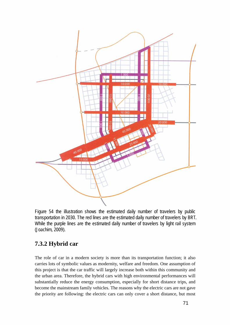
71
Figure 54 the illustration shows the estimated daily number of travelers by public transportation in 2030. The red lines are the estimated daily number of travelers by BRT. While the purple lines are the estimated daily number of travelers by light rail system (Joachim, 2009).
7.3.2 Hybrid car
The role of car in a modern society is more than its transportation function; it also carries lots of symbolic values as modernity, welfare and freedom. One assumption of this project is that the car traffic will largely increase both within this community and the urban area. Therefore, the hybrid cars with high environmental performances will substantially reduce the energy consumption, especially for short distance trips, and become the mainstream family vehicles. The reasons why the electric cars are not gave the priority are following: the electric cars can only cover a short distance, but most

72
people in the community also want to travel to other cities quite far away from Caofeidian. Besides, the volume of the battery is rather large and it takes seven hours or more to fully recharge the battery. However the hybrid car is the combination of electric car and fuel efficient car. Today's mass-produced hybrid electric vehicles combine conventional propulsion with a rechargeable energy storage system to achieve better fuel economy than a conventional vehicle as well as to emit fewer greenhouse gases (Worah, 2009). The fuel engine and breaking are the main means of recharging the battery. However, right now the price of the hybrid car is rather high for the local people. As the development of the technology, it will be affordable for the city dwellers. In the next 30 years, there is also a market for the hybrid cars in the density 12 km² initial area. The local government can also support the environmental car business in the community and governmental subsidize could be an effective promotion for this market. Generally speaking, the automobile dependency will become more and more obvious in Caofeidian. The pedestrian-friendly, transit-oriented community is the main strategy to slow down this tendency. Even though we have economical, technical and social solutions for achieving this goal, the technical solution, expansion of transportation infrastructures, will always end with the larger needs of travel. For the economical solution, those who suffer the most are those who can afford it least. Only the social solutions, breaking down our addiction to the automobile and promoting the pedestrian and cycle traffic, can solve the transportation problem in the long term compatible with the overall requirements of sustainability (Roseland, 2005).
7.3.3 Parking strategy
According to the SWECO’s design, it places a key emphasizes on the establishment of the car pooling strategy and organization, in terms of sustainable transportation system, to promote the high use of private vehicles. In recent years, as the oil price rising, the restriction of private vehicle and frequent cold and warm extreme events in China, carpooling set off an animated discussion in most big cities in China. ‘As an alternative to using a single-occupancy vehicle, carpooling, carpooling can limit use of personal vehicle for daily commuting, save time by using high occupancy vehicle lane and provide useable time for riders- read, sleep, work and talk’ (Manole, 2010). Nonetheless, carpooling is illegal in China, because private cars are forbidden to engage in for-profit activities. Free carpooling is legal, but seriously, paid carpooling is against the law, even the paid money is less than the cost of the petrol. To be worse, once the accident happens, it is difficult to investigate and affix the responsibility of the accident. Besides, the insurance company can refuse to settle the claim for car accident damage, due to the wrongful carpooling (Bai, 2010).1 In my opinion, Caofeidian administrative commission should provide policy guidelines and a system 1 The original document is in Chinese.
73
for setting prices for carpooling. The carpooling strategy in the master plan of Caofeidian Ecocity should be cancelled in order to adapt Chinese laws and supplementary measurements should be made to keep the operation of sustainable transportation model. As stated in the master plan, to take full advantage of parking facilities, the parking spaces can be used by people in residential or commercial areas in alternation. For instance, from 8am to 4pm, parking spaces can be used for commercial parking. While during the rest of the day, residents can use the parking facilities. According to the Swedish experience, such measures can reduce around 10% -25% of the parking spaces (Millers-Dalsjö and Ullman, 2009). However, most shops stay open from 9 a.m. to 8 p.m., even as late as 10 p.m. in China. Therefore, it is rather difficult to implement parking facility sharing strategy in Chinese cities. Thus, it is suggested that stopping equipment and auxiliary equipment should be installed to facilitate car parking in the urban area and the price of parking should be set at reasonable level to control the actual vehicle flow rate not exceeding the optimum rate, as shown in Figure 53.
7.4 Gridiron block structure Although many Chinese ancient cities have long since passed into oblivion, the patterns of ancient city layout could be, to some extent, beneficial to the planning of Caofeidian eco-city. For instance, Daxing city, to be known as Chang’an again in the Tang dynasty, was chosen by Sui wendi to be the new site of imperial capital in 582. Daxing city was nevertheless extraordinary well planned, due to ‘its strict adherence to a grid pattern for the streets and the almost perfect symmetry of the city were emphasized by the streets’ lengths’ (Steinhardt, 1999). Divided by fourteen longitudinal and eleven latitudinal streets, the Daxing city was composed one hundred eight wall enclosed sectors, ward or block, and two symmetrically located markets, each occupied an area of two blocks. Not being the same, the blocks in the northern part of the city were larger than that in the south. ‘Certain wards were designated for specific purposes, for instance a craft or commerce; others attracted residents from one foreign land or practitioners of an exotic religion’ (Steinhardt, 1999).
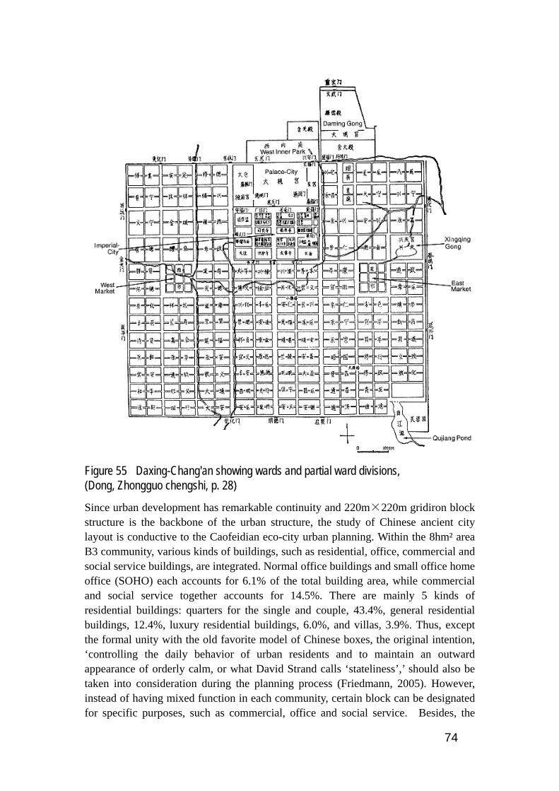
74
Figure 55 Daxing-Chang'an showing wards and partial ward divisions, (Dong, Zhongguo chengshi, p. 28)
Since urban development has remarkable continuity and 220m×220m gridiron block structure is the backbone of the urban structure, the study of Chinese ancient city layout is conductive to the Caofeidian eco-city urban planning. Within the 8hm² area B3 community, various kinds of buildings, such as residential, office, commercial and social service buildings, are integrated. Normal office buildings and small office home office (SOHO) each accounts for 6.1% of the total building area, while commercial and social service together accounts for 14.5%. There are mainly 5 kinds of residential buildings: quarters for the single and couple, 43.4%, general residential buildings, 12.4%, luxury residential buildings, 6.0%, and villas, 3.9%. Thus, except the formal unity with the old favorite model of Chinese boxes, the original intention, ‘controlling the daily behavior of urban residents and to maintain an outward appearance of orderly calm, or what David Strand calls ‘stateliness’,’ should also be taken into consideration during the planning process (Friedmann, 2005). However, instead of having mixed function in each community, certain block can be designated for specific purposes, such as commercial, office and social service. Besides, the
75
ideology of symmetry should be implemented during the whole development process of Caofeidian Ecocity, thereby resonating with the tradition of Chinese cities.

76
7.5 Infrastructure Administration
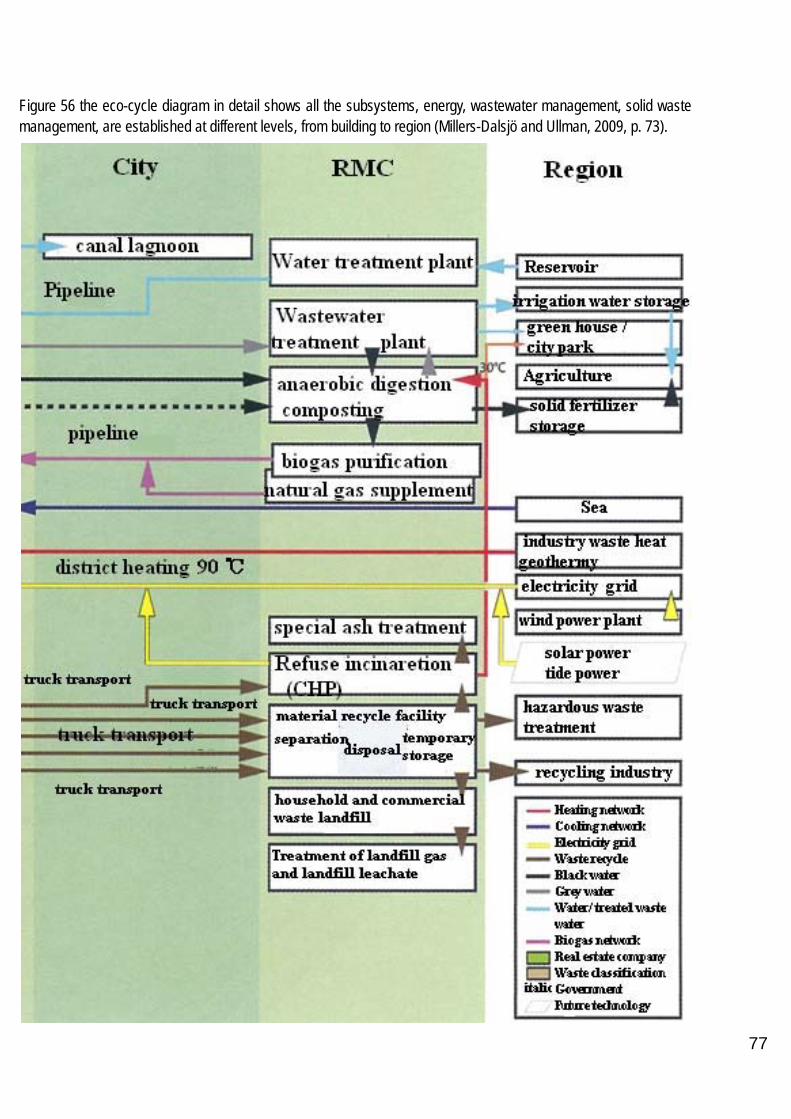
77
Figure 56 the eco-cycle diagram in detail shows all the subsystems, energy, wastewater management, solid waste management, are established at different levels, from building to region (Millers-Dalsjö and Ullman, 2009, p. 73).

78
According to the eco-cycle diagram (Figure 56), the whole eco-cycle model is mainly divided into 5 different hierarchies: building level, neighborhood level, street or district level, city level, RMC and regional level. Therefore, after the establishment of professional management system of the eco-cycle, the Caofeidian administrative commission should make the management system integrate Chinese administrative structure gradually, thereby setting up a top-grade and high-efficiency sustainable system. Hence, significant administrative changes and implementation of a revised city management system from that typical in China is advisable to ensure the proper functioning of the whole ecological system in Caofeidian (Boberg et al., 2010). Currently at the county level and township level, the skeletal account of local governance structure is based on the neighborhood communities, street offices, district and then city municipality, which is Caofeidian administrative commission during the construction period. (See Figure 57 below) Hence I suggest RMC, under the management of city municipality, is responsible for the centralized and unified management of waste water treatment, waste treatment plant, refuse incineration and biogas generation plant from the RMC level to the building level (Figure 56 above). The centralized treatment management has many advantages, first of all, compared to investment for many small treatment plants, a large-scale treatment plant is usually more economical efficient, although the cost of former piping system is relatively lower. Secondly, a technically confident team is responsible for operation and maintenance of RMC throughout the year to ensure a high level of operational safety. Third, for a large city, a large scale treatment plant is usually more efficient and more secure. For example, central waste water treatment in RMC is better for flexible usage of the treated water. If water in reservoir is insufficient, the recycled water will be deep treated to use as potable water (Millers-Dalsjö and Ullman, 2009). A legal corporation framework should be enacted to administer the whole ecological model in an integrated manner, as well as effectively superintending the potential redevelopment and enlargement of the ecological subsystems interdisciplinarily integrated. Such legal framework is idea in Chinese context as demonstrated by the sustainable Chinese cities programme in Shenyang, Wuhan and Guiyang, where closely cooperation between governmental departments, Un-habitat, local enterprise and research institutions have greatly alleviated the troublesome environmental situation. To begin with, the study of Caofeidian’s environmental situation and evaluation of environmental policies should be carried out during the urban planning and construction process. Shortly after the construction of 12 km² initial area in 2013, Caofeidian municipality together with experts from the sustainable cities programme should prepare the relative information for the Caofeidian environment profile, which will be used as a vital literature for the following city consultation. Then, after identification and mobilization of possible participators, the Caofeidian municipality will hold the city consultation meeting in which proficient from the sustainable Chinese cities programme, officers from the ministries, representatives from

79
non-governmental organizations, experts from academics as well as elitists from local manufactory enterprises will take part (Li and Pan, 2009). During the city consultation, potential conflicts of interest between different institutional factors and between subsystems should be identified and addressed (Ranhagen et al., 2007). Afterwards, five working groups will be formed. The sustainable energy group should give special attention to safe energy supply, including energy production to energy distribution, from renewable energy sources as well as ‘energy efficiency in all steps of energy flows’ (Ranhagen et al., 2007). Various issues are central in terms of sustainable energy system: for instance, currently, a fervent discussion has been arisen between scholars, government and the people on the security problems of large-scale CHP systems (Combined Heat and Power) in Chinese large cities. As a result, local residents in Guangzhou have successfully petitioned against the sitting of a CHP plant near their community. Therefore, rigorous environmental considerations, best technology of reducing dioxin emissions and governmental campaigns must be proposed by the group, thereby allowing the successful operation of CHP plant (Ranhagen et al., 2007). Besides, energy strategy in Caofeidian prepared by governmental authorities and energy planners should include affordable energy supply for the poor (Ranhagen et al., 2007). The second group is sustainable building group which is fully responsible for the operation and maintenance of aforementioned building management organization. Moreover, since the detail information about construction materials is lacking, the group should encourage environmentally friendly materials which is best for minimization building energy consumption. The third group is sustainable waste management group. Environmental effects monitor system of the waste management system should be established by the group. While industry waste and hazardous substance should be separated collected and treated in close collaboration between industrial sectors, local authorities and sustainable waste management group. The fourth group is sustainable water sanitation group. Because urban canal system is an important city feature, water and waste authorities and private actors need to corporate to prevent dumping of solid waste in saltwater drainage. And also it is essential to provide affordable drinking water for the poor, thereby promoting social equality. Water authorities together with Caofeidian municipality should make regulations to protect groundwater and surface water (Ranhagen et al., 2007). Last but not least, the overall objective of the sustainable transportation group is to ensure the fully implement of TOD (transit orientated development) strategy in Caofeidian and supervise any enlargement of the transportation sectors symbiotically integrated (Ranhagen et al., 2007). The fate of Huangbaiyu eco-village is a telling example of a top-down approach and lacking of communication with local stakeholders, rather than satisfying local people. In Dongtan, a scandal involving the key governmental sponsor can entirely undermine the project. Therefore, a legal corporation framework can enormously reduce these problems (Boberg et al., 2010).

80
Furthermore, acting as two additional levels, street offices and residents’ committees, carry-overs from the Maoist era when they played complementary roles to the dominant work-unit system, operate at the interface between society and government (Friedmann, 2005). ‘The division of responsibility between city and street office: district government focus on economic development issues, street office is expected to manage service for communities, such as local justice, community security, traffic control, sanitation, maintenance of open spaces and environmental protection’ (Friedmann, 2005) Hence, at the building, neighborhood level and street level, street office, neighborhood community and RMC workers should work together on the operation and maintenance of facilities for storm water collection, solid waste separation and community heating and cooling system, thereby allowing formation of a more independent entity representing local interests. However
there are significant positive aspects of the decentralized Street Offices which are seen in the administrative structures of many Chinese cities and which have responsibility for provision of local basic services, but which give scope for capitalistic activities on the part of their organizers to raise funds for the community, communication and cooperation throughout the city area is vital to allow efficient and symbiotic use of resources (Boberg et al., 2010, Friedmann, 2005).
Figure 57 the model shows the local governmental administrative structure in China (Street community=street office. Country=county). There are mainly four hierarchies: province level to township level. At the township level, street communities and neighborhood committees are the major components (Boberg et al., 2010).
Besides, as shown in Figure 58, the buildings, green space, on site rain collection and processing facilities and park waste on site composting treatment is owned by local real estate company. While most of the waste treatment, wastewater treatment and renewable energy generation facilities are under governmental ownership. Therefore, under the framework of Caofeidian eco-cycle model, the local government and real estate company should be committed to close co-operation and work strictly accordance with the relative laws and regulations.

81
Figure 58 the illustration shows the overall flow chart for integrated handling of the eco-cycle model based on eco-cycle models for each separate system. The green squares are local government property, while the blue squares are owned by local real estate company, (Millers-Dalsjö and Ullman, 2009, p. 67).
82
8. Sustainable goals and sustainability
indicators
The plan for Caofeidian contains a comprehensive indicator system, composed by planning indicators and monitoring indicators. However, these indicators are not fully effective until the city has been built. Thus, deferring to the different city development stages, I set back casting goals to assess the eco-city performance. According to master plan, the development of 30 km² eco-city will be set up in a three year cycle. From 2008 to 2010, the constructing scale is 5 km², mainly including residential area for 100,000 to 150,000 people and supplementary facilities such as commercial area, primary health services and public schools. Besides, a central park covering a total area of 30 to 50 hectares will be built to meet recreational needs. During 2011 to 2013, a total building area of 10 km² will be completed, meeting 100,000 to 200,000 people’s housing needs. And also shopping centers, cultural facilities and integrated star-hotels will also be built. From 2013 to 2016, a total 15 km² building area will be finished, includes innovation node, trade node, sports node, science node and maritime node. Therefore, the backcasting goals for different time period are listed below: (Schylberg, 2009) • 2010 Urban population density: 200 to 300 people per hectare, low density. 25% of houses have basic service functions within 400 meters. 30% of all community blocks should be mixed-use. 20% of local travels are by foot or bicycle. 20% of energy from renewable sources 20% waste to recycling and energy recovery. 15% of yearly amount of storm water being stored. 25%-30% of buildings equipped separated black and grey water system. 30% of housing reaches public space and green spaces within 500m. 50% workers at wage and hours limit. • 2013 Urban population density: 133 to 233 people per hectare, low density. 30% of houses have basic service functions within 400 meters. 35% of all community blocks should be mixed-use. 30% of local travels are by foot or bicycle. 30% of energy from renewable sources 30% waste to recycling and energy recovery. 25% of yearly amount of storm water being stored. 30%-40% of buildings equipped separated black and grey water system. 40% of housing reaches public space and green spaces within 500m. 60% workers at wage and hours limit.

83
• 2016 Urban population density: 200 to 250 people per hectare, low density. 40% of houses have basic service functions within 400 meters. 40% of all community blocks should be mixed-use. 40% of local travels are by foot or bicycle. 40% of energy from renewable sources 40% waste to recycling and energy recovery. 35% of yearly amount of storm water being stored. 35%-45% of buildings equipped separated black and grey water system. 45% of housing reaches public space and green spaces within 500m. 65% workers at wage and hours limit. • 2026 Urban population density: 250 to 300 people per hectare, low density and medium density in initial area. 50% of houses have basic service functions within 400 meters. 50% of all community blocks should be mixed-use. 50% of local travels are by foot or bicycle. 55% of energy from renewable sources 50% waste to recycling and energy recovery. 45% of yearly amount of storm water being stored. 40%-55% of buildings equipped separated black and grey water system. 50% of housing reaches public space and green spaces within 500m. 70% workers at wage and hours limit. • 2036 Urban population density: 250 to 300 people per hectare, low density and medium density in initial area. 70% of houses have basic service functions within 400 meters. 60% of all community blocks should be mixed-use. 55% of local travels are by foot or bicycle. 65% of energy from renewable sources 60% waste to recycling and energy recovery. 55% of yearly amount of storm water being stored. 55%-65% of buildings equipped separated black and grey water system. 70% of housing reaches public space and green spaces within 500m. 75% workers at wage and hours limit. 2046 Urban population density: 300 to 400 people per hectare, medium density. 85% of houses have basic service functions within 400 meters. 70% of all community blocks should be mixed-use. 55% of local travels are by foot or bicycle. 85% of energy from renewable sources 70% waste to recycling and energy recovery. 65% of yearly amount of storm water being stored. 75%-85% of buildings equipped separated black and grey water system.

84
85% of housing reaches public space and green spaces within 500m. 85% workers at wage and hours limit. 2060 Urban population density: 300 to 400 people per hectare, medium density, 500 people per hectare in 12 km² city district. 95% to 100% of houses have basic service functions within 400 meters. 80% of all community blocks should be mixed-use. 55% to 60%of local travels are by foot or bicycle. 95% of energy from renewable sources 80% waste to recycling and energy recovery. 75% of yearly amount of storm water being stored. 90%-95% of buildings equipped separated black and grey water system. 95%-100% of housing reaches public space and green spaces within 500m. 100% workers at wage and hours limit. (Schylberg, 2009) Based on a reductionist principle, to reduce complexity in order to make problems quantifiable and communicable (OECD, 1993), different sustainable goals are roughly set for different time period. Furthermore, sharply decline in the cost of renewable energies, especially solar, wind, geothermal and tide energy, an upsurge in the price of fossil fuels, as well as the facilitation of ecological model development when the city infrastructures are completed are taken into consideration (Boberg et al., 2010).

85
9. Conclusion
Currently the construction of Caofeidian international eco-city is on board; therefore making a firm conclusion of the brand Eco-city project is rather difficulty. However, with the strong support from the Chinese central government and national industries, Caofeidian international Eco-city plan is considered highly economical feasible. Additional, by presenting the POBESCA model of the master plan, various interdisciplinary suggestions are provided to help Caofeidian eco-city better realized in the Chinese context, especially adhering to local social and environmental aspects. Lastly, I believe Caofeidian City would not only be the robust platform for high sustainability technology, but also the great integration between western eco-city planning concepts with Chinese traditional urban planning, which will carry a compelling and enlighten affection on future China’s urban transition.

86
References
(Npcc), T. L. A. C. O. T. S. C. O. T. N. P. S. C. O. T. P. S. R. O. C. (2009) LAW OF THE PEOPLE'S REPUBLIC OF CHINA ON PROTECTING AGAINST AND MITIGATING EARTHQUAKE DISASTERS, Beijing.
Ahlgren, M. & Ding, L. (2009) the public space, water system and green structure of Caofeidian Eco‐city. World Architecture, 56‐65.
Alexander, C., Ishikawa, S. & Silverstein, M. (1977) A pattern language: towns, buildings, construction, New York, Oxford University Press.
Alexandria, V. Transit oriented development‐ design for a livable sustainable future. http://www.transitorienteddevelopment.org/.
Bai, X. (2010) China Youth Daily. Berg, P. G. (2009) Timeless Cityland ‐Building the sustainable human habitat, Uppsala. Boberg, C., Wegweiser, C., Li, H., Zhen, J., Khalfallah, N., Sookias, R., Wang, S., Vuong,
T., Zhang, W. & Yang, Y. (2010) Caofeidian Eco‐City Project Report. Bokalders, V. & Block, M. (2009) The whole building handbook : how to design
healthy, efficient and sustainable buildings, London ; Sterling, VA, Earthscan. Bokalders, V. & Block, M. (2010) The whole building handbook : how to design
healthy, efficient and sustainable buildings, London ; Sterling, VA, Earthscan. Chen, G. www.tangshan.gov.cn. Tangshan city, China. Chen Guoying, M. O. T. C. www.tangshan.gov.cn. Chinanews (2006) A long standing history of Caofeidian. Cizm, C. I. Z. M. C. (2010) Investment Facilitation Services. Durrett, K. M. A. C. (1995) Cohousing‐ A Contemporary Approach to Housing
Ourselves, Berkeley, California, Ten Speed Press. French, P. (28 Jan 2009) ‘Eco‐towns in China ‐ Lessons from Dongtan, Huangbaiyu and
Rizhao. Podcast. Ethical Corporation. Friedkmann, J. (2005) Chinese Urban Transition M I N N E A P O L I S • LONDON, U N I
V E R S I T Y OF MINNESOTA PRESS. Friedmann, J. (2005) China's urban transition, Minneapolis, University of Minnesota
Press. Hald, M. (July 2009) Sustainable urban development and the chinese eco city, Fridtjof
Nansens Institutt. Hessle, A. (2009) Caofeidian Sustainability Centre. World Architecture 76‐86. Institute, W. (2007) State of the World : Our Urban Future. Jernberg, J. & Ding, L. (2009) the urban pattern and city image of Caofeidian eco‐city.
World Architecture, 34‐43. Joachim, A. (2009) Integrated land use and transport planning of Caofeidian Eco‐city.
World Architecture, 44‐55. Li, Z. & Pan, X. (2009) A sustainable cities China programme(1996‐2007)). IN UYS, I.
(Ed.) A sustainable cities China programme(1996‐2007)). UNON, Publishing

87
Services Section, Nairobi, ISO 14001:2004‐certified. Liang, S. & Liu, Z. (1969) Zhongguo jian zhu zi liao ji cheng, Taibei, Fa xing ren Chen
Tainong, Yang Renjiang. Liu, Z. (2003) Brief history of Chinese traditional buildings Ma, Q. (2009) Eco‐city and eco‐planning in China: taking an example for CAOFEIDIAN
Ecocity. Manole, N. (2010) ALBUQUERQUE‐ Offical City Website. Millers‐Dalsjö, D. & Ullman, P. (2009) The eco‐cycle model of Caofeidian Eco‐city:
energy, water and waste. World Architecture, 66‐75. Municipality, T. (2009) The general planning of Caofeidian international eco‐city,
Tangshan. IN MUNICIPALITY, T. (Ed.). Tangshan. Nbsc, N. B. O. S. O. C. (2007) China Statistical Yearbook 2007, Beijing, China Statistics
Press. Oecd (1993) OECD Core Set of Indicators for Environmental Performance Reviews.
Environment Monographs no 83, OECD/GD (93)179. P Hartoft‐Nielsen, M. O. E., Dk The "proximity‐to‐station" location policy in Greater
Copenhagen ‐ background, impacts and experiences. Ranhagen, U., Billing, K., Lundberg, H. & Karlberg, T. (2007) The Sustainable City
Approach‐ Sida Manual for Support to Environmentally sustainable urban development in developing countries, Stockholm.
Ranhagen, U. & Jacobs, S. (2008) SWECO‐ Sustainable engineering and design. Roseland, M. (2005) Toward Sustainable Communities: A Resource Book for Municipal
and Local Governments, Gabriola Island, Canada, New Society Publishers. Sarkissian, C. C. M. A. W. (1986) Housing as if people mattered. University of
California Press. Schylberg, K. (2009) The idicator system for Caofeidian Eco‐city. World Architecture,
28‐33. Song, Y., and Chengri Ding (2007) Urbanization in China, Critical Issues in an Era of
Rapid Growth. Steinhardt, N. S. (1999) Chinese Imperial City Planning, Honolulu, University of
Hawai'i Press. Sweco (2009) Caofeidian International Deep Green Eco‐City, Nine Themes of
Planning. Taylor, J., and Qinghuxie (2000) "Wuhan: Policies for Management and Improvement",
New York: St, Martin's Press. Teara.Gov (2005). Throsby, D. (1995) Culture, Economics and Sustainability. Toy, M.‐A. (August 26, 2006) China's first eco‐village proves a hard sell, Huangbaiyu,
China. United Nations Human Settlements Programme. (2006) The state of the world's cities
2006/2007 : the millennium development goals and urban sustainability : 30 years of shaping the Habitat Agenda, London ; Sterling, VA
Nairobi, Kenya, Earthscan ; For and on behalf of the UN‐HABITAT.

88
Wang, A. & Liu, H. (2008) Tangshan Evening News. Wang, Y. & Shi, Y. (2010) The attempt on a new from of community: design
conception and practice of B3 community in Caofeidian Ecocity. World Architecture.
Worah, J. (2009) Domain‐b. Zhang, X., Lv, L. & Zhang, L. (2007) The economic positioning and industrial outlook of
Caofeidian region. Contemporary Economics(5), 98.

89
Appendices
1. Seal style courtyard in Yunnan, (Liang and Liu, 1969)
2. Multiple level of residential buildings, (Wang and Shi, 2010, p. 97)
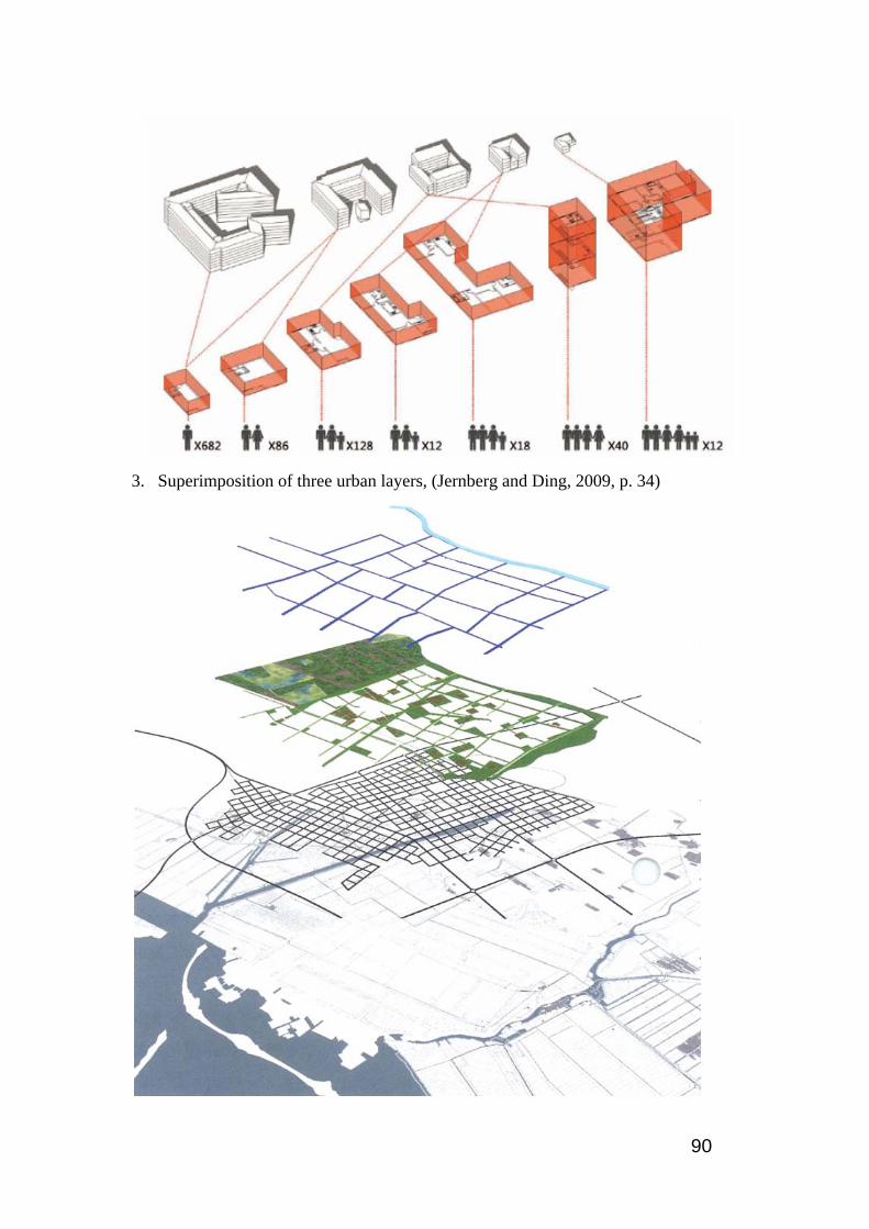
90
3. Superimposition of three urban layers, (Jernberg and Ding, 2009, p. 34)

91
4. Overall traffic structure, (Joachim, 2009, p. 45)
5. BRT Station, (Joachim, 2009, p. 47)
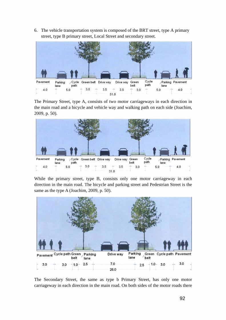
92
6. The vehicle transportation system is composed of the BRT street, type A primary street, type B primary street, Local Street and secondary street.
The Primary Street, type A, consists of two motor carriageways in each direction in the main road and a bicycle and vehicle way and walking path on each side (Joachim, 2009, p. 50).
While the primary street, type B, consists only one motor carriageway in each direction in the main road. The bicycle and parking street and Pedestrian Street is the same as the type A (Joachim, 2009, p. 50).
The Secondary Street, the same as type b Primary Street, has only one motor carriageway in each direction in the main road. On both sides of the motor roads there
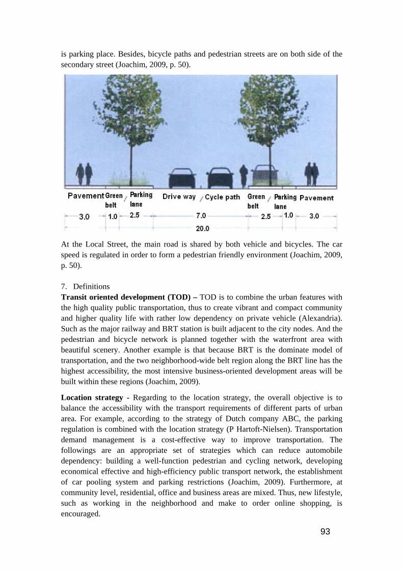
93
is parking place. Besides, bicycle paths and pedestrian streets are on both side of the secondary street (Joachim, 2009, p. 50).
At the Local Street, the main road is shared by both vehicle and bicycles. The car speed is regulated in order to form a pedestrian friendly environment (Joachim, 2009, p. 50). 7. Definitions Transit oriented development (TOD) – TOD is to combine the urban features with the high quality public transportation, thus to create vibrant and compact community and higher quality life with rather low dependency on private vehicle (Alexandria). Such as the major railway and BRT station is built adjacent to the city nodes. And the pedestrian and bicycle network is planned together with the waterfront area with beautiful scenery. Another example is that because BRT is the dominate model of transportation, and the two neighborhood-wide belt region along the BRT line has the highest accessibility, the most intensive business-oriented development areas will be built within these regions (Joachim, 2009).
Location strategy - Regarding to the location strategy, the overall objective is to balance the accessibility with the transport requirements of different parts of urban area. For example, according to the strategy of Dutch company ABC, the parking regulation is combined with the location strategy (P Hartoft-Nielsen). Transportation demand management is a cost-effective way to improve transportation. The followings are an appropriate set of strategies which can reduce automobile dependency: building a well-function pedestrian and cycling network, developing economical effective and high-efficiency public transport network, the establishment of car pooling system and parking restrictions (Joachim, 2009). Furthermore, at community level, residential, office and business areas are mixed. Thus, new lifestyle, such as working in the neighborhood and make to order online shopping, is encouraged.