Embed Size (px)
Citation preview

The Chicxulub Impact Structure, Yucatán Peninsula, México. Studies in the Eastern Merida -Valladolid Sector
Jaime Urrutia Fucugauchi Director, Instituto de Geofísica, UNAM. Email: [email protected] José María Chávez Aguirre Supervisor de Geología, Depto. de Geología, GEIC-CFE . Email: [email protected] José Luis de la Rosa Residente, Residencia de Geohidrología, CFE, Mérida, Yucatán. Email: [email protected]
Abstract
The Chicxulub crater is located in the northwestern sector of the Yucatan peninsula, buried by a
thick sequence of Tertiary carbonate rocks. The crater was first identified from geophysical studies
carried out during oil exploration surveys in the peninsula. For several years and particularly since 1980
the Federal Commission of Electricity (CFE) has conducted geohidrological and geotechnical
investigations in Yucatan. Studies have concentrated on the groundwater aquifers and karstic landforms.
The semicircular distribution of sinkholes has been related to the crater structural features (the cenote
ring correlates well with circular gravity anomaly pattern). Chemical analyses of water samples from the
saline intrusion/groundwater interface show high concentrations of elements like arsenic, cobalt, nickel,
and strontium. Studies are being conducted to document their sources. As part of the CFE program,
several boreholes were drilled in the eastern sector between Merida and Valladolid. Distribution of
sinkholes presents a more complex pattern in this area (as compared with the well-defined ring to the
south and west) and there is little information on the shallow stratigraphy and occurrence of impact
breccias. Here we report results from petrographic studies on samples from eleven boreholes. Boreholes
reach depths down to >300 m, and cut a thick carbonate sequence that has been divided into the Carrillo
Puerto and Chichen Itza Tertiary Formations. Beneath about 250 m depths, the carbonate rocks show
effects of tectonic deformation and fragmentation. An interval of about 34 m of carbonate breccias has
been recovered, which may correlate with the carbonate breccia sequence observed in the Santa Elena
and Tekax UNAM boreholes. Apparently undisturbed limestone strata are observed beneath the breccia
interval.

Introduction
The Chicxulub structure is currently interpreted in terms of a large bolide impact, occurring some
65 Ma ago (Hildebrand et al., 1991; Sharpton et al., 1992). The impact produced a large >200 km
diameter crater, as well as significant structural deformation on the target area and adjacent extensive
carbonate platform. The Chicxulub impact has been linked to the worldwide distributed Ir-rich clay layer
that has been the stratigraphic
marker of the Cretaceous/Tertiary
(K/T) boundary. The K/T layer
formed as a result of the
deposition of fine-grained
particle material sent out high
into the atmosphere by the
impact, which blocked incoming
solar radiation causing severe
global environmental and
climatic effects on the life
support systems (Alvarez et al.,
1980).
The Chicxulub crater is
located in the northwestern sector
of the Yucatan peninsula, buried
by a thick sequence of Tertiary
carbonate rocks (Figure 1).
Figure 1.- Chicxulub
crater and cenotes location in the
Yucatan peninsula.
The crater was first identified from geophysical studies carried out during oil exploration surveys
in the peninsula (Penfield and Camargo, 1981). Samples from the impact breccias and melt were
recovered from the exploratory PEMEX drilling program (e.g., Lopez Ramos, 1983). Samples from this
program are available in limited amounts, however. More recently, UNAM conducted a drilling program
in the southern sector of the crater, and in three boreholes the thick breccia sequence was sampled.

Analyses indicate that the breccia is formed by two distinct sequences: an upper breccia rich in basement
and melt fragments and a lower breccia rich in carbonate fragments. The upper breccia presents high
magnetic susceptibility, low seismic velocities, low density and low porosity and permeability (e.g.,
Urrutia-Fucugauchi et al., 1996; Rebolledo-Vieyra et al., 2000). The upper breccia appears similar to the
suevitic breccias documented in the Ries crater.
For several years and particularly since 1980 the Federal Commission of Electricity (CFE) has
conducted geohydrologic and geotechnical investigations in Yucatan. Studies have focussed on the
groundwater aquifers and karstic landforms, and also include an exploration shallow drilling program
(Figure 2). In this paper we report on the initial results of the CFE studies in the eastern sector of the
crater in the area between Merida and Valladolid.
Figure 2.- Chicxulub impact and UNAM and CFE boreholes location.
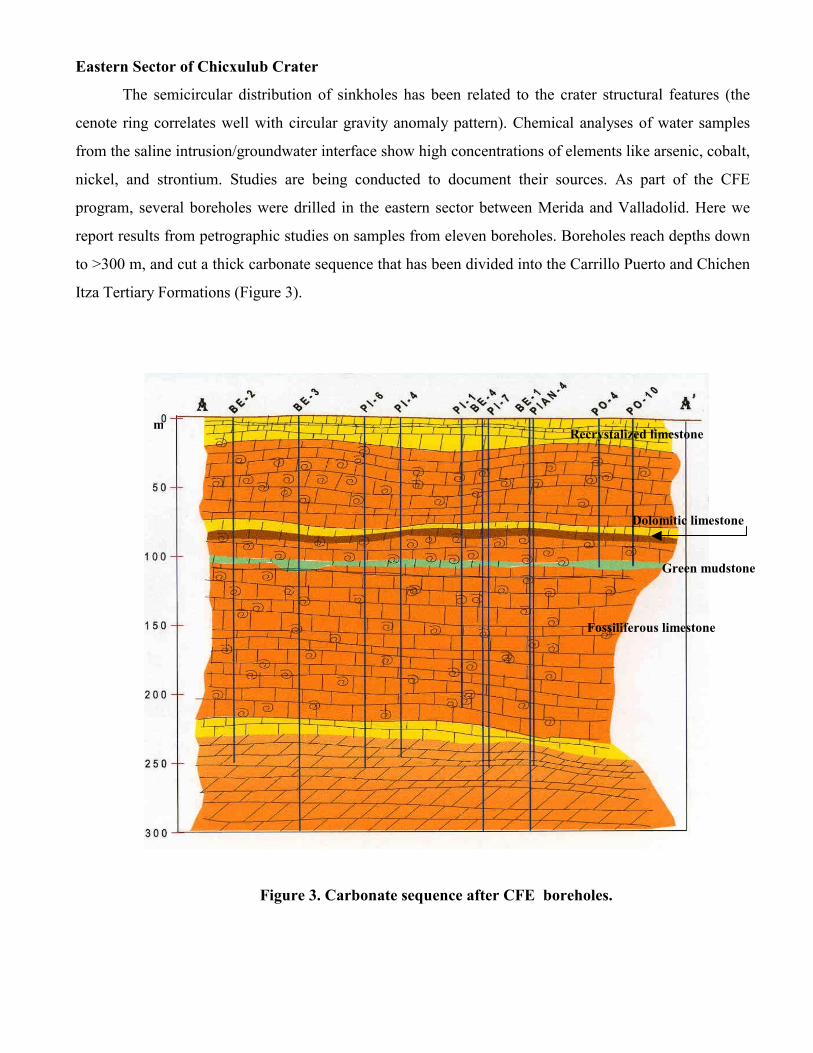
Eastern Sector of Chicxulub Crater
The semicircular distribution of sinkholes has been related to the crater structural features (the
cenote ring correlates well with circular gravity anomaly pattern). Chemical analyses of water samples
from the saline intrusion/groundwater interface show high concentrations of elements like arsenic, cobalt,
nickel, and strontium. Studies are being conducted to document their sources. As part of the CFE
program, several boreholes were drilled in the eastern sector between Merida and Valladolid. Here we
report results from petrographic studies on samples from eleven boreholes. Boreholes reach depths down
to >300 m, and cut a thick carbonate sequence that has been divided into the Carrillo Puerto and Chichen
Itza Tertiary Formations (Figure 3).
m
Recrystalized limestone
Dolomitic limestone
Green mudstone
Fossiliferous limestone
Figure 3. Carbonate sequence after CFE boreholes.

Beneath 250 m depths, the carbonate rocks show effects of tectonic deformation and
fragmentation. An interval of about 34 m of carbonate breccias has been recovered, which may correlate
with the carbonate breccia sequence observed in the Santa Elena and Tekax UNAM boreholes (Figure 4).
Apparently undisturbed limestone strata are observed beneath the breccia interval.
Figure 4.- CFE exploratory boreholes between Valladolid and Mérida.
Discussion
The Chicxulub crater is located in the northwestern sector of the Yucatan peninsula, buried by a
thick sequence of Tertiary carbonate rocks. The Chicxulub impact has been linked to the worldwide
distributed Ir-rich clay layer that has been the stratigraphic marker of the K/T boundary. The K/T layer
formed as a result of the deposition of fine-grained particle material sent out high into the atmosphere by

the impact, which blocked incoming solar radiation causing severe global environmental and climatic
effects on the life support systems. The crater was first identified from geophysical studies carried out
during oil exploration surveys in the peninsula. Samples from the impact breccias and melt were
recovered from the exploratory PEMEX drilling program. Samples from this program are available in
limited amounts, however. More recently, UNAM conducted a drilling program in the southern sector of
the crater, and in three boreholes the thick breccia sequence was sampled. Analyses indicate that the
breccia is formed by two distinct sequences: an upper breccia rich in basement and melt fragments and a
lower breccia rich in carbonate fragments. The upper breccia presents high magnetic susceptibility, low
seismic velocities, low density and low porosity and permeability. The upper breccia appears similar to
the suevitic breccias documented in the Ries
crater. 256.00m
Federal Commission of Electricity has
conducted geohidrological and geotechnical
investigations in Yucatan. Studies have
focussed on the groundwater aquifers and
karstic landforms. The semicircular
distribution of sinkholes has been related to the
crater structural features (the cenote ring
correlates well with circular gravity anomaly
pattern). Chemical analyses of water samples
from the saline intrusion/groundwater interface
show high concentrations of elements like
arsenic, cobalt, nickel, and strontium. Studies
are being conducted to document their sources.
As part of the CFE program, several boreholes
were drilled in the eastern sector between
Merida and Valladolid. We report results from
petrographic studies on samples from eleven
boreholes (Figure 5).
Figure 5.- Samples of the exploratory borehole BE-4, C.T. Valladolid, Yuc. 278.40m

Boreholes reach depths down to >300 m, and cut a thick carbonate sequence that has been divided into
the Carrillo Puerto and Chichen Itza Tertiary Formations. Beneath 250-m depths, the carbonate rocks
show effects of tectonic deformation and fragmentation (Figure 6). An interval of about 34-m of
carbonate breccias has been recovered, which may correlate with the carbonate breccia sequence
observed in the Santa Elena and Tekax UNAM boreholes.
Brecciated limestone Recrystalized brecciated limestone (274.00m) (274.40m)
Intraclastic brecciated limestone Dolomitic micrite (279.70m) (280.40m)
Figure 6.- Microscopic views of thin sections of samples of the BE-4 CFE exploratory borehole.

References
Alvarez, L.W., Alvarez, W., Asaro, F. and Michel, H., 1980. Extraterrestrial cause for the Cretaceous-
Tertiary extinction. Science, 208, 1095-1108. Anonymous, 1992. Diagnostico y pronostico de la calidad del agua en la parte del acuifero que subyace al
area metropolitana de la ciudad de Merida, Yucatan. Publ. Biotecnia Industrial, Consultores, 126 pp. Black, W. And Hanshaw, W., 1970. Comparison of chemical hydrogeology of the carbonate peninsula of
Florida and Yucatan. J. Hydrol., 10, 330-368. Connors, M., Hildebrand, A., Pilkington, M., Ortiz, C., Chavez, R., Urrutia-Fucugauchi, J., Graniel, E.,
Camara-Zi, A., Vasquez, J. and Halpenny, J., 1996. Yucatan karst features and the size of Chicxulub crater. Geophys. J. Int., 127, F11-F14.
Dohering, D.O. and Buttler, J.H., 1974. Hydrogeologic constraints on Yucatan�s development. Science, 186, 591-595.
Hildebrand, A., Penfield, G., Kring, D., Pilkington, M., Camargo, A., Jacobsen, S.B. and Boynton, W., 1991. Chicxulub crater: A possible Cretaceous/Tertiary boundary impact crater on the Yucatan peninsula, Mexico. Geology, 19, 867-871.
Lopez Ramos, E., 1983. Geologia de Mexico. Edicion Privada, 3 Ed., Mexico City, Mexico. Penfield, G. and Camargo, A., 1981. Definition of a major igneous zone in the central Yucatan platform
with aeromagnetics and gravity. Ann. Meet. Soc. Expl. Geophys., Technical Progr. Abstr., 51, 37 (abstr.).
Perry, E.C., Marin, L., McClain, J. and Velazquez, G., 1995. The ring of cenotes (sinkholes), northwest Yucatan, Mexico: Its hydrogeologic characteristics and possible association with the Chicxulub impact crater. Geology, 23, 17-20.
Perry, E.C., Swift, J., Gamboa, J., Reeve, A., Sanborn, R., Marin, L. and Villasuso, M., 1989. Geologic and environmental aspects of surface cementation, north coast Yucatan, Mexico. Geology, 17, 818-821.
Pope, K., Ocampo, A., Kinsland, G. and Smith, R., 1996. Surface expression of the Chicxulub crater. Geology, 24, 527-530.
Rebolledo-Vieyra, M., Urrutia-Fucugauchi, J., Marin, L., Trejo-Garcia, A., Sharpton, V.L. and Soler-Arechalde, A.M., 2000. UNAM scientific shallow-drilling program of the Chicxulub impact crater. Int. Geol. Rev., 42, 928-940.
Sharpton, V.L., Dalrymple, G., Marin, L., Ryder, G., Shuraytz, B. and Urrutia-Fucugauchi, J., 1992. New links between the Chicxulub impact structure and the Cretaceous/Tertiary boundary. Nature, 359, 819-821.
Steinich, B. and Marin, L., 1997. Determination of flow characteristics in the aquifer of the northwestern peninsula of Yucatan, Mexico. J. Hydrol., 191, 315-331.
Urrutia-Fucugauchi, J., Marin, L. and Trejo-Garcia, A., 1996. UNAM scientific drilling program of Chicxulub impact structure: Evidence for a 300 kilometer crater diameter. Geophys. Res. Lett., 23, 1565-1568.


![Chicxulub impact predates K T boundary: New evidence from ... · Chicxulub crater on Yucatan [1] and impact spherule ejecta at the base of a sandstone complex throughout Mexico and](https://img.dokumen.tips/doc/110x75/601902805d45c0558c523744/chicxulub-impact-predates-k-t-boundary-new-evidence-from-chicxulub-crater-on.jpg)