Embed Size (px)
Citation preview


CALIFORNIA DEPARTMENT OF TRANSPORTATION
THE REAL-TIME SYSTEM MANAGEMENT INFORMATION PROGRAM COMPLIANCE REPORT
2014 – INTERSTATE HIGHWAYS 2016 – METROPOLITAN AREA ROUTES OF SIGNIFICANCE
Prepared by
Division of Traffic Operations Office of Traffic Management
Submitted to
Federal Highway Administration California Division
October 2016

Real-Time System Management Information Program Compliance Report October 2016
i
TABLE OF CONTENTS INTRODUCTION .......................................................................................................................... 1
I. PART A: 2014 INTERSTATE ROUTES ........................................................................... 3
1. CONSTRUCTION ACTIVITIES (INTERSTATES)................................................... 4
2. ROADWAY OR LANE-BLOCKING INCIDENTS (INTERSTATES) ..................... 6
3. ROADWAY WEATHER OBSERVATIONS (INTERSTATES)................................ 8
4. TRAVEL TIME INFORMATION (INTERSTATES) ............................................... 10
5. ITS ARCHITECTURE (INTERSTATES) ................................................................. 16
II. PART B: 2016 ROUTES OF SIGNIFICANCE ................................................................ 17
INTRODUCTION TO ROUTES OF SIGNIFICANCE .............................................................. 18
1. CONSTRUCTION ACTIVITIES (STATE ROUTES OF SIGNIFICANCE) ........... 20
2. ROADWAY OR LANE-BLOCKING INCIDENTS (STATE ROUTES OF SIGNIFICANCE) ....................................................................................................... 22
3. ROADWAY WEATHER OBSERVATIONS (STATE ROUTES OF SIGNIFICANCE) ....................................................................................................... 24
4. TRAVEL TIME INFORMATION (STATE ROUTES OF SIGNIFICANCE) ......... 26
5. ITS ARCHITECTURE (STATE ROUTES OF SIGNIFICANCE)............................ 32
CONCLUSION ............................................................................................................................. 33
APPENDIX A: PLANNED CLOSURES STATEWIDE (INTERSTATES) .............................. 35
ACCURACY COMPLIANCE TRENDLINE ................................................................... 36
APPENDIX B: SUMMARY OF ROADWAY WEATHER OBSERVATIONS ....................... 37
APPENDIX C: FIVE METROPOLITAN REGIONS ................................................................. 39
APPENDIX D: INTERSTATES STATEWIDE – TRAVEL TIME INFORMATION .............. 40
APPENDIX E: LISTING OF STATEWIDE ROUTES OF SIGNIFICANCE ........................... 46
APPENDIX F: STATE ROUTES OF SIGNIFICANCE – TRAVEL TIME INFORMATION ................................................................................................................ 53
APPENDIX G: SACRAMENTO REGION – DISTRICT 3 CONSTRUCTION ACTIVITIES ...................................................................................................................... 60
ACCURACY COMPLIANCE TRENDLINE ................................................................... 61
APPENDIX H: BAY AREA REGION – DISTRICTS 4 AND 5 CONSTRUCTION ACTIVITIES ...................................................................................................................... 62
ACCURACY COMPLIANCE TRENDLINE ................................................................... 63

Real-Time System Management Information Program Compliance Report October 2016
ii
APPENDIX I: LOS ANGELES REGION – DISTRICTS 7 AND 12 CONSTRUCTION ACTIVITIES ...................................................................................................................... 64
ACCURACY COMPLIANCE TRENDLINE ................................................................... 65
APPENDIX J: RIVERSIDE REGION – DISTRICT 8 CONSTRUCTION ACTIVITIES ...................................................................................................................... 66
ACCURACY COMPLIANCE TRENDLINE ................................................................... 67
APPENDIX K: SAN DIEGO REGION – DISTRICT 11 CONSTRUCTION ACTIVITIES ...................................................................................................................... 68
ACCURACY COMPLIANCE TRENDLINE ................................................................... 69
APPENDIX L: LOCAL ARTERIAL ROUTES OF SIGNIFICANCE – SACRAMENTO REGION ............................................................................................................................. 70
APPENDIX M: LOCAL ARTERIAL ROUTES OF SIGNIFICANCE – SAN FRANCISCO REGION ............................................................................................................................. 71
APPENDIX N: LOCAL ARTERIAL ROUTES OF SIGNIFICANCE – SAN JOSE REGION ............................................................................................................................. 72
APPENDIX O: LOCAL ARTERIAL ROUTES OF SIGNIFICANCE – LOS ANGELES REGION ............................................................................................................................. 73
APPENDIX P: LOCAL ARTERIAL ROUTES OF SIGNIFICANCE – RIVERSIDE REGION ............................................................................................................................. 74
APPENDIX Q: LOCAL ARTERIAL ROUTES OF SIGNIFICANCE – SAN DIEGO REGION ............................................................................................................................. 75
APPENDIX R: STATE AND REGIONAL TRANSPORTATION PARTNERS COLLABORATION DOCUMENTS ................................................................................ 76
ROUTES OF SIGNIFICANCE FACT SHEET ................................................................. 77
CRITERIA FOR DESIGNATING ROUTES OF SIGNIFICANCE ................................. 78
ROUTES OF SIGNIFICANCE SUBMITTAL PROCESS ............................................... 82
ROUTES OF SIGNIFICANCE CHECKLIST ................................................................... 83
REGIONAL TRANSPORTATION PARTNER MEMORIALIZATION LETTER ......... 86
LIST OF TABLES ........................................................................................................................ 88
DIRECTIONAL LEGEND ........................................................................................................... 89
ACRONYM LEGEND ................................................................................................................. 90
Real-Time System Management Information Program Compliance Report October 2016
1
INTRODUCTION The California Department of Transportation (Caltrans) updated the 2014 Real-Time System Management Information Program (RTSMIP) compliance report for Interstate routes and combined it with the 2016 RTSMIP for metropolitan area routes of significance (RoS). The combined report demonstrates conformance with the federal regulations for accurate and available traffic and travel conditions reporting statewide on Interstate highways and metropolitan area non-Interstate highways, or RoS. The RTSMIP provides accessibility to traffic and travel conditions information by public agencies, the traveling public, and other parties who deliver value-added information products. The Safe, Accountable, Flexible, Efficient Transportation Equity Act: A Legacy for Users (SAFETEA-LU) Section 1201 (a)(1), (a)(2) and (c)(1) final rule published in the Federal Register on November 8, 2010, requires the State Department of Transportation (DOT) to develop a RTSMIP meeting the requirements as outlined in title 23, Code of Federal Regulations part 511 (23 CFR 511). The RTSMIP is defined as the program by which states gather and make available data for traffic and travel conditions on Interstate highways and RoS. These conditions refer to the traveling public’s experiences on roadways, with the emphasis on the following four areas: construction activities, roadway or lane-blocking incidents, roadway weather observations, and travel time information. For construction activities and travel time information, the regulations define metropolitan areas as geographical areas designated as Metropolitan Statistical Areas (MSAs) with a population exceeding one million inhabitants. Compliance with federal regulations to the four provisions is measured by the accuracy and availability of the reported information. The accuracy of information measurement is 85 percent accurate at a minimum, or a maximum error rate of 15 percent. The availability of information measurement is 90 percent available at a minimum. The program provides the capability to monitor traffic and travel conditions of the major highways across the United States in real-time, as well as a means of sharing data with state and local governments, and the traveling public. The RTSMIP is designed to use existing traffic and travel condition monitoring capabilities, build upon them where applicable and complement current transportation performance reporting systems, making it easier to gather and enhance required information. Data quality standards are to be established for data to the consumers. The program includes participation from highway agencies, public safety agencies, transit operators, and other operating agencies necessary to sustain mobility. The Intelligent Transportation Systems (ITS) Architecture was evaluated and explicitly addresses needs for real-time highway and transit information, and the methods to meet these needs. The ITS Architecture features the components and functionality of the program while focusing on coverage, monitoring systems, data fusion, accessibility to highway and transit information, and value-added information product providers.

Real-Time System Management Information Program Compliance Report October 2016
2
The effective date of the RTSMIP for traffic and travel conditions on Interstate highways was November 8, 2014, and is November 8, 2016 for RoS. This report establishes Caltrans’ compliance with 23 CFR 511 and addresses conformance with regard to construction activities, roadway or lane-blocking incidents, roadway weather observations, and travel time information on Interstate highways and RoS. Emphasis is placed on accuracy of information measured at 85 percent or higher, and availability of information measured at 90 percent available or higher. Caltrans’ ITS Architecture is also compliant with federal regulations.

Real-Time System Management Information Program Compliance Report October 2016
3
I. PART A: 2014 INTERSTATE ROUTES

Real-Time System Management Information Program Compliance Report October 2016
4
1. CONSTRUCTION ACTIVITIES (INTERSTATES) Federal regulations require state DOTs to provide traffic and travel conditions through the RTSMIP. The timeliness for the availability of information regarding full construction activities that close or reopen roadways or lanes will be 20 minutes or less from the time of the closure for highways outside of metropolitan areas, and 10 minutes or less from the time of the closure or reopening within metropolitan areas. Intermittent or short-term lane closures of limited duration that are less than the required reporting times are not regulated for compliance in this provision. Caltrans uses two tools to report, monitor, and status construction activities on Interstate highways. The first tool is the Lane Closure System (LCS), an Oracle database that contains all information related to planned lane closures for all 12 Caltrans districts. The second tool is QuickMap, a web page that is updated every five minutes with real-time traffic information feeds from various data sources, including: Caltrans’ Commercial Wholesale Web Portal (CWWP), Changeable Message Signs (CMS) content, the Caltrans Highway Information Network (CHIN), the Transportation Management Center Activity Log (TMCAL), and the LCS. Caltrans uses QuickMap to make real-time traveler information available to motorists. Caltrans demonstrates compliance with construction activity regulations by reporting all planned lane closures on Interstate highways to the Transportation Management Center (TMC) before the first advanced warning sign is placed on the roadway. This process is referred to as “10-97.” When the TMC staff member is notified and inputs “10-97” into the LCS, a traffic device icon appears in QuickMap with estimated end times and dates for the planned closure. At the end of the planned closure, the TMC is notified after all of the advanced warning signs are removed from the roadway. This process is referred to as “10-98.” When “10-97” and “10-98” are reported to the TMC within the specified end times and dates, the lane closure is considered “accurately statused.” If either a “10-97” or a “10-98” occurs without the reciprocating activity, this is considered “not accurately statused.” For construction activity compliance, Appendix A provides compliance reports for statewide planned lane closures on Interstate highways for a three-month period from January through March 2015. For planned closures, approval must be obtained from the District Traffic Manager (DTM) one week before the closure takes place. Once approved, the closure is posted in the LCS and becomes active before the first advanced warning sign is placed on the roadway. The lane closure is considered complete after all of the advanced warning signs are removed from the roadway. Emergency closures do not require DTM approval and are entered into the LCS immediately upon notification by the TMC staff member.

Real-Time System Management Information Program Compliance Report October 2016
5
Caltrans uses QuickMap, the LCS and CMS to disseminate real-time system information as follows:
• QuickMap is a web-based map which displays current traffic speeds, roadway incidents, full closures, lane closures related to construction, active CMS, CCTV (Closed Circuit Television) camera images, and chain controls. The Headquarters (HQ) Traveler Information Coordinator and the Public Information Officer (PIO) manage the information shown on QuickMap.
• The LCS is an Oracle database which contains start and end times related to planned lane
closures for all 12 districts. The Statewide Lane Closure Management Coordinator manages LCS.
• CMS may be used to inform travelers about active construction activities on highways.
The LCS disseminates construction information to QuickMap, the CWWP, the Performance Measurement System (PeMS), and the CHIN. The lane closure data files in QuickMap and the CWWP are updated every five minutes. In terms of accuracy, the LCS is up and running approximately 99 percent of the time (excluding a daily 15 minute routine maintenance period). The real-time information availability for lane closures from all districts exceeds the 90 percent threshold. Of the 12 Districts, the TMCs in District 1, 2, 5, and 9 do not operate 24 hours per day, 7 days per week. When these districts have a planned lane closure scheduled after business hours, the lane closure is entered into the LCS by one of the neighboring districts. For scheduled planned lane closures that occur after the TMC business hours, District 1 notifies District 4, District 2 notifies District 3, and Districts 5 and 9 notify District 6. Due to intermittent cell phone coverage in rural areas, there may be occasions where planned lane closures are not statused within the 20 minute timeframe as stated in the regulations. These occasions are rare and Caltrans is currently exploring the use of LCS mobile applications with broadband coverage allowing field personnel to status lane closures remotely.

Real-Time System Management Information Program Compliance Report October 2016
6
2. ROADWAY OR LANE-BLOCKING INCIDENTS (INTERSTATES) Federal regulations require that the availability of information related to roadway or lane-blocking traffic incidents to be 20 minutes or less from the time the incident is verified for highways outside of metropolitan areas. The availability of information related to roadway or lane-blocking traffic incidents within metropolitan areas will be 10 minutes or less from the time the incident is verified. Caltrans uses the following tools to report, monitor, and status incidents on Interstate highways: the TMCAL, the Advanced Traffic Management System (ATMS), the Intelligent Roadway Information System (IRIS), and the California Highway Patrol Computer-Aided Dispatch (CHP CAD).
• The TMCAL is a MySQL statewide database where incidents are logged and fed into QuickMap. From the time a roadway or lane-blocking incident is reported to the TMC, the latency between the incident reporting and the data entry into the TMCAL by staff is minimal and within the 85 percent accuracy threshold. After the incident is entered into the TMCAL, the process to store and disseminate the information is automated.
• The ATMS is a statewide database which uses ITS elements to gather real-time
information on State highways and distribute the information to the district TMCs.
• The IRIS is a statewide database used to monitor incidents on State highways.
• The CHP CAD is a statewide database where local dispatchers enter incident information gathered from officers in the field. The CHP CAD feeds real-time incident updates to the TMCAL, which in turn feeds the incident into QuickMap.
• The CWWP houses data and makes it available for government and local agencies, cities,
counties, and the public. Caltrans disseminates traveler information through the CHIN IVR number 1-800-427-7623 (1-800-GAS-ROAD), QuickMap, the CWWP, and CMS signs. The CHIN IVR, QuickMap, the CWWP, and the general messages for the CMS are managed by the HQ Office of Traffic Management. The accuracy and availability of roadway and lane-blocking incidents by Caltrans meets or exceeds the requirements through the TMCs that are staffed and managed 24 hours per day, 7 days per week, and through the use of an automated system which populates the TMCAL database. Incidents occurring in districts that are not continuously operational are reported to the neighboring TMCs that function 24 hours per day, 7 days per week. The TMCs also have reporting policies to local entities as appropriate and required, and also report with the neighboring TMCs when an incident affects more than one district.
Real-Time System Management Information Program Compliance Report October 2016
7
For roadway and lane-blocking incidents, Caltrans and the CHP work together to monitor and report highway conditions. The CHP uses the CAD to track all accidents on the State Highway System (SHS). The dispatcher enters the information into the CAD as soon as it is obtained from the reporting party. Typos are generally corrected immediately after the information is entered. The Media CAD, a limited subset of the CAD determined for public consumption by the CHP, uploads the information in five minutes or less. The process is subject to human error yet is generally very accurate and meets the federal regulation’s 85 percent minimum accuracy threshold. The Media CAD is never off-line and is 100 percent reliable and available. It has back-up servers and four hubs; therefore, updates and routine maintenance are completed one hub at a time. The Media CAD meets the 90 percent availability requirement as outlined in federal regulations. The incident reporting Standard Operating Procedure (SOP) is that the CHP enters the information into the CHP CAD which is then released to the Media CAD and the CWWP. If the event is reported by a CHP field officer, it is considered verified. If it is relayed by the public via 911, there needs to be either multiple 911 calls, verification by CCTV, or field verification by the CHP or Caltrans personnel before it is considered verified. When confirmation is received that the event is no longer affecting the roadway, the incident is closed out in the CAD and the CWWP no longer shows the event. In general, the information entered by the CHP is in the CWWP before Caltrans is aware there is an incident. The latency between the CAD and the CWWP is small (approximately five minutes); therefore, the event will always be available to the public within approximately five minutes. Caltrans does not have the ability to affect “false data,” meaning data that may exist even though there is no actual event. Caltrans utilizes CCTV and/or Caltrans field personnel to verify there is no incident, or that an incident has been completed, at which point Caltrans relays the information to the CHP who in turn closes the incident, effectively removing it from the CWWP.

Real-Time System Management Information Program Compliance Report October 2016
8
3. ROADWAY WEATHER OBSERVATIONS (INTERSTATES) Federal regulations require the availability of information about hazardous driving conditions and roadway or lane closures or blockages due to adverse weather conditions to be 20 minutes or less from the time the hazardous conditions, blockage, or closure is observed. Caltrans reports weather statewide using similar weather-related tools: the CHP CAD, the Road Weather Information System (RWIS), the Fog Detection and Warning System (FDWS), and Chain Controls. Once the data is gathered or reported it is entered into the CHIN. Data can be entered into the CHIN using the TMCAL or by the Headquarters Communication Center (HCC) receiving a call, facsimile, or e-mail, and manually entering the data. From the time the TMC is notified, the process is fully automated with a Mean Time Between Failure (MTBF) that meets the required accuracy.
• The RWIS consist of networks of weather monitoring stations that collect weather condition data on roadways. The system is comprised of Environmental Sensor Stations (ESS) in the field, a communication system for data transfer, and central systems to collect field data from numerous ESS. These stations measure atmospheric, pavement, and/or water level conditions.
• The FDWS consists of visibility sensors, speed detectors, and cameras to detect
congestion and visibility problems that could affect driver and passenger safety on roadways. Through intelligence built into the ITS product, the system alerts motorists automatically of adverse weather conditions and slow speeds by using CMS and Highway Advisory Radio (HAR). The installation is 40 percent solar-powered, using both point-to-point and point-to-multipoint wireless radios to provide network connectivity. Local field controllers allow the field equipment to work autonomously should a break occur in communications to the central system.
Caltrans provides real-time roadway weather information on Interstate highways through three sources: the IVR, the CWWP, and the Web. Additionally, TMCs have reporting protocols to local entities as required. When adverse weather conditions cause lane closures, Caltrans personnel relay the information to the TMC dispatch and similarly update the TMC when the closure is removed. The TMCs and Maintenance Dispatch report incidents as identified in the Highway Conditions Reporting Matrix to the HCC within 10 minutes of notification of the incident, as well as to their district executive management. The Traffic Management Team (TMT) may also respond to a weather-related road closure, and can perform a travel run to determine delay time.

Real-Time System Management Information Program Compliance Report October 2016
9
Inter-agency coordination between Caltrans and the CHP occurs in the event of a major storm that closes the highway. The CHP performs escorts prior to the closure and Caltrans is responsible for putting the closure in place. The incident information is reported to and received by the TMC, and a dispatcher enters the data into the TMCAL, which is disseminated to the public. The TMCs operating 24 hours per day, 7 days per week have negligible system down time, and exceed the 90 percent availability requirement (except in the case of a power outage). Caltrans districts get their weather information from similar sources and then enter this information into the CHIN. The TMC will relay the information to the HCC, and staff will then either enter the data into the TMCAL, or directly into the CHIN. All districts use weather information from the CHP CAD, Caltrans maintenance supervisors, and the National Oceanic Atmospheric Administration (NOAA) for roadway weather. Districts 1, 2, 3, 6, 8, 9, and 10 collect the RWIS weather data. Districts 2 and 3 use the TMCAL to populate the weather information to the CHIN. The other districts input the data manually into the CHIN. District 10 plans to switch to the TMCAL in the future. District 11 has a system designed to automatically post any information to the CHIN. Appendix B shows a detailed summary of roadway weather tools and observations by district, and also discusses the accuracy and availability of roadway weather real-time information. Both Caltrans and the CHP jointly decide when to close Interstate highways due to adverse weather conditions. Either Caltrans or the CHP will initiate the discussion based upon on site visual inspection of the conditions on the facility. The closure is then reported to the TMC and the CHP dispatch. The TMC and the CHP place this information into their databases and tracking systems.

Real-Time System Management Information Program Compliance Report October 2016
10
4. TRAVEL TIME INFORMATION (INTERSTATES) Federal regulations require the timeliness for the availability of travel time information along limited access roadway segments within metropolitan areas to be 10 minutes or less from the time the travel time calculation is completed. For the purposes of reporting real-time travel information, Caltrans has divided the State into five metropolitan regions: Sacramento, Bay Area (San Francisco and San Jose), Los Angeles, Riverside, and San Diego. Appendix C is a statewide graphic of the highlighted regions. Throughout the metropolitan areas of California, Caltrans utilizes CMS to provide real-time travel information on Interstates. All five regions are in federal compliance and real-time travel information is provided on at least one Interstate route in each metropolitan region. For travel time compliance, Appendix D lists all CMS statewide displaying travel time information on Interstate highways by district, county, route, postmile, direction, and CMS location. In November 2014, the Federal Highway Administration (FHWA) made an observation and recommendation for the 2014 RTSMIP compliance report:
• Observation: “The report indicates many of Caltrans’ districts responsible for a Metropolitan Statistical Area (MSA) have an alternative to providing travel times on Changeable Message Signs (CMS). When loop detection is poor, districts shut off the CMS or use them for a different operational purpose. In California, the data feed from CMS operation is the link to Caltrans’ QuickMap and other third party messaging applications. In other words, when the CMS is dark during periods of traffic congestion, there are no other means to transmit travel time information to Caltrans’ application because the CMS display is the primary source used to broadcast travel time to other systems. This could impact Caltrans’ ability to meet the information availability portion of 23 CFR 511 in the future {Refer to 23 CFR 511.309 (4) & (6)}.”
• Recommendation: “Caltrans’ public performance report The Mile Marker contains a
statewide goal of having 90% or more vehicle loop detectors functioning properly. As such, Caltrans should consider having each district managing an MSA achieve an intermediate milestone in pursuit of the overall statewide goal of 90% functionality. In addition to pursuing your loop detector health goal, Caltrans should consider the methods Caltrans’ District 4 and District 8 are currently implementing to use real-time data from additional technologies as an alternative approach to vehicle loop detection.”
To ensure compliance with federal regulations, Caltrans will enhance the data strategy for travel times to address the FHWA’s observation and recommendation. Travel time algorithms would be automatically generated and sent directly to the CWWP. By automatically sending the travel time algorithms directly to the CWWP, the travel times will not have to be initially posted on a CMS. Expected implementation of this data strategy is within three years.

Real-Time System Management Information Program Compliance Report October 2016
11
Interstate Travel Time Information – Sacramento Region (District 3)
• El Dorado, Placer, Sacramento, and Yolo Counties
• Cities of Sacramento, Roseville, and Arden Arcade
• The Metropolitan Planning Organization (MPO) for the Sacramento Region is the Sacramento Area Council of Governments (SACOG).
District 3 displays travel times on Interstate highways with updates provided typically at five minute intervals. The travel times posted at CMS locations are initially verified with field staff driving the segments to ensure accuracy. Travel times are verified by driving the route using a tachometer to confirm the actual time information. A tachometer is a device used to estimate traffic speed and volume. A vehicle is equipped with a sensor and “tach runs” can be completed to record the traffic data. The TMC operator staff checks posted travel times along with the other posted CMS messages in the district. If a travel time appears unusual, the operator will check the camera and PeMS data to ascertain if there are reasons to explain the unusual posted travel time. As a fail-safe measure, if more than a three mile segment of detection is not functional, the system will stop displaying travel times and the CMS location will be blanked. Therefore, the system improves accuracy by not operating if there is not adequate detection. The availability of a CMS location for posting travel times encounters interruptions only in the following cases: incident management, construction traffic management, and emergency notifications such as America’s Missing Broadcast Emergency Response (AMBER) for missing children, and Blue Alerts, which assist in the apprehension of violent criminals who kill or seriously injure law enforcement officers. Over a three-month period, CMS locations operated greater than 96 percent of the time. Non-operational CMS locations are reported timely to the Electrical Systems Branch for investigation. Once an operator notes that a CMS is blank instead of displaying travel times, the location is reported to the Electrical Support Systems Branch for investigation. Any necessary field repairs are submitted to maintenance through the Integrated Maintenance Management System (IMMS). Travel time information displayed on CMS for Interstate highways in the Sacramento Region is illustrated in Table 1.
Table 1: Sacramento Region Interstate Routes
SACOG/District 3 Cities of Sacramento, Roseville, and Arden Arcade El Dorado, Placer, Sacramento, and Yolo Counties
COUNTY INTERSTATE ROUTES SACRAMENTO 5

Real-Time System Management Information Program Compliance Report October 2016
12
Interstate Travel Time Information – Bay Area Region (Districts 4 and 5)
• Alameda, Contra Costa, San Francisco, San Mateo, Marin, San Benito, and Santa Clara Counties
• Cities of San Francisco, Oakland, Hayward, San Jose, Sunnyvale, and Santa Clara
• The MPO for the Bay Area Region is the Metropolitan Transportation Commission
(MTC). District 4 uses data provided by the MPO-MTC partnership. The MTC has purchased traffic data from INRIX using Global Positioning System (GPS) probe-based traffic data. The source of the GPS data is a combination of Commercial Vehicle GPS Probe, Consumer Vehicle GPS Probe, GPS-Enabled Smartphone Probe, and Cellular Network Probe. The data is fed to the fusion engine which checks and weighs the data accuracy and procedures, and estimates travel times. The technique has been tested by the Washington State Department of Transportation and the New Jersey State Department of Transportation. New Jersey validated the data on the I-95 via a second set of Bluetooth readers. The MTC validates the travel time data via a series of floating car studies. INRIX has over three years of stored data that is normalized for seasonal traffic patterns. The ATMS travel time module for District 4 is programmed on a fixed schedule of 0500 to 2100 hours daily. If the system loses the data feed from the MTC for longer than 10 minutes, the travel time system is programmed to blank out the signs. If the data feed is unable to be restored, there is an option to use the secondary source of data from Caltrans’ traffic monitoring stations. District 5 does not have Interstate routes that qualify for the RTSMIP at this time. Travel time information displayed on CMS for Interstate highways in the Bay Area Region is illustrated in Table 2.
Table 2: Bay Area Region Interstate Routes
MTC/Districts 4 and 5 Cities of San Francisco, Oakland, Hayward, San Jose, Sunnyvale, and Santa Clara
Alameda, Contra Costa, San Francisco, San Mateo, Marin, San Benito, and Santa Clara Counties COUNTY INTERSTATE ROUTES
ALAMEDA 80, 580, 880 CONTRA COSTA 80 SANTA CLARA 280, 680, 880

Real-Time System Management Information Program Compliance Report October 2016
13
Interstate Travel Time Information – Los Angeles Region (Districts 7 and 12)
• Orange and Los Angeles Counties
• Cities of Los Angeles, Long Beach, and Anaheim
• The MPO for the Los Angeles Region is the Southern California Association of Governments (SCAG).
District 7 displays travel times on approximately 45 CMS using roadway loop detectors. A computer algorithm gathers the real-time loop information and automatically computes an estimated travel time to selected target locations. The CMS are updated every three minutes. To ensure accuracy when no detector information is available, the CMS will not display a travel time for that target location. The travel times are displayed on CMS daily from 0500 to 2100 hours. This wide range of available travel times encompasses 100 percent of the daily congestion period on roadways. The travel times are not displayed outside of this period when congestion and traffic volumes are lower. Due to insufficient detection, designated travel times may not be displayed on CMS, yet the real-time information is available above the 90 percent requirement during the operational time frame. District 12 checks the accuracy of speed which is calculated with the loop detection system, and utilizes radar guns and tach runs to verify traffic conditions. This analysis concludes that the speed calculation is 95 percent accurate. The travel times are displayed on CMS from 0600 to 2200 hours. An algorithm calculates travel time based on real-time traffic speed along a corridor. The algorithm has the intelligence to extrapolate the calculation in the event of malfunction for up to two and a half miles and is 95 percent accurate. Travel time information displayed on CMS for Interstate highways in the Los Angeles Region is illustrated in Table 3.
Table 3: Los Angeles Region Interstate Routes
SCAG/Districts 7 and 12 Cities of Los Angeles, Long Beach, and Anaheim
Orange and Los Angeles Counties COUNTY INTERSTATE ROUTES
LOS ANGELES 5, 10, 105, 110, 210, 405, 605 ORANGE 5, 405
Real-Time System Management Information Program Compliance Report October 2016
14
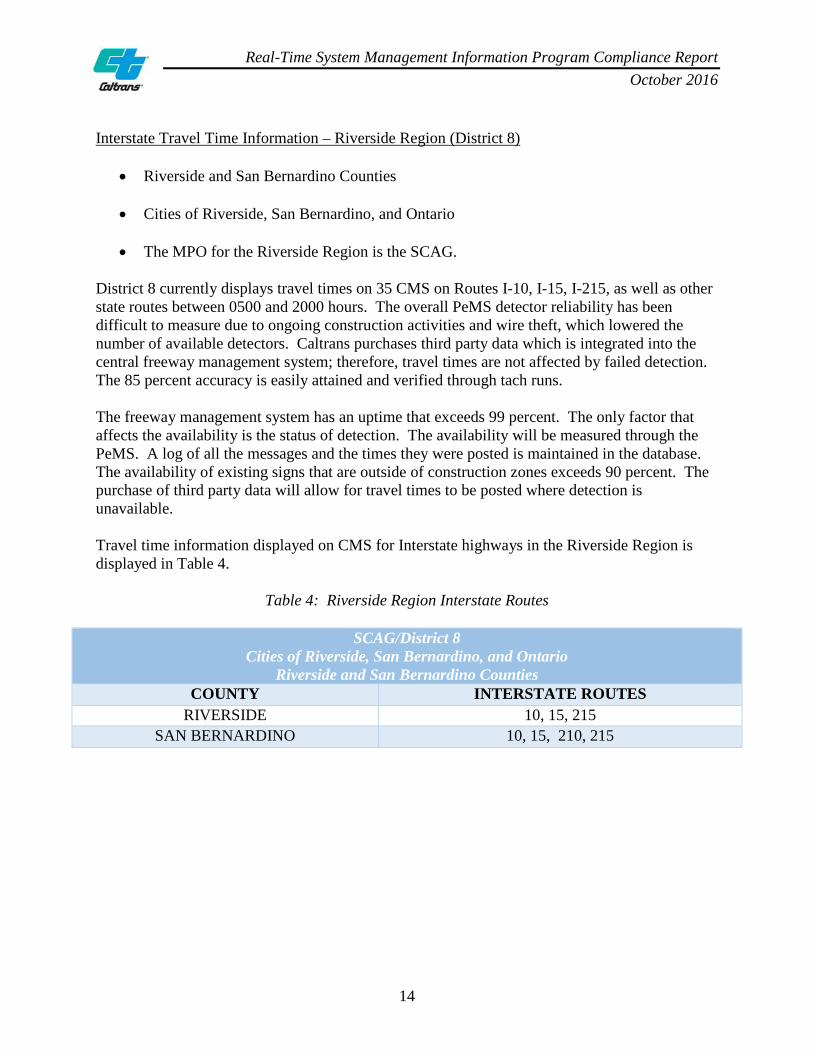
Interstate Travel Time Information – Riverside Region (District 8)
• Riverside and San Bernardino Counties
• Cities of Riverside, San Bernardino, and Ontario
• The MPO for the Riverside Region is the SCAG. District 8 currently displays travel times on 35 CMS on Routes I-10, I-15, I-215, as well as other state routes between 0500 and 2000 hours. The overall PeMS detector reliability has been difficult to measure due to ongoing construction activities and wire theft, which lowered the number of available detectors. Caltrans purchases third party data which is integrated into the central freeway management system; therefore, travel times are not affected by failed detection. The 85 percent accuracy is easily attained and verified through tach runs. The freeway management system has an uptime that exceeds 99 percent. The only factor that affects the availability is the status of detection. The availability will be measured through the PeMS. A log of all the messages and the times they were posted is maintained in the database. The availability of existing signs that are outside of construction zones exceeds 90 percent. The purchase of third party data will allow for travel times to be posted where detection is unavailable. Travel time information displayed on CMS for Interstate highways in the Riverside Region is displayed in Table 4.
Table 4: Riverside Region Interstate Routes
SCAG/District 8 Cities of Riverside, San Bernardino, and Ontario
Riverside and San Bernardino Counties COUNTY INTERSTATE ROUTES
RIVERSIDE 10, 15, 215 SAN BERNARDINO 10, 15, 210, 215
Real-Time System Management Information Program Compliance Report October 2016
15
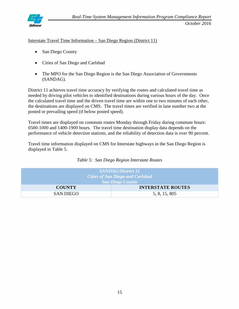
Interstate Travel Time Information – San Diego Region (District 11)
• San Diego County
• Cities of San Diego and Carlsbad
• The MPO for the San Diego Region is the San Diego Association of Governments (SANDAG).
District 11 achieves travel time accuracy by verifying the routes and calculated travel time as needed by driving pilot vehicles to identified destinations during various hours of the day. Once the calculated travel time and the driven travel time are within one to two minutes of each other, the destinations are displayed on CMS. The travel times are verified in lane number two at the posted or prevailing speed (if below posted speed). Travel times are displayed on commute routes Monday through Friday during commute hours: 0500-1000 and 1400-1900 hours. The travel time destination display data depends on the performance of vehicle detection stations, and the reliability of detection data is over 90 percent. Travel time information displayed on CMS for Interstate highways in the San Diego Region is displayed in Table 5.
Table 5: San Diego Region Interstate Routes
SANDAG/District 11 Cities of San Diego and Carlsbad
San Diego County COUNTY INTERSTATE ROUTES
SAN DIEGO 5, 8, 15, 805

Real-Time System Management Information Program Compliance Report October 2016
16
5. ITS ARCHITECTURE (INTERSTATES) Federal regulations require all states and regions which have created a Regional ITS Architecture to evaluate their Regional ITS Architecture to determine whether the architecture addresses real-time highway and transit information needs, and the methods needed to meet such needs. The regulation further states that Regional ITS Architectures shall feature the components and functionality of the RTSMIP. The California Statewide ITS Architecture (SWITSA) contains a blueprint for deployment of ITS projects that fall within the category of statewide and interregional ITS services related to regional integration and cooperation among stakeholders. The SWITSA was developed in 2004, updated in 2010, and is currently undergoing an update. The update will include deployment of the ITS SystemBuilder tool, which will enable users to view the SWITSA and all other Regional ITS Architectures within the State. The SWITSA includes the following regional service packages that support the RTSMIP established in accordance with 23 CFR 511.
• MC10: Maintenance and Construction Activity Coordination supports the dissemination of maintenance and construction activity to information service providers (ISPs) who can provide the information to travelers.
• ATMS08: The Traffic Incident Management System manages both unexpected incidents
and planned events so that the impact to the transportation network and traveler safety is minimized.
• MC03: Road Weather Data Collection collects current road and weather conditions using
data collected from environmental sensors deployed on and about the roadway.
• MC06: Winter Maintenance collects current road and weather conditions using data collected from environmental sensors deployed on and about the roadway.
• ATIS1: Broadcast Traveler Information collects traffic conditions, advisories, general
public transportation, incident information, and roadway maintenance and construction information; and broadly disseminates this information through existing infrastructures.
• ATMS06: Traffic Information Dissemination provides driver information using roadway
equipment such as CMS or HAR. The user service packages referenced above represent a subset of a more comprehensive list contained within the SWITSA. The current SWITSA can be referenced at the following website: http://www.kimleyhorn.com/projects/caarchitecture/project_reports.htm.

Real-Time System Management Information Program Compliance Report October 2016
17
II. PART B: 2016 ROUTES OF SIGNIFICANCE

Real-Time System Management Information Program Compliance Report October 2016
18
INTRODUCTION TO ROUTES OF SIGNIFICANCE Routes of significance (RoS) are metropolitan area, non-Interstate highways designated by states that merit the collecting, monitoring, and reporting of information related to traffic and travel conditions in collaboration with local or regional agencies. Factors that were considered in designating RoS included roadway safety (e.g., crash rate, routes affected by environmental events), public safety (e.g., evacuation routes), economic productivity, severity and frequency of congestion, and utility of the highway to serve as a diversion route for congested routes. RoS consist of State highways and local principal arterials. Appendix E shows a statewide listing of RoS by district, county, route, direction, postmile start, segment description, and postmile end. Caltrans’ state-owned routes serve as vital RoS for metropolitan regions and communities. For the purpose of this report, state routes were identified as RoS that merit the collection, monitoring, and reporting of activities as specified in federal regulations. Caltrans has approximately 4,837 RoS lane miles in the RTSMIP.
• Sacramento Region: 213 RoS lane miles
• San Francisco Region: 548 RoS lane miles
• San Jose Region: 59 RoS lane miles
• Los Angeles Region: 3,223 RoS lane miles
• Riverside Region: 426 RoS lane miles
• San Diego Region: 368 RoS lane miles Local principal arterials also serve as vital routes for local regions and communities, but have not been identified as RoS at this time. Economic vitality, goods movement, and enhancing quality of life are all factors to consider in designating RoS for a local region and community. Many of the principal arterials in local jurisdictions do not meet all of the provisions in the regulations to support the critical functions of RoS, including collection, monitoring, and reporting capabilities. Appendices L through Q are reserved for future local principal arterial RoS.

Real-Time System Management Information Program Compliance Report October 2016
19
Caltrans evaluated all proposed state-owned RoS for inclusion in the RTSMIP. Caltrans based the evaluation on the factors in the federal regulations, the criteria Caltrans established for RoS, and the proficiency of the route to comply with the four reporting provisions. Caltrans used the LCS compliance data to ensure state-owned RoS attained 85 percent accuracy or higher for permits, construction, and maintenance closure activities. The extensive breadth of this data in the LCS includes every state-owned route in its entirety throughout California. All state-designated RoS have a CMS displaying travel time information during peak commute hours as motorists enter into a metropolitan area, demonstrating compliance with travel time information. Throughout the process of designating RoS, Caltrans collaborated with regional transportation partners by facilitating focus group meetings, specifically targeting the process and technical strategies. Caltrans provided criteria and guidance documents to assist in understanding how to select RoS and the process involved in submitting the routes, along with supporting compliance documentation addressing the four traffic and travel reporting conditions. Caltrans also provided each regional transportation partner with a letter of participation memorializing the collaborative efforts. Appendix R provides an example of the collaboration documents with regional transportation partners as required by federal regulations.
Table 6: Statewide Routes of Significance and Total Lane Miles
REAL-TIME SYSTEM MANAGEMENT INFORMATION PROGRAM Routes of Significance
REGION STATE ROUTES TOTAL LANE MILES
LOCAL ROUTES
SACRAMENTO 50, 99 213 – SAN FRANCISCO 24, 92, 101 548 –
SAN JOSE 101 59 – LOS ANGELES 55, 57, 60, 91, 101, 134, 210 3,223 –
RIVERSIDE 60, 91 426 – SAN DIEGO 15, 52, 54, 94, 163, 905 368 –
4,837 – None identified

Real-Time System Management Information Program Compliance Report October 2016
20
1. CONSTRUCTION ACTIVITIES (STATE ROUTES OF SIGNIFICANCE)
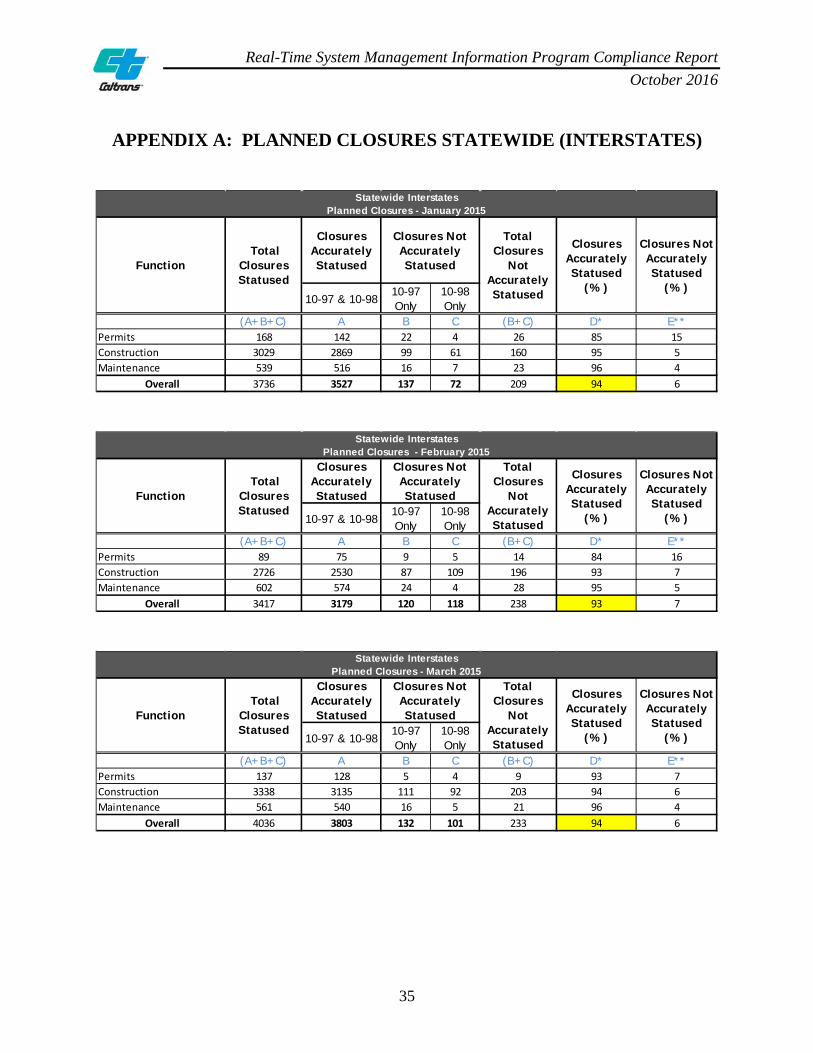
Federal regulations require state DOTs to provide traffic and travel conditions through the RTSMIP. The timeliness for the availability of information regarding full construction activities that close or reopen roadways or lanes will be 10 minutes or less from the time of the closure or reopening within metropolitan areas. Intermittent or short-term lane closures of limited duration that are less than the required reporting times are not regulated for compliance in this provision. Caltrans uses two tools to report, monitor, and status construction activities on state-owned RoS. The first tool is the Lane Closure System (LCS), an Oracle database that contains all information related to planned lane closures for all 12 Caltrans districts. The second tool is QuickMap, a web page that is updated every five minutes with real-time traffic information feeds from various data sources, including: Caltrans’ Commercial Wholesale Web Portal (CWWP), Changeable Message Signs (CMS) content, the Caltrans Highway Information Network (CHIN), the Transportation Management Center Activity Log (TMCAL), and the LCS. Caltrans uses QuickMap to make real-time traveler information available to motorists. Caltrans demonstrates compliance with construction activity regulations by reporting all planned lane closures on State highways to the Transportation Management Center (TMC) before the first advanced warning sign is placed on the roadway. This process is referred to as “10-97.” When the TMC staff member is notified and inputs “10-97” into the LCS, a traffic device icon appears in QuickMap with estimated end times and dates for the planned closure. At the end of the planned closure, the TMC is notified after all of the advanced warning signs are removed from the roadway. This process is referred to as “10-98.” When “10-97” and “10-98” are reported to the TMC within the specified end times and dates, the lane closure is considered “accurately statused.” If either a “10-97” or a “10-98” occurs without the reciprocating activity, this is considered “not accurately statused.” For construction activity compliance, Appendices G-K provide compliance reports for statewide planned lane closures on state-owned RoS for a three-month period from January through March 2015. For planned closures, approval must be obtained from the District Traffic Manager (DTM) one week before the closure takes place. Once approved, the closure is posted in the LCS and becomes active before the first advanced warning sign is placed on the roadway. The lane closure is considered complete after all of the advanced warning signs are removed from the roadway. Emergency closures do not require DTM approval and are entered into the LCS immediately upon notification by the TMC staff member.
Real-Time System Management Information Program Compliance Report October 2016
21
Caltrans uses QuickMap, the LCS and CMS to disseminate real-time system information as follows:
• QuickMap is a web-based map which displays current traffic speeds, roadway incidents, full closures, lane closures related to construction, active CMS, CCTV (Closed Circuit Television) camera images, and chain controls. The Headquarters (HQ) Traveler Information Coordinator and the Public Information Officer (PIO) manage the information shown on QuickMap.
• The LCS is an Oracle database which contains start and end times related to planned lane
closures for all 12 districts. The Statewide Lane Closure Management Coordinator manages LCS.
• CMS may be used to inform travelers about active construction activities on highways.
The LCS disseminates construction information to QuickMap, the CWWP, the Performance Measurement System (PeMS), and the CHIN. The lane closure data files in QuickMap and the CWWP are updated every five minutes. In terms of accuracy, the LCS is up and running approximately 99 percent of the time (excluding a daily 15 minute routine maintenance period). The real-time information availability for lane closures from all districts exceeds the 90 percent threshold. Of the 12 Districts, the TMCs in District 1, 2, 5, and 9 do not operate 24 hours per day, 7 days per week. When these districts have a planned lane closure scheduled after business hours, the lane closure is entered into the LCS by one of the neighboring districts. For scheduled planned lane closures that occur after the TMC business hours, District 1 notifies District 4, District 2 notifies District 3, and Districts 5 and 9 notify District 6. Due to intermittent cell phone coverage in rural areas, there may be occasions where planned lane closures are not statused within the 20 minute timeframe as stated in the regulations. These occasions are rare and Caltrans is currently exploring the use of LCS mobile applications with broadband coverage allowing field personnel to status lane closures remotely.

Real-Time System Management Information Program Compliance Report October 2016
22
2. ROADWAY OR LANE-BLOCKING INCIDENTS (STATE ROUTES OF SIGNIFICANCE)
Federal regulations require that the availability of information related to roadway or lane-blocking traffic incidents within metropolitan areas to be 10 minutes or less from the time the incident is verified. Caltrans uses the following tools to report, monitor, and status incidents on State highways: the TMCAL, the Advanced Traffic Management System (ATMS), the Intelligent Roadway Information System (IRIS), and the California Highway Patrol Computer-Aided Dispatch (CHP CAD).
• The TMCAL is a MySQL statewide database where incidents are logged and fed into QuickMap. From the time a roadway or lane-blocking incident is reported to the TMC, the latency between the incident reporting and the data entry into the TMCAL by staff is minimal and within the 85 percent accuracy threshold. After the incident is entered into the TMCAL, the process to store and disseminate the information is automated.
• The ATMS is a statewide database which uses ITS elements to gather real-time
information on State highways and distribute the information to the district TMCs.
• The IRIS is a statewide database used to monitor incidents on State highways.
• The CHP CAD is a statewide database where local dispatchers enter incident information gathered from officers in the field. The CHP CAD feeds real-time incident updates to the TMCAL, which in turn feeds the incident into QuickMap.
• The CWWP houses data and makes it available for government and local agencies, cities,
counties, and the public. Caltrans disseminates traveler information through the CHIN IVR number 1-800-427-7623 (1-800-GAS-ROAD), QuickMap, the CWWP, and CMS signs. The CHIN IVR, QuickMap, the CWWP, and the general messages for the CMS are managed by the HQ Office of Traffic Management. The accuracy and availability of roadway and lane-blocking incidents by Caltrans meets or exceeds the requirements through the TMCs that are staffed and managed 24 hours per day, 7 days per week, and through the use of an automated system which populates the TMCAL database. Incidents occurring in districts that are not continuously operational are reported to the neighboring TMCs that function 24 hours per day, 7 days per week. The TMCs also have reporting policies to local entities as appropriate and required, and also report with the neighboring TMCs when an incident affects more than one district.

Real-Time System Management Information Program Compliance Report October 2016
23
For roadway and lane-blocking incidents, Caltrans and the CHP work together to monitor and report highway conditions. The CHP uses the CAD to track all accidents on the State Highway System (SHS). The dispatcher enters the information into the CAD as soon as it is obtained from the reporting party. Typos are generally corrected immediately after the information is entered. The Media CAD, a limited subset of the CAD determined for public consumption by the CHP, uploads the information in five minutes or less. The process is subject to human error yet is generally very accurate and meets the federal regulation’s 85 percent minimum accuracy threshold. The Media CAD is never off-line and is 100 percent reliable and available. It has back-up servers and four hubs; therefore, updates and routine maintenance are completed one hub at a time. The Media CAD meets the 90 percent availability requirement as outlined in federal regulations. The incident reporting Standard Operating Procedure (SOP) is that the CHP enters the information into the CHP CAD which is then released to the Media CAD and the CWWP. If the event is reported by a CHP field officer, it is considered verified. If it is relayed by the public via 911, there needs to be either multiple 911 calls, verification by CCTV, or field verification by the CHP or Caltrans personnel before it is considered verified. When confirmation is received that the event is no longer affecting the roadway, the incident is closed out in the CAD and the CWWP no longer shows the event. In general, the information entered by the CHP is in the CWWP before Caltrans is aware there is an incident. The latency between the CAD and the CWWP is small (approximately five minutes); therefore, the event will always be available to the public within approximately five minutes. Caltrans does not have the ability to affect “false data,” meaning data that may exist even though there is no actual event. Caltrans utilizes CCTV and/or Caltrans field personnel to verify there is no incident, or that an incident has been completed, at which point Caltrans relays the information to the CHP who in turn closes the incident, effectively removing it from the CWWP.
Real-Time System Management Information Program Compliance Report October 2016
24
3. ROADWAY WEATHER OBSERVATIONS (STATE ROUTES OF SIGNIFICANCE)
Federal regulations require the availability of information about hazardous driving conditions and roadway or lane closures or blockages due to adverse weather conditions to be 20 minutes or less from the time the hazardous conditions, blockage, or closure is observed. Caltrans reports weather statewide using similar weather-related tools: the CHP CAD, the Road Weather Information System (RWIS), the Fog Detection and Warning System (FDWS), and Chain Controls. Once the data is gathered or reported it is entered into the CHIN. Data can be entered into the CHIN using the TMCAL or by the Headquarters Communication Center (HCC) receiving a call, facsimile, or e-mail, and manually entering the data. From the time the TMC is notified, the process is fully automated with a Mean Time Between Failure (MTBF) that meets the required accuracy.
• The RWIS consist of networks of weather monitoring stations that collect weather condition data on roadways. The system is comprised of Environmental Sensor Stations (ESS) in the field, a communication system for data transfer, and central systems to collect field data from numerous ESS. These stations measure atmospheric, pavement, and/or water level conditions.
• The FDWS consists of visibility sensors, speed detectors and cameras to detect
congestion and visibility problems that could affect driver and passenger safety on roadways. Through intelligence built into the ITS product, the system alerts motorists automatically of adverse weather conditions and slow speeds by using CMS and Highway Advisory Radio (HAR). The installation is 40 percent solar-powered, using both point-to-point and point-to-multipoint wireless radios to provide network connectivity. Local field controllers allow the field equipment to work autonomously should a break occur in communications to the central system.
Caltrans provides real-time roadway weather information on State highways through three sources: the IVR, the CWWP, and the Web. Additionally, the TMCs have reporting protocols to local entities as required. When adverse weather conditions cause lane closures, Caltrans personnel relay the information to the TMC dispatch and similarly update the TMC when the closure is removed. The TMCs and Maintenance Dispatch report incidents as identified in the Highway Conditions Reporting Matrix to the HCC within 10 minutes of notification of the incident, as well as to their district executive management. The Traffic Management Team (TMT) may also respond to a weather-related road closure, and can perform a travel run to determine delay time.
Real-Time System Management Information Program Compliance Report October 2016
25
Inter-agency coordination between Caltrans and the CHP occurs in the event of a major storm that closes the highway. The CHP performs escorts prior to the closure and Caltrans is responsible for putting the closure in place. The incident information is reported to and received by the TMC, and a dispatcher enters the data into the TMCAL, which is disseminated to the public. The TMCs operating 24 hours per day, 7 days per week have negligible system down time, and exceed the 90 percent availability requirement (except in the case of a power outage). Caltrans districts get their weather information from similar sources and then enter this information into the CHIN. The TMC will relay the information to the HCC, and staff will then either enter the data into the TMCAL, or directly into the CHIN. All districts use weather information from the CHP CAD, Caltrans maintenance supervisors, and the National Oceanic Atmospheric Administration (NOAA) for roadway weather. Districts 1, 2, 3, 6, 8, 9, and 10 collect the RWIS weather data. Districts 2 and 3 use the TMCAL to populate the weather information to the CHIN. The other districts input the data manually into the CHIN. District 10 plans to switch to the TMCAL in the future. District 11 has a system designed to automatically post any information to the CHIN. Appendix B shows a detailed summary of roadway weather tools and observations by district, and also discusses the accuracy and availability of roadway weather real-time information. Both Caltrans and the CHP jointly decide when to close State highways due to adverse weather conditions. Either Caltrans or the CHP will initiate the discussion based upon on site visual inspection of the conditions on the facility. The closure is then reported to the TMC and the CHP dispatch. The TMC and the CHP place this information into their databases and tracking systems.

Real-Time System Management Information Program Compliance Report October 2016
26
4. TRAVEL TIME INFORMATION (STATE ROUTES OF SIGNIFICANCE)
Federal regulations require the timeliness for the availability of travel time information along limited access roadway segments within metropolitan areas to be 10 minutes or less from the time the travel time calculation is completed. For the purposes of reporting real-time travel information, Caltrans has divided the State into five metropolitan regions: Sacramento, Bay Area (San Francisco and San Jose), Los Angeles, Riverside, and San Diego. Appendix C is a statewide graphic of the highlighted regions. Throughout the metropolitan areas of California, Caltrans utilizes CMS to provide real-time travel information on State highways. All five regions are in federal compliance and real-time travel time information is provided on all state-owned RoS in each metropolitan region. For travel time compliance, Appendix F lists all CMS statewide displaying travel time information on state-owned RoS by district, county, route, CMS location, direction, postmile start, segment description, and postmile end. The CMS are generally located within the limits of the RoS.
Real-Time System Management Information Program Compliance Report October 2016
27
State Routes of Significance Travel Time Information – Sacramento Region (District 3)
• El Dorado, Placer, Sacramento, and Yolo Counties
• Cities of Sacramento, Roseville, and Arden Arcade
• The Metropolitan Planning Organization (MPO) for the Sacramento Region is the Sacramento Area Council of Governments (SACOG).
District 3 displays travel times on State highways with updates provided typically at five minute intervals. The travel times posted at CMS locations are initially verified with field staff driving the segments to ensure accuracy. Travel times are verified by driving the route using a tachometer to confirm the actual time information. A tachometer is a device used to estimate traffic speed and volume. A vehicle is equipped with a sensor and “tach runs” can be completed to record the traffic data. The TMC operator staff checks posted travel times along with the other posted CMS messages in the district. If a travel time appears unusual, the operator will check the camera and PeMS data to ascertain if there are reasons to explain the unusual posted travel time. As a fail-safe measure, if more than a three mile segment of detection is not functional, the system will stop displaying travel times and the CMS location will be blanked. Therefore, the system improves accuracy by not operating if there is not adequate detection. The availability of a CMS location for posting travel times encounters interruptions only in the following cases: incident management, construction traffic management, and emergency notifications such as America’s Missing Broadcast Emergency Response (AMBER) for missing children and Blue Alerts, which assist in the apprehension of violent criminals who kill or seriously injure law enforcement officers. Over a three-month period, CMS locations operated greater than 96 percent of the time. Non-operational CMS locations are reported timely to the Electrical Systems Branch for investigation. Once an operator notes that a CMS is blank instead of displaying travel times, the location is reported to the Electrical Support Systems Branch for investigation. Any necessary field repairs are submitted to maintenance through the Integrated Maintenance Management System (IMMS). Travel time information displayed on CMS for state-owned RoS in the Sacramento Region is illustrated in Table 7.
Table 7: Sacramento Region State Routes of Significance
SACOG/District 3 Cities of Sacramento, Roseville, and Arden Arcade El Dorado, Placer, Sacramento, and Yolo Counties
COUNTY STATE ROUTES OF SIGNIFICANCE SACRAMENTO 50, 99

Real-Time System Management Information Program Compliance Report October 2016
28
State Routes of Significance Travel Time Information – Bay Area Region (Districts 4 and 5)
• Alameda, Contra Costa, San Francisco, San Mateo, Marin, San Benito, and Santa Clara Counties
• Cities of San Francisco, Oakland, Hayward, San Jose, Sunnyvale, and Santa Clara
• The MPO for the Bay Area Region is the Metropolitan Transportation Commission
(MTC). District 4 uses data provided by the MPO-MTC partnership. The MTC has purchased traffic data from INRIX using Global Positioning System (GPS) probe-based traffic data. The source of the GPS data is a combination of Commercial Vehicle GPS Probe, Consumer Vehicle GPS Probe, GPS-Enabled Smartphone Probe, and Cellular Network Probe. The data is fed to the fusion engine which checks and weighs the data accuracy and procedures, and estimates travel times. The technique has been tested by the Washington State Department of Transportation and the New Jersey State Department of Transportation. New Jersey validated the data on the I-95 via a second set of Bluetooth readers. The MTC validates the travel time data via a series of floating car studies. INRIX has over three years of stored data that is normalized for seasonal traffic patterns. The ATMS travel time module for District 4 is programmed on a fixed schedule of 0500 to 2100 hours daily. If the system loses the data feed from the MTC for longer than 10 minutes, the travel time system is programmed to blank out the signs. If the data feed is unable to be restored, there is an option to use the secondary source of data from Caltrans’ traffic monitoring stations. District 5 does not have state-owned RoS that qualify for the RTSMIP at this time. Travel time information displayed on CMS for state-owned RoS in the Bay Area Region is illustrated in Table 8.
Table 8: Bay Area Region State Routes of Significance
MTC/Districts 4 and 5 Cities of San Francisco, Oakland, Hayward, San Jose, Sunnyvale, and Santa Clara
Alameda, Contra Costa, San Francisco, San Mateo, Marin, San Benito, and Santa Clara Counties COUNTY STATE ROUTES OF SIGNIFICANCE
ALAMEDA 24 CONTRA COSTA 24 SAN FRANCISCO 101
SAN MATEO 92, 101 MARIN 101
SANTA CLARA 101
Real-Time System Management Information Program Compliance Report October 2016
29
State Routes of Significance Travel Time Information – Los Angeles Region (Districts 7 and 12)
• Orange and Los Angeles Counties
• Cities of Los Angeles, Long Beach, and Anaheim
• The MPO for the Los Angeles Region is the Southern California Association of Governments (SCAG).
District 7 displays travel times on approximately 45 CMS using roadway loop detectors. A computer algorithm gathers the real-time loop information and automatically computes an estimated travel time to selected target locations. The CMS are updated every three minutes. To ensure accuracy when no detector information is available, the CMS will not display a travel time for that target location. The travel times are displayed on CMS daily from 0500 to 2100 hours. This wide range of available travel times encompasses 100 percent of the daily congestion period on roadways. The travel times are not displayed outside of this period when congestion and traffic volumes are lower. Due to insufficient detection, designated travel times may not be displayed on CMS, yet the real-time information is available above the 90 percent requirement during the operational time frame. District 12 checks the accuracy of speed which is calculated with the loop detection system, and utilizes radar guns and tach runs to verify traffic conditions. This analysis concludes that the speed calculation is 95 percent accurate. The travel times are displayed on CMS from 0600 to 2200 hours. An algorithm calculates travel time based on real-time traffic speed along a corridor. The algorithm has the intelligence to extrapolate the calculation in the event of malfunction for up to two and a half miles and is 95 percent accurate. Travel time information displayed on CMS for state-owned RoS in the Los Angeles Region is illustrated in Table 9.
Table 9: Los Angeles Region State Routes of Significance
SCAG/Districts 7 and 12 Cities of Los Angeles, Long Beach, and Anaheim
Orange and Los Angeles Counties COUNTY STATE ROUTES OF SIGNIFICANCE
LOS ANGELES 57, 60, 101, 134, 210 ORANGE 55, 57, 91

Real-Time System Management Information Program Compliance Report October 2016
30
State Routes of Significance Travel Time Information – Riverside Region (District 8)
• Riverside and San Bernardino Counties
• Cities of Riverside, San Bernardino, and Ontario
• The MPO for the Riverside Region is the SCAG. District 8 currently displays travel times on 35 CMS on Routes I-10, I-15, I-215, as well as other state routes between 0500 and 2000 hours. The overall PeMS detector reliability has been difficult to measure due to ongoing construction activities and wire theft which lowered the number of available detectors. Caltrans purchases third party data which is integrated into the central freeway management system; therefore, travel times are not affected by failed detection. The 85 percent accuracy is easily attained and verified through tach runs. The freeway management system has an uptime that exceeds 99 percent. The only factor that affects the availability is the status of detection. The availability will be measured through the PeMS. A log of all the messages and the times they were posted is maintained in the database. The availability of existing signs that are outside of construction zones exceeds 90 percent. The purchase of third party data will allow for travel times to be posted where detection is unavailable. Travel time information displayed on CMS for state-owned RoS in the Riverside Region is displayed in Table 10.
Table 10: Riverside Region State Routes of Significance
SCAG/District 8 Cities of Riverside, San Bernardino, and Ontario
Riverside and San Bernardino Counties COUNTY STATE ROUTES OF SIGNIFICANCE
RIVERSIDE 60, 91 SAN BERNARDINO 60
Real-Time System Management Information Program Compliance Report October 2016
31
State Routes of Significance Travel Time Information – San Diego Region (District 11)
• San Diego County
• Cities of San Diego and Carlsbad
• The MPO for the San Diego Region is the San Diego Association of Governments (SANDAG).
District 11 achieves travel time accuracy by verifying the routes and calculated travel time as needed by driving pilot vehicles to identified destinations during various hours of the day. Once the calculated travel time and the driven travel time are within one to two minutes of each other, the destinations are displayed on CMS. The travel times are verified in lane number two at the posted or prevailing speed (if below posted speed). Travel times are displayed on commute routes Monday through Friday during commute hours: 0500-1000 and 1400-1900 hours. The travel time destination display data depends on the performance of vehicle detection stations, and the reliability of detection data is over 90 percent. Travel time information displayed on CMS for state-owned RoS in the San Diego Region is displayed in Table 11.
Table 11: San Diego Region State Routes of Significance
SANDAG/District 11 Cities of San Diego and Carlsbad
San Diego County COUNTY STATE ROUTES OF SIGNIFICANCE
SAN DIEGO 15, 52, 54, 94, 163, 905
Real-Time System Management Information Program Compliance Report October 2016
32
5. ITS ARCHITECTURE (STATE ROUTES OF SIGNIFICANCE) Federal regulations require all states and regions which have created a Regional ITS Architecture to evaluate their Regional ITS Architecture to determine whether the architecture addresses real-time highway and transit information needs, and the methods needed to meet such needs. The regulation further states that Regional ITS Architectures shall feature the components and functionality of the RTSMIP. The California Statewide ITS Architecture (SWITSA) contains a blueprint for deployment of ITS projects that fall within the category of statewide and interregional ITS services related to regional integration and cooperation among stakeholders. The SWITSA was developed in 2004, updated in 2010, and is currently undergoing an update. The update will include deployment of the ITS SystemBuilder tool, which will enable users to view the SWITSA and all other Regional ITS Architectures within the State. The SWITSA includes the following regional service packages that support the RTSMIP established in accordance with 23 CFR 511.
• MC10: Maintenance and Construction Activity Coordination supports the dissemination of maintenance and construction activity to information service providers (ISPs) who can provide the information to travelers.
• ATMS08: The Traffic Incident Management System manages both unexpected incidents
and planned events so that the impact to the transportation network and traveler safety is minimized.
• MC03: Road Weather Data Collection collects current road and weather conditions using
data collected from environmental sensors deployed on and about the roadway.
• MC06: Winter Maintenance collects current road and weather conditions using data collected from environmental sensors deployed on and about the roadway.
• ATIS1: Broadcast Traveler Information collects traffic conditions, advisories, general
public transportation, incident information, and roadway maintenance and construction information; and broadly disseminates this information through existing infrastructures.
• ATMS06: Traffic Information Dissemination provides driver information using roadway
equipment such as CMS or HAR. The user service packages referenced above represent a subset of a more comprehensive list contained within the SWITSA. The current SWITSA can be referenced at the following website: http://www.kimleyhorn.com/projects/caarchitecture/project_reports.htm.
Real-Time System Management Information Program Compliance Report October 2016
33
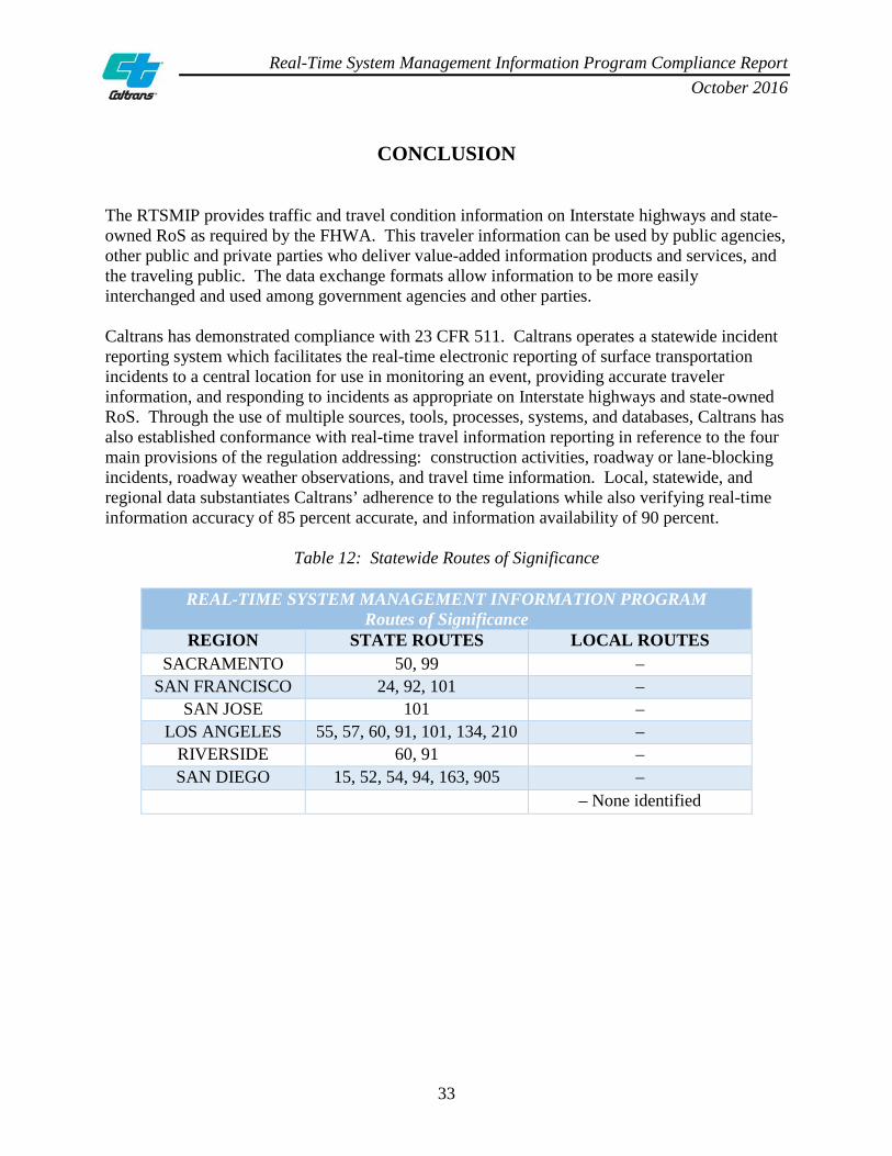
CONCLUSION The RTSMIP provides traffic and travel condition information on Interstate highways and state-owned RoS as required by the FHWA. This traveler information can be used by public agencies, other public and private parties who deliver value-added information products and services, and the traveling public. The data exchange formats allow information to be more easily interchanged and used among government agencies and other parties. Caltrans has demonstrated compliance with 23 CFR 511. Caltrans operates a statewide incident reporting system which facilitates the real-time electronic reporting of surface transportation incidents to a central location for use in monitoring an event, providing accurate traveler information, and responding to incidents as appropriate on Interstate highways and state-owned RoS. Through the use of multiple sources, tools, processes, systems, and databases, Caltrans has also established conformance with real-time travel information reporting in reference to the four main provisions of the regulation addressing: construction activities, roadway or lane-blocking incidents, roadway weather observations, and travel time information. Local, statewide, and regional data substantiates Caltrans’ adherence to the regulations while also verifying real-time information accuracy of 85 percent accurate, and information availability of 90 percent.
Table 12: Statewide Routes of Significance
REAL-TIME SYSTEM MANAGEMENT INFORMATION PROGRAM Routes of Significance
REGION STATE ROUTES LOCAL ROUTES SACRAMENTO 50, 99 –
SAN FRANCISCO 24, 92, 101 – SAN JOSE 101 –
LOS ANGELES 55, 57, 60, 91, 101, 134, 210 – RIVERSIDE 60, 91 – SAN DIEGO 15, 52, 54, 94, 163, 905 –
– None identified

Real-Time System Management Information Program Compliance Report October 2016
34
The ITS Architecture developed by Caltrans is compliant with the regulations and addresses real-time highway and transit information needs, and the concurrent methods to meet such needs. The SWITSA demonstrates a comprehensive set of regional service packages including MC10, ATMS08, MC03, MC06, ATIS1, and ATMS06, featuring the components and functionality of the RTSMIP as required by 23 CFR 511. The SWITSA contains a blueprint for deployment of ITS projects related to regional integration and cooperation among stakeholders. The SWITSA was developed in 2004, updated in 2010, and is currently undergoing an update to address ongoing needs of ITS coverage, monitoring systems, data fusion and archiving, and highway and transit information accessibility for other states as federally required. The update will include deployment of the ITS SystemBuilder tool which will enable users to view the SWITSA and all other Regional ITS Architectures within the State via a website.
Real-Time System Management Information Program Compliance Report October 2016
35
APPENDIX A: PLANNED CLOSURES STATEWIDE (INTERSTATES)
Closures Accurately Statused
10-97 & 10-9810-97 Only
10-98 Only
(A+B+C) A B C (B+C) D* E**Permits 168 142 22 4 26 85 15Construction 3029 2869 99 61 160 95 5Maintenance 539 516 16 7 23 96 4
Overall 3736 3527 137 72 209 94 6
Statewide InterstatesPlanned Closures - January 2015
Closures Not Accurately Statused
(%)
Function Total
Closures Statused
Closures Not Accurately Statused
Total Closures
Not Accurately Statused
Closures Accurately Statused
(%)
Closures Accurately Statused
10-97 & 10-9810-97 Only
10-98 Only
(A+B+C) A B C (B+C) D* E**Permits 89 75 9 5 14 84 16Construction 2726 2530 87 109 196 93 7Maintenance 602 574 24 4 28 95 5
Overall 3417 3179 120 118 238 93 7
Statewide InterstatesPlanned Closures - February 2015
Closures Not Accurately Statused
(%)
Function Total
Closures Statused
Closures Not Accurately Statused
Total Closures
Not Accurately Statused
Closures Accurately Statused
(%)
Closures Accurately Statused
10-97 & 10-9810-97 Only
10-98 Only
(A+B+C) A B C (B+C) D* E**Permits 137 128 5 4 9 93 7Construction 3338 3135 111 92 203 94 6Maintenance 561 540 16 5 21 96 4
Overall 4036 3803 132 101 233 94 6
Statewide InterstatesPlanned Closures - March 2015
Closures Not Accurately Statused
(%)
Function Total
Closures Statused
Closures Not Accurately Statused
Total Closures
Not Accurately Statused
Closures Accurately Statused
(%)

Real-Time System Management Information Program Compliance Report October 2016
36
ACCURACY COMPLIANCE TRENDLINE

Real-Time System Management Information Program Compliance Report October 2016
37
APPENDIX B: SUMMARY OF ROADWAY WEATHER OBSERVATIONS
TOOL DISTRICT PROCESS AVAILABILITY ACCURACY California Highway Patrol Computer- Aided Dispatch (CHP CAD)/ Media Computer- Aided Dispatch (Media CAD)
All
CHP field personnel or 911 calls to alert the CHP Communication Center. Information is relayed related to high winds, fog, dust, snow, flooding, rock and mud slides, wild fire, and other adverse weather or natural disaster conditions that affect the highway system. The information is placed into CHP CAD which is then released to Media CAD. If the event is reported by a CHP field officer, it is considered verified. If it is relayed by the public via 911, there needs to be either multiple 911 calls, verification by CCTV, or field verification by the CHP or Caltrans’ personnel before it is considered verified. Once the event is confirmed as no longer affecting the roadway, it is closed out in CAD and the event is no longer shown. The CHP CAD is not broadcast by Caltrans.
The CHP CAD has quadruple servers and the CAD information is available to the CWWP 100 percent of the time.
Field personnel, CCTV, RWIS, FDWS, or multiple 911 calls are utilized to verify that an event is occurring. Caltrans will not be aware of the end of an event until field personnel verify and the event is closed by CHP (CAD) or Caltrans (CHIN).
Road Weather Information System (RWIS)
1, 2, 3, 6, 8, 9 and 10
RWIS feeds information back to the server in HQ and displays data via website of the conditions at the individual locations. For some districts, this information is also sent to the National Weather Service (NWS) in Hanford, California, where the data is incorporated into their forecasting models. Caltrans has a project started to include both RWIS and MesoWest weather data to QuickMap.
Maintenance issues with RWIS are ongoing but can be reconciled by the NWS. The NWS has a large volume of data to compare what is being or not being reported from our system.
The RWIS location data is “point” data, meaning it is not relied upon as a regional weather predictor. The TMC looks at the aggregation of data provided by the NWS in Hanford, California, including Caltrans' RWIS data.

Real-Time System Management Information Program Compliance Report October 2016
38
TOOL DISTRICT PROCESS AVAILABILITY ACCURACY Caltrans Highway Information Network (CHIN)
All
Information is received in the TMC via the CHP and Media CAD, both of which are present in the TMC along with State forces (e.g., Maintenance, Storm Patrol), weather service providers, Google Maps, and traditional network Media-TV news, etc. Upon confirmation of major weather events affecting the highway system, the TMC enters the information into logging systems and also notifies the HCC. The HCC then enters the data into CHINs UNIX-based system to support the 1-800 Service (IVR), and the logging systems update CWWP.
All processes are automated; the reliability is based on the uptime of the associated components.
All accuracy is based on the field sensor.
Chain Control Reporting
1, 2, 3, 4, 6, 7, 8, 9, 10 and 11
Districts notify the HCC of Chain Control requirements which update the 1-800 Service (IVR), CWWP, and QuickMap. The majority of districts enter chain control requirements into TMCAL as well.
Availability is based on component uptime as the system is automated from the time of entry to notification.
Information is accurate and comes from knowledgeable field personnel.
Fog Detection and Warning System (FDWS)
6 and 10
FDWS is used by D6 and D10, and the system automatically sends a message to the CMS when it detects fog. CMS messaging is then picked up by the Satellite Operations Center Control System (SOCCS) and fed to CWWP.
Since the system is automated, the reliability is dependent on the uptime of each component; the components are monitored and have rollover functionality.
The accuracy is based on the inaccuracy of the sensor itself.
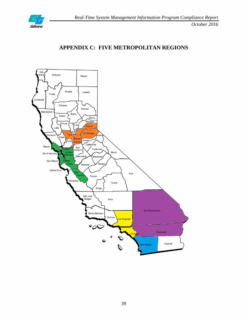
Real-Time System Management Information Program Compliance Report October 2016
39
APPENDIX C: FIVE METROPOLITAN REGIONS

Real-Time System Management Information Program Compliance Report October 2016
40
APPENDIX D: INTERSTATES STATEWIDE – TRAVEL TIME INFORMATION
SACOG/District 3 Cities of Sacramento, Roseville, and Arden Arcade El Dorado, Placer, Sacramento, and Yolo Counties
DIST CO RTE PM DIR CMS LOCATION 3 SAC 5 12.7 NB Laguna Blvd

Real-Time System Management Information Program Compliance Report October 2016
41
MTC/Districts 4 and 5 Cities of San Francisco, Oakland, Hayward, San Jose, Sunnyvale, and Santa Clara
Alameda, Contra Costa, San Francisco, San Mateo, Marin, San Benito, and Santa Clara Counties DIST CO RTE PM DIR CMS LOCATION
4 ALA 80 4.58 WB WB I-80 E/O Powell St 4 ALA 80 6.19 EB EB I-80 E/O University Ave 4 ALA 580 18.4 WB WB I-580 Hacienda Rd OFR 4 ALA 580 R27.3 WB WB I-580 E/O Castro Valley Blvd OFR 4 ALA 580 R33.7 EB EB I-580 E/O Grand Ave 4 ALA 580 44.07 WB WB I-580 Chetwood St OC 4 ALA 880 12.3 SB SB I-880 N/O Alvarado Blvd 4 ALA 880 14.75 NB NB I-880 N/O Industrial Pkwy 4 ALA 880 31.024 NB NB I-880 S/O Oak St OFR 4 CC 80 7.6 WB WB I-80 E/O Appian Way 4 CC 80 13.41 WB WB I-80 W/O Carquinez Bridge 4 SCL 280 12.91 SB SB I-280 N/O Foothill Expy 4 SCL 680 M9.6 SB SB I-680 S/O Scott Creek Rd 4 SCL 880 5.4 SB SB I-880 N/O Brokaw Rd

Real-Time System Management Information Program Compliance Report October 2016
42
SCAG/Districts 7 and 12 Cities of Los Angeles, Long Beach, and Anaheim
Orange and Los Angeles Counties DIST CO RTE PM DIR CMS LOCATION
7 LA 5 12.2 NB S/O Atlantic Blvd 7 LA 5 15.6 SB N/O Indiana St 7 LA 5 19.48 SB Broadway St 7 LA 5 37.9 SB Terra Bella St 7 LA 10 R6.88 EB E/O Overland Ave 7 LA 10 R7.15 WB National Blvd 7 LA 10 R12.92 WB Western Ave 7 LA 10 19.81 EB N/O City Terrace Dr 7 LA 10 28.59 EB Santa Anita Ave 7 LA 10 33.52 WB Puente Ave 7 LA 10 44.66 WB W/O White Ave 7 LA 105 R1.4 EB W/O I-405 7 LA 105 R5.22 EB E/O Crenshaw Blvd 7 LA 105 R9.19 WB W/O Wilmington Ave 7 LA 105 R15.72 WB Lakewood Blvd 7 LA 110 6.35 NB S/O Carson St 7 LA 110 11.15 NB Redondo Beach Blvd 7 LA 110 15.72 SB Manchester Ave 7 LA 110 17.4 NB Gage Ave 7 LA 210 R21.02 EB Foothill Blvd 7 LA 210 R33.4 EB W/O Myrtle Ave 7 LA 210 R39.4 WB Vernon Ave 7 LA 405 3.72 NB N/O Lakewood Blvd 7 LA 405 9.48 SB Wilmington Ave 7 LA 405 11.18 NB Avalon Blvd 7 LA 405 14.54 SB Western Ave 7 LA 605 R1.31 NB S/O Carson St
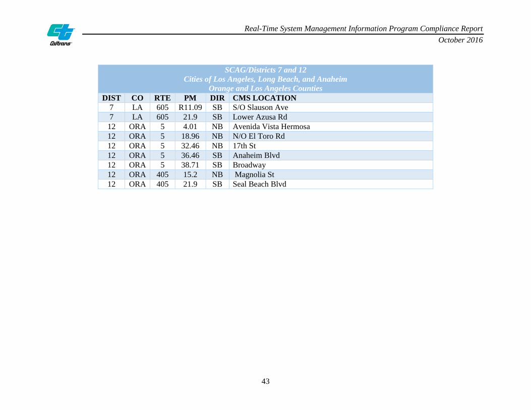
Real-Time System Management Information Program Compliance Report October 2016
43
SCAG/Districts 7 and 12 Cities of Los Angeles, Long Beach, and Anaheim
Orange and Los Angeles Counties DIST CO RTE PM DIR CMS LOCATION
7 LA 605 R11.09 SB S/O Slauson Ave 7 LA 605 21.9 SB Lower Azusa Rd 12 ORA 5 4.01 NB Avenida Vista Hermosa 12 ORA 5 18.96 NB N/O El Toro Rd 12 ORA 5 32.46 NB 17th St 12 ORA 5 36.46 SB Anaheim Blvd 12 ORA 5 38.71 SB Broadway 12 ORA 405 15.2 NB Magnolia St 12 ORA 405 21.9 SB Seal Beach Blvd

Real-Time System Management Information Program Compliance Report October 2016
44
SCAG/District 8 Cities of Riverside, San Bernardino, and Ontario
Riverside and San Bernardino Counties DIST CO RTE PM DIR CMS LOCATION
8 RIV 10 R23.99 EB W/O Haugen Lehmann Way 8 RIV 15 R0.57 NB 0.5 N/O RIV/SD CO Line 8 RIV 15 39.24 NB 0.4 N/O Ontario Ave 8 RIV 15 44.38 SB 1.1 S/O 6th St 8 RIV 15 47.35 NB 68th St 8 RIV 215 R34.47 NB Cactus Ave 8 RIV 215 38.83 NB At Central Ave/University Ave 8 RIV 215 45.28 SB 0.4 S/O Iowa Ave at SBD/RIV CO line 8 SBD 10 2.72 EB Mountain Ave 8 SBD 10 8.38 EB 0.1 E/O Haven Ave 8 SBD 10 12.65 WB 0.5 W/O Cherry Ave 8 SBD 10 26.95 WB 0.2 W/O Mountain View Ave-E/O Tippecanoe Ave 8 SBD 15 5.94 NB .5 S/O Baseline Rd 8 SBD 15 10.18 SB 0.2 N/O Summit Ave 8 SBD 15 R18.19 NB 3.0 N/O Kenwood Ave 8 SBD 15 R18.3 SB 3.0 N/O Kenwood Ave 8 SBD 15 68.07 NB I-15 at Lenwood Rd 8 SBD 15 R135.75 NB S/O Baker Blvd 8 SBD 15 139.22 SB N/O Baker Blvd 8 SBD 15 181.94 SB 0.5 N/O Yates Well Rd 8 SBD 210 0.81 EB 0.75 E/O Base Line Rd 8 SBD 210 7.82 EB I-210 at Milliken Ave 8 SBD 210 15.41 WB Sierra Ave 8 SBD 210 R30.18 WB W side 5th St UC 8 SBD 215 12.39 NB 0.9 N/O University Pkwy
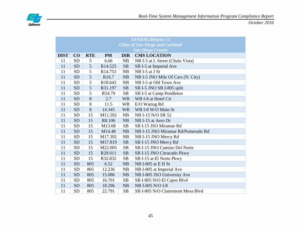
Real-Time System Management Information Program Compliance Report October 2016
45
SANDAG/District 11 Cities of San Diego and Carlsbad
San Diego County DIST CO RTE PM DIR CMS LOCATION
11 SD 5 6.66 NB NB I-5 at L Street (Chula Vista) 11 SD 5 R14.525 SB SB I-5 at Imperial Ave 11 SD 5 R14.753 NB NB I-5 at J St 11 SD 5 R16.7 NB NB I-5 JNO Mile Of Cars (N. City) 11 SD 5 R18.643 NB NB I-5 at Old Town Ave 11 SD 5 R31.197 SB SB I-5 JNO SB I-805 split 11 SD 5 R54.79 SB SB I-5 at Camp Pendleton 11 SD 8 2.7 WB WB I-8 at Hotel Cir 11 SD 8 11.5 WB E/O Waring Rd 11 SD 8 14.345 WB WB I-8 W/O Main St 11 SD 15 M11.592 NB NB I-15 N/O SR 52 11 SD 15 R8.106 NB NB I-15 at Aero Dr 11 SD 15 M13.68 SB SB I-15 JSO Miramar Rd 11 SD 15 M14.48 NB NB I-15 JNO Miramar Rd/Pomerado Rd 11 SD 15 M17.392 NB NB I-15 JNO Mercy Rd 11 SD 15 M17.819 SB SB I-15 JNO Mercy Rd 11 SD 15 M22.005 SB SB I-15 JNO Camino Del Norte 11 SD 15 R29.011 SB SB I-15 JNO Citracado Pkwy 11 SD 15 R32.832 SB SB I-15 at El Norte Pkwy 11 SD 805 6.52 NB NB I-805 at E H St 11 SD 805 12.236 NB NB I-805 at Imperial Ave 11 SD 805 15.086 NB NB I-805 JSO University Ave 11 SD 805 16.701 SB SB I-805 N/O El Cajon Blvd 11 SD 805 18.296 NB NB I-805 N/O I-8 11 SD 805 22.791 SB SB I-805 N/O Clairemont Mesa Blvd

Real-Time System Management Information Program Compliance Report October 2016
46
APPENDIX E: LISTING OF STATEWIDE ROUTES OF SIGNIFICANCE
District 3 Cities of Sacramento, Roseville, and Arden Arcade El Dorado, Placer, Sacramento, and Yolo Counties
DIST CO RTE DIR PM START SEGMENT DESCRIPTION PM END 3 SAC 99 NB 12.89 Start of urban area at Elk Grove NB to US 50 24.06 3 SAC 50 EB R0.25 SR 99 to end of urban area at Scott Rd 21.44 3 SAC 50 WB 21.44 Start of urban area at Scott Rd to SR 99 L2.39

Real-Time System Management Information Program Compliance Report October 2016
47
Districts 4 and 5 Cities of San Francisco, Oakland, Hayward, San Jose, Sunnyvale, and Santa Clara
Alameda, Contra Costa, San Francisco, San Mateo, Marin, San Benito, and Santa Clara Counties DIST CO RTE DIR PM START SEGMENT DESCRIPTION PM END
4 ALA 24 WB R6.241 ALA/CC CO line to JCT I-580/I-980 R1.847 4 ALA 24 EB R1.847 JCT I-580/I-980 to CC/ALA CO line R6.241 4 CC 24 WB 9.684 JCT I-680 to ALA/CC CO line R0.000 4 MRN 101 NB L0.000 Golden Gate Bridge to JCT I-580 9.960 4 MRN 101 SB 19.085 JCT SR 37 to JCT I-580 9.960 4 MRN 101 NB 9.960 JCT I-580 to JCT SR 37 19.085 4 MRN 101 SB 27.627 SON/MRN CO line to JCT SR 37 19.085 4 SCL 101 SB 52.550 SM/SCL CO line to JCT I-880 38.300 4 SF 101 NB 0.000 SF/SM CO line to JCT I-80 R.4.241R 4 SF 101 SB R4.306L JCT I-80 to SF/SM CO line 0.000 4 SF 101 NB 0.000 SF/SM CO line to JCT I-80 R4.241R 4 SM 92 EB R 7.551 JCT I-280 to Foster City Blvd R 13.607 4 SM 92 WB R 13.607 Foster City Blvd to JCT I-280 R 7.584 4 SM 101 NB 5.385 JCT SR 84 to JCT SR 92 11.881

Real-Time System Management Information Program Compliance Report October 2016
48
Districts 4 and 5 Cities of San Francisco, Oakland, Hayward, San Jose, Sunnyvale, and Santa Clara
Alameda, Contra Costa, San Francisco, San Mateo, Marin, San Benito, and Santa Clara Counties DIST CO RTE DIR PM START SEGMENT DESCRIPTION PM END
4 SM 101 SB 11.881 JCT SR 92 to JCT SR 84 5.385 4 SM 101 NB 11.881 JCT SR 92 to SM/SF CO line 26.107 4 SM 101 SB R 20.719 JCT I-380 to JCT SR 92 11.881 4 SM 101 SB 26.107 SM/SF CO line to JCT I-380 R 20.719

Real-Time System Management Information Program Compliance Report October 2016
49
Districts 7 and 12 Cities of Los Angeles, Long Beach, and Anaheim
Orange and Los Angeles Counties DIST CO RTE DIR PM START SEGMENT DESCRIPTION PM END
7 LA 57 NB R0.000 LA/OC CO line to SR 60 R4.518R 7 LA 57 NB R4.518 SR 60 to SR 210 R12.303R 7 LA 57 NB R4.518 SR 60 to SR 210 R12.303R 7 LA 57 SB R12.212L SR 210 to SR 60 R4.518 7 LA 57 SB R12.212L SR 210 to SR 60 R4.518 7 LA 60 EB L0.114 I-10/I-5 IC to LA/SBD CO line R30.456 7 LA 60 EB L0.114 I-10/I-5 IC to LA/SBD CO line R30.456 7 LA 60 EB L0.114 I-10/I-5 IC to LA/SBD CO line R30.456 7 LA 60 WB R30.456 LA/SBD CO line to I-10/I-5 IC L0.000 7 LA 60 WB R30.456 LA/SBD CO line to I-10/I-5 IC L0.000 7 LA 101 NB S0.000 I-5 to LA/VEN CO line 38.190 7 LA 101 NB S0.000 I-5 to LA/VEN CO line 38.190 7 LA 101 NB S0.000 I-5 to LA/VEN CO line 38.190 7 LA 101 NB S0.000 I-5 to LA/VEN CO line 38.190 7 LA 101 SB 38.190 LA/VEN CO line to I-5 S0.000 7 LA 101 SB 38.190 LA/VEN CO line to I-5 S0.000 7 LA 101 SB 38.190 LA/VEN CO line to I-5 S0.000 7 LA 101 SB 38.190 LA/VEN CO line to I-5 S0.000 7 LA 101 SB 38.190 LA/VEN CO line to I-5 S0.000 7 LA 134 EB 0.000 US 101/SR 170 to I-210 R13.341

Real-Time System Management Information Program Compliance Report October 2016
50
Districts 7 and 12 Cities of Los Angeles, Long Beach, and Anaheim
Orange and Los Angeles Counties DIST CO RTE DIR PM START SEGMENT DESCRIPTION PM END
7 LA 134 WB R13.341 I-210 to US 101/SR 170 0.000 7 LA 134 WB R13.341 I-210 to US 101/SR 170 0.000 7 LA 210 EB R43.943 SR 57 to LA/SBD CO line R52.150 7 LA 210 WB R52.150 LA/SBD CO line to SR 57 R43.943 12 ORA 55 NB 2.021 NB SR 55 from Costa Mesa to SR 91 R17.876 12 ORA 57 SB R22.551 SB SR 57 from LA CO line to I-5 in Anaheim 10.649L 12 ORA 57 SB 18.420 SB SR 57 from CMS sign 99 to I-5 in
Anaheim 10.649L
12 ORA 57 NB 10.734R NB SR 57 from I-5 and CMS sign 66 to LA CO line
R22.551
12 ORA 91 EB R0.000 EB SR 91 from LA CO line to RIV CO line R18.905 12 ORA 91 WB R18.905 WB SR 91 from RIV CO line to LA CO line R0.000

Real-Time System Management Information Program Compliance Report October 2016
51
District 8 Cities of Riverside, San Bernardino, and Ontario
Riverside and San Bernardino Counties DIST CO RTE DIR PM START SEGMENT DESCRIPTION PM END
8 RIV 60 WB R3.100 Country Village Rd to Milliken Ave R.262 8 RIV 60 EB 9.300 SR 60/SR 91/I-215 IC 11.976 8 RIV 60 WB 15.490 Heacock St to Day St 13.392 8 RIV 91 EB R1.065 ORA CO Line to I-15 separation 9.150 8 RIV 91 EB R.413 ORA CO line to downtown Riverside 20.076 8 RIV 91 WB 5.280 Lincoln Ave to Green River Rd R 0.995 8 RIV 91 WB 10.000 Pierce St to I-15 separation 6.800 8 RIV 91 WB 10.720 Pierce St to SR 71 separation R1.970 8 RIV 91 EB 18.520 Central Ave to SR 91/I-215 IC 20.860 8 SBD/RIV 60 EB R8.043 Archibald Ave to I-15 separation R1.310 8 SBD/RIV 60 EB R8.043 Archibald Ave to I-215 separation 11.976 8 SBD/RIV 60 EB R3.789 Mountain Ave to I-15 separation R1.310 8 SBD/RIV 60 EB R3.789 Mountain Ave to SR 60/SR 91/I-215 IC 11.976 8 SBD 60 WB R5.713 Grove Ave to Ramona Ave R1.169

Real-Time System Management Information Program Compliance Report October 2016
52
District 11 Cities of San Diego and Carlsbad
San Diego County DIST CO RTE DIR PM START SEGMENT DESCRIPTION PM END
11 SD 15 NB 0.405 NB/SB route connecting I-5, I-805 SR 94 and I-8
R6.012
11 SD 52 EB 0.000 EB route connecting I-5 and I-805 3.761 11 SD 52 WB 7.314 WB route connecting I-15, I-805 and I-5 0.000 11 SD 52 EB 14.962 EB route connecting SR 125 and SR 67 17.271 11 SD 52 WB 17.271 WB route connecting SR 67, SR 125, I-15, I-
805 and I-5 0.000
11 SD 54 WB 6.028 WB/EB route connecting SR 125, I-805 and I-5 0.00L 11 SD 94 WB R9.567L EB/WB route connecting SR 125, I-805, I-15
and I-5 1.416
11 SD 163 SB R11.662 SB route connecting I-15, I-8 and I-5 0.598L 11 SD 163 NB 0.531R NB route connecting I-5, I-8 and I-15 R11.662 11 SD 163 NB 0.531R NB route connecting I-5, I-8 and I-15 R11.662 11 SD 905 WB R11.737 POE connecting I-5, SR 125 and SR 11 3.190L

Real-Time System Management Information Program Compliance Report October 2016
53
APPENDIX F: STATE ROUTES OF SIGNIFICANCE – TRAVEL TIME INFORMATION
District 3 Cities of Sacramento, Roseville, and Arden Arcade El Dorado, Placer, Sacramento, and Yolo Counties
DIST CO RTE CMS LOCATION DIR PM START SEGMENT DESCRIPTION PM END 3 SAC 99 Elk Grove Blvd NB 12.89 Start of urban area at Elk Grove NB to US 50 24.06 3 SAC 50 Howe Ave EB R0.25 SR 99 to end of urban area at Scott Rd 21.44 3 SAC 50 Scott Rd WB 21.44 Start of urban area at Scott Rd to SR 99 L2.39
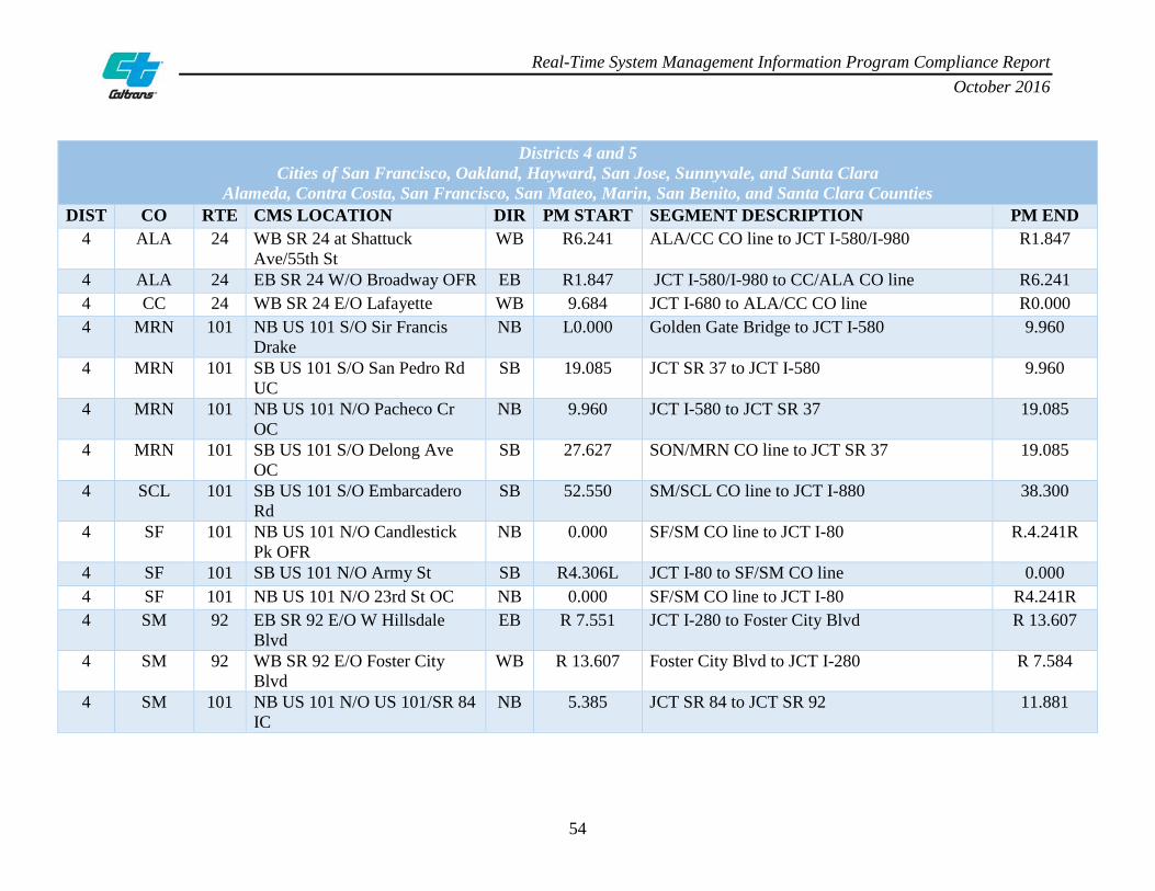
Real-Time System Management Information Program Compliance Report October 2016
54
Districts 4 and 5 Cities of San Francisco, Oakland, Hayward, San Jose, Sunnyvale, and Santa Clara
Alameda, Contra Costa, San Francisco, San Mateo, Marin, San Benito, and Santa Clara Counties DIST CO RTE CMS LOCATION DIR PM START SEGMENT DESCRIPTION PM END
4 ALA 24 WB SR 24 at Shattuck Ave/55th St
WB R6.241 ALA/CC CO line to JCT I-580/I-980 R1.847
4 ALA 24 EB SR 24 W/O Broadway OFR EB R1.847 JCT I-580/I-980 to CC/ALA CO line R6.241 4 CC 24 WB SR 24 E/O Lafayette WB 9.684 JCT I-680 to ALA/CC CO line R0.000 4 MRN 101 NB US 101 S/O Sir Francis
Drake NB L0.000 Golden Gate Bridge to JCT I-580 9.960
4 MRN 101 SB US 101 S/O San Pedro Rd UC
SB 19.085 JCT SR 37 to JCT I-580 9.960
4 MRN 101 NB US 101 N/O Pacheco Cr OC
NB 9.960 JCT I-580 to JCT SR 37 19.085
4 MRN 101 SB US 101 S/O Delong Ave OC
SB 27.627 SON/MRN CO line to JCT SR 37 19.085
4 SCL 101 SB US 101 S/O Embarcadero Rd
SB 52.550 SM/SCL CO line to JCT I-880 38.300
4 SF 101 NB US 101 N/O Candlestick Pk OFR
NB 0.000 SF/SM CO line to JCT I-80 R.4.241R
4 SF 101 SB US 101 N/O Army St SB R4.306L JCT I-80 to SF/SM CO line 0.000 4 SF 101 NB US 101 N/O 23rd St OC NB 0.000 SF/SM CO line to JCT I-80 R4.241R 4 SM 92 EB SR 92 E/O W Hillsdale
Blvd EB R 7.551 JCT I-280 to Foster City Blvd R 13.607
4 SM 92 WB SR 92 E/O Foster City Blvd
WB R 13.607 Foster City Blvd to JCT I-280 R 7.584
4 SM 101 NB US 101 N/O US 101/SR 84 IC
NB 5.385 JCT SR 84 to JCT SR 92 11.881

Real-Time System Management Information Program Compliance Report October 2016
55
Districts 4 and 5 Cities of San Francisco, Oakland, Hayward, San Jose, Sunnyvale, and Santa Clara
Alameda, Contra Costa, San Francisco, San Mateo, Marin, San Benito, and Santa Clara Counties DIST CO RTE CMS LOCATION DIR PM START SEGMENT DESCRIPTION PM END
4 SM 101 SB US 101 S/O Brittan Ave OFR
SB 11.881 JCT SR 92 to JCT SR 84 5.385
4 SM 101 NB US 101 N/O Broadway NB 11.881 JCT SR 92 to SM/SF CO line 26.107 4 SM 101 SB US 101 S/O SFO IC SB R 20.719 JCT I-380 to JCT SR 92 11.881 4 SM 101 SB US 101 N/O Sierra Point
Pkwy SB 26.107 SM/SF CO line to JCT I-380 R 20.719

Real-Time System Management Information Program Compliance Report October 2016
56
Districts 7 and 12 Cities of Los Angeles, Long Beach, and Anaheim
Orange and Los Angeles Counties DIST CO RTE CMS LOCATION DIR PM START SEGMENT DESCRIPTION PM END
7 LA 57 Diamond Bar Blvd NB R0.000 LA/OC CO line to SR 60 R4.518R 7 LA 57 Temple Ave NB R4.518 SR 60 to SR 210 R12.303R 7 LA 57 S/O Covina Blvd NB R4.518 SR 60 to SR 210 R12.303R 7 LA 57 S/O Temple Ave SB R12.212L SR 210 to SR 60 R4.518 7 LA 57 S/O Via Verde SB R12.212L SR 210 to SR 60 R4.518 7 LA 60 Indiana St EB L0.114 I-10/I-5 IC to LA/SBD CO line R30.456 7 LA 60 Santa Anita Ave EB L0.114 I-10/I-5 IC to LA/SBD CO line R30.456 7 LA 60 Fullerton Rd EB L0.114 I-10/I-5 IC to LA/SBD CO line R30.456 7 LA 60 Garfield Ave WB R30.456 LA/SBD CO line to I-10/I-5 IC L0.000 7 LA 60 Seventh Ave WB R30.456 LA/SBD CO line to I-10/I-5 IC L0.000 7 LA 101 Melrose Ave NB S0.000 I-5 to LA/VEN CO line 38.190 7 LA 101 Barham Blvd NB S0.000 I-5 to LA/VEN CO line 38.190 7 LA 101 Woodman Ave NB S0.000 I-5 to LA/VEN CO line 38.190 7 LA 101 De Soto Ave NB S0.000 I-5 to LA/VEN CO line 38.190 7 LA 101 Melrose Ave SB 38.190 LA/VEN CO line to I-5 S0.000 7 LA 101 N/O Laurel Canyon Blvd SB 38.190 LA/VEN CO line to I-5 S0.000 7 LA 101 White Oak Ave SB 38.190 LA/VEN CO line to I-5 S0.000 7 LA 101 Parkway Calabasas SB 38.190 LA/VEN CO line to I-5 S0.000 7 LA 101 Lost Hills Rd SB 38.190 LA/VEN CO line to I-5 S0.000 7 LA 134 Forest Lawn Dr EB 0.000 US 101/SR 170 to I-210 R13.341

Real-Time System Management Information Program Compliance Report October 2016
57
Districts 7 and 12 Cities of Los Angeles, Long Beach, and Anaheim
Orange and Los Angeles Counties DIST CO RTE CMS LOCATION DIR PM START SEGMENT DESCRIPTION PM END
7 LA 134 W/O Hollywood Way WB R13.341 I-210 to US 101/SR 170 0.000 7 LA 134 Glendale Ave WB R13.341 I-210 to US 101/SR 170 0.000 7 LA 210 W/O Sunflower Ave EB R43.943 SR 57 to LA/SBD CO line R52.150 7 LA 210 Foothill Blvd WB R52.150 LA/SBD CO line to SR 57 R43.943 12 ORA 55 Dyer Rd NB 2.021 NB SR 55 from Costa Mesa to SR 91 R17.876 12 ORA 57 N/O Lambert Rd UC SB R22.551 SB SR 57 from LA CO line to I-5 in Anaheim 10.649L 12 ORA 57 Yorba Linda Blvd SB 18.420 SB SR 57 from CMS sign 99 to I-5 in Anaheim 10.649L 12 ORA 57 Chapman Ave NB 10.734R NB SR 57 from I-5 and CMS sign 66 to LA
CO line R22.551
12 ORA 91 Holder St EB R0.000 EB SR 91 from LA CO line to RIV CO line R18.905 12 ORA 91 Lakeview Ave WB R18.905 WB SR 91 from RIV CO line to LA CO line R0.000
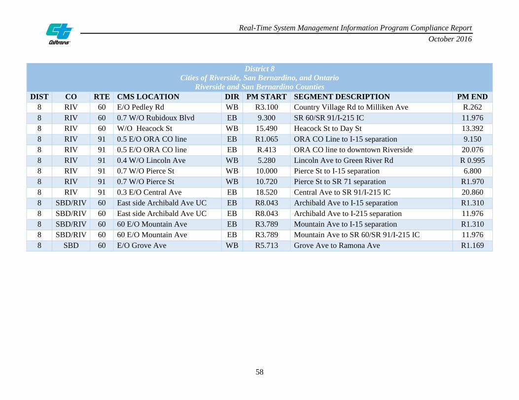
Real-Time System Management Information Program Compliance Report October 2016
58
District 8 Cities of Riverside, San Bernardino, and Ontario
Riverside and San Bernardino Counties DIST CO RTE CMS LOCATION DIR PM START SEGMENT DESCRIPTION PM END
8 RIV 60 E/O Pedley Rd WB R3.100 Country Village Rd to Milliken Ave R.262 8 RIV 60 0.7 W/O Rubidoux Blvd EB 9.300 SR 60/SR 91/I-215 IC 11.976 8 RIV 60 W/O Heacock St WB 15.490 Heacock St to Day St 13.392 8 RIV 91 0.5 E/O ORA CO line EB R1.065 ORA CO Line to I-15 separation 9.150 8 RIV 91 0.5 E/O ORA CO line EB R.413 ORA CO line to downtown Riverside 20.076 8 RIV 91 0.4 W/O Lincoln Ave WB 5.280 Lincoln Ave to Green River Rd R 0.995 8 RIV 91 0.7 W/O Pierce St WB 10.000 Pierce St to I-15 separation 6.800 8 RIV 91 0.7 W/O Pierce St WB 10.720 Pierce St to SR 71 separation R1.970 8 RIV 91 0.3 E/O Central Ave EB 18.520 Central Ave to SR 91/I-215 IC 20.860 8 SBD/RIV 60 East side Archibald Ave UC EB R8.043 Archibald Ave to I-15 separation R1.310 8 SBD/RIV 60 East side Archibald Ave UC EB R8.043 Archibald Ave to I-215 separation 11.976 8 SBD/RIV 60 60 E/O Mountain Ave EB R3.789 Mountain Ave to I-15 separation R1.310 8 SBD/RIV 60 60 E/O Mountain Ave EB R3.789 Mountain Ave to SR 60/SR 91/I-215 IC 11.976 8 SBD 60 E/O Grove Ave WB R5.713 Grove Ave to Ramona Ave R1.169
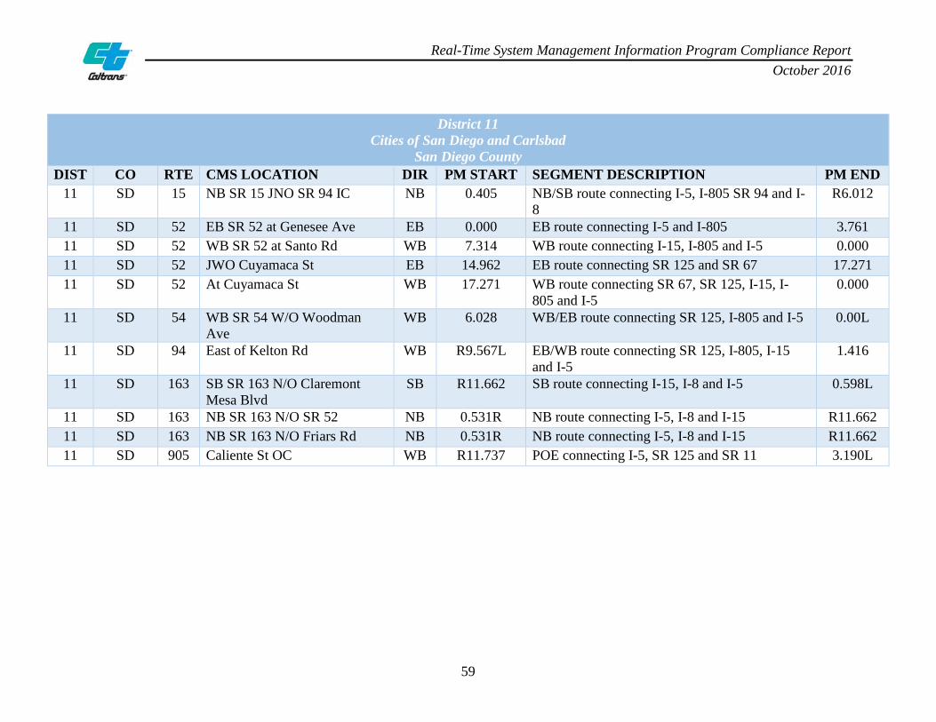
Real-Time System Management Information Program Compliance Report October 2016
59
District 11 Cities of San Diego and Carlsbad
San Diego County DIST CO RTE CMS LOCATION DIR PM START SEGMENT DESCRIPTION PM END
11 SD 15 NB SR 15 JNO SR 94 IC NB 0.405 NB/SB route connecting I-5, I-805 SR 94 and I-8
R6.012
11 SD 52 EB SR 52 at Genesee Ave EB 0.000 EB route connecting I-5 and I-805 3.761 11 SD 52 WB SR 52 at Santo Rd WB 7.314 WB route connecting I-15, I-805 and I-5 0.000 11 SD 52 JWO Cuyamaca St EB 14.962 EB route connecting SR 125 and SR 67 17.271 11 SD 52 At Cuyamaca St WB 17.271 WB route connecting SR 67, SR 125, I-15, I-
805 and I-5 0.000
11 SD 54 WB SR 54 W/O Woodman Ave
WB 6.028 WB/EB route connecting SR 125, I-805 and I-5 0.00L
11 SD 94 East of Kelton Rd WB R9.567L EB/WB route connecting SR 125, I-805, I-15 and I-5
1.416
11 SD 163 SB SR 163 N/O Claremont Mesa Blvd
SB R11.662 SB route connecting I-15, I-8 and I-5 0.598L
11 SD 163 NB SR 163 N/O SR 52 NB 0.531R NB route connecting I-5, I-8 and I-15 R11.662 11 SD 163 NB SR 163 N/O Friars Rd NB 0.531R NB route connecting I-5, I-8 and I-15 R11.662 11 SD 905 Caliente St OC WB R11.737 POE connecting I-5, SR 125 and SR 11 3.190L
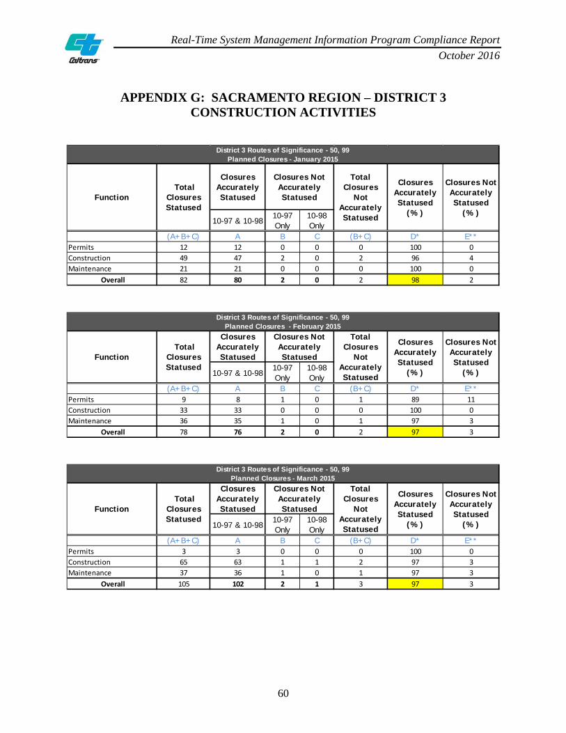
Real-Time System Management Information Program Compliance Report October 2016
60
APPENDIX G: SACRAMENTO REGION – DISTRICT 3 CONSTRUCTION ACTIVITIES
Closures Accurately Statused
10-97 & 10-9810-97 Only
10-98 Only
(A+B+C) A B C (B+C) D* E**Permits 12 12 0 0 0 100 0Construction 49 47 2 0 2 96 4Maintenance 21 21 0 0 0 100 0
Overall 82 80 2 0 2 98 2
District 3 Routes of Significance - 50, 99Planned Closures - January 2015
Closures Not Accurately Statused
(%)
Function Total
Closures Statused
Closures Not Accurately Statused
Total Closures
Not Accurately Statused
Closures Accurately Statused
(%)
Closures Accurately Statused
10-97 & 10-9810-97 Only
10-98 Only
(A+B+C) A B C (B+C) D* E**Permits 9 8 1 0 1 89 11Construction 33 33 0 0 0 100 0Maintenance 36 35 1 0 1 97 3
Overall 78 76 2 0 2 97 3
District 3 Routes of Significance - 50, 99Planned Closures - February 2015
Closures Not Accurately Statused
(%)
Function Total
Closures Statused
Closures Not Accurately Statused
Total Closures
Not Accurately Statused
Closures Accurately Statused
(%)
Closures Accurately Statused
10-97 & 10-9810-97 Only
10-98 Only
(A+B+C) A B C (B+C) D* E**Permits 3 3 0 0 0 100 0Construction 65 63 1 1 2 97 3Maintenance 37 36 1 0 1 97 3
Overall 105 102 2 1 3 97 3
District 3 Routes of Significance - 50, 99Planned Closures - March 2015
Closures Not Accurately Statused
(%)
Function Total
Closures Statused
Closures Not Accurately Statused
Total Closures
Not Accurately Statused
Closures Accurately Statused
(%)

Real-Time System Management Information Program Compliance Report October 2016
61
ACCURACY COMPLIANCE TRENDLINE

Real-Time System Management Information Program Compliance Report October 2016
62
APPENDIX H: BAY AREA REGION – DISTRICTS 4 AND 5 CONSTRUCTION ACTIVITIES
Closures Accurately Statused
10-97 & 10-9810-97 Only
10-98 Only
(A+B+C) A B C (B+C) D* E**Permits 4 3 1 0 1 75 25Construction 181 164 11 6 17 91 9Maintenance 56 51 3 2 5 91 9
Overall 241 218 15 8 23 90 10
District 4 Routes of Significance - 24, 92, 101Planned Closures - January 2015
Closures Not Accurately Statused
(%)
Function Total
Closures Statused
Closures Not Accurately Statused
Total Closures
Not Accurately Statused
Closures Accurately Statused
(%)
Closures Accurately Statused
10-97 & 10-9810-97 Only
10-98 Only
(A+B+C) A B C (B+C) D* E**Permits 23 16 7 0 7 70 30Construction 128 121 7 0 7 95 5Maintenance 45 40 5 0 5 89 11
Overall 196 177 19 0 19 90 10
District 4 Routes of Significance - 24, 92, 101Planned Closures - Februay 2015
Closures Not Accurately Statused
(%)
Function Total
Closures Statused
Closures Not Accurately Statused
Total Closures
Not Accurately Statused
Closures Accurately Statused
(%)
Closures Accurately Statused
10-97 & 10-9810-97 Only
10-98 Only
(A+B+C) A B C (B+C) D* E**Permits 23 22 1 0 1 96 4Construction 200 185 5 10 15 93 8Maintenance 90 88 1 1 2 98 2
Overall 313 295 7 11 18 94 6
District 4 Routes of Significance - 24, 92, 101Planned Closures - March 2015
Closures Not Accurately Statused
(%)
Function Total
Closures Statused
Closures Not Accurately Statused
Total Closures
Not Accurately Statused
Closures Accurately Statused
(%)

Real-Time System Management Information Program Compliance Report October 2016
63
ACCURACY COMPLIANCE TRENDLINE

Real-Time System Management Information Program Compliance Report October 2016
64
APPENDIX I: LOS ANGELES REGION – DISTRICTS 7 AND 12 CONSTRUCTION ACTIVITIES
Closures Accurately Statused
10-97 & 10-9810-97 Only
10-98 Only
(A+B+C) A B C (B+C) D* E**Permits 5 5 0 0 0 100 0Construction 264 247 7 10 17 94 6Maintenance 91 86 3 2 5 95 5
Overall 360 338 10 12 22 94 6
Districts 7 and 12 Routes of Significance - 55, 57, 60, 91, 101, 134, 210Planned Closures - January 2015
Closures Not Accurately Statused
(%)
Function Total
Closures Statused
Closures Not Accurately Statused
Total Closures
Not Accurately Statused
Closures Accurately Statused
(%)
Closures Accurately Statused
10-97 & 10-9810-97 Only
10-98 Only
(A+B+C) A B C (B+C) D* E**Permits 11 6 5 0 5 55 45Construction 351 311 20 20 40 89 11Maintenance 92 82 10 0 10 89 11
Overall 454 399 35 20 55 88 12
Districts 7 and 12 Routes of Significance - 55, 57, 60, 91, 101, 134, 210Planned Closures - February 2015
Closures Not Accurately Statused
(%)
Function Total
Closures Statused
Closures Not Accurately Statused
Total Closures
Not Accurately Statused
Closures Accurately Statused
(%)
Closures Accurately Statused
10-97 & 10-9810-97 Only
10-98 Only
(A+B+C) A B C (B+C) D* E**Permits 28 27 0 1 1 96 4Construction 403 382 12 9 21 95 5Maintenance 89 81 6 2 8 91 9
Overall 520 490 18 12 30 94 6
Districts 7 and 12 Routes of Significance - 55, 57, 60, 91, 101, 134, 210Planned Closures - March 2015
Closures Not Accurately Statused
(%)
Function Total
Closures Statused
Closures Not Accurately Statused
Total Closures
Not Accurately Statused
Closures Accurately Statused
(%)

Real-Time System Management Information Program Compliance Report October 2016
65
ACCURACY COMPLIANCE TRENDLINE

Real-Time System Management Information Program Compliance Report October 2016
66
APPENDIX J: RIVERSIDE REGION – DISTRICT 8 CONSTRUCTION ACTIVITIES
Closures Accurately Statused
10-97 & 10-9810-97 Only
10-98 Only
(A+B+C) A B C (B+C) D* E**Permits 0 0 0 0 0 0 0Construction 213 199 0 14 14 93 7Maintenance 16 16 0 0 0 100 0
Overall 229 215 0 14 14 94 6
District 8 Routes of Significance - 60, 91Planned Closures - January 2015
Closures Not Accurately Statused
(%)
Function Total
Closures Statused
Closures Not Accurately Statused
Total Closures
Not Accurately Statused
Closures Accurately Statused
(%)
Closures Accurately Statused
10-97 & 10-9810-97 Only
10-98 Only
(A+B+C) A B C (B+C) D* E**Permits 1 1 0 0 0 100 0Construction 177 177 0 0 0 100 0Maintenance 20 20 0 0 0 100 0
Overall 198 198 0 0 0 100 0
District 8 Routes of Significance - 60, 91Planned Closures - February 2015
Closures Not Accurately Statused
(%)
Function Total
Closures Statused
Closures Not Accurately Statused
Total Closures
Not Accurately Statused
Closures Accurately Statused
(%)
Closures Accurately Statused
10-97 & 10-9810-97 Only
10-98 Only
(A+B+C) A B C (B+C) D* E**Permits 2 2 0 0 0 100 0Construction 206 205 0 1 1 100 0Maintenance 31 31 0 0 0 100 0
Overall 239 238 0 1 1 100 0
District 8 Routes of Significance - 60, 91Planned Closures - March 2015
Closures Not Accurately Statused
(%)
Function Total
Closures Statused
Closures Not Accurately Statused
Total Closures
Not Accurately Statused
Closures Accurately Statused
(%)

Real-Time System Management Information Program Compliance Report October 2016
67
ACCURACY COMPLIANCE TRENDLINE
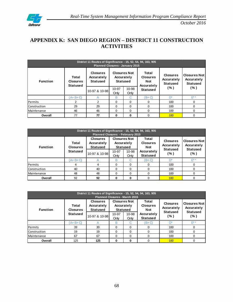
Real-Time System Management Information Program Compliance Report October 2016
68
APPENDIX K: SAN DIEGO REGION – DISTRICT 11 CONSTRUCTION ACTIVITIES
Closures Accurately Statused
10-97 & 10-9810-97 Only
10-98 Only
(A+B+C) A B C (B+C) D* E**Permits 2 2 0 0 0 100 0Construction 29 29 0 0 0 100 0Maintenance 46 46 0 0 0 100 0
Overall 77 77 0 0 0 100 0
District 11 Routes of Significance - 15, 52, 54, 94, 163, 905Planned Closures - January 2015
Closures Not Accurately Statused
(%)
Function Total
Closures Statused
Closures Not Accurately Statused
Total Closures
Not Accurately Statused
Closures Accurately Statused
(%)
Closures Accurately Statused
10-97 & 10-9810-97 Only
10-98 Only
(A+B+C) A B C (B+C) D* E**Permits 4 4 0 0 0 100 0Construction 40 40 0 0 0 100 0Maintenance 48 48 0 0 0 100 0
Overall 92 92 0 0 0 100 0
District 11 Routes of Significance - 15, 52, 54, 94, 163, 905Planned Closures - February 2015
Closures Not Accurately Statused
(%)
Function Total
Closures Statused
Closures Not Accurately Statused
Total Closures
Not Accurately Statused
Closures Accurately Statused
(%)
Closures Accurately Statused
10-97 & 10-9810-97 Only
10-98 Only
(A+B+C) A B C (B+C) D* E**Permits 39 39 0 0 0 100 0Construction 19 19 0 0 0 100 0Maintenance 67 67 0 0 0 100 0
Overall 125 125 0 0 0 100 0
District 11 Routes of Significance - 15, 52, 54, 94, 163, 905Planned Closures - March 2015
Closures Not Accurately Statused
(%)
Function Total
Closures Statused
Closures Not Accurately Statused
Total Closures
Not Accurately Statused
Closures Accurately Statused
(%)

Real-Time System Management Information Program Compliance Report October 2016
69
ACCURACY COMPLIANCE TRENDLINE

Real-Time System Management Information Program Compliance Report October 2016
70
APPENDIX L: LOCAL ARTERIAL ROUTES OF SIGNIFICANCE – SACRAMENTO REGION
Appendix L is reserved for future local principal arterial RoS.

Real-Time System Management Information Program Compliance Report October 2016
71
APPENDIX M: LOCAL ARTERIAL ROUTES OF SIGNIFICANCE – SAN FRANCISCO REGION
Appendix M is reserved for future local principal arterial RoS.

Real-Time System Management Information Program Compliance Report October 2016
72
APPENDIX N: LOCAL ARTERIAL ROUTES OF SIGNIFICANCE – SAN JOSE REGION
Appendix N is reserved for future local principal arterial RoS.

Real-Time System Management Information Program Compliance Report October 2016
73
APPENDIX O: LOCAL ARTERIAL ROUTES OF SIGNIFICANCE – LOS ANGELES REGION
Appendix O is reserved for future local principal arterial RoS.

Real-Time System Management Information Program Compliance Report October 2016
74
APPENDIX P: LOCAL ARTERIAL ROUTES OF SIGNIFICANCE – RIVERSIDE REGION
Appendix P is reserved for future local principal arterial RoS.

Real-Time System Management Information Program Compliance Report October 2016
75
APPENDIX Q: LOCAL ARTERIAL ROUTES OF SIGNIFICANCE – SAN DIEGO REGION
Appendix Q is reserved for future local principal arterial RoS.

Real-Time System Management Information Program Compliance Report October 2016
76
APPENDIX R: STATE AND REGIONAL TRANSPORTATION PARTNERS COLLABORATION DOCUMENTS
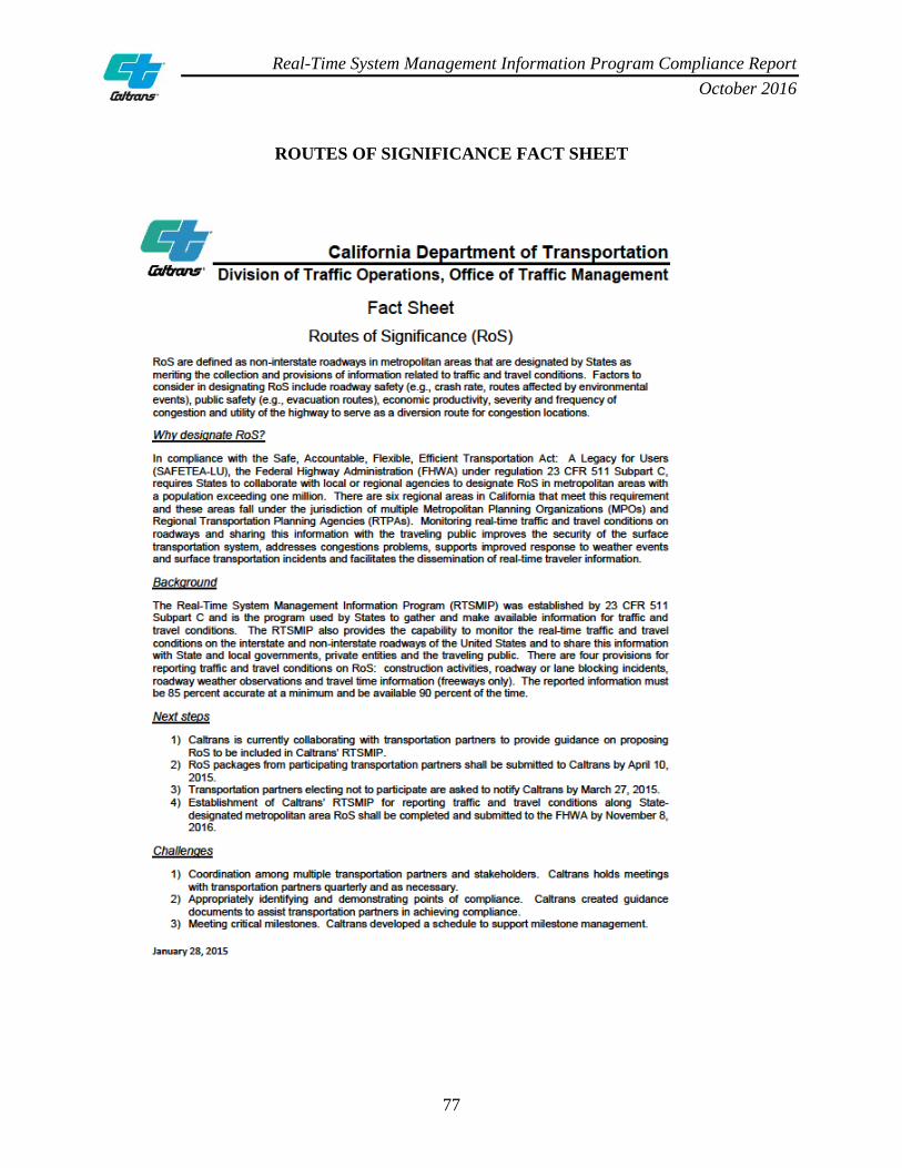
Real-Time System Management Information Program Compliance Report October 2016
77
ROUTES OF SIGNIFICANCE FACT SHEET

Real-Time System Management Information Program Compliance Report October 2016
78
CRITERIA FOR DESIGNATING ROUTES OF SIGNIFICANCE
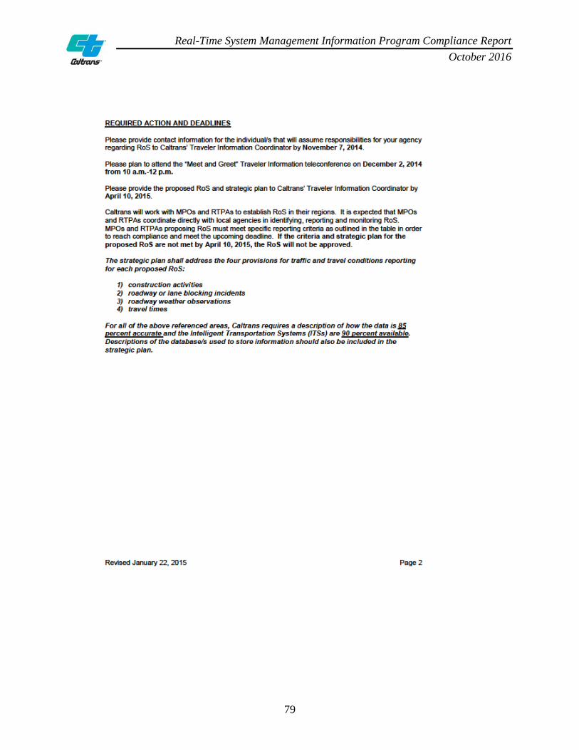
Real-Time System Management Information Program Compliance Report October 2016
79

Real-Time System Management Information Program Compliance Report October 2016
80

Real-Time System Management Information Program Compliance Report October 2016
81

Real-Time System Management Information Program Compliance Report October 2016
82
ROUTES OF SIGNIFICANCE SUBMITTAL PROCESS
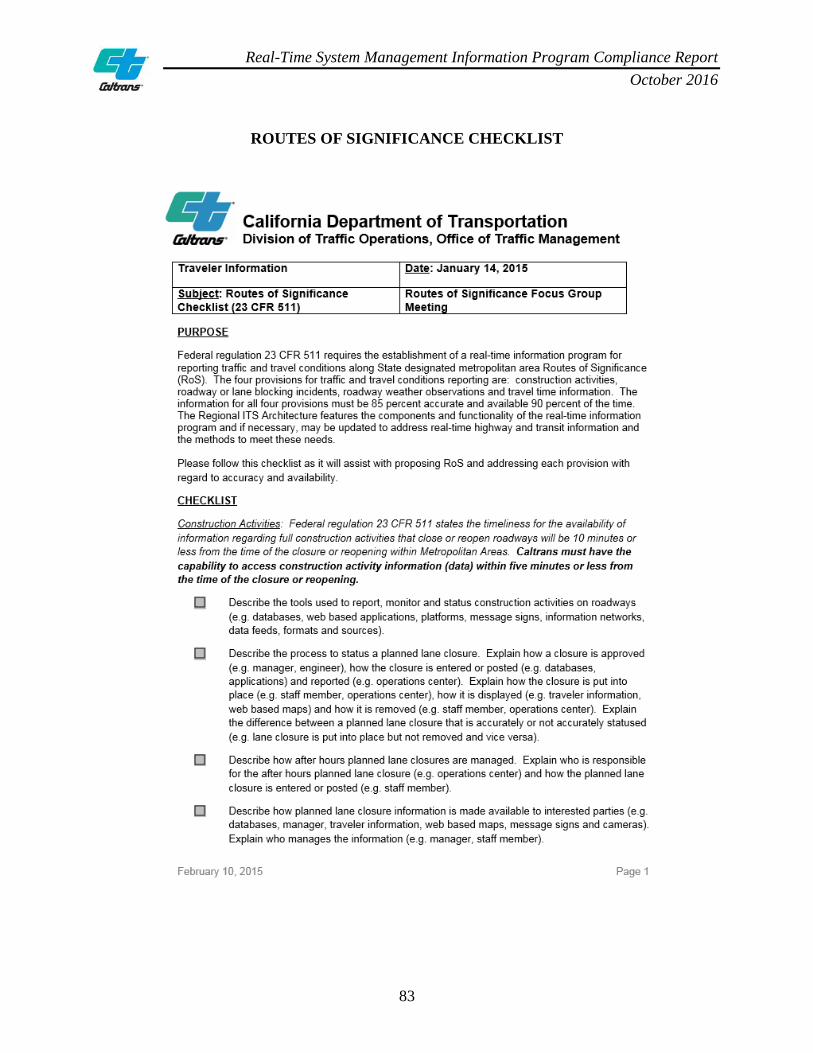
Real-Time System Management Information Program Compliance Report October 2016
83
ROUTES OF SIGNIFICANCE CHECKLIST

Real-Time System Management Information Program Compliance Report October 2016
84

Real-Time System Management Information Program Compliance Report October 2016
85
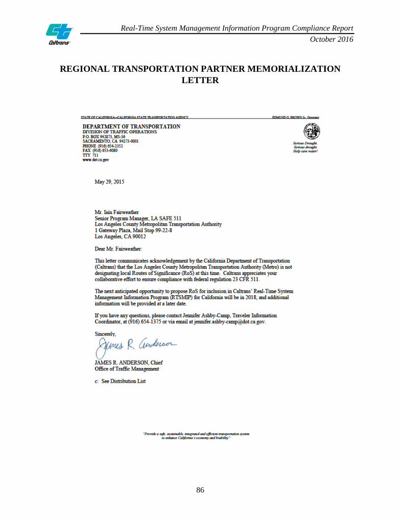
Real-Time System Management Information Program Compliance Report October 2016
86
REGIONAL TRANSPORTATION PARTNER MEMORIALIZATION LETTER
Real-Time System Management Information Program Compliance Report October 2016
87

Real-Time System Management Information Program Compliance Report October 2016
88
LIST OF TABLES
REAL-TIME SYSTEM MANAGEMENT INFORMATION PROGRAM TABLE LIST
TABLE NUMBER
TABLE NAME PAGE NUMBER
1 Sacramento Region Interstate Routes 11 2 Bay Area Region Interstate Routes 12 3 Los Angeles Region Interstate Routes 13 4 Riverside Region Interstate Routes 14 5 San Diego Region Interstate Routes 15 6 Statewide Routes of Significance and Total Lane Miles 18 7 Sacramento Region State Routes of Significance 26 8 Bay Area Region State Routes of Significance 27 9 Los Angeles Region State Routes of Significance 28 10 Riverside Region State Routes of Significance 29 11 San Diego Region State Routes of Significance 30 12 Statewide Routes of Significance 32

Real-Time System Management Information Program Compliance Report October 2016
89
DIRECTIONAL LEGEND
REAL-TIME SYSTEM MANAGEMENT INFORMATION PROGRAM DIRECTIONAL LEGEND
ABBREVIATION MEANING CO County DIR Direction DIST District E/O East of EB Eastbound I Interstate IC Interchange JCT Junction JNO Just north of JSO Just south of JWO Just west of N/O North of NB Northbound OC Overcrossing OFR Off-ramp PKW Parkway PM Post mile POE Port of Entry RTE Route S/O South of SB Southbound SR State Route UC Undercrossing W/O West of WB Westbound

Real-Time System Management Information Program Compliance Report October 2016
90
ACRONYM LEGEND
REAL-TIME SYSTEM MANAGEMENT INFORMATION PROGRAM Acronym Legend
ABBREVIATION MEANING 10-97 First advanced warning sign placed on roadway 10-98 All advanced warning signs removed from roadway 23 CFR 511 Title 23, Code of Federal Regulations Part 511 AMBER America's Missing Broadcast Emergency Response ATMS Advanced Traffic Management System Caltrans California Department of Transportation CCTV Closed Circuit Television CHIN Caltrans Highway Information Network CHP CAD California Highway Patrol Computer-Aided Dispatch CMS Changeable Message Signs CWWP Commercial Wholesale Web Portal DOT Department of Transportation DTM District Traffic Manager ESS Environmental Sensor Stations FDWS Fog Detection Warning System FHWA Federal Highway Administration GPS Global Positioning System HAR Highway Advisory Radio HCC Headquarters Communication Center HQ Headquarters IMMS Integrated Maintenance Management System IRIS Intelligent Roadway Information System ITS Intelligent Transportation System IVR Interactive Voice Response LCS Lane Closure System MEDIA CAD Media Computer-Aided Dispatch MPO Metropolitan Planning Organization MSA Metropolitan Statistical Area MTBF Mean Time Between Failure MTC Metropolitan Transportation Commission NOAA National Oceanic Atmospheric Administration NWS National Weather Service PeMS Performance Measurement System
Real-Time System Management Information Program Compliance Report October 2016
91
REAL-TIME SYSTEM MANAGEMENT INFORMATION PROGRAM Acronym Legend
ABBREVIATION MEANING PIO Public Information Officer RoS Routes of Significance RTSMIP Real-Time System Management Information Program RWIS Road Weather Information System SACOG Sacramento Area Council of Governments SAFETEA-LU Safe, Accountable, Flexible, Efficient Transportation Equity Act: A
Legacy for Users SANDAG San Diego Association of Governments SCAG Southern California Association of Governments SHS State Highway System SOCCS Satellite Operations Center SOP Standard Operating Procedure SWITSA Statewide ITS Architecture TMC Transportation Management Center TMCAL Transportation Management Center Activity Log TMT Traffic Management Team