Embed Size (px)
Citation preview
The Association for Roman Archaeology
September 2012 Issue 28
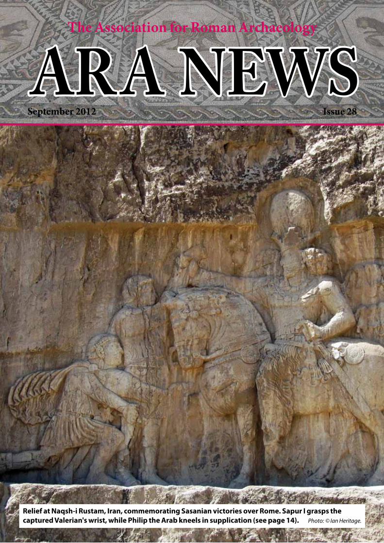
Relief at Naqsh-i Rustam, Iran, commemorating Sasanian victories over Rome. Sapur I grasps the captured Valerian's wrist, while Philip the Arab kneels in supplication (see page 14). Photo: © Ian Heritage.
ARA NEWS

2
CONTENTSPage
Contents and Contacts 2
Editorial 2
A visit to The Novium, Chichester's new museum 3 to 5
The Jupiter stone – a Romano-British sculptural treasure goes on display at The Novium 5
2012 ARA study tour of Sicily 6 to 11
Halstock Roman villa, Dorset – a lost floor of opus sectile 12 and 13
A Tale of Three Emperors: Images of Roman defeat in Sasanian Iran 14 to 21
Anthony Beeson's Archaeological Round-up 22, 23, 30, 31 and 35
Jublains – a provincial Gallo-Roman civitas 24 to 29
Epigraphy quiz 29
Three Treasures of Ancient Britain and Sweet Fanny Adams 32 to 35
Epigraphy quiz solution 35
ARA Honorary Life Membership Award – Brian Philp 36
Obituaries 37 to 39
Membership Matters 40
Booking form: ARA 2012 AGM and Symposium 41
Recent ARA grants 42
Donations and Bequests 43
Trustee nominations form 44
a time when the economy is struggling. If only we could generate a similar level of passion, pride and political support for the national legacy we already have, the legacy of our country's past.
Among the cuts and closures there is some good news. Chichester's new museum, The Novium, has opened (pp3–5). The future of the Curtis Museum and the Allen Gallery in Alton, Hampshire (pp32–5), both of which nearly closed last year, seems a little more certain, although sadly professional staff at the museums lost their jobs. The museums survive due to the hard work of enthusiastic volunteers.
As the Olympics has shown, volunteers can make an invaluable contribution. It's a rewarding experience; if you've not done so, I suggest you try it. I've just returned from working as a volunteer on an excavation in Alderney. I learned a great deal, made friends and got some
much-needed exercise. But local authorities and museum trusts should remember that replacing trained staff with volunteers carries risks. Museums do more than display items: they are archives, holding and conserving far more than is seen by visitors. They hold artefacts in trust for future generations. Academics using new techniques and with new insights can learn more about our past (see the Archaeology Round-up items on the Capitoline Wolf, p22, and the statue of Mark Antony's and Cleopatra's twins, p23). I suspect it will be many years before the skills, local knowledge and experience that left with the Alton museums' former staff can be regained, if it can be at all.
Finally, I'd like to congratulate Brian Philp (see p36), who in July was awarded an Honorary Degree of Doctor of Letters by the University of Canterbury.
Nich Hogben, Editor.
EditorialWhile I'm no great watcher of sport, it was good to see the nation get behind the spectacle of the Olympics. However, having heard of the debts and white elephant sports' facilities of former Olympic cities, the talk of 'legacy' made me wonder how much benefit our country will see in the long run from the enormous investment of time, money and political effort in the Games. And also, how much our heritage would benefit from a fraction of that support.
The organisation of the Olympics was an incredible achievement. National pride and the attention of the media meant that the political cost of failure would have been high, so it had the full backing of Government. Billions of pounds were spent. Thousands of volunteers pitched in, and scores of celebrities performed in the opening and closing ceremonies. And all of this at

3
A Visit to The Novium, Chichester's new museumby Grahame Soffe
In June 2004 the ARA visited the Chichester District Museum in Little London, a former eighteenth-century corn mill, first opened in 1962 (ARA 17, (2006)). Although Chichester has had a museum since 1831, by the 1970s, when it was required to serve the whole district, the collections had grown enormously, partly because of the continuous excavations taking place around the city. The ARA also viewed the Roman sculptured stones and inscriptions stored in the old Guildhall – in fact the huge thirteenth-century chancel of the Greyfriars' Priory church, which was occasionally opened to the public. The old museum has been closed for several years, so it was with trepidation and excitement that, at the invitation of Tracey Clark, the Museum Manager, I visited The Novium (Fig. 1), Chichester District's long-awaited new museum, a few days after its official opening to the public in July this year. In comparison, the new building offers three floors of objects and history, access for all, and a purpose-built social history collection's store.
The new museum stands in the middle of Noviomagus Reginorum, the Roman city from which it derives its name, on the remains of the Roman public baths excavated in 1974–75. The exposed area of a part of the baths occupies a sunken area viewed from the ground floor of the museum (Fig. 2). The rest of the floor is taken up with other important Roman exhibits. The wall behind the baths has been utilised as the screen for an audio/visual film showing a re-creation of how the baths might have been used, including actors swimming and playing ball games. The
building, designed by Keith Williams, the architect of the Wexford Opera House in Ireland and the Unicorn Theatre in London, had to be arched across the deep excavation, 1.5m below street level. Its modernistic design, coated with crushed Bath stone, has caused some considerable controversy in a city of old brick, medieval stone and flint. The original excavations took place during the 'golden age' of Chichester archaeology, when Alec Down over many years led dedicated teams exploring a large number of sites threatened with redevelopment. The baths, like so many of these sites, were speedily published by Alec Down and his colleagues in Chichester Excavations, a splendid set of volumes. After excavation, the baths lay preserved under a car park, together with remnants of Saxon pottery production, medieval housing, a pub and a school, until the new museum could be built. Now we can step back onto the excavation site and view the remains of masonry hypocausted rooms, and even a labelled section. A huge plate-glass window, whereby the baths could be viewed from Tower Street outside, has had to be covered over whilst problems with algae growth are being tackled. Staff at Fishbourne Roman Palace, just down the Roman road running west out of the city, are giving valuable advice.
The moment I walked through the glass doors, I was amazed by the space provided by the building. Up against the baths there is a glass balustrade case containing Roman objects found at the site, and the fine bronze arm from a statue, illustrated in ARA 17 (p41, Fig. 2). Another feature of the ground floor is
the mosaic from one of the two villas excavated by Alec Down in the Chilgrove valley, dating to the fourth century (Fig. 3). Having been temporarily displayed at Fishbourne, moving the mosaic to the museum was a major task, as one section alone weighs nearly 500kg and there are four pieces fixed onto the wall opposite the baths. In the centre of the ground floor is the key exhibit, the Jupiter Stone discussed by Anthony Beeson in this issue (p5), and on the first floor the tombstone of a woman with a Romano-Celtic sounding name ending … CCA AELIA – possibly Boudicca Aelia – who died aged 36. Another tombstone, of Catia Censorina, decorated with a pelta, has been moved back to the Collections Discovery Centre at Fishbourne. The ground floor also houses the Tourist Information Centre and shop. I hope that over time the shop will provide products such as books, which will
Fig. 1. Exterior of The Novium. Photo: © Grahame Soffe.
Fig. 3. Chilgrove mosaic on display with shop to left. Photo: © Grahame Soffe.Fig. 2. Roman public baths – heated room 1, view from north. Photo: © Grahame Soffe.

4
showcase and interpret the exhibits. The front-of-house staff include ARA member Bernie Speigelhalter.
My guide on the tour was Anooshka Rawden, Collections Officer and Assistant Museum Manager, also an ARA member. She reminded me this is not a 'Roman' museum as such, but covered all human prehistory and history from the Palaeolithic to the present day, as well as geology and palaeontology. Indeed, as part of the building works a bore hole was drilled to provide a geological record of 50 million years of the rocks below the site. Although the ground floor has a Roman theme, the first and second floor displays are definitely 'thematic' in the usual sense, avoiding an ordering in time and space – an interesting approach best expounded by the great late-nineteenth-century archaeologist General Pitt Rivers, and still to be admired in the wonderful museum in Oxford which bears his name today. Modern thematic displays can also be seen at the National Museum of Scotland in Edinburgh and the newly opened Waterfront Museum at Bristol, where at the latter, unfortunately, the important local Roman archaeology seems to have been lost almost entirely. However, there are dangers with such a thematic approach. My experience of teaching sixth-formers and adult students has shown me that concepts of chronology and cultural development in prehistory and history have reached a low point in the general knowledge of the public, probably due to inadequate teaching of history and geography in the state school curriculum. It was therefore a relief to find The Novium providing a small 'Time and Place' gallery, with an
excellent time-line and maps of the district, an explanation of stratigraphy, and at least a way of establishing where our Roman period lies in the great scheme of things! Moving past the 'curiosities case', containing a prehistoric elephant tusk, 'Heron Allen's Feet' and other strange items never exhibited before, I came to the large first-floor gallery in the centre of which is a huge cube display case. This gallery concentrates on the concept of 'Place' – 'connecting places' (transport, roads, etc), 'domestic places' (houses, etc) and 'burial places' (Fig. 4). Here, amongst a variety of later objects, such as an early twentieth-century gas cooker, can be found a very fine collection of complete Roman pots of all types from the cemetery excavations at St Pancras and elsewhere, a Roman lead coffin, a stone lararium statue of Fortuna from Chilgrove, other figurines of goddesses in terracotta and jet, and ceramic bricks and box-flue tiles. The gallery's outer walls are free for temporary exhibitions and there is a research room and small library to help students and the public access the collections further. This floor also contains the museum's environmentally controlled stores.
As I reached the second-floor landing I stopped to take in the fine view of the Cathedral and a roof-scape of old chimney pots. An audio description tells how an earlier spire of the Cathedral had collapsed in the 1860s. The second floor focuses on 'People and Emotions', an interactive gallery where one can pull out drawers of finds, try on reproduction Roman helmets and even 'make' a mosaic. Here the tall display cases surround one on all sides with entire wall lengths devoted to themes such as 'Bravery', 'Joy', 'Sorrow' and
'Hope', with many of the objects shown in open white boxes – a rather effective exhibition device. Indeed, all exhibits in the museum are clearly labelled with provenance and accession details. Amongst them I found yet more Roman pots, an amphora (Fig. 5) and a first-century BC/AD coin hoard from the beach at Selsey, and first-century BC coin moulds and a crucible from Boxgrove. In the 'Bravery' display, the development of weaponry and military equipment is shown from prehistory to the recent World Wars, and here I found a fine Roman soldier's bronze belt-plate, a helmet crest knob, an eagle-head vehicle terminal (Fig. 6) and an iron gladius, all from the Chapel Street excavations nearby; clear evidence for the early military phase of Roman Chichester. This gallery also has a fine tinned circular mirror from St Pancras, some very rare hexagonal terracotta roof tiles from the Battens Hanger Roman villa at Elsted, and an iron emasculator found on the Cattlemarket site in a box of Roman farrier's equipment – as distinct from an elaborate human version connected to the worship of Cybele that was found in London. I had not realised that the lost gates of the city had been temporarily 're-created' on their original sites over a century ago: the 'Roman' east gate is shown on an early postcard photo to celebrate Queen Victoria's Diamond Jubilee. Some of the medieval human remains from excavated burials are currently part of a project with Bradford University which aims to investigate ancient diseases. The project involves creating 3D images that will eventually be placed on touch screens in the galleries. Ongoing research has already found one of the earliest cases of syphilis in a young Saxon man buried at East Marden. The centre of the gallery has plenty of space for larger objects, such as a wooden funeral bier, portable stocks and a huge bronze bell. The second floor also houses the Woolstaplers' Room – a meeting room for school learning sessions, lectures and other activities.
On reflection, I was relieved that so much Roman and other archaeological material known from the old museum was still on display, or at least available for study, although one major item, the large stone head of the Emperor Trajan (discussed in ARA 8, 1999, p9, Figs. 3 and 4) has now made its way to Fishbourne. The great Roman inscription from the Temple of Neptune and Minerva, which
Fig. 4. Part of first-floor display. Photo: © Grahame Soffe.Fig. 6. Roman bronze eagle-head terminal.
Photo: © Grahame Soffe.
Fig. 5. Roman amphora from Selsey beach. Photo: © Grahame Soffe.

5
Little architectural stonework from Roman Chichester survives, no doubt having been recycled for the cathedral or burned for lime. Some rare pieces, previously stored in the Guildhall, are on display in the new building. Prime amongst these, and indeed one of the most important surviving pieces from Britannia, is the section of the base of a monument to Jupiter, showing the upper part of two entwined females (Fig. 1). This probably came from a Jupiter column or statue base that stood either in a sacred precinct or in the forum. A watercolour reconstruction of the former interpretation, with the monument given a typical polychromed finish, is given here (Fig. 2). It was hoped that the importance of this sculpture would be recognised in the display, and indeed the piece has a prominent position in the centre of the ground floor gallery.
Fortunately, the stone can be viewed easily on all four sides, and it is in a
central, primary position in the gallery. To counter the lack of an audio-visual presentation, a basic information sheet on the stone has been produced for the public to take for free. These are proving popular and people are taking an interest in the piece. Now that it is prominently displayed, hopefully the stone will become better known.
It is splendid to relate that the stone has now been cleaned and conserved. Anooshka Rawden, Collections Officer and Assistant Manager, told me "It was conserved prior to display by Richard Rogers Conservation Ltd – an excellent team of conservators and some of the best I have ever worked with. The stone was structurally unstable and was suffering as a result of ingrained dust and dirt. Most of the fills used to reconstruct the piece were visually jarring and did not complement the stone. The stone was therefore deconstructed before being moved to the new museum for treatment and
installation. The pieces were reattached using epoxy resin and some sections required additional dowelling to secure. Filling was carried out using fresh mortar, created by using the dowelled stonework as rubble soaked in water which was used to bulk out mortar repairs and strengthen the mortar. Surface repairs were toned-in using acrylic washes, and the stone now has a beautiful yellow hue. It looks really lovely in terms of its current conservation condition."
The Jupiter stone – a Romano-British sculptural treasure goes on display at The Novium
by Anthony Beeson
Fig. 2. An interpretative reconstruction of the Jupiter column from Chichester in a religious precinct. © From a painting by Anthony Beeson.
Fig. 1. The Jupiter stone during installation in The Novium. It was still drying out at this stage after conservation but is now a paler colour. Photo: Richard Rogers Conservation Ltd, © Chichester District Council.
refers to the client king Tiberius Claudius Togidubnus, remains gloomily and annoyingly behind dirty reflecting glass in North Street. Is it not about time it found an appropriate home in the museum? After all, it is one of the most important Roman inscriptions in Britain, and it seems ignored by the passing public in its present location. On a lighter note, if you were to get tired of the archaeological material, entertainment can be obtained from the discovery of the Municipal Moon
Lantern (c.AD 1600), Robbie Williams's postcard collection, and – my favourite – antique gramophones.
In these days of recession and museum closures, the resurrection of Chichester's museum as The Novium must be celebrated and supported. Of course there will be small details to criticise, but these are only to be expected in the enormous efforts made to meet the opening deadlines, and can always be ironed out as the museum grows and
develops into the future. The museum's staff is to be congratulated for all it has done over the past months and I recommend this new museum to ARA members.
The Novium, Tower Street, Chichester, West Sussex PO19 1QH (01243 775888, www.thenovium.org) is open seven days a week in the summer and five days a week between November and March. Entry is £7 for adults, £6 for concessions.

6
The 2012 ARA study tour of Sicilyby John Partridge
The 2012 ARA study tour of Sicily began with our evening arrival at the island's best known tourist spot, and a destination of travellers on the Grand Tour of past centuries – Taormina. A glance at our study notes, compiled by Anthony Beeson, indicated that in order to understand the sites we were about to visit we should read them thoroughly in the days to come. Sicily is rich in ancient and classical history, for it has been occupied or influenced by numerous cultures over the centuries: Greek, Carthaginian, Roman, Vandal, Byzantine, Islamic, Norman and many others. The itinerary had been specifically designed to encompass both well-known and rarely visited sites. We were also armed with a letter of introduction kindly supplied by Christopher Smith, the Director of the British School in Rome, that literally opened doors to the group.
Day two started with a visit to Taormina, guided by Wendy Mazza. Tauromenion was founded by Greeks in 358 BC and expanded by the Romans. Octavian/Augustus expelled its inhabitants for helping Pompey in the Civil War. It was revived in Byzantine times, destroyed by the Arabs in 902 and 962 and grew again under the Normans. Similar misfortune and sometimes revival was the fate of many places on the tour. We started with a brief visit to a tower and the courtyard of the Palazzo Corvaja, a tenth-century Arabic palace named after the family who owned it from the sixteenth to the twentieth century. A short walk took us to the small second-century odeon, built beside the foundations of a Greek temple and discovered in 1892 (Fig. 1). A short distance away was the magnificent Greco-Roman theatre with its stunning views of Mount Etna and the Ionian Sea (Fig. 2). Although Greek in plan, it was rebuilt in Roman times,
largely of brick. The walls at the back of the scena and cavea are well preserved. It is the second-largest theatre in Sicily, with an orchestra measuring 35m and the cavea having a diameter of 109m. In another part of town the Naumachia, misnamed in a mistaken belief that it was used for staged sea battles, and referred to in one guide book as a gymnasium, was in fact a 122m by 18m reservoir, part of a sophisticated water supply system. The external façade is well preserved, with 18 arches between which rectangular recesses may have housed statues (Fig. 3). The morning ended at part of the baths – three large heated rooms which originally had marble and mosaic decoration – and a brief stop at the Baroque Church of St Pancras, patron saint of Taormina, built over a Roman temple dedicated to Jupiter Serapis. The afternoon began with a visit to Naxos Archaeological Park. Founded in 735 BC, the walled city of Naxos is said to be the earliest Greek settlement in Sicily. It was destroyed by the tyrant Dionysius in 403 BC and robbed out in antiquity. The easy-to-walk site is clearly marked out with information boards. Among the remains are two well-preserved kilns (Fig. 4), gate 4 and part of the city walls, also well preserved considering their early date. The site museum has, in addition to artefacts from this and other sites, a fine collection of anchors and amphorae dredged from the nearby bay (Fig. 5). The Alcàntara Gorge doubtless enchanted the ancient inhabitants, as it did us, as we ended day two. Its waters flow through a 70m deep fissure in lava laid down about 2400 BC.
We headed north on the third day to Patti Marina through the many tunnels in the mountainous countryside. There, during construction of the Palermo–Messina motorway in 1973, a fourth-century AD Roman villa was discovered (Fig. 6). Built over an earlier villa of the second century AD, it measures at least 200m by 100m. It was destroyed by an earthquake in the fifth century. A raised walkway around the excavations gave a good view of a collapsed peristyle comprising an arcade of piers and shallow arches with a low balustrade. A corridor mosaic of geometric designs and representations of animals, including a tiger with a mirror, was probably created by Sicilian craftsmen. Fig. 5. Naxos, anchors. Photo: © John Partridge.
Fig. 4. Naxos, kilns. Photo: © John Partridge.
Fig. 3. So-called Naumachia, Taormina. Photo: © John Partridge.
Fig. 2. Greco-Roman theatre, Taormina. Photo: © John Partridge.
Fig. 1. Odeon, Taormina, from the temple podium. Photo: © John Partridge.
Fig. 6. Patti Marina, villa. Photo: © John Partridge.

7
Further along the north coast we visited the site of a late second or early first century BC Roman villa at Castroreale San Biagio. A series of rooms surrounded a 17-metre-square peristyle with columns of plastered brick and a low balustrade. A triclinium had a mosaic border, opus sectile panels and a rear wall with a niche for a statue. The frigidarium of the baths contained a fine monochrome mosaic of fishermen in a boat and giant fish (Fig. 7). The villa fell out of use around the end of the third century AD. Our day was completed by a visit to Tyndaris, a city originally founded by the Greeks in about 395 BC. It apparently took the right side in the 35 BC war between Octavian and Pompey, for an inscription attests to "Colonia Augusta Tyndaritanorum". The city continued in existence until at least the early fourth century AD when it suffered destruction in one of a series of earthquakes. Our interest was aroused by a large, enigmatic Roman building which is described variously as a basilica, a gymnasium and a propylaeum (monumental entrance) (Fig. 8). The last is the favoured description. The problem as to its function lies in its unusual plan. The three aisles leading from high arches are separated by walls, and are thus inaccessible one from another as in a basilica. In truth the building may have had many uses, including accommodation for shops. Even the date of its construction is contested. The Hellenistic theatre, probably from the fourth century BC, could seat 3,000 spectators. It was remodelled in Roman times into an amphitheatre. Long stretches of the decumanus (east–west street) are well
preserved, while in some areas damage by earthquake is vividly shown in the undulating surface. Roman baths in Insula IV revealed closely grouped cylindrical hot air flues and a mosaic floor, while re-erected brick columns adorn the peristyle of a first-century BC two-storey house. Nearby are six tabernae (shops). The cathedral and monastery complex on the top of the ancient acropolis contains the Black Madonna of Tyndaris: a Byzantine painted wooden statue of the Virgin and Child on a throne, one of the great relics and shrines of Sicily. The site museum houses many artefacts among which are oil lamps with the Chi-Rho symbol and a marble head of Augustus (Fig. 9). We were indebted to the guardian of the site, who kindly acted as an unofficial guide and ensured that the museum was opened for us (Fig. 10).
Halfway along the north coast was the first destination of our fourth day – Cefalu. Like many Greek towns in Sicily it was at one time allied to Carthage and later came under Roman, Byzantine, Arab and Norman domination. Remains of the ancient city may still be seen on the summit of the rock. Some members visited the Mandalisca museum, which has a fine collection of Greek and Roman coins, intaglios, some nice sculpture and a mosaic. The prominent feature of the town is the Norman cathedral, construction of which began in 1131. The façade has two square Norman towers with a fifteenth-century three-arched portico between them. The eight columns separating each aisle from the nave are partly of second century AD origin. The apse and part of
Fig. 7. Villa San Biagio baths, mosaic. Photo: © John Partridge.
Fig. 8. Tyndaris, so-called basilica. Photo: © John Partridge.
Fig. 11. Solunto, cistern. Photo: © John Partridge.
Fig. 9. Tyndaris, marble head of young Augustus, first century AD. Photo: © John Partridge.
Fig. 10. Tyndaris, site guardian showing the origin of acanthus decorations. Photo: © Anthony Beeson.

8
the choir have some fine late-Byzantine mosaics: that of the Christ Pantokrator with the Virgin Mary and archangels beneath is considered one of the best examples of the work of mosaicists from Constantinople.
During coach trips on the tour, Anthony Beeson and Mike Stone gave talks on such topics as the history of Sicily and differences between Greek and Roman architecture. On the way to Solunto, Anthony read from Professor R Ross Holloway's account of the theft of statues and other works of art by Gaius Verres, a Governor of Sicily; he was prosecuted by Cicero. Although only a quarter of the town has been excavated it presents many interesting features. Originally a Phoenician colony, the town became Carthaginian and then Roman; it was the remains of the Roman town that we were to see. A steep walk along the ancient stone block road took us up over 180m to where the town overlooks a wide bay on the Tyrrhenian Sea. We were impressed by a system of domestic and public water cisterns, the largest of which adjoined the agora (Fig. 11). Near the agora, which had nine rooms, was the bouleuterion (council chamber). The theatre, which is poorly preserved, had fallen out of use by the first century AD. Beyond the theatre were houses with opus signinum floors and polka-dot inlaid stones (Fig. 12). A wall of at least one house was of pise construction (rammed earth which was plastered over) (Fig. 13). The House of Masks still retains signs of painting in the second Pompeian style. A third house aroused great interest with its window opening (Fig. 14), painted wall and part of a stucco frieze. A notable
feature of one house was a mosaic depiction of an armillary sphere – an ancient invention which modelled the position of celestial objects. The museum at the site displays wall paintings, lamps, urns and small altars.
Our tour continued on day five at Palermo, modern capital of Sicily, a place settled since 8000 BC and occupied in turn by Phoenicians, Greeks, Carthaginians, Romans, Vandals, Ostrogoths, Byzantines, Arabs and Normans. Some members visited the Punic necropolis. We all visited the site of Villa Bonnano, the site of several grand Roman houses, one of which has fine mosaics. 'The Alexander Hunt' is a copy of a lost Hellenistic painting. The Orpheus and Seasons mosaics have been removed to the museum. The highlight of the day was our visit to the magnificent Cathedral of Monreale – one of the finest examples of Norman architecture to be seen anywhere. Our local guide, Giusi Nicoletti, instructed us through headsets in the cathedral. The mosaic on the half-dome of the eastern apse has a colossal image of Christ and below it the Virgin and Child. The interior surfaces are covered with 6,500m2 of glass mosaics in bright colours on a gold ground depicting saints and scenes from the Old and New Testaments. Late Byzantine in design and execution, these outstanding mosaics present a wondrous sight. The Cosmati pavement in the choir, of marble and porphyry, shows signs of Arabic influence. Our capacity to absorb such a wealth of visual richness was tested by our next edifice: the Palatine Chapel of the Royal Palace. Commissioned by Roger II of Sicily and consecrated in 1140, it too
Fig. 13. Solunto, rammed earth wall. Photo: © John Partridge.
Fig. 15. Palermo, Palatine Chapel, mosaic with Saints Paul and Peter, and Emperor Nero. Photo: © John Partridge.
Fig. 17. Segesta, temple. Photo: © John Partridge.Fig. 16. Segesta, temple, unfinished blocks.
Photo: © John Partridge.
Fig. 12. Solunto, polka-dot inlaid stone mosaic. Photo: © John Partridge.
Fig. 14. Solunto, window. Photo: © John Partridge.
9
was richly decorated with mosaics and paintings (Fig. 15). On each side of the nave Arab arches rested on classical columns, and Arab influence was apparent in some of the artwork. We also visited Palermo Cathedral to see the magnificent collection of Roman marble sarcophagi with sculptured reliefs.
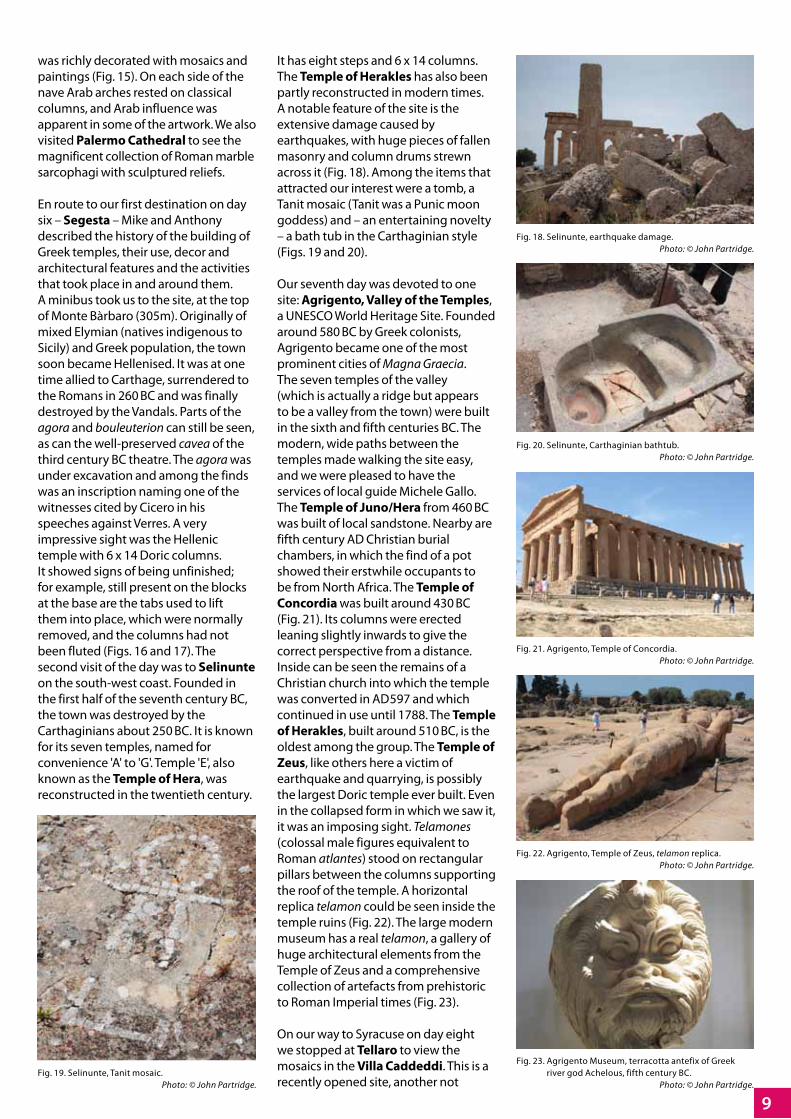
En route to our first destination on day six – Segesta – Mike and Anthony described the history of the building of Greek temples, their use, decor and architectural features and the activities that took place in and around them. A minibus took us to the site, at the top of Monte Bàrbaro (305m). Originally of mixed Elymian (natives indigenous to Sicily) and Greek population, the town soon became Hellenised. It was at one time allied to Carthage, surrendered to the Romans in 260 BC and was finally destroyed by the Vandals. Parts of the agora and bouleuterion can still be seen, as can the well-preserved cavea of the third century BC theatre. The agora was under excavation and among the finds was an inscription naming one of the witnesses cited by Cicero in his speeches against Verres. A very impressive sight was the Hellenic temple with 6 x 14 Doric columns. It showed signs of being unfinished; for example, still present on the blocks at the base are the tabs used to lift them into place, which were normally removed, and the columns had not been fluted (Figs. 16 and 17). The second visit of the day was to Selinunte on the south-west coast. Founded in the first half of the seventh century BC, the town was destroyed by the Carthaginians about 250 BC. It is known for its seven temples, named for convenience 'A' to 'G'. Temple 'E', also known as the Temple of Hera, was reconstructed in the twentieth century.
It has eight steps and 6 x 14 columns. The Temple of Herakles has also been partly reconstructed in modern times. A notable feature of the site is the extensive damage caused by earthquakes, with huge pieces of fallen masonry and column drums strewn across it (Fig. 18). Among the items that attracted our interest were a tomb, a Tanit mosaic (Tanit was a Punic moon goddess) and – an entertaining novelty – a bath tub in the Carthaginian style (Figs. 19 and 20).
Our seventh day was devoted to one site: Agrigento, Valley of the Temples, a UNESCO World Heritage Site. Founded around 580 BC by Greek colonists, Agrigento became one of the most prominent cities of Magna Graecia. The seven temples of the valley (which is actually a ridge but appears to be a valley from the town) were built in the sixth and fifth centuries BC. The modern, wide paths between the temples made walking the site easy, and we were pleased to have the services of local guide Michele Gallo. The Temple of Juno/Hera from 460 BC was built of local sandstone. Nearby are fifth century AD Christian burial chambers, in which the find of a pot showed their erstwhile occupants to be from North Africa. The Temple of Concordia was built around 430 BC (Fig. 21). Its columns were erected leaning slightly inwards to give the correct perspective from a distance. Inside can be seen the remains of a Christian church into which the temple was converted in AD 597 and which continued in use until 1788. The Temple of Herakles, built around 510 BC, is the oldest among the group. The Temple of Zeus, like others here a victim of earthquake and quarrying, is possibly the largest Doric temple ever built. Even in the collapsed form in which we saw it, it was an imposing sight. Telamones (colossal male figures equivalent to Roman atlantes) stood on rectangular pillars between the columns supporting the roof of the temple. A horizontal replica telamon could be seen inside the temple ruins (Fig. 22). The large modern museum has a real telamon, a gallery of huge architectural elements from the Temple of Zeus and a comprehensive collection of artefacts from prehistoric to Roman Imperial times (Fig. 23).
On our way to Syracuse on day eight we stopped at Tellaro to view the mosaics in the Villa Caddeddi. This is a recently opened site, another not
Fig. 18. Selinunte, earthquake damage. Photo: © John Partridge.
Fig. 20. Selinunte, Carthaginian bathtub. Photo: © John Partridge.
Fig. 19. Selinunte, Tanit mosaic. Photo: © John Partridge.
Fig. 21. Agrigento, Temple of Concordia. Photo: © John Partridge.
Fig. 22. Agrigento, Temple of Zeus, telamon replica. Photo: © John Partridge.
Fig. 23. Agrigento Museum, terracotta antefix of Greek river god Achelous, fifth century BC. Photo: © John Partridge.

10
largest known, had 67 rows of seats in nine sections and accommodated 15,000 spectators. It was later adapted by the Romans. The Roman amphitheatre, partly carved from the rock, had been the victim of stone robbing, despite which it still presents an impressive sight with parts of the entrances visible as well as the rectangular cellar for stage machinery in the centre of the arena (Fig. 25). The seventh or sixth century Temple of Apollo was, in later centuries, adapted to a Byzantine church and a mosque. We had seen a fine model of it in the Paolo Orsi Regional Museum. Our day ended with a visit to the cathedral, adapted in the seventh century AD from the fifth-century BC Temple of Athena, whose Doric columns can be seen incorporated into its outer walls and between the nave and aisles.
The penultimate and last full day of the tour took us first to another UNESCO World Heritage Site – the famous Villa Romana del Casale at Piazza Armerina, where we were met by our local guide Diana Mazza. The original ownership and purpose of this early fourth-century AD villa is disputed but it was an extensive and luxurious establishment at the centre of a great estate. Its collection of late-Roman mosaics, mostly by North African mosaicists, is considered to be the largest and richest anywhere in the world. Centred on a peristyle were more than 50 public and private rooms, including a large basilica or aula for receptions, most with magnificent mosaics, marbles and frescoes. Parts of it at least were in use up to the twelfth century, when it was covered by a landslide. Excavated in the early and
Fig. 25. Syracuse, amphitheatre. Photo: © John Partridge.
Fig. 26. Piazza Armerina, mosaic with erotic scene, young women and Saturnalia masks. Photo: © John Partridge.
Fig. 27. Piazza Armerina, Hercules mosaic, giants struck dead. Photo: © John Partridge.
visited by conventional tour groups. Although this luxurious fourth-century AD establishment burned down at the end of that century, there remain some very fine mosaics. Most notable is that of a hunt scene depicting episodes seen in the Great and Little Hunt mosaics at Piazza Armerina. Also of note, and very unusual, is a mosaic of a scene from the Trojan War that is unknown in other sources. The central panel shows the body of Hector being weighed against a pan of golden vessels for ransom (Fig. 24). We continued to Syracuse, founded by Greek settlers around 734 BC. We began with a visit to the Paolo Orsi Regional Archaeological Museum, which houses a large collection of antiquities from the city and the surrounding area covering the time from prehistory to the end of the classical era. Next to the museum are an odeon and a Roman temple with a spectacularly well-preserved cella. After lunch we set off with our local guide Eva Greco to see several interesting sites. Pausing briefly at the Altar of Hieron (third century BC) we entered the archaeological park. An ancient quarry was notable for the fact that the Greeks extricated the rocks from below, leaving great pillars to support what became a roof above them. The Greek theatre, one of the
Fig. 24. Ransom of Hector. Photo: © Anthony Beeson.

11
things, tiles, conduits and storage jars. The House of Ganymede, named after a mosaic within it, dates from the third century BC, and is now under a protective building which makes it difficult to see and photograph. The House of the Greeting is named after the inlaid white polka-dot stones that form the Greek word EYEXEI – 'Welcome'. A wall of another house used in its construction what must be volume measures – large, medium and small – from the macellum (Fig. 31). We departed along a well-preserved street with stone block paving.
Our final visits took place on the morning of day ten, in the evening of which we were to end our tour. Catania was a Greek colony founded about 730 BC by settlers from nearby Naxos. Much of the city was buried under lava from an eruption of Mount Etna in 1669 but the theatre and adjacent odeon survive. The theatre, constructed largely of volcanic rubble and concrete, though with limestone seating, was probably built about the beginning of the second century AD and refurbished a century later. Some of the vomitoria, steps and passages are well preserved (Fig. 32). Part of the Cathedral of Catania, dedicated to St Agatha, was rebuilt in Baroque style after the earthquake of 1693, but the Norman eastern end has re-used Roman columns and capitals. To one side of the cathedral and partly underneath it are the fifth to fourth century BC Terme Achilliane (Achillean Baths). The part we visited comprised a vault supported by four pillars with remains of paintings and stucco work surviving. A walk or bus ride took group members to the spectacular remains of the lava-built amphitheatre and our last site: the Terme della Rotunda, Roman baths of the first to second century AD. Much of the structure of the baths was used when the church of St Mary was built, probably in the early Byzantine era (Fig. 33).
So ended a tour that contributed enormously to a more thorough understanding of Sicily's place in the ancient and classical world.
Our thanks go to Anthony Beeson and Mike Stone for their work in preparing this tour and so ably conducting it, and to our good-humoured courier, Michele Lomas. She will be remembered for a remark she made during a conversation with one of the local site guides: "They're not a normal group".
mid-twentieth century, the villa is now covered by a protective building. We were granted special access to parts of the villa under the old cover buildings. From the extensive raised walkways we were able to admire the famous Great and Little Hunt mosaic, mosaics of mythical scenes, circus scenes, scenes of daily life and geometric patterns (Fig. 26). Perhaps the most outstanding mosaics were those of Bacchus and the labours of Hercules in the three-apsed triclinium, magnificent in their grandeur and artistry (Fig. 27). Such was the splendour that ended the first half of the day.
We then travelled to Morgantina. With a history going back to at least 459 BC, this town underwent various allegiances but was distinctly Hellenic from the fifth century BC. It was destroyed around 27 BC for siding with Pompey in the Civil War. The fourth-century BC theatre remained unaltered in its plan throughout the town's history and could accommodate 5,000 spectators. Three stoai (arcades) enclosed a probably two-storeyed agora measuring 200m by 150m (Fig. 28). Along the south side of the northern stoa was a gymnasium, and at its western end a bouleuterion, of which parts can still be seen. A second-century BC macellum (market) within the agora was built around a peristyle with 13 shops on two sides, with a tholos – a small, round structure – inside it. A large trapezoidal staircase with about 13 steps formed the ekklesiasterion – an assembly place for free citizens over 20 years of age (Fig. 29). A raised tribunal enabled speakers to address the crowd. A Chthonic sanctuary dedicated to Demeter and Persephone was built around the fourth century BC. Of particular interest was a large kiln built against the old defensive walls, which had fallen out of use (Fig. 30). One of the largest known in the ancient world, it had furnaces at each end and was used for the firing of, among other
Fig. 28. Morgantina, east stoa. Photo: © John Partridge.
Fig. 29. Morgantina, ekklesiasterion. Photo: © John Partridge.
Fig. 30. Morgantina, large kiln. Photo: © John Partridge.
Fig. 31. Morgantina, reused volume measures. Photo: © John Partridge.
Fig. 32. Catania, theatre. Photo: © John Partridge.Fig. 33. Catania, Roman baths under St Mary's church.
Photo: © John Partridge.
12
A large courtyard villa near Halstock, 16 miles north-west of Dorchester, was first excavated under the direction of Edward Large (1967–70); Ron Lucas excavated it from then on to its completion in 1985. The report was published as Dorset Monograph 13 (Lucas, RN, 1993). The villa was of considerable interest as it contained two almost identical wing-fronted residential buildings side by side, with a very large suite of baths attached to one of them. The baths' large frigidarium had been laid with a very elaborate geometric mosaic, originally identified around 1901, along with a second mosaic depicting an image of Medusa. Unfortunately, no trace of the Medusa mosaic was discovered during the excavations; apparently it was completely destroyed in the intervening years (Neal, D and Cosh, S, 2006).
In 1979, during the early stages of the excavations and consolidation of the Roman villa at Littlecote Park in the parish of Ramsbury, Wiltshire, I contacted Ron Lucas. I asked him whether there were any discarded limestone mosaic tesserae on his site, superfluous to archive requirements and which might be useful in the proposed restoration of the triconch Orpheus mosaic at Littlecote. He had a tesserae dump at the side of the field where the excavations were taking place; consequently, I visited the site.
When I arrived, I was shown a stack of assorted tesserae lying in a heap of decaying plastic sacks. These were gathered up and placed into storage tubs for transfer to Littlecote. After they had been cleaned, the stones were found to contain large and unusual shapes. They were unsuitable for the restoration, and the stones were put into storage as a future source of material. The eventual restoration of the Orpheus mosaic was completed using modern terracotta to distinguish between the original antique areas and the restored sections. The Halstock material was virtually forgotten.
In 2009, while I was dismantling the Littlecote archive stores for rehousing, the Halstock tesserae reached the light of day once more. I spread out the material and could see it contained a substantial quantity of specifically cut stones, inappropriate for normal tessellated flooring; these warranted closer examination. It is quite common to find misshaped tesserae in mosaic and tessellated floors, ones which have not been cut to a regular cube-like form. However, the unusual quantity and diversity of shapes and sizes present in what was a relatively modest assemblage appeared
exceptional, and I separated them for comparison against the regular cut tesserae in the collection. What specifically interested me was that many of the pieces were too thin in cross section when compared to the surface area, appearing more like small tiles than regular tesserae, including some exceptionally large examples. In the late 1960s I participated in the excavations at the complex of Roman buildings at Great Witcombe in Gloucestershire, and when working in the central courtyard I recovered a great many of the small opus sectile tiles which had once formed the flooring of the elaborate octagonal room and forward porticus at the centre of the complex. It was the memory of the Witcombe pieces that stimulated me to make a more detailed examination of the Halstock material.
Floors of opus sectile are extremely rare in the buildings of Roman Britain, and the central octagon at Great Witcombe is a singular exception. A fragment of it was still in situ when Samuel Lysons uncovered the room in 1819 and he fortunately made a pencil drawing of it which is preserved in the archives of the Society of Antiquaries in London. This drawing has been the source of the design for the computer graphic restoration of the Witcombe floors by David Rider, as part of the architectural re-assessment of the site he has recently undertaken with the writer (Rider and Walters, forthcoming). Two of the houses at Silchester (House 1 in insula xxiii and House 2 in insula xxiv) had entrance vestibules floored with similar simple tile designs (Neal and Cosh, 2009). Similar pieces to those at Halstock were also recovered in minor examinations carried out on the Banwell villa in Somerset by Dr David Tomalin. First-century examples of such material were discovered at the Neronian proto-palace at Fishbourne, though not found in situ, being recovered as residual and discarded red, blue, white, grey and yellow tiles, very similar to material in floors widespread in Italy and southern Gaul. This showed that opus sectile had been laid at Fishbourne in the first century (Cunliffe 1971; 1998).
Halstock Roman villa, Dorset – a lost floor of opus sectileby Bryn Walters
Fig. 3. Left: Possible composition of tiles based on a design from Amathus Cyprus. Right: Flooring in a Christian basilica in Amathus, Cyprus. Photos: left, © Bryn Walters; right, © Ken Holt.
Fig. 2. Opus sectile floor, Salamis, Cyprus. Photo: © Nich Hogben.
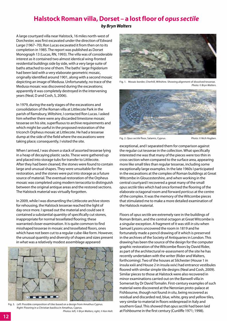
Fig. 1. Mosaic border, Cherhill, Wiltshire. Showing alignment of dissolved tesserae. Photo: © Bryn Walters.

13
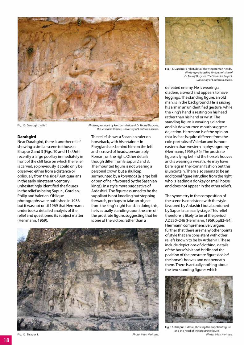
Consequently, the evidence suggests there was an area of opus sectile present in one of the two adjacent houses at Halstock. The stones consist in the main of blue/grey Somerset limestone, which over time has become patinated with a calcareous surface. There is a lesser quantity of reworked terracotta which displays a distinctive diamond shape, which could of course be simply ill-cut tesserae. There was also a small number of triangular pieces in hard chalk, which again could have originated from a standard mosaic. It has frequently been observed that softer grades of chalk, used as tesserae, can dissolve through time; this has been identified by hollow alignments in surviving mosaic borders and tessellated floors during excavations. I identified such alignments in the borders of the Durnovarian mosaic I excavated in 1984 at Cherhill near Calne, Wiltshire (Fig. 1). I suspect there may have been a larger amount of inferior chalk pieces in the original floor at Halstock, which over time disintegrated. If this occurred during the lifetime of the floor, it may have been the reason for its removal and replacement. There might originally have been a geometric tiled floor at Halstock made principally of blue/grey limestone, highlighted with pieces in red terracotta and white chalk. A truly fine example of this type of floor is depicted in the baths of the Kampanopetra basilica at Salamis in Cyprus (Fig. 2) (see ARA News 22, 2009, p17).
During this research I have put together a small selection of the Halstock pieces, as examples of what could have been created: one modelled on an opus sectile floor in the Christian basilica at Amathus in Cyprus (Fig. 3) (see ARA News 22, 2009, p5), and another of random pieces conjoined as a speculative border pattern (Fig. 4). Such a border may have surrounded Halstock's lost Medusa mosaic; a chequered black and red tile border surrounds the Medusa mosaic in the baths at the Roman villa in Bignor, West Sussex.
The larger pieces have a variety of forms and sizes (Fig. 5). These include regular triangles, elongated triangles, truncated right-angled triangles, wedge-shaped lozenge forms and a large number of probable diamond shapes. A large selection of 'border' sticks was also present, and a few larger square and rectangular tiles not dissimilar to those recovered from Great Witcombe.
The Halstock assemblage raises questions. How many other examples of opus sectile floors have been lost during refurbishment of buildings in the Roman period? Also, have tiles found as residual detritus in archaeological excavations of Roman sites in Britain been misidentified and discarded as unusual loose tesserae and not recorded for what they originally were? The latter appears to have been the case at the Halstock villa. The collection (Fig. 6) has been deposited with the Halstock archive at the Dorchester County Museum.
This paper is an extended version of a 'note' published in Britannia (Walters, 2011).
BibliographyCosh, S and Neal, D, 2006, Roman Mosaics of Britain, Vol II: South-West Britain, Society of the Antiquaries of London.
Cunliffe, BW, 1971, Excavations at Fishbourne 1961–1969, Vol 2: The Finds, Reports of the Research Committee of the Society of Antiquaries of London 27, London.
Cunliffe, BW, 1998, Fishbourne Roman Palace (second edition), Stroud.
Lucas, RN, 1993, The Romano-British villa at Halstock, Dorset. Excavations 1967–1985, Dorset Natural History and Archaeological Society Monograph 13, Dorchester.
Neal, DS and Cosh, SR, 2009, Roman Mosaics of Britain, Vol III: South-East Britain, Part I, Society of Antiquaries of London.
Rider, D and Walters, B, forthcoming, The Roman building at Great Witcombe, Gloucestershire. An architectural and functional review, in Roman villas in Britain, a retrospective, ed. M Henig and G Soffe. Oxbow Books.
Walters, B, 2011, A Probable Opus Sectile Pavement from the Halstock Villa in Dorset. Britannia Vol 42, pp315–18. The Society for the Promotion of Roman Studies.
Fig. 4. Suggested border pattern. Photo: © Bryn Walters.
Fig. 5. Principal limestone forms. Photo: © Bryn Walters.
Fig. 6. Complete collection. Photo: © Bryn Walters.

14
This essay was inspired by a tour of Iran which I undertook in April/May 2010. This was a fascinating and unique opportunity for me to visit a country often considered inaccessible by western travellers and archaeologists, their perceptions influenced by Iran's place in international politics. It is an impressive and varied country. The Iranian people are warm, friendly, hospitable and genuinely interested in western travellers. In terms of archaeology I was captivated and fascinated by the beautiful Islamic mosques and gardens of Shiraz and Isfahan, the ancient Achaemenid sites at Persepolis, Pasargadae, Susa and Bisotun, as well as the cosmopolitan bustle of modern-day Tehran.
Within the territories of the former Roman Empire one sees images of Rome commemorating the defeats of its enemies and the subjugation of conquered kingdoms. Only in countries never occupied by the Romans do we discover their enemies' perceptions of them. In Fars Province in south-west Iran I was particularly intrigued by a series of Sasanian monumental stone reliefs and inscriptions. These were commissioned by Sasanian rulers to commemorate their victories over Rome and assert their right to rule. Several of the reliefs relate to the third-century Sasanian ruler Sapur I and use a formulaic composition to express his differing relationships with the three Roman emperors whom he defeated: Gordian III, Philip the Arab and Valerian. Elsewhere in the Fars Province, major building works, including the city of Bisapur and an extensive series of bridges and dams at Shushtar, were undertaken by Sapur with Roman prisoners of war but these are not discussed here.
ScopeAfter providing their historical context this article describes and discusses the carved stone inscription at Naqsh-i Rustam and monumental reliefs at Bisapur, Naqsh-i Rustam and Darabgird (Fig. 1).1 These celebrate Sasanian victories over Roman armies and reveal much about the attitudes of the Sasanians to their arch-rivals and to our understanding of this ill-fated period in Roman history. There is no definitive
chronology for when each of these reliefs was created, so those that contain all the elements of the formulaic scene will be discussed first, followed by those that contain only partial elements. Lastly will be discussed some later reliefs that show Roman defeats by Sapur's successors.
Historical backgroundThe Sasanians emerged during the early third century AD as the local leaders in what is now the Iranian province of Fars. Their influence grew and in AD 224 the last Parthian king was defeated by the first Sasanian ruler Ardashir I. At its greatest extent, the Sasanian Empire extended from eastern Syria to the Indus and from Georgia to the Persian Gulf and eventually even to the Yemen. It collapsed in the mid-seventh century when the Arabs overran Mesopotamia. The Sasanians considered themselves to be the rightful spiritual successors of the great Achaemenid dynasty of the sixth to fourth centuries BC. The Sasanian period saw a renaissance in Persian art, culture, architecture and mathematics; it was during this time that the dome and the vault, the archetypal features of later Islamic architecture, were first developed by them. Contrastingly, Rome was at a low point in its history following the murder of Alexander Severus in AD 235. A succession of ill-chosen and short-lived emperors caused instability within and hostile incursions along its borders: not only from a newly resurgent Persia but also from Alamanni and Goths on the Rhine and Danube.
Ardashir I (AD 224–240)Soon after his succession, Ardashir I invaded Mesopotamia and Syria, demanding that Rome return the Achaemenid territories lost during Parthian rule. The period which followed, until the Roman defeat at Samarra in AD 363, was one of heightened aggression and acquisitive hostilities between Persia and Rome, with both disputing possession of Asia Minor, Armenia, Mesopotamia and Syria.
Sapur I (AD 240–272, son of Ardashir I)Beginning in AD 244, when he defeated the young Roman emperor Gordian III at Misik in modern Iraq, Sapur I won a number of prestigious military and diplomatic victories over Rome. The fourth-century Roman source, the Historia Augusta, states that Gordian was murdered shortly after his defeat, as a result of intrigue by his Praetorian prefect and successor Philip the Arab (Historia Augusta (a) 29–30). Immediately following his accession, Philip was forced to approach Sapur on Persian territory to sue for peace, to arrange tributary payment and to negotiate the return of prisoners by paying a ransom of 500,000 denarii. Philip's capitulation was considered to be dishonourable by the Romans and the victory at Misik was a huge propaganda coup for Sapur. In celebration, he renamed Misik, Peroz-Sapur ('Victorious is Sapur') (Dignas & Winter, 2007, p119). Sapur pressed home his advantage and went on to conquer Armenia in AD 252 and then advance into Mesopotamia, Syria and Antioch.
The Romans suffered further humiliation in AD 260 when the Sasanians were besieging the towns of Carrhae and Edessa. The Roman emperor Valerian advanced with what was reported to be an army of 70,000 men but was defeated at Edessa and captured along with his senior officials and 60,000 men. This was the largest number of prisoners ever absorbed by Persia. Valerian was deported to the Fars region, most probably to Bisapur, where it is assumed that he died in captivity.
A Tale of Three Emperors: Images of Roman defeat in Sasanian Iran
by Ian Heritage
Fig. 1. Map showing the sites. © Ian Heritage.

15
The remains of Valerian's army were resettled in cities throughout Assyria, Susiana, Persia and elsewhere (Dignas & Winter, 2007, pp80–81).
The reliefs which Sapur commissioned to celebrate and commemorate these victories were located at two sites of great significance for the Sasanians. The first, the Chogan Gorge, formed the approach to Sapur's triumphal city of Bisapur, built by Roman prisoners of war to commemorate his victory at Edessa. The second was Naqsh-i Rustam, the royal necropolis of the Achaemenid kings. Not only were these two sites of great historical significance for the Sasanians but they also lay on major routes, where proclamations of Sasanian supremacy were seen by all, from the local populace to visiting envoys and traders from beyond the borders of Iran.
The Chogan Gorge cuts a dramatic cleft in the Zagros mountains, an austere but impressive outcrop of rock extending 1,500km diagonally from the Turkish border in the north-west, to the Persian Gulf in the south-east (Fig. 2). The Gorge itself lies south of modern Faliyan, on the ancient road which originally linked the Sasanian capital of Istakhr, near Persepolis, to Ctesiphon, in modern Iraq. Here, Sapur I and his successors Bahram I (273–276), Bahram II (276–293) and Sapur II (309–379) carved a total of six rock reliefs, three of which relate to Sapur I's victories over the Romans.
Naqsh-i Rustam is an impressive rock escarpment near Persepolis (Fig. 3). It is notable for the four large cruciform tombs cut into its face, which are believed to be those of the Achaemenid kings: Darius II, Artaxerxes I, Darius I and Xerxes I. Also present here and typically placed beneath or alongside the tombs
are eight over-sized Sasanian rock reliefs. Carved much later than the tombs, these reliefs commemorate the investitures and victories of Ardashir I, Sapur I, Bahram II, Narseh I (293–302), Hormuzd II (302–309) and Sapur II. By associating these reliefs with Achaemenid monuments, the Sasanians identified themselves with and proclaimed themselves to be the rightful dynastic successors of the ancient dynasty. One of the reliefs relates to Sapur I's Roman victories and two others may depict victories over Rome by his successors.
The inscription: Res gestae divi SaporisIn addition to the reliefs there is an important Sasanian trilingual inscription at Naqsh-i Rustam, inscribed on the lower outer walls of a small Achaemenid stone tower located directly in front of the cliff face (the Kab'a-i Zardasi – "Cube of Zarathustra") (Fig. 4). The text was probably composed by Sapur I himself and inscribed after his death by his son Hormuzd I (272–273) (Dignas & Winter, 2007, pp56–57). The inscription is in Middle Persian, the language of the Sasanians, with separate translations in Parthian and Greek. This inscription was not revealed until the 1930s and describes Sapur I's perception of himself, his political goals and the composition and religion of the Sasanian state. Most importantly, a third of it provides detailed accounts of his campaigns and conflicts with Rome, although in common with its counterparts in the Historia Augusta, it omits references to Sasanian defeats. The inclusion of Parthian and Greek translations, the languages of Sapur I's most significant conquered regimes, is therefore significant: language here is a symbol of Sasanian dominance in addition to communication. Crucially,
this is the only contemporary source for Sapur I's campaigns against Rome. Its importance is such that it has become known as the Res gestae divi Saporis2 (the RGDS) (ibid, p56).
The presentation of events in the RGDS differs from Roman sources in ways that are unsurprising. It states that Gordian III began an offensive immediately after Sapur I's succession, while Roman sources state that Sasanian incursions into Roman territory provoked a Roman counter-attack (Historia Augusta (a) 26:3–6). The RGDS fails to mention Gordian's earlier victories over Sapur I. For the battle at Misik it states:
"… and a great frontal attack took place along the borders of Asurestan – in Misik. And the emperor Gordian was killed and we destroyed the Roman army: and the Romans proclaimed Philip emperor." (quoted in Dignas & Winter, 2007, p77).
The inscription links Gordian's death with the battle without explicitly stating that he died on the battlefield or of
Fig. 2. The Chogan Gorge near Bisapur. Photo: © Ian Heritage.
Fig. 3. Naqsh-i Rustam. Photo: © Ian Heritage.
Fig. 4. The Kab'a-i Zardasi tower, Naqsh-i Rustam. Photo: © Ian Heritage.

16
wounds afterwards. Contrastingly, the Roman account fails to mention their defeat and asserts that Philip treacherously intrigued for Gordian's murder. Possibly the ambiguity of the RGDS allowed Sapur to claim credit for Gordian's death without actually falsifying what really happened. The inscription was composed within thirty years of the events of AD 244 and it would have harmed Sapur's credibility to have published a blatantly false account. The RGDS goes on to describe Valerian's defeat at Edessa. It emphasises the large size of Valerian's army and the capture of Valerian, his praetorian prefect, senators and officials, presumably to further glorify the extent of Sapur's victory (quoted in Dignas & Winter, 2007, p80).
Reliefs showing three emperorsThe stone reliefs described here almost certainly depict the events described in the RGDS. In this sense they provide a visual accompaniment to the inscription. Most of them show a formulaic scene involving Sapur I and three Roman imperial figures, identified by their attire.
Sapur is on horseback and is clearly identified by his crown (distinct in design from those of other Sasanian rulers). Each of the Roman figures adopts a distinctive pose:i) a prostrate figure lies beneath the
hooves of the victor's horse;ii) a supplicant figure kneels before
the victor;iii) a standing Roman has his hand or
wrist securely clasped by Sapur.
This central vignette lies within a wider scene, with Sapur's retinue and subjects on the left and with captured armies and subjects of client kingdoms on the right. Here Sapur is at the centre of an ordered world, extending beyond the
territories of Iran and confirming his title, explicitly stated in the RGDS, as "King of Kings of Iran and Non Iran" (Canepa, 2009, p54).
Bisapur 2This well-preserved relief3 is located on the south-western side of the Chogan Gorge, away from the main sequence of Sasanian reliefs on the south-eastern side (Figs. 5 and 6). In front of Sapur hovers a small winged figure, a cherub or putto, carrying the ring of power (cydaris) and the diadem of rule. The three submissive figures have been allowed to retain their weapons and insignia of office. Surrounding this central panel are two panels on the left showing the Sasanian retinue and five panels on the right showing at least four subject peoples, none of them apparently Roman (and a blank panel on the upper right may have been intended for more).
The standing Roman just behind Sapur has his grasped wrist covered by his sleeve in order not to pollute the King of Kings. Since the beginning of the nineteenth century it had been thought that the standing figure was either Philip the Arab or Cyriades (an Antiochene who led Sapur to Antioch and was rewarded by being proclaimed the new Roman emperor). MacDermot has argued convincingly against the standing figure being Cyriades.4 In each relief Sapur is shown very deliberately placing a hand on the standing figure and except in the Darabgird relief he is always grasping the hand or wrist. This may be a literal representation of Sapur's own reference in the RGDS.
"And on the other side of Carrhae and Edessa we fought a great battle with Valerian, and we captured the emperor Valerian with our own hands…" (quoted in Dignas & Winter, 2007, p80)
"with our own hands" is itself a formulaic phrase that originated with the Assyrians, meaning to take personal credit for a deed (Ball, 2000, p120). It is reasonable, therefore, to presume that the depiction in the reliefs is a literal representation of this and that the standing figure is Valerian.
The prostrate figure is unlikely to be an anonymous Roman. Sasanian iconography elsewhere typically only portrays rulers and gods trampling somebody of equivalent but opposite rank (Ball, 2000, pp118–119) and like the other two Romans this figure appears to be wearing a head wreath. The youthful and beardless features resemble coin portraits of Gordian III, who was only 19 when he was killed (see MacDermot, 1954, p79).
The suppliant figure is posed in a manner consistent with the humiliated status of Philip the Arab, who was compelled to make terms with Sapur I. The short-cropped hair and beard is similar to his numismatic portrayals and also to a marble bust now in the Vatican (see MacDermot, 1954, plate V).
The close resemblance between the figures postulated to be Gordian and Philip and their numismatic portraits is not unlikely. The artists and stone-masons involved might never have seen the real emperors and would likely have copied coin portraits. The resemblance between the standing figure and Valerian coin portraits is less convincing. The face of the figure is quite crudely executed, although it appears to be beardless as on the Valerian coins and also reproduces his thick neck.
Bisapur 3This is the first of a series of four Sasanian reliefs along the north-eastern side of the Chogan Gorge (Figs. 7 and 8).
Fig. 5. Bisapur 2, central vignette. Photo: © Ian Heritage. Fig. 6. Bisapur 2. Photo: © Ian Heritage.

17
It is extremely weathered and was further damaged when a stone aqueduct was constructed along the gorge. Although the aqueduct was removed during the 1970s a deep groove remains, with associated water damage, along the bottom of the relief.
The crown of the mounted figure identifies it as Sapur I. The winged figure carrying the ring and diadem is also present as in Bisapur 2. The Roman figures are too badly damaged to reveal details but the striking similarities with those of Bisapur 2 allow reliable identification. The standing and suppliant figures appear to have been allowed to retain their swords. The composition is not typical of Sasanian reliefs in that it is divided into five narrow horizontal registers. Beyond the central scene are long repeating rows of figures, showing the Sasanian retinue on the left and the subject peoples on the right. In contrast to the prominence of the Roman emperors in the central panel, the Roman retinue only occupies a limited space in the two lower right panels. The upper right registers are occupied by figures in leggings, probably Kusans, who bring extravagant tributes including an Indian elephant, wild cats on leashes and a riderless but richly harnessed horse. Contrastingly, the Roman tributes are more modest and less elaborately detailed (Fig. 9). In addition to a figure carrying a vexillum, the Romans are leading a riderless carriage,
of a type that may be recognised as imperial by comparison with those on the Arch of Galerius in Thessaloniki and the Arch of Constantine in Rome (Canepa, 2000, pp72–73).
Bisapur 3 is reminiscent of Roman reliefs that depict full Roman triumphs, and Ball remarks on its similarity to the Column of Trajan in Rome. He also remarks on the absence of violence and seemingly implicit magnanimity in the scene. In contrast to those depicted in Roman triumphs, the prisoners here are
unchained and have been allowed to retain their weapons and chariots. The dignified depiction of the Romans suggests that it may even have been carved by captured Roman craftsmen (Ball, 2000, p121). Herrmann, however, has dismissed any similarity to the Column of Trajan. While agreeing that the fluid and naturalistic style of the figures suggests Roman craftsmanship, she points out that the Column of Trajan has a single spiralling register telling a continuous narrative, which is plainly not the case at Bisapur 3. Rather, the repeating registers, the grouping of different figures, the concept of harmonious order and the design, number and size of the figures, may have more in common with the much earlier Achaemenid 'tribute bearer' reliefs at nearby Persepolis (Herrmann, 1969, p82). However, this style of presentation was undoubtedly used on Roman triumphal arches, for example the panels on the Arch of Galerius.
Fig. 7. Bisapur 3. Photo: © Ian Heritage.
Fig. 8. Bisapur 3, central vignette. Photo: © Ian Heritage.
Fig. 9. Bisapur 3, detail showing the Roman retinue. Photo: © Ian Heritage.
18
DarabgirdNear Darabgird, there is another relief showing a similar scene to those at Bisapur 2 and 3 (Figs. 10 and 11). Until recently a large pool lay immediately in front of the cliff face on which the relief is carved, so previously it could only be observed either from a distance or obliquely from the side.5 Antiquarians in the early nineteenth century unhesitatingly identified the figures in the relief as being Sapur I, Gordian, Philip and Valerian. Oblique photographs were published in 1936 but it was not until 1969 that Herrmann undertook a detailed analysis of the relief and questioned its subject matter (Herrmann, 1969).
The relief shows a Sasanian ruler on horseback, with his retainers in Phrygian hats behind him on the left and a crowd of heads, presumably Roman, on the right. Other details though differ from Bisapur 2 and 3. The mounted figure is not wearing a personal crown but a skullcap surmounted by a korymbos (a large ball or bun of hair favoured by the Sasanian kings), in a style more suggestive of Ardashir I. The figure assumed to be the suppliant is not kneeling but stepping forwards, perhaps to take an object from the king's right hand. In doing this, he is actually standing upon the arm of the prostrate figure, suggesting that he is one of the victors rather than a
defeated enemy. He is wearing a diadem, a sword and appears to have leggings. The standing figure, an old man, is in the background. He is raising his arm in an unidentified gesture, while the king's hand is resting on his head rather than his hand or wrist. The standing figure is wearing a diadem and his downturned mouth suggests dejection. Herrmann is of the opinion that its face is quite different from the coin portraits of Valerian and is more eastern than western in physiognomy (Herrmann, 1969, p86). The prostrate figure is lying behind the horse's hooves and is wearing a wreath. He may have bare legs in the Roman fashion but this is uncertain. There also seems to be an additional figure intruding from the right, who is leading a donkey or small horse and does not appear in the other reliefs.
The symmetry in the composition of the scene is consistent with the style favoured by Ardashir I but abandoned by Sapur I at an early stage. This relief therefore is likely to be of the period AD 230–246 (Herrmann, 1969, pp83–84). Herrmann comprehensively argues further that there are many other points of style that are consistent with other reliefs known to be by Ardashir I. These include depictions of clothing, details of the horse's bit and bridle and the position of the prostrate figure behind the horse's hooves and not beneath them. There is actually nothing about the two standing figures which
Fig. 12. Bisapur 1. Photo: © Ian Heritage.
Fig. 13. Bisapur 1, detail showing the suppliant figure and the head of the prostrate figure. Photo: © Ian Heritage.
Fig. 10. Darabgird relief. Photo reproduced by kind permission of Dr Touraj Daryaee, The Sasanika Project, University of California, Irvine.
Fig. 11. Darabgird relief, detail showing Roman heads. Photo reproduced by kind permission of Dr Touraj Daryaee, The Sasanika Project, University of California, Irvine.

19
conclusively identifies them as Roman, although Herrmann is of the opinion that the dejected faces on the right are 'unmistakable caricatures of Roman soldiery' (ibid, p86). Ardashir had several victories over the Romans but it is not clear which particular event is portrayed here. Matheson suggests, without much conviction, that the relief may depict defeats of Severus Alexander and/or Maximus Thrace (Matheson, 2001, p142).
Reliefs showing two emperorsTwo more reliefs depict similar scenes to those discussed above but only show two rather than three defeated Roman emperors, with neither relief showing the same two individuals.
Bisapur 1This relief is located on the south-west side of the Chogan Gorge, at a distance from the main sequences of reliefs (Figs. 12 and 13). It is very badly damaged along its upper half but enough details are discernible to allow its original composition to be deduced for comparison with other reliefs. Here, two horsemen face each other: on the left, the supreme god Ahuramazda hands over the symbol of power, the cydaris ring, to Sapur I on the right. Ahuramazda's horse tramples upon the embodiment of evil, the god Ahriman, while Sapur's horse tramples upon a prostrate figure, presumably Gordian. In the centre a suppliant figure, presumably Philip, kneels before Sapur.
Here the suppliant figure is kneeling with his right leg forwards, his shin fully on the ground and with his left leg splayed out behind him. He appears to be grasping the legs of Sapur's horse. This very naturalistic pose is in contrast to the more formal composition of the other reliefs. Although no features can be made out on the damaged face, the figure is clad in Roman imperial costume, with traces of a laurel crown, a cloak with a fibula (brooch) and a baldric with a pommel-headed sword.
This is likely to be the earliest of the reliefs discussed here because it alone lacks the standing figure of Valerian, adding weight to the assertion that the suppliant figure is indeed Philip and not Valerian. The primary focus of the relief is Sapur's investiture, only two years before the events at Misik. Sapur is unlikely to have still been commemorating this event sixteen years later and just after his victory at Edessa. The relief also employs the symmetrical composition
and imagery, if not the style, of a relief which Ardashir his father had carved at Naqsh-i Rustam, in which a mounted Ardashir tramples the last Arsacid king Artabanus IV, while facing him the mounted god Ahuramazda tramples Ahriman. None of the other reliefs discussed above shows this supernatural element (Canepa, 2009, pp58–64).
Naqsh-i RustamThis well-preserved relief (see cover image) is located directly below and to the left of what is conjectured to be Darius I's tomb. Sapur appears on horseback, while behind him are the head and shoulders of Kartir, his High Priest. Sapur's outstretched right hand grasps the raised hand of a figure in Roman dress standing in the background. In the foreground, a half-kneeling Roman stretches out his hand in supplication. The short-cropped hair and beard of the suppliant figure is consistent with the numismatic likeness of Philip and the relief at Bisapur 2.
This relief differs from the others because the prostrate figure of Gordian III is absent, even though his death was the earliest event in the series. No conclusive reason for this has been established, although MacDermot notes that the location and style of this relief are also very different from the others. The relief may even have been produced at a much later date than the others, after Sapur's death. Sapur himself never claimed direct credit for Gordian's
death and the event may have lost its significance after Sapur's own demise (MacDermot, 1954, p80). The postulated late date of this relief becomes even more plausible when considering its position in relation to the tomb of Darius I. It is placed below and to the left of the tomb, while another relief, probably relating to the later ruler Bahram II, is positioned centrally and directly below the tomb. Surely the relief showing Sapur I would have occupied this central position if it had been the first to be carved.
Other reliefsSapur's monumental commemorations of his victories over the Romans were considerable, not only in his prominent stone reliefs but also in his cities and public works created by the labour of Roman prisoners. After Sapur's reign, explicit portrayals of triumph over Rome did not feature as prominently in the art of his successors, even though the Sasanians continued to win notable victories. Possibly this was an indication of changing concerns and circumstances within the Sasanian dynasty (Canepa, 2009, p78). Two reliefs at Naqsh-i Rustam appear to depict conflicts with Rome although these are less prominent and less explicit about the incidents portrayed.
A relief located immediately below the tomb of Darius I is divided into two registers, both showing equestrian scenes (Fig. 14). In the upper segment,
Fig. 14. Naqsh-i Rustam: double register equestrian relief. Photo: © Ian Heritage.

20
a king accompanied by a standard bearer (no longer well-defined) is using a lance to force his opponent, possibly a Roman, from his horse. In the lower register, the king is again battling a mounted, possibly Roman figure. Both registers depict a dead enemy under the hooves of the king's horse. Matheson suggests that the upper register shows either Bahram II or Sapur II whilst the lower register shows Hormuzd II (Matheson, 2001, p122). Information at the site suggests that both registers depict Bahram II.
A second relief immediately below what is conjectured to be the tomb of Darius II (Fig. 15) shows an equestrian scene with a mounted Sasanian king accompanied by a standard bearer. The king is fighting a figure which appears to be wearing a Roman cavalry helmet. The Roman is plainly about to be defeated because his horse is rearing and his pilum is broken. The king's crown is no longer sufficiently distinct enough for clear identification but Matheson suggests it to be either Hormuzd II or Bahram IV (388–399) (Matheson, 2001, pp121–122). Information at the site states that it could be Sapur II.
A further relief at Taq-i Bustan, a separate site displaying reliefs commemorating much later Sasanian rulers, has been considered by some to depict the defeat of the Roman emperor Julian the Apostate (see, for example, Dignas & Winter, 2007, pp92–93 and Canepa, 2009, pp108–109). The present author, however, thinks that this relief, despite its late date, is more likely to be a link with and a reminder of the early origins of the Sasanian dynasty and actually depicts the Sasanian victory over the last Parthian king Artabanus IV. Therefore, for reasons of space and relevance it is not discussed here.
DiscussionIn the Sapur I reliefs, the three Roman emperors each appear to play a symbolic role which confirms Sapur's right to rule. The death of Gordian III was a monumental victory for Sapur, as a worthy successor to his father's victories. The suppliant Philip the Arab shows submission of Iran's enemies to the King of Kings. The standing Valerian, with his wrist firmly held by the victor, shows Sapur's prowess on the battlefield and his magnanimity in allowing the captured emperor to live. These three events spanned sixteen years and their inclusion in one scene is
not a literal representation of actual events. In Bisapur 2 and 3 and perhaps at Darabgird, the vignette showing Sapur with these symbolic appendages is made all the more powerful by it being placed at the centre of an ordered world, surrounded by subject peoples extending beyond the territories of Iran. It confirms Sapur's role as the King of Kings of Iran and Non Iran. The reliefs that show only two emperors do not include this wider group. It is likely that this is because Bisapur 1 was created early in Sapur's reign, when he had not yet secured sufficient conquests to warrant this. The relief at Naqsh-i Rustam was probably created after Sapur's death, when he was still remembered and honoured but with a successor now occupying this central position in the world.
The Sasanian representation of events in the reliefs and in the RGDS differs in key ways from those described in Roman sources. The Sasanian version suggests that Gordian was not ignominiously murdered by his successor but died on the battlefield – a more noble death with which Sapur, as the protector of his kingdom, would wish to be directly linked. The relief at Naqsh-i Rustam, which does not show Gordian's corpse, suggests that Sapur's claim had lost its significance for later generations. Valerian's depiction as the standing figure may suggest that although Sapur held him as a captive trophy he was still seen as equal in terms of kingship, unlike the suppliant Philip who capitulated in defeat. In reality Philip had no alternative but to agree terms quickly and so obtain closure on his predecessor's defeat, in order to return quickly to Rome to establish and consolidate his succession as emperor. The Sasanian reliefs, however, portray this as craven submission although the Roman prisoners in the
relief retain their weapons and appear to be treated with dignity.
The notion that Sapur I granted dignity to his Roman captives is suggested by the leeway he appears to have allowed them in the construction of the nearby city of Bisapur. The layout, design and decoration are strongly suggestive of Roman cities. This liberal approach seems to have ensured a peaceful captivity; Dignas and Winter (2007, p256) note that there are no accounts of any subsequent confrontations at Bisapur between the new Roman settlers and the local indigenous inhabitants. If that was the case then it appears to argue against some Roman sources, which suggest that Valerian at best died in humiliating slavery and at worst was tortured and used by Sapur as his footstool when mounting his horse, after death his body being flayed and put on public display.6
The interpretation of the reliefs, in terms of what they can say about the Sasanians' attitude to these Roman emperors, is highly subjective. Although Valerian is standing in the reliefs in which he appears, suggesting that he has a higher status than the kneeling Philip, his figure is actually the less conspicuous of the two. He is always shown standing behind Sapur or in the background behind Philip, although this may simply be because of the compositional problems of trying to make all four figures visible in one compact scene. Philip also fares better in terms of depictions of his facial likeness. In the reliefs which are sufficiently undamaged to discern faces, the sculptors have taken pains to show Philip's beard and short hair, contrasting markedly with Valerian's undistinguished features. Again, this could be simply because Philip's bearded features lend themselves more
Fig. 15. Naqsh-i Rustam: single equestrian relief. Photo: © Ian Heritage.

21
to the Sasanian style of portraiture. Valerian's numismatic portraits show him to be beardless and thus more difficult to distinguish in carvings (see MacDermot, 1954, p79). Maybe our assumption that he must be the more important figure is only a Roman perspective. The Romans would have seen the capture of a Roman emperor in battle as more acceptable than the humiliating submission of a discredited one. Contrastingly, the Sasanians may have seen Valerian's capture as simply due to the fortunes of war, whereas Philip's voluntary submission was a much more telling recognition of Sasanian superiority (ibid, pp79–80).
There seems to be general agreement that the creation of these reliefs received some level of influence from Roman artisans, accidentally, formally and technically, as seen especially in Bisapur 3. Herrmann states that the presence of the small winged cherubs in Bisapur 2 and 3 is an entirely western classical feature that had not been seen before (Herrmann, 1969, p80). This is debatable as this feature may have derived from Hellenistic stylistic influences present in Persia since Alexander the Great. Large-scale detention of captured Romans created the means for the transfer of both labour and ideas. Canepa suggests that this may not have been entirely accidental or arbitrary. The importation of Roman styles may be seen as war booty and a clear challenge to Rome. He notes that while the convention of showing slain enemies under the hooves of the victor's horse is well established in Persian sculpture, the physical act of submission as represented by suppliant or kneeling figures is unknown in earlier Achaemenid, Parthian or early Sasanian visual culture. In contrast, it is relatively frequent and well established in Roman imagery, especially as performed by Arsacid (Parthian and Armenian) subject kings who were made to prostrate themselves in front of their Roman overlords. It is likely therefore that Sapur appropriated this imagery from Rome and employed it against them (Canepa, 2009, p64). This interplay of cultures emphasised Sapur's role as King of Kings of Iran and Non Iran. By employing the best of styles and visual culture as used throughout his world, in particular in the design of the city of Bisapur, Sapur placed himself at the centre of all things.
Readers are welcome to contact the author on [email protected]
AcknowledgementsWith grateful thanks to Professor Eberhard Sauer of the University of Edinburgh for his valuable suggestions and comments; to Professor Touraj Daryaee of the Sasanika Project, based at the University of California, Irvine, for allowing me to use the photograph of the Darabgird relief; and to my parents Jean and John Heritage for their help in turning my efforts into a readable and literate piece of work.
ReferencesBall, W, 2000. Rome in the East: The Transformation of an Empire. London, Routledge, ISBN 978-0415113762.
Canepa, M, 2009. The Two Eyes of the Earth: Art and Ritual between Rome and Sasanian Iran. University of California, ISBN 978-0520257276.
Curtis, J, 2011. Ancient Persia. London, British Museum Press, ISBN 978-0714121802.
Dignas, B and Winter, E, 2007. Rome & Persia in Late Antiquity: Neighbours and Rivals. Cambridge University, ISBN 978-0521614078.
Gibbon, E, 1776. Decline and Fall of the Roman Empire, vol 1, 1910. London, Everyman's Library edition.
Herrmann, G, 1969. 'The Darabgird Relief – Ardashir or Shahpur?', Iran, vol 77, pp63–88.
MacDermot, B, 1954. 'Roman Emperors in the Sassanian reliefs', Journal of Roman Studies, vol 44, pp76–80.
Matheson, S, 2001. Persia: An Archaeological Guide, third edition. Tehran, Yassavoli Publications.
Sauer, E, 2012. Email, personal communication, 2 June 2012.
Primary sourcesHistoria Augustaa) Magie, D, 1924. 'The Three Gordians',
in Historia Augusta, Volume II. Massachusetts: Loeb, pp381–447.
b) Magie, D, 1932. 'The Two Valerians', in Historia Augusta, Volume III. Massachusetts: Loeb, pp3–15.
LactantiusCreed, JL, (ed.), 1984. Lactantius: De Mortibus Persecutorum. Oxford: Clarendon Press.
The Sasanika Project, based at the University of California, Irvine, is devoted to promoting studies into the history and culture of the Sasanians. Its website exists as a comprehensive database of academic papers, photographs and news of recent research: http://www.humanities.uci.edu/sasanika/
Notes1 Darabgird was not visited by the author
but is discussed here.2 An analogy to the Res gestae divi Augusti,
the autobiographical inscription of the emperor Augustus.
3 The reliefs from Bisapur discussed here are numbered according to a generally accepted numbering of all the Sasanian reliefs at the site. The numbers here are therefore not consecutive.
4 Cyriades, sometimes referred to as Mareades, was an obscure citizen of Antioch who, according to the Historia Augusta, was raised to the status of the Roman emperor by Sapur after the defeat of Valerian and after he led the Sasanian ruler to Antioch. With this interpretation, the reliefs under discussion would show Sapur replacing the western Roman emperor by a nominee of his own choosing. However, there is no mention of Cyriades in the RGDS and no numismatic evidence of a reign of Cyriades. Other sources suggest that Cyriades was soon put to death by Sapur, probably at the time of the first Sasanian capture of Antioch c.AD 253. It is therefore improbable that he would be prominently depicted on a relief some 16 years after his execution (MacDermot, 1954, p77).
5 In 2004 the pool was observed to have dried up (Sauer, 2012).
6 The version of events describing Valerian's captivity as being one of torture and humiliation was first described by Lactantius (AD c.240–c.320) in his work De Mortibus Persecutorum (Chapter 5). A Christian writer and advisor to Constantine I, his work collects short biographies of Roman emperors who had persecuted Christians and presents the often gruesome ends they met as evidence of divine retribution. His lurid descriptions are very likely inflamed Christian propaganda. Of the other early writers who describe Valerian's capture, only Aurelius Victor (AD c.320–c.390) mentions Valerian's use as a footstool (Epitome de Caesaribus, 32:5–6). The Historia Augusta ((b) 1–4), Zosimus (c.490–c.510) (Historia Nova, 1) and Eutropius (latter part of fourth century AD) (Historiae Romanae Breviarium, 9:7), describe Valerian's capture as slavery but do not mention any such tortures. Modern historians since the time of Gibbon have questioned the veracity of this story (Gibbon, 1776, pp265–266).

22
NOT WHAT SHE SEEMS? THE SHOCKING NEWS ABOUT
THE SHE-WOLF
For centuries the Lupa Capitolina, the she-wolf of Rome, has been the symbol of the city and an ever-popular souvenir. Recent research into the iconic bronze sculpture (Fig. 1) has suggested that it is a casting dating between 1021 and 1153, rather than an original Etruscan work of the sixth or fifth centuries BC. This follows radiocarbon tests carried out by Lucio Calcagnile, at the University of Salento's Centre for Dating Diagnostics. An announcement has now been made at the Capitoline Museum, the home of
the sculpture, refuting the belief that the sculpture was used as a symbol of the city by the earliest Romans.
In legend the wolf suckled the abandoned babies Romulus and Remus in a cave on the Palatine. The sculpture was given to the city in 1471 by Pope Sixtus IV and the infants added to the group soon after by Antonio Pollaiulo. Certainly the image of the children suckled by the she wolf appears much in Roman art and on coinage and so had a symbolism for the later Roman viewer. An altar to Venus and Mars from the reign of Trajan, found in the portico of the Piazzale dei Corporazioni in Ostia Antica and now in the Palazzo Massimo alle Terme, shows a typical representation (Fig. 2). A mosaic from Aldborough in Britain shows the same scene, although even this has been questioned for authenticity by some, on account of its singularity (Fig. 3).
The Etruscan origins of the figure were not questioned until the 1997 restoration of the statue. At that time, restorer Anna Maria Carruba noticed that the she-wolf was cast as a single unit, a technique typically used in the Middle Ages. Ancient bronzes were cast in separate parts and then brazed together. This technique was used by the Greeks and then adopted by Etruscan and Roman sculptors. The technique basically consisted of brazing the separate joints together using bronze as welding material. Rome's officials decided to carry out more detailed examinations into the Lupa to clear any doubts. The researchers used accelerator mass spectrometry, and extracted, analysed and radiocarbon dated organic samples from the casting process. The results revealed with an accuracy of 95.4% that the sculpture was crafted between the eleventh and twelfth century AD. The new theory concerning the wolf is that she is a medieval copy of an original Etruscan work.
The Etruscan attribution was first made in the eighteenth century by art historian Johann Joachim Winckelmann on the basis of how the wolf's fur was represented. The dating and origin of the sculpture has been a matter of discussion ever since. It is possible that we shall never have a definite answer but the latest study has brought elucidation to the discussion.
http://www.usatoday.com/tech/science/2008-07-11-she-wolf-statue_N.htm
TYNE AND WEAR ARCHIVES AND MUSEUMS AWARDED
£400,000 FOR A COMMUNITY ARCHAEOLOGY PROJECT ON
HADRIAN'S WALL
The Heritage Lottery Fund has awarded a community archaeology project £400,000 to uncover the history of Hadrian's Wall and its legacy on Tyneside. The three-year project is to be organised by Tyne and Wear Archives and Museums and will involve more than 500 people from the North East.
From autumn 2012 work will commence on the study of Hadrian's Wall, including large sections that now are under roads and buildings, and to raise awareness of the Roman fortification amongst local communities. It is planned that members of the public who participate in the project will work alongside professional archaeologists and historians and also have the opportunity to get involved in excavations, surveying and desk-based research. Ged Bell, chairman of Tyne and Wear Archives and Museums joint committee, said: "This is a very exciting project which will reveal more about one of our region's most important landmarks, from its starting point in Wallsend and heading as far west as Hexham and Corbridge."
The new research and excavations will centre on the remains of the Roman fort of Condercum in Benwell; sections of the Wall in Wallsend, central Newcastle and Roman finds from Gateshead; Arbeia Roman fort at South Shields; and the 'lost Roman road' between Chesters and Corbridge, the route of which is unknown. Additional excavation will take place at Segedunum Roman fort in Wallsend where it is hoped that more finds and information will be gleaned. This project hopes not only to raise awareness of the Wall within the community but to also discover additional facts about a relatively unknown stretch of it. "It will provide fantastic volunteering opportunities and teach people taking part a diverse range of practical archaeological skills" said former BBC weather presenter Trai Anfield, who has been appointed as a new member of the HLF North East Committee.
http://www.museumsassociation.org/museums-journal/news/11072012-community-archaeology-project-
awarded-400000
http://www.hlf.org.uk/news/Pages/HadriansWall.aspx
Anthony Beeson's
Archaeological Round‑up
Fig. 1. The Lupa Capitolina, the Capitoline Museum. Photo: © Nich Hogben.
Fig. 2. Detail of an altar to Venus and Mars from Ostia. Photo: © Anthony Beeson.
Fig. 3. Detail of the Aldborough Romulus and Remus mosaic. Photo: © Anthony Beeson.

23
moon. Both discs are decorated with the udjat-eye, also called the eye of Horus, a common symbol in Egyptian art. Unfortunately the faces are not well preserved, but we can see that the boy has curly hair and a braid on the right side of the head, typical of Egyptian children. The girl's hair is arranged in a way similar to the so-called melonenfrisur (melon coiffure), an elaborate hairstyle often associated with the Ptolemaic dynasty, and Cleopatra particularly."
Capriotti compared the children's sculpture with another from the Ptolemaic era, the statue of Pakhom, governor of Dendera, now on display at the Detroit Institute of Arts. "Stylistically, the statues have several features in common. For example, the figures have round faces, little chins and big eyes." As the Pakhom statue has been dated to 50–30 BC she believes that the children's sculpture was also by an Egyptian sculptor of the same era, following Mark Antony's official recognition of the twins in 37 BC. In 36 BC Cleopatra bore Antony another son, Ptolemy Philadelphus. She had previously given Julius Caesar a son in 47 BC, named Caesarion.
"At the time of their birth in 40 BC, the twins were simply named Cleopatra and Alexander. When they were officially recognized by their father, three years later, as Antony returned to Antioch, in present Turkey, and Cleopatra joined him, they were named Alexander Helios (Sun) and Cleopatra Selene (Moon). Antony's recognition of the children was marked by an eclipse. Probably for this reason, and to mythologise their twin birth, the children were added those celestial names. Although in Egypt the moon was a male deity, in the sculpture the genders were reversed according to the Greek tradition," Capriotti said.
While Caesarion was killed under Octavian's orders as a threat to his dynasty, the three younger children were spared and sent to Rome to be brought up in the house of Octavia, the wife of Mark Antony and sister to Octavian. The boys vanish from history and presumably died young, but Cleopatra Selene married King Juba II of Mauretania, by whom she had a least one child, a son named after her little brother, Ptolemy Philadelphus.
http://news.discovery.com/history/cleopatras-twin-babies-120420.html
http://news.egypt.com/english/permalink/106641.html
A HOUSE BELIEVED TO BE THE BIRTHPLACE OF AUGUSTUS
DISCOVERED IN ROME
Archaeologists excavating on the north-eastern side of the Palatine Hill in Rome, close to the Arch of Titus, have uncovered the remains of a substantial house that they believe may have been the birthplace of the future emperor Augustus. The building was partially excavated in 2006 by a team led by Clementina Panella who discovered a corridor and other parts of what was described as "a very ancient aristocratic house". Further excavations since that date have uncovered ten rooms with beautiful mosaics and frescoed walls, and have strengthened the belief that this was the house owned by Gaius Octavius, the father of Augustus. Built around an atrium, the two-storeyed house climbed the hill and must have had fine views across the Roman Forum below and across to the Esquiline Hill.
Beyond a tufa wall the archaeologists found the remains of an ancient sanctuary identified by them as the Curiae Veteres, the earliest shrine of the curiae of Rome. According to tradition, Romulus, one of the city's twin founders, divided the Romans into 30 parts or curiae. These in turn were grouped into three sets of ten called tribes. Mentioned by the Roman historian Tacitus as one point in the Palatine pomerium, the original line ploughed by Romulus to mark Rome's boundaries, the Curiae Veteres was an important gathering place. On certain days of the year, representatives of the 30 curiae carried out ritual obligations in the communal building to reaffirm their membership. The many thousands of votive offerings and cult objects excavated here indicate that the Curiae Veteres sanctuary was active for about 11 centuries – from the seventh century BC to the fourth century AD. Later there were two curiae: the Curiae Veteres, where priests attended to religious matters, and the Curia Hostilia, built by King Tullus Hostilius, where senators cared for human affairs. Varro attributes the name curia to the Latin for 'care for' (curarent).
Suetonius states that Augustus was born on 23 September 63 BC, "in the region of the Palatine called Ad Capita Bubula (Ox Heads)". Several scholars believe that the toponym probably indicated a place in the Curiae Veteres. There are however doubts concerning the veracity of this statement and
Panella says "Augustus could have even made up his birth in the Curiae Veteres. He might have badly wanted to be born in that place, as it was strongly symbolic. It represented Romulus' founding and Augustus' re-founding of Rome."
As a child, Augustus lived at the house near the Curiae Veteres for the first three years of his life until his family moved to the Carinae, on a spur of the Esquiline. When 18 he bought a house near the Forum, moving only when he was 36 to live on the Palatine, when he purchased the house belonging to the orator Hortensius. The purchase was probably again symbolic as this lay above the grotto believed to be where Romulus and Remus were suckled and Romans worshipped them.
Much of the house near the Curiae Veteres has still to be uncovered. However, it is clear that it was a victim of the Neronian fire of AD 64 and was totally destroyed in the conflagration. In the rebuilding that followed the remains were covered and sealed beneath a road.
http://www.dnaindia.com/scitech/report_augustus-s-birthplace-still-uncertain-with-more-excavations-
uncovered_1611432
A STATUE OF CLEOPATRA VII'S AND MARK ANTONY'S TWINS
REDISCOVERED
Giuseppina Capriotti, an Italian Egyptologist, claims that she has rediscovered a lost sculpture of Mark Antony and Cleopatra's twin babies. The sandstone sculpture, discovered in 1918 near the temple of Dendera, is held by the Egyptian Museum in Cairo but previously it had not been closely studied. The back of the piece is engraved with stars, suggesting that the stone was part of a ceiling before being reused and carved to represent the children.
According to Capriotti, "It shows two naked children, one male and one female, of identical size standing within the massive coils of two serpents. Each figure has an arm over the other's shoulder, while the other hand grasps a serpent." She identified the children as Alexander Helios and Cleopatra Selene, Antony and Cleopatra's twins. The boy has a sun-disc on his head, in reference to Helios, while the girl boasts a crescent and a lunar disc as an allusion to Selene. Capriotti also believes that "the serpents, perhaps two cobras, would also be different forms of sun and

24
Driving from Normandy towards the Loire Valley, past a small town called Mayenne, roughly half way between Bayeux and Angers, one encounters signs to 'Jublains ville gallo-romaine'. Intrigued, we paid Jublains an impromptu visit and found it well worth the detour for anyone interested in Roman history or archaeology. Now a small village, Jublains was once a thriving provincial urban centre, the capital town of the local Gaulish tribe, and boasted a temple, a forum, baths and even a theatre. Built around what might be an indigenous religious sanctuary, it was also conveniently placed at a crossroads, and it became the subject of a Roman urbanisation programme in the first century AD before suffering difficulties in the third and declining in the fourth, but not before leaving us a fortified building whose purpose perplexes archaeologists to this day.
Reasons for building Roman towns were varied, from redevelopments of existing villages to new settlements around Roman staging posts on main roads. In the case of Jublains, there is
Jublains – a provincial Gallo-Roman civitasby Marigold Norbye
evidence that suggests an indigenous Gaulish sanctuary, without any surrounding town, existed there since the fourth century BC. It was used by the local tribe, the Diablintes, whose name is attested in Caesar's Gallic Wars (III.9). The modern name 'Jublains' is derived from 'Diablintes'. After the Roman conquest, around this ancient sanctuary a town was built to fulfil the role of tribal capital of the territory of the Diablintes, with the rather unoriginal name of Noviodunum ('New Town'). As a capital, it became a crossroads. Noviodunum was on a road from Avranches (ancient Legedia) in Normandy to Le Mans that is attested by four surviving milestones including one near Jublains. From Le Mans the main road network led to Lyon, the provincial capital of this part of Gaul, as well as to other parts of central France. Noviodunum also had roads leading to Brittany in the west and Angers to the south (and thence to Aquitanian Gaul), as well as secondary routes to local destinations.
In the first century AD, the wooden Celtic structure was replaced by a stone
Fig. 1. Plan of ancient Noviodunum in grey and black, with modern Jublains in blue. © Conseil Général de la Mayenne.
temple in the Roman style. Thanks to three coins found in the foundations, it is estimated that the construction started c.AD 66–68 and that building works probably lasted about half a century. The new town around it was designed following the classic Roman grid pattern and covered about 25 hectares (c.62 acres) in all. A main north–south street linked the temple at the northern end of the town to the theatre at the south, going past the forum and the baths on the way (Fig. 1). This pattern of alignment is relatively unusual, but is found in other small towns founded around a sanctuary. The temple was built first, then the theatre, and finally the baths, whilst the construction of the town was taking place. From the archaeological evidence it appears that the full ambitious urbanisation plan was not carried out: some parts of the grid are incomplete, and others, where one would expect to find residential dwellings, instead contain traces left by workshops, suggesting that artisans installed themselves in spaces that were never finished. The rectangles formed by the grid are roughly 70m long.
Fig. 2. Scale model of the temple seen from the west, Jublains Museum. Photo: © Marigold Norbye.
Fig. 3. Temple seen from the west. Photo: © Marigold Norbye.

25
For the modern visitor, an ingenious way of suggesting the ancient street layout has been devised: 15 hectares (37 acres) of fields between the temple and the edge of the modern village (roughly at the level of the ancient forum) have been purchased by the local authority for future preservation and excavation, and grassed over with gravel paths drawn over the exact location of the Roman streets. Thus one can stand at the temple, looking across the visible street layout, and get a feel for the size of the ancient town. In the distance, a house built in 1878 in a Roman-inspired style in the unfulfilled hope of turning it into an archaeological museum ('La Maison de la Tonnelle') marks the site of the forum; even further away, the spire of the nineteenth-century church indicates the location of the baths. Further archaeological digs are planned in the grid area, with the intention that each excavation will be visible to the public. In the modern village itself, coloured paving stones on roads and pavements indicate the outlines of the Roman streets. Information panels with useful diagrams and maps are placed at regular intervals throughout the archaeological area and the village, to give the visitor a feel for the various elements of the ancient town.
The main monuments were uncovered in the nineteenth century. Since 1996, systematic excavations of the residential area have been taking place. Thus it appears that the area to the south-east of the forum was occupied by artisans from the first to the third centuries. A potter's kiln has been found, as well as traces indicating activities by blacksmiths, glass-makers, bronze and leather workers, and even the making of meat products. The results of these excavations are visible in the Jublains Museum, which is built on top of the ancient cemetery in the south-western corner of the site, next to a mysterious third-century 'fortress', of which more later.
The oldest Roman monument is the temple, built over the original Gaulish sanctuary (Fig. 2 – see www.bude-orleans.org/lespages/42gallo_romains/jublains.html for some excellent reconstructions). The sacred area (temenos) was enclosed by an ambulatory with a blank wall on the outside and a low wall supporting a colonnade on the inside, forming a square with sides of about 78m long,
with three door openings. There was also a portico with colonnade along the outside of the wall on the east side only, framing the porch forming the main entrance. The lower part of the ambulatory wall still survives, as do some of the columns (Fig. 3). The columns were made of local sandstone, with Corinthian capitals carved of 'tuffeau' (a soft white limestone from the Loire Valley 70km away). The temenos ambulatory walls were painted, and enough fragments have survived to reveal their design, including attractive birds that surrounded the main eastern doorway (Fig. 4).
The temple itself follows the classic pattern of a rectangular cella (sacred room) surrounded by a colonnade, with a set of steps leading up to it. The base of the temple remains, and is currently protected by some modern roofing. The internal walls and floors of the temple were lined with various types of marble, most of which came from the Pyrenees. The temple itself was not placed in the centre of the walled area; this left a larger empty space in the northern part. The reasons for this are unclear: was
there a link to the site of the previous sanctuary, or was a choice made to have a larger clear area for ceremonies?
Water appears to have played an important role: rainwater falling from the roof of the temple was gathered into an underground channel leading to a well. The liquid could then be drawn from the well and poured into two special basins: a semi-circular one in the east colonnade, and another in a small room built for the purpose (probably in the third century) against the outside wall, heated by a hypocaust, which may have been used by the priests before performing sacrifices. It would seem that the water was considered to have beneficial properties, and was used for purification and possibly healing.
It is not known to which divinity the temple was dedicated, but fragments of a cult statue of a larger-than-life-size female figure have been found (Fig. 5). She is clothed and seated, representing a Mother-Goddess type very prevalent under various names in Gaul. She may be the tutelary deity of this sanctuary.
Fig. 4. Wall painting from the eastern entrance of the temple complex, second half of first century AD, Jublains Museum. Photo: © Marigold Norbye.
Exhibits in Jublains Museum , from left to right:Fig. 5. Head of the cult statue of the goddess in coarse shelly limestone, second century AD.Fig. 6. Ex votos, including (top) fibulae, (middle) rings and (bottom left) a pair of eyes.Fig. 7. White terracotta Mother Goddess statuette, second century AD. Photos: © Marigold Norbye.

26
Various ex voto offerings have been found in the temple area, such as fibulae (brooches), rings or even representations of eyes (from someone suffering from eye problems perhaps) (Fig. 6). In a small building south of the temple, about sixty white terracotta statuettes of female deities of two types – the seated Mother Goddess suckling and a naked Venus – have been found (Figs. 7 and 8). Was this a store of votive offerings or was it the stock of a shopkeeper selling such objects?
The temple formed the starting point for the main street of the town which, along with one parallel to it, has been dated to the mid- or late-first century AD thanks to traces of terra nigra pottery. The next major monument was the forum, whose remains are not visible today, but whose location is marked by the 'Maison de la Tonnelle' mentioned above. Further along, a church has been
erected on top of the ancient baths (built around AD 100). They were used until the fourth or fifth century, at which stage they were transformed into a Christian church, with the separate rooms being knocked together to form the nave and the various basins filled in. The original church was replaced by the current building in 1877. Nowadays, visitors can view the frigidarium and the tepidarium from behind a glass panel in the crypt of the church (Fig. 9).
The baths complex contained the usual suite of bathing halls from cold to hot, and numerous small annexe rooms which were probably shops, libraries, doctors' dispensaries or sports training rooms, as well as a palaestra (public place for athletics) and porticos with colonnaded galleries. An inscription survives informing us that a lady with a name ending in '–nia' paid for the baths and their annexes (Fig. 10).
At the end of the main street one finds the theatre, the culmination of the road that started at the temple. It may be that this was a deliberate choice, enabling religious processions to start at the sanctuary and terminate at the theatre. The site of the theatre was carefully chosen to exploit a particularity of the local terrain at this point: a semi-circular slope suitable for seating spectators with a flat area at the bottom that could serve as a stage (orchestra). The theatre seats were probably built of wood, with stone only used for the walls that outlined the shape of
the building and that supported the weight of the wooden seats and the earthworks that were needed to enhance the natural slope. There was no tall stage wall behind the orchestra (as found for example in southern Gaul at modern Orange); like other small theatres in northern Gaul, the theatre in Noviodunum simply had a small building along the back of the stage for the actors' entrances and exits.
The original theatre was built in the first century (c.AD 80) and had a closed quasi-circular shape (Fig. 11). Within it, abutting the edge, was an orchestra shaped like a truncated circle. There were four vomitoria (the corridors and stairways used to let spectators in and out) in the seating area (cavea). It was rebuilt in the second century, with the theatre's circular shape being cropped by a new edging wall across the original orchestra so that the theatre now formed a truncated circle, the orchestra itself being enlarged inwards into the original cavea to make a larger performance area (forming a virtually elliptical shape), and more earthworks added to increase the seating area, with two concentric supporting walls (linked
Fig. 11. Plan of the two phases of the theatre. Phase 1 is shown in red and pink. Phase 2 is shown in black and grey. © Conseil Général de la Mayenne.
Fig. 10. Dedicatory inscription of the baths. Photo: © Marigold Norbye.
[B]alneu[m c]um aed(ibus) [s(uis) ...]nia inp(endio) [s(uo)]: "With her money, [...]nia (paid for) the baths and their annexes."
Fig. 8. White terracotta 'Venus' statuettes, second century AD, Jublains Museum. Photo: © Marigold Norbye.
Fig. 9. Baths in the church undercroft, with pool in foreground. Photo: © Marigold Norbye.

27
at regular intervals by perpendicular partition walls) to support the weight. The new shape of the orchestra made it similar to the arenas found in amphitheatres (e.g. the Colosseum), and it probably reflected a change of spectator tastes from more intimate plays to larger spectacles such as entertainments with acrobats and dancers or gladiator fights. (See the scale model in Fig. 12, which represents the second theatre, though it confusingly appears to put rows of seating in the new arena in order to show the shape of the original orchestra.)
they inform us that Orgetorix son of A[...]rus gave the theatre for the use of the city with his money (Fig. 15). It is of interest to note that although he was obviously part of the Romanised elite, who saw fit to expend large sums of money on municipal monuments in the typical Roman fashion, he had a Gaulish name and did not adopt the Roman naming system of three names. Nowadays, Orgetorix is commemorated in the name of the local restaurant.
The final monument currently visible in Jublains is the so-called 'fortress',
Fig. 12. Scale model of the theatre during phase 2, but with phase 1 stage layout. Photo: © Marigold Norbye.
Fig. 13. Theatre: looking down from the north towards the stage. Photo: © Marigold Norbye.
Fig. 14. Theatre: looking up from the stage towards the church (former baths), with the edging wall of the phase 2 stage in the foreground. Photo: © Marigold Norbye.
Fig. 15. Orgetorix dedicatory inscription of the theatre, Jublains Museum. Photo: © Marigold Norbye.
The inscription reads "In [honorem] | dom[us divinae] | Orgeto[ri]x A[…] |sri f(ilius) theatru[m u-] | sibus civitati[s] | d(e) s(uo)": "In honour of the divine house Orgetorix son of A[...]rus (gave) the theatre for the use of the city with his own (money)" (interpretation as displayed in the museum). Note that the fragment in Fig. 15 does not have the 'x' and 'A' of the names, but others do. Those interested in epigraphy can note the use of ligatures in theatrum (two sets of ligatures) and usibus as well as the elegant interlocking letters in dom[us]. An alternative interpretation of the first two lines is "Im[peratore Flavio] | Dom[itiano Augusto]": to the emperor Domitian (AD 81–96); this is supported by Naveau (1991), who also expands the end section to "civitat[i Diablintum] d(e) s(ua) [pecunia]" ("the city of the Diablintes with his own money"). This interpretation would enable a closer dating of the first theatre.
Fig. 16. Scale model of the 'fortress', with the southern corner in the bottom left, Jublains Museum. Photo: © Marigold Norbye.
In its current state of preservation, the theatre retains some elements of the stone supporting walls and vomitoria. The slopes of the cavea are grassed over, and the area of the first stage is covered with sand, with the edging wall of the stage of second phase cutting across it (Figs. 13 and 14).
Like the baths, the theatre was the result of the generosity of a local benefactor, in this case a certain Orgetorix. Three fragmentary copies of inscriptions commemorating his munificence have survived. Together

28
whose purpose and use remain subject of debate (Fig. 16). It is not situated in the main town, but on the edge, beyond the ancient cemetery. The original core was built around AD 200: a rectangular building with towers in all four corners. There was an inner open-air courtyard. The ground floor was built of granite blocks fixed by metal brackets, whereas the first floor was constructed of smaller rubble stones. Internal posts supporting the flooring of the first floor were placed on stone cubes on the ground. The towers each had a brick-arched doorway giving onto the interior (Fig. 17); two of them also had posterns turned towards the outside, which were closed with three wooden beams. Within the building there was a well, 13m deep.
In the second half of the third century, external additions were made to the building: three rectangular basins or cisterns, possibly to collect rainwater, and two annexes in the corners of two of the towers, whose role is unclear (Fig. 18). There is some speculation that it may have been to reinforce the building's defensive capacity: the original towers were placed in such a way that they did not look out in all directions, which suggests that they were not built solely for defence, whereas the adjunctions do enable one to face all four ways.
In diametrically opposed corners of the site are two small baths: one is a complete suite, with changing room, frigidarium, tepidarium, caldarium and sweating-room (Fig. 19); the other merely had a changing room and a caldarium, and may have been for more lowly members of staff. The smaller one has good examples of surviving flues in the walls.
There was no large underground aquifer in Jublains, which lies in an area where
the bedrock is mainly granite, so other water sources had to be found. An approximately 8km-long aqueduct ran from a spring to a point near the temple; fragments of it are displayed in the museum. Other means of water supply are evidenced by the well in the 'fortress' and the cisterns built there later.
The complex formed by the central building and the baths was surrounded by an embankment and a ditch. This in turn was girdled by a roughly square-shaped defensive wall, punctuated by circular corner towers and small rectangular buildings along the sides.
The original purpose of the building continues to be the subject of speculation. Despite some defensive features, it does not resemble any known Roman fort, nor does it have enough room to accommodate a large garrison. The plan is more suggestive of fortified granaries, with a central courtyard in which to winnow the wheat. Hence it has been surmised that it could be a food depot, used for stocking provisions destined for the city of Rome or the army. Other hypotheses of the materials stored here include gold (extracted in this region during antiquity) or tin (which is found locally; moreover, Noviodunum lay on one of the roads along which tin from Brittany or Great Britain was imported). Brogan (1953, pp34–5) discusses relay stations on main roads, where in the late Empire small fortified castella (containing the state granaries storing taxation in kind)
were built to protect communications in a period of increasing brigandage. She cites the castellum of Jublains among such road stations, "a stoutly built structure within a fortified enclosure". King (1990, p181) refers to "the activities of rural brigands, or bagaudae" in this part of Gaul in the later third century, and gives examples of fortifications, including "at Jublains (defending some sort of official installation)… constructed to take account of this internal unrest". Johnson (1983, p94) states "The diminutive scale of the defences of Jublains suggests that it can hardly have ever been considered as anything other than a fort. The question of the purpose of such small defended sites such as this is one of considerable difficulty." Further archaeological investigations are needed to provide more clues.
It was probably in the late third century, a period full of unrest in Gaul in particular, that an earth embankment with a palisade, surrounded by a ditch 10m wide and 2–3m deep, was made, which has now disappeared. Later on, the enclosing wall was constructed. Evidence is lacking as to whether this
Fig. 19. Fortress: the south baths. Photo: © Marigold Norbye.
Fig. 17. Fortress: doorway from inner courtyard into west tower. Photo: © Marigold Norbye.
Fig. 18. Fortress: south tower and its external annexe in the foreground; cistern in the background to the left. Photo: © Marigold Norbye.

29
was merely to protect the central building, or to turn the whole site into a fort; it was at this time that the additions to the towers of the building were made. However, the construction work may never have been completed, and the 'fortress' was not occupied in the fourth century.
This would appear to reflect a decline of the role of Noviodunum during that century. Another clue is the fact that the Christianisation of Gaul was taking place then, with bishoprics being set up in main cities. Yet Noviodunum never had its own bishop; from the start, it was part of the diocese of Le Mans. Thus Noviodunum seems to have lost its role as city by the end of the Western Roman Empire. Its position was further eroded in the early Middle Ages when the castle in the nearby town of Mayenne became the centre of local power in the ninth century. By the following century, Jublains was reduced to a small village huddled around the church and the cemetery, and its Roman past became obliterated, before being rediscovered in the eighteenth century and systematically excavated in various campaigns since 1834.
Many of the finds of the archaeological excavations are now on display in a room in the excellent small museum next to the 'fortress', which also boasts a scale model of the reconstituted Roman city (examples in some of the illustrations of this article) as well as a large aerial photograph of the village, enabling one to get a feel for the articulation between the various parts of the Roman city. There is an eclectic collection of objects, including a copper alloy dodecahedron (Fig. 20), one of many found in western Europe; their function is debated. Captions are not only in French, but in German and
English. This trilingualism also applies to the various notice boards near the monuments. Thus English-speaking visitors to this area of western France can come to Jublains and enjoy the Roman ruins, their understanding enhanced by the informative educational panels. Jublains is a relatively modest site, but it is sufficiently well preserved and well presented to make it worth exploring as an example of the small provincial civitates that collectively formed the essential fabric of the Roman Empire.
Further readingBocquet, A, Chuniaud, K and Naveau, J, 2004. 'Le quartier antique de la Grande-Boissière à Jublains (Mayenne)', Revue archéologique de l'Ouest, 21, pp131–174.
Brogan, O, 1953. Roman Gaul. G Bell & Sons.
Guillier, G, Delage, R and Besombes, P-A, 2008. 'Une fouille en bordure des thermes de Jublains (Mayenne) : enfin un dodécaèdre en contexte archéologique!', Revue Archéologique de l'Ouest, 25. Online at: http://rao.revues.org/680
Johnson, S, 1983. Late Roman fortifications. Batsford.
King, A, 1990. Roman Gaul and Germany (Exploring the Roman World). British Museum Press, ISBN 978-0714120447.
MacKendrick, P, 1971. Roman France. G Bell & Sons, ISBN 978-0713516920.
Naveau, J, (ed) 1997. Recherches sur Jublains (Mayenne) et sur la cité des Diablintes. Documents Archéologiques de l’Ouest. Revue archéologique de l'Ouest.
Naveau, J, 1992, pp42–79. Carte archéologique de la Gaule, La Mayenne, 53. Académie des Inscriptions et Belles-Lettres.
Naveau, J, 1991. 'L'épigraphie du site de Jublains (Mayenne)', Revue archéologique de l'Ouest, 8. Written by one of the official local archaeologists about the epigraphic finds in Jublains, with drawings and interpretations of all the inscriptions found there, and some general archaeological and chronological observations. Online at http://www.persee.fr/web/revues/home/prescript/article/rao_0767-709x_1991_num_8_1_1139
Fig. 20. Jublains Museum: the dodecahedron (height 59mm). Photo: © Tim Arnold.
Naveau, J, 1986. 'Le plan antique de Jublains (Mayenne)', Revue archéologique de l'Ouest, 3, pp107–117. Online at http://www.persee.fr/web/revues/home/prescript/article/rao_0767-709x_1986_num_3_1_892
Woolf, G, 1998, Becoming Roman: The Origins of Provincial Civilization in Gaul. Cambridge University Press, ISBN 0 521 41445 8.
Note: Apart from my own observations as a visitor and the photographs I took at the site (including the numerous information panels), this article is heavily indebted to two excellent French websites from which I gathered most of the specific historical and archaeological data: detailed briefings for teachers produced by the Jublains Museum (www.museedejublains.fr, section 'Scolaires-groupes', then 'dossiers pédagogiques') and a page produced by the Orléans branch of a historical association, the Association Guillaume-Budé (www.bude-orleans.org/lespages/42gallo_romains/jublains.html). Some sections of this article are quasi-paraphrases of the original French texts; I trust their anonymous authors will appreciate the fact that the aim of this article is to disseminate knowledge of Jublains more fully to a non-French-speaking audience.
EPIGRAPHY QUIZby Marigold Norbye
Can you decipher the following Roman inscription? You may want to refer to Marigold's two-part article on Latin epigraphy (ARA News 26 pp24–29 and ARA News 27 pp36–43).
The inscription is on a tombstone with a relief of a trooper overcoming an enemy, was found in Wotton near Gloucester, and is now in Gloucester City Museum. It has the Roman Inscriptions of Britain number RIB 121.
RVFVS.SITA.EQVES.CHO VI
TRACVM.ANN.XL.STIP.XXII
HEREDES.EXS.TEST.F.CVRAVE
H S E
Hints on how to translate the inscription, and Marigold's translation, may be found on page 35.

30
THE BEAU STREET HOARD BEGINS TO REVEAL ITS
SECRETS
The huge collection of coins discovered and lifted en masse in November 2007 during a routine archaeological excavation in advance of building work in Beau Street, Bath is beginning to reveal some of its secrets following work done by British Museum conservator Julia Tubman. It has been discovered that the hoard is not just one jumbled collection of coins but is composed of at least six separate bags. Julia's intention is to remove the coins bag by bag in order to preserve the groupings, which are very significant. This approach will also give a clear indication of the shape and size of each bag. Estimates of the number of coins in the hoard has varied from 22,000 to 30,000. Fears that the coins might be concreted together have so far proved groundless. The two smallest bags have already been retrieved from the grouping. One contained almost exclusively denarii, which suggests that the coins were bagged by denomination. The c.3,000 coins in this bag so far seem to date to no later than the third century, with a few worn earlier examples dating back as far as the end of the Roman republic. So far it appears that the other small bag only contains radiates.
Photographs show that the shapes of the actual bags in which the coins were once held were fossilised by the coins' orientation. Traces of the bags themselves indirectly survive in the form of the bright blue corrosion they engendered on the metal. These bags were probably made of leather. Julia suspects that more small bags of coins may survive beneath the weight of the other, larger bags. The bottom of the cist was obviously uneven, and the pit had been roughly dug before being lined with tile. There is no indication that the coins were in a wooden box.
It is rare to discover coin hoards in Roman town centres. This leads to speculation as to why they were deposited. Some of the coins were centuries old at the time of deposition. Given that the coins seem to have been
sorted into denominations, perhaps this was an official deposit. Given the proximity of the Temple of Sulis Minerva's precinct, and the theory that the walled area at Bath encompassed only the sacred area of the town, is this therefore to be interpreted as a sacred burial of donations to the main cult or to another shrine within the walls? Offerings made to deities were often buried after a while. No doubt more interesting discoveries will be made from the hoard as the work progresses.
The Roman Baths Museum in Bath is currently attempting to raise £150,000 to acquire, conserve and display the hoard.
http://blog.britishmuseum.org/category/conservation-2/beau-street-hoard/
http://www.romanbaths.co.uk/whats_on/beau_street_hoard.aspx
A NEW VILLA DISCOVERED AT WALTON, NEAR PETERBOROUGH
A combined team from Oxford Archaeology East and archaeologists from Peterborough City Council have discovered and excavated a substantial and wealthy second-century villa and farm on the site of former allotments at Walton to the east of the city. This is an area that has previously been silent about its Roman past. The huge Roman complex at Castor is some 8km away and the town of Durobrivae (now Water Newton) is some 6km distant, but the discovery of this building, made in August 2011, was quite unexpected. The decision was taken to excavate the villa fully and an area of 100m by 50m was examined. It is the first villa in the area to have been excavated using modern techniques and thus is important for the information that it will afford.
At least three roundhouses within a ditched enclosure once occupied the site. The largest house was 10m in diameter, suggesting an inhabitant of importance, perhaps a local tribal leader.
At the end of the first or beginning of the second century AD the first villa was built within the enclosure, although the western edge of the enclosure then disappeared and a small tile kiln was built, no doubt to aid with the construction. The new villa was built of stone and timber framing and had painted plaster. It appears to have burned down and was replaced by a new building in masonry that grew and altered over time. It was a courtyard villa
with probably three ranges, although one is still buried beneath allotments to the south. It was of at least two storeys in height, having substantial walls more than a metre thick. Much of the stone walling was robbed from the building after its demise in the fourth century and can only be traced in soil by robber trenches. Although it has been surmised that this robbing happened soon after the abandonment of the villa, that scenario seems unlikely as at the time few masonry buildings were being constructed and there would not have been a need for the stone. A far later date into the Middle Ages or even more recent times seems more likely. However, the presence of an unusual number of yet undated burials, some of them cut into robber trenches, may indeed prove that at least part of the villa was robbed at an early date. A Saxon woman was buried on site and dated by her jewellery to the fifth century; this suggests that not only was something left standing there but that the place was still of significance locally. One wonders if it might have housed a villa church.
The western range seems to have been the residential one with a front corridor, living rooms, kitchen and heated chambers interpreted as baths. An apsidal room was attached to the latter, but they retain no traces of use in Roman times. The later villa was lavishly decorated with painted wall plaster, much in expensive Egyptian Blue. A great amount has survived in good condition and will be studied. Geometric panels seem to predominate but some areas also held natural designs of leaves and flowers. Mosaics had been laid but unfortunately did not survive the demolition and subsequent land usage. In many cases they would have been smashed in order to rob the pilae, below the heated floors, of their tiles. Only one small area of tessellation remained intact in a corridor, but dumps of colourful mortared tesserae from a smashed pavement were discovered on site in an early context and may be from the first villa.
The site has now been built over and a housing estate called 'Mosaic' has been erected on the site. The finds from this excavation are to be deposited in Peterborough Museum.
http://www.bbc.co.uk/news/uk-england-cambridgeshire-16512512
Current Archaeology 269 – August 2012
Anthony Beeson's
Archaeological Round‑up

31
two 3D digital recreations for the Arch of Titus Digital Restoration Project. "In the first, or 'state model,' we will add just the colour that is attested by Dr Piening's studies," he said. "In the second, or 'restoration model,' we will go beyond the spotty evidence that survives to restore colour all over the arch, inspired both by the actual traces and by analogous examples of painted Roman imperial monuments. What has been learned thus far can encourage even 'minimalists' like myself to dare to restore colour even to monuments that have not yet been studied. After all, the ancient colour palette was limited, and we are starting to see conventions emerge in the use of colour. And one thing we do know is that white marble – whether on a public building or on a statue – was rarely, if ever, left unpainted."
Two lithographs by M and N Hanhart (Fig. 1), from the Revd. Alfred J Church's Story of the Last Days of Jerusalem from Josephus (London, 1883), illustrate in pale manner the effect that the bas-reliefs would have had when painted. In addition to the colour provided on this early and careful attempt at polychrome restoration, one must add colourful tunics with painted decoration, head garlands and other minor items. The fact that on the Menorah relief the rear portion of sculpted arch fades into nothing suggests that the remaining part of this structure was completed in paint rather than sculpted, and that the background of the whole relief was finished not with a single colour, such as blue or red as often occurred, but as a true city or landscape painting. The procession would appear thus to be a three-dimensional painting. Painters of the highest calibre were used for prestigious sculpture polychromy, and encaustic pigments were often employed. A further dimension had long been added to bas-reliefs in the ancient world in the form of attached metal weapons, bridles and helmets.
Bernard Frischer has also created 3D digital models for the polychromatic restoration of Roman sculpture, such as Virginia Museum of Art's statue of Caligula, on behalf of the Virtual World Heritage Laboratory, which he founded in July 2009.
http://www.virginia.edu/uvatoday/newsRelease.php?id=18963
http://www.nytimes.com/2012/06/25/arts/design/menorah-on-arch-of-titus-in-roman-forum-was-rich-
yellow.html
A NEW STUDY FINDS TRACES OF PIGMENT ON THE
ARCH OF TITUS IN ROME
A team from Virginia's College of Arts and Sciences led by Bernard Frischer has conducted research into the polychrome decoration once applied to the famous bas-reliefs on the Arch of Titus in the Roman Forum. The Arch of Titus Digital Restoration Project used twenty-first century technology to look for any remaining traces of pigment on the panels that show the spoils of the temple of Jerusalem being carried in his triumphal procession. Titus sacked the Second Temple in AD 70 during the campaign to quash the Jewish revolt. The subsequent Triumph held in Rome is commemorated by the arch. As has long been suspected, such monuments were once brightly painted and not just the white marble that we see nowadays.
Describing the project Frischer said "It entailed the use of two different technologies with which I am very familiar from earlier projects." The researchers used non-invasive, 3D optical data capture and ultra-violet visual spectrometry to determine the chemistry of the pigment deposits. Frischer called on the expertise of
Unocad of Vincenza, Italy, for the 3D capture, using the Breuckmann SmartScan for its precise optical measurements, and Dr Heinrich Piening, a conservator with the State of Bavaria Department for the Conservation of Castles, Gardens and Lakes in Germany and a pioneer in ultra-violet visual spectrometry, for analysis. "UV-VIS spectrometry is still a relatively new technique in Roman archaeology," Frischer said.
After centuries of exposure to the weather the pigments on the arch had probably faded long before the 1820s, when it was scraped clean and restored to the condition in which we view it today. The project concentrated on the bas-reliefs of the triumphal procession that flank the inside walls of the arch. The one showing the Menorah, the golden seven-branched candlestick, has received the greatest attention because of its importance to Judaism. It was found that there were traces of yellow ochre pigment on the marble candlestick so in antiquity, when painted, the Menorah would indeed have appeared to be golden.
Once investigation is completed on the arch, Frischer will use the data to create
Fig. 1. Reconstruction of bas-reliefs from the Arch of Titus, Roman Forum. M and N Hanhart, from the Revd. Alfred J Church's Story of the Last Days of Jerusalem from Josephus.

32
The pleasant country town of Alton in Hampshire is perhaps now best known to the outside world for its proximity to Jane Austen's house at Chawton, or for being the northern terminus of the reborn Mid-Hants Railway, the famous 'Watercress Line'.
However, for the informed visitor, it offers great attractions in itself. For, apart from the splendid historic church of St Lawrence, with its Saxon font, Romanesque carvings and later mural paintings, it is the home to two little-known museum collections of national
importance: the Curtis Museum (Fig. 1, www3.hants.gov.uk/curtis-museum) and the Allen Gallery (Fig. 2, www3.hants.gov.uk/allen-gallery). Both are situated close to the church, respectively on Crown Hill (High Street) and in Church Street. The purpose of this paper is to both publicise the museums themselves and to bring to a wider notice three exceptional treasures that they hold.
The Allen Gallery is housed in adjoining buildings dating from the sixteenth to the eighteenth century and is backed by a lovely garden. They were bequeathed to the Curtis Museum by William Hugh Curtis, a descendant of the founder, William Curtis, in 1957. Following this the building was extensively altered and enhanced through the estate of William Henry Allen, who had been the principal of the Farnham College of Art. In 1942 Allen signed a deed of gift assigning his collection of watercolours, notebooks, applied art and English ceramics to the care of the Curtis Museum. Further to this, in 1943 Major Ross Bignell gave 330 pieces of old English pottery to the museum from his collection. The Allen Gallery opened in Church Street in 1963 and displayed the combined collection of classic and medieval pottery. This stunning assemblage covers English ceramics from 1250 until the present day. Other private collections were added to the Allen including the famous Berthoud collection of 1,743 examples of tea and coffee wares that was purchased in 1994. The Allen Gallery is a collection of paramount importance for the study of ceramics in this country, and is an astonishing gem for a country museum to possess and has few rivals anywhere in Britain. It is truly something that Hampshire County Council should be proud of and promote widely, as it deserves to be better known. The Allen Gallery was revamped and opened as the Ceramic Collection in 1979, and further enhanced at a later date with new signage and labelling – a professional job on which ARA News' former editor David Gollins was employed.
The gallery occupies two floors and each room is devoted to a particular ceramic theme. The tin-glaze or Delftware section (Fig. 3) is particularly notable with display cases overflowing with wonderful things, whilst below them are layers of drawers each holding contemporary tiles. Similar drawers in another room hold more tiles and collections of shoe buckles.
From a Romanist's viewpoint it is quite fitting that Alton should be the home of such an important ceramics collection as the Allen, for the famous Alice Holt pottery was made in the vicinity in Roman times (Fig. 4). This grey sandy coarse ware was produced at several sites in the area of Alice Holt Forest and nearby Farnham from the first to the fourth centuries AD, and was widely distributed across southern England. The forest and surrounding areas was one of the most important centres for industrial-scale production of domestic ceramics in Britannia and supplied up to 60% of all pottery found in excavations at London. It was transported across south-east Britannia throughout the entire Roman period from AD 60 to the early fifth century, when industrial pottery production apparently ceased. It would be a fitting connection with local history if examples of Alice Holt ware were on display at the Allen gallery as well as in the Curtis Museum.
Dr William Curtis was a member of a well-known local Quaker family. In 1850 he suggested that Alton should add a "well arranged museum" to the Mechanics Institute that had been established in the town in 1837. In 1855 the Institute bought 18 Market Street for a library and reading room
Fig. 1. The Curtis Museum in High Street, Alton. Photo: © Anthony Beeson.
Fig. 3. Part of the early tin-glaze section of the Allen Gallery. Photo: © Anthony Beeson.
Fig. 2. The Allen Gallery in Church Street, Alton. Home to the impressive collection of English ceramics. Photo: © Anthony Beeson.
Fig. 4. Model of a kiln from the Alice Holt potteries and examples of the typical greyware, Curtis Museum. Photo: © Dave Allen.
Three Treasures of Ancient Britain and Sweet Fanny Adamsby Anthony Beeson

33
and established a museum on the first floor; it opened the following year with 4,000 exhibits. The Mechanics Institute gradually outgrew its premises and in 1880 finally moved to a donated site on Crown Hill and into premises designed by Charles E Barry, the grandson of the architect of the Houses of Parliament. Curtis died in 1881 and the new first-floor museum was then named after him. The Curtis family continued to have links with the collections but the 1944 Education Act caused the museum to be transferred to Hampshire County Council with its first professional curator engaged in 1951. Recent cuts have seen the on-site curatorial staff replaced by enthusiastic friends of the Curtis Museum and Allen Gallery.
Apart from a small but charming collection of infantalia, most of the building is given over to the story of Alton. There is a small archaeological gallery but this succinct collection contains three quite wonderful objects. Two are from the Roman era and the third from the sixth or seventh centuries AD. The first (Fig. 5) is perhaps the most unusual and is a Romano-British pictorial graffito found near Alton at Neatham in 1972 during excavations conducted by Farnham and District Museum Society (Wilson, 1973, pp317–8, pl. xxxv b; Henig in Millett & Graham, 1986, pp124–5, fig. 85). The drawing is inscribed into a tile that had seen secondary use in a row of tiles flanking a street, possibly for use as a sill-beam support. The tile is unfortunately broken but what survives must be one of the best examples of a Romano-British 'doodle' or People's Art yet discovered in Britain and its importance lies in this. It seems to be the art of the ordinary man at leisure. There are traces of mortar bordering the top edge of the
picture and a white infilling to the incisions that appears to have been added for the first museum display in 1985. The mortar line may date from its reuse in antiquity.
The subject is the greater part of the face of a woman with large expressive eyes and nose. What is fascinating is that evidently the artist first decided to draw a flagon with a narrow neck and a large curving handle into the wet clay. He then changed the subject and, presumably, smoothed out the incised handle with his finger leaving a curving indentation in the clay. Then, using the outline of the flagon as her face, he proceeded to frame it by adding waves of hair around it and slimming it near the eyes with vertical lines. The neck of the flagon may either represent a continuation of these waves starting from a centre parting or denote a central plait pulled back from the forehead as occurs on the fine marble head of a woman of probable Severan date at York. The large and heavily lashed eyes have a naïve and yet artistic fluidity in their execution. They, and the broad nose and brows, dominate the face in the same stylised manner that one sometimes finds in faces in less-accomplished mural painting. Obviously the tile-maker who was responsible for the drawing was used to such doodling. Two curving lines on the bottom right hand corner are part of the composition and possibly all that is left of an attribute at her shoulder identifying the sitter. If a she is goddess, perhaps they are the wings of Cupid, leaves or a peacock feather, and she is Venus.
In discussing the tile with David Allen, Senior Keeper of Archaeology, Hampshire Museums Service, he
speculated on whether it might have been made specially to perhaps advertise an inn, showing that both wine and girls were available on the premises. It is a jolly idea but the author felt it is probably unlikely. However, on reflection, what is noticeable about the tile are the number of nail fixing holes pushed through whilst it was still unfired. Three and possibly the remains of a fourth can be traced on the remaining piece alone. As ordinary roof tiles do not generally have more than two to fix them, it does look as though this was made specially to be nailed vertically to a structural post or beam rather than to go on a roof. If so, then this adds credence to the theory that rather than just a doodle we may be looking at a commissioned piece. Perhaps this is the earliest inn sign in Britain! It was certainly found at the roadside. Whether it really represented the establishment's dual attractions to patrons or just the name of the inn (perhaps called 'The Venus'), we shall unfortunately never know. In any event it is a wonderful survival.
Neatham is believed to be the town of Vindomis of the Antonine Itinerary. An important minor town, it spread around the crossing of the Silchester to Chichester (north–south) road and the main London to Winchester (east–west) road, just north of the crossing over the River Wey. Excavations in the 1980s, to the west of the Silchester to Chichester highway, revealed a number of rectangular, timber-built dwellings abutting onto the road, one measuring 3.5m x 20m. Behind these buildings, some of which revealed evidence of bronze-working, lay a 40m-wide area delineated by a suspected boundary ditch, which was dotted by various pits and wells. A previous dig undertaken in
Fig. 5. The graffito tile from Vindomis, Neatham. This is probably the most artistic graffito so far discovered in Britain. Above, an interpretative drawing outlining the earlier graffito of a flagon. Left, the handle was later smoothed out and the body of the vessel adapted to form the woman's face. Photos: © Anthony Beeson.

34
the 1970s had revealed a flint-built bath-house, in use between the late-third and late-fourth centuries, whose back wall was later found to conform to this suspected 40m western boundary. Occupation of this civilian settlement lasted from Flavian times until the late-fourth or early-fifth centuries. It is estimated to have covered an area of at least 20 hectares. A mansio or posting station is suspected here, similar to those found at Iping, Hardham and Alfoldean: a ditched enclosure measuring some 212m x 178m, with the Silchester to Chichester road cutting through its long axis. The ditches appear to have been cut in the late-second century and back-filled by the mid-third century. On the western side of the road within the enclosure limited excavations have uncovered a large, aisled, timber building with a packed clay floor measuring at least 9.5m x 18m. Vindomis is likely to have been the distribution centre for Alice Holt pottery and was also the agricultural centre for the villas in this fertile area. There is evidence of a boom time connected with the pottery industry in the third and fourth centuries, and a presence well into the fifth is suggested by coins of Arcadius and Honorius and rather crude handmade pottery that post-dates that from Alice Holt. The name Neatham (meaning 'cattle market') hints that the settlement was still in existence in Saxon times. The site is fully published by Martin Millett and David Graham (Millett & Graham, 1986).
The second of the treasures of the Curtis Museum (Fig. 6) is a unique enamelled mug, 106mm in height, found in 1867 during the rebuilding of Blackmoor House at Woolmer Forest. It was enclosed in a grey pottery Alice Holt urn that contained a Romano-British cremation burial; the urn was of a type that became rare from the mid-second century. Also included in the urn was a bronze patera and a worn coin of Lucius Verus (AD 161–169). The mug became known as the Selborne Cup and it remained with the Selborne family until it was sold at Christie's in 1975. Fortunately in 1983 it was purchased by Hampshire County Council Museums Service with the aid of the Victoria and Albert Museum's Purchase Grant Fund, and it is thus now displayed at the Curtis Museum. The vessel's copper alloy body was made in two matching and tapering parts that, when joined together at the middle, aped a barrel in overall shape. A separate copper baseplate was then attached to the bottom where a rather clumsy repair was also made at some time. The rim of copper may not be original as it covers some of the decoration. The existing handle also seems to be a replacement and may not mirror what was the original design, as there seems to have been another on the opposite side at some time. Possibly, the original vessel was without handles and was a beaker. However, the wonder of the piece is in the enamelled decoration. This is of very high quality and survives in good
condition. The cells are curvilinear in design and ape the stylised lotus and ivy leaves that one finds on mosaics and on some enamelled skillet handles. Some are half leaves and they are roughly arranged around diamonds and arrow-head shapes. Five colours of enamel were used in the decoration: red, yellow, dark blue, light green and turquoise. It seems very likely that the Selborne Cup was Romano-British in origin, given the popularity of enamelling in the province (see Beeson, 2012, p13; Henig, 2011). Around fourteen enamelled cups survive from Roman Britain but most are smaller and none resembles the Selborne Cup. An incomplete and unprovenanced vessel in the French National Museum's collection at Saint-Germain-en-Laye bears some resemblance to the Selborne Cup's decoration but it is too damaged to compare the shape. CN Moore (Moore, 1978) provides a good survey of examples known up to that date, but does not include this cup. It is likely that British enamellers who had previously decorated horse harness and weapons changed their products with the Roman conquest, especially in the years following the Boudiccan revolt.
The third and rather spectacular exhibit in the Curtis Museum's archaeological gallery is a sixth or seventh century Anglo-Saxon buckle found during excavations in Alton in 1959–61 (Fig. 7). It was discovered in grave 16 of the Mount Pleasant Anglo-Saxon cemetery. The burial was that of an Anglo-Saxon warrior and contained a sword, shield boss, and spear heads, as well as numerous other small items (Evison, 1988). The buckle is made of silver-gilt and has a debased triangular shape, with three large studs. It is decorated with filigree wirework and niello and mounted with cloisonné garnets and glass. The main triangular repoussé panel is a ropework semi-zoomorphic design in gold filigree and set within a repoussé field. The base sheet was worked from the front and the wires soldered on to it. Different colours of gold were used in the ropework and the surrounding plait-effect border. The colour was determined by the alloy content of the wires. The buckle loop was engraved and decorated with niello, pressed into the prepared channels, and uniquely also adorned with wire filigree. Below this a pair of birds' heads are joined to bodies of shaped and spliced garnets. The white
Fig. 6. The Selborne Cup. A unique and high quality drinking vessel with exceptionally fine enamelling that probably dates from the second century AD. Photo: © Anthony Beeson.
Fig. 7. The Alton Buckle. This rich and splendid example of a sixth- or seventh-century man's belt buckle, found in a warrior's grave in Alton, is one of the finest discovered in Britain. Photo: © Anthony Beeson.

35
The translation
Rufus Sita eques c(o)ho(rtis) VI | Tracum ann(orum) XL stip(endiorum) XXII | heredes exs test(amento) f(aciendum) curave(runt) | h(ic) s(itus) e(st)
'Rufus Sita, trooper/cavalry man of the sixth Cohort of Thracians, aged 40 with 22 years' service. (His) heirs took care of making (this tombstone) under his Will. He lies here.'
You can see a picture of the tombstone at www.roman-britain.org/places/glevum.htm.
EPIGRAPHY QUIZHints
Refresh your memory by looking at the commentary on Figs. 1 and 2 in Latin epigraphy Part II, ARA News 27, pp36–37.
First of all, transcribe the text into lower case, remembering that V and U are interchangeable. Note that some letter combinations could be numbers, not words. Once you have done this, try to make sense of the words, with these clues:1. What is the person's name?2. He is an army man, of a particular
type. The word 'equestrian' might give you an idea.
3. He served in a unit: think of a Roman military unit containing the letters C, H and O (it's a word in English as well).
4. In which particular unit did he serve? The unit came from a particular area in the Empire in what is now southern Bulgaria/European Turkey/north-eastern Greece. We usually spell that place with an extra letter H in the word.
5. What does 'ann.' stand for? Think of 'annual'.
6. How old was he when he died?7. As an army man, how many years
did he serve and receive his stipend?8. What are 'heredes' (as in 'heredity')?9. 'EXS': this is a variant spelling of 'ex',
meaning 'from, by, of'.10. 'test': another word for a Will (see the
list of abbreviations for 'ex test').11. F: look up the list of abbreviations,
and think of the context.12. 'curave': 'took care of' (think of a
'curator').13. H S E: see the list of abbreviations, or
the explanations for Figs. 1 and 2 in Latin epigraphy Part II.
inlay is believe to be shell. The object had seen considerable use by the time it was buried, with damage having occurred to the decoration of the triangular sunken ropework panel. It was repaired in antiquity with two fluted silver-gilt straps placed across the triangular panel. Such buckles were attached to belts and worn around the hips or waist by men at this era.
The Alton Buckle is the finest example of early Anglo-Saxon craftsmanship to have been found in Hampshire and must rank amongst the best for the whole country. It is another astonishing exhibit to find in a country museum. It is one of the most beautiful examples of the goldsmiths' art of this era to have been discovered outside of the Sutton Hoo burial. The recent discovery of the Staffordshire Hoard shows just how accomplished craftsmen were in this so-called Dark Age. Surely the skills of Romano-British goldsmiths must have survived and been passed down in the years after AD 410 and the so-called fall of Roman Britain.
As for Sweet Fanny Adams… she was a local Alton infant whose gruesome murder and dismemberment in 1867 was immortalised by British sailors who referred to their newly introduced butchered and tinned mutton as 'Sweet Fanny Adams'. The Curtis Museum covers the whole story of the town's unfortunate daughter.
References
Beeson, A, 2012, Anthony Beeson's Archaeological Round-up. ARA News 27, pp12–13.
Evison, VI, 1988, An Anglo-Saxon Cemetery at Alton, Hampshire. Hants. Field Club Archaeol. Soc. Monograph 4.
Henig, M, 2011, Souvenir or Votive? The Ilam Pan. ARA 20, pp13–15.
Millett, M, Graham, D, 1986, Excavations on the Romano-British Small Town at Neatham Hampshire, 1969–1979. Hants. Field Club Archaeol. Soc. Monograph 3.
Moore, CN, 1978, An enamelled skillet-handle from Brough-on-Fosse and the distribution of similar vessels. Britannia 9, pp319–27.
Wilson, DR, 1973, Roman Britain in 1972, I. Sites Explored. Britannia 4. pp271–323.
ROMAN ALTAR FOUND DURING EXCAVATIONS AT
MARYPORT, CUMBRIA
An intact, well-preserved altar dedicated to Jupiter Optimus Maximus was discovered in August 2012 during excavations at Maryport. It was lying face down, acting as packing in one of several large post pits that formed the foundations of a very large timber building. Last year's excavation identified one or more such buildings on the highest point of the ridge that overlooks the Solway Firth and Alauna, Maryport's Roman fort.
The altar has been dated to the second or third century AD. The inscription names Titus Attius Tutor, commander of the First Cohort of Baetasians. At the time of writing the altar is on display at the Senhouse Museum in Maryport, which also holds the 17 stone altars that were discovered by Humphrey Senhouse. Professor Ian Haynes of Newcastle University, who with Tony Wilmott is leading the excavation, said "The results of last summer's research were exceptionally important. Until last year's excavation it was accepted by Roman scholars worldwide that the 17 Maryport altar stones excavated in 1870 at the site – Britain's largest cache of Roman altars – had been buried as part of a religious ceremony. It turns out they were re-used in the foundations of a large Roman timber building or buildings."
It is possible that the timber building was constructed in the early post-Roman period. Several graves have been found at the site during this year's excavation. One is a long-cist grave, containing a white quartz stone. Tony Wilmott said "Such graves, found occasionally in the British west, and in southern Scotland, are the earliest field monuments that mark the late Roman and early post-Roman Christian settlements of the area." In one very small, deep grave was found a necklace of glass beads, deposited in a corner rather than worn by the occupant; a small fragment of textile was recovered by wet-sieving the contents of the grave.
The excavation is run by the Senhouse Museum Trust and Newcastle University. The team includes archaeologists and students from the University and 42 local volunteers.
http://www.bbc.co.uk/news/uk-england-19224154
http://www.senhousemuseum.co.uk/blogg2012-tw5.html
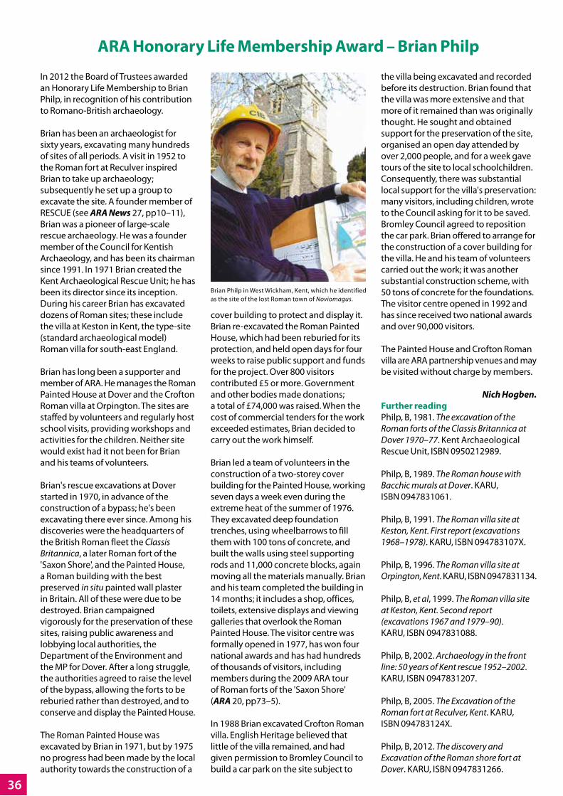
36
ARA Honorary Life Membership Award – Brian Philp
In 2012 the Board of Trustees awarded an Honorary Life Membership to Brian Philp, in recognition of his contribution to Romano-British archaeology.
Brian has been an archaeologist for sixty years, excavating many hundreds of sites of all periods. A visit in 1952 to the Roman fort at Reculver inspired Brian to take up archaeology; subsequently he set up a group to excavate the site. A founder member of RESCUE (see ARA News 27, pp10–11), Brian was a pioneer of large-scale rescue archaeology. He was a founder member of the Council for Kentish Archaeology, and has been its chairman since 1991. In 1971 Brian created the Kent Archaeological Rescue Unit; he has been its director since its inception. During his career Brian has excavated dozens of Roman sites; these include the villa at Keston in Kent, the type-site (standard archaeological model) Roman villa for south-east England.
Brian has long been a supporter and member of ARA. He manages the Roman Painted House at Dover and the Crofton Roman villa at Orpington. The sites are staffed by volunteers and regularly host school visits, providing workshops and activities for the children. Neither site would exist had it not been for Brian and his teams of volunteers.
Brian's rescue excavations at Dover started in 1970, in advance of the construction of a bypass; he's been excavating there ever since. Among his discoveries were the headquarters of the British Roman fleet the Classis Britannica, a later Roman fort of the 'Saxon Shore', and the Painted House, a Roman building with the best preserved in situ painted wall plaster in Britain. All of these were due to be destroyed. Brian campaigned vigorously for the preservation of these sites, raising public awareness and lobbying local authorities, the Department of the Environment and the MP for Dover. After a long struggle, the authorities agreed to raise the level of the bypass, allowing the forts to be reburied rather than destroyed, and to conserve and display the Painted House.
The Roman Painted House was excavated by Brian in 1971, but by 1975 no progress had been made by the local authority towards the construction of a
cover building to protect and display it. Brian re-excavated the Roman Painted House, which had been reburied for its protection, and held open days for four weeks to raise public support and funds for the project. Over 800 visitors contributed £5 or more. Government and other bodies made donations; a total of £74,000 was raised. When the cost of commercial tenders for the work exceeded estimates, Brian decided to carry out the work himself.
Brian led a team of volunteers in the construction of a two-storey cover building for the Painted House, working seven days a week even during the extreme heat of the summer of 1976. They excavated deep foundation trenches, using wheelbarrows to fill them with 100 tons of concrete, and built the walls using steel supporting rods and 11,000 concrete blocks, again moving all the materials manually. Brian and his team completed the building in 14 months; it includes a shop, offices, toilets, extensive displays and viewing galleries that overlook the Roman Painted House. The visitor centre was formally opened in 1977, has won four national awards and has had hundreds of thousands of visitors, including members during the 2009 ARA tour of Roman forts of the 'Saxon Shore' (ARA 20, pp73–5).
In 1988 Brian excavated Crofton Roman villa. English Heritage believed that little of the villa remained, and had given permission to Bromley Council to build a car park on the site subject to
the villa being excavated and recorded before its destruction. Brian found that the villa was more extensive and that more of it remained than was originally thought. He sought and obtained support for the preservation of the site, organised an open day attended by over 2,000 people, and for a week gave tours of the site to local schoolchildren. Consequently, there was substantial local support for the villa's preservation: many visitors, including children, wrote to the Council asking for it to be saved. Bromley Council agreed to reposition the car park. Brian offered to arrange for the construction of a cover building for the villa. He and his team of volunteers carried out the work; it was another substantial construction scheme, with 50 tons of concrete for the foundations. The visitor centre opened in 1992 and has since received two national awards and over 90,000 visitors.
The Painted House and Crofton Roman villa are ARA partnership venues and may be visited without charge by members.
Nich Hogben.Further readingPhilp, B, 1981. The excavation of the Roman forts of the Classis Britannica at Dover 1970–77. Kent Archaeological Rescue Unit, ISBN 0950212989.
Philp, B, 1989. The Roman house with Bacchic murals at Dover. KARU, ISBN 0947831061.
Philp, B, 1991. The Roman villa site at Keston, Kent. First report (excavations 1968–1978). KARU, ISBN 094783107X.
Philp, B, 1996. The Roman villa site at Orpington, Kent. KARU, ISBN 0947831134.
Philp, B, et al, 1999. The Roman villa site at Keston, Kent. Second report (excavations 1967 and 1979–90). KARU, ISBN 0947831088.
Philp, B, 2002. Archaeology in the front line: 50 years of Kent rescue 1952–2002. KARU, ISBN 0947831207.
Philp, B, 2005. The Excavation of the Roman fort at Reculver, Kent. KARU, ISBN 094783124X.
Philp, B, 2012. The discovery and Excavation of the Roman shore fort at Dover. KARU, ISBN 0947831266.
Brian Philp in West Wickham, Kent, which he identified as the site of the lost Roman town of Noviomagus.

42
Recent ARA GrantsSt Algar's Roman villa, SomersetOctober 2011, grant of £500This scheduled Roman villa site is currently the focus of a five-year investigation into the pre-Roman to post-Roman occupation at St Algar's Farm, West Woodlands near Selwood, Somerset, which was originally discovered in the 1960s. An investigative clearance of topsoil in 1971, over 400m2, identified a large villa, a considerable quantity of third–fourth century pottery, lead objects and tesserae. An evaluation in 2010 found evidence of late-Roman glass working, a unique discovery for a rural site in Roman Britain as other known glass works are on military or urban sites. The 2010 evaluation recovered over 400 fragments of glass and glass-working waste along with 22 crucible sherds.
In 2011 work concentrated on a possible temple or mausoleum adjacent to the villa, along with parts of the linear enclosure which surrounds the winged corridor house and a possible gate house. Work in 2012 was planned to investigate the villa and glass working site within the scheduled area. ARA members visited the site on 25 August 2012 as part of the day excursion to Somerset.
Newstead centenary publicationMarch 2012, grant of £1,000In 1905–10 excavations by James Curle at the Roman fort of Newstead (Trimontium; see ARA News 24, pp4–5) in the Scottish Borders revolutionised views of Roman frontier forts. The excavations produced a remarkable range of well-preserved material, published in such a way that it illuminated lives on the Roman frontier. This highly influential volume is much quoted and widely respected in Britain and on the Continent as a foundation of Roman military studies. To mark the centenary of the excavations and their publication, the Trimontium Trust and the National Museums Scotland have commissioned a series of essays from leading authorities to review the impact of the excavator, the site and the finds. These cover a wide range of topics and offer an up-to-date perspective on this fort of international renown.
It is hoped that this will provide a volume of broad appeal, and act as a springboard for the next century of work. The commercial publishing arm of the National Museums Scotland has agreed to produce the volume, but the present cuts in public sector funding has necessitated appeals to the various archaeological charities.
Clarkly Hill excavation, Burghead in MorayMarch 2012, grant of £1,000Geophysical survey and small-scale excavation at Clarkly Hill in 2008 and 2011 identified an extensive and long-lived Iron Age settlement. Of key interest is the evidence for contacts with the Roman world revealed by a scatter of Roman brooches and two disturbed coin hoards of later second century date. Too often discoveries such as these have been treated as 'stray finds', but here excavation can provide a highly significant context.
The applicant has recently completed a long-term excavation on a strikingly similar site at Birnie only 12km away which has been interpreted as a local power centre having extensive contacts with Rome (ARA 21, forthcoming). Finds include two Severan silver coin hoards, best interpreted as diplomatic gifts or subsidies as part of Roman foreign policy on this difficult frontier. Clarkly Hill appears very similar, lending support to the latter model. The work at Clarkly Hill can thus cast important fresh light on the impact of the Roman world in north-eastern Scotland and the long-term development of settlement and society along the Moray littoral.
Bosworth Roman temple, LeicestershireMay 2012, grant of £1,000At Bosworth in Leicestershire geophysical survey and recovered plough-soil finds indicate the presence of a nationally important Roman temple and an associated settlement. The finds, including the largest assemblage of horse-and-rider brooches known in Britain and over 700 coins spanning the whole of the Roman period, were clustered around a circular feature approximately 12m in diameter, near cropmark enclosures which may represent a contemporary settlement.
Circular structures associated with Roman temples predominantly cluster in the south-east of England, or in military contexts further north. The development of religious sites in the transitional East Midlands is of great interest with the evidence from Bosworth being unique; it may represent a distinct regional tradition.
Bourne Park Roman villa survey, KentMay 2012, grant of £500A previously unknown large Roman villa, off the main road between Canterbury and Dover, is being revealed at Bourne Park. The project, which is sponsored by both Cambridge and Southampton Universities, intends to determine the relationship of this villa with the large number of archaeological features and other finds from the surrounding area located by antiquarian excavations, modern road construction, metal detecting and aerial photography.
Topographical and geophysical surveys last year produced promising results, the magnetometry revealing two wings of a large structure, including a probable range of baths. During the 2012 season the survey area will be extended and will also include a training session in surveying methods for three undergraduate students from Cambridge. In future seasons the project hopes to extend the resistivity surveys with ground-penetrating radar on specific features.
Fragment of a crucible used for melting glass. Left, the interior surface; right, profile of the same piece (enlarged), with the glass deposit on the upper surface. Photo: © Ceri Lambdin, St Algar's Project Group.