Embed Size (px)
Citation preview

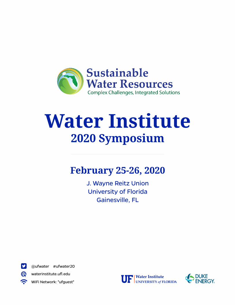
Water Institute2020 Symposium
Thank You Sponsors
Abstract Book
#ufwater20waterinstitute.ufl .edu
Founding Sponsor
Student Poster Awards Sponsor
Silver Sponsors
Bronze Sponsors
Student Sponsors
UF/IFAS Soil & Water Sciences • UF/IFAS Agricultural & Biological EngineeringUF School of Natural Resources and Environment • UF Department of Geological Sciences
UF/IFAS Wildlife Ecology and Conservation • UF/IFAS Food & Resource Economics DepartmentSt. Johns River Water Management District • Tampa Bay Water
UF ABE Center for Remote Sensing • Florida Gulf Coast University Everglades Wetland Research Park
It is only through the generous fi nancial contributions from our sponsors that make this symposium possible. Their donations are greatly appreciated.
February 25-26, 2020J. Wayne Reitz Union | Gainesville, FL

Level 2
Symposium Floorplan
Level 3 (Poster Session Reception)
Orange Elevator
Blue Elevator
Meeting Spaces
Restrooms
RION BALLROOM(Poster Session
Reception)
CONCURRENT SESSIONS
waterinstitute.ufl.edu
WiFi Network: "ufguest"
@ufwater #ufwater20
February 25-26, 2020J. Wayne Reitz UnionUniversity of Florida
Gainesville, FL
Water Institute2020 Symposium


Table of ContentsHonoring Karl E. Havens ................................................................................................. 7
Welcome Letters .............................................................................................................8
Committee Recognition ................................................................................................10
Thank You to Our Sponsors .......................................................................................... 11
Abstract Compilation ....................................................................................................13
Notes ........................................................................................................................... 256
About the Water InstituteThe University of Florida Water Institute brings together talent from throughout the University and builds internal and external partnerships to address urgent water research challenges; implement innovative interdisciplinary academic programs to train excellent students; and provide state-of-the-art expert assistance and educational programs for external stakeholders. Water Institute faculty represent a breadth of water specialties from geophysical, chemical, biological and social sciences, engineering, law and humanities.
To learn more about the Water Institute, visit waterinstitute.ufl.edu.


Karl E. HavEns, the director of the Florida Sea Grant program since 2007 and a Professor of Aquatic Ecology at the University, passed away suddenly on April 26, 2019. He was 61. Havens was a leading international expert on aquatic research, management, education and outreach. His area of expertise included the response of lakes and estuaries to natural and human-caused impacts such as nutrient enrichment, drought, climate variability and hurricanes.
“Karl was a visionary who could help others see as well. He often did it with photographs. He always did it with excitement in his voice when he talked about science,” said Jack Payne, UF Senior Vice President for Agriculture and Natural Resources. “His passion was a great contribution to science because he inspired others to discover, too.”
Haven's professional achievements include the creation of the biennial Florida Sea Grant Coastal Science Symposium, the formation of the program’s first advisory council in 2009, and the leadership of the university’s Oyster Recovery Team that addressed the collapse of the commercial oyster fishery in Apalachicola Bay. He was leading the UF/IFAS Harmful Algal Bloom Task Force at the time of his death.
Havens earned his B.A. in biological sciences from the State University of New York at Buffalo in 1979, and his master’s and Ph.D. in biology from West Virginia University in 1981 and 1984, respectively. Before joining the University of Florida as professor and chair of the
Department of Fisheries and Aquatic Sciences, he served as Chief Environmental Scientist at the South Florida Water Management District from 1993-2004, where he became one of Florida’s most respected voices on the science behind the management of Lake Okeechobee and the Everglades. He published more than 160 peer-reviewed journal articles and 20-plus extension publications. His latest papers reflect collaborations with international scientists about the effects of climate change and eutrophication on lakes and estuaries, the future of controlling harmful blooms in the face of climate change and the role that nitrogen pollution plays in stimulating toxic blue-green algae blooms. He was the 1999 recipient of the Edward Deevey, Jr. Award from the Florida Lake Management Society, given to individuals contributing to the scientific understanding of Florida’s water bodies. He served as associate editor of the research journals Hydrobiologia and the Journal of Plankton Research. He was also a member of the board of directors for the Florida Ocean Alliance and the Florida Institute of Oceanography.
An avid amateur photographer, Havens founded a Facebook community titled Photography with Classic Lenses that grew to more than 11,600 members. He created and co-hosted the Classic Lenses podcasts that were listened to by thousands of amateur and professional photographers around the globe.
Karl was active in the UF Water Institute, participating in research projects and technical review teams, contributing to Water Institute Symposia, and serving multiple terms on the Faculty Advisory Committee. He is sorely missed.
The “Karl Havens Excellence Fund” has been established to support students and research at Florida Sea Grant affiliated institutions in the areas of limnology, coastal and estuarine water quality, and harmful algal blooms.
Visit https://www.flseagrant.org/news/2019/08/contribute-to-the-karl-havens-excellence-fund/ to make a donation.
In Honor ofKarl E. Havens
1957 – 2019
8
Welcome Colleagues,Thank you for joining us for the 7th UF Water Institute Symposium.
This Symposium provides an intellectually stimulating venue that links leading researchers, educators and students with resource managers, policymakers, non-governmental organizations, authors and artists interested in exploring interdisciplinary solutions to current water challenges.
We are pleased that this year’s Symposium received a record number of abstract submissions and has record attendance! Over the course of the next two days over 250 contributed oral, poster and panel presentations will present innovative science, technology, cultural, policy, and management solutions to pressing water issues such as harmful algae blooms; sources, impacts, and management of contaminants; water scarcity, allocation, and use; and impacts of and resilience to climate change, extreme events and sea level rise.
We are encouraged that water issues are receiving renewed attention from Florida leaders. Nevertheless, developing socially-acceptable, scientifically-sound solutions remains a complex process because our scientific understanding is incomplete, our goals contradictory, and complex interdependencies result in unexpected outcomes. We welcome you to join with us to ask difficult questions, listen to unexpected answers, engage in constructive dialogue, and learn from those outside your area of expertise so that together we can envision and chart a path to a sustainable water future.
Thanks again for attending the 7th UF Water Institute Symposium. We value your contributions and encourage your active participation.
Sincerely,
Wendy Graham
Carl S. Swisher Chair in Water ResourcesDirector, UF Water Institute

9
Dear Faculty, Students and Special Guests,
Welcome to the 7th UF Water Institute Symposium! As a public, land-grant university, we strive to support and grow research that benefits people and nature and to engage productively with communities around the state, nation and globe. This biennial Symposium embodies both of those goals – and that’s particularly true this year, as its focus expands from environmental issues to ones involving water and human health.
With 16 colleges, 100 undergraduate programs and over 200 graduate programs, UF is among the most comprehensive universities in the nation. As such, we are uniquely equipped to contribute to this growing breadth, with scholars from across our university joining industry representatives, public policy makers and other diverse participants in discussing a widening spectrum of water issues. At this year’s Symposium, these range from preserving Florida’s signature springs to the challenges posed by climate change to the upswing in toxic algal blooms – and how they impact not just the health of the environment but also that of people.
Since the Water Institute was established in 2006, it has done much to further science, education and conservation of water, including providing critical information and research related to the restoration of the Everglades and the preservation of our springs. I am proud of these and other contributions and look forward to the Institute continuing to serve as a leading resource in Florida and around the globe. I thank each of you for joining in that tradition and for your participation and contributions to this year’s Symposium.
I wish you the best for thought-provoking and inspiring discussions – with a positive and lasting influence on an issue that is critical to all of us.
Sincerely,
W. Kent Fuchs
PresidentUniversity of Florida
Dear Symposium Guests,
Welcome to the seventh University of Florida Water Institute Symposium. The UF Institute of Food and Agricultural Sciences has always been one of the Water Institute’s chief sustainers because of the deep appreciation and expertise we bring to complex water issues.
That starts from the top of the Institute. Director and UF/IFAS faculty member Wendy Graham not only has national stature as a member of the National Academy of Sciences Water Science and Technology Board, but Governor DeSantis appointed her to serve on the State of Florida Blue-Green Algae Task Force. This task force is overseen by another UF/IFAS faculty member Tom Frazer, who had been director of our School of Natural Resources and Environment until the governor appointed him as the state’s first ever Chief Science Officer.
Sherry Larkin, UF/IFAS Associate Dean for Research and Interim Director of Florida Sea Grant has been appointed to the Governor’s Red Tide Task Force. UF/IFAS leadership on water science is demonstrated through many collaborations with government, industry, and non-profits. In fact, UF/IFAS’s collaborative spirit extends across campus as well – it is a co-founder and co-funder (with the Office of Research, Provost, and College of Liberal Arts and Sciences) of the Water Institute.
UF/IFAS had yet another faculty member appointed to the Governor’s Blue-Green Algae Task Force. Karl Havens suddenly passed away before he could serve. But before he passed, he organized a UF/IFAS Harmful Algal Bloom Task Force that brings together experts from a wide variety of disciplines.
This year’s Symposium is dedicated to the memory of Karl as a way of recommitting ourselves to continuing his work. Thank you for joining us in this commitment.
Sincerely,
Jack Payne
Senior Vice President for Agriculture & Natural ResourcesUF Institute of Food and Agricultural Sciences

10
Acknowledgments
Planning Committee
Wendy Graham, Symposium Chair, UF Water Institute
Wendy-Lin Bartels, Florida Natural Resources Leadership Institute
Tom Bianchi, UF Geological Sciences Department
Tatiana Borisova, UF Food and Resource Economics Department
Mark Brenner, UF Geological Sciences Department
Joe Delfino, UF Environmental Engineering Sciences Department
Nancy Denslow, UF Environmental Toxicology
Mark Diblin, Wood PLC and Florida AWRA
Tom Frazer, Florida Department of Environmental Protection
Holly Henderson, Duke Energy
Jasmeet Judge, UF Agricultural and Biological Engineering, Center for Remote Sensing
Dail Laughinghouse, UF Agronomy Department, Ft. Lauderdale Research and Education Center
Mary Lusk, UF Soil and Water Sciences Department, Gulf Coast Research and Education Center
Bruce MacFadden, Thompson Earth Systems Institute
Kati Migliaccio, UF Agricultural and Biological Engineering Department
Kevin Morris, Peace River Manasota Regional Water Supply Authority
Nathan Reaver, Water Institute and UF Environmental Engineering Sciences
Les Thiele, UF Political Science, Center for Adaptive Innovation, Resilience, Ethics and Science
UF Water Institute Staff
Paloma Carton de Grammont, UF Water Institute
Karen Schlatter, UF Water Institute
Robyn Screws, UF Water Institute

11
Thank You to Our SponsorsWithout their generous support, this Symposium would not be possible.
Founding Sponsor
Student Poster Awards Sponsor
Silver Sponsors
Bronze Sponsors
Student Sponsors
Florida Gulf Coast University Everglades Wetland Research Park • St. Johns River Water Management DistrictTampa Bay Water • UF ABE Center for Remote Sensing • UF Department of Geological Sciences
UF/IFAS Agricultural & Biological Engineering • UF/IFAS Food & Resource Economics DepartmentUF/IFAS Soil & Water Sciences • UF/IFAS Wildlife Ecology and Conservation
UF School of Natural Resources and Environment


13
Abstract CompilationAbstracts are sorted alphabetically by presenting author’s
last name. Presenting author names appear in bold.

14

15
AGRICULTURAL PRODUCERS’ WILLINGNESS TO ACCEPT PAYMENTS FOR IMPROVING WATER RESOURCES IN THE FLORIDA AQUIFER Unmesh Koirala1, Damian C. Adams1, and Jose R. Soto2
1University of Florida, Gainesville, FL, USA 2University of Arizona, Tucson, AZ, USA
Increased adoption of best management practices (BMPs) by agricultural producers is a potential tool for improving water resource conditions. However, the economic feasibility of this approach is largely unknown in watersheds connected to the Florida aquifer. This study assessed the farm and forest-level economic tradeoffs associated with a suite of proposed BMPs for typical agricultural enterprises and crop rotation in S. Georgia and N. Florida (row crops, planted pines, and hay). We then surveyed producers to determine what level of incentive payments would be required to ensure their participation in voluntary BMPs, which often require high start-up and/or installation costs and can affect farm and forest yields. The survey included economic valuation questions designed to understand producer preferences in an elicitation format known as Best-Worst Choice modeling. Results of the survey are used to estimate a supply curve for water resource improvements from producers as a function of price, and in the context of a hypothetical payments program, can predict levels of producer participation and the subsequent changes in water resource conditions in the study area. PRESENTER BIO: Unmesh Koirala is PhD Candidate, School of Forest Resources and Conservation, University of Florida. Damian C. Adams is Associate Professor, School of Forest Resources and Conservation and UF/IFAS Interim Assistant Dean. Jose R. Soto is Assistant Professor, School of Natural Resources and the Environment, University of Arizona.
16
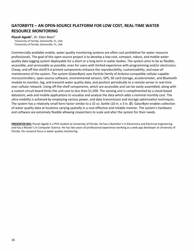
GATORBYTE – AN OPEN-SOURCE PLATFORM FOR LOW COST, REAL-TIME WATER RESOURCE MONITORING Piyush Agade1, Dr. Eban Bean2
1University of Florida, Gainesville, FL, USA 2University of Florida, Gainesville, FL, USA
Commercially available mobile, water quality monitoring systems are often cost prohibitive for water resource professionals. The goal of this open-source project is to develop a low-cost, compact, robust, and mobile water quality data logging system deployable for a short or a long term in water bodies. The system aims to be as flexible, accessible, and serviceable as possible, even for users with limited experience with programming and/or electronics. Cheap, and off-the-shelf/3-d printed components enhance the reproducibility, customizability, and ease-of-maintenance of the system. The system (GatorByte) uses Particle family of Arduino compatible cellular-capable microcontrollers, open-source software, environmental sensors, GPS, SD card storage, accelerometer, and Bluetooth module to monitor, log, and transmit water quality data, and position periodically to a remote server in real-time over cellular network. Using off-the-shelf components, which are accessible and can be easily assembled, along with a custom circuit board limits the unit cost to less than $1,500. The sensing unit is complimented by a cloud-based datastore, web and mobile applications to visualize and analyze the data which adds a nominal monthly cost. The ultra-mobility is achieved by employing various power, and data transmission and storage optimization techniques. The system has a relatively small form factor similar to a 32 oz. bottle (10 in. x 3 in. Ø). GatorByte enables collection of water quality data at locations varying spatially in a cost-effective and reliable manner. The system’s hardware and software are extremely flexible allowing researchers to scale and alter the system for their needs. PRESENTER BIO: Piyush Agade is a PhD student at University of Florida. He has a Bachelor’s in Electronics and Electrical engineering and has a Master’s in Computer Science. He has two years of professional experience working as a web app developer at University of Florida. His research focus is water quality monitoring.

17
SPATIAL AND SEASONAL VARIATIONS OF THE MESOPOTAMIAN MARSHES HYDRO-PATTERN UNDER NATURAL AND REGULATED FLOW CONDITIONS Ali Al-Quraishi and David Kaplan
University of Florida, Gainesville, FL, USA The Mesopotamian Marshlands are the largest wetland system in the Middle East. Historically, these marshes served as the floodplains of the Tigris and Euphrates rivers, and they are currently connected to these rivers through direct surface water connection via feeder canals. Historically, the Mesopotamian marshes received consistent flood pulses during the spring season from March to May, which represents the natural flow regime for the Tigris and Euphrates in this location. In recent decades, several large dams have been constructed in the Tigris and Euphrates basins for irrigation purposes and power generation, severely altering the flow regime and, along with other anthropogenic activities, degrading the marsh ecosystem. This work quantifies changes in the riverine flow regime and how they have affected the hydro-pattern of the western Mesopotamian marshes (focusing on the western Al-Hammar marsh) and describes the role of others potential hydrological drivers (direct precipitation and groundwater) that may be important to sustain the marshes. Statistical analysis of hydro-climatological data from 1901 to 2018 showed a reduction in surface flow of 16.3% and 34.6% in the Tigris and Euphrates rivers, respectively, with a steadily negative trend since 1974. Consequently, the total area of the marsh has been reduced from an average of 2800 km2 in the historic period (before 1974) to a minimum of 120 km2 in recent decades, concomitant with flow reductions from an average of 29.41 to 9.3 billion cubic meters per year. This analysis quantifies the central role between precipitation and the annual flow variability, and the flow variability with the wetland area under pre-dam and post-dam, with cascading effects on vegetation cover, productivity, and soil biogeochemistry. A focus on river-marsh connections will help to create predictive models and scenarios for the restoration of the water budget and hydroperiod of these important marshes. PRESENTER BIO: Al-Quraishi is a 4th year PhD student in Environmental Engineering at University of Florida, and his PhD project addresses the ecohydrological restoration of the Mesopotamian marshes. He got two master’s degrees in Environmental Engineering that concentrated in the restoration issues of the Mesopotamian marshes.

18
‘AFTER THE FLUSH’ SEPTIC SYSTEM HOMEOWNER EDUCATION PROGRAM Mary Lusk1, Andrea Albertin2, Whitney Elmore3, William Lester4 and Jim Moll3
1University of Florida, Gulf Coast Research and Education Center, Wimauma, FL USA 2University of Florida /IFAS Extension, North Florida Research and Education Center, Quincy, FL, USA 3University of Florida/IFAS Extension, Pasco County, Dade City, FL USA University of Florida/IFAS Extension, Hernando County, Brooksville, FL USA
About 30% of Florida’s population relies on septic systems to treat and dispose of household wastewater. This translates to 2.6 million systems discharging approximately 426 million gallons of wastewater per day to underlying soil and groundwater. On average, septic systems remove 30% of nitrogen flowing into them and are identified as important sources of N to groundwater particularly when improperly sited or failing. If septic systems contribute at least 20% of the N load in areas with a Basin Management Action Plan (BMAP), a septic system remediation plan goes into place. This includes connecting homes to sewer systems and replacing conventional systems with advanced N-removal technology, both of which are costly for local governments and residents. In response, UF/IFAS Extension agents and research faculty are developing a septic system educational program called “After the Flush”. The program is a ‘Septics 101’ for residents, aimed to increase knowledge about septic system function and best practices, advanced onsite N-removal technology, and connections between septics and water quality. It addresses septic system regulations established by the 2016 Florida Water Bill. The program responds to needs identified by UF/IFAS Extension agents in a 2017 survey concerning septic system education. Of 87 respondents, 55 agents (63%) were interested in printed and online information to share with clients, 34 (39%) were interested in teaching residents about connections between septic systems and potential water quality impacts, and 26 (30%) were interested in hosting or co-teaching workshops on systems and how to properly maintain them.
19
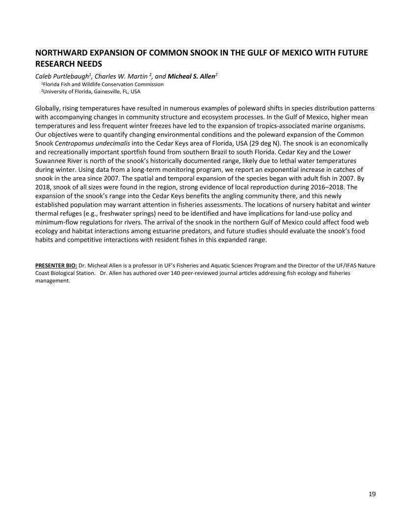
NORTHWARD EXPANSION OF COMMON SNOOK IN THE GULF OF MEXICO WITH FUTURE RESEARCH NEEDS Caleb Purtlebaugh1, Charles W. Martin 2, and Micheal S. Allen2
1Florida Fish and Wildlife Conservation Commission 2University of Florida, Gainesville, FL, USA
Globally, rising temperatures have resulted in numerous examples of poleward shifts in species distribution patterns with accompanying changes in community structure and ecosystem processes. In the Gulf of Mexico, higher mean temperatures and less frequent winter freezes have led to the expansion of tropics-associated marine organisms. Our objectives were to quantify changing environmental conditions and the poleward expansion of the Common Snook Centropomus undecimalis into the Cedar Keys area of Florida, USA (29 deg N). The snook is an economically and recreationally important sportfish found from southern Brazil to south Florida. Cedar Key and the Lower Suwannee River is north of the snook’s historically documented range, likely due to lethal water temperatures during winter. Using data from a long-term monitoring program, we report an exponential increase in catches of snook in the area since 2007. The spatial and temporal expansion of the species began with adult fish in 2007. By 2018, snook of all sizes were found in the region, strong evidence of local reproduction during 2016–2018. The expansion of the snook’s range into the Cedar Keys benefits the angling community there, and this newly established population may warrant attention in fisheries assessments. The locations of nursery habitat and winter thermal refuges (e.g., freshwater springs) need to be identified and have implications for land-use policy and minimum-flow regulations for rivers. The arrival of the snook in the northern Gulf of Mexico could affect food web ecology and habitat interactions among estuarine predators, and future studies should evaluate the snook’s food habits and competitive interactions with resident fishes in this expanded range. PRESENTER BIO: Dr. Micheal Allen is a professor in UF’s Fisheries and Aquatic Sciences Program and the Director of the UF/IFAS Nature Coast Biological Station. Dr. Allen has authored over 140 peer-reviewed journal articles addressing fish ecology and fisheries management.
20
3D FLOOD-INUNDATION MODEL OF THE AMITE RIVER IN BATON ROUGE PARISH IN 2016, LOUISIANA STATE Maram AlrehailiI
Dept. of Geography, University of Florida, Gainesville, FL, USA Background/Problem In 2016, a catastrophic flood devastated part of South Louisiana after receiving rainfall more than 20 inches. The heavy rainfall led to widespread flash flooding and recorded river flooding across multiple parishes. The flooding comes from Amie river level raise and many creeks and bayous flow to the Baton Rouge parish. This project purposes first is a simulation of the Amite River in 3D modeling to provide an analysis and understanding of the risk of 2016 flood on the urban and natural environment in East Baton Rouge Parish. Second, modeling the Amite river floodplain delineation, drainage basin, and to lead the decision-maker to better plan the urban area and manage the natural environment suitability.
Data To achieve the aims stated above, several datasets required to be collected and pre-processed from diverse sources:
I. Spatial data: Baton Rouge parish boundary, footprint buildings shapefile of the building in Baton Rouge Parish derived from EBRGIS Program to display building footprints for East Baton Rouge Parish in 2014. The shapefile contains the highest of the year of the build buildings which is a good indicatorid of the building’s vulnerability. Furthermore, Imagery of Baton Rouge parish in 2016 to determine the land use need to be collected that could be challenging, because the data from EBRGIS is monthly updating of the land use.
II. Digital elevation models (DEM) data: DEM is essential input that provides topographical data in flood inundation modeling. Digital elevation models (DEMs) use as geometrical input. Significantly affect the results of flood inundation modeling. This project would use DEM data derived from the US Geological Survey (USGS) with 30 meters resolution.
III. Hydro Data: Bathymetric data need to be collected because the DEM data shows the elevation of landforms above sea level. However, the bathymetric maps show the depths of landforms below sea level, which an essential step to consider when analyzing and simulation the 2016 flood.
Method In the method section, further steps would be performed to provide an accurate analysis of the affected areas in Baton Rouge parish flood in 2016.
I. The Classification of Land Use I am using supervised classification to class the land use in Baton Rouge parish. This step is to explore the type of land use that affected most by flood in 2016. In case the data not available online, a furthered performance would be a procedure in Fig1.
1- Examinig and explore the imagery
2- Collecting trainf samples
3- Evaluting trainig samples
4- Editing traning samples
5- Creating the signtaure file
Appling claassification
Fig1.Supervised Classification Land Use
II. Hydrological Molding
This step is crucial to molding the watershed and delineated the floodplain and drainage of the Amite river basin. In this step, the Hydrology toolset would use under a spatial analysis tool. The input data would be the DEM data in Fig2.
Expected Results
The outcomes of this project would include the Amie river watershed and 3D flood simulation to simulate the 2016 flood to illustrate the affected areas by the2016 flooding based on the Bathymetric map. Land uses classification map to investigate the land class that affected more via 2016 flooding. Finally, Animation movie would be performed to illustrate the flood and the effected buildings by 2016 flood in Baton Rouge Parish, Louisiana state
DEM
Flow Direction
Sink
Are there any Sinks?
Fill
Yes
Depression less DEM
Flow Accumulation
Stream order
Stream to Feature
Stream Link
Watershed
Snap pour point
Flow Length
No
Apply Threshold
3D Flood Simulation
Fig2. Hydrological Analysis

21
VISTA AND CISTA FRAMEWORKS FOR VULNERABILITY ASSESSMENTS IN FOOD-WATER NEXUS Aavudai Anandhi
Biological Systems Engineering, Florida Agricultural and Mechanical University, Tallahassee, FL, USA Food and water are essential resources. Altered environment and increasing population are stressing the food production and water resource systems. This is resulting in an increased demand for food-water-energy as well as creating a need for vulnerability assessments. The overall objective of this study was to develop a novel tool that can translate a theoretical concept [vulnerability of food and water resources (VFWR)] to an operational framework mainly under altered temperature and precipitation. The tool developed using novel systems thinking approach had three stages. Stage-1: Translating theoretical concept to characteristics identified from studies; Stage-2: Operationalizing characteristics to methodology in VWR; Stage-3: Utilizing the methodology for development of a conceptual modeling tool for VWR: FWR-VISTA (Food-Water Resource Vulnerability assessment conceptual model using Indicators selected by System’s Thinking Approach). The specific novelties were: 1) The important characteristics in VFWR were identified in Stage-1 (target system, system components, scale, level of detail, data source, frameworks, and indicator); 2) FWR-VISTA combined two vulnerability assessments frameworks: the European’s Driver–Pressure–State–Impact–Response framework and the Intergovernmental Panel on Climate Change’s framework (IPCC’s); and 3) used systems thinking approaches for indicator selection. The developed application was demonstrated in Florida, using ~10 indicators with intermediate level of detail. The developed tool can be easily replicated to other regions within and outside the US. PRESENTER BIO: Dr. Aavudai Anandhi is an Assistant professor in the Biological System Engineering program at Florida A&M University. During the last 20 years her research, teaching and service involves exploring the beautiful world of food-water-energy nexus and environmental change, its vulnerability adaptation and mitigation using complex systems thinking.
22
USING MARINE ANIMALS, VIDEO STREAMS AND SEWAGE SPILL ALERTS TO IDENTIFY THREATS TO COASTAL HUMAN AND ENVIRONMENTAL HEALTH James Liao1, Christine Angelini2, Lauren Brisley3 and Jeffrey Johnson4
1Whitney Lab for Marine Science, Department of Biology, University of Florida, Gainesville, FL, USA 2Department of Environmental Engineering Sciences, University of Florida, Gainesville, FL, USA 3Coastal Engineering, University of Florida, Gainesville, FL, USA 4Department of Anthropology, University of Florida, Gainesville, FL, USA
Marine animals possess exquisite sensory capabilities, from echolocation in dolphins to the extreme chemosensory abilities of sharks. These capabilities far exceed mankind’s abilities to develop equivalent sensors that are as robust, persistent, foul-resistant, and economical. We are therefore initiating a new sensor program in St. Augustine that leverages the innate abilities of local animals, as well as low-cost video systems, and existing infrastructure failure alert systems to detect abiotic and biotic phenomena of interest. Our goal is to understand animal behaviors well enough that sudden perturbations (chemical, weather, etc.) can be detected through changes in their behavior and use video data to quantify fluxes in vessel and wildlife traffic through coastal waters. Simultaneous, we are utilizing sewage spill data from existing public infrastructure data streams to assess patterns in the timing, frequency and magnitude of these pollution spills to evaluate when and where they may affect fish and wildlife being monitoring via our underwater and aerial systems. We have initiated our program by tagging red drum (Sciaenops ocellatus) with acoustic tags, installing a solar-powered video-monitoring system and developing sewage spill data algorithms, using St. Augustine, FL and its adjacent watersheds as our test bed. For the first time, this study aims to monitor water quality parameters (chlorophyll levels, E.coli, nitrogen, water velocity) via data-logging sondes while also simultaneously monitoring red drum via acoustic telemetry, vessel traffic and wildlife movements via video. This combination of underwater, aerial and infrastructure monitoring looks to correlate movements to broader physical processes. Our unique observatory network will represent a marriage of biogeochemistry, marine technology, fish physiology, human behavior and infrastructure performance to expand our understanding of coastal ecosystem responses to important environmental changes. PRESENTER BIO: Dr. Angelini is a coastal ecologist and assistant professor at the University of Florida with more than 12 years of experience studying the spatial organization and resilience of coastal ecosystems. She has extensive experience with experimental ecology and restoration design. She is currently co-leading the iCoast initiative at the University of Florida to help innovate new methods for sensing hazards in the coastal zone.

23
BEST PRACTICES IN CLIMATE ADAPTATION: THE WATER UTILITIES CLIMATE ALLIANCE EXAMPLE Laurna Kaatz1, Julie Vano2, Seevani Bista3, Alan Cohn4, David Behar5, Kavita Heyn6, Keely Brooks7, Jennifer McCarthy8, Mohammed Mahmoud9, Tirusew Asefa10, ‡, Abby Sullivan and Julia Rockwell11, Marisa Flores-Gonzalez and Heather Dalrymple12, Danielle Purnell13
1Denver Water 2Aspen Global Change Institute 3San Diego County Water Authority 4New York City Dept of Environmental Protection 5San Francisco Public Utilities Commission 6Portland Water Bureau 7Southern Nevada Water Authority 8Metropolitan Water District of Southern California 9Central Arizona Project 10Tampa Bay Water 11Philadelphia Water Department 12Austin Water 13Seattle Public Utilities
Water Utilities Climate Alliance (wucaonline.org) is a coalition of 12 of the largest water utilities in the nation with over 50 million customers base. Through spectrum of climate adaptations (Understand, Engage, Plan, Act, and Sustain), the coalition has developed a guideline for Best Practices (BPs) in climate adaptation. A wide range of application scenarios and utilities business functions were considered in this effort. This talk highlights a series of BPs and lesson learned that may be implemented by utilities to build resiliency in the face of climate change and variability.
24
BRIDGING THE SCIENCE-KNOWLEDGE-POLICY GAP TO ADDRESS CUMULATIVE IMPACTS OF SMALL HYDROPOWER PLANTS IN THE BRAZILIAN AMAZON Simone Athayde1, Evandro M. Moretto2, Ana Paula A. Dibo3, Amarilis L. C. F. Gallardo4, Luisa A. Sangoi5, Carla G. Duarte6, Juliana Siqueira-Gay3, and Luis E. Sánchez3.
1Tropical Conservation and Development Program, Center for Latin American Studies, University of Florida, Gainesville, FL, USA 2Institute of Energy and Environment (IEE) and School of Arts, Sciences and Humanities (EACH), University of São Paulo – USP, São Paulo, SP,
Brazil 3 Escola Politécnica, University of São Paulo – USP, São Paulo, SP, Brazil 4Environmental Management and Sustainability Program and Smart and Sustainable Cities Program at the University Nove de Julho -
Uninove. Escola Politécnica, University of São Paulo - USP, São Paulo, SP, Brazil 5Ministério Público Federal – MPF, Santarém, PA, Brazil 6Institute of Environmental, Chemical and Pharmaceutical Sciences, Federal University of São Paulo - UNIFESP, Diadema, SP, Brazil
In Brazil, incentives and policy regulations have contributed to a five-fold increase in the number of small hydropower plants (SHPs) in the last 20 years, with 87 currently operating and 256 inventoried in Amazonian rivers. The combined impacts of multiple SHPs have been largely neglected in Brazilian planning practices, despite policy requirements. Our understanding of existing and potential impacts of these expansions on biodiversity, indigenous and traditional communities, and the capacity to mitigate them, is limited by lack of effective integrated planning tools and rigorous cumulative impact assessment (CIA), flexible environmental licensing policies, data and research gaps, lack of inter-sectorial dialogue, and lack of involving critical stakeholders in the decision-making process. In this presentation, we share results of research under development by the Small Dams Working Group (SDWG) of the Amazon Dams International Network (ADN), an international network of actors collectively studying the social-ecological transformations of hydropower implementation across Amazonian watersheds. The SDWG has developed interdisciplinary analyses of planned SHPs in the Tapajós watershed, focusing on environmental impact assessment, CIA and the social-ecological implications of deficient SHPs planning and management in the region. This includes implications for water quantity, quality and flow, fisheries sustainability, land degradation and negative impacts on indigenous and local communities’ livelihoods. The group is working with civil society institutions and policy-makers to envision and develop improved planning and management strategies for both SHPs and large dams, including: adopting good practices in cross-scale environmental assessment; including: the adoption of Strategic Environmental Assessment taking into consideration other plans, programs and policies in regional and Amazon-wide scales; developing integrated environmental assessments considering inventoried SHPs and LHPs; using scientific evidence and technological tools in planning and siting of SHPs; complying with policies related to the defense of human and environmental rights; and strengthening intersectoral dialogue and multi-stakeholder forums and committees. PRESENTER BIO: Simone Athayde is a Research Scientist at the Tropical Conservation and Development Program (TCD) in the Center for Latin American Studies at the University of Florida. She is the UF leader of the Amazon Dams International Research Network (ADN), an international network of actors collectively studying the social-ecological transformations of hydropower development across Amazonian watersheds.

25
PLANTING STORMWATER PONDS: DETERMINING THE BEST MANAGEMENT PRACTICES IN BUFFER ZONE AREAS Michelle Atkinson1, Basil V. Iannone III2, Mary Lusk3, Paul F. Monaghan2; Alexander J. Reisinger2
1University of Florida, Palmetto, FL, USA 2University of Florida, Gainesville, FL, USA 3University of Florida, Wimauma, FL, USA
Selecting stormwater pond buffer zone plants is more challenging than selecting plants for a conventional landscape. Site conditions can vary greatly and are more difficult to control. Steep slopes can make plant establishment and retention difficult. The Florida-Friendly Landscaping principle of using the right plant in the right place is particularly important in the shoreline environment because the planting area includes a dry slope and areas that can be inundated with water during frequent rain events. Planted stormwater pond buffer zones help to absorb nutrients and provide wildlife habitat. The buffer zone areas often contains the slope of the bank leading to the water's edge. This area can present challenges for the establishment of a low-maintenance plant buffer zone, sometimes referred to as no-mow zones. The plant buffer functions as a protective barrier by reducing or preventing fertilizer runoff and grass clippings from entering the pond. Collaborators on this project have a sincere interest in protecting downstream water resources and have been working together with landscape maintenance and stormwater pond maintenance contractors to define best management practices pertaining to installation and maintenance in planted stormwater pond buffer zone areas. PRESENTER BIO: Michelle is an Extension Agent with 13 years of experience. Michelle focuses her work on water quality and conservation through teaching a variety of programs to residents and landscape professionals on these topics. Michelle also focuses some attention to stormwater ponds and their water quality issues.

26
FIELD-SCALE DEMONSTRATION OF THE SEDIMENT BED PASSIVE FLUXMETER AT A CVOC IMPAIRED SITE Scott Augustine1, Michael Annable2, and Jaeyun Cho3
1University of Florida, Gainesville FL, USA 2University of Florida, Gainesville FL, USA 3University of Florida, Gainesville FL, USA
Laboratory and preliminary field testing have been completed to demonstrate a new tool for providing accurate characterizations of vertical water, pollutant and nutrient fluxes at the groundwater-surface water interface through direct in-situ measurement. The Sediment Bed Passive Fluxmeter (SBPFM) was designed to passively and directly provide simultaneous and independent measurements of volumetric water and solute mass fluxes exchanged vertically through the GW-SW interface. The SBPFM consists of an internal, permeable, carbon-based adsorbent media impregnated with a suite of water-soluble tracers contained in a dedicated drive-point with upper and lower screened openings for fluid intake and exhaust. This configuration generates passive flow driven by the vertical hydraulic gradient between surface and groundwaters. Once deployed, tracers are displaced at rates proportional to the average, advective flow through the device. The loss of tracers is used to calculate the cumulative water flux over the deployment period. Simultaneously, the cumulative mass of adsorbed pollutants provides a direct measurement of the contaminant mass flux through the sediment. This presentation involves a field-scale demonstration of the SBPFM in characterizing the magnitude and distribution of chlorinated solvents exchanging between impaired groundwaters and a tidally-influenced estuary. Here we present a comparison of pre- and post-remedial flux assessments using an array of SBPFMs within a 20,000 [m2] plane of estuary sediments. Both assessments consisted of a 4X8 array of probes deployed for two weeks. The first deployment (2015) estimated a mass discharge of 115 TCE [g/d] and was used to establish infrastructure supporting a targeted pump-and-treat system. A similarly constructed redeployment (2018) investigated the effects of the pumping after 10 months. Preliminary analyses of the results show the spatial distribution for both periods and evidence that the TCE mass discharge to the tributary was reduced by more than 99%. PRESENTER BIO: Scott Augustine graduated in 2016 from the University of Florida with a B.S. in Environmental Engineering Sciences. He is pursuing a PhD in Environmental Engineering with a focus on contaminated site characterization and remediation.

27
CHARACTERIZING LONG-TERM ECOLOGIC RESPONSES TO HYDROLOGIC CHANGE IN IMPAIRED DEPRESSIONAL WETLANDS IN TAMPA BAY, FL
Jessica Balerna and David Lewis University of South Florida, Tampa FL, USA
The hydrologic regimes of depressional wetlands are intricately connected to their ecological structure and function. Anthropogenic changes to wetland hydrology in the form of groundwater abstraction and land-use intensification will thus elicit strong ecological responses. In Tampa Bay, groundwater abstraction accounts for approximately 60% of potable drinking water supply resulting in almost 90 million gallons being withdrawn from active wellfields across Hillsborough and Pasco County each day. Additionally, population size has grown 11% in the Tampa metropolitan area over the past ten years resulting in increased impervious surface coverage and reduced groundwater recharge. Water management agencies in the area have been monitoring over 300 wetlands hydrologic and ecologic responses to these anthropogenic changes for 40 and 15 years respectively providing a unique opportunity to study long-term hydrologic changes and their subsequent ecologic responses. This project seeks to utilize this data to explain differences in ecological responses in the form of plant community shifts and biodiversity in over 170 depressional wetlands by looking at several hydrologic, geomorphic, and landscape drivers such as wetland type, area, predominant soil type, normal pool offset, hydroperiod, surrounding land-use/land cover, and legacy groundwater abstraction among others. Analyzing these long-term trends will ultimately help improve wetland conservation and protection especially in areas where this level of data collection may be impossible given financial or labor resource limitations. PRESENTER BIO: Jessica is pursuing a doctoral degree in the integrative biology department at the University of South Florida that will assess the relationships between water management decisions and wetland condition utilizing both ecohydrologic and ethnographic data. She received her BS in Environmental Science from American University in Washington DC in 2017.

28
FLOCCULATION OF NOROVIRUS FROM SURFACE WATER USING SKIMMED MILK Rebecca Barber1 and Naim Montazeri2
1Microbiology and Cell Science Department, University of Florida, Gainesville FL, USA 2Food Science and Human Nutrition Department, University of Florida, Gainesville FL USA
As one of the leading causes of gastrointestinal illnesses worldwide, human norovirus creates significant health and socioeconomic burdens. Norovirus is environmentally persistent, highly infectious, and transmitted through the ingestion of virus particles. Even the presence of norovirus in low concentrations in environmental waters presents a risk for human infection, thereby demanding the use of effective methods to isolate and concentrate norovirus to assess this risk accurately. One such emerging method is skimmed milk flocculation (SMF), which uses acidified skimmed milk to flocculate virus particles. Although this method has been successfully used to isolate norovirus from food and water matrices, it has not been tested on different kinds of surface waters, nor has the impact of SMF on virus infectivity been adequately elucidated. This study is the first step to bridge this gap by optimizing the method using bacteriophage MS2, a commonly utilized surrogate for human norovirus. A 40-ml sample of de-ionized water was inoculated with 7.7 log10 genome copies of MS2 per ml (total of 9.3 log10 genome copies). After acidification and incubation of the virus suspension with 0.05% skim milk (pH 3.5) at 4°C, flocculated viruses were separated using centrifugation and purified by chloroform extraction. Incubation of the virus suspension did not significantly impact the loss of virus infectivity, as measured by infectivity (plaque) assay. Quantification of viral RNA after the initial inoculation of water and chloroform extraction by RT-qPCR revealed an average reduction of 1.9 log10 genome copies in the final virus extract (1.5 mL). Moving forward, this study will optimize the protocol, and evaluate the efficacy of SMF in isolating human norovirus and its surrogate, Tulane virus, from inoculated water taken from different locations at the Paynes Prairie Basin in Florida. SMF will then be used to isolate and concentrate norovirus from varied environmental water sources. PRESENTER BIO: Ms. Barber is a fourth-year undergraduate student studying microbiology, with keen research interests in environmental microbiology. She received the NSF Louis-Stokes Alliance for Minority Participation, and is currently a member of the Ronald E. McNair Scholars program through the University of Florida, under which this research has been conducted.

29
EFFECTS OF GLYPHOSATE (RODEO) ON THE GROWTH OF PLANKTONIC CYANOBACTERIA Maximiliano Barbosa, David E. Berthold, Forrest Lefler, H. Dail Laughinghouse IV
Agronomy Department, Fort Lauderdale Research and Education Center, University of Florida / IFAS, Davie, FL, USA The widespread application of glyphosate as an aquatic herbicide has been disputed based on its potential secondary effects on aquatic algae, especially those that form harmful algal blooms (HABs). Glyphosate, the active ingredient in the commercial aquatic herbicide Rodeo, is thought to stimulate algal growth, primarily of cyanobacteria, with an inorganic form of phosphorus (P). In order to investigate the role of glyphosate (Rodeo) on the growth of planktonic bloom forming cyanobacteria, we inoculated Microcystis aeruginosa and Aphanizomenon sp. into BG11 supplemented with glyphosate. Rodeo (glyphosate) was applied to cultures using relative field application rates (1, 3, and 30ppm) together with both normal BG11 and BG11 without P. Cultures were incubated at 25oC, on a rotary shaker (120 rpm) for two weeks. Growth was monitored using a plate reader for in situ chlorophyll a and phycocyanin quantification. Preliminary results suggest that the addition of glyphosate to BG11 can stimulate the growth of these two planktonic cyanobacteria. Further research aims at testing the effect of glyphosate on other planktonic cyanobacteria and benthic cyanobacteria due to the possibility of differing responses based on evolutionary history, physiology, and location in the aquatic system. In addition, experiments at mesocosm scales are planned. PRESENTER BIO: Maximiliano Barbosa is a PhD student in the Agronomy Department working at the Fort Lauderdale Research and Education Center of the University of Florida. He works under the supervision of Dr. Dail Laughinghouse in research relating to cyanobacterial algal blooms, algal ecology, and applied phycology.
30
WATER LEVEL VARIABILITY CONTROL OF INVASIVE PLANT COVER AND WATER BIRD POPULATIONS IN THE PALO VERDE WETLAND, COSTA RICA Stefano Barchiesi1, Christian J. Köppl2, Alice Alonso3, Marco Pazmiño-Hernandez1, Juan M. Serrano-Sandí4, Monica Garcia2, Rafael Muñoz-Carpena1, Christine Angelini1
1University of Florida, Gainesville, FL, USA 2Technical University of Denmark, Lyngby, Denmark 3Université catholique de Louvain, Ottignies-Louvain-la-Neuve, Belgium 4Organization for Tropical Studies, Palo Verde, Guanacaste, Costa Rica
The global extent of wetlands is estimated to have declined sharply. The associated reduction in freshwater biodiversity is chiefly attributed to habitat degradation, pollution, flow regulation, water extraction, fishery overexploitation, alien species introductions as well as climate change. The Palo Verde National Park and Ramsar Site in Costa Rica is formally considered under threat. It is also an informative model system for investigating how changes in ecological integrity influence delivery of ecosystem services to different sectors of society and how these sectors can in turn help accelerate restoration of these vital biomes. Restoration objectives in Palo Verde are linked to the number of water birds harbored. Habitat suitability for several priority species is suggested to depend on water levels and vegetation density in the seasonal lagoons. However, the effectiveness of controlling invasive plants has not been studied relative to the inter-annual variability of these concurrent habitat needs. Also, the combined effects of invasive plants and water level at the landscape scale have yet to be used as dual predictors of abundance in water bird species distribution models. We used wetland stage measured at hydrological stations and invasive vegetation cover classified from drone-acquired imagery to develop spectral identification rules for satellite data of the wetland area connected to the Park. Overall water bird counts from citizen-science reports were extracted at sub-wetland and regional levels to account for population dynamics and species habitat use. The time series thus obtained were fed into a Random Forest model to first measure variable relative importance of wetland stage and extent on the accuracy of classification of water bird abundances for priority species at the sub-wetland level. This model will be incorporated into an assessment of ecosystem services for the area as the basis to evaluate the sensitivity of alternate restoration decisions to uncertainty. PRESENTER BIO: Stefano holds two Master’s degrees in Natural Sciences (Bologna, Italy) and Environmental Management and Policy (Lund, Sweden). He served on the Ramsar Convention’s scientific body while with IUCN Global Water Programme in Switzerland for nearly ten years. He has also done research for the European Commission on the Water-Energy-Food Nexus.
31
MECHANISTIC ANTIVIRAL ACTIVITY OF CHITOSAN MICROPARTICLES AGAINST BACTERIOPHAGE MS2, A HUMAN NOROVIRUS SURROGATE. Candace Barnes1, Rebecca Barber1, Robyn Louis2, Anita Wright1, Melissa Jones3, and Naim Montazeri1
1Food Science and Human Nutrition Department, University of Florida, Gainesville, FL, USA 2Psychology Department, University of Florida, Gainesville, FL, USA 3Microbiology and Cell Sciences Department, University of Florida, Gainesville, FL, USA
Human norovirus is the leading cause of acute viral gastroenteritis worldwide and a public health concern because of its low infectious dose and persistence in the environment. Water plays a major role in the transmission of norovirus to humans, and effective decontamination of water can control the spread of the pathogen. Chitosan is a polysaccharide derivative of chitin and has shown promising antibacterial activity; however, limited research has been performed on its application for the antiviral treatment of water. In this study, we investigated the antiviral activity of chitosan microparticles (CM) in suspension against bacteriophage MS2, a cultivable surrogate for human norovirus. CM was generated through the ionic gelation of chitosan solution using sodium sulfate as a cross-linker while sonicating, quality assessed against the MS2 host E. coli strain using macrodilution broth method and size-characterized by dynamic light scattering. The CM preparation had 6% (w/v) dry weight and a particle size range of approximately 0.5-1.0 µm. Quality assessment of CM revealed a minimum inhibitory concentration of 0.006% (w/v) with no interference in infectivity assays. The impacts of CM against virus infectivity and genome integrity were assessed with plaque assay and reverse-transcriptase quantitative PCR (RT-qPCR), respectively. The infectious titer of MS2 with 0.3% CM immediately decreased to the limit of detection of 1.85 log10 PFU/ml, and viral genome with CM concentrations up to 0.01% decreased to the limit of detection of 1.12 log10 RT-qPCR units at 0-hour contact time. Further research focuses on continuing mechanistic studies using a plate-based thermal release assay (PaSTRy) to assess virus capsid and RNA stability in binding to CM, visualizing CM using electron microscopy, investigating the impact of CM on human norovirus, and assessing downstream applications in agricultural water. PRESENTER BIO: Candace Barnes is an M.S. student in Food Science at the University of Florida (Gainesville, FL). She received her B.S. in Cellular and Molecular Biology at Hampton University (Hampton, VA) and researched adeno-associated viruses in the University of Florida College of Medicine before joining the Food Science program.

32
IMPROVING IRRIGATION DECISION MAKING USING SOIL MOISTURE SENSORS Charles Barrett
University of Florida, North Florida Research and Education Center – Suwannee Valley, Live Oak, FL, USA The purposes of this presentation are to describe a model program used to educate county agricultural agents and growers on the basics of soil moisture sensor use for irrigation decision making, and to demonstrate the use of soil moisture sensors. County Extension faculty work with growers to help them grow crops more efficiently and more profitably. Growers look to these agents for information on, and guidance with, adopting new technologies that aim to conserve expensive inputs. Soil moisture sensors are used all over the United States to improve water use efficiency, but their cost, combined with a lack of information on their benefits and uses, can be barriers to adoption. To aid in adoption, demonstrations were conducted on-farm to explain the principles of soil moisture sensor use and give agents and growers hands-on experience with the technology. Irrigation schedules, handouts and displays were used to teach beginners how to interpret soil moisture sensor data for use in decision making. Trainings with 12 agents were conducted. The agents that participated in the training scored 25% higher on tests administered after the training compared to tests taken prior to the training. After the training the agents were given access to soil moisture sensors to use with growers on their farms. The agents used 22 sensors with 20 growers and nearly 80% of the growers that participated in the program purchased soil moisture sensors the following year. Many of the growers reported that the most meaningful benefit of the sensors was that it gave them “piece of mind”. Agents reported having more confidence with the technology and that having sensors provided them with more opportunities to interact with growers about all aspects of their operations. PRESENTER BIO: Dr. Barrett is a Regional Specialized Agent for Water Resources in Northeast Florida. His primary focus is to help farmers increase input use efficiency through the adoption of best management practices including soil moisture sensors and precision agricultural technologies.
33
BUILDING RESILIENT LIVING SHORELINES WITH LOW-COST, LOW-IMPACT ALTERNATIVE MATERIALS AND METHODS Savanna C. Barry1 and Mark W. Clark2
1University of Florida, Cedar Key, FL, USA 2University of Florida, Gainesville, FL, USA
Looking for a low-cost, low-weight, and plastic-free substitute for oyster bags? Ever wonder how deep you really should be planting marsh transplants? Thinking about using shell types other than oyster culch? You are not alone! Here, we present the results of several alternative materials and methods experiments conducted in our living shoreline projects in Florida’s Gulf coast. Topics will include oyster reef performance across water depths and three shell substrate types, results from early tests of a low-weight, low-cost, low-carbon footprint, and plastic-free alternative oyster spat settling substrate to concrete forms, and marsh planting depth experiments that cover both low and high marsh planting zones. Results from these experiments are being applied in nearby living shoreline projects in Cedar Key, FL and can help reduces costs and impacts of living shoreline projects elsewhere. PRESENTER BIO: Dr. Barry is a Regional Specialized Extension Agent at the UF/IFAS Nature Coast Biological Station. She specializes in coastal marine ecosystems and her extension programs focus on sustainable tourism, habitat restoration, and coastal literacy. She works with students and faculty in Florida Sea Grant, Fisheries and Aquatic Science, and Soil and Water Sciences Department on applied research projects.
34
MANAGING STAKEHOLDER ENGAGEMENT THROUGH ITERATIVE PROCESS DESIGN AND FACILITATION: A UNIQUE ROLE FOR SOCIAL LEARNING RESEARCH C. Furman, W. Bartels, K. Rowles, and M. Masters School of Forest Resources and Conservation, University of Florida/IFAS, Gainesville, FL, USA Addressing complex environmental problems demands approaches that transcend multiple disciplines and span various scales of inquiry. Much research and practice to date explores ways to make the problem-solving space inclusive and transparent in order to develop solutions that are more holistic and relevant to stakeholders. Emergent from these studies and experiences are innovations in methods, strategies, and processes to guide successful integration of stakeholder input into environmental problem solving. We contribute to this evolving body of literature and argue for combining social learning research with adaptive process design and management. We suggest a new practice of continuous monitoring, documentation, and collaborative reflection for fine-tuning stakeholder engagement and facilitation. Such adjustments encourage deeper communication and balanced participation to elicit input and build dialog across a diversity of project team members. The Floridan Aquifer Collaborative Engagement for Sustainability (FACETS) project brings together teams of bio-physical and social scientists from across the southeastern US with stakeholders representing farming, forestry, local government, and conservation in a participatory modeling process. Together, project participants develop and examine future pathways and tradeoffs associated with ensuring economically sustainable agriculture and silviculture in North Florida and South Georgia while also protecting water quantity and quality of the Floridan Aquifer. This paper discusses the theoretical framework and methods of the social science and process management team (composed of anthropologists and professional facilitators). We highlight the opportunities and challenges associated with creating, managing, and maintaining an engaged group of stakeholders and scientists navigating a participatory modeling process.
35
RECENT IMPROVEMENTS IN ESTIMATING RECHARGE FOR LARGE REGIONAL GROUNDWATER FLOW MODELS IN FLORIDA Ron Basso, P.G.
Southwest Florida Water Management District, Brooksville, FL, USA Water management districts have recently developed large regional groundwater flow models to assess the hydrologic impacts from current and future groundwater extraction on the state’s water resources. These simulation tools include the North Florida-Southeast Georgia (NFSEG) model and the East-central Florida Expanded Transient (ECFTX) model. Each model’s domain covers a large part of the state or includes portions of multiple states to assess regional changes due to withdrawals. Unlike fully integrated surface water/ground-water simulations, both models employ standard MODFLOW-based code that requires the introduction of recharge fluxes from external sources. In the past, empirical estimation techniques using simplified water budgets were usually employed to develop recharge packages. These techniques often led to a greater degree of uncertainty in recharge fluxes. More recently, surface water modeling has played a key role in more accurately determining water budget terms through the partitioning of rainfall into recharge, evapotranspiration (ET), and runoff contributions. For both model domains, the surface water models were calibrated to long-term transient conditions using gauged streamflow. For the NFSEG model, the Hydrologic Simulation Program Fortran (HSPF) simulation code was used to estimate recharge fluxes for three steady-state periods: 2001, 2009, and 2010. For the ECFTX model, the methodology to develop ET and recharge estimates consisted of AFSIRS (Agricultural Field Scale Irrigation Requirement Simulations) combined with the USDA National Resources Conservation Service (NRCS) Curve Number (CN) method for partitioning rainfall into runoff, ET, and recharge. Recharge from the AFSIRS/NRCS methodology was input into the ECFTX groundwater flow model on a monthly basis for an 11-year transient simulation. Benefits of utilizing surface water models for groundwater recharge fluxes include recharge is better constrained through calibration of surface water hydrology, fewer parameters are required to be modified in the groundwater flow model during the calibration process, and aquifer parameter distributions are often improved. PRESENTER BIO: Ron Basso is a chief hydrogeologist with the Southwest Florida Water Management District. He has over 30 years of experience in groundwater issues in the state of Florida. He has authored or co-authored over 20 District publications on hydrogeologic conditions, numerical models, and minimum flow and level evaluations.

36
IMPACT OF LAND COVER ON GROUNDWATER QUALITY IN THE UPPER FLORIDAN AQUIFER IN FLORIDA, UNITED STATES Ranjit Bawa, and Puneet Dwivedi
Warnell School of Forestry and Natural Resources, University of Georgia, Athens, GA, USA Although agricultural lands are generally assumed to correlate negatively with groundwater quality, the intricate relationship between general land cover and contaminant concentrations present in an aquifer may vary substantially; contingent upon the land type, interacting factors, and scale considered. The Upper Floridan Aquifer (UFA) is a primary source of potable water supply for the state of Florida. The Suwannee River Water Management District (SRWMD), located in northcentral Florida, relies exclusively on the UFA for water supplies. Over much of the SRWMD in the UFA is unconfined, rendering it vulnerable to contamination from surface sources. This study analyses groundwater concentrations of Nitrate-Nitrogen (NO3–N) and Potassium (K) from shallow wells across the SRWMD for assessing the effect of different land covers on groundwater quality over time. Annual potentiometric surface maps were used to delineate semicircular recharge zones of 500 m, 1000 m, and 2000 m radii upstream of sampled well stations. Proportions of agriculture, forest, and urban lands were identified for each buffer zone using USDA Cropland Data Layer. Multivariate regression models were developed to infer relationships between land cover and NO3–N and K concentrations. Results show significant associations among land cover type, water table height, and groundwater quality parameters. Specifically, we find a large proportion of agricultural cover consistently associated with larger increases in groundwater pollutant loads relative to urban or forest cover across all models, after controlling for depth to water table. Our study suggests a need for widespread adoption of cost-effective agricultural best management practices (BMPs) that could help in securing regional water supply.

37
QUANTIFYING MACROALGAE, SUBMERGED AQUATIC VEGETATION, AND FLOW IN FOUR FLORIDA SPRING-FED RIVERS Laura Bedinger1, Danielle Rogers2, Jordan Miller2, and Barry Vance1
1Water & Air Research Inc., Gainesville, FL USA 2SWFWMD, Brooksville, FL USA
This work documents the diversity, biomass, and community structure of the macrophytic submerged aquatic vegetation (SAV) communities along the length of four spring-fed rivers in west-central Florida. Field measurements of SAV cover (of individual species/group and total areal) and water velocity were collected at fixed transects (each with five stations) along the Chassahowitzka (25 transects), Homosassa (26 transects), Rainbow (28 transects), and Weeki Wachee (21 transects) rivers in summer 2019 and will be repeated in winter 2020. Plant/algal material was collected from above the sediment surface in 0.25 m2 quadrats and the material sorted and weighed (wet and dry weight) in the laboratory. The most diverse SAV community was found in the Chassahowitzka and the least diverse was the Weeki Wachee. Filamentous algal biomass was more abundant in the first 2.5 kilometers of the Chassahowitzka and Homosassa, but, in contrast, increasingly abundant moving away from the headspring in the Rainbow. The Weeki Wachee showed no upstream/downstream pattern of algal abundance. Water velocity was not correlated with algal biomass in the Weeki Wachee or the Rainbow. Highest algal biomass was found in the Rainbow and lowest in the Homosassa. PRESENTER BIO: Dr. Bedinger has a background in community ecology. Her doctoral research consisted mainly of field experiments focused on seagrass/algal communities in Florida. Her work over the last six years has included the design, execution, data analysis, and reporting on aquatic benthic (both SAV and faunal) monitoring studies.
38
WATER BUDGET FOR THE FLORIDAN AQUIFER SYSTEM Jason C. Bellino1 and Eve Kuniansky2
1United States Geological Survey, Tampa, FL, USA 2United States Geological Survey, Emeritus, Atlanta, GA USA
The first successful attempt to extract water from the Floridan aquifer system was in 1881 when a 550-foot deep well was completed west of Albany, Ga; municipal wells were dug soon after in 1887 as the City of Savannah, Ga. moved to supplement its supply of freshwater from the Savannah River. Since then the Floridan aquifer system has become the primary source of potable water for more than 10 million people across Florida and parts of Georgia, Alabama, and South Carolina. In 2000, an assessment of overall groundwater withdrawals by the U.S. Geological Survey ranked the Floridan aquifer system 5th out of all principle aquifers of the Nation. The water withdrawn is supplied from storage (decreased water levels) and by increased recharge (reduced discharge to streams and lakes, reduced discharge to springs, reduced coastal discharge, and increased leakage from adjacent aquifers). To help water-resource managers address these regional challenges, the U.S. Geological Survey Water Availability and Use Science Program began assessing groundwater availability of the Floridan aquifer system. A preliminary water budget indicates that much of the groundwater extracted from the Floridan aquifer system is associated with 1) reduced storage, 2) downward leakage from the surficial aquifer system, and 3) reduced discharge to springs. Many of the components of this preliminary water budget are highly uncertain and will be refined by a numerical model analysis of the groundwater flow system encompassing the extent of the Floridan aquifer system throughout the southeastern United States. PRESENTER BIO: Jason Bellino is a hydrologist with 15 years of experience conducting field work and project management at the Caribbean-Florida Water Science Center.
39
EFFECTS OF FLOODED RICE AS A SUMMER CROP ROTATION IN SOUTH FLORIDA AGRICULTURE PRODUCTION Rachelle J. Berger1, Samira H. Daroub1, Willm Martens-Habbena2, Sarah L. Strauss3, Mabry J. McCray1 and Timothy A. Lang1
1University of Florida, Everglades Research and Education Center, FL, USA 2University of Florida, Fort Lauderdale Research and Education Center, FL USA 3University of Florida, Southwest Florida Research and Education Center, FL USA
Growing flooded rice as a crop rotation can induce positive effects on water management, environmental quality, and benefit the succeeding crops with increased nutrient availability (i.e. sugarcane and vegetables). Cycling water through flooded rice fields gives farmers ability to reduce discharging water which reduces phosphorus loading of their farms. The objective of this study was to determine the impact of flooded rice on nutrient availability in the Everglades Agricultural Area (EAA) farms in deep and shallow muck soils. The effects of flooded rice were investigated by collecting soil samples from 28 farm plots before and after flooded rice cultivation in the EAA. We measured soil depth, various macro and micronutrients and performed microbial sequencing. Statistical analyses were conducted to elucidate the impact of flooded rice in shallow and deep soils on nutrient availability. Potassium (K) and Silicon (Si) significantly decreased after flooded rice production due to the uptake of these nutrients by the rice crop. On average K decreased from 65 kg/ha to 40 kg/ha, and Si decreased on average from 100 kg/ha to 58 kg/ha. P fertilizers are not added normally for flooded rice production in the EAA and available P did not change between pre and post flooded rice in the sampled plots. We observed an increase in Iron (Fe) availability post flooding possibly due to lower redox values. Some differences in nutrient availability were also found between shallow and deep soils. The production of flooded rice as a summer crop rotation in the EAA farm region has the potential to improve nutrient availability for the following crop, reduce discharge flow and P nutrient loading. PRESENTER BIO: Rachelle Berger is a M.S. graduate student in the Soil and Water Sciences Department at the UF Everglades Research and Education Center under the mentorship of Dr. Samira Daroub. She has performed research on field and in the laboratory on various projects dedicated to soil and water quality.

40
UNDERSTANDING SEASONAL VARIATIONS OF PENINSULAR FLORIDA A. Bhardwaj and V. Misra
Dept. of Earth, Ocean and Atmospheric Science & Center for Ocean-Atmospheric Prediction Studies, Florida State University, Tallahassee, FL, USA
This study accounts for varying lengths of the seasons, which turns out to be an important consideration of climate variability over Peninsular Florida (PF). We introduce an objective definition for the onset and demise of the winter season over relatively homogenous regions within PF: North Florida (NF), Central Florida (CF), Southeast Florida (SeF), and Southwest Florida (SwF). We first define the summer season based on precipitation, and follow this by defining the winter season using surface temperature analysis. As a consequence, of these definitions of the summer and the winter seasons, the lengths of the transition seasons of spring and fall also vary from year to year. The onset date variations have a robust relationship with the corresponding seasonal length anomalies across PF for all seasons. Furthermore, with some exceptions, the onset date variations are associated with corresponding seasonal rainfall and surface temperature anomalies, which makes monitoring the onset date of the seasons a potentially useful predictor of the following evolution of the season. In many of these instances the demise date variations of the season also have a bearing on the preceding seasonal length and seasonal rainfall anomalies. However, we find that variations of the onset and the demise dates are independent of each other across PF and in all seasons. We also find that the iconic ENSO teleconnection over PF is exclusive to the seasonal rainfall anomalies and it does not affect the variations in the length of the winter season. Given these findings, we strongly suggest monitoring and predicting the variations in the lengths of the seasons over PF as it is not only an important metric of climate variability but also beneficial to reduce a variety of risks of impact of anomalous seasonal climate variations.

41
CHALLENGES AND OPPORTUNITIES FOR WATER RESOURCE PROTECTION IN THE SUWANNEE RIVER BASINS: RESULTS FROM STAKEHOLDER DISCUSSIONS Tatiana Borisova1, Paul Monaghan2, Karissa Raymond3, Xiang Bi1, and Kelly Grogan1
1Food and Resource Economics Department, University of Florida, Gainesville, FL, USA 2Agricultural Education and Communication Department, University of Florida, Gainesville, FL, USA
3Formerly Agricultural Education and Communication Department, University of Florida, Gainesville, FL, USA Water resource management programs in the Suwannee River Basin in Florida are aimed at addressing multiple challenges associated with water quality, availability, and use in the region. Stakeholder opinions are essential for developing regulatory and outreach strategies intended to meet water quality and restoration goals. This study summarizes the results of the focus group discussions and interviews conducted in the region. Three focus group discussions were held, each involving a different group of stakeholders: springs activists, springs users, and agency personnel. In addition, 18 interviews were conducted with agricultural producers, agency personnel, and outreach professionals. Discussions questions included personal experiences with the springs, perceptions of the current state of the springs, concerns about water issues, and the perceptions and attitudes towards current science, proposed solutions, and policies. The focus group discussions and interviews were transcribed and reviewed, thematic patterns in responses were analyzed, and the main categories of responses were identified. The coding of the main categories was completed using NVivo and MaxQDA qualitative data analysis software. Springs are experienced differently by the study participations, and the springs activities influenced the perception of the springs, especially among the frequent users and activists, most of whom were concerned among the springs conditions. Limited data and related lack of accountability, lack of enforcement, and the overall failure to work were some of the opinions expressed about the existing policies and programs intended to protect the springs. While disagreement was expressed about the threats facing the water resources in the region, a desire for more dialog was also observed. PRESENTER BIO: Dr. Tatiana Borisova is an associate professor and statewide extension specialist (water economics and policy). Since she joined the University of Florida 10 years ago, she contributed to a variety of projects, including “Innovative Policies to Optimize Water Quality and Conservation Investments and Maximize Multiple Benefits”, which funded this study.
42
HOW MUCH WOULD IT COST TO MEET FLORIDA’S FUTURE WATER DEMAND? ANALYSIS OF PROPOSED PROJECT OPTIONS Tatiana Borisova1, Matthew Cutillo2, Krystle Hoenstine2 and Kate Beggs2
1University of Florida, Gainesville, FL, USA 2Economic and Demographic Research, Tallahassee, FL USA
Regional water supply plans developed by Florida’s water management districts (WMDs) identify the need to expand water supplies by 0.5 billion gallons per day in the next 20 years. It is expected that water conservation can partially offset the water supply expansion needs. The objective of this study is to estimate the expenditure needed to implement water supply and water conservation projects to meet future demand in the state. To achieve this objective, we utilize a dataset of the completed water projects and proposed future water supply and conservation project options assembled by the Florida Department of Environmental Protection. First, the average costs of developing new water supplies and implementing conservation initiatives are estimated. An econometric model relates the average costs to the project size, type, and WMD region. Secondly, the information about future project options is used to identify water supply sources that can be capable of meeting a large share of the water demand increase in various regions. Finally, combining the average cost estimates with project size and type assumptions, we assess the total expenditure that will be needed to meet the future water demand in Florida. Limitations of this study are also noted. Specifically, the study focuses on the “average” water demand projections (as opposed to a drought scenario). The analysis does not explicitly account for the expenditure to meet the goals of the minimum flows and water levels for the natural systems in recovery or prevention status. Finally, the analysis is based on assumptions regarding the likely water supply sources for various planning regions, as well as the funding needs for completed projects, which may not accurately reflect the future cost. The expenditure forecast will continue to be revised as better information on the water sources, funding needs, project sizes, and other relevant parameters becomes available. PRESENTER BIO: Dr. Borisova is associate professor and extension specialist in Food and Resource Economics Department, University of Florida. For the past 3 years, she has been collaborating with the Economic and Demographic Research (EDR), Florida Legislature, on EDR’s annual assessment of Florida’s Water Resources and Conservation Lands.

43
NITRATE MITIGATION SYSTEMS FOR SPRINGS PROTECTION
Adelbert (Del) B. Bottcher Soil and Water Engineering Technology, Inc. Gainesville, FL, USA
Increasing nitrate levels in springs are a major concern for their associated ecosystems. The sources of the nitrates have been identified as agricultural and urban fertilizer use, septic tanks, municipal wastewater treatment facilities, and livestock operations. To help mitigate these sources, a nitrate mitigation system has been developed that captures nitrate laden water as it enters the top of the surficial aquifer. The extracted groundwater is either used for irrigation or is pumped through a denitrification bioreactor to strip the nitrates from the water before returning it to the aquifer. Five systems have been installed on five separate farms in north Florida. The nitrate mitigation systems design, lessons learned, and current systems’ performances will be presented. For example, the latest system installed on a 125-acre dairy sprayfield captured approximately 4.5 tons of nitrate (as N) from the groundwater for irrigation reuse in its first six weeks of operation, while the denitrification bioreactor for this system has also demonstrated an over 95% nitrate removal efficiency. This technology will also be discussed as to how it can be applied the other sources, including leachate from septic tank drainfields and residential fertilization, with potential nitrate removal rates approaching 100%. PRESENTER BIO: Dr. Bottcher is president of SWET with more than 40 years of experience in the development and implementation of best management practices for water quality control for both agricultural operations and urban stormwater. He has led over 50 different projects throughout Florida and internationally dedicated to reducing anthropogenic impacts on the environment.

44
WETLACULTURE: UTILIZING NUTRIENT POLLUTION TO SUPPORT AGRICULTURAL CROPS IN SOUTH FLORIDA Kyle D Boutin, Andrew Wilson, and William J. Mitsch Ph.D.
Everglades Wetland Research Park, Florida Gulf Coast University, Naples, FL, USA Waters around the world are experiencing algal blooms as a result of excess anthropogenic nitrogen and phosphorus, largely from agricultural runoff. Wetlaculture- the periodic flipping of land between wetlands and agriculture- offers a landscape-scale solution to not only sequester these nutrients from aquatic systems, but to recycle them to agriculture, thus reducing the need for additional fertilizer. Wetlands are well-known to effectively remove N and P from water and store them in the soil. By flipping wetlands that store nutrients with agriculture that consumes them, Wetlaculture presents a sustainable agricultural system with the potential to significantly mitigate algal blooms. A wetlaculture mesocosm experiment was started in 2018 at Freedom Park wetlands in Naples, Florida. Twenty-eight 1m2 mesocosms were filled with site soil and planted with Cladium jamaicense. These mesocosms are evenly split between high and low flow, and high and low water level, for a total of four treatments of seven mesocosms each. Water is pumped into the mesocosms from an urban drainage ditch onsite. Periodic measurements are taken of the nutrient content of water flowing into and out of the mesocosms to evaluate their efficacy and estimate nutrient retention. After four years, one mesocosm from each hydrologic treatment will be drained and planted with a popular South Florida crop to determine their capacity to support agriculture. Soil samples after 3 or 4 years will determine the N and P accumulated in the experimental wetland mesocosms, and crop yield (biomass) will ultimately be measured and compared with regional agricultural standards. Two major crops from the Everglades Agricultural Area are being evaluated for suitability: sweet corn (Zea mays var. saccharata) and sugarcane (Saccharum officinarum) although energy crops may be investigated too. Estimates of N and P retention in mesocosms will be compared with known N and P demand values for these crops to determine which is most appropriate. PRESENTER BIO: Kyle Boutin is a first-year student in the Environmental Science M.S. program at Florida Gulf Coast University.

45
EMPOWERING MASTER GARDENERS TO BUILD THEIR OWN GARDENING FLOATING BEDS Lorna Bravo1, Jiangxiou Qiu2, and German Sandoya3
1University of Florida IFAS, Broward, FL, USA 2University of Florida REC, Broward, FL, USA 3University of Florida TREC, Palm Beach, FL, USA
Background: Broward County Urban Horticulture agent joined forces with four UF/IFAS Extension state agents and 2 UF faculty specialists to conduct the first Broward County Hydroponic Solutions for Urban Food production in July 2018. Broward County does not have an agricultural program but is collaborating with state agents and UF faculty to offer new program opportunities to Broward County Master Gardeners and residents. The first workshop had great attendance with 40 people in Broward County of which 13 were Master Gardeners (MGs). The attendees were evaluated in a pre and post survey indicating a 4.9 out of 5 levels of satisfaction. This preliminary data indicated that there is an emerging interest to implement hydroponic operations in this program. Objective/Purpose: This multi-discipline approach brings together the expertise of each agent: Agriculture and Horticulture in an urban setting to increase the awareness on environmental benefits of urban farming and hydroponics. In doing this Broward County Extension can offer more programs, reach a different audience and provide higher quality hands-on learning experiences. This collaboration also allows for agents to share and learn about each other’s programs and ultimately improve the livelihoods of urban residents, especially low-income communities through MGs. Method: Because of the first workshop; in May 2019, Broward County Master Gardener program launched the first hydroponic workshop to 23 Master Gardeners with a focus on water use efficiency. MGs were trained in urban agriculture aspects, water use efficiency and identify suitable cultivars for hydroponics. Conclusion: From 23 Master Gardeners, 19 were satisfied from workshop and results. Master Gardeners were evaluated in a pre and post survey indicating their hydroponic knowledge increased from 35% to 85%. Participants learned to build their own hydroponic floating bed system together to test hydroponically grown Florida lettuce as an alternative crop for local food production. Broward county extension agents and faculty will continue this program and expand the hydroponic Broward County program to other program areas in need such as 4-H. PRESENTER BIO: Lorna is currently serving as the new UF/IFAS Extension Broward County Director / Urban Horticulture Agent. Lorna is currently pursuing her Ph.D. at the University of Florida under the department of Environmental Horticulture, where she will be researching water conservation in the built environment.
46
NUTRIENT OVER-ENRICHMENT AND BROWN TIDE RESULT IN LIGHT LIMITATION OF SEAGRASS COMMUNITIES IN THE INDIAN RIVER LAGOON Brian E. Lapointe, Laura W. Herren, Rachel A. Brewton, and Pamela Alderman
Harbor Branch Oceanographic Institute, Florida Atlantic University, 5600 US 1, Fort Pierce, Florida, USA, 34946 Historically, extensive seagrass meadows were common throughout the Indian River Lagoon (IRL) in east-central Florida, USA. Between 2011 and 2017, widespread catastrophic seagrass losses (~ 95%) occurred in the IRL following unprecedented harmful algal blooms (HABs), including persistent brown tides (Aureoumbra lagunensis). Little is known about how dissolved nutrients and chlorophyll a are related to light limitation or how biochemical factors, such as the elemental composition (C:N:P) and stable isotope signatures (δ13C, δ15N), of seagrasses within the IRL relate to coverage. Accordingly, we conducted a survey from 2013 - 2015 at 20 sites to better understand these relationships. Results showed a negative correlation between DIN and salinity, indicating freshwater inputs as a DIN source. Seawater N:P ratios and chlorophyll a concentrations were higher in the urbanized, poorly-flushed northern IRL segments. Kd values were higher in the wet season and exceeded seagrass light requirements (0.8 m-1) for restoration, demonstrating light limitation. Species distribution varied by location. Halodule wrightii was ubiquitous, whereas Syringodium filiforme was not found in the northernmost segments. Thalassia testudinum was only present in the two southernmost segments that had the lowest TDN and highest light availability (Kd). Blade %N and %P also frequently exceeded critical values of 1.8% and 0.2%, respectively, especially in the northern segments. Further, δ15N was positively correlated with ammonium, suggesting wastewater as a major N source. The δ13C values indicated a trend of increasing light limitation from south to north, which helps explain the recent catastrophic loss of seagrasses in the northern IRL. Overall, elemental composition reflected high N-availability and seagrass species distributions were relatable to spatial trends in N and light limitation. For effective restoration, resource managers must reduce N-loading to the IRL to diminish HABs and increase light availability. Regular biochemical monitoring of seagrass tissue should also be implemented during restoration efforts. PRESENTER BIO: Ms. Brewton is a research coordinator with over 10 years of experience in water quality, fisheries, and ecosystem health. She has a diverse background conducting biological research in environments spanning from groundwater to offshore. She is a part-time Ph.D. student at Florida Atlantic University in the Geosciences department.

47
MICROBIAL SOURCE TRACKING OF HUMAN AND ANIMAL FECAL CONTAMINATION IN THE BEACHES AND RIVERS OF TRINIDAD Ronell S.H. Bridgemohan1, Dave Bachoon2, Yingfang Wang2, Christine Mutiti2, Adesh Ramsubaugh3, and Puran Bridgemohan4
1University of Florida, Gainesville, FL, USA 2Georgia College & State University, Milledgeville, GA USA 3University of the West Indies, St. Agustine, Trinidad & Tobago, W.I. 4University of Trinidad & Tobago, Waterloo Research Campus, W.I.
Increasing levels of fecal pollution pose a potential economic constraint and hardship for Caribbean islands as their economy primarily depends on a thriving coastal tourism industry. The aim of this study was to identify the main sources of fecal pollution in Trinidad at popular beaches and rivers. A total of 58 water samples were collected from 35 sampling sites, including 23 marine and 12 freshwater locations. Colilert-18TM was used to enumerate the Escherichia coli concentration at the sampling sites. Of the 58 samples collected, 19 sites exceeded EPA standard for safe recreational use. The sites with the highest levels of fecal contamination were on the west coast of the island and included Brickfield River (4839 MPN 100 ml-1), Orange valley Bay (2406.6 MPN 100 ml-1) and Chaguaramas Bay (1921.2 MPN 100 ml-1). Fortunately, most of the popular beaches including Maracas, Tyrico, Las Cuevas, Macqueripe, Toco, had relatively low or safe levels of E. coli. DNA was extracted from each sample and qPCR was used for microbial source tracking (MST) of human, avian and ruminant fecal bacteria. MST detected human (HF183) fecal pollution at (~63%) sites, birds (CP1F/R) at (~67%) sites, chicken (CP29F/R) at (~36%) sites, ruminant (Rum-2-bac) at (~48%) sites and cattle (BacCow) at (~34%) sites particularly along the central and west coast of the island. In addition, ~21% of the sampling areas were impacted by human, avian and ruminants. The high incident of fecal pollution of the island water systems is particularly alarming and represent a serious public health risk. PRESENTER BIO: Ronell S.H. Bridgemohan is a current PhD candidate of the Soil and Water Sciences Department in the University of Florida. He is a scientist/water ecologist and environmental microbiologist He has done research in the Caribbean for 11 years. He has 16 publications and 3 ongoing projects in water quality science and research. He worked on projects locally, regionally and internationally in various fields of water quality, biosciences, agriculture, food production
48
CITY OF WINTER HAVEN ONE WATER MASTER PLAN Mike Britt1and Jon Dinges2
1City of Winter Haven, FL, USA 2Black & Veatch Corporation, Orlando, FL USA
The City of Winter Haven is located within the Peace Creek watershed and has 50 lakes inside and adjacent to the city limits. It is known as the “Chain of Lakes City” and depends on these natural systems for quality of life. Winter Haven operates a public water supply system for the benefit of approximately 37,500 customers and a population of 74,700. Winter Haven provides wastewater service to approximately 23,740 customers and a population of approximately 56,100. Winter Haven also provides reclaimed water service to 12 major users and has a stormwater system comprised of conveyances that capture surface water runoff with discharge to retention/detention storage ponds or, more often, directly into lakes. Winter Haven faces many challenges: rapid population growth, land use change, scarcity of traditional fresh groundwater supplies, escalating water supply costs, impaired lakes water quality and levels, and impacted watershed hydrology. If Winter Haven were to address each of these challenges independently, it would be very costly and take a long time to resolve. Winter Haven has embarked on an initiative to address these challenges within an integrated, holistic One Water approach to ensure affordable outcomes within a reasonable timeframe. By engaging the One Water approach, water resource issues and challenges can be addressed together to ensure objectives are coordinated and do not compete. The outcome is efficient and effective planning that will give Winter Haven a well-communicated plan that is understood across all stakeholders. The result of implementing the One Water Master Planning approach will be restored hydrology and natural systems, long-term affordable water supply, a sustainable growth and economy, and improved connectivity with parks and natural systems, all leading to excellent quality of life. Communities across Florida, particularly in water-stressed regions, could greatly benefit from implementing this innovative approach to water resources planning and management. PRESENTER BIO: Mr. Mike Britt has 30 years of experience managing water at the local scale and has worked in the Natural Resources, Utilities and Planning Departments. He has implemented a number of multiple benefit green infrastructure projects and has been a proponent of sustainable water resource management at the community level.

49
GEOSPATIAL ANALYSIS OF STORMWATER PONDS AND WATER QUALITY ACROSS THE STATE OF FLORIDA Trista Brophy, Steven Hohman, AJ Reisinger, Eban Bean, and Samuel Smidt
University of Florida, Gainesville, FL, USA Approximately 95,000 stormwater detention ponds collect surface water and nutrient runoff from urbanized landscapes across the state of Florida. However, poorly managed ponds may increase the occurrence of regional algal blooms and degraded water quality by failing to effectively buffer nutrient discharge. Here, we seek to build a spatial and temporal relationship between remote imagery and surface water quality to evaluate nutrient behavior within stormwater ponds across the state by combining satellite-based imagery with on-the-ground water quality measurements. Chlorophyll is used to ground-truth Landsat satellite imagery with water quality samples collected through the community science Florida Lakewatch program. All processed Landsat imagery satisfy two conditions: (1) images were taken within a one-day buffer of a recorded water sample and (2) images contained 10% or less cloud cover. Satellite imagery is corrected using ERDAS Imagine software, and data processes are automated using Python, Matlab, and ArcGis software. Remote sensing chlorophyll compliments in-situ sampling, providing a practical solution for water resource assessment. Particularly, this research may help to rapidly assess water quality dynamics at large spatial scales or short and frequent timescales, evaluate the impacts of vegetation on water quality, and manage nutrient fluxes in freshwater systems. PRESENTER BIO: Trista is a PhD student in the School of Natural Resources and Environment and a graduate assistant in the Soil and Water Sciences Department at UF. Her research focuses on sustainability and climate change in an urban planning context and the core of her work centers around stormwater.

50
WATER QUALITY SUMMIT: FROM ZERO TO 600 IN 3 MONTHS Lee Hayes Byron1 and Abbey Tyrna2
1County Extension Director, Sarasota County, FL, USA 2Water Resources Extension Agent, Sarasota County, FL, USA
Sarasota County experienced dramatic impacts from the 2018 red tide bloom. Businesses suffered, people experienced health impacts, and the associated marine species die-off became headline news around the world. Residents demanded action. The County Commission identified water quality as their highest priority issue and directed staff to design a summit to engage the community on the issue. Their goals were to: enhance community understanding; share the latest research and opportunities; and provide an opportunity for public engagement. A team of 15 staff members from 6 departments, led by UF/IFAS Extension, established a plan for the summit that included 24 speakers and 21 exhibitors from local and state organizations. The speakers were arranged into four panels that shared the most important water quality information on: the science; local action; what the community can do; and what state policy makers and agencies are doing on the issue. To maximize public engagement, several strategies were implemented before, during, and after the event. Over 600 people registered for the event and over thirty media contacts extended our reach beyond those who attended in person. Over 700 questions and comments were submitted, which were answered in detail, made public and given to the County Commissioners. Future education efforts are being informed by these results. Most importantly, the post-event survey indicated that over 84% of respondents plan to take action to protect local water quality. The event set a common framework for understanding the complex issue of water quality, increased knowledge, planted seeds for future action, and increased engagement by individuals. It also provided the County Commission with a clearer picture of community priorities and legislative opportunities and will inform Extension programs going forward. This collaborative approach was successful at showcasing Extension’s expertise, facilitation skills, and community programs to protect water quality. PRESENTER BIO: Lee Hayes Byron is the County Extension Director for UF/IFAS Extension Sarasota County providing science-based education for our local community on issues ranging from nutrition and hurricane preparedness to energy, water quality, and landscaping. Previously she was the Sarasota County Sustainability Manager, overseeing sustainability improvements within government operations and community-wide.
51
INVESTIGATING THE HYDROLOGIC CONNECTIVITY OF GEOGRAPHICALLY ISOLATED WETLANDS USING SOLUTE TRACERS Olivia C. Cacciatore, Joshua Epstein, Matthew J. Cohen
School of Forest Resources and Conservation, University of Florida, Gainesville, FL, USA Florida’s wetlands are an important ecological resource that have significant impacts to landscape hydrology and downstream transport of key solutes (nutrients, organic matter). Because geographically isolated wetlands (GIWs) vary in degree of connectivity, their contribution to landscape hydrology is contested, especially as it applies to their protections under the Clean Water Act. Understanding GIW connectivity is important for quantifying and predicting landscape scale processes of which they are part. We sought to quantify landscape patterns of time-varying GIW connectivity by investigating solute signatures of water in GIWs across three contrasting wetlandscapes. We selected 16 wetlands in each of three locations spanning a connectivity gradient from exclusively surface connectivity (Big Cypress National Preserve), surface and shallow subsurface connectivity (Austin Cary Forest flatwoods) and primarily subsurface connectivity (Ordway Swisher Biological Preserve) across Florida. These wetlands varied their physical attributes (size, spill-elevation), geographic proximity to adjacent wetlands, and flow path position. We assessed hydrochemical similarity among these sites using a suite of solute tracers including major ion chemistry, dissolved organic matter fluorescence properties, water isotopes, and nutrients. This array of tracers was analyzed as a wetland solute signature to extract spatial and temporal patterns of similarity from which conclusions about the temporal and spatial heterogeneity of connectivity could be obtained. PRESENTER BIO: Olivia Cacciatore is pursuing a master’s degree in Forest Resources and Conservation (College of Agriculture and Life Sciences) working with Dr. Matthew Cohen as part of University of Florida’s Ecohydrology Laboratory. Her research interests include hydrochemistry and ecohydrology of wetland ecosystems.
52
CHARACTERIZING THE DYNAMICS OF POLLUTANTS IN STREAMS DRAINING URBANIZED AREAS IN NORTHWEST FLORIDA Savannah Cain1, Matthew J. Deitch1, Ronell S. H. Bridgemohan2 and Eban Bean2
1University of Florida IFAS West Florida Research and Education Center, Milton, FL, USA 2University of Florida, Gainesville, FL, USA
Understanding the dynamics of contaminants in streams represents an important first step for identifying their sources and methods to mitigate their delivery from the landscape. We have begun to examine the concentrations and loads of several pollutants in streams during storm events and periods of base flow in the developed areas around Pensacola, Florida. Pressure transducers were installed to serve as water level gauges in ten small streams in the Pensacola Bay watershed, and we measure streamflow at least once per month using current meters or an acoustic Doppler current profiler to develop discharge records from each study watershed. We conducted two separate sampling regimens at eight of the sites to examine pollutants including nitrogen, phosphorus, and fecal indicator bacteria. To examine pollutants in base flow, we took water samples approximately biweekly from each stream; and to examine pollutants in stormwater, we operated automatic stormwater samplers through storm events in 2019. Our results show that concentrations of most pollutants we examined (which included N, P, and coliform bacteria) were reduced during storm event flows, but daily loads increased due to increased discharge in streams compared to base flow conditions. This provides important information for understanding how pollutants vary with discharge and over time, as well as the feasibility of methods such as green infrastructure for reducing pollutant loads. PRESENTER BIO: Ms. Cain is a Research Technician in the Watershed Management Laboratory at the UF IFAS West Florida Research and Education Center in Milton.

53
INITIAL ASSESSMENT OF HOW SALTWATER INTRUSION CAN AFFECT HORTICULTURE INDUSTRY Xinyang Yu (1,2), Junghun Song (2), E.V. Campoverde (3) and Young Her (1)
1UF/IFAS Tropical Research and Education Center, Homestead, FL USA 2Shandong Agricultural University, Shandong, China 3UF/IFAS Extension Miami-Dade County, Homestead, FL USA
The quality of irrigation water is an important aspect to horticultural production in more than 1,300 nurseries in south Florida. The Biscayne Aquifer, the east coast's primary source of fresh water for irrigation, is shallow and highly permeable, which makes the agriculture of south Florida more vulnerable to sea level rise and saltwater intrusion. High salinity levels on main irrigation systems can reduce the quality of horticultural crops, which will then decrease their market values. We investigated how the biomass and sizes of nursery specialty crops respond to the different levels of irrigation water salinity to provide information necessary to develop best management practices for monitoring and mitigating the impacts of saltwater intrusion on nursery crops. A pot-scale experiment was conducted with Hibiscus and Mandevilla and several salinity levels of irrigation water (0.5 dS/m as the control) at the Tropical Research and Education Center in Homestead, FL. From the experiment, we found that the biomass, widths, and heights of the crops were not statistically significantly affected by salinity if the levels of irrigation water salinity were less than 4 dS/m. However, the crop growth was quickly showing signs of withering and yellowing in the first week of watering, and the biomass and sizes of the crops were significantly reduced when the salinity levels was increased. Such findings suggest that the current salinity level (0.5 dS/m) of irrigation water might be safe for the crops, but extensive and continuous groundwater salinity monitoring should be implemented to mitigate the negative impacts of sea level rise and saltwater intrusion in south Florida. PRESENTER BIO: Mrs. Campoverde is an UF/IFAS Extension agent empowering green industry professionals since 2011. She has more than 17 years of experience in leadership and agricultural projects involving research, teaching and Extension appointments in collaboration with research institutions, society organizations, academia and private industry.
54
USING MULTIPLE TRACERS TO DETERMINE WASTEWATER CONTRIBUTIONS TO GROUNDWATER IN SPRINGS CONTRIBUTING AREAS Andy Canion1, Katherine R. Ransom2, Brian G. Katz 3
1St. Johns River Water Management District, Palatka, FL, USA 2University of California, Davis, CA, USA 3Tallahassee, FL, USA
A key strategy for springs restoration in Florida is the reduction of nitrogen inputs to groundwater in springsheds. Verifying groundwater nitrogen sources may allow for more cost-effective project development to address nitrogen load targets set by Basin Management Action Plans. Tracers of nitrogen source were sampled in priority springs, as well as Upper Floridan and surficial aquifer wells from the St. Johns River Water Management District (SJRWMD) monitoring well network. Areas adjacent to wells had varying septic tank density and reuse water application. Dual nitrate stable isotopes (δ15N, δ18O), boron stable isotope ratios (δ11B), and three wastewater indicators (Sucralose, Iohexol, and the Cl:Br ratio) were analyzed to infer the relative contribution of fertilizer and wastewater nitrogen sources. Bayesian isotope mixing models predicted fertilizer as the major nitrogen source for most wells, with the remaining wells having equal contributions from fertilizer and wastewater. Sucralose detections generally corresponded to wells with high predicted wastewater contributions, however, local geology was likely more important in determining whether sucralose was detected. Iohexol, a marker suitable for discriminating between septic tank effluent and reuse water, was not detected in this study. The present study demonstrates the utility of a multi-tracer approach in building multiple lines of evidence to develop locally-relevant nitrogen source reduction strategies for groundwater. PRESENTER BIO: Dr. Canion is a supervising environmental scientist with experience in water quality analysis, biogeochemistry, and phytoplankton ecology. In his present position, he leads a team whose projects include lake and wetland restoration and water quality improvements.
55
IRRIGATION CONSERVATION PROGRAM EVALUATION IN ORANGE COUNTY, FLORIDA Bernardo Cárdenas, Michael Dukes, and Nick Taylor
University of Florida, Gainesville, FL, USA In Florida, the Orange County Utilities (OCU) embarked upon rebate programs for high efficiency sprinkler nozzles (HES) during 2015, and for rain sensors (RS) during 2016. The objective was to evaluate if these technologies could reduce irrigation water use in their service area. After completion of these programs, the monthly billing data of their customers was analyzed. Several assumptions were made to normalize the data. Homes were excluded from the dataset if they had incomplete data, they participated in other OCU conservation programs at the same time, or they did not use irrigation water during the analyzed period. Only data from a year before and a year after program interventions were considered, for properties that were single-family homes, and located in zip codes with a minimum of five homes participating in a specific rebate program. For the selected homes, indoor and outdoor water use were estimated. Then, the outdoor water use (considered as irrigation) from HES and RS homes was compared to homes in their same zip code (COMP), pre and post program intervention. As an overall weighted average, the irrigation water savings by the HES homes were 17% by volume and 18% by depth compared to the COMP homes, whereas on the RS homes were 6% by volume and 7% by depth. According to the conditions in which this study was carried out, the HES demonstrated a higher outdoor water savings potential relative to RS. PRESENTER BIO: Bernardo Cárdenas is a UF Research Associate, with more than 16 years of experience in water conservation projects. He also has extensive experience in irrigation efficiency with smart water application technologies in landscapes. He has been responsible of many projects in Florida involving BMPs to conserve irrigation water.

56
ASSESSING RECREATIONAL WATER QUALITY VIA MAGNETIC ISOLATION OF BACTERIA Keisha Y. Castillo-Torres and David P. Arnold
Interdisciplinary Microsystems Group, Electrical and Computer Eng. Department, University of Florida, Gainesville, FL, USA Water quality monitoring represents a vital aspect of public health: from drinking to recreational waters. For instance, in the U.S., 27 outbreaks related to environmental water exposure were reported (2013-2014) [1]. In drinking and recreational water quality monitoring, fecal indicating bacteria (FIB) are used as indicators of possible pathogenic contamination, for which safe exposure levels range between 1 and 126 CFU/100 mL for drinking and recreational waters, respectively. This work presents a method for water quality assessment that rapidly isolates bacterial targets (i.e. FIB) from water samples using bio-functionalized magnetic microdiscs and a magnetic separation microfluidic device. Magnetic microdiscs used in this work are ‘bacteria-sized’ (1.5-µm diameter, 80-nm thickness) and possess a large magnetic moment which lead to their effective isolation. Magnetic material used for the microdiscs is Permalloy (Ni80Fe20), which is sandwiched between two 5-nm layers of gold. Gold-surface bio-functionalization is achieved via gold-thiol bonds. Therefore, thiolated capture probes are used to selectively target FIB. The magnetic separation microfluidic device is used to isolate microdisc-FIB conjugates in a localized area, ready-to-inspect under a microscope, at flow rates as high as 0.12 mL/s, which allows filtering 100 mL samples in less than 15 minutes. Proof-of-concept results have shown E. coli isolation from water samples using aptamer-functionalized microdiscs at levels of 100 CFU/100 mL in less than an hour [2]. Also, preliminary results on selectivity have shown that using different capture probes during the bio-functionalization step (i.e. lectins and DNA aptamers) can help isolate different bacterial targets (i.e. total coliforms and E. coli). This work envisions expanding the use of capture probes to target other FIB targets that are of interest for recreational water quality monitoring, such as, Enterococci. Also, sample analysis is expected on field samples obtained from close/local lakes/beaches (i.e. Lake Alice, Crescent Beach). PRESENTER BIO: Keisha Y. Castillo-Torres is a graduate research assistant within the Interdisciplinary Microsystems Group (IMG) and the UF ECE Department. She is working towards her PhD degree under the advisement of Dr. David Arnold on the application of magnetic microdiscs for the detection of waterborne bacterial pathogens for water quality monitoring.
57
ICOAST: DEPLOYING ADVANCED WATER SENSOR TECHNOLOGY TO MONITOR WATER QUALITY Taryn M. Chaya, and Todd Z. Osborne
University of Florida, The Whitney Laboratory for Marine Biosciences, St. Augustine, FL, USA Predicting coastal threats, such as algal blooms, storm surge, and saltwater intrusion is vital for protecting coastal communities and ecosystems. The iCoast program, an interdisciplinary effort among scientists and engineers at the University of Florida, was designed to monitor these coastal threats in real-time. At the University of Florida’s Whitney Laboratory for Marine Bioscience, in St. Augustine, FL, multiparameter YSI EXO2 water sensors collect water quality data as an integral component of the iCoast program. Temperature, salinity, dissolved oxygen, turbidity, depth, fluorescent dissolved organic matter, and pH measurements were collected at three sites in St. Augustine, FL, every 15 minutes during the preliminary study. Two test sites were located along the Matanzas River, a saltwater estuary fed by the St. Augustine and the Matanzas Inlets. The third site, in Pellicer Creek, is further inland in a predominantly freshwater region. Ongoing data collection and collaboration with other researchers in the iCoast program is projected to preemptively combat the coastal problems resulting from climate change and other anthropogenic impacts. PRESENTER BIO: Taryn Chaya is pursuing a M.Sc. degree in Soil and Water Science with a focus in wetland biogeochemistry.
58
A GENERAL HYPOTHESIS FOR ECOLOGICAL CHANGE IN FLORIDA’S SPRINGS Matthew Cohen
School of Forest Resources and Conservation, University of Florida, Gainesville, FL, USA Understanding ecological change in Florida’s springs is an urgent priority. Widespread changes include the loss of submerged aquatic vegetation (SAV), proliferation of benthic filamentous algae, and attendant impacts of these changes to higher trophic levels, as well as to public perceptions of ecological health. While nitrate enrichment is most widely invoked as the dominant causal mechanism, the spatial and temporal patterns of ecological change suggest the primacy of other controls. The hypothesis proposed here emerges from a synthesis of available evidence, and has two parts: 1) the role of slow variables (press-type stressors) and 2) the role of fast variables (pulse-type stressors). At both temporal scales, changes in the hydrologic regime are central, both via direct effects on the hydraulic shear environment and indirectly on water chemistry, water clarity (and thus ecosystem energetics), and sediment properties. The dominant press-disturbances include declines in bed shear and alterations to sediment redox conditions and water column oxygen tensions that are broadly coincident with reduced discharge. These slow-changing biophysical attributes cascade through the entire ecological community, and help explain spatial variation in ecological change. The temporal patterns of ecological change further suggest hydrologic controls, particularly the role of short-lived flow reversals in creating incipient conditions for dramatic ecological regime shifts, and reinforcing the biological feedbacks that mediate the competition between SAV and algae. While springs vary in their relative susceptibility to pulse and press disturbances, the hypothesis proposed here may be of utility in understanding the spatial and temporal patterns of change that have already occurred, and by extension also for predicting trajectories and timing of ecological recovery. PRESENTER BIO: Dr. Cohen is a professor in the School of Forest Resources and Conservation at the University of Florida. His expertise is in ecosystem science and hydrology. He was a member of the UF CRISPS project team, and has 25 publications related to ecological and hydrological processes in Florida’s springs
59
FINDING COMMON GROUND: ENVIRONMENTAL IDENTITY AMONG STAKEHOLDERS IN WATER CONFLICT Natalie A. Cooper
University of Florida, Gainesville, FL, USA Water conflicts in south Georgia and north Florida involve numerous stakeholder groups, among them, agricultural producers and environmentalists. Despite mutual interests in sustaining water security and similarly intimate interactions with natural resources, these groups are often perceived as adversaries rather than partners in environmental stewardship. Social identities, associated with in-group favoritism and out-group hostility, have formed around these established stakeholder groups throughout the course of conflict over time. Nevertheless, members of each of these groups may share a common environmental identity. Environmental identity forms part of a person’s self concept; it is a sense of connection to the natural environment and is based on history, emotional attachment, and/or similarly. Further, environmental identity affects the ways in which a person perceives and acts toward the world. I will conduct in-depth interviews with farmers and environmentalists to understand and compare the ways each group relates to nature, the common language they use to describe those relationships, and the extent to which they share an environmental identity may aid in the identification and communication of common interests and attitudes. Further, does the Environmental Identity Scale adequately capture farmer relationships with nature? Grasp on the language that resonates with both groups will be critical for science communication around water security issues. One application of this research will include its incorporation into communications materials reporting results from a FACETS, a five-year, multi-disciplinary and participatory modeling project examining trade-offs between water and agricultural security in critical regions of the Upper Floridan Aquifer. These materials are intended to educate about model-derived scenarios that characterize potential pathways and trade-offs between water quality and quantity and agricultural production in the region. Which of these pathways gets pursued will depend on the decisions and collaboration of these principle stakeholder groups. PRESENTER BIO: Natalie Cooper is a PhD student in the School of Forest Resources and Conservation at the University of Florida. Her focus is social dimensions of natural resource management, and her research explores relationships of identity, resource conflict, and governance. She has extensive experience with community-based conservation and development projects internationally.
60
REGIONAL, PASSIVE SALINE ENCROACHMENT IN THE FLORIDAN AQUIFER SYSTEM (1991-2011) Rick Copeland, and Andy Woeber
Florida Department of Environmental Protection, Tallahassee FL, USA For decades governmental agencies in Florida have been concerned about degrading groundwater quality. To better understand the changes, in the early 1990s, the state’s water management districts, the Department of Environmental Protection, and the U.S. Geological Survey began efforts to coordinate groundwater monitoring in Florida. This evaluation investigates how aquifer potentials and major ion concentrations changed from 1991 through 2011 (21 years) in groundwater from the Floridan aquifer system (FAS). Data were obtained from 55 of the largest springs in Florida, along with 200 wells. During the period of record used in this analysis, discharge decreased in springs and groundwater levels declined in wells. Concentrations of saline indicators such as sodium and chloride increased, along with rock-matrix analytes such as calcium, magnesium, potassium, alkalinity, and sulfate. Analyses revealed the FAS, underlying all of Florida, experienced passive saline encroachment across about three-quarters of the state. Not only did passive encroachment occur along Florida’s coasts, but also in the interior of the state. However, the rate of change was greater along the coasts. Statewide the rate of change for sodium and chloride, combined, was about 3.0 mg/L per decade. The rate of change for total dissolved solids was between 10.0 and 20.0 mg/L per decade. Data suggests that the predominant cause of the encroachment was declining rainfall, followed by groundwater extraction, and possibly sea-level rise. The source of the saline water is from salt water near Florida’s coasts and relict sea water from the deeper portions of the FAS. The observed changes are in line with those predicted by the Ghyben-Herzberg principle in a coastal, carbonate aquifer experiencing declining aquifer potentials. Data from an independent investigation using more recent data suggests concentrations of saline indicators are continuing to slowly increase across Florida. PRESENTER BIO: Rick Copeland holds B.S., M.S., and Ph.D. degrees in geology from the University of Florida and Florida State University. He is an Environmental Consultant in the Watershed Monitoring Section. He previously administered the state’s water quality monitoring networks and has more than 40 years of experience in evaluating water quality.
61
INNOVATIVE WATER RESOURCES PROJECTS THROUGH ALTERNATIVE DELIVERY METHODS Ernie Cox1, Matt Wagley2 and Anne Cox, PhD3
1Family Lands Remembered, LLC, Jupiter, FL, USA 2Phillips & Jordan, Inc., Knoxville, TN USA 3Ecolo-G, Inc., Stuart, FL, USA
Florida has significant water resources challenges that need to be addressed soon. Protecting and enhancing our underground aquifers, rivers, and streams are all necessary to meet Florida’s need for green infrastructure and will require billions of dollars of investment over the near and long terms. As Florida’s population grows from 21 million people to potentially 35 million people by 2070, sustainable water resources are critical including water supply for those people, for agriculture, for industry and other businesses, and for the environment. Adding to this challenge, certain factors have reached a tipping point – algae blooms, red tide, sea level rise, sewage spills, water shortages, aging infrastructure, etc. - and immediate action is necessary. The present system of government projects, including traditional design, bid, build processes, along with single-use projects, will not be able to meet all of the needs in the time frame that Florida requires. One potential tool is alternative delivery methods, such as public-private partnerships. Coupled with innovative multi-use projects that include a number of public benefits, alternative delivery methods can help Florida meet these challenges in time to make a difference. This presentation will focus on two case studies of innovative multi-use projects using collaborative alternative delivery methods. The C-51 Reservoir Project is a collaboration between utilities and local governments throughout South Florida, along with state and regional agencies and the private sector, to capture harmful discharges to tide, store the water and then use it to recharge the aquifer for public water supply and for environmental purposes. The 4G Ranch Beneficial Reuse Project is a collaboration between Pasco County, state and regional agencies and the private sector to create new wetlands, recharge the aquifer and restore existing depleted wetlands. Both involve alternative delivery methods to design, permit and implement these regionally significant water resource projects. PRESENTER BIO: Ernie Cox has degrees in Geology, Economics and Law from the University of Florida. His innovative conservation, sustainable development and water resource projects include the Collier County and St. Lucie County Rural Land Stewardship Areas, Hatchineha Ranch, Babcock Ranch, Farmton/Deering Park, C-51 Reservoir and the 4G Ranch Beneficial Reuse Project.

62
QUANTIFYING THE CUMULATIVE EFFECTS OF CLIMATE CHANGE, UPSTREAM DEVELOPMENT, AND LARGE DAMS ON HYDROLOGY AND SEDIMENT FLUX IN THE MADEIRA RIVER, THE AMAZON’S LARGEST TRIBUTARY Trey Crouch, and David Kaplan
University of Florida, Gainesville, FL, USA The Madeira River contributes up to half the sediment load to the Amazon, which has extensive global social and ecological importance. Until recently, basin-wide sediment dynamics and river geomorphology have not been well quantified due to data scarcity. As the Madeira region continues to develop, understanding these dynamics is paramount. In the last decade, two mega, hydroelectric “run-of-the-river” (ROR) dams were installed along the Madeira River. ROR reservoirs are expected to quickly fill up with sediments and stabilize to a dynamic equilibrium. However, this depositional expectation may not hold along large, tropical rivers with high and historically sparse sediment load estimations. Here the uncertainty of present and future Madeira Hydroelectric Complex (MHC) sedimentation is rigorously reassessed using the dam companies’ monitoring data, data collected on an independent field campaign, and a sediment transport model. First, the recent field data are synthesized with relevant data from the literature. The synthesized data and model structure uncertainties are then tracked through a model sensitivity analysis to identify the model´s parameter uncertainties. Modeling of sedimentation is done for both present and future climatic conditions. Results show that there is considerable variability and uncertainty in estimated annual sediment load (250-715Mt/yr) and gradations. The initial bed material input data, riverbed roughness coefficient, and critical shear stress are expected to be the main sources of uncertainty of reservoir sedimentation estimations to-date and into the future. Pre-dam estimations of reservoir sedimentation predicted the need for sediment management after 20-30 years. Due to an extreme flood event (300-year return period), observations have shown sediment has already exceeded the intake elevation, requiring early sediment management and operational guideline changes. This highlights the importance of reducing uncertainty of sediment transport predictions by improving discharge and sediment load forecasts through continued sediment monitoring and consideration of basin-wide development and climate change projections.

63
USING MOLECULAR METHODS TO IMPROVE METAL MIXTURE RISK ASSESSMENT AT MINING-IMPACTED SITES Danielle L. Cucchiara1, Devrah Arndt1, Joseph S. Meyer2,4, Chris Vulpe1,3, James F. Ranville2
1Center for Environmental and Human Toxicology, University of Florida, Gainesville, Florida, USA 2 Department of Chemistry, Colorado School of Mines, Golden, Colorado, USA 3Department of Physiological Sciences, University of Florida, Gainesville, Florida, USA 4Applied Limnology Professionals LLC, Golden, Colorado, USA
Environmental contamination by mining activity is a global problem, and toxic metal pollution can affect human and environmental health. Regulation of metal-impacted freshwaters can be informed by using bioavailability-based geochemical speciation models such as the Biotic Ligand Model (BLM). These models are used to calculate the binding of metals to exposed organisms by modeling the biogeochemical mechanics of metal uptake to the site of toxic action (the biotic ligand), as affected by complexation of metals by abiotic ligands in the water (e.g., dissolved organic matter) and by metal-metal competition for binding to biotic ligands. Thus far, application of geochemical speciation models to metal mixture toxicity has assumed additive behavior. However, metal mixtures do not always exhibit additive toxicity, thus sometimes leading to inaccurate prediction of toxicity in mining-impacted freshwater environments. The overarching goal of this work is the development of tools that can more accurately assess freshwater sites impacted by mining activities. Our previous work indicates a protective effect of zinc against cadmium toxicity, because Daphnia magna exposed to cadmium in the presence of zinc exhibited increased survival compared to Daphnia exposed to cadmium alone. Results of RNAseq genomic analysis indicate that competitive binding at the biotic ligand does not fully explain the lower toxicity of cadmium in the presence of zinc. To further evaluate the underlying mechanisms of cadmium-zinc toxicity, we measured the internal dose of cadmium and zinc in Daphnia after 48 h using ICPMS and determined cadmium-zinc toxicity to Daphnia across a wider range of time points and concentrations. Additional RNAseq analysis at targeted cadmium-zinc concentrations could further elucidate the protective mechanisms of zinc in the presence of cadmium. The regulation of metal mixtures depends on accurate risk assessments, and results of this work can be used to inform the management of aqueous discharges from mining-related activities. PRESENTER BIO: I am a 3rd year PhD student in the department of Environmental and Global Health at the University of Florida. I have 4 years of environmental toxicology technician experience prior to starting my doctorate. I am interested in the effects of metal mixtures on gene expression and how these high throughput technologies can inform regulatory decisions.

64
PUBLIC PERCEPTIONS OF HARMFUL ALGAL BLOOMS IN FLORIDA Christopher Cuevas and David Kaplan
University of Florida, Gainesville, FL, USA Florida’s freshwater and saltwater ecosystems are vulnerable to blooms of cyanobacteria and Karenia brevis, popularly known as blue-green algae and red tide, and together referred to as harmful algal blooms (HABs). Recent HABs of both species have resulted in negative environmental, public health, and economic impacts throughout the state. Florida is a state notable for its economic and sociocultural diversity, which poses major challenges for consensus-building on complex public policy issues. In an effort to assess the attitudes of Florida voters on HAB issues, a poll was conducted in December 2018 through the University of Florida’s Bureau for Economic and Business Research. A sample of 421 Floridians were polled about their voting record during the 2018 election cycle and their opinions on Florida's HAB issues. While only 15% of respondents indicated that they or their families were directly impacted by the 2018 blooms, nearly 80% of respondents across racial, economic, political, and geographic spectrums were concerned or very concerned about the issue, and 50% believed that the environment was a major election issue. When asked to assign assess whether each of several groups were “responsible” for the crises, respondents identified agricultural producers (listed by 60% of respondents), followed by Florida’s state government (53%), and local governments (40%), however Democrats and Independents were 87% and 42% more likely than Republicans, respectively, to perceive the state government as responsible. These results show that most Floridians were concerned about the HABs of 2018 yet felt uninformed on the issue. There were substantial differences among respondents about who bears responsibility—especially when it comes to Florida’s state government—and these differences were strongly associated with political affiliation. This study indicates that finding politically feasible solutions to HABs in Florida may remain challenging despite a consensus on the importance of addressing this issue. PRESENTER BIO: Mr. Cuevas is a senior undergraduate student pursuing dual degrees in environmental engineering and political science. His research interests include harmful algal blooms, environmental policy, and science communication. In the future, he intends to pursue a Master’s in Public Administration degree with a concentration in environmental policy.

65
RESILIENCY AND ADAPTATION IN THE NATIONS OLDEST CITY Michael G. Cullum, P.E.
City of St. Augustine, St. Augustine, FL, USA The City of St. Augustine (COSA) was one of the three communities involved in the Community Resiliency Initiative Pilot Projects administered through the Florida Department of Economic Opportunity and funded by NOAA. The objectives of this effort were: Assess community vulnerability to projected increases in coastal flooding, June 2016. Develop adaptation strategies to improve resilience to the associated impacts, May 2017. These two documents provided a much of the background information contained in the 2019 Perils of Flood Appendix to the Conservation and Coastal Management (CCM) Element. COSA also created a Stormwater Utility (1993), Master Plan (1995) and Update (2013), and has numerous ongoing stormwater projects. The Vulnerability Assessment determined that nuisance flooding has the largest potential to impact COSA in the near term. Present-day areas subject to nuisance flooding are expected to be flooded almost daily by tides with 1.5 ft. of SLR, which could occur between 2040 and 2100, depending on the degree of acceleration. Funding for tide check valves to deal with nuisance flooding is provided through the COSA ten-year capital improvement program and is cost shared with agencies such as the St. Johns River Water Management District. The tide check valve program has been very successful, as 31 valves have been installed as of October, 2019. The remaining 72 drainage outfalls are being evaluated and will be prioritized by the end of 2019. The current flooding level as a result of the 1% annual chance flood was estimated to be 6.9 ft. in the Vulnerability Assessment. Under this flood condition, a significant portion of downtown St. Augustine and Davis Shores floods. In addition, flood levels resulting from Hurricanes Matthew, Irma and Dorian were in the 7.0 ft., 6.0 ft. and 5.0 ft. range, respectively. Projects are currently being designed and built to protect areas of the City up to the 7.0 ft. elevation. PRESENTER BIO: Michael G. Cullum, P.E., is Director of Public Works and Chief Resilience Officer, City of St. Augustine. He worked 25 years for the St. Johns River Water Management District as Chief of Engineering and Hydro Science and Director of Engineering. He has a B.S. in Chemistry and Master of Engineering, from the University of Florida.
66
TRANSLATING COASTAL CLIMATE CHANGE IMPACTS TO VULNERABILITY, RISK, AND ADAPTATION Brett Cunningham, PE
Jones Edmunds & Associates, Inc., Gainesville, FL, USA The effects of climate change on sea-level rise (SLR) and – to a lesser extent – of other climate variables such as extreme event rainfall have been quantified within useful ranges of uncertainty under various assumptions of future behavior. To ultimately translate these effects into an adaptation plan, vulnerability and risk must first be accurately assessed. For coastal communities, two of the greatest vulnerabilities and risks will typically be from rainfall-induced and coastal surge flooding. A lesson that can be learned in Florida from our experiences over the last decade with FEMA Risk MAP updates and translated to climate change adaptation is that analyses of this nature need to be accurate to the parcel level to provide the guidance necessary to properly adapt. This presentation uses recent project examples along the east coast of Florida to demonstrate how climate change projections can be accurately translated to future vulnerabilities and risks at the parcel level as the basis for a meaningful adaptation plan. PRESENTER BIO: Brett Cunningham, PE is a recognized expert in water resources with 32 years of experience in flood protection, water quality, water supply, natural systems, and integrated water resources planning. He excels in applying modeling and GIS to develop cost-effective water strategies. Brett serves as President of the FSA Education Foundation.

67
FORECASTING BREVETOXIN RESPIRATORY IRRITATION Richard P Stumpf1, Robert D. Currier2, Kathrine Collins4, Kelli Hammer Levy3, Stacey Day3, Grant Craig5, Michelle Tomlinson1, and Barbara Kirkpatrick5
1NOAA-NOS National Centers for Coastal Ocean Science, Silver Spring, MD, USA 2Texas A&M University, Depart of Oceanography, Gainesville, FL USA 3Pinellas County Environmental Management, Clearwater, FL, USA 4CSS-Dynamac, Silver Spring, MD, USA 5GCOOS, Sarasota FL, USA
Brevetoxins produced by Karenia brevis can be aerosolized and lead to severe respiratory irritation. In people with asthma, brevetoxins pose a substantial and sustained health impact, even after one-hour exposure. Local emergency room visits also increase during blooms. Economic impacts occur as even healthy people avoid beach businesses when a “red tide” is reported to be in the region. The distribution of brevetoxin aerosol impact varies greatly, depending on patchiness of blooms and changes in wind direction. We have developed forecasts of location and timing of irritation in order to reduce all of these impacts. The forecast uses cell counts, a respiratory model, and a Web page delivery system. It requires timely knowledge of bloom concentration and location, which we obtain using rapid response microscopy cell counts, and a new system called HABscope. The HABscope—designed for use by volunteer citizen scientists—uses a student-grade microscope, a pocket tablet computer to capture and upload video, and open-source feature recognition software to count Karenia cells within minutes of sample collection. The HABscope was demonstrated in Sarasota County in 2018, with good accuracy and consistent data collection. The forecasts and Web distribution components were demonstrated in Pinellas County during the intense bloom of fall, 2018. The county sampled water 3-7 days each week at 12-15 public beaches and determined concentration daily with microscopy. We combined that data with 3-hourly forecasts of wind speed and direction to determine risk of respiratory irritation at each beach for the next 36 hours, updated every three hours. Results were posted on a web-page. Both sampling and forecasts will continue during the next red tide event. We plan on expanding the forecast to other areas that have samples at least two days per week, and look to begin including monitoring by volunteers with the HABscope. PRESENTER BIO: Bob Currier is a Research Specialist, Department of Oceanography, Texas A&M University. His primary area of expertise is ocean observation data management and visualization using a variety of developmental tools including Python, Flask, Keras and TensorFlow. His current research involves automated classification of phytoplankton using deep learning.

68
ENGAGING COMMUNITIES USING A DEMONSTRATION LIVING SHORELINE Justina Dacey
University of Florida, Institute for Food & Agricultural Sciences Callahan, FL, USA Florida has more than 1,350 miles of coastline, making it highly vulnerable to erosion, sea level rise and the impacts of climate change. Coastal communities need to plan for coastal resiliency, yet numerous challenges arise when discussing climate change and sea level rise. Demonstration projects are an innovative approach to bringing communities together and creating public engagement on controversial topics. A demonstration living shoreline implemented by UF/IFAS Nassau County Extension is being utilized to educate and engage the local community of Northeast Florida on oyster restoration, water quality issues while simultaneously discussing sea level rise and climate change. Community volunteers and Florida Master Naturalist students assisted with phase one of the project creating a unique shoreline that showcases several materials homeowners can use to build their own living shoreline. Five educational workshops and two citizen science monitoring events provided participants an opportunity for a more open community discussion. The session will share the approaches used and lessons learned. PRESENTER BIO: Justina Dacey is the Natural Resources & Agriculture Extension Agent for UF/IFAS Nassau County Extension with more than six years of experience planning, designing, and implementing educational programs. She has extensive experience with conservation of Florida’s water resources and coastal habitats.

69
ISOLATION, GENOMIC IDENTIFICATION, AND CHARACTERIZATION OF CYANOBACTERIA SPECIES IN LAKE OKEECHOBEE, FLORIDA, USA Elizabeth R. Schroeder1, Julia V. Sereda1, Elizabeth K. Dahedl1, Taylor L. Hancock1, Jacob H. Steele1, Gabrianna A. Andrews1, Carissa E. Flaherty1, Haruka E. Urakawa1, Emily E. Karwacki2, Viviana Mazzei2, Philip E. Fortman3, Lauren E. Krausfeldt3, Jose V. Lopez3, Barry H. Rosen1,2, Hidetoshi Urakawa1
1Florida Gulf Coast University, Fort Myers, FL USA 2U.S. Geological Survey, Orlando, FL, USA 3Nova Southeastern University, Fort Lauderdale, FL USA
Cyanobacteria are a diverse and widespread group of microorganisms. An overgrowth of these organisms limits recreational use of water resources and negatively impacts aquatic ecosystems. Moreover, some cyanobacteria can produce toxins, causing additional problems for human and animal health. Lake Okeechobee, the second largest freshwater lake within the contiguous United States, experienced extensive cyanobacterial blooms in 2016 and 2018. Although field studies have been conducted to examine phytoplankton communities in this lake, cultivation efforts are quite limited. This has diminished further laboratory research, which is valuable to study the ecophysiology of these algal species to understand their nutrient preference and the capability of toxin production. The objective of this research is to isolate some representative cyanobacterial species from Lake Okeechobee samples and to examine their genomic and ecological features. Water samples from multiple sites around Lake Okeechobee were cultured in the lab to isolate some species of cyanobacteria. A new batch of samples was cultured each month from April-September 2019 to see if different species show up at different times in the summer. Samples were also cultured from the Caloosahatchee River, a waterway of Lake Okeechobee. Strategies used to create unialgal cultures include serial dilutions, antibiotics, hydrogen peroxide treatments, and physical separation. Once a cyanobacteria species was isolated, a DNA sample was also prepared to determine its genome sequence. At least 60 strains of algae have been isolated and genomic DNA samples were prepared, and the DNA sequencing of 23S rRNA gene was determined over 15 strains. The determined DNA sequences were compared with other DNA sequences available in the GenBank. Our isolates included species of Synechococcus, Microcystis, Limnothrix, Planktothrix, Merismopedia, and some other eukaryotic algae. These cyanobacteria will be used in a whole-genome sequencing to determine their capability to produce toxins and fix dinitrogen.
70
AQUATIC EXPOSURE OF LARGEMOUTH BASS AND FLORIDA MANATEE TO GLYPHOSATE Maite De Maria1, Kevin Kroll1, Cecilia Silva-Sanchez1, Mike Walsh2 and Nancy Denslow1
1Department of Physiological Science, University of Florida, Gainesville, FL, USA 2Aquatic Animal Health Program, University of Florida, Gainesville, FL, USA
Glyphosate is the most used herbicide worldwide, with no historical comparison. In Florida, it is used routinely as a sugarcane ripener and for terrestrial and aquatic vegetation management. Previous studies have shown that chronic exposure can lead to immune dysfunction in animal models. Because of it is extended used in water bodies and runoff from agricultural areas, fish and manatees can be chronically exposed. We exposed adult largemouth males during 21 days to glyphosate and Rodeo (formulation for invasive aquatic plants) to 10 mg/L of glyphosate and chemically equivalent concentration. We isolated total RNA from the head kidney and performed RNA sequencing. Glyphosate significantly enriched molecular pathways related to leukocyte infiltration necessary for the occurrence of an inflammatory attack. Rodeo exposure significantly enriched two immune pathways: drug metabolism and herpes simplex infection. The drugs highlighted in the pathway lead to immune suppression when administrated to humans and herpes infection occurs in immune-suppressed fish. High doses of glyphosate and Rodeo exposure lead to immune dysfunction in largemouth bass and Rodeo had additional toxicity pathways. In addition, we analyzed the concentration of glyphosate in plasma of 65 Florida manatees with LC-MS/MS; 56 from Crystal River and 24 from Brevard County. The average concentration was 0.039 ± 0.03 µg/L in Crystal River and 0.05 ± 0.025 µg/L in Brevard County. One possible route of exposure to the manatees could be drinking water. Therefore, we installed novel passive devices (POCIS) in Florida waterbodies to measure chronic exposure to glyphosate. Two POCIS were deployed for 15-35 days in Crystal River, Caloosahatchee River, St. Lucie Canal and the outflows of Storm Treatment Area. We will analyze the concentration of glyphosate accumulated using LC-MS/MS. We will deploy them again in November-December when manatees utilize more fresh-water refugees and coincide with glyphosate spraying for sugarcane ripening. PRESENTER BIO: Maite De Maria is an International Ph.D. Student at the College of Veterinary Medicine, University of Florida. She received the Everglades Foundation ForEverglades Scholarship to examine the link between agricultural runoff and water quality in outflow from Lake Okeechobee. She will determine the concentration of the widely used glyphosate in the outflow from Lake Okeechobee, and its possible consequences in the immune systems of wildlife that are chronically exposed. She is doing her Ph.D. in the Department of Physiological Science and in the Aquatic Animal Health Program as a Fulbright Scholar. She received her master degree in Ecology and Evolution in her home country (Uruguay). Her research has always been related to anthropogenic activities and wildlife, particularly marine mammals. She also participated in a successful interdisciplinary project aimed at understanding problems of artisanal fishers in Uruguay. Among the problems addressed in this participatory project was the interaction of fishermen with sea lions. Together they developed a plan to change the way fishing gear was used to diminish the interaction with these marine mammals. She has also worked with trace elements in sea lions and its trophic transfer. Now at UF, Maite is making her own path in research in toxicology with the guidance of experienced and innovative advisors, working with novel techniques such as non-invasive biomarkers for contaminant exposure.

71
PARTICIPATORY HYDROPOWER INVENTORY STUDIES IN BRAZIL – A CASE STUDY Ana Cláudia Cirino dos Santos, Carlos Eduardo Cabral Carvalho, Felipe Maruff Dib, Henrique Paiva de Paula and Renato Marques Batista
Agência Nacional de Energia Elétrica – ANEEL, Brasilia, Brazil Infrastructure development, and particularly, developing its abundant hydraulic resources is an important part of energy expansion in Brazil. This task presents a challenge, especially since we often notice impacts on rights and duties of the affected population located in the region being developed, a challenge that becomes even more complex considering the contrast between localized impacts and distributed benefits. The National Agency for Electric Energy (ANEEL) plays a critical role in this process, holding the responsibility for approving inventory studies, the first step in the hydropower development process. Drawing on our experience in this context, we concluded that the expansion of the Brazilian hydropower sector lacked participation of relevant stakeholders, principally those affected by the construction of hydropower plants before, during or after construction. This perception made us rethink our methods and consider, and change, how and when ANEEL can include more stakeholders in the process resulting in the elaboration of Participatory Hydropower Inventory Studies. This is important because the engagement needed in this process is obtained through dialogue and provides different perspectives in terms of interests, risks, benefits and prioritization. ANEEL, as the main player in this process, is developing strategies for cooperation with environmental agencies to promote participation and engagement throughout the approval process. The case study to be presented demonstrates the first case of a Participatory Hydropower Inventory Study of the Pardo River, located in the state of Mato Grosso do Sul, in central Brazil. In this pilot study, Imasul, the state’s environmental agency, was the only stakeholder involved. With their participation, we were able to assess the dam siting studies with the perspective of the licensing authority. The result was the approval of the study considering different environmental aspects and, in parallel, the elaboration of the Term of Reference for the Integrated Environmental Assessment for the Pardo River watershed, which will be mandatory for any entrepreneur interested in developing the hydropower plants identified in the inventory studies. PRESENTER BIO: Henrique is an Electrical Engineer and holds an MSc in Civil and Environmental Engineering. He has 10 years of experience working for the Brazilian Electrical Energy Regulator (ANEEL) with hydropower inventory studies and hydropower development. He rides a motorcycle, plays saxophone and soccer and is learning how to fly gliders.

72
A PARTICLE-TRACKING APPROACH TO ANALYZE THE AGE AND SOURCE COMPONENTS DURING TRANSIENT STREAM FLOW CONDITIONS Rob de Rooij, and Wendy Graham
University of Florida, Gainesville, FL, USA
Stream water is essentially a mixture of water molecules that have converged along different flow paths, Therefore stream water consists of time-variant source and age components and these components provide useful insights into the hydrodynamic functioning of a catchment. Moreover, they also provide practical information about how contaminant and nutrient transport within a watershed. Lagrangian particle-tracking schemes are well suited to simulate these age and source components. We developed a transient coupled surface-subsurface flow model for the Santa Fe River Basin. Using the simulated flow fields, a particle-tracking scheme is used to simulate the source and age components in the Santa Fe River at multiple points along streamflow hydrographs. It is shown that the simulated travel time distributions (TTD’s) in the Santa Fe River are highly transient. During significant rain events, the streamflow is characterized by a larger fraction of relatively young water due to surface runoff from the confined region. During dry periods the streamflow is characterized primarily by older water from the Upper Floridan aquifer. Our findings correspond well to what is found from end-member mixing analysis based on stream chemistry and from isotopic dating estimates of the age of water emanating from Santa Fe River springs. As such, the particle-tracking results provides further confidence in the underlying hydrologic model and to our overall understanding of flow and transport processes in the Santa Fe River Basin. PRESENTER BIO: Rob de Rooij is a research assistant scientist at the Water Institute (University of Florida).
73
EVALUATION OF DRAINAGE INFRASTRUCTURE CAPACITY UNDER PROJECTED SEA LEVEL AND CLIMATE CONDITIONS, BROWARD COUNTY, FLORIDA Jeremy D. Decker
US Geological Survey, Lutz, FL USA In southeast Florida, a rising sea level has been observed over the last century. Broward County has low altitude and a flat topography. These factors coupled with higher sea level would likely result in decreased drainage potential and an increased likelihood of inundation during substantial precipitation events. The possibility of increased frequency and intensity of storms in the future amplifies these effects. County managers and planners need to identify locations of greatest concern, test management or adaptation actions, and plan timelines for project implementation. The USGS, in cooperation with Broward County, is developing a surface-water/groundwater flow model to characterize the drainage capacity and the inundation potential in the urbanized areas of Broward County. This MODFLOW application uses the Surface-Water Routing (SWR) process to simulate the surface-water drainage system, surface-water flow through primary and secondary control structures, groundwater flow, and groundwater/surface-water interactions. The project relies on hydraulic parameter values derived in previous studies within the region and includes a dynamic representation of the surface-water system throughout the county. The simulated groundwater levels and surface-water stages are then used to evaluate the inundation potential throughout the County under various scenarios. Future scenarios include projected sea-level rise and changes in precipitation. Sea-level rise estimates will be informed by the Southeast Florida Regional Climate Change Compact’s unified projections, which currently sets a range of 14 to 34 inches for the 2060 timeframe and a range of 31 to 81 inches for the 2100 timeframe. Results from these future scenarios will be used to evaluate the effects of the loss of drainage capacity with sea-level rise and changes in climatic patterns. Simulated results could be used to evaluate possible needed adaptation or mitigation strategies resulting from sea-level rise. PRESENTER BIO: Dr. Decker is a hydrologist with the US Geological Survey. Over the last 13 years, he has been involved in the development of surface-water/groundwater models for a number of study areas including the Florida Everglades, Miami-Dade County, Broward County, the Southwest Florida coast, and the Great Dismal Swamp.
74
CAN RESIDENTIAL RAINWATER HARVESTING REDUCE FLOODING IN FLORIDA? Matthew J. Deitch
University of Florida, IFAS West Florida Research and Education Center, Milton, FL, USA
Rainwater harvesting has gained attention across the globe as a potential method for increasing non-potable water supply and reducing surface flooding during rain events. Effective rainwater harvesting for flood reduction and water supply depends on several logistical factors (e.g., tank size, capture area) and practical factors such as cost of developing the collection infrastructure. Recent attention to eutrophication issues and state-level policy changes in Florida have provided opportunities for existing infrastructure—retired septic tanks—to be accessible for rainwater harvesting. The purpose of this research is to examine whether septic tanks converted to rainwater cisterns could store enough rainwater to appreciably reduce flooding in Florida; and if not, under which set of conditions rainwater cisterns might reduce surface flooding. I obtained FDOH records that identify methods of wastewater treatment for each parcel in Florida as sewer or septic, and counted the number of parcels on septic in a 10-hectare grid statewide (in approximately 1.7 million cells). Cisterns with volume equal to septic tanks (approximately 5.5 cubic meters, or 1500 gallons) would capture more than 10 percent of a 2-inch rainfall in only a few grid cells statewide, suggesting that rainwater harvesting into retired septic tanks are likely not an efficient means of flood reduction. I then conducted a similar count of parcels in each grid cell on sewer or septic, and examined the potential for rainwater harvesting if all parcels were to store water in cisterns of varying volume. In areas of high housing density, rainwater cisterns of similar magnitude may store 10 to 15 percent of rainfall in a 2- or 4-inch rain event. These results suggest that rainwater cisterns may have some flood reduction benefit under appropriate conditions of parcel density, cistern size, and rain magnitude. PRESENTER BIO: Dr. Deitch is an Assistant Professor in the Soil and Water Sciences Department located at the IFAS West Florida Research and Education Center in Milton, FL. His research and teaching focus on hydrology, water quality, and watershed management, especially in the Florida Panhandle.
75
SUSTAINABLE PHOPHORUS MANAGEMENT IN FLORIDA Dean R. Dobberfuhl
St. Johns River Water Management District, Palatka, FL, USA Phosphorus is a necessary ingredient for life and commerce. The element is integral to bones and many of life’s most important molecular processes like energy production and genetics. It is also an essential macronutrient for agricultural crop production. Finally, P is an important intermediary component for many industrial chemical processes. Anthropogenic handling of P, particularly in food production and waste streams, is currently a leaky, mostly linear process. On the supply side, P is applied to food crops and urban landscaping where it may not be needed for optimal growth. On the waste side, P is delivered in reuse water to customers who do not know the contents and cannot factor extant nutrient concentrations into landscaping decisions. Similarly, biosolids, either through direct land application or through derivative products, typically have N:P ratios much lower than plant requirements. Overapplication of P is especially problematic in Florida where native soils are often P replete or have low P binding capacity, creating conditions where excess P accrues on the landscape, creating a nutrient pool susceptible to widespread loading to waterbodies. The leaky, linear supply chain presents abundant opportunities to close loops New beneficial P recycling practices will increase efficiency and reduce adverse environmental impacts. Moving from a linear to a circular P supply chain requires innovation and modification at all stages from source to disposal. There are substantial opportunities to use organic waste to create energy and liberate inorganic phosphorus for reuse, avoiding the waste stream. Within the waste stream, products like reclaimed water can be delivered using a more complete understanding of nutrient supply and demand. Likewise, biosolids can be composted and processed to deliver nutrients congruent with crop requirements. And as an end user, agriculture can implement revised BMPs that both optimize agronomic efficiency and protect the ecosystem. Enlightened policy will move Florida toward sustainable P use, benefitting a growing population. PRESENTER BIO: Dr. Dobberfuhl is the Water Resources bureau chief at the St. Johns River Water Management District and supported by a dedicated staff of talented biologists and ecologists. He has been with the agency for 20 years, conducting applied research and restoration in wetlands, rivers, and lakes throughout northeast Florida.

76
PROPERTY VALUE IMPACTS OF PROXIMITY TO THE CABOT-KOPPERS SUPERFUND SITE IN GAINESVILLE, FL Megan Donovan
University of Florida, Gainesville, FL, USA The effects of environmental contamination on communities varies considerably depending on community context and the nature and extent of the contamination. Property values are a common economic means of assessing community impacts of proximity to environmental contamination, particularly in the case of Superfund sites. This study explores how property values changed over time in the face of a prolonged Superfund site cleanup process. The case examined is the Stephen Foster (SF) neighborhood located adjacent to the Cabot-Koppers Superfund site in Gainesville, FL. I used property value data from the Florida Department of Revenue to look at two specific time periods representing watershed periods in the cleanup process: (1) 2000-2005 and (2) 2006-2011. The first time period represents events surrounding discovery of contamination from the site in the Floridan aquifer. The second time period represents events characterized by a series of litigations related to the site. The SF neighborhood and a comparison group neighborhood are represented by corresponding census tracts. The hypothesis that the impacts would be more profound for the SF neighborhood due to proximity to the Cabot-Koppers site was not supported for both time periods. The reputation of the SF neighborhood was tainted due to proximity to the site and this may have resulted in consistent property values over time in contrast to the comparison neighborhood. In effect, the reputation of the SF neighborhood may have acted as a protective factor against the economic downturn in the second time period. PRESENTER BIO: Megan Donovan is a current PhD student in the School of Natural Resources and Environment at the University of Florida. She has extensive experience in the nonprofit sector, particularly in youth development. She currently works on a research project investigating decision-making processes of farmers raising organic vegetables in high tunnels.

77
DRAINAGE AND STORMWATER DETENTION PONDS IN A RAPIDLY-URBANIZING LANDSCAPE, SOUTHWEST FLORIDA L. Donald Duke, Jared Wilkey, Paula Feliciano, and Kyle Philpot
Florida Gulf Coast University, Fort Myers, FL, USA The Village of Estero, FL, incorporated 2015, inherited drainage infrastructure built by county, state, and federal agencies. Development along flowways and within floodplains, has become vulnerable to flooding during major storms; Hurricane Irma in 2017, with over 10 inches’ rainfall, left portions of Estero inundated for several days. The objective of this research was to investigate how anticipated runoff and flooding may be affected by the rapid changes of the region’s built and natural drainages; the built environment, especially rapid growth in impervious surfaces; and the design, location, and detention capacity of the many stormwater management ponds required by Florida regulations in residential communities under Water Management District guidance. Because the ponds are owned and operated by private entities, no public agency has complete information about their number, location, volume capacity, or how they respond to intense precipitation. Research methods included aerial imagery to inventory existing ponds – not known to the municipality as they are on private property – and mark their points of discharge to the drainage system. Data were also acquired from permits issued at the time of construction, which may, decades later, be imprecise about as-built geometry and deteriorated conditions decades later. Estero’s 20 mi2 area includes 63 private community developments, together containing 761 stormwater detention ponds. Growth was concentrated into a distinct time period: the decade 1995-2005 accounted for some 75% of all current paved acreage in the Estero, draining through a system whose backbone was constructed before 1990 with spurs and tributaries installed incrementally with little cumulative analysis. Communities vary widely: those built before 1990 on average had many more, and smaller, ponds than those after 1995. High-density, small-footprint communities, built in all decades, have high proportion of impermeable surfaces; while 15 large-acreage communities center on golf courses, with more permeable surfaces, most built after 1995. PRESENTER BIO: Dr. Duke is Professor of Environmental Studies in the FGCU Water School. His 30 years of research specializes in watershed assessment; scientific basis for water resources policy; and flood mitigation. This research was funded by FGCU’s Communities in Transition Initiative, conducted with undergraduate researchers under Senior Research in Environmental Studies.

78
WHO OWNS THE POND? WHO OWNS THE POLLUTANT? STORMWATER DETENTION PONDS AND POLLUTANT CONTROL IN SUBURBAN SOUTHWEST FLORIDA L. Donald Duke and Tori Catalo
Florida Gulf Coast University, Fort Myers, FL, USA Florida regulations specify that residential developments construct wet stormwater detention ponds to sequester nutrients before discharge to receiving waters, with design standards for individual ponds and detention volume for multi-pond housing developments. But ponds are poorly studied as to their effect on cumulative impacts at a regional scale, and regional approaches to operate ponds systematically for pollutant removal, drainage and flood control have not been widely investigated because ponds are privately owned and increased incrementally. This research analyzed the existing and potential regulatory authority available to Florida communities that may want to regulate stormwater ponds’ water quality and detention capacity, and potentially design and operate a region’s ponds in an integrated way. Institutional factors are not well integrated: Federal regulation for nonpoint sources addresses only monitoring, limited to selected geographic areas, and do assess ponds’ stormwater quality as a category. State regulations (South Florida Water Management District, SFWMD) include Environmental Resource Permits (ERP) for activities affecting water resources, but for stormwater detention ponds specify only design geometry; do not direct owners to monitor water quality; and do not require routine inspections even for decades-old ponds whose ownership is assumed by private landowners – in southwest Florida, homeowner associations (HOAs) or community development districts (CDDs). Local agencies have authority to monitor publicly-owned drainage channels – which might detect pollutants in pond discharges – but not ponds on private property. Stormwater utilities allow municipalities to collect revenue, but do extended to design, monitoring, or maintenance of ponds in HOAs or CDDs. Regulatory authority is fragmented and diffuse. Multiple agencies have overlapping, redundant, or gaps in authority, some undefined authority, and no clear primacy of one entity over others. Any regional program for integrated monitoring, water quality control, or flow detention may require voluntary collaboration among multiple private and public entities. PRESENTER BIO: Dr. Duke is Professor of Environmental Studies in the FGCU Water School. His 30 years of research specializes in watershed assessment; scientific basis for water resources policy; and flood mitigation. This research was funded by FGCU’s Communities in Transition Initiative, conducted with undergraduate researchers under Senior Research in Environmental Studies.

79
TECHNOLOGIES AND TECHNIQUES INCREASE LANDSCAPE IRRIGATION EFFICIENCY AND CONSERVE WATER Michael D. Dukes
University of Florida, Gainesville, FL, USA Smart irrigation technologies have been commercially available for approximately 20 years though they have been mainstream for only. The irrigation industry through the Irrigation Association Smart Water Application Technologies program introduced methods to test these technologies to ensure function and assess performance. The EPA WaterSense program created in 2006 took testing a step further with third party testing and certification of these technologies to ensure that they save at least 20% compared to traditional technologies. We have tested these technologies in research plots and in single family homes to determine optimal and real world irrigation savings and impact on irrigation efficiency. These technologies can reduce irrigation more than 40% for excess irrigators and increasing irrigation efficiency. The potential for water conservation has also been assessed on alternative landscape configurations such as Florida Friendly Landscaping showing reductions of more than 60% compared to traditional landscapes. PRESENTER BIO: Dr. Dukes is a professor and irrigation specialist in the Agricultural and Biological Engineering Department and Director of the Center for Land Use Efficiency in UF/IFAS.

80
EXTENSION EFFORTS OF THE TREASURE COAST HAB WORKING GROUP Vincent Encomio1, Donna Kaminski2, Ken Gioeli3, H. Dail Laughinghouse4 and Lisa Krimsky5
1Martin County Extension, Florida Sea Grant, University of Florida/IFAS, Stuart, FL, USA 2University of Florida/IFAS Gainesville, FL, USA 3St. Lucie County Extension, University of Florida/IFAS, Ft. Pierce, FL, USA 4Ft. Lauderdale Research and Education Center, University of Florida/IFAS, Davie, FL, USA 5South Florida Extension District, Florida Sea Grant, University of Florida/IFAS, Fort Pierce, FL, USA
Harmful algal blooms (HABs), particularly cyanobacteria, or blue-green algae, blooms have been a chief environmental concern among communities along the Treasure Coast (Martin, St. Lucie, Okeechobee and Indian River counties). In recognition of this issue and to better address stakeholder concerns related to HABs, UF IFAS extension agents and specialists representing Treasure Coast counties formed a HAB working group in 2019. The objectives of the working group are to 1) utilize the best available scientific knowledge on HABs to educate the public and address potential misinformation on HABs, 2) establish lines of communication and support among Treasure Coast IFAS faculty on HAB issues to jointly address stakeholder concerns, 3) support research and extension programs that address HABs and their impacts, and 4) engage and potentially partner with other agencies and organizations involved in HAB issues. Guided by these objectives, and in response to specific impacts caused by cyanobacterial blooms along the Treasure Coast, extension products and programs were produced and developed. To address cyanotoxin poisoning of dogs in 2018, we produced a fact sheet for the general public on cyanobacteria and dog safety, with planned conversion to an infographic document. Review of this fact sheet was not only shared internally, but also with local veterinarians. We also collaborated with the Martin County Department of Health to translate blue-green algae advisory signs to Spanish. We also expanded a citizen science program on algae monitoring, continuing an earlier (2017) program developed by several working group members. This regional program will be united with a national citizen science program (NOAA Phytoplankton Monitoring Network) to provide local data to a national network. These initial efforts provide examples of how this working group has addressed regional HAB issues and developed a framework for ongoing collaboration. PRESENTER BIO: Vincent Encomio is the Florida Sea Grant extension agent for Martin and St. Lucie counties. His extension programming addresses issues related to coastal health and water quality. He has worked extensively on oyster and living shoreline restoration projects and coordinates citizen science programs on water quality and microplastics.

81
PERCEPTION OF AGRICULTURE IN THE CONTEXT OF BEST MANANAGEMENT PRACTICES AND HARMFUL ALGAL BLOOMS Katherine R. English
Pavese Law Firm, Fort Myers, FL, USA Agriculturalists (farmers and ranchers) have long engaged with government and society to feed the population, protect the environment and assure the economic viability of agriculture. As agriculturalists have become more efficient and effective in their production of food and fiber, fewer people work in the agriculture on which we all rely. Few people live in agricultural settings and fewer still are directly involved with agricultural production. As direct experience with agriculture declines, public awareness of agriculture, including new techniques, new varieties, new pests and diseases, and growing economic pressures, also declines. Societally, there is a fundamental disconnect between what people eat and their understanding of how those foods are produced. Agriculturalists are not effectively communicating how they operate, the regulatory programs with which they comply and the economic pressures they face. Best Management Practices (BMP) manuals adopted by rule in the State of Florida are an example of a program developed by government and agriculturalists to help protect water quality, an essential component of the environment and every agricultural operation. Public perception of agriculturalists’ compliance with BMPs and the experience of agriculturalists with implementing BMP’s are incongruent. BMP’s are practices that agriculturalists implement on farm and ranch that are economically viable and technically feasible methods to reduce the movement of excess nutrients into waters. Agricultural BMPs cannot be the sole solution for addressing water quality, because they are not the sole source of nutrients that can cause harmful algal blooms. BMPs are only one component of a broad suite of practices and infrastructure needed to protect and restore water quality. We must invest in sound science to analyze and revise BMPs based on changes in agricultural practices and embrace new technology. Water quality protection requires broad based problem solving efforts and cannot be limited to a single population or industry. PRESENTER BIO: Katherine English, a partner with Pavese Law Firm, has 25 years’ experience in agricultural law and environmental permitting. She and her family farm citrus and cattle on property owned by them for more than 130 years. She is founding chair of the American Farm Bureau Federation’s Water Issue Advisory Committee.
82
CONTROLS ON COMMUNITY COMPOSITION AND BIODIVERSITY IN NORTH-CENTRAL FLORIDA GEOGRAPHICALLY ISOLATED WETLANDS Joshua M. Epstein, and Matthew J. Cohen
University of Florida, Gainesville, FL, USA Wetlands span a continuum of hydrologic connectivity, from those with persistent surface water connections to downstream waters to those that only connect via groundwater. Geographically isolated wetlands (GIWs), those wetlands surrounded by uplands, are characterized as lacking persistent and measurable surface water connectivity, and thus occupy the lower end of the connectivity continuum. While they do not exhibit obvious impacts on downstream waters, and are therefore often viewed as functionally isolated, their weaker connectivity is what enables and enhances some GIW functions, with resulting implications for functioning at the landscape-scale. One such function is biodiversity support, in which spatially and temporally heterogeneous networks of GIWs may provide unique habitat for biota, and thus contribute to landscape-scale biodiversity and metapopulation stability. Understanding the factors that control the distribution of biota in GIWs will provide a better understanding of the biological significance of these systems. We selected 16 GIWs at the Ordway-Swisher Biological Station (north-central Florida sandhill ponds and cypress domes) to monitor for fish, plant, and larval amphibian composition (twice annually) and stage variation over two years. We recorded wetland macrophytes in 1 m by 5 m quadrats along two transects spanning north-south and east-west directions. We surveyed fishes and amphibians using dip-netting and minnow traps, both of which were distributed among the extant wetland habitat types. We recorded hourly water levels using monitoring wells instrumented with pressure transducers, and collected water quality data during biological sampling events. Using our community data, we measured alpha and beta diversity for each taxonomic group during each sampling period, and determined drivers of diversity metrics using generalized linear mixed models (alpha-diversity) and multivariate ordination analyses (beta-diversity). Preliminary results suggest hydrologic attributes (i.e., water level variability, surface hydrologic connectivity, and hydroperiod) to be the dominant factors influencing diversity and composition of the surveyed taxonomic groups. PRESENTER BIO: Joshua Epstein is a doctoral student in the School of Forest Resources and Conservation at the University of Florida. He earned his bachelor’s degree in biological sciences from Rutgers University in May 2013, and his master’s degree in wildlife ecology and conservation at the University of Florida in August 2016.

83
15 YEARS OF WATER CONSERVATION: FARMS, A PUBLIC / PRIVATE PARTNERSHIP AGRICULTURAL COST SHARE PROGRAM Carole Estes, P.G
Southwest Florida Water Management District, Sarasota, FL, USA In 2003 the Southwest Florida Water Management District started a cost share program aimed at reducing agricultural groundwater use. The Districts Cooperative funding program for public supply conservation had been in existence for many years and resulted in a significant reduction in per capita water use. However, agriculture has been the second largest water use in the District with more than 450 mgd permitted Districtwide. With broad stakeholder support in the southern part of the District, The Facilitating Agricultural Resource Management Systems, or FARMS Program was born. In 2004, the year of the hurricanes in central Florida, we originated only 2 projects and were limited to projects in a few priority areas. In the 15 years since, we have approved 208 projects with an estimated reduction in groundwater use of nearly 30 mgd. Our costs are constrained by a requirement that we meet a ratio that compares the benefit of the project to the cost, in terms of cost per 1000 gallons of groundwater saved. Our current average ratio is $2.34 per 1000 gallons of ground water saved. Alternative water supply, using tailwater recovery ponds, dominates our program, with additional projects that involve groundwater conservation through irrigation system automation. In the last 15 years we’ve expanded the program to allow for projects throughout the District, to allow for projects that reduce the use of groundwater for cold protection in the Dover / Plant City Area, and we have recently expanded to allow for nutrient reduction projects in the Districts springs areas. We’ve also added a Mini-FARMS program for small agricultural operations. Over the last 15 years FARMS has proven to be a cost-effective tool for conservation and a tool that could be used to further future District goals. PRESENTER BIO: Carole Estes has been with the FARMS program for 15 years. Before coming to SWFWMD she spent 15 years in environmental consulting in Florida and Arizona. She has a master’s degree in Geology from University of South Florida and a bachelor’s degree in Geological Oceanography from Florida Institute of Technology.
84
BIOGEOCHEMICAL AND HYDROLOGICAL CONTROLS ON NITROUS OXIDE CYCLING IN KARSTIC AQUIFERS Madison K. Flint1, Adrian Barry-Sosa2, Tatiana Summerall1, Jonathan B. Martin1, Brent C. Christner2
1Department of Geological Sciences, University of Florida, Gainesville, FL, USA 2Department of Microbiology & Cell Science, University of Florida, Gainesville, FL, USA
Increasing environmental abundance of reactive nitrogen species due to human activities has elevated atmospheric nitrous oxide (N2O) concentrations, a potent greenhouse gas, which continues to rise ~0.3% annually. Reactive nitrogen may form N2O through several microbial and abiotic processes, including denitrification, nitrification, and redox driven interactions between iron and nitrogen species. We hypothesize that all of these processes are sources of N2O in karst aquifers as extensive surface water-groundwater exchange delivers dissolved oxygen, iron, nitrate and dissolved organic carbon (DOC) to the subsurface. We tested this hypothesis at three settings in the Upper Floridan Aquifer (UFA) with distinct DOC concentrations and water residence times ranging from days to years: (1) Ichetucknee springs system with low DOC concentrations and apparent CFC ages of 20 to 40 years, (2) Madison Blue, Peacock, and Little River springs, which periodically (~1 per year) reverse flow during flooding to receive oxygenated and DOC-rich flood waters (residence times of weeks to months), and (3) the Santa Fe River sink-rise system, where DOC-rich surface water continuously flows ~7 km through a subsurface network of flooded conduits (residence times – days to weeks). All of the springs had elevated N2O concentrations (up to 1,700% supersaturation) with respect to atmospheric equilibrated water (~11 nM). N2O concentrations within the Ichetucknee springs system ranged from 15-64 nM, with elevated concentrations observed in younger spring waters. Madison, Peacock, and Little River springs exhibit N2O concentrations that ranged from 60-108 nM. The highest N2O concentrations (ranging from 8 to 138 nM) were observed at the Santa Fe River Rise during base-flow when surface water flowing into the River Sink mixes with groundwater stored in matrix porosity prior to discharge. These are the first data to indicate that the UFA and other karst hydrologic systems may be important sources of N2O to the atmosphere. PRESENTER BIO: Madison Flint is a PhD candidate in the Department of Geological Sciences at the University of Florida. She has a strong background in both organic and inorganic synthetic chemistry and her major research interests include investigating human induced perturbations of global geochemical cycles - particularly with respect to greenhouse gas emissions - from both terrestrial and marine aquatic ecosystems.
85
SHIFTING GROUND: LANDSCAPE-SCALE MODELING OF BIOGEOCHEMICAL PROCESSES UNDER CLIMATE CHANGE IN THE FLORIDA EVERGLADES Hilary Flower1, Mark Rains2, Carl Fitz3
1Eckerd College, St. Petersburg, FL, USA 2University of South Florida, Tampa, FL, USA 3EcoLandMod, Inc, Fort Pierce, FL, USA
Scenarios modeling can be a useful tool to plan for climate change. In this study, we help Everglades restoration planning to bolster climate change resiliency by simulating plausible ecosystem responses to three climate change scenarios: a Baseline scenario of 2010 climate, and two scenarios that both included 1.5 °C warming and 7% increase in evapotranspiration, and differed only by rainfall: either increase or decrease by 10%. In conjunction with output from a water-use management model, we used these scenarios to drive the Everglades Landscape Model to simulate changes in a suite of parameters that include both hydrologic drivers and changes to soil pattern and process. In this paper we focus on the freshwater wetlands; sea level rise is specifically addressed in prior work. The decreased rainfall scenario produced marked changes across the system in comparison to the Baseline scenario. Most notably, muck fire risk was elevated for 49% of the period of simulation in one of the three indicator regions. Surface water flow velocity slowed drastically across most of the system, which may impair soil processes related to maintaining landscape patterning. Due to lower flow volumes, this scenario produced decreases in parameters related to flow-loading, such as phosphorus accumulation in the soil, and methylmercury production risk. The increased rainfall scenario was hydrologically similar to the Baseline scenario due to existing water management rules. A key change was phosphorus accumulation in the soil, an effect of flow-loading due to higher inflow from water control structures in this scenario. PRESENTER BIO: Dr. Flower is an Assistant Professor of Environmental Studies at Eckerd College. Her research focuses on the geochemical consequences of sea level rise and climate change in wetlands.

86
HARMFUL ALGAL BLOOMS AND FLORIDA WILDLIFE: A BRIEF REVIEW Ruth Francis-Floyd
University of Florida, Gainesville, FL, USA Harmful algal blooms (HABs) are an important global health concern. Visible impacts on wildlife are often an early indication of bloom presence and a trigger of public alarm. Public concerns include personal and family health risks, concern for the safety of pets, and anxiety when wild animals are observed dead or dying. Harmful effects can be the direct result of toxicity or can result indirectly from environmental disturbance such as loss of sea grass beds or low oxygen conditions. Algal blooms are complex and attributed to a myriad of potentially harmful organisms, each capable of causing unique disease and mortality patterns. Many of these seem to be “blooming” more frequently and more intensely as waters warm and storms intensify. Red tide and blue-green algal blooms are becoming a major economic concern for Florida. Wildlife impacts often precede human impacts and some wildlife species are considered sentinels for environmental health. Red tide, caused by the dinoflagellate Karenia brevis, is a well-documented cause of mass mortality of manatees, dolphins and other wildlife species in Florida. Blue-green algal blooms may produce several different toxins. Of these, Microcystin is of particular concern and has been implicated in mortality of sea otters in California. Risks to Florida wildlife health from blue-green algae blooms are not as clear. Recent phytoplankton blooms in the Indian River Lagoon have included Psuedonitzschia spp., producer of domoic acid, Pyrodinium bahamense, producer of saxitoxin, and brown tides (Aureoumbra lagunensis), which shade out sea grass beds. Domoic acid is well recognized as a cause of disease and mortality in California sea lions and sea birds. For each of these organisms, the impact of blooms will be discussed. Identification of the causative organism, its potential for direct and indirect effects on wildlife health, and methods of detection will be reviewed. PRESENTER BIO: Dr. Francis-Floyd is an extension veterinary specialist with the aquatic animal health program and is a joint professor in the College of Veterinary Medicine and the School of Forest Resources and Conservation. She has more than 30 years’ experience working with captive and wild aquatic organisms.
87
ADAPTING ASSESSMENT TOOLS AND WATER QUALITY CRITERIA FOR A CHANGING CLIMATE Beck R. Frydenborg
Frydenborg EcoLogic, LLC, Tallahassee, FL USA Climate change is predicted to have several significant effects on Florida’s waters, and stakeholders and policymakers must prepare accordingly. Changes in rainfall, temperature, streamflow, lake and wetland levels, and groundwater recharge will influence aquatic community structure and function, nutrient dynamics, pollutant transport, and attainment of minimum flows and levels. Current environmental assessment tools and restoration strategies have mainly been developed to account for human activities in local watersheds. Such strategies may become unsuccessful if climate change is not properly considered. This presentation examines the potential influence of climate change on water quality/quantity management frameworks, and how these regulatory systems must adapt to continue to be effective. These include exploring how:
• Watershed restoration programs (Total Maximum Daily Loads); • Minimum Flows and Levels; and • Biological assessments (e.g., Stream Condition Index, Lake vegetation Index)
may need to be revised to account for long term changes in hydrology and pollutant loadings.
PRESENTER BIO: Beck Frydenborg is the Senior Scientist at Frydenborg Ecologic, LLC. During her six years with the company, she has been part of more than 60 water quality and assessment projects throughout Florida.

88
SWEETWATER BRANCH/PAYNES PRAIRIE RESTORATION PROJECT, PART 1: STREAM ASSESSMENT AND WATER QUALITY MODELING Andrew Stoddard1, Russel Frydenborg 2, Jan Mandrup-Poulsen1 and Richard Hutton3
1Dynamic Solutions, LLC, Knoxville, TN, USA 2Frydenborg EcoLogic, Tallahassee, FL, USA 3Gainesville Regional Utilities, Gainesville, FL, USA
The Sweetwater Wetlands project provides a comprehensive approach for improving water quality, restoring wetlands, and reducing nutrients and other pollutants from a 2,100-acre urbanized watershed in Gainesville, Florida. To assure project success, water quality goals were critical to protect all portions of the watershed. This presentation describes applications of in-stream environmental assessments and water quality modeling to develop site-specific nutrient criteria in Sweetwater Branch. Beginning in the 1920s, Sweetwater Branch was channelized from the urban center of Gainesville through Paynes Prairie to Alachua Sink, where contaminated water was discharged into the Floridan Aquifer. Biological health, as measured by the Stream Condition Index (SCI), was impaired by channelization. Flora in Alachua Sink (measured by chlorophyll a) was also impaired, prompting the Florida Department of Environmental Protection (FDEP) to establish a Total Maximum Daily Load nutrient reduction goal for the sink in 2006. In 2013, FDEP established Numeric Nutrient Criteria (NNC) for streams, lakes, and estuaries. Stream NNC are achieved if flora are healthy and regional nutrient thresholds are met, if flora and SCI indicate healthy conditions, or if flora are healthy and stressor identification determines that fauna are affected by factors other than nutrients. The EPA Causal Diagnosis/Decision Information System (CADDIS) was used to determine causes of biological impairment and the QUAL2K stream model was used to determine acceptable levels of TN, TP, periphyton, and chlorophyll under point source and stormwater loading scenarios. The model showed that nutrient impacts on flora were limited by shading and residence time and model output was used to establish Level II Water Quality Based Effluent Limitations (WQBELs) for point sources and stormwater, establishing site-specific nutrient criteria for Sweetwater Branch. Part 2 of this presentation addresses the design, construction and operation of a wetland for restoration of downstream waters, including achievement of the Alachua Sink TMDL. PRESENTER BIO: Russel Frydenborg worked for FDEP for 35 years, where he developed water quality standards and conducted ecological assessments in natural waters. He currently directs Frydenborg EcoLogic, L.L.C.

89
INVESTIGATING ALLELOPATHIC EFFECTS OF AQUATIC WEEDS IN AGRICULTURAL SCIENCES Yuting Fu1, Jehangir H. Bhadha1, Philippe Rott1, Julien Beuzelin1 and Ramdas Kanissery2
1Everglades Research and Education Center, University of Florida/IFAS, Belle Glade, FL, USA 2Southwest Florida Research and Education Center, University of Florida/IFAS, Immokalee, FL, USA
Aquatic weeds such as muskgrass (Chara spp.), water lettuce (Pistia stratiotes), water hyacinth (Eichhornia crassipes), hydrilla (Hydrilla verticillate), filamentous algae (Lyngbya wollei), and duckweed (Lemna minor), are commonly found in farm canals within the Everglades Agricultural Area (EAA) of South Florida. These plants have invaded many aquatic ecosystems in the area and have no economic benefits. Thus, discovering ways in which these weeds can be best managed or utilized will help to address environmental concerns. The release of allelopathic compounds by these aquatic weeds can have a beneficial or harmful effect on surrounding organisms. The overall goal of this research is to study the allelopathic effects of six aquatic weeds that commonly proliferate in South Florida watersheds, and to determine the allelochemicals potential use in agriculture, in order to develop organic alternatives to conventional pesticides in the future. Aqueous ethanol extracts and powdered aquatic weeds at different concentrations were prepared for three sets of experiments in order to determine their potential use as (i) biomicrobicides against bacteria, to evaluate their antibiotic activity; (ii) bioinsecticides in sweetcorn production, to test the effects on fall armyworm (Spodoptera frugiperda) survival and growth, as well as the feeding preference; and (iii) bioherbicides on terrestrial weeds, to test their inhibitory activity towards seed germination and root growth of pigweed (Amaranthus spp.), yellow nutsedge (Cyperus esculentus), common lambsquarters (Chenopodium album), and common ragweed (Ambrosia artemisiifolia). PRESENTER BIO: Yuting is a graduate student working towards a master degree in Soil and Water Sciences at University of Florida. She works under Dr. Bhadha at the Everglades Research and Education Center, researching the allelopathic potential of aquatic weeds that are commonly found in the canals within the Everglades Agricultural Area.
90
MICROBE MEDIATED BIOGEOCHEMICAL CYCLES IN A COUPLED FOREST AND AQUATIC SYSTEM Masanori Fujimoto, Connor Tringali, Jade Bittenbender, and Anson Tam
University of Florida, Gainesville, FL, USA Aquatic and terrestrial environments are tightly coupled. Although aquatic environments are productive due to carbon fixation by algal populations, organic matter from forests and other terrestrial environments can also subsidize aquatic production. Florida is one of the most vegetated yet lake rich states in the nation. Inland lakes, though small in surface area, are one of the most active sites for carbon transport on the earth and are a major component of the global scale carbon budget. Microbes in aquatic environments play a key role in determining the fate of terrestrial originated organic matter. Characterizing how terrigenous organic matter affects aquatic microbial communities, functions and biogeochemical processes in lakes has significant implications for understanding global-scale nutrient cycles. We conducted a study that aimed to elucidate the impact of terrigenous organic matter from forests on aquatic microbial communities and functions related to carbon sequestration and nutrient transformation. Water and sediment samples were collected from three swamp-connected colored lakes and a set of three adjacent closed clear lakes in the Ordway Swisher Biological Station (OSBS). We predicted that microbial communities and functions would differ between the colored and clear lakes, particularly for those microbes that are involved in primary production and carbon cycles. Microbial abundance, community compositions and functions were determined using genomic-based approaches following the extraction of genomic materials from microbial cells. We found that both microbial abundance and diversity were higher in dark-colored lakes than in clear lakes. Microbial community compositions (MCC) differed between dark-colored lakes and clear lakes, including cyanobacteria compositions in the water column and methanogen compositions in sediments. Findings from this study suggest that organic matter derived from forests alone can affect microbial community compositions and functions, which in turn have implications for both water quality management and carbon sequestration in inland lakes. PRESENTER BIO: Dr. Fujimoto is an aquatic microbial ecologist at University of Florida. Dr. Fujimoto is interested in understanding fundamental ecological processes related to microbes and their application to solving environmental issues. His current research involves elucidating the role of microbes in biogeochemical cycles in Florida’s inland lakes, wetlands, and aquifer.

91
WATER MANAGEMENT BENEFITS OF FULLY INTEGRATED HYDROLOGIC MODELS Jeff Geurink, Ph.D., P.E.
Tampa Bay Water, Clearwater, FL, USA The nexus of increasing water supply demand, environmental sustainability concerns, and regulation complexity requires water managers to consider application of hydrologic models with greater accuracy, flexibility, and capabilities. Environmental and water supply sustainability concerns in Florida have been increasing over the past three decades. These concerns have led the five water management districts in Florida to designate more than half of the state as a Water Resource Caution Area and to assign a Minimum Flow or Level to an increasing number of water bodies each year. Growing sustainability concerns for Florida’s water resources should motivate water managers to consider application of advanced modeling technology which better captures the interdependent relationships among rainfall, landuse, pumping, and hydrologic responses. A fully-integrated surface water / ground water model can be used to partition the influences of rainfall, landuse change, and well pumping on flows and levels and to dynamic define changes to recharge, surface runoff, baseflow, and evapotranspiration. The benefits of using a fully-integrated model increase where near-surface water table conditions are prevalent. For changes to well pumping rates, a calibrated groundwater model can estimate changes in aquifer water levels, baseflow to a stream, and evapotranspiration (ET) from the groundwater system but it cannot estimate changes in recharge to groundwater, surface runoff to a stream, and ET from the vadose zone. Since a groundwater model does not dynamically redefine recharge during a simulation scenario that includes modified pumping rates, the model biases the magnitude and variability of changes to aquifer water levels and baseflow. An integrated model overcomes these limitations. Uncertainty of future flows and levels due to known historical rainfall variability and projections of climate change is a missing element in historical assessments. Fully-integrated models provide capability to assess uncertainty of flows and levels through a Monte-Carlo framework. PRESENTER BIO: Jeff Geurink is a lead water resources system engineer with Tampa Bay Water, a wholesale regional water supply utility. He has over 30 years of water resources experience and 25 years of experience in fully-integrated hydrologic modeling including development of simulation code, user training, and water resources and sustainability applications.
92
MAPPING FLOATING WETLAND COVERAGE IN EVERGLADES STORMWATER TREATMENT AREAS USING DRONE IMAGERY Katie Glodzik, and Mark Clark
University of Florida, Gainesville, FL, USA Stormwater treatment areas (STAs) in the Everglades Agricultural Area are large managed wetland areas used to filter phosphorus from surface water before it flows into the Everglades. Phosphorus levels in much of the Everglades are extremely low and a concentration of 10 parts per billion has been determined as a maximum threshold to protect ecosystem ecology. The STAs total 57,000 acres in area and consist of emergent wetland treatment cells, primarily of cattail, that then flow into submerged aquatic vegetation cells. In recent years, emergent wetland vegetation cells have developed patches of floating wetlands, mostly caused by vegetation mats breaking off the water bottom. This shift may affect phosphorus removal potential, since it often causes cattail to be replaced by less desirable species. This study examined use of unmanned aerial vehicle (i.e., drone) imagery (3.6 cm grid cell resolution) to map vegetation, with the particular challenge of identifying floating cattail before it has transitioned to other species. Because floating and rooted cattail appear similar from an aerial view, yet they have different vertical profiles, fine-scale surface elevation data derived from the drone data was also used. These findings assist management of these systems by providing methods for finding problem areas on a large scale, for potential intervention. We also briefly present early findings from an examination of potential environmental factors that lead to these vegetation shifts. PRESENTER BIO: Dr. Glodzik is a Postdoctoral Research Associate in the Soil and Water Sciences Department at University of Florida. In addition to remote sensing of wetland and coastal environments, her research interests include impacts of saltwater intrusion and hydrologic change to coastal ecosystems, and living shoreline development.
93
CARBON DYNAMICS OF URBAN STORMWATER PONDS: BURIAL, GAS FLUX, AND DOM COMPOSITION Audrey Goeckner1, Mary Lusk1, AJ Reisinger2, Joseph Smoak3, Thomas Bianch4
1Department of Soil and Water Sciences, University of Florida Gulf Coast Research and Education Center, Wimauma, FL, USA 2Department of Soil and Water Sciences, University of Florida, Gainesville, FL, USA 3Department of Environmental Science, Policy, and Geography, University of South Florida, St. Petersburg, FL, USA 4Department of Geological Sciences, University of Florida, Gainesville, FL, USA
Permanently Wet Stormwater Ponds are engineered stormwater management systems that are increasing in number on the landscape and have the potential to play a significant role in altering biogeochemical cycling on the landscape, especially that of carbon. Although individually small in size, stormwater ponds collectively are estimated to make up just under 1% of Florida’s land area and remain under-researched. This study aims to assess the potential impact of urban stormwater ponds on regional carbon cycling by examining burial rates, greenhouse gas flux (CO2, CH4), and the composition of dissolved organic matter (DOM). C analyses were conducted on five residential stormwater ponds selected by an age gradient (14-34 years) in the Lakewood Ranch community of Bradenton, FL, a subtropical region. We hypothesized that urban stormwater ponds would bury significant quantities of carbon and be sources of greenhouse gases to the atmosphere. Additionally, we predict runoff to consist of relatively labile sources of terrestrial DOM and the pond to contain more labile sources of internally produced DOM. Data will be presented on carbon burial rates from pond sediment cores collected during May 2019, as well as preliminary data on biweekly measurements of GHG emissions and OM quality via fluorescence spectrometry that began June 2019. The goal of this study is to understand how small constructed aquatic systems intercept water from the landscape and transform carbon that is either stored, emitted to the atmosphere, or sent downstream to naturally occurring streams, rivers, wetlands, or lakes.

94
ALACHUA COUNTY’S TURF SWAP LANDSCAPING RETROFIT PROGRAM Stacie Greco and Hollie Greer
Alachua County Environmental Protection Department, Gainesville, FL, USA Public supply is the largest use of water in Alachua County, with landscape irrigation representing much of the residential water budget. While Alachua County recently adopted a Landscape Irrigation Design Code which applies design standards, approval fees, and inspection requirements to all new landscape irrigation systems in Alachua County, there are over 14,000 existing landscape irrigation systems in the County. The Alachua County Environmental Protection Department (ACEPD) designed and pilot tested the Turf SWAP (Save Water, Add Plants) program in 2013-2015 to help property owners replace irrigated turf with Florida Friendly LandscapingTM. The greatest barriers for homeowner participation included costs and lack of time. To overcome such, staff secured $300,000 in cost share funding from the St. Johns River Water Management District in 2016 to offer a 50% cash rebate to participating property owners. This presentation will explore the lessons learned from the implementation of this successful program through which 135 people removed over 1,900 irrigation heads. This discussion will focus on program development and promotion, demographics of participants, and initial estimates of water savings using a water consumption and conservation program visualization tool created for Gainesville Regional Utilities by the UF Program for Resource Efficient Communities. PRESENTER BIO: Stacie Greco currently serves as the Water Resources Program Manager with the Alachua County Environmental Protection Department (ACEPD), where she has worked to protect our water since 2003. Hollie Greer is a Senior Environmental Specialist with ACEPD and has specialized in environmental public outreach in the community for 15 years.

95
NUTRIENT RETENTION VIA VEGETATIVE UPTAKE AND SEDIMENTATION IN CREATED WETLANDS IN SUBTROPICAL FLORIDA Lauren N. Griffiths1,2 and William J. Mitsch2,1
1School of Geosciences, University of South Florida, Tampa, Florida, USA 2Everglades Wetland Research Park, Florida Gulf Coast University, Naples, Florida, USA
Nutrient removal by a 4.6-ha urban stormwater treatment wetland system in a 20-ha water/nature park in southwest Florida has been investigated for several years, suggesting that the wetlands are significant sinks of both phosphorus and nitrogen. More than two years of water quality studies have indicated a slightly decreasing ability for total phosphorus reduction to 55%, whereas nitrogen retention has remained consistent at about 26% reduction compared to studies done directly after the wetlands’ creation. This study investigates the importance of vegetative and sedimentation intra-system processes in affecting nutrient concentrations and fluxes through these wetlands. Vegetation samples are collected every six months in the dry and wet seasons to estimate net primary productivity, biomass, and nutrient storage/retention in the vegetative tissues. Additionally, sedimentation measurements along with sediment nutrient analyses every six months allowed us to estimate gross sedimentation rates of 0.26 ± 0.03 mm day-1 and nutrient retention rates of approximately 81.7 g-N m-2 yr-1 and 7.8 g-P m-2 yr-1. Using horizon marker methods to back-calculate net sedimentation rates, we theorize that resuspension may be responsible for up to 73.5% of the gross sedimentation within the system and nutrient retention may be closer to 1.96 g-P m-2 yr-1 and 20.3 g-N m-2 yr-1. The role of vegetation species and communities on nutrient cycling is also investigated with results pointing to the important role of what wetland managers often view as “undesirable species” in the overall reduction of nitrogen and phosphorus concentrations in the water column. Ongoing research focuses on the extent to which resuspension plays a role in net nutrient retention and the role of vegetation community shifts on nutrient cycling and wetland lifespan. PRESENTER BIO: Lauren Griffiths is pursuing a Geology Ph.D. in the School of Geosciences at the University of South Florida and is a graduate assistant and courtesy faculty at FGCU’s Everglades Wetland Research Park in Naples, Florida. Current research focuses on carbon sequestration in mangroves and water quality and nutrient cycling in freshwater wetlands.

96
USING GROUNDCOVERED BEDS AS BMP FOR CITRUS WATER MANAGEMENT Sandra M. Guzmán, Mohammad Valipour and Eduart Murcia
University of Florida, Indian River Research and Education Center, Fort Pierce, FL, USA Woven groundcover beds are currently used by citrus growers in southeast Florida to manage the impacts of Diaprepes root weevil and other insect root pests in citrus production. However, these groundcovers could contribute to improving the water holding capacity after an irrigation or rain event. In this trial, we evaluate the water use efficiency of woven mesh-covered beds as a Best Management Practice (BMP) for water management in citrus production. The research is conducted in a commercial orchard located in Fort pierce Fl, with a traditional micro-sprinkler irrigation system. In this trial, we compare young orange trees planted with and without ground cover. Five replications for each treatment and five trees for each replication were considered. Irrigation recommendations are provided for both treatments, on a weekly basis, using data from soil moisture sensors (SMS’s) deployed in the field. A weather station was also installed to record meteorological variables that are used for the weekly irrigation recommendations. We measured physiological variables including tree height, trunk diameter, and canopy size in two directions (north-south and east-west). Then, we calculate canopy volume and trunk area for trees located in both treatments. Preliminary results show that although we are using more water for uncovered beds, there is no significant difference (p<0.05) across physiological variables. Although uncovered beds are receiving more water, this has not led to better plant performance. This preliminary result highlights the influence of covered beds for water saving which may fall into the BMP’s goals. The results of this ongoing project will provide baseline information to growers and stakeholders of the expected water use of this BMP, especially for young citrus trees in which currently is where most of the water losses from irrigation are present. PRESENTER BIO: Dr. Guzmán is an agricultural engineer working as an assistant professor at Indian River Research and Education Center (IRREC) at University of Florida, Fort Pierce, Florida. She is currently leading the smart irrigation and hydrology program at IRREC working in direct contact with producers and stakeholders in Southeast Florida.

97
SOURCES AND TRANSPORT OF (MICRO)PLASTIC IN URBAN RIVERS: FIELD STUDY IN THE HILLSBOROUGH RIVER Charlotte Haberstroh, and Mauricio E. Arias
Department of Civil and Environmental Engineering, University of South Florida, Tampa, FL, USA Plastic has become a major source of contamination for the world’s water. Urbanization and population density have a direct impact of plastic pollution in river systems, yet there is a lack of data and knowledge on sources and transport of plastics from urban catchments. Although listed as a pollutant in the U.S. Clean Water Act, plastic is currently not regulated. The objective of this study is to investigate tempo-spatial variations in plastic loads through an urban coastal river system with the ultimate goal to enhance the development of mitigation and prevention strategies. Our three sites are strategically located along the Hillsborough River as it meanders through Tampa before discharging in Tampa Bay and the Gulf of Mexico. They represent distinct degrees of flow accumulation and increasing urbanization to assess the impact of the city. The river cross-sections were sampled with a neuston net (500 µm mesh size) and an Acoustic Doppler Current Profiler (ADCP) was used to create corresponding flow and discharge profiles. We collected 18 months data of plastic concentrations in 2018 and 2019, capturing two wet seasons and one dry season. Plastic release is linked to rainfall and runoff and therefore peaks after storm events. At our baseline site, plastic concentrations are very low; from there, loads are noticeable increasing as the river passes through the city. We found plastic concentrations up to 25 counts/m3, with a majority floating at the river surface. In high flow conditions, plastics are also re-suspended from the riverbed. Sizes range typically between 500 µm and 10 cm. This is a first comprehensive study of urban plastic pollution in a Florida river. This research serves to close some of the current data gaps and supports efforts to incorporate plastic as a pollutant into stormwater and waste management practices. PRESENTER BIO: Charlotte Haberstroh is a Civil Engineering PhD Candidate at the University of South Florida conducting research on plastic in river systems in Florida and Cambodia. She has a BS in Environmental Engineering from RWTH Aachen University and BS in Latin American Studies from University of Cologne (both in Germany).

98
RESILIENT AND SUSTAINABLE COMPACT BED PLASTICULTURE FOR WATERMELON PRODUCTION IN FLORIDA Kira M. Hansen, Sanjay Shukla, Rajendra P. Sishodia, and Gregory Hendricks
Southwest Florida Research and Education Center, University of Florida, Immokalee, FL, USA Florida is the second-largest producer of fresh fruits and vegetables in the United States, using 337 million gallons of water every day. Plasticulture is the most common method of production for fresh fruits and vegetables but is a high input, cost, and impacting system. In recent years, increased cost, foreign competition, and environmental awareness have made the production of fresh fruits and vegetables difficult in the state of Florida. Compact bed plasticulture has recently been introduced as a resilient and sustainable agricultural strategy for the production of erect crops across the eastern coast of the United States. Recent studies by Holt et. al. show compact bed geometries increase water, pesticide, and nutrient use efficiency while sustaining yield for tomato and eggplant production. Co-benefits identified by Holt et. al. include decreased production costs ($200/ha), reduced carbon and energy footprints (5-10%), and production risk reduction including reduced soil saturation yield losses and the likelihood of water vectored diseases. Growers were surveyed to determine their conventional bed geometry and likelihood of adopting alternative compact bed geometries. Once a conventional, 76 cm by 20 cm, and two alternative compact, 46 cm by 30 cm and 41 cm by 30 cm, bed geometries were identified, they were evaluated on commercial farms in historically watermelon producing areas of the state. The first season’s preliminary results show no difference in yield between geometries with a potential for increased system efficiency similar to the results seen in erect crops. In-bed water and nutrient management were also evaluated to determine if compact bed geometries resulted in more ideal soil moisture content and reduced nutrient leaching from irrigation and rainfall events. The use of compact bed plasticulture might offer a win-win solution to reduce the environmental impact of plasticulture while sustaining Florida fresh fruit and vegetable producers. PRESENTER BIO: Kira Hansen is a PhD student who has conducted eleven seasons of on-farm research with commercial vegetable growers from New Jersey to South Florida. Her research focuses on the evaluation of compact bed plasticulture with regards to: water and nutrient efficiencies; fumigation types and rates; and soil-borne pests and diseases.

99
OVERCOMING CLIMATE CHANGE DENIAL AND ENGAGING RECREATIONAL OCEAN USERS AND SEAFOOD CONSUMERS IN REEF CONSERVATION James W. Harper1, and Annelore Reisewitz2
1University of Florida, Gainesville, FL, USA; 2Strategic Ocean Solutions, San Diego, CA, USA
In 2013, we won a contract from the Florida Department of Environmental Protection to create the community planning process called Our Florida Reefs (http://ourfloridareefs.org/). This process was successful in engaging ocean user communities to develop management strategies for the Florida Reef Tract. We created the name, brand, website, media strategy, and supporting materials for the process. However, materials that mentioned “climate change” were altered or ignored in a manner that avoided addressing the contributions of climate change to coral reef degradation. As this form of omission continued into 2014, we initiated contact with an investigative reporter who ultimately broke the story that the State of Florida was engaged in suppressing information related to climate change. Although we were vindicated, the decision to become a whistleblower was difficult. In contrast, our research and work in conservation showed that the recreational fishing communities and consumers of seafood in southeastern Florida were willing to pay additional fees to support coral reef conservation and that their attitudes towards climate change expressed high levels of concern. We developed a curriculum for seafood restaurants to educate their employees about sustainable seafood, and it was received positively. We advocate for continued engagement of recreational ocean users and seafood consumers to support marine conservation efforts. PRESENTER BIO: James W. Harper is the communications manager for the Feed the Future Innovation Lab for Livestock Systems (http://livestocklab.ifas.ufl.edu/), based at the University of Florida. He holds an M.A. in mass communication from UF and an M.S. in environmental studies from FIU. Bio of Annelore Reisewitz is available upon request.

100
EFFECTS OF PRODUCERS’ RISK PERCEPTIONS ON THE CHOICE OF NITROGEN APPLICATION RATES: A CASE STUDY OF FLORIDA CARROT PRODUCTION Fei He1, Tatiana Borisova1, Kevin Athearn2, Charles Barrett2, Bob Hochmuth2, and Damian Adams3
1Food and Resource Economics Department, University of Florida, FL, USA 2North Florida Research & Education Center-Suwannee Valley, University of Florida, FL, USA 3School of Forest Resources and Conservation, University of Florida, FL, USA
A variety of factors influence the choice of fertilizer application rates in crop production. A key among these factors is the effect of the fertilizer rates on marketable yields and profits. However, given that the yields and profits cannot be predicted with certainty, producers’ risk aversion ultimately drives the choice of the rate. This study reports on an economic analysis conducted to inform nutrient management decisions for carrot, an emerging crop for north-central Florida. Objectives: (1) to identify the most economically preferred nutrient application rates; (2) to examine the changes in carrot net returns given alternative nitrogen application rates; and (3) to explore the differences in the ranking of the net returns given alternative risk perceptions of carrot producers. Data and Method: using data from an on-going carrot field experiment, profitability and risks are examined given alternative nitrogen application rates. The distributions of net returns are simulated based on the historical prices of nitrogen fertilizer and cello and jumbo carrot while accounting for the difference between marketable and total yields. The analysis is completed using Simetar Add-In for Excel. Results: Alternative ranking of the net return distributions are developed assuming various producers’ risk aversion levels. Next steps: This study is a part of a multi-institutional and multi-disciplinary project “Agricultural Water Security Through Sustainable Use of the Floridan Aquifer” (FACETS). The project focuses on North Florida and Southern Georgia and aims at ensuring the economic sustainability of agriculture while protecting water resources in the Upper Floridan Aquifer. As a part of the project, economic and environmental implications of various carrot management systems will be examined.

101
ECOLOGICAL MANIFESTATIONS OF PHOSPHORUS ENRICHMENT IN THE ST. JOHNS RIVER, FLORIDA John Hendrickson
St. Johns River Water Management District, Palatka, FL, USA The St. Johns River drains northeast Florida, and is composed of large flow-through and off-line lacustrine segments with sufficient residence time in spring and summer to promote phytoplankton community expansion. If growth resources are sufficient, bloom proportions are achieved, and because phosphorus supply exceeds bioavailable silica and nitrogen, these blooms in the river’s freshwater segments are dominated by cyanobacteria. Delivery of the external phosphorus load occurs primarily during fall and winter when saturated soil conditions favor desorption and migration from ephemerally-connected near-stream source areas. This delivery is temporally disconnected from peak phytoplankton growth seasons, but nonetheless is effective for baseline production in the spring by resupplying transient sediment phosphorus inventories. Niches formed by hydrodynamic and chemical interactions tend to select for specific cyano-HAB communities and successional patterns. The near elimination of point-source effluent loads to the river has significantly reduced average phytoplankton standing stock and cyanobacteria relative abundance, though unseasonable pulses of nutrient-rich non-point source external load can enhance and reposition blooms, and now constitutes the primary cyano-HAB set-up scenario. Microcystis appears to be the primary benefactor of this pattern. This genus also tends to thrive in a niche endemic to the St. Johns arising from low N:P and high colored dissolved organic matter. The combination of increased phosphorus loading to the landscape and future predicted regional shifts in temperature and the timing and intensity of rainfall has the potential to increase the frequency of the suite of factors favoring the dominance of this HAB genus in the river’s freshwater reaches. PRESENTER BIO: John Hendrickson is an Environmental Scientist and Supervisor of the Aquatic Systems Section of the SJRWMD Bureau of Water Resources, and is involved in evaluation of TMDL restoration progress, water quality impacts to habitat and designated use achievement, and design of monitoring, analysis and modeling to evaluate cost-effective management alternatives.

102
ARE DETENTION PONDS PROTECTING URBAN DEPRESSIONAL WETLANDS? Kayla M Hess1, AJ Reisinger2, Basil Iannone1
1School for Forest Resources and Conservation, University of Florida, Gainesville, FL, USA 2Soil and Water Sciences Department, University of Florida, Gainesville, FL, USA
Urbanization is increasing rapidly causing habitat fragmentation and loss, impairing the ecosystem services these habitats provide. Aquatic ecosystems are particularly susceptible due to hydrological and nutrient alterations, such as decreased subsurface flow and increased pollutants entering aquatic ecosystems through surface runoff. Stormwater detention ponds are constructed to lessen these impacts. However, the degree to which these common BMPs protect natural water bodies is unclear. We investigated the ability of detention ponds to protect aquatic ecosystems by assessing the plant communities, water and soil chemistry, and water level fluctuations in depressional wetlands with and without detention ponds draining into them and nonurban reference depressional wetlands. We predicted that if detention ponds are protecting wetlands into which they drain then the plant communities, water and soil chemistry, and hydrological dynamics of these wetlands will be more similar to those of nonurban wetlands than urban wetlands not receiving stormwater drainage. We found that wetlands protected by detention ponds had greater cover and species richness of facultative, exotic, native and obligatory species of lower conservation value, and greater pH and inorganic nutrient levels in their soils and water. These characteristics, along with hydrological dynamics, more closely resembled characteristics of urban wetlands not protected by detention ponds than non-urban reference wetlands. Furthermore, differences between urban and non-urban plant communities were more strongly related to changes in the water and soil chemistry (increased pH, nitrate-N, TotalP, ortho-P) than hydrological dynamics. These findings suggest that strategies to enhance the ability of detention ponds to protect receiving water bodies need to focus on limiting changes to soil and water chemistry caused by urbanization than on hydrological alterations. Our findings reveal that BMPs and regulation policies need to be critically evaluated to confirm their efficacy in protecting urban aquatic ecosystems. PRESENTER BIO: Kayla Hess is a master’s student in the School for Forest Resources and Conservation at the University of Florida. She works in the Residential Landscape Ecology Lab studying urban depressional wetlands. Kayla plans to pursue a career in extension and wetland restoration
103
QUANTIFYING MECHANISMS DRIVING NUTRIENT DYNAMICS IN STORMWATER PONDS ACROSS AN AGE GRADIENT Steven P Hohman1, Ashley R Smyth2, Eban Bean1, Alexander J Reisinger1
1University of Florida, Gainesville, FL, USA 2University of Florida, Tropical Research and Education Center, Homestead, Florida, USA
Stormwater ponds (SWPs) provide valuable ecosystem functions such as flood mitigation and pollutant removal from stormwater runoff. Due to their potential to impair downstream water quality, nutrients are commonly targeted for removal within SWPs. Although there are a variety of nutrient removal processes, denitrification is a particularly important nitrogen (N) removal mechanism as it converts bioavailable nitrate (NO3
-) to nitrogen gas (N2) gas, permanently removing N from the system. Denitrification is commonly coupled with N fixation, in which N2 is converted into bioavailable ammonium (NH4
+), representing an addition of N to the system. Studies quantifying N dynamics via mass balance approaches are common in SWPs, but research on the biogeochemical mechanisms driving nutrient flux in SWPs is lacking. To better understand the mechanistic drivers of SWP nutrient cycling, we collected sediment cores from residential stormwater ponds ranging from 10 to 30 years old in Gainesville and Miami during winter and summer seasons. Using these cores, we performed continuous flow core incubations, where sediments were exposed to both ambient and elevated water column NO3
- levels. We quantified net N2 fluxes (via membrane-inlet mass spectrometry) and dissolved inorganic nutrient uptake. Under ambient nitrate levels, pond sediments were equally likely to add N, due to N fixation, or remove N, due to denitrification, from the water column. However, under NO3
- enriched conditions we observed a shift from net N fixation to denitrification and an increase in the rate of denitrification across 7 of the 8 ponds sampled. We also observed a relationship between NO3
- uptake and denitrification, suggesting that denitrification was responsible for a large portion of total NO3-
uptake. Results of this research will provide a mechanistic understanding of nutrient dynamics within SWPs, allowing for development of targeted management actions for enhanced nutrient removal. PRESENTER BIO: Steven Hohman is a 2nd year M.S. student in the Urban Ecosystem Ecology Lab working with Dr. AJ Reisinger. He is researching the effects of external and internal drivers on nutrient cycling within stormwater ponds, with an emphasis on how these drivers impact the rate of denitrification within stormwater ponds.

104
ROTATIONAL SUPPLY MANAGEMENT PROVIDES A BONUS – LOW COST SAFE YIELD INCREASE Terri Holcomb, Kevin Morris, and Rob Wilson
Peace River Manasota Regional Water Supply Authority, Lakewood Ranch, FL, USA Water systems with multiple sources of supply can adopt rotational source management to improve overall system yield. Activation of groundwater sources prior to dry season onset preserves stored surface water reserves. This presentation discusses how rotational supply management can leverage system yield by as much as 10 percent. The Peace River Manasota Regional Water Supply Authority’s source of water is the Peace River which has no dams or salinity barriers to capture and store fresh water to prevent it from flowing to tide. So the utility must harvest water in the wet season when river flows are high and then store this water for use later in drier conditions when river flows are low. A severe drought over much of the state in 2007-8 led to development of a permit known as the Operational Flexibility Water Use Permit (OFWUP) in 2009. The OFWUP recognized the intrinsic value of multiple sources of supply being interconnected. The OFWUP was a remarkable achievement in collaborative partnering and parties to the permit included: the Englewood Water District, Sarasota County, the City of Punta Gorda and the Peace River Manasota Regional Water Supply Authority. The face value of the permit was 7.25 and 11.6 million gallons per day (MGD) on an annual average and peak month basis, respectively. Groundwater is inherently drought tolerant compared with surface supplies so leveraging reserve capacity from groundwater systems significantly increased regional system resiliency. Although the OFWUP was only intended to serve the region in emergencies, water managers have been exploring possible benefits from a more formalized rotational supply strategy through computer modeling. Modeling efforts have revealed that not only does rotational supply management boost resiliency levels but it can generate as much as 10% in new system yield without the need for any new capital investment. PRESENTER BIO: Ms. Holcomb is a licensed Professional Engineer with 25 years of experience in water supply development and planning. She has worked in both the private and public sectors and has both regulatory and utility management experience.
105
GROUNDWATER SUSTAINABILITY MODELING IN THE CAMBRIAN-ORDOVICIAN AQUIFER Nathan Holt1 and Mike Gannon2
1Drummond Carpenter, PLLC, Orlando, Florida, FL, USA 2Iowa Geological Survey, IIHR-Hydroscience and Engineering, University of Iowa, Iowa City, IA, USA
In an experience that may sound familiar to parts of Florida, a once “practically inexhaustible” aquifer that Iowa communities and industries rely on for water supply has come under stress. The Cambrian-Ordovician (CO) aquifer has experienced a declining potentiometric surface in certain areas due to withdrawals exceeding recharge rates. Based on input from various stakeholders, the Iowa Legislature modified regulatory requirements related to the CO aquifer in 2014 to provide a better way to protect and manage the resource into the future. New regulations included defining regulatory limits based on pumping water levels and designating two protected water source areas. For perspective from another state dealing managing future water supply, presented will be results and observations from year-long groundwater modeling studies conducted by the Iowa Geological Survey to evaluate the sustainability of the two protected water source areas. For both areas, the evaluation was conducted in a collaborative fashion with participation from most individual water users as well as the water supply regulators—Iowa Department of Natural Resources. A regional, statewide groundwater flow model of the CO aquifer was locally-refined in and around the protected water source areas. Modeling was conducted using Visual MODFLOW. Model development involved refining geologic surfaces, conducting a series of aquifer pump tests, and calibrating to static water level time series as well as pump test drawdowns. Future water levels, drawdowns, and regional well interference over 20 years under different growth scenarios were simulated after model calibration. Results indicate that the CO aquifer can be a sustainable water source for the protected areas into the future; however, available growth may be limited in certain parts. The groundwater model developed can now serve as a tool to help individual users in the permitting process and the regulatory authority manage the resource into the future. PRESENTER BIO: Nathan Holt (PE), is an engineer with Drummond Carpenter, PLLC in Orlando, Florida. He graduated from UF with BS and MS degrees in Agricultural and Biological Engineering. He has experience working a variety of projects related to assessing and optimizing water resources for agricultural and groundwater systems.

106
STRUCTURE OF THE ICOAST COASTAL HAZARD FORECAST SYSTEM Chu-En Hsu, Luming Shi and Maitane Olabarrieta
University of Florida, Gainesville, FL, USA Within the UF iCoast initiative, we are developing a coastal hazard prediction system, which is aimed at providing real-time numerical forecast of different coastal hazards, such as erosion, flooding and water quality reduction. This poster presentation reviews the present status and recent updates of the system. The icoast-forecast system is a platform based on Matlab and Python currently running on the Hipergator supercomputer from the UF Research Computing Center. Every day, the icoast-forecast system pre-processes the initial, boundary and atmospheric forces needed to run a 3-dimensional hydrodynamic and wave generation and propagation models. The current version of the forecast system is based on the Coupled-Ocean-Atmosphere-Wave-Sediment Transport (COAWST) model, which is composed of the Regional Ocean Modeling System (ROMS) hydrodynamic model and the Simulating WAves Nearshore (SWAN) for wave generation and propagation. Atmospheric forces forecasted by the High-Resolution Rapid Refresh HRRR model are used to force both ROMS and SWAN. Initial and boundary conditions for ROMS are extracted from HYCOM (HYbrid Coordinate Ocean Model). Initial and boundary conditions for SWAN are derived from the WW3 (WaveWatch3) forecast run by NOAA. Although in the current system specific boundary and forcing sources are considered, in the future we plan to include different forcing sources. The goal is to include in our predictions. the uncertainty derived from the atmospheric forecast uncertainty. The prediction system is being tested in the area of Guana-Tolomato-Matanzas (GTM) estuary and provides up to 36 hours forecast on a daily base. The forecast variables include water level oscillations, 3-dimensional structure of currents, water temperature, salinity and wave conditions. After we verify this forecast system in the Guana-Tolomato-Matanzas estuary, we will apply it to other coastal areas along Florida. PRESENTER BIO: Mr. Chu-En Hsu and Mr. Luming Shi are graduate students working in Dr. Maitane Olabarrieta’s lab. Dr. Maitane Olabarrieta is an associate professor in Civil and Coastal Engineering Department, UF.
107
GUANACASTE: A REGION OF METEOROLOGICAL EXTREMES. Caroline Huguenin
University of Florida, Gainesville, FL, USA Global and regional precipitation patterns are changing, bringing an added stress to the social, economic and environmental systems, reshaping prospects for food, water, and health security. The economic impacts of global climate change have been calculated based more on average variables rather than the extremes when bigger economic impacts come from extreme climatic events. This change is attributable in large part to the warming world we live in. It has led to the alteration of the occurrence and magnitude of extreme meteorological events like floods and droughts. To be able to predict how climate extremes could change in the near future, it is important to understand first the nature of changes in the historic record and their potential drivers. The main goal of this research is to identify the variability of extreme precipitation (excesses and a dearth of daily precipitation) in the Tempisque river basin in Costa Rica. Both extreme value theory, applied to annual maxima, and peak above the threshold are used to characterize excess rainfalls and the duration of dry spells are used as a surrogate for drought, during the rainy season (May-October). Annual properties of these variables derived from daily rainfall records (1970-2017) are linked to the global scale drivers of variability El Niño-Southern Oscillation and the Atlantic Multidecadal Oscillation. Results from this research will help identify possible trends in climate variability in the area improving the management and decision-making process involving water allocation, ecosystem services, and mathematical dynamic models. PRESENTER BIO: Caroline Huguenin is part of the Water Institute Graduate Fellow cohort of 2017. She holds a Bachelor degree in civil engineering from the University of Costa Rica, a master’s degree in Hydrology and Water Resources from UNESCO-IHE, The Netherlands and is a PhD student at the Geography department of the University of Florida

108
STORIES OF THE FLORIDAN AQUIFER: FRAMING OF WATER ISSUES IN REGIONAL NEWSPAPERS Sadie Hundemer, and Martha Monroe
University of Florida, Gainesville, FL, USA When water is scarce, how should it be allocated? What is responsible water use and what is inappropriate? Which users are virtuous and which are villainous? There are no easy answers to these questions, but we are told that there are. We may, for example, be told and quickly accept that “corporations don’t care about the wise use of natural resources and can never be trusted,” or that “farmers are models of stewardship, always making the most of natural resources in order to feed humanity,” or exactly the opposite. Regardless of the narrative, the message is typically simple and absolute. Such simplicity is appealing. We like the ease of categorizing things as right and wrong, and so we listen to and tell ourselves stories that remove complexity and provide easy answers. But what are the implications of these stories on our water futures? Through an examination of articles from six regional newspapers, we will examine how water stories are told in northern Florida and southern Georgia, a region that depends on the Floridan Aquifer – a resource of threatened water quality and quantity – to support population growth, agriculture, tourism, and industry. We will look at the frames used by journalists and their sources to describe the regional water situation, considering how the stories impart value judgements including suggestions of whose outcomes matter, which risks are worth taking, and who is playing by the written and unwritten rules of society. Finally, we will consider what the simplification of water stories means for water sustainability. PRESENTER BIO: Sadie Hundemer is a Ph.D. student at the University of Florida specializing in human dimensions and natural resources communication. Her cross-disciplinary research explores identity, mental models, moral foundations, and value priorities. She is currently researching framing and stakeholder perceptions of water issues pertaining to the Upper Floridan Aquifer.
109
SWEETWATER WETLANDS PROJECT, PART 2: DESIGN, CONSTRUCTION, AND OPERATION Richard H. Hutton1, PE, Alice Rankeillor, PE2, Christopher H. Keller, PE3, Walter A. Nickel, PE4, Amy L. Goodden, PE4
1Gainesville Regional Utilities, Gainesville, FL, USA 2City of Gainesville Public Works Department, Gainesville, FL, USA 3Wetland Solutions, Inc., Gainesville, FL, USA 4Jones Edmunds, Gainesville, FL, USA
The Sweetwater Wetlands project provides a cost-effective, comprehensive approach for improving water quality, restoring wetlands, and reducing nutrients and other pollutants from a 2,100-acre urbanized watershed in Gainesville, Florida. The project was completed in 2015 and is located adjacent to the Paynes Prairie Preserve State Park, which is an Outstanding Florida Water. Part 1 of this presentation provided the problem description and development of project criteria. This part addresses the design, construction, operation, and performance of the project. Sweetwater Branch flows through urban area Gainesville and discharges to Paynes Prairie. Historic flood control activities had rerouted the flow from Sweetwater Branch to Alachua Sink, a 4 acre lake that discharges via sinkhole to the Floridan Aquifer. The hydrology of 1,300 acres of wetlands was disrupted. Urbanization of the Sweetwater Branch watershed resulted in increased nutrient loads from wastewater discharges, stormwater runoff, and septic tanks. In response to water quality concerns in Alachua sink, a Total Maximum Daily Load was established in 2006, which set regulatory requirements for reducing nutrient loads from sources within Sweetwater Branch and other watersheds flowing to Paynes Prairie. The project was developed through a partnership between the City of Gainesville, Gainesville Regional Utilities, Florida Department of Environmental Protection, and several stakeholders as a comprehensive approach to meet several environmental goals. The project includes sediment and trash removal facilities, 125 acres of enhancement wetlands, and public access facilities. The project accomplishes the following:
• Improved water quality in Alachua Sink; • Achievement of regulatory requirements for reducing nitrogen and phosphorus from the watershed; • Hydrologic restoration of 1,300 acres of wetlands in Paynes Prairie; • Enhanced wildlife habitat; • Creation of a public park; and • Interception and removal of trash, sediment, and other pollutants.
This presentation describes the project concept, design and construction, and water quality performance data. PRESENTER BIO: Rick Hutton is a supervising engineer at Gainesville Regional Utilities; Alice Rankeillor is a supervising engineer with Gainesville Public Works Dept; Chris Keller is president of Wetland Solutions, Inc, Walt Nickel and Amy Goodden are senior engineers with Jones Edmunds.
110
STORMWATER POND PLANTINGS AS A STRATEGY FOR IMPROVING WATER QUALITY Basil V. Iannone III1, Michelle Atkinson2, Eban Z. Bean1, Mary Lusk3, Paul M. Monaghan1, Alexander J. Reisinger1
1University of Florida, Gainesville, FL, USA 2Manatee County Cooperative Extension Service, Palmetto, FL, USA 3Univeristy of Florida Gulf Coast Research and Education Center, Wimauma, FL, USA
There are currently over 76,000 stormwater ponds in Florida. These engineered ecosystems are designed to provide flood control and to prevent nutrient runoff from urban landscapes into natural water bodies. Nevertheless, studies suggest stormwater ponds are ineffective at achieving this latter goal. Given the increased reliance on this BMP, strategies are needed to enhance the ability of stormwater ponds to mitigate the impacts of urban nutrient runoff. One potential strategy for enhancing the ability of stormwater ponds to remove nutrients is incorporating plants into stormwater ponds. Plantings may also help stormwater ponds provide other ecological functions, e.g. wildlife habitat. However, residents living around stormwater ponds often perceive plantings negatively, as they feel that they detract from pond aesthetics. In this instance, ornamental plantings may help to balance the need for water protection with the aesthetics desired by homeowners. To determine the potential for the balance between aesthetics and ecological function, we compared water quality in paired stormwater ponds with and without ornamental plantings in Lakewood Ranch, FL. Plantings occurred along 20% to 30% of each planted stormwater pond’s littoral shelf and bank, costing approximately $3,000 per pond. Water samples collected from multiple locations within each pond revealed no overall effects of plantings on pond water quality. However, water samples collected from planted and non-planted littoral shelves within each planted pond revealed 28% less ortho-phosphate in planted areas. In addition, total organic nitrogen (TON) was 14% lower in planted vs. non-planted littoral shelves in the fall; this effect reversed in the spring when planted littoral shelves had 38% higher TON. These effects suggest that plantings may benefit water quality only when they are incorporated at much greater abundance. Continued monitoring of planted vs. non-planted littoral shelves, and of stormwater ponds varying in plant biomass, will improve our understanding of the degree to which stormwater pond plantings can protect downstream aquatic ecosystems. PRESENTER BIO: Dr. Iannone studies the ecology of greenspaces and designed/designer ecosystems contained within urban and residential landscapes. His research and extension programs inform the design, construction, and management of urban and residential landscapes with the aim of enhancing biodiversity and the ecological functions and services that these landscapes provide.

111
INTEGRATING SENSORS WITH DRONES FOR WATER QUALITY SURVEYS Peter Ifju, Carlos Manzanas, Z. Hugh Fan, Andrew Ortega, Mallori Johnson, Jordan Bernstein, Chad Tripp, Matthew Snyder
Mechanical and Aerospace Engineering, University of Florida, Gainesville, FL, USA We are developing a sensing device for in-situ pathogen detection and a drone to collect water samples, with an ultimate goal to integrate them together. The sensing device is designed to detect E. coli outbreaks that threatens many coastal regions around the world. This device allows us to detect E. coli much faster than traditional culture approaches, lowering the analysis time from ~2 days to ~2 hours. The device is capable of bacteria lysis and DNA enrichment, enabled by ball-based valves for the storage and sequential delivery of reagents. The collected DNA is amplified by loop-mediated isothermal amplification (LAMP), followed by colorimetric detection. The platform has potential to detect a dozen of E. coli strains and we have confirmed the detection of three types of E. coli so far. We have designed and built a drone-based sampling device to sample normally inaccessible areas. A commercial-off-the-shelf drone (DJI M-600) provides an ideal platform to carry the water collection payload, due to its endurance and weight capacity. This allows the collection of water samples in difficult to access areas with little risk to the drone or ground personnel. The payload sampling mechanism, which takes the form of a small boat hull, is attached to the drone by a tether line and lowered into the water by a winch. A water sensing device embedded within the hull triggers a pump to draw water into a sterile bag within the vessel. Once samples are collected the drone returns to the launch site, then proceeds to land on a small foldable raft. This will allow for safely landing the drone away from any personal operating the drone/boat. PRESENTER BIO: Dr. Ifju is a Professor and Associate Chair in the Mechanical and Aerospace Engineering Department at the University of Florida. He has over 20 years of experience developing unmanned aircraft systems for a variety of applications including natural resources, infrastructure inspection, survey/mapping and application for the DOD.
112
VEGETATION EFFECTS ON GREENHOUSE GAS PRODUCTION IN SUBTROPICAL WETLAND SOILS OF THE NATIONAL ECOLOGICAL OBSERVATORY NETWORK Domenica Santana1, Cari Bean2 and Patrick W. Inglett1
1Department of Soil and Water Sciences, University of Florida, Gainesville, FL, USA 2School of Natural Resources and the Environment, University of Florida, Gainesville, FL, USA
Wetlands are a major source of global greenhouse gases including carbon dioxide (CO2) and methane (CH4) and are very sensitive to climatic changes such as warming and precipitation. The National Ecological Observatory Network (NEON) provides long-term data on ecosystem processes including greenhouse gas production rates of various ecosystems. The UF Ordway Swisher Biological Station (OSBS) is a NEON site with a variety of wetland system types including lake fringe, emergent marsh, and riverine forest. Currently, there are no greenhouse gas production estimates for the OSBS wetland types. This study sought to determine rates of CO2 or CH4 production for various OSBS wetlands, with a hypothesis that CO2 and CH4 production rates will differ as a function of vegetation-related soil characteristics. In support of our hypothesis, both soil (total and extractable carbon and nitrogen) and microbial (microbial biomass carbon and nitrogen) were significantly different between the different wetland types with higher values observed for more continuously flooded zones of the emergent marsh or hardwood swamp. Similarly, differences were also seen in greenhouse gas production rates between the sites with highest rates being found for sites with highest overall soil carbon (total and extractable), and in the case of CO2 production, N availability. Results of this study provide baseline data for long-term monitoring of greenhouse gas production at these sites where changing climate may affect hydrology and vegetation of these sites leading to altered greenhouse gas emissions. PRESENTER BIO: Domenica and Cari are undergraduate students at the University of Florida. The work presented here is the product of their involvement in an internship program during the summer of 2019 under the supervision of Dr. Inglett, Associate Professor and Director of the UF Wetland Biogeochemistry Laboratory.
113
THE TIMING OF FIRE AND FLOODING INTERACT TO AFFECT SURVIVAL OF CROTON LINEARIS, A RARE PLANT IN PINE ROCKLANDS Andrea M. Irons1, Aerin Land2, and Raelene M. Crandall1
1School of Forest Resources and Conservation, University of Florida, Gainesville, FL, USA 2Everglades National Park, 40001 State Road 9336, Homestead, FL, USA
Certain ecotones experience hydrologic gradients of periodic to prolonged seasonal flooding, and plants occupying niches within these ecotones are often sensitive to the timing of fire. If dry season fires are quickly followed by flooding, then re-sprouting plants can become completely inundated. While some plants have adapted traits to survive inundation, most have high mortality unless they begin re-growing before the wet season begins and water rises. Pine rocklands of the Everglades National Park (ENP), Florida is an ideal ecosystem for examining interactions between the timing of fire and flooding and human manipulations of these disturbances. Lightning-strike fires are common, natural occurrences in pine rocklands, but fires have been suppressed in recent decades and now most fires are prescribed. Furthermore, hydrology has and continues to be human-modified in ENP, and climate change has introduced greater uncertainty in the onset of the rainy season. It is unknown how human-induced changes in fire-flooding interactions affect rare and sensitive species along hydrologic gradients. For instance, Croton linearis has suffered recent declines in population size, which is of serious concern to ENP ecologists because C. linearis is the host plant for two endangered butterfly species. We used plant demographic measurements, including survival, growth, and reproduction, collected throughout 2005-2018 to determine how timing of fire and flooding affect population dynamics of C. linearis. Local well data was used to determine daily water surface levels for each plant population, and fire dates were provided by ENP. We found C. linearis recruitment and survival declined when flooding occurred within one month of fire, especially at lower elevations. Population growth rates were greater at higher elevations where plants experienced less severe and shorter-lived flooding. Our results demonstrate that the interactive effects of human-modified fire and hydrologic regimes can have unanticipated impacts on rare plant populations along hydrologic gradients. PRESENTER BIO: Andie Irons, a PhD student in the Fire Ecology Lab, researches rare plant demography in pine rocklands of Everglades National Park under the advisement of Dr. Raelene Crandall. Her M.S. research (SUNY-ESF) characterized riparian forest succession following flood events along the Sacramento River, California, using floodplain age maps and dendrochronology.

114
IMPACT OF INDUSTRIES EFFLUENTS TO RIVER TURAG: EFFECT TO CLIMATE CHANGE Md. Monirul Islam1, Raihan Ahmed1, Rifat Sumona Mollik1, Nahidul Islam1 and Sardar Md. Shaheen2
1International University of Business Agriculture and Technology, 4 Embankment Dr Road, Dhaka, Bangladesh 2Simec Institute of Technology, Shah Makhdum Avenue, Uttara, Dhaka, Bangladesh
Many industries have been set up in and around the Dhaka city and in the bank of river Turag during the last decade, and the number of the new industries is continually increasing. The major sources that cause pollution to Turag river water are various consumer goods industries, garments industries, pharmaceuticals industries, dyeing industries, different manufacturing industries, textile, paint, chemical factories, ready mix concrete factory, etc. Many of the industries do not follow the environmental law. They directly diffuse the effluent to the river Turag without treatment. Also the chemicals present in surface runoff from agricultural land e.g. pesticides and nutrients, and contaminants arising from diffuse sources in surface runoff and storm overflows are fallen into this river and contaminates the river water. This study includes a brief description of the present state of the Turag river, the sources of the Turag river pollution, the causes of the pollution, the impacts of the pollution on the environment, ecosystem as well as the socio-economic impacts. Samples were collected from the different outfalls of industries where they released the almost untreated effluents to the river and also from different places of main stream of the river and analyzed the water samples in the laboratory. Biological oxygen demand (BOD) and chemical oxygen demand (COD) values were found higher than standard values whereas dissolved oxygen (DO) of the river was found to be very less than the standard value. The maximum average TDS, conductivity and turbidity was recorded during the summer season as 451.75 ± 17.50 mg/l, 785.25 ± 20.50 μS/cm and 76.53 ± 6.5 NTU, respectively. It can be concluded from the results found from both BOD and COD values along with the different heterotrophic and enteric bacteria that the river Turag was polluted with organic, chemical and bacterial pollutants. PRESENTER BIO: Dr. Md. Monirul Islam is a Professor and Dean of College of Engineering and Technology of International University of Business Agriculture and Technology. He has nineteen years teaching experience with twenty six years research experience in the diverse fields of water resources engineering and disaster management
115
HYDROXYPROPYLTRIMETHYL AMMONIUM CHITOSAN CHLORIDE FUNCTIONALIZED GRAPHENE OXIDE FOR BIOFOULING CONTROL ON REVERSE OSMOSIS MEMBRANES Jennifer Jackson and Andreia Fonseca de Faria
University of Florida, Gainesville, FL, USA Due to increasing water scarcity and decreasing quality of freshwater sources, there is a growing need for alternative water treatment strategies. Reverse osmosis (RO) will be crucial for addressing these water resource issues as it desalinates water and removes contaminants of emerging concern. However, RO desalination still faces problems with membrane biofouling. Bacteria present in the feed water can attach to the membrane surface and reproduce, creating a biofilm that decreases the performance of the membrane. Addressing biofouling is critical for increasing the efficiency of RO systems and the production of drinkable water. One strategy to mitigate biofouling in RO systems is to modify the membrane surface with materials that can prevent bacterial attachment or inactivate bacteria cells that are able to attach. Nanomaterials such as graphene oxide (GO) have been studied extensively for this purpose. GO sheets work as promising anti-biofouling agents due to their ability to kill bacteria and smooth out the membrane surface. GO sheets have sharp edges that can puncture bacteria and contain functional groups that generate reactive oxygen species (ROS) which chemically inactivate bacteria. Furthermore, in combination with other biocidal materials, GO can form nanocomposites with improved anti-biofouling properties. For this research, GO sheets were functionalized with a quaternary ammonium salt of chitosan and then chemically bonded to the membrane surface to increase biofouling resistance. N-[(2-hydroxy-3-trimethylammonium)propyl] chitosan chloride (HACC) was synthesized and cross-linked with GO via EDC-NHS reaction. The GO-HACC nanocomposite was then bonded to the surface of the RO membranes via EDC-NHS reaction and the effects of this surface coating on the membrane’s antibacterial activity, selectivity and permeability were explored. PRESENTER BIO: Jennifer Jackson completed her undergraduate studies in chemical engineering at the University of Florida (UF) in 2017. Currently, she is a Ph.D. student in the Department of Environmental Engineering Sciences at UF where she is focusing on developing new strategies to mitigate biofouling on thin-film composite membranes.

116
DISAGGREGATING LANDSCAPE-SCALE NITROGEN ATTENUATION James W Jawitz1 and Michael D Annable2
1Soil and Water Sciences Department, University of Florida, USA 2Engineering School of Sustainable Infrastructure and Environment, University of Florida, USA
Evaluating how nitrogen (N) sources are attenuated throughout the landscape is critical to further our understanding of catchment-scale N budgets. We developed catchment-scale nitrate budgets for 16 springs in Florida, with springshed areas ranging from 10 to 1000 km2. We used in situ measurements (nitrate leaching fluxes and attenuation), and long-term records (surface N inputs and spring exports) to estimate landscape-scale N loading, attenuation, and export. Nitrate concentrations have been rising in Florida springs over the past 50 years alongside increases in population and changes in land use. Spring discharge integrates the inputs, transport, and attenuation factors over the entire springshed. Here we evaluate the relative contributions to total N flux from Florida springs that can be attributed to land use, human population density, and soil types associated with N attenuation. Surface N loads were estimated based on land use and population density. Attenuation was estimated based on in situ measurements of vadose zone nitrate flux, aquifer push-pull tests, and excess N2. Travel time distributions were estimated based on recharge rates and springshed area and morphology. We predicted attenuation of up to 90% (± 3% standard deviation) of N inputs, in close agreement with N loss calculated using measured spring mass discharge. Further, when this attenuation is disaggregated along hydrological flow paths, we estimate up to 64% of inputs are lost in the surface soil, 20% in the vadose zone, and 6% in the aquifer. Our model-based estimates of the relative contributions of different N sources were also independently supported based on measured isotopic signatures of both recharged and discharged nitrate.

117
ESTIMATING IMPORTANCE OF HYDROLOGIC CONDITIONS ON NUTRIENT RETENTION BY WETLACULTURE MESOCOSM SYSTEMS IN THE FORMER GREAT BLACK SWAMP BingBing Jiang1,2 and William J. Mitsch2,1
1School of Geosciences, University of South Florida, Tampa, FL, USA 2Everglades Wetland Research Park, Florida Gulf Coast University, Naples, FL, USA
Human-induced non-point sources of nitrogen and phosphorus have contributed to the world's widely common occurrence of harmful algal blooms, such as the serious eutrophication issue of western Lake Erie and south Florida’s coastlines. Wetlands have long been considered as an effective way to remove nutrients before the runoff entering rivers or lakes. A new term “wetlaculture” and its practice were recently described and is currently under investigation to describe a landscape consisting of rotating ‘wetlands and agriculture’. A wetlaculture mesocosm experiment has been set up on agricultural land in Defiance, Ohio, the northwestern edge of the former 4,000 km2 ‘Great Black Swamp’ which was drained entirely in the 19th century. The mesocosm compound consisting of twenty-eight 379 L Rubbermaid tubs, was constructed in 2017 and planted in October 2017 with the sedge Schoenoplectus tabernaemontani. Nearby ditch water containing agricultural runoff is pumped weekly into an elevated water feed tank system, with a sampling hydroperiod. The mesocosms were randomly assigned to a 7x2x2 hydrologic experiment involving 2 water depths (0 and 30 cm standing water above the soil surface) and 2 hydraulic loading rates (10 and 30 cm/week). Inflow and outflow water samples from each wetland mesocosms are collected and analyzed for soluble reactive phosphorus, total phosphorus(TP), nitrate+nitrite, total Kjeldahl nitrogen and total nitrogen(TN), every two other weeks during sampling hydroperiods. Data in 2018 and 2019 suggest the Defiance mesocosm wetlands have already become nutrient sinks with a positive removal rate of TP (72±1% (n=345)) and TN (34±3% (n=302)), respectively. There are statistically significant decreases between the inflow and outflow of TP (0.150±0.019 mg-P L-1 and 0.042±0.002 mg-P L-1, p<0.01) and TN (5.879±0.121 mg-N L-1 and 3.762±0.198 mg-N L-
1, p<0.01). The mesocosm wetland systems show effective nutrient reduction with all four hydrologic treatments. This study will provide valuable information on restoring wetlands from farmlands in the former Great Black Swamp strategically focused on reducing the nutrient loading to western Lake Erie from the Maumee River Basin. Eventually, dynamic and spatial mathematical models basing on wetlaculture mesocosm data will be developed to predict the behavior of created and restored wetlands at a landscape-scale. PRESENTER BIO: BingBing Jiang has been a doctoral student at the School of Geosciences at the University of South Florida since September 2016. She is also a research assistant and courtesy faculty at FGCU’s Everglades Wetland Research Park. Her research is focusing on wetland biogeochemistry and ecosystem modeling. Her master’s degree is from Capital Normal University (Beijing, China) in 2010. In 2012, she was a visiting scholar in the USA at the Olentangy River Wetland Research Park, Ohio State University (Columbus, Ohio), Everglades Wetland Research Park, Florida Gulf Coast University (Naples, Florida) and Tulane University (New Orleans, Louisiana). She is author or co-author of 11 publications and abstracts related to wetlands since 2011.

118
INTEGRATED MODELING FOR ENVIRONMENTAL EVALUATION USING ICPR VERSION 4 Tom Jobes
St. Johns River Water Management District, Palatka, FL, USA Monitoring of the St. Johns Marsh Conservation Area (SJMCA) in recent years has shown serious issues with overdrainage by existing canals that is impacting the ecosystem and exposing the heavily organic soils to oxidation. Solutions that retain surface water in the marsh are constrained by USACE flood control flows that must be passed without reducing structure capacity or negatively impacting adjacent privately-owned land. The system’s combination of deep canals, a fluctuating water table, spatial variability in inundation patterns, and flood control structures that control a large fraction of the inflows meant that a simple surface water hydrology model would not suffice to accurately determine hydroperiod, while a groundwater model would not suffice to accurately predict the adequacy of conveyance of flood flows. Therefore, the St. Johns River Water Management District (SJRWMD) used ICPR version 4 to develop a detailed hydraulic model of the structures and canals linked to a two-dimensional (2D) integrated surface and groundwater model of the impacted portion of the marsh. The model facilitated evaluation of structural alternatives for protecting soils and providing a hydrologic regime suitable for maintaining the ecosystem, while allowing existing flood control releases to pass through the area. This model addresses surface and groundwater systems, including 2D overland flow, structure operations, infiltration, evapotranspiration, soil moisture, runoff, surficial aquifer recharge, and water table dynamics above and below ground. A number of scenarios were evaluated over three phases of the project. The primary optimization maximizes the area where organic soils are protected by sufficient hydroperiod and the area of desirable wetland vegetation types. The preferred restoration scenario was predicted to protect an additional 1700 acres (12% of the total area) from oxidation compared to the initial proposal, and resulted in an additional 1800 acres (13% of the total) with predicted vegetation in the most desired categories. PRESENTER BIO: Tom Jobes is a Senior Engineer Scientist at the St. Johns River Water Management District. He has 28 years of watershed modeling experience, including software development and model applications in hydrology, hydraulics, and water quality, and participated in the development and testing of the Integrated Hydrologic Model (IHM).
119
DEVELOPMENT OF AN AQUIFER VULNERABILITY ASSESSMENT METHODOLOGY FOR SOURCE WATER PROTECTION Cathleen Beaudoin Jonas1, James Dozier1, Robert McConnell2, and Shawn Jones2
1HSW Engineering, Inc., Tampa, FL, USA 2Tampa Bay Water, Clearwater, FL USA
Tampa Bay Water’s Source Water Assessment and Protection Program (SWAPP) for regional public drinking water supplies in southwest Florida includes water quality monitoring, source vulnerability assessments with identification of potential contaminant sources (PCS), and integration into a standardized geographic information system (GIS) platform. The regional system includes groundwater wellfields and dispersed wells in source water protection areas. Within these areas, there are a wide range of land use activities that may contribute to potential groundwater contamination. A previous PCS ranking methodology was based on the proximity of PCSs to wellheads and travel time through the upper Floridan aquifer (UFA) only, presence of bulk storage, and environmental database records. Potential groundwater contaminant migration from the surficial aquifer into the UFA is mitigated by the presence of the Intermediate Confining Unit (ICU) where present and is proportional to the vertical hydraulic conductivity and thickness of the ICU. For this project, an Aquifer Vulnerability Analysis (AVA) methodology was developed that incorporates potential effects of hydrogeology and anthropogenic stresses upon travel time through the ICU to the top of the UFA to improve the PCS ranking methodology. The Integrated Northern Tampa Bay (INTB) model provides an advanced, physically-based, hydrologic simulation tool which supports ongoing regional water management activities. The INTB model incorporates local-scale geologic and historical atmospheric, hydrologic, and pumping data collected at the wellfields and regionally. Groundwater levels and aquifer parameters from the INTB model were used to determine the velocity and associated travel times from the surficial aquifer through the ICU to the UFA and integrated to develop localized aquifer vulnerability zones. The AVA information was then incorporated into Tampa Bay Water’s SWAPP GIS platform and used to improve the groundwater PCS ranking methodology and prioritization for source protection. PRESENTER BIO: Cathleen Beaudoin Jonas is a Principal Hydrogeologist at HSW with over 25 years of experience in water resources investigations. James Dozier is a Senior Hydrogeologist with HSW. Robert McConnell is Source Water Assessment Manager for Tampa Bay Water. Shawn Jones is a Water Quality Scientist with Tampa Bay Water.

120
ESTIMATING ABUNDANCE OF LEGACY NUTRIENTS AND DORMANT CYANOBACTERIA IN LAKE OKEECHOBEE SEDIMENTS Paul R. Jones
South Florida Water Management District, West Palm Beach, FL, USA Lake Okeechobee is a large (~1730km2), shallow (average depth 2.7m) lake which has experienced decades of extensive nutrient and sediment loading from its watershed. Physical barriers have disrupted natural flushing processes over the past century, causing sediments and associated nutrients to accumulate over time. Due to its size:depth ratio, the lake is highly susceptible to wind-driven sediment resuspension, with studies showing that internal nutrient loading can exceed external loading within a given year. In addition to resuspending particulate-associated organic and inorganic phosphorous and nitrogen containing compounds, wind may also disperse dormant cyanobacterial cells throughout the water column. Under favorable conditions these previously quiescent cells may have sufficient light and nutrients to rapidly replicate and initiate bloom formation. To test for sediment-associated cyanobacteria, a pilot study is being conducted to collect and analyze sediment cores and overlying water samples from areas of the lake with sediments prone to resuspension. Lake-wide sediment mapping studies were conducted in 1988, 1998 and 2006, with cores taken from approximately 170 sites with known coordinates. Results from these studies helped focus collection efforts on sites which previously produced cores with high mud and nutrient content. The nutrient content (e.g. TP, TN, OPO4, NH4, NOx) of these sediment/water samples are being analyzed using the standard SFWMD methodologies. The samples are also being examined for the presence of cyanobacterial cells using fluorescence microscopy (FM), and a proposed DNA analysis. The FM analysis checks for potentially viable cells using a combination of chlorophyll autofluorescence, DNA stains (e.g. DAPI) and other cell viability stains (e.g. SYTO9/PI). Genetic analysis uses quantitative-PCR to determine the abundance and identity of any sediment associated cyanobacteria, and to reveal which cells can produce known cyanotoxins. This study will help identify sediment roles in bloom formation on the lake and lead to better predictive tools. PRESENTER BIO: Dr. Jones is a senior scientist at the South Florida Water Management District with more than 15 years’ experience in environmental research and experimental design. He is proficient in numerous molecular biology/genetic techniques used to identify and quantify pelagic and benthic microorganisms in freshwater and marine ecosystems.
121
ASSESSING CITRUS CROP COEFFICIENTS FOR OPTIMIZING WATER USE AND SUSTAINING ENVIRONMENTAL QUALITY Davie M. Kadyampakeni and Wije Bandaranayake
University of Florida, Lake Alfred, FL, USA Citrus production in Florida accounts for about 60% of national production. Recently, there has been a decline in fruit production and citrus acreage largely due to a disease called citrus greening, and partly due to increasing urbanization and hurricane damage. Citrus greening cripples tree performance by aggravating root loss, accelerating defoliation and limiting tree metabolism. Studies have shown that treed affected by citrus greening might use about 20 to 35% less water than healthy trees. We have been conducting field studies to determine the appropriate coefficients (Kc) for trees affected by citrus greening using the modified Penman-Monteith method (using the Florida Automated Weather Network, FAWN) and the stem heat balance method. Irrigation is non-limiting since the trees are irrigated twice a day. We also determined soil moisture distribution patterns in the root zone using the HS-10 capacitance sensors. Observations on leaf area index (LAI), canopy size and root density were also conducted and fluctuate throughout the year. LAI and canopy size increase in summer and decrease at other times of the year suggesting that Kc might follow that pattern. The root density is elevated in May and September and dampens in other times of the year, which might affect the potential for uptake. Soil moisture distribution measured at 0-15 cm, 15-30 cm, 30-45 cm and 45-60 cm showed that moisture content remained at or slightly above field capacity and did not reach saturated moisture content. Transpiration measured using stem heat balance method showed high values, as expected, in summer compared to other seasons of the year. These results show that adjustments in the Kc values are needed for the trees affected by citrus greening to reflect changes in crop cover and root length density and also citrus varieties, root stock and planting density. PRESENTER BIO: Dr. Kadyampakeni is an assistant professor of Soil and Water Science at the University of Florida with more than 10 years’ experience in implementing projects on water and nutrient management, environmental sustainability and environmental modeling. He has led several projects on soil water quality, water and nutrient management and conservation.

122
CLIMATE CHANGE AND COASTAL HAZARDS ASSESSMENT FOR LONG-TERM MASTER WATER PLAN PROJECTS Ivana Kajtezovic1, Tirusew Asefa2, Ken Herd3, Andre Dieffenthaller4, Stephanie Ishii5
1Planning Program Manager, Tampa Bay Water, Clearwater FL, USA 2Planning & Decision Support Manager, Tampa Bay Water 3Chief Technical Officer, Tampa Bay Water 4Vice President, Hazen & Sawyer 5Principal Scientist, Hazen & Sawyer
This presentation will focus on Tampa Bay Water’s assessment of climate change and coastal hazards impacts on potential future supply sources. During the update of its 2018 Long-term Master Water Plan document, several future water supply options were evaluated. As a part of those evaluations, an assessment was completed to characterize the vulnerability of existing and potential future water supply facilities to climate change and coastal hazards. The presentation will discuss the approach to vulnerability assessment as well as scores developed for existing and potential new supply projects that could be built to meet the growing drinking water needs of the Tampa Bay region. PRESENTER BIO: Ivana Kajtezovic is a planning program manager with over a decade of experience in resource planning and project management.
123
ICOAST: A 21ST CENTURY COASTAL MONITORING NETWORK AND FORECASTING SYSTEM David Kaplan1, Todd Osborne1, Nicole Dix Pangle2, Christine Angelini1, Thomas Bianchi1, John Bowden1, Alberto Canestrell1i, Nancy Denslow1, Hugh Fan1, Peter Ifju1, Jeffery Johnson1, Jimmy Liao1, Maitane Olabarietta1, Arnoldo Valle-Levinson1
1University of Florida, Gainesville, FL, USA 2Guana Tolomato Matanzas National Estuarine Research Reserve, Ponte Vedra Beach, FL, USA
Water quality degradation at the coast threatens environmental and human health, with impacts through direct exposure (e.g., blue-green algae blooms that create neurotoxins, microbial water-borne diseases, metals, and carcinogens), and through contaminated seafood or deteriorated ecosystems that no longer provide clean air, water, and food. Better understanding the sources, fate, and transport of pollutants to the coast—and how they affect public health and welfare—is critical for maintaining healthy coastal ecosystems and communities, particularly in the context of intensifying storms and sea-level rise. Critically, robust forecasting systems that enable managers and public health officials to anticipate emerging coastal hazards are urgently needed to support proactive control of threats before they become full-blown crises. To meet this challenge, UF researchers across nine academic units and four colleges launched the interdisciplinary iCoast initiative in 2019. iCoast is aggressively pilot-testing new approaches to resolve critical water quality challenges and building capacity through new collaborations and partnerships. This session highlights progress to-date, including development of smart indicators of human waste contamination, micro-fluidic chip technology for rapid E. coli detection, a drone-based water sampling platform, and a high-resolution estuarine hydrodynamic model and forecasting system. By integrating widespread, real-time, multi-scale monitoring with existing and novel public health data streams, we aim to map and predict pressing environmental and human health threats along the coast. Simultaneously, we are developing new training programs in topics such as applied machine learning, ecosystem restoration, microbial source tracking, and 21st-century environmental, public health and infrastructure sensing to create a workforce adept in using the new data streams, technologies, and forecasting tools generated through iCoast. PRESENTER BIO: Dr. Kaplan is an Associate Professor of Environmental Engineering Sciences and Director of the H.T. Odum Center for Wetlands. Research in Dr. Kaplan’s Watershed Ecology Lab (www.watershedecology.org) focuses on linkages among the hydrological cycle, ecosystem processes, and human activities, with the goal of advancing natural resources conservation and management.

124
QUANTIFYING THE EFFECTS OF UPLAND PRESCRIBED BURNS ON THE HYDROLOGY OF GEOGRAPHICALLY ISOLATED WETLANDS IN FLORIDA PINE FLATWOODS Kevin Henson, and David Kaplan
University of Florida, Gainesville, FL, USA The pine flatwoods ecosystem in the southeastern United States is a fire-dependent mosaic of upland pine savanna and isolated wetlands that comprise approximately 30% of the total land area. These wetlands are important for flora and endemic fauna that depend on them for water use, breeding, and larval development. The hydrology of these wetlands is closely connected to the upland water table and is likely impacted by upland restoration and management, but the magnitude of these connections has yet to be empirically quantified. One such management activity, prescribed burns, are often initiated in flatwoods on a 1- to 5-year cycle and may lower rates of upland evapotranspiration (ET) by removing groundcover plants, with potential effects on embedded wetlands. In this study, we used pressure transducers to measure water level every 15 minutes in three wetlands and their surrounding uplands within a 10-hectare flatwoods plot for one year before and after a controlled burn (i.e., treatment). A similarly sized control wetland with no treatment was also monitored over the course of the two-year experiment and used to develop expected water level and ET response in the experimental plot in absence of the treatment; any deviations were assumed to be caused by the fire. The intensity of the burn was quantified by measuring groundcover and canopy leaf area index before and after the fire, with an average reduction in palmetto groundcover of 12% and shrub groundcover of 19%. We found that all treatment wells had significantly higher water levels in the post-fire period relative to the pre-treatment expectation. We also found an average ET reduction of 108 mm in the treatment block in the year post-fire. This reduction in ET indicates the importance of burns in the fire-dependent pine flatwoods ecosystem for maintaining the hydrology of uplands and isolated wetlands. PRESENTER BIO: Dr. Kaplan is an Associate Professor of Environmental Engineering Sciences and Director of the H.T. Odum Center for Wetlands. Research in Dr. Kaplan’s Watershed Ecology Lab (www.watershedecology.org) focuses on linkages among the hydrological cycle, ecosystem processes, and human activities, with the goal of advancing natural resources conservation and management.

125
LAKE OKEECHOBEE NUTRIENT MASS BALANCE AND TRENDS: A 45-YEAR ANALYSIS Sayena Faridmarandi, Yogesh Khare and G. Melodie Naja
The Everglades Foundation, Palmetto Bay, FL, USA Long-term data analysis and assessment are critical for a successful adaptive management of any ecosystem restoration. Lake Okeechobee (LO) is the liquid heart of the greater Everglades through its direct and indirect connections with the entire South Florida. LO has suffered from substantial environmental impairment over the last seven decades. While water quality restoration efforts began over 30 years, no substantial improvement is evident as of now. The aim of this study is to perform flow and nutrient (Total Phosphorus – TP and Total Nitrogen – TN) mass balances for LO and to assess temporal trends in nutrient loadings and concentrations of surface inflows and outflows as well as in-lake water, while compiling a 45-year database (1973-2018). The trend analysis results indicated that surface water inflows and outflows remained unchanged for the last 45 years (at α = 5%) along with inflow nutrient loadings. The outflow TP load and TP Flow Weighted Mean Concentration (FWMC) showed an increasing trend while inflow TN FWMC showed a decreasing trend. The in-lake TP concentrations increased statistically while the in-lake TN concentrations showed the opposite trend, resulting in a decreased TN:TP ratio from well over 30 in 1973 to below 10 in 2018. Results also indicated that LO has been a hypereutrophic lake (Trophic State Index > 60) over the last 45 years. LO TP sedimentation rate (indicator of sediments assimilation capacity) showed a decreasing trend further indicating that the lake may become a continuous source of TP by 2035. TP accumulation in LO sediments was estimated to be 37,750 mtons with 82% and 17% contributions attributed to the northern and southern regions, respectively. TP contribution from the southern region to the total TP accumulated in the sediments was 1.6 times greater than the contribution from the northern region on a unit per area basis. PRESENTER BIO: Dr. Khare received his PhD from the University of Florida (2014) focusing on hydrologic and water quality modeling and uncertainty & sensitivity analysis. For the last 5 years and in his current role as a water quality scientist at the Everglades Foundation, he is engaged in Everglades water quality research and restoration planning.
126
VERTICAL TRANSPORT OF SECONDARILY TREATED WASTEWATER FROM THE BOULDER ZONE OF THE FLORIDAN AQUIFER SYSTEM TO AN UNDERGROUND SOURCE OF DRINKING WATER IN SOUTHEASTERN FLORIDA: SIMULATION OF PREFERENTIAL TRANSPORT THROUGH KARST COLLAPSE STRUCTURES Jeffrey King
Since June 1997, the Miami-Dade Water and Sewer Department has injected secondarily treated wastewater from the North District Wastewater Treatment Plant about one kilometer below ground surface into the Boulder Zone at the base of the Floridan aquifer system. In May 1998, the department first detected wastewater beneath the plant in the Avon Park permeable zone, about 400 meters above the Boulder Zone. In 2008, the department first detected wastewater beneath the plant in an underground source of drinking water, about 700 meters above the Boulder Zone. In the mid-2000s, the Miami-Dade Water and Sewer Department stated that wastewater transport at the North District from the Boulder Zone to the Avon Park permeable zone was caused by a three-to-five day breach in confinement during well construction in 1997; and that the breach was sealed when the well was completed. In a 2018 scientific investigations report, the USGS showed with numerical simulation that preferential transport paths through karst collapse structures that span confining units explain wastewater in the Avon Park. In about 2010---during the investigation described in the 2018 report---I determined with numerical simulation that a temporary breach in confinement during well construction in 1997 did not explain wastewater in the Avon Park. I used a modified version of the variable-density groundwater flow and constituent transport code SEAWAT, the parameter estimation code PEST, and the USGS supercomputer Yeti to minimize an objective function that described the fit of simulated to measured head, simulated to measured total dissolved solids concentration, and simulated to measured total ammonium concentration, from 1997 to 2011. In 2016, following several USGS investigations, the Miami-Dade Water and Sewer Department drilled a three-kilometer-deep, exploratory well, searching for confined, permeable, hydrogeologic units below the Floridan aquifer system, for future disposal of treated wastewater. Deep injection of wastewater is one strategy to satisfy a 2008 State of Florida requirement prohibiting the discharge of secondarily treated wastewater to the ocean. One unintended benefit of deep injection of treated wastewater may be the sequestration of carbon that would otherwise be discharged to the ocean. Injection of a mixture of wastewater and ocean water may densify the mixed fluid, decreasing buoyancy and mitigating the potential for vertical migration into overlying underground sources of drinking water.

127
ARE CHANGES IN ECOLOGICAL DRIVERS INHIBITING SUBMERGED AQUATIC VEGETATION RESTORATION IN FLORIDA SPRING SYSTEMS? Sean King
Wood Environment & Infrastructure Solutions Inc., Gainesville, FL, USA Special Session; Nathan Reaver. Submerged aquatic vegetation (SAV) communities are major structural and functional components of many Florida spring systems. High water clarity and relatively stable hydrology and temperature have historically allowed SAV communities to flourish in these springs, with primary production rates comparable to Earth’s most productive ecosystems. Over recent decades substantial changes have been observed in spring SAV communities. Filamentous macroalgae have become more abundant and appear to be displacing strap-leaf sagittaria (Sagittaria kurziana), eelgrass (Vallisneria americana), and other native SAV species characteristic of springs. The increase in macroalgae, decline in SAV, and corresponding ecological degradation have drawn the attention of the public, elected officials, water resource managers, and scientists. Despite considerable investment in scientific research to determine the causes of SAV community changes, scientific consensus is currently lacking regarding a specific causal mechanism. SAV community changes have been largely attributed to nutrient enrichment and declining flows, but closer inspection has revealed that these drivers cannot fully explain observed changes. The role of episodic disturbance events, such as flood pulses from adjacent blackwater rivers and storm surges in coastal spring systems, has recently emerged as a strong driver of SAV communities and may be exacerbated by climate change. Although uncertainties remain regarding the causes of SAV community changes, efforts to replant SAV have been attempted in several spring systems. These SAV replanting efforts have employed a variety of techniques in different settings, which has led to new information regarding drivers of SAV communities and potential opportunities to improve restoration outcomes. This presentation will provide a statewide overview of the status and trends of SAV communities and their drivers and discuss the lessons learned from SAV restoration efforts in Florida springs. PRESENTER BIO: Dr. King is a senior engineer with more than 10 years of experience planning, designing, and implementing projects to better understand and improve Florida water resources. Recent projects include ecological assessment and restoration of springs, wetlands, and coastal systems; and innovative stormwater and wastewater infrastructure improvements focused on water quality.
128
BUILDING CONSENSUS FOR FLORIDA’S HARMFUL ALGAL BLOOM Lisa Krimsky1 and Betty Staugler2
1University of Florida, Ft. Pierce, FL, USA 2University of Florida, Port Charlotte, FL, USA
Algae blooms are becoming a pervasive problem for Florida, impacting nearly every type of water body within the state. In 2018, the coastal red tide and blue-green algal blooms brought international attention to the state’s water quality issues. Concern about the probable human, economic, and environmental health impacts of these harmful algal blooms (HABs) motivated action and water quality has become a statewide priority. Municipal, county and state officials are grappling with effective policies to address the numerous sources of natural and anthropogenic nutrients which are feeding these HABs. Management challenges are confounded due to the differences in species composition and geographic range, and the confusing and often misguided messages that are pervasive. Success of management decisions is contingent upon their being based on the best available science. In August 2019, Florida Sea Grant convened a forum of 75 harmful algal bloom scientists to assess the current state of the research for Florida’s HABs, with a focus on Karenia brevis red tide and Microcystis aerugenosa cyanobacteria blooms. The Florida Harmful Algal Bloom State of the Science Symposium was developed with guidance from a steering committee comprised of leading research scientists from state and federal agencies (FDEP, FDOH, FWC-FWRI, NOAA, USGS, and UF/IFAS). The goals of the two-day forum were to develop consensus statements identifying the current state of the science regarding what we know and what we think we know, data gaps and areas of uncertainty, and research priorities. Specific topic addressed include: 1) Bloom initiation, development, and termination; 2) Detection and monitoring, 3) Prediction and modeling; 4) Prevention and mitigation; and 5) Public health. The consensus statements will be used to inform Florida’s Harmful Algal Bloom and Blue-Green Algae Task Forces and facilitate cohesive public outreach by aligning and prioritizing the agencies and respective scientific institutions. PRESENTER BIO: Dr. Lisa Krimsky is a Water Resources Regional Specialized Agent with the University of Florida IFAS and the Florida Sea Grant College Program. Lisa’s extension work focuses on coastal water quality and harmful algal blooms in Florida.
129
ANTINEOPLASTIC AGENTS: ENVIRONMENTAL PREVALENCE AND ADVERSE OUTCOMES IN AQUATIC ORGANISMS Alexis M. Wormington1,2, Maite De María 1,3, Hajime G. Kurita1,3, Joseph H. Bisesi Jr1,2, Nancy D. Denslow1,3,4, Christopher J. Martyniuk1,3,4,5
1Center for Environmental and Human Toxicology, University of Florida, Gainesville, FL, USA 2Department of Environmental and Global Health, College of Public Health and Health Professions, University of Florida, FL, USA 3Department of Physiological Sciences, College of Veterinary Medicine, University of Florida, Gainesville, FL, USA 4University of Florida Genetics Institute, Gainesville, FL, USA 5Interdisciplinary Program in Biomedical Sciences Neuroscience, Gainesville, FL, USA
Cancer is the second leading cause of death worldwide, with 9.6 million cancer-related deaths in 2018. The global health burden attributable to cancer has increased over time, rising the prescription of chemotherapeutic drugs. These drugs, known as antineoplastic agents, are designed to disrupt specific cell cycle processes and there is a narrow window of safety between therapeutic and toxic doses. Similar to other pharmaceuticals, antineoplastic agents enter the aquatic environment primarily through human excretion into waste streams. Since many antineoplastics are not adequately removed during wastewater treatment, these compounds can pose a risk to aquatic life. The objectives of this critical review were to investigate the risk of antineoplastics to aquatic species and to summarize the current state of knowledge regarding their levels in the environment. We conducted two separate literature reviews to synthesize global information on environmental prevalence and toxicity of antineoplastics. Based on our review, the antineoplastics most frequently detected in the environment included cyclophosphamide, ifosfamide, tamoxifen, methotrexate and 5-fluorouracil; all are detectable in multiple water sources, including effluent and surface waters. These antineoplastics span three different mechanistic classes, with cyclophosphamide and ifosfamide classified as alkylating agents, tamoxifen as a hormonal agent, and methotrexate and 5-fluorouracil as antimetabolites. Studies that characterize the risk of antineoplastic agents released into aquatic environments are scarce. In this review, we summarize the biological impacts of the most environmentally prevalent antineoplastics on aquatic organisms and propose an adverse outcome pathway for cyclophosphamide and ifosfamide, two highly prescribed alkylating agents with a similar immunotoxic mode of action. Acute and chronic ecotoxicity studies using aquatic models are necessary for risk characterization. PRESENTER BIO: Hajime Kurita is a PhD candidate in the Department of Physiological Sciences at the College of Veterinary Medicine-UF under the supervision of Dr. Nancy Denslow. Kurita is a Paraguayan Government’s scholarship holder from the first cohort of this kind, which was awarded to six people nation-wide.
130
TOXICITY ASSESSMENT OF NOVEL NANOPARTICLES ENGINEERED TO DISPERSE CRUDE OIL MONITORED USING A GENE EXPRESSION BIOMARKER IN FATHEAD MINNOW JUVENILES Hajime Kurita1, Kevin Kroll1, Wayne Reed3, Scott Grayson4, Daniel Savin2, Nancy Denslow1
1Department of Physiological Sciences, University of Florida, Gainesville, FL, USA 2Department of Chemistry, University of Florida, Gainesville, FL, USA 3Department of Physics, Tulane University, New Orleans, LA, USA 4Department of Chemistry, Tulane University, New Orleans, LA, USA
Uncontrolled oil releases during extraction or shipping can impact the environment due to the toxicity of its organic constituents. Dispersants have been a tool in remediating oil spills, particularly in large bodies of water, because of their ability to break up concentrated oil into dispersed microdroplets, which can be successfully metabolized by microbes. However, traditional chemical dispersants depend on their critical micellar concentration to disperse the oil, which quickly is missed by infinite dilution. In addition, traditional dispersants enhance ecotoxicity. A novel nanoparticle-based unimolecular micelle, based on silica with amphiphilic branches, is able to disperse oil without the need of achieving critical micellar concentration. In this study, we exposed fathead minnow embryos and juveniles to various engineered NPs, differing in their amphiphilic branch characteristics. NPs were re-suspended (1 mg/mL) in Hanks solution at 20% strength and then added to the water-accommodated fraction (WAF) of the oil. The duration of the exposure was 96h with 50% water changes every day. Endpoints measured were mortality and gene expression of cyp1a as a biomarker of PAH bioavailability. There was no mortality observed in either life stage, meaning that NPs were not acutely toxic. Cyp1a gene expression evaluation was only performed using juveniles. Results indicate that WAF elicited the expression of cyp1a as expected; on the other hand, NPs lowered the expression. In conclusion, NPs were effective in capturing oil components making them less bioavailable to fathead minnow juveniles as measured indirectly by gene expression. PRESENTER BIO: Hajime Kurita is a PhD candidate in the Department of Physiological Sciences at the College of Veterinary Medicine-UF under the supervision of Dr. Nancy Denslow. Kurita is a Paraguayan Government’s scholarship holder from the first cohort of this kind, which was awarded to six people nation-wide.
131
EVALUATION OF WATER USE BY HUANGLONGBING (HLB) AFFECTED CITRUS TREES IN FLORIDA Samuel Kwakye and Davie Kadyampakeni
University of Florida, Gainesville, FL, USA Increasing irrigation efficiency in citrus can be achieved by matching water supply with plant water demand, and maintaining adequate moisture in the root zone throughout the critical growth stages of citrus tree. Since HLB-affected citrus trees experience about 40% to 70% root loss to bacterial infection of roots, they may not require the same irrigation rate as non-infected trees. A greenhouse experiment was established in 2019 at Citrus Research and Education Center in Lake Alfred, Florida to assess the interaction of citrus water and nutrient use in 1 to 4-year-old HLB-affected Valencia orange (Citrus sinensis) trees. Four treatments, 100% ET and 80% ET, on HLB- and non HLB-affected trees were applied on a randomized complete block design with 5 replicates. Field capacity was estimated on the growth medium to determine how much water to apply. A drip irrigation system, controlled by a timer, was used to facilitate water delivery into the pots. All pots received equal amount of fertilizer and were covered l to minimize surface evaporation. Soil water content and stem water potential will be measured with EM 50 moisture sensor device and pressure chamber instruments (Model 1515D), respectively, and results corelated with root growth and tree growth (height and diameter). Leaf nutrient content will also be measured for each replicate and results compared among treatments. It is expected that HLB-affected trees which received 80% ET will show similar root, height and trunk growth relative to trees which receive 100% ET. It is also expected that treatments which received 80% ET show acceptable amount of soil moisture around the root zone. This study aims to reduce the amount of irrigation water applied to HLB-affected citrus trees in Florida, which will in turn minimize leaching losses of some essential nutrients, specifically, nitrogen and phosphorus into aquifers and other water bodies. PRESENTER BIO: Samuel Kwakye is a PhD student at the Soil and Water Science department. He has an M.S. degree in Plant, Soil and Environmental Sciences with a major in soil fertility and plant nutrition. He has a little over a year working on nutrients and water management in citrus production

132
CHALLENGES AND OPPORTUNITIES FOR SUSTAINING SOUTHEASTERN US COASTAL WETLANDS Tricia Kyzar1, Ilgar Safak2, Just Cebrian3, Mark W. Clark4, Nicole Dix5, Kaitlyn Dietz5, Rachel Gittman6, Raymond Grizzle7, John Jaeger8, Kara Radabaugh9, Annie Roddenberry9, Alexandru Sheremet2, Carter Smith10, Eric L. Sparks11, Benjamin Stone12, Gary Sundin12, Michelle Taubler13, Christine Angelini2,13
1Department of Urban and Regional Planning, University of Florida, Gainesville, Florida, USA 2Department of Civil and Coastal Engineering, Engineering School of Sustainable Infrastructure and Environment, University of Florida,
Gainesville, Florida, USA 3Northern Gulf Institute, Mississippi State University, Starkeville, Mississippi, USA 4Department of Soil and Water Science, University of Florida, Gainesville, Florida, USA 5Guana Tolomato Matanzas National Estuarine Research Reserve, Ponte Vedra, Florida, USA 6Department of Biology and Coastal Studies, Eastern Carolina University, Greenville, North Carolina, USA 7Jackson Lab, Biological Sciences, University of New Hampshire, Durham, New Hampshire, USA 8Department of Geological Sciences, University of Florida, Gainesville, Florida, USA 9Florida Fish and Wildlife Conservation Commission, New Smyrna Beach, Florida, USA 10Nicholas School of the Environment, Duke University, Beaufort, North Carolina, USA 11Coastal Research and Extension Center, Mississippi State University, Biloxi, Mississippi, USA 12South Carolina Department of Natural Resources, Columbia, South Carolina, USA 13Department of Environmental Engineering Sciences, Engineering School of Sustainable Infrastructure and Environment, University of
Florida, Gainesville, Florida, USA Estuaries are experiencing increasing pressure from encroaching development, altered watershed dynamics, rising seas, and increasing intensity, frequency, and duration of storm events. Worldwide humans are altering landscapes, ecological habitats, the hydrologic and hydraulic characteristics of watersheds, and the overall balance of the basic functions of the planet (Rockström et al., 2009). As populations in coastal areas swell the impacts of human activities; pollution, shoreline hardening, over harvesting, and other impacts are magnifying these pressures. With these rapidly changing inputs to already complex ecosystems it is difficult to identify the greatest threats. The goal of this study is to identify the most important threats to these ecosystems, the knowledge gaps relevant to these questions, and potential strategies for protection and management of coastal wetlands. The study encompasses the coastal counties of the southeastern United States from Mississippi through North Carolina. These communities are highly dependent on coastal wetlands and reefs for shellfish harvesting and tourism revenue yet the region has experienced significant population increases including estuaries vital for livelihood (Dwight Trueblood et al., 2013). To address these questions population and land use data were analyzed, experts in estuary management and science were surveyed, and outcomes from stakeholder workshops were synthesized. Coastal counties in this region experienced an average increase of 26% in population density from 1996 to 2016. Correspondingly, surveyed experts reported that development, upstream alterations to freshwater flow, and shoreline hardening were among the most significant threats to these coastal ecosystems. Based on their input, improving the available science and opportunities for collaboration among resource managers will be key to improving and protecting estuarine habitats. Additionally, engaging people from all sectors (government, residents, businesses, visitors, etc.) will be vital to reducing human induced impacts and improving the health of these coastal environments as together we respond to the increasing pressures of global change. PRESENTER BIO: : Ms. Kyzar is a Ph.D. student in Urban and Regional Planning. Her research focuses on impacts to coastal waters by land use and climate change. Projects include spatial analysis and machine learning applications to land cover, water quality, and census data to correlate patterns of human activities to estuary health.

133
IRRIGATION DECISION-MAKING AND GROUNDWATER USE OUTCOMES IN WESTERN KANSAS Susan E. Lamb, and Samuel J. Smidt
University of Florida, Soil and Water Sciences, Land and Water Lab, Gainesville, FL, USA Groundwater levels across parts of western Kansas have been declining at unsustainable rates due to pumping for agricultural irrigation despite technological advances designed to decrease total water use from the underlying aquifer (e.g., efficient irrigation, drought-resistant cultivars). Thus, water management across this agricultural landscape is more complex than targeting a simple water budget. Instead, both qualitative (e.g., management boundaries) and quantitative (e.g., crop prices) factors drive unsustainable water applications. This study uses boosted regression trees, which draw on statistical and machine-learning techniques to simultaneously analyze categorical and numerical data against annual irrigation pumping. We test approximately 40 key variables to irrigation use from 1996-2017 to characterize the relative influence of each variable on total pumping, interactions between variables, and predictive irrigation use. The results reveal relationships between total irrigation pumping and drivers such as governing policies, crop type, or soil characteristics across both space and time. By targeting the combinations of factors that statistically lead to the greatest volumes of groundwater pumping, robust management strategies can be developed to achieve conservation goals adopted in the region. This statistical approach can be replicated for other large-scale studies across the country, particularly in regions seeking to better understand irrigation use in a changing agricultural landscape. PRESENTER BIO: Susan is a MS student in Soil and Water Sciences studying the interdisciplinary factors that impact irrigation decision-making and groundwater use of the High Plains Aquifer. She is also partnering with ECHO to develop a guide on irrigation water quality management for development practitioners.

134
ECOLOGY OF PELAGIC SARGASSUM BLOOMS AND THEIR EMERGING IMPACTS ON SOUTH FLORIDA’S COASTAL ZONE Brian E. Lapointe1, Rachel Brewton1, Mengqiu Wang2, and Chuanmin Hu2
1Florida Atlantic University-Harbor Branch Oceanographic Institute, Ft. Pierce, FL, USA 2University of South Florida, Tampa, FL, USA
Since 2011, unprecedented coastal strandings of the pelagic seaweed Sargassum have occurred over broad areas of the North Atlantic basin, Caribbean Sea and South Florida. These strandings, characterized by excessive biomass, are harmful because of their growing impacts on both the environment (fish kills, dead zones, toxic H2S) and the tourist-based economies of affected areas. We used long-term Sargassum tissue C:N:P data from offshore the Florida Keys, satellite imagery, numerical models, and field measurements to assess changes in the ecology and oceanography of these blooms. Comparison of Sargassum C:N:P data in the Straits of Florida from 1983-1989 and 2010-2018 showed significant increases in %N and the N:P ratio, indicating increasing P-limitation of growth. A 19-year record of observations from MODIS satellite imagery revealed the recent development of a Great Atlantic Sargassum Belt (GASB) that extends across the tropical Atlantic Ocean. The GASB formed in the spring/summer months between 2011 and 2018. In 2015 and 2018, the GASB showed the highest coverage, extending > 8,850 km from west Africa across the tropical Atlantic Ocean and through the Caribbean Sea to the Gulf of Mexico. Since 2015, mass strandings of Sargassum have increasingly impacted South Florida’s coastlines, and in 2018 co-occurred with an extensive red tide (Karenia brevis). Considering that these Sargassum blooms likely represent the new normal, local governments are now challenged with developing mitigation and management programs. PRESENTER BIO: Dr. Lapointe is a Research Professor with four decades of research experience in nutrient enrichment, harmful algal blooms, and coastal eutrophication in Florida and the Caribbean. His work focuses on phytoplankton and macroalgae blooms in seagrass and coral reef ecosystems, as well as identifying land-based nutrient sources supporting blooms.

135
TROPHIC STATE, WATERSHED USE, AND BLOOMS OF CYANOBACTERIA - A CHILEAN EXAMPLE Viviana P. Almanza1,2, Roberto Urrutia1,2, Annick Wilmotte3, H. Dail Laughinghouse4
1CRHIAM Center, University of Concepción, Chile 2EULA Center, University of Concepción, Chile 3Centre for Protein Engineering, University of Liège, Belgium 4Ft. Lauderdale Research and Education Center, University of Florida / IFAS, United States
There has been an increase in the distribution and frequency of cyanobacterial blooms worldwide; however, understanding the triggers for this increase is more difficult. In this study, we examined the variables that influence the abundance of planktonic cyanobacteria in temperate lakes of central and southern Chile. These lakes differed in trophic state and watershed use. Cyanobacteria dominated meso- and eutrophic systems and correlating to watershed use (tree plantations and urban areas). Ochrophyta and Bacillariophyta were dominant in oligotrophic lakes, where native forest dominated land usage. In these lakes, the maximum depth of the euphotic zone influenced community structure and cyanobacterial diversity. Dolichospermum was the most abundant, frequent, and widely distributed genus, found in oligotrophic and eutrophic lakes, forming blooms in eutrophic systems. Total phosphorus and total nitrogen positively influenced cyanobacterial abundance and bloom formation, mainly by Aphanizomenon, Aphanocapsa, Aphanothece, Dolichospermum, and Microcystis. In contrast to many reports in the northern hemisphere, these genera formed dispersive blooms at low temperatures in autumn and winter (10.8–15.6 °C). This shows that eutrophication is the main factor for bloom formation and these genera can form blooms independent of temperature. However, some genera, such as Microcystis, increased their abundance and formed thick blooms (scums) at high temperatures. Our study provides baseline data to document long-term changes in lentic systems of the western south-central area of South America, including genera that could increase with eutrophication and projected climatic changes. PRESENTER BIO: Laughinghouse is a broadly trained phycologist working with basic and applied algal research. He has worked with systematics, ecology, HABs, cyanotoxins, phycoremediation, biofuels, and genomics of marine, freshwater and/or terrestrial algae from tropical to polar regions. Research in the Laughinghouse Lab focuses on diversity, ecology, toxicity and mitigation of cyanobacteria.
136
PALEOLIMNOLOGICAL METHODS FOR LAKE MANAGEMENT Francesca Lauterman1, Mary Szafraniec1, Megan Long1, and Robert Burnes2
1Wood Environment and Infrastructure Solutions, Tampa, FL USA 2Pinellas County Environmental Management, Clearwater, FL USA
Modern development has led to changes in water quality throughout the state of Florida. For lakes that lack monitoring data, it can be difficult to determine optimal site-specific restoration projects. Even with long-term monitoring data, it can also be difficult to assess lake water quality prior to anthropogenic disturbance. However, paleolimnological studies can be used as a tool to bridge water quality data gaps and extend the available data record, which can aid in the restoration, conservation, and management of these systems. Using multiple sedimentary indicators such as diatoms, sedimented algal pigments, and 210Pb dating, paleolimnological studies can infer the timing and intensity of historical water quality and land-use changes. Paleolimnology studies can also identify the onset of eutrophication by observing shifts in algal communities from diatoms to cyanobacteria. In this study, Wood demonstrated how modern water quality data paired with paleo-derived historical inferences can aid in the development of a site-specific alternative criteria (SACC) for the nutrients total phosphorus (TP), total nitrogen (TN), and chlorophyll a (Chl-a) in an urban Florida lake. Analysis of diatom assemblages, algal pigments, and other paleolimnological data to establish water quality conditions before anthropogenic disturbance showed that the lake is not impaired and has always been eutrophic. PRESENTER BIO: Francesca Lauterman is an ecologist specializing in paleolimnology. In her Masters research at University of South Florida and at Wood, she investigates the historical ecology of Florida lakes with diatom assemblages and other sedimentary evidence to interpret environmental changes and long-term climatic and human influence on lakes and watersheds.

137
IMPACTS OF PASTURE, HAY AND ROW CROP MANAGEMENT SYSTEMS ON GROUNDWATER QUALITY AND QUANTITY IN THE SANTA FE RIVER BASIN, FLORIDA Dogil Lee, Sagarika Rath and Wendy D. Graham
University of Florida, Gainesville, FL, USA
The Upper Floridan Aquifer, which is underlies all of north Florida, is threatened by over-pumping and nutrient enrichment. In the Santa River Basin, north Florida, agriculture has been identified as a large groundwater user and a primary source of nutrients in groundwater and the springs and rivers it feeds. Grazed pasture, hay and row crops are the major agricultural land uses in the Santa Fe basin, occupying approximately 12%, 4% and 5% of the basin area respectively. The main objectives of this study were to quantify the water and nutrient footprints for grazed pasture, hay and row crops in the Santa Fe Basin using the Soil and Water Assessment Tool (SWAT). SWAT was calibrated and validated using available experimental data for corn-peanut rotations (Zamora et al, 2018) and Bermuda grass (Graetz et al 2006; Overman et al, 1991), then used to evaluate yield, net groundwater recharge, and nitrate leaching over a range of management systems commonly used for each of these land uses. Results showed that for corn-peanut rotations different management systems produced approximately equivalent yields, but large variations groundwater recharge and nitrate leaching. For pastures different management systems produced approximately equivalent yields and groundwater recharge, but large variations in nitrate leaching. Hay management systems showed large variation in yields, but small variation in groundwater recharge and nitrate leaching. Results of this study should be useful for incentivizing growers to adopt management practices with lower water and nutrient footprints, and for estimating the land use and land management changes required to achieve aquifer, spring and river protection in the Santa Fe Basin. PRESENTER BIO: Dogil Lee is a first year PhD student in the Agricultural and Biological Engineering Department at the University of Florida. His research interests include field and watershed scale modeling of the impacts of agricultural best management practices on water quality and quantity.

138
THE EFFECTS OF ALGAECIDES AND HERBICIDES ON A MICROCYSTIS AERUGINOSA BLOOM IN LAKE OKEECHOBEE, FLORIDA (USA) F.W. Lefler1, D.E. Berthold1, M. Barbosa1, A. Calomini2, H.D. Laughinghouse IV1
1Agronomy Department, Ft. Lauderdale Research and Education Center, University of Florida / IFAS, Davie, Florida, USA 2EA Engineering, Science and Technology, Inc., Hunt Valley, MD, USA
Microcystis-dominated cyanobacterial harmful algal blooms (cyanoHABs) are a widespread reoccurring problem in freshwater lakes, resulting in worldwide economic and health impacts. As public awareness on cyanoHABs health risks increases, there is an urgency for understanding the short and long-term management of cyanoHABs. In this study, we tested various concentrations and combinations of algaecides and herbicides in order to provide science-based best management practices and eradication/treatment options. For this, a bloom from Lake Okeechobee, dominated by Microcystis aeruginosa, with Pseudanabaena present, was collected in August 2019. Bloom material was exposed to four increasing concentrations of eleven different algaecides, herbicides, or combinations thereof. Cell counts, abundance and morphology, chlorophyll a/b, phycocyanin and microscopic analyses were evaluated at the time of collection, 24, and 72 hours post-treatment. Toxin concentrations were measured from crude bloom material at 491 ± 94 μg/L as total microcystins. Overall, effectiveness of the chemicals varied; the most efficacious treatment method for reducing bloom density included hydrogen peroxide with peroxyacetic acid, hydrogen peroxide with peroxyacetic and endothall, and copper sulfate pentahydrate. Few chemicals, including endothall, were unable to deplete cyanobacterial abundance and therefore considered ineffective treatment options for the treatment of M. aeruginosa-dominated blooms. While microcystin concentrations typically increased one day post algaecide exposure, copper ethanolamine complex and copper gluconate/citrate chelates showed significant decrease in total microcystin 4 days post treatment. Future work aims at monitoring and treating toxic blooms together with toxin production and release for effective treatments in situ. PRESENTER BIO: Forrest Lefler is a master student studying cyanobacterial diversity in South Florida. His current projects involve monitoring community shifts within Lake Okeechobee along the outflow to the St. Lucie estuary, assessing water quality, and evaluating treatment methods for harmful algal bloom-forming species found within the lake.

139
THE DAMS AND THE FISHERS- OCCUPATIONAL CHANGE IN RESOURCE DEPENDENT COMMUNITIES May Lehmensiek1, Kai Lorenzen1, Elineide Eugênio Marques2, Eva Barros Miranda2
1University of Florida, Gainesville, FL, USA 2Universidade Federal do Tocantins, Palmas, TO, Brasil
Resource dependent occupations, such as fishing, farming, or hunting and gathering, are an important part of the cultural landscape. The construction of a dam leads to changes in the natural resource base, for example by altering species abundance and diversity, changing groundwater levels, and inundating large areas of land. These changes can limit the viability of resource depended occupations in the impacted region. I suggest that when resource access is altered to such a degree that the viability of the occupation is reduced, we can speak of ‘occupational displacement’. Occupational displacement can be challenging because work is an important part of most people’s lives and holds meaning beyond the earning of wages and the securing of a livelihood. For my dissertation, I have conducted qualitative case studies of occupationally displaced commercial fishers in Florida and in Brazil. Based on preliminary findings from these studies and evidence in the literature, I suggest that: (1) Fishing holds specific meanings beyond the earning of wages and securing of a livelihood, (2) commercial fishers experience occupational displacement as a turning-point in their lives, and (3) the experience of occupational displacement is disruptive on the individual as well as the community level and is associated with feelings of powerlessness, sense of injustice, sadness, and anger. Here, I will present preliminary results of the Brazilian case study. In the summer of 2019, my collaborators and I conducted 22 semi-structured interviews with people who commercially fished before the construction of the Lajeado Dam on the Tocantins River in Brazil. While many of the interviewed fishers continue to fish commercially, they describe having to change where and how they fish, as well as the need to diversity their livelihood activities. PRESENTER BIO: May Lehmensiek is a PhD candidate in Interdisciplinary Ecology and a Water Institute Graduate Fellow at the University of Florida. After having worked as an environmental scientist in Florida for 10 years, she returned to UF to pursue a doctoral degree. She finds humans fascinating.

140
CLIMATE VS CONTROL: IS FLOW IN THE LOWER ACF BASIN CONTROLLED BY CLIMATE VARIATION OF HUMAN DECISIONS? Steve Leitman1, Lydia Stefanova1, and Greg Kiker2
1Florida State University, Apalachicola Bay Strategic Initiative 2University of Florida, Department of Agricultural and Biological Engineering,
The Apalachicola River is the largest river in Florida in terms of flow. It is part of the Apalachicola-Chattahoochee-Flint (ACF) watershed and has been the subject of a decades-long dispute over the effects of water management practices on the salinity regime of the Apalachicola estuary. Implicit to these lawsuits and proposed remedies to addressing ecological problems in the Apalachicola estuary is the assumption that flow in the watershed is primarily defined by municipal/agricultural water consumption and reservoir management practices. Additionally, these assumptions include the notion that it will be possible to restore future flows to historically recorded levels. In this presentation, we will focus on the extent to which inflows to the Apalachicola estuary are driven by climate versus human management practices. This question is addressed using the ACF-STELLA watershed model that has been validated with historical flow conditions. Using the current Water Control Manual operations for the ACF reservoir system along with the current level of consumptive withdrawals from the basin, we evaluate the water flow entering the Apalachicola River and the elevation of the storage reservoirs in the ACF under alternative flow scenarios based on 96 downscaled future climate projections. With these future conditions in mind, we focus on the following outcomes: 1) how often drought operations are in effect; 2) extreme low, moderately low and median flows entering the Apalachicola River at Jim Woodruff Dam; 3) the elevations of the principal storage reservoirs (e.g., Lake Lanier, West Point Lake and W.F. George Lake); and 4) flows in wet and dry years. PRESENTER BIO: Dr. Leitman is an environmental hydrologist and Dr. Stefanova a meteorologist who work on the Apalachicola Bay Strategic Initiative at Florida State University AND Dr. Kiker is a hydrologist at the University of Florida. All three of the authors have extensive experience working the ACF watershed and multiple publications on water management related issues in the watershed.

141
FROM URBAN CANAL TO NATURAL STREAM: UTILIZING STREAM RESTORATION CONCEPTS TO IMPROVE WATER QUALITY, HABITAT, AND RESILIENCE Megan Long, Mary Szafraniec, John Kiefer, Kristen Nowak
Wood Environment and Infrastructure Solutions, Tampa, FL, USA Urban drainage canal systems and channelized streams throughout Florida have altered natural hydrology and are susceptible to dramatic responses to rainfall events, excessive erosion and sedimentation, increased pollutant loads, and reduced habitat integrity as a result of poorly drained, surface runoff-dominated urban landscapes and channels with insufficient floodplains. Restoring channels to include natural floodplains, meanders, pools, riffles, and improved riparian zones dissipates energy associated with severe weather events to prevent erosion and downstream sedimentation, which also reduces maintenance needs and costs. Natural channel stream restoration also provides additional storage volume to abate flooding, provides multiple nutrient reduction mechanisms, improves terrestrial and aquatic habitat, and offers a wide array of community benefits. Floodplain and channel dimensions required to sustain a natural stream are determined by watershed characteristics such as soil types, drainage areas, and elevation gradients. To restore an urban channel back to a naturally functioning stream, the area available for use in the project must be able to accommodate the natural channel dimensions, and the valley slope must provide sufficient energy gradient to support a stable stream that neither incises nor aggrades the channel. Because of the requirements necessary, natural channel stream restoration is not feasible for all canals, and other channel restoration techniques are sometimes required. In this stream restoration feasibility project, a canal in Pinellas County, FL was evaluated to assess if the site met requirements to implement natural channel stream restoration. The stream restoration concept design was compared to two other channel restoration alternatives using two-dimensional hydraulic/hydrologic modeling software to assess shear stresses during several discharge scenarios. The modeling results showed that natural channel stream restoration provides the greatest reduction in shear stresses, especially during extreme flow events. The project will also assess performance efficiency of stream restoration as a BMP to obtain water quality credit. PRESENTER BIO: Megan Long works on a variety of stream restoration, water quality, and hydrology projects at Wood, where she builds on her water resources, ecohydrology, and sustainability background acquired through research and studies at University of South Florida (Master of Science) and University of Wisconsin-Madison (B.S. Civil Engineering).

142
EXPANDING THE USE OF RECLAIMED WATER IN FLORIDA'S URBAN LANDSCAPES: IMPLICATIONS FOR WATER SUPPLY AND WATER QUALITY Mary Lusk
University of Florida, Gulf Coast Research and Education Center, Soil and Water Sciences Department, Wimauma, FL USA Reclaimed water is former wastewater that has been treated and undergone disinfection at a wastewater treatment plant. It can be discharged to surface or ground water or it can be piped back to communities for beneficial reuse. Facing continued population growth and pressures on potable water supplies, there is effort to expand the beneficial reuse of reclaimed water so as to offset the use of potable supplies for applications such as landscape irrigation. This talk presents data on statewide reuse of reclaimed water, the quality of reclaimed water in terms of nutrients and inorganic salts, and ways that reclaimed water use for urban landscapes may impact urban water quality. PRESENTER BIO: Dr. Lusk is an assistant professor in the UF Soil and Water Sciences Department at the university’s Gulf Coast Research and Education Center in Hillsborough County. Her research and extension work focus on residential scale best management practices for nutrient stewardship and water quality.

143
SCIENTIST IN EVERY FLORIDA SCHOOL: ENGAGING THE NEXT GENERATION IN WATER EDUCATION Bruce J. MacFadden
Florida Museum of Natural History and TESI (Thompson Earth Systems Institute), University of Florida, Gainesville, FL, USA The hydrosphere is crucial to the future of Florida’s environment and sustainability. TESI’s Scientist in Every Florida School (SEFS) “moonshot” program provides a path and training to help you get your research disseminated into K-12 schools around the state, and thus reach an important audience—the next generation. Through the moonshot we will facilitate in-person and virtual scientist visits to reach elementary, middle and high schools throughout the state. The STEM content that we support includes the broad range of earth systems science, including air (atmosphere), land (“geosphere”), life (biosphere), and of relevance here—water (hydrosphere). Our current award is a three-year pilot focused on five Florida counties, i.e., Alachua, Escambia, Lee, Palm Beach, and Seminole. This presentation will: (1) give an overview and examples of our successes and lessons learned, and (2) provide information about how water scientists can participate in our program and expand their reach to broader audiences. Participants will learn how they can host a lab experience, best communication tips for K-12 outreach, how to incorporate K-12 learning standards into their research, and testimonials from participating scientists thus far. In addition to, or in support of, classroom “visits,” in the future our program will: (1) host summer teacher professional development, including research lab experiences at UF; (2) provide focused support for “at risk” teachers; and (3) train scientists in science communication optimized for the K-12 classroom. All school visits are aligned to, and mapped from, state science standards (e.g., CPALMS) and we provide training for scientists interested in participating in SEFS. We are always looking to partner with scientists who have already developed K-12 outreach programs, or who are interested in developing new programs (e.g., as part of an NSF Broader Impacts plan). With your help, the SEFS moonshot can further focus on the hydrosphere. PRESENTER BIO: Dr MacFadden is Distinguished Professor and Director, Thompson Earth Systems Institute (TESI), Florida Museum of Natural History, UF. A geologist and paleontologist, he has published about 200 peer-reviewed articles and the recent book Broader Impacts of Science on Society (Cambridge, 2019).
144
ANALYSIS OF CHEMICAL FINGERPRINTS IN COMPLEX HAITIAN WATER MIXTURES Nima J Madani1, Jacob Ulrich2, Melanie Dickerson1, Joseph H Bisesi1, Lee P Ferguson2, Tara Sabo-Attwood1
1Department of Environmental and Global Health, Center for Environmental & Human Toxicology, University of Florida, Gainesville, FL, USA 2Department of Civil and Environmental Engineering, Nicholas School of the Environment, Duke University, NC, USA
The degree of environmental pollution in developing countries is limited despite the acknowledged association between chemical exposure and adverse health outcomes. A challenge of resource poor environments is the lack of knowledge about chemical “soups” that are present in diverse water systems. Therefore, researchers have limited knowledge of which chemicals are of concern. Given the presence of potentially thousands of chemicals in aquatic reservoirs, identifying components of chemical ‘soups’ as a means to better understand exposure and health impacts is warranted. To address this we are employing ‘non-targeted’ high-resolution mass spectrometry (MS) followed by a custom annotation pipeline to generate chemical fingerprints in collected water samples, and determine, whether toxicity data are (or not) readily available for these chemicals. As a case study, water samples were collected in Gressier, Haiti from 4 wells and 9 surface waters and then subjected to MS identifying over 170 chemicals. Initial categorization analysis shows the greatest number of compounds identified represented in pharmaceuticals (12%), pesticides (13%), and natural products (17%). Overall, surface water samples showed greater chemical contamination compared to well samples. Chemicals such as Diethyl phthalate were detected in only lower portions of the Momance River but absent in the upper regions, suggesting human input at varied locations. These results showcase the utility of non-target chemistry to identify chemical fingerprints in complex water samples where limited background information is available. Our identified chemicals were then compared to an EPA database called Toxcast where biological activity data for over 10,000 chemicals and their ac50’s for over 1400 different assays is housed. Our findings showed that of the 173 chemicals identified by MS, 52% had no representation in Toxcast. Future goals are to develop a multi-plex assay that can detect common contaminants that are found in developing countries for which limited toxicity data are available. PRESENTER BIO: Nima Madani is a 3rd year One Health PhD student in the Department of Environmental and Global Health. He is currently working on an interdisciplinary project that merges computational and molecular toxicology approaches to develop better surveillance tools of micropollutants in understudied water systems.
145
SWIMMER-SCIENTISTS SAVE FLORIDA FRESH WATER LAKES ONE SWIM AT A TIME Jay Madigan, Valerie Anderson, Lucky Meisenheimer, M.D3
Lake Cane Restoration Society, Orlando, FL, USA Who would you name as Citizen of the Year? A teacher? A philanthropist? Maybe an exemplary student? What about a hero in the fight against Harmful Algae Bloom? You’ve got it - the Lake Cane Restoration Society (LCRS) is a swimmer-scientist educational 501(c)3 just named Orange County’s District 1 Citizen of the Year. We originally created LCRS as a protest group. Now, we are a non-profit corporation dedicated to Lucky’s Lake Swim by engaging the community through a series of fun, athletic and cultural events resulting in lower levels of nutrients and phosphates in our favorite swim hole. Making our approach an example for others is part of our mission – our volunteers provide time, service and a toolkit of engagement to take to your lake, river or beachfront. We accomplish our strategically defined water quality goals through data collection, education, and action. LCRS will facilitate other individual property owners to act as partners with public entities in defining their respective responsibilities to keep the water clean. We share how we generate revenue funding our own enterprise. Lucky’s six-day-a-week swim is registered with the Central Florida Historical Society. It is one of American’s top 100 open water swimming destinations, frequented by Olympic medal winners and buoyant retirees alike. Swimming in Florida lakes takes guts. Swimmers are just the kind of people you want for water protection in an increasingly developed metropolitan area. Embedded within the northernmost headwaters of the Everglades, Lake Cane’s water basin includes a massive constituency of interested parties. Keeping Lake Cane swimmable, fishable and (someday) drinkable requires proactively protecting our aquifer-fed water resource. This means engaging people from all walks of life. Neuroscience research indicates time around water produces the cognitive and aerobic benefits required for clear thinking. This paper describes ours. PRESENTER BIO: Jay, Valerie and Doc Lucky spend a lot of time swimming in a Florida lake, so their non-profit approach is rooted in letting nature do what nature does – their restoration project has been named Citizen of the Year for their Region of Orange County. Their exemplary experience with wetland restoration can be a model for the nearly 800 other small-sized, non-distress, private-property lakes in Central, Florida.
146
MINIATURIZED PLATFORM FOR IN SITU DETECTION OF E. COLI IN WATER SAMPLES Carlos Manzanas1 and Z. Hugh Fan1,2
1Mechanical and Aerospace Engineering, University of Florida, Gainesville, FL, USA 2Biomedical Engineering, University of Florida, Gainesville, FL, USA
We have been developing an innovative platform to detect E. coli outbreaks that threaten many coastal regions around the world. E. coli are a large and diverse group of bacteria. Most strains are harmless, but others can cause abdominal cramps, vomiting, and diarrhea. In addition, the presence of E. coli is the water quality indicator recommended by the United States Environmental Protection Agency since E. coli are present in faecal material, and faecal matter is the main source for disease-causing agents in water. Our device is capable of lysis bacteria, enriching and purifying DNA, which is enabled by a paper-based unit and ball-based valves for the storage and sequential delivery of reagents. To speed up filtration for a relatively large volume of the sample, we have integrated a vacuum at the bottom of the platform to accelerate the process. The collected DNA is then amplified by using a smart coffee mug (Ember Travel Mug) that provides constant temperature for reverse transcription loop-mediated isothermal amplification (RT-LAMP), followed by colorimetric detection. The colorimetric detection is carried out by adding SYBR Green dye after DNA amplification. Our platform is capable of detecting E. coli much faster than traditional culture approaches, lowering the analysis time from 2-3 days (Method 1603 by Environmental Protection Agency) to less than 90 min. We demonstrated the detection of several E. coli strains using this device including One Shot™ TOP10 Chemically Competent E. coli, K12 MG1655, and DH5-α. Integration and adaption of the overall platform for in situ detection in the field have been planned. PRESENTER BIO: Carlos Manzanas is a PhD student in the Department of Mechanical and Aerospace Engineering at the University of Florida. He is also part of the Interdisciplinary Microsystems Group and part of the Microfluidics and BioMEMS Laboratory. He received his BS in Mechanical Engineering from Northern Illinois University.
147
FUTURE EXTREME RAINFALL PROJECTIONS IN BROWARD COUNTY Carolina Maran1, Jennifer Jurado1, Mike Zygnerski1, Jayantha Obeysekera2 and Mark Ellard3
1 Broward County, Environmental Planning and Community Resilience Division, Fort Lauderdale, FL, USA 2 Florida International University, Sea Level Solutions Center, Miami, FL, USA 3 Geosyntec Consultants Inc., Orlando, FL, USA
As part of Broward County’s efforts to build resilience and address the impacts of climate change, especially sea level rise, the Broward County Board of County Commissioners approved the creation of a Future Conditions Map Series in the Broward County Code of Ordinances. The first map of the series – Future Conditions Average Wet Season Groundwater Elevation Map – was approved in July 2017 and establishes antecedent conditions for application in surface water permitting of all major redevelopment and new development projects. The map ensures drainage systems will function under conditions of additional sea level rise and more intense rainfall predicted through 2060 - 2069, decreasing future flood risk. The second map of the series – Future Conditions 100-year Flood Elevation Map – currently under development – will establish minimum finish flood elevations, under the same 2060-2069 seal level rise scenario, and a selected future 100-year rainfall event. This presentation will summarize the determination of extreme future rainfall scenarios for the study. Departing from a regionally accepted methodology, developed for South Florida Water Management District, Broward County has expanded the analysis of a varied set of downscaled rainfall datasets, including CORDEX, COAPS, BCCA, LOCA, Raw GCMs and Jupiter WRF, with the goal of reducing associated uncertainties in determining future rainfall through a super-ensemble approach. PRESENTER BIO: Carolina Maran, Ph.D., P.E. is the Water Resources Manager with Broward County, where she is responsible for implementing countywide water resources programs and coordinating planning and policy concerns related to local water supply and stormwater management, including impacts from future climate conditions, across federal, state, regional and local agencies.
148
USGS NATIONAL AND LOCAL PROGRAMS IN WATER AVAILABILITY AND USE RESEARCH Richard Marella
U.S. Geological Survey, Caribbean-Florida Water Science Center, Orlando, FL, USA Water availability and use are reoccurring themes of priority research identified by the USGS. Elements of the USGS Water Availability and Use Science Program (WAUSP), launched to facilitate this research, include a comprehensive national inventory of water use and the development of operational and predictive models that integrate groundwater, surface water, and ecological systems, such as the National Hydrologic Model. At the local level, the USGS Caribbean-Florida Water Science Center is conducting WAUSP-funded collaborative research with State and local agencies that includes mapping of agricultural irrigated land-use by county, estimation of domestic self-supply and lawn watering withdrawals, and publications (5-year intervals) of water-use and availability compilations. Data compiled for 2015 for Florida indicates freshwater withdrawals totaled about 5,721 million gallons per day (Mgal/d) of which groundwater withdrawals totaled 3,604 Mgal/d (63 percent) and surface water withdrawals totaled 2,117 Mgal/d (37 percent). The majority of groundwater withdrawals (almost 62 percent) in 2015 were obtained from the Floridan aquifer system. Over the 40-year period between 1975 and 2015, there was an increase in freshwater withdrawals caused by large increases in population and expansion of irrigated acreage which were offset by decreases in water used for power generation and commercial-industrial-mining withdrawals. Since 2000, however, irrigated acreage has decreased statewide because of crop disease, storm damage, and urbanization. This decline, coupled with large gains in water conservation measures in the farming industry, has led to agricultural withdrawals in Florida being lower than public-supply withdrawals for the first time since water-use data were first reported in 1965. The use of alternative water sources, such as reclaimed wastewater and private lawn irrigation wells, has helped lower demands for potable, public supplied water in several areas of the State. PRESENTER BIO: Richard Marella is Geographer with the U.S Geological Survey, Caribbean-Florida Water Science Center. His research and expertise includes water use and availability in Florida.

149
EVIDENCE AND EFFECTS OF CLIMATE CHANGE IN FLORIDA’S NATURE COAST Charles W. Martin1, Carrie R, Adams2, Scott B. Alford1, Micheal S. Allen1, Savanna C. Barry1, David C. Chagaris1, Victor Doig3, Peter C. Frederick4, Ashley M. McDonald1, Caleb Purtlebaugh5, Laura K. Reynolds6
1UF/IFAS Nature Coast Biological Station, University of Florida, Cedar Key, FL, USA 2Department of Environmental Horticulture, University of Florida, Gainesville, FL, USA 3Lower Suwannee National Wildlife Refuge 4Department of Wildlife Ecology and Conservation, University of Florida, Gainesville, FL, USA 5Florida Fish Wildlife and Conservation Commission 6Department of Soil and Water Science, University of Florida, Gainesville, FL, USA
Florida’s Nature Coast, spanning from Hernando to Wakulla County in the northeast Gulf of Mexico, is one of the most undeveloped estuarine ecosystems in the Southeastern United States. The region contains an abundance of diverse habitats, including tidal creeks, salt marshes, oyster reefs, seagrass meadows, and mangroves, as well as an economy driven by natural resources (farming, fishing, forestry, ecotourism, and aquaculture, among other industries). Despite the presence of numerous wildlife refuges and protected lands, the area is still under threat from a number of disturbances, including global climate change. The gradual elevation gradient makes the Nature Coast extremely susceptible to climate change, as even small changes to sea level or the timing and magnitude of freshwater discharge become exacerbated. Here, we synthesize the available evidence for the existence of climate change along the Nature Coast, including changes to temperature, sea level, and large scale weather patterns that may influence freshwater discharge from the Suwannee River, one of the largest and most pristine rivers in the Southeast. In addition, we provide examples of tropical and subtropically-associated fauna (groupers, snappers, snook, parrotfish) and flora (black, red, and white mangroves) that exhibit expanding distributions into the northern Gulf of Mexico. The objective of collating this information is to develop a more comprehensive understanding of the risk of climate change to this estuary and highlight critical knowledge gaps that should be prioritized in future efforts. PRESENTER BIO: Dr. Martin is an estuarine ecologist at the UF/IFAS Nature Coast Biological Station in Cedar Key, Florida. He has over 15 years’ experience in research of Gulf of Mexico ecosystems with over 25 publications, and more than 10 different projects dedicated to conserving Gulf ecosystems.

150
USING SEASONAL CLIMATE FORECASTS TO IMPROVE SOURCE-ALLOCATION DECISIONS BY MEMBER UTILITIES OF THE FLORIDA WATER AND CLIMATE ALLIANCE Christopher J. Martinez1, Tirusew Asefa2, Tracy Irani1, Jasmeet Judge1, Vasu Misra3, Kevin Morris4 and Lisette Stall1
1University of Florida, Gainesville, FL, USA 2Tampa Bay Water, Clearwater, FL, USA 3Florida State University, Tallahassee, FL, USA 4Peace River Manasota Regional Water Supply Authority, Lakewood Ranch, FL, USA
Utilities in the state of Florida use hydrologic, climate, and water supply and demand models to different degrees and with different purposes; however, they share similar constraints on, and needs for, improved seasonal climate forecasts. While seasonal climate forecasts have been available for many years, their utility to the water management community has been relatively modest to-date. This is of particular importance as many utilities move away from using a single source of water (e.g. groundwater) to using multiple sources that can include groundwater, surface water, and desalinated water. In this project we work with two water utilities of the Florida Water and Climate Alliance (FloridaWCA), a stakeholder-scientist partnership aimed at increasing the relevance and usability of climate information in water resource decision making. One utility uses a combination of groundwater, surface water, and desalinated water to meet municipal demand, and the second uses surface water and an aquifer storage and recovery system. The questions we seek to answer is when to use the right water source at the right time in order to minimize cost while maintaining environmental flows, and to what degree can improved dry season forecasts improve source allocation decisions? To address this question we will develop a real-time monitoring tool to anticipate the onset and demise of the wet and dry seasons, develop high-resolution dry season forecasts, and integrate these forecasts into decision tools of the two utilities. PRESENTER BIO: Dr. Martinez is an Associate Professor in the Department of Agricultural and Biological Engineering and a faculty member of the Center for Landuse Efficiency at the University of Florida. One of his main interests are the impacts of climate variability and change on human and natural systems.

151
USE OF RECLAIMED WATER TO OFFSET FERTILIZER APPLICATION: A COST-EFFECTIVE POLLUTION PREVENTION MANAGEMENT PRACTICE? Erich R Marzolf
St. Johns River Water Management District, Palatka, FL USA Attempts to limit increasing withdrawals of high-quality groundwater and efforts to reduce point source discharges of wastewater to waterbodies have led to the greater use of treated wastewater for irrigation. Reclaimed water receives disinfection but remains enriched with nitrogen and phosphorus. Removing point source wastewater effluent discharges to waterbodies has been responsible for substantial nutrient load reductions and concomitant improvements in water quality. However, irrigation with reclaimed water has increased nutrient inputs to other areas of the landscape. While reuse has offset potable water demand, the delivered nutrient load has rarely been quantified or reported, thus fertilizer applications have not been reduced to account for these nitrogen and phosphorus inputs. Thus, many locations receive uncoordinated nutrient loads from both reclaimed water and fertilizer. In a homeowner survey within the Wekiva springshed, reuse customers were found to fertilize their lawns more frequently than residents irrigating with potable water. As pollution prevention is considered more cost-effective than pollutant removal from the environment, reducing fertilizer inputs of nitrogen and phosphorus in response to the loads delivered via reuse would seem to be reasonable management practice. Wastewater utilities have nutrient concentration and water volume data for their customers. Thus, they have the data needed to determine the monthly nutrient load delivered to their reuse customers. This load can be expressed as fertilizer application recommendations by incorporating each customer’s turf area, which can be estimated using parcel data. For watersheds with existing nutrient BMAPs, the implementation of a fertilizer offset program should be a cost-effective better management practice for utilities to implement and earn BMAP credits. Homeowners benefit from reduced fertilizer expense. Optimizing reuse for both a water and nutrient perspective will accomplish two important goals, preserving valuable potable water supplies and reducing nutrient pollution to impaired waterways. PRESENTER BIO: Dr. Marzolf is the Director of the Division of Water and Land Resources at the SJRWMD where he oversees data collection, land management and ecosystem restoration planning. In this role he works on integrating aquatic and terrestrial restoration and management efforts to meet the District’s core missions.

152
ECOLOGICAL CHANGES IN FLORIDA SPRINGS OVER THE PAST SIX DECADES: EVALUATION OF THE EVIDENCE Robert A. Mattson, CEP, CSE
St. Johns River Water Management District, Palatka, FL, USA Florida’s artesian springs have been the subject of intensive research and management attention for the past 30 years due to the physical, chemical and biological changes observed by professionals and the public. A substantial body of hydrologic and water quality data are available for springs which clearly document the physical and chemical changes that have occurred since the 1950s. However, it is the biological changes that the concerned public sees, including changes in submerged vegetation communities, fish populations, and wildlife use, and the biological data to document these changes are sparse to nonexistent. This presentation will compare the historical and current biological data for selected springs and their spring-run streams and discuss trends exhibited. Differences in sampling method, number of stations, sampling location, etc. limit the conclusions that can be drawn from this exercise. Submerged vegetation data (macrophyte and/or algae - SAV) indicate some springs have exhibited little change in SAV abundance over the past six decades, while others have changed significantly. The Ichetucknee River has shown increases in SAV cover between the late 1970s and 2000s but apparent declines in SAV abundance (as g/m2 dry weight). Fish population data exhibit a high degree of variability which makes interpretation difficult, but springs with comparable data indicate periods of high and low fish abundance. The upper reach of the Silver River has exhibited changes in fish community composition since the 1950s. Regular manatee population surveys at Volusia Blue Spring have shown substantial increases between the 1970s and current day. This analysis indicates that sustained, consistent biological monitoring data must be collected concurrently with spring flow and water quality data to gain a wholistic understanding of trends in Florida springs and their responses to management and restoration efforts. PRESENTER BIO: Mr. Mattson is a Sr. Environmental Scientist at SJRWMD. He has been involved in monitoring, research, and management of Florida springs, rivers, and estuaries for 35 years. Since joining SJRWMD in 2005, he has worked mainly on springs evaluating the drivers affecting spring ecology and applying that knowledge to management.

153
DRIVERS OF EVAPOTRANSPIRATION IN GLOBAL CLIMATE ZONES Kathryn L. McCurley, and James W. Jawitz
Soil and Water Sciences Department, University of Florida, Gainesville, FL, USA Terrestrial evapotranspiration (ET) is a direct indicator of water yield and helps sustain precipitation rates at all spatial scales. Globally varying climate characteristics and land cover attributes impose climate zone-dependent effects on ET, suggesting that climate changes and land conversions may cause unexpectedly large ET shifts within sensitive climate zones. This study investigated the relative impact of climate and land cover on mean annual ET within 27 global Kӧppen-Geiger climate zones. Previous work has generally concluded that climate variables are more important than land cover in driving ET. Here we test the hypothesis that the relative significance of climate and land cover drivers of ET are climate zone-specific. We compiled a global gridded dataset consisting of climate variables (mean annual precipitation, P, mean annual potential evapotranspiration, PET, and intra-annual monthly synchronicity of P and PET) as well as coverage proportion of nine major land cover types (crop, desert, forest, grass, pasture, shrub, tundra, urban, and water). The relative importance of statistically significant variables in each zone was found using a multi-adaptive regression approach. This study provided three main conclusions: 1) climate factors were the primary ET controls, with variable land cover influence on ET (R2 increase between 0.02-0.16 when included with climate), 2) P was the overall most important ET driver, and 3) tundra and forest were the most important land cover types. This work can inform climate zone-specific land management strategies to better protect the reliability of local and regional water supply. PRESENTER BIO: Kathryn is a PhD candidate and is the manager of the Landscape Hydrology Laboratory. She graduated from the University of Georgia with a Bachelor of Science in environmental economics and intends to pursue a career in applied scientific research.

154
MANAGING NUTRIENTS IN THE WEKIVA SPRINGS WATERSHED: PROVOKING BEHAVIOR CHANGE IN RESIDENTIAL FERTILIZER USERS Tina McIntyre, MS, CEP1, Dr. Terrence Fullerton2
1Florida-Friendly Landscaping Agent, University of Florida IFAS Extension Seminole County, Sanford, FL, USA 2Fertilizer Educator, University of Florida IFAS Extension Seminole County, Sanford, FL, USA
Seminole County (SC) is home to the Wekiva Springs River, a National Wild & Scenic River and an Outstanding Florida Waterbody, and the St. Johns River, which includes the oxbow Lakes Harney, Monroe and Jesup. These waterbodies are all impaired by nutrients and have Basin Management Action Plans, defined as the "blueprint" for restoring impaired waters. These water resources are economically and environmentally tied to the area through recreation, property values, wildlife support and aquifer recharge. Research on the Wekiva Springs Basin shows 26% of all nitrate entering the basin was from urban turfgrass fertilizer. The SC fertilizer ordinance of 2017 further funded the Florida-Friendly program and tasked staff with educating the public. September 2018 - May 2019 the Florida-Friendly Landscaping Agent and the Seminole County Fertilizer Educator offered Fertilizer Workshops. Workshops targeted homeowners and HOA’s, offered a free bag of Florida-Friendly fertilizer to each participant and educated participants on water quality issues and Best Management Practices (BMP’s) for residential landscapes. 17,454 people were educated about fertilizer BMP’s by way of 27 different workshops and mass media; of those, 288 completed reflective post-surveys which revealed 97.2% increased their knowledge on the impacts stormwater (including fertilizer run-off) has on local waterbodies, 98.8% intended to use the information to fertilize their yard appropriately, and 95.3% were more confident they could fertilize appropriately. In a 6 month follow up survey, 86.1% of class participants reported they were currently using BMP’s or had recommended BMP’s to their landscaper as a result of the fertilizer workshop. These educational efforts resulted in data that shows effective and significant behavior changes which seeks to reduce local levels of nitrogen and phosphorous, pollutants that lead to harmful algae blooms and impairments. Participants better understand sources of water contamination resulting from fertilizer misuse and have acted to change those behaviors. PRESENTER BIO: Tina McIntyre is a Florida-Friendly Landscaping Agent who came to Extension with 10 years of experience; four as Senior Biologist at the Orange County Environmental Protection Division and six at the University of Central Florida Arboretum as Program Coordinator and Professor. She specializes in water quality/quantity and landscape BMP’s.

155
UNDERSTANDING THE RAIN-MAKERS: WATER MANAGEMENT IN THE TEMPISQUE-BEBEDERO WATERSHED, COSTA RICA. Oswaldo Medina-Ramírez
Anthropology Department, University of Florida, Gainesville, FL, USA This research explores water management in the context of the Tempisque-Bebedero (TB) watershed in Costa Rica. Water management in Costa Rica is composed of a complex network of political-governmental structures that out-scales even the country’s immense environmental management system. Previous studies have directed little attention toward understanding this complexity. Despite the importance of such analysis to the context of sensitive tropical landscapes. In the face of climate change, analysis which addresses the interactions between political, legal, and technical structures, ideology, and discourse are essential to understanding the way social systems connected to and respond to changes in natural systems. To this end, this study seeks to build a more foundational understanding of the actors, relationships, and culture of the water management system that shape bureaucratic processes and determine how access to this increasingly scarce natural resource is allocated to/by who, and why. Ultimately, governmental arrangements hold multi-scalar implications for responsiveness to climate-induced risks such as drought and flood. In dialogue with research in political and legal anthropology this work uses a mixed method approach to characterize the TB water management system. An important step to understand the challenges posed by climate change to water governance is to characterize the context in which natural and social systems intertwine and relate. Ultimately, this study aims to contribute to a growing body of research that supports more equitable and just allocation of water through a deeper understanding of the water management arrangements which support those goals. PRESENTER BIO: Oswaldo Medina is a Ph.D. student in the Anthropology Department at the University of Florida. His research focuses on water governance and policy. Before joining UF, he worked as the director of agricultural and development programs for the Ecuadorian government. He holds an M.A. in Sustainable Development Practice from UF.

156
HYDROPOWER DAMS AND URBANIZATION IN THE BRAZILIAN AMAZON – A REGIONAL ANALYSIS Roberta Mendonça De Carvalho
University of Florida, Department of Geography, Gainesville, FL, USA Urbanization in the Brazilian Amazon has intensified in recent decades, with urban population rates surpassing 70% and over 400 new municipalities created in the past forty years. While acknowledging that urbanization has numerous drivers, this work analyzes the impact of hydropower on population growth in Amazonian municipalities. The region’s abundant hydropower generation potential, along with public policies oriented towards regional integration and energy generation, are bringing about significant change as hundreds of new dams are planned and constructed. This work seeks to understand the diversity and spatial organization of urbanization drivers across the region, with a particular focus on the role of hydropower development in spurring urban growth relative to other drivers. To do so, we used spatial socioeconomic and hydropower development data from 1980 to 2010 to assess similarities and differences in the urbanization process across all Amazonian municipalities. Results showed that urbanization was higher in regions closer to hydropower development. A division of the Amazon into quadrants also allowed to detect a spatial concentration of higher correlations in the southwestern Amazon. Although urbanization is a widespread process across the Amazon, it is happening with different intensities in different regions and is manifesting as a function of multiple drivers, including investments in hydropower systems. This work contributes to our understanding of the heterogenous urbanization process that is reshaping the Amazon and provides an updated assessment of this globally important and dynamically evolving social-environmental system.

157
IMPROVING AGRICULTURAL WATER USE AND WATER QUALITY USING ENHANCED IRRIGATION SCHEDULING METHODS Jason Merrick, Michael Dukes, and Wendy Graham
University of Florida, Gainesville, FL, USA Agricultural water and nutrient use continue to be a point of major concern regarding water quality and quantity in North Florida. This study takes place in Suwannee County, Florida where ground water withdrawals for agricultural irrigation have increased from 19 million gallons per day (MGD) to almost 30 MGD since 2000. The goal of this study was to compare the differences in irrigation use and crop yields between four irrigation scheduling methods and three fertilization levels. Corn and carrots were grown in rotation (2018/2019). Soil moisture sensor, soil water balance-based smart phone app, and conventional calendar-based scheduling methods plus a non-irrigated treatment were combined with 112, 224, and 336 kg N/ha treatments in a randomized complete block, split-plot design. A significant interaction between irrigation and fertilization was found in yield means for both crops. In corn, no significant gains were found by increasing N from 224 to 336 kg N/ha and a significant decrease occurred at the highest irrigation amount. Carrot yields showed no significant gains when increasing from 224 to 336 kg N/ha in any irrigated treatment and non-irrigated treatments showed no significant differences in any fertilization treatment. PRESENTER BIO: Jason Merrick is a PhD student with the Agricultural and Biological Engineering Department at the University of Florida. His research interests are nutrient management in agriculture through efficient water use and application techniques.
158
A 500-YEAR RECONTRUCTION OF MEAN GROUNDWATER ELEVATIONS IN NORTH CENTRAL FLORIDA Evan R. Larson1, and Tom Mirti2
1University of Wisconsin-Platteville, Platteville, WI, USA 2Suwannee River Water Management District, Live Oak, FL, USA
Tree ring-based hydrologic reconstructions can extend perspectives of water resource variability beyond instrumental records to span centuries, thereby enabling analyses of the climatic drivers of long-term changes in hydrologic conditions and informing planning. Early tree-ring-based climate reconstructions focused primarily on relatively xeric environments where water was clearly limited for parts of any given year. As the science of dendroclimatology matured, efforts extended to more mesic environments where recent droughts have amplified concern for water scarcity in areas with growing human populations. Here, we report the results of a multi-year effort that resulted in 1) development of a new longleaf pine (Pinus palustris) tree-ring record from trees and stumps in Goethe State Forest, north-central Florida and 2) development and analysis of a new reconstruction of groundwater elevation within the Suwannee River Water Management District. The tree-ring chronology spans the years 1472–2017 and tells a fascinating story of climate variability and landuse change over that period, including clear suppressions in growth that likely result from logging and turpentining in the 1800s and early 1900s. Combining the longleaf pine chronology with previously developed tree-ring records from bald cypress (Taxodium distichum) produced a robust reconstruction that captures 55% of the variance in mean groundwater elevation for north central Florida and extends from 1500–2017. This reconstruction indicates that recent lows in groundwater are exceptional relative to the last five centuries. Periodicity and low-frequency changes indicate important roles for ocean-atmospheric phenomena in the variability of groundwater elevations. This data set represents an important new proxy-based reconstruction for a region where such efforts have been historically limited. PRESENTER BIO: Tom Mirti is Deputy Executive Director at SRWMD. His experience spans 30 years in north Florida in the public and private sectors. Tom spent five years during the 1980’s in West Africa working with non-governmental organizations. He and his wife have operated a 25-acre organic farm since 1993.

159
A COUPLED OCEAN-ATMOSPHERE DOWNSCALED CLIMATE PROJECTION FOR THE PENINSULAR FLORIDA REGION V. Misra and A. Bhardwaj
Dept. of Earth, Ocean and Atmospheric Science & Center for Ocean-Atmospheric Prediction Studies, Florida State University, Tallahassee, FL, USA
A downscaled projection over the Peninsular Florida (PF) region is conducted with a Regional Climate Model (RCM) at 10km grid spacing that incorporates interactive coupling between the atmosphere and ocean components of the climate system. This is first such application of a coupled ocean-atmosphere model for climate projection over the PF region. The RCM is shown to display reasonable fidelity in simulating the mean current climate and exhibits higher variability both in the ocean and in the atmosphere than the large-scale global model (Community Climate System Model version 4 [CCSM4]), which is used to drive the RCM. There are several features of the regional climate that RCM displays as an improvement over CCSM4: upper ocean thermal stratification, surface eddy kinetic energy of the ocean, volume flux through the Yucatan Channel, and terrestrial rainfall over PF. The projected mean hydroclimatic change over the period 2041-2060 relative to 1986-2005 over PF shows significant difference between RCM and CCSM4, with the RCM becoming significantly drier and CCSM4 moderately wetter. Furthermore, over the ocean surface, especially over the West Florida Shelf (WFS), RCM displays a wetter and a warmer surface climate compared to the CCSM4 simulation. Our analysis of the model output indicates that owing to far improved resolution of ocean bathymetry in the RCM relative to CCSM4, the response in projected changes in surface heat flux, clouds, upper ocean circulations and upper ocean stratification especially over the shallower parts of the ocean around PF respond differently. This contrast is most apparent between WFS and PF in the RCM simulation, which suggests that a future warm climate would likely produce more rain over WFS at the expense of corresponding reduction over PF, contrary to the absence of any such gradient in the CCSM4 simulation. Furthermore, in the RCM simulation, the warming of the sub-surface ocean in the future climate is owed to the combined influence of excess atmospheric heat flux directed towards the ocean from the atmosphere and the advective heat flux convergence with the relative slowing of the Loop Current in the future climate. The study demonstrates that such RCMs with coupled ocean-atmosphere interactions are necessary to downscale the global climate models to project the surface hydro-climate over regions like PF that have mesoscale features in the ocean, which can influence the terrestrial climate.

160
SUSTAINABLY SOLVING LEGACY NUTRIENTS IN LANDSCAPES WITH WETLANDS AND WETLACULTURE William J. Mitsch1,2 and Sam Miller3
1Everglades Wetland Research Park, Florida Gulf Coast University, Naples, FL, USA 2School of GeoSciences, University of South Florida, Tampa, FL, USA 3Mendoza College of Business, University of Notre Dame, Notre Dame, IN, USA
Humans have caused both landscape change and climate change, leading to ecological calamities around the world in freshwater and coastal waters. Harmful algal blooms (HABs), more common and wicked because of excessive and non-stop fertilization and runoff from farms and urban areas, are accelerated by increased water temperatures. We have also changed our landscapes by draining wetlands that could help with nutrient retention and carbon sequestration. The world has lost 87% of its wetlands, with half of that loss occurring in the 20th century alone. Wetlands have been demonstrated to be effective nutrient sinks for long periods and at very large scale of 20,000 ha or more. One hundred thousand acres of treatment wetlands, both in the Florida Everglades and in the former Great Black Swamp adjacent to western Lake Erie have been recommended as sustainable solutions for harmful algal blooms in those regions. A nutrient recycling approach applicable to landscapes around the world called “wetlaculture” (wetlands + agriculture) could help solve downstream nutrient pollution problems while decreasing the amount of fertilizers added to landscapes. We have established in 2016 to 2018 field physical model replicated wetland mesocosm compounds, two in temperate Ohio and one in subtropical south Florida, for estimating the amount of time needed for wetlands to accumulate nutrients before flipping the land to agriculture. Early results show significant nutrient retention by the wetland mesocosms in Ohio. In addition, our early business model suggests that farmers could make profits comparable to crops by receiving payment for ecosystem services (PES) coupled with public environmental impact bonds sold to investors. PRESENTER BIO: Bill Mitsch has been a university professor specializing in wetland and aquatic biogeochemistry and ecological engineering for 44 years at 4 universities. He is currently Eminent Scholar and Director, Everglades Wetland Research Park, and Juliet C. Sproul Chair for Southwest Florida Habitat Restoration at FGCU in Naples Florida.
161
WATER USE PATTERNS IN FLORIDA-FRIENDLY LANDSCAPES Maria C. Morera, Paul F. Monaghan, and Michael D. Dukes
University of Florida, Gainesville, FL, USA
Efforts to mitigate residential outdoor water use increasingly include the promotion of Florida-Friendly Landscaping (FFL) based on its documented effectiveness. Targeted initiatives, however, require an understanding of mechanisms underpinning low irrigation use in single-family homes with regionally-appropriate landscaping. Based on survey data collected in 2017, this study identifies factors associated with irrigation practices among FFL clients. Results show that less than a third of survey participants belong to a homeowner’s association (HOA) with rules regarding yard care while the majority are at least moderately familiar with landscape system components. Logistic regression estimates indicate that property values, water conservation attitudes, lawn grass, and in-ground irrigation system use significantly predict irrigation practices. Findings suggest that whereas water-saving yard-care is governed by aesthetic considerations, environmental concerns, and extensive knowledge of the landscape and irrigation system, it is further shaped by neighborhood-scale forces. Providing not just homeowners, but HOAs, with outreach materials that build on existing support for water conservation could augment adoption of low maintenance plants and sustainable practices in Florida’s urban landscapes. PRESENTER BIO: Dr. Morera is an anthropologist with expertise in the social dimensions of environmental sustainability and safety. She has extensive experience investigating the effectiveness of Extension-based education and natural resource conservation programs. Her work tracks end-user response to technological innovations. She has led several multidisciplinary projects exploring the opportunities and constraints that shape the uptake of conservation and preventive practices.

162
SENSORS COUPLED WITH RISK AND DECISION MODELS FOR COMMUNITY WATER MANAGEMENT Victoria Morgan1, Kelli McCourt1, Diana Vanegas2, Lisseth Casso-Hartmann2, Irene Velez-Torres3, Greg Kiker1, and Eric McLamore1
1University of Florida, Gainesville, FL, USA 2Clemson University, Clemson, SC USA 3University of Valle, Cali, Colombia
Mercury is a dangerous neurotoxin that can cause a plethora of health effects at very low levels (as low as 6 ppb in drinking water). These effects are often heightened in rural and disadvantaged populations where they have less control over environmental and occupational exposure and the resources to monitor mercury pollution. Although necessary for validation, standard laboratory techniques to test water (e.g., atomic adsorption spectroscopy) are accurate but are excessively expensive and impractical due to the advanced instrumentation, complex training, and the analysis time. Here, we demonstrate the development of low-cost, facile, and rapid electrochemical nanosensors for mercury determination coupled with a risk and decision support model on a mobile device to equip the communities with field measurements. Electrodes were fabricated by laser scribing polyimide and decorated with nanocuprous oxide, recovered from recycled material, by anchoring copper nanoparticles using a novel magneto-hydrodynamic deposition process for creating carbon-metal nanohybrid structures. The electrochemical behavior and sensor performance were analyzed via voltammetry on a portable potentiostat. Mercury sensors were linear from 0 - 1000 ppb, response time of less than 3 min, and a relatively high sensitivity. The sensors were paired with a hazard quotient assessment on smart phone technology to create a participatory monitoring effort in the region and map out areas of higher and lower risk. This information is being used to create a Multi-Criteria Decision Analysis with the communities in order to implement a mitigation plan. The methods for developing the carbon nanosensors and decision support tools do not require specialty equipment, are facile, economic, and quick, which makes this method practical for development in rural areas. Sensors, risk models, and decision support present a new paradigm in participatory monitoring for vulnerable rural communities in Cauca, Colombia. PRESENTER BIO: Victoria Morgan is a PhD candidate in Agricultural and Biological Engineering. She is co-advised by Dr. McLamore and Dr. Kiker in a project that combines low-cost nanotech with risk and decision models. The goal is to determine the best outcome by assessing economic, health, cultural/social, and ecological costs.

163
EXPLORING THE RELATIONSHIP BETWEEN CYANOBACTERIAL TOXINS AND HUMAN DISEASES IN FLORIDA Yi Guo, J. Glenn Morris, Jr., Edward J. Phlips, Mark Hoyer, Stephen M. Roberts, Nancy D. Denslow, Jiang Bian, William R. Hogan Recent massive cyanobacteria blooms experienced in Florida in 2016 and 2018 have heightened public anxiety about harmful algal blooms. In fact, the incidence and intensity of harmful algal blooms involving toxic cyanobacteria have increased in recent decades in the United States and worldwide, driven by cultural eutrophication of water bodies and rising temperatures which favor cyanobacteria. In Florida, while the driving factors supporting cyanobacteria blooms in certain ecosystems have been the focus of intensive research, many uncertainties remain over the consequences for human health. First, it is necessary to better understand the geographic distribution of toxins and regional modes of human exposure, and to identify geographic locations of unusually high rates of human diseases related to the toxins, including the hepatotoxin microcystin produced by Microcystis aeruginosa and the neurotoxin saxitoxin produced by Anabaena circinalis (aka Dolichospermum circinalis). Second, there is a need to better describe the presence and distribution of BMAA (β-N-methylamino-L-alanine), a potential contributor to neurodegenerative diseases, as well as its potential human health impacts in Florida. With anticipated funding from the Florida Department of Health, we are working to address these issues. First, we will link electronic heath record data from the OneFlorida clinical research consortium with Florida LAKEWATCH data on regional distribution of aquatic ecosystems subject to intense toxic cyanobacteria blooms and significant human interactions. We will identify the spatial clusters of significantly higher rates of human diseases by performing a Hot Spot Analysis using the Getis-Ord Gi* statistic in ArcGIS. We will then build geographically weighted regression models to test whether exposure to harmful algal blooms is related to the possible occurrence of relevant human diseases. Second, we will establish monitoring networks to confirm the presence of toxin-producing cyanobacteria in major blooms in representative freshwater ecosystems identified in the first aim, with a focus on three key cyanobacteria toxins known to be prevalent in Florida and associated with human health risks: microcystin and saxitoxin, and a suspected, but poorly described, toxin threat, BMAA.
164
AQUIFER STORAGE AND RECOVERY (ASR) SYSTEM RECOVERY INITIATION INDEX Kevin Morris1, Tyler Grega1, and Rob Wilson
Peace River Manasota Regional Water Supply Authority, Lakewood Ranch, FL, USA The Peace River Manasota Regional Water Supply Authority is a surface water utility that relies exclusively upon flow in the Peace River to meets customer needs. The utility stores raw water in off-stream reservoirs and can store treated drinking water in a system of 21 Aquifer Storage and Recovery (ASR) wells which have a combined storage capability of 6 billion gallons. The storage zone used for ASR at this location is the Suwannee Aquifer formation between an interval of 500 and 1,000 feet below land surface. This resource is used to help sustain the utility through droughts when flow in the Peace River is too low for withdrawal. The water stored in ASR wells during recharge operations mixes with the native water found in the formation. The naturally occurring water at this location is fairly good, with moderate hardness, sulfate and total dissolved solids (TDS) of about 1,200 mg/L. Operational decisions about when to start ASR recovery entering a dry period or drought, can greatly impact system reliability and resulting water quality. So the decision of when to start ASR recovery operations is vitally important and difficult as well. The utility developed an ASR Recovery Initiation Index in 2014 working with Florida WCA scientists. This is a decision tool that is useful for projecting optimal timing for when to initiate ASR Recovery. The decision tool combines ten variables comprised of seasonality, climate prediction products, soil moisture and both hydrologic and operational conditions. The resulting index is designed to synthesize these various data in a comprehensive manner that yields guidance on system operation. PRESENTER BIO: Mr. Morris is a licensed Professional Engineer with 30 years of experience in water supply development and planning. He has numerous specialty certifications and is actively involved in the community with youth mentoring and leadership development.

165
PEACE RIVER SALINITY INCURSIONS – IMPACT ON PUBLIC SUPPLY Kevin Morris, Sam Stone, Rob Wilson
Peace River Manasota Regional Water Supply Authority, Lakewood Ranch, FL, USA Charlotte Harbor is located about an hour south of the Tampa Bay region and is a vital marine estuary supporting a thriving commercial fishery and it is noted worldwide as a destination for recreational sport fishing. The estuary spans nearly 270 square miles and the movement and mixing of fresh and saline water in this estuary is a complex process affected by three main factors: tide, wind and the seasonal runoff from streams and rivers. There are three main freshwater flows into Charlotte Harbor: the Peace River, the Myakka River and Shell Creek. The mouth of Charlotte Harbor is 5 miles wide at Bokeelia and beyond this threshold there are half a dozen passes which serve to regulate flows into and out of the estuary. The Peace River Manasota Regional Water Supply Authority's intake pump station on the Peace River is located almost 30 miles from the Gulf of Mexico but there are times that this distance is not sufficient to completely guard against the threat of salinity incursions. The Water Supply Authority’s treatment facilities utilize conventional alum coagulation and multimedia filtration. These facilities cannot remove the dissolved salts found in brackish water and so it is exceedingly important for the utility to guard against withdrawing high salinity water from the river. This paper describes the utility’s withdrawal facilities on the Peace River, summarizes historical river water quality and the engineering controls and operational protocols in place to safeguard water quality for the public. These facilities are currently rated for 120 million gallons per day of withdrawals and the utility expects to more than double this capacity to 258 million gallons per day over the next decade. PRESENTER BIO: Mr. Morris is a licensed Professional Engineer with 30 years of experience in water supply development and planning. He has numerous specialty certifications and is actively involved in the community with youth mentoring and leadership development.
166
AGRICULTURAL PRODUCTION AND WATER RESOURCES QUANTITY AND QUALITY IN THE FLORIDA SPRINGS REGION Silvia J. Mostacedo Marasovic1, and Angeline Meeks2
1University of Florida, Gainesville, FL, USA 2Florida Springs Institute, High Springs, FL USA
The Floridan Aquifer System (FAS) provides water to more than 1,000 artesian springs in Florida (FDEP, 2018; FSI, 2018), enabling the largest concentration of freshwater (FDEP, 2018) and first magnitude springs in the world (FSI, 2018). These springs conform the Florida Springs Region (FSR), which comprises 42,000 square miles and includes 56 counties (FSI, 2018). Springs provide a broad spectrum of environmental services. They source 90% of drinking water in the state (Borisova, Olexa, & Davis, 2017; Donaldson, 2018; FDEP, 2019); they offer critical habitats for plants and animals; and they provide recreational opportunities valuable for the tourism sector (Borisova et al., 2017; FDEP, 2019). In addition, the FSR supports agricultural production. In 2017, crop production sales in Florida were estimated at 5,704 million USD; out of which 3,166 million USD corresponded to sales in the FSR’s counties (USDA & NASS, 2017). Among some of the main concerns in relation to the springs include decreasing spring flows; and excessive nutrients that can lead to algal growth and habitat degradation (Borisova et al., 2017; FDEP, 2019). Both occur as a result of agricultural and urban landscape practices, leaking septic systems; and inadequate stormwater management, among others (Borisova et al., 2017). Within this perspective, this poster proposal aims to quantify agricultural production (crop sales and crops imports and exports) in the Florida Springs Region, as well as its relationship with nitrogen application and groundwater withdrawals. The main axis of the report is the importance of water resources conservation for maintaining the springs’ ecosystem services, while acknowledging the importance of agriculture production. The study corresponds to an intermediate assessment of different official databases and the development of maps. The main results are expected to support current efforts to adopt Best Management Practices (BMPs) related to the development and implementation of Basin Management Action Plans (BMAPs). PRESENTER BIO: Jessica Mostacedo is a Master of Sustainable Development Practice graduate student at UF. She has a BSc. in Socioeconomic Development and the Environment. She has ten years of experience working for the UN-ECLAC, and as consultant in agricultural value chains, and mitigation and adaptation to climate change in Latin America.

167
A COMPREHENSIVE ASSESSMENT OF CHANGES TO FLOWS AND LEVELS RESULTING FROM RECLAIMED WATER AQUIFER RECHARGE USING AN INTEGRATED MODEL Renee R. Murch, P.E.
INTERA, Inc., Tampa FL, USA With increasing water demands, more complex modeling tools can assist engineers, scientists, and planners to improve management of water resources. One such tool is the Integrated Hydrologic Model (IHM), which dynamically couples two widely used and defensible independent models, HSPF and MODFLOW, to simulate all significant hydrologic processes in the groundwater and surface water systems. The Integrated Northern Tampa Bay (INTB) application of the IHM has been calibrated and used in West-Central Florida to address a variety of water management challenges. Recently, the model was used to evaluate alternatives for increasing recharge to the upper Floridan aquifer within the Hillsborough River watershed by applying reclaimed water to rapid infiltration basins (RIBs) and by injecting reclaimed water into upper Floridan aquifer wells. The Hillsborough River is located in West-Central Florida and is covered in part or whole by two Water Use Caution Areas indicating water resources sustainability concerns exist. The integrated model was used to evaluate changes to aquifer water levels, springflow, and total streamflow, including surface runoff and baseflow components, for RIB and aquifer injection recharge alternatives at three locations within the watershed. Simulated aquifer water levels and springflow increased. These changes are expected to be different between an independent ground-water model and the integrated model because the integrated model dynamically generates greater evapotranspiration and surface runoff as depth-to-water table diminishes. For the simulated recharge alternatives, the integrated model estimates 50 to 75% of the total streamflow change is due to increased surface runoff. More than half of the streamflow change would be missing from the evaluation if using an independent ground water model. Compared to assessments using independent surface water or groundwater models, the use of an integrated model such as the IHM yields a more complete assessment of water management alternatives PRESENTER BIO: Renee Murch is a Senior Engineer with INTERA, a global geoscience and engineering consulting firm. She has 16 years of water resources engineering experience using surface water, ground water, statistical, and integrated hydrologic models that has supported minimum flows and levels, permitting, and resolution of water resource disputes

168
THE SEASONAL PREDICTABILITY OF THE ANOMALOUS RAINY SEASONS OF FLORIDA Carly Narotsky and V. Misra
Dept. of Earth, Ocean and Atmospheric Science & Center for Ocean-Atmospheric Prediction Studies, Florida State University, Tallahassee, FL, USA
In this talk we will present results on the predictability of the onset/demise and length of the summer season over Florida from the North American Multi-Model Ensemble models. We will show the results as a function of the models and their lead times of the forecast. PRESENTER BIO: Carly Narotsky is a Meteorology graduate student at Florida State University. She received her Bachelor’s degree in Atmospheric Sciences from the University of North Carolina at Asheville. Her research interests include climate change, variability, and prediction on seasonal to multidecadal time-scales

169
GEO AQUAWATCH: THE GLOBAL WATER QUALITY INITIATIVE Merrie Beth Neely1, Steve Greb2 Paul DiGiacomo3
1Global Science and Technology, Greenbelt, MD USA 2University of Wisconsin – Madison, Madison, WI USA 3NOAA NESDIS/STAR, Satellite Oceanography and Climatology Division, College Park, MD, USA
The Group on Earth Observation (GEO) AquaWatch Water Quality Initiative is a global community of practice including scientists and subject matter experts from over 100 countries. The mission of the AquaWatch Initiative is to improve the coordination, delivery and utilization of water quality information for the benefit of society. Our goal is to bridge the information gap between global decision-makers and the water quality earth observation data providers. We will do so by tackling five objectives: 1) Facilitate effective partnerships between the producers, providers and users of water quality data, products and information 2) Improve analysis and integration of in situ and remote sensing water quality data, 3) Develop and deliver fit-for-purpose water quality products and information services, 4) Support technology transfer and access to water quality data products and information, and 5) Advocate for increased education and capacity for the use of water quality information for decision making. Each of our five working groups advance these objectives. Open data is paramount. Our efforts support country-level reporting on sustainable development goals (particularly 6.1, 6.3.2, and 14.1.1), Paris Agreement, and the Sendai Framework for Disaster Risk Reduction. GEO AquaWatch has several exciting projects promoting the use of scalable remote sensing and in situ water quality data. 2020 projects include building a water quality information service pilot project and enhancing our online Knowledge Hub of available best practices and resources for both in situ and satellite data providers and users. To enable efficiencies and build trust with data users we intend to compile available training resources and update online data product brochures to augment our existing data product inventory available at www.geoaquawatch.org. PRESENTER BIO: Dr. Neely serves part-time as the Scientific Coordinator of the GEO AquaWatch Secretariat and scientific program manager in NOAA’s Satellite Oceanography and Climatology Division. Her career as a phytoplankton ecologist and seagrass expert includes publications on nutrients, HABs, seagrasses, and benthic microalgae in the Gulf of Mexico and Florida Bay.

170
WATER, A COMMON ENEMY: FLORIDA & WATER IN HISTORICAL PERSPECTIVE Steven Noll
Department of History, University of Florida, Gainesville, FL, USA This paper examines the struggle of Floridians to “tame” their environment over the past century and a half. This battle has been waged mostly over turning Florida’s wetlands and coastal regions into areas suitable for human habitation and agricultural pursuits. By looking at how business and agricultural interests as well as local, state, and federal governments have drastically reshaped Florida and its relationship to water, we can examine past mistakes and hopefully not make them in the future (before it is too late to save Florida’s unique water environments). The paper looks particularly at Everglades drainage, coastal dredge and fill operations, the threat to springs and the Floridan aquifer, and the Cross Florida Barge Canal in their relation to the broader issue of Florida water policy and the destruction of natural ecosystems. PRESENTER BIO: Dr. Noll is a master lecturer in the history department at the University of Florida. His interests focus on Florida history and environmental policy. He is currently writing a book on the continuing controversy over the removal of the Rodman (Kirkpatrick) Dam on the Ocklawaha River.

171
REVISION OF WATER USE NORMS BY THE ECONOMY SECTORS OF CENTRAL ASIA IN CONDITION OF CLIMATE CHANGE Inom Sh. Normatov1, Rano U. Eshankulova1, Parviz I. Normatov1
1Institute of Water problems, Hydropower and Ecology AS of Tajikistan, Dushanbe, Tajikistan Two major rivers the Amu Darya and the Syr Darya play a decisive role in the life of more than 70 Mln. people of the Central Asia. More than 80% of transboundary water resources are formed on the upstream of the rivers on the territories of Tajikistan and Kyrgyzstan. About 85% of irrigated agriculture is concentrated in Kazakhstan, Turkmenistan and Uzbekistan that takes up to 90% of the annual surface runoff of the Aral Sea basin. At the same time, irrigated agriculture provides about 30% of GDP and provides employment for more than 60% of the region's population. Natural runoff resources in the Aral Sea basin are completely exhausted and the region's economy is developing in conditions of increasing water scarcity (130 – 150% in the Syr Darya basin and 100 – 110% in the Amu Darya basin). Dynamics of population change in the Central Asian republics shows that by 2050 their number will reach more than 88 Mln. people, i.e., compared to 2015, it will increase by more than 30%. The total area of irrigated land in the five Central Asian countries in 2016 was 8.7 Mln. ha and by 2025 to expand to 11.8 Mln. ha, i.e. by more than 35%. According to World Bank estimates in Northern Afghanistan at the present irrigated approximately 400 ha of land, including irrigated directly from transboundary Pyanj and Amu Darya rivers — about 100 Th. ha. Potential of growth of irrigated land in Afghan territory in the basin of these rivers is huge, and the area of irrigation of fertile land can, according to various estimates, to reach 500 Th. ha. Therefore, after the stabilization of the political situation of Afghanistan will qualify for additional volume of water from water resources of the Amu Darya river basin that will reduce runoff downstream. Thus, at analysis of the state of water use in the agricultural sector of the Central Asian countries found that in the conditions of climate change and intensive melting of glaciers in the region, it is necessary to revise water use norms. It is pointed out that the efficient and rational use of water resources is primarily dictated by demographic factors, the problems of reducing the area of glaciation and runoff of river systems and the negative impact of climate change on ecosystem components including water resources. On the example of hydrological characteristics of the Gunt river and meteorological conditions of the river basin shows a significant impact of climate warming on the water resources of the Pamir highlands. PRESENTER BIO: Corresponding Member of Academy of Sciences of the Republic of Tajikistan (2004), Doctor of Chemistry (1993), professor (1996). Sub-Manager of the International EUROPEAN Commission 6th FP Project "JAYHUN" (2006-2009). Manager of the Project Volkswagen Fund "Impact of transition processes on environmental risk assessment and risk management strategies in Central Asian Transboundary Basin" (2007-2010), USAID-University of Colorado Project "Contribution to High Asia Runoff from Ice and Snow" (2013-2016), Manager of the ISTC Project T - 2109 (2014-2017). The main directions of research and applied works are alternative energy, climate change and development of mechanisms of adaptation, management of risk, and quality of waters of the Transboundary Rivers, isotope hydrology, and hydrogen power. In the framework of the project “Risk management & Risk assessment of water resources of the Amu Darya river basin in the conditions of climate change and construction of large reservoirs” will be carried out a systematic study of glaciers and waterways of upstream of the Transboundary Rivers Amu Darya in Tajikistan

172
TRACKING STEROID HORMONES IN WATER, SUSPENDED PARTICULATES AND SEDIMENT IN ICOAST PROJECT USING TARGETED MASS SPECTROMETRY Mohammad-Zaman Nouri1, Elise Morrison2, John Bowden1, Thomas Bianchi2, Nancy Denslow1
1Center for Environmental and Human Toxicology, University of Florida, Gainesville, FL, USA 2Department of Geological Sciences, University of Florida, Gainesville, FL, USA
Concerns about the presence of steroid hormones, including naturally occurring or synthetic hormones in rivers are increasing owing to their endocrine disrupting potentials. As part of the monitoring network of the iCoast project, surface waters were collected twice (May and June, 2019) from nine sites in the intracoastal stretch between Saint Augustine and the Whitney Laboratory for Marine Bioscience in Florida. Some sediment and deep-water samples were collected from a subset of sites to check for the presence of hormones in lower parts of the water column. Collected water was filtered through a glass fiber filter to separate the particulate and dissolved fraction. Steroid hormones were extracted from particulates using sonication in methanol: acetonitrile (1:1) with 1% formic acid. Hormones were extracted from the dissolved fraction using HLB columns. Freeze-dried sediments (1 g) were subjected to four rounds of sonication in methanol, methanol: water (1:1), acetone and methanol: water (1:2, pH=2), respectively, using a probe sonicator, followed by clean-up using HLB columns. All samples were spiked with deuterated internal standards of hormones before extraction to calculate the extraction efficiency. Fourteen hormones were quantified based on the individual calibration curves using targeted analysis by LC-MS/MS. Progesterone and estrone were commonly detected in all samples. Concentration of progesterone and estrone in water and particulates ranged between 0.02-0.19 ng/L and 0.004-1.2 ng/L, respectively. In sediments, however, the concentrations increased up to 4.6 ng/g and 1.1 ng/g at one of the sites. 17β-estradiol was only detected in sediment, whereas, testosterone was detected in sediments and deep-water. Ethinylestradiol, a synthetic hormone, was found in the particulates, surface water or deep-water at four sites. Equilin, a horse estrogen that is used for hormone replacement therapy was uniquely detected in the particulate fractions at two sites. Detection of ethinylestradiol and equilin confirms the presence of human waste, the source of which is still unknown. PRESENTER BIO: Dr. Nouri is an Assistant Scientist working on the analysis of various compounds using targeted mass spectrometry. He has developed methods for extraction of steroid hormones from water, particulates and sediments in the iCoast project of the University of Florida.

173
CHLORIDE SIGNATURE AND TRANSPORT IN AN URBAN-AGRICULTURAL WATERSHED Andrew Oberhelman1, Eric W. Peterson2, Catherine M. O’Reilly2, Walton R. Kelly3
1University of Florida, Gainesville, FL USA 2Illinois State University, Normal, IL USA 3Illinois State Water Survey, Urbana-Champaign, IL, USA
Analyses (n = 525) of chloride (Cl-), bromide (Br-), nitrate as nitrogen (NO3-N), sodium (Na+), calcium (Ca2+), and potassium (K+) in stream water, tile-drain water, and groundwater were conducted in a small urban-agricultural watershed (10% urban/impervious, 87% agriculture) in Central Illinois to investigate the importance of stormflow to Cl- transport and to explore potential differences in the signature of Cl- originating from an urban source as compared to an agricultural source. Water samples were collected on a weekly interval and during storm events from February 2018 to February 2019 at three stations along the stream and from tile drains and wells. Nearly all surface water and tile water samples had Cl- concentrations above the calculated background threshold of 18 mg/l. A Mann-Whitney U test show ratios of Cl- to Br- (p = 0.045), NO3-N (p < 0.0001), Ca2+ (p < 0.0001), and Na+ (p < 0.0001) to be statistically significantly different between urban and agricultural waters. Cl- ratios indicate that road salt is the dominant Cl- source while KCl fertilizer is an important secondary source. Storm events were vital to Cl- export accounting for 57.5% of total Cl- load during only 19% of the study period. Winter and spring storms accounted for nearly half of total Cl- export, while summer and fall accounted for only 10% of total export. Elevated Cl- was flushed through the watershed following the cold season (Dec-Feb) and just after the dry season (Jun-Aug). Road salt use appears to be able to raise Cl- concentrations to levels hazardous to ecosystems and water supplies (>100 mg/l) in a dominantly agricultural watershed. This study demonstrated that while deicing in watersheds where urban land use is minimal can have a profound impact on Cl- dynamics, agricultural practices should not be ignored. PRESENTER BIO: Andrew is a PhD student in the UF Department of Geological Sciences. His research interests include karst hydrogeology and hydrochemistry, groundwater quality and sustainability, and urban hydrology.

174
EFFECTS OF COMBINING SOCIAL AND HYDROLOGICAL FACTORS IN WATER SCARCITY-INDUCED MIGRATIONS: APPLICATION TO A “TOY” AGENT-BASED MODEL Woi Sok Oh, Rachata Muneepeerakul, Rafael Munoz-Carpena and Alvaro Carmona Cabrero
University of Florida, Gainesville, FL, USA Human migration, especially induced by water scarcity, is a by-product of social and hydrological factors. Many previous studies of the migration problem have emphasized that social and hydrological factors must be framed together to generate a useful model. However, we lack a theoretical background on how to incorporate the two factors. In this research, we present three examples of theoretical factor configuration for the migration. First, ADD configuration stands for the perfect substitutability between social and hydrological factors. Second, both of two factors are needed in AND configuration. Third, OR configuration is that either factor is enough. Based on this setting, our research questions are: 1) How important is the factor configuration of social and hydrological factors to outputs relative to other inputs?; 2) How do different factor configurations change migration patterns and model outputs?; and 3) Does different factor configuration require different ways of management? We develop a “toy” agent-based model (ABM) of water scarcity-migration to answer these questions. To analyze ABM results, we apply global sensitivity analysis (GSA) and Monte-Carlo Filtering (MCF). GSA identifies which input is relatively the important inputs controlling model outputs. The technique checks whether we should consider how the factors are incorporated. Then, MCF translates ABM-GSA results in terms of management to learn how policymakers should control the inputs. This integrated framework of ABM, GSA, and MCF fosters a better understanding of the migration problem, disentangling complex human-water interactions. PRESENTER BIO: Woi Sok Oh is a Ph.D student in the Department of Agricultural and Biological Engineering. His research focuses on modeling complex systems, especially coupled natural-human systems, by connecting social theories and natural dynamics. He mainly uses dynamical system modeling and agent-based modeling to capture human-nature interactions.

175
SUBLETHAL EFFECTS OF GLYPHOSATE EXPOSURE ON THE NATIVE FLORIDA MACROPHYTE VALLISNERIA AMERICANA Megan Opincarne, Maite de Maria Mulet, Kevin Kroll, Nancy Denslow, and P. Chris Wilson
University of Florida, Gainesville, FL, USA Glyphosate is the most used herbicide in South Florida, where it is used as a sugar cane ripener, and to control invasive aquatic plants. Low light penetration, high phosphorous content, and periodic brackish conditions common to Everglades water bodies suggest that Florida waterways may be particularly vulnerable to increased residence time due to slowed breakdown. Glyphosate is a non-selective broad-spectrum herbicide, which means it controls target and non-target broad-leaf weeds and grasses. It blocks plastidial uptake of ESPS synthase, inhibiting the plant’s ability to synthesize essential aromatic amino acids required for growth. Glyphosate is also thought to inhibit d-aminolevulinate synthetase, an enzyme implicated in chlorophyll synthesis. It is absorbed through leaf surfaces in low doses, and can be accumulated by non-target plants. Glyphosate translocation throughout non-target plant tissues could represent not only a route of exposure to herbivores, but could also be an environmental stressor impacting submerged plant abundance and quality, which would negatively impact valuable ecosystem services they provide in the Everglades. To assess these effects, we exposed the native Florida submerged plant Vallisneria americana (tapegrass) to three concentrations of glyphosate and an aquatic formulation, Rodeo. We will present findings on 1) glyphosate accumulation in sink tissues, 2) inhibition of photosynthetic efficiency and machinery, and 3) enzymatic inhibition. We will quantify translocation of glyphosate and Rodeo® (glyphosate formulated for invasive aquatic plants) to plant tissues where they may be consumed by herbivorous grazers. In addition, we will analyze the consequences of these exposures at the gene and metabolite level. We expect glyphosate blocks biosynthetic pathways in plants required for growth, photosynthesis, plant defense, and carbon fixing ability. This study will help us to identify sublethal effects of glyphosate exposure to plant health and growth ability, and to determine whether it may be transferred up trophic levels in SAV tissues. PRESENTER BIO: Megan Opincarne is a graduate student at UF’s School of Natural Resources and Environment. She is working towards a master’s degree in Interdisciplinary Ecology with a concentration in biochemistry and molecular biology. Her work focuses on sublethal impacts of exposure to environmental chemicals in an ecosystem context.

176
PREFERENTIAL FLOW THROUGH THE RIPARIAN VADOSE ZONE: LIGHT TRANSMISSION EXPERIMENTS AND MODELING FRAMEWORK Enrique Orozco-López1, Rafael Muñoz-Carpena1, Bin Gao1, and Garey Fox2.
1Agricultural ang Biological Engineering Department, University of Florida, Gainesville, FL, USA 2Biological and Agricultural Engineering Department, University of North Carolina State, Raleigh NC, USA
Excess agrochemical and fertilizers are transported towards surface water bodies during overland runoff events. This periodic non-point source contamination input leads to progressive regime shifts on aquatic ecosystems (e.g. eutrophication). Pollution control practices, such as riparian buffers, are focused on surface runoff, with little attention given to subsurface transport. Nonetheless, field evidence suggests that riparian vadose zones are particularly rich in macropores (i.e. structured openings allowing fast movement of infiltrating water). Macropores lead to preferential flow, PF, bypassing soil matrix filtering capability, and rapidly driving contaminants to the shallow water table, typical of riparian zones. Current modeling frameworks allow to capture PF non-sequential patterns, such as the source-responsive model. However, the physical interpretation and identifiability of some PF parameters remain unclear due to data scarcity. We hypothesize that, PF can be quantified and related to different morphologies and soil textures by setting some influencing factors through laboratory experiments; and, if connectivity is not required for PF to have a significant impact on the overall transport process, then PF impact is largely underestimated. Therefore, the objective of this study is to develop, characterize, and model, PF laboratory experiments in a two-dimensional flow chamber through light transmission experiments. A fully physical light transmission model is proposed based on Beer-Lambert and Fresnel´s law, capturing soil moisture variations with excellent test efficiencies throughout the profile (NSE>0.95). PF experiments, carried out using 3D printed macropores, show that the fast increase on macropore hydraulic conductivity during infiltration leads to unstable flow at the pore-end (i.e. fingering). Hence, source-responsive model is parameterized; and a recession component is included, absent in the original framework. A comprehensive PF mechanistic model is proposed, describing heterogeneous infiltration through the riparian vadose zone. This PF model shall be integrated in decision-support tools to enhance riparian buffers efficiency on contaminant removal. PRESENTER BIO: Enrique Orozco-Lopez is a Chemical Engineer from Murcia, Spain. Enrique is a PhD candidate in hydrologic modeling and water quality at ABE, working with Dr. Rafael Muñoz-Carpena and Dr. Bin Gao in modeling the impact of preferential flow on contaminant transport through riparian buffers. Enrique’s research interest is in water quality engineering, from treatment plants to treatment wetlands.
177
COLLECTING WATER SAMPLES WITH DRONES FOR WATER QUALITY SURVEYS Andrew Ortega, Mallori Johnson, Jordan Bernstein, Chad Tripp, Matthew Snyder, Peter Ifju
Mechanical and Aerospace Engineering, University of Florida, Gainesville, FL, USA The Unmanned Aircraft Systems Research Program consisting of researchers from Mechanical and Aerospace Engineering, The USGS Wildlife Coop Unit and the Geomatics Program at the University of Florida have designed and built a drone-based sampling device to sample water in normally inaccessible areas. Additionally, it can be used to quickly sample water for red tide, algal blooms, pollution and other contaminants from the shore without having to operate a boat. A commercial-off-the-shelf drone (DJI M-600) provides an ideal platform to carry the water collection payload, due to its endurance and weight capacity. This allows the collection of water samples in difficult to access areas with little risk to the drone or ground personnel. The payload sampling mechanism, which takes the form of a small boat hull, is attached to the drone by a tether line and lowered into the water by a winch. A water sensing device embedded within the hull triggers a pump to draw water into a sterile bag within the vessel. Once samples are collected the drone returns to the launch site, then proceeds to land on a small foldable raft. This will allow for safely landing the drone away from any personal operating the drone/boat. PRESENTER BIO: Andrew Ortega is a student at the University of Florida and a member of the Unmanned Aircraft Systems Research Program.

178
PHOSPHATE REMOVAL FROM CANAL WATER IN THE EVERGLADES AGRICULTURAL AREA USING ACTIVATED ALUMINUM OXIDE Jennifer Cooper1, Maryory Orton2, Timothy Lang2, and Samira H. Daroub2
1University of Nebraska, Lincoln, NE, USA 2University of Florida, IFAS, Belle Glade, FL, USA
The Everglades Agricultural Area (EAA) located South of Lake Okeechobee plays a crucial role in the water supply to the Everglades National Park in South Florida. Discharged water from the EAA has been identified to contain high levels of phosphorus (P). Therefore, Best Management Practices (BMP) have been implemented to reduce off-farm P loads. Although BMP’s have been successful at reducing P-loads, current measures for P-removal could use the aid from other mechanisms to further achieve maximum P-adsorption capacity. Furthermore, new methodologies of P-removal are needed in this area. This study was conducted to determine the ability of aluminum oxide (Al2O3) to act as an adsorbent for P with the goal to utilize it as a reactive barrier in the EAA farm canals. A granular media of activated Al2O3 was tested using adsorption isotherms to determine its P-adsorption capacity under canal water with various adjusted pH levels. P-desorption from Al2O3 was also measured to determine the recycling potential of the product. Canal water isotherms demonstrated a higher P-adsorption capacity at the highest pH levels used in this study, with pH 8 having the greatest P-adsorption capacity at 33.0 mg g-1 and pH 5 having the lowest P-adsorption at 23.1 mg g-1. Other factors may have affected the full capacity of Al2O3 to adsorb P at lower pH levels. These factors will most likely be the presence of other metals in the canal water. Despite the presence of other factors, Al2O3 still showed to be very effective at pH 7 which falls in the pH range of the EAA canal water. Our results have shown that Al2O3 has a high capacity adsorption for P-removal in canal water in the EAA, this mechanism could be useful to aid current methodologies in maximizing P-removal potential. PRESENTER BIO: Maryory Orton is an M.S. graduate student under the mentorship of Dr. Samira Daroub in the Department of Soil and Water Sciences at the University of Florida-IFAS station located in Belle Glade, FL. She has worked with Dr. Daroub in different projects concerning the implementation of BMP’s in the EAA.

179
ICOAST: SMART INDICATORS OF ANTHROPOGENIC CONTAMINATION Elise S. Morrison1, Nancy Denslow2, John Bowden2, Mohammad-Zaman Nouri2, Todd Z. Osborne3, Thomas S. Bianchi1
1Department of Geological Sciences, University of Florida, Gainesville, FL, USA 2Center for Environmental and Human Toxicology & Department of Physiological Sciences, University of Florida, Gainesville, FL, USA 3The Whitney Laboratory for Marine Bioscience, University of Florida St. Augustine, FL, USA
The diversity of anthropogenic impacts to coastal systems call for novel and “smart” indicators of anthropogenic contamination. Here, we have incorporated a suite of high-sensitivity techniques to assess anthropogenic contamination as part of the broader iCoast initiative. A 28 km transect was established in March 2019 to monitor the effects of seasonal changes and episodic storm events on contaminants within coastal waters. Sampling trips were conducted in March and June to establish baselines for seasonal and inter-annual variability, and additional sampling occurred before, during, and after Hurricane Dorian. Targeted and un-targeted chemical analyses were conducted to quantify contaminants of emerging concern and other indicators of anthropogenic contamination. Water samples (both particulate and dissolved fractions, POM and DOM, respectively) and sediment samples were analyzed for (1) a suite of 14 hormones, (2) a set of 14 fecal sterol/stanols; (3) untargeted contaminant analyses via orbitrap LC-MS; and (4) fecal coliforms. Supplementary data on water chemistry, including dissolved and particulate organic carbon, salinity, and chlorophyll-a, were also collected. Two hormones, progesterone and estrone, were found in all three components studied (i.e. water column particulates, dissolved, and sediment). However, other hormones were only seen in the water column (i.e. POM and DOM; ethinylestradiol), dissolved organic matter (cortisol), or particulate/sediment fraction (estradiol, equilin), highlighting that certain contaminants may have interactions with particles and sediments, and that multiple ecosystem compartments should be considered when evaluating coastal contaminants. In addition to hormones, the relative abundances of coprostanol, epicoprostanol, 24-ethylcoprostanol, cholestanol are currently being evaluated to determine the contributions of human, herbivore, and omnivore contamination in the system. Overall, the integration of these advanced approaches will provide further insights into the location and extent of anthropogenic contamination within coastal waters. PRESENTER BIO: Dr. Todd Z. Osborne is an Assistant Professor and has a diverse research program focusing on biogeochemical processes in soil and water in a variety of ecosystems throughout Florida. I seek to meld my scientific interests and training with a lifelong passion for the environment.

180
AFFORESTATION AND ITS IMPACTS ON GROUNDWATER RESOURCE AVAILABILITY IN A MISSISSIPPI WATERSHED Ying Ouyang1, Wei Jin2, Gary Feng3, and Johnny M. Grace4
1USDA Forest Service, Mississippi State, MS 39762. 2St. Johns River Water Management District, Palatka, FL 32178. 3USDA-ARS, Mississippi State, MS 39762. 4USDA Forest Service, Tallahassee, FL 32307
Groundwater resource depletion, resulted from agricultural, industrial and domestic usages, is an issue of increasing water resource concern. Many parts of USA, especially in Mississippi Delta, are now experiencing an overdraft of groundwater resources. Afforestation has been applied to sustain water quantity, improve water quality, and mitigate river flooding. However, knowledge of afforestation’s impacts on groundwater resource availability is currently fragmented. In this study, we applied the USGS’s MERAS (Mississippi Embayment Regional Aquifer Study) model in conjunction with ModelMuse to estimate the impacts of afforestation on groundwater resource availability at the Upper Yazoo River Watershed (UYRW) in Mississippi. This watershed consists of 49% crop land and 46% forest land. Two simulation scenarios were developed in this study. The first scenario was a base scenario for the agricultural pumping conditions commonly used as well as for the natural forest conditions normally existed in the UYRW. The second scenario was the same as the first scenario except that the crop lands were converted to the forest lands as a result of afforestation. During the afforestation, all of the agricultural pumping wells have been “removed” because no groundwater irrigation is needed for tree growth in this humid subtropical region. Simulations showed that the average groundwater level at the UYRW had declined 1.2 m without afforestation over a 20-year period from 1987 to 2007, whereas the average groundwater level at the UYRW had declined only 0.13 m with afforestation for the same simulation period. The latter occurred due to the “removal” of agricultural pumping wells. Results suggested that afforestation had mitigated the groundwater resource depletion at the UYRW. This approach (afforestation) could be applied to marginal (low productivity) crop lands for groundwater conservation. PRESENTER BIO: Dr. Ouyang is a research hydrologist with USDA Forest Service, Southern Research Station. He has extensive experience in hydrology and water quality modeling and measurement.

181
WHERE DO WE GO FROM HERE? MITIGATING HARMFUL CYANOBACTERIAL BLOOMS IN A WORLD FACING HUMAN NUTRIENT OVER-ENRICHMENT AND CLIMATE CHANGE Hans W. Paerl
Institute of Marine Sciences, University of North Carolina at Chapel Hill, Morehead City, NC, USA Harmful (toxic, hypoxia-generating, food web altering) cyanobacterial blooms (CyanoHABs) pose a serious environmental and human health problem that is expanding globally and threatening sustainability of our aquatic resources. Human nutrient enrichment and hydrologic modifications, including dam and reservoir construction and diversions, are a major driver of bloom expansion. However, climatic changes taking place, including warming, more extreme rainfall and drought events, act synergistically with man-made drivers to exacerbate the problem. Bloom mitigation steps must incorporate these dynamic interactive factors in order to be successful in the short- and long-term. To be most effective, these steps must be applicable along the freshwater to marine continuum spanning lakes, rivers, estuarine and coastal waters. Nutrient input reductions are an essential component of virtually all CyanoHAB mitigation strategies. Traditionally, phosphorus (P) reductions were prescribed for freshwater systems, while (N) reductions were stressed in brackish and coastal waters. However, these systems are hydrologically connected and on the watershed scale single nutrient (e.g., P) management steps taken upstream may not reduce CyanoHAB problems and sometimes exacerbate them downstream. To ensure long term, sustainable success, these strategies should include both nitrogen (N) and phosphorus (P) input reductions. Flexibility in nutrient reductions needed to mitigate along the continuum should be an integral component of nutrient management strategies because as climatic influences change, and internal nutrient loading decreases over time, new nutrient-bloom thresholds will likely emerge.

182
ADAPTATION ACTIONS TO REDUCE IMPAIRMENT OF INDIAN RIVER LAGOON WATER QUALITY CAUSED BY CLIMATE CHANGE Randall W. Parkinson, Ph.D., P.G.1, Valeri Seidel2, Clay Henderson3 and Duane De Freese, Ph.D.4
1RWParkinson Consulting, Inc., Melbourne, FL, USA 2The Balmoral Group, Winter Park, FL, USA 3Stetson University, DeLand, FL, USA 4Indian River Lagoon National Estuary Program, Sebastian, FL, USA
The results of an Indian River Lagoon (IRL) Climate Change Vulnerability Assessment completed in 2018 indicate Impaired Waters is the most vulnerable key indicator or vital sign with regards to both the number of IRL Comprehensive Conservation and Management Action Plans negatively affected and level of risk. The most significant climate change stressors to all 32 vital signs are changes in precipitation, storminess, and sea level. Based upon these results, nine “Climate Ready” Adaptation Actions have been identified to reduce anthropogenic pollutant loading caused by the three predominant stressors. All focus on impairment caused by On Site Treatment and Disposal Systems, Wastewater Treatment Plants, and Surface Water Storage and Conveyance Systems. A majority of the other vital signs and related Action Plans are also expected to benefit from the implementation of the nine Water Quality Adaptation Actions given all are interconnected by biological, chemical, and physical processes operating within the IRL watershed. The output of each Water Quality Adaptation Action is a Climate Change Adaptation Strategy (CCAS) consisting of a comprehensive set of goals and objectives to mitigate each risk, as well as a means for tracking progress. Because elevated pollutant loadings caused by climate change will likely complicate the ability of existing Basin Management Action Plans to meet their respective Total Maximum Daily Load (TMDL) targets, it is logical to incorporate all nine CCASs into existing TMDL programs operating within the IRL watershed. PRESENTER BIO: Dr. Parkinson is a coastal geologist specializing in the effects of climate change and urbanization on the built and natural environment. He has conducted investigations throughout the southeastern USA for 35 years and is a Research Associate Professor at Florida International University's Sea Level Solutions Center.

183
WATER LEVEL VARIABILITY CONTROL OF INVASIVE PLANT COVER AND WATER BIRD POPULATIONS IN PALO VERDE, COSTA RICA: IMPLICATIONS FOR WETLAND RESTORATION Marco Pazmiño-Hernandez
Rapid human development is one of the most important factors affecting the degradation of wetlands around the world. The Palo Verde Wetland in Guanacaste, Northwestern Costa Rica, is a site representing the unintended and cascading consequences resulting from development. Located in the Tempisque-Bebedero watershed, Palo Verde Wetland has faced severe ecological degradation during the past four decades due to water transfer for hydropower generation and irrigation infrastructure systems. The basin outlet forms Palo Verde coastal wetland, part of the Palo Verde National Park, and has been designated under the Ramsar Convention as a wetland of international importance, especially as waterfowl habitat. While the different stakeholders in the sectors in the area (hydropower generation, agricultural irrigation, urban/rural water abstraction) successfully operate according to their initial objectives (clean power, food production and water supply), the local ecosystem has progressively degraded. A greater understanding of causal drivers leading to such degradation is critical to inform improved management of the area leading to environmental restoration. A substantial data collection effort was conducted using a unique database of baseline and hydrologic, meteorological, and land use data from public repositories, private institutions, remote sensing databases, and a high spatio-temporal resolution instrumentation network in the downstream Palo Verde National Park wetland. The management of the wetland was focused on the ecological degradation it has experienced, and its location in the downstream portion of the watershed, which makes it particularly vulnerable to the upstream pressure that propagates down the catchment with water fluxes. Therefore, we consider this wetland as an integrative indicator that reflects on the water-management practices.
184
MODELING AND APPLICATION OF REDUCED HEIGHT BIOSAND FILTERS FOR HOUSEHOLD SCALE WATER TREATMENT James A Phillips, and Samuel J Smidt
University of Florida, Gainesville, FL, USA Despite its widespread popularity as a useful point-of-use water treatment solution, the biosand filter (BSF) made from concrete, sand, and gravel has two inherent gaps in its design: (1) it is oversized relative to its performance, and (2) its heavy design (350-lbs. per filter) makes it difficult to reach remote audiences in need of clean water. The main objective of this study was to characterize the fluid flow and bacterial removal capabilities of two alternative designs of the v.10 CAWST biosand filter using a finite element approximation of Darcy’s law with discrete time steps and a slow sand filtration model. A 40% and 70% reduced height filter from the traditional BSF were characterized while conserving the total filter area, reservoir volume, and vertical dimensions of the biolayer. Results suggested near 100% removal for the 70% reduced height design using medium-coarse, medium, and fine sand at full depth regardless of the biolayer maturation age, while the traditional filter design displayed the lowest efficiency of the three filters with 100% removal only using fine sand. These results can be used to improve the overall efficiency, ease of use, and accessibility of the biosand filter for communities living with inadequate water quality as a 70% reduced height design can lead to new construction methods; preliminary results of using wood ash as a cement alternative are further explored here. PRESENTER BIO: James Phillips is a University of Florida senior Chemical Engineering major in the Land and Water Lab focusing on water quality in developing regions. He is the program lead of the UF Engineers Without Borders Nepal Program and wishes to continue pursuing water development in a Masters program.

185
ICOAST-MODELING: MODELING OF E. COLI AND NUTRIENTS DISPERSAL IN THE GUANA-TOLOMATO-MATANZAS LAGOONAL SYSTEM AND ADJACENT OCEAN Daniele Pinton, and Alberto Canestrelli
University of Florida, Gainesville, FL, USA As one of the twenty-nine National Estuarine Research Reserve (NERR) in the country, the Guana-Tolomato-Matanzas NERR (GTMNERR) protects and provides for a great diversity of plants and animals. People, as important figures preserved this ecosystem in time, but also improve its long term contamination and degradation. Massive coastal urbanization has significant impacts on the coastal zone, including eutrophication, hypoxia, fish kills, and water-borne pathogens. One of the main ecological concerns in regard to septic tank usage and agricultural runoff is the release of nutrients and fecal bacteria (i.e. E.coli) into the surrounding environment. Numerical analyzing of bacteriological and chemical pollution using a hydrodynamic and water quality model, with a focus on the GTM estuary and the adjacent ocean waters will be the starting point to enhance preservation activities, empowering local, county and state authorities to make proactive decisions about coastal water quality management. To achieve this goal, we are developing a 3D hydrodynamic and water quality model (Delft3D FLOW-WAVE-WAQ) as part of the UF-iCoast initiative. The model extends about 50km north and south of the City of St. Augustine, including the GTMNERR and the adjacent ocean. The hydrodynamic calibration is being performed using water levels, and tidal constituents distributed by the NOAA and the GTMNERR stations along with the domain. The calibration of the water quality model will be performed using the nutrient measurements collected in surface waters, as well as nutrient measurements routinely carried out by the GTMNERR. We will simulate pollutant dispersal under different conditions, allowing us to understand how tidal range, rainfall, storms, wind, salinity, oxygen concentration, and freshwater input affect nutrients and bacterial residence time and dispersal. Once tested, the model will be coupled with a forecasting platform, permitting the short term prediction of pollutant dispersion in the GTMNERR system an in the adjacent ocean. PRESENTER BIO: Mr. Daniele Pinton is a Ph.D. graduate student at the Coastal Engineering graduate program. Daniele is part of the within Dr. Canestrelli’s lab, which focuses on the improvement of numerical hydrodynamic and eco-morph dynamic models in coastal, estuarine and riverine environments.
186
POTABLE REUSE PILOT TESTING RESULTS: UF/RO/AOP VS. OZONE/BAF/AOP Ryan Popko, P.E., Paul Steinbrecher, P.E., Tom Bartol, P.E., Rob Zammataro, P.E.
JEA, Jacksonville, FL, USA JEA is the water, sewer and electric utility provider for the greater Jacksonville, Florida area. Currently, groundwater is the only source for drinking water. Although JEA has significant conservation and reclaimed water programs, as the population continues to grow alternative source water will be needed to meet potable demands. One potential source is potable reuse. JEA owns and operates 11 water reclamation facilities (WRF) with a range of influent characteristics. In order to identify the best opportunities for potable reuse, JEA began work on a multi-step project. First, pilot testing was performed with two different industry leading treatment technologies on two different source waters. After piloting, the optimal process was selected for demonstration scale testing which is fully expandable for implementation. In the piloting step, the two treatment trains pilot tested side-by-side were: a) coagulation/flocculation/sedimentation, ozone, biological active filtration, advanced oxidation, (Ozone/BAF/AOP) vs. b) ultrafiltration, reverse osmosis, advanced oxidation (UF/RO/AOP). The treatment trains were tested at two different WRFs with significantly different water quality: one with a predominantly domestic/commercial customer base, and the other which has a significant industrial component. Due to the characteristics of the source waters tested, the UF/RO/AOP process produced higher quality water compared to Ozone/BAF/AOP, exhibited more reliable operation and was less subject to variations in source water quality. Based the water quality results, as well as factors including operational flexibility at all 11 WRFs and lifecycle cost estimates, UF/RO/AOP was selected for demonstration and implementation. The purpose of the 1.0 mgd demonstration scale facility is to confirm performance at a larger scale and further public education and acceptance. Public acceptance is a critical component that will ultimately determine the success of the program. By demonstrating that potable reuse is safe, reliable and economical, it can provide a long term sustainable water supply for Northeast Florida. PRESENTER BIO: Ryan Popko is JEA’s water purification program manager. He specializes in water quality and advanced treatment systems. Ryan has a Bachelor of Science in Environmental Engineering from Rensselaer Polytechnic Institute and a Master of Science in Environmental Engineering from the University of Massachusetts - Amherst.

187
LOCAL-SCALE DRAINAGE, RUNOFF, AND RECHARGE DELINEATION IN THE SOUTH MIAMI HEIGHTS AREA Yesenia Herrera, Eric Swain, and Scott Prinos
U.S. Geological Survey Caribbean-Florida Water Science Center, Davie, FL, USA Miami-Dade County is prone to urban flooding due to low topography and poor drainage. Sea-level rise may reduce hydraulic gradients and limit drainage capacity, increasing the likelihood of flooding and saltwater contamination. Climate change may intensify flooding by increasing the frequency and magnitude of storm tides and extreme events. Drainage, runoff, and recharge are poorly quantified, but are important factors in predicting the effects that sea-level rise and extreme-weather events may have on flooding in urban areas. South Miami Heights has an intricate, small-scale drainage system that includes catchment basins, vertical French drains, water-control structures, canals, and culverts. These features could potentially increase the introduction of saltwater from storm surge into the aquifer. Storm surge from Hurricane Irma, for example, traveled nearly 8 miles upstream in the Snapper Creek canal where it contaminated a small canal and lake with saltwater, which seeped into the aquifer and toward a well field. To better quantify the influence of urban drainage, runoff, and recharge on a local-scale hydrologic budget, water levels in catchment basins and vertical French drains in South Miami Heights are being monitored. Data collected from these small-scale drainage features and from an extensive surface-water and groundwater-monitoring network were used to aid in the development and calibration of a local-scale MODFLOW 6 groundwater flow model. Geophysical logs, core observations, and published hydrogeologic studies were used to define the aquifer properties in the model. Preliminary model results show that the simulated groundwater levels are sensitive to recharge-rate estimates and hydraulic conductivity. Water-level fluctuations in the drains during recharge events will be used to estimate recharge volumes and rates. The model simulations, with the recharge estimates as input parameters, will be evaluated. The simulated changes in groundwater elevation from sea-level rise and storm surge will lend insight into urban flooding and drainage. PRESENTER BIO: Scott Prinos is a supervisory hydrologist working for the Caribbean-Florida Water Science Center, U.S. Geological Survey, in Davie, Florida. He has been the lead investigator or co-investigator on a variety of interdisciplinary projects which included borehole and surface geophysical surveys, geochemical examinations, mapping, statistical analysis, website development, and hydrostratigraphic analysis.

188
AQUIFER STORAGE RECOVERY: EFFICIENT AND COST-EFFECTIVE APPLICATIONS TO ACHIEVE FLORIDA’S WATER MANAGEMENT GOALS R. David G. Pyne, P.E.
ASR Systems LLC, Gainesville Florida, USA Droughts and floods dominate Florida’s water management. Storage of water deep underground in ASR wells during wet months and years for recovery during dry months and emergencies is cost-effective and proven, augmenting water supplies and raising groundwater levels. About 30 different applications of ASR have been implemented to date. However, effective integration of ASR storage and surface reservoir storage is a goal yet to be achieved. This presentation will address several proposed ASR applications in Florida that would significantly augment storage in Lake Okeechobee; reduce flood discharges to estuaries; push back saltwater intrusion in the Lower East Coast Upper Floridan aquifer, creating a subsurface regional freshwater reservoir; and augment dry season flows to Everglades National Park. Impediments to achieving these goals will be addressed, including a regulatory framework that needs updating to encourage rather than discourage seasonal subsurface water storage rather than relying only on average annual allocations. One of the keys to achieving ASR success at each ASR well or wellfield is to conduct cycle testing so that an initial buffer zone is formed and maintained, separating the stored water that is required for recovery from the surrounding brackish, saline or relatively poor quality groundwater in the aquifer. The buffer zone is like the walls of a tank. Experience has shown that this low cost, simple approach achieves high recovery efficiencies while reducing arsenic to acceptable concentrations. Another key is to stack water vertically in adjacent ASR wells, storing recharge water in different, confined or semi-confined aquifers. Large water storage volumes can then be achieved in a very small area. When a stacked ASR wellfield is located and operated in conjunction with a large surface storage reservoir, such as Lake Okeechobee, optimized operation enables lower reservoir elevations while achieving improved water management, water supply and environmental goals. PRESENTER BIO: Mr Pyne coined the term “aquifer storage recovery” and pioneered development of ASR science and technology in Florida, nationwide and globally. He has over 40 years of experience, including as a member of the NRC Peer Review Panel for the CERP ASR Regional Study scientific investigations from 2000 to 2015. [He is a UF graduate (MSE 1967 and PhD studies through 1969 (incomplete). BSCE Duke University, 1966]

189
EVALUATION OF WATER USE, QUANTITY, AND QUALITY EFFECTS OF AMENDING COMPACTED RESIDENTIAL SOILS WITH COMPOST Jovana Radovanovic, and Eban Bean
University of Florida, Gainesville, FL, USA Currently, nearly 1,000 people move to Florida every day and based on 2035 demands, the Central Florida Water Initiative estimates that the resulting regional deficit will be 250 million gallons per day. New residential landscapes are often installed on compacted (bulk densities > 1.60 g/cm3), low-quality fill material that has limited water holding capacity and nutrients, but incorporating amendments can improve soil quality. The goal of this study is to reduce the irrigation necessary to maintain new residential lawns and assess any water quality impacts of amending soils. This study is located in central Florida (Ocala) at 24 homes within an active adult (55+) community. Data collection began during summer 2018 and will run through the end of 2020. Before landscape installation, one of three treatments (compacted [null], tilled, tilled with compost amendment) were applied and zoysia grass was installed. Soil moisture sensors were installed in 12 of the 24 homes to record volumetric water content within the top six inches, and lysimeters were installed in the backyards of all the homes to collect leachate to evaluate potential nutrient exports to groundwater. Storm drains were instrumented with weir boxes, water level loggers, and autosamplers to measure and sample runoff. Water quality samples were analyzed for nitrogen and phosphorus species. Results from this study will be used to inform local government development and water resource policies. PRESENTER BIO: Jovana Radovanovic is a master’s student in the Agricultural and Biological Engineering department with a focus on Urban Land and Water Resources. Her research projects have to do with organic soil amendments and irrigation in residential lawns.
190
VISIONING THE FUTURE: SCENARIOS MODELING OF THE FLORIDA COASTAL EVERGLADES Mark Rains1, Hilary Flower2, Carl Fitz3
1University of South Florida, Tampa, FL, USA 2Eckerd College, St. Petersburg, FL, USA 3EcoLandMod, Inc, Fort Pierce, FL, USA
To achieve some measure of lasting success, Everglades restoration must build resilience to climate change and sea level rise. Here we provide a screening-level analysis of the ecological responses of the coastal Everglades to two plausible 2060 scenarios: +/-10% precipitation, along with +1.5 degrees C, +7% ET, and +0.5 m sea level rise, all relative to 2010. Under these conditions, we loosely linked the South Florida Water Management Model and the Ecological Landscape Model to generate plausible “book-end” ecological outcomes for the coastal Everglades in 2060. In general, and under both rainfall scenarios, water depths increased as freshwater inflows backed up against rising sea levels, flooding lower elevation environments, especially in an arcuate environment that trends NW-SE through Whitewater Bay; salinities increased along a topographic-influenced gradient, as the press of sea level moved the oligohaline isoline landward; phosphorus accumulation rates increased due to higher phosphorus concentrations in marine source waters; peat accretion rates decreased due to interactions between changing habitat types, altered nutrient availabilities, and increased salinities, and thus decreased plant productivity/turnover, especially in deeply flooded environments. Freshwater marsh (e.g., sawgrass) area decreased under both scenarios, replaced by mangrove (e.g., a maximum of 70,000 ha under the -10% rainfall scenario) and open water (e.g., a maximum of 116,000 hectares under the +10% rainfall scenario). Importantly, the two rainfall scenarios differ in detail, but not in the direction and magnitude of change. Rising sea levels necessitate rising freshwater levels, but only topography and not freshwater flows alone will halt seawater incursions. The sum total under both scenarios is large-scale retreat along topographic controls, which implies that adaptive planning efforts that foster upward peat accretion may slow that retreat and help support the long-term sustainability of both freshwater marsh and mangrove habitats. PRESENTER BIO: Dr. Mark Rains is a Professor of Geology and Director of the School of Geosciences at University of South Florida, Tampa

191
IMPACT OF LAND USE CHANGE AND DIFFERENT MANAGEMENT PRACTICES ON NITRATE LOADING TO GROUNDWATER IN SANTA FE RIVER BASIN Sagarika Rath, Dr. Wendy Graham and Dr. David Kaplan
University of Florida, Gainesville, FL, USA The Santa Fe River basin (SFRB), encompassing 3584 square kilometers in north-central Florida, is dominated by forest and agricultural (primarily corn, peanut, hay, pasture) land uses. The Upper Floridan Aquifer (UFA) is the key water source that supports agricultural production, domestic supply and ecological sustainability in SFRB. In a significant portion of the SFRB, the UFA is unconfined, overlain by sandy soil and associated with high permeable fractured limestones which causes rapid recharge by rainfall and also makes it susceptible to NO3-N infiltration from various point and non-point sources. Non-point sources such as N fertilizer and organic manure from pastures are of particular concern in SFRB. Basin Management Action Plans (BMAPs) that have been developed to meet the mandated numeric nutrient criterion (NNC) of 0.35 mg/l NO3-N in springs and rivers in the SFRB estimated that a 35% reduction in NO3-N leaching to UFA is needed. A basin scale model was developed and calibrated to predict SFRB river flow and NO3-N concentrations for the time period 2000-2010 using the USDA Soil and Water Assessment Tool (SWAT). The calibrated model was then used to assess NO3-N leaching and NO3-N river concentrations for a range of alternative land use and nutrient and water management practices. Preliminary results show that adoption of reduced nitrogen fertilizer rates and improved irrigation management for existing agricultural land uses and/or conversion from more intensive (row crops, grazed pasture) to less intensive (hay and forest) land uses, can significantly reduce NO3-N leaching in the SFRB. PRESENTER BIO: Sagarika Rath is a PhD candidate in Agriculture and Biological Engineering Department, in University of Florida.
192
IMPACTS OF CONCURRENT EXTREMES ON WATER RESOURCES AND VULNERABILITY ASSESSMENTS Deepa Raveendranpillai1, and Aavudai Anandhi2
1College of Agriculture and Food Sciences, Florida A&M University, Tallahassee, FL, USA 2Biological Systems Engineering, Florida Agricultural and Mechanical University, Tallahassee, FL, USA
Exposure of water resources under concurrent (multiple places, same time) precipitation extremes for small scale watersheds are often not studied. Exposure represents the degree of stress on the systems and is a component of vulnerability assessment. Three concurrent extreme precipitation events occurred over south Asia, Europe and Canada during June 2013. Wide- spread damage, threat to human lives and economic losses (~$ 12 billion in total) were incurred. The present study analyzes the large- scale atmospheric drivers (such as meridional wind, North Atlantic Oscillation) associated with these concurrent extremes. The initiation and decay of these extreme events and how useful are atmospheric teleconnection patterns in explaining these events are examined using Global Precipitation Measurement (GPM) Integrated Multi-SatellitE Retrievals for GPM (IMERG), Geographic Information Systems (GIS) and NCEP-NCAR reanalysis data sets. This study will be carried out based on statistical (composite analysis) and dynamical (identifying teleconnection pattern) methods. The preliminary results show that all the extremes events in this study are associated with the teleconnection patterns, which links the extratropical weather events with the tropics. The findings from the study will have implications on the prediction of extreme events as well as its impacts on water resources and vulnerability assessments in multiple scales ranging from local and small watershed to global scales. PRESENTER BIO: Deepa is a graduate (Master’s) student at Florida A&M University in the college of Agriculture and Food Sciences. Her research interests are in Extreme Events, its impact on agro-ecosystems, use of Geographic Information Science in interdisciplinary research. She is currently working with Dr. Aavudai Anandhi Swamy in Biological System Engineering.
193
DEDUCING DOMINANT DRIVERS OF DISCHARGE DYNAMICS: SIMULTANEOUSLY TESTING MULTIPLE CAUSAL HYPOTHESES OF CHANGES IN SPRING FLOW Nathan G. F. Reaver1, David A. Kaplan2, Harald Klammler2,3 and James W. Jawitz4
1Water Institute, University of Florida, Gainesville, FL, USA 2Engineering School of Sustainable Infrastructure and Environment (ESSIE), University of Florida, Gainesville, Florida, USA 3Department of Geosciences, Federal University of Bahia, Salvador, Bahia, Brazil. 4Soil and Water Science Department, University of Florida, Gainesville, Florida, USA.
Understanding the biophysical processes that govern the dynamic relationships between aquifer recharge, storage, and discharge is fundamental for sustainable groundwater and groundwater-dependent ecosystem management. However, the complexity and large spatial and temporal scales of many groundwater systems can make direct observation of important processes difficult or impractical. Mechanistic modeling is hence a vital tool for exploring system dynamics, especially since competing hypotheses regarding the mechanisms driving observed phenomena may invoke very different physical and biological processes. In this study, we develop a mechanistic modeling framework to simultaneously test multiple hypotheses and determine the dominant drivers of groundwater discharge. We model the biophysical processes specific to each hypothesis independently, couple them into a single model, and calibrate the model to observed data using Bayesian statistical inference. This yields a posterior probability distribution of all model parameters. Critically, the model structure is designed to include parameters corresponding to each hypothesis, allowing us to evaluate the relative importance of each hypothesized causal mechanism and synergistic effects between them from the posterior distribution. We apply this framework to Silver Springs, a major karst spring system fed by the Floridan aquifer, to determine the dominant processes driving observed long-term flow declines of 30% since the 1960s. Proposed mechanisms include: changes in groundwater recharge (springshed) area, land use change, climatic shifts, groundwater pumping, a dynamic saltwater-freshwater interface at the aquifer bottom, and increases in receiving surface water body elevation due to vegetation or surficial aquifer dynamics. All mechanisms are integrated into a single parsimonious model, which is calibrated to long-term time series of spring discharge, groundwater levels, and river stages. Preliminary results indicate that interactions between long-term climatic shifts as drivers and a dynamic saltwater-freshwater interface as a delaying mechanism dominate spring discharge dynamics over the multi-decadal time scale, necessitating their inclusion in groundwater and river management strategies. PRESENTER BIO: Dr. Reaver is a Post-Doctoral Associate with the UF Water Institute. He earned his Ph.D. in Environmental Engineering Sciences from UF in 2018. At the Water Institute, he applies his multi-disciplinary experience to the understanding of hydrological, ecological, and social dynamics in karst watersheds.

194
IMPLEMENTING PINE PLANTATION SILVICULTURAL PRODUCTION AND MANAGEMENT PRACTICES INTO THE SOIL AND WATER ASSESSMENT TOOL (SWAT) Nathan G. F. Reaver1, Henrique Haas2, David A. Kaplan3, Latif Kalin2, and Wendy D. Graham1
1Water Institute, University of Florida, Gainesville, FL, USA 2School of Forestry & Wildlife Sciences, Auburn University, Auburn, AL, USA 3Engineering School of Sustainable Infrastructure and Environment (ESSIE), University of Florida, Gainesville, Florida, USA
Pine plantation silviculture has a significant economic and landscape footprint within the southeastern United States. With approximately 32 million planted acres in the region, pine plantations are a substantial fraction of the land area in many watersheds. It is well understood that the land use and land management practices within a watershed can have significant impacts on its water quality and quantity, such as the net recharge and nitrate loading to groundwater. Some plantation management practices, such as lower density planting or heavy thinning, have been shown to increase net recharge to groundwater. While these effects have been demonstrated at the plot scale, it is desirable to quantify the potential impacts of widespread adoption of similar management practices at the watershed scale. To that aim, a watershed scale model such as the Soil and Water Assessment Tool (SWAT) can be employed. SWAT is a biophysical model that can directly simulate the effects of land management practices on water quantity and quality. Within SWAT, we implement the current range of management practices for loblolly, slash, and longleaf pine in Florida and Georgia to quantify their relative differences in net recharge and nitrate loading to groundwater. SWAT was initially designed for annual crops, and therefore the standard SWAT management operations have inherent limitations in simulating the multi-decadal rotations and management practices required for pine plantations. To circumvent some of these limitations, we make use of the dynamic land use update feature to simulate two different vegetation types (i.e. pine plantation and understory) fractionally within each Hydrologic Response Unit. This allows us to simulate the effects of plantation management practices known to impact net recharge and nitrate loading (e.g. thinning), which SWAT would otherwise be unable to do. Current work is utilizing these pine plantation implementations within regional SWAT-MODFLOW models to investigate basin-scale impacts of land management practices. PRESENTER BIO: Dr. Reaver is a Post-Doctoral Associate with the UF Water Institute. He earned his Ph.D. in Environmental Engineering Sciences from UF in 2018. At the Water Institute, he applies his multi-disciplinary experience to the understanding of hydrological, ecological, and social dynamics in karst watersheds.

195
DIGGING HOLES IN PEOPLE’S YARDS: QUANTIFYING NITROGEN LEACHING FROM RESIDENTIAL SOILS IN ALACHUA COUNTY, FL Alexanader J. Reisinger1, Eban Z. Bean2, Mark W. Clark1, and E. Shane Williams3
1Soil and Water Sciences Department, University of Florida Institute of Food and Agricultural Sciences, Gainesville, FL, USA 2Department of Agricultural and Biological Engineering, University of Florida Institute of Food and Agricultural Sciences, Gainesville, FL, USA 3Alachua County Environmental Protection Department, Gainesville, FL, USA
Excess nitrogen (N) entering surface waters and groundwater can cause a range of environmental (i.e., eutrophication) and social (i.e., drinking water contamination) concerns. There are a range of sources and pathways for excess N to reach these ecosystems, broadly split between agricultural or urban sources and surface water or groundwater pathways. Groundwater leaching is particularly concerning in north-central FL where sandy soils overlying karst geology means that water can rapidly move from the surface into the Floridan aquifer. In urban areas, management of residential landscapes has the potential to be a major N source. For this study, we quantified N leaching from residential landscapes throughout Alachua County, FL. We installed 20 lysimeters under either turfgrass lawns or mulched beds within landscapes spanning various socioeconomic gradients (i.e., home age, property value, fertilization frequency). We collected leachate at these sites ~weekly throughout the year, quantifying total leachate volume and N concentrations of the leachate. We estimated total N loads based on the volume and N concentration of leachate. Preliminary data suggest that leaching events vary throughout the year and across locations. Certain lysimeters have never obtained any leachate sample, whereas other lysimeters are full every week regardless of precipitation. Although N loads are dominated by nitrate (NO3
-), a non-negligible (up to 20%) of N loads from leachate is organic N. Overall, it appears that N loads leaching from residential landscapes exhibit a bi-modal distribution, with landscapes exhibiting either low or high nutrient export to groundwater. For example, during a 2-month period in Spring 2019, 90% of landscapes leached less than 0.5lbs N/1000 ft2, but the remaining 10% leached >2.5lbs N/1000 ft2. Identifying the social, economic, and/or environmental factors driving this variability in leaching is essential for developing recommendations to reduce environmental impacts of residential landscapes in rapidly expanding north-central FL urban environments. PRESENTER BIO: AJ Reisinger is an assistant professor and extension specialist at the University of Florida. His background is primarily in aquatic ecosystem ecology and water quality, and he has been working in urban and urbanizing environments throughout his time at UF.

196
A SYNTHESIS OF OPPORTUNITIES FOR APPLYING THE TELECOUPLING FRAMEWORK TO MARINE PROTECTED AREAS Vanessa Hull, Christian J. Rivera , and Chad Wong
Department of Wildlife Ecology and Conservation, University of Florida, Gainesville, FL, USA The world’s oceans face unprecedented anthropogenic threats in the globalized era that originate from all over the world, including climate change, global trade and transportation, and pollution. Marine protected areas (MPAs) serve important roles in conservation of marine biodiversity and ecosystem resilience, but their success is increasingly challenged in the face of such large-scale threats. Here, we illustrate the utility of adopting the interdisciplinary telecoupling framework to better understand effects that originate from distant places and cross MPA boundaries (e.g., polluted water circulation, anthropogenic noise transport, human and animal migration). We review evidence of distal processes affecting MPAs and the cutting-edge approaches currently used to investigate these processes. We then introduce the umbrella framework of telecoupling and explain how it can help address knowledge gaps that exist due to limitations of past approaches that are centered within individual disciplines. We then synthesize five examples from the recent telecoupling literature to explore how the telecoupling framework can be used for MPA research. These examples include the spatial subsidies approach, adapted social network analysis, telecoupled qualitative analysis, telecoupled supply chain analysis, and decision support tools for telecoupling. Our work highlights the potential for the telecoupling framework to better understand and address the mounting and interconnected socioeconomic and environmental sustainability challenges faced by the growing number of MPAs around the world. PRESENTER BIO: Christian J. Rivera is a PhD student studying tropical ecology, conservation, and development at the University of Florida. His research interests include analysis of coupled human and natural systems, endangered species conservation, and biocultural diversity and conservation. BA: Princeton University ’14; MA: Columbia University ’18.

197
TECHNIQUES FOR ASSESSING PHOSPHORUS LOSS FROM SOILS OF VARYING TEXTURES FOR PROTECTION OF WATER QUALITY Amanda N. Rodriguez, and Vimala Nair
Soil and Water Science Department, University of Florida, Gainesville, FL, USA Excessive phosphorus (P) fertilizer application in agricultural production has resulted in P accumulation in soils, increasing the risk of P loss to surrounding waterbodies. Techniques that estimate soil storage and sorption characteristics are necessary to minimize this loss. Langmuir isotherms measure soil sorption characteristics, such as P bonding strength (KL), equilibrium P concentration (EPC0), and P sorption maximum (Smax). Soil P storage capacity (SPSC) estimates the maximum amount of P a soil can retain before posing an environmental risk. It is based on a threshold P saturation ratio (PSR) of 0.1 and is calculated as: SPSC = (0.1 – Soil PSR) * (Fe+Al) * 31 mg kg-1. Phosphorus, Fe and Al concentrations were obtained in a Mehlich 3 solution, a common extractant in soil testing laboratories. The objective of this experiment was to evaluate potential P loss using isotherm parameters and soil test data for soils of varying textures ranging from sand to clay loam. Surface soil samples with varying P-impact levels and textural properties were collected from different locations (six from eastern and central US; five from Africa, India and Spain). Isotherm parameters, water-soluble P (WSP), PSR, and SPSC were determined for all soils. Low PSR values (<0.01) were found in high P-retentive foreign soils, likely due to the presence of poorly crystallized and crystalline Fe and Al oxides and high clay content. Consequently, SPSC values could not be calculated as a threshold value of 0.1 might not be accurate for these soils. All parameters (WSP, EPC0, Smax and PSR) suggest that P loss from the sandy US soils in this study would result in greater P loss compared to the more P-retentive soils when applied at the same P rate. PRESENTER BIO: Amanda Rodriguez is a first year Master’s student in the Soil and Water Science Department at the University of Florida. Her research primarily focuses on the use of Langmuir isotherms to determine soil phosphorus sorption characteristics.
198
SEAGRASS ECOSYSTEMS AND ENVIRONMENTAL CHANGE: EFFECTS OF MULTIPLE STRESSORS ON PLANT-HERBIVORE INTERACTIONS Jamila Roth and Laura Reynolds
University of Florida, Gainesville, FL, USA The ecological impact of multiple stressors is hard to predict, and when these stressors impact foundation species, such as seagrasses, the effects can cascade throughout the entire ecosystem. Gulf of Mexico ecosystems are currently experiencing a suite of novel stressors, which include increased water temperature accompanied by increased herbivory due to tropicalization. In this study, we investigated the impact of these stressors on Thalassia testudinum, the dominant seagrass species in the Gulf of Mexico, and herbivore feeding activity by integrating a mesocosm study with feeding trials using the sea urchin Lytechinus variegatus. We found that warming temperatures will negatively impact T. testudinum meadows both directly through reduced biomass, productivity, density, and structural complexity as well as indirectly through increased palatability due changes in leaf tissue nutrient concentrations and leaf toughness. Feeding choice experiments support these findings, as L. variegatus individuals frequently selected seagrass leaves that were grown under heated conditions over those grown under ambient temperatures. However, our results indicate that grazing treatments induced increases in leaf toughness and interacted with temperature treatments to mitigate losses in the number of leaves per plant. While these positive effects of grazing may counteract some of the negative effects of rising temperatures, we predict that future coastal conditions with warmer temperatures and increased herbivory will yield diminished seagrass structure and cover, as all plants grown under heated conditions exhibited reduced density, biomass, and productivity. This loss of biomass will compound current global declines in seagrass cover, and decreases in seagrass structure and cover will likely have deleterious consequences for associated species as well as coastal economies that rely on seagrass ecosystem services. PRESENTER BIO: Jamila Roth is an Interdisciplinary Ecology PhD student at the University of Florida. For her dissertation, she is focusing on the effects of changing environmental conditions on seagrass communities and exploring mechanisms for increasing the resilience of seagrass ecosystems.
199
FLORIDA-FRIENDLY LANDSCAPING PILOT PROGRAM IN THE LINCOLN PARK COMMUNITY AND SURROUNDING AREA Kate Rotindo1, Caleta Scott2, and Sheila Wise3
1University of Florida/IFAS St. Lucie County Extension, Fort Pierce, FL, USA 2Grants Administration Division; Lincoln Park Revitalization Coordinator, City of Fort Pierce, FL, USA 3Reporting and Grants Specialist; City of Fort Pierce, FL, USA
The Lincoln Park community is approximately 2.5 square miles in the City of Fort Pierce, FL within St. Lucie County. This culturally and historically rich community has been home to influential African-American artists such as author Zora Neal Hurston and the Florida Highwaymen. Complex social factors contributed to this area’s decline in the 1960s-1990s. Recent revitalization efforts by the City, community organizations, and residents have included infrastructure improvements, streetscapes, facade improvements, and community gardens. Moore’s Creek runs through the Lincoln Park community, which provides drainage for the area and discharges into the Indian River Lagoon (IRL). Recent revitalization efforts of Moore’s Creek include the installation of baffle boxes and the construction of littoral shelves, to potentially improve water quality. This proposed Florida-Friendly Landscaping pilot program, in the Lincoln Park Community, seeks to address one of the most serious threats to the IRL, non-point source pollution - stormwater runoff. Urban residents can be unaware of the impact the design and maintenance of their residential yards have in relation to water supply and water quality within their watershed. With collaboration between the City of Fort Pierce and UF/IFAS St. Lucie County Extension Urban Horticulture, needs assessments will be conducted and community members engaged, to formulate effective ways to connect and educate residents on this topic. The goal of this pilot program is to educate Lincoln Park residents on how landscape practices directly impact the local watershed, the Indian River Lagoon. The program will emphasize the use of FFL principles in the landscape for improved water quality, economic, and beautification elements of that community. Possible program ideas include “front-porch changes”, where participants would learn Florida-Friendly Landscaping principles, design changes to small areas of their landscape implementing FFL principles, and possibly qualify for grant-funded, small monetary assistance for implementation. PRESENTER BIO: Kate Rotindo is the UF/IFAS St. Lucie County Urban Horticulture Agent and much of her programming efforts involve educating residents on Best Management Practices in the landscape, in order to ensure improved water quality, increased water conservation in the landscape, and enhance sustainable landscapes.

200
ASSESSING GREEN GOVERNANCE IN PRACTICE: CONFLICT AND CONTRADICTION IN SUSTAINABLE HYDROPOWER DEVELOPMENT IN THE AMAZON Alexandra Sabo
Department of Geography, University of Florida, Gainesville, FL, USA This paper presents a case study from the Madeira River, the largest tributary of the Amazon river, in northwestern Brazil where the Santo Antonio and Jirau dams were recently constructed for the production of hydropower. Both dams are climate change mitigation projects and as such followed plans to ensure environmental, social, and economic sustainability. However, in practice, many of the projects’ sustainability goals have fallen short, leaving communities impoverished and without access to the resources on which they are dependent. While many technological and institutional advances have been made since the destructive projects of Brazil’s past, many of the same socio-environmental impacts persist. This paper analyzes evolving governance for socio-environmental impact mitigation throughout the dam building process. The study employed semi-structured interviews in 3 dam-impacted communities, as well as interviews with state and non-state actors charged with impact governance, document analysis of plans for resource governance and impact management, and participant observation. Drawing on an environmental governance framework and assemblage theory, it demonstrates not only the gaps between planning and practice but also how governance plays out in practice, and thus begins to shed light on the why behind the gaps. PRESENTER BIO: Alexandra Sabo is a Water Institute Graduate Fellow and PhD Candidate in Geography at the University of Florida. Her research focuses on the multi-scalar governance of climate change and energy development, the socio-spatial implications of energy development and energy transitions, and the forms of social mobilization that these processes generate.

201
USING EXTENSION TO INCREASE ADOPTION OF WATER-SAVING TECHNOLOGIES ON FARMS Tatiana Sanchez
University of Florida, IFAS Extension Alachua County, Gainesville, FL, USA Multiple efforts exist to improve water use efficiency in agriculture. Alachua County’s Commercial Horticulture Agent joined these efforts by starting a program in 2018 to demonstrate the use and potential benefits of using soil moisture sensors (SMS) in horticultural crops. The goals were to increase awareness of Best Management Practices (BMPs) and adoption of water-saving technologies and practices to improve water use in farms. Through the UF/IFAS Minigrant program as well as with support from NFREC-Suwannee Valley, the agent was able to acquire and maintain support on two All-in-one Sentek Soil Moisture Probes. The probes were rotated on six farms with crops such as peppers, cabbage, peaches, strawberry, sweet potatoes, and beans. The agent worked with each grower during the demonstration period to improve irrigation and nutrient management. Two farms were selected to host a field day to display the use of the sensors, and to make attendees aware of cost-share programs available through water management districts and the Florida Department of Agriculture and Consumer Services. Forty-two people attended the two field days. Attendees included growers, master gardeners and, university personnel. Exit surveys for each day indicated that participants intend to adopt SMS (16% n=26 and 57% n=16), use irrigation scheduling (50%, n=16) and, self-evaluate water use (50% n=26, 57% n=16). Knowledge gain for these events ranged from 18% to 36%. Out of six farmers that tried the technology, three applied for a cost-share program to acquire the sensors. For the remaining three growers, two were indifferent and one was in disagreement with the adoption of SMS on small, diversified farms. Three farmers adjusted their irrigation practices while using the sensors and all of them reported water savings. Additional efforts are needed to educate farmers on tools available for water conservation and increase the adoption of best management practices. PRESENTER BIO: Dr. Sanchez is the Commercial Horticulture Agent in Alachua County since 2016. Through her extension programs, she has educated hundreds of agriculture and green industry professionals in the adoption of best management practices for the responsible use of water resources.

202
EFFECTS OF REPEATED HURRICANE DISTURBANCE ON DISSOLVED ORGANIC MATTER CYCLING ALONG AN AQUATIC CONTINUUM IN NORTHEAST FLORIDA Tracey Schafer1,2, Nicole G. Dix3, Shannon Dunnigan3, K.R. Reddy1, Todd Z. Osborne1,2
1University of Florida, Gainesville, FL, USA 2Whitney Laboratory for Marine Biosciences, St. Augustine, FL, USA 3Guana Tolomato Matanzas National Estuarine Research Reserve, Ponte Vedra Beach, FL, USA
Hurricane disturbance causes large-scale changes to coastal waterways and has significant effects on biogeochemical cycling that can spread from coastal to inland areas. Hurricanes Matthew, Irma, and Dorian have all impacted waterways along the east coast of Florida within the past 4 years, although the impacts from each storm varied depending on wind speed, precipitation, and storm surge impact. In order to study these differences and the effects of repetitive hurricane influence along the aquatic continuum, a salinity gradient from a freshwater stream to the Intracoastal-Waterway between St. Augustine and Marineland, FL were studied. Hurricanes Matthew and Dorian were both dry windy storms with little rainfall, as opposed to Hurricane Irma that inundated the study site and surrounding watershed with 8 inches of rainfall. Due to the uniqueness of these storms and environmental conditions prior to storm impact, effects on carbon, nutrients, and anthropogenic inputs being transported into waterways and carried downstream by the storms varied greatly. By compiling data from weather stations, YSI data sondes, and grab sampling along this continuum, it was possible to see the results of periodic and repeated hurricanes on riverine- estuarine biogeochemical cycling. As hurricane frequency and intensity are predicted to increase in the future, it is important to understand how hurricanes of different intensities impact this area in the short-term and how repeated hurricanes can influence biogeochemical dynamics in the long-term. PRESENTER BIO: Ms. Schafer is a 4th year PhD student in the soil and water sciences department at the University of Florida studying the effects of hurricanes on dissolved organic matter cycling along an aquatic continuum in St. Augustine, FL.
203
SHOULD THE APALACHICOLA RIVER AND BAY BE SEPARATE PROJECTS? Frank Schmitz1, Tyler McCreary1, Steve Leitman2
1Florida State University, Department of Geography, Tallahassee, FL, USA 2Florida State University, Department of Urban and Regional Planning, Tallahassee, FL, USA
The United States Corps of Engineers manages the Apalachicola-Chattahoochee-Flint river system (ACF) and the Gulf Intercoastal Waterway as two distinct projects. When first conceived, the ACF project extended from Gorrie Bridge, which runs from the City of Apalachicola to Eastpoint, Florida to the headwaters of the Chattahoochee and Flint Rivers, thereby leaving Apalachicola Bay out of the management boundaries for the ACF project. The Gulf Intercoastal Waterway extended from Texas to St. Marks, Florida and included the Apalachicola Bay. Therefore, freshwater inflow to the Apalachicola estuary is not considered a management objective of the ACF project. At the time of conception of these projects, there was little consideration or understanding of the importance of the freshwater inflow and estuary ecology. However, in more recent decades, advancements in marine ecology have highlighted the importance of freshwater inflows upon marine ecosystems. This consideration has become a central issue of contention in the current U.S. Supreme Court case regarding the “Tri-State Water Wars”, Florida v Georgia, No.142. This presentation traces the historic construction of this boundary between these two projects and its enduring political and environmental impacts. It will examine the trade-offs and obstacles to managing the ACF basin and Apalachicola Estuary as a single system. PRESENTER BIO: Frank Schmitz is a PhD student in the Department of Geography at Florida State University.

204
CONSERVING AND PROTECTING FLORIDA’S ONE WATER: PRIVATE, PUBLIC, AND UNIVERSITY PERSPECTIVES AND PATHWAYS Jennison Kipp Searcy1, Lesley Bertolotti2, Beth Lewis2, Ernie Cox3 and Pierce Jones1
1University of Florida, Gainesville, FL, USA 2The Nature Conservancy, West Palm Beach, FL USA 3Family Lands Remembered, LLC, Jupiter, FL, USA
Is there common ground among private- and public-sector interests for conserving and protecting Florida’s water? Are ‘water for people’ and ‘water for nature’ distinct from one another? What do the Venn diagrams of strategic priorities and incentives for water conservation look like from different institutional and stakeholder perspectives? Can we leverage shared interest in the health and sustained supply of Florida’s “One Water” resource to move the needle substantially on conservation and do so in ways that are replicable and scalable? Applying a systems lens and long-view perspective, the UF/IFAS Program for Resource Efficient Communities is working with The Nature Conservancy and Family Lands Remembered to identify practical, actionable answers to some of these challenging and complex questions, specifically as they relate to water use in residential landscapes. Can we make the business case for irrigation-free landscaping and other water conservation measures that will make a meaningful water conservation impact? Our presentation will do the following: 1) introduce this evolving private-public-university applied research collaboration; 2) detail our respective water initiatives and priorities; 3) identify shared interests that will help shift the current residential water use paradigm; and 4) discuss a pilot project for performance-based certification of “One Water Florida” for new community developments. The session will build an understanding of synergies and tradeoffs that shape residential landscape water use and decisions that affect optimal paths forward. Session participants will leave with an improved awareness of how this collaboration came to be and why cross-sector collaborations are essential for accelerating water conservation programs and scaling impacts. PRESENTER BIO: Jennison is an ecological economist with over two decades of experience working to identify incentives for resource efficiency, protect the health and resilience of the natural environment, and strengthen community capacity. She coordinates Sustainable FloridiansSM, a systems-level education and “discussion-to-action” Extension program.

205
CHARACTERIZATION, ABUNDANCE, AND DIVERSITY OF ANTIMICROBIAL RESISTANT PATHOGENS IN WASTEWATER TREATMENT TRAINS Karen Sem1, Katherine Deliz-Quiñones1, John Bowden2, Galaxia Cortés-Hinojosa3, and Ashley Lin1
1Department of Environmental Engineering Sciences, University of Florida, Gainesville, FL, USA 2Department of Physiological Sciences, University of Florida, Gainesville, FL, USA 3Department of Small Animal Clinical Sciences, University of Florida, Gainesville, FL, USA
Wastewater treatment facilities (WWTFs) utilize secondary and tertiary treatments that are designed to remove chemical and biological pollutants, but the harsh conditions that they create may select for antimicrobial resistance (AMR). The spread of AMR from reclaimed water and sludge into receiving environmental microbiomes can lead to the propagation and retention of AMR-conferring genes throughout the natural environment, reducing the potency of antimicrobials which these genes confer resistance against and threatening the efficacy of their common uses, such as in food production and the prevention and treatment of microbial infections. This presentation examines the composition of antimicrobial resistant pathogens throughout various WWTF treatment trains. Samples were taken from each of the treatment stages in a municipal WWTF and a university WWTF in north central Florida. The identity and relative abundance of pathogenic species present in each sample were found using biochemical tests performed on colony dilutions and DNA extraction and sequencing. Through observing changes in the occurrence and abundance of pathogenic species in each stage of the facility, the effect of the corresponding secondary or tertiary treatment on AMR selection can be determined. This information can contribute to the development of more effective treatments and management strategies that target the removal of antimicrobial resistant pathogens from wastewater. PRESENTER BIO: Karen Sem is a student at the University of Florida pursing a bachelor’s degree in Environmental Engineering Sciences. She is interested in investigating the efficacy of waste management and treatment methods in safeguarding public health.

206
EVALUATION OF ACTUAL EVAPOTRANSPIRATION RATES FROM THE OPERATIONAL SIMPLIFIED SURFACE ENERGY BALANCE METHOD IN FLORIDA Nicasio Sepulveda
USGS-Caribbean-Florida Water Science Center, Orlando, FL, USA Evapotranspiration (ET) is commonly the second largest component of the water budget in Florida and could be the largest in years of droughts. Reliable estimates of actual evapotranspiration (ETa) rates are needed by water-resource managers in surface-water and groundwater-flow studies. The operational Simplified Surface Energy Balance (SSEBop) method uses potential evapotranspiration, air temperature, and remotely-sensed land-surface temperature to calculate ETa in one-square kilometer cells. SSEBop ETa rates were compared with two independent methodologies: the water-budget balance equation and field-scale ETa measurements. The water-budget analysis was completed in 56 basins throughout Florida from 2000 to 2017 and involved using the water-balance equation to solve for ETa rates. Coefficients of determination (R square) between monthly SSEBop-generated ETa rates and field-measured ETa (mETa) rates ranged from 0.59 at the forest station to 0.79 for pasture stations; root-mean-square errors between SSEBop ETa and mETa rates ranged from 0.60 inch per month (in/mon) at the urban station to 1.08 in/mon at the forest station. Bias corrections to SSEBop rates were made to all cells using linear regressions of mETa-SSEBop versus SSEBop rates. Differences in annual averages between corrected SSEBop ETa rates and those calculated from the water-budget balance equation, calculated over the 2000 to 2017 period, were less than 15 percent for most of the 56 basins. Root-mean-square errors between bias corrected SSEBop ETa rates and mETa ranged from 0.40 inch per month (in/mon) at the urban station to 0.73 in/mon at the open-water stations. Bias corrected SSEBop ETa rates could be used to quantify the role of drought, fire, landscape type, seasonality, or water-table depth on ETa in Florida and, thus, improve the efficacy of hydrologic models used for water-supply planning. PRESENTER BIO: Dr. Sepulveda is a research hydrologist at the USGS with more than 30 years of experience leading studies in surface and groundwater flow, rainfall-runoff relations in watersheds, solute-transport modeling, simulation of actual evapotranspiration rates, and effects of groundwater pumping rates on the potentiometric surface of the Floridan aquifer system.

207
DISENTANGLING FLOOD DRIVERS: COASTAL RIVER FLOOD RISK IN A CHANGING CLIMATE Katherine A. Serafin1,2, Jenny Suckale2, Jeffrey Kosseff3, and Jack W. Baker3
1Department of Geography, University of Florida, Gainesville, FL, USA 2Department of Geophysics, Stanford University, Stanford, CA, USA 3Department of Civil and Environmental Engineering, Stanford University, Stanford, CA, USA
Return levels, which relate the frequency of an event to the magnitude of an event, are ubiquitous in planning. Flood protection strategies such as levees and seawalls are often built to withstand a 100-yr flood which is assumed to be linked to a meteorologically or hydrologically extreme event. However, in coastal environments, flooding is often driven by compound events, where multiple forcing such as storm surge, tides, and river discharge, combine to drive high water levels. Furthermore, we often assume these events are not changing in time. This is particularly troublesome in urban environments, where design events focused on univariate processes for flood planning may misrepresent the risk to flooding densely developed communities face. Here we explore the transfer of flood risk in an urban setting due to both compound forcing and adaptation interventions. Our study site, the San Francisquito Creek, flows from the Santa Cruz Mountains into the San Francisco Bay. The San Francisquito Creek runs through five municipalities, all of which have a large variation in wealth, and has been entwined in watershed management issues focused on sedimentation, flood control, and habitat conservation. Local authorities are currently deciding how to best manage sediment which has accumulated at the upstream dam while avoiding an increase in downstream flood threats. We employ a hybrid modeling technique, which merges probabilistic modeling of flood drivers with numerical modeling of along-river water levels. This technique allows us to simulate thousands of high water level scenarios over various implementations of flood protection measures and river channel sedimentation to identify the dominate drivers of flood risk. Overall, our research quantifies the uncertainty in flood events by characterizing the climatic, morphologic, and human driven processes that alter design water levels in a changing climate. PRESENTER BIO: Dr. Serafin is an assistant professor in the Department of Geography at the University of Florida. Her research focuses on understanding the frequency, drivers, and impacts of coastal flooding and erosion events to evaluate the risk and resilience of coastal settings to present day and future hazards.
208
CLIMATE CHANGE AND SEA WATER RISING: CHALLEGES FOR COASTAL HABITANTS IN BANGLADESH Md. Monirul Islam1, and Sardar Md. Shaheen2
1International University of Business Agriculture and Technology, 4 Embankment Dr Road, Dhaka, Bangladesh 2Simec Institute of Technology, Shah Makhdum Avenue, Uttara, Dhaka, Bangladesh
Bangladesh is low lying deltaic area consist of three mighty rivers; the Ganges, Brahmaputra, and Meghna and southern part is Bay of Bengal. 170 million people live in low-lying deltaic area in which 35.5 million people live in coastal area. Twelve districts, that meet the sea or lower estuary is fallen on the “exposed coastal zone” among the 64 districts of Bangladesh, where the sea-level rise could affect the entire population (nearly 29% of total population). Bangladesh is mostly affected by the severe impacts of floods, cyclone, and salinity of backwater flow from Bay of Bengal because of the meteorological and topographical conditions of Bangladesh which is synergized with its high population density and inadequate infrastructure system. The degree of “vulnerability” is very high in this region due to impacts of climate change and it makes the population susceptible to adverse health impacts, which threats the development achievements. This study determines the potential impacts of a sea-level rise, cyclone, and affect of salinity for the existing population and infrastructure, especially for the people who are living in coastal areas. The following major impacts are identified and predicted for 1m sea level rise; (a) Area Inundation 18% of the total areas were inundated including the number of cities and towns with a major port area (b) Population Displacement: nearly 12% of the population could be displaced by inundation. (c) Ecosystem destruction such world largest mangrove area, Sundarbans (d) Agricultural Losses: Over 1.2 million ha of breadbasket land, producing 16% of the country's rice, could be lost due to inundation. These effects result not only from gradual changes in sea level and temperature but also from increased regional climate variability and extreme events, including more intense floods, droughts and storms. Above mentioned areas and vulnerabilities are identified by using GIS techniques.

209
TEMPERATURE INDICATORS FOR DEVELOPING ADAPTION STRATEGIES FOR CROP PRODUCTION: A CASE STUDY IN FLORIDA Anjali Sharma1, and Aavudai Anandhi2
1School of Environment, Florida A&M University, Tallahassee, FL, USA 2Biological Systems Engineering, Florida Agricultural and Mechanical University, Tallahassee, FL, USA
As the world's population continues to grow, there are increased demands on food. Changes in regional climate patterns can disrupt weather and affect crop production. In this study different ecological indicators are used to study the different crops i.e. crop failure temperature and frost indices, beyond which plants and plant tissue have a high potential of being damaged. The historical (1950-2005) and future climate scenario (Representative concentration Pathways 8.5, 2006-2021) data from Coupled Model Inter-comparison Project Phase 5 (CMIP5) 21 global climate models are used for the analysis. The frequency and intensity trends for CFTs are analyzed at six temperature thresholds (Tmax ≥30℃, 32℃, 34℃, 35℃, 39℃, and 40℃) as well for frost, six thresholds (Tmin <= -5℃, -2℃, -1℃, 0℃, 2.2℃, 5.6℃). From this study, it is observed that there will be an increase in the intensity and frequency trends of crop failure temperature (0.01 to 0.03℃ per decade) by 2100. Furthermore, frost analysis reveals that the intensity and frequency trends are only at higher temperature thresholds (more than 0℃) for the Florida (Panhandle) region. The direct effects of these indicators are reduced cropland, increased wildfire occurrence, reduced water availability, increased plant failure and water demand. Adaptations must be followed that helps to enhance agricultural productivity under the climate change scenario to ensure food security. Therefore, using a conceptual framework i.e., Driver-Pressure-State-Impact-Responses (DPSIR) framework, adaptation strategies are recommended for decision making so that stakeholders and managers can use them to draw responses for their use. PRESENTER BIO: Anjali Sharma is a Ph.D. candidate at Florida A&M University majoring in the School of the environment. Her research interest lies in the climate resilience, its impact on the agro-ecosystems and food security as well as developing decision support tools. She is currently working with Dr. Aavudai Anandhi Swamy in Biological System Engineering.

210
ASSESSING THE CUMULATIVE EFFECTS OF RESTORATION ACTIVITIES ON IMPROVING WATER QUALITY IN TAMPA BAY, FLORIDA Marcus W. Beck1, Edward T. Sherwood1, Jessica R. Henkel2, Kirsten Dorans3, Kathryn Ireland4 and Patricia Varela5
1Tampa Bay Estuary Program, St. Petersburg, FL, USA 2Gulf Coast Ecosystem Restoration Council, New Orleans, LA, USA 3Tulane University, New Orleans, LA, USA 4 World Wildlife Fund, Washington, DC, USA 5Geosyntec Consultants Inc., TX, USA
Habitat and water quality restoration projects are commonly used to enhance coastal resources or mitigate negative impacts of water quality stressors. Significant resources have been expended for restoration projects, yet much less attention has focused on evaluating broad regional outcomes beyond site-specific assessments. The development of an empirical framework to evaluate multiple datasets in Tampa Bay (Florida, USA) will be discussed. The framework was used to identify: 1) the types of restoration projects that have produced the greatest improvements in water quality over a >40-year time period, and 2) the approximate time frames over which different projects may produce water quality benefits. Information on the location and date of completion of 887 restoration projects from 1971 to 2017 were spatially and temporally matched with water quality records at each of 45 long-term monitoring stations in Tampa Bay. The underlying assumption was that the developed framework could identify differences in water quality changes between restoration project types based on aggregate estimates of chlorophyll-a concentrations before and after the completion of one to many projects. Water infrastructure projects to control point source nutrient loading into the bay were associated with the highest likelihood of chlorophyll-a reduction, particularly for projects occurring earlier in the record (pre-1995). Habitat restoration projects were also associated with reductions in chlorophyll-a, although the likelihood of reductions from the cumulative implementation of these projects were less than reductions estimated from implementing infrastructure improvements alone. The framework is sufficiently flexible for application to different spatio-temporal contexts and could be used to develop reasonable expectations for implementation of future water quality restoration activities throughout the Gulf of Mexico. PRESENTER BIO: Mr. Sherwood is the Executive Director of the Tampa Bay Estuary Program and has 18 years of coastal and estuarine research and management experience. He is responsible for continuing the region's science-based, community-focused restoration and recovery strategies through implementation of the TBEP's Comprehensive Conservation and Management Plan.

211
ICOAST-FORECAST: COASTAL HAZARD FORECAST SYSTEM Luming Shi, Daniele Piton, Alberto Canestrelli, Maitane Olabarrietaiand David Kaplan
University of Florida, Gainesville, FL, USA Anthropogenic pressures along the coast have been continuously growing in the last decades and are expected to increase in the future. Massive coastal populations have significant impacts on the coastal zone, including excessive nutrient loads, hypoxia, fish kills, and water-borne pathogens. Growing anthropogenic pressures, along with rising sea levels and climate change, are increasing the risk of pollution, erosion and flooding, which reduces the services provided by coastal ecosystems. Increased understanding of the physical processes and complex ecological, societal and economical interactions during coastal disaster is imperative to minimize risk and increase coastal resilience. An important step towards minimizing impacts is the development of reliable coastal hazard forecast systems intended for facilitating and promoting early and efficient decision-making. Given the current urgency of improved coastal hazard predictions, we are developing a coastal hazard forecast modeling system as part of the UF iCoast initiative. The forecast system is flexible in the sense that it can be applied in different coastal areas and adapted to forecast various types of hazards, such as flooding and erosion during extreme storms, evolution of algae blooms outbreaks and eutrophication development. The current version of the system is being applied and tested in the Guana-Tolomato-Matanzas estuary. As a first step, waves, currents, salinities and temperatures are being forecasted within the GTM estuary. Forecasted time series are being compared to observations and measurements collected within the GTM. Once the hydrodynamic forces are verified, the model components available to predict the fate of pollutants, flooding and erosion will be activated and tested. The end goal of the system development is to create a platform that will be easily deployed and tested in other coastal regions along the Unites States East and Gulf of Mexico coasts. PRESENTER BIO: Mr. Luming Shi is a graduate student at the Coastal Engineering graduate program. Luming’s research is part of the within Dr. Olabarrieta’s coastal morphodynamics lab, which focuses on the improvement of coastal hazard prediction capabilities
212
CLIMATE CHANGE IMPACTS ON NATURAL AND MANAGED WETLAND WATERSHEDS IN THE WESTERN EVERGLADES Satbyeol Shin1, Younggu Her1, and Yogesh Khare2
1Department of Agricultural and Biological Engineering & Tropical Research and Education Center, University of Florida, Homestead, FL ,USA 2The Everglades Foundation, Palmetto Bay, FL, USA
Low floodplain wetlands such as the western Everglades in South Florida are vulnerable to extreme events, and their water quality largely varies depending on changes in water levels and discharges. The future climate is projected to result in increased frequency and magnitude of extreme events, which can negatively affect the water resources and natural ecosystems. This study evaluated climate change impacts on the runoff and total phosphorus (TP) of natural (L28 GAP) and managed (L28) wetland watersheds in the Western Everglades. For the assessment, we employed future climate projections made using 29 Global Circulation Models (GCMs) and a watershed loading model, Watershed Assessment Model (WAM). The watershed loading model was calibrated and validated for the baseline period (2000 – 2014), and the GCMs were incorporated into the model to project the runoff discharge and TP loads for the near-future (2030 – 2044) and far-future (2070 – 2084) periods. The variations of projected frequencies and magnitudes of extreme events were substantial, implying large uncertainty in the following hydrological modeling and projections. Modeling results obtained that the overall runoff volume decreased in the wet season from May to October (i.e., for the far-future period under the extreme scenario, 46% and 68% of flow decreasing in L28 and L28 GAP, respectively). TP loads were projected to decrease in the dry seasons, but their projections for the wet seasons were not consistent across GCMs. The impacts of projected climate changes on daily runoff and TP loads were limited by water control facilities in the managed watershed, highlighting the importance of watershed management practices for improved water quality. This study demonstrated how global-scale changes could affect the hydrological processes and water quality of the local wetland watersheds, which is expected to help develop effective climate change adaptation plans to improve the sustainability of the Greater Everglades System. PRESENTER BIO: Satbyeol Shin is a second-year PhD student. Her doctoral research investigates optimal watershed management for mitigating climate change impacts on the Everglades system. She is developing a spatially integrated simulation tool that will be able to provide a holistic view of the connection between the upstream and downstream Everglades system.
213
RECYCLING OF NUTRIENTS USING STORMWATER DETENTION SYSTEMS Sanjay Shukla1, Asmita Shukla2, and Alan Hodges1
1University of Florida, Gainesville, FL, USA 2Southwest Florida Water Management District, Brooksville, FL, USA
“Reduce, reuse, and recycle” is a phrase commonly associated with urban environments. We present the three R’s of environmental conservation for agricultural systems in the Everglades basin. The main goal was to design an environmentally and economically sustainable approach to manage the inevitable nitrogen (N) and phosphorus (P) losses from agricultural farms. The approach was a combination of mining nutrients from agricultural stormwater detention systems by harvesting aboveground biomass, composting it to produce organic fertilizer, and farm application of the compost to enhance soil productivity and water and nutrient use efficiencies. Nitrogen losses from the farm could be considerably reduced through harvesting-composting approach. The N retention efficiency of the detention systems was estimated to increase from 68% to 86%. If the cost of composting-harvesting was to be incurred by the State, a positive cash flow of $42,000/year could be achieved considering the 20-year net present worth of the project. For P, harvesting-composting was shown to be an even better approach to capture farm-scale losses. We show that there is an increasing degree of P saturation in aged detention systems which is causing them to transition from a sink to a source of P. Such shifts can have significant consequences for P-limited ecosystems such as the Everglades. Mining “surplus P” is a promising sustainable solution to maintain the sink function of detention systems. Results showed that P retention efficiency could be increased by almost 50% while reducing the P treatment cost by 90%, compared to publicly-funded stormwater treatment systems. A Payment for Environmental Services (PES) approach developed for both N and P treatment, will be presented as a win-win for the producers as well as the state. Water quality and economic analyses results will be compared to an ongoing PES program, using 10-year water quality and economic data. PRESENTER BIO: Sanjay Shukla is a professor in the Agricultural and Biological Engineering Department at UF. He is a Distinguished Water Institute Fellow, UF Foundation Research Professor and Term Professor. His interests include hydrology and water quality, drainage and irrigation management, and win-win solutions to bring changes in agriculture.
214
HOW DO URBAN STORMWATER INFILTRATION BASINS TREAT NITROGEN ALONG A HYDROLOGIC FLOW PATH GRADIENT? Qianyao Si 1. M. Lusk1., P. Inglett2, J. Bonzongo3
1University of Florida, Gulf Coast Research and Education Center, Wimauma, FL, USA 2University of Florida, Soil and Water Sciences Dept., Gainesville, FL, USA 3University of Florida, Department of Environmental Engineering Sciences, Gainesville, FL, USA
Stormwater infiltration basins are designed to mitigate the potentially negative effect of excess stormwater runoff and pollutant loads in urban environments. The main and original purpose of infiltration basins is flood control, but they may also serve to transform and remove pollutants such as nitrogen (N), though the N removal function of infiltration basins is highly variable and needs further study. So, in this research project, the N cycle processes (mineralization, nitrification, denitrification) and the N removal efficiency in sediments of urban stormwater infiltration basins will be identified and compared along a hydrologic flow path from the inlets of the basins’ outward—with the hypothesis that increased sedimentation near the inlet pipe will result in a gradient of soil properties that will in turn lead to a gradient in N cycling and N transport to the underlying groundwater. We present preliminary data of soil physical and chemical properties associated with denitrification, a major process of soil N removal, and demonstrate variability of these properties along the basins’ hydrologic flow path and with depth. This data suggests that N-removal treatment by infiltration basin soils will be spatially variable and that stormwater interacting with soils near the basins’ inflows may be treated differently than that interacting with soils near the basins’ centers. To test this, we combine the investigation of soil N cycling processes with a comparison of basin inflows (stormwater) and outflows (subsurface leaching) during dry and wet seasons and during storm events of various sizes. We will discuss N removal efficiency along basin hydrologic flow paths and relate this removal to soil physical and chemical properties. By identifying the N removal ability of infiltration basins, we could improve their design for increased N removal with solid data support.
PRESENTER BIO: Qianyao is a master student in Soil and Water Sciences major at the University of Florida. She is now studying the pollution of urban soil and water resources. Her dream job is to be an environmental surveyor, but before this, getting a PHD degree is her academic goal

215
CLASSIFYING HYDROLOGIC REGIMES OF THE AMAZON Sharmin F. Siddiqui1, Xavier Zapata-Rios2, Sandra Torres-Paguay2, Andrea C. Encalada3, Elizabeth P. Anderson4, Mark Allaire1, David A. Kaplan1
1University of Florida, Gainesville, FL, USA 2Escuela Politécnica Nacional, Quito, Ecuador 3Universidad San Francisco de Quito, Quito, Ecuador 4Florida International University, Miami, FL, USA
As the largest watershed in the world, the Amazon River basin contains a vast diversity of habitats and accompanying hydrologic regimes. Further understanding the spatial distribution of flow regimes across the Amazon can inform river management and conservation, especially in areas with limited or inconsistent streamflow monitoring. This study compares multiple inductive approaches to classify streamflow regimes across the topographic Amazon basin using an unprecedented compilation of streamflow records from Bolivia, Brazil, Colombia, Ecuador, and Peru. Inductive classification schemes use attributes of streamflow data to categorize river reaches into similar classes, which then may be generalized to understand streamflow behavior at the basin scale. In this study, inductive classification was accomplished through principal components analysis of 67 hydrologic indicators (including environmental flow components) and k-means hierarchical clustering for 361 stations (representing 6,833 station-years) across five Amazonian countries. Classification was performed using both indicators of hydrologic alteration (IHA) of each station as well as median annualized hydrographs. For both approaches, the removal of magnitude influence led to a more equal distribution of classes and streamflow behaviors related to rate of change became stronger drivers of flow classification. Comparison of classes produced by each inductive flow classification method led to the development of five primary hydrologic classes, which generally led to different class membership in each of the four methods. These results highlight the diversity of flow regimes across the Amazon and provide a framework for studying relationships between hydrologic regimes and ecological responses in the context of changing climate, land use, and human-induced hydrologic alteration. The methodology developed here provides a multi-faceted framework and data-driven approach for classifying flow regimes based on observed data. When coupled with local knowledge and expertise, these classifications can be used to develop hydrologically and ecologically relevant conservation management practices. PRESENTER BIO: Sharmin Siddiqui is a 2nd year PhD student and NSF Graduate Research Fellow in the Environmental Engineering Sciences Department supervised by Dr. David A. Kaplan. Her work focuses on understanding the relationship between human activities (such as dams and land use change) and ecosystem stability across the Amazon River basin.

216
ABIOTIC AND BIOTIC CONTROLS ON AQUATIC INSECT EMERGENCE FROM PRAIRIE STREAM REFUGIA DURING DROUGHT CONDITIONS IN A TALLGRASS PRAIRIE STREAM Adam C. Siders1, Garrett W. Hopper2, Keith B. Gido2, Alexander J. Reisinger1, and Matt R. Whiles1
1Soil and Water Sciences Department, University of Florida, Gainesville, FL, USA 2Department of Biology, Kansas State University, Manhattan, KS USA
Nutrients and energy transported from a donor ecosystem into a recipient ecosystem where they stimulate primary or secondary production are known as resource subsidies. One well-known example of a resource subsidy is the emergence of aquatic insects. The flux of aquatic insects into terrestrial environments provides an important food source for riparian predators such as reptiles, spiders, birds, and bats. Fishes are known to control aquatic insect emergence through predation, but less is known about how fishes interact with abiotic stressors, such as extreme drought, to affect emergence. We examined how severe drought, which resulted in longitudinal disconnection of flow, high water temperatures, and high predator densities, affected the flux of adult aquatic insects from 12 drying pools over a four week period in a tallgrass prairie stream at the Konza Prairie Biological Station in the Flint Hills, KS. Preliminary results indicate three general patterns: (1) Average emergence abundance and biomass across 12 pools declined from 60 individuals/m2/day and 54.8 mg/m2/day, respectively, on the first sampling date to 37 individuals/m2/day and 30.6 mg/m2/day on the final sampling date; (2) on the first sampling date, there was a trend of lower emergence abundance and biomass with increasing pool surface area (R2=0.29, p=0.07 for both abundance and biomass); and (3) emergence abundance and biomass were not correlated with fish abundance (R2=0.01 and 0.02, p=0.72 and 0.69, respectively). Together these results indicate that abiotic factors may exert a stronger control on insect emergence than biotic factors. Results from this study demonstrate that lower pool surface area may confer high emergence rates during harsh, drying conditions such that insects emerge to avoid desiccation, but total emergence biomass is likely higher over time from pools with greater surface area due to their abilities to support more invertebrates. PRESENTER BIO: Adam is a PhD student in the Soil and Water Sciences Department. His work focuses on the effects of manatees on coastal spring ecosystems. He is also conducting research on aquatic emergent insect subsidies in a tallgrass prairie stream at the Konza Prairie Biological Station in Kansas.
217
DEVELOPMENT OF A MULTI-CLASS CYANOBACTERIA AND ALGAL TOXIN DETECTION METHOD Cecilia Silva Sanchez, Nancy Denslow, and Stephen M. Roberts
Center for Environmental & Human Toxicology, University of Florida, Gainesville, FL, USA. A harmful algal bloom (HBA) is observed when algal colonies from either fresh or saline waters overgrow, releasing into the waterbodies toxic compounds that can adversely affect humans, fish, shellfish, marine mammals and birds. Among these toxic compounds, Microcystins (MC-x), nodularins (Nod), cylindrospermopsin (Cyl), anatoxin -a (Ana), b-N methylamino-L-alanine (BMAA), okadaic acid (OA), domoic acid (DA), and saxitoxin (Sax) are the main compounds identified from a large group of cyanobacteria and algal toxins. Due to their diverse structural and physiochemical properties, it is necessary to use different laboratory tests in order to identify all of them, making their monitoring very difficult and often cost prohibited. Our goal was to develop a multiclass analytical method for their simultaneous detection and quantitation by LC-MS/MS. A comprehensive panel of 12 microcystins, Ana, BMAA, Cyl, DA, Nod, OA, and Sax standard solutions were directly infused on a 6500 QTRAP to optimize each compound for a multiple reaction monitoring (MRM) experiment. A mixture of all the toxins was prepared, and different concentrations of standards solutions were injected to an Acclaimed Trinity P1 column. A gradient of water and acetonitrile acidified with 0.1% formic acid was used to separate them. So far, 9 out the 12 microcystins were detected with a limit of detection (LOD) ranging from 4 to 30 ppb (µg/L), Ana LOD=2.5 ppb (µg/L), BMAA LOD=80 ppb (µg/L), Cyl LOD=1.9 ppb (µg/L), DO LOD=1.5 ppb (µg/L), Nod LOD=4.6 ppb (µg/L), OA LOD=21 ppb (µg/L), and Sax LOD=6.2 ppb (µg/L). To our knowledge, this is the first analytical method to detect a multi-class panel of cyanobateria and algal toxins with good sensitivity. PRESENTER BIO: Dr. Silva-Sanchez is the Scientific Laboratory manager of the Analytical Toxicology Core laboratory (ATCL) at the Center for Environmental and Human Toxicology (CEHT) at the University of Florida. She has over 12 years of experience working in core facilities and specializes in mass spectrometry as an environmental toxicological analytical method.

218
STORM SURGE MODELING AND SEA LEVEL RISE ANALYSIS ON A SMALL ESTUARINE TRIBUTARY, ST. JOHNS COUNTY, FLORIDA Dr. Sangdon So1, Dr. Steve Peene1 and Matt Goodrich, PE2
1Applied Technology & Management, Inc. (ATM), Gainesville, FL, USA 2Water Environment Consultants, Mount Pleasant, SC, USA
Storm surge modeling, including the statistical prediction of surge for varying return period storms, has significant financial and logistical implications for coastal communities. These issues are exacerbated by the combined effects of global sea level rise (SLR) and coastal development. FEMA models are used to develop base flood elevations under present water level conditions. FEMA is not currently running their full simulation models with SLR included. Typically, studies of future SLR effects on flooding simply add static SLR increases to FEMA extreme water level estimates, potentially missing critical local wind set-up or other non-linear effects. As part of a study to evaluate future flooding risks on the San Sebastian River, a tidal tributary near St. Augustine, Florida, the FEMA ADCIRC model for the Northeast Florida and Georgia area, was utilized under future SLR scenarios to assess potential flooding risks. The study included 23 storm simulations based on storms that directly impacted the area. The ADCIRC simulations were performed under 25-, 50-and 100-year SLR scenarios. Detailed assessment of the simulations identified two significant deficiencies in the existing FEMA predictions for the San Sebastian River. First, the resolution in the existing FEMA model was insufficient to resolve the channel geometry and two critical causeway structures that impact the progression of surge upstream. Second, examination of the FEMA stillwater flood elevation for the river indicated that the model results were not used upstream of the first structure, missing nearly two-thirds of the system, and not accounting for the impacts of surge flow through the small causeway openings. The simulations also identified the significance of the storm track and the timing of offshore surge coupled with local wind set-up. The study’s end product was a more robust assessment of the risks of surge in the tidal tributary. PRESENTER BIO: Dr.So specializes in storm surge, sediment transport, and water quality modeling; statistical and time-series analysis; and field data collection in estuarine, coastal and marine environments. He utilizes his background to understand potential impacts and risk assessment on coastal habitats.

219
SIMULTANEOUS ADOPTION OF AGRICULTURAL BEST MANAGEMENT PRACTICES IN FLORIDA: TAILWATER RECOVERY SYSTEM AND OTHER BEST MANAGEMENT PRACTICES FOR VEGETABLES AND AGRONOMIC CROPS Moonwon Soh1 2, Tara Wade1 2, and Tatiana Borisova2
1University of Florida-IFAS Southwest Florida Research and Education Center, Immokalee, FL, USA
2University of Florida-IFAS Food and Resource Economics Department, Gainesville, FL, USA Agricultural best management practices (BMPs) can help to minimize nonpoint source water pollution by reducing nutrient over-enrichment and improving irrigation management. To maximize their effectiveness, multiple BMPs may be adopted simultaneously, as a combination of practices in a BMP “treatment train.” The Florida Department of Agriculture and Consumer Services maintains a dataset of growers’ intent to implement conservation plans. Data for vegetable and agronomic crop growers are used to analyze patterns of multiple-BMP selection. Using cluster analysis, we show that the patterns of simultaneous BMP adoption vary among growers. The differences are partially explained by the variations in production systems. Further, since simultaneous adoption of tailwater recovery systems (TWR) with other BMPs is thought to have additive environmental benefits for reducing irrigation water usage, we focus on the BMP “treatment trains” that include TWR. Approximately 12% of growers simultaneously adopted TWR, maintained water table levels, installed water table observation wells, used irrigation scheduling tools, and installed rain gauges. Of growers who adopted TWR, several adopted irrigation scheduling tools (67%) and installed rain gauges (77%), while fewer maintained water tables (16%) and water table observation wells (14%). Positive and significant unobserved variation in the bivariate probit regression analysis indicates that TWR is complementary to maintaining water table levels and installing water table observation wells. Regression results also indicate that increased precipitation in the prior year and being in the Northwest Florida Water Management District positively affects TWR adoption while observing freezing temperatures and having swamp and marsh lands negatively affect adoption. This analysis points to the need to identify BMP “treatment trains”, analyze their environmental and economic implications, and examine the drivers of adoption. Overall, improved understanding of BMP “treatment trains” can help increase BMP use through the adoption of complementary practices. PRESENTER BIO: Moonwon Soh is a PhD student as well as graduate research assistant in the Food and Resource Economics Department at University of Florida.

220
THE IMPORTANCE OF PROCESS REPRESENTATION FOR SIMULATING COUPLED SURFACE-GROUNDWATER FLOW IN KARST WATERSHEDS: A COMPARISON OF SWAT, SWAT-MODFLOW AND DISCO Patricia Spellman1, Rob de Rooij2, Sagarika Rath2, Nathan Reaver2, Wendy Graham2, David Kaplan 2
1University of South Florida, Tampa, FL, USA 1University of Florida, Gainesville, FL, USA
The Soil and Water Assessment Tool (SWAT) is a powerful tool that can simulate the effects of land management practices on water quantity and water quality. Recently, SWAT has been coupled with the USGS groundwater flow model MODFLOW to overcome its limitations with respect to subsurface flow. In the SWAT-MODFLOW model, SWAT handles the surface and soil water component whereas MODFLOW handles the subsurface water component. We have developed a SWAT-MODFLOW model for the Santa Fe River Basin within the framework of the USDA-NIFA funded Floridan Aquifer Collaborative Engagement for Sustainability (FACETS) project, which aims to understand land use changes needed to achieve agricultural water security while meeting environmental regulations. To guide our modeling effort we simultaneously developed two other models. We developed a stand-alone SWAT model to test the hypothesis that a SWAT-MODFLOW model can simulate groundwater contributions to streams more correctly as SWAT-MODFLOW provides a better representation of the subsurface. In addition, we developed a DisCo model in which surface and subsurface flow are coupled fully implicitly and are governed by the diffusive wave equation and the Richards’ equation, respectively. While the DisCo model cannot simulate the effects of land management practices as needed for our project, it is a more-physically based flow model than SWAT-MODFLOW. As such, we expect that this model can provide insights into possible limitations of SWAT-MODFLOW. Preliminary results show all models perform well in terms of simulated stream flows. We discuss the limitations and benefits of each model. In addition, we illustrate how having multiple models for the same region was beneficial for the development of the SWAT-MODFLOW model. PRESENTER BIO: Patricia Spellman is an assistant professor at the University of South Florida.
221
THE NATIONAL HYDROLOGIC MODEL AND STREAMSTATS APPLICATION FOR ASSESSING WATER AVAILABILITY, SUSTAINABILITY, AND EXTREME EVENTS John F. Stamm
U.S. Geological Survey, Caribbean-Florida Water Science Center, Lutz, FL, USA The U.S. Geological Survey (USGS) has developed tools for assessing water availability, sustainability, and extreme events. These tools include the National Hydrologic Model (NHM) and the StreamStats application. The NHM provides a modeling infrastructure for the evaluation of hydrologic processes at multiple scales across the continental United States (CONUS). The NHM infrastructure includes a geospatial fabric of spatial features, attributes of features, and default parameter values for hydrologic modeling. The NHM provides nationally-consistent datasets (such as temperature, precipitation, hydrography, model parameters) for national and local application of the Precipitation-Runoff Modeling System (PRMS), which computes water budgets and daily streamflow at the watershed scale. Potential applications include estimates of daily streamflow in ungaged parts of watersheds, and detailed simulations of a watershed’s response to extreme events such as hurricanes and droughts. The results of application of NHM to PRMS for CONUS are available as a USGS data release and is referred to as the NHM-PRMS. An overview of the NHM-PRMS will be presented. The Caribbean-Florida Water Science Center is currently expanding the NHM infrastructure to Puerto Rico and the Virgin Islands and will also improve representation of coastal processes in PRMS. A second USGS tool for assessing water resources is StreamStats (https://streamstats.usgs.gov/ss/), which is a web application used to delineate watersheds, tabulate watershed characteristics, and provide estimates of flow statistics, such as peak-flow and low-flow frequencies, for the delineated watershed. StreamStats allows estimates of streamflow statistics to be made for ungaged parts of watersheds on the basis of regional-regression curves. The availability of StreamStats varies from state to state and is currently not available for Florida. The Caribbean-Florida Water Science Center is developing StreamStats for Puerto Rico, based on regional regression curves developed for peak-flow and low-flow frequencies. Examples of StreamStats applications will be presented. PRESENTER BIO: Dr. John Stamm is a Supervisory Hydrologist with the U.S Geological Survey, Caribbean-Florida Water Science Center. His research and expertise includes paleoclimatology, global and regional climate modeling, stream hydrology, geostatistics, GIS, and geomorphology.

222
EVALUATING THE REMOVAL EFFICIENCY OF BAFFLE BOXES IN THE TAMPA AREA Mauricio E. Arias, Awet Tsegay, and Cody J. Stewart
University of South Florida, Tampa, FL, USA Urbanization has rapidly increased since the mid-twentieth century and is projected to continue at even faster rates. Urbanization is often characterized by impervious surface cover and lack of vegetative space. Impervious surfaces are one of the main contributors to stormwater runoff. Stormwater infrastructure has been aiding civilization with runoff water since 3500 B.C.; however, modern systems must accomplish more than their predecessors. Modern systems must be able to reduce the amount of nutrients, suspended solids, and other pollutants deposited into receiving waters. Some stormwater management options employed today are rain gardens, retention ponds, bio-swales, baffle boxes, and etc. This study will focus on suspended solid removal of four baffle boxes within the City of Tampa. Furthermore, through long-term monitoring, maintenance records, weather data, and field storm sampling, it is this project’s goal to evaluate the relationships between weather characteristics (such as rainfall duration, intensity, etc.) and suspended solid removal efficiency. Ultimately, the results from this study will be used to create a Best Management Practice for the utilization and maintenance of baffle boxes within the City of Tampa to ensure their long-term efficiency. PRESENTER BIO: Cody Stewart is a Ph.D. student in the Civil and Environmental Engineering Department at the University of South Florida. Cody earned his M.S. in environmental horticulture from the University of Florida and his B.S. in Biology from the Indiana University of Pennsylvania.

223
APPLICATIONS OF HYPERSPECTRAL DRONE IMAGERY FOR RAPID AQUATIC HABITAT ASSESSMENTS Gretchen L. Stokes, Samuel Smidt, Mabel Cesarina-Baez, Beatriz Lopez-Gutierrez, Jaime Chavez, Pamela Montero-Alvarez, Ana O. Fiorini, Diego G. Olaechea and Eben Broadbent
University of Florida, Gainesville, FL, USA Effective and efficient monitoring of dispersed and heterogenous freshwater habitat requires innovative technologies, particularly in rapidly changing landscapes. Hyperspectral signatures from remotely sensed imagery are an emerging tool for identifying and tracking changes in aquatic environments. This study aimed to determine the extent to which hyperspectral drone imagery could accurately identify aquatic vegetation distribution and abundance. All data collection occurred in a sandhill lake in Ordway-Swisher Biological Station, Putnam County, Florida. Hyperspectral data were collected by the GatorEye Unmanned Flying Laboratory; water quality and vegetation data were collected by canoe using linear transects and stratified random quadrant samples, respectively. Images were processed using supervised and unsupervised classifications, linear spectral unmixing and band ratioing. Multiple linear regressions and principal component analyses were used to assess relationships between spectral signatures and classes, vegetation data and water quality. Results indicate the effective use of hyperspectral bands for general classification of vegetation (i.e. emergent, submerged, floating), with greatest accuracy in shallow water, and some potential use for highly characterizable target species. The techniques applied here may be especially useful in expansive areas where surveys by boat are not possible or unsafe; for frequent, repeated monitoring; and for areas of critical importance where data are needed rapidly, such as those under threat from harmful algal blooms or sea level rise. PRESENTER BIO: Gretchen Stokes is a Ph.D. candidate at the University of Florida and NSF Graduate Research Fellow at the USGS National Climate Adaptation Science Center. She holds Master’s and Bachelor’s degrees in fisheries and wildlife biology (Virginia Tech, NC State). Her research interests include international conservation, geospatial analysis and movement ecology.
224
LOW IMPACT DEVELOPMENT SYMPOSIUM TARGETS COUNTY PLANNERS TO ADDRESS IMPLEMENTATION BARRIERS AND IMPROVE WATER QUALITY Krista Stump1, Jeremy Buchanon2, and Rick Baird2
1University of Florida, Institute of Food and Agricultural Sciences Extension, Osceola County, Kissimmee, FL, USA 2Osceola County Division of Public Works, Kissimmee, FL, USA
Low impact development (LID) is an approach to stormwater management that emphasizes conservation and uses on-site natural features to protect water quality. Osceola County is the 5th fastest growing county in the US by percentage. As the county develops, there is opportunity to implement rain gardens, bioswales, impervious pavement, and other LID methods to manage stormwater runoff and protect water quality. Currently, the county’s land development code only encourages the use of LID, leaving many county-employed planners unmotivated to include non-traditional stormwater methods in development plans. A technical symposium targeting county planners, engineers, and decision makers was developed to address barriers and misconceptions about LID. The objective of the program is that participants will have a 50% increase in knowledge about LID principles and practices. In addition, 10% of participants will include LID in a future project, as measured by a follow-up survey. The Low Impact Development Symposium includes a technical overview of LID by UF faculty, and case study presentations for both urban retro-fit projects and newly constructed subdivisions by area engineers. An afternoon panel allows participants to clarify their regulatory and maintenance questions. The panel consists of a South Florida Water Management District representative, local government staff managing LID projects, and a representative from the East Central Florida Regional Planning Council. Programmatic outcomes and impacts will be evaluated and presented. Knowledge gain results will be measured by a retrospective post-/pre-test. A follow-up survey for behavior change will collect results regarding the specific LID methods implemented in projects following the conference. In addition, data will be collected to analyze barriers to implementation if LID practices were not used following the conference. Potential impacts include a change to the land development code, improved water quality, and better infrastructure resilience. PRESENTER BIO: Krista Stump is a Natural Resources Extension Agent in Osceola County for UF/IFAS Extension and a PhD student in the Agricultural and Biological Engineering Department at UF. Her Extension programs focus on water quality and quantity, BMPs, invasive species, and environmental literacy for youth and adults.

225
USE OF SATELLITE TO IDENTIFY OR QUANTIFY BLUE-GREENS AND “RED TIDE” Richard P Stumpf1, Sachi Mishra2, Michelle Tomlinson3, Andrew Meredith2
1NOAA-NOS National Centers for Coastal Ocean Science, Silver Spring, MD, USA 2CSS-Dynamac, Silver Spring, MD, USA
Satellite data has been shown to be effective for monitoring of two major types of harmful algal blooms that impact Florida, cyanobacteria in freshwater and Karenia brevis in marine water. The new Sentinel-3 satellites provide remarkable improvement in detection, monitoring, and assessment of these blooms as compared to previous satellites. The Sentinels (3a and 3b) were developed as part of the European Union’s Copernicus program and launched in 2016 and 2018. They provide nearly daily coverage with 300-meter pixel resolution. The Ocean Land Colour Imager (OLCI) on these satellites has bands that allow identification and quantification of cyanobacterial blooms, and can also indicate the extent of blooms of K. brevis, provided these blooms have been confirmed through other means. Cell counts are a standard confirmation, however, K. brevis is the most common bloom-former on the west Florida shelf in the late summer and autumn, so ecological information can be used for confirmation. OLCI can be used to assess over one-hundred large lakes in Florida for cyanobacterial blooms and determine the presence and quantity of cyanobacteria. As an example, Lake Okeechobee has been monitored with Sentinel-3 since the data become available in 2017. We have also combined the OLCI data with historical MERIS data (2002-2012), in order to provide a time series of bloom severity in the lake. Karenia brevis “red tides” typically dominate the biomass of the Florida shelf when they occur. These can be detected by chlorophyll fluorescence once they increase above background concentrations, typically at about 1 µg/L of chlorophyll. Sentinel-3 showed the development of the 2018 bloom along the west coast of Florida from June through September and provides detail to within 300-500 m of the shore. We are currently evaluating the consistency of the fluorescence method for quantifying the biomass of these blooms. PRESENTER BIO: Dr. Richard Stumpf is an Oceanographer at NOAA with over 30 years of experience in detection and forecasting of red tide and other harmful algal blooms. He leads NOAA’s efforts to transition research models to operations to forecast these blooms.

226
SPRINGSHED DELINEATION OF WEKIVA RIVER BASIN SPRINGS Qing Sun and Wei Jin
St. Johns River Water Management District, Palatka, FL, USA The Wekiva River, fed by groundwater flows from the Floridan Aquifer through 32 artesian springs, is an Outstanding Florida Water. The Floridan Aquifer is the source of 90% drinking water for most Floridians. A numerical model has been developed to delineate the springshed and capture zones based on groundwater recharge, discharge, and the hydraulic properties of the aquifers. The completed model is used for water supply planning and minimum flows and levels (MFLs) assessments. The objective of this project was to delineate a single springshed capturing the groundwater contributing area in the Upper Floridan aquifer (UFA) for the Wekiva River Basin springs. The springshed is defined in this study as the area within the UFA contributing groundwater discharge to 32 springs in the Wekiva River Basin. A three-dimensional steady-state version of the East-Central Florida Transient Expanded (ECFTX) groundwater flow model with a numerical particle tracking program (MODPATH version 6) were used for the delineation. Backward tracking mode successfully delineated the pathways of particles in the MODPATH simulations. The process included simulating a springshed for spring groups under different wet, dry and average recharge scenarios, and combining these springshed boundaries to a composite maximum extent boundary. The final composite springshed delineated for the Wekiva River Basin springs encompassed about 646 square miles. PRESENTER BIO: Dr. Sun is a professional engineer with more than 15 years of experience on groundwater modeling. She has extensive experience with subsurface flow and transport models, integrated surface water and ground water models, and water supply planning projects.
227
MEASURING CHANGES TO FLOODPLAINS AFTER SERIAL DAMMING OF THE TOCANTINS RIVER IN THE EASTERN AMAZON A.Christine Swanson, Stephanie Bohlman and David Kaplan
University of Florida, Gainesville, FL, USA Riparian forests are critical ecotones linking aquatic and terrestrial habitats, providing ecosystem services including sediment control and nutrient regulation. Riparian forest function is intimately linked to river hydrology and floodplain dynamics. The Tocantins River in the eastern Amazon currently has 7 mega-dams along its course with 2 more proposed. As these dams alter the hydrology of the river, it is expected that the riparian vegetation will respond to these hydrological alterations. To understand large-scale and cumulative impacts of multiple dams on floodplains of the Tocantins, we quantify the landscape scale changes in floodplain extent, flood timing, and hydroperiod near the Peixe Angical Dam. Because riparian forests are also impacted by climate and land use change, we developed linear models to examine the impacts of these drivers in addition to dams. We use water level data collected by the Agencia Nacional das Aguas from the 1970s to the present to create daily floodplain maps. We then compared these maps before and after damming to determine whether significant changes occurred. Additionally, we monitored precipitation and land cover change throughout the study area during the same period to control for effects of climate and land cover change. Preliminary analysis shows that after installation of the Serra da Mesa dam, 1.41 million square meters of the study area no longer flooded, and an addition 1.38 million square meters of the floodplain was inundated for less time. These changes were also spatially and temporally explicit. During the dry season, 190,800 square meters was inundated for an extra eight days after the installation of the upstream impoundment dam while in the wet season, the floodplain became drier. These changes were not linked to changes in precipitation as the climate did not significantly change within the region of interest during the study period. PRESENTER BIO: Christine Swanson is a PhD candidate in Forest Resources and Conservation. Her research links hydrology to forest change within Amazonian riparian forests. Her current work is sponsored by the Future Investigators in NASA Earth and Space Science grant, the UF Water Institute, and the UF Informatics Institute.

228
SUSTAINABILITY CONCERNS FOR FLORIDA NATURAL WATER SYSTEMS AND WATER SUPPLY MOTIVATES APPLICATION OF ADVANCED MODELING TECHNOLOGIES Jeff Geurink1, Ph.D., P.E., Patrick Tara2, P.E., and Renee Murch2, P.E.
1Tampa Bay Water, Clearwater, FL, USA 2INTERA, Inc., Tampa, FL, USA
Evidence from the State of Florida is presented showing increasing water supply demand, environmental and water supply sustainability concerns, regulation complexity, and surface water / groundwater interactions which have resulted in growing sustainability concerns for Florida’s water resources. These sustainability concerns should motivate water managers to consider application of advanced modeling technologies which better captures the interdependent relationships among climate, landuse, pumping, and hydrologic responses. In the State of Florida, five water management districts (WMD) share the responsibility for regional water supply regulation and planning through several long-term programs. Over the next 20 years, water use for Florida is projected to increase 17% statewide and 11% to 28% by WMD. Water Resource Caution Areas (WRCA) have been assigned to more than half of Florida where water resource problems exist or are projected to exist within the next 20 years. Sustainability of natural flowing or static water systems is protected by adoption of Minimum Flows and Levels (MFLs) at over 400 water bodies as of 2019, with the number increasing annually. For an MFL that is currently not being met or is projected to not be met in the next 20 years, a recovery strategy or a prevention strategy, respectively, is developed and implemented. To secure a permit to use either a surface or ground-water source, water suppliers for all types of uses are required to demonstrate the use is reasonable and beneficial, does not interfere with other legal existing users, and does not adversely impact water or land resources. Near-surface water table conditions exist for more than half of Florida which causes complex interactions between surface and groundwater systems that are more completely represented by advanced modeling technologies. PRESENTER BIO: Patrick Tara is a principal engineer with INTERA, a geoscience and engineering consulting firm located in Tampa, Florida. He has 30 years of water resources engineering experience requiring surface water, ground water, or integrated hydrologic and hydraulic modeling that has supported minimum flows and levels, flood protection, and resolution of water resource disputes.

229
HOW CAN THE LAKE OKEECHOBEE SYSTEM BE OPERATED TO MITIGATE THE HARMFUL ALGAL BLOOMS PROBLEM? Osama Tarabih, and Mauricio Arias
University of South Florida, Tampa, FL, USA Lake Okeechobee has faced serious environmental problems for decades, including Harmful Algal Blooms (HABs) and biodiversity deterioration. Previous environmental research in Okeechobee has highlighted two main issues: First, hydrologic alterations have led to excessive water discharges to the St. Lucie and Caloosahatchee Rivers, thus reducing water going to the Everglades. Second, legacy nutrient loadings primarily from agriculture have caused serious eutrophication in the lake and adjacent waterways. This study aims at evaluating drivers of HABs in the Okeechobee system through analyzing flows, rainfall, nutrients, and Chlorophyll-a (as an indicator of HABs) at the main inlets and outlets of the Lake. First, the study evaluates temporal trends in flows, rainfall, Total Phosphorous (TP), Total Nitrogen (TN), and Chlorophyll-a around Lake Okeechobee using the non-parametric Mann-Kendall test. Second, the study quantifies the relationships among these parameters in water entering the Lake, as well as their effect on parameters of discharges out of the Lake into the estuaries and Everglades. Ultimately, flow-HABs relationships will be quantified at key locations of the Lake. Preliminary results demonstrate that despite increasing trends in water discharges from the lake into St. Lucie and Caloosahatchee, there hasn’t been significant positive trends in TP concentration loadings into the Lake since 1973. Increasing trends in TP concentrations have indeed occur in the Lake itself and in discharges into St. Lucie, Caloosahatchee, and Miami Canal. Although there have not been significant trends in Chlorophyll-a concentrations in the Lake since 1980, there has been an increasing trend in concentrations discharged into the St. Lucie. Ultimately, identifying the relations between flow, nutrients, and HABs in the Okeechobee system can better inform water managers about how modifications to the system infrastructure operations could improve the well-being of South Florida ecosystems and the millions of Floridians that are influenced by the Lake. PRESENTER BIO: Osama is a Ph.D. student at USF where he is interested in hydrology, ecology, and the ecological responses of altered hydrology. Prior to joining USF, Osama was a Lecturer Assistant at the Department of Irrigation and Hydraulics, Cairo University where he obtained his Master’s degree there in hydrology.
230
RECOVERY OF NUTRIENT AND ENERGY CYCLING FOLLOWING HYDROLOGIC DISTURBANCES IN SUB-TROPICAL URBAN STREAMS Emily A. Taylor, and Alexander J. Reisinger
University of Florida, Gainesville, FL, USA Urban streams are under considerable pressure from multiple anthropogenically-induced stressors. Increased impervious surfaces in the watershed associated with ongoing urbanization and subsequent losses of riparian zones result in increasingly flashy hydrology, altered dissolved organic material (DOM) composition, and rising nutrient concentrations. Following storm events in urban areas, run-off enriches streams with anthropogenically-derived nutrients and DOM from sources such as fertilizers, wastewater effluent, and debris. However, these anthropogenic inputs differ in their composition, bioavailability, and cycling across streams. For example, anthropogenically-derived DOM is more labile than natural sources, allowing it to be more easily processed by microorganisms. Additionally, inputs of nitrogen (N) further support microbial activity. Despite, or perhaps because of, these stressors, urban streams maintain high rates of ecosystem functions, including ecosystem metabolism, which is the combination of gross primary production (GPP) and ecosystem respiration (ER). However, the response of stream metabolism following storms is unclear. To test the effects of multiple stressors on urban streams, we continuously monitored dissolved oxygen, light, and temperature from seven streams along an urbanization gradient to estimate ecosystem metabolism and quantified DOM composition and N concentrations bi-weekly. To assess recovery following storm events, DOM and N were sampled twice daily after storms until streams returned to antecedent conditions. We hypothesize that stream metabolic recovery will be subsidized by anthropogenic inputs of N and increased bioavailability of DOM in urban streams and that GPP and ER will recover quickest in more heavily urbanized systems. We believe that ER recovery will be driven by DOM while GPP recovery will be driven by light availability. Preliminary data suggest that DOM bioavailability increases in more urbanized systems as do nutrient concentrations, except in the most urbanized stream. Results from our study will provide information on how landscape practices affect urban streams’ ability to recover and withstand hydrologic disturbances. PRESENTER BIO: Emily Taylor is a PhD student in the Soil and Water Sciences Department working in the Urban Systems Ecology Lab working with Dr. AJ Reisinger. She is researching the impacts of urbanization on stream ecosystem metabolism and nutrient cycling.

231
RESPONDING TO CYANOBACTERIA BLOOMS IN FLORIDA LAKES: RESULTS FROM THREE APPARENT SUCCESS STORIES David A. Tomasko and Emily Keenan1, Robert Burnes2, Joanne Vernon and Sherri Ouimet3, Lizanne Garcia and Randy Smith4
1Environmental Science Associated, Tampa, FL, USA 2Pinellas County Environmental Management, Clearwater FL USA 3 Charlotte County Public Works, Punta Gorda, FL USA 4 Southwest Florida Water Management District, Brooksville, FL USA
Cyanobacteria have a number of physiological features that make them especially difficult to control, especially in Florida’s warm, sub-tropical and phosphorus-rich Peninsula. However, cyanobacteria control has been the focus of applied research from locations as disparate as Mississippi and Minnesota, as well as Scotland and the Islamic Republic of Iran. Using prior studies as a guide, a series of lakes were managed based on lake-specific paradigms, as discussed below. In Charlotte County’s Sunshine Lake, a prior cyanobacteria bloom has been mostly eliminated through a combination of dredging, whole-lake aeration, and the supplementation of dry season lake levels through the use of groundwater wells with low phosphorus concentrations, and careful management of nuisance Submerged Aquatic Vegetation (SAV). In Pinellas County’s Lake Tarpon, prior cyanobacteria blooms appeared to be related to the amount of nuisance SAV that was treated with herbicide applications, rather than the amount of stormwater runoff. Over the past 20 years, the lake level has been at a fairly constant level, which seems to have reduced the frequency of low-water level conditions that led to subsequent increases in nuisance SAV. This has in turn reduced the public’s desire for a quick fix to eradicate nuisance SAV, which has reduced the need for herbicide applications, which seems to have resulted in reduced phytoplankton levels. In Polk County’s Lake Hancock, water quality has dramatically improved concurrent with a number of lake restoration activities. These activities have included raising the lake level and other actions which have increased the interaction between the lake and its surrounding wetland forests. These changes appear to be responsible for substantial improvements in water quality in what FDEP had once called “Florida’s most polluted large lake.” PRESENTER BIO: Dr. Tomasko has more than 30 years of experience, and has led efforts to develop water quality management plans for more than 60 lakes. In addition, he was the primary author of the Surface Water Improvement and Management Plans for both Sarasota Bay and Charlotte Harbor.

232
ASSESSMENT OF SALT TOLERANCE THRESHOLD FOR WETLAND PLANTS Mohsen Tootoonchi, Lyn A Gettys, Kyle L Thayer, Ian J Markovich and Joseph Sigmon
University of Florida FLREC, Davie, FL, USA Salinization is a great threat to wetlands and freshwater ecosystems. Increased salinity can disturb aquatic vegetation and alter their growth and morphology. To understand the fate of aquatic fauna under future salinity levels, several wetland plant species with different morphologies (submersed, amphibious, floating-leaved, emergent and woody/tree) were exposed to increased salinity conditions. The objective was to model their growth in response to a salinity gradient and identify the salt tolerance threshold for each species. Species were grown under freshwater [0.2 parts per thousand (ppt)] conditions until mature, then transferred to treatment tanks with different salinity concentrations (0.2, 2.0, 4.0, 10.0, 15.0 and 20.0 ppt). After 6 to 9 weeks of growth in treatment tanks, plants were visually evaluated on a 1 to 10 scale (1 = dead; 10 = green, healthy and robust), then above- and below-ground biomass was collected to calculate shoot and root growth rates. We assessed the lower and upper limits of salinity tolerated by each species and implemented nonlinear regression techniques to project sublethal salinity concentrations that would reduce plant biomass and visual quality by 50% (LC50). Overall, increased salinity caused declines in plant health and growth. Visual quality of both tree species (pond apple and Brazilian pepper) declined at a lower salinity concentration than did shoot and root growth, so visual quality was the most sensitive parameter for these species. Shoot biomass was most the sensitive parameter for 9 of the 12 non-tree species evaluated (Illinois pondweed, hydrilla, lemon bacopa, alligatorweed, hygrophila, yellow waterlily, crested floatingheart, pickerelweed and broadleaf sagittaria), whereas root growth was the most sensitive parameter for torpedograss, spatterdock and southern naiad. Salt tolerance was highest in pond apple, Brazilian pepper, alligatorweed and torpedograss, and salt stress was highest in spatterdock and lemon bacopa. PRESENTER BIO: Mohsen Tootoonchi is a PhD candidate in Dr. Lyn Gettys’ Aquatic Plant Science Lab at the University of Florida. His dissertation research examines the effect of saltwater encroachment into freshwater systems.

233
LETHAL SALINITY CONCENTRATION VARIES AMONG VALLISNERIA AMERICANA ECOTYPES Mohsen Tootoonchi, Lyn A Gettys, Kyle L Thayer, Ian J Markovich and Joseph Sigmon
University of Florida FLREC, Davie, FL, USA Increased salinity can severely affect vegetation in freshwater ecosystems. Salinity of a waterbody can increase as a result of saltwater intrusion or by runoff/leaching from de-icing salts. Habitats that are deteriorating as a result of increased salinity can be restored with freshwater ecotypes (locally adapted populations) that tolerate above-normal salinity. These salt-tolerant ecotypes can be used to stabilize and revegetate marshes and wetlands. Vallisneria americana is a prominent species in many freshwater ecosystems and is commonly used in restoration efforts. Ecotypes of this species respond differently to other abiotic conditions such as light and fertility, so in this study we evaluated the effects of salt stress on 26 ecotypes of V. americana. Instant Ocean aquarium salt was used to create saline solutions [0.2, 2.0, 4.0, 10.0, 15.0 and 20.0 parts per thousand (ppt)], then plants were abruptly exposed to these solutions and maintained in these concentrations for 5 weeks before being visually assessed for quality and destructively harvested. Analysis of variance and non-linear regression were used to calculate LC50 values – the lethal concentration of salt that reduced plant biomass and quality by 50% compared to control treatment. Growth rate and visual quality varied significantly among ecotypes, and ecotypes that were most and least sensitive to salt had 50% biomass reductions at 0.8 and 9.1 ppt, respectively. Quality and growth of all ecotypes were negatively affected at 4.0 ppt, but all ecotypes survived salinity concentrations as high as 10.0 ppt. No ecotype survived 20.0 ppt, which suggests the maximum salinity concentration tolerated by these ecotypes is between 15.0 and 20.0 ppt. . PRESENTER BIO: Mohsen Tootoonchi is a PhD candidate in Dr. Lyn Gettys’ Aquatic Plant Science Lab at the University of Florida. His dissertation research examines the effect of saltwater encroachment into freshwater systems

234
ESTABLISHING THE CONDITION OF FLORIDA STORMWATER PONDS USING A RAPID HABITAT ASSESSMENT Abbey Tyrna1, Michael Barbour2, Mollie Holland3, Russ Hoffman4, and Kendall Winn5
1UF/IFAS Extension Sarasota County, FL, USA 2Lakeshore Village Homeowners Association, Sarasota, FL, USA 3Sarasota County Government, Sarasota, FL, USA 4Beautiful Ponds, Sarasota, FL, USA 5UF/FAS Extension Sarasota County, FL, USA
Stormwater is the biggest contributor to water pollution in Florida and wet detention ponds are the most common method for stormwater management. We can and must get more ecosystem function and service from stormwater ponds. Homeowners who hold the permit and responsibility to maintain the health and functionality of stormwater systems often do not know where to begin to improve the condition of their neighborhood ponds. In order to help owners assess the habitat services provided by stormwater ponds, a Stormwater Pond Habitat Assessment Tool (the tool) was created. The tool provides an overall rating of the pond's physical habitat for aquatic wildlife, which depend on these water bodies for food, refuge, and reproductive success. Specifically, the tool partitions various aspects of the buffer, littoral and open water zones as a basis for judging the overall condition. Nine parameters are assessed and given a score between 1 and 4 with 4 being optimal, 3 suboptimal, 2 marginal and 1 poor. The scores are compiled to provide an overall rating. The tool was used to examine the condition of stormwater ponds in Sarasota County. A spatially balanced sample representing one-percent of the total wet detention pond population across county boundaries was examined. The results indicated that 73% of ponds assessed (n=41) had a score ≥ 3, rating them as either optimal or suboptimal. Buffer zone extent was the lowest ranked parameter with 68% of scores ≤ 2. Over half of the ponds had adequate littoral zones, but plant abundance and native plant diversity were lacking. The majority of stormwater ponds were discovered to be hotspots for non-native plant species with 78% containing one or more species not native to Florida. Overall, the tool was effective at ranking, comparing, and communicating the relative condition of stormwater ponds across Sarasota County. PRESENTER BIO: Dr. Abbey Tyrna is the Water Resources Agent for UF/IFAS Extension Sarasota County. Since coming back to Florida in 2016, Abbey has been working on water quality and conservation issues; everything from Florida Microplastics Awareness Project and Florida Waters Stewardship Program to stormwater pond management and drinking local tap water.

235
HYDROGEN PEROXIDE MEASUREMENTS IN SUBTROPICAL FRESHWATER ECOSYSTEMS AND THEIR IMPLICATIONS FOR CYANOBACTERIAL BLOOMS Hidetoshi Urakawa, Luka K. Ndungu, Jacob H. Steele and Taylor Hancock
Florida Gulf Coast University, Fort Myers, FL, USA Hydrogen peroxide is widely recognized as the most stable reactive oxygen species (ROS) in natural waters. Its high reactivity in mediating redox transformations can affect aquatic ecosystem functions, including primary production. However, environmental interactions between photoautotrophs, particularly cyanobacteria, and hydrogen peroxide are poorly understood. We aimed to understand the ecological interplay between cyanobacterial blooms and hydrogen peroxide dynamics in southwest Florida. We visited a variety of water bodies to examine the baseline hydrogen peroxide concentrations. In general, hydrogen peroxide levels were associated with cyanobacterial blooms, indicating the potential role of cyanobacteria in hydrogen peroxide dynamics in freshwater. The hydrogen peroxide concentrations were higher at the bloom sites of Microcystis aeruginosa compared to the control sites and higher at locations exposed to the sunlight compared to areas in the shade. To determine the hydrogen peroxide biodegradation during sample transportation, water samples were passed through 0.2 µm filters immediately after sampling and compared with unfiltered water samples. We found that filtered water samples retained higher concentrations of hydrogen peroxide than unfiltered samples with a mean biodegradation rate of 44 ± 10.6 nmol/h. Out of a total of 26 samples, only one unfiltered sample showed a higher hydrogen peroxide concentration than the filtered samples. We also determined microscale depth profiles (10-60 mm) of hydrogen peroxide using a hydrogen peroxide microsensor. Micro-profiles showed extremely high hydrogen peroxide concentrations (3.3 to 20.9 µM) in the topmost layer of the lake water in cyanobacterial blooms. Laboratory measurements of hydrogen peroxide production by cyanobacteria conducted in light and dark conditions supported these findings. Overall, we developed the method to measure micro-profiles of hydrogen peroxide in the topmost layer of the lake water using the microelectrode technique and found that cyanobacteria may play an important role in hydrogen peroxide dynamics in subtropical freshwater environments. PRESENTER BIO: Dr. Urakawa is an aquatic ecologist and professor at FGCU. He has been studying cyanobacteria and hydrogen peroxide dynamics since 2016 in a project supported by the National Science Foundation. He is interested in environmental mitigation and biodiversity.

236
SULFATE MITIGATION STRATEGIES FOR THE EVERGLADES Matthew S. Varonka, William H. Orem, and Tiffani Schell
U.S. Geological Survey, Reston, VA, USA Sulfate concentrations in much of the Everglades are many times the estimated background concentration of ≤ 1 mg/L. Increased sulfate concentrations are shown to stimulate production of the neurotoxin methylmercury via microbial sulfate reduction, leading to bioaccumulation of mercury in fish and wildlife. Human exposure to methylmercury through consumption of game fish is a serious health concern, and the Florida Department of Health continues to issue fish consumption advisories across the ecosystem. Sulfate is discharged into the ecosystem via canals draining the Everglades Agricultural Area (EAA), where sulfur-containing fertilizer and soil amendments are applied to the fields. Sulfate may also be introduced to the system through groundwater pumping or infiltration through canal bottoms, but isotopic data suggests these effects are minimal. While best management practices (BMPs) and stormwater treatment areas (STAs) have been successful in reducing phosphorous loading to the Everglades, there are no BMPs for sulfur use, and STAs, as currently configured, remove minimal sulfate from surface water. Little attention has been paid to targeted sulfate remediation strategies. Due to the scale and complexity of the Everglades ecosystem and extent of sulfate contamination, a multi-faceted approach is needed to reduce sulfate loading and mitigate the impacts of sulfate on the ecosystem. An approach incorporating limiting sulfur use in the EAA, controlling sulfate transport, and removal of sulfate through treatment may be successful in reducing sulfate concentrations in Everglades surface water. Reduction of sulfate sources by limiting sulfur-containing soil amendments, fertilizers, and fungicides and limiting inputs of high-sulfate groundwater is vital to the success of sulfate reduction. Water management through increased sheet flow and control of dry/rewet cycles could also reduce sulfate transport through the system. Additionally, several mitigation strategies including biological removal, chemical treatment, and removal using permeable reactive barriers will be discussed. PRESENTER BIO: Dr. Varonka is a chemist with the U.S. Geological Survey Eastern Energy Resources Science Center in Reston, VA. He has worked for 10 years as part of a group of researchers studying the link between sulfate concentrations and methylmercury production in South Florida.

237
TOWARD A DYNAMICAL, TRANSDISCIPLINARY MODEL OF A WATER-SUBSIDIZED SYSTEM Kathleen Vazquez
Department of Agricultural and Biological Engineering, University of Florida/IFAS, Gainesville, FL, USA The Tempisque-Bebedero watershed is a highly interconnected watershed, with complex dynamics between both social and environmental variables. In such a system, it can be difficult to compare the effects of potential management choices due to unexpected interactions and unintended consequences. Mathematical modeling can shed light on these interactions and potential tradeoffs by operationalizing the system dynamics through carefully chosen model outputs. To appropriately choose these outputs, input from relevant stakeholders was solicited through a scenario planning workshop. Stakeholder perceptions of important and well-understood drivers of change within the basin contributed to model output selection. Additionally, ecological and environmental variables representing Water Institute Graduate Fellow (WIGF) research were included. To operationalize the model, expertise from the WIGF cohort was utilized: Oswaldo Medina’s anthropological network research provided the basis for novel quantitative modeling of governance. Incorporating ecological degradation of the wetland via cattail invasion drew from Stefano Barchiesi’s research in Palo Verde National Park. Caroline Huguenin’s work lent perspective on unique climatic conditions and perturbations in Northwest Costa Rica. Stability analysis of the model was then used to explore resilience implications of various policy and management decisions, with applications to other watersheds with complex interactions. Methods and preliminary results are presented.
238
JUNCUS ROEMERIANUS EXHIBITS STRESS RESPONSE TO ELEVATED SALT MARSH SOIL SALINITY Stephanie Verhulst, Carrie Reinhardt Adams, and William E Pine
University of Florida, Gainesville, FL, USA Southeastern US coastal salt marshes are experiencing increased salinity and inundation due to sea-level rise and resultant salt marsh die-off along creek and coastal edges. Juncus roemerianus, dominant in the Big Bend region of Florida, tolerates high levels of salt within its tissues. Defenses to increased salinity include 1) production of the enzyme proline, an osmoregulator to protect against cellular damage from increased salt ion levels and 2) increased stomatal densities to allow for greater capacity for water transpiration. To what degree J. roemerianus utilizes these defenses, and whether sea-level rise may be creating conditions that exceed this capacity, is unknown. To quantify J. roemerianus stress and to provide a predictive measure of possible salt marsh die-off, 12 creek systems on the Florida Gulf coast were intensively sampled from May-June 2019. We measured morphological (stomatal density), physiological (proline, water content, lignin, and ion levels), and growth characteristics (above- and below-ground biomass and stem height and density) of J. roemerianus, and sampled soil for salinity, texture, and nutrients in 6 plots within each creek (plots were at three distances from the creek mouth to the inland and positioned at both the creek bank and 40 m into the marsh interior). Creek systems varied in soil salinities, yet generally showed elevated salinity towards the creek mouth. Surprisingly, biomass production was not significantly affected by distance along the creek reach. However, proline levels, stem density, and stem water content increased significantly with soil salinity, demonstrating a link between plant stress and elevated salinity. This study is the first to quantify salinity-related stress in J. roemerianus along the Florida Gulf coast, suggesting that though productivity declines are difficult to measure, these indicators can signal potential pre-die-off conditions in stressed salt marshes. PRESENTER BIO: Ms. Verhulst is a Ph.D. student at the University of Florida in the Environmental Horticulture department. She has over 5 years of experience as an environmental consultant managing numerous wetland mitigation and restoration projects throughout Florida and Georgia before obtaining her M.S. in Biology and now working towards her Ph.D.
239
EFFECTS OF CHANGING VEGETATION COMPOSITION ON COMMUNITY STRUCTURE, ECOSYSTEM FUNCTIONING, AND PREDATOR-PREY INTERACTIONS AT THE SALTMARSH-MANGROVE ECOTONE Julie Walker1, Christine Angelini2, Ilgar Safak3, Andrew H. Altieri2, and Todd Z. Osborne4
1School of Natural Resources and Environment, Whitney Laboratory for Marine Bioscience, University of Florida, St. Augustine, FL, USA 2Environmental Engineering Sciences, Engineering School for Sustainable Infrastructure and the Environment, University of Florida,
Gainesville, FL, USA 3Civil and Coastal Engineering Department, University of Florida; Gainesville, FL, USA 4Soil and Water Sciences Department, School of Natural Resources and Environment, Whitney Laboratory for Marine Bioscience, University
of Florida, Gainesville, FL, USA Decreasing frequency of freeze events due to climate change is enabling the poleward range expansion of mangroves. As these tropical trees disperse poleward, they are replacing herbaceous saltmarsh vegetation. These vegetation types are typically viewed as having similar ecosystem functions, such as providing high-quality habitat. However, few studies have investigated how predation regimes, community structure, and ecosystem functions are shifting at the saltmarsh-mangrove ecotone. In this study, we manipulated predator access to marsh and mangrove creekside habitats to test their role in mediating vegetation and invertebrate structure and stability in a two-year-long experiment. We also conducted a survey to evaluate how shifting vegetation is modifying structural complexity, invertebrate communities, and ecosystem functioning at the ecotone. Excluding larger (>2cm diameter) predators had no effect on vegetation or invertebrate structure or stability in either saltmarsh or mangrove habitats. The survey revealed the two habitat types consistently differ in structural metrics, including vegetation height, inter-stem distance, and density but support similar invertebrate and algal communities, soil properties, and predation rates. We conclude that although mangrove range expansion immediately modifies habitat structural properties, it is not altering larger predatorconsumptive effects, community stability, community composition and some ecosystem functions at the ecotone. PRESENTER BIO: Julie Walker is a PhD student co-advised by Dr.Todd Osborne and Dr. Christine Angelini. She is a part of the University of Florida and Smithsonian Institution partnership as a Marine Conservation Fellow. Her current research interests are studying the ecological impact of climate induced range shifts of tropical mangrove trees into neo-tropical wetlands, with a regional focus on the mangrove-saltmarsh ecotone in St. Augustine, Fl. Julie’s future research goals include expanding her area of study to include ecological significance of loss and changes to foundation species across the globe as a result of anthroprogenic stress.

240
SELECTING BEHAVIORS FOR YOUR WATER OUTREACH PROGRAM: A CASE STUDY FROM VOLUSIA COUNTY, FL Laura A. Warner1, Megan Martin2, Jennifer Mitchell3 and Caleb Reed1
1University of Florida, Gainesville, FL, USA 2Volusia County, Deland, FL USA 3St. Johns River Water Management District, Jacksonville, FL, USA
People who work on water conservation and water quality have many behaviors to choose from when developing programs targeting the residential sector. Given limited resources, we cannot reach every household and encourage them to adopt every behavior. But how might one select from behaviors ranging from smart irrigation devices to rain barrels, soil testing to purchasing specific fertilizer products? Some practices are likely to make a bigger impact on water resources, but what if people are not likely to adopt them, or if most people are already engaged in the specific behavior? Using principles from community based social marketing, water outreach professionals can weight, rank, and prioritize behaviors given a behavior’s expected impact, its current use, its potential to be adopted, and its applicability. This presentation will discuss this process and present an example using data collected in Volusia County, Florida. Results can be conveyed to stakeholders when discussing program planning and used to make decisions to guide outreach programs. PRESENTER BIO: Dr. Warner is an associate professor and extension specialist in the University of Florida, Department of Agricultural Education. She provides leadership and professional development in behavior change and program evaluation. Her research focuses on factors relating to landscape best practices to protect water resources.
241
MODELING EFFECTS OF CLIMATE CHANGE AND VARIABILITY ON SORGHUM YIELD IN ETHIOPIA Fikadu Getachew Welidehanna1, Claass Nendel2, Tommaso Stella2, Michael Berg2, Marcos Lana3, Haimonote K Bayabil4
1Agricultural and Biological Engineering Department, University of Florida, Gainesville, FL, USA 2Leibniz Centre for Agricultural Landscape Research (ZALF), Germany 3Swedish University of Agricultural Sciences (SLU), Sweden 4Agricultural and Biological Engineering Department, Tropical Research and Education Center, University of Florida, Homestead, FL, USA
Sorghum is one of the most important staple crops with significant area coverage in Ethiopia. Ethiopian agriculture is prone to frequent droughts and extreme weather events and these are expected to intensify due to climate change and variability. The objectives of this study were to investigate the impacts of climate change and variability on sorghum yield and evaluate the effects of adaptation strategies in mitigating climate change impacts on sorghum production. The Model for Nitrogen and Carbon in Agro-ecosystems (MONICA) was developed at 10 km grid scales. The model was calibrated using observed data for two sorghum cultivars (Meko and Tehsale ). The calibrated model was used to assess climate change impacts and identify viable adaptation options (e.g., onset date, targeted fertilizer rate) for sorghum cropping systems in Ethiopia. Sorghum yield was estimated for 2011-2040 period under four Representative Concentration Pathways (RCP2.6, RCP4.5, RCP6, and RCP8.5) of the Fifth Assessment Report (AR5) by the Intergovernmental Panel on Climate Change (IPCC). Results showed that climate change will negatively affect sorghum yield. Without adaptation strategies up to 50% sorghum yield reduction is expected. Model simulations showed that climate change adaptation strategies could mitigate negative impacts of climate change and could likely result in an overall increase in sorghum yield. This study highlights the significance of adaptation strategies in mitigating the negative effects of climate change and variability in the region. PRESENTER BIO: Mr. Fikadu G. is a graduate student in the department of Agricultural & Biological Engineering at the University of Florida. Fikadu is an agro-meteorologist with more than 7 years of research experience on climate change and crop simulation modeling.

242
IDENTIFYING THE EFFECTS OF CHRONIC SALTWATER INTRUSION ON COASTAL FLOODPLAIN SWAMPS USING REMOTE SENSING Elliott White Jr and David Kaplan
University of Florida, Gainesville, FL, USA Sea level rise (SLR) and saltwater intrusion (SWI) are important drivers of change in coastal floodplain swamps (CFS) worldwide. Studying SWI impacts on CFS over large spatiotemporal scales is challenging and resource intensive, however, and remote sensing (RS) techniques offer an alternate approach to traditional field methods that can be used to answer a broad array ecological questions. In this study, a suite of hypotheses about expected changes resulting from chronic, low-level SWI were developed based on CFS phenology and vegetation characteristics. CFS sites were selected across the northern Gulf of Mexico from our existing network of monitored locations (6), a state monitoring program (1), and the literature (1). Water quality data were used to partition sites into upstream and downstream with downstream sites currently experiencing chronic, low-level SWI. Enhanced vegetation index (EVI) data were calculated at each site using surface reflectance data from the MODIS Terra satellite over the period from 2000 to 2018. The suite of nine hypotheses were supported only 53% of the time, however a subset of four hypotheses were supported ≥ 75% of the time. The best-performing hypotheses compared differences in average EVI, EVI distribution, average growing-season EVI, and the ratio of growing to dormant season EVI values for sites experiencing chronic, low-level SWI relative to unimpacted sites. The hypotheses that worked best were centered around descriptive statistics of mean and distribution, whereas the other five hypotheses relied on change over time as a central component. The inherent intra- and interannual variation in CFS EVI can mask any long-term trends that maybe occurring at a given site. The ecologically based approach developed here offers future researchers a low cost way to monitor and investigate CFS that are suspected of chronic, low-level SWI. PRESENTER BIO: Elliott White Jr. is a doctoral candidate at the University of Florida. He studies the effect of chronic, low-level saltwater intrusion into coastal floodplain swamps across the northern Gulf of Mexico. His interdisciplinary research includes biogeochemistry, hydrology, ecology, and remote sensing.
243
EVALUATION OF PEDOTRANSFER FUNCTIONS WITH SMALL-SCALE SIMPLE FIELD MEASUREMENTS OF HYDRAULIC CONDUCTIVITY IN LAIKIPIA, KENYA Lory Willard, Rafael Muñoz-Carpena, and Cheryl Palm
University of Florida, Gainesville, FL, USA Understanding the hydrologic cycle on a small scale is necessary for water resources management and sustainable agricultural intensification in Kenya and across Africa. As a primary driver of the hydrologic cycle, hydraulic conductivity influences runoff, infiltration, and evapotranspiration, but field tests can be difficult to conduct in water-scarce communities. Soil datasets generated by the Africa Soil Information Service (AfSIS) and Food and Agriculture Organization (FAO) have been integral for enhancing modeling efforts across Africa due to a historical lack of data and the cost of field research. Since these datasets contain information such as bulk density and soil texture, they can be used to infer more complicated measurements, such as hydraulic conductivity, through pedotransfer functions. These databases often have low spatial resolution (>250 m) and are based on low sampling density and frequency. When using the datasets to parameterize hydrologic models, special errors can compound to limit the usability of the model as a research and management tool. Although field infiltration studies are generally costly, several field instruments, such as the mini-disk infiltrometer and modified Philip-Dunne permeameter (MPD), exist that allow for easier and inexpensive collection of hydraulic conductivity data. In this study, we compare hydraulic conductivity in agricultural, pastoral, and bush landscapes in Laikipia County, Kenya observed using a mini-disk infiltrometer and MPD with those calculated using publicly available soil databases. Results were analyzed to determine if there is an optimal spatial scale to use soil databases versus field sampling. Understanding the limitations of the soils products as well as the potential effectiveness of “quick” field tests is necessary to continually improve water resources management in Kenya and across Africa through effective model development. PRESENTER BIO: Lory is a graduate student in the Agricultural and Biological Engineering Department at UF. She received her bachelor’s (’13) and master’s (’14) degrees from the Biological Systems Engineering Department at Virginia Tech, and worked for several years in environmental consulting and local government.
244
PHOSPHOROUS RECOVERY FROM WASTEWATER: CURRENT PRACTICES AND FUTURE OPPORTUNITIES Todd O. Williams, and Randy Boe
Jacobs Engineering, Gainesville, FL, USA Phosphorous recovery as struvite from biosolids and digestate sidestreams has been gaining popularity at water resource recovery facilities (WRRFs) in North America. Struvite contains both phosphorus and nitrogen and is a slow- release environmentally- friendly fertilizer. This practice offers many benefits including resource recovery, production of a marketable end product, minimization of struvite scaling in the WRRF, improvements in biosolids dewaterability, and reduction of the nutrient content, primarily phosphorous content of treated biosolids. In North America, phosphorus land application regulations are becoming increasingly stringent in order to mitigate eutrophication. Extractive phosphorous recovery at WRRF’s can reduce recycle loads, achieve chemical and energy savings, and promote overall sustainability. While struvite crystallization is the most commonly used approach for P recovery, other proven technologies are available and, as interest in nutrient recovery grows, competing processes are beginning to enter the marketplace. It is important to recognize that technology is not the barrier to extractive nutrient recovery becoming a standard practice at WRRFs. Rather, it is the lack of a socio-technological methodology to select and implement the most sustainable solutions based on local factors. Key to a successful project is sustained stakeholder engagement involving customers and community members, regulatory and legislative staff, media representatives, environmental advocacy groups, and water industry professionals. This presentation will provide an overview of the types of phosphorous recovery systems being used in modern WRRF’s as well as provide information on developing phosphorous recovery technologies and their implementation. PRESENTER BIO: Todd Williams is a professional engineer with 40 years of experience in the wastewater industry. Todd is a recognized biosolids management planning expert having supported dozens of biosolids management plans in his career. Todd currently serves as Jacobs Residuals Resource Recovery Global Technology Leader assisting wastewater clients throughout North America.
245
EXAMINING HYDROLOGIC VARIABLES AND EXTERNAL FACTORS ON NUTRIENT RETENTION IN WETLAND MESOCOSMS IN SOUTHWEST FLORIDA Andrew Wilson1,2, Li Zhang2, and William Mitsch2,1
1School of Geosciences, University of South Florida, Tampa, FL, USA 2Everglades Wetlands Research Park Florida Gulf Coast University, Naples, FL, USA
Wetland mesocosm studies are an effective method of investigating wetland nutrient dynamics. They represent physical model simulations of wetland ecosystems that allow experimental control of specific variables in replication. An experimental wetland mesocosm compound was started in Naples, FL in 2018. Wetland mesocosms generally act as a “sink” for nutrients. However, it can take time for a newly constructed wetland to develop into a fully functional ecosystem. The Naples, FL experimental wetland mesocosms were constructed in soils that are currently undergoing this process of transformation from dry to hydric soils. Therefore, it is not unexpected that these mesocosms have nutrient concentrations higher in the outflows than the inflows. It is the magnitude of these concentrations that is surprising, as total phosphorus removal rates are -202% (n=280) and total nitrogen removal rates are -17.56% (n=252). We hypothesize that long-term application of wastewater recycled water applied with sprinkler systems to these soils for up to 10 years before we constructed the mesocosms has saturated the landscape with nutrients. Nutrient concentrations (TP, TN, Soluble reactive phosphorus) in sprinkler water are higher on average than in the city of Naples stormwater runoff that is used as a nutrient source for the mesocosm study. Further investigation will be conducted to test this hypothesis, but it is possible that the use of recycled wastewater for watering lawns and parks across the state is ultimately harmful to downstream freshwater and coastal aquatic ecosystems and potentially contributes to harmful algal blooms. PRESENTER BIO: Andrew Wilson is a graduate student at the University of South Florida pursuing a Ph.D. in Geography, Environmental Science and Policy. He has two years of experience as an environmental consultant in New Jersey, and received his B.S. in Environmental Science from the University of Notre Dame in 2014.

246
CONSTRUCTION, OPTIMIZATION, AND COST-BENEFIT ANALYSIS OF FLOATING AQUATIC TREATMENT WETLANDS FOR PHYTOREMEDIATION PRE-TREATMENT OF MUNICIPAL LANDFILL LEACHATE EMPLOYING SALINE-TOLERANT PLANTS
Austin Wise2, Marilia Mansano Soares2 and Sandra Un Jan2, Dr. Ashley Danley-Thomson1 1Florida Gulf Coast University, Fort Myers, FL, USA 2Hinkley Center Research Group, Fort Myers, FL USA
Leachate treatment is a cost-intensive process for most municipal landfills because it carries excessively high concentrations of ammonia, metals, and other dissolved solids which can disrupt the function of contemporary water treatment plants. To compensate for potential disruption, wastewater treatment plants require payment based on the volume and concentration of multiple substances in leachate. Some of the substances are: chemical oxygen demand, ammonium, phosphate, nitrate, and nitrite. Dr. Ashley Danley-Thomson’s lab at the U.A. Whitaker College of Engineering at Florida Gulf Coast University tested the ability of multiple native Florida, saline-tolerant plant species to survive in leachate. After a few species (mangrove spider lily, giant leather fern, white mangrove, red mangrove, and black mangrove among others) were identified to survive in leachate and remove some contaminants, those species were suspended in dilutions of 25%, 50%, 75%, and 100% concentrations of leachate to test their ability to survive in it without soil and to treat it. Different floating wetland designs were also tested to determine the most efficient design for reduction of chemical oxygen demand, ammonium, phosphate, nitrate, and nitrite in the leachate. Once trials were conducted to examine the efficiency of different plants and designs to treat leachate, a cost-benefit analysis was done to determine the extent to which floating wetlands could be used to minimize costs for municipal landfills. The analysis determined some plant species which were more efficient at removing chemical oxygen demand and some which were more efficient at removing ammonium. The appropriate species for optimal removal depends on initial concentrations within the target leachate and the specific contaminant regulations which must be met for treatment. Other factors may be used to optimize the system including aeration and pH adjustment. PRESENTER BIO: Austin Wise is a senior at Florida Gulf Coast University studying Environmental Engineering. From Punta Gorda, Florida, Austin spends as much time as possible outside, especially in or near the water. His affinity for the outdoors is what drives his passion academically and what will continue to drive him professionally.
247
EFFECTS OF PARTICLE ADSORPTION IN AQUATIC ENVIRONMENTS ON THE BIOAVAILABILITY OF PHARMACEUTICAL CONTAMINANTS IN FISH Alexis M. Wormington1, Sarah Robinson1, Candace Lavelle1, Tara Sabo-Attwood1, John Bowden2, Joseph Bisesi1
1Department of Environmental and Global Health, Center for Environmental & Human Toxicology, University of Florida, Gainesville, FL, USA 2Department of Physiological Sciences, University of Florida, Gainesville, FL, USA
Every year, small-sized particulate contaminants such as microplastics and nanomaterials are released into the environment. A portion of these make their way into aquatic systems, including surface and drinking waters. Because of their large surface area and chemical properties, many particulate contaminants can adsorb chemicals before being taken up by aquatic organisms, acting as a “trojan horse” for oral exposure of chemicals. This is especially a concern for pharmaceuticals, which have been shown to both adsorb to particles and bioaccumulate in fish. We conducted two exposures in largemouth bass (Micropterus salmoides) exploring the impact of single-walled carbon nanotubes (SWCNTs), particulate contaminants that are expected to be released into aquatic systems, on the bioavailability of two pharmaceuticals: ethinyl estradiol (EE2), a synthetic estrogen common in birth control pills, and venlafaxine, a SNRI antidepressant. After exposure to SWCNTs with EE2 adsorbed, largemouth bass exhibited induction of the egg-yolk protein vitellogenin, an indirect measurement of estrogenic activity, in male fish at levels that were similar to EE2 alone. These results indicate that EE2 sorbed to aquatic particulate contaminants becomes desorbed and bioavailable after ingestion. Additionally, we conducted a month long feeding study with SWCNTs and adsorbed venlafaxine. Measurements of venlafaxine in plasma and tissues will be used to determine whether adsorbed venlafaxine is bioavailable following oral exposure. Preliminary results from these studies indicate that pharmaceuticals bound to the surface of particulates in the water can become bioavailable following oral exposure, which runs counter to the conventional wisdom that chemicals bound to particulate matter are not bioavailable. As such, oral exposure to particle adsorbed pharmaceuticals should be considered in risk assessments. PRESENTER BIO: Alexis Wormington is a doctoral candidate within the University of Florida department of Environmental & Global Health, with a research concentration in environmental health. Her research addresses the molecular and behavioral impact of emerging contaminants in aquatic species; specifically the impact of nanomaterials and pharmaceuticals in fish.

248
ASSESSING SATELLITE-BASED SOIL MOISTURE PRODUCTS FOR AGRICULTURAL AREAS IN NORTH CENTRAL FLORIDA George Worrall, and Jasmeet Judge
Center for Remote Sensing, Agricultural and Biological Engineering, University of Florida, Gainesville, FL, USA Agriculture covers about 7 million acres in Florida, with growers producing a large variety of crops resulting in highly heterogeneous land covers. Much of the agriculture in Florida is irrigated, with agricultural water use at $61M / year. Accurate knowledge of soil moisture in irrigated regions will help growers make better irrigation decisions leading to more efficient water use. With the recent launch of satellite missions such as NASA’s Soil Moisture Active/Passive (SMAP) in 2015 and the ESA’s Soil Moisture Ocean Salinity (SMOS) in 2009, access to remotely sensed soil moisture products at high temporal resolutions of every 2-3 days is now better than ever. However, their coarse spatial resolutions of 10s of km have limited the validation studies of these soil moisture data products to rain-fed regions of relative homogeneity, such as the US Midwest. More challenging is assessment over heterogeneous and heavily irrigated areas, such as those in Florida’s agricultural regions. With advances in machine-learning algorithms for spatial downscaling, we are now able to obtain higher spatial resolution soil moisture. In this study, we conduct an assessment of currently available remotely sensed soil moisture products using in-situ ground data to understand their suitability for use in North Central Florida. PRESENTER BIO: George Worrall is a Ph.D student in the Center for Remote Sensing, Department of Agricultural and Biological Engineering, University of Florida, Gainesville, FL, USA.

249
A NEW UNDERSTANDING OF THE RELATIONSHIP BETWEEN PRECIPITATION AND TEMPERATURE VIA PRESSURE CHANGE EVENTS AND ITS TREND IN CLIMATE CHANGE
Ziwen Yu1, Stephanie Miller2, Franco Montalto3 and Upmanu Lall4 1University of Florida, Gainesville, FL, USA 2National Snow and Ice Data Center (NSIDC), Boulder, CO, USA 3Drexel university, Philadelphia, PA, USA 4Columbia University, New York, NY, USA
Anthropogenic warming may change precipitation patterns, impacting infrastructure performance and reliability. Future precipitation statistics generated using General Circulation Models (GCM) are, however, often biased and not easily applied to problems such as runoff estimation. Stochastic weather generation is hence used as an alternative to GCMs in hydrology and hydraulic modelling. This paper explores the dependence of fine temporal precipitation characteristics on air pressure and air temperature using historic observations. The goal is to develop, based on the key causes of precipitation, a climatological basis for a stochastic precipitation generator for non-stationary precipitation under climate change conditions. The analysis focuses on precipitation in the urban Northeast United States and utilizes pooled observations from meteorological stations in New York City, Philadelphia, and Boston over 60 years. A negative correlation between hourly Probability of Precipitation (POP) and air pressure is observed. When the historical records are discretized using air Pressure Change Events (PCE), Decreasing Pressure Change Events (DePCEs) had a higher POP and a higher Precipitation Depth (PD) than Increasing Pressure Change Events (InPCEs). Temperature was more strongly associated with PD during DePCEs than InPCEs; this association was more pronounced during high magnitude PCEs and extreme events. The potential for simulating future hourly precipitation by associating historic hourly precipitation patterns with PCE's and monthly temperature is assessed. PRESENTER BIO: Dr. Yu is an assistant professor in Agriculture Engineering at the University of Florida. He has extensive experience with hydrology, climate change and data analytics. His research focus includes, big data analytics, climate change impact assessment, automated farming system, etc.

250
FLORIDANS’ LOVE-HATE RELATIONSHIP WITH INVASIVE SPECIES: AN OVERVIEW OF TWO CASE STUDIES HIGHLIGHTING THE COMPLEXITY OF COMMUNICATION AND EDUCATION W. Samantha Yuan and Laura Warner
University of Florida, Gainesville, FL, USA Invasive aquatic species are not only costly to manage in the state of Florida, but also pose ecological harm to the native aquatic and terrestrial ecosystems. A challenge to natural resource managers is some invasive aquatic species can also be beneficial. This study presentation will convey two cases about Pomacea maculate, island apple snail and Hydrilla verticillate, hydrilla, and why Floridian both love and detest these two invasive aquatic species. Implications for education, communication, and future research will also be discussed. PRESENTER BIO: Samantha Yuan is pursuing her Ph. D with the School of Natural Resources and Environment with concertation on effective communication. She holds a bachelor’s and master’s degrees in Biology from the University of Central Florida. She works for the Florida Fish and Wildlife Conservation Commission.

251
PHOSPHORUS MANAGEMENT IN THE EVERGLADES WATERSHED: TIME FOR A CHANGE IN PARADIGM? Quinn C. Zacharias, and David A. Kaplan
University of Florida, Gainesville, FL, USA The Florida Everglades is a Wetland of International Significance and World Heritage Site. Restoration of the Everglades after a century of hydrological modification and phosphorus (P) pollution is a critical challenge. In recent decades, strict water quality regulation has motivated improved water and nutrient management, reducing P loading from some sources by up to 90%. However, these interventions have yet to consistently meet the mandated 10 part-per-billion (ppb) regulatory standard. In addition, changes in the quantity, timing and distribution of water deliveries to the Everglades and the greater watershed have at times been compromised in pursuit of improved water quality. Given this gap between policy expectations and the physical limitations of the system, it is critical to assess the range of current phosphorus and water management approaches. As these problems persist, the South Florida Water Management District, Florida Department of Environmental Protection and other stakeholders have established a discourse of solutions and viewpoints on management through agency assessment and public engagement. In this context, a need remains to review and synthesize the science and dialogue about current and future P management paradigms in the Everglades. This work thus aims to review how and why specific phosphorus management goals and strategies have developed in the Florida Everglades, including the scientific background for standards and policy development. Next, the review discusses current and future issues in phosphorus management, including ecological tradeoffs, stakeholder equities, practical versus ideal phosphorus management, and the possibility of balancing multiple hydrologic and water quality goals. Overall, our goal is to provide an in-depth understanding of past and present P management approaches in the Everglades—including their shortcomings and potential future adaptations—that can help to support restoration progress into the future. PRESENTER BIO: Quinn Zacharias is a 5th year environmental engineering sciences undergraduate at the University of Florida and completing an undergraduate honors thesis as a University Scholar. Under the supervision of Dr. David Kaplan, he is studying phosphorus management within the Florida Everglades watershed.
252
IRRIGATION AND N FERTILITY RATES STRATEGIES TO POTENTIALLY REDUCE N LEACHING FROM AGRICULTURAL FIELDS IN NORTHERN FLORIDA REGIONS Maria I. Zamora-Re, Michael D. Dukes and Sagarika Rath
Ag. & Biol. Engineering Dept. University of Florida, Gainesville, FL, USA Excessive nutrients in waterbodies, such as nitrate-N, have been one of the major issues in unconfined regions underneath the Upper Florida aquifer during the last decades. With the aim to meet the numeric nutrient criteria (NNC) of 0.35 mg/L for nitrate-N in springs and streams, irrigation and N fertilizer best management practices (BMPs) have been implemented as potential strategies to reduce nutrients leaving the agricultural fields. A field experiment was conducted in Live Oak, Florida to evaluate several BMPs in a corn and peanut conventional rotation. The experiment design was a randomized complete block arranged in a split plot with four replications. Three irrigation treatments (i) GROW, mimics grower’s irrigation practices, (ii) SMS, uses soil moisture sensors to monitor volumetric water content and activate irrigation and (iii) NON, non-irrigated/rainfed; and three N fertility rates (i) low (157 kg N/ha), (ii) medium (247 kg N/ha), and (iii) high (336 kg N/ha) were evaluated. The evaluation of the DSSAT crop growth models with field measurements provided good performance on the irrigated treatments, but a lower model performance was found in the rainfed treatment. Overall, the GROW– high N treatment results showed lower N uptake and larger N leaching amounts, whereas the opposite effect was found in the SMS – high and medium rates. During seasons with heavy rainfall events, important N leaching amounts resulted during the fallow periods after corn production in the NON – high N treatment. Thus, using a sensor-based methodology for irrigation scheduling and a medium N rate that close to the UF/IFAS recommendation can reduce irrigation amounts and N leaching from agricultural fields. However, even following a careful irrigation and fertility management, N leaching may result if rainfall amounts and distribution exceed the low soil water holding capacity characteristic of sandy soils. PRESENTER BIO: Dr. Zamora-Re investigated different irrigation and N fertilizer BMPs as part of her PhD. in the Agricultural and Biological Engineering Department. Previously, she had led several projects focused on water efficiency and conservation. Currently, Dr. Zamora-Re is a Post-Doctoral Associate at the University of Florida working on irrigation scheduling and water allocation for blueberries in Florida.
253
ECOLOGICAL SUCCESSION, HYDROLOGY, AND WATER QUALITY OF RESTORED URBAN WETLANDS IN SOUTH FLORIDA Li Zhang, and William J. Mitsch
Everglades Wetland Research Park, Florida Gulf Coast University, Naples, FL, USA Succession patterns were investigated for a restored brackish marsh and a restored freshwater marsh in South Florida. Both sites were dominated by Melaleuca quinquenervia and Schinus terebinthifolia (Brazilian pepper-tree) before restorations. The freshwater marsh located on Florida Gulf Coast University Campus was restored in 1995 and the brackish marsh located at the Naples Botanical Garden was restored in 2007. The freshwater marsh is currently dominated by Cyperus spp., Utricularia vulgaris, Nymphaea tetragona, and Eleocharis palustris with water level fluctuations of 20-120 cm caused by alternating wet/dry seasons. The brackish marsh is dominated by sand cordgrass Spartina bakeri, with other herbaceous species such as Spartina patens, Cladium jamaicense, Acrostichum danaeifolium and Eleocharis cellulose with some red and black mangrove trees beginning to appear (Rhizophora mangle and Avicennia germinans). A real-time monitoring system for water level and water quality (water temperature, pH, salinity, and dissolved oxygen) has been in place at both sites since 2012. Water level changes significantly between dry and wet seasons. Salinity is largely affected by seasonal freshwater inflows and its coastal location. It is suggested that hydrology and salinity dominant ecological succession for urban wetlands. PRESENTER BIO: Dr. Zhang is Assistant Director of Everglades Wetland Research Park at Florida Gulf Coast University with more than 20 years of experience planning and implementing wetlands construction projects. She has extensive experience with wetland and river restoration, and has also experience with watershed hydrology and GIS modelling.

254
ENHANCING PRIVATE WELL WATER SAFETY THROUGH EXTENSION OUTREACH Yilin Zhuang
University of Florida, Institute of Food and Agricultural Sciences (UF/IFAS) Extension Marion County, Ocala, FL, USA Management and protection of private well water is under the control of well owners and depends primarily on education rather than regulation. University of Florida Institute of Food and Agricultural Sciences (UF/IFAS) Extension Marion County partners with local health department and offers a two-hour seminar monthly to educate well owners of the possibility of contamination of their wells, the causes of and methods for prevention and treatment. A free well water test for total coliform and E.coli is offered after the class, followed by an explanation of the results and well water protection practices. As of June 2018, 180 well owners attended the class and 124 surveys were collected. All have indicated that they improved their understanding of private well management, septic system maintenance, and importance of protecting Florida’s water. Ninety-six class attendees collected water samples and returned them back to the Extension office for a bacteria test. The average water sample return rate is around 25% according to the Texas and Virginia Well Owner Network. This program has a sample return rate at 53%. Bacteria was detected in 28 samples. Twenty-six successfully disinfected the well and the other 2 installed continuous disinfection systems. Annual well testing is recommended, but about 65% participants reported never testing their water, mainly because they did not know where to test it and what to test. The free water testing provides an opportunity for well owners to test their well water. Ninety class attendees committed to pumping their septic systems. Twenty-two of them pumped the tanks as a result of attending the class, eliminating approximately 1,500 pounds of nitrogen leaching into groundwater in five years. This program is an initial attempt of the Florida Well Owner Network and will support on-going Florida groundwater quality improvement and protection. PRESENTER BIO: Dr. Yilin Zhuang is the Community Resource Efficiency Agent at UF/IFAS Extension Marion County. Her Extension programs include water conservation, water quality protection, and K-12 environmental education. She received her Ph.D. in Civil Engineering from University of South Florida. She is a LEED® professional and Florida Water StarSM certifier.

255
Notes

Water Institute2020 Symposium
Thank You Sponsors
Abstract Book
#ufwater20waterinstitute.ufl .edu
Founding Sponsor
Student Poster Awards Sponsor
Silver Sponsors
Bronze Sponsors
Student Sponsors
UF/IFAS Soil & Water Sciences • UF/IFAS Agricultural & Biological EngineeringUF School of Natural Resources and Environment • UF Department of Geological Sciences
UF/IFAS Wildlife Ecology and Conservation • UF/IFAS Food & Resource Economics DepartmentSt. Johns River Water Management District • Tampa Bay Water
UF ABE Center for Remote Sensing • Florida Gulf Coast University Everglades Wetland Research Park
It is only through the generous fi nancial contributions from our sponsors that make this symposium possible. Their donations are greatly appreciated.
February 25-26, 2020J. Wayne Reitz Union | Gainesville, FL