Embed Size (px)
Citation preview
VARIOUS Counties VARIOUS Districts
TEXAS TRANSPORTATION COMMISSION MINUTE ORDER Page 1 of2
The Texas Transportation Commission (commission) ofthe State of Texas (state) has found in order to promote the public safety, to facilitate the safety and movement of traffic and to preserve the financial investment of the public in its highways, public necessity requires the laying out, opening, constructing, reconstructing, rriaintaining, and operating ofthe following highways in the state as a part of the State Highway System (highway system).
The commission has found and determined that each of the following listed parcels of land, same being more particularly described in the exhibits attached hereto, and such additional lesser estates or property interests described thereon, are necessary or convenient for use for such purposes and it is necessary to acquire fee simple title to said land, as provided by Texas Transportation Code, Subchapter D, Chapter 203, Sections 203.051,203.052, and 203.054, as a part ofthe highway system to be constructed, reconstructed, niaintained and operated thereon.
The commission has found in order to promote the public safety, to facilitate the safety and movement of traffic, to preserve the financial investment of the public in its highways and reconstructing, mamtaining, and operating of Controlled Access Highways in the state as a part of the highway system at such locations as are necessary throughout the state and has determined that each ofthe following listed parcels of land, described in those Exhibits designated, identified and listed by an alphabetical exhibit reference under "CONTROLLED ACCESS" and same being more particularly described in the exhibits attached hereto and such additional lesser estates or property interests described thereon, are necessary and suitable for use for such purposes and it is necessary to acquire fee simple title to said land, as provided by law, as a part of the highway system to be so constructed, reconstructed, maintained, and operated thereon and in the exercise of the police power of the state for the preservation of human life and safety, and under existing laws, the highway to be constructed on each such parcel of land is designated as a Controlled Access Highway, and on such parcels of land listed herein where there is remaining abutting private property, roads are to be built as a part of said highway whereby the right of ingress and egress to or from the remaining private property abutting on said highway is to be permitted and/or denied, as designated and set forth on each of the exhibits attached hereto.
The commission, through its duly authorized representatives, has attempted to negotiate with the owner(s) of the parcels of land described in the attached exhibits and has been unable to agree with such owner(s) as to the fair cash market value thereof and damages, if any, or after diligent search of available records, numerous inquiries, and actual visits to the location of said parcels of land has been unable to locate the owner(s) of same so as to enter into negotiations for the purchase of said parcels of land.
IT IS THEREFORE ORDERED that the executive director is hereby authorized and directed to transmit this request ofthe commission to the attorney general to file or cause to be filed against all owners, lienholders and any owners of any other interests in said parcels of land, proceedings in eminent domain to acquire in the name of and on behalf of the state, for said purposes, fee simple title to each such parcel of land as are more particularly described in each ofthe exhibits attached hereto and made a part hereof, and such additional lesser estates or property interests as are more fully described in each of said exhibits, save and excepting, oil, gas and sulphur, as provided by law, to wit:

VARIOUS Counties VARIOUS Districts
TEXAS TRANSPORTATION COMMISSION MINUTE ORDER
NON-CONTROLLED ACCESS
Page 2 of2
EXHIBIT COUNTY HIGHWAY ROWCSJNO. PARCEL
1 Brazos SH21 0117-02-031 3 2 Tarrant SH 199 0171-04-051 412E 3 Brazos FM2154 0504-04-056 27 4 Live Oak US 59 0542-07-011 17&17E 5 Live Oak US 59 0542-07-011 20 6 Harris Gulf Bank Road 8003-12-008 105B 7 Harris Gulf Bank Road 8003-12-008 112A 8 Harris Gulf Bank Road 8003-12-008 112B 9 Harris Gulf Bank Road 8003-12-008 170A 10 Harris Gulf Bank Road 8003-12-003 210B
CONTROLLED ACCESS
EXHIBIT COUNTY HIGHWAY ROW CSJ NO. PARCEL
A Hidalgo US 83 0039-17-144 1 B Hidalgo US 83 0039-17-144 74 C Falls SH 6 0049-04-059 6 D Webb Loop 20 0086-14-037 lPt.l,2,3&4 E Harris LH 10 0271-07-260 714 F Harris IH 10 0271-07-260 718 G Harris IH 10 0271-07-263 684E H Liberty SH105 0338-05-025 4 I Liberty SH105 0338-05-025 12PU&2 J Liberty SH105 0338-05-025 15 K Upshur US 259 0392-02-072 2/2AC L Upshur US 259 0392-02-072 10 M Travis SH130 0440-06-008 196PU&2 N Travis SH130 0440-06-008 396A 0 Travis SH 130 0440-06-008 396B P Tarrant/Johnson SH 121 0504-04-002 127PU&2 Q Dallas LH635 2374-01-150 33 R Dallas IH635 2374-01-152 9 S Dallas IH635 2374-01-152 16 T Dallas IH635 2374-01-152 20 U Dallas IH635 2374-01-152 24 V Dallas IH635 2374-02-115 12
w Dallas IH635 2374-02-115 17 X Smith Loop 49 3487-01-011 7 ,
Recommended by:
• dD, s/22-'*&*~w Executive Director
110493 MR 30 06 Minute Date Number Passed

MINUTE ORDER EXHIBIT 1 PAGE 1 OF 5
County: Parcel No.: Highway; Limits:
CSJ:
Brazos 3 State Highway 21 From: Democrat Road To: the Navasota River 0117-02-031
PROPERTY DESCRIPTION FOR PARCEL 3
DESCRIPTION OF A 1.181 ACRE TRACT OF LAND LOCATED IN THE J. SEALE SURVEY, ABSTRACT No. 214 IN BRAZOS COUNTY, TEXAS, BEING A PORTION OF A CALLED 8.001 ACRE TRACT OF LAND AS DESCRIBED IN DEED TO MORRIS P. ENDLER, ET UX IN VOLUME 1081, PAGE 120 OF THE OFFICIAL PUBLIC RECORDS OF BRAZOS COUNTY, TEXAS, (O.P.R.B.C.TX.), SAID 1.181 ACRE TRACT, AS SHOWN ON A RIGHT-OF-WAY SKETCH PREPARED BY LANDTECH CONSULTANTS, INC. FOR THIS PARCEL, BEING MORE PARTICULARLY DESCRIBED BY METES AND BOUNDS AS FOLLOWS:
BEGINNING at a 5/8-inch iron rod with a Texas Department of Transportation (TxDOT) aluminum cap set in the proposed southeasterly right-of-way line of State Highway 21 (SH 21), being 128.00 feet right of Survey Baseline Station 1624+51.10, being in the line common to said 8.001 acre tract and a called 114.78 acre tract as described in deed to Lenard MiUsap as recorded in Volume 2336, Page 206, O.P.R.B.C.TX. and being the northeasterly corner of the herein described tract and the POINT OF BEGINNING, from which a 5/8-inch iron rod with a TxDOT aluminum cap set for the northeasterly corner of said 8.001 acre tract bears S 47° 50' 04" E, a distance of 845.62 feet;
1. ) THENCE with said proposed southeasterly right-of-way line of SH 21 and southeasterly line ofthe herein described tract, S 41° 30' 09" W, a distance of 352.30 feet to a point in the line common to said 8.001 acre tract and a called 4.016 acre tract as described in deed to Feather Crest Farms, Inc. (Containing an underlying Life Estate to Joe Clyde Burt), as recorded in Volume 2489, Page 261, O.P.R.B.C.TX., being 128.00 feet right of Survey Baseline Station 1620+98.80 and being the southeasterly corner of the herein described tract;
2. ) THENCE with said common line, N 48° 03' 26" W, a distance of 145.88 feet to point in the existing southeasterly right-of-way line of SH 21 as described in deed to the State of Texas in Volume 78, Page 244 of the Deed Records of Brazos County, Texas (D.R.B.C.TX.) and being the southwesterly corner of the herein described tract, from which a 3/8-inch iron rod found bears S 49° E, a distance of 1.5 feet;
3. ) THENCE with said existing southeasterly right-of-way line of SH 21 and northwesterly line ofthe herein described tract, N 41° 28' 38" E, a distance of 352.87 feet to the common westerly corner of said 8.001 acre tract and said 114.78 acre tract and being the northwesterly corner ofthe herein described tract, from which a 1/2-inch iron rod found bears S 48° E, a distance of 2.1 feet and from which a TxDOT Type I found concrete monument bears N 57° E, a distance of 6.0 feet;
4. ) THENCE with said common line, S 47° 50' 04" E, a distance of 146.04 feet to the POINT OF BEGINNING and containing 1.181 acres of land, more or less. Al l bearings are based on the Texas Coordinate System, Central Zone, NAD 83 (93).

MINUTE ORDER EXHIBIT 1 PAGE 2 OF 5
This property description is accompanied by a separate plat.
I, Scott M. Fertak, a Registered Professional Land Surveyor, do hereby certify that the above description is true and correct to the best of my knowledge and belief and that the property described herein was determined by a survey made on the ground under my direction and supervision.
Landtech Consultants, Inc. 2627 North Loop West Suite 224 Houston, Texas 77008 SA0320063\Survey\M&B'SDocs\ENDLERM&B.doc
Date: 2 5 day of / f c t ^ 2004
^ ^ r = ^ ^ r ^ r ^ ^ ^ ^ Scott M. Fertak Registered Professional Land Surveyor No. 5257 - State of Texas

MINUTE ORDER EXHIBIT 1 PAGE 3 OF 5
4-
/
W1X0N WATER SUPPLY CORPORATION
20' WIDE EASEMENT VOL. 309. PG. 639
D.R.B.C.TX.
FND. %" I.R.
J . \AL{
STATE OF TEXAS VOL. 78, PG. 244
D.R.B.C.TX. CALLED 7.36 AC%
EXISTING R.O.W
N-44Z-2
- n p S q f z ^ m , - - - - - ? ^ - - '
MCORFORXTEG. GTE SOUTHWEST INCOR 10' WIDE EASEMENT VOL. 1474, PG. 28
D^TST
IV
S.H. 21 WIDTH VARIES)
V FND. / 2
0 25 50 100
i—GTE SOUTHWEST INCORPORATED
10' WIDE EASEMENT VOL. 1474, PG. 49
D.R.B.C.TX.
S 4 S .392.87'
_j 0_ _ _ _ _ Q g ^ - ^ - - / "
(PROPO^Ep BASELINE S . H T 2 l \ 4 o GTE SOUTHWEST- 1
INCORPORATED IO1 WIDE EASEMENT VOL. 1474, PG. 37
D.R.B.C.TX.
PROPOSED R.O.W,
352.30'
MORRIS P. ENDLER, ET VOL. 1081, PG. 120
O.P.R.B.C.TX. CALLED 8.001 AC.
FEATHER CREST FARMS, INC. VOL. 2439, PG. 261
O.P.R.B.C.TX. CALLED 4.016 A C (JOE CLYDE BURT
RETAINS A LIFT ESTATE
P.O.R. PARCEL 3 SET % " I.R.
W/TXDOT ALUM. CAP.
P.O.B. PARCEL 1624*5110
* o
< > oafl > g
=j =5
H @g <
APPROX." SURVEY LINE
PARCEL N.T.S.
MILLSAP PG.206
TX. 8 AC.
SUBJECT TO ESM'T FOR
^TRANSMISSION AND/OR < DISTRIBUTION OF
ELECTRICAL ENERGY NOT TO EXCEED
20' IN WIDTH VOL. 141, PG. 580; D.R.B.C. VOL. 484, PG. 356, D.R.B.C VOL. 562, PG. 641, D.R.B.C. VOL. 620, PG. 388, D.R.B.C
TX. .TX. .TX. .TX.
LEGEND
0
Existing R.O.W. Line Proposed R.O.W. Line Property Line Existing Fence
Parce l Number
® PROPERTY CORNER (FOUND AS NOTED)
• FOUND TXDOT TYPE I CONC. MON.
• SET TXDOT TYPE 11 CONC. MON. (UNLESS OTHERWISE NOTED)
• SET 5 / 8 " i.R, W/TXDOT ALUM. CAP
D . R . B . C . - DEED RECORDS BRAZOS COUNTY O . R . W . C . - DEED RECORDS MADISON COUNTY O . P . R . B . C . T X . - OFFICIAL PUBLIC RECORDS
BRAZOS COUNTY TEXAS ESMT. - EASEMENT O . H . - OVERHEAD LINE B . L . - BUILDING LINE P . 0 . 8 . - POINT OF BEGINNING P . O . R . - POINT OF REFERENCE P . U . S . - PUBLIC UTILITY EASEMENT .
AREA TABLE (ACRES)
EXISTING TAKING REMAINDER EXISTING TAKING LEFT RIGHT
8.001 1.181 6.820
IHERE3Y CERTIFY THAT THIS SURVEY WAS MADE ON THE GROUND UNDER MY SUPERVISION AND THAT THIS PLAT CORRECTLY REPRESENTS THE FACTS AS FOUND AT THE TIME OF THE SURVEY. SURVEY DATE' OCTOBER 23,2Q03
^^F=ST 65 P^cLlDD^
SC OTT M.' FE RTA K
NOTES: I. Deed research for this project was performed
In April. 2003. 2- All coordinates and bearings shown hereon
are referenced to the Texas Coordinate System, Central Zone. North American Datum of 1983. All distances and coordinates shown hereon are surface feet ond nay De converted to qrld by dividing by the surface adjustment factor of 1.000120.
3. field work for this project was performed Way tfirough October. 2003.
1. This Rignt-af-woy map was completed in October, 2003.
5. Survey line locations ora approximate.
.sum SCOTT M. FERTAK REGISTERED PROFESSIONAL LAND SURVEYOR NO. 5257
PARCEL NO. 3 RIGHT OF WAY PLAT
SHOWING PROPERTY OF MORRIS P. ENDLER, ET UX
S.H. 21 BRAZOS COUNTY R.O.W. C S J 0117-02-031
LANDTECH CONSULTANTS, INC. O C T . 2 3 , 2 0 0 2
SCALE: r -100 '

MINUTE ORDER EXHIBIT 1 PAGE 4 OF 5
SH21 Brazos County 8017-1-61 CSJ 0117-02-031 Limits: From Democrat Road to the Navasota River Parcel 3
AND IN ADDITION THERETO:
Title to all the contents ofthe stock pond located partially on the remainder ofthe herein described parcel, said improvements being bisected by the proposed right ofway line, with the result that the portion of said stock pond lying adjacent to the said right of way line would be in such a condition that it could not be adequately reconstructed at such location, plus the temporary right to enter upon the said remaining property for the sole purpose of removing all ofthe said contents ofthe stock pond located partially on the remaining property.

MINUTE ORDER EXHIBIT 1 PAGE 5 OF 5
(Addendum)
Access Clause
Access will be permitted to the highway facility from the remainder of the property abutting the highway facility.


MINUTE ORDER EXHIBIT 2 PAGE 1 OF 5
COUNTY: HIGHWAY: ACCOUNT: PARCEL:
TARRANT SH 199 8002-01-67 412 E
AND IN ADDITION THERETO:
An easement for the purpose of opening, constructing and maintaining a permanent channel/drainage easement in, along, upon and across the premises described in the foregoing property description, together with the right and privilege at all times of egress and ingress to and from said premises for the purpose of making any additions, improvements, modifications or repairs which the State deems necessary.

MINUTE ORDER EXHIBIT 2 PAGE 2 OF 5
Parcel 412E SHI 99 CSJ: 0171-04-051 11/8/2004
BEING a 9,013 square foot tract of land, out ofthe J. Wilcox Survey, Abstract No. A-1718 and being a portion of Lot 6W of the Porter Estates Addition, by plat recorded in Volume 388-5, Page 86 of the Plat Records of Tarrant County, Texas, as described in Warranty Deed to Kenneth Leon Short, recorded in Volume 6361, Page 517 of the Deed Records of Tarrant County, Texas (D.R.T.C.T.), and being more particularly described as follows:
BEGINNING at a 5/8-inch set iron rod with a red plastic cap stamped "TxDOT" (hereinafter referred to as "with red plastic cap") on the southwest right-of-way line of State Highway 199 (a variable width right-of-way), and being 194.32 feet right of and perpendicular to centerline station 830K74.26 of said State Highway 199, from which a point at the intersection of the northern line of said Short tract and said right-of-way line bears North 46 degrees 27 minutes 05 seconds West, a distance of 94.79 feet;
(1) THENCE South 46 degrees 27 minutes 05 seconds East, along said right-of-way line, a distance of 84.34 feet to a found 3-1/4-inch aluminum disk stamped "TEXAS DEPARTMENT OF TRANSPORTATION ROW" (hereinafter referred to as "Aluminum disk");
(2) THENCE South 15 degrees 47 minutes 07 seconds East, continuing along said right-of-way line, a distance of 43.91 feet to a found 3-1/4-inch Aluminum disk on the common line between said Lot 6W and Lot 7W of said Porter Estates Addition, as described in deed to Charles and Margaret Burrows, recorded in Volume 14611, Page 419, D.R.T.C.T.;
(3) THENCE South 59 degrees 01 minute 43 seconds West, departing said right-of-way line and along said common line, a distance of 112.64 feet to a 5/8-inch set iron rod with a red plastic cap;
(4) THENCE North 38 degrees 52 minutes 15 seconds West, departing said common line, over and across said Lot 6W, a distance of 38.24 feet to a 5/8-inch set iron rod with red plastic cap;
(5) THENCE North 28 degrees 37 minutes 02 seconds East, continuing across said Lot 6W, a distance of 115.37 feet to a 5/8-inch set iron rod with red plastic cap;
(6) THENCE North 15 degrees 51 minutes 29 seconds West, continuing across said Lot 6W, a distance of 28.37 feet to THE POINT OF BEGINNING AND CONTAINING 9,013 square feet or 0.2069 acres of land, more or less.
MINUTE ORDER EXHIBIT 2 PAGE 3 OF 5
Parcel 412E SH199 CSJ: 0171-04-051 11/8/2004
Bearings are based on NAD 83 Datum, Texas State Plane Coordinate System, North Central Zone, with all distances and coordinates adjusted to the surface by project surface factor of 1.00012.
A Plat accompanies this Legal Description.

MINUTE ORDER EXHIBIT 2 PAGE 4 OF 5
Q] S46Sr05'E 84. Zf
E CM5,I9'B3'W 43.84'J Sl5-4T'0r£ 43,9f
0 50 100
SCALE IN FEET Bearings ere based on NAD 83 Datum, Texas State "Plane Coordinate System, North Central Zone, with ell distances end coordinates adjusted to the surface project surface factor of 1.00012.
A legal description eccompemes this plat,
SUWEY LEGEND
.FND 3*«ifflff«W DISK STAMPED TEXAS DEPAATUEHT OF UON- TRANSPORTAT/ON R.O.W.'
•FiTi FOUND IRON ROD
A CONTROL POINT
PK PK NHL
°SIR %'SET IRON POO W/RED PLASTIC CAP STMIPED fxDOr
POa POINT OF BEGINNING
pftopoSEO EASEMENT UNE
EXISTING ROW UNE
—«— EXISTING PROPERTY WE
— €— CENTERLINE
SURVEY UNE
—* BREAK IN SCALE
OOs\il"6^'i|\ l«007Ndgn\^34P'112e.cJgn
PARCEL 412E Kenneth Leon Short
9,013 SQ. FT.
Texas Department
of Transportation
PAGE:
STATE DIST. COUNTY
TEXAS 02 TARRANT
CONT. SECT. JOB HIGHWAY NO.
0171 04 051 S.H. 199 t t / t 6 / 2 0 0 4 2 : 0 0 : 2 5 PM AH87

MINUTE ORDER EXHIBIT 2 PAGE 5 OF 5
(Addendum)
Access Clause
h i g h w a y r a c i % T r o m t h e r e m a i n d e r °r


MINUTE ORDER EXHIBIT 3 PAGE 1 OF 4
County: Parcel No.: Highway: Limits:
Brazos 27 FM Highway 2154 From: 0.3 Mile North of FM 2818 To: 0.6 Mile South of SH 40 0540-04-056 C S J :
PROPERTY DESCRIPTION FOR PARCEL 27
DESCRIPTION OF A 0.40 ACRE TRACT OF LAND LOCATED IN THE ROBERT STEVENSON LEAGUE, ABSTRACT No. 54 IN BRAZOS COUNTY, TEXAS, BEING A PORTION OF A CALLED 11.29 ACRE TRACT OF LAND OF UNIVERSITY INDUSTRIAL CENTER - PHASE I, A SUBDIVISION RECORDED IN VOLUME 456, PAGE 249, OF THE DEED RECORDS OF BRAZOS COUNTY, TEXAS (D.R.B.C.TX.), CONVEYED TO OCEANOGRAPHY INTERNATIONAL CORPORATION, AND RECORDED IN VOLUME 449, PAGE 108, D.R.B.C.TX., SAID 0.40 ACRE TRACT, AS SHOWN ON A RIGHT-OF-WAY SKETCH PREPARED BY SAM, INC. FOR THIS PARCEL, BEING MORE PARTICULARLY DESCRIBED BY METES AND BOUNDS AS FOLLOWS:
BEGINNING at a 5/8-inch iron rod with Texas Department of Transportation (TxDOT) aluminum cap set in the proposed northeast right-of-way line of F.M. Highway 2154, being 76.37 feet left of Survey Baseline 'G' Station 227+68.60, and being in the common line of said 11.29 acre tract and Lot 1, Block 14(14.0753 acres per plat) of Edelweiss Estates, Phase Five, a subdivision recorded in Volume 2537, Page 67, D.R.B.C.TX., conveyed to Cottages of Rock Prairie, Limited Partnership (Exhibit "A"), and recorded in Volume 2257, Page 308, of the Official Records of Brazos County, Texas (O.R.B.C.TX.), and being a northwesterly corner of the tract described herein and the POINT OF BEGINNING, from which a 5/8-inch iron rod found in the common line of said 11.29 acre tract and said 14.0753 acre tract bears, N 41° 57' 54" E, a distance of 1169.71 feet;
THENCE through the interior of said 11.29 acre tract, with said proposed northeast right-of-way line, the following two (2) courses and distances:
1.) S 39° 59' 50" E, a distance of 371.38 feet to a TxDOT Type II concrete monument set 85.00 feet left of Survey Baseline 'G' Station 231+30.00, being a northeasterly corner of the tract described
2.) S 83° 40' 52" E, a distance of 37.04 feet to a TxDOT Type It concrete monument set 112.89 feet left of Survey Baseline 'G' Station 231+53.57, being in the common line of said 11.29 acre tract and the existing north right-of-way line Graham Road, a 60 foot wide right-of-way, as described in Volume 319, Page 817, D.R.B.C.TX., and being a northeasterly corner of the tract described herein;
3.) THENCE S 41 0 49' 56" W, leaving said proposed northeast right-of-way line, with the common line of said 11.29 acre tract and said existing north right-of-way line of Graham Road, a distance of 80.37 feet to a calculated point for the south common corner of said 11.29 acre tract and said north right-of-way line of Graham Road, being in the curving existing northeast right-of-way line of said F.M. Highway 2154 as conveyed to the State of Texas and recorded in Volume 171, Page 181, D.R.B.C.TX., and being the southeasterly corner of the tract described herein;
herein, and
FN 3047 (trt) 23003B

MINUTE ORDER EXHIBIT 3 PAGE 2 OF 4
4. ) THENCE with said curving existing northeast right-of-way line of said F.M. Highway 2154, being the south line of said 11.29 acre tract, with the arc of a curve to the left, a distance of 404.30 feet, through a central angle of 07° 56' 51", having a radius of 2914.79 feet and whose chord bears, N 38° 10' 46" W, a distance of 403.98 feet to a calculated point for the south common corner of said 11.29 acre tract and said 14.0573 acre tract, and being the southwesterly corner of the tract described herein;
5. ) THENCE N 41 0 57' 54" E, leaving said existing northeast right-of-way line of said F.M. Highway 2154, with the common line of said 11.29 acre tract and said 14.0753 acre tract, a distance of 41.57 feet to the POINT OF BEGINNING, and containing 0.40 acre of land, more or less.
All bearings are based on the Texas State Plane Coordinate System, Central Zone, NAD 83 (93).
This property description is accompanied by a separate plat.
THE STATE OF TEXAS
COUNTY OF TRAVIS
§ KNOW ALL MEN BY THESE PRESENTS:
That I, Robert J . Roy, a Registered Professional Land Surveyor, do hereby certify that the above description is true and correct to the best of my knowledge and belief and that the property described herein was determined by a survey made on the ground under my direction and supervision.
WITNESS MY HAND AND SEAL at Austin, Travis County, Texas this the 5 t h day of December 2003 A.D.
SURVEYING AND MAPPING, Inc, 5508 West Highway 290 Building B Austin, Texas 78735
Robert J . Roy Registered Professional (Land Surveyor No. 5159 - State of Texas
FN 3047 (trt) 23003B

MINUTE ORDER EXHIBIT 3 PAGE 3 OF 4
r CURVE TABLE
NO, DELTA 1 RADIUS LENGTH CHORD CHORO BEARING TAN CI 07- 56*51". |. 2914.79' 404.30 ' 403.98' N3B°10'46"W 202.48'
CC1] 07 "56 '48 " ' I 2915.00' 404.30 ' 403.98' N34" 46'02"W 202,48'
\
LINE TABLE
50
GRAPHIC SCALE 1"-100'
0 25 50
LINE NO. BEARING DISTANCE LI S 8 3 M 0 ' 5 2 " E 37.04' L2 541" 49'56"Vf 80.37'
LJ N41° 57 '54 'T 41.57'
100
BRAZOS COUNTY, TEXAS P.O.R. % " IRF
^
„ 4 . ^ ^ ^ p t A T l EDELWEISS ESTATES
PHASE FIVE VOL. 2537. PG. 67
O.R.B.C.TX.
COTTAGES OF ROCK PRAIRIE.
LIMITED PARTNERSHIP EXHIBIT "A "
CALLED 14.0753 AC. VOL. 2257. PG. 308
O.R.B.C.TX.
f\t Ul l 0
^
ste *u
sr yE/vso/v
UNIVERSITY INDUSTRIAL CENTER PHASE I.
(11.29 AC. PER PLAT) VOL. 456, PG. 249
D.R.B.C.TX.
OCEANOGRAPHY INTERNATIONAL CORPORATION
11.29 AC. PORTION OF A CALLED 50.0 AC.
VOL. 449, PG. 108 D.R.B.C.TX.
0 A 4 A e (
i ) P.O.B. P.O.C. CO.*. P.C, p.r.
H.T.S. mr PF
P.U.E, —Of—
O.P,R,B.C.TX,
^ Z O.fl.B.C.TX.
LEGEND TYPE I CONCRETE MONUMENT FQUM3 TYPE «CONCRETE MONUMENT FOUNO TYPE I CONCRETE MONUMENT SET Vi " PIPE FOUNO UNLESS NOTED H " «0N ROD W/TXOOT ALUMINUM CAP SET UNLESS NOTED Vt" RON ROD FOUNO UNLESS NOTED 'X' IN CONCRETE FENCE POST FOUNO UNLESS NOTED BO 0 NAM. SET UNLESS NOTED 60 D NAIL FOUND UNLESS NOTED CALCULATED POINT PROPERTY LINE CENTER LME RECORD NFORMATtON PONT OF BEGINNING POINT OF COMMENCING POMT OF REFERENCE POINT OF CURVATURE POMT OF TANGENCY NOT TO SCALE MOM HOD FOUNO IRON PIPE FOUND PUBLC UTILITY EASEMENT OVERHEAD UTILITY
^ r f f l f " " 8 B f i W 0 S
DEED RECORDS BRAZOS COUNTY,TEXAS Ip. •> P.R.8.C.TX. PLAT RECORDS BRAZOS COUNTY. TEXAS
- * .fk
m -cnOi
• t — WIRE FENCE — * • CHAIN LINK FENCE
WOOD FENCE
\ A NOTHING FOUND
20
P% <cn
E z
H r ^ * " 10'UTILITY' EASEMENT VOL, 456, PG, 249
0.R.B.G.TX. 10' UTILITY EASEMENT
VOL, 456, PG. 245 D.R.B.C.TX.
NOTES:
IIT^CW^ m^vmuBBf&a^ % ACGIELAND •V- W
tom^h¥§a » sm ^ ^ W L ^ f ^ ^ f T r W ^ ^«%™^L.. hmv ,amxew ff^mx^m^^m j^us- SY
U NO ER G R"& UNO" U TILITO^* H AT ARE ^NOT ^ SHOW? U P ° N V ' S I S L E E V I D E N C E FOUND ON THE GROUND. THERE MAY BE ADDITIONAL
5. PROPERTY DESCRIPTION OF EVEN DATE ACCOMPANIES THIS PLAT.
M >
HERESY CERTIFY THAT THIS SURVEY WAS MADE ON THE GROUND
^ 8 1 % ^ ^ 12 /05 /03
DATE
REF, FIELD NOTE NO. 30^7
S A M iUaVEYING-AERIAL MAPPING-ENGINEERING /
550fl West Highway 2S0, Bjiiding B Austin. Texan 73735 (512) 447-0575 Pax. [512)326-3039
R I G H T - O F - W A Y S K E T C H SHOWING P R O P E R T Y OF
O C E A N O G R A P H Y INTERNATIONAL CORPORATION
C S J N O . 0 5 4 0 - 0 4 - 0 5 6 A C C T . NO. 8 0 1 7 - 1 - 6 3

MINUTE ORDER EXHIBIT 3 PAGE 4 OF 4
(Addendum)
Access Clause
Access will be permitted to the highway facility from the remainder ofthe property abutting the highway facility.

MINUTE ORDER EXHIBIT 4 PAGE 1 OF 8
CCSJ RCSJ Limits
County: Highway:
Live Oak US 59 0542-07-008 0542-07-011 US 281 to the intersection of Bus. US 59
Property Description for Parcel 17
Being 0.1511 of an acre or 6,582 square feet of land out of Lot 56 of the Washington Heights Addition to the City of George West, recorded in Volume 32, Page 574, Live Oak County Deed Records (L.O.C.D.R.), situated in the Pedro Guana Survey, Abstract No. 193, Live Oak County, Texas; said 0.1511 of an acre tract also being out of a 4.513 acre (calculated area) tract of land conveyed by a correction deed dated February 24, 2005 from Roy E. Hammit to Mitchell Williams, recorded in Volume 25, Page 699, Live Oak County Official Records (L.O.C.O.R.); metes and bounds description of said 0.1511 of an acre tract is as follows:
COMMENCING at a point (from which a found one inch iron pipe bears South 35° 36' West, 2.60 feet) at the intersection of the existing northwest right of way line of Lamar Street (50 feet wide) and the existing northeast right of way line of San Antonio Street (50 feet wide per Volume 2, Page 18, Live Oak County Map Records) for the south corner of said Lot 56; Thence as follows:
North 36° 10' 38" West, along the existing northeast right of way line of said San Antonio Street, a distance of 231.81 feet to a Type II concrete monument set for the south end of an existing cutback line for US Highway 59; said point being 109.85 feet right from the existing centerline station 14+56.41;
North 06° 38' 21" East, along said cutback line, a distance of 21.86 feet to a Type II concrete monument set at the intersection of the proposed southeast right of way line of said US Highway 59 for the POINT OF BEGINNING of the herein described tract; said point being 95.00 feet right from the existing centerline of said US Highway 59, hereinafter referred to as the "existing centerline" at the existing centerline station 14+72.45;
1. ) THENCE North 06° 38' 21" East, continuing along said cutback line, a distance of 51.50 feet to point in the existing southeast right of way line of said US Highway 59 for a corner;
2. ) THENCE North 53° 57' 57" East, along the existing southeast right of way line of said US Highway 59, a distance of 190.74 feet to an angle point;

MINUTE ORDER EXHIBIT 4 PAGE 2 OF 8
Parcel 17 (cont.)
3. ) THENCE North 49° 33' 36" East, continuing along the existing southeast right of way line of said US Highway 59, a distance of 34.63 feet to a Type II concrete monument set in the proposed southeast right of way line of said US Highway 59 for the most northerly corner of the herein described tract; said point being 75.06 feet right from the existing centerline station 17+35.00;
4. ) THENCE South 40° 32' 41" East, along the proposed southeast right of way line of said US Highway 59, a distance of 19.94 feet to a Type II concrete monument set for the northeasterly corner of the herein described tract; said point being 95.00 feet right from the existing centerline station 17+35.00;
5. ) THENCE South 49° 27' 19" West, continuing along the proposed southeast right of way line of said US Highway 59, a distance of 262.55 feet to the POINT OF BEGINNING and containing 0.1511 of an acre or 6,582 square feet of land.
All bearings are referenced to the Texas Coordinate System, South Central Zone, North American Datum of 1983, 1993 Adjustment.
I hereby certify that this survey was made on the ground under my supervision and that this document correctly represents the facts as found at the time of the survey. A survey plat titled "Parcel 17" of even survey date herewith accompanies this legal description.
Survey date: July 23, 2004
Note:
Leo M. Delatorre Registered Professional Land Surveyor Texas Registration No. 5113
Date:
43fn1377-17.doc

MINUTE ORDER EXHIBIT 4 PAGE 3 OF 8
RflCIHIARD (WOMAN @URVEV ABSTRACT 4114
LEGEND PROPOSED R.O.W. EXISTING R.O.W. PROPERTY LINE EASEMENT SURVEY LINE TYPE I CONCRETE MONUMENT FOUND TYPE II CONCRETE MONUMENT SET %" IRON ROD SET W/ CAP PROPERTY CORNER FOUND AS NOTED
PARCEL NO.
POWER LINE GAS LINE FENCE ACCESS DENIAL LINE POINT OF BEGINNING POINT OF COMMENCING LIVE OAK COUNTY DEED RECORDS LIVE OAK COUNTY MAP RECORDS LIVE OAK COUNTY OFFICIAL RECORDS
NOTES: 1. ALL BEARINGS ARE REFERENCED TO THE TEXAS
COORDINATE SYSTEM. SOUTH CENTRAL ZONE. ADJ. TO THE NORTH AMERICAN DATUM OF 1983 (1993 ADJUSTMENT). ALL COORDINATES SHOWN ARE SURFACE VALUES. TO CONVERT SURFACE TO GRID VALUES DIVIDE BY TXDOT'S SURFACE ADJUSTMENT FACTOR OF 0.99999
2. PROPERTY DESCRIPTION WITH EVEN SURVEY DATE ACCOMPANIES THIS PLAT.
I HEREBY CERTIFY THAT THIS SURVEY WAS MADE ON THE GROUND UNDER MY SUPERVISION AND THAT THIS PLAT CORRECTLY REPRESENTS THE FACTS AS FOUND AT THE TIME OF THE SURVEY.
LEO M. DELATORRE REGISTERED PROFESSIONAL LAND SURVEYOR STATE OF TEXAS REG. NO. 5113
L a n d + e c h C o n s u I f o n t s , I n c 2627 North Loop West
Suite 224 Houston. Texas 77008
PARCEL 17 DIST. NAME
CORPUS CHRISTI
SURVEY PLAT PROPERTY OF'
MITCHELL WILLIAMS
COUNTY
LIVE OAK
ACCOUNT NO.
SURVEY PLAT PROPERTY OF'
MITCHELL WILLIAMS SURVEY DATE JULY 23,2004
US 59
CCSJ NO. 0542-07-008, RCSJ 0542-07-011
ACQUISTIONi 0.1511 AC. (6.5B2 S.F.)
REMAINDER 4.3619 AC. (RIGHT)

MINUTE ORDER EXHIBIT 4 PAGE 4 OF 8
CCSJ: RCSJ; Limits:
County: Highway:
Live Oak US 59 0542-07-008 0542-07-011 US 281 to the intersection of BUS. US 59
Preamble to Property Description for Parcel 17E
An easement for the purpose of drainage in, along, upon and across the premises described in the foregoing property description, together with the right and privilege at all times of ingress and egress to and from said premises for the purpose of making any additions, improvements, modifications or repairs which the State deems necessary.

MINUTE ORDER EXHIBIT 4 PAGE 5 OF 8
CCSJ RCSJ Limits
County: Highway:
Live Oak US 59 0542-07-008 0542-07-011 US 281 to the intersection of Bus. US 59
Property Description for Parcel 17E
Being 0.2342 of an acre or 10,200 square feet of land out of Lot 56 and 57 of the Washington Heights Addition to the City of George West, recorded in Volume 32, Page 574, Live Oak County Deed Records (L.O.C.D.R,), situated in the Pedro Guana Survey, Abstract No. 193 and the Richard Roman Survey, Abstract No. 414, Live Oak County, Texas; said 0.2342 of an acre tract also being out of a 4.513 acre (calculated area) tract of land conveyed by a correction deed dated February 24, 2005 from Roy E. Hammit to Mitchell Williams, recorded in Volume 25, Page 699, Live Oak County Official Records (L.O.C.O.R.); metes and bounds description of said 0.2342 of an acre tract is as follows:
COMMENCING at a point (from which a found one inch iron pipe bears South 35° 36' West, 2.60 feet) at the intersection of the existing northwest right of way line of Lamar Street (50 feet wide) and the existing northeast right of way line of San Antonio Street (50 feet wide per Volume 2, Page 18, Live Oak County Map Records) for the south corner of said Lot 56; Thence as follows:
North 36° 10' 38" West, along the existing northeast right of way line of said San Antonio Street, a distance of 231.81 feet to a Type II concrete monument set for the south end of an existing cutback line for US Highway 59; said point being 109.85 feet right from the existing centerline station 14+56.41;
North 06° 38' 21" East, along said existing southeast cut back line, a distance of 21.86 feet to a Type II concrete monument set in the proposed southeast right of way of said US Highway 59;
North 49° 27' 19" East, along the proposed southeast right of way of said US Highway 59, a distance of 193.27 feet to a 5/8 inch iron rod with cap set for the most westerly corner and the POINT OF BEGINNING of the herein described tract; said point being 95.00 feet right from the existing centerline of said US Highway 59, hereinafter referred to as the "existing centerline" at the existing centerline station 16+65.72;
1.) THENCE North 49° 27' 19" East, continuing along the proposed southeast right of way of said US Highway 59, a distance of 69.28 feet to a Type II concrete monument set for the north corner of the herein described tract; said point being 95.00 feet right from the existing centerline station 17+35.00;

MINUTE ORDER EXHIBIT 4 PAGE 6 OF 8
Parcel 17E (cont.)
2.) THENCE South 70° 32' 41" East, a distance of 152.68 feet to a 5/8 inch iron rod with cap set for the east corner of the herein described tract; said point being 227.22 feet right from the existing centerline station 18+11.34;
3. ) THENCE South 19° 27' 19" West, a distance of 60.00 feet to a 5/8 inch iron rod with cap set for the south corner of the herein described tract; said point being 257.22 feet right from the existing centerline station 17+59.38;
4. ) THENCE North 70° 32' 41" West, a distance of 187.32 feet to the POINT OF BEGINNING and containing 0.2342 of an acre or 10,200 square feet of land.
All bearings are referenced to the Texas Coordinate System, South Central Zone, North American Datum of 1983, 1993 Adjustment.
I hereby certify that this survey was made on the ground under my supervision and that this document correctly represents the facts as found at the time of the survey. A survey plat titled "Parcel 17E" of even survey date herewith accompanies this legal description.
Survey date: July 23, 2004
Note:
^ llJar- Ls Leo M. Delatorre Registered Professional Land Surveyor Texas Registration No, 5113
Date:
43fn1377-17E.doc

MINUTE ORDER EXHIBIT 4 PAGE 7 OF 8
PEDRO QUAMA 0 !Y A[B8TOA£"ir H9S
US 59 I N 49* 27'19" E ,
/
/
50 100
LOT 55
EXISTING R.O.W. (PER VOL. 349, PG. 133, L.O.C.D.R.)
LOT 57
SURVEY J-«5__
mOGIHIAGm R@ftfflAM gmWEV
LEGEND
©
•III III-P.O.B. P.O.C.
L.O.C.D.R. L.O.C.M.R. L.O.C.O.R.
PROPOSED R.O.W. EXISTING R.O.W. PROPERTY LINE EASEMENT SURVEY LINE.
TYPE I CONCRETE MONUMENT FOUND TYPE II CONCRETE MONUMENT SET %" IRON ROD SET W/ CAP PROPERTY CORNER FOUND AS NOTED
PARCEL NO.
POWER LINE GAS LINE FENCE
ACCESS DENIAL LINE POINT OF BEGINNING POINT OF COMMENCING LIVE OAK COUNTY DEED RECORDS LIVE OAK COUNTY MAP RECORDS LIVE OAK COUNTY OFFICIAL RECORDS
NOTES: 1. ALL BEARINGS ARE REFERENCED TO THE TEXAS
COORDINATE SYSTEM, SOUTH CENTRAL ZONE, ADJ. TO THE NORTH AMERICAN DATUM OF 1983 (1993 ADJUSTMENT). ALL COORDINATES SHOWN ARE SURFACE VALUES. TO CONVERT SURFACE TO GRID VALUES DIVIDE BY TXDOT'S SURFACE ADJUSTMENT FACTOR OF 0.99999
2. PROPERTY DESCRIPTION WITH EVEN SURVEY DATE ACCOMPANIES THIS PLAT.
I HEREBY CERTIFY THAT THIS SURVEY WAS MADE ON THE GROUND UNDER MY SUPERVISION AND THAT THIS PLAT CORRECTLY REPRESENTS THE FACTS AS FOUND AT THE TIME OF THE SURVEY.
LEO M. dElATCRRE REGISTERED PROFESSIONAL LAND SURVEYOR STATF OF TFYAS RFG. NO. 5113
Landtech ConsuItants. Inc 2627 North Loop West
Suite 224 Houston, Texas 77008
PARCEL 17E DIST. NAME
CORPUS CHRISTI
SURVEY PLAT PROPERTY OF:
MITCHELL WILLIAMS
COUNTY
LIVE OAK
ACCOUNT NO.
SURVEY PLAT PROPERTY OF:
MITCHELL WILLIAMS SURVEY DATE
JULY 23,2004
US 53
CCSJ NO. 0542-07-008, RCSJ NO. 0542-07-011
ACQUISTIOW 0.2342 AC. 110,200 S.F.)
REMAINDER

MINUTE ORDER EXHIBIT 4 PAGE 8 OF 8
(Addendum)
Access Clause
Access will be permitted to the highway facility from the remainder ofthe property abutting the highway facility.

MINUTE ORDER EXHIBIT 5 PAGE 1 OF 4
County: Highway: CCSJ RCSJ Limits
Live Oak US 59 0542-07-008 0542-07-011 US 281 to the intersection of Bus. US 59
Property Description for Parcel 20
Being 0.0310 of an acre or 1,351 square feet of land out of Lot 58 1/2 of the Washington Heights Addition to the City of George West, recorded in Volume 32, Page 574, Live Oak County Deed Records (L.O.C.D.R.), situated in the Pedro Guana Survey, Abstract No. 193, Live Oak County, Texas; said 0.0310 of an acre tract also being out of a 0. 3915 acre (calculated area) tract of land as described in a deed dated April 7, 1971 from Concepcion Reyes, et al to Christina Reyes Zapata, recorded in Volume 231, Page 448, L.O.C.D.R.; metes and bounds description of said 0.0310 of an acre tract is as follows:
COMMENCING at a point (from which a found 3/4 inch iron pipe bears South 72° 24' East, 1.63 feet) in the existing northwest right of way line of Lamar Street (50 feet wide per Volume 2, Page 18, Live Oak County Map Records) for the south corner of a 1.3062 acre (calculated area) tract of land composed of a 0.9129 acre (calculated area) tract described in a deed dated March 4, 1996 from Silveria G. Ruiz, et al to Marcos G. Ruiz, recorded in Volume 516, Page 230, L.O.C.D.R., and a 0.3933 acre (calculated area) tract described in a deed dated September 14, 2003 from David Zapata, et ux, to Marcos G. Ruiz, recorded in Volume 615, Page 50, L.O.C.D.R.; Thence as follows:
North 53° 49' 51" East, along the northwest right of way line of said Lamar Street, a distance of 166.67 feet to point for the south corner of said 0.3915 acre tract and the east corner of said 1.3062 acre tract;
North 36° 10' 38" West, along the northeast line of said 1.3062 acre tract and the southwest line of said 0.3915 acre tract, a distance of 312.35 feet to a 5/8 inch iron rod with cap set in the proposed southeast right of way line of US Highway 59 for the south corner and the POINT OF BEGINNING of the herein described tract and; said point being 90.00 feet right from the existing centerline of said US Highway 59, hereinafter referred to as the "existing centerline" at the existing centerline station 24+65.02;
1. ) THENCE North 36° 10' 38" West, continuing along the northeast line of said 1.3062 acre tract and the southwest line of said 0.3915 of an acre tract, a distance of 30.01 feet to a point (from which a found broken Type I concrete monument bears North 10° 36' East, 0.48 feet) for the west corner of the herein described tract and in the existing southeast right of way line of said US Highway 59;

MINUTEORDEREXHIBIT^ P A G E ^ O F 4
Parcel 20 (cont.)
2. ) THENCE North 59^ 53^ 44" East, along the existing southeast right of way line of said US Highway 59, adistance of 50.23 feet toapo in t for thenortheasterly corner of said 0.3915 of an acre tract and the northwesterly corner ofa2.911acre (calculatedarea)tractoflanddescribedinadeeddated December 31,2002 from Bia^caEste l iaMart inezVargastoRuben Martinet recorded in Voiume 603, Page 343, L.C.C.D.R.;
3. ) THENCE South 36^ 10'33" East, along the northeast line of said 0^3915 acre tract and aiong tho southwest iine of said 2.911 acretract,adistanceof25.14 feet toa5/3 inch iron rod with cap set in the proposed southeast right of way iine of s^id US Highway 59 for the southeasterly corner of the herein described tract and; ^aid point being 91^35 feet right from the existing centeriine station 25+15.45;
4. ) THENCE South 59^ 53'44" West, along the proposed southeast right of way line o fsa idUS Highway 59,adistance o f l l . 09 feet toaType II concrete monument set for the beginning ofanon-tangent curve to left whose center bears South 37^ 07'24" East,10,156.64 feet; said point being 90.00 feet right from the existing centerline station 25+04.35;
5 ) THENCE, along the proposed southeast right of way line of said US Highway 59 and around saidcurve to the left witharadiusof10,156.64feet^acentrai angle of 00^ 13'12",an arc length of 33.93 feet, andachord which bears South 52^ 46' 01" West, 33.93 feet to the POINT OF BEGINNING and conta ins acr^or1,351 square feet of land.
Note: All bearings are referenced to theTexas Coordinate System, South Central ^one,NorthAmerican Datum of1933,1993 Adjustment.
Ihereby certify that this survey was made on the ground under my supervision and that this document correctly represents the facts as found at the time of the survey.Asurvey plattitled "Parcel 20" of even survey date herewith accompanies this legal description.
Surveydate :^y23,2004
Leo Ivl. Delatorre Date: Registered Professional Land Surveyor Texas Registration No. 5113

MINUTE ORDER EXHIBIT 5 PAGE 3 OF 4
Confer I irm Curve Goto P . I . S ta t ion N £ De l t a Degree 3
Tangont Length Hud I us = Ex te rna l Long Chord = MIO. Ord. P , C . S ta t i on p . r . S ta t i on
22+82.66 13.304.801,04
2.255.002.23 4*21*42* D'33 '33"
390.21 780.O4
10.246.64 1.43
779.86 7.42
18+92.45 26+72.49
CURVE DATA CURVE A RADIUS LENGTH CHORD
CI 00-13' 12" 10.15S.S4 ' 38.98 ' S 52-46 '01" W 38.98 '
EXISTING R.O.W. (PER. VOL. 349, PG. 58, LOr€:0rfO
LINE DATA LINE BEARING LENGTH
LI H 3 6 ' ' 0 ' 3 B * W 30.01 '
L2 N 59 '53 '44" E 50.28 '
L3 S 36M0 '39* E 25.14' L4 S 59" S3 '44 ' W 11.09'
G0NZAL0 GAMEZ 1.2826 AC. RESIDUE OF 3.57
VOL. 91, PG. 445, L.O.C.D.R JULY 22, 1942
LEGEND
©
in P.O.B. P.O.C.
L.O.C.D.R. L.O.C.M.R. L.O.C.O.R.
PROPOSED R.O.W. EXISTING R.O.W. PROPERTY LINE EASEMENT SURVEY LINE TYPE I CONCRETE MONUMENT FOUND TYPE II CONCRETE MONUMENT SET %" IRON ROD SET W/ CAP PROPERTY CORNER FOUND AS NOTED
PARCEL NO.
POWER LINE GAS LINE FENCE
ACCESS DENIAL LINE POINT OF BEGINNING POINT OF COMMENCING LIVE OAK COUNTY DEED RECORDS LIVE OAK COUNTY MAP RECORDS LIVE OAK COUNTY OFFICIAL RECORDS
NOTES; 1. ALL BEARINGS ARE REFERENCED TO THE TEXAS
COORDINATE SYSTEM, SOUTH CENTRAL ZONE, ADJ. TO THE NORTH AMERICAN DATUM OF 1983 (1993 ADJUSTMENT). ALL COORDINATES SHOWN ARE SURFACE VALUES. TO CONVERT SURFACE TO GRID VALUES DIVIDE BY TXDOT'S SURFACE ADJUSTMENT FACTOR OF 0.99999
2. PROPERTY DESCRIPTION WITH EVEN SURVEY DATE ACCOMPANIES THIS PLAT.
f f M ' r • • • « n#* *
LEO M. DELATORRE
\ t ' " V /
I HEREBY CERTIFY THAT THIS SURVEY WAS MADE ON THE GROUND UNDER UY SUPERVISION AND THAT THIS PLAT CORRECTLY REPRESENTS THE FACTS AS FOUND AT THE TIME OF THE SURVEY.
LEO MT'DELATORRE REGISTERED PROFESSIONAL LAND SURVEYOR
L a n d t e c h C o n s u l t a n t s . I n c 2 6 2 7 N o r t h L o o p Wes t
S u i t e 224 H o u s t o n . T e x a s 77008
PARCEL 20 DIST. NAME CORPUS CHRISTI
ACCOUNT NO.
SURVEY PLAT PROPERTY OF:
CHRISTINA REYES ZAPATA
COUNTY
LIVE OAK
SURVEY DATE JULY 23,2004
US 59
CCSJ NO. 0542-07-008, RCSJ 0542-07-011
ACQUISTIQN! 0.0310 AC. (1.351 S.F.)

MINUTE ORDER EXHIBIT 5 PAGE 4 OF 4
(Addendum)
Access Clause
Access will be permitted to the highway facility from the remainder of the property abutting the highway facility.

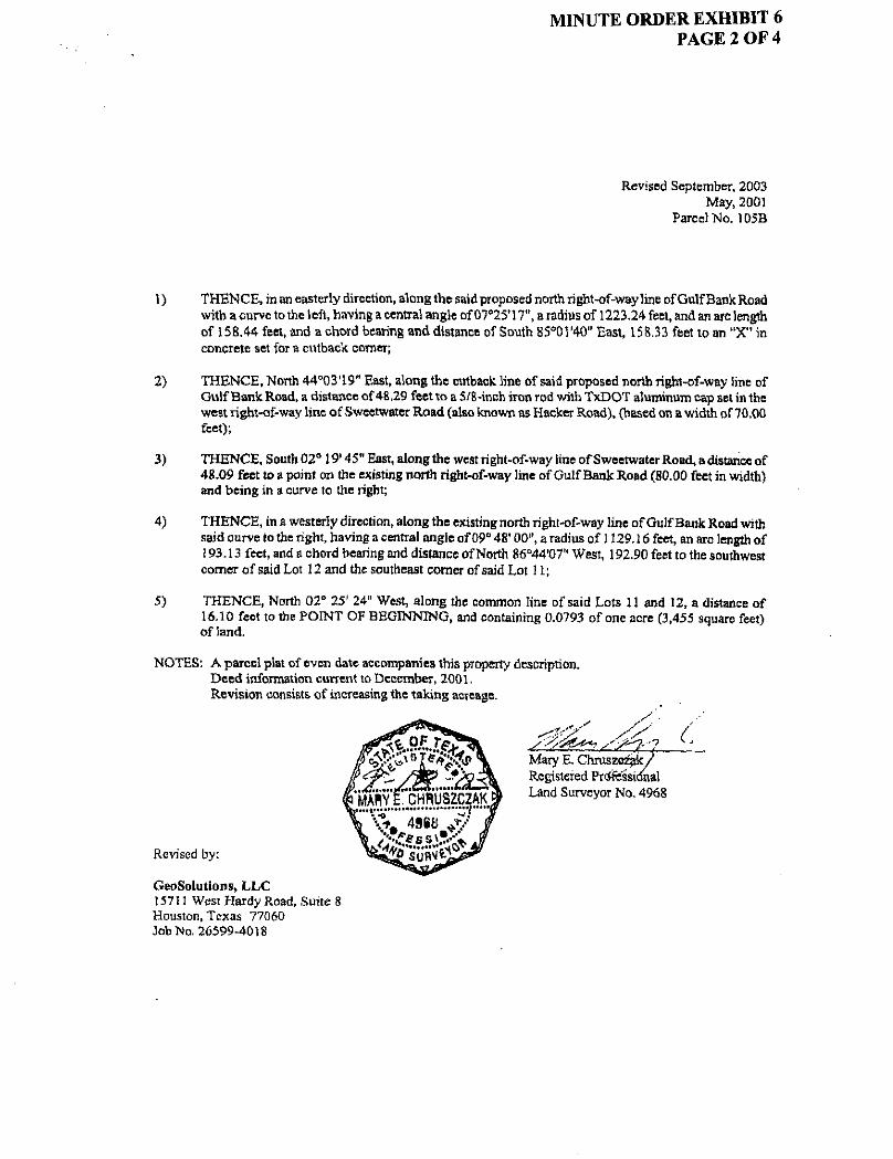
MINUTE ORDER EXHIBIT 6 PAGE 1 OF 4
Revised September, 2003 May, 2001
Parcel No. 105B
County: Highway: Project Limits: Account Number;
Harris Gulf Bank Road U.S. Hwy 290 to U.S. Hwy. 59 6012-50-2
PROPERTY DESCRIPTION FOR PARCEL NO. I05B
Being a 0.0793 of one acre (3,455 square feet) parcel of land, situated in the Phillip Tharp Survey, Abstract No. 1645, Harris County, Texas, being part of and out of Lots 12 and 15, Block 1, of North Shepherd Manor Section 1, a subdivision as shown on map or plat and recorded in the Harris County Map Records (H.C.M.R,) in Volume 35, Page 44, and being part of that certain tract of land conveyed in deed from Houston Ricardo's Number One Mexican Restaurant, Inc. to Song II Kim, dated September 16, 1994, as recorded in the Official Public Records of Real Property of Harris County (O.F.R.R.P.H.C.), Texas, under County Clerk's File No. R064662, Film Code No. 501 -08-1760; said 0.0793 of one acre parcel being more particularly described by metes and bounds as follows;
COMMENCING at a galvanized iron fence post found (Point of Reference) being the northwest corner of that certain tract of land conveyed in deed from James B. Wesley, Substitute Trustee to Jeannine Kell Garnctt, dated July 7,1992, as recorded in the O.P.R.R.P.H.C, under County Clerk's File No. N754612, Film Code No. 025-49-3315 and the northeast comer of that certain tract of land conveyed in deed from G & C Properties Corporation to Sun Development, Inc., dated December 30,1994, as recorded in the O.P.R.R.P.H.C., under County Clerk's File No. R226389, Film Code No. 502-42-3544, thence as follows:
South 02° 25' 24" East, along the common line of said Garnctt and Sun Development, Inc. tracts, a distance of 147.76 feet to a 5/8-inch iron rod with TxDOT aluminum cap found in the proposed north right-of-way line of Gulf Bank Road {width varies), and being in a curve to the right;
In an easterly direction along the proposed north right-of-way line of Gulf Bank Road, with said curve to the right, having a central angle of 09° 16' 47", a radius of 1572.57 feet, an arc length of 254.69 feet, and a chord bearing and distance of South SINS' 59" East, 254.42 feet to a 5/8-inch iron rod with TxDOT aluminum cap found for a point of reverse curvature;
In an easterly direction along the said proposed north right-of-way line of Gulf Bank Road, (100 feet in width) with a curve to the left, having a central angle of 04* 38' 27", a radius of 1223.24 feet, an arc length of 99.08 feet, and a chord bearing and distance of South 78° 59' 48" East, 99.05 feet to a 5/8 inch iron rod with TxDOT aluminum cap found in the common line of Lots U and 12, Block 1, and also being the POINT OF BEGINNING of the parcel herein described and having surface coordinates of X=3,138,138.56, Y=764,924,87; all bearings and coordinates are based on the Texas State Plane Coordinate System, South Central Zone NAD 27; all distances and coordinates are surface and maybe converted to grid by multiplying by a combined adjustment factor of 0.999870;
MINUTE ORDER EXHIBIT 6 PAGE 2 OF 4
Revised September, 2003 May, 2001
Parcel "No. 105B
1) THENCE, in an easterly direction, along the said proposed north right-of-way line of Gulf Bank Road with a curve to the left, having a central angle of 07°25'17", a radius of 1223.24 feet, and an arc length of 158.44 feet, and a chord bearing and distance of South 85=01'40" East, 158.33 feet to an "X" in concrete set for a cutback corner;
2) THENCE, North 44°03l19" East, along the cutback line of said proposed north right-of-way line of Gulf Bank Road, a distance of48,29 feet to a 5/8-inch iron rod with TxDOT aluminum cap set in the west right-of-way line of Sweetwater Road (also known as Hacker Road), (based on a width of 70.00 feet);
3) THENCE, South 02° 19' 45" East, along the west right-of-way line of Sweetwater Road, adistance of 48.09 feet to a point on the existing north right-of-way line of Gulf Bank Road (80.00 feet in width) and being in a curve to the right;
4) THENCE, in a westerly direction, along the existing north right-of-way line of Gulf Bank Road with said curve lo the right, having a central angle of 09" 48' 00", a radius of 1129.16 feet, an arc length of 193.13 feet, and a chord bearing and distance of North 86°44'07" West, 192.90 feet to the southwest comer of said Lot 12 and the southeast comer of said Lot 11;
5) THENCE, North 02° 25' 24" West, along the common line of said Lots 11 and 12, a distance of 16.10 feet to the POINT OF BEGINNING, and containing 0.0793 of one acre (3,455 square feet) of land.
NOTES: A parcel plat of even date accompanies this property description. Deed information current to December, 2001. Revision consists, of increasing the taking acreage.
Revised by:
GeoSolutions, L L C 157II West Hardy Road, Suite 8 Houston, Texas 77060 Job No. 26599-4018

MINUTE ORDER EXHIBIT 6 PAGE 3 OF 4

MINUTE ORDER EXHIBIT 6 PAGE 4 OF 4
(Addendum)
Access Clause
Access will be permitted to the highway facility from the remainder ofthe property abutting the highway facility.

MINUTE ORDER EXHIBIT 7 PAGE 1 OF 4
May, 2001 Parcel No. 112A
County: Highway, Project Limits: Account Number:
Harris Gulf Bank Road US. Hwy 290 to U.S. Hwy. 59 6012-50-2
PROPERTY DESCRIPTION FOR PARCEL NO. 112A
Being 0.0841 of one acre (3,665 square feet) of land, more or less, situated in the A.C. Allen Survey, Abstract No. 1295, Harris County, Texas, being part of and out of a 0.6554 acre tract being Lots 4 - 6, Block 4, of North Shepherd Manor Section 1, a subdivision as shown on map or plat and recorded in the Harris County Map Records (H.C.M.R.) in Volume 35, Page 44, and being part of said Lot 4 conveyed in deed from W. R. Morgan and wife, Irene Morgan to Lewis William Hinsch and wife, Dimple Irene Hinsch dated November 10, 1960, under County Clerk's File No. B257854, Volume 4199, Page 153, said Lots 5 and 6 conveyed in deed from B. B. Lang and wife, Marjorie Lang to Dimple Irene Lang, dated February 19,1960, under County Clerk's File No. B161629, Volume 3991, Page 293 and also being part of said Lot 7 conveyed in deed from Effie Florence Gist et al to Dimple Irene Gist Henderson, dated November 27, 1978, under County Clerk's File No. F871991, Film Code No. 113-91-2137 as recorded in the Official Public Records of Real Property of Harris County (O.P.R.R.P.H.C.), Texas, said 0.0841 of one acre parcel being more particularly described by metes and bounds as follows:
COMMENCING at a 1 -inch iron pipe found (Point of Reference) being the southwest comer of said Lot 7 and the southeast comer of said Lot 6, Block 4, thence as follows:
North 02° OS* 39" West, along the common line of said Lots 6 and 7, a distance of 115.84 feet to a 5/8-inch iron rod with TxDOT aluminum cap set in the proposed south right-of-way line of Gulf Bank Road (100.00 feet in width), and being the POINT OF BEGINNING of the parcel herein described and having surface coordinates of X~3,138,835.63, Y-764,816.83; all bearings and coordinates are based on the Texas State Plane Coordinate System, South Central Zone; all distances and coordinates are surface and may be converted to grid by multiplying by a combined adjustment factor of 0.999870;
1) THENCE, South 89° 19' 14" West, along the proposed south right-of-way line of Gulf Bank Road, a distance of 209.94 feet to a TxDOT aluminum cap set in the west line of said Lot 4 and being the east line of Lot 3 as conveyed in deed to William E. Cahill under County Clerk's File No. M345812, Film Code No, 158-71-1767 in the O.P.R.R.P.H.C, thence as follows;
2) THENCE, North 02° 08' 39" West, along the common lines of said Lot 4 and Lot 3, Block 4, a distance of 14.66 feet to a 1-inch iron pipe found for the northeast corner;

MINUTE ORDER EXHIBIT 7 PAGE 2 OF 4
May, 2001 Parcel No. U2A
3) THENCE, North 87° 47' 26" East, along the existing south right-of-way line of Gulf Bank Road (50.00 feet in width), a distance of 209.87 feet to a 3/4-inch iron pipe found for the northeast comer of said Lot 6 and the northwest comer of said Lot 7;
4) THENCE, South 02* 08' 39" East, along the common line of said Lots 6 and 7, a distance of 20.27 feet to the POINT OF BEGINNING, and containing 0,0841 of one acre (3,665 square feet) of land, more or less.
NOTES: A plat of even date accompanies this metes and bounds description. Deed information current to August, 2000.
Prepared by: j r - ^ ^ /
Edwards and Kelcey 654 E, North Belt, Suite 144 Houston, Texas 77060 Job No. 26599-4018

A.C. ALLEN SURVEY ABSTRACT 1295
P R O P O S E D B A S E L I N E ^ N 8 9 j i 9 ' U " E
4-FND. I.P GULFBANK •ROAD ;.' h .- P • ' "
Fun ' /VI .P . -H B?°4776" _ ^ N p T % ' ' LP.
WILLIAM E. CAHILL H.C C F. * M345S12 F C. • 15S-7M767
0 P.R.F P H.C.
LEWIS WILLIAM HINSCH AND DIMPLE IRENE HINSCH
H.C.C.F. * B257854 VOL.4199. PG.153
H.C.D.R. H C C F . « BIG 1629 VOL.3991, PG.293
HC.O.R. O.P.R.R P.H.C.
FND. T I P .
NORTH SHEPHERD MANOR SECTION 1
VOL. 35 PG. 44 H.C.M.R.
NOTES'
1. Metes and bounds cf even date accompanies this plat.
2. Ail bearings and coordinates ore bosed on the Te .as State Plane Coordinate Sys tem. South Central Zore ; all distances ond coordinates are surface ond may be converted to grid by multiplying by o combined adjustment factor of 0.999370.
3. Deed information current to August. 2000.
SCALE r - 5 0 '
FRANK DONALD HEUGATTER AND ' PATSY IRIS HEUG ATTER
H C C F . • U025005 F.C • 52S-62-124-9
O.P.R.R.P.H.C.
x %
-«s-y
• tfldijotes i n d / s e t 5 /B - i nch i rcn rod unless otherwise noted.
Q Indicates fnd /se t 5 /8 - i nch iron rod with TxDOT Aluminum Cop.
EXISTING TAKING REMAINING
0 5554 Ac. 0.0S41 Ac. 0.5713 Ac.
3,665 Sq. F t .
PARCEL 112A ACCOUNT NO. 6012-50-2
PARCEL PLAT SHOWING PROPERTY OF
LEWIS WILLIAM HNSCH AND DIMPLE IRENE HINSCH
PROPOSED GULF BANK ROAD HARRIS COUNT t' C . S . J . 3 0 0 3 - 1 2 - 0 0 3
SCALE 1" - 50 ' MAY, 2001 prepared by:
EDWARDS AND KELCEY Tel (281) 931-9920 Fcx (281) 931-8929

MINUTE ORDER EXHIBIT 7 PAGE 4 OF 4
(Addendum)
Access Clause
Access will be permitted to the highway facility from the remainder of the property abutting the highway facility.

M I N U T E O R D E R E X H I B I T 8 P A G E t O F 4
May, 2001 Parcel No. U2B
County: Highway: Project Limits: Account Number:
Harris Gulf Bank Road U.S. Hwy 290 to U.S. Hwy. 59 6012-50-2
PROPERTY DESCRIPTION FOR PARCEL NO. II2B
Being 0.0342 of one acre (1,488 square feet) of land, more or less, situated in the A.C. Allen Survey, Abstract No. 1295, Harris County, Texas, being part of and out of a 0.2193 acre tract being Lot 7, Block 4, of North Shepherd Manor Section 1, a subdivision as shown on map or plat and recorded in the Harris County Map Records (H.C.M.R.) in Volume 35, Page 44, and being part of said Lot 7 conveyed in deed from Walter Dean Henderson to Frank Donald Heugatter and wife Patsy Iris Heugatter, dated October 13, 1999 under County Clerk's File No. U025005, Film Code No.528-62-1249 as recorded in the Official Public Records of Real Property of Harris County (O.P.R.R.P.H.C.), Texas, said 0.0342 of one acre parcel being more particularly described by metes and bounds as follows:
COMMENCING at a 5/8-inch iron rod found (Point of Reference) being the southeast corner of said Lot 7 and the southwest comer of Lot 8, Block 4 as conveyed in deed to Nuong Thi Tran Nguyen under County Clerk's File No. S203862, File Code No. 510-75-3788 in the O.P.R.R.P.H.C., thence as follows:
North 02°08' 39" West, along the common lines of said Lots 7 and 8, a distance of 114.03 feet to a 5/8-inch iron rod with TxDOT aluminum cap found in the proposed south right-of-way line of Gulf Bank Road (100.00 feet in width), and being the POINT OF BEGINNING of the parcel herein described and having surface coordinates of X=3,138,905.81, Y=764,817.66; all bearings and coordinates are based on the Texas State Plane Coordinate System, South Central Zone; all distances and coordinates are surface and may be converted to grid by multiplying by a combined adjustment factor of 0.999870;
1) THENCE, South 89° 19' 14" West, along the proposed south right-of-way line of Gulf Bank Road, a distance of 70.18 feet to a 5/8-inch iron rod with TxDOT aluminum cap set in the west line of said Lot 7 and the east line of Lot 6 as conveyed in deed to Lewis William Hinsch and Dimple Irene Hinsch under County Clerk's File No, B257854, O.P.R.R.P.H.C. Volume 4199, Page 153, Harris County Deed Records (H.C.D.R.) and County Clerk's File No. B161629, O.P.R.R.P.H.C., Volume 3991, Page 293 ofthe H.C.D.R.;
2) THENCE, North 02° 08' 39" West, along the common lines of said Lot 6 and Lot 7, Block 4, a distance of 20.27 feet to a 3/4-inch iron pipe found for corner in the existing right-of-way of Gulf Bank Road (80.00 feet wide);

MINUTE ORDER EXHIBIT 8 PAGE 2 OF 4
May, 2001 Parcel No. 112B
3) THENCE, North 87° 47' 26" East, along the existing south right-of-way line of Gulf Bank Road (50.00 feet in width), a distance of 70.16 feet to a I-inch iron pipe found for the northeast corner of said Lot 7 and the northwest corner of said Lot 8;
4) THENCE, South 02° 08' 39" East, along the common lines of said Lots 7 and 8, a distance of 22.14 feet to the POINT OF BEGINNING, and containing 0.0342 of one acre (1,488 square feet) of land, more or less.
NOTES: A plat of even date accompanies this metes and bounds description. Deed information current to August, 2000.
Land Surveyor No. 4968
Prepared by: S'"^^~
Edwards and Kelcey 654 E. North Belt, Suite 144 Houston, Texas 77060 Job No. 26599-4018
GULFBANK ROAD (80' WIDE)
PROPOSED BASELINE N 6 9 * 19'T*" £ =*t- \
NORTH SHEPHERD MANOR SECTION 1
VOL. 35 PG. 44 H.C.M.R.
B '.- i - : ' p ^ t - . — -
S 8 9 ° 1 9 ' H " W - 70.18'
LEWIS WILLIAM hONS^H AND DUPLE IRENE F*SCH
H.C.C.F. • B257854 VOL. 4199, PG. 1!
H.C.D.R-H.C.C.F. »B161629 •
VOL. 3991, PG 295 w H.C.D.R.
OP.R R P K C W
• P f e EXISTING R-O-W. LINE
< PROPOSED R.O.W. LINE
X ^ a 8 . 9 0 5 . 8 1 r*?§4.817.66
TrtTRAH NGUYEN C.C.F. • S2D3862
.C. • 510-75-3788 Q.P.R.R.P.H.C.
SCALE 1"-50'
A.C. A L L E N SURVEY ABSTRACT 1295
FRANK DONALO HEUGATTER AND PATSY RIS HEUGATTER
H.C.C.F. • U025005 F.C. » 528-62-1249
O.P.R.R.P-H.C.
* indicates f n d / s e t S /8 - i nch iron rod unless olherwree noted.
9 Indicates fnd /se t 5 /8 - inch iron rod with TxDOT Aluminum Cap.
NOTES'
1. Metes and bounds of even dote occompanies this plot.
2 . All bearings and coord inates are based on the Texas State. Plane Coordinate S y s t e m , south Centra! Zone; all distances and coordinates ore sur face and may be converted to grid by multiplying by a combined adjustment factor of 0.999870.
3. Deed information current to August, 2000. PARCEL 112B ACCOUNT NO. 6DT2-5D-2
EXISTING TAKING REMAINING
0.2IS3 Ac . 0 .0342 Ac. 0.1851 Ac.
148B S q . Ft-
PARCEL PLAT SHOWING PROPERTY OF
FRANK DONALD hEVGAJTER AND PATSY RENE hCUGAXTER
PROPOSED GULF BANK ROAD HARRIS COUNTY C . S . J - 8003-12-008
SCALE 1" - 50 ' MAY. 2001 prepared by :
COWARDS AMD KELCEY Tel. (281) 931-9920 Fax (281) 931-3929
z s ut
O 49 * L
z e H PJ
M
so W
03 w H oc

MINUTE ORDER EXHIBIT 8 PAGE 4 OF 4
(Addendum)
Access Clause
Access will be permitted to the highway facility from the remainder of the property abutting the highway facility.

MINUTE ORDER EXHIBIT 9 PAGE 1 OF 4
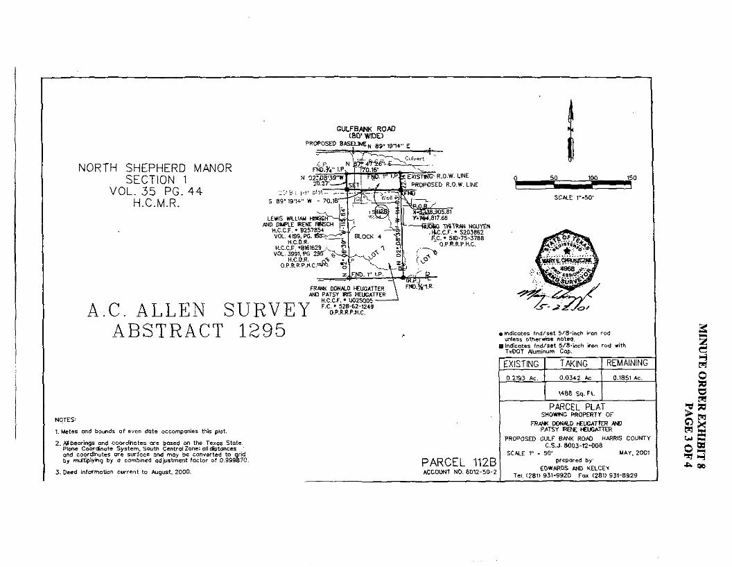
May, 2001 Parcel No. 170A
County. Highway; Project Limits: Account Number;
Harris Gulf Bank Road U.S. Hwy 290 to U.S. Hwy. 59 6012-50-2
PROPERTY DESCRIPTION FOR PARCEL NO. 170A
Being 0.0208 of one acre (905 square feet) of land, more or less, situated in the M X Snell Survey, Abstract No. 688, Hams County, Texas, being part of and out of a 2.92 acre tract being a portion of Lot 67, ofthe WX. Hill Subdivision, as shown on map or plat and recorded in the Harris County Map Records (H.C.M.R.) in Volume 7, Page 4, and being part of that certain tract of land conveyed in deed from Dolores P. Carr to Ash an Ho8emsmdLoisHosem,datedDeeemb^ of Harris County (O.P.RR.P.H.C.), Texas, -under County Clerk's File No. N436966, Film Code No. 008-58-0552, said 0.0208 of one acre parcel being more particularly described by metes and bounds as follows:
COMMENCING at a 2-inch pinch top pipe found in the west line of said Hosein tract, being in the east line of that certain tract of land as conveyed in deed to Laura Cowdrey, Trustee, dated September 18, 1989, as recorded in the Official Public Records of Real Property of Harris County, Texas, under County Clerk's File No. M350845, Film Code No. 158-77-2542, thence as follows:
South 01° 58' 49" East, along fee common line of said Hosein and Cowdrey tracts, a distance of 699.34 feet to a 5/8-inch iron rod with TxDOT aluminum cap found in the proposed north right-of-way line of Gulf Bank Road (100.00 feet in width) and being the POINT OF BEGINNING ofthe parcel herein described and having surface coordinates of X=3J146,068.81, Y=765,401.6L; all bearings and coordinates are based on the Texas State Plane Coordinate System, South Central; all distances and coordinates are surface and may be converted to grid by multiplying by a combined adjustment fector of 0,999870;
1) THENCE, North 88° 03' 27" East, along the proposed north right-of-way line of Gulf Bank Road, a distance of 17.93 feet to a 5/8-inch iron rod with TxDOT aluminum cap found in the west line of that certain tract of land as conveyed in Warranty Deed to Overton Spencer, Jr. and wife Thelma Joyce Spencer, dated August 5,1992, as recorded in the Official Public Records of Real. Property of Harris County, Texas, under County Clerk's File No. N803048, Film Code No. 106-58-3780;
2) THENCE, South 02° 23' 43" East, along the common line of said Hosein and Spencer tracts, a distance of 50.00 feet to a point in existing north right-of-way line of Gulf Bank Road (50.00 feet in width), from which a found 5/8-incb iron rod bears South 02" East, a distance of 0.40 feet;

MINUTE ORDER EXHIBIT 9 PAGE 2 OF 4
May, 2001 Parcel No. 170A
3) THENCE, South 88° 03' 27" West, along the existing north right-of-way line Df Gulf Bank Road, a distance of 18.29 feet to a point in the east line of said Cowdrey tract, from which a found 1-1/4-inch iron pipe bears South 02° East, a distance of 0,40 feet;
4) THENCE, North 01° 58' 49" West, along the common line of said Hosein and Cowdrey tracts, a distance of50.00 feet to the POINT OF BEGINNING, aridcontaming 0.0208 of one acre (905 square feet) of land, more or less.
NOTES: A plat of even date accompanies this metes and bounds description. Deed information current to August, 2000.
Prepared, ty:
M6yE% Registered Profe Land Surveyor No. 4098
j r - . a z ' - o / Edwards and Kelcey 654 North Sam Houston Parkway East, Suite 144 Houston, Texas 77060 JobNo.26599-4018

MINUTE ORDER EXHIBIT 9 PAGE 3 OF 4
M.K. SNELL SURVEY ABSTRACT 688
W,L. HILL SUBDIVISION VOL. 7 PG. 4
H.C.M.R.
NOTES;
1. W i t " ond Sounds •( en dola necomponl** thii plat
1, wtnarinno ond coardinol" »'t bund on Uiu T i iq i Sinn done Com&wik Sy»wn. South Cinttal lont ul ldatwci i ond eoerrfnqlct ait »UTIOCC ami way b i convtrlid lo v ia by mulUplyho toy o comtwiid aujwlnnflt factor ol D.SSSii'O.
J , rued information c u r r M ID *u;u«t, 3000.
PROPOSED R.0.W.UHE'
.waaw&f
,«mampwwr www O.P.R.Bi'.H.C,
> Indies l i i f nd /n l 5/5-Inch Iron rod unlets nlhemllt nnled.
I InnTiiDtu tnoViil 8/B-Inch Iron rod with T(QOI Mumlnum Cop,
EXISTING TAKING REMAINING 2.92 Ac. 0.020B Ac. 2.9C Ac
iB.ae>' GULFBANK ROAD
(50' WIDE) PARCEL 170A ACCOUNT NO, 6D12-B0-2
PARCEL PLAT SHOWING PROPERTY OF
ASHW HO SEN ANO LOIS HDSEIM
PROPOSED GUtf HtNK HDfD WWRIS COUNTY C.S.J, B003-12-OOB ' •
SCALE I" . 60' MAI, M M prsporad by'
EDWARDS AND KELCEY Tel. IZBU 831-8BM Foi (2BII 931-8929

MINUTE ORDER EXHIBIT 9 PAGE 4 OF 4
(Addendum)
Access Clause
Access will be permitted to the highway facility from the remainder of the property abutting the highway facility.

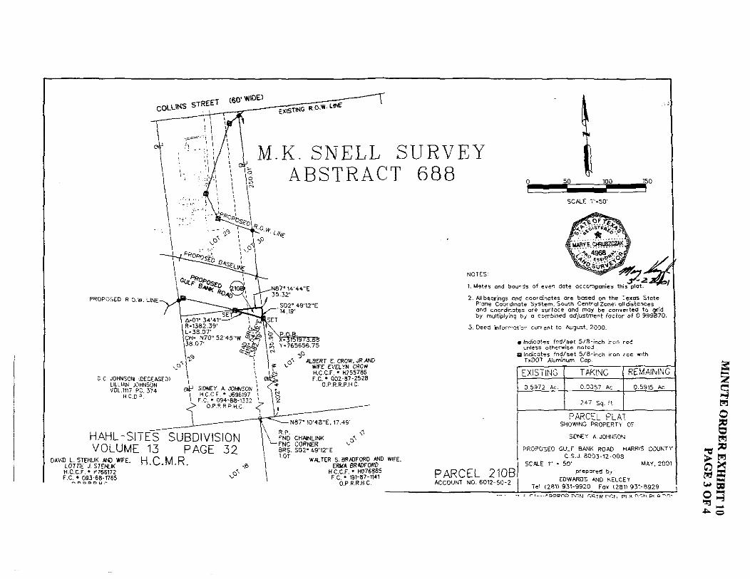
MINUTE ORDER EXHIBIT 10 PAGE 1 OF 4
May, 2001 Parcel No. 21 OB
County: Highway: Project Limits: Account Number:
Harris Gulf Bank Road U.S. Hwy 290 to U.S. Hwy. 59 6012-50-2
PROPERTY DESCRIPTION FOR PARCEL NO. 210B
Being 0.0057 of one acre (247 square feet) of land, more or less, situated in the M.K. Snell Survey, Abstract No. 688, Harris County, Texas, being a portion of Lots 29 and 30 ofthe Hahl-Sites Subdivision as shown on map or plat and recorded in the Harris County Map Records (H.C.M.R.) in Volume. 13, Page 32, and being part of that certain 0.5972 of one acre tract (called 0.5969 of one acre) as conveyed in deed from Lillian E. Johnson to Sidney A. Johnson, dated April 21, 1984, as recorded in the Official Public Records of Real Property of Harris County (O.P.R.R.P.E.C.), Texas, under County Clerk's File No. J696197, Film Code No. 094-88-1332, said 0.0057 of one acre parcel being more particularly described by metes and bounds as follows:
COMMENCING at the common corner of Lots 17,18,29, and 30 of said Hahl-Sites Subdivision and being in the south line of said 0.5972 of one acre tract, and from which a chainlink fence corner found bears South 02° 49' 12" East, 1.01 feet, thence as follows;
North 87° 10' 48" East, along the south line of said Lot 30 and the said 0.5972 of one acre tract, a distance of 17.49 feet to the southeast corner of said 0.5972 of one acre tract and the southwest comer of that certain 2.108 acre tract as conveyed in deed to Albert E. Crow, Jr,, and wife, Evelyn Crow, dated June 10, 1971, and recorded in the O.P.R.R.P.H.C. under County Clerk's File No. D345668, Film Code No. 129-39-0530, and deed dated December 5, 1981, and recorded in the O.P.R.R.P.H.C. under County Clerk's File No. H255786, Film Code No. 002-87-2528;
North 02° 49' 12" West, along the common line of said 0.5972 acre tract and said 2.108 acre tract, a distance of 235.90 feet to a 5/8-inch iron rod with TxDOT aluminum cap found for the POINT OF BEGINNING of the parcel herein described being on the proposed southerly right-of-way line of Gulf Bank Road and having surface coordinates of X=3,151,973.88, Y=765,656.75; all bearings and coordinates are based on the Texas State Plane Coordinate System, South Central Zone; all distances and coordinates are surface and may be converted to grid by multiplying by a combined adjustment factor of 0.999870;
MINUTE ORDER EXHIBIT 10 PAGE 2 OF 4
May, 2001 Parcel No. 21 OB
1) THENCE in a northwesterly direction along the proposed southerly right-of-way line of Gulf Bank Road, with a curve to the left, having a radial bearing of North 19° 54' 36" East, a central angle of 01° 34' 41", a radius of 1,382.39 feet, an arc length of 38.07 feet, and a chord bearing and distance of North 70° 52' 45" West, 38.07 feet to a 5/8-inch iron rod with TxDOT cap found on the north line of said 0.5972 of one acre tract;
2) THENCE, North 87° 14' 45" East, along the north line of said 0.5972 of one acre tract, adistance of 35.32 feet to a point in the said east line ofthe 0.5972 of one acre tract and the said west line ofthe 2.108 acre tract;
3) THENCE, South 02° 49' 12" East, along the common line of said 0.5972 of one acre tract and said 2.108 acre tract, a distance of 14.19 feet to the POINT OF BEGINNING, and containing 0.0057 of one acre (247 square feet) of land, more or less.
NOTES: A plat of even date accompanies this metes and bounds description. Deed information current to August, 2000.
Prepared by:
Edwards and Kelcey 654 North Sam Houston Parkway East, Suite 144 Houston, Texas 77060 Job No. 26599-4018
O / Land Surveyor No. 4698
^ O ^ ^ O ^ 0 ^ ^ ^
G.C JOHNSON iDECEASED) LILLIAN JOHNSON VOL.in7 PG. 374
H C D P.
M.K. SNELL SURVEY ABSTRACT 688
HAHL-SITES VOLUME 13
SUBDIVISION PAGE 32
OAV1D L. STEHLIK WJO WIFE. LOT HE J. STEHLIK H-C.C.F. • P766172 F.C. * 093-68-1765
H.C.M.R. *
R.P. FND CHAINLINK FNC CORNER SRS. S 0 2 " 49 ,12 , 'E 1 0 T WALTER S. BRADFORD AND WIFE.
ZRUA BRADFORD H C C F . • H076SS5 F.C. • 191-87-1141
O.P.R.R-H C.
SCALE V - 5 0 '
t. Mates and bounds of even dote accompanies this plat.
2. All bearings ond coordinates are based on the Texas State Plane Coordinate Sys tem, South Central Zone, oil distances ond coordinates are sur face and may be converted to grid by multiplying by a combined adjustment fac tor of 0 999870.
3. Deed information current to August. 2000.
* Indicates fnd /se t 5 /8 - inch iron rod unless otherwise noted
B Indicates fnd /se t 5 /8 - inch iron rod with TxDOT Aluminum Cap.
EXISTING TAKING REMAINING
0.5972 Ac. 0.0057 Ac 0.5915 Ac.
247 Sq. ft.
PARCEL 2108 ACCOUNT N O . 6 0 1 2 - 5 0 - 2
PARCEL PLAT SHOWING PROPERTY OF
SIDNEY A. JOHNSON
PROPOSED GULF BANK ROAD HARRIS COUNTY C . S . J . 8003 -12 -003
SCALE 1" - 5D- MAY, 2001 prepared by
EDWARDS AND KELCEY Tel (231)931-9920 Fan (281)931-8929
r -oDcns nr.u T .RTR p e n PI ,o ur.n pi a
MINUTE ORDER EXHIBIT 10 PAGE 4 OF 4
(Addendum)
Access Clause
Access will be permitted to the highway facility from the remainder of the property abutting the highway facility.

MINUTE ORDER EXHIBIT A PAGE 1 OF 13
September, 2000 Parcel 1
County: Hidalgo Account No.: 8021-01-067 CSJ No.: 0039-17-144 Highway: U.S. 83 Expressway Grantor: Heirs of T. B. Waite and J. P. Waite
FIELD NOTES FOR PARCEL 1
Being 8.624 acres (375,674 square feet) of land, situated in Los Ejidos de Reynosa Viejo Grant, Abstract No. 70, Hidalgo County, Texas, being part of that certain 207.05 acre tract, residue of that certain 210.34 acre tract, also referred to as Tract No. 379, conveyed to T. B. Waite and J, P. Waite, by a deed dated January 23,1935, recorded in Volume 408, Page 8, Deed Records of Hidalgo County, Texas, the subject 8.624 acres (375,674 square feet) of land, being more particularly described by metes and bounds as follows:
COMMENCING at a l/2-inch iron rod found on the easterly line of said 210.34 acre tract, and being the southwesterly comer of that certain tract conveyed to Jaime Pena, dated September 2, 1994, recorded in Document No. 408327, Official Public Records of Hidalgo County, Texas, also referred to as Lot 168, Silverado West Subdivision, as shown on plat thereof recorded in Volume 26, Page 90, Map Records of Hidalgo County, Texas, thence as follows;
NORTH 07°57,22" EAST, with the common line between said Lot 168, and said 210.34 acre tract, a distance of 136.45 feet to a 5/8 inch iron rod with a yellow plastic cap marked "RODS Surveying Inc." set for the POINT OF BEGINNING, having surface coordinates of X=l,011,683.03 and Y=16,612,836.44, being on the proposed southerly right ofway line of U.S. 83 Expressway, based on 300.00 feet wide. All hearings and coordinates are based on the Texas State Plane Coordinate System, South Zone, North American Datum 1983 (1993 adjustment). All distances and coordinates are surface and may be converted to grid by multiplying by a combined scale factor of 0.999960;
1. THENCE, NORTH 81026'i8" WEST, with said proposed southerly right ofway line, a distance of 1,101.59 feet to a 5/8 inch iron rod with a yellow plastic cap marked "RODS Surveying Inc.", set for point of curvature of a tangent curve to the right, having a radius of 5,854.58 feet;
2. THENCE, in a northwesterly direction continuing with said southerly right ofway line, along said curve to the right, having a central angle of 07Q00'00", a radius of 5,854.58 feet, an arc length of 715.28 feet, a chord bearing and distance of N 77°56'18" W, 714.83 feet to a 5/8 inch iron rod with a yellow plastic cap marked "RODS Surveying Inc." set

MINUTE ORDER EXHIBIT A PAGE 2 OF 13
September, 2000 Parcel 1
for the point of tangency;
3. THENCE, NORTH 74°26'18" WEST, continuing with said proposed right ofway line, a distance of 361.75 feet to a 5/8 inch iron rod with a yellow plastic cap marked "RODS Surveying Inc." set for point of curvature of a tangent curve to the left, having a radius of 5,604.58 feet;
4. THENCE, in a northwesterly direction, continuing with said proposed right of way line along said curve to the left, having a central angle of 07°00'00"/ a radius of 5,604.58 feet, an arc length of 684.73 feet, a chord bearing and distance of N 77°56'18" W, 684.31 feet to a 5/8 inch iron rod with a yellow plastic cap marked "RODS Surveying Inc." set for point of tangency;
5. THENCE, NORTH 81°26'18" WEST, continuing with said proposed right ofway line, a distance of 1,759.69 feet to a 5/8 inch iron rod with a yellow plastic cap marked "RODS Surveying Inc." set for an angle point;
6. THENCE, NORTH 81°25'24" WEST, conthmimg vrith said proposed south right ofway line, a distance of 385.95 feet to a 5/8 inch iron rod with a yellow plastic cap marked "RODS Surveying Inc." set on the westerly line of said 210.34 acre tract, for corner, and the east line of that certain 9.960 acre tract as conveyed to T. B. Waite, Jr., et ux, by deed dated July 23,1953, recorded in Volume 778, Page 179, Deed Records of Hidalgo County, Texas;
7. THENCE, NORTH 07°57'22" EAST, with the westerly line of said 210.34 acre tract, a distance of75.00 feet to a 5/8 inch iron rod with a yellow plastic cap marked "RODS Surveying Inc." set for corner on the existing south right of way line of U.S.83 Expressway, based on 200.00 feet wide;
8. THENCE, SOUTH 81°25f24" EAST, with the existing south right ofway line of U.S.83 Expressway, a distance of 386.75 feet to an angle point;
9. THENCE, SOUTH 81°26'18" EAST, with the existing south right of way line of U.S, 83 Expressway, a distance of 1,759.69 feet to a point of curvature of a tangent curve to the right, having a radius of 5,679.58 feet;
10. THENCE, in a southeasterly direction along said curve to the right, having a central angle of 07°00'00", a radius of 5,679.58 feet, an arc length of 693.89 feet, a chord bearing and distance of S 77°56'18" E, 693.46 feet to a point of tangency;
MINUTE ORDER EXHIBIT A PAGE 3 OF 13
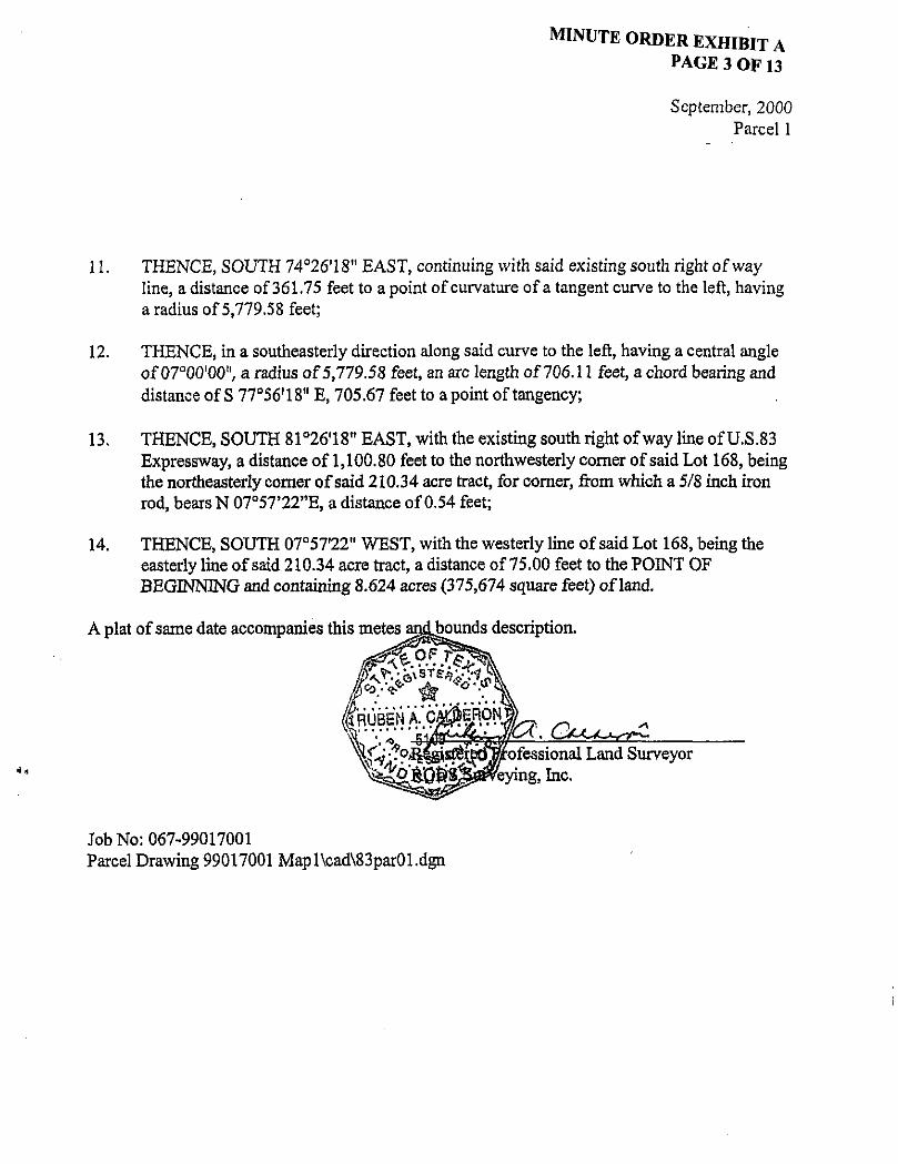
September, 2000 Parcel 1
11. THENCE, SOUTH 74°26'18" EAST, continuing with said existing south right ofway line, a distance of 361.75 feet to a point of curvature of a tangent curve to the left, having a radius of 5,779.58 feet;
12. THENCE, in a southeasterly direction along said curve to the left, having a central angle of 07°00'00"/ a radius of5,779.58 feet, an arc length of 706.11 feet, a chord bearing and distance of S 77°56'18" E, 705.67 feet to a point of tangency;
13. THENCE, SOUTH 81°26*18n EAST, with the existing south right ofway line of U.S.83 Expressway, a distance of 1,100.80 feet to the northwesterly corner of said Lot 168, being the northeasterly corner of said 210.34 acre tract, for corner, from which a 5/8 inch iron rod, bears N 07°57'22"E, a distance of 0.54 feet;
14. THENCE, SOUTH 07°57'22" WEST, with the westerly line of said Lot 168, being the easterly line of said 210.34 acre tract, a distance of 75.00 feet to the POINT OF BEGINNING and containing 8.624 acres (375,674 square feet) of land.
A plat of same date accompanies this metes anibounds description.
^^R^r% §RUBEN A ^ C ^ l R O N ^ % ' \" V ' ' sy&*J£^/CA . U C U ^
\\vV "^P^SS^fed^ofessional Land Surveyor ^ ^ ^ & 0 W & # e y i n g , Inc.
Job No: 067-99017001 Parcel Drawing 99017001 Mapl\cad\83par01.dgn

@>EW&© ^ L © ^ E # PORGIOM 11 AMT03ACTT Mo. I ??
E»fl©iMaifl® a&mmE A B S T R A C T
POROUOM 71 D. 503
U S 8 3 EXPRESSWAY (200 ' R.O.W.)
IT •? *pp
a r
PP /•EXISTING R.O.W. S a i ' 25 24" E^ 386^5"
PP
SURVEY LINE/ r
,5 81" 26'18" E
PP U.G. Mkr.SWB PP 1759.59'
© Set N 81" 25-24" W 385.95' PROPOSED R.O.W.J Set N B1*26'18" W 1759
H §
L®! :«JIDID®;
TRACT 379 210.340 ACRES
HEIRS OF T.B. WAITE ond J.P. WAITE VOL. 408 PAGE 8 01-23-35
D.R.H.C.
I BE OSiYTOSA ABSTRACT No. 70
^gz
<
LL I
il^AWT
Notes:
1. AH beorings ond coordinates ore based on the Texas State Plane Coordinate System. South Zone. North American Datum 1983.11993 adjustment). AM Distances ond Coordinotes shown ore surface and may be converted to grid by multiplying by a combined scale factor of 0.999960.
2. Set: Indicates a 5/8 inch iron rod with plastic cop marked "RODS Surveying. Inc."
3. Survey Sne locations are approximate and bosed on the best avarable evidence.
4. A metes ond bounds description of some dote accompanies this plot.
POB.Set U Parcel No. 1 N X-1011683.03
Y-15612836.44
(RP) Commencing Point Parcel No. 1 Fnd. V 2 " I.R.
Account No. 8021-01-067 Parcel No. 1
EXISTING TAKING REMAINING
210.340 AC. 8.624 AC. 201.716 AC. 375.674 SOFT
RIGHT OF WAY SKETCH SHOWING PROPERTY Of
HEIRS OF T.B. WAITE AND J .P . WAITE
US 83 HIDALGO COUNTY CSJ 0039-17-144
RODS SURVEYING INC. SEPT 2000 SCALE = V-8D-
t..iii,'j«' ssinaafciiii CJO nv^" JJ-

MINUTE ORDER EXHIBIT A PAGE 5 OF 13
„8„ 3NHH01VW
o z
o 0_
^
#5
WC=
'B-m m <
1-. To &? w o M ° CO —
g
©
s« !sa
sS!!, w
H tn oi a
!
i
< « m o =2)
m g@ «g ©
>-o EM egg
5=
(§)@5)
. ^
c j
,Vu 3NllH01vn

MINUTE ORDER EXHIBIT A PAGE 6 OF 13
MDM 3 N IHOIVW
IN
@y @
m=, @§o
rssj
L
II w o
s§ in 3
CJ ri L
0
^ ^
/ /
3
*R 5 R
u! ? o
= 4
S^gg cc 9 D 8
G=
< (fig #
o "» BM
; g S
O
F
1
VO
L.
41
mm im
£ % #
® g ^ QRjt
o =4
N
„ 8 „ 3NllH01VkN

MINUTE ORDER EXHIBIT A PAGE 7 OF 13
„(],» 3NI1H31VW
o z
o CL
H
* m <m o =3
m
>2
55 c=> mam
®m
=9
=j
3NllH01Vn

^ © ^ u © ^ © ^ © ^ ^ ^ ^ ^ ^
US 83 EXPRESSWAY (200' R.O.W.)
/ \ ,
SWB M.H.
EXISTING R.O.W.-, o p
I . } ' L _ V r
L-693.W CHB-S 77" 5618" E. 693.4* /4 *26 ' I8 -E 361.7^ '
w
Ld
X
o f— <
PROPOSED R.O.Wn
- a - 7 * 00 00" R-5604.5B' L-634.73' CHB-N 77- 56*18" W. 684.31'
TRACT 379 210.340 ACRES
HERS OF T.B. WATTE and J f . WAITE VOL. 408 PAGE 8 01-23-35
D.R.H.C.
Set N 74-2618" W 361.75'
LOO IJOOOO BE R E Y N 0 8 A WflU® GRANT ABSTHACTT No. 70
Parce l No. 1
n . « ' M « a i ; < t 9 ! u C i r

I ^ A W B l l A B S T R A C T
71
LU
b J
X o t— <
' US 8 3 EXPRESSWAY
(200 ' R.O.W.) — - ~~ _ ^
SURVEY UNE-y^V — —
^ _ _
EXISTING R Q.W.-\ PP a-7-oooo" 1 " R-5779.59' PP I.• 706.11' CHB-S 77" 5 6 ' W E. 705.67' P P
YL o PROPOSED R.O.W.T N 74-26-18" W 361.75' \ I Set 6 - 7 - 0 0 0 0 " R-S8S4.58" 1-715.28' CHB-N 77*56"1B" W, 714.83*
L u
W
X o I— <£
TRACT 379 210-340 ACRES
HERS OF 1 3 . WAITE ond J.P. WAITE VOL. 408 PAGE 8 01-23-35
D.R.H.C.
LOS IJ f lPOS O I REVMOSA WBiJ® ##AMTr A B S T R A C T Mo. TO
Parce l No. 1
u . I[ [-»«**• «0iUO»Hei.'t"I> »!e»-tl i f


D ^ ^ ^ ^
o z ^ ^ o.
,»H„ 3NI1H31VM
N
i fit @ I
WW&=
a<
ii g ! m Bst t
L§ N
it
9 vt
SK
u 5ss o
y >- e w i
" *- 2 » M
N h o
f
B=
<
"»
; g
55 m^i mm
8« GMm
"3
=3
..0„ 3NI1HD1VW

DIOMI$#0 RAMIRBZ P0NC60M 71 A#@TI
SURVEY IWE-y
LLl
z _-J X a
* Fnd. 576
GW S ^ l * 2 6 ' ! 8 " E EXISTING
pp flOO.BO' •pftgattTAga
o PROPOSED R.O.W.-.
M 61*26'%" W *rtOTt.59-
TRACT 379 210.340 ACRES
HERS OF T.B. WA»E ond J.P. WAITE VOL. 408. PAGE 8
01-23-35 O.R.H.C.
LO P I REYMO IBBTRACT
<RP1 Commencing Point
Parcel No. 1, Fnd. 1/2" I.R.
70
P.O.B.. Sot Parcel
X-TO116S3.03 Y-B&12B36.44
IRAMT.
PorcelNo. 1
; i . t r c s c * ? - ^

MINUTE ORDER EXHIBIT A PAGE 13 OF 13
ROW Account: 8021-01-067 CSJ 0039-17-144 County: Hidalgo Highway No. US 83 Expressway, Palmview Parcel 1
CONTROL OF ACCESS CLAUSE:
Access will be permitted to the South remainder abutting the highway facility of the foregoing property description.

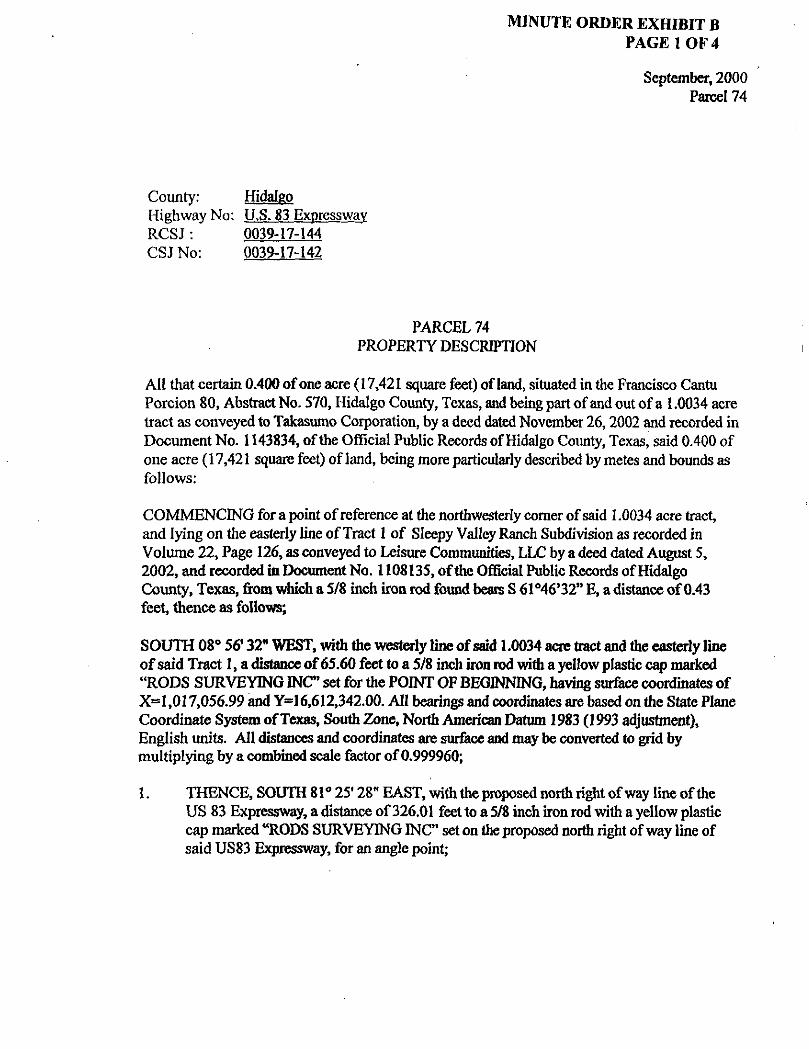
MINUTE ORDER EXHIBIT B PAGE 1 OF 4
September, 2000 Parcel 74
County: Hidalgo Highway No: U.S. 83 Expressway RCSJ: 0039-17-144 CSJ No: 0039-17-142
PARCEL 74 PROPERTY DESCRIPTION
Al l that certain 0.400 of one acre (17,421 square feet) of land, situated in the Francisco Cantu Porcion 80, Abstract No. 570, Hidalgo County, Texas, and being part of and out of a 1.0034 acre tract as conveyed to Takasumo Corporation, by a deed dated November 26,2002 and recorded in Document No. 1143834, ofthe Official Public Records of Hidalgo County, Texas, said 0.400 of one acre (17,421 square feet) of land, being more particularly described by metes and bounds as follows:
COMMENCING for a point of reference at the northwesterly corner of said 1.0034 acre tract, and lying on the easterly line of Tract 1 of Sleepy Valley Ranch Subdivision as recorded in Volume 22, Page 126, as conveyed to Leisure Communities, LLC by a deed dated August 5, 2002, and recorded in Document No. 1108135, ofthe Official Public Records of Hidalgo County, Texas, from which a 5/8 inch iron rod found bears S 61*46*32" E, a distance of 0.43 feet, thence as follows;
SOUTH 08° 56' 32" WEST, with the westerly line of said 1.0034 acre tract and the easterly line of said Tract 1, a distance of65.60 feet to a 5/8 inch iron rod with a yellow plastic cap marked "RODS SURVEYING I N C set for the POINT OF BEGINNING, having surface coordinates of X«l,017,056.99 and Y=I 6,612,342.00. Al l bearings and coordinates are based on the State Plane Coordinate System of Texas, South Zone, North American Datum 1983 (1993 adjustment), English units. All distances and coordinates are surface and may be converted to grid by multiplying by a combined scale factor of0.999960;
1. THENCE, SOUTH 81° 25* 28" EAST, with the proposed north right ofway line ofthe US 83 Expressway, a distance of326.01 feet to a 5/8 inch iron rod with a yellow plastic cap marked "RODS SURVEYING INC" set on the proposed north right ofway line of said US83 Expressway, for an angle point;
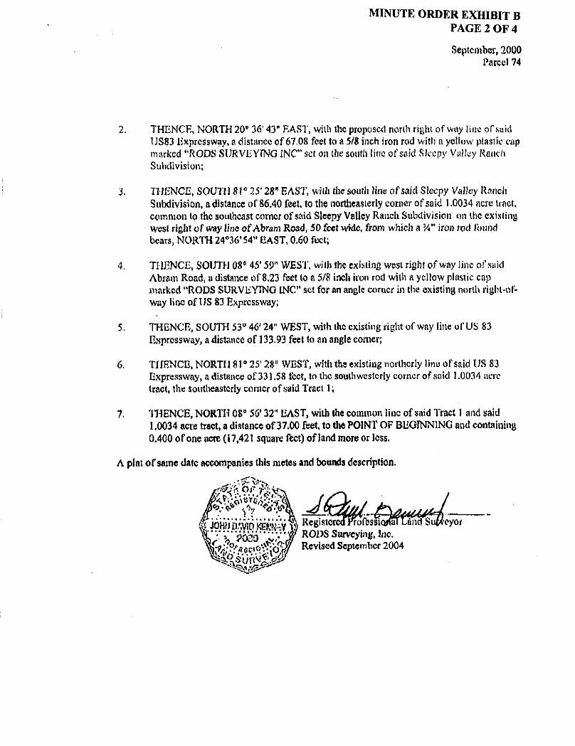
MINUTE ORDER EXHIBIT B PAGE 2 OF 4
September, 2000 Parcel 74
2. THENCE, NORTH 20' 36' 43" EAST, with the proposal north right ofway line ofxuid TJS83 Expressway, a distance of 67.08 feet to a 5/8 inch iron rod with a yellow plastic cap marked "RODS SURVEYING INC" set on (he south lino of said Sleepy Valley Ranch Subdivision;
3. THENCE, SOUTH 8 l a 25'28" EAST, with the south iine of said Sleepy Valley Ranch Subdivision, adistance of 86.40 feet, to the northeasterly comer of said 1.0034 acre tract, common to the southeast comer of said Sleepy Valley Ranch Subdivision on the existing west right of way line of Abram Road, 50 feet wide, from which a Vi" iron rod Ibtind bears, NORTH 24*36'54" EAST, 0.60 feet;
4. THENCE, SOUTH 086 45' 5T WEST, with the existing west right of way hne of said Abram Road, a distance of 8,23 feet to a 5/8 inch iron rod with a yellow plastic cap marked "RODS SURVEYING INC" set for an angle corner in the existing north right-of-way line of US 83 Expressway;
5. THENCE, SOUTH 53° 46' 24" WEST, with the existing right ofway line of US 83 Expressway, a distance of 133.93 feet to an angle corner;
6. THENCE, NORTH 81° 25' 28" WEST, with the existing northerly line of said US 83 Expressway, a distance of 331.58 teet, to the southwesterly corner of said 1.0034 acre tract, the southeasterly corner of said Tract 1;
7. THENCE, NORTH 08° 56' 32" EAST, with the common line of said Tract 1 and said 1.0034 acre tract, a distance of 37,00 feet, to the POINT OF BEGINNING and containing 0.400 of one acre (17,421 square feet) of land more or less.
A plat of same date accompanies this metes and bounds description.

FOSAMCIISCO CANTU
SLEEPY VALLEY RANCH, VOLUME 22. PAGE 12ft. SB. R. H, C.
-%Saa-SUBJECT TO BLANKET EASEMENT
t i FAVOR Of SOUTHWESTCKH BELL V O L . 18*5. P A C E 5 M . o j e k c e - 2 a - a J
101 C.P.I. L. U.E.I i VOL 1793 PACE 577 k.
D.fi.H.C g-11-Sll ~<
ItftftCafflmtfldM 0*M ftjfc*?* raafts**
r l C C W L U.E.
fj^n^i PROPOSED H-O.W.
^ ' ^ a z o m a - ^ ^ ^
a&M ~ " f k f
20 ' LA JOYA Wottr Supply Core E t t tmw i t V O L . . K 7 S . PACE 725 B*8
W M . - J b & a*- - - - - " - -^ 5 S H
US 83 EXPRESSWAY (200' R.O.WJ
/ - U S . 83 BASELINE
L 0 8 IE JUDOS DE REVMOSA WDEJ)® QRAMT. ABSTRACT No. 7©
Not * * :
1. M bowing* ond cooroTnot« or* bosed on tho Toxos Slot* Pfono CoordnQto System, South Zetw, North Am*rieon Dotum 1983. (1993 edjutlmonu. Ad Otttone** ond CoordtnolM thown or* turfoe* ond may b* convert** to qrW w mwA^ylng by a combined moot* factor ef 0.9999*0,
2. S * f tndteot** o 5/8 hwh Iron rod with pfoitto cap morked "HOOi &ir**yh@. if*.*
3. Survey «n» locations or* opproximat* ond boi td on th* twtt ovoiloW* evidene*.
4. A met** ond bounds description of some dot* aeeompeni** thb plot.
KFLP LIMITED DOC, NO. 877601
O.R.H.C. fi-2-00 SCALE ir-toc
OEXPREfteWAV A C R E * SUBDBVfiSIOM.
VOLUME 22. PAGE 175. M.R.M.C.
J ^ -REVISED ' SEPTEMKR. 200*
EXISTING TAKING REMAINING
1.003+ AC. j 0.400 AC. | 0.6034 AC. j
wasEXti RIGHT OF WAY SKETCH
SHOWMC H W t l W Y OF
US S3
P n n c e< io>
Parcel No. 74 KtOALGQ COUNT!
RCSJ 0039-17-144
z CJ S3 o P3
*e 9H > w
i.i
11 03

MINUTE ORDER EXHIBIT B PAGE 4 OF 4
ROW Account: 8021-01-067 CSJ 0039-17-144 County: Hidalgo Highway No. US 83 Expressway, Palmview Parcel 74
CONTROL OF ACCESS CLAUSE:
Access will be permitted to the North remainder abutting the highway facility along the foregoing property description.

M I N U T E O R D E R E X m B I T C P A O E I O F ^
January 12,2005 C o u n t y ^ ^ l l s
Highway: SH6 Timits: from 0.3 ^ilesNorthofP^413To 0.236^ilesSouthof^46 ^ W C S ^ : 0049-0^059 ^.DWAccount8009-02-028
Property Description Parcel
Being 0.303 of an acre o f l a n d s i ^ ^ County,Te^as.Beingaportionofa0.62 acre tract(descrihed as Pirst Tract) conveyed to ^.^1. Swinnea^r., andwife Amy Swinneahydeed and recorded in^olume 14,Page831 of me Official Puhlic records ofPalls County.
Commencing ataset 5 8 inch iron rod with ^CS^ cap in the southerly right of way line ofP^Bl 413 (hasedonawidthof70 feet) and also in me northerly line of that certain tract ofland called ^2^Tract^conveyedtol^.^.Swinnca,^r.,andwifeAmySwirmeahy deed and recordedm volume 14 Page 831 ofthe Official Puhlic records of^allsCounty^
Thence, southwesterly 129.07 ^et along the arc ofacurve to the right(delta:09^00^30^,^.adius: 820.95 feet, Chord: Soum 5 3 ^ 1 0 ^ West 128.94 teet), also the southerly right of wa P^413 and the northerly hne of said tracts toaset 5 8 inch iron rod withTexasDepartme ofTransportation (TxDOT) ah^inum cap marking the Beginning of an Access D e n i a l s the proposed easterly right of way line of SH6and the northeast corner of that certain tract of land conveyed toWilhertTocl^idge and recorded in^olume77 Page 444 of the Official Puhlic records ofPalls County.
Thence South 33^13^50^ ^ast 124 42 feet along the proposed easterly right of w^y hne of SH6 ^ndalongaAccess Denial Tine, also along the easterly line of said Tocl^ridge tract toaset 5 8 inch iron rod with T^DOT aluminum cap at the southeasterly comer of said Tockridge tract and also heing in the northerly line ofsaid 0.62 acre tract.
Thence South 57^26^15^ West21.90^eetalongthe proposed easterly right of way line of SH6 and alongaAccess Denial Tine, also along the southerlyline of said Tockridge tract and the northerlylineofsaid0.62acretracttoaset 5 8 inch hon rod with T^DOT aluminum cap for the Point ofBeginning.
1) Thence South 34^05^55^ Tast 125.60 feet along the proposed easterly right ofway line of SH 6 also alongaAccess Denial Tine toaset 5.8 inch iron rod withT^DOTaluminum cap marking the Tnd of the Access Denial Tineinthesoutherlyline of said 0.62 acre tract and the northerly line ofthat certain called 89.51 acre tract conveyed to Michael D. ^ader and wife^DeniseD.^aderhy deed and recorded in^olume315,Page 670 of the l alls County Deed records.

MINUTE ORDER EXHIBIT C PAGE 2 OF 3
2) Thence South 57°26'15" West 106.10 feet along the southerly line of said 0.62 acre tract and along the northerly line of said 89.51 acre tract, to a set 5/8 inch iron rod with "GS" cap in the easterly line of that certain called 1.92 acres conveyed to Jimmy L. Land by deed and recorded in Volume 91, Page 404 of the Official Public Records of Falls County.
3) Thence North 33°13' 50" West 125.56 feet along the easterly line said 1.92 acres and the westerly line of said 0.62 acre tract to a set 5/8 inch iron rod with "GS" cap in the centerline of a unimproved 20 foot wide alley and the southerly line of said Lockridge tract, also being in the northerly line of said 0.62 acre tract.
4) Thence North 57°26'15" East 104.20 feet along the centerline of a unimproved 20 foot wide alley and the southerly line of said Lockridge tract, also the northerly line of said 0.62 acre tract to the Point of Beginning and containing 0.303 of an acre, more or less.
Basis of bearings is the Texas State Plane Coordinate System, Central Zone, North American Datum 1983 (NAD 83). Al l coordinates adjusted to the surface using project surface adjustment factor of 1.00012. Survey control monuments and surface adjustment factor furnished by
Access is prohibited across the "Access Denial Line" to the highway facility from the remainder of the abutting property.
A survey was performed on the ground under my supervision on July, 2004.
See attached 8 %" x 11" plat that accompanies. ,
TxDOT.
The Woodlands, Texas 77380 Phone Number (281)681-9766
Prepared by: GeoSolutions Ltd. 1440 Lake Front Circle, Suite 110

ADL
o $ E
N P.O.B. P.O.C.
LEGEND
S«t TxDOT Type II Comer eta Monument
Set IR w/TuDOT Alum. Cop marks end of Access Denial Line Set %" IR w/TxDOT Alum. Cap Set (5 /8" Iron Rod with GSCapl Fnd. (Type Indicated at Location) Calculated Point Center Line Property Line Landhook
POINT OF BEGINNING
POINT OF COMMENCING
Survey Line
Access Denial Line
NOTES;
PEMO BAim&§ mffiwiEv
A-09'00'30 1
R-820.95' L-129.07/ CHB-S53' 26'10 CHD-128.94
BEGIN ACCESS DENIAL LINE 5TA:505+72.69 0FF:213.7B
I S $
POC PARCEL 6 / ' SET%"R W/GS |CAP
• . ' 1 > i I
' 2 n d TRACT,' R-M.SWINf€i. JR. AND. WIFE. AMY SWINNEA
VOL.14,PC.831 O.P .R .F .C .
S33M3'5D"E 124.42'
WHITE _E*:,5
ACCESS-
1
DEMAL UNE POB PARCEL 6
STAs50€-*6.§0 •OFF: 190,00' L
W*26,;i5)'Et-^,fl 104 J20'''
#
WILBERT LQCKRISGE, tVOL.77. RG.444 J
Q-.PiR.iF.C.
1St TRfrcT "•• (0 .62 AC. )
R.M,SWINNEA.- JR. AND W I F E . '
AMY SW1NNEA \ VOL.14.PG.831 i
• .P . I ^ .F IC ]
S57*26'I5*W 21.90 S 3 4 * ^ 5 5 j | E ^ g 6 0 |
CALLED 1.0 ACRE R.M. SWINNEA. JR. i AND WIFE,
AMY SWINNEA VOL;330. PC.326
. IF .CiD.R.
ACCESS-' DENIAL UNE
^ © A 1 ALLEY
END ACCESS -DENIAL LINE
STA=508*22.K) OFF'-mOOT
PROPOSED R.O.W. FAOL
h "So
CALLED 89.51 ACRES MICHAEL 0 . VAOER AND WIFE. DENISE D. VAOER
VOL. 315. PG. 670 F.C-D.R.
16.97'
CALLED 1.92 ACRES JIMMY L- LAND
VOL. 91. PG. 404 Q.P.R.F.C.
*" ' t t
N33M3'50"K 125 .%' T f e 32 ACRES A~ . LAND c / U
, W AMWL: r j u ' fei-L - O^LH:M
PROPOSED BASEL]NE
S34 '05 '55"E ALL BEARINGS ARE BASED ON THE TEXAS STATE PLANE COORDINATE SYSTEM, CENTRAL ZONE, NAD 83; ALL DISTANCES AND COORDINATES ' ARE SURFACE US SURVEY FEET. THE I SURFACE ADJUSTMENT FACTOR IS 1.00012. f
VOLUME AND PAGES SHOWN HEREON REFER TO THE DEED RECORDS OF FALLS COUNTY, TEXAS UNLESS DESIGNATED OTHERWISE.
IMPROVEMENTS SHOWN HEREON ARE BASED UPON TXDOT AERIAL SURVEY DIGITAL FILES.
ALL PARENT TRACT INSETS ARE NOT TO SCALE.
ACCESS IS PROHIBITED ACROSS THE "ACCESS DENIAL LINE" TO THE TRANSPORTATION FACILITY FROM THE ADJACENT PROPERTY.
, PROPOSED STATE HtGHWAf 4
WIDTH VAft/ES)
Ld / ! / / A
BOUNDARY DISCREPANCY APPROXIMATELY 4.854 SQUARE FOOT OVERLAP ON ADJOINING
PROPERTY OWNER (HATCHED AREA)
-DEED LINE
PARCEL 6 0303 Ac
1320Z sq.ft.
PARCEL 6 RM.SWINNEA JR. AND WIFE. AMY SWINNEA
SH-6 C.S.J. 0049-04-059
FALLS COUNTY OCTOBER, 200* prepared by-
iC3^3Solut ions, i td.!
•2
3 m o m
hs & > w
i l w n


MINUTE ORDER EXHIBIT D PAGE 1 OF 12
March. 2004 CSJ Number; 008644-037 County: Webb Highway: Loop 20 Project Limits: From: 0.20 mi. South of SPUR 400
To: 1.68 mi. North of U.S. 59
FIELD NOTES FOR PARCEL NO. 1
Being 3.5664 acres (155,352 square feet) of land, the grand total of Parts 1, 2, 3 and 4, out of Porcion 29, Abstract No. 3086, Webb County, Texas, Juan B. Villarreal, Original Grantee, being part of the residue of that certain 657.0736 acre tract, conveyed from Killam & Hurd Ltd., to Killam Oil Company, by deed dated December 31, 1981, recorded in Volume 684, Page 459, Deed Records of Webb County, Texas; the subject grand total, 3.5664 acres of land, being more particularly described in four parts by metes and bounds as follows:
P A R T I COMMENCING at a the southwest corner of Lot 1, Block 1, Ponderosa Hills Subdivision, Unit 1, as shown on plat thereof recorded in Volume 21, Page 49, Plat Records of Webb County, Texas, from which a 5/8-inch iron rod found bears, South 05°45'33" East, a distance of 0.33 feet, being on the northerly right of way line of Fairfield Drive, based on an 80 foot width, thence as follows:
South 08°10,49** West, across the right ofway of Fairfield Drive, a distance of 80.10 feet, to a point on the southerly right ofway line of said Fairfield Drive, being the northwesterly corner of Block 7, Ponderosa Hills Subdivision, also being on a curve to the right, having a radius of 472.21 feet;
In a Westerly direction with said southerly right of way line, along said curve to the right, having a central angle of 24°05'56", a radius of 472.21 feet, an arc length of 198.61 feet, a chord bearing and distance of North 72°19'12" West, 197,15 feet, to the point of tangency;
North 60° 16'14" West, continuing with the southerly line of said Fairfield Drive, a distance of 83.86 feet to a point for corner on the northeast end of a cutback line;
South 74°42'23" West, along said cutback line of Fairfield Drive, a distance of 9.97 feet, to the proposed east right of way line of Loop 20 for the POINT OF BEGINNING of the herein described parcel, having surface coordinates of X=677,647.44 and Y=17,080,350.12. Al l bearings and coordinates are based on the State Plane Coordinate System of Texas, South Zone, North American Datum 1983 (1993 adjustment). All distances and coordinates are surface and may be converted to grid by dividing by a surface adjustment factor of 1.000030;
1. THENCE, SOUTH 29°46*27" WEST, continuing with said proposed right ofway line, a distance of 487.80 feet, to a 5/8-inch iron rod with a Texas Department of Transportation aluminum disk set for corner;

^ ^ O I ^ E ^ E X H I B I T D P A G E 2 0 E I 2
Farcell
2. THENCE^ SOUTH 29^7^^^ WEST,continuingwith said proposedrightofway line, a distance of 207.55 eet, to a 5/8-inch iron rod with a Texas Department of Transportation aluminum disk set tor comer;
3 T H E N C E F O R T H 60^2^3^ WEST,adistanceofl2.19 feet, toa5/8-inchironrod withaTexasDepartmentofTransportation aluminum disk set tor comer on the existing easterlyright ofway line ofToop 20 based ona!20 toot width;
4. THENCE^ N O ^ T H 2 9 ^ 0 1 ^ EAST, with said existing easterly line ofToop20,a distance of 682.35 feet toapointt^r comer on the southwest end ofacutback hne rrom Fairfield Drive;
5. THENCE^ NOI^TH 7^42^23^ EAST, along said cutback line of Fairfield Drive,a distance of 18.31 feet, to the POINT OE BEGINNING and containing 0.2023 of one acre (8,810square teet) ofland in Fartl.
PA^RT2 COMMENCING ata5/8-inch iron rod ^bund tor the southwest comer of Tot46, Block 6, Towne East Subdivision, FhaselV,as shown on plat thereof recorded inVolume!3,Fage 23, Flat Records ofWebbCounty,Texas, being on the north right of way line of Ramirez Drive based ona50 toot width, thence as lollows:
South 03°10*32"West, across said Ramirez Drive,adistance of 50.00 teet,toapoint on the southerly line of said Ramirez Drive;
North 86^49^28"West,with said southerly line ofRamirezDrive,adistance of 150.00 feet, toa point tbrthe northeast end ofacutback line;
South 48°10^32"West, with said cutback line,adistance of 28.28 ^et , toapointto^ southwest end ofsaidcutbackline,beingonthe southerly right of way line of said Ramirez Drive, based ona90 loot width;
Norm 86°49*28^ West, continuing with the south line of said Ramirez Drive,adistanceofl0.74 l^et, to the Beginning of anAccessDenialTine and the POINTOEBEGINNINGofthe herein describedparcel, being on theproposedright ofway lineof Toop 20 andhaving surtace coordinates ofX^677,830.64 and ^17,080,936.76 and proposed baseline station of!00^02.64 and an offset of87.26 feet to the right. Al l bearings and coordinates are based on the State Flane Coordinate System ofTexas, South Zone, North American Datum 1983 (1993 adjustment). Al l distances andcoordinates are surtace and may be convertedtogridbydividingbyasurtace adjustmentlactorofl.000030.

MINUTE ORDER EXHIBIT D PAGE 3 OF 12
Parcel 1
1. THENCE, SOUTH 10°05'02" WEST, with said Access Denial Line and said proposed right ofway line, a distance of 274.67 feet, to a point for corner on said proposed right of way line;
2. THENCE, SOUTH 24°17'55" WEST, continuing with said Access Denial Line and said proposed right of way line of Loop 20, a distance of 216.63 feet, to a 5/8-inch iron rod with a Texas Department of Transportation aluminum disk set for corner of the existing easterly right of way of Loop 20, for the end of said Access Denial Line, being on a curve to the left having a radius of 1,346.09 feet and having a proposed baseline station of 95+38.69, with an offset of 81.41 feet to the right;
3. THENCE, in a northeasterly direction, with said existing right of way line, along said curve to the left having a central angle of 20°40'59'\ a radius of 1,346.09 feet, an arc length of 485.92 feet, a chord bearing and distance of North 13°57'26" East, a distance of 483.29 feet, to the southerly line of Ramirez Drive;
4. THENCE, SOUTH 86°49'28" EAST, with said southerly right ofway line, a distance of 20.70 feet to the POINT OF BEGINNING and containing 0.1185 of one acre (5,162 square feet) of land in Part 2.
PART 3 COMMENCING at a 5/8-inch iron rod found for the southwest corner of Lot 46, Block 6, Towne East Subdivision, Phase IV, as shown on plat thereof recorded in Volume 13, Page 23, Plat Records of Webb County, Texas, being on the north right of way line of Ramirez Drive based on a 50 foot width, thence as follows:
North 86°49'28"West, with the northerly line of Ramirez Drive, a distance of 150.00 feet, to a point for the southeast end of a cutback line;
North 41°49'28"West, with said cutback line, a distance of 28.28 feet, to a point for the northwest end of said cutback line, being on the northerly right of way line of said Ramirez Drive, based on a 90 foot width and being the POINT OF BEGINNING ofthe herein described parcel, having surface coordinates of X=677,846.35 and Y=17,08l,026.03. Al l bearings and coordinates are based on the State Plane Coordinate System of Texas, South Zone, North American Datum 1983 (1993 adjustment). Al l distances and coordinates are surface and may be converted to grid by dividing by a surface adjustment factor of 1.000030;
1. THENCE, NORTH 86°49f28" WEST, continuing with said northerly right of way line, a distance of 31.64 feet, to a point for corner on the existing easterly line of Loop 20 width varies;
2. THENCE, NORTH 02°59'49" EAST, with the existing easterly right of way line of Loop 20, a distance of 190.00 feet, to a point for corner on the southerly right of way line

M I N U T E O R D E R E X H I B I T E P A G E 4 0 E I 2
Parcell
of Campos Drive based ona90 foot width, as shown on theTowne East Subdivision, Phase 111, recorded in Volumell,Page 70, Plat Records ofWebbCounty,Texas;
3. THENCE, SOUTH 8 6 ^ 2 8 ^ EAST, with said southerly line of Campos Drive,a distance of32.23 feet, toapoint^br comer on the southwest end ofacutback line;
4. THENCE, NORTH 48^^32^ EAST, with said cutback line,adistanceof28.28 feet, toa5/8-inch iron rod withaTexas Department ofTransportation aluminum disk set tor comer ofthe proposed easterly right ofway ofToop 20;
5. THENCE, SOUTH 0 8 ^ 3 6 ^ WEST, with said proposed easterlyright ofway line,a distance of210.95 1eet to the POINT OE BEGINNING and containing 0.1829 of one acre (7,968 square leet)ofland in Part 3.
PART4 COMMENCING ata5/8-inch iron rod found tor the southwest comer of Tot46, Block 6, Towne East Subdivision, Phase lV,as shown on plat thereof recorded inVolume!3,Page 23, Plat Records ofWebbCounty,Texas, being on the north right of way line of Ramirez Drive based ona^Ofbotwidth, thence as lollows:
North 03 10*32" East, with the westerly line of said Block 6, at 230.00 feet passing the south right of way line of Campos Drive,basedona50 toot width,being the northwest comer of Block 6,Towne East Subdivision, Phase 111, as shown on plat thereof recorded inVolumel l , Page 70, Plat Records ofWebbCounty,Texas,atotal distance of280.00 feet, toapoint for the southwest comer ofTotl ,Block 5,ofsaid Phase 111 subdivision, and being on the north right of way line of said Campos Drive;
North 86^28"West, with the north line of said Campos Drive,adistanceofl42.78 feet, toa 5/8-inchironrodwithaTexas Department ofTransportation aluminum disk set for the POINT OE BEGINNING ofme herein described parcel, having surface coordinates ofX^677,887.93 and Y^17,081,284.12.Allbearings and coordinates arebasedontheStatePlane Coordinate System ofTexas, South Zone, North American Datum 1983 (1993 adjustment). Al l distances andcoordinates are surface and may be converted to grid by dividing byasurface adjustment factorofl.000030;
1. THENCE, NORTH 86^49^28^ WEST, continuing with said north hne of Campos Drive,adistanceof7.22 teet to the east end ofacut-back;
2. THENCE, NORTH 4 1 ^ 2 8 ^ WEST, wimsaid cutback line,adistanceof28.28 1eet toapoint for comer on the north line of said Campos Drive based ona90 foot width;

^ ^ O R D E R E X H ^ T D C A O E ^ O ^
Parcell
3 THENCE, NORTH 8 6 ^ 2 8 ^ WEST, with saidnorthright ofway line,adistanceof 32.51 teet, toapoint lor comer on the existing east right of way line ofToop 20, hased onal20 foot width;
4. THENCE,NORTH 0 2 ^ 4 9 ^ EAST, with said existing eastright ofway lineofToop 20,adistanceofl089Tl teet, to an angle point for the southwest end ofacuthack line from the south right of way IineofU.S.Highway 59;
5. THENCE, NORTH 4 8 ^ 1 ^ E A S T , with said cutback line,adistanceof70.67 feet, toapoint tor comer on the south right of way line of said U.S. Highway 59, based ona 150footwidth;
6. THENCE, SOUTH 8 6 ^ 3 2 ^ EAST, with the existing southright ofway IineofU.S. Highway 59,adistanceof200.50 feet, toa5/8-inch iron rod withaTexas Department of Transportation aluminum disk set tor the northeast comer ofthe herein described parcel, and being the northeast end ofacutback line from the proposed east right of way ofToop 20, also being the Beginning ofan Access Denial Tine, having surface coordinates o f X ^ 678,139.09 andY^ 17,082,431.58 and an US59 existing baseline station of!94+53.74, with an oftsetof60.00 teet to the right;
7 THENCE, SOUTH ^ 3 7 ^ WEST, with said cutback line along said proposed east right of way line and said Access Denial Tine,adistanceofl38.73 feet toa5/8^inch iron rod withaTexas Department of Transportation aluminum disk set for comer on the proposed east right ofway line ofToop 20, variable width;
8. THENCE, SOUTH 0 2 ^ 3 2 ^ WEST, continuing with said Access Denial Tine and said proposed east right of way hne, atadistanceof224.80 teet, the end of said Access Denial Tine, having surface coordinates ofX^678,009.89 and Y ^ 17,082,134.82 anda Toop 20 Proposed baseline station ofll2+03.39, with an oflsetof220.99leettotheright and continuing fbratotal distance of 360.59 feet toa5/8inch iron rod withaTexas Department ofTransportation aluminum disk set tor comer on the proposed east right of way lineofToop 20, variable width;
9 THENCE, SOUTH 09^^21^ WEST, continuing with the proposed easterly right of way line of Toop20,adistance of 724.33 teet to the EOINTOEREOINNINO and containing 3.0627 acres (133,412 square feet) of land in Part 4, andagrand total of 3.5664 acres (155,352 square teet) ofland.

M I N U T E O R B E R E X H I B I T D P A G E 6 0 E I 2
Parcel
ACCESS DENIATTINEBESCRIPTION
Being an Access Denial Line dehneatingadenial of access to the transportation facility from the adjacentpropertyalongthecommonboundaryofU.S.59,beingpartoftheresidueofthatcertain 657.0736 acre tract, conveyed from ^i l lam^Hurd Ltd., to killam Oil Company, by deed dated December31,1981,recordedinVolume 684, Page 459,Deed Records ofWebb County, Texas; the subject grand total, 3.5664 acres ofland, said Access Denial Line beingmoreparticu^^^ describedbymetes and bounds as tbllows:
BEGINNING al a 5/8-inch iron rod with a TxDOT aluminum disk set lor comer at the intersection of the existing southerly right of way line ofUS59 (based on 175fbot width) with theacut-backlinefromtheproposedeasterlyright of way line ofToop 20, (based on variable width), being the northeasterly comer of the above described Parcell,Part4, having surtace coordinatesof X^678,139.09 and Y^17,082,43L58, havingan existingDS59 stationof 194+53.74,withanoffsetof60.00 totheright;allbearings and coordinates are based on the Texas StatePlaneCoordinateSystem,SouthZone(4205),NorthAmericanDatumofl983, 1993 Adjustment. Al l distances and coordinates shown are surface and may be converted to grid by dividingbyareciprocal combined adjustment factor ofl.00003;
THENCE, SOUTH 86^6^32^ EAST, with said existingsouth right ofway line,adistance of 135.72 feet to the end of said Access Denial Line having an existing US59 baseline of 195+89.46,withari offset of 60.00 to m^ andY^17,082,424.34
THENCE, SOUTH 86^6^32^ EAST,continuingwith said existing southright ofway line,a distance of 135.72 feettothebeginningofasecond Access Denial Line, having an existing US59 baseline of 196+19.46, with an offset of60.00 to the right and having surface coordinates ofX^678,304.60andY^17,082,422.74;
THENCE, SOUTH 86^6^32^ EAST,continuingwith said existing southright ofway line,a distance of35.00 feet to the End ofsaid second Access Denial Line, having an existing US59 baseline of 196+54.46,with an offset of 60.00 to the right and having surface coordinates of X^678,339.53 and^l7,082,420.87
Aplat of even date herewith accompanies this metes and bounds description. See exhlbitplat "B**.
Accessisprohibitedacrossthe^ACCESS DENIAL LINE^ to the transportation facility from the adjacent property.
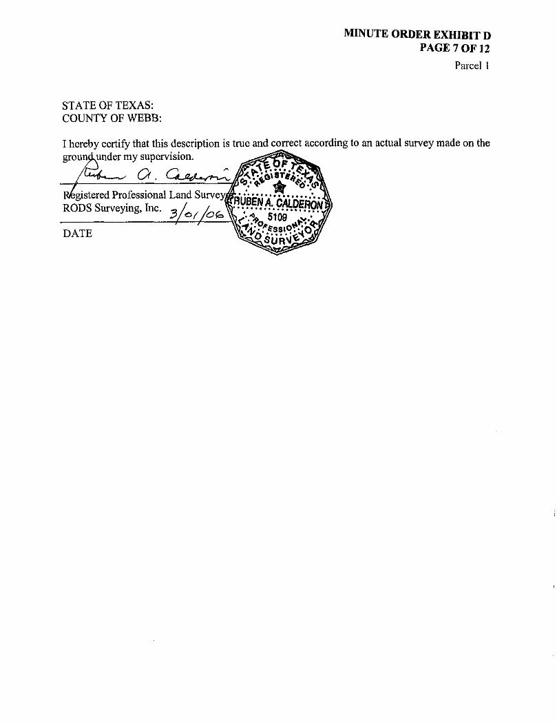
MINUTE ORDER EXHIBIT D PAGE 7 OF 12
Parcel 1
STATE OF TEXAS: COUNTY OF WEBB:
I hereby certify that this description is true and correct according to an actual survey made on the grouncLunder my supervision. ^s&^Ki?^^

EXIST. R.O.W. LINE
P©B%GH©INI 2®, mtL&um
ORIGINAL @®&MT\
100 200 300
EAL,
S 29" 57-18" W 207.55'
LINE TABLE
LINE NO. BEARING DISTANCE L-1 N 60"16 - 14" W 83.86 ' L-2 5 7 4 ° 4 2 ' 2 3 " W 9.97' L -3 N 74° 42 2 3 " E 18.3V
NOTES:
BASELINE CURVE DATA P.I. STA. - 96*75.18 A - 2 6 " 46'12" D = Q3° OO'OO" R = 1,909.86' T = 4 5 4 . 4 6 ' L=892.33-CHL = 884.24* CHB-N 16°22 '55" E P.C. STA. = 92 + 20.72
1. All bearings and coordinates ore based on the Texas p " T C T f i . " - i m 1% r \c State Plane Coordinate Sys tem. South Zone, North r * ' • ~ « ' ° - U D
American Datum. 1983 11993 Adj.). All distances ond X= 6 7 7 , 7 0 8 . 4 4 coordinates shown are surface and may be converted y = \ J 0 8 0 6 0 3 6 9 io grid dividing by a sur face adjustment factor of: ' * Webb County 1.000030.
2. Set •' Indicates Texas Department of Transportation aluminum disc on a 5 / 8 " I.R. set in concrete, unless otherwise depicted hereon.
3. Set 1 : Indicates a 5 / 8 " I.R. set with o yeliow plastic cap manted "RODS Surveying, Inc.".
4. Pardon line locations ore approximate and based upon the best available evidence.
5. D-R.W.C. indicates Deed Records of Webb County.
6. O.P.R.W.C. indicates Official Public Records of Webb County.
7. Remainder acres were calculated bosed on acreage called for in parent t ract less acres for ports 1. 2. 3 , & 4. Remaind acreage was not reduced to include any other conveyances out of this tract.
U B D I V i a i O M IH, P G . 4#, P R . VOL.
POC X-677.929.12: Y = 17,080,330.57
BLOCK 7 \ PARCEL 1 PART 1
EXISTING
H I h Access DeniolLine • Access is prohibited across ttw Access Denial Line-
9. A.D.L. Indicates Access Denial Line
657.0736 AC.
TAKING
0.2033 AC.
8.810 SQ. FT.
REMAININC
65.5.5072 AC.
SEE NOTE 7
PARCEL PLAT SHOWING
PARCEL 1, PART 1 PROPERTY OF:
KILLAM OIL COMPANY
LOOP 20 WEBB COUNTY R.O.W. C S J 0 0 8 6 - 1 4 - 0 3 7
RODS SURVEYING, INC. MARCH, 2004 SCALE: V'-IOO'
F I L E : N / L A N 0 5 5 / 2 0 2 2 1 0 0 1 / C A 0 / R O V . ' L 0 O F 2 0 / 2 0 - 5 9 P A R C E L ; - 1 . O G 1 J

200 300
LINE NO. BEARING DISTANCE
L-1 S 4 8 " 10-32" W 28.28 '
L-2 N 86° 49-28" W 10.74'
L -3 S 8 6 ' 4 9 ' 2 8 " E 20.70 '
L-4 5 03° 10'32" W 50.00 '
All b e a r i n g s o n d c o o r d i n a t e s o r e b a s e d o n the T e x a s S t a t e P lane C o o r d i n a t e S y s t e m . S o u t h Z o n e . N o r t h A m e r i c a n D a t u m , 1 9 8 3 £1993 Ad j . ) . All d i s t a n c e s and c o o r d i n a t e s s h o w n a r e s u r f a c e and m a y be c o n v e r t e d to g r i d d iv id ing by a s u r f a c e a d j u s t m e n t f a c t o r o f : Webb C o u n t y • 1 . 0 0 0 0 3 0 .
2 . S e t •• Ind i ca tes T e x a s D e p a r t m e n t o f T r a n s p o r t a t i o n a lum inum d i s c o n o % " I.R. s e t in c o n c r e t e , un l ess o t h e r w i s e d e p i c t e d h e r e o n .
3 . S e t 1 : I nd i ca tes a % " I.R. s e t wi th a ye l low p l o s t i c c a p m a r k e d " R O D S S u r v e y i n g , Inc . " .
4 . P o r c i o n line l o c a t i o n s a r e a p p r o x i m a t e and b o s e d upon the b e s t ava i l ab le e v i d e n c e .
5 . O . R . W . C . i n d i c a t e s D e e d R e c o r d s o f W e b b C o u n t y .
6 . O . P . R . W . C . i n d i c a t e s O f f i c i a l Pub l i c R e c o r d s o f Webb C o u n t y .
7. R e m a i n d e r a c r e s w e r e c a l c u l a t e d b a s e d o n a c r e a g e c a l l e d fo r in p a r e n t t r o c t l e s s a c r e s f o r p a r t s 1, 2 . 3 , & 4 . R e m a i n d e r a c r e a g e w a s n o t r e d u c e d t o i nc lude a n y o the r c o n v e y a n c e s out of this t r a c t .
CURVE A RADIUS LENGTH CHORD BRG. CH. DIST.
C-t 20 °40 '59 " 1.346.09' 485.92 ' N 13°57'26" E 483.29 1
C-2 0 0 ° 4 8 ' 2 6 " 1,346.09' 18.97' N 24° 42 '08 " E 18.97-
BASELINE CURVE DATA P.I. S T A . . 96+75.18 A=26° 46"12" D = 0 3 c 0 0 ' 0 0 " R-1,909.86* T - 4 5 4 . 4 6 ' L = 892 .33 ' C H L - 8 8 4 . 2 4 ' CHB-N 16= 2 2 ' 5 5 " E P.C. STA.-92+20.72 P.T. S T A . - 1 0 M 3 . 0 5 X= 6 7 7 , 7 0 8 . 4 4 Y= 17,080,603.69
P A R C E L 1 P A R T 2 ACCESS DENIAL LINE
NORTHING EASTING BEGIN A.D.L. 17,080.936.76 677.830.64 END A.D.L. 17.080.468.89 677.693.41
E X I S T I N G
657-0736 AC.
H I h A c c e s s D e n i o l L i n e : A c c e s s i s p r o h i b i t e d y*//ot a c r o s s the A c c e s s Den ia l L i n e .
9 . A . D . L , Ind ica tes A c c e s s Den ia l L i n e
TAK ING
0.1185 AC.
5.162 SO. FT .
REMAINING
653.5072 AC.
SEE NOTE 7
PARCEL PLAT SHOWING
PARCEL 1, PART 2 PROPERTY OF"
KILLAM OIL COMPANY
LOOP 20 WEBB COUNTY R.O.W. C S J 0 0 8 6 - 1 4 - 0 3 7
RODS SURVEYING, INC. MARCH. 2004 SCALE: 1" = 100'
FIL£:N/LAN055/20221001/CAD/ROWLOOP20/20-59PARCEL1-2.DGM

[p>©(B<§0@(M 28, EUUENOO MARTIN ORIGINAL ®G3ANIT AB#TI^A©T M©.
^
657.0736 ACRES KILLAM OIL COMPANY
VOL. 684 , PG. 459 , O.R.W.C. DEC. 31, 1981
N 0 2 a 5 9 ' 4 9 " E 1,444,75
0 100 200 300
SCALE 1" = 100'
T© gO©M i DV H®, IP©
IP.®. LINE TABLE
L- l N 8 6 ° 4 9 , 2 8 " W 31.64' L-2 N 48° T0'32" E 28.28 '
NOTES:
1. All bearings and coordinates are based on the Texas State Plane Coordinate System. South Zone. North American Datum, 1983 (1993 Adj.). All distances and coordinates shown are surface and may be converted to grid dividing by a surface adjustment factor of: Webb County - 1.000030.
2. Set : Indicates Texas Department of Transportation aluminum disc on a 5 / 8 " I.R. set in concrete, unless otherwise depicted hereon.
3. Set 1 : Indicates a 5 / 8 " I.R. set with a yellow plastic cop marked "RODS Surveying. Inc.".
4. Porcion line locations are approximate ond based upon the best available evidence.
5. D.R.W.C. indicates Deed Records of Webb County.
6. O.P.R.W.C. indicates Official Public Records of Webb County.
7. Remainder acres were calculated based on acreage called for in parent t ract less acres for ports 1. 2, 3, & 4. Remainder acreage was not reduced to include any other conveyances out of this tract.
Fnd. 5 / 8 " I.R. POC PARCEL 1, PART 3 X= 678,014.98 Y - 17,080.996.64
-i I h Access DeniblLine : Access is prohibited across the Access Denial Line.
9. A.D.L. indicates Access Denial Line
PARCEL PLAT SHOWING
PARCEL 1, PART 3 PROPERTY OF:
KILLAM OIL COMPANY
LOOP 20 WEBB COUNTY R.O.W. CSJ 0 0 8 6 - 1 4 - 0 3 7
RODS SURVEYING, INC. MARCH, 2004 SCALE: V ' -100 '
FILE-N/LAN055/20Z21001/CAD/ROWLOCP20/20-59PARC£H-3.0GtJ
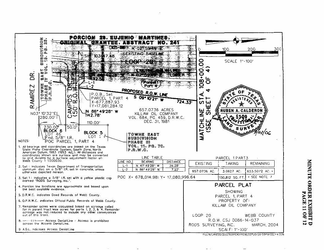
28, MABTOflE©, iGT-'W57WT
cr o M U J
or I r N03° 10 '32"E|
280 .00 ' i
t/)
2 b <m
X-677,887.93 Y = 17,081.284.12
7243?
V jN 86°49'28" W ni42.78'
NOTES:
110.00' 2 3 0 . BL L0°TC K46 6 ' B L O C K S IFnd. 5 / 8 " I.R. L 0 T 1
iPOC PARCEL 1, PART 4
657 .0736 ACRES KILLAM OIL COMPANY
VOL. 684 , PG. 459, O.R.W.C. DEC. 31, 1981
1. All b e a r i n g s and c o o r d i n a t e s a r e b a s e d o n the T e x a s S t a t e P l a n e C o o r d i n a t e S y s t e m . S o u t h Z o n e , N o r t h A m e r i c a n D a t u m , 1 9 8 3 (1993 A d j . ) . All d i s t a n c e s and c o o r d i n a t e s s h o w n o r e s u r f a c e a n d m a y b e c o n v e r t e d to g r i d d iv id ing by o s u r f a c e a d j u s t m e n t f a c t o r o f : Webb C o u n t y • 1 . 0 0 0 0 3 0 .
2 . Se t ; i n d i c a t e s T e x a s D e p a r t m e n t o f T r a n s p o r t a t i o n a luminum d i s c o n a 5 / 8 " I.R. s e t in c o n c r e t e , u n l e s s o t h e r w i s e d e p i c t e d h e r e o n .
3 . S e t 1 : I nd i ca tes a 5 / 8 " I.R. s e t wi th a ye l l ow p l a s t i c c a p m a r k e d " R O D S S u r v e y i n g , Inc . " .
4 . P o r c i o n line l o c a t i o n s a r e a p p r o x i m a t e a n d b a s e d upon the b e s t a v a i l a b l e e v i d e n c e .
5 . D . R - W . C . i n d i c a t e s D e e d R e c o r d s o f W e b b C o u n t y .
6 . D . P . R . W . C . i n d i c a t e s O f f i c i a l Pub l i c R e c o r d s o f W e b b C o u n t y .
7 . R e m a i n d e r a c r e s w e r e c a l c u l a t e d b a s e d o n a c r e a g e ca l l ed fo r in p a r e n t t r a c t l e s s a c r e s f o r p a r t s 1, 2 . 3 , & 4 . Rema inde r a c r e a g e was no t r e d u c e d t o i nc l ude any o t h e r c o n v e y a n c e s out o f this t r a c t .
E E A # T 8HJIBDDVISII0N
V O L . IH . P< P . R . W . C .
300
LINE TABLE LINE NO. BEARING DISTANCE
L-1 N 41° 49 '28 " W 28.28 ' L-2 N 86=49'2B" W 7.22"
PARCEL 1 PART3
EXISTING TAKING
657.0736 AC.
POC X - 678,014.98; Y - 17,080,996.64
A c c e s s Den ia l L ine : A c c e s s is p roh ib i t ed a c r o s s the A c c e s s Denia l L i n e .
9. A . D . L . I nd i c tees A c c e s s Den ia l L ine
3-0627 AC.
130,812 SQ. FT.
REMAININC
653.5072 AC.
- SEE NOTE 7
PARCEL PLAT SHOWING
PARCEL 1, PART 4 PROPERTY OF:
KILLAM OIL COMPANY
LOOP 20 WEBB COUNTY R.O.W. C S J 0 0 8 6 - 1 4 - 0 3 7
RODS SURVEYING, INC. MARCH, 2004 SCALE: 1" = 100'
F I L £ : N / L A N 0 5 5 / 2 0 2 2 1 0 0 1 / C A D / R O W L C O P 2 0 / 2 0 - 5 9 P A R C E : L I - 4 DGN

2 e-H W O
II sB §2 csS FiLE-fJ "LANG55 '20221001 Cf€) F0Vii.OGP2O 2 C - 5 9 F A P C r n - 5 DON

MINUTE ORDER EXHIBIT E PAGE 1 OF 4
August, 2002 Parcel 714
County: Harris Highway: Interstate Highway 10 Project Limits: From 0,41 miles West of Washington Avenue to Taylor Street Account No.: 9112-00-023
PROPERTY DESCRIPTION FOR PARCEL NO. 714
Being a 0.0248 acre (1,081 square feet) parcel of land situated in the John Austin Survey, Abstract 1, Harris County, Texas being part of and out of the Northerly portion of a deed called 0.106 acre tract conveyed to Doris Gwendolyn Lee from Emma Armbrister as described in Harris County Clerks File Number E778921 Film Code Number 142-01-0149 ofthe Official Public Records of Real Property Harris County (O.P.R.R.P.H.C.), Texas, dated May 24,1976; said 0.0248 acre parcel being further described by metes and bounds as follows:
COMMENCING at a 5/8 inch iron rod set for the Southeast corner of the said 0.106 acre tract, and the Southwest corner of the Crownpoint Homes, L L C . 0.0997 acre tract as described in Harris County Clerks File Number U139188, Film Code Number 529-77-0089, Official Public Records of Real Property Harris County (O.P.R.R.P.H.C.), Texas, dated December 17, 1999; having coordinates X = 3,110,026.10, Y = 13,849,035.95; all bearings and coordinates are based on the Texas State Plane Coordinate system (NAD 83,1993 adjustment), South Central Zone, all distances and coordinates shown are surface and may be converted to grid by multiplying by a combined adjustment of0.999870;
THENCE, North 02 degrees 48 minutes 40 seconds West, along the West line ofthe said 0.0997 acre tract, along the East line of the said 0.106 acre tract, a distance of 67.15 feet to a e/a inch iron rod with TxDOT aluminum cap set with coordinates X = 3,110,022.81 and Y - 13,849,103.02, being a point on a curve to the right having a radius of5,904.70 feet, on the proposed South right-of-way line of Interstate Highway 10 (variable width) and being the POINT OF BEGINNING;
1. ) THENCE, in a northwesterly direction, along the proposed South right-of-way line of Interstate Highway 10 (variable width), said curve to the right, having a radius of 5,904.70 feet, a central angle of 00 degrees 29 minutes 25 seconds, a distance of 50.52 feet, whose chord bears North 84 degrees 33 minutes 11 seconds West, a chord distance of 50.52 feet to a % inch iron rod with TxDOT aluminum cap set on the west line of the said 0.106 acre tract;
2. ) THENCE, North 02 degrees 48 minutes 40 seconds West, along the west line ofthe said 0.106 acre tract and the east line of the BMI Investments, Inc. 0.110 acre tract as described in Harris County Clerks File Number T143211, Film Code Number 519-83-1656 ofthe Official Public Records of Real Property Harris County (OJP.R.RP.H.C), dated July 8, 1998, a distance of 19,83 feet to a point on the existing South right-of-way line of Interstate Highway 10 (variable width);

MINUTE ORDER EXHIBIT E PAGE 2 OF 4
August, 2002 Parcel 714
3. ) THENCE, South 88 degrees 31 minutes 12 seconds East, along the existing South right-of-way line of Interstate Highway 10 (variable width), a distance of 50.14 feet to a point on the East line of the said 0.106 acre tract, and the West line of the said 0.0997 acre tract;
4. ) THENCE, South 02 degrees 48 minutes 40 seconds East, along the east line of the said 0.106 acre tract, and the west line ofthe said 0.0997 acre tract, a distance of23.34 feet to the POINT OF BEGINNING and containing 0.0248 acre (1,081 square feet) of land.
A plat of even survey date accompanies this legal description. Areas given for adjoining tracts are approximate. Access will not be permitted to the south remainder abutting the highway facility along call 1 of the foregoing property description.

- d
CO
John Austin Survey A-l
•£50POSEDBASE L 1 N E praam
C U R V E D A T A
ARC LENGTH
B A S E L I N E C U R V E D A T A Pi STATION D E L T A
- 3 0 2 * 0 9 . 6 7 12 ' 3 2 ' 3 7 " t L T ) « |
DEGREE OF CURVE - 1" 00 ' 0 0 " TANGENT LENGTH RADIUS P C STATION PT STATION
629.70' - 1,254.36' - 5.729.58' - 295*82.49 - 3 0 8 * 3 6 . B 5
INTER ST
CHORD BEARING N 84" 3311" W
CHORD LENGTH 5 0 . 5 2 '
L I N E D A T A No BEARING DISTANCE
L1 N 0 2 , 4 8 ' 4 0 " W 19.83' L2 S B6*31'12" E 50.14' L3 S 02 '48 ' 40 " E 23.34'
T E 51GHWAY 10
L E G E N D :
m = SET 5 / B ' IRON ROD WITH TXDOT ALUMINUM CAP 0 : FOUND IRON ROD
P. 0 .0 = POI NT OF CDMMENCING P.O.B = POINT OF BEGINNING H. C. 0. ft. = HARRI5 COUNTY DEED RECORDS H. C.C. F. = HARRIS COUNTY CLERK'S FILE F. C. : FILM CODE 0. P. Ft. R . P . H . C. = OFFICIAL PUBLIC RECORDS
REAL PROPERTY HARRIS COUNTY
N O T E S : 1 1 Texas S t a t e P lane Coord inate System. South C e n t r a l Zone.
Had 1983 (1993 Adjustment) t o convert Sur face Coord ina tes t o G r i d Coo rd ina tes . M u l t i p l y By the coco Ined f a c t o r erf 0.999B70-
2 : Se t : I nd i ca tes Texas Deportment of T r a n s p o r t a t i o n aluminum cap on a * i inch i r o n rod .
3) Survey t i ne l o c a t i o n s are approximate ond based upon nest a v a i l a b l e ev idence .
4) Th is p l a t i s prepared a long wi th a w r i t t e n d e s c r i p t i o n of same date of the proper ty surveyed.
5) E x i s t i n g ana remain ing areas shown ore approximate.
' OFFSET
EXISTING ACRES
TAKING ACRES/S.F. REMAINING
* 0-106 Q.0248/1.081 0.0812
^ r v : A I I an Munz R . P . L . S . T e x . R e g . N O . 1855
ACCOUNT H o . 9 1 1 2 - O 0 - O 2 3
PARCEL PLAT SHOWING P R O P E R T Y OF
DORIS GWENDOLYN LEE I. H . 10 H A R R I S COUNTY
C S J 0 2 7 1 - 0 7 - 2 6 0 R.W. PATRICK & ASSOCIATES. INC.
AUGUST. 2002 SCALE 1" - 40'
U> O * i -b .
g H w o
it w 50
m 03 M
H
m

MINUTE ORDER EXHIBIT E PAGE 4 OF 4
August, 2002 Parcel 714
Account No.: 9112-00-023 County: Harris ROW CSJ: 0271-07-260 Project Limits;IH 10 - 0.41 miles West of Washington Avenue to Taylor Street
CONTROL OF ACCESS CLAUSE AND IN ADDITION THERETO:
Access will not be permitted to the south remainder abutting the highway facility along call 1 of the foregoing property description.

MINUTE ORDER EXHIBIT F PAGE 1 OF 3
August, 2002 Parcel 718
County: Harris Highway: Interstate Highway 10 Project Limits: From 0.41 miles West of Washington Avenue to Taylor Street Account No.: 9112-00-023
PROPERTY DESCRIPTION FOR PARCEL NO. 718
Being a 0.0262 acre (1,143 square feet) parcel of land situated in the John Austin Survey, Abstract I, Harris County, Texas being the northerly portion of a deed called 0.094 acre tract conveyed to Chancy and Dorothy M Clark from Billie Jean Lawson, dated December 29,1983, as described in Harris County Clerks File Number J448057, Film Code Number078-89-1583 ofthe Official Public Records of Real Property Harris County (O.P.R.R.P.H.C.), Texas; said 0.0262 acre parcel being further described by metes and bounds as follows:
COMMENCING at a 5/8 inch iron rod set for the Southeast corner of the said 0.094 acre tract and the West right-of-way line of Bass Street (variable width), having coordinates X = 3,110,402.32, Y = 13,849,054.96; all bearings and coordinates are based on the Texas State Plane Coordinate system (NAD 83,1993 adjustment), South Central Zone, all distances and coordinates shown are surface and may be converted to grid by multiplying by a combined adjustment of 0.999870;
THENCE, North 02 degrees 38 minutes 15 seconds West, along the East line ofthe said 0.094 acre tract, and the West right-of-way line of Bass Street, a distance of 25.85 feet to a % inch iron rod with TxDOT aluminum cap set with coordinates X = 3,110,401.13 and Y * 13,849,080.79, on a curve to the right having a radius of 5,904.70 feet, being on the proposed South right-of-way line of Interstate Highway 10 (variable width) being the POINT OF BEGINNING;
1. ) THENCE, in a northwesterly direction along the proposed South right-of-way line of Interstate Highway 10 (variable width), said curve to the right, having a radius of 5,904.70 feet, a central angle of 00 degrees 58 minutes 25 seconds, a distance of 100.33 feet, whose chord bears North 87 degrees 59 minutes 22 seconds West, a chord distance of 100.33 feet to a Ve inch iron rod with TxDOT aluminum cap set on the West line ofthe said 0.094 acre tract;
2. ) THENCE, North 02 degrees 38 minutes 15 seconds West, along the West line ofthe said 0.094 acre tract, same being the East line of the Nancy Jones 0.115 acre tract as described in Harris County Clerks File Number P178293, Film Code Number 125-50-0788, of the Official Public Records of Real Property Harris County (O.P.R.R.P.H.C.), dated April 12, 1993, a distance of 16.42 feet to a point on the existing South right-of-way line of Interstate Highway 10 (variable width);
3. ) THENCE, South 82 degrees 12 minutes 52 seconds East, along the existing South right-of-way line of Interstate Highway 10 (variable width), a distance of 101.68 feet to a point on the East line of the said 0.094 acre tract;

MINUTE ORDER EXHIBIT F PAGE 2 OF 3
August, 2002 Parcel 718
4.) THENCE, South 02 degrees 38 minutes 15 seconds East, along the East line of the said 0.094 acre tract, along the West right-of-way line of Bass Street, a distance of 6.16 feet to the POINT OF BEGINNING and containing 0.0262 acres (1,143 square feet) of land
A plat of even survey date accompanies this legal description. Areas given for adjoining tracts are approximate. Access will not be permitted to the south remainder abutting the highway facility along call 1 of the foregoing property description.

C U R V E D A T A
BASEL INF PI STATION DELTA DECREE OF CURVE TANGENT LENGTH RADIUS PC STATION PT CTATimi
300+00 CURVE DATA
I*.'_^€ . 1 DELTA RADIUS ARC LENGTH CHCWO BCARMC CHORD LENGTH CX> 0O'5B'25" S.9O4.70* T00.33' N 87* 5D*22" W TO0.33' CX>
302*09.67 12- 32 '37 " (LT) 1' 00' OO" 629.70' 1.254.36' 5.729.58' 295'62.49 '08-36.85
I N T E R S T A T E 'VARIABLE WIDTH R . Q . m
^
Austin y A-l
WITH TXDOT ALUWNUH > FOUND IRON ROD P.O.C * POINT OF CO>*€NCING P.O.a : POINT Of BEGINNING H. C. D. R. = KARRI S COUNTY DEED RECORDS H . C C F . > HARRIS COUNTY CLERK'S FILE F .C * FI LH CODE 0.P.R. R. P. H.C. = OFFICIAL PUBUC RECORDS
REAL PROPERTY HARRIS COUNTY
H W A Y Ol Ot
n r— t Ot
n or n <NI & ID
a M
in a M K o < n K
<• Ifl
ST
.
w n T F S :
10 L I N E D A T A
No BEARING a S T A * * LI N 02"3815" W 16.42* 12 S 82*t2 , 52" E » t w L3 S 02'3B'T5" E 8.16'
o.r s.
' 1
2) Sat: olumlmm cap on
CALLED
Testes State PI om coordinate 5yat em. South Cantrol Zone. Nod 1983 (1993 Adjustment) to convert Sir+ooa Coord I notes to Grid CoordI notes, ttjltlpiy by the combined footer of 0.999870.
E X I S T I N G A C R E S
T A K I N G A C R E S / S . F . R E M A I N I N G
• 0 . 0 9 4 3.0262/1.143 0 . 0 6 7 B
Inch Iron rod.
3) Survey l ine locations ore approximate ond based upon best available evidence.
<l This plot Is prepared along with o written descript ion of some dote of the property surveyed.
5) Exist ing and remaining areas showt are approximate.
DOROTHY U. CLARK H.C.C.F. No. J44805T F.C. No. 078-89-1583
Q.P.R.R.P.H.C.
0#_Tm A l l * 7 » X .
i M u n z R . P . L . S . R»Q. HO. 1»SS
^vfiuTf '4 PARCEL 718
ACCOUNT No. 9112-O0-OZ3 SHEET 1 OF 1
PARCEL P L A T SHOWING PROPERTY OF
CHANCY AND DOROTHY M. CLARK H. 10 HARRIS COUNTY CSJ 02T1-O7-260
R.V. PATRICK & ASSOCIATES. INC. AUGUST. 2002 SCALE 1 * - 40'


MINUTE ORDER EXHIBIT G PAGE 1 OF 6
Parcel 684E Account 9112-00-025 Highway IH 10W County Harris
EASEMENT PREAMBLE
AN EASEMENT, together with all fixed improvements located thereon, if any, for the purpose of opening, construction and maintaining a permanent drainage channel in, along, upon and across the following described tract of land, with the right and privilege at all times of having ingress, egress and regress in, along, upon and across such tract of land for the purpose of making additions to, improvements on and repairs to the said drainage channel or any part thereof, said tract of land being hereinafter described by the metes and bounds of the follows;

MINUTE ORDER EXHIBIT G PAGE 2 OF 6
July, 2005 Parcel 684E
County: Highway: Project Limits:
Account:
Harris Interstate Highway 10 From 0.03 Mi W. of Tri-Oaks Lane to Attingham Drive 9112-00-025
PROPERTY DESCRIPTION FOR PARCEL 684E
Being a 0.0036 acre (156 square feet) parcel of land out of the Christiana Williams Survey, Abstract No. 834, Harris County, Texas, being a portion of that certain 7.693 acre tract conveyed from Korean Central Presbyterian Church of Houston to Wilcrest Venture, LTD., by deed dated December 27, 2000, and recorded under Clerk's File No. U802686 ofthe Official Public Records of Real Property Harris County (O.P.R.R.P.H.C.), said 0.0036 acre parcel being more particularly described as follows: (All bearings and coordinates are based on the Texas State Plane Coordinate System, South Central Zone, North American Datum 1983,1993 Adjustment; all distances and coordinates shown are surface and may be converted to grid by multiplying by a combined scale factor of 0.999870).
COMMENCING at a 5/8-inch iron rod with cap found at the northeast corner of a 3.876 acre tract conveyed from PPM Realty, LTD. to MH 3.876, LTD., by deed dated July 25,2003, and recorded under Clerk's File No. W881326 ofthe O.P.R.R.P.R.C., the southeast corner of a 6.0273 acre tract conveyed from Rescom Center to Robert Dupre, Michael Barrack, and Thomas Wilkinson, by deed dated June 28,1981, and recorded under Clerk's File No. H029931 ofthe O.P.R.R.P.H.C., and lying in the west right-of-way line of Upland Drive (60 feet wide), and recorded in Volume 18, Page 32 of the Harris County Map Records (H.C.M.R.); thence as follows:
NORTH 87 degrees 59 minutes 10 seconds EAST, a distance of60.00 feet to a point lying in the west line of said 7.693 acre tract, and the east right-of-way line of Upland Drive (60 feet wide);
SOUTH 02 degrees 00 minutes 50 seconds EAST, a distance of 358.54 feet along tlie west line of said 7.693 acre tract and said east right-of-way line of Upland Drive (60 feet wide) to a Texas Department of Transportation (TxDOT) aluminum disk set on a 5/8-inch iron rod in the proposed north right-of-way line of Interstate Highway 10 (IH 10) (width varies);
SOUTH 47 degrees 03 minutes 17 seconds EAST, a distance of 7.77 feet along said proposed north right-of-way line of IH 10 to a TxDOT aluminum disk set on a 5/8-inch iron rod;

MINUTE ORDER EXHIBIT G PAGE 3 OF 6
July, 2005 Parcel 684E
NORTH 88 degrees 41 minutes 36 seconds EAST, at 140.75 feet pass a TxDOT aluminum disk set on a 5/8-incri iron rod for station 1510+00, and continuing a total distance of 253.62 feet along said proposed north right-of-way line of IH 10 to a TxDOT aluminum disk set on a 5/8-inch iron rod at the POINT OF BEGINNING and southwest comer of the herein described parcel, having a Texas State Plane Coordinate Value of X = 3,054,949.85, Y = 13,850,790.66;
1. ) THENCE, NORTH 01 degrees 18 minutes 24 seconds WEST, a distance of 6.00 feet to a TxDOT aluminum disk set on a 5/8-inch iron rod at the northwest corner of the herein described parcel;
2. ) THENCE, NORTH 88 degrees 41 minutes 36 seconds EAST, a distance of 26.00 feet to a TxDOT aluminum disk set on a 5/8-inch iron rod at the northeast corner of the herein described parcel;
3. ) THENCE, SOUTH 01 degrees 18 minutes 24 seconds EAST, a distance of 6.00 feet to a TxDOT aluminum disk set on a 5/8-inch iron rod at the southeast corner of the herein described parcel, and lying in said proposed north right-of-way line of IH 10;
4. ) THENCE, SOUTH 88 degrees 41 minutes 36 seconds WEST, a distance of26.00 feet along said proposed north right-of-way line of IH 10 to the POINT OF BEGINNING, and containing 0.0036 acre (156 square feet) of land.
A parcel plat of even date was prepared to accompany this property description.
Access will be permitted to the northerly remainder abutting the highway facility.
PAUL RAY SMIJH J ;

LP. LR. OP.RR.P-H.C-
H C D J l RCF-CXJ.
KCU.R. Fnd C.C.F. . F.C. R.O.W. . Vol
2 = CD
LEGEND
-ton Pp* _fron Red -Oftaol Pubic f t j cor* of A*d Property Hvr i i County
_Horr* County D M * H*oord> -Harm County Flood Control Dhririct
.Horn County Hap Mmcordm -Found -County CWfm F#* Mmbar
m Cod* -Fkn
LC L R UX. _ D£. _ ex. _ T.C. _ R.C.P. CMP.
JCgM&f Way _Vdum J * » t _Dm#o Anato -Chord Baifcig
Numbor
Langth of Chord •ijwoth of curv«
JJWfty Eaaowwit Jkmmm E w m n t _BuU« L m .Top of Curb JtaMorud Conor** P^o jCorrugotad MmWP**
BLL BOARD SEN CABLE PtDESTAL/lOX LfCOWHOLW CABLE MARKER TELEPHONE PEDESTAL WATER I tCS SAM SEWER U C S STORM LINES FORCE U W
R -MP-m
UNE TABLE UNE Nm. KA f lNG DBTANCE
LM4 Nt7*ar«rE •0.00* LHS SOZ^OQWE
TELEPHONE MANHOLE ELECTRC BOX ELECTMC PEDESTAL ELECTRC TRANSFORMER GUY WftE UNDSKRQUND ELECTMC OVERHEAD ELECTRC METER POLE POWER POLE UQKT POLE PPBJNE MARKER GAS VALVE GAS METER RPELAC VtKT WATER METER WATER VALVE WATER WELL JRH1LER HEAD F#E HYDRANT BENOWRK M M PTE HON ROD
BARRED W*E FENCE CHAM LMK FENCE UNLESS
NOTED OTHERWISE BOLLARD MAL BOX TRAFFC SOML POLE TRAFFIC 3BNAL BOX TIUrTC BARBER Aft RELEASE VALVE BLOW OFF VALVE STORM MANHOLE SAN. SEWER MANHOLE SAN. SEWER CLEAN OUT
&
o c—
— E — — O E —
f J
M.T.S.
OLD KATY ROAD (60'WIDE) «
— / / — EHSTMB, TAMMG VEMAMER 7.M3 AC 0.003ft AC 7.693 AC
« s.r.
(HEREBY CERTIFY THAT THIS PLAT * ACCOMPANYING LEGAL DESCRIPTION tS BASED ON AN ON THE GROUND SURVEY MADE UNDER MY SUPERVISION AND TO THE BEST OF MY KNOWLEDGE, IS TRUE.AND CORRECT.
* /W>4» J~*& PaulR. Smith if No. 4646
NOTE A PROPERTY DESCRIPTION OF EVEN DATE WAS PREPARED IN CONJUNCTION WITH THIS PARCEL PLAT.
- I l l - CONTROL OF ACCESS UNE • INDICATES FOUND MONUMENT AS NOTED. • INDICATES SET % " LR. WITH TXDOT ALUMMJM CAP.
ALL COORDMATES ARE BASED ON THE TEXAS STATE PLANE COORDINATE SYSTEM SOUTH CENTRAL ZONE. NAD 83 (1903 ADJ.) ALL DISTANCES AND COORDINATES SHOWN ARE SURFACE AND MAY BE CONVERTED TO GRID BY MULTIPLYING BY A COMBINED SCALE FACTOR OF 0-999870.
— M A T 6F pmcn aa4£
RCSJ< 0271-07 -2*3 MTERSTATE HJGHWAY nmm COUNTY^TEXAS
10
s * v mmwm^mc PXOfFSSKXiM. LAMP SURVEYORS 20tn KRAHN SPRMO. TEXAS 773W
OFFICE - (2*0 365-2670 FAX - OBI) 353-2407 E-MAL - m*mmmrvm*mjmn /n DmAm* JULY. MOB somwr^w
2 !
I O W
* * > M
§s H o\
Jm* Mm.' BD4X7-0W-4-0EV Dfwdmm Mm.

MINUTE ORDER EXHIBIT G PAGE 5 OF 6
M H l S r v i S 3NI1 HOJ.VH I
•n.os'isz *8'3l*lW
VIS
•n .ob'isz VIS
n ,zrwK 69£S*0OSl
—v rwrwsv
•n*H'3*H ZC *Od 9V TO* 3AMQ OWWn
%
« « 2
^ i P p S ^
urn
4 i y i 10 B Q - • sssi s £ l i O D
* d or a iu
8
I
* 6 or
i t-(/> x w
p </)
VIS

*E J
CHRISTIANA & WILLIAMS SURVEYS
A-834 w
WH.CREST VENTURE, LTD.**1 , 7.693 AC k i t
F.N. U802686 « W-O.P.R.R.P.H.C.
DECEMBER 27,2000 j , I 10' H.L.&P. EASEMENT ^ J * . i
8 i n
< #-(/)
*
x o 5 2
VOL. 3501 PG. ..j, HP. n ft APRIL 22,1958
GGK, INC. 3.790 AC.
F.N. L747416 O.P.R.R.P.H.C. JULY 7.1988
OLD KATY ROAD (60' WIDE)
VOL. 739 PG. 721 H.C.D.R. MARCH 2,1928 VOL. 1. PAGE 581 C.C.M. AUGUST 17.1895
N 8 8 " 4 f 3 * " E 6,435.28'
PROPOSED BASELINE IH-10
INTERSTATE HIGHWAY 10 (WIDTH VARIES)
UNE TABLE I UNE N*. KAfVMG i .^r-v*
L * S t C ' O T S S t I 45.04' 1
N
BOFT
SCALE-' r - 5 0 '
PLAT
N C W 0271 -07 -2 *3 WTERSTATE HJQHWAY 10 HAIWg COUNTY. TEXAS
S «\ V MMWVMQ*- 'MC. AmPXSSWJMML i ^MD S U * V F Y O * S 20tflMMHN SPNMB, TEXAS 7736*
OTOC - <2*D 363-2670 FAX - (2*1) 363-2407 E-bWL - o *mm**mn* * *amm
D * * JULY, 2O06 A Setfwr-SO*
z e H W O
m -o so > m
88
5S » o
J*m Mm.: 50*27-<n0-O-D£V

. — MINUTE ORDER EXHIBIT H PAGE 1 OF 4
County: Liberty R.C.S.J. No.: 0338-05-025 Highway No.: State Highway No. 105 (New Location) Parcel No.: 4
BEING a 3.0496 hectare (7.536 acres) tract or parcel of land out of and a part of the Thomas Devers Survey, Abstract No. 169, in Liberty County, Texas, and also out of and a part of that certain called 120.3144 hectare (297.3021 acres) tract of land described as TRACT ONE in Special Warranty Deed dated September 28,1993, from Eugene Campbell to Transit Mix Concrete & Materials Company, a Delaware Corporation, recorded in Volume 1483, Page 672, Official Public Records of Liberty County, Texas, said 3.0496 hectare (7.536 acres) tract being more particularly described as follows:
Note: All bearings, latitude's and longitude's are referenced to the Texas State Plane Coordinate System, South Central Zone, Lambert Projection, NAD 83, All distances and acreages shown are surface. The scale factor is 0,999970. Convergence Angle is 02 40 '32.33 ". Coordinates shown are in meters.
COMMENCING at a 19mm (3/4 inch) pinched top pipe found for the Southwest corner of that certain called 8,0937 hectares (20 acres) tract of land as described in Special Warranty Deed with Vendor's Lien, dated December 8, 1993, from Eugene Campbell to Rebecca Tooley, a feme sole, recorded in Volume 1493, Page 136, Official Public Records of Liberty County, Texas, and the Northwest corner of that certain called 40.4687 hectare (100.000 acres) tract as conveyed by Special Warranty Deed with Vendor's Lien, dated December 11, 1992, from Eugene Campbell to Rebecca B. Tooley, a feme sole, recorded in Volume 1444, Page 822, Official Public Records of Liberty County, Texas, said corner also being located on the East line of that certain called 1258.1727 hectare (3109 acres) tract of land described as TRACT ONE in Special Warranty Deed dated February 4, 1992, from Strother Timberlands, Ltd., an Alabama limited partnership to Eugene Campbell, recorded in Volume 1404, Page 346, Official Public Records of Liberty County, Texas;
THENCE NORTH 86*48' 15" EAST, along the common line between said 8.0937 hectare (20 acres) tract and said 40.4687 hectare (100 acres) tract, for a distance of 404.944 meters (1328.55 feet) to a 25.4mm (1 inch) pinched top pipe found for the Southeast corner of said 8.0937 hectare (20 acres) tract and the Southwest corner of said 120.3144 hectare (297.3021 acres) tract, and also being in the North line of said 40.4687 hectare (100.000 acre) tract;
THENCE NORTH 86°48' 15" EAST, along the common line between 120.3144 hectare (297.3021 acres) tract and said 40.4687 hectare (100.000 acre) tract, for a distance of 44.631 meters (146.43 feet) to a 16mm (5/8 inch) iron rod with TXDOT aluminum disk set for corner, said disk being located on the proposed Southwesterly right of way line of State Highway No. 105 and being the POINT OF BEGINNING ofthe tract herein described(T.S.C. Y=3,084,181.0149, X=l,201,249.6377) (Engineer's Station 11+636.890, 50.011 meters (164.08 feet) right), and also being the Southwest corner of the herein described tract of land, said disk also being the beginning of a "Control of Access Line";
\_ MARK W. WHITELEYAND ASSOCIATES, INC. y
o%vio 4-

MINUTE ORDER EXHIBIT H PAGE 2 OF 4
County: Liberty R.C.S.J. No.: 0338-05-025 Highway No.: State Highway No. 105 (New Location) Parcel No,: 4
1. THENCE NORTH 22°17'23" WEST, along and with the proposed Southwesterly right of way line of State Highway No. 105, the same being a "Control of Access Line", for a distance of 139.050 meters (456.20 feet) to a 16mm (5/8 inch) iron rod with TXDOT aluminum disk set for corner, said disk being located on the East line of said 8.0937 hectares (20 acres) tract and the West line of said 120.3144 hectare (297.3021 acres) tract, said disk marking the end of this "Control of Access Line";
2. THENCE NORTH 03°34'07"WEST, along the common line between said 8.0937 hectares (20 acres) tract and said 120.3144 hectare (297.3021 acres) tract, for a distance of 68.894 meters (226.03 feet) to a 25.4mm (1 inch) pinched top pipe found for the Southeast corner of the remainder of that certain called 198.0967 hectare (489.506 acres) tract of land described as TRACT ONE in Special Warranty Deed dated December 9, 1991, from Louis J. Meyer, Jr. to Eugene Campbell, recorded in Volume 1439, Page 773, Official Public Records of Liberty County, Texas and the Northeast corner of said 8.0937 hectare (20 acres) tract, and being in the West line of said 120.3143 hectare (297.3121 acres) tract;
3. THENCE NORTH 03o47'09" WEST, along the common line between said remainder of 198.0967 hectare (489.506 acres) tract and said 120.3143 hectare (297.3121 acres) tract, for a distance of 243.845 meters (800.01 feet) to a 16mm (5/8 inch) iron rod with TXDOT aluminum disk set for corner, said disk being located on a non tangent curve to the right in the proposed Northeasterly right of way line of State Highway No. 105, whose radius is 1350 meters (4429.13 feet), delta angle is 01°33'24", and whose chord bears South 23°04'06" East, a distance of 36.680 meters (120.34 feet) and also being the most Northerly corner of the herein described tract of land, said disk also being the beginning of a "Control of Access Line";
4. THENCE in a Southeasterly direction along and with said curve to the right in the proposed Northeasterly right of way line of State Highway No. 105, the same being a "Control of Access Line", for an arc distance of 36.681 meters (119.36 feet) to a TXDOT concrete monument with brass disk set, said concrete monument being located on the point of tangency in said proposed Northeasterly right ofway line;
5. THENCE SOUTH 22°17'23" EAST, along and with the proposed Northeasterly right of way line of State Highway No. 105, the same being a "Control of Access Line", for a distance of 433.478 meters (1422.14 feet) to a 16mm (5/8 inch) iron rod with TXDOT aluminum disk set for corner, said disk being located on the South line of said 120.3144 hectare (297.3021 acres) tract and the North line of said 40.4687 hectare (100.000 acres) tract, and also being the Southeast corner of the herein described tract of land, and marking the end of this "Control of Access Line";
V. MARK W, WHITELEY AND ASSOCIATES, INC. J 0 6 OT, o \.
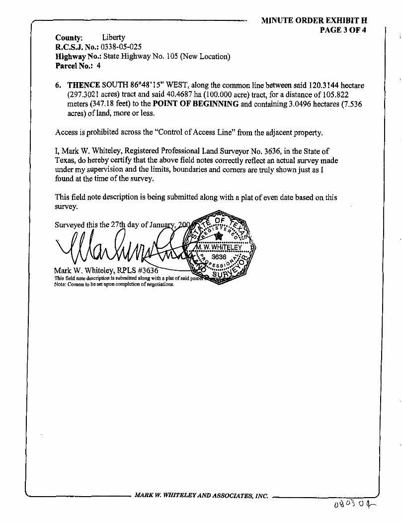
County: Liberty R.C.S.J. No.: 0338-05-025 Highway No.: State Highway No. 105 (New Location) Parcel No.: 4
MINUTE ORDER EXHIBIT H PAGE 3 OF 4
6. THENCE SOUTH 86°48' 15" WEST, along the common line between said 120.3144 hectare (297.3021 acres) tract and said 40.4687 ha (100.000 acre) tract, for a distance of 105.822 meters (347.18 feet) to the POINT OF BEGINNING and containing 3.0496 hectares (7.536 acres) of land, more or less.
Access is prohibited across the "Control of Access Line" from the adjacent property.
I, Mark W. Whiteley, Registered Professional Land Surveyor No. 3636, in the State of Texas, do hereby certify that the above field notes correctly reflect an actual survey made under my supervision and the limits, boundaries and corners are truly shown just as I found at the time of the survey.
This field note description is being submitted along with a plat of even date based on this survey.
Surveyed this the 27th day of January, •2QQ$ffi?v?%$?^
Mark W. Whiteley, RPLS #363(T— This field note description is submitted along with a plat of said pare? Note: Comers to be set upon completion of negotiations.
V M A S K W. WHITELEY A N D ASSOCIATES, INC. /
0^0%

POINT OF BEGINNINGS
PAR No.
Y - N O R T H X-FAST
3084181.0149 1201249.6377
LEGEND: FOUND PROPERTY CORNERS SET ffimm (5/8") WON ROD WITH TxDOT ALUMINUM DISK
SET TxDOT BRASS DISK IN CONCRETE
PROP. ROW
EXIST. ROW
SURVEY LINE
-ill CONTROL OF ACCESS LINE
CURVE DATA
CURVE RADIUS ARC LENGTH DELTA ANGLE CHORD LENGTH CHORD BEARING TANGENT C35 1350.000m(4429.13'1 36.681m (119.36') 01"33'24" 36.680m 1120.34' ) S23*04'O6"E 18.342m (60.18')
STA 11-204:51$ 52.073m (170^83^^
DEVERS SURVEY A-169 STA 11*204.518 TO 11*671.506
CONTROL OF A C C E S S LINE
i.umjfmmfY. m MERER CERTIFY THAT THIS SURVEY WAS OK THE Off MAX » THE SURFfCE OF THE GHOWD OF THE PROPERTY L£GW flf SCKBED HEfiEOK MS) CORRECT!! REPRESENTS THE F/CTS FOUHD JO 7/£ TIME OF THE SUMY. THE PLKT E BfM6 SUBKTTED AWHG WITH A FIEIS BOTE l£SCHPTOt BASED OK THIS SURVET. DBE.
STA 1 1 - 4 3 2 . 5 9 \
EUGENE CAMPBELL PINCUEO TRACT OWF TOP P I P
REM. OF 198.0967 ho (489.506 AC) VOL. 1439. PG. 773 DECEMBER 9,1991
LC
TRANSIT MIX CONCRETE 8. MATERIALS COMPANY DEED
VOL 1*83 PG 6 7 2 OPRLC SEPTEMBER 2 8 . 1993
CALLED ORIGINAL TRACT 120.3144 ha (297.3021 AC) - TRACT ONE
TAKING 3.0496 ha (7 .536 AC)
VOL. P G . APPROX. REM.
117.2648 ha 1289.766 AC)
urn nmrziEf REBSTERED PROFESSIOHAL UW> SUfVEWR ta J636
N O T E S :
1) THE BEARINGS. LATITUDES AND LONGITU& ARE REFERENCED TO THE TEXAS STATE PLANE COORDINATE SYSTEM. SOUTH CENTRAL ZONE. LAMBERT PROJECTION. NAD 63. ALL DISTANCES AND ACREAGES SHOWN ARE SURFACE- THE SCALE FACTOR IS 0.999970. CONVERGENCE ANGLE IS 02°40'32.33". ALL COORDINATES ARE IN METERS. UNLESS OTHERWISE NOTED.
2) UNLESS NOTED. SURVEY LINE LOCATIONS ARE APPROXIMATE AND BASED UPON THE BEST AVAILABLE EVIDENCE.
3) ONLY STRUCTURES WITHIN 50.00' OF PROPOSED RIGHT-OF-WAY ARE SHOWN WITH TIES.
A) ALL REMAINING ACREAGFS ARE APPROXIMATE FROM INFORMATION OBTAINED FROM THE LIBERTY COUNTY APPRAISAL DISTRICT AND LIBERTY COUNTY DEED RECORDS.
5) CORNERS TO BE SFT I1PUN COMPLETION OF NEGOTIATIONS.
6) ACCESS IS PROHIBITED ACROSS THE "CONTROL OF ACCESS LINE" FROM THE ADJACENT PROPERTY.
(164.01*) LT
/4'''"^w.wHifar" -t.i
3G3S v i^rJ/
P.O.C. PARCEL 4 FND 19mm <3/4"T PINCHED TOP PIPE
N 8 6 " 4 B ' 1 5 " E 4 4 . 6 3 1 m
( 1 4 6 . 4 3 ' )
STA 11*636.890 50.011m (164.07 ) RT P . 0 . B . - P A R C E L 4 X = 1 2 0 1 2 4 9 . 6 3 7 7 Y = 3 0 8 4 1 8 1 . 0 1 4 9
REBECCA B. TOOLEY 40.4687 ho (100.0 AC)
VOL. 1444, PC. 822 DECEMBER 11, 1992
OPRLC
f PARCEL
r"
CONVEYANCE DATA CHART STATION
FROU TO
11+204.518 | 114671.506
£-« eru.£BMfiOH
9 3 - 5 5 8
IASI <JPI:AU CWH/07-0*
m
SCALF:
1=3333 1/3 F I E - V \ t . w i \ - i r i L &i\
9 3 5 5 8 P 4
CURRENT TRACT ROW ACQUIRED APPROX REMAINDER METRIC ENGLISH METRIC ENGLISH
1204m 1*4257.3021 4 3 . 0 4 % ha] 7.536 AC|l17.%48 t f j 289.766 AC
' l O T :
nn L
HARK W. WHITELEY AND ASSOCIATES
INCORPORATED, CONSULTING ENGINEERS. SUKYEYOBS. AMD PLAHRBtS
p. & #01 M M u i M i r r a s m M M
sua txsm nvr. mnuar. T H « TTTM
(TUD <« - « iut
METRIC ENGLISH
PARCEL P L A T SHOWING PROPERTY
OF TRANSIT MIX
CONCRETE & MATERIALS COMPANY
PARCEL 4 PAGE A OF A
STATE HIGHWAY 105
LIBERTY COUNTY. TEXAS
U.C.S.O. No. OS3B-D5-025
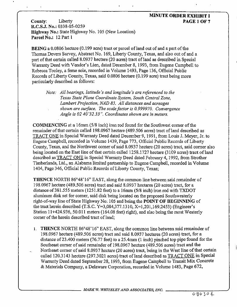
County: Liberty R.C.S.J. No.: 0338-05-0259 Highway No.: State Highway No. 105 (New Location) Parcel No.: 12 Part I
BEING a 0.0806 hectare (0.199 acre) tract or parcel of land out of and a part of the Thomas Devers Survey, Abstract No. 169, Liberty County, Texas, and also out of and a part of that certain called 8.0937 hectare (20 acres) tract of land as described in Special Warranty Deed with Vendor's Lien, dated December 8, 1993, from Eugene Campbell to Rebecca Tooley, a feme sole, recorded in Volume 1493, Page 136, Official Public Records of Liberty County, Texas, said 0.0806 hectare (0.199 acre) tract being more particularly described as follows:
Note; All bearings, latitude's and longitude's are referenced to the Texas State Plane Coordinate System, South Central Zone, Lambert Projection, NAD 83. Alt distances and acreages shown are surface. The scale factor is 0.999970. Convergence Angle is 02 40'32.33 ". Coordinates shown are in meters.
COMMENCING at a 16mm (5/8 inch) iron rod found for the Southwest corner of the remainder of that certain called 198.0967 hectare (489.506 acres) tract of land described as TRACT ONE in Special Warranty Deed dated December 9,1991, from Louis J. Meyer, Jr. to Eugene Campbell, recorded in Volume 1439, Page 773, Official Public Records of Liberty County, Texas, and the Northwest corner of said 8.0937 hectare (20 acres) tract, said corner also being located on the East line of that certain called 1258.1727 hectare (3109 acres) tract of land described as TRACT ONE in Special Warranty Deed dated February 4,1992, from Strother Timberlands, Ltd., an Alabama limited partnership to Eugene Campbell, recorded in Volume 1404, Page 346, Official Public Records of Liberty County, Texas;
THENCE NORTH 86°48' 16" EAST, along the common line between said remainder of 198.0967 hectare (489.506 acres) tract and said 8.0937 hectares (20 acres) tract, for a distance of 381.555 meters (1251.82 feet) to a 16mm (5/8 inch) iron rod with TXDOT aluminum disk set for comer, said disk being located on the proposed Southwesterly right-of-way line of State Highway No. 105 and being the POINT OF BEGINNING of the tract herein described (T.S.C. Y=3,084,377.1310, X=l,201,169.2453) (Engineer's Station 11+424.936, 50.011 meters (164.08 feet) right), and also being the most Westerly comer of the herein described tract of land;
1. THENCE NORTH 86°48' 16" EAST, along the common line between said remainder of 198.0967 hectare (489.506 acres) tract and said 8,0937 hectares (20 acres) tract, for a distance of 23.400 meters (76.77 feet) to a 25.4mm (1 inch) pinched top pipe found for the Southeast comer of said remainder of 198.0967 hectare (489.506 acres) tract and the Northeast comer of said 8.0937 hectare (20 acres) tract, being in the West line of that certain called 120.3143 hectare (297.3021 acres) tract of land described as TRACT ONE in Special Warranty Deed dated September 28,1993, from Eugene Campbell to Transit Mix Concrete & Materials Company, a Delaware Corporation, recorded in Volume 1483, Page 672,
MARK W. WHITELEY AND ASSOCIATES, INC. J 08C,3<>4.
MINUTE ORDER EXHIBIT I PAGE 1 OF 7

County: Liberty MINUTE ORDER EXHIBIT I
PAGE 2 OF 7 R.C.S.J. No.: 0338-05-0259 Highway No.: State Highway No. 105 (New Location) Parcel No.: 12 Parti
Official Public Records of Liberty County, Texas, and also being the Northeast corner ofthe herein described tract of land;
2. THENCE SOUTH 03°34'07" EAST, along the common line between said 8.0937 hectares (20 acres) tract and said 120.3143 hectare (297.3021 acres) tract, for a distance of 68.894 meters (226.03 feet) to a 16mm (5/8 inch) iron rod with TXDOT aluminum disk set for corner, said disk being located on the proposed Southwesterly right-of-way line of State Highway No. 105, and being the most Southerly corner of the herein described tract of land AND ALSO BEING THE BEGINNING OF A "Control of Access Line";
3. THENCE NORTH 22°17'23" WEST, along and with the proposed Southwesterly right-of-way line of State Highway No. 105, the same being a "Control of Access Line", for a distance of 72.904 meters (239.19 feet) to the POINT OF BEGINNING and containing 0.0806 hectare (0.199 acre) of land, more or less, and also marking the end of this "Control of Access Line".
Access is prohibited across the "Control of Access Line" from the adjacent property.
I, Mark W. Whiteley, Registered Professional Land Surveyor No, 3636, in the State of Texas, do hereby certify that the above field notes correctly reflect an actual survey made under my supervision and the limits, boundaries and corners are truly shown just as I found at'the time of the survey.
This field note description is being submitted along with a plat of even date based on this survey.
Surveyed this the 27th day of January, 2004. d ^ R T S f T w ^ i f i l l i q T I.*
,«_V_jL fft
V MARKW. WHITELEY AND ASSOCIATES, INC. {-
J

POINT OF BEGINNINGS PAR No.
12-1
Y-NORTH
3084377.1310
X-EAST
1201169.2453
LEGEND:
FOUND PROPERTY CORNERS SET 16mm [5/8") IRON ROD WITH TxDOT ALUMINUM DISK SET TxDOT BRASS DISK IN CONCRETE PROP. ROW
EXIST. ROW
. SURVEY LINE
-HI CONTROL OF ACCESS LINE
THOMAS D E V E R S A - 7 6 9
SURVEY
PARCEL AREA 12-1 8 .0937 ho
2 0 . 0 0 0 AC 12-2 4 0 . 4 6 8 7 ho
100.00 AC
PARCELS 12-1 ond 12-2 SUMMARY TABLE REBECCA TOOLEY
12-1 STA. 11*424.936 TO STA. 11*497.840 12-2 STA. 11*636.890 TO S T A 12-058.055
VOL. PG.
VOLXPG DATE 1493/136 12 -08 -93
TRANSIT MX CONCRETE & MATERIALS COMPANY / V TRACT ONE , ' r / V , 120.3143 ho (297.3021 AC)
VOL. 5483. PG. 672 SEPTEMBER 28.1993
OPRLC
1 4 4 4 / 8 2 2 12-11-92
TAKING 0 .0806 ha 0.199 AC 3.7138 ha 9.177 AC
4 8 . 5 6 2 4 ha 120.000 AC
lum W.WHtTFW. ED HEREBY CERTIFY THAT THS SURVEY WAS OK THIS DAT HADE OH THE SURFXE OF THE OOJHD OF THE PROPERTY IEGM1X DESCRIBED ffifSIW M) CORRECTtf REPRESENTS THE F/CTS FOOD AT THE TBS OF THE SURVEY. THIS PUT IS BEIK SUBMITTED Mm VTH A FiELD KOTE DESCf&nOH BASED OH THS SURVEY.
DATE SURVEYED: JH?h
EUGENE CAMPBELL TRACT ONE
198.0957 ha (489.506 AC). VOL. 1439. PG. 773 DECEMBER 9.1991
OPRLC
Um KMHTElEf REGISTERE!) FWFESSBNM. LWD SHWfWK Ma 3636
N O T E S : %$ iry;'; 1) THE BEARINGS, LATITUDES AND LONGITUDES ARE REFERENCED TO THE TEXAS STATE PLANE COORDINATE SYSTEM. SOUTH CENTRAL ZONE. LAMBERT PROJECTION. NAD 83. ALL DISTANCES AND ACREAGES SHOWN ARE SURFACE. THE SCALE FACTOR IS 0.999970- CONVERGENCE ANGLE IS 02"40'32-33". ALL COORDINATES ARE IN METERS. UNLESS OTHERWISE NOTED.
2) UNLESS NOTED. SURVEY LINE LOCATIONS ARE APPROXIMATE AND BASED UPON THE BEST AVAILABLE EVIDENCE.
3) ONLY STRUCTURES WITHIN 50-00' OF PROPOSED RIGHT-OF-WAY ARE SHOWN WITH TIES.
A) ALL REMAINING ACREAGES ARE APPROXIMATE FROM INFORMATION OBTAINED FROM THE LIBERTY COUNTY APPRAISAL DISTRICT AND LIBERTY COUNTY DEED RECORDS.
5) CORNERS TO BE SET UPON COMPLETION OF NEGOTIATIONS.
6) ACCESS IS PROHIBITED ACROSS THE "CONTROL OF ACCESS LINE" FROM THE ADJACENT PROPERTY.
EUGENE CAMPBELL TRACT ONE
1258.1727 ho (3109 AC) VOL. 1404, PG. 346 FEBRUARY 4.1992
OPRLC
TRANSIT MIX CONCRETE & MATERIALS COMPANY ^ TRACT ONE
120.3143 ha (297.3021 AC) VOL. 1483, PG. 672
SEPTEMBER 28.1993 OPRLC
PARCEL 7^
{ STATION CURRENT TRACT I ROW ACQUIRED I APPROX REMAINDER
FROM | TO METRIC | ENGLISH | METRIC | ENGLISH | UETRIC | ENGLISH 11+424.936 | 11+497.840 jB.0937 ho| 20.00 ACjO.OBOG ho| 0.199 AC(&-0131 ho| 19.801 AC
CONVEYANCE DATA CHART
I IK W ItSBAHRCH^
CRt/Jcn' .
J " E 9 3 - 5 5 8
(A'..I gi-'Ilfcil u
CWH 07-0*
1:1000
US SE
- 07-04
FILE. * M . I ' J h u E V [ R , \
9 3 5 5 8 P 1 2 - 1
MARK ¥ . WHITELEY AND ASSOCIATES
INCORPORATED. CONSULTING ENGINEERS. SURVEYORS, AND PLANNERS
P. 0. BOX MS2 BEimoirT, TSU3 Tmt-ntz
4M-BS2-M2I
3S50 t t s n x m t . BKDiioiiT. TEXis r r m
<r»»> imi-as:-i3<*
PARCEL PLAT SHOWING PROPERTY
OF
REBECCA TOOLEY
PARCEL 12-PART 1 S T A T E H IGHWAY 1 0 5
LIBERTY COUNTY. TEXAS
l 'n .C.S . , [ . No. 033B-95-0Z5
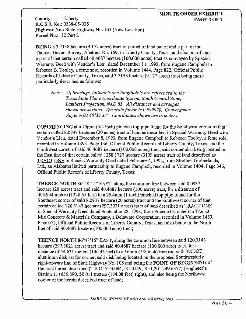
MINUTE ORDER EXHIBIT I County: Liberty PAGE 4 OF 7 R.C.S.J. No.: 0338-05-025 Highway No.: State Highway No. 105 (New Location) Parcel No.: 12 Part 2
BEING a 3.7138 hectare (9.177 acres) tract or parcel of land out of and a part of the Thomas Devers Survey, Abstract No. 169, in Liberty County, Texas, and also out of and a part of that certain called 40.4687 hectare (100.000 acres) tract as conveyed by Special Warranty Deed with Vendor's Lien, dated December 11,1992, from Eugene Campbell to Rebecca B. Tooley, a feme sole, recorded in Volume 1444, Page 822, Official Public Records of Liberty County, Texas, said 3.7138 hectare (9.177 acres) tract being more particularly described as follows:
Note: All bearings, latitude's and longitude's are referenced to the Texas State Plane Coordinate System, South Central Zone, Lambert Projection, NAD 83, All distances and acreages shown are surface. The scale factor is 0.999970. Convergence Angle is 02 40 '32.33 ". Coordinates shown are in meters.
COMMENCING at a 19mm (3/4 inch) pinched top pipe found for the Southwest corner of that certain called 8.0937 hectares (20 acres) tract of land as described in Special Warranty Deed with Vendor's Lien, dated December 8,1993, from Eugene Campbell to Rebecca Tooley, a feme sole, recorded in Volume 1493, Page 136, Official Public Records of Liberty County, Texas, and the Northwest corner of said 40.4687 hectare (100.000 acres) tract, said corner also being located on the East line of that certain called 1258.1727 hectare (3109 acres) tract of land described as TRACT ONE in Special Warranty Deed dated February 4, 1992, from Strother Timberlands, Ltd., an Alabama limited partnership to Eugene Campbell, recorded in Volume 1404, Page 346, Official Public Records of Liberty County, Texas;
THENCE NORTH 86°48' 15" EAST, along the common line between said 8.0937 hectare (20 acres) tract and said 40.4687 hectare (100 acres) tract, for a distance of 404.944 meters (1328.55 feet) to a 25.4mm (1 inch) pinched top pipe found for the Southeast comer of said 8.0937 hectare (20 acres) tract and the Southwest comer of that certain called 120.3143 hectare (297.3021 acres) tract of land described as TRACT ONE in Special Warranty Deed dated September 28, 1993, from Eugene Campbell to Transit Mix Concrete & Materials Company, a Delaware Corporation, recorded in Volume 1483, Page 672, Official Public Records of Liberty County, Texas, and also being in the North line of said 40.4687 hectare (100.000 acre) tract;
THENCE NORTH 86°48' 15" EAST, along the common line between said 120.3143 hectare (297.3021 acres) tract and said 40.4687 hectare (100.000 acre) tract, for a distance of 44.631 meters (146.43 feet) to a 16mm (5/8 inch) iron rod with TXDOT
_ aluminum disk set for comer, said disk being located on the proposed Southwesterly right-of-way line of State Highway No. 105 and being the POINT OF BEGINNING of the tract herein described (T.S.C. Y=3,084,181.0149, X=l,201,249.6377) (Engineer's Station 11+636.890, 50.011 meters (164.08 feet) right), and also being the Northwest comer of the herein described tract of land;
V MARK W. WHITELEY AND ASSOCIATES, INC. O9030 4-
J

MINUTE ORDER EXHIBIT I County: Liberty PAGE 5 OF 7 R.C.S.J. No.: 0338-05-025 Highway No.: State Highway No. 105 (New Location) Parcel No.: 12 Part 2
1. THENCE NORTH 86°48'15" EAST, along the common line between said 120.3143 hectare (297.3021 acres) tract and said 40.4687 hectare (100.000 acre) tract, for a distance of 105.822 meters (347.18 feet) to a 16mm (5/8 inch) iron rod with TXDOT aluminum disk set for corner, said disk being located on the proposed Northeasterly right-of-way line of State Highway No. 105, and also being the Northeast corner of the herein described tract of land, said disk also being the beginning of a "Control of Access Line";
2. THENCE SOUTH 22°17,23" EAST, along and with the proposed Northeasterly right-of-way line of State Highway No. 105, the same being a "Control of Access Line", for a distance of 89.706 meters (294.31 feet), to a TXDOT concrete monument with brass disk set, said concrete monument being located at the beginning of a curve to the left in the proposed Northeasterly right-of-way line of State Highway No. 105, whose radius is 750 meters (2460.63 feet), delta angle is 17°37'30", and whose chord bears South 31o06'08" East, a distance of 229.801 meters (753.94 feet);
3. THENCE in a Southeasterly direction along and with said curve to the left in the proposed Northeasterly right-of-way line of State Highway No. 105, the same being a "Control of Access Line", for an arc distance of 230.710 meters (756.92 feet) to a TXDOT concrete monument with brass disk set for angle point in said proposed Northeasterly right-of-way line;
4. THENCE SOUTH 10°53'01" WEST along and with the proposed Easterly right-of-way line of State Highway No. 105, the same being a "Control of Access Line", for a distance of 35.079 meters (115.09 feet) to a TXDOT concrete monument with brass disk set, said concrete monument being located at the beginning of a non tangent curve to the left in the proposed Northeasterly right-of-way line of State Highway No. 105, whose radius is 777.500 meters (2550.85 feet), delta angle is 02°00'03", and whose chord bears South 44°00'07" East, a distance of 27.151 meters (89.08 feet);
5. THENCE in a Southeasterly direction along and with said curve to the left in the proposed Northeasterly right-of-way line of State Highway No. 105, the same being a "Control of Access Line", for an arc distance of 27.152 meters (89.08 feet) to a 16mm (5/8 inch) iron rod with TXDOT aluminum disk set for corner, said disk marking the end of this "Control of Access Line" and also being located on the South line of said 40.4687 hectare (100.000 acre) tract and the North line of that certain called 12.1406 hectare (30 acres) tract of land as described in Warranty Deed dated August 18,1993, from Leo Isaacks and Beatrice Isaacks Mayberry, Independent Executors ofthe Estate of Arba A, Isaacks, Deceased, to Allen J. Isaacks, recorded in Volume 1479, Page 208, Official Public Records of Liberty County, Texas and also as described in Quitclaim Deed dated August 18,1993, from Katie R. Isaacks, a feme sole, to Allen J. Isaacks, recorded in Volume 3479, Page 211, Official Public
V MARK W. WHITELEY AND ASSOCIATES, INC. 4%0304.
V

MINUTE ORDER EXHIBIT I County: Liberty PAGE 6 OF 7 R.C.S.J. No.: 0338-05-025 Highway No.: State Highway No. 105 (New Location) Parcel No.: 12 Part 2
Records of Liberty County, Texas, and also being the Southeast corner of the herein described tract of land;
6. THENCE SOUTH 86*48*15" WEST, along the common line between said 12.1406 hectare (30 acres) tract and said 40.4687 ha (100.000 acre) tract, for a distance of 93,224 meters (305.85 feet) to a 16mm (5/8 inch) iron rod with TXDOT aluminum disk set for corner and also being the beginning of a "Control of Access Line", said disk lying in a curve to the right in the proposed Southwesterly right-of-way line of State Highway 105, whose radius is 850.000 meters (2788.71 feet), delta angle is 17°11*16", and whose chord bears North 30°53'01" West, a distance of 254.032 meters (833.44 feet), and also being the Southwest corner ofthe herein described tract of land;
7. THENCE in a Northwesterly direction along and with said curve to the right in the proposed Southwesterly right-of-way line of State Highway No. 105, the same being a "Control of Access Line", for an arc distance of 254.987 meters (836.57 feet) to a TXDOT concrete monument with brass disk set, said concrete monument being located at the point of tangency in said proposed Southwesterly right-of-way line;
8. THENCE NORTH 22°17'23" WEST, along and with the proposed Southwesterly right-of-way line of State Highway 105, the same being a "Control of Access Line", for a distance of 124.322 meters (407.88 feet) to the POINT OF BEGINNING, said point marking the end of this "Control of Access Line" and containing 3.7138 hectares (9.177 acres) of land, more or less.
Access is prohibited across the "Control of Access Line" from the adjacent property.
I, Mark W. Whiteley, Registered Professional Land Surveyor No. 3636, in the State of Texas, do hereby certify that the above field notes correctly reflect an actual survey made under my supervision and the limits, boundaries and comers are truly shown just as I found at the time ofthe survey.
This field note description is being submitted along with a plat of even date based on this survey.
Surveyed this the 27t
Mark W. Whiteley, RPLS #3636 This field note description is submitted along with a plat of said parcel of same date. Note: Corners to be set upon completion of negotiations.
MARK W. WHITELEY AND ASSOCIATES, INC. -
0 8 0 ) 0 4 .

POINT OF BEGINNINGS PAR No.
Y-NORTH X-EA5T
12-2 3084181.0149 1201249.6377
LEGEND-
FOUND PROPERTY CORNERS SET 16mm (5/8" ! IRON ROD WITH TxDOT ALUMINUM DISK SET TxDOT BRASS DISK IN CONCRETE
— — PROP. ROW
EXIST. ROW
SURVEY LINE
-111 CONTROL OF ACCESS LINE
TRANSIT MIX CONCRETE & MATERIALS COWPMIY.
TRACT ONE 120.3143 he (297.3021 AC) STA 1 1 + 6 7 1 . 5 0 6
a a S S S 4*5 S&rW OPRLC 7? / o v s ; ^
P.O.B.-PARCEL 12 PT 2~f2&<§ X=1201249-6377 ^ / % ' Y=3084181.0149
PARCELS 12-1 end 12-2 SUMMARY TABLE
REBECCA S. TOOLEY
12-1 STA. 11*424.936 TO S T K 11*497.840 12-2 S T A . ^ 8 9 0 TO S % _ 1 2 ^ 8 055
V O L \ P G 1493/136
DATE 1 2 - 0 8 - 9 3
TAKING 0.0806 ha 0.199 AC 3.7138 ha
9.177 AC
REM. 6.0131 ha
19.801 AC 36 .7549 ha
90.823 AC
REBECCA TOOLEY 8.0937 ha (20.0 AC)
VOL. 1493, PG. 136 DECEMBER 8. J993
OPRLC
MARK W.WH1TE1FT, DO HEREBY CERTIFY THff THIS SURVEY WAS OH THIS flff MADE OH THE SURFXE OF THE OOJiD OF THE PROPERTY IESAUX DESCRIBED HEREDH AHD CDRRECTU REPRESENTS THE FJCTS FCtlMD AT THE TIME OF THE SOWS'. THS PUT & KM SUBISTTED turn nm A FIEW KTE OESCfUPTttk BASED 0* THIS SUR/ET.
DATTSURVFYE*
HARK W.WHirELEr REOSTERED PROFESSOIAL LPHD SURVEYOR Koi X X N O T E S :
_ Q .- FEBRUARY 4.
5 0 . 0 1 8 m ( 1 6 4 . 1 1 T.J. WILLIAMS
A-AOA
ALLEN J . ISAACKS 12.1406 ha (30 AC) VOL-1479. P. 208 &
VOL. 1479, P. 211 AUGUST 18.1993
' ) RT OPRLC
S U R V E Y
1) THE BEARINGS. LATITUDES AND LONGITUDES ARE REFERENCED TO THE TEXAS STATE PLANE COORDINATE SYSTEM, SOUTH CENTRAL ZONE• LAMBERT PROJECTION. NAD 83. ALL DISTANCES AND ACREAGES SHOWN ARE SURFACE. THE SCALE FACTOR IS 0.999970. CONVERGENCE ANGLE IS 02"40'32.33". ALL COORDINATES ARE IN METERS. UNLESS OTHERWISE NOTED.
2) UNLESS NOTED. SURVEY LINE LOCATIONS ARE APPROXIMATE AND BASED UPON THE BEST AVAILABLE EVIDENCE.
CURVE RADIUS ARC LENGTH DELTA ANGLE CHORD CENGTH CHORD B E A R I N G TANGENT C 3 3 8 5 0 . 0 0 0 m 12788 .71 ' ) 2 5 4 . 9 8 7 m ( 8 3 6 . 5 7 ' ) 1 7 ' 1 1 ' 1 6 " 2 5 4 . 0 3 2 m ( 8 3 3 . 4 4 ' ) N 3 0 - 5 3 ' 0 1 " W 1 2 8 . 4 5 8 m ( 4 2 1 . 4 5 ' ) C34 7 5 0 . 0 0 0 m 1 2 4 6 0 . 8 3 ' ) 2 3 0 . 7 1 0 m ( 7 5 6 . 9 2 ' ) 1 7 - 3 7 ' 3 0 " 2 2 9 . 8 0 1 m ( 7 5 3 . 9 4 ' ) S 3 1 * 0 G ' 0 B " E 1 1 6 . 2 7 3 m ( 3 8 1 . 4 7 ' ) C47 7 7 7 . 5 0 0 m ( 2 5 5 0 . 8 5 ' ) 2 7 . 1 5 2 m ( 8 9 . 0 8 ' ) 0 2 * 0 0 ' 0 3 " 2 7 . 1 5 1 m ( 8 9 . 0 8 ' I S 4 4 - 0 0 ' 0 7 " E 1 3 . 5 7 8 m ( 4 4 . 5 5 ' )
( f i H fcP CONVEYANCE DATA CHART ( f i H fcP
STATION CURRENT TRACT ROW ACQUIRED APPROX REMAINDER
. FROM | TO METRIC | ENGLISH METRIC | ENGLISH METRIC | ENGLISH
. 11+636.890 | 12+058.055 <0.«BT hd.100.00 AC&.7138 hcj 9.177 AC 36-7549 hd 90.823 AC
3) ONLY STRUCTURES WITHIN 50-00' OF RIGHT-OF-WAY ARE SHOWN WITH TIES-
PROPOSED
4) ALL REMAINING ACREAGES ARE APPROXIMATE FROM INFORMATION OBTAINED FROM THE LIBERTY COUNTY APPRAISAL DISTRICT AND LIBERTY COUNTY DEED RECORDS.
5) CORNERS TO BE SET UPON COMPLETION OF NEGOTIATIONS-
G) ACCESS IS PROHIBITED ACROSS THE "CONTROL OF ACCESS LltC" FRCM THE -'.QJACENT PRGPEHTtf.
i PARCEL
L'k L. i i L S J M R R O W ( 11 -> • Jl t 11. I
cm OT- w
93 -558
1/3 f I! f • f . l i - i l . f .UV! l:i \
9 3 5 5 8 P 1 2 - 2
' M - M S S E
1 0 7 - 0 4
MARK TT. WHITELEY AND ASSOCIATES
INCORPORATED a,
CONSULTING EtfCDTCERS. SURVEYORS, 1W> FLANKERS
p. o. BO* Mas BEitWONT, TEIIS
l a t o s a o i s i
sw eisrai rtrr. auvHorr. Texts TTW*
i j j i l l 4 OH BP2 1341
PARCEL PLAT SHOWING PROPERTY
OF
REBECCA B. TOOLEY
PARCEL 12-PART 2 S T A T E H IGHWAY 1 0 5
LIBERTY COUNTY. TEXAS
|fi.c.s.j. No. i3;a-55-o?:
z C3 H W
pa 5 5 0
n - J M -4 w

I

County: Liberty R.C.S.J. No.: 0338-05-025 Highway No.: State Highway No. 105 (New Location) Parcel No.: 15
BEING a 9.0457 hectare (22.352 acres) tract or parcel of land out of and part of the Clayton Harper Survey, Abstract 209, Liberty County, Texas, and also out of and part of that certain called 17,7459 hectare (43.851 acres) tract of land described as TRACT ONE and that certain called 7.9733 hectare (19,7024 acres) tract of land described as FOURTH TRACT in Warranty Deed dated December 27, 1994, from CLE-TEX MATERIALS, INC., a Texas Corporation to Byron Curtis Smith, Sr., Trust, recorded in Volume 1716, Page 455, Official Public Records of Liberty County, Texas, said 9.0457 hectare (22.352 acres) tract being more particularly described as follows:
Note: All bearings, latitude '$ and longitude'$ are referenced to the Texas State Plane Coordinate System, South Central Zone, Lambert Projection, NAD 83. All distances and acreages shown are surface. The scale factor is 0.999970, Convergence Angle is 02 40 '32.33 ". Coordinates shown are in meters.
COMMENCING at a 12.7mm (W inch) iron rod found at the most Southerly Southeast corner of said 17.7459 hectare (43.851 acres) tract and the Southwest corner of that certain called 2.9879 hectare (7.3832 acres) tract of land as described in Warranty Deed with Vendor's Lien dated December 5,1996, from Jim McCulloch to G. W. Pruett, recorded in Volume 1647, Page 850, Official Public Records of Liberty County, Texas, and. being in the North line of that certain called 4.1683 hectare (10.3000 acres) tract of land as described in Special Warranty Deed dated January 31,1990, from Federal Deposit Insurance Corporation as Receiver of Harris County Bank, N.A. to Johnny Young, recorded in Volume 1316, Page 429, Official Public Records of Liberty County, Texas;
THENCE NORTH 18*09'33" EAST, along the common boundary between said 17.7459 hectare (43.851 acres) tract and said 2.9879 hectare (7,3832 acres) tract, for a distance of 72.883 meters (239.12 feet) to a 12.7mm (% inch) iron rod found at an interior ell corner of said 17.7459 hectare (43.851 acres) tract and the Northwest corner of said 2.9879 hectare (7:3832 acres) tract;
THENCE NORTH 87°48*12" EAST, along the common boundary between said 17.7459 hectare (43.851 acres) tract and said 2.9879 hectare (7.3832 acres) tract, for a distance of 120.241 meters (394.49 feet) to a 16mm (5/8 inch) iron rod with TXDOT aluminum disk set for corner, said disk being located on a proposed Westerly right-of-way line of State Highway No. 105 and lying in a curve to the right, whose radius is 431.800 meters (1416.66 feet), delta angle is 07°03'51", and whose chord bears North 04°51'01" West a distance of 53.203 meters (174.55 feet), being the POINT OF BEGINNING of the tract herein described (T.S.C. Y-3,083,395.3344, X=l,202,078.0039) (Engineer's Station .2+238.245,32.607 meters (106.98 feet) right), and being the Southwest corner ofthe herein described tract of land, and also being the beginning of a "Control of Access Line";
1. THENCE in a Northwesterly direction, along said curve to the right in a proposed Westerly right-of-way line of State Highway No. 105, the same being "Control of
MINUTE ORDER EXHIBIT J PAGE 1 OF 5
V. MARK W. WHITELEY AND ASSOCIATES, INC. o&^o 4_

r MINUTE ORDER EXHIBIT J PAGE 2 OF 5
County: Liberty R.CS.J. No.: 0338-05-025 Highway No.: State Highway No. 105 (New Location) Parcel No.: 15
Access Line", for an arc distance of 53.237 meters (174.66 feet) to a TXDOT concrete monument with brass disk set in said proposed Westerly right-of-way line for the point of tangency in said proposed Westerly right-of-way line;
2. THENCE NORTH 02°04,47" WEST, along and with a proposed Westerly right-of-way line of State Highway No. 105, the same being a "Control of Access Line", for a distance of 45.136 meters (148.08 feet) to a TXDOT concrete monument with brass disk set for angle point in said proposed Westerly right-of-way line;
3. THENCE NORTH 45*02*31" WEST, along and with a proposed Southwesterly right-of-way line of State Highway No. 105, the same being a "Control of Access Line", for a distance of 21.702 meters (71.20 feet) to a TXDOT concrete monument with brass disk set, said concrete monument being located at the beginning of a non tangent curve to the right whose radius 880.00 meters, (2887.13 feet), delta angle is 20°08T7", and whose chord bears North 78°11'17" West, a distance of307.707 meters (1009.54 feet);
4. THENCE in a Westerly direction, along said curve to the right in the proposed Southerly right-of-way line of State Highway 105, the same being a "Control of Access Line", for an arc distance of 309.297 meters (1014.75 feet) to a TXDOT concrete monument with brass disk set for angle point in the said proposed Southerly right-of-way line;
5. THENCE NORTH 09°43,27" EAST, along and with the proposed Westerly right-of-way line of State Highway No. 105, the same being a "Control of Access Line", for a distance of 41.191 meters (135.14 feet) to a TXDOT concrete monument with brass disk set for angle point in the said proposed Westerly right-of-way line;
6. THENCE NORTH 55Q53'05" WEST, along and with the proposed Southerly right-of-way line of State Highway No. 105, the same being a "Control of Access Line", for a distance of 3.110 meters (10.20 feet) to a 16mm (5/8 inch) iron rod with TXDOT aluminum disk set for corner, said disk being located on the North line of said 7.9733 hectare (19.7024 acres) tract and the South line of that certain called 7.9733. hectare (19.7024 acres) tract of land as described in Warranty Deed dated December 31, 1990, from Margaret Irene Tullis, being the same as referred as Margaret Daniel Tullis and husband R.B. Tullis, to Eugene Campbell, recorded in Volume 1349, Page 588, Official Public Records of Liberty County, Texas, and being the Northwest corner of the herein described tract of land and also marking the end of this "Control of Access Line";
7. THENCE NORTH 87°02'58" EAST, along the common boundary between said Smith ~ 7.9733 hectare (19.7024 acres) tract and said Campbell 7,9733 hectare (19.7024 acres)
tract, for a distance of 778.592 meters (2554.43 feet) to a 16mm (5/8 inch) iron rod found at the Northeast corner of said Smith 7.9733 hectare (19,7024 acres) tract and the Southeast corner of said Campbell 7.9733 hectare (19.7024 acres) tract, said iron rod being located in the Westerly right-of-way line of U.S. Highway 59, a 97.536 meter
MARK W. WHITELEY AND ASSOCIATES, INC -S
o^o^of

MINUTE ORDER EXHIBIT J County: Liberty PAGE 3 OF 5 R.C.S.J. No.: 0338-05-025 Highway No.: State Highway No. 105 (New Location) Parcel No.: 15
(320 feet) wide right-of-way, and also being the most Northeast corner of the herein described tract ofland;
8. THENCE SOUTH 24W38" WEST, along the existing Westerly right-of-way line of U.S. Highway 59 and the Easterly line of said Smith 7.9733 hectare (19.7024 acres) tract, for a distance of 70.738 meters (232.08 feet) to a 12.7mm (1/2 inch) iron rod found at Southeast corner of said Smith 7.9733 hectare (19.7024 acres) tract and the Northeast corner of said 17.7459 hectare (43.851 acres) tract;
9. THENCE SOUTH 24°08'31" WEST, continuing along the existing Westerly right-of-way line of U.S. Highway 59 and the Easterly line of said 17.7459 hectare (43.851 acres) tract, for a distance of 68.091 meters (223.40 feet) to a TXDOT concrete monument with brass disk set for the intersection of said existing Westerly right-of-way line of U.S. Highway 59 and the proposed Southerly right-of-way line of State Highway No. 105, and being the beginning of a "Control of Access Line" and also being the most Northerly Southeast corner of the herein described tract ofland;
10. THENCE SOUTH 87o05'24" WEST, along and with the proposed Southerly right-of-way line of State Highway No. 105, the same being a "Control of Access Line", for a distance of 330.580 meters (1084.58 feet) to a TXDOT concrete monument with brass disk set for angle point in the said proposed Southerly right-of-way line;
11. THENCE SOUTH 42°5 P13" WEST, along and with a proposed Southeasterly right-of-way line of State Highway No. 105, the same being a "Control of Access Line", for a distance of21.502 meters (70.54 feet) to a TXDOT concrete monument with brass disk set for angle point in the said proposed Southeasterly right-of-way line;
12. THENCE SOUTH 01°22'58" East, along and with a proposed Easterly right-of-way line of State Highway No. 105, the same being a "Control of Access Line", for a distance of 51.084 meters (167.60 feet) to a TXDOT concrete monument with brass disk set, said concrete monument being located at the beginning of a curve to the left whose radius 178.200 meters (584.64 feet), delta angle is 14°59'49", and whose chord bears South 08°52'53" East, a distance of 46.510 meters (152.59 feet);
13. THENCE in a Southeasterly direction, along said curve to the left in a proposed Easterly right-of-way line of State Highway No. 105, the same being a "Control of Access Line", for an arc distance of 46.643 meters (153.03) to a 16mm (5/8 inch) iron rod with TXDOT aluminum disk set for corner, said disk being located on the North line of said 2.9879 hectare (7.3832 acres) tract and the South line of said 17.7459 hectare (43.851 acres) tract, and marking the end of this "Control of Access Line" and also being the most Southerly Southeast corner of the herein described tract of land;
14. THENCE SOUTH 87°48,12" WEST, along the common boundary between said 17.7459 hectare (43.851 acres) tract and said 2.9879 hectare (7.3832 acres) tract, for a
V. MARK W. WHITELEY AND ASSOCIATES, INC. J

/ "
County: Liberty MINUTE ORDER EXHIBIT J
PAGE 4 OF 5 R.C.S.J.NO.: 0338-05-025 Highway No.: State Highway No. 105 (New Location) Parcel No.: 15
distance of 66.310 meters (217.55 feet) to the POINT OF BEGINNING of this tract and containing in area 9.0457 hectares (22.352 acres) more or less.
Access is prohibited across the "Control of Access Line" from the adjacent property.
I, Mark W. Whiteley, Registered Professional Land Surveyor No. 3636, in the State of Texas, do hereby certify that the above field notes correctly reflect an actual survey made under my supervision and the limits, boundaries and comers are truly shown just as 1 found at the time of the survey.
This field note description is being submitted along with a plat of even date based on this survey.
This field note descnption is submitted along with a plat of said Note: Comers to be set upon completion of negotiations.
V MARKW, WHITELEY AND ASSOCIATES, INC. 090^04
J

POINT Or QEGINNINGS PAR Ho. Y-MORTH
15 3083395.3344
X-EAST
1202078.0039
CURVE DATA CURVE RAO l l tS A k t LENfetH DELTA ANGLE CHORD LENGTH CHORD BEARING TANGENT
C22 4 3 1 . 8 0 0 m ( 1 4 1 6 . 6 6 ' ) 5 3 . 2 3 7 m ( 1 7 4 . 6 6 * J 0 7 * 0 3 ' 5 1 " S 3 . 2 0 3 m ( 1 7 4 . 5 5 * 1 N 0 4 * 5 1 ' 0 1 " W 2 6 . 6 5 2 m ( 8 7 . 4 4 ' ) C23 1 7 B . 2 0 0 m ( 5 8 4 . 6 4 ' ) 4 6 . 6 4 3 m ( 1 5 3 . 0 3 * : 1 4 * 5 9 ' 4 9 " 4 6 . 5 1 0 m 1 1 5 2 . 5 9 ' ) S 0 8 - 5 2 ' 5 3 " E 2 3 . 4 S 5 m ( 7 6 . 9 5 ' ) C24 880.000m (2887.1} 3 0 9 . 2 9 7 m t l 0 1 4 . 7 5 ' 2 0 * 0 8 * 1 7 " 3 0 7 . 7 0 7 m 1 1 0 0 9 . 5 4 ' ) N 7 8 * 1 1 ' 1 7 " W 156 .260m ( 2 0 . 5 6 ' )
FND ,16crm (5/8")
RW
524*00 '38
.026m (262.57") R7
G. W, PR LETT 2.9879 ho (7.3832 AC)
V O L 1647, PG. 850 STA 2*249 783 DECEMBER 5.1998
(107.32') LT OPRLC
S87*4B'12"W 66.310m ( 2 1 7 . 5 5 ' ]
lunruMTfirr AEBSTDED 1MB 50KWHJHJS36 NOTES:
P.O.B.-PARCEL 15 X=120207B.003*3 Y-3083395. 33-1-4
STA 2-238.245
1) THE BEARINGS. L AT I TUBES' A%DMlONG1 TUOES ARE REFERENCED TO THE TEXAS STATE PLANE COORDINATE SYSTEM. SOUTH CENTRAL ZONE. LAMBERT PROJECTION. NAD 83. ALL DISTANCES ANO ACREAGES SHOWN ARE SURFACE. THE SCALE FACTOR IS 0.999970. CONVERGENCE ANGLE IS 02'40'32.33". ALL COORDINATES ARE IN METERS. UNLESS OTHERWISE NOTED-
2) UNLESS NOTED. SURVEY LINE LOCATIONS ARE APPROXIMATE AND BASED UPON THE BEST AVAILABLE EVIDENCE.
3) ONLY STRUCTURES WITHIN 50.00' OF PROPOSED RIGHT-OF-WAY ARE SHOWN WITH TIES.
4) ALL REMAINING ACREAGES ARE APPROXIMATE FROM INFORMATION OBTAINED FROM THE LIBERTY COUNTY APPRAISAL DISTRICT AND LIBERTY COUNTY DEED RECORDS.
5) CORNERS TO BE SET UPON COMPLETION OF NEGOTIATIONS.
6) ACCESS IS PROHIBITED ACROSS THE "CONTROL OF ACCESS LINE* FROM THE ADJACENT PROPERTY.
CLAYTON 32.607m CT06.98-) LT J 0 W t f Y YOUNG
4.1663 ho (10.300 AC] ~ VOL. 1316. PG. 429
JANUARY 31,1990 OPRLC
HARPER A-209
CONVEYANCE DATA CHART STATION
FROU TO
12+389.925 [ 13+163.355 K fctiLifWfcRC* L M I U P D M L h i
CWH/B7-04
fj-r-;.!-, 1=5000
CURRENT TRACT METRIC ENGLISH
ROW ACQUIRED METHC ENGLISH
APPROX REMAINDER METRIC ENGLISH
S.1132 ttja.SSM ACj 9.045? ttj 22.352 AC|lG.S735 M <K1O1AC
93-558 9355SP15
u s s E 07-04
'H
MARK ff. THITELEr* AND ASSOCIATES
INCORPORATED. orarstftTflfC B K B t B S S . SURVEYORS. AND PUNVBtB
r. a. IOI n o atu r»siti r t n . K t W H I . THIS H U M M T . TEU3 TTTTO
O M t t W I <*4» * « - B M M e
PARCEL PLAT SHOWING PROPERTY
OF BYRON CURTIS SMITH, SR. TRUST
PARCEL 15 PACE 5 OF 5
STATE HIGHWAY 105
LIBERTY COUNTY. TEXAS
jS.C-S.J. Ho. 0338-05-025


MINUTE ORDER EXHIBIT K PAGE 1 OF 5
COUNTY: UPSHUR HIGHWAY: US 259 PROJECT LIMITS: AT INTERSECTION
OF SH 155
I, Billy Frank Davis, Jr., Registered Professional Land Surveyor, do hereby certify that this boundary description represents the results of a survey made on the grpantTthMj^^ to June 2004
CSJ: CSJ:
0392-02-071 (Construction) 0392-02-072 (ROW)
g ^ ^ g ^ z -W v « ? \ Billy Frank Davis, Jr. R.P.L.S. 4671
Property Description for Parcel 2
BEING 0.2058 of an acre of land situated in the J.R. Davis Survey, Abstract No. 122, and the Robert Asher Survey, Abstract No. 10, Upshur County, Texas, and being out of that certain called 15.381 acre tract or parcel of land described in a deed from Waylon Morgan and Dorothy Morgan to Conrad Coppedge, et ux, dated April 06, 2001, and recorded in Volume 407, Page 160, of the Official Records of Upshur County, Texas, and being out of that certain called 4.744 acre tract or parcel of land described in a deed from Waylon Morgan and Dorothy Morgan to Conrad Coppedge, et ux, dated April 06, 2001, and recorded in Volume 407, Page 158, of the Official Records of Upshur County, Texas, and also being east and adjacent to a certain called 1.60 acre tract or parcel of land described in a deed to the State of Texas, recorded in Volume 305, Page 203, of the Deed Records of Upshur County, Texas, said 0.2058 of an acre tract to be more particularly described by metes and bounds as follows:
BEGINNING at a %" Iron Rod Set, with yellow cap stamped "BWR", being located at the intersection of the proposed East right-of-way line of U.S. Highway 259, the North boundary line of a certain called 200 acre tract or parcel of land described in a deed to Weldon Newsom, dated February, 13, 1962, and recorded in Volume 265, Page 85, of Deed Records of Upshur County, Texas, and the West boundary line of said called 4.744 acre Coppedge tract, said point of beginning being located South 42° 58' 41" West, a distance of 677.53 feet from a RR Spike Found for the Northeast corner of said called 4.744 acre Coppedge tract, and also being located 179.71 feet left of and at a right angle from the proposed survey centeriine of U.S. Highway 259, hereinafter referred to as the "Survey Centerline", at Survey Centerline Station 691+25.08, and being located at the coordinates of 7,012,495.2426 feet North and 3,126,865.3456 feet East;
1. THENCE South 85° 55' 32" West, along the North boundary line of said called 200.00 acre Newsom tract, a distance of 61.63 feet to a point from which a RR Spike bears North 78° 31' 19" East, a distance of 1.12 feet, and also being on the existing East right-of-way line of U.S. Highway 259, 119.51 feet left of Survey Centerline Station 691+11.88;
2. THENCE North 16° 24' 25" West, along the existing East right-of-way line of U.S. Highway 259, a distance of 297.86 feet to a Type II Concrete Right of Way Monument

MINUTE ORDER EXHIBIT K PAGE 2 OF 5
with Bronze Disk Set at the intersection of the proposed East right-of-way line of U.S. Highway 259, being 119.66 feet left of Survey Centerline Station 688+14.02;
3. THENCE South 27° 21' 47" East, along the proposed East right-of-way line of U.S. Highway 259, a distance of 316.80 feet, to the PLACE OF BEGINNING and containing 0.2058 of an acre of land.
(2 AC)
BEING an "Access Denial Line" from which access across said line is prohibited to the highway facility from the remainder of the abutting property;
BEGINNING at a W Iron Rod Set, with yellow cap stamped "BWR", being located at the intersection of the proposed East right-of-way line of U.S. Highway 259, the North boundary line of said called 200 acre Newsom tract, and the West boundary line of said called 4.744 acre Coppedge tract, and being in the "Access Denial Line", said point of beginning being located South 42° 58' 41" West, a distance of 677.53 feet from a RR Spike Found for the Northeast corner of said called 4.744 acre Coppedge tract, and also being located 179.71 feet left of Survey Centerline Station 691+25.08;
1. THENCE North 27° 21' 47" West, along the proposed East right-of-way line of U.S. Highway 259 and with the "Access Denial Line", a distance of 316.80 feet to a Type II Concrete Right of Way Monument with Bronze Disk Set at the intersection of the existing East right-of-way line of U.S. Highway 259, being 119.66 feet left of Survey Centerline Station 688+14.02;
2. THENCE North 16° 24' 25" West, along the existing East right-of-way line of U.S. Highway 259 and with the "Access Denial Line", a distance of 113.40 feet to a Type II Concrete Right of Way Monument with Bronze Disk Set, being 119.72 feet left of Survey Centerline Station 687+00.63;
3. THENCE North 19° 16' 26" West, along the existing East right-of-way line of U.S. Highway 259 and with the "Access Denial Line", a distance of 200.30 feet to a Type II Concrete Right of Way Monument with Bronze Disk Set, being 109.81 feet left of Survey Centerline Station 685+00.57;
4. THENCE North 16° 24' 26" West, along the existing East right-of-way line of U.S. Highway 259 and with the "Access Denial Line", a distance of 700.57 feet to a Type II Concrete Right of Way Monument with Bronze Disk Set, being 110.17 feet left of Survey Centerline Station 678+00.00;
Access is prohibited across the "Access Denial Line" to the highway facility from the remainder of the abutting property.

MINUTE ORDER EXHIBIT K PAGE 3 OF 5
Notes:
1. All bearings and coordinates shown are surface coordinates based on the Texas State Plane Coordinate System of 1983 (NAD83), North Central Zone 4202, based on USGS/ NGS monuments Gilport <PJD CR 1361), DQUA (PID AF9579), and TXTY (PID DG5394), and can be converted to grid coordinates by dividing by a combined scale factor of 1.000120.
2. All referenced property distances and areas were taken from deed records acquired from the Upshur County Deed or Official Records.
Texas Department of Transportation 701 East Main Street Atlanta, Texas 75551-1210 Phone: (903) 796-2851

MINUTE ORDER EXHIBIT K PAGE 4 OF 5
LINE BEARING DISTANCE
LI $85° 55'32"W 61 .63'
L2 N16'24'25"W 297. 86' 13 S27' 2! ' 47"E 316.80'
L4 NI6°24'25"W 1 13. 40'
L5 NI9' 16'26"W 200.30'
J.R. DAVIS A-122
NOTES:
1.
3.
A.
ALL BEARINGS AND COORDINATES SHOWN ARE ' SURFACE COORDINATES BASED ON THE TEXAS STATE PLANE COORDINATE SYSTEM OF 1963, NORTH CENTRAL ZONE 420?. BASED ON USCS/ NGS MONUMENTS GILPORT (PID CR1361), DQUA (PID AF9579), AND TXTY (PID DG5394), AND CAN BE CONVERTED TO GRID COORDINATES BY DIVIDING BY A COMBINED SCALE FACTOR OF 1.000120.
ALL REFERENCED PROPERTY, DISTANCES AND AREAS WERE TAKEN FROM DEED RECORDS ACQUIRED FROM UPSHUR COUNTY DEED RECORDS OR OFFICIAL RECORDS.
REMAINDER ACREAGE 15 BY DEED CALL SUBTRACTION UNLESS OTHERWISE NOTED.
ACCESS IS PROHIBITED ACROSS THE "ACCESS DENIAL LINE" TO THE HIGHWAY FACILITY FROM THE REMAINDER OF THE ABUTTING PROPERTY.
"1I 8 L --X---
• • • ©
O.R.U.C.T.
O.R.U.C. T.
LEGEND PROPOSED CENTERLINE
PROPOSED R.O.W.
EXISTING R.O.W.
PROPERTY LINE
[ RAILROAD FENCE
EXISTING ROADWAY- LIMITS
ACCESS DENIAL LINE
POWERLINE
FIBER OPTIC LINE
SURVEY LINE
TYPE I R.O.W. MARKER FOUND
TYPE II R.O.W, MARKER SET
'/;' IRON ROD SET
EXISTING PROPERTY CORNER
OFFICIAL RECORDS UPSHUR CO.TX.
DEED RECORDS UPSHUR CO,TX.
PREPARED BY:
PNT. FOR CORNER FROM I I 9 5, ' WHICH A RR SPIKE (FND. )
BEARS N78'3!'I9"E - ). 12'
ROBERT ASHER A-10
I B H I I I BUCHER, WILLIS & R A T U F F I V W l k CORPORATION
601 SHELLEY M . , SUITE 201 '»LEH, r i TS10I
I, BILLY FRANK DAVIS, J R . , REGISTERED PROFESSIONAL LAND SURVEYOR, DO HEREBY CERTIFY THAT THIS BOUNDARY DESCRIPTION REPRE5EW*-TME BWWef5-9f \A SURVEY MADE ON THE^TOUND^BTOMMAY 2004 TO JUNE 2004.
BILLY FRANK DAVIS JR. REGISTERED PROFESSIONAL LAND SURVEYOR STATE OF TEXAS NO. 467) S C A L E = 100
P A R C E L N O . 2 & 2AC CONRAD COPPEDGE, ET UX
US 259/SH 155 INTERCHANGE UPSHUR COUNTY, TEXAS CSJ NO. 0392-02 -072 (ROW) CSJ NO. 0392-02-071 (CONST)
R.O.W. ACQUISITION = 0.2058 AC. REMAINDER LT. « 19.9192 AC. (APPROX.)

MINUTE ORDER EXHIBIT K PAGE 5 OF 5
'BEGIN ACCESS STA 678+00
DENIAL LINE 1 1 0 . 1 7 ' LT.
J.R. DAVIS A-122
LN]
- - X - - - - X - - -
•HI m »n UN*
F0
• • • 0
O.R.U.C. T.
0. R. tf.C. T.
NOTES'
ALL BEARINGS AND COORDINATES SHOWN ARE SURFACE COORDINATES BASED ON THE TEXAS STATE PLANE COORDINATE SYSTEM OF 1983, NORTH CENTRAL ZONE 4Z0Z, BASED ON USGS/ NGS MONUMENTS CILPORT (PID CR1361), DQUA (PID AF9579), AND TXTY (PID DG5394), AND CAN BE CONVERTED TO GRID COORDINATES BY DIVIDING BY A COMBINED SCALE FACTOR OF 1.O00I20.
ALL REFERENCED PROPERTY, DISTANCES AND AREAS WERE TAKEN FROM DEED RECORDS ACQUIRED FROM UPSHUR COUNTY DEED RECORDS OR OFFICIAL RECORDS.
REMAINDER ACREAGE IS BY DEED CALL SUBTRACTION UNLESS OTHERWISE NOTED.
ACCESS IS PROHIBITED ACROSS THE •ACCESS DENIAL LINE" TO THE HIGHWAY FACILITY FROM THE REMAINDER OF THE ABUTTING PROPERTY.
CALL: /5, 381 AC. CONRAD COPPEDGE, ET UX
407/760 0. R. U. C. T.
04-06-01 LEGEND
PROPOSED CENTERLINE \ PROPOSED R.O.W. EXISTING R.O.W. PROPERTY LINE RAILROAD FENCE
EXISTING ROADWAY LIMITS ACCESS DENIAL LINE POWERLINE FIBER OPTIC LINE
SURVEY LINE TYPE I R.O.W. MARKER FOUND • TYPE II R.O.W. MARKER SET 14" IRON ROD SET EXISTING PROPERTY CORNER OFFICIAL RECORDS UPSHUR CO. TX DEED RECORDS UPSHUR CO.TX.
PREPARED BY:
LINE BEARING DISTANCE L6 J NI6"24'2G"W 700.57'
r ^ \4k%i
-jfetf* B.iF.MDAVISiJR;<
>"\?iyiT\Z?f*<
S # BUCHER, WILLIS & RATtIFF k CORPORATION
tOI SHCLtf' DR.. SUHC 102 'run, '» Tl'Ot
I, BILLY FRANK DAVIS, JR., REGISTERED PROFESSIONAL LAND SURVEYOR, DO HEREBY CERTIFY THAT THIS BOUNDARY DESCRIPTION REPRE5EW5-^KE-Be5tftrM.0F A SURVEY MADE ON THE GflCQwHWM MAY 200(1 TO JUNE 2004.
BILLY FRANK DAVIS JR. REGISTERED PROFESSIONAL LAND SURVEYOR STATE OF TEXAS NO. 4671 SCALE 1 00'
P A R C E L N O . 2 & 2AC CONRAD C O P P E D G E , ET UX
US 259 /SH 155 INTERCHANGE UPSHUR COUNTY, TEXAS CSJ NO. 0392 -02 -072 (ROW) CSJ NO, 0392-02-073 (CONST)
R.O.W. ACQUISITION - 0.2058 AC. REMAINDER LT. > 19.9192 AC. (APPROX.)


MINUTE ORDER EXHIBIT L PAGE 1 OF 3
COUNTY: UPSHUR HIGHWAY: US 259 PROJECT LIMITS: AT INTERSECTION
I, Billy Frank Davis, Jr., Registered Professional Land Surveyor, do hereby certify that this boundary description represents the results of a survey made on the groujjd^rnjyJa^ to June 2004
O F S H 155
CSJ: CSJ:
0392-02-071 (Construction) 0392-02-072 (ROW)
V v ' \ » V | " v f ? \ Billy frank Davis, Jr. R.P.LS. 4671
Property Description for Parcel 10
BEING 0.5191 of an acre of land situated in the Robert Asher Survey, Abstract No. 10, Upshur County, Texas, and being out of that certain called 8.796 acre tract or parcel of land (Tract 1), a called 1.044 acre tract or parcel of land (Tract 2), and a called 1.044 acre tract or parcel of land (Tract 3), described in a deed from Edna Faye Case to Charles M. Case, Jr., dated July, 1983, and recorded in Volume 446, Page 727, of the Deed Records of Upshur County, Texas, and also being north and adjacent to a certain called 8.74 acre tract or parcel of land described in a deed to the State of Texas, recorded in Volume 185, Page 224, of the Deed Records of Upshur County, Texas, said 0.5191 of an acre tract to be more particularly described by metes and bounds as follows:
BEGINNING at a 14" Iron Rod Set, with yellow cap stamped "BWR", being located at the intersection of the proposed North right-of-way line of State Highway 155, the West boundary line of said called 1.044 acre Case tract (Tract 3), and the East boundary line of a certain called 200 acre tract or parcel of land described in a deed to Weldon Newsom, dated February 13, 1962, and recorded in Volume 265, Page 85, of the Deed Records of Upshur County, Texas, said point of beginning being located South 13° 13' 20" East, a distance of 194.96 feet from a Fence Corner Found for the Northwest corner of said called 1.044 acre Case tract (Tract 3), and also being located 85.00 feet left of and at a right angle from the proposed survey centerline of State Highway 155, hereinafter referred to as the "Survey Centerline", at Survey Centerline Station 1334+02.76, and being located at the coordinates of 7,011,760.3273 feet North and 3,127,665.0094 feet East;
1. THENCE North 76° 26' 06" East, along the proposed North right-of-way line of State Highway 155, a distance of 907.30 feet to a Type II Concrete Right of Way Monument with Bronze Disk Set on the East boundary line of said called 8.796 acre Case tract and the West boundary line of an unrecorded called 30.78 acre tract or parcel of land described in a deed to Vernon Davenport, Jr., 85.00 feet left of Survey Centerline Station 1343+10.06;
2. THENCE South 32° 55' 39" East, along the East boundary line of said called 8.796 acre Case tract, a distance of 26.24 feet to a Type II Concrete Right of Way Monument with

MINUTE ORDER EXHIBIT L PAGE 2 OF 3
Bronze Disk Set, at the intersection of the existing North right-of-way line of State Highway 155, being 60.24 feet left of Survey Centerline Station 1343+18.76;
3. THENCE South 76° 25' 45" West, along the existing North right-of-way line of State Highway 155, a distance of 916.01 feet to a %" Iron Rod Set, with yellow cap stamped "BWR", on the West boundary line of said called 1.044 acre Case tract, 60.15 feet left of Survey Centerline Station 1334+02.76;
4. THENCE North 13° 32'42" West, along the West boundary line of said called 1.044 acre Case tract, a distance of 24.85 feet, to the PLACE OF BEGINNING and containing 0.5191 of an acre of land.
Access is permitted to the highway facility from the remainder of the abutting property.
Notes:
1. All bearings and coordinates shown are surface coordinates based on the Texas State Plane Coordinate System of 1983 (NAD83), North Central Zone 4202, based on USGS/ NGS monuments Gilport (PID CR 1361), DQUA (PID AF9579), and TXTY (PID DG5394), and can be converted to grid coordinates by dividing by a combined scale factor of 1.000120.
2. All referenced property distances and areas were taken from deed records acquired from the Upshur County Deed or Official Records.
Texas Department of Transportation 701 East Main Street Atlanta, Texas 75551-1210 Phone: (903) 796-2851

MINUTE ORDER EXHIBIT L PAGE 3 OF 3
CALL.: 30. 78 AC. \ZfRN0N DAVENPORT, JR,
UNRECORDED
C4(./_: 9. 796 j C . 7"/?. / CHARLES M. CASE, JR.
446 /727 D. R. U. C. T.
0 7 - 8 J
1. ALL BEAMINGS AND COORDINATES SHOWN ARE SURFACE COORDINATES BASED ON THE TEXAS STATE PLANE COORDINATE SYSTEM OF 1983, NORTH CENTRAL ZONE 4202, BASED ON USGS/ NGS MONUMENTS GILPORT (PID CR136U, DOUA (PID AF95791, AND TXTY (PID DG5394), AND CAN BE CONVERTED TO GRID COORDINATES BY DIVIDING BY A COMBINED SCALE FACTOR OF 1.O0012O.
2. ALL REFERENCED PROPERTY. DISTANCES AND AREAS WERE TAKEN EROM DEED RECORDS ACQUIRED FROM UPSHUR COUNTY DEED RECORDS OR OFFICIAL RECORDS.
3. REMAINDER ACREAGE IS BY DEED CALL SUBTRACTION UNLESS OTHERWISE NOTED.
4. ACCESS IS PERMITTED TO THE HIGHWAY FACILITY FROM THE REMAINDER OF THE ABUTTING PROPERTY.
ROBERT AS HER A-W
CALL: / . 044 AC. JR. 2 CHARLES M. CASE, JR.
4 4 6 / 7 D. R. U. C. J .
0 7 - 8 3
SCALE I" = 100'
LINE BEARING DISTANCE Lt N76"26'06"E 907.30'
L2 532° 55'39 E 26.24'
L3 S76'25'45"W 916.01' L4 NI 3° 32'42"W 24.85'
^>^~ " . LEGEND
PROPOSED CENTERLINE
PROPOSED R.O.W.
EXISTING R.O.W.
ft PROPERTY LINE
£ RAILROAD FENCE
EXISTING ROADWAY LIMITS ACCESS DENIAL LINE POWERLINE FIBER OPTIC LINE SURVEY LINE
TYPE I R.O.W. MARKER FOUND TYPE II R.O.W. MARKER SET ' / j - IRON ROD SET EXISTING PROPERTY CORNER OFFICIAL RECORDS UPSHUR CO.TX DEED RECORDS UPSHUR CO.TX.
o u t ; 044 0. r/7. j ^ S f ,
446/ 727 0. /?. c/. f. 7",
0 7-9J
C//..; 200 40. WElDON NEWSOM
265/65 0. /?. U. 0. @ 02-/J-62
PREPARED BY:
IIIIIIP BUCHER, WILLIS & RATLIFF I P W l k CORPORATION
#0] SHELLEY O R . . SU11E 261 IVLEH, T» 75701
I, BILLY FRANK DAVIS, JR., REGISTERED PROFESSIONAL LAND SURVEYOR, DO HEREBY CERTIFY THAT THIS BOUNDARY DESCRIPTION REPRESENTS THE RESULTS OF A SURVEY MADE ON^WCPWUNO FR4W MAY 2004 TO JUNE 2004
^ < = ~ n - ' ^/3VQ5
BILLY FRANK DAVIS JR. REGISTERED PROFESSIONAL LAND SURVEYOR STATE OF TEXAS NO. 4671
PARCEL NO.10 CHARLES M. CASE, JR
liS 259 /SH 155 INTERCHANGE UPSHUR COUNTY, TEXAS CSJ NO. 0392 -02 -072 (ROW) CSJ NO. 0392-02-071 (CONST)
R.O.W. ACQUISITION = 0.5191 AC. REMAINDER LT. > 10.3649 AC. (APPROX.)


MINUTE ORDER EXHIBIT M PAGE 1 OF 11
County: Parcel No.: Highway: Limits:
Federal Aid Project No.: ROW/CSJ:
Travis 196 S.H. 130 From: I.H. 35 and S.H. 195, North of Georgetown To: I.H. 10 and U.S. 90, East of Seguin
HP 1196(1) 0440-06-008
Segment: 2 From: Sta. 693+00 To: Sta. 1486+01.90
DESCRIPTION FOR PARCEL 196
DESCRIPTION OF A 2,803,145 SQUARE FOOT, 64.351 ACRE, TRACT OF LAND OUT OF THE WILLIAM H, SANDERS SURVEY NO. 54, ABSTRACT NO. 690, TRAVIS COUNTY, TEXAS, ALSO BEING OUT OF A 180.99 ACRE TRACT DESCRIBED IN A SPECIAL WARRANTY DEED DATED MAY 14, 2001, TO WILD HORSE ADDITION, LTD., RECORDED IN DOCUMENT NO. 2001079095, OFFICIAL PUBLIC RECORDS OF TRAVIS COUNTY, TEXAS, SAID 2,803,145 SQUARE FOOT, 64.351 ACRE TRACT AS SHOWN ON THE ACCOMPANYING PARCEL PLAT, BEING MORE PARTICULARLY DESCRIBED AS PART ONE CONTAINING 2,762,972 SQUARE FEET, 63.429 ACRES, PART TWO CONTAINING 40,173 SQUARE FEET, 0.922 ACRES, BY METES AND BOUNDS AS FOLLOWS:
PART 1 (2,762,972 square feet, 63.429 acres)
COMMENCING for reference at a found 1/2-inch iron pipe at the westernmost corner of said 180.99 acre tract and an interior east corner of a 151.55 acre tract described in a Substitute Trustee's Deed dated August 4, 1987, to George L. Dacy, Trustee for Tay W. Bond and Associates, recorded in Volume 10366, Page 237, Real Property Records of Travis County, Texas;
THENCE, N 26° 40' 59" E, with the common line between said 180.99 acre tract and said 151.55 acre tract, a distance of 878.94 feet to a set 1/2-inch iron rod with TxDOT aluminum cap on the proposed west right-of-way line of S.H. 130, 595.89 feet right of proposed S.H. 130 baseline station 1457+04.01, (584.16 feet right of proposed U.S. Hwy. 290 baseline station 493+39.95), for the westernmost comer and POINT OF BEGINNING of this tract;
1) THENCE, N 26° 40' 59" E, continuing with the common line between said 180.99 acre tract and said 151.55 acre tract, a distance of 778.93 feet to a calculated point on the existing south right-of-way line of U.S. Hwy. 290, a varying-width right-of-way, at a northwest corner of said 180.99 acre tract and the northeast corner of said 151.55 acre tract, for the northernmost northwest corner of this tract, from which point a found 1/2-inch iron rod bears N 26° 40' 59" E, 0.34 feet;
PI96-R5 10/18/05 R5

MINUTE ORDER EXHIBIT M PAGE 2 OF 11
County: Parcel No.: Highway: Limits:
Federal Aid Project No.: ROW/CSJ:
Travis 196 S.H. 130 From: I.H. 35 and S.H. 195. North of Georgetown To: I.H. 10 and U.S. 90, East of Seguin
HP 1196(1) 0440-06-008
Segment: 2 From: Sta. 693+00 To: Sta. 1486+01.90
2) THENCE, N 65° 05' 48" E, with the common line between said U.S. Hwy. 290 and said 180.99 acre tract, a distance of 660.29 feet to a found 1/2-inch iron rod, 678.92 feet left of proposed S.H. 130 baseline station 1452+31.18, at a northeast corner of said 180.99 acre tract and the northwest corner of a 15.25 acre tract described as a 20.25 acre tract, save and except 5.00 acres, in a General Warranty Deed dated October 1, 2001, to DJRS, Inc., recorded in Document No.2002001243, Official Public Records of Travis County, Texas, for the northernmost corner of this tract;
3) THENCE, S 25° 30' 56" E, with the common line between said 180.99 acre tract and said 15.25 acre tract, a distance of 416.27 feet to a set 1/2-inch iron rod with TxDOT aluminum cap on the proposed east right-of-way line of S.H. 130, 679.73 feet left of proposed S.H. 130 baseline station 1456+47.45, (517.12 feet right of proposed U.S. Hwy. 290 baseline station 506+15.05), for an angle point of this tract, from which point a found 1/2-inch iron pipe at a common angle point of said 180.99 acre tract and said 15.25 acre tract bears S 25° 30' 56" E, 354.77 feet;
THENCE, across said 180.99 acre tract, with said proposed east right-of-way line of S.H. 130, the following seven (7) courses:
4) S 20° 35* 12" W, a distance of 335.77 feet to a set 1/2-inch iron rod with TxDOT aluminum cap (to be replaced with a TxDOT Type II monument after right-of-way acquisition is complete), for an angle point of this tract;
5) S 34° 14' 14" E, a distance of 196.48 feet to a set 1/2-inch iron rod with TxDOT aluminum cap (to be replaced with a TxDOT Type II monument after right-of-way acquisition is complete), for an interior corner of this tract;
6) N 53° 47' 20" E, a distance of 150.09 feet to a set 1/2-inch iron rod with TxDOT aluminum cap (to be replaced with a TxDOT Type II monument after right-of-way acquisition is complete), for an exterior corner of this tract;
7) S 34° 14' 14" E, a distance of 285.64 feet to a set 1/2-inch iron rod with TxDOT aluminum cap (to be replaced with a TxDOT Type II monument after right-of-way acquisition is complete), for an exterior corner of this tract;
8) S 53° 47' 20" W, a distance of 150.09 feet to a set 1/2-inch iron rod with TxDOT aluminum cap (to be replaced with a TxDOT Type II monument after right-of-way acquisition is complete), for an interior corner of this tract;
P196-R5 10/18/05 R5
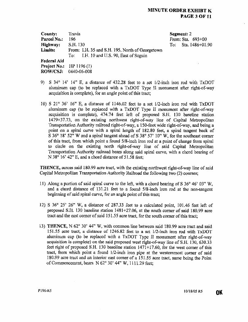
MINUTE ORDER EXHIBT K PAGE 3 OF 11
County: Parcel No.: Highway: Limits:
Federal Aid Project No.: ROW/CSJ:
Travis 196 S.H. 130 From: I.H. 35 and S.H. 195, North of Georgetown To: I.H. 10 and U.S. 90, East of Scguin
HP 1196(1) 0440-06-008
Segment: 2 From: Sta. 693+00 To: Sta. 1486+01.90
9) S 34° 14' 14" E, a distance of 432.28 feet to a set 1/2-inch iron rod with TxDOT aluminum cap (to be replaced with a TxDOT Type II monument after right-of-way acquisition is complete), for an angle point of this tract;
10) S 21° 36' 16" E, a distance of 1146.02 feet to a set 1/2-inch iron rod with TxDOT aluminum cap (to be replaced with a TxDOT Type II monument after right-of-way acquisition is complete), 474.74 feet left of proposed S.H. 130 baseline station 1479+37.73, on the existing northwest right-of-way line of Capital Metropolitan Transportation Authority railroad right-of-way, a 150-foot wide right-of-way, and being a point on a spiral curve with a spiral length of 182.80 feet, a spiral tangent back of S 36° 18* 52" W and a spiral tangent ahead of S 38° 57' 10" W, for the southeast corner of this tract, from which point a found 5/8-inch iron rod at a point of change from spiral to circle on the existing north right-of-way line of said Capital Metropolitan Transportation Authority railroad bears along said spiral curve, with a chord bearing of N 38° 16' 42" E, and a chord distance of 51.58 feet;
THENCE, across said 180.99 acre tract, with the existing northwest right-of-way line of said Capital Metropolitan Transportation Authority Railroad the following two (2) courses;
11) Along a portion of said spiral curve to the left, with a chord bearing of S 36° 46s 03" W, and a chord distance of 131.21 feet to a found 5/8-inch iron rod at the non-tangent beginning of said spiral curve, for an angle point of this tract;
12) S 36° 25' 26" W, a distance of 287.33 feet to a calculated point, 101.46 feet left of proposed S.H. 130 baseline station 1481+27.06, at the south corner of said 180.99 acre tract and the east corner of said 151,55 acre tract, for the south corner of this tract;
13) THENCE, N 62° 30' 44" W, with common line between said 180.99 acre tract and said 151.55 acre tract, a distance of 1246.82 feet to a set 1/2-inch iron rod with TxDOT aluminum cap (to be replaced with a TxDOT Type II monument after right-of-way acquisition is complete) on the said proposed west right-of-way line of S.H. 130, 630.33 feet right of proposed S.H. 130 baseline station 1471+17.60, for the west corner of this tract, from which point a found 1/2-inch iron pipe at the westernmost corner of said 180.99 acre tract and an interior east corner of a 151.55 acre tract, same being the Point of Commencement, bears N 62° 30' 44" W, 1111.29 feet;
P196-R5 10/18/05 R5

MINUTE ORDER EXHIBIT K PAGE 4 OF 11
County: Parcel No.: Highway: Limits:
Federal Aid Project No.: ROW/CSJ:
Travis 196 S.H. 130 From: I.H. 35 and S.H. 195, North of Georgetown To: I.H. 10 and U.S. 90, East of Seguin
HP 1196(1) 0440-06-008
Segment: 2 From: Sta. 693+00 To: Sta. 1486+01.90
THENCE, across said 180.99 acre tract, with the said proposed west right-of-way line of S.H. 130, the following two (2) courses:
14) N 19° 34' 22" W, at a distance of 324.00 feet pass a set 1/2-inch iron rod with TxDOT aluminum cap (to be replaced with a TxDOT Type II monument after right-of-way acquisition is complete), and at a distance of 805.52 feet pass a set 1/2-inch iron rod with TxDOT aluminum cap (to be replaced with a TxDOT Type II monument after right-of-way acquisition is complete), in all a total distance of 1327.80 feet to a set 1/2-inch iron rod with TxDOT aluminum cap (to be replaced with a TxDOT Type II monument after right-of-way acquisition is complete), for an angle point of this tract;
15) N 72° 07' 32" W, a distance of 153.74 feet to the POINT OF BEGINNING, containing 2,762,972 square feet, 63.429 acres ofland, more or less.
PART 2 (40,173 square feet, 0.922 acres)
COMMENCING for reference at a found TxDOT Type I concrete monument on the existing south right-of-way line of Old Highway 20 (Old Manor Road), a varying-width right-of-way, and a north line of said 180.99 acre tract, at the west corner a 0.94 acre tract described as Fourth Tract in a Warranty Deed dated February 28, 1972, to Roy A. Butler recorded in Volume 4282, Page 1082, Deed Records of Travis County, Texas, and referenced as Tract 3 in a Special Warranty Deed dated September 1, 1994, to The Butler Family Partnership, Ltd. recorded in Volume 12271, Page 872, Real Property Records of Travis County, Texas;
THENCE, S 89° 50' 58" W, with the common line between said Old Highway 20 and said 180.99 acre tract, a distance of 734.06 feet to a set 1/2-inch iron rod with TxDOT aluminum cap (to be replaced with a TxDOT Type 11 monument after right-of-way acquisition is complete) on the proposed east right-of-way line of S.H. 130, 2165.53 feet left of proposed S.H. 130 baseline station 1454+97.53, (355.00 feet right of proposed U.S. Highway 290 (U.S. Hwy. 290) baseline station 520+99.57), for the east corner and POINT OF BEGINNING of this tract;
16) THENCE, S 65° 03' 56" W, across said 180.99 acre tract with the proposed east right-of-way line of said S.H. 130, a distance of 482.55 feet to a set 1/2-inch iron rod with TxDOT aluminum cap, 1683.00 feet left of proposed S.H. 130 baseline station 1454+93.56, (355.00 feet right of proposed U.S. Hwy. 290 baseline station 516+17.03), on an interior west line of said 180.99 acre tract and the east line of a 6.010 acre tract described as Tract Two in a Warranty Deed dated June 29, 2001, to D & R Associates, Inc., recorded in
P196-R5 10/18/05 R5
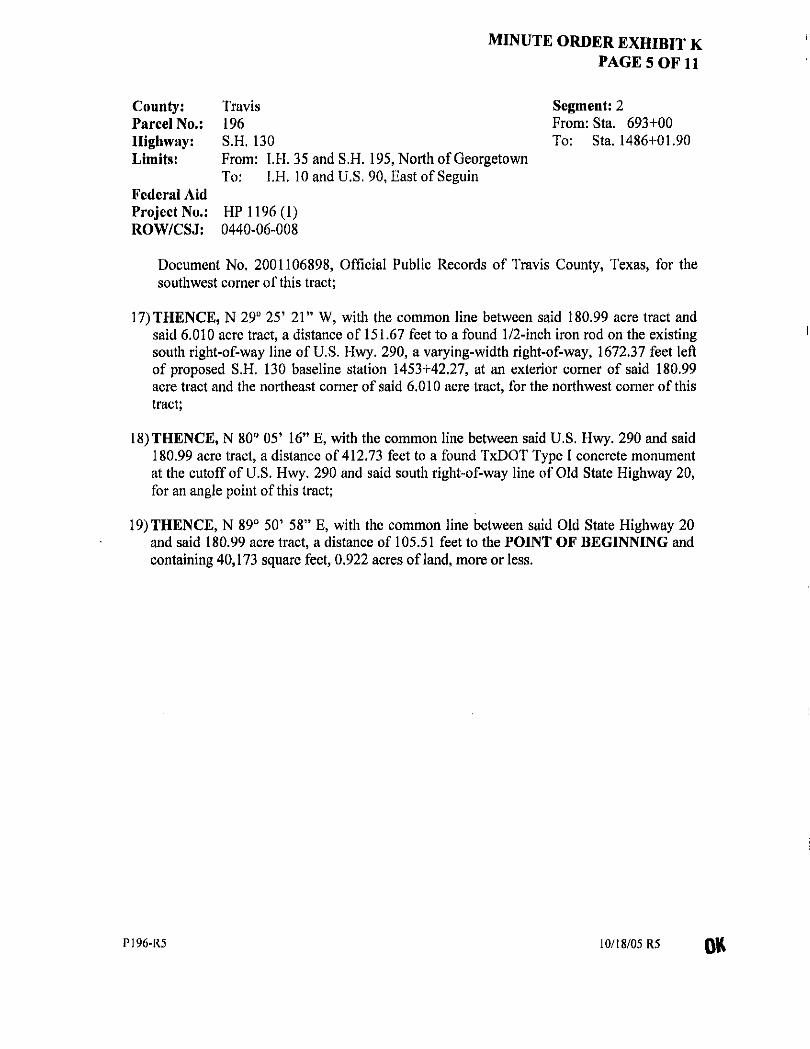
MINUTE ORDER EXHIBIT K PAGE 5 OF 11
County: Parcel No.: Highway: Limits:
Federal Aid Project No.: ROW/CSJ:
Travis 196 S.H. 130 From: I.H. 35 and S.H. 195, North of Georgetown To: I.H. 10 and U.S. 90, East of Seguin
HP 1196(1) 0440-06-008
Segment: 2 From: Sta. 693+00 To: Sta. 1486+01.90
Document No. 2001106898, Official Public Records of Travis County, Texas, for the southwest corner of this tract;
17) THENCE, N 29° 25' 21" W, with the common line between said 180.99 acre tract and said 6.010 acre tract, a distance of 151.67 feet to a found 1/2-inch iron rod on the existing south right-of-way line of U.S. Hwy. 290, a varying-width right-of-way, 1672.37 feet left of proposed S.H. 130 baseline station 1453+42.27, at an exterior corner of said 180.99 acre tract and the northeast corner of said 6.010 acre tract, for the northwest corner of this tract;
18) THENCE, N 80° 05' 16" E, with the common line between said U.S. Hwy. 290 and said 180.99 acre tract, a distance of 412.73 feet to a found TxDOT Type I concrete monument at the cutoff of U.S. Hwy. 290 and said south right-of-way line of Old State Highway 20, for an angle point of this tract;
19) THENCE, N 89° 50' 58" E, with the common line between said Old State Highway 20 and said 180.99 acre tract, a distance of 105.51 feet to the POINT OF BEGINNING and containing 40,173 square feet, 0.922 acres ofland, more or less.
P196-R5 10/18/05 R5 OK

MINUTE ORDER EXHIBIT M PAGE 6 OF 11
County: Parcel No.: Highway: Limits:
Federal Aid Project No.: ROW/CSJ:
Travis 196 S.H. 130 From: I.H. 35 and S.H. 195, North of Georgetown To: I.H. 10 and U.S. 90, East of Seguin
HP 1196(1) 0440-06-008
Segment: 2 From: Sta. 693+00 To: Sta. 1486+01.90
All bearings shown hereon are based upon the Texas State Plane Coordinate System, NAD83 (1986), Central Zone. All distances shown hereon are surface distances. The T.T.A. SH-130 Segment "2" State Plane Grid to Project Surface Adjustment Scale Factor is 1.00011.
STATE OF TEXAS § § KNOW ALL MEN BY THESE PRESENTS:
COUNTY OF TRAVIS §
That I, Carmelo L. Macias, a Registered Professional Land Surveyor, do hereby certify that the above description is true and correct to the best of my knowledge and belief and that the property described herein was determined by a survey made on the ground under my direction and supervision.
WITNESS MY HAND AND SEAL at Austin, Travis County, Texas, this the 18th day of October, 2005 A.D.
MACIAS & ASSOCIATES, INC. Carmelo L. Macias V 5410 South 1st Street Registered Professional Land Surveyor Austin, Texas 78745 No. 4333 - State of Texas
P196-R5 10/18/05 R5

MINUTE ORDER EXHIBIT M PAGE 7 OF 11
EXISTING R.O.W. LINE
PLAT TO ACCOMPANY PARCEL DESCRIPTION
PAGE 7 OF 1 0 / 1 8 / 0 5
EXISTING R.O.W. LINE
U.S. HWY, 290 (R.O.W, WIDTH VARIES) _
„ „ JpWi,|»),w,JiiiEL, "=i7«W!IBBl5riir~ l^ l l l—
AFFIDAVIT OF ADVERSE POSSESSION V.I0648, P0499
R.P.R.T.C. Texas Department of Transportation
T»xm$ Turnplk* Authority Division 2003 OK.
M A C I A S Sc A S S O C . i l ) LAND SURVEYORS ( J ^
* * * ^ V t
V f 5410 SOUTH 1ST STREET VI AUSTIN, TEXAS 78745 PH. (512)442-7875
FAX (512)442-7876 EMAIL MACIASURVEYeEARTHUNK.NET
PARCEL PLAT SHOWING PROPERTY OF WILD HORSE ADDITION, LTD.
FILE P196-PT1-R5
SCALE 1" = 400 '
T.T.A. PROJECT
STATE HIGHWAY 130 FEOCfW. AID PROJECT NO.
HP 1196 (1) N.O.W.-C. S. J . NO.
0440-06-008
DISTRICT
T.T.A. COUNTY
TRAVIS
P A R C E L N U M B E R
ACQUISITION PART 1 ACQUISITION PART 2
TOTAL ACQUISITION CALC. DEED AREA REMAINDER AREA
196 PT 1 A 2 ACRES 63.426 "01932 64.351 179.79 115.44
SQUARE FEET 2.762,972
40,173 2,803,145 7,831.652 5.028.507
6 ^4 II AM J \JOBS\LSI\Acqui5i l ions\5i:G 2\Porcel !S52'05URUPA99B2,OGN

MINUTE ORDER EXHIBIT M PAGE 8 OF 11
PLAT TO ACCOMPANY PARCEL DESCRIPTION
PAGE 8 OF 1 10/18/05 R5
x — :< —r-x — x — x -x — x — x — V. PROPOSED R.O.W. UNE
+ • x ^ v — v .
if' i\
n EXISTING R.O.W. LINE
, / 2 A
\ jBSTTMCZ/A'O. o</6' \ _
EXISTING R.O.W. UNE
5/03'56"E-7099:08[J PROPOSED U.Sr290 " ' ~ Z . . . ^ -615:66'.' - T "
z * V
lJ.§. flWY. 290 <\ W.O.jf. WIDT+FVAR/ESF- - •• —
520*00
AUSTIN Mftriap; fe:;-^ . _
^ i k ^ a ^ r ^ ^
VlU77rF.215: -~D.RJ.C.
\ tCSJ NO. 114-1&2
S,H. 130 ST*. 1454+93.56
1683.00' LT. US. HWY. 290
STA 516*17.03 * I 355.00' RT.
KlS
DJRS, INC. (15.25 AC.
DOC. NO. 2002< O.P.R.T.C. l u 'wW WILD HORSE
ADDITION, LTD. (180.99 AC.)
DOC. NO. 2001079095
O.P.R.T.C.
t JO
>
THE BUTLER FAMILY-PARTNERSHIP, LTD.
(TRACT 3, 275,66 AC.) V. 12271, P.B72, R.P.R.T.C.
DESCRIBED IN (FOURTH TRACT 0.94 AC.) V.4282, P.1082, D.R.T.C.
200' K)Q'
WILLIAM I f . SANDERS SURVEY NO. 54
ABSTRACT NO. 690
'UO'
GRAPHIC SCALE
JW^TQXB9 Department of Transportation J r»jr«* Turnpik* Authority Division
© 2003
M A C I A S & A S S O C . PARCEL PLAT SHOWING PROPERTY OF WILD HORSE ADDITION, LTD.
P A R C E L N U M B E R 196 PT 1 & 2
0 LAND SURVEYORS f i |
s £ o * • • V f 5410 SOUTH 1ST STREET VI
AUSTIN, TEXAS 78745 PH. (512)442-7875 FAX (512)442-7876
EMAIL: MACIASLfRVEYOEARTHUNK.NET
PARCEL PLAT SHOWING PROPERTY OF WILD HORSE ADDITION, LTD.
P A R C E L N U M B E R 196 PT 1 & 2
0 LAND SURVEYORS f i |
s £ o * • • V f 5410 SOUTH 1ST STREET VI
AUSTIN, TEXAS 78745 PH. (512)442-7875 FAX (512)442-7876
EMAIL: MACIASLfRVEYOEARTHUNK.NET
PARCEL PLAT SHOWING PROPERTY OF WILD HORSE ADDITION, LTD. ACRES SQUARE FEET 0 LAND SURVEYORS f i |
s £ o * • • V f 5410 SOUTH 1ST STREET VI
AUSTIN, TEXAS 78745 PH. (512)442-7875 FAX (512)442-7876
EMAIL: MACIASLfRVEYOEARTHUNK.NET
FILE
P196-PT2-R5 T.T.A. PROJECT
STATE HIGHWAY 130 DISTRICT T.T.A.
ACQUISITION PART 1 63.429 i.HlQii 0 LAND SURVEYORS f i |
s £ o * • • V f 5410 SOUTH 1ST STREET VI
AUSTIN, TEXAS 78745 PH. (512)442-7875 FAX (512)442-7876
EMAIL: MACIASLfRVEYOEARTHUNK.NET
FILE
P196-PT2-R5 T.T.A. PROJECT
STATE HIGHWAY 130 DISTRICT T.T.A. ACQUISITION PART 2
TfYTAl A C f J MtMTinU 6.952" 4o,i n
2a63 145
0 LAND SURVEYORS f i |
s £ o * • • V f 5410 SOUTH 1ST STREET VI
AUSTIN, TEXAS 78745 PH. (512)442-7875 FAX (512)442-7876
EMAIL: MACIASLfRVEYOEARTHUNK.NET
SCALE 1" = 200 '
FDXRAL MO PROJECT NO. R.O.W.-C. 3. J. HO. HP 1196 (1) 0 4 4 0 - 0 6 - 0 0 8
COUNTY TRAVIS
I U 1 A U / H A U l a l l l U N
CALC. DE :D AREA 179.79 1 ~**
7.631,652
0 LAND SURVEYORS f i |
s £ o * • • V f 5410 SOUTH 1ST STREET VI
AUSTIN, TEXAS 78745 PH. (512)442-7875 FAX (512)442-7876
EMAIL: MACIASLfRVEYOEARTHUNK.NET
SCALE 1" = 200 '
FDXRAL MO PROJECT NO. R.O.W.-C. 3. J. HO. HP 1196 (1) 0 4 4 0 - 0 6 - 0 0 8
COUNTY TRAVIS REMAINDER AREA 115.44 5.028,507
J:\Jt)D:i\LblSflcquisitiDns\SEC 2\PnC8is \5 ; iGSumjP* i9963.0CN
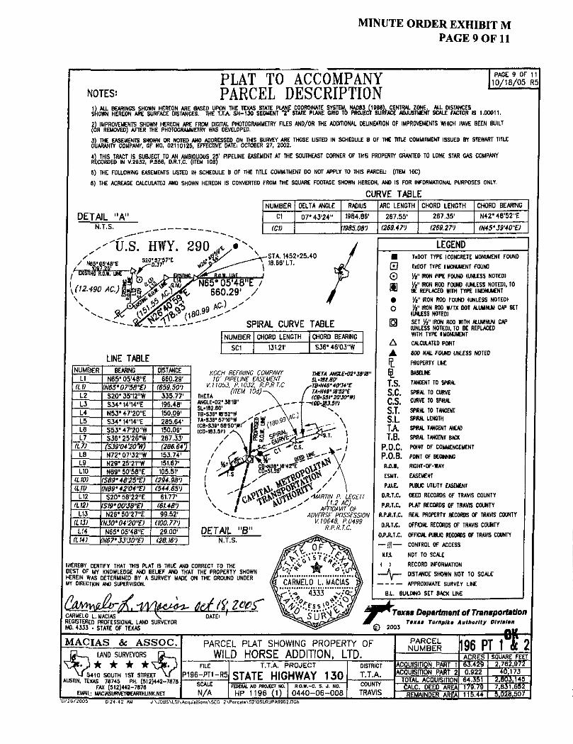
MINUTE ORDER EXHIBIT M PAGE 9 OF 11
PLAT TO ACCOMPANY NOTES: PARCEL DESCRIPTION
a S M S ..00011. 2) IMPROVEMENTS SHOWN HEREON ARE FROM OKJFTAL PHOTOGRAMMETRY FILES AND/OR THE ADDITIONAL DELINEATION OF IMPROVEMENTS WHICH HAVE BEEN BUILT (OR REMOVED) AFTER THE PHOTOGRAMMETRY WAS DEVELOPED.
3) THE EASEMENTS SHOWN OR NOTED AND ADDRESSED ON THIS SURVEY ARE THOSE LISTED IN SCHEDULE 8 OF THE TITLE COMMITMENT ISSUED BY STEWART TITLE GUARANTY COMPANY, CF NO, 02110125, EFFECTIVE DATE; OCTOBER 27, 2002.
4) THIS TRACT IS SUBJECT TO AN AMBIGUOUS 25' PIPELINE EASEMENT AT THE SOUTHEAST CORNER OF THIS PROPERTY GRANTED TO LONE STAR GAS COMPANY RECORDED IN V.2832, P.S66. D.R.T.C. (ITEM 10B)
5) THE FOLLOWING EASEMENTS LISTED IN SCHEDULE 8 OF THE TfTLE COMMITMENT DO NOT APPLY TO THIS PARCEL (ITEM 10C)
6) THE ACREAGE CALCULATED ANO SHOWN HEREON IS CONVERTED FROM THE SQUARE FOOTAGE SHOWN HEREON, AND IS FOR INFORMATIONAL PURPOSES ONLY.
CURVE TABLE
PAGE 9 OF 11 1 0 / 1 8 / 0 5 R5
DETAIL "A" N.T.S.
NUMBER
CI
(CV
DELTA ANGLE
07' 43'24"
RADIUS
1984.86'
1935.08')
ARC LENGTH
267.55*
(263.47-)
CHORD LENGTH
267,35'
(269.27')
CHORD BEARING
N42M6'52"E
M5*W40"£)
'U.S. HWY. HOT™
290 y , STA. 1452+25.40 18.66' LT.
LEGEND
SPIRAL CURVE TABLE
LINE TABLE
NUMBER CHORD LENGTH CHORD BEARING
SC1 131,21' 536' 46'03"W
NUMBER BEARING DISTANCE LI N65"05'48"E 660.29'
(LO W5'07'58"E) (659.50') L2 S20' 35'12 "W 335,77' L3 S34" 14'14"E 196.48' L4 N53" 47'20"E 150.09' L5 534' 14'14"E 285,64' L6 S53'47'20"W 150,09' L7 536* 25'25"W 287.33'
(L 7) (S39V4'20tV) (286.64') LB N72' 07'32"W 153.74' L9 N29'25'21"ff 151.67' L!0 N89° 50'58"E 105.51'
(L10) (S89'48,25"E) (294.98') (LIU 'N89*42'04"E) (544.65')
L12 520' 58'22"E 61,77' (L12) (S19*00'38"E) (6t.48')
L13 N26' 50'27"E 99.52' (LIJ) (N30t04'20"E> WO. 77')
LH N65*05'48"E 29.00' (L14) <N67*33'30"E) (28.W)
KOCH REFINING COMPANY 10' PIPELINE EASEMENT
V.llObJ, P.)052, R.P.R.T.C.
mm ANGLE-OZ'38'18" SL-IB2.80' TB-SJ6* tB'52-W
THETA AWtJT-M'Jfl'B" SL-tBiaO' TBWWWE
•N49' 18'52'f <CB-S5f2Q,30"W)
- -f -f«-^9J.5rj
sTB-N< f M-W / fCB-S
DETAIL "B" N.T.S.
MARTIN P. LEGETT (1.2 AC)
AFFIDAVIT OF ADVERSE POSSESSION
V.1Q648, P.0499 R.P.R.T.C.
I HEREBY CERTIFY THAT THIS PLAT IS TRUE AND CORRECT TO THE BEST OF MY KNOWLEDGE ANO BELEF ANO THAT THE PROPERTY SHOWN HEREIN WAS DETERMINED BY A SURVEY MADE ON THE GROUND UNDER MY DRECTION ANO SUPERVISION.
CA^QJ&T^, -Wti*MH~ IMS CARMELO L. MACIAS \ DATE' ' REGISTERED PROFESSIONAL LANO SURVEYOR
TuDOT TYPE I CONCRETE MONUMENT FOUND MOT TYPE I MONUMENT FOUND
Vt" IRON PIPE FOUND (UNLESS NOTED) W IRON ROD FOUND (UNLESS NOTED), TO BE REPLACED WITH TYPE II MONUMENT Yl" IRON ROD FOUND (UNLESS NOTED) Vt" IRON ROD W/TX DOT ALUMINUM CAP SET
(UNLESS NOTEOI SET IRON ROD WITH ALUMINUM CAP (UNLESS NOTED), TO BE REPLACED WITH TYPE I MONUMENT CALCULATED POUT
m NAIL FOUND UNLESS NOTED PROPERTY LNE
BA5ELME TANGENT TO SPHAL SPRAL TO CURVE CURVE TO SPIRAL SPIRAL TO TANGENT SPRAL LENGTH SPIRAL TANGENT AHEAD SPIRAL TANGENT SACK POINT OF COMMENCEMENT PONT OF BCCNMC RIGHT-OF-WAY EASEMENT PUBUC UTLITY EASEMENT DEED RECORDS OF TRAVIS COUNTY PLAT RECORDS OF TRAVIS COUNTY REAL PROPERTY RECORDS OF TRAVIS COUNTY OFFICIAL RECORDS OF TRAVIS COUNTY OFFICIAL PUBLIC RECORDS OF TRAVIS COUNTY CONTROL OF ACCESS NOT TO SCALE RECORD INFORMATION DISTANCE SHOWN NOT TO SCALE
APPROXIMATE SURVEY LNE B.L. BUS.DWG SET BACK LINE
0 0 m # o
A • t t T.S. S.C. C.S. S.T. S.L TA T.B.
P.O.C. P.O.B. R.O.W.
ESMT.
P.U.E.
O.R.T.C.
P.R.T.C.
R.PJB.U.
D.R.T.C.
O.PJU.C.
Texas Department of Transportation TOKOI Turnplko Authority Dlvlalon
M A C I A S Sc A S S O C . C L _ LAND SURVEYORS C L
• • V f 5410 SOUTH 1ST STREET V f
AUSTIN, TEXAS 78745 PH. (512)442-7879 FAX (512)442-7676
EMAIL; MACiASURVEYOEARTHLINK.NET
PARCEL PLAT SHOWING PROPERTY OF WILD HORSE ADDITION, LTD.
P A R C E L N U M B E R 196 PT 1"% 2 M A C I A S Sc A S S O C .
C L _ LAND SURVEYORS C L
• • V f 5410 SOUTH 1ST STREET V f
AUSTIN, TEXAS 78745 PH. (512)442-7879 FAX (512)442-7676
EMAIL; MACiASURVEYOEARTHLINK.NET
PARCEL PLAT SHOWING PROPERTY OF WILD HORSE ADDITION, LTD. ACRES SQUARE FEET
M A C I A S Sc A S S O C . C L _ LAND SURVEYORS C L
• • V f 5410 SOUTH 1ST STREET V f
AUSTIN, TEXAS 78745 PH. (512)442-7879 FAX (512)442-7676
EMAIL; MACiASURVEYOEARTHLINK.NET
FILE P196-PT1-R5
T.T.A. PROJECT
STATE HIGHWAY 130 DISTRICT
T.T.A. ACQUISITION PART 1 63.429 2,762,972
M A C I A S Sc A S S O C . C L _ LAND SURVEYORS C L
• • V f 5410 SOUTH 1ST STREET V f
AUSTIN, TEXAS 78745 PH. (512)442-7879 FAX (512)442-7676
EMAIL; MACiASURVEYOEARTHLINK.NET
FILE P196-PT1-R5
T.T.A. PROJECT
STATE HIGHWAY 130 DISTRICT
T.T.A. ACQUISfDON PART 2 TOTAI ACQUISITION
0.922 64,351
40.173 2.803,145
M A C I A S Sc A S S O C . C L _ LAND SURVEYORS C L
• • V f 5410 SOUTH 1ST STREET V f
AUSTIN, TEXAS 78745 PH. (512)442-7879 FAX (512)442-7676
EMAIL; MACiASURVEYOEARTHLINK.NET SCALE N / A
FEDERAL AID PROJECT NO, R.O.W.-C. S. J. NO. HP 1196 (1) 0 4 4 0 - 0 6 - 0 0 8
COUNTY TRAVIS
1 <J 1 ni- nvuufoi 1 l\J*1 CALC. DEED AREA 179.79 7,831,652
M A C I A S Sc A S S O C . C L _ LAND SURVEYORS C L
• • V f 5410 SOUTH 1ST STREET V f
AUSTIN, TEXAS 78745 PH. (512)442-7879 FAX (512)442-7676
EMAIL; MACiASURVEYOEARTHLINK.NET SCALE N / A
FEDERAL AID PROJECT NO, R.O.W.-C. S. J. NO. HP 1196 (1) 0 4 4 0 - 0 6 - 0 0 8
COUNTY TRAVIS REMAINDER AREA 115.44 5.028,507

MINUTE ORDER EXHIBIT M PAGE 10 OF 11
7o*pvimtfii TarrnniporlMlon
form TTA-ROW-S-COAC Rev. 03/06/2003
PREPARED BY
SURVEYOR
DATE
PAGE
Macias & Associates, Inc. Carmelo L. Macias #4333 10/18/05 R5 10 of 11
CONTROL OF ACCESS CLAUSE
R O W C S J NO. : 0440-06-008
C O U N T Y : Travis
H I G H W A Y :
L I M I T S :
P A R C E L N O :
SH130
From: IH 35 and SH 195, North of Georgetown To: IH 10 and US 90, East of Seguin
196, PART 1
A: ACCESS TO AND FROM GRANTOR'S REMAINING PROPERTY TO THE S.H. 130/U.S. 290 SERVICE/ACCESS ROAD WILL BE PERMITTED AS FOLLOWS:
Access will be permitted to the east remainder abutting the highway facility from the beginning of Call 5, to a point located S 21° 36' 16" E, a distance of 925 feet from the beginning of Call 10, of the foregoing property description.
AND
Access will be permitted to the west remainder abutting the highway facility from the beginning of Call 14, to the end of Call 14, of the foregoing property description.
B: ACCESS TO AND FROM GRANTOR'S REMAINING PROPERTY TO THE S.H. 130/U.S. 290 SERVICE/ACCESS ROAD WILL BE DENIED AS FOLLOWS:
Access will be denied to the east remainder abutting the highway facility from the beginning of Call 4, to the end of Call 4, and from a point located S 21° 36' 16" E, a distance of 925 feet from the beginning of Call 10, to the end of Call 10, of the foregoing property description.
AND
Access will be denied to the west remainder abutting the highway facility from the beginning of Call 15, to the end of Call 15, of the foregoing property description, g
C: ACCESS TO AND FROM GRANTOR'S REMAINING PROPERTY TO THE MAIN TRAFFIC LANES OF THE STATE HIGHWAY I30/TJ.S. HIGHWAY 290 FACILITY WILL BE DENIED.

MINUTE ORDER EXHIBIT M PAGE 11 OF 11
ro*p*rfin«it TelTttntporlitlen
Form TTA-ROW-S-COAC Rev. 03/06/2003
PREPARED BY: Macias & Associates, Tne. SURVEYOR: Carmelo L. Macias #4333
DATE: 10/18/05 R5 PAGE: 11 of 11
CONTROL OF ACCESS CLAUSE
R O W C S J N O . : 0440-06-008
C O U N T Y : Travis
H I G H W A Y : SH130
T TTVITTQ From: IH 35 and SH 195, North of Georgetown L U Y l l l b : T o , r H 1 0 a n d u s 9 0 j E a s t 0 f S e g u i n
P A R C E L N O : 196, PART 2
A: ACCESS TO AND FROM GRANTOR'S REMAINING PROPERTY TO THE U.S. 290 SERVICE/ACCESS ROAD WILL BE PERMITTED AS FOLLOWS:
Access will be permitted to the south remainder abutting the highway facility from a point located S 65° 03' 56" E, a distance of 464.55 feet from the beginning of Call 16, to the end of Call 16, of the foregoing property description.
B: ACCESS TO AND FROM GRANTOR'S REMAINING PROPERTY TO THE U.S. 290 SERVICE/ACCESS ROAD WILL BE DENIED AS FOLLOWS:
Access will be denied to the south remainder abutting the highway facility from the beginning of Call 16, to a point located S 65° 03' 56" W, a distance of 464.55 feet from the beginning of Call 16, of the foregoing property description.
C: ACCESS TO AND FROM GRANTOR'S REMAINING PROPERTY TO THE MAIN TRAFFIC LANES OF THE STATE HIGHWAY 130/ U.S. HIGHWAY 290 FACILITY WILL BE DENIED,
OK


MINUTE ORDER EXHIBIT N PAGE 1 OF 7
County: Parcel No.: Highway: Limits:
Federal Aid Project No.: ROW/CSJ:
Travis 396A S.H. 130 From: I.H. 35 and S.H. 195 North of Georgetown To: I.H. 10 and U.S. 90, East of Seguin
HP 1196(1) 0440-06-008
Segment: 4 From: Sta. 2440+00 To: Sta. 2938+00
DESCRIPTION FOR PARCEL 396A
DESCRIPTION OF A 56,984 SQUARE FOOT, A 1.308 ACRE TRACT OF LAND OUT OF THE WILLIAM LEWIS, SR. SURVEY NO. 2, ABSTRACT NO. 479, IN TRAVIS COUNTY, TEXAS, ALSO BEING OUT OF A REMAINDER OF A 15.084 ACRE TRACT DESCRIBED IN A GENERAL WARRANTY DEED DATED AUGUST 2, 2004, TO JIMMY NASSOUR AND JOHN LEWIS, RECORDED IN DOCUMENT NO. 2004150394, OFFICIAL PUBLIC RECORDS OF TRAVIS COUNTY, TEXAS; SAID 56,984 SQUARE FOOT, 1.308 ACRE TRACT AS SHOWN ON THE ACCOMPANYING PARCEL PLAT, BEING MORE PARTICULARLY DESCRIBED BY METES AND BOUNDS AS FOLLOWS:
COMMENCING for reference at a found 1/2-inch iron rod on the north line of said 15.084 acre tract, same being the north line of a 6.446 acre tract described in a Special Warranty Deed dated December 23, 2004, to Rosa E. Santis, recorded in Document No. 2004240996, Official Public Records of Travis County, Texas, at the southwest corner of a 12.048 acre tract known as Tract 5, described in a Warranty Deed dated July 23, 1974, to The Veterans' Land Board of the State of Texas, recorded in Volume 4972, Page 1825, Deed Records of Travis County, Texas, and also described in a Contract of Sale and Purchase dated July 5, 1974, to Carlos Luna Villalobos, recorded in Volume 4972, Page 1838, Deed Records of Travis County, Texas, and at the southeast corner of a 12.644 acre tract known as Tract 6, described in Warranty Deed dated July 23, 1974 to The Veterans' Land Board ofthe State of Texas, recorded in Volume 4972, Page 1829, Deed Records of Travis County, Texas, and also described in a Contract of Sale and Purchase dated July 5, 1974, to Raymond Joseph Sanders, recorded in Volume 4972, Page 1833, Deed Records of Travis County, Texas;
THENCE, S 61° 50' 47" E, with the common line between said 6.446 acre tract and the south line of said 12.048 acre tract, at a distance of 148.01 feet pass the northeast corner of said 6.446 acre tract and the northwest corner ofthe remaining portion of said 15.084 acre tract, in all a total distance of 619.40 feet to a set 1/2-inch iron rod with TxDOT aluminum cap on the proposed curving west right-of-way line of S.H. 130, 389.70 feet right of proposed S.H. 130 baseline station 2630+24.19, for the northwest corner and POINT OF BEGINNING of this tract;
P396A 09/12/05

MINUTE ORDER EXHIBIT N PAGE 2 OF 7
County: Parcel No.: Highway: Limits:
Federal Aid Project No.: ROW/CSJ:
Travis 396A S.H. 130 From: I.H. 35 and S.H. 195 North of Georgetown To: I.H. 10 and U.S. 90, East of Seguin
HP 1196(1) 0440-06-008
Segment: 4 From: Sta. 2440+00 To: Sta. 2938+00
1) THENCE, S 61° 50' 47" E, with the north line ofthe remaining portion of said 15.084 acre tract and the south line of said 12.048 acre tract, a distance of 72.27 feet to a calculated point on the west line of a 50 acre tract described in a Warranty Deed dated November 23,1947, to Perry J. Shirley and wife, Ruby Shirley, recorded in Volume 849, Page 147, Deed Records of Travis County, Texas, for the northeast corner of said 15.084 acre tract and the southeast corner of said 12.048 acre tract, for the northeast corner of this tract;
2) THENCE, S 27° 25' 59" W, with the common line between said 15.084 acre tract and said 50 acre tract, a distance of 702.64 feet to a calculated point on the existing north right-of-way line of F.M. 812, a 100-foot wide right-of-way, at the southeast corner of said 15.084 acre tract and the southwest corner of said 50 acre tract, for the southeast corner of this tract, from which a found TxDOT Type I concrete monument on the existing north right-of-way line of said F.M. 812 bears S 61° 51* 57" E, a distance of 627.23 feet;
3) THENCE, N 61° 51' 57" W, with the common line between said existing north right-of-way line of F.M. 812 and said 15.084 acre tract, a distance of 527.89 feet to a calculated point at the southeast corner of said 6.446 acre tract and the southwest corner of the remaining portion of said 15.084 acre tract, for the southwest corner of this tract, from which a found TxDOT Type I concrete monument on the existing north right-of-way line of said F.M. 812 bears N 61° 51' 57" W, a distance of 1873.43 feet;
4) THENCE, N 26° 08' 52" E, with the west line ofthe remaining portion of said 15.084 acre tract with the east line of said 6.446 acre tract, at a distance of 0.52 feet pass a found 1/2-inch iron rod, in all a total distance of 28.65 feet to a set 1/2-inch iron rod with TxDOT aluminum cap, on the proposed west right-of-way line of said S.H. 130, being the proposed north right-of-way line of F.M. 812, 848.88 feet right of proposed S.H. 130 baseline station 2636+90.61;
THENCE, across said 15.084 acre tract with said proposed west right-of-way line of S.H. 130 and the proposed north right-of-way line of F.M. 812, the following three (3) courses:
5) S 62° 53' 24" E, a distance of 412.70 feet to a set 1/2-inch iron rod with TxDOT aluminum cap (to be replaced with a TxDOT Type II monument after right-of-way acquisition is complete), for an angle point of this tract;
P396A 09/12/05

MINUTE ORDER EXHIBIT N PAGE 3 OF 7
County: Parcel No.: Highway: Limits:
Federal Aid Project No.: ROW7CSJ:
Travis 396A S.H. 130 From: I.H. 35 and S.H. 195 North of Georgetown To: LH. 10 and U.S. 90, East of Seguin
HP 1196(1) 0440-06-008
Segment: 4 From: Sta. 2440+00 To: Sta. 2938+00
6) N 72° 39' 04" E, a distance of 121.08 feet to a set 1/2-inch iron rod with TxDOT aluminum cap (to be replaced with a TxDOT Type II monument after right-of-way acquisition is complete), at a non-tangent point of curvature of a curve to the right;
7) Along said curve having a radius of 4622.31 feet, a central angle of 07° 13' 25", a chord which bears N23° 15' 27" E, 582.37 feet, and an arc distance of 582.76 feet to the POINT OF BEGINNING, containing 56,984 square feet, 1.308 acres of land, more or less.
All bearings shown hereon are based upon the Texas State Plane Coordinate System, NAD83 (1986), South Central Zone. All distances shown hereon are surface distances. The T.T.A. SH-130 Segment "4" State Plane Grid to Project Surface Adjustment Scale Factor is 1.00006.
P396A 09/12/05

MINUTE ORDER EXHIBIT N PAGE 4 OF 7
County: Travis Segment: 4 Parcel No.: 396A From: Sta. 2440+00 Highway: S.H. 130 To: Sta. 2938+00 Limits: From: I.H. 35 and S.H. 195 North of Georgetown
To: LH. 10 and U.S. 90, East of Seguin Federal Aid Project No.: HP 1196(1) ROW/CSJ: 0440-06-008
STATE OF TEXAS § §
COUNTY OF TRAVIS § KNOW ALL MEN BY THESE PRESENTS:
That I, Carmelo L. Macias, a Registered Professional Land Surveyor, do hereby certify that the above description is true and correct to the best of my knowledge and belief and that the property described herein was determined by a survey made on the ground under my direction and supervision.
WITNESS MY HAND AND SEAL at Austin, Travis County, Texas, this the 12th day of September, 2005 A D .
MACIAS & ASSOCIATES, INC. 5410 South 1st Street Austin, Texas 78745
(LwrwL^ "'armftln T K/foniac \ Carmelo L. Macias Registered Professional Land Surveyor No. 4333-State of Texas
P396A 09/12/05

MINUTE ORDER EXHIBIT N PAGE 5 OF 7
M A C I A S &c A S S O C . PARCEL PLAT SHOWING PROPERTY OF JIMMY NASSOUR AND JOHN LEWIS
PARCEL NUMBER 396A (M
Q , LAND SURVEYORS \2 i
s K ) * • * VI 5410 SOUTH 1ST STREET M
AUSTIN. TEXAS 78745 PH. (512)442-7875 FAX (512)442-7876
EMWU U*CWSURVEY0£ARTHUNKJ4ET
PARCEL PLAT SHOWING PROPERTY OF JIMMY NASSOUR AND JOHN LEWIS ACRES SQUARE FEET Q , LAND SURVEYORS \2 i
s K ) * • * VI 5410 SOUTH 1ST STREET M
AUSTIN. TEXAS 78745 PH. (512)442-7875 FAX (512)442-7876
EMWU U*CWSURVEY0£ARTHUNKJ4ET
FILE
S415SURUPA3962 T U R N P I K E P R O J E C T
STATE HIGHWAY 130 DISTRICT
T.T.A. ACQUISITION 1.308 56,984
Q , LAND SURVEYORS \2 i
s K ) * • * VI 5410 SOUTH 1ST STREET M
AUSTIN. TEXAS 78745 PH. (512)442-7875 FAX (512)442-7876
EMWU U*CWSURVEY0£ARTHUNKJ4ET
FILE
S415SURUPA3962 T U R N P I K E P R O J E C T
STATE HIGHWAY 130 DISTRICT
T.T.A. CAIC DEED AREA 8.638 376,271
Q , LAND SURVEYORS \2 i
s K ) * • * VI 5410 SOUTH 1ST STREET M
AUSTIN. TEXAS 78745 PH. (512)442-7875 FAX (512)442-7876
EMWU U*CWSURVEY0£ARTHUNKJ4ET
SCALE r = 200'
FEDERAL AC PROJECT NO. R.O.W.-C. S. J. HO. HP 1196 (1) 0440-06-008
COUNTY TRAVIS REMAINDER AREA 7.330 319.287
1:51=34 PM jAJOBS\LSI \Acqu is I t ions \SEG 4\Parcels \S415SURUPA3962.dgn

MINUTE ORDER EXHIBIT N PAGE 6 OF 7
PLAT TO ACCOMPANY PARCEL DESCRIPTION
PAGE 6 OF 7 0 9 / 1 2 / 0 5
NOTES:
J) ALL BEARINGS SHOWN HEREON ARE BASED UPON THE TEXAS STATE PLANE COORDINATE SYSTEM, NAD63 (1986), SOUTH CENTRAL ZONE. ALL DISTANCES SHOWN HEREON ARE SURFACE DISTANCES. THE T.TA SH-130 SEGMENT 4" STATE PLANE GRID TO PROJECT SURFACE ADJUSTMENT SCALE FACTOR IS 1.00006.
2) IMPROVEMENTS SHOWN HEREON ARE FROM DIGITAL PHOTOGRAMMETRY FILES AND/OR THE ADDITIONAL DELINEATION OF IMPROVEMENTS WHICH HAVE BEEN BUILT (OR REMOVED) AFTER THE PHOTOGRAMMETRY WAS DEVELOPED.
3) THE EASEMENTS SHOWN OR NOTED AND ADDRESSED ON IMS SURVEY ARE THOSE LISTED IN SCHEDULE B OF THE TTTLE COMMITMENT ISSUED BY STEWART TTTLE GUARANTY COMPANY, OF NO. 03050)54, EFFECTIVE DATE' JUNE 22, 2005.
4) THIS TRACT IS SUBJECT TO A BLANKET TYPE EASEMENT GRANTED TO LOWER COLORADO RIVER ELECTRIC COOPERATIVE, INC., REFERENCED IN V.659, P.438, D.R.T.C. (ITEM 10b)
5) THE ACREAGE CALCULATED ANO SHOWN HEREON IS CONVERTED FROM THE SQUARE FOOTAGE SHOWN HEREON, ANO IS FOR INFORMATIONAL PURPOSES ONLY.
LEGEND
• TxDOT TYPE t CONCRETE MONUMENT FOUND
0 TxDOT TYPE 1 MONUMENT FOUND
© m
%" RON PPE FOUND (UNLESS NOTED) 14" RON ROD FOUND (UNLESS NOTED), TO BE REPLACED WITH TYPE 1 MONUMENT
• ' / / RON ROD FOUND (UNLESS NOTED)
0
0
' / l ' RON ROD W/TX DOT ALUMMJM CAP SET (UNLESS NOTED) SET 'A" RON ROD WITH ALUMINUM CAP (UNLESS NOTED), TO BE REPLACED WITH TYPE 1 MONUMENT
A CALCULATED POINT
A 600 NAIL FOUND UNLESS NOTED
t PROPERTY LME
t BASEUNE
P.O.C. PONT Of COMMENCEMENT
P.O.B. PONT OF BEGffMNG
R.O.W. RIGHT-OF-WAY
ESMT. EASEMENT
PJJ£. PUBUC UTIJTY EASEMENT
OAT.C, DEED RECORDS OF TRAVIS COUNTY
P.R.T.C PLAT RECORDS OF TRAVIS COUNTY
Rf.R.T.C REAL PROPERTY RECORDS OF TRAVIS COUNTY
OJLT.C. OFFICIAL RECORDS OF TRAVIS COUNTY
OPJLTX. OFFICIAL PUBUC RECORDS OF TRAVIS COUNTY
-in— CONTROL OF ACCESS
MA NOT TO SCALE
( ) RECORD INFORMATION
±h DISTANCE SHOWN NOT TO SCALE
APPROXIMATE SURVEY UNE
B.L. BULOWG SET BACK UNE
/ (12.048 AC.) f r-
LI
\ 71.07' 1.20'
V * DETAIL "A"
N.T.S.
(50 AC.) \
I
/ ''(12.048 ACj^ \
4 , ^ % ^
/^i * / ^
, ^ ^ i - r — r~
(50 4C. j \ N57 ,24 ,53"E \
0 . 3 8 * ^ — ^ S70* 12'44"E M 9 '
~ ] EXISTING R.O.W. UNE
\ F.M. 812 /
DETAIL " B " N.T.S.
\ EXISTING \ R.O.W. UNE
\ F.M. 812/
DETAIL "D"
CURVE TABLE NUMBER DELTA ANGLE RADIUS ARC LENGTH CHORD LENGTH CHORD BEARING
CI 0 7 ' 13'25" 4622.31' 582,76' 582.37' N23M5'27"E
N.T.S.
I HEREBY CERTIFY THAT THS PLAT IS TRUE AND CORRECT TO THE BEST OF MY KNOWLEDGE AND BELIEF AND THAT THE PROPERTY SHOWN HEREIN WAS DETERMINED BY A SURVEY MADE ON THE GROUND UNDER MY. DRECnON AND SUPERVISION. , )
OMwd^.n\dMs*. J^t, /2 #<r CARMELO L. MACIAS ' DATE' REGISTERED PROFESSIONAL LAND SURVEYOR NO. 4333 - STATE OF TEXAS
LINE TABLE NUMBER BEARING DISTANCE
L1 S61" 50'47"E 72.27' L2 N2G'0B'52"E 28.65'
Texas Department of Transportation Toxoo Turnpike Authority Dlvlmlon
© 2003
M A C I A S & A S S O C . PARCEL PLAT SHOWING PROPERTY OF JIMMY NASSOUR AND JOHN LEWIS
P A R C E L N U M B E R 396A m
LAND SURVEYORS •
• * V I 5410 SOUTH 1ST STREET V I
AUSTIN TFKAS 78745 PH (512^442—7875
PARCEL PLAT SHOWING PROPERTY OF JIMMY NASSOUR AND JOHN LEWIS ACRES SQUARE FEET LAND SURVEYORS •
• * V I 5410 SOUTH 1ST STREET V I
AUSTIN TFKAS 78745 PH (512^442—7875
FILE S415SURUPA3962
T U R N P I K E P R O J E C T
STATE HIGHWAY 130 DISTRICT T . T . A .
ACQUISITION 1.308 56,984 LAND SURVEYORS •
• * V I 5410 SOUTH 1ST STREET V I
AUSTIN TFKAS 78745 PH (512^442—7875
FILE S415SURUPA3962
T U R N P I K E P R O J E C T
STATE HIGHWAY 130 DISTRICT T . T . A .
CALC DEED AREA 8 . 6 3 8 3 7 6 , 2 7 1 r&J Hip 1 | U ( 1 U r H i \ J 1 A / " ' t f U f w
FAX (312)442-7876 EMAIL- UACHStffiVETVEAR7NlJNK.NET
SCALE
r = 200' FEOQW. MO PROJECT NO.
HP 1 1 9 6 (1 ) H.O.W.-C. S. J . NO.
0 4 4 0 - 0 6 - 0 0 8 COUNTY TRAVIS REMAINDER AREA 7 .330 3 1 9 , 2 8 7

I "0«ptrtmwtt 'ol fttntpotlathn
MINUTE ORDER EXHIBIT N PAGE 7 OF 7
Form TT-RGW-S-COAC Rev. 02/01/2004
PREPARED BY:
SURVEYOR:
DATE:
PAGE:
Macias & Associates, Inc.
Carmelo L. Macias #4333
09/12/05
7 of 7
CONTROL OF ACCESS CLAUSE
ROWCSJNO.: 0440-06-008
COUNTY: Travis
HIGHWAY: SH 130 T TMTTV2 From: IH 35 and SH 195, North of Georgetown
T o . m io and US 90, East of Seguin
PARCEL NO: 396A
A: ACCESS TO AND FROM GRANTOR'S REMAINING PROPERTY TO THE SERVICE/ACCESS ROAD WILL BE PERMITTED AS FOLLOWS:
Access will be permitted to the west remainder abutting the highway facility from the beginning of Call 5, to a point located northerly, an arc distance of 513 feet, having a radius of 4622.31 feet from the beginning of Call 7, of the foregoing property description.
B: ACCESS TO AND FROM GRANTOR'S REMAINING PROPERTY TO THE SERVICE/ACCESS ROAD WILL BE DENIED AS FOLLOWS:
Access will be denied to the west remainder abutting the highway facility from a point located northerly, an arc distance of 513 feet, having a radius of4622.31 feet from the beginning of Call 7, to the end of Call 7, ofthe foregoing property description.
C: ACCESS TO AND FROM GRANTOR'S REMAINING PROPERTY TO THE MAIN TRAFFIC LANES OF THE SH 130 HIGHWAY FACILITY WILL BE DENIED.
OK


MINUTE ORDER EXHIBIT O PAGE 1 OF 6
County: Parcel No.: Highway: Limits:
Travis 396B S.H. 130 From: I.H. 35 and S.H. 195 North of Georgetown To: LH. 10 and U.S. 90, East of Seguin
Segment: 4 From: Sta. 2440+00 To: Sta. 2938+00
Federal Aid Project No.: HP 1196(1) ROW7CSJ: 0440-06-008
DESCRIPTION FOR PARCEL 396B
DESCRIPTION OF A 10,019 SQUARE FOOT, A 0.230 ACRE TRACT OF LAND OUT OF THE WILLIAM LEWIS, SR. SURVEY NO. 2, ABSTRACT NO. 479, IN TRAVIS COUNTY, TEXAS, ALSO BEING OUT OF A 6.446 ACRE TRACT DESCRIBED IN A SPECIAL WARRANTY DEED DATED DECEMBER 23, 2004, TO ROSA E. SANTIS, RECORDED IN DOCUMENT NO. 2004240996, OFFICIAL PUBLIC RECORDS OF TRAVIS COUNTY, TEXAS; SAID 10,019 SQUARE FOOT, 0.230 ACRE TRACT AS SHOWN ON THE ACCOMPANYING PARCEL PLAT, BEING MORE PARTICULARLY DESCRIBED BY METES AND BOUNDS AS FOLLOWS:
COMMENCING for reference at a found 1/2-inch iron rod on the south line of a 12.644 acre tract known as Tract 6, described in Warranty Deed dated July 23, 1974 to The Veterans' Land Board of the State of Texas, recorded in Volume 4972, Page 1829, Deed Records of Travis County, Texas, at the northwest corner of said 6.446 acre tract, and the northeast corner of a 5.00 acre tract described in Warranty Deed dated June 21, 1994 to Amarente H. Constancio and Enes H. Constancio, recorded in Volume 12223, Page 2174, Real Property Records of Travis County, Texas;
THENCE, S 26° 08' 01" W, with the common line between said 6.446 acre tract and said 5.00 acre tract, a distance of 681.74 feet to a set 1/2-inch iron rod with TxDOT aluminum cap (to be replaced with a TxDOT Type II monument after right-of-way acquisition is complete), on the proposed west right-of-way line of S.H. 130, 1248.47 feet right of proposed S.H. 130 baseline station 2636+91.10, for the westernmost corner and POINT OF BEGINNING of this tract;
1) THENCE, S 62° 53' 24" E, across said 6.446 acre tract, with the said proposed west right-of-way line of S.H. 130, same being the proposed north right-of-way line of F.M. 812, a distance of 399.59 feet to a set 1/2-inch iron rod with TxDOT aluminum cap, on the east line of said 6.446 acre tract and the west line ofthe remaining portion of a 15.084 acre tract described in a General Warranty Deed dated August 2, 2004, to Jimmy Nassour and John Lewis, recorded in Document No. 2004150394, Official Public Records of Travis County, Texas, for the northeast corner of this tract, from which a found 1/2-inch iron rod bears N 26° 08' 52" E 674.54 feet;
P396B 09/12/05

MINUTE ORDER EXHIBIT O PAGE 2 OF 6
County: Parcel No.: Highway: Limits:
Federal Aid Project No.: ROW/CSJ:
Travis 396B S.H. 130 From: I.H. 35 and S.H. 195 North of Georgetown To: I.H. 10 and U.S. 90, East of Seguin
HP 1196(1) 0440-06-008
Segment: 4 From: Sta. 2440+00 To: Sta. 2938+00
2) THENCE, S 26° 08' 52" W, with the east line of said 6.446 acre tract, continuing across the remaining portion of said 15.084 acre tract, at a distance of 28.13 feet pass a found 1/2-inch iron rod, in all a total distance of 28.65 feet to a calculated point on the existing north right-of-way line of F.M. 812, a 100-foot wide right-of-way, at the southwest corner of the remaining portion of said 15.084 acre tract and the southeast corner of said 6.446 acre tract, for the southeast corner of this tract, from which a found concrete monument on the existing north right-of-way line of said F.M. 812 bears S 61 ° 51' 57" E, 1155.12 feet;
3) THENCE, N 61° 51' 57" W, with the common line between said existing north right-of-way line of F.M. 812 and said 6.446 acre tract, a distance of 399.77 feet to a set 1/2-inch iron rod with TxDOT aluminum cap (to be replaced with a TxDOT Type II monument after right-of-way acquisition is complete), at the southwest corner of said 6.446 acre tract and the southeast corner of said 5.00 acre tract, for the southwest corner of this tract, from which a found concrete monument on the existing north right-of-way line of said F.M. 812 bears N 61° 51' 57" W, 1473.66 feet;
4) THENCE, N 26° 08' 01" E, with the common line between said 6.446 acre tract and said 5.00 acre tract, at a distance of 1.27 feet pass a found 1/2-inch iron rod, in all a total distance of 21.51 feet to the POINT OF BEGINNING, containing 10,019 square feet, 0.230 acres ofland, more or less.
All bearings shown hereon are based upon the Texas State Plane Coordinate System, NAD83 (1986), South Central Zone. All distances shown hereon are surface distances. The T.T.A. SH-130 Segment "4" State Plane Grid to Project Surface Adjustment Scale Factor is 1.00006.
P396B 09/12/05

MINUTE ORDER EXHIBIT O PAGE 3 OF 6
County: Parcel No.: Highway: Limits:
Federal Aid Project No.: ROW/CSJ:
Travis 396B S.H. 130 From: LH. 35 and S.H. 195 North of Georgetown To: LH. 10 and U.S. 90, East of Seguin
HP 1196(1) 0440-06-008
Segment: 4 From: Sta. 2440+00 To: Sta. 2938+00
STATE OF TEXAS § §
COUNTY OF TRAVIS § KNOW ALL MEN BY THESE PRESENTS:
That I, Carmelo L. Macias, a Registered Professional Land Surveyor, do hereby certify that the above description is true and correct to the best of my knowledge and belief and that the property described herein was determined by a survey made on the ground under my direction and supervision.
WITNESS MY HAND AND SEAL at Austin, Travis County, Texas, this the 12th day of September, 2005 A.D.
fMw\£ MACIAS & ASSOCIATES, INC. 5410 South 1st Street Austin, Texas 78745
(Ud4— Carmelo L. Macias Registered Professional Land Surveyor No. 4333 - State of Texas
P396B 09/12/05

MINUTE ORDER EXHIBIT O PAGE 4 OF 6
Texas Department of Transportation Ttxma Turnplk* Authority Division
2003
M A C I A S & A S S O C . PARCEL PLAT SHOWING PROPERTY OF ROSA E. SANTIS
PARCEL NUMBER 3968 Oft
O LAND SURVEYORS g
* ) • • • V I 5410 SOUTH 1ST STREET V f
AIKTM 7A7AR PH f51 ?\447-7R7B
PARCEL PLAT SHOWING PROPERTY OF ROSA E. SANTIS ACRES SQUARE FEET O LAND SURVEYORS g
* ) • • • V I 5410 SOUTH 1ST STREET V f
AIKTM 7A7AR PH f51 ?\447-7R7B
FILE
S415SURUPA39W T U R N P I K E P R O J E C T
STATE HIGHWAY 130 DISTRICT
T.T.A. ACQUISITION 0.230 10,019
O LAND SURVEYORS g
* ) • • • V I 5410 SOUTH 1ST STREET V f
AIKTM 7A7AR PH f51 ?\447-7R7B
FILE
S415SURUPA39W T U R N P I K E P R O J E C T
STATE HIGHWAY 130 DISTRICT
T.T.A. DEED AREA 6.446 280,788
pUaiM, ICJWa fo/^O rn< ivrw FAX (512)442-787*
EMAIL: MACIASURVEYOEARTHUNK.NET
SCALE 1" = 200'
FEDERAL MO PROJECT NO, fl.O.W.-C £ J. HO. HP 1196 (1) 0440-06-008
COUNTY TRAVIS REMAINDER AREA 6.216 270,769
11/8/2005 JAJOBS\LSI \Acqu is i t ions \SEG 4\Porcela\S415SURUPA3963.dgn

MINUTE ORDER EXHIBIT O PAGE 5 OF 6
PAGE 5 OF 6 0 9 / 1 2 / 0 5 PLAT TO ACCOMPANY
PARCEL DESCRIPTION NOTES:
1) ALL BEARINGS SHOWN HEREON ARE BASED UPON THE TEXAS STATE PLANE COORDINATE SYSTEM. NAD83 (1986). SOUTH CENTRAL ZONE. ALL DISTANCES SHOWN HEREON ARE SURFACE DISTANCES. THE T.TA SH-J30 SEGMENT "4* STATE PLANE GRID TO PROJECT SURFACE ADJUSTMENT SCALE FACTOR IS 1.00006.
2) IMPROVEMENTS SHOWN HEREON ARE FROM DIGITAL PHOTOGRAMMETRY FILES AND/OR THE ADDITIONAL DELINEATION OF IMPROVEMENTS WHICH HAVE BEEN BUILT (OR REMOVED) AFTER THE PHOTOGRAMMETRY WAS DEVELOPED.
5) THE EASEMENTS SHOWN OR NOTED AMD ADDRESSED ON THIS SURVEY ARE THOSE LISTED IN SCHEDULE B OF THE TTTLE COMMITMENT ISSUED BY STEWART TITLE GUARANTY COMPANY, GF NO. 506057s, EFFECTIVE DATE: JUNE 23, 2005.
4) THIS TRACT IS SUBJECT TO A BLANKET TYPE EASEMENT GRANTED TO LOWER COLORADO RIVER ELECTRIC COOPERATIVE, INC., REFERENCED IN V.659, P.438, D.R.T.C. (fTEM 10b)
5) THE ACREAGE CALCULATED ANO SHOWN HEREON IS CONVERTED FROM THE SQUARE FOOTAGE SHOWN HEREON. AND IS FOR INFORMATIONAL PURPOSES ONLY.
LEGEND
• TxDOT TYPE 1 CONCRETE MONUMENT FOUND
0 TxDOT TYPE lUQHMDfT FOUND
© •A" RON PTE FOUND (UNLESS NOTED)
® •/z" RON ROD FOUND (UNLESS NOTED), TO BE REPLACED WITH TYPE 1 MONUMENT
• RON ROD FOUND (UNLESS NOTED)
0
® ft" RON ROD W/TX DOT AUMNUM CAP SET
(UNLESS NOTED) SET ft" RON ROD WITH ALUMNUM CAP (UNLESS NOTED), TO * REPLACED WITH TYPE 1 MONUMENT
A CALCULATED POUT
• 600 HAL FOUND UNLESS NOTED
t PROPERTY LME
t BASQJNE
P.O.C. POMT OF COMMENCEMENT
P.O.B. POMT OF BEGMNNG
&&*. RIGHT-OF-WAY
ESMT. EASEMENT PJJ£. PUBUC UTUTY EASEMENT
DJtT.C DEED RECORDS OF TRAVIS COUNTY
P.R.T.C PLAT RECORDS OF TRAVIS COUNTY
R-PATX. REAL PROPERTY RECORDS OF TRAVIS COUNTY
OAT.C. OFFICIAL RECORDS OF TRAVIS COUNTY
OP.H.T.C,
-III— OmclK PUBUC RECORDS OF TRAVIS COUNTY
CONTROL OF ACCESS
NTS NOT TO SCALE
( ) RECORD INFORMATION
± DISTANCE SHOWN NOT TO SCALE
APPROXIMATE SURVEY LINE
B.L. BULDMG SET BACK LINE
P.0.8. STA, 2636*91.10 1248.47'RT. ^ ^
*'«;x 1 g W ™o 59'N
X F . M . 812^
>9.?7' tjg \ EXISTING EXISTING \ RAW. UNE
\ F . M . 812,/
i
STA. 2637*12.60^' 1248.08' RT.
DETAIL "A" N.T.S.
. / ( 12 .048 AC. ) \
/ J M W T T
P M 4 8 . 0 1 '
DETAIL "B" N.T.S.
N.T.S.
f HERESY CERTFY THAT THS PUT (S TRUE AND CORRECT TO THE BEST OF UY KNOWLEDGE AND BELIEF ANO THAT THE PROPERTY SHOWN HEREIN WAS DETERMINED BY A SURVEY MADE ON THE GROUND UNDER kTYJ)RECTION ANDi SUPERVISION., A /
CahneU^ffUi,tor> Je*ftZ, VEYOR
LINE TABLE NUMBER BEARING DISTANCE
L1 S26'0B'52"W 28.65' L2 N26"08'01"E 21.51*
'jjjT^ Texas Department of Transportation T*XB* Turnptk* Authority PlrlaJon
© 2003
M A C I A S & A S S O C . PARCEL PLAT SHOWING PROPERTY OF ROSA E. SANTIS
P A R C E L N U M B E R 3968 OK
LAND SURVEYORS O
* * \ f 5410 SOUTH 1ST STREET M
AUSTIN, TEXAS 78745 PH. (512)442-7875
PARCEL PLAT SHOWING PROPERTY OF ROSA E. SANTIS
P A R C E L N U M B E R 3968 OK
LAND SURVEYORS O
* * \ f 5410 SOUTH 1ST STREET M
AUSTIN, TEXAS 78745 PH. (512)442-7875
PARCEL PLAT SHOWING PROPERTY OF ROSA E. SANTIS ACRES SQUARE FEET LAND SURVEYORS O
* * \ f 5410 SOUTH 1ST STREET M
AUSTIN, TEXAS 78745 PH. (512)442-7875
FILE S415SURUPA3963
T U R N P I K E P R O J E C T
STATE HIGHWAY 130 DISTRICT T . T . A .
ACQUISIT ION 0,230 10,019 LAND SURVEYORS O
* * \ f 5410 SOUTH 1ST STREET M
AUSTIN, TEXAS 78745 PH. (512)442-7875
FILE S415SURUPA3963
T U R N P I K E P R O J E C T
STATE HIGHWAY 130 DISTRICT T . T . A .
DEED AREA 6 .446 2 8 0 , 7 8 8 FAX (512)442-7676
EMAIL MACIASURVEY9EARTHUNK.NET SCALE
1" = 2 0 0 ' FEDERAL MO PROJECT NO. &C.W.-C. S. J. NO.
H P 1196 (1) 0 4 4 0 - 0 6 - 0 0 8 COUNTY TRAVIS REMAINDER AREA 6 .216 2 7 0 , 7 6 9
t V B / 2 0 0 5 1:50:03 PM i ' \JOBS\L^\Acqui : iUon«\SEG 4 \ porcels \S415SURUP A3963.dgn

M MINUTE ORDER EXHIBIT O
PAGE 6 OF 6 r«xw
Depirtm&il 'ofTtMtportttlon
Form TT-ROW-S-COAC Rev. 03/01/2004
PREPARED BY
SURVEYOR
DATE
PAGE
Macias & Associates, Inc.
Carmelo L. Macias #4333
09/12/05
6 of 6
CONTROL OF ACCESS CLAUSE
R O W C S J N O . : 0440-06-008
C O U N T Y : Travis
H I G H W A Y : SH 130
T T\f TT<2 From: IH 35 and SH 195, North of Georgetown L I M I I & : To: IH 10 and US 90, East of Seguin
P A R C E L N O : 396B
A: ACCESS TO AND FROM GRANTOR'S REMAINING PROPERTY TO THE SERVICE/ACCESS ROAD WILL BE PERMITTED AS FOLLOWS:
Not Applicable - The remainder ofthe property does not abut the S.H. 130 service / access roads.
B: ACCESS TO AND FROM GRANTOR'S REMAINING PROPERTY TO THE SERVICE/ACCESS ROAD WILL BE DENIED AS FOLLOWS:
Not Applicable - The remainder of the property does not abut the S.H. 130 service / access roads.
C: ACCESS TO AND FROM GRANTOR'S REMAINING PROPERTY TO THE MAIN TRAFFIC LANES OF THE SH 130 HIGHWAY FACILITY WILL BE DENIED.
OK
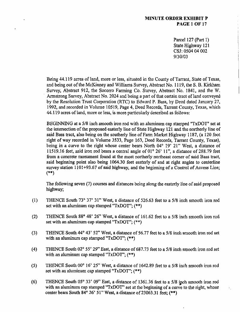
MINUTE ORDER EXHIBIT P PAGE 1 OF 17
Parcel 127 (Parti) State Highway 121 CSJ: 0504 04 002 9/30/03
Being 44.119 acres ofland, more or less, situated in the County of Tarrant, State of Texas, and being out of the McKinney and Williams Survey, Abstract No. 1119, the S. B. Kirkham Survey, Abstract 912, the Socorro Farming Co. Survey, Abstract No. 1841, and the W. Armstrong Survey, Abstract No. 2024 and being a part of that certain tract ofland conveyed by the Resolution Trust Corporation (RTC) to Edward P. Bass, by Deed dated January 27, 1992, and recorded in Volume 10519, Page 4, Deed Records, Tarrant County, Texas, which 44.119 acres ofland, more or less, is more particularly described as follows:
BEGINNING at a 5/8 inch smooth iron rod with an aluminum cap stamped "TxDOT" set at the intersection of the proposed easterly line of State Highway 121 and the northerly line of said Bass tract, also being on the southerly line of Farm Market Highway 1187, (a 120 foot right of way recorded in Volume 3533, Page 163, Deed Records, Tarrant County, Texas), being in a curve to the right whose center bears North 04° 19' 21" West, a distance of 11519.16 feet, said iron rod bears a central angle of 01° 26' 11", a distance of 288.79 feet from a concrete monument found at the most northerly northeast corner of said Bass tract, said beginning point also being 1064.30 feet easterly of and at right angles to centerline survey station 1101+93.67 of said highway, and the beginning of a Control of Access Line;
The following seven (7) courses and distances being along the easterly line of said proposed highway;
(1) THENCE South 73° 37' 31" West, a distance of 526.63 feet to a 5/8 inch smooth iron rod set with an aluminum cap stamped "TxDOT"; (**)
(2) THENCE South 88° 48' 26" West, a distance of 161.62 feet to a 5/8 inch smooth iron rod set with an aluminum cap stamped *TxDOT"; (**)
(3) THENCE South 44° 43' 52" West, a distance of 56.77 feet to a 5/8 inch smooth iron rod set with an aluminum cap stamped "TxDOT"; (**)
(4) THENCE South 02° 55' 29" East, a distance of 687.73 feet to a 5/8 inch smooth iron rod set with an aluminum cap stamped "TxDOT"; (**)
(5) THENCE South 00° 16' 25" West, a distance of 1642.89 feet to a 5/8 inch smooth iron rod set with an aluminum cap stamped "TxDOT"; (**)
(6) THENCE South 05° 33' 09" East, a distance of 1361.36 feet to a 5/8 ijpch smooth iron rod with an aluminum cap stamped "TxDOT" set at the beginning of a curve to the right, whose center bears South 84° 26' 51" West, a distance of 23063.31 feet; (**)

MINUTE ORDER EXHIBIT P PAGE 2 OF 17
Parcel 127 (Part 1) State Highway 121 CSJ: 0504 04 002 9/30/03
(7) THENCE in a Southerly direction, along said curve, through a central angle of 01° 36' 55", a distance of 650.25 feet to a 5/8 inch smooth iron rod with an aluminum cap stamped "TxDOT" set on the approximate south line of Tarrant County, also being the approximate north line of Johnson County, and the end of said Control of Access Line;
(8) THENCE North 89° 41' 46" West, along said approximate County Line, a distance of 290.81 feet to a 5/8 inch smooth iron rod with an aluminum cap stamped "TxDOT" set on the proposed westerly line of said State Highway 121, being in a curve to the left, whose center bears South 86° 00' 32" West, a distance of 22773.31 feet, and being the beginning of a Control of Access Line;
The following eight (8) courses and distances being along the westerly line of said proposed highway;
(9) THENCE in a Northerly direction, along said curve, through a central angle of 01° 33' 41", a distance of 620.57 feet to a 5/8 inch smooth iron rod set with an aluminum cap stamped "TxDOT"; (**)
(10) THENCE North 05° 33' 09" West, a distance of 1852.75 feet to a 5/8 inch smooth iron rod set with an aluminum cap stamped "TxDOT"; (**)
(11) THENCE North 12° 21' 10" West, a distance of 1480.77 feet to a 5/8 inch smooth iron rod set with an aluminum cap stamped "TxDOT"; (**)
(12) THENCE North 03° 52' 52 " West, a distance of 422.53 feet to a 5/8 inch smooth iron rod set with an aluminum cap stamped "TxDOT"; (**)
(13) THENCE North 48° 52' 51" West, a distance of 58.69 feet to a 5/8 inch smooth iron rod set with an aluminum cap stamped "TxDOT"; (**)
(14) THENCE South 88° 48' 27" West, a distance of 63.23 feet to a 5/8 inch smooth iron rod set with an aluminum cap stamped "TxDOT"; (**)
(15) THENCE North 86° 38' 12" West, a distance of 158.98 feet to a 5/8 inch smooth iron rod set with an aluminum cap stamped "TxDOT"; (**)
»

MINUTE ORDER EXHIBIT P PAGE 3 OF 17
Parcel 127 (Part I) State Highway 121 CSJ: 0504 04 002 9/30/03
(16) THENCE North 69° 44' 09" West, a distance of 268.50 feet to a 5/8 inch smooth iron rod with an aluminum cap stamped "TxDOT" set on the southerly line of said Farm Market Highway 1187, also being the northerly line of said Bass tract, being in a curve to the left, whose center bears North 00° 06' 20" West, a distance of 2924.79 feet, and the end of said Control of Access Line; (**)
(17) THENCE in an Easterly direction, along the northerly line of said Bass tract, also being the southerly line of said Farm Market Highway 1187, and with said curve, through a central angle of 01° 01' 37", a distance of 52.42 feet to a concrete monument found;
(18) THENCE North 88° 55' 57" East, continuing along the northerly line of said Bass tract, also being the southerly line of said Farm Market Highway 1187, a distance of 1175.46 feet to a concrete monument found at the beginning of a curve to the left, whose center bears North 01° 04' 40" West, a distance of 11519.16 feet;
(19) THENCE in an Easterly direction, continuing along the northerly line of said Bass tract, also being the southerly Une of said Farm Market Highway 1187, and with said curve, through a central angle of 03° 14' 40", a distance of 652.29 feet to the POINT OF BEGINNING.
Notes:
(**) The monument described and set in this call may be replaced with a TxDOT Type II right of way marker upon completion of the highway construction project under the supervision of a Registered Professional Land Surveyor either employed or retained by TxDOT.
Bearing are based on NAD 83 Datum, Texas State Plane Coordinates, North Central Zone, with all distances and coordinates adjusted to the surface by project surface factor of 1.00012.
Access is prohibited across the "Control of Access Line" to the transportation facility from the adjacent property.

MINUTE ORDER EXHIBIT P PAGE 4 OF 17
N5A5'32yt._ .fSJmrt {SSSVJ-E K>7,n
NotOSi
Legal description to accompany this survey sketch.
Bearings ore based on NAD 83 Datum, Texas State Plane Coordinate System. North Central Zone, with all distances ond coordinates adjusted to tt» surface by project surface factor of 1.00012
^
Ss 4^ h. 9>
EAtard P. Boss Vol. IOSS. Pg. 4
O.R. T.C. f.
Scale ~ Feet
100 ^00
9 • %'smooth Iron rod set w/ plastic cap stomped 'TxDOT or other object as noted
# * Marker found 'as noted' 0 ' %' smooth Iron rod w/ aluminum cap stamped 'TxDOT • • Type II monument to bo set at the end of construction
• • %'smooth Iron rod w/ aluminum cop stomped 'TxDOTto be replaced with Type II monument at the end of construction
A - 60d flail set P. 0.8. * Point Of Beginning
ft • Property Une 1 • Survey Line Z • Fee Hook £ • Proposed Centerline
D.R.T.C.T. • Deed Records, Tarrant County, Texas P.R.T.C.T. • Plat Records, Tarrant County, Texas
C 3 ' Record Information —<— • Controtof Access
Z. /2f rPjr/ /; Edward P. Bass
/kres
STATE
T E X A S
CONT.
0504
DIST.
FTW
SECT.
04
COUNTY
TARRANT
JOB
002
HIGHWAY NO.
SHI 21

MINUTE ORDER EXHIBIT P PAGE 5 OF 17
G
" I .
f <
U. 2
Nrof4crw yw\J
~~r Umimenl
Fauna
it II
McKJnney & Williams Survey
a
COuva P, Bass Val, K)Si9, Pg, 4
D.P.. T.C. f .
Proposed ROW
X SZ55'Z9r£ 687.73' 1
Control of Access
(S Pt./
PT 1103+16.66
s %
g Curve Data Ph/079-85.95 R-5729.59' L-5006.29' &r5O0y4f?LT
Notesi
Legal description to accompany this survey sketch.
Bearings are based on NAD 83 Datum, Texas State Plane Coordinate System, North Central Zone, with all distances ond coordinates adjusted to the surface by project surface factor of t.00012
Proposed g SW/ZK. _ r ~ 1 1.05+00
S5°33 '09 "E
0
Scale ~ Feet
100 200
© • 5ft" smooW) /r«i rod sef w/ plastic cap stamped 'TxDOT or other object as noted
# " Marker found 'as noted" 0 • %' smooth Iron rod w/ oiumlnum cop stomped 'TxDOT • - Type II monument to be set at the end of construction
Q - %' smooth Iron rod w/ aluminum cop stamped 'TxDOT to be replaced with Type II monument at tho end of construction
A • 60d Nail set P.0.8. •PointOf Beginning
It • Property Une 1 • Survey Une Z " Fee Hook £ • Proposed Centerline
D.R.T.C.T. •Deed Records. Tarrant County. Texas P.R.T.C.T. • Plat Records, Tarrant County. Texas
t J • Record Information —*— • Control of Access
m t t l tmbr%yl* * • tt11+\
k \STjfy r / j HAMPTON » • i l y i M >«t
rPor/ /) Edward P. Bass
^ . / / 9 Aras
© • 5ft" smooW) /r«i rod sef w/ plastic cap stamped 'TxDOT or other object as noted
# " Marker found 'as noted" 0 • %' smooth Iron rod w/ oiumlnum cop stomped 'TxDOT • - Type II monument to be set at the end of construction
Q - %' smooth Iron rod w/ aluminum cop stamped 'TxDOT to be replaced with Type II monument at tho end of construction
A • 60d Nail set P.0.8. •PointOf Beginning
It • Property Une 1 • Survey Une Z " Fee Hook £ • Proposed Centerline
D.R.T.C.T. •Deed Records. Tarrant County. Texas P.R.T.C.T. • Plat Records, Tarrant County. Texas
t J • Record Information —*— • Control of Access ^
/ / ftpwtmfl* / / rfftanqpwMtoi
STATE DIST. COUNTY
© • 5ft" smooW) /r«i rod sef w/ plastic cap stamped 'TxDOT or other object as noted
# " Marker found 'as noted" 0 • %' smooth Iron rod w/ oiumlnum cop stomped 'TxDOT • - Type II monument to be set at the end of construction
Q - %' smooth Iron rod w/ aluminum cop stamped 'TxDOT to be replaced with Type II monument at tho end of construction
A • 60d Nail set P.0.8. •PointOf Beginning
It • Property Une 1 • Survey Une Z " Fee Hook £ • Proposed Centerline
D.R.T.C.T. •Deed Records. Tarrant County. Texas P.R.T.C.T. • Plat Records, Tarrant County. Texas
t J • Record Information —*— • Control of Access ^
/ / ftpwtmfl* / / rfftanqpwMtoi
T E X A S FTW TARRANT
© • 5ft" smooW) /r«i rod sef w/ plastic cap stamped 'TxDOT or other object as noted
# " Marker found 'as noted" 0 • %' smooth Iron rod w/ oiumlnum cop stomped 'TxDOT • - Type II monument to be set at the end of construction
Q - %' smooth Iron rod w/ aluminum cop stamped 'TxDOT to be replaced with Type II monument at tho end of construction
A • 60d Nail set P.0.8. •PointOf Beginning
It • Property Une 1 • Survey Une Z " Fee Hook £ • Proposed Centerline
D.R.T.C.T. •Deed Records. Tarrant County. Texas P.R.T.C.T. • Plat Records, Tarrant County. Texas
t J • Record Information —*— • Control of Access ^
/ / ftpwtmfl* / / rfftanqpwMtoi
CONT. SECT. JOB HIGHWAY NO.
© • 5ft" smooW) /r«i rod sef w/ plastic cap stamped 'TxDOT or other object as noted
# " Marker found 'as noted" 0 • %' smooth Iron rod w/ oiumlnum cop stomped 'TxDOT • - Type II monument to be set at the end of construction
Q - %' smooth Iron rod w/ aluminum cop stamped 'TxDOT to be replaced with Type II monument at tho end of construction
A • 60d Nail set P.0.8. •PointOf Beginning
It • Property Une 1 • Survey Une Z " Fee Hook £ • Proposed Centerline
D.R.T.C.T. •Deed Records. Tarrant County. Texas P.R.T.C.T. • Plat Records, Tarrant County. Texas
t J • Record Information —*— • Control of Access ^
/ / ftpwtmfl* / / rfftanqpwMtoi
0504 04 002 SHI 21

MINUTE ORDER EXHIBIT P PAGE 6 OF 17
EOward P. Bass
McKlnney & Williams Survey A-III9
tfotest
Legal description to accompany this survey sketch.
Bearings are based on NAD 83 Datum. Texas State Plane Coordinate System, North Central Zone, with all distances and coordinates adjusted to the surface by project surface factor of 1.00012
@ • %' smooth Iron rod setw/ plastic cap stamped 'TxDOT" or other object as noted
# - Marker found 'as noted" O • %' smooth Iron rod w/ aluminum cap stomped 'TxDOT • • Type II monument to be set at the end of construction
D " %'smooth Iron rod w/ aluminum cap stamped 'TxDOT to be replaced with Type II monument at the end of construction
A - 60d Nail set P.O.B. • PolntOf Beginning
4 • Property Une t • Survey Une z " Fee Hook € • Proposed Centerline
D.R.T.C.T. ' Deed Records. Tarrant County. Texas P.R.T.C.T. • Plat Records, Tarrant County. Texas
^^^^^A^Xfo^^ m 1* \** • ww* t f t m
j ^ ^ ^ ^
PARCEL /27 fPorf /J Edward P. 8055
44JI9 Acres
@ • %' smooth Iron rod setw/ plastic cap stamped 'TxDOT" or other object as noted
# - Marker found 'as noted" O • %' smooth Iron rod w/ aluminum cap stomped 'TxDOT • • Type II monument to be set at the end of construction
D " %'smooth Iron rod w/ aluminum cap stamped 'TxDOT to be replaced with Type II monument at the end of construction
A - 60d Nail set P.O.B. • PolntOf Beginning
4 • Property Une t • Survey Une z " Fee Hook € • Proposed Centerline
D.R.T.C.T. ' Deed Records. Tarrant County. Texas P.R.T.C.T. • Plat Records, Tarrant County. Texas ^
/ / efffwMporMlM
STATE DIST. COUNTY
@ • %' smooth Iron rod setw/ plastic cap stamped 'TxDOT" or other object as noted
# - Marker found 'as noted" O • %' smooth Iron rod w/ aluminum cap stomped 'TxDOT • • Type II monument to be set at the end of construction
D " %'smooth Iron rod w/ aluminum cap stamped 'TxDOT to be replaced with Type II monument at the end of construction
A - 60d Nail set P.O.B. • PolntOf Beginning
4 • Property Une t • Survey Une z " Fee Hook € • Proposed Centerline
D.R.T.C.T. ' Deed Records. Tarrant County. Texas P.R.T.C.T. • Plat Records, Tarrant County. Texas ^
/ / efffwMporMlM
T E X A S FTW TARRANT
@ • %' smooth Iron rod setw/ plastic cap stamped 'TxDOT" or other object as noted
# - Marker found 'as noted" O • %' smooth Iron rod w/ aluminum cap stomped 'TxDOT • • Type II monument to be set at the end of construction
D " %'smooth Iron rod w/ aluminum cap stamped 'TxDOT to be replaced with Type II monument at the end of construction
A - 60d Nail set P.O.B. • PolntOf Beginning
4 • Property Une t • Survey Une z " Fee Hook € • Proposed Centerline
D.R.T.C.T. ' Deed Records. Tarrant County. Texas P.R.T.C.T. • Plat Records, Tarrant County. Texas ^
/ / efffwMporMlM
CONT. SECT. JOB HIGHWAY NO.
C J • Record Information —•— • Control of Access
^ / / efffwMporMlM 0504 04 002 SHI 21
Scale % Feet
0 100 200 •j

MINUTE ORDER EXHIBIT P PAGE 7 OF 17
CdwordP, Oau Vol. KJ58. Pa. 4
QM.T.C.f.
* Control of Access
scriezsvi ISAZ.B3 Proposed Row-.
Proposed £ SHIZI r '
\ 115+00 — - —I'
(S Pt.l
— 1
S5"33'09"E
20+00
proposed ROW
Edward P. Bass Val. 8519. Pg. 4
D.R.T.C.T.
McKlnney & Williams Survey A-/I/9
Notes>
legal description to accompany thts survey sketch.
Bearings ore posed on NAD 83 Datum, Texas State Plane Coordinate System, North Central Zona, with all distances and coordinates adjusted to the surface by project surface factor of 1.00012 0
Scale ~ Feet
100 ZOO
e • o • •
• P.O.B.
* I z C
o.fl. r.c.r. P.R.J.C.T.
C ]
• %'smooth Iron rod setw/ plastic cap stamped 'TxDOVor other object as noted Marker found 'as noted' %' smooth Iron rod w/ aluminum cap stamped 'TxDOV Type II monument to be set at the end of construction
%'smooth Iron rod w/ aluminum cap stamped 'TxDOPto be replaced with Type II monument at the end of construction
60d Natlsel Point Of Beginning Property Une Survey Une Fee Hook Proposed Centerline Deed Records. Tarrant County, Texas Plat Records, Tarrant County, Texas Record Information Control of Access
jlj^^ l^ PARCEL 127 (Port 1)
Edward P. Bass
f?.//9 Ares
ff^ / / Di^Mftnfflf Z / HTt^nqwmhti
STATE 0IST. COUNTY
ff^ / / Di^Mftnfflf Z / HTt^nqwmhti
TEXAS FTW TARRANT ff^ / / Di^Mftnfflf Z / HTt^nqwmhti
CONT. SECT. JOB HIGHWAY NO. ff^ / / Di^Mftnfflf Z / HTt^nqwmhti
0504 04 002 SHI 21

MINUTE ORDER EXHIBIT P PAGE 8 OF 17
Propoa*/ g SH/2, \ I , , r
Eawarn P. flow Vol. 10519. Pg. *
a.H.r.c.f.
McKInney & Williams Survey A-III9
S%%fW «*g.gy
" Control of Access
proposed ROW 05.36'
— £
* (g Pt.l S5"33 '09"E
1125+00
Control of Access •
'Proposed BOH V - * " O.i
Vol. A35/9, Pa- •» O.ft.T.C.T,
(AJ S. B. Kirk ham Survey
A-9/2 Tarrant A-III6 Johnson
Notest
Legal description to accompany this survey sketch.
Bearings are based on NAD 83 Datum. Texas State Plane Coordinate System. North Centroi Zone, with all distances and coordinates adjusted to the surface by project surface factor of 1.00012 0
Sco/e % Feef
100 200
@ •%• smooth Iron rod set w/ plastic cap stamped 'TxDOT" or other object as noted
# • marker found 'as noted" O • %' smooth Iron rod w/ aluminum cap stamped 'TxDOT • • Type II monument to be set at the end of construction
• • %'smooth Iron rod w/ aluminum cap stamped 'TxDOT to be replaced with Type II monument at the end of construction
A ' BOd Nad set P.O.B. • Point Of Beginning
* •Property Une t • Survey Une z -Fee Hook £ - Proposed Centerline
D.R.T.C.T. • Deed Records. Tarrant County. Texas P.R.T.C.T. • Piot Records. Tarrart County. Texas
C 3 • Record Information -—*— •Controlof Access
wQ"V^ViV **•••**%***m
J@i^^yK
PARCEL /27 /; Edward P. Bass
44JI9 Acres
@ •%• smooth Iron rod set w/ plastic cap stamped 'TxDOT" or other object as noted
# • marker found 'as noted" O • %' smooth Iron rod w/ aluminum cap stamped 'TxDOT • • Type II monument to be set at the end of construction
• • %'smooth Iron rod w/ aluminum cap stamped 'TxDOT to be replaced with Type II monument at the end of construction
A ' BOd Nad set P.O.B. • Point Of Beginning
* •Property Une t • Survey Une z -Fee Hook £ - Proposed Centerline
D.R.T.C.T. • Deed Records. Tarrant County. Texas P.R.T.C.T. • Piot Records. Tarrart County. Texas
C 3 • Record Information -—*— •Controlof Access
STATE 0I5T. COUNTY
@ •%• smooth Iron rod set w/ plastic cap stamped 'TxDOT" or other object as noted
# • marker found 'as noted" O • %' smooth Iron rod w/ aluminum cap stamped 'TxDOT • • Type II monument to be set at the end of construction
• • %'smooth Iron rod w/ aluminum cap stamped 'TxDOT to be replaced with Type II monument at the end of construction
A ' BOd Nad set P.O.B. • Point Of Beginning
* •Property Une t • Survey Une z -Fee Hook £ - Proposed Centerline
D.R.T.C.T. • Deed Records. Tarrant County. Texas P.R.T.C.T. • Piot Records. Tarrart County. Texas
C 3 • Record Information -—*— •Controlof Access
T E X A S FTW TARRANT
@ •%• smooth Iron rod set w/ plastic cap stamped 'TxDOT" or other object as noted
# • marker found 'as noted" O • %' smooth Iron rod w/ aluminum cap stamped 'TxDOT • • Type II monument to be set at the end of construction
• • %'smooth Iron rod w/ aluminum cap stamped 'TxDOT to be replaced with Type II monument at the end of construction
A ' BOd Nad set P.O.B. • Point Of Beginning
* •Property Une t • Survey Une z -Fee Hook £ - Proposed Centerline
D.R.T.C.T. • Deed Records. Tarrant County. Texas P.R.T.C.T. • Piot Records. Tarrart County. Texas
C 3 • Record Information -—*— •Controlof Access
/ / turn
/ / s&aami-/ o#?hrtflP*rtMlon
CONT. SECT. JOB HIGHWAY NO.
@ •%• smooth Iron rod set w/ plastic cap stamped 'TxDOT" or other object as noted
# • marker found 'as noted" O • %' smooth Iron rod w/ aluminum cap stamped 'TxDOT • • Type II monument to be set at the end of construction
• • %'smooth Iron rod w/ aluminum cap stamped 'TxDOT to be replaced with Type II monument at the end of construction
A ' BOd Nad set P.O.B. • Point Of Beginning
* •Property Une t • Survey Une z -Fee Hook £ - Proposed Centerline
D.R.T.C.T. • Deed Records. Tarrant County. Texas P.R.T.C.T. • Piot Records. Tarrart County. Texas
C 3 • Record Information -—*— •Controlof Access
/ / turn
/ / s&aami-/ o#?hrtflP*rtMlon
0504 OA 002 SHI21

MINUTE ORDER EXHIBIT P PAGE 9 OF 17
» Eaword P. Bau Vol. OSIO. Pa. 4
D.R.T.C.T. Co Survey
u x ^ t ^ s w l /Proposed RCW SS33V9TE l .,
,i. f Control of Access-
"^Jy * i * 1 £
Proposed •£ . — M
, •• 1130+00
(S Pt.l
S 5 ' 3 3 ' 0 9 " E . n T
Y Control of Access NS-33'CffW I85ZJ5'
Edward f . Boss Vol. (OSS, Pfl. 4
D.R.T.C.T.
Proposed HON 7
S. B. Kirk ham Survey A-912 Tarrant A-I//6 Johnson
Notesi
Legal description to accompany this survey sketch.
Bearings are based on NAD 83 Datum, Texas State Plane Coordinate System, North Central Zone, with all distances and coordinates adjusted to the surface by projoct surface factor of 1.00012
@ • %'smooth Iron rod set w/ plastic cap stamped 'TxDOT or other object as noted
# • Uarker found 'as noted" 0 • %'smooth Iron rod w/ aluminum cap stamped 'TxDOT • • Type II monument to be set at the end of const ruction
Q • %'smooth Iron rod w/ aluminum cap stamped 'TxDOT to be replaced with Type II monument at the end of construction
A - eod Not/set P.O.8. • Point Of Beginning
H •Property Une
1 * Survey Une z 'Fee Hook <L • Proposed Centerline
D.R.T.C.T. - Deed Records. Tarrant County. Texas P.R.T.C.T. • Plot Records. Tarrant County. Texas
[ J • Record Information —*— • Control of Access
j ^ p f
^ ^ ^ ^
/27 r /w /; Edward P. Bass
44.//9 Acras
@ • %'smooth Iron rod set w/ plastic cap stamped 'TxDOT or other object as noted
# • Uarker found 'as noted" 0 • %'smooth Iron rod w/ aluminum cap stamped 'TxDOT • • Type II monument to be set at the end of const ruction
Q • %'smooth Iron rod w/ aluminum cap stamped 'TxDOT to be replaced with Type II monument at the end of construction
A - eod Not/set P.O.8. • Point Of Beginning
H •Property Une
1 * Survey Une z 'Fee Hook <L • Proposed Centerline
D.R.T.C.T. - Deed Records. Tarrant County. Texas P.R.T.C.T. • Plot Records. Tarrant County. Texas
[ J • Record Information —*— • Control of Access
7 ^ / / t h p u m i *
/ / of i h m p w N M
STATE DIST. COUNTY
@ • %'smooth Iron rod set w/ plastic cap stamped 'TxDOT or other object as noted
# • Uarker found 'as noted" 0 • %'smooth Iron rod w/ aluminum cap stamped 'TxDOT • • Type II monument to be set at the end of const ruction
Q • %'smooth Iron rod w/ aluminum cap stamped 'TxDOT to be replaced with Type II monument at the end of construction
A - eod Not/set P.O.8. • Point Of Beginning
H •Property Une
1 * Survey Une z 'Fee Hook <L • Proposed Centerline
D.R.T.C.T. - Deed Records. Tarrant County. Texas P.R.T.C.T. • Plot Records. Tarrant County. Texas
[ J • Record Information —*— • Control of Access
7 ^ / / t h p u m i *
/ / of i h m p w N M
TEXAS FTW TARRANT j
@ • %'smooth Iron rod set w/ plastic cap stamped 'TxDOT or other object as noted
# • Uarker found 'as noted" 0 • %'smooth Iron rod w/ aluminum cap stamped 'TxDOT • • Type II monument to be set at the end of const ruction
Q • %'smooth Iron rod w/ aluminum cap stamped 'TxDOT to be replaced with Type II monument at the end of construction
A - eod Not/set P.O.8. • Point Of Beginning
H •Property Une
1 * Survey Une z 'Fee Hook <L • Proposed Centerline
D.R.T.C.T. - Deed Records. Tarrant County. Texas P.R.T.C.T. • Plot Records. Tarrant County. Texas
[ J • Record Information —*— • Control of Access
7 ^ / / t h p u m i *
/ / of i h m p w N M
CONT. SECT. JOB HIGHWAY NO.
@ • %'smooth Iron rod set w/ plastic cap stamped 'TxDOT or other object as noted
# • Uarker found 'as noted" 0 • %'smooth Iron rod w/ aluminum cap stamped 'TxDOT • • Type II monument to be set at the end of const ruction
Q • %'smooth Iron rod w/ aluminum cap stamped 'TxDOT to be replaced with Type II monument at the end of construction
A - eod Not/set P.O.8. • Point Of Beginning
H •Property Une
1 * Survey Une z 'Fee Hook <L • Proposed Centerline
D.R.T.C.T. - Deed Records. Tarrant County. Texas P.R.T.C.T. • Plot Records. Tarrant County. Texas
[ J • Record Information —*— • Control of Access
7 ^ / / t h p u m i *
/ / of i h m p w N M
0501 OA 002 SHI 21
Scale ~ Feet
0 WO 200 •!

MINUTE ORDER EXHIBIT P PAGE 10 OF 17
— 1
Edward P. Boss Vol. OSS. Pa. *
D.R.T.C.T.
Socorro Farming Co. Survey A-/84I
L-650.Z5-
Proposed flCWv SWQCTE 1361.36
-& PC 1140+22.16
Proposed g SHI2I<^
1135+00
S 5 " 3 3 ' 0 9 " E . ' . ! . . . n 40+00
(S p/./
• Control oT Access NST33V3rV IB5Z.75'
g Curve Data PNH5-47.78 P.-229I8.3I' L-I05I.06'
. {\-Z37'4Crm
L-6Z6.57' —
Edward P. Boss Vol. 0519. Pg. 4
D.B.T.C.T.
S. B. Klrkham Survey A-912 Tarrant A-///6 Johnson
Notes,
Legal description to accompany this survey sketch.
Bearings are based on NAD 83 Datum. Texas State Plane Coordinate System, North Central Zone, with all distances and coordinates adjusted to the surface by project surface factor of 1.00012
Scale ~ Feet
0 \~
100 200
9> • %'smooth iron rod set w/ plastic cop stamped 'TxDOT" or other object as noted
# • Uarker found 'as noteo" O • %'smooth Iron rod w/ aluminum cap stomped 'TxDOT' M • Type II monument to be set at the end of construction
0 • %'smooth Iron rod w/ aluminum cap stamped 'TxDOT" to be replaced with Type II monument at the end of construction
A • 60d Nallset P.O.B. • Point Of Beginning
It • Property Una 1 • Survey Une z -Fee Hook { • Proposed Centerline
D.B.T.C.T. 'Deed Records, Tarrant County. Texas P.R.T.C.T. • Plat Records. Tarrant County. Texas
[ J - Record Information —•— • Control of Access
PARCEL 127 (Port 1)
Edward P. Bass
44.119 Acres
9> • %'smooth iron rod set w/ plastic cop stamped 'TxDOT" or other object as noted
# • Uarker found 'as noteo" O • %'smooth Iron rod w/ aluminum cap stomped 'TxDOT' M • Type II monument to be set at the end of construction
0 • %'smooth Iron rod w/ aluminum cap stamped 'TxDOT" to be replaced with Type II monument at the end of construction
A • 60d Nallset P.O.B. • Point Of Beginning
It • Property Una 1 • Survey Une z -Fee Hook { • Proposed Centerline
D.B.T.C.T. 'Deed Records, Tarrant County. Texas P.R.T.C.T. • Plat Records. Tarrant County. Texas
[ J - Record Information —•— • Control of Access
7 7 ^ / / Off*nw*
/ / ctTtwwportUtan
STATE DIST. COUNTY
9> • %'smooth iron rod set w/ plastic cop stamped 'TxDOT" or other object as noted
# • Uarker found 'as noteo" O • %'smooth Iron rod w/ aluminum cap stomped 'TxDOT' M • Type II monument to be set at the end of construction
0 • %'smooth Iron rod w/ aluminum cap stamped 'TxDOT" to be replaced with Type II monument at the end of construction
A • 60d Nallset P.O.B. • Point Of Beginning
It • Property Una 1 • Survey Une z -Fee Hook { • Proposed Centerline
D.B.T.C.T. 'Deed Records, Tarrant County. Texas P.R.T.C.T. • Plat Records. Tarrant County. Texas
[ J - Record Information —•— • Control of Access
7 7 ^ / / Off*nw*
/ / ctTtwwportUtan
T E X A S FTW TARRANT
9> • %'smooth iron rod set w/ plastic cop stamped 'TxDOT" or other object as noted
# • Uarker found 'as noteo" O • %'smooth Iron rod w/ aluminum cap stomped 'TxDOT' M • Type II monument to be set at the end of construction
0 • %'smooth Iron rod w/ aluminum cap stamped 'TxDOT" to be replaced with Type II monument at the end of construction
A • 60d Nallset P.O.B. • Point Of Beginning
It • Property Una 1 • Survey Une z -Fee Hook { • Proposed Centerline
D.B.T.C.T. 'Deed Records, Tarrant County. Texas P.R.T.C.T. • Plat Records. Tarrant County. Texas
[ J - Record Information —•— • Control of Access
7 7 ^ / / Off*nw*
/ / ctTtwwportUtan
CONT. SECT. JOB HIGHWAY NO.
9> • %'smooth iron rod set w/ plastic cop stamped 'TxDOT" or other object as noted
# • Uarker found 'as noteo" O • %'smooth Iron rod w/ aluminum cap stomped 'TxDOT' M • Type II monument to be set at the end of construction
0 • %'smooth Iron rod w/ aluminum cap stamped 'TxDOT" to be replaced with Type II monument at the end of construction
A • 60d Nallset P.O.B. • Point Of Beginning
It • Property Una 1 • Survey Une z -Fee Hook { • Proposed Centerline
D.B.T.C.T. 'Deed Records, Tarrant County. Texas P.R.T.C.T. • Plat Records. Tarrant County. Texas
[ J - Record Information —•— • Control of Access
7 7 ^ / / Off*nw*
/ / ctTtwwportUtan
0504 04 002 SH121

MINUTE ORDER EXHIBIT P PAGE 11 OF 17
%
Socorro Farming Co. Survey A-I84I Edward P. Bass
% T w
Proposed £ £HI£'^\ I T . ' Z ; 1 . " ! . . _ u 45tQf>
Armstrong Survey A-Z0Z4 Tarrant A-IZ55 Johnson
r—IH-g Curve Data PMI45'47.7B R-Z29l8.3r L-I05I.06'
Cxzzi'Acrm
Control of Access*
4 - - -
S. B. Kirkham Survey A-9IZ Tarrant A-III6 Johnson
Notes,
Legal description to accompany this survey sketch.
Bearings are based on NAD 83 Datum, Texas State Plane Coordinate System, North Central Zone, with all distances and coordinates adjusted to the surface by project surface factor of 1.00012 0
Scale ~ Feet
100 200
« ' %'smooth iron rod setw/ plastic cap stamped 'TxDOT or other object as noted Marker found 'as noted'
• %' smooth Iron rod w/ aluminum cap stomped 'TxDOT' • Type II monument to be set at the end of construction
%'smooth Iron rod w/ aluminum cop stamped 'TxDOrto be replaced with Type II monument at the end of construction 60d Natl set
Point Of Beginning Property Une Survey Une Fee Hook
Proposed Centerline Deed Records, Tarrant County, Texas
P.R.T.C.T. * Plat Records, Tarrant County. Texas f 2 - Record Information
*— * Control of Access
# o m •
• P.O. 6.
* i z
e D.R.T.C.T.
RA/?c&_ /zr f f w / ; Edward P. Bass
44.119 Acres
STATE
T E X A S
CONT.
0504
OIST.
FTW
SECT.
04
COUNTY
TARRANT
JOB
002
HIGHWAY NO.
SHI 21

MINUTE ORDER EXHIBIT P PAGE 12 OF 17
E
Proposed g SHIZl-^
1 110+00
S5°33'09"E:
1115+00
(S pt.i
, control of
Etfward P. £ou W. Pp. 4
D.R.T.C.T.
proposed pott
McKinney & Williams Survey A-///9
Notes, Legal description to accompany this survey sketch.
Bearings dre based on NAD 83 .Datum. Texas State Plans Coordinate System. North Central Zone, with all distances and coordinates adjusted to the surface by project surface factor of 1.00012
Scale ™ Feet
0 k
100 200
«
o • •
• p.o. a.
e i z E
D.R.T.C.T. P.R.T.C.T.
C J •
• %' smooth Iron rod set w/ plastic cop stomped 'TxDOT" or other object as noted
• Uarker found "as noted" • %'smooth Iron rod w/ aluminum cop stamped "TxDOT • Type It monument to be set at the end of construction • %' smooth Iron rod w/ aluminum cap stamped 'TxDOT to
be replaced with Type II monument at the end of construction • 60d Noll set -PointOf Beginning • Property Une • Survey Une *Fee Hook • Proposed Centerline • Deed Records, Tarrant County, Texas • Plat Records, Tarrant County. Texas • Record Information • Control of Access
@$ik k.ST&pLyHAMPTON m
PARCEL 127 (Part 1)
Edward P. Bass
44.113 Acres
/ / 0«p«taMf / / ef nwMporMfen
STATE DIST. COUNTY
/ / 0«p«taMf / / ef nwMporMfen
TEXAS FTW TARRANT
/ / 0«p«taMf / / ef nwMporMfen
CONT. SECT. JOB HIGHWAY NO.
/ / 0«p«taMf / / ef nwMporMfen 0504 04 002 SH121

MINUTE ORDER EXHIBIT P PAGE 13 OF 17
*8
tfS
K
!
g Curve Data Pl-1079-85.95 #5729.5f L-5006.29-^•SCTO^LT
(5 p t j
Proposed g 5H!2f-^ _ r " 1105+00
S5°33 ' 09 "E — i
"IJ - H
O UI +
<T>
(Ti
cn
1480.77'
422.53'
Edward P. Boss Vol. 10519. Pg. 4
o.n.T.c.f,
-v SBSWZWi ^ ' 63.23' Notes,
Legal description to accompany this survey sketch.
Bearings are Based on NAD 83 Datum, Texas State Plane Coordinate System. North Central Zone, with alt distances and coordinates adjusted to the surface by project surface factor of 1.00012
McKlnney & Williams Survey A-/II9
0
Scale % Feet
100 200
0 " %' smooth Iron rod set w/ plastic cap stamped TxDOT'or other object as noted
ft • Marker found 'as noted' 0 • %' smooth Iron rod w/ aluminum cop stamped 'TxDOT • • Type It monument to be set at the end of construction
• * %'smooth Iron rod w/ aluminum cap stamped 'TxDOTto be replaced with Type 11 monument at the end of construction
A • GOd Natl set P.O.B. • Point Of Beginning
ft • Properly Une 1 • Survey Une Z 'Fee Hook 1 ' Proposed Centerline
D.R.T.C.T. - Deed Records. Tarrant County, Texas P.R.T.C.T. • Plat Records. Tarrant County. Texas
C 3 • Record Information —•— •Controlof Access
y^^Wf PARCEL 127 (Parti) Edward P. Bass
f^.//9 Aya?
0 " %' smooth Iron rod set w/ plastic cap stamped TxDOT'or other object as noted
ft • Marker found 'as noted' 0 • %' smooth Iron rod w/ aluminum cop stamped 'TxDOT • • Type It monument to be set at the end of construction
• * %'smooth Iron rod w/ aluminum cap stamped 'TxDOTto be replaced with Type 11 monument at the end of construction
A • GOd Natl set P.O.B. • Point Of Beginning
ft • Properly Une 1 • Survey Une Z 'Fee Hook 1 ' Proposed Centerline
D.R.T.C.T. - Deed Records. Tarrant County, Texas P.R.T.C.T. • Plat Records. Tarrant County. Texas
C 3 • Record Information —•— •Controlof Access
—t/y STATE DIST. COUNTY
0 " %' smooth Iron rod set w/ plastic cap stamped TxDOT'or other object as noted
ft • Marker found 'as noted' 0 • %' smooth Iron rod w/ aluminum cop stamped 'TxDOT • • Type It monument to be set at the end of construction
• * %'smooth Iron rod w/ aluminum cap stamped 'TxDOTto be replaced with Type 11 monument at the end of construction
A • GOd Natl set P.O.B. • Point Of Beginning
ft • Properly Une 1 • Survey Une Z 'Fee Hook 1 ' Proposed Centerline
D.R.T.C.T. - Deed Records. Tarrant County, Texas P.R.T.C.T. • Plat Records. Tarrant County. Texas
C 3 • Record Information —•— •Controlof Access
—t/y T E X A S FTW TARRANT
0 " %' smooth Iron rod set w/ plastic cap stamped TxDOT'or other object as noted
ft • Marker found 'as noted' 0 • %' smooth Iron rod w/ aluminum cop stamped 'TxDOT • • Type It monument to be set at the end of construction
• * %'smooth Iron rod w/ aluminum cap stamped 'TxDOTto be replaced with Type 11 monument at the end of construction
A • GOd Natl set P.O.B. • Point Of Beginning
ft • Properly Une 1 • Survey Une Z 'Fee Hook 1 ' Proposed Centerline
D.R.T.C.T. - Deed Records. Tarrant County, Texas P.R.T.C.T. • Plat Records. Tarrant County. Texas
C 3 • Record Information —•— •Controlof Access
/ / TtaM / / Dfl+m*t
£_ / efnwMporMdon
CONT. SECT, JOB HIGHWAY NO.
0 " %' smooth Iron rod set w/ plastic cap stamped TxDOT'or other object as noted
ft • Marker found 'as noted' 0 • %' smooth Iron rod w/ aluminum cop stamped 'TxDOT • • Type It monument to be set at the end of construction
• * %'smooth Iron rod w/ aluminum cap stamped 'TxDOTto be replaced with Type 11 monument at the end of construction
A • GOd Natl set P.O.B. • Point Of Beginning
ft • Properly Une 1 • Survey Une Z 'Fee Hook 1 ' Proposed Centerline
D.R.T.C.T. - Deed Records. Tarrant County, Texas P.R.T.C.T. • Plat Records. Tarrant County. Texas
C 3 • Record Information —•— •Controlof Access
/ / TtaM / / Dfl+m*t
£_ / efnwMporMdon 0504 04 002 SH121

MINUTE ORDER EXHIBIT P PAGE 14 OF 17
Notesi
Legal description fo accompany this survey sketch.
Bearings ore bosed on NAD 83 Datum. Texas State Plane Coordinate System. North Central Zone, with all distances and coordinates adjusted to the surface by project surf ace factor of 1.00012
E(t#ard P. Bass Vol. 105/9. Pt. •*
O.d.T.C.T.
McKInney & Williams Survey A-/I/9
"FMS"
Scale % Feet
0 100 zoo @ • %'smooth Iron rod set w/ plastic cap stomped
'TxDOV or other object as noted # • Uarker found 'as noted' 0 • %' smooth Iron rod w/ aluminum cap stamped 'TxDOV • • Type II monument to be set at the end of construction
• • %' smooth Iron rod w/ aluminum cap stamped 'TxDOV to be replaced with Type II monument at the end of construction
• - 60d Nail set P.O.B. - Point Of Beginning
It " Properly Une 1 • Survey Une z - Fee Hook £ - Proposed Centerline
D.R.T.C.T. • Deed Records. Tarrant County. Texos P.R.T.C.T. • Plat Records, Tarrant County. Texas
C J • Record Information —•— •Controlof Access
/MEIW PARCEL 127 (Port I) Edward P. Bass
/4./Z9 /Acres
@ • %'smooth Iron rod set w/ plastic cap stomped 'TxDOV or other object as noted
# • Uarker found 'as noted' 0 • %' smooth Iron rod w/ aluminum cap stamped 'TxDOV • • Type II monument to be set at the end of construction
• • %' smooth Iron rod w/ aluminum cap stamped 'TxDOV to be replaced with Type II monument at the end of construction
• - 60d Nail set P.O.B. - Point Of Beginning
It " Properly Une 1 • Survey Une z - Fee Hook £ - Proposed Centerline
D.R.T.C.T. • Deed Records. Tarrant County. Texos P.R.T.C.T. • Plat Records, Tarrant County. Texas
C J • Record Information —•— •Controlof Access
/ / thfivtmm / / erAwMpoTMfen
STATE DIST. COUNTY
@ • %'smooth Iron rod set w/ plastic cap stomped 'TxDOV or other object as noted
# • Uarker found 'as noted' 0 • %' smooth Iron rod w/ aluminum cap stamped 'TxDOV • • Type II monument to be set at the end of construction
• • %' smooth Iron rod w/ aluminum cap stamped 'TxDOV to be replaced with Type II monument at the end of construction
• - 60d Nail set P.O.B. - Point Of Beginning
It " Properly Une 1 • Survey Une z - Fee Hook £ - Proposed Centerline
D.R.T.C.T. • Deed Records. Tarrant County. Texos P.R.T.C.T. • Plat Records, Tarrant County. Texas
C J • Record Information —•— •Controlof Access
/ / thfivtmm / / erAwMpoTMfen
T E X A S FTW TARRANT
@ • %'smooth Iron rod set w/ plastic cap stomped 'TxDOV or other object as noted
# • Uarker found 'as noted' 0 • %' smooth Iron rod w/ aluminum cap stamped 'TxDOV • • Type II monument to be set at the end of construction
• • %' smooth Iron rod w/ aluminum cap stamped 'TxDOV to be replaced with Type II monument at the end of construction
• - 60d Nail set P.O.B. - Point Of Beginning
It " Properly Une 1 • Survey Une z - Fee Hook £ - Proposed Centerline
D.R.T.C.T. • Deed Records. Tarrant County. Texos P.R.T.C.T. • Plat Records, Tarrant County. Texas
C J • Record Information —•— •Controlof Access
/ / thfivtmm / / erAwMpoTMfen
CONT. SECT. JOB HIGHWAY NO.
@ • %'smooth Iron rod set w/ plastic cap stomped 'TxDOV or other object as noted
# • Uarker found 'as noted' 0 • %' smooth Iron rod w/ aluminum cap stamped 'TxDOV • • Type II monument to be set at the end of construction
• • %' smooth Iron rod w/ aluminum cap stamped 'TxDOV to be replaced with Type II monument at the end of construction
• - 60d Nail set P.O.B. - Point Of Beginning
It " Properly Une 1 • Survey Une z - Fee Hook £ - Proposed Centerline
D.R.T.C.T. • Deed Records. Tarrant County. Texos P.R.T.C.T. • Plat Records, Tarrant County. Texas
C J • Record Information —•— •Controlof Access
/ / thfivtmm / / erAwMpoTMfen 0504 04 002 SHI 21

\ MINUTE ORDER EXHIBIT P PAGE 15 OF 17
Parcel 127 (Part 2) Highway 121 CSJ: 0504 04 002 9/30/03
Being 2.702 acres of land, more or less, situated in the County of Johnson, State of Texas, being out of the S. B. Kirkham Survey, Abstract 1116 and the W. Armstrong Survey, Abstract No. 1255 and being a part of that certain tract of land conveyed by the Resolution Trust Corporation (RTC) to Edward P. Bass, by Deed dated January 27,1992, and recorded in Volume 10519, Page 4, Deed Records, Tarrant County, Texas, which 2.702 acres ofland, more or less, is more particularly described as follows:
BEGINNING at the intersection of the proposed easterly line of State Highway 121 and the south line of said Bass tract, said beginning point bears South 89° 34' 12" West, a distance of 174.93 feet from the most southerly southeast corner of said Bass tract, a 1 inch reference iron rod found bears North 00° 53' 33" West, a distance of 86.00 feet from said most southerly southeast comer, said beginning point also being 145.00 feet easterly of and at right angles to centerline survey station 1150+69.81 of said highway and in County Road 920A;
(1) THENCE South 89° 34' 12" West, along the south line of said Bass tract and with said County Road 920A, a distance of204.27 feet to an angle point in said south line;
(2) THENCE South 89° 36' 33" West, continuing along said south line and with said County Road, a distance of 86.01 feet to the proposed westerly line of said State Highway 121, being in a curve to the left whose center bears South 87° 02' 05" West, a distance of 22773.31 feet, also being the beginning of a Control of Access Line;
(3) THENCE in a Northerly direction, along said proposed westerly line and with said curve, at a central angle of 00° 03'19", a distance of 21.99 feet passing a 5/8 inch smooth iron rod with an aluminum cap stamped "TxDOT" set on the northerly line of said County Road 920A, and continuing in all through a central angle of 01° 01' 33", a distance of 407.71 feet to a 5/8 inch smooth iron rod with an aluminum cap stamped "TxDOT" set on the approximate north line of Johnson County, also being the approximate south line of Tarrant County and the end of said Control of Access Line; (**)
(4) THENCE South 89° 41' 46" East, along said approximate County Line, a distance of 290.81 feet to a 5/8 inch smooth iron rod with an aluminum cap stamped "TxDOT" set on the proposed easterly line of said State Highway 121, being in a curve to the right whose center bears South 86° 03' 47" West, a distance of 23063.31 feet and being the beginning of a Control of Access line (**)

MINUTE ORDER EXHIBIT P PAGE 16 OF 17
Parcel 127 (Part 2) State Highway 121 CSJ: 0504 04 002 9/30/03
(5) THENCE in a Southerly direction, along said proposed easterly line and with said curve, at a central angle of 00° 56' 51", a distance of 381.35 feet passing a 5/8 inch smooth iron rod with an aluminum cap stamped "TxDOT" set on the northerly line of said County Road 920A, and continuing in all through a central angle of 01° 00' 13", a distance of 404.02 feet to the POINT OF BEGINNING and the end of said Control of Access Line, of which 0.149 acres of land, more or less, lies within County Road 920A, leaving a net of 2.553 acres of land, more or less. (**)
Notes:
(**) The monument described and set in this call may be replaced with a TxDOT Type II right ofway marker upon completion ofthe highway construction project under the supervision of a Registered Professional Land Surveyor either employed or retained by TxDOT.
Bearing are based on NAD 83 Datum, Texas State Plane Coordinates, North Central Zone, with all distances and coordinates adjusted to the surface by project surface factor of 1.00012.
Access is prohibited across the "Control of Access Line" to the transportation facility from the adjacent property.
Survey sketch to accompany this legal description.
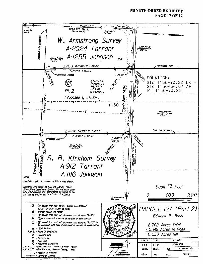
MINUTE ORDER EXHIBIT P PAGE 17 OF 17
F S = ^ 8IO.3CyC8K3.4-)
fkan Rod Pound A
Sf75J'JJ-£ 896.30-cscrore exiT}
86.00'
fRtttrmot Iran Rod Found
CflWrtf P. Boss Vol. CM. Pg. 4
D.R.T.C.T.
W. Armstrong Survey \ A-20Z4 Tarrant \ A-IZ55 Johnson
f A-rooVJ' R-S3063.3r L-404.02' Proposed RON
K. ^•a56'5r 1-381.35'
Control of Access
• oi
\> 92. Pt.2 Proposed g SHI2/-^
g Curve Data PHI45'47.78 R'Z29I8.3I' L-KJ5I.06' frZ37'4CrRT
A . 5 % EQUATION: ^ 1 Sta 1150+73.22 BK
Sta 1150+64.67 AH PT 1150+73.22
Harold UcXIntw i. ZS4S, Pg. 6S2
O.R.J.C.T.
A-fO/JJ' R-ZZm.lf L-407.7F Control of Access
Proposed ROW-y A-0'58'/f L-Z85.7Z
Edward P. Bat
S. B. Klrkham Survey A-9I2 Tarrant A-III6 Johnson
Notes,
Legal description to accompany this survey sketch.
Bearings are based on NAD 83 Datum. Texas State Plane Coordinate System. North Central Zone, with all distances ond coordinates adjusted to the surface by project surface factor of t.OOQIZ
Scale ~ Feet
100 ZOO
@ •%'smooth Iron rod set w/ plastic cap stamped 'TxDOT'or otter object as noted
# • Marker found 'as noted' 0 • %'smooth Iron rod w/ aluminum cap stamped 'TxDOV M • Type II monument to be set at 1h» end of construction
• • %'smooth Iron rod w/ aluminum cap stamped 'TxDOV to be replaced with Type II monument at the end of construction
• • 60d Nail set P.O.B. •Pointer Beginning
It • Property Une 1 • Survey Une z -Fee Hook € • Proposed Centerline
D.R.J.C.T. •Deed Records. Johnson County. Texas P. R.J.C.T. • Plat Records. Johnson County, Texas
[ J • Record Information —•— • Control of Access
/ % = -/ / •fftamporMfeff
PARCEL IZ7 (Part Z) Edward P. Bass
2.702 Acres Totai - 0.149 Acres In Road 2.553 Acres Net.
STATE
TEXAS CONT.
0504
OIST.
FTW SECT.
05
COUNTY
JOHNSON
JOB
002
HIGHWAY NO.
SH121


MINUTE ORDER EXHIBIT Q PAGE 1 OF 3
County: DALLAS Highway: LH, 635 D-15-14
May 31,2004 Revised: December 30,2005
Project Limits: From: North Dallas Tollway To: Hillcrest Road
ROW CSJ: 2374-01-150 ACCT: 9118-01-037
Legal Land Description for Parcel 33
BEING a 0.244 acre portion of that certain called 4.0 acre parcel situated in Edward Wilburn Survey, Abstract No. 1583, in the City of Dallas, Dallas County, Texas, being in Block 7433, which was conveyed to King Of Glory Lutheran Church, as evidenced by the deeds recorded in Volume 920 at Page 1080 and Volume 82158 at Page 1267 ofthe Deed Records of Dallas County, Texas, and being more particularly described by metes and bounds as follows:
COMMENCING at a %-inch steel rod found in the east line of said King Of Glory parcel, same being the northwest comer of Lot 1, Block A/7427 of Northwood Homes, an addition to the City of Dallas, according to the map recorded in Volume 32 at Page 199 ofthe Map Records of Dallas County, Texas;
THENCE, along the common line between said King Of Glory parcel and said Lot 1, South 16°48'35" West, a distance of 151.87 feet to a 5/8-inch steel rod with TxDOT aluminum cap found for the southwest corner of said Lot 1 and lying in the existing and new northern right-of-way lines of Interstate Highway 635, variable width rights-of-way, the POINT OF BEGINNING; **
1. THENCE, along said existing northern right-of-way line, South 16°48'35" West, a distance of20.99 feet to a point being the southeast corner of said King Of Glory
2. THENCE, continuing along said existing northern right-of-way line, South 89°01'ir West, a distance of 499.87 feet to a bolt found for the southwest corner of said King Of Glory parcel, same being the southeast comer of Lot 4, Block E/7433 of the replat of Coterie H, an addition to the City of Dallas according to the map recorded in Volume 77143 at Page 1897 of the Map Records of Dallas County, Texas;
3. THENCE, along the common line between said King Of Glory parcel and said Lot 4, North 16°12,32" East, a distance of 22.86 feet to a 5/8-inch steel rod with TxDOT aluminum cap set for corner lying in said new northern right-of-way line of Interstate Highway 635 and at the beginning of this Control of Access Line and the beginning of a non-tangent curve to the right having a central angle of 01°17'59", a radius of 2,804.46 feet, and a long chord which bears North 88°39'55" East for a distance of63.62 feet;
parcel;
1

MINUTE ORDER EXHIBIT Q PAGE 2 OF 3
County: DALLAS Highway: LH. 635 D-15-14
May 31, 2004 Revised: December 30,2005
Project Limits: From: North Dallas Tollway To: Hillcrest Road
ROW CSJ; 2374-01-150 ACCT: 9118-01-037
Legal Land Description for Parcel 33
4. THENCE, along said new northern right-of-way Hne, and said curve to the right, at an arc distance of 35.68 feet passing a 5/8-inch steel rod set for the end of this Control of Access Line, continuing for a total arc distance of 63.62 feet to a 5/8-inch steel rod with TxDOT aluminum cap set for comer; **
5. THENCE, continuing along said new northern right-of-way line, North 89°18'55" East, a distance of 435.92 feet to the POINT OF BEGINNING; and containing an area of 10,622 square feet, or 0.244 acres ofland, more or less.
I, Dennis R. Maloney, Jr., Registered Professional Land Surveyor, do hereby certify that the above description correctly represents the results of a survey made on the ground.
1. All bearings are based on the Texas State Plane Coordinate System, NAD 83, North Central Zone. Scale factor: 1.000136506
2. A survey plat of even date herewith accompanies this legal description.
**If destroyed or disturbed during the highway construction project, the monument described in this call may be replaced with a TxDOT Type H Right-of-Way Marker set under the supervision of a Registered Professional Land Surveyor, either employed or retained by TxDOT.
Access is prohibited across the "Control of Access Line" to the highway facility from the adjacent property.
December 31,2003
Notes:

MINUTE ORDER EXHIBIT Q PAGE 3 OF 3
STATE OF TEXAS VOL. 67004. PG. 46
C.C.R.D.C.T. .$
INTERSTATE HIGHWAY 635 • (LBJ FREEWAY)
(VARIABLE WIDTH R.O.W. >•
STATE OF TEXAS VOL. 401. PC. 883
C.C.R.D.C.T. .LP
M O M i V 6 WHLUAM8 ABSTRACT MO.#
ZOO6-\2-10l REVlSeo QEEO VOL/PG.
#* IF DISTJKWD ON DIITURIEO DWIIWO THE HICHMT CCNITIUJCT|(W MOJECT. THE MDMMENT SEKRIIED IH THII CAW HAT RE ItfPLACEO KITH * TtfflT II mCMT-Of-MT W E N SET WOEft THE
rag's %:,%:':i%or™' "» E,TW" LEGEND PROPOSED flOW
EXISTING ROW PROPERTY LINE COUNTY LINE
HI - •—• CONTROL OF ACCESS LINE
% SURVEY LINE
- X X — FENCE LINE
CITY LIMITS
P . O . C ,
P . 0 . 8 .
EASEMENT
RAILROADS
STRUCTURE
OVEAHE»|} $K>
* U 1EWNCS * « BAStD ON THE TEXAS SMTl PLANE
« ^ W C W W I E i ^ l i " ' " * * M ' E H £ K " ' T H
Sf C " tCH L I N E ' , I T I D A C T O S S ™£ C O H T * O L
5TKUCTUHE . / _ ' w >
POINT Of COWWENCIWcC^/ / ^ Q POINT OF BEGINNING ^
POUND CONC. MONUMENT
SET V STEEL ROD WITH
ALUMINUM TXDOT CAP
SET OR! FOUND MONUMENTATION
O U T . HAIC
DALLAS
H.AT Of A SURVEY OF MHVEATY
KING Of GLORY LUTHERAN
CHURCH TRACT
COUNTY
DALLAS
PARCEL HO.
33 INTERSTATE HIGHVAY « 5 l » * ESJI IJT4-01-150
DATE
MAY 31 2004
ROW PARCEL 10,622 SO F I 0.244 AC


MINUTE ORDER EXHIBIT R PAGE 1 OF 4
COUNTY: HIGHWAY: ROW CSJ: DON CSJ: ACCOUNT:
DALLAS I.H. 635 January 21, 2005 2374-01-152 2374-01-068 9118-01-038
Description for Parcel 9
Being 2,572 square feet of land situated in the Noah Good Survey, Abstract No. 520, Dallas County, Texas and being a portion of that certain tract of land conveyed in deed to Bob Evans Farms, Inc. as recorded in Volume 93079, Page 2150 ofthe Deed Records of Dallas County, Texas said tract of land being Lot 5, Block A out of an addition known as Replat Pace Addition, an Addition in the City of Farmers Branch and recorded in Volume 93045, Page 3876 of said deed records said 2,572 square feet of land being more particularly described by metes and bounds as follows:
COMMENCING at a 1/2" iron rod with a red cap stamped "Prism Surveys" found marking the southwest corner of that certain tract of land, being Block 1, Lot 1, of Exxon No. 6-3903 Addition an addition to the City of Farmers Branch recorded in Volume 86157, Page 4926 of said deed records same being the intersection ofthe north Right-of-Way line of I.H. 635 (a variable width Right-of-Way) described in deed to the State of Texas as recorded in Volume 235, Page 56 of said deed records and the east Right-of-Way line of Midway Road (a variable width Right-of-Way);
THENCE S 63°30'47" W, over and across said Midway Road, a distance of 175.11 feet to the POINT OF BEGINNING, said point being at the intersection of the north Right-of-Way line of said I.H. 635 described in deed to the State of Texas, Tract 2 as recorded in Volume 443, Page 364 of said deed records and the west Right-of-Way line of said Midway Road;
(1) THENCE S 66°37,10" W, along said north Right-of-Way line, common with the south line of said Bob Evans tract, a distance of 19.09 feet to an "X"-Cut set**and also being the beginning of a Control of Access Line;
(2) THENCE N 13°00'33" E, along the new western Right-of-Way line of said Midway Road, also being a Control of Access Line, for a distance of 35.43 feet to a 5/8" iron rod with an aluminum cap stamped "TxDot" set**, and also being the end of this Control of Access Line;
(3) THENCE along a curve to the right having a radius of 846.46 feet, a delta angle of 08°21'02", a long chord that bears N 13°58'33" W, a distance of 123.26 feet, and an arc distance of 123.37 feet to a 5/8" iron rod with an aluminum cap stamped "TxDot" set**;
MINUTE ORDER EXHIBIT R PAGE 2 OF 4
COUNTY: HIGHWAY: ROW CSJ: DON CSJ: ACCOUNT:
DALLAS I.H. 635 2374-01-152 2374-01-068 9118-01-038
January 21, 2005
Description for Parcel 9
(4) THENCE along a curve to the right having a radius of 162.40 feet, a delta angle of 06°19'26*\ a long chord that bears N 06°38'18" W, a distance of 17.92 feet, and an arc distance of 17.92 feet to an "X"-Cut set**, in the north line of said Bob Evans tract, common with a south line of that certain tract of land described in deed to State Street Bank and Trust Company of Connecticut National Association, as recorded in Volume 96044, Page 4271 of said deed records;
(5) THENCE N 89D13'39" E, along said common line, a distance of 12.98 feet to the northeast corner of said Bob Evans tract, same being in the west Right-of-Way line of said Midway Road;
(6) THENCE along the east line of said Bob Evans tract, common with said west Right-of-Way line of Midway Road, with a curve to the left having a radius of 840.42 feet, a delta angle of 07°18,29", a long chord that bears S 14°53'59" E, a distance of 107.12 feet, and an arc distance of 107.20 feet to a point for corner, from said point a 1/2" iron rod found, bears S 01°08'02" E, a distance of 0.52 feet;
(7) THENCE S 00°48'35" E, continuing along said common line, a distance of 61.01 feet to the POINT OF BEGINNING, and containing 2572 square feet of land, more
IN ADDITION a Control of Access Line delineating a denial of access to the transportation facility from the adjacent property along the common boundary of I.H. 635 as conveyed by deed to the State of Texas, Tract 2 as recorded in Volume 443, Page 364 of said deed records, and a tract of land conveyed to said Bob Evans Farms tract of land; said Control of Access Line being more particularly described by metes and bounds as follows:
COMMENCING at a 1/2" iron rod with a red cap stamped "Prism Surveys" found marking the southwest corner of that certain tract of land, being Block 1 of Exxon No. 6-3903 Addition, an addition to the City of Farmers Branch recorded in Volume 86157, Page 4926 of said deed records same being the intersection of the north Right-of-Way line of I.H. 635 (a variable width Right-of-Way) described in deed to the State of Texas as recorded in Volume 235, Page 56 of said deed records and the east Right-of-Way line of Midway Road (a variable width Right-of-Way);
or less.

COUNTY: HIGHWAY: ROW CSJ: DON CSJ: ACCOUNT:
DALLAS LH. 635 2374-01-152 2374-01-068 9118-01-038
MINUTE ORDER EXHIBIT R PAGE 3 OF 4
January 21, 2005
Description for Parcel 9
THENCE S 63°30'47" W, over and across said Midway Road, a distance of 175.11 feet to a point, said point being at the intersection of the north Right-of-Way line of said I.H. 635 described in deed to the State of Texas, Tract 2 as recorded in Volume 443, Page 364 of said deed records and the west Right-of-Way line of said Midway Road;
THENCE S 66°37'10" W, along said north Right-of-Way line, common with the south line of said Bob Evans tract, a distance of 19.09 feet to an "X"-Cut set** for this Control of Access Line;
1) THENCE S 66°37'10" W along the existing north Right-of-Way line of I.H. 635 and along the Control of Access Line for a distance of 208.50 feet to a "X"-cut set**, at the end of this control of Access Line.
** The Monument described and set in this call, if destroyed during construction, may be replaced with a TxDOT Type II Right-of-Way Marker upon the completion of the highway construction project under the supervision of a Registered Professional Land Surveyor, either employed or retained by TxDOT.
Basis of Bearings is based on the Texas State Plane Coordinate System, NAD 83 (1993 Adj.) North Central Zone, all distances and coordinates shown are surface and may be converted to grid by dividing by TxDOT conversion factor of 1.000136506.
Access is prohibited across the Control of Access Une to the highway facility from the adjacent property.
A parcel plat of even date herewith accompanies this property description.

LINE BEARING DISTANCE LI S 66' 37' 10" W 19-09' L2 N 13'00'33" E 35.43' L3 N 89' 13'39" E 12.98' LA S 00'48'35" E 61.01 '
« TITB Monument daacrtbed ond set in this coil, If destroyed during construction, may be r«oiace4 *itn a TxDOT Type H Right of Way Marker upon canoletlon of th* highway construction project ^> under tne supervision of a Registered Profess'ana I Lone" Surveyor, either employed or retained by TxDOT. ^
I
ALL BEARINGS ARE ON THE TEXAS STATE PLANE COORDINATE SYSTEM, NAD. 83 (1993 Adj.J NORTH CENTRAL ZONE. ALL DISTANCES AND COORDINATES SHOWN ARE SURFACE AND MAY BE CONVERTED TO GRID BY DIVIDING BY TxDOT CONVERSION FACTOR OF 1.000136506.
CURVE RADIUS DELTA ANGLE CHORD BEARING CHORD LENGTH ARC LENGTH CI 846.46' 08=21 '02" . N 13" 58'33" W 123. 26' 123.37' C2 162. 40' 06" 19'26'%' N 06"36'18" W 17. 92' 17. 92' C3 840. 42' 07"18' 29/:' S 14"53'59" E 107. 12' 107. 20'
STATE, STREET BANK AND TRUST COMPANY OF CONNECTICUT-
NATIONAL. ASSOCIATION VOL. 96044, PG/ 427!
D.R.D.C.T.
^#0-,4<K
EXISTING BIGHT Of MT LINE PROPERTY LINE COUNTY LINE CONTROL OT ACCESS LINE SURVEY LINE FENCE LINE CITY LIMITS EASEUENTS RAILROAD STRUCTURE
S 66*37= 10" / " \ 2 0 8 . 50'
^ - , f / 4f t
LEGEND
, c-„ "X"-CUT ^ O i ^ r ^ c y SET
i&jsfa f%
«^>y
O • TxOQT ALLM1MUW DISK SET ON TOP OF IRON ROD UNLESS OTHERWISE NOTED
SET BD- TxDOT BRONZE DISK SET IN CONCRETE
/
r A PLAT OF PARCEL 9
2572' S.F. TRACT OF LAND 208.50' L.F. OF ACCESS CONTROL IN THE NOAH GOOD SURVEY ABSTRACT NUMBER 520
BEING PART OF LOT 5 BLOCK A OF THE PACE ADDITION CITY OF FARMERS BRANCH DALLAS COUNTY, TEXAS
DATE: JANUARY 21,2005
PARCEL OS C.S.J. NO. 2374-01-15Z ACCT. NO. 9118-01-056
MINUTE ORDER EXHIBIT S PAGE 1 OF 3
COUNTY: HIGHWAY: ROW CSJ: DON CSJ: ACCOUNT:
DALLAS LH. 635 November 8, 2004
Updated: January 21, 2005 2374-01-152 2374-01-068 9118-01-038
Description for Parcel 16
Being a 6,020 square feet of land situated in the Mary Brown Survey, Abstract No. 159, Dallas County, Texas, being Lot 4, Block 1 of the "Lot 4 and 5, Block 1, Metropolitan Industrial Park Addition Three" an addition to the City of Farmers Branch, recorded in Volume 92201, Page 2752 of the Deed Records of Dallas County, Texas, said Lot 4 being conveyed by deed to Recreational Equipment, INC., recorded in Volume 92198, Page 1194 of said deed records, said 6,020 square feet of land being more particularly described by metes and bounds as follows:
COMMENCING at the common northwest corner of said Recreational Equipment and the common northeast corner of a tract of land conveyed by deed to Consolidated Freed Properties Limited Partnership, recorded in Volume 95182, Page 05841 of said deed records, from which a 1 /2" found iron rod bears S 14°37'53" E a distance of 0.30 feet;
THENCE S 0Q°07'47" E, along the common west property line of said Recreational Equipment tract of land and the common east property line of said Consolidated Freed Properties tract of land a distance of 502.10 feet to a "60D" nail set**, for the POINT OF BEGINNING;
(1) THENCE departing said common line and along a curve to the left being the new north Right-of-Way line of I.H. 635, having a radius of 5,691.93 feet, a delta angle of 01°31'40", a long chord that bears N 87°09'02" E, a distance of 151.78 feet, and an arc distance of 151.78 feet to a "PK" nail set,**;
(2) THENCE N 86°23'11" E, along said new Right-of-Way line a distance of 58.50 feet to a PK nail set**, on a common east line of said Recreational Equipment tract of land and a common west line of a tract of land as conveyed by deed to Robert and Helen Lamer Community Property Revocable Trust, recorded in Volume 98185, Page 07878 of said deed records, said Lamer tract of land being Lot 5, Block 1 out of said "Lot 4 and 5, Block 1, Metropolitan industrial Park Addition Three";
(3) THENCE S 00°43'52" E, along said common line a distance of 33.47 feet to a point on the existing north Right-of-Way line of I.H. 635 as conveyed by.deed to the State of Texas, recorded in Volume 235, Page 56 of said .deed records, said point being the common southeast corner of said Recreational Equipment, INC. and the common southwest corner of said Lamer tract of land

MINUTE ORDER EXHIBIT S PAGE 2 OF 3
COUNTY: HIGHWAY: ROW CSJ: DGN CSJ: ACCOUNT:
DALLAS LH. 635 November 8, 2004
Updated: January 21, 2005 2374-01-152 2374-01-068 9118-01-038
Description for Parcel 16
(4) THENCE S 89°17'21" W, along the common south line of said Recreational Equipment tract of land and the common existing north Right-of-Way line of said I.H. 635 a distance of 210.36 feet to a point for corner, said corner being the common southwest corner of said Recreational Equipment tract of land and the common southeast corner of said Consolidated Freed Properties tract of land;
(5) THENCE N 00Q07'47" W, along the common west line of said Recreational Equipment tract ofland and the common east line of said Consolidated Freed Properties tract of land a distance of 24.85 feet to the POINT OF BEGINNING, and containing 6,020 square feet of land, more or less.
** The Monument described and set in this call, if destroyed during construction, may be replaced with a TxDOT Type II Right-of-Way Marker Upon the completion of the highway construction project under the supervision of a Registered Professional Land Surveyor, either employed or retained by TxDOT.
Basis of Bearings is based on the Texas State Plane Coordinate System, NAD 83 (1993 Adj.) North Central Zone, alt distances and coordinates shown are surface and may be converted to grid by dividing by TxDOT conversion factor of 1.000136506.
Access is allowed to the transportation facility from the adjacent property.
A parcel plat of even date herewith accompanies this property description.
William C. Boden, R.P.L.S. Registered Professional Land Surveyor Texas Registration No. 1932 Carter Burgess Inc. 7950 Elmbrook Dr Dallas, Texas 75429 214-638-0145
January 21, 2005

P. 0. c. PARCEL 16
FND. 1 / 2 " IRON ROD BEARS S 14*37 ' 53 ' E 0. 3 0 '
o s LOT A AND 5, BLOCK 1 METROPOLITAN INDUSTRIAL PARK ADDITION THREE
VOL. 9 2 2 0 1 , PG, 2752 D. R. D, C, T.
.f &
^
cf
GOD NAIL SET
N 0 0 - 0 7 ' 4 7 " W 24. 85*
w
r~-o
o (M
o o i n o LO
BLOCK 1 LOT 4
RECREATIONAL EQUIPMENT, INC. VOL. 92198 , P G . 1194
D . R . D . C . T .
R= 5 6 9 1 . 9 3 ' A = 0 1 * 3 1 ' . 4 0 "
CH. VBRG.-N 87* 0 9 ' 0 2 CH. LEN.= 1 5 1 . 7 8 ' ARC LEN.= 1 5 1 , 7 8 ' )
E
PK NAIL
8 6 * 2 3 ' 1 1 - E 5B. 5 0 %
J
BLOCK 1 LOT 5
ROBERT AND HELEN LARNER COMMUNITY PROPERTY
REVOCABLE TRUST VOL. 98185 , P G . 07878
D . R . D . C . T .
ALL BEARINGS ARE ON THE TEXAS STATE PLANE COORDINATE SYSTEM, NAD. S3 11993 o a f . I NORTH CENTRAL 20NE, ALL DISTANCES AND COORDINATES SHOWN ARE SURFACE AND WAY SE CONVERTED TO CHID BY DIVIDING BY TxDOT CONVERSION FACTOR Of 1 .000136506.
— jna i m j m l o««crtb*a i n l *at In t t i l » c o i l . If O n t r w M during comtruc l 1 on. moj da r u l g c i d » l « i a TuDot Tjom II Right of way Uarknr upon carelHtlan of tno h l^Mqy ocrufr- i jcr 'v i orqfvcr indar tho i L s a r v I i l m cf a ftasl i toroi i Prof»»»[cr>ol LinO S i n « i o r , o l t t v vieioyoo c r r t t c t w by TxDot.
LEGEND
,PK NAIL SET
S 00" 43 '52" E 33. 47'
^
CITY OF FARMERS BRANCH
EXISTING R.O.W. LINE
I .H . 6 3 5 - L . B . J . FREEWAY VARIABLE R.O.W. WIDTH
STATE OF TEXAS VOL. 235 , PG 56
D. R . D . C . T . A LEGAL DESCRtPTlON AT EVEN
SURVEY DATE HEREWITH
ACCOMPANIES THIS PLtT,
EXISTING RIGHT OF WAY LIFE PROPERTY LINE COUNTY LIME CONTROL OF ACCESS LINE SURVEY LIKE FENCE LINE C I T Y L 1 U I T S
E I S E L £ N T S
RAILROAD STM1C7IBE
- * r
•**.-O' TxDOT ALUMINUM DISK SET ON TOP OF A 5/8-INCH IRON ROO UNLESS OTHERWISE NOTED
SET BO- TxDOT BRONZE DISK SET IN CONCRETE
GRAPHIC SCALE
PLAT OF PARCEL 16 FOR STATE HIGHWAY I. H. 635 A 6 , 0 2 0 SQ, FT. , [ 0 . 1 3 8 AC. ]
TRACT OF LAND IN THE MARY BROWN SURVEY ABSTRACT NO. 159
CITY OF FARMERS BRANCH DALLAS COUNTY, TEXAS
W 05
PAHCE1 !6 C . S . J . HO. 2374-01-152 ACCT, UCL 911 i - 0 1 - 0 3 8


MINUTE ORDER EXHIBIT T PAGE 1 OF 5
COUNTY: HIGHWAY: ROW CSJ: DGN CSJ: ACCOUNT:
DALLAS LH. 635 November 9, 2004
Updated: January 21, 2005 2374-01-152 2374-01-068 9118-01-038
Description for Parcel 20
Being a 8132 square feet tract of land situated in the Mary Brown Survey, Abstract No. 159, Dallas County, Texas and being a portion of that certain tract of land described in deed to W.O. Bankston Nissan, Inc. as recorded in Volume 2003123, Page 08399 of the Deed Records of Dallas County, Texas, said 8132 square feet tract of land situated in the City of Farmers Branch and being more particularly described by metes and bounds as follows:
COMMENCING at a 1/2" iron rod found marking the most easterly northeast corner of said W.O. Bankston tract, common with the northwest corner of W.O. Bankston Paint and Body, Inc., as recorded in Volume 97095, Page 00001, of said deed records;
THENCE 5 00°05'49" W, a distance of 496.92 feet to a 1/2" iron rod found marking the southeast corner of said W.O. Bankston Nissan tract, common with the southwest corner of said W.O. Bankston Paint and Body tract, for the POINT OF BEGINNING in the north line of I.H. 635 right-of-way, as recorded in deed to the State of Texas, Volume 235, Page 56 of said deed records.
(1) THENCE N 88°07'19" W, along the north line of I.H. 635 right-of-way, a distance of 149.57 feet to a "TxDOT" aluminum disc stamped 2190 found;
(2) THENCE S 87°26,15" W, along the north line of I.H. 635 right-of-way, a distance of 170.31 feet to an "X" cut found marking the southwest corner of said W.O. Bankston Nissan tract;
(3) THENCE along the easterly line of Welch Road, a 60 foot right-of-way as recorded in Volume 67222, Page 1484 of said deed records with a curve to the left having a radius of 438.76 feet, a delta angle of 21a53'13", a long chord that bears N 13°31'36" W a distance of 166.59 feet, an arc distance of 167.61 feet to a point for corner;
(4) THENCE N 65°28'45" E, a distance of 3.63 feet a PK nail set**;
(5) THENCE along a curve to the right having a radius of 432.75 feet, a delta angle of 14°31'08", a long chord that bears S 17°15'41" E a distance of 109.37 feet, an arc distance of 109.66 feet to a PK nail set**;
(6) THENCE S 39°43'50" E, distance of 25.98 feet a PK nail set**;

MINUTE ORDER EXHIBIT T PAGE 2 OF 5
COUNTY: HIGHWAY: ROW CSJ: DGN CSJ: ACCOUNT:
DALLAS LH. 635 2374-01-152 2374-01-068 9118-01-038
November 9, 2004 Updated: January 21, 2005
Description for Parcel 20
(7) THENCE S 72°09'59" E, a distance of 22.45 feet a PK nail set**;
(8) THENCE S 88°54'10" E, a distance of 147.75 feet a PK nail set**;
(9) THENCE S 84°12'30" E, a distance of 132.57 feet a 5/8" iron rod with an aluminum cap stamped "TxDOT" set**;
(10) THENCE S 87023'58" E, a distance of 5.28 feet a 5/8" iron rod with an aluminum cap stamped "TxDOT" set** in the east line of said W.O. Bankston Nissan tract, common with the west line of said W.O. Bankston Paint and Body tract;
(11) THENCE S 00o05'49" W, along said common line, a distance of 13.02 feet to the POINT OF BEGINNING, and containing 8132 square feet of land, more or less.

MINUTE ORDER EXHIBIT T PAGE 3 OF 5
COUNTY: DALLAS HIGHWAY: I.H. 635 November 9, 2004
Updated: January 21, 2005 ROW CSJ: 2374-01-152 DON CSJ: 2374-01-068 ACCOUNT: 9118-01-038
Description for Parcel 20
** The Monument described and set in this call, if destroyed during construction, may be replaced with a TxDOT Type II Right-of-Way Marker upon the completion of the highway construction project under the supervision of a Registered Professional Land Surveyor, either employed or retained by TxDOT.
Basis of Bearings is based on the Texas State Plane Coordinate System, NAD 83 (1993 Adj.) North Central Zone, all distances and coordinates shown are surface and may be converted to grid by dividing by TxDOT conversion factor of 1.000136506.
A parcel plat of even date herewith accompanies this property description.
William C. Boden, R.P.L.S. January 21, 2005 Registered Professional Land Surveyor Texas Registration No. 1932 Carter Burgess Inc. z ^ ^ O F 7950 Elmbrook Dr Dallas, Texas 75429 214-638-0145

MINUTE ORDER EXHIBIT T PAGE 4 OF 5
DALLAS L-OUN I Y , TEXAS SCALE 1 " = 100'
P.O.C, 1/2"' IRON ' ROD FOUND
W.O. BANKSTON NISSAN, INC.* VOL. 2003123, PG. 08399 '
D.R.D.C.T.
0 I
NAIL SET
PK NAIL SET
PK NAIL SET PK NAIL SET
S 08"54'IO" E 147.75'
$ ^ S O . F f j : | ^ - ' - ^
NEW R.O.W. LINE
'PK NAIL SET
I7'2eHS".Jff. 170.31'
u
V . Q
"So 8@§ 8 % ^ l u i Q
- .fgor
i" J
' <t
(O
' 4 , 3 :
isssss EXISTING . R / O . C O N E
..5('8'!.IRON. . W/ALUM DISC
STAMPED "TxDOT" '2190
P.O.B* , FND. 1/2 " IRON'ROD *«»
MARY BROWN SURVEY ABSTRACT 159
CURVE RADIUS DELTA ANGLE CHORD BEARING CHORD LENGTH ARC LENGTH CI 438. 76' 21"53'13" N 13*31 '36" W 166. 59' 167. 61 ' C2 432. 75' M* 31'08" S 17" 15*41" E 109.37' 109.66'
NOTE: ACCESS IS PROHIBITED ACROSS THIS CONTROL OF ACCESS LINE.
I l l 11 ["CONTROL OF ACCESS LINE.
ALL BEARINGS ARE BASEO ON THE TEXAS STATE PLANE COORDINATE SYSTEM. NAD 63 (1993 ADJ.). NORTH CENTRAL 2ONE, ALL DISTANCES ANO COORDINATES SHOWN ARE SURFACE AND MAY BE CONVERTED TO GRID BY DIVIDING BY TxDOT CONVERSION FACTOR OF 1.000136506.
• INDICATED FOUND R.O.W, MONUMENT AS NOTED. OINDICATES FOUND MONUMENT AS NOTED.
• INDICATES SET 5/8" I.R. WITH TxDOT ALUMINUM CAP.
Tha Monument described and so l In this call, If destroyed during construction, may be replaced with a TxDOT Type II Right of Way Marker upon the com pie lion of the highway construction project under the supervision of a Registered Professional land Surveyor, either amployed-qr retained by TxDOT.
THAT THIS PLAT IS BASED ON AN ON THE GROUND DEB UY SUBERVISIQN ANO, TO THE BEST OF UY
AND JHjfREC
LINE BEARING DISTANCE LI N 65'28'45" E 3. 63' L2 S 39" 43'50" E 25.98' L3 S 72°09'59" E 22.45' L4 S 87* 23'58" E 5. 28' L5 S 00'05'49" W 13, 02'
WILLIAM C.BODEN R.P.L.5, No.1932
A properly das crip lion of even dale her«*Hh accompanist tNa pwcalplal.
Ronlmatrlc data, from osrlol mopping, shown hereon was provldnd by TvQOT. unlass oiharwlia no lad.
SHEET 4 OF A PLAT OF
PARCEL 20 I.H. 635
DALLAS COUNTY, TEXAS NOVEMBER 8, 2004
ROW C.S.J. No. 2374-01-152 ACCOUNT: 9118-01-038
SCALE: I" = IOO'
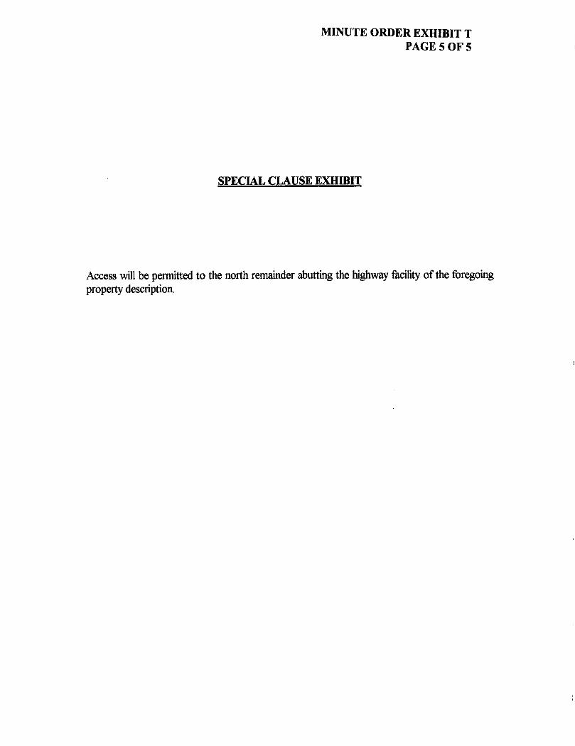
MINUTE ORDER EXHIBIT T PAGE 5 OF 5
SPECIAL CLAUSE EXHIBIT
Access will be permitted to the north remainder abutting the highway facility of the foregoing property description.


MINUTE ORDER EXHIBIT U PAGE 1 OF 3
COUNTY: HIGHWAY; ROW CSJ: DON CSJ: ACCOUNT:
DALLAS I.H. 635 November 8, 2004
Update: January 21, 2005 2374-01-152 2374-01-068 9118-01-038
Description for Parcel 24
Being a 1,490 square foot tract of land situated in the Mary Brown Survey, Abstract No. 159, Dallas County, Texas and conveyed to W.O. Bankston Paint and Body, Inc. as recorded in Volume 97095, Page 00001 of the Deed Records of Dallas County, Texas, said 1490 square foot tract of land situated in the City of Farmers Branch and being more particularly described by metes and bounds as follows:
COMMENCING at a 1/2" iron rod found marking the most easterly northeast corner of that certain tract of land described in deed to W.O. Bankston Nissan, Inc. as recorded in Volume 2003123, Page 08399 of said deed records, common with the northwest corner of said W.O. Bankston Paint and Body Tract;
THENCE S 00°05'49" W, along a common west line of said W.O. Bankston Paint and Body tract and the common east line of said W.O. Bankston Nissan tract, a distance of 496.92 feet to a 1/2" iron rod found marking the southeast corner of said W.O. Bankston tract, common with the southwest corner of said W.O. Bankston Paint and Body, for the POINT OF BEGINNING in the north line of I.H. 635 Right-of-Way;
(1) THENCE N 00°05'49" E, along said common line, a distance of 13.02 feet a 5/8" iron rod with an aluminum cap stamped "TxDOT" set**;
(2) THENCE S 87°23'58" E, a distance of 187.05 feet to a 5/8" iron rod with an aluminum cap stamped "TxDOT" set**, in the north line of I.H. 635 Right-of-Way;
(3) THENCE S 87°22,46" W, along the existing north line of I.H. 635 Right-of-Way, a distance of 135.91 feet to a "X" cut found;
(4) THENCE N 8 8 W 1 9 " W, along the existing north line of I.H. 635 Right-of-Way, a distance of 51.14 feet to the POINT OF BEGINNING, and containing 1490 square feet of land, more or less.

MINUTE ORDER EXHIBIT U PAGE 2 OF 3
COUNTY: HIGHWAY: ROW CSJ: DON CSJ: ACCOUNT:
DALLAS LH. 635 November 8, 2004
Update: January 21, 2005 2374-01-152 2374-01-068 9118-01-038
Description for Parcel 24
** The Monument described and set in this call, if destroyed during construction, may be replaced with a TxDOT Type II Right-of-Way Marker upon the completion ofthe highway construction project under the supervision of a Registered Professional Land Surveyor, either employed or retained by TxDOT.
Basis of Bearings is based on the Texas State Plane Coordinate System, NAD 83 (1993 Adj.) North Central Zone, all distances and coordinates shown are surface and may be converted to grid by dividing by TxDOT conversion factor of 1.000136506.
Access is allowed to the transportation facility from the adjacent property.
A parcel plat of even date herewith accompanies this property description.
William C. Boden, R.P.L.S. January 21, 2005 Registered Professional Land Surveyor Texas Registration No. 1932 Carter Burgess Inc. s^ry 7950 Elmbrook Dr Dallas, Texas 75429 214-638-0145

MINUTE ORDER EXHIBIT U PAGE 3 OF 3
7? P.O.C. FNO. 1/2" IRON ROD
DALLAS COUNTY, TEXAS SCALE 1 " = IOO'
W.O. BANKSTON PAINT AND BODY, INC. VOL. 97095, PG. 0000
D.R.D.C.T.
V =
' EStfSTING* "R.D.'W; CJNE
3 . Q . B .
-NO. 1/2" IRON ROD
N 0 0 ' 0 5 ' 4 9 " E 1 3 . 0 2 '
r—1.430 SOFT.
S87°23'58"E IB 7.05' " '
^
NEW R.O.W. LINE
S87°22'46"W , 135.91' •NO. "k" CUT
^ f f f ^
CITY =OF FARMERS
• ST-A-Ik-OF.-TEXAS VOL.235, PC. 56
D.R.D.C.T.
NOTE: ACCESS IS PROHIBITED ACROSS THIS CONTROL OF ACCESS LINE.
11 h~H IH" CONTROL OF ACCESS LINE.
ALL BEARINGS ARE BASED ON THE TEXAS STATE PLANE COORDINATE SYSTEM, NAD 83 (1993 ADJ.). NORTH CENTRAL ZONE. ALL DISTANCES AND COORDINATES SHOWN ARE SURFACE AND MAY BE CONVERTED TO GRID BY DIVIDING BY TxDOT CONVERSION FACTOR OF 1.000136506.
• INDICATED FOUND R.O.W. MONUMENT AS NOTED.
OINDICATES FOUND MONUMENT AS NOTED.
• INDICATES SET 5/8" I.R. WITH TxDOT ALUMINUM CAP.
• • The Monument described and set In this call. If destroyed during construction, may be replaced with a TxDOT Type II Right a ' Way Marker upon the completion o< the highway construction project under the supervision of a Registered Professional Land Surveyor, either employ** or retained by TxDOT.
CITY OF DALLAS
I.H. 635 - L.B.J. FREEWAY VARIABLE R.O.W. WIDTH
• s STATE OF TEXAS VOL.235, PG. 56
D.R.D.C.T.
I HEREBY CEftTI/Y THAT THIS PLAT IS BASED ON AN ON THE GROUND SURVEY MADE/UNOER UY SUPERVISION AND, TO THE BEST OF MY KNOWLEDGE/lib TRUE AND flDRREC]
..\t..9I.rf
WILLIAM C. BODEN "V^S*
k property dascription ol even doit haravHh accornponlgi this por eel plot,
Planlmotrlc dolo. Irom oerlol mopping, shown hereon was prouldad by TiDOT, unlaii oihorwtaa notod,
* 1932 vvy * r
^ A ^ -^ % S S \ ^ f
S U R
WILLIAM C. BODEN R.P.L.S. No.1932
PLAT OF
PARCEL 24 I.H. 635
DALLAS COUNTY,TEXAS NOVEMBER 8, 2004
ROW C.S.J. No. 2374-01-152 ACCOUNT: 9118-01-038
SCALE: 1" = 100' M P r u T r n . I A M I I A P V ? I 9rms


MINUTE ORDER EXHIBIT V PAGE 1 OF 3
County; Dallas Highway: I.H. 635 April 9,2004 R.O.W.CSJ: 2374-02-115 ACCOUNT: 9118-01-036
Description for Parcel 12
BEING a 35,184 square feet tract ofland situated in the T. Thomas Survey, Abstract No. 1461, Dallas County, Texas, and being a part of Tract 2, of Faulkner Corners No. 2, an addition to the City of Mesquite as recorded in Volume 83007, Page 2365, of the Deed Records of Dallas County, Texas and also being that tract as conveyed to Ashiq A. Kanji as recorded in Volume 94116, Page 3046, ofthe Deed Records of Dallas County, Texas, said 35,184 square feet being more particularly described by metes and bounds as follows:
COMMENCING at a point on the north line of said Ashiq A. Kanji tract, said point also being the southeast corner of a tract as conveyed to Windridge Court, Ltd. as recorded in Volume 2002151, Page 8221, of said Deed Records, firom which an " X " found in concrete bears North 40 degrees 12 minutes 23 seconds West, a distance of 1.05 feet;
THENCE South 44 degrees 18 rninutes 13 seconds West, along the common fine of said Windridge Court Ltd. tract, and said Kanji tract, a distance of 300.19 feet to an < e X" in concrete set for corner on the new right ofway line of LH. 635 and the beginning of a control of access line and being the POINT OF BEGINNING;
1) THENCE South 46 degrees 51 minutes 03 seconds East, along the new right ofway line of LH. 635 and a control of access line, a distance of68.58 feet to a **5/8" iron rod with TxDOT cap set for corner;
2) THENCE South 55 degrees 33 minutes 30 seconds East, continuing along the new right of way line of I.H. 635 and a control of access line, a distance of 111.73 feet to a **5/8" iron rod with TxDOT cap set for comer;
3) THENCE South 64 degrees 15 minutes 54 seconds East, continuing along the new right of way line of LH. 635 and a control of access line, a distance of 114.20 feet to a **5/8" iron rod with TxDOT cap set for corner at the intersection of the new right ofway line of IJL 635 and the existing right ofway line of L H 30 and being the end of this control of access line;
4) THENCE South 53 degrees 53 minutes 26 seconds West, along the existing right of way line of LH. 30, a distance of227.35 feet to a TxDOT brass monument found at the intersection of the existing right ofway line of LH. 30 with the existing right ofway line of LH. 635, said point also being the southwest corner of said Kanji tract;
5) THENCE North 21 degrees 22 minutes 54 seconds West, along the existing right of way line of LH: 635, a distance of273.27 feet to the northwest corner of said Ashiq A. Kanji tract and the southwest corner of said Windridge Court, Ltd. tract;

MINUTE ORDER EXHIBIT V PAGE 2 OF 3
County: Dallas Highway: LH. 635 R.O.W. CSJ: 2374-02-115 ACCOUNT: 9118-01-036
April 9,2004
Description for Parcel 12
6) THENCE North 44 degrees 18 minutes 13 seconds East, leaving the existing right of way line of L H 635, along the common line of said Windridge Court, Ltd. tract and Kanji tract, a distance of 54.78 feet to the POINT OF BEGINNING and containing 35,184 square feet [0.8077 ac] ofland, more or less
A plat at even survey date herewith accompanies this legal description.
** The monument described and set in this call, if destroyed during construction, may be replaced with a TxDOT Type II Right of Way Marker upon the completion ofthe highway construction project under the supervision of a Registered Professional Land Surveyor, either employed or retained by TxDOT.
Access is prohibited across the "Control of Access Line" to the highway facility from the adjacent property.
All bearings are based on the Texas State Plane Coordinate System, N.A.D. 83 (1993 Adj.), North Central Zone. All coordinates shown are surface and may be converted to grid by dividing by the TxDOT conversion factor of 1.000136506.
Texas Registration No. 4872
Douphrate & Associates, Inc. 2235 Ridge Road, Suite 200 Rockwall, Texas 75087 Ph. (972) 771-9004

STATE CP TEXAS VOL TBI, PO. 11
D.RD.CT.
LEGEND
3 r
EXISTING RNKT OF WAT UNE PROPERTY UNE COUNTY UNE CONTROL OF ACCESS UNE SURWY LINE FENCE UNE CITY uuns EASEMENTS RAKROAO STRUCTURE %l " Xj ACCESS B PKCHUIED ACROSS THE "CONTROL OF ACCESS UNE" O -TxDOT ALUHNUH CAP SET ON TOP OF A 3/SHNCH
RON ROD UNLESS OTHERMBE NOTED SO -TJDOT BRONZE DEK SET M CONCRETE ~ THE MOHUCNT OESCRtRED ARB SET IN THIS CALL F DESTROYED DUMB CONSTRUCTION. UAY RE REPLACED HTH A TiDOT TYPE I RRHT OF RAY MARKER UPON THE CCMRETKM OF THE HKHRAY CONSTRUCTION PR&ECT UNDER THE SUPERWSKM OF A REQSTEREU PROFESSKHAL LAND SURVEYOR EITHER EMPLOYED OR RETAKD
OlAPHIC SCALE
85 50
A PLAT OF A SURVEY » PARCEL 12
FOR I.H. 635 A 35,184 SQ. FT., (0.8077 AC.)
TRACT OF LAND IN THE T. THOMAS SURVEY ABSTRACT NO. 1461 CITY OF MESQUITE
ioo DALLAS COUNTY, TEXAS APRIL 9, 2004
ALL BEARHCS ARE ON THE TEXAS STATE PLANE COORDNATE SYSTEM, NAD, B3 (1993 ML) NORTH CENTRAL ZONE. ALL DISTANCES AND COORDMATES SHORN ARE SURFACE AND WAY BE CONVERTED TO ORO BY nVDWB BY TOOL COHVERSKM FACTOR OF 1.ODDT3B50S. /
A LEGAL DESCRIPTION AT I SURVEY DATE HERERTTH ACC0MMNE3 THIS PLAT.
UGH YffiLspN KNIGHT R.P.LS. N(5. 4872
DATE
2
a u> O •n w
H W
o m % P3
05 M
H <
ACCOUNT: 9118-01-036 R.O.W. CSJ: 2374-02-115


MINUTE ORDER EXHIBIT W PAGE 1 OF 3
County: Dallas Highway: LH. 635 April 9,2004 R.O.W.CSJ: 2374-02-115 ACCOUNT: 9118-01-036
Description for Parcel 17
BEING a 30,943 square feet tract ofland, more or less, in the T. Thomas Survey, Abstract No. 1461 (21,800 square feet) and the L Thomas Survey, Abstract No. 1501 (9,143 square feet), Dallas County, Texas, and being a part of that tract as conveyed to White Property Co., No. 2, Ltd. as recorded in Volume 2001041, Page 4391 ofthe Deed Records of Dallas County, Texas, said 30,943 square feet being more particularly described by metes and bounds as follows:
COMMENCING at a lA t t iron rod found on the west right of way line of Childress Avenue at the southeast corner of said White Property Co., No. 2, Ltd. tract, said point also being the northeast comer of a tract as conveyed to State Street Bank and Trust Company of Connecticut as recorded in Volume 91134, Page 1078, of said Deed Records, and also being Lot 13 of a Correction Plat of The Emporium, Block B, Lot 13 and 14 an addition to the City of Mesquite, as recorded in Volume 91207, Page 1646, ofthe Deed Records of Dallas County, Texas;
THENCE South 89 degrees 08 minutes 50 seconds West, leaving the existing right of way line of Childress Avenue, a distance of258.80 feet to a **5/8" iron rod with TxDOT cap set for comer at the point of intersection ofthe existing right ofway line of I.H 635 with the new right of way line of L H 635 and also being the southwest comer of said White Property Co., No. 2, Ltd. tract and the northwest corner of said State Street Bank and Trust Company of Connecticut tract, from which a iron rod found bears South 87 degrees 52 minutes 27 seconds West, a distance of 1.09 feet and being the POINT OF BEGINNING;
1) THENCE North 07 degrees 59 minutes 11 seconds West, along the existing right ofway line of L H 635, a distance of 1,031.82 feet to the northwest corner of said White Property Co., No. 2, Ltd. tract, said point also being the southwest comer of a tract as conveyed to Texas Power and Light Company of Dallas as recorded in Volume 466, Page 107 of said Deed Records;
2) THENCE North 71 degrees 13 minutes 57 seconds East, leaving the existing right ofway line of I.H. 635, along the common line of said White Property Co., No. 2, Ltd. tract and said Texas Power and Light Company of Dallas tract, a distance of 61.06 feet, to a 5/8" iron rod with TxDOT cap set for comer on the new right of way line of L H 635 and the beginning of a control of access line;

MINUTE ORDER EXHIBIT W PAGE 2 OF 3
County: Highway; R.O.W. CSJ: ACCOUNT:
Dallas I.H. 635 2374-02-115 9118-01-036
April 9, 2004
Description for Parcel 17
3) THENCE South 04 degrees 41 rninutes 46 seconds East, along the new right of way Line of LH. 635 and a control of access line, a distance of 1,044.96 feet to the end of this control of access line and the POINT OF BEGINNING and containing 30,943 square feet [0.7104 acj ofland, more or less.
** The monument described and set in this calf, if destroyed during construction, may be replaced with a TxDOT Type n Right of Way Marker upon the completion of the highway construction project under the supervision of a Registered Professional Land Surveyor, either employed or retained by TxDOT.
Access is prohibited acre the "Control of Access Line" to the highway facility from the adjacent property.
All bearings are based on the Texas State Plane Coordinate System N.AD. 83 (1993 Adj.), North Central Zone. All coordinates shown are surface and may be converted to grid by dividing by the TxDOT conversion factor of 1.000136506.
A plat at even survey date herewith accompanies this legal description.
Texas Registration No. 4872
Douphrate & Associates, Inc. 2235 Ridge Road, Suite 200 Rockwall, Texas 75087 Ph.(972)771-9004

N7113'57 61.06'
T. THOMAS SURVEY ABSTRACT NO. 1461
THOMAS SURVEY ABSTRACT NO. 1501
VARIABLE WIDTH R.O.W.
LEGEND
3 r
EH5TJNC W a f t CF «AY UNE
Hurony UNE
COUNTY UNE
CONTROL OF ACCESS LINE surer UNE F E N C E U N E
CITY m m
CASEMENT* RMLKHAO
STRUCTURE ^ f j ACCES1 M nONSITED ACROO THE "CONTROL C f ACCESS UNC" O - W W T AU1UNIM1 CAP SET CN TOP OF A R / R - N C H
IRON ROD UNLESS OTHEHHSE NOTED RD -TOOT RR0M2£ D W RET W CONCRETE — THE U C I U f f X T OESCRHRD AND K T IH THIS CALL F DESTROYED DURUM O O M n r J C U M , HAY RE REPLACED W H A TrfWT TWC I GRAPHIC SCALE
\ A PLAT OF A SURVEY
PARCEL 17 FOR I.H, 635
30,943 SQ. FT., (0.7104 AC.) TRACT OF LAND IN THE
T. THOMAS SURVEY . ABSTRACT NO. 1461 &
I. THOMAS SURVEY ABSTRACT NO. 1501 CITY OF MESQUITE
DALLAS COUNTY. TEXAS A DDI! O ' ^ n J
ALL BEAHNCS ARE ON THE TEXAS STATE PLANE CORONATE SYSTEM. NAD. S3 (1M3 Adt ) NORTH CENTRAL ZONE, ALL DISTANCES AND COOOHATES S H O W AHE SURFACE AND WAY RE CONVERTED TO GRID BY DMOINB BY TWX)T CCNVER90N FACTOR OF 1.00013650*.
A LEGAL DE5GWTMN AT EVEN
DATS H6RBHTH ACBOyPHRER * M 1 M A Y .
^
2 e H PJ
o m
§i w 53
S3


MINUTE ORDER EXHIBIT X PAGE 1 OF 3
Highway: Limits:
Loop 49 From: State Highway 31, 2.0 Miles East of F.M. 2661, South To: State Highway 155, 2.1 Miles North of F.M. 2868 SMITH 8010-02-070 3487-01-011
County: Account No CSJ:
Property Description for Parcel 7
BEING 20.10 acres of land situated In Section 25 of the T. Quevado Survey, Abstract No. 18, Smith County, Texas, and being out of that certain called 89.431 acre tract described as Exhibit "A" in a deed from Sibyl McKee Roberson to Marcus Roberson, et al., dated August 20, 1998, and recorded in Volume 4449, Page 85, of the Deed Records of Smith County, Texas, said 20.10 acre tract to be more particularly described by metes and bounds as follows:
BEGINNING at a W Iron bar (found) at an interior ell comer of the above mentioned 89.431 acre tract, being at the southeast comer of that certain called 12.328 acre tract described in a deed to Deal Folmar et ux, and recorded In Volume 6103, Page 335, said point of beginning also being located 270.09 feet left of and at a right angle from Centerline Station 903+40.42, and being located at the coordinates of 6,790,944.56 feet North and 2,927,002.45 feel East;
1. THENCE North 01° 57' 36" West, for a distance of 63.58 feet, with the most northerly west boundary line of said 89.431 acre tract, and with the east boundary line of the above mentioned 12.328 acre tract, to a %" iron rod (set) for corner in the proposed northeast right-of-way line of Loop 49, being in a control of access line, and being in a curve (to the left), from said iron rod, the most northerly northwest comer of said 89.431 acre tract bears North 01° 57' 36" West, 712.19 feet;
THENCE In a southeasterly direction, with the proposed northeast right-of-way line of Loop 49, and with a control of access line, as follows:
2. THENCE in a southeasterly direction, for an arc distance of 233.26 feet, with the above mentioned curve (to the left), whose radius Is 2789.79 feet, whose central angle is 04° 47' 26", and whose long chord is South 63" 44' 23" East, a distance of 233.19 feet, to a TYPE II Right-Of-Way Monument (set) for comer;
3. THENCE South 88* 08' 06" East, for a distance of 450.65 feet, to a TYPE II Right-Of-Way Monument (set) for comer at the beginning of a curve (to the right);
4. THENCE in a southeasterly direction, for an arc distance of 89.31 feet, with the above mentioned curve (to the right), whose radius is 6054.58 feet, whose central angle Is 00° 50' 43", and whose long chord Is South 85° 42' 44" East, a distance of 89.31 feet, to a %" iron rod (set) for comer In the east boundary line of said 89.431 acre tract, and being in the west boundary line of that certain called 35 V* acre tract described in a deed to Holly Hitt Ezell, et al., and recorded In Volume 7267, Page 255;
5. THENCE South 01° 38' 40" East, for a distance of 730.19 feet, with the east boundary line of said 89.431 acre tract, with the west boundary line ofthe above mentioned 35 % acre tract, and with the west boundary line of that certain called 2.455 acre tract described in a deed to Steven Wayne Hutchfns, et al., and recorded in Volume 2231, Page 288, to a TYPE II Right-Of-Way Monument (set) for comer In the proposed southwest right-of-way line of Loop 49, being in a control of access line, and being in a curve (to the left);
THENCE in a northwesterly direction, with the proposed southwest right-of-way line of Loop 49, and with a control of access line, as follows:
6. THENCE in a northwesterly direction, for an arc distance of 330.72 feet, with the above mentioned curve (to the left), whose radius is 5654.08 feet, whose central angle is 03° 21' 05", and whose long chord is North 64" 27' 35" West, a distance of 330.68 feet, to a TYPE II Right-Of-Way Monument (set) for comer;

MINUTE ORDER EXHIBIT X PAGE 2 OF 3
7. THENCE North 66° 08' 06" West, for a distance of 547.90 feet, to a TYPE II Right-Of-Way Monument (set) for comer at the beginning of a curve (to the right);
8. THENCE In a northwesterly direction, for an arc distance of 1098.73 feet, with the above mentioned curve (to the right), whose radius is 3349.06 feet, whose central angle is 18" 47' 49", and whose long chord is North 56° 44' 12" West, a distance of 1093.81 feet, to a W iron rod (set) for corner In the most westerly north boundary line of said 89.431 acre tract, and being In the south boundary line of that certain called 24.88 acre tract described as the Second Tract in a deed to William Lee Tomlinson et ux, and recorded In Volume 1128, Page 94;
9. THENCE North 88" 09' 46" East, for a distance of 306.05 feet, with the most westerly north boundary line of said 89.431 acre tract, and with the south boundary line of the above mentioned 24.88 acre tract, to a V* Iron rod (found) at the southeast comer of said 24.88 acre tract, and being at the southwest comer of said 12.328 acre tract;
10. THENCE North 88" 47' 00" East, for a distance of 686.85 feet, with the most westerly north boundary line of said 89.431 acre tract, back to the place of beginning and containing 20.10 acres
1. All bearings and distances, coordinates, and areas are based on the Texas Coordinate System, North Central Zone, NAD 83. The theta angle at the P.O.B. is 1°41'29".
2. All distances and coordinates shown are surface, using a TXDOT factor of 1.00012. To return to grid, multiply by 0.899880014.
3. All W iron rods and Type II right-of-way monuments described herein as "set", are pending TxDot right-of-way approval and/or survey permission before actual placing on the ground.
4. Access Is prohibited across the "Control of Access Line* to the transportation facility from the adjacent property.
See Exhibit Plat "B" prepared even date.
I, K. L. Kilgore, Registered Professional Land Surveyor, do hereby certify that the above description was prepared from surveys made on the ground under my supervision during the months of October 2003 through February 2004.
GIVEN UNDER MY HAND AND SEAL, this the 16* day of June 2004.
of land.
Notes:
RegisfermProfessional Land Surveyor State of Texas No. 4687
Prepared by: K. L. KILGORE & COMPANY INC. 6712 PALUXY DRIVE TYLER, TX. 75703 PH. (903) 581-7800
TEXAS DEPARTMENT OF TRANSPORTATION 2703 W. FRONT STREET TYLER TX. 75702 903) 510-9141

MINUTE ORDER EXHIBIT X PAGE 3 OF 3
N T. Q U E V A D O
A - 1 8 /: SECTION 25 h'0i^J;'!^Li™c-L'
SECTION 18
ALL BEARINGS. DISTANCES, COORDINATE:-. AND AREAS ARC HASED ON THE TEXAS COORDINATE SYSTEM. NORTH CENTRAL ZONE (NAD 9J,\ THE THE!A ANGLE AT THE P.O.D. A'.'. I'JC'i" ALL DISTANCES AND COORDINATES SHOWN ARC SURFACE, USING TXDOT FACTOR OE 1.0001V. TO RETURN TO GRID. MULTIPLY BY 0.09?SiSOCh1. REMAINDER ACREAGE IS DY DEED CALL SUf-TRACTION UNLESS OTHERWISE NOTED. fA-i.MENTS A'ERE NOT RISEARCHCP ALL l/V" IRON RODS AND TYRE II RICH' -'•if-WAY MONUMENTS DESCRIBED HERON AS "SF.r, ARC PENDING TXDOT RIGHT-OF- WAY
•'I'CV-K -WD/OR SURVEY PERMISSION •JLfORE ACIUM. Rl.ACINC ON THE C>\Q'JVL: ACCESS IS PROHIBITED ACROSS THE CONTROL OE ACCESS LINE.
LEGEND
CALL: 89.431 AC. (EXHIBIT "A") MARCUS ROBERSON, ET AL.
C 1 VOL. 4449, PC. 85
t z j j . ze ' R~2789.79' A^04-47'26"
C LW---233.19' BRC--S 63'44'23" E
•4&-
it—
CQVThtQL or ACCE: PROPERTY UNE AC'i-wr.': ^r-:r.s SURVEY UNE FENCE
7 R.O.fi. \"
C3 L 330.72'
/?-5654.08' A--03'2?'05"
C LEN-330.68' BRC-'N 64-27'35" W
C2 1=89.31' ^
R~6054.58' ' A--=00'50'43"
C LEN-89.31' BRG=-S 65'42'44"
:.4ss AC~-S'tVL'N M\YNC HuVCHWC. £•
VOL 2231, PC. 238 i /^ 'Vf-I V ~ - *
^ '
-e-
t i .
C4 L-~ 1098.73' R--3349.06' &--18'47'49"
C LEN^W93.81' 8RG---N 56'44'12" M'
LINE BEARING DISTANCE L1 N 0V57 '36 " W 63.58' L2 S 66'08'06" E 450.65' L3 N 66*08'06" W 547.90' L4 N 88 '09 '46" E 306.05' L5 N 88-47'00" E 686.85'
CM; i.M: :> f?J'L'.'
s~<'n>'x" r F Vi
i-f:
. j - . : - i ' ^ i \ . >u L ^ i . .
•*T-j -:'!z>.-"s \ : . •i'^;y
'_' - . - '' sc L/r ; JOO'
^/?cri. rvo. 7 */ /?cus /?oef#so/v, Er ^ i . LOOP 49 (FROM: S.H. 31, 2.0 MILES EAST OF F.M. 2661, SOUTH TO: S.H. 155, 2.1 MILES KjR^H CF F.M. 2868) SMITH COUNTY. TEXAS CSJ NO. 3487-01-011, ROW NO. 8010-02-Q7C
4C0l/ /S/7, '0/V 2 0 . 70 4 C . REMAINDER LEFT ••••• 14.11 AC. (APPROX.) REMAINDER RIGHT 55.22 AC- (APPROX.)