Embed Size (px)
Citation preview

Final Updated Environmental Scoping and Environmental Management Plan (EMP) Report to Support the Application
for Environmental Clearance Certificate (ECC) for the Proposed Exploration / Prospecting in the Exclusive Prospecting License (EPL) No. 5658, Karibib District,
ERONGO REGION, WEST-CENTRAL NAMIBIA
January 2020
Terrace Minerals Exploration (Pty) Ltd
13 Feld Street, P. O. Box 3489 Windhoek, Namibia

Terrace Minerals Exploration-EPL 5658 ii Updated Final Scoping and EMP for Exploration –Jan 2020
Prepared By
RRRBBBSSS
Risk-Based Solutions cc
The Consulting Arm of Foresight Group Namibia (PTY) LTD Our Investments and Consultancy Portfolio / Specialisation:
❖ Environmental Assessments (Scoping, SEAs, EIAs and EMPs)
❖ Oil and Gas Exploration and Production Technical Support Services ❖ Minerals Exploration and Mining Technical Support Services
❖ Renewable Energy Technical Support Services ❖ Property Development and Tourism Investments ❖ Waste Management Technical Support Services
❖ Geoenvironmental and Geotechnical Engineering Technical Support Services ❖ Programme and Project Management and Logistics Support Services
❖ Specialised Training and Industry Research Support
41 Feld Street, Ausspannplatz Corner of Lazarett and Feld Street
P. O. Box 1839 WINDHOEK NAMIBIA
P.O. Box 1839 WINDHOEK
NAMIBIA
Cell: +264 - (0) 811413229 Tel: +264-61- 306058
FaxMail: +264-886561821 Emails: [email protected] or [email protected]
Global Office URL:http//www.rbs.com.na
Foresight Group Namibia (FGN) (PTY) LTD – Perfecting the Future Risk-Based Solutions (RBS) – Delivering the Solutions

Terrace Minerals Exploration-EPL 5658 iii Updated Final Scoping and EMP for Exploration –Jan 2020
Summary Profile and Qualification of the Environmental Assessment Practitioner (EAP) / International Consultant Projects Director – Dr Sindila Mwiya
Dr Sindila Mwiya has more than eighteen (18) years of practical field-based technical industry experience in Environmental Assessment (SEA, EIA, EMP, EMS), Energy (Renewable and Non-renewable energy sources), onshore and offshore resources (minerals, oil, gas and water) exploration / prospecting, operation and utilisation, covering general and specialist technical exploration and recovery support, Health, Safety and Environment (HSE) permitting for Geophysical Surveys such as 2D, 3D and 4D Seismic, Gravity and Electromagnetic Surveys for mining and petroleum (oil and gas) operations support, through to engineering planning, layout, designing, logistical support, recovery, production / operations, compliance monitoring, rehabilitation, closure and aftercare projects lifecycles. The great array of highly technical specialist knowledge and field-based practical experiences of Dr Sindila Mwiya has now been extended to supporting the development of Environmentally Sustainable, automated / smart and Climate Change resilient homes, towns and cities. Through his companies, Risk-Based Solutions (RBS) CC and Foresight Group Namibia (FGN) (Pty) Ltd which he founded, he has undertaken more than 200 projects for Local (Namibian), Continental (Africa) and International (Global) based clients. He has worked and continue to work for Global, Continental and Namibian based reputable resources (petroleum and mining / minerals) and energy companies such as EMGS (UK/ Norway), CGG Services UK Limited (UK/ France/Namibia), BW Offshore (Norway/Singapore /Namibia), Shell Namibia B. V. Limited (Namibia/ the Netherlands), Tullow Oil (UK/Namibia), Debmarine (DBMN) (Namibia), Reconnaissance Energy Africa Ltd (ReconAfrica) (UK/Canada/Namibia), Osino Resource Corporation (Canada/Germany/Namibia), Desert Lion Energy Corporation (Canada/ Australia/ Namibia), Petrobras Oil and Gas (Brazil) / BP (UK)/ Namibia, REPSOL (Spain/ Namibia), ACREP (Namibia/Angola), Preview Energy Resources (UK), HRT Africa (Brazil / USA/ Namibia), Chariot Oil and Gas Exploration (UK/ Namibia), NABIRM (USA/ Namibia), Serica Energy (UK/ Namibia), Eco (Atlantic) Oil and Gas (Canada / USA/ Namibia), ION GeoVentures (USA), PGS UK Exploration (UK), TGS-Nopec (UK), Maurel & Prom (France/ Namibia), GeoPartners (UK), PetroSA Equatorial Guinea (South Africa / Equatorial Guinea/ Namibia), Preview Energy Resources (Namibia / UK), Sintezneftegaz Namibia Ltd (Russia/ Namibia), INA Namibia (INA INDUSTRIJA NAFTE d.d) (Croatia/ Namibia), Namibia Underwater Technologies (NUTAM) (South Africa/Namibia), InnoSun Holdings (Pty) Ltd and all its subsidiary renewable energy companies and projects in Namibia (Namibia / France), HopSol (Namibia/Switzerland), Momentous Solar One (Pty) Ltd (Namibia / Canada), OLC Northern Sun Energy (Pty) Ltd (Namibia) and more than 100 local companies. Dr Sindila Mwiya is highly qualified with extensive practical field-based experience in petroleum, mining, renewable energy (Solar, Wind, Biomass, Geothermal and Hydropower), Non Renewable energy (Coal, Petroleum, and Natural Gas), applied environmental assessment, management and monitoring (Scoping, EIA, EMP, EMP, EMS) and overall industry specific HSE, cleaner production programmes, Geoenvironmental, geological and geotechnical engineering specialist fields. Dr Sindila Mwiya has undertaken and continue to undertake and manage high value projects on behalf of global and local resources and energy companies. Currently, (2020-2023) Dr Sindila Mwiya is responsible for permitting planning through to operational and completion compliance monitoring, HSE and engineering technical support for multiple major upstream onshore and offshore petroleum, minerals and mining projects, Solar and Wind Energy Projects, manufacturing and environmentally sustainable, automated / smart and Climate Change resilient homes developments in different parts of the World including Namibia. Currently, Dr Sindila Mwiya is developing a 16 Ha commercial and residential Mwale Mwiya Park in the Town of Katima Mulilo, Zambezi Region, Namibia as one of first advanced Environmentally Sustainable, automated / smart and Climate Change resilient development in Namibia. He continue to worked as an International Resources Consultant, national Environmental Assessment Practitioner (EAP) / Environmentally Sustainable, automated / smart and Climate Change resilient homes developer, Engineering / Technical Consultant (RBS / FGN), Project Manager, Programme Advisor for the Department of Natural and Applied Sciences, Namibia University of Science and Technology (NUST) and has worked as a Lecturer, University of Namibia (UNAM), External Examiner/ Moderator, NUST, National (Namibia) Technical Advisor (Directorate of Environmental Affairs, Ministry of Environment and Tourism / DANIDA – Cleaner Production Component) and Chief Geologist for Engineering and Environment Division, Geological Survey of Namibia, Ministry of Mines and Energy and a Field-Based Geotechnician (Specialised in Magnetics, Seismic, Gravity and Electromagnetics Exploration and Survey Methods) under the Federal Institute for Geoscience and Natural Resources (BGR) German Mineral Exploration Promotion Project to Namibia, Geophysics Division, Geological Survey of Namibia, Ministry of Mines and Energy. He has supervised and continue to support a number of MScs and PhDs research programmes and has been a reviewer on international, national and regional researches, plans, programmes and projects with the objective to ensure substantial local skills development, pivotal to the national socioeconomic development through the promotion of sustainable natural resources coexistence, management, development, recovery, utilisation and for development policies, plans, programmes and projects financed by governments, private investors and donor organisations. Since 2006 until 2017, he has provided extensive technical support to the Department of Environmental Affairs (DEA), Ministry of Environment and Tourism (MET) through GIZ in the preparation and amendments of the Namibian Environmental Management Act, 2007, (Act No. 7 of 2007), new Strategic Environmental Assessment (SEA) Regulations, preparation of the updated Environmental Impact Assessment (EIA) Regulations as well as the preparation of the new SEA and EIA Guidelines and Procedures all aimed at promoting effective environmental assessment and management practices in Namibia. Among his academic achievements, Dr Sindila Mwiya is a holder of a PhD (Engineering Geology/Geotechnical / Geoenvironmental / Environmental Engineering and Artificial Intelligence) – Research Thesis: Development of a Knowledge-Based System Methodology (KBSM) for the Design of Solid Waste Disposal Sites in Arid and Semiarid Environments, MPhil/PG Cert and BEng (Hons) (Engineering Geology and Geotechnics) qualifications from the University of Portsmouth, School of Earth and Environmental Sciences, United Kingdom. During the 2004 Namibia National Science Awards, organised by the Namibian Ministry of Education, and held in Windhoek, Dr Sindila Mwiya was awarded the Geologist of the Year for 2004, in the professional category. Furthermore, as part of his professional career recognition, Dr Sindila Mwiya is a life member of the Geological Society of Namibia, Consulting member of the Hydrogeological Society of Namibia and a Professional Engineer registered with the Engineering Council of Namibia.
WINDHOEK JANUARY 2020

Terrace Minerals Exploration-EPL 5658 iv Updated Final Scoping and EMP for Exploration –Jan 2020
CONTENT LIST
NON-TECHNICAL SUMMARY ............................................................................................VIII
1. BACKGROUND ...........................................................................................................- 1 -
1.1 INTRODUCTION ..................................................................................................................................... - 1 - 1.2 REGULATORY REQUIREMENTS .............................................................................................................. - 1 - 1.3 LOCATION, SITE DESCRIPTION, LAND USE AND INFRASTRUCTURE ........................................................... - 1 -
1.3.1 Location ......................................................................................................................................... - 1 - 1.3.2 Site Description ............................................................................................................................. - 4 - 1.3.3 Current Land Uses ........................................................................................................................ - 4 - 1.3.4 Supporting Infrastructure and Services ........................................................................................ - 4 -
1.4 PROJECT MOTIVATION .......................................................................................................................... - 7 - 1.5 TERMS OF REFERENCE, APPROACH AND METHODOLOGY ....................................................................... - 7 - 1.6 ASSUMPTIONS AND LIMITATIONS ............................................................................................................ - 8 - 1.7 STRUCTURE OF THE REPORT ................................................................................................................ - 9 -
2. DESCRIPTION OF THE EXPLORATION .................................................................. - 10 -
2.1 GENERAL OVERVIEW .......................................................................................................................... - 10 - 2.2 PROPOSED DETAILED LOCAL FIELD-BASED ACTIVITIES ........................................................................ - 10 - 2.3 PREFEASIBILITY AND FEASIBILITY STUDY ............................................................................................. - 11 -
3. REGULATORY FRAMEWORK.................................................................................. - 12 -
3.1 MINERALS EXPLORATION LEGISLATION AND REGULATIONS ................................................................... - 12 - 3.2 ENVIRONMENTAL REGULATIONS .......................................................................................................... - 12 -
3.2.1 Environmental Assessment Requirements and Procedures ...................................................... - 12 - 3.2.2 Regulatory Authorities ................................................................................................................. - 12 -
3.3 RECOMMENDATIONS ON PERMITTING REQUIREMENTS .......................................................................... - 13 - 3.4 STANDARDS AND GUIDELINES ............................................................................................................. - 13 -
4. SUMMARY OF NATURAL ENVIRONMENT ............................................................. - 15 -
4.1 CLIMATE............................................................................................................................................. - 15 - 4.2 TOPOGRAPHY ..................................................................................................................................... - 15 - 4.3 VERTEBRATE FAUNA AND FLORA DIVERSITY ........................................................................................ - 15 -
4.3.1 Reptiles ....................................................................................................................................... - 15 - 4.3.2 Amphibians ................................................................................................................................. - 16 - 4.3.3 Mammals ..................................................................................................................................... - 16 - 4.3.4 Avifauna ...................................................................................................................................... - 16 - 4.3.5 Trees and Shrubs ....................................................................................................................... - 16 - 4.3.6 Other Flora Species .................................................................................................................... - 17 - 4.3.7 Fauna and Flora Conclusions ..................................................................................................... - 17 -
4.4 SOCIOECONOMIC SETTING .................................................................................................................. - 18 - 4.4.1 Overview ..................................................................................................................................... - 18 - 4.4.2 Agriculture ................................................................................................................................... - 18 - 4.4.3 Conservation and Tourism .......................................................................................................... - 19 - 4.4.4 Safety, Security and Obstructions .............................................................................................. - 19 -
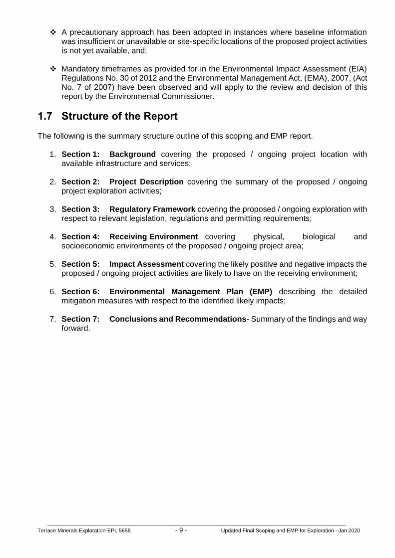
4.5 GROUND COMPONENTS ...................................................................................................................... - 19 - 4.5.1 Geology ....................................................................................................................................... - 19 - 4.5.4 Geotechnical Engineering Considerations .................................................................................. - 20 - 4.5.5 Water Sources ............................................................................................................................ - 21 - 4.5.6 Evaluation of Water Vulnerability ................................................................................................ - 22 -
4.7 PUBLIC CONSULTATIONS AND ENGAGEMENT ........................................................................................ - 25 - 4.7.1 Overview ..................................................................................................................................... - 25 -
5. IMPACT ASSESSMENT RESULTS ........................................................................... - 29 -
5.1 ASSESSMENT PROCEDURE.................................................................................................................. - 29 - 5.2 ALTERNATIVES AND ECOSYSTEM ASSESSMENTS .................................................................................. - 29 -
5.2.2 Summary of Key Issues Considered in the Assessment Process .............................................. - 30 - 5.2.2.1 Sources of Impacts (Proposed / Ongoing Project Activities) ............................................................. - 30 - 5.2.2.2 Likely Environmental Impacts ........................................................................................................... - 31 -
5.3 IMPACT ASSESSMENT CRITERIA .......................................................................................................... - 31 -

Terrace Minerals Exploration-EPL 5658 v Updated Final Scoping and EMP for Exploration –Jan 2020
5.3.1 Approach ..................................................................................................................................... - 31 - 5.4 EVALUATION OF IMPACTS .................................................................................................................... - 36 -
5.4.1 Impact Factors (Project Activities) .............................................................................................. - 36 - 5.4.2 Evaluation of Project Activities Impacts ...................................................................................... - 36 -
5.4.2.1 Summary Overview ........................................................................................................................... - 36 - 5.4.2.2 Severity Criteria for Environmental Impacts ...................................................................................... - 36 - 5.4.2.3 Likelihood (Probability) of Occurrence .............................................................................................. - 37 -
5.4.3 Project Activities Summary of Impacts Results .......................................................................... - 38 - 5.5 EVALUATION OF SIGNIFICANT IMPACTS ................................................................................................ - 55 -
5.5.1 Overview ..................................................................................................................................... - 55 - 5.5.2 Significance Criteria .................................................................................................................... - 55 - 5.5.3 Assessment Likely Significant Impacts ....................................................................................... - 55 -
5.6 ASSESSMENT OF OVERALL IMPACTS .................................................................................................... - 61 - 5.6.1 Summary of the Results of the Impact Assessment ................................................................... - 61 -
6. THE EMP .................................................................................................................... - 62 -
6.1 SUMMARY OF THE EMP OBJECTIVES ................................................................................................... - 62 - 6.2 IMPLEMENTATION OF THE EMP............................................................................................................ - 62 -
6.2.1 Roles and Responsibilities .......................................................................................................... - 62 - 6.2.2 Proponent’s Representative (PR) / Project Manager (PM) ......................................................... - 62 - 6.2.3 Project Health, Safety and Environment (Project HSE) .............................................................. - 63 - 6.2.4 Contractors and Subcontractors ................................................................................................. - 63 -
6.3 SPECIFIC MITIGATION MEASURES ........................................................................................................ - 64 - 6.3.1 Hierarchy of Mitigation Measures Implementation...................................................................... - 64 - 6.3.2 Mitigation Measures Implementation .......................................................................................... - 64 -
6.4 REHABILITATION AND CLOSURE PLAN .................................................................................................. - 81 - 6.4.1 Rehabilitation Process ................................................................................................................ - 81 -
6.5 MONITORING OF THE ENVIRONMENTAL PERFORMANCE ......................................................................... - 83 - 6.5.1 Rehabilitation Evaluation and Performance Monitoring .............................................................. - 83 - 6.5.2 Overall Environmental Performance Monitoring and Reporting ................................................. - 84 -
7. CONCLUSION AND RECOMMENDATION ............................................................... - 86 -
7.1 CONCLUSIONS .................................................................................................................................... - 86 - 7.2 RECOMMENDATIONS ........................................................................................................................... - 86 - 7.3 SUMMARY TOR FOR TEST MINING AND MINING STAGES ....................................................................... - 88 -
8. BIBLIOGRAPHY / REFERENCES ............................................................................. - 89 -

Terrace Minerals Exploration-EPL 5658 vi Updated Final Scoping and EMP for Exploration –Jan 2020
LIST OF FIGURES
Figure 1.1: Copy of the ECC granted on the 1st November 2017 to Cedric Shilongo (Previous Proponent). The ECC need to be transferred to the current Proponent, Terrace Minerals Exploration (Pty) Ltd ....................................... - 2 -
Figure 1.2: Regional location of the EPL ........................................................................ - 3 -
Figure 1.3: Detailed regional location of the EPL 5658................................................... - 5 - Figure 1.4: Commercial farmland covered by the EPL 5658 and existing access. ......... - 6 - Figure 4.1: Regional Hydrogeology of the EPL 5658 ................................................... - 23 - Figure 4.2: Regional groundwater vulnerability around the EPL 5658 - 24 - Figure 4.3: Copy of the public notice that was published in the Confidente
newspaper dated 29th June -5th July 2017. ................................................. - 25 - Figure 4.4: Copy of the public notice that was published in the Observer newspaper
dated 30th June 2017. ................................................................................. - 26 - Figure 4.5: Copy of the public notice that was published in the Republikein
Newspaper dated 21st July 2017. ............................................................... - 27 - Figure 4.6: Copy of the public notice that was published in the Confidente
newspaper dated 20th -26th July 2017. ....................................................... - 28 -
LIST OF TABLES
Table 1.1: Summary of the proposed / ongoing activities, alternatives and key issues considered during the Environmental Assessment (EA) process covering Scoping and Environmental Management Plan (EMP). ................. - 8 -
Table 3.1: Government agencies regulating environmental protection in Namibia. ..... - 12 - Table 3.2: R553 Regional Standards for Industrial Effluent, in Government
Gazette No 217 dated 5 April 1962. ........................................................... - 13 - Table 3.3: Comparison of selected guideline values for drinking water quality ........... - 14 - Table 4.1: Partial Lithostratigraphy of the Damara Sequence in Central Namibia
(Karibib-Swakopmund Area). ..................................................................... - 20 - Table 4.2: General rock structure scheme. ................................................................. - 21 - Table 5.1: The impact matrix for the proposed / ongoing exploration in the EPL No.
5658. .......................................................................................................... - 32 - Table 5.2: Scored on a scale from 0 to 5 for impact magnitude. .................................. - 37 - Table 5.3: Scored time period over which the impact is expected to last. ................... - 37 - Table 5.4: Scored geographical extent of the induced change. ................................... - 37 - Table 5.5: Summary of the qualitative scale of probability categories (in increasing
order of likelihood). ..................................................................................... - 37 - Table 5.6: Results of the scored on a scale from 0 to 5 for negative impact
magnitude. .................................................................................................. - 39 - Table 5.7: Results of the scored time period over which the impact is expected to
last. ............................................................................................................. - 43 - Table 5.8: Results of the scored geographical extent of the induced change. ............ - 47 - Table 5.9: Results of the qualitative scale of probability occurrence. .......................... - 51 - Table 5.10: Scored impact significance criteria. ............................................................ - 55 - Table 5.11: Significant impact assessment matrix for the proposed / ongoing
exploration activities. .................................................................................. - 57 - Table 6.1: Project planning and implementation. ........................................................ - 66 - Table 6.2: Implementation of the EMP. ....................................................................... - 66 - Table 6.3: Public and stakeholders relations. .............................................................. - 67 -

Terrace Minerals Exploration-EPL 5658 vii Updated Final Scoping and EMP for Exploration –Jan 2020
Table 6.4: Measures to enhance positive socioeconomic impacts. ............................. - 67 - Table 6.5: Environmental awareness briefing and training. ......................................... - 68 - Table 6.6: Erection of supporting exploration infrastructure. ....................................... - 68 - Table 6.7: Use of existing access roads, tracks and general vehicle movements. ...... - 69 - Table 6.8: Mitigation measures for preventing flora and ecosystem destruction and
promotion of conservation. ......................................................................... - 70 - Table 6.9: Mitigation measures for preventing faunal and ecosystem destruction
and promotion of conservation. .................................................................. - 71 - Table 6.10: Mitigation measures to be implemented with respect to the exploration
camps and exploration sites. ...................................................................... - 72 - Table 6.11: Mitigation measures for surface and groundwater protection as well as
general water usage. .................................................................................. - 73 - Table 6.12: Mitigation measures to minimise negative socioeconomic impacts. ........... - 74 - Table 6.13: Mitigation measures to minimise health and safety impacts. ...................... - 75 - Table 6.14: Mitigation measures to minimise visual impacts. ........................................ - 76 - Table 6.15: Mitigation measures to minimise vibration, noise and air quality. ............... - 77 - Table 6.16: Mitigation measures for waste (solid and liquid) management. .................. - 78 - Table 6.17: Rehabilitation plan. ..................................................................................... - 79 - Table 6.18: Environmental data collection. .................................................................... - 80 -

Terrace Minerals Exploration-EPL 5658 viii Updated Final Scoping and EMP for Exploration –Jan 2020
NON-TECHNICAL SUMMARY The Exclusive Prospecting License (EPL) No. 5658 was initially held by Cedric Shilongo and has now been transferred to Terrace Minerals Exploration (Pty) Ltd. The EPL No. 5658 was granted on 23/09/2014 and will expiry 23/05/2020. Terrace Minerals Exploration (Pty) Ltd (the Proponent) intends to continue with exploration activities with special focus on base, rare and precious metals. The EPL 5658 covering a total area of 19905.7989 Ha, falls within the north and northeast Karibib Townlands and peripheral farmlands surrounding the town of Karibib in the Erongo Region. The exploration activities to be undertaken as assessed in this environmental assessment are as follows:
(i) Initial desktop exploration activities (no field-work undertaken);
(ii) Regional reconnaissance field-based mapping and sampling activities (Subject to the positive results of (i);
(iii) Initial local field-based mapping and sampling activities (Subject to the positive
results of (i) and (ii) above); (iv) Detailed local field-based activities such as local geological mapping,
geochemical mapping and sampling, trenching and drilling of closely spaced boreholes and bulk sampling (Subject to the positive results of (i) - (iii) above);
(v) Prefeasibility and feasibility studies (Subject to the positive results of (i) and (iv)
above). The proposed exploration activities are listed activities under the Environmental Management Act, 2007, (Act No. 7 of 2007) and cannot be undertaken without an Environmental Clearance Certificate (ECC). This Environmental Scoping and Environmental Management Plan (EMP) report has been prepared by Risk-Based Solutions on behalf of the Proponent in order to support the application for ECC. The population of Karibib Constituency is 13, 320 which accounts for 8.8 percent of the total Erongo Region population. The socioeconomic activities in and around the Town of Karibib are dependent on mining (the QKR Namibia Navachab Gold Mine), farming (small stock and cattle), tourism and trading. It is estimated that at least 86 species of reptile, 7 amphibian, 88 mammal, 216 birds, 79-109 larger trees and shrubs and up to 111 grass species occur in the general/immediate Karibib/Usakos/Omaruru areas surrounding the EPL 5658 of which a high proportion are endemics species (e.g. reptiles 43%). Following the public consultation period that was conducted as part of the environmental assessment process, the Draft Scoping Report as a source of background information and Terms of Reference (ToR) was prepared and a stakeholder register was opened. Despite the newspaper advertisements published in the local newspapers and communications to stakeholders, no written comments / objections / inputs with respect to the proposed minerals prospecting in the EPL No. 5658 were received by the Environmental Assessment Practitioner (EAP). The effect that the proposed / ongoing exploration and associated infrastructure such as access and campsite would have on the receiving environment would depend on the extent of the proposed / ongoing activities over the development area, management of the area and how

Terrace Minerals Exploration-EPL 5658 ix Updated Final Scoping and EMP for Exploration –Jan 2020
the proposed mitigations are eventually implemented by the proponent. Avoiding sensitive habitats such as Ephemeral River channels, rock heads and mountainous terrains as well as track discipline (including no killing/poaching of fauna and unnecessarily cutting down of trees) must be adhered to and/or enforced at all times. The following is the assessment summary of the likely environmental impacts that the proposed / ongoing exploration / prospecting activities will have on the receiving environment (physical, biological, socioeconomic environments and ecosystem functions, services, use and non-use values or passive uses) without mitigations:
(i) Initial desktop exploration activities: Overall likely negative impact on the receiving environment will be negligible with extremely unlikely probability of occurrence without mitigations. Overall significant impacts will be negligible;
(ii) Regional reconnaissance field-based activities: Overall likely negative impact on the receiving environment will be negligible with extremely unlikely probability of occurrence without mitigations. Overall significant impacts will be negligible. Some field-based activities will have localised low impacts with low probability of occurrence without mitigations and negligible with mitigations. Overall significant impacts will be negligible;
(iii) Initial local field-based activities: Initial field-based activities will have localised
low impacts with low probability of occurrence without mitigations and negligible with mitigations. Overall significant impacts will be negligible. All desktop related activities and laboratory assessments will have negligible impacts with extremely unlikely probability of occurrence without mitigations. Overall significant impacts will be negligible;
(iv) Detailed local field-based activities: Overall likely negative impact on the
receiving environment will be high and localised impacts without mitigations and localised low impacts with mitigations. Overall significant impacts will be medium without mitigations and low with mitigations;
(v) Prefeasibility and feasibility studies to be implemented on a site-specific area if
the local field-based studies prove positive: Overall likely negative impact on the receiving environment will be high and localised impacts without mitigations and localised medium impacts with mitigations. Overall significant impacts will be high without mitigations and low with mitigations for bulk sampling, test mining and field logistics including exploration camp.
Based on the findings of this Environmental Assessment covering this Environmental Scoping and Environmental Management Assessment (EMP), it’s hereby recommended that the proposed / ongoing exploration activities be issued with an Environmental Clearance Certificate (ECC) with the following key conditions:
(i) The proponent shall negotiate an Access Agreement with the land owner/s;
(ii) The Proponent shall adhere to all the provisions of the EMP and conditions of the Access Agreement to be entered between the proponent and the land owner/s in line with all applicable national regulations;
(iii) Before entering any private property such as a private farm, the proponent must
give advance notices and obtain access permission from the land owners at all times;

Terrace Minerals Exploration-EPL 5658 x Updated Final Scoping and EMP for Exploration –Jan 2020
(iv) Mitigation measures shall be implemented as detailed in Section 6 (EMP) of this Scoping and EMP report;
(v) Where possible, and if water is found during the detailed exploration boreholes
drilling operations, the proponent shall support other land uses in the area in terms of access to freshwater supply for both human consumption, wildlife and agricultural support as may be requested by the local community / land owners/s. The abstraction of the groundwater resources shall include water levels monitoring, sampling and quality testing on a bi-annual basis, and that the affected landowners must have access to the results of the water monitoring analyses as part of the ongoing stakeholder disclosure requirements on shared water resources as maybe applicable.
Once a viable project has been defined for mining operations (economic resources are delineated) and separate field-based and site-specific Environmental Impact Assessment (EIA) and Environmental Management Plan (EMP) must be implemented as part of the feasibility study with respect to the test mining or possible mining operations. The site-specific EIA and EMP shall cover the area identified to have potential economic minerals resources including the pit / shaft area/s, waste rock, tailings dump, access, office blocks, water and energy infrastructure support areas (water, energy and road / access). In addition to the Terms of Reference (ToR) to be developed during the Environmental Scoping study phase for the test mining / mining stages, the following field-based and site-specific specialist studies shall be undertaken as prat of the EIA and EMP for possible test mining or mining operations in an event of a discovery of economic minerals resources and possible development of a mining project:
(i) Groundwater studies including modelling as maybe applicable;
(ii) Field-based flora and fauna diversity;
(iii) Noise and Sound modelling linked to engineering studies;
(iv) Socioeconomic assessment, and;
(v) Others as may be identified / recommended by the stakeholders/ land owners/ Environmental Commissioner or specialists.

Terrace Minerals Exploration-EPL 5658 - 1 - Updated Final Scoping and EMP for Exploration –Jan 2020
1. BACKGROUND
1.1 Introduction Terrace Minerals Exploration (Pty) Ltd (the Proponent) holds minerals rights under the Exclusive Prospecting License (EPL) No. 5658. The EPL No. 5658 was granted on 23/09/2014 and will expiry 23/05/2020. The Proponent intends to continue with exploration activities with special focus on base, rare and precious metals.
1.2 Regulatory Requirements The proposed minerals exploration / prospecting activities in the EPL 5658 falls under the activities that are listed in the Environmental Management Act, 2007, (Act No. 7 of 2007) and cannot be undertaken without an Environmental Clearance Certificate (ECC). In order to obtain the ECC for the listed activities, the proponent was required to have undertaken Environmental Assessment comprising Environmental Scoping and Environmental Management Plan (EMP) for the proposed minerals prospecting programme. The Environmental Assessment process was undertaken in accordance with the provisions of the Environmental Impact Assessment Regulations, 2012 and the Environmental Management Act, 2007, (Act No. 7 of 2007). In fulfilment of the environmental requirements, the proponent appointed Risk-Based Solutions (RBS) CC as the Environmental Consultants, led by Dr Sindila Mwiya as the Environmental Assessment Practitioner (EAP) to undertake the Scoping and EMP in order to support the application for Environmental Clearance Certificate (ECC). The ECC was granted on the 1st November 2017 to Cedric Shilongo (Previous Proponent). The ECC as shown in Fig. 1.1 need to be transferred to the current Proponent, Terrace Minerals Exploration (Pty) Ltd. This updated Scoping and EMP Report has been prepared in order to support the application for the ECC transfer.
1.3 Location, Site Description, Land Use and Infrastructure
1.3.1 Location
The EPL 5658 is located in central Namibia, approximately 220 km east of the Atlantic Ocean (Fig. 1.2). The EPL 5658 covering a total area of 19905.7989 Ha and is situated to the north and northeast Karibib Townlands and peripheral farmlands surrounding the Town of Karibib, Karibib District, Erongo Region of Namibia. The Town of Karibib is the nearest town to the EPL area (Figs. 1.3 and 1.4). Swakopmund, the regional centre of the Erongo Region and Walvis Bay the main Port are situated about 170 km and 210 km to the west of the EPL area. Namibia’s capital City, Windhoek, is located approximately 124 km southeast of EPL 5649 Area (Fig. 1.1).

Terrace Minerals Exploration-EPL 5658 - 2 - Updated Final Scoping and EMP for Exploration –Jan 2020
Figure 1.1: Copy of the ECC granted on the 1st November 2017 to Cedric Shilongo (Previous
Proponent). The ECC need to be transferred to the current Proponent, Terrace Minerals Exploration (Pty) Ltd.

Terrace Minerals Exploration-EPL 5658 - 3 - Updated Final Scoping and EMP for Exploration –Jan 2020
Figure 1.2: Regional location of the EPL (Source: Updated from Risk-Based
Solutions, 2015).

Terrace Minerals Exploration-EPL 5658 - 4 - Updated Final Scoping and EMP for Exploration –Jan 2020
1.3.2 Site Description
The EPL 5658 area falls within the north and northeast Karibib Townlands and peripheral farmland surrounding the Town of Karibib (Figs. 1.2-1.4). The license area boarders the Karibib Townlands with a major portion covering privately owned commercial farmland and the names and numbers of the farms covered by the EPL area are shown in Fig. 1.4. The EPL 5658 borders the EPLs Nos. 5364 and 3739 to the east, 4692, 5535, 5866, 3275 and 6557 to the south, 5649 and 6725 to the west and 6167 and 6408 to the north. The EPL 5658 area is not pristine and is dominated by a number of old excavations, waste rock and litter linked to the historical exploration activities and other associated current urban and Peri-urban areas land uses. The proposed exploration activities within the EPL 5658 will to some extent address some of the current poor state of the local environment that has not been rehabilitated over many years of historical exploration operations.
1.3.3 Current Land Uses
The land use around the EPL area is dominated by farming (small stock and cattle), tourism and trading within the Town of Karibib, minerals exploration and mining including several EPLs, Mining Claims (MCs), Quarries for dimension stone (marble), small scale mining operations and large-scale mining such as the Navachab Gold. A number of lodges are found in the Town of Karibib and the surrounding areas but not necessary within the EPL boundary. Bush thickening or encroachment is viewed as an economic problem in the general area but does not seem to be an issue within the EPL area. The area is not part of the communal conservancy system in Namibia with no protected area nearby the EPL area.
1.3.4 Supporting Infrastructure and Services
The EPL is accessible via the B2 road linking the towns of Okahandja and Karibib, the C33 road link the towns of Karibib and Omaruru and the D1941 gravel road that comes off the C33 (Figs. 1.3 and 1.4). The proposed / ongoing exploration programme will not require major water and energy resources. Water requirements for exploration will be provided from the available local resources in Karibib, supplied by NamWater as well as local water boreholes. Electricity needs will be supplied by generators and solar installations while diesel and petrol will be the main sources of fuels and all readily available in the Town Karibib. In an event of a discovery of economic minerals resources, and the subsequent development of a mining project within the EPL Area, there will be a need to have reliable energy and water supply sources. Sources of water supply will be provided by NamWater from possible local and regional groundwater resources still to be determined. Electricity supply will be provided by NamPower from already existing infrastructure in the region. The assessment of the energy and water resources requirements for mining operations will be evaluated in detail in the environmental assessment that will be undertaken as part of the feasibility study if economic resources are discovered within the EPL 5658 Area.

Terrace Minerals Exploration-EPL 5658 - 5 - Updated Final Scoping and EMP for Exploration –Jan 2020
Figure 1.3: Detailed regional location of the EPL 5658 (Data Source: http://portals.flexicadastre.com/Namibia).

Terrace Minerals Exploration-EPL 5658 - 6 - Updated Final Scoping and EMP for Exploration –Jan 2020
Figure 1.4: Commercial farmland covered by the EPL 5658 and existing access (Source: Namibia 1:1000000 Registration Divisions Extract).

Terrace Minerals Exploration-EPL 5658 - 7 - Updated Final Scoping and EMP for Exploration –Jan 2020
1.4 Project Motivation The EPL 5658 is situated in a highly prospective area for base, rare and precious metals associated with local rock outcrops comprising pegmatites, limestones, dolomites and schists. Gold and associated minerals are known to occur in the general area. The proposed / ongoing exploration activities has some limited socioeconomic benefits which are mainly centred around the payment of the annual license rental fees to the Central Government through the Ministry of Mines and Energy (MME) and value addition to the potential underground minerals resources in the area which otherwise would not have been known if the exploration in the EPL 5658 did not take place. The potential discovery of additional economic minerals resources and the development of new mining project in the area will have much greater and positive socioeconomic benefits to the local community and the Towns of Karibib and Omaruru. Additional socioeconomic benefits will also be realised at regional and national levels in terms of capital investments, value addition opportunities, license rental fees, royalty taxes payable to Government, direct and indirect contracts and employment opportunities, export earnings, foreign direct investments and various taxes payable to the Government.
1.5 Terms of Reference, Approach and Methodology Risk-Based Solutions (RBS) was appointed by the proponent to prepare the Environmental Scoping and Environmental Management Plan (EMP) report in order to support the Application for Environmental Clearance Certificate (ECC) for the EPL No. 5658 with respect to the proposed exploration activities. The following is summary of the key guiding principles and objectives of this Environmental Scoping and Environmental Management Plan (EMP)
❖ Inform the public about the proposed / ongoing exploration / prospecting programme;
❖ Identify the main stakeholders and their concerns and values; ❖ Define the reasonable and practical alternatives to the proposed / ongoing project
activities; ❖ Identify the important issues and significant impacts to be addressed in the Scoping
and EMP Sections of the Report; ❖ Define the boundaries for Scoping and EMP in time, space and subject matter.
The Scoping desktop study reviewed the receiving environmental settings (physical, biological, socioeconomic and ecosystem services, function, use values and non-use) and proposed / ongoing exploration activities and then assessed the likely impacts (positive and negative) on the receiving environment (Table 1.1). The key deliverable comprised this Environmental Scoping and Environmental Management Plan (EMP) detailing appropriate mitigation measures that will enhance the positive impacts and reduce the likely negative impacts identified. The Final Environmental Scoping and Environmental Management Plan (EMP) report and the completed Application for Environmental Clearance Certificate (ECC) shall be submitted to the client (Proponent) and the Office of the Environmental Commissioner, Department of Environmental Affairs (DEA), Ministry of Environment and Tourism (MET) for review and final decision. The Environmental Scoping and EMP has been performed with reasonable skill, care and diligence in accordance with professional standards and practices existing at the date of performance of the assessment and that the guidelines, methods and techniques that have been applied are all in conformity to the national regulatory requirements, process and specifications in Namibia as required by Ministry of Mines and Energy (MME), Ministry of Environment and Tourism (MET) and the client (Proponent). The Scoping and EMP

Terrace Minerals Exploration-EPL 5658 - 8 - Updated Final Scoping and EMP for Exploration –Jan 2020
has been prepared in line with the January 2015 MET Environmental Assessment Reporting Guideline. Table 1.1: Summary of the proposed / ongoing activities, alternatives and key issues
considered during the Environmental Assessment (EA) process covering Scoping and Environmental Management Plan (EMP).
PROPOSED / ONGOING PROJECT ACTIVITIES
ALTERNATIVES TO BE CONSIDERED
KEY ISSUES TO BE EVALUATED AND ASSESSED WITH ENVIRONMENTAL
MANAGEMENT PLAN (EMP) / MITIGATION MEASURES DEVELOPED
(i) Initial desktop exploration activities (review of existing information and all previous activities in order identify any potential target/s)
(ii) Regional reconnaissance field-
based activities such mapping and sampling to identify areas with potential targets based on the recommendations of the desktop work
(iii) Initial local field-based
activities such as widely spaced mapping, sampling, surveying and possible drilling in order to determine the viability of any delineated local target
(iv) Detailed local field-based
activities such very detailed mapping, sampling, surveying and possible drilling in order to determine the feasibility of any delineated local target
(v) Prefeasibility and feasibility
studies to be implemented on a site-specific area if the local field-based studies prove positive
(i) Location for Minerals Occurrence: A number of economic deposits are known to exist in different parts of Namibia and some have been explored by different companies over the years. The proponent intends to explore / prospect for possible economic minerals occurrence in the EPL area;
(ii) Other Alternative Land Uses: Game Farming, Tourism and Agriculture
(iii) Ecosystem Function (What the Ecosystem Does;
(iv) Ecosystem Services;
(v) Use Values;
(vi) Non-Use, or Passive Use;
(vii) The No-Action Alternative
Potential land use conflicts / opportunities for coexistence between proposed / ongoing exploration and other existing land uses such as conservation, tourism and agriculture
Impacts on the Physical Environment
Natural Environment such as air, noise, water, dust etc.
Built Environment such as existing houses, roads, transport systems, Buildings, energy and water and other supporting infrastructure
Socioeconomic, Archaeological and Cultural impacts on the local societies and communities
Impacts on the Biological Environment
Flora
Fauna
Habitat
Ecosystem functions, services, use values and non-Use or passive use
Others to be identified during the public consultation process and preparation of the Scoping and EMP Report
1.6 Assumptions and Limitations The following assumptions and limitations underpin the approach adopted, overall outcomes and recommendations for this Scoping and EMP study:
❖ The proposed exploration activities as well as all the plans, maps, EPL Boundary / coordinates and appropriate data sets received from the proponent, project partners, regulators, Competent Authorities and specialist assessments are assumed to be current and valid at the time of conducting the studies and compilation of this environmental report;
❖ The impact assessment outcomes, mitigation measures and recommendations
provided in this report are valid for the entire duration of the proposed exploration / prospecting activities;
Terrace Minerals Exploration-EPL 5658 - 9 - Updated Final Scoping and EMP for Exploration –Jan 2020
❖ A precautionary approach has been adopted in instances where baseline information was insufficient or unavailable or site-specific locations of the proposed project activities is not yet available, and;
❖ Mandatory timeframes as provided for in the Environmental Impact Assessment (EIA)
Regulations No. 30 of 2012 and the Environmental Management Act, (EMA), 2007, (Act No. 7 of 2007) have been observed and will apply to the review and decision of this report by the Environmental Commissioner.
1.7 Structure of the Report
The following is the summary structure outline of this scoping and EMP report.
1. Section 1: Background covering the proposed / ongoing project location with available infrastructure and services;
2. Section 2: Project Description covering the summary of the proposed / ongoing project exploration activities;
3. Section 3: Regulatory Framework covering the proposed / ongoing exploration with respect to relevant legislation, regulations and permitting requirements;
4. Section 4: Receiving Environment covering physical, biological and
socioeconomic environments of the proposed / ongoing project area;
5. Section 5: Impact Assessment covering the likely positive and negative impacts the proposed / ongoing project activities are likely to have on the receiving environment;
6. Section 6: Environmental Management Plan (EMP) describing the detailed
mitigation measures with respect to the identified likely impacts;
7. Section 7: Conclusions and Recommendations- Summary of the findings and way forward.

Terrace Minerals Exploration-EPL 5658 - 10 - Updated Final Scoping and EMP for Exploration –Jan 2020
2. DESCRIPTION OF THE EXPLORATION
2.1 General Overview The overall aim of the proposed / ongoing project activities (exploration / prospecting programme) is to search for potential economic minerals resources within the EPL area and in particular base, rare and precious metals. The exploration activities to be undertaken as assessed in this environmental assessment are as follows:
(i) Initial desktop exploration activities (no field-work undertaken);
(ii) Regional reconnaissance field-based mapping and sampling activities (Subject to the positive results of (i);
(iii) Initial local field-based mapping and sampling activities (Subject to the positive results of (i) and (ii) above),
(iv) Detailed local field-based activities such as local geological mapping, geochemical mapping and sampling, trenching and drilling of closely spaced boreholes and bulk sampling (Subject to the positive results of (i) - (iii) above);
(v) Prefeasibility and feasibility studies (Subject to the positive results of (i) and (iv) above).
The field-based support and logistical activities will depend on the scale of proposed exploration activities to be undertaken. The proposed exploration activities will be supported by existing tracks and campsites / farmstead as well as existing accommodation in the Town of Karibib as may be applicable. In the absences of existing tracks, the field team will create such new tracks with the permission of the land owner/s and depending on the scale of exploration. In the absences of existing suitable campsite / farmstead, temporary camp will be setup at suitable locations in line with the EMP provisions within the EPL area. The size of the exploration camp will be of very limited footprints during the exploration phase but may be expanded for the test mining and mine development phases in an event of a discovery of economic minerals resources.
2.2 Proposed Detailed Local Field-Based Activities A number of regional reconnaissance field-based mapping and sampling activities as well as initial local field-based mapping and sampling activities have already been undertaken within the EPL area but will still be extended to other parts of the EPL Area where potential base, rare and precious metals are expected. Other activities to be undertaken as part of the detailed local field-based activities include the following:
(i) Surface and subsurface geological mapping including boreholes drilling and
logging, sampling and laboratory analyses / assessments;
(ii) Trenching, logging, sampling and laboratory analyses of shallow targets; (iii) Baseline studies such as fauna and flora diversity spanning across the seasons
in twelve (12) months and hydrogeological assessments including boreholes drilling and possible groundwater modelling;

Terrace Minerals Exploration-EPL 5658 - 11 - Updated Final Scoping and EMP for Exploration –Jan 2020
(iv) Logistical support such as access preparation, exploration and camp sites management.
2.3 Prefeasibility and Feasibility Study
Prefeasibility and feasibility studies will be implemented on site-specific area and is subject to the positive outcomes of the detailed local field-based exploration activities. The activities to be undertaken as part of the prefeasibility and feasibility will include the following:
(i) Detailed site-specific surveys;
(ii) Detailed geological mapping; (iii) Bulk sampling and testing; (iv) Ore reserve calculations; (v) Geotechnical studies for mine design; (vi) Detailing technical viability studies including forecasts of estimated expenditure
and financial; (vii) Mine planning and designs including all supporting infrastructures (water, energy
and access); (viii) Environmental Impact Assessment for mining; (ix) Environmental Management Plan for mining; (x) Test mining activities; (xi) Preparation of feasibility report and application for Mining License;
Field-based support and logistical activities will be very extensive because the local field-based activities will be undertaken on a specific area for a very long time (up to one year or more in some instances). The activities will be supported by existing tracks and campsites / lodging facilities in Karibib and where suitably available.

Terrace Minerals Exploration-EPL 5658 - 12 - Updated Final Scoping and EMP for Exploration –Jan 2020
3. REGULATORY FRAMEWORK
3.1 Minerals Exploration Legislation and Regulations
The Ministry of Mines and Energy (MME) is the competent authority with respect to minerals prospecting and mining activities in Namibia. The Minerals (Prospecting and Mining) Act (No 33 of 1992) is the most important legal instrument governing minerals prospecting / exploration and mining activities. Several explicit references to the environment and its protection are contained in the Minerals Act, which provides for environmental impact assessments, rehabilitation of prospecting and mining areas and minimising or preventing pollution.
3.2 Environmental Regulations
3.2.1 Environmental Assessment Requirements and Procedures
Environmental Assessment (EA) process in Namibia is governed by the Environmental Impact Assessment (EIA) Regulations No. 30 of 2012 gazetted under the Environmental Management Act, (EMA), 2007, (Act No. 7 of 2007). The proposed / ongoing field–based exploration activities falls within the categories of listed activities that cannot be undertaken without an Environmental Clearance.
3.2.2 Regulatory Authorities
The environmental regulatory authorities responsible for environmental protection and management in relation to the proposed / ongoing project including their role in regulating environmental protection are listed in Table 3.1.
Table 3.1: Government agencies regulating environmental protection in Namibia.
AGENCY RESPONSIBILITY
Ministry of Environment and Tourism (MET)
Issue of Environmental Clearance Certificate (ECC) based on the review and approval of the Environmental Assessments (EA) reports comprising Environmental Scoping, Environmental Impact Assessment (EIA) and Environmental Management Plan (EMP) prepared in accordance with the Environmental Management Act (2007) and the Environmental Impact Assessment Regulations, 2012
Ministry of Mines and Energy (MME)
The competent authority for minerals prospecting and mining activities in Namibia. Issues Exclusive prospecting License (EPL), Mining Licenses (ML) and Mining Claims (license) as well as all other minerals related permits for processing, trading and export of minerals resources
Ministry of Agriculture, Water and Forestry (MAWF)
The Directorate of Resource Management within the Department of Water Affairs (DWA) at the MAWF is currently the lead agency responsible for management of surface and groundwater utilisation through the issuing of abstraction permits and waste water disposal permits. DWA is also the Government agency responsible for water quality monitoring and reporting. The National Botanical Research Institute’s (NBRI) mandate is to study the flora and vegetation of Namibia, in order to promote the understanding, conservation and sustainable use of Namibia’s plants for the benefit of all. The Directorate of Forestry (DOF) is responsible for issuing of forestry permits with respect to harvest, transport, and export or market forest resources.

Terrace Minerals Exploration-EPL 5658 - 13 - Updated Final Scoping and EMP for Exploration –Jan 2020
3.3 Recommendations on Permitting Requirements
It is hereby recommended that the Proponent must follow the provisions of all relevant national regulatory throughout the proposed / ongoing project lifecycle and must obtain the following permits/ authorisations as maybe applicable / required as the proposed project develops:
(i) Valid Exclusive Prospecting License (EPL) as maybe applicable from Department of Mines in the Ministry of Mines and Energy (MME);
(ii) Valid Environmental Clearance Certificate (ECC) from the Department of Environmental Affairs in the Ministry of Environment and Tourism (MET);
(iii) The Proponent shall apply for a fresh water abstraction and waste water discharge
permits from the Department of Water Affairs (DWA) in the Ministry of Agriculture, Water and Forestry (MAWF) before drilling a water borehole and discharge wastewater into the environment respectively, and;
(iv) All other permits as maybe become applicable during the proposed exploration
operations.
3.4 Standards and Guidelines
Industrial effluent likely to be generated by the proposed activities must comply with provisions of the Government Gazette No 217 dated 5 April 1962 (Table 3.2) while the drinking water quality comparative guideline values are shown in Table 3.3.
Table 3.2: R553 Regional Standards for Industrial Effluent, in Government Gazette No 217 dated 5 April 1962.
Colour, odour and taste
The effluent shall contain no substance in concentrations capable of producing colour, odour or taste
pH Between 5.5 and 9.5
Dissolved oxygen At least 75% saturation
Typical faecal coli No typical faecal coli per 100 ml
Temperature Not to exceed 35 °C
Chemical demand oxygen Not to exceed 75 mg/l after applying a correction for chloride in the method
Oxygen absorbed Not to exceed 10 mg/l
Total dissolved solids (TDS)
The TDS shall not have been increased by more than 500 mg/l above that of the intake water
Suspended solids Not to exceed 25 mg/l
Sodium (Na) The Na level shall not have been increased by more than 50 mg/l above that of the intake water
Soap, oil and grease Not to exceed 2.5 mg/l
Other constituents
Residual chlorine 0,1 mg/l as Cl
Free & saline ammonia 10 mg/l as N
Arsenic 0,5 mg/l as As
Boron 1,0 mg/l as B
Hexavalent Cr 0,05 mg/l as Cr
Total chromium 0,5 mg/l as Cr
Copper 1,0 mg/l as Cu
Phenolic compounds 0,1 mg/l as phenol
Lead 1,0 mg/l as Pb
Cyanide and related compounds 0,5 mg/l as CN
Sulphides 1,0 mg/l as S
Fluorine 1,0 mg/l as F
Zinc 5,0 mg/l as Zn

Terrace Minerals Exploration-EPL 5658 - 14 - Updated Final Scoping and EMP for Exploration –Jan 2020
Table 3.3: Comparison of selected guideline values for drinking water quality (after Department of Water Affairs, 2001).
Parameter and
Expression of the results
WHO
Guidelines for Drinking-
Water Quality 2nd
edition 1993
Proposed Council Directive
of 28 April 1995
(95/C/13- 1/03) EEC
Council Directive of 15
July 1980 relating to the
quality intended for
human consumption 80/778/EEC
U.S. EPA
Drinking water Standards and
Health Advisories Table December
1995
Namibia, Department of Water Affairs
Guidelines for the evaluation of drinking-water for human consumption with reference to chemical, physical
and bacteriological quality July 1991
Guideline Value (GV)
Proposed Parameter
Value
Guide Level (GL)
Maximum Admissible Concentration (MAC)
Maximum Contaminant Level
(MCL)
Group A Excellent Quality
Group B Good
Quality
Group C Low
Health Risk
Group D Unsuitable
Temperature t °C - - 12 25 - - - - -
Hydrogen ion concentration
pH, 25° C - R <8.0 6.5 to 9.5 6.5 to 8.5
10 - 6.0 to 9.0 5.5 to 9.5 4.0 to 11.0 <4.0 to >11.0
Electronic conductivity
EC, 25° C
mS/m
- 280 45 - - 150 300 400 >400
Total dissolved solids
TDS mg/l R 1000 - - 1500 - - - - -
Total Hardness CaCO3 mg/l - - - - - 300 650 1300 >1300
Aluminium Al μ g/l R 200 200 50 200 S 50-200 150 500 1000 >1000
Ammonia NH4+ mg/l R 1.5 0.5 0.05 0.5 - 1.5 2.5 5.0 >5.0
N mg/l 1.0 0.04 0.4 - 1.0 2.0 4.0 >4.0
Antimony Sb μ g/l P 5 3 - 10 C 6 50 100 200 >200
Arsenic As μ g/l 10 10 - 50 C 50 100 300 600 >600
Barium Ba μ g/l P 700 - 100 - C 2000 500 1000 2000 >2000
Berylium Be μ g/l - - - - C 4 2 5 10 >10
Bismuth Bi μ g/l - - - - - 250 500 1000 >1000
Boron B μ g/l 300 300 1000 - - 500 2000 4000 >4000
Bromate BrO3 - μ g/l - 10 - - P 10 - - - -
Bromine Br μ g/l - - - - - 1000 3000 6000 >6000
Cadmium Cd μ g/l 3 5 - 5 C 5 10 20 40 >40
Calcium Ca CaCO3
mg/l - - 100 - - 150 200 400 >400
mg/l - - 250 - - 375 500 1000 >1000
Cerium Ce μ g/l - - - - - 1000 2000 4000 >4000
Chloride Cl- mg/l R 250 - 25 - S 250 250 600 1200 >1200
Chromium Cr μ g/l P 50 50 - 50 C 100 100 200 400 >400
Cobalt μ g/l - - - - - 250 500 1000 >1000
Copper after 12 hours in pipe
Cu μ g/l P 2000 2 100 - C TT## 500 1000 2000 >2000
μ g/l - - 30001 - S 1000 - - - -
Cyanide CN- μ g/l 70 50 - 50 C 200 200 300 600 >600
Fluoride F- mg/l 1.5 1.5 - at 8 to 12 oC: 1.5
C 4 1.5 2.0 3.0 >3.0
mg/l - - - at 25 to 30 oC: 0.7
P,S 2 - - - -
Gold Au μ g/l - - - - - 2 5 10 >10
Hydrogen sulphide
H2S μ g/l R 50 - - undetectable - 100 300 600 >600
Iodine I μ g/l - - - - - 500 1000 2000 >2000
Iron Fe μ g/l R 300 200 50 200 S 300 100 1000 2000 >2000
Lead Pb μ g/l 10 10 - 50 C TT# 50 100 200 >200
Lithium Li μ g/l - - - - - 2500 5000 10000 >10000
Magnesium Mg mg/l - - 30 50 - 70 100 200 >200
CaCO3 mg/l - - 7 12 - 290 420 840 >840
Manganese Mn μ g/l P 500 50 20 50 S 50 50 1000 2000 >2000
Mercury Hg μ g/l 1 1 - 1 C 2 5 10 20 >20
Molybdenum Mo μ g/l 70 - - - - 50 100 200 >200
Nickel Ni μ g/l 20 20 - 50 - 250 500 1000 >1000
Nitrate* NO3-
N mg/l P 50 50 25 50 45 45 90 180 >180
mg/l - - 5 11 C 10 10 20 40 >40
Nitrite* NO2-
N mg/l 3 0.1 - 0.1 3 - - - -
mg/l - - - C 1 - - - -
Oxygen, dissolved
O2 % sat.
- 50 - - - - - - -
Phosphorus P2O5
PO43-
μ g/l - - 400 5000 - - - - -
μ g/l - - 300 3350 - - - - -
Potassium K mg/l - - 10 12 - 200 400 800 >800
Selenium Se μ g/l 10 10 - 10 C 50 20 50 100 >100
Silver Ag μ g/l - - - 10 S 100 20 50 100 >100
Sodium Na mg/l R 200 - 20 175 - 100 400 800 >800
Sulphate SO42- mg/l R 250 250 25 250 S 250 200 600 1200 >1200
Tellurium Te μ g/l - - - - - 2 5 10 >10
Thallium TI μ g/l - - - - C 2 5 10 20 >20
Tin Sn μ g/l - - - - - 100 200 400 >400
Titanum Ti μ g/l - - - - - 100 500 1000 >1000
Tungsten W μ g/l - - - - - 100 500 1000 >1000
Uranium U μ g/l - - - - P 20 1000 4000 8000 >8000
Vanadium V μ g/l - - - - - 250 500 1000 >1000
Zinc after 12 hours in pipe
Zn μ g/l R 3000 - 100 - S 5000 1000 5000 10000 >10000
μ g/l - - 5000 - - - - - -
P: Provisional R: May give reason to complaints from consumers
C: Current; P: Proposed; S: Secondary; T#: Treatment technique in lieu of numeric MCL; TT##: treatment technique triggered at action level of 1300 μ g/l

Terrace Minerals Exploration-EPL 5658 - 15 - Updated Final Scoping and EMP for Exploration –Jan 2020
4. SUMMARY OF NATURAL ENVIRONMENT
4.1 Climate The EPL 5658 is located in the Karibib District, Erongo Region in central Namibia with daytime warm to hot temperatures throughout the year, while the nights are mild to cool in winter. The mean annual rainfall is highly variable and may range between 200 - 300 mm in some parts of the EPL Area. The distribution of rainfall is extremely seasonal with almost all the rain falling in summer - from November to April with occasional with mean annual gross evaporation of about 3300 mm. The local project area has the following three distinct seasons:
❖ A dry and relatively cool season from April to August with average daytime highs of 23°C and virtually no rainfall during this period;
❖ A hot and dry season from September to December with minimal and variable rainfall falling (<20mm per month) and average daytime highs of 30°C, which regularly exceed 40°C, and;
❖ A hot and rainy season from January through to March with >50mm per month falling during this period (although this is extremely variable) and average high temperatures of 29°C.
The project area does not have a weather station with reliable wind records. However, based on the regional wind patterns, the prevailing wind in the area seems to be dominated by winds from the north eastern and southwest quadrants. Locally, the situation may be different dues various influences including topographic effects.
4.2 Topography The terrain around the EPL 5658 is rocky and rugged in nature with steep slopes characterising the mountainous sections whilst the foothills of the mountains are flat and gently undulating. The drainage of the area is dendritic in nature with ephemeral streams, often steeply incised, forming small early stage tributaries of the Khan Ephemeral River and a tributary of the Swakop River which one of the major ephemeral rivers of western Namibia.
4.3 Vertebrate Fauna and Flora Diversity
4.3.1 Reptiles
The high percentage of endemic reptile species (43%) associated with the rocky escarpment region of central western Namibia underscores the importance of this area without formal state protection. The most important species expected to occur in the general area are viewed as the tortoise Stigmochelys pardalis; pythons – P. anchietae and P. natalensis – Varanus albigularis and some of the endemic and little-known gecko species – e.g. Pachydactylus species. Tortoises, snakes and monitor lizards are routinely killed for food or as perceived threats. Other important species are those viewed as “rare” – i.e. Rhinotyphlops lalandei, Mehelya vernayi & Afroedura africana – although very little is known about these species. An important, albeit little known and understudied species occurring in the Karibib area, is the Namibian Wolf Snake (Lycophidion namibianum) (Haacke and Branch pers. com.). Indiscriminate killing of snakes is a threat to little known species. The most important habitat is the rocky outcrops.

Terrace Minerals Exploration-EPL 5658 - 16 - Updated Final Scoping and EMP for Exploration –Jan 2020
4.3.2 Amphibians
Of the seven species of amphibians that potentially could occur in the general area, 2 species are endemic (Poyntonophrynus hoeschi and Phrynomantis annectens) (Griffin 1998b) and 1 species is classified as “near threatened” (Pyxicephalus adspersus) (Du Preez and Carruthers 2009) – i.e. high level (42.9%) of amphibians of conservation value from the general area. Pyxicephalus adspersus is also more common in northern Namibia where it faces severe anthropomorphic pressure (Griffin pers. com). With the exception of these important species and due to the fact that there is no open permanent surface water in the general area, amphibians are not viewed as very important in the dry western part of Namibia. The most important amphibian habitat is probably the ephemeral Khan (north of Karibib) and Swakop Rivers (south of Karibib) and associated tributaries; fountains; farm reservoirs; ground dams and sewage works.
4.3.3 Mammals
Of the at least 88 species of mammals known and/or expected to occur in the general Karibib/Usakos/Omaruru areas, 10 species (11.4%) as endemic while the Namibian legislation further classifies 5 species as vulnerable, 2 species as rare, 3 species as specially protected game, 9 species as protected game and 5 species as insufficiently known. The most important species from the general area are probably those classified as rare (e.g. Cistugo seabrai & Atelerix frontalis angolae) and vulnerable (e.g. Galago moholi, Proteles cristatus, Hyaena brunnea, Acinonyx jubatus, Felis silvestris, Otocyon megalotis, Vulpes chama & Giraffa camelopardalis) under the Namibian legislation and near threatened (e.g. Eidolon helvum, Hipposideros commersoni, Hipposideros vittatus, Hyaena brunnea & Panthera pardus) and vulnerable (e.g. Acinonyx jubatus, Equus zebra hartmannae) by the IUCN (IUCN 2016). The most important habitat is the rocky outcrops and Khan River & Swakop Rivers habitat.
4.3.4 Avifauna
At least 216 bird species [mainly terrestrial “breeding residents”] occur and/or could occur in the general Karibib/Usakos/Omaruru areas at any time and include 12 of the 14 Namibian endemics (85.7% of all Namibian endemic species or 5.6% of all the species expected to occur in the area). The most important endemic species known/expected to occur in the general area are viewed as Monteiro’s Hornbill (Tockus monteiri), Damara Hornbill (Tockus damarensis), Ammomanopsis grayi (Gray’s Lark), Namibornis herero (Herero Chat), Eupodotis rueppellii (Rüppell’s Korhaan) and Poicephalus rueppellii (Rüppell’s Parrot). All the birds listed as endangered, vulnerable and near threatened are also viewed as important. The most important habitat is the rocky outcrops and Khan River riparian vegetation.
4.3.5 Trees and Shrubs
At least 79 to 109 larger species of trees and shrubs are known and/or expected to occur in the general area of which of these 5 species are classified as endemic (4.6%) and 4 species as near endemic (3.7%), 24 species (22%) protected by Forestry laws, 5 species (4.6%) protected by the Nature Conservation Ordinance No. 4 of 1975 and 4 species (3.7%) classified as CITES Appendix II species. The most important species are viewed as Cyphostemma bainesii (endemic, Forestry#, NC), Cyphostemma currorii (Forestry#, NC), Cyphostemma juttae (endemic, Forestry#, NC), Erythrina decora (endemic, Forestry#), Heteromorpha papillosa (endemic) and Manuleopsis dinteri (endemic). These species are often associated with rocky outcrops indicating the importance of such geological features in the Karibib/Usakos/Omaruru areas. The endemic grass – Eragrostis omahekensis – is viewed as

Terrace Minerals Exploration-EPL 5658 - 17 - Updated Final Scoping and EMP for Exploration –Jan 2020
the most important species potentially occurring in the general area. The most important habitat is the rocky outcrops and Khan River habitat.
4.3.6 Other Flora Species
Aloes are protected throughout Namibia with 5 other aloe species not included in Table 7, but which potentially occur in the general area, and also viewed as important are Aloe asperifolia, A. dinteri, A. hereroensis, A. namibensis and A. zebrina (Rothmann 2004). Many endemic Commiphora species are found throughout Namibia with Steyn (2003) indicating that Commiphora crenato-serrata (not included in the Table 7) potentially also occurring in the general area. Other species with commercial potential that could occur in the general area include Harpagophytum procumbens (Devil’s claw) – harvested for medicinal purposes and often over-exploited – and Citrullus lanatus (Tsamma melon) which potentially has a huge economic benefit (Mendelsohn et al. 2002). Lithops species – all protected (See Nature Conservation Ordinance No. 4 of 1975) – are also known to occur in the general area and often difficult to observe, especially during the dry season when their aboveground structures wither. At least two species of Lithops are known to occur in the Usakos area – Lithops gracilidelineata var. gracilidelineata and L. werneri – and are viewed as important (Cole and Cole 2005). At least 64 species of ferns, of which 13 species being endemic, occur throughout Namibia. Ferns in the general area include at least 15 indigenous species (Actiniopteris radiata, Asplenium cordatum, Cheilanthes dinteri, C. eckloniana, C. marlothii, C. parviloba, Marselia aegyptiaca, M. ephippiocarpa, M. farinosa, M. macrocarpa, M. nubica, M. unicornis, M. vera, Ophioglossum polyphyllum & Pellaea calomelanos) (Crouch et al. 2011). The general area is undercollected with more species probably occurring in the general area than presented above. The overall diversity of lichens is poorly known from Namibia, especially the coastal areas and statistics on endemicity is even sparser (Craven 1998). More than 100 species are expected to occur in the Namib Desert with the majority being uniquely related to the coastal fog belt. Lichen diversity is related to air humidity and generally decreases inland form the Namibian coast (Schults and Rambold 2007). Off road driving is the biggest threat to these lichens which are often rare and unique to Namibia. To indicate how poorly known lichens are from Namibia, the recent publication by Schultz et al. (2009) indicating that 37 of the 39 lichen species collected during BIOTA surveys in the early/mid 2000’s was new to science (i.e. new species), is a case in point. The most important lichen habitat is viewed as the Erongo Mountains; granite domes and other rocky areas.
4.3.7 Fauna and Flora Conclusions Species most likely to be adversely affected by the proposed exploration and possible mining operations within the EPL 5658 would be the variety of reptiles and birds specifically associated with the proposed development site(s) as well as the potential effect such development may have on carnivores as well as the protected and unique flora. As all development have potential negative environmental consequences, identifying the most important fauna and flora species including high risk habitats beforehand, coupled with environmentally acceptable mitigating factors, lessens the overall impact of such development. The following is the summary of the most important fauna and flora (habitat) areas within the EPL area:

Terrace Minerals Exploration-EPL 5658 - 18 - Updated Final Scoping and EMP for Exploration –Jan 2020
(i) Erongo Mountains [botanical richness and endemic vertebrates];
(ii) Granite domes and other rocky outcrops [biotic richness and endemism];
(iii) Local Ephemeral Rivers – Tributaries and the main Khan [biotic richness, large desert-dwelling mammals, high value for human subsistence and tourism].
The following is summary of the key aspect of the proposed exploration programme likely to have some negative impacts on the receiving environment:
(i) Access routes - Localised disruption/destruction of the habitat and thus consequently fauna associated directly with the actual routes. This however, would be a relatively small area with localised implications because the proponent will utilise the already existing extensive access routes;
(i) Excavation, trenching/ drilling sites - Localised disruption/destruction of the habitat and thus consequently fauna associated directly with the actual sites. This however, would be a relatively small area and will depend on scale of the operations resulting in localised implications;
(ii) Supporting Infrastructure including campsite - Localised disruption/destruction of the
habitat and thus consequently fauna associated directly with the actual sites. This however, would be a relatively small area – especially if the existing (albeit ruins) infrastructure areas are used rather than affecting new sites – with localised implications.
4.4 Socioeconomic Setting
4.4.1 Overview
The nearest Town to the EPL 5658 is the mining Town of Karibib. The development of this project will have some socioeconomic contributions to the Town of Karibib which currently is dependent on the Navachab Gold Mine. There will be temporary employment opportunities and workers from the project area will be staying in the Town of Karibib. Potential for the development of a viable mining project will bring added local benefits and contribute to the national economy through taxes, royalty and direct investment.
4.4.2 Agriculture
As an important cattle, game and small stock (goats and sheep) farming area (and consequently a source of employment) as well as renewed interest from a tourism point of view, the importance of the western central Namibia to the GDP of Namibia is invaluable. The area surrounding EPL 5658 area falls within the long established private commercial farming communities. The carrying capacity for the general area is 10-20kg/ha (Mendelsohn et al. 2002) or 12-15LAU/ha (van der Merwe 1983) and the risk of farming is viewed as relatively high. Small stock farming is the dominant farming activity in the Karibib area with between 70-80% of stock farmed with being sheep and 20-30% goats and cattle, respectively (van der Merwe 1983). The stock density is estimated at <3sheep/km² (1.5% of total sheep in Namibia) and <1cattle/km² (1.3% of total cattle in Namibia) (van der Merwe 1983). There are numerous existing tourism ventures in the area with the tourism potential viewed as relatively high (Mendelsohn et al. 2002).

Terrace Minerals Exploration-EPL 5658 - 19 - Updated Final Scoping and EMP for Exploration –Jan 2020
4.4.3 Conservation and Tourism
The area does not fall within a Communal Conservancy with the closest being ǂGaingu located in the Spitskoppe area to the west of Karibib, neither within a Freehold (i.e. commercial) Conservancy with Okawi being the closest, east of Karibib (Mendelsohn et al. 2002, NACSO 2006, 2010). The area is not well known for tourism and it does not have major tourism products such as unique natural landscapes, cultural resources or nature parks.
4.4.4 Safety, Security and Obstructions
Current safety issues include steep slopes / gullies / valleys, excavations and minor scattered scrap metals. Generally, there will be a need to ensure that all employees and the general public and visitors to the EPL area are safe. The entire proposed development will not cause any obstruction to human or fauna.
4.5 Ground Components
4.5.1 Geology
The EPL 5658 falls within the Central Zone of the Damara Sequence which underlies most of Namibia. The oldest rocks within the Central Zone are the pre-Damaran basement that consists of gneiss and granite lithologies found in different parts of the zone (Miller, 1992). According to Miller, (1983a), the sequence was deposited during successive phases of rifting, spreading, subduction and continental collision. Much of the basal succession (Nosib Group), laid down in or marginal to intracontinental rifts, consists of quartzite, arkose, conglomerate, phyllite, calc-silicate, subordinate, limestone and evaporitic rocks. Local alkaline ignimbrites with associated subvolcanic intrusions ranging from 840 to 720 million years in age also form part of the regional geology (Miller, 1992). According to Miller, (1992), widespread carbonate deposition followed and overlapped far beyond early rift shoulders (Kudis, Ugab and basal Khomas Subgroups); interbedded mica and graphitic schist, quartzite (some ferruginous), massflow deposits, iron-formation and local within-plate basic lava point to fairly variable depositional conditions south of a stable platform where only carbonates with very minor clastics occur (Otavi Group). Near the southern margin of the orogen, deep-water fans, facies equivalents of the carbonates were deposited on either side of a Southern Zone ocean separating Kalahari and Congo Cratons (Auas and Tinkas Formations). Thick schistose metagreywacke and metapelite (Kuiseb Formation) overlie the above rocks. The lithostratigraphy of the Damara Sequence in the Central Zone (CZ) in which the EPL 5658 falls has been reviewed and significantly revised by Badenhorst (1987), who has also correlated the stratigraphy across the Omaruru Lineament. The stratigraphy of the CZ taken from Steven (1993) as slightly modified after Badenhorst, (1987) and (1988) is given in Table 4.1.

Terrace Minerals Exploration-EPL 5658 - 20 - Updated Final Scoping and EMP for Exploration –Jan 2020
Table 4.1: Partial Lithostratigraphy of the Damara Sequence in Central Namibia (Karibib-Swakopmund Area) (Source: Venmyn Deloitte, 2014).
GROUP SUB-GROUP FORMATION THICKNES
S (m) LITHOLOGICAL DESCRIPTION
Swakop
Khomas
Kuiseb
3,000
Biotite-rich quartzo-feldspathic schist, biotite-garnet-cordierite schist, minor amphibolite schist, quartzite, calc-silicate rock and marble.
Karibib 700 Marble, biotite schist, quartz schist and calc-silicate rock.
Chuos 700 Diamictite, pebble- and boulder-bearing schist and minor quartzite
Discordance
Ugab
Rössing
200
Very variable marble, quartzite, conglomerate, biotite schist, biotite cordierite schist and gneiss, aluminous gneiss, biotite-hornblende schist and calc-silicate schist.
Unconformity or conformable transition
Nosib Khan 1,100 Various gneisses, quartzite, schist, conglomerate, minor marble, amphibolite and calc-silicate rock.
Etusis 3,500 Layered light-red to greyish-brown quartzites with high feldspar content. In-between para-gneisses, biotite schists and conglomerates occur.
4.5.4 Geotechnical Engineering Considerations
Rocks of varying geotechnical characteristics are expected within the pegmatite zones and alternating bands within the banded dolomitic marble and biotite-quartz schist country rock and covered by a variety of sediments in some places. No field and laboratory assessment of rock mass and detailed discontinuities survey were undertaken as part of this study. Table 4.2 outlines an indicative classification of the various discontinuities that are likely to be found in the area. Both low and high order discontinuities are likely to be found around the EPL area. It’s highly recommended that a field-based geotechnical engineering assessment followed by laboratory assessments must be undertaken before the implementation deep excavation in order to have accurate figures of all the key geotechnical parameters.

Terrace Minerals Exploration-EPL 5658 - 21 - Updated Final Scoping and EMP for Exploration –Jan 2020
Table 4.2: General rock structure scheme (Source: Mwiya, 2004).
GEOMETRY
CHARACTERISTIC
EX
AM
PL
E
INF
LU
EN
CE
IN
DIC
AT
OR
DIS
CO
NT
INU
ITY
LE
NG
TH
m
SP
AC
ING
m
WID
TH
m
TR
AN
SM
ISS
IVIT
Y
m2/s
HY
DR
AU
LIC
CO
ND
UC
TIV
ITY
m/s
INF
ILL
ING
TH
ICK
NE
SS
m
LOW ORDER DISCONTINUITIES; ZONES OUTCROPS 1ST
ORDER
>104 >103 >102 10-5 - 10-2 10-7- 10-5
AV. [10-6] 100 Regional major fault
systems
4 V. High
2ND ORDER
103 - 104 102- 103 101 – 102 10-7 - 10-4 10-8 – 10-6
AV. [10-7] 10-1 Local major fault
zones
3RD ORDER
102 – 103 101 – 102 100 - 101 10-9 – 10-6 10-9 – 10-7
AV. [10-8] 10-2
Local minor fault zones
HIGH ORDER DISCONTINUITIES: INDEPENDENT OUTCROPS 4TH
ORDER
101 – 102 100- 101 - - 10-11-10-9 AV.[10-10]
- Local major joint set or bedding
3 High 5TH
ORDER
100 - 101 10-1 - 100 - - 10-12-10-10 AV. [10-11]
- Local minor joints/ fractures
6TH ORDER
10-1 - 100 10-2 – 10-1 - -
10-13-10-11 AV. [10-12]
- Local minor fissures / schistosity
2 Low
7TH ORDER
<10-1 <10-2 - - <10-13 - Crystalline voids
1 V. Low
4.5.5 Water Sources
Groundwater as well as surface water (only during the rainy season) from ephemeral river channels is the sources of water supply in the area as well as much of the Erongo Region. According to the Department of Water Affairs, (2001), the Erongo Region and in particular the Karibib and the EPL area generally has a low groundwater potential (Fig. 4.3). The area with aquifer potential, more or less reflects the rainfall distribution, decreasing westwards. Knowledge of the aquifers in this area is sparse, due to the low number of boreholes and few on groundwater. Recharge from rainfall is an important parameter determining the groundwater potential, but the degree of metamorphism affects the groundwater potential too. The groundwater potential of rocks decreases, as the degree of metamorphism increases. Crystalline rocks normally exhibit a very low tendency to store water, typical of the pegmatite zones and the alternating bands within the banded dolomitic marble and biotite-quartz schist found within the project area (Fig. 4.3). The groundwater potential of these rock units is generally low, to locally moderate. Possible targets for water resources in this area are mainly fractured zones and faults that outcrop on the surface without impermeable infillings. But the success rate and yields for these rock types are generally low. The area along major ephemeral rivers may be more promising due to well developed fractures and faults that give rise to good recharge potential during the rainy season. There is a NamWater Navachab mine water supply pipeline from the Swakoppoort Dam in the area, which dams the ephemeral Swakop River. The water supply pipeline dedicated for Navachab Gold Mine is located within the close proximity of the EPL area.

Terrace Minerals Exploration-EPL 5658 - 22 - Updated Final Scoping and EMP for Exploration –Jan 2020
4.5.6 Evaluation of Water Vulnerability
Vulnerability assessment of surface water covered possible runoff, the presence of source factors and major flow routes such as major high order discontinuities (Table 4.2), ephemeral river channels, valleys and gullies as pathways and the presence of surface water body as a target (Figs. 4.1 and 4.2). The groundwater assessments covered hydraulic properties and thickness of the unsaturated and saturated zones derived from geological and hydrogeological data. The assessment of the unsaturated characteristics was based on the ability for source factors to influence the system through known pathway factors such as discontinuities. The combined effects of unsaturated and saturated flow probabilities were used as indicator for groundwater vulnerability. However, groundwater or surface water will only be vulnerable to contamination if the following three (3) component are all present at the same time and at a site-specific area within the EPL:
(i) Contaminant sources resulting from proposed exploration programme;
(ii) Potential pathways for contaminant migration such as major high order discontinuities (Table 4.2), ephemeral river channels, valleys and gullies;
(iii) Targets (economic water resources) present within the project area. Overall, the limited local groundwater resources found in the area form part of the poorly developed metamorphic rocks based confined and unconfined aquifer system that is moderately vulnerable to any sources of pollution (Figs. 4.1 and 4.2). During the rainy season, surface water bodies can be found along the local ephemeral river system of the Aroab Ephemeral River. This surface water often recharges the local groundwater resources along the faults, solutions holes and other discontinuities along the ephemeral rivers in the general surrounding EPL area because the Aroab Ephemeral River channel found around the EPL area flows into the Khan Ephemeral River near the Town of Usakos and the Khan Ephemeral River flows into the Swakop Ephemeral River (Figs. 4.1 and 4.2). Therefore, surface water in the local EPL area is more vulnerable to pollution sources associated with some of the proposed local field-based detailed prospecting / exploration activities such as drilling and trenching as well as supporting activities such as campsite and discharge of liquid and solid waste. It is important that all polluting activities must not be placed or undertaken in areas with high order discontinuities, valleys or gullies connected to Khan and Aroab Ephemeral River systems in the area. Discharge of waste into a public stream is prohibited.
Terrace Minerals Exploration-EPL 5658 - 23 - Updated Final Scoping and EMP for Exploration –Jan 2020
Figure 4.1: Regional Hydrogeology of the EPL 5658 (Source: Department of Water Affairs and Forestry, 2001).

Terrace Minerals Exploration-EPL 5658 - 24 - Updated Final Scoping and EMP for Exploration –Jan 2020
Figure 4.2: Regional groundwater vulnerability around the EPL 5658 (Source: Department of Water Affairs and Forestry, 2001).

Terrace Minerals Exploration-EPL 5658 - 25 - Updated Final Scoping and EMP for Exploration –Jan 2020
4.7 Public Consultations and Engagement
4.7.1 Overview
Public consultation and engagement process have been part of the environmental assessment process for this project. Public notices were published in the local newspapers during the months of June and July 2017 (Figs. 4.3 - 4.6 and Annex 2). Through the newspaper advertisements as shown in Figs. 4.3 - 4.6 the public were invited to submit written comments / inputs / objections with respect to the proposed / ongoing minerals exploration activities in the EPL 5658. A stakeholder register was opened and despite telephonic inquiries with respect to contracts and employment opportunities, no written comments / inputs / objections were received during the two (2) months period from June – July 2017 that was dedicated for public consultations.
Figure 4.3: Copy of the public notice that was published in the Confidente newspaper dated 29th June -5th July 2017.

Terrace Minerals Exploration-EPL 5658 - 26 - Updated Final Scoping and EMP for Exploration –Jan 2020
Figure 4.4: Copy of the public notice that was published in the Observer newspaper dated 30th June 2017.

Terrace Minerals Exploration-EPL 5658 - 27 - Updated Final Scoping and EMP for Exploration –Jan 2020
Figure 4.5: Copy of the public notice that was published in the Republikein Newspaper dated 21st July 2017.

Terrace Minerals Exploration-EPL 5658 - 28 - Updated Final Scoping and EMP for Exploration –Jan 2020
Figure 4.6: Copy of the public notice that was published in the Confidente newspaper dated 20th -26th July 2017.

Terrace Minerals Exploration-EPL 5658 - 29 - Updated Final Scoping and EMP for Exploration –Jan 2020
5. IMPACT ASSESSMENT RESULTS
5.1 Assessment Procedure The Environmental Assessment process that has been undertaken with respect to the proposed exploration programme for the EPL No. 5658 has been conducted in accordance with the provisions of the Environmental Impact Assessment (EIA) Regulations No. 30 of 2012 gazetted under the Environmental Management Act, (EMA), 2007, (Act No. 7 of 2007).
5.2 Alternatives and Ecosystem Assessments The following alternatives have been considered:
(i) EPL Location: A number of economic minerals deposits are known to exist in in the general area linked to the regional geology of the EPL area. The proponent intends to explore / prospect for all licensed minerals groups likely to be associated with the regional and local geology. The minerals occurrences are site-specific and related to the regional and local geology of a specific area to which there are no alternatives sites to consider. The only other alternative is the no-action option (no exploration activities are implemented);
(ii) The No-Action Alternative - A comparative assessment of the environmental
impacts of the ‘no-action’ alternative (a future in which the proposed / ongoing exploration activities do not take place) has been undertake. An assessment of the environmental impacts of a future, in which the proposed / ongoing exploration and possible discovery of economic minerals resources does not take place, may be good for the receiving environment because there be no negative environmental impacts due to the proposed minerals exploration or possible mining operation that may take place in the EPL area in an event of a discovery of economic minerals resources. The environmental benefits will include no negative environmental impact on the receiving environment. However, it is important to understand that even if the proposed / ongoing exploration activities do not take, to which the likely negative environmental impacts are likely to be low and localised, the current and other future land uses such as agriculture and tourism will still have some negative impacts on the receiving environment.
The likely negative environmental impacts of other current and future land use that may still happen in the absence of the proposed / ongoing minerals exploration activities includes: Land degradation due to drought, poor land management practices, erosion and overgrazing. Furthermore, it’s also important to understand what benefits might be lost if the proposed / ongoing exploration activities do not take place. Key loses that may never be realised if the proposed / ongoing project activities do not go-ahead include: Loss of potential added value to the unknown underground minerals resources that maybe found within the EPL No. 5658, socioeconomic benefits derived from current and future exploration and possible mining capital investments, rehabilitation of old excavations within the EPL Area, license rental fees, royalties payable to Government, direct and indirect contracts and employment opportunities, export earnings, foreign direct investments and various taxes payable to the Government;
(iii) Other Alternative Land Uses: The EPL area fall within the commercial agricultural land uses area dominated by small stock farming. Minerals exploration and mining activities are well known land uses options in Namibia and the local EPL area and
Terrace Minerals Exploration-EPL 5658 - 30 - Updated Final Scoping and EMP for Exploration –Jan 2020
has existed in the general area since 1950s. Due to the limited scope of the proposed / ongoing exploration and the implementation of the EMP, it’s likely that the proposed / ongoing exploration can coexist with the current land uses;
(iv) Potential Land Use Conflicts: Considering the current land use practices (small
stock farming and tourism) as well as potential other land uses including exploration, it’s likely that the economic spin-off from any positive exploration outcomes leading to the development of a mine in the general area can still co-exist with the existing and potential future land use options of the general area. However, much more detail assessment of any likely visual and other socioeconomic impacts will need to be undertaken as part of the full EIA that must be undertaken as part of the prefeasibility and feasibility studies if economic minerals resources are discovered. The use of thematic mapping thereby delineating zones for specific uses such as conservation, mining or tourism etc, within the EPL area will greatly improve the multiple land use practices and promote coexistence;
(v) Ecosystem Function (What the Ecosystem Does): There are wildlife habitats,
carbon cycling or the trapping of nutrients and characterised by the physical, chemical, and biological processes or attributes that contribute to the self-maintenance of an ecosystem in this area. The proposed / ongoing exploration activities will not affect the ecosystem function due to the limited scope of the proposed / ongoing activities because the ecosystem of this EPL area is part of the larger local and regional ecosystems which are all interlinked;
(vi) Ecosystem Services: Food chain, harvesting of animals or plants, and the
provision of clean water or scenic views are some of the local ecosystem services associated with the EPL area. However, the proposed / ongoing exploration activities will not affect the ecosystem services due to the limited scope and area of coverage of the proposed / ongoing activities because the ecosystem of this EPL area is part of the larger local and regional ecosystems which are all interlinked;
(vii) Use Values: The EPL area has direct use for other land uses such as agriculture,
conservation and tourism as well as indirect include watching a television show about the general area and its wildlife, food chain linkages that sustains the complex life within this area and bequest value for future generations to enjoy. The proposed / ongoing exploration activities will not destroy the current use values due to the limited scope of the proposed / ongoing activities as well as the adherence to the provisions of the EMP as detailed in Chapter 6 of this report, and;
(viii) Non-Use or Passive Use: The EPL area has an existence value that is not linked
to the direct use / benefits to current or future generations. The proposed / ongoing exploration activities will not affect ecosystem current or future none or passive uses due to the limited scope of the proposed / ongoing activities that will leave much of the EPL area untouched because the ecosystem of this EPL area is part of the larger local and regional ecosystems which are all interlinked.
5.2.2 Summary of Key Issues Considered in the Assessment Process
5.2.2.1 Sources of Impacts (Proposed / Ongoing Project Activities)
The ongoing exploration activities being undertaken in the EPL 5658 and as assessed in this environmental assessment covering Environmental Scoping and Environmental Management Plan (EMP) are as follows:

Terrace Minerals Exploration-EPL 5658 - 31 - Updated Final Scoping and EMP for Exploration –Jan 2020
(i) Initial desktop exploration activities (no field-work undertaken);
(ii) Regional reconnaissance field-based mapping and sampling activities; (iii) Initial local field-based mapping and sampling activities; (iv) Detailed local field-based activities such as local geological mapping,
geochemical mapping and sampling, trenching and drilling of closely spaced boreholes and bulk sampling;
(v) Prefeasibility and feasibility studies leading to test mining and mining if proves
positive.
5.2.2.2 Likely Environmental Impacts
The likely negative impacts that the proposed / ongoing project activities (exploration / prospecting) would have on the receiving environment would depend on the extent of the proposed / ongoing exploration, management of the area and how the proposed mitigations are eventually implemented by the proponent. The following is the summary of the likely key components of the receiving environment (physical, biological, socioeconomic environments and ecosystem functions, services, use and non-use values or passive uses) that have been assessed in this report and are likely to be impacted by the proposed / ongoing exploration / prospecting activities:
(i) Impacts on the Physical Environment such as the following:
❖ Natural Environment such as air quality, surface water, groundwater, dust
noise, waste water management and solid waste management etc; ❖ Built Environment such as Land Use and User Conflicts (Agriculture, Tourism,
Conservation) and Built Environment (Houses, Roads, Transport Systems, Buildings, Infrastructure, and;
❖ Socioeconomic and Cultural / Archaeological–Characteristics of the local
societies and communities’ matters.
(ii) Impacts on the Biological Environment such as the following:
❖ Flora and fauna;
❖ Habitat, and;
❖ Ecosystem functions, services, use values and non-use or passive use.
5.3 Impact Assessment Criteria
5.3.1 Approach
The impact assessment methodology adapted for this EPL are in line with the Terms of Reference (ToR) and the national environmental regulatory requirements. The overall impact assessment approach has adopted the Leopold matrix framework which is one of the internationally best-known matrix assessment methodology available for predicting the impact of a project on the receiving environment (Table 5.1).

Terrace Minerals Exploration-EPL 5658 - 32 - Updated Final Scoping and EMP for Exploration –Jan 2020
Table 5.1: The impact matrix for the proposed / ongoing exploration in the EPL No. 5658.
ENVIRONMENTAL IMPACT KEY Likely Impact No Impacts
RECEPTORS / TARGETS THAT MAY BE IMPACTED (RESOURCES) PHYSICAL ENVIRONMENT BIOLOGICAL ENVIRONMENT
Land Use (Agriculture, Tourism, Conservation) and Built Environment (Houses, Roads, Transport Systems, Buildings, Infrastructure
Natural Environment –Air Quality, Surface Water, Groundwater, Dust Noise, Waste Water Management, Solid Waste Management
Socioeconomic and Cultural / Archaeological–Characteristics of the local societies and communities matters
Flora
Fauna
Habitat
Ecosystem [Services, Function, Use and Non Use Values
SO
UR
CE
S O
F P
OT
EN
TIA
L IM
PA
CT
EXPLORATION
STAGES
ACTIVITIES
1. INITIAL DESKTOP
EXPLORATION ACTIVITIES
(i) General evaluation of the EPL area covering satellite, topographic, land tenure, accessibility, supporting infrastructures and socioeconomic environment
(ii) Purchase and analysis of existing Government high resolution magnetics and radiometric geophysical data
(iii) Purchase and analysis of existing Government aerial hyperspectral data if available
(iv) Interpretation of the results and delineating of potential targets for future reconnaissance regional field-based activities if potential targets have been delineated
2. REGIONAL
RECONNAISSANCE FIELD-BASED ACTIVITIES
(i) Regional geological, topographical and remote sensing mapping and data analysis
(ii) Regional geochemical sampling aimed at identifying possible targeted based on the results of the initial exploration and regional geological, topographical and remote sensing mapping and analysis undertaken
(iii) Regional geological mapping aimed at identifying possible targeted based on the results of the initial exploration and regional geological, topographical and remote sensing mapping and analysis undertaken
(iv) Limited field-based support and logistical activities including exploration camp site lasting between one (1) to two (2) days
(v) Laboratory analysis of the samples collected and interpretation of the results and delineating of potential targets for future detailed site-specific exploration if the results are positive and supports further exploration of the delineated targets

Terrace Minerals Exploration-EPL 5658 - 33 - Updated Final Scoping and EMP for Exploration –Jan 2020
Table 5.1: Cont.
ENVIRONMENTAL IMPACT KEY Likely Impact No Impacts
RECEPTORS / TARGETS THAT MAY BE IMPACTED (RESOURCES) PHYSICAL ENVIRONMENT BIOLOGICAL ENVIRONMENT
Land Use (Agriculture, Tourism, Conservation) and Built Environment (Houses, Roads, Transport Systems, Buildings, Infrastructure
Natural Environment –Air Quality, Surface Water, Groundwater, Dust Noise, Waste Water Management, Solid Waste Management
Socioeconomic and Cultural / Archaeological–Characteristics of the local societies and communities matters
Flora
Flora
Habitat
Ecosystem [Services, Function, Use and Non Use Values
EXPLORATION STAGES ACTIVITIES
SO
UR
CE
S O
F P
OT
EN
TIA
L IM
PA
CT
3. INITIAL LOCAL FIELD-BASED ACTIVITIES
(i) Local geochemical sampling aimed at verifying the prospectivity of the target/s delineated during regional geochemical sampling and analysis undertaken
(ii) Local geological mapping aimed at identifying possible targeted based on the results of the regional geological and analysis undertaken
(iii) Ground geophysical survey (Subject to the positive outcomes of i and ii above)
(iv) Possible Trenching (Subject to the outcomes of i - iii above)
(v) Field-based support and logistical activities will be very limited because the local field-based activities will only focus on a site-specific area for a very short time (maximum five (5) days)
(vi) Laboratory analysis of the samples collected and interpretation of the results and delineating of potential targets for future detailed site-specific exploration if the results are positive and supports further exploration of the delineated targets

Terrace Minerals Exploration-EPL 5658 - 34 - Updated Final Scoping and EMP for Exploration –Jan 2020
Table 5.1: Cont.
ENVIRONMENTAL IMPACT KEY Likely Impact
No Impacts
RECEPTORS / TARGETS THAT MAY BE IMPACTED (RESOURCES) PHYSICAL ENVIRONMENT BIOLOGICAL ENVIRONMENT
Land Use (Agriculture, Tourism, Conservation) and Built Environment (Houses, Roads, Transport Systems, Buildings, Infrastructure)
Natural Environment –Air Quality, Surface Water, Groundwater, Dust Noise, Waste Water Management, Solid Waste Management
Socioeconomic and Cultural / Archaeological–Characteristics of the local societies and communities matters
Flora
Flora
Habitat
Ecosystem [Services, Function, Use and Non Use Values
SO
UR
CE
S O
F P
OT
EN
TIA
L IM
PA
CT
EXPLORATION STAGES
ACTIVITIES
4. DETAILED LOCAL
FIELD-BASED ACTIVITIES
(i) Local geochemical sampling aimed at verifying the prospectivity of the target/s delineated during regional geochemical sampling and analysis undertaken
(ii) Local geological mapping aimed at identifying possible targeted based on the results of the regional geological and analysis undertaken
(iii) Ground geophysical survey (Subject to the positive outcomes of i and ii above);
(iv) Possible Trenching (Subject to the outcomes of i - iii above)
(v) Drilling of boreholes (Subject to the outcomes of i - vi above)
(vi) Sampling (Subject to the outcomes of i -vi above)
(vii) Access preparation and related logistics to support activities
(viii) Laboratory analysis’s of collected samples

Terrace Minerals Exploration-EPL 5658 - 35 - Updated Final Scoping and EMP for Exploration –Jan 2020
Table 5.1: Cont.
ENVIRONMENTAL IMPACT KEY Likely Impact
No Impacts
RECEPTORS / TARGETS THAT MAY BE IMPACTED (RESOURCES) PHYSICAL ENVIRONMENT BIOLOGICAL ENVIRONMENT
Land Use (Agriculture, Tourism, Conservation) and Built Environment (Houses, Roads, Transport Systems, Buildings, Infrastructure
Natural Environment –Air Quality, Surface Water, Groundwater, Dust Noise, Waste Water Management, Solid Waste Management
Socioeconomic and Cultural / Archaeological–Characteristics of the local societies and communities matters
Flora
Flora
Habitat
Ecosystem [Services, Function, Use and Non Use Values
EXPLORATION STAGES ACTIVITIES
SO
UR
CE
S O
F P
OT
EN
TIA
L IM
PA
CT
5. PREFEASIBILITY AND FEASIBILITY STUDIES
(i) Detailed site-specific surveys
(ii) Detailed geological mapping
(iii) Additional detailed drilling and bulk sampling and testing
(iv) Ore reserve calculations
(v) Geotechnical studies for mine design
(vi) Detailing technical viability studies including forecasts of estimated expenditure and financial
(vii) Mine planning and designs including all supporting infrastructures (water, energy and access
(viii) Environmental Impact Assessment for mining
(ix) Environmental Management Plan for mining
(x) Test mining activities
(xi) Preparation of feasibility report and application for Mining License
(xii) Field-based support and logistical activities will be very extensive because the local field-based activities will on a specific area for a very long time (up to one year or more in some instances)

Terrace Minerals Exploration-EPL 5658 - 36 - Updated Final Scoping and EMP for Exploration –Jan 2020
5.4 Evaluation of Impacts
5.4.1 Impact Factors (Project Activities)
The proposed / ongoing exploration activities have been characterised as sources of impact
and have been classified into impact factors resulting in key issues in order to assess the
likely impacts of the proposed / ongoing individual project activities on the natural, built,
socioeconomic, cultural, flora, fauna, habitat and ecosystem services, function, use and non-
use values components of the receiving environment. Impact factors (proposed / ongoing
exploration activities) have been evaluated separately for each environmental component
relevant for the scope of this study.
5.4.2 Evaluation of Project Activities Impacts
5.4.2.1 Summary Overview
In evaluating the degree of potential impacts, the following factors have been taken into
consideration:
(i) Impact Severity: The severity of an impact is a function of a range of considerations;
(ii) Likelihood of Occurrence (Probability): How likely is the impact to occur?
5.4.2.2 Severity Criteria for Environmental Impacts
In evaluating the severity of potential environmental impacts, the following factors have been
taken into consideration:
❖ Receptor/ Resource Characteristics: The nature, importance and sensitivity to change
of the receptors / target or resources that could be affected;
❖ Impact Magnitude: The magnitude of the change that is induced;
❖ Impact Duration: The time period over which the impact is expected to last;
❖ Impact Extent: The geographical extent of the induced change, and;
❖ Regulations, Standards and Guidelines: The status of the impact in relation to
regulations (eg. discharge limits), standards (eg. environmental quality criteria) and
guidelines.
The overall impact severity has been categorised using a subjective scale as shown in Table
5.2 for magnitude, Table 5.3 for duration and Table 5.4 for extent.
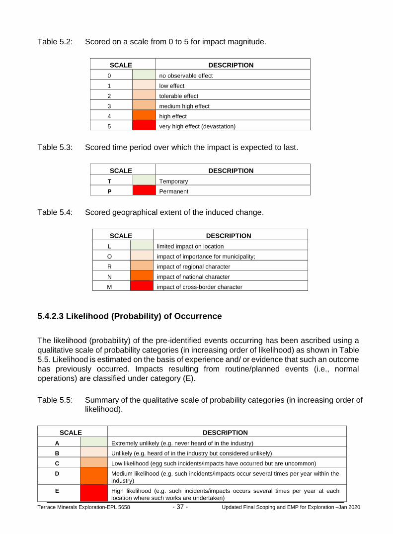
Terrace Minerals Exploration-EPL 5658 - 37 - Updated Final Scoping and EMP for Exploration –Jan 2020
Table 5.2: Scored on a scale from 0 to 5 for impact magnitude.
SCALE DESCRIPTION
0 no observable effect
1 low effect
2 tolerable effect
3 medium high effect
4 high effect
5 very high effect (devastation)
Table 5.3: Scored time period over which the impact is expected to last.
SCALE DESCRIPTION
T Temporary
P Permanent
Table 5.4: Scored geographical extent of the induced change.
SCALE DESCRIPTION
L limited impact on location
O impact of importance for municipality;
R impact of regional character
N impact of national character
M impact of cross-border character
5.4.2.3 Likelihood (Probability) of Occurrence
The likelihood (probability) of the pre-identified events occurring has been ascribed using a
qualitative scale of probability categories (in increasing order of likelihood) as shown in Table
5.5. Likelihood is estimated on the basis of experience and/ or evidence that such an outcome
has previously occurred. Impacts resulting from routine/planned events (i.e., normal
operations) are classified under category (E).
Table 5.5: Summary of the qualitative scale of probability categories (in increasing order of likelihood).
SCALE DESCRIPTION
A Extremely unlikely (e.g. never heard of in the industry)
B Unlikely (e.g. heard of in the industry but considered unlikely)
C Low likelihood (egg such incidents/impacts have occurred but are uncommon)
D Medium likelihood (e.g. such incidents/impacts occur several times per year within the
industry)
E High likelihood (e.g. such incidents/impacts occurs several times per year at each
location where such works are undertaken)

Terrace Minerals Exploration-EPL 5658 - 38 - Updated Final Scoping and EMP for Exploration –Jan 2020
5.4.3 Project Activities Summary of Impacts Results
The results of the impacts assessment and evaluation has adopted a matrix framework similar to the Leopold matrix. Assessment results of the magnitude, duration, extent and probability of the potential impacts due to the proposed / ongoing project activities interacting with the receiving environment are presented in form of a matrix table as shown in Tables 5.6-5.9. The overall severity of potential environmental impacts of the proposed / ongoing project activities on the receiving environment will be of low magnitude (Table 5.6), temporally duration (Table 5.7), localised extent (Table 5.6) and low probability of occurrence (Table 5.9) due to the limited scope of the proposed activities and the use of step progression approach in advancing exploration. The step progressional approach will allow the proponent to the results of exploration success and the implementation of the next stage of exploration will be subject to the positive outcomes of previous activities as graded (Tables 5.6-5.9). It is important to note that the assessment of the likely impacts as shown in Tables 5.6-5.9 have been considered without the implementation of mitigation measures detailed in Section 6 of this Report. The need for implementation of the appropriate mitigation measures as presented in the Section 6 of this report have be determined on the results of the impact assessment (Tables 5.6-5.9) and the significant impacts as detailed in Tables 5.10 and 5.11.

Terrace Minerals Exploration-EPL 5658 - 39 - Updated Final Scoping and EMP for Exploration –Jan 2020
Table 5.6: Results of the scored on a scale from 0 to 5 for negative impact magnitude.
ENVIRONMENTAL IMPACT KEY
RECEPTORS / TARGETS THAT MAY BE IMPACTED (RESOURCES) PHYSICAL ENVIRONMENT BIOLOGICAL ENVIRONMENT
Land Use (Agriculture, Tourism, Conservation) and Built Environment (Houses, Roads, Transport Systems, Buildings, Infrastructure
Natural Environment –Air Quality, Surface Water, Groundwater, Dust Noise, Waste Water Management, Solid Waste Management
Socioeconomic and Cultural / Archaeological–Characteristics of the local societies and communities matters
Flora
Fauna
Habitat
Ecosystem [Services, Function, Use and Non Use Values
SO
UR
CE
S O
F P
OT
EN
TIA
L IM
PA
CT
EXPLORATION STAGES
ACTIVITIES
1. INITIAL DESKTOP
EXPLORATION ACTIVITIES
(i) General evaluation of the EPL area covering satellite, topographic, land tenure, accessibility, supporting infrastructures and socioeconomic environment 0 0 0 0 0 0 0
(ii) Purchase and analysis of existing Government high resolution magnetics and radiometric geophysical data 0 0 0 0 0 0 0
(iii) Purchase and analysis of existing Government aerial hyperspectral data if available 0 0 0 0 0 0 0
(iv) Interpretation of the results and delineating of potential targets for future reconnaissance regional field-based activities if potential targets have been delineated 0 0 0 0 0 0 0
2. REGIONAL
RECONNAISSANCE FIELD-BASED ACTIVITIES
(i) Regional geological, topographical and remote sensing mapping and data analysis 0 0 0 0 0 0 0
(ii) Regional geochemical sampling aimed at identifying possible targeted based on the results of the initial exploration and regional geological, topographical and remote sensing mapping and analysis undertaken
0 0 0 0 0 0 0
(iii) Regional geological mapping aimed at identifying possible targeted based on the results of the initial exploration and regional geological, topographical and remote sensing mapping and analysis undertaken
0 0 0 0 0 0 0
(iv) Limited field-based support and logistical activities including exploration camp site lasting between one (1) to two (2) days 2 2 2 2 2 2 2
(v) Laboratory analysis of the samples collected and interpretation of the results and delineating of potential targets for future detailed site-specific exploration if the results are positive and supports further exploration of the delineated targets
0 0 0 0 0 0 0
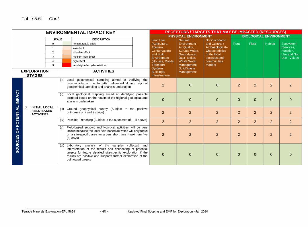
Terrace Minerals Exploration-EPL 5658 - 40 - Updated Final Scoping and EMP for Exploration –Jan 2020
Table 5.6: Cont.
ENVIRONMENTAL IMPACT KEY
RECEPTORS / TARGETS THAT MAY BE IMPACTED (RESOURCES) PHYSICAL ENVIRONMENT BIOLOGICAL ENVIRONMENT
Land Use (Agriculture, Tourism, Conservation) and Built Environment (Houses, Roads, Transport Systems, Buildings, Infrastructure
Natural Environment –Air Quality, Surface Water, Groundwater, Dust Noise, Waste Water Management, Solid Waste Management
Socioeconomic and Cultural / Archaeological–Characteristics of the local societies and communities matters
Flora
Flora
Habitat
Ecosystem [Services, Function, Use and Non Use Values
EXPLORATION STAGES
ACTIVITIES
SO
UR
CE
S O
F P
OT
EN
TIA
L IM
PA
CT
3. INITIAL LOCAL FIELD-BASED ACTIVITIES
(i) Local geochemical sampling aimed at verifying the prospectivity of the target/s delineated during regional geochemical sampling and analysis undertaken 2 0 0 2 2 2 2
(ii) Local geological mapping aimed at identifying possible targeted based on the results of the regional geological and analysis undertaken 0 0 0 0 0 0 0
(iii) Ground geophysical survey (Subject to the positive outcomes of i and ii above) 2 2 2 2 2 2 2
(iv) Possible Trenching (Subject to the outcomes of i - iii above) 2 2 2 2 2 2 2
(v) Field-based support and logistical activities will be very limited because the local field-based activities will only focus on a site-specific area for a very short time (maximum five (5) days)
2 2 2 2 2 2 2
(vi) Laboratory analysis of the samples collected and interpretation of the results and delineating of potential targets for future detailed site-specific exploration if the results are positive and supports further exploration of the delineated targets
0 0 0 0 0 0 0

Terrace Minerals Exploration-EPL 5658 - 41 - Updated Final Scoping and EMP for Exploration –Jan 2020
Table 5.6: Cont.
ENVIRONMENTAL IMPACT KEY
RECEPTORS / TARGETS THAT MAY BE IMPACTED (RESOURCES) PHYSICAL ENVIRONMENT BIOLOGICAL ENVIRONMENT
Land Use (Agriculture, Tourism, Conservation) and Built Environment (Houses, Roads, Transport Systems, Buildings, Infrastructure
Natural Environment –Air Quality, Surface Water, Groundwater, Dust Noise, Waste Water Management, Solid Waste Management
Socioeconomic and Cultural / Archaeological–Characteristics of the local societies and communities matters
Flora
Flora
Habitat
Ecosystem [Services, Function, Use and Non Use Values
SO
UR
CE
S O
F P
OT
EN
TIA
L IM
PA
CT
EXPLORATION STAGES
ACTIVITIES
4. DETAILED
LOCAL FIELD-BASED ACTIVITIES
(i) Local geochemical sampling aimed at verifying the prospectivity of the target/s delineated during regional geochemical sampling and analysis undertaken 1 1 1 1 1 1 1
(ii) Local geological mapping aimed at identifying possible targeted based on the results of the regional geological and analysis undertaken 0 0 0 0 0 0 0
(iii) Ground geophysical survey (Subject to the positive outcomes of i and ii above); 2 2 2 2 2 2 2
(iv) Possible Trenching (Subject to the outcomes of i - iii above) 2 2 2 2 2 2 2
(v) Drilling of boreholes (Subject to the outcomes of i - vi above) 3 3 3 3 3 3 3
(vi) Sampling (Subject to the outcomes of i -vi above) 3 3 3 3 3 3 3
(vii) Access preparation and related logistics to support activities 3 3 3 3 3 3 3
(viii) Laboratory analysis’s of collected samples 0 0 0 0 0 0 0

Terrace Minerals Exploration-EPL 5658 - 42 - Updated Final Scoping and EMP for Exploration –Jan 2020
Table 5.6: Cont.
ENVIRONMENTAL IMPACT KEY
RECEPTORS / TARGETS THAT MAY BE IMPACTED (RESOURCES) PHYSICAL ENVIRONMENT PHYSICAL ENVIRONMENT
Land Use (Agriculture, Tourism, Conservation) and Built Environment (Houses, Roads, Transport Systems, Buildings, Infrastructure
Natural Environment –Air Quality, Surface Water, Groundwater, Dust Noise, Waste Water Management, Solid Waste Management
Socioeconomic and Cultural / Archaeological–Characteristics of the local societies and communities matters
Flora
Flora
Habitat
Ecosystem [Services, Function, Use and Non Use Values
EXPLORATION STAGES ACTIVITIES
SO
UR
CE
S O
F P
OT
EN
TIA
L IM
PA
CT
5. PREFEASIBILITY AND FEASIBILITY STUDIES
(i) Detailed site-specific surveys 0 0 0 0 0 0 0
(ii) Detailed geological mapping 0 0 0 0 0 0 0
(iii) Additional detailed drilling and bulk sampling and testing 2 0 3 3 3 3 3
(iv) Ore reserve calculations 0 0 0 0 0 0 0
(v) Geotechnical studies for mine design 0 0 0 0 0 0 0
(vi) Detailing technical viability studies including forecasts of estimated expenditure and financial 0 0 0 0 0 0 0
(vii) Mine planning and designs including all supporting infrastructures (water, energy and access 0 0 0 0 0 0 0
(viii) Environmental Impact Assessment for mining 0 0 0 0 0 0 0
(ix) Environmental Management Plan for mining 0 0 0 0 0 0 0
(x) Test mining activities 4 4 4 4 4 4 4
(xi) Preparation of feasibility report and application for Mining License 0 0 0 0 0 0 0
(xii) Field-based support and logistical activities will be very extensive because the local field-based activities will on a specific area for a very long time (up to one year or more in some instances)
3 3 3 3 3 3 3

Terrace Minerals Exploration-EPL 5658 - 43 - Updated Final Scoping and EMP for Exploration –Jan 2020
Table 5.7: Results of the scored time period over which the impact is expected to last.
ENVIRONMENTAL IMPACT KEY
RECEPTORS / TARGETS THAT MAY BE IMPACTED (RESOURCES) PHYSICAL ENVIRONMENT BIOLOGICAL ENVIRONMENT
Land Use (Agriculture, Tourism, Conservation) and Built Environment (Houses, Roads, Transport Systems, Buildings, Infrastructure
Natural Environment –Air Quality, Surface Water, Groundwater, Dust Noise, Waste Water Management, Solid Waste Management
Socioeconomic and Cultural / Archaeological–Characteristics of the local societies and communities matters
Flora
Fauna
Habitat
Ecosystem [Services, Function, Use and Non Use Values
SO
UR
CE
S O
F P
OT
EN
TIA
L IM
PA
CT
EXPLORATION STAGES
ACTIVITIES
1. INITIAL DESKTOP
EXPLORATION ACTIVITIES
(i) General evaluation of the EPL area covering satellite, topographic, land tenure, accessibility, supporting infrastructures and socioeconomic environment T T T T T T T
(ii) Purchase and analysis of existing Government high resolution magnetics and radiometric geophysical data T T T T T T T
(iii) Purchase and analysis of existing Government aerial hyperspectral data if available T T T T T T T
(iv) Interpretation of the results and delineating of potential targets for future reconnaissance regional field-based activities if potential targets have been delineated T T T T T T T
2. REGIONAL
RECONNAISSANCE FIELD-BASED ACTIVITIES
(i) Regional geological, topographical and remote sensing mapping and data analysis T T T T T T T
(ii) Regional geochemical sampling aimed at identifying possible targeted based on the results of the initial exploration and regional geological, topographical and remote sensing mapping and analysis undertaken
T T T T T T T
(iii) Regional geological mapping aimed at identifying possible targeted based on the results of the initial exploration and regional geological, topographical and remote sensing mapping and analysis undertaken
T T T T T T T
(iv) Limited field-based support and logistical activities including exploration camp site lasting between one (1) to two (2) days T T T T T T T
(v) Laboratory analysis of the samples collected and interpretation of the results and delineating of potential targets for future detailed site-specific exploration if the results are positive and supports further exploration of the delineated targets
T T T T T T T

Terrace Minerals Exploration-EPL 5658 - 44 - Updated Final Scoping and EMP for Exploration –Jan 2020
Table 5.7: Cont.
ENVIRONMENTAL IMPACT KEY
RECEPTORS / TARGETS THAT MAY BE IMPACTED (RESOURCES) PHYSICAL ENVIRONMENT BIOLOGICAL ENVIRONMENT
Land Use (Agriculture, Tourism, Conservation) and Built Environment (Houses, Roads, Transport Systems, Buildings, Infrastructure
Natural Environment –Air Quality, Surface Water, Groundwater, Dust Noise, Waste Water Management, Solid Waste Management
Socioeconomic and Cultural / Archaeological–Characteristics of the local societies and communities matters
Flora
Flora
Habitat
Ecosystem [Services, Function, Use and Non Use Values
EXPLORATION STAGES
ACTIVITIES
SO
UR
CE
S O
F P
OT
EN
TIA
L IM
PA
CT
3. INITIAL LOCAL FIELD-BASED ACTIVITIES
(i) Local geochemical sampling aimed at verifying the prospectivity of the target/s delineated during regional geochemical sampling and analysis undertaken T T T T T T T
(ii) Local geological mapping aimed at identifying possible targeted based on the results of the regional geological and analysis undertaken T T T T T T T
(iii) Ground geophysical survey (Subject to the positive outcomes of i and ii above) T T T T T T T
(iv) Possible Trenching (Subject to the outcomes of i - iii above) T T T T T T T
(v) Field-based support and logistical activities will be very limited because the local field-based activities will only focus on a site-specific area for a very short time (maximum five (5) days)
T T T T T T T
(vi) Laboratory analysis of the samples collected and interpretation of the results and delineating of potential targets for future detailed site-specific exploration if the results are positive and supports further exploration of the delineated targets
T T T T T T T

Terrace Minerals Exploration-EPL 5658 - 45 - Updated Final Scoping and EMP for Exploration –Jan 2020
Table 5.7: Cont.
ENVIRONMENTAL IMPACT KEY
RECEPTORS / TARGETS THAT MAY BE IMPACTED (RESOURCES) PHYSICAL ENVIRONMENT BIOLOGICAL ENVIRONMENT
Land Use (Agriculture, Tourism, Conservation) and Built Environment (Houses, Roads, Transport Systems, Buildings, Infrastructure
Natural Environment –Air Quality, Surface Water, Groundwater, Dust Noise, Waste Water Management, Solid Waste Management
Socioeconomic and Cultural / Archaeological–Characteristics of the local societies and communities matters
Flora
Flora
Habitat
Ecosystem [Services, Function, Use and Non Use Values
SO
UR
CE
S O
F P
OT
EN
TIA
L IM
PA
CT
EXPLORATION STAGES
ACTIVITIES
4. DETAILED
LOCAL FIELD-BASED ACTIVITIES
(i) Local geochemical sampling aimed at verifying the prospectivity of the target/s delineated during regional geochemical sampling and analysis undertaken T T T T T T T
(ii) Local geological mapping aimed at identifying possible targeted based on the results of the regional geological and analysis undertaken T T T T T T T
(iii) Ground geophysical survey (Subject to the positive outcomes of i and ii above); T T T T T T T
(iv) Possible Trenching (Subject to the outcomes of i - iii above) T T T T T T T
(v) Drilling boreholes (Subject to the outcomes of i - vi above) T T T T T T T
(vi) Bulk Sampling (Subject to the outcomes of i -vi above) P P P P P P P
(vii) Access preparation and related logistics to support activities T T T T T T T
(viii) Laboratory analysis’s of collected samples T T T T T T T

Terrace Minerals Exploration-EPL 5658 - 46 - Updated Final Scoping and EMP for Exploration –Jan 2020
Table 5.7: Cont.
ENVIRONMENTAL IMPACT KEY
RECEPTORS / TARGETS THAT MAY BE IMPACTED (RESOURCES) PHYSICAL ENVIRONMENT PHYSICAL ENVIRONMENT
Land Use (Agriculture, Tourism, Conservation) and Built Environment (Houses, Roads, Transport Systems, Buildings, Infrastructure
Natural Environment –Air Quality, Surface Water, Groundwater, Dust Noise, Waste Water Management, Solid Waste Management
Socioeconomic and Cultural / Archaeological–Characteristics of the local societies and communities matters
Flora
Flora
Habitat
Ecosystem [Services, Function, Use and Non Use Values
EXPLORATION STAGES ACTIVITIES
SO
UR
CE
S O
F P
OT
EN
TIA
L IM
PA
CT
5. PREFEASIBILITY
AND FEASIBILITY STUDIES
(i) Detailed site-specific surveys T T T T T T T
(ii) Detailed geological mapping T T T T T T T
(iii) Additional detailed drilling and bulk sampling and testing T T T T T T T
(iv) Ore reserve calculations T T T T T T T
(v) Geotechnical studies for mine design T T T T T T T
(vi) Detailing technical viability studies including forecasts of estimated expenditure and financial T T T T T T T
(vii) Mine planning and designs including all supporting infrastructures (water, energy and access T T T T T T T
(viii) Environmental Impact Assessment for mining T T T T T T T
(ix) Environmental Management Plan for mining T T T T T T T
(x) Test mining activities P P P P P P P
(xi) Preparation of feasibility report and application for Mining License T T T T T T T
(xii) Field-based support and logistical activities will be very extensive because the local field-based activities will on a specific area for a very long time (up to one year or more in some instances)
T T T T T T T

Terrace Minerals Exploration-EPL 5658 - 47 - Updated Final Scoping and EMP for Exploration –Jan 2020
Table 5.8: Results of the scored geographical extent of the induced change.
ENVIRONMENTAL IMPACT KEY
RECEPTORS / TARGETS THAT MAY BE IMPACTED (RESOURCES) PHYSICAL ENVIRONMENT BIOLOGICAL ENVIRONMENT
Land Use (Agriculture, Tourism, Conservation) and Built Environment (Houses, Roads, Transport Systems, Buildings, Infrastructure
Natural Environment –Air Quality, Surface Water, Groundwater, Dust Noise, Waste Water Management, Solid Waste Management
Socioeconomic and Cultural / Archaeological–Characteristics of the local societies and communities matters
Flora
Fauna
Habitat
Ecosystem [Services, Function, Use and Non Use Values
SO
UR
CE
S O
F P
OT
EN
TIA
L IM
PA
CT
EXPLORATION STAGES
ACTIVITIES
1. INITIAL DESKTOP
EXPLORATION ACTIVITIES
(i) General evaluation of the EPL area covering satellite, topographic, land tenure, accessibility, supporting infrastructures and socioeconomic environment L L L L L L L
(ii) Purchase and analysis of existing Government high resolution magnetics and radiometric geophysical data L L L L L L L
(iii) Purchase and analysis of existing Government aerial hyperspectral data if available L L L L L L L
(iv) Interpretation of the results and delineating of potential targets for future reconnaissance regional field-based activities if potential targets have been delineated L L L L L L L
2. REGIONAL
RECONNAISSANCE FIELD-BASED ACTIVITIES
(i) Regional geological, topographical and remote sensing mapping and data analysis L L L L L L L
(ii) Regional geochemical sampling aimed at identifying possible targeted based on the results of the initial exploration and regional geological, topographical and remote sensing mapping and analysis undertaken
L L L L L L L
(iii) Regional geological mapping aimed at identifying possible targeted based on the results of the initial exploration and regional geological, topographical and remote sensing mapping and analysis undertaken
L L L L L L L
(iv) Limited field-based support and logistical activities including exploration camp site lasting between one (1) to two (2) days L L L L L L L
(v) Laboratory analysis of the samples collected and interpretation of the results and delineating of potential targets for future detailed site-specific exploration if the results are positive and supports further exploration of the delineated targets
L L L L L L L

Terrace Minerals Exploration-EPL 5658 - 48 - Updated Final Scoping and EMP for Exploration –Jan 2020
Table 5.8: Cont.
ENVIRONMENTAL IMPACT KEY
RECEPTORS / TARGETS THAT MAY BE IMPACTED (RESOURCES) PHYSICAL ENVIRONMENT BIOLOGICAL ENVIRONMENT
Land Use (Agriculture, Tourism, Conservation) and Built Environment (Houses, Roads, Transport Systems, Buildings, Infrastructure
Natural Environment –Air Quality, Surface Water, Groundwater, Dust Noise, Waste Water Management, Solid Waste Management etc
Socioeconomic and Cultural / Archaeological–Characteristics of the local societies and communities matters
Flora
Flora
Habitat
Ecosystem [Services, Function, Use and Non Use Values
EXPLORATION STAGES
ACTIVITIES
SO
UR
CE
S O
F P
OT
EN
TIA
L IM
PA
CT
3. INITIAL LOCAL FIELD-BASED ACTIVITIES
(i) Local geochemical sampling aimed at verifying the prospectivity of the target/s delineated during regional geochemical sampling and analysis undertaken L L L L L L L
(ii) Local geological mapping aimed at identifying possible targeted based on the results of the regional geological and analysis undertaken L L L L L L L
(iii) Ground geophysical survey (Subject to the positive outcomes of i and ii above) L L L L L L L
(iv) Possible Trenching (Subject to the outcomes of i - iii above) L L L L L L L
(v) Field-based support and logistical activities will be very limited because the local field-based activities will only focus on a site-specific area for a very short time (maximum five (5) days)
L L L L L L L
(vi) Laboratory analysis of the samples collected and interpretation of the results and delineating of potential targets for future detailed site-specific exploration if the results are positive and supports further exploration of the delineated targets
L L L L L L L

Terrace Minerals Exploration-EPL 5658 - 49 - Updated Final Scoping and EMP for Exploration –Jan 2020
Table 5.8: Cont.
ENVIRONMENTAL IMPACT KEY
RECEPTORS / TARGETS THAT MAY BE IMPACTED (RESOURCES) PHYSICAL ENVIRONMENT BIOLOGICAL ENVIRONMENT
Land Use (Agriculture, Tourism, Conservation) and Built Environment (Houses, Roads, Transport Systems, Buildings, Infrastructure
Natural Environment –Air Quality, Surface Water, Groundwater, Dust Noise, Waste Water Management, Solid Waste Management etc
Socioeconomic and Cultural / Archaeological–Characteristics of the local societies and communities matters
Flora
Flora
Habitat
Ecosystem [Services, Function, Use and Non Use Values
SO
UR
CE
S O
F P
OT
EN
TIA
L IM
PA
CT
EXPLORATION STAGES
ACTIVITIES
4. DETAILED
LOCAL FIELD-BASED ACTIVITIES
(i) Local geochemical sampling aimed at verifying the prospectivity of the target/s delineated during regional geochemical sampling and analysis undertaken L L L L L L L
(ii) Local geological mapping aimed at identifying possible targeted based on the results of the regional geological and analysis undertaken L L L L L L L
(iii) Ground geophysical survey (Subject to the positive outcomes of i and ii above); L L L L L L L
(iv) Possible Trenching (Subject to the outcomes of i - iii above) L L L L L L L
(v) Drilling boreholes (Subject to the outcomes of i - vi above) L L L L L L L
(vi) Bulk Sampling (Subject to the outcomes of i -vi above) L L L L L L L
(vii) Access preparation and related logistics to support activities L L L L L L L
(viii) Laboratory analysis’s of collected samples L L L L L L L

Terrace Minerals Exploration-EPL 5658 - 50 - Updated Final Scoping and EMP for Exploration –Jan 2020
Table 5.8: Cont.
ENVIRONMENTAL IMPACT KEY
RECEPTORS / TARGETS THAT MAY BE IMPACTED (RESOURCES) PHYSICAL ENVIRONMENT PHYSICAL ENVIRONMENT
Land Use (Agriculture, Tourism, Conservation) and Built Environment (Houses, Roads, Transport Systems, Buildings, Infrastructure
Natural Environment –Air Quality, Surface Water, Groundwater, Dust Noise, Waste Water Management, Solid Waste Management etc
Socioeconomic and Cultural / Archaeological–Characteristics of the local societies and communities matters
Flora
Flora
Habitat
Ecosystem [Services, Function, Use and Non Use Values
EXPLORATION STAGES ACTIVITIES
SO
UR
CE
S O
F P
OT
EN
TIA
L IM
PA
CT
5. PREFEASIBILITY AND FEASIBILITY STUDIES
(i) Detailed site-specific surveys L L L L L L L
(ii) Detailed geological mapping L L L L L L L
(iii) Additional detailed drilling and bulk sampling and testing L L L L L L L
(iv) Ore reserve calculations L L L L L L L
(v) Geotechnical studies for mine design L L L L L L L
(vi) Detailing technical viability studies including forecasts of estimated expenditure and financial L L L L L L L
(vii) Mine planning and designs including all supporting infrastructures (water, energy and access L L L L L L L
(viii) Environmental Impact Assessment for mining L L L L L L L
(ix) Environmental Management Plan for mining L L L L L L L
(x) Test mining activities L L L L L L L
(xi) Preparation of feasibility report and application for Mining License L L L L L L L
(xii) Field-based support and logistical activities will be very extensive because the local field-based activities will on a specific area for a very long time (up to one year or more in some instances)
L L L L L L L

Terrace Minerals Exploration-EPL 5658 - 51 - Updated Final Scoping and EMP for Exploration –Jan 2020
Table 5.9: Results of the qualitative scale of probability occurrence.
ENVIRONMENTAL IMPACT KEY
RECEPTORS / TARGETS THAT MAY BE IMPACTED (RESOURCES) PHYSICAL ENVIRONMENT BIOLOGICAL ENVIRONMENT
Land Use (Agriculture, Tourism, Conservation) and Built Environment (Houses, Roads, Transport Systems, Buildings, Infrastructure
Natural Environment –Air Quality, Surface Water, Groundwater, Dust Noise, Waste Water Management, Solid Waste Management etc
Socioeconomic and Cultural / Archaeological–Characteristics of the local societies and communities matters
Flora
Fauna
Habitat
Ecosystem [Services, Function, Use and Non Use Values
SO
UR
CE
S O
F P
OT
EN
TIA
L IM
PA
CT
EXPLORATION STAGES
ACTIVITIES
1. INITIAL DESKTOP
EXPLORATION ACTIVITIES
(i) General evaluation of the EPL area covering satellite, topographic, land tenure, accessibility, supporting infrastructures and socioeconomic environment A A A A A A A
(ii) Purchase and analysis of existing Government high resolution magnetics and radiometric geophysical data A A A A A A A
(iii) Purchase and analysis of existing Government aerial hyperspectral data if available A A A A A A A
(iv) Interpretation of the results and delineating of potential targets for future reconnaissance regional field-based activities if potential targets have been delineated A A A A A A A
2. REGIONAL
RECONNAISSANCE FIELD-BASED ACTIVITIES
(i) Regional geological, topographical and remote sensing mapping and data analysis A A A A A A A
(ii) Regional geochemical sampling aimed at identifying possible targeted based on the results of the initial exploration and regional geological, topographical and remote sensing mapping and analysis undertaken
A A A A A A A
(iii) Regional geological mapping aimed at identifying possible targeted based on the results of the initial exploration and regional geological, topographical and remote sensing mapping and analysis undertaken
A A A A A A A
(iv) Limited field-based support and logistical activities including exploration camp site lasting between one (1) to two (2) days A A A A A A A
(v) Laboratory analysis of the samples collected and interpretation of the results and delineating of potential targets for future detailed site-specific exploration if the results are positive and supports further exploration of the delineated targets
A A A A A A A

Terrace Minerals Exploration-EPL 5658 - 52 - Updated Final Scoping and EMP for Exploration –Jan 2020
Table 5.9: Cont.
ENVIRONMENTAL IMPACT KEY
RECEPTORS / TARGETS THAT MAY BE IMPACTED (RESOURCES) PHYSICAL ENVIRONMENT BIOLOGICAL ENVIRONMENT
Land Use (Agriculture, Tourism, Conservation) and Built Environment (Houses, Roads, Transport Systems, Buildings, Infrastructure
Natural Environment –Air Quality, Surface Water, Groundwater, Dust Noise, Waste Water Management, Solid Waste Management etc
Socioeconomic and Cultural / Archaeological–Characteristics of the local societies and communities matters
Flora
Flora
Habitat
Ecosystem [Services, Function, Use and Non Use Values
EXPLORATION STAGES
ACTIVITIES
SO
UR
CE
S O
F P
OT
EN
TIA
L IM
PA
CT
3. INITIAL LOCAL FIELD-BASED ACTIVITIES
(i) Local geochemical sampling aimed at verifying the prospectivity of the target/s delineated during regional geochemical sampling and analysis undertaken C C C C C C C
(ii) Local geological mapping aimed at identifying possible targeted based on the results of the regional geological and analysis undertaken A A A A A A A
(iii) Ground geophysical survey (Subject to the positive outcomes of i and ii above) C C C C C C C
(iv) Possible Trenching (Subject to the outcomes of i - iii above) C C C C C C C
(v) Field-based support and logistical activities will be very limited because the local field-based activities will only focus on a site-specific area for a very short time (maximum five (5) days)
C C C C C C C
(vi) Laboratory analysis of the samples collected and interpretation of the results and delineating of potential targets for future detailed site-specific exploration if the results are positive and supports further exploration of the delineated targets
A A A A A A A

Terrace Minerals Exploration-EPL 5658 - 53 - Updated Final Scoping and EMP for Exploration –Jan 2020
Table 5.9: Cont.
ENVIRONMENTAL IMPACT KEY
RECEPTORS / TARGETS THAT MAY BE IMPACTED (RESOURCES) PHYSICAL ENVIRONMENT BIOLOGICAL ENVIRONMENT
Land Use (Agriculture, Tourism, Conservation) and Built Environment (Houses, Roads, Transport Systems, Buildings, Infrastructure
Natural Environment –Air Quality, Surface Water, Groundwater, Dust Noise, Waste Water Management, Solid Waste Management etc
Socioeconomic and Cultural / Archaeological–Characteristics of the local societies and communities matters
Flora
Flora
Habitat
Ecosystem [Services, Function, Use and Non Use Values
SO
UR
CE
S O
F P
OT
EN
TIA
L IM
PA
CT
EXPLORATION STAGES
ACTIVITIES
4. DETAILED
LOCAL FIELD-BASED ACTIVITIES
(i) Local geochemical sampling aimed at verifying the prospectivity of the target/s delineated during regional geochemical sampling and analysis undertaken C C C C C C C
(ii) Local geological mapping aimed at identifying possible targeted based on the results of the regional geological and analysis undertaken A A A A A A A
(iii) Ground geophysical survey (Subject to the positive outcomes of i and ii above); C C C C C C C
(iv) Possible Trenching (Subject to the outcomes of i - iii above) C C C C C C C
(v) Drilling boreholes (Subject to the outcomes of i - vi above) C C C C C C C
(vi) Bulk Sampling (Subject to the outcomes of i -vi above) C C C C C C C
(vii) Access preparation and related logistics to support activities C C C C C C C
(viii) Laboratory analysis’s of collected samples A A A A A A A

Terrace Minerals Exploration-EPL 5658 - 54 - Updated Final Scoping and EMP for Exploration –Jan 2020
Table 5.9: Cont.
ENVIRONMENTAL IMPACT KEY
RECEPTORS / TARGETS THAT MAY BE IMPACTED (RESOURCES) PHYSICAL ENVIRONMENT PHYSICAL ENVIRONMENT
Land Use (Agriculture, Tourism, Conservation) and Built Environment (Houses, Roads, Transport Systems, Buildings, Infrastructure
Natural Environment –Air Quality, Surface Water, Groundwater, Dust Noise, Waste Water Management, Solid Waste Management etc
Socioeconomic and Cultural / Archaeological–Characteristics of the local societies and communities matters
Flora
Flora
Habitat
Ecosystem [Services, Function, Use and Non Use Values
EXPLORATION STAGES ACTIVITIES
SO
UR
CE
S O
F P
OT
EN
TIA
L IM
PA
CT
5. PREFEASIBILITY AND FEASIBILITY STUDIES
(i) Detailed site-specific surveys B B B B B B B
(ii) Detailed geological A A A A A A A
(iii) Additional detailed drilling and bulk sampling and testing D D D D D D D
(iv) Ore reserve calculations A A A A A A A
(v) Geotechnical studies for mine design A A A A A A A
(vi) Detailing technical viability studies including forecasts of estimated expenditure and financial A A A A A A A
(vii) Mine planning and designs including all supporting infrastructures (water, energy and access A A A A A A A
(viii) Environmental Impact Assessment for mining A A A A A A A
(ix) Environmental Management Plan for mining A A A A A A A
(x) Test mining activities D D D D D D D
(xi) Preparation of feasibility report and application for Mining License A A A A A A A
(xii) Field-based support and logistical activities will be very extensive because the local field-based activities will on a specific area for a very long time (up to one year or more in some instances)
D D D D D D D

Terrace Minerals Exploration-EPL 5658 - 55 - Updated Final Scoping and EMP for Exploration –Jan 2020
5.5 Evaluation of Significant Impacts
5.5.1 Overview
The significance of each impact has been determined by assessing the impact severity against the likelihood (probability) of the impact occurring as summarised in the impact significance assessment matrix provided in Table 5.10.
5.5.2 Significance Criteria
Significance criteria for negative/adverse impacts (i.e., relative ranking of importance) are defined in Table 5.10. It is important to note that impacts have been considered without the implementation of mitigation measures. The need for and appropriate mitigation measures as presented in the EMP Section 6 of this report have be determined on the basis of the impact assessment presented in this report. Table 5.10: Scored impact significance criteria.
IMPACT LIKELIHOOD
IMPACT
SEVERITY
Extremely Unlikely
[0]
Unlikely
[1]
Low Likelihood
[2]
Medium Likelihood
[3]
High Likelihood
[4]
Negligible
[A]
Negligible Impact [A0]
Negligible Impact [A1]
Negligible Impact [A2]
Negligible Impact [A3]
Negligible Impact [A4]
Low
[B]
Negligible Impact [B0]
Negligible Impact [B1]
Negligible Impact [B2]
Negligible to Low Impact [B3]
Low Impact [B4]
Medium
[C]
Negligible Impact [C0]
Negligible Impact [C1]
Low Impact
[C2]
Low to Medium
Impact
[C3]
Medium Impact
[C4]
High
[D]
Negligible to Low
Impact
[D0]
Low Impact
[D1]
Medium Impact
[D2]
High Impact
[D3]
High to
Unacceptable
Impact
[D4]
5.5.3 Assessment Likely Significant Impacts
The assessment of significant impacts depended upon the degree to which the proposed / ongoing project activities are likely to results in unwanted consequences on the receptor covering physical and biological environments (Table 5.11). Overall, the assessment of significant impacts has focused on the ecosystem-based approach that considers potential impacts to the ecosystem. The main key sources of impacts that have been used in the determination of significant impacts posed by the proposed / ongoing minerals exploration comprised activities. Each of the main areas of impact have been identified and assessed as follows:

Terrace Minerals Exploration-EPL 5658 - 56 - Updated Final Scoping and EMP for Exploration –Jan 2020
❖ Positive Impacts are classified under a single category; they are then evaluated qualitatively with a view to their enhancement, if practical;
❖ Negligible or Low Impacts will require little or no additional management or mitigation
measures (on the basis that the magnitude of the impact is sufficiently small, or that the receptor is of low sensitivity);
❖ Medium or High Impacts require the adoption of management or mitigation measures;
❖ High Impacts always require further management or mitigation measures to limit or
reduce the impact to an acceptable level. Overall the results of the significant impact assessment matrix for the proposed / ongoing minerals exploration activities on the physical and biological environments are shown in Tables 5.11.

Terrace Minerals Exploration-EPL 5658 - 57 - Updated Final Scoping and EMP for Exploration –Jan 2020
Table 5.11: Significant impact assessment matrix for the proposed / ongoing exploration activities.
ENVIRONMENTAL IMPACT KEY
RECEPTORS / TARGETS THAT MAY BE IMPACTED (RESOURCES) PHYSICAL ENVIRONMENT BIOLOGICAL ENVIRONMENT
Land Use (Agriculture, Tourism, Conservation) and Built Environment (Houses, Roads, Transport Systems, Buildings, Infrastructure
Natural Environment –Air Quality, Surface Water, Groundwater, Dust Noise, Waste Water Management, Solid Waste Management
Socioeconomic and Cultural / Archaeological–Characteristics of the local societies and communities matters
Flora
Fauna
Habitat
Ecosystem [Services, Function, Use and Non Use Values
SO
UR
CE
S O
F P
OT
EN
TIA
L IM
PA
CT
EXPLORATION STAGES
ACTIVITIES
1. INITIAL DESKTOP
EXPLORATION ACTIVITIES
(i) General evaluation of the EPL area covering satellite, topographic, land tenure, accessibility, supporting infrastructures and socioeconomic environment [A0] [A0] [A0] [A0] [A0] [A0] [A0]
(ii) Purchase and analysis of existing Government high resolution magnetics and radiometric geophysical data [A0] [A0] [A0] [A0] [A0] [A0] [A0]
(iii) Purchase and analysis of existing Government aerial hyperspectral data if available [A0] [A0] [A0] [A0] [A0] [A0] [A0]
(iv) Interpretation of the results and delineating of potential targets for future reconnaissance regional field-based activities if potential targets have been delineated [A0] [A0] [A0] [A0] [A0] [A0] [A0]
2. REGIONAL
RECONNAISSANCE FIELD-BASED ACTIVITIES
(i) Regional geological, topographical and remote sensing mapping and data analysis [A0] [A0] [A0] [A0] [A0] [A0] [A0]
(ii) Regional geochemical sampling aimed at identifying possible targeted based on the results of the initial exploration and regional geological, topographical and remote sensing mapping and analysis undertaken
[A0] [A0] [A0] [A0] [A0] [A0] [A0]
(iii) Regional geological mapping aimed at identifying possible targeted based on the results of the initial exploration and regional geological, topographical and remote sensing mapping and analysis undertaken
[A0] [A0] [A0] [A0] [A0] [A0] [A0]
(iv) Limited field-based support and logistical activities including exploration camp site lasting between one (1) to two (2) days [A0] [A0] [A0] [A0] [A0] [A0] [A0]
(v) Laboratory analysis of the samples collected and interpretation of the results and delineating of potential targets for future detailed site-specific exploration if the results are positive and supports further exploration of the delineated targets
[A0] [A0] [A0] [A0] [A0] [A0] [A0]

Terrace Minerals Exploration-EPL 5658 - 58 - Updated Final Scoping and EMP for Exploration –Jan 2020
Table 5.11: Cont.
ENVIRONMENTAL IMPACT KEY
RECEPTORS / TARGETS THAT MAY BE IMPACTED (RESOURCES) PHYSICAL ENVIRONMENT BIOLOGICAL ENVIRONMENT
Land Use (Agriculture, Tourism, Conservation) and Built Environment (Houses, Roads, Transport Systems, Buildings, Infrastructure
Natural Environment –Air Quality, Surface Water, Groundwater, Dust Noise, Waste Water Management, Solid Waste Management etc
Socioeconomic and Cultural / Archaeological–Characteristics of the local societies and communities matters
Flora
Flora
Habitat
Ecosystem [Services, Function, Use and Non Use Values
EXPLORATION STAGES
ACTIVITIES
SO
UR
CE
S O
F P
OT
EN
TIA
L IM
PA
CT
3. INITIAL LOCAL FIELD-BASED ACTIVITIES
(i) Local geochemical sampling aimed at verifying the prospectivity of the target/s delineated during regional geochemical sampling and analysis undertaken [B2] [B2] [B2] [B2] [B2] [B2] [B2]
(ii) Local geological mapping aimed at identifying possible targeted based on the results of the regional geological and analysis undertaken [A0] [A0] [A0] [A0] [A0] [A0] [A0]
(iii) Ground geophysical survey (Subject to the positive outcomes of i and ii above) [B2] [B2] [B2] [B2] [B2] [B2] [B2]
(iv) Possible Trenching (Subject to the outcomes of i - iii above) [B2] [B2] [B2] [B2] [B2] [B2] [B2]
(v) Field-based support and logistical activities will be very limited because the local field-based activities will only focus on a site-specific area for a very short time (maximum five (5) days)
[B2] [B2] [B2] [B2] [B2] [B2] [B2]
(vi) Laboratory analysis of the samples collected and interpretation of the results and delineating of potential targets for future detailed site-specific exploration if the results are positive and supports further exploration of the delineated targets
[A0] [A0] [A0] [A0] [A0] [A0] [A0]

Terrace Minerals Exploration-EPL 5658 - 59 - Updated Final Scoping and EMP for Exploration –Jan 2020
Table 5.11: Cont.
ENVIRONMENTAL IMPACT KEY
RECEPTORS / TARGETS THAT MAY BE IMPACTED (RESOURCES) PHYSICAL ENVIRONMENT BIOLOGICAL ENVIRONMENT
Land Use (Agriculture, Tourism, Conservation) and Built Environment (Houses, Roads, Transport Systems, Buildings, Infrastructure
Natural Environment –Air Quality, Surface Water, Groundwater, Dust Noise, Waste Water Management, Solid Waste Management etc
Socioeconomic and Cultural / Archaeological–Characteristics of the local societies and communities matters
Flora
Flora
Habitat
Ecosystem [Services, Function, Use and Non Use Values
SO
UR
CE
S O
F P
OT
EN
TIA
L IM
PA
CT
EXPLORATION STAGES
ACTIVITIES
4. DETAILED
LOCAL FIELD-BASED ACTIVITIES
(i) Local geochemical sampling aimed at verifying the prospectivity of the target/s delineated during regional geochemical sampling and analysis undertaken [D2] [D2] [D2] [D2] [D2] [D2] [D2]
(ii) Local geological mapping aimed at identifying possible targeted based on the results of the regional geological and analysis undertaken [A0] [A0] [A0] [A0] [A0] [A0] [A0]
(iii) Ground geophysical survey (Subject to the positive outcomes of i and ii above); [D2] [D2] [D2] [D2] [D2] [D2] [D2]
(iv) Possible Trenching (Subject to the outcomes of i - iii above) [D2] [D2] [D2] [D2] [D2] [D2] [D2]
(v) Drilling boreholes (Subject to the outcomes of i - vi above) [D2] [D2] [D2] [D2] [D2] [D2] [D2]
(vi) Bulk Sampling (Subject to the outcomes of i -vi above) [D2] [D2] [D2] [D2] [D2] [D2] [D2]
(vii) Access preparation and related logistics to support activities [D2] [D2] [D2] [D2] [D2] [D2] [D2]
(viii) Laboratory analysis’s of collected samples [A0] [A0] [A0] [A0] [A0] [A0] [A0]

Terrace Minerals Exploration-EPL 5658 - 60 - Updated Final Scoping and EMP for Exploration –Jan 2020
Table 5.11: Cont.
ENVIRONMENTAL IMPACT KEY
RECEPTORS / TARGETS THAT MAY BE IMPACTED (RESOURCES) PHYSICAL ENVIRONMENT PHYSICAL ENVIRONMENT
Land Use (Agriculture, Tourism, Conservation) and Built Environment (Houses, Roads, Transport Systems, Buildings, Infrastructure
Natural Environment –Air Quality, Surface Water, Groundwater, Dust Noise, Waste Water Management, Solid Waste Management etc
Socioeconomic and Cultural / Archaeological–Characteristics of the local societies and communities matters
Flora
Flora
Habitat
Ecosystem [Services, Function, Use and Non Use Values
EXPLORATION STAGES ACTIVITIES
SO
UR
CE
S O
F P
OT
EN
TIA
L IM
PA
CT
5. PREFEASIBILITY AND FEASIBILITY STUDIES
(i) Detailed site-specific surveys [B2] [B2] [B2] [B2] [B2] [B2] [B2]
(ii) Detailed geological [A0] [A0] [A0] [A0] [A0] [A0] [A0]
(iii) Additional detailed drilling and bulk sampling and testing [D3] [D3] [D3] [D3] [D3] [D3] [D3]
(iv) Ore reserve calculations [A0] [A0] [A0] [A0] [A0] [A0] [A0]
(v) Geotechnical studies for mine design [A0] [A0] [A0] [A0] [A0] [A0] [A0]
(vi) Detailing technical viability studies including forecasts of estimated expenditure and financial [A0] [A0] [A0] [A0] [A0] [A0] [A0]
(vii) Mine planning and designs including all supporting infrastructures (water, energy and access [A0] [A0] [A0] [A0] [A0] [A0] [A0]
(viii) Environmental Impact Assessment for mining [A0] [A0] [A0] [A0] [A0] [A0] [A0]
(ix) Environmental Management Plan for mining [A0] [A0] [A0] [A0] [A0] [A0] [A0]
(x) Test mining activities [D3] [D3] [D3] [D3] [D3] [D3] [D3]
(xi) Preparation of feasibility report and application for Mining License [A0] [A0] [A0] [A0] [A0] [A0] [A0]
(xii) Field-based support and logistical activities will be very extensive because the local field-based activities will on a specific area for a very long time (up to one year or more in some instances)
[D3] [D3] [D3] [D3] [D3] [D3] [D3]

Terrace Minerals Exploration-EPL 5658 - 61 - Updated Final Scoping and EMP for Exploration –Jan 2020
5.6 Assessment of Overall Impacts
5.6.1 Summary of the Results of the Impact Assessment
In accordance with Tables 5.6 - 5.11, the following is the summary of the overall likely negative and significant impacts of the proposed / ongoing exploration activities on the receiving environment (physical, biological and socioeconomic environments) without and with mitigations:
(i) Initial desktop exploration activities: Overall likely negative impact on the receiving environment will be negligible with extremely unlikely probability of occurrence without mitigations. Overall significant impacts will be negligible [A0];
(ii) Regional reconnaissance field-based activities: Overall likely negative impact on the receiving environment will be negligible with extremely unlikely probability of occurrence without mitigations. Overall significant impacts will be negligible [A0]. Some field-based activities will have localised low impacts with low probability of occurrence without mitigations and negligible with mitigations. Overall significant impacts will be negligible [B2].
(iii) Initial local field-based activities: Initial field-based activities will have localised
low impacts with low probability of occurrence without mitigations and negligible with mitigations. Overall significant impacts will be negligible [B2]. All desktop related activities and laboratory assessments will have negligible impacts with extremely unlikely probability of occurrence without mitigations. Overall significant impacts will be negligible [A0];
(iv) Detailed local field-based activities: Overall likely negative impact on the
receiving environment will be high and localised impacts without mitigations and localised low impacts with mitigations. Overall significant impacts will be medium [D2] without mitigations and low with mitigations;
(v) Prefeasibility and feasibility studies to be implemented on a site-specific area if
the local field-based studies prove positive: Overall likely negative impact on the receiving environment will be high and localised impacts without mitigations and localised medium impacts with mitigations. Overall significant impacts will be high [D3] without mitigations and low with mitigations for bulk sampling, test mining and field logistics including exploration camp).

Terrace Minerals Exploration-EPL 5658 - 62 - Updated Final Scoping and EMP for Exploration –Jan 2020
6. THE EMP
6.1 Summary of the EMP Objectives The Environmental Management Plan (EMP) provides a detailed plan of action required in the implementation of the mitigation measures for minimising and maximising the identified negative and positive impacts respectively. The EMP gives commitments including financial and human resources provisions for effective management of the likely environmental liabilities during and after the exploration. Regular assessments and evaluation of the environmental liabilities during the exploration will need to be undertaken and will ensure adequate provision of the necessary resources towards good environmental management at various stages of the project development.
6.2 Implementation of the EMP
6.2.1 Roles and Responsibilities Management of the environmental elements that may be affected by the different activities of the proposed / ongoing exploration is an important element of the proposed / ongoing exploration activities. The EMP also identifies the activity groups I environmental elements, the aspects I targets, the indicators, the schedule for implementation and who should be responsible for the management to prevent major impacts that the different exploration activities may have on the receiving environment (physical and biological environments).
6.2.2 Proponent’s Representative (PR) / Project Manager (PM)
The proponent is to appoint a Proponent’s Representative (PR) / Project Manager (PM) with the following responsibilities with respect to the EMP implementation:
❖ Act as the site project manager and implementing agent;
❖ Ensure that the proponent’s responsibilities are executed in compliance with the relevant legislation;
❖ Ensure that all the necessary environmental authorizations and permits have been
obtained;
❖ Assist the exploration contractor/s in finding environmentally responsible solutions to challenges that may arise;
❖ Should the PR be of the opinion that a serious threat to, or impact on the environment
may be caused by the exploration activities, he/she may stop work; the proponent must be informed of the reasons for the stoppage as soon as possible;
❖ The PR has the authority to issue fines for transgressions of basic conduct rules and/or contravention of the EMP;
❖ Should the Contractor or his/her employees fail to show adequate consideration for the
environmental aspects related to the EMP, the PR can have person(s) and/or equipment removed from the site or work suspended until the matter is remedied;

Terrace Minerals Exploration-EPL 5658 - 63 - Updated Final Scoping and EMP for Exploration –Jan 2020
❖ Maintain open and direct lines of communication between the landowners and
proponent, as well as any other identified Interested and Affected Parties (I&APs) with regards to environmental matters; and
❖ Attend regular site meetings and inspections as may be required for the proposed /
ongoing exploration programme.
6.2.3 Project Health, Safety and Environment (Project HSE)
The proponent is to appoint a Project Health, Safety and Environment (Project HSE) with the following responsibilities with respect to the EMP implementation:
❖ Assist the PR in ensuring that the necessary environmental authorizations and permits have been obtained;
❖ Assist the PR and Contractor in finding environmentally responsible solutions to challenges that may arise;
❖ Conduct environmental monitoring as per EMP requirements;
❖ Carry out regular site inspections (on average once per week) of all exploration areas
with regards to compliance with the EMP; report any non-compliance(s) to the PR as soon as possible;
❖ Organize for an independent internal audit on the implementation of and compliance to the EMP to be carried out half way through each field-based exploration activity; audit reports to be submitted to the PR;
❖ Continuously review the EMP and recommend additions and/or changes to the EMP
document;
❖ Monitor the Contractor’s environmental awareness training for all new personnel coming onto site;
❖ Keep records of all activities related to environmental control and monitoring; the latter
to include a photographic record of the exploration activities, rehabilitation process, and a register of all major incidents; and
❖ Attend regular site meetings.
6.2.4 Contractors and Subcontractors
The responsibilities of the Contractors and Subcontractors that may be appointed by the proponent to undertake certain field-based activities of the proposed / ongoing exploration programme include:
❖ Comply with the relevant legislation and the EMP provision;
❖ Preparation and submission to the proponent through the Project HSE of the following Management Plans:

Terrace Minerals Exploration-EPL 5658 - 64 - Updated Final Scoping and EMP for Exploration –Jan 2020
o Environmental Awareness Training and Inductions;
o Emergency Preparedness and Response;
o Waste Management; and; o Health and Safety.
❖ Ensure adequate environmental awareness training for senior site personnel;
❖ Environmental awareness presentations (inductions) to be given to all site personnel
prior to work commencement; the Project HSE is to provide the course content and the following topics, at least but not limited to, should be covered:
o The importance of complying with the EMP provisions;
o Roles and Responsibilities, including emergency preparedness;
o Basic Rules of Conduct (Do’s and Don’ts);
o EMP: aspects, impacts and mitigation;
o Fines for Failure to Adhere to the EMP;
o Health and Safety Requirements.
❖ Record keeping of all environmental awareness training and induction presentations;
and
❖ Attend regular site meetings and environmental inspections.
6.3 Specific Mitigation Measures
6.3.1 Hierarchy of Mitigation Measures Implementation
A hierarchy of methods for mitigating significant adverse effects has been adopted in order of preference and as follows:
(i) Enhancement, e.g. provision of new habitats;
(ii) Avoidance, e.g. sensitive design to avoid effects on ecological receptors;
(iii) Reduction, e.g. limitation of effects on receptors through design changes; and
(iv) Compensation, e.g. community benefits.
6.3.2 Mitigation Measures Implementation
The Environmental Management Plan (EMP) provides a detailed plan of action required in the implementation of the mitigation measures for minimising and maximising the identified negative and positive impacts respectively. The EMP also provides the management actions

Terrace Minerals Exploration-EPL 5658 - 65 - Updated Final Scoping and EMP for Exploration –Jan 2020
with roles and responsibilities requirements for implementation of environmental management strategies by the proponent through the Contractors and Subcontractors who will be undertaking the exploration activities. The EMP gives commitments including financial and human resources provisions for effective management of the likely environmental liabilities during and after the implementation of the proposed / ongoing exploration programme. Based on the findings of the Scoping work, Table 6.1 – 6.18 provides the detailed specific mitigations measures to be implemented by the proponent with respect to the proposed / ongoing exploration programme activities and in particular for the field-based exploration activities. The following is the summary of the key areas of the migration measures provided in Tables 61-6.18:
1. Project planning and implementation;
2. Implementation of the EMP; 3. Public and stakeholders relations;
4. Measures to enhance positive socioeconomic impacts; 5. Environmental awareness briefing and training; 6. Erection of supporting exploration infrastructure; 7. Use of existing access roads, tracks and general vehicle movements; 8. Mitigation measures for preventing flora destruction;
9. Mitigation measures for preventing faunal destruction; 10. Mitigation measures to be implemented with respect to the exploration camps and
exploration sites; 11. Mitigation measures for surface and groundwater protection as well as general water
usage; 12. Mitigation measures to minimise negative socioeconomic impacts; 13. Mitigation measures to minimise health and safety impacts; 14. Mitigation measures to minimise visual impacts; 15. Mitigation measures to minimise vibration, noise and air quality; 16. Mitigation measures for waste (solid and liquid) management; 17. Rehabilitation plan, and; 18. Environmental data collection.
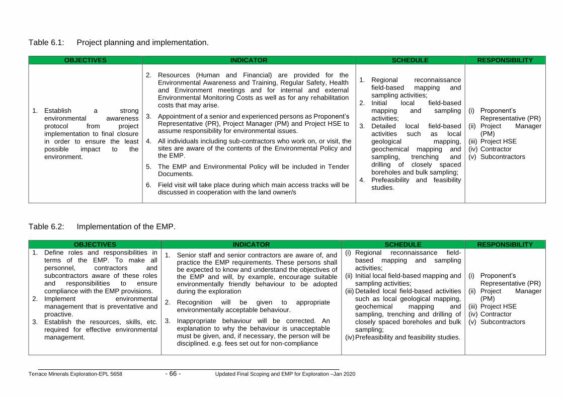
Terrace Minerals Exploration-EPL 5658 - 66 - Updated Final Scoping and EMP for Exploration –Jan 2020
Table 6.1: Project planning and implementation.
Table 6.2: Implementation of the EMP.
OBJECTIVES INDICATOR SCHEDULE RESPONSIBILITY
1. Define roles and responsibilities in terms of the EMP. To make all personnel, contractors and subcontractors aware of these roles and responsibilities to ensure compliance with the EMP provisions.
2. Implement environmental management that is preventative and proactive.
3. Establish the resources, skills, etc. required for effective environmental management.
1. Senior staff and senior contractors are aware of, and practice the EMP requirements. These persons shall be expected to know and understand the objectives of the EMP and will, by example, encourage suitable environmentally friendly behaviour to be adopted during the exploration
2. Recognition will be given to appropriate environmentally acceptable behaviour.
3. Inappropriate behaviour will be corrected. An explanation to why the behaviour is unacceptable must be given, and, if necessary, the person will be disciplined. e.g. fees set out for non-compliance
(i) Regional reconnaissance field-based mapping and sampling activities;
(ii) Initial local field-based mapping and sampling activities;
(iii) Detailed local field-based activities such as local geological mapping, geochemical mapping and sampling, trenching and drilling of closely spaced boreholes and bulk sampling;
(iv) Prefeasibility and feasibility studies.
(i) Proponent’s
Representative (PR) (ii) Project Manager
(PM) (iii) Project HSE (iv) Contractor (v) Subcontractors
OBJECTIVES INDICATOR SCHEDULE RESPONSIBILITY
1. Establish a strong environmental awareness protocol from project implementation to final closure in order to ensure the least possible impact to the environment.
2. Resources (Human and Financial) are provided for the Environmental Awareness and Training, Regular Safety, Health and Environment meetings and for internal and external Environmental Monitoring Costs as well as for any rehabilitation costs that may arise.
3. Appointment of a senior and experienced persons as Proponent’s Representative (PR), Project Manager (PM) and Project HSE to assume responsibility for environmental issues.
4. All individuals including sub-contractors who work on, or visit, the sites are aware of the contents of the Environmental Policy and the EMP.
5. The EMP and Environmental Policy will be included in Tender Documents.
6. Field visit will take place during which main access tracks will be discussed in cooperation with the land owner/s
1. Regional reconnaissance
field-based mapping and sampling activities;
2. Initial local field-based mapping and sampling activities;
3. Detailed local field-based activities such as local geological mapping, geochemical mapping and sampling, trenching and drilling of closely spaced boreholes and bulk sampling;
4. Prefeasibility and feasibility studies.
(i) Proponent’s Representative (PR)
(ii) Project Manager (PM)
(iii) Project HSE (iv) Contractor (v) Subcontractors

Terrace Minerals Exploration-EPL 5658 - 67 - Updated Final Scoping and EMP for Exploration –Jan 2020
Table 6.3: Public and stakeholders relations.
OBJECTIVES MITIGATION MEASURES SCHEDULE RESPONSIBILITY 1. Maintain sound relationships
with the Other land users/ land owner/s and another stakeholders / public
1. No littering or any other activity prohibited
2. Permission to utilise water as well as all applicable permits are obtained.
1. Regional reconnaissance field-based mapping and sampling activities;
2. Initial local field-based mapping and sampling activities;
3. Detailed local field-based activities such as local geological mapping, geochemical mapping and sampling, trenching and drilling of closely spaced boreholes and bulk sampling;
4. Prefeasibility and feasibility studies.
(i) Proponent’s Representative (PR) (ii) Project Manager (PM) (iii) Project HSE (iv) Contractor (v) Subcontractors
Table 6.4: Measures to enhance positive socioeconomic impacts.
OBJECTIVES MITIGATION MEASURES SCHEDULE RESPONSIBILITY Measures to enhance positive socioeconomic impacts in order to: 1. Avoid exacerbating the
influx of unemployed people to the area.
2. Develop a standardised recruitment method for sub-contractor and field workers.
1. Stipulate a preference for local contractors in its tender policy. Preference to local contractors should still be based on competitive business principles and salaries and payment to local service providers should still be competitive;
2. Develop a database of local businesses that qualify as potential service providers and invite them to the tender process;
3. Scrutinise tender proposals to ensure that minimum wages were included in the costing;
4. Stipulate that local residents should be employed for temporary unskilled/skilled and where possible in permanent unskilled/skilled positions as they would reinvest in the local economy;
5. Must ensure that potential employees are from the area, they need submit proof of having lived in the area for a minimum of 5 years;
6. Must ensure that contractors adhere to Namibian Affirmative Action, Labour and Social Security, Health and Safety laws. This could be accomplished with a contractual requirement stipulating that monthly proof should be submitted indicating payment of minimum wages to workers, against their ID numbers, payment of social security and submission of affirmative action data;
7. Encouraged to cater for the needs of employees to increase the spending of wages locally.
(i) Regional reconnaissance field-
based mapping and sampling activities;
(ii) Initial local field-based mapping and sampling activities;
(iii) Detailed local field-based activities such as local geological mapping, geochemical mapping and sampling, trenching and drilling of closely spaced boreholes and bulk sampling;
(iv) Prefeasibility and feasibility studies.
(i) Proponent’s
Representative (PR) (ii) Project Manager (PM) (iii) Project HSE (iv) Contractor (v) Subcontractors

Terrace Minerals Exploration-EPL 5658 - 68 - Updated Final Scoping and EMP for Exploration –Jan 2020
Table 6.5: Environmental awareness briefing and training.
OBJECTIVES MITIGATION MEASURES SCHEDULE RESPONSIBILITY 1. Implement environmental
awareness briefing / training for individuals who visit, or work, on site.
1. Every senior/supervisory member of the team shall familiarise themselves with the contents of the EMP. They shall understand their roles and responsibilities with regard to personnel and project compliance with the EMP.
2. Subject to agreement of the parties, the Environmental Coordinator will hold an Environmental Awareness Briefing meeting, which shall be attended by all contractors before the start of the mineral exploration activities.
3. Briefings on the EMP and Environmental Policy shall discuss the potential dangers to the environment of the following activities: public relations, littering, off-road driving, waste management, poaching and plant theft etc. The need to preserve soil, conserve water and implement water saving measures shall be presented.
4. Individuals can be questioned on the Environmental Philosophy and
EMP and can recall contents.
(i) Regional reconnaissance field-
based mapping and sampling activities;
(ii) Initial local field-based mapping and sampling activities;
(iii) Detailed local field-based activities such as local geological mapping, geochemical mapping and sampling, trenching and drilling of closely spaced boreholes and bulk sampling;
(iv) Prefeasibility and feasibility studies.
(i) Proponent’s
Representative (PR)
(ii) Project Manager (PM)
(iii) Project HSE (iv) Contractor (v) Subcontractors
Table 6.6: Erection of supporting exploration infrastructure.
OBJECTIVES MITIGATION MEASURES SCHEDULE RESPONSIBILITY
1. Get Environmental Clearance before
implementation 2. Establishment of the supporting
exploration infrastructure done on an area with the least disturbance to the environment and within the non-sensitive areas
1. Documented Environmental Clearance from MET.
2. All on site exploration infrastructure (e.g. water tanks, sewage tanks, waste disposal) are not situated on environmental sensitive area and have disturbed as less as possible.
3. No littering.
(i) Regional reconnaissance field-based mapping and sampling activities;
(ii) Initial local field-based mapping and sampling activities;
(iii) Detailed local field-based activities such as local geological mapping, geochemical mapping and sampling, trenching and drilling of closely spaced boreholes and bulk sampling;
(iv) Prefeasibility and feasibility studies.
(i) Proponent’s Representative (PR)
(ii) Project Manager (PM)
(iii) Project HSE (iv) Contractor (v) Subcontractors

Terrace Minerals Exploration-EPL 5658 - 69 - Updated Final Scoping and EMP for Exploration –Jan 2020
Table 6.7: Use of existing access roads, tracks and general vehicle movements.
OBJECTIVES MITIGATION MEASURES SCHEDULE RESPONSIBILITY
1. Plan a road/track network that considers the environmental sensitivity of the area and a long-term tourism potential, and which is constructed in a technically and environmentally sound manner.
2. Stick to the recommended track and sensitivity management zones.
1. Avoid unnecessary affecting areas viewed as important habitat – i.e. Ephemeral River and its network of tributaries of ephemeral rivers; rocky outcrops; clumps of protected tree species;
2. Make use of existing tracks/roads as much as possible throughout the area;
3. Do not drive randomly throughout the area (could cause mortalities to vertebrate fauna and unique flora; accidental fires; erosion related problems, etc.);
4. Avoid off-road driving at night as this increase’s mortalities of nocturnal species;
5. Implement and maintain off-road track discipline with maximum speed limits (e.g.30km/h) as this would result in fewer faunal mortalities and limit dust pollution;
6. Use of "3-point-turns" rather than "U-turns"; 7. Where tracks have to be made to potential exploration sites off
the main routes, the routes should be selected causing minimal damage to the environment – e.g. use the same tracks; cross drainage lines at right angles; avoid placing tracks within drainage lines; avoid collateral damage (i.e. select routes that do not require the unnecessary removal of trees/shrubs, especially protected species);
8. Leave vehicles on tracks and walk to point of interest, when possible;
9. Rehabilitate all new tracks created.
(i) Regional reconnaissance
field-based mapping and sampling activities;
(ii) Initial local field-based mapping and sampling activities;
(iii) Detailed local field-based activities such as local geological mapping, geochemical mapping and sampling, trenching and drilling of closely spaced boreholes and bulk sampling;
(iv) Prefeasibility and feasibility studies.
(i) Proponent’s
Representative (PR) (ii) Project Manager (PM) (iii) Project HSE (iv) Contractor (v) Subcontractors

Terrace Minerals Exploration-EPL 5658 - 70 - Updated Final Scoping and EMP for Exploration –Jan 2020
Table 6.8: Mitigation measures for preventing flora and ecosystem destruction and promotion of conservation.
OBJECTIVES MITIGATION MEASURES SCHEDULE RESPONSIBILITY
1. Prevent flora and ecosystem destruction and promote conservation
1. Limit the development and avoid rocky outcrops throughout the entire area; 2. Avoid development and associated infrastructure in sensitive areas – e.g. Ephemeral River, in/close
to drainage lines, cliffs, boulder and rocky outcrops in the area, etc. This would minimise the negative effect on the local environment especially unique features serving as habitat to various species;
3. Avoid placing access routes (roads and tracks) trough sensitive areas – e.g. over rocky outcrops/ridges and along drainage lines. This would minimise the effect on localised potentially sensitive habitats in the area;
4. Avoid driving randomly through the area (i.e. “track discipline”), but rather stick to permanently placed roads/tracks – especially during the construction phase. This would minimise the effect on localised potentially sensitive habitats in the area;
5. Stick to speed limits of maximum 30km/h as this would result in less dust pollution which could affect certain flora – e.g. lichen species. Speed humps could also be used to ensure the speed limit;
6. Remove unique and sensitive flora (e.g. all Aloe sp.) before commencing with the development activities and relocate to a less sensitive/disturbed site if possible;
7. Prevent and discourage the collecting of firewood as dead wood has an important ecological role – especially during the development phase(s). Such collecting of firewood, especially for economic reasons, often leads to abuses – e.g. chopping down of live and/or protected tree species such as Acacia erioloba which is a good quality wood;
8. Attempt to avoid the removal of bigger trees during the development phase(s) – especially with the development of access routes – as these serve as habitat for a myriad of fauna;
9. Prevent and discourage fires – especially during the development phase(s) – as this could easily cause runaway veld fires causing problems (e.g. loss of grazing and domestic stock mortalities, etc.) for the neighbouring farmers;
10. Rehabilitation of the disturbed areas – i.e. initial development access route “scars” and associated tracks as well as temporary accommodation sites. Preferably workers should be transported in/out to the construction sites on a daily basis to avoid excess damage to the local environment (e.g. fires, wood collection, poaching, etc.). Such rehabilitation would not only confirm the company’s environmental integrity, but also show true local commitment to the environment;
11. Implement erosion control. The area(s) towards and adjacent the drainage line(s) are easily eroded and further development may exacerbate this problem. Avoid construction within 20m of the main drainage line(s) to minimise erosion problems as well as preserving the riparian associated fauna;
12. Conduct a thorough investigation on the flora associated with the proposed / ongoing exploration site(s);
13. Prevent the introduction of potentially invasive alien plant species (e.g. Tecoma stans, Pennisetum setaceum, etc.) for ornamental purposes as part of the landscaping should mining activities eventually commence. Alien species often “escape” and become invasive causing further ecological damage;
14. A thorough investigation of water use and ground water extraction should take place before actual mining activities commence as this would affect the local flora, especially the ephemeral riparian vegetation, not only locally, but downstream as well.
(i) Regional
reconnaissance field-based mapping and sampling activities;
(ii) Initial local field-based mapping and sampling activities;
(iii) Detailed local field-based activities such as local geological mapping, geochemical mapping and sampling, trenching and drilling of closely spaced boreholes and bulk sampling;
(iv) Prefeasibility and feasibility studies.
(i) Proponent’s
Representative (PR)
(ii) Project Manager (PM)
(iii) Project HSE (iv) Contractor (v) Subcontractors

Terrace Minerals Exploration-EPL 5658 - 71 - Updated Final Scoping and EMP for Exploration –Jan 2020
Table 6.9: Mitigation measures for preventing faunal and ecosystem destruction and promotion of conservation.
OBJECTIVES MITIGATION MEASURES SCHEDULE RESPONSIBILITY
1. Prevent faunal and ecosystem destruction and promote conservation
1. Limit the development and avoid rocky outcrops throughout the entire area; 2. Avoid development & associated infrastructure in sensitive areas – e.g. in/close to drainage lines,
cliffs, boulder and rocky outcrops in the area, etc. This would minimise the negative effect on the local environment especially unique features serving as habitat to various species;
3. Avoid placing access routes (roads & tracks) trough sensitive areas – e.g. over rocky outcrops/ridges and along drainage lines. This would minimise the effect on localised potentially sensitive habitats in the area;
4. Avoid driving randomly through the area (i.e. “track discipline”), but rather stick to permanently placed roads/tracks – especially during the construction phase. This would minimise the effect on localised potentially sensitive habitats in the area;
5. Stick to speed limits of maximum 30km/h as this would result in fewer faunal road mortalities. Speed humps could also be used to ensure the speed limit;
6. Remove (e.g. capture) unique fauna and sensitive fauna before commencing with the development activities and relocate to a less sensitive/disturbed site if possible;
7. Prevent and discourage the setting of snares (poaching), illegal collecting of veld foods (e.g. tortoises, etc.), indiscriminate killing of perceived dangerous species (e.g. snakes, etc.) and collecting of wood as this would diminish and negatively affect the local fauna – especially during the development phase(s);
8. Attempt to avoid the removal of bigger trees during the development phase(s) – especially with the development of access routes – as these serve as habitat for a myriad of fauna;
9. Prevent and discourage fires – especially during the development phase(s) – as this could easily cause runaway veld fires affecting the local fauna, but also causing problems (e.g. loss of grazing & domestic stock mortalities, etc.) for the neighbouring farmers;
10. Rehabilitation of the disturbed areas – i.e. initial development access route “scars” and associated tracks as well as temporary accommodation sites. Preferably workers should be transported in/out to the construction sites on a daily basis to avoid excess damage to the local environment (e.g. fires, wood collection, poaching, etc.). Such rehabilitation would not only confirm the company’s environmental integrity, but also show true local commitment to the environment;
11. Implement erosion control. The area(s) towards & adjacent the drainage line(s) are easily eroded and further development may exacerbate this problem. Avoid construction within 20m of the main drainage line(s) to minimise erosion problems as well as preserving the riparian associated fauna;
12. Conduct a thorough investigation on the fauna associated with the proposed / ongoing exploration site(s);
13. Prevent the number of domestic pets – e.g. cats & dogs – accompanying the workers during the construction phase as cats decimate the local fauna and interbreed & transmit diseases to the indigenous African Wildcat found in the area. Dogs often cause problems when bonding on hunting expeditions thus negatively affecting the local fauna. The indiscriminate and wanton killing of the local fauna by such pets should be avoided at all costs.
(i) Regional
reconnaissance field-based mapping and sampling activities;
(ii) Initial local field-based mapping and sampling activities;
(iii) Detailed local field-based activities such as local geological mapping, geochemical mapping and sampling, trenching and drilling of closely spaced boreholes and bulk sampling;
(iv) Prefeasibility and feasibility studies.
(i) Proponent’s
Representative (PR)
(ii) Project Manager (PM)
(iii) Project HSE (iv) Contractor (v) Subcontractors

Terrace Minerals Exploration-EPL 5658 - 72 - Updated Final Scoping and EMP for Exploration –Jan 2020
Table 6.10: Mitigation measures to be implemented with respect to the exploration camps and exploration sites.
OBJECTIVES MITIGATION MEASURES SCHEDULE RESPONSIBILITY
1. Promotion of conservation through preservation of flora, fauna and ecosystem around the exploration camps and exploration sites
1. Select camp sites and other temporary lay over sites with care – i.e. avoid important habitats; 2. Use portable toilets to avoid faecal pollution around camp and exploration sites; 3. Initiate a suitable and appropriate refuse removal policy as littering could result in certain animals
becoming accustomed to humans and associated activity and result in typical problem animal scenarios – e.g. baboon, black-backed jackal, etc.;
4. Avoid and/or limit the use of lights during nocturnal exploration activities as this could influence and/or affect various nocturnal species – e.g. bats and owls, etc. Use focused lighting for least effect;
5. Prevent the killing of species viewed as dangerous – e.g. various snakes – when on site; 6. Prevent the setting of snares for ungulates (i.e. poaching) or collection of veld foods (e.g.
tortoises) and unique plants (e.g. various Aloe and Lithop) or any form of illegal hunting activities; 7. Avoid introducing dogs and cats as pets to camp sites as these can cause significant mortalities to
local fauna (cats) and even stock losses (dogs); 8. Remove and relocate slow moving vertebrate fauna (e.g. tortoises, chameleon, snakes, etc.) to
suitable habitat elsewhere on property; 9. Avoid the removal and/or damaging of protected flora potentially occurring in the general area – e.g.
various Aloe, Commiphora and Lithop species; 10. Avoid introducing ornamental plants, especially potential invasive alien species, as part of the
landscaping of the camp site, etc., but rather use localised indigenous species, should landscaping be attempted, which would also require less maintenance (e.g. water);
11. Remove all invasive alien species on site, especially Prosopis sp., which is already becoming a major ecological problem along various water courses throughout Central Namibia. This would not only indicate environmental commitment, but actively contribute to a better landscape;
12. Inform contractors/workers regarding the above-mentioned issues prior to exploration activities and monitor for compliance thereof throughout;
13. Rehabilitate all areas disturbed by the exploration activities – i.e. camp sites, exploration sites, etc.; 14. Implement a policy of replacing 2 tree species (preferably the same species) for every 1
protected tree species having to be removed (if necessary); 15. Although fires are not expected to be a major issue in the general area due to the overall lack of
grass cover, some years it may be necessary to consider fire prevention. Ensure that adequate firefighting equipment (e.g. fire beaters; extinguishers, etc.) is available at camp sites and clear kitchen areas to avoid accidental fires;
16. Employ an independent environmental auditor to ensure compliance, especially of the rehabilitation of all the affected areas.
(i) Regional
reconnaissance field-based mapping and sampling activities;
(ii) Initial local field-based mapping and sampling activities;
(iii) Detailed local field-based activities such as local geological mapping, geochemical mapping and sampling, trenching and drilling of closely spaced boreholes and bulk sampling;
(iv) Prefeasibility and feasibility studies.
(i) Proponent’s
Representative (PR)
(ii) Project Manager (PM)
(iii) Project HSE (iv) Contractor (v) Subcontractors

Terrace Minerals Exploration-EPL 5658 - 73 - Updated Final Scoping and EMP for Exploration –Jan 2020
Table 6.11: Mitigation measures for surface and groundwater protection as well as general water usage.
OBJECTIVES MITIGATION MEASURES SCHEDULE RESPONSIBILITY
1. Effective management / protection of surface and groundwater resources and general water resources usage
1. Always use as little water as possible. Reduce, reuse and re-cycle water where possible;
2. All leaking pipes / taps must be repaired immediately they are noticed; 3. Never leave taps running. Close taps after you have finished using them. 4. Never allow any hazardous substance to soak into the soil; 5. Immediately tell your Contractor or Environmental Control Officer / Site Manager
when you spill, or notice any hazardous substance being spilled anywhere in the solar park areas;
6. Report to your Contractor or Environmental Control Officer / Site Manager when you notice any container, which may hold a hazardous substance, overflow, leak or drip;
7. Immediately report to your Contractor or Environmental Control Officer / Site Manager when you notice overflowing problems or unhygienic conditions at the ablution facilities;
8. No washing of vehicles, equipment and machinery, containers and other surfaces;
9. Limit the operation to a specific site and avoid sensitive areas and in particular the Ephemeral River Channel. This would sacrifice the actual area for other adjacent Ephemeral River areas and thus minimise any likely negative effect on water resources;
10. Disposal of wastewater into any public stream is prohibited; 11. The Proponent must obtain permission of the land owners before utilising any
water resources or any associated infrastructure; 12. If there is a need to drilling a water borehole to support the exploration
programme the proponent (Proponent) must obtain permission form the land owner and Department of Water Affairs in the Ministry of Agriculture and Forestry. In an event of discovery of economic minerals resources, the sources of water supply for the mining related operations will be supplied by NamWater;
13. If there are any further (larger scale) exploration/drilling activities and/or mining activities to follow from the initial planned drill holes, groundwater monitoring must be implemented to include water level monitoring and also water sampling on a bi-annual basis. In order to have greater transparency on the water monitoring activities, the affected landowners / farmers must be given full access to the results of the water monitoring analyses.
(i) Regional
reconnaissance field-based mapping and sampling activities;
(ii) Initial local field-based mapping and sampling activities;
(iii) Detailed local field-based activities such as local geological mapping, geochemical mapping and sampling, trenching and drilling of closely spaced boreholes and bulk sampling;
(iv) Prefeasibility and feasibility studies.
(i) Proponent’s
Representative (PR)
(ii) Project Manager (PM)
(iii) Project HSE (iv) Contractor (v) Subcontractors

Terrace Minerals Exploration-EPL 5658 - 74 - Updated Final Scoping and EMP for Exploration –Jan 2020
Table 6.12: Mitigation measures to minimise negative socioeconomic impacts.
OBJECTIVES MITIGATION MEASURES SCHEDULE RESPONSIBILITY
1. Effective management of socioeconomic benefits of the proposed / ongoing project activities
1. The employment of local residents and local companies should be a priority. To ensure that potential employees are from the area, they need submit proof of having lived in the area for a minimum of 5 years;
2. Providing information such as the number and types of jobs available, availability of accommodation facilities and rental costs and living expenses, could make potential job seekers wary of moving to the area;
3. Addressing unrealistic expectations about large numbers of jobs would be created; 4. Exploration camp if required should be established in close consultation with the land
owners; 5. Exploration camp should consider provision of basic services; 6. When employees’ contracts are terminated or not renewed, contractors should
transport the employees out of the area to their hometowns within two days of their contracts coming to an end;
7. Tender documents could stipulate that contractors have HIV/Aids workplace policies and programmes in place and proof of implementation should be submitted with invoicing;
8. Develop strategies in coordination with local health officers and NGO’s to protect the local communities, especially young girls.
9. Contract companies could submit a code of conduct, stipulating disciplinary actions where employees are guilty of criminal activities in and around the vicinity of the EPL. Disciplinary actions should be in accordance with Namibian legislation;
10. Contract companies could implement a no-tolerance policy regarding the use of alcohol and workers should submit to a breathalyser test upon reporting for duty daily;
11. Request that the Roads Authority erect warning signs of heavy exploration vehicles on affected public roads;
12. Ensure that drivers adhere to speed limits and that speed limits are strictly enforced; 13. Ensure that vehicles are road worthy and drivers are qualified;
14. Train drivers in potential safety issues.
(i) Regional
reconnaissance field-based mapping and sampling activities;
(ii) Initial local field-based mapping and sampling activities;
(iii) Detailed local field-based activities such as local geological mapping, geochemical mapping and sampling, trenching and drilling of closely spaced boreholes and bulk sampling;
(iv) Prefeasibility and feasibility studies.
(i) Proponent’s
Representative (PR) (ii) Project Manager (PM) (iii) Project HSE (iv) Contractor (v) Subcontractors

Terrace Minerals Exploration-EPL 5658 - 75 - Updated Final Scoping and EMP for Exploration –Jan 2020
Table 6.13: Mitigation measures to minimise health and safety impacts.
OBJECTIVES MITIGATION MEASURES SCHEDULE RESPONSIBILITY
1. Promotion of health and safe working environment in line with national Labour Laws
1. Physical hazards: Follow national and international regulatory and guidelines provisions, use of correct Personal Proactive Clothing at all times, training programme, as well as the implementation of a fall protection program in accordance with the Labour Act;
2. Some of the public access management measures that may be considered in an event of vandalism occurring are:
• All exploration equipment must be in good working condition and services accordingly;
• Control access to the exploration site through using gates on the access road(s) if required;
• The entire site, must be fenced off; the type of fencing to be used would, however, be dependent on the impact on the visual resources and/or cost; and;
• Notice or information boards relating to public safety hazards and emergency contact details to be put up at the gate(s) to the exploration area.
3. There is a comprehensive First Aid Kit on site and that suitable anti-histamine for bee stings / snake bites should be available.
4. Rubber gloves are used in case of an accident to reduce the risk of contracting HIV/AIDS;
5. All individuals have received instructions concerning the dangers of dehydration or hyperthermia. Encourage all to drink plenty of clean water not directly from the surface water bodies.
6. No person under the influence of alcohol or drugs is allowed to work on site. 7. The Exploration Manager ensures compliance with the requirements of the
relevant Namibian Labour, Mining and Health and Safety Regulations. 8. Dangerous or protected / sensitive areas are clearly marked and access to these
areas is controlled or restricted. 9. Due care must be taken when driving any vehicles on any roads particularly the
gravel roads. ALL Drivers must drive with their headlights switched on when travelling on the gravel roads (day and night).
10. Persons driving a vehicle must be in possession of a valid driver’s license 11. Awareness on HIV/AIDS among workers is raised
(i) Regional reconnaissance
field-based mapping and sampling activities;
(ii) Initial local field-based mapping and sampling activities;
(iii) Detailed local field-based activities such as local geological mapping, geochemical mapping and sampling, trenching and drilling of closely spaced boreholes and bulk sampling;
(iv) Prefeasibility and feasibility studies.
(i) Proponent’s
Representative (PR) (ii) Project Manager (PM) (iii) Project HSE (iv) Contractor (v) Subcontractors

Terrace Minerals Exploration-EPL 5658 - 76 - Updated Final Scoping and EMP for Exploration –Jan 2020
Table 6.14: Mitigation measures to minimise visual impacts.
OBJECTIVES MITIGATION MEASURES SCHEDULE RESPONSIBILITY
1. Preserve the landscape character in the development of supporting infrastructure and choice of visual screening
1. Consider the landscape character and the visual impacts of the exploration area including camp site from all relevant viewing angles, particularly from public roads;
2. Use vegetation screening where applicable. Do not cut down
vegetation unnecessary around the site and use it for site screening;
3. Avoid the use of very high fencing;
4. Minimise access roads and no off-road that could result in land
scarring is allowed;
5. Minimise the presence of secondary structures: remove inoperative support structures;
6. Remove all infrastructure and reclaim, or rehabilitate the project
site after exploration activities are completed.
(i) Regional reconnaissance
field-based mapping and sampling activities;
(ii) Initial local field-based mapping and sampling activities;
(iii) Detailed local field-based activities such as local geological mapping, geochemical mapping and sampling, trenching and drilling of closely spaced boreholes and bulk sampling;
(iv) Prefeasibility and feasibility studies.
(i) Proponent’s
Representative (PR) (ii) Project Manager (PM) (iii) Project HSE (iv) Contractor (v) Subcontractors

Terrace Minerals Exploration-EPL 5658 - 77 - Updated Final Scoping and EMP for Exploration –Jan 2020
Table 6.15: Mitigation measures to minimise vibration, noise and air quality.
OBJECTIVES MITIGATION MEASURES SCHEDULE RESPONSIBILITY
1. Promote of effective management of vehicle movement, drilling and blasting operations and use of Personal Protective Equipment (PPE) in mitigating air quality and vibrations impacts in line with national laws
1. Limit vehicle movements and adhere to the speed of 60 km/h; 2. Vehicles and all equipment must be properly serviced to
minimise noise pollution; 3. Use of Personal Protective Equipment (PPE) to minimise
Occupational Health Safety impacts dues to noise pollution around the site;
4. National or international acoustic design standards must be followed.
5. Drilling and blasting operations can major sources of vibration, noise and dust and where required the following mitigation measure shall be implemented; • Drilling and blasting operations shall only be done by a
qualified person who must at all times adhere to the required blasting protocol;
• Prior warning shall be given to all persons, neighbour and visitors before the blasting takes place;
• Careful planning and timing of the blast program to minimise the size of the charge;
• Where practicable, use of explosive products with lower detonation velocities, but noting that this would require more explosives to achieve the same blast result;
• Use of detonating caps with built-in time delays, as this effectively reduces each detonation into a series of small explosions;
• Use of a procedure ("decking the charge") which subdivides the charge in one blast hole into a series of smaller explosions, with drill patterns restricted to a minimum separation from any other loaded hole;
• Over-drilling the holes to ensure fracturing of the rock; • Staggering the detonation for each blast hole in order to
spread the explosive's total overpressure over time; • Matching, to the extent possible, the energy needed in the
“work effort” of the borehole to the rock mass to minimise excess energy vented into the receiving environment.
(i) Regional reconnaissance
field-based mapping and sampling activities;
(ii) Initial local field-based mapping and sampling activities;
(iii) Detailed local field-based activities such as local geological mapping, geochemical mapping and sampling, trenching and drilling of closely spaced boreholes and bulk sampling;
(iv) Prefeasibility and feasibility studies.
(i) Proponent’s
Representative (PR) (ii) Project Manager (PM) (iii) Project HSE (iv) Contractor (v) Subcontractors

Terrace Minerals Exploration-EPL 5658 - 78 - Updated Final Scoping and EMP for Exploration –Jan 2020
Table 6.16: Mitigation measures for waste (solid and liquid) management.
OBJECTIVES MITIGATION MEASURES SCHEDULE RESPONSIBILITY
1. Promotion of effective waste (solid and liquid) management through the adoption of sound and hierarchical approach to waste management, which would include waste minimisation, re-use, recovery, recycling, treatment, and proper disposal.
1. Burial of waste on anywhere within the EPL area is not allowed and all generated solid waste must be disposed at the at an approved municipal waste disposal site;
2. Toilet and ablution facilities must be provided on site and should not be located close to Ephemeral Rivers or visible discontinuities (fractures, joints or faults);
3. Provide site information on the difference between the two main types of waste, namely: • General Waste; and • Hazardous Waste.
4. Sealed containers, bins, drums or bags for the different types of wastes must be provided. Never dispose of hazardous waste in the bins or skips intended for general waste or construction rubble;
5. All solid and liquid wastes generated from the proposed / ongoing project activities shall be reduced, reused, or recycled to the maximum extent practicable;
6. Trash may not be burned or buried, except at approved sites under controlled conditions in accordance with the municipal regulations;
7. Never overfill any waste container, drum, bin or bag. Inform your Contractor or the Environmental Control Officer / Site Manager if the containers, drums, bins or skips are nearly full;
8. Never litter or throwaway any waste on the site, in the field or along any road. No illegal dumping;
9. Littering is prohibited. 10. Latrines and French drains built >100m from watercourses or
pans to avoid pollution of primary and secondary aquifers. 11. Chemical toilets or suitable waste water management system
shall be provided on site and around the camp as may be required.
(i) Regional reconnaissance
field-based mapping and sampling activities;
(ii) Initial local field-based mapping and sampling activities;
(iii) Detailed local field-based activities such as local geological mapping, geochemical mapping and sampling, trenching and drilling of closely spaced boreholes and bulk sampling;
(iv) Prefeasibility and feasibility studies.
(i) Proponent’s
Representative (PR) (ii) Project Manager (PM) (iii) Project HSE (iv) Contractor (v) Subcontractors

Terrace Minerals Exploration-EPL 5658 - 79 - Updated Final Scoping and EMP for Exploration –Jan 2020
Table 6.17: Rehabilitation plan.
OBJECTIVES MITIGATION MEASURES SCHEDULE RESPONSIBILITY
1. Contributions toward environmental
preservation and sustainability through rehabilitation of disturbed areas such as exploration sites and remove all unwanted part of the fixtures and restore the sites to close an approximation of the pristine state as is technically, financially and reasonably possible.
1. The following rehabilitation actions are practiced:
• Small samples are preferably removed from site to avoid additional scars in the landscape;
• Litter from the site has been taken to the appropriate disposal site.
• Debris, scrap metal, etc is removed before moving to a new site or closure of the mine.
• Water tanks are dismantled and removed if not need for after use.
• Tracks on site and the access road are rehabilitated by smoothing the 'middle mannetjie'(middle ridge between the tracks) and raking the surface.
2. The following should be undertaken at all disturbed areas that require further rehabilitation: • if applicable the stockpiled subsoil to be replaced
(spread) and/or the site is neatly contoured to establish effective wind supported landscape patterns;
• Replace the stored topsoil seed bank layer. • Five (5) years after rehabilitation the sites are not
visible from 500 m away.
(i) Regional reconnaissance
field-based mapping and sampling activities;
(ii) Initial local field-based mapping and sampling activities;
(iii) Detailed local field-based activities such as local geological mapping, geochemical mapping and sampling, trenching and drilling of closely spaced boreholes and bulk sampling;
(iv) Prefeasibility and feasibility studies.
(i) Proponent’s
Representative (PR) (ii) Project Manager (PM) (iii) Project HSE (iv) Contractor (v) Subcontractors

Terrace Minerals Exploration-EPL 5658 - 80 - Updated Final Scoping and EMP for Exploration –Jan 2020
Table 6.18: Environmental data collection.
OBJECTIVES MITIGATION MEASURES SCHEDULE RESPONSIBILITY
1. Collect data that will add value to environmental monitoring and reporting to the regulators
2. Collect data that will add to the
general scientific and geographic knowledge of the environment in which the exploration process takes place.
3. Acknowledged that the required
skills and knowledge to collect all the suggested data may not be available within the mine /exploration team, however, as much data as is practical should be collected.
1. Environmental Monitoring Report Compiled and submitted by the Environmental Coordinator to the regulators
2. The following types of information should be gathered:
• Fauna. What tracks or signs of animal activity have been seen? (photographs and GPS recording) What animals, birds etc were identified? Alternatively provide a description and/ or photo if unidentified.
• Unusual weather conditions, e.g. records of the prevailing wind direction and the direction from which storm events come. Was there fog or rain, frost overnight or intense heat? Preferably have a thermometer and rain gauge on site.
• Vegetation. Record trees, shrubs, grass, etc. that are found in the vicinity along each of the profiles. Some plants do only occur after rainfall and might not have been seen for decades.
• Any archaeological, cultural or historical sites that may be found. GPS coordinates, photograph and plot the position on a 1: 50 000 maps.
• other including surface water, spring, large scale geological features etc
(i) Regional reconnaissance
field-based mapping and sampling activities;
(ii) Initial local field-based mapping and sampling activities;
(iii) Detailed local field-based activities such as local geological mapping, geochemical mapping and sampling, trenching and drilling of closely spaced boreholes and bulk sampling;
(iv) Prefeasibility and feasibility studies.
(i) Proponent’s
Representative (PR) (ii) Project Manager (PM) (iii) Project HSE (iv) Contractor (v) Subcontractors

Terrace Minerals Exploration-EPL 5658 - 81 - Updated Final Scoping and EMP for Exploration –Jan 2020
6.4 Rehabilitation and Closure Plan
6.4.1 Rehabilitation Process
The following is the summary of key rehabilitation process to be implemented by the proponent:
❖ Step 1: Backfilling the mining void: o Transporting all stockpiled overburden, whether being stockpiled or used as berms,
back to the mining voids;
o Backfilling the trenches, pits and quarries using this material;
o If applicable, backfill the various layers of overburden in the reverse order in which they were removed, i.e. Last out should be first in as far as possible, and;
o When backfilling, bear in mind that some space must be left for the backfilling of the
soil on top of the overburden.
❖ Step 2: Remove all waste and unwanted materials:
o Once the slimes ponds have dried sufficiently, scrape out the slimes and transporting back to the mining voids during the overburden backfilling stage;
o Bulldoze the slimes pond walls over and contour;
o Allow the pollution control dam to evaporate completely, scrape all waste that has collected in the pond and dispose of these and the pond lining at a suitable site;
o Bulldoze the walls of the pollution control pond over and contour;
o Collect remaining domestic waste on site and transport to an approved municipal
waste disposal site;
o Clean out the oil traps, collect the waste material in drums and transport to a suitable site for disposal, and;
o Manually remove all weedy species that are present at the site (the entire plant can
easily be removed because the plants tend not to root deeply).
❖ Step 3: Remove all structures:
o Sell all permanent structures such as houses to the farmer or another private person for using as a tourist camp;
o Disassemble all building structures including the washing plant structures and pre-fabricated buildings and transport them to a new exploration /mining test site or storage facility or sell by auction;
o Remove all building materials from the exploration / test mining site and either:
• Transporting to a new site if it is to be used or stored elsewhere; or

Terrace Minerals Exploration-EPL 5658 - 82 - Updated Final Scoping and EMP for Exploration –Jan 2020
• Disposing at a suitable approved municipal waste disposal site; or
• Making them available to the farmer or local persons; or
• Selling at an auction.
o Remove all machinery from the site and transport to a new site where it is to be used or stored or sell at an Auction;
o Remove all fences that have been constructed and either make the material available to the local persons/farmer, dispose at a suitable site or sell at an Auction;
o Remove the generators from the sites from site and either transport to a new site for
storage or sell it to the farmer or an Auction;
o Seal all petrol, diesel, oil and grease containers and remove from the site to a storage facility or make it available to the farmer;
o Collect all scrap metal and dispose at a suitable site or sell at an Auction;
o Break up all concrete slabs and structures on site and transport the fragments to a
suitable site for disposal;
o The concrete reservoirs can probably remain intact provided that the farmer wishes to utilize them at some stage - this will need to be negotiated;
o The future of the water pipeline can be negotiated with the farmer or a new
owner/lender of the site, because if he chooses to use the pipeline it will not be necessary to remove it and rehabilitate the route, and;
o If the pipeline is to be removed, disassemble and transport the component parts to
a storage site or sell at an Auction.
❖ Step 4: Rehabilitate the excavated voids:
o Replace the subsoil layer by backfilling the soil on top of the overburden and contour cap the subsoil with a topsoil layer about 10cm deep, and;
o Cap the topsoil containing the seedbank with a layer of gravel by manually spreading the fragments across the surface using a rake.
❖ Step 5: Rehabilitate site-specific storm-water channel:
o Remove the Hyson cells or gabions;
o Dispose of the plastic/wire and use the fill material to backfill the storm-water
channel;
o Cap with a layer of topsoil to a depth of about 10cm, and;
o Cap the topsoil containing the seedbank with a gravel layer by manually spreading the fragments across the surface using a rake.

Terrace Minerals Exploration-EPL 5658 - 83 - Updated Final Scoping and EMP for Exploration –Jan 2020
❖ Step 6: Rehabilitate all adjacent exploration / test mining sites affected:
o Compaction of the substrate will result from utilisation of these areas or the pressure of overlying structures;
o Rip the surfaces to a depth of 40 cm to 50 cm using a multi-toothed ripper and tractor;
o Cover with a layer of topsoil to a depth of about 10 cm, and;
o Cap the topsoil containing the seedbank with a layer of gravel by manually spreading the fragments across the surface using a rake.
❖ Step 7: Rehabilitate all unwanted access roads created:
o Compaction of the road will result from the continuous passage of heavy vehicles so
it will be necessary to break up the road surface;
o Rip the road surface to a depth of at least 50 cm using a multi-toothed ripper and tractor;
o Disk the ripped surface to break up the clods;
o Cover with a layer of topsoil to a depth of about 10 cm, and;
o Cap the topsoil containing the seedbank with a gravel layer by manually spreading
the fragments across the surface using a rake.
6.5 Monitoring of the Environmental Performance
6.5.1 Rehabilitation Evaluation and Performance Monitoring
The following is the summary of key rehabilitation evaluation and performance monitoring to be implemented by the proponent:
❖ Monitoring: Monitoring program is instituted to ensure that the requirements of the mining site rehabilitation program are met. Rehabilitation program may be subjected to various natural or man-made forces that can hinder the progress and lead to problems or failure or the rehabilitation program. Regular monitoring will ensure that these factors are identified early so they may be resolved through appropriate recommendations;
❖ Frequency: All rehabilitated areas should be monitored over a three (3) years period
from the onset of the rehabilitation procedures. The frequency of monitoring suggested above is dependent on satisfactory performance. If, however, the requirements are not being met, the frequency of monitoring can be increased. It is suggested that the monitoring be conducted once a year around September when the grasses and forbs are flowering;
❖ Methods: The rehabilitated areas might be monitored by the sampling randomly
located 1m2 quadrates. Approximately 10 quadrates per hectare (or a minimum of 3) should be sampled per plant community. The factors that will be examined in each quadrate include:

Terrace Minerals Exploration-EPL 5658 - 84 - Updated Final Scoping and EMP for Exploration –Jan 2020
o Percentage basal cover;
o Percentage aerial cover;
o Species composition and diversity;
o Vigor and health of plants;
o Presence of and evidence of fauna, and;
o Nature of the substrate.
❖ Controls: To enable a comparison, control plots located within the surrounding un-mining areas should also be monitored. This will give an indication of the progress of rehabilitated areas versus the natural vegetation and will set the goals, which ultimately should be achieved. By monitoring the natural vegetation annually, it will also be possible to assess the natural changes that are taking place. These findings can then be applied to the rehabilitated areas so as to account for the changes, which may have resulted from natural events. Approximately 5 to 10 quadrates of 1m2 should be sampled per community type to set the controls;
❖ Maintenance: Maintenance requirements may include seeding (if there is poor
germination of the seedbank), fertiliser applications, correcting erosion problems, removing weeds, etc. Maintenance of the rehabilitated areas will be necessary periodically. The need for and extent of maintenance activities will be determined during the regular monitoring of the site, and;
❖ Qualified Personnel: The rehabilitation procedures from implementation to
monitoring should be overseen by qualified personnel. Any persons involved in the rehabilitation of the mining site should be trained in the techniques involved.
6.5.2 Overall Environmental Performance Monitoring and Reporting
The monitoring of the environmental performances for the proposed / ongoing exploration project can be divided into two (2) parts and these are:
(i) Routine / ongoing daily monitoring activities to be undertaken by the Project HSE Officer with the support of the external specialist consultants as maybe required, and;
(ii) Preparation of annual Environmental Monitoring Report and Environmental Closure
covering all activities related to the Environmental Management Plan during exploration / prospecting stages and at closure of the proposed / ongoing exploration to be undertaken by the Project HSE Officer with the support of the external specialist consultants as maybe required.
The proponent will be required to report regularly (twice in a year or as the case maybe) to the Environmental Commissioner in the Ministry of Environment and Tourism (MET), the environmental performances as part of the ongoing environmental monitoring programme. Environmental monitoring programme is part of the EMP performances assessments and will need to be compiled and submitted as determined by the Environmental Commissioner. The process of undertaking appropriate monitoring as per specific topic (such as fauna and flora) and tracking performances against the objectives and documenting all environmental activities

Terrace Minerals Exploration-EPL 5658 - 85 - Updated Final Scoping and EMP for Exploration –Jan 2020
is part of internal and external auditing to be coordinated by the Project HSE Officer. The second part of the monitoring of the EMP performance will require a report outlining all the activities related to effectiveness of the EMP at the end of the planned mineral exploration to be undertaken by the Project HSE Officer with the support of the external specialist consultants as maybe required. The objective will be to ensure that corrective actions are reviewed and steps are taken to ensure compliance for future EIA and EMP implementation. The report shall outline the status of the environment and any likely environmental liability after the completion of the proposed / ongoing project activities. The report shall be submitted to the Environmental Commissioner in the Ministry of Environment and Tourism and will represent the final closure and fulfilment of the conditions of the Environmental Clearance Certificate (ECC) issued by the Environmental Commissioner and the conditions of the Pro-Forma Environmental Contract signed by the Proponent, Environmental Commissioner and the Mining Commissioner.

Terrace Minerals Exploration-EPL 5658 - 86 - Updated Final Scoping and EMP for Exploration –Jan 2020
7. CONCLUSION AND RECOMMENDATION
7.1 Conclusions Terrace Minerals Exploration (Pty) Ltd (the Proponent) intends to undertake exploration activities in the Exclusive Prospecting Licence (EPL) No. 5658, with special focus on base, rare and precious metals. The exploration activities to be undertaken as assessed in this environmental assessment are as follows:
(i) Initial desktop exploration activities;
(ii) Regional reconnaissance field-based activities;
(iii) Initial local field-based activities including detailed mapping, sampling and drilling operations;
(iv) Detailed local field-based activities including detailed mapping, sampling and
drilling operations, and;
(v) Prefeasibility and feasibility studies including possible test mining. The overall severity of potential environmental impacts of the proposed / ongoing project activities on the receiving environment (physical, biological, socioeconomic environments and ecosystem functions, services, use and non-use values or passive uses) will be of low magnitude, temporally duration, localised extent and low probability of occurrence. Mitigation measures must be implemented as detailed in Section 6 (EMP) of this report. The proponent must obtain permission of the land owners (surface rights holders) before exercising their subsurface rights in all the farms covered by the EPL 5658.
7.2 Recommendations It’s hereby recommended that the proposed / ongoing exploration activities be issued with an Environmental Clearance Certificate (ECC) with the following key conditions:
(i) The proponent shall negotiate an Access Agreement with the land owner/s;
(ii) The Proponent shall adhere to all the provisions of the EMP and conditions of the Access Agreement to be entered between the proponent and the land owner/s in line with all applicable national regulations;
(iii) Before entering any private property such as a private farm, the proponent must
give advance notices and obtain access permission from the land owners at all times;
(iv) Mitigation measures shall be implemented as detailed in Section 6 (EMP) of this
Scoping and EMP report; (v) Where possible, and if water is found during the detailed exploration boreholes
drilling operations, the proponent shall support other land uses in the area in terms of access to freshwater supply for both human consumption, wildlife and agricultural support as may be requested by the local community / land owners/s. The abstraction of the groundwater resources shall include water levels

Terrace Minerals Exploration-EPL 5658 - 87 - Updated Final Scoping and EMP for Exploration –Jan 2020
monitoring, sampling and quality testing on a bi-annual basis, and that the affected landowners must have access to the results of the water monitoring analyses as part of the ongoing stakeholder disclosure requirements on shared water resources as maybe applicable.
The proponent must take all the necessary steps to implement all the recommendations of the EMP for the successful implementation and completion of the proposed / ongoing exploration programme covering the EPL 5658. Recommended actions to be implemented by the proponent as part of the management of the likely impacts through implementations of the EMP are:
(i) The proponent must obtain permission from the land owners to enter the EPL area in order to undertake field-based exploration / prospecting activities;
(i) The proponent must implement precautionary measures / approach to environmental management. Once a viable and potential economic resource have been identified, the proponent must develop and implement a separate EIA and EMP inclusive of the specialist studies such as fauna and flora to be undertaken by specialist consultants as part of the feasibility study stage;
(ii) Before detailed site-specific exploration activities such as extensive drilling operations and access routes are selected, the Project HSE Officer with the support of the external specialist consultants as maybe required, should consider the flora, fauna and archaeological sensitivity of the area and commission a field survey in advance of any site development as may be required based on the assessment undertaken;
(iii) The Project HSE Officer shall lead, implement and promote environmental
culture through awareness raising of the workforce, contractors and sub-contractors in the field during the whole duration of the proposed / ongoing exploration period;
(iv) The proponent to provide all the necessary support including human and financial
resources, for the implementation of the proposed / ongoing mitigations and effective environmental management during the planned exploration activities for the EPL 5658;
(v) Project HSE Officer with the support of the external specialist consultants as
maybe required to develop a simplified environmental induction and awareness programme for all the workforce, contractors and sub-contractors;
(vi) Where contracted service providers are likely to cause environmental impacts,
these will need to be identified and contract agreements need to be developed with costing provisions for environmental liabilities;
(vii) Implement internal and external monitoring of the actions and management
strategies developed during the mineral exploration process. Final Environmental Monitoring report shall be prepared by the Project HSE Officer with the support of the external specialist consultants as maybe required to be submitted to the regulators and to mark the closure of the proposed / ongoing mineral exploration;
Terrace Minerals Exploration-EPL 5658 - 88 - Updated Final Scoping and EMP for Exploration –Jan 2020
(viii) Develop and implement a monitoring programme that will fit into the overall company’s Environmental Management Systems (EMS) as well as for any future EIA for possible mining projects.
7.3 Summary ToR for Test Mining and Mining Stages Once a viable project has been identified (economic resources are discovered) and a separate field-based and site-specific Environmental Impact Assessment (EIA) and Environmental Management Plan (EMP) must be implemented as part of the prefeasibility and feasibility study with respect to the test mining or possible mining operations. The site-specific EIA and EMP shall cover the area identified to have potential economic minerals resources as well as all areas to be used for infrastructural support areas such as pit / shaft area/s, waste rock, tailings dump, access, office blocks, water and energy infrastructure support areas (water, energy and road / access). In addition to the Terms of Reference (ToR) to be developed during the Environmental Scoping study phase for the test mining / mining stages, the following field-based and site-specific specialist studies shall be undertaken as prat of the EIA and EMP for possible test mining or mining operations in an event of a discovery of economic minerals resources and possible development of a mining project:
(i) Groundwater studies including modelling as maybe applicable;
(ii) Field-based flora and fauna diversity;
(iii) Noise and Sound modelling linked to engineering studies;
(iv) Socioeconomic assessment, and;
(v) Others as may be identified / recommended by the stakeholders/ land owners/ Environmental Commissioner or specialists.
The aims and objectives of the Environmental Assessment (EA) covering Environmental Impact Assessment (EIA) and Environmental Management Plan (EMP) to be implemented as part of the feasibility study if a variable resource is discovered are:
(i) To assess all the likely positive and negative short- and long-term impacts on the receiving environment (physical, biological and socioeconomic environments) at local (EPL Area), regional, national (Namibia) and Global levels using appropriate assessment guidelines, methods and techniques covering the complete project lifecycle. The EIA and EMP to be undertaken shall be performed with reasonable skill, care and diligence in accordance with professional standards and practices existing at the date of performance of the assessment and that the guidelines, methods and techniques shall conform to the national regulatory requirements, process and specifications in Namibia and in particular as required by the Ministry of Mines and Energy, Ministry of Environment and Tourism and Ministry of Agriculture, Water Affairs and Forestry;
(ii) The development of appropriate mitigation measures that will enhance the positive
impacts and reduce the likely negative influences of the negative impacts identified or anticipated. Such mitigation measures shall be contained in a detailed EMP report covering the entire project lifecycle.

Terrace Minerals Exploration-EPL 5658 - 89 - Updated Final Scoping and EMP for Exploration –Jan 2020
8. BIBLIOGRAPHY / REFERENCES 1. FURTHER GENERAL READING
Cunningham, P. L., 2013. Specialist Desktop Study: Vertebrate fauna and flora associated with the Lithium ML – Karibib Area, Report prepared by Dr Sindila Mwiya, Risk-Based Solutions (RBS) CC Department of Affairs and Forestry, 2001. Groundwater in Namibia: An explanation to the hydrogeological map. MAWRD, Windhoek, 1, 128 pp. Directorate of Environmental Affairs, 2002. Atlas of Namibia Project. Ministry of Environment and Tourism, Windhoek, http://www.met.gov.na Diehl, M., 1992. Lithium, Beryllium and Cesium. In: Mineral Resources of Namibia, pp. 6.15-1 – 6.15-18. Namibia: Geological Survey of Namibia. Special Publication. Geological Survey of Namibia, 1999. The Simplified Geological Map of Namibia, Windhoek. Miller, R.McG. 2008. The geology of Namibia. Geological Survey, Ministry of Mines and Energy, Windhoek, Vol. 3. Miller, R. McG., 1992. Stratigraphy. The mineral resource of Namibia, Geological Survey of Namibia, MME, Windhoek, 1.2 .1 -1.2.13. Miller, R. McG., 1983a. The Pan – African Damara Orogen od S.W.A. / Namibia, Special Publication of the Geological Society of South Africa, 11, 431 - 515. Miller, R. McG., 1983b. Economic implications of plate tectonic models of the Damara Orogen, Special Publication of the Geological Society of South Africa, 11, 115 -138. Mwiya, S., 2004. A Knowledge-Based System Model Methodology (KBSMM) for Development and Management of Mine Waste sites in Arid and Semiarid Environments of Southern Africa, Geosciences Africa 2004, University of Witwatersrand, Johannesburg, South Africa, pp 486. Risk-Based Solutions (RBS) CC, 2015. Final Environmental Impact Assessment (EIA) and Environmental Management Plan (EMP) Report for Mining Claims Nos. 68619, 68872- 68876 (Helikon Project) to be converted to a Mining License (ML) Area, Karibib District, Erongo Region, West Central Namibia. Roesener H and Schreuder C.P (1992) Iron. In: Mineral Resources of Namibia, pp. 2.4-1–2.4-14. Namibia: Geological Survey of Namibia. Special Publication. South African National Standards (SANS), 2005. South African National Standard, Ambient Air Quality – Limits for Common Pollutants. SANS 1929:2005. Standards South Africa, Pretoria. Venmyn Deloitte, 2014. Independent Competent Persons’ Report on the Material Mineral Assets of Unimin African Resources Limited (Unimin), SR1.1A(i), Final Draft Report, Johannesburg, South Africa.

Terrace Minerals Exploration-EPL 5658 - 90 - Updated Final Scoping and EMP for Exploration –Jan 2020
2. REFERENCES AND FURTHER READING ON FAUNA AND FLORA
Alexander, G. and Marais, J. 2007. A guide to the reptiles of southern Africa. Struik Publishers, Cape Town, RSA. Barnard, P. 1998. Underprotected habitats. In: Barnard, P. (ed.). Biological diversity in Namibia: a country study. Windhoek: Namibian National Biodiversity Task Force. Bester, B. 1996. Bush encroachment – A thorny problem. Namibia Environment 1: 175-177. Branch, B. 1998. Field guide to snakes and other reptiles of southern Africa. Struik Publishers, Cape Town, RSA. Branch, B. 2008. Tortoises, terrapins and turtles of Africa. Struik Publishers, Cape Town, RSA. Boycott, R.C. and Bourquin, O. 2000. The Southern African Tortoise Book. O Bourquin, Hilton, RSA. Broadley, D.G. 1983. Fitzsimons’ Snakes of southern Africa. Jonathan Ball and AD. Donker Publishers, Parklands, RSA. Brown, C.J., Jarvis, A., Robertson, T. and Simmons, R. 1998. Bird diversity. In: Barnard, P. (ed.). Biological diversity in Namibia: a country study. Windhoek: Namibian National Biodiversity Task Force. Burke, A. 2003. Wild flowers of the Central Namib. Namibia Scientific Society, Windhoek. Burke, A. 2005. Wild flowers of the Northern Namib. Namibia Scientific Society, Windhoek. Buys, P.J. and Buys, P.J.C. 1983. Snakes of Namibia. Gamsberg Macmillan Publishers, Windhoek, Namibia. Carruthers, V.C. 2001. Frogs and frogging in southern Africa. Struik Publishers, Cape Town, RSA. Channing, A. 2001. Amphibians of Central and Southern Africa. Protea Bookhouse, Pretoria, RSA. Channing, A. and Griffin, M. 1993. An annotated checklist of the frogs of Namibia. Madoqua 18(2): 101-116. Coats Palgrave, K. 1983. Trees of Southern Africa. Struik Publishers, Cape Town, RSA. Craven, P. 1998. Lichen diversity in Namibia. In: Barnard, P. (ed.). Biological diversity in Namibia: a country study. Windhoek: Namibian National Biodiversity Task Force. Craven, P. (ed.). 1999. A checklist of Namibian plant species. Southern African Botanical Diversity Network Report No. 7, SABONET, Windhoek. Cunningham, P.L. 1998. Potential wood biomass suitable for charcoal production in Namibia. Agri-Info 4(5): 4-8.

Terrace Minerals Exploration-EPL 5658 - 91 - Updated Final Scoping and EMP for Exploration –Jan 2020
Cunningham, P.L. 2006. A guide to the tortoises of Namibia. Polytechnic of Namibia, Windhoek, Namibia. Curtis, B. and Barnard, P. 1998. Sites and species of biological, economic or archaeological importance. In: Barnard, P. (ed.). Biological diversity in Namibia: a country study. Windhoek: Namibian National Biodiversity Task Force. Curtis, B. and Mannheimer, C. 2005. Tree Atlas of Namibia. National Botanical Research Institute, Windhoek, Namibia. De Graaff, G. 1981. The rodents of southern Africa. Buterworths, RSA. Du Preez, L. and Carruthers, V. 2009. A complete guide to the frogs of southern Africa. Struik Publishers, Cape Town, RSA. Estes, R.D. 1995. The behaviour guide to African mammals. Russel Friedman Books, Halfway House, RSA. Giess, W. 1971. A preliminary vegetation map of South West Africa. Dinteria 4: 1 – 114. Griffin, M. 1998a. Reptile diversity. In: Barnard, P. (ed.). Biological diversity in Namibia: a country study. Windhoek: Namibian National Biodiversity Task Force. Griffin, M. 1998b. Amphibian diversity. In: Barnard, P. (ed.). Biological diversity in Namibia: a country study. Windhoek: Namibian National Biodiversity Task Force. Griffin, M. 1998c. Mammal diversity. In: Barnard, P. (ed.). Biological diversity in Namibia: a country study. Windhoek: Namibian National Biodiversity Task Force. Griffin, M. 2003. Annotated checklist and provisional national conservation status of Namibian reptiles. Ministry of Environment and Tourism, Windhoek. Griffin, M. 2005. Annotated checklist and provisional national conservation status of Namibian mammals. Ministry of Environment and Tourism, Windhoek. Hebbard, S. n.d. A close-up view of the Namib and some of its fascinating reptiles. ST Promotions,Swakopmund, Namibia. Hockey, P.A.R., Dean, W.R.J. and Ryan, P.G. 2006. Roberts Birds of Southern Africa VII Edition. John Voelcker Bird Book Fund. IUCN, 2015. IUCN Red List of threatened species. Version 2015.2. www.iucn.redlist.org. IUCN, Gland, Switzerland. Joubert, E. and Mostert, P.M.K. 1975. Distribution patterns and status of some mammals in South West Africa. Madoqua 9(1): 5-44. Komen, L. n.d. The Owls of Namibia – Identification and General Information. NARREC, Windhoek. Maclean, G.L. 1985. Robert’s birds of southern Africa. John Voelcker Bird Book Fund.

Terrace Minerals Exploration-EPL 5658 - 92 - Updated Final Scoping and EMP for Exploration –Jan 2020
Maggs, G. 1998. Plant diversity in Namibia. In: Barnard, P. (ed.). Biological diversity in Namibia: a country study. Windhoek: Namibian National Biodiversity Task Force. Mannheimer, C. and Curtis, B. (eds) 2009. Le Roux and Müller’s field guide to the trees and shrubs of N amibia. Macmillan Education Namibia, Windhoek. Marais, J. 1992. A complete guide to the snakes of southern Africa. Southern Book Publishers, Witwatersrand University Press, Johannesburg, RSA. Mendelsohn, J., Jarvis, A., Roberts, A. and Robertson, T. 2002. Atlas of Namibia. A portrait of the land and its people. David Philip Publishers, Cape Town, RSA. Monadjem, A., Taylor, P.J., F.P.D. Cotterill and M.C. Schoeman. 2010. Bats of southern and central Africa. Wits University press, Johannesburg, RSA. Müller, M.A.N. 1984. Grasses of South West Africa/Namibia. John Meinert Publishers (Pty) Ltd, Windhoek, Namibia. Müller, M.A.N. 2007. Grasses of Namibia. John Meinert Publishers (Pty) Ltd, Windhoek, Namibia. Passmore, N.I. and Carruthers, V.C. 1995. South African Frogs - A complete guide. Southern Book Publishers, Witwatersrand University Press, Johannesburg, RSA. Rothmann, S. 2004. Aloes, aristocrats of Namibian flora. ST promotions, Swakopmund. SARDB, 2004. CBSG Southern Africa. In: Griffin, M. 2005. Annotated checklist and provisional national conservation status of Namibian mammals. Ministry of Environment and Tourism, Windhoek. Schultz, M. and Rambold, G. 2007. Diversity shifts and ecology of soil lichens in central Namibia. Talk, Ecological Society of Germany, Austria and Switzerland (GfÖ), 37th Annual Meeting, Marburg: 12/9/2007 to 15/9/2007. Schultz, M., Zedda, L. and Rambold, G. 2009. New records of lichen taxa from Namibia and South Africa. Bibliotheca Lichenologica 99: 315-354. Simmons, R.E. 1998a. Important Bird Areas (IBA’s) in Namibia. In: Barnard, P. (ed.). Biological diversity in Namibia: a country study. Windhoek: Namibian National Biodiversity Task Force. Simmons, R.E. 1998b. Areas of high species endemism. In: Barnard, P. (ed.). Biological diversity in Namibia: a country study. Windhoek: Namibian National Biodiversity Task Force. Simmons R.E., Brown C.J. and Kemper, J. 2015. Birds to watch in Namibia: red, rare and endemic species. National Biodiversity Programme, Windhoek. Skinner, J.D. and Smithers, R.H.N. 1990. The mammals of the southern African subregion. University of Pretoria, RSA. Skinner, J.D. and Chimimba, C.T. 2005. The mammals of the southern African subregion. Cambridge University Press, Cape Town, RSA. Stander, P. and Hanssen, L. 2003. Namibia large carnivore atlas. Unpublished Report, Ministry of Environment and Tourism, Windhoek.

Terrace Minerals Exploration-EPL 5658 - 93 - Updated Final Scoping and EMP for Exploration –Jan 2020
Steyn, M. 2003. Southern Africa Commiphora. United Litho, Arcadia, South Africa. Tarboton, W. 2001. A guide to the nests and eggs of southern African birds. Struik Publishers, Cape Town, RSA. Taylor, P.J. 2000. Bats of southern Africa. University of Natal Press, RSA. Tolley, K. and Burger, M. 2007. Chameleons of southern Africa. Struik Nature, Cape Town, RSA. Van Oudtshoorn, F. 1999. Guide to grasses of southern Africa. Briza Publications, Pretoria, South Africa. Van Wyk, B. and Van Wyk, P. 1997. Field guide to trees of Southern Africa. Cape Town: Struik Publishers.