Embed Size (px)
Citation preview
CO-039
TECHNOLOGY TRANSFER : LAND USE & LAND COVER MAPPING projects Case studies and
analysis of key factors of success
DEKEYNE C., JAFFRAIN G.
IGN FI, PARIS, FRANCE
KEY WORDS
Land cover, land use, agriculture statistics, visual interpretation, detection of changes, technology and
knowhow transfer, IGN FI
CONTEXT
The scarcity of natural resources, the impact of climate changes, the need to manage the development of
territories (while securing agriculture and taking into account demographic pressure) have given birth to
new needs. Indeed, there is an increasing demand for accurate and up-to-date information that can help the
decision-makers (national and local levels) to have a better understanding of their territories and of the
way they change with an environmental focus.
In addition to the sustainable development and environmental issues, the databases serve a wide range of
sectors of application.
Apart from environmental issues, land cover and land use projects contribute to improve the knowledge of
territories in other fields such as agriculture, forestry, planning, transportation, education and research
In Europe, the CLC experience has had several fields of application:
• Territorial impact assessment,
• Regional planning,
• Coastal management
• Impact of agricultural policies on the environment
• Nature conservation
• Modelling of carbon (REDD policies)…
Land use and land cover mapping projects are led in many countries.
From the CLC experience started in middle of the 1980s, this abstract will show the added values of these
homogeneous databases and the way they are used in Europe.
The second part of the presentation will focus on overseas projects in which IGN France International has
been involved.
Several countries have launched their own projects. Each case study will be shortly presented as well as
the key findings. They will clearly illustrate that such land use and land cover mapping projects are of
interest in all local contexts. It also illustrates that harmonized and standardized spatial reference data are
considered mandatory in supporting environmental management in the different countries.
Founded in 1986 and with 25 years of experience, IGN France International (IGN FI) internationally
promotes and develops IGN’s savoir faire concerning themes as diverse as land use, topography, geodesy,
cadastre and land information systems as well as all systems related in one way or another to geographic
information.
These interventions are essentially concentrated towards project management assistance, technical
assistance, training, technology and skills transfers, project management and finally in the establishment of
a methodological concept in France and abroad.
CORINE LAND COVER: AN EXHAUSTIVE AND HOMOGENEOUS DATABASE OVER
EUROPE
General overview
From 1985 to 1990, the European Commission implemented the CORINE Programme (Co-ordination of
Information on the Environment). During this period, an information system on the state of the European
environment was created (the CORINE system) and nomenclatures and methodologies were developed
and decided upon at the EU level. At the Dobris Conference in 1991 the European Environment Ministers
requested the application of the programme to the Central and Eastern European countries covered by the
EC Phare programme.

Following the European Council decision to set up the European Environment Agency (EEA) and the
establishment of the European Environment Information and Observation Network (EIONET), the
responsibilities of the CORINE databases, including their up-dates now rely on the EEA.
In response to the need for environmental assessment a reference land cover database and its regular
updating were urgently implemented in nearly 39 European and semi-European states. This land cover
database called CORINE land cover (CLC) is a biophysical inventory of land occupation providing
consistent European-wide information on land cover changes occurred over time. There is no international
database which can be compared to it, in terms of detail, exhaustiveness and comparability. This is the
result of national efforts created and supported by the European Commission and the European
Environmental Agency.
Objectives
The CORINE Land Cover (CLC) project’s objective is to generate a digital database of the European and
Pan-European land cover (LC)/land use (LU) and its changes. The database represents a unique data
source.
The basic aim of the CLC project is to provide an inventory of the Earth surface features for managing the
environment.1 Only features that are relatively stable in time are mapped. CLC is not interested in diurnal
changes (tide), seasonal changes (e.g. vegetation cycle) or short-term changes (e.g. flooding).
So far three projects have been completed: CLC1990, Image 2000 & CLC 2000 (I&CLC2000) and
CLC2006 (under the Global Monitoring for Environment and Security – GMES umbrella- Jan Feranec &
al 2010.
The first project CLC1990 was launched by the European Commission in 1985, the second (CLC2000)
was opened by the European Environment Agency (EEA) and Joint Research Centre (JRC) of the
European Commission in 2000 and the third CLC2006 was part of the implementation of GMES in 2006
fast track service on land monitoring.2
Technical specificities
• The approach of computer assisted visual interpretation of satellite images was chosen as the mapping
methodology.
• The choice of the scale (1:100.000), the minimum mapping unit (MMU) to be mapped (25 hectares) and
the minimum width of the linear elements (100 metres) represents a trade-off between cost and the detail
of the land cover information. The land cover change considered must represent at least 5 ha.
These three basic parameters are the same for, CLC1990 CLC2000 and CLC2006.
• The standard CLC nomenclature includes 44 land cover classes and they are grouped in a three level
hierarchy. The five level one categories are:
1) Artificial surfaces,
2) Agricultural areas
3) Forests and semi-natural areas,
4) Wetlands,
5) Water bodies
Evolution over time of CLC
Evolution of the methodology: During the first CLC inventory a “traditional” photo-interpretation method
was used: a transparent overlay was fixed on top of a satellite image hardcopy and the photo-interpreter
drew polygons on it. Later the overlay was digitised, topology was created and the CLC code entered
(Heymann, et al., 1994).
This procedure often resulted in several types of errors:
• Geometrical errors caused by an imprecise hardcopy image size, distortions of the hardcopy image,
improper alignment of overlay and image, errors of digitisation.
• Thematic errors made by the photo interpreter because of the limited interpretability of hardcopy image
and / or because of the misuse of the nomenclature. Thematic mistakes could have been introduced during
the database-coding phase, as well.
> In CLC2000 and CLC2006 the method of drawing on transparencies was rejected, and the use of
computer-assisted photointerpretation (CAPI) was required3. The improved technology was expected to
provide better thematic and positional accuracy.
Land cover change detection: CLC2000 and CLC2006 are based on the photo-interpretation of satellite
images by the national teams of the participating countries.

The CLC2000 and CLC2006 are done by mapping only the changes occurred between the CLC90 and
2000 and between 2000 and 2006. The change detection process and the mapping of the CLC-Changes are
carried out by means of image comparison, using computer aided visual interpretation tools.
The MMU of the LCC database was set to 5 ha. The 100 meter minimum width is also valid for the LCC
polygons for practical reasons. Changes should refer to real evolution processes, and not to different
interpretations of the same subject.
(Sources :EEA)
Mapping representation of Corine Land cover in Europe
Main fields of application
The database has served a wide range of sectors of application besides the sector of environment, such as
agriculture, forestry, physical planning, transportation or education and research.
This range of applications is even expected to grow with the arrival of the CLC2006 and land cover
change databases.
Environmental applications have mainly focused on nature conservation and biodiversity-related issues, as
well as water and soil management (including modelling of diffuse contamination) or air pollution and
climate change.
Several applications are also foreseen within the European Commission Services, such as DG-Regional
Policy, DG-Environment and DG-Agriculture, as well as in EEA and its European Topic Centres (ETCs).
The work plan includes European-wide computation of agro-environmental indicators (IRENA project),
assessment of fragmentation by urban and transportation infrastructures, mapping urban sprawl, mapping
forests within 1, 25 and 50 km from major urban agglomerations, and coastal zone assessment
(Kleeschulte, 2004a).
The CORINE LAND COVER data base is ONE of the sources of the Land Ecosystem Account in Europe.
The overall individual changes are gathered by land cover flow according to their nature. Thus some land
cover flow can be determined as urban land management, agricultural extension or intensification, forest
creation and management and so on4…
Main key lessons5
As LC is indivisible of the landscape, it reflects its states in different stages of development.6
This is the reason why Land Cover changes can be considered as a relevant information source about
processes (flows) in the landscape.
The methodology applied in Haines-Young and Weber`s study7 generalizes LC changes into Land Cover
flows (LCF) on the basis of the second CLC data level and presents their spatial aspects through LCF
intensity maps.
Documentation of LC changes in European landscapes between 1990 and 2006 was accomplished by this
approach.
This conversion table or in other words “matrix of flows” groups LC changes of the same type (where the
aspect of use is preferred to the biophysical aspect, i.e. the physical state of the particular object in time
when the satellite image was taken)8.
7 mains flows in Europe have been determined
1–Urbanization (industrialisation),
2 – Intensification of agriculture,
3 – Extensification of agriculture,
4 – Afforestation,
5 – Deforestation,
6 – Water bodies construction and management,
7 – Other changes (recultivation, dump sites, unclassified changes, etc.).
CASE STUDIES - THE CORINE LAND COVER CONCEPT OVERSEAS
Introduction
The need for accurate and up-to-date spatial data is also a major concern for emerging countries.
Corine-Land-cover type projects have been developed in several countries.
The key issue in developing or emerging countries is how to:
1- Adapt the CLC methodology to each local contexts
2- Keep the data as accurate and up-to-date as possible over time.
Key factors of success:
• The strong involvement of the IGN FI experts to acquire the understanding of the local situation
• The commitment of local experts in their fields (ecology, agronomy, geomorphology…) in accordance
with the local situation/ needs
• A very close cooperation between the IGN France International experts and the local teams
Technical and skills transfer - definition
The technical and skills transfer can include the following steps:
• Preliminary work in order to have a better understanding of the local context, in accordance to the local
needs
This phase includes for instance:
- Bibliography research relating to the country in order to have an idea of the dominant landscape
(natural area and dominant crops)
- European Corine land cover nomenclature adaptation
- Methodology definition and adaptation
• The installation of materials and software if needed
- analysis of the local ICT context
- analysis of the existing equipment
• The training of national operators, surveyors or supervisors in accordance to the objectives of each
project:
- For the software (Arc GIS )
- For methodological mapping rules
- For the CLC nomenclature and Corine concept
- For the field survey (statistical approach)
CASE STUDY 1 THE EXAMPLE OF BURKINA FASO: ADAPTATION OF THE DATABASE TO THE SAHELIAN
CONTEXT
General overview
Since April of 2005, the National Program for Land Management (NPLM2) located in Burkina Faso has
two land occupation databases (BDOT) at its disposal that reflect the state of the territory in 1992 and
2002, respectively.
This project funded by the Danish cooperation, launched and coordinated by the NPLM2 with support
from the Ministry of Agriculture, Hydraulics and Halieutic Resources, from the Ministry of the
Environment and Quality of Life, and from the PNGIM network, was entrusted to IGN France
International.
Content
This BDOT (Base de données d’occupation des Terres) is the European CORINE concept adapted to
Sahelian context.
Indeed some specific land cover types have been added at the third level and a fourth level has also been
added.

Example of land cover adaptation (nomenclature of forest adapted) in comparison of the European Corine
land cover
Key lessons/ main findings
The BDOT1992 and BDOT2002, and the changes database, which is a product of the two BDOT
databases, proved a fundamental source of information for the implementation of biophysical accounts,
monitoring and diachronic analysis of the land occupation changes occurring on the steppes and savannahs
(among other locations) during this decade.
• The protected forest of Dida (83407,6 ha)
• The protected forest of Maro (53 231.5 ha)
Conclusion/ follow up
These data available at National and Provincial levels have contributed to:
- Having a good landscapes stratification of the territory
- Measuring and locating evolutions and the main flows for the territory

- Having an exhaustive diagnostic of some environmental policies (such as protected perimeters) forest
of Dida, Maro
- Monitoring and assessing the success of current and future policies.
The BDOT is still in use today. The entire BDOT database is expected to be fully updated in the near
future.
CASE STUDY 2
EXAMPLE IN LATIN AMERICA: ADAPTATION OF THE DATABASE TO THE TROPICAL AND
SEMI TROPICAL CONTEXT
General overview
The implementation of CORINE Colombia began in June of 2004 over the entire hydrological basin of Rio
Magdalena covering a surface area of more than 274.000 km².
Based on a close association between IGN FI’s team and the Colombian agencies, the IGAC (Instituto
Geografico Agustin Codazzi) the IDEAM (Instituto De Hidrologia, Meteorologia y Medio Ambiente) and
finally the CORMAGDALENA (Corporacion Autonoma Regional del Rio Grande de La Magdalena), this
operation consisted of estimating the context of the KYOTO protocol (Carbon and clean development
mechanism project), the link between present quantities of Carbon and vegetation cover as well as the
variability in time and space.
Content
The CLC Colombia is the European CORINE concept adapted for tropical and semi-tropical conditions.
Indeed some specific land cover types have been added at the third level and the fourth level.
Example of land cover adaptation (nomenclature of forest adapted) in comparison of the European Corine
land cover
Main findings/ key lessons
After the implementation of CORINE in Colombia, several environmental projects come about. This
database consisted in the estimation, among other things, in the context of the KYOTO protocol (Carbone
project and self-development mechanism) the link between the quantities of carbon present and the
vegetation coverage as well as the variations in time and space.
The CORINE Colombia database, completed since the beginning of 2007, has become a referential for the
establishment of new ecosystems databases, is an aid for the implementation of vegetation maps (vegetal
physiognomy) and the establishment of the national map for land conflicts.
The follow-up of the pressure on forest formations is planned during the database updating phase.

Corine land cover in Colombia
Extract of the Watershed of Rio-Magdalena- 2006
Conclusion/follow-up
In Colombia: The CORINE Colombia database, finished since the beginning of 2007, has become a
national reference for the land cover topic. Its extension is forthcoming for the entire Colombian territory.
In the CAN countries: Negotiations are underway to establish a common system for CAN countries
(Andean Community of Nations) in collaboration with the all national geographic and environmental
institutes and with the ONFI (National Office of Forest).
CASE STUDY 2
EXAMPLE IN EGYPT: A COMBINAISON SPATIAL AND STATISTICAL APPROACH
Overview
IGN-FI implemented two projects in collaboration with the Egyptian local experts using a methodology
based on statistical approach crossed with a spatial approach (carried out using Geodatabase).
The first project named the ALMA project (Arable Land Monitoring and Assessment) was launched in
2006 in order to monitor the urban extension over the arable land and the arable land extension on the
desert over the previous twenty years (1985 - 2005). All of this work was done under supervision and in
collaboration with the SWERI (Soil Water Environment Research Institute) of the Egyptian Ministry of
Agriculture and under the supervision of an expert from the French Ministry of Agriculture.
The second project done by IGNFI in collaboration with the ARC (Agricultural Research Center) and
CLAC (Central Laboratory for Agriculture Climatology) launched a joint project called CIPA
(Comprehensive Investigations of Productivity of Agriculture) covering the Nile valley and Delta. The
CIPA project consisted of providing reliable and robust information to the Egyptian Ministry of
Agriculture in the context of a know-how transfer in order to enable them to conduct their agricultural
policy and to be aware of the yield of certain dominant crops.
The overall objectives of the CIPA project were:
• to carry out an area-frame survey based on points in order to collect information on land cover and
particularly in the field of agriculture, within an acceptable period, particularly in terms of all its
agricultural components;
• to develop a standard survey methodology in terms of the sampling plan, the nomenclature and the
collection of data to obtain harmonised data (unbiased estimates) at the Egyptian level of the main Land
Cover areas and agricultural crops. Accuracy is expected to be around or better than 2% for main
categories like wheat, cereals, arable land, permanent crops, urban areas, inland waters….
• To offer a common sampling base (frame, nomenclature, data processing) that some other states
interested could use to obtain representative data at national/regional levels by increasing the sampling
rate, respecting the general “LUCAS / CIPA” approach.
• To extend the scope of the survey from the normal agricultural domain to aspects related to
environment, multi-use, landscape and sustainable development.
The methodology used in Egypt comes from the experience of integration of land use and land cover data
in European countries through a harmonization of nomenclatures and collection methods, as has been done
in the LUCAS project “Land Use/Cover Area frame statistical Survey" which was launched by Eurostat in
2001, in close collaboration with the European Directorate General for Agriculture and with the technical
support of the Joint Research Centre ISPRA. LUCAS was implemented in 2006 in 23 EU Member States.
The main goals of the both projects were:
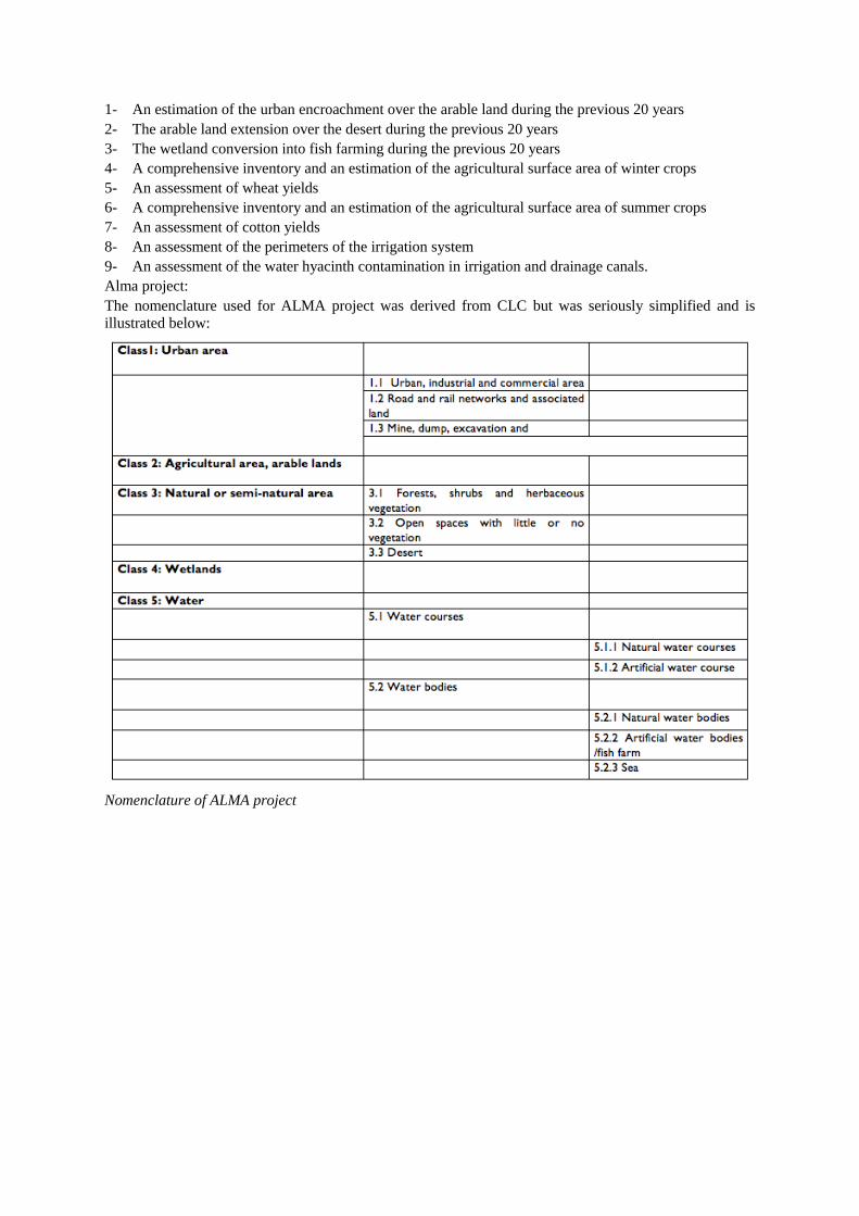
1- An estimation of the urban encroachment over the arable land during the previous 20 years
2- The arable land extension over the desert during the previous 20 years
3- The wetland conversion into fish farming during the previous 20 years
4- A comprehensive inventory and an estimation of the agricultural surface area of winter crops
5- An assessment of wheat yields
6- A comprehensive inventory and an estimation of the agricultural surface area of summer crops
7- An assessment of cotton yields
8- An assessment of the perimeters of the irrigation system
9- An assessment of the water hyacinth contamination in irrigation and drainage canals.
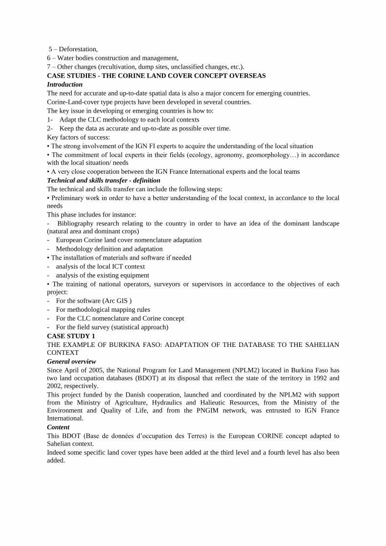
Alma project:
The nomenclature used for ALMA project was derived from CLC but was seriously simplified and is
illustrated below:
Nomenclature of ALMA project

Nomenclature of CIPA project (extract of a part of the agricultural topic)
More than 70 items were defined in this nomenclature and specifically used for the surveyors during the
field survey.
Main findings

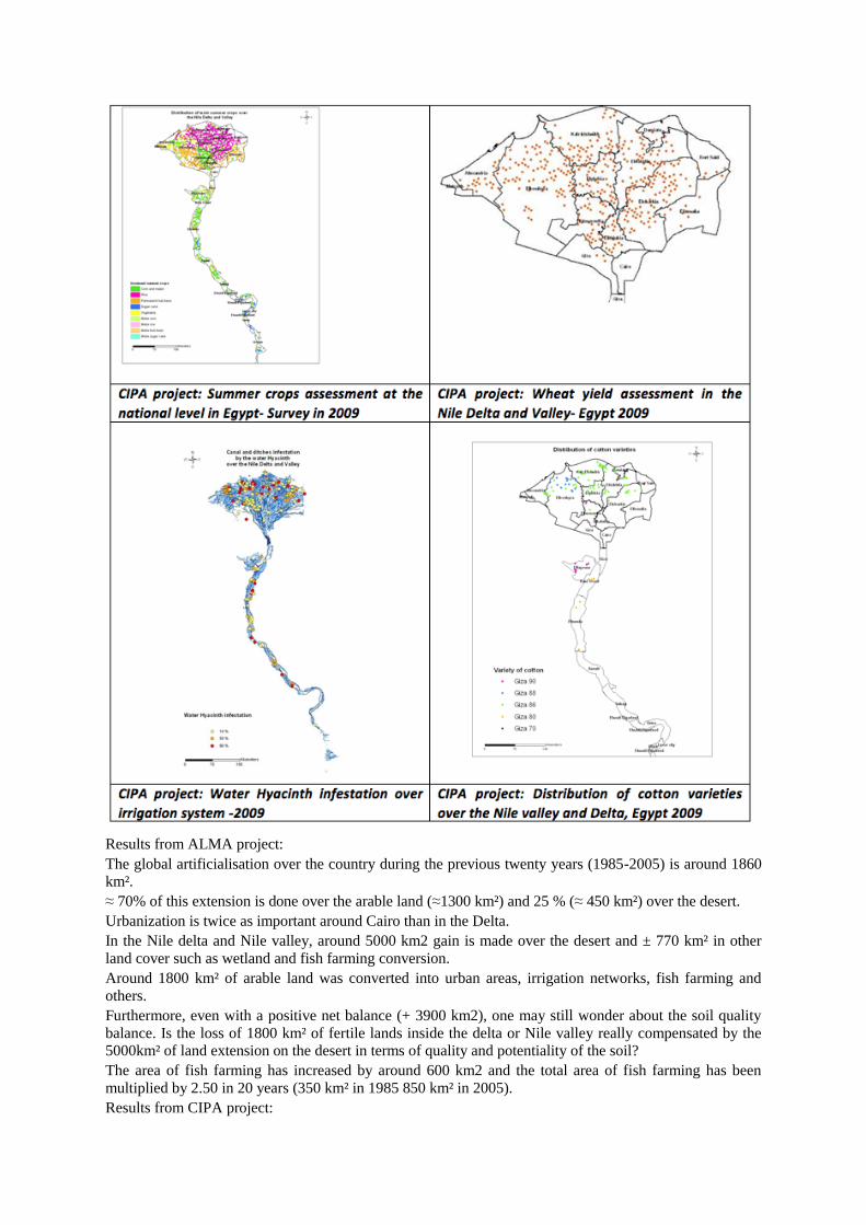
Results from ALMA project:
The global artificialisation over the country during the previous twenty years (1985-2005) is around 1860
km².
≈ 70% of this extension is done over the arable land (≈1300 km²) and 25 % (≈ 450 km²) over the desert.
Urbanization is twice as important around Cairo than in the Delta.
In the Nile delta and Nile valley, around 5000 km2 gain is made over the desert and ± 770 km² in other
land cover such as wetland and fish farming conversion.
Around 1800 km² of arable land was converted into urban areas, irrigation networks, fish farming and
others.
Furthermore, even with a positive net balance (+ 3900 km2), one may still wonder about the soil quality
balance. Is the loss of 1800 km² of fertile lands inside the delta or Nile valley really compensated by the
5000km² of land extension on the desert in terms of quality and potentiality of the soil?
The area of fish farming has increased by around 600 km2 and the total area of fish farming has been
multiplied by 2.50 in 20 years (350 km² in 1985 850 km² in 2005).
Results from CIPA project:

The surveyors visited 2700 sites, spread all over the Nile valley, the delta, and its extensions. The observed
zone represents 52882 km². The surveyors noted the cover of the land for 31500 spots in the country and it
was completed with 3500 spots, located inside large towns or at their boundaries (mainly desert and sea),
which were photo-interpreted.
The results give the areas of each type of crops in ha or Feddan (Egyptien reference) for the winter and
summer crops.
Concerning the wheat, the field survey was carried out between the 15th of April and the 15th of May
2009 by visiting 546 wheat plots regularly spread all over the Nile Valley and the Delta.
In each plot a sample was taken at two different places, the surface harvested representing two square
meters. The sampling proved successful for 422 samples out of the 546 plots (some plots where already
harvested, or conditions of sampling were not respected for the others).
Some linear features are present in the countryside such as small irrigation canals, ditches, paths or hedges
and represent an area which is not occupied by the crops.
These elements were observed during the summer crop area survey which was carried out from mid-June
to the end of July.
At near 15000 points, the surveyors noted the presence of these elements when they were less than ten
meters from the given point (radius approach).
The encroachment rate of these linear structures is lower than 1%. The full coverage represents 2.2 % of
the agricultural land.
The water hyacinth assessment was completed during the summer crop area survey which was carried out
from mid-June to end of July. The surveyors visited 20000 points spread all over the Nile valley, the delta
and its extensions.
About 550 points of large canals and ditches (width >3m) and 3500 points of small canals and ditches
(width<3m) were surveyed.
The surveyors noted for all the canals or ditches which were in the scope of the survey the presence of
water hyacinths: scarce cover, large cover, full cover.
The pilot survey concerning the cotton yield was carried out between the 15th of August and the 12th of
September 2009 by visiting 100 cotton plots regularly spread all over the Nile Valley and the Delta.
In the selected plots a specific counting was carried out by the surveyors. The length of the counting and
observation was fixed at 4 meters, and the same protocol was used all over Egypt.
The sampling was successful for 75 samples out of the 100 plots (some plots were already harvested, or
conditions of counting were not respected for the others).
GENERAL CONCLUSIONS
Land Use and land cover mapping projects: part of a global strategy
• Land cover and land use mapping projects give very relevant information and contribute to a better
understanding of the changes and evolutions that impact the territories. This information helps the
decision-makers to build up national and local strategies.
• But beyond environmental uses, the land cover databases and the statistical information are used as a
reference layer in a Spatial Data Infrastructure (SDI).
Choice of the appropriate methodology: statistical approach or spatial approach
In some cases a statistical or a spatial approach will be more appropriate, in other cases a combination
between spatial and statistical approaches will be advised and the combination of the two methods will
always provide a general improvement in quality of the final results.
> The implemented method proves that IGN FI masters both approaches and spatial monitoring methods
of the evolution of land occupation and is capable of implementing statistical methodologies in the field
that responds to specific demands.
Internal key factors for success
• The countries must have a precise knowledge of their territory and of the different elements of the
biosphere
• It is important that the country defines its needs because this will impact the perimeter of the project to be
launched
• Each protocol is specific and depends on:
• The physical phenomenon that is being measured,
• The scale of the study

• The frequency of updating
• The field survey work; indeed certain requests and studies will require more surveys in the field.
• The duration of the project
• The countries must be autonomous in the execution of projects, the management of their data and the use
of this data
> The maintenance of accurate and up-to-date geospatial data is a key issue in the long-term, especially in
the context of developing countries.
External key factors for success: the choice of the technical/methodological partner
• Its knowledge of local contexts
• Its network of thematic experts
• Its technical skills and know-how
To assist the country in the various phases of the project:
• Implementation
• Execution
• Follow-up
• Technical assistance
• Training in accordance with the needs and with the local situation
Choice of the partner: its references are a key factor of success
• From the European CORINE Land Cover project’s inception in the mid-1980s, IGN FI became involved
in the concept’s development, its feasibility, its production, its extension and its regular updating.
Today IGN FI, continuing its collaboration with the thematic European, French and foreign experts,
implements tools of knowledge, analysis, follow-up, surveillance, management and spatial planning in
fields as varied as cities, forests, water, agriculture and land occupation in its entirety
• IGN FI has been entrusted with various tasks such as the coordination of production or the supervision of
the French database while the French Institute of the Environment (IFEN) was in charge of the French
program
• Since 2001, IGN FI is part of the European Thematic Center’s technical team ETC-LUSI (Land Use and
Spatial Information) working for the EEA in the monitoring and thematic evaluation of spatial databases
on national levels, updated “CORINE Land Cover” land occupation
• IGNFI is actively involved in the developing of methodologies for various projects and programs
ensuring the integration of environmental data according to the INSPIRE directive, the supervision of
databases like GLOBCOVER, the creation of operational services within GMES** (Geoland, GSE Land,
Urban Atlas), as well as the search for applications and reflections coming from the CLC concept.
• IGNFI has developed Land use and land cover mapping projects in numerous international contexts 1 Heymann et al., 1994
2 Steenmans and Perdigao 2001, Büttner et al. 2004, Feranec et al. 2007a, EEA-ETC/LUSI 2007
3 Perdigão and Annoni, 1997
4 Land accounts for Europe 1990-2000 –Towards integrated land and ecosystem accounting EEA report
No 11/2006
Land cover classification proposed for SEEA, LG/15/8/2, drafted by Jean-Louis Weber (EEA), 15th
Meeting of the London Group on Environmental Accounting, Wiesbaden, 30 November – 4 December
2009)
5 This Land cover and its change in Europe between 1990-2006 is the subject of the presentation by J Feranec 6 Feranec &al 2011
7 2006, p. 9
8 Feranec at al. 2010