Embed Size (px)
Citation preview

Technical Report of Project entitled
Study on Mining Affected Areas and its Impact on
Livelihood
Meghalaya- Community Led Landscape Management Project
Meghalaya Basin Management Agency Shillong
2019


Prof. O. P. Singh Principal Investigator/Consultant
Department of Environmental Studies North-Eastern Hill University Shillong- 793022 Meghalaya
Project Number: P 157836
Contract Number: MBMA/CLLMP/PP/Mining/46/2017


i | P a g e
Preface
The indiscriminate and unscientific mining and absence of post mining treatment and management of mined areas have made the fragile ecosystems of Meghalaya more vulnerable to environmental degradation and depletion of natural resources. As a consequence, the natural resources such as soil, water, forest and forest products, biodiversity etc. have been severely affected both in terms of their quality and quantity in the mining areas of the state. The traditional livelihood options linked to these resources have also been found affected. The information on effects of coal, limestone, sand mining etc. on land, water, forest resources and the community are fragmentary and thus needed consolidation with recent data. The meagre information available on the effect of mining on human health, natural resources with special emphasis on soil, water and biodiversity, livelihood of the people with particular reference to agriculture including horticulture, livestock, aquaculture and fishery are scattered, hence needed compilation. Such information is essential to strengthen the community led natural resource management practices in order to facilitate community led planning coupled with technical inputs and funding broadly in the areas of forest, water and soil in Meghalaya. Hence, the need was felt to compile available information in order to identify the drivers of degradation and also for promoting activities towards conservation of forest, soil and water resources with reference to sustainable livelihood. Hence, the project entitled ‗Study on Mining Affected Areas and its Impact on Livelihood‘ under the Meghalaya-Community Led Landscape Management Project (CLLMP), Meghalaya Basin Development Authority, Shillong was undertaken with the major objectives of strengthening community led natural resource management of mining affected area of Meghalaya During the study information was collected and compiled based on field visits, discussion with the stakeholders, questionnaire survey, laboratory analyses and consultation with experts. Local bodies, research and voluntary organizations, communities, Green Volunteers, NGO representatives etc. were also consulted. Based on the information generated and gathered from primary and secondary sources this report has been prepared. The information included give a generalized view of the state of environment of mining areas of Meghalaya based on scientific studies and peoples‘ perception on mining and its impact on natural resources and livelihood based on questionnaire survey. Measures to mitigate the adverse impacts of mining activity on environmental components and livelihood of the people have also been suggested. Options to restore and rehabilitate the mining affected areas are also included for improvement of livelihood options and life of the affected people. It is expected that information included in this report will help in strengthening the community led natural resource planning and management of different landscapes in Meghalaya. Professor Department of Environmental Studies Dr. O. P. Singh North-Eastern Hill University, Shillong- 793022 Principal Investigator/ Consultant

Blank Page

iii | P a g e
Acknowledgement
The consultants of the project entitled ‗Study on Mining Affected Areas and its Impact on Livelihood‘ would like to thank Meghalaya Basin Development Authority Shillong and World Bank for assigning the study to the team of researchers of North Eastern Hill University, Shillong. The team members would like to express their gratitude to Shri P. Sampath Kumar, IAS, Chief Executive Officer (CEO), MBDA & Project Director CLLMP; Shri S. Ashutosh, IFS, former Chief Executive Officer, MBDA; Shri S. M. Sahai, IFS, former Dy. CEO, MBDA; Shri Aiban Swer, Director (A&F), MBDA; and Shri L. Shabong, Officer on Special Duty (MINR), MBDA for their valuable suggestions and support in formulating the project proposal and its successful execution. We are also thankful to Shri P. K. Marbaniang, Deputy Project. Director, CLLMP (Monitoring and Evaluation), and Shri B. S. Rumnong, Dy. Project Director, CLLMP for rendering help in smooth completion of the study and also for their valuable suggestions on draft report. The consultant is also thankful to the members of World Bank Team specially Shri Pyush Dogra, Sr. Environmental Specialist, World Bank for their valuable comments and suggestions on draft report. During the course of study the team members received help from the field staff of MBDA in organizing awareness/interaction meetings and conducting the field visits and questionnaire survey. We would like to thank Dr. (Ms.) Wansah Pyrbot and other field staff of MBDA and District Administration for their help in organizing awareness meeting and data collection. We also like to record our appreciation to the villagers particularly respondents, the Green Volunteers and students of the area for their active participation and sincere efforts in conducting the questionnaire survey and helping in sampling of various environmental components. The Principal Investigator is grateful to the Project Fellows, Mr. Gregory Malngiang and Ms. Lorraine. C. Marbaniang for their help in field work, computation, analysis and compilation of data of the questionnaires survey and laboratory analysis and also for their help in preparation of the draft report. The team is also thankful to the University administration for providing logistics during the course of study, without which study would have not completed successfully. Professor Department of Environmental Studies O. P. Singh North-Eastern Hill University, Shillong- 793022 Principal Investigator/Consultant

Blank Page

v | P a g e
Mining Affected Areas and its Impact on Livelihood
[Contents]
Contents Preface i Acknowledgement iii Executive Summary I-IX 1. Introduction 1-7
1.1 Meghalaya 1 1.2 Minerals and Mining 3 1.3 Impact of Mining 5 1.4 Information Gap 6 1.5 Structure of the Report 7 References
2. Objectives and Scope 9-10 2.1 Objectives 9 2.2 Scope 9 2.3 Activities 10 References
3. Methodology 11-15 3.1 Organization of Interaction Meetings and Awareness Programmes 11 3.2 Data Sources 12 3.3 Questionnaire Survey 12 3.4 Sampling and Analysis of Environmental Components 14
3.4.1 Sampling and Analysis of Soil 14 3.4.2 Sampling and Analysis of Water 14 3.4.3 Sampling and Analysis of Air 15 3.4.4 Analysis of Forest Cover 15 3.4.5 Laboratory Analysis 15
3.5 Collection of secondary data 15 References
4. Results 17-139
4.1 Geology and Mineral Resources of Meghalaya 17 4.1.1 Geology of Meghalaya 17 4.1.2 Mineral Resources of Meghalaya 18 4.1.3 A Brief Account of various Minerals 20
4.1.3.1 Coal 21 4.1.3.2 Limestone 24 4.1.3.3 Stone and Sand 31 4.1.3.4 Uranium 31 4.1.3.5 Sillimanite 31 4.1.3.6 Granite 31

vi | P a g e
Mining Affected Areas and its Impact on Livelihood
[Contents]
4.1.3.7 Clay and Kaolin 32 4.1.3.8 Glass Sand 32 4.1.3.9 Quartz 32 4.1.3.10 Feldspar 32 4.1.3.11 Gypsum 33 4.1.3.12 Iron ore 33 4.1.3.13 Bauxite 33 4.1.3.14 Other Mineral resources 33
4.2 Mining of Minerals 33 4.2.1 Coal Mining 33
4.2.1.1 Unscientific and Primitive Method of Mining 34 4.2.2 Limestone Mining 36 4.2.3. Sand and Stone Mining 39
4.3 Effect of Mining based on Scientific Studies 39 4.3.1 Effect of Coal Mining on Soil and Water 40
4.3.1.1 Effect of Coal Mining on Land and Soil 40 4.3.1.2 Effect of Coal Mining on Water 43
4.3.1.2.1. Ground Water Resources and Quality in Jaintia Hills 43 4.3.1.2.2. Surface Water 47
4.3.1.3 Impact of water pollution on aquatic life 54 4.3.2 Effect of Limestone Mining on Soil and Water 56
4.3.2.1 Effect of Limestone Mining on Land and Soil 56 4.3.2.2 Limestone mining and Water quality 58
4.3.3 Water Scarcity 61 4.3.4 Effect of Mining on Air quality 61 4.3.5 Effect of Coal and Limestone mining on Forest 63 4.3.6 Effect of Coal Mining on Floristic Composition 66 4.3.7 Effect of Mining on Agriculture 70
4.3.7.1 Diversion of Agricultural Land 70 4.3.7.2 Degradation of Agricultural Land 72 4.3.7.3 Environmental Pollution and Agriculture 73
4.3.8 Effect on Fish and Fishing 74 4.3.9 Impact on Human Health 76 4.3.10 Effects of Mining on Socio Economy 77 4.3.11 Effect of Mining on Livelihood 79
4.4 Perception of Local People on Effect of Mining 80 4.4.1 Dependence of people on Mining 80 4.4.2 Impact of mining on Land and Soil 86 4.4.3 Impact of mining on Agriculture 88 4.4.4 Impact of Mining on Forest 92
4.4.4.1 Forest and Livelihood 95 4.4.4.2 Dependence on Forest Resources for Livelihood 95
4.4.5 Impact on Biodiversity 102 4.4.6 Impact on Human Health 104
4.5 Community Conservation Practices and Knowledge 107 4.5.1 Agencies Involved in Community Conservation 107 4.5.2 Community Conservation Measures 109
4.5.2.1 Community Conservation Measures in Jaintia Hills 109 4.5.2.1.1 Measures taken up to Increase Availability of Water 110 4.5.2.1.2 Measurements taken to Increase Quality of Water 111 4.5.2.1.3 Measures to reduce Contamination 111 4.5.2.1.4 Measures to Improve Soil Fertility 113

vii | P a g e
Mining Affected Areas and its Impact on Livelihood
[Contents]
4.5.2.1.5 Measures to Improve Aquatic Resources 113 4.5.2.2 Community Conservation Measures in Garo Hills 114 4.5.2.3 Community conservation Measures in East Khasi Hills 114
4.5.3.3.1 Measures taken to Increase Availability of Water 115 4.5.3.3.2 Measures taken to Protect the Quality of Water 116 4.5.3.3.3 Measures to Reduce Water and Soil Contamination 116 4.5.3.3.4 Measures to Improve Aquatic Resources. 117
4.6 Demand Supply of Fuel wood and Charcoal 119 4.6.1 Consumption of Fuel wood 119 4.6.2 Shortfall in Availability of Fuel wood 120
4.6.3 Production, Uses, Demand and Supply of Charcoal 124 4.6.3.1 Charcoal Production 124 4.6.3.2 Demand and Supply of Charcoal 125 4.6.3.3 Use of Charcoal in Households 126 4.6.3.4 Procurement of Charcoal 126 4.6.3.5 Making of Charcoal 127 4.6.3.6 Dependence on Charcoal Production for Livelihood 127 4.6.3.7 Profit in Charcoal Business 128 4.6.3.8 Dependence on Charcoal Production for Livelihood 131 4.6.3.9 Availability of Charcoal in Market 132 4.6.3.10 Tree Species used for charcoal making 133
4.7 Traditional Knowledge for Protection of Environment 135 References
5. Strategy for Restoration and Rehabilitation of Mining Affected Area 141-174 5.1 Statutory Regulations and Policy Related to Mining 142 5.2 Restoration and Rehabilitation of Mining Affected Areas 144
5.2.1 Prevention 145 5.2.1.1 Safe Disposal, Segregation and Storage 145 5.2.1.2 Construction of Wall around the Mine Pits 146 5.2.1.3 Mine Reclamation by Filling the Mine Pits 146 5.2.1.4 Landscaping and Compaction 149 5.2.1.5 Conservation of Topsoil 149 5.2.1.6 Management of AMD and Surface Water 149 5.2.1.7 Construction of Designated Area for Storage of Coal 150 5.2.1.8 Control of Formation of Acid Mine Drainage 150 5.2.1.9 Prohibition of Mining near Water Sources 152 5.2.1.10 Covering of Acid Producing Materials 152 5.2.1.11 Covering the Acid Producing Materials 152 5.2.1.12 Alkaline Amendment 152 5.2.1.13 Diversion of Surface Water 153 5.2.1.14 Inhibition of Bacterial Activity 153
5.2.2 Remediation 153 5.2.2.1 Passive Treatment Technologies 154
5.2.2.1.1 Open Limestone Channels 154 5.2.2.1.2 Anoxic Limestone Drains (ALD) 155 5.2.2.1.3 Aerobic wetlands 156 5.2.2.1.4 Anaerobic Wetlands 156 5.2.2.1.5 In-Stream Limestone Sand 157 5.2.2.1.6 Limestone Diversion Wells 158 5.2.2.1.7 Vertical Flow System 158 5.2.2.1.8 Successive Alkalinity Producing System (SAPS) 159
viii | P a g e
Mining Affected Areas and its Impact on Livelihood
[Contents]
5.2.2.2 Active Treatment Methods 160 5.2.2.2.1 Alkaline Chemicals Commonly Used in Active Treatment 160 5.2.2.2.2 Processes in Active Treatment technology 161
5.2.3 Rehabilitation 162 5.2.3.1. Afforestation 162 5.2.3.2 Additional Actions needed in Rehabilitation 163
5.2.3.2.1 Rejuvenation of Springs 163 5.2.3.2.2 Rainwater Harvesting 164 5.2.3.2.3. Revival of Lost Rural Livelihood 165
5.2.3.3 Creating Awareness among Local Communities 168 5.3. Ten Actionable Points 169
5.3.1 Framing Policy and Regulation of Mining 169 5.3.2 Rainwater Harvesting 169 5.3.3 Rejuvenation of Springs 169 5.3.4 Protection of Streams not affected by Mining 170 5.3.5 Neutralization of Acidic contaminated water 170 5.3.6 Prohibition of Mining near Water Sources 170 5.3.7 Afforestation 171 5.3.8 Revival and Promotion of Traditional Livelihood Options 171 5.3.9 Development of Nature based Tourism: 171 5.3.10 Awareness and Incentive 172
5.4 Good Practices/Success stories 173 References
Annexure 174-194
Good Practices/Success Stories Annexure 1: Neutralization of Acid Mine Drainage contaminated water Meghalaya 174 Annexure 2: Coal Miners switch to turmeric farming in Meghalaya 180 Annexure 3: A success story of Strawberry cultivation in East Jaintia Hills District. 186 Annexure 4: Success stories of Aquaculture/Fishery in Meghalaya. 188
Questionnaire Annexure 5: Questionnaire used for data collection in this study. 190
*****

ix | P a g e
Mining Affected Areas and its Impact on Livelihood
[Contents]
List of Figures
Figure 1.1: District map of Meghalaya
Figure 4.1: Geological map of Meghalaya
Figure 4.2: Mineral Map of Meghalaya
Figure 4.3: Map showing distribution of coal bearing areas in the State of Meghalaya
Figure 4.4: Map showing distribution of limestone bearing areas in the state of Meghalaya
Figure 4.5: Photographs showing coal mine, mining activities in Jaintia Hills
Figure 4.6: Photographs showing limestone mining activities
Figure 4.7: Loading of sand mined from nearby river in Garo Hills
Figure 4.8: Photographs showing land degradation & soil pollution due to coal mining & storage
Figure 4.9: Hydrogeological map of Jaintia Hills
Figure 4.10: Photographs showing state of rivers and water quality due to coal mining
Figure 4.11: Location map of the Jaintia Hills and sampling points
Figure 4.12: Land Use Land Cover maps of 1987, 1999 and 2013 of an area of Jaintia Hills
Figure 4.13: LULC maps of a part of Jaintia Hills showing changes in LULC
Figure 4.14: Changes in area of different LULC categories during 1999 and 2013
Figure 4.15: Land degradation in Jaintia Hills due to coal mining
Figure 4.16. Location of the surveyed area showing fish and water sampling sites
Figure 4.17a: Dependence of local community of Jaintia Hills on mining
Figure 4.17b: Help rendered by mining to the local community of Jaintia Hills
Figure 4.18a: Means of occupation of the local community of Jaintia Hills
Figure 4.18b: Benefits of mining derived by the local community of Jaintia Hills
Figure 4.19a: Dependence of the local community of Garo Hills on mining
Figure 4.19b: Help rendered by mining to the local community of Garo Hills
Figure 4.20a: Means of occupation for the local community of Garo Hills
Figure 4.20b: Benefits of mining derived by the local community of Garo Hills
Figure4.21a: Dependence of the local community of Khasi Hills on mining
Figure 4.21b: Help rendered by mining to the local community of Khasi Hills
Figure 4.22a: Occupation of people in mining area of Khasi Hills
Figure 4.22b: Benefits of mining derived by the community of Khasi Hills
Figures 4.23a & b: Impact of mining on soil and its fertility in Jaintia, Garo Hills
Figure 4.23c: Impact of mining on soil and its fertility in Khasi Hills
Figures 4.24a & b: Change in agri pattern and impact on vegetation in Jaintia Hills
Figures 4.25a & b: Changes in agri pattern and impact of mining on vegetation in Garo Hills
Figures 4.26a & b: Impact of mining on agricultural pattern and vegetation in Khasi Hills
Figures 4.27a & b: Impact of mining on Forest cover and forest products in Jaintia Hills.

x | P a g e
Mining Affected Areas and its Impact on Livelihood
[Contents]
Figures 4.28a & b: Impact of mining on Forest cover and forest products in Garo Hills.
Figures 4.29a & b: Impact of mining on Forest cover and forest products in Khasi Hills
Figures 4.30a & b: Dependence on forest for livelihood and occupations in Jaintia Hills
Figures 4.31a-b: Impact of livelihood due to forest loss and the causes thereof in Jaintia Hills
Figures 4.32a & b: Impact on livelihood due to forest loss and occupations in Garo Hills
Figure 4.32c: Impact of livelihood due to loss of forest in Garo Hills
Figures 4.33a & b: Occupation of people and their dependence on forest livelihood in Khasi Hills
Figures 4.34a & b: Impact of livelihood due to loss of forest and reasons thereof in Khasi Hills
Figures 35a, b & c: Effect of mining on environment and biodiversity in Jaintia, Garo and Khasi Hills
Figures 4.36a & b: Impact of mining on health and reasons thereof in Jaintia Hills
Figures 4.37a & b: Impact of mining on health and reasons thereof in Garo Hills
Figures 4.38a & b: Role of agencies in conservation of environment in Jaintia and Khasi Hills
Figures 4.39a & b: Conservation measures undertaken for increasing water in Jaintia Hills
Figures 4.40a & b: Measures to improve quality of water and reduce water & soil contamination
Figures 4.41a & b: Measures to increase soil fertility and increase fish production in Jaintia Hills
Figures 4.42a & b: Conservation measures to increase water quality in Khasi Hills
Figures 4.43a & b: Measures to protect water quality in Khasi Hills
Figure 4.44: Measures undertaken to improve aquatic resources in East Khasi Hills
Figure 4.45: Per capita average daily consumption of fuel wood in Khasi, Garo and Jaintia Hills
Figures 4.46a & b: Shortfall in availability of fuel wood and the reasons in Jaintia Hills
Figures 4.47a & b: Shortfall in availability of fuel wood and the reasons in Garo Hills
Figures 4.48a & b: Shortfall in availability of fuel wood and the reasons in Khasi Hills
Figure 4.49: Population that make use of charcoal in Jaintia Hills
Figure 4.50: Sources of charcoal for the local community of Jaintia Hills
Figure 4.51: Population of Jaintia Hills involved in charcoal making
Figure 4.52: Dependence of Households of Jaintia Hills on charcoal production for livelihood
Figure 4.53: Status of profit in charcoal business in Jaintia Hills
Figure 4.54: Population of Garo Hills that make use of charcoal
Figures 4.55a & b: Population that make use of charcoal and sources of charcoal in Khasi Hills
Figures 4.56a & b: Charcoal making and dependence for livelihood in Khasi Hills
Figures 4.57a & b: Status of profit in charcoal business in Khasi Hills
Figure 4.58: Preference of tree species being used in charcoal making in Khasi Hills
Figure 4.59: Photographs of practices based on traditional knowledge of Meghalaya
Figures 4.60a, b & c: Use of traditional knowledge in Jaintia, Garo and Khasi Hills
Figure 5.1: Imagery showing coal mining area Jaintia Hills
Figures 5.2a, b, c & d: Passive treatment technologies used in remediation of acid mine drainage
Figures 5.3a, b, c & d: Diagrams of some water conservation and rain water harvesting measures

xi | P a g e
Mining Affected Areas and its Impact on Livelihood
[Contents]
List of Tables
Table 3.1: Number of questionnaires filled in three Hills regions of Meghalaya
Table 4.1: Minerals of Meghalaya: Occurrence, reserves and industrial uses
Table 4.2: Places of coal mining/occurrence of coal in three hill regions of Meghalaya
Table 4.3: Estimated Coal reserves at different coalfields of Meghalaya
Table 4.4: Occurrence of limestone in three Hill regions of Meghalaya
Table 4.5: Distribution of Limestone in different parts of Meghalaya
Table 4.6: Chemical composition of limestone found in different parts of Meghalaya
Table 4.7: Limestone mining leases granted by Government of Meghalaya
Table 4.8: List of major Cement Plants operating in Meghalaya
Table 4.9: Average values of Soil Quality parameters due to coal mining area of Jaintia Hills
Table 4.10: Values of physico-chemical parameters of groundwater samples of Ummulong village
Table 4.11: Physico-chemical parameters of water of some streams of Jaintia Hills
Table 4.12: Water quality parameters of streams of coal mining areas of Jaintia Hills
Table 4.13: Water quality parameters of water of Simsang river of Garo Hills, Meghalaya
Table4.14 : Physico-chemical properties of the water of some rivers of Jaintia Hills, Meghalaya
Table 4.15: Concentration of selected elements in the water samples collected from Jaintia Hills
Table 4.16: Physicochemical parameters and metal concentrations in mine drainage and dug-well water from Jaintia Hills
Table 4.17: Water quality of Lynriang River
Table 4.18: Water quality of Prang River15
Table 4.19: Macro-invertebrates and fish, frog etc. in rivers and streams of Jaintia Hills12
Table 4.20: Soil quality parameters of soil of limestone mining areas of East Khasi Hills,
Table 4.21: Soil quality parameters of soil of limestone mining areas of East Jaintia Hills
Table 4.22a: Water quality parameters of water in East Jaintia Hills, Meghalaya
Table 4.23b: Water quality parameters of water in East Jaintia Hills, Meghalaya
Table 4.24: Annual deforestation rate during 1987-1999 and 1999-2013 in Jaintia Hills
Table 4.25: Species composition in mined area in Nokrek Biosphere Reserve, Garo Hills
Table 4.26: Tree species found in unmined and mined areas of the Nokrek Biosphere Reserve
Table 4.27: Distribution of fish species in the water bodies of Jaintia Hills, Meghalaya
Table 4.28: Data of charcoal production from 1995 to 2005 in Meghalaya

xii | P a g e
Mining Affected Areas and its Impact on Livelihood
[Contents]
List of Boxes
Box: 4.1: Coal in Meghalaya
Box 4.2: Limestone in Meghalaya
Box 4.3: Rat hole mining in Meghalaya
Box 4.4: Effects of coal mining on Soil
Box 4.5. Effects of coal mining on water
Box 4.6: Effect of limestone mining on soil and water
Box 4.7: Effect of Mining on Forest
Box 4.8: Dependence of People on Mining
Box 4.9: Impact of Mining on Land and Soil
Box 4.10: Impact of Mining on Agriculture
Box4.11: Impact of Mining on Forest
Box 4.12: Dependence of community on forest for resources and livelihood
Box 4.13: Impact on Biodiversity
Box 4.14: Impact of Mining on Human Health
Box 4.15: Community Conservation Practices
Box 4.16: Demand and Supply of Fuel Wood
Box 4.17: Demand and Supply of Charcoal
Box 4.18: Traditional Knowledge in Conservation of Resources
Box 5.1: Passive Treatment
Box 5.2: Active Treatment
Box 5.3: Ten Actionable Points
xiii | P a g e
Mining Affected Areas and its Impact on Livelihood
[Abbreviation]
Abbreviation
AMD- Acid Mine Drainage
APHA- American Public Health Association
ALD - Anoxic Limestone Drain
ASM- Artisanal and Small Scale mining
BD- Bulk Density
BDO- Block Development Officer
BIS- Bureau of Indian Standards
BOD- Biological Oxygen Demand
Ca- Calcium
CaO- Calcium Oxide
Cl- Chloride
CLLMP- Community Led Landscape Management Project
CPCB – Central Pollution Control Board Cu- Copper
DC- Deputy Commissioner
DGM- Directorate of Geology and Mining
DMR- Directorate of Mineral Resources
DO- Dissolved Oxygen
EC- Electrical Conductivity
EGH- East Garo Hills
EJK- East Jaintia Hils
EKH- East Khasi Hills
FBC- Fluidized bed combustion
FCO2- Free Carbon dioxide
Fe- Iron
Fe(OH)3- Ferric Hydroxide
FeS2- Pyrite ( Iron sulphide)
FSI- Forest Survey of India
GIS- Geographical Information System
GSI- Geological Survey of India
H+ - Hydrogen ions
HCO3- Bicarbonate
H2O- Water
HH- Household
H2S- Sulfide gas
H2SO4- Sulphuric acid
K- Potassium
LPG- Liquefied petroleum gas
Ltd- Limited
LULC- Land Use Land Cover
MBDA- Meghalaya Basin Development Agency
MBMA-Meghalaya Basin Management Agency
MSMPB -Meghalaya State Medicinal Plants Board
MC- Moisture Content
MCCL- Mawmluh -Cherra Cements Limited
MCLLMP- Meghalaya Community Led Landscape Management Project
Mg- Magnesium
MGNREGA- Mahatma Gandhi National Rural Employment Guarantee Act
MLA- Member of the Legislative Assembly
MMDR- The Mines and Minerals (Development and Regulation Act 1957
Mn- Manganese
MSPCB – Meghalaya State Pollution
Control Board MT- Million Tonnes
N- Nitrogen
NA- Not Available
Na- Sodium
NEHU- North Eastern Hill University
NEEPCO - North Eastern Electric Power
Corporation Limited

xiv | P a g e
Mining Affected Areas and its Impact on Livelihood
[Abbreviation]
NGO- Non Governmental Organization
NGT- National Green Tribunal
NH3- Ammonia
NO3- Nitrate
NOX- Nitrogen Oxides
NTFP- Non Timber Forest Product
NTU- Nephelometric Turbidity Unit
O2- Oxygen
OC- Organic Carbon
OLC -Open Limestone Channels
P- Phosphorus
PO4- Phosphate
PP- Pilot Project
REDD - Reducing Emissions from Deforestation and Forest Degradation
PSU- Public Sector Undertaking
RDS- Respirable Dust Sampler
RS- Remote Sensing
RSPM- Respirable Suspended Particulate Matter
SAPS- Successive Alkalinity Producing System SMC- Soil Moisture Content
SMELC- Social Mobilization
Experimentation and Learning Centre
SO2- Sulphur dioxide SO4- Sulphate
SOC- Soil Organic Content
SPM- Suspended Particulate Matter
Sq.m- Square meters
T- Temperature
TA- Total Alkalinity
TB- Tuberculosis
TDS- Total Dissolved Solids
TH- Total Hardness
TK- Traditional Knowledge
TKN- Total Kjeldahl Nitrogen
TS- Total Solids
TU- Turbidity Unit
WHC- Water Holding Capacity
WHO – World Health Organization
WT- Water Temperature
Zn- Zinc

Report Prepared for MBDA by Prof. O.P. Singh, Dept. of Environmental Studies, NEHU, Shillong I | P a g e
EXECUTIVE SUMMARY
Introduction Meghalaya is one of the eight states situated in North-Eastern Region of India and often acknowledged as ‗The Abode of Clouds‘. The State is comprised of three Hills regions namely, Khasi Hills, Jaintia Hills and Garo Hills. It is divided into eleven districts viz. 5 in Garo Hills, 4 in Khasi Hills and 2 in Jaintia Hills. As per 2011 Census, the total population of the state was 29,64,007. The rural and urban populations constitute 79.93% and 20.07%, respectively. More than 86% of the inhabitants are tribes belonging predominantly to the Khasi (Khasi, Pnar, Bhoi and War) and Garo communities. The state can, broadly, be divided into three physiographic zones (i) the Central Plateau Region between 900-2000 m (ii) Sub-montane region below 900 m which gradually merges with the plains in the West and North and (iii) Border region which stretches south-wards abruptly from the Central Plateau to the plains in Bangladesh. The climate of the state is directly controlled by the southwest monsoon originating from the Bay of Bengal and the Arabian Sea. The rainfall is heaviest in south eastern Garo hills and decreases in the central regions and in the north. The Cherrapunjee-Mawsynram area receives the heaviest rainfall with an annual average of 12,670 mm. The average rainfall in the state is 12,000 mm. Most of the precipitation in the state occurs between April and October. The winter is quite severe with minimum temperature coming down to as low as 2° C in the Khasi Hills. May and June are the warmest months and January is the coldest month. However, the climatic conditions vary substantially from place to place due to wide differences in altitude. Meghalaya has predominantly an agrarian economy as agriculture is the main
occupation of about 80% of people of the state. In addition to agriculture and horticulture, people of rural areas are also dependent on mining and mining related activities, fishing, hunting, collection of non-timer forest products (NTFPs), firewood and charcoal business for their livelihood and income generation. About 70% (17,146 sq. km.) of the geographical area is covered with forest. The forests of Meghalaya are diverse comprising broadly of tropical evergreen, tropical semi-evergreen, tropical moist deciduous, sub-tropical moist broad leaves, sub-tropical pine forest, temperate forest, grassland and savannah types. Forests support a vast floral diversity, including a large variety of parasites, epiphytes, succulent plants and shrubs. A substantial number of interesting fauna comprising of a large variety of mammals, birds, reptiles and insects etc. is also found in Meghalaya. A dense network of streams and rivers exists in Meghalaya. They flow either towards Brahmaputra River in the north or in the Surma valley of Bangladesh in the south. Soils of Meghalaya are slightly acidic, rich in organic carbon with low in phosphorus and available potassium. The State is endowed with deposits of rich mineral resources. Coal and limestone occur in all three hills regions of Meghalaya, mostly near the southern fringes of the state. The coal and limestone are the extensively exploited minerals in the state. Unscientific mining of minerals poses a serious threat to the environment, resulting in reduction of forest cover and loss of biodiversity, soil erosion and pollution of air, water and land. The land degradation and water pollution have affected the traditional agriculture, availability of bio-

Report Prepared for MBDA by Prof. O.P. Singh, Dept. of Environmental Studies, NEHU, Shillong II | P a g e
resources etc. and in turn the livelihood of the people. Mining, in absence of post mining treatment and management of mined areas is making the fragile ecosystems more vulnerable to environmental degradation The positive influences of mining include employment and income generation to the mine owners, miners, transporters and businesses linked to mining. However, the benefits seem to be short term and limited to a small number of people compared to large scale environmental degradation, depletion of natural resources and loss of traditional livelihood affecting a large number of people. The present report on mining affected areas and its impact on livelihood in Meghalaya is based on both, secondary and primary data. The secondary data gathered from scattered sources on the effect of mining. on land, water, forest resources and the community have been compiled in this report. The report is also based on primary data generated during present study in order to update the available data and fill the information gap. The report includes detailed information on the effect mining on environment and natural resources with special emphasis on soil, water and biodiversity. It also includes information on impact of mining on livelihood of the people with particular reference to agriculture including horticulture, livestock, aquaculture and fishery. The report has identified the drivers of degradation and loss of livelihood. Such information will be helpful in strengthening the community led natural resource management practices and conservation of forest, water and soil resources to promote sustainable livelihood activities in Meghalaya. Overview of Mining in Meghalaya A number of valuable minerals such as coal, limestone, kaolin, clay, granite, glass-sand, iron ore, quartz, feldspar, sillimanite, bauxite, rock phosphate, phosphate nodule, gypsum and uranium
are found in different parts of the State. Of these, coal and limestone have been mined in large area of Meghalaya covering all three Hill Regions. Sand and stone mining from the hills and river beds is also taking place. Other minerals are distributed in small patches in the State and mostly they remain un-mined. As a result only coal and limestone have yielded significant revenue for the State. Mining in Meghalaya is mostly done in unscientific manner with no consideration to environmental protection and social responsibility. Absence of any post mining treatment and restoration of degraded ecosystems make the situation worst with long term environmental and social implications. Coal Mining Coal is an important mineral resource of Meghalaya. The total coal reserves found in the state is estimated about 576.48 million tonnes. The coal found in Meghalaya belongs to tertiary age and is generally of sub-bituminous type. The coal seams varying from 30 to 212 cm in thickness occur imbedded in sedimentary rocks, sandstones and shale of the Eocene age. The Garo Hills has the highest reserve of coal deposits followed by West Khasi Hills, Jaintia Hills and East Khasi Hills. However, in terms of coal production, maximum extraction has taken place from Jaintia Hills. Areas such as Bapung-Sutnga and Khliehriat in the Jaintia Hills; Cherrapunjee, Laitryngew, Laitduh, Mawlong, Borsora Langrin etc. in Khasi Hills; and East Darrangiri, West Darrangiri, Siju, Pendengru Balpakram in the Garo Hills are the coal mining hubs in the State. Coal mining in Meghalaya is done by primitive mining method commonly known as ‗rat-hole‘ mining. The coal deposits present on the hill-slopes and along the river sides are mined by ‗side-cutting‘ however, coal present underground in plain land is mined through a shaft/pit by

Report Prepared for MBDA by Prof. O.P. Singh, Dept. of Environmental Studies, NEHU, Shillong III | P a g e
‗box cutting‘ method. The coal mining in Meghalaya is small scale and an unorganized venture controlled by individuals, who own the land. However, collectively coal mining engages thousands of people in mining and mining related activities spread in wide areas of all three Hills Regions of the State. The coal of Meghalaya is utilized in other states of the country in brick kilns, paper mills, tea gardens and other small scale industries. It is also exported to Bangaladesh. Limestone Mining Limestone is another abundantly found and extracted mineral in Meghalaya. About 9% of the country‘s total limestone reserves are available in the state. It is distributed in all three Hills regions of Meghalaya. The limestone found in different parts of the Meghalaya varies in chemical composition and thus differs in quality from cement to chemical grade. Generally, the CaO content of limestone found in Meghalaya is about 50%. The limestone in Meghalaya is mainly extracted for manufacturing of cement in the state itself as well as in neighboring state of Assam. It is also exported to Bangladesh. The areas where mining of limestone is taking place are villages like Nongsning, Mynkree, Thangskai, Wahiajer, Lumshnong, Sutnga, Lakadong, Syndai of East Jaintia Hills; Cherrapunjee and Shella of East Khasi Hills; and in Nongtalang and Amtapoh of West Jaintia Hills. Limestone extraction in Meghalaya is done by open cast mining. Both small scale and large scale mining of limestone are carried out in Khasi Hills for manufacturing of quicklime and cement, respectively. The extraction of limestone from the hillocks in Sohra is carried out by several land owners sharing the entire Mawmluh hills for making quicklime and edible lime. The limestone mined from Khasi Hills is also transported to Bangladesh through a cross
border conveyer belt of Lafarge Surma Cement Ltd. Company. The mining in Jaintia Hills is mostly done by cement industries. Due to unique land holding system in Meghalaya, mining of limestone is also carried out by individual land owners. The mining done by the cement industries is mechanized using heavy machinery. On the other hand, extraction by individual land owners is semi-mechanical and slow. Limestone in Jaintia Hills is mainly used for manufacturing of cement. Sand and Stone Mining Sand and stone mining is also taking place from riverbed and hill sides to cater the local needs in the state as well as of neighboring state. Mostly these resources are collected from the riverbed after the rainy season when water level of rivers is low. However, mining from hill sides continues throughout the year. Sand and stone mining from the hills and river beds are taking place unabated in all three Hills regions of Meghalaya. Other minerals are distributed in small patches in Meghalaya and mostly they remain un-mined. Thus, only coal and limestone have been mined extensively in the state and contributed significant amount of revenue to the State and the private mine owners. Environmental Impact of Mining Mining of minerals in Meghalaya has provided employment opportunity and newer livelihood options to the local people. To some extent, it has also contributed towards industrial and economic development of the state. However, the overall information suggest that mining, particularly mining of coal and limestone has severely affected the land and soil, water, air, fishery, forest, biodiversity, agriculture and agricultural production, socio-economy etc. in the mining areas. Sustainable options of livelihood of the people have also been found affected. The benefits seem to be

Report Prepared for MBDA by Prof. O.P. Singh, Dept. of Environmental Studies, NEHU, Shillong IV | P a g e
short term and limited to a small number of people. A brief account of the impact of mining on environmental components such as soil, water, air, forest etc. is given below. Impact of Mining on Soil The prevailing unscientific method of coal mining generates huge quantity of mine spoil or overburden in the form of gravels, rocks, sand and soil which are dumped over a large area adjacent to mine pits changing the natural landscape. The dumping of overburden and coal leads to severe soil degradation. Further, excavation of land leads to loss of top fertile soil. Physico-chemical analysis of mining affected soils revealed that the soil has become acidic and poor in nutrient content, water holding capacity and organic matter. At the same time soil was found contaminated with metals such as Cu, Fe, Mn, Zn etc. Low moisture and higher bulk density were other features of mining affected soil. Acidification of soil due to discharge of acid mine drainage (AMD) was found the most serious problem affecting the soil quality leading to degradation of agricultural land and decline in crop productivity. This has led farmers to abandon the age old agricultural activity and engaging themselves in other livelihood activities. Limestone mining has also affected the soil quality in terms of remarkable decrease in organic matter, moisture content, water holding capacity, organic carbon and total nitrogen. However, the soil quality parameters such as pH, electrical conductivity and bulk density showed an increase in the values in mining area. The increase in soil pH can be considered an improvement in soil quality because of prevailing acidic nature of soil in the area. Such changes in soil quality were found both in Khasi Hills and Jaintia Hills. Limestone mining has also resulted in removal of vegetation and fertile top soil and dumping of overburden
resulting in deterioration aesthetic beauty of the proximate landscape. Impact of Mining on Water The water bodies of the coal mining areas are the greatest victims in terms of qualitative degradation and quantitative depletion. The streams and rivers are badly affected by contamination of AMD originating from mines and spoils, leaching of heavy metals, organic enrichment and silting by coal and sand particles. Pollution of the water is evident by the colour of the water which in the mining area varies from brownish to reddish orange. Low pH (between 3-4), high conductivity, high concentration of sulfates, iron and toxic heavy metals, low dissolved oxygen (DO) and high biological oxygen demand (BOD) are some of the physico-chemical and biological parameters that characterize the degradation of water quality. Water of streams and rivers of all three regions (Jaintia, Khasi and Garo) have been found affected by coal mining. The adverse effects are severe in Jaintia Hills as most of the streams in coal mining areas have become highly acidic. However, in Garo Hills only few rivers or stretches of rivers have turned acidic due to coal mining. Further, low pH, low DO, higher sulphate content and turbidity of water have affected severely the aquatic life in the coal mining areas. As a result, aquatic fauna belonging to higher animal groups like fish, frog, crayfish, snail, crab etc. have totally vanished from the affected water bodies of Jaintia Hills. Both limestone mining and cement plants also have negative impact on the physico-chemical properties of water of the area. The mining of limestone has caused alteration in the quality of surface water in terms of high content of calcium, bicarbonates, sodium and chloride salts in the water of streams and rivers receiving a
Report Prepared for MBDA by Prof. O.P. Singh, Dept. of Environmental Studies, NEHU, Shillong V | P a g e
significant volume of mine water generated from open cast limestone mining areas. Study found elevated levels of pH, conductivity, dissolve solids, hardness, calcium and sulphate in affected streams. The discharge of cement dust emanating from Cement Plants has also contributed significantly towards degradation water quality, particularly in East Jaintia Hills. However, overall water pollution due to limestone mining is limited to a slight increase in pH, conductivity and turbidity. Water Scarcity due to Mining Due to Karst topography of Meghalaya, only a few perennial surface water bodies are present in coal and limestone deposit areas leading to water scarcity in lean period. Mining of coal and limestone and establishment of cement plants in the region have further aggravated the water scarcity in the area. Due to excavation of land and disturbance of landscape, many streams in the area have become seasonal as water of streams percolates into the ground. Thus, water resources in the mining area have been affected both in terms of its quantity and quality resulting severe scarcity of water. In many area people face real difficulty in fetching clean drinking water. Poor people are worst affected. Besides above mentioned harmful effects of mining, the entire coal mining area of the Jaintia Hills has become full of mine pits and caves. These open, unfilled pits are the places where surface water percolates and disappear into the ground and reaches to lower areas. As a result, smaller streams and rivers of the area, which served as life lines for the people are either completely disappearing from the face of the earth or becoming seasonal. Some water bodies are found above ground for certain distance and then disappear due to flowing of water underground. Consequently, the area is facing acute shortage of clean drinking and irrigation water either due to pollution
of available water or due to percolation of surface water into the ground. Effect of Mining on Air quality Mining involves activities such as drilling, blasting, hauling, loading and transportation. All these activities are major sources of gaseous and particulate air pollution. Pollution of air is one of the many pronounced impacts of mining carried out in Meghalaya. Activities like blasting of rocks, dumping and piling of coal and limestone and their loading and transportation are significant contributors to air pollution, particularly concentration of suspended particulate matter (SPM), respirable suspended particulate matter (RSPM) in the area. The gaseous pollutants released into the air are attributed by the motorized machines involved during the entire process of mining, i.e. movement of bulldozer, drilling machines, dumpers and transportation vehicles. Some cement plants have established coal based captive thermal power plants for generation of electricity. These power plants are burning coal which contains high concentration of sulfur, a major source of sulfur dioxide in atmosphere. Localities, adjacent to limestone mining area and cement plants experience deposition of thick dust on vegetation, buildings and roof top especially during the dry season. Dust deposition on vegetation can affect agricultural/horticultural productivity by hampering photosynthesis. Effect of Mining on Forest Mining involves clearance of large amount of forest lands resulting in deforestation and denudation of vegetation. Studies revealed deforestation, fragmentation of forest, diminishing plant diversity and degradation and loss of habitats due to coal and limestone mining. Striking changes in Land Use Land Cover (LULC) in Jaintia Hills during last two decades have been mostly implicated to coal and limestone mining and
Report Prepared for MBDA by Prof. O.P. Singh, Dept. of Environmental Studies, NEHU, Shillong VI | P a g e
establishment the cement manufacturing units. Both deforestation and degradation of the quality of the forest have been found in the mining areas. Among different classes of LULC, an increase in scrub/grassland, barren land, built up and water body areas has been recorded. Mining has also reduced the diversity and density of vegetation. The density of trees, shrubs and herbs in the mined areas has been reported significantly lower than that of the unmined areas. The LULC changes observed in mining areas indicate a clear tendency of deforestation and degradation of forest in the mining areas of Meghalaya. Such changes might lead to several ecological implications and affect flora and fauna and the people of the area. Effect of Mining on Agriculture Mining activity has come into direct competition with agriculture and has adversely affected the agricultural land and soil and crop growth and production. The pollution of air, water and soil caused by mining activities has affected the agriculture/horticulture, fisheries and rearing of livestock, directly and indirectly leading to degradation of soil quality and reduction in cropped area and agriculture productivity. Changes in water levels and flow of rivers, its availability for domestic and irrigation uses, changes in sediment flow and deposition, degradation of water quality, reduction and degradation of habitat of aquatic flora and fauna and decrease in abundance and diversity of aquatic species are some of the adverse impacts of mining. Pollution of rivers due to mining activities by contamination of acid mine drainage, in particular has significantly reduced the aquatic resources particularly fish fauna in the mining area. This has significantly caused a decline in fish production which has compromised livelihood of the local people traditionally dependent on fishing.
Further, mining activities have deteriorated the overall environment of the area in terms of deforestation and biodiversity loss, landscape disturbance, soil erosion, and degradation of land. Effects of Mining on Socio-economy People in Meghalaya which falls in Sixth Schedule area do not suffer from land alienation from outside people, yet the emerging trend reveals that the poorer section of the society are losing their land to rich coal merchants who use their man and money power to acquire land. Powerful coal mine owners are claiming community lands for coal mining and as such much of the community land has gone to the individuals. This has led to the disintegration of community land and loss of livelihood avenues. Landless people find it difficult to maintain cultural continuity as the mining activities have separated them from their traditional homestead and agricultural lands and thus affected the socio-economy of the local communities. With the development of coal mining, the socio-cultural adjustment in the mining area is becoming worse and the issues like consumption of alcohol, prostitution and other illegal activities are becoming common. The women who enjoyed special social status in the community are at the receiving end and vulnerable to anti-social activities. Hence, it can be concluded that mining of coal and limestone have severe effects on land and soil, water, air, agriculture, forest, biodiversity, agriculture and agricultural production, socio-economy etc. in mining areas of Meghalaya. Sustainable options of livelihood of a large number of people have been affected and the benefits seem to short term and limited to a small number of people. People’s Perception on Mining and its Effects Among three hills regions of Meghalaya, maximum number of households dependent on coal mining was found in

Report Prepared for MBDA by Prof. O.P. Singh, Dept. of Environmental Studies, NEHU, Shillong VII | P a g e
Jaintia Hills and least number in Garo Hills. Relatively lower dependence on mining for their livelihood in Garo Hills has been attributed to other means of livelihood. People in mining area are of the opinion that mining has helped the community and various benefits cited include increase in income, creation of employment and business opportunities. However, people have noticed various adverse impacts of mining that include degradation of land and soil, water, loss of forest and biodiversity, agriculture and ultimately livelihood of the people. Environmental Effect of Mining Majority of people perceive land and soil degradation and reduced agricultural productivity in coal mining areas. The land and soil degradation and decline in agricultural productivity was found more in Jaintia and Garo Hills. People reported acidification of soil and iron toxicity as main causes of soil degradation. Land use land cover changes due to various mining activities, erosion of soil and loss of organic matter, invasion of weeds and contamination of soil with inorganic components were the major causes of adverse effects on agriculture including paddy and orange cultivation. Clearance of forest land for mining operations and large scale deforestation were reported by the people. A majority of people in Jaintia and Garo Hills reported reduction of forest and its degradation resulting in a drastic reduction in availability of forest products. The main issues encountered by the local community in Khasi Hills as a result of loss of forest cover include impact on family income; decrease in charcoal production, degradation and loss of water resources, loss of forest resources like firewood and other NTFPs. People also noticed that mining, particularly in Jaintia and Khasi Hills has adversely affected biodiversity. Prevalence of various diseases of respiratory and digestive systems was reported in mining areas and people in
Jaintia Hills linked mining with various respiratory diseases owing to air pollution. Peoples‘ perception collected through questionnaire survey corroborates the results of scientific studies and people of the area are also aware of adverse effects of mining on various components of the environment and availability of resources. They also know that mining has ultimately affected their traditional livelihood options. Demand and Supply of Fuel wood The per capita daily consumption of wood was found highest in the mining areas Khasi Hills followed by Garo Hills and Jaintia Hills. Highest consumption in Khasi Hills was attributed to extensive dependence on wood primarily for cooking and heating purposes and also for fencing. In Garo Hills, wood was found as main source of domestic energy for cooking and heating purposes. In Jaintia Hills, the local communities have better access to modern fuels and electricity. Owing to factors such as shrinking of forest area and increasing demand people experience a shortfall in availability of fuel wood in Jaintia and Garo Hills, however people of Khasi Hills reported no shortfall. Demand and Supply of Charcoal Charcoal making is prevalent in the West Khasi Hills, East Khasi Hills and Ri-Bhoi Districts of Meghalaya. Widespread use of charcoal was recorded only in Khasi Hills. In Jaintia Hills a small number of people reported using charcoal, however no use of charcoal was recorded in Garo Hills. Preferred tree species used for making of charcoal include Castanopsis indica (Diengsoh-ot) and Shorea robusta (Diengsai). Restoration and Rehabilitation Traditional Knowledge for Protection of Environment Inspite of rich culture of traditional knowledge (TK) in Meghalaya, most people living in mining areas are not aware about their TK system which perhaps may be due to modernization and

Report Prepared for MBDA by Prof. O.P. Singh, Dept. of Environmental Studies, NEHU, Shillong VIII | P a g e
not paying attention to such knowledge. Hence, no such knowledge has been used in conservation of natural resources and restoration of mining affected areas. Very few people reported to possess some TK related to sacred groves, sacred forests and traditional ponds, however they have not used such knowledge in mining area for protection of environment. Community Conservation To conserve and protect the environment, different conservation measures have been undertaken at the community level supported by various Government Officials/Departments. These include initiatives such as framing rules and its imposition, undertaking tree plantation; prohibition of coal mining near water sources used for domestic purposes; prohibition of illicit felling of trees; proper storage of water available in the area; construction of drains for diverting polluted water and AMD in order to protect water sources from contamination; cleaning of rivers and streams at regular intervals; prohibition of washing and plying of vehicles near drinking water sources; construction of enclosure to protect springs; cleaning of the villages; prohibition of coal mining in areas used for cultivation of crops; construction of proper drainage for diverting agricultural runoff away from water bodies; not allowing dumping of coal near water sources; proper disposal of domestic waste; prohibition of fishing in water bodies with less fish population; and prohibition of the use of any chemical and poison in rivers and streams for harvesting fishes. Measures for Restoration and Rehabilitation of Mining Affected Areas The negative impacts of mining are long term and in all possibility impair the sustainable growth and development of the area and over weigh the short term economic benefits of mining. Hence, it is imperative to initiate actions to mitigate environmental degradation, rejuvenate the availability of natural resources and recreate healthy ecosystems for diverse
flora and fauna to flourish. Simultaneously, steps are needed to restore traditional livelihood and create newer livelihood options for sustainable development. Some of the measures suggested for eco-restoration and rehabilitation of the degraded areas include urgent need for a holistic policy on mining of minerals in Meghalaya; regulation of mining under prevailing central and state legislations; restoration and rehabilitation of mining affected areas; providing alternative livelihood options to the people and imparting awareness, training and skill development to the local people. The eco-restoration and rehabilitation of mining area can be done in three steps, i.e., prevention, remediation and rehabilitation. Prevention mainly focus on activities inhibiting AMD formation like safe disposal, segregation and storage of overburden; construction of wall around the mine pits; mine reclamation by filling the mine pits; landscaping, compaction and covering of overburden; conservation of topsoil; management of AMD and contaminated water; construction of designated area for storage of coal; prohibition of mining near water sources and alkaline amendment. Remediation activities mainly focus on treatment of AMD and acidic water before its discharge in natural water bodies and on land. Both passive and active methods can be employed. Passive methods include treatment of AMD by open limestone channels, anoxic limestone drains, limestone diversion wells, in-stream dumping of limestone sand, aerobic and anaerobic wetlands and phyto-remediation. However, the active treatment methods involve addition of alkaline chemicals to neutralize acidity. A wide range of chemical agents such as limestone, hydrated lime, caustic soda, soda ash, calcium oxide, anhydrous ammonia, magnesium oxide and magnesium hydroxide can be used.

Report Prepared for MBDA by Prof. O.P. Singh, Dept. of Environmental Studies, NEHU, Shillong IX | P a g e
Rehabilitation is the process of bringing back the mining affected ecosystems to its normal state and functioning. Thus, the land of mining affected areas needs to be re-vegetated, water and soil be brought to normal state and people living in and around the area be provided sustainable livelihood options. Re-vegetation of mine spoils can be done either by planting species suitable for degraded land or by making the condition of soil suitable for the growth of selected plant species. In addition, activities such as rejuvenation of springs and rainwater harvesting are needed to increase the availability of clean water. Revival of lost rural livelihood options like sericulture, beekeeping, traditional horticulture, cultivation of areca nut and local fruits and mushroom can engage employment to a large number of people of the mining affected areas. Further, Meghalaya has diverse landscapes, flora and fauna and climatic conditions suitable for nature based tourism. The mining areas also possess beautiful undulating green hill slopes, valleys, lakes, caves and waterfalls which can be developed for eco-tourism and generating additional employment and income to the local people. In order to make above activities successful programs of awareness and skill development can be organized for the local inhabitants. They should also be educated regarding the rules and regulations, importance of healthy environment, current government programs, the role of forest, health hazards of mining, requisite precautions and safety measures for environmental and socio-economic development leading to human wellbeing. Some of the measures suggested for eco-restoration of the degraded areas and rehabilitation of peoples‘ livelihood include
urgent need for a holistic policy on mining of minerals in Meghalaya; regulation of mining under prevailing central and state legislations; restoration and rehabilitation of mining affected areas (activities suggested in the report like proper storage of overburden; construction of wall around the mine pits; mine reclamation by filling the mine pits; landscaping, compaction and covering of overburden; conservation of topsoil; management of AMD and contaminated water; construction of designated area for storage of coal; prohibition of mining near water sources; active and passive treatment of AMD and AMD contaminated water; revegetation of the mining affected area etc.); rendering alternative livelihood options to the people (like sericulture, beekeeping, traditional horticulture, cultivation of mushroom, areca nut and local fruits etc.); imparting awareness, training and skill development to the local people etc. Ten Actionable Points 1. Regulation of Mining under Policy Level; 2. Rainwater Harvesting, 3. Rejuvenation of Springs, 4. Protection of Streams and Springs not affected by Mining, 5. Development of Nature based Tourism, 6. Prohibition of Mining near Water Sources and Dumping of Coal at Designated places under Institutional level; 7. Neutralization of Acidic water for domestic and irrigation uses, 8. Afforestation, 9. Revival and Promotion of Traditional Livelihood Options and 10. Awareness and Incentive under Field level are mentioned for restoration and rehabilitation of mining affected areas. Some Good Practices/Success stories (success stories of aquaculture/fishery, strawberry cultivation, turmeric cultivation) relevant to restoration and rehabilitation of mining affected area and providing alternative livelihood options to the people of the mining affected areas are appended with the report.
.

Blank Page

Report Prepared for MBDA by Prof. O.P. Singh, Dept. of Environmental Studies, NEHU, Shillong 1 | P a g e
Mining Affected Areas and its Impact on Livelihood
[Chapter 1: Introduction]
1. Introduction
1.1 Meghalaya
Meghalaya is one of the eight states situated in North-Eastern Region of India and often
acknowledged as ‗The Abode of Clouds‘. Its coordinates lie between 25002‘E - 26007‘N
latitude and 89049‘E and 92050‘ E longitude. The total geographical area of the state is
22,429 sq. km. The landscape comprises of undulating topography interspersed with low
and high hills, deep gorges and valleys. The boundary of Meghalaya is shared by Assam
from three sides the north, west and east. The southern side forms the international
boundary with Bangladesh.
The state can, broadly, be divided into three physiographic zones (i) the Central Plateau
Region between 900-2000 m (ii) Sub-montane region in continuation with the Central
Plateau below 900 m which gradually merges with the plains in the West and North and (iii)
Border region which stretches south-wards abruptly from the Central Plateau to the plains
in Bangladesh.
The climate of the state is directly controlled by the southwest monsoon originating from the
Bay of Bengal and the Arabian Sea. The climate of Meghalaya is generally very humid. It is
directly influenced by the south west monsoon and the north east winter winds. The four
main seasons of Meghalaya are Spring (March to April), Monsoon (May to September),
Autumn (October to November) and Winter (December to February). The rainfall is heaviest
in south eastern Garo hills and decreases in the central regions and in the north.
Cherrapunjee-Mawsynram region receives the heaviest rainfall with an annual average of
12670 mm. The average rainfall in the state is 12000 mm. Most of the precipitation in the
state occurs between April and October. The temperature starts warming up with the

Report Prepared for MBDA by Prof. O.P. Singh, Dept. of Environmental Studies, NEHU, Shillong 2 | P a g e
Mining Affected Areas and its Impact on Livelihood
[Chapter 1: Introduction]
advent of spring and reaches the maximum in the summer (monsoon) months of May and
June. The winter is quite severe with minimum temperature coming down to as low as 2° C
in the Khasi Hills. May and June are the warmest months and January is the coldest month.
The climatic conditions vary substantially from place to place due to wide differences in
altitude.
About 70% (17,146 sq. km.) of the geographical area is covered with forest. The forests of
Meghalaya are rich and diverse comprising broadly of tropical evergreen, tropical semi-
evergreen, tropical moist deciduous, sub-tropical moist broad leaves, sub-tropical pine
forest, temperate forest, grassland and savannah types1. Meghalaya forests support a vast
floral diversity, including a large variety of parasites, epiphytes, succulent plants and
shrubs. Commercially important tree species found in the region are Sal, Pine, Teak, Birch,
Titachap, Walnut, Mahagony, Schim, Beach, Nahar, Agar, Champs, Gamari and others.
Meghalaya is also the home to a large variety of fruits, vegetables, spices, and medicinal
plants. Meghalaya has a substantial number of interesting fauna comprising of a large
variety of mammals, birds, reptiles and insects etc. The important mammal species include
elephants, bear, red panda, civet, mongoose, weasel, gaur, wild buffalo, bat, deer, wild boar
and a number of rodents and primates. Forests of Meghalaya are a natural habitat of rare
animal species. The Hoolock Gibbon, which is a sole ape species in India is found in the
forests of many north-eastern areas, including Meghalaya.
A dense network of streams and rivers exist in Meghalaya. They flow either towards
Brahmaputra River in the north or in the Surma valley of Bangladesh in the south. Soils of
Meghalaya are slightly acidic in nature, rich in organic carbon with low content of
phosphorus and with available potassium ranging between low to medium. The texture of
soils varies from loamy to fine loamy. The soils of the alluvial plains adjacent to the
northwest and southern plateau are very deep, dark brown to reddish-brown in colour and
sandy-loam to silty-clay in texture.
The State is comprised of three Hills regions namely, Khasi Hills, Jaintia Hills and Garo
Hills. The state has eleven districts viz. 5 in Garo Hills, 4 in Khasi Hills and 2 in Jaintia Hills.
According to 2011 Census, the total population of the state is 29,64,007. The populations
residing in rural and urban areas are 79.93% and 20.07%, respectively. The tribal
inhabitants are predominantly the Khasi (Khasi, Pnar, Bhoi and War) and Garo
communities which constitute about 86.15% of State‘s total population.

Report Prepared for MBDA by Prof. O.P. Singh, Dept. of Environmental Studies, NEHU, Shillong 3 | P a g e
Mining Affected Areas and its Impact on Livelihood
[Chapter 1: Introduction]
Figure 1.1: District map of Meghalaya2
Meghalaya has predominantly an agrarian economy as agriculture is the main occupation of
about 80% of people of the state. Rice (Oryza sativa Linn.) and maize (Zea mays Linn.) are
the major food crops. Important fruits grown are orange (Citrus reticulate Blanco), pineapple
(Ananas comosus Merrill), lemon (Citrus limon Burm. f.), guava (Psidium guajava Linn.), jack
fruit (Artocarpus heterophyllus Lam.) and banana (Musa sp.). Potato (Solanum tuberosum
Linn.), jute (Hibiscus cannabinus Linn.), cotton (Gossypium sp.), arecanut (Areca catechu
Linn.), ginger (Zingiber officinale Rosc.), turmeric (Curcuma domestica Valeton), betel leaf
(Piper betle Linn.) and black pepper (Piper nigrum Linn.) are the chief commercial crops. In
addition to agriculture and horticulture, people of rural areas are also dependent on mining
and mining related activities, fishing, hunting, collection of NTFPs, firewood and charcoal
business for their livelihood and income generation.
1.2 Minerals and Mining
The State of Meghalaya is endowed with deposits of a number of minerals such as coal,
limestone, kaolin, clay, granite, iron ore, glass-sand, quartz, feldspar, sillimanite, bauxite,
rock phosphate, gypsum and uranium. Coal and limestone occur in all three hills regions of
Meghalaya, predominantly near the southern fringe of the state. Substantial amount of
uranium of good quality has been discovered in West Khasi Hills. Other minerals such as
apatite occur in Jaintia Hills; china clay in East and West Garo Hills, Jaintia Hills and East
Khasi Hills; copper, lead-zinc, silver and titanium minerals in East Khasi Hills district; feldspar
and rock phosphate in East Garo Hills and Jaintia Hills; fireclay in East Khasi Hills and West
Garo Hills; granite in West Khasi Hills; iron ore (magnetite) in East Garo Hills; quartz and
silica sand in East Garo Hills, West Garo Hills and East Khasi Hills; and sillimanite and
uranium in West Khasi Hills. These minerals are utilized in several mineral-based industries
in the country. Limestone is exported to Bangladesh and also used in the state for
manufacturing of cement. Earlier the State exported coal also to Bangladesh earning foreign

Report Prepared for MBDA by Prof. O.P. Singh, Dept. of Environmental Studies, NEHU, Shillong 4 | P a g e
Mining Affected Areas and its Impact on Livelihood
[Chapter 1: Introduction]
exchange for country. However, coal export officially was halted after the imposition of ban of
coal mining in Meghalaya by the Honourable National Green Tribunal of India.
The minerals that have been extensively exploited in the state of Meghalaya are coal and
limestone. Besides, clay, sillimanite and some other minerals have also been utilized. Coal is
found in all three hills regions of Meghalaya viz. Jaintia Hills, Khasi Hills and Garo Hills.
Although maximum deposit of coal is found in Garo Hills but maximum mining have taken
place in Jaintia Hills due to its relatively gentle topography and easy accessibility. The
production of coal has been done by private mines owners in the un-organized sector due to
unique land tenure system in the state. Some of the prominent coal mining areas in the state
include West Dadenggiri, Siju, Balpakram, Pyndengrei, Langrin, Mawlong-Shella, Laitryngew
and Bapung. About 9% of the country's total limestone reserves are distributed in the state of
Meghalaya. Mining is carried out by open cast method of mining. Both large scale and small
scale mining of limestone are taking place in Meghalaya. It is done by cement manufacturing
companies as well as by individuals and communities. Jaintia and Khasi Hills are the areas
where limestone deposits have been used for manufacturing of cement and production of
quick lime and other products. The distribution of other minerals such as clay, kaoline,
sillimanite etc. is in localized areas and mining of these minerals has not yet attracted so
much attention by the people.
Minerals in Meghalaya are distributed all through the State however the southern part is
relatively richer in coal and limestone. The distribution of various minerals in the state of
Meghalaya is mapped by Department of Mining and Geology, Government of Meghalaya
(Figure 4.2).
Though, mining of coal and limestone in Meghalaya (coal mining in Jaintia Hills and Khasi
Hills and limestone mining in Khasi Hills) started in the second half of 19th Century during
British period, it was only in seventies of twentieth century that mining began to flourish.
Suddenly, Jaintia Hills was recognized as a rich coal belt in Meghalaya. At that time,
extracted coal was mainly supplied and marketed to Silchar to tea estates and brick kilns. In
the 1980s, large-scale commercial mining of coal started in the area and extensive
exploitation of coal was carried out in Jaintia Hills. Similarly, large scale mining of limestone
in Cherrapunjee for the production of cement started quite early, but drastic expansion of
limestone mining took place in Jaintia and Khasi Hills in the first decade of this century after
establishment of large number of Cement Plants in the state. Thereafter, mining of both coal

Report Prepared for MBDA by Prof. O.P. Singh, Dept. of Environmental Studies, NEHU, Shillong 5 | P a g e
Mining Affected Areas and its Impact on Livelihood
[Chapter 1: Introduction]
and limestone are taking place in all three Hills regions of Meghalaya and has become an
important source of income and employment in the state.
Owing to the unique land holding system and property rights prevailing in Meghalaya, the
state government played no role in allocation and acquisition of land for mining purposes.
The mine owners have unlimited access to extraction of minerals without any regulation. The
Mines and Minerals (Development and Regulation) Act, 1957, Environmental (Protection)
Acts 1986 etc. applicable to the mining sector throughout the country were ignored in the
past in Meghalaya in the shadow of Sixth Schedule of the Indian Constitution. Owing to all
these, mining has become a preferred investment option and has attracted many to this
business. Under prevailing situation, rampant unregulated mining of coal, in particular is
going on and it has adversely affected the environment, flora and fauna, natural resources,
traditional livelihood and human health. However recently the Honourable Supreme court
directed that coal mining can only be done in Meghalaya following all relevant regulations
applicable in mining sector of the country3. Thus, mining of coal in the state, henceforth shall
be regulated under The Mines Act 1952, Mines & Minerals (Developments Regulation) Act
1957, Mineral Concessions Rules, 1960, Forest (Conservation) Act, 1980, Environment
(Protection) Act,1986 etc.
1.3. Impact of Mining
Unscientific mining of minerals poses a serious threat to the environment, resulting in
reduction of forest cover and loss of biodiversity, soil erosion and pollution of air, water and
land. In Meghalaya, although different minerals are mined, the impact of mining has been
studied in respect to coal and limestone mining. It is reported that mining operation,
undoubtedly has brought wealth and employment opportunity in the State, but
simultaneously has led to extensive environmental degradation and erosion of traditional
values in the society. Environmental problems associated with mining have been felt
severely because of the region‘s fragile ecosystems and richness of biological and cultural
diversity4.
The indiscriminate and unscientific mining and absence of post mining treatment and
management of mined areas are making the fragile ecosystems more vulnerable to
environmental degradation and leading to large scale land cover/land use changes. The land
degradation and water pollution due to mining have affected the traditional agriculture,

Report Prepared for MBDA by Prof. O.P. Singh, Dept. of Environmental Studies, NEHU, Shillong 6 | P a g e
Mining Affected Areas and its Impact on Livelihood
[Chapter 1: Introduction]
horticulture, availability of bio-resources etc. in the mining areas of Meghalaya. The primitive
and unscientific ‗rat-hole‘ method of coal mining adopted by private operators and related
activities have caused environmental degradation in all three Hills regions of the state.
However, severe impact can be seen in Jaintia Hills where maximum coal production takes
place in the state.
Large scale denudation of forest cover, scarcity of water, air and water pollution, degradation
of soil and agricultural lands, land subsidence, haphazard dumping of coal and overburden
are some of the conspicuous environmental implications of coal mining in Meghalaya 5, 6.
Coal mining has adversely affected the vegetation and the density of trees, shrubs and herbs
in mined areas7. The mining of other minerals is taking place at very small scale and
therefore their impacts have been found localized in small areas. However impact of mining
of these minerals is yet to be studied
1.4. Information Gap
In general, we know that mining in Meghalaya has influenced the people of the State both in
positive and negative ways. The positive influences include employment and income
generation to the mine owners, miners, transporters, businesses linked to mining activity.
The negative effects of mining include environmental degradation, depletion of natural
resources, loss of livelihood of people traditionally dependent on various activities other than
mining, increasing economic disparity and social problems.
The information on effects of coal, limestone, sand mining etc. on land, water, forest
resources and the community are scattered and needed consolidation with recent data. Very
little information is available on the effect mining on human health, natural resources with
special emphasis on soil, water and biodiversity, livelihood of the people with particular
reference to agriculture including horticulture, livestock, aquaculture and fishery. Such
information is essential to strengthen the community led natural resource management
practices in order to facilitate community led planning coupled with technical inputs and
funding broadly in the areas of forest, water and soil in Meghalaya. Hence, the need was felt
to compile available information in order to identify the drivers of degradation and also for
promoting activities towards conservation of forest, soil and water resources with reference
to sustainable livelihood.

Report Prepared for MBDA by Prof. O.P. Singh, Dept. of Environmental Studies, NEHU, Shillong 7 | P a g e
Mining Affected Areas and its Impact on Livelihood
[Chapter 1: Introduction]
Thus, the present study entitled ‗Study on Mining Affected Areas and its Impact on
Livelihood‘ under the Meghalaya- Community Led Landscape Management Project
(CLLMP), Meghalaya Basin Development Authority, Shillong was conducted with the major
objectives of strengthening community led natural resource management of different
landscapes. This will facilitate community led planning by providing support, technical inputs
and funding to the people of the mining affected areas of Meghalaya. Based on information
generated and gathered in the present study measures have been suggested to mitigate the
adverse impacts of mining activity on environmental components and livelihood of the
people; prepare an action plan for restoration and rehabilitation pertaining to prevention of
soil loss silt load in streams, rivers and reservoirs; improve soil moisture regime; promote in-
situ water harvesting; promote afforestation/ reforestation of denuded areas; training and
capacity building and to provide support for sustainable livelihood.
1.5. Structure of the Report
The information collected from secondary sources and generated by our own field and
laboratory analysis during the course of present study has been compiled in this report in five
chapters, namely 1. Introduction, 2. Objectives and Scope, 3. Methodology, 4. Results and 5.
Rehabilitation Strategy. In addition, the report also includes a Summary in the beginning.
Salient points of each major topic/section are listed in Boxes included at the end of the
section. The data/information taken from studies of other researchers, publications etc. are
duly referred and references are given at the end of each chapter. Some good practices and
success stories relevant to the study are appended as Annexure (1, 2, 3 and 4). A copy of
the questionnaire used for data collection has also been included at the end of report
(Annexure 5).
References
1. Champion, S. H., & Seth, S.K. (1968) A revised survey of the forest types of India. A revised survey of the forest types of India, Delhi, Manager of Publications, 1968.
2. http://megcnrd.gov.in/cdblocks.html 3. Judgement of Honourable Supreme Court of 3
rd July, 2019.
4. Swer, S., & Singh, O. P. (2003). Coal mining impacting water quality and aquatic biodiversity in Jaintia Hills district of Meghalaya. ENVIS Bulletin Himalayan Ecology, 11(2): 26-33.
5. Swer, S., & Singh, O. P. (2004). Water quality, availability and aquatic life affected by coal mining in ecologically sensitive areas of Meghalaya. In Proceedings of the 3rd National Seminar on Inland Water Resources and Environment. University of Kerala. 2nd-4th February 102-108.
6. Sarma, K. (2005, February). Impact of coal mining on vegetation: a case study in Jaintia Hills district of Meghalaya, India. ITC.
7. Lamare, R. E., & Singh, O. P. (2016). Limestone mining and its environmental implications in Meghalaya, India. ENVIS Bulletin Himalayan Ecology, 24: 87-100.

Blank Page

Report Prepared for MBDA by Prof. O.P. Singh, Dept. of Environmental Studies, NEHU, Shillong 9 | P a g e
Mining Affected Areas and its Impact on Livelihood
[Chapter 2: Scope]
2. Objectives and Scope The study has been conducted to report the findings on the impact of current and abandoned
mining operations on environment and the communities that are dependent for their
livelihoods on the natural ecosystems. The details of objectives, scope and major activities
mutually agreed1 in the project proposal are given below:
2.1 Objectives
The present study was completed to fulfill following major objectives:
Strengthening community led natural resource management of different landscapes in
Meghalaya.
Facilitating community led planning by providing support, technical inputs and funding.
The community will be engaged at the very early stage of the project planning.
Helping the Meghalaya Community Led Landscape Management Project broadly in the
areas of landscape forest and water and will help in identifying activities for degraded
forest, soil and water conservation, rejuvenation of springs and water bodies, nature
based tourism, agro-forestry and homestead forestry. The project will enhance skills and
technical capacity of communities along with strengthening support to social system.
2.2 Scope
The broad scope of the study covered the following points:
a. To conduct Assessment of community conservation practices and knowledge.
b. To conduct Demand supply of wood, fuelwood and charcoal at village level.
c. To study the effects of coal, limestone mining etc. on land, water, forest and the
community that are dependent for their livelihood on the resources particularly when the
ecological and occupational considerations are not given due importance.
d. To identify suitable sampling sites for the study to cover different minerals like coal,
limestone etc. different types of mining, regions/landscapes and tribal people.
e. To make an assessment of areas affected by each type of mining.

Report Prepared for MBDA by Prof. O.P. Singh, Dept. of Environmental Studies, NEHU, Shillong 10 | P a g e
Mining Affected Areas and its Impact on Livelihood
[Chapter 2: Scope]
f. To study and analyze hazards of each mining type/category in terms of impacts on
Human health, natural resources with special emphasis on soil, water, biodiversity and
livelihood with particular reference to agriculture including
horticulture/livestock/aquaculture/fishery.
g. Conduct stake holder consultation on preliminary findings of the study.
h. Identify hotspots of severely mining affected areas.
i. Suggest measures to mitigate the adverse impacts of mining activity on livelihoods.
j. Prepare an action plan for restoration of the mining affected areas.
k. To prepare the Rehabilitation Strategies in order to:
Check soil loss silt load in streams, rivers and reservoirs.
Improve soil moisture regime.
Promote in-situ water harvesting.
Improve recharge of springs and aquifers.
Promote afforestation/ reforestation of denuded hills/areas.
Promote development of pasture lands and horticulture plantations.
Impact training and capacity building for the village community/farmers on sustainable
farming practices.
Provide support for livelihood activities such as piggery, poultry, fisheries, etc.
2.3 Activities
The following activities were performed to collect data and preparation of report:
a) Collection of data and discussion with the State Govt. officers and other stake holders.
b) Series of both formal and in formal consultation with Legal Experts, Administrative Policy
Makers, Researchers, Green Volunteers, NGO representatives, (Shillong) and the
Autonomous District Councils to gather inputs for the study.
c) Gathering legal materials (statutory precedents and administrative).
d) Drawing lessons from experience in the field (at the grassroots) from line agencies, local
bodies, research and voluntary organizations, communities and at the policy-making
levels, senior levels of administration related agencies of the state, law and policy
makers.
e) Assessment of existing laws, regulations, orders, operating rules and forest rights etc.
Reference
1. Contract between consultant and MBDA (Contract Number: MBMA/CLLMP/PP/Mining/46/2017).

Report Prepared for MBDA by Prof. O.P. Singh, Dept. of Environmental Studies, NEHU, Shillong 11 | P a g e
Mining Affected Areas and its Impact on Livelihood
[Chapter 3: Methodology]
3. Methodology
3.1 Organization of Interaction Meetings and Awareness Programmes
Before starting the data collection through field and questionnaire survey, Awareness cum
Interaction Meetings were organized in three Hills regions of Meghalaya. Interaction meeting
for Jaintia Hills was organized on June 26, 2018 in the Meghalaya Basin Development
Agency (MBDA) premises of Khliehriat, East Jaintia Hills district with the help of concerned
officers of District administration and MBDA. The Heads/representatives of different villages
falling in coal and limestone mining areas of the district were invited to participate in the
meeting. Good number of village Heads/representatives attended the Meeting.
During the meeting the objectives of the project were explained by Team Leader and
Investigators of the project. An overview of the prevailing environmental and livelihood
aspects in the mining areas of Jaintia Hills was presented giving available scientific data. The
village Heads/representatives present in the meeting actively participated in discussion and
shared their experiences on various effects of mining activities on environment particularly
water, soil and availability of bio-resources and also on livelihood of the people in the area.
The anticipated interventions for reducing adverse impacts of mining were also discussed.
The participants of the meeting narrated their views on various impacts of mining and
expressed the need for an urgent action to minimize the multifarious adverse impacts of
mining and to bring improvement in livelihood of the people. The Investigators through the
officers of district administration and MBDA sought the support of village
Heads/representatives in collecting data for the project. The village Heads/representatives
assured full support and cooperation for the study.

Report Prepared for MBDA by Prof. O.P. Singh, Dept. of Environmental Studies, NEHU, Shillong 12 | P a g e
Mining Affected Areas and its Impact on Livelihood
[Chapter 3: Methodology]
Similar meetings were also organized by MBDA for Garo Hills in Tura and for Khasi Hills in
Shillong 10th August 2018 and 17th August, 2018, respectively. The Garo Hills meeting was
organized at SMELC Building, Tura. The programme was attended by the officials of various
State Departments such as Soil and Water Conservation, Water Resources, Forest and
Environment, Agriculture and Horticulture. The Deputy Commissioner or the representative,
BDOs and community leaders of villages also attended the meeting. Various
consultants/their representatives engaged under the CLLMP i.e. Tata Institute of Social
Sciences, Guwahati; Rain Forest Research Institute, Jorhat; and North-Eastern Hill
University, Shillong also attended the programme. The programme was split into two
sessions. The first session dealt upon the project and its probable benefits to the community.
The second session was devoted to discussion on objectives of projects with community
elders and various consultants. The Khasi Hills meeting was organized in similar fashion in
NEHU campus, Shillong.
3.2 Data Sources
Both primary and secondary data have been used to prepare this report. The information
already available was collected from research publications and reports, books and
monographs and also from various websites. The data sources/references of the information
collected from secondary sources are indicated in the text. The primary data was generated
by field visits, sampling and conducting laboratory analyses of water, soil and air samples
collected in three seasons during the study period.
3.3 Questionnaire Survey
In order to gather information regarding demand-supply of various natural resources,
community conservation practices, mining affected areas and its impact on various
components and sectors in mining areas of three hills regions (Khasi, Jaintia and Garo Hills
regions) of Meghalaya, field survey and questionnaire surveys were conducted in
representative villages of East Jaintia Hills District, East Khasi Hills District and South Garo
Hills District with the help of Green Volunteers, researchers and local students. Before
starting the survey, the surveyors were trained to conduct questionnaire survey in their
respective area.
A structured questionnaire containing 58 questions on different aspects of mining, impact of
mining, demand supply of wood, fuel wood and charcoal, quality of water, impact on socio-
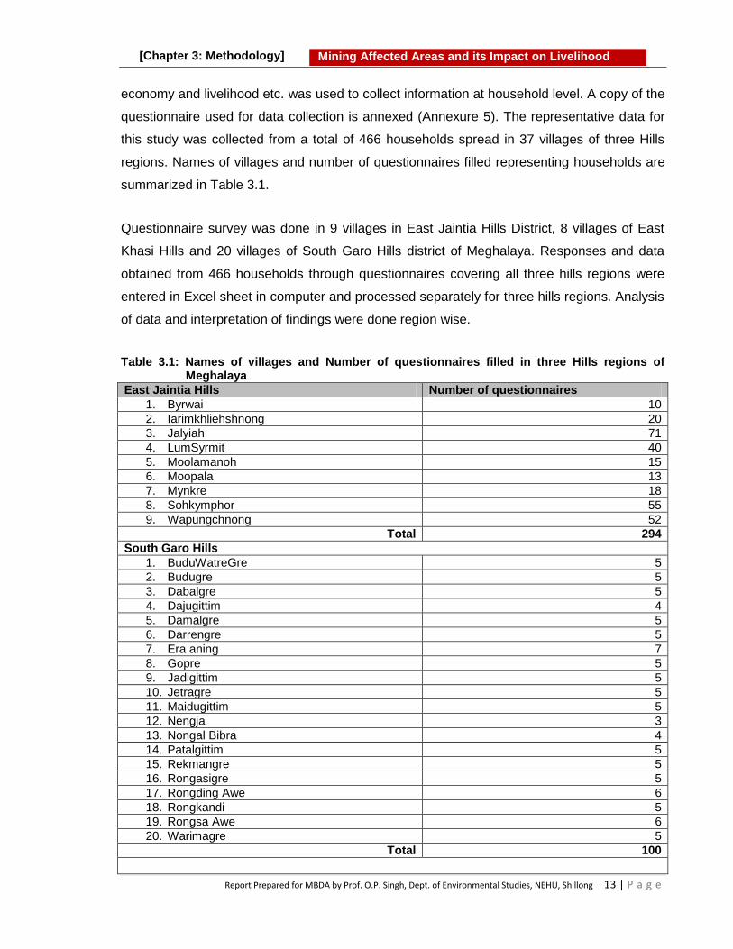
Report Prepared for MBDA by Prof. O.P. Singh, Dept. of Environmental Studies, NEHU, Shillong 13 | P a g e
Mining Affected Areas and its Impact on Livelihood
[Chapter 3: Methodology]
economy and livelihood etc. was used to collect information at household level. A copy of the
questionnaire used for data collection is annexed (Annexure 5). The representative data for
this study was collected from a total of 466 households spread in 37 villages of three Hills
regions. Names of villages and number of questionnaires filled representing households are
summarized in Table 3.1.
Questionnaire survey was done in 9 villages in East Jaintia Hills District, 8 villages of East
Khasi Hills and 20 villages of South Garo Hills district of Meghalaya. Responses and data
obtained from 466 households through questionnaires covering all three hills regions were
entered in Excel sheet in computer and processed separately for three hills regions. Analysis
of data and interpretation of findings were done region wise.
Table 3.1: Names of villages and Number of questionnaires filled in three Hills regions of Meghalaya
East Jaintia Hills Number of questionnaires
1. Byrwai 10
2. Iarimkhliehshnong 20
3. Jalyiah 71
4. LumSyrmit 40
5. Moolamanoh 15
6. Moopala 13
7. Mynkre 18
8. Sohkymphor 55
9. Wapungchnong 52
Total 294
South Garo Hills
1. BuduWatreGre 5
2. Budugre 5
3. Dabalgre 5
4. Dajugittim 4
5. Damalgre 5
6. Darrengre 5
7. Era aning 7
8. Gopre 5
9. Jadigittim 5
10. Jetragre 5
11. Maidugittim 5
12. Nengja 3
13. Nongal Bibra 4
14. Patalgittim 5
15. Rekmangre 5
16. Rongasigre 5
17. Rongding Awe 6
18. Rongkandi 5
19. Rongsa Awe 6
20. Warimagre 5
Total 100
Report Prepared for MBDA by Prof. O.P. Singh, Dept. of Environmental Studies, NEHU, Shillong 14 | P a g e
Mining Affected Areas and its Impact on Livelihood
[Chapter 3: Methodology]
East Khasi Hills
1. Jathang 10
2. Laitryngew 10
3. Langkyrdem 8
4. Lumthangjnat 8
5. Mawbeh 10
6. Mawkma 10
7. Mawsynram 10
8. Rangsohkham 6
Total 72 Total number of villages 37
Total number of Questionnaires 466
3.4 Sampling and Analysis of Environmental Components
Field surveys were undertaken to study the effects of coal, limestone, stones and sand
mining on land, water, forest resources and the community that are dependent for their
livelihood on the resources particularly when the ecological and occupational considerations
have not been given due importance in the mining activities. During the field survey samples
of water and soil were collected using standard sample collection methods. Sampling and
analysis of soil and water have been done following applicable standard methods. Data on
air quality was collected by operating Respirable Dust Samplers (RDS) in the field. Data was
collected in three seasons viz. winter, pre-monsoon and post-monsoon during the study
period.
3.4.1 Sampling and Analysis of Soil
To study different physico-chemical parameters of soil, soil samples were collected from the
coal and limestone mining areas of East Jaintia Hills, East Khasi Hills and South Garo Hills,
Meghalaya. Soil samples were also collected from the nearby un-mined area for comparison.
The samples were analyzed in laboratory to know the average values of various physico-
chemical parameters. Soil quality parameters such as pH, electrical conductivity, moisture
content, bulk density, water holding capacity, organic carbon, total nitrogen and available
phosphorus and potassium were estimated using standard methods 1, 2
3.4.2 Sampling and Analysis of Water
To know the effect of coal and limestone mining on water resources, water samples were
collected during winter, pre-monsoon and post-monsoon seasons from different locations in
East Jaintia Hills, East Khasi Hills and South Garo Hills, Meghalaya. Grab sampling method
was adopted for water sample collection. Data of pH, electrical conductivity, turbidity, total
alkalinity, total hardness, calcium, magnesium, sulphate, chloride and Biological Oxygen

Report Prepared for MBDA by Prof. O.P. Singh, Dept. of Environmental Studies, NEHU, Shillong 15 | P a g e
Mining Affected Areas and its Impact on Livelihood
[Chapter 3: Methodology]
Demand (BOD) were collected by laboratory analysis following standard methods as
described in APHA, 20051, 2.
3.4.3 Sampling and Analysis of Air
To know the ambient air quality of the mining area, air sampling was done in East Jaintia
Hills district using Respirable Dust Sampler (RDS) in post-monsoon season. The
Suspended Particulate Matter (SPM), Respirable Suspended Particulate Matter (RSPM) and
gaseous pollutants were estimated using standard methods.2
3.4.4 Analysis of Forest Cover
To know the effect of mining on forest cover, data from studies already done was collected
and compiled. Study done compared the Land use Land Cover change (LULC) maps of
1987, 1999 and 2013 and LULC changes were analyzed in respect of ongoing human
activities including the mining activity in Jaintia Hills. Changes in LULC computed by
comparing the two set of LULC maps were the basis of findings on effect of mining on forest
resources. Both coal and limestone mining were considered to detect the LULC changes.
The finding is representative and shall also apply on other mining areas.
3.4.5 Laboratory Analysis
Some physico-chemical parameters of water were measured in field itself. However, for other
parameters water samples were analyzed in laboratory. Analyses of water, soil and air
samples were done following standard methods as described in Maiti, 2003; APHA, 2005 1, 2.
3.5 Collection of Secondary Data
In order to project the generalized information about the status of environment in mining
areas of Meghalaya, relevant environmental data available in the studies of other
researchers were also collected from published research articles, technical reports and
websites.
References
1. Maiti S.K. (2004). Handbook of Methods in Environmental studies (Vol.1: Water and Wastewater analysis). ABD Publishers, Jaipur.ISBN 81-8577-34-0.
2. APHA, AWWA, and WEF, (2005). Standard Methods for the Examination of Water and Wastewater, 21st ed. American Public Health Association, Washington, D.C.21: 258-259.

Blank Page

Report Prepared for MBDA by Prof. O.P. Singh, Dept. of Environmental Studies, NEHU, Shillong 17 | P a g e
Mining Affected Areas and its Impact on Livelihood
[Chapter 4: Results]
4 Results
The state of Meghalaya is rich in different minerals by virtue of being geologically unique
in North eastern region. Presence of large deposits of a number of valuable minerals
such as coal, limestone, kaolin, clay, granite, glass-sand, uranium etc. have been
reported from the state. Of these, coal and limestone have been mined extensively and
contributed significantly in the economic development of state. Mining has also provided
opportunity for a variety of employment and livelihood options to the local people of the
mining area. Simultaneously, exploitation of rocks and minerals in the state has affected
the local environment at its various stages of mining, transport and utilization. Various
aspects such as geology and mineral resources of the state; mining of minerals and its
multifaceted impacts on environment and society have been discussed based on
scientific studies and people‘s perception. The first section of the chapter deals with
geology and minerals of the State. Details of mining of major minerals are compiled in
second section of the chapter. The impacts of mining on environment, natural resources
and livelihood of the people have been discussed in third section of the chapter.
4.1 Geology and Mineral Resources of Meghalaya
4.1.1 Geology of Meghalaya
Geologically the Meghalaya plateau comprises of rocks from the oldest Precambrian
gneissic complex to the recent alluvium formations. The stratigraphic sequence is
comprised of 1. Cretaceous –Tertiary sediments, 2. The Sylhet trap, 3. Lower Gondwana
rocks, 4. Shillong Group of rocks, and 5. Precambrian gneissic complex (Basement
gneiss).
The Precambrian gneissic complex of para-orthogneisses, migmatites and the Shillong
Group of rocks comprising mainly quartzytes are exposed in the central, eastern and
northern parts of the Meghalaya plateau. They are intruded by basic and ultrabasic

Report Prepared for MBDA by Prof. O.P. Singh, Dept. of Environmental Studies, NEHU, Shillong 18 | P a g e
Mining Affected Areas and its Impact on Livelihood
[Chapter 4: Results]
intrusives and late tectonic granite plutons. The lower Gondwana rocks of Permo-
carboniferous age are recognized at the western part of Garo Hills and consist of pebble
bed, sandstone, and carbonaceous shale. The Sylhet trap of middle Jurassic age
comprising mainly of basalt, rhyolites, acid tuffs, is exposed in a narrow E-W strip along
the southern border of Khasi Hills. The Cretaceous- Tertiary sediments occupying
southern part of the Meghalaya plateau comprise of the Khasi Group (arenaceous facies),
the Jaintia Group (calcareous facies) and the youngest formation the Garo Group which
is represented as Simsang, Bagmara and Chengapara formations. Besides these the
Dupi Tilla group of mid-Pliocene age occurs in the western part of Garo Hills and towards
south of Khasi Hills. Isolated patches of older Alluvium overlie the Tertiary rocks along the
southern and western borders of the State. The recent Alluvium formation is mostly found
in the river valleys of Garo and Khasi Hills areas 1. The geological map of the State is
shown in Figure 4.1.
Figure 4.1: Geological map of Meghalaya
1
4.1.2 Mineral Resources of Meghalaya
Meghalaya is rich in mineral deposits. A number of valuable minerals such as coal,
limestone, kaolin, clay, granite, glass-sand, iron ore, quartz, feldspar, sillimanite, bauxite,
rock phosphate, phosphate nodule, gypsum and uranium are found in different parts of
the State. Mined minerals are utilized in several mineral-based industries in the country.
The mined limestone is utilized mainly for manufacturing of cement in the state of
Meghalaya and also exported to Bangladesh. Small scale mining of limestone is also

Report Prepared for MBDA by Prof. O.P. Singh, Dept. of Environmental Studies, NEHU, Shillong 19 | P a g e
Mining Affected Areas and its Impact on Livelihood
[Chapter 4: Results]
done for making lime and other products. Earlier, export of coal to Bangladesh also took
place. However, mining and transport of coal have been suspended in the state of
Meghalaya after imposition of ban of coal mining by Honorable National Green Tribunal in
2014. Among various minerals found in the state, coal, limestone and uranium are most
important minerals. Details of various minerals found in Meghalaya are given in Table 4.1.
Table 4.1: Minerals of Meghalaya: Occurrence, reserves and industrial uses1
Minerals Reserve (in Million tonnes) Grades Places of occurrence Proved Indicated Inferred Total
Limestone 9515 41599 3986 15100 Cement, Metallurgical and Chemical
Cherrapunjee, Mawlong, Ishamati, Shella, Komorrah, Borsora, Bagli in Khasi Hills District, Lakadong, Lumshnong, Nongkhlieh in Jaintia Hills District, Darrang Era-Aning, Siju and Chokpot in Garo Hills District.
Coal 133.13 - 443.35 576.48 Sub-bituminous with medium to high sulphur.
Langrin and East Darrangiri in Khasi Hills District, Bapung in Jaintia Hills District and West Darranggiri in Garo Hills District
Clay (Lithomargic)
- - 97.0 97.0 White ware, earthen ware, furnace lining, curing soap etc.
Cherrapunjee and Mahadek in Khasi Hills District, Tongseng in Jaintia Hills District, Nangwalbibra and Rongrenggiri in Garo Hills District
Granite 24.0 - 26.0 50.0 million m
3
Table top, wall cladding etc.
Nongpoh in Ri-Bhoi, Mylliem and Mawkyrwat in Khasi Hills District, Rongjeng in East Garo Hills District
Kaolin 3.20 1.94 0.10 5.24 White ware Mawphlang, Smit, Laitlyngkot in Khasi Hills District, Thadlaskein, MuliehShangpung, Mynsngat in Jaintia Hills District and Darugiri in Garo Hills District
Iron ore 3.60 - - - Low grade West Khasi Hills and East Garo Hills District
Glass sand - - 3.0 3.0 Ordinary glass ware
Laitryngew, Umstew and Kreit in Khasi hills, Tura

Report Prepared for MBDA by Prof. O.P. Singh, Dept. of Environmental Studies, NEHU, Shillong 20 | P a g e
Mining Affected Areas and its Impact on Livelihood
[Chapter 4: Results]
in Garo Hills District
Quartz - 0.5 0.5 0.5 Ordinary ceramic grade
Feldspar - - 0.127 0.127 Ceramic grade
Bonsamgiri and Rombhagiri in East Garo Hills District
Silimanite - - 0.045 0.045 High temp. furnace lining
Sonapahar in West Khasi Hills District
Bauxite - - 1.45 1.45 Low grade(40% Al2O3)
Sung valley in Jaintia Hills District
Rock phosphate
- 0.015 - 0.015 Low grade(15-30%P2O5)
Sung valley in Jaintia Hills District
Phosphatic nodule
Nominal P2O5: 5-15%
Rewak in South Garo Hills District
Gypsum Nominal Crystals of salanite variety
Mahendraganj in West Garo Hills District
Uranium AMD, Govt of India, has established a reserve of 9.22 million tons, higher grade 0.104% U2O3 at Domiasiat, West Khasi Hills District
Base metal /trace metal
1.14% Cu: 0.80 mt; 1.61% Zn: 0.85 mt; 1.88% Pb: 0.88 mt. with traces of Cd, Bi, Ag, Tenor of gold encountered in 3 bore Holes of Tyrsad
Distribution of different minerals in Meghalaya is depicted in Mineral Map of Meghalaya
prepared by Department of Mining and Geology, Government of Meghalaya (Figure 4.2.)
Figure 4.2: Mineral Map of Meghalaya
1
4.1.3 A Brief Account of various Minerals
The major minerals of Meghalaya are Coal, Limestone, Clay, Uranium and Sillimanite.
These minerals are utilised in several mineral-based industries in the country. The mined
coal and limestone are exported to Bangladesh as well. Coal and limestone are the only

Report Prepared for MBDA by Prof. O.P. Singh, Dept. of Environmental Studies, NEHU, Shillong 21 | P a g e
Mining Affected Areas and its Impact on Livelihood
[Chapter 4: Results]
major minerals mined in the State even though with the presence of many other minerals.
A brief account of the various mineral resources present in Meghalaya is given below:
4.1.3.1 Coal
One of the main mineral resources found in Meghalaya is coal. The total coal reserves
found in Meghalaya is estimated about 576.48 million tones. The coal found in Meghalaya
belongs to tertiary age and is generally of sub-bituminous type. The coal seams varying
from 30 to 212 cm in thickness occur imbedded in sedimentary rocks, sandstones and
shale of the Eocene age 2.
Occurrence of Coal: Garo Hills has the highest reserve of coal deposits followed by
West Khasi Hills, Jaintia Hills and East Khasi Hills. However, in terms of coal production,
maximum extraction has taken place from Jaintia Hills due to gentle topography and
facilities developed for transport and marketing.
In Khasi Hills coal deposits are found in Bairung, Sohra, Laitryngew, Mawlong-Shella,
Mawstoh, Mawsynram, Mawdon, Mao-nai-chhora, Mawbehlarkar, Lyngkyrdem and
Pynursla. The prominent coalfields of Jaintia Hills District are Bapung, Lakadong, Sutnga,
Rymbai, Chiehruphi, Lumshnong, Narwan, Byrwai, Sohkymphor, Myntriang, Jalyiah,
Lumchyrmit, Lumskhen, Rangad, Iapmala, Musniang, Moollamanoh, Moolang, Mookhain,
Semmasi, Umkyrpong, Lakasein, Mooriap, Jalaphet, Moolait, Lamyrsiang, Mynthning,
Kyrluh, Sakhain, Umthei, Umlawang, Tluh, Moolamylliang, Latyrke, Nongkhlieh elaka,
Khliehriat, Lad Rymbai, Byndihati, Moosianglamare in Khliehriat Civil Sub-Division, Iooksi
and Shangpung under Jowai Sadar whereas Jarain and Skhentalang coalfields in
Amlarem Civil Sub-Division. The areas of occurrence of coal in Garo Hills include
Agalgithim, Asilgaon Hill, Balpakram, Balpakram -pendongru, Dapsi- garogithim,
Dapsikhosgiri, Dogring, Holwang Baljong, Jangkhre, Kylas Hill, Mermelsaram, Nabru,
Nongalbibra, Pengdengrew, Rengotim, Rongrenggirri, Rongrenggre, Siju, Singrimari, and
West Darranggiri. A summary of main places of occurrence of coal in three hill regions of
Meghalaya is presented in Table 4.2.

Report Prepared for MBDA by Prof. O.P. Singh, Dept. of Environmental Studies, NEHU, Shillong 22 | P a g e
Mining Affected Areas and its Impact on Livelihood
[Chapter 4: Results]
Table 4.2: Places of coal mining/occurrence of coal in three hills regions of Meghalaya
Hill Regions Places of occurrence
1 Garo Hills Agalgithim, Asilgaon Hill, Balpakram, Balpakram -pendongru, Dapsi- garogithim, Dapsikhosgiri, Dogring, HolwangBaljong, Jangkhre, Kylas Hill, Mermelsaram, Nabru, Nongalbibra, Pengdengrew, Rengotim, Rongrenggirri, Rongrenggre, Siju, Singrimari, West Darranggiri.
2 Jaintia Hills Bapung, Iooksi, Jarain, Khliehriat, Lakadong, Lamare, Musiang , Pamsaru, Pamsaru, Sutnga, Tkhentalang, Umlatdoh.
3 Khasi Hills Cherrapunjee, Goalbari, Jarain, Jathang, Kushang, Laitduh, Laitryngew , Langkyrdem, Langrin Borsora, Lumbidon, Mawbehlarkar, Mawlong Shella, Mawmluh, Mawsynram, Moisngi, Mongokhorkhonjoy, Nongmaharu, Nongplu Nongjion, Rangsokham, Sohling, Um Bytit, Um Mawblei, Um Tongkut Wah Rangah, Wahlong
Areas such as Bapung-Sutnga and Khliehriat in the Jaintia Hills; Cherrapunjee,
Laitryngew, Laitduh, Mawlong, Borsora Langrin etc. in Khasi Hills; and East Darrangiri,
West Darrangiri, Siju, Pendengru Balpakram in the Garo Hills are the coal mining hubs in
the State. Area wise distribution of coal reserves in Meghalaya is given in Table 4.3.
Table 4.3: Estimated Coal reserves at different coalfields of Meghalaya
Coalfield Proved Indicated Inferred Total
(in million tonnes)
West Darangiri 65.40 - 59.60 125.00
East Darangiri - - 34.19 34.19
Balphakram-Pendenguru - - 107.03 107.03
Siju - - 125.00 125.00
Langrin 10.46 16.51 106.19 133.16
Mawtong Shelia 2.17 - 3.83 6.00
Khasi Hills - - 10.10 10.10
Bapung 11.01 - 22.65 33.66
Jaintia Hills - - 2.34 2.34
Total 89.04 16.51 470.93 576.48
Source: Coal Directory of India, 2014-15.
A map showing distribution of coal bearing areas/ mining areas in the state of Meghalaya
prepared in the present study is presented in Figure 4.3.
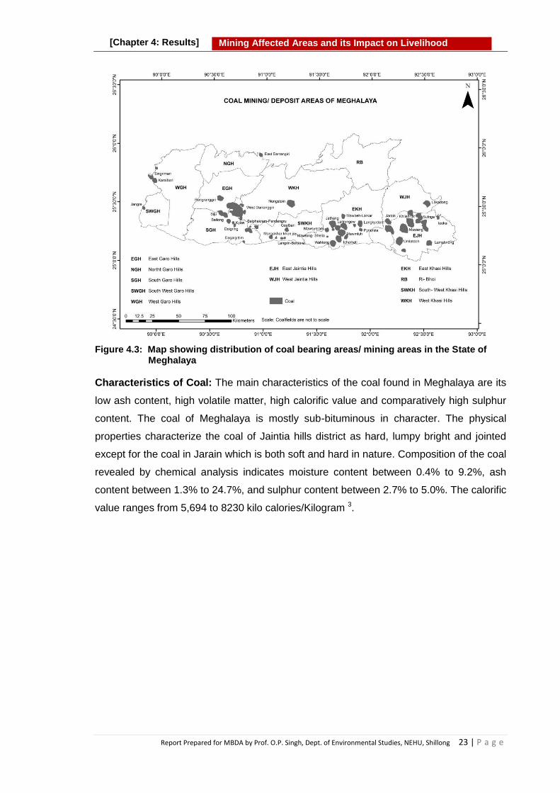
Report Prepared for MBDA by Prof. O.P. Singh, Dept. of Environmental Studies, NEHU, Shillong 23 | P a g e
Mining Affected Areas and its Impact on Livelihood
[Chapter 4: Results]
Figure 4.3: Map showing distribution of coal bearing areas/ mining areas in the State of
Meghalaya
Characteristics of Coal: The main characteristics of the coal found in Meghalaya are its
low ash content, high volatile matter, high calorific value and comparatively high sulphur
content. The coal of Meghalaya is mostly sub-bituminous in character. The physical
properties characterize the coal of Jaintia hills district as hard, lumpy bright and jointed
except for the coal in Jarain which is both soft and hard in nature. Composition of the coal
revealed by chemical analysis indicates moisture content between 0.4% to 9.2%, ash
content between 1.3% to 24.7%, and sulphur content between 2.7% to 5.0%. The calorific
value ranges from 5,694 to 8230 kilo calories/Kilogram 3.

Report Prepared for MBDA by Prof. O.P. Singh, Dept. of Environmental Studies, NEHU, Shillong 24 | P a g e
Mining Affected Areas and its Impact on Livelihood
[Chapter 4: Results]
4.1.3.2 Limestone
Next to coal, limestone is the most abundantly found and extracted mineral in Meghalaya.
Limestone rocks are sedimentary in origin and classified as non-metallic mineral with
inorganic origin in nature. The two most important constituents of limestone are calcite
(calcium carbonate, CaCO3) and dolomite. Limestone often contain small amount of
impurities such as magnesium, iron, manganese and lead. Dolomite is a carbonate of
calcium and magnesium [CaMg(CO3)2].
The limestone found in different parts of Meghalaya varies in chemical composition to
some extent and thus differs in quality ranging from cement to chemical grade. Generally,
the CaO content of limestone found in Meghalaya is about 50%. Various grades and
extent of limestone rocks are found in the southern fringe of the state extending for about
200 Km from Jaintia Hills in the east to Garo Hills in the west. The maximum limestone
reserve in Meghalaya is reported in Jaintia Hills (55%), followed by Khasi Hills (38%) and
Garo Hills (7%). A summary of main places of occurrence of limestone in three hills
regions of Meghalaya is presented in Table 4.4.
Table 4.4: Places of limestone mining/occurrence in three Hills regions of Meghalaya
Hill Region Places/Location
1 Garo Hills Chokpot, Darranggiri, Era Aning, Nongalbibra, Rongrenggre, Siju.
2 Jaintia Hills Amtapoh, Lakadong, Lumshnong, Mynkree, Nongkhlieh, Nongsning, Nongtalang, Sutnga, Syndai, Thangskai, Wahiajer.
3 Khasi Hills Borsora, Cherrapunjee, Ichamati, Langkyrdem, Mawbeh, Mawkma, Mawlong, Mawmluh, Mawsmai, Nongtalang, Pynursla, Rangsohkham, Shella, Umstew.
Box: 4.1: Coal in Meghalaya The coal is one of the extensively utilized minerals in Meghalaya.
Coal deposits in the state are found all along the southern fringe of Shillong
plateau covering all three Hill regions, namely Khasi, Jaintia and Garo Hills. Garo Hills has the highest reserve of coal deposits followed by Khasi Hills
and Jaintia Hills. However, in terms of coal production, maximum extraction has taken place from Jaintia Hills due to gentle topography and facilities developed for transport and marketing.
Coal extraction is done by primitive mining method commonly known as ‗rat-
hole‘ mining. Most of the mining activities are small scale ventures controlled by
individuals who own the land

Report Prepared for MBDA by Prof. O.P. Singh, Dept. of Environmental Studies, NEHU, Shillong 25 | P a g e
Mining Affected Areas and its Impact on Livelihood
[Chapter 4: Results]
Limestone Reserves: About 9% of the country's total limestone reserves are distributed
in the State. It is distributed predominantly in the southern fringe of Meghalaya plateau
and falls under the rocks formation units of Cretaceous- Tertiary sedimentary rock, which
is divided into three groups i.e. the Khasi group, the Jaintia group and the Garo group.
Maximum reserve is in Jaintia Hills followed by Khasi Hills and Garo Hills. It is mainly
distributed in the districts of East Jaintia Hills, West Jaintia Hills, East Khasi Hills, West
Khasi Hills and South Garo Hills districts. The details of limestone reserves estimated in
different parts of Meghalaya are presented in Table 4.5.
Table 4.5: Distribution of Limestone in different parts Meghalaya1
District/ Parts
Location Area and Extents Resources (in million tonnes)
East Khasi Hills
Cherrapunjee/ Sohra
1.40 sq. km. in the Mawmluh-Mawsmai Hills.
31.15
Laitryngew
Occur as small outcrops in Umstew and Mawkma area of Laitryngew. Theband is 7.5 m. thick and traceable for about 150 m. at Umstew Cliff section.
Not estimated
Mawlong-ishamati
13.75 sq. km. in area, 4(four) limestone bands separated by Sandstone bands are encountered. Thickness of limestone bands are of the order of 60.0,12 .0, 21.0 and 71.0 m respectively. Total thickness 244 m including both Sandstone and Limestone.
An inferred category resource of 2,166 million tonnes was reported by D.G.M., Assam. GSI has proved 395 million tonnes of resource in the area (Upper Sylhet limestone - 290 m. tones and Middle Sylhet limestone - 105 m. tonnes).
Komorrah
The total thickness is 415m considering all limestone and sandstone bands only 0.52 sq. km. area was covered by detailed survey, where only first two limestone bands were considered.
The indicated category resource is 14.2 million tonnes (only the first two bands) and the category resource proved by drilling is 7.5 million tonnes.
Shella
An area of 2.76 sq. km. was covered by detailed mapping where Upper Sylhet (Prang) and Middle Sylhet (Umlatdoh) limestone Members of the Shella formation were encountered. The Average thickness of the Upper and Middle Sylhet limestone Members are 60m and 20m respectively. The bands are maintaining an easterly strike with a variable dip of 80 to 400 towards south.
The total indicated category resource of limestone in Shella area is 180 million tonnes of which 150 million tonnes in the Upper Sylhet limestone and 30 million tonnes in the Middle limestone beds.
West Khasi Hills
Borsora
Covers an area of 1.5km with an east-westerly extension along East-West direction and limestone bearing area is about 1.00 Sq.Km. around Borsora Village.
The indicated category resource of limestone in the above mentioned area is 3.7million tonnes.

Report Prepared for MBDA by Prof. O.P. Singh, Dept. of Environmental Studies, NEHU, Shillong 26 | P a g e
Mining Affected Areas and its Impact on Livelihood
[Chapter 4: Results]
Jaintia Hills
Lumshnong
Extends over an area of 76.8 sq.km
The inferred category resource of Upper Sylhet Limestone as reported by G.S.I. is 652 million tonnes. D.M.R., Meghalaya, indicated a resource of 291.21 million tonnes for Lower and Middle Sylhet Limestone covering an area of 2.50 sq. km., out of which 154 million tonnes of Limestone was proved over an area of 2.0 sq.km.
Sutnga
The limestone bearing area is 9.15 m. by 75 m. in extension, (0.07 sq. km.) extended along ENE-WSW direction. Average thickness 15 m.
The indicated category resource is 2 million tonnes.
Nongkhlieh
Covers an area of 4.01 sq. km. and the thickness range from 130m to 135m,as encountered in the borehole drilled by D.M.R., Meghalaya.
The inferred category resource is 600 million tonnes over an area of 4.1 sq. km. Proved category resource is 400 million tonnes (168 m.t. in the north block & 127 million tonnes inthe middle & 115 million in the south block over an area of 2.1 sq. km.
Lakadong Covers an area of 26 sq.kms. The inferred category resource is
780 million tonnes.
Syndai
The deposit occurs as narrow belt around Unlari and Syndai village covering an area of 2.0864 sq. kms. and the thickness of the limestone varies from 15m to 20m.
The inferred category resource is as follows (in an area of 2.08 sq. km.) (1) 26.05 million tonnes. Cement grade (2) 69.80 million tonnes. Dolomitic limestone
West Garo Hills
Darrang-eraaning
Covers an area of 1.94 sq. kms. Average thickness of upper band is 15 m and lower one is 3m.
The total indicated category resource is 47.7 million tonnes, out of which the top band contains 37.70 million tonnes and the lower band contains 10.02 million tonnes.
Siju-artheka
Covers an area of 5.70 sq. kms. Limestone occurs on both side of Simsang river. Maximum thickness 90m (Average 60m).
The indicated category resource is 229 million tonnes, out of which 27 million tonnes of cement grade limestone is proved by drilling.
A map showing distribution of limestone bearing areas/ mining areas in the state of
Meghalaya prepared during this study is presented in Figure 4.4.

Report Prepared for MBDA by Prof. O.P. Singh, Dept. of Environmental Studies, NEHU, Shillong 27 | P a g e
Mining Affected Areas and its Impact on Livelihood
[Chapter 4: Results]
Figure 4.4: Map showing distribution of limestone bearing areas/ mining areas in the state
of Meghalaya
Chemical Composition: The limestone found in different parts of Meghalaya varies in
chemical composition to some extent and thus differs in quality ranging from cement to
chemical grade in nature. Generally, the CaO content of limestone found in Meghalaya is
almost 50% 4. It is used for various purposes such as manufacturing of cement, lime and
edible lime etc. The chemical composition of limestone found in different parts of
Meghalaya is summarized in Table 4.6.
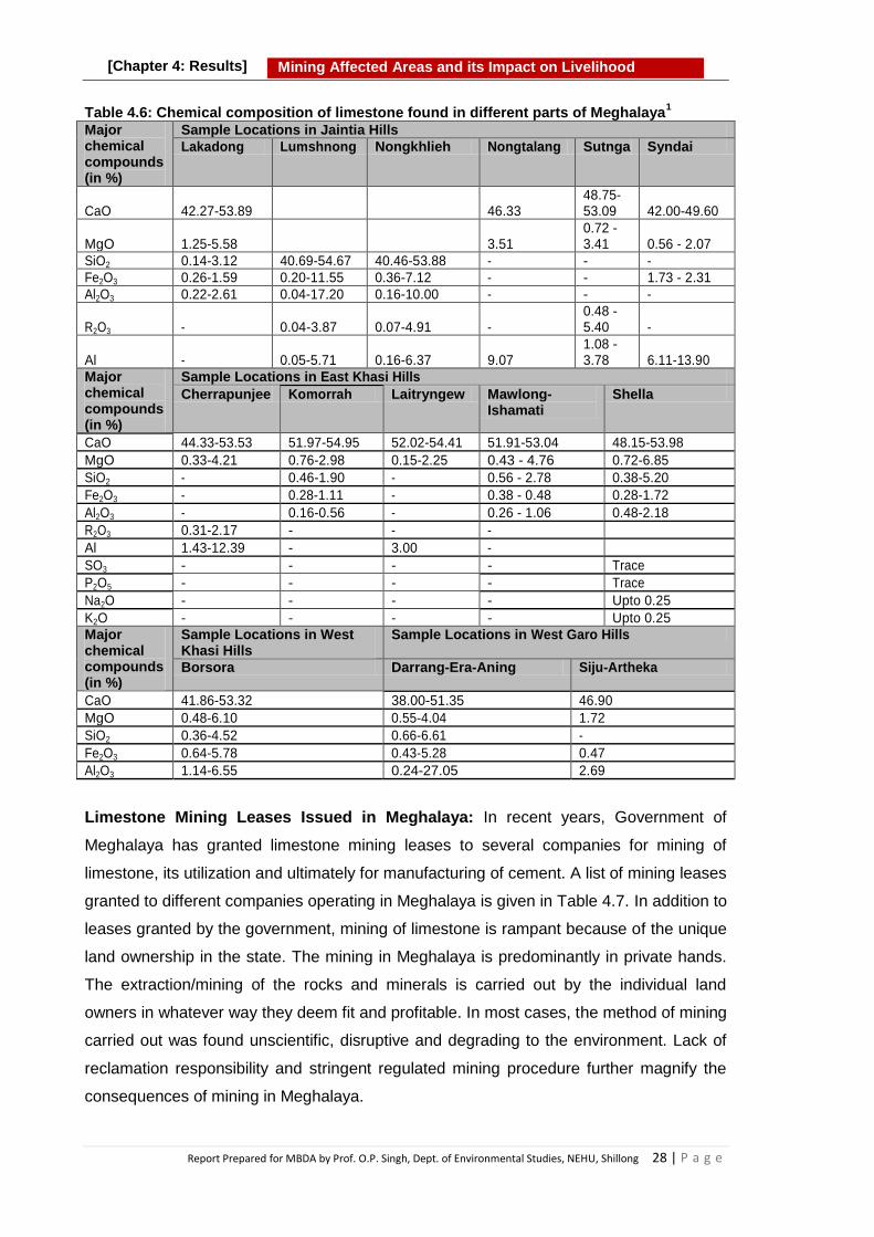
Report Prepared for MBDA by Prof. O.P. Singh, Dept. of Environmental Studies, NEHU, Shillong 28 | P a g e
Mining Affected Areas and its Impact on Livelihood
[Chapter 4: Results]
Table 4.6: Chemical composition of limestone found in different parts of Meghalaya1
Major chemical compounds (in %)
Sample Locations in Jaintia Hills
Lakadong Lumshnong Nongkhlieh Nongtalang Sutnga Syndai
CaO 42.27-53.89 46.33 48.75-53.09 42.00-49.60
MgO 1.25-5.58 3.51 0.72 - 3.41 0.56 - 2.07
SiO2 0.14-3.12 40.69-54.67 40.46-53.88 - - -
Fe2O3 0.26-1.59 0.20-11.55 0.36-7.12 - - 1.73 - 2.31
Al2O3 0.22-2.61 0.04-17.20 0.16-10.00 - - -
R2O3 - 0.04-3.87 0.07-4.91 - 0.48 - 5.40 -
Al - 0.05-5.71 0.16-6.37 9.07 1.08 - 3.78 6.11-13.90
Major chemical compounds (in %)
Sample Locations in East Khasi Hills
Cherrapunjee Komorrah Laitryngew Mawlong- Ishamati
Shella
CaO 44.33-53.53 51.97-54.95 52.02-54.41 51.91-53.04 48.15-53.98
MgO 0.33-4.21 0.76-2.98 0.15-2.25 0.43 - 4.76 0.72-6.85
SiO2 - 0.46-1.90 - 0.56 - 2.78 0.38-5.20
Fe2O3 - 0.28-1.11 - 0.38 - 0.48 0.28-1.72
Al2O3 - 0.16-0.56 - 0.26 - 1.06 0.48-2.18
R2O3 0.31-2.17 - - -
Al 1.43-12.39 - 3.00 -
SO3 - - - - Trace
P2O5 - - - - Trace
Na2O - - - - Upto 0.25
K2O - - - - Upto 0.25
Major chemical compounds (in %)
Sample Locations in West Khasi Hills
Sample Locations in West Garo Hills
Borsora Darrang-Era-Aning Siju-Artheka
CaO 41.86-53.32 38.00-51.35 46.90
MgO 0.48-6.10 0.55-4.04 1.72
SiO2 0.36-4.52 0.66-6.61 -
Fe2O3 0.64-5.78 0.43-5.28 0.47
Al2O3 1.14-6.55 0.24-27.05 2.69
Limestone Mining Leases Issued in Meghalaya: In recent years, Government of
Meghalaya has granted limestone mining leases to several companies for mining of
limestone, its utilization and ultimately for manufacturing of cement. A list of mining leases
granted to different companies operating in Meghalaya is given in Table 4.7. In addition to
leases granted by the government, mining of limestone is rampant because of the unique
land ownership in the state. The mining in Meghalaya is predominantly in private hands.
The extraction/mining of the rocks and minerals is carried out by the individual land
owners in whatever way they deem fit and profitable. In most cases, the method of mining
carried out was found unscientific, disruptive and degrading to the environment. Lack of
reclamation responsibility and stringent regulated mining procedure further magnify the
consequences of mining in Meghalaya.

Report Prepared for MBDA by Prof. O.P. Singh, Dept. of Environmental Studies, NEHU, Shillong 29 | P a g e
Mining Affected Areas and its Impact on Livelihood
[Chapter 4: Results]
Table 4.7: Limestone mining leases granted by Government of Meghalaya.
Sl. No
District Name of Lessee Location Lease Period (Years)
Area in Hectare
Year Granted
1 East Khasi Hills
Mawmluh Cherra Cement Ltd.
Mawmluh 20 139.67 2001
Komorrah Limestone Mining Co.
Komorrah 20 240.55 2003
Lafarge Umiam Mining Pvt. Ltd
Nongtrai 30 100 2001
M/S K. Singh Wann & Son
Ichamati Mawkhlain
20 4.56 2006
2 Jaintia Hills
M/S Adhunik Cement Ltd.
Mootang Thangskai Block -1
20 4.9 2009
Block -2 20 4.9 2009
Block -4 20 4.9 NA
M/S JUD Cement LTD
Wahiajer Narpuh
30 4.76 2009
Cement Manufacturing Co. Ltd
Lumshnong
20 4.96 2005
20 4.7 2006
20 4.85 2006
Meghalaya Cement Ltd
Moiong, Chiehruphi
20 4.8 2007
Khliehjri, Thangskai
20 4.9 2006
3 West Khasi Hills
Anderson Mineral Pvt. Ltd
Lalghat Cherragoan
20 60 2007
Source: Directorate of Mineral Resources Portal, Government of Meghalaya (2016)
Cement Plants in Meghalaya: In last decade several cement plants were established in
Meghalaya with maximum number in Jaintia Hills. Presently, the cement plants are the
main consumers of limestone rocks found in the state. The Limestone is also exported to
Bangladesh. The cement manufactured in Meghalaya is utilized in the state as well as
transported to other states of the country. A list of cement plants operating in Meghalaya
is given in Table 4.8.

Report Prepared for MBDA by Prof. O.P. Singh, Dept. of Environmental Studies, NEHU, Shillong 30 | P a g e
Mining Affected Areas and its Impact on Livelihood
[Chapter 4: Results]
Table 4.8: List of major Cement Plants operating in Meghalaya 5,6
Sl. No
Company Name Brand Name Group Location/Village (District)
1 Adhunik Cement Ltd Adhunik Cement - Thangskai (EJH)
2 Amrit Cement Industries Ltd. Amrit Cement Amrit Group Umlaper (EJH)
3 Cement Manufacturing Company Limited
Star Cement Shyam Group
Lumshnong (EJH)
12 Cosmo Cement Ltd. Cosmo Cement - Nongkhlieh (EJH)
13 Goldstone Cement Ltd. Goldstone Cement - Musiang Lamare (EJH)
4 Green Valley Industries Ltd. Max Cement GNG Group Nongsning (EJH)
5 Hill Cement Company Ltd. Taj Cement - Mynkree (EJH)
6 Jaintia Cement Limited Jaintia Cement - Sutnga (EJH)
7 Jud Cement Limited Best Cement Ud Group Wahiajer (EJH)
8 Mawmluh-Cherra Cement Ltd.
Mawmluh-Cherra Cement
PSU Mawmluh (EKH)
9 Meghalaya Cement Limited Topcem Prithvi Group Thangskai (EJH)
10 RNB Cement Pvt. Ltd. Magic cement RNB Group Barapani (Ri-Bhoi)
11 Virgo Cement Ltd. Virgo Cement - Damas (EGH)
NB: EJH- East Jaintia Hill; EGH - East Garo Hill; EKH- East Khasi Hill
Box 4.2. Limestone in Meghalaya Next to coal, limestone is most abundantly found and extracted mineral in
Meghalaya About 9% of the country‘s total limestone reserves are distributed in the state.
Limestone is found in all three hills regions (Khasi, Jaintia, Garo) of
Meghalaya. The Limestone found in different parts of the Meghalaya varies in chemical
composition and thus differs in quality from cement to chemical grade. It is mainly extracted for manufacturing of cement.

Report Prepared for MBDA by Prof. O.P. Singh, Dept. of Environmental Studies, NEHU, Shillong 31 | P a g e
Mining Affected Areas and its Impact on Livelihood
[Chapter 4: Results]
4.1.3.3 Stone and Sand
Stone and sand are basic components of construction sector. These materials are
required for construction of buildings, roads, bridges, dams, canals etc. To support
ongoing developmental activities demand for stone and sand is increasing day by day. To
meet the requirement, both legal and illegal mining and quarrying of stone, boulders and
sand are going unabated in Meghalaya. The enforcement of rules by concerned agencies
is found to be not satisfactory on the ground.
Sand and stone mining from the hills and river beds are taking place in all three Hills
regions of Meghalaya. It is a matter of concern for both the ecology of the area and the
resource availability. All rivers, particularly in border areas are being used for extraction of
sand which mostly takes place in dry season. It is found that sand mining has adverse
effects on aquatic bio-diversity due to loss of habitat caused by sand mining. It also
destabilizes the soil structure of river banks and often is a major cause of collapse of river
banks and change of flow of river course. In streams, mining lowers the stream bottom
resulting in bank erosion. Depletion of sand in the streambed and along the bank area
causes the deepening of rivers, which may result in destruction of aquatic and riparian
habitats as well and thus affects various species of flora and fauna..
4.1.3.4 Uranium
Significant occurrence of Uranium deposits are found in and around Domiasiat and
Wahkji areas in West Khasi Hills District of Meghalaya within an area of about 4.0 sq.
kms with higher grade of 0.104% U2O3. It is estimated to be 9.22 million tonnes in state.
Traces of this precious resource have also been located at Anek in Garo Hills, Wah Kaliar
near Cherrapunjee in Khasi Hills and in the Tarangblang-Satpator area of Jaintia Hills.
(Department of Mining & Geology, Meghalaya). The mining of Uranium has not started
yet due to opposition by locals.
4.1.3.5 Sillimanite
Silimanite in the State occurs at two places namely, Sonapahar in West Khasi Hills
District and Daprl-Tholegiri in Garo Hills District. The grade of sillimanite occurring in the
state is High Temperature furnace lining grade and its total estimated reserve is 0.045
million tonnes. (Department of Mining & Geology, Meghalaya)
4.1.3.6 Granite
Deposits of multi-coloured granite have been located around Nongpoh in Ri-Bhoi District;
Mylliem in East Khasi Hills District; Mawkyrwat and Nongstoin in West Khasi Hills District;
and Rongjeng, Mendipathar and Songsak in East Garo Hills District. Granite found in the

Report Prepared for MBDA by Prof. O.P. Singh, Dept. of Environmental Studies, NEHU, Shillong 32 | P a g e
Mining Affected Areas and its Impact on Livelihood
[Chapter 4: Results]
State is generally of low grade and of low economic value. The total reserve of Granite in
the state is 50.0 million m3 (Department of Mining & Geology, Meghalaya).
4.1.3.7 Clay and Kaolin
The state of Meghalaya is endowed with a number of deposits of white clay, fire clay and
kaolin or china clay. The total reserves of such clay are estimated to be 102.24 million
tonnes. Varying grades of clay and kaolin are used for making white ware, earthen ware,
furnace lining, curing soap etc. Clay is found in different parts of the state such as at
Cherrapunjee and Mahadek in the Khasi Hills. Whereas in Jaintia Hills it is found in
Tongseng and in Garo Hills it is found in Nangalbibra and Rongrenggiri. Kaolin, however
is found in Mawphlang, Smit and Laitlyngkot of Khasi Hills; Thadlaskein, Mulieh
Shangpung, Mynsngat of Jaintia Hills and Darugiri of Garo Hills. Good quality Kaolin2,
(China Clay) occurs around Mawphlang, Smit and Laitlyngkot in East Khasi Hills,
Thandlaskein, Shangpung, Mulieh and Mynsngat in Jaintia Hills and Darugiri in East Garo
Hills. Sedimentary White Clay is found around Cherrapunjee and Mahadek in East Khasi
Hills District; Nangwalbibra in South Garo Hills and Rongrengre in East Garo Hills District
(Department of Mining & Geology, Meghalaya).
4.1.3.8 Glass Sand
It is generally found with the grade of ordinary glass ware. It is found in Laitryngew,
Umstew and Kreit of East Khasi Hills and Tura of West Garo Hills Districts. The total
reserve of glass sand in the state is 3.0 million tonnes (Dept. of Mining & Geology,
Meghalaya).
4.1.3.9 Quartz
The Quartz is found all over the state and is of ordinary ceramic grade. The total reserves
in the state is 0.5 million tonnes as reported by Department of Mining & Geology,
Meghalaya and 7.08 million tonnes as reported in the Indian Bureau of Mines Report
20155.
4.1.3.10 Feldspar
This mineral is mainly found in Bonsamgiri and Rombhagiri of East Garo Hills District with
Ceramic grade and the total reserves in the state is 0.127 million tonnes as reported by
Department of Mining & Geology, Meghalaya and 37449 metric tonnes reported in the
Indian Bureau of Mines Report, (2015)5.

Report Prepared for MBDA by Prof. O.P. Singh, Dept. of Environmental Studies, NEHU, Shillong 33 | P a g e
Mining Affected Areas and its Impact on Livelihood
[Chapter 4: Results]
4.1.3.11 Gypsum
Gypsum is present in a very low quantity and does not have any economic significance. It
is mainly found at Harigoan and near Mahendraganj in Tarapara, Garobadha,
Messinglpara and Mogopara of South West Garo Hills District.
4.1.3.12 Iron ore
Two important occurrences of iron ore are found in Garo Hills at Nishangram and at
Athiabari and some parts of West Khasi Hills District. Iron ore in the State is present as
Haematite and Magnetite which are reported to be 225 thousand tonnes and 3380
thousand tones, respectively 5.
4.1.3.13 Bauxite
Bauxite, a principle ore of Aluminum is also found in the State. It is of low grade (40%
Al2O3) and constitutes a total reserve of 1.45 million tonnes. Bauxite is mainly found in
Sung valley of Jaintia Hills (Department of Mining & Geology, Meghalaya).
4.1.3.14 Other Mineral Resources
Apart from the minerals and ores mentioned above, there are some deposits of trace
metals in the State. These include 1.14% Cu: 0.80 MT; 1.61% Zn: 0.85 MT; 1.88% Pb:
0.88 MT; and thin traces of Cd, Bi, Ag and Tenor of gold. Some amount of rock
phosphate is also found in Jaintia Hills (Department of Mining & Geology, Meghalaya).
4.2 Mining of Minerals
Of these minerals only coal and limestone have been mined in large area of Meghalaya
covering all three Hill Regions viz. Khasi, Jaintia and Garo Hills. Sand and stone mining
from the hills and river beds is also taking place in all three Hill regions of Meghalaya.
Other minerals are distributed in small patches in the State and mostly they remain un-
mined. As a result only coal and limestone have yielded significant revenue for the State.
4.2.1 Coal Mining
Though, small scale mining of coal existed during pre-independence period mainly for the
purpose of heating and local use by blacksmiths, however mining of coal stopped later
due to non-availability of uses. Mining of coal started again in the beginning of 1970s and
gradually acquired status of a major business in Meghalaya in Jaintia, Khasi and Garo
Hills regions.

Report Prepared for MBDA by Prof. O.P. Singh, Dept. of Environmental Studies, NEHU, Shillong 34 | P a g e
Mining Affected Areas and its Impact on Livelihood
[Chapter 4: Results]
Coal mines all over the county were nationalized by an Act passed by the Parliament,
(Coal Mines Nationalization Act, 1973), and subsequently brought under Coal India
Limited in November 1973. But coal mines in Meghalaya operate without giving any
consideration towards the Coal Mines Nationalization Act 1973. Various provisions of The
Mines and Minerals (Development and Regulation) Act, 1957 and different environmental
acts have also been ignored in coal mining sector of Meghalaya.
Large-scale coal mining began from 1980s onwards in Meghalaya and Jaintia Hills region
was recognized as a major coal producing area. Since then a huge unscientific
exploitation of coal has been taking place in all three Hills regions of Meghalaya, without
obtaining any permission from any authority, including environmental clearance, and
often without taking any safety measures for the mining workers. In recent decades coal
was marketed and transported to different parts of India and also exported to
Bangladesh.
The coal mining in Meghalaya is small scale and an unorganized venture controlled by
individuals, who own the land. Many land owners lease out their land to miners who
arrange finances, implements, workers, transporters etc. and undertake extraction of
coal. However, collectively coal mining engaged thousands of people in mining and
mining related activities spread in wide areas of all three Hills Regions of the State before
imposition of ban by Hoinarable National Green Tribunal (NGT) in 2014.
4.2.1.1 Unscientific and Primitive Method of Mining
Coal extraction in Meghalaya is done by primitive mining method commonly known as
‗rat-hole‘ mining. The method of extraction of coal depends on the location and orientation
of the coal seams. The coal deposits present on the hill-slopes and along the river sides
are approached by ‗side-cutting‘, in which coal seam is reached by excavating
the side edge of the hill slopes and then coal is extracted by making a horizontal narrow
tunnel (rat hole) through the coal seams. In plain land the coal deposit is reached
through a pit by ‗box cutting‘ method. In this method the land is, first cleared by cutting
and removing the ground vegetation and then pits ranging from 5 to 100 square meters
are dug into the ground to reach the coal seam. Thereafter, tunnels are made into the
seam sideways to extract coal which is first brought into the pit and then taken out and
dumped on open area. The extracted coal is then transported near the highways for its
sale. In this process a large area of the land is spoiled and denuded due to movement of
heavy equipments like bulldozers, tractors, trucks and cranes. The overburden in the form
of rocks and soil generated while digging the pit is dumped near the mining site.

Report Prepared for MBDA by Prof. O.P. Singh, Dept. of Environmental Studies, NEHU, Shillong 35 | P a g e
Mining Affected Areas and its Impact on Livelihood
[Chapter 4: Results]
Photographs showing a coal mine, mining activity and coal dumps are presented in
Figure 4.5.
Figure 4.5: Photographs showing coal mine, mining activity and piles of mined coal in
Jaintia Hills

Report Prepared for MBDA by Prof. O.P. Singh, Dept. of Environmental Studies, NEHU, Shillong 36 | P a g e
Mining Affected Areas and its Impact on Livelihood
[Chapter 4: Results]
4.2.2 Limestone Mining
The history of limestone mining in Khasi Hills of Meghalaya seems very old. As per the
Assam District Gazetteers published in 1906, limestone quarrying and trading in Khasi
Hills have existed as early as in eighteenth century and it was a lucrative business to the
people of Sylhet (presently in Bangladesh) and Khasi Hills of Meghalaya (then Assam).
Thus, limestone mining in Meghalaya is taking place for long time, however earlier it was
at small scale and for local uses only mainly for the production of edible lime. Later,
limestone was used for the production of cement on establishment of cement
manufacturing industries in Meghalaya. The Mawmluh-Cherra Cements Limited (MCCL)
was the first cement manufacturing unit in the state. It was originally established in
Cherrapunjee in 1955 under the banner name of Assam Cements Limited. The limestone
mining in Jaintia Hills started relatively late for commercial purposes. The Jaintia Cement
Limited was the first private cement manufacturing plant established in Sutnga Village in
1986. Extensive mining of limestone in Jaintia Hills, Meghalaya started from 2004
onwards after establishment of Cement Manufacturing Company Limited (Star Cement) in
Lumshnong and then other privately owned cement manufacturing units in the area.
Box 4.3: Rat hole mining in Meghalaya Coal in Meghalaya being found deposited in thin seams imbedded in
sedimentary rocks, sandstones and shale is mined by making tunnels through the coal seam. The tunnels being narrow are referred to as ‗rat holes‘ and the mining method is commonly known as ‗rat hole mining‘.
Miners approach coal seam by making tunnel either through side of the hills or through a rectangular shaft/pit. Based on the approach route, the rat hole mining methods have been referred to as ‗side-cutting‘ or ‗box-cutting‘.
In ‗side-cutting‘ rat hole mining a hole is cut from the side of the hill where coal
seam is visible from outside or there is possibility of coal seam located inside. Through a narrow tunnel the miners explore the inside of the hill for coal and if found extract it manually through small implements.
In ‗box-cutting‘ method the land is, first cleared by cutting and removing the ground vegetation and then pits ranging from 5 to 100 m2 are dug vertically into the ground to reach the coal seam. The depth of the vertical shaft varies from 20 m to 130 m depending on the depth of the coal seam. Thereafter, horizontal narrow tunnels are made into the seam. The height of the tunnel, in most cases is about 3 to 4 feet due to thin coal seam.
In both methods (side-cutting or box-cutting) the miners enter/crawl into the narrow tunnel and mine the coal with small shovel. The extracted coal is brought from the tunnel into the shaft/pit by using a low height wooden wheel barrow. The coal is then taken out of the pit either manually or with the help of a small crane. The extracted coal is dumped on nearby area, from where it is carried to the larger dumping places near road/highways for its trade and transportation.

Report Prepared for MBDA by Prof. O.P. Singh, Dept. of Environmental Studies, NEHU, Shillong 37 | P a g e
Mining Affected Areas and its Impact on Livelihood
[Chapter 4: Results]
The mining in Jaintia Hills is mostly done by cement industries. However, due to unique
land holding system in Meghalaya, mining of limestone is also carried out by individual
land owners. The mining process carried out by the cement industries is efficient being it
mechanical using heavy machinery for excavation. On the other hand, extraction by
individual land owners is semi-mechanical and slow. Generally, extraction of limestone
involves mechanical removal of overburden (using bulldozers), manual drilling the blast
holes, blasting of rocks, manual shattering (sizing) of the lime stone rock and then finally
loading and transportation of limestone to the cement plants.
The limestone mined form Meghalaya is also transported to Bangladesh via a 17 Km long
cross border Conveyer belt by Lafarge Surma Cement Ltd. In recent years, Government
of Meghalaya has also granted limestone mining leases to several companies for mining
of limestone, its utilization and ultimately for manufacturing of cement.
In Sohra (Cherrapunjee), limestone is also extracted at small scale level. The small scale
extraction of limestone is done manually by individuals using minimal machinery and thus
categorized as Artisanal and Small Scale mining (ASM). Limestone extraction in
Meghalaya is carried out by open cast method of mining. It is taking place at both large
scale and small scale levels. The large scale extraction of limestone is taking place in
Jaintia Hills mainly for the manufacturing of cement. While both large scale and small
scale mining are in practice in Sohra for production of cement, quicklime and edible lime.
The extraction of limestone from the hillocks in Sohra (EKH) is carried out by several land
owners sharing the entire Mawmluh hills. The limestone beds are drilled for blast holes
using drilling machines, after which the rocks undergo blasting. The limestone rocks
undergo manual sizing, so as to obtain rock pieces of suitable size for easy transportation
and processing in small vertical kilns.

Report Prepared for MBDA by Prof. O.P. Singh, Dept. of Environmental Studies, NEHU, Shillong 38 | P a g e
Mining Affected Areas and its Impact on Livelihood
[Chapter 4: Results]
Figure 4.6: Photographs showing limestone mining activities
Small scale mining is carried out by the people who are directly involved in the production
of quicklime and edible lime. The processed lime is exported to the paper industries in the
neighbouring states. The processed lime is also used for white-washing of houses and
walls. Other by products (pulverized form of lime) obtained in the process of production of
lime are used as soil conditioner in agricultural fields. Mining of limestone in Meghalaya is
also done for other uses such as construction of temporary roadbed to the quarrying
sites, cement plants and adjacent locality; house construction etc. Large scale mining is
also done in Sohra, by adopting mechanical methods for production of cement but by
Mawmluh Cherra Cements Ltd.

Report Prepared for MBDA by Prof. O.P. Singh, Dept. of Environmental Studies, NEHU, Shillong 39 | P a g e
Mining Affected Areas and its Impact on Livelihood
[Chapter 4: Results]
The areas where active mining of limestone in Meghalaya is taking place are villages like
Nongsning, Mynkree, Thangskai, Wahiajer, Lumshnong, Sutnga, Lakadong, Syndai of
East Jaintia Hills; Cherrapunjee and Shella of East Khasi Hills; and also in Nongtalang
and Amtapoh of West Jaintia Hills. Photographs showing limestone deposit and mining
activity can be seen in Figure 4.6.
4.2.3. Sand and Stone Mining
Sand and stone mining is also taking place from riverbed and hill sides to cater the local
needs in the state as well as of neighboring state. Mostly these resources are collected
from the riverbed after the rainy season when water level of rivers is low. However,
mining from hill sides continues throughout the year depending on local needs. Sand and
stone mining from the hills and river beds are taking place unabated in all three Hills
regions of Meghalaya.
Figure 4.7: Loading of sand mined from nearby river in Garo Hills
6
Other minerals are distributed in small patches in Meghalaya and mostly they remain un-
mined. Thus, coal and limestone have been mined extensively in Meghalaya and have
contributed significant revenue for the State and the private mine owners.
4.3 Effect of Mining based on Scientific Studies
Mining and exploitation of minerals have provided opportunity for a variety of employment
and livelihood options to the local people. Besides, it has also contributed towards
industrial and economic development of the state. On the other hand, exploitation of
rocks and minerals including coal and limestone has affected the local environment at its
various stages of mining, processing and utilization. The impact of mining on
environmental components such as water, soil, air, forest have been described in this
section supported by empirical data. Impacts on human health, natural resources with
special emphasis on soil, water and biodiversity and livelihood with particular reference to
agriculture including horticulture/livestock/aquaculture/fishery have been discussed based
on primary and secondary data collected during the study.

Report Prepared for MBDA by Prof. O.P. Singh, Dept. of Environmental Studies, NEHU, Shillong 40 | P a g e
Mining Affected Areas and its Impact on Livelihood
[Chapter 4: Results]
4.3.1 Effect of Coal Mining on Soil and Water
In order to gather information on effects of coal mining on major environmental
components such as soil, water and air, sampling and analysis of these components were
done in three seasons Winter (Jan-Feb 2018); Pre monsoon (April – May 2018) and Post
monsoon (Oct – Nov 2018)during the study period in coal mining areas. Besides,
secondary data available in studies done by other researchers were also collected. Based
on primary data generated during the present study and the secondary data collected
from the studies of others researchers, the effects of coal mining on soil, water and air
have been described.
4.3.1.1 Effect of Coal Mining on Land and Soil
The extraction of coal has been taking place in all three Hills Regions of Meghalaya viz.
Khasi, Jaintia and Garo Hills. Maximum extraction of coal has taken place in Jaintia Hills
on last more than four decades. Mining operation, undoubtedly has brought wealth and
employment opportunity in the area, but simultaneously has led to serious environmental
degradation including contamination of soil. The prevailing method of mining generates
huge quantity of mine spoil or overburden in the form of gravels, rocks, sand, soil, etc.,
which are dumped over a large area adjacent to mine pits changing the natural
landscape. The dumping of overburden and coal leads to severe soil degradation. Acidity
and contamination of soil with sand, coal particles and gravels are most serious problems
leading to degradation of agricultural land and decline in crop productivity. The
agricultural land is also getting degraded due to caving in and subsidence of coal mines.
This has led farmers to abandon the agricultural activity and engaging themselves in
other livelihood activities. The agriculture is also getting affected due to scarcity of clean
water as water has become highly acidic.
Mining of minerals has serious impact on soil both in terms of its quantity and quality.
Excavation of land leads to loss of top fertile soil and alters the quality of soil in
surrounding areas in terms of its physical, chemical and microbiological properties.
Removal of top soils is the basic operations involved in coal mining processes resulting
into elimination of seed bank and root, depletion of organic matter and nutrient contents,
modification of soil texture and structure leading to drastic deterioration in quality of soil.
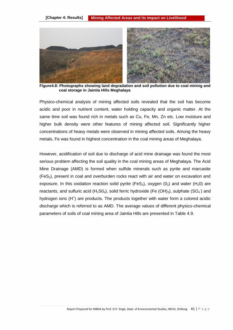
Report Prepared for MBDA by Prof. O.P. Singh, Dept. of Environmental Studies, NEHU, Shillong 41 | P a g e
Mining Affected Areas and its Impact on Livelihood
[Chapter 4: Results]
Figure4.8: Photographs showing land degradation and soil pollution due to coal mining and
coal storage in Jaintia Hills Meghalaya
Physico-chemical analysis of mining affected soils revealed that the soil has become
acidic and poor in nutrient content, water holding capacity and organic matter. At the
same time soil was found rich in metals such as Cu, Fe, Mn, Zn etc. Low moisture and
higher bulk density were other features of mining affected soil. Significantly higher
concentrations of heavy metals were observed in mining affected soils. Among the heavy
metals, Fe was found in highest concentration in the coal mining areas of Meghalaya.
However, acidification of soil due to discharge of acid mine drainage was found the most
serious problem affecting the soil quality in the coal mining areas of Meghalaya. The Acid
Mine Drainage (AMD) is formed when sulfide minerals such as pyrite and marcasite
(FeS2), present in coal and overburden rocks react with air and water on excavation and
exposure. In this oxidation reaction solid pyrite (FeS2), oxygen (02) and water (H20) are
reactants, and sulfuric acid (H2S04), solid ferric hydroxide (Fe (OH)3), sulphate (SO4-) and
hydrogen ions (H+) are products. The products together with water form a colored acidic
discharge which is referred to as AMD. The average values of different physico-chemical
parameters of soils of coal mining area of Jaintia Hills are presented in Table 4.9.

Report Prepared for MBDA by Prof. O.P. Singh, Dept. of Environmental Studies, NEHU, Shillong 42 | P a g e
Mining Affected Areas and its Impact on Livelihood
[Chapter 4: Results]
Table 4.9: Average values of Soil Quality Parameters of contaminated soil in coal mining area of Jaintia Hills Meghalaya
Parameters
Mining site Un-mined site
Winter Pre-monsoon
Post monsoon
Average Winter Pre-monsoon
Post monsoon
Average
pH 4.35 4.05 4.78 4.39 5.2 5.45 5.8 5.483
BD( Bulk Density) (gm/cm
3)
1.31 1.31 1.32 1.31 0.76 0.77 0.79 0.77
SMC (Soil Moisture Content) %
18.67 31.175 23.22 24.35 21.25 39.4 28.56 29.73
SOC (Soil Organic Content) %
0.759 1.387 0.86 1.01 2.15 2.42 2.01 2.19
N (Nitrogen) %
0.084 0.142 0.098 0.108 0.378 0.471 0.412 0.420
P (Phosphorous) %
0.0027 0.0027 0.0020 0.0025 0.004 0.006 0.005 0.005
K (Potassium) %
0.009 0.018 0.19 0.072 0.112 0.160 0.155 0.142
Cu (Copper) %
0.54 1.47 0.32 0.77 0.11 0.26 0.28 0.21
Fe (Iron) (mg/kg)
26.31 27.11 27.44 26.95 22.36 26.02 26.45 24.94
Zn (Zinc) (mg/kg)
0.213 0.428 0.430 0.357 0.12 0.51 0.52 0.38
Mn (Manganese) (mg/kg)
0.622 0.932 0.872 0.808 0.12 0.51 0.48 0.37
Study done on soil quality of Simsang River valley in Garo Hills, Meghalaya by Talukdar
et al. (2016)7 also found low pH of soil samples collected from Nangalbibra and Siju.
Study found soil with relatively low pH (4.6 ± 2.91), low nutrients (nitrogen, phosphorus
and potassium) content and organic carbon (0.77 ± 2.86) at mining affected locations.
Certain heavy metals in high concentration (Fe, Zn, Pb, Ni and Mn) were also detected in
soil samples. They found coal mining a major concern for the current condition of the soil
quality of Simsang River valley which flows around the coal fields such as Nangalbibra
and Siju in Garo Hills.
The acidic nature of soil of the coal mining area is not suitable for cultivation thus farmers
have abandoned their farm land and no farming is done on a vast agricultural land due to
less productivity of crops. The agriculture on affected land is not remunerative and thus
has affected the livelihood of the people who depended on agriculture in the past.
Pollution form coal mining poses a huge risk to the ecosystems of the surrounding area.
Most plants achieve optimal growth in soil at natural pH. Many metabolic processes are
impeded altogether in acidic environments. High soil acidity inhibits plant root growth by
limiting the amount of nutrients available for uptake, thus making the eco-restoration and
afforestation work difficult. Besides, a vast area has become physically disfigured due to
haphazard dumping of overburden and mined coal, and caving in of the ground and
subsidence of land

Report Prepared for MBDA by Prof. O.P. Singh, Dept. of Environmental Studies, NEHU, Shillong 43 | P a g e
Mining Affected Areas and its Impact on Livelihood
[Chapter 4: Results]
4.3.1.2 Effect of Coal Mining on Water
4.3.1.2.1. Ground Water Resources and Quality in Jaintia Hills
Hydrogeology: Hydrogeologically, the Jaintia Hills can be divided into three units,
namely consolidated, semi consolidated and unconsolidated formations. Consolidated
formation includes the oldest rock formation occupying about 1300 km2 in the northern
and western parts. Peneplaned gneissic complex, quarzitesetc constitute this unit. The
depth of weathering varies from place to place and is 15 to 20 m at places. The storage
and movement of ground water in hard rock is controlled by physiography, zone of
weathering and interconnected places of weakness. Ground water occurs under
unconfined condition and in semi-confined condition in the interconnected secondary
structural weakness/ features like joints, fractures etc. of the underlying hard rocks.
Box 4.4: Effects of coal mining on Soil The mining area has been denuded of vegetation to facilitate mining, storage of
coal, dumping of overburden and movement of vehicles. The exposed soil has become prone to soil erosion by rain water, wind etc.
Mining typically exposes sulfur-containing minerals like, pyrites that oxidize to sulfuric acid on exposure to oxygen, water, and certain aerobic bacteria. The acidic discharge referred to as Acid Mine Drainage (AMD), which on contamination has brought down the soil pH to about 4.4. Organic carbon, total nitrogen, phosphorus (P), potassium (K) and other plant nutrients were found relatively low in the soil of mining area making soil un-favourable for plant growth
Soil in mining area gets polluted due to disposal of mining wastes and discharge of contaminated water and acid mine drainage (AMD) from mines, overburden and coal storage sites. The AMD contamination has made the soil acidic. The acidic nature of soil of the coal mining area is not suitable for plant growth and development. Thus many plant species have been eliminated. Only resistant species are surviving on acidic soil. Acidic soil is not suitable for cultivation thus farmers have abandoned their farm land and no farming is done on a vast agricultural land due to less productivity of crops. The agriculture on affected land is not remunerative and thus has affected the livelihood of the people who depended on agriculture in past.
Pollution from coal mining poses a huge risk to the ecosystems of the
surrounding area. Most plants achieve optimal growth in soil at neutral pH. Many metabolic processes are impeded altogether in acidic environments. High soil acidity inhibits plant root growth by limiting the amount of nutrients available for uptake, thus making the eco-restoration and afforestation work difficult.
Coal mining, in some parts has triggered the land subsidence posing problems to infrastructure (road, buildings etc) and agricultural land.

Report Prepared for MBDA by Prof. O.P. Singh, Dept. of Environmental Studies, NEHU, Shillong 44 | P a g e
Mining Affected Areas and its Impact on Livelihood
[Chapter 4: Results]
Semi consolidated formation constitute the major part of the Jaintia Hills covering
Amlarem and Khliehriat blocks and covers two- thirds of the entire area. It ranges in age
from late Cretaceous to Plio- Pleistocence. The shella formation of the Jaintia group is the
most conspicuous. Ground water in this formation occurs under unconfined to semi
confined conditions due to primary porosities of the semi consolidated formations as well
as in the secondary porosities like caverns, open fractures and joints. Finally, the
unconsolidated formation is primarily represented by recent alluvium occurs near the
southern fringe of the district and is the continuation of the alluvial plain of Bangladesh.
Figure 4.9: Hydrogeological map of Jaintia Hills
8
Groundwater Resources: Ground water resource assessment in Meghalaya has been
done by Central Ground Water Board(CGWB), Ministry of Water Resources, New Delhi
adopting the modified method known as Ground Water Resources Estimation
Methodology 1997 (GEC ‘97)8. Rainfall is the main constituent that contributes to the
recharge of ground water in the area. Based on the recent estimates, the total annual
ground water recharge estimated in Jaintia Hills (JH) and East Khasi Hills (EKH) are
37,800 hectare meter and 40,268 hectare meter, respectively. The overall annual ground
water draft estimated in JH is 1.98 hectare meter and 6.0 hectare meter in EKHD. This
ground water distribution was chiefly accounted under domestic and industrial uses. On
the contrary, the accounted ground water draft used for irrigation purposes in both the
districts has been found negligible. Based on the data generated by the CGWB, the
projected annual demand for domestic and industrial uses of groundwater up to 2025 in
JH and EKH is estimated to be 1,319 hectare meter and 2,382 hectare meter,
respectively.

Report Prepared for MBDA by Prof. O.P. Singh, Dept. of Environmental Studies, NEHU, Shillong 45 | P a g e
Mining Affected Areas and its Impact on Livelihood
[Chapter 4: Results]
Groundwater Uses: Groundwater is a significant natural resource particularly with
reference for drinking water purposes. It is primarily used by rural population for various
domestic and irrigational purposes. Lamare et al., (2014)9 reported that owing to limited
availability and supply of potable water, numerous households have resorted to using
groundwater from dug wells for drinking and other domestic purposes. As such
groundwater plays a significant role in the lives of these local communities. Besides,
some industries and institutions have installed bore wells for their requirements of water
supply.
Groundwater Quality: In order to study the chemical quality of the groundwater,
representative water samples were collected by CGWB from the select bore wells, dug
wells and springs and analyzed for pH, EC, TDS, CO3, Cl, SO4, F, Ca, Mg, TH and Fe.
From the analysis, it was observed that the spring water is by and large slightly alkaline
rather than acidic. Overall the chemical constituent present in the groundwater is within
permissible limit set by BIS and WHO except the concentration of Iron in few pockets in
deeper aquifer, which is higher than permissible limit. Thus, the qualitative assessment of
ground water resources of Jaintia Hills and East Khasi Hills has been classified under
‗safe‘ category.
Monitoring of ground water quality represented by spring water has been done by
Meghalaya State Pollution Control Board (MSPCB) in Jaintia Hills. Measurement of
values of physico-chemical parameters such as pH, Conductivity (µmho/cm), Turbidity
(NTU), Fluoride (mg/l), Iron (mg/l) and Total Coliform (MPN/ 100ml) of Umsahep Spring,
Bapung (Jaintia Hills) was found to be 6.5, 125.0 µmho/cm, 1.25 NTU, 0.047 mg/l, 0.10
mg/l and 15 MPN/ 100ml, respectively 10.
Thus the study of MSPCB indicates that spring water is primarily slightly alkaline rather
than acidic. Overall the chemical constituents present in the ground water are within
permissible limit set by BIS and WHO. However, Iron concentrations in some deep
aquifers were reportedly higher than permissible limits. This perhaps can be attributed to
coal mining carried out in the area.
However, assessment of groundwater quality carried out by Lamare and Singh (2014)
from five different dug wells of Ummulong village were also found to be acidic in nature
and rich in iron concentrations. At the same time the values of other physic-chemical
parameters studied were found within the permissible limit prescribed by BIS. Overall the
study revealed that even though dug well water samples recorded acidic values and high

Report Prepared for MBDA by Prof. O.P. Singh, Dept. of Environmental Studies, NEHU, Shillong 46 | P a g e
Mining Affected Areas and its Impact on Livelihood
[Chapter 4: Results]
iron content, however considering other physic-chemical parameters the groundwater
from these sample sites was categorized under good water characteristics. Details of the
results of physico-chemical analysis of groundwater samples of Ummulong village are
presented in Table 4.10.
Table 4.10 : Values of physico-chemical parameters of groundwater samples of Ummulong village, Jaintia Hills
9
Parameters October, 2013 February, 2014 BIS Range Mean±SD Range Mean±SD
Water Temperature (ºC)
19.60 - 20.27 19.89 ±0.26
15.67 - 23.47 18.58 ±3.15
-
pH 4.87 - 5.80 5.38 ±0.38
5.07 - 6.17 5.76 ±0.44
6.5-8.0
Electrical conductivity (µS/cm)
29.00 - 418.33 169.60 ±148.28
22.33 - 550.67 200.47 ±205.60
-
Turbidity (NTU) 0.06 - 0.80 0.36 ±0.28
0.07 - 1.01 0.44 ±0.37
5
Total Dissolved Solids (mg/l)
30.00 - 343.33 144.67 ±127.14
20.00 - 370.00 142.67 ±142.62
500
Total Hardness (mg/l)
27.33 - 118.67 65.07 ±39.50
42.67 - 197.33 117.60 ±60.10
300
Ca2+
(mg/l) 3.36 - 37.85 16.26 ±14.78
4.77 - 35.88 18.05 ±13.76
75
Mg 2+
(mg/l) 4.60 - 7.73 5.95 ±1.13
7.48 - 26.19 17.63 ±7.14
35
Cl-(mg/l) 18.93 - 136.53 50.09
±49.11 18.93 - 118.96 48.29
±40.26 250
SO4(mg/l) 75.00 - 217.71 119.79 ±61.29
117.50 - 226.25 143.50 ±46.64
200
Na+(ppm) 0.57 - 69.00 20.27
±27.65 1.27 - 62.30 21.53
±23.65 200
K+
(ppm) 0.33 - 23.33 6.81 ±9.46
0.10 - 21.47 6.05 ±8.75
-
Fe (ppm) 7.31 - 13.78 11.09 ±3.36
1.05 - 2.40 1.80 ±0.65
0.30
Being as major coal belt area, the Jaintia Hills region is well known for large production of
coal with Khliehriat sub division. The environment particularly surface and ground water
bodies have been adversely affected by unscientific method of coal mining coupled with
limestone quarry undertaken by cement factories. The main source of this pollution in the
mining area is ―Acid Mines Drainage (AMD)‖ originating from mines and spoils, leaching
of metals from soil and rocks. The data on ground water quality in relation to mining is not
sufficiently available. However, considering the facts of disturbed landscapes of the
mining area, digging of mining pits up to a depth 100-150 m, blasting, leaving the mines
pits abandoned and filled with AMD rich water, hilly terrain etc. there is every possibility
that AMD contaminated water from surface be reaching to shallow aquifers and polluting
the ground water resources in the mining areas of Meghalaya.

Report Prepared for MBDA by Prof. O.P. Singh, Dept. of Environmental Studies, NEHU, Shillong 47 | P a g e
Mining Affected Areas and its Impact on Livelihood
[Chapter 4: Results]
Groundwater Management: Springs play a major role of water requirement for the
people of rural areas in Jaintia Hills. The springs are mainly located in foothills and
intermontane valleys. The spring water in areas where there is no mining is still of good
quality and suitable for domestic uses. However, many springs located in mining areas
have already been affected by coal mining. As the people in rural areas are
predominantly dependent on spring water, there is an urgent need for scientific approach
for proper development and management of ground water in the area. It may be
recommended that the development of springs having high discharge is needed in
mitigating the water scarcity faced by the people. A special thrust to ground water
development is needed. Creating public awareness for conservation, protection and
judicious use of ground water is essential for proper management of ground water
resources in the mining area.
4.3.1.2.2. Surface Water
Literature survey coupled with field visits revealed that a large number of rivers and
streams drain the undulating landscape of the Jaintia Hills. Most of these rivers and
streams flow towards south-east into the flood plains of Bangladesh. However, a few also
flow towards northern side into the Brahmaputra valley. The major rivers and streams in
Jaintia Hills are Myntdu, Prang, Lukha and Lubha rivers. Some other rivers in coal mining
area are Kmai-um and Rawaka of Rymbai, Thwai Kungor of Bapung, Brilakam of
Myrsiang, and Mynsar of looksi.
The water bodies of the area are the greatest victims of the coal mining. The stream and
rivers are badly affected by contamination of Acid Mines Drainage (AMD) originating from
mines and spoils, leaching of heavy metals, organic enrichment and silting by coal and
sand particles. Pollution of the water is evident by the colour of the water, which in most
of the mining affected rivers and streams varies from brownish to reddish orange. Low pH
(between 3-4), high conductivity, high concentration of sulphates, iron and toxic heavy
metals, low dissolved oxygen (DO) and high BOD are some of the physico-chemical and
biological parameters which characterize the degradation of water quality. The average
values of physico-chemical parameters of water of some streams of the coal mining area
in Jaintia Hills are summarized in Tables 4.11 and 4.12.

Report Prepared for MBDA by Prof. O.P. Singh, Dept. of Environmental Studies, NEHU, Shillong 48 | P a g e
Mining Affected Areas and its Impact on Livelihood
[Chapter 4: Results]
Table 4.11: Average values of physico-chemical parameters of water of some streams of coal mining area of Jaintia Hills
11
Rivers/Streams Surrounding Area
Colour of water
pH DO (mg/L)
Sulphate content (mg/L)
Conductivity (mMHOS)
Remarks
Waikhyrwi, Sutnga
Coal mining area
Brownish 3.96 5.94 78.69 DNA Polluted
Rawaka, (Rymbai)
Coal mining area
Reddish brown
2.31 4.24 166.5 1.35 Highly polluted
Kmai-um, (Rymbai)
Coal mining area
Reddish brown
2.66 5.84 144.0 0.74 Highly polluted
Metyngka, (Rymbai)
Coal mining area
Reddish brown
2.42 4.24 168.0 2.70 Highly polluted
Um-Mynkseh, Ladrymbai
Coal mining area
Brownish orange
3.52 5.04 118.7 0.67 Polluted
Thwai-Kungor, Bapung
Coal mining area
Brownish 4.01 5.68 82.87 0.18 Polluted
Umkyrpon, Khliehriat
Coal mining area
Light orange
3.67 4.4 161.3 0.37 Polluted
Myntdu, Jowai
Away from Coal mining area
Bluish 6.67 10.2 3.66 0.10 Clean
DNA-Data Not Available.
Table 4.12: Average values of some water quality parameters of streams of coal mining areas of Jaintia Hills, Meghalaya
12
Sl. No.
Sampling & Location T
(⁰C)
TU (NTU)
pH EC (µS)
SO4 (mg/l)
TDS (mg/Ll
TH Mg/l)
1 Molishah Stream (Shanpung) (Control)
19.08 4.87 6.67 30.50 7.41 79.67 19.03
2 Yalip Stream 19.12 1.74 6.67 31.33 2.67 72.33 23.94
3 Savanong Stream 18.77 2.61 6.67 36.67 5.80 79.89 19.69
4 Umpai River (Rymbai) 16.53 1.1 2.9 1314.33 151.49 931.0 134.72
5 Mynkseh River (Lad Rymbai)
15.76 0.69 3.2 562.67 113.13 397.0 131.04
6 Khyrwi River (Sutnga) 16.93 1.39 2.9 1113.0 161.12 790.0 140.25
7 Sarbang Stream (Sutnga)
15.33 2.47 3.8 230.67 81.82 263.66 137.43
8 Kopili River (Running Water)
20.46 0.73 5.7 79.33 69.83 204.67 112.22

Report Prepared for MBDA by Prof. O.P. Singh, Dept. of Environmental Studies, NEHU, Shillong 49 | P a g e
Mining Affected Areas and its Impact on Livelihood
[Chapter 4: Results]
Figure 4.10: Photographs showing mine pits filled with acidic water, state of rivers and
water quality in rivers due to coal mining in Jaintia Hills, Meghalaya
The average values of physico-chemical parameters of water of some streams and rivers
of coal mining area of Garo Hills are summarized in Table 4.13.
Table 4.13: Average values of some water quality parameters of water of Simsang river of
Garo Hills, Meghalaya7
Garo Hills Simsang River
Sl. No.
Sampling & Location
T (⁰C)
pH DO (mg/l)
FCO2
(mg/l) Cl (mg/l)
TA (mg/l)
TDS (mg/Ll
NO3
(mg/l) NH3
(mg/l) PO4
(mg/l) SO4
(mg/l)
1 Romagre (free from coal mining)
15.7 7.51 8.8 6.37 5.9 21.4 21.0 1.42 0.02 0.04 8.52
2 Williamnagar 16.5 7.27 8.86 6.75 6.7 21.22 21.5 1.55 0.04 0.04 8.75
3 Baghmara 14.4 7.0 6.27 6.4 9.1 17.6 23.5 2.17 0.1 0.71 3.37
4 Nangalbibra 22.1 5.03 4.77 15.75 6.3 6.3 84.75 3.8 0.07 0.20 29.5
5 Siju 15.3 4.5 4.75 19.9 8.9 5.07 145.7 3.57 0.08 0.20 31.7
Data of average values of physico-chemical parameters of water of streams of Jaintia
Hills show that pH value of most streams are in highly acidic range. The pH values of
water was found as low as 2.31, 2.42, 2.66, 2.9 etc. The pH of water between 2 and 3 is
considered highly acidic. It shows that most of the streams in coal mining areas of Jaintia

Report Prepared for MBDA by Prof. O.P. Singh, Dept. of Environmental Studies, NEHU, Shillong 50 | P a g e
Mining Affected Areas and its Impact on Livelihood
[Chapter 4: Results]
Hills have become highly acidic. On the other hand, in Garo Hills only few rivers or
stretches of rivers which are affected by coal mining have turned acidic. Thus, the
situation in Jaintia Hills is much worse than the Garo Hills.
Besides above mentioned harmful effects of mining, the entire coal mining area of the
Jaintia Hills has become full of mine pits and caves. These open, unfilled pits are the
places where surface water percolates and disappear into the ground and reaches to
lower areas. As a result, smaller streams and rivers of the area, which served as life lines
for the people, are either completely disappearing from the face of the earth or becoming
seasonal. Consequently, the area is facing acute shortage of clean drinking and irrigation
water either due to pollution of available water or due to percolation of surface water into
the ground.
Studies done by Mylliemngap and Ramanujam (2011)13 on water quality of Jaintia Hills
also reported that the water bodies in mining areas have been adversely affected by
contamination of acid mine drainage (AMD) originating from coal mining operations by
private coal miners. Certain parameters such as low pH, high conductivity, high metal
content and low dissolved oxygen are some of the implications brought about by coal
mining activity which has resulted in the decline or total loss of fish fauna in the coal
mining areas of the region. In the water bodies of the coal mining areas where pH is
approximately 4.0, only one species, Brachydanio rerio was found. High metal
concentration in the rivers of the coal mining areas was also reported.
Rivers studied by them include Kopili at Iooski, Umkyrpon at Khliehriat, Kmai-um at
Rymbai, Myntdu at Jowai and Lubha at Sonapur. Physico-chemical analysis of water of
Kopili, Umkyrpon and Kmai-um which flow in the coal mining area showed low pH
(between 2.6 to 4.0) and DO (between 2.6 to 5.9) values indicating sever impact of coal
mining on water quality. These rivers also showed presence of metals like iron, copper,
cadmium, lead and zinc. On the other hand, pH (between 6.7 to 7.1) and DO (between
4.1 to 10.1) of Myntdu and Lubha rivers located adjacent to coal mining area were found
relatively higher (Tables 4.14).

Report Prepared for MBDA by Prof. O.P. Singh, Dept. of Environmental Studies, NEHU, Shillong 51 | P a g e
Mining Affected Areas and its Impact on Livelihood
[Chapter 4: Results]
Table4.14 : Physico-chemical properties of the water of some rivers of Jaintia Hills, Meghalaya
13
Rivers/Streams and location
Surrounding areas pH DO(mg/L) Conductivity (mS/cm)
Remarks
Kopili, Iooski Coal mining area 3.7-4.0 2.6-5.2 0.85-0.89 Polluted by AMD
Umkyrpon, Khliehriat Coal mining area 3.1-4.0 5.2-5.9 0.27-0.29 Polluted by AMD
Kmai-um, Rymbai Coal mining area 2.6-3.5 4.8-5 0.23-0.25 Polluted by AMD
Myntdu, Jowai Away from coal mining area
6.7-7.1 10.1 0.10-0.12 Not polluted by AMD
Lubha, Sonapur Adjacent to coal mining area
6.8-6.9 4.6-5.5 0.14-0.18 Slightly polluted by AMD and cement factories
Table 4.15: Concentration (ppm) of selected elements in the water samples of the rivers collected from Jaintia Hills
13
Sampling site Lead Copper Cadmium Zinc Iron
Iooski Kopili 0.03 0.032 ND 1.426 0.088
Khliehriat Umkyrpon 0.08 0.020 ND 1.202 0.033
Rymbai Kmai-um 0.04 0.02 0.03 ND 7.13
Thamar Leshka ND 0.013 0.005 0.942 0.124
Lukha & Lubha 0.03 0.042 0.03 2.41 0.371
Myntdu Jowai ND 0.010 ND 4.412 0.129 ND- Not Detected
Apart from our own data previous studies by other researchers also found that the water
quality of the rivers of Jaintia Hills has deteriorated due to AMD contamination. For
instance, Sahoo et al (2012)14 studied various streams and dug wells in coal mining areas
of Jaintia Hills (Figure 4.11) during the month of October 2007 and reported degradation
of water quality due to mining.
Figure 4.11: Location map of the Jaintia Hills coalfield, Meghalaya and sampling point of mine discharges (M1–M12), stream water (S1–S32) and dug-well (D1–D13) samples
14

Report Prepared for MBDA by Prof. O.P. Singh, Dept. of Environmental Studies, NEHU, Shillong 52 | P a g e
Mining Affected Areas and its Impact on Livelihood
[Chapter 4: Results]
Sahoo et al. (2012)14 found that the pH of mine drainage highly acidic. Higher EC was
observed in contaminated water having low pH because of higher solubility of most
species. Further, EC in various water bodies is significantly correlated with dissolved
SO42- and TDS which indicate conductivity can be a good indicator of the degree of
contamination. The high acidity was observed in mine drainage indicating the scarcity of
carbonates to neutralize the acidity during the pyrite oxidation. Further, acidity is strongly
correlated with Fe and Al contents suggesting contribution of free protons by dissolution
of Fe and Al compounds. There is typical enrichment of SO42- in most of the mine
discharges and stream waters affected by AMD whereas HCO3- is dominated in the dug-
well waters. Sodium and Calcium were found to be the dominant cations in most of the
samples. This suggests that all the hydrological units except dug-well in the study area
are affected by AMD.
Table 4.16: Physicochemical parameters and metal concentrations in mine drainage (12 nos.), stream (33 nos.) and dug-well water (13 nos.) from Jaintia Hills coalfield
14
Study Area Mine Drainage Stream Water Dug Water
Max Min Avg Max Min Avg Max Min Avg
pH 4.8 1.6 3.01 5.6 2.6 3.7 6.8 4.8 5.98
EC 5858 602 2740 2848 234 932.1 378 115 192.20
TDS 4469 423 1884 2078 174 684.7 234 93 144.50
SO42−
4489 457 1533 1209 105 441 132 5.4 44.00
Cl−
6.1 1.6 3.28 10.3 1.67 3.33 20.2 6.3 12.47
Acidity 2754 214 893 642 10 182 14.6 0 4.10
HCO3−
0 0 0 61 0 6.28 85.4 7.4 53.53
Fe2+
218 10.4 75.05 47.9 0.2 8.19 0.6 bdl 0.05
Fe3+
97.3 12.9 43.39 40 1.28 14.88 2.3 0.024 0.51
Fe 290.4 38.5 118.4 66.1 1.5 23.08 2.3 0.024 0.56
Al 117.8 15.2 54.77 46.6 0.33 13.28 1.75 0.007 0.55
Ca 182 15.6 67.77 108.2 0.33 25.36 23.5 2.6 11.74
Mg 61.8 7.2 27.49 26.27 0.72 11.14 11.7 2.2 6.51
Mn 11.73 0.27 4.07 3.25 0.01 0.77 0.25 0.005 0.08
Na 168 84.4 132.4 204 24.7 79.93 33 5.45 18.72
K 28.3 3.6 12.65 18.78 0.25 4.07 5.72 0.34 1.25
Ni 5.15 0.02 1.08 1.02 bdl 0.136 0.07 bdl 0.01
Cu 1.82 0.01 0.32 0.09 bdl 0.01 0.01 bdl 0
Co 1.52 0.02 0.31 0.09 bdl 0.01 0.0 bdl 0
Zn 15.45 0.26 4.22 2.05 0.011 0.29 0.06 bdl 0.01
Cd 0.08 bdl 0.03 0.06 bdl 0.01 0.0 bdl 0
Pb 1.58 0.01 0.43 0.46 bdl 0.07 0.03 bdl 0.01
Cr 0.17 bdl 0.06 0.05 bdl 0.01 0.01 bdl 0
(Unit: EC — μS/cm, acidity: mg/L as CaCO3, others in mg/L except pH)
Another study done by Nongtdu et al.(2018)15 also found that rivers Prang and Lynriang
which are situated near mining sites are devoid of aquatic life and highly acidic. The
values of some of the water quality parameters of Lynriang and Prang rivers found by
Nongtdu et al. (2018)15 are shown in Tables 4.17.

Report Prepared for MBDA by Prof. O.P. Singh, Dept. of Environmental Studies, NEHU, Shillong 53 | P a g e
Mining Affected Areas and its Impact on Livelihood
[Chapter 4: Results]
Table 4.17: Water quality of Lynriang River15
Parameters Upstream Midstream Downstream
pH 3.1 2.9 4.6
Conductivity (µmho/cm) 240 680 70
Total Dissolved Solids (mg/l) 166 469 50
Turbidity (NTU) 15 9 15
Chloride (mg/l) 11 9 6
Total Hardness (mg/l) 22 52 34
Nitrate-N (mg/l) 0.24 0.26 0.36
Table 4.18: Water quality of Prang River15
Parameters Upstream Downstream
pH 3.4 3.1
Conductivity (µmho/cm) 690 560
Total Dissolved Solids (mg/l) 476 386
Turbidity (NTU) 8.8 4.5
Chloride (mg/l) 7 7
Total Hardness (mg/l) 64 42
Nitrate-N (mg/l) 0.41 0.34
The data of water quality parameters of Lynriang and Prang rivers of Jaintia Hills of
Meghalaya showed that both rivers have very low pH values showing their acidic nature.
The Hardness values observed put them in the hard water category. Conductivity is also
very high and may be because of the presence of chloride, nitrate and iron. The rest of
the parameters lies within the permissible limits and pose no threat to the environment.
Coal operations was banned by the National Green Tribunal( NGT) but different effluents
originating from mines, leaching of heavy metals, silting by coal and sand particles are
major causes of degradation of water quality in this area.
Several other studies done by both Meghalaya State Pollution Control Board (MSPCB)
and Central Pollution Control Board (CPCB) during 2013-14 and 2016 on rivers of the
coal mining areas also reported degradation of water quality due to coal mining. The
studies reported very low pH of Lunar River at Myndihati, Kyrhukhla River at Lad-Rymbai
and Lukha River at Sonapur. A minimum value (pH 2.2) was recorded of Lunar river at
Myndihati during the dry months of April. Low pH indicates that water is acidic in nature
which is mainly due to acid effluent from coal mines located on the catchment. Study
concluded that acidic water of Lukha river at Sonapur, Lunar river at Myndihati and
Kyrhukhla river at Lad-Rymbai cannot be put to any beneficial uses. The water quality of
other water bodies is relatively good and can still be put for various beneficial purposes
although it is not recommended to use directly for drinking purposes unless treated and
disinfected by an organized water supply system.
In addition to above mentioned studies that showed severe degradation of water quality,
a plethora of data generated by various researchers show that rivers and streams of coal
Report Prepared for MBDA by Prof. O.P. Singh, Dept. of Environmental Studies, NEHU, Shillong 54 | P a g e
Mining Affected Areas and its Impact on Livelihood
[Chapter 4: Results]
mining areas are severely affected by coal mining in Meghalaya and AMD is the main
cause of water pollution.
4.3.1.3 Impact of Water Pollution on Aquatic Life
Low pH, low Dissolved Oxygen (DO), higher sulphate content and turbidity in water of
coal mining areas are affecting the aquatic life. Study on benthic macro-invertebrates
revealed presence of only a few tolerant species namely Chironomus larvae (Diptera),
dragonfly larvae (Odonata) and water bugs (Hemiptera) in rivers and streams of the area.
Analysis further revealed lower abundance and species diversity of macro-invertebrates.
The presence of only a few tolerant species of benthic macro-invertebrates and the
absence of most of the aquatic organisms particularly the sensitive species are most
likely due to acidic water contaminated with AMD. Further, most of the rivers of the mining
areas lack commonly found aquatic organisms such as fish, frog and crustacean. On the
other hand, studies done in upstream of river Myntdu, which is away from the coal mining
area revealed relatively higher abundance and species diversity of macro-invertebrates.
The species present in the unaffected stretches of the river include many sensitive
species such as stonefly nymph (Plecoptera), mayfly nymph (Ephemeroptera), caddisfly
(Tricoptera) along with some tolerant species mentioned above.
The primary cause of degradation of water quality and the declining trend of biodiversity
in the water bodies of the mining area is attributed mainly to the AMD, which makes water
highly acidic, turbid and rich in iron, sulphate and heavy metals. Low pH is directly
injurious to many freshwater animals and has diverse biological effects including changes
in abundance, biomass and diversity of invertebrates. Higher concentration of heavy
metal in water impairs with the normal physiological functioning of the aquatic organisms,
and leads to toxicity. The effects of AMD are the result of a combination of factors which
are devastating to stream ecosystem by eliminating stream macro-invertebrates, fish
community, and plant species. Water bodies which are not affected by acid mine
drainage support high diversity of aquatic insects belonging to orders of Ephemeroptera
(Mayflies), Plecoptera (Stoneflies) and Trecoptera (Caddisflies). Mayflies are one of the
most sensitive group of aquatic insect to low pH. Acid mine drainage causes a reduction
in the abundance and diversity of benthic macro-invertebrates. Sensitive species are
eliminated even in moderately polluted water bodies. In severely polluted condition,
tolerant organisms like earthworms (Tubificidae) midge larvae (chironomidae) etc
dominate and are present in abundance. Data on occurrence of macro-invertebrates and
fish, frog etc. in some rivers and streams of Jaintia Hills affected by coal mining are
presented in Table 4.19.

Report Prepared for MBDA by Prof. O.P. Singh, Dept. of Environmental Studies, NEHU, Shillong 55 | P a g e
Mining Affected Areas and its Impact on Livelihood
[Chapter 4: Results]
Table 4.19: Occurrence of macro-invertebrates and fish, frog etc. in rivers and streams of Jaintia Hills
16
Benthic macro invertebrates
Rivers/Streams
Myntdu (Control)
Waikhyrwi (Sutnga)
Rawaka (Rymbai)
Kmai-Um (Rymbai)
Metyngka (Rymbai)
Um-Mynkseh (Lad Rymbai)
Thwai Kongor (Bapung)
Um Krypong (Khliehriat)
Plecoptera (Stonyefly nymph)
P A A A A A A A
Epheroptera (Mayfly nymph)
P A A A A A A A
Tricoptera (Caddis fly larvae)
P A A A A A A A
Odanata (Dragon fly)
P P A A A P A A
Hemiptera (Water bugs)
P P A A A P A A
Diptera (Chironomus larvae)
P P A A A P A A
Crustacea P A A A A A A A
Other aquatic organisms (Fishes, Frogs & Tadpoles)
P A A A A A A A
P- Present; A-Absent.
Aquatic fauna belonging to higher animal groups like fish, frog, crayfish, snail, crab etc.
have totally vanished from the acidic water bodies in the coal mining area of Jaintia hills
due to acidic nature of water and absence of macro invertebrates which serve as food for
fishes, crabs etc.
Box 4.5. Effects of coal mining on water The water bodies of the area are the greatest victims of the coal mining.
The stream and rivers are badly affected by contamination of Acid Mine
Drainage (AMD) originating from mines and spoils, leaching of heavy metals, organic enrichment and silting by coal and sand particles.
Pollution of the water is evident by the colour of the water which in most of the rivers and streams in the mining area varies from brownish to reddish orange.
Low pH (between 3-4), high conductivity, high concentration of sulphates, iron
and toxic heavy metals, low dissolved oxygen (DO) and high BOD are some of the physico-chemical and biological parameters which characterize the degradation of water quality.
Water of streams and rivers of all three regions (Jaintia, Khasi and Garo) have
been found affected by coal mining, however the adverse effects are severe in Jaintia Hills.

Report Prepared for MBDA by Prof. O.P. Singh, Dept. of Environmental Studies, NEHU, Shillong 56 | P a g e
Mining Affected Areas and its Impact on Livelihood
[Chapter 4: Results]
4.3.2 Effect of Limestone Mining on Soil and Water
As mentioned earlier limestone mining is going on in Jaintia and Khasi Hills regions.
Limestone mining in East Jaintia Hills, Meghalaya is being carried out extensively for the
production of cement. Extraction of limestone is done mainly by adopting opencast
method of mining. Mining activities have deteriorated the environment of the area in terms
of deforestation, biodiversity loss, water quality and availability of clean water, noise
pollution, landscape disturbance, soil erosion, generation of spoils and degradation of
land. A brief account of effects of limestone mining on soil and water is given below.
4.3.2.1 Effect of Limestone Mining on Land and Soil
Data collected on the soil quality in relation to limestone mining revealed that the soil
quality has deteriorated in limestone mining areas of Meghalaya. Remarkable decrease in
organic matter, moisture content, water holding capacity, organic carbon and total
nitrogen has been found in soils of mining area in comparison to the soil of a non-mining
area. However, the soil quality parameters such as pH, electrical conductivity and bulk
density showed an increase in the values in mining area. The increase in soil pH can be
considered an improvement in soil quality because of prevailing acidic nature of soil in the
area. However, changes in other parameters show slight deterioration in soil quality.
Similar changes were also found in Sohra/Cherrapunjee and other limestone mining
areas of the State. It was reported that land degradation and alteration of landscape
topography by dumping of overburden/spoils and limestone waste material was due to
artisanal and small scale limestone mining in Sohra. Further, excavation of limestone
resulted in removal of fertile top soil and generation of spoil and overburden which have
deteriorated the aesthetic beauty of the proximate landscape.17
The average values of different soil quality parameters found in East Jaintia Hills and
East Khasi Hills are summarized in Tables 4.20 and 4.21.

Report Prepared for MBDA by Prof. O.P. Singh, Dept. of Environmental Studies, NEHU, Shillong 57 | P a g e
Mining Affected Areas and its Impact on Livelihood
[Chapter 4: Results]
Table 4.20: Average values of various soil quality parameters of soil samples collected in three seasons from limestone mining areas and a non-mining area of East Khasi Hills (Sohra), Meghalaya
Sl. No.
Sampling Location
Season
Average values of various physico-chemcal parameters
Soil pH
MC (%)
Soil EC (dS/m)
B. D. (g/cm
3)
WHC (%)
OC (%)
TKN (%)
P (%)
K (mg/g)
1 Mawsmai village
Winter 7.9 26.06 0.84 1.57 26.06 0.51 0.03 9.80 0.36
Pre- Monsoon
7.7 39.44 0.4 1.4 29.44 0.35 0.02 5.68 0.13
Post-Monsoon
8.0 40,2 0.58 1.71 32.1 0.29 0.02 6.1 0.18
Average 7.87 35.23 0.6 1.56 29.2 0.38 0.02 7.19 0.22
2 Maw-Ki-Syiem (Control)
Winter 5.74 46.8 0.02 1.26 46.80 2.89 0.28 8.42 0.78
Pre- Monsoon
5.80 60.08 0.02 1.06 60.04 1.98 0.19 4.72 0.32
Post-Monsoon
5.78 62.5 0.02 1.21 58.6 2.1 0.21 5.8 0.41
Average 5.77 56.46 0.02 1.17 55.14 2.32 0.22 6.31 0.50
MC- Moisture Content; EC- Electrical Conductivity; BD- Bulk Density; WHC- Water Holding Capacity; OC- Organic Carbon; TKN- Total Kjeldahl Nitrogen; P- Phosphorus; K- Potassium.
Table 4.21: Average values of various soil quality parameters of soil samples collected in three seasons from limestone mining areas and a non-mining area (control) of East Jaintia Hills, Meghalaya
Sl. No.
Sampling Location
Season
Average values of various physico-chemcal parameters
Soil pH
MC (%)
Soil EC (mS/cm)
B. D. (g/cm
3)
WHC (%)
OC (%)
TKN (%)
P (%)
K (mg/g)
1 Nongsning
Winter 7.4 5.53 0.45 1.37 32.00 0.21 0.04 1.93 0.65
Pre- Monsoon
7.1 9.44 0.52 1.53 29.57 0.23 0.03 3.87 0.52
Post-Monsoon
7.5 7.32 0.50 1.48 30.22 0.24 0.04 3.11 0.56
Average 7.33 7.43 0.49 1.46 30.60 0.23 0.04 2.97 0.58
2 Mynkree
Winter 7.4 4.39 0.23 1.55 32.00 0.24 0.04 2.07 0.41
Pre- Monsoon
7.0 9.58 0.47 1.48 30.74 0.29 0.03 3.85 0.52
Post-Monsoon
7.5 8.33 0.38 1.66 29.67 0.28 0.04 3.22 0.48
Average 7.3 7.43 0.36 1.56 30.80 0.27 0.04 3.05 0.47
3. Wahiajer-Narpuh
Winter 8.1 2.46 0.40 1.55 32.50 0.48 0.05 2.11 0.53
Pre- Monsoon
7.1 10.18 0.32 1.54 34.85 0.46 0.06 3.19 0.64
Post-Monsoon
7.9 8.66 0.37 1.58 35.45 0.43 0.05 3.61 0.55
Average 7.7 7.1 0.36 1.56 34.27 0.46 0.05 2.97 0.57
4.
Lumshnong
Winter 7.5 6.64 0.36 1.51 35.47 0.34 0.05 1.98 0.27
Pre- Monsoon
7.2 11.09 1.16 1.38 36.70 0.66 0.07 2.86 0.36
Post-Monsoon
7.4 9.22 0.98 1.45 34.88 0.56 0.06 2.11 0.32
Average 7.37 8.98 0.83 1.45 35.68 0.52 0.06 2.32 0.32
5. Um-Tyraa (Control)
Winter 5.4 18.52 0.03 1.17 50.04 2.58 0.29 2.08 0.42
Pre- Monsoon
5.5 32.50 0.03 1.06 60.30 2.59 0.37 3.55 0.61
Post-Monsoon
5.4 33.01 0.02 1.22 58.43 2.55 0.34 2.99 0.59
Average 5.43 28.01 0.03 1.15 56.26 2.57 0.33 2.87 0.54
MC- Moisture Content; EC- Electrical Conductivity; BD- Bulk Density; WHC- Water Holding Capacity; OC- Organic Carbon; TKN- Total Kjeldahl Nitrogen; P- Phosphorus; K- Potassium.

Report Prepared for MBDA by Prof. O.P. Singh, Dept. of Environmental Studies, NEHU, Shillong 58 | P a g e
Mining Affected Areas and its Impact on Livelihood
[Chapter 4: Results]
4.3.2.2 Limestone Mining and Water Quality Mining is known to affect water resources severely both in terms of its quantity and
quality. Changes in water levels and flow, its availability for domestic and irrigation uses,
changes in sediment flow and deposition, degradation of water quality, reduction and
degradation of habitat of aquatic flora and fauna and decrease in abundance and
diversity of aquatic species are some of the adverse impacts of mining. As any other
mining, the mining of limestone rocks also causes alteration in the quality of surface water
in terms of high content of calcium, bicarbonates, sodium and chloride salts in the water
of streams and rivers receiving a significant volume of mine water generated from open
cast limestone mining areas.
Assessment of water quality in limestone mining areas of Meghalaya was carried out in
East Jaintia Hills and East Khasi Hills 17, 18. Study found that both limestone mining and
cement plants have negative impact on the physico-chemical characteristics of water of
the area. Study found elevated levels of pH, conductivity, dissolve solids, hardness,
calcium and sulphate in affected streams. The Cement plants were found contributing
towards water quality degradation than the limestone mining in East Jaintia Hills,
Meghalaya. Artisanal and small scale mining (ASM) of limestone rocks in Sohra is carried
out mainly for production of quicklime and edible lime. Mining and processing of
limestone generate overburden and limestone waste materials that are disposed off in the
nearby areas pose some environmental problems, including adverse effect on water
quality. However, the effect of ASM in Sohra is confined to a small area. The average
values of some water quality parameters found in limestone mining areas of Jaintia Hills
and Sohra are given in Table 4.22a and 4.22b.

Report Prepared for MBDA by Prof. O.P. Singh, Dept. of Environmental Studies, NEHU, Shillong 59 | P a g e
Mining Affected Areas and its Impact on Livelihood
[Chapter 4: Results]
Table 4.22a: Average values of various water quality parameters (Temperature, pH, Electrical Conductivity, Turbidity, Total Solids, Total Alkalinity, Total Hardness, and Calcium) of water samples collected in three seasons from limestone mining area of East Jaintia Hills
Sl. No. Sampling & Location
Season WT
(⁰C)
pH EC (µS/cm)
T (NTU)
TS (mg/l)
TA (mg/l)
TH (mg/l)
Ca (mg/l)
Jaintia Hills
1 Mihchariang Winter 18.2 8.0 205.0 0.85 150.0 142.6 232.6 49.9
Pre- Monsoon
21.3 8.1 168.6 5.33 103.3 109.0 120.6 44.8
Post-Monsoon
20.0 7.9 179.7 4.9 123.2 134.4 198.7 47.5
Mean 19.83 8.00 184.43 3.69 125.50 128.67 183.97 47.40
2 Wah Rkhiang Winter 16.8 7.6 471.3 0.78 383.3 104.0 298.6 70.6
Pre- Monsoon
22.6 8.1 103.0 30.7 73.33 76.3 67.3 17.3
Post-Monsoon
18.0 8.0 231.0 14.5 83.2 78.3 123.2 45.9
Mean 19.13 7.90 268.43 15.33 179.94 86.20 163.03 44.60
3. Wah Pom Pa Winter 18.1 7.7 305.3 4.5 223.3 173.3 282.0 61.6
Pre- Monsoon
22.1 7.9 163.0 55.7 126.67 109.67 107.3 35.88
Post-Monsoon
19.2 7.9 211.0 45.9 188.1 123.3 210.1 55.9
Mean 19.80 7.83 226.43 35.37 179.36 135.42 199.80 51.13
4. Wah Myntdu Jowai (Control)
Winter 13.2 8.2 29.33 1.64 50.0 52.33 58.0 5.05
Pre- Monsoon
23.3 7.8 25.0 11.09 23.33 36.0 24.0 6.17
Post-Monsoon
18.0 8.1 22.1 9.2 31.6 44.5 38.4 5.3
Mean 18.17 8.03 25.48 7.31 34.98 44.28 40.13 5.51
Sohra /Cherrapunjee
1. Wah- Maw lyntang
Winter 18.5 7.5 36.33 1.34 63.33 52.0 39.3 11.21
Pre- Monsoon
26.4 7.9 25.33 2.7 36.67 40.67 30.6 7.57
Post-Monsoon
19.5 8.0 23.9 1.8 55.9 36.5 33.2 8.8
Mean 21.47 7.80 28.52 1.95 51.97 43.06 34.37 9.19
2 Wah Khasaw Winter 20.2 7.8 77.33 0.601 80.0 61.0 71.3 12.9
Pre- Monsoon
28.2 9.4 113.00 1.73 80.0 59.67 88.67 22.99
Post-Monsoon
22.0 8.6 101.4 1.2 67.2 67.2 69.4 18.4
Mean 23.47 8.60 97.24 1.18 75.73 62.62 76.46 18.10
3. Mawthlong (Control)
Winter 12.6 7.6 9.67 0.41 36.67 33.0 29.33 3.92
Pre- Monsoon
20.5 7.4 12.33 3.08 13.33 20.67 26.67 5.05
Post-Monsoon
17.0 7.3 10.4 2.15 22.7 23.9 25.8 4.5
Mean 16.70 7.43 10.80 1.88 24.23 25.86 27.27 4.49

Report Prepared for MBDA by Prof. O.P. Singh, Dept. of Environmental Studies, NEHU, Shillong 60 | P a g e
Mining Affected Areas and its Impact on Livelihood
[Chapter 4: Results]
Table 4.22b: Average values of various water quality parameters (Magnesium, Sulfate, Chloride, Nitrate, Phosphorus, Sodium, Potassium, Dissolved Oxygen, Biological Oxygen Demand) of water samples collected in three seasons from Limestone mining area of East Jaintia Hills, Meghalaya
Sl. No Sampling & Location
Season Mg (mg/l)
SO4 (mg/l)
Cl (mg/l)
NO3
(mg/l) P (mg/l)
Na (ppm)
K (ppm)
DO (mg/l)
BOD (mg/l)
Jaintia Hills
1 Mihchariang Winter 26.2 30.4 11.9 10.6 3.8 0.37 0.13 8.66 2.95
Pre- Monsoon
2.11 24.1 14.5 6.4 10.0 0.87 0.17 7.72 1.14
Post-Monsoon
7.8 18.4 12.2 9.8 7.0 0.67 0.19 7.98 2.10
Mean 12.04 24.30 12.87 8.93 6.93 0.64 0.16 8.12 2.06
2 Wah Rkhiang Winter 29.7 182.8 17.3 16.6 4.4 22.6 2.83 10.8 4.90
Pre- Monsoon
5.82 100.4 13.4 5.86 11.5 1.97 1.10 7.45 1.41
Post-Monsoon
24.5 177.4 14.3 12.7 9.2 8.8 1.88 8.23 3.2
Mean 20.01 153.53 15.00 11.72 8.37 11.12 1.94 8.83 3.17
3. Wah Pom Pa Winter 31.1 201.0 12.1 11.5 4.5 5.07 0.43 8.39 2.68
Pre- Monsoon
4.31 123.8 15.12 7.26 12.42 1.67 0.73 7.72 1.54
Post-Monsoon
23.5 166.7 13.1 8.9 12.0 3.7 0.65 6.61 1.99
Mean 19.64 163.83 13.44 9.22 9.64 3.48 0.60 7.57 2.07
4. Wah Myntdu Jowai ( Control)
Winter 11.0 18.5 8.77 9.05 3.7 3.67 1.83 8.93 0.4
Pre- Monsoon
2.09 6.19 9.76 1.81 9.32 3.13 0.87 7.72 1.34
Post-Monsoon
8.2 12.2 8.9 7.9 6.7 2.9 1.01 6.3 1.12
Mean 7.10 12.30 9.14 6.25 6.57 3.23 1.24 7.65 0.95
Sohra /Cherrapunjee
1. Wah- Maw lyntang
Winter 2.76 128.10 11.65 9.45 4.33 0.63 0.2 8.12 3.96
Pre- Monsoon
3.93 94.29 13.21 3.12 11.81 0.33 0.3 7.11 1.14
Post-Monsoon
2.12 78.8 12.1 6.9 8.9 0.44 0.35 8.11 2.34
Mean 2.94 100.40 12.32 6.49 8.35 0.47 0.28 7.78 2.48
2 Wah Khasaw Winter 9.51 161.43 14.04 8.71 4.19 2.7 1.4 8.12 1.75
Pre- Monsoon
7.60 378.1 15.31 3.10 10.14 0.93 0.67 7.25 1.41
Post-Monsoon
6.8 146.6 12.8 5.7 8.55 1.78 1.21 5.78 1.56
Mean 7.97 228.71 14.05 5.84 7.63 1.80 1.09 7.05 1.57
3. Mawthlong (Control)
Winter 4.75 99.05 9.09 11.6 4.06 0.27 0.56 9.13 1.61
Pre- Monsoon
3.42 75.71 11.29 4.26 11.16 0.63 0.67 8.05 2.08
Post-Monsoon
4.2 76.8 9.4 6.5 9.3 0.5 0.64 7.78 1.88
Mean 4.12 83.85 9.93 7.45 8.17 0.47 0.62 8.32 1.86

Report Prepared for MBDA by Prof. O.P. Singh, Dept. of Environmental Studies, NEHU, Shillong 61 | P a g e
Mining Affected Areas and its Impact on Livelihood
[Chapter 4: Results]
4.3.3 Water Scarcity
Due to Karst topography of Meghalaya, only a few perennial surface water bodies are
present in coal and limestone deposit areas leading to water scarcity in lean period.
Mining of coal and limestone and establishment of cement plants in the region have
further aggravated the water scarcity in the area. Due to excavation of land and
disturbance of landscape, many streams in the area have become seasonal as water of
streams percolates into the ground. Some water bodies are found above ground for
certain distance and then disappear due to water flowing underground. Hence, water
resources in the mining area have been affected both in terms of its quantity and quality
and lead to severe scarcity of water. In many area people face real difficulty in etching
clean drinking water. Poor people are worst affected.
4.3.4 Effect of Mining on Air quality
Irrespective of its scale, excavation of minerals and rocks affect the environment at its
various stages of mining, processing and utilization. Mining activities such as drilling,
blasting, hauling, collection and transportation and utilization are some of the major
sources of air pollution in mining area. Owing to generation of dust, these different
activities are known to have an impact on air quality in the mining areas causing air
pollution mainly higher levels of suspended particulate matter (SPM) and Respirable
Suspended Particulate Matter (RSPM).
Box 4.6: Effect of limestone mining on soil and water Both small scale and large scale mining of limestone are taking place in Jaintia
and Khasi Hills of Meghalaya. In small scale mining the effect is localized and confined to a small area.
Soil Pollution due to limestone mining is evident in all mining areas of Jaintia and Khasi Hills. It is happening due to loss of top soil, disposal of mining wastes and denudation of vegetation.
The pH of the soil in mining area was found little higher than the pH of surrounding area. This is due to dissolution of calcium carbonate, the major constituent of limestone.
Contamination of inorganic constituents such as sand and gravels, depletion of organic matter and nutrient contents, modification of soil texture and structure are major causes of soil quality deterioration.
Water pollution due to limestone mining is limited to a slight increase in pH, Conductivity and Turbidity and is localized.

Report Prepared for MBDA by Prof. O.P. Singh, Dept. of Environmental Studies, NEHU, Shillong 62 | P a g e
Mining Affected Areas and its Impact on Livelihood
[Chapter 4: Results]
Deterioration in air quality or pollution of air is one of the many pronounced impacts of
unscientific coal mining carried out in Jaintia Hills. Dumping and piling of coal on
roadsides in and around mining areas are also reportedly a significant contributor to air
pollution, particularly concentration of suspended particulate matter (SPM), respirable
suspended particulate matter (RSPM) in the area. The gaseous pollutant released into
the air are attributed by the motorized machines involved during the entire process of
mining, i.e. movement of bulldozer, drilling machines, dumper and transportation vehicles.
Some cement plants have established coal based captive thermal power plants for
generation of electricity. These power plants are burning locally available coal which
contains high concentration of sulphur, a major source of sulphur dioxide in atmosphere.
Hence, burning of local coal in captive thermal power plants can also be a major source
of gaseous pollutants (sulphur dioxide, nitrogen oxide, carbon monoxide and carbon
dioxide) in air.
Activities involved during limestone extraction like drilling, blasting, loading and
transportation generate dust into the surrounding areas causing air pollution mainly
suspended particulate matter (SPM) and respirable suspended particulate matter
(RSPM). Study done in limestone mining areas of Meghalaya showed higher levels of
SPM in and around the mining area, particularly in mining activities done by cement
plants. Presence of large number of cement plants in a relatively small area of Jaintia
Hills, Meghalaya is also responsible for higher levels of SPM and RSPM in ambient air as
during the manufacturing of cement particulates of various sizes are emitted in air. In the
vicinity of cement plants there is problem of dust deposition on leaves of plants (crops
and forest). However, the weekly mean levels of SPM, RSPM, NOx and SO2 were found
below the permissible limits, in general at most places in Jaintia, Khasi and Garo Hills.
However, Central Pollution Control Board, on few occasions has reported the pollution
levels of ambient air of the coal mining areas and coal storage areas in Jaintia Hills
exceeding the National Ambient Air Quality Standards. Gaseous pollutants released into
the air as a result of limestone mining in Jaintia Hills are mainly attributed to motorized
machine involved during the entire processes i.e. bulldozer, drilling machines, dumper
and transportation vehicles. However the unique climate conditions, vast area under
forest cover, extremely high humidity, etc. minimize the air pollution level and keep the
average weekly or annual air pollution level within the permissible levels prescribed by
Central Pollution Control Board (CPCB), New Delhi.
Due to extensive limestone mining in the area the adjacent localities experience
deposition of thick dust on vegetation, buildings and roof top throughout the year
Report Prepared for MBDA by Prof. O.P. Singh, Dept. of Environmental Studies, NEHU, Shillong 63 | P a g e
Mining Affected Areas and its Impact on Livelihood
[Chapter 4: Results]
especially during the dry season. Daily deposition of dust from the cement plants
established in Jaintia Hills may cause contamination of the rain water harvested from
rooftop thereby leading to threat to future rain water harvesting programmes19. Dust
deposition can also affect agricultural/horticultural productivity in the area.
4.3.5 Effect of Coal and Limestone mining on Forest
The indiscriminate unscientific mining and absence of post mining treatment of mined
area are rendering the fragile ecosystems of East Jaintia Hills to be more susceptible to
environmental degradation resulting in large scale land use and land cover changes
(LULC). Mining involves clearance of large amount of forest lands resulting in
deforestation and denudation of the forests. As per the Meghalaya State Development
Report, deforestation due to mining and extraction of timber has considerably altered the
natural landscape of the State. Significant loss of forest cover in the past has been
reported. Continuous fragmentation of large forests into smaller patches has also been
noted. Forest depletion and land degradation have inevitable association with extensive
loss of habitat and biodiversity. Various scientific studies on impact of coal and limestone
mining on the different components of the forest and environment have been conducted
in the Jaintia Hills regions. These studies reveal deforestation, fragmentation of forest,
diminishing plant diversity and loss and degradation of habitat due to changes in land use
and land cover associated with mining.
Geographic information system (GIS) combined with remote sensing (RS) have been
used to analyze LULC changes in Jaintia Hills in relation to coal and limestone mining
and establishment of cement manufacturing units. Using GIS & RS, striking changes in
land use and land cover have been found in Jaintia Hills. Such changes have been
implicated to limestone mining and expansion of the cement manufacturing units. Within
the timeline of 2005 to 2011, a loss of around 1265.36 ha of forest area was observed
within a radius of 5 km2. 20, 21
Striking changes in LULC during 2005 and 2011, were mostly implicated to limestone
mining and expansion of the cement manufacturing units. Continuous human interference
like coal and limestone mining in Jaintia Hills has led to decrease in forest cover as well
as degradation of its quality. This has resulted in both deforestation and degradation of
the quality of the forest. Data revealed significant reduction in the areas under dense and
open forests with varying deforestation trends. However, among different classes of
forests, an increase in scrub/grassland, barren land, built up and water body area was
recorded. A decrease of approximately 12.17% in dense forest and 10.97% in open

Report Prepared for MBDA by Prof. O.P. Singh, Dept. of Environmental Studies, NEHU, Shillong 64 | P a g e
Mining Affected Areas and its Impact on Livelihood
[Chapter 4: Results]
forests were recorded during 2005 and 2011. Data on annual deforestation rate of dense
forest and open forest classes during 1987-1999 and 1999-2013 in Jaintia Hills 20 are
given in Table 4.23.
Table 4.23: Annual deforestation rate of dense forest and open forest class during 1987-1999 and 1999-2013 in an area of Jaintia Hills
20
Forest class
Year 1987-1999 1999-2013
1987 1999 2013 Change (in Ha)
Total % Rate of change %
Change (in Ha)
Total% Rate of change %
Dense forest
63922 67006 70351 -3345.03 -4.75 -0.24 -3083.85 -4.60 -0.19
Open forest
46120 51300 57735 -6435.45 -11.15 -0.21 -5179.95 -10.10 -0.17
The comparative analysis between the two time frames i.e (1987-1999) and (1999-2013)
shows that loss in dense forest was comparatively higher than the loss observed in open
forest. Net decline in dense forest during the time frame of 1987-1999 was reportedly
contributed by open forest. Furthermore, a notable increase in areas under ‗barren land‘
and ‗built-up‘ classes were recorded during the analysis. Increase in built up and barren
areas by a total of 1177 ha (192.32 %) and 4571 ha (47.8 %), respectively were recorded.
Changes in Dense and Open Forest categories during the Year of 1987-1999 and 1999-
2013 are shown in Figures 4.12. The maps indicate that amount of forest loss is higher
than its regrowth in both open and dense forest categories.
Figure 4.12: Land Use Land Cover maps of 1987, 1999 and 2013 of an area of Jaintia Hills
20
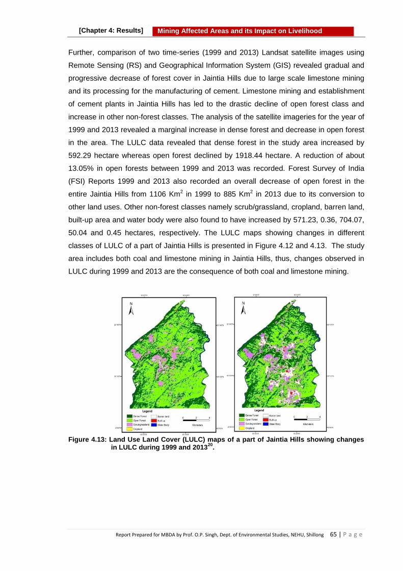
Report Prepared for MBDA by Prof. O.P. Singh, Dept. of Environmental Studies, NEHU, Shillong 65 | P a g e
Mining Affected Areas and its Impact on Livelihood
[Chapter 4: Results]
Further, comparison of two time-series (1999 and 2013) Landsat satellite images using
Remote Sensing (RS) and Geographical Information System (GIS) revealed gradual and
progressive decrease of forest cover in Jaintia Hills due to large scale limestone mining
and its processing for the manufacturing of cement. Limestone mining and establishment
of cement plants in Jaintia Hills has led to the drastic decline of open forest class and
increase in other non-forest classes. The analysis of the satellite imageries for the year of
1999 and 2013 revealed a marginal increase in dense forest and decrease in open forest
in the area. The LULC data revealed that dense forest in the study area increased by
592.29 hectare whereas open forest declined by 1918.44 hectare. A reduction of about
13.05% in open forests between 1999 and 2013 was recorded. Forest Survey of India
(FSI) Reports 1999 and 2013 also recorded an overall decrease of open forest in the
entire Jaintia Hills from 1106 Km2 in 1999 to 885 Km2 in 2013 due to its conversion to
other land uses. Other non-forest classes namely scrub/grassland, cropland, barren land,
built-up area and water body were also found to have increased by 571.23, 0.36, 704.07,
50.04 and 0.45 hectares, respectively. The LULC maps showing changes in different
classes of LULC of a part of Jaintia Hills is presented in Figure 4.12 and 4.13. The study
area includes both coal and limestone mining in Jaintia Hills, thus, changes observed in
LULC during 1999 and 2013 are the consequence of both coal and limestone mining.
Figure 4.13: Land Use Land Cover (LULC) maps of a part of Jaintia Hills showing changes
in LULC during 1999 and 201320
.

Report Prepared for MBDA by Prof. O.P. Singh, Dept. of Environmental Studies, NEHU, Shillong 66 | P a g e
Mining Affected Areas and its Impact on Livelihood
[Chapter 4: Results]
Figure 4.14: Graph showing changes in area of different LULC categories during 1999
and 201320
The observations on changes in LULC of these studies can be used as indicators for
other mining areas of the State. Significant LULC changes observed in the studies show
clear tendency of deforestation and degradation of the forest covers in the mining areas
of Meghalaya. Such changes might lead to several ecological implications and affect flora
and fauna and the people of the area.
4.3.6 Effect of Coal Mining on Floristic Composition
Impact of coal mining on plant diversity and tree population structure was analyzed in
Jaintia Hills by Sarma et al (2010)22. The study found low density and diversity of tree
species in the mining area due to various mining activities compared to adjacent unmined
area. However, mining site was represented by higher number of herbaceous species
(31-41 species) than the unmined area (23 species). Shannon diversity index for tree and
shrub species were low in mined areas as compared to that of the unmined area,
however, diversity index of ground vegetation did not differ among the mined and
unmined areas. The tree density was more (1040 stems per ha) in the unmined area than
the mined areas (515 and 646 stems per ha) while density of herbaceous species was
higher in mined areas than the unmined area. The trees of medium girth class contributed
to the maximum stand density in the mined areas, while in the unmined site the trees of
low girth class contributed to the maximum stand density. The higher basal area in the
mined areas, in spite of low stand density, could be mainly due to the existence of trees
of high girth as they were not damaged by the miners during the mining operations.
In Garo Hills also the total number of plant species found in the mined areas was
significantly less than the unmined areas. The number of tree species was higher in the
unmined areas than the mined areas. With the exception of herb species at one site, the

Report Prepared for MBDA by Prof. O.P. Singh, Dept. of Environmental Studies, NEHU, Shillong 67 | P a g e
Mining Affected Areas and its Impact on Livelihood
[Chapter 4: Results]
tree and shrub species showed a drastic reduction in their number due to mining. The
number of shrub species was much less in comparison to tree and herbs at all the three
sites. Fifteen tree species, 4 shrub and 28 herb species were exclusively found in mined
sites, while 27 tree species, 4 shrub species and 16 herb species were exclusively found
in the unmined sites. Since the mined and unmined areas had similar climatic, edaphic
and physiographic features the differences in species composition could be attributed to
the mining activities. Some plant species which seem resistant were found in both mined
and unmined sites.23
The total plant density in mined area ranged between 3250 and 4161 stems per ha while
that in the unmined areas ranged between 6720 and 7260 stems per ha. The density of
trees, shrubs and herbs in mined areas were significantly lower than the unmined areas
at all the three sites studied in Garo Hills. The unmined areas had greater plant diversity
compared to the mined stands because of acidic pH, moisture stress and nutrient
property of the litter.
Species composition of tree, shrub and herb in mined and unmined areas at three sites in
Nokrek Biosphere Reserve, Garo Hills are summarized in Table 4.24.
Table 4.24: Species composition in mined and unmined areas at three sites in Nokrek Biosphere Reserve, Garo Hills, Meghalaya
20
Species
composition
Budugiri Budu Wathegiri Faramgiri
Unmined Mined Unmined Mined Unmined Mined
Tree
Number of species 38 25 31 26 44 25
Number of genera 35 24 29 26 26 20
Number of families 26 20 20 19 28 16
Shrub
Number of species 5 6 16 13 18 17
Number of genera 5 5 15 12 16 17
Number of families 5 5 14 12 14 14
Herb
Number of species 28 33 26 17 18 18
Number of genera 26 31 26 16 17 18
Number of families 23 26 22 10 16 15
Tree species found in unmined and mined areas of the Nokrek Biosphere Reserve, Garo
Hills are listed in Table 4.25.

Report Prepared for MBDA by Prof. O.P. Singh, Dept. of Environmental Studies, NEHU, Shillong 68 | P a g e
Mining Affected Areas and its Impact on Livelihood
[Chapter 4: Results]
Table 4.25: Tree species found in unmined and mined areas of the Nokrek Biosphere
Reserve, Garo Hills, Meghalaya23
Unmined Mined
Tree species
Antidesma acuminatum Alchornea tiliaefolia
Artemisia nilagirica Anacardium occidentale
Casearia kurzii Bauhinia variegata
Citrus medica Linn. Bridelia monoica
Clausena heptaphylla Callicarpa arborea
Cleidion spiciflorum Cordia grandis
Daphne composita Duabanga grandiflora
Dysoxylum gobara Erythrina stricta
Ficus gasparriniana Euonymus attenuates
Garcinia paniculata Meliosma wallichii
Helicia nilagirica Prunus cerasoides
Homonia riparia Saurauia nepaulensis
Kydia calycina Schima wallichii
Litsea cubeba Spondias pinnata
Litsea salicifolia Writhtia coccinea
Maesa indica
Melodinus khasianas
Ostodes paniculata
Picrasmajavanica
Rhus javanica
Saprosma ternatum
Skimmia laureola
Sterculia hamiltonii
Syzygium cumini
Terminalia bellerica
Tetrameles nudiflora
Zizyphus mauritiana
Shrub species
Ardisia odontophylla Agapetes variegata
Calophyllum polyanthum Clerodendrum viscosum
Psychotria erratica Clerodendrum wallichii
Rubus ellipticus Eischoltzia blanda
Herb species
Arisaema tortuosum Agapetes variegata
Cynotis vaga Cyperus compress
Dischidia nummularia Desmodium racemosa
Elatostemma rupestre Digitaria ciliaris
Erythroxylum kunthianum Embelia ribes
Hoya lanceolata Eupatorium adenophorum
Marchantia sp. Eupatorium odoratum
Molineria capitulata Hedyotis scandence
Olax acuminata. Ipomea simosa
Piper longum. Jasminium lanceolarum.
Pogestemon auricularis. Leea crispa
Psychotria erratica Morinda angustifolia
Smilax ferox Kunth Murrya paniculata.
Strobilanthus discolor. Ophiopogon parviflorus
Report Prepared for MBDA by Prof. O.P. Singh, Dept. of Environmental Studies, NEHU, Shillong 69 | P a g e
Mining Affected Areas and its Impact on Livelihood
[Chapter 4: Results]
Tacca laevis . Oxalis sp.
Vandelia multiflora. Phyllanthus raticulatus.
Piper thomsonii.
Plantago major
Plecfranthus tern!folius
Sapondus pinnata.
Selinum striatum
Senecio griffithii.
Senecio scandens
Solanum tora
Stephania japonica
Thysanolaena maxima
Triumfetta tomentosa
Zanthoxylum armatum
Plant species found both in mined and unmined areas of the Nokrek Biosphere Reserve,
Garo Hills, Meghalaya are listed in Table 4.26.
Table 4.26: Plant species found both in mined and unmined areas of the Nokrek Biosphere Reserve, Garo Hills, Meghalaya
23
Plant species found both in mined and unmined areas
Location: Budugiri
Tree species Shrub species Herb species
Acacia pennata Citrus sp Davallia sp.
Aporusa oblonga Lygodium sp.
Echinocarpus murex Pteris sp.
Glochidion oblatum
Macaranga denticulate
Location: Budu Wathegiri
Tree species Shrub species Herb species
Acacia pennata Citrus sp. Agave sisalana
Alangium chinensis Asplenium sp.
Albizia chinensis Curculigo orchioides
Aporusa oblonga Davallia sp.
Echinocarpus murex Osmunda javanica
Macropanax undulates Paedaria foetida
Polygala glomerata
Location: Faramgiri
Tree species Shrub species Herb species
Albizia chinensis Cyathula tomentosa Curculido orchioides
Bridelia stipularis Gleichenia sp.
Castanopsis indica Polygala glomerata
Castanopsis kurzii
Castanopsis purpurella
Ficus raeemosa
Maearanga denticulate
Randia longiflora

Report Prepared for MBDA by Prof. O.P. Singh, Dept. of Environmental Studies, NEHU, Shillong 70 | P a g e
Mining Affected Areas and its Impact on Livelihood
[Chapter 4: Results]
4.3.7 Effect of Mining on Agriculture
Before the advent of mining the people of Jaintia Hills, mostly depended on agriculture as
the source of livelihood. Both settled and jhum cultivation were prevalent with crops
mainly rain fed in nature. The principal crops grown were rice, maize and other cereals.
Oilseed crops like sesamum, rapeseed and mustard, soybean are also cultivated for
personal uses. Other important crops of Jaintia Hills include pineapple, papaya, citrus,
potato, sweet potato, tapioca, chilies, turmeric, ginger, areca nut, tobacco and
vegetables.
However, mining, particularly of coal and limestone has spread in the state of Meghalaya
adversely affected the agricultural lands and agricultural productivity in many ways. The
pollution of air, water and soil caused by mining activities affect the agriculture, directly
and indirectly leading to loss of agricultural land, degradation of agricultural land and plant
growth and productivity. Thus, the mining activity has come into direct competition with
another predominant means of livelihood including agriculture. In mining areas of
Meghalaya all such ill effects of mining on agriculture are visible. A brief account of
various adverse impacts of mining to agriculture sector is given below.
4.3.7.1 Diversion of Agricultural Land
In order to facilitate mining activities and storage of extracted minerals, a large area of
good agricultural land has been diverted to other uses leading to reduction of areas under
Box 4.7: Effect of Mining on Forest Interference like coal and limestone mining in Jaintia Hills has led to
decrease in forest cover as well as degradation of its quality. In recent years, development, industrial expansion, urbanization, cultivation, plantation etc. have also contributed to the reduction of forest cover and its degradation.
Coal and limestone mining and establishment of cement plants in Jaintia Hills have led to the drastic decline of open forest class and increase in other non-forest classes.
Studies show clear tendency of deforestation and degradation of the forest covers in the mining areas of Meghalaya. Mining has been also found reducing the diversity and density of vegetation in the mining areas.
The density of trees, shrubs and herbs in the mined areas were significantly lower than the unmined areas at all the three sites studied in Garo Hills.
The unmined areas had greater plant diversity compared to the mined stands because of acidic pH, moisture stress and nutrient deficiency in soil of the mining area.

Report Prepared for MBDA by Prof. O.P. Singh, Dept. of Environmental Studies, NEHU, Shillong 71 | P a g e
Mining Affected Areas and its Impact on Livelihood
[Chapter 4: Results]
agriculture and horticulture and ultimately reduction in agricultural production. The mining
activities on agricultural land in some areas, movement of vehicles through agricultural
land, storage of minerals on agricultural land etc. have reduced the net agricultural land
and its productivity in Jaintia Hills.
It has been reported that farmers generally lease out their agricultural lands to both locals
and non-locals for coal mining in Jaintia Hills. Most of the farmers who own the land but
do not have the means to carry out mining operation rent their land to others for mining.
The land owner gets the rent of the land on the basis of truck or tons of coal extracted
from the land.
Owing to the unique land holding system and property rights prevailing in the State, there
is hardly any role of the Government in allocation and acquisition of land for mining.
Before the Judgement of the Honourable Supreme Court of 3rd July 2019 the mine
owners had unlimited access to extraction of minerals without following any regulation the
Mines and Minerals (Development and Regulation) Act, 1957 and various Environmental
Acts applicable to mining sector had not been implemented as yet in the shadow of Sixth
Schedule of Indian Constitution. Owing to all these, the mining has become a preferred
investment option and has attracted many to this business. The said Judgement the Apex
Court now made applicable all relevant regulations which apply in other parts of the
country.
Though the Jaintias do not suffer from land alienation to people from outside, yet the
emerging trend reveals that the poorer section of the society are losing their land to rich
coal merchants who use both man and money power to acquire their lands. As a result,
transformation of traditional economic activities from agriculture to mining has taken place
in the mining areas, particularly in Jaintia Hills. This has resulted in an overall decline in
agricultural activity of the people. Due to degradation of land and non-availability of labor,
paddy fields are abandoned by the people who, in past traditionally depended on
agriculture for their livelihood. Thus, coal mining, on one hand was able to bring wealth to
some but it has rendered many without any viable long term livelihood options, hence has
not benefited many of the local people. Further, due to lack of skill and expertise in newer
occupational activities and also lack of working capital for investment the local people are
finding difficulty in switching over to other occupations for their sustenance.
This has reportedly resulted in deterioration of social bonding which once existed among
the local people. Mining has also caused the disintegration of community land. Under old

Report Prepared for MBDA by Prof. O.P. Singh, Dept. of Environmental Studies, NEHU, Shillong 72 | P a g e
Mining Affected Areas and its Impact on Livelihood
[Chapter 4: Results]
tradition and practices, the local people who did not possess any land for cultivation were
provided land for farming so that they can sustain themselves and their family. However,
the present trend is completely different where people are claiming these lands for coal
mining. A large chunk of community land is being handed over to individuals and families.
Similarly limestone mining has also affected the livelihood of the local people of
Meghalaya. Owing to quick revenue obtained from limestone mining, to a certain extent a
decline in traditional agricultural practices has been observed in East Jaintia Hills. Daily
deposition of dust on the roof top generated from cement plants established in the area
has been resulting in contamination of water and degradation of land.
Hence, due to reduction in the area of agricultural land, degradation of agricultural land,
and shortage of labour force in agriculture, the farming practices in the mining area have
been noticed severely affected. Mining has resulted in a decline in the traditional
agricultural practices that once provided social and institutional infrastructure to
harmonize the regional ecosystems. The farming communities who have not shifted to
other livelihood activities have suffered to a greater extent in terms of losing their
agriculture fields to mining, degradation of their agricultural fields and less productivity
and income.
4.3.7.2 Degradation of Agricultural Land
Contamination of soil with pollutants (solid, liquid and gaseous) emanating from mining
activities has degraded the agricultural land in Meghalaya. Degradation of agricultural
land is more prominent in Jaintia Hills where extensive mining of coal and limestone has
been taking place for decades. Mining of both minerals (coal and limestone) have
adversely affected the soil of the area. However, the effects of coal and limestone are
different in nature and extent.
The coal mining, on one hand has made the soil acidic due to contamination of acid mine
drainage oozing out from coal mines, coal dumps and overburden. The limestone mining,
on the other hand has changed the soil pH in alkaline range. Both, acidity and alkalinity
beyond the optimum range are not good for soil and plant growth and development. Other
problems such as deposition of mineral particles (coal or limestone particles), sand
particles, erosion of top fertile soil, reduction in organic components of soil, increase of
inorganic constituents, change in composition of soil flora and fauna etc. arise due to
mining of both coal and limestone. Deposition of dust from limestone mining area and
cement plants on soil and vegetation is another serious problem of the agriculture sector.

Report Prepared for MBDA by Prof. O.P. Singh, Dept. of Environmental Studies, NEHU, Shillong 73 | P a g e
Mining Affected Areas and its Impact on Livelihood
[Chapter 4: Results]
Such degradation of soil and various other factors which arise due to mining do not
support proper plant growth, development and productivity and thus make farming less
remunerative. As a consequence, farmers in the mining areas have abandoned the
agricultural activity and a large area of agricultural land is left unattended because
farming on such land has become loss making livelihood option.
Figure 4.15: Photograph showing land degradation in Jaintia Hills due to coal mining and storage of coal in and around the farm land
4.3.7.3 Environmental Pollution and Agriculture
Air pollution is known to affect agriculture in numerous ways. It has the potential to reduce
both the yield and the nutritional quality of crops. Therefore, agricultural production would
fall even if there were no change in the quantity of other inputs used. There have been a
number of empirical studies on effects of mining on agriculture; however such studies are
limited in Meghalaya. In mining regions, the presence of high levels of suspended
particulate matter is a major problem for agriculture. It is observed that when dust falls
onto the plants it affects their nutrients, photosynthesis and production. It was shown that
villages located near coal mines have suffered from a loss of productivity in rice
cultivation because of the high presence of coal dust. Coal mining activities has also
brought about a diversification in the occupation24 of the people. The coal belt areas are
throng not only by miners but also by managers, supervisors, traders, shopkeepers,
truckers and others, belonging to different races and communities. Pollution by mining
coupled with high density of human population and their activities in the area is also not
conducive for agriculture.
Among all the agricultural crops grown in the area, rice constitutes the principal crop.
During recent years rice cultivation has been affected to some extent by coal and
limestone mining in the East Jaintia Hills district. Encroachment/conversion of agricultural
land for other purposes such as mining; soil erosion; degradation of soil due to

Report Prepared for MBDA by Prof. O.P. Singh, Dept. of Environmental Studies, NEHU, Shillong 74 | P a g e
Mining Affected Areas and its Impact on Livelihood
[Chapter 4: Results]
contamination of acid mine drainage, sand particles, coal particles etc. are some of the
reasons noticed for decline of acreage and productivity in the coal mining area.
4.3.8 Effect on Fish and Fishing
Pollution of rivers due to mining activities by contamination of acid mine drainage, in
particular has significantly reduced the aquatic resources particularly fish fauna in the
mining area. This has compromised the livelihood of the local people traditionally
dependent on fishing. The local fishing business has further suffered by import of fishes
from other states. Fishing for many of the villagers in Meghalaya is an important activity
for livelihood, sustenance and entertainment. Contamination of rivers in the area by Acid
mine drainage has significantly caused a decline in fish production which has
compromised livelihood of the local population dependent on this activity.
A detailed study done by Mylliemngap And Ramanujam (2011)13 on fish diversity in
relation to water quality in the water bodies of coal mining and adjacent non-coal mining
areas of Jaintia Hills district of Meghalaya reported a drastic reduction in fish diversity.
The location of the surveyed area is shown in Figure 4.16. In the river Thwai-Kungor at
Bapung coal mining areas where pH is approximately 4.0, only one species, Brachydanio
rerio was found. However, most streams affected by coal mining showed complete
absence of fish fauna. However, rivers Myntdu (Jowai) and Umngot (Dawki) which are not
much affected by coal mining revealed rich fish diversity. Various fish species of the order
Cypriniformes, Siluriformes, Perciformes, Synbranchi-formes, Beloniformes and
Tetraodontiformes were found in these two rivers. Survey of fish diversity in water bodies
not impacted from the mining area revealed a total of 38 fish species belonging to 28
genera under 14 families and 6 orders Table 4.27. Certain parameters such as low pH,
high conductivity, high metal content and low dissolved oxygen are some of the
implications brought about by coal mining activity which has resulted in the decline or
total loss of fish fauna in the coal mining areas of the region.

Report Prepared for MBDA by Prof. O.P. Singh, Dept. of Environmental Studies, NEHU, Shillong 75 | P a g e
Mining Affected Areas and its Impact on Livelihood
[Chapter 4: Results]
Figure 4.16. Location of the surveyed area showing fish and water sampling sites
Table 4.27: Studies on the distribution of fish species in the water bodies of Jaintia Hills, Meghalaya between Jan., 2007 and Dec., 2008
13.
Order Family Species Total No collected
Rivers/Streams
Myntdu Dawki Lubha & Lukha
Thwai-Kungor
Cypriniformes
Cyprinidae Danio dangila 120 + + - -
D. rerio 231 + + + +
D. aequipinnatus
92 + + + -
Puntius chola 36 + + - -
P. saphore 35 + - + -
P. sarana 54 - + + -
Cirrhinus reba 26 - + - -
Chela laubuca 18 + + - -
Labeo gonius 31 - + + -
L. boga 12 - + + -
L. pangusia 17 - + + -
Cyprinus carpio 60 + + - -
Amblypharyngodon mola
07 - + - -
Barilius bendelisis
65 + - - -
Salmostoma bacaila
53 - - + -
Garra gotyla 39 - + - -
G. lamta 47 - + - -
Balitoridae Balitora brucei 12 - + + -
Acanthocobitis botia
85 - + + -
Cobitidae Botia Dario 73 - + + -
Lepidocephalus guntea
76 - - + -
Siluriformes Siluridae Ompok pabo 19 - + + -

Report Prepared for MBDA by Prof. O.P. Singh, Dept. of Environmental Studies, NEHU, Shillong 76 | P a g e
Mining Affected Areas and its Impact on Livelihood
[Chapter 4: Results]
Bagridae Mystus cavasius 38 + + + -
M. vittalus 27 - - + -
Olyralongi caudata
43 + - - -
Sisoridae Bagarius bagarius
09 + + + -
Clarias batrachus
104 + - - -
Heteropneustidae
Heteropneustes fossilis
06 + - + -
Perciformes Nandidae Badis badis 25 + - - -
Gobiidae Glossogobius giuris
23 - - + -
Belontidae Colisa fasciatus 47 - + + -
Channidae Channa gachua 22 - - + -
Channa punctatus
88 + + + -
Synbranchifo-rmes
Mastacembelidae
Macrognathus aral
15 - + - -
M. pancalus 11 - - + -
Mastacembelus armatus
17 - - + -
Beloniformes Belonidae Xenentodon cancila
18 - + - -
Tetradontifo-rmes
Tetraodontidae
Tetraodon cutcutia
33 - + + -
*Presence (+) and absence (-)
They concluded that unscientific mining strategy poses a serious threat to the icthyofauna
of the water bodies in the region. AMD along with other anthropogenic activities have
greatly led to the decline of fish diversity in the district. Low pH, high metal content in the
water bodies of the coal mining areas resulted in the decrease and total disappearance of
fish and other aquatic organisms.
4.3.9 Impact of Mining on Human Health
The majority of health problems in mining regions are caused by air and water pollution
and accidents at sites. The environment becomes contaminated from the release of dust
generated by blasting and excavation, and the dumping of mine waste. Sources of air
pollution in coal mining areas generally include drilling, blasting, overburden dumping,
loading and unloading of coal and limestone, road transport, coal handling, exposed pit
etc.25 The health and safety problems vary from one mineral to the other, and according
to the type of technology used, type of mines, and the size of operations. Because the
concentration of particulate matter is high in mining areas, respiratory diseases are more
common in mining workers and in people residing in mining areas26.
The mines and people residing in coal mining areas are at an increased risk of
developing heart and lung diseases, cancer, hypertensions, and kidney diseases, and

Report Prepared for MBDA by Prof. O.P. Singh, Dept. of Environmental Studies, NEHU, Shillong 77 | P a g e
Mining Affected Areas and its Impact on Livelihood
[Chapter 4: Results]
mortality rates are higher in communities located in closer proximity to coal mines.
Moreover, people who live close to mining areas are likely to consume contaminated
water leading to multiple health problems. Some of the diseases are water-borne,
including skin diseases and joint pain. Nevertheless, the majority of them are airborne,
such as respiratory diseases, tuberculosis (TB), cough and cold, and eye problems.
According to the local doctors, the common mine-related diseases observed in the area
over the years include, but are not limited to, vector-borne diseases such as malaria;
respiratory tract diseases, especially TB; skin diseases; and eye diseases, especially
acute conjunctivitis.
Unorganized coal mines in Meghalaya lack basic facilities such as lighting, ventilation,
safe drinking water, washing facilities, first aid box at the place of work or preventive
measures against various occupational diseases. The working condition and the
environment at the coal mines is such that miners are exposed to hazardous conditions
for long hours every day in the underground mines. These poor conditions inflicted on the
coal miners are the major causes of several physical and mental disabilities which
eventually in the long run lead to occupational injuries. Exposure to high concentration of
dust in these mines often leads to various types of health hazards especially respiratory
disorders, in particular. Several disorders such as musculo-skeletal pain, muscle
disorders related to nerves, tendons, ligaments, joints and cartilage have been associated
with mining of minerals. Detail studies are needed to ascertain the effect of mining on
health in mining areas of Meghalaya.
4.3.10 Effects of Mining on Socio-economy
There is an acute economic disparity between the people in the coal mining areas. When
land is acquired for mining, the adjoining communities become jobless and this in turn
results in inequality in income generation. It is important to remember that the social
structure and economic life of the people are closely related, and when the economic
structure changes, it is expected to bring about a change in the social organization of the
people. These modifications in the context of rural social structure have taken place since
the intrusion of coal mining in the area. Mining disturbs cultural ties of the indigenous
communities and also disintegrates their social and cultural identity. With the
development of coal mining, the socio-cultural adjustment in the mining area is becoming
worse and the issues like consumption of alcohol and drugs, prostitution, illegal activities
etc. are common. Vulnerable communities find it difficult to maintain cultural continuity as
the mining activities are separating them from their traditional homestead and agricultural

Report Prepared for MBDA by Prof. O.P. Singh, Dept. of Environmental Studies, NEHU, Shillong 78 | P a g e
Mining Affected Areas and its Impact on Livelihood
[Chapter 4: Results]
lands. The loss of emotional connection with the land is diminishing their indigenous
knowledge system established over generations.
It may be pointed out that Jaintia Hills falls within the Sixth Schedule of the Indian
Constitution and hence many of the social and economic forces are practically regulated
in this context. Though the Jaintias do not suffer from land alienation to people from
outside, yet the emerging trend reveals that the poorer section of the society are losing
their land to rich coal merchants who uses both their man and money power to acquire
their lands. This has led to the disintegration of community land. Now people are claiming
community lands for coal mining and as such much of the community land has gone to
the families of individuals. Some other impacts of mining in such areas include anti-social
activities, violence, social evils (drinking and prostitution), and disintegration of the family
and others which remains yet to be explored.
The traditional concept of a market in a tribal society has disappeared altogether in these
places. The weekly market which serves as a meeting ground for people from other areas
have been replaced by the daily market, catering to the needs of both the local and non-
local populations. People who at one point of time would take active part in many of the
traditional festivals and practices are now shying away from them for lack of ―time and
space‖. People are more interested in investing their time in such activities where they
would gain economically 26
Further, the past traditional agrarian economy provided a platform for women to not only
contribute in the field via their labour but also control the agricultural economy. In present
scenario most of the coal business is run by the male members of the community and
thus has reduced the role of women in household economy and rendered them
vulnerable to anti-social activities. As result, the women who enjoyed special social status
in the community are at the receiving end in recent past.26.
With the concerns over unscientific, unregulated and rampant extraction of coal causing
environmental degradation and hazards to human health, a ban on coal mining was
imposed by the National Green Tribunal in the year of 2014. This ban was imposed
following a complaint from people of neighbouring state of Assam, who cited pollution of
the Kopili River in downstream areas because of coal mines in Meghalaya. The ban
brought a slowdown in the local economy, employment opportunities and
entrepreneurship.. Thus, both mining of coal and its ban in 2014 has brought socio-
economic changes of different nature in the mining areas of Meghalaya. Some of these

Report Prepared for MBDA by Prof. O.P. Singh, Dept. of Environmental Studies, NEHU, Shillong 79 | P a g e
Mining Affected Areas and its Impact on Livelihood
[Chapter 4: Results]
changes in each case may be positive or negative depending on different perceptions.
However, there is need to adopt a policy which can bring positive socio-economic
changes in the mining area.
Based on above mentioned data of various scientific studies it can be concluded that
mining, particularly mining of coal and limestone have severe effects on land and soil,
water, air, agriculture, forest, biodiversity, agriculture and agricultural production, socio-
economy etc. in mining areas of Meghalaya. Sustainable options of livelihood of the
people have been affected. The benefits seemed short term and limited to a small
number of people.
4.3.11 Effect of Mining on Livelihood:
Assessment by Lambodar (2006)27 of the impact of coal mining and its related activities
on the local people of Jaintia Hills found that people of Jaintia Hills including owners and
non-owners of coalmine, other businessmen, etc. generate income directly and indirectly
from the coalmine activities. Coal mining plays an important role in the social and
economic activities of the local inhabitants of Jaintia Hills. The local people including
owners and non-owners generate resources from such activities that can be invested for
further raising income, employment and sustain growth process.
This study also found that there has been over-extraction of coal in Meghalaya and coal
mine owners have lower time preference for the future than what it would have been.
That means they are not much concerned about the preservation of nature for the future.
Rather, they value their present welfare more than the future.
Another study is by Sahu et al. (2010)28 which showed that most coalfields are habitats of
tribes and other vulnerable section of society who derive their living from forest land. With
acquisition of land and loss of forest cover, they either lose their livelihood or are
marginalized. This has led to involuntary displacement leading to loss of livelihood and
resource base for the tribes. As of today there is no comprehensive rehabilitation or
resettlement policy.

Report Prepared for MBDA by Prof. O.P. Singh, Dept. of Environmental Studies, NEHU, Shillong 80 | P a g e
Mining Affected Areas and its Impact on Livelihood
[Chapter 4: Results]
4.4 Perception of Local People on Effect of Mining
To know the peoples‘ opinion on mining, its effect on environment, natural resources and
on livelihood of the people of the mining area, extensive field visits and questionnaire
survey were done in randomly selected representative villages of three Hills regions of
Meghalaya. Attempts were also made to document the community conservation practices
through field visits and questionnaire survey. Questionnaire survey was conducted with
the help of Green Volunteers and students of the area. A structured questionnaire
containing 58 questions on different aspects of mining, impact of mining, demand supply
of fuel wood and charcoal, quality of water, impact on socio-economy and livelihood etc.
was used to collect information at household level from randomly selected villages in East
Jaintia Hills, East Khasi Hills and South West Garo Hills. Data was collected from 294
households of 9 villages in East Jaintia Hills; 100 households of 20 villages in South West
Garo Hills; and 72 households of 8 villages of East Khasi Hills. A copy of the
Questionnaire is annexed (Annexure 5). Data collected, altogether from 466 households
were analyzed and findings are compiled below.
4.4.1 Dependence of People on Mining
Mineral resources have a great bearing on the economy of the state and the life of its
people. Mining is a means of sustenance for many people of the mining area. Coal mining
in particular has a long history in the State of Meghalaya. Although, mining activities
suffers many evils that usually eclipse its benefits, it is one of the most profitable activities
which has brought economic and employment opportunity to a number of people of the
state, particularly in mining areas. Simultaneously, mining has also adversely affected the
traditional livelihood options of the people due its negative impacts on environment and
ecology in the form of degradation of water, land and soil, forest, biodiversity, human
health etc. Thus, mining has brought newer livelihood options to many people but also
has adversely affected the traditional and long term livelihood options such as agriculture,
horticulture, fishing, livelihood dependent on forest resources etc. of the people of the
mining areas.
Questionnaire survey in Jaintia Hills revealed that 59.52% of the surveyed households
were exclusively dependent on mining while partial dependence was reported by 40.14%
households in coal mining areas. Data on dependency of people on mining is presented
in the Figures 4.17a and 4.17b.

Report Prepared for MBDA by Prof. O.P. Singh, Dept. of Environmental Studies, NEHU, Shillong 81 | P a g e
Mining Affected Areas and its Impact on Livelihood
[Chapter 4: Results]
Figure 4.17a: Dependence of local
community of Jaintia Hills on mining
Figure 4.17b: Help rendered by mining to the local community of Jaintia Hills
People reported that mining activities in villages of East Jaintia Hills have helped the
villagers in increasing their household income. About 76.87% respondents reported that
mining has helped the people of the area in increasing the household income and
providing employment opportunities. However, 16.33% respondents were of the opinion
that mining has not helped them in any way. Analysis of responses of the people who
indicated benefits due to mining was found that 45.24% respondents think that mining
has helped in increasing their household income; 30.27% think that it has provided them
employment opportunities; 11.22% were of the opinion that mining has given them
various business opportunities; and 42.18% respondents think that mining has helped
people in all three ways (Figures 4.18a and 4.18b).

Report Prepared for MBDA by Prof. O.P. Singh, Dept. of Environmental Studies, NEHU, Shillong 82 | P a g e
Mining Affected Areas and its Impact on Livelihood
[Chapter 4: Results]
Figure 4.18a: Means of occupation of the local community of Jaintia Hills
Figure 4.18b: Types of benefits of mining derived from mining by the local community of Jaintia Hills
In Garo Hills questionnaire survey revealed that partial dependence on mining was
reported by 77% respondents and complete dependence was reported by 16%
households. At the same time 7% reported no dependence on mining. Relatively lower
dependence of people on mining in Garo Hills compared to Janitia Hills may be due to the
fact that the surveyed households in the area also have other means of subsistence as
33% of the respondents reported their dependence on agricultural activities; 36% owned
small businesses; 11% indirectly employed in mining related businesses; 19% employed
as wage labourers; and 9% employed as Government servants.
Extraction of minerals in Garo Hills has helped almost the entire surveyed population
accounting for 95% in the coal mining areas. However, only 2% respondents think that
mining has not helped them and 3% respondents reported that they do not know if mining
has helped them (Figures 4.19a and 4.19b ).

Report Prepared for MBDA by Prof. O.P. Singh, Dept. of Environmental Studies, NEHU, Shillong 83 | P a g e
Mining Affected Areas and its Impact on Livelihood
[Chapter 4: Results]
Figure 4.19a: Dependence of the local community of Garo Hills on mining
Figure 4.19b: Help rendered by mining to the local community of Garo Hills
Mining of minerals in Garo Hills also provided various benefits which included
additional/new source of income, employment opportunity and business opportunities etc.
Analysis found that 21% respondents reported that mining has helped the people of the
area in increasing the household income; 7% reported employment opportunities; 24%
thought mining has given them business opportunities. Of these, 60% respondents
reported that mining has helped in all above mentioned ways (Figures 4.20a and 4.20b).

Report Prepared for MBDA by Prof. O.P. Singh, Dept. of Environmental Studies, NEHU, Shillong 84 | P a g e
Mining Affected Areas and its Impact on Livelihood
[Chapter 4: Results]
Figure 4.20a: Means of occupation for the local community of Garo Hills
Figure 4.20b: Types of benefits derived from mining by the local community of Garo Hills
The 93.06% respondents in Khasi Hills reported that mining has helped their community.
Only 1.30% household stated that mining has not helped their community in any way. At
the same time the remaining 5.56% of the surveyed population do not know if mining has
helped the community of this area. Data on how mining has helped the local community
of East Khasi Hills are presented in Figure. 4.21a and 4.21b
In Khasi Hills exclusive dependence of people on mining was recorded by 51.39%
respondents while partial dependence was reported by 44.44% respondents. At the same
time 4.17% respondents reported no dependent on mining. Hence, the results show that
almost entire households in mining area of Khasi Hills are fully or partially dependent on
mining. In addition, respondents reported having other means of sustenance like 87.50%
found employed as wage labourers; 6.94% run their owned small businesses; 1.39%
employed as a skilled labourers; and another 4.17% reported other means of livelihood
(Figure 4.22a and 4.22b).

Report Prepared for MBDA by Prof. O.P. Singh, Dept. of Environmental Studies, NEHU, Shillong 85 | P a g e
Mining Affected Areas and its Impact on Livelihood
[Chapter 4: Results]
Figure 4.21a: Dependence of the local community of Khasi Hills on mining
Figure 4.21b: Help rendered by mining to the local community of Khasi Hills
Figure 4.22a: Occupation of people in mining area of Khasi Hills
Figure 4.22b: Types of benefits derived from mining by the community of Khasi Hills

Report Prepared for MBDA by Prof. O.P. Singh, Dept. of Environmental Studies, NEHU, Shillong 86 | P a g e
Mining Affected Areas and its Impact on Livelihood
[Chapter 4: Results]
4.4.2 Impact of Mining on Land and Soil
Exploitation of mineral resources provides raw materials for the economic development.
However, it is also responsible for the degradation of environmental quality including the
severe land degradation. Mining operations cause serious impacts on soil fertility by
removing the topsoil and contaminating the soil with unwanted materials. Large scale
degradation of land and alteration in soil quality result in decreased agricultural
productivity. Mining of coal and limestone in Meghalaya has also degraded the land and
soil of the mining area in all three regions of the state. Scientific studies done by
researchers provide plethora of evidence for degradation of land and soil. Here, based on
questionnaire survey we report the perception of the local people on land and soil
degradation in the mining areas of Meghalaya.
Analysis of data of questionnaire survey conducted in Jaintia Hills revealed that 76.53%
of the respondents think that soil in the mining areas are severely affected by mining
activities carried out in the area. Simultaneously, 68.03% of the respondents reported a
decline in soil fertility and agricultural productivity as a negative impact of mining in their
area (Figure 4.23a). Findings corroborate the scientific studies and suggest that effects of
land and soil degradation are visible to the common people.
Box 4.8: Dependence of People on Mining Among three hills regions of Meghalaya, maximum number of households
dependent on mining was found in the coal mining areas of Jaintia Hills. However, least number of households dependent on mining was recorded from Garo Hills.
Maximum number of people in Jaintia Hills was also found exclusively dependent on mining for their livelihood while the least number of households exclusively dependent on mining were recorded in Garo Hills.
Relatively lower dependence on mining for their livelihood in Garo Hills
was attributed to the locals having others means of livelihood and involvement of relatively less number of people.
Almost the entire surveyed households of the coal mining areas of the
Jaintia, Garo and Khasi Hills were of the opinion that mining has helped the local community.
People of the three hills regions of the State cited various benefits of
mining such as increase of household income, creation of employment and business opportunities etc.

Report Prepared for MBDA by Prof. O.P. Singh, Dept. of Environmental Studies, NEHU, Shillong 87 | P a g e
Mining Affected Areas and its Impact on Livelihood
[Chapter 4: Results]
Figures 4.23a & b: Peoples perception on impact of mining on soil and its fertility in Jaintia,
Garo Hills
Figure 4.23c: Peoples perception on impact of mining on soil and its fertility in Khasi Hills
In Garo Hills also 38% of the respondents reported degradation of land and soil quality
and consequently decline in soil fertility and agricultural productivity was reported by 29%
of the respondents. At the same time 33% of the respondents provided no responses on
impact of mining on land and soil (Figure 4.23b)
The results of the questionnaire survey in Khasi Hills found that only 19.44% of the
respondents were of the opinion that mining in their area has affected land and soil.
Interestingly 58.33% of respondents have reported decline in soil fertility owing to mining
which has resulted in reduced agricultural productivity in their area. This indicates that
degradation is much more than actually perceived by the people because about 58% of

Report Prepared for MBDA by Prof. O.P. Singh, Dept. of Environmental Studies, NEHU, Shillong 88 | P a g e
Mining Affected Areas and its Impact on Livelihood
[Chapter 4: Results]
the respondents have reported the decline in agricultural productivity which is the ultimate
consequence of land and soil degradation. No response was obtained from the 22.22% of
the surveyed households (Figure 4.23c).
Hence, a substantial number of people has perceived that mining has affected the land
and soil and has reduced the agricultural productivity in all three regions of Meghalaya.
4.4.3 Impact of Mining on Agriculture
Despite agriculture being the mainstay for the community of Jaintia Hills, many cement
factories have been set up due to abundance of limestone in the area. Coal mining has
also taken place in a wide area. As a result of extensive mining of limestone and coal in
Jaintia Hills, the area has experienced a steep decline in the cropped area (District
Statistical Handbook, 2012). There is also an overall decline in agricultural productivity
due to multiple environmental problems caused by coal and limestone mining.
Based on the questionnaire survey conducted in Jaintia Hills, majority respondents
believe that after coming of mining in their area, agricultural pattern has reportedly
changed. This change in agricultural pattern due to mining activities in the area was
recorded by a high percentage (97.62%). However, 2.04% respondents reported no
Box 4.9: Impact of Mining on Land and Soil The land and soil degradation due to mining are visible to the common
people of the mining area.
A substantial percentage of the surveyed households reported reduced agricultural productivity due to degradation of land and soil as a result of mining activities.
The local community of Jaintia Hills has perceived adverse impact on soils,
most (76.53% households) due to extensive mining activities carried out in the area. While, relatively smaller population of 38% and 19.44% reported adverse impacts on soils in Garo Hills and Khasi Hills, respectively.
Consequently maximum number of households in Jaintia Hills reported
decline in soil fertility and agricultural productivity as a result of mining. Relatively smaller percentage of households reported decline in soil fertility and agricultural productivity in Garo Hills. However, only about one third of the surveyed households reported decline in soil fertility and agricultural productivity in Khasi Hills due to mining.
Thus, land and soil degradation and decline in agricultural productivity due
to mining is more in Jaintia and Garo Hills than that of Khasi Hills.

Report Prepared for MBDA by Prof. O.P. Singh, Dept. of Environmental Studies, NEHU, Shillong 89 | P a g e
Mining Affected Areas and its Impact on Livelihood
[Chapter 4: Results]
change in agricultural pattern. At the same time no response was obtained from a single
household (0.34 %).The data are presented in Figure 4.24a.
The results of the questionnaire analysis also indicate that mining has adverse impact on
vegetation of the area. Adverse impact on vegetation due to mining was reported by a
maximum number of respondents (70.07%). No change in vegetation due to mining was
reported from a very small percentage (1.70%) of respondents and 28.23% of
respondents were found not aware of any change. Data on impact of mining on
vegetation are depicted in Figures 4.24b.
Figures 4.24a & b: Change in agricultural pattern and impact on vegetation reported in
Jaintia Hills
In Garo Hills also 82% of the respondents perceived changes in agriculture pattern.
However, no change in agricultural pattern was perceived by 18% of the surveyed HHs.
Data of questionnaire survey on the question of change in agricultural pattern due to
mining in Garo Hills are depicted in Figures 4.25a.

Report Prepared for MBDA by Prof. O.P. Singh, Dept. of Environmental Studies, NEHU, Shillong 90 | P a g e
Mining Affected Areas and its Impact on Livelihood
[Chapter 4: Results]
Figures 4.25a & b: Changes in agricultural pattern and impact of mining on vegetation in
Garo Hills
The results of the questionnaire survey in Garo Hills show that only 12% of households
perceived adverse impact on vegetation, however 41% of respondents reported no
change in vegetation of the area due to mining. 44% of respondents were not aware
about the impact of mining on vegetation of the area. At the same time no response was
provided by 3% of the respondents. Data on impact of mining on vegetation of the region
is depicted in Figure 4.25b.
As per Khasi Hills the questionnaire survey conducted in Khasi Hills, almost the entire
surveyed households comprising of 94.44% reported no change in agricultural pattern
due to mining. Change in agricultural pattern however was recorded from only a small
percentage of respondents accounting 5.56% of the surveyed households.
No adverse impact on vegetation due to mining was perceived in Khasi Hills. No change
in vegetation due to mining was noticed by 79.17% of the respondents while, 20.83% of
the respondents did not provide an answer to the question. Data on impact of agricultural
pattern and change in vegetation due to mining are depicted in Figures 4.26a & b.

Report Prepared for MBDA by Prof. O.P. Singh, Dept. of Environmental Studies, NEHU, Shillong 91 | P a g e
Mining Affected Areas and its Impact on Livelihood
[Chapter 4: Results]
Figures 4.26a & b: Impact of mining on agricultural pattern and vegetation in Khasi Hills
Box 4.10: Impact of Mining on Agriculture Mining of limestone and coal in Jaintia Hills has resulted in a steep
decline in cropped area and an overall decrease in agricultural productivity.
People reported acidification of soil and iron toxicity as main causes of soil degradation in coal mining areas of the State.
Land use land cover changes due to various mining activities, run off
from mining areas during the rainy season, erosion of soil and loss of organic matter, invasion of weeds and enrichment of soil with inorganic components were the major causes of adverse effects on agriculture.
People reported environmental problems such as deterioration in quality
of soil and water that has affected most the cultivation of paddy and Khasi Mandrin (orange) in the State.
Maximum number of households in Jaintia Hills reported changes in
agricultural pattern and adverse impact on vegetation due to mining, followed by Khasi Hills and Garo Hills.

Report Prepared for MBDA by Prof. O.P. Singh, Dept. of Environmental Studies, NEHU, Shillong 92 | P a g e
Mining Affected Areas and its Impact on Livelihood
[Chapter 4: Results]
4.4.4 Impact of Mining on Forest
To know the peoples‘ view on effect of mining on forests of their area, questionnaire
survey in three Hills regions were conducted. The results of the survey indicate that
clearing of forest land for mining, to facilitate transportation machinery and coal, creating
coal storage sites etc, large scale deforestation and degradation of forest area have taken
place in last few decades.
When asked about the impact of mining on forest cover of Jaintia Hills, 93.88% of the
respondents reported that forest cover in the area has reduced and degradation of forests
has also taken place due to mining of minerals. Only 5.44% of the respondents consisting
of 16 households stated that no change in forest cover has been observed. Improvement
in forest cover of the area has also been reported by a small percentage of 0.68%
respondents consisting of only 2 households. Data on response on impact of mining on
forest cover of Jaintia Hills is depicted in Figure 4.27a.
Due to deforestation and degradation of forest quality, majority of the respondents
(65.65%) have reported a drastic reduction in availability of forest products. However,
3.74% of respondents reported no reduction of forest products. While, 30.61% of
respondents gave no response as they were not aware about the changes in availability
of forest products. Data on reduction in availability of forest products in Jaintia Hills is
graphically depicted Figure 4.27b.
Figures 4.27a & b: Impact of mining on forest cover and on availability of forest products in
Jaintia Hills.

Report Prepared for MBDA by Prof. O.P. Singh, Dept. of Environmental Studies, NEHU, Shillong 93 | P a g e
Mining Affected Areas and its Impact on Livelihood
[Chapter 4: Results]
The questionnaire survey carried out in Garo Hills revealed that 88% of respondents are
of the opinion that mining is responsible for deforestation and degradation of forests. A
very small number of respondents (4%), however think otherwise and said that there is
improvement in forest cover. Simultaneously, 6% of the respondents perceived no
change in forest cover due to mining. No response was provided by 2% of the
respondents. Data of response on effect of mining on forest cover in Garo Hills is
graphically depicted in Figure 4.28a.
With degradation in forest cover recorded from a substantial percentage of the surveyed
households, reduction in availability of forest products was also recorded from a high
percentage (80%) of respondents in the area. However, 6% respondents have not
noticed any reduction in availability of these resources. 13% of respondents did not know
whether there is any reduction in forest products on account of mining and no answer
was given to this question by respondent. Data on response received on reduction in
availability of forest products as a result of mining are presented in Figure 4.28b.
Figures 4.28a & b: Impact of mining on Forest cover and availability of forest products in
Garo Hills.
In Khasi Hills, a small percentage (18.06%) of respondents reported that there is
reduction in forest cover due to mining. However, no change in forest cover was reported
by a substantial percentage of respondents i.e. 81.06%. Thus, the results found in Khasi

Report Prepared for MBDA by Prof. O.P. Singh, Dept. of Environmental Studies, NEHU, Shillong 94 | P a g e
Mining Affected Areas and its Impact on Livelihood
[Chapter 4: Results]
Hills are different than the results of Jaintia Hills and Garo Hills where majority of
respondents noticed reduction in forest cover and degradation of forest quality due to
mining. At the same time no respondent noticed any improvement in forest cover in Khasi
Hills. Response data on impact of mining on forest cover of Khasi Hills is presented in the
Figure 4.29a.
Reduction in availability of forest products was recorded from only a small percentage of
respondents (12.5%). This perhaps can be attributed to no change in forest cover
observed by a high percentage of respondents (81.06%). No reduction in availability of
forest products was noticed by 69.44% of respondents in Khasi Hills. The remaining
18.06% of respondents did not know whether reduction in availability of forest products
has taken place. Data of response on reduction in availability of forest products due to
mining is summarized in Figure 4.29b.
Figure 4.29a & b: Impact of mining on forest cover and availability of forest products in
Khasi Hills

Report Prepared for MBDA by Prof. O.P. Singh, Dept. of Environmental Studies, NEHU, Shillong 95 | P a g e
Mining Affected Areas and its Impact on Livelihood
[Chapter 4: Results]
4.4.4.1 Forest and Livelihood
Products of forest like timber, fuel wood and other Non Timber Forest Products (NTFP)
play important role in supplementing the household income. Harvesting of these
resources is one of the important economic activities in the rural areas and thus forests
play a vital role in sustenance of the rural population. Both scientific studies and peoples‘
perception have found substantial reduction in forest area and its quality due to mining
activities. Further, in order to know the peoples‘ view on impact of forest loss on
livelihood, the data of questionnaire survey was analyzed and findings are presented
below for three Hills regions of the state.
4.4.4.2 Dependence of Community on Forest Resources for Livelihood
Study found that people of Jaintia Hills depend partially or completely on forest for their
livelihood. Survey revealed that 63.61% of the households depend partially and 3.74%
depend completely on forests for their livelihood in the area. Simultaneously, it was also
found that 32.65% of the households do not depend on forests for their livelihood. The
summary of the findings is depicted in Figure 4.30a. Since a substantial percentage of the
population was found dependent on forests for livelihood, it can be concluded that loss of
forest cover in the area has deleteriously affected the livelihood of the local people. The
alternate livelihood options of the people who were found partially dependent on forests
are given in Figure 4.30b.
Box4.11: Impact of Mining on Forest Clearance of forest land for mining operations has been reported by the
people of Jaintia and Garo Hills of Meghalaya resulting in large scale deforestation and degradation of forest in last few decades.
However, only a small percentage of households in Khasi Hills reported loss of forest cover due to mining.
A majority of households in Jaintia and Garo Hills reported reduction and
degradation of forest cover due to mining resulting in a drastic reduction in availability of forest products.
On the contrary, only a very small percentage of surveyed households in Khasi Hills reported reduction in forest cover due to mining. Majority of households (81.06%) reported no change in availability of forest products due to mining.
Thus, impact of mining on forest and forest products has been relatively
received more in Jaintia and Garo Hills compared to Khasi Hills.

Report Prepared for MBDA by Prof. O.P. Singh, Dept. of Environmental Studies, NEHU, Shillong 96 | P a g e
Mining Affected Areas and its Impact on Livelihood
[Chapter 4: Results]
The main grievances encountered by the local people as a result of loss of forest cover
include decreasing availability of firewood, timber and NTFPs, pollution of water and soil,
decreasing availability of drinking water especially during the winter season, decrease in
employment opportunities, decrease in availability of land for agricultural purposes,
decrease in abundance and diversity of flora and fauna etc.
Figures 4.30a & b: Graphs showing data on dependence on forest for livelihood and
alternate occupations of local community in Jaintia Hills
Analysis of data further revealed that 66.33% of respondents expressed their view that
their livelihood is adversely affected by loss of forests in Jaintia Hills. Whereas, 29.25% of
the respondents indicated that forest loss has not affected their livelihood. The remaining
4.42% of the surveyed population had no idea when asked about the impact on livelihood
due to loss of forest cover (Figure 4.31a).
Various reasons were cited by the respondents for adverse effects on livelihood.
Decrease in employment opportunity was reported by 7 respondents; decrease in
availability of water was reported by 3 respondents; decrease in availability of land for
agricultural purposes was reported by 1 respondent; decrease in availability of wood was
reported by 3 respondents; decrease in availability of fuel wood was reported by 16

Report Prepared for MBDA by Prof. O.P. Singh, Dept. of Environmental Studies, NEHU, Shillong 97 | P a g e
Mining Affected Areas and its Impact on Livelihood
[Chapter 4: Results]
respondents; decrease in availability of wild fruits and vegetables and bush meat reported
by 1 respondent; shortage of drinking water by 1 respondent; cessation in availability of
fire wood for domestic and other purposes recorded by 21 respondents. Hence, it is clear
that peoples‘ livelihood has been affected by various reasons connected with loss of
forest in the area. Summary of the data on impact on livelihood as a result of loss in forest
cover is presented in Figure 4.31b.
Figures 4.31a & b: Impact of livelihood due to forest loss and the causes there of in Jaintia
Hills

Report Prepared for MBDA by Prof. O.P. Singh, Dept. of Environmental Studies, NEHU, Shillong 98 | P a g e
Mining Affected Areas and its Impact on Livelihood
[Chapter 4: Results]
In Garo Hills, 44% of the households were found partially dependent on forests for
livelihood. Complete dependence was recorded from 23% of the households while 30%
of households indicated no dependence on forests for their livelihood. A small number of
respondents (3%) were not sure. Data on dependence of local community on forests for
livelihood and alternate livelihood options of partially dependent population are presented
in Figures 4.32a & b.
Figures 4.32a & b: Impact on livelihood due to forest loss and alternate occupations of
people in Garo Hills
Only 10% of households indicated that their livelihood is affected by loss of forest in the
area. Interestingly, no impact on livelihood was reported by 89% of respondents in Garo
Hills Figure 4.32c.

Report Prepared for MBDA by Prof. O.P. Singh, Dept. of Environmental Studies, NEHU, Shillong 99 | P a g e
Mining Affected Areas and its Impact on Livelihood
[Chapter 4: Results]
Figure 4.32c: Impact of livelihood due to loss of forest in Garo Hills
In Khasi Hills also partial and complete dependence on forests for livelihood was reported
by the respondents. Complete dependence on forests for livelihood was indicated by
56.94% of the households. Partial dependence was reported by a relatively less
percentage of (25%) households in Khasi Hills. At the same time 18.06% of households
reported no dependence (Figure 4.33b).
Reasons cited for adverse effects on livelihood due to loss of forests in Garo Hills include
scarce availability of fuel wood, wood and drinking water. This perhaps may be due to
healthy forests and improvement in forest quality being reported from the area. The main
issues encountered by the local community of the area as a result of loss of forest cover
include impact on income of families who are dependent on forests; decrease in charcoal
production; degradation and loss of water resources; decrease in availability of fuel wood;
degradation of land and loss of employment opportunities and agricultural practices. A
detailed account of dependence on forests for livelihood and impact on livelihood as a
result of loss of forest is given in Figures 4.33a&b.

Report Prepared for MBDA by Prof. O.P. Singh, Dept. of Environmental Studies, NEHU, Shillong 100 | P a g e
Mining Affected Areas and its Impact on Livelihood
[Chapter 4: Results]
Figures 4.33a & b: Means of occupation of local people and their dependence on forest for
livelihood in Khasi Hills
As shown in Figure 4.34a the livelihood of 41.67% of households was found affected due
to loss of forest in Khasi Hills. However, no impact on livelihood as a result of loss of
forest cover was reported by 58.33% of households. This perhaps may be due to healthy
forests and improvement in forest quality being recorded from a sizable percentage of
households (54.16%).
The main issues encountered by the local community in Khasi Hills as a result of loss of
forest cover include impact on income of families; decrease in charcoal production,
degradation and loss of water resources, impact on loss of forest resources, impact on
people dependent on and dealing with sale of firewood, impact on people dependent on
various forest resources, loss of surface water, degradation of land, loss of agricultural
produce and loss of employment opportunities. The grievances most severely felt by the
local community as a result of loss of forest cover were impact on income of households
dependent on forest for livelihood. Loss of charcoal production and forest resources
reported by 1 HH (1.39%); impact on people dependent on charcoal production reported
by 2 HH (2.78%); impact on people dependent on and dealing with sales of firewood
reported by 4 HH (5.56%); impact on people dependent on various forest resources
reported by 3 HH (4.17%); impact on people dependent on forest for income reported by
6 HH (8.33%); degradation and loss of water resources reported by 5 HH (6.94%); loss of

Report Prepared for MBDA by Prof. O.P. Singh, Dept. of Environmental Studies, NEHU, Shillong 101 | P a g e
Mining Affected Areas and its Impact on Livelihood
[Chapter 4: Results]
agricultural produce thereby affecting income reported by 1 HH (1.39%); loss of fuel wood
and water resources reported by 2 HH (2.78%) and loss of employment opportunities and
agricultural practices reported by a single household (1.39%). At the same time, a single
household had no response (Figure 4.34b).
Figures 4.34a & b: Impact on livelihood due to loss of forest cover and reasons thereof in
Khasi Hills

Report Prepared for MBDA by Prof. O.P. Singh, Dept. of Environmental Studies, NEHU, Shillong 102 | P a g e
Mining Affected Areas and its Impact on Livelihood
[Chapter 4: Results]
4.4.5 Impact on Biodiversity
All mining operations have a disruptive impact on various components of the environment
including biodiversity. The State of Meghalaya is endowed with rich natural vegetation,
flora and fauna. Mining of minerals in Jaintia Hills has caused large scale environmental
degradation and habitat loss. Studies on impact of coal and limestone mining conducted
in both Khasi and Jaintia Hills revealed deterioration of water, forest, land and soil thus
have affected both terrestrial and aquatic biodiversity. Direct removal of trees and shrubs
is one of the first activities involved in mining operations leading to disturbance of natural
plant communities. In this process land and soil are also impacted that ultimately affects
the soil biodiversity consisting of soil microorganisms, population of soil arthropods,
earthworms etc. by way of the quantitative and qualitative alterations of soil habitat.
Quantitative and qualitative changes of water resources affect the aquatic biodiversity
including the population of fishes,frogs, crabs etc.
In order to assess the perception of local people, questionnaire survey was conducted in
all three Hills regions. Out of 294 households surveyed, 93.20% of the respondents of
Jaintia Hills revealed that mining has severely affected the surface water and its biological
resources such as fish, crab, frog etc. Further, 76.53% respondents reported degradation
of soil and its biodiversity. Simultaneously, 51.02% and 21.09% of respondents reported
Box 4.12: Dependence of community on forest for resources and livelihood Mining activities has resulted in a substantial reduction in forest area and its
quality in mining areas of all three hills regions of Meghalaya. The loss of forest cover has deleteriously affected the livelihood of the local people.
People were found partially and completely dependent on forest for their livelihood. Maximum number of people in Khasi Hills was found dependent on forests for livelihood, followed by the people of Garo Hills and Jaintia Hills. At the same time, certain households found not dependent on forests for livelihood which perhaps can be attributed to locals having other alternative livelihood options.
Loss of forests in the mining area has affected livelihood of 66.33% of
households in Jaintia Hills, 41.67% of households In Khasi Hills and only 10% of households in Garo Hills.
Loss of forest cover has resulted in reduced availability of firewood, timber and
non-timber forest products, drinking water especially during the winter season, degradation of land and loss of employment opportunities and agricultural productivity.
However, a sizable percentage (54.16%) of people of Khasi Hills reported
improvement in forest cover and its quality and as such no impact on livelihood of people dependent on forest.

Report Prepared for MBDA by Prof. O.P. Singh, Dept. of Environmental Studies, NEHU, Shillong 103 | P a g e
Mining Affected Areas and its Impact on Livelihood
[Chapter 4: Results]
severe effects of mining on forest and its biodiversity of the area. Data of response on the
impact of mining on the different components of the environment and its biodiversity is
summarized in Figure 4.35a.
Questionnaire survey in Garo Hills with respect to components that were mostly affected
was ground water which was recorded and assessed from half of the surveyed population
and impact on forest was reported by 47%. Impact on soil was reported by 38% of the
surveyed Households. Impact on surface water and biodiversity was reported by 14% and
13% of the surveyed population, respectively. Data on impact of mining on different
components of the environment is presented in the Figure 4.35b.
Figures 35a, b & c: Effect of mining on environmental components and biodiversity in
Jaintia, Garo and Khasi Hills

Report Prepared for MBDA by Prof. O.P. Singh, Dept. of Environmental Studies, NEHU, Shillong 104 | P a g e
Mining Affected Areas and its Impact on Livelihood
[Chapter 4: Results]
The results of survey in Khasi Hills revealed that 29.17% of the respondents think that
mining has affected surface water and its biodiversity. Impact on other components
namely soil, forest and biodiversity was recorded from 19.44%, 1.39% and 4.17%
respondents, respectively. Data of response on effect of mining different components
environment and its biodiversity is summarized in Figure 4.35c.
4.4.6 Impact on Human Health
Extensive mining operations undertaken are likely to have significant adverse impacts on
soil water and air quality which are known to cause health related problems in people
living in mining affected area. Various health problems associated with mining range from
respiratory problems, digestive problems to psychological problems. Questionnaire
survey conducted found that villagers do have perception that mining is causing many
diseases in the areas. Results of the questionnaire survey are discussed below.
When asked about health related problems arising due to mining activities in Jaintia Hills,
287 households responded while the remaining 7 households did not respond. As far as
health related issues are concerned, about 62.93% responded that no health related
problems have been associated with mining. However, 34.69% of surveyed HH
responded that mining activities have resulted in numerous health related problems in
people residing in the mining area. They reported that common diseases caused by
mining are difficulty in breathing, tuberculosis, other chronic respiratory disorders such as
Box 4.13: Impact on Biodiversity Peoples‘ perception corroborates the scientific studies that mining in Jaintia
and Khasi Hills has adversely affected terrestrial and aquatic biodiversity of the area.
Adverse impact of mining on soil and forests and their biodiversity was
reported by a substantial percentage of the people of the area affected by mining.
Maximum number of Households in Jaintia Hills was of the opinion that mining
in the area has deleteriously affected the surface water thereby affecting the biological resources such as fish, frog, crab etc.
Impact of coal mining on forest and soil and their biodiversity was reported by
a sizable percentage of the people in Garo Hills. Some people also reported the impact on ground water of the area. However, impact of mining on surface water and its biodiversity was reported by a relatively lesser percentage of people.
In Khasi Hills also the mining was found affecting the soil, forest and surface
water and their biodiversity.

Report Prepared for MBDA by Prof. O.P. Singh, Dept. of Environmental Studies, NEHU, Shillong 105 | P a g e
Mining Affected Areas and its Impact on Livelihood
[Chapter 4: Results]
cough and cold and various other diseases arising from air and water pollution. 15.31
percent of households reported various kinds of diseases caused due to air pollution.
3.74% HHs said that due to mining people are suffering from tuberculosis. 1.70% HHs
think chronic respiratory disorders such as cough and cold; 0.34% breathing related
problems could be due to mining activities. However, 9.52% of the population did not
mention the specific diseases that people of the area are suffering due to mining. At the
same they stated that these diseases may not be due to mining. They linked these
diseases with the air pollution. Data on impact of mining on health is presented in Figures
4.36a & b.
Figures 4.36a & b: Impact of mining on health and reasons thereof in Jaintia Hills
The survey in Garo Hills also indicates various health implications due to mining in the
area. 16% of the people were of the opinion that diseases such as typhoid, skin diseases,
common cough and cold, malaria, tuberculosis and diarrhoea are the result of mining in
the area. The remaining 84%, on the other hand reported that there is no health related
problem arising from mining activities in the area. Data on health related problems
associated with mining and reasons there of in the area are presented in Figures 4.37 a &
b.

Report Prepared for MBDA by Prof. O.P. Singh, Dept. of Environmental Studies, NEHU, Shillong 106 | P a g e
Mining Affected Areas and its Impact on Livelihood
[Chapter 4: Results]
Figures 4.37a & b: Impact of mining on health and reasons thereof in Garo Hills
Based on the questionnaire survey conducted in Khasi Hills, people were of the opinion
that mining has no health related problems among the locals. No impact on health as a
result of mining was reported by the entire surveyed population consisting of 72
Households.
Based on questionnaire survey it can be concluded that majority of the people believe
that mining has no health impact in local communities residing in the mining area. People
who reported that mining has some link with diseases such as typhoid, skin diseases,
common cough and cold, malaria, tuberculosis and diarrhoea etc. are in minority. Many of
the disease reported are actually not caused directly by mining activities.

Report Prepared for MBDA by Prof. O.P. Singh, Dept. of Environmental Studies, NEHU, Shillong 107 | P a g e
Mining Affected Areas and its Impact on Livelihood
[Chapter 4: Results]
4.5 Community Conservation Practices and Knowledge
Questionnaire survey also collected data from the local people regarding various
community conservation measures undertaken by the community and agencies which are
involved or rendering help in community conservation.
4.5.1 Agencies Involved in Community Conservation
Both governmental and non-governmental agencies are involved in conservation of
natural resources in mining affected areas of Meghalaya. Tree plantation, construction of
water storage structures, water and soil conservation measures etc. are being undertaken
with the help of community.
Questionnaire survey in Jaintia Hills revealed that 24.83% of household reported that
conservation measures were taken in the form of tree plantation under the MGNREGA
scheme involving local community. A single household (accounting for 0.34% of surveyed
HH) reported that fund was received from the MLA of the area for construction of water
storage structures. However, 74.83% of the HH reported that no Government
agency/NGO facilitated or supported implementation of any conservation activities.
In Khasi Hills 55.56% of the surveyed population consisting of 40 Households reported
that certain Government departments and NGOs are rendering help in conservation of
Box 4.14: Impact of Mining on Human Health People of the mining area reported prevalent of various diseases of respiratory
and digestive systems. Some reported psychological problems associated with mining.
People of Jaintia Hills linked mining with various respiratory diseases owing to pollution of water and air.
In Garo Hills, also some people implicated mining with various health problems
including respiratory disorders, skin diseases and other infections. However, simultaneously many people found no mining related health problems among the people.
Contrary to the people of Jaintia and Garo Hills, the local community of Khasi
Hills reported that mining in the area has not resulted in any health related problems.
Since many diseases reported by the people do not actually originate as a result
of mining activities, therefore it can be concluded that their response can be based on mere perception. However, there is a need for undertaking scientific studies to ascertain the findings based on peoples‘ perception.

Report Prepared for MBDA by Prof. O.P. Singh, Dept. of Environmental Studies, NEHU, Shillong 108 | P a g e
Mining Affected Areas and its Impact on Livelihood
[Chapter 4: Results]
different components of environment. 41.67% of the surveyed households , however
reported that no any agency is helping environmental conservation in the area. At the
same time no response was provided from 2 households accounting for 2.78%. The
agencies helping in community conservation were identified as Soil Conservation
Department through REDD project, Environment and Forest Department by way of
plantation of tree saplings, MGNREGA, Synjuk Arliang Mamla in Khasi Hills.
In Garo Hills analysis of questionnaire survey revealed that people are not aware of any
agency helping community in conservation.
Based on the questionnaire survey, it can be said that many Government Departments/
programmes such as Soil Conservation Department, Environment and Forest
Department, Block Development offices, MGNREGA, Synjuk Arliang Mamla in Khasi Hills
etc. are rendering help in conservation of different natural resources. Graphical
representation of data on response of the people on role of agencies rendering help in the
conservation of natural resources in Jaintia Hills and Khasi Hills are depicted in Figures
4.38 a & b.
Figures 4.38 a & b: Graphical representation of data on response of the people on role of agencies rendering help in the conservation of natural resources and Environment in Jaintia Hills and Khasi Hills

Report Prepared for MBDA by Prof. O.P. Singh, Dept. of Environmental Studies, NEHU, Shillong 109 | P a g e
Mining Affected Areas and its Impact on Livelihood
[Chapter 4: Results]
4.5.2 Community Conservation Measures
In order to conserve and protect the various components of the environment, different
conservation measures have been undertaken by the local people at the community level.
These include various kinds of initiatives such as framing rules and its imposition by
communities in their area; undertaking tree plantation; prohibition of coal mining near
water bodies used for domestic purposes; prohibition of illicit felling of trees; proper
storage of water that is available; construction of drains for diverting polluted water and
AMD in order to protect water sources from contamination; cleaning of rivers and streams
at regular intervals; prohibition of plying vehicles near water bodies used as sources of
drinking water; construction of enclosure to protect springs; restriction of washing of
vehicles near water sources; cleaning of the villages; prohibition of coal mining in areas
used for cultivation of crops; construction of proper drainage system for diverting
agricultural runoff away from water bodies; not allowing dumping of coal near water
sources; burning of domestic waste; proper disposal of domestic waste usually far away
from drinking water sources; prohibition of fishing in water bodies with less fish
population, and prohibition of the use of any chemical and poison in rivers and streams of
the villages for harvesting fishes.
In doing so, the communities were supported by various Government
Officials/Departments for conservation of natural resources and protection of the
environment. Under the MGNREGA scheme, local people of district have also carried out
tree plantation and some other activities relevant to environmental protection. The MLA
fund was also made available in some villages for the construction of water storage
structures. Region wise analysis of community conservation measures undertaken are
discussed below.
4.5.2.1 Community Conservation Measures in Jaintia Hills
The results of the questionnaire survey in jaintia Hills revealed that a good number of
people are of the opinion that various community conservation measures for protection of
forest, water and soil resources have been taken up in their area. Out of 294 households
surveyed, 290 households (93.64% of the surveyed HHs) responded while no response
was given by the remaining 1.36% of the households. Out of 290 HHs, 179 households
(60.88%) reported that conservation measures have been taken up and practiced by
them in their area. However, 111 households (37.76%) responded that no conservation
measures were taken up by them. This shows that more than 50% of HHs are aware of
various conservation measures undertaken in their area in jaintia Hills. Graphical
representation of responses is presented in Figure 4.39a

Report Prepared for MBDA by Prof. O.P. Singh, Dept. of Environmental Studies, NEHU, Shillong 110 | P a g e
Mining Affected Areas and its Impact on Livelihood
[Chapter 4: Results]
4.5.2.1.1 Measures taken up to Increase Availability of Water
The water resources have been found most affected due to mining operations in the East
Jaintia Hills. To conserve the water resources and protect it from pollution some
conservation measures have been taken up at the community level. In survey only
20.07% HHs think that some community conservation measures have been taken up in
the area. However, 79.93% of HHs have no idea about the conservation measures
undertaken at community level as no responses was obtained from them. Questionnaire
survey revealed that measures to increase availability of water included afforestation and
plantation of trees near sources of drinking water. It was also found that people have
started exploring ground water for their domestic uses, which was not in practice earlier in
the area. Maximum respondents suggested tree plantation as measures to increase the
availability of water. Various conservation measures suggested by respondents are
depicted in Figure 4.39b.
Figures 4.39a & b: Response of the people on conservation measures undertaken reported for increasing availability of water in Jaintia Hills

Report Prepared for MBDA by Prof. O.P. Singh, Dept. of Environmental Studies, NEHU, Shillong 111 | P a g e
Mining Affected Areas and its Impact on Livelihood
[Chapter 4: Results]
4.5.2.1.2 Measurements taken to Increase Quality of Water
Out of 294, only 40 respondents mentioned that measures have been taken up to
increase quality of water. Rest did not answer. Measures undertaken to increase quality
of water include tree plantation, cleaning of water bodies, prohibition of coal mining near
water bodies used for drinking purposes, prohibition of illicit felling of trees, proper
storage of water, plantation of more trees, construction of proper drainage system,
construction of proper latrines in each household, imposition of certain rules and
regulations for checking water pollution, prohibition of cars from plying near water bodies
used as sources used for drinking purposes, construction of proper spring water storage
structures and restriction of washing of vehicles near water sources.
Questionnaire survey found that 0.34% respondent mentioned tree plantation and
cleaning of water bodies; prohibition of coal mining near water bodies by 0.34%;
prohibition of illicit felling of trees recorded by 0.34%; proper storage of water reported by
1.36%; plantation of more trees reported by 2.04%; construction of proper drainage
system for diverting polluted water reported by 4.76% (14 HH); frequent cleaning of
surface water sources such as rivers and streams recorded from 0.68% (2 HH);
construction of proper latrines recorded from 1.70%, imposition of certain rules and
regulations to check water pollution from 0.34%; prohibition of cars from plying near water
sources from 0.34%; construction of proper storage structures for spring water from
0.68%; and restriction of washing of vehicles near water sources from 0.34%. Data on
various measures undertaken to increase quality of water is presented in Figure 4.40a.
4.5.2.1.3 Measures to reduce Water and Soil Contamination
No response was obtained from 249 Households (84.69% HHs) on community
conservation measures in their area. Only 45 HHs responded that some community
conservation measures have been taken up. Various measures taken for reduction of
water and soil pollution include cleaning of the village at least once in a month; prohibition
of coal mining in areas used for cultivation of crops; construction of proper drainage for
diversion of polluted water away from water bodies used for domestic purposes; no
storage of mined coal near the water sources used for domestic purposes; burning of
domestic waste; domestic waste disposed at far distances from water sources;
construction of toilets in every household. Cleaning of the village at least once in a month
to reduce water and soil contamination was mentioned by only 1 HH comprising of 0.34%
of the surveyed population; prohibition of coal mining in areas used for cultivation of crops
recorded by 0.34% household, construction of proper drainage system for diversion of
polluted water recorded from maximum number of households accounting for a

Report Prepared for MBDA by Prof. O.P. Singh, Dept. of Environmental Studies, NEHU, Shillong 112 | P a g e
Mining Affected Areas and its Impact on Livelihood
[Chapter 4: Results]
percentage of 8.16%; no storage of coal near water sources from 1.36%; burning of
domestic wastes from 0.68%; dumping of domestic waste at far distances from water
sources used for drinking purpose from 2.38%; construction of latrines in every
households was recorded from 0.68% of surveyed HHs. Data on the various measures
for reduction of water and from soil pollution are presented in the Figure 4.40b.
Figures 4.40 a & b: Measures taken at community level to improve quality of water and
reduce water & soil contamination in Jaintia Hills

Report Prepared for MBDA by Prof. O.P. Singh, Dept. of Environmental Studies, NEHU, Shillong 113 | P a g e
Mining Affected Areas and its Impact on Livelihood
[Chapter 4: Results]
4.5.2.1.4 Measures to Improve Soil Fertility
The various measures under taken by the local people of East Jaintia Hills to improve
fertility of soil include addition of large amount of fertilizers and plantation of trees.
Addition of manure to the soil to increase soil fertility was reported by 8.84% of the
surveyed households. Use of fertilizers was reported by 2.72% of the surveyed
households; plantation of trees to increase fertility of soil reported by 1.02%; plantation of
trees in village forests by 1.70% HHs; use of large amount of fertilizers during cultivation
of crops was reported by 7.14% of the surveyed households. Data on various measures
taken up by the local community to improve fertility of soil are depicted in Figure 4.41a.
4.5.2.1.5 Measures taken to Improve Aquatic Resources such as Fish production
Various conservation measures to improve aquatic resources include prohibition of the
use of chemicals and poison for harvesting fishes from rivers of the area was recorded
from maximum number of respondents i.e. 15.99%. Other conservation measures taken
up by the local community include prohibition of coal mining near water bodies (0.68%
HH). Implementation of certain rules and regulations for checking and monitoring the
harvest of fishes was reported by 0.34% and ban of fishing in rivers and streams of
villages reported by 0.34% household. Out of a total of 294 respondents, 235 Households
(79.93%) did not give any response regarding measures taken to improve aquatic
resources such as fish production. This shows that very little has been done on this
aspect by the community. Data on the various measures taken up to improve aquatic
resources such as fish production is presented in Figure 5.41b

Report Prepared for MBDA by Prof. O.P. Singh, Dept. of Environmental Studies, NEHU, Shillong 114 | P a g e
Mining Affected Areas and its Impact on Livelihood
[Chapter 4: Results]
Figures 4.41 a & b: Measures suggested by Community increase soil fertility and increase
fish production in Jaintia Hills
4.5.2.2 Community Conservation Measures in Garo Hills
The results of the questionnaire survey indicate that no measures have been taken at the
community level for conservation of different components of the environment. The entire
surveyed population responded that no conservation measures were carried out in the
area.
4.5.2.3 Community conservation Measures in East Khasi Hills
A percentage of 63.89% consisting of 46 Households reported that measures for
conservation of forest, water and soil resources were undertaken by the local community.
31.94% of respondents, however stated that no measures have been taken up for
conservation of forest, water and soil resources in the area. At the same time no

Report Prepared for MBDA by Prof. O.P. Singh, Dept. of Environmental Studies, NEHU, Shillong 115 | P a g e
Mining Affected Areas and its Impact on Livelihood
[Chapter 4: Results]
response was provided from the remaining 4.17% of respondents. Data on measures
taken for conservation of forest, water and soil resources in the area are graphically
depicted in Figure 4.42a.
4.5.3.3.1 Measures taken to Increase Availability of Water
Details of the various conservation measures undertaken by the local community in East
Khasi Hills were recorded in the questionnaire survey. Maximum number of respondents
did not answer on this aspect. Only 18.05% of HHs suggested construction of ponds and
wells, construction of check dams for rain water collection, fencing of area where water is
found, protection and conservation of ponds which act as sources of drinking water and
preservation of traditional ponds. Construction of ponds and wells to increase availability
of water was reported by a maximum surveyed population of 11.11%. Preservation of
traditional ponds as a conservation measure was reported by 2.78% of the surveyed
households. While construction of check dams for rain water collection; construction of
dams and fencing of areas where water is found and protection and conservation of
ponds acting as sources of drinking water reported by 1.39% each of the surveyed
population. Data on measures undertaken to increase availability of water are presented
in the Figure 4.42b.
Figures 4.42 a & b: Conservation measures being practiced and measures suggested to
increase water quantity in Khasi Hills

Report Prepared for MBDA by Prof. O.P. Singh, Dept. of Environmental Studies, NEHU, Shillong 116 | P a g e
Mining Affected Areas and its Impact on Livelihood
[Chapter 4: Results]
4.5.3.3.2 Measures taken to protect the Quality of Water
Covering of water storage structures such as constructed ponds and wells was the main
method being undertaken by the local community to protect the quality of water. Covering
of constructed ponds for improving quality of water was reported by 40.28%, while
covering of constructed ponds and wells reported by a smaller percentage of 12.5%
respondents. Data on measures undertaken to protect the quality of water is presented in
Figure 4.43a.
4.5.3.3.3 Measures taken to Reduce Water and Soil Contamination
Measures taken by community to reduce contamination of water and soil include
prohibition of disposal of plastic waste, prohibition of improper disposal of waste and
prohibition of disposal of waste in water bodies and soil. However, prohibition of disposal
of plastic waste was reported by a maximum of 40.28% households. Prohibition of
improper disposal of waste was recorded from 1.39% and prohibition of dumping of waste
in water bodies and soil recorded from 13.89% households. At the same time, prohibition
of disposal of waste in water bodies and soils by village authorities recorded from another
1.39% of the surveyed HHs. Data on measures undertaken to reduce water and soil
contamination are depicted in Figure 4.43 b.
Figure 4.43a & b: Measures taken to protect water quality and reduce water and soil
contamination in Khasi Hills

Report Prepared for MBDA by Prof. O.P. Singh, Dept. of Environmental Studies, NEHU, Shillong 117 | P a g e
Mining Affected Areas and its Impact on Livelihood
[Chapter 4: Results]
4.5.3.3.4 Measures taken to Improve Aquatic Resources such as Fish etc.
Construction of dams was the only measure undertaken by the local community of the
area to improve the aquatic resources such fish production in the area. Construction of
dams to improve aquatic resources was suggested by 55.56% of respondents. No
response was provided by remaining 44.44% households. Data are depicted in Figure
4.44
Figure 4.44: Measures undertaken to improve aquatic resources in East Khasi Hills

Report Prepared for MBDA by Prof. O.P. Singh, Dept. of Environmental Studies, NEHU, Shillong 118 | P a g e
Mining Affected Areas and its Impact on Livelihood
[Chapter 4: Results]
Box 4.15: Community Conservation Practices Various governmental and non-governmental agencies are engaged in
conservation of natural resources in mining affected areas involving local communities.
The Mahatma Gandhi National Rural Employment Guarantee (MGNREG) Scheme, Soil Conservation Department, MLA Fund, REDD project, Synjuk Arliang Mamla etc. were found involved in tree plantation, construction of water storage structures and conservation of different natural resources like forest soil and water.
Communities with the support of various Government Officials/Departments and non-governmental agencies were also found involved in framing rules and its implementation in their area for conservation of natural resources..
Rules regarding prohibition of coal mining near water bodies used for domestic
purposes; prohibition of illicit felling of trees; proper storage of water that is available; construction of drains for diverting polluted water and AMD in order to protect water sources from contamination; cleaning of rivers and streams at regular intervals; prohibition of plying vehicles near water bodies used as sources of drinking water; construction of enclosure to protect of springs; restriction of washing of vehicles near water sources; cleaning of the villages; prohibition of coal mining in areas used for cultivation of crops; construction of proper drainage system for diverting agricultural runoff away from water bodies; not allowing dumping of coal near water sources; burning of domestic waste; proper disposal of domestic waste usually far away from drinking water sources; prohibition of fishing in water bodies with less fish population and prohibition of use of any chemical and poison in rivers and streams of the villages for harvesting of fishes etc. are being framed and implemented by the communities.
However, in Garo Hills, the local communities of the area were found unaware of any such agencies rendering help to the community for conservation.

Report Prepared for MBDA by Prof. O.P. Singh, Dept. of Environmental Studies, NEHU, Shillong 119 | P a g e
Mining Affected Areas and its Impact on Livelihood
[Chapter 4: Results]
4.6 Demand Supply of Fuel wood and Charcoal
4.6.1 Consumption of Fuel wood
Based on the questionnaire survey per capita daily consumption of wood was assessed
in all three Hills regions of Meghalaya. Study found highest fuel wood consumption in
households of Khasi Hills followed by Garo and Jaintia Hills. For Khasi Hills per capita
consumption was assessed to be 3.93 Kg/capita/day while per capita average daily
consumption in Garo Hills and Jaintia Hills was assessed to be 3.69 Kg/capita/day and
1.68 Kg/capita/day, respectively.
Highest per capita daily consumption of fuel wood by the households of Khasi Hills in
rural area can perhaps be due to extensive dependence on fuel wood which is primarily
used for cooking and heating purposes. Analysis of data collected through questionnaire
survey revealed that 93.06% of households use fuel wood as household fuel, 26.39% use
charcoal, 18.06% use kerosene and 8.33% use LPG in Khasi hills. Use of extracted wood
for fencing and other household purposes was recorded from a small percentage of
6.94% and use of extracted wood for construction purposes was recorded from 15.28%
respondents.
In Garo Hills, 99% of the households reported use of fuel wood as main source of
domestic energy for cooking and heating purposes in houses of rural area. Use of
modern fuels such as LPG and Kerosene was recorded by 36% of households.
In Jaintia Hills, 94.22% reportedly used fuel wood as main source of household fuel.
Wood was also used for numerous other purposes. Use of fuel wood and charcoal was
recorded from 93.06% and 26.39%, respectively by the surveyed households. However,
with better access to modern fuels, electricity and electrical gadgets in Jaintia Hills, per
capita consumption of fuel wood was found lowest in comparison to Khasi and Garo Hills.
Data on per capita average daily consumption of fuel wood in Jaintia Hills, Garo Hills and
Khasi Hills are depicted in Figure 4.45.

Report Prepared for MBDA by Prof. O.P. Singh, Dept. of Environmental Studies, NEHU, Shillong 120 | P a g e
Mining Affected Areas and its Impact on Livelihood
[Chapter 4: Results]
Figure 4.45: Per capita average daily consumption of fuel wood in Khasi, Garo and Jaintia
Hills regions of Meghalaya
Assessment of fuel wood consumption was has also been done by Bhatt and Sachan
(2004)29. The study also recorded highest consumption of firewood in Khasi community
(5.81 kg/capita/day), followed by the Garo (5.32 kg/capita/day) and Jaintia (3.90
kg/capita/day) 29. On comparison of data generated in this study on per capita
consumption of fuel wood with that of Bhatt and Sachan (2004), our study found relatively
lower consumption of fuel wood than that reported earlier. But, the trend of consumption
is same in three Hills regions. Comparatively lower consumption of fuel wood found in the
present study could be due to different sample sizes in two studies. Variation could also
be due to data being of two different years in a gap of about 15 years and in last 15 years
of time there is a general reduction of consumption of fuel wood due to availability of
modern fuels like kerosene and LPG and electricity.
4.6.2 Shortfall in Availability of Fuel wood
Questionnaire survey revealed that a total of 99.66% of the households in Jaintia Hillls
experienced a shortfall in availability of fuel wood. Reasons cited for the shortfall include
shrinking of forest cover, increasing demand, excessive deforestation etc.
Inadequate availability of fuel wood owing to shrinking of forest cover have been reported
by 25.51% of respondents. While 69.04% and 56.46% of respondents attributed shortage
in availability of fuel wood to the increasing in demands and excessive deforestation
respectively. No response was obtained from a single respondent. Data of response on
shortfall of fuel wood are presented in Figures 4.46a & b.

Report Prepared for MBDA by Prof. O.P. Singh, Dept. of Environmental Studies, NEHU, Shillong 121 | P a g e
Mining Affected Areas and its Impact on Livelihood
[Chapter 4: Results]
Figures 4.46a & b: Graphical representation of data on shortfall in availability of fuel wood
and the reasons for shortfall in Jaintia Hills
Inadequate availability of wood and fuel wood in Garo Hills was recorded from almost half
of the surveyed population consisting of 49% respondents. They cited reason as
shrinkage of forest as a result of excessive deforestation for inadequate availability of
wood and fuel wood in Garo Hills. But, almost same number of respondents find no short
supply of wood and fuel wood in Garo hills. Inadequate availability of wood and fuel wood
due to shrinking of forest was reported by 29% households. Excessive deforestation was
the reason cited by 18% households. However, no reason was cited by 2% of the
respondents. Data of response on shortfall in availability of fuel wood are summarized in
Figures 4.47 a & b.

Report Prepared for MBDA by Prof. O.P. Singh, Dept. of Environmental Studies, NEHU, Shillong 122 | P a g e
Mining Affected Areas and its Impact on Livelihood
[Chapter 4: Results]
Figures 4.47a & b: Graphical representation of data on shortfall in availability of fuel wood
and the reasons for shortfall in Garo Hills
Interestingly, 69.44% of the respondents were of the opinion that there is no shortfall in
availability of wood and fuel wood in East Khasi Hill. Increasing forest cover recorded
from a substantial percentage of respondents can be the reason for sufficient availability
of wood and fuel wood in the area. Of these, 54.17% respondents reported improvement
in forest quality. The remaining 30.56% of respondents however experienced a shortfall in
availability of wood and fuel wood in the area. Of these, 70.83% of respondents cited
forest being adversely affected by mining. Increasing in demand was reported by 18.06%
respondents and shortfall due to excessive deforestation was reported by 8.33%. Thus, it
can be said that about 70% of the respondents do not see any shortfall in availability of
wood and fuel wood in East Khasi Hills. Details of response on shortfall of availability are
summarized graphically in Figures 4.48 a & b.

Report Prepared for MBDA by Prof. O.P. Singh, Dept. of Environmental Studies, NEHU, Shillong 123 | P a g e
Mining Affected Areas and its Impact on Livelihood
[Chapter 4: Results]
Figures 4.48a & b: Graphical representation of data on shortfall in availability of fuel wood
and the reasons for shortfall in Khasi Hills
Box 4.16: Demand and Supply of Fuel Wood The per capita daily consumption of wood was found to be highest in the
households of Khasi Hills (3.93 Kg/capita/day) followed in Garo Hills (3.69 Kg/capita/day) and Jaintia Hills (1.68 Kg/capita/day).
Highest per capita daily consumption by households of Khasi Hills was
attributed to extensive dependence on wood primarily for cooking and heating purposes and also for fencing. In Garo Hills, wood was found as main source of domestic energy for cooking and heating purposes. In Jaintia Hills, the local communities have better access to modern fuels and electricity.
Owing to factors such as shrinking of forest cover, increasing demand,
excessive deforestation in Jaintia Hillls people experience a shortfall in availability of fuel wood.
Inadequate availability of wood and fuel wood in Garo Hills was also recorded
from almost half of the surveyed population consisting of 49%. This shortfall was primarily attributed to shrinkage of forest as a result of excessive deforestation.
Interestingly, majority of the people (70%) in Khasi Hills reported no shortfall in
availability of wood and fuel wood which may perhaps be attributed to increasing forest cover and improvement of forest quality reported in the area.

Report Prepared for MBDA by Prof. O.P. Singh, Dept. of Environmental Studies, NEHU, Shillong 124 | P a g e
Mining Affected Areas and its Impact on Livelihood
[Chapter 4: Results]
4.6.3 Production, Uses, Demand and Supply of Charcoal
Charcoal is one of the important forest products of the State. Meghalaya produces
considerable quantity of charcoal and has emerged as an important charcoal producing
state in the country. Charcoal finds various uses by the local community. It has some
industrial uses too.
4.6.3.1 Charcoal Production
In Meghalaya, charcoal is generally made by burning of tree stem and branches in a
specially dug pit which is then packed in sacks and sold in the market. Price of charcoal
varies from place to place depending on local demand and supply. Apart from this,
charcoal is also produced as a by-product of saw mills and furniture workshops. Quality of
charcoal produced depends upon the tree species from which it is made. The different
types of tree species used for charcoal making include Schima wallichii, Quercus spp and
Castanopsis indica that reportedly produce good quality of charcoal and fetch high price.
While charcoal made from Litsea species, Stereospermum griffithii, Dendrocalamus
hamiltonii, Bombax ceiba, Bischofia javanica etc. is of lower quality and fetches lesser
price.
Charcoal making is prevalent in the West Khasi Hills, East Khasi Hills and Ri-Bhoi
Districts of Meghalaya. Charcoal can be considered as one of the most important
commercial NTFP of the state. The main charcoal markets in the state are Iewduh
(Shillong), Cherrapunjee, Mawngap, Pynursla, Laitlyngkot, Smit and Mawkynrew in the
East Khasi Hills and Nongpoh, Umsning, Byrnihat in Ri-Bhoi district. Whereas the main
markets in Jaintia Hills are Ummulong, Lad Rymbai and Dawki. Good income and
increase in demand have encouraged illicit felling of trees for producing charcoal in many
districts of the state29.
Charcoal production in the state was an important source of livelihood as it serves a
major fuel used for cooking and space heating during the winter season. Besides, Ferro-
alloy industries at Byrnihat are major consumers of charcoal. One such industry namely
Nalari Ferro Alloys Private Limited was established in 2001 and consuming a major chunk
of charcoal produced in Meghalaya. After establishment of these Ferro-alloy industries
the demand of charcoal increased considerably as these industries consumed an
estimated amount of more than 20,000 tonnes of charcoal annually30 But after the
introduction of The Meghalaya Charcoal (Control of Production, Storage, Trade and
Transit) Rules, 2008 which prohibits production of charcoal from wood obtained from
illegal sources and without the permission of the Principal Chief Conservator of Forests,

Report Prepared for MBDA by Prof. O.P. Singh, Dept. of Environmental Studies, NEHU, Shillong 125 | P a g e
Mining Affected Areas and its Impact on Livelihood
[Chapter 4: Results]
Meghalaya the production of charcoal has reduced. It was found that in 2011 the state
government banned the supply of charcoal from Meghalaya to Ferro alloy industries. This
was mainly done to combat deforestation and production of charcoal from timber obtained
from illegal sources. The data of charcoal production in Meghalaya from the year of 1995
to 2005 are given in Table 4.22. The data of 2005-06 onwards could be accessed despite
sincere efforts. The data of charcoal production from 1995 to 2005 gives a idea of
quantum of charcoal production in Meghalaya.
Table 4.28: Data of charcoal production from 1995 to 2005 in Meghalaya30
Year Quantity (tonnes) Total
Khasi Hills Jaintia Hills
1995-96 336.0 N.A 336.0
1996-97 97.7 891.4 989.1
1997-98 560.7 817.7 1378.4
1998-99 7111.1 819.6 7930.7
1999-00 4832.0 1239.9 6071.9
2000-01 4100.2 1452.0 5552.2
2001-02 3578.0 2280.8 5858.8
2002-03 12458.5 2050.1 14508.6
2003-04 24914.5 2109.6 27024.1
2004-05 18075.6 4970.5 23046.1
4.6.3.2 Demand and Supply of Charcoal
Information on demand and supply of charcoal was collected by conducting questionnaire
survey in areas of three Hills regions of Meghalaya. The findings based on peoples‘
perception on demand and supply of charcoal in Jaintia, Garo and Khasi Hills are
summarized below.
The results of the questionnaire survey conducted in Jaintia Hills indicate that the supply
of charcoal is more than its demand in East Jaintia Hills that have been surveyed. Since a
majority of the population surveyed are highly dependent on fuel wood, only a small
percentage of the households surveyed were found utilizing charcoal which they mostly
procure from the market.
Despite being a lucrative business, the results also indicate that owing to the
discontinuance of the making of charcoal and the ban that has been imposed due to
environmental degradation, business of charcoal making is not very common in Jaintia
Hills. Only a very small percentage of households consisting of the poorer population
surveyed found involved in charcoal making. The households involved in charcoal making
were found partially dependent on charcoal production for their livelihood. Their
participation in charcoal making was found to earn extra income.

Report Prepared for MBDA by Prof. O.P. Singh, Dept. of Environmental Studies, NEHU, Shillong 126 | P a g e
Mining Affected Areas and its Impact on Livelihood
[Chapter 4: Results]
It was reported that in spite of the restriction being imposed, making of charcoal is
however still taking place in certain pockets of the district. The charcoal is not made
throughout the year but it is usually based on the demand. Since charcoal is also brought
into the district from other areas, availability of charcoal in the markets was found
sufficient. Hence, it can be concluded that the supply of charcoal in Jaintia hills is more
than its demand. A detailed account on the demand and supply of charcoal in East Jaintia
Hills that have been surveyed and analyzed are given below.
4.6.3.3 Use of Charcoal in Households
Since a majority of the population surveyed is highly dependent on fuel wood, only
15.65% of respondents reported the use of charcoal in Jaintia Hills. The remaining
84.01% respondents however reported that they do not use charcoal in their households.
No response was received from a single respondent. Data on percentage of the
population that utilize charcoal in Jaintia Hills are depicted in Figure 4.49.
4.6.3.4 Procurement of Charcoal
It was found that most household primarily procured charcoal from the market. A total of
54.08% respondents) reported that they obtain charcoal from market. Making of charcoal
for their own uses was not reported by any respondent. Study found that making of
charcoal in most of the villages surveyed has been banned to avoid deforestation and
environmental degradation. As a result, all the households of 9 villages surveyed in East
Jaintia Hills reported that they obtained their charcoal only from the market. At the same
time no response was obtained from the remaining 45.92% respondents. Data on source
of procurement of charcoal in East Jaintia Hills are depicted in Figure 4.50.

Report Prepared for MBDA by Prof. O.P. Singh, Dept. of Environmental Studies, NEHU, Shillong 127 | P a g e
Mining Affected Areas and its Impact on Livelihood
[Chapter 4: Results]
Figure 4.49: Population that make use of charcoal in Jaintia Hills
Figure 4.50: Sources of charcoal for the local community of Jaintia Hills
4.6.3.5 Making of Charcoal
As far as the making of charcoal is concerned, response from a total of 57.48% HHs was
obtained while no response was provided by 42.52% HHs. A small percentage of only
3.06% households have been found involved in making of charcoal while 54.42%
reported to not be involved in making or selling of charcoal. Data on households involved
in charcoal making is summarized in Figure 4.51.
A total of 69.44% households were reported to not be involved in charcoal making in
Khasi Hills. Only 29.17% of respondents, on the other hand were found involved in
charcoal making in the area. At the same time no response was provided from 1.39%
households.
4.6.3.6 Dependence on Charcoal Production for Livelihood
With access to markets, charcoal appears to be one of the sources of income for only
11.22% of the surveyed households. It was reported that the mostly poorer households
participate in production and sale of charcoal. Study found that only 11.22% of the
households are partially dependent on charcoal production for their livelihood while,
40.12% of surveyed households were found not dependent on charcoal production for
their livelihood. No response was given by 2 respondents. Data on dependence of
households on charcoal production is summarized in Figure 4.52.

Report Prepared for MBDA by Prof. O.P. Singh, Dept. of Environmental Studies, NEHU, Shillong 128 | P a g e
Mining Affected Areas and its Impact on Livelihood
[Chapter 4: Results]
Figure 4.51: Population of Jaintia Hills
involved in charcoal making Figure 4.52: Dependence of Households
of Jaintia Hills on charcoal production for livelihood
4.6.3.7 Profit in Charcoal Business
Since only a small percentage of the population is involved in charcoal making, currently
charcoal making in East Jaintia Hills is not a profitable activity as 22.79% of the
households reported no profit in charcoal business. Only 2.04% households reported that
this business is still profitable while 13.27% found it less remunerative. Data on profit in
charcoal business in East Jaintia Hills is depicted in Figure 4.53.

Report Prepared for MBDA by Prof. O.P. Singh, Dept. of Environmental Studies, NEHU, Shillong 129 | P a g e
Mining Affected Areas and its Impact on Livelihood
[Chapter 4: Results]
Figure 4.53: Status of profit in charcoal business in Jaintia Hills
In Garo Hills, 100% of the surveyed households were found dependent on fuel wood for
their energy demands. Therefore, 99% of the households that participated in the
questionnaire survey reported that they do not make use of charcoal as shown in Figure
4.54. No response however was provided from the remaining 1% of the surveyed
household. The study indicates that a small percentage (3%) of the respondents was
found involved in charcoal making in Garo Hills. Hence, it is assumed that a minute scale
of charcoal making takes place in the area and dependence on charcoal production for
livelihood is almost negligible. Since, people are not using charcoal in their households
there is no demand in the area and consequently there is supply also. The 3%
households who reported involved in charcoal making may be making charcoal for their
own use or for selling outside the region.

Report Prepared for MBDA by Prof. O.P. Singh, Dept. of Environmental Studies, NEHU, Shillong 130 | P a g e
Mining Affected Areas and its Impact on Livelihood
[Chapter 4: Results]
Figure 4.54: Population of Garo Hills that make use of charcoal
Questionnaire survey in Khasi Hills recorded widespread use of charcoal as 98.61% of
respondents indicated use of charcoal in their households. The remaining 1.39% however
reported that they do not make use of charcoal in their households. They obtained
charcoal from markets and suppliers. Some reported that they make their own charcoal.
A sizable number of households (66.67%) in Khasi Hills procured charcoal from market.
Only 5.56% of households reported that they procured charcoal directly from a supplier.
27.78% of households reported that they make charcoal in forest. Data on population
involved in charcoal making and sources of charcoal in Khasi Hills are depicted in Figure
4.55a & b.

Report Prepared for MBDA by Prof. O.P. Singh, Dept. of Environmental Studies, NEHU, Shillong 131 | P a g e
Mining Affected Areas and its Impact on Livelihood
[Chapter 4: Results]
Figures 4.55a & b: Population that make use of charcoal and sources of charcoal in Khasi
Hills
Charcoal business bringing in profit was recorded from only a single household (1.39%).
No profit in this business was recorded from 4.17% households.
4.6.3.8 Dependence on Charcoal Production for Livelihood
Complete dependence on charcoal production for livelihood was also not recorded in
Khasi Hills. This perhaps may be due to the fact that local community may have different
sources of sustenance. Partial dependence on charcoal production was recorded from
more than half of the surveyed population accounting to 62.50% of respondents. 37.5%
consisting of 27 households however were reportedly not dependent. At the same time
1.39% of the surveyed household did not give any response. Data on involvement of
people in charcoal making and their dependence on charcoal production for livelihood are
summarized in Figures 4.56a & b.

Report Prepared for MBDA by Prof. O.P. Singh, Dept. of Environmental Studies, NEHU, Shillong 132 | P a g e
Mining Affected Areas and its Impact on Livelihood
[Chapter 4: Results]
Figure 4.56a & b: People involved in charcoal making and dependence on charcoal
production for livelihood in Khasi Hills
4.6.3.9 Availability of Charcoal in Market
Decreasing availability of charcoal was reported by 36.11% of the households. However,
no reply was given by a majority (63.89%) of households in Khasi Hills. Most of the
people reported that charcoal business is not very profitable. Data on status of profit in
charcoal business and availability of charcoal in market are presented in Figures 4.57a &
b.

Report Prepared for MBDA by Prof. O.P. Singh, Dept. of Environmental Studies, NEHU, Shillong 133 | P a g e
Mining Affected Areas and its Impact on Livelihood
[Chapter 4: Results]
Figure 4.57a & b: Status of profit in charcoal business and availability of charcoal in market
of Khasi Hills
4.6.3.10 Tree Species used for charcoal making
Different tree species used for charcoal making in Khasi Hills are Schima wallichii
(Diengngan); Castanopsis indica (Diengsoh-ot); Diengsohpa-it; Dieng met; Diengsohrang;
Shorea robusta (Diengsai); Symplocos paniculata/ Diospyross kaki; Dienglapoh-iat;
Lingustrum robustum; Dieng stab; Rhussemialata (DiengSohma); Myricaesculenta
(Diengsohphie); Diengsoh rang (Drimycarpusracemosis); Prunus serrulata (Dienglieng);
Diengstah; Diengpyrshit (Eurya japonica); Diengsorti and Diengsyrngam (Micromelum
intergerrimum). However, Castanopsis indica (Diengsoh-ot) and Shorea robusta
(Diengsai) were found the most preferred choice in making charcoal. Data on various tree
species used in charcoal making in Khasi Hills are presented in Figure 4.58.

Report Prepared for MBDA by Prof. O.P. Singh, Dept. of Environmental Studies, NEHU, Shillong 134 | P a g e
Mining Affected Areas and its Impact on Livelihood
[Chapter 4: Results]
Figure 4.58: Preference of tree species being used in charcoal making in Khasi Hills
Box 4.17: Demand and Supply of Charcoal Meghalaya has emerged as an important charcoal producing state in the
country. Charcoal making is prevalent in the West Khasi Hills, East Khasi Hills and Ri-Bhoi Districts of Meghalaya.
The supply of charcoal in East Jaintia Hills is more than its demand since only a
small percentage of households were found utilizing charcoal which is mostly procured from the market. Owing to the ban imposed on making of charcoal a very small percentage of population is partially dependent on charcoal production for their livelihood.
Widespread use of charcoal in Khasi Hills was recorded. Owing to having other
sources of sustenance, only partial dependence on charcoal production for livelihood was recorded in Khasi Hills.
Quality of charcoal produced depends upon the tree species from which it is
made. Various types of tree species are used in making charcoal, however Castanopsis indica (Diengsoh-ot) and Shorea robusta (Diengsai) were found the most preferred species. The charcoal is not made throughout the year but usually depends on its demand. Depending on local demand and supply, price of charcoal varies from place to place.
Since, people are not using charcoal in the households of Garo Hills, there is no
demand in the area and also consequently there is no supply.

Report Prepared for MBDA by Prof. O.P. Singh, Dept. of Environmental Studies, NEHU, Shillong 135 | P a g e
Mining Affected Areas and its Impact on Livelihood
[Chapter 4: Results]
Thus, it can said that Meghalaya in past emerged as an important charcoal producing
state in the country and charcoal making was prevalent in the West Khasi Hills, East
Khasi Hills and Ri-Bhoi Districts of Meghalaya. In spite of the restriction imposed by the
Meghalaya Government, making of charcoal is still taking place in certain pockets but
quantum of production is less than earlier. Owing to the ban imposed on making of
charcoal a very small percentage of population is partially dependent on charcoal
production for their livelihood.
4.7 Traditional Knowledge for Protection of Environment
Traditional knowledge (TK) refers to the knowledge, innovations and practices of
indigenous and local communities. This knowledge is unique to a given society and
embedded in their cultural traditions. Developed from experience gained over the
centuries and adapted to the local culture and environment, traditional knowledge is
transmitted orally from generation to generation. Indigenous communities use traditional
knowledge in conservation of natural resources and the environment, thus some
traditional knowledge play important role in sustainable development.
The tribal communities of Meghalaya too possess rich traditional knowledge which is
being used in traditional agricultural systems, conservation of natural resources and
environmental protection. The role of Bun cultivation in conservation of soil moisture and
in preventing land degradation and soil erosion is well documented. The Tree based
farming system, where crops are grown in association with tree species like
alder, Aquilaria, areca nut, coconut, bamboo, Khasi pine, etc. play important role in
maintaining food, socio-economic and ecological security. The Bamboo drip irrigation and
Bench terrace Irrigation promote cultivation in local conditions (steep hill slopes and low
soil depth) using the locally available resources in eco-friendly manner. The traditional
knowledge has also been used in pest management where plant materials and animal
parts are used as insect pest repellent or attractant.
Forest management practices seen in the forms of village restricted forests, village supply
forests, clan forests and other traditionally managed forests are some other examples of
traditional ecological knowledge practiced by the local communities of the State. These
forests are protected and managed by the tribal people through institutional arrangements
developed to benefit the community as a whole. Use of medicinal plants by traditional
healers to cure ailments is a long- standing tradition in tribal communities of Meghalaya.
Some photographs of practices based on traditional knowledge of Meghalaya are shown
in Figure 4.59.

Report Prepared for MBDA by Prof. O.P. Singh, Dept. of Environmental Studies, NEHU, Shillong 136 | P a g e
Mining Affected Areas and its Impact on Livelihood
[Chapter 4: Results]
Figure 4.59: Photographs of practices based on traditional knowledge of Meghalaya
In order to know whether local communities make use of traditional knowledge in
conservation of natural resources and protection of environment, questionnaire survey
was conducted in all three Hills regions of Meghalaya. Analysis of response in Jaintia
Hills revealed that only 3.06% of respondents reported that they possess some traditional
knowledge. The majority of respondents (96.60%), on the other hand reported that they
do not possess any traditional knowledge related to conservation and protection of the
environment. In Garo Hills also 98% of the respondents said that they are not aware of
any knowledge used in conservation and protection of environment. Similarly, about
69.44% of the respondents of Khasi Hills were not aware of any kind of traditional
knowledge with respect to conservation and protection of the environment. However,
26.39% of respondents in Khasi hills said that they possess some knowledge related to
sacred groves, sacred forests and traditional ponds. Protection of environment through
sacred groves and sacred forests was reported by 22.22% of respondents in Khasi Hills.
However, details of traditional knowledge were not disclosed by the respondents. Data of

Report Prepared for MBDA by Prof. O.P. Singh, Dept. of Environmental Studies, NEHU, Shillong 137 | P a g e
Mining Affected Areas and its Impact on Livelihood
[Chapter 4: Results]
response on information about traditional knowledge related to conservation and
protection of environment in mining areas of three Hills regions are depicted in Figures
4.60a, b & c..
Figures 4.60a, b & c: Use of traditional knowledge by local communities in Jaintia, Garo
and Khasi Hills
Above findings suggest that although, communities in Meghalaya possess rich traditional
knowledge related to agriculture, water management, soil conservation, conservation of
natural resources and protection of environment, most people living in mining areas are
not aware about their traditional knowledge system and therefore have not made use of
such knowledge in restoration of mining affected areas. This may be because of
possessing relatively less information on traditional knowledge by the people of present
generation in wake of modernization. Since people are not much aware of the traditional
knowledge. They have not used it in conservation of natural resources and protection of
environment.

Report Prepared for MBDA by Prof. O.P. Singh, Dept. of Environmental Studies, NEHU, Shillong 138 | P a g e
Mining Affected Areas and its Impact on Livelihood
[Chapter 4: Results]
References
1. DMR (2018) website of Directorate of Mineral Resources, Govt of Meghalaya (http://megdmg.gov.in/features.html)
2. Guha Roy, P. K. (1992) Coal mining in Meghalaya and its Impact on Environment. In: Environment, Conservation and Wasteland development in Meghalaya, Meghalaya Science Society, Shillong.
3. Directorate of Mineral Resources, 1985. Technical report of the Directorate of Mineral Resources, Government of Meghalaya, Shillong, Meghalaya.
4. Kharkongor G. L and Dutta R. (2014). A Status of Adivasis/Indigenous Peoples Mining Series– 3 Meghalaya. (Delhi, Aakar Books).
5. Indian Minerals Yearbook, Indian Bureau of Mines, Ministry of Mines, Government of India. (2012 & 2014). (Part- 1 & 2: State Reviews Meghalaya), 51st Edition.
6. www.northeasttoday.in/sand-mining-goes-unregulated-in-garo-hills 7. Talukdar B, Kalita HK, Basumatary S, Sarma D (2016) Impact of Coal Mining on Soil Characteristics
of Simsang River, Meghalaya, India. J Fundam Renewable Energy Appl 6: 219. doi:10.4172/2090-4541.1000219.
8. Technical Report Series: D of Central Ground Water Board, Ministry of Water Resources, Government of India: Ground Water Information Booklet, Jaintia Hills District, Meghalaya 2013
9. Lamare, E. R., Shylla, R., & Singh, O. P. (2014). Assessment of ground water quality from dug wells in West Jaintia Hills District, Meghalaya, India. International Journal of Environmental Sciences, 5(
3); 544 - 552 10. Annual Report (2013-14) of Meghalaya State Pollution Control Board, Meghalaya. 11. Swer, S., and Singh, O. P. (2003). Coal mining impacting water quality and aquatic biodiversity in
Jaintia Hills district of Meghalaya. ENVIS Bulletin Himalayan Ecology, 11(2): 26 - 33. 12. Singh, O. P. (2018) Technical Project Report of ‗Study on Flora and Fauna and Survival in Acidic
Water of Kopili Reservoir of Kopili Hydro Electric Plant, Umrongso, Dima Hasao District, Assam with emphasis on identification of Endangered Species and a Practical Solution to their conservation under existing condition of acidic water. Submitted to North Eastern Electric Power Corporation ( NEEPCO), Shillong
13. Mylliemngap, K. Brandon, Ramanujam, S. N., (2011) Icthyodiversity in the Coal mining and adjacent
Non-coal mining drainages of Jaintia Hills, India. Asian Fisheries Science 24(2):177-185.
14. Sahoo, P.K., Tripathy, S., Equeenuddin, S.M. & Panigrahi, M. K. (2012) Geochemical characteristics of coal mine discharge vis-à-vis behaviour of rare earth elements at Jaintia Hills coalfield, northeastern India. Journal of Geochemical Exploration, 112, 235-243.
15. Nongtdu L,& Saikia D. M.(2018) Effect of Coal Mining in Water Quality of Prang River and Lynriang River, Jaintia Hills, Meghalaya, India. International Research Joural of Engineering and Technology
(IRJET), 05(6) e-ISSN: 2395-0056
16. Swer, S., & Singh, O. P. (2004). Water quality, availability and aquatic life affected by coal mining in ecologically sensitive areas of Meghalaya. In Proc of the 3rd Nat. Seminar on Inland Water Resources and Environment. University of Kerala: 102-108.
Box 4.17: Traditional Knowledge in Conservation of Resources
The tribal communities of Meghalaya possess rich traditional knowledge which
is being used in traditional agricultural systems, conservation of natural resources and environmental protection.
However, most people living in mining areas are not aware about their
traditional knowledge system which perhaps may be due to modernization and not paying attention to such knowledge.
Due to lack of traditional knowledge among younger generation, no such
knowledge has been used in conservation of natural resources and restoration of mining affected areas.
In Garo Hills, almost entire population reported that they are not aware of any
traditional knowledge. While, in Khasi Hills a quarter of respondents reported to possess some
knowledge related to sacred groves, sacred forests and traditional ponds.

Report Prepared for MBDA by Prof. O.P. Singh, Dept. of Environmental Studies, NEHU, Shillong 139 | P a g e
Mining Affected Areas and its Impact on Livelihood
[Chapter 4: Results]
17. Lamare R. E. And Singh O. P. (2016) Seasonal variation in water quality of Lukha River, Meghalaya, India. Current World Environment 11 (1): 101-113
18. Lamare R. E. and Singh O. P. (2015). Localised effect of artisanal and small scale mining of limestone mining on water quality in Meghalaya, India. Pollution Research, 34 (2): 321-329.
19. Lamare R. E. and Singh O. P (2019) Effect of cement dust on soil physic-chemical properties around cement plants i Jaintia Hills, Meghalaya Environmantal Engineering Research https://doi.org//10.4491/eer.2009.099
20. Somendro T. and Singh O. P. (2015). Analysis of land use/land covers dynamics using Remote Sensing and GIS Techniques: a case of Jaintia Hills, Meghalaya. Intl. Journal Current Research, 7(1): 11873-11879
21. Lamare R. E., Singh Somendro Thangjam & Singh O. P. Land use Land Cover Change in East Jaintia Hills, Meghalaya in Relation to Limestone Mining. Environment and Ecology 37 (3A): 886-893
22. Blahwar B, Srivastav SK, Smeth JB (2012) Use of high resolution satellite imagery for investigating acid mine drainage from artisanal coal miningin north-eastern India. Geocarto Intl. J Coal Sci Technol 3 (2): 87-96
23. Sarma, K. (2002). Coal mining and its impact on environment of Nokrek Biosphere Reserve, Meghalaya.
24. CMRI, (1998). Determination of emission factor for various opencast mining activities, Report GAP/9/EMG/MOEF/97, Central Mining Research Institute, Environmental Management Group, Dhanbad, India
25. Saha, S., Pattanayak, S. K., Sills, E. O., & Singha, A. K. (2011). Under-mining health: environmental justice and mining in India. Health & Place, 17 (1), 140-148.
26. Sho Lamare (2012) Paper presented at North Eastern Social Research Centre (NESRC), Guwahati, on 3 October 2012
27. Rout Lambodar, 2006 Impact of Coal Mining and Trading on the Economy of Meghalaya: A Case study of Jaintia Hills District.)
28. Sahu, B. P. and Goel, N. P. (2010). Social and environmental impact assessment of opencast mining in Meghalaya: a case study of Jaintia hills.
29. Bhatt, B. P., and Sachan, M. S. (2004). Firewood consumption pattern of different tribal communities in Northeast India. Energy Policy, 32(1), 1-6.
30. Singh O. P., Tiwari B. K., Lynser Marvellous B.& Bharali Sanjeeb( 2008) Environmental Accounting
of Natural Resources of Meghalaya: Phase I- Land and Forest Resources.

Blank Page

Report Prepared for MBDA by Prof. O.P. Singh, Dept. of Environmental Studies, NEHU, Shillong 141 | P a g e
Mining Affected Areas and its Impact on Livelihood [Chapter 5: Rehabilitation]
5. Strategy for Restoration and Rehabilitation of Mining Affected Area
It is clear from the information compiled in chapter 4 that mining of minerals particularly
coal and limestone in Meghalaya is helpful in increasing the income by creating new
employment and business opportunities for the people of the state. But rampant,
unregulated and unscientific mining of minerals has also brought serious environmental
degradation in the form of deforestation; degradation of landscape and pollution of water,
soil and air leading to depletion and degradation of natural resources (water, soil, bio-
resources etc.), loss of traditional livelihood options (agriculture, fishery etc.), various
problems of human health and safety and disruption of social fabric and harmony.
Severely degradation of water and soil has also been reported. Due to degradation of
water and soil quality, cultivation of rice, is major crop in the area is also affected. During
rainy season the runoff from the mining area is the major cause of degradation of paddy
fields making the soil acidic, rich in inorganic components and deficient in organic matter
and other nutrients. Study to assess the impact of coal mining on paddy cultivation and
rice productivity revealed that rampant dumping of overburden and seepage of acid mine
drainage in coal mining areas are transforming productive agricultural lands into
unproductive wastelands in some parts of Meghalaya.
The investigation showed that acidity of soil, its contamination with coal and soil particles
in East Jaintia Hills has turned the district into degraded lands creating unfavourable
habitat conditions for growth of plants. Reduction in number of tree and shrubs due to
mining activities has also been reported in this area. However, number of herbaceous
species colonizing mined areas is higher in comparison to un-mined areas, posing
problems of weeds in cultivated land. As such invasion of some herbaceous species in
newly created habitats have also been recorded.

Report Prepared for MBDA by Prof. O.P. Singh, Dept. of Environmental Studies, NEHU, Shillong 142 | P a g e
Mining Affected Areas and its Impact on Livelihood [Chapter 5: Rehabilitation]
Degradation of soil quality due to acidification and iron toxicity has been found as major
cause of decline in soil fertility and agricultural productivity in coal mining areas of
Meghalaya. Cultivation of paddy and other crops such as Khasi Mandrin (orange) were
reportedly affected due to the deterioration in quality of soil and water in the area. East
Jaintia Hills was formerly known for orange cultivation and production. However, owing to
land use land cover changes taking place in the area many orange orchards were found
destroyed over the years on account of mining. Furthermore, due to reasons not known
the orange trees in this area no longer bear healthy flowers and fruits. As a result many
farmers have stopped orange cultivation in the area. Hence, conservation measures to
regulate conversion of forest land into non-forest land have been suggested for
sustainable development of the area.
The negative impacts of mining are long term and in all possibility impair the sustainable
growth and development of the area and over weigh the short term economic benefits of
mining. Hence it is imperative to initiate actions which can mitigate the environmental
degradation, rejuvenate the availability of natural resources and recreate healthy
ecosystems to flourish diverse flora and fauna. Simultaneously, steps are needed to
restore traditional livelihood options and create newer livelihood options for sustainable
development of area. Some of the measures for eco-restoration of the degraded areas
and rehabilitation of people‘s livelihood are suggested below.
5.1 Statutory Regulations and Policy Related to Mining
The Mines and Minerals (Development and Regulation) Act, 1957, (MMDR Act, 1957)
and the Mines Act, 1952, together with the rules and regulations framed under these
regulations, constitute the principal legislations that govern the mineral and mining sector
in India. The Acts are in force by the Central Government for regulation of mining
operations in India. The relevant rules in force under the MMDR Act, 1957 are the Mineral
Concession Rules, 1960, and the Mineral Conservation and Development Rules, 1988.
The regulations outline the procedures and conditions for obtaining a Prospecting License
or Mining Lease and lay down guidelines for ensuring mining in a scientific manner with
emphasis on environmental protection and conservation of natural resources. The health
and safety of the workers are governed by the Mines Rules, 1955 created under the
jurisdiction of the Mines Act, 1952. As far as coal mining is concerned, the Central
Government with the objectives of promoting capital investment and growth of coal
sector; adopting scientific methods of mining and improving the working condition of
labour force, the coal sector in India was nationalized with the enactment of the Coal
Mines (Nationalization) Act, 1973. Subsequently, Government of India took control of all

Report Prepared for MBDA by Prof. O.P. Singh, Dept. of Environmental Studies, NEHU, Shillong 143 | P a g e
Mining Affected Areas and its Impact on Livelihood [Chapter 5: Rehabilitation]
coal mines in India and coal mining was brought under the ambit of Coal India Limited in
1975.
Different mining activities adversely affect the environment in the form of deforestation,
land degradation, pollution of air, water and soil, depletion of natural resources including
flora and fauna. Thus, various environmental legislations such as Forest Conservation
Act, 1980, Environment (Protection) Act, 1986, Wildlife (Protection) Act, 1972 etc. are
also applicable in mining sector to safeguard the environment. These mining related
legislations apply all over the country and responsibility of implementation lies on both the
Central Government and respective State Governments.
The state of Meghalaya enjoys special provision granted under Sixth Schedule of the
Indian Constitution for certain administrative purposes through the Autonomous District
Councils, which possess elaborate functions/powers in the legislative, executive, judicial
and financial domains concerning allotment, occupation, use of land, other than reserved
forests for purposes of agriculture, grazing and other residential and non-residential
purposes; management of unreserved forests, use of water courses and canals for
agricultural purpose, regulation of shifting cultivation, establishment of village councils
and town committees, administration of village policy, public health and sanitation,
appointment and succession of chiefs or headmen, inheritance of property, marriage,
divorce and social customs, money lending and trading by non-tribals within the areas
autonomous districts. These powers are expected to uplift the tribal communities in the
domains of primary education, health, culture, social customs, social welfare, forest, land,
agriculture, water management, village administration, economic and rural development
etc. The District Councils enjoy autonomy and the Acts of the Parliament and the State
legislatures on the subject mentioned above do not normally apply to the autonomous
districts.
However, the matters of minerals and mining do not find any mention in the provisions of
Sixth Schedule. Hence, it can be construed that all the Central legislations related to
minerals and mining apply in Meghalaya, too. This may be the reason that the
Government of Meghalaya has recently sought exemption from the Central Government
in certain provisions of Mines and Mineral (Development and Regulation) Act, 1957, and
Coal Mines (Nationalisation) Act, 1973 invoking the para 12 A (b) of the Sixth Schedule.
The Central Government after consideration suggested Government of Meghalaya the
option of undertaking mining by the State Government Corporations in the present
statutory regime. The State Government Corporations can be allocated the local coals

Report Prepared for MBDA by Prof. O.P. Singh, Dept. of Environmental Studies, NEHU, Shillong 144 | P a g e
Mining Affected Areas and its Impact on Livelihood [Chapter 5: Rehabilitation]
block in the State under current provisions of Law. The State Government Corporations
can involve the local communities or land owners through any suitable arrangement that
is either by making them shareholder in the corporation or entering into contractual
agreements with them for revenue or/profit sharing or any other mode found suitable in
the context of State. However, many stakeholders of the state did not find merit in the
suggestion of the Central Government. The matter of seeking exemption of certain
provisions of Mines and Mineral (Development and Regulation) Act, 1957, and Coal
Mines (Nationalisation) Act, 1973 was again referred to the Central Government for
consideration. However the Central Government has rejected the proposal for exemption
from certain provisions of the MMDR Act and Coal mining (Nationalisation) Act in its
present form unless there is amalgamation and consolidation of mines in the state of
Meghalaya. This is the reason that ban on coal mining imposed by Honourable National
Green Tribunal in April 2014 still continues in the state of Meghalaya.
The State Government has its own mining policy referred to as ‗The Meghalaya Mines
and Minerals Policy, 2012‘. It has been formulated with an aim to facilitate systematic,
scientific and planned utilization of mineral resources and to streamline mineral based
development of the State, keeping in view, the protection of environment, land, health and
safety of the people in and around the mining areas. However, it lacks connection with
relevant mining related regulations of the Government of India.
Hence, there is urgent need to resolve the issue so that a holistic policy considering all
relevant regulations can be developed for mining of minerals in Meghalaya. Policy must
incorporate regulatory provisions for checking unscientific and uncontrolled mining;
benefit sharing; safety and health issues of miners and plans for eco restoration and
rehabilitation of the mining affected areas.
5.2 Restoration and Rehabilitation of Mining Affected Areas
Within the mining context, the term restoration is synonymous with rehabilitation and is
defined as progression towards the recovery of the original ecosystem. However, terms
like reclamation, restoration and rehabilitation have been often used in same or different
connotations. But, all three ultimately aim for bringing back the normal conditions of
landscape, soil, vegetation and land use capability of the degraded landscape, near to its
original state.
Mining of coal, limestone and other minerals lead to inevitable destruction of ecosystem.
Various mining activities exert an effluence on surface structure and environment

Report Prepared for MBDA by Prof. O.P. Singh, Dept. of Environmental Studies, NEHU, Shillong 145 | P a g e
Mining Affected Areas and its Impact on Livelihood [Chapter 5: Rehabilitation]
resulting in underground empty spaces that lead to subsidence of land, ponding, drying of
water sources, road crack, and house collapse. Further, the mining activities lead to
destruction of the original vegetation, loss of soil, soil compaction and changes in texture,
and reduced water infiltration. All these reduce the farmland output being the land
stripped of surface soil, soil flora and fauna and microbial activities. Dumping of mine
waste further threatens the ecological and social sustainability of the area. Un-reclaimed
lands create different problems such as erosion and leaching of materials of waste dumps
and expansion of degradation of the area because of the spread of waste dump
materials. Hence, mining areas need to be restored to its original state or near to its
original state, so that it can be made productive and economically and ecologically
sustainable. Among different mining activities, the mining of coal has severely affected
the environment and the local people in coal mining areas of Meghalaya. Therefore,
strategies for eco-restoration and rehabilitation of coal mining areas, in particular are
discussed in this section of the report.
The eco-restoration and rehabilitation of mining area can be done in three steps, i.e.,
prevention, remediation and rehabilitation. Prevention techniques mainly focus on
inhibiting AMD formation reactions by controlling the source and also undertaking the
activities that check/avoid further Environmental degradation. Remediation activities focus
on treatment of already produced AMD before its discharge in to water and land and take
actions that can restore the degraded envrionment. Remediation can be done by
adopting active and passive technologies. Finally rehabilitation of AMD aims to bring back
the landscape and environmental settings to its original or near to original state. Various
activities involved in prevention, remediation and rehabilitation in context to mining
affected areas of Meghalaya are described below.
5.2.1 Prevention
Various activities for the prevention or minimization of further degradation are undertaken
in mining affected areas. These include filling of abandoned mines, landscaping and
compaction of mining area, conservation of top soil, management of AMD and surface
water and inhibition of AMD formation etc. All these preventive measures mainly focus on
reduction of damage by mining degraded ecosystem.
5.2.1.1 Safe Disposal, Segregation and Storage of overburden
The overburden refers to rocks and soil overlying the mineral deposits. In order to extract
the mineral, the overburden materials are removed and disposed off. A significant step in
preventing and controlling formation of Acid Mine Drainage is proper and safe disposal of

Report Prepared for MBDA by Prof. O.P. Singh, Dept. of Environmental Studies, NEHU, Shillong 146 | P a g e
Mining Affected Areas and its Impact on Livelihood [Chapter 5: Rehabilitation]
overburdens and tailings. This can be done by disposing off pyritic materials along with
some benign material such as waste rock, limestone to reduce AMD production from
mine waste. Waste rock containing high percentage of sulphide minerals can be
separated and also disposed off at specifically designed and prepared storage areas.
To reduce oxygen penetration through mine waste, large waste rocks can be mixed with
fine tailings which possess higher moisture content. Large pores of the waste rock are
filled with these fine tailings which curtail oxidation process. Based on the neutralization
potential of the soil type, the pyritic waste can be mixed with alkaline amendments such
as limestone and other materials with higher neutralization potential namely fluidized bed
combustion (FBC) ash/fly ash and kiln dust so as to reduce acidity of the overall system.
Apart from their ability to increase alkalinity of the system, hard cement like substance are
formed which act as a barrier and stabilization material.
5.2.1.2 Construction of Wall around the Mine Pits
Coal Mining in Meghalaya is done by primitive mining method commonly referred to as
‗Rat hole mining‘. In box-cutting method of rat hole mining the land is, first cleared by
cutting and removing the ground vegetation and then pits ranging from 5 to 100 m2 are
dug vertically into the ground to reach the coal seam. The depth of the vertical shaft
varies from 20 m to 130 m depending on the depth of the coal seam. Thereafter,
horizontal narrow tunnels are made into the seam for extraction of coal. The vertical
shafts or mine pits are left abandoned after extraction of coal. Thousands of such mine
pits are present in coal mining areas of Jaintia Hills. Water from the surrounding area
enters into these mine pits and facilitates formation of AMD. As a result, most of these
mine pits are filled with acidic water of varying depths. The acidic water from these mine
pits continuously seeps to nearby surface water bodies and ground water sources and
contaminates them. If mine pits are surrounded by concrete wall of height above the
submergence level and covered, the flow of water to these pits can be checked to some
extent. This way formation and discharge of acidic water inside the mine pits can be
reduced. Besides, it will also protect stray animals and humans from accidently falling in
these pits.
5.2.1.3 Mine Reclamation by Filling the Mine Pits
Abandoned mines are continuous source of AMD, as the exposed rocks come in contact
with water and air, and generate acidic seepage for long time to come. Abandoned
unfilled mines cause subsistence of land mass and development of cracks that promote
percolation of surface water, erosion of topsoil and generation of AMD. Hence, it is very

Report Prepared for MBDA by Prof. O.P. Singh, Dept. of Environmental Studies, NEHU, Shillong 147 | P a g e
Mining Affected Areas and its Impact on Livelihood [Chapter 5: Rehabilitation]
important to fill the mines with the same overburden material that was removed during the
process of mining. Additional rocks, sand and soil can also be used to fill the mines.
This way we can reclaim land which has been turned into a pit (mine pit) or vandalized
into a landscape devoid of surface soil and vegetation. The reclamation of land is the first
step in the process of restoration. Reclamation brings back the land to its natural or
economical usable state. Hence, wherever possible the waste rock, overburden, etc.
should be backfilled into mine pits with a view of restoring the land to its original use as
far as possible. Back-filling not only helps in reclamation of land but also prevents the
emanation of pollution. Thus, the mine reclamation minimizes and mitigates
the environmental effects of mining.
Thousands of coal mine pits in Meghalaya spread in all three Hills regions where mine
pits can be seen in Satellite imagery of a coal mining area in Jaintia Hills ( Fig 5.1) have
been left open, unmarked and un-barricaded after extraction of coal. Pits of different
depths can be found filled with highly acidic water continuously formed by oxidation of
sulphide minerals. The acidic water slowly moves to the lower reaches and contaminates
the nearby streams and land making the natural water and soil acidic and rich in metals.
The abandoned pits are perpetual source of acid mine drainage in the mining areas of
Meghalaya. The number and density of such mine pits are very high in Jaintia Hills.
These pits can be hazardous for stray animals and human beings in the area. To avoid
accidents and prevent formation and release of acid mine drainage these abandoned pits
need to be back filled with waste rock and overburden.
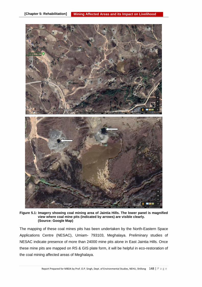
Report Prepared for MBDA by Prof. O.P. Singh, Dept. of Environmental Studies, NEHU, Shillong 148 | P a g e
Mining Affected Areas and its Impact on Livelihood [Chapter 5: Rehabilitation]
Figure 5.1: Imagery showing coal mining area of Jaintia Hills. The lower panel is magnified view where coal mine pits (indicated by arrows) are visible clearly. (Source: Google Map)
The mapping of these coal mines pits has been undertaken by the North-Eastern Space
Applications Centre (NESAC), Umiam- 793103, Meghalaya. Preliminary studies of
NESAC indicate presence of more than 24000 mine pits alone in East Jaintia Hills. Once
these mine pits are mapped on RS & GIS plate form, it will be helpful in eco-restoration of
the coal mining affected areas of Meghalaya.

Report Prepared for MBDA by Prof. O.P. Singh, Dept. of Environmental Studies, NEHU, Shillong 149 | P a g e
Mining Affected Areas and its Impact on Livelihood [Chapter 5: Rehabilitation]
Although, the process of mine reclamation in organized sector occurs once mining is
completed, but the planning of mine reclamation activities takes place much before the
starting of mining. The limestone mining in Meghalaya is mostly done by cement
companies either for their own use or for export for manufacturing of cement. To eco-
restore the mining affected areas, the cement companies should be encouraged to
undertake reclamation and restoration activities on mines where extraction of limestone
has been completed.
5.2.1.4 Landscaping and Compaction
Regardless of the method used, the mines affects natural landscape of the area leaving
behind multiple damages and large volumes of wastes and overburden scattered in the
mining area. Such landscapes pose serious pollution hazards to the environment, to
human health and to agriculture. Therefore, the next step after filling of mine pits is
changing the disturbed landscape into a landscape matching with the landscape of the
surrounding area by doing levelling of the overburden heaps and making it compact. Care
should be taken to spread soil and wastes rich in organic matter on top the layer, which
will help in re-vegetation of the area. In the process, topsoil left if any should not be
disturbed and removed from the surrounding area and also care needs to be taken to
protect it from erosion and degradation.
5.2.1.5 Conservation of Topsoil
Soil is essential for plant growth and agricultural productivity. Once lost, it takes decades
in formation and regeneration. Hence, conservation of top soil is very important in the
process of eco restoration. Removal of topsoil prior to mining and its replacement as the
final cover following coal mining is most beneficial method for assuring quick
establishment of vegetation and eco restoration. In addition to the benefits of top soiling
for improving vegetation and restoring pre-mining soil productivity, topsoil also helps in
retention of water for plant growth. It has been found that a final cover of topsoil on a
mine backfill significantly reduces the infiltration rate of water. Limited infiltration of water
means less production of AMD.
5.2.1.6 Management of AMD and Surface Water
Proper management of AMD and surface water in mining areas can be of great use in
mitigation of water pollution and related environmental problems. Channelling of AMD
and its prevention from contamination of agricultural fields and water resources can save
agricultural land and water bodies from degradation. Use of proper water management
techniques to prevent AMD on mining sites can also control erosion and sedimentation,

Report Prepared for MBDA by Prof. O.P. Singh, Dept. of Environmental Studies, NEHU, Shillong 150 | P a g e
Mining Affected Areas and its Impact on Livelihood [Chapter 5: Rehabilitation]
and surface water infiltration. Thus, the AMD oozing out from coal mines, coal dumps and
overburden rocks should be contained in a pond or an enclosed area where steps can be
taken to neutralize the AMD. The methods of neutralization are described in later
sections.
5.2.1.7 Construction of Designated Area for Storage of Coal
It has been found that extracted coal is dumped haphazardly here and there in forest,
agricultural fields, on road side, near streams without any planning. Such open coal
dumps are the sources of AMD formation and discharge in rainy season. Haphazard
storage of coal should be prohibited and designated storage area for storage of coal
should be created and mine owners be encouraged for storing their extracted coal at
these areas. Such designated areas should be surrounded by wall to prevent spreading
of dust, coal particles, AMD etc. Arrangements should also be made to divert the acidic
seepage in a pond so that it can be treated before releasing it into water bodies.
5.2.1.8 Control of Formation of Acid Mine Drainage
Acid mine drainage (AMD) forms when sulfide minerals buried in the earth are exposed
during mining and other large scale excavations. On exposure to water and oxygen, most
sulfide minerals oxidize and form sulfuric acid, metal ions and sulphate. The untreated
AMD enters the surface and ground water sources and make the water acidic. The pH of
AMD may reach as low as 2 to 4 and contain high concentration of various toxic metals.
The process of pyrite (sulphide) oxidation, and AMD in formation and effects of AMD on
water and soil are well documented.1 Abandoned coal mines, coal dumps and overburden
rocks discharge a huge amount of AMD in coal mining areas. The production of AMD
varies in different regions due to a variety of physical, chemical and biological factors.
The acidity level, metal composition and concentrations of a given AMD source depend
on the type and quantity of sulfide minerals present and acid-neutralizing (carbonate)
minerals contained in the exposed rocks.
Once produced, AMD can severely impact the surrounding ecosystem due to its acidity,
metal toxicity, sedimentation and other deleterious properties. Natural water
contaminated by acid mine drainage seriously retards virtually all beneficial water uses.
The AMD contaminated water is not fit for domestic uses, irrigation purposes, industrial
uses etc. It has deleterious influence on fish, wildlife and plant life in receiving waters.
The AMD contaminated surface water eventually becomes unsuitable for sustaining
biodiversity. Reports indicate that it causes a marked reduction in the microflora of
streams and also noxious to most aerobic and anaerobic heterotrophic bacteria that are

Report Prepared for MBDA by Prof. O.P. Singh, Dept. of Environmental Studies, NEHU, Shillong 151 | P a g e
Mining Affected Areas and its Impact on Livelihood [Chapter 5: Rehabilitation]
indigenous in streams. The acid in the streams is highly corrosive to bridges, dams and
other structures as well as to plumbing. The acidic water also makes soil acidic which
severely affects the plant growth and development and ultimately agricultural productivity.
Besides, soils exposed to AMD become structurally unstable and highly prone to erosion.
Formation and discharge of acid mine drainage (AMD), a highly acidic and metal-rich
solution, is the biggest environmental problem in coal mining areas of Meghalaya,
particularly in Jaintia Hills. Abandoned mines, coal dumps and piles of waste and
overburden scattered haphazardly contribute AMD all over the coal mining area. The coal
in Meghalaya is of tertiary nature and contains high content of sulfure which is found as
sulphides mostly iron sulphide (pyrite). Oxidation of pyrite or iron sulphide (FeS2) in the
presence of oxygen and water, forms Fe2+, SO4 2− and H+ ions. This concoctant is highly
acidic and referred to as acid mine drainage (AMD). The overall chemistry of AMD
formation is summarized in reaction given below:
4 FeS2 + 15 O
2 + 14 H
2O = 4 Fe(OH)
3↓ + 8 H
2SO
4
Pyrite + Oxygen + Water = "Yellow precipitate"↓ + Sulphuric Acid
The water bodies in coal mining areas of Jaintia Hills are the greatest victims of the coal
mining. Contamination of AMD originating from mines and spoils, leaching of heavy
metals, organic enrichment and silting by coal and sand particles are major causes of
degradation of water quality in the area. Pollution of the water is evident by the
colouration of water which in most of the affected rivers and streams in the mining area
varies from brownish to reddish orange. Low pH (between 3-4), high electrical
conductivity, high concentration of ions of sulphate and iron and toxic heavy metals, low
dissolved oxygen (DO) and high BOD are some of the physico-chemical and biological
parameters which characterize the degradation of water quality in coal mining areas of
Meghalaya. The AMD contaminated degraded water bodies have affected the aquatic
flora and fauna. As a result affected water bodies lack fish, frog, crabs, and pollution
sensitive macroinvertebrates. Terrestrial ecosystems and its components have also been
affected due to land degradation and soil acidity. Thus in order to reduce the ill effects of
AMD it is necessary to take up effective post-mining management practices that can be
necessary to control AMD pollution. Adverse effects of AMD can be mitigated by its
prevention and remediation. Prevention techniques mainly focus on inhibiting AMD
formation reactions by controlling the source. Remediation techniques focus on the
treatment of already produced AMD before its discharge into water bodies. Here in this
section, some measures to prevent and minimize AMD formation are described. The
remedial measures shall be described later while dealing the remediation.

Report Prepared for MBDA by Prof. O.P. Singh, Dept. of Environmental Studies, NEHU, Shillong 152 | P a g e
Mining Affected Areas and its Impact on Livelihood [Chapter 5: Rehabilitation]
5.2.1.9 Prohibition of Mining near Water Sources
The unpolluted water sources which are being used by the people for various purposes
need to be protected. Hence, mining should not be allowed near such water sources. It is
therefore recommended that community should resolve that opening of new mines near
water sources will not be allowed in order to prevent these water sources from pollution.
Similarly, catchment areas of such water sources also need to be protected from
disturbance, deforestation and mining to maintain the continuous flow of unpolluted water.
5.2.1.10 Covering of Acid Producing Materials
To reduce oxygen penetration through mine waste, large waste rocks can be mixed with
fine tailings which possess higher moisture content. Large pores of the waste rock are
filled with these fine tailings which curtails oxidation process. Based on the neutralization
potential of the soil type, the pyritic waste can be mixed with alkaline amendments such
as limestone and other materials with higher neutralization potential namely fluidized bed
combustion (FBC) ash/fly ash and kiln dust so as to reduce acidity of the overall system.
Apart from their ability to increase alkalinity of the system, hard cement like substance are
formed by these materials which act as a barrier and stabilization material.
5.2.1.11 Covering the Acid Producing Materials
Production of acid mine drainage can be controlled at its source of generation. It can be
done by various ways. AMD generation can be reduced by covering the acid producing
rocks and minerals with plastic sheet, soil and clay and other such materials. Various
materials such as impervious membranes, dry seals, hydraulic mine seals, and grout
curtains/walls etc. have been used as barriers which have been found effective in
reducing the movement of water or oxygen into areas containing acid producing rocks
and thus retarding the AMD formation.
In coal mining areas of Meghalaya, the overburden, coal piles and abandoned mines
which are potential source of AMD, are generally left in open and thus continuously
generate AMD throughout the year. In order to reduce the formation of AMD, such AMD
producing sources should be covered with barriers suitable for the place. This will reduce
the AMD formation substantially in coal mining areas of Meghalaya and thus reduce the
pollution of surface and ground water and the land.
5.2.1.12 Alkaline Amendment
Abandoned mines comprise of huge volumes of spoil and overburden rocks of unknown
composition and hydrology. Abandoned underground mines are problematic because

Report Prepared for MBDA by Prof. O.P. Singh, Dept. of Environmental Studies, NEHU, Shillong 153 | P a g e
Mining Affected Areas and its Impact on Livelihood [Chapter 5: Rehabilitation]
they are often partially caved and flooded, cannot be accessed, and have nonexistent
mine maps. Filling abandoned underground mine voids with non-permeable materials is
one of the best methods to prevent AMD. Filling of abandoned mine pits located near
residential area, water sources, ecologically sensitive areas etc. with fly ash, overburden
and waste material from limestone mining sites or mixture of both can be used in
Meghalaya to control AMD generation and discharge from the abandoned mines. Such
alkaline materials can also be added to spoil and overburden rocks, a potential source of
AMD, in order to reduce the AMD generation.
5.2.1.13 Diversion of Surface Water
Diversion of surface water to prevent or decrease the amount of water entering the mines
and AMD producing materials is highly recommended for control of AMD generation, as
limiting the water to AMD source reduces the AMD formation. If it cannot be diverted,
incoming water can flow through limestone to be pre-treated and increase the alkalinity of
the water. Mixing of alkaline water with AMD source lowers the rate of AMD formation.
5.2.1.14 Inhibition of Bacterial Activity
Acidophilic bacteria such as Acidithiobacillus ferrooxidans and Acidithiobacillus
thiooxidans (formerly Thiobacillus ferrooxidans, Thiobacillus aldus,
and Thiobacillus spp.) play a significant role in accelerating the rate of AMD formation
reactions as these bacteria catalyze the oxidation of ferrous ions and sulfides. Thus, acid
production in coal mines can be prevented if bacterial activities are inhibited. Studies
have found anionic surfactants like alkylbenzene sulphonate and sodium lauryl sulphate
as active inhibitors of the acidophilic bacterium T. ferrooxidans. Low molecular weight
organic acids also inhibit iron and sulphur oxidation and growth of T. ferrooxidans.
The use of anionic surfactants, alkylbenzene sulphonate, sodium lauryl sulphate and
other such materials can be used on experimental basis at high AMD generating areas of
Jaintia Hills to reduce the AMD generation.
5.2.2 Remediation
The above described preventive measures can help in controlling the AMD formation
and reducing the future pollution load. However, preventive measures cannot deal with
acidic mine drainage already accumulated in the mining area because prevention
techniques mainly focus on inhibiting AMD formation. However the remediation
techniques focus on the treatment of already produced AMD before its discharge into
water bodies and agricultural fields.
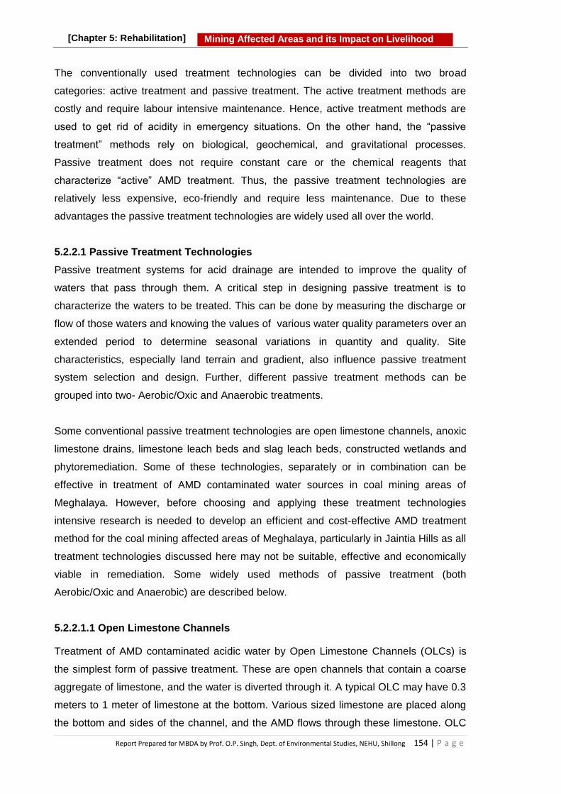
Report Prepared for MBDA by Prof. O.P. Singh, Dept. of Environmental Studies, NEHU, Shillong 154 | P a g e
Mining Affected Areas and its Impact on Livelihood [Chapter 5: Rehabilitation]
The conventionally used treatment technologies can be divided into two broad
categories: active treatment and passive treatment. The active treatment methods are
costly and require labour intensive maintenance. Hence, active treatment methods are
used to get rid of acidity in emergency situations. On the other hand, the ―passive
treatment‖ methods rely on biological, geochemical, and gravitational processes.
Passive treatment does not require constant care or the chemical reagents that
characterize ―active‖ AMD treatment. Thus, the passive treatment technologies are
relatively less expensive, eco-friendly and require less maintenance. Due to these
advantages the passive treatment technologies are widely used all over the world.
5.2.2.1 Passive Treatment Technologies
Passive treatment systems for acid drainage are intended to improve the quality of
waters that pass through them. A critical step in designing passive treatment is to
characterize the waters to be treated. This can be done by measuring the discharge or
flow of those waters and knowing the values of various water quality parameters over an
extended period to determine seasonal variations in quantity and quality. Site
characteristics, especially land terrain and gradient, also influence passive treatment
system selection and design. Further, different passive treatment methods can be
grouped into two- Aerobic/Oxic and Anaerobic treatments.
Some conventional passive treatment technologies are open limestone channels, anoxic
limestone drains, limestone leach beds and slag leach beds, constructed wetlands and
phytoremediation. Some of these technologies, separately or in combination can be
effective in treatment of AMD contaminated water sources in coal mining areas of
Meghalaya. However, before choosing and applying these treatment technologies
intensive research is needed to develop an efficient and cost-effective AMD treatment
method for the coal mining affected areas of Meghalaya, particularly in Jaintia Hills as all
treatment technologies discussed here may not be suitable, effective and economically
viable in remediation. Some widely used methods of passive treatment (both
Aerobic/Oxic and Anaerobic) are described below.
5.2.2.1.1 Open Limestone Channels
Treatment of AMD contaminated acidic water by Open Limestone Channels (OLCs) is
the simplest form of passive treatment. These are open channels that contain a coarse
aggregate of limestone, and the water is diverted through it. A typical OLC may have 0.3
meters to 1 meter of limestone at the bottom. Various sized limestone are placed along
the bottom and sides of the channel, and the AMD flows through these limestone. OLC

Report Prepared for MBDA by Prof. O.P. Singh, Dept. of Environmental Studies, NEHU, Shillong 155 | P a g e
Mining Affected Areas and its Impact on Livelihood [Chapter 5: Rehabilitation]
introduces alkalinity to acid mine water and is supposed to raise the pH of the acid water
to 6–8. For optimum performance, the OLC is designed considering the pH level of water
and its nature. Factors like channel dimensions (especially length) and channel slope are
given importance in design and construction of an OLC system. The drain length should
be sufficiently long, so that mine drainage water gets enough contact time with limestone
for proper neutralization. If the slope is more than 10 degrees, acid mine water will pass
through the limestone aggregate too fast. Hence, there will not be adequate
neutralization. In too low slope drains heavy metal precipitates (armouring or coating of
the limestone) will occur around limestone and within its void spaces and decreases the
neutralizing capacity. For efficient performance, channel gradient should be more than
20%. The OLC neutralizes and removes the heavy and toxic metals from the acidic
water. For better results, OLC can be used with other passive treatment technologies1.
Coating of limestone with precipitates of iron and growth of algae may take place after
certain period of treatment. The coated or armoured limestone is less effective in
neutralization and thus needs cleaning or replacement with new materials for treatment
effectiveness. Cleaning can be done by washing with jet of water and other methods for
refreshing the surface for treatment effectiveness.
5.2.2.1.2 Anoxic Limestone Drains (ALD)
An anoxic limestone drain (ALD) is below ground limestone aggregate beds (covered in
plastic or impervious liner, and then capped with clay or compacted soil) along gently
graded slopes through which an unaerated AMD contaminated water flows by gravity.
With these capping of clay or organic matter, it is ensured that minimum or no air enters
into the drain, the exclusion of oxygen with AMD prevents oxidation of metals and
clogging of the system. The trenches can be designed considering the volume of water
to be treated and its physico-chemical properties. This system requires 14-15 hours
retention time. The objective with ALD is to add alkali to AMD while maintaining the iron
in its reduced form to avoid the oxidation of ferrous iron and precipitation of ferric
hydroxide on the limestone. The prime function of an ALD is to provide bicarbonate
alkalinity via limestone dissolution and to raise the pH of AMD to 6–8 hence converting
net acid water into net alkaline water.
The ALD‘s are suitable for the treatment of AMD from coal mines because coal mines
are generally associated with reduced water, in which iron precipitation is minimised. As
long as the reduced state of influent AMD is maintained in the ALD, the rate of armouring
of limestone with iron precipitates and associated blocking of ALD flow pathways should

Report Prepared for MBDA by Prof. O.P. Singh, Dept. of Environmental Studies, NEHU, Shillong 156 | P a g e
Mining Affected Areas and its Impact on Livelihood [Chapter 5: Rehabilitation]
be minimal. Anoxic Limestone Drains provide a relatively inexpensive form of alkalinity
addition. Maintenance costs for ALD‘s are very low, and are associated with periodic
inspection of the ALD and upkeep of the vegetation cover. However, maintenance of the
limestone layer can prove difficult due to the buried trench design of the system.
5.2.2.1.3 Aerobic wetlands
An aerobic wetland has a large surface area shallow pond (lined or unlined) filled with
organic matter, for example, compost and contain a layer of limestone gravel on the
bottom with the nearly horizontal flow of AMD contaminated water through it. The pond
may be planted with wetland species which prevent channeling (e.g., regulate water
flow) and also filter and stabilize the accumulating ferric precipitates. It is designed for
natural oxidation and precipitation of metals like iron, manganese, and other metals from
the water. Wetland plants remove heavy and toxic metals from acidic water by
adsorption. The metal adsorption capacity of wetlands depends on many factors like
concentrations of dissolved metals, dissolved oxygen (DO), air, pH, alkalinity of AMD,
active microbial biomass and the retention time of AMD in the wetland. The size of the
wetland depends on the influent load entering the wetland. Aerobic wetlands are a good
option for long-term treatment in low maintenance and operational costs but these
wetlands require longer detention time and huge surface area for acid mine water
treatment. Aerobic wetlands are used to treat mildly acidic waters containing elevated Fe
concentrations. They have limited capacity to neutralize acidity. The aerobic wetlands
work better in combination with other treatment technologies like OLD, ALD etc.
5.2.2.1.4 Anaerobic Wetlands
Anaerobic wetland includes a bed of limestone beneath or mixed with an organic
substrate, which encourages generation of alkalinity as bicarbonate (HCO3) which
effectively treats the acidic waters. The limestone is placed so that waters must move
through organic substrate prior to contacting it, which allows bacteria in the organic
material to remove O2 from the percolating waters. This process helps to prevent
armoring of the limestone. In anaerobic wetlands sulfate-reducing bacteria utilize the
oxygen that enters the anoxic environment as a component of sulfate (SO42-) for
metabolic processing of biodegradable organics, transforming the associated S to either
hydrogen sulfide gas (H2S) or to a solid-phase sulfide. The most common form of sulfide
reduction generates H2S and bicarbonate alkalinity. Sulfate reduction is a microbial
process that occurs under anoxic (low O2) conditions when sulfates and biodegradable
organics are present. When acid-soluble metals are in solution, sulfate reduction can

Report Prepared for MBDA by Prof. O.P. Singh, Dept. of Environmental Studies, NEHU, Shillong 157 | P a g e
Mining Affected Areas and its Impact on Livelihood [Chapter 5: Rehabilitation]
form solid-phase metal sulfides as an alternative end product, which removes metals
from solution and deposits them in the substrate.
The other alkalinity generating process is dissolution of the limestone within or below the
organic substrate: CaCO3 + H+ → Ca2+ + HCO3 . The bicarbonate (HCO3-) is a source of
alkalinity, and can neutralize H+ and/or raise pH to enhance precipitation of acid-soluble
metals: HCO3- + H+ → H2O + CO2 (aq).
Fig. 5.2a: Photograph of an open
limestone Channel 2
Fig. 5.2b: Typical Section of an Aerobic Wetland
3
Fig 5.2c: Anoxic limestone drains 3
Fig. 5.2d: Schematic view of a diversion well
3
Figures 5.2a, b, c & d: Photograph/diagrams of some passive treatment technologies used in remediation of acidic water/acid mine drainage
5.2.2.1.5 In-Stream Limestone Sand
Limestone sand is placed directly into the streambed of high-gradient headwater
streams. The sand dissolves into the water column as it spreads downstream during
high stream flow periods. Dissolved limestone sand adds CaCO3, which in turn results in
higher pH. Where to add the limestone depends on treatment objectives and road
access. Wherever the limestone is placed, the site should have sufficient flow and
stream gradient to carry sand downstream. Roads, weather, and water quality dictate the
timing of limestone sand addition. The frequency and timing of limestone sand addition
may vary with stream conditions. The type of limestone sand added should be Grade A
agricultural limestone, with high CaCO3 content and of sand size (average diameter of

Report Prepared for MBDA by Prof. O.P. Singh, Dept. of Environmental Studies, NEHU, Shillong 158 | P a g e
Mining Affected Areas and its Impact on Livelihood [Chapter 5: Rehabilitation]
about 0.02 inches). The amount of limestone sand added should, theoretically, be
sufficient to neutralize the acid load in the stream.
5.2.2.1.6 Limestone Diversion Wells
Diversion wells are used to raise alkalinity and pH in streams affected by acid mine
drainage. The diversion well is a concrete circular casing that resembles a large
diameter, shallow well sunk into the ground next to the stream. To force water through
the well, a small intake dam is constructed upstream from the well to create an elevation
difference between the well and the intake of 8 feet to 13 feet. Water enters through an
intake pipe at the dam and is piped downstream to the well. Water exits the pipe a few
inches from the bottom of the well and flows upward, fluidizing or suspending the
limestone, before it exits through an overflow pipe back into the stream. The fluidized
bed of limestone dissolves and is slowly added to the stream. The suspended gravel-
sized particles grind against one another improving their solubility by maintaining fresh
reaction surfaces. The limestone gravel should be about 0.8 to 1.2 inches in diameter
and have high calcium content. The well should be filled to about 2/3 its depth with
limestone. Generally the well can hold enough limestone to last 1 to 2 weeks. Limestone
diversion wells can treat streams with relatively small flows and raises pH. When
necessary, more than one diversion well may be constructed on a stream system to
provide adequate acid neutralization.
5.2.2.1.7 Vertical Flow System
Vertical flow passive-treatment systems combine the treatment mechanisms of anaerobic
wetlands and ALDs in an attempt to compensate for the limitations of both. The basic
elements of this system are similar to the anaerobic wetland, but a drainage system is
added to force the AMD into direct contact with the alkalinity producing substrate. The
three major system elements are the drainage system, a limestone layer, and an organic
layer. The system is constructed within a water-tight basin, and the drainage system is
constructed with a standpipe to control water depths and ensure that the organic and
limestone layers remain submerged. As the AMD waters flow downward through the
organic layer, the dissolved oxygen is utilized by aerobic bacteria utilizing biodegradable
organic compounds. Low dissolved oxygen prevents limestone armouring. In the
limestone layer, CaCO3 is dissolved by the acidic, anoxic waters moving down to the
drainage system, producing additional alkalinity. The final effluent is discharged into a
settling pond for acid neutralization and metal precipitation prior to ultimate discharge. For
treating highly acidic discharges, several vertical flow cells can be placed in sequence,
separated by settling ponds.

Report Prepared for MBDA by Prof. O.P. Singh, Dept. of Environmental Studies, NEHU, Shillong 159 | P a g e
Mining Affected Areas and its Impact on Livelihood [Chapter 5: Rehabilitation]
Vertical flow systems can neutralize acidity and promote metal precipitation in difficult
treatment situations. Due to the forced contact of the AMD with the limestone, acid
neutralization is more rapid in vertical flow systems than in anaerobic wetlands, so
vertical flow systems generally require shorter residence time and smaller surface areas.
Two major limitations to the long term performance of vertical flow systems are
accumulation of metal floc, primarily Fe and Al in the limestone layer, and degradation of
the organic layer. This system requires good quality of limestone. To operate properly,
the organic layer must be sufficiently biodegradable. It also must be permeable, so water
can move through it into the limestone.
5.2.2.1.8 Successive Alkalinity Producing System (SAPS)
The Successive Alkalinity Producing System (SAPS) is a combination of an ALD with an
anaerobic wetland/pond. The AMD flows through a pool of water, an organic substrate,
and a limestone bed before discharging from the bottom. The organic substrate and the
depth of water create the anaerobic conditions necessary to reduce the likelihood of
metals precipitating and clogging the limestone. The SAPS should empty into an aerobic
wetland and/ or settling pond for metal removal.
Box 5.1: Passive Treatment The passive treatment methods rely on biological, geochemical, and
gravitational processes to neutralize acidity and remove metals from AMD or AMD contaminated water.
A passive treatment system for acid mine drainage is intended to improve the quality of waters by passing it through natural materials and through natural processes. Passive treatments can be Aerobic/Oxic or Anaerobic.
Site characteristics, rock composition and land terrain and gradient etc.
influence the passive treatment. Some of the conventional and emerging passive treatment technologies are
constructed wetlands, anaerobic sulfate-reducing bioreactors, anoxic limestone drains, open limestone channels, limestone leach beds, slag leach beds and phytoremediation.
The passive treatments technologies are relatively less expensive, eco-friendly
and require less maintenance and therefore widely used all over the world.

Report Prepared for MBDA by Prof. O.P. Singh, Dept. of Environmental Studies, NEHU, Shillong 160 | P a g e
Mining Affected Areas and its Impact on Livelihood [Chapter 5: Rehabilitation]
5.2.2.2 Active Treatment Methods
In active treatment alkaline chemicals are added to AMD or AMD contaminated water to
raise the pH and precipitate metals. Six chemicals can be used to treat acidic water. Each
chemical has a particular characteristic that make it more or less appropriate for a specific
condition. These chemicals are chosen based on both technical and economic grounds.
The technical factors include acidity levels, flow, and the types and concentrations of
metals in the water. The economic factors include prices of reagents and cost of its
application. One of the major advantages of the active treatment process is that it is fast
and effective in removing acidity and metals. However, active treatment processes are
relatively expensive as it involves recurring cost of adding chemicals and needs regular
maintenance of the system.
5.2.2.2.1 Alkaline Chemicals Commonly Used in Active Treatment
A variety of alkaline materials can be used to treat acidic water. They are selected on
case to case basis for treatment of acidic environment considering local conditions, cost
of the chemical and sustainability. Some commonly used chemicals recommended for
neutralization of acidic environment are discussed below.
Limestone: Limestone has been used for decades to raise pH and precipitate metals in
AMD. It has the lowest material cost and is the safest and easiest to handle of the
chemicals used for treatment of AMD. Unfortunately, its successful application has been
limited due to its low solubility and tendency to develop an external coating, or armour, of
Fe(OH)3 when added to AMD. In cases where pH is low and acidic water contains
relatively low metal concentrations, finely-ground limestone is dumped in streams directly
to raise pH of the stream.
Hydrated Lime: Hydrated lime is a commonly-used chemical for treating AMD. It is sold
as a powder that tends to be hydrophobic, and extensive mechanical mixing is required to
disperse it in water. Hydrated lime is particularly useful and cost effective in large flow,
high acidity situations where a lime treatment plant with a mixer/aerator is constructed to
help dispense and mix the chemical with the water.
Soda Ash: Soda ash (Na2CO3) is generally used to treat AMD in remote areas with low
flow and low amounts of acidity and metals. Selection of Na2CO3 for treating AMD is
usually based on convenience rather than chemical cost.

Report Prepared for MBDA by Prof. O.P. Singh, Dept. of Environmental Studies, NEHU, Shillong 161 | P a g e
Mining Affected Areas and its Impact on Livelihood [Chapter 5: Rehabilitation]
Caustic Soda: Caustic soda (NaOH) is often used in remote locations (e.g., where
electricity is unavailable), and in low flow, high acidity situations.
Ammonia: Ammonia (NH3) is a gas at ambient temperatures. The compressed ammonia
can be stored in liquid form which turns to the gaseous state when released. Ammonia is
extremely soluble in water and reacts rapidly. It behaves as a strong base/alkali and can
easily raise the pH of receiving water. Ammonia or anhydrous ammonia (NH3 or NH4OH)
is an extremely hazardous chemical that must be handled carefully.
5.2.2.2.2 Processes in Active Treatment technology
The Active treatment technologies involve treating mine drainage with alkaline chemical
to raise water pH, neutralize acidity and precipitate metals. After active treatment,
precipitation of metal hydroxides is induced by electro-precipitation processes or by metal
ion adsorption. Thereafter, metal hydroxide solids are removed from the treated water by
allowing settling and sedimentation of particles in a pond.
Active AMD Treatment Technologies are facilitated by Chemical Precipitation (Removal
of metals by neutralization using a hydroxide precipitate-caustic soda treatment); In-Line
Aeration (where the treatment reactions are closely monitored and accelerated in order
to reduce the chemical reagent costs and reaction); Electro-precipitation (precipitation of
metal hydroxides by passing electricity); Oxidation (reduced metals like Fe2+, Mn2+ are
oxidized to Fe3+, Mn4+ by transferring oxygen into the water); Sedimentation (settling and
sedimentation of metal hydroxide solids in suspension by gravity); Reverse Osmosis
(Membrane separation technology to remove metal ions via micro filtration, nano filtration
and reverse osmosis); and Ion Exchange (removal of ions from solution by exchange
similarly charged ions attached to an immobile solid particle).
Based on above information it can be concluded that active chemical treatment can
provide effective remediation of AMD, it has the disadvantages of high operating costs
and problems with disposal of the bulky sludge that is produced. Active treatment can be
used at small scale but large scale AMD remediation by active methods may not prove
economically viable.

Report Prepared for MBDA by Prof. O.P. Singh, Dept. of Environmental Studies, NEHU, Shillong 162 | P a g e
Mining Affected Areas and its Impact on Livelihood [Chapter 5: Rehabilitation]
5.2.3 Rehabilitation
Rehabilitation is the process of bringing back the mining affected ecosystems to its
normal state and functioning. After applying preventive and remedial measures, the
mining affected areas need to be re-vegetated and people living in and around the area
be provided sustainable livelihood options. Various steps needed for rehabilitation of
mining affected areas of Meghalaya are discussed below.
5.2.3.1 Afforestation
After extraction of coal, the mining areas become devoid of vegetation which lead to soil
erosion, pollution and degradation of land. It also affects flora and fauna of the area due
to large scale disturbance of terrestrial and aquatic habitat. It is therefore needed that
denuded area be re-vegetated and reforested so that ecosystem again start supporting
natural resources and life of plants and animals. Reclamation and rehabilitation of
degraded land reduces negative geomorphological processes, such as landslides and
erosions which are significant factors in unstable hilly terrain. Rehabilitation with
vegetation potentially reduces discharges of acidic seepage into the environment.
Vegetation exert a catalytic effect in the mine spoil restoration, by changing the
understory microclimatic conditions (viz. increased soil moisture, reduced temperature,
Box 5.2: Active Treatment The active treatment involves addition of various acid-neutralizing and metal-
precipitating chemical agents into AMD or AMD contaminated water.
A wide range of chemical agents such as limestone (CaCO3), hydrated lime (Ca(OH)2), caustic soda (NaOH), soda ash (Na2CO3), calcium oxide (CaO), anhydrous ammonia (NH3), magnesium oxide (MgO) and magnesium hydroxide (Mg(OH)2) are used during the active treatment of AMD water worldwide.
The active treatment does not require any additional space or construction; is
fast and effective in removing acidity and metals; and lower cost is involved in handling and disposal of sludge in comparison to that of passive treatment.
However, it requires a continuous supply of chemicals, energy and manpower
to operate efficiently thus it is costly. Also, some chemicals are of extremely hazardous nature and need careful handling; and the use of some chemicals (like excessive ammonia) can create problems of nitrification and denitrification in receiving water bodies.
Due to high cost and certain other disadvantages active treatment
technologies are not favoured and passive treatments are widely used all over the world.

Report Prepared for MBDA by Prof. O.P. Singh, Dept. of Environmental Studies, NEHU, Shillong 163 | P a g e
Mining Affected Areas and its Impact on Livelihood [Chapter 5: Rehabilitation]
etc.), increased vegetational-structural complexity, and development of litter and humus
layers, which occur during the early years of plantation growth.
Thus, undertaking extensive afforestation on coal mining degraded lands is an important
approach in rehabilitation of the affected area. However, afforestation on acidic, nutrient
and organic matter deficient land without top layer of soil is a challenging task. Therefore,
before planting the sapling the land be treated with alkaline materials and made organic
rich for better establishment of saplings.
Revegetation of mine spoils can be attempted in two different ways. Either the plants
suitable for existing soils and site conditions can be considered for re-vegetation or the
condition of the soil and site are made suitable to facilitate the growth of the particular
species of plants. Adopting a combination of these two approaches is found to be more
successful in practice. Afforestation with native saplings is the commonly adopted
management strategy. Both, early successional species for wildlife and soil stability, and
high-value trees should be planted for better results.
5.2.3.2 Additional Actions needed in Rehabilitation
In addition to above mentioned prevention and remediation technologies the following
proposed actions will help in improving the availability of essential natural resources and
the livelihood and life of the people of the coal mining areas of Meghalaya. Some of the
activities described below have already been initiated by different agencies in Meghalaya
yielded promising results.
5.2.3.2.1 Rejuvenation of Springs
Although Meghalaya receives heavy rainfall, people face acute scarcity of water in some
hilly tracts of the state. Springs play a major role in meeting the water needs of the people
in rural areas as the spring water is of good quality and is suitable for domestic uses.
Since people in rural areas are highly dependent on spring for their water needs, there is
a need for rejuvenation of springs for better water yield and quality.
The springs are generally found in areas of foothills and inter montane valleys. In recent
decades, the yield and quality of water of these springs have been affected due to various
anthropogenic activities. Hence, it is recommended that various activities such as
protection of forest, additional plantation and prohibition of anthropogenic activities in the
area need to be undertaken for sustainable water yield from springs. Measures for
increasing the rain water percolation, creating storage facility and promoting villagers to

Report Prepared for MBDA by Prof. O.P. Singh, Dept. of Environmental Studies, NEHU, Shillong 164 | P a g e
Mining Affected Areas and its Impact on Livelihood [Chapter 5: Rehabilitation]
adapt rain harvesting shall further improve the discharge of springs and flow of streams
for longer duration in the year. The Meghalaya Basin Development Agency has already
started work in this direction. The work of the agency has achieved promising results in
the development of springs. Such work may be extended to water scarce mining areas for
mitigating the water problems of the people. The areas where springs are not affected by
mining needs to be identified and actions to rejuvenate the springs be undertaken.
Schematic Diagram of Contour Bund/Trenches Schematic Diagram of a Gabion Bund
Schematic Diagram of Roof Top Rainwater Harvesting5 Schematic Diagram of Filter
5
Figures 5.3a, b, c & d: Schematic diagrams of some water conservation and rain water harvesting measures
5.2.3.2.2 Rainwater Harvesting
Meghalaya receives high rainfall in four-five months of rainy season. However, people
face scarcity of water in lean season due to lack of adequate water management
practices. The rainwater harvesting can be helpful in solving the water problem of the
people in lean season. The rainwater harvesting structures are simple, economical and
eco-friendly and have been found suitable in the north-eastern region, including in
Meghalaya. Hence, there is need to encourage people to adopt rainwater harvesting
measures, create surface and underground water storage structures and develop suitable
mechanism for supply of harvested water in lean season. The harvested water can be
used for domestic and irrigation purposes. Various structures commonly suited for the
region may be adopted with the technical inputs of concerned governmental and non-

Report Prepared for MBDA by Prof. O.P. Singh, Dept. of Environmental Studies, NEHU, Shillong 165 | P a g e
Mining Affected Areas and its Impact on Livelihood [Chapter 5: Rehabilitation]
governmental agencies. The schematic diagrams of some of the water conservation and
rain water harvesting measures suggested by Central Ground Water Board, North
Eastern Region, Guwahati are given in Figures 5.2a, b, c & d.
5.2.3.2.3 Revival of Lost Rural Livelihood
Mining is regarded as one of the vital economic activities. Mining activities are harmful for
the environment, including adverse impact on rural livelihood. With the intervention of
mining activities many local people in coal mining areas of Meghalaya have lost their
traditional occupation with which they were acquainted since ages.
Until the introduction of mining business the entire occupational scenario of the mining
affected villages was agro-based. Most of the villagers depended both directly and
indirectly on agriculture for their livelihood. The forest resources were also another major
source of income for them. It has been reported that mining of coal in Meghalaya has
brought changes in livelihood of the local people. Agriculture which was a major source of
livelihood is being replaced by non-farm activities. Prior to mining the non-farm activities
were not abundantly available but mining has introduced diversified sources of livelihood.
Due to this many people of the mining area who lack skill, capital and land resources are
still in the process of finding newer and better livelihood options. It is therefore required
that development authorities must safeguard the livelihood of the people in a sustainable
way by rendering technical and financial help and promoting newer livelihood options.
Some of the needed actions are proposed below.
Sericulture: Sericulture involves a labour intensive practice of cultivation of host plants
like mulberry and rearing of silkworm. It has potential to provide employment to large
number of people in rural area. Due to the favourable climatic conditions of the state
sericulture has the potential to perform well in the state. Cultivation of host plants, rearing
silkworms and weaving are the most important cottage based eco-friendly activities.
Hence, suitable areas for sericulture need to be identified, particularly in mining affected
areas and villagers of the area be given necessary technical and financial help to start the
sericulture. Respective Government Departments be involved to promote sericulture in
coal mining areas of Meghalaya. Necessary training in cultivation of host plant, rearing of
silk worms, production of silk cocoons, reeling, weaving etc. may be provided to villagers
for starting the venture.
Horticulture: Meghalaya has a natural advantage in growing a variety of horticultural
crops like fruits, vegetables, spices etc. in addition to cultivation of turmeric, ginger, chilli,

Report Prepared for MBDA by Prof. O.P. Singh, Dept. of Environmental Studies, NEHU, Shillong 166 | P a g e
Mining Affected Areas and its Impact on Livelihood [Chapter 5: Rehabilitation]
black pepper etc. Besides, cultivation of turmeric and ginger newer crops of fruits and
vegetables be introduced and farmers be encouraged for cultivation. Such activities have
proved remunerative in many areas of the state and therefore need to be promoted in
mining affected areas of Meghalaya.
Mushroom cultivation: Mushroom cultivation can help reduce vulnerability to poverty
and strengthen livelihoods through the generation of a fast yielding and nutritious source
of food and a reliable source of income. Since it does not require access to land,
mushroom cultivation is a viable and attractive activity for rural farmers. Mushroom
substrate can be prepared from any clean agricultural waste and it can be produced in
temporary clean shelters. It can be cultivated on a part-time basis, and require little
capital, maintenance and labour. Indirectly, mushroom cultivation also provides
opportunities for improving the sustainability of small farming systems through the
recycling of organic matter, which can be used as a growing substrate, and then returned
to the land as fertilizer. Mushroom is cultivated on recycled agricultural residues which
is accessible in nearly every part of the country. Mushroom cultivation has the
potential to address nutritional concerns of the society in terms of protein and vitamin
deficiencies, and may even provide gainful employment to the rural people engaged in
production. Mushrooms are also highly amenable for food processing. Thus, mushroom
cultivation is highly suitable for raising the socio-economic status of the rural community
in coal mining affected areas of Meghalaya.
Promotion of mushroom cultivation in coal mining areas of Meghalaya may be one of the
technologies to provide an alternative livelihood option and to uplift the economic status in
sustainable manner. The raw materials available locally for mushroom cultivation may be
utilized with technical and financial inputs from concerned agencies. The species of
mushroom may be selected considering the eco-climatic conditions of the area.
Mushroom species suitable for cultivation in the rural area of Meghalaya are Oyster
mushrooms (Pleurotus sp.) and button mushrooms (Agaricus sp.).
Beekeeping: The beekeeping or apiculture is a ‗sideline activity‘ in rural areas of
Meghalaya. In rural communities where access to income is limited, small scale
beekeeping can contribute significantly to livelihood security. It provides additional income
to the people and thus keeps people out of poverty. However, beekeeping has potential
to provide livelihood option to a large number of people of the rural area, if it is
undertaken as an occupation.

Report Prepared for MBDA by Prof. O.P. Singh, Dept. of Environmental Studies, NEHU, Shillong 167 | P a g e
Mining Affected Areas and its Impact on Livelihood [Chapter 5: Rehabilitation]
Meghalaya, by virtue of having a large area under forest cover has a great potential for
development of beekeeping. A large number of plants species for bee foraging occur in
different parts of Meghalaya. It is therefore suggested that beekeeping be promoted in
mining affected area, but at a safe distance from mines, coal dumps and loading and
unloading sites as bees are sensitive to pollution. Both, wild honey production and
production of honey by adopting scientific beekeeping methods can be organized by
imparting training to the villagers in order to strengthen rural livelihood. It can play an
important role in income generation, both directly by providing products for household
consumption and income from sale of honey and other bee products, and indirectly as an
important source of pollinators to improve productivity of agricultural and horticultural
crops.
Cultivation of Areca nut: Since time immemorial, Areca nut has been grown in
Meghalaya as an important commercial crop. Areca nut can be grown on a variety of
soils. However the crop thrives best in well drained soils with good organic matter. This
crop can be grown at an altitude upto 1000 meters above mean sea level and the ideal
temperature range is from 10⁰ C to 40⁰ C. Hence, in areas where the soil and climatic
conditions are favourable areca nut plantation can be promoted as a source of additional
income.
Cultivation of local Fruits: Local fruits like Sohiong (Prunus napaulensis), Sohshang
(Elaeagnus latifolia) etc. are getting popularized and are in high demand. They have
therapeutic uses in treating many diseases. Cultivation of such different fruits on a
commercial basis shall be helpful in providing additional livelihood options in mining
affected areas of Meghalaya. It also has potential to promote food processing industry as
fruits can be processed to make jams, juices and even wine. Since, sohshang grows on
acidic soil, it can be promoted in coal mining areas of Meghalaya where soil has become
acidic. Further, it adds nitrogen in the soil and therefore cultivation will help in restoration
of the area to some extent.
Cultivation of Medicinal and Aromatic Plants: The State of Meghalaya has 850
species of Medicinal Plants, 377 of which are used by 70% to 80% of the State's
population for primary health care needs. The Meghalaya State Medicinal Plants Board
(MSMPB) supports various efforts to identify, protect and propogate the species of
medicinal and aromatic plants and to address issues of health care by traditional
practitioners and of plant based modern medicine. Recently the state of Meghalaya has
been found suitable for cultivation of many commercial species of aromatic and medicinal

Report Prepared for MBDA by Prof. O.P. Singh, Dept. of Environmental Studies, NEHU, Shillong 168 | P a g e
Mining Affected Areas and its Impact on Livelihood [Chapter 5: Rehabilitation]
plants like Pelargonium graveolens (Geranium), Aloe vera, Cymbopogon flexuosus
(Lemon grass), Mentha arvensis (Mentha), Vertivera zizinoides (Vetiver) etc. Many of
these plants grow even on degraded land. Hence, encouraging farmers by providing
training, financial support shall prove beneficial for the people of the coal mining areas of
Meghalaya.
Tourism: Meghalaya, the abode of clouds, is one of the most beautiful states in the
North-East India. The state has diverse landscapes, flora and fauna and climatic
conditions suitable for nature based tourism. The state can mesmerize tourists with its
undulating green hill slopes, lush green vegetation on hills, valleys, lakes, caves and
waterfalls etc. Handicrafts and souvenirs made of wood-carving and artistic weaving,
cane and bamboo, jewellery, clay, indigenous tiny musical instruments etc. can further
add value to various tourism activities.
All three Hills regions offer a variety of sites of tourists‘ interest where various tourism
activities can be planned and developed for generating employment and income.
However, tourism potential of the state remains untapped to the extent it should have
been. Since mining has adversely affected certain livelihood activities of the locals,
promotion of tourism covering newer activities and sites will be of help in providing
alternate livelihood options to the people of the mining affected areas.
Tourism helps in generating employment in local communities and is a source of income
generation. Nature rich Meghalaya has potential for developing eco-tourism. The tourist
spots like waterfalls, caves, camping sites, pristine forest areas etc. need to be identified
and popularized to attract tourist to those spots. Necessary infrastructure be also
developed simultaneously. Tourist spots like Moopun falls, the Stone Bridge of Umjhai
River, Rynji falls, Krem Kotsati and Krem Umlawan in East Jaintia Hills and KrangSuri
falls Bophill falls Tyrshi falls, Syntu ksiar in West Jaintia Hills be given publicity for
attracting tourists.
5.2.3.3. Creating Awareness among Local Communities
The local inhabitants should be educated regarding the rules and regulations, importance
of environment, current government programmes, the role of forest, health hazards,
requisite precautions and safety measures for human wellbeing, so that they can
appreciate and take decisions and necessary precautions for the betterment of their
socio-economic, ecological and environmental needs.
Report Prepared for MBDA by Prof. O.P. Singh, Dept. of Environmental Studies, NEHU, Shillong 169 | P a g e
Mining Affected Areas and its Impact on Livelihood [Chapter 5: Rehabilitation]
Skill development programme for the local populace should be organized, so that they
can earn their skill development and training programmes need to be organized to train
people in making local Artefacts, Sericulture, Medicinal Plant Cultivation, Sewing etc. and
implementing these Socio-economic activities scientifically for further Value Additions.
5.3 Ten Actionable Points
Ten actionable points divided into three sections viz. (a) Policy (b) Institutional and (c)
Field levels are mentioned below for restoration of mining affected areas, conservation of
natural resources, improving the availability of water, providing livelihood to the people
and rehabilitation of the area.
(A) POLICY LEVEL
5.3.1 Regulation of Mining
The Mines and Minerals (Development and Regulation) Act, 1957, (MMDR Act, 1957)
and the Mines Act, 1952, together with the rules and regulations framed under these
regulations, constitute the principal legislations that govern the mineral and mining sector
in India. The relevant rules in force under the MMDR Act, 1957 are the Mineral
Concession Rules, 1960, and the Mineral Conservation and Development Rules, 1988.
Forest Conservation Act, 1980, Environment (Protection) Act, 1986, Wildlife (Protection)
Act, 1972 etc. are also applicable in mining sector to safeguard the environment. The
regulations outline the procedures and conditions for obtaining a Prospecting License or
Mining Lease and lay down guidelines for ensuring mining in a scientific manner with
emphasis on environmental protection and conservation of natural resources.
In the interest of people and to maintain healthy environment and protect precious natural
resources of the state, relevant regulatory framework be created to do mining in scientific
manner by taking care of environment, safety of miner and protecting natural resources.
(B) INSTITUTIONAL LEVEL
5.3.2 Rainwater Harvesting
Meghalaya receives high rainfall in four-five months of rainy season. However, people
face scarcity of water in lean season due to lack of adequate water management
practices. The rainwater harvesting can be helpful in solving the water problem of the
people in lean season, particularly in mining areas where most of the available water is
polluted. Hence, there is need to encourage people to adopt rainwater harvesting
measures. The harvested water can be used for domestic and irrigation purposes.

Report Prepared for MBDA by Prof. O.P. Singh, Dept. of Environmental Studies, NEHU, Shillong 170 | P a g e
Mining Affected Areas and its Impact on Livelihood [Chapter 5: Rehabilitation]
5.3.3 Rejuvenation of Springs
The springs play a major role in meeting the water needs of the people in rural areas.
Hence, it is recommended that various activities such as protection of forest, additional
plantation and prohibition of anthropogenic activities in the catchment area need to be
undertaken for sustainable water yield from springs. The Meghalaya Basin Development
Agency has already started work in this direction. The work of the agency has achieved
promising results in the development of springs. Such work may be extended to water
scarce mining areas for mitigating the water problems of the people.
5.3.4 Protection of Streams and Springs not affected by Mining
Many small streams and springs are not affected by mining. Such streams and springs
may be identified and measures be taken to protect them from contamination. Protection
of such less polluted/pristine streams will help in reducing the acidity of reservoir water.
Present study revealed that Malishah, Yalip and Savanong streams are still not affected
and carry unpolluted water. These streams may be given priority in protections of their
catchment in order to increase water yield and to conserve aquatic life.
5.3.5 Development of Nature based Tourism
Tourism helps in generating employment in local communities and is a source of
additional income. Nature rich Meghalaya has potential for developing eco-tourism. The
tourist spots like waterfalls, caves, camping sites, pristine forest areas etc. need to be
identified and popularized to attract tourist. Necessary infrastructure for tourism be
developed and training to local youth be given for reaping maximum possible benefits.
5.3.6 Prohibition of Mining near Water Sources and Dumping of Coal at Designated places
The unpolluted water sources which are being used by the people for various purposes
need to be protected. Hence, mining should not be allowed near such water sources. It is
therefore recommended that community should resolve that opening of new mines near
water sources will not be allowed in order to prevent these water sources from pollution.
It has been found that extracted coal is dumped haphazardly here and there in forest,
agricultural fields, on road side, near streams without any planning. Such open coal
dumps are the sources of AMD formation and its discharge in rainy season. Haphazard
storage of coal should be prohibited and designated storage area for storage of coal
should be created. Arrangements should also be made to divert the acidic seepage in a
pond so that it can be treated before releasing it into water bodies.

Report Prepared for MBDA by Prof. O.P. Singh, Dept. of Environmental Studies, NEHU, Shillong 171 | P a g e
Mining Affected Areas and its Impact on Livelihood [Chapter 5: Rehabilitation]
(C) FIELD LEVEL
5.3.7 Neutralization of Acidic water for domestic and irrigation uses
Construction of Open Limestone Channels (OLC) and Anoxic Limestone Channel (ALC)
and other similar activities have been found effective methods to raise the pH of water of
streams carrying acidic water. Such structures may be constructed to neutralize acid
water. A pilot project on OLC undertaken in Meghalaya by NEHU and MBDA has resulted
encouraging findings in neutralization of AMD and in improving the quality of Moolawar
stream in Mukhaialong village, East Jaintia Hills District. Similar projects need to be
replicated for the benefit of local people.
5.3.8 Afforestation
After extraction of coal, the mining areas become devoid of vegetation which lead to soil
erosion, pollution and degradation of land. It is therefore needed that denuded area be re-
vegetated and reforested so that ecosystem again start supporting natural resources and
life of plants and animals. Land areas with good forest and vegetation cover promote
percolation of rain water which emerge in the form of streams and are sources of rural
water supply. However, afforestation on acidic, nutrient and organic matter deficient land
without top layer of soil is a challenging task. Therefore, before planting the sapling the
land be treated with alkaline materials and made organic rich for better result.
5.3.9 Revival and Promotion of Traditional Livelihood Options
Beekeeping and sericulture are old practices in rural areas of Meghalaya for getting
nutritional supplements and additional income. Such traditional practices supported by
modern knowledge and implements be revived and promoted by providing financial
assistance in rural areas of mining affected areas. Both beekeeping and sericulture have
potential to generate employment and additional income in rural areas.
Further, Meghalaya has been found suitable for cultivation of many commercial species
of aromatic and medicinal plants like Pelargonium graveolens (Geranium), Aloe vera,
Cymbopogon flexuosus (Lemon grass), Mentha arvensis (Mentha), Vertivera zizinoides
(Vetiver) etc. Many of these plants grow even on degraded land. Hence, encouraging
farmers by providing training, financial support shall prove beneficial for the people of the
coal mining areas of Meghalaya.
Meghalaya has a natural advantage in growing a variety of horticultural crops like fruits,
vegetables, spices etc. in addition to cultivation of turmeric, ginger, chili, black pepper etc.
Cultivation of such crops be encouraged in the mining affected areas. Highly

Report Prepared for MBDA by Prof. O.P. Singh, Dept. of Environmental Studies, NEHU, Shillong 172 | P a g e
Mining Affected Areas and its Impact on Livelihood [Chapter 5: Rehabilitation]
remunerative crops such as capsicum, chili, mushroom etc. can be cultivated in poly
houses with efficient use of resources.
5.3.10 Awareness and Incentive
Success of any plan or project much depends on the people of the area. Hence,
environmental awareness among the people of the area be created. Where ever possible
people may also be given due incentive for protection of streams and its flora and fauna.
Small individual actions are liable to bring big positive change in due course of time.
5.4. Good Practices/ Success stories
Some Good Practices/Success stories relevant to restoration and rehabilitation of mining
affected area and providing alternative livelihood options to the people of the mining
affected areas are appended as annexure 1 to 4. In conclusion, it can be said that
depletion of forest cover, pollution of air, water and soil, degradation of agricultural fields,
and scarcity of water and other natural resources are some major environmental issues of
the coal mining areas. The streams and rivers are the greatest victims of the coal mining.
Peoples‘ perception also corroborates the scientific studies. The mining on one hand has
given better income opportunity to some people, but on the other hand has adversely
affected the traditional livelihood options of a large number of people in the mining area.
Hence, there is urgent need for initiating activities for Eco restoration of the affected
Box 5.3: Ten Actionable Points
(a) POLICY LEVEL
Regulation of Mining
(b) INSTITUTIONAL LEVEL
Rainwater Harvesting
Rejuvenation of Springs
Protection of Streams and Springs not affected by Mining
Development of Nature based Tourism
Prohibition of Mining near Water Sources and Dumping of Coal at
Designated places
(c) FIELD LEVEL
Neutralization of Acidic water for domestic and irrigation uses
Afforestation
Revival and Promotion of Traditional Livelihood Options
Awareness and Incentive
Report Prepared for MBDA by Prof. O.P. Singh, Dept. of Environmental Studies, NEHU, Shillong 173 | P a g e
Mining Affected Areas and its Impact on Livelihood [Chapter 5: Rehabilitation]
areas. Measures to mitigate the environmental problem and improvement of water quality
include protection of non-polluted water sources; rejuvenation of springs; adopting
scientific mining with proper environmental safeguards; safe disposal of overburden;
filling of mine pits; channelling of acid mines drainage in order to protect contamination of
water and soil; restricting mining near water bodies and agricultural fields; treatment of
acidic seepage and AMD contaminate water; extensive afforestation and re-vegetation of
the area etc. could be of great help in mitigating the adverse impacts of coal mining in the
affected areas. At the same newer livelihood options are required to be given to the
people for sustainable development of environment, economy and society.
References
1. Skousen, J. and P. Ziemkiewicz. 1996. Acid Mine Drainage Control and Treatment. 2nd Ed. National Research Center for Coal and Energy, National Mine Land Reclamation Center, West Virginia University, Morgantown, WV. 362 pp.
2. Zipps, C., Skousen, J and Jaga, C. (2011) Passive treatment of Acid Mine Drainage. Virginia Cooperation Extension Publ. 460- 133 pp1-11
3. Pyrbot, W., Shabong, L., & Singh, O. P. (2019). Neutralization of Acid Mine Drainage Contaminated Water and Ecorestoration of Stream in a Coal Mining Area of East Jaintia Hills, Meghalaya. Mine Water and the Environment, 1-5.
4. Seervi, V., Yadav, H. L., Srivastava, S. K., & Jamal, A. (2017). Overview of active and passive systems for treating acid mine drainage. IARJSET, 4(5), 131-137.
5. Ground Water Information Booklet (2013) Jaintia Hills District, Meghalaya, Central Ground Water Board, Govt. India, North Eastern Region, Guwahati. (http://cgwb.gov.in/District_Profile/Meghalaya/Jaintia%20Hills.pdf).

Blank Page

Annexure Good Practices/Success Stories
Annexure 1: Neutralization of Acid Mine Drainage contaminated
water ............... Meghalaya
Annexure 2: Coal Miners switch to turmeric farming in Meghalaya
Annexure 3: A success story of Strawberry cultivation in East Jaintia
Hills District.
Annexure 4: Success stories of Aquaculture/Fishery in Meghalaya.
Questionnaire
Annexure 5: Questionnaire used for data collection in this study.

Blank Page

Report Prepared for MBDA by Prof. O.P. Singh, Dept. of Environmental Studies, NEHU, Shillong 174 | P a g e
Annexure 1 Mine Water and the Environment https://doi.org/10.1007/s10230-019-00601-9
TECHNICAL COMMUNICATION
Neutralization of Acid Mine Drainage Contaminated Water and Ecorestoration of Stream in a Coal Mining Area of East Jaintia Hills, Meghalaya
Wansah Pyrbot1 · Lamjingshaihun Shabong
1 · Om Prakash Singh
2
Received: 6 September 2018 / Accepted: 26 February 2019 © Springer-Verlag GmbH Germany, part of Springer Nature 2019
Abstract The unscientific mining of coal without environmental safeguards in Jaintia Hills, Meghalaya has adversely affected the
water resources of the area, leading to streams with a pH of 3–5. The acidic stream water is not suitable for human use and
lacks aquatic life. The prevailing situation demanded immediate neutralization and eco-restoration. Considering the need,
the water of Moolawar stream in Mukhaialong village, East Jaintia Hills District, Meghalaya, India was neutralized by
constructing an open limestone channel (OLC) using locally available limestone. The OLC raised the pH of the stream
water from 4.31 to 6.57. The near-neutral pH has promoted the reappearance of many aquatic flora and fauna, including
two species of fishes and some insects. The OLC was found to be cost effective and technically feasible in this rural area
and thus prompted the construction of more such projects for improvement of water quality and ecorestoration of degraded
streams. Details of the study and associated improvements in water quality and aquatic ecology are reported. Keywords Rat-hole coal mining · Open limestone channel · Water pollution · Moolawar stream · Mukhaialong village
Introduction Coal mining can have severe environmental effects if min-ing
is conducted without appropriate environmental safe-guards
(Akcil and Koldas 2006; Bian et al. 2010; Mishra and Das
2017). Eocene age coal is found in Meghalaya in all three hill
regions, namely Khasi, Jaintia, and Garo Hills. The Jaintia
Hills is a major coal producing area, with an esti-mated coal
reserve of about 40 million metric tons (t). The sub-
bituminous tertiary coal found in Meghalaya is charac-terised
by high sulphur (2–8%), a high content of volatile matter and
vitrinite, a low ash content, and a high calorific value.
Extraction of coal in Meghalaya has been done by *\ Wansah Pyrbot ([email protected])
Om Prakash Singh ([email protected]) 1 Institute of Natural Resource, Meghalaya Basin Management
Authority, Shillong, Meghalaya 793001, India
2 Department of Environmental Studies, North-Eastern Hill
University, Shillong, Meghalaya 793022, India
the primitive mining method commonly known as ‘rat-
hole’ mining (Swer and Singh 2003). Decades of such mining has caused: large scale land
cover/land use change and denudation of forest cover
(Somendro and Singh 2015), pollution of air, water and soil,
degradation of agricultural fields; and scarcity of clean potable
water and other natural resources (Chabukdhara and Singh
2016; Swer and Singh 2004) . Acid mine drain-age (AMD)
generated from active and abandoned mines, coal storage
sites, and overburden is currently the main sur-face water
pollutant. The colour of the surface water varies from
brownish to reddish-orange in most of the rivers and streams
of the mining areas. Low pH (between 3 and 5), high electrical
conductivity (EC), and elevated concentrations of sulphate
and some metals (Swer and Singh 2003; Sahoo et al. 2012;
Blahwar et al. 2012; Chabukdhara and Singh 2016), along
with, silting by coal and sand particles are some indicators of
degradation of water bodies. The mining is also responsible
for degradation of aquatic habitats and loss of aquatic life
(Swer and Singh 2005; Chabukdhara and Singh 2016). The
contaminated surface water has degraded the agricultural
fields by making the soil acidic, which has forced farmers to
abandon agricultural activity. In some areas of Jaintia Hills,
people do not have access to clean

Report Prepared for MBDA by Prof. O.P. Singh, Dept. of Environmental Studies, NEHU, Shillong 175 | P a g e
Author's personal copy \ Mine Water and the Environment
water and hence are forced to depend on the acidic water in
the polluted streams. Lack of any post-mining treatment
and environmental safeguards make the fragile ecosystems
more vulnerable to environmental degradation. Despite the serious environmental, health and socio-eco-
nomic implications of the contaminated surface water, very
little has been done to tackle these problems in Meghalaya.
So, a field experiment was undertaken to improve the water
quality of one of the streams by constructing an open lime-
stone channel (OLC) using locally available limestone.
Materials and Methods
Study Site
The field experiment was conducted near the village of
Mukhaialong, which has about 300 households, at an
elevation of 1299 m, between 25°39′467″N latitude and
92°26 ′216″E longitude (Fig. 1) . The undulating landscape
of the area is interspersed with agricultural fields and coal
mines. The field experiment was carried out in Moolawar
stream, a small tributary of the Myntdu River, near the vil-
lage. The stream originates from an elevated area where two
small streams (Streams A and B), measuring about 33.0 and
34.0 m, respectively in length, originate from crevices and
join together. The two streams differ in certain attributes,
which helped in comparing the effectiveness of treatment in
the two streams. Details such as length, breadth, bed area,
discharge rate etc. of two streams are given in Table 1.The
stream water is used for domestic purposes by the villag-ers,
even though it is contaminated with acid mine drainage
(AMD) and has a pH of 4.3–5.0. The pH drops further to as
low as 3.0–4.0, during the dry season (in winter), when stream
flow is severely decreased. The same trend has been observed
in other streams of the Jaintia Hills coal mining areas
(Chabukdhara and Singh 2016).
Construction of an Open Limestone Channel (OLC)
Open limestone channels were constructed on the two origi-
nating Moolawar streams (A and B) using locally available
Fig. 1 Location of the experimental site and Moolawar Stream in East Jaintia Hills, Meghalaya

Report Prepared for MBDA by Prof. O.P. Singh, Dept. of Environmental Studies, NEHU, Shillong 176 | P a g e
Author's personal copy Mine Water and the Environment\
Table 1 Details of Stream A and Stream B and constructed open
limestone channels
Particular Stream A Stream B
Details of streams Length of stream 33.0 m 34.0 m
Width of the stream 0.97 m 1.22 m
Area of the stream bed 12.23 m2
16.35 m2
Discharge rate 50.59 L/min 55.60 L/min
Details of open limestone channels
Height of limestone bed 0.30 m 0.30 m
Total limestone used 11.61 m3 15.18 m3
limestone. After levelling, the streams were filled with pieces
of limestone (measuring about 15–20 cm) to a height of about
30 cm. To prevent downstream sliding of limestone pieces,
gabion check dams were constructed about 4.5 m and 9.0 m
from the starting point, as shown in Fig. 2. The stream water
was channelized through the OLCs so that the acidic water be
neutralized by the limestone. The gabion check dam also
ensured that the limestone was inundated with the
contaminated stream water. Details are given in Table 1.
Physico‑Chemical Parameters of the Water
Fig. 2 a Photographs showing
an aerial view of Moolawar
Streams (Streams A and B); b
diagrammatic representation of
the open limestone channel
(OLC); c, d View of open lime-
stone channels constructed on
Moolawar Stream at Mukhaia-
long Village, East Jaintia Hills
District, Meghalaya
Water samples were collected from two sites at each stream, upstream of the OLC and at its downstream end, at regu- lar intervals starting few days after OLC construction was

Report Prepared for MBDA by Prof. O.P. Singh, Dept. of Environmental Studies, NEHU, Shillong 177 | P a g e
Author's personal copy \ Mine Water and the Environment
completed. The pH was recorded at the experimental sites
using a pH meter calibrated to pH 4, 7, and 12 buffers.
However, other water quality parameters, such as total dis-
solved solids (TDS), total hardness (TH), carbonate hardness
(CH), non-carbonate hardness (NH), chloride, sulphate, and
total iron were analyzed in the Pasteur Institute Laboratory,
Meghalaya. Standard methods of sampling and analysis were
followed, as described in Maiti (2003) and APHA (2005).
continuous treatment, it was noticed that the improvement
in water quality paved the way for reappearance of several
aquatic species in the treated section of the stream. Species
of aquatic insects such as water penny and dragon fly and
two fish species appeared. These life forms brought back
some activity in the treated section of the stream. Algae
growth was also noticed in the treated section. This was an
encouraging sign of ecorestoration.
Results
Improvement in Water Quality
The mean values of the various parameters of both streams
(A and B) before (Site 1) and after treatment (Site 2) are
pre-sented in Table 2. The mean pH of the stream water
before entering the OLC was 4.31 and 5.49 in streams A
and B, respectively. The pH of the water after passing
through the OLC in Stream A increased from 4.31 to 6.57,
while in Stream B, the pH increased from 5.49 to 6.32 after
pass-ing through the OLC. Based on the pH alone, it is
clear that OLC treatment was effective in raising the pH of
water (reducing the acidity). The OLC treatment in Stream
A was more effective than in Stream B (Table 2). The total dissolved solids (TDS) was reduced slightly,
from 28 to 24 mg/L in stream A by the OLC, while no
change was noted in stream B. TH, CH, NH, chloride, iron,
and sulphate all showed very little variation before and
after treatment. However, the OLC undoubtedly was
effective in raising the pH of the stream water.
People’s Participation
The Mukhaialong community leaders were involved in the
OLC construction and operation. Sensitization and aware-
ness meetings were organized with the support of the Dis-
trict Administration, Basin Development Unit (Khliehriat)
and the Institute of Natural Resource (INR) under Megha-
laya Basin Development Authority (MBDA). The inter-
action and meetings encouraged villagers to propose a
suitable treatment site near the village so that they could
use the water for their domestic requirements. Seeing the
success and improvement in water quality and restora-tion
of the ecology of Moolawar stream in Mukhaialong
village, village communities in other areas of the district
have also started replicating the activities of this project in
their areas. Based on the demand, the Meghalaya Basin
Management Agency has already initiated work to improve
the water quality of other AMD affected streams in the
Jaintia Hills through an International Fund for Agricultural
Development funded project, MLAMP.
Ecorestoration of Streams
Along with monitoring of water quality, the stream was
monitored for associated changes in its ecology. Before
treatment, the stream was almost lifeless with no aquatic
insects, frogs, or fish. However, after a few months of
Acceptability of the Treated Water
Improvement of water quality and reappearance of some
aquatic life in the treated stream section brought a sense of
satisfaction among the villagers, leading to higher accept-
ability of using treated water for domestic use. They also
Table 2 Mean values of various water quality parameters of Stream A and Stream B before (Site 1) and after (Site 2) treatment through the OLC
Water quality parameters Stream A Stream B
Before treatment After treatment Difference Before treatment After treatment Difference
(Site 1) (Site 2) (Site 1) (Site 2)
pH 4.31 6.57 2.26 5.49 6.32 0.83
TDS (mg/L) 28 24 − 4 22 22 0
Total hardness (mg/L) 7.2 12.6 5.4 12.6 12.6 0
Carbonate hardness (mg/L) 5.4 12.6 7.2 5.4 9.6 4.2
Non-carbonate hardness (mg/L) 1.8 9.6 7.8 7.2 3.6 − 3.6
Chloride (mg/L) 10.8 11.8 1.0 11.8 11.8 0
Iron (mg/L) 0.44 0.52 0.08 0.24 0.24 0
Sulphate (mg/L) 4.7 4.1 − 0.6 5.7 6.4 − 0.7

Report Prepared for MBDA by Prof. O.P. Singh, Dept. of Environmental Studies, NEHU, Shillong 178 | P a g e
Author's personal copy Mine Water and the Environment\
felt the need to expand such projects in the area so that
more streams could be targeted for ecological restoration.
the Village community of Mukhaialong are also thanked for their
help and cooperation.
Discussion
Neutralization of Acidic Water in Moolawar Stream
In Meghalaya, the usual pH of surface water is a bit acidic
(6.5–7.0) due to pyrite in the soil and rocks (Swer and Singh
2003). Thus, restoring pH of stream water to normal can be
considered a success of OLC. However, by doing certain
modifications to the OLC’s flow rate and gradient, the effec-
tiveness of the treatment can perhaps be enhanced. The bet-ter
results found in Stream A may be due to relatively gentle slope
and lower width and discharge, which allowed longer duration
of contact between the acidic water and limestone, facilitating
better neutralization. The OLC is one of the many options available for neu-
tralization of AMD-contaminated acidic water in mining
areas. The present study found that the OLC was effective
in neutralizing the acidic water. The method is low in cost,
easy to operate, eco -friendly, and suitable for rural areas.
It not only neutralized the acidity but also improved the
aquatic ecosystem downstream. However, to increase the
effective-ness of this neutralization, the OLC can also be
combined with other passive treatment options, such as
constructed wetlands to lower iron concentrations, or other
methods of adding alkalinity, such as diversion wells and
vertical flow reactors. Acknowledgements The authors thank the MBDA for their financial
assistance. The team from the INR, Centre of Water Resource and Basin
Development Unit (EJH) under MBDA and Shri Sankupar Tari-ang, Smt
Ivory Thabah (Mewda), Shri Taiwanyoo War S&WCD and
References Akcil A, Koldas S (2006) Acid mine drainage (AMD): causes, treat-
ment and case studies. J Clean Prod 14:1139–1145 APHA (2005) Standard methods for the examination of water and
waste waters. 21st edit, Washington DC, USA Bian I, Imyang HI, Daniels JL, Otto F, Struthss S (2010) Environ-
ment issues from coal mining and their solution. Min Sci
Technol 20(2):215–223 Blahwar B, Srivastav SK, Smeth JB (2012) Use of high-resolution
satellite imagery for investigating acid mine drainage from artisa-nal
coal mining in north-eastern India. Geocarto Intl 27:231–247 Chabukdhara M, Singh OP (2016) Coal mining in northeast India: an
overview of environmental issues and treatment approaches. Int
J Coal Sci Technol 3(2):87–96 Maiti SK (2003) Handbook of methods in environmental studies, vol
2. ADB Publication, Jaipur Mishra N, Das N (2017) Coal mining and local environment: a study
in Talchar coalfield of India. Air Soil Water Res 10:1–2 Sahoo PK, Tripathy S, Equeenuddin SM, Panigrahi MK (2012) Geo-
chemical characteristics of coal mine discharge vis-a`-vis
behavior of rare earth elements at Jaintia Hills coalfield,
northeastern India. J Geochem Explor 112:235–243 Somendro T, Singh OP (2015) Analysis of land use/land covers
dynam-ics using remote sensing and GIS techniques: a case of
Jaintia Hills, Meghalaya. Int J Curr Res 7(1):11873–11879 Swer S, Singh OP (2003) Coal mining impacting water quality and
aquatic biodiversity in Jaintia Hills District of Meghalaya.
ENVIS Bull Himalayan Ecol 11:26–33 Swer S, Singh OP (2004) Status of water quality in coal mining areas
of Meghalaya, India. In: Sinha IN, Ghose MK, Singh G (eds)
Proc. national seminar on environmental engineering with
special emphasis on mining environment (NSEEME) Swer S, Singh OP (2005) Water pollution in coal mining areas in
Jain-tia hills, Meghalaya and its impact on benthic macro
invertebrates. In: Singh OP (ed) Mining environment: problems
and remedies. Regency Publications, New Delhi, pp 57–69

Blank Page

Annexure 2
Report Prepared for MBDA by Prof. O.P. Singh, Dept. of Environmental Studies, NEHU, Shillong 180 | P a g e
Coal miners switch to turmeric farming in Meghalaya
A school mistress spearheads a turmeric farming movement in
Meghalaya
By Sahana Ghosh on 4 March 2019
The indigenous Lakadong variety of turmeric has higher curcumin content than
others available in the market. Meghalaya’s Department of Agriculture is relying on Saioo’s leadership to take the
Mission Lakadong forward to organise farmer growers to take up area expansion of Lakadong turmeric in West Jaintia Hills.
The coal-mining boom over two decades ago lured farmers away from turmeric. But after the 2014 mining ban, many switched back to turmeric farming.
This is the first story in our new series focusing on women’s role in environmental conservation – ‘Environment and Her’.
Fifty-two-year-old Trinity Saioo in Meghalaya has never heard of turmeric lattes that have
gained a cult following in the ever-expanding list of healthy beverages. But every day,
after the school she teaches in gets over, Saioo the teacher diligently tends to her farms
of the „golden spice‟ that is the core ingredient behind the latte trend.
Far from the madding crowd that has jumped on to the turmeric-wellness bandwagon,
Saioo, an award-winning turmeric farmer from Mulieh village in the northeastern state, has
been silently leading 800 women in her state to cultivate and boost the popularity of the
indigenous, high-curcumin content Lakadong variety of the spice.
Saioo has been hand-holding women to blaze their own trails to success, reaching out to
women farmers from her own village first. Mulieh and several other adjoining villages, that
form the epicentre of the Lakadong variety of turmeric, lie in the eponymously named area
in the rugged terrains of Meghalaya‟s West Jaintia Hills, the notorious coal-belt of the
state.
The Jaintia hills (split into east and west) produce at least three turmeric varieties –
Lachein, Lakadong and Ladaw, each with its distinct identity.
“My mother also farmed turmeric. So it was a very natural transition for me to start doing
the same,” recalled a proud Saioo, who was recently awarded by the Union Ministry of
Agriculture for excellence in horticulture production.
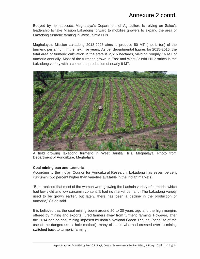
Annexure 2 contd.
Report Prepared for MBDA by Prof. O.P. Singh, Dept. of Environmental Studies, NEHU, Shillong 181 | P a g e
Buoyed by her success, Meghalaya‟s Department of Agriculture is relying on Saioo‟s
leadership to take Mission Lakadong forward to mobilise growers to expand the area of
Lakadong turmeric farming in West Jaintia Hills.
Meghalaya‟s Mission Lakadong 2018-2023 aims to produce 50 MT (metric ton) of the
turmeric per annum in the next five years. As per departmental figures for 2015-2016, the
total area of turmeric cultivation in the state is 2,516 hectares, yielding roughly 16 MT of
turmeric annually. Most of the turmeric grown in East and West Jaintia Hill districts is the
Lakadong variety with a combined production of nearly 9 MT.
A field growing lakadong turmeric in West Jaintia Hills, Meghalaya. Photo from Department of Agriculture, Meghalaya.
Coal mining ban and turmeric
According to the Indian Council for Agricultural Research, Lakadong has seven percent
curcumin, two percent higher than varieties available in the Indian markets.
“But I realised that most of the women were growing the Lachein variety of turmeric, which
had low yield and low curcumin content. It had no market demand. The Lakadong variety
used to be grown earlier, but lately, there has been a decline in the production of
turmeric,” Saioo said.
It is believed that the coal mining boom around 20 to 30 years ago and the high margins
offered by mining and exports, lured farmers away from turmeric farming. However, after
the 2014 ban on coal mining imposed by India‟s National Green Tribunal (because of the
use of the dangerous rat-hole method), many of those who had crossed over to mining
switched back to turmeric farming.

Annexure 2 contd.
Report Prepared for MBDA by Prof. O.P. Singh, Dept. of Environmental Studies, NEHU, Shillong 182 | P a g e
Saioo‟s tryst with Lakadong began in 2003. After she experimented with Lakadong in her
fields, she observed that it doubled her income in contrast to when she grew the Lachein
variety. “I realised that other farmers were not aware of the benefits of growing Lakadong.
The high cost of the seed tubers was also a hindrance for the poor farmers,” Saioo said.
Lakadong turmeric is proven to have two percent more curcumin content as compared to
other Indian turmeric varieties. It gives a better yield and fetches higher profits. Photo from
Department of Agriculture, Meghalaya.
Saioo, received training from the state‟s agriculture and horticulture departments on
improving the yield of Lakadong turmeric and with the Spices Board by her side, she
helped illiterate women to complete their documentation and avail subsidies for seed
tubers as well as organic certification to switch to the high yielding variety.
“As a teacher, I guide them to cultivate turmeric and help with pest management. Women
in Meghalaya do the core of the farming work and our husbands or male members assist
them. So any boost to their skills means it adds to their family‟s income,” she said.
Over the course of the last decade, Saioo has been instrumental in reviving the Life Spice
Federation of Self-Help Groups, which currently has 100 self-help groups (SHGs) as
members. She has pushed for policy advocacy, implementation of schemes and
marketing of Lakadong turmeric.
Through the SHGs, she leads 700 to 800 women farmers, who rely on the versatility of
turmeric-derived products for their income. “The turmeric is harvested, sun-dried and
sliced or powdered by the women,” Saioo explained.

Annexure 2 contd.
Report Prepared for MBDA by Prof. O.P. Singh, Dept. of Environmental Studies, NEHU, Shillong 183 | P a g e
The advantage with turmeric is that once it is harvested, the rhizome can also be dried,
stored and sold as and when needed. “Many women sell dried and powdered products
when they need money, for instance, to purchase textbooks ahead of the new school
session. So the income is variable and the farmers have a choice,” Saioo said.
Trinity Saioo (right), a teacher and farmer, has played an important role in spreading awareness about Lakadong turmeric and helping other women to cultivate it. She was rewarded by the Union Ministry of Agriculture for excellence in horticulture production. Photo from Trinity Saioo.
Upscaling, pests challenge Lakadong uptake
But upscaling production has been a challenge due to the lack of an organised supply
chain, concedes Saioo.
“We send out some of the products to Kerala, Karnataka and other northeast states but it
is still not an organised process. There is a good demand in the market and we have our
own government-established aggregation and processing hub but unless we streamline
the supply we can‟t run it profitably,” said Saioo, referring to the demand among private
players.
The Mission Lakadong document also reiterates what Saioo has stressed: the turmeric
aggregation and processing hub established at Thadlaskein block has yet to develop an
organised supply chain that would enable it to run profitably year round. “We have drying
machines and grinding equipment in the hub but we need a decent supply chain to run
them year long,” Saioo said.
According to the Mission Lakadong document, private players have started making
inroads into the turmeric-growing villages of Jaintia Hills to source the spice and cash in
on the default organic nature of the turmeric and its high curcumin content.

Annexure 2 contd.
Report Prepared for MBDA by Prof. O.P. Singh, Dept. of Environmental Studies, NEHU, Shillong 184 | P a g e
A turmeric oil extraction plant has also been also set up for value addition, but the unit is
barely managing to keep itself afloat as it deals with problems of inefficient management,
no distinctive branding strategy and low understanding of the market.
While awareness about Lakadong turmeric is spreading in Meghalaya and the
government‟s „Mission Lakadong‟ gains traction, lack of an organised supply chain is still
an issue. Photo from Department of Agriculture, Meghalaya.
White grub infestation has also become another concern.
“Instead of relying on chemical pesticides, we have switched to cow urine,
vermicomposting and other organic means of aiding growth. But while some years there is
no infestation, there are others when these pests completely ravage our plants,” said
Saioo.
But she and her band of farmers are not ones to back down. “We have the gift of good
soil, conducive climate and hardworking women. We hope to work these to our advantage
so that people outside Meghalaya realise the value of our produce,” she beamed in
conclusion.

Blank Page

Annexure 3
Report Prepared for MBDA by Prof. O.P. Singh, Dept. of Environmental Studies, NEHU, Shillong 186 | P a g e
Smt. Iahphang Dkhar, of Shohshrieh village in
East Jaintia Hills is one of the farmers of the
District who has taken up commercial
cultivation of strawberry. Tracking through her
past records, Smt. Iahphang Dkhar has been
always been a hardworking and sincere farmer.
In her capacity as a farmer, she has cultivated
spices like
Turmeric (Lakadong variety), Ginger, Vegetables
like Cabbage, Tomato, Radish, Colocasia, French
beans, etc to support her family, especially her
school going children.
Encouraged by the Office of the District Horticulture Officer to take up Strawberry Cultivation, as the
area (Shohshrieh Village) was highly favourable for growing such a fruit crop, her desire and passion to
become one of the progressive farmers of the area finally took off when she was selected as a
beneficiary under MIDH scheme during the year 2013-2014.
At the beginning, the Department assisted her with 6000 nos. of strawberry runners, which she planted
in the open field. Hit by hailstones and thunderstorm in March-April, most of the fruits were affected
thus reducing yield. Therefore, she started replanting the runners from the open field to protected
cultivation under Polyhouse. This move proved beneficial as her yield improved and garnered her
maximum returns throughout the year, fetching a good price of Rs.400/- per kg. Smti. Dkhar harvests
the fruits twice in a month from Feb-July/Aug with the average yield being 200gms/plant/harvest
season. (i.e 6000 plants gives 600kg/harvest) Amounting Rs. 2, 40,000/- per season.

Annexure 3 contd.
Report Prepared for MBDA by Prof. O.P. Singh, Dept. of Environmental Studies, NEHU, Shillong 187 | P a g e
Smt. Iahphang Dkhar marketed the produce to local markets in Ladrymbai, Khliehriat, Jowai and
Shillong. Due to high demand of the fruit in the District, she is now expanding the area on strawberry
cultivation in the village by buying her own runners for multiplication along with the help and technical
guidance from the Department.
Smt. Iahphang Dkhar was assisted with various kinds of input support which included items like
imported planting material of strawberry variety (festival), organic manures, plant protection, irrigation
system like creation of water sources, drip irrigation, poly houses, vermi-compost unit,
collection/packing house for strawberry, etc. Encouraged by the technical advice that she received from
the Department of the District, she is now planning to set up a Minimal Processing Unit in the area by
forming one SHG named Man-i-tre.
Besides the assistance that she received from the Department, Smt. Iahphang Dkhar received support from
her family to extend their hands in managing this large scale cultivation. She also hires labourers from the
village when demand of work is high like land preparation, planting, weeding etc. Excluding the expenditure
and input support, Smt. Iahphang Dkhar has made a profit of around Rs.1,90,000/- from her strawberry
cultivation.
Source:http://megipr.gov.in/docs/STRAWBERRY%20CULTIVATION%20IN%20EAST%20JAINTIA%20HIL
LS.pdf

Annexure 4
Report Prepared for MBDA by Prof. O.P. Singh, Dept. of Environmental Studies, NEHU, Shillong 188 | P a g e
Success stories of Aquaculture/Fishery in Meghalaya
A number of success stories of aquaculture/fishery is recorded from different parts of
Meghalaya by the Meghalaya State Aquaculture Mission 2.0, Government of Meghalaya.
Replication of such similar activities at suitable sites in mining areas may yield fruitfull results
and provide alternative livelihood options to the people affected by mining in Meghalaya. A few
success stories are included below however details of many more can be found out from
website http://msam.nic.in/success.html.

Blank Page

Annexure 5
Report Prepared for MBDA by Prof. O.P. Singh, Dept. of Environmental Studies, NEHU, Shillong 190 | P a g e
Questionnaire
Department of Environmental Studies North-Eastern Hill University
Shillong- 793022
Questionnaire for data collection regarding study in collaboration with Meghalaya Basin Management Agency (MBMA)
A. Identification Schedule
1. Address
a) District:
b) Block:
c) Village:
d) Locality/Dong:
e) GPS Coordinates of the village:
f) Respondent Name:
2. Gender
a) Male
b) Female
3. Education Level
a) Uneducated
b) Primary
c) Metric passed
d) Graduate passed
e) Post-Graduate
4. Occupation
a) Agriculture
b) Small Business
c) Mining
d) Wage labourer
e) Transport related
f) Skilled labourer such as tailoring,
carpentry, construction worker etc
g) Government Servant
h) Others (specify, if any)
5. Household Size
a) <3 b) <6
c) <9 d) <12
6. Range of Household Income per
month (Rs.)
a) <5000
b) 5,000-10,000
c) 10,000-25,000
d) More than 25000
B. Mining related
7. Which minerals is mined in and
around the village:
a) Coal
b) Limestone
c) Sand
d) Clay
e) Others
8. Mineral Extraction is done on the:
a) Private land
b) Community land
c) Rented land
d) Others
9. Extracted minerals are
a) Transported and Sold in the
market
b) Sold to the dealer
c) Transported directly to a company
d) Others

Annexure 5 contd.
Report Prepared for MBDA by Prof. O.P. Singh, Dept. of Environmental Studies, NEHU, Shillong 191 | P a g e
10. For how long has mining been
operational in the area:
a) Recently (<2 year)
b) < 5 Years
c) <10 years
d) >10 years
11. Is mining the main source of income
to the family:
a) Yes
b) No
12. Dependency of people on mining:
a) Exclusively/Totally
b) Partially/Moderately
c) Not dependent
d) Others
13. How you are involved in mining
a) As Labourer
b) As mine owner
c) As Transporter
d) Not at all engaged
e) Others
14. Do you think mining affects the
environment (soil, water and
forest)of the area:
a) Yes
b) No
15. Which component of the environment
was observed mostly affected
because of mining:
a) Surface water
b) Groundwater
c) Soil
d) Forest
e) Biodiversity
16. Any negative impact or side effect of
mining on the area:
a) Decline in soil fertility
b) Degradation of water
c) Loss of flora and fauna
d) Any others (specify)
17. Do you think mining has helped the
community:
a) Yes
b) No
c) Do not know
18. In what way mining in the area has
benefit the community:
a) Source of income
b) Employment opportunity
c) Business opportunity
d) All of the above
e) Non of the above
19. Do you think mining has reduced/ is
reducing the availability of forest
goods and products in the area:
a) Yes
b) No
c) Do not know
20. What is effect of mining on forest cover
in the area
a) Improving
b) Degrading
c) No change
21. Has agriculture pattern changed after
mining started in the area
a) Yes
b) No
If yes, is it?
a) Increasing
b) Decreasing
c) No change
22. Is there any change in the water
bodies since mining started in the
area:
a) Yes
b) No
If yes, specify

Annexure 5 contd.
Report Prepared for MBDA by Prof. O.P. Singh, Dept. of Environmental Studies, NEHU, Shillong 192 | P a g e
23. Any health related problem associated
with mining observed in the area
a) Yes
b) No
If yes,
Name common diseases or
others kind of sickness people
are facing
24. Source of water supply in the area:
a) Rainwater
b) Springs
c) Streams and river water
d) PHED water supply
25. Availability of drinking water in the
area is ______ by mining
a) Adversely affected
b) Moderately affected
c) Slightly affected
d) Not affected
26. Impact of mining on vegetation:
a) Adverse
b) No change
c) Do not know
27. The degree of pollution at which
mining affects the environment is :
a) Heavy pollution
b) No pollution
c) Little Pollution
d) Cannot say
28. Any measure taken by
individual/village community for
conservation of forest, water and soil
resources in the area
a) Yes
b) No
If yes, answer the question given
below:
i. Any Measures taken to
increase availability of water
(its quantity)
ii. Any Measures taken to
increase quality of water
iii. Any Measures taken to reduce
water and soil contamination
iv. Any Measures taken to
improve the fertility of soil
v. Any Measures taken to
improve aquatic resources
such as fish production etc.
vi. Any Measures taken to
improve any other component
of the environment
29. Do you have any information about
traditional knowledge related to
conservation and protection of the
environment?
a) Yes
b) No
If yes, please elaborate
30. Is there any agency (either
Government/NGO’s) helping the study
in conserving the different component
of the environment?
a) Yes
b) No
If yes, name the organisation and
which component of the environment
does its deal with:
C. Demand and Supply of wood and
fuel wood
31. Do you use wood as the main source
of Household (HH) Fuel
a) Yes
b) No

Annexure 5 contd.
Report Prepared for MBDA by Prof. O.P. Singh, Dept. of Environmental Studies, NEHU, Shillong 193 | P a g e
32. Type of Household Fuel used
a) Wood
b) Charcoal
c) LPG
d) Kerosene
e) Others (Specify, if any)
33. Source of wood; How do you procure
a) Directly from forest
b) Via supplier
c) From Market
d) Others (Specify, If any)
34. Area from where fuel wood supply is
obtained
a) Village forest
b) Own forest
c) Plantations
d) Market Area
35. The extracted wood is used chiefly
for:
a) Cooking & Heating
b) Making charcoal
c) Construction purposes
d) Furniture
e) Fencing/ Household purposes
f) Sales
g) Combinations of any/others
36. The availability of firewood in the
market:
a) Increasing
b) Decreasing
c) No change
d) Can’t say
37. The availability status of wood in the
forest
a) Plenty/Abundance
b) Limited
c) Scarcely available
d) Problem in near future
e) Others (specify)
38. The average daily consumption of
wood in Houselhold
a) < 5 units
b) 5-10 units
c) 10-15 units
d) >15 units
39. Price of fuel wood:
.......................................
40. What benefits is obtained from
clearing/ cutting the tree in the forest
area:
a) Cash generation
b) Employment
c) Land for agriculture
d) Land for habitation
e) No benefits
f) Others
41. Health status of the forest
a) No change
b) Deteriorating
c) Increasing
d) No idea
42. Any change in forest cover in last few
decades:
a) Increasing
b) Decreasing
c) No change
d) Adversely affected
43. Any shortfall of wood/fuel wood
availability:
a) Yes
b) No
If yes, is it because of
a) Shrinking of forest
b) Increasing in demand
c) Excessive deforestation
d) Others

Annexure 5 contd.
Report Prepared for MBDA by Prof. O.P. Singh, Dept. of Environmental Studies, NEHU, Shillong 194 | P a g e
44. Do the local community depend on
the forest for their livelihood:
a) Totally dependent
b) Partially dependent
c) Not dependent
d) Others
45. Did loss of forest cover affects the
livelihood of the local people
a) Yes b) No
If yes, How?
46. Do you think the forest quality in the
area has:
a) Improved
b) Degraded
c) Little improvement due to
conservation practices of the
community
d) No idea
D. Demand and Supply of Charcoal
47. Do you use Charcoal in your
House/Household
a) Yes
b) No
48. Where do you procure charcoal from?
a) From the Market
b) Directly from the Supplier
c) By processing and making it in the
forest
d) Others
49. Are you involved in charcoal making
in the area?
a) Yes
b) b) No
50. How dependent are the locals on the
charcoal production for their
livelihood:
a) Totally dependent
b) Partially dependent
c) Not dependent
d) Others
51. What is the current status of charcoal
business making in the area:
a) Very profitable
b) Not profitable
c) Less but essential
d) Others
52. Making of charcoal is taking place in
the area
a) Throughout the year
b) Seasonal
c) Monthly
d) Depends on the demand
53. Currently, the availability of charcoal
in the market is:
a) Increasing
b) Decreasing
c) Cannot say
54. Types of Tree Species used for
charcoal making:
55. How many numbers of sacks is
produce per processing in a unit area:
56. Price of charcoal per bag:
57. Do you think making of charcoal
reduced the forest cover in the area?
a) Yes
b) No
58. Any suggestions of how to bring back
the forest growth in the area after
clearing of forest for making charcoal?