Embed Size (px)
Citation preview

John QuagliarielloNational Weather Service – Columbia, SC
Taking SKYWARN to the Next Level: An Advanced Weather & Storm Spotting Course

Course Information
Purpose –
To expand upon material presented in the basic SKYWARN course
General Outline –
Understanding the Atmosphere
Severe Weather Ingredients
Radar Principles, Advantages and Limitations
Radar and Storm Structure
Review of Impact-Based Warnings
Reporting Procedures
NWS Columbia

Importance of Spotters
Provide “Ground Truth”
Our “eyes” out there!
Detailed storm reports can…
Add value to existing/new warnings
Verify warnings
Can assist with post-storm analysis, research and training
Can mitigate limitations with radar coverage
NWS Columbia

The 3-D Atmosphere
NWS Columbia
L

The 3-D Atmosphere
NWS Columbia
Ingredients
NWS Columbia
Thunderstorm Development
Moisture
Trigger / Lift
Instability
Determining Factors:
Instability
Wind Shear

What is Stability?
NWS Columbia
The degree to which
vertical motion in the
atmosphere is enhanced or
suppressed
Depending on the vertical
temperature profile of the
atmosphere, air will: rise, sink,
remain at rest

Three Types of Stability
NWS Columbia
Unstable AtmosphereEnhances of encourages vertical movement of air
Stable AtmosphereSuppress or resists vertical movement of air
Neutral AtmosphereNeither suppresses nor enhances vertical movement of air

Unstable Atmosphere
NWS Columbia
Air parcels will
continue to rise

Unstable Atmosphere
NWS Columbia
Rising
Air
Promotes the formation
and growth of vertically
developed clouds,
thunderstorms and tall
smoke columns

Stable Atmosphere
NWS Columbia
Level of
Origin
Air parcels displaced
upward (downward)
will eventually return
to their level of origin

Atmospheric Stability
NWS Columbia
4 ways to change
atmospheric
stability

Temperature Lapse Rates
NWS Columbia
Instability is based
upon how warm it
is at the surface vs.
how cold it is aloft
Change in Temperature
Change in Altitude

Measuring Stability
NWS Columbia

Instability
NWS Columbia
4 ways to change
atmospheric
stability
NWS Columbia, SC
Heig
ht
Incre
asin
g
Temperature Increase
CAPE
CAPE stands for the:
Convective
Available
Potential
Energy
•Depending on what type of
CAPE exists (tall, short,
skinny, fat) will determine
the type and amount of
thunderstorms that are
possible (potential).

High CAPE vs. Low CAPE
NWS Columbia
Low CAPE High CAPE
• Low storm potential
• Weak lapse rate
• Higher storm potential
• Steep lapse rate
CAPE is only 1 ingredient that we look at…. Many, many more
variables must be analyzed to make an accurate forecast.

CAPE and Thunderstorms
NWS Columbia

18 / 67
Inc
rea
sin
g H
eig
ht
Change in wind
speed with
height
Change in wind
direction with
height
Change in wind speed
and direction with height
Wind Shear: What is it?

Why Wind Shear
NWS Columbia
Separate
Updrafts and
downdrafts
allow the
storm to
keep
refueling.
Separates Updraft and Downdraft

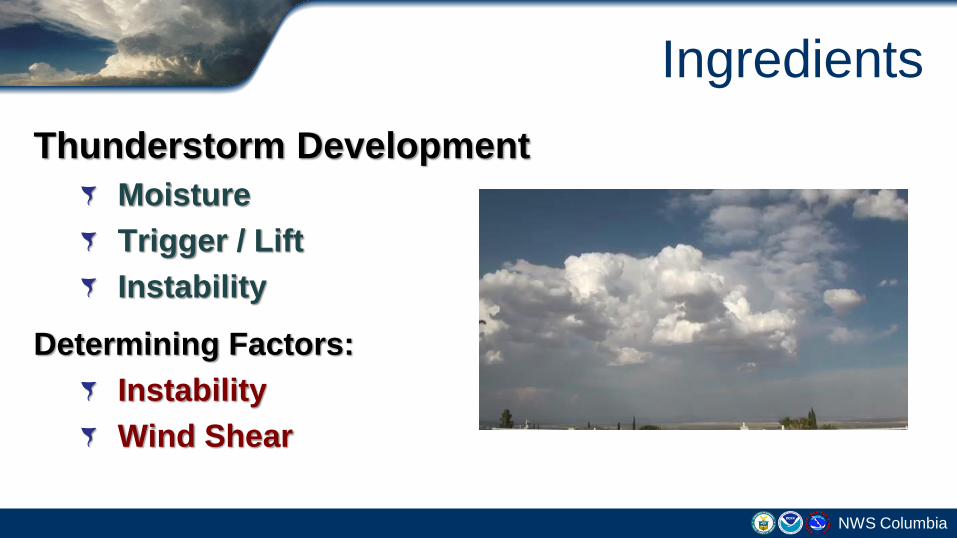
Wind Shear
NWS Columbia
Downdraft chokes
updraft causing storm
be short-lived
Weak
Updraft &
downdraft are
separated, the
storm lives longer
Strong

Updraft in Weak Wind SPEED Shear
NWS Columbia
Updraft in Strong Wind SPEED Shear
NWS Columbia

Wind Shear & Supercells
NWS Columbia
Wind shear gets
the air turning
The updraft bends
the turning air
upward.
The updraft begins spinning
with the turning air
Wind shear is quantified
using terms like Helicity
and Bulk Shear

Supercell – Rotating Updraft
NWS Columbia

Same Ingredients
as a basic
Thunderstorm.
But add
significant
amounts of speed
and directional
shear
Supercell Thunderstorm

NWS Columbia

Measuring Wind Shear
NWS Columbia
HELICITY FACTS:
•Measured at several
height levels
•Aids in determining
storm type and
“convective mode”
•0-6 km = Storm Motion
•0-3 km = Storm Type
•0-1 km = Tornadoes?

Storm-scale/Environment Information readily available!
28 / 67NWS Shreveport Advanced Spotters’ Course – 2011
http://www.spc.noaa.gov/
http://www.spc.noaa.gov/exper/mesoanalysis/

Storm Type
NWS Columbia
Multi-Cell Clustero Downburst Winds
o Hail
o Flash Flooding
o Tornadoes (usually low)
Multi-Cell Bow Echoo Damaging Winds
o Isolated Tornadoes
o Flash Flooding
o Hail (usually low)
Supercello Tornadoes
o Large Hail
o Damaging Winds
o Flash Flooding

10

What is Radar?Radio Detection and Ranging
Detects the distance to and power returned from a target
Weather radar is designed to detect targets made of water
Many brief microwave pulses per second are transmitted
In between the pulses, the radar is “listening” for a reflected signal, or “echo”
The amount of reflected signal received is called reflectivity
NWS Columbia
Raindrop, snowflake, hail, insect, dust, etc.

What is Reflectivity?The higher the reflectivity, the
heavier the rainfall
Colors are used to display low
and high reflectivity
Warm colors = high
Cool colors = low
Always use the color legend
Threats seen: Heavy rain, hail,
snow
Can also see birds, insects,
leaves (tornado debris)
NWS Columbia

The Doppler EffectDoppler effect is a change in
frequency of a moving object
Targets moving toward the
radar are colored green
Targets moving away from the
radar are colored red
The brighter the color, the
stronger the wind
Threats seen: Damaging wind,
tornadoes
NWS Columbia

weather.gov/huntsvilleweather.gov/huntsville [email protected]
Base Velocity and Storm Relative Velocity
What separates storm relative motion
from base velocity is the motion of
storms are "subtracted" from the overall
flow of the wind.
Green = Motion towards the radar
Red = Motion away from the radar
Couplet: Intense outbound winds next
to intense inbound wind.

Dual-Polarization Radar
Radar waves polarized horizontally and vertically
Can see the size and shape of weather and non-weather targets
Threats seen: Hail, heavy rainfall, tornado debrisNWS Columbia

Correlation CoefficientA correlation between the
reflected horizontal and vertical
power returns
Good indicator of hydrometeor
diversity
High values = Uniform targets
(rain)
Low values = Other targets
mixed in (hail, debris, bugs, etc.)
NWS Columbia

Limitations of RadarResolution decreases with distance
Earth curvature
Need network of radars
NWS Columbia
Earth
Radar

Beam Spreading:
Beam spreads nearly 1,000 ft for every 10 miles of travel.
At 60 miles from the radar the beam is over 6,000 feet wide.
At 120 miles from the radar the beam is well over 2 miles wide.
Beam spreading affects resolution capability of the radar!
Small scale features which can be easily discerned near the radar often become
obscured at greater distances.
Limitations of Radar

Fort Worth94 miles / 8,300 ft
Dyess AFB25 miles /
1,700 ft
Frederick112 miles / 11,200 ft
Granger167 miles /
21,000 ft
Effects of Beam Spreading:Same Storm w/ 4 different Radars

Storm Structure - Reflectivity
Most likely area for damaging wind, large hail and tornadoes
T

Storm Structure - Reflectivity
T
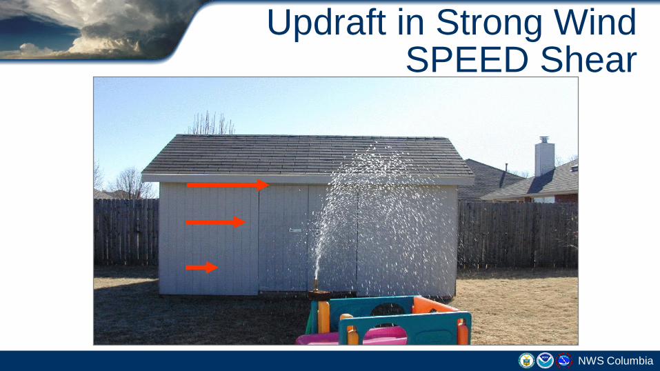
HP Supercells:Rain-Wrapped Tornado

Storm Structure - Velocity
T

Storm Structure - Velocity
T
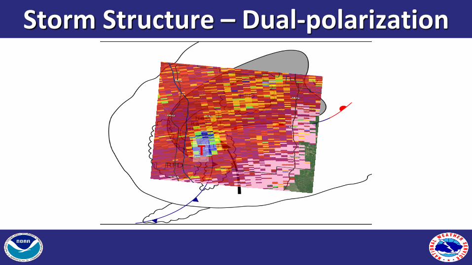
Storm Structure – Dual-polarization
T

Storm Structure – Dual-polarization
T

Impact-Based Warnings

IBW Case Study: November 18, 2015
QLCS Tornadoes

Purpose:Impact Based Warnings
Meteorology: Newer (88D/Dual-Pol) Radar technology &
products can affect NWS warning decision-making
Social Science: Small, yet critical, wording changes in
Warnings & Follow-up statements (SVS)
Hazard/Source/Impacts/Tags
Media & Public: easier to key in on the most important parts of
warning (threats & impacts)

4-panel from FFC Radar: 4:45 PM EST
Base Velocity
Correlation Coeff. / Debris SignatureStorm-Relative Velocity
Reflectivity

Initial TORNADO Warning Issued at 4:47 PM EST
Confidence LOW
with confirmation /
HIGH tornado
occurring
Source / Tag:
“Radar Indicated”

4-panel from FFC Radar:4:48 PM EST
Base VelocityReflectivity
Storm-Relative Velocity Correlation Coeff. / Debris Signature

4-panel from FFC Radar:4:51 PM EST
Reflectivity Base Velocity
Storm-Relative Velocity Correlation Coeff. / Debris Signature

Follow-up Severe Weather Statement (SVS) -- continuing TOR Warning
Confidence HIGH confirmed tornado producing damage!
Based on Radar (TDS)
Source:Radar Confirmed
Tag:Observed
Hazard/PPA statements change

4-panel from FFC Radar:4:58 PM EST – 2nd Tornado
Reflectivity Base Velocity
Storm-Relative Velocity Correlation Coeff. / Debris Signature

What to Report
NWS Columbia
Measured or Estimated Winds 50+ mph
Wind Damage (downed trees/tree limbs, power lines, cars, etc.)
Tornadoes/Waterspouts
Funnel Clouds
Significant Flooding (roads impassable/closed, water into
homes/businesses, etc.)
Hail (any size)…report largest piece

How to Report
NWS Columbia
Web:
http://weather.gov/cae
Phone (unlisted):
On Quick Reference Sheet
E-mail:
Facebook:
NWSColumbia
Twitter:
@NWSColumbia

weather.gov/cae/register
NWS Columbia
Register as a spotter to enter
our database
Receive your spotter certificate
May infrequently be contacted
for severe weather reports