Embed Size (px)
Citation preview
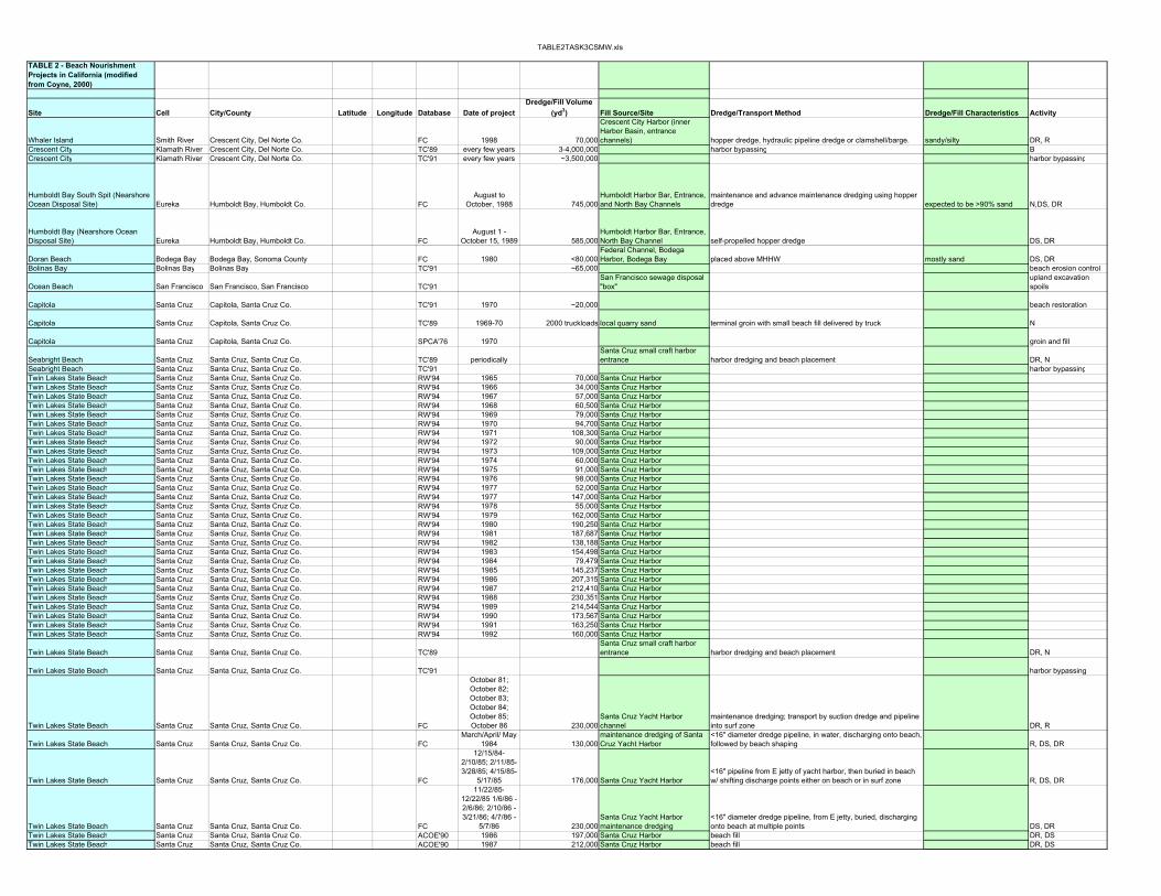
TABLE2TASK3CSMW.xls
TABLE 2 - Beach Nourishment Projects in California (modified from Coyne, 2000)
Site Cell City/County Latitude Longitude Database Date of projectDredge/Fill Volume
(yd3) Fill Source/Site Dredge/Transport Method Dredge/Fill Characteristics Activity
Whaler Island Smith River Crescent City, Del Norte Co. FC 1998 70,000
Crescent City Harbor (inner Harbor Basin, entrance channels) hopper dredge, hydraulic pipeline dredge or clamshell/barge. sandy/silty DR, R
Crescent City Klamath River Crescent City, Del Norte Co. TC'89 every few years 3-4,000,000 harbor bypassing BCrescent City Klamath River Crescent City, Del Norte Co. TC'91 every few years ~3,500,000 harbor bypassing
Humboldt Bay South Spit (Nearshore Ocean Disposal Site) Eureka Humboldt Bay, Humboldt Co. FC
August to October, 1988 745,000
Humboldt Harbor Bar, Entrance, and North Bay Channels
maintenance and advance maintenance dredging using hopper dredge expected to be >90% sand N,DS, DR
Humboldt Bay (Nearshore Ocean Disposal Site) Eureka Humboldt Bay, Humboldt Co. FC
August 1 - October 15, 1989 585,000
Humboldt Harbor Bar, Entrance, North Bay Channel self-propelled hopper dredge DS, DR
Doran Beach Bodega Bay Bodega Bay, Sonoma County FC 1980 <80,000Federal Channel, Bodega Harbor, Bodega Bay placed above MHHW mostly sand DS, DR
Bolinas Bay Bolinas Bay Bolinas Bay TC'91 ~65,000 beach erosion control
Ocean Beach San Francisco San Francisco, San Francisco TC'91San Francisco sewage disposal "box"
upland excavation spoils
Capitola Santa Cruz Capitola, Santa Cruz Co. TC'91 1970 ~20,000 beach restoration
Capitola Santa Cruz Capitola, Santa Cruz Co. TC'89 1969-70 2000 truckloads local quarry sand terminal groin with small beach fill delivered by truck N
Capitola Santa Cruz Capitola, Santa Cruz Co. SPCA'76 1970 groin and fill
Seabright Beach Santa Cruz Santa Cruz, Santa Cruz Co. TC'89 periodicallySanta Cruz small craft harbor entrance harbor dredging and beach placement DR, N
Seabright Beach Santa Cruz Santa Cruz, Santa Cruz Co. TC'91 harbor bypassingTwin Lakes State Beach Santa Cruz Santa Cruz, Santa Cruz Co. RW'94 1965 70,000 Santa Cruz HarborTwin Lakes State Beach Santa Cruz Santa Cruz, Santa Cruz Co. RW'94 1966 34,000 Santa Cruz HarborTwin Lakes State Beach Santa Cruz Santa Cruz, Santa Cruz Co. RW'94 1967 57,000 Santa Cruz HarborTwin Lakes State Beach Santa Cruz Santa Cruz, Santa Cruz Co. RW'94 1968 60,500 Santa Cruz HarborTwin Lakes State Beach Santa Cruz Santa Cruz, Santa Cruz Co. RW'94 1969 79,000 Santa Cruz HarborTwin Lakes State Beach Santa Cruz Santa Cruz, Santa Cruz Co. RW'94 1970 94,700 Santa Cruz HarborTwin Lakes State Beach Santa Cruz Santa Cruz, Santa Cruz Co. RW'94 1971 108,300 Santa Cruz HarborTwin Lakes State Beach Santa Cruz Santa Cruz, Santa Cruz Co. RW'94 1972 90,000 Santa Cruz HarborTwin Lakes State Beach Santa Cruz Santa Cruz, Santa Cruz Co. RW'94 1973 109,000 Santa Cruz HarborTwin Lakes State Beach Santa Cruz Santa Cruz, Santa Cruz Co. RW'94 1974 60,000 Santa Cruz HarborTwin Lakes State Beach Santa Cruz Santa Cruz, Santa Cruz Co. RW'94 1975 91,000 Santa Cruz HarborTwin Lakes State Beach Santa Cruz Santa Cruz, Santa Cruz Co. RW'94 1976 98,000 Santa Cruz HarborTwin Lakes State Beach Santa Cruz Santa Cruz, Santa Cruz Co. RW'94 1977 52,000 Santa Cruz HarborTwin Lakes State Beach Santa Cruz Santa Cruz, Santa Cruz Co. RW'94 1977 147,000 Santa Cruz HarborTwin Lakes State Beach Santa Cruz Santa Cruz, Santa Cruz Co. RW'94 1978 55,000 Santa Cruz HarborTwin Lakes State Beach Santa Cruz Santa Cruz, Santa Cruz Co. RW'94 1979 162,000 Santa Cruz HarborTwin Lakes State Beach Santa Cruz Santa Cruz, Santa Cruz Co. RW'94 1980 190,250 Santa Cruz HarborTwin Lakes State Beach Santa Cruz Santa Cruz, Santa Cruz Co. RW'94 1981 187,687 Santa Cruz HarborTwin Lakes State Beach Santa Cruz Santa Cruz, Santa Cruz Co. RW'94 1982 138,188 Santa Cruz HarborTwin Lakes State Beach Santa Cruz Santa Cruz, Santa Cruz Co. RW'94 1983 154,498 Santa Cruz HarborTwin Lakes State Beach Santa Cruz Santa Cruz, Santa Cruz Co. RW'94 1984 79,479 Santa Cruz HarborTwin Lakes State Beach Santa Cruz Santa Cruz, Santa Cruz Co. RW'94 1985 145,237 Santa Cruz HarborTwin Lakes State Beach Santa Cruz Santa Cruz, Santa Cruz Co. RW'94 1986 207,315 Santa Cruz HarborTwin Lakes State Beach Santa Cruz Santa Cruz, Santa Cruz Co. RW'94 1987 212,410 Santa Cruz HarborTwin Lakes State Beach Santa Cruz Santa Cruz, Santa Cruz Co. RW'94 1988 230,351 Santa Cruz HarborTwin Lakes State Beach Santa Cruz Santa Cruz, Santa Cruz Co. RW'94 1989 214,544 Santa Cruz HarborTwin Lakes State Beach Santa Cruz Santa Cruz, Santa Cruz Co. RW'94 1990 173,567 Santa Cruz HarborTwin Lakes State Beach Santa Cruz Santa Cruz, Santa Cruz Co. RW'94 1991 163,250 Santa Cruz HarborTwin Lakes State Beach Santa Cruz Santa Cruz, Santa Cruz Co. RW'94 1992 160,000 Santa Cruz Harbor
Twin Lakes State Beach Santa Cruz Santa Cruz, Santa Cruz Co. TC'89Santa Cruz small craft harbor entrance harbor dredging and beach placement DR, N
Twin Lakes State Beach Santa Cruz Santa Cruz, Santa Cruz Co. TC'91 harbor bypassing
Twin Lakes State Beach Santa Cruz Santa Cruz, Santa Cruz Co. FC
October 81; October 82; October 83; October 84; October 85; October 86 230,000
Santa Cruz Yacht Harbor channel
maintenance dredging; transport by suction dredge and pipeline into surf zone DR, R
Twin Lakes State Beach Santa Cruz Santa Cruz, Santa Cruz Co. FCMarch/April/ May
1984 130,000maintenance dredging of Santa Cruz Yacht Harbor
<16" diameter dredge pipeline, in water, discharging onto beach, followed by beach shaping R, DS, DR
Twin Lakes State Beach Santa Cruz Santa Cruz, Santa Cruz Co. FC
12/15/84- 2/10/85; 2/11/85-3/28/85; 4/15/85-
5/17/85 176,000 Santa Cruz Yacht Harbor<16" pipeline from E jetty of yacht harbor, then buried in beach w/ shifting discharge points either on beach or in surf zone R, DS, DR
Twin Lakes State Beach Santa Cruz Santa Cruz, Santa Cruz Co. FC
11/22/85-12/22/85 1/6/86 - 2/6/86; 2/10/86 - 3/21/86; 4/7/86 -
5/7/86 230,000Santa Cruz Yacht Harbor maintenance dredging
<16" diameter dredge pipeline, from E jetty, buried, discharging onto beach at multiple points DS, DR
Twin Lakes State Beach Santa Cruz Santa Cruz, Santa Cruz Co. ACOE'90 1986 197,000 Santa Cruz Harbor beach fill DR, DSTwin Lakes State Beach Santa Cruz Santa Cruz, Santa Cruz Co. ACOE'90 1987 212,000 Santa Cruz Harbor beach fill DR, DS

TABLE2TASK3CSMW.xls
Applicant/SponsorDuration of Fill/Performance Funding Environmental Effects Monitoring Notes Ref. ID Permit/FC Ref. See Also
USACOE CD-80-98source: Armstrong 1987sources: Armstrong
USACOEGray Whale (scheduled outside of migration periods); commercial and recreational crab fishing (scheduled after season ends)
COE monitored nearshore site using bathymetric surveys (Aug., Oct. '88, March '89) and Seabed Drifter (Nov. '88)
"disposal of the dredged material directly on the beach was considered impractical due to high costs and unsafe wave conditions in the area." "the designation of a [nearshore site]…is viewed as a "test" to discover whether sand will be retained in the littoral system and provide beach nourishment." CD-045-88 CD-21-87
USACOE turbidity, smothering of benthics
planned bathymetric and seabed drifter surveys of site:Aug. 89, post-deposition, Winter, '90, Spring '90; biological: June, Sept.'89, March '90
"preliminary data from bathymetric surveys and seabed drifter releases indicates that the dredge deposited the Nearshore Site (sic) in FY-1988 have dispersed and has remained in the littoral zone.." CD-026-89
CD-5-88; CD-45-88; CD-31-86; CD-18-85; CD-21-87
USACOE CD-006-80sources: Armstrong
washed away in '82-'83 storms source: Armstrong
city of Capitolalost 3x '70-'86; present in '86 $146,100 (inc. groin)
source: CA Dept of Nav. And Ocean Dev. 1976; Griggs and Savoy '86; Shaw 1980
city/CA Parks and Recreation $146,000 source: CA-DNOD 1977; Griggs and Savoy 1986
city/CA Parks and Recreation $146,100 source: CA-DNOD 1976
source: CA-DNOD 1977; Griggs and Savoy 1986source: Griggs and Savoy 1986
source: CA-DNOD 1977; Armstrong 1987
feader beach source: CA Dept of Nav. And Ocean Dev. 1977 (atlas); Armstrong 1987
USACOE CD-012-81
USACOE CD-046-83
USACOE CD-059-84 CDP 3-84-13CD-12-81, CD-46-83, CDP 3-59-84
CD-031-85 CDP 3-84-13 CD-59-84; CD-46-83USACOE via navigation ProjectUSACOE via navigation Project

TABLE2TASK3CSMW.xls
Site Cell City/County Latitude Longitude Database Date of projectDredge/Fill Volume
(yd3) Fill Source/Site Dredge/Transport Method Dredge/Fill Characteristics ActivityTwin Lakes State Beach Santa Cruz Santa Cruz, Santa Cruz Co. ACOE'90 1988 210,000 Santa Cruz Harbor beach fill DR, DSTwin Lakes State Beach Santa Cruz Santa Cruz, Santa Cruz Co. FC 1994 <75,000 San Lorenzo River channels N, DS, DR
Moss Landing State Beach Southern Monterey Bay Monterey Bay, Monterey County FC March/April '84 10-20,000
maintenance dredging of Moss Landing Harbor
hydraulic cutterhead dredge with submerged pipeline disposal intertidally (north of Sandholt Pier) medium sand R, DS, DR
Moss Landing State Beach Southern Monterey Bay Monterey Bay, Monterey County ACOE'90 1987 29,000 Moss Landing Harbor beach fill DR, DS
Morro Bay beaches Morro Bay Morro Bay, San Luis Obispo TC'89 since 1940s 120,000/yr Morro Bay navigational channel DR, NMorro Bay Morro Bay Morro Bay, San Luis Obispo TC'91 1949 822,000Morro Bay Morro Bay Morro Bay, San Luis Obispo TC'91 1964 702,000Morro Bay Morro Bay Morro Bay, San Luis Obispo TC'91 1968 406,000Morro Bay Morro Bay Morro Bay, San Luis Obispo TC'91 1971 190,000Morro Bay Morro Bay Morro Bay, San Luis Obispo TC'91 1982Morro Bay Morro Bay Morro Bay, San Luis Obispo TC'91 1985
Morro Bay Morro Bay Morro Bay, San Luis Obispo TC'89 1985 120,000 Morro Bay navigational channel dredged, then pumped N of harbor entrance DR, NMorro Bay Morro Bay Morro Bay, San Luis Obispo TC'91 1987Morro Bay Morro Bay Morro Bay, San Luis Obispo ACOE'90 1987 400,000 probably Morro Bay beach fill DR, DSMorro Bay Morro Bay Morro Bay, San Luis Obispo TC'91 1941-1943 1,000,000 0.7 mi long fillMorro Bay Morro Bay Morro Bay, San Luis Obispo TC'91 1942-1946 3,071,000 Harbor constructionMorro Bay Morro Bay Morro Bay, San Luis Obispo TC'91 1974?Morro Bay Morro Bay Morro Bay, San Luis Obispo TC'89 early 1940's Morro Bay navigational channel DR
Morro Bay Morro Bay Morro Bay, San Luis Obispo TC'91 yearly ~120,000 harbor bypassing
Morro Dunes Natural Preserve Morro Bay Morro Bay, San Luis Obispo FCNovember '84 to
February '85 50,000Morro Bay entrance channel, Navy Channel, Morro Channel
hydraulic suction dredge, tractor with pipe lift attachment on beach
fine to medium grained, poorly sorted sands, 1-8% fines R, DS, DR
Morro Dunes Natural Preserve Morro Bay Morro Bay, San Luis Obispo FC
October 1, 1986 - February 15,
1987 350,000 Morro Bay Harborpipeline along sand spit to beach disposal site 3 miles S of harbor entrance predominantly sand R, DS, DR
Morro Dunes Natural Preserve Morro Bay Morro Bay, San Luis Obispo FC
September '90 to 10/15/90-11/30/90 200,000
Morro Bay Entrance, Navy, Morro Channels and additional embayment near entrance
maintenance dredging by hopper dredge; deposition in no deeper than 40' MLLW (sand spit 8000' S of harbor) (nearshore disposal) >97% sand DS, DR
Morro Dunes Natural Preserve Morro Bay Morro Bay, San Luis Obispo FCAugust to
December 1993all or fraction of
840,000 Morro Bay Harbor mouthhopper dredge; disposal by hopper dredge to nearshore no deeper than -40' MLLW (sand spit; 8000' S of harbor) N, DS
Morro Strand State Beach (South) Morro Bay Morro Bay, San Luis Obispo FCNovember '84 to
February '85 450,000Morro Bay entrance channel, Navy Channel, Morro Channel
hydraulic suction dredge, 12-26" diameter pipeline on surface of beach (3.6 mi long)
fine to medium grained, poorly sorted sands, 1-8% fines R, DS, DR
Morro Strand State Beach (South) Morro Bay Morro Bay, San Luis Obispo FC
September '90 to 10/15/90-11/30/90 200,000
Morro Bay Entrance, Navy, Morro Channels and additional embayment near entrance
maintenance dredging by hopper dredge; deposition in no deeper than 40' MLLW (8000' N of harbor) (nearshore disposal) >97% sand DS, DR
Morro Strand State Beach (South) Morro Bay Morro Bay, San Luis Obispo FCAugust to
December 1993all or fraction of
840,000 Morro Bay Harbor mouth
hopper dredge; disposal by either hopper dredge or pipeline fromhopper dredge to surf zone or nearshore no deeper than -40' MLLW; (8000' N of harbor) N, DS
Morro Strand State Beach (South) Morro Bay Morro Bay, San Luis Obispo FC 11/1/93 - 3/31/94 600,000Morro Bay Harbor Entrance, Navy and Morro Channels
either cutterhead hydraulic pipeline dredge with surf zone disposal or hopper/clamshell combination dredge with nearshore disposal DS, DR
East Beach Santa Barbara Santa Barbara, Santa Barbara TC'89 1935 202,000 Santa Barbara Harborfirst sand-bypassing operation; created offshore ridge: 200' wide, 2000' long, 18' of water, 1000' offshore (nearshore) B
East Beach Santa Barbara Santa Barbara, Santa Barbara TC'91 1935 202,000 0.4 mi long; deposited in ~20 ft water depth, ~1000 ft offshore harbor bypassing
East Beach Santa Barbara Santa Barbara, Santa Barbara TC'91 1938 584,000 0.2 mi long; ~500 ft wide harbor bypassingEast Beach Santa Barbara Santa Barbara, Santa Barbara TC'91 1940 697,700 0.5 mi long harbor bypassingEast Beach Santa Barbara Santa Barbara, Santa Barbara TC'91 1942 600,110 1.0 mi long harbor bypassingEast Beach Santa Barbara Santa Barbara, Santa Barbara TC'91 1945 717,773 1.0 mi long harbor bypassingEast Beach Santa Barbara Santa Barbara, Santa Barbara TC'91 1947 642,977 1.0 mi long harbor bypassingEast Beach Santa Barbara Santa Barbara, Santa Barbara TC'91 1949 638,152 1.0 mi long harbor bypassingEast Beach Santa Barbara Santa Barbara, Santa Barbara TC'91 1950-1952 2,476,098 harbor bypassing
East Beach Santa Barbara Santa Barbara, Santa Barbara TC'911954-1972
(periodically) harbor bypassingEast Beach Santa Barbara Santa Barbara, Santa Barbara TC'91 1972 229,333 harbor bypassingEast Beach Santa Barbara Santa Barbara, Santa Barbara Shaw'80 1972 224804 Santa Barbara Harbor bypassing to downcoast of harborEast Beach Santa Barbara Santa Barbara, Santa Barbara Shaw'80 1974 380337 Santa Barbara Harbor bypassing to downcoast of harborEast Beach Santa Barbara Santa Barbara, Santa Barbara TC'91 1974 388,000 harbor bypassingEast Beach Santa Barbara Santa Barbara, Santa Barbara TC'91 1975 50,667 harbor bypassingEast Beach Santa Barbara Santa Barbara, Santa Barbara Shaw'80 1975 49666 Santa Barbara Harbor bypassing to downcoast of harborEast Beach Santa Barbara Santa Barbara, Santa Barbara Shaw'80 1976 394714 Santa Barbara Harbor bypassing to downcoast of harborEast Beach Santa Barbara Santa Barbara, Santa Barbara TC'91 1976 402,667 harbor bypassingEast Beach Santa Barbara Santa Barbara, Santa Barbara Shaw'80 1977 335899 Santa Barbara Harbor bypassing to downcoast of harbor
East Beach Santa Barbara Santa Barbara, Santa Barbara TC'91 1977 342,667 harbor bypassing
East Beach Santa Barbara Santa Barbara, Santa Barbara ACOE'90 1986 300,000 Santa Barbara Harbor beach fill
East Beach Santa Barbara Santa Barbara, Santa Barbara ACOE'90 1987 225,000 Santa Barbara Harbor beach fill
East Beach Santa Barbara Santa Barbara, Santa Barbara ACOE'90 1988 260,000 Santa Barbara Harbor beach fill
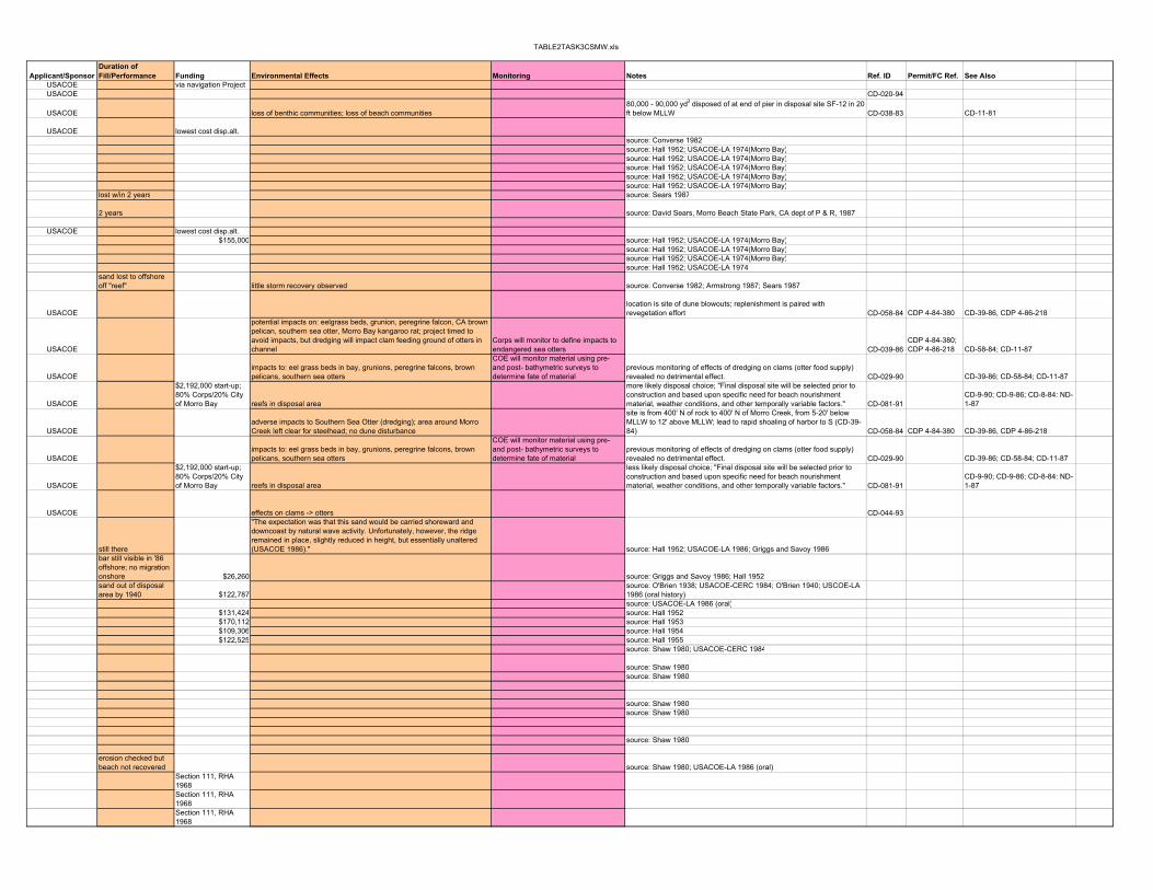
TABLE2TASK3CSMW.xls
Applicant/SponsorDuration of Fill/Performance Funding Environmental Effects Monitoring Notes Ref. ID Permit/FC Ref. See Also
USACOE via navigation ProjectUSACOE CD-020-94
USACOE loss of benthic communities; loss of beach communities80,000 - 90,000 yd3 disposed of at end of pier in disposal site SF-12 in 20 ft below MLLW CD-038-83 CD-11-81
USACOE lowest cost disp.alt.source: Converse 1982source: Hall 1952; USACOE-LA 1974(Morro Bay)source: Hall 1952; USACOE-LA 1974(Morro Bay)source: Hall 1952; USACOE-LA 1974(Morro Bay)source: Hall 1952; USACOE-LA 1974(Morro Bay)source: Hall 1952; USACOE-LA 1974(Morro Bay)
lost w/in 2 years source: Sears 1987
2 years source: David Sears, Morro Beach State Park, CA dept of P & R, 1987
USACOE lowest cost disp.alt.$155,000 source: Hall 1952; USACOE-LA 1974(Morro Bay)
source: Hall 1952; USACOE-LA 1974(Morro Bay)source: Hall 1952; USACOE-LA 1974(Morro Bay)source: Hall 1952; USACOE-LA 1974
sand lost to offshore off "reef" little storm recovery observed source: Converse 1982; Armstrong 1987; Sears 1987
USACOElocation is site of dune blowouts; replenishment is paired with revegetation effort CD-058-84 CDP 4-84-380 CD-39-86, CDP 4-86-218
USACOE
potential impacts on: eelgrass beds, grunion, peregrine falcon, CA brown pelican, southern sea otter, Morro Bay kangaroo rat; project timed to avoid impacts, but dredging will impact clam feeding ground of otters in channel
Corps will monitor to define impacts to endangered sea otters CD-039-86
CDP 4-84-380; CDP 4-86-218 CD-58-84; CD-11-87
USACOEimpacts to: eel grass beds in bay, grunions, peregrine falcons, brown pelicans, southern sea otters
COE will monitor material using pre- and post- bathymetric surveys to determine fate of material
previous monitoring of effects of dredging on clams (otter food supply) revealed no detrimental effect. CD-029-90 CD-39-86; CD-58-84; CD-11-87
USACOE
$2,192,000 start-up; 80% Corps/20% City of Morro Bay reefs in disposal area
more likely disposal choice; "Final disposal site will be selected prior to construction and based upon specific need for beach nourishment material, weather conditions, and other temporally variable factors." CD-081-91
CD-9-90; CD-9-86; CD-8-84: ND-1-87
USACOEadverse impacts to Southern Sea Otter (dredging); area around Morro Creek left clear for steelhead; no dune disturbance
site is from 400' N of rock to 400' N of Morro Creek, from 5-20' below MLLW to 12' above MLLW; lead to rapid shoaling of harbor to S (CD-39-84) CD-058-84 CDP 4-84-380 CD-39-86, CDP 4-86-218
USACOEimpacts to: eel grass beds in bay, grunions, peregrine falcons, brown pelicans, southern sea otters
COE will monitor material using pre- and post- bathymetric surveys to determine fate of material
previous monitoring of effects of dredging on clams (otter food supply) revealed no detrimental effect. CD-029-90 CD-39-86; CD-58-84; CD-11-87
USACOE
$2,192,000 start-up; 80% Corps/20% City of Morro Bay reefs in disposal area
less likely disposal choice; "Final disposal site will be selected prior to construction and based upon specific need for beach nourishment material, weather conditions, and other temporally variable factors." CD-081-91
CD-9-90; CD-9-86; CD-8-84: ND-1-87
USACOE effects on clams -> otters CD-044-93
still there
"The expectation was that this sand would be carried shoreward and downcoast by natural wave activity. Unfortunately, however, the ridge remained in place, slightly reduced in height, but essentially unaltered (USACOE 1986)." source: Hall 1952; USACOE-LA 1986; Griggs and Savoy 1986
bar still visible in '86 offshore; no migration onshore $26,260 source: Griggs and Savoy 1986; Hall 1952sand out of disposal area by 1940 $122,787
source: O'Brien 1938; USACOE-CERC 1984; O'Brien 1940; USCOE-LA 1986 (oral history)source: USACOE-LA 1986 (oral)
$131,424 source: Hall 1952$170,112 source: Hall 1953$109,306 source: Hall 1954$122,525 source: Hall 1955
source: Shaw 1980; USACOE-CERC 1984
source: Shaw 1980 source: Shaw 1980
source: Shaw 1980 source: Shaw 1980
source: Shaw 1980
erosion checked but beach not recovered source: Shaw 1980; USACOE-LA 1986 (oral)
Section 111, RHA 1968Section 111, RHA 1968Section 111, RHA 1968
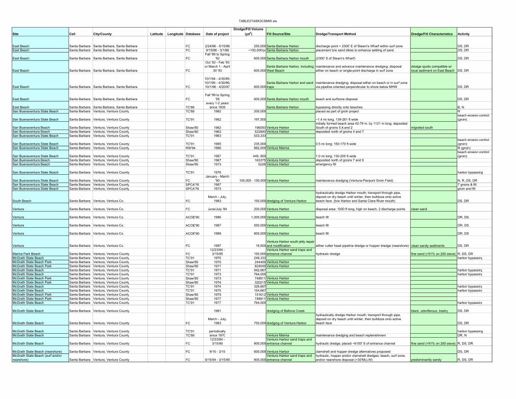
TABLE2TASK3CSMW.xls
Site Cell City/County Latitude Longitude Database Date of projectDredge/Fill Volume
(yd3) Fill Source/Site Dredge/Transport Method Dredge/Fill Characteristics Activity
East Beach Santa Barbara Santa Barbara, Santa Barbara FC 2/24/86 - 5/15/86 250,000 Santa Barbara Harbor discharge point = 2300' E of Stearn's Wharf within surf zone DS, DREast Beach Santa Barbara Santa Barbara, Santa Barbara FC 9/15/86 - 3/1/88 ~100,000/yr Santa Barbara Harbor placement b/w sand dikes to enhance settling of sand DS, DR
East Beach Santa Barbara Santa Barbara, Santa Barbara FCFall '89 to Spring
'92 600,000 Santa Barbara Harbor mouth (2300' S of Stearn's Wharf) DS, DR
East Beach Santa Barbara Santa Barbara, Santa Barbara FC
Oct '92 - Feb '93 or March 1 - April
30 '93 600,000Santa Barbara Harbor, including West Beach
maintenance and advance maintenance dredging; disposal either on beach or single-point discharge in surf zone
dredge spoils compatible w/ local sediment on East Beach DS, DR
East Beach Santa Barbara Santa Barbara, Santa Barbara FC
10/1/94 - 4/30/95; 10/1/95 - 4/30/96; 10/1/96 - 4/20/97 600,000
Santa Barbara Harbor and sand traps
maintenance dredging; disposal either on beach or in surf zone via pipeline oriented perpendicular to shore below MHW DS, DR
East Beach Santa Barbara Santa Barbara, Santa Barbara FCFall '99 to Spring
'05 600,000 Santa Barbara Harbor mouth beach and surfzone disposal DS, DR
East Beach Santa Barbara Santa Barbara, Santa Barbara TC'89every 1-2 years
since 1935 Santa Barbara Harbor bypassing directly onto beaches B, NSan Buenaventura State Beach Santa Barbara Ventura, Ventura County TC'89 1962 200,000 placed as part of groin project R
San Buenaventura State Beach Santa Barbara Ventura, Ventura County TC'91 1962 197,500 ~1.4 mi long, 139-261 ft widebeach erosion control (groin)
San Buenaventura Beach Santa Barbara Ventura, Ventura County Shaw'80 1962 196050 Ventura Harborinitially formed beach area 42-79 m. by 1121 m long; deposited South of groins 5,4,and 2 migrated south
San Buenaventura Beach Santa Barbara Ventura, Ventura County Shaw'80 1963 522800 Ventura Harbor deposited north of groins 4 and 7San Buenaventura State Beach Santa Barbara Ventura, Ventura County TC'91 1963 533,333
San Buenaventura State Beach Santa Barbara Ventura, Ventura County TC'91 1965 235,000 0.5 mi long; 150-170 ft widebeach erosion control (groin)
San Buenaventura State Beach Santa Barbara Ventura, Ventura County RW'94 1966 882,000 Ventura Marina R (groin)
San Buenaventura State Beach Santa Barbara Ventura, Ventura County TC'91 1967 449, 800 1.0 mi long; 130-200 ft widebeach erosion control (groin)
San Buenaventura Beach Santa Barbara Ventura, Ventura County Shaw'80 1967 163375 Ventura Harbor deposited north of groins 7 and 9San Buenaventura Beach Santa Barbara Ventura, Ventura County Shaw'80 1973 5228 Ventura Harbor emergency fill
San Buenaventura State Beach Santa Barbara Ventura, Ventura County TC'91 1976 harbor bypassing
San Buenaventura State Beach Santa Barbara Ventura, Ventura County FCJanuary - March
'90 100,000 - 150,000 Ventura Harbor maintenance dredging (Ventura-Pierpont Groin Field) N, R, DS, DRSan Buenaventura State Beach Santa Barbara Ventura, Ventura County SPCA'76 1967 7 groins & fillSan Buenaventura State Beach Santa Barbara Ventura, Ventura County SPCA'76 1973 groin and fill
South Beach Santa Barbara Ventura, Ventura Co. FCMarch - July,
1983 150,000 dredging of Ventura Harbor
hydraulically dredge Harbor mouth; transport through pipe, deposit on dry beach until winter, then bulldoze onto active beach face (b/w Harbor and Santa Clara River mouth) DS, DR
Ventura Santa Barbara Ventura, Ventura Co. FC June/July '84 200,000 Ventura Harbor disposal area: 1000 ft long, high on beach, 2 discharge points clean sand
Ventura Santa Barbara Ventura, Ventura Co. ACOE'90 1986 1,000,000 Ventura Harbor beach fill DR, DS
Ventura Santa Barbara Ventura, Ventura Co. ACOE'90 1987 550,000 Ventura Harbor beach fill DR, DS
Ventura Santa Barbara Ventura, Ventura Co. ACOE'90 1988 800,000 Ventura Harbor beach fill DR, DS
Ventura Santa Barbara Ventura, Ventura Co. FC 1997 19,500Ventura Harbor south jetty repair and modification either cutter head pipeline dredge or hopper dredge (nearshore) clean sandy sediments DS, DR
Marina Park Beach Santa Barbara Ventura, Ventura County FC12/23/84 -
3/15/85 150,000Ventura Harbor sand traps and entrance channel hydraulic dredge fine sand (>91% on 200 sieve) R, DS, DR
McGrath State Beach Santa Barbara Ventura, Ventura County TC'91 1970 249,333 harbor bypassingMcGrath State Beach Park Santa Barbara Ventura, Ventura County Shaw'80 1970 244409 Ventura HarborMcGrath State Beach Park Santa Barbara Ventura, Ventura County Shaw'80 1971 924049 Ventura HarborMcGrath State Beach Santa Barbara Ventura, Ventura County TC'91 1971 942,667 harbor bypassingMcGrath State Beach Santa Barbara Ventura, Ventura County TC'91 1973 764,000 harbor bypassingMcGrath State Beach Park Santa Barbara Ventura, Ventura County Shaw'80 1973 748911 Ventura HarborMcGrath State Beach Park Santa Barbara Ventura, Ventura County Shaw'80 1974 320215 Ventura HarborMcGrath State Beach Santa Barbara Ventura, Ventura County TC'91 1974 326,667 harbor bypassingMcGrath State Beach Santa Barbara Ventura, Ventura County TC'91 1975 154,667 harbor bypassingMcGrath State Beach Park Santa Barbara Ventura, Ventura County Shaw'80 1975 151612 Ventura HarborMcGrath State Beach Park Santa Barbara Ventura, Ventura County Shaw'80 1977 748911 Ventura HarborMcGrath State Beach Santa Barbara Ventura, Ventura County TC'91 1977 764,000 harbor bypassing
McGrath State Beach Santa Barbara Ventura, Ventura County 1981 dredging of Ballona Creek black, odoriferous, trashy DS, DR
McGrath State Beach Santa Barbara Ventura, Ventura County FCMarch - July,
1983 750,000 dredging of Ventura Harbor
hydraulically dredge Harbor mouth; transport through pipe, deposit on dry beach until winter, then bulldoze onto active beach face DS, DR
McGrath State Beach Santa Barbara Ventura, Ventura County TC'91 periodically harbor bypassingMcGrath State Beach Santa Barbara Ventura, Ventura County TC'89 since 1970 Ventura Marina maintenance dredging and beach replenishment DR, N
McGrath State Beach Santa Barbara Ventura, Ventura County FC12/23/84 -
3/15/85 800,000Ventura Harbor sand traps and entrance channel hydraulic dredge; placed ~6100' S of entrance channel fine sand (>91% on 200 sieve) R, DS, DR
McGrath State Beach (nearshore) Santa Barbara Ventura, Ventura County FC 9/15 - 3/15 600,000 Ventura Harbor clamshell and hopper dredge alternatives proposed DS, DRMcGrath State Beach (surf and/or nearshore) Santa Barbara Ventura, Ventura County FC 9/15/94 - 3/15/95 800,000
Ventura Harbor sand traps and entrance channel
hydraulic, hopper and/or clamshell dredges; beach, surf zone, and/or nearshore disposal (<30'MLLW) predominantly sandy R, DS, DR

TABLE2TASK3CSMW.xls
Applicant/SponsorDuration of Fill/Performance Funding Environmental Effects Monitoring Notes Ref. ID Permit/FC Ref. See Also
USACOEscheduled during grunion spawning, but deposition in surf zone; monitoring planned to determine impacts
beach profile monitoring to document impacts of single-pt surf zone disposal on grunion CD-009-86
USACOE grunion CD-025-86 CD-2-83; CD-12-84; CD-25-84
USACOE CD-046-89
USACOEimpacts to grunion spawning if contingency dredging necessary; creation of sand traps in harbor intended to mitigate need for this dredging
effects of March disposal on grunion spawning CD-040-92 CD-25-86; CD-46-89
USACOEApril extension to monitor impacts of surf zone disposal on grunion CD-032-93
CD-21-83; CD-25-86; CD-46-89; CD-58-90; CD-79-91; ND-4-92; CD-40-92
USACOEnightly surveys of grunion to detect onset of spawning CD-048-98
CD-21-83; CD-25-86; CD-46-89; CD-58-90; CD-79-91; ND-4-92; CD-40-92; CD-32-93
USACOE
"migrated south" "impounded on N side of groins" source: USACOE-LA 1976; Shaw 1980
"accretion on N side of groins" source: Shaw 1980
source: USACOE-LA 1976
$2,157,000 (7 groins plus fill) "accretion on N side of groins" source: USACOE-LA 1976; CA Dept of Nav and Ocean Dev 1976;
current bypassing has problems source: Herron 1987
USACOEbeach profiles by Ventura Port District, annually in September CD-036-89
$2,157,000 source: CA-DNOD 1976$370,000 source: CA-DNOD 1976
USACOE CD-002-83
CDP 4-83-257A (in lieu of CD-43-84)
CD-25-84; CD-30-85; CD-42-88;CD-17-89
USACOEto mitigate impacts to access, Corps will fill beach in stages; will operate single discharge points to mitigate tern and grunion impacts 2600 ft beach frontage CD-025-84 CP 4-83-257
USACOESection 111, RHA 1968
USACOESection 111, RHA 1968
USACOESection 111, RHA 1968
USACOE
sand dredged from around pier; will be placed either in sand trap to be dredged with next maintenance dredging or directly into nearshore somewhere downdrift. CD-168-97
USACOE least turn nesting, brown pelican (dredging)Corps will monitor to define erosion issues disposal site ~1400 ft long, from first groin in Pierpont groin field CD-030-85 CD-25-84; CD-42-88; CD-17-89
source: Shaw 1980
source: Shaw 1980source: Shaw 1980
source: Shaw 1980source: Shaw 1980
source: Shaw 1980
LA Co/ USACOEstoring sand in backshore until winter to avoid grunion and least turn spawning season noted in CD-02-83
USACOEstoring sand in backshore until Sept. 1 to avoid grunion and least turn spawning season
dredging-induced opportunistic surf zone nourishment was conducted prior to this project CD-002-83
"1977: Effect of bypassing overshadowed by extremely high sediment flows in Santa Clara River." source: Shaw 1980
source: Shaw 1980
USACOEgrunion spawning, salt marsh bird's beak, The Belding's Savannah Sparrow (nourishment); least turn nesting (dredging) disposal site ~4400 ft long CD-030-85 CD-25-84; CD-42-88; CD-17-89
USACOE/Ventura Port District
increased turbidity, loss of O2, loss of benthics, impacts to least tern, grunion beach profiles by Ventura Port District
nearshore disposal -> berm: -15' MLLW, 4300' long, 900' footprint, b/w -15' and -10' contours CD-053-91 CDP 4-83-257 ND-42-88; CD-17-89
USACOE terns, grunions, plover beginning 100' S of Santa Clara River mouth and extending S for 4300' CD-054-94
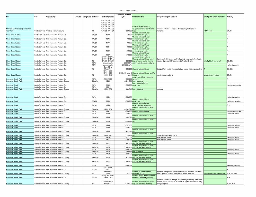
TABLE2TASK3CSMW.xls
Site Cell City/County Latitude Longitude Database Date of projectDredge/Fill Volume
(yd3) Fill Source/Site Dredge/Transport Method Dredge/Fill Characteristics Activity
McGrath State Beach (surf and/or nearshore) Santa Barbara Ventura, Ventura County FC
9/15/98 - 3/15/99; 9/15/99 - 3/15/00; 9/15/00 - 3/15/01; 9/15/01 - 3/15/02; 9/15/02 - 3/15/03; 9/15/03 - 3/15/04; 500,000
Ventura Harbor entrance, navigation channels and sand traps
hydraulic cutterhead pipeline dredge (maybe hopper or clamshell) >80% sand DR, R
Silver Strand Beach Santa Barbara Port Hueneme, Ventura Co. RW'94 1973 75000Channel Islands Harbor maintenance dredging R
Silver Strand Beach Santa Barbara Port Hueneme, Ventura Co. RW'94 1975 100000Channel Islands Harbor maintenance dredging R
Silver Strand Beach Santa Barbara Port Hueneme, Ventura Co. RW'94 1977 100000Channel Islands Harbor maintenance dredging R
Silver Strand Beach Santa Barbara Port Hueneme, Ventura Co. RW'94 1981 100000Channel Islands Harbor maintenance dredging R
Silver Strand Beach Santa Barbara Port Hueneme, Ventura Co. RW'94 1983 150000Channel Islands Harbor maintenance dredging R
Silver Strand Beach Santa Barbara Port Hueneme, Ventura Co. RW'94 1987 378000Channel Islands Harbor maintenance dredging R
Silver Strand Beach Santa Barbara Port Hueneme, Ventura Co. FC
9/1/88 - 3/15/89; 9/1/90 - 3/15/91; 9/1/92 - 3/15/93 300,000
maintenance dredging of Channel Islands Harbor sand trap, entrance basin, channel
diesel or electric cutterhead hydraulic dredge; buried hydraulic pipeline ( placed 800' downcoast of harbor S jetty) initially black and smelly DS, DR
Silver Strand Beach Santa Barbara Port Hueneme, Ventura Co. TC'89 occassionally 200,000/yr nearby maintenance dredging NSilver Strand Beach Santa Barbara Port Hueneme, Ventura Co. TC'91 occassionally 200,000 cu/yr harbor bypassing
Silver Strand Beach Santa Barbara Port Hueneme, Ventura Co. FCSept. '83 to March '84 150,000 Channel Islands Harbor dredged from harbor, transported via buried discharge pipeline ? DS, DR
Silver Strand Beach Santa Barbara Port Hueneme, Ventura Co. FC
10/94 - 3/95; 10/96 - 3/97; 10/98 - 3/99
6,900,000 (over 6 years)
Channel Islands Harbor and Port Hueneme maintenance dredging predominantly sandy DR, R
Hueneme Beach Park Santa Barbara Port Hueneme, Ventura Co. TC'89 1935-1940 1,500,000excavation of Port Hueneme harbor R
Hueneme Beach Park Santa Barbara Port Hueneme, Ventura County Shaw'80 1939 2,614,000 Port Hueneme
Hueneme Beach Santa Barbara Port Hueneme, Ventura Co. TC'91 1940 1,360,000Port Hueneme harbor excavation Harbor construction
Hueneme Beach Santa Barbara Port Hueneme, Ventura Co. TC'91 1941Hueneme Beach Park Santa Barbara Port Hueneme, Ventura County Shaw'80 1953-1954 1,986,640 Port Hueneme bypassed
Hueneme Beach Santa Barbara Port Hueneme, Ventura Co. TC'91 1954 2,033,000 harbor bypassing
Hueneme Beach Santa Barbara Port Hueneme, Ventura Co. RW'94 1960 3,700,000Channel Islands Harbor excavation harbor construction
Hueneme Beach Santa Barbara Port Hueneme, Ventura Co. TC'89 1960Channel islands harbor excavation and bypassing B, N
Hueneme Beach Park Santa Barbara Port Hueneme, Ventura County Shaw'80 1960-1961 6,234,390Channel Islands Harbor sand trap
Hueneme Beach Santa Barbara Port Hueneme, Ventura Co. TC'91 1961 6,000,000 Channel Islands harbor Harbor constructionHueneme Beach Santa Barbara Port Hueneme, Ventura Co. TC'91 1963 1,986,000 harbor bypassing
Hueneme Beach Park Santa Barbara Port Hueneme, Ventura County Shaw'80 1963 1984026Channel Islands Harbor sand trap
Hueneme Beach Park Santa Barbara Port Hueneme, Ventura County Shaw'80 1965 3524979Channel Islands Harbor sand trap
Hueneme Beach Santa Barbara Port Hueneme, Ventura Co. TC'91 1965 3,527,000 harbor bypassingHueneme Beach Santa Barbara Port Hueneme, Ventura Co. TC'91 1968 1,704,000 harbor bypassing
Hueneme Beach Park Santa Barbara Port Hueneme, Ventura County Shaw'80 1968 1670346Channel Islands Harbor sand trap
Hueneme Beach Park Santa Barbara Port Hueneme, Ventura County Shaw'80 1969-1970 2722481Channel Islands Harbor sand trap initially widened beach 30 m
Hueneme Beach Park Santa Barbara Port Hueneme, Ventura Co. TC'91 1970 2,777,333 widened beach 99 ft harbor bypassingHueneme Beach Park Santa Barbara Port Hueneme, Ventura Co. TC'91 1971 2,533,333 widened beach 99 ft harbor bypassing
Hueneme Beach Park Santa Barbara Port Hueneme, Ventura County Shaw'80 1971 2483300Channel Islands Harbor sand trap and entrance channel
Hueneme Beach Park Santa Barbara Port Hueneme, Ventura County Shaw'80 1973 2483300Channel Islands Harbor sand trap and entrance channel
Hueneme Beach Park Santa Barbara Port Hueneme, Ventura Co. TC'91 1973 2,533,333 harbor bypassingHueneme Beach Park Santa Barbara Port Hueneme, Ventura County Shaw'80 1975 109,788 Port HuenemeHueneme Beach Park Santa Barbara Port Hueneme, Ventura Co. TC'91 1975 1,768,000 harbor bypassing
Hueneme Beach Park Santa Barbara Port Hueneme, Ventura County Shaw'80 1975 1623294Channel Islands Harbor sand trap and entrance channel
Hueneme Beach Park Santa Barbara Port Hueneme, Ventura County Shaw'80 1977 2483300Channel Islands Harbor sand trap and entrance channel
Hueneme Beach Park Santa Barbara Port Hueneme, Ventura Co. TC'91 1977 2,533,333 harbor bypassing
Hueneme Beach Park Santa Barbara Port Hueneme, Ventura Co. TC'891941, 1943,
1954, R
Hueneme Beach Park Santa Barbara Port Hueneme, Ventura County FC1985? In the
future 61,000Channel A, Port Hueneme, below +1' MLLW
hydraulic dredge from MLLW down to -20'; placed in surf zone unless grunion season; then placed above H20 line compatible w/ local sediment N, R, DS, DR
Hueneme Beach Park Santa Barbara Port Hueneme, Ventura Co. TC'89every two years
since 1960Channel Island Harbor and Port Hueneme Harbor bypassing B, N
Hueneme Beach Park Santa Barbara Port Hueneme, Ventura County FCOctober '84 to
March '85 2,000,000Channel Islands Harbor (sand trap and entrance channel)
hydraulic cutterhead dredge; deposited hydraulically via buried pipeline (+10 ft MLLW, 50 ft. from HWL); (downcoast of E Jetty to beyond pier) R, DS, DR

TABLE2TASK3CSMW.xls
Applicant/SponsorDuration of Fill/Performance Funding Environmental Effects Monitoring Notes Ref. ID Permit/FC Ref. See Also
USACOE
grunion, least terns, snowy plovers; single point diked discharge to minimize turbidity; discharge further than 200' from mouth of Santa Clara River to minimize impacts to steelhead trout in estuary CD-64-98
CD-54-94; CD-53-91; CD-42-88; CD-51-86; CD-30-85; CD-2-83
source: USA/CESPL as given in Noble 89 as given in Wiegel '94
source: USA/CESPL as given in Noble 89 as given in Wiegel '94
source: USA/CESPL as given in Noble 89 as given in Wiegel '94
source: USA/CESPL as given in Noble 89 as given in Wiegel '94
source: USA/CESPL as given in Noble 89 as given in Wiegel '94
source: USA/CESPL as given in Noble 89 as given in Wiegel '94
USACOE 3000' along beach CD-004-89CD-25-83; CD-53-84; CD-43-86/CD-60-86
source: CA-DNOD 1977; Armstrong 1987source: Herron and Harris 1966; Armstrong 1987
USACOE CD-025-83 CDP 4-83-257
USACOE
need to protect least terns, grunions, snowy plover; limit post-March 31 disposal to diked or single-point disposal; map for plovers pre-disposal; mitigate impacts to pismo clams CD-052-94
CD-4-89; CD-7-89; CD-80-86; CD-43-86; CD-53-84; CD-25-83; CD-15-90; CD-12-85
3 years
total loss and beyond w/in 3 years $295,800 source: USACOE-LA 1954
source: USACOE-LA 1954
"Plan only partially successful. Bypassed only half the planned volume, b/c of difficulty of dredging in surf zone. Gave temporary respite, but by 1958, city of Port Hueneme again building emergency seawall." source: USACOE-CERC 1984
$1,250,000 source: Herron 1987; Herron and Harris 1966$951,000 source: Herron and Harris 1966
"Of 14M cy pumped to feeder beach b/w 1960 and 1966, some 9M cy have moved on downcoast." source: Herron and Harris 1966
$852,000 source: Shaw 1980, Herron and Harris 1968
source: Shaw 1980source: Shaw 1980
source: Shaw 1980
source: Shaw 1980
bypassing has overcome problem
source: Shaw 1980; Armstrong 1987; Herron 1987; USACOE-CERC 1984
source: Hall 1952; Herron and Harris 1962)
USACOE additional 163,000 yd3 needed to be dredged/disposed in 1986 CD-012-85 CDP 4-86-204
source: Shaw 1980
USACOEcoverage/disturbance/elimination of benthic communities; turbidity; fish displacement CD-053-84 CD-25-83; CD-12-85; CD-62-87

TABLE2TASK3CSMW.xls
Site Cell City/County Latitude Longitude Database Date of projectDredge/Fill Volume
(yd3) Fill Source/Site Dredge/Transport Method Dredge/Fill Characteristics Activity
Hueneme Beach Park Santa Barbara Port Hueneme, Ventura County FCSept. '83 to March '84 1,350,000 Channel Islands Harbor dredged from harbor, transported via buried discharge pipeline ? DS, DR
Hueneme Beach Park Santa Barbara Port Hueneme, Ventura County FCSept. '83 to March '84 200,000 Hueneme Harbor dredged from harbor, transported via buried discharge pipeline clean sand DS, DR
Hueneme Beach Park Santa Barbara Port Hueneme, Ventura County ACOE'90 1987 2,000,000 Channel Islands Harbor beach disposal DR, DS
Hueneme Beach Park Santa Barbara Port Hueneme, Ventura County FC 3/15/87 - 5/30/87 500,000Channel Islands harbor entrance, basin, sand trap
routine dredging; diesel dredge; bermed disposal site >25' from highest contour of wave runup, 1700' long, 7' above MLLW; single return water discharge point littoral drift material DS, DR
Hueneme Beach Park Santa Barbara Port Hueneme, Ventura County FC 1989 2,200,000
maintenance dredging of Channel Islands Harbor sand trap, entrance basin, channel
diesel or electric cutterhead hydraulic dredge; hydraulic pipeline on beach surface initially black and smelly DS, DR
Hueneme Beach Park Santa Barbara Port Hueneme, Ventura County FC
10/94 - 3/95; 10/96 - 3/97; 10/98 - 3/99
6,900,000 (over 6 years)
Channel Islands Harbor and Port Hueneme maintenance dredging predominantly sandy DR, R
Hueneme Beach Santa Barbara Port Hueneme, Ventura County FC 1999-2000 630,000 Port Hueneme maintenance dredging; on or nearshore disposal clean sedimentPacific Missile Range Santa Barbara Point Mugu, Ventura County TC'89 1947 700,000 Mugu lagoon DR, N
Pacific Missile Range Santa Barbara Point Mugu, Ventura County TC'91 1947 709,333Pacific Missile Range Santa Barbara Point Mugu, Ventura County Shaw'80 1947 695,324 Mugu Lagoon fill degraded rapidlyPacific Missile Range Santa Barbara Point Mugu, Ventura County RW'94 1961 3 groins constructed with fill sand groins and fillLas Tunas Beach Santa Monica Malibu, Los Angeles Co. TC'89 1960-1974 50,000 RLas Tunas Beach Santa Monica Malibu, Los Angeles Co. TC'91 1960-1974 ~50,000 beach erosion controlWill Rogers State Beach Santa Monica Pacific Palisades, Los Angeles Co TC'91Santa Monica State Beach Santa Monica Santa Monica, Los Angeles Co. TC'91 1939
Santa Monica Beach Santa Monica Venice Beach, Los Angeles County Shaw'80 1939 60,122 Santa Monica Breakwater Ocean Park to Santa Monica PierSanta Monica State Beach Santa Monica Santa Monica, Los Angeles Co. TC'91 1943 150,000 beach erosion control
Santa Monica Beach Santa Monica Venice Beach, Los Angeles County Shaw'80 1949 396,021 Santa Monica Breakwater deposited from Ocean Park Pier to Santa Monica Pier
Santa Monica State Beach Santa Monica Santa Monica, Los Angeles Co. TC'91 1950 1,000,000
Santa Monica State Beach Santa Monica Santa Monica, Los Angeles Co. TC'89 1939, 1949, 1950 RSanta Monica State Beach Santa Monica Santa Monica, Los Angeles Co. RW'94 1945 150,000 R
Santa Monica State Beach Santa Monica Santa Monica, Los Angeles Co. LHW'94 1939 60,000Santa Monica Breakwater bypassing bypassed
Santa Monica State Beach Santa Monica Santa Monica, Los Angeles Co. LHW'94 1949-50 960,000Santa Monica Breakwater bypassing bypassed
Santa Monica State Beach Santa Monica Santa Monica, Los Angeles Co. LHW'94 1957-58 780,000Santa Monica Breakwater bypassing bypassed
Venice City Beach Santa Monica Venice, Los Angeles County LHW'94 1945 150,000 Hyperion excavation DS
Venice City Beach Santa Monica Venice, Los Angeles County RW'94 1945 150,000 Hyperion sewage disposal plant erosion control
Venice City Beach Santa Monica Venice, Los Angeles County TC'89 1945 140,000 nearby dunes trucked from dunes to beach R
Venice City Beach Santa Monica Venice, Los Angeles County TC'91 1945 140,000 0.6 mi long; 75 ft fill width beach restoration
Venice Beach Santa Monica Venice Beach, Los Angeles County Shaw'80 1945 148,998 Santa Monica Breakwater Venice Pier to Washington St.
Venice City Beach Santa Monica Venice, Los Angeles County RW'94 1947 Hyperion sewage disposal plant R
Venice Beach Santa Monica Venice Beach, Los Angeles County Shaw'80 1948 1,390,648 Santa Monica Breakwater El Segundo to Ocean Park; widened beach ~180 m (x ft)Venice City Beach Santa Monica Venice, Los Angeles County RW'94 1973 17,000 entrance of Marina Del Rey maintenance dredgingVenice City Beach Santa Monica Venice, Los Angeles County TC'89 1975 11,000 RVenice City Beach Santa Monica Venice, Los Angeles County TC'91 1975 11,000
Venice Beach Santa Monica Venice Beach, Los Angeles County Shaw'80 1975 10,456 Marina Del Rey bypassing
Venice City Beach Santa Monica Venice, Los Angeles County FCMarch - May
1998 <123,00Marina Del Rey Harbor (sand trap)
either hopper dredge, clamshell dredge with disposal barge or hydraulic cuttterhead with pipeline; pipeline w/ single-pt. discharge in intertidal zone 99% sand DS, DR
Venice City Beach/Dockweiler Santa Monica Venice, Los Angeles County LHW'94 1947 13,900,000 Hyperion excavation DS
Venice City Beach/Dockweiler Santa Monica Santa Monica, Los Angeles Co. RW'94 1946-48 ~14,000,000Hyperion sewage disposal plant excavation hydraulically excavated from sand dunes DS, R
Venice City Beach/Dockweiler Santa Monica Santa Monica, Los Angeles Co. TC'89 1947-48 14,000,00Hyperion sewage disposal plant excavation sand from sand hills R
Venice City Beach/Dockweiler Santa Monica Playa Del Rey, Los Angeles County Shaw'80 1948 13,984,900nearby sand hills (Hyperion excavation)
sand hydraulically removed from hills, transported to beach via discharge pipes
Dockweiler Beach Santa Monica Playa Del Rey, Los Angeles Co LHW'94 1938 1,800,000 Hyperion excavation DS
Dockweiler Beach Santa Monica Playa Del Rey, Los Angeles County Shaw'80 1938 1,803,660 nearby sand hills
Dockweiler Beach Santa Monica Playa Del Rey, Los Angeles Co LHW'94 1969 389,000Marina Del Rey Harbor (sand trap) bypassing bypassed
Dockweiler Beach Santa Monica Playa Del Rey, Los Angeles Co LHW'94 1975 10,000Marina Del Rey Harbor (sand trap) bypassing bypassed
Dockweiler Beach Santa Monica Playa Del Rey, Los Angeles Co LHW'94 1981 217,000Marina Del Rey Harbor (sand trap) bypassing bypassed
Dockweiler Beach Santa Monica Playa Del Rey, Los Angeles Co LHW'94 1987 35,000Marina Del Rey Harbor (sand trap) bypassing bypassed
Dockweiler Beach Santa Monica Playa Del Rey, Los Angeles Co TC'89 1938 1,800,000 nearby hills Dockweiler: from El Segundo/LA City border to Marina Del Rey RDockweiler Beach Santa Monica Playa Del Rey, Los Angeles Co TC'91 1938 1,840,000 upland excavation fill

TABLE2TASK3CSMW.xls
Applicant/SponsorDuration of Fill/Performance Funding Environmental Effects Monitoring Notes Ref. ID Permit/FC Ref. See Also
USACOEno fill deposition after March 31 due to grunion spawning; avoid least turn nesting CD-025-83 CDP 4-83-473 CD-53-84; CD-12-85;
USACOE CD-025-83 CDP 4-83-257
USACOESection 111, RHA 1968
USACOEdisposal site diked to minimize impacts to grunion; return flow clearer due to dike decanting notes ocean disposal is more costly than beach disposal CD-060-86 CD-43-86; CD-25-83; CD-53-84
use of diked beach disposal proposed to minimize impacts to grunion spawning after March 15 CD-004-89
CD-25-83; CD-53-84; CD-43-86/CD-60-86
USACOEneed to protect least terns, grunions, snowy plover; limit post-March 31 disposal to diked or single-point disposal; map for plovers pre-disposal CD-052-94
DR, DS USACOE CD-030-99degraded rapidly
fill downgraded rapidly source: Shaw 1980
source: USACOE-LA 1974source: USCOE-LA (Las Tunas) 1974source: Griggs and Savoy 1986source: Shaw 1980
$88,000 source: USACOE-LA 1986 (oral)
$250,000
"Nullified downdrift erosion damage caused by Santa Monica breakwater and resultant. Today's beach is totally artificial & much wider today than natural beach of 50 years ago." source: Hall 1952
major portion there after 4yrs source: Johnson 19501949 still there; estimated life=10 yr $10,500 sources: Johnson, 1950; Hall 1952; Shaw 1980
source: Shaw 1980$7,000 source: Shaw 1980
USACOE severe impacts to least tern nesting CD-002-98
1 mil.yd3/yr initiallywidened beach to avg. width of 600' (Johnson 1950) to 800' (Kenyon 1950)
source: Shaw 1980source: Shaw 1980

TABLE2TASK3CSMW.xls
Site Cell City/County Latitude Longitude Database Date of projectDredge/Fill Volume
(yd3) Fill Source/Site Dredge/Transport Method Dredge/Fill Characteristics Activity
Dockweiler Beach Santa Monica Playa Del Rey, Los Angeles Co RW'94 1956 2,400,000 electric power plant excavation
"placed along 8,600 ft of Dockweiler beach southerly from the Ballona Creek jetties. Bulldozers, conveyor belts and dump trucks were used to move the sand." upland excavation fill
Dockweiler Beach Santa Monica Playa Del Rey, Los Angeles Co LHW'94 1956 2,400,000 Scattergood power plant DS
Dockweiler Beach Santa Monica Playa Del Rey, Los Angeles County Shaw'80 1962 3,202,150 Marina Del Rey downcoast of Ballona CreekDockweiler Beach Santa Monica Playa Del Rey, Los Angeles Co LHW'94 1960-62 3,200,000 Marina Del Rey DS
Dockweiler Beach Santa Monica Playa Del Rey, Los Angeles Co TC'91 1962 3,000,000 harbor construction Dockweiler Beach Santa Monica Playa Del Rey, Los Angeles Co LHW'94 1963 6,900,000 Marine Del Rey DSDockweiler Beach Santa Monica Playa Del Rey, Los Angeles Co TC'91 1963 <7,022,667 Dockweiler Beach Santa Monica Playa Del Rey, Los Angeles Co RW'94 1969 389,000 entrance of Marina Del Rey maintenance dredgingDockweiler Beach Santa Monica Playa Del Rey, Los Angeles Co TC'91 1975 10,667Dockweiler Beach Santa Monica Playa Del Rey, Los Angeles Co RW'94 1981 217,000 entrance of Marina Del Rey maintenance dredgingDockweiler Beach Santa Monica Playa Del Rey, Los Angeles Co RW'94 1987 35,000 entrance of Marina Del Rey maintenance dredging
Dockweiler Beach Santa Monica Playa Del Rey, Los Angeles Co ACOE'90 1987 31,000 Marine Del Rey beach fill DR, DS
Dockweiler Beach Santa Monica Playa Del Rey, Los Angeles Co FCFebruary 2, 1987 -March 15, 1987 200,000
Marina Del Rey Harbor entrance and approach channels, and Ballona Creek mouth
electric or diesel dredge; discharge pipeline on sand above supratidal zone predominantly sand DS, DR
Dockweiler Beach Santa Monica Playa Del Rey, Los Angeles Co RW'94 1988 155,000 Hyperion excavation expansionDockweiler Beach Santa Monica Playa Del Rey, Los Angeles Co LHW'94 1988 155,000 Hyperion excavation expansion DS
Dockweiler Beach Santa Monica Playa Del Rey, Los Angeles Co RF '93 1989 1,097,880Hyperion sewage disposal plant excavation
"transported by conveyor belt..across Pacific Coast Highway to Dockweiler Beach" R
Dockweiler Beach Santa Monica Playa Del Rey, Los Angeles Co RW'94 1989 1,100,000Hyperion sewage disposal plant excavation
"The sand was transported from the excavation site by a dry-haul conveyor system through a 9-ft diameter steel casing installed under the 4-lane coastal highway (Vista Del Mar) and the bicycle path seaward of the highway to the beach, then along the beach by conveyor to the placement site (either upcoast or downcoast), and finally handled by use of bulldozers." R
Dockweiler Beach Santa Monica Playa Del Rey, Los Angeles Co FCMarch - May
1998 <123,000Marina Del Rey Harbor (sand trap)
either hopper dredge, clamshell dredge with disposal barge or hydraulic cuttterhead with pipeline; pipeline w/ single-pt. discharge in intertidal zone 99% sand DS, DR
Dockweiler Beach Santa Monica Playa Del Rey, Los Angeles Co TC'89 occassionally Marina del Rey dredgingDockweiler Beach Santa Monica Playa Del Rey, Los Angeles Co FC 1999 150,000 Marina Del Rey Harbor clean sand DR, DS
Dockweiler Beach Santa Monica Playa Del Rey, Los Angeles Co CDP 1999 215,655 Marine Del Rey
North Jetty dredging and related federal project; to widen beach by 100 ft at end of Torrance Blvd, Redondo Beach and Dockweiler clean sand DR, DS
El Segundo Santa Monica El Segundo, Los Angeles Co. TC'89 1936 1,800,000 nearby dunes R
El Segundo Santa Monica El Segundo, Los Angeles Co. TC'91 1936 1,800,000 1.8 mi long; 200 ft wideupland excav./ beach rest.
El Segundo Santa Monica El Segundo, Los Angeles Co. TC'89 early 1980s 750,000 in conjunction with groin construction REl Segundo Santa Monica El Segundo, Los Angeles Co. TC'91 early 1980s 750,000 beach wideningEl Segundo Santa Monica El Segundo, Los Angeles Co. LHW'94 1984 620,000 offshore nourishmentEl Segundo Santa Monica El Segundo, Los Angeles Co. RW'94 1988 550,000 Hyperion excavation expansion downcoast of Chevron groinEl Segundo Santa Monica El Segundo, Los Angeles Co. RW'94 1989/90 945,000 Hyperion excavation expansion REl Segundo Santa Monica El Segundo, Los Angeles Co. LHW'94 1989-90 945,000 Hyperion excavation expansion DSRedondo Beach Santa Monica Redondo Beach, Los Angeles Co LHW'94 1947 100,000 onshore nourishmentRedondo Beach Santa Monica Redondo Beach, Los Angeles Co TC'91 1947 57,000 beach restorationRedondo Beach Santa Monica Redondo Beach, Los Angeles Co RW'94 1947 ?220,000
Redondo Beach Santa Monica Redondo Beach, Los Angeles Co TC'89once during
1940s R
Redondo Beach Santa Monica Redondo Beach, Los Angeles Co TC'89once during
1950s R
Redondo Beach Santa Monica Redondo Beach, Los Angeles Co TC'91 1956-58navigation/beach erosion control
Redondo Beach Santa Monica Redondo Beach, Los Angeles Co RW'94 1962 ?220,000
Redondo Beach Santa Monica Redondo Beach, Los Angeles Co TC'89 1968 1,400,000 offshore pumped R
Redondo Beach Santa Monica Redondo Beach, Los Angeles Co TC'91 1968 1,405,961 1.2 mi long; increased beach to avg width of ~225 ft beach erosion control
Redondo Beach Santa Monica Redondo Beach, Los Angeles Co RW'94 1968 1,400,000 offshore
7800ft long; source was 30-60 ft below MLLW, ~1700' offshore; "A hopper dredge and floating pipeline operated in a water depth of about 37 ft, and pumped sand to shore."
fill: 0.4-0.7 mm med. Diameter; native 0.5 mm
Redondo Beach Palos Verdes Redondo Beach, Los Angeles County Shaw'80 1968 1,398,490 offshore
deposited on Redwood Beach, Topaz St. to Malaga Cove, using hydraulic pipeline from 9-20 m below MLLW
~400,00 cy migrated N into King Harbor by mid-1969
Redondo Beach Santa Monica Redondo Beach, Los Angeles Co LHW'94 1968-69 1,400,000 offshore nourishment
Redondo Beach Santa Monica Redondo Beach, Los Angeles Co SPCA'76 1970groin and replenishment
Redondo Beach Santa Monica Redondo Beach, Los Angeles Co TC'91 1971 1,020,000
Redondo Beach Santa MonicaRedondo Beach, Los Angeles County Shaw'80 1971 999,855 offshore
deposited beach using hydraulic pipeline from 9-20 m below MLLW
Redondo Beach Santa Monica Redondo Beach, Los Angeles Co FC proposed 1991 6,000King Harbor, harbor side of N breakwater disposal in surf zone
fine to medium grained sands, with only minor amounts of gravel and/or fines R, DS, DR
Redondo Beach Santa Monica Redondo Beach, Los Angeles Co 2000 230,000nearshore deposits from previous Harbor dredging
transported by barge from dredge site to dump site, then hydraulically pumped from nearshore to onshore R

TABLE2TASK3CSMW.xls
Applicant/SponsorDuration of Fill/Performance Funding Environmental Effects Monitoring Notes Ref. ID Permit/FC Ref. See Also
placed in anticipation of downcoast erosion from Marina Del Rey jetties; no serious erosion in 1986. Source: USCOE-LA 1986
source: Shaw 1980
source: Shaw 1980
USACOESection 111, RHA 1968
USACOE no effects on endangered species; time to accommodate grunion CD-057-86 CDP 129-81
source: Woodell and Hollar, 1991
USACOE severe impacts to least tern nesting CD-002-98
CD-23-88; CD-31-91; CD-53-92; CD-68-94; CD-88-94; ND-112-94; ND-22-96
result of periodic nourishment: "wide beach stabilized by groins and by the King Harbor breakwater (CA-DNOD 1977)."
USACOE CD-022-99
LA CountyApp. #5-99-232 (PE-LB)
1.8 miles of beach; source: Hall 1952
source: Hall 1952Chevron USA, Inc 3 years required by permit; no report
source: Pratt 1984
source: Coastal Frontiers Corp. 1992
$7,000 source: Hall 1952LA County
source: USACOE-LA 1959 (So.Cal.)
USACOEby mid-1969 30% of fill had migrated N source: USACOE 1970, Shaw 198030% lost in year 1; reshaped and terminated successfully $1,500,000
sand tends to migrate N and S; causes shoaling in King Harbor, Redondo Harbor sources: Shaw 1980; USACOE-LA 1970; Saville 1981
$2,400,000 source: CA-DNOD 1976
destroyed, winter 1983 $2,400,000source: Pipkin 1986; questioned and doubted by Weigel 1994 for lacking original source
USACOE exceptionally dense marine fauna CD-025-91
city of Los Angeles beach is 180 ft. wide from http://beaches.co.la.ca.us/scripts/redondo1.htm

TABLE2TASK3CSMW.xls
Site Cell City/County Latitude Longitude Database Date of projectDredge/Fill Volume
(yd3) Fill Source/Site Dredge/Transport Method Dredge/Fill Characteristics Activity
Santa Monica Bay Beaches Santa Monica Santa Monica, Los Angeles Co. RF '93 1947 14,377,000Hyperion sewage disposal plant excavation upland excavation fill
Santa Monica Bay Beaches Santa Monica Santa Monica, Los Angeles Co. RF '93 1960-1963 10,063,900 Marina Del Rey excavation harbor excavationSanta Monica Bay Beaches Santa Monica Santa Monica, Los Angeles Co. TC'91 1947-1948 14,000,000 ~7 mi. long; avg. beach width 600-800 ft upland excavation fillCabrillo Beach San Pedro San Pedro, Los Angeles Co. TC'89 1927 R
Cabrillo Beach San Pedro San Pedro, Los Angeles Co. TC'91 1927 500,000 0.2 mi long; beach width 200ft beach restorationCabrillo Beach San Pedro San Pedro, Los Angeles Co. RW'94 1927 500,000 Outer LA Harbor
Cabrillo Beach San Pedro Los Angeles, Los Angeles County Shaw'80 1927 496660Fillet south of San Gabriel River jetty
migrated E along breakwater into harbor
Cabrillo Beach San Pedro Los Angeles, Los Angeles County Shaw'80 1948 2866251Fillet south of San Gabriel River jetty
migrated into harbor and offshore
Cabrillo Beach San Pedro San Pedro, Los Angeles Co. TC'91 1948 2,536,500 0.4 mi long; beach width 500 ft beach restorationCabrillo Beach San Pedro San Pedro, Los Angeles Co. RW'94 1948 2,900,000 Outer LA Harbor
Cabrillo Beach San Pedro Los Angeles, Los Angeles County Shaw'80 1963 1202440 Los Angles Harbor, West Basin stabilized beach at groin
Cabrillo Beach San Pedro San Pedro, Los Angeles Co. RW'94 1963 1,200,000 West Basin, LA Harbor pumpedCabrillo Beach San Pedro San Pedro, Los Angeles Co. TC'89 1964 1,300,000 in conjunction with terminal groin built in 1962 R
Cabrillo Beach San Pedro San Pedro, Los Angeles Co. TC'91 1964 1,226,667 navigation Cabrillo Beach San Pedro San Pedro, Los Angeles Co. RW'94 1991 220,000 Hyperion facility trucked coarser than original sandLong Beach San Pedro Long Beach, Los Angeles Co. TC'91 1955 harbor construction
Long Beach San Pedro Long Beach, Los Angeles Co. TC'91 1942-43 >6,000,000 ~4 mi longbeach widening/ navigation
Long Beach San Pedro Long Beach, Los Angeles Co. TC'91 1945-46 800,000 navigation
Long Beach San Pedro Long Beach, Los Angeles Co. RW'94 1943-46 ~6,000,000 Los Angeles River delta placed along 4 miles from Rainbow Pier east to ~ Belmont Pier flood control dredging
Long Beach San Pedro Long Beach, Los Angeles Co. RW'94 1945-46 800,000 channel dredged in Alamitos Bay placed along beach updrift of entrance channel to BayLong Beach City Beach San Pedro Long Beach, Orange Co. Shaw'80 1946 794656 Alamitos Bay ChannelLong Beach San Pedro Long Beach, Los Angeles Co. TC'89 1946 to 1989 9,000,000 + RLong Beach San Pedro Long Beach, Los Angeles Co. TC'91 1975-85 ~2,026,670 beach 300-1200 ft wide navigation
Long Beach San Pedro Long Beach, Los Angeles Co. FC 1996-1998 109,000 Golden Shore Public boat launch 4000 truck trips (placed b/w 1st Pl and 15th Pl.)90-95% sand = fill; 88.6 - 99.2% sand = site DR, R
Long Beach (surf zone) San Pedro Long Beach, Los Angeles Co. FC 1999 100-120,000 West Basin, Long Beach Harbor disposal in surf zone west of Alamitos Bay west jetty DR, RSeal Beach San Pedro Seal Beach, Orange County LAD93-1 1954 800,000 ?Seal Beach San Pedro Seal Beach, Orange County LAD93-1 1955 400,000 Long Beach Marina excavation replenishmentSeal Beach San Pedro Seal Beach, Orange County LAD93-1 1956 200,000 Outer Anaheim Harbor replenishmentSeal Beach San Pedro Seal Beach, Orange County TC'91 1958 800,000
Seal Beach San Pedro Seal Beach, Orange County RW'94 1959 ?250,000 or 200,000San Gabriel River or Navy harbor placed on SE section of beach bisected by groin
Seal Beach San Pedro Seal Beach, Orange County Shaw'80 1959 248330 Anaheim BaySeal Beach San Pedro Seal Beach, Orange County LAD93-1 1959 225,000 ? replenishmentSeal Beach San Pedro Seal Beach, Orange County SPCA'76 1960 groin and fill
Seal Beach San Pedro Seal Beach, Orange County TC'91 1960 250,000 1.0 mi long beach erosion controlSeal Beach San Pedro Seal Beach, Orange County LAD93-1 1967 70,000 San Gabriel River replenishmentSeal Beach San Pedro Seal Beach, Orange County TC'91 1968 70,000
Seal Beach San Pedro Seal Beach, Orange County LAD95 1983 250,000Anaheim Bay Naval Weapons Station R
Seal Beach San Pedro Seal Beach, Orange County FC 1983 350,000Anaheim Bay Naval Weapons Station
dredged via hydraulic suction dredge; discharged into intertidal zone from 16-26" diameter pipeline running from harbor entrance to beach; Sept. '82 - Feb. '83 R, DS, DR
Seal Beach San Pedro Seal Beach, Orange County RW'94 1983 250,000Anaheim Bay Naval Weapons Station maintenance dredging
Seal Beach San Pedro Seal Beach, Orange County P,Y'89 1983 250,000Anaheim Bay Naval Weapons Station
Seal Beach San Pedro Seal Beach, Orange County LAD93-1 1983 80,000 - 250,000Anaheim Bay Naval Weapons Station dredged from Bay approach and placed on East Beach very fine sand replenishment
Seal Beach San Pedro Seal Beach, Orange County LAD93-1 1988 110,000Anaheim Bay Naval Weapons Station dredged from Outer Bay and placed on East Beach replenishment
Surfside/Sunset Beach San Pedro Huntington Beach, Orange Co. LAD95 1945 202,000Anaheim Bay Naval Weapons Station R
Surfside/Sunset Beach San Pedro Huntington Beach, Orange Co. P,Y'89 1945 202,000Anaheim Bay Naval Weapons Station R
Surfside/Sunset Beach San Pedro Huntington Beach, Orange Co. RW'94 1945 202,000Anaheim Bay Anaheim Bay Naval Weapons Station new harbor construction
Surfside-Sunset Beach San Pedro Huntington Beach, Orange Co. Shaw'80 1945 201278 Santa Ana River eroded steadilySurfside/Sunset Beach San Pedro Huntington Beach, Orange Co. TC'91 1945 205,333
Surfside/Sunset Beach San Pedro Huntington Beach, Orange Co. LAD95 1947 1,220,000Anaheim Bay Naval Weapons Station R
Surfside/Sunset Beach San Pedro Huntington Beach, Orange Co. P,Y'89 1947 1,220,000Anaheim Bay Naval Weapons Station
Surfside/Sunset Beach San Pedro Huntington Beach, Orange Co. RW'94 1947 1,220,000Anaheim Bay Anaheim Bay Naval Weapons Station new harbor construction
Surfside-Sunset Beach San Pedro Huntington Beach, Orange Co. Shaw'80 1947 1220738 Santa Ana River eroded steadilySurfside/Sunset Beach San Pedro Huntington Beach, Orange Co. TC'91 1947 1,245,333
Surfside/Sunset Beach San Pedro Huntington Beach, Orange Co. LAD95 1956 874,000Anaheim Bay Naval Weapons Station R
Surfside/Sunset Beach San Pedro Huntington Beach, Orange Co. P,Y'89 1956 874,000Anaheim Bay Naval Weapons Station

TABLE2TASK3CSMW.xls
Applicant/SponsorDuration of Fill/Performance Funding Environmental Effects Monitoring Notes Ref. ID Permit/FC Ref. See Also
source: Flick 1993source: Flick 1993
initial losses 1cm/yr sources: Johnson, 1950; Kenyon, 1950; USACOE 1986 (oral)sand migrated E into harbor
migrated E into LA harbor $100,000 source: Hall 1952; Shaw 1980"sand moved away" source: USA/CESPL Cabrillo Report, 1989
migrated E into LA harbor and offshore $1,014,600 source: Hall 1952; Shaw 1980"sand moved away" source: USA/CESPL Cabrillo Report, 1989
"successful" but lost in 82/82 and 1988
source: Shaw 1980originally cobble beach; eventually covered by sand; stabilized by groin in 1962 source: Shaw 1980; USACOE-LA 1986 (oral)
LA County 10,000 yd3/yr lost
1987: beach is 250-300 ft wide source: Kenyon 1950; Herron 1987
source: Kenyon 1950; USACOE-LA 1986 (oral)
"relatively stable"
source: USACOE 1986
City of Long Beach CC-98-96 CDP-96-124 CDP 5-94-103
City of Long BeachUSACOE source: USACOE-LAD 1993 Rep. 93-1 Table 5-26USACOE source: USACOE-LAD 1993 Rep. 93-1 Table 5-26USACOE source: USACOE-LAD 1993 Rep. 93-1 Table 5-26
source: USACOE-LA 1980 (Seal Beach)
USACOE source: USACOE-LAD 1993 Rep. 93-1 Table 5-26$286,000 source: CA-DNOD 1976
$286,000source: USACOE-LA 1980 (Anaheim); CA Dept of Nav and Ocean Dev 1976
USACOE source: USACOE-LAD 1993 Rep. 93-1 Table 5-26source: USACOE-LA 1980 (Anaheim)
USACOE source: USACOE-LA 1995 (Surfside-Sunset/Newport)
USACOEmortality of intertidal invertebrates; temporary increase in turbidity; nourishment timed to avoid grunion spawning CD-011-82
USACOEquickly lost from littoral zone source: USACOE-LAD 1993 Rep. 93-1 Table 5-26
USACOE source: USACOE-LAD 1993 Rep. 93-1 Table 5-26
USACOE source: USACOE-LA 1995 (Surfside-Sunset/Newport)
USACOE
steady loss, <2yr source: Shaw 1980; Marx 1967
USACOE source: USACOE-LA 1995 (Surfside-Sunset/Newport)
steady loss source: Shaw 1980; Marx 1967
USACOE source: USACOE-LA 1995 (Surfside-Sunset/Newport)

TABLE2TASK3CSMW.xls
Site Cell City/County Latitude Longitude Database Date of projectDredge/Fill Volume
(yd3) Fill Source/Site Dredge/Transport Method Dredge/Fill Characteristics Activity
Surfside/Sunset Beach San Pedro Huntington Beach, Orange Co. RW'94 1956 874,000Anaheim Bay Anaheim Bay Naval Weapons Station
Surfside-Sunset Beach San Pedro Huntington Beach, Orange Co. Shaw'80 1956 873076 Santa Ana River eroded steadilySurfside/Sunset Beach San Pedro Huntington Beach, Orange Co. TC'91 1956 890,667Surfside/Sunset Beach San Pedro Huntington Beach, Orange Co. TC'91 1961 restored beach buffer emergency
Surfside/Sunset Beach San Pedro Huntington Beach, Orange Co. LAD95 1964 4,000,000Anaheim Bay Naval Weapons Station R
Surfside/Sunset Beach San Pedro Huntington Beach, Orange Co. LAD95 1964 1,315,000Anaheim Bay Naval Weapons Station R
Surfside/Sunset Beach San Pedro Huntington Beach, Orange Co. LAD99 1964 4,000,000Seal Beach Naval Weapons Station created feeder beach, 500' wide x 9200' long; June R
Surfside/Sunset Beach San Pedro Huntington Beach, Orange Co. P,Y'89 1964 4,000,000Anaheim Bay Naval Weapons Station
Surfside/Sunset Beach San Pedro Huntington Beach, Orange Co. P,Y'89 1964 1,315,000Anaheim Bay Naval Weapons Station
Surfside/Sunset Beach San Pedro Huntington Beach, Orange Co. RW'94 1964 4,000,000Anaheim Bay Anaheim Bay Naval Weapons Station construction/channel deepening
Surfside-Sunset Beach San Pedro Huntington Beach, Orange Co. Shaw'80 1964 3999420 Anaheim Bay initially expanded 150 m (x ft) in width (2790m/xft long) migrated south
Surfside/Sunset Beach San Pedro Huntington Beach, Orange Co. TC'91 1964 4,000,000 1.7 mi long; ~450 ft wide feeder beach beach erosion control
Surfside/Sunset Beach San Pedro Huntington Beach, Orange Co. LAD95 1971 2,260,000Anaheim Bay Naval Weapons Station
Surfside/Sunset Beach San Pedro Huntington Beach, Orange Co. LAD99 1971 2,300,000Seal Beach Naval Weapons Station May R
Surfside/Sunset Beach San Pedro Huntington Beach, Orange Co. P,Y'89 1971 2,250,000Anaheim Bay Naval Weapons Station
Surfside/Sunset Beach San Pedro Huntington Beach, Orange Co. RW'94 1971 2,260,000Anaheim Bay Anaheim Bay Naval Weapons Station
Surfside-Sunset Beach San Pedro Huntington Beach, Orange Co. Shaw'80 1971 2258496 Anaheim Bay bypassing?Surfside/Sunset Beach San Pedro Huntington Beach, Orange Co. SPCA'76 1971 replenishment
Surfside/Sunset Beach San Pedro Huntington Beach, Orange Co. TC'91 1971 2,364,000 1.1 mi long beach erosion controlSurfside-Sunset Beach San Pedro Huntington Beach, Orange Co. Shaw'80 1978 1489980 offshore
Surfside/Sunset Beach San Pedro Huntington Beach, Orange Co. LAD95 1979 1,664,000 offshore borrowSurfside/Sunset Beach San Pedro Huntington Beach, Orange Co. LAD99 1979 1,600,000 offshore borrow June: onto feeder beach DR, RSurfside/Sunset Beach San Pedro Huntington Beach, Orange Co. P,Y'89 1979 1,544,000 offshore borrowSurfside/Sunset Beach San Pedro Huntington Beach, Orange Co. RW'94 1979 1,644,000 offshore
Surfside/Sunset Beach San Pedro Huntington Beach, Orange Co. TC'91 1979 1,664,000 1.7 mi long; 500 ft wide beach erosion controlSurfside/Sunset Beach San Pedro Huntington Beach, Orange Co. 87-10 1982 1,500,000
Surfside/Sunset Beach San Pedro Huntington Beach, Orange Co. LAD95 1983 500,000Anaheim Bay Naval Weapons Station
Surfside/Sunset Beach San Pedro Huntington Beach, Orange Co. P,Y'89 1983 500,000Anaheim Bay Naval Weapons Station
Surfside/Sunset Beach San Pedro Huntington Beach, Orange Co. RW'94 1983 500,000Anaheim Bay Anaheim Bay Naval Weapons Station maintenance dredging
Surfside/Sunset Beach San Pedro Huntington Beach, Orange Co. FC 1983 150,000 dredging of Anaheim Baydischarged into intertidal zone from 16-26" diameter pipeline running from harbor entrance to beach; Sept. '82 - Feb. '83 R, DS, DR
Surfside/Sunset Beach San Pedro Huntington Beach, Orange Co. LAD95 1984 1,500,000 offshore borrow
Surfside/Sunset Beach San Pedro Huntington Beach, Orange Co. LAD95 1984 650,000Anaheim Bay Naval Weapons Station
Surfside/Sunset Beach San Pedro Huntington Beach, Orange Co. P,Y'89 1984 1,500,000 offshore borrow
Surfside/Sunset Beach San Pedro Huntington Beach, Orange Co. P,Y'89 1984 650,000Anaheim Bay Naval Weapons Station
Surfside/Sunset Beach San Pedro Huntington Beach, Orange Co. RW'94 1984 1,500,000 offshore
Surfside/Sunset Beach San Pedro Huntington Beach, Orange Co. RW'94 1984 650,000Anaheim Bay Anaheim Bay Naval Weapons Station construction
Surfside/Sunset Beach San Pedro Huntington Beach, Orange Co. FC 1984 1,500,000
3 borrow sites offshore of Anaheim Bay and Surfside Beach (155 acres)
hydraulic suction dredge; discharge via 16-26" diameter pipeline on surface of beach into surf zone; Oct. '83 - March '84 sand with 8% fines N, R, DR
Surfside/Sunset Beach San Pedro Huntington Beach, Orange Co. TC'91 1985 2,293,000 1.1 mi long; 480 ft wide beach erosion control
Surfside/Sunset Beach San Pedro Huntington Beach, Orange Co. LAD99 1985 2,700,000
offshore borrow sites and Anaheim Bay Naval Weapons Station
dredged from offshore and from adjacent approach channel and placed on feeder beach DR, R
Surfside/Sunset Beach San Pedro Huntington Beach, Orange Co. TC'91 1987 no project
Surfside/Sunset Beach San Pedro Huntington Beach, Orange Co. RW'94 1988 180,000Anaheim Bay Naval Weapons Station maintenance dredging
Surfside/Sunset Beach San Pedro Huntington Beach, Orange Co. LAD95 1990 1,300,000 offshore borrowSurfside/Sunset Beach San Pedro Huntington Beach, Orange Co. LAD95 1990 522,000 offshore borrowSurfside/Sunset Beach San Pedro Huntington Beach, Orange Co. LAD99 1990 1,800,000 offshore borrow DR, RSurfside/Sunset Beach San Pedro Huntington Beach, Orange Co. RW'94 1990 1,300,000 offshore borrowSurfside/Sunset Beach San Pedro Huntington Beach, Orange Co. RW'94 1990 522,000 offshore borrowSurfside/Sunset Beach San Pedro Huntington Beach, Orange Co. LAD-BNSS 1990 1,826,000 26" cutter head suction dredge, dredged onto beach DS
Surfside/Sunset Beach San Pedro Huntington Beach, Orange Co. FC 1990 3,000,000two borrow sites offshore of Anaheim Bay jetties
dredged by hydraulic suction dredge and transported to the beach by floating pipeline; mid-Sept. 1989 - mid-March 1990
slightly contaminated with PCBs and DDT; composite samples average 8% fines R, DS, DR

TABLE2TASK3CSMW.xls
Applicant/SponsorDuration of Fill/Performance Funding Environmental Effects Monitoring Notes Ref. ID Permit/FC Ref. See Also
steady loss source: Shaw 1980; Marx 1967source: Marx 1967; Shaw 1980
USACOEStage 1, Public Law 87-874 1962 source: USACOE-LA 1995 (Surfside-Sunset/Newport)
USACOEStage 1, Public Law 87-874 1962 source: USACOE-LA 1995 (Surfside-Sunset/Newport)
USACOE Stage 1 source: USACOE-LA 1999 CCSTWS Chapter 4 draft, December
~ half of fill lost in two years downcoast $2,082,000 source: USACOE-LA 1969; 1986 (report)
Stage 4a, Public Law 87-874 1962 source: USACOE-LA 1995 (Surfside-Sunset/Newport)
USACOE Stage 4a source: USACOE-LA 1999 CCSTWS Chapter 4 draft
$1,074,000 source: CA-DNOD 1976"has controlled erosion in this area" source: USACOE-LA 1980(equity study, unpublished); 1986 (report)
Stage 7, Public Law 87-874 1962 source: USACOE-LA 1995 (Surfside-Sunset/Newport)
USACOE
"has controlled erosion in this area" source: USACOE-LA 1980(Seal Beach); 1986 (report)
USACOE source: Corps of Engineers records, A. Fuentes, 1986
source: USACOE-LA 1995 (Surfside-Sunset/Newport)
USACOEmortality of intertidal invertebrates; temporary increase in turbidity; nourishment timed to avoid grunion spawning CD report notes that USACOE replenished sand in '56, '64, '71, '79 CD-011-82
source: USACOE-LA 1995 (Surfside-Sunset/Newport)
source: USACOE-LA 1995 (Surfside-Sunset/Newport)
offshore impacts minimized by creation of shallow multiple, rather than single, dredge pit previous nourishments by Corps: 1956, 64, 71, 79 CD-036-83
"periodic beach nourishment maintains stability"
source: USACOE-LA 1986 (oral and report); CA Dept of Nav and Ocean Dev 1977 (atlas of erosion and study of nourishment)
USACOE Stage 8 source: USACOE-LA 1999 CCSTWS Chapter 4 draftrequired interval: 5-6 years
"stable beach with seasonal variations….sand is eventually transported offshore and south…"
source: Armstrong 1987; Spencer 1987; USACOE-LA 1987(unpublished project summary)
Stage 9, Public Law 87-874 1962 source: USACOE-LA 1995 (Surfside-Sunset/Newport)
source: USACOE-LA 1995 (Surfside-Sunset/Newport)USACOE Stage 9 source: USACOE-LA 1999 CCSTWS Chapter 4 draft
USACOE $6.9 mill; $3.78/yd3 M. Change, pers. Communication in report
USACOE CD-027-89CD-11-82; CD-36-83; CD-12-84; CD-40-89; CD-34-90; CD-52-90
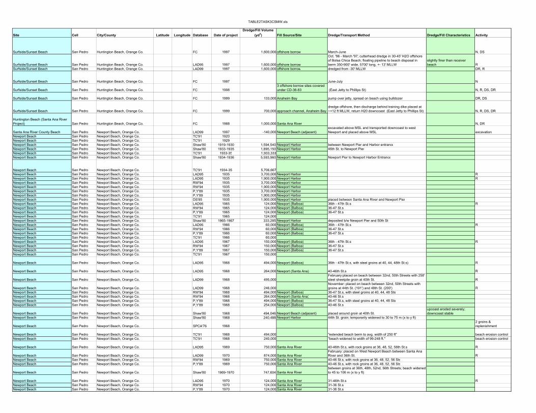
TABLE2TASK3CSMW.xls
Site Cell City/County Latitude Longitude Database Date of projectDredge/Fill Volume
(yd3) Fill Source/Site Dredge/Transport Method Dredge/Fill Characteristics Activity
Surfside/Sunset Beach San Pedro Huntington Beach, Orange Co. FC 1997 1,600,000 offshore borrow March-June N, DS
Surfside/Sunset Beach San Pedro Huntington Beach, Orange Co. LAD95 1997 1,600,000 offshore borrow
Oct. '96 - March '97; cutterhead dredge in 30-45' H2O offshore of Bolsa Chica Beach; floating pipeline to beach disposal in berm 350-900' wide, 5700' long, +- 13' MLLW
slightly finer than receiver beach R
Surfside/Sunset Beach San Pedro Huntington Beach, Orange Co. LAD99 1997 1,600,000 offshore borrow dredged from -30' MLLW DR, R
Surfside/Sunset Beach San Pedro Huntington Beach, Orange Co. FC 1997 June-July N
Surfside/Sunset Beach San Pedro Huntington Beach, Orange Co. FC 19983 offshore borrow sites covered under CD-36-83 (East Jetty to Phillips St) N, R, DS, DR
Surfside/Sunset Beach San Pedro Huntington Beach, Orange Co. FC 1999 133,000 Anaheim Bay pump over jetty, spread on beach using bulldozer DR, DS
Surfside/Sunset Beach San Pedro Huntington Beach, Orange Co. FC 1999 700,000 approach channel, Anaheim Baydredge offshore, then discharge behind training dike placed at ~+12 ft MLLW, return H20 downcoast (East Jetty to Phillips St) N, R, DS, DR
Huntington Beach (Santa Ana River Project) San Pedro Huntington Beach, Orange Co. FC 1988 1,000,000 Santa Ana River N, DR
Santa Ana River County Beach San Pedro Newport Beach, Orange Co. LAD99 1997 -140,000 Newport Beach (adjacent)excavated above MSL and transported downcoast to west Newport and placed above MSL excavation
Newport Beach San Pedro Newport Beach, Orange Co. TC'91 1920Newport Beach San Pedro Newport Beach, Orange Co. TC'91 1929Newport Beach San Pedro Newport Beach, Orange Co. Shaw'80 1919-1930 1,594,540 Newport Harbor between Newport Pier and Harbor entranceNewport Beach San Pedro Newport Beach, Orange Co. Shaw'80 1933-1935 1,895,150 Newport Harbor 46th St. to Newport PierNewport Beach San Pedro Newport Beach, Orange Co. TC'91 1933-35 1,933,333Newport Beach San Pedro Newport Beach, Orange Co. Shaw'80 1934-1936 5,593,960 Newport Harbor Newport Pier to Newport Harbor Entrance
Newport Beach San Pedro Newport Beach, Orange Co. TC'91 1934-35 5,706,667Newport Beach San Pedro Newport Beach, Orange Co. LAD95 1935 3,700,000 Newport Harbor RNewport Beach San Pedro Newport Beach, Orange Co. LAD95 1935 1,900,000 Newport Harbor RNewport Beach San Pedro Newport Beach, Orange Co. RW'94 1935 3,700,000 Newport HarborNewport Beach San Pedro Newport Beach, Orange Co. RW'94 1935 1,900,000 Newport HarborNewport Beach San Pedro Newport Beach, Orange Co. P,Y'89 1935 3,700,000 Newport HarborNewport Beach San Pedro Newport Beach, Orange Co. P,Y'89 1935 1,900,000 Newport HarborNewport Beach San Pedro Newport Beach, Orange Co. DS'85 1935 1,900,000 Newport Harbor placed between Santa Ana River and Newport PierNewport Beach San Pedro Newport Beach, Orange Co. LAD95 1965 124,000 Newport (Balboa) 36th - 47th St.s RNewport Beach San Pedro Newport Beach, Orange Co. RW'94 1965 124,000 Newport (Balboa) 36-47 St.sNewport Beach San Pedro Newport Beach, Orange Co. P,Y'89 1965 124,000 Newport (Balboa) 36-47 St.sNewport Beach San Pedro Newport Beach, Orange Co. TC'91 1965 124,000Newport Beach San Pedro Newport Beach, Orange Co. Shaw'80 1965-1967 333,285 Newport Harbor deposited b/w Newport Pier and 50th St.Newport Beach San Pedro Newport Beach, Orange Co. LAD95 1966 60,000 Newport (Balboa) 36th - 47th St.s RNewport Beach San Pedro Newport Beach, Orange Co. RW'94 1966 60,000 Newport (Balboa) 36-47 St.sNewport Beach San Pedro Newport Beach, Orange Co. P,Y'89 1966 60,000 Newport (Balboa) 36-47 St.sNewport Beach San Pedro Newport Beach, Orange Co. TC'91 1966 60,000Newport Beach San Pedro Newport Beach, Orange Co. LAD95 1967 150,000 Newport (Balboa) 36th - 47th St.s RNewport Beach San Pedro Newport Beach, Orange Co. RW'94 1967 150,000 Newport (Balboa) 36-47 St.sNewport Beach San Pedro Newport Beach, Orange Co. P,Y'89 1967 150,000 Newport (Balboa) 36-47 St.sNewport Beach San Pedro Newport Beach, Orange Co. TC'91 1967 150,000
Newport Beach San Pedro Newport Beach, Orange Co. LAD95 1968 494,000 Newport (Balboa) 36th - 47th St.s, with steel groins at 40, 44, 48th St.s) R
Newport Beach San Pedro Newport Beach, Orange Co. LAD95 1968 264,000 Newport (Santa Ana) 40-46th St.s R
Newport Beach San Pedro Newport Beach, Orange Co. LAD99 1968 495,000February:placed on beach between 32nd, 50th Streets with 258' steel sheetpile groin at 40th St. R
Newport Beach San Pedro Newport Beach, Orange Co. LAD99 1968 246,000November: placed on beach between 32nd, 50th Streets with groins at 44th St. (191') and 48th St. (200') R
Newport Beach San Pedro Newport Beach, Orange Co. RW'94 1968 494,000 Newport (Balboa) 36-47 St.s, with steel groins at 40, 44, 48 StsNewport Beach San Pedro Newport Beach, Orange Co. RW'94 1968 264,000 Newport (Santa Ana) 40-46 St.sNewport Beach San Pedro Newport Beach, Orange Co. P,Y'89 1968 494,000 Newport (Balboa) 36-47 St.s, with steel groins at 40, 44, 48 StsNewport Beach San Pedro Newport Beach, Orange Co. P,Y'89 1968 254,000 Newport (Balboa) 40-46 St.s
Newport Beach San Pedro Newport Beach, Orange Co. Shaw'80 1968 494,046 Newport Beach (adjacent) placed around groin at 40th St.upcoast eroded severely; downcoast stable
Newport Beach San Pedro Newport Beach, Orange Co. Shaw'80 1968 240,488 Newport Harbor 44th St. groin; temporarily widened to 30 to 75 m (x to y ft)
Newport Beach San Pedro Newport Beach, Orange Co. SPCA'76 19682 groins & replenishment
Newport Beach San Pedro Newport Beach, Orange Co. TC'91 1968 494,000 "extended beach berm to avg. width of 250 ft" beach erosion controlNewport Beach San Pedro Newport Beach, Orange Co. TC'91 1968 240,000 "beach widened to width of 99-248 ft." beach erosion control
Newport Beach San Pedro Newport Beach, Orange Co. LAD95 1969 750,000 Santa Ana River 40-46th St.s, with rock groins at 36, 48, 52, 56th St.s R
Newport Beach San Pedro Newport Beach, Orange Co. LAD99 1970 874,000 Santa Ana RiverFebruary: placed on West Newport Beach between Santa Ana River and 36th St. R
Newport Beach San Pedro Newport Beach, Orange Co. RW'94 1969 750,000 Santa Ana River 40-46 St.s, with rock groins at 36, 48, 52, 56 StsNewport Beach San Pedro Newport Beach, Orange Co. P,Y'89 1969 750,000 Santa Ana River 40-46 St.s, with rock groins at 36, 48, 52, 56 Sts
Newport Beach San Pedro Newport Beach, Orange Co. Shaw'80 1969-1970 747,604 Santa Ana Riverbetween groins at 36th, 48th, 52nd, 56th Streets; beach widened to 45 to 106 m (x to y ft)
Newport Beach San Pedro Newport Beach, Orange Co. LAD95 1970 124,000 Santa Ana River 31-46th St.s RNewport Beach San Pedro Newport Beach, Orange Co. RW'94 1970 124,000 Santa Ana River 31-36 St.sNewport Beach San Pedro Newport Beach, Orange Co. P,Y'89 1970 124,000 Santa Ana River 31-36 St.s

TABLE2TASK3CSMW.xls
Applicant/SponsorDuration of Fill/Performance Funding Environmental Effects Monitoring Notes Ref. ID Permit/FC Ref. See Also
USACOE single-point discharge to minimize impacts to grunion and least terns.
project extension; placement limited to non-public portion of beach; in addition, turbidity monitoring to determine efficacy of filter system CD-028-97 ND-58-95; CD-27-89
USACOE source: USACOE-LA 1995 (Surfside-Sunset/Newport)USACOE Stage 10 source: USACOE-LA 1999 CCSTWS Chapter 4 draft
USACOEexcavation of settling pond and discharge of sand on public beach with filter fabrics to minimize turbidity
turbidity monitoring; change in project due to unacceptable turbidity in previous design
modification to previously-approved beach replenishment project including relocation of discharge site, modification of discharge method, and extension of time. CD-067-97
CD-27-89; CD-28-97; ND-58-95; ND-03-97; ND-20-97
USACOE project updates timing of CD-36-83; feeder beach area is 1700 ft long CD-11-82; CD-36-83
USACOE CD-065-99CD-21-88; CD-27-89; CD-52-90; CD-34-90
USACOE
to minimize grunion impacts: 1) single discharge point; 2) material restricted to feeder beach; 3) no discharge after 3/1/84; 4) discharge behind dike on backbeach updates/supplements CD-12-82 CD-012-84
USACOECOE will monitor turbidity and its effects on least terns in consultation w/ USFWS CD-029-88 CD-13-81
USACOE Stage 10 source: USACOE-LA 1999 CCSTWS Chapter 4 draftsource: Shaw 1980 source: Shaw 1980
source: Shaw 1980
loss of 70,000 cy as of 1936; loss of 40,000 cy as of 1937; source: Shaw 1980 ; USACOE-LA 1959 (Orange Co.)
USACOE source: USACOE-LA 1995 (Surfside-Sunset/ Newport)USACOE source: USACOE-LA 1995 (Surfside-Sunset/ Newport)
USACOE source: USACOE-LA 1995 (Surfside-Sunset/ Newport)
source: USACOE-LA 1969
USACOE source: USACOE-LA 1995 (Surfside-Sunset/ Newport)
source: USACOE-LA 1969USACOE source: USACOE-LA 1995 (Surfside-Sunset/ Newport)
1965-68: 30 ft./yr avg source: USACOE-LA 1969
USACOEStage 2, Public Law 87-874 1962 source: USACOE-LA 1995 (Surfside-Sunset/ Newport)
USACOEStage 2, Public Law 87-874 1962 source: USACOE-LA 1995 (Surfside-Sunset/ Newport)
USACOE Stage 2 source: USACOE-LA 1999 CCSTWS Chapter 4 draft
USACOE Stage 2 source: USACOE-LA 1999 CCSTWS Chapter 4 draft
$700,000 source: CA-DNOD 1976upcoast portion: severe erosion
$700,000 (2 groins plus fill) source: USACOE-LA 1969; Shaw 1980
source: USACOE-LA 1969
USACOEStage 3, Public Law 87-874 1962 source: USACOE-LA 1995 (Surfside-Sunset/ Newport)
USACOE Stage 3 source: USACOE-LA 1999 CCSTWS Chapter 4 draft
USACOEStage 3, Public Law 87-874 1962 source: USACOE-LA 1995 (Surfside-Sunset/ Newport)

TABLE2TASK3CSMW.xls
Site Cell City/County Latitude Longitude Database Date of projectDredge/Fill Volume
(yd3) Fill Source/Site Dredge/Transport Method Dredge/Fill Characteristics Activity
Newport Beach San Pedro Newport Beach, Orange Co. SPCA'76 19704 groins & replenishment
Newport Beach San Pedro Newport Beach, Orange Co. TC'91 1970 900,000 Santa Ana River 1.6 mi length; 150-360 ft wide
beach erosion control/flood control spoils
Newport Beach San Pedro Newport Beach, Orange Co. LAD95 1973 350,000 Santa Ana River 28-48ths Sts., with rock groins at 28, 32, 40, 48th St.s R
Newport Beach San Pedro Newport Beach, Orange Co. LAD99 1973 358,000
March: added on to existing groins at 40th (480') and 44th (470') Streets with rock; new rubblemound groins at 32nd (540') and 28th (600') Streets. Replenished b/w 32nd, 28th Streets R
Newport Beach San Pedro Newport Beach, Orange Co. Shaw'80 1973 355,504 Santa Ana River between groins at 28th and 32nd StreetsNewport Beach San Pedro Newport Beach, Orange Co. RW'94 1973 358,000 Santa Ana River 28-48 St.s, with rock groins at 40, 48, 28, 32 StsNewport Beach San Pedro Newport Beach, Orange Co. P,Y'89 1973 358,000 Santa Ana River 28-48 St.s, with rock groins at 40, 48, 28, 32 Sts
Newport Beach San Pedro Newport Beach, Orange Co. SPCA'76 19733 groins & replenishment
Newport Beach San Pedro Newport Beach, Orange Co. TC'91 1973 358,000 beach erosion controlNewport Beach San Pedro Newport Beach, Orange Co. LAD95 1992 1,227,000 Santa Ana River nearshore deposition R, nearshore
Newport Beach San Pedro Newport Beach, Orange Co. RW'94 1992 1,300,000 Santa Ana Riverdredged from river channel; sieved; placed 300 ft offshore, 20 ft deep water, 3000 ft long mound
fine to medium sand with some rocks dredging
Newport Beach San Pedro Newport Beach, Orange Co. ACOE95 1992 1,227,000 Santa Ana River placed in nearshore
Newport Beach San Pedro Newport Beach, Orange Co. LAD95 1997 140,000 Santa Ana County Beach Park
proposed for '96/'97; transport via trucks from beach source site to disposal site 2000' downcoast. Fill characteristics: +2' to -13' MLLW same as receiver beach DR, R
Newport Beach San Pedro Newport Beach, Orange Co. LAD99 1997 140,000 Santa Ana County Beach Parkexcavated from above MSL, transported downcoast and placed above MSL excavation
Corona State Beach San Pedro Newport Beach, Orange Co. ACOE93 1935 ? Newport Bay entrance channel N
Doheny State Beach Park Oceanside Dana Point City, Orange Co. TC'91 1928-30 "considerable amount"upland excavation spoils
Doheny State Beach Park Oceanside Dana Point City, Orange Co. TC'89 1930 RDoheny State Beach Park Oceanside Dana Point City, Orange Co. SPCA'76 1964 groin and fill
Doheny State Beach Park Oceanside Dana Point City, Orange Co. RW'94 1964 94,000 San Juan Creek 1400' pocket beach created between N training wall of creek and Dana Point Harbor E breakwater
Doheny State Beach Park Oceanside Dana Point City, Orange Co. TC'91 1964 94,000 0.3 mi. long; 100-300 ft wide beach beach erosion control
Doheny State Beach Park Oceanside Dana Point City, Orange Co. NRC'94 1964 94,104~1400 ft. long; constructed with sand tight rubblemound jetty to Dana Point Harbor DS
Doheny State Beach Park Oceanside Dana Point City, Orange Co. Shaw'80 1964 94104 San Juan Creek placed upcoast of creek and retained by groin (N training wall)
Doheny State Beach Park Oceanside Dana Point City, Orange Co. RW'94 1966 690,000Camp Pendelton terrace deposits hauled by truck; placed E from San Juan Creek for ~4500 ft
Doheny State Beach Park Oceanside Dana Point City, Orange Co. SPCA'76 1966 replenishment
Doheny State Beach Park Oceanside Dana Point City, Orange Co. TC'91 1966 840,000 0.9 mi. long; 100-300 ft wide beach beach erosion controlDoheny State Beach Park Oceanside Dana Point City, Orange Co. Shaw'80 1966 840401 San Juan Creek downcoast bank creek migrated southDoheny State Beach Park Oceanside Dana Point City, Orange Co. Shaw'80 1969 364653 San Juan Creek upcoast of creekDoheny State Beach Park Oceanside Dana Point City, Orange Co. TC'91 1969 365,000
Doheny State Beach Park Oceanside Dana Point City, Orange Co. RW'94 1969 212,000San Juan Creek flood control restoration dredging
Doheny State Beach Park Oceanside Dana Point City, Orange Co. TC'91 1970 128,000Doheny State Beach Park Oceanside Dana Point City, Orange Co. TC'91 1970 906,667Capistrano Beach Park (nearshore) Oceanside Dana Point City, Orange Co. Shaw'80 1970 125472 Dana Point Harbor deposited downcoast of harbor as surfing reef
Capistrano County Beach (nearshore) Oceanside Dana Point City, Orange Co. CDP 1997 35,500Dana Point Harbor (West Breakwater) 96% sand DR, N
San Onofre State Beach Oceanside San Onofre, San Diego County TC'89occasionally since 1964 SONGS power plant excavation deposited as hump in 1984 R
San Onofre State Beach South Oceanside San Clemente, San Diego County RW'94 1964 306,000 SONGS power plant excavation placed SE of SONGS to nourish beachSan Onofre State Beach Oceanside San Onofre, San Diego County TC'91 1964 204,000 upland excavation fillSan Onofre State Beach Oceanside San Onofre, San Diego Co. Shaw'80 1964 203892 SONGS bluff excavation placed south of pipelineSan Onofre State Beach Oceanside San Onofre, San Diego Co. Shaw'80 1966 254865 SONGS bluff excavation placed south of pipelineSan Onofre State Beach Oceanside San Onofre, San Diego County TC'91 1966 255,000 upland excavation fillSan Onofre State Beach Oceanside San Onofre, San Diego County TC'91 1967 10,000 upland excavation fillSan Onofre State Beach Oceanside San Onofre, San Diego Co. Shaw'80 1967 10456 SONGS bluff excavation placed south of pipelineSan Onofre State Beach Oceanside San Onofre, San Diego Co. Shaw'80 1974 1601075 offshore placed south of pipeline as nourishmentSan Onofre State Beach Oceanside San Onofre, San Diego County TC'91 1974 1,605,000San Onofre State Beach Oceanside San Onofre, San Diego County TC'91 1977 220,000 upland excavation fillSan Onofre State Beach Oceanside San Onofre, San Diego Co. Shaw'80 1977 219576 offshore placed south of pipeline as nourishmentSan Onofre State Beach Oceanside San Onofre, San Diego County TC'91 1978 46,000 upland excavation fillSan Onofre State Beach Oceanside San Onofre, San Diego Co. Shaw'80 1978 45745 offshore placed south of pipeline as nourishmentSan Onofre State Beach Oceanside San Onofre, San Diego County RW'94 1977-1980 270,000 offshore placed SE of SONGS to nourish beach
San Onofre State Beach Oceanside San Onofre, San Diego County TC'91 1984 - "laydown pad released"
Oceanside City Beach Oceanside Oceanside, San Diego County TC'91 1944 1,530,667 contained cobbles navigation byproduct
Oceanside City Beach Oceanside Oceanside, San Diego Co. Shaw'80 1958 799884Del Mar Boat Basin and Oceanside Harbor disposed 6th to 9th St.
lost immediately; migrated North
Oceanside City Beach Oceanside Oceanside, San Diego Co. Shaw'80 1960 41824Del Mar Boat Basin and Oceanside Harbor disposed 6th to 9th St. eroded
Oceanside City Beach Oceanside Oceanside, San Diego County TC'91 1960 17,500 navigation byproductOceanside City Beach Oceanside Oceanside, San Diego County TC'91 1960 23,700 navigation byproduct

TABLE2TASK3CSMW.xls
Applicant/SponsorDuration of Fill/Performance Funding Environmental Effects Monitoring Notes Ref. ID Permit/FC Ref. See Also
$600,000 source: CA-DNOD 1976
$600,000 (4 groins and fill)
source: USACOE-LA 1986 (report); CA Dept of Nav and Ocean Dev 1976; Spencer 1985
USACOEStage 4b & 5, Public Law 87-874 1962 source: USACOE-LA 1995 (Surfside-Sunset/ Newport)
USACOE Stage 4b & 5 source: USACOE-LA 1999 CCSTWS Chapter 4 draft
$1,100,000 source: CA-DNOD 1976beach is stable source: USACOE-LA 1986 (oral and report)
USACOE source: USACOE-LA 1995 (Surfside-Sunset/ Newport)
USACOE
proposed Stage 10, Public Law 87-874 1962
USACOE Stage 10 source: USACOE-LA 1999 CCSTWS Chapter 4 draftUSACOE source: USACOE-LA 1993 "Existing State of the Orange Co. Coast"
source: USACOE-LA 1987(Oceanside); Shaw 1980replenished as byproduct of upland excavation operations
$247,000 source: CA Dept of Nav and Ocean Dev 1976source: Price, R.C., 1966. Statement of the CA Dept. of Water Resources. Shore and Beach, 34(1):22-32.
$247,000 (groin and fill)
source: USACOE-LA 1978 (Doheny); CA Dept of Nav and Ocean Dev 1976; Shaw 1980source: Price, R.C., 1966. Statement of the CA Dept. of Water Resources. Shore and Beach, 34(1):22-32.
$713,000 source: CA Dept of Nav and Ocean Dev 197612/66 and 1/67: groin failed--stream runoff $713,000
source: USACOE-LA 1978 (Doheny), 1986 (report); CA Dept of Nav and Ocean Dev 1976; Shaw 1980
source: USACOE-LA 1987 (Oceanside)
source: USA/CESPL and CA/DNOD 1978 inspection tour reportsource: USACOE-LA 1987 (Oceanside); Shaw 1980source: USACOE-LA 1987 (Oceanside)
County of Orangeno disposal during grunion spawning; kelp beds and reefs in Doheny Marine Life Refuge
monitoring plan; turbidity must remain less than 20% above natural non-storm conditions (0-50 NTUs) and dissolved O2 can't drop below 5.0 mg/l 15' depth, 1000' long 5-97-232 FC CC-138-97
substantial sand "hump" migrated downcoast, preceded by erosional wave larger in magnitude than hump itself by Scripps; Grove et al. 1987
source: Flick and Wanetick, 1989, SIO Ref. No. 89-20, 51 pp.source: USACOE-LA 1987 (Oceanside)
source: USACOE-LA 1987 (Oceanside)source: USACOE-LA 1987 (Oceanside)
source: USACOE-LA 1987 (Oceanside)source: USACOE-LA 1987 (Oceanside)
source: USACOE-LA 1987 (Oceanside)
source: Flick and Wanetick, 1989, SIO Ref. No. 89-20, 51 pp."1987: Sand hump migrated ~2m/day. Extremely rapid decay of volume (decreased to 1/2 every 200 days). Migrating hump preceded by erosion wave (8 km long in >2 years)…" source: USACOE-LA 1987 (Oceanside); Grove et al. 1987
"held them for a year or two" source: USACOE-LA 1986 (oral); 1987 (Oceanside)
eroded source: USACOE-LA 1987 (Oceanside); Shaw 1980eroded source: USACOE-LA 1987 (Oceanside)

TABLE2TASK3CSMW.xls
Site Cell City/County Latitude Longitude Database Date of projectDredge/Fill Volume
(yd3) Fill Source/Site Dredge/Transport Method Dredge/Fill Characteristics Activity
Oceanside City Beach Oceanside Oceanside, San Diego Co. Shaw'80 1961 482283Del Mar Boat Basin and Oceanside Harbor disposed 6th to 9th St. eroded 2.5 - 6.5 m/yr in width
Oceanside City Beach Oceanside Oceanside, San Diego County TC'91 1961 222,350 navigation byproductOceanside City Beach Oceanside Oceanside, San Diego County TC'91 1961 265,333 navigation byproductOceanside Harbor Oceanside Oceanside, San Diego County RF '93 1961 3,921,000 placed on area beaches DR
Oceanside City Beach Oceanside Oceanside, San Diego Co. Shaw'80 1963 3809905Del Mar Boat Basin and Oceanside Harbor 9th St. eroded immediately contained cobbles
Oceanside City Beach Oceanside Oceanside, San Diego County TC'91 1963 265,333 cobblesbeach erosion control/ harbor construction
Oceanside City Beach Oceanside Oceanside, San Diego County SPCA'76 1963groin and replenishment
Oceanside City Beach Oceanside Oceanside, San Diego Co. Shaw'80 1965 111095Del Mar Boat Basin and Oceanside Harbor disposed 9th to 3rd St. eroded
Oceanside City Beach Oceanside Oceanside, San Diego County RW'94 1965 110,000 Oceanside Harbor
Oceanside City Beach Oceanside Oceanside, San Diego Co. Shaw'80 1966 683561Del Mar Boat Basin and Oceanside Harbor disposed 3rd to Minn. Ave eroded
Oceanside City Beach Oceanside Oceanside, San Diego County RW'94 1966 690,000 Oceanside HarborOceanside City Beach Oceanside Oceanside, San Diego County TC'91 1966 690,000 harbor bypassing
Oceanside City Beach Oceanside Oceanside, San Diego Co. Shaw'80 1967 177752Del Mar Boat Basin and Oceanside Harbor disposed 3rd to Tyson St. eroded
Oceanside City Beach Oceanside Oceanside, San Diego County RW'94 1967 180,000 Oceanside HarborOceanside City Beach Oceanside Oceanside, San Diego County TC'91 1967 177,900 harbor bypassing
Oceanside City Beach Oceanside Oceanside, San Diego Co. Shaw'80 1968 433924Del Mar Boat Basin and Oceanside Harbor disposed San Luis Rey to Wisconsin Ave eroded
Oceanside City Beach Oceanside Oceanside, San Diego County RW'94 1968 430,000 Oceanside HarborOceanside City Beach Oceanside Oceanside, San Diego County TC'91 1968 433,900 harbor bypassing
Oceanside City Beach Oceanside Oceanside, San Diego Co. Shaw'80 1969 352890Del Mar Boat Basin and Oceanside Harbor disposed San Luis Rey to 3rd St eroded
Oceanside City Beach Oceanside Oceanside, San Diego County RW'94 1969 350,000 Oceanside HarborOceanside City Beach Oceanside Oceanside, San Diego County TC'91 1969 353,000 harbor bypassing
Oceanside City Beach Oceanside Oceanside, San Diego Co. Shaw'80 1971 551554Del Mar Boat Basin and Oceanside Harbor disposed 3rd St. to Wisconsin Ave eroded
Oceanside City Beach Oceanside Oceanside, San Diego County RW'94 1971 550,000 Oceanside HarborOceanside City Beach Oceanside Oceanside, San Diego County TC'91 1971 551,750 harbor bypassing
Oceanside City Beach Oceanside Oceanside, San Diego Co. Shaw'80 1973 433924Del Mar Boat Basin and Oceanside Harbor disposed Tyson to Hay St eroded
Oceanside City Beach Oceanside Oceanside, San Diego County RW'94 1973 440,000 Oceanside Harbor
Oceanside City Beach Oceanside Oceanside, San Diego Co. Shaw'80 1975 559396Del Mar Boat Basin and Oceanside Harbor disposed Pine to Witherby St. eroded
Oceanside City Beach Oceanside Oceanside, San Diego County RW'94 1975 560,000 Oceanside HarborOceanside City Beach Oceanside Oceanside, San Diego County TC'91 1975 559,750 harbor bypassing
Oceanside City Beach Oceanside Oceanside, San Diego Co. Shaw'80 1976 550247Del Mar Boat Basin and Oceanside Harbor disposed Ash to Witherby St. eroded
Oceanside City Beach Oceanside Oceanside, San Diego County RW'94 1976 550,000 Oceanside HarborOceanside City Beach Oceanside Oceanside, San Diego County TC'91 1976 550,000 harbor bypassing
Oceanside City Beach Oceanside Oceanside, San Diego County RW'94 1977 320,000 Oceanside Harbor
Oceanside City Beach Oceanside Oceanside, San Diego Co. Shaw'80 1978 318908Del Mar Boat Basin and Oceanside Harbor disposed Ash to Witherby St. eroded
Oceanside City Beach Oceanside Oceanside, San Diego County TC'91 1978 318,550 February cobbles harbor bypassing
Oceanside City Beach Oceanside Oceanside, San Diego County RW'94 1981 460,000 Oceanside HarborOceanside City Beach Oceanside Oceanside, San Diego County RW'94 1981 400,000 nearshore off Oceanside placed SE from Harbor on beachOceanside City Beach Oceanside Oceanside, San Diego County TC'91 1981 463,000 1.5 miles long not coarse enough harbor bypassing
Oceanside City Beach Oceanside Oceanside, San Diego County TC'91 1982 920,000harbor bypassing/ beach erosion control
Oceanside City Beach Oceanside Oceanside, San Diego County RF '93 1982 1,300,000 San Luis Rey River bed trucked R
Oceanside City Beach Oceanside Oceanside, San Diego County CE'99 1986 450,000 Oceanside harbor placed on beach near Tyson St. DR, DS Oceanside City Beach Oceanside Oceanside, San Diego County ACOE'90 1986 350,000 Oceanside harbor beach fill DR, DS Oceanside City Beach Oceanside Oceanside, San Diego County ACOE'90 1988 257,000 Oceanside harbor beach fill DR, DS
Oceanside City Beach Oceanside Oceanside, San Diego County TC'891944 (frequently
since)harbor excavation, harbor bypassing R
Oceanside City Beach Oceanside Oceanside, San Diego County TC'91 1951-58 700,000nav. byproduct/ beach erosion control
Oceanside City Beach Oceanside Oceanside, San Diego County RW'94 1962-1963 3,800,000 Oceanside Harbor excavationOceanside City Beach Oceanside Oceanside, San Diego County RW'94 1965-1981 ~5,000,000 sand and riverine cobbles
Oceanside City Beach Oceanside Oceanside, San Diego County FC 1981 (12 mos) 800,000
San Luis Rey River (Whelan Lake to Murray Rd) (San Luis Rey Flood Control Project)
transported via surface roads, placed using bulldozers, graded, above and below MLLW datum
medium grain size (95% on 200 sieve) R
Oceanside City Beach Oceanside Oceanside, San Diego County RW'94 1981-1982 923,000 San Luis Rey riverbed trucked from site 7 miles from coast
Oceanside City Beach Oceanside Oceanside, San Diego County FC1983 August to
November 450,000Camp Pendelton/Oceanside Harbor
hydraulic pipeline dredge, pump, discharged in surf zone (Municipal Pier to Forster St.) silty sand R, DS, DR

TABLE2TASK3CSMW.xls
Applicant/SponsorDuration of Fill/Performance Funding Environmental Effects Monitoring Notes Ref. ID Permit/FC Ref. See Also
eroded source: USACOE-LA 1987 (Oceanside); Shaw 1980eroded 8-22 ft/yr source: Shaw 1980
all fill lost by 1968 source: USACOE-CERC 1984; Moffat and Nichol 1983; Shaw 1980
$1,785,000 source: CA-DNOD 1976
source: USA/CESPL, 1987, Oceanside Littoral Cell Preliminary Sediment Budget Report, prepared by Tekmarine, inc, CCSTWS87-4
source: USA/CESPL, 1987, Oceanside Littoral Cell Preliminary Sediment Budget Report, prepared by Tekmarine, inc, CCSTWS87-4
eroded source: USACOE-LA 1987 (Oceanside); Shaw 1980
source: USA/CESPL, 1987, Oceanside Littoral Cell Preliminary Sediment Budget Report, prepared by Tekmarine, inc, CCSTWS87-4
eroded source: USACOE-LA 1987 (Oceanside); Shaw 1980
source: USA/CESPL, 1987, Oceanside Littoral Cell Preliminary Sediment Budget Report, prepared by Tekmarine, inc, CCSTWS87-4
eroded source: USACOE-LA 1987 (Oceanside); Shaw 1980
source: USA/CESPL, 1987, Oceanside Littoral Cell Preliminary Sediment Budget Report, prepared by Tekmarine, inc, CCSTWS87-4
eroded source: USACOE-LA 1987 (Oceanside); Shaw 1980
source: USA/CESPL, 1987, Oceanside Littoral Cell Preliminary Sediment Budget Report, prepared by Tekmarine, inc, CCSTWS87-4
eroded source: USACOE-LA 1987 (Oceanside); Shaw 1980
source: USA/CESPL, 1987, Oceanside Littoral Cell Preliminary Sediment Budget Report, prepared by Tekmarine, inc, CCSTWS87-4
source: USA/CESPL, 1987, Oceanside Littoral Cell Preliminary Sediment Budget Report, prepared by Tekmarine, inc, CCSTWS87-4
eroded source: USACOE-LA 1987 (Oceanside); Shaw 1980
source: USA/CESPL, 1987, Oceanside Littoral Cell Preliminary Sediment Budget Report, prepared by Tekmarine, inc, CCSTWS87-4
eroded source: USACOE-LA 1987 (Oceanside); Shaw 1980source: USA/CESPL, 1987, Oceanside Littoral Cell Preliminary Sediment Budget Report, prepared by Tekmarine, inc, CCSTWS87-4
eroded 2/78 source: USACOE-LA 1987 (Oceanside) (Coastal Cliff Sediments)source: USA/CESPL, 1987, Oceanside Littoral Cell Preliminary Sediment Budget Report, prepared by Tekmarine, inc, CCSTWS87-4source: Ryan, Joe, personal communications with Weigelsource: USACOE-LA 1987 (Oceanside)
one season (expected 2-3 seasons) $4,000,000 bypassing inadequate
source: USACOE-LA 1987 (Oceanside); Spencer 1987; USACOE-CERC 1984; Moffat and Nichol Engineers 1983
source: Coastal Environments 1999 Agua Hedionda Lagoon studyUSACOE lowest cost disp. Alt.USACOE lowest cost disp. Alt.
"Each time the fill has eroded, often quite rapidly."total loss +300,000 add'l by 12/59 fill migrated upcoast into nav. Channel source: USACOE-LA 1960; Shaw 1980
source: USACOE-LA 1987 (Oceanside); Shaw 1980
USACOE
Congressional authorization for <$3,000,000 none CD-006-81
source: Bagley and Whitson, Shore and Beach 1982
USACOEdredging: elimination of benthic organisms. DR and N: turbidity; timed after nesting season 3 prior coastal permits for same activity CD-020-83 CD-6-81; Appeal #218-80

TABLE2TASK3CSMW.xls
Site Cell City/County Latitude Longitude Database Date of projectDredge/Fill Volume
(yd3) Fill Source/Site Dredge/Transport Method Dredge/Fill Characteristics Activity
Oceanside City Beach Oceanside Oceanside, San Diego County FC 1984-1989 400,000
sediment bypasses Oceanside Harbor-one beach site and two harbor sites jet-pumped sand bypassing with underwater slurry pipeline
sand and silt, clean and dirty, light and dark R, DR
Oceanside City Beach Oceanside Oceanside, San Diego County FC
3/15/90 - 7/30/90; 9/15/92 - 3/15/93; 9/15/94 - 3/15/95; 9/15/96 - 3/15/97 500,000
Oceanside Harbor entrance and navigation channels and sand trap
hydraulic dredge, buried/exposed pipeline (S of Oceanside Public Pier and S of Tyler St.) DS, DR
Oceanside City Beach Oceanside Oceanside, San Diego County FC 9/15/94 - 3/15/95 400,000Oceanside Harbor (entrance, navagation channels, sand trap)
hydraulic or hopper dredge (south of Oceanside Pier) (beach or nearshore disposal) R, DS, DR
Oceanside City Beach Oceanside Oceanside, San Diego County FC as of 1-11-98 102,000San Diego Bay main channel (dredge area 1) sand with munitions DR, DS, R
Oceanside City Beach Oceanside Oceanside, San Diego County Mar-00 Oceanside Harbor
Oceanside City Beach* Oceanside Oceanside, San Diego County 8/24/01 - 9/23/01 421,000 Offshore Trailing suction hopper dredgeMedian grain size of fill = 0.62 mm N
North Carlsbad Oceanside Carlsbad, San Diego County 7/6/01 - 8/2/01 225,000 Offshore Trailing suction hopper dredgeMedian grain size of fill = 0.14-0.62 mm N
Carlsbad State Beach Park Oceanside Carlsbad, San Diego County TC'91 1954 4,080,000 1.0 mile long, widened beach 396 ftCarlsbad State Beach Park Oceanside Carlsbad, San Diego County TC'91 1955 111,000Carlsbad State Beach Park Oceanside Carlsbad, San Diego County TC'91 1957 232,000Carlsbad State Beach Park Oceanside Carlsbad, San Diego County TC'91 1960 371,000Carlsbad State Beach Park Oceanside Carlsbad, San Diego County TC'91 1961 225,000Carlsbad State Beach Park Oceanside Carlsbad, San Diego County TC'91 1963 308,000Carlsbad State Beach Park Oceanside Carlsbad, San Diego County TC'91 1965 223,000Carlsbad State Beach Park Oceanside Carlsbad, San Diego County TC'91 1967 160,000Carlsbad State Beach Park Oceanside Carlsbad, San Diego County TC'91 1969 97,000Carlsbad State Beach Park Oceanside Carlsbad, San Diego County TC'91 1972 200,000Carlsbad State Beach Park Oceanside Carlsbad, San Diego County TC'91 1974 341,000Carlsbad State Beach Park Oceanside Carlsbad, San Diego County TC'91 1976 392,000
Carlsbad State Beach Park Oceanside Carlsbad, San Diego Co. Shaw'80 1954 3999420 Agua Hedionda Lagoonplaced from 1060 m upcoast of mouth to 600 m S of outlet; widened beach avg. 30m (x ft)
Carlsbad State Beach Park Oceanside Carlsbad, San Diego Co. Shaw'80 1955 111095 Agua Hedionda Lagoon placed to south of Lagoon outletCarlsbad State Beach Park Oceanside Carlsbad, San Diego Co. Shaw'80 1957 231339 Agua Hedionda Lagoon placed to south of Lagoon outletCarlsbad State Beach Park Oceanside Carlsbad, San Diego Co. Shaw'80 1960 369881 Agua Hedionda Lagoon placed to south of Lagoon outletCarlsbad State Beach Park Oceanside Carlsbad, San Diego Co. Shaw'80 1961 224804 Agua Hedionda Lagoon placed to south of Lagoon outletCarlsbad State Beach Park Oceanside Carlsbad, San Diego Co. Shaw'80 1963 307145 Agua Hedionda Lagoon placed to south of Lagoon outletCarlsbad State Beach Park Oceanside Carlsbad, San Diego Co. Shaw'80 1965 222190 Agua Hedionda Lagoon placed to south of Lagoon outletCarlsbad State Beach Park Oceanside Carlsbad, San Diego Co. Shaw'80 1967 159454 Agua Hedionda Lagoon placed to south of Lagoon outletCarlsbad State Beach Park Oceanside Carlsbad, San Diego Co. Shaw'80 1969 96718 Agua Hedionda Lagoon placed to south of Lagoon outletCarlsbad State Beach Park Oceanside Carlsbad, San Diego Co. Shaw'80 1972 199971 Agua Hedionda Lagoon placed to N and S of lagoon outletCarlsbad State Beach Park Oceanside Carlsbad, San Diego Co. Shaw'80 1974 339820 Agua Hedionda Lagoon placed to N and S of lagoon outletCarlsbad State Beach Park Oceanside Carlsbad, San Diego Co. Shaw'80 1976 390793 Agua Hedionda Lagoon placed to N and S of lagoon outletCarlsbad State Beach Park Oceanside Carlsbad, San Diego Co. Shaw'80 1979 418240 Agua Hedionda Lagoon placed to N and S of lagoon outlet
Carlsbad State Beach Park Oceanside Carlsbad, San Diego County TC'91 1979 419,000Carlsbad State Beach Park Oceanside Carlsbad, San Diego County TC'91 1979 430,667
Carlsbad State Beach Park Oceanside Carlsbad, San Diego County TC'89frequently since
1944 Agua Hedionda Lagoon R
Carlsbad State Beach Park Oceanside Carlsbad, San Diego County RW'94 1954 ~4,000,000 Agua Hedionda Lagoonexcavated for San Diego G&E Co. plant; placed from 3500 ft N of lagoon entrance jetties to 2000 ft S of discharge jetties
Carlsbad State Beach Park Oceanside Carlsbad, San Diego County RW'94 1955 110,000 Agua Hedionda Lagoonpumped as slurry into surf zone; placed downdrift of discharge jetties
Carlsbad State Beach Park Oceanside Carlsbad, San Diego County RW'94 1957 230,000 Agua Hedionda Lagoonpumped as slurry into surf zone; placed downdrift of discharge jetties
Carlsbad State Beach Park Oceanside Carlsbad, San Diego County RW'94 1960 370,000 Agua Hedionda Lagoonpumped as slurry into surf zone; placed downdrift of discharge jetties
Carlsbad State Beach Park Oceanside Carlsbad, San Diego County RW'94 1961 225,000 Agua Hedionda Lagoonpumped as slurry into surf zone; placed downdrift of discharge jetties
Carlsbad State Beach Park Oceanside Carlsbad, San Diego County RW'94 1963 307,000 Agua Hedionda Lagoonpumped as slurry into surf zone; placed downdrift of discharge jetties
Carlsbad State Beach Park Oceanside Carlsbad, San Diego County RW'94 1965 222,000 Agua Hedionda Lagoonpumped as slurry into surf zone; placed downdrift of discharge jetties
Carlsbad State Beach Park Oceanside Carlsbad, San Diego County RW'94 1967 159,000 Agua Hedionda Lagoonpumped as slurry into surf zone; placed downdrift of discharge jetties
Carlsbad State Beach Park Oceanside Carlsbad, San Diego County RW'94 1969 97,000 Agua Hedionda Lagoonpumped as slurry into surf zone; placed downdrift of discharge jetties
Carlsbad State Beach Park Oceanside Carlsbad, San Diego County RW'94 1972 200,000 Agua Hedionda Lagoonpumped as slurry; placed downdrift and updrift of discharge jetties
Carlsbad State Beach Park Oceanside Carlsbad, San Diego County RW'94 1974 340,000 Agua Hedionda Lagoonpumped as slurry; placed downdrift and updrift of discharge jetties
Carlsbad State Beach Park Oceanside Carlsbad, San Diego County RW'94 1976 391,000 Agua Hedionda Lagoonpumped as slurry; placed downdrift and updrift of discharge jetties
Carlsbad State Beach Park Oceanside Carlsbad, San Diego County RW'94 1979 418,000 Agua Hedionda Lagoonpumped as slurry; placed downdrift and updrift of discharge jetties
Carlsbad State Beach Park Oceanside Carlsbad, San Diego County RW'94 1981 235,000 Agua Hedionda Lagoon pumped as slurry
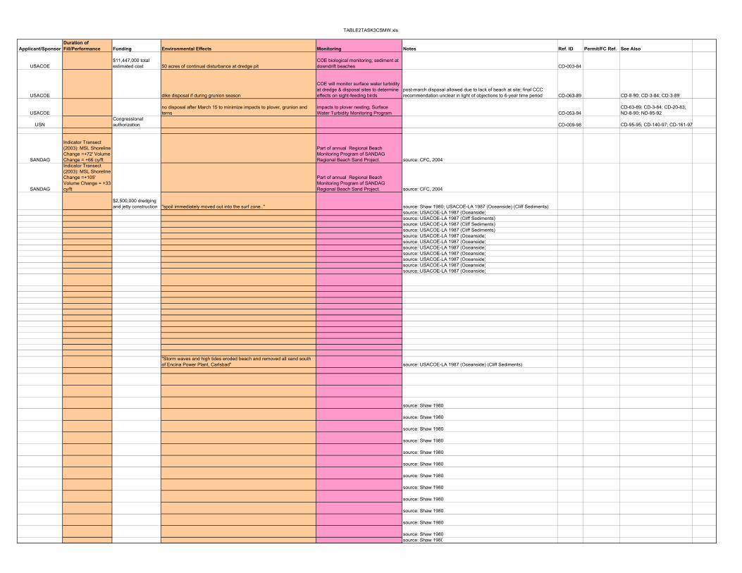
TABLE2TASK3CSMW.xls
Applicant/SponsorDuration of Fill/Performance Funding Environmental Effects Monitoring Notes Ref. ID Permit/FC Ref. See Also
USACOE$11,447,000 total estimated cost 50 acres of continual disturbance at dredge pit
COE biological monitoring; sediment at downdrift beaches CD-003-84
USACOE dike disposal if during grunion season
COE will monitor surface water turbidity at dredge & disposal sites to determine effects on sight-feeding birds
post-march disposal allowed due to lack of beach at site; final CCC recommendation unclear in light of objections to 6-year time period CD-063-89 CD-8-90; CD-3-84; CD-3-89
USACOEno disposal after March 15 to minimize impacts to plover, grunion and terns
impacts to plover nesting; Surface Water Turbidity Monitoring Program CD-053-94
CD-63-89; CD-3-84; CD-20-83; ND-8-90; ND-95-92
USNCongressional authorization CD-009-98 CD-95-95; CD-140-97; CD-161-97
SANDAG
Indicator Transect (2003): MSL Shoreline Change =+72' Volume Change = +66 cy/ft
Part of annual Regional Beach Monitoring Program of SANDAG Regional Beach Sand Project. source: CFC, 2004
SANDAG
Indicator Transect (2003): MSL Shoreline Change =+105' Volume Change = +33 cy/ft
Part of annual Regional Beach Monitoring Program of SANDAG Regional Beach Sand Project. source: CFC, 2004
$2,500,000 dredging and jetty construction "spoil immediately moved out into the surf zone.." source: Shaw 1980; USACOE-LA 1987 (Oceanside) (Cliff Sediments)
source: USACOE-LA 1987 (Oceanside)source: USACOE-LA 1987 (Cliff Sediments)source: USACOE-LA 1987 (Cliff Sediments)source: USACOE-LA 1987 (Cliff Sediments)source: USACOE-LA 1987 (Oceanside)source: USACOE-LA 1987 (Oceanside)source: USACOE-LA 1987 (Oceanside)source: USACOE-LA 1987 (Oceanside)source: USACOE-LA 1987 (Oceanside)source: USACOE-LA 1987 (Oceanside)source: USACOE-LA 1987 (Oceanside)
"Storm waves and high tides eroded beach and removed all sand south of Encina Power Plant, Carlsbad" source: USACOE-LA 1987 (Oceanside) (Cliff Sediments)
source: Shaw 1980
source: Shaw 1980
source: Shaw 1980
source: Shaw 1980
source: Shaw 1980
source: Shaw 1980
source: Shaw 1980
source: Shaw 1980
source: Shaw 1980
source: Shaw 1980
source: Shaw 1980
source: Shaw 1980source: Shaw 1980
TABLE2TASK3CSMW.xls
Site Cell City/County Latitude Longitude Database Date of projectDredge/Fill Volume
(yd3) Fill Source/Site Dredge/Transport Method Dredge/Fill Characteristics ActivityCarlsbad State Beach Park Oceanside Carlsbad, San Diego County RW'94 1983 222,000 Agua Hedionda Lagoon pumped as slurryCarlsbad State Beach Park Oceanside Carlsbad, San Diego County RW'94 1985 404,000 Agua Hedionda Lagoon pumped as slurry
Carlsbad State Beach Park Oceanside Carlsbad, San Diego County RW'94 1988 347,000 Agua Hedionda Lagoonpumped as slurry into surf zone S of discharge jetties; also pumped behind dikes along beach
Carlsbad State Beach Park Oceanside Carlsbad, San Diego County RW'94 1991 489,000 Agua Hedionda LagoonCarlsbad State Beach Park Oceanside Carlsbad, San Diego County RW'94 1992 126,000 Agua Hedionda LagoonCarlsbad State Beach Park Oceanside Carlsbad, San Diego County RW'94 1993 115,000 Agua Hedionda LagoonCarlsbad State Beach Park Oceanside Carlsbad, San Diego County CE'99 Apr-91 459,000 Agua Hedionda Lagoon placed on Middle and South Beaches DR,DSCarlsbad State Beach Park Oceanside Carlsbad, San Diego County CE'99 Feb.-Apr. 1991 115,395 Agua Hedionda Lagoon placed on Middle beach (600-900 yd length) DR,DSCarlsbad State Beach Park Oceanside Carlsbad, San Diego County CE'99 Feb.-Apr. 1988 347,782 Agua Hedionda Lagoon? placed on North, Middle and South Beaches DR,DSCarlsbad State Beach Park Oceanside Carlsbad, San Diego County CE'99 Apr-92 125,976 Agua Hedionda Lagoon? placed on North Beach DR,DSCarlsbad State Beach Park Oceanside Carlsbad, San Diego County CE'99 1994 158,996 Agua Hedionda Lagoon? placed on North, Middle and South BeachesCarlsbad State Beach Park Oceanside Carlsbad, San Diego County CE'99 1996 443,130 Agua Hedionda Lagoon? placed on North, Middle and South BeachesCarlsbad State Beach Park Oceanside Carlsbad, San Diego County CE'99 1997 197,342 Agua Hedionda Lagoon? placed on Middle BeachCarlsbad State Beach Park Oceanside Carlsbad, San Diego County CE'99 1998 273,581 Agua Hedionda Lagoon? placed on Middle and South BeachesAgua Hedionda Lagoon Oceanside Carlsbad, San Diego County RF '93 1954 3,921,000 placed on area beaches DR
South Carlsbad Oceanside Carlsbad, San Diego County 6/25/01 - 7/6/01 158,000 Offshore Trailing suction hopper dredgeMedian grain size of fill = 0.62 mm N
Batiquitos Oceanside Leucadia, San Diego County 8/16/01 - 8/23/01 117,000 Offshore Trailing suction hopper dredgeMedian grain size of fill = 0.62 mm N
Leucadia Oceanside Leucadia, San Diego County 6/4/01 - 6/15/01 132,000 Offshore Trailing suction hopper dredgeMedian grain size of fill = 0.62 mm N
Moonlight Beach Oceanside Encinitas, San Diego County 8/10/01 - 8/16/01 105,000 Offshore Trailing suction hopper dredgeMedian grain size of fill = 0.34-0.62 mm N
Cardiff OceansideCardiff-by-the-Sea, San Diego County 8/2/01 - 8/10/01 101,000 Offshore Trailing suction hopper dredge
Median grain size of fill = 0.34 mm N
Fletcher Cove Oceanside Solana Beach, San Diego County 6/15/01 - 6/24/01 146,000 Offshore Trailing suction hopper dredgeMedian grain size of fill = 0.14 mm N
Del Mar Oceanside San Diego Co. FC as of 1-11-98 170,000San Diego Bay main channel (dredge area 1) sand with munitions DR, DS, R
Del Mar Oceanside Del Mar, San Diego County 4/27/01 - 5/10/01 183,000 Offshore Trailing suction hopper dredgeMedian grain size of fill = 0.14 mm N
Torrey Pines Oceanside Del Mar, San Diego County 4/6/01 - 4/27/01 245,000 Offshore Trailing suction hopper dredgeMedian grain size of fill = 0.14 mm N
Pacific Beach Mission Bay Pacific Beach, San Diego Co. TC'91 1948 613,333 beach widened 300 ft max beach restorationPacific Beach Mission Bay Pacific Beach, San Diego Co. RW'94 1948 ~600,000 Mission Bay placed North of North JettyPacific Beach Mission Bay Pacific Beach, San Diego Co. Shaw'80 1948 601,220 Mission Bay widened beach max. 91 m (x ft) migrated south; lost by 1957Pacific Beach Mission Bay Pacific Beach, San Diego Co. TC'91 1973 306,667Pacific Beach Mission Bay Pacific Beach, San Diego Co. RW'94 1973 300,000 Mision Bay entrancePacific Beach Mission Bay Pacific Beach, San Diego Co. Shaw'80 1973 300,610 Mission Bay migrated south
Mission Beach Mission Bay Mission Beach, San Diego Co. TC'91 1948 ~600,000 Mission Bay beach widened ~300 ft DR, RMission Beach Mission Bay Mission Beach, San Diego Co. RW'94 1958 150,000 Mission Bay DR, R
Mission Beach Mission Bay Mission Beach, San Diego Co. FCOctober '83 to
January '84 490,000 Mission Bay Harbor
cutter-head hydraulic suction or hopper dredge, discharged onto beachface from 16-26" surface pipeline (from N Jetty to Crystal Pier) fine sand and silty sand R, DS, DR
Mission Beach Mission Bay Mission Beach, San Diego Co. RW'94 1984 246,000 Mission Bay entrance placed N of jetties R, DS, DR
Mission Beach Mission Bay Mission Beach, San Diego Co. FC as of 1-11-98 12,000San Diego Bay main channel (dredge area 1) (nearshore) sand with munitions DR, DS, R
Mission Beach Mission Bay Mission Beach, San Diego Co. 5/10/01 - 5/21/01 151,000 Offshore Trailing suction hopper dredgeMedian grain size of fill = 0.52 mm N
Ocean Beach Mission Bay Ocean Beach, San Diego Co. RW'94 1950 67,000 Mission Bay DR, DS, R
TABLE2TASK3CSMW.xls
Applicant/SponsorDuration of Fill/Performance Funding Environmental Effects Monitoring Notes Ref. ID Permit/FC Ref. See Also
source: Shaw 1980source: Shaw 1980
source: Shaw 1981source: Shaw 1982source: Shaw 1983source: Shaw 1984
>18 months source: Coastal Environments 1999 Agua Hedionda Lagoon study<6 months source: Coastal Environments 1999 Agua Hedionda Lagoon study<6 months source: Coastal Environments 1999 Agua Hedionda Lagoon study0-6 months source: Coastal Environments 1999 Agua Hedionda Lagoon study
source: Coastal Environments 1999 Agua Hedionda Lagoon studysource: Coastal Environments 1999 Agua Hedionda Lagoon studysource: Coastal Environments 1999 Agua Hedionda Lagoon studysource: Coastal Environments 1999 Agua Hedionda Lagoon study
SANDAG
Indicator Transect (2003): MSL Shoreline Change =+31' Volume Change = -6 cy/ft
Part of annual Regional Beach Monitoring Program of SANDAG Regional Beach Sand Project. source: CFC, 2004
SANDAG
Indicator Transect (2003): MSL Shoreline Change =+55' Volume Change = -5 cy/ft
Part of annual Regional Beach Monitoring Program of SANDAG Regional Beach Sand Project. source: CFC, 2004
SANDAG
Indicator Transect (2003): MSL Shoreline Change =+28' Volume Change = +26 cy/ft
Part of annual Regional Beach Monitoring Program of SANDAG Regional Beach Sand Project. source: CFC, 2004
SANDAG
Indicator Transect (2003): MSL Shoreline Change =+103' Volume Change = -27 cy/ft
Part of annual Regional Beach Monitoring Program of SANDAG Regional Beach Sand Project. source: CFC, 2004
SANDAG
Indicator Transect (2003): MSL Shoreline Change =+97' Volume Change = +54 cy/ft
Part of annual Regional Beach Monitoring Program of SANDAG Regional Beach Sand Project. source: CFC, 2004
SANDAG
Indicator Transect (2003): MSL Shoreline Change =+48' Volume Change = +10 cy/ft
Part of annual Regional Beach Monitoring Program of SANDAG Regional Beach Sand Project. source: CFC, 2004
USNCongressional authorization CD-009-98 CD-95-95; CD-140-97; CD-161-97
SANDAG
Indicator Transect (2003): MSL Shoreline Change =+96' Volume Change = +11 cy/ft
Part of annual Regional Beach Monitoring Program of SANDAG Regional Beach Sand Project. source: CFC, 2004
SANDAG
Indicator Transect (2003): MSL Shoreline Change =+73' Volume Change = +17 cy/ft
Part of annual Regional Beach Monitoring Program of SANDAG Regional Beach Sand Project. source: CFC, 2004
by '57, returned to '40 width source: Shaw 1980
fill moved south source: Shaw 1980
sand migrated south to Mission beach
USACOEreturned to '40 position by 1960
beachfill transported S; by 1958 shoreline had returned to 1948 position; shoreline retreated 200 ft. in reach S of Crystal Pier source: USACOE-LAD 1960, 1964, 1987 (Cliff Sediments)
USACOE source: USACOE-LAD 1964
USACOE
"Turbidity during dredging and disposal operations will reduce dissolved oxygen concentration in the water column and may temporarily clog respiratory and feeding mechanisms of fish and benthic animals."
suspended sediment levels w/ discharge flow regulated through use of weir system CD-032-83
USACOE
moved N after placement near amusement park
source: Castens, Corps of Eng. Records, per. Comm. (see CCSTWS 87-10)
USNCongressional authorization CD-009-98 CD-95-95; CD-140-97; CD-161-97
SANDAG
Indicator Transect (2003): MSL Shoreline Change =+91' Volume Change = +41 cy/ft
Part of annual Regional Beach Monitoring Program of SANDAG Regional Beach Sand Project. source: CFC, 2004
USACOEmigrated N, filled in mouth of San Diego River source: Walker and Brodeur, 1993; USACE-LAD, 1970

TABLE2TASK3CSMW.xls
Site Cell City/County Latitude Longitude Database Date of projectDredge/Fill Volume
(yd3) Fill Source/Site Dredge/Transport Method Dredge/Fill Characteristics Activity
Ocean Beach Mission Bay Ocean Beach, San Diego Co. Shaw'80 1950 66,657 Mission Bay Newport Ave. to Saratoga Ave.; widened beach max. 45 m (x ft) migrated north; lost in 6 months
Ocean Beach Mission Bay Ocean Beach, San Diego Co. SPCA'76 1955 groin and fillOcean Beach Mission Bay Ocean Beach, San Diego Co. RW'94 1955 275,000 Mission Bay entrance 1700 ft long beach
Ocean Beach Mission Bay Ocean Beach, San Diego Co. Shaw'80 1955 274,470 Mission BayNiagara Ave. to Cape May Ave.; widened beach max. 109 m (x ft)
some migrated north; remainder stable
Ocean Beach Mission Bay Ocean Beach, San Diego Co. 87-10 1959 275,000 contained at N end by groinOcean Beach Mission Bay Ocean Beach, San Diego Co. RW'94 1984 30,000 Mission Bay entrance placed S of groin
Ocean Beach Mission Bay Ocean Beach, San Diego Co. FCOctober '83 to
January '84 50,000 Mission Bay Harborcutter-head hydraulic suction or hopper dredge, discharged onto beachface from 16-26" surface pipeline (from S Jetty to S Groin) fine sand and silty sand R, DS, DR
North Island Oceanside Beach Silver Strand Coronado, San Diego County RW'94 1941 2,200,000 San Diego BayNorth Island Oceanside Beach Silver Strand Imperial Beach, San Diego Co. Shaw'80 1940-1941 2248040 San Diego Harbor temporarily widened beach max. 272 m (x ft)
Coronado City Beach Silver Strand Coronado, San Diego County FCJuly-December
'85 1,100,000
offshore borrow site ~1500' offshore, 1 mi. downcoast of Amphibious base, 20-40' below MLLW
cutterhead hydraulic dredge, pumped through submerged pipeline to beach sand R, DR
Coronado Shores Beach Silver Strand Imperial Beach, San Diego Co. Shaw'80 1946 26009300 San Diego Harbor widened beach max. 333 m (x ft)retreated back 152 m (199 ft) by 1958
Gator Beach Silver Strand Coronado, San Diego County RW'94 1977 1,100,000 San Diego BayGator Beach Silver Strand Coronado, San Diego County RW'94 1985 1,100,000 San Diego Bay
Gator Beach Silver Strand Coronado, San Diego County FC
September 1986 to March 15,
1987 294,000San Diego Bay, main channel, including Naval station piers
hopper dredge for main channel dredging (source of nourishment sediment), clamshell dredge for pier dredging; submerged and floating pipeline transport to pre-existing pipeline under Silver Strand Peninsula N, R, DS, DR
Silver Strand State Beach Park Silver Strand Imperial Beach, San Diego Co. TC'89b/w 1936 and
1946 40,000,000 San Diego Bay dredging of Bay R
Silver Strand State Beach Park Silver Strand Imperial Beach, San Diego Co. TC'91 1940-41 2,260,000 1.0 mi long; "temporary maximum shoreline advance of 898 ft"navigation byproduct/ recreational beach
Silver Strand State Beach Park Silver Strand Imperial Beach, San Diego Co. TC'91 1941-46 26,200,000 2.0 mi long; advanced shoreline seaward >985 ft navigational byproductSilver Strand State Beach Park Silver Strand Imperial Beach, San Diego Co. TC'91 1936 14,000,000 navigation byproductSilver Strand State Beach Park Silver Strand Imperial Beach, San Diego Co. TC'91 1944Silver Strand State Beach Park Silver Strand Coronado, San Diego County RW'94 1946 26,000,000 San Diego Bay 2 mile long beachSilver Strand State Beach Park Silver Strand Coronado, San Diego County RW'94 1967 40,000 San Diego Bay
Silver Strand State Beach Park Silver Strand Imperial Beach, San Diego Co. TC'91 1967 40,000Silver Strand State Beach Park Silver Strand Imperial Beach, San Diego Co. Shaw'80 1967 41,824 San Diego Harbor net migration to NorthSilver Strand State Beach Park Silver Strand Imperial Beach, San Diego Co. Shaw'80 1976 3,467,471 San Diego Harbor net migration to NorthSilver Strand State Beach Park Silver Strand Coronado, San Diego County RW'94 1976 1,000,000 San Diego Bay
Silver Strand State Beach Park Silver Strand Imperial Beach, San Diego Co. TC'91 1976 3,500,000 2.0 mi longSilver Strand State Beach Park Silver Strand Imperial Beach, San Diego Co. TC'91 1985 1,100,000 0.7 mi long
Silver Strand State Beach Park Silver Strand Coronado, San Diego County RW'94 1988 148,000San Diego bay outer entrance Channel
placed in nearshore as submerged mound, 1200 ft. long, 600 ft. wide, ~7 ft high
fill median = 0.20 mm; native median = 0.25 mm
Silver Strand State Beach Park Silver Strand Imperial Beach, San Diego Co. TC'91 1988 ~1,000,000 "placed offshore in 25 ft water depth" navigation byproductSilver Strand State Beach (nearshore disposal) Silver Strand Imperial Beach, San Diego Co. DRP-1-01 1988-1989 190,000
San Diego bay outer entrance Channel
split-hull dredge disposal in nearshore; 1200 ft long, 600 ft wide from 800 to 1400 ft offshore (-10 to -30' MLLW)
med. 0.18 mm, <12% at No. 200 sieve DR, DS
Silver Strand State Beach (nearshore disposal) Silver Strand Imperial Beach, San Diego Co. FC Feb-96 400,000
San Diego Bay (entrance and navigation channels) Hopper dredge "Essayons"; nearshore disposal
92.4% sand or larger particles; low in total organic carbon R, DS, DR
Silver Strand State Beach (nearshore disposal) Silver Strand Imperial Beach, San Diego Co. FC 1987 450,000
ESSAYONS hopper dredge, then deposition in -35 to -40 MLLW offshore of Silver Strand Beach R, DS, DR
Delta Beach (north side, ocean) Silver Strand Coronado, San Diego County FC 1995 -60,000disposal on bay side of Delta Beach transport via truck DR
Delta Beach (south side, bay) Silver Strand Coronado, San Diego County FC 1995 60,000 ocean side of Delta beach transport via truck NImperial Beach Silver Strand Imperial Beach, San Diego Co. RW'94 1977 1,100,000
Imperial Beach Silver Strand Imperial Beach, San Diego Co. TC'91 1977 1,100,000 1.0 mi long; ~150 ft wideImperial Beach Silver Strand Imperial Beach, San Diego Co. Shaw'80 1977 999855 San Diego Harbor net migration to North
Imperial Beach Silver Strand Imperial Beach, San Diego Co. TC'91 1979 1,000,000 fill contained foreign matterImperial Beach Silver Strand Imperial Beach, San Diego Co. TC'89 1977, 1979 2,100,000 R
Imperial Beach Silver Strand Imperial Beach, San Diego Co. FC late 1984? 7,300 Tijuana slough and estuarydragline and bulldozer dredging; placement on beach above MHW, leveling to grade
storm-deposited sands; no mud DR
Imperial Beach Silver Strand Imperial Beach, San Diego Co. FC 1994 51,000Ballast Point, Point Loma Peninsula, San Diego nearshore disposal 97% sand R, DS, DR
Imperial Beach Silver Strand Imperial Beach, San Diego Co. FC 1994 240,000San Diego Bay, Naval Station, Pier 2 disposal in nearshore (>10' MLLW) predominantly sandy R, DS, DR
Imperial Beach Silver Strand Imperial Beach, San Diego Co. RW '94 1994 <240,000San Diego Bay, Naval Station, Pier 3 sandy portion of dredge spoils R

TABLE2TASK3CSMW.xls
Applicant/SponsorDuration of Fill/Performance Funding Environmental Effects Monitoring Notes Ref. ID Permit/FC Ref. See Also
$161,000 source: CA-DNOD 1976
USACOE source: USACE-LAD 1970
USACOE
"Turbidity during dredging and disposal operations will reduce dissolved oxygen concentration in the water column and may temporarily clog respiratory and feeding mechanisms of fish and benthic animals."
suspended sediment levels w/ discharge flow regulated through use of weir system CD-032-83source: Shaw 1980; Walker and Brodeur, 1993
USACOE scheduled to avoid grunion spawning and least tern nesting
post-construction monitoring at borrow site for recolonization and sand movement into pit receiver beach is ~3300' long; CD-003-85
source: Shaw 1980; Walker and Brodeur, 1993source: Shaw 1980; Walker and Brodeur, 1993
USACOE scheduled around least tern nesting
Gator Beach selected b/c: 1) extant underground pipeline; 2) extant nourishment project in the area; 3) eroding condition 4) extant archeological and biological surveys BUT Gator Beach off-limits to public for military reasons CD-033-85
eventually migrated N source: Moffat and Nichol, Engineers 1987; Shaw 1980"After 1960, shoreline behaved approximately as it had before 1933. Indicates the beachfill-forced shoreline adjusted to a dynamic equilibrium platform b/w 1954 and 1960."
source: Moffat and Nichol, Engineers 1987; Shaw 1980; Inman 1976; Converse 1982
$1,260,000 source: USACOE-LA 1986 (oral)source: Inman 1976source: Shaw 1980; Walker and Brodeur, 1993source: Shaw 1980; Walker and Brodeur, 1993
"Net migration to N. Ultimately impounded by Zuniga Jetty or swept offshore to depths of 495-990 ft by ebb currents." source: Moffat and Nichol, Engineers 1987; Shaw 1980
source: Shaw 1980; Walker and Brodeur, 1993"1987: Since 1978, the beach has eroded and the buildings constructed on the 1941-1976 fill can be completely surrounded by the sea during even small storm events." source: Moffat and Nichol, Engineers 1987
source: Moffat and Nichol, Engineers 1987sand moved shoreward
"Since 1941, most of the fill has remained in the system. Appears 20-30% moved offshore because too fine to remain in dynamic equilibrium on shoreface. Somewhat <40% of the beachfill that was reworked was lost offshore."
source: Moffat and Nichol, Engineers 1987; Surfrider Foundation, 1987/88
USACOEmigrated on and downshore
source: DRP-1-01, August 1990, "Construction and Monitoring of Nearshore Placement of Dredged Material at Silver Strand State…"
USACOE CD-071-95 CD-53-87; CD-3-87; CD-91-93
USACOE
increased turbidity, loss of O2, loss of benthics, impacts to least tern, grunion, kelp; dredging activity modified to prevent turbidity in upper 1/3 of H2O column CD-053-87
USN CD-128-95
USN to protect nesting tern coloniesto improve least tern nesting habitat; loss of sand from ocean-side littoral system to be offshet by homeporting dredge spoils CD-128-95
50% lost by 6/1978source: Van Deerlin 1978; Shaw 1980; USACOE-LA 1983; Moffat and Nichol 1987
"demonstrated winnowing will clean sand." 1986: "Groins have not worked very well because of fine nature of sand." source: USACOE-CERC 1984; Converse 1982; USACOE-LA 1986 (oral)migrated to N sources: Shaw 1980, Converse 1982, USACOE 1984, 1986
USFWS
work scheduled to avoid impacts to: light-footed clapper rails, CA least terns, Western snowy plovers; sited to avoid impacts to salt-marsh birds-beak CD-041-84
US Coast Guard
kelp beds avoided during disposal; pre-disposal survey w/ NMFS and demarcation of kelp area; nearshore disposal minimizes impacts to grunions CD-026-94 CD-91-93
USN kelp beds kelp bed monitoring CD-091-93

TABLE2TASK3CSMW.xls
Site Cell City/County Latitude Longitude Database Date of projectDredge/Fill Volume
(yd3) Fill Source/Site Dredge/Transport Method Dredge/Fill Characteristics Activity
Imperial Beach Silver Strand Imperial Beach, San Diego County 5/22/01 - 6/04/01 120,000 Offshore Trailing suction hopper dredgeMedian grain size of fill = 0.24-0.52 mm N
Tijuana River National Estuary Silver Strand Imperial Beach, San Diego FC winter 96 ?
connector channel between the Oneonta Slough and existing tidal lagoons
hydraulic cutterhead dredge for excavation; pipeline transport to surf zone; front end loader 65-75% sand DS, DR

TABLE2TASK3CSMW.xls
Applicant/SponsorDuration of Fill/Performance Funding Environmental Effects Monitoring Notes Ref. ID Permit/FC Ref. See Also
SANDAG
Indicator Transect (2003): MSL Shoreline Change =+137' Volume Change = +52 cy/ft
Part of annual Regional Beach Monitoring Program of SANDAG Regional Beach Sand Project. source: CFC, 2004
CA Coastal Conservancy
disposal during rainy season, during outgoing tides to simulate natural high turbidity situations CC-054-96
R=REPLENISHMENTDS=DISPOSALN=NOURISHMENTDR=DREDGINGB=BYPASSINGM=MAINTENANCETC=TonyaClaytonSPCA=ShoreProtectionInCalifornia-DNOD1976RF=RonFlick-S&B'93RW=RobertWeigel-S&B'94CE=Coastal Environments 1999 Agua Hedionda Lagoon StudyNRC=National Research Council Beach Nourishment and Protection
P,Y'89=Patterson and Young, Coastal Zone '89LHW'94=Leidersdorf, Hollar and Woodell, Shore and Beach 1994Shaw'80=Martha Shaw 1980 Scripps Report
LAD93-1=ACOE LA District CCSTWS Final Report 93-1
LAD99=ACOE LA District CCSTWS Chapter 4 Draft Report December 1999
LAD-BNSS=Beach Nourishment Sediment Sources: Previous Studies and results from vibracoring field program, Orange Co. CA, Final Report, 1993
ACOE=US ACOE 1990 Beach and Nearshore Placement of Material Dredged from Federally authorized navigation projects
LAD95=ACOE LA District Surfside-Sunset/West Newport Beach Nourishment Project, Orange Co., CA; May 1995DS'85=Donald Spencer, The Newport Beach Groin Field, Orange Co CA, in CA's Battered Coast, 198587-10=US ACOE 1987 CCSTWS 87-10 Shoreline Movement Investigations Report