Embed Size (px)
Citation preview

CHAPTER 3 ZONING, USES AND DIMENSIONAL STANDARDS
Chapter 3 – Zoning, Uses and Dimensional Standards
LDI Draft 03/12/08 i
Table of Contents Chapter 3. Zoning, Uses and Dimensional Standards...................................................1
Section 3.01. In General..................................................................................................................... 1 3.01.01. Establishment of Zoning Districts ................................................................................ 1 3.01.02. Official Zoning Map ..................................................................................................... 1 3.01.03. Adoption, Identification, and Amendments.................................................................. 1 3.01.04. Future Land Use Map – Zoning District Compatibility................................................ 2 3.01.05. Rules for Interpretation of District Boundaries ............................................................ 2 3.01.06. Uses Not Permitted in the City ..................................................................................... 3 3.01.07. Uses Not Listed in this Chapter .................................................................................... 3
Section 3.02. Residential Zoning Districts ....................................................................................... 3 3.02.01. Purpose of Districts....................................................................................................... 3 3.02.02. Residential Districts - Allowable Uses ......................................................................... 4 3.02.03. Residential Districts – Dimensional Standards............................................................. 6
Section 3.03. Non-Residential and Mixed Use Zoning Districts .................................................... 8 3.03.01. Purpose of Districts....................................................................................................... 8 3.03.02. Non-Residential and Mixed Use Districts – Allowable Uses....................................... 9 3.03.03. Non-Residential and Mixed Use Districts - Dimensional Standards.......................... 13 3.03.04. Master Planned Development (MPD) Zoning District Development Standards........ 15
Section 3.04. Overlay Zones ............................................................................................................ 19 3.04.01. Purpose and Intent....................................................................................................... 19 3.04.02. Wetland Overlay Zone................................................................................................ 19 3.04.03. Gateway Overlay Zone ............................................................................................... 20 3.04.04. Palm Coast Parkway Overlay Zone ............................................................................ 26
Section 3.05. Interpretations ........................................................................................................... 27 3.05.01. Lot Width .................................................................................................................... 27 3.05.02. Building Setbacks ....................................................................................................... 27 3.05.03. Calculating Densities and Intensities .......................................................................... 29 3.05.04. Recreation Level of Service........................................................................................ 31

Chapter 3 – Zoning, Uses and Dimensional Standards
LDI Draft 03/12/08 1
Chapter 3. Zoning, Uses and Dimensional Standards
Section 3.01. In General 3.01.01. Establishment of Zoning Districts
The City of Palm Coast, Florida is hereby divided into the following zoning districts. Each zoning district allows a set of uses that are consistent with its purpose and also a set of land development regulations designed to achieve the purpose of the district.
1. AGR - Agriculture District
2. EST-1; EST-2 – Rural and Suburban Estate Districts
3. SFR-1; SFR-2; SFR-3; SFR-4; SFR-5 – Single Family Residential Districts
4. DPX – Duplex Residential District
5. MFR-1; MFR-2 – Multifamily Residential Districts
6. MHD – Mobile Home District
7. MPD – Master Planned Development District
8. COM-1; COM-2; COM-3 – Commercial Districts
9. OFC-1; OFC-2 – Office Districts
10. IND-1; IND-2 – Industrial Districts
11. PSP – Public/Semi-Public District
12. P&G – Parks and Greenways District
13. PRS – Preservation District
3.01.02. Official Zoning Map
A. Zoning District Boundaries
The boundaries of the zoning districts are hereby established and shall be delineated on the Official Zoning Map for the City. The Map shall be kept on file in the offices of the City Clerk and shall be the official record of the zoning designation of properties within the City.
B. Establishment of the Master Planned Development (MPD)Zoning District
This Chapter establishes the Master Planned Development (MPD) zoning district to replace the following mixed use zoning districts: Village Center (VGC-1 and VGC-2), Golf Course Community (GCC), Planned Unit Development (PUD) and Planned Rural Development (PRD). These former mixed use zoning districts are now referenced in this Code as “former VGC-1,” “former VGC-2,” “former GCC,” “former PUD,” and “former PRD,” and will remain on the Official Zoning Map; however, these districts are depicted by a hatch pattern that identifies them as “former” zoning districts. The map legend shall state that these hatched pattern zoning districts were designated prior to the adoption of the current Official Zoning Map, in effect as of _________, 2008, [DATE TO BE INSERTED AT A LATER TIME] and that after this date no parcels of land may be rezoned to any of the zoning districts designated as “former.”
3.01.03. Adoption, Identification, and Amendments
The following shall apply to adoption and amendments to the Official Zoning Map:

Chapter 3 – Zoning, Uses and Dimensional Standards
LDI Draft 03/12/08 2
1. The City of Palm Coast Official Zoning Map shall be adopted by ordinance of the City Council after considering the recommendations of the Planning and Land Development Regulation Board.
2. If, in accordance with the provisions of this LDC and Chapter 163, Florida Statutes, changes are made in district boundaries or other matter portrayed on the City of Palm Coast Official Zoning Map, such changes shall be entered on the Official Zoning Map after enactment of the amending ordinance.
3. No change of any nature shall be made on the Official Zoning Map or matter shown thereon except in conformity with procedures set forth in this LDC or in Chapter 163, Florida Statutes. Any unauthorized change shall be null and void and have no force or effect.
4. Regardless of the existence of purported copies of the Official Zoning Map that may from time-to-time be made or published, the Official Zoning Map shall be the final authority as to the current zoning status of land and water areas, buildings and other structures in the City.
5. Unless a prior Official Zoning Map has been lost or has been totally destroyed, the prior map or any significant parts thereof remaining shall be preserved, together with all available records pertaining to its adoption or amendment.
3.01.04. Future Land Use Map – Zoning District Compatibility
All development in the City shall be consistent with the Comprehensive Plan and the Future Land Use Map (FLUM). Each future land use category contains a set of zoning districts that may be permitted within its boundaries. No property shall be rezoned unless it is to a district that is compatible with the future land use designation of the site. The following table correlates individual zoning districts with the compatible future land use categories.
Table 3 - 1: Future Land Use Map/Zoning District Compatibility
FLUM Land Use Category Zoning Districts Permitted
Residential SFR-1, SFR-2, SFR-3, SFR-4, SFR-5, EST-1, DPX, MFR-1, MFR-2, MHD, PSP, P&G, PRS, and MPD
Institutional OFC-1, MPD, PSP, P&G, and PRS Mixed Use SFR-1, SFR-2, SFR-3, SFR-4, SFR-5, EST-1, DPX, MFR-1, MFR-2, MHD[LDI1],
COM-1, COM-2, COM-3, OFC-1, OFC-2, IND-1[LDI2], PSP, P&G, PRS, and MPD Industrial OFC-1, COM-2, COM-3, IND-1, IND-2, MPD and PSP Greenbelt EST-1, EST-2, AGR, P&G, PSP, PRS and MPD[LDI3] Conservation PRS 3.01.05. Rules for Interpretation of District Boundaries
Where uncertainty exists as to the boundaries of districts as shown on the City of Palm Coast Official Zoning Map, the following rules shall apply and shall be implemented by the Community Development Department:
1. Boundaries indicated as approximately following the centerlines of streets, highways, or alleys shall be construed to follow such centerlines.
2. Boundaries indicated as approximately following platted lot lines or parcel lines shall be construed as following such lot lines or parcel lines.
Chapter 3 – Zoning, Uses and Dimensional Standards
LDI Draft 03/12/08 3
3. Boundaries indicated as approximately following City Limits shall be construed as following the City Limits.
4. Boundaries indicated as following railroad lines shall be construed to be midway between the rails of the main line.
5. Boundaries indicated as following shorelines shall be construed to follow the mean high water line, and in the event of change in the shoreline shall be construed as moving with the line.
6. Boundaries indicated as approximately following the centerlines of streams, rivers, canals, lakes, or other bodies of water, shall be construed to follow such centerlines.
7. Boundaries indicated as parallel to or extensions of features indicated above shall be so construed.
8. Where physical features such as streets, railroad lines, rivers, streams and such, existing on the ground are at variance with those shown on the City of Palm Coast Official Zoning Map, or in other circumstances not covered above, the Community Development Department shall make a written interpretation of the district boundaries.
9. The Community Development Department may require that a professional survey be submitted prior to making a boundary determination.
3.01.06. Uses Not Permitted in the City
The following uses are prohibited from being located within the City due to their incompatibility with current development trends in the City, their deleterious effects upon the public health, safety and welfare, and the likelihood that they will create nuisances and significant adverse impacts upon adjacent land uses. The list is not all-inclusive and other uses found by the Community Development Department to be similar in nature and character to the listed uses shall, also, be prohibited.
Asphalt Manufacturing Plants
Animal Feed Lots and Livestock Operations
Deep Well Injection of Waste Products
Dog Farms
Hog and Poultry Farms
Incinerator Plants
Junkyards, Salvage Yards
Motor Vehicle Race Tracks
Paper and Pulp Mills 3.01.07. Uses Not Listed in this Chapter
The listing of permitted principal uses, special exception uses, accessory uses and limited uses in a zoning district is not meant to be all-inclusive, nor is the list of uses that are not permitted intended to be all inclusive. Uses not specifically listed shall be reviewed by the Community Development Department to determine if the proposed use is similar in nature and character to others listed in the zoning district. The North American Industry Classification System manual, as amended, shall serve as a general guideline in making this determination. Based on the determination, the proposed use shall be classified in the same manner as those similar uses listed in terms of it being permitted as a principal, special exception, accessory or limited use. The Community Development Department may also determine that other uses are not permitted on the basis that they are not similar in nature or character to the other uses listed in the zoning district. Determinations may be appealed in accordance with the appeal procedures established in Chapter 2.
Section 3.02. Residential Zoning Districts 3.02.01. Purpose of Districts
Chapter 3 – Zoning, Uses and Dimensional Standards
LDI Draft 03/12/08 4
A. Agriculture Zoning District (AGR)
The purpose of the Agriculture district is to provide areas for limited agricultural, farming and silviculture uses. The development of detached single-family dwellings and accessory uses, including home occupations common to rural areas, is also permissible.
B. Suburban and Rural Estate Zoning Districts (EST-1 and EST-2)
The purpose of the Estate districts is to provide areas for detached single-family dwellings and accessory uses on estate-sized lots to create very low-density neighborhoods in suburban and rural areas.
C. Single-Family Residential Zoning Districts (SFR–1, SFR-2, SFR-3, SFR-4, and SFR-5)
The purpose of the Single-Family Residential districts is to provide areas for detached single-family dwellings, duplexes and accessory uses in low to medium density residential neighborhoods.
D. Duplex (DPX)
The purpose of the DPX District is to provide areas for two-family residential structures, combined with single family and attached homes, in medium density residential neighborhoods.
E. Multi-Family Residential Zoning Districts (MFR-1 and MFR-2)
The purpose of the Multi-Family Residential districts is to provide areas for small lot or zero lot line detached residential, duplexes, attached housing, and medium to high-density apartments or condominiums. These districts also provide opportunities for assisted living or nursing homes and townhouse development.
F. Mobile Home Zoning District (MHD)
The purpose of the Mobile Home district is to provide areas for detached mobile or manufactured home dwellings in low to medium density manufactured/mobile home parks or master planned residential subdivisions.
3.02.02. Residential Districts - Allowable Uses
The following table contains a list of uses allowed in each district, and specifies if they are permitted by right (P) or if they require special exception approval (S) in accordance with Chapter 2. Uses permitted only as accessory to a principal use are noted with an (A). All uses marked with an (L) have additional limitations specific to that use listed in Chapter 4.
THIS PART INTENTIONALLY LEFT BLANK

Chapter 3 – Zoning, Uses and Dimensional Standards
LDI Draft 03/12/08 5
Table 3 -2. Residential Zoning Districts - Use Table
USES SFR
-1
SFR
-2
SFR
-3
SFR
4 &
5
EST
-1
EST
-2
AG
R
DPX
MFR
1 &
2
MH
D
Form
er V
GC
-1
Form
er V
GC
-2
Form
er G
CC
Form
er P
UD
M
PD
RESIDENTIAL Accessory Dwelling Units (L) - S S P P P P P - - P P P P PAssisted Living Facilities - - - - - - - - P - P P P P PBoarding and Rooming Houses - - - - - - - - S - S S S P PCluster Development (L) P P P P P P - - - - P P P P PCommunity Residential Homes (1-6 persons) (L[PF4]) P P P P P P P P P P P P P P PCommunity Residential Homes (7-14 persons) (L) - - - - - - - - P - P P P P PDuplex (L) - - P - - - - P - P P P P PFamily Care Home (L) P P P P P P P - P - P P P P PLarge Family Day Care Home (L) - - - - S S P - S - P P P P PFarm worker / Labor Housing - - - - - S P - - - - - - P -Mobile Home Parks (L) - - - - - - - - P - - - P -Mobile / Manufactured Home Subdivision (L) - - - - - - - - - P - - - P -Multi-Family Dwellings (L) - - - - - - - - P - P P P P PNeo-Traditional Development (L) P P P P - - - - P - P P P P PNursing Homes - - - - - - - - P - P P P P PSingle-Family Detached Dwelling Units P P P P P P P P - - P P P P PTownhouses (L) - - - - - - - P P - P P P P PNON-RESIDENTIAL Agriculture, Silviculture and Other (L)
Agricultural Uses, bona fide uses (except feedlots) - - - - - S P - - - - - - P -Animal Husbandry - - - - - S S - - - - - - P -Aviaries - - - - - A A - - - - - - P -Crop Production - - - - - P P - - - - - - P -Equestrian Activities and Uses - - - - - P P - - - - - - P PFarm Animals (other than horses) - - - - - S P - - - - - - P -Forestry (Logging/Timber Tract Operations, plant nurseries)
- - - - - - P - - - - - - P -
Horses - - - - P P P - - - - - - P PSilviculture - - - - - - P P P P P P P PSod Farms - - - - - - P - - - - - - P -
Bed and Breakfast Inn - - - - - - - S S - P P P P SCemeteries (L) - - - - - S P - - - - - - P PAdult/Child Care Centers (L) - - - S S P P - S - P P P P PHome Occupations Class 1 (L) A A A A A A A A A A A A A A AHome Occupations Class 2 (L) A A A A A A A A A A A A A A AHome Occupations Class 3 (L) - - - - - A A - - - - - - A AKennels and Pet Boarding - - - - - - P - - - - - - P P

Chapter 3 – Zoning, Uses and Dimensional Standards
LDI Draft 03/12/08 6
USES SFR
-1
SFR
-2
SFR
-3
SFR
4 &
5
EST
-1
EST
-2
AG
R
DPX
MFR
1 &
2
MH
D
Form
er V
GC
-1
Form
er V
GC
-2
Form
er G
CC
Form
er P
UD
M
PD
Marina (Commercial) (L) S S S S S S S S S S S S S P PMining and Soil Extraction (L) - - - - - - S - - - - - - P -Public Parks and Recreational Facilities[LDI5] S S S S S S S S S - - - - PPump Stations and Well Sites P P P P P P P P P P P P P P PRV Parks and Camps (L) - - - - - - S - - - - - - P -Schools, Elementary and Secondary (including charter schools)
P P P P P P - - P - P P P P P
Veterinary Clinics and Services - - - - - S P - - - - - - P PWholesale/Retail Fertilizer Sales - - - - - - P - - - - - - P -Wireless Communication Facilities (L) P P P P P P P P P P P P P P P
3.02.03. Residential Districts – Dimensional Standards
The following table contains the dimensional standards for the various uses allowed in each residential district. Section 3.02.04 establishes additional standards for selected residential districts.
THIS PART INTENTIONALLY LEFT BLANK

Chapter 3 – Zoning, Uses and Dimensional Standards
LDI Draft 03/12/08 7
Table 3 - 3: Residential Zoning Districts - Dimensional Standards[PF6]
Standard SFR
-1
SFR
-2
SFR
-3
SFR
-4
SFR
-5
EST
-1
EST
-2
AG
R
MH
D
DPX
MFR
-1
MFR
-2
Minimum Lot Size 6,000 sq. ft.
7,500 sq. ft.
10,000 sq. ft.
12,000 sq. ft.
20,000 sq. ft.
1.0 acre1
2.5 acres1
5 acres [PF7]2
4,000 sq. ft
9,000 sq. ft.
2,500 sq. ft.3
2,500 sq. ft.3
Development Site Size4 N/A N/A N/A N/A N/A N/A N/A N/A 1 acre
N/A 3 acres 4 acres
Minimum Lot Width 50’ 60’[PF8] 80’ 80’ 100’ 100’ 150’ 200[PF9]’ 40’ 80’ 25’/ 100’5
25’/ 100’6
Maximum Density6 7.0 5.0 4.0 3.0 2.0 1.0 0.4 0.2[PF10] 8.0 4.0 8.0 12.0 Minimum Living Area (square feet) [PF11]
1,200 1,200 1,200 1,200 1,200 1,200 1,200 1,200 600 800 sq. ft.
650 650
Minimum Front Setback7 20’ 20’[PF12] 25’ 25’ 25’ 25’ 25’ 50’ 10’ 25’ 25′ 25′ Minimum Rear Setback 9 10′ 6.5′[PF13] 10’ 15′ 20’ 25’ 25’ 50’ 10' 10’ 20′ 20′ Minimum Rear Street Setback9[LDI14]
15′ 15’ 15’ 15′ 15′ 20′ 25’ 25′ 10' 15’ 25′ 5′
Minimum Interior Side Setback9
5’ 7.5’ 7.5’ 7.5’ 10’ 10’ 15′ 25[PF15]′ 5’ 7.5’ 10’8 10’11
Minimum Street Side Setback 9
15’ 15[PF16]’ 20’ 20’ 20’ 20’ 25’ 25′ 10 20’ 20′ 20′
Maximum Impervious Surface Ratio (ISR) 9
0.75 0.75[PF17]
0.70 0.70 0.70 0.50 0.50 0.25 0.70 0.70 0.70 0.70
Maximum Building Height 10 35’ 35’ 35’ 35’ 35’ 35’ 35’ 35’ 35’ 35’ 50’ 60’
1 Residential lots in the EST-1 and EST-2 districts shall have a contiguous upland area of at least 12,000 square feet. Residential lots utilizing well of septic systems shall have a contiguous upland area of at least one acre. 2 Residential lots in the AGR district shall have a contiguous upland area of at least 20,000 square feet. Residential lots utilizing well of septic systems shall have a contiguous upland area of at least one (1) acre. 3 Minimum lot size is shown for a townhouse lot 4 Minimum size for manufactured/mobile home park in the MHD district and for multifamily development sites in the MFR-1 and MFR-2 districts 5 25’ lot width is minimum for townhouse lot; 100’minimum lot width is for manufactured/mobile home park site or multifamily development sites 6 See Section 3.05 regarding density calculation methodology 7 See Section 3.05 for setback determinations 8 Multi-family developments with more than two stories adjacent to an SFR, DPX, MFR, EST or AGR district require an additional 15’ building setback . 9 See Section 3.05 for ISR calculation methodology. 10 Building height on properties fronting on Palm Coast Parkway within the Palm Coast Parkway Corridor Overlay Zone shall not exceed fifty (50) feet.

Chapter 3 – Zoning, Uses and Dimensional Standards
LDI Draft 03/12/08 8
[PF18]
[PF19]
[PF20]
Section 3.03. Non-Residential and Mixed Use Zoning Districts
3.03.01. Purpose of Districts
A. Neighborhood, General and High Intensity Commercial Zoning Districts (COM-1, COM-2 and COM-3)
1. The purpose of the COM-1, Neighborhood Commercial District, is to provide areas for limited commercial and office uses developed at a neighborhood scale to meet the day-to-day retail and service needs of nearby residents.
2. The purpose of the COM-2, General Commercial District, is to provide areas for general commercial and office uses to meet the community-wide demand for retail, services, business and employment opportunities.
3. The purpose of the COM-3, High Intensity Commercial District, is to provide areas for the most intensive commercial uses, including those that focus on automobile sales and service, outdoor storage, and heavy traffic[PF21].
B. Limited and General Office Zoning Districts (OFC-1 and OFC-2)
1. The purpose of the OFC-1, Limited Office District, is to provide areas for limited office development. This district is primarily intended to provide office support to larger institutional uses, such as medical offices surrounding hospitals. This district also allows for limited service and retail uses to meet the needs of office workers.
2. The purpose of the OFC-2, General Office District, is to provide areas for various types of office uses, such as office parks, corporations, and other business and employment centers. This district also permits limited service and retail uses to meet the needs of office workers.
C. Master Planned Development Zoning District (MPD)
The purpose of the Master Planned Development District is to provide areas where a variety of uses are mixed together in master planned developments and communities. This district utilizes cohesive architectural themes and emphasizes accessibility for pedestrians and bicyclists. Regulations for this district are intended to promote flexibility and creative land use planning and design concepts. The Master Planned Development District replaces the Village Center (VGC-1 and VGC-2), Golf Course Community (GCC), Planned Unit Development (PUD) and Planned Rural Development (PRD) zoning districts. Projects developed or approved within these former districts are bound to their respective Development Agreements and the uses that were formerly allowed in those districts; however, substantial revisions to a Development Agreement, as described in Section 3.03.04.O, will require an application under the terms and procedures of the Master Planned Development District and/or a rezoning. Section 3.03.04 establishes the development standards for the Master Planned Development District.
D. Light and Heavy Industrial Zoning Districts (IND-1 and IND-2)
1. The purpose of the IND-1, Light and Warehousing Industrial District, is to provide areas for restricted industrial and warehouse uses of low to moderate intensities with minimal potential for off-site impacts. This district utilizes performance standards to ensure that impacts are controlled.

Chapter 3 – Zoning, Uses and Dimensional Standards
LDI Draft 03/12/08 9
2. The purpose of the IND-2, Heavy Industrial District, is to permit a wide range of intensive industrial uses, which include those that are major users of water, produce greater amounts of hazardous and regulated waste, storage of significant amounts of chemicals, produce air emissions, or substantially impact the landscape through mining and soil extraction. This district utilizes performance standards to ensure that impacts are controlled to protect the public health, safety and welfare.
E. Public/Semi-Public Zoning District (PSP[PF22])
The purpose of the Public/Semi-Public District is to provide areas for government owned facilities, religious institutions, civic buildings, community club facilities, educational/vocational facilities, non-profit organization facilities, and essential public services, including transit facilities, water and sewer utility plants and related facilities, and electrical power substations.
F. Parks and Greenways Zoning District (P&G)
The purpose of the Parks and Greenways District is to provide areas for various parks, including active recreational facilities as well as passive open spaces that provide for recreational opportunities. This district also includes areas for historical sites, outdoor museums, and golf courses, driving ranges and associated facilities. [PF23]
G. Preservation (PRS)
The purpose of the Preservation District is to provide for the protection of valuable and unique natural resource areas. This district allows minimal development for the purpose of providing public accessibility and basic facilities only.
3.03.02. Non-Residential and Mixed Use Districts – Allowable Uses
The following table contains a list of uses allowed in each district, and specifies if they are permitted by right (P) or if they require special exception approval (S) in accordance with Chapter 2. Uses permitted only as accessory to a principal use are noted with an (A) . All uses marked with an (L) have additional limitations specific to that use listed in Chapter 4.
THIS PART INTENTIONALLY LEFT BLANK

Chapter 3 – Zoning, Uses and Dimensional Standards
LDI Draft 03/12/08 10
Table 3 - 4. Non-Residential and Mixed Use Zoning Districts - Use Table
Specific Use Type CO
M-1
CO
M-2
CO
M-3
OFC
-1
OFC
-2
IND
-1
IND
-2
PSP
P &
G
PRS
Form
er V
GC
-1
Form
er V
GC
-2
Form
er G
CC
Form
er P
UD
MPD
Civic, Non-Profit & Institutional Civic Uses (e.g., police, fire, town hall, libraries, museums, postal service)
P P P P P S - P - - P P P P P
Clubs and Fraternal Organizations P P P P P - - P - - P P P P PHospice Services S P P S P - - P - - S S - P PHospitals - P P - P - - P - - P P P P PHouses of Worship/Religious Institutions (L) S S S S S - - P - - P P P P PNon-Profit Organizations, (e.g., humane societies) S S S S S - - P - - P P P P P
Eating, Drinking and Entertainment Adult-Oriented Businesses (L) - - - - - - S - - - - - - - - Bars, Taverns, and Nightclubs (without discotheques and/or live entertainment) (L)
P P P S S - - - - - P P - P P
Bars, Taverns, Nightclubs (with discotheques and/or live entertainment) (L)
- S P - - - S - - - - - - P P
Beer, Wine, and Liquor Stores (L) P P P P P - - - - - P P - P PCafeterias, Snack bars, Sandwich Shops, Delicatessens, Bakeries
P P P P P S S P - - P P P P P
Performing Arts Facilities (e.g. dinner theaters) S P P - - - - P - - P P P P PPizza Delivery Establishments and Takeout Places (L)
P P P P P S S - - - P P - P P
Restaurants, Fast Food P P P - - - - - - - P P - P PRestaurants, Sit Down P P P P P - - - - - P P - P P
Educational Facilities Elementary/Secondary Schools (public and private) P P P P P - - P - - P P P P PColleges/Universities S S P S P - - P - - P P P P P
Industrial Uses (L[LDI24]) Manufacturing Heavy (L) - - - - - S P - - - - - - P - Manufacturing, Light (L) - - - - - P P - - - - - - P PMaterial Recovery Facilities (e.g. recycling centers) - - - - - P P - - - - - - P - Mining and Soil Extraction (L) - - - - - - S - - - - - - P -
Laboratories Medical and Diagnostic Laboratories S P P P P P - - - - P P - P PDental Labs P P P P P - - - - - P P - P P
Mixed Use Building (L) P P S P P - - - - - P P - P POffice, Medical and Professional
Banks and Credit Unions P P P P P - - - - - P P - P PBuilding Contractors - S P S P P - - - - S S - P PMail Order Facilities P P P P P P - - - - P P - P P

Chapter 3 – Zoning, Uses and Dimensional Standards
LDI Draft 03/12/08 11
Specific Use Type CO
M-1
CO
M-2
CO
M-3
OFC
-1
OFC
-2
IND
-1
IND
-2
PSP
P &
G
PRS
Form
er V
GC
-1
Form
er V
GC
-2
Form
er G
CC
Form
er P
UD
MPD
Medical and professional offices P P P P P - - - - - P P - P POutpatient Care Facilities P P P P P - - - - - P P - P PScientific and Technical (e.g. architects, engineers, design, programming, and consulting)
P P P P P S - - - - P P - P P
Temporary Employment Agencies and Management Services
P P P P P - - - - - P P - P P
Veterinarians (without kennels /post-operative care only)
P P P P P - - - - - P P - P P
Recreation and Tourism [LDI25] Bed and Breakfast Inn P P P - - - - - - - P P - P P[LDI26] [LDI27] Golf Courses, Driving Ranges and Country Clubs - - - - - - - - P - P P P P PHotels P P P P P - - - - - P P - P PMarinas (Commercial) (L) P P P P P P P P [PF28]
S P P P P P P
[LDI29] Motels - P P - - - - - - - - - - P P[LDI30] Public Parks and Recreation Facilities[LDI31] P S S S S S S P S S P P P P PRecreation, Indoor P P P - - - - - - - - - - - PRecreation, Outdoor - S P - - - - P - S - - - - PRV Parks and Camps (L) - - - - - - - - P - S S S P - Shooting and Target Ranges (indoor) - - S - - P - - - - - - - P - Stadiums and Athletic/Sports Arenas - - P - - - - P - - P P P P P
Residential Assisted Living Facilities, Nursing Homes P P P P P - - P - - P P P P PCaretaker’s Dwelling - S S - S S S S S S S S S P PCommunity Residential Homes (7 to 14 residents) - - - - - - - - - - P P P P POn-site dwelling units for agents or employees of principal use.
- - - - S - - S S S S S S P P
Dormitories S S S - - - - S - - S S S P PRetail Sales and Services
Art Dealers - P P P P - - - - - P P - P PAutomotive Parts (e.g. accessories and tires) - P P - - P - - - - - - - P PBuilding Material Stores (paint, hardware) P P P - - P - - - - P P - P PClothing and Accessory Stores (e.g. shoes and luggage)
P P P S P - - - - - P P - P P
Retail (L) P P P - - - - - - - P P - P P

Chapter 3 – Zoning, Uses and Dimensional Standards
LDI Draft 03/12/08 12
Specific Use Type CO
M-1
CO
M-2
CO
M-3
OFC
-1
OFC
-2
IND
-1
IND
-2
PSP
P &
G
PRS
Form
er V
GC
-1
Form
er V
GC
-2
Form
er G
CC
Form
er P
UD
MPD
Florists P P P P P - - - - - P P - P PFood and Beverage Stores (supermarkets and specialty foods)
P P P P P - - - - - P P - P P
Furniture and Home Furnishings Stores P P P - P P - - - - P P - P PHome Improvement Centers - P P - - P - - - - - - - P PLarge Scale Retail Centers (L) - P P - - - - - - - - - - P PLawn and Garden Equipment and Supplies Stores P P P - - P - - - - P P - P PModel Home Centers (L) P P P P P - - - - - P P - P PPet (domestic) Stores P P P - - - - - - - P P - P PPlant Nurseries P P P - - - - - - - P P - P PPhoto Finishing P P P P P - - - - - P P - P PSporting Goods, Hobby, Book and Music Stores P P P P P - - - - - P P - P PUsed Merchandise Stores S P P - - - - - - - S S - P P
Service, Business Printing and Publishing S P P S P P S - - - S S - P PAll other business services[LDI32] P P P P P P P - - - P P - P P
Service, Personal[LDI33] Adult/Child Day Care Centers P P P P P - - - - - P P - P PBail Bonding - S P - - - - - - - - - - P PFuneral Homes S P P S P - - - - - S S - P PTarot Card, Psychic, and Palm Readings - S P - - - - - - - - - - P PTattooing, Body Piercing, and other Body Art - S P - - - - - - - - - - P PAll other personal service uses P P P P P P - - - - P P - P P
Service, Major Heavy Construction and Land Excavation Contractors
- - - - - P P - - - - - - P -
Kennels and Animal Boarding - S P - - P - - - - - - - P PLandscaping Services P P P - - P S - - - P P - P - Machine Shops and Tool and Die - - - - - P P - - - - - - P - Repair Services for Commercial and Industrial Machinery and Equipment
- S P - - P P - - - - - - P -
Truck Stops - - S - - P P - - - - - - P - Training Facilities
Automobile Driver Schools P P P P P - - P - - P P - P - Technical/Trade Schools P P P P P P S P - - P P P P PTrucks and Heavy Equipment Driving Schools - - P - - P P P - - P P P P -
Utilities and Public Works Dredge Spoil Disposal - - - - - - - S - - S S S P - Landfills (for non-hazardous, organic debris or construction debris only)
- - - - - - - S - - S S S P -

Chapter 3 – Zoning, Uses and Dimensional Standards
LDI Draft 03/12/08 13
Specific Use Type CO
M-1
CO
M-2
CO
M-3
OFC
-1
OFC
-2
IND
-1
IND
-2
PSP
P &
G
PRS
Form
er V
GC
-1
Form
er V
GC
-2
Form
er G
CC
Form
er P
UD
MPD
L P Gas Dealer and Storage - P P - - P - - - - - - - P - Municipal Pump Stations and Well Sites P P P P P P P P P - P P - P PPark and Ride Facilities - - - - - - - S - - S S S P PPower Generation and Distribution (electric and gas) Facilities
- S S S S P P - - - S S - P -
Public Works Facilities - - - - - P P P - - - - - P - Passenger Transit or Rail Stations P P P P P S P P - - P P P P PSolid Waste Transfer Stations - - - - - - S S - - - - - P - Wastewater Treatment Facilities - - - - - - - S - - S S S P - Water Supply Plants - - - - - - - S - - S S S P PWireless Communication Facilities (L) P P P P P P P P P P P P P P P
Vehicle Sales, Rental, Service and Repair Automotive, Recreational Vehicle, and Boat Dealers - S P - - P - - - - - - - P PCar Washes - S P - - - - - - - S S - P PCommercial& Industrial Machinery & Equipment Rental and Leasing
- S P - - P P - - - - - - P P
Convenience Stores with Fueling Facilities (L) P P P - - - - - - - P P - P PMotor Vehicle Towing Services - - S - - P P - - - - - - P PMotorcycle Dealers - P P - - P - - - - - - - P PService Stations P P P - - P - - - - P P - P PTaxi and Limousine Services P P P - - - - - - - P P - P PVehicle Rental/Leasing - S P - - P - - - - P P P P PVehicle Repair - S P - - P - - - - P P P P P
Warehousing Mini-warehouses, Office Warehouses and Self-Storage
- S P - - P - - - - - - - P P
Warehouse/Distribution Facilities (>50,000 sq ft) - - S - - S P - - - - - - P - Warehouse/Distribution Facilities (<50,000 sq ft) - S P - - P S - - - - - - P P 3.03.03. Non-Residential and Mixed Use Districts - Dimensional Standards
The following table contains the dimensional standards for the various uses allowed in each non-residential and mixed-use district. The following subsections contain additional standards for the various non-residential mixed-use districts.
THIS PART INTENTIONALLY LEFT BLANK

Chapter 3 – Zoning, Uses and Dimensional Standards
LDI Draft 03/12/08 14
Table 3 - 5. Non-Residential and Mixed Use Zoning Districts - Dimensional Standards
Zoning District Standard C
OM
-1
CO
M-2
CO
M-3
OFC
-1
OFC
-2
PSP
IND
-1
IND
-2
P&G
PRS
MPD
Minimum Lot Size 20,000 sq. ft.
20,000 sq. ft.
30,000 sq. ft.
15,000 sq. ft.
20,000 sq. ft.
20,000 sq. ft.
20,000 sq. ft.
1 acre[PF34] NA NA N/A
Minimum Lot Width 100' 100' 100' 100' 100' 100' 100' 150' NA NA N/A
Maximum Impervious Surface Ratio (ISR)
0.70 0.70 0.70 0.70 0.70 0.70 0.70 0.65 0.20 0.05[PF35] 0.60[PF36]11
Maximum Floor Area Ratio (FAR)
0.3012 0.40 0.50 0.40 0.40 0.30 0.35 0.35 0.10 NA 0.55[PF37]
Maximum Building Height13[PF38] 50' 100' 75' 75' 100' 100' 65' 65' 35' 35' 100[PF39]’
Interior Side and Rear Setbacks14 10’ 10’15 10’ 10’ 10’ 10’ 10’ 15’ 5’ 5’ N/A
Minimum Building Setbacks from Streets:
Arterial/Collector Road 25’ 25’ 25’ 25’ 25’ 25’ 25’ 35’ 35’ 35’ N/A
Local Road 20’ 20’ 20’ 20’ 20’ 20’ 25’ 35’ 10’ 10’ N/A
11 See Subsection 3.03.04 for open space requirements. 12 The gross floor area of a neighborhood shopping center shall not exceed 120,000 square feet. The gross floor area of any anchor tenant in a neighborhood shopping center shall not exceed 50,000 square feet. 13 Building height on properties fronting on the Palm Coast Parkway Corridor shall not exceed fifty (50) feet, including all appurtenances. See Chapter 13 for additional restrictions on building height that may be applicable. 14 When a development is adjacent to an SFR, DPX, MFR, EST or AGR district, an additional 15’ building setback is required. 15 A zero (0) foot setback is permitted for a large scale retail center
Chapter 3 – Zoning, Uses and Dimensional Standards
LDI Draft 03/12/08 15
3.03.04. Master Planned Development (MPD) Zoning District Development Standards
Requesting a rezoning to the Master Planned Development District is a voluntary process commenced by an applicant proposing a master plan for a unique, individually planned development which would not otherwise be permitted in any of the zoning districts established by this Chapter. An application for rezoning to a Master Planned Development District shall show that the planned development will produce a functional, enduring and desirable environment, with no significant adverse impacts to adjacent properties.
A. Purpose
The purpose of the Master Planned Development District is to provide opportunities for innovative planning and design. Although greater flexibility is given within this district, procedures are established in this Subsection to ensure that master planned developments are consistent with sound and generally accepted land development practices and that added benefit is accrued to the community. Approval of a Master Planned Development Agreement will be based on the finding that the submittal results in one (1) or more of the following:
1. A recognizable and material benefit to the ultimate users of the project and to the community, where such benefit would otherwise be unfeasible or unlikely to be achieved without application of the master planned development zoning approval; or
2. Long-term protection and preservation of natural resources and natural features of a significant quantity and/or quality, where such benefit would otherwise be unfeasible or unlikely to be achieved without application of the master planned development zoning approval.
B. Intent
The intent of the Master Planned Development District is to:
1. Encourage efficient land development through the use of innovative land use planning.
2. Encourage a more compatible and harmonious development of contiguous lands.
3. Permit the combining and coordinating of architectural styles, building forms, and building relationships within a development.
4. Provide for the planning, review and approval of one or a combination of residential, commercial, industrial, recreational and public land uses and structures that results in an organized development.
5. Minimize infrastructure costs through a more efficient arrangement of structures, utilities, on-site circulation, and ingress and egress than is permitted under conventional zoning and subdivision regulations.
6. Preserve to the greatest extent feasible environmental assets and natural amenities such as scenic and functional open space areas.
7. Establish specific limitations and requirements in excess of those included in other zoning districts, based on the unique characteristics of the individual site, where necessary for the protection of the public health, safety, or welfare, or for the protection or preservation of lands either internal or external to the planned development.
C. General Requirements
1. Comprehensive plan consistency. The master planned development shall be consistent with the Comprehensive Plan. A Master Planned Development District is allowed only within the

Chapter 3 – Zoning, Uses and Dimensional Standards
LDI Draft 03/12/08 16
greenbelt, residential, industrial, institutional and mixed-use Comprehensive Plan Future Land Use Map categories[PF40].
2. Other ordinances. All building and housing codes of the City are applicable to the Master Planned Development District; however, requirements for dimensional standards, parking, open space, and other land use regulations established in the master planned development plan may differ from those specific to the zoning district in which the development is located. Special exceptions and variances are, therefore, not applicable to master planned development plans.
[LDI41]
D. Permitted Uses, Densities and Intensities
All principal and accessory uses permitted within the Master Planned Development District, as provided for in Tables 3-2 and 3-4 are subject to approval by the City Council based on consistency with the Comprehensive Plan and compatibility with the surrounding areas. The maximum gross residential density or non-residential intensity permitted within any proposed master planned development shall not exceed the density or intensity permitted within the Comprehensive Plan Future Land Use Map category where the particular master planned development is proposed.
E. Development Standards
All development standards including, but not limited to, lot sizes, setback, lot coverage, building height, lighting, architecture, recreation and open space shall be specified in the Master Planned Development agreement[LDI42].
F. [PF43]Compatibility Standards
In order to ensure compatibility of the master planned development the following shall apply whenever the proposed development abuts a single-family detached residentially zoned development:
1. Residential lot arrangement at the master planned development property line(s), including width, depth and area shall be consistent with the average width, depth and area of the abutting existing neighborhood with a variation of no more than twenty-five (25) percent less than the average;
2. Residential and non-residential building heights within one hundred (100) feet of the abutting property line(s) shall not exceed building heights permitted in the abutting residential zoning district by more than one hundred fifty (150) percent.
3. Non-residential delivery and loading areas, dumpsters and mechanical equipment shall be located away from property lines abutting residential areas.
G. Perimeter Buffer Requirement
Whenever a master planned development abuts existing developments with lower density or intensity land uses the City Council may impose perimeter buffer requirements in excess of the minimum requirements established in Chapter 11 in order to protect the privacy of existing adjoining uses, including, but not limited to:
1. Structures, buildings, and streets located at the perimeter of the development shall be permanently screened in a manner that sufficiently protects the privacy and amenities of the adjacent existing uses.

Chapter 3 – Zoning, Uses and Dimensional Standards
LDI Draft 03/12/08 17
2. Increased setbacks from the perimeter line may be imposed to protect privacy of adjacent existing uses.
H. Vehicular and Pedestrian Access and Parking
The master planned development shall be designed in a way that integrates pedestrian, bicycle and vehicular traffic circulation systems into the surrounding community. The development shall provide for safe and convenient access to public uses, common areas and other community services, facilities and activities located both within the proposed development and beyond its boundaries.
1. All uses within the master planned development shall have access to a public street either directly or indirectly via a private approach road, pedestrian way, court or other area dedicated by a common easement guaranteeing access. Permitted uses are not necessarily required to front on a dedicated road. The City shall be allowed access on privately owned roadways, easements and common open space to ensure the police and fire protection of the area, to meet emergency needs, to conduct City services and services of exclusive franchises, and to generally ensure the health and safety of the residents of the master planned development.
2. Vehicular access from individual lots or dwelling units onto arterial or collector streets within or adjacent to the development is discouraged.
3. Adequate parking and loading shall be provided in general conformance with regulations established in Chapter 5. However, the minimum number of parking spaces required may be modified, based on evidence that other standards would be more reasonable. A decision to reduce the number of parking spaces shall be based on technical information provided by a qualified consultant that verifies the reduction will not impair the functioning of the development or adjacent developments.
I. Open space requirement
A master planned development shall give priority to preservation and interconnection of wildlife corridors and wildlife preservation areas, including below grade crossings, if necessary. Open space should, to the maximum extent possible, preserve the most important environmental features on the site in their natural state or restrict these areas for passive outdoor recreational purposes only.
1. Minimum Required Open Space
A master planned development shall be required to provide open space totaling forty (40) percent of its gross area. For a development with residential uses, at least twenty-five (25) percent of the total required open space shall be common areas accessible to the public. Additional open space shall be, where possible, located and designed to achieve the following:
a. Provide areas for informal recreation and pathways;
b. Connect to adjacent open space, parks, bike paths or pedestrian paths;
c. Provide natural greenbelts along roadways; and
d. Buffer adjacent land uses where appropriate.
2. Permitted uses of open space

Chapter 3 – Zoning, Uses and Dimensional Standards
LDI Draft 03/12/08 18
a. Pervious areas including, but not limited to, conservation of natural, archeological, and historical resources; woodlands, wetlands, ponds, lakes, wildlife corridors, landscape, and similar environmental or conservation-oriented areas.
b. Walking or bicycling trails or paths paved with pervious or semi-pervious materials.
c. Passive recreation areas such as playgrounds which meet the following standards:
(1) Such areas do not exceed ten (10) percent of the required open space; and
(2) Such areas are located outside any conservation areas that include wetlands that qualify as moderate and optimum in Chapter 10.
d. Easements for drainage, access, and underground utility lines.
e. Stormwater retention and detention ponds.
f. Golf courses.
3. Prohibited uses of open space
a. Roads and parking lots
b. Buildings, structures and other impervious surfaces, except as necessary for residential walkways connecting to public sidewalks.
4. Common open space and improvements.
All common open space, as well as public and recreation facilities, shall be specifically included in the development plan and Master Planned Development Agreement and shall be constructed and fully improved by the developer.
a. Common improvements associated with residential uses, including private or public parks, pools, recreation centers, or other facilities shall be constructed in conjunction with residential dwellings. Such facilities shall be completed at a rate equal to that which is capable of serving the number of completed residential units in the master planned development. The improvements shall be complete prior to the first residential certificate of occupancy issuance for which the improvements are associated.
b. The improvements must be backed by performance bonds issued to the City in a form and quantity acceptable to the Community Development Department prior to the issuance of the first residential permit.
c. Improvements may be completed in phases as long as the capacity of the improvement is capable of serving the associated phase of development.
5. Conveyance and preservation of open space.
Open space shall be preserved in perpetuity based upon the type of space and the user, as follows:
a. Common open space, proposed for use of the master planned development owners and residents, shall be conveyed to a homeowners association or to a nonprofit organization whose principal purpose is the conservation of open space, to a corporation or trust owned or to be owned by the owners of the lots or dwelling units within the residential cluster development, or to owners of shares within a cooperative development. If such a corporation or trust is used, ownership shall pass with the conveyances of the lots or dwelling units. The conveyance shall be recommended to the City Council by the

Chapter 3 – Zoning, Uses and Dimensional Standards
LDI Draft 03/12/08 19
Planning and Land Development Regulation Board and shall be in a form approved by the City Attorney.
b. Open space associated with natural features including, but not limited to, wetlands and other environmentally sensitive areas shall be preserved in perpetuity via a conservation easement that shall be recorded with the Flagler County Clerk.
6. Maintenance of common areas, stormwater conveyance system and open space.
Homeowners or Property Owners Association Bylaws shall be required for a master planned development project and shall identify the party(ies) or person(s) responsible for maintaining the common areas, stormwater conveyance system and open space, including multi-use trails open to the public.
J. Existing Golf Course Communities
Existing golf courses communities located within the former Golf Course Community (GCC) district seeking to add residential units must comply with the standards established for the master planned development district. In addition, the development shall utilize the following guidelines in order to minimize adverse impacts on any abutting single-family residentially zoned areas.
1. Existing direct golf course views from the rear yards of all existing, platted lots located within any residentially zoned districts directly abutting the site shall be maintained. Peripheral (i.e. side) views from these existing rear yards may be impacted by new development and new development may be visible from existing development.
2. Existing golf course views from existing platted lots located within any residentially zoned area located across a right-of-way or a water body from the site shall be maintained to the maximum extent practical.
3. Multi-family uses shall be surrounded by fairways, clubhouse, and/or other golf course facilities to buffer single-family areas within the same development. The multi-family uses shall not be located within one hundred fifty (150) feet from any existing, platted lots located within a residentially zoned area.
K. Master Planned Development Review and Approval Process[PF44]
The application for a master planned development and the rezoning, along with the required Master Planned Development Agreement, shall be submitted and approved in conformance with Chapter 2.
Section 3.04. Overlay Zones 3.04.01. Purpose and Intent
The intent of this Section is to establish certain overlay zones within which special development restrictions are imposed. The land uses permitted within the underlying zoning districts remain undisturbed by the creation of the overlay zone.
3.04.02. Wetland Overlay Zone
A. Purpose
The purpose of the wetland overlay zone is to designate areas within the City containing significant wetland areas.
B. Delineation of Wetland Overlay Zone Boundaries

Chapter 3 – Zoning, Uses and Dimensional Standards
LDI Draft 03/12/08 20
The wetland overlay zone boundaries delineate areas in which aerial maps, the Future Land Use Map, or other sources of conceptual wetland mapping information indicate that the subject parcel or lot appears to meet at least one of the following conditions:
1. More than fifty (50) percent of the land area within the parcel or lot contains wetlands as defined and protected under Chapter 10.
2. The parcel or lot contains wetlands that are part of a protected environmental or resource corridor or an integrated, non-isolated wetland system.
3. The location of the wetlands on the parcel or lot are situated in such a manner that the property’s future development may be substantially restricted
C. Restrictions to Future Development Within a Wetland Overlay Zone
Although the wetland overlay zone designation is an indication that a property’s future development may be restricted due to the presence of wetlands, the designation itself does not entail any specific development regulations. Upon determination of the jurisdictional wetlands boundary by the St. Johns River Water Management District or other government designated entities and the application of Chapter 10, the parcel or lot is permitted to develop in accordance with the prescribed standards of its zoning district.
D. Preserved Wetland Areas
Preserved wetland areas may be used on a parcel or lot to meet setback requirements, to provide credit toward meeting landscape requirements, and to provide pervious area. Twenty-five (25) percent of preserved wetland areas may count in the gross acreage used to calculate residential density in accordance with Section 3.06.
E. Wetlands Impacts
The wetland overlay zone designation neither precludes impacts to wetlands nor does it provide justification for wetland impacts. Chapter 10 contains the City’s regulations regarding wetland impacts.
3.04.03. Gateway Overlay Zone
A. Purpose
The purpose of the gateway overlay zone is to establish provisions that enable development of a unique hub located within the City’s State Road 100 Community Redevelopment Area. This shall be accomplished by implementation of land development criteria promoting redevelopment that provides consistent landscape and architectural standards compatible with the approved Town Center Development of Regional Impact. At the same time, the City recognizes that there are existing uses – both commercial and residential – within the gateway overlay zone that need to remain as viable properties during the interim period before redevelopment can occur. The gateway overlay zone is intended to:
1. Ensure the roadways develop into a cohesive, scenic gateway;
2. Provide uniform design standards to establish high quality development;
3. Prevent disjointed, disorganized development caused by unplanned and uncoordinated uses, buildings, and structures; and
4. Maintain and enhance property values;
B. Description of District

Chapter 3 – Zoning, Uses and Dimensional Standards
LDI Draft 03/12/08 21
The boundary of the gateway overlay zone is delineated on the Official Zoning Map and is generally described as being bounded on the west by Bulldog Drive, on the north by the northerly property lines of the Midway Park First Addition Subdivision and southeasterly to the northern lot lines of Whispering Pines Subdivision; on the east by the east lot lines of Whispering Pines Subdivision; and on the south by the northerly right-of-way line of State Road 100.
C. Site Planning Guidelines
Site design shall specifically address the creation of an attractive, safe and functional urban environment. The requirements contained in Chapter 13 relating to general architectural design shall apply to lands within this overlay zone as well as the following guidelines, which are unique to this zone.
1. Building design, layout and orientation.
a. Buildings shall be organized to create or strengthen view corridors to significant natural or man-made features.
b. Building siting and orientation shall create a healthier pedestrian environment designed within the existing urban framework and linked to outdoor spaces including parks, plazas and walkways.
c. When two (2) or more buildings are proposed on a single lot of record, the primary building shall be oriented to face the public right-of-way.
d. Buildings shall be oriented to maximize pedestrian access and views of significant natural or man-made features, even if there is a primary façade on the public right-of-way.
e. Building orientation and massing should relate to nearby buildings and to the urban context, with off-street parking areas located to the sides and rear of the site.
f. In order to provide a unified design with the main structure and enhance the visual impact of ourparcels on a site, all exterior façades of the outparcel buildings shall be considered primary façades and shall employ architectural and landscape design treatments similar to or compatible with the primary building and anchor tenant.
g. Secondary building entrances shall be considered when parking is located to the rear of the building to provide direct service and customer access to the store from parking areas as well as improve circulation between the parking lots and the street. Architectural embellishments, awnings, landscaping and directional signage shall be used to mark the secondary entrance, and the design and building materials of the rear of the building shall be consistent with the front façade.
h. National corporate building design that is typically read as signage, corporate logo, or branding is discouraged.
2. Vehicular and pedestrian access and parking
a. Vehicular connection between the buildings, including the main structures and outparcels, is required to provide for safe and convenient vehicular movement within the site.
b. Interconnection of pedestrian walkways with the main structure and adjacent outparcels is required. Pedestrian walkways that are incorporated into parking areas or roadways shall be distinguished as such through the use of different materials.
c. The site plan shall be integrated with adjacent parcels to provide a logical, safe and harmonious system of roadways and interconnecting bike paths and sidewalks.

Chapter 3 – Zoning, Uses and Dimensional Standards
LDI Draft 03/12/08 22
d. Parking areas shall be designed to avoid the appearance of a large expanse of pavement, and shall be conducive to safe pedestrian access and circulation.
e. Joint or shared parking and cross access are encouraged to create physical and visual linkages and to create more developable areas for commercial, institutional and amenity uses.
3. Maintenance and service areas
a. All maintenance and service areas shall be located in the rear of the buildings or, if a rear location is not possible, such areas shall be screened from public view.
b. Efficient access shall be provided to service drops and maintenance or trash collection areas.
D. Building Design
1. Building height shall not exceed forty-five (45) feet.
2. Buildings shall have architectural features and patterns that provide visual interest from the perspective of pedestrians and motorists. Buildings shall include substantial variation in mass, such as articulation of vertical and horizontal planes, particularly in primary building façades.
3. Building façades shall be designed to avoid visual monotony. Landscaping may be employed to enhance the architectural features, but shall not be used in lieu of the following:
a. Façades shall not exceed thirty (30) horizontal feet and ten (10) vertical feet without incorporation of two (2) of the following elements:
(1) A change in plane, such as an offset, reveal or projecting rib. Such plane projections or recesses may include, but are not limited to, columns, planters, arches and voids and shall be a minimum of twelve (12) inches in depth, applied to at least twenty (20) percent of the building length.
(2) Control and expansion joints constitute a blank wall, unless used in a decorative pattern with varied materials or textures and spaced a maximum of ten (10) feet on center. Relief and reveal depth shall be a minimum of three quarters (3/4ths) of an inch.
(3) Architectural details, such as raised bands and cornices.
(4) Awnings
(5) Change in color and/or texture (banding alone does not constitute a change in color or texture).
b. Façades that extend for more than one hundred (100) feet in length shall incorporate, in addition to two (2) of the above requirements, at least one (1) of the following elements:
(1) A change in plane, such as an offset, reveal, or projection rib a minimum of twelve (12) inches in depth with a maximum spacing of one hundred (100) feet between features.
(2) Prominent public entrance defined by substantive architectural features.
(3) Change in building material, such as split face block.
4. Façade treatments for primary and secondary façades shall include the following:

Chapter 3 – Zoning, Uses and Dimensional Standards
LDI Draft 03/12/08 23
a. Primary façades shall have at least two (2) of the following elements for at least sixty (60) percent of the width of the façade:
(1) Public entrances;
(2) Arcades or other roof treatment such as shutters or secondary roofs to provide pedestrian shade and façade interest;
(3) Windows;
(4) Awnings, associated with windows or doors; or
(5) Foundation plantings adjacent to the building with a minimum width of five (5) feet.
b. Secondary façades shall incorporate two (2) of the following design elements for primary façades:
(1) The first floor of all buildings, including structured parking, shall be designed to encourage pedestrian-scale activity.
(2) Overhangs/awnings shall be no less than five (5) feet deep to protect pedestrians from inclement weather.
(3) The highest point of a first floor awning on a multi-story building shall not be higher than the midpoint between the top of the first story window and the second story windowsill.
(4) Accessory structures including, but not limited to, carwash buildings and gas station/convenience store canopies, shall have the same architectural detail, design elements and roof design as the primary structure.
(5) All additions, alterations and accessory buildings shall be compatible with the principal structure in design and materials.
5. Fenestration details such as windows, awnings, covered arcades, sills, shutters, relieves, trims, pilasters, accent tiles, quoins, reveals, cornices, arches, and decorative vents shall be provided along a minimum of sixty (60) percent of the façade length of the front elevation. If a side or rear elevation is contiguous to a public street or residential use, forty (40) percent of the elevation must have fenestration details.
6. Entrances
a. Primary customer entrances shall face a public street. Buildings larger than 30,000 square feet located on corner lots shall provide customer entrances on both streets, or a corner entrance. Additional entrances are encouraged facing parking lots, plazas, lake fronts and adjacent buildings. When a property is adjacent to multiple public streets, the street that carries the greatest volume of traffic is the preferred orientation for the main entrance.
b. A primary and a secondary entry feature design element listed below shall be provided at each customer entrance:
(1) Primary[LDI45]
o Canopies, porte-cochere or porticos o Wall recess or projection a minimum of twelve (12) inches in depth o Covered arcades, a minimum of eight (8) feet clear in width o Peaked roof forms o Arches, columns or pilasters

Chapter 3 – Zoning, Uses and Dimensional Standards
LDI Draft 03/12/08 24
o Landscape planters a minimum width of five (5) feet
(2) Secondary
o Overhangs, cornices and eaves o Decorative moldings or trims around windows and doors o Covered public outdoor patio or plaza incorporated with entry area which
is not part of a tenant space o Special pavers, bricks, decorative concrete or similar marked pavement
treatment o Architectural details, such as tile work or moldings o Landscape planters a minimum width of five (5) feet
7. Roofs
a. Buildings shall have a recognizable top consisting of but not limited to: cornice treatments, roof overhangs with brackets, steeped parapets, and richly textured materials. Color bands, typically used for advertising, are prohibited.
b. A primary roof is the portion of the roof that covers the main area of the building. A secondary roof is the portion of the roof covering smaller extensions of the structure. A primary and a secondary roof design element, selected from those listed below, shall be incorporated into the design:
(1) Primary
o Articulated parapet –The average height of parapets shall not exceed fifteen (15) percent of the height of the supporting wall, and the highest point of the parapet shall not at any point exceed thirty (30) percent of the height of the supporting wall.
o Pitched roof with minimum twelve (12) inch overhanging eaves o Three (3) or more roof plane breaks or slopes per façade elevation o Any combination of the above
(2) Secondary
o Decorative roof details, such as dormers, cupolas, rafter tails, balconies, terraces or exposed beams
o Three-dimensional cornices with decorative moldings o Pediments, porticos, architectural features at entryways or decorative
towers E. Pedestrian Amenities
1. Where development abuts a collector or arterial road, walkways a minimum of five (5) feet in width shall be provided from each adjacent perimeter public sidewalk to all customer entrances. Where development abuts a local road, walkways a minimum of four (4) feet in width shall be provided from each adjacent perimeter public sidewalk to all customer entrances. All such walkways shall include the following:

Chapter 3 – Zoning, Uses and Dimensional Standards
LDI Draft 03/12/08 25
a. One (1) native canopy tree for each thirty (30) linear feet with a maximum spacing of fifty (50) feet between trees; trees may be massed to enhance views, create public spaces or otherwise improve the overall appearance of the project.
b. A bench every two hundred (200) feet between the public right-of-way and the front customer entrance.
2. Walkways traversing vehicular use areas shall be accented with special pavers, bricks, decorative concrete, stamped concrete, or similar decorative pavement treatment consistent with the Town Center Development of Regional Impact theme.
3. Bicycle parking/storage shall be provided in accordance with Chapter 5.
F. Service, Utility, Display and Storage Areas[PF46]
In addition to the service, utility, display and storage requirements of Chapter 13, developments within this district shall also meet the following requirements:
1. All utilities shall be located underground. .
2. Outdoor storage of materials is prohibited.
3. Outdoor display of merchandise is permissible if the merchandise is related to the business occurring on the property, does not affect pedestrian and vehicular circulation, and can be stored either inside the building or in an area screened from public view when the business is not open.
4. Vending machines located outside of buildings or structures are prohibited.
G. Site Lighting
1. Site lighting shall be provided along all streets, sidewalks, parking lots, steps/ramps, plazas and other areas of high pedestrian use.
2. Light fixtures shall be spaced in a manner to provide soft and uniform illumination for a given area or corridor.
3. Light fixtures shall be consistent with Town Center Development of Regional Impact theme, style, materials, scale, proportion, color and location.
4. Building lighting shall consist of light fixtures mounted on or near the building.
5. Areas to be lit shall have a system of hierarchy or priority to establish which elements or areas will have the most emphasis in regard to lighting intensity and color. High design areas such as building facades, entries and walkways shall receive the highest priority.
6. Landscape lighting shall be of low-level illumination with tones and colors that enhance the look of the plant material. Fixtures and light source shall be concealed.
7. Light pole maximum heights: parking lots and access drives – thirty (30) feet; pedestrian walkways, terraces, plazas –twenty (20) feet.
8. Illumination shall be limited to the site and shall not cause glare or visual disturbance to adjacent properties.
9. Flood lighting, beacon or search lights, except as limited by State of Florida or Federal law, or drop lens fixtures are prohibited.
10. Animated lighting is prohibited.
11. See Chapter 9 for further site lighting criteria.

Chapter 3 – Zoning, Uses and Dimensional Standards
LDI Draft 03/12/08 26
H. Landscape Standards
The requirements contained in Chapter 11 shall apply to lands within the gateway overlay zone. Live Oak (Quercus virginiana) shall be used as the street tree where properties abut State Road 100.
I. Signage
The provisions of Chapter 12 shall regulate all signs in the gateway overlay zone; however, off-premise signs are prohibited.
3.04.04. Palm Coast Parkway Overlay Zone
A. Purpose
The purpose of the Palm Coast Parkway overlay zone is to impose additional standards for new construction of commercial and multi-family development within its boundaries. The Palm Coast Parkway overlay zone is intended to:
1. Provide for additional access management controls to ensure that Palm Coast Parkway develops into an attractive functional roadway corridor meeting the needs of vehicles and pedestrians; and
2. Prevent disjointed, disorganized development caused by unplanned and uncoordinated building layout and design;
3. The maximum height permitted within the Palm Coast Parkway overlay zone is fifty (50) feet.
B. Description of District
The boundary of the Palm Coast Parkway Overlay Zone is delineated on the Official Zoning Map and is generally described as the corridor along Palm Coast Parkway between U.S. 1 east to the Hammock Dunes Toll Bridge.
C. Site Plan Submittal Requirements
Development within the overlay zone shall be subject to review and approval as outlined in Chapter 2.
D. Site Planning Guidelines
Site design shall specifically address the creation of an attractive, safe and functional urban corridor. The requirements contained in Chapter 13 relating to general architectural design shall apply to lands within this overlay zone.
1. Building design, layout and orientation.
2. Vehicular and pedestrian access and parking
3. Mechanical Equipment, Utilities and Storage Areas
E. Landscape Standards
The requirements contained in Chapter 11 shall apply to lands within this overlay zone. Live Oak (Quercus virginiana) shall be used as the street tree
F. Signage
The provisions of Chapter 12 shall regulate all signs in the Palm Coast Parkway overlay zone; however, off-premise signs are prohibited.

Chapter 3 – Zoning, Uses and Dimensional Standards
LDI Draft 03/12/08 27
Section 3.05. Interpretations 3.05.01. Lot Width
Lot width shall be measured along the front property line.
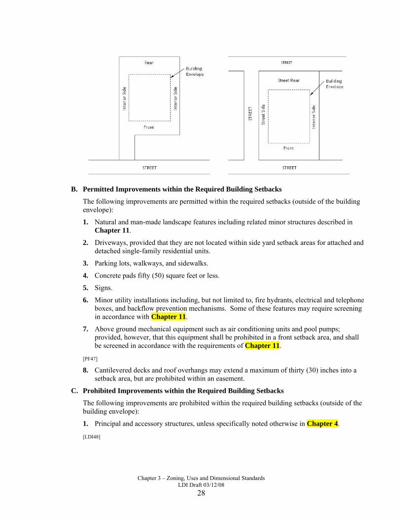
3.05.02. Building Setbacks
Building setbacks shall be measured from the property line, or, if applicable, from the right-of-way line of an adjacent private street or the boundary line of an access easement, to the wall of the building. The required building setbacks determine the building envelope.
A. Determining Building Setbacks
Front, side, and rear yard setbacks shall be determined based on the following. In cases of uncertainty, the setbacks shall be determined by the Community Development Department based on the same guidelines.
1. The front yard setback shall be considered that portion, typically along the lot’s narrowest part, which abuts the street or roadway where access is provided. Consideration shall be given to a structure’s orientation in making a front yard setback determination (i.e. the front of a building faces the front of the lot).
2. The rear yard setback typically runs parallel to the front yard setback, and does not connect to the front yard setback.
3. The side yard setbacks connect the front and rear setbacks and are perpendicular to them on square or rectangular lots.
Chapter 3 – Zoning, Uses and Dimensional Standards
LDI Draft 03/12/08 28
B. Permitted Improvements within the Required Building Setbacks
The following improvements are permitted within the required setbacks (outside of the building envelope):
1. Natural and man-made landscape features including related minor structures described in Chapter 11.
2. Driveways, provided that they are not located within side yard setback areas for attached and detached single-family residential units.
3. Parking lots, walkways, and sidewalks.
4. Concrete pads fifty (50) square feet or less.
5. Signs.
6. Minor utility installations including, but not limited to, fire hydrants, electrical and telephone boxes, and backflow prevention mechanisms. Some of these features may require screening in accordance with Chapter 11.
7. Above ground mechanical equipment such as air conditioning units and pool pumps; provided, however, that this equipment shall be prohibited in a front setback area, and shall be screened in accordance with the requirements of Chapter 11.
[PF47]
8. Cantilevered decks and roof overhangs may extend a maximum of thirty (30) inches into a setback area, but are prohibited within an easement.
C. Prohibited Improvements within the Required Building Setbacks
The following improvements are prohibited within the required building setbacks (outside of the building envelope):
1. Principal and accessory structures, unless specifically noted otherwise in Chapter 4.
[LDI48]

Chapter 3 – Zoning, Uses and Dimensional Standards
LDI Draft 03/12/08 29
2. Patios, porches, and decks that are either elevated above ground level, have roofs, or exceed fifty (50) square feet including, but not limited to, concrete pads that exceed fifty (50) square feet.
[LDI49].
3. Other vertical improvements not specifically exempted.
4. Sills, cornices, chimneys, flues, eaves and other architectural features may extend a maximum of thirty (30) inches into a setback area, but are prohibited within an easement.
D. Waterline Setbacks
Stormwater retention facilities, canals, or other water features may be located on the lot or parcel. In these circumstances, the Community Development Department may determine that it is applicable to measure the setback from the bulkhead, water line, or mean high water line rather than the lot or parcel line.
E. Reduction for Public Purpose
When an existing setback on a developed lot or parcel is reduced due to the conveyance of land to a Federal, State, or local government for a public purpose, the minimum setback requirement of the zoning district shall be reduced by the amount conveyed, up to a maximum of fifty (50) percent of the setback requirement.
[PF50]
[PF51].
[PF52]
3.05.03. Calculating Densities and Intensities
A. Residential Densities
1. Dwelling unit / lot yield. The determination of the maximum number of residential dwelling units or lots permitted on a residentially zoned parcel shall be calculated based upon the gross upland acreage in the pre-development condition (i.e. prior to the property being subdivided into lots).
2. Density bonus for preserved wetland and imperiled upland habitats. Twenty-five (25) percent of wetland and/or imperiled upland habitat areas preserved from the pre-development condition may be counted as “net upland acreage” in determining the maximum number of units as discussed in Paragraph A above. To be counted as preserved area, a wetland and/or imperiled upland habitat must be placed in a conservation easement, a separate conservation tract, or otherwise perpetually protected in the post development condition.
3. Application of the density/intensity calculations provides only a theoretical maximum dwelling unit or lot yield. It does not guarantee that the development will be approved to attain the maximum lot yield. Application of other development standards may substantially decrease the lot yield.
4. To determine density, the multiplier for Nursing Homes, Assisted Living Facilities, or other residential care facilities is four (4) beds per multi-family residential dwelling unit permitted.
B. Non-Residential Floor Area Ratio (FAR)
The Floor Area Ratio (FAR) is the calculated ratio of the total gross square footage of all floors of all buildings on a development site (building area) divided by total gross square footage of the

Chapter 3 – Zoning, Uses and Dimensional Standards
LDI Draft 03/12/08 30
development site (site area). Thus, an FAR of 2.0 would indicate that the gross floor area of a building is two times the gross area of the development site on which it is constructed.
C. Non-Residential Intensities; Impervious Surface Ratios; Floor Area Ratio
1. In calculating Impervious Surface Ratio (ISR) or Floor Area Ratio (FAR) an applicant may get credit for an off-site drainage facility site. The amount to be credited shall be proportional to the size of the site in relation to all the sites served by the same facility.
2. Lots served by master stormwater management systems, where drainage facilities under common ownership are located offsite, may count a portion of the offsite drainage lot, tract, or parcel in calculating ISR or FAR. The portion of the offsite drainage property that is counted shall be in direct proportion to the size of the subject lot as compared to all of the lots being served.
D. Densities and Intensities in Mixed-Use Districts
In zoning districts that allow mixed-uses, the same land area shall not be counted for the purpose of both residential density and non-residential intensity.
1. Base on the proposed number of dwelling units:
a. Step 1: Calculate the maximum residential density permitted on the site (Acres of land in development site multiplied by the permitted number of dwelling units per acre equals the maximum potential dwelling units).
b. Step 2: Determine the percentage of the site to be used for residential based on the number of proposed units (Proposed dwelling units divided by maximum potential dwelling units equals the percent capacity of the tract used for residential development).
c. Step 3: Calculate the percentage of the site available for non-residential use (One hundred (100) percent total capacity minus the percent used for residential equals the percent available for non-residential development).
d. Step 4: Find the maximum permitted FAR based on the percentage of the site available for non-residential use (Non-residential percentage times maximum FAR equals the allowable FAR for non-residential use).
2. Based on proposed square footage of non-residential use:
a. Step 1: Calculate the maximum FAR permitted on the site (Acres of land multiplied by the FAR equals the maximum square footage of non-residential development).
b. Step 2: Determine the percentage of the site to be used for non-residential based on the number of proposed square feet of non-residential use (The proposed square footage divided by the maximum square footage equals the percent of available capacity devoted to non-residential).
c. Step 3: Calculate the percentage of the site available for residential use (One hundred (100) percent total capacity minus the percent used for non-residential equals the percent of the site acreage available for residential development).
d. Step 4: Find the maximum permitted number of units based on the percentage of the site available for residential use (Residential site percentage times the maximum permitted density equals the allowable number of dwelling units).
[PF53]

Chapter 3 – Zoning, Uses and Dimensional Standards
LDI Draft 03/12/08 31
3.05.04. Recreation Level of Service[PF54]
All residential projects of twenty-five (25) units or greater shall provide recreational land to meet the level of service standard of eight (8) acres (five activity-based and three resource-based) for each 1,000 potential residents except for nursing homes and assisted living facilities or other residential care facilities.

[LDI1]The PLDRB requested that MHD be deleted from Mixed-Use. However, the comprehensive plan states that ALL residential zoning districts are permitted within the Mixed-Use category (see page 1-8 of FLUE). [LDI2]The PLDRB requested that IND-1 be deleted from Mixed-Use. However, the comprehensive plan states that light industrial and warehousing are permitted zoning districts within the Mixed-Use category (see page 1-8 of FLUE). [LDI3]The PLDRB requested that MPD be deleted from Greenbelt. However, per Objective 1.1.2, Planned Unit Developments (PUDs) are permitted in any FLUM designation except Conservation. [PF4]Chapter 419, Florida Statutes states: “Homes of six or fewer residents which otherwise meet the definition of a community residential home shall be deemed a single-family unit and a noncommercial, residential use for the purpose of local laws and ordinances. Homes of six or fewer residents which otherwise meet the definition of a community residential home shall be allowed in single-family or multifamily zoning without approval by the local government, provided that such homes shall not be located within a radius of 1,000 feet of another existing such home with six or fewer residents.” e fol [LDI5]Parks should be allowed in all districts, even if as Special Exception. They are an integral part of a neighborhood. [PF6]Per PLDRB request the “baseline” for this table is the same as the Table 3.06.02.A, adopted in 2005. Revisions have been made to accommodate changes in zoning districts and to address other issues. These are described in comments where applicable. [PF7]Currently AGR requires 5 acres and SVL requires 10 acres. AGR and SVL have been combined and the “new” AGR requires 5 acres, therefore no lots will be made nonconforming. [PF8] SFR-2 (currently 65’ width), SFR-3a (currently 60’ width) and SFR-3b (currently 70’ width) are now combined as SFR-2. The “new” SFR-2 requires a minimum 60’ lot width; however, as footnoted, lots on Freshwater canals shall require 70’ width, as currently required. [PF9]Currently AGR requires 200’ width and SVL requires 300’ width. AGR and SVL have been combined and the “new” AGR requires 200’minimum lot width, therefore no lots will be made nonconforming. [PF10]Adopted table calls for 0.5 (1 unit per 2 acres). Changed to 0.2 (1 unit per 5 acres) to be consistent with FLUE. [PF11]First sentence of footnote regarding minimum living area moved to Chapter 1, under non-conforming uses of land and structures. Second sentence of footnote is deleted because the LDC does not include any regulations/standards for affordable housing. [PF12]SFR-2 (currently 20’ front), SFR-3a (currently 20’ front) and SFR-3b (currently 25’ front) are now combined as SFR-2. The “new” SFR-2 requires a minimum 20’ front setback; however, as footnoted, lots on freshwater canals shall require a 25’ front setback. [PF13]SFR-2 (currently 10’ rear), SFR-3a (currently 10’ rear) and SFR-3b (currently 6.5’ rear) are now combined as SFR-2. The “new” SFR-2 requires a minimum 10’ minimum rear setback, which may cause a few nonconforming lots. [LDI14]Non conforming. Footnote regarding setbacks along streets already addressed in footnote 6, which refers to 3.05 where it is explained how setbacks are determined. [PF15]Currently AGR requires 25’ interior side setback and SVL requires 50’interior side setback. AGR and SVL have been combined and the “new” AGR requires 25' interior side setback; therefore, no lots will be made nonconforming. [PF16]SFR-2 (currently 15’street side), SFR-3a (currently 20’ street side) and SFR-3b (currently 20’ street side) are now combined as SFR-2. The “new” SFR-2 requires a minimum 15’ minimum street side setback, therefore no existing lots will be made nonconforming. [PF17]SFR-2 (currently .75 ISR), SFR-3a (currently 75 ISR) and SFR-3b (currently 70 ISR) are now combined as SFR-2. The “new” SFR-2 requires a maximum 75 ISR, therefore no existing lots will be made nonconforming. [PF18]These sections were felt to be most appropriate as either footnotes for Table 3-3 or deleted because they are addressed in Chapter 4. [PF19]Recommend taking this out, since, as it says, “manufactured buildings” are allowed anywhere. Since these manufactured buildings are allowed anywhere, why specify that the MHD district allows a “planned community”. [PF20]This sentence has been deleted because detached garages is now listed as a residential use with limitations which are described in Chapter 4.

[PF21]PLDRB requested examples from original draft to be put back in. Original draft (6/14/07) didn't have examples either.
[PF22]This category has combined the PSP, EDU, and TCU into one Zoning District. [PF23]Golf courses are a use, not a zoning district. A golf course or driving range may be located in a PSP district, a P&G district or in a commercial district. [LDI24]Reduced list because definitions list uses now. [LDI25]Recommend deleting term "adult arcade" to avoid confusion with "adult-oriented businesses". If the concern is the sale of alcohol, arcades where alcohol is served would be classified as "bars". See chapter 14 for definition of bar. [LDI26]Noted as outdoor recreation in definition. [LDI27]Noted as indoor recreation in definition. [PF28]Section 4.17.02 states that “commercial marina shall be permitted as a principal or accessory use on any waterway lot in any zoning district …except residential zoning district which shall require a special exception.” [LDI29]Already noted in definition as outdoor recreation. [LDI30]Noted in definitions as indoor recreation. [LDI31]Why can't public parks be allowed in all districts? Currently only allowed in public, recreational and conservation districts. The City shouldn't have to go through rezoning to add new parks. Changed the name to Public Parks (instead of "City" parks). [LDI32]Chapter 14 defines business services and gives examples of uses. [LDI33]Consolidated uses that were allowed in the same districts. Definition of personal service provided in chapter 14, with sample uses. [PF34]As per PLDRB, reduce IND-2 from maximum 3 acres to 1 acre. [PF35]Because of the nature of the district the .20 is a high percentage and usually 0.05 is the maximum ISR achieved/desired. [PF36]An MPD development requires a minimum 40% open space so a ISR of 0.60 is required. [PF37]The MPD has replaced the former mixed use and PUD/PRD districts. In order to avoid non-conforming developments and because the MPD standards are intended to be similar to the former Mixed Use and PUD/PRD districts, an FAR of 0.55 is recommended. [PF38]Addition to footnote per PLDRB [PF39]The MPD has replaced the former mixed use and PUD/PRD districts and because the MPD standards are intended to be similar to the former Mixed Use and PUD/PRD districts, maximum height of 100’ is recommended. [PF40]The PLDRB requested that MPD be deleted from greenbelt and industrial. [LDI41]The PLDRB requested that the minimum site size be deleted. [LDI42]Deleted reference to chapter 13 but added "architecture to the paragraph above. Deleted reference to multi-use buildings because the table of uses already states they are limited (L). [PF43]Moved this to Chapter 4 because it is a use allowed in other districts. [PF44]This section has been moved to Chapter 2, under the MPD Review and Approval Process. [LDI45] Converted from table to text/list [PF46]Some of the elements listed below are deleted here because the standards are established in Chapter 13. [PF47]This is included in Chapter 4, Accessory Structures, Sheds. [LDI48]Addressed in Chapter 4, Accessory Structures [LDI49]Addressed in Chapter 4, Accessory Structures [PF50]This is addressed in Chapter 4, under Multi-family Residential Uses [PF51]Already located as a footnote to Table 3-5. [PF52]As per PLDRB removed all height exceptions. [PF53]Removed per PLDRB [PF54]The Recreation Element has an adopted LOS of 8 acres per 1,000 population. It states that, as a guideline, the 8 acres may be divided into 3 acres of resource-based and 5 of activity-based parkland


![Index [] · INDEX ABANDONMENT Motor vehicles, 12-3-104 Zoning, special exceptions, 18-16-406 ACCESSORY STRUCTURES AND USES Alcoholic beverage uses as accessory to other uses, 18-10-103](https://img.dokumen.tips/doc/110x75/5faa14eb5260ea2c7375fbf9/index-index-abandonment-motor-vehicles-12-3-104-zoning-special-exceptions.jpg)