Embed Size (px)
Citation preview

ZONING STAFF REPORT
Meeting Date: October 6, 2015Determination: Approved Amended Postponed Denied
GENERAL INFORMATION
PETITIONER:OWNER:REQUESTED CHANGE:
LOCATION:
SIZE:
Christopher & Julie PriceChristopher & Julie PriceFrom A-4A (Single Family Residential District) to A-4A (SingleFamily Residential District) with MHO (Manufactured HousingOverlay)Parcel located on the east side of Behrman Street, north of CoastBlvd, being lots 3, 4, 5 & 6, Block 14; S23, T9S, R14E; Ward 8,District 1212,500 sq.ft
SITE ASSESSMENTACCESS ROAD INFORMATIONType: Parish Road Surface; 2 lane asphalt Condition: Good
LAND USE CONSIDERATIONSSURROUNDING LAN]) USE AND ZONING:Direction Land UseNorth Mobile HomeSouth Mobile HomeEast Mobile HomeWest Mobile Home
EXISTING LAND USE:Existing development? Yes
ZoningA-4A (Single Family Residential District)A-4A (Single Family Residential District)I-i (Industrial District)A-4A (Single Family Residential District)
Multi occupancy development? Yes
COMPREHENSWE PLAN:Commercial - Sales outlets for goods and services. Several levels or forms ofcommercial structuresinclude: limited or specialty; neighborhood service centers; generous “highway commercial” uses;offices; public uses; planned mixed commercial and residential centers, and the traditional villageor town central business district.
STAFF COMMENTS:The petitioner is requesting to change the zoning from A-4A (Single Family Residential District)to A-4A (Single Family Residential District) with MHO (Manufactured Housing Overlay). The siteis located on the east side ofBehrman Street, north of Coast Blvd, being lots 3, 4, 5 & 6, Block 14.The 2025 future land use plan calls for the area to be developed with commercial uses. The east sideof Behrman Street is currently developed with residential uses which are, for the most part,manufactured homes. Staff does not have any objection to the request.
STAFF RECOMMENDATION:The staffrecommends that the request for a MHO (Manufactured Housing Overlay) designation beapproved.
Date: September 28, 2015Case No.: ZC15-l0-070Posted: 09/15/16
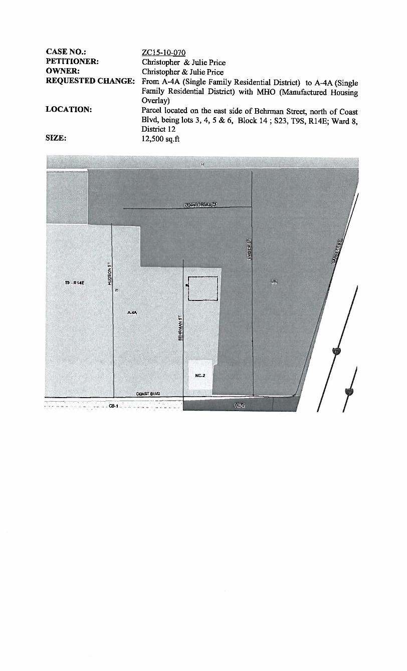
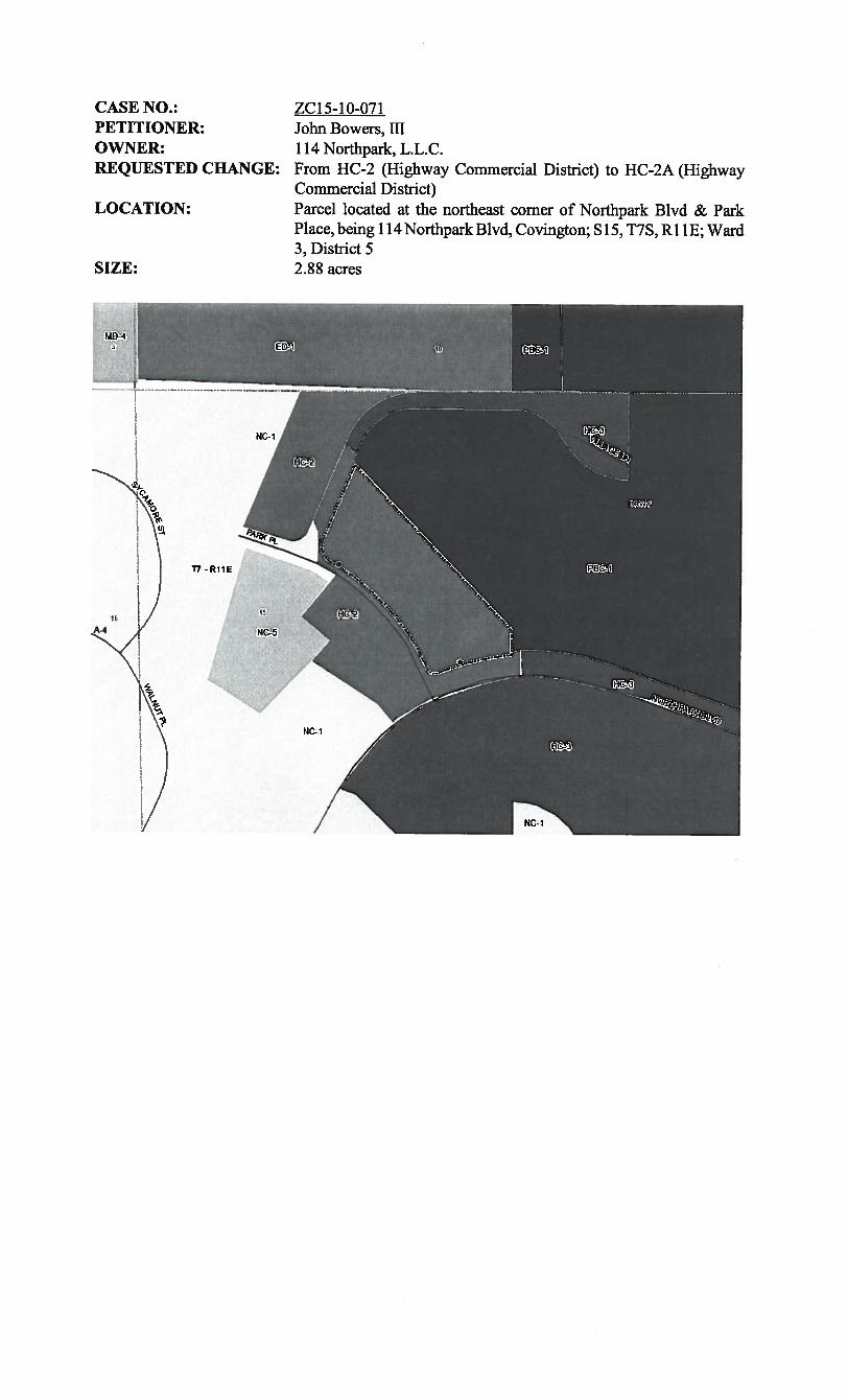
CASE NO.:PETITIONER:OWNER:REQUESTED CHANGE:
LOCATION:
SIZE:
ZC15-1O-070Christopher & Julie PriceChristopher & Julie PriceFrom A-4A (Single Family Residential District) to A-4A (SingleFamily Residential District) with MHO (Manufactured HousingOverlay)Parcel located on the east side of Behrman Street, north of CoastBlvd, being lots 3, 4, 5 & 6, Block 14; S23, T9S, R14E; Ward 8,District 1212,500 sq.ft
L

I
-4
COMMERCIAL
4E2
_4-_. I56730
c4:
r-H
s1S669
56705.
56662Ia
‘4I •b- 56692
56673’ I•-
--56671--.
I
d
270 Feet
::ib:
1,.
——
-L
_
U,
s-I
51
I’
F
II44
-w
vi3
0p
—:Z
U,
CCUi
0U> :
NIll.i
—‘11.
4b—
!s-T
I
.I7%iy
¼
4t—
—-
it
L—
TI”
1-
‘II.,It
—5.—
4.)I’
—I
.II‘bw
00
I-j’
t
10
I
T—.-“!
——
TS
I
II
‘..I1L
5T
*+
!.Ji....L
——
—
E7*
——
—11
I
---S
c.‘
——
‘..
q’
%V
.
I,
‘I,.
Jr
-
.-.
•—j:;
,.-,--.—
-.-4...
I‘‘-r
——
e
.r
..L
svo
d’1
fl9
it—
—?
!I,
*ill
.I3
1--
iJiti
--
j;,-
0-_
--__1.
sO
Npit
I,S
—-----_
-:-_
lb
-.
Sb
let
ag
Is-Si
4’I
F1%
r‘ ‘
‘‘—
‘.I
5L
1U,
01U
,O
>
1
---—--.--
4’s.
-a
iE,>
;
0•1
rrt:vv
4’3
jr,,p71
1/
I
//
‘.
.5
-s-i
#7
‘s
‘r
Ir’t
--:
+—H
’
1A””
!!rT
f
f_vt
27
a‘r
—
I,’
.—
I.sc
-.
.1,;t,’—
1•II-
i,I-q,
i<,y
.
M
0
Dj
LP
-F
:4.
.‘/J.-fr
p.
ls
,
rr
—s---I
FE-L
.t4.
;I;
ft.‘‘
,r
•
t.
—a,
:-
p..,l1
p.S
7l
I’
I-f—
AS
..3
.-’
_r5’
::::
.-=
“I
i,
;?•.
-4
Tl-J
;’
rz
-C__nw
fI
z
a0
-!$_c.,
LL
er
SI
Nno-i
srU
.73•
t3rh-44
I
•L
ip
•1\
00Dx
I
%j.
—I
__t,
--.#5
Ic
-.a,.
J,
o.1
10
a-’
IE•
E.,1
atI
-4••
-
ii:
I;.
If
R’-
--
--
.-,f
‘_
r’
f
r•r
-‘f
#5,
:3.,4
-
______z
-::_—
4*-
=1”‘-
I-
I,
-r—
-_
-_
--,,—
L7
QI
b-
ti----.‘---
a—•-‘
ii
ptS
.,,
--
“I—
-•i
(A
ST
I
-o’
L.
——
AWt
——
8=—
0_s.—
I,
I—
tr_,
,.——
‘•A_IJP_,
a
95.1.
I’
-•
FL
FAm
AmI,
pp
—
J-
--5
--
---r
-
r.
---
N1
{2)
0c;
•,,$ .
‘I
-
-O
S
:-
4k
--i,,-
.si
-
-.-•
..—4
-•
-A
/
A•
ktq
-- ••,
Iv
---IM
--
.{,—-- -
-.,‘.
:‘
---
•r
;ii
--
-_;
-:-
I“
—cL
-
9-
--
•
51
/

ZONING STAFF REPORT
Date: September 28, 2015Case No.: ZC15-i0-071Posted: 09/16/15
Meeting Date: October 6. 2015Determination: Approved Amended Postponed Denied
GENERAL INFORMATION
PETITIONER:OWNER:REQUESTED CHANGE:
LOCATION:
SIZE:
John Bowers, ifi114 Northpark, L.L.C.From HC-2 (Highway Commercial District) to HC-2A (HighwayCommercial District)Parcel located at the northeast corner of Northpark Blvd & ParkPlace, being 114 Northpark Blvd, Covington; Si 5, T7S, Ri 1 E; Ward3, District 52.88 acres
SITE ASSESSMENTACCESS ROAD INFORMATIONType: Private Road Surface: 2 lane asphalt
LAND USE CONSIDERATIONSSURROUNDING LAND USE AND ZONING:Direction Land UseNorth Fed Ex & Chevron Buildings
EXISTING LAND USE:Existing development? Yes
Condition: Good
ZoningHC-2 (Highway Commercial District) &PBC-1 (Planned Business Center)HC-2 (Highway Commercial District)PBC-i (Planned Business Center)HC-2 (Highway Commercial District & NC-5 (Retail & Service District)
Multi occupancy development? Yes
COMPREHENSIVE PLAN:Commercial - Sales outlets for goods and services. Several levels or forms ofcommercial structuresinclude: limited or specialty; neighborhood service centers; generous “highway commercial” uses;offices; public uses; planned mixed commercial and residential centers, and the traditional villageor town central business district.
STAFF COMMENTS:The petitioner is requesting to change the zoning from HC-2 (Highway Commercial District) to HC2A (Highway Commercial District). The site is located at the northeast corner ofNorthpark Blvd &Park Place, being 114 Northpark Blvd, Covington. The 2025 future land use plan calls for the areato be developed with commercial uses. Staffdoes not have any objection to the request consideringthat the site is abutting the Chevron office complex on the east side which is zoned PBC-i and othercommercial uses on the north, south and west sides zoned HC-2 & HC-3. Note that the HC-2Awould allow to increase the size of the existing building to a maximum of 75,000 square feet.
STAFF RECOMMENDATION:The staffrecommends that the request for a HC-2A (Highway Commercial District) designation beapproved.
SouthEastWest
Offices & Fire StationChevron BuildingsOffices
CASE NO.:PETITIONER:OWNER:REQUESTED CHANGE:
LOCATION:
SIZE:
ZC15-1O-071John Bowers, ifi114 Northpark, L.L.C.From HC-2 (Highway Commercial District) to HC-2A (HighwayCommercial District)Parcel located at the northeast corner of Northpark Blvd & ParkPlace, being 114 Northpark Blvd, Covington; Si 5, T7S, Ri 1 E; Ward3, District 52.88 acres

‘A
1
_—
..—
—.—
‘—
••—
‘N
I
:N
I
z.
.1’—
.
Ii
0

U—‘U..
(,)
BUILDING SETBACKS75’ ON NORTHPARK BLVD.35’ ON PARK PLACE35’ ON VILLAGE LANEREAR SETBACK NOT SHOWN
—— LEGEND —
A = 5/8” IRON ROD FOUND
• = 1/2” IRON ROD FOUNDo = 1/2” IRON ROD SET
THIS PROPERTY IS LOCATED IN FLOODZONE C; BASE FLOOD ELEV. NA; FIR.hi.PANEL NO. 225205 0230 ; REV. 10—17—89
NOTE. SERVITUDES SHOWN HEREON ARE NOT NECESSARILYEXCLUSIVE. SERVITUOES OF RECORD AS SHOWN ON TITLEOPION OR TITLE POLICY WILL BE ADDED HERETO IPONREOUEST, AS SURVEYOR HAS NOT PERFORhED ANY TITLESEARCH OR ABSTRACT.
REFERENCES:1. PLAT OF NORTHPARI< SUBO., PH. II BY WALKER AND AVERY INC.FILED FOR RECORD 8/24/88, MAP NO. 9908 FROM WHICHSETBACKS WERE TAKEN.2. PLAT OF A PREVIOUS SURVEY OF LOT 40—A BY JOHN J. AVERY& ASSOC. INC., DATED ,JUNE 19. 1995, REV. JUNE 21, 1995FROM WHICH CLECO SERV1TUDES WERE TAKEN.
BOUNDARY SURVEY OF:
LOT 40—A, NORTHPARKSECTION 15, T—7—S, R—11—E,ST. TAMMANY PARISH, LA.
PREPARED FOR:
JSB INTEREST
KELLY J. McHUGH & ASSOC., INC.CIVIL ENGINEERS & LAN!) SURVEYORS845 GALVEZ ST.. MANDEVILLE, LA. 626—5611
SCALE:— 1” 100’ DATE: 09—19—07
DRAWN: DRJ JOB N0: 07—263
10— o-
.4£‘1..
LOT 40—B
F’)
0-J
,. KELLY J. McPJ(JCH REG. NO. 4443CERTED CORRECT ‘ø16 II ACCORDANCE WITH A PHYSICALSURVEY MADE ON THE GR0UIU AND COWLYINC WiTH THECURRENT APPLICABLE STANDARDS OF PRACTICE FOR A CLASSC”SURVEY. RED STAMP SlGI$FIES CORRECT PEAT.

ZONING STAFF REPORT
Date: September 28, 2015 Meeting Date: October 6. 2015Case No.: ZC15-10-072 Determination: Approved Amended Postponed DeniedPosted: 09/17/15
GENERAL INFORMATION
PETITIONER: Bruce D. & Lori H. CoxOWNER: Bruce D. & Lori H. CoxREQUESTED CHANGE: From A-3 (Suburban District) to HC-2 (Highway Commercial
District)LOCATION: Parcel located on the northwest corner ofSharp Road & LA Highway
59, being lots 63, 64, 65, 66, & 67, Square 1, De Val Estates; S36,T7S, Ri 1E; Ward 4, District 5
SIZE: 70,808 sq.ft
SITE ASSESSMENTACCESS ROAD INFORMATIONType: Parish/State Road Surface: 2 lane & 3 lane asphalt Condition: Good
LAND USE CONSIDERATIONSSURROUNDING LAND USE AND ZONING:Direction Land Use ZoningNorth Residential A-3 (Suburban District)South Residential A-2 (Suburban District)East Residential A-2 (Suburban District)West Residential A-3 (Suburban District)
EXISTING LAND USE:Existing development? Yes Multi occupancy development? No
COMPREHENSiVE PLAN:Residential - Areas that provide for dwelling units. Such areas may vary in site design, structuredesign, and in the density ofunits per acre. Certain areas such as “village or town residential” mayinclude mixed uses and would have the highest number ofunits per acre, while “Rural residential”would have the lowest number ofunits per acre, and may include agricultural or open space uses aswell. In between these two types of residential areas would be varying levels of single-familydetached dwellings, multi-family attached residential, and planned subdivisions for manufacturedhomes.
STAFF COMMENTS:The petitioner is requesting to change the zoning from A-3 (Suburban District) to HC-2 (HighwayCommercial District). The site is located on the northwest corner of Sharp Road & LA Highway 59,being lots 63, 64, 65, 66, & 67, Square 1, De Val Estates. The 2025 future land use plan calls for thearea to be developed with residential uses. Considering that the site is surrounded by single familyresidential uses, staff does not see compelling reason to recommend approval.
STAFF RECOMMENDATION:The staff recommends that the request for an HC-2 (Highway Commercial District) designation bedenied.

CASE NO.:PETITIONER:OWNER:REQUESTED CHANGE:
LOCATION:
SIZE:
ZC15-l0-072Bruce D. & Lori H. CoxBruce D. & Lori H. CoxFrom A-3 (Suburban District) to HC-2 (Highway CommercialDistrict)Parcel located on the northwest corner ofSharp Road & LA Highway59, being lots 63, 64, 65, 66, & 67, Square 1, De Va! Estates; S36,T7S, Ri 1E; Ward 4, District 570,808 sq.ft
RI2E
A-i
Ti -RilE
A-2
A-2
17
43

_-i
‘
/
Lh
4L
0r.
P
-1 0
;_
_j.
I0)
V
r I
j
•1
p.-
9?—
“
.•%
,
r
f
1
-1:

NOTES:
2. This property is located in Flood Zone C,per F.E.M.A. Map No. 225205 0245 C,dated October 17, 1989.
0=0=.=
RS=
1/2” IRON ROD FOUND5/8” IRON ROD FOUND3/4” iRON PIPE FOUND1” IRON PIPE FOUNDREFERENCE SURVEY
REFERENCE SURVEY:
THERE IS NO REPRESENTA11ON THAT ALL APPLiCABLE SERVTRJDES AND/OR 1. SubdivisIon Plot of De Vol Estate Sites, Section “B”,RESTRICTIONS HAVE BEEN SHOWN HEREON. ANY SERV1ThDES AND/oR by Adloe Orr, Jr. & Associates, Engineers, doted 11—7—60.RESTRICTiONS SHOWN ON THIS PLAT ARE LIMITED TO THOSE SET FORThN THE DESCRIP11ON AND/OR INFORMA11ON FLJRHISfIED THE UNDERSIGNED.A liThE OR PUBUC RECORD SEARCH FOR SUCH INFORMATION WAS HOT MADE 2. Survey for Harrold Mark PhlilppI by Gilbert, Kelly, &BY THE UNDERSIGNED IN COMPILING DATA FOR 11-115 SURVEY. Couturle, Inc., Surveyors, doted 12—21—92.
(985) 892—1549
in17n (. (!1ummins anb .ssnriabz503 N. JEFFERSON AYE. Professional Land Surveyors COVINGTON, LA. 70433
PLAT PREPARED FOR: .DR .iV44VEAYJ .VAZIK
SHOWING A SURVEY OF: LOTS 63, 64, 65, 66, & 67, SQUARE 1,DE VAL ESTATES SITES, SEC11ON B,
JOHN G. ¶(JMMJNGS -ST. TAMMANY PARISH, LOUISIANA.. LIns No. 4770. PROFE’OALTHIS PLAT REPRESENTS A PHYSICAL SURVEY MADE ON
:fd; —THE GROUND BY ME, OR THOSE UNDER MY DIRECTION.AND CONFORMS ID ALL APPUCABLE STANDARDS SETFORTH BY THE STATE OF LOUISIANA. AND BEARS A
..‘‘CLASS B SURVEY. P6FESSl0NAL LAND SURVEYOR
SCALE: 1” = 100’ IJ0B NO. 04275 b0ATE: 12—23—04/ REVISED:
ASTRONOMIC NORTHr---o (jEJ REFERENCE BEARING:
DETERMINED BY SOLAROBSERVA11ONS.
9j’hi>
-J
>
hi
9.>
121.36’ ——192.31’-S8950’24”W N8945’07”W
(ASPHALT) SHARP ROAD(FORMERLY PINELAND DR.)
/
1. As requested. Improvements not shown hereon.
LEGEND

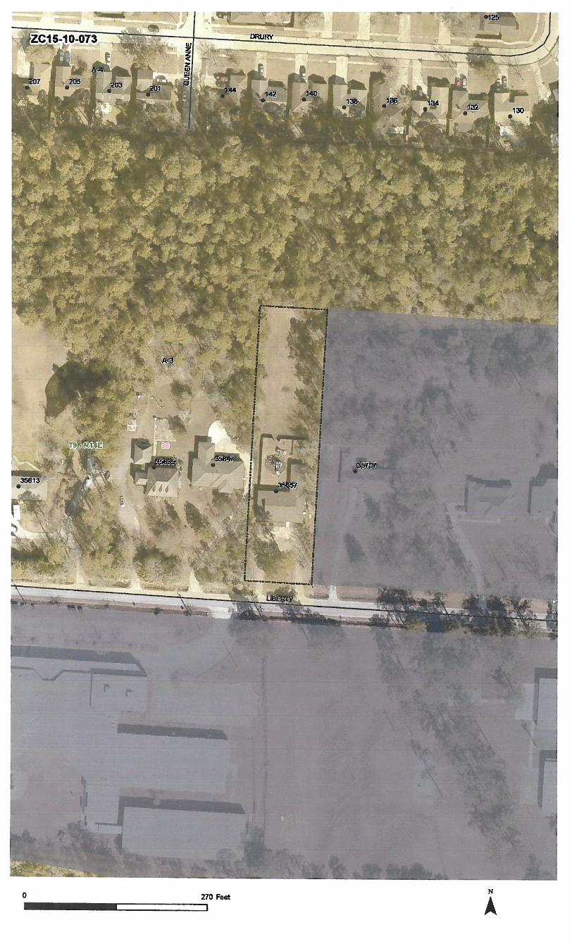
ZONING STAFF REPORT
Date: September 28, 2015 Meeting Date: October 6, 2015Case No.: ZC15-10-073 Determination: Approved Amended Postponed DeniedPosted: 09/15/15
GENERAL INFORMATION
PETITIONER: Kelly CokerOWNER: VFC Properties 25 L.L.C.REQUESTED CHANGE: From A-3 (Suburban District) to ED-i (Primary Education District)LOCATION: Parcel located on the north side of Liberty Drive, west of Carroll
Road, being 35647 Liberty Drive, Slidell; S38, T9S, R14E ; Ward 9District 14
SIZE: 0.94 acres
SITE ASSESSMENTACCESS ROAD INFORMATIONType: Parish Road Surface: 2 lane asphalt Condition: Good
LAND USE CONSIDERATIONSSURROUNDING LAND USE AND ZONING:Direction Land Use ZoningNorth Undeveloped A-3 (Suburban District)South School City of SlidellEast Residential City of Slide!!West Residential A-3 (Suburban District)
EXISTING LAND USE:Existing development? Yes Multi occupancy development? No
COMPREHENSIVE PLAN:Residential - Areas that provide for dwelling units. Such areas may vary in site design, structuredesign, and in the density ofunits per acre. Certain areas such as “village or town residential” mayinclude mixed uses and would have the highest number ofunits per acre, while “Rural residential”would have the lowest number ofunits per acre, and may include agricultural or open space uses aswell. In between these two types of residential areas would be varying levels of single-familydetached dwellings, multi-family attached residential, and planned subdivisions for manufacturedhomes.
STAFF COMMENTS:The petitioner is requesting to change the zoning from A-3 (Suburban District) to ED-i (PrimaryEducation District). The site is located on the north side of Liberty Drive, west of Carroll Road,being 35647 Liberty Drive, Slidell. The 2025 future land use plan calls for the site to be developedwith a single family residential use. Staff feels that there is no compelling reason to recommendapproval, considering that the north side of Liberty Drive is currently developed with residentialuses.
Note that there is an existing single family residence on the site, which was previously operated asa daycare (CP93-03-026). The zoning change is being requested in order to make the site conformto the appropriate zoning to reopen the daycare facility.
STAFF RECOMMENDATION:The staff recommends that the request for an ED-i (Primary Education District) designation bedenied.

CASE NO.:PETITIONER:OWNER:REQUESTED CHANGE:LOCATION:
SIZE:
ZC15-10-073Kelly CokerVFC Properties 25 L.L.C.From A-3 (Suburban District) to ED-i (Primary Education District)Parcel located on the north side of Liberty Drive, west of CarrollRoad, being 35647 Liberty Drive, Slidell; S38, T9S, R14E; Ward 9District 14
0.94 acres
A-3
I I! f
I
I [T9-R14E 3e
I II a
NC-2
I
NG!2
- -
‘
L
1-
ZC15-iO-O73 ,1
II132
I.
0 270 Feet A

many Parish Clerk of Court — lnst#1O9958ACTUAL GROUND SURVEY AND THAT To THEBEST OF MY KNOWLEDGE NO ENCROACHMENTS EXIST EITHER WAY ACROSS ANY OF
‘THE PROPERTY LINES, EXCEPT AS SHOWN
SURVEYED IN ACCORDANCE WITH THE LOUANA “MINIMUM STANDARDS FOR PROPER, rBOUNDARY SURVEYS” FOR A CLASS
______
SURVEY. BEARINGS ARE BASED ON RECORDBEARINGS.
V
Page
I //:2/./L7’I-.--- — . —. —
- ‘DENv.dA.&b’,t&9 74.’.&j
.P)/D2 /C’ ‘,‘747Z?,z .7y’” i-r) /00 Z’S’ /3’,2E-
1//Iz2/4’6 g,4C/5/7,zz&, Z/nEA7 7/z/IETh 4’v /571,T/DIJ z ‘,& ?ADDRESS:
SURVEY N0.q/35[ -
DATE: 1 2990
504.649.0075REVISED:
52a4eE Z
Ar /L20.45’t222 /0’
/4’12 3*”
.7
I
LOT/2
L7-s /
Z2,2’& //tc7-s /377,’,2B Z4 /
-
--7-
F.LR.M. 2Z52D5D420.O
J. V. BURKES & ASSOC., INC.GAUSE BLVD. EAST STE. B • SLIDELL, LA 70461
SuRVEY MAP OF:r0
7-/z
ZONE B.FE.
______
LocATED IN:2////í’7y4AV1/V53u1qL2
ST. TAMMANY PARISH, LOUISIANA
CERTIFIED To: _ .5Z’/J4 7E1z,5’AND 1’/C.k7 McB,4ve5/evE1AND 2MA-1DA/WEAL7/ L4t’V
777zE /A J,4/l/ Co,? SURVEYED BY:
9..1 V. BURKES IIILA. REG. No B40

ZONING STAFF REPORT
Date: September 28, 2015 Meeting Date: October 6. 2015Case No.: ZC15-i0-074 Determination: Approved Amended Postponed DeniedPosted: 09/16/15
GENERAL INFORMATION
PETITIONER: William David & Janet Gorence DavasOWNER: William David & Janet Gorence DavasREQUESTED CHANGE: From A-i (Suburban District) & RO (Rural Overlay) to A-iA
(Suburban District) & RO (Rural Overlay)LOCATION: Parcel located on the north side of C. Gotti Road, east of Faucheaux
Road, west of Church Road; S35, T5S, R1OE; Ward 2, District 3SIZE: 8 acres
SITE ASSESSMENTACCESS ROAD INFORMATIONType: Parish Road Surface: 2 lane asphalt Condition: Good
LAND USE CONSIDERATIONSSURROUNDING LAND USE AND ZONING:Direction Land Use ZoningNorth Residential/Vacant A-i (Suburban District)South Residential A-i (Suburban District)East Residential A-i (Suburban District)West Residential A-i (Suburban District)
EXISTING LAND USE:Existing development? No Multi occupancy development? Yes
COMPREHENSIVE PLAN:Residential! Agricultural - Agricultural and related or other active or passive uses that use orpreserve the countryside, forests and other areas and rural residential uses — widely ranging indwelling size or type, siting and organization; both of which are generally located some distancefrom more intense land uses. Permitted uses include single-family residential, and uses ancillary toeither of these primary uses. Other uses require a change in zoning.
STAFF COMMENTS:The petitioner is requesting to change the zoning from A-i (Suburban District) & RO (RuralOverlay) to A-iA (Suburban District) & RO (Rural Overlay). The site is located on the north sideofC. Gotti Road, east ofFaucheaux Road, west ofChurch Road. The 2025 future land use plan callsfor the area to be developed with residential and agricultural uses. Staff feels that there is nocompelling reason to recommend approval considering that the site is surrounded by large parcelsof land zoned A-i Suburban District.
STAFF RECOMMENDATION:The staff recommends that the request for an A-lA (Suburban District) designation be denied.

CASE NO.:PETITIONER:OWNER:REQUESTED CHANGE:
LOCATION:
SIZE:
ZC15-iO-074William David & Janet Gorence DavasWilliam David & Janet Gorence DavasFrom A-i (Suburban District) & RO (Rural Overlay) to A-iA(Suburban District) & RO (Rural Overlay)Parcel located on the north side of C. Gotti Road, east of FaucheauxRoad, west of Church Road; S35, T5S, R1OE; Ward 2, District 38 acres
r
I I1 1I II II 1
I I
I I
T5-RIDE A-i

fl
CC,
It
I-. .. :‘:.•. --. -
:::i- ----:.;::‘
-H.
;: .•.
1
F—
-St _tjE 0-- -i -- -.
*
S ttt Ia •
:g::-- $7t.*jZk:*,. 1
——
a :1: I-“-
A-i I
n..I.an.ni*.sb...4aaJ C $OflI
H
c4t
q *-
;::‘:L :::.i.1
I
1
4‘C
-
- -
0 540 Feet A
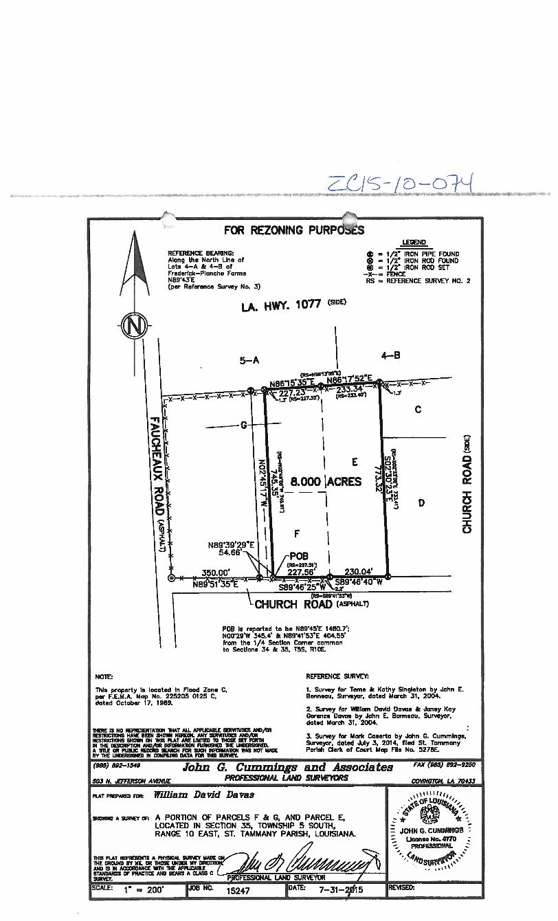
FOB Is reported to be N89’45’E 1480.7’:NOO’29’W 345.4’ & N8g’41’5rE 404.55’from the 1/4 SectIon Corner commonto Sections 34 & 35, T5S. RiDE.
This property Is located In Flood Zone C,per F.E.M.A. Mop No. 225205 0125 C,dated October 17. 1989.
REFERENCE SURVEY:
1. Survey for Teme & Kathy Singleton by John E.Bonneou, Surveyor, doted March 31. 2004.
2. Survey for William David Doves & Janey KayGorence Doves by John E. Bonneou, Surveyor.dated March 31, 2004.
3. Survey for Mark Caserta by Jotin G. Cummings.Surveyor, dated .iuly 3, 2014. flied St. TommonyParish Clerk of Court Map File No. 5278E.
/-‘
...*.‘. . ,— — —4. ,., 4
REFERENCE BEARING:Along the North Line ofLots 4—A & 4—0 ofFrederick—Plonche FormsN89’43’E(per Reference Survey No. 3)
FOR REZONING PURPOSLEGEND
1/2k IRON PIPE FOUND0 = 1/2 IRON ROD FOUND(I) = 1/2w IRON ROD SET
—X—= FENCERS = REFERENCE SURVEY NO. 2
LA. HWY. 1077 (SIDE)
4—B5—A
E
8.000 ACRES
0In
0
0
D=C-)
D
F’
(ASPHALi
NOTE:
Th!RE is No REPRTAlICH THAT Mi. APPUCABLE SERVDUDES MID/GRREsiRIcllONs HAVE BEEN 1O HEREON. ANY i1ES AND/CRRESTRIC11CNS fOlIN CH THIS PLAT ARE LIMITED 10 tHOSE RET FORTHIN THE DESCRIP1TON AND,R INFORIIA1ON FURNIENED THE LINDOlGRED.A TITLE CR PIJBUO REC0IW SEARCH FOR SUCH INFORMATION WAS NOT MADEBY THE UNDOUREEIED 54 COUPliNG DATA FOR ThIS INJRT
(985) 892-1549 John G. Cummings and Associates FAX (985) 892-9250
PROE’S51ONAL LAND SUR%’EYORS COWNGTON LA 704.D503 N. .EffiRSON AtENUE
PLAT PREPA FOR WIlilain David Davas L I I ILOUj.
THORINC A WR A PORON OF PARCELS F & G, AND PARCEL E,LOCATED IN SEC11ON 35, TOWNSHIP 5 SOUTH.RANGE 10 EAST. ST. TAMMANY PARISH, LOUISIANA. G. cuMM1NG :
L1nse No.4170 :PRO S$!O!A4.
THE GROUND BY ME. OR ThOSE UNDER MY DlREC1TLW”24 j5) ‘
THIS PLAT REPRESENTS A PH’IliCAL SURVEY MADE ON
AND IS IN ACCORDANDE lIITN ThE APPUCABLESTANDARDS OF PRACTISE AND BEARS A .ASS C
pESSlONAL LAND SURVEYORSURVE
SCALE: 1” = 200’ 1J08 NO. 15247 1DATE: 7—31—Zfi15 REVISED;

ZONING STAFF REPORT
Meeting Date: October 6, 2015Determination: Approved Amended Postponed Denied
GENERAL INFORMATION
PETITIONER:OWNER:REQUESTED CHANGE:
LOCATION:
SIZE:
Darrell FussellSt. Tammany Council on the Aging INCFrom A-3 (Suburban District) & NC-i (Professional Office District)to NC-i (Professional Office District)Parcel located on the east side of Ramos Avenue, south of CrawfordRoad; S42, T6S, Ri 1E; Ward 3, District 20.77 acres
SITE ASSESSMENTACCESS ROAD ITSIFORMATIONType: Parish Road Surface: 2 lane asphalt Condition: Good
LAND USE CONSIDERATIONSSURROUNDiNG LAND USE AND ZONING:Direction Land UseNorth UndevelopedJApartmentsSouth UndevelopedEast Assisted Living FacilityWest Office
EXISTING LAND USE:Existing development? Yes
ZoningA-3 (Suburban District)A-3 (Suburban District)MD-i (Medical Residential District)NC-i (Professional Office District)
Multi occupancy development? No
COMPREHENSiVE PLAN:Residential - Areas that provide for dwelling units. Such areas may vary in site design, structuredesign, and in the density ofunits per acre. Certain areas such as “village or town residential” mayinclude mixed uses and would have the highest number of units per acre, while “Rural residential”would have the lowest number ofunits per acre, and may include agricultural or open space uses aswell. In between these two types of residential areas would be varying levels of single-familydetached dwellings, multi-family attached residential, and planned subdivisions for manufacturedhomes.
STAFF COMMENTS:The petitioner is requesting to change the zoning from A-3 (Suburban District) & NC-i (ProfessionalOffice District) to NC-i (Professional Office District). The site is located on the east side ofRamosAvenue, south of Crawford Road. The 2025 future land use plan calls for the area to be developedwith residential uses. Staff does not have any objection considering that the front portion of the siteis developed with an office complex zoned NC-i, and it is directly abutting an assisted living facilityzoned MD-i in the rear.
STAFF RECOMMENDATION:The staff recommends that the request for a NC-i (Professional Office District) designation beapproved.
Date: September 28, 2015Case No.: ZC15-10-075Posted: 09/16/15

CASE NO.:PETITIONER:OWNER:REQUESTED CHANGE:
LOCATION:
SIZE:
ZC15-1O-075Darrell FussellSt. Tammany Council on the Aging INCFrom A-3 (Suburban District) & NC-i (Professional Office District)to NC-i (Professional Office District)Parcel located on the east side ofRamos Avenue, south of CrawfordRoad; S42, T65, Ri 1E; Ward 3, District 20.77 acres
-HC-2
MD-i
MD-i
NCi
T6-RIIE
NC-4
,____._
‘\\
\ .—-
NC-2
A-S

-4
0 0

1i1fl1 ,Ik* lie,, ‘sill hi sir lied hy emite,wtrmier ptIbr Ii Ii? gta*lremuign. di Ill
ab,It.rl fr.. nit hi• Jiriarlid h ill. imt.rsiiaed.heir Ills Ii I. ennui Ititti )hl,i cflniulad liii Fadensi iei),riecaJa.laiiIlIltae l,,d Iland Oippdfly Still Ii Iual ill, prellinliiiilril.I i italtu in Fiend pnnls1 C ilili aean. lii.d tI,vi(hn i lilA In aec.ridia “Its tu..wll
“ i5205 I100 C flnnI,1a OCIOPEO 17. 1009.
liii,: 3,r,lindee ihvwi hUine at, gilln.cn*iriI ntniniJar. Stiltpd,s atntenn a) o ii hilt ipuphni, an limitmulti iii, Pt aidiul Strain apis mimi.
c Il,r,f•r Ii. ‘Ii per! triad up till.larch it diuidCt.
mm Ii I, cerlirp tIll I life tinejul mliii pmiEnt O??f mid letpl mIllI, hacr.I(PPIqli taut hither mr .‘cr,ue
__ihviF_.t!rjiJmneaucspl is lilian.
Km
Pipe
litit: tathaii iiiiii ifuihi ii ,,ritiadei aanar
er iielniCiit etI,r,te in)’ c.ailfultiii’.. Ii •i
aural Ire eat bun partuirsad If ijl eiudlrliqruli.
u.ir limited,, •bunui marina nrc iii..g,iiWiIV arlI,al.t. Slriul.411 Iicrird di iiI en llh. .ptnte em’ hIltp.ll.j .111 I’, ,dded birch 1pm r’h)i.as aertayet 1cm nil parlance rn Stilealert!. it e1,itJCt.
In.Ir,s. Pipe
luet paint ii rilartid ii butietlpl.11.ieifl.W mmii the heMillS trill In Irma S..t CIIMC i(
heniuhliIp I iamt5, liunl II tail
/I
t11EET
/,
U • srrttrii 411.00’• 55’217N i.ur
L3llJO’OJW lb.flU’1P15)’( ;c.ti’i•
tie — 1173’5i’t dI.3’l’
ILS/
F
// q.
lien.: thllut? ill fl’CO I.. hilt! /.Cliii ‘Nip. ill. haulS. O
ma.. t,
/• I..
i/Inor hunts t .Lt hlflt5 ill tolltIliawelut intulUllit ithlt5iP.lIitlS. eta:.010111 a-ioca. snnuntv mm. tmo.uh.riusro i.iI.100fl. tinsEl ItT JOWl (.CnWC&u 0 inSTIL. liE. rim niost rprttuluihwsiqancE P5111’. tIE.. Pnhl:P 0.15.9!.5101sF)’ mill. tHou.
rim tin. At$.134
lilia IS itt CEflhltE 11111 11115 5111707 illS Polil ITIKEIS $1 PITIECi S{TEfltmShhll *110 C0R1fl11t Aim 11111 tilE 51017Ff 5105 UtilE alt ilW P111411u”o IS Iii ACCoflflhliCt pills lilt 9hiamnuiu smurnmnto roll IflfiLU1T Illililiflint SliftYfil’ is iiim’ittii hIT lilt Stilt ir LOIJ1SIAIIJ. nnnnn ormGltttfthiuiii roil rnlcFssimui. tiIShiEl1S lint l.itfl SIllIETWIE halt £ ClAim 1111507.— .
-. — — ,.—. —MIVIV I1JLW IIII°
A 0. 77 . A 0. 96 AC. PARCEL OF LANDii)
SECTION A2, TownIiIp 6 south. Range ii East,!!Jt ioiun1nv IPirImb, rt,nnIoilcnt
Liii
.. Fi.flBT 4iEMIUt4.lNSLJThNCE GROUP IlIC.FINANCIAL INSURANCE CQNSULTANIS, INC.,UNION LANTBflS BANK nd CHICAGO
.TlTLE_INSURANCE_COMPANYSira”1. aooi is eni 571 .101 seal,: I — tm,i,-s.,g i, immno7..Pill. lMflClI 0. fl01 baum kaLd ttrllIl,
JOHN E. BONNEAU ASSOCIATES, INC.’ ‘
Prnrtu1nnmI Land Surveyors . Plominors arm CrmniWItanLo( I1lOll ii. t:AusEhuay flijil. .SUIIE )4 il IIAIftIE?iliE. U. 70471 (504)050-0000 4’ -
.tIUftL (5Q.41n13-2500.RAOUEYILLE 1504) SG-304G em II. II. t5t)4)4ttI3?U42•—
FAX liii. 1504) 00(1-01157 , huh
I iflflL. i.l02
ST. TAMMANY PARISH COUNCIL
ORDiNANCE
ORDINANCE CALENDAR NO: ORDINANCE COUNCIL SERIES NO:
COUNCIL SPONSOR:_________ PROVIDED BY: DEVELOPMENT
INTRODUCED BY:___________ SECONDED BY:
____
ONTHEDAYOF ,2015.
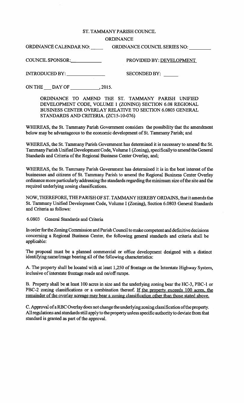
ORDINANCE TO AMEND THE ST. TAMMANY PARISH UNIFIEDDEVELOPMENT CODE, VOLUME 1 (ZONING) SECTION 6.08 REGIONALBUSINESS CENTER OVERLAY RELATIVE TO SECTION 6.0803 GENERALSTANDARDS AND CRITERIA. (ZC15-10-076)
WHEREAS, the St. Tammany Parish Government considers the possibility that the amendmentbelow may be advantageous to the economic development of St. Tammany Parish; and
WHEREAS, the St. Tanimany Parish Government has determined it is necessary to amend the St.Tammany Parish Unified Development Code, Volume 1 (Zoning), specifically to amend the GeneralStandards and Criteria of the Regional Business Center Overlay, and;
WHEREAS, the St. Tarnmany Parish Government has determined it is in the best interest of thebusinesses and citizens of St. Tammany Parish to amend the Regional Business Center Overlayordinance more particularly addressing the standards regarding the minimum size ofthe site and therequired underlying zoning classifications.
NOW, THEREFORE, THE PARISH OF ST. TAMMANY HEREBY ORDAINS, that it amends theSt. Tammany Unified Development Code, Volume I (Zoning), Section 6.0803 General Standardsand Criteria as follows:
6.0803 General Standards and Criteria
In order for the Zoning Commission and Parish Council to make competent and definitive decisionsconcerning a Regional Business Center, the following general standards and criteria shall beapplicable:
The proposal must be a planned commercial or office development designed with a distinctidentifying name/image bearing all of the following characteristics:
A. The property shall be located with at least 1,250 of frontage on the Interstate Highway System,inclusive of interstate frontage roads and on/off ramps.
B. Property shall be at least 100 acres in size and the underlying zoning bear the HC-3, PBC-1 orPBC-2 zoning classifications or a combination thereof. If the property exceeds 100 acres, theremainder of the overlay acreage may bear a zoning classification other than those stated above.
C. Approval ofa RBC Overlay does not change the underlying zoning classification ofthe property.All regulations and standards still apply to the propertyunless specific authority to deviate from thatstandard is granted as part of the approval.

PAGE 2 OF 2ORDINANCE CALENDAR NUMBER:
________
ORDINANCE COUNCIL SERIES NO. 2015-
REPEAL: All Ordinances or parts of Ordinances in conflict herewith are hereby repealed.
SEVERABILITY: If any provision of this Ordinance shall be held to be invalid, such
invalidity shall not affect other provisions herein which can be given effect without the invalid
provision and to this end the provisions of this Ordinance are hereby declared to be severable.
EFFECT1VE DATE: This Ordinance shall become effective fifteen (15) days after adoption.
MOVED FOR ADOPTION BY:
___________,
SECONDED BY:
_________
WHEREUPON THIS ORDINANCE WAS SUBMfl1ED TO A VOTE ANDRESULTED IN THE FOLLOWING:
YEAS:
NAYS:
ABSTAIN:
ABSENT:
THIS ORDINANCE WAS DECLARED ADOPTED AT A REGULAR MEETING OF THE
PARISH COUNCIL ON THE____ DAY OF 2015; AND BECOMESORDINANCE COUNCIL SERIES NO. 2015-
RICHARD TANNER, COUNCIL CHAIRMAN
ATTEST:
THERESA FORD, COUNCIL CLERK
PATRICIA BRISTER, PARISH PRESIDENT
Published introduction:
___________________
2015Published adoption on:
____________________,
2015
Delivered to Parish President:
_______________,
2015 @
___________
Returned to Council Clerk:
________________,
2015 @
___________

ZONING STAFF REPORT
Meeting Date: October 6, 2015
__________
Determination: Approved Amended Postponed Denied
GENERAL INFORMATIONMark SalvettiStirling Properties / Townsend UnderhillFrom NC-2 (Indoor Retail & Service District), NC-5 (Retail &Service District), A-4 (Single Family Residential District) & A-6(Multi Family Residential District) to NC-2 (Indoor Retail & ServiceDistrict), NC-S (Retail & Service District), A-4 (Single FamilyResidential District) & A-6 (Multi Family Residential District) &RBCO (Regional Business Center Overlay)Parcel located on the south side of Brewster Road, east of StirlingBlvd; S47, T7S, Ri 1E; Ward 1, District 180.98 acres
SITE ASSESSMENTACCESS ROAD INFORMATIONType: Parish Road Surface: 4 lane asphalt Condition: Good
LAND USE CONSIDERATIONSSURROUNDING LAND USE AND ZONING:Direction Land Use ZoningNorth Commercial & Undeveloped PBC-1 & HC-3South Undeveloped/Future Residential HC-l & PUD (Planned Unit Development
Overlay)Undeveloped PUD (Planned Unit Development Overlay)Commercial/Apartments/Assisted HC-3 (Highway Commercial District), A-8living facility (Multi Family Residential District) & MD-i
(Medical Residential District)
EXISTING LAND USE:Existing development? No Multi occupancy development? Yes
COMPREHENSWE PLAN:Planned Districts - Coordinated development on several parcels, usually at a higher density — butnot in all cases - than other parcels in the proximity, planned in an integrated fashion as single unitsincluding residential, commercial and possibly other (institutional, recreational, e.g.) uses, as wellas the supporting infrastructure and public services they will require (See “Small Area Plans,”below). Generally, such developments improve environmental qualities, preserve naturalenvironments, provide for open space and recreational uses, and for residential as well as commercialuses, and are equipped with central utility systems and efficient and effective internal and externaltransportation access in multiple modes.
Single Family Residential — Conservation - These planned districts would include clustered singlefamily residential uses, at a density — within the overall tract — which is similar to that of adjoiningresidential uses, and conservation areas, following a Small Area Plan, and providing for balance,compatibility and integration of uses and all supporting infrastructure. Such individual PlannedResidential — Conservation developments should aim to achieve contiguity among adjoiningconservation areas in adjacent developments.
STAFF COMMENTS:The petitioner is requesting a RBCO (Regional Business Center Overlay) on the south side ofBrewster Road, east of Stirling Blvd. The request consists ofan addition to the previously approvedRBCO and would meet the standards listed within the approved RBCO document. A RBCO waspreviously approved for River Chase Development, located at the northeast & southeast intersectionsof Brewster Road and Hwy 21 and on the north side of Brewster Road (see attached map & ZC13-08-063).
Date: September 28, 2015Case No.: ZC15-i0-077Posted: 09/17/15
PETITIONER:OWNER:REQUESTED CHANGE:
LOCATION:
SIZE:
EastWest

The standards ofthe Unified Development Code, Section 6.0803 B. General Standards and Criteria,requires that a RBCO be at least 100 acres in size and the underlying zoning bears the HC-3, PBC-1or PBC-2 zoning classifications or a combination thereof. A text amendment (ZC15-10-076) to thegeneral standards of the Regional Business Center Overlay is proposed, to allow for a RBCOexceeding 100 acres in size, to be in effect on the remainder ofa site bearing a zoning classificationother than the HC-3, PBC-1 or PBC-2. The zoning change to RBCO, hereby requested, is subjectto the approval of the proposed text change (ZC15-10-076) to amend the general standards oftheRegional Business Center Overlay, since the 80.98 acre site is currently zonedNC-2 (Indoor Retail& Service District), NC-5 (Retail & Service District), A-4 (Single Family Residential District) &A-6 (Multi Family Residential District).
Finally, an amendment ofthe originally approved RBCO design standards (see ZC13-08-063) hasbeen submitted for review. The attached document identifies the proposed changes to the existingdesign zones and guidelines regarding the architecture, landscape, signage, parking and additionalmiscellaneous criteria, which would also apply to the requested RBCO for this site.
COMPREHENSIVE PLAN ANALYSISThe 2025 future land use plan designates the site to be developed as a Planned District with a mixof commercial and residential uses. The proposed changes to the RBCO for the southern portionof River Chase development will remain compatible with the objectives of the 2025 future landuse plan. The RBCO will allow for the development of a mix of commercial & residential uses,while providing a transition with the adjacent proposed single residential uses.
APPROVAL & AMENDMENT TO THE RBC OVERLAYNote that the approval for RBC Overlay shall be binding upon the applicant or any successors ininterest. Also, any request to deviate from the standards ofthe underlying zoning district or fromthe specific design flexibility allowed by the RBC Overlay shall be considered an amendment tothe RBC Overlay and require a hearing before the Zoning Commission and Parish Council asoutlined in this section.
STAFF RECOMMENDATION:The staff recommends that the request for a RBCO (Regional Business Center Overlay)designation be approved.

CASE NO.:PETITIONER:OWNER:REQUESTED CHANGE:
LOCATION:
SIZE:
ZC15-lO-077Mark SalvettiStriling Properties / Townsend UnderhillFrom NC-2 (Indoor Retail & Service District), NC-5 (Retail &Service District), A-4 (Single Family Residential District) & A-6(Multi Family Residential District) to NC-2 (Indoor Retail & ServiceDistrict), NC-5 (Retail & Service District), A-4 (Single FamilyResidential District) & A-6 (Multi Family Residential District) &RBCO (Regional Business Center Overlay)Parcel located on the south side of Brewster Road, east of StirlingBlvd; S47, T7S, RilE; Ward 1, District 180.98 acres

I
0)
0 0 CD
6
.!
ii
1.
0
C,

7,
/
rr0
ZO
NIN
GL
EG
EN
DSTR
L!NC
A—
-1/—119.22
AC
.
STR
LN
GB
=4/—
41.6
OA
C.
STR
UN
GC
+/—
74
.23
AC
.r,i
ww
w.rlv
er-c
hase
.com
RIV
ERC
HA
SE
-(W
ICD
IA
VV
LJID

ZONING STAFF REPORT
Date: September 28, 2015 Meeting Date: October 6. 2015
Case No.: ZC13-08-063 Determination: Approved Amended Postponed DeniedPrior Action : Approved as Amended (08/06/15)Posted: 09/16/15
GENERAL INFORMATION
PETITIONER: Mark SalvettiOWNER: Stirling Properties / Townsend UnderhillREQUESTED CHANGE: From HC-2 (Highway Commercial District), HC-3 (Highway
Commercial District), PBC-1 (Planned Business Center), NC-S(Retail & Service District) & NC-2 (Indoor Retail & ServiceDistrict) to HC-2 (Highway Commercial District), HC-3 (HighwayCommercial District), PBC-1 (Planned Business Center), NC-S(Retail & Service District) & NC-2 (Indoor Retail & ServiceDistrict) & RBCO (Regional Business Center Overlay)
LOCATION: Parcel located at the southeast intersection of LA Highway 21 & I-12; 546,T7S,R1OE & S47,T7S,Ri 1E; Ward 1, District 1
SIZE: 201.285 acres
SITE ASSESSMENTACCESS ROAD INFORMATIONType: Parish Road Surface: 2 lane asphalt Condition:Good
LAND USE CONSIDERATIONSSURROUNDING LAND USE AND ZONING:Direction Land Use ZoningNorth 1-12South Residential & Institutional MD-i (Medical Residential District) &
PUD (Planned Unit Development Overlay)East 1-12/Brewster Road InterchangeWest Commercial HC-2 (Highway Commercial District)
EXISTING LAND USE:Existing development? Yes Multi occupancy development? No
COMPREHENSIVE PLAN:Planned Districts - Coordinated development on several parcels, usually at a higher density—butnot in all cases - than other parcels in the proximity, planned in an integrated fashion as singleunits including residential, commercial and possibly other (institutional, recreational, e.g.) uses,as well as the supporting infrastructure and public services they will require (See “Small AreaPlans, “below). Generally, such developments improve environmental qualities, preserve naturalenvironments, provide for open space and recreational uses, and for residential as well ascommercial uses, and are equipped with central utility systems and efficient and effective internaland external transportation access in multiple modes.
Mixed Use — Commercial — Conservation - These planned districts would include mixed uses,except for residential uses, — at varying densities - and conservation areas, following a Small AreaPlan, and providing for balance, compatibility and integration of uses and all supportinginfrastructure.
Single Family Residential — Conservation - These planned districts would include clusteredsingle family residential uses, at a density — within the overall tract — which is similar to that ofadjoining residential uses, and conservation areas, following a Small Area Plan, and providing forbalance, compatibility and integration of uses and all supporting infrastructure. Such individualPlanned Residential — Conservation developments should aim to achieve contiguity amongadjoining conservation areas in adjacent developments.

STAFF COMMENTS:The petitioner is requesting to amend the originally approved RBCO (Regional Business Center
Overlay). The attached document identifies the proposed changes in regards to the design zones
and guidelines regarding the architecture, landscape, signage, parking and additional
miscellaneous criteria.
COMPREHENSIVE PLAN ANALYSISThe 2025 future land use plan designates the site to be developed as a Planned District with a mix
of commercial and residential uses. The proposed changes to the RBCO for the River Chase
development will remain compatible with the objectives of the 2025 future land use plan. The
RBCO will allow for the preservation and development of the existing and proposed mix of
commercial uses, while providing a transition with the adjacent existing and proposed residential
uses. Moreover, the proposed modifications of the general zoning regulations, will also allow for
balance, compatibility and integration of the uses within the entire the development, meeting the
objectives of the Mixed Use — Commercial — Conservation criteria of the 2025 Future Land Use
Plan.
APPROVAL & AMENDMENT TO THE RBC OVERLAYNote that the approval for RBC Overlay shall be binding upon the applicant or any successors in
interest. Also, any request to deviate from the standards of the underlying zoning district or fromthe specific design flexibility allowed by the RBC Overlay shall be considered an amendment tothe RBC Overlay and require a hearing before the Zoning Commission and Parish Council asoutlined in this section.
STAFF RECOMMENDATION:The staff recommends that the request to amend the standards of the RBCO (Regional BusinessCenter Overlay) be approved.

CASE NO.:PETITIONER:OWNER:REQUESTED CHANGE:
LOCATION:
SIZE:
ZCI 3-08-063Mark SalvettiStirling Properties / Townsend UnderhillFrom HC-3 (Highway Commercial District), PBC-1 (PlannedBusiness Center) to HC-3 (Highway Commercial District), PBC-l(Planned Business Center) & RBCO (Regional Business CenterOverlay)Parcel located at the southeast intersection of LA Highway 21 & 1-12; S46,T7S,R1OE & S47,T7S,R1 1E; Ward 1, District 1151.43 acres
C
11i
V
2
C
-: r / N%/
-Th /
5-.
i;H
5-
.‘ !. --
-. /‘-.5-
5--, I
N
5_’
1’
fl
_
;fr4 /!1
f” -7_ -
A-8 ‘/5-
-% I - -
- A 4- I -
S. __S,_ f / •._
_____
‘5 - - k-
“,-‘- ‘-5
,
-
L sw
4
FI
0
c-1
2,000 Feet AN
--—I

?
ZO
NIN
GLEG
END
SST
ILIN
CA
—*/—
R9.2
2A
C.
STIPJN
G8
=+
/—41.6
0C
.
S’R
LN
GC
+/—
74
.23
AD
.
ww
w.rtver-chase.com
RIV
ERC
HA
SE
-
mE
A.
Ip
I.u
.L
NC
I4W
LY
.
IIII4

RWER CHASE
ARCfflTECTIIRAL GUIDELINES
Stirling “A” (Yellow)
BUILDING SITE GUIDELINES.
a. Temporary Buildings. No structure of a temporary character,trailer, tent, shack, garage, barn or other outbuilding shall be built,used or maintained on any Lot within River Chase at any time otherthan during the construction period of buildings and otherpermanent structures on the respective Lots within River Chase.
b. Building Materials and Colors.i. Exterior building materials, textures and colors are tobe selected so as to be in harmony with the environmentandlor existing structures.ii. Mirrored glass is prohibited. Reflective or colortinted glass is discouraged and will not be permitted withoutwritten approval by the ARB. Where necessary, smoked ortinted glass is preferred.
c. Roofs and Mechanical Systems. Rooftop equipment whichis or potentially could be visually offensive to a taller neighboringstructure shall be either fully enclosed, painted to match roofingaggregate, the color palette of the primary structure, or similarlytreated in a manner acceptable to the ARB. No Rooftop equipmentshall be visible from public streets or adjacent structures of equal orlesser height must be similarly treated.d. Building wall footings shall not encroach from one Tractonto another Tract. The design and construction shall be of highquality.
e. Setbacks. Except for the more restrictive requirements setforth below, all buildings or other permanent structures shall beconstructed, placed and maintained in conformity with theapplicable requirements set forth in the UDC, as it relates to PublicROW however no setback will be required along adjoining propertyboundaries to encourage cross access and ease of pedestrian flowbetween internal lots.
f. Exception to Setback Restrictions. The followingimprovements are expressly excluded from these setbackrestrictions:
i. Surface parking areas exclusive of parkingstructures.ii. Steps, walks, and driveway access to the site.iii. Landscaping, including berms, irrigation and accentlighting.iv. Planters not exceeding 4’ in height or within motoristsight lines at intersections or entries.v. Project identification graphics.
I

g. Height Limitations. All height limitations shall be as setforth below:
i. On the Retail Area I: Thirty-two (32) feetprovided that a Building having greater than fifty thousand (50,000)square feet of gross leaseable area may have an architectural entryfeature not to exceed a height of thirty-six (36) feet not to exceedthirty (30) percent of the total frontage of such Building, OutparcelBuildings shall not exceed twenty-six (26) feet provided that aBuilding may have any architectural entry feature not to exceedthirty (30) feet.
ii. On the Target Tract (Retail Area II): Thirty-two(40) feet
iii. On the Remaining Portion of Retail Area II: Twenty-Eight and one-half (28.5) feet: provided that Buildings contiguousto the Target Building shall not exceed a height of twenty-five (25)feet within the first ten (10) feet adjacent to the Target Building;Buildings with storefront width of 80 feet or more may have anarchitectural entry feature up to thirty-two (32) feet. OutparcelBuildings shall not exceed twenty-six (26) feet provided that aBuilding may have any architectural entry feature not to exceedthirty (30) feet.
iv. On the Retail Area III: Forty (40) feet.v. On the Retail Area IV: Thirty-two (32) feet.
h. Permitted Uses : Uses as listed in underlying zoning shallsupersede except temporary uses.
2
RIVER CHASE
ARCifiTECTURAL GUIDELINES
Stirling “B” (Pink)
BUILDING SITE GUIDELINES.
a. Temporary Buildings. No structure of a temporary character,trailer, tent, shack, garage, barn or other outbuilding shall be built,used or maintained on any Lot within River Chase at any time otherthan during the construction period of buildings and otherpermanent structures on the respective Lots within River Chase.
b. Building Materials and Colors.i. Exterior building materials, textures and colors are tobe selected so as to be in harmony with the environmentandlor existing structures.ii. Mirrored glass is prohibited. Reflective or colortinted glass is discouraged and will not be permitted withoutwritten approval by the ARB. Where necessary, smoked ortinted glass is preferred.
c. Roofs and Mechanical Systems. Rooftop equipment whichis or potentially could be visually offensive to a taller neighboringstructure shall be either fully enclosed, painted to match roofingaggregate, the color palette of the primary structure, or similarlytreated in a manner acceptable to the ARB. No Rooftop equipmentshall be visible from public streets or adjacent structures of equalor lesser height must be similarly treated.
a. Small Scale Low-Rise.i. No building shall exceed thirty-five (35) feet inheight above the natural grade of the property at the locationof the structure or base flood elevation as established inFlood Ordinance 791, whichever is higher.ii. Roofs may be flat or pitched. Pitched roof shall bestanding seam metal, clay or concrete tile. No compositionshingles shall be permitted.iii. Exterior Walls shall be masonry to include stucco,textured concrete, brick, stone, granite or marble or tintedglass.
b. Mid-Rise Building.i. No building shall exceed one hundred (100) feet inheight above the natural grade of the property at the locationof the structure or base flood elevation as established inFlood Ordinance 791, whichever is higher.ii. Roofs may be flat or pitched. Pitched roof shall bestanding seam metal, clay or concrete tile. No compositionshingles shall be permitted.iii. Exterior Walls shall be primarily masonry to includestucco, textured concrete, brick, stone, granite or marble ortinted glass.
c. Permitted Uses : Uses as listed in underlying zoning shallsupersede except temporary uses. V
3

RIVER CHASE
ARCHITECTURAL GUIDELINES
Stirlinz “C” (Aqua Blue)
BUILDING SITE GUIDELINES.
a. Temporary Buildings. No structure of a temporary character, trailer,tent, shack, garage, barn or other outbuilding shall be built,used or maintained on any Lot within River Chase at anytime other than during the construction period of buildingsand other permanent structures on the respective Lots withinRiver Chase.
b. Building Materials and Colors.i. Exterior building materials, textures and colors are tobe selected so as to be in harmony with the environmentand/or existing structures.ii. Mirrored glass is prohibited. Reflective or colortinted glass is discouraged and will not be permitted withoutwritten approval by the ARB. Where necessary, smoked ortinted glass is preferred.
c. Roofs and Mechanical Systems. Roof top equipment which is orpotentially could be visually offensive to a taller neighboringstructure shall be either fully enclosed, painted to matchroofing aggregate, the color palette of the primary structure,or similarly treated in a manner acceptable to the ARB. NoRoof top equipment shall be visible from public streets oradjacent structures ofequal or lesser height must be similarlytreated.
d. Small Scale Low-Rise.i. No building shall exceed thirty-five (45) feet inheight above the natural grade of the property (as allowableby zoning ofproperty) at the location ofthe structure or baseflood elevation as established in Flood Ordinance 791,whichever is higher.ii. Roofs may be flat or pitched. Pitched roof shall bestanding seam metal, clay or concrete tile. No compositionshingles shall be permitted.iii. Exterior Walls shall be masonry to include stucco,textured concrete, brick, stone, granite or marble or tintedglass.
iv. Roofs may be flat or pitched. Pitched roof shall bestanding seam metal, clay or concrete tile. No compositionshingles shall be permitted.v. Exterior Walls shall be primarily masonry to includestucco, textured concrete, brick, stone, granite or marble ortinted glass.
e. Uses as listed in underlying zoning shall supersede excepttemporary uses.
4
RIVER CHASE
LANDSCAPE GUIDELINES
Stir1hi Area Ag B and C
LANDSCAPING GUIDELINES
a. Landscaping shall be installed and maintained within thoseportions of a Lot improved by buildings, parking areas and the like,including the Street Planting Area: Trees, shrubs, landscaping,fountains and any other landscape architectural feature, specificallyapproved by the Department of Planning, are allowed.
b. Also allowed are sidewalks, driveways, signs, utilityeasements and servitudes, retention/detention ponds, drainage waysand facilities or other non-building improvements approved byStaff.
c. All required trees and shrubs shall be located within thestreet planting area as follows:If no servitude or easement within street planting area locate ClassA and B trees and shrubs anywhere within street planting areaIf overhead line servitude or easement, along street or road, withinstreet planting area locate Class A trees outside of servitude oreasement; locate Class B trees within servitude or easement; locateshrubs anywhere within street planting areaIf underground line servitude or easement is located along Street orroad, within street planting area locate Class A and B trees outsideservitude or easement; locate shrubs within servitude or easementIf crossing servitude or easement is located overhead orunderground, within street planting area locate all Class A treesoutside servitude or easement; if overhead, locate some Class Btrees within servitude or easement; if underground, locate some
shrubs within servitude or easement.
d. Side and rear setback areas not used for parking or drives orbuildings. In the specific zones (Retail, Small Scale Office andOffice/Mid-Rise) driveways may be parallel to and over propertylines so as to service each contiguous parcel, the landscape bufferswill be placed on either side of the driveway; parking lots may belocated over property lines where cross parking servitudes allow forparking on each contiguous parcel; and in no event shall less than10 percent of the total improved area be landscaped.
e. All parking areas on the Lot shall be landscaped in such amanner as to interrupt or screen subject areas from view from thestreets.
f. Landscaping shall be an effective combination of trees,grass, ground cover and shrubbery, including a sprinider system tomaintain same. The preservation of existing trees on the Lot shallbe done wherever possible.
g. Landscaping shall be designed so as to permit reasonableaccess to any and all public and private utility lines and easementssituated on or adjacent to Lot(s), for installation and repair.
5

h. The interior parking landscaped areas shall be curbed with
permanently anchored material at least six (6) inches in height. Curb
material shall be concrete.
i. A required interior parking landscaped area may beconnected with a required street or buffer planting area so long asthe interior parking landscaped area is in addition to the area of therequired street planting or buffer areas.
j. No more than twelve (12) parking spaces shall be permittedin a continuous row without being interrupted or terminated by alandscaped island or median of not less than six (6) feet in width(exclusive ofcurbs) and not less than the length ofthe parking space.In the event an existing tree is to be saved within the parking it willbe allowed to exceed 12 spaces in order for tree preservation.
k. Every parking row shall terminate in a landscaped island ofnot less than nine (9) feet in width (including the curbs) and not lessthan the length of the parking space; provided that, a landscapeisland shall not be required at the end of a parking row where theend of the parking row abuts a street planting area or buffer plantingarea.
1. All undeveloped properties shall be maintained by theOwner of that property in accordance with applicable requirements
of Governmental Authorities, and such Owner shall be obligated tomaintain such undeveloped property free and clear ofany man-madedebris and to maintain all weeds and underbrush at an elevation of
not more than nine inches (9”) in height by cutting the same not less
than four times each year.
m. Exposed concrete culverts for drainageways shall bediscouraged.All drainageways shall be maintained free of all man-made debrisand under-brush, fences, or any other man-made structures orobstructions of any kind.
n. The chosen plant palette should consider hardiness ofspecies, maintenance, application and consistency with the adjacentmicro-climatic zones of the region’s established landscapes.
o. The Owner shall be responsible for the design, installation,maintenance and proper utilization of automatically controlledlandscape irrigation systems for each site. frrigation installationshall be performed by a licensed irrigation contractor as regulatedby the Louisiana Horticulture Commission. Irrigation devices shallnot be installed above finish grade or in such a manner as to behazardous to pedestrian traffic.
p. Landscape lighting used outdoors shall not be visible fromthe street.
q. Any retention/detention ponds shall be designed as a visualamenity to the area in which it is situated. A strip of land, aminimum of five (5) feet in width, shall surround the
6

retention/detention pond on the front, rear and all sides, which stripshall be at grade level and shall not be excavated or made a part ofthe slope of the retention/detention pond. This strip of land shallcontain the required landscaping for the area in which theretention/detention pond is located.
r. If the banks of the retention/detention pond are sloped, theslope shall be at such a ratio so that vegetation will grow thereon sothat it can be maintained. Vegetation is required on such slopes.Water quality ponds may have a vegetative shelf for certain aquaticplants.
s. Any fences around the retention/detention pond shall be anornamental fence.
t. The plan for the retention/detention pond shall be shown onthe landscape and tree preservation plan or on a separate plan. Thisplan shall be submitted to the Department of Planning andEngineering for its review and approval in connection with theissuance of the landscape permit.
u. At least 60%, of the aggregate in number, of all requiredtrees and shrubs (the sum of all trees and shrubs required in streetplanting areas, buffer planting areas, parking areas, building facadeplanting areas and any other areas where trees and shrubs arerequired shall be a native species of trees and shrubs. None of therequired ground cover need be a native species.
v. Tree Species and replanting: In order to maintain a diversityof replacement trees and to avoid a monoculture, it will be allowedto mitigate the removal of Live Oak and Cypress trees with anassortment of “Class A” native south Louisiana trees deemedappropriate and mutually agreed upon by the St. Tammany ParishDepartment of Development.
7

RIVER CHASE
SIGNAGE GUIDELINES
StirIliu A. B and C
SIGNAGE DEVELOPMENT GUIDELINES.
A. Design Precept. Exterior signage should closely reflect thearchitectural style of primary structures. Sign structures should integratewith the landscape and should be designed as a part of the overall sitedevelopment.
a. No signs shall be permitted except permanent signs to identify thesubdivision, those necessary for directional or information purposes, andthose necessary to identify the establishment. Signs design and materialsshall contain a stone base and maintain the use of stone as a primary designelement. Signs for directional or informational purposes shall not exceedten (10) square feet per sign. Signs necessary to identify an establishmentshall be included within the architectural design of the building. In no eventshall signs be permitted to be placed on the roofs of any building orpermanent structures. Banners, pennants, spinners and streamers shall notbe permitted. No neon, intermittent or flashing signs shall be permittedwithin the subdivision.
b. Undeveloped properties shall be limited to one sign per lot whichshall identify only the prospective use or development of that property, orthe fact that such property is available for sale, build to suit and/or groundlease. All signs shall be kept in a neat and orderly appearance, free of chipsand smudges, and in a plumb, vertical position. Prohibited signs includesigns mounted above parapets or roof lines, bench signs, billboards,pennants, political campaign signs, trailer signs, signs with beacons, anysign containing statements, pictures or words of an objectionable nature orany sign that obstructs “safe” sight lines at street or road intersection.
c. Temporary Signage. Temporary signage will be allowed on thebuilding exterior or on the premises, but within ten (10) feet of adjoiningpublic street Rights-of-way, for “For Lease” or “For Sale”, but not generalbusiness promotion. Any such signs shall not exceed 2 in number per Lotor be larger than 64 square feet or more than 8 feet high. Temporarysignage, applied to glass, and visible from the building exterior, isprohibited. Temporary signage intended to identify a site user is allowed.
B. Pylon Signs
a. Pylon Signs shall be located at the designated locations as shown onthe River Chase Pylon & Entry Sign Concepts plan dated February 2,2010 page 1. Pylon Signs can display users, tenants, owners on any parcelanywhere in the River Chase Projectb. Number of Pylon Signs. Two Pylon Signs shall be located alongStirling Blvd adjacent to Interstate 12 ROW as shown on the River ChasePylon & Entry Sign Concepts plan dated February 2,2010 page 1. OnePylon Sign shall be located at the Highway 21 and Brewster Roadentrance to River Chase as shown on the River Chase Pylon and EntrySign Concepts plan dated February 2, 2010 page 1.
8

c. Location of Pylon Signs.i. A pylon sign must be located within one hundred feet ofthe highwayor frontage road right of way.ii. If a pylon sign is located on the development side of an internalpublic road it must be setback at least fifteen feet from the right of wayof said public road. If a pylon sign is located between an internal roadand an Interstate highway right of way, the sign must be at least 5 feet
from the internal road right of way, and may be placed immediatelyadjacent to the Interstate Highway right of way, if there is no objection
to such placement from the Louisiana Department ofTransportation andDevelopment.iii. A pylon sign may not be located within a triangular area formed by
the street or driveway right-of-way lines and a line connecting them at
points fifty (50) feet from the intersection of said right-of-ways.
d. Standards for Pylon Signsi. Area - The total sign face area (multiple tenant signs) for each allowed
pylon sign shall not exceed 450 square feet per side.
ii. Height of Pylon Signs - The height of monument signs shall not be
greater than 45 feet from grade.iii. The total structure face shall not exceed 1500 square feet, inclusive
of the total sign face.iv. A logo or graphic identified with the development may be placed oneach side of the structure not to exceed 100 square feet in area per side.
B. Entry Identification Monument Signs
i. Entry Identification Monument Signs shall be located at the RiverChase east entry and west entry on Brewster Road as shown on theRiver Chase Pylon & Entry Sign Concepts plan dated February 2,2010 page 1.
D. Outparcel Small Pylon Sign
a. Single user allowed offpremisesb. The Outparcel Small Pylon Sign shall be located at the northentrance from Highway 21 to the Outparcel “A” building.c. Height of Monument Signs - The height of monument signs shall
not be greater than nine (9) feet.d. Area - The total sign area for each allowed monument sign
constructed shall not exceed the following limits:Building Type Square Footage Per Side
Single Occupancy 32 sq. ft.Multiple Occupancy 100 sq. ft.
E. Multi-Tenant Monument Signs
a. Allowed to display any users within the project area including off
premise usersb. Multi-Tenant Monument Signs shall be located at the entrance to theretail, office and small scale office areas located on Stirling Blvd, BrewsterRoad and River Chase Drive within the River Chase Regional BusinessCenter Overlay District.
9

c. Height ofMonument Signs - The height ofmonument signs shallnot be greater than nine (9) feet.
d. Area - The total sign area for each allowed monument signconstructed shall not exceed the following limits:
Building Type Square Footage Per SideMultiple Occupancy 100 sq. ft.
i. Retail Building Signage.
a. Signs, Location - One wall sign per occupant to be sized at a ratioof one square foot of sign area per linear foot of the facade of thestore front. For store fronts of less than thirty-two (32) linear feetthe allowable size sign shall be thirty-two (32) square feet.
b. Corner Buildings - On store frontages located at the corner of abuilding, which face two different street frontages (or parking lot),or if a business occupies an entire separate structure within acenter, additional wall signs, the area of which shall be calculatedas above.
c. Tenant’s sign shall be store identity sign only and shall be placedon the exterior facade above the storefront
d. Tenant’s sign shall be individual, 3 dimensional, internallyilluminated channel letters mounted directly to the signboard. Noraceways are allowed.
e. Tenant’s sign shall be limited to letters not to exceed that allowedby code.
f. Rear Doors - One rear identification wall sign must be displayedon or at a rear door of each separate business entity for purposes ofemergency access and deliveries only. Such sign shall be limited insize to the minimum size required by the state fire marshal.
g. Address Signs - An occupant shall place 6” numbers for the streetaddress of the store above the main entrance door(s).
10

RIVER CHASE
PARKING GUIDELINES
Stfrlin2 A. B and C
PARKING GUIDELINES
a. Parking. All present and future vehicle parking shall beconstructed and maintained on the premises. The number ofparkingspaces to be included in the parking area shall be the greater of 4.5per 1,000 square feet of leasable area of Retail I thru IV or therequirements of Section 7.0704 Supplemental District Regulationsand conform to all other applicable government regulationsincluding and pursuant to underlying zoning designations. All suchareas shall be paved with permanent surfacing materials, such asasphalt or concrete. Parking areas shall be curbed and paved withappropriate materials. No parking area shall be allowed to beconstructed within 10 feet from any public street right-of-way line.Parking areas for trucks and vans shall be provided at the rear of thebuilding or at the side ofthe building within properly screened areasin accordance with the landscaping provision. No on-street parkingof any vehicle shall be permitted and the parking area shall bedesigned so as to ensure that no on-street parking will occur.
b. Surface Parking. Driveways and Sidewalk. Adequate off-street parking shall be provided to accommodate all parking needsfor employees, visitors and company vehicles for each site. Allparcels shall be designed to have self-sustaining parking. Crossparking easements can be utilized. The intent of this provision is toeliminate the need for any on-street parking.
Parking of equipment on a regular basis in parking areas will not beallowed. The development and use of parking structuresarchitecturally compatible with the surrounding buildings, landusage, and natural environment is encouraged.
c. Construction Materials. The construction of parking areas,driveways and sidewalks shall comply with the followingrequirements:
i. All parking areas and drives shall be paved withconcrete or asphalt and properly marked.ii. Where a curb or gutter is used at the pavement edge,top of curb shall be placed at natural grade. Where no curbis utilized, pavement must terminate with a suitable edgingto ensure stability of the pavement edge and drainage awayfrom landscape areas.iii. A curb or other wheel stop shall be provided at theperimeter of planted areas to prevent vehicular intrusion.iv. Expanded walks with curb or perimeter curb sectionsare preferred over free-standing wheel stops.v. Parking lot and vehicular use area surface markingsshall be painted in a semi-reflective white or yellow paintmanufactured for such purposes. Red surface marking isprohibited unless required by UDC.
d. Structured Parking. Parking structures shall be compatiblein material, color, and design to the primary commercialstructure(s). The maximum height permitted for any parkingstructure is the lesser of forty-five feet (45’) from adjacent ground
11

level or the height of the adjacent building. When used, parkingstructures should maintain adequate setbacks from adjacent rights-of-way. No part of the automobile below the hood line shall bevisible from any point on the site, or from adjacent sites or roads.Garages shall be constructed with internal ramps such thathorizontal floor planes are present when viewed externally. The useof planters, trees and vines is encouraged to mask or break up theelevations of parking structures. Light sources located withinparking structures should be so placed or shielded so as to concealtheir source and not create a negative impact on adjacent properties.
e. Landscaping Requirements. All landscaping at the parkinglots shall meet the guidelines herein.
RIVER CHASE
MISCELLANEOUS GUIDELINES
Stirling A. B and C
A. MISCELLANEOUS GUIDELINES.
a. Refuse and Storage Areas.i. Refuse and outside storage areas shall be visiblyscreened from streets and adjacent properties with a 7’-O”tall screen. All such areas shall be located to the rear of thebuilding or to the side of a building, other than street side, atleast three-fourths (% ths) of the way from the front of thebuilding.ii. All waste and exterior trash shall be situated so as tobe inconspicuous from adjacent public streets. 7’-O” talldumpster enclosures shall completely screen the unit andshall incorporate an opaque 7’-O” tall gate for access.iii. On site storage of materials, supplies, equipment,trucks, trailers and other commercial or industrial vehicles isprohibited.
b. Utilities.i. All onsite utility service lines, including electricallines and telephone lines, located within a Lot shall be placedunderground from the property line. Any transformer orterminal equipment provided within or immediately adjacentto the parcel area shall be visibly screened from view fromstreets and adjacent properties, with appropriate screeningmaterial provided by, maintained by and at the sole cost andexpense of the Lot Owner.ii. Transformers, mechanical equipment, electric, gas orother meters of any type shall be painted to blend with thenative planting or the color ofthe building. Full coordinationwith the local utility companies is recommended to ensurethe most aesthetic siting of utility equipment.iii. Internet and Phone services shall be permitted.
c. Roofs. Placement of any objects such as air conditioningunits or exhaust fans on the roof of any building or other permanentstructure shall be effectively screened from view.
12

d. Walls and Fences.i. No fence, wall, or hedge shall be built or maintainedin front of any buildings. Rear yard fencing shall not extendnearer than 15 feet to the front wall line of the building ornearer than 15 feet to any adjoining building. Side yardfencing is permitted, but shall not extend nearer than 15 feetto the front wall line of the building, nor nearer than 15 feetto any adjoining building. Chain link fencing shall not bepermitted under any circumstances.ii. The design, materials, textures and colors of suchelements must be architecturally compatible with those ofthe building. Where practical, they are to be integrated withthe building so as to be an extension thereof.
e. Lighting.i. All exterior light fixtures shall be designed andplaced to illuminate structures within the confinement of theLot boundary lines.ii. On each site, lighting fixtures shall be from the samefamily of fixtures with regard to design, materials, color offixture and light source. Exterior building and parking lotlighting is required on all sites. All exterior lighting shallbe directed so as to avoid glare or light throw onto streets oradjoining properties. The lighting guideline shall beestablished to provide a minimum of 4 foot candles in allareas of the site.iii. Encouragement will be given to the illumination oftree groupings within these buffers using ground or treemounted up-lights. Light sources shall not be visible fromthe street.iv. Accent illumination ofbuilding or site entry points isencouraged. Identification signage shall be interiorilluminated or illuminated by an approved ground mountedfixtures. Blinking, flashing or multi-colored illumination isgenerally unacceptable. All exterior illumination shall befully operational each night from dusk until midnight or asrequired by the Parish of St. Tammany. All wiring shall beinstalled underground.
f. Screening.i. All required screening within any Lot in thesubdivision shall be constructed of 100 percent masonry orstucco. Berms or shrubs shall be allowed to be used forscreening if properly landscaped and continuouslymaintained.ii. Screening devices shall be of a height at least equalto that of the materials or equipment being screened.
g. Loading Areas.i. No loading docks shall be permitted on the front ofany building. The truck docks shall be properly screenedwith the appropriate screening material so as not to be visiblefrom public streets.ii. Adequate area shall be provided on site for allloading and maneuvering of trucks and other vehicles. Nosuch operations will be permitted within any street, privateaccess drives or rights-of-way. Truck loading and serviceareas shall be sited and screened so as not to be visible fromadjacent public streets and should minimize the potential fornegative impacts on adjacent site users. No such areas shallencroach into any public right-of-way, fire lane, parkingarea, or interior drive.
13

h. Solar Panels and Equipment.i. Roof-mounted solar panels must match the roofmaterial. Panels must be an integrated part of the roofdesignand mounted directly to the roof plane. Solar units must bescreened from neighboring property.
i. Satellite Dishes/Transmission Equipment. Large exteriorutility equipment, such as satellite dishes, cooling towers, and thelike, shall be placed to the rear or side ofbuildings, out ofview fromthe street, or shall be screened from view by landscaping, fences,wells or berms. Antennas or other pieces of equipment taller thanthe building will generally not be permitted. All federal and statelaw regarding satellite dishes, antennae, and microwave dishes mustbe met in full compliance.
j. Site Furniture. Site furniture consists ofbenches, mailboxes,bollards, bicycle racks, trash receptacles and the like. Thespecification and design of all site furniture should be consistentwith, and complementary of its context. These elements should beof uniform design and material wherever possible. Site furniturecannot be placed along drainage easements.
14

PLAN REVIEW STAFF REPORT
Date: September 28, 2015 Meeting Date: October 6. 2015CASE NO.: PR15-10-004 Determination: Approved Amended Postponed DeniedPosted: 09/17/15
PETiTIONER: Doe DubreuillOWNER: W. J. B. Realty, Li.C.PROPOSED USE: Office WarehousePREVIOUS/CuRRENT USE: VacantSQ. F!’. OF USE: 6,390 sq.ft.GROSS AREA LOT SIZE: 5.171 acresZONING CLASSWICATION: 1-2 (Industrial District)CORRIDOR: Tainmany Trace Planned CorridorLOCATION: Parcel located on the west side ofLA Highway 59, north ofMarion Lane, south ofEmile Strain Road,
being 68583 Highway 59, Mandeville ; S24, T7S, RIlE; Ward 4, DistrictS
SiTE ASSESSMENTACCESS ROAD INFORMATIONType: State Road Surface: 3 lane asphalt Condition: Good
LAND USE CONSIDERATIONSSurrounding Land Use and Zoning:Direction Land Use ZoningNorth Undeveloped 1-2 (Industrial District)South Industrial 1-2 (Industrial District)East Fire Station 1-2 (Industrial District)West Undeveloped/Tammany Trace 1-2 (Industrial District)
Existing development? No Multi occupancy development? No
STAFF COMMENTS:Petitioner is proposing a new Office Warehouse on a parcel located on the west side ofLA Highway 59, north of Marion Lane, south ofEmile Strain Road, being 68583 Highway 59, Mandeville. A site and landscape plan has been submitted as required meeting most oftherequirements. A waiver ofthe rear facade requirement, which as per the PCO requirements, shall have a finish of Cement Plaster (stucco),Brick or wood, is being requested. The building would have a metal rear facade as shown on the attached plan. Staff does not have anyobjections to the requested variance considering that the building is proposed to be located approximately 150’ from the rear property line(see attached plan), limiting its visibility from the Tanimany Trace.
STAFF RECOMMENDATIONS:The staff recommends approval of this proposal, subject to all applicable regulations and the following conditions:
1. Provide a revised landscape plan meeting all the requirements. Note that a revised plan showing the size and location of allexisting trees to be preserved and any new plant materials to meet the applicable landscaping requirements, will have to beprovided before final inspection if some of the species oftrees are being changed. Provide the size, caliper and species of theproposed trees on the revised landscape plan. Note that the size ofthe Class A & Class B trees has to be a minimum of 10’ to 12’high. The caliper of Class A trees has to be a minimum of 2W’ and the caliper of Class B trees has to be a minimum of 1W’measured at 1 4 feet above the ground.
2. Revised the calculation of the tree credit within the front and northern greenspace.3. Remove the 3 display pads, proposed to be located within the front greenspace area.4. The required 10’ buffer, on the south side of the property, must be extended to the front of the property. The driveway shall be
removed from the required 10’ side greenspace.5. Access ways through the periphery of an off street parking or other vehicular use area shall be a minimum of24’ to a maximum
of 35’ wide for 2 way traffic; and a minimum of 12’ to 15’ wide for one way traffic. Southern proposed driveway shall be aminimum of 10’ from the side property line.
6. If a dumpster is required, provide the location and the required screening.7. The property owner shall be responsible for the maintenance and the replacement of the required plant materials.8. During construction, planting or open ground areas surrounding preserved trees shall be wired off with a properly flagged,
reinforced & rolled wire mesh.9. Sight triangle shall have 25 feet at the intersection of a public street and 15 feet along a private access way. No parking, wall,
fence, sign, structure or plant material shall be placed within the sight distance area so as not to impede vision between a heightof24 feet and 10 feet above the center line grades of the intersecting streets and/or drives.
10. No plant material except grass or ground cover shall be located closer than 3 feet from the edge of any access way pavement.11. Provide an exterior lighting plan so all exterior lighting shall be shaded or inwardly directed in such a manner so that no direct
lighting or glare is cast beyond the property line. The intensity of such lighting shall not exceed one foot candle as measured atthe abutting property line. Outdoor lighting illumination shall follow the recommended guidelines for the luminescence asestablished in the IESNA Lighting Handbook.
NOTE TO PETiTIONERThere is a 10 day appeals period following the Zoning Commission decision. If the request is approved, permits will not be issued untilthis 10 day period has elapsed. The petitioner shall have one year to obtain the appropriate building permits or occupy the site from thedate of approval of the St. Tammany Parish Zoning Commission, unless otherwise stipulated by the St. Tammany Parish ZoningCommission.

CASE NO.:APPLICANT:PROPOSED USE:PREVIOUS/CURRENT USE:SQ. FT. OF USE:GROSS AREA LOT SIZE:ZONING CLASSIFICATION:CORRIDOR:LOCATION:
PRI 5-10-004Doe DubreuillOffice WarehouseVacant6,390 sq.ft.5.171 acres1-2 (Industrial District)Tammany Trace Planned CorridorParcel located on the west side ofLA Highway 59, north ofMarion Lane, south ofEmile Strain Road,being 68583 Highway 59, Mandeville ; S24, T7S, RilE; Ward 4, DistrictS

0
zr
-
•—
3
;4f
0 m
•1j
— Iiir

Pla
nt
Leg
end
—
Class
AT
ree.
WO
lowO
ak
()L
oblollyP
ine
QC
ypress
Chin
es.E
lm
ShrubsD
warf
Burford
Holly
Class
BT
ress
OS
wset
Bay
Placetop
ofrtha[
5t1
L
abortooi
line(2
mac.)
icotree
we.
rxtba.
boriapo
rropen
rran
top
F-a’f ofno’.
NO
TE
S:N
OT
ES:
TY
PICA
LSH
UR
BPL
AN
TIN
G,
IND
IVID
UA
LPL
AN
TIN
GH
OL
E
1.D
igplanting
holeat
least2x
thesize
oftherootball
orcontainer.
2.Scarify
subgradeand
sidesof
plantinghole
when
plantingin
day
soil.3.
Set
thetop
ofthe
rootb
alllevel
with
theexisting
soilsurface,
or1-2”
aboveifsoil
isprone
tosettling.
4.If B
&B
remove
brulapfrom
atleast
thtop
ofthe
rootball,w
ithoutdisturbing
rootball.R
emove
allcord
fromthe
trunk.R
emove
burlapand
wire
basket(if
present)from
therootball.
6.B
ackfillthe
plantinghole
with
excavatednative
soil,broken
upor
tilled.If
soilis
mostly
clay,add
upto
25%organic
tothe
soiland
mix
well.
7.W
aterto
remove
airpockets.
RP
lacenin
estraw
mulch
onthe
surfaceto
asettled
deathof
3inches.
L3reaknel
6c
camp
foririn
ee.opro
-
toplan
r
Street
PIan
thg
Area.
Class
AT
rees:I
per25
linear
feet(or
fractionthereof)
of streetor
roadfrontage
Class
BT
rees:I
per25
linearfeet
(orfractionthereof)
ofstreetor
roadfrontage
Shrubs:
Iper
10linear
feet(or
fractionthereof)
ofstreet
orroad
frontage
Buffer
Pbn
tlnL
rea
Width:
Buffer
plantingarea
width
shallbe
am
inimum
often(10)
feet,
Ground
Cover
Required.
Livingvegetative
groundcover
material
coveringthe
entiresurface
ofthe
streetplanting
areaother
thandrivew
ays,sidew
alks,retention/detention
ponds,drainage
ways
andfacilities,
fountains,signs
andother
areasw
hichare
notplantable
dueto
landscapearchitectural
featuresapproved
bythe
Departm
entofP
lanning.
TR
EE
NO
TE
SA
ll Class
Atrees
shallbe
am
inimum
of10’
-12’
high.All
Class
BT
reesto
bea
minim
umof
8’-lO’
highafter
planting.
Class
AT
reesshall
havea
minim
um2-/
caliperand
Class
BT
reesshall
havea
minim
um1.1/25
caliperm
easured6’
asbovethe
ground.
Parking
Pla
gj
The
landscapedislands
shallcontain
am
inimum
ofone(1)
Class
Btree
forevery
four(4)
parkingspaces
çjg
The
interiorparking
landscapedareas
shallbe
curbedw
ithperm
anen
tlyanchored
material
atleast
six(6)
inchesin
height.
Note:B
aseinform
ationfrom
aSite
Planfor
New
Failityfor
Equipco,
dateddlflfllflflaC
0.......I....
0P
.I......
I25’
Rear
Buffer
Planting
Area
14C
I...A
Trees
Required
7l.obIolly
PIne7
Cypress
14C
l...B
Tree.
Required
7B
aylaegnoha
7C
hin
e..Elm
10’Side
Buffer
Planting
Area
13C
lassA
Tress
Required
Sl.oblolly
Pins
4C
yprees13
Clu
eB
Trees
SB
ayM
agnolia5
Chln
e.eE
lm
0C.)
LU
I0)
L()
=-JLC
)
CD
Side
Buffer
Planting
4T
reesP
reserved
1.5
”PIne
1.1
4”
Pine
1.1
5”
Pine
.30
’Pine
10’S
IdeB
ufferP
lantingA
rea
10C
l...A
Treee
Required
4P
reservedS
Labially
PIne
Planted
Cypress
Planted
IOC
Is.sBT
rs.s6
Sw
eetB
ayM
egnollaP
lanted4
ChInese
Elm
Planted
Scale:
3/1
6”=
l’—O
”
30’ StreetP
lantin
g
23C
lassA
Trees
Required
ISC
lassA
Tree.
Preserved
SW
illowT
reesP
lanted23
Class
BT
me
11B
a)’M
agnoliaP
lanted12
ChInese
Elm
Planted
SaS
hnjb
s88
Burford
Holly
Midi
2-4seep
.
ceepnddiorcafrantiirk.
LAH
wy
591
-1ru
vso
.5-r
Willow
Oak
3-9
”W
Illow051,
3-1
0”
WIllow
O.K
\Mien
takir
050n
itor
tat
5t.SkOS
with2
belt-likentro
.
Mow
forsnim
moeem
ent
fracthestem
,
ctn
ia-e
a2-
times
diameter ofthe
Tree
PlantingD
etail(N
TSI
5etbof
orjiclintrbeo
s,
‘“
eacero
frroilc
h
E:
°..
ShrubPlanting
Detail
August
12,2
01
)coprofr’t
o,,_
.,I.fl
(NT
S)
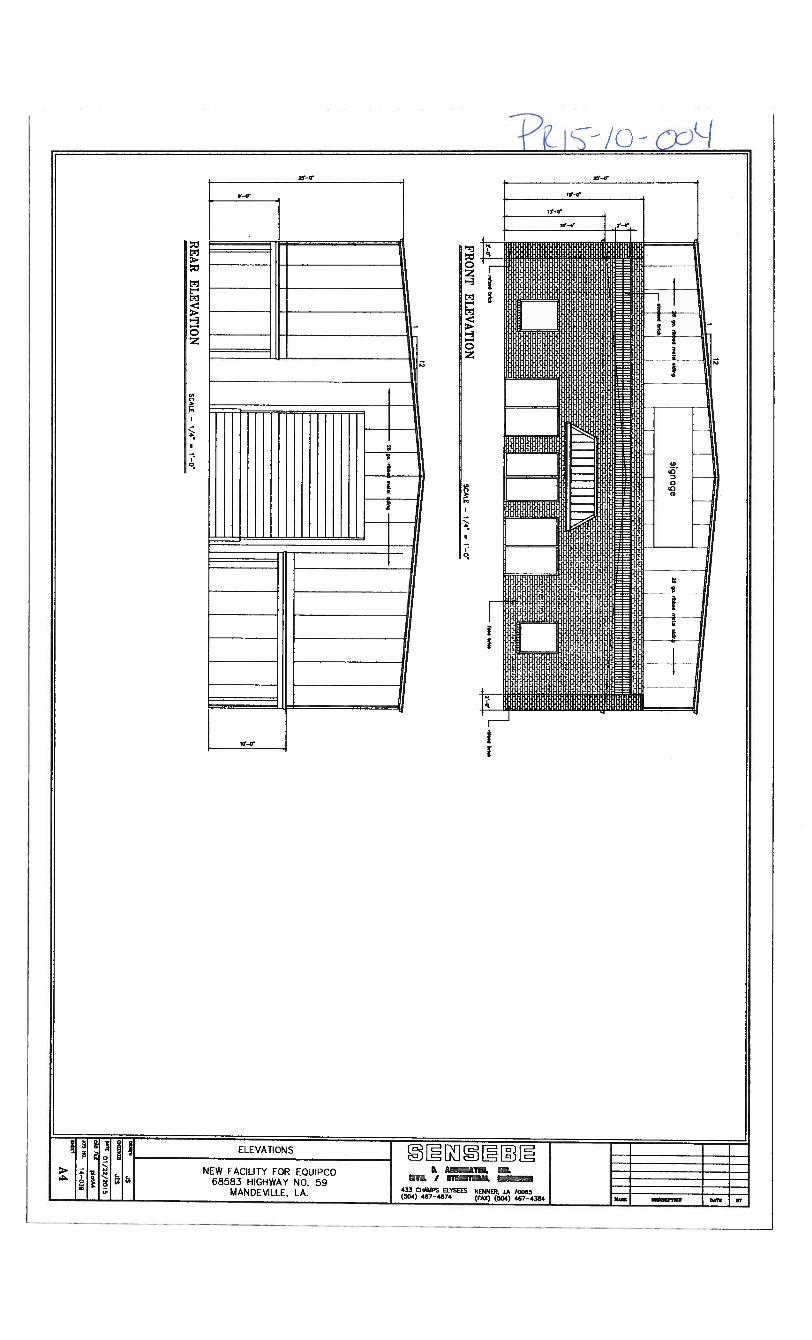
FRO
NT
EL
EV
AT
ION
RE
AR
EL
EV
AT
ION
SCALE
—I/4
=

0U)
C-J
r
0(Jo,
0-O
f,
00<
LOJ-
cjr’.)<
bJz
cJOO
1b.JES
°01/2
2/2
015
C.OD;U
plotAl
JONNO.
14—039
Al
(3
.I.tIn9
Ipoor
pal.
1PA
RC
EL
A—
4SEC
TION
24,TO
WN
SHIP
7SO
UT
H,
RA
NG
E11
EA
STST.
TAM
MA
NY
PAR
ISH,
LOU
ISIAN
A
—___
_4;e
p9.
o,or000
9000
00
0
/
L
SITE
PLAN
-30’
z-J0U,
N495I
LANE
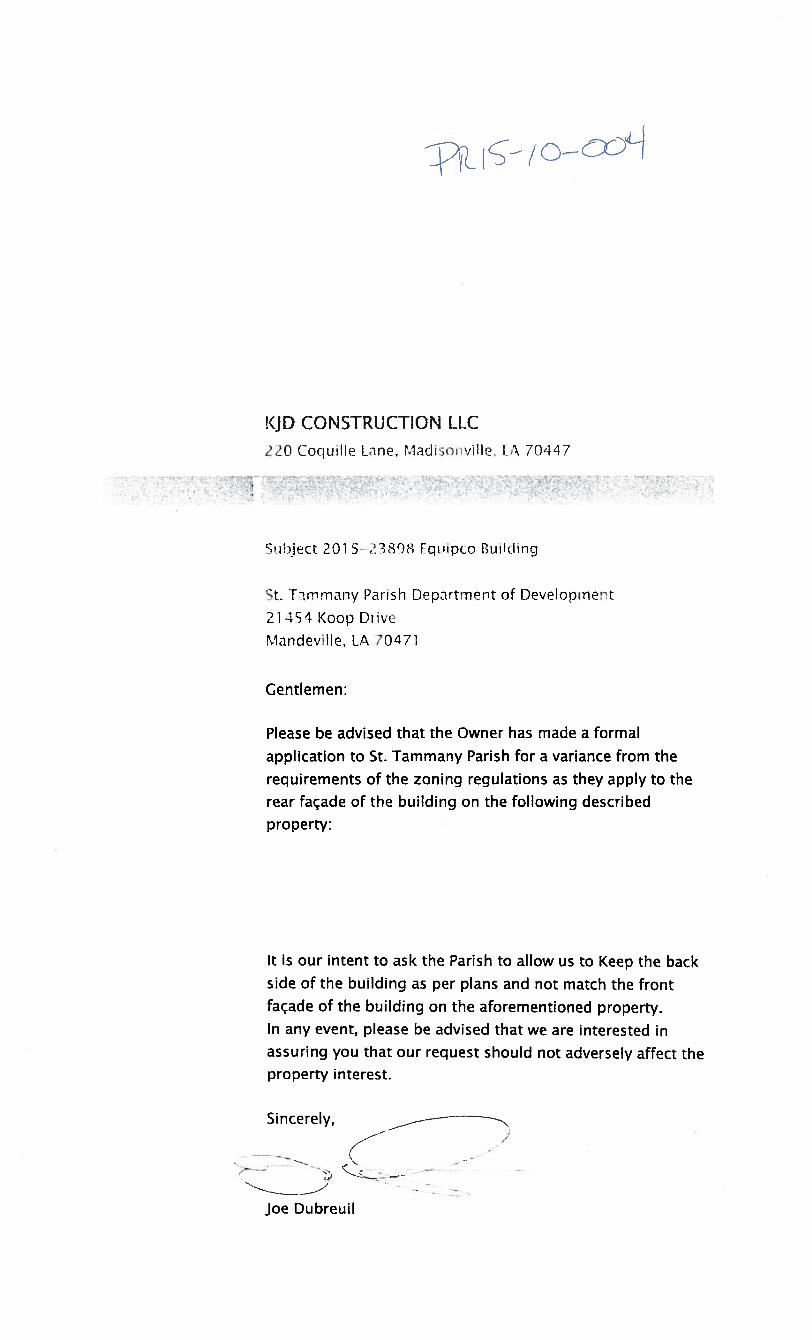
L c
(JD CONSTRUCTION LLC
170 CoquilIe Line, MadisoviHe A 70447
Subject 201 73808 Fcit’ipo Ouliding
St. Thmrnany Parish Dcpirtment of Deveiopment
21 4 Koop Ddve
Mandeville, IA 70471
Gentlemen:
Please be advised that the Owner has made a formal
application to St. Tammany Parish for a variance from therequirements of the zoning regulations as they apply to therear façade of the building on the following describedproperty:
It is our intent to ask the Parish to allow us to Keep the backside of the building as per plans and not match the frontfaçade of the building on the aforementioned property.In any event, please be advised that we are interested inassuring you that our request should not adversely affect theproperty interest.
Sincerely,
) :-—
Joe Dubreuil

St Tammany Parish Clerk of Court Inst#1 925632
REFERENCE BEARING:AstronomIc Northdetermined byGPS Observation
LEGEND
WOOD CORNER FOUND3/4” IRQN PIPE FOUND1/2” IRON PIPE FOUND5/8” IRON ROD FOUND1/2” IRON ROD FOUND1/2” IRON ROD SET
PARCEL A—45.171 ACRES
LiCb4
18
19
0,10
Page 1 of I
503
PLAT PARED PCR
fO%tNO A JRVEY ;
PTP Properties. LW
PARCEL A—4, LOCATED IN THE NE 1/4 OF ThE NE 1/4OF SEC11ON 24, TOWNSHIP 7 SOUTH, RANGE 11 EAST,ST. TAMMANY PARISH, LOUISIANA.
LA
li ti/I0
* r
JCHN 0. CUMIVi1NG54o.417U
PROFESSL .::
‘ .I liii
NOTE:
IALAMOSA PARK
This property in located In Flood Zone C,per F.E.M.A. Mop No. 225205 0245 C,doted October 17, 1969.
ThE (5 NO REPRESENTATION AND/OR
II
REFERENCE SURVEY:
Survey for P.T.P. Properties, LL.C by John G.Cummings, Surveyor, doted April 15. 2013,filed St. Tcmmany Parish Clerk of Court Mop FileFile No. 5171D.
1” = 200’

APPENDIX ACASE NO.: PRI5-10-004LANDSCAPE CHART
FOR COMMERCIALIINDUSTRIALIINSTITUTIONALIMULTI-FAMILY USES ONLY
Affected Planned Corridor Minimum Petitioner Staff
Area Requirements Provided Recommends
Street 35’ planting area 35’ planting area 35’ planting area As petitioner
Planting 23 Class A 23 Class A 15 trees preserved proposes
Hwy 59 23 Class B 23 Class B for a total of 37
570.11 ft. 57 Shrubs 57 Shrubs credits23 Class Bprovided58 Shrubs
North 10’ planting area 10’ planting area 10’ planting area As petitioner
Perimeter 10 Class A 10 Class A 4 trees preserved proposes
Planting 10 Class B 10 Class B for a total of 14
315.36 ft. credits6 Class AlOClassB
South 10’ planting area 10’ planting area 10’ planting area As petitioner
Perimeter 13 Class A 13 Class A 13 Class A proposes
Planting 13 Class B 13 Class B 13 Class B
403.21 ft.
West 25’ planting area 25’ planting area 25’ planting area As petitioner
Perimeter 14 Class A 14 Class A 14 Class A proposes
Planting 14 Class B 14 Class B 14 Class B
416.99 ft.
Parking 1 Class A in Island / 12 1 Class A / 12 spaces 1 island at the end As petitioner
Planting spaces & in island at & in islands at ends of of each parking proposes
ends of row row row.12 Spaces 1 Class A tree in
Required island
12 SpacesProvided
Other Considerations:Hours of Operation: 10 hours per day Number of Employees: Noise Expected: Moderate