1
2F-5000 NS-1 2F-5000 LC-1 3F-4000 Linden Street LI-1 2F-5000 3F-4000 OS-RC Goodenough Street LI-1 OS-UP 3F-4000 OS- RC 3F-4000 3F-4000 3F-4000 2F-5000 OS-P LC-.5 3F-4000 OS-G Guest Street LI-2 NS-.5 3F-4000 NS-1 3F-4000 NS-.5 N Beacon Street LI-1 OS-P LI-1 NS-1 OS-RC 3F-4000 3F-4000 OS-RC Western Avenue/ Soldiers Field Road CC-1 IS 2F-5000 NS-1 3F-4000 MFR-1 3F-4000 OS-P 3F-6000 MFR-1 1F-5000 2F-5000 CPS 3F-4000 2F-5000 CPS NS-1 2F-5000 MFR-1 CC-4 LC-.5 Harvard Avenue CC-1 1F-5000 1F-5000 CF NS-1 3F-4000 NS-1 3F-4000 2F-5000 OS-UW CPS OS-RC 2F-5000 (A) NS-.5 OS-P OS-CM OS-P St. Elizabeth's Hospital Medical Center IS CPS OS-RC 1F-3000 LC-.5 OS-RC OS-P OS-A Western Avenue/ Soldiers Field Road CC-1 2F-5000 1F-5000 Braintree Street LI-1 Allston Landing South EDA 2F-5000 MFR-1 MFR-1 MFR-1 MFR-1 Western Ave/ Soldiers Field Rd CC-1 OS Franciscan Children's Hospital IS Packards Corner CC-2 Harvard Avenue CC-1 OS-A 2F-5000 Suth e r la nd Rd Barrows St Br entwood St H a r v a r dA v H oo k er St Al l s t o n St K e l t o n S t Soldier s Fi eld Rd B r a i n er d Rd Everett St M yr i ck S t Mo n a s te r y Rd C h e ste r St S c o t t f i e l dR d N or t hB e aco n S t A rmington St W este r n Av R a ym o nd St G le ncoe St R e e d s da le St Gardne r St Non ant um Rd Cam bridg e St M assach u set t s Tnpk U n io n S t M a ssa ch uset t s T npk Fidel i s W y C o rey Rd Henshaw St Ev e r e t t S t Ma r k e t S t I m r i e R d C a mbr i d g eS t F i d el i s W y W averl y S t Fa neuil St Wi nship S t G l e nv ille Av A s h for d St Lincoln St N ort h Beaco n S t Brigh t on A v S um m it A v Allst o nS t F r a n k l i n S t R y an R d Holto n St Leo M Bi rmi n g h am Pkw y C ommonw e al th Av We st e r n Av L o n g Av S p o f f o rd R d Cambridg e St W i n shi p P l C ambridg e S t Hichborn St L or r ai ne T er I s l in g t o n S t Wa s h i n gto n St Be nnett S t She pa r d Pl B raintre e St Fordham Rd S h e p a rd W y I slin g t o n T e r A r li n gton St Ma c k i nS t De l a wa re P l C o o lid ge Rd M u r doc k St E tna S t F i s ke T e r M a n to n Te r F e n e n o T e r Po r t s m o u t h St Leicester St Lif e S t Wa rren S t Spa rhawk St Le oM Bi rmin gham P kw yA v Ga rdne rT e r A n tw erp St East on S t S no w S t W o od s toc k Av H ig g ins S t B ar ke r St Al di e St Cy p res s Rd B a y a rd S t H o llis P l Kinro s s Rd La w r ence P l G lenvi l le Ter Eust o n Rd Hig g i n s S t C la y m o ss R d Su r r e y St Ab b y Rd W ebl ey S t S o uth Wa v e r l yS t Mou n t Hoo d R d Ascot S t S inc l a ir R d S p e e d w a y A v Farr in gton A v B en s on St Kilsyth T e r Montca l mA v S aybr ook St Cushm an Rd G oul d S t Gar d ena St Du va l S t C ygnet S t A t h o l S t W i rt S t Soldier s Fiel d R d Ra d cl iff e R d P r i c e R d B e ll v i s ta Rd B agn al St C ity View R d H a r riet S t E r i c Rd J or da n R d Wa l d o T er Gu ilfo rd S t M e ad St Or c h ar d Rd E lm ir a St Holmes St R o y a l S t W i l t o n S t Wa l b r i d ge S t M elto n Rd Col l i s t o n R d Melv i nA v He r r ic k St Ke e n an R d W il l iston R d L a r o s e P l S an d e rs o nP l V i n al St Ca ro lA v T e l f o r d St B r adbury S t Griggs St G o r h a m S t B r o n s d o nS t R o y c e R d S e lk i r k Rd B le n ford R d Peacea ble St Art h ur St Re d f o r d S t Lanark Rd Ap pian W y Mo r r o w Rd Nev i n s St Eg r emont R d Me nlo S t H o l m a n S t M c do nald A v E l k o St Hi gh R o c k Wy Al c ot t St Ri c hards o n S t B e n t le y St H i g h g a t e S t A r d e n S t St Lu kes R d L ot h r o p St E u s t o n R d Ra n so m Rd N anta s k et A v Fidel i s Wy R i verdal e S t C am e l o t Ct Gu e st S t S hannon St E l e ct r i c Av Vin e l a n d St C o l b o r n e R d Co lbo rn e R d Nor t h Ha rvar d St G o o d e n o u g h St G oo d e n oug h St L i nden S t G o r d o n S t Ma y f l o w e r St K i l s y t h R d K i l syth Rd M a n s f i e l d S t P ar s on s St P ar sons S t Ev eret t St L a n a r k R d S t r a t h m o r e R d D u s t i n S t D u st in St Q u i n t A v Q u i n t A v P r a t t S t Wes t ford St No tt i n g h i ll R d C u m m ings Rd Emer y Rd Grigg sP l Pa r k V a l e A v Com monw eal t h Av H a rv a r d A v Mar ket St Mas s a chu s e tt s Tnpk Mape l t o n S t Corey Rd C he ste r St F r a nklin St Watertown Cambridge Brookline 7A/7B/7C/7D Allston/Brighton Neighborhood District 7A/7B/7C/7D Allston/Brighton Neighborhood District Allston/Brighton Neighborhood District Boundary District Boundary Subarea Boundary Greenbelt Protection Overlay District For maximum allowed Height, FAR, and other provisions, see Article 51. 1F 2F 3F MFR CPS OS OS-A OS-CM OS-G OS-P OS-RC OS-UP OS-UW LC NS CC LI EDA IS Zoning Districts City of Boston Map 7A/7B/7C/7D Allston/Brighton Neighborhood District (Replacing "Map 7, Allston/Brighton") As amended Effective: June 15, 2021 Public Notice: June 9, 2021 Residential Subdistricts One-Family Residential Subdistrict Two-Family Residential Subdistrict Three-Family Residential Subdistrict Multifamily Residential Subdistrict Conservation Protection Subdistrict Open Space Districts Open Space District Air-Right Open Space Subdistrict Cemetery Open Space Subdistrict Community Garden Open Space Subdistrict Parkland Open Space Subdistrict Recreation Open Space Subdistrict Urban Plaza Open Space Subdistrict Urban Wild Open Space Subdistrict Neighborhood Business Subdistricts Local Convenience Subdistrict Neighborhood Shopping Subdistrict Community Commercial Subdistrict Local Industrial Subdistrict Economic Development Subdistrict Institutional Subdistrict PDA Permitted Neighborhood Design Overlay District Adjoins Map 7B/7D Map Designed for 1" = 400' 0 400 800 Feet N 7A/7B/7C/7D Allston/Brighton Neighborhood District 7A/7B/7C/7D Allston/Brighton Neighborhood District CC, CPS, EDA, LI PDA Designation Adjoins Map 7A/7C Instutional Master Plan Area Adopted by the Zoning Commission of the City of Boston in meeting on November 6, 1991 Effective: November 13, 1991 Date of public notice: October 26, 1991 (See St. 1956, c. 665, s.5) Chairman The Boston Zoning Maps, printed, or downloaded from the Boston Planning and Development Agency (BPDA) website (bostonplans.org) may not reflect the most current Maps adopted by the Boston Zoning Commission. The print versions of the Maps as approved and signed by the Zoning Commission, available at the BPDA for download as a PDF, remain the official versions of the Maps. Thus, if discrepancies exist between the official print and Internet versions of these Maps, the official print version shall be considered correct. For further information regarding the official version of the Boston Zoning Code, including both the text and maps, please consult the BPDA. DISCLAIMER

t c i r t s i D d o h r o b h g i e N n o t h g i r B n o

  • Upload
    others

  • View
    1

  • Download
    0

Embed Size (px)

Citation preview

OS-RC

OS-P

2F-5000

NS-12F-5000

LC-1

1F-5000

LC-.5

OS-RC

IS

3F-4000

LindenStreet LI-1

2F-5000

NS-.5

1F-5000

CPS

3F-4000

OS-RC

GoodenoughStreetLI-1

1F-5000

1F-5000

LC-.5

OS-UP

3F-4000OS-RC

3F-4000

CC-2IS

IS

ASHFORD ST LI-1

1F-4000

3F-4000

3F-40002F-5000

OS-P

LC-.5

3F-4000

OS-G

Guest Street LI-2

NS-.5

3F-4000

NS-1

3F-40002F-5000

NS-.5

N BeaconStreetLI-1

OS-P

LI-1

NS-1

OS-RC3F-4000

3F-4000

OS-RC

ALLSTONLANDING

NORTH EDA

MFR-1

Western Avenue/Soldiers Field Road

CC-1

IS

2F-5000

NS-13F-4000 NS-1

OS-RC

MFR-1

2F-5000

NS-1

2F-5000

OS-P

2F-5000

MFR-1 3F-4000

OS-P

3F-6000

MFR-13F-4000

3F-4000MFR-2

3F-5000

2F-5000

2F-5000 1F-3000

MFR-2

1F-5000

2F-5000

CPS

3F-40002F-5000

CPSNS-13F-4000

2F-5000

MFR-11F-5000CPS

1F-5000

OS

HARVARD UNIVERSITY IS

CC-4

LC-.5

ALLSTONLANDING

SOUTH EDA

HarvardAvenue

CC-11F-5000

1F-5000

CF

LC-.5

NS-1

3F-4000

NS-1

3F-40002F-5000

OS-UWCPS

OS-R

C

OS-P

OS-P

2F-5000 (A)

NS-.5

OS-P

OS-CM

OS-P

St. Elizabeth'sHospital

Medical CenterIS

CPSOS-RC

1F-3000

LC-.5

OS-RCOS-P

OS-A

Western Avenue/Soldiers Field Road

CC-1

2F-50001F-5000

BraintreeStreet LI-1

Allston Landing SouthEDA

2F-5000

MFR-1

MFR-1

MFR-1

MFR-1

Western Ave/SoldiersField Rd

CC-1

OS

Franciscan Children'sHospital

IS

PackardsCornerCC-2

HarvardAvenue

CC-1

OS-A2F-5000

Sutherland Rd

Barro

ws St

Brentwood St

Har va

rdA v

Hooker St

Allston St

Kelton St

Soldiers Field Rd

Brainerd Rd

Everett

St

Myrick St

Monastery

Rd

Chester

St

Scottfiel

d Rd

North Beacon St

Armington St

Western Av

Raymond St

Glencoe St

Reedsd

aleSt

Gardner St

Nonantum Rd

Cambridge St

Massachusetts Tnpk

Union St

Massachusetts Tnpk

Fidelis Wy

Corey Rd

Henshaw St

Everett

St

Market St

Imri e

R d

Cambridge StFidel is Wy

Waverly St

Faneuil St

Winship St

Glenville Av

Ashford St

Lincoln St

North Beacon St

Brighton Av

Summit Av

Allston St

Frankl

in St

Ryan Rd

Holton St

Leo M Birmingham Pkwy

Commonwealth Av

Western Av

Long Av Spo fford Rd

Cambridge St

Winship Pl

Cambridge St

Hichborn St

Lorraine Ter

Isling t

onS t

Washington St

Bennett St

Shepard Pl

Braintree St

Fordha

m Rd

Shepard Wy

Islingto

nTer

Arlington St

Macki

n St

Delaware

Pl

Coolidge Rd

Murdock St

EtnaSt

Fiske Ter

MantonTerFeneno

Ter

Portsm

outh S

t

Leiceste

r St

LifeSt

Warren St

Sparhawk St

LeoM Birm

ingham

Pkwy Av

Gardne

r Ter

Antwerp

St

Easton St

Snow St

WoodstockAv

Higgins St

Barker StAldie St

Cypress Rd

Bayard St

Hollis Pl

Kinross Rd

Lawrence Pl

Glenville Ter

Euston Rd

Higgins

St

Claymoss Rd

Surrey St

Abby Rd

Weble

y St

South Wave

rly St

Mount Hood Rd

Ascot St

Sinclai

r Rd

Speedw

ayAv

Farrington Av

Benson St

KilsythTer

Montcalm Av

Saybrook St

Cushman Rd

Gould St

Gardena St

Duval St

Cygnet St

Athol S

t

Wirt S

t

Soldiers Field Rd

Radcliffe Rd

Price Rd

Bellvista Rd

Bagnal

St

City View Rd

Harriet St

EricRd

JordanRd

Waldo

Ter

Guilford St

MeadSt

OrchardRd

Elmira St

Holme

s St

Royal St

Wilton St

Walbridge St

MeltonRd

Colliston Rd

Melvin Av

Herrick St

Keenan Rd

WillistonRd

Larose Pl

Sanders

on Pl

Vinal StCarol Av

Telfor

d St

Bradbury St

Griggs St GorhamSt

Bronsd

onSt

Royce Rd

Selkirk Rd

Blenford Rd

Peaceable St

Arthur S

t

Redford St

Lanark Rd

Appian

Wy

Morrow Rd

Nevins St

Egremont Rd

Menlo

St

Hol m

anSt

Mcdonald Av

ElkoSt

High Rock Wy

Alcott St

Richardson St

Bentley

St

Highga

teSt

ArdenSt

StLuk

esRd

Lothrop St

Eus to

nRd

Ransom Rd

Nantasket

Av

Fidelis

Wy

Riverdal

e St

Came

lotCt

Guest St

Shanno

n St

Electric Av

Vineland St

Col bo

rneRd

Colborne Rd

North Harvard St

Goodenough St

Gooden

ough St

Linden

St

Gordo

n St

Mayflower St

Kilsyth Rd

Kilsyth Rd

Mansfield St

Parsons St

Parsons

St

Everett

St

Lanark

Rd

Stra th

more

Rd

Dustin St

DustinSt

Qui nt

Av

Quint Av

P rat t S

t

Westford St

Nottinghill Rd

Cummings Rd

EmeryRd

Griggs Pl

Park V

aleAv

Commonw

ealthA

v

Harva

rdAv

Market St

Massachusetts Tnpk

Mapelton St

Corey Rd

Chester

St

Franklin St

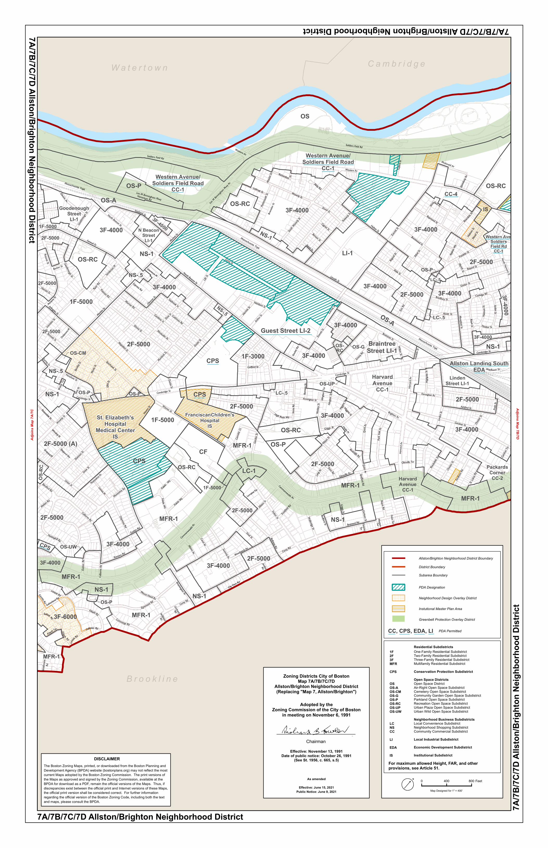
W a t e r t o w n C a m b r i d g e

B r o o k l i n e

7A/7B/7C/7D Allston/Brighton Neighborhood District

7A/7B/7C/7D Allston/Brighton Neighborhood District

Allston/Brighton Neighborhood District Boundary

District Boundary

Subarea Boundary

Greenbelt Protection Overlay District

For maximum allowed Height, FAR, and otherprovisions, see Article 51.

1F2F3FMFRCPS

OSOS-AOS-CMOS-GOS-POS-RCOS-UPOS-UW

LCNSCCLIEDAIS

Zoning Districts City of BostonMap 7A/7B/7C/7D

Allston/Brighton Neighborhood District(Replacing "Map 7, Allston/Brighton")

As amended

Effective: June 15, 2021Public Notice: June 9, 2021

Residential SubdistrictsOne-Family Residential SubdistrictTwo-Family Residential SubdistrictThree-Family Residential SubdistrictMultifamily Residential SubdistrictConservation Protection SubdistrictOpen Space DistrictsOpen Space DistrictAir-Right Open Space SubdistrictCemetery Open Space SubdistrictCommunity Garden Open Space SubdistrictParkland Open Space SubdistrictRecreation Open Space SubdistrictUrban Plaza Open Space SubdistrictUrban Wild Open Space SubdistrictNeighborhood Business SubdistrictsLocal Convenience SubdistrictNeighborhood Shopping SubdistrictCommunity Commercial SubdistrictLocal Industrial SubdistrictEconomic Development SubdistrictInstitutional Subdistrict

PDA Permitted

Neighborhood Design Overlay District

Adjoins Map 7B/7D

Map Designed for 1" = 400'

0 400 800 FeetN

7A/7B/7C/7D Allston/Brighton Neighborhood District

7A/7B

/7C/7D

Allst

on/B

righto

n Neig

hbor

hood

Dist

rict

CC, CPS, EDA, LI

PDA Designation

Adjoi

ns M

ap 7A

/7C

Instutional Master Plan Area

Adopted by theZoning Commission of the City of Boston

in meeting on November 6, 1991

Effective: November 13, 1991Date of public notice: October 26, 1991

(See St. 1956, c. 665, s.5)

Chairman

The Boston Zoning Maps, printed, or downloaded from the Boston Planning andDevelopment Agency (BPDA) website (bostonplans.org) may not reflect the mostcurrent Maps adopted by the Boston Zoning Commission. The print versions ofthe Maps as approved and signed by the Zoning Commission, available at theBPDA for download as a PDF, remain the official versions of the Maps. Thus, ifdiscrepancies exist between the official print and Internet versions of these Maps, the official print version shall be considered correct. For further informationregarding the official version of the Boston Zoning Code, including both the textand maps, please consult the BPDA.

DISCLAIMER