Embed Size (px)
Citation preview

DRAFT Phase 2 Report
System Reoperation Study Strategy Formulation and Refinement
February 2014
California Department of Water Resources

Phase 2 Report –Strategy Formulation and Refinement – Draft
February 2014 | i
Table of Contents
Acronyms and Abbreviations ....................................................................................................................... iii Executive Summary ....................................................................................................................................... 1
Study Process ............................................................................................................................................ 2 Strategy Formulation and Refinement ..................................................................................................... 3 Next Steps ................................................................................................................................................. 5
1.0 Introduction ...................................................................................................................................... 6 1.1 Study Background ......................................................................................................................... 7
1.1.1 Study Authorization and Objectives ..................................................................................... 7 1.1.2 Study Area ............................................................................................................................. 7 1.1.3 Study Process ........................................................................................................................ 9 1.1.4 Planning Principles .............................................................................................................. 10 1.1.5 Study Assumptions and Constraints ................................................................................... 10
1.2 Related Studies and Programs .................................................................................................... 11 1.2.1 Central Valley Flood Protection Plan .................................................................................. 12 1.2.2 Shasta Lake Water Resources Investigation ....................................................................... 12 1.2.3 North-of-the-Delta Offstream Storage Investigation.......................................................... 12 1.2.4 Folsom Dam Joint Federal Project ...................................................................................... 12 1.2.5 Bay-Delta Conservation Plan ............................................................................................... 13 1.2.6 Delta Plan ............................................................................................................................ 13 1.2.7 San Joaquin River Restoration Program .............................................................................. 13 1.2.8 Upper San Joaquin River Basin Storage Investigation ........................................................ 14 1.2.9 Cross Valley Canal Expansion Project ................................................................................. 14 1.2.10 Central Valley Basin Study .................................................................................................. 14
1.3 Climate Change ........................................................................................................................... 14 2.0 Phase 2 Summary and System Reoperation Concepts ................................................................... 16
2.1 System Reoperation Building Blocks ........................................................................................... 16 2.1.1 Forecast-Based Operations Analysis ................................................................................... 16 2.1.2 Outreach and Vetting Process ............................................................................................ 24 2.1.3 Tradeoff Analysis ................................................................................................................. 25
2.2 Promising Strategies to be Advanced to Phase 3 Preliminary Assessments .............................. 29 2.2.1 Concept for Shasta and Oroville Reservoir Reoperation .................................................... 31 2.2.2 Concept for Reoperation of New Exchequer Dam .............................................................. 31 2.2.3 Operational Components Included in All Reservoir Reoperation ....................................... 31 2.2.4 Concept for SWP and CVP Integration ................................................................................ 32
3.0 Next Steps ....................................................................................................................................... 33 3.1 Evaluation Baseline ..................................................................................................................... 33 3.2 Analytical Tools ........................................................................................................................... 33 3.3 Metrics to be Evaluated .............................................................................................................. 34
3.3.1 Water Supply Metrics ......................................................................................................... 34 3.3.2 Ecosystem Metrics .............................................................................................................. 34 3.3.3 Flood Risk Reduction Metrics .............................................................................................. 35

System Reoperation Study
ii | February 2014
Tables Table 2-1. Thirteen Potential Strategies That Went into Vetting Process .................................................. 18 Table 2-2. Summary of Reservoir Refill with Historical and F-BO Reoperation Conditions .................... 23 Table 2-3. Summary of Effects on SWP and CVP Carryover Storage and Water Supply from F-BO Reoperation ....................................................................................................... 23 Table 2-4. Tradeoff Analysis Scenario Matrix ........................................................................................... 26 Table 2-5. Summary of Tradeoffs Analysis ................................................................................................ 28 Table 2-6. Summary of Pulse Flow Analysis Without Water Supply Index Threshold ............................. 30
Figures Figure ES-1. Location of Central Valley and Study Area for SRS ............................................................... 2 Figure 1-1. Location of Central Valley and Study Area for SRS ................................................................. 9 Figure 2-1. Depiction of the reservoir space allocations under (a) typical operating paradigm and (b) forecast-based operations. ........................................................................................................................... 17
List of Attachments Attachment A Draft System Reoperation Study Forecast-Based Operations Analysis
Attachment B Draft System Reoperation Tradeoff Analysis Technical Report

Phase 2 Report –Strategy Formulation and Refinement – Draft
February 2014 | iii
Acronyms and Abbreviations BDCP Bay Delta Conservation Plan
COA Coordinated Operations Agreement
CVP Central Valley Project
CVPIA Central Valley Project Improvement Act
DWR California Department of Water Resources
F-BO Forecast-based flood operations
IDC Isolated Delta conveyance
JFP Folsom Dam Joint Federal Project
MAGPI Merced Area Groundwater Planning Initiative
M&I municipal and industrial
NODOS North-of-the-Delta Offstream Storage
POS Plan of Study
Reclamation United States Department of the Interior Bureau of Reclamation
SPFC State Plan of Flood Control
SRS System Reoperation Study
SWP State Water Project
USACE United States Army Corps of Engineers

Phase 2 Report –Strategy Formulation and Refinement – Draft
February 2014 | 1
Executive Summary The California Department of Water Resources (DWR) is conducting a system reoperation study (SRS) in cooperation with other State and federal agencies, local water districts, groundwater managers, and other stakeholders, to identify potential strategies for reoperation of the statewide flood protection and water supply systems. The opportunity to reoperate portions of California’s statewide water system to yield increased water resources-related benefits was recognized by the State Legislature in Senate Bill X2 1 (SB X2 1) (Perata, 2008 – Water Code Section 83002.5).
In support of the legislative objectives, DWR developed the SRS to identify viable reoperation strategies and understand how integrated management can:
• Improve the reliability of municipal and irrigation water supply • Reduce flood hazards • Restore and protect ecosystem function and habitat conditions • Buffer the hydrologic variations expected from climate change • Improve water quality
California’s statewide water system is comprised of a multitude of local, state, and federal projects. These projects include facilities such as dams and reservoirs, hydropower plants, canals, and water diversion structures. Many of these facilities were developed in the early to mid-20th century, and were not designed, constructed, or operated as an integrated water supply and flood management system. Over time, operations of the two largest water supply projects, the State Water Project (SWP), operated by DWR and the Central Valley Project (CVP), operated by the U.S. Department of the Interior’s Bureau of Reclamation (Reclamation), have been integrated to a certain degree.
California’s water supply and flood management infrastructure is physically interconnected to the extent that it is technically feasible to move water around the system from Trinity County in the north to Imperial County in the south. However, the management of the water system is not as well integrated as it could be. The underlying logic of the SRS is that California can do much more with its existing water infrastructure by taking advantage of the physical interconnections (and enhancing them) while also operating the system in a coordinated manner to optimize the benefits.
The current focus of the SRS is the Central Valley because this region has the highest integration of water supply and flood management facilities. Additionally, the greatest potential for ecosystem restoration through infrastructure reoperation is found in the Central Valley because the existing infrastructure has had a profound effect on aquatic ecosystems. Figure ES-1 shows the location of the Central Valley and study area for the SRS. Figure 1-1 also shows major features of the CVP and SWP.

System Reoperation Study
2 | February 2014
Figure ES-1. Location of Central Valley and Study Area for SRS
Study Process Development of the SRS is a multi-phased effort that includes:
• Phase 1 – Plan of Study • Phase 2 – Strategy Formulation and Refinement • Phase 3 – Preliminary Assessments of Strategies • Phase 4 – Reconnaissance Level Assessments of Strategies
Phase 2 Report –Strategy Formulation and Refinement – Draft
February 2014 | 3
This Phase 2 report summarizes the work that has been completed since the plan of study (POS) was released in March 2011 and provides next steps for Phase 3 and Phase 4 of the SRS.
This study is being conducted to identify and assess viable reoperation strategies to improve (1) water supply reliability, (2) flood hazard reduction, and (3) ecosystem protection and restoration (i.e., the three mission areas of this study). In development of the SRS, DWR has adopted a set of guiding principles, study assumptions, and constraints (e.g., physical limitations and regulations) to guide the formulation of reoperation strategies. Principally, reoperation studies of regional and local projects will be performed with the collaborative and voluntary participation of infrastructure owners and operators; and priority for study will be reoperation opportunities that simultaneously provide a net improvement in flood management, water supply reliability, and ecosystems functions. Additionally, numerous related studies (e.g., the Central Valley Flood Protection Plan, Bay Delta Conservation Plan, and Reclamation’s Central Valley Basin Study) are being undertaken simultaneously at the local, State and federal levels with goals and objectives similar to that of the SRS; therefore, the SRS is being developed in the context of, and in coordination with, these studies to the maximum extent feasible.
Strategy Formulation and Refinement The initial challenge for the SRS was to formulate a list of infrastructure reoperation strategies designed to simultaneously achieve all three of the study objectives: improve water supply reliability, reduce flood risks, and restore damaged aquatic ecosystems. Water system optimization studies conducted in river basins around the world have identified a limited universe of physical and operations changes in existing infrastructure which, if combined together in different ways, provide all the possible permutations for constructing optimization strategies. These general “building blocks” include:
• Reoperate reservoirs by changing the storage and discharge regime. • Integrate management of groundwater and surface water by utilizing dewatered aquifer space
for storage in conjunction with reservoir reoperation. • Transfer water among willing parties to reallocate limited supplies from existing water rights
holders to uses bearing a higher/different economic or social value. • Change stream flow patterns to improve magnitude, duration, frequency, timing and location of
both high and low flow events below reservoirs to restore the more natural flow conditions conducive to ecosystem health and productivity.
• Expand through-valley flood conveyance and reactivate floodplains via levee set-backs, expanded flood bypasses, increased transitory storage, easements, and similar actions.
• Retrofit dams, such as expanding outlets, adding or relocating outlets, increasing the spillway size, retrofitting sluice gates, and other physical changes that allow changes in reservoir flow releases.
• Change points, timing and/or volume of diversions to reduce or alter diversions (e.g., the isolated conveyance facility proposed within the Bay Delta Conservation Plan).
• Improve conveyance; interconnections can increase the flexibility of water storage and delivery in the Central Valley.
• Improve fish passage, such as installing fish passage facilities around dams.
The combining of these building blocks into reoperation strategies for SRS was an iterative process that was started in the POS and will be continued through Phase 4, where their feasibility and effectiveness in achieving the study objectives will be assessed at a reconnaissance level. In the POS, these building blocks were used to develop 22 potential reoperation strategies. The 22 potential strategies were narrowed down and refined by further analyses, including forecast-based operations analysis, an outreach and

System Reoperation Study
4 | February 2014
vetting process, and a tradeoff analysis. Nine of the 22 potential strategies identified in the POS are about the technique of forecast-based operations (F-BO) applied to various Central Valley reservoirs that have a traditional water supply and flood control space allocation paradigm). F-BO is not a discrete strategy and will be an element in each reservoir reoperation strategy that emerges from the SRS. It is better understood as another “building block”. That clarification left 13 preliminary strategies:
• Integrate operations of reservoirs in American River watershed with groundwater-pumping operations of groundwater banking in Sacramento area near American River
• Integrate operations of reservoirs in Sacramento River watershed with groundwater-pumping operations of San Joaquin River or Tulare Basin groundwater users
• Integrate operations of reservoirs in Sacramento River watershed with groundwater-pumping operations of San Joaquin River or Tulare Basin groundwater users
• Reoperation and groundwater storage options to facilitate Bay Delta Conservation Plan (BDCP) solutions
• Integrate operations of reservoirs in San Joaquin River watershed and groundwater-pumping operations of Merced-area groundwater users (using in lieu-recharge)
• Integrate operations of reservoirs in San Joaquin River watershed and groundwater-pumping operations of Madera-area groundwater users (using active recharge)
• Integrate operations of reservoirs in San Joaquin River watershed and groundwater-pumping operations of Modesto and Turlock-area districts groundwater users
• Integrate CVP-SWP reservoir operations • Integrate operation of CVP, SWP, and South Delta export pumps • Integrate operation of CVP reservoir and U.S. Army Corps of Engineers (USACE) reservoirs • Integrate CVP-SWP reservoir operations and local reservoir operations • Reoperate flood management reservoirs in the Central Valley in conjunction with reactivated
downstream floodplains • Reduction in physical losses of water supply through transfer facilitation
A vetting process on various reoperation strategies included a series of consultations over several months with the water management institutions whose infrastructure or water management policies could be implicated in any of the potential reoperation strategies. During vetting, five potential strategies were eliminated from this study after discussions with the infrastructure owners and operators.
Further, a reconnaissance level tradeoff analysis was designed and performed with the goal of identifying potential reoperation options for the Shasta and Oroville reservoir reoperation strategies and to improve understanding of existing system constraints. The analysis was referred to as a “tradeoff analysis” in recognition of the fact that the existing water supply and flood management system is highly integrated and currently operated to meet water supply, flood management, and ecosystem purposes. Therefore, reoperation strategies designed to meet one of the three objectives of the SRS frequently create tradeoffs with the other objectives. For example, reductions in required reservoir space for flood management may improve water supply reliability but increase risk of flood damage.
Based on the Phase 2 analyses, four system reoperation strategies are recommended for preliminary assessments in Phase 3. These strategies include:
• Reoperation of Shasta Reservoir – The basic concept of system reoperation for Shasta Reservoir is to lower carryover storage levels relative to current operations and to increase flood reservation by conveying additional water to either an existing or future groundwater bank located in the Sacramento Valley or south of the Delta, with available capacity.
• Reoperation of Oroville Reservoir – The basic concept of system reoperation for Oroville Reservoir is to lower carryover storage levels relative to current operations and to increase

Phase 2 Report –Strategy Formulation and Refinement – Draft
February 2014 | 5
flood reservation by conveying additional water to either an existing or future groundwater bank located in the Sacramento Valley or south of the Delta, with available capacity.
• Reoperation of New Exchequer Dam (Lake McClure) – The concept for reoperation of New Exchequer Dam (Lake McClure) is with reservoir payback by in lieu groundwater banking within the Merced Irrigation District and the Merced Area Groundwater Planning Initiative (MAGPI). The reoperation would enable environmental flows to be restored from the dam to the Delta to improve conditions for steelhead trout. This strategy would be developed and conducted in partnership with Merced Irrigation District and MAGPI.
• Integration of the SWP and CVP operations – The study team is working with the SWP and CVP operators to explore ways that the two projects’ operations could be further/more fully integrated to provide mutual water supply benefits to the SWP and CVP, reduce flood hazard, and improve ecosystem protection and restoration.
All strategies will include forecast-based operations, conjunctive management, system integration, and environmental flows to varying extents.
Next Steps The SRS is moving on to Phase 3 – Preliminary Assessment of Strategies. The purpose of Phase 3 is to evaluate, sort, and rank the reoperation strategies based on their performance in meeting the goals and objectives of the study. The strategies will be examined for acceptability, completeness, effectiveness, and efficiency. Phase 3 will include:
• Defining baseline operations • Defining the operations of the strategies • Evaluating system reoperation strategies:
o Identifying existing physical and operational constraints o Identifying new or modified physical facilities needed for potential system reoperation
strategies o Conducting hydrologic and other modeling o Quantifying benefits o Analyzing appropriate climate change scenarios
• Ranking reoperation strategies based on their performance • Selecting reoperation strategies to be carried forward into Phase 4 for more detailed analysis
The strategies evaluated in Phase 3 that meet the objectives of the study will be carried forward for more detail evaluations in Phase 4 that will include:
• Analyzing and assessing reoperation strategies • Evaluating ability of strategies to reduce or minimize impacts of climate change on water
supply, flood management, and ecosystems • Evaluating benefits • Evaluating costs • Quantifying economic benefits • Developing conceptual designs for facilities modifications • Identifying institutional challenges • Documenting the findings • Recommending strategies for potential implementation • Identifying funding and key steps necessary for implementation • Making recommendations for next steps • Preparing the final SRS report

System Reoperation Study
6 | February 2014
1.0 Introduction California’s statewide water system is comprised of a multitude of local, state, and federal projects. These projects include facilities such as dams and reservoirs, hydropower plants, canals, and water diversion structures. Many of these facilities were developed in the early to mid-20th century, and were not designed, constructed or operated as an integrated water supply and flood management system. Over time, operations of the two largest water supply projects, the State Water Project (SWP), operated by the California Department of Water Resources (DWR), and the Central Valley Project (CVP), operated by the U.S. Department of the Interior’s Bureau of Reclamation (Reclamation), have been integrated to a certain degree. The current level of integration is based on the Coordinated Operations Agreement1 (COA) that was initiated in the 1970’s and finalized in 1986.
California’s water supply and flood management infrastructure is physically interconnected to the extent that it is technically feasible to move water around the system from Trinity County in the north to Imperial County in the south. However, the management of the water system is not as well integrated as it could be. These realities influence water resources planning in two ways:
1. Changes in water management at any point may have consequences throughout the rest of the system.
2. The inherent physical interconnections in the system provide opportunities for improving water resource benefits throughout the Central Valley via more integrated management arrangements.
This system reoperation study (SRS) was undertaken with these two points in mind. The underlying logic is that California can do much more with its existing water infrastructure by taking advantage of the physical interconnections (and enhancing them) while also operating the system in a coordinated manner to optimize the benefits. This SRS is a systems analysis to understand how integrated management can:
• Improve the reliability of municipal and irrigation water supply • Reduce flood hazards • Restore and protect ecosystem function and habitat conditions • Buffer the hydrologic variations expected from climate change • Improve water quality
Examples of enhanced interconnections include conjunctive management of groundwater and surface water and isolated conveyance of water between the two great river systems of the Central Valley, the Sacramento and San Joaquin. Both of these open up large opportunities for system-wide improvements.
DWR is conducting this study in cooperation with other State and federal agencies, local water districts, groundwater managers, and other stakeholders, to identify potential strategies for reoperation of the statewide flood protection and water supply systems. This Phase 2 report summarizes the work that has been completed since the plan of study (POS) was released in March 2011 and provides next steps for Phase 3 and Phase 4 of the SRS.
1 The Agreement between the United States of America and the State of California for Coordinated Operation of the Central Valley Project and the State Water Project was authorized by PL 99-546 in 1986.

Phase 2 Report –Strategy Formulation and Refinement – Draft
February 2014 | 7
1.1 Study Background
1.1.1 Study Authorization and Objectives
The opportunity to reoperate portions of California’s statewide water system to yield increased water resources-related benefits was recognized by the State Legislature in Senate Bill X2 1 (SB X2 1) (Perata, 2008 – Water Code Section 83002.5), which mandated and allocated resources for “planning and feasibility studies to identify potential options for the reoperation of the state's flood protection and water supply systems that will optimize the use of existing facilities and groundwater storage capacity.” Specifically, SB X2 1 stipulated that, “the studies shall incorporate appropriate climate change strategies and be designed to determine the potential to achieve the following objectives:
(I) Integration of flood protection and water supply systems to increase water supply reliability and flood protection, improve water quality, and provide for ecosystem protection and restoration. (II) Reoperation of existing reservoirs, flood facilities, and other water facilities in conjunction with groundwater storage to improve water supply reliability, flood hazard reduction, and ecosystem protection and to reduce groundwater overdraft. (III) Promotion of more effective groundwater management and protection and greater integration of groundwater and surface water resource uses. (IV) Improvement of existing water conveyance systems to increase water supply reliability, improve water quality, expand flood protection, and protect and restore ecosystems.”
In support of the legislative objectives, DWR developed the SRS to identify viable reoperation strategies. These reoperation strategies will be assessed with respect to their ability to improve (1) water supply reliability, (2) flood hazard reduction, and (3) ecosystem protection and restoration (i.e., the three mission areas of this study).
Along with the three mission areas, water quality, groundwater overdraft, and climate change are also mentioned in SB X2 1. Water quality affects water supply and ecosystems, and is therefore included within those discussions. Similarly, groundwater overdraft is considered here as a component of water supply. Finally, because climate change increases the variability of hydrology, and because such variability is expected to further stress future water supply, flood hazard management infrastructure, and aquatic ecosystems, climate change is also considered within each of those topical areas.
1.1.2 Study Area The geographic scope of this study could include the entire state of California; however, a close read of the legislative mandate focuses this study on the “state’s flood protection and water supply systems”. This suggests that emphasis should be given to those areas of the state where both of these systems are found and operate together. The state’s major flood management infrastructure is located in the Central Valley, both north and south of the Delta, (i.e., the State Plan of Flood Control). The Central Valley is also where the greatest concentration of interconnected water supply infrastructure is located.
Because this infrastructure has had a profound effect on aquatic ecosystems, the greatest potential for ecosystem restoration through infrastructure reoperation is also found in the Central Valley. For these reasons, the initial geographic scope for identifying system reoperation opportunities focused on the Central Valley.

System Reoperation Study
8 | February 2014
Figure 1-1 shows the location of the Central Valley and study area for this SRS. Figure 1-1 also shows features of the CVP and SWP. The CVP and the SWP are the two main water storage and delivery systems within the Central Valley. The CVP is managed by Reclamation and the SWP is managed by DWR. The CVP consists of 20 reservoirs, 11 power plants, and more than 500 miles of canals and aqueducts, with a total storage capacity of more than 11 million acre-feet (MAF). Project purposes include: flood management; navigation; provision of water for irrigation and domestic uses; fish and wildlife protection, restoration, and enhancement; and power generation. The SWP consists of 34 storage facilities, reservoirs and lakes; 20 pumping plants; four pumping-generating plants; five hydroelectric power plants; and about 700 miles of open canals and pipelines. The SWP’s purpose is to store and distribute water for agricultural, municipal, and industrial uses in Northern California, the San Francisco Bay area, the San Joaquin Valley, the Central Coast, and Southern California. Other functions include flood management; water quality maintenance; power generation; recreation; and fish and wildlife enhancement. Major facilities of the CVP and SWP include: Shasta Lake, Keswick Reservoir, and Red Bluff Diversion Dam on the Sacramento River; Trinity Lake on the Trinity River; Whiskeytown Reservoir on Clear Creek; Lake Oroville and Thermalito Afterbay on the Feather River; Folsom Lake and Folsom South Canal on the American River; New Melones Lake on the Stanislaus River; Millerton Lake on the San Joaquin River; Harvey O. Banks (SWP) and C.W. “Bill” Jones (CVP) pumping plants; the Contra Costa Canal and North Bay and South Bay aqueducts in the Delta; and the Delta-Mendota Canal, Governor Edmund G. Brown California Aqueduct, Friant-Kern and Madera canals, and San Luis Reservoir in the San Joaquin Valley.

Phase 2 Report –Strategy Formulation and Refinement – Draft
February 2014 | 9
Figure 1-1. Location of Central Valley and Study Area for SRS
1.1.3 Study Process Development of the SRS is a multi-phased effort that includes:
• Phase 1 – Plan of Study • Phase 2 – Strategy Formulation and Refinement • Phase 3 – Preliminary Assessments of Strategies • Phase 4 – Reconnaissance Level Assessments of Strategies

System Reoperation Study
10 | February 2014
Phase 1 – Plan of Study, which was completed in March 2011: • Provided early direction and scope for the study • Identified problems, needs, and opportunities • Identified measures that could be assembled into reoperation strategies • Established a framework for the identification, development, and future ranking of reoperation
strategies • Laid out a preliminary process/path to assess reoperation strategies to improve performance for
water supply reliability, flood hazard reduction, and ecosystem protection and restoration • Presented an initial roster of reoperation concepts for further study
This Phase 2 report marks the completion and documentation of Phase 2 - Strategy Formulation and Refinement, which includes:
• Formulation of preliminary strategies • Vetting of preliminary strategies with stakeholders • Tradeoff analysis of preliminary strategies • Preliminary analysis of forecast-based operations (a component of all preliminary strategies) • Refinement and screening of preliminary strategies
1.1.4 Planning Principles In development of the SRS, DWR has adopted a set of guiding principles drawn (with minor modifications) from the California Water Plan Update 2009 as follows:
1. Water supply benefits resulting from reoperation will be shared with the owners of the projects as negotiated with the owners.
2. Reoperation studies of regional and local projects will be performed with the collaborative and voluntary participation of infrastructure owners and operators.
3. Priority for study will be reoperation opportunities that simultaneously provide a net improvement in flood management, water supply reliability, and ecosystems functions.
4. A reasonable range of predictions regarding anticipated changes in hydrology and run-off patterns anticipated from climate change will be taken into account in the reoperation studies.
1.1.5 Study Assumptions and Constraints The POS developed in Phase 1 of the SRS included a table that described both “fixed” and “malleable” constraints to help contain the development of the reoperation strategies. Fixed constraints include physical conditions that the study team takes as limitations in formulating reoperation strategies. For example, capacities of existing infrastructure and design conditions adopted for the study and the requirement that all reoperation strategies must provide a net improvement for all objectives of the project. The study team will not consider strategies that enhance water supplies at the expense of environmental flow improvements or vice versa. However, the study considers strategies that benefit one parameter within an objective at the expense of another so long as there is a basis for concluding that the net effect will be beneficial. For example, strategies that improve dry year irrigation supplies at the expense of average deliveries may be net beneficial in systems that do not have internal storage; or it might be that improvements in Delta inflow patterns at the expense of Delta outflows would provide a net improvement in conditions for native species throughout the system.

Phase 2 Report –Strategy Formulation and Refinement – Draft
February 2014 | 11
“Malleable” constraints are economic or legal conditions that can be adjusted as necessary to implement a physical improvement in the system. The following are examples of malleable constraints:
• Some reservoir reoperations may only be economically attractive if water supply beneficiaries compensate some groundwater users for increasing the depths of their wells.
• Water quality control plans may need to be adjusted to implement changes in points of diversion.
• Water control manuals for reservoirs can be amended by the U.S. Army Corps of Engineers (USACE) to accommodate reservoir reoperation strategies that reduce flood risks.
• COA may need to be amended to permit more integrated operations of the CVP and SWP systems.
Accordingly, strategies that would require changes in economic incentives or transfer payments to compensate for financial costs or voluntary transfers of water subject to proprietary rights are eligible for consideration. However, some regulatory constraints are considered “fixed” constraints for the study. One of these is endangered species regulations.
As the SRS progressed, the study team had to reconsider assumptions regarding the types of infrastructure improvements that will be considered within the scope of the study. The POS looked at the possibility that only minor improvements to existing infrastructure would be necessary to make a strategy feasible. Interconnections of canals or drilling of additional wells would be included in the strategies, with the major exception of isolated conveyance of water through the Delta. In light of the BDCP process, the study team determined that the utility of the SRS would be greatest if it evaluated the feasibility of reoperation strategies both with and without isolated Delta conveyance (recognizing that some of the strategies are only feasible with improved Delta conveyance).
One final constraint on the formulation of reoperation strategies is the SRS will only assess reoperation strategies involving infrastructure that is owned or operated by entities other than the State of California with their concurrence and participation, or at least acquiescence. For this reason, much time and effort has been expended by the study team in vetting the emergent reoperation concepts with these facility owners and operators, and incorporating their feedback and preferences, so that the strategies that are assessed will be those that these water managers are interested in considering.
1.2 Related Studies and Programs Numerous related studies are being undertaken simultaneously at the local, State and federal levels with goals and objectives similar to that of the SRS (i.e., flood hazard reduction, water supply reliability, ecosystem protection and restoration). DWR’s SRS is being developed in the context of, and in coordination with, these studies to the maximum extent feasible.
Additionally, the SRS considers projects, studies, and programs that, if implemented, could affect reoperation opportunities. Although strategies are formulated to reoperate existing facilities, major new facilities are in the planning stages, and if constructed and brought on-line, could affect reoperation. For example, BDCP, Shasta Dam and Shasta Lake enlargement, Sites Reservoir, and the Cross Valley Canal are well along in the planning process.
Potential related studies are too numerous to summarize in this report. Appendix B of the POS summarized these studies. The studies and programs identified below are specifically discussed because they could have far reaching system-wide effects.

System Reoperation Study
12 | February 2014
1.2.1 Central Valley Flood Protection Plan The Central Valley Flood Protection Plan (CVFPP) created the State Systemwide Investment Approach (SSIA) which proposed sustainable and integrated flood management in areas receiving protection from facilities of the State Plan of Flood Control (SPFC). Collectively, the facilities, lands, programs, conditions, and mode of operations and maintenance for the State-federal flood protection system in the Central Valley are referred to as the SPFC. The SSIA reflects the State’s strategy for modernizing the SPFC facilities. The SSIA includes forecast-based operations for the multipurpose reservoirs involved in providing flood management for the rivers that drain into the Central Valley.
1.2.2 Shasta Lake Water Resources Investigation Reclamation is studying the Shasta Lake Water Resources Investigation (SLWRI). The purpose of the SLWRI is to improve operational flexibility of the Sacramento-San Joaquin Delta (Delta) watershed system through modifying the existing Shasta Dam and reservoir to increase water supply reliability and anadromous fish populations in the upper Sacramento River. Specifically, the objectives of the investigation are to accomplish the following:
• Promote increased survival of anadromous fish populations in the upper Sacramento River. • Increase water supplies and water supply reliability for agricultural, municipal and industrial
(M&I), and environmental purposes to help meet current and future water demands. • Conserve and restore ecosystem resources in the Shasta Lake area and along the upper
Sacramento River, reduce flood damage along the Sacramento River, increase hydropower capabilities at Shasta Dam, maintain and increase recreation opportunities at Shasta Lake, and maintain or improve water quality conditions in the Sacramento River downstream from Shasta Dam and in the Delta.
1.2.3 North-of-the-Delta Offstream Storage Investigation DWR and Reclamation are working in partnership with local, regional, State, and Federal agencies, and stakeholders to study North-of-the-Delta Offstream Storage (NODOS) opportunities. The NODOS investigation’s primary objectives are to improve water supply reliability for agriculture, M&I, and environmental users; increase the survival and health of anadromous fish populations in the Sacramento River along with other aquatic species; improve Delta water quality; and provide flexible hydropower benefits to the statewide power grid. Secondary objectives include: develop additional recreational opportunities; and create incremental flood-damage reduction opportunities in the vicinity of the reservoir.
1.2.4 Folsom Dam Joint Federal Project The Folsom Dam Joint Federal Project (JFP) is a collaborative effort by Reclamation and USACE to improve flood management and address dam safety and hydrologic risk at the Folsom facility. Under the Dam Safety Program, Reclamation identified the requirement for expedited action to reduce hydrologic (overtopping), seismic (earthquake), and static (seepage) events. These events have a low probability of occurrence in a given year; however, due to the large population downstream of Folsom Dam, modifying the facilities is necessary to improve public safety. USACE, in partnership with the Central Valley Flood Protection Board and the Sacramento Area Flood Control Agency is working to implement congressional direction to reduce the risk of flooding in the Sacramento area. The JFP involves the construction of a new auxiliary spillway controlled by six gates, and including a channel, concrete-lined chute, and stilling basin. This new spillway will provide the operational capability for improved hydrologic control (controlled sustained discharge earlier, and for longer durations, and prevention of dam or embankment

Phase 2 Report –Strategy Formulation and Refinement – Draft
February 2014 | 13
overtopping) of storm-induced floods in excess of reservoir storage capacity in advance of and during extreme storm events2. The new auxiliary spillway is slated to be completed in October 2017. The SRS will coordinate with this effort when considering system reoperation strategies that could be influenced by or dependent on Folsom operations.
1.2.5 Bay-Delta Conservation Plan BDCP is a habitat conservation plan with the goals of restoring the Sacramento-San Joaquin Delta ecosystem and securing California water supplies. The BDCP would secure California’s water supply by building new water delivery infrastructure and operating the system to improve the ecological health of the Delta. The BDCP would also restore or protect approximately 145,000 acres of habitat to address the Delta’s environmental challenges. The BDCP is made up of specific actions, called conservation measures, to improve the Delta ecosystem.
The BDCP is being prepared through a collaboration of State, federal, and local water agencies, State and federal fish agencies, environmental organizations, and other interested parties. These organizations have formed the BDCP Steering Committee with the goal of identifying water flow and habitat restoration actions to recover endangered and sensitive species and their habitats in the Delta. A range of alternatives for providing species/habitat protection and improving water supply reliability will be evaluated through the development of an environmental impact report/environmental impact statement. One goal of the BDCP is to provide a reliable water supply to the Delta through isolated conveyance of water. A major feature of BDCP is the Isolated Delta Conveyance (IDC). An IDC facility would increase the reliability of conveying Sacramento River water to CVP, SWP, and other projects south of the Delta. The BDCP would also restore aquatic and terrestrial habitat in the Delta; some of these habitats would benefit from changes in flow regime. The major system changes under consideration in the BDCP have significant potential to influence the performance of system reoperation strategies. Therefore, the SRS will closely coordinate with the BDCP process. The SRS includes IDC as a modification to baseline conditions that will be considered in the evaluation of system reoperation strategies.
1.2.6 Delta Plan The Delta Stewardship Council developed, as required in the 2009 Delta Reform Act, and unanimously adopted, the Delta Plan on May 16, 2013. The Delta Plan lays out new rules and recommendations for the Delta to further the State’s coequal goals of improving statewide water supply reliability, and protecting and restoring a vibrant and healthy Delta ecosystem; all in a manner that preserves, protects, and enhances the unique agricultural, cultural, and recreational characteristics of the Delta. The SRS will coordinate aspects of system reoperation strategies with Delta-specific components, as necessary for compatibility with the Delta Plan.
1.2.7 San Joaquin River Restoration Program The San Joaquin River Restoration Program (SJRRP) has two goals: (1) to restore and maintain fish populations in "good condition" in the main stem of the San Joaquin River below Friant Dam to the confluence of the Merced River, including naturally reproducing and self-sustaining populations of salmon and other fish; and (2) to reduce or avoid adverse water supply impacts to all of the Friant Division long-term contractors that may result from the interim flows and restoration flows. SJRRP is a direct result of a settlement reached in September 2006 from an 18-year lawsuit to provide sufficient fish 2 U.S. Bureau of Reclamation. Record of Decision. Folsom Dam Safety and Flood Damage Reduction Joint Federal Project. May 2007.
http://www.usbr.gov/mp/nepa/documentShow.cfm?Doc_ID=2716.

System Reoperation Study
14 | February 2014
habitat in the San Joaquin River below Friant Dam near Fresno, California. The settlement involved the U.S. Department of the Interior, the U.S. Department of Commerce, the Natural Resources Defense Council, and the Friant Water Users Authority. Because this program will alter future flow regimes in the San Joaquin Basin, the SRS will coordinate all aspects of system reoperation strategies that influence or are dependent on the hydrology of the basin.
1.2.8 Upper San Joaquin River Basin Storage Investigation The Upper San Joaquin River Basin Storage Investigation is a feasibility study being performed by Reclamation and DWR. The investigation evaluates ways to develop alternative water supplies from the San Joaquin River and enhance water exchanges to urban areas. The investigation aims to expand water storage capacity; improve water supply reliability and flexibility for agricultural, urban, and environmental uses; and enhance San Joaquin River water temperature and flow conditions to support anadromous fish restoration efforts. To the extent possible, through pursuit of the planning objectives, alternatives will also include features to help address the following: improve management of flood flows at Friant Dam; preserve and increase energy generation, and improve energy management in the study area; preserve and increase recreation opportunities in the study area; improve San Joaquin River water quality; and improve the quality of water supplies delivered to urban areas.
1.2.9 Cross Valley Canal Expansion Project The Cross Valley Canal (CVC) is located in Kern County and is operated by the Kern County Water Agency. It is the primary conduit for water deliveries to and from the California Aqueduct. Construction was completed on the CVC Expansion Project in 2012. CVC conveyance capacity increased from 922 cubic feet per second (cfs) to 1,422 cfs (an increase of about 54 percent), including 500 cfs of capacity in the CVC/Friant Kern Canal Intertie3.
1.2.10 Central Valley Basin Study Reclamation’s Central Valley Basin Study is a collaborative effort to recommend adaptation strategies in response to climate change. The Central Valley Basin Study encompasses the entire Central Valley of California which ranges from the Tehachapi Range in the South to the Klamath Mountains in the north. Approximately 7 million people reside in the Central Valley and it has been one of the fastest growing regions in the State. The study area includes three major basins which are the Sacramento in the north (which includes a portion of the Trinity River Basin), the San Joaquin in the central portion, and the Tulare Lake in the south. The study will assess potential climate change impacts to the Central Valley Basin’s water supplies and demands. Mitigation and adaptation strategies will be developed to address negative impacts.
1.3 Climate Change California’s water resources and water management systems are vulnerable to the impacts of climate change. To the extent practicable, the SRS will use tools developed by DWR and others to evaluate the resilience of system reoperation strategies to hydrologic changes due to climate change. Climate change impacts can be addressed as a function of projected changes in atmospheric temperature, precipitation, evapotranspiration, snowpack accumulations, snowmelt timing and runoff, and sea level rise. Parameters for these changes can be derived through the approach detailed in the December 23, 2010, DWR paper, Climate Change Characterization and Analysis in California Water Resources Planning Studies.
3 Kern County Water Agency. Cross Valley Canal Expansion. http://www.kcwa.com/projects/cvc_expansion.shtml.

Phase 2 Report –Strategy Formulation and Refinement – Draft
February 2014 | 15
Climate change presents a significant challenge for California water management. Recent climate change studies project a broad range of potential effects, such as increases in air temperature, changes in the timing, amount, and form of precipitation, changes in runoff timing and volume, sea level rise, increased storm extremes, greater floods, and longer droughts.
While there is much uncertainty about how climate change will affect the overall amount of precipitation in California, there is general agreement that climate change will affect both the timing and form of precipitation. Climate change studies indicate that more precipitation will fall in the form of rain instead of snow and that higher temperatures will cause earlier snowmelt. The results of these changes in precipitation form and timing will be a decrease in the overall snowpack storage as well as earlier and greater runoff from both rainfall and earlier snowmelt.
Most of California’s major surface water reservoirs are managed for multiple benefits, but are primarily managed for water supply and flood protection. During the winter, when storms are common, flood protection takes priority and this drives reservoir operation decisions. For the rest of the year, when storms are uncommon, water supply, water quality, and ecosystem management drive reservoir operation decisions.
As runoff patterns shift to occurring earlier in the year, more and more runoff will arrive during the flood operations period. Much of this water will need to pass through the reservoirs to allow the reservoirs to maintain adequate flood protection space. By the time the flood protection season ends, much of the runoff will have already passed through the reservoirs and will not be available in storage for use later in the year, which is during peak water demand periods.
In addition to changes in precipitation timing and form as a result of climate change, studies indicate that sea levels may rise by as much as 55 inches at the Golden Gate Bridge by 2100. Sea level rise would increase salinity in the Delta, requiring larger volumes of fresh water to control salinity for SWP, CVP, and other Delta water user operations. Delta salinity requirements are one of the primary constraints guiding the operation of the SWP and CVP systems.
The system reoperation strategies will be analyzed with appropriate climate change scenarios and evaluated for their ability to reduce or minimize climate change impacts to water supply, flood management, and the ecosystem. System reoperation which involves primarily the use existing storage infrastructure and conveyance systems, such as conjunctive use of surface water and groundwater, could help reduce climate change impacts including reduced snowpack, more precipitation in the form of rain, and early snow melt. For example, by moving water from surface storage to groundwater banking sites in the fall, reservoir levels could be lowered farther so that excess water during the winter and spring could be stored in the reservoirs. This early reservoir drawdown would increase flood storage capacity and therefore improve flood protection. In turn, the water stored in groundwater banking sites would help supplement summer water supplies and decrease the reliance on reduced snowpack runoff.
Large-scale system reoperation strategies, such as conjunctive use of surface water and groundwater, provide opportunities to adapt operations to climate change with an efficient and consistent approach.

System Reoperation Study
16 | February 2014
2.0 Phase 2 Summary and System Reoperation Concepts
2.1 System Reoperation Building Blocks The initial challenge for the SRS was to formulate a list of infrastructure reoperation strategies designed to simultaneously achieve all three of the study objectives: improve water supply reliability, reduce flood risks, and restore damaged aquatic ecosystems. Given the scale and complexity of the Central Valley water and flood systems, this may appear to be a daunting challenge. Yet, in practice, water system optimization studies conducted in river basins around the world have identified a limited universe of physical and operations changes in existing infrastructure which, if combined together in clever ways, provide all the possible permutations for constructing optimization strategies. These “building blocks” are enumerated and described in the POS. A summarized list of the system reoperation building blocks is as follows:
• Reoperate reservoirs by changing the storage and discharge regime. • Integrate management of groundwater and surface water by utilizing dewatered aquifer space
for storage in conjunction with reservoir reoperation. • Transfer water among willing parties to reallocate limited supplies from existing water rights
holders to uses bearing a higher economic or social value. • Change stream flow patterns to improve magnitude, duration, frequency, timing and location of
both high and low flow events below reservoirs to restore the more natural flow conditions conducive to ecosystem health and productivity.
• Expand through-valley flood conveyance and reactivate floodplains via levee set-backs, expanded flood bypasses, increased transitory storage, easements, and similar actions.
• Retrofit dams by expanding outlets, adding or relocating outlets, increasing the spillway size, retrofitting sluice gates, and other physical changes that allow changes in reservoir flow releases.
• Change points, timing and/or volume of diversions to reduce or alter diversions (e.g., the isolated conveyance facility proposed within BDCP).
• Improve conveyance; interconnections can increase the flexibility of water storage and delivery in the Central Valley.
• Improve fish passage by installing fish passage facilities around dams.
The combining of these building blocks into reoperation strategies is an iterative process that was started in the POS and will be continued through Phase 4, where their feasibility and effectiveness in achieving the study objectives will be assessed at a reconnaissance level. In the POS, these building blocks were used to develop 22 potential reoperation strategies. The following subsections describe how the 22 potential reoperation strategies were narrowed down and refined by further analyses, including forecast-based operations analysis, an outreach and vetting process, and a tradeoff analysis.
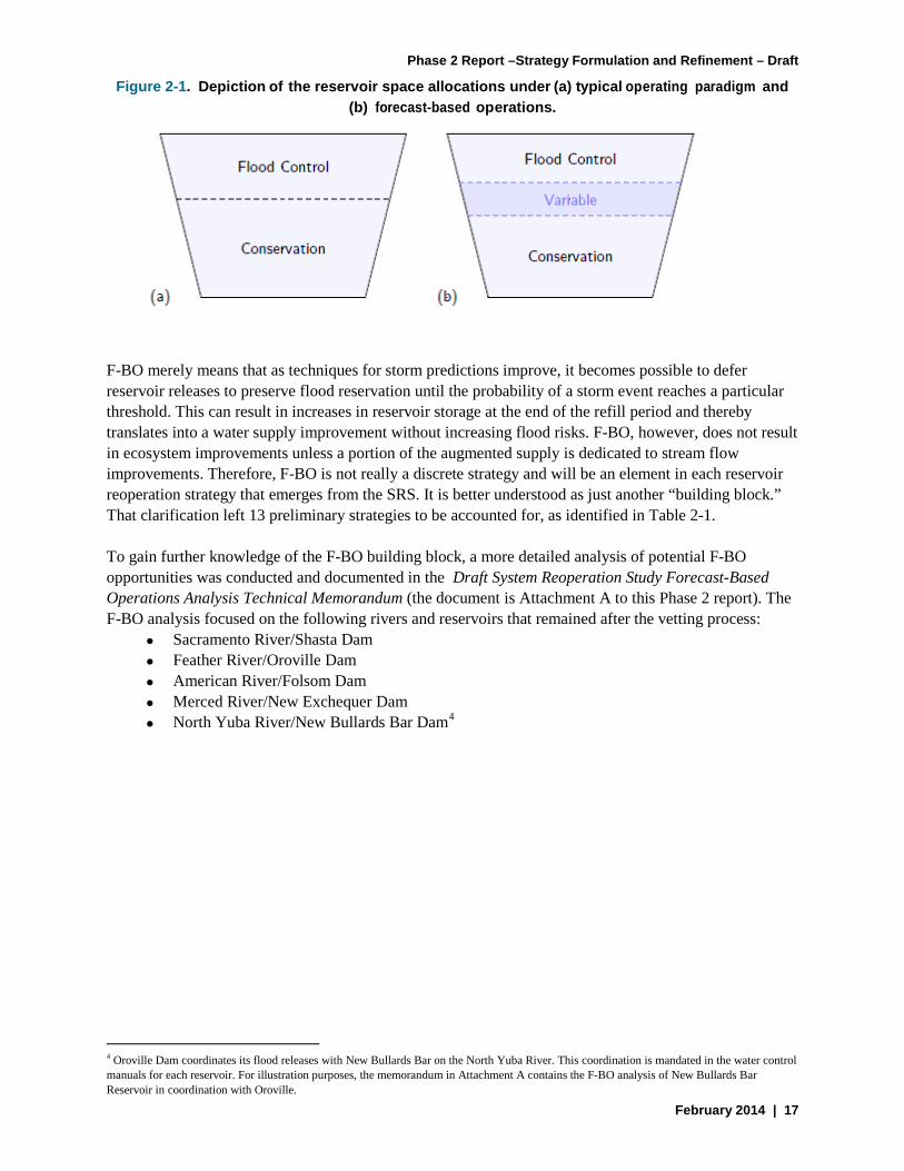
2.1.1 Forecast-Based Operations Analysis Nine of the 22 potential reoperation strategies identified in the POS were merely the technique of forecast-based operations (F-BO) applied to various Central Valley reservoirs that have a traditional water supply and flood control space allocation paradigm (see Figure 2-1). The incorporation of weather forecasts allows for greater flexibility in the management of the reservoir’s space (flood control versus conservation) and inherently increases the opportunities for gaining additional water supply and flood management benefits through its implementation. Figure 2-1 depicts the typical, rigid flood/conservation space division and the flexible division under F-BO.
Phase 2 Report –Strategy Formulation and Refinement – Draft
February 2014 | 17
Figure 2-1. Depiction of the reservoir space allocations under (a) typical operating paradigm and (b) forecast-based operations.
F-BO merely means that as techniques for storm predictions improve, it becomes possible to defer reservoir releases to preserve flood reservation until the probability of a storm event reaches a particular threshold. This can result in increases in reservoir storage at the end of the refill period and thereby translates into a water supply improvement without increasing flood risks. F-BO, however, does not result in ecosystem improvements unless a portion of the augmented supply is dedicated to stream flow improvements. Therefore, F-BO is not really a discrete strategy and will be an element in each reservoir reoperation strategy that emerges from the SRS. It is better understood as just another “building block.” That clarification left 13 preliminary strategies to be accounted for, as identified in Table 2-1.
To gain further knowledge of the F-BO building block, a more detailed analysis of potential F-BO opportunities was conducted and documented in the Draft System Reoperation Study Forecast-Based Operations Analysis Technical Memorandum (the document is Attachment A to this Phase 2 report). The F-BO analysis focused on the following rivers and reservoirs that remained after the vetting process:
• Sacramento River/Shasta Dam • Feather River/Oroville Dam • American River/Folsom Dam • Merced River/New Exchequer Dam • North Yuba River/New Bullards Bar Dam4
4 Oroville Dam coordinates its flood releases with New Bullards Bar on the North Yuba River. This coordination is mandated in the water control manuals for each reservoir. For illustration purposes, the memorandum in Attachment A contains the F-BO analysis of New Bullards Bar Reservoir in coordination with Oroville.

System Reoperation Study
18 | February 2014
Table 2-1. Thirteen Potential Reoperation Strategies That Went into Vetting Process
No. Strategy Reoperation Features Description Result from Vetting Process Integrate Groundwater and Surface Water Operations Sacramento River Watershed Reservoirs and Groundwater Aquifers 1 Integrate Operations of Reservoirs in American River Watershed
with Groundwater-Pumping Operations of groundwater banking in Sacramento area near American River.
a. Reoperate reservoir for groundwater-surface water integration b. Implement forecast-based flood operations at reservoir c. Construct diversion/conveyance facilities from American River to
current groundwater users d. Construct conveyance facilities from wells to back-stop water users e. Reoperate existing groundwater wells f. Construct new groundwater wells g. Develop water transfers h. Integrate operations with existing statewide water supply system i. Integrate operations with existing statewide water supply system and
BDCP facilities
Reoperate American River watershed reservoirs at lower carryover storage levels by delivering additional water for environmental restoration and groundwater banking in Sacramento area near American River. Recover from bank in years when reservoirs do not entirely refill.
Operations of Folsom Reservoir are highly constrained by the municipal water supply obligations. Moreover, Folsom is operated in conjunction with Shasta such that the two must be combined into an integrated reoperation strategy. For these reasons, Folsom reoperation is now included as an element of the Shasta reoperation strategy and this discrete American River reoperation strategy is eliminated.
Sacramento River Watershed Reservoirs and San Joaquin River Groundwater Aquifers
2 Integrate Operations of Reservoirs in Sacramento River Watershed with Groundwater-Pumping Operations of San Joaquin River or Tulare Basin Groundwater users.
a. Reoperate Sacramento River watershed reservoirs for groundwater-surface water integration
b. Implement forecast-based flood operations at Sacramento River watershed reservoirs
c. Reoperate Sacramento River intake and associated conveyance facilities
d. Construct diversion/conveyance facilities conveying to current San Joaquin County groundwater users
e. Construct diversion/conveyance facilities from wells to original water rights holders
f. Reoperate existing groundwater wells g. Construct new groundwater wells h. Develop water transfers i. Integrate operations with existing statewide water supply system j. Integrate operations with existing statewide water supply system and
BDCP facilities
Reoperate Sacramento River watershed reservoirs at lower carryover storage levels by delivering additional water for environmental restoration and groundwater banking in San Joaquin County. Use existing conveyance capacity in existing water supply facilities between the two areas. Recover from bank in years when reservoirs do not entirely refill.
The only reservoir in the Sacramento River watershed with sufficient capacity to provide reoperation benefits is Shasta. Shasta releases can be conveyed to the Tulare basin using the California Aqueduct.

Phase 2 Report –Strategy Formulation and Refinement – Draft
February 2014 | 19
No. Strategy Reoperation Features Description Result from Vetting Process 3 Integrate Operations of Reservoirs in Sacramento River
Watershed with Groundwater-Pumping Operations of San Joaquin River or Tulare Basin Groundwater Users
a. Reoperate reservoirs for groundwater-surface water integration b. Implement forecast-based flood operations at the reservoirs c. Construct diversion/conveyance facilities conveying to current San
Joaquin Valley Groundwater Basin groundwater users
d. Construct diversion/conveyance facilities from wells to original water rights holders
e. Reoperate existing groundwater wells in San Joaquin Valley Groundwater Basin
f. Construct new groundwater wells g. Develop water transfers h. Integrate operations with existing statewide water supply system i. Integrate operations with existing statewide water supply system and
BDCP facilities
Reoperate reservoirs in Sacramento River watershed at lower carryover storage levels by delivering additional water for environmental restoration and consumptive use in groundwater bank area. Reservoirs would refill in most years. In years where reservoirs would not entirely refill, serve groundwater bank area with groundwater from existing and/or new wells in that area.
The only reservoir in the Sacramento River watershed with sufficient capacity to provide reoperation benefits is Shasta. However, Shasta releases cannot be easily conveyed to San Joaquin County for in lieu recharge within the groundwater system.
4 Reoperation and Groundwater Storage Options to Facilitate BDCP Solutions
BDCP is scoped to exclude actions by permittees outside of the Delta. Yet, the in-Delta conditions will be determined by upstream reservoir operations and the ability to store water diverted during times of high Delta inflows for use during times of low Delta inflows. Reservoir reoperation and south of Delta groundwater storage options can increase Delta exports while reducing fishery impacts, compared to the status quo. The System Reoperation Study will explore these storage operations to determine the optimal operations for enhancing BDCP outcomes.
Elements of this strategy will be incorporated in the Shasta and Oroville reoperation strategies with isolated conveyance and south of Delta storage.
San Joaquin River Watershed Reservoirs and San Joaquin River Groundwater Aquifers 5 Integrate Operations of Reservoirs in San Joaquin River
Watershed and Groundwater-Pumping Operations of Merced-Area Groundwater Users (Using In Lieu-Recharge)
a. Reoperate San Joaquin River watershed reservoirs for groundwater-surface water integration
b. Implement forecast-based flood operations at San Joaquin River watershed reservoirs
c. Construct diversion/conveyance facilities from river in San Joaquin River watershed reservoirs to current groundwater users
d. Construct conveyance facilities from wells to original surface water users
e. Reoperate existing groundwater wells f. Construct new groundwater wells g. Develop water transfers h. Integrate operations with existing statewide water supply system i. Integrate operations with existing statewide water supply system and
BDCP facilities
Turn off pumps at end of irrigation season and substitute surface water deliveries to lower carryover storage in San Joaquin River watershed reservoirs and increase groundwater storage in Merced area. In years when reservoirs do not refill completely, backstop by using groundwater in lieu of surface water, release environmental flows.
Reoperation of New Exchequer dam in conjunction with in lieu groundwater storage in the Merced Area Groundwater Users Initiative (MAGPI) is a strategy that will be carried forward into Phase 3 for preliminary assessment.

System Reoperation Study
20 | February 2014
No. Strategy Reoperation Features Description Result from Vetting Process 6 Integrate Operations of Reservoirs in San Joaquin River
Watershed and Groundwater-Pumping Operations of Madera-area Groundwater Users (using Active Recharge)
a. Reoperate San Joaquin River watershed reservoirs for groundwater-surface water integration
b. Implement forecast-based flood operations at San Joaquin River watershed reservoirs
c. Construct diversion/conveyance facilities from irrigation canal in San Joaquin River watershed to current groundwater users
d. Construct active-recharge facilities e. Construct conveyance facilities from wells to original water rights
holders f. Reoperate existing groundwater wells g. Construct new groundwater wells h. Develop water transfers i. Integrate operations with existing statewide water supply system j. Integrate operations with existing statewide water supply system and
BDCP facilities
Pre-deliver water from irrigation canal in San Joaquin River watershed to Madera-area irrigation district at end of irrigation season to lower carryover storage in San Joaquin River watershed reservoir, bank this water in Madera-area groundwater aquifer, draw on banked water at times when Madera-area canal is shut off to generate fishery restoration flows. Groundwater recharge in Madera area would be done actively.
The Madera Irrigation District’s new groundwater banking operation does not have sufficient operating history to assess its practicality as a component of a reservoir reoperation strategy. Also, this water bank is most suitable for storage of water released from Friant Dam and delivered through the Madera Canal. But Friant reoperation for groundwater banking is highly constrained by the fact that carry-over storage at this reservoir is at dead storage most years. For these reasons, the strategies that involve storage of reservoir pay-back water in an actively recharged groundwater bank will instead assume the use of the Kern Water Bank, Arvin-Edison Water Bank, or Semi-Tropic Water Bank.
7 Integrate Operations of Reservoirs in San Joaquin River Watershed and Groundwater-Pumping Operations of Modesto- and Turlock-area Districts Groundwater Users
a. Reoperate reservoirs in San Joaquin River watershed for groundwater-surface water integration
b. Implement forecast-based flood operations at reservoirs in San Joaquin River watershed
c. Construct diversion/conveyance facilities from river in San Joaquin River watershed to current groundwater users
d. Construct conveyance facilities from wells to original water rights holders
e. Reoperate existing groundwater wells f. Construct new groundwater wells g. Develop water transfers h. Integrate operations with existing statewide water supply system i. Integrate operations with existing statewide water supply system and
BDCP facilities
Drill production wells in Modesto- and Turlock-area irrigation districts proximate to irrigation canals. Before the end of the irrigation season, shut off wells and substitute surface water deliveries. Lower carryover storage in reservoirs in San Joaquin River watershed. In years that reservoir does not refill completely, use groundwater in lieu of surface water to make up the difference, restore environmental flows in the river in the San Joaquin River watershed.
The Turlock and Modesto irrigation districts have elected not to participate in the reoperation study (at this time). Hence, reoperation strategies involving New Don Pedro Reservoir have been eliminated from the study until these districts agree to participate.
Integrate SWP, CVP, USACE and Local Surface Water Operations 8 Integrate CVP-SWP Reservoir Operations a. Reoperate CVP reservoirs for surface water integration deficit
(compared to current operations) by drawing on water in other reservoirs. b. Reoperate SWP reservoirs for surface water integration c. Implement forecast-based flood operations at CVP reservoirs d. Implement forecast-based flood operations at SWP reservoirs e. Reoperate other reservoirs f. Construct conveyance facilities from other reservoirs to back-stop water users g. Develop water transfers h. Integrate operations with existing statewide water supply system i. Integrate operations with existing statewide water supply system and BDCP facilities
Reoperate CVP and SWP reservoirs at lower carryover storage levels (to increase flood storage capacity) by releasing additional water to achieve environmental flow targets in Sacramento and Feather rivers, respectively, and for additional water supply in the Sacramento Valley. Implement forecast based flood operations in the reoperation strategy. Reservoir would refill in most years. In approximately 15 percent of years when reservoirs would not entirely refill, the deficit (compared to current operations) can be made up by drawing on water in other reservoirs.
Strategies involving integration of CVP and SWP operations will be carried forward into Phase 3 for preliminary assessment. These may involve integrated use of reservoirs, conveyance, points of diversion and areas of use.

Phase 2 Report –Strategy Formulation and Refinement – Draft
February 2014 | 21
No. Strategies Reoperation Features Description Result from Vetting Process 9 Integrate Operation of CVP, SWP, and South Delta Export
Pumps a. Reoperate CVP reservoirs b. Reoperate SWP reservoirs c. Reoperate SWP south-Delta export pumps d. Reoperate CVP south-Delta export pumps e. Reoperate California Aqueduct-Delta Mendota Canal Intertie f. Develop water transfers g. Modify coordinated operations agreement h. Integrate operations with existing statewide water supply system i. Integrate operations with existing statewide water supply system and
BDCP facilities
Jointly operate currently existing SWP/CVP storage, diversion, and conveyance infrastructure north of and including the south Delta export pumps
Strategies involving integration of CVP and SWP operations will be carried forward into Phase 3 for preliminary assessment. These may involve integrated use of reservoirs, conveyance, points of diversion and areas of use.
10 Integrate Operation of CVP Reservoir and USACE Reservoirs a. Reoperate CVP reservoirs b. Reoperate USACE reservoirs c. Construct diversion/conveyance facilities and interconnections
between San Joaquin watershed service areas d. Develop water transfers e. Integrate operations with existing statewide water supply system f. Integrate operations with existing statewide water supply system and
BDCP facilities
Jointly operate currently existing CVP/USACE storage, diversion, and conveyance infrastructure south of the Delta
The most promising of the USACE-built reservoirs for reoperation is Pine Flat on the Kings River. However, this is a mostly self-contained unit of the Central Valley water system in that the Kings River connects to the rest of the system through flow into the San Joaquin River only in extremely wet years. Some conjunctive use is already practiced in this basin. Accordingly, it does not seem to offer much potential for system reoperation.
11 Integrate CVP-SWP Reservoir Operations and Local Reservoir Operations
a. Reoperate CVP Reservoir b. Reoperate SWP Reservoir c. Reoperate local-owner reservoirs d. Construct diversion/conveyance facilities from local-owner reservoirs
to CVP/SWP water users e. Develop reservoir-storage lease agreements with local owner f. Develop water transfers g. Integrate operations with existing statewide water supply system h. Integrate operations with existing statewide water supply system and
BDCP facilities
Jointly operate currently existing SWP/ CVP storage, diversion, and conveyance infrastructure north of and including the south Delta export pumps with local-owner reservoirs south of the Delta
The only non-project reservoirs of note in the San Joaquin basin are New Exchequer and New Don Pedro. Reoperation of the former will be studied with conjunctive groundwater use in its own service area initially. Once those results have been obtained, it may be interesting to construct a hybrid strategy that would combine New Exchequer reoperation with reoperation of CVP reservoirs (such as New Melones) or with Oroville reoperation. The owners and operators of New Don Pedro have declined to join the reoperation study (for now).

System Reoperation Study
22 | February 2014
No. Strategy Reoperation Features Description Result from Vetting Process Reactivate Floodplains for Improved Flood Hazard Reduction
12 Reoperate Flood Management Reservoirs in the Central Valley in Conjunction with Reactivated Downstream Floodplains
a. Reoperate reservoirs b. Set back levees c. Construct flood bypasses d. Construct transitory storage flood plains e. Modify reservoir rule curves
There are 11 reservoirs with flood management functions in the Central Valley. All of these are currently operated under rule curves designed to prevent inundation of historic floodplains, which have become encroached by post-dam development. In many cases, levees are also a part of this flood management infrastructure. These operations are suboptimal with respect to all of the objectives of this project: flood hazard reduction, water (and power) supply, and environmental flows. Floodplain encroachment reduces the magnitude of dam releases that can be accommodated, and therefore the rate at which flood water can be released. This requires that more reservoir storage space be dedicated to flood reservation than would be necessary if floodplain constraints were ameliorated, at the expense of water supply, power generation and biological productivity. Under this strategy, the System Reoperation Study will investigate the "pinch points" that constrain reservoir operations and strategies to alleviate them. We will focus on floodplains that would be of exceptional ecological value if reactivated. This work directly augments the FloodSAFE California planning program and the Central Valley Flood Protection Plan.
Reactivation of floodplains will be an element of all of the reoperation strategy that will be carried forward into Phase 3 for preliminary assessment. Since reactivation requires reoperation of the upstream reservoirs in all cases, this will be the best way to study the potential for using historic floodplain features to augment transient flood storage and facilitate forecast-based flood operations.
Reduce Physical Losses of Water Supply Though Transfer Facilitation 13 Reduction in Physical Losses of Water Supply Through Transfer
Facilitation a. Reoperate reservoirs b. Develop water transfers c. Construct storage facilities d. Construct conveyance facilities
Appreciable quantities of irrigation water are lost to evaporation and deep percolation because of underinvestment in water conservation technologies in the Central Valley. Market opportunities create the incentives for these investments. However, long-term transfer arrangements are necessary to amortize these investments. Long-term transfers do not occur due to an absence of mechanisms to store and convey conserved water. It may be worthwhile to investigate how such mechanisms could improve water use efficiency, making more water available for consumptive use and environmental flows, and how this could also allow irrigation reservoirs to operate a lower carryover storage levels to enhance flood management.
This reoperation candidate is deferred for consideration until after the current suite of strategies has been assessed.

Phase 2 Report –Strategy Formulation and Refinement – Draft
February 2014 | 23
A reconnaissance-level analysis was performed to demonstrate the refilling potential of Shasta, Oroville, Folsom, and New Bullards Bar reservoirs from F-BO reoperation. Table 2-2 summarizes the results of the reservoir refilling with F-BO reoperation compared with historical conditions.
Table 2-2. Summary of Reservoir Refill with Historical and F-BO Reoperation Conditions
A CalLite model run was performed to demonstrate the potential effects of F-BO reoperation systemwide on the carryover storage and water supply of the SWP and CVP. Table 2-3 summarizes the changes in carryover storage at Shasta, Trinity, Folsom, and Oroville reservoirs, Delta inflow and outflow, and SWP and CVP exports and deliveries with F-BO reoperation.
Table 2-3. Summary of Effects on SWP and CVP Carryover Storage and Water Supply from F-BO Reoperation
Change in Average Annual Carryover Storage (TAF)
Change in Average Annual Delta Flows, Exports, and Deliveries (TAF)
Shas
ta E
OS
Stor
age
Trin
ity E
OS
Stor
age
Fols
om E
OS
Stor
age
Oro
ville
EO
S St
orag
e
Del
ta In
flow
Del
ta O
utflo
w
Jone
s Pu
mpi
ng P
lant
Ban
ks P
umpi
ng P
lant
NO
D A
g Se
rvic
es
Del
iver
ies
NO
D M
&I D
eliv
erie
s
SWP
Tabl
e A
D
eliv
erie
s
Art
icle
21
Del
iver
ies
Base 2,680 1,396 517 1,836 17,913 15,802 2,252 2,630 233 85 2,179 63
F-BO Minus Base
60 20 28 -21 -16 -28 18 -5 11 1 -1 -3
EOS = end of September F-BO = forecast-based operations M&I = municipal and industrial NOD = north of Delta SWP = State Water Project TAF = thousand acre feet
Reservoir Years in Period of Record
Years When Reoperation Increases Max Storage
Years with Spring Refill (Historical Conditions)
Years with Spring Refill (Reoperation Conditions)
Shasta 57 24 12 20
Oroville 42 10 15 19
Folsom 55 22 14 28
New Bullards Bar 39 5 12 13

System Reoperation Study
24 | February 2014
2.1.2 Outreach and Vetting Process The vetting process included a series of consultations over several months with the water management institutions whose infrastructure or water management policies could be implicated in any of the potential reoperation strategies. Table 2-1 identifies the five potential strategies that were eliminated in the vetting process with the infrastructure owners and operators.
To date, vetting sessions have been conducted with the following institutions, and meeting notes have been prepared and maintained for the SRS files:
• Arvin-Edison Water Storage District • Calleguas Municipal Water District • Central Valley Flood Protection Project managers • East Bay Municipal Utility District • Friant Water Users Authority • Glenn Colusa Irrigation District • Inland Empire Utilities Agency • Kern County Water Agency • Kern Water Bank Authority • Madera Irrigation District and Madera Ranch Water Bank • Merced Irrigation District • Metropolitan Water District of Southern California • Modesto Irrigation District • National Marine Fisheries Service • Northern California Water Association • Orange County Water District • Raymond Basin Management Board • Reclamation District 108 • San Gabriel Basin Water Quality Authority • San Luis Delta Mendota Water Authority • Semitropic-Rosamond Water Bank • Study team for Sacramento Valley Conjunctive Water Management Program (Shasta and
Oroville reoperations) • The Nature Conservancy • Three Valleys Municipal Water District • Turlock Irrigation District • U. S. Bureau of Reclamation • U.S. Army Corps of Engineers • Water Replenishment District
The SRS team decided that DWR should limit the scope of the study to strategies that can and will be implemented, if they prove to be feasible and practical. As such, the study is limited to reoperation strategies for which the implementing entities were willing to participate in the study.

Phase 2 Report –Strategy Formulation and Refinement – Draft
February 2014 | 25
2.1.3 Tradeoff Analysis A reconnaissance level tradeoff analysis was designed and performed with the goal of identifying potential reoperation strategies and to improve understanding of existing system constraints. The analysis is referred to as a “tradeoff analysis” in recognition of the fact that the existing water supply and flood management system is highly integrated and currently operated to meet water supply, flood management, and ecosystem purposes. Current system operations are complex and frequently constrained by flood management and environmental requirements, and water rights and contracts for the beneficial use of water. Therefore, reoperation strategies designed to meet one of the three objectives of the SRS frequently create tradeoffs with the other objectives. For example, reductions in required reservoir space for flood management may improve water supply reliability but increase risk of flood damage.
The tradeoff analysis was conducted as a reconnaissance-level study designed to help illustrate how operational changes designed for one purpose can affect other objectives. The analysis is documented in the Draft System Reoperation Tradeoff Analysis Technical Report, which is provided as Attachment B to this report.
The reconnaissance-level study helped identify tradeoffs, some of which were unexpected or unintended, and thereby help guide refinement of more promising strategies. Model simulations performed in the tradeoff analysis are not refined for the purpose of quantifying benefits or impacts, but rather are intended to illustrate how operational changes in one area affect other areas. For example, how CVP operations can affect SWP operations, and vice versa.
The tradeoff analysis focused on two potential reoperation options for the Shasta Reservoir and Oroville Reservoir reoperation strategies:
1. Additional spring releases from reservoirs for ecosystem benefits. A range of spring release volumes from Shasta and Oroville reservoirs was analyzed as a surrogate for potential ecosystem flows. For a reconnaissance-level analysis, defining only the volume and months of additional release is adequate to illustrate and understand tradeoffs.
2. Expanded conjunctive management in the Sacramento Valley. Conjunctive management evaluated in the tradeoff analysis focused on additional groundwater pumping during periods of limited surface water availability to create potential ecosystem and water supply benefits. A reconnaissance-level analysis of this type of operation identifies tradeoffs for a variety of programs that can make additional surface water available during drought periods including groundwater substitution transfer or crop idling.
These two reoperation options were also analyzed in concert to illustrate how the options may work together to meet study objectives; therefore, a total of 26 different tradeoff scenarios were developed and analyzed as part of the tradeoff analysis (Table 2-4).
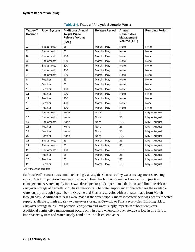
System Reoperation Study
26 | February 2014
Table 2-4. Tradeoff Analysis Scenario Matrix
Tradeoff Scenario
River System Additional Annual Target Pulse Release Volume (TAF)
Release Period Annual Conjunctive Management Volume (TAF)
Pumping Period
1 Sacramento 25 March - May None None
2 Sacramento 50 March - May None None
3 Sacramento 100 March - May None None
4 Sacramento 200 March - May None None
5 Sacramento 300 March - May None None
6 Sacramento 400 March - May None None
7 Sacramento 500 March - May None None
8 Feather 25 March - May None None
9 Feather 50 March - May None None
10 Feather 100 March - May None None
11 Feather 200 March - May None None
12 Feather 300 March - May None None
13 Feather 400 March - May None None
14 Feather 500 March - May None None
15 Sacramento None None 25 May – August
16 Sacramento None None 50 May – August
17 Sacramento None None 100 May – August
18 Feather None None 25 May – August
19 Feather None None 50 May – August
20 Feather None None 100 May – August
21 Sacramento 25 March - May 25 May – August
22 Sacramento 50 March - May 50 May – August
23 Sacramento 100 March - May 100 May – August
24 Feather 25 March - May 25 May – August
25 Feather 50 March - May 50 May – August
26 Feather 100 March - May 100 May – August
TAF = thousand acre feet
Each tradeoff scenario was simulated using CalLite, the Central Valley water management screening model. A set of operational assumptions was defined for both additional releases and conjunctive management. A water supply index was developed to guide operational decisions and limit the risk to carryover storage at Oroville and Shasta reservoirs. The water supply index characterizes the available water supply through September in Oroville and Shasta reservoirs with estimates made from March through May. Additional releases were made if the water supply index indicated there was adequate water supply available to limit the risk to carryover storage at Oroville or Shasta reservoirs. Limiting risk to carryover storage helps limit potential ecosystem and water supply impacts in subsequent years. Additional conjunctive management occurs only in years when carryover storage is low in an effort to improve ecosystem and water supply conditions in subsequent years.
Phase 2 Report –Strategy Formulation and Refinement – Draft
February 2014 | 27
Table 2-5 summarizes results from the 26 tradeoff scenario simulations. Results are average annual values and average annual change from the base simulation that represents the existing flood management and water supply infrastructure and regulatory condition. Results are presented in thousands of acre-feet for the purpose of comparison between scenarios. However, a reconnaissance-level study is not accurate to this level of precision. Results are interpreted to understand potential tradeoffs relative to the volume of additional release or conjunctive management and for comparison between scenarios.
Results presented in Table 2-5 show several key results of the tradeoff analysis. Observations are summarized below by scenario operations:
• Pulse Flow Only Scenarios o The target volume of release is not made every year. o Carryover storage is reduced by making the additional release. o Reduced carryover storage in Shasta Reservoir can result in tradeoffs for both cold-water
resources for water temperature management and water supply in subsequent years. o Reductions in water available in Shasta Reservoir create tradeoffs with water supply to
CVP contractors both north and south of the Delta. o Additional releases from both Shasta and Oroville reservoirs increase Delta outflow and
reduce Delta exports. o Delta export reductions occur primarily to the project, either CVP or SWP, making the
additional reservoir releases. o There can be a small increase in water supply for the project not making additional
reservoir releases in some years. • Conjunctive Management Scenarios
o Conjunctive management pumping results in additional surface water available in the system in some years. A portion of this may be held in upstream reservoirs on the river system where it is pumped (i.e., this increases carryover storage in these reservoirs). Increased carryover storage can provide ecosystem benefits through additional cold-water resources in subsequent years. Increased carryover storage can also improve water supply reliability.
o Additional conjunctive management pumping on the Sacramento River can affect operations in Shasta Reservoir and other CVP facilities, including Trinity Reservoir, and may reduce Trinity River imports.
o A portion of additional surface water made available through expanded conjunctive management pumping goes to increased Delta outflow.
• Pulse Flow with Conjunctive Management Scenarios o There can be additional conjunctive management pumping in combined scenarios
compared to conjunctive management only scenarios because additional spring releases decrease reservoir storage and trigger pumping in more years.
o Expanded conjunctive management may mitigate some of the tradeoffs described above for pulse flow only scenarios.
o Additional spring releases reduce the water supply benefits of expanded conjunctive management.
o A higher percentage of the increased Delta inflow goes to Delta outflow in the combined scenarios compared to conjunctive management only scenarios.

System Reoperation Study
28 | February 2014
Table 2-5. Summary of Tradeoffs Analysis
Trad
eoff
Scen
ario
Riv
er S
yste
m
Scen
ario
N
umbe
r
Targ
et P
ulse
Vo
lum
e
Targ
et
Con
junc
tive
Man
agem
ent
Volu
me
Puls
e R
elea
se
Expa
nded
G
roun
dwat
er
Pum
ping
Sh
asta
EO
S St
orag
e
Trin
ity E
OS
Stor
age
Fols
om E
OS
Stor
age
Oro
ville
EO
S St
orag
e
Del
ta In
flow
(S
acra
men
to
Riv
er)
Del
ta O
utflo
w
Jone
s Pu
mpi
ng
Plan
t
Ban
ks P
umpi
ng
Plan
t
Nor
th-o
f-Del
ta
Agr
icul
tura
l Se
rvic
e D
eliv
erie
s
Average Annual Storage
Average Annual Flow/Export (TAF)
Base -- -- -- -- 2,6
1,396 517 1,836 17,913 15,802 2,252 2,630 233
Additional Volume Change in Storage (TAF) Change in Flow (TAF)
Puls
e Fl
ow O
nly
Sacr
amen
to (S
ac.) 1 25 -- 13 -- -3 2 0 1 1 4 -2 0 0
2 50 -- 25 -- -10 -5 -1 -2 4 6 -3 1 -1 3 100 -- 47 -- -24 -13 -2 -3 8 12 -5 1 -2 4 200 -- 87 -- -42 -25 -5 -3 14 25 -11 0 -5 5 300 -- 126 -- -64 -37 -7 0 18 31 -13 1 -6 6 400 -- 156 -- -79 -48 -6 4 22 39 -17 0 -9 7 500 -- 171 -- -85 -50 -5 3 22 40 -17 -1 -9
Feat
her (
Feat
.)
8 25 -- 7 -- 0 2 0 -5 0 1 0 -2 0 9 50 -- 14 -- 3 5 0 -12 -1 5 -1 -4 1 10 100 -- 27 -- 1 3 1 -25 0 8 0 -7 0 11 200 -- 45 -- 0 0 0 -40 1 14 0 -12 0 12 300 -- 59 -- -1 2 1 -52 0 18 0 -17 0 13 400 -- 56 -- -1 0 1 -49 2 21 0 -18 0 14 500 -- 49 -- 0 1 1 -42 3 18 0 -15 0
Con
junc
tive
Man
agem
ent (
CM
) O
nly Sa
c. 15 -- 25 -- 5 6 2 2 0 3 1 2 0 1
16 -- 50 -- 9 8 6 2 0 7 2 3 1 1 17 -- 100 -- 18 19 8 7 0 14 5 7 2 2
Feat
. 18 -- 25 -- 8 -1 1 0 6 7 1 1 5 0 19 -- 50 -- 16 0 1 0 10 15 2 1 11 0 20 -- 100 -- 30 -2 1 2 16 29 6 1 21 0
Puls
e Fl
ow
with
CM
Sac.
21 25 25 13 4 1 4 2 1 4 5 -1 0 0 22 50 50 25 7 0 0 1 -2 9 8 1 1 0 23 100 100 48 14 -8 -7 4 -4 18 15 1 2 -1
Feat
. 24 25 25 7 9 -1 3 0 1 8 3 1 4 0 25 50 50 14 18 3 3 0 0 17 8 -1 10 0 26 100 100 27 37 0 0 2 -3 37 14 0 22 0
TAF = thousand acre feet
Phase 2 Report –Strategy Formulation and Refinement – Draft
February 2014 | 29
To analyze the effects of pulse flow releases on the storage and water supply without consideration to limit the risk to carryover storage, DWR performed CalLite model runs on six pulse flow scenarios (three on Shasta Reservoir and three on Oroville Reservoir). These runs were performed without using the water supply index to guide the pulse flow release operations. In these runs, the spring pulse flow volume was released from Shasta Reservoir and Oroville Reservoir in equal proportions during March, April, and May of all water year types except in critical years. Table 2-6 summarizes the results of these six pulse flow scenarios.
In comparison to the pulse flow analysis with the water supply index threshold that limit the risk to carryover storage, below are observations of the pulse flow runs that did not include the water supply index threshold:
• The average annual pulse flow release volumes for both the Sacramento and Feather rivers are greater.
• The reduction in exports is greater and occurs primarily to the project, either SWP or CVP, making the pulse flow release.
• The reduction in carryover storage in the reservoirs making the additional release is greater. • The increase in Delta outflow as a result of pulse flow releases from Shasta Reservoir or
Oroville Reservoir is greater.
2.2 Promising Strategies to be Advanced to Phase 3 Preliminary Assessments This section provides a summary of the four system reoperation strategies that are recommended for preliminary assessments following initial considerations in the POS and vetting in Phase 2. These strategies include:
• Reoperation of Shasta Reservoir • Reoperation of Oroville Reservoir • Reoperation of New Exchequer Dam (Lake McClure) • Integration of the SWP and CVP operations
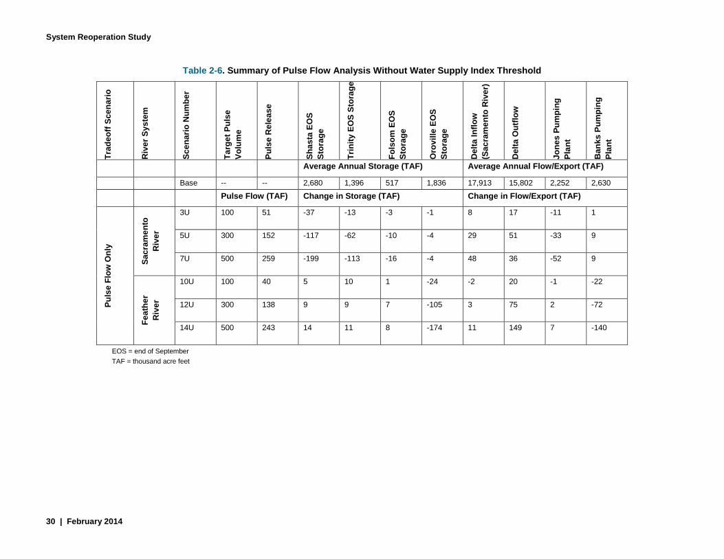
System Reoperation Study
30 | February 2014
Table 2-6. Summary of Pulse Flow Analysis Without Water Supply Index Threshold
Trad
eoff
Scen
ario
Riv
er S
yste
m
Scen
ario
Num
ber
Targ
et P
ulse
Vo
lum
e
Puls
e R
elea
se
Shas
ta E
OS
Stor
age
Trin
ity E
OS
Stor
age
Fols
om E
OS
Stor
age
Oro
ville
EO
S St
orag
e
Del
ta In
flow
(S
acra
men
to R
iver
)
Del
ta O
utflo
w
Jone
s Pu
mpi
ng
Plan
t
Ban
ks P
umpi
ng
Plan
t
Average Annual Storage (TAF) Average Annual Flow/Export (TAF)
Base -- -- 2,680 1,396 517 1,836 17,913 15,802 2,252 2,630 Pulse Flow (TAF) Change in Storage (TAF) Change in Flow/Export (TAF)
Puls
e Fl
ow O
nly
Sacr
amen
to
Riv
er
3U 100 51 -37 -13 -3 -1 8 17 -11 1
5U 300 152 -117 -62 -10 -4 29 51 -33 9
7U 500 259 -199 -113 -16 -4 48 36 -52 9
Feat
her
Riv
er
10U 100 40 5 10 1 -24 -2 20 -1 -22
12U 300 138 9 9 7 -105 3 75 2 -72
14U 500 243 14 11 8 -174 11 149 7 -140
EOS = end of September TAF = thousand acre feet

Phase 2 Report –Strategy Formulation and Refinement – Draft
February 2014 | 31
2.2.1 Concept for Shasta and Oroville Reservoir Reoperation The basic concept of system reoperation for Shasta and Oroville reservoirs is to lower their carryover storage levels relative to current operations and to increase flood reservation by conveying additional water to either an existing or future groundwater bank located in the Sacramento Valley or south of the Delta with available capacity. This reoperation would reduce flood control spills and would occur at times when excess conveyance capacity is available in the Delta. To the extent reservoirs recover fully, the banked water is a supplement to water supplies. In dry years when complete storage recovery does not occur, the reservoir would be paid back with withdrawals from the groundwater bank and delivered to CVP/SWP customers on a full cost recovery basis.
Potential enlargement of San Luis Reservoir5 may be considered in conjunction with groundwater storage in the reoperation strategies. San Luis Reservoir is a key south of Delta reservoir for the SWP and CVP to store water pumped from the Delta for delivery to the contractors. The additional south of Delta storage provided by San Luis Reservoir enlargement will likely enhance the water supply benefits of the Shasta and Oroville reoperations with an assumed isolated Delta conveyance in place.
2.2.2 Concept for Reoperation of New Exchequer Dam The concept for reoperation of New Exchequer Dam (Lake McClure) is with reservoir payback by in lieu groundwater banking within the Merced Irrigation District and the Merced Area Groundwater Planning Initiative (MAGPI). The reoperation would enable environmental flows to be restored from the dam to the Delta to improve conditions for steelhead trout. This strategy would be developed and conducted in partnership with Merced Irrigation District and MAGPI. The environmental flow release would have to be managed through the downstream infrastructure. Releases from Lake McClure pass through a series of power plants and smaller diversions and are regulated at McSwain Reservoir. Below McSwain Reservoir, water is diverted to the Merced Irrigation District at the PG&E Merced Falls Dam and is diverted further downstream at Crocker-Huffman Diversion Dam. It may be possible that the surplus water dedicated to steelhead habitat enhancement in the Merced River could be diverted below the confluence with the San Joaquin River for water supply.
2.2.3 Operational Components Included in All Reservoir Reoperation Four operational components will be included in all the reservoir reoperation strategies:
• Forecast-Based Operations (F-BO). The goal is to reduce flood control space in reservoirs to allow higher storages at certain times of the year based on improved inflow forecasts. F-BO’s incorporation of weather forecasts in the flood operations of reservoirs could result in greater flexibility in the management of the reservoirs’ space and therefore result in opportunities for additional water supply and flood management benefits.
• Conjunctive Management. Conjunctive management involves the coordinated use and management of ground and surface water resources to maximize the water supplies to meet water management objectives. The goal is to develop more integrated management of groundwater and surface water supplies. Several different operational changes are possible with increased conjunctive management including increased groundwater banking through in lieu and active recharge and more aggressive reservoir reoperations backstopped by groundwater pumping.
• System Integration. The goal is to integrate operations between multiple reservoirs or increase the degree of integration at reservoirs that are currently integrated.
5 San Luis Reservoir Expansion Draft Appraisal Report (Reclamation, December 2013)
System Reoperation Study
32 | February 2014
• Environmental Flows. A variety of new environmental flows may be included in each strategy. Differences in the timing and magnitude of environmental flows change how those flows can be used to meet multiple project objectives. Flows under consideration include floodplain inundation flows, spring pulse flows, flows to improve water temperature, and flows coordinated with fish hatchery operations.
Additionally, the Shasta Reservoir reoperation strategy may consider fish passage above Shasta Dam into the colder water environments of the Upper Sacramento and McCloud rivers as a component. Fish passage above Shasta Dam is a core element of the Salmon Recovery Plan of the National Marine Fisheries Service. Reclamation is in a process of conducting a pilot study to evaluate the feasibility of reintroducing Chinook salmon and steelhead to tributaries above Shasta Lake. The key issue is whether fish passage would allow more flexible operations of Shasta Dam that could facilitate the reoperation concepts under consideration.
2.2.4 Concept for SWP and CVP Integration The study team is working with the SWP and CVP operators to explore ways that the two projects’ operations could be more fully integrated to provide mutual water supply benefits to the SWP and CVP, reduce flood hazard, and improve ecosystem protection and restoration. The SWP and CVP systems are currently operated in a partially integrated fashion through coordination of the SWP and CVP operators. This coordination occurs on a routine and continual basis and is supported by both verbal and written agreements. The COA is a written agreement that describes how the responsibility to satisfy flow requirements and water available for diversion is shared between the SWP and CVP. The COA was implemented in 1986 at a time when the SWP and CVP were operated in conformance with the State Water Resources Control Board (SWRCB) D-1485 Delta requirements. The COA does not address requirements specified in SWRCB D-1641 or the more recent salmon and Delta smelt biological opinions. Because the COA does not address sharing between the SWP and CVP for recent regulatory requirements, verbal agreements have been made between the SWP and CVP to comply with these requirements. The COA is outdated and may limit SWP and CVP operational efficiency. A primary goal of SWP and CVP system integration is to explore potential system operations of the two projects that could provide mutual water supply benefits to the SWP and CVP, reduce flood hazards, and improve ecosystem protection and restoration without limitations of the COA.
There are varying degrees of system integration that may be explored. The basic premise of system integration is based on the physical makeup of the SWP and CVP. The CVP has greater upstream storage capacity than the SWP, but the CVP has less capacity to convey stored water south of the Delta to project users than the SWP. By combining the projects, water stored in upstream CVP reservoirs can be conveyed through SWP facilities. A simple approach to system integration is to assume expanded Joint Point of Diversion (JPOD) for Delta exports and a more comprehensive approach is to assume the SWP and CVP operating as a single project (consolidating place of use under the water rights permits). The first phase of the evaluation of system integration will be to expand JPOD. The second phase will be to explore expanded sharing of system resources and facilities.

Phase 2 Report –Strategy Formulation and Refinement – Draft
February 2014 | 33
3.0 Next Steps The next steps of the SRS include Phase 3 – Preliminary Assessment, and Phase 4 – Reconnaissance Level Assessment. The purpose of Phase 3 is to evaluate, sort, and rank the reoperation strategies based on their performance in meeting the goals and objectives of the study. The strategies will be examined for acceptability, completeness, effectiveness, and efficiency. Phase 3 will include:
• Defining baseline operations • Defining the operations of the strategies • Evaluating system reoperation strategies:
o Identifying existing physical and operational constraints o Identifying new or modified physical facilities needed for potential system reoperation
strategies o Conducting hydrologic and other modeling o Quantifying benefits
• Ranking reoperation strategies based on their performance • Selecting reoperation strategies to be carried forward into Phase 4 for more detailed analysis
In Phase 4, the strategies evaluated in Phase 3 that met the objectives of the study will be carried forward for more detail evaluations. Phase 4 will include:
• Analyzing and assessing reoperation strategies • Evaluating benefits • Evaluating costs • Quantifying economic benefits • Developing conceptual designs for facilities modifications • Identifying institutional challenges • Documenting the findings • Recommending strategies for potential implementation • Identifying funding and key steps necessary for implementation • Making recommendations for next steps • Preparing a report
The following subsections describe the baseline, analytical tools, and metrics to be used in future analysis. Additionally, the future analysis of climate change implications is briefly described in this section.
3.1 Evaluation Baseline To evaluate the performance of reoperation strategies, they must be compared to assumed baseline conditions. Therefore, baseline conditions for water supply, flood hazard reduction, and ecosystem will be developed and documented. The assumed physical system and operations will be defined and the following items will be identified: assumed physical and operational constraints, assumed institutional constraints, competing beneficial uses, and considerations for climate change. To the extent practicable, information and assumptions will be developed from other current and ongoing studies.
3.2 Analytical Tools The reconnaissance level assessments will make use of existing data and analytical tools developed and used by DWR. The reoperation strategies will be evaluated primarily using DWR’s Central Valley water management screening model, CalLite and planning model, CalSim II. Other models, such as ecosystem and flood delineation related modeling, may be used when CalLite and CalSim II are not applicable.

System Reoperation Study
34 | February 2014
3.3 Metrics to be Evaluated To measure progress toward addressing the problems and achieving the objectives, it is necessary to define a suite of metrics for each objective: water supply reliability, flood risk reduction, and ecosystem protection and restoration. In the course of refining the strategies, these metrics may be modified, as applicable, to make them “strategy-specific,” thus acknowledging the potential changes in the system and making the metrics correspond to the benefits outlined in the strategies.
3.3.1 Water Supply Metrics Water delivery reliability is usually defined as the annual amount of water that can be expected to be delivered with a certain frequency. While long term delivery is important, some water users prefer for the reliability of dry year delivery. Different metrics for measuring improvements in water deliveries reliability reflect the needs of different water users. For example, M&I water users without their own storage frequently place a higher value on dry year reliability than on average annual deliveries; whereas M&I water users that have adequate water storage capacities will place a higher value on average annual deliveries. In most cases, agricultural water users, especially those with permanent crops and limited access to groundwater, will prefer higher dry year reliability.
3.3.2 Ecosystem Metrics Ecosystem metrics will be used to determine the ability to protect and restore ecosystem in the water system and provide protected fishes favorable habitats that have certain minimum requirements on the timing, flow and volume, quality and temperature of water in the river/stream. Although the specific habitat requirements may not be fully known, the SRS will use the best available science. Environmental flow and temperature metrics will be used.
Environmental flows describe the quantity, timing, and quality of water flows required to sustain freshwater and estuarine ecosystems. A variety of environmental flow improvements may be included in the study. Flows under consideration include geomorphic flows, floodplain inundation flows, spring pulse flows, temperature control flows and the combination of these flows. The current water system may not be able to provide the water for all the environmental flow targets. Some trade-off analysis may need to be performed to analyze the cost of every environmental flow target. The selection of environmental flow targets may depend on the importance of environment flows themselves and the cost of implementation to meet the environmental flow targets.
Environmental flow related metrics include: • Floodplain inundation – The purpose is to seasonally inundate floodplains for rearing habitat
and food web productivity. Potential target areas are the Sutter and Yolo flood bypasses and potentially other floodplain features where large ecosystem benefits can be achieved without major changes in land uses in the floodplain. Inundation of floodplains requires significant volumes of reservoir storage to be released; not only to provide water to floodplains, but to increase river elevations to the point where water flows from river channels into floodplains. To economize on the amount of water necessary to inundate flood bypasses, weirs may be modified to created inundated floodplain habitat more frequently and for a longer duration with minimal water cost. Achieving this goal is more important in wet years than dry or critical years.
• Spring time flow enhancement – The purpose of the spring flow enhancement is to increase rearing habitat along channel margins and within high flow channels and to help with outmigration of salmon. This could be accomplished with shorter duration pulses than needed

Phase 2 Report –Strategy Formulation and Refinement – Draft
February 2014 | 35
to optimize floodplain inundation with appropriate ramping. This goal can also be measured by traditional measures such as long-term average additional flows and recurrence or reliability.
• Attraction flow enhancement – The first precipitation event of a water year is often a trigger for salmon migration to begin. There may be benefit in enhancing stream flows through increased reservoir releases during initial storms to benefit migration of salmon. This flow enhancement can be measured by long-term average supplemental flow and reliability or recurrence.
• Geomorphic flows – These flows are needed for sediment transport, river bed mobilization, and bed scour to create and maintain habitat complexity. The morphology of the river and its floodplain determines the habitat quality which determines the biological productivity of the river system. The magnitude, frequency, and duration of flows to achieve ecosystem improvements will vary by river and reach. Geomorphic flows can also be measured by long-term average supplemental flows and recurrence especially. This goal is also more strongly correlated to wetter years.
Water temperature is also a critical component of habitat for salmon and other fishes in rivers and streams throughout the California water system. Management of stream temperature below reservoirs is accomplished by managing two operational components: (1) reservoir cold water pools, and (2) temperature control releases.
Reservoir cold water pools are affected by reservoir storage, inflows, timing of releases, operation of temperature control devices, and meteorological conditions. This can be measured by (1) the additional water in storage and its recurrence, with an emphasis on drier years (i.e., cold water pool management), and (2) supplemental releases to improve temperatures downstream of reservoirs. In cases where a temperature model has been developed for a particular reservoir/stream, the temperature change can be described in terms of long-term average and reliability of achieving certain temperature objectives in the stream at specific locations. In cases where there is not an existing temperature model, the reliability of the cold water pool and the releases can be reported as indicators.
Changes in reservoir releases for downstream ecological benefits affect cold water pool management; therefore, the appropriate balance between spring time environmental flows and cold water management throughout the summer and fall is critical to establish optimal operations.
3.3.3 Flood Risk Reduction Metrics Reduction in flood risks to properties and lives is one of the objectives in the SRS. Engineers and hydrologists usually use stage and flow to measure the flood risk in a region. However, in areas with frequent levee breaks, number of levee breaks, and extent of inundated area sometimes are used in measuring flood risk. Ultimately, the flood risk should be measured in the loss of lives and property damage.