Embed Size (px)
Citation preview
CHAPTER 3
SYSTEM DESCRIPTION
3.1 Introduction
The reservoirs play a very important role in meeting the water demands
for power, irrigation, domestic and industrial water supply, inland navigation and
tourism sectors in Kerala State, south - west India. Highly varying temporal distri-
bution of rainfall in the region makes the role of reservoirs all the more important.
Twelve reservoirs forming part of seven HEPs exist in the Periyar river basin situ-
ated in the central part of Kerala (Table 3.1). Since the water from the Idukki HEP
in the Periyar basin - the largest such project in the State - is transferred to the
adjacent Muvattupuzha river basin, both these basins are considered as one system
for the present study (Figure 3.1).
24
Chapter 3. SYSTEM DESCRIPTION
3.2 Characteristics of the Periyar - Muvattupuzha river
system
The Periyar-Muvattupuzha system falls between 090 15′ and 100 30′ N
latitude and 760 00′ and 770 30′ E longitude. The Periyar river basin with a catch-
ment area of 5398 km2 is flanked by the Chalakudy river basin on the north and
the Muvattupuzha and Pamba river basins on the south (Figure 3.1). The Periyar
river is the longest river in Kerala with a length of 244 km. From its source at
1850 m above the mean sea level (amsl), the Mullayar flows down traversing 48 km,
and joins the Periyar from its right at an elevation of 850 m amsl. The Periyar river
continues to flow towards the west for another 16 km and joins the Mullaperiyar
reservoir. The Mullaperiyar dam was constructed in 1896, which gave birth to the
Periyar lake, famous for its wildlife and tourism. The water from this reservoir
is diverted to the adjoining Tamil Nadu State mainly for irrigation and partly for
power generation. The spillover from this reservoir reaches the Idukki reservoir of
the Idukki HEP which has an effective storage of 1459.4 MCM. It is located at an
elevation of 540 m amsl. The Periyar then flows through the midland and lowland
and finally joins the Vembanad - Kol wetland system.
The tailrace from the Idukki project, after harnessing power, is diverted
to the Muvattupuzha river basin located on the southern side of the Periyar river
basin. Because of the above mentioned two interbasin transfers, the catchment of
the Periyar river basin contributing to the water downstream is virtually brought
down to 3665 km2, where as the effective catchment of the unaltered Periyar river
basin is 5398 km2 (Water Resources of Kerala, 1974). Several small HEPs were
developed in the Periyar river basin before the commissioning of Idukki HEP. The
Idamalayar HEP with an effective storage capacity of 1017.8 MCM and the Lower
Periyar HEP in the Periyar mainstream with an effective storage capacity of 4.55
MCM were commissioned after the Idukki HEP in the Periyar river basin, which
are regulations within the basin.
25

Chapter 3. SYSTEM DESCRIPTION
The Vembanad wetlands - a Ramsar site with rich biodiversity, the Cor-
poration of Cochin, and the fast growing industrial belt of Kerala in and around
Alwaye are located in the lower reaches of the Periyar basin. Two major irrigation
projects, namely the Periyar Valley Irrigation Project (PVIP) and the Idamalayar
Irrigation Project (IIP) are located in this river basin. Several rural and urban wa-
ter supply schemes under Kerala Water Authority (KWA) depend on this river for
freshwater needs. Tourism and inland water transport are other two sectors which
depend on the Periyar river (James et al. 1999, Irrigation Division, 2003).
Figure 3.1: The Periyar-Muvattupuzha river system
The Muvattupuzha river is also a perennial river. It originates from the
26

Chapter 3. SYSTEM DESCRIPTION
Western Ghats and flows through the highland and the lateritic midland and fi-
nally joins the Vembanad estuary. The length of the river is 121 km and it has a
catchment area of 1,554 km2. The Muvattupuzha river basin is bounded by the
Periyar river basin on the north and the Meenachil river basin on the south. Con-
siderable changes have taken place to the flow characteristics of the Muvattupuzha
river after the commissioning of the Idukki HEP in 1976. The Thodupuzha tribu-
tary of Muvattupuzha river receives the tailrace from the Idukki HEP. The tailrace
discharge from the Moolamattom powerhouse of the Idukki HEP ranges between
19.83− 78.5 m3/sec. (Gopinath 2003).
The Kothamangalam, Kalyar and Thodupuzha tributaries join together
to form the Muvattupuzha river. The Thodupuzha tributary is the receptor of
the tailwater from the Moolamattom powerhouse of the Idukki HEP. The power
production at the Moolamattom powerhouse is continuous throughout the year.
Because of this, flow of good quality water is always available in the river even in
summer. The water from the Periyar is diverted to the underground power house of
the Muvattupuzha river basin mainly to gain more head for power generation. Both
the Kothamangalam and Kaliyar rivers join near Muvattupuzha town and forms
the Muvattupuzha river. The Muvattupuzha river bifurcates into Ittupuzha and
Murinjapuzha branches in the downstream and finally joins the Vembanad wetlands
(Gopinath 2003).
The major area of the Periyar-Muvattupuzha river system falls under the
highland and midlands (between 7.6 and 76 m amsl) of Kerala State(Balakrishnan
2009, Gopinath 2003). The lowland (< 7.6 m amsl) in the downstream is a narrow
belt almost parallel to the shoreline. The width of the lowland ranges from 8 to
15km. Broad valleys, flood plains with swamps/ marshes and subdued sand dunes
are the major landforms of this narrow coastal region. A network of canals connect
different parts of the lowland to the Vembanad wetland system (Balakrishnan 2009).
27
Chapter 3. SYSTEM DESCRIPTION
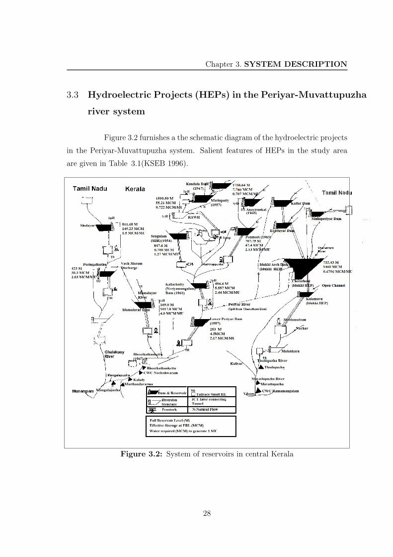
3.3 Hydroelectric Projects (HEPs) in the Periyar-Muvattupuzha
river system
Figure 3.2 furnishes a the schematic diagram of the hydroelectric projects
in the Periyar-Muvattupuzha system. Salient features of HEPs in the study area
are given in Table 3.1(KSEB 1996).
Figure 3.2: System of reservoirs in central Kerala
28

Chapter 3. SYSTEM DESCRIPTION
Table 3.1: Salient features of HEPs in the Periyar-Muvattupuzha river system
Name of Name of Free Effective Power
HEP dam catchment storage generation
(year) (km2) (MCM) capacity
(MW)
Mullaperiyar 624 443.23 140
(1896)
Pallivasal Kundala 36.26 7.78 15
(1947)
Mattupatty 67.34 55.21 22.5
(1957)
C.P.R 129.75
Head Works
Sengulam Sengulam 5.18 0.70 48
(1954)
Neriyamangalam Kallarkutty 81.6 5.49 45
(1961)
Panniyar Ponmudi 221.445 47.4 30
(1963)
Anayirankal 64.75 48.98 -
(1965)
Idukki Idukki 649.31 1459.43 780
Cheruthoni
Kulamavu
(1976)
Idamalayar Idamalayar 380.73 1017.80 75
(1987)
Lower Periyar Lower Periyar 181.3 4.55 180
(1997)
29

Chapter 3. SYSTEM DESCRIPTION
3.3.1 Interbasin and intrabasin water transfers
The interlinking of rivers is aimed at linking surplus rivers with the defi-
cient rivers so that the excess water from surplus region could be diverted to deficient
region. This would improve water availability for drinking, irrigation and industrial
purposes in the receiving basin. Floods are moderated in the diverted basin to a
certain extent. Other than the two major interbasin transfers under the Idukki HEP
and the Mullaperiyar project, small transfers also exist in the basin. The details
of present and proposed interbasin water transfers from the Periyar river basin are
given in Table 3.2
Table 3.2: Existing and proposed interbasin water transfers from the Periyarriver basin*
Name of project Water export to Annual utilization (MCM)
Existing projects
Periyar Dam Vaigai 623 (Irrigation,63850 ha)
Idukki HEP Muvattupuzha 1271
Lower Nirar Bharathapuzha 71
Upper Nirar Bharathapuzha 255
Ongoing projects
Idamalayar Chalakudy 201
Irrigation Project (Irrigation,14394 ha)
Idukki stage III Muvattupuzha 310
Narakakkanam Muvattupuzha 6
diversion
*Source: Irrigation Division,Ernakulam,Water Resources Department 2003
30

Chapter 3. SYSTEM DESCRIPTION
3.4 Surfacewater utilization in the Periyar-Muvattupuzha
system
In the Periyar-Muvattupuzha system, summer flow augmentation by
HEPs resulted in several sectors depending more on the rivers for fresh water needs.
Data collected from different departments/agencies were integrated with the primary
data collected from the field and a schematic line sketch detailing water utilization
pattern in the system by various sectors was prepared (Appendix 3).
The schematic line diagram (Appendix 3) shows the interbasin and in-
trabasin regulations in the system, stream gauging sites, location of intakes for
domestic and industrial water supply, lift irrigation schemes and diversion structure
of major irrigation projects. Canal networks, location of major urban centres and
water quality monitoring sites are also shown. The present water withdrawal is
given sectorwise in tables. This diagram highlights the positive side of streamflow
regulation by HEPs. Dependable streamflow in the adjoining Muvattupuzha basin
multiplied several times because of interbasin water transfer. The interbasin trans-
fer reduced the salinity intrusion during the summer and supported development
of several domestic water supply schemes downstream of the Muvattupuzha river.
This river also meets the freshwater needs of a major paper industry, the Hindustan
Newsprint Limited, located in the basin.
3.5 Present status of Periyar-Muvattupuzha river system
The streamflow pattern in the river system depends on the downstream
releases from HEPs after power generation in addition to the respective catchment
yield. The Kerala State Electricity Board (KSEB) controls the operation of HEPs.
There is no integrated operation policy for HEPs in Kerala. The monthly power
generation from the Idukki HEP and the monthly total power generated from all
HEPs in the Periyar river basin was analyzed for a period of ten years (2000-09);
the monthly time series is given in Figure 3.3. The bar charts show a positive trend
31

Chapter 3. SYSTEM DESCRIPTION
in both the cases. The scatter plot of rainfall vs streamflow for the monsoon period
Figure 3.3: Power generation from HEPs in Periyar basin
show that the R2 value gradually comes down as the degrees of regulation increase
in the Periyar river (Figure 3.4).
Fifty six percent of the endemic fish of Kerala, classified under 32 species
is reported from the Periyar river, which makes the river basin a unique one in this
region (Arun 1998, Kurup et al. 2001). A fish survey in the Periyar and Muvat-
tupuzha rivers indicates that more than 50% of the ornamental/ food fish species
are critically endangered or endangered (Kurup et al. 2004). The construction of
15 dams has almost closed the river system to the movement of the biota through
the Periyar basin. Because of this fragmentation, many endemic and rare species of
fish occur as fragmented populations, isolated in headwater tributaries. Indiscrimi-
nate sand mining and pollution added negatively to such alterations (Sreebha et al.
2010).
Considerable degradation has occurred to the physical environment and
ecological conditions downstream of the Periyar river. The assessment on the health
status of this river stretch made using indices such as physical Habitat Quality (HQ),
water quality and index of biotic integrity (IBI) classifies the river health under the
poorest category (Kurup et al. 2001). The indicators for the Periyar river (Smakhtin
et al. 2007) gives a status summary for the river (Table 3.3).
32

Chapter 3. SYSTEM DESCRIPTION
Figure 3.4: Monsoon rainfall vs streamflow in the Periyar river basin
33

Chapter 3. SYSTEM DESCRIPTION
Table 3.3: Indicators for Periyar river basin*
Indicator Value Score Justification and comments
Rare and Very 5 Fishes critically endangered(5 nos),
aquatic biota high threatened (14 nos),extinct (14 Nos);
(Arun 1998; Kurup et al. 2001)
Unique Very 5 56% of endemic fishes of Kerala reported
aquatic biota high from Periyar (32 species);
(Arun 1998; Kurup et al. 2001)
Diversity of Very 5 Many threatened fish species inhibit in
aquatic habitats high pools, streams, runs and cascades;
(Arunachalam 2000)
Presence of Very 5 The river flows through Periyar wild life
protected and high sanctuary. 30% of basin area is covered with
pristine areas dense pristine forests)
Sensitivity of High 4 Multiple dams reduced flow leading to
aquatic ecosystem decline in fish diversity and algal bloom;
to flow reduction (Joseph 2004)
Percentage of 30-50% 3 30% of the watershed is covered with dense
watershed under natural forests; (Joseph 2004)
natural vegetation
Degree of 20-50% 3 Calculated as the ratio of the total
flow regulation storage capacity (3.27 BCM) to long-term
mean annual flow volume at outlet (12.3 BCM)
Percentage of basin 70-100% 1 Construction of 15 dams have almost closed
closed to movement the river system to movement of the biota
of aquatic biota
Fish Species Very 5 The basin is very rich in fish species
relative richness high (208 out of 287 species in the Western
ghats(70%); (Joseph et al. 2004)
Overall water Class B 5 Water quality in upstream and middle reaches-
quality Class B, Lower reaches Class C;
(Singh and Anandh (1996)
*Source: (Smakhtin et al. 2008)34