Embed Size (px)
Citation preview

1
Syrian Arab Republic
GeoGRAphy, climAte And populAtionGeographyThe Syrian Arab Republic, with a total area of 185 180 km², is bordered in the north by Turkey, in the east and southeast by Iraq, in the south by Jordan, in the southwest by Israel and in the west by Lebanon and the Mediterranean Sea. Administratively the country is divided into 14 mohafazats (governorates), one of which is the capital Damascus.
The country can be divided into four physiographic regions: ¾the coastal region between the mountains and the sea; ¾the mountains and the highlands extending from north to south parallel to the ¾Mediterranean coast;the plains or interior, located east of the highlands and including the plains of ¾Damascus, Homs, Hama, Aleppo, Hassakeh and Dara;the Badiah and the desert plains in the southeastern part of the country, bordering ¾Jordan and Iraq.
In 2005, total cultivable land was estimated at 5.91 million ha, or 32 percent of the total area of the country and the cultivated land was 5.74 million ha (Table 1). Of the 5.53 million ha of cultivated land in 2004, temporarily fallow land represented 0.80 million ha and the effective cultivated land 4.73 million ha, of which over 30 percent was irrigated. Hassakeh, Aleppo and Raqqa are the main agricultural mohafazats accounting for 28, 21 and 12 percent respectively of the effective cultivated land in the country. The private sector owns 54 percent of the effective cultivated area, cooperatives 45 percent and the public sector less than 0.5 percent (CBS, 2006).
climateThe Syrian Arab Republic’s climate is Mediterranean with a continental influence: cool rainy winters and warm dry summers, with relatively short spring and autumn seasons. Large parts of the Syrian Arab Republic are exposed to high variability in daily temperature. The maximum difference in daily temperature can be as high as 32 °C in the interior and about 13 °C in the coastal region. Total annual precipitation ranges from 100 to 150 mm in the northwest, 150 to 200 mm from the south towards the central and east-central areas, 300 to 600 mm in the plains and along the foothills in the west, and 800 to 1 000 mm along the coast, increasing to 1 400 mm in the mountains. The average annual rainfall in the country is 252 mm.
populationTotal population is just over 19 million (2005), of which almost 50 percent is rural (Table 1). The average annual demographic growth rate was estimated at 2.5 percent

Irrigation in the Middle East region in figures – AQUASTAT Survey 20082
HOMS
RAQQA
ALEPPO
HASSAKEH
DAYRAZ ZOR
HAMA
DAMASCUS
IDLEB
DARAAS
SUWEIDA
LATTAKIA
TARTOUS
ALQUNAYTIRAH
IRAQ
TURKEY
SAUDI ARABIA
JORDAN
ISRAEL
LEBANON
WESTBANK
Damascus
Al Qunaytirah
As Suwayda
Duma
An Nabk
Tartus
Latakia
Hamah
Hims
Aleppo
Idlib
Ath Thawrah
Ar Raqqah
Tadmur
Dara
Jisr ashShughur
Abu Kamal
Al Hasakah
Al Qamishli
Dayr az Zawr Nah
r al
Kh
abu
r
Eu
phra
tes
Al Tabka
Al-Rastan
Euphrates
Asi- O
ron
tes
Lake al AsadLake
Jabboul
Gulf of
Iskenderun
LakeTiberias
Jord
an
Ceyhan N
ehri
Lake Qattinah
Yarmou
k
Qattinah
Litani
El Kebir
Afr
in
Euphrates
Tigris
Seyhan
Neh
ri
Me
dit
er
ran
ea
n S
ea
Re
d S
ea
Arabian Sea
The designations employed and the presentation of material in this publication do not imply the expression of any opinion whatsoever on the part of theFood and Agriculture Organization of the United Nations concerning the legal status of any country, territory, city or area or of its authorities,
or concerning the delimitation of its frontiers or boundaries.
Disclaimer
FAO - AQUASTAT, 2008SYRIAN ARAB REPUBLIC
Legend
Canal
Lake
Intermittent Lake
Salt Pan
River
Intermittent River
Zone of Irrigation Development
0 50 100 15025 km
Albers Equal Area Projection, WGS 1984
Capital, Regional Capital, Town
Armistice Demarcation Line
International Boundary
Administrative Boundary
Dam

Syrian Arab Republic 3
during the period 2000–2005. The average population density is about 103 inhabitants/km2.
In 2006, 92 percent of the population had access to improved sanitation (96 and 88 percent in urban and rural areas respectively) and 89 percent had access to improved water sources (95 and 83 percent in urban and rural areas respectively).
economy, AGRicultuRe And food SecuRityIn 2007 the Gross Domestic Product (GDP) was US$38.1 billion, and agriculture accounted for 20 percent of the GDP (Table 1). The economically active population is about 6.55 million of which 71 percent is male and 29 percent female. In agriculture, 1.69 million inhabitants are economically active of which 34 percent is male and 66 percent female.
The Syrian Arab Republic can be divided into five main agricultural regions, namely Southern, Central, Coastal, Northern and Eastern:
The Southern region covers about 15.7 percent of the total area of the country. It ¾includes Damascus, Dara, Suweida, and Al-Qunaytirah. It is famous for its fruit production, especially apricots, apples and grapes, but it also produces crops such as chickpeas and tomatoes, in addition to raising cattle. Between 1998 and 1999, the region’s contribution to national production was 36 percent for chickpeas, 51 percent for apples, 31 percent for grapes, and 62 percent for apricots.The Central region accounts for about 27.6 percent of the total area and produces ¾mainly sugar beets, dried onion, potato and almonds. Between 1998 and 1999, the region’s contribution to the national production was 57 percent for sugar beets, 53 percent for dried onions, 31 percent for potatoes, and 14 percent for irrigated wheat.
TABLE 1Basic statistics and population
physical areas
Area of the country 2005 18 518 000 ha
Cultivated area (arable land and area under permanent crops) 2005 5 742 000 ha
as % of the total area of the country• 2005 31.0 %
arable land (annual crops + temp. fallow + temp. •meadows)
2005 4 873 000 ha
area under permanent crops• 2005 869 000 ha
population
Total population 2005 19 043 000 inhabitants
of which rural• 2005 49.7 %
Population density 2005 102.8 inhabitants/km2
Economically active population 2005 6 548 000 inhabitants
as % of total population• 2005 34.4 %
female• 2005 28.7 %
male• 2005 71.3 %
Population economically active in agriculture 2005 1 690 000 inhabitants
as % of total economically active population• 2005 25.8 %
female• 2005 66.1 %
male• 2005 33.9 %
economy and development
Gross Domestic Product (GDP) (current US$) 2007 38 080 million US$/yr
value added in agriculture (% of GDP)• 2007 20 %
GDP per capita• 2005 1 480 US$/yr
Human Development Index (highest = 1) 2005 0.724
Access to improved drinking water sources
Total population 2006 89 %
Urban population 2006 95 %
Rural population 2006 83 %

Irrigation in the Middle East region in figures – AQUASTAT Survey 20084
The Coastal region on the Mediterranean Sea includes the cities of Lattakia and ¾Tartous. Although this region is relatively small (2.3 percent of the total area), it contributes significantly to national agricultural production, with 98 percent of citrus, 42 percent of olives, 55 percent of tomatoes and 56 percent of tobacco.The Northern region covers 12.6 percent of the country’s total area and includes ¾the cities of Aleppo and Idleb. Its main contributions to national agricultural production are lentils with 55 percent, chickpeas 51 percent, olives 56 percent, and pistachios 69 percent. Local farmers breed about 20 percent of the total sheep population of the Syrian Arab Republic.The Eastern region is the largest in the country, covering 41.8 percent of the ¾total area, concentrating the national cereals and cotton production. In order to enhance productivity through irrigation many networks have been built in this region, especially on the Euphrates and Al Khabour rivers. In addition many wells have been constructed. Farms tend to specialize in irrigated wheat which contributes 64 percent to the national production, while rainfed wheat contributes 38 percent, cotton 63 percent, and lentils 29 percent.
Self-sufficiency has been achieved for some crops, such as wheat, legumes (chickpeas and lentils), cotton, vegetables (potatoes and tomatoes), and fruit (citrus and olive). There have even been cases of surplus production. However, domestic production of crops for sugar, vegetable oils (with the exception of olive oil), and of some kinds of red meat, and dairy products (cheese, butter and dried milk) is not sufficient to meet domestic demand. Moreover, maize imports for chicken feed have increased (NAPC, 2003).
WAteR ReSouRceS And uSeWater resourcesIt is estimated that water resources generated from rain falling within the country amount to about 7.1 km3/year (Table 2). Internal renewable surface water resources are estimated at 4.3 km3/year and groundwater recharge at 4.8 km3/year, of which 2 km3/year discharge into rivers as spring water (overlap between surface water and groundwater).
TABLE 2Water: sources and use Renewable freshwater resources
Precipitation (long-term average) - 252 mm/yr
- 46.67 109 m3/yr
Internal renewable water resources (long-term average) - 7.132 109 m3/yr
Total actual renewable water resources - 16.797 109 m 3/yr
Dependency ratio - 72.29 %
Total actual renewable water resources per inhabitant 2005 882 m3/yr
Total dam capacity 2007 19 654 106 m3
Water withdrawal:
Total water withdrawal 2003 16 690 106 m3/yr
- irrigation + livestock 2003 14 669 106 m3/yr
- municipalities 2003 1 426 106 m3/yr
- industry 2003 595 106 m3/yr
per inhabitant• 2003 921 m3/yr
Surface water and groundwater withdrawal 2003 13 894 106 m3/yr
as % of total actual renewable water resources• 2003 82.7 %
non-conventional sources of water:
Produced wastewater 2002 1 364 106 m3/yr
Treated wastewater 2002 550 106 m3/yr
Reused treated wastewater 2002 550 106 m3/yr
Desalinated water produced - 106 m3/yr
Reused agricultural drainage water 2004 2 246 106 m3/yr

Syrian Arab Republic 5
Seven main hydrographic basins can be identified: Al Jazeera, Aleppo (Quaick and Al Jabbool sub-basins), Al Badia (Palmyra, Khanaser, Al Zelf, Wadi el Miah, Al Rassafa, Al Talf and Assabe’biar sub-basins), Horan or Al Yarmook, Damascus, Asi-Orontes and Al Sahel. Rainfall and snowfall represent the major water supply for the basins, except for the Al Jazeera and Asi-Orontes, the main sources of which are located in the neighbouring countries. There are 16 main rivers and tributaries in the country, of which 6 are main international rivers:
the Euphrates (Al Furat), which is the Syrian Arab Republic’s the largest river. ¾It comes from Turkey and flows to Iraq. Its total length is 2 330 km, 680 km of which are in the Syrian Arab Republic;the Afrin in the northwestern part of the country, which comes from Turkey, ¾crosses the Syrian Arab Republic and flows back to Turkey;the Asi-Orontes in the western part of the country, coming from Lebanon and ¾flowing into Turkey;the Yarmouk in the southwestern part of the country with sources in the Syrian ¾Arab Republic and Jordan and which forms the border between these two countries before flowing into the Jordan river;the El-Kabir with sources in the Syrian Arab Republic and Lebanon and which ¾forms the border between them before flowing to the sea;the Tigris, which forms the border between the Syrian Arab Republic and Turkey ¾in the extreme northeastern part.
Total actual renewable water resources are estimated at 16.797 km3/year. The natural average surface runoff to the Syrian Arab Republic from international rivers is estimated at 28.515 km3/year. The actual external renewable surface water resources are 17.335 km3/year, which includes 15.750 km3 of water entering with the Euphrates, as unilaterally proposed by Turkey, 0.335 km3 of water entering with the Asi-Orontes, as agreed with Lebanon, and 1.250 km3/year from the Tigris. The Tigris has a total mean annual flow of 18 km3, but since it only borders the country over a short distance in the east, very little can be available for the Syrian Arab Republic and a figure of 1.250 km3/year is given (Abed Rabboh, 2007). Total actual groundwater inflow has been estimated at 1.33 km3/year, of which 1.20 km3 from Turkey and 0.13 km3 from Lebanon (Dan springs). Groundwater outflow to Israel and Jordan is estimated at 0.25 and 0.09 km3/year respectively.
The main groundwater aquifers are those of Anti-Lebanon and the Alouite Mountains. Folding and faulting of the geological layers has resulted in the mingling of the subaquifer systems. There are a number of springs discharging from this aquifer system, such as the Ari-Eyh, Barada, Anjar-Chamsine and Ras El-Ain. Recharge to the system occurs from intense precipitation in the mountainous regions which infiltrates through the fractures and fissures of the karstified surface layer. Water quality ranges from 175 to 900 ppm. Another significant aquifer system is that of the Damascus plain aquifers extending from the Anti-Lebanon Mountains in the west to the volcanic formations in the south and east of the country. This system is composed of gravel and conglomerates with some clay, and is represented by riverbeds and alluvial fan deposits with a thickness of up to 400 metres. Groundwater quality ranges from 500 to more than 5 000 ppm. The major carbonate Haramoun mountain aquifer is located between Lebanon and the Syrian Arab Republic. The main discharging springs are those of the Banias and Dan tributaries of the Jordan River basin. Groundwater quality is estimated at 250 ppm. Other aquifers with limited potential are located in the desert areas. These consist of marl and chalky limestone of the Paleogene age. Recharge occurs mainly from flood flow. Water quality ranges from 500 to 5 000 ppm depending on the source of recharge (ESCWA, 2001).
There are 166 dams in the Syrian Arab Republic with a total storage capacity of 19.7 km3 (Table 3). The largest dam is the Al Tabka dam, located near Ar Raqqah on

Irrigation in the Middle East region in figures – AQUASTAT Survey 20086
the Euphrates and forming the Al Assad Lake with a storage capacity of 14.1 km3 and a surface area of 674 km2. Medium-size dams include the Al Rastan (228 million m3), the Qattinah (200 million m3), the Mouhardeh (67 million m3) and the Taldo (15 million m3). The majority of these dams are located near Hims and Hamah in the western part of the country.
In 2002, total wastewater produced in the Syrian Arab Republic was 1 364 million m3. The treatment of municipal wastewater was carried out mainly in the towns of Damascus, Aleppo, Hims and Salamieh and it reached 550 million m3 in 2002. All treated wastewater is reused. The reused treated wastewater was 330 million m3 in 1993, meaning an increase of 49 percent since 1993. The production of desalinated water in the Syrian Arab Republic is marginal. The installed gross desalination capacity (design capacity) is 8 183 m3/day, which is less than 3 million m3/year (Wangnick Consulting, 2002).
Water useTotal annual water withdrawal in the Syrian Arab Republic was estimated at 16.69 km³/year in 2003, 87.9 percent of which was for agricultural purposes (Table 2, Figure 1 and Figure 2). Compared to 1993, the total water withdrawal increased by almost 31 percent. Agricultural water withdrawal followed the same trend but municipal and industrial withdrawal increased by 39 and 89 percent respectively.
In 1999, the Euphrates and Asi-Orontes basins accounted for about 50 and 20 percent of the water withdrawal respectively (Salman, 2004).
international water issuesAn agreement was signed in 1955 between the Syrian Arab Republic and Jordan regarding the allocation of the water of the Yarmouk River,
TABLE 3main dams in Syria (mlAe, 2007)Basin number of dams total storage
capacity (million m³)
Yarmouk 42 245
Barada and Awaj - -
Coastal 21 602
Orontes 49 1 492
Al Badia 37 69
Euphrates and Allepo 4 16 146
Tigris and Khabour 12 1 045
total 165 19 599
Irrigation + livestock
87 %
Municipalities
9 %
Industry 4 %
FIGURE 1Water withdrawal by sector
Total 16.69 km3 in 2003
Reused treated
wastewater
Reused agricultural drainage water
13 %
3 %
Fresh water
(surface water
+ groundwater)
84 %
FIGURE 2Water withdrawal by source
Total: 16.690 km3 in 2003
Syrian Arab Republic 7
and was further revised in 1987. A recent agreement between Lebanon and the Syrian Arab Republic on the Asi-Orontes River has led to a share of 80 million m³/year for Lebanon and the remaining 335 million m3 for the Syrian Arab Republic.
In 1973, the Syrian Arab Republic constructed the Tabqa Dam, which was filled in 1975. The filling of this dam and the Turkish Keban dam caused a sharp decrease in downstream flow and the quantity of water entering Iraq fell by 25 percent (El Fadel et al, 2002). As a consequence Iraq and the Syrian Arab Republic exchanged mutually hostile accusations and came dangerously close to a military confrontation (Akanda et al, 2007). Iraq threatened to bomb the dam. Both countries moved troops towards their common border. Saudi Arabia and possibly the Soviet Union mediated. Eventually the threat of war died down, after the Syrian Arab Republic released more water from the dam to Iraq. Although the terms of the agreement were never made public, Iraqi officials have privately stated that the Syrian Arab Republic agreed to take only 40 percent of the river’s water, leaving the remainder for Iraq (Kaya, 1998).
In 1983, Turkey, Iraq and the Syrian Arab Republic established the Joint Technical Committee for Regional Waters, the aim of which was to deal with all water issues among the Euphrates-Tigris basin riparians and to ensure that the procedural principles of consultation and notification were followed as required by international law. However, this group disintegrated after 1993 without making any progress (Akanda et al, 2007).
In 1987, an informal agreement between Turkey and the Syrian Arab Republic guaranteed the latter a minimum flow of the Euphrates River of 500 m3/sec throughout the year (15.75 km³/year). The Syrian Arab Republic has since then accused Turkey of violating this agreement a number of times. According to an agreement between the Syrian Arab Republic and Iraq signed in 1990, the Syrian Arab Republic agrees to share the Euphrates water with Iraq on a 58 percent (Iraq) and 42 percent (the Syrian Arab Republic) basis, which corresponds to a flow of 9 km³/year at the border with Iraq when using the figure of 15.75 km³/year from Turkey (FAO, 2004).
The construction of the Ataturk Dam, one of the Southeastern Anatolia projects (GAP) completed in 1992, has been widely portrayed in the Arab media as a belligerent act, since Turkey began the process of filling the Ataturk dam by shutting off the river flow for a month (Akanda et al, 2007). Both the Syrian Arab Republic and Iraq accused Turkey of not informing them about the cut-off, thereby causing considerable harm. Iraq even threatened to bomb the Euphrates dams. Turkey countered that its co-riparians “had been timely informed that river flow would be interrupted for a period of one month, due to technical necessities” (Kaya, 1998). Turkey returned to previous flow sharing agreements after the dam became operational, but the conflicts were never fully resolved as downstream demands had increased in the meantime (Akanda et al, 2007).
As shown above, a number of crises have occurred in the Euphrates-Tigris basin because of a lack of communication, conflicting approaches, unilateral development, and inefficient water management practices. The Arab countries have long accused Turkey of violating international water laws with regard to the Euphrates and the Tigris rivers. Iraq and the Syrian Arab Republic consider these rivers as international, and thus claim a share of their waters. Turkey, in contrast, refuses to concede the international character of these two rivers and only speaks of the rational utilization of transboundary waters. According to Turkey, the Euphrates only becomes an international river after it joins the Tigris in lower Iraq to form the Shatt al-Arab, which then serves as the border between Iraq and the Islamic Republic of Iran until it reaches the Persian Gulf only 193 km further downstream. Furthermore, Turkey is the only country in the Euphrates basin to have voted against the United Nations Convention on the Law of Non-navigational Uses of International Watercourses. According to

Irrigation in the Middle East region in figures – AQUASTAT Survey 20088
irrigation potential - ha
irrigation:
1. Full or partial control irrigation: equipped area 2004 1 439 100 ha
- surface irrigation 2004 1 251 400 ha
- sprinkler irrigation 2004 130 200 ha
- localized irrigation 2004 57 500 ha
% of area irrigated from surface water• - %
% of area irrigated from groundwater• 2004 60.1 %
% of area irrigated from mixed surface water and groundwater• 2004 39.9 %
% of area irrigated from non-conventional sources of water• - %
area equipped for full or partial control irrigation actually irrigated• - ha
- as % of full/partial control area equipped - %
2. Equipped lowlands (wetland, ivb, flood plains, mangroves) - ha
3. Spate irrigation - ha
total area equipped for irrigation (1+2+3) 2004 1 439 100 ha
as % of cultivated area• 2004 26 %
% of total area equipped for irrigation actually irrigated• - %
average increase per year over the last 11 years• 1993-2004 3.2 %
power irrigated area as % of total area equipped• - %
4. Non-equipped cultivated wetlands and inland valley bottoms - ha
5. Non-equipped flood recession cropping area - ha
total water-managed area (1+2+3+4+5) 2004 1 439 100 ha
as % of cultivated area• 2004 26 %
full or partial control irrigation schemes criteria
Small-scale schemes < ha - ha
Medium-scale schemes - ha
large-scale schemes > ha - ha
Total number of households in irrigation -
irrigated crops in full or partial control irrigation schemes
Total irrigated grain production (wheat and barley) - metric tons
as % of total grain production• - %
harvested crops
Total harvested irrigated cropped area 2000 1 334 265 ha
Annual crops: total• 2000 1 214 050 ha
- Wheat 2000 694 469 ha
- Sugar beet 2000 27 474 ha
- Pulses 2000 7 271 ha
- Vegetables 2000 87 508 ha
- Cotton 2000 270 290 ha
- Fodder 2000 100 974 ha
- Other annual crops 2000 26 064 ha
Permanent crops: total• 2000 120 215 ha
- Olive 2000 28 994 ha
- Citrus 2000 27 338 ha
- Other perennial crops 2000 63 883 ha
Irrigated cropping intensity (on full/partial control area actually irrigated) 2000 105 %
drainage - environment
Total drained area 1993 273 000 ha
- part of the area equipped for irrigation drained 1993 273 000 ha
- other drained area (non-irrigated) 1993 0 ha
Drained area as % of cultivated area• - %
Flood-protected areas - ha
Area salinized by irrigation 1989 60 000 ha
Population affected by water-related diseases - inhabitants
TABLE 4irrigation and drainage
Turkey, if signed, the law would give “a veto right” to the lower riparians over Turkey’s development plans. Consequently, Turkey maintains that the Convention does not apply to them and is thus not legally binding (Akanda et al, 2007).
Syrian Arab Republic 9
In 2001, a Joint Communiqué was signed between the General Organization for Land Development (GOLD) of the government of the Syrian Arab Republic and the GAP Regional Development Administration (GAP-RDA), which works under the Turkish Prime Minister’s Office. This agreement envisions supporting training, technology exchange, study missions and joint projects (Akanda et al, 2007).
In 2002, a bilateral Agreement between the Syrian Arab Republic and Iraq was signed concerning the installation of a Syrian pump station on the Tigris River for irrigation purposes. The quantity of water drawn annually from the Tigris River, when the flow of water is average, shall be 1.25 km3 with a drainage capacity proportional to the relative surface area of 150 000 ha (FAO, 2002).
In April 2008, Turkey, the Syrian Arab Republic and Iraq decided to cooperate on water issues by establishing a water institute that will consist of 18 water experts from each country to work towards the solution of water-related problems among the three countries. This institute will conduct its studies at the facilities of the Ataturk Dam, the biggest dam in Turkey, and plans to develop projects for the fair and effective use of transboundary water resources. Several talks have been held between the Syrian Arab Republic and Turkey, during which the two countries have decided to jointly construct a dam on the Asi-Orontes River, which originates in the Syrian Arab Republic and flows to the Mediterranean Sea from Turkey’s Hatay province (Yavuz, 2008).
The Golan Heights control the main water sources of the State of Israel. Israel’s only lake and its main source of fresh water, supplying the country with a third of its water, is fed from the Golan Heights. The Golan Heights were conquered by Israel in 1967 and have been under Israeli law, jurisdiction, and administration since 1981, which however has not been recognized by the United Nations Security Council.
iRRiGAtion And dRAinAGe developmentevolution of irrigation developmentEstimates of irrigation potential, based solely on soil resources, lead to a figure of around 5.9 million ha, which is roughly equal to the cultivable area. Considering the water resources available, irrigation potential depends on how the Syrian Arab Republic reaches agreements with neighbouring countries on the sharing of river waters in the future.
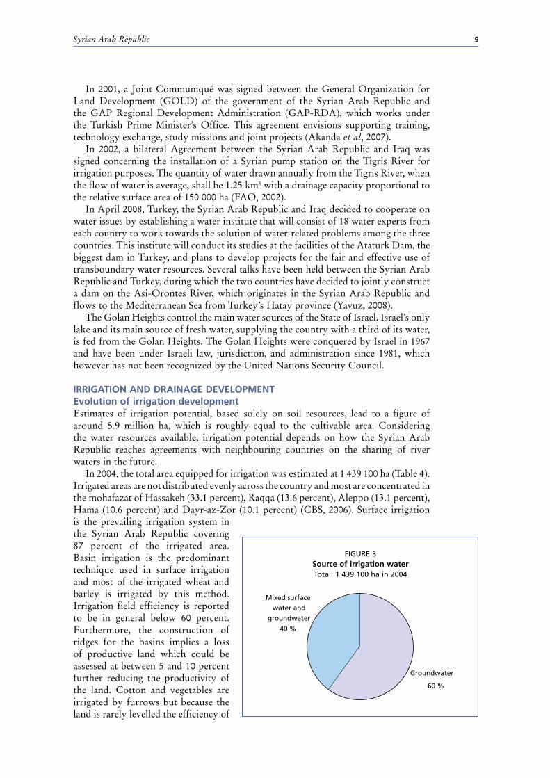
In 2004, the total area equipped for irrigation was estimated at 1 439 100 ha (Table 4). Irrigated areas are not distributed evenly across the country and most are concentrated in the mohafazat of Hassakeh (33.1 percent), Raqqa (13.6 percent), Aleppo (13.1 percent), Hama (10.6 percent) and Dayr-az-Zor (10.1 percent) (CBS, 2006). Surface irrigation is the prevailing irrigation system in the Syrian Arab Republic covering 87 percent of the irrigated area. Basin irrigation is the predominant technique used in surface irrigation and most of the irrigated wheat and barley is irrigated by this method. Irrigation field efficiency is reported to be in general below 60 percent. Furthermore, the construction of ridges for the basins implies a loss of productive land which could be assessed at between 5 and 10 percent further reducing the productivity of the land. Cotton and vegetables are irrigated by furrows but because the land is rarely levelled the efficiency of
Groundwater
60 %
Mixed surface
water and
groundwater
40 %
FIGURE 3Source of irrigation waterTotal: 1 439 100 ha in 2004

Irrigation in the Middle East region in figures – AQUASTAT Survey 200810
such a technique is also low (Varela-Ortega and Sagardoy, 2001).
In 2004, 864 700 ha (60.1 percent of the total irrigated area) were irrigated from groundwater (Figure 3), the remaining 574 400 ha by mixed surface water and groundwater, of which 340 200 ha were government projects. Recycled irrigation drainage water was estimated in 2004 at 2 246 million m3 (Ministry of Local Administration and Environment, 2007).
In 2003, the agricultural sector withdrew 14 669 million m3/year to irrigate 1 361 200 ha, which means an average of 10 777 m3/ha.
The sprinkler irrigation area increased from 30 000 ha in 1993 to 130 200 ha in 2004. While localized
irrigation was practiced on only 2 000 ha in 1993, the figure rose to 57 500 ha in 2004 (Figure 4). Lands irrigated by these so-called modern irrigation systems (sprinkler and localized irrigation) are mainly situated in the mohafazat of Hama (26.9 percent), Idleb (18.9 percent) and Aleppo (12.5 percent) (CBS, 2006).
The size of the irrigated holdings is substantially smaller than the size of the rainfed holdings and varies distinctively across regions. At national level, the average farm size for all types of holdings is 9.2 ha and the average irrigated farm size is 3.6 ha. The average size of irrigated holdings varies greatly according to the mohafazat, it is 10.5 ha in Hassakeh, 8.9 ha in Raqqa and 5.4 ha in Aleppo but only 0.8 ha and 0.9 ha in Aa-Suweida and Tartous respectively (Varela-Ortega and Sagardoy, 2001).
Role of irrigation in agricultural production, economy and societyIn 2000, the harvested irrigated crop area covered 1 334 265 ha while the rainfed area occupied 3 352 204 ha. Thus 28.5 percent of the harvested crop area was irrigated. Sugar beet and cotton were entirely irrigated just as almost all the citrus area (99.7 percent) was. About 75 percent of the area under vegetables and 41 percent of wheat were irrigated. Only 6.7 percent of fodder area, 6.1 percent of olives and 3.1 percent of pulses were irrigated. Irrigated barley and maize are mainly used as a fodder crop (Table 4 and Figure 5).
The performance of irrigated agriculture is high and the difference with rainfed yields is noticeable. Yields of wheat range between 3.4 and 3.5 tonnes/ha when irrigated and between 0.6 and 0.8 tonnes/ha when rainfed. Irrigated citrus trees produce on average 99 kg/tree while non irrigated citrus trees produce less than 20 kg/tree. Average yields of irrigated sugar beet and cotton are 42.8 and 4 tonnes/ha respectively (National Agricultural Policy Centre, 2003).
There is a wide variation in cropping patterns in the irrigated areas, depending on the water resources available and the agroclimatological conditions. Strategic crops such as wheat and cotton are concentrated in the northern and eastern parts of the country. More than 50 percent of the wheat and cotton produced comes from the Hassakeh governorate in the northeastern part of the country. The production of winter vegetables is centred in the coastal region, while summer vegetables are produced mainly in the internal plains, especially in the central and southern regions.
Unit costs for irrigation development have increased considerably in the last three decades and this is one of the reasons why since the 1970s attention has also been
Surface irrigation
87 %
Localized irrigation4 %
Sprinkler irrigation9 %
FIGURE 4irrigation techniques
Total: 1 439 100 ha in 2004

Syrian Arab Republic 11
paid to drainage and irrigation rehabilitation, mainly in the Euphrates valley where irrigation through pumping from the river has developed rapidly since the 1950s. Appreciable progress has been made in restoring large irrigated areas which went out of cultivation due to waterlogging and salinity, especially in the lower and middle parts of the Euphrates valley. At present, the average cost of a drip system varies between US$1 000 and US$3 000/ha (US$1 000–1 400/ha for trees and US$2 400–3 000/ha for vegetables) and that of a sprinkler system ranges between US$2 000 and US$2 400/ha for fixed devices and US$400/ha for manual ones (World Bank, 2001).
Cost of irrigation development is around US$1 100–1 200/ha in one part of the Euphrates (Beer Hashem), in the Yarmouk and in the Coastal basins, but it is US$2 700/ha in the Tigris and Al-Kabour basins (Hassakeh). It even reaches US$3 500/ha in another part of the Euphrates basin (Maskeneh Gharb) (Varela-Ortega and Sagardoy, 2001).
Status and evolution of drainage systemsDrainage is mainly developed in the mohafazats bordering the Euphrates River. In Raqqa, for instance, 62 percent of the irrigated area is drained. About 24 percent of the total drained area is power drained. The drainage systems are generally mixed systems of surface and subsurface drainage. In 1989, 60 000 ha of irrigated land were estimated to be affected by salinization (Table 4). Some 5 000 ha in the Euphrates basin have been abandoned due to waterlogging and salinity problems. In new irrigation schemes open drainage systems have been installed on 90 percent of the irrigated land. Only a small area has been equipped with subsurface drains.
WAteR mAnAGement, policieS And leGiSlAtion RelAted to WAteR uSe in AGRicultuReinstitutionsThe responsibility of dealing with water resources management lies with a number of ministries, which are all represented on the Council of General Commission for Water Resource Management:
0 100 200 300 400 500 600 700 800
Wheat
Sugar beet
Pulses
Vegetables
Cotton
Fodder
Other annual crops
Olive
Citrus
Other perennial crops
Thousand hectares
FIGURE 5irrigated crops
Total harvested area: 1 334 265 ha in 2000 (cropping intensity on equipped area: 105%)

Irrigation in the Middle East region in figures – AQUASTAT Survey 200812
The Ministry of Irrigation (MOI) is the central institution for managing, ¾developing and protecting the water resources, supervising the investments and the establishments in all water basins and drawing up strategic plans for executing the water policies to achieve sustainable development for water resources. The ministry is responsible for making available suitable water resources for all water using sectors, for controlling drilled wells and for licensing future wells.The Ministry of Agriculture and Agrarian Reform (MAAR) is the main consumer ¾of water resources; it is responsible for the rational use of water for agricultural purposes, for minimizing water consumption and encouraging the use of modern irrigation techniques. The Council of Ministers agreed (2005) to establish a national monetary fund for modern irrigation projects.The Ministry of Housing and Construction (MHC) is responsible for supplying ¾drinking water from surface and underground water resources by building, operating and investing in the water networks and water purification stations as well as building sewage-water networks and treatment plants and enhancing the efficiency of water and sewage networks.The Ministry of Local Administration and Environment (MLAE) is responsible for ¾monitoring and controlling water quality through its laboratories and observatory networks, for issuing national standards for the protection of water resources and tracking the sources of pollution in order to implement Environmental Law.Each Ministry has local bodies (local directorates or local institutions) related to ¾the central body of each Ministry and distributed over the 14 administrative units. In the case of the MOI there is the General Commission for Water Resources as a central body within the Ministry and in the case of the MLAE, there is the General Commission for Environmental Affairs (MLAE, 2007).
Water managementOn-farm irrigation is under the jurisdiction of the Directorate of Irrigation and Water Use (DIWU) of the MAAR in terms of research, testing, piloting and demonstration programmes regarding on-farm irrigation techniques, scheduling, wastewater reuse and so on, although farmers are responsible for irrigation management at the field level. The MAAR has 13 irrigation and water use research stations in all basins in order to conduct research and to disseminate information on crop water requirements, optimized irrigation methods and so on, suitable for local conditions. The MAAR also provides farmers with technical support for the planning, design and maintenance of the on-farm irrigation systems (World Bank, 2001).
Between 2005 and 2006 the International Programme for Technology and Research in Irrigation and Drainage (IPTRID), carried out the Project Design and Management Training Programme (PDM) for Professionals in the Water Sector in some countries of the Near East such as the Syrian Arab Republic. The objective of the programme is to strengthen participants’ capacities for developing more effective and efficient projects to address pressing water issues in the region (FAO, 2008).
financesIn the agricultural sector, the structure of the water tariff collected from farmers only covers a part of the cost for the irrigation water distribution network plus the costs of network operation and maintenance. The tariff is fixed at around US$70/ha, irrespective of the type of crops or the amount of exploited water. Apparently this does not provide any incentive for water conservation. So it is very important to shift to a volume based tariff for irrigation, in spite of the fact that till now there has been no strong policy for setting prices for irrigation water, and no legal regulation for invoicing the price of irrigation with a volume-related pricing system.

Syrian Arab Republic 13
Beneficiaries from the public irrigation systems are subject to a fee which tries to recover some of the investments made. The fee to be paid is calculated by taking into consideration the development costs for an amortization period of 30 years but no interest is charged nor is it corrected by inflation. Therefore the amount charged is small, from US$40 to 140/ha. The payments to be made are regulated by several legislative decrees, and executive decisions have been issued in order to recover the cost of the irrigation projects.
Operation and maintenance (O&M) costs for the irrigation and drainage networks are charged with a flat fee of US$70/ha for permanent irrigation and US$12/ha for winter irrigation. These fees have been determined according to decision no. 5 of 21/11/1999 issued by the Prime Minister. As could be expected, the actual cost of operation and maintenance is considerably higher for pump irrigation (US$110/ha) than for gravity irrigation (less than US$35/ha). It has been reported that the percentage of payment of the established O&M fees is close to 90 percent which is very high by world standards (Varela-Ortega and Sagardoy, 2001).
policies and legislationWater is defined by Syrian law as a “public good” that is not treated according to market forces. The right to use surface water or groundwater is acquired through the issuance of water use licenses by the MOI. Whoever installs a pump on public surface water without having a license is subject to a nominal fine. The license can be withdrawn if users do not comply with license conditions or if they use the water for purposes other than those authorized. At present, licenses specify discharge, well numbers and a maximum depth of 150 metres. They are issued for periods of either 1–3 years or 10 years. A very strong law banning new wells has been in place for more than five years. This law allows the repair of problematic wells but prohibits new constructions. However, enforcement of this law is weak.
Over 140 laws dealing with water have been passed since 1924. Water use priorities have not, however, been set by any official legislation. There is, however, a widely accepted consensus among related ministries about priorities for water usage. Drinking water has the top priority followed by agricultural and industrial water. Prohibitions on well digging and groundwater pollution have been passed but there are no clear mechanisms for their enforcement (Salman, 2004).
enviRonment And heAlthMonitoring activities show that near all major settlements groundwater and surface water are polluted by municipal and industrial waste where the concentrations of biochemical oxygen demand (BOD), suspended solids (SS) and ammonia exceed Syrian standards, and groundwater in the basin also contains extremely high concentrations of pathogens, nitrates and agrochemicals. This situation occurs in many areas (MLAE, 2007):
Water pollution from sewage water is reported in the Barada River; ¾An increase in the amount of nitrates and ammonia ions has been noted in some ¾drinking wells in the Damascus countryside (Ghouta), over the permitted level. In 2005 this led to a stop in the investment of more than 200 wells for drinking;Uncontrolled discharge of industrial wastewater occurs on a large scale. The ¾fertilizer and food processing industries contribute to the pollution load, but smaller and medium-sized industries such as tanneries also contribute and their impacts are even larger;Drainage water from irrigated agriculture, containing excessive nutrients, pesticides ¾and sometimes (in the case of irrigation with untreated wastewater) pathogens, reaches the rivers and groundwater;

Irrigation in the Middle East region in figures – AQUASTAT Survey 200814
In areas with heavy groundwater extraction, saltwater intrusion into the aquifer ¾from the sea or other saline groundwater has occurred.
There is sufficient evidence to indicate that significant health impacts have been caused as a result of water pollution. The following cases have been reported:
Almost 900 000 cases of waterborne diseases were reported in 1996, and a ¾significant number went unreported;High rates of infantile diarrhoea, with fatality rates of up to 10 percent within ¾some illegal housing areas not served by a drinking water network.
Compared to the period 1991–95, during the period 1995–2000 the rate of typhoid and hepatitis infections increased tenfold and that of diarrhoea doubled. Animals were also affected by several diseases, such as tapeworm and pulmonary tuberculosis and others, resulting from the use of untreated wastewater for fodder crop irrigation. The major factors favouring the development and dispersion of these diseases can be summarized as follows (DIWU, 2001):
Scarcity of groundwater resources and the orientation toward the use of ¾wastewater to meet the shortage;Lack of infrastructure especially that related to wastewater treatment and disposal, ¾i.e. random disposal without treatment most of the time;Lack of health awareness and proper handling of polluted water; ¾Non-existence or lack of adoption of regulations related to the protection of the ¾environment and public health.
The cost of environmental degradation in the Syrian Arab Republic was estimated in 2004 by the Mediterranean Environmental Technical Assistance Program (METAP)/World Bank to be 2.6–4.1 percent of GDP annually, based on the 2001 figures, with a mean estimate of around US$600 million/year. Estimated costs of damage are organized by environmental category. The cost of diarrhoea illness and mortality follows at an estimated 0.6–0.7 percent of GDP, caused by a lack of access to safe potable water and sanitation, and inadequate domestic, personal and food hygiene, while the total cost of water resource degradation, and inadequate potable water, sanitation and hygiene is estimated at 0.7–1.0 percent of GDP (MLAE, 2007).
pRoSpectS foR AGRicultuRAl WAteR mAnAGementIrrigation development to a large extent depends on how the Syrian Arab Republic reaches agreements with neighbouring countries on the sharing of river waters (Turkey, Lebanon, Jordan and Iraq). Identifying and implementing policies, programs, projects and techniques to improve water use efficiency and to control surface water and groundwater exploitation better are the important challenges facing Syrian policy-makers.
The main issues that the irrigation and drainage sector in the Syrian Arab Republic is facing are the legacy of over-investment in project development and the lack of an “exit strategy” to maintain the financial sustainability of this development, including clear economic incentives and an effective institutional framework. Reform of pricing and subsidies, management transfer and organizational restructuring are the key elements among others within the overall institutional reform that will encompass these issues and prioritize actions in order to achieve a sustainable improvement of this sector.
Government irrigation tariff policies do not provide any incentives to farmers to optimize water use and invest in modernized on-farm irrigation systems. For the public surface water irrigation schemes in particular, farmers do not have any incentives to save water since the operation and maintenance charge is a flat fee unrelated to water consumption and determined by the field size alone. For the individual groundwater irrigation systems, farmers have access to cheap credit to finance their initial capital investments and pay for subsidized energy with no charge for water.
Although there have been several attempts, particularly since 2000, to restructure the water sector in the Syrian Arab Republic, they have been somewhat superficial

Syrian Arab Republic 15
and have made no fundamental changes to its monumental structure which has a dominant “centralization” view. At present, the capacity of government organizations to support water management (as opposed to water development) appears limited and their services are weak and fragmented. Subsector agencies plan and implement their programmes without attempting to sequence and coordinate with each other which has led to incomplete improvements and reduced farmer benefits. In addition, the government policy to modernize irrigation systems at farm level requires the involvement of the Ministry of Agriculture and Agrarian Reform and the engagement of other agencies, which in reality seems incoherent and not applied properly. It is therefore important to emphasize the need for an overall organizational restructuring in the water sector that considers the possibility of decentralizing the decision-making authority, more involvement of private sector agriculture, greater involvement of users and strong quality control of activities. Such a restructuring can only be effective if it is embedded into an integrated set of measures that create the synergy necessary to achieve the anticipated objectives for sustainable water development in the country, and if it is backed by effective enforcement which in turn requires substantial support activities (education and outreach) to close the “perception gap” (Salman, 2004).
mAin SouRceS of infoRmAtionAbed Rabboh, Reem. 2007. Water demand management in Syria. Presented at the
workshop on “Water demand management in the Mediterranean, progress and policies”. Zaragossa 19–21 March 2007.
Akanda, A., Freeman, S. and Placht, M. 2007. The Tigris-Euphrates River Basin: Mediating a Path Towards Regional Water Stability
CBS (Central Bureau of Statistics). 2006. Statistical abstract 2005. Damascus.DIWU (Directorate of Irrigation and Water Use). 1993. Water requirements for the
agricultural plan 1993–94. Damascus.DIWU. 2003. Syria country paper. In: Proceedings-Expert consultation for launching
the regional network on wastewater reuse in the Near East.Economic and Social Commission for Western Asia (ESCWA). 2001. Implications of
groundwater rehabilitation on water resources protection and conservation: artificial recharge and water quality improvement in the ESCWA Region.
El Fadel, M., El Sayegh, Y., Abou Ibrahim, A., Jamali, D. and El Fadl, K. 2002. The Euphrates-Tigris Basin: A Case Study in Surface Water Conflict Resolution
ESCWA/FAO/ Ministry of Agriculture and Agrarian Reform (MAAR). 1995. Evaluation of agricultural policies in the Syrian Arab Republic (policy analysis matrix approach). Damascus, Syria.
ESCWA/FAO/MAAR. 1995. National Farm Data Handbook 1994. United Nations, New York.
FAO. 1993. Irrigation sub-sector review. Mission Report. Rome, Italy.FAO. 2002. Bilateral agreement between Syria and Iraq concerning the installation of
a Syrian pump station on the Tigris River for irrigation purposes. http://faolex.fao.org/waterlex/
FAO. 2008. Project Design & Management Training Programme for Professionals in the Water Sector in the Middle East
Kaya, I. 1998. The Euphrates-Tigris basin: An overview and opportunities for cooperation under international law
Ministry of Agriculture and Agrarian Reform (MAAR). 1993. Annual plan for agricultural production 1993–94. Damascus, Syria.
Ministry of Agriculture and Agrarian Reform (MAAR). 1993. Balance of land utilization for 1993.
MLAE (Ministry of Local Administration and Environment). 2007. Water demand management in Syria. Prepared by Abed Rabboh, R. Submitted to Blue Plan,

Irrigation in the Middle East region in figures – AQUASTAT Survey 200816
UNEP/MAP. Third regional workshop on: Water and sustainable development in the Mediterranean - Water demand management, progress and policies. Zaragoza, Spain, March 2007.
National Agriculture Policy Center (NAPC). 2003. The state of food and agriculture in the Syrian Arab Republic 2002. FAO Project GCP/SYR/006/ITA.
Salman, Maher. 2004. Institutional reform for irrigation and drainage in Syria: diagnosis of key elements.
Soumi, George. 1993. Management and development of water resources and their use rationalization. Report to the Technical Conference of the Arab Agricultural Engineers Federation in Tunis.
UNDP/FAO. 1994. Improved management of water resources for agricultural use (phase II). SYR/90/001. Damascus, Syria.
Varela-Ortega, C. and Sagardoy, J.A. 2001. The Utilization of Water Resources for Agriculture: Analysis of the Current Regime and Policy. Assistance in Institutional Strengthening and Agricultural Policy - Syria. FAO GCP/SYR/006/ITA.
Wangnick Consulting. 2002. IDA Worldwide desalting plants inventory. Report No. 17. Sponsored by the International Desalination Association (IDA).
World Bank. 2001. Syrian Arab Republic: Irrigation Sector Report. Report 22602. Yavuz, Ercan. 2008. Turkey, Iraq, Syria to initiate water talks. Todays Zaman 12/03/2008