Embed Size (px)
Citation preview
Sacramento District Real Estate Division Sutter Basin Pilot Feasibility Report - Environmental Impact Report / Supplemental Environmental Impacts Statement Butte and Sutter Counties, California REAL ESTATE APPENDIX E June 2013 Revised: October 2013
1

TABLE OF CONTENTS
1. STATEMENT OF PURPOSE 2. PROJECT AUTHORITY 3. PROJECT DESCRIPTION 4. DESCRIPTION OF LANDS, EASEMENTS, RIGHTS OF WAY, RELOCATIONS
AND DISPOSALS 5. LERRDs OWNED BY THE NFS AND CREDITING 6. STANDARD FEDERAL ESTATES AND NON-STANDARD ESTATES 7. DESCRIPTION OF ANY EXISTING FEDERAL PROJECT IN OR PARTIALLY IN
THE PROPOSED PROJECT 8. DESCRIPTION OF ANY FEDERALLY OWNED LAND NEEDED FOR THE
PROJECT 9. APPLICATION OF NAVIGATIONAL SERVITUDE TO THE LERRDs
REQUIREMENT 10. PROJECT MAP 11. ANTICIPATED INCREASED FLOODING AND IMPACTS 12. COST ESTIMATE 13. RELOCATION ASSISTANCE BENEFITS 14. MINERAL/TIMBER ACTIVITY/WATER RIGHTS 15. NON-FEDERAL SPONSOR’S ABILITY TO ACQUIRE 16. ZONING ANTICIPATED IN LIEU OF ACQUISITION 17. ACQUISITION SCHEDULE 18. DESCRIPTION OF FACILITY AND UTILITY RELOCATIONS 19. STATEMENT THAT THE NON-FEDERAL SPONSOR HAS BEEN NOTIFIED IN
WRITING ABOUT THE RISKS ASSOCIATED WITH ACQUIRING LAND FOR THIS PROPOSED PROJECT
20. HAZARDOUS,TOXIC, AND RADIOLOGICAL WASTE IMPACTS 21. ATTITUDE OF LANDOWNERS
EXHIBIT 1 – SUTTER FEASIBILITY REAL ESTATE PLAN EXHIBIT 1A – ASSESSMENT OF NON-FEDERAL PARTNERS REAL ESTATE ACQUISITION CAPABILITY
2

Real Estate Plan
For Sutter Basin Pilot Feasibility Study Sutter & Butte Counties, California
1. Statement of Purpose
This Real Estate Plan (REP) is intended to support and present the real estate requirements for the Sutter Basin Pilot Feasibility Study located in Sutter and Butte Counties, California. This REP focuses on the SB-7 and SB-8 alternatives which ultimately identified the Recommended Plan, and is to be used for planning purposes only. Alternative SB-8 has been granted a waiver by the Assistant Secretary of the Army’s office as an exception to policy to consider the Locally Preferred Plan (LPP) as the Recommended Plan. There may be modifications to the project and its plans that occur during the Preconstruction, Engineering and Design (PED) phase, thus changing the final acquisition area(s) and/or administrative and land costs reflected in this REP.
This report presents the Real Estate requirements for the Sutter Basin Pilot Feasibility
Study, Sutter and Butte Counties, California.
A high risk of flooding from levee failure threatens the public safety of approximately 95,000 people, as well as property and critical infrastructure throughout the Sutter Basin study area. Past flooding events have caused loss of life and extensive economic damages. Recent geotechnical analysis and evaluation of past levee performance indicate the existing project levees, which are part of the authorized Sacramento River Flood Control Project, do not meet current U.S. Army Corps of Engineers (USACE) levee design criteria, and are at risk of breach failure at stages less than overtopping of the levees.
This Real Estate Plan supports the Sutter Basin Pilot Feasibility Study the purpose of which is to investigate and determine the extent of Federal interest in plans that reduce flood risk to the Sutter Basin in Sutter and Butte Counties. That report: (1) assesses the risk of flooding; (2) describes a range of alternatives formulated to reduce flood risk; and (3) identifies a tentatively selected plan (TSP) for implementation. That report constitutes both a draft Feasibility Report that describes a USACE “pilot” planning process followed to identify the Recommended Plan, and an Environmental Impact Statement/Environmental Impact Report (EIS/EIR) required to comply with the National Environmental Policy Act (NEPA) and the California Environmental Quality Act (CEQA). Following public and governmental agency review, that draft report will be finalized and submitted to Headquarters, USACE, for review and approval, then transmitted to Congress for recommended project authorization. Project construction would also be dependent upon Congressional appropriation of funding for the Federal share of the project.
3

2. Project Authority
The authority for the USACE to study Flood Risk Management (FRM) and related water resources problems in the Sacramento River Basin, including the study area in Sutter and Butte Counties, is provided in the Flood Control Act of 1962, Public Law No. 87‐874, § 209, 76 Stat. 1180, 1196 (1962).
The existing project levees of the Sutter Basin provide FRM as part of the more
comprehensive Sacramento River Flood Control Project (SRFCP) which was authorized by the Flood Control Act of 1917.
The purpose of the Sutter Basin Pilot Feasibility Study analyzed in the Report and this REP,
is to address flood risk-related issues in the study area. The study is a General Investigations study undertaken to evaluate structural and non-structural FRM measures including re-operation of existing reservoirs, improvements to existing levees, construction of new levees, and other storage conveyance and non-structural options.
The Report presents planning, engineering, and implementation details of the recommended
plan to allow final design and construction to proceed provided USACE approval of the Recommended Plan, and is thereafter expected to be the basis for a recommendation to Congress for authorization of a new project. 3. Project Description
Specifically, this REP identifies the real estate costs for the NED Plan (Alternative SB-7) and the Recommended Plan (SB-8). Alternative SB-7 consists of strengthening approximately 27 miles of the existing Feather River West Levee from Sunset Weir to Laurel Avenue. The Recommended Plan (SB‐8) consists of strengthening approximately 41 miles of the existing Feather River West Levee to Thermalito Afterbay and addresses the flooding risks in the communities of Biggs, Gridley, and Live Oak. Alternative SB-8 is supported by the local sponsors as the Recommended Plan, and can be considered in a multi‐objective planning context to be a more comprehensive and complete Federal plan. Alternative SB-8 has been granted a waiver by the Assistant Secretary of the Army’s office as an exception to policy to consider the LPP as the Recommended Plan and is discussed in more detail in the main Report.
Sutter and Butte counties lie in a portion of north-central California known as the
Sacramento Valley. The project area is approximately 40 miles north of the City of Sacramento. The counties are significant components of the Sacramento River Flood Control Project (SRFCP). The SRFCP includes levees along the Sacramento River, the Sutter Bypass, the Feather River, Yankee Slough, Wadsworth Canal Cross Canal and Tisdale Bypass. In 1968, the Oroville Dam was completed, and over the years various improvements have been made to the original levee system to reinforce and enhance flood protection for the basin. Repairs have been made to major weaknesses in local levees since 1997. The most recent construction projects include the Wadsworth Canal slurry wall completed in 2008, and the Feather River setback levee at Star Bend that was completed in 2009.
4
Components of the Sacramento River Flood Control Project define an area within the counties known as the Sutter-Butte basin. The basin is generally bounded by the Sutter Bypass to the west and south, the Feather River to the east and south, and the Thermalito Afterbay to the north. Urbanized areas located within the basin include Biggs, Gridley, Live Oak and Yuba City. The Feather River flows south through Butte County from the City of Oroville and enters Sutter County near the community of Live Oak. The Feather River forms the Sutter/Yuba County line before flowing into the Sacramento River in southern Sutter County. The Sutter Bypass bisects Sutter County from the Sutter Buttes in the northwest to the Sacramento River in the south. The Sutter Bypass acts as flood relief for the Sacramento River. The Sutter Bypass conveys floodwaters from Butte Basin and additional floodwaters from the Sacramento River through the Tisdale Bypass, which connects to the Sacramento River downstream from the town of Grimes.
The Sutter Butte Flood Control Agency (SBFCA) is proposing to construct the Feather River West Levee Project (FRWLP) to reduce flood risk in the Sutter Basin, which includes portions of Sutter and Butte Counties in the Sacramento Valley of California. The SBFCA was formed as a joint powers authority in 2007 through a joint exercise of powers agreement by the Counties of Sutter and Butte; the Cities of Yuba City, Gridley, Live Oak, and Biggs; and Levee Districts 1 and 9 (LD 1 and LD 9).
In partnership with the State of California (through the California Department of Water Resources (DWR) and the Central Valley Flood Protection Board (CVFPB), the SBFCA embarked on a comprehensive evaluation of the condition of the levees protecting the area in 2007, the results of which are also being used by the U.S. Army Corps of Engineers (USACE). The evaluation was necessary to identify the magnitude and severity of deficiencies and determine measures to address the deficiencies. The results of the comprehensive evaluation revealed that substantial construction is necessary to meet current flood protection standards.
The FRWLP is being advanced by SBFCA to expeditiously reduce flood risk before the Sutter Basin Pilot Feasibility Study is completed. To construct the FRWLP, the SBFCA has requested permission from USACE pursuant to Section 14 of the Rivers and Harbors Act of 1899 (33 USC § 408) (hereinafter the “Section 408 permit”) for its proposed alteration of an existing federal levee previously constructed as part of the SRFCP. The Report and this REP does not analyze the Section 408 permit, but rather focuses only on the Federal NED Plan (Alternative SB-7) and the Recommended Plan (Alternative SB-8).
5
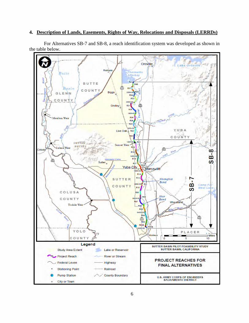
4. Description of Lands, Easements, Rights of Way, Relocations and Disposals (LERRDs) For Alternatives SB‐7 and SB‐8, a reach identification system was developed as shown in the table below.
6

The real estate cost estimate of Alternatives SB-7 and SB-8 was developed based on the conventional approach for development of feasibility level design. During development of the REP, the real estate cost estimate was developed for alternatives SB-7 and SB-8 in accordance with ER 405-1-12 and based upon the footprints delineating project requirements developed by the Sacramento’s Engineering Division. The Lands, Easements, Rights of Way, Relocations and Disposal (LERRDs) requirements for the REP include: the acquisition of flood protection levee easements, permanent road easements, utility easements, drainage easements, temporary work area easements, borrow easements, and mitigation fee title. The basis for the different types of acquisitions are as follows:
• Flood protection levee easements are required for the construction and operation and maintenance of project levee features. The easements vary in width and are delineated by the toe of existing levee and boundary of the seepage berms (within the project’s limit), relocated levee segments and new seepage berms.
• 15 foot permanent road easements along the landside and waterside edge of the flood protection levee easements, at a minimum, are needed for providing maintenance access to and for flood fighting purposes along the toe of the project features.
• Flood protection levee easements and permanent road easements together will be
sufficient to cover the acquisition needed for the vegetation free zone and to allow for the movement of construction equipments within the construction site.
• Additional utility easements (approximately 20ft beyond the permanent road
easement for O&M roads) may also be needed for obtaining utility corridors for relocation of utilities such as poles and pipelines running parallel to the project’s alignment outside of the proposed ROW. The specific locations of these additional utility easements have yet to be identified. The potential costs of such easements were determined by calculating the projected 20 foot easement outside the O&M corridor for the length of the project. These costs are included in the cost estimate tables.
• Drainage Easements are required for the Sutter-Butte Canal relocations. The
location of said easements generally falls within [(1) between stations 1429+00 and 1432+70, and (2) between station 1754+30 and 1766+00], and the costs of the easements are covered by existing contingencies in the real estate appraisal.
• Temporary work area easements are required for acquiring staging areas along the
length of the project.
• Borrow easements are required for potential borrow sites as shown in the borrow maps.
• Potential on-site mitigation areas will be acquired in fee title as shown in the
maps.
7

Alternative SB‐7 contains 21 reaches (2A north to 21) along the Feather River West Levee (FRWL) alignment, beginning at the same point south of Laurel Avenue and extending approximately 24 miles north to immediately north of Sunset Weir (station 1433+83). There are an estimated 292 parcels identified in Alternative SB-7 for project. The real estate costs for Alternative SB-7 are estimated at $42,390,000. There are 242 acres of levee easements, road easements and temporary work easements required for Alternative SB-7. There are also 1,771 acres of potential borrow sites identified and 71 acres of on- site mitigation proposed for Alternative SB-7.
8

The potential design features of Alternative SB-7 (Reaches 2 – 21) include the following:
9

D Recommended Plan SB‐8 contains 41 reaches (2A north to 41) along the FRWL
alignment, beginning approximately 1.7 miles north of the State Route 99 bridge over the Feather River (at station 180+00, approximately 2,250 feet south of Laurel Avenue) and extends north approximately 41 miles to the Thermalito Afterbay, downstream of Oroville Dam (at station 2368+00). There are an estimated 468 parcels identified in Alternative SB-8 for project implementation. The real estate costs for SB-8 are estimated at $53,546,000. There are 401.6 acres of levee easements, road easements and temporary work easements for Alternative SB-8. There are also 1,771 acres of potential borrow sites identified and there are 71 acres of on-site mitigation proposed for Alternative SB-8.
10
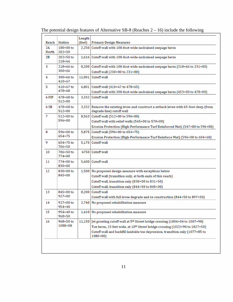
The potential design features of Alternative SB-8 (Reaches 2 – 16) include the following
11

The potential design features of Alternative SB-8 (Reaches 17 – 27) include the following:
12

The potential design features of Alternative SB-8 (Reaches 28 – 41) include the following:
13

The construction impacts to real property interests due to design features on existing levee sections are discussed below for SB-7 and SB-8.
No Modification Required
There are 7 levee sections along the Feather River West Levee alignment where modification is not required. These sections are between: (1) 831+50 and 844+50, (2) 923+75 and 1006+24, (3) 1007+70 and 1024+00, (4) 1027+50 and 1078+00, (5) 1625+00 and 1673+00, (6) 1769+40 and 1813+30, and (7) 2303+00 and 2331+00, approximately. Existing cutoff walls (30 to 50 feet in depth) are present within the first four levee sections. Cutoff Wall Only
There are 14 levee sections along the Feather River West Levee alignment where cutoff wall is the only modification feature required. These sections are between: (1) 231+00 and 453+00, (2) 478+68 and 512+00, (3) 570+00 and 831+50, (4) 1078+00 and 1096+00, (5) 1098+10 and 1107+00, (6) 1125+70 and 1129+99, (7) 1130+20 and 1429+00, (8) 1451+50 and 1455+00, (9) 1461+00 and 1608+50, (10) 1624+70 and 1625+00, (11) 1673+00 and 1673+30, (12) 1766+00 and 1769+40, (13) 1813+30 and 1900+50, and (14) 1903+50 and 2290+00. Jet Grouting Cutoff Wall Only
There are 4 levee sections along the Feather River West Levee alignment where jet grouting cutoff wall is the only modification feature required. These levee sections are between: (1) 1006+04 and 1007+90, (2) 1095+80 and 1098+30, (3) 1129+50 and 1130+67, and (4) 1900+00 and 1904+00.
Seepage Berm Only
There are 3 levee sections along the Feather River West Levee alignment where seepage berm is the only modification feature required. These levee sections are between: (1) 1024+00 and 1027+50, (2) 2290+00 and 2303+00, and (3) 2331+00 and 2368+00. Cutoff Wall with Full Levee Degrade and Relief Wells
There are 2 levee sections along the Feather River West Levee alignment where the levee will be fully degraded and reconstructed with a cutoff wall along the levee centerline These levee sections area between: (1) 844+50 and 897+50, and (2) 1455+00 and 1461+00. The proposed cutoff wall will function in combination with the existing seepage interceptor system (including 52 relief wells, a drainage ditch and pump stations) between station 844+50 and station 897+50.
14
Cutoff Wall with Relief Wells
Cutoff wall is required for the area between station 512+00 and station 570+00. The proposed cutoff wall will function in combination with the existing seepage interceptor system (including 24 relief wells, a drainage ditch and pump stations) between station 512+00 and station 545+00. A new seepage collector system (including 22 relief wells and a 2,500-foot long concrete lined V-ditch) will be installed between station 545+00 and station 570+00 at 120-foot interval. The new seepage interceptor system will be tied in with the existing one at station 545+00.
A cutoff wall is also required for the area between station 897+50 and station 923+75.
The proposed cutoff wall will function in combination with the existing seepage interceptor system (including 24 relief wells, drain ditch and pump stations). Cutoff Wall with Seepage Berm
There are 2 levee sections where both a cutoff wall and a seepage berm are required. These levee sections are between: (1) 180+00 and 231+00, and (2) 453+00 and 478+68. Cutoff Wall with Levee Relocation
The existing levee will be relocated 20 feet toward the river at three locations, between: (1) 1432+70 and 1451+50, (2) 1608+50 and 1624+70, and (3) 1673+30 and 1754+30. A cutoff wall is required at these locations and will be constructed along the relocated levee alignment. Cutoff Wall with Landside Toe Fill
A cutoff wall is required for the area between 1107+00 and 1125+70. The landside toe depression in this area will be filled. Soil- Bentonite versus Deep Soil Mix (DSM) Cutoff Wall
The proposed cutoff walls vary in depth along the project alignment. At locations where a cutoff wall is the required (except for the jet grouting sites), the cutoff wall will be: soil bentonite cutoff wall (if the wall is less than 75 feet in depth) or DSM cutoff wall (if the wall is greater than 75 feet in depth). There are 10 levee sections along the FRWL alignment where DSM cutoff walls are required. These sections are between: (1) 230+00 and 250+00, (2) 1125+00 and 1129+99, (3) 1130+20 and 1151+50, (4) 1224+00 and 1248+00, (5) 1987+25 and 2002+00, (6) 2016+75 and 2036+75, (7) 2067+00 and 2088+00, (8) 2137+00 and 2148+00, (9) 2182+00 and 2196+50, (10) 2245+75 and 2292+00, approximately (see Table 5-2 for more details). The wall’s depth at these locations will vary between 75 and 120 feet. Between 844+50 and 897+50, an 85-foot deep soil bentonite cutoff wall is considered adequate for this area.
15

Erosion Protection
An anchored HPTRM is required on the landside slope for two initial overtopping levee sections located in reaches 7 and 23 between: (1) 547+00 and 604+60, and (2) 1582+00 and 1601+00 to increase the sections’ resiliency and enhance flood warning and evacuation time prior to overtopping failure from events that exceed the design event. Closure Structure
One gate type closure structure or equivalent is required at station 1130+00, where the UPRR crosses the FRWL alignment and would be constructed in Reach 17 near Live Oak Blvd. where the levee crosses the railroad embankment.
The existing project levee is higher than the railway and a gap exists in the top portion of the levee. The gap is required to prevent interference with the approach grade to a Bridge across the Feather River. The current method of closing this levee gap is to fill the reach with sandbags during large flood event. The sandbag approach was last used during the January 1997 flood.
The sandbag approach was not preferred for the TSP because of reliability considerations. Accordingly, the selected approach for the TSP was to construct the referenced gated closure structure. An abutment would be constructed in the levee on each side of the railway. During a large flood event, floodgates hinged on the abutment would be closed across the railway preventing floodwaters from flowing through the gap. When installed, the floodgate structure would be approximately 3-4 feet high. The closure would not interfere with railway traffic because an existing closure structure on the east side of the Feather River Bridge would also be closed during the flood event.
16

This location is the lowest point along the levee and the performance of project depends on the closure structure operating correctly. If this structure is not operated correctly the levee could breach due to overtopping. This would result in rapid inundation of Yuba City. This is a highly populated area and a failure would have high life safety consequences. To further increase the robustness of the levee, this location would be made more resistant to overtopping.
Because the control structure serves to ensure the integrity of the levee system at its juncture with the railway line, the closure structure is classified as a project feature. The underlying fee owner of the real property is State of California.
Construction of the railroad gate type closure structure will require a Temporary Work
Area Easement. Also, the railroad gate type closure structure will require Flood Protection Levee Easement real estate rights to maintain and operate the closure structure system.
Cutoff Wall with Canal Relocation
The Sutter Butte Main Canal (Canal) will be relocated away from the existing levee toe at two locations: (1) between 1429+00 and 1432+70, and (2) between 1754+30 and 1766+00. The existing canal sections will be backfilled for an estimated total of 1500 feet.
A cutoff wall is required at these locations and will be constructed along the levee
centerline. Canal relocation was selected for a small section along the alignment where the FRWL is too close to the Feather River’s main channel to relocate the levee. This option was also selected for a small section of the Sutter Butte Canal near the Sunset Weir Pump Station, around station 1430+00, because it was deemed to be more cost effective than the levee relocation option which would require relocation of the pump station’ electrical system. At one of the four locations where the Sutter Butte Canal encroaches into the proposed ROW, specifically between station 1904+00 and station 1957+00, an existing 10‐foot minimum natural berm, on the levee’s landside slope, would be utilized for O&M purposes without any further actions.
Levee relocation was deemed to have the least overall impact and was selected as the primary measure for addressing the issue. The relocated levee is required to meet the minimum levee design criteria and height requirement. The cutoff wall would be constructed at the centerline of the relocated levee sections.
The Canal is operated by the Joint Water Districts – which include the following four water districts: the Richvale Irrigation District, the Biggs‐West Gridley Water District, the Butte Water District, and the Sutter Extension Water District. The Main Canal delivers Feather River water supply to these four districts that are located generally south and west of Lake Oroville and the Feather River along the eastern side of the Sacramento Valley. The Canal is approximately 17 miles long and is predominately unlined. The existing operating capacity ranges from approximately 1,600 cubic feet per second (cfs) at the upstream end to approximately 500 cfs at the downstream end. Potential impacts to water delivery requirements are discussed herein in Section 14. Both the Canal and the Feather River levee have meandering alignments. The Canal is adjacent to the levee at four locations, for a combined length of about 3.5 miles, and is up to several hundred feet away from the levee in other locations
17

Seepage and stability issues resulting from the Canal being adjacent to the levee could be addressed by the construction of a cutoff wall through the levee; however, there is no room for a landside easement due to the location of the adjacent canal. The landside easement is required to accommodate an O&M road.
For erosion protection, an Anchored High Performance Turf Reinforced Mat (HPTRM) is required on the landside slope for two levee sections. These levee sections are between (1) 547+00 and 604+60, and (2) 1582+00 and 1601+00, for a total of 7,660 linear feet. The proposed action for each area is addressed below. a. Affected Area 1a (1429+00 to 1433+83, FRWLP Reach 21). The proposed option for this area is to move the Canal landward into an adjacent agricultural area to provide space between the Canal and the levee for the landside O&M road. See Plate 4‐1. b. Affected Area 1b (1430+00 to 1449+00, FRWLP Reach 22). The proposed option for this area is to move the levee waterward into the flood overflow area to provide space sufficient for the landside O&M road. c. Affected Area 2 (1611+00 to 1623+00, FRWLP Reach 24). The proposed option for this area is to move the levee waterward into the flood overflow area to provide space sufficient for the landside O&M road.
18

19

20

As previously noted, the 41 reaches along the Feather River are broken into two alternatives: Alternative SB-7 (Reaches 2-21) and Alternative SB-8 (Reaches 2 – 41). Alternative SB-7 is completely included within Alternative SB-8. The reaches are then broken into 7 construction contracts including A, B, C1, C2, D1, and D2. The following tables represent the inventory of potential LERRDs required for the construction, operation and maintenance of alternatives SB-7 and SB-8:
Alternative Name Acres Incremental Costs Total cost
SB7 Lands and Damages
2136 $10,579,000 $42,390,000
SB8 Recommend Lands and Damages
2328 $11,751,000 $53,546,000
Potential Borrow Sites Potential borrow sites have been identified in various regions in the project area, and each site is summarized in the Table below and shown in the maps below. The borrow sites are the same for SB-7 and SB-8 since SB-7 is completely included within the SB-8 footprint. An investigation of each of the identified sites was based upon the quantity of available material, hauling distance, material composition, groundwater elevation, and prospects for acquisition. The purpose of the investigation was to identify the potential sites with the greatest potential to provide material economically for the project. Economical hauling has been determined to be within a 2-miles radius and marginally economic hauling within a 10-mile radius. Borrowing outside this radius is not recommended and additional sites would be identified to supply material within these limits.
13 sites were identified as potential borrow areas, five of which were eliminated as a result of a preliminary screening process. The screening criteria included contamination level, and relative location to the levee or seepage berm. SBFCA and USACE are currently in the process of sampling and testing the sites to ensure they meet material requirements. It was estimated that the borrow sites may provide up to 1,349,900 cubic yards of Type 1 fill material, 459,800 cubic yards of Type 2 fill material, and 330,800 cubic yards of Random fill material.
Alternative SB‐7 may require up to 419,760 cubic yards of Type 1 fill material, 579,045 cubic yards of Type 2 fill material, and no Random fill material required.
Alternative SB‐8 may require up to 629,810 cubic yards of Type 1 fill material, 809,845 cubic yards of Type 2 fill material, and 179,520 cubic yards of Random fill material.
21

22 Potential Parcels for 13 Borrow Sites used in the Screening Process
Parcels Proposed Borrow Easement Acres 025-230-999-000 11.737 025-280-007-000 2.122 025-280-008-000 12.296 025-280-009-000 24.811 025-280-010-000 7.655 025-280-011-000 2.824 025-280-019-000 4.677 025-280-020-000 9.037 025-280-021-000 20.057 025-280-022-000 9.926 025-290-019-000 21.878 025-290-020-000 5.075 06-470-046 26.27 08-220-013 38.213 08-220-030 0.221 08-220-031 0.490 08-220-032 38.609 08-220-033 38.719 08-260-043 39.245 10-071-001 40 13-270-033 40 10-032-018 12
22

23

24

Mitigation Sites
The proposed mitigation plan for SB-7 and SB-8 is to acquire 24.5 acres at Star Bend and 63.1 acres at the Three River Levee Improvement Authority (TRLIA) Feather River Floodway Restoration Project Site. Total mitigation lands needed are 87.6 acres. These sites are to be used to mitigate impacts to Valley Elderberry Longhorn beetle, riparian forest and oak woodland. The entire Star Bend Conservation Area is 48.5 acres site -- about 24.5 acres would restored as shown in the attached figure. Mitigation banks will be used for wetland and giant garter snake mitigation. Star Bend Mitigation Site (Reach 6) 1 Parcel
Parcels Mitigation Acres 2010-0001863 24.5
Star Bend Mitigation Site
25

Proposed 500-acre parcel for habitat restoration in the Feather River Setback Area
This potential mitigation property was purchased in fee by TRLIA for the State of California (DWR) and is currently managed by TRLIA until its fee title transfer to the State. At the time of purchase, the property was used as a pear orchard. The orchards were removed during setback levee construction and used as a borrow site. The property was refilled when the replaced levee was degraded. A small portion of the property is now being used by a local farmer under a short term lease for wheat. The Corp estimates it only needs 63 acres out of the 500. This site is part of the Feather River Floodway Corridor Restoration Project. This is an opportunity for regional cooperation and an ideal location for the mitigation required. Feather River Setback Area 1 Parcel
Parcels Mitigation Acres 040-600-082 63.1
26

Proposed Disposal Sites
Implementation of Alternatives SB‐7 and SB‐8 may generate up to 220,000 cubic yards of solid waste that would require disposal. Solid waste related to construction activities would include levee material, structural debris from removal of residences and agricultural structures, and roadway pavements. 220,000 cubic yards of unsuitable dirt would be wasted at the proposed borrow sites as LERRD’s. 5. LERRDs Owned by the NFS and Crediting
In the event the recommended plan is authorized, crediting will follow standard
procedures as set out in the model Project Partnership Agreement (PPA). No credit will be afforded to any lands or interests previously acquired and credited for any applicable Federal project. Credit will only be applied to the acreage within the “project footprint,” namely the lands or corridor required for the recommended plan of improvements. Lands outside of the project requirements and lands that may be acquired for the sponsor’s own purposes would not be creditable LERRDs. Only land deemed necessary that has not been previously cost shared on a project will be credited.
Corps’ policy also prescribes that credit will not be afforded for lands purchased with
Federal funds or grants where the granting of such credit is not permissible, whether as prescribed by statute, or as determined by the head of the Federal agency and administer such grants or programs. The Federal Emergency Management Agency (FEMA’s) floodplain hazard mitigation and elimination grants are examples of such Federal grant programs where credit would not be allocated. The Non-Federal sponsors own an estimated 8 parcels (constituting approximately 23 acres of the total acreage required for the project) in fee title, according the County Assessor’s office.1 These 8 fee title parcels (identified in the tract registers in reaches 2, 12, 23, 40 and 41) are assumed sufficient to support project purposes/functions, and no inconsistent encumbrances and/or restrictions on said land is anticipated. At this time, sufficiency of the 93 acres of remaining estates and real property rights held by the non-Federal sponsors, and identified as available to support project purposes/functions in the track registers, is unknown. The potential impact to project costs and/or plan selection as a consequence of this uncertainty is minimal inasmuch as the gross appraisal conservatively estimates the unit costs for the estates required for project purposes and includes seven incremental and improvement contingencies for various unknowns including severance damages, unknowns for level of study definition, unforeseen aspects due to inaccessibility and lack of onsite inspections, cost/value increases from time and development pressure, negotiation latitude above fair market value, potential for excessive cost/awards, potential for unknowns natural resources or minerals, improvement/building contingencies. Accordingly, this contingency assessment should reduce risk and cause no impact to plan selection. Parcels that are owned by the non-Federal sponsors in fee title are listed in the table below. The Non Federal Sponsors have the legal capability to provide the lands required for the
1 The Sac and San Joaquin Drainage District is a subdivision or agency of the State of California, DWR, and thus our non-Federal Sponsor. 27
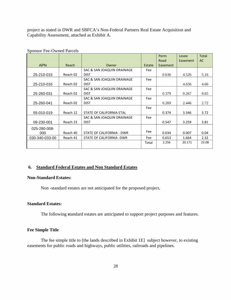
project as stated in DWR and SBFCA’s Non-Federal Partners Real Estate Acquisition and Capability Assessment, attached as Exhibit A. Sponsor Fee-Owned Parcels
APN Reach Owner Estate
Perm Road Easement
Levee Easement
Total AC
25-210-015 Reach 02 SAC & SAN JOAQUIN DRAINAGE DIST
Fee 0.636 4.526 5.16
25-210-016 Reach 02 SAC & SAN JOAQUIN DRAINAGE DIST
Fee 4.656 4.66
25-260-031 Reach 02 SAC & SAN JOAQUIN DRAINAGE DIST
Fee 0.379 0.267 0.65
25-260-041 Reach 02 SAC & SAN JOAQUIN DRAINAGE DIST
Fee 0.269 2.446 2.72
55-010-019 Reach 12 STATE OF CALIFORNIA ETAL Fee
0.374 3.346 3.72
09-230-001 Reach 23 SAC & SAN JOAQUIN DRAINAGE DIST
Fee 0.547 3.259 3.81
025-280-008-000 Reach 40 STATE OF CALIFORNIA - DWR
Fee 0.034 0.007 0.04
030-340-033-00 Reach 41 STATE OF CALIFORNIA -DWR Fee 0.653 1.664 2.32
Total 2.256
20.171
23.08
6. Standard Federal Estates and Non Standard Estates Non-Standard Estates:
Non -standard estates are not anticipated for the proposed project. Standard Estates: The following standard estates are anticipated to support project purposes and features. Fee Simple Title The fee simple title to [the lands described in Exhibit 1E] subject however, to existing easements for public roads and highways, public utilities, railroads and pipelines.
28

Flood Protection Levee Easement (FPLE)
A perpetual and assignable right and easement in the land [described in Exhibit1F tract registers] to construct, maintain, repair, operate, patrol and replace a flood protection levee, including all appurtenances thereto; reserving, however, to the owners, their heirs and assigns, all such rights and privileges in the land as may be used without interfering with or abridging the rights and easement hereby acquired; subject, however, to existing easements for public roads and highways, public utilities, railroads and pipelines. Temporary Work Area Easements (TWAE)
A temporary easement and right-of-way in, on, over and across for a period not to exceed 2 years after the execution of the construction contract, beginning with date possession of the land is granted to the Non Federal Sponsor, for use by the United States, the NFS, its representatives, agents, and contractors as a (borrow area) (work area), including the right to borrow and/or deposit fill, spoil and waste material thereon) (move, store and remove equipment and supplies, and erect and remove temporary structures on the land and to perform any other work necessary and incident to the construction of the Sutter Project, together with the right to trim, cut, fell and remove there from all trees, underbrush, obstructions, and any other vegetation, structures, or obstacles within the limits of the right-of-way; reserving however, to the landowners, their heirs and assigns, all such rights and privileges as may be used without interfering with or abridging the rights and easement hereby acquired; subject, however, to existing easements for public roads and highways, public utilities, railroads and pipelines. Permanent Road Easement (PRE) A perpetual and assignable easement and right-of-way in, on, over and across [parcel number] for the location, construction, operation, maintenance, alternation and replacement of (a) road(s) and appurtenances thereto; together with the right to trim, cut, fell and remove there from all trees, underbrush, obstructions and other vegetation, structures, or obstacles within the limits of the right-of-way; (reserving, however, to the owners, their heirs and assigns, the right to cross over or under the right-of-way as access to their adjoining land at the locations indicated in the tract register); subject, however, to existing easements for public roads and highways, public utilities, railroads and pipelines. Borrow Easement
A perpetual and assignable right and easement to clear, borrow, excavate and remove soil, dirt, and other materials from (the land described in Tract register) subject, however, to existing easements for public roads and highways, public utilities, railroads and pipelines; reserving, however, to the landowners, their heirs and assigns, all such rights and privileges in said land as may be used without interfering with or abridging the rights and easement hereby acquired.
29
Utility or Pipeline Easement
A perpetual and assignable easement and right-of-way in, on, over and across [the land described in Exhibit 1F] for the location, construction, operation maintenance, alteration, repair and patrol of [(overhead) or (underground) utility or pipeline]; together with the right to trim, cut, fell and remove therefrom all trees, underbrush, obstructions and other vegetation, structures, or obstacles within the limits of the right-of-way; reserving, however, to the landowners, their heirs and assigns, all such rights and privileges as may be used without interfering with or abridging the rights and easement hereby acquired; subject, however, to existing easements for public roads and highways, public utilities, railroads and pipelines. Drainage Ditch Easement
A perpetual and assignable easement and right-of-way in, over and across [the land described in Exhibit 1F] to construct, maintain, repair, operate, patrol and replace a drainage ditch, reserving, however, to the owners, their heirs and assigns, all such rights and privileges in the land as may be used without interfering with or abridging the rights and easement hereby acquired; subject, however, to existing easements for public roads and highways, public utilities, railroads and pipelines. 7. Description of Any Existing Federal Project in or Partially in the Proposed Project
Area
There are four Federal levee projects constructed prior to 1960 along the Feather River located in the study area or overlapping a portion of the study area. These levees are the same levees that are proposed for rehabilitation in the recommended project plan. Of these prior Federal projects, four Levee Unit Reaches (Reaches 152, 148, 144, and 143) are located along the Feather River as shown in the corresponding map, below, and the levee improvements in these units were part of the Sacramento River Flood Control Project authorized by the Flood Control Act of 1917, as modified by the Acts of 1928, 1937, and 1941. Reaches 152, 148, and 144 overlap with the recommended plan. Less than one-half (½) of the levee length in Unit Reach 143 also overlaps with the recommended plan. The remaining portion of Reach 143 is located outside of the study area completely. The southern levee stretch is longer than the proposed project construction site.
The four Federal levee projects referenced above were constructed prior to 1986 cost
share requirements, and lands to support Federal construction were provided and paid for by the non- Federal sponsors. Preliminary review of available Operation & Maintenance (O&M) Manuals and existing agreements from these prior Federal projects indicates no Federal retained right to use the land provided for subsequent Federal projects, contrary to the Corps’ post-1986 cost share policy mandates requiring a retained right of access for inspection, repair and rehabilitation of the project .
30

The non-Federal sponsors for the current recommended plan have existing O&M and levee easements in the prior federally constructed levees, however, it has been assumed for purposes of this study that the non-Federal sponsors will be required to acquire said rights and interests to implement Alternatives SB-7 and SB-8, and the acquisition costs have been included in the total project cost estimate. If during the Planning Engineering and Design (PED) Phase existing levee easements are discovered and available, those existing rights will not be cost-shared, which may lower the total project cost.
The local Levee and Maintenance Districts own, operate and maintain or currently have
easements or rights to maintain the various reaches of levee along the Feather River and are not owned by the Sutter Butte Flood Control Agency our current Non-Federal Sponsor. Our other Non-Federal Sponsors, the State of California DWR, currently owns 8 parcels in the project area that overlap the original projects and those parcels are listed in the tract registers located in Exhibit B of this report.
31

Prior Federal Levees located in the Project Area
32

8. Description of any Federally Owned Land Needed for the Project
There does not appear to be any federally owned land available to support the construction, operation and/or maintenance of Alternatives SB-7 or SB-8. The lands needed for the construction, operation and maintenance of each proposed alternative are either state owned, county owned, city owned and/or privately owned. 9. Application of Navigational Servitude to the LERRDs Requirement
The levees at issue in the implementation of Alternative SB-7 and Alternative SB-
8 are set back from the Feather River. Accordingly, there do not appear to be any lands required for the construction, operation and maintenance of either Alternative SB-7 or SB-8 that fall within the navigational servitude.
33
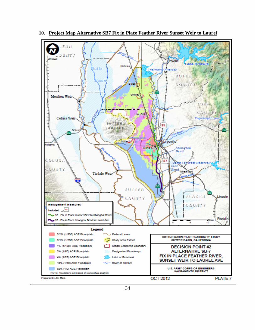
10. Project Map Alternative SB7 Fix in Place Feather River Sunset Weir to Laurel
34

Project Map Alternative SB8 Fix in Place Thermalito to Laurel Ave.
35

11. Anticipated Increased Flooding and Impacts
Change in Water Surface Elevations and Flood Safety Attributable to Project Design. Alternative SB-8 represents minor design modifications to the proposed action analyzed in the FRWLP Final EIS. SB-8 includes the proposed realignment of 11,600 linear feet of existing levee where it lies directly adjacent to the Sutter-Butte Canal (Canal). The modification would move the levee about 20 feet waterward to provide a 10-foot maintenance road between the Canal and the project levee. To evaluate whether moving the levee waterward would affect water surface elevations and increase the potential risk of flooding, changes to flow, depth, duration, and velocity were estimated using a hydraulic model. The hydraulic model results were also used to perform a transfer of risk analysis using Risk and Uncertainty based methods. The hydraulic model results indicated no measureable change in flow, depth, duration, and velocity within the Feather River (stage change less than 0.005 feet). The 20 foot realignment is located where the levee toe is higher than the 0.5% (1/200) ACE water surface elevation. Therefore, any change in water surface elevation would only occur for flood events more rare than 0.5% (1/200) ACE. In addition, this reach of river is over 5000 feet wide and the 20 foot realignment of the levee is a small change in the overall hydraulic cross section. Transfer of flood risk was evaluated by comparing with-project and without-project levee performance values at index points throughout the system. For purposes of evaluating system impacts, the risk analysis is limited to hydrologic and hydraulic parameters and their uncertainties. This approach is consistent with Section 3.b (2) of the memorandum “Clarification Guidance on the Policy and Procedural Guidance for the Approval of Modifications and Alterations of Corps of Engineers Projects” (USACE, 2008). The analysis is described in detail in the Hydraulic Design and Analysis Appendix. Analysis of the Alternative SB-8 found no transfer of flood risk. As described above, the hydraulic model created for Alternative SB-8 computed the same water surface elevations as Alternative SB-1 (No Action Alternative). Since the water surface elevations are the input to the Risk and Uncertainty model, and they did not change, there is no change in the project performance and no transfer of flood risk. Based on this hydraulic analysis there were no anticipated increased flooding or impacts of any significance applicable to Alternatives SB-7 or SB-8.
36

12. Cost Estimate Summary for Lands and Damages and Relocations
The following is a preliminary analysis estimating the costs of acquiring the required LERRDs to support Alternative SB-7. The table below estimates the costs associated with acquiring real property interests necessary to construct, operate and maintain a local levee project primarily located along the Feather River within the Counties of Butte and Sutter. The date of the approved cost estimate was December 6, 2012. The below is a summary of Real Estate Costs provided to Cost Engineering: SB7 Real Estate Cost estimate
Alternative SB-7 Features 292 Parcels Acres Costs
Incremental Real Estate
Costs
Total Costs Rounded
MCACES 01 ACCOUNT - LANDS AND DAMAGES (Non Fed)
Non Fed Admin
$13,462,170 $673,108 (5%)
$14,135,278
Non Fed Lands 2084 $17,375,434 $9,418,730
(50%) $26,794,164
Non Fed Relocation Payment Assistance
$588,333 $294,167 (50%)
$882,500
Non Fed New Utility Easements 52 $385,372 $192,686
(50%) $578,058
TOTAL LANDS AND DAMAGES (Non Fed)
$31,811,000 10,579,000 (33%)
$42,390,000 Rounded
MCACES 01 ACCOUNT - LANDS AND DAMAGES (Fed)
Federal Admin MCACES 01
$6,952,000 348,000 (5%)
$7,300,000
MCACES 02 ACCOUNT - RELOCATIONS (Non Fed) Utility Relocation Costs PED Relocations Construction Management
$22,298,000 $4,014,000 $2,230,000
TOTAL RELOCATIONS
$28,542,000
Federal Real Estate Administration costs include all acquisition, cadastral, appraisal, budget, and relocation specialist activities associated with PED, construction, and crediting activities over the 10 year life cycle of the project.
Non Federal Real Estate Administration costs include all effort directly related to acquisition of real property and interests by purchase, donation, exchange, reassignment, permits and options, such as: (a) mapping, writing legal descriptions, surveys and ownership research; (b) obtaining title evidence; (c) negotiations conducted for acquisition of real property of interests therein by purchase, donation, exchange, reassignment or transfer; closing land purchase cases, title curative work; recording of deeds; delivery of checks to landowners; and filing title opinions; and (e) acquisition activities associated with the relocation of facilities, utilities, cemeteries, public roads. Any effort prior to a decision to condemn should be charged to the Acquisition. Once that decision is made, all effort, starting with the mailing of the condemnation includes effort in connection with preparation of condemnation assemblies, including declarations of taking and the processing thereof up to and including the filing of the case. Other activities include obtaining Appraisals, PL 91-646 relocation activities, and obtaining permits. 37
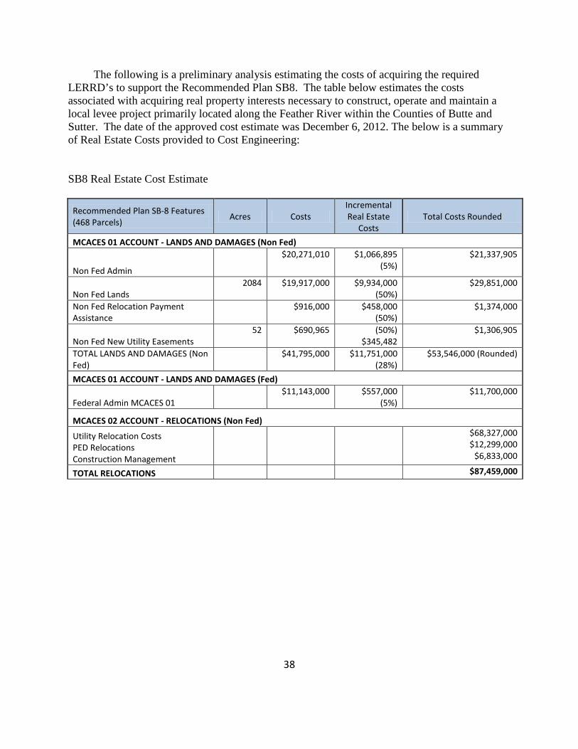
The following is a preliminary analysis estimating the costs of acquiring the required LERRD’s to support the Recommended Plan SB8. The table below estimates the costs associated with acquiring real property interests necessary to construct, operate and maintain a local levee project primarily located along the Feather River within the Counties of Butte and Sutter. The date of the approved cost estimate was December 6, 2012. The below is a summary of Real Estate Costs provided to Cost Engineering: SB8 Real Estate Cost Estimate
Recommended Plan SB-8 Features (468 Parcels) Acres Costs
Incremental Real Estate
Costs Total Costs Rounded
MCACES 01 ACCOUNT - LANDS AND DAMAGES (Non Fed)
Non Fed Admin
$20,271,010 $1,066,895 (5%)
$21,337,905
Non Fed Lands 2084 $19,917,000 $9,934,000
(50%) $29,851,000
Non Fed Relocation Payment Assistance
$916,000 $458,000 (50%)
$1,374,000
Non Fed New Utility Easements 52 $690,965 (50%)
$345,482 $1,306,905
TOTAL LANDS AND DAMAGES (Non Fed)
$41,795,000
$11,751,000 (28%)
$53,546,000 (Rounded)
MCACES 01 ACCOUNT - LANDS AND DAMAGES (Fed)
Federal Admin MCACES 01 $11,143,000 $557,000
(5%) $11,700,000
MCACES 02 ACCOUNT - RELOCATIONS (Non Fed)
Utility Relocation Costs PED Relocations Construction Management
$68,327,000 $12,299,000
$6,833,000
TOTAL RELOCATIONS
$87,459,000
38

13. Relocation Assistance Benefits (as required by the Uniform Relocation Assistance and Real Property Acquisition Policies Act, P.L. 91-646)
The non-Federal sponsors must comply with the Uniform Relocation Assistance and
Real Properties Acquisition Policies Act of 1970, as amended, 42 U.S.C. 4601 et seq. (P.L. 91-646, “the Uniform Act”) and provide relocation assistance to qualifying residences and businesses within the project area that are displaced, as defined in the Uniform Act, as a consequence of project implementation. The non-Federal sponsors has prepared a draft relocation plan, which the Corps has reviewed. The relocation inventory was created by viewing conceptual designs over Aerial Photographs. The estimated costs of such potential displacements are required for estimating project costs and will be refined by the non-Federal sponsors when construction designs are completed.
Under both alternatives, property will be acquired with permanent easements and/or
temporary construction easements. The existing right-of-way (ROW) corridor includes O&M corridors that vary in width along the alignment and that are discontinuous for a significant distance at some locations. The minimum levee design criteria require the project levee to have an O&M corridor along the levee toes of a minimum of 15 feet on each side of the levee. The O&M corridors are necessary for O&M and flood fighting purposes. Therefore, for this Feasibility Study, additional real estate would be acquired to provide sufficient space for the O&M corridors. Acquiring additional real estate would result in relocation of physical structures (e.g., buildings) along the alignment, which may result in potential qualifying displacements.
Implementation of Alternative SB‐8 may result in the relocation of 34 residential properties, 5 businesses, and 10 agricultural buildings/structures.
Implementation of Alternative SB-7 may require the relocation of 22 residential
properties, 5 businesses, and 2 agricultural buildings/structures. A majority of these structures are within Reach 16 (Yuba City).
Presently, the potential P.L. 91-646 relocation assistance benefit estimates for
Alternative SB-7 are $882,500. The improvements and land costs have been estimated in the appraisal in the land and damage 01 account.
Presently, the potential P.L. 91-646 relocation assistance benefit estimates for Alternative
SB-8 are $1,374,000. The improvements and land costs have been estimated in the appraisal in the land and damage 01 account.
39

(Uniform Relocation Act (Moving Assistance Payments) Reach Station ID Structure Cost
Reach 16 Residential $ 32,500.00 Reach 16 Business $40,000.00 Reach 16 Business $40,000.00 Reach 16 Residential $32,500.00 Reach 16 Residential $ 32,500.00 Reach 16 Residential $ 32,500.00 Reach 16 Residential $ 32,500.00 Reach 16 Residential $ 32,500.00 Reach 16 Residential $ 32,500.00 Reach 16 Residential $ 32,500.00 Reach 16 Residential $ 32,500.00 Reach 16 Residential $ 32,500.00 Reach 16 Residential $ 32,500.00 Reach 16 Residential $ 32,500.00 Reach 16 Residential $ 32,500.00 Reach 16 Residential $ 32,500.00 Reach 16 Business $40,000.00 Reach 16 Residential $32,500.00 Reach 16 Residential $32,500.00 Reach 16 Business $40,000.00 Reach 16 Residential $32,500.00 Reach 16 Residential $ 32,500.00 Reach 16 Residential $ 32,500.00 Reach 16 Residential $ 32,500.00 Reach 16 Residential $ 32,500.00
Reach Station ID Structure Cost Reach 16 Assistance Payments for SB7 $842,500.00 Reach 31 Building Contents $40,000.00 Reach 28 Building Contents $40,000.00 Reach 28 Residential $32,500.00 Reach 28 Residential $32,500.00 Reach 28 Residential $32,500.00 Reach 26 Residential $32,500.00 Reach 26 Residential $32,500.00
Relocations due to Levee Relocations
Station 1744 Reach 28 Residential $32,500.00 Station 1734 Reach 28 Ag Building Contents $32,500.00 Station 1730 Reach 28 Residential $32,500.00 Station 1726 Reach 28 Residential $32,500.00 Station 1700 Reach 26 Residential $32,500.00 Station 1665 Reach 25 2 Ag Building Contents $22,000.00 Station 1610 Reach 25 Residential $32,500.00
Station 1470 Reach 22 Residential $32,500.00 Total est. all Relocations Assistance Payments for SB8 $1,333,400.00
40

Availability of Replacement Housing/Business Properties: There are currently over 300 single family homes for sale in Yuba City. At this time there is replacement housing available. There are over 100 businesses for sale or lease available in Yuba City, Marysville, Chico, Live Oak, Gridley and Oroville. There are only five businesses inventoried to be potentially relocated.
The foregoing impacts and estimates relating to potential displacements, and the
anticipated need to provide relocation assistance benefits, are provided exclusively for project cost estimating purposes only and are not intended to be relied upon for provision of benefits and/or the payment of the estimates referenced herein. A draft relocation assistance plan has been provided by the Sutter Butte Flood Control Agency and will be refined during PED.
14. Mineral/Timber Activity/Water Rights
Mineral/Timber Activity:
There does not appear to be any effect on the availability of aggregate resources because no structures are anticipated to be constructed that would otherwise interfere with access to permitted mineral resources, and no permitted mineral resource extraction mines exist in the project corridor.
Neither proposed alternative is anticipated to cause the loss of a known mineral resource of regional or local importance as a result of placement according to NEPA and CEQA.
There is no timber harvesting activities going on in the project footprint. There are small
portions of agricultural lands (orchards and row crops) that are located in the project footprint, but those have been assessed and are included in the cost estimate.
No natural gas wells are in or near the construction footprint.
Water Rights:
The Sutter-Butte Main Canal (the Canal) delivers Feather River water supply to four water districts (hereinafter the Joint Water Districts) that are located generally south and west of Lake Oroville and the Feather River along the eastern side of the Sacramento Valley. The Joint Water Districts consist of the Sutter Extension Water District, Butte Water District, Richvale Water District and Biggs/West Gridley Water District. In the case of the Canal (which encroaches into the proposed ROW at four locations along the FRWL alignment)\ four potential measures were considered for each area to address ROW needs: construction of a retaining wall in the landside slope, construction of a flood wall, levee relocation and Canal relocation. The proposed measures were also coordinated with the U.S. Fish and Wildlife Service. The flood wall\, retaining wall and Canal relocation options were generally eliminated because these structures were deemed to create substantial barriers to movement of terrestrial wildlife species. Each measure was evaluated based on construction cost and impacts with the conclusion that levee relocation had the least impacts and costs.
41

Levee relocation was deemed to have the least overall impact and was selected as the primary measure for addressing the issue. The relocated levee is required to meet the minimum levee design criteria and height requirement. The cutoff wall would be constructed at the centerline of the relocated levee sections.
Relocation of the Canal was, however, selected for a small section along the alignment where the FRWL is too close to the Feather River’s main channel to relocate the levee. This option was also selected for a small section of the Canal near the Sunset Weir Pump Station, around station 1430+00, because it was deemed to be more cost effective than the levee relocation option which would require relocation of the pump station’ electrical system.
It is presently understood that the Joint Water Districts hold senior water rights on the Feather River, predating the State Water Project. Following the construction of the State Water Project’s Oroville Dam and related downstream facilities, the Canal began taking supply from a new turnout at the Thermalito Afterbay. The Canal route runs roughly north to south, with major turnouts to each of the four districts’ internal distribution systems. The Canal is approximately 17 miles long and is predominantly unlined. The existing operating capacity ranges from approximately 1,600 cubic feet per second (cfs) at the upstream end to approximately 500 cfs at the downstream end. Operation and maintenance (O&M) of the Canal is conducted by the Joint Water Districts Board, which includes representatives of each of the four districts referenced above. The Canal operates as the backbone of a gravity irrigation distribution system, with check dams at regular intervals used to maintain water surface levels at sufficient height to allow gravity diversions to adjacent users.
The Corps and the non-Federal sponsors are mindful that water/irrigation districts and its customers are sensitive to water rights needs and delivery requirements associated with water off of the Canal. Although District Real Estate had no opportunity to review any operative water rights agreements, presently, neither the implementation of Alternative SB-7 or SB-8 anticipates the need for acquisition of potential water rights held by the Joint Water Districts for project implementation purposes. Temporary bypass systems may be provided, if legally required and/or permissible, to avoid or minimize disruption to irrigation and other utility services, when the impacted portion of the Canal is relocated for project purposes, as further discussed in Section 18 of this Real Estate Plan Appendix. Any unanticipated acquisitions associated with the Canal realignment are covered in the real estate cost estimate which includes a 50% contingency for unknown acquisitions issues, and any unanticipated construction impacts and associated costs are included in the Engineering Appendix.
15. Non-Federal Sponsor’s Ability to Acquire The State of California Central Valley Flood Protection Board has partnered with the
Corps on many prior projects and has a full Real Estate staff capable of fulfilling its’ responsibilities as a non-Federal sponsor.
42

An assessment of the Non-Federal Sponsor’s Real Estate Acquisition Capability has been provided to Corps by both non-Federal sponsors and is included in Exhibit A.
16. Zoning Anticipated in Lieu of Acquisition
The Corps does not propose use of a zoning ordinance that would essentially facilitate property acquisition by prohibiting certain uses of property instead of purchasing the property. No such ordinance is proposed. The plan assumes purchasing property along the levee.
43
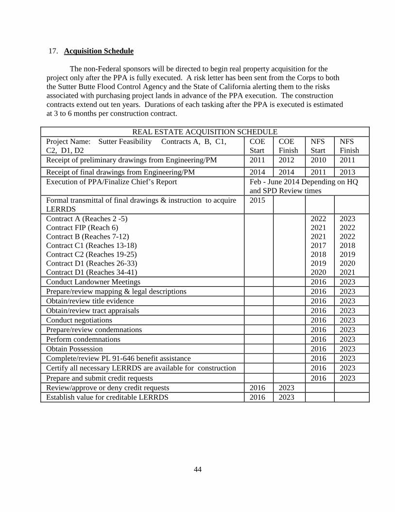
17. Acquisition Schedule The non-Federal sponsors will be directed to begin real property acquisition for the project only after the PPA is fully executed. A risk letter has been sent from the Corps to both the Sutter Butte Flood Control Agency and the State of California alerting them to the risks associated with purchasing project lands in advance of the PPA execution. The construction contracts extend out ten years. Durations of each tasking after the PPA is executed is estimated at 3 to 6 months per construction contract.
REAL ESTATE ACQUISITION SCHEDULE Project Name: Sutter Feasibility Contracts A, B, C1, C2, D1, D2
COE Start
COE Finish
NFS Start
NFS Finish
Receipt of preliminary drawings from Engineering/PM 2011 2012 2010 2011 Receipt of final drawings from Engineering/PM 2014 2014 2011 2013 Execution of PPA/Finalize Chief’s Report Feb - June 2014 Depending on HQ
and SPD Review times Formal transmittal of final drawings & instruction to acquire LERRDS
2015
Contract A (Reaches 2 -5) Contract FIP (Reach 6) Contract B (Reaches 7-12) Contract C1 (Reaches 13-18) Contract C2 (Reaches 19-25) Contract D1 (Reaches 26-33) Contract D1 (Reaches 34-41)
2022 2021 2021 2017 2018 2019 2020
2023 2022 2022 2018 2019 2020 2021
Conduct Landowner Meetings 2016 2023 Prepare/review mapping & legal descriptions 2016 2023 Obtain/review title evidence 2016 2023 Obtain/review tract appraisals 2016 2023 Conduct negotiations 2016 2023 Prepare/review condemnations 2016 2023 Perform condemnations 2016 2023 Obtain Possession 2016 2023 Complete/review PL 91-646 benefit assistance 2016 2023 Certify all necessary LERRDS are available for construction 2016 2023 Prepare and submit credit requests 2016 2023 Review/approve or deny credit requests 2016 2023 Establish value for creditable LERRDS 2016 2023
44

18. Description of Facility and Utility Relocations For cost shared projects, the non-Federal sponsors are generally required to perform or assure the performance of all utility/facility relocations necessitated by project implementation, with some specified exceptions.
On January 10, 2013, the Corps issued Real Estate Policy Guidance Letter No. 31--Real Estate Support to Civil Works Planning Paradigm (3x3x3) (“PGL No. 31”) establishing additional Corps policy guidance for feasibility-level real estate efforts directed at identifying, defining and estimating the costs of utility/facility relocations resulting from project implementation for planning and budgeting purposes. In qualifying instances, a real estate assessment, in lieu of an attorney’s preliminary opinion of compensability, may be prepared and utilized for such purposes (although a final attorney’s opinion of compensability will be required for specified relocations prior to execution of the Project Partnership Agreement between the Corps and the non-Federal sponsors.).
The Utility/Facility Inventory table, maps and cost estimates discussed herein and
available in Exhibit1B and Exhibit 1D on DVD sets forth the following information: the utilities/facilities falling within the project area that are presently anticipated to be impacted by the construction, operation and maintenance of the project thus requiring “relocation” (as defined in applicable law and regulations); the District’s preliminary efforts to identify owners with compensable interests in the impacted utilities/facilities and eligibility for the provision of a substitute or replacement facility under applicable law and regulations; and identification of the non-Federal sponsors’ performance and cost responsibilities in connection with the identified relocations for this cost-shared project.
Consistent with requirements of PGL No. 31, the preparation of a real estate assessment
is appropriate for this feasibility study because the estimated total cost to modify all project utility/facility relocations identified in the Utility/Facility Inventory (including the value of any additional lands that may be required for perform the relocations) for either Alternative SB-7 or SB-8 do not exceed 30 percent of estimated total project costs. Here, total project costs are estimated at $694,010,000 and the utility relocations are estimated at $68,327,000 which is below the 30% threshold.
The real estate assessment discussed herein, and presented in Exhibit 1B on DVD, is based upon the following assumptions to assist in preliminarily analyzing and determining compensability for Study planning and budgeting purposes:
(1) If an impacted utility/facility is likely supported by a permit that has been issued to
the utility/facility owner by the underlying property owner, and the terms of the permit include conditional language stating the utility/facility owner must relocate the impacted utility/facility at its own expense at request of the underlying fee or easement owner, the relocation was categorized as a non-compensable relocation, the costs of which are borne by the utility/facility owner and/or the non-Federal sponsor, and not included in the total project cost estimate.
45

(2) If the owner of the impacted utility/facility likely has an easement or real property interest in the underlying land, and the utility/facility so impacted preliminarily appears to meet the criteria for the provision of a substitute and/or replacement facility under the substitute facilities doctrine, the relocation was categorized as a compensable relocation, the costs of which are borne by the non-Federal sponsor and included in the total project cost estimate.
(3) If, the impacted utility/facility likely has a pre-1955 permit as provided by the non-
Federal sponsors, and it is located within existing Corps O&M manuals, its relocation (which would otherwise be categorized as non-compensable and handled in the same manner as the relocations identified in Assumption No. 1, above) was categorized –for feasibility cost estimating purposes only--as a compensable relocation, the costs of which are borne by the non-Federal sponsor and included in the total project cost estimate. It is expressly understood that this characterization is preliminary and non-binding, and would further require the express permission and approval of the Assistant Secretary of the Army for its ongoing characterization for this specific project.
(4) The proposed relocation of Sutter-Butte Canal (Canal) (approximately 500 feet in
one location and 1000 feet in another location) is preliminarily assumed to be compensable since the Canal utility/facility owner likely has a compensable interest in the underlying land (i.e. the Canal is built on private farm properties); however, for feasibility purposes, it is presently assumed that compensation will take the form of the provision of a substitute facility, the cost of which will be borne by the non-Federal sponsor and is included in the total project cost estimate. It is also presently assumed that the relocation of the impacted portion of this Canal shall neither increase or decrease the cfs flowing in the existing Canal. Temporary bypass systems are preliminarily proposed to be provided to minimize disruption to irrigation and other utility services during the farming season Notwithstanding the foregoing, in the event the provision of a substitute and/or replacement facility, and/or the provision of temporary bypass systems, is not legally permissible, associated costs incurred by the non-Federal sponsors in the provision of a substitute and/or replacement facility and/or the provision of temporary bypass systems may be limited to the land damage value at crediting and/or regarded as a “betterment” and thus not included in total project costs.
(5) Impacted utilities/facilities requiring relocation that likely intercept and/or convey
drainage blocked by levees or floodwalls from the protected side of the waterway with measures such as intercepting ditches, ponding areas, pumping plants, gravity outlets, and pressurized conduits, were preliminarily categorized as project features; thus an item of construction to be cost shared and are included in the total project cost estimate. These project features have not been not included in the Utility/Facility Inventory, however, with the exception of costs to increase the size of the facilities to meet special local needs (including betterments), which costs are borne 100% by the non-Federal sponsors and are not included in the total project cost estimate.
The Utility/Facility Inventory was subdivided into two categories: levee prism
encroachments and right-of- way (ROW) encroachments.
46
Levee prism encroachments are utility pipelines and conduits running perpendicular to the levee alignment. Most of these pipeline and conduit crossings are either dated and do not comply with the current standard for levee encroachment, or would be disrupted or otherwise impacted by levee construction. These pipelines and conduits, therefore, would be removed before the cutoff wall construction begins and replaced with proper materials after the cutoff wall construction is completed. Gravity lines (e.g., storm drain) would be replaced in‐place. Pressurized lines (e.g., irrigation and drainage discharge lines, gas pipes, water and sewer lines) and conduits (e.g., electrical and communication lines) would be relocated. Pipes that are known to be recent installations would remain because they are assumed to be in compliance with current Corps policy. Abandoned pipelines and conduits would be removed.
ROW encroachments are utilities and physical structures (e.g., overhead electrical lines)
located outside of the levee prism but within the limits of the proposed ROW. These structures would be relocated outside of the proposed ROW prior to levee and seepage berm constructions. Under Alternatives SB‐7 and SB‐8, utilities that run parallel to the levee alignment and within the proposed ROW would be relocated outside of the proposed ROW. Utility pipelines and conduits crossing the existing levee embankment would be removed, modified or replaced to meet the USACE standard for levee penetration.
Reaches 2 thru 21 represent Alternative SB-7. Alternative SB-7 yields utility/facility relocation costs in the estimated amount of $22,298,000. The additional 52 acres of utility corridor easements required for SB-7 is 578,057.
Reaches 2 thru 41 represent Alternative SB-8 (the TSP). Alternative SB-8 yields utility/facility relocation costs in the estimated amount of $68,327,000. The additional 85 acres of utility corridor easements required for SB- 8 is $1,036,447.
Final Attorney’s Opinions of Compensability will be completed during the PED Phase
and prior to the execution of the Project Partnership Agreement, as well as prior to any notice to proceed to obtain lands and perform relocations by the non-Federal sponsors.
ANY CONCLUSION OR CATEGORIZATION CONTAINED IN THIS REAL ESTATE PLAN (AND THE REPORT) THAT AN ITEM IS A UTILITY OR FACILITY RELOCATION TO BE PERFORMED BY THE NON-FEDERAL SPONSOR AS PART OF ITS LERRD RESPONSIBILITIES AND/OR IS OTHERWISE COMPENSABLE OR NON-COMPENSABLE IS PRELIMINARY AND FOR DISCUSSION PURPOSES ONLY. THE GOVERNMENT WILL MAKE A FINAL DETERMINATION OF THE RELOCATIONS NECESSARY FOR THE CONSTRUCTION, OPERATION, OR MAINTENANCE OF THE PROJECT AFTER FURTHER ANALYSIS AND COMPLETION AND APPROVAL OF THE FINAL ATTORNEY’S OPINIONS OF COMPENSABILITY FOR EACH OF THE IMPACTED UTILITIES AND FACILITIES DURING FINAL DESIGNS.
47

Utility Station ID Map 48

19. Statement that the Non-Federal Sponsor has been notified in writing about the Risks Associated with Acquiring Land for this Proposed Project
The Government has sent risk letters to the NFS’s in August 2012 enumerating the
Sponsor’s financial risks associated with acquisition of real property interests prior to execution of the Project Partnership Agreement. 20. Hazardous, Toxic, and Radiological Waste Impacts
A preliminary Phase I Environmental Site Assessment (ESA) has been conducted to identify potential HTRW sites. No known contamination due to HTRW was confirmed within the construction zone, however, a full Phase I ESA has not been conducted.
To further investigate the potential for hazardous toxic radioactive wastes (HTRW) in the project area, a full Phase I Environmental Site Assessment (ESA) would be performed during the project design phase. If the Phase I ESA indicates the presence of HTRW, a Phase II ESA would be performed involving chemical analysis for hazardous substances and/or petroleum hydrocarbons. If hazardous substances are encountered during construction, USACE or its contractor will implement required measures for the proper transport and disposal of such materials in accordance with the appropriate local, state, and Federal laws and regulations.
If any evidence of potential HTRW is found during construction, all work would cease,
and the Corps and non-Federal sponsor would be notified for further evaluation of the potential contamination. Any unanticipated hazardous materials encountered during construction would be handled according to applicable federal, state, and local regulations. The Corps would require that a contingency plan that outlines steps to be taken before and during construction activities to document soil conditions, as well as procedures to be followed if unexpected conditions are encountered, be prepared by the contractor. The non-Federal sponsor is responsible for 100 percent of the cost to develop the clean-up procedures (remedial action plan) and to treat the contaminate in place or relocate the material (ER 1110-2-1150). For further detailed information the Integrated EIS document has a HTRW section and the Engineering appendix contains the HTRW assessment details. 21. Attitude of Landowners
To date, the results of the outreach program from the public scoping meetings have been
very favorable, constructive, and supportive. The tone and substance of the input has been consistent with the voter-approved assessment to fund the local share of the project.
49

EXHIBIT A1
ASSESSMENT OF NON-FEDERAL SPONSOR'S REAL ESTATE ACQUISITION CAPABILITY
SUTTER PILOT FEASIBILITY STUDY
SPONSORS: The State of California, Central Valley Flood Protection Board (CVFPB), Sutter Butte Flood Control Agency (SBFCA) I. Legal Authority: a. Do the sponsors have legal authority to acquire and hold title to real property for project purposes? Yes CVFPB; Yes SBFCA b. Do the sponsors have the power of eminent domain for this project? Yes CVFPB; Yes SBFCA c. Do the sponsors have "quick-take" authority for this project? Yes CVFPB; Yes SBFCA d. Are any of the lands/interests in land required for the project located outside the sponsor's political boundary? No CVFPB; No SBFCA e. Are any of the lands/interests in land required for the project owned by an entity whose property the sponsor cannot condemn? No CVFPB; SBFCA Response: Some of the lands are owned by public entities, including local and state agencies. Under California law, it is more difficult to condemn property owned by public entities. Some of the property within the project area is owned by a railroad company. Condemning railroad property is also more difficult due to federal pre-emption issues. II. Human Resource Requirements: a. Will the sponsor's in-house staff require training to become familiar with the real estate requirements of Federal projects including P.L. 91-646, as amended? Yes CVFPB; No SBFCA b. If the answer to a. is "yes," has a reasonable plan been developed to provide such training? Yes CVFPB; SBFCA N/A c. Does the sponsor's in-house staff have sufficient real estate acquisition experience to meet its responsibilities for the project? Yes CVFPB; Yes SBFCA d. Is the sponsor's project in-house staffing level sufficient considering its other workload, if any, and the project schedule? Yes CVFPB; Yes SBFCA e. Can the sponsor obtain contractor support, if required, in a timely fashion? Yes CVFPB; Yes SBFCA
50


EXHIBIT 1A – ASSESSMENT OF NON-FEDERAL PARTNERS REAL ESTATE ACQUISITION CAPABILITY EXHIBIT1B – SUMMARY OF ENCROACHMENTS FOR ALTERNATIVE SB8 EXHIBIT1C- TENTATIVELY SELECTED PLAN SB-8 CADASTRAL MAP EXHIBIT 1D- UTILITY INVENTORY MAPS EXHIBIT1E –TRACT REGISTER BORROW AND MITIGATION SITES EXHIBIT1F-TRACT REGISTER TENTATIVELY SELECTED PLAN
52