Embed Size (px)
Citation preview

International Research Journal of Engineering and Technology (IRJET) e-ISSN: 2395 -0056
Volume: 03 Issue: 07 | July-2016 www.irjet.net p-ISSN: 2395-0072
© 2016, IRJET | Impact Factor value: 4.45 | ISO 9001:2008 Certified Journal | Page 1600
Suitable Site Selection for Urban Solid Waste Management
using GIS Technique- a Case Study of Dhanbad Block
Mr. Surajit Bera1st, Dr. Mobin Ahmad2nd Dr. Anjanee Kumar3rd
Project Assistant, L-II, Dept. of Environment, CSIR-Central Institute of Mining & Fuel Research,
Dhanbad-India, [email protected] Scientist, Dept. of Environment, CSIR-Central Institute of Mining & Fuel Research, Dhanbad-India
Principal Scientist, Dept. of Environment, CSIR-Central Institute of Mining & Fuel Research, Dhanbad-
India
--------------------------------------------------------------------------------------------------------------------------------
Abstract-In the recent past few years’ growth of
population and uncontrolled urbanization has
made solid waste management an important issue
for Environmental sustainability. In the recent
years GIS is one of the powerful tool for suitable site
selection for urban solid waste management. Using
toposheet map & Landsat TM-5 satellite data for
generation of road, water body, river, settlement &
land cover map the existing disposal site were
located from the distance of road 100mt, river
300mt, settlement 200mt, and water body 200mt.
the disposal site were located to Gorbudih, Baludih,
Petia, Bhaga Bandh, Shiyalguri, Kantapahari,
Kustor, Bhuli, Kurmidih, Patraku and Damodarpur
at Dhanbad block. Major suitable site is situated in
the southern part of the study area. The selected
site for solid waste dumping is 1-1.5 km of the
residential area and the area under grass land and
open space area.
Keyword: GIS Technique, Remote Sensing, TM-5
Satellite Data, Toposheet, Arc GIS, ERDAS, Map
Layer, Overlay Analysis, NIMBY.
1. Introduction:
The increasing level of municipal solid waste
is, now a days, a serious problem in urban
area of the world. Municipal solid waste
management is regarded as one of the major
problems for city planners, administrators
and researchers all over the world (Shah.S.A,
et al-2014). Solid waste management issues
are one of the global environmental problems
at an increasing frequency, as population and
consumption growth result in increasing
quantities of waste. Solid waste has become a
major consequence of economic growth,
development and rapid population growth,
yet some of the greatest challenges to its
management are most keenly felt in less
developed countries of the world (Elizabeth,
1998, Emeka Amakihe, 2011). In India alone,
the urban population has increased from 11%
in 1901 to 26% in 2001 (M.K. Ghose et al).
The unsuitable method for waste dumping at
water body and free abandoned land without
proper treatment have lead to serious

International Research Journal of Engineering and Technology (IRJET) e-ISSN: 2395 -0056
Volume: 03 Issue: 07 | July-2016 www.irjet.net p-ISSN: 2395-0072
© 2016, IRJET | Impact Factor value: 4.45 | ISO 9001:2008 Certified Journal | Page 1601
environmental pollution and health related
problem. Geographic Information System
(GIS) and Remote Sensing are such
computerized systems which can be
integrated to get optimal solutions for
sustainable management and planning of
solid waste (Achi, H. A.-2012).
2.0 Study Area:
The study area Dhanbad Block (Fig-1) is
underlying by Dhanbad district part of
Jharkhand State, India. The latitude &
longitude of the area is 86018'46.73"E to
86029'23.40"E longitude & 23051'8.31"N to
23042'3.82"N latitude. The large quantity of
coal is available in Dhanbad & its surrounding
area. Dhanbad is located in the Golden
Quadrilateral Highway connecting New Delhi
– Kolkata. Also it is connected with the major
cities in Jharkhand such as Ranchi,
Jamshedpur. The study area has good
connectivity with other districts of Jharkhand
and various parts of the country. All villages
are provided with all season roads. The
National Highway no.2 linking Kolkata with
Delhi runs very close to the study area. The
NH–32 which traverses through the study
area connects the study area with the Bokaro
Steel City and Chas on one side and connects
to NH-2 on the north eastern side.
Fig-1: Location Map of the Study Area
3. Data & Software Used:
The toposheet map and Landsat TM-5
satellite data used to prepared suitable site
selection for solid waste dumping zone. The
road, water body, settlement and river layer
generated using toposheet map and land
cover map generate using satellite data. The
use of Arc GIS and Erdas software generated
different layer and its buffer zone in the study
area.
4. Methodology:
The present study was conduct to the
different parameter analysis of the study
area. The creating different feature layer like
road, water body, settlement and river using
toposheet map and land cover map prepared
using Landsat TM-5 satellite data. After
creating the feature layer corrected the
topology error then created buffer layer using
suitable distance from the feature wise in
other hand corrected the classification error
International Research Journal of Engineering and Technology (IRJET) e-ISSN: 2395 -0056
Volume: 03 Issue: 07 | July-2016 www.irjet.net p-ISSN: 2395-0072
© 2016, IRJET | Impact Factor value: 4.45 | ISO 9001:2008 Certified Journal | Page 1602
and creating accuracy assessment on Land
use map. After creating the entire buffer layer
overlay analysis were done using all thematic
layer and finally created the suitable solid
waste dumping zone and mark some point for
solid waste dumping at the Dhanbad block.
5. Result and Discussion:
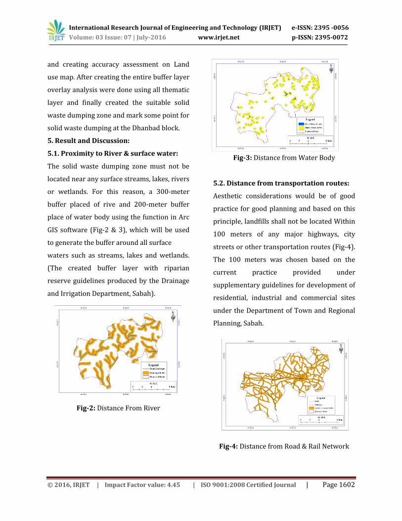
5.1. Proximity to River & surface water:
The solid waste dumping zone must not be
located near any surface streams, lakes, rivers
or wetlands. For this reason, a 300-meter
buffer placed of rive and 200-meter buffer
place of water body using the function in Arc
GIS software (Fig-2 & 3), which will be used
to generate the buffer around all surface
waters such as streams, lakes and wetlands.
(The created buffer layer with riparian
reserve guidelines produced by the Drainage
and Irrigation Department, Sabah).
Fig-2: Distance From River
Fig-3: Distance from Water Body
5.2. Distance from transportation routes:
Aesthetic considerations would be of good
practice for good planning and based on this
principle, landfills shall not be located Within
100 meters of any major highways, city
streets or other transportation routes (Fig-4).
The 100 meters was chosen based on the
current practice provided under
supplementary guidelines for development of
residential, industrial and commercial sites
under the Department of Town and Regional
Planning, Sabah.
Fig-4: Distance from Road & Rail Network

International Research Journal of Engineering and Technology (IRJET) e-ISSN: 2395 -0056
Volume: 03 Issue: 07 | July-2016 www.irjet.net p-ISSN: 2395-0072
© 2016, IRJET | Impact Factor value: 4.45 | ISO 9001:2008 Certified Journal | Page 1603
5.3. Distance from urban areas:
Landfills should not be placed too close to
high-density urban areas in order to mitigate
conflicts relating to the Not in My Back Yard
syndrome (NIMBY). This guards against
health problems, noise complaints, odour
complaints, decreased property values and
mischief due to scavenging animals. For this
reason the buffer zone created 200-meter
from the settlement area (Fig-5).
Fig-5: Distance from Residential Area
5.4. Land use/land cover:
The Land use and Land cover must be known
in order to determine which areas are more
suitable for a landfill. Land use types such as
grassland, forests and cultivated land would
be considered and assigned an appropriate
index of land use suitability (Fig-6). The
Department of Agriculture, Sabah has
identified several classes of land cover and
for the purpose.
Fig-6: Land Use / Land Cover Map
5.5. Suitable Solid Waste Dumping Zone:
The major goal of the landfill site selection
process is to ensure that the disposal facility
is located at the best location possible with
little negative impact to the environment.
Using Arc GIS 10.1 software creating different
thematic layer and overlay analysis were
done and identify eleven point (Gorbudih,
Baludih, Petia, Bhaga Bandh, Shiyalguri,
Kantapahari, Kustor, Bhuli, Kurmidih, Patraku
and Damodarpur) for suitable solid waste
dumping zone at the Dhanbad block (Fig-7).
The major suitable zone for solid waste
dumping is situated in southern part of the
Dhanbad block. The all selected zone is
present open free space and grass land area.
All location are selected in-between 1.5 km
from the residential settlement area.

International Research Journal of Engineering and Technology (IRJET) e-ISSN: 2395 -0056
Volume: 03 Issue: 07 | July-2016 www.irjet.net p-ISSN: 2395-0072
© 2016, IRJET | Impact Factor value: 4.45 | ISO 9001:2008 Certified Journal | Page 1604
Fig-7: Suitable Site map for Solid Waste
Dumping
1.0. Conclusion:
This study used the integration of GIS and
Remote Sensing in identifying the best sites
for the dumping the solid waste material in a
typically urbanizing city. A multi-criteria
approach was employed in conjunction with
GIS-based overlay analysis to identify the
most suitable site for solid waste dumping in
the Dhanbad block. The study was based
upon a set of key criteria, which were
selected in relation to already available
knowledge from research literature as well as
the pre-existing local level factors of the area.
A set of eleven (11) potential sites were
identified in the most suitable sites for solid
waste dumping. The integration of GIS and
Remote Sensing techniques contributed to
the achievement of the results obtained.
Remote Sensing techniques made it possible
to study the various land cover types within
the study area whereas GIS aided in the
modeling and preparation of needed maps.
Indeed, it has been an effective and efficient
tool in carrying out this study.
2.0. Reference:
1. Achi, H, et al. Disposal Sites and
Transport Route Selection Using
Geographic Information System and
Remote Sensing in Abeokuta, Nigeria,
Global Journals Inc. (USA) Online
ISSN: 2249-460x & Print ISSN: 0975-
587X.
2. Elizabeth, T.M. Solid waste
management issues for developing
Countries. Mona Kingston: Canoe
press. (1998).
3. Emeka Amakihe, Geographic
Information System (GIS) as a
Decision Support Tool for Selecting
Potential Landfill Sites, The Degree
Programme of Integrated Coastal
Zone Management Raseborg 2011.
4. Malaysian Government, 1995,
Environmental Impact Assessment
Guidelines for Municipal Solid Waste
and Sewerage Treatment and
Disposal projects, Department of
Environment, Ministry of Science,
Technology and Environment
Malaysia, Government Printing.

International Research Journal of Engineering and Technology (IRJET) e-ISSN: 2395 -0056
Volume: 03 Issue: 07 | July-2016 www.irjet.net p-ISSN: 2395-0072
© 2016, IRJET | Impact Factor value: 4.45 | ISO 9001:2008 Certified Journal | Page 1605
5. M.K. Ghose, et al. A GIS based
transportation model for solid waste
disposal – Acase study on Asansol
municipality.
6. Sabah Government, 1973, Greater
Kota Kinabalu Scheme, memorandum
attached to Plan No. P01150113, the
Greater Kota Kinabalu Schemes
(GKKS), Huszar Brammah and
Associates, Kota Kinabalu, Town and
Regional Planning Department.
7. Sabah Government, 1982, Preliminary
Appraisal of the Proposed Refused
Disposal Site at Lok Kawi Estate,
Penampang, Huszar Brammah and
Associates, Kota Kinabalu, Town and
Regional Planning Department.
8. Sabah Government, 1983, Kota
Kinabalu Structure Plan 2000, Huszar
Brammah and Associates, Kota
Kinabalu, Town and Regional
Planning Department.
9. Shamim Ahmad Shah, et al, Geospatial
Based Approach for Enhancing
Environment Sustainability of
Srinagar city - A Study on Solid Waste
Disposal, International Journal of u-
and e- Service, Science and
Technology Vol.7, No.3 (2014),
pp.289-302.
BIOGRAPHIES
Mr. Surajit Bera Project Assistant, L-II CSIR-CIMFR, Dhanbad, India [email protected]