Embed Size (px)
Citation preview
STUDY OF MORPHOTECTONICS AND HYDROGEOLOGY FOR GROUNDWATER PROSPECTING USING REMOTE SENSING AND GIS IN THE NORTH WEST
HIMALAYA, DISTRICT SIRMOUR, HIMACHAL PRADESH, INDIA
Thapa, R1, Kumar Ravindra2and Sood, R.K1
1Remote Sensing Centre, Science Technology & Environment, 34-SDA Complex, Kasumpti, Shimla, Himachal Pradesh,
India 171 009 India - [email protected], [email protected] 2Centre of Advanced Study in Geology,Panjab University Chandigarh,160 014 India - [email protected].
KEY WORDS: Satellite Imageries, Neo-Tectonics,GPS, Hydrogeology, Morphometric Analysis, Weightage, GIS, Ground Water Potential. ABSTRACT: The study of aerial photographs, satellite images topographic maps supported by ground truth survey reveals that the study area has a network of interlinked subsurface fractures. The features of neo-tectonic activities in the form of faults and lineaments has a definite control on the alignment of many rivers and their tributaries. Geology and Morphotectonics describes the regional geology and its correlation with major and minor geological structures. The study of slopes, aspects, drainage network represents the hydrogeology and helps in categorization of the land forms into different hydro-geomorphological classes representing the relationship of the geological structures vis-à-vis the ground water occurrence. Data integration and ground water potential describes the designing of data base for ground water analysis in GIS platform and the use of hydro-geomorphological models based on satellite imageries based thematic maps for understanding the hydrogeology on a scientific basis with sound decision rules for ground water exploration and management. Introduction:
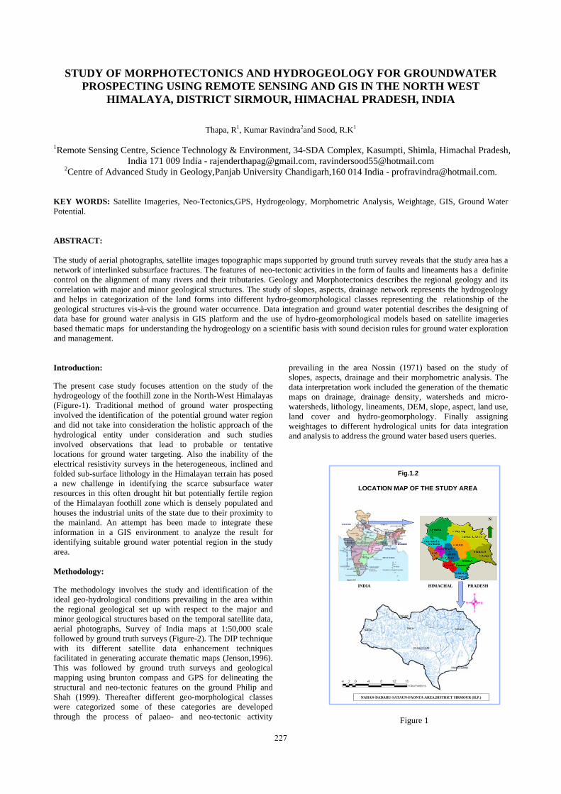
The present case study focuses attention on the study of the hydrogeology of the foothill zone in the North-West Himalayas (Figure-1). Traditional method of ground water prospecting involved the identification of the potential ground water region and did not take into consideration the holistic approach of the hydrological entity under consideration and such studies involved observations that lead to probable or tentative locations for ground water targeting. Also the inability of the electrical resistivity surveys in the heterogeneous, inclined and folded sub-surface lithology in the Himalayan terrain has posed a new challenge in identifying the scarce subsurface water resources in this often drought hit but potentially fertile region of the Himalayan foothill zone which is densely populated and houses the industrial units of the state due to their proximity to the mainland. An attempt has been made to integrate these information in a GIS environment to analyze the result for identifying suitable ground water potential region in the study area. Methodology:
The methodology involves the study and identification of the ideal geo-hydrological conditions prevailing in the area within the regional geological set up with respect to the major and minor geological structures based on the temporal satellite data, aerial photographs, Survey of India maps at 1:50,000 scale followed by ground truth surveys (Figure-2). The DIP technique with its different satellite data enhancement techniques facilitated in generating accurate thematic maps (Jenson,1996). This was followed by ground truth surveys and geological mapping using brunton compass and GPS for delineating the structural and neo-tectonic features on the ground Philip and Shah (1999). Thereafter different geo-morphological classes were categorized some of these categories are developed through the process of palaeo- and neo-tectonic activity
prevailing in the area Nossin (1971) based on the study of slopes, aspects, drainage and their morphometric analysis. The data interpretation work included the generation of the thematic maps on drainage, drainage density, watersheds and micro-watersheds, lithology, lineaments, DEM, slope, aspect, land use, land cover and hydro-geomorphology. Finally assigning weightages to different hydrological units for data integration and analysis to address the ground water based users queries.
Figure 1
HIMACHAL PRADESH
NAHAN-DADAHU-SATAUN-PAONTA AREA,DISTRICT SIRMOUR (H.P.)
LOCATION MAP OF THE STUDY AREA
N
Fig.1.2
INDIA
227

The International Archives of the Photogrammetry, Remote Sensing and Spatial Information Sciences. Vol. XXXVII. Part B4. Beijing 2008
Figure 2. Procedure for preparation of integrated thematic maps
Data used:
The following data were used for the hydrogeological and ground water potential study. High resolution IRS 1C LISS III digital data satellite data. High resolution IRS 1C LISS III precision geocoded paper print satellite data. Aerial photographs 1:50,000. Geological Maps prepared by Geological Survey of India. Published literatures and maps
Geology and Morphotectonics:
The study area consists Mandhali Formation comprised of the quartzites, Blaini phyllites, Infra-Krol group carbonaceous shales and slates with intercalation of brown quartzites, Krol limestones, Subathu shales, Dharmshala shales and sandstones
and the Siwalik sandstones, shales and boulder conglomerate beds. The Doon gravel comprises of boulders pebbles and cobbles of sandstones, quartzites and phyllites and unconsolidated and unstratified alluvial materials comprising of sand, silt and clay. The presence of a number of active fault systems north of the HFT suggests that the strains released in the region is distributed over a broad area above the decollment rather than all at the mountain front (Oatney et al., 2001) and the presence of south side up linear fault trace with variable fault dips suggests that the fault system is high angle reverse with a component of a strike slip this has resulted in the formation of structural hills south of the MBF. In the north of the study area prominent lineaments could be very well identified on the satellite images as well as in the aerial photographs and it clearly demarcates that the south side up offset which is also reflected by the truncation of streamlets along this line (Figure-3.1). The above phenomenon have shaped the morphology of the present study area Virdhi and Philip (2006).
228

The International Archives of the Photogrammetry, Remote Sensing and Spatial Information Sciences. Vol. XXXVII. Part B4. Beijing 2008
Figure 3.1 Some of the features those are related with the neotectonic movements in the study area are,Upliftment of land masses; Longitudinal and transverse lineaments; Active land slides; Abrupt truncation of stream alignments; Longitudinal structural valleys; Unpaired terraces; Huge widening of intermountain valleys; Alignment of springs along mountain fronts; Steep scarps; Presence of residual hills and inclined river terraces Hydrogeology:
The physical characters of rocks, including mineralogical and chemical composition, grain size, their sorting and packing and the primary structures that makes up the overall lithology have hydro-geological significance in the study area. Unconsolidated granular materials like gravels, cobbles, pebbles and sand deposits are potential aquifers and geological structures like synclinal folds, faults, joints and stratified rocks are potential zones for the movement and storage of ground water. The ground water potential of an area is dependent upon the intrinsic characters of the rocks and soil, surface hydrology, depositional and structural features are a direct consequence of the surface geomorphology. Thus it was imperative to delineate the geomorphic features in order to define the spatial distribution of different groundwater prospect classes. Satellite data in the study represents excellent information on the drainage and landforms (Figure- 3.2) that acts as a direct indicators of ground water occurrences, these landforms are direct indicators of the subsurface rock types and sub surface structures. Alluvial fans river terraces, palaeochannels, flood plains and other alluvial features are good indicators of ground water potential zones (Srivastava and Murthy, 1992) whereas the structural hills, ravenous zones are generally poor in ground water potential (Ravindran et al., 1995). Synclinal valleys and structural controlled valleys with inclined formation of alternate aquifer are the most favourable zones for the ground water
exploration. Highly inclined alternate layers of rock formations are however unfavourable in the undulating hilly terrain.
Hydrogeomorphology:
Remotely sensed information on topography, drainage, fracture patterns, is directly related to the presence or absence of ground water. The defined drainage network over a large area subject to good rainfall may indicate good water occurrence. Information on soil also forms an important input in mapping ground water potential zones, e.g. coarse textured soils are generally permeable while fine textured soils indicate less permeability. Highly permeable soil permit relatively rapid rate of infiltration wherein much of the rainwater can reach ground water table. To evaluate the ground water potential zones, various parameters namely lithology, drainage, slope, lineaments, hydr-geomorphology, land use/land cover was delineated. Lithologically the Infra-Krol phyllites are hard and compact and are impervious, so is the Balani shales and Mandhali quartzites, however the Siwalik sandstones are porous and holds good water holding capacity, clay on the other hand are impervious and forms aquitards, the Siwalik sandstones, clays and boulder conglomerates and the eastern part is made up of the unconsolidated, porous material comprising of the Dun gravels which acts as a good water potential zone. Drainage maps were generated using the topographical sheets and updated these information using the latest satellite imageries (Figure-3.2) minute details were updated using aerial photographs. Drainage density was calculated for micro watersheds. The drainage density ranges between 0.1 to 0.6 per Km2. It is observed that the drainage density is high in the structural and cuesta type hills and higher in the Siwalik hills. The central eastern region with thick deposits of Dun gravels with low drainage density represents high permeability. Slope map was generated as slope percentage polygons using
229

The International Archives of the Photogrammetry, Remote Sensing and Spatial Information Sciences. Vol. XXXVII. Part B4. Beijing 2008
Arc/Info by latticepoly option as well as by wentworth method. The structural hills and the cuesta type hills represents steeper slope category and higher run off zone where as the structural valleys and Dun valley represents low runoff zones allowing more time for the water to be in contact to the surface and allows higher infiltration into the subsurface thereby increasing the recharge of ground water in different geomorphic features. Lineaments are large scale linear features which expresses itself in terms of topography which is in itself an expression of the underlying structural features. From the ground water point of view such features includes valleys controlled by folding, faulting and jointing, hill ranges and ridge lines, abrupt truncation of rocks, straight segments of streams and right angled offsetting of stream courses (Ravindran et al., 1995) as these linear features are commonly associated with dislocation and deformation they provide the pathways for groundwater movements ( Small, 1970). Lineaments are important in rocks where secondary permeability and porosity dominate the inter-granular characteristics combine in secondary openings influencing weathering, soil water and ground water movements. The fracture zones forms an interlaced network of high transmissivity and acts as ground water conduits in massive rocks in inter fractured areas. The lineament intersection area are considered to be good ground water potential zones. The with higher lineament density and topographically low elevated grounds are considered to be the best aquifer zones. All the linear features in the study area are marked on the lineament map. The distribution of the lineaments is observed to be maximum on the northern and southern region. These lineaments ranges between a few kilometers to several kilometers in length ( Figure 3.1 ). The SE -NW trending lineaments are predominant followed by the E-W trending lineaments still smaller lineaments. are in the NE - SW direction very few of them are observed in the NNW-SSE direction (Figure 3.1).Based on the above criteria the entire area is divided into different hydro-geomorphic units such as structural hills, structural valleys, valley fills, river terraces, piedmont zones, alluvial plains and flood plains, Channel bar etc. (Figure 4). Within structural hills ridge type geomorphic units are low in ground water potential but the fractured zones acts as good ground water conduits. Cuesta type hills also acts as good ground water aquifer zones at different levels. Landslide zones especially old landslides holds good ground water storage zones in the form of springs where as the scraps are poor in ground water potential. Within the structural valleys river terraces at different elevation away from the river bed has also been recognized by (Nossin, 1971) These terraces holds good ground water storage zones. The terraced structures facilitates higher surface water infiltration and low run off, especially the terraces with agricultural bundings holds higher rate of infiltration. The upper half of the terrace closer to the hills and transversed by perennial streams show higher sub-surface flow closer to the stream length and lesser flow away from it. The depth of water level also increases away from the hill. The older river terrace signifies deeper water level in comparison to the younger river terraces closer to the present river channel. The piedmont zones also acts as zone of major infiltration and are the major recharge zones for the foothill region. It allows rapid infiltration at the head of the piedmont zone due to the presence of coarser material and slower infiltration away from it. The base of the piedmont zone serves as saturated groundwater zones which serves as aquifers. Alluvial plains by virtue of its proximity to the perennial river source, flat terrain and higher permeability
hold very high recharge and least run off. Even the region away from the river channel holds the same potential for the ground water due to the presence of higher permeability and porosity through the homogeneous alluvial plain. Flood plains formed by the major rivers in the Dun valley has higher potential for channel bed infiltration and sub-surface water storage due to the presence of unconsolidated river borne sediments. Channel bars are composed of sub rounded to sub–angular pebbles and cobbles and are recognized as zones of very high infiltration, therefore the base levels are considered to have higher sub – surface flow even at shallow depth. Land use/ land cover also influence the percolation of precipitation from the top soil to the subsurface aquifer zones, forest cover and agriculture area represents good recharge condition as compared to the scrubland and wastelands. To understand the hydro- geological behaviour in the study area a comprehensive well inventory was carried out for different types of wells ranging from open well, dug wells hand pumps as well as the inventory of springs. Other information on the well parameters are gathered from the Irrigation and Public Health Department, Ground Water Organization and Central Ground Water Board.
Figure 4 Data Integratation and Ground water Potential:
To evaluate the different ground water potential zones, essential parameters were considered, these essential parameters were carefully selected for different geomorphic units Nakata (1972) and different weightage were assigned as per their water retaining capacity within the study area Thapa (2007). To account for varying geology Rupke and Sharma (1976) quartzite and slates were assigned lower weightage due to their inherent hardness and compactness, lacking inter granular porosity and impermeability. Shales with sandstones and the compact Conglomerate Formation were assigned low weightage on account of their impervious nature. Dharmshala sandstone with shales, Subathu shale, quartzite and limestone, Siwalik
230

The International Archives of the Photogrammetry, Remote Sensing and Spatial Information Sciences. Vol. XXXVII. Part B4. Beijing 2008
sandstones were assigned moderate weightage on account of their water holding capacity. Alluvium was assigned highest weightage due to higher porosity and permeability. Likewise for hydro-geomorphic units, ridge type structural hills were assigned low values, cuesta type structural hills, piedmont zone and alluvial fan moderate values and the highest weightage was assigned to the old and young river terraces. Piedmont zones into moderate ground water potential zone. The ridge type structural hills with low lineament density and higher drainage density were assigned low values. The slope % >10 was assigned least weightage on account of steeper slope and higher run off. 5-10% and 3-5 % slope was assigned moderate weightage due to moderate rate of infiltration and discharge, 1-3 %and <1 % slope area was assigned the highest weightage. Drainage density value <1.84 are assigned the highest weightage on account of lower number of drainages per unit area, followed by 1.84-2.39, range between 2.39-3.12 and 3.12-3.44 were assigned lower values >3.44 was assigned the lowest weightage. Similarily owing to secondary porosity lineament density values <0.4 was assigned the least weightage, 0.4 - 1.35 moderate and >2.52 the highest. Land cover also influence the ground water infiltration and alters the rate of percolation of precipitation on the hill slope. Agriculture classes were weighted the highest. Thick forest vegetation cover was assigned higher weightages, degraded forest and land with scrubland classes were weighed moderately and the stony rocky waste area with least weightages. All the weighted thematic maps were integrated and on the basis of the users defined criteria using the Arc-info software and potential ground water prospect zones were identified in the GIS environment one of the query based analysis is demonstrated in (Figure-5).
Conclusion:
Thus in the absence of any scientific approach, the above mentioned hydro-geological study which encompasses the modern techniques of remote sensing and GIS together with geological data certainly assisted in accurately modeling the ground water flow system at the local level. With the use of this simple hybrid technique of remote sensing satellite data, interpretation for thematic layers and the use of GIS for the ultimate data integration based on the user defined criteria with weighted approach, it is possible to identify the potential sites for bore wells both in the hilly terrain and in the intermountain depressions in the hills.
ACKNOWLEDGEMENTS
The author expresses his deep sense of gratitude to his research supervisors Prof. Ravindra Kumar, Director and Chairman, Centre of Advanced Study in Geology, Panjab University, Chandigarh, India and Dr. Ravinder Kumar Sood, Joint Member Secretary and Chief Executive Officer, State Council for Science Technology & Environment, Shimla, India for his guidance in the field of Remote Sensing and ground water exploration both in lab and field has made it possible to put forward the present research paper.
REFERENCES
Jenson, J. R., 1996, Introductory Digital Image Processing, A Remote Sensing Perspective. 2nd Edition, Prentice Hall, New Jersey, Pp: 316 Nakata, T., 1972, Geomorphic History And Crustral Movement Of The Foot Hills Of Himalaya. Science Reports, Tohoku University, 7th Series, Vol. 1, 39-177. Nossin, J.J., 1971, Outline Of The Geomorphology Of The Doon Valley, Northern U.P., India. Z. Geomorph. N.F., 12: 18-50. Oatney, E.M., Virdhi, N.S. and Yeats, R.S. (2001) Contribution of theTrans Yamuna Active Fault System towards hanging wall strain release above the decollment, Himalayan footwall of the north west India.Vol 22(2), pp9-28. Philip, G. And Shah, M. P., 1999, Geomorphic Signature For Active Tectonics In The Trans-Yamuna Segment Of The Western Doon Valley, North-West Himalaya. International Journal Of Applied Earth Observation And Geoinformation, 1, 54-63. Ravindran K. V., Kumar, P., Jaganathan, C and Manchanda, M. L. (1995) Synergetic case of ERS-1SAR and IRS-1B LISS-II data for gemorphological mapping: A case study in Western Doon valley, U.P.in Sahai, B.(Ed), Proceeding of ISRS Silver Jubilee Symposium on Remote sensing for environmental monitoring and management with special emphasis on hilly regions, NNRMS, Bangalore,34-38 Rupke, J.and Sharma, R. P., 1974, Preliminary Geological Map Of The Western Kumaon Himalayas. In Stratigraphic And Structural Evolution Of The Kumaon Lesser Himalaya. Sed. Geology.11 Pp: 81-265. Srivastva, J. B. and Murty, C. D. (1992) Study of palaeochannels adjacent to Banda city through remote sensing and their hydrogeoghysical evaluation. Proceedings of National
Figure 5
231

The International Archives of the Photogrammetry, Remote Sensing and Spatial Information Sciences. Vol. XXXVII. Part B4. Beijing 2008
symposium on Remote sensing for sustainable development, 136-143. Small, J.R. (1970) The study of landforms. A textbook of geomorphology. Cambridge Press, Cambridge, 477p. Thapa, R., 2007, Morphotectonics and Hydrogeology of Catchment of Lower Jalal-Giri, Upper Markanda and Bata River, Sirmour District, Himachal Pradesh, India., Unpublished Ph.D. Thesis, Centre of Advanced Study in Geology, Panjab University Chandigarh, India.
Virdhi, N.S., Philip, G., 2006, Neotectonic activity and its control on drainage changes in the northwestern frontal Himalaya between the rivers Satluj and Yamuna. Him. Geol., Vol. 27 (2), pp.129-143. Wesnousky, S. G., Kumar, S., Mohindra, R. and Thakur, V.C., 1999, Uplift and convergence across Himalayan Frontal Thrust of India. Tectonics, 18, 967-976.
232