Embed Size (px)
Citation preview
JOURNAL OF QUATERNARY SCIENCE (1993) 8 (3) 251-262 @ 1993 by john Wiley & Sons, Ltd.
0267-81 79/93/030251-12811 .OO
Stratigraphy and palaeoecology of a possible interglacial site, northernmost Ellesmere Island, Canada D. J. A. EVANS Department of Geography and Topographic Science, University of Glasglow, Glasgow G12 8QQ, Scotland R. 1. MOTT Geological Survey of Canada, 601 Booth Street, Ottawa, Ontario K1A OE8, Canada
Evans, D. I. A. and Mott, R. I. 1993. Stratigraphy and palaeoecology of a possible interglacial site, northernmost Ellesmere Island, Canada. /ourna/ of Quaternary Science, Vol. 8, 251-262. ISSN 0267-81 79
Received 23 March 1992 Accepted 22 April 1993
ABSTRACT: An extensive stratigraphic section at Cape Alfred Ernest on the Wootton Peninsula, northwest Ellesmere island contains six lithofacies which appear to record two glacial phases separated by an organic layer. (1) A lower massive gravel records a pre-ice advance outwash phase; ( 2 ) massive fine-grained sediments record a period of non-glacial marine deposition when sea-level was higher than present; (3) a massive diamicton records the advance of ice across the site; (4) intermediate stratified beds record supraglacial and proglacial outwash, and include an organic layer; (5) massive diamicton grading down-valley to stratified diamicton and then massive, jourml of Quaternary Science sheared diamicton, overlain by laminated fine-grained sediments with dropstones, recording the last (late Wisconsinan) glaciation; (6) upward-coarsening sands and gravels record proglacial outwash and grade to raised marine deltas.
Radiocarbon dates of 39270 k 640 and > 51 000 yr BP were obtained on samples from the organic layer by accelerator mass spectrometry and conventional radiocarbon dating, respectively. Palaeoecological data suggest that the organics accumulated in a wet sedge meadow environment when the climate was warmer than present. Stratigraphic considerations suggest that the organic layer represents an interglacial interval which, if valid, indicates that the site constitutes the northernmost interglacial stratigraphy in the Canadian Arctic. Alternatively, the organic layer may date to Plio-Pleistocene times.
KEYWORDS: Interglacial, stratigraphy, palaeoecology, Ellesmere Island.
Introduction
The ice coverage of the last glaciation on northern Ellesmere Island has been mapped and dated by several researchers and is characterised by a restricted style whereby glaciers advanced on average less than 40 km, either calving into the sea or terminating inland from the present coastline (England, 1983, 1987, 1990; Bednarski, 1986; England and Bednarski, 1989; Lemmen, 1989; Evans, 1990a). Evidence for older Quaternary events on northern Ellesmere Island is rare; glacial and coastal geomorphology with associated shell dates and amino acid ratios record multiple glaciations in the northeast (England et a/., 1981; Retelle, 19861, and high-elevation erratics and shell fragments and reworked sub-till marine sediments occur sporadically in the north and northwest (Bednarski, 1987; Evans, 1988a,b; Lemmen, 1988; Lemmen and England, 1992).
Stratigraphic evidence of older Quaternary events through- out the Queen Elizabeth islands is equally rare (Fig. 1). Blake and Matthews (1979) reported evidence for an interglacial climate at a site at Makinson Inlet, southern Ellesmere Island
(77'40"). Hodgson (1 985) described a possible interglacial site on Canon Fiord slightly farther north (79"24'N) where plant and insect fossils indicate a low arctic tundra environment. The only other evidence of interglacial conditions occurs on Bathurst island (Blake, 1974). Evidence of possible interstadial conditions has been reported from southern Ellesmere Island (Blake, 1980, 1982, 1988). Possible interglacial sites have been reported at a similar latitude on northern Greenland (Meldgaard and Bennike, 1989), and Thule, northwestern Greenland (Funder, 1989).
Interpretation of the stratigraphy at sites on the Queen Elizabeth Islands i s complicated by the widespread occurrence of late Tertiary deposits, often containing organic beds, that are sometimes difficult to distinguish from Quaternary deposits; both types of deposits yield non-finite radiocarbon ages. Pollen and macrofossils indicative of climatic conditions much warmer than the present, with trees at or near the site, often characterise the late Tertiary deposits (Matthews et a/., 1986; Fyles, 1989, 1990; Matthews and Ovenden, 1990; Wang and Geurts, 1991 1. However, in younger deposits, the pollen spectra contain less or minor amounts of tree pollen (Hills, 1975; Matthews and Ovenden, 1990; Wang and

252 JOURNAL OF QUATERNARY SCIENCE
Figure 1 Location map of the Queen Elizabeth Islands.
Guerts, 1991 1. Plio-Pleistocene sites in north Greenland also have pollen spectra with minor arboreal representation even though macrofossils document the presence of trees (Bennike, 1990). Such pollen assemblages do not differ greatly from modern low arctic spectra or possible interglacial spectra. This paper presents data from a site on northern Ellesmere Island (82"N) where an organic layer that occurs between glacigenic deposits yields pollen evidence indicative of summer temperatures warmer than present.
Site details
The site, located at 82"23'N, 85"35'W, 4.5 km north of Cape Alfred Ernest, on the west coast of the Wootton Peninsula (Fig. 2), is influenced by the central Arctic Ocean climate with air masses of Arctic origin dominating the weather systems. Low summer temperatures (mean July temperature = +2"C), a short snow-free season (mean duration of melt period = 65 days), persistent cloud cover (June and July cloud cover = 75-80%) and, for this latitude, relatively high summer precipitation (mean total summer precipitation =
60 mm) characterise the region (Edlund and Alt, 1989).
The extant regional vegetation reflects the summer climatic patterns. Edlund and Alt (1989) classify the vegetation of the Wootton Peninsula, and the northwest coast of Ellesmere Island in general, within Bioclimatic Zone 1, the herb zone. The vegetation i s entirely herbaceous with no shrubs or sedges. Emergent aquatics are absent and grasses dominate the low wet areas. Vegetation is sparse on the better drained sites, where rushes (mainly Luzula confusa) or purple saxifrage (Saxifraga oppositifolia) dominate. Snow-free south facing slopes and sheltered valleys towards the heads of fiords may support local prostrate shrub communities of arctic willow (Salix arctica) and/or arctic avens (Dryas integrifolia) and wetlands containing a few sedges (Cyperaceae). Ericaceous (Ericaceae) plants are not present, and such arctic shrubs as dwarf birch (Betula glandulosa) do not reach the Queen Elizabeth Islands and at present occur only in low arctic regions much farther south (Edlund, 1986).
A stratigraphic section 1 km long, excavated by a meltwater stream, lies less than 2 km from the contemporary ice margin and is behind the Alfred Ernest Ice Shelf (Fig. 3). Ice shelves occur along the north coast of Ellesmere Island because the glacierisation level descends to sea-level (Miller et a/., 1975; Evans, 1988a; Lernmen et a/., 1988). During the last glaciation the site was overrun by glacier ice from the Alert Point Ice Cap. Outlet lobes were channelled through valleys at the

INTERGLACIAL SITE IN NORTHERN CANADA 253
lOkm
i 0-
Cope Armstrong-
O C E A N (b:
P
r 4 5 , ,--
Figure 2 Location maps of the Wootton Peninsula, northwest Ellesrnere Island.
coast, where they floated in a glacio-isostatically higher sea (marine limit = 3 65 m a.s.1.; Evans, 1990a). Changes in the grounding lines of outlet glaciers are recorded in
Stratigraphy
Six main lithofacies occur in the Alfred Ernest section (Fig. 5). First, basal massive gravels and sands ( G m l , Sml) are separated from intermediate beds at the eastern end of the section by a diamicton ( ~ ~ ~ 3 ) . Second, at the western end of the section an outcrop of massive fines (Fm2) has an erosional upper contact with either the upper sands
the stratigraphy of local cliffs, where silt-rich diamictons unconformably overlain by clast-rich diamictons are inter- preted as proximal glacimarine sediments and till respectively (Evans, 1988a, 1990a). Capping this sequence is an areally extensive coarse alluvium deposited during retreat from the last glacial maximum (Fig. 4).
of the intermediate beds or the uppermost sands and gravels (see below). The massive fines display no rhythmic laminations or dropstones. Third, a lower light brown, massive, matrix-

254 JOURNAL OF QUATERNARY SCIENCE
Figure 3 Part of air photograph A17456-11, Department of Energy, Mines and Resources, Ottawa.
supported diamicton (Dmm3) outcrops only at the eastern and central parts of the section where it forms discontinuous lenses of < 1-3 m thick.
Fourth, the intermediate beds consist of laminated fines (F14) and low angle cross-bedded, laminated and rippled sands (S14, Sh4, Sr4), which either grade up to, or are conformably overlain by, massive gravels (Sg4-Gm4). In the eastern half of the section the intermediate beds display large scale, post-depositional, gentle folds (Fig. 6). An organic bed, < 30 cm thick, occurs in the upper sands of the intermediate beds at the centre and western end of the section (Figs 5 and 7).
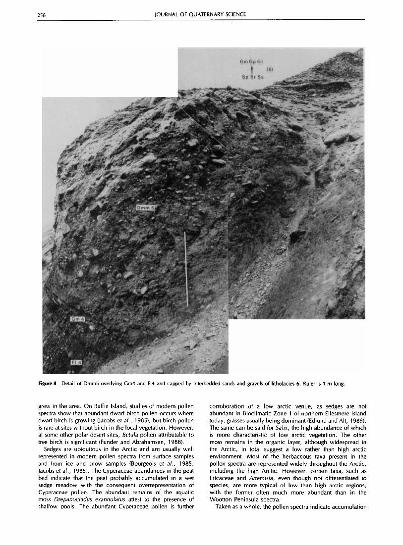
Fifth, the upper dark brown, massive, matrix-supported diamicton (Dmm5) is 4 m thick at the eastern end of the section (Fig. 8) . and wedges out at 32 m a.s.1. in the west after grading laterally into stratified diamicton (Dms5) and then sheared diamicton (Dmm(s15). The sheared diamicton
displays shear structures and smeared inclusions of the underlying organic layer. Evidence of glacitectonic disturbance also occurs below the sheared diamicton in the underlying sands (Sr4) and massive fines (Fm2), with which the sheared diamicton has an erosional contact. The sheared diamicton appears to be a product of reworking of the stratified diamicton (Dms5). The stratified diamicton (Dms5) and sheared dia- micton (Dmm(s)5) are conformably overlain by laminated fines with dropstones (Fld5). From this point westward, no diamictons are evident and massive silts (Fm2) are directly overlain by the interbedded sands and gravels that cap the section.
Sixth, the section is capped by > 5 m of interbedded sands and gravels, which coarsen upwards into massive gravels at the surface (Sp6, Sr6, Ss6, Sg6 and Gt6, Gp6, Gm6). The cross-bedding indicates a general palaeocurrent direction from the north to northeast. Some gentle folding suggests

INTERGLACIAL SITE IN NORTHERN CANADA 255
45 m
inactive alluvium Grn / Sr 87 m A.S.L.
( Full glacial sea = 270 rn )
A A
A 63 rn A.S.L.
clast - rich diarnicton
Erosional contact formed by grounding line advance (Evans 1988a) 1 I 1 Dm '? silt- rich diarnicton
5rn
Om
Figure 4 Generalized lithostratigraphy of the Cape Alfred Ernest area, south of the organic layer site.
Figure 5 Principal lithostratigraphic units of the Cape Alfred Ernest section.

256 JOURNAL OF QUATERNARY SCIENCE
Figure 6 Overview of eastern end of section, illustrating post-depositional folding of intermediate beds (lithofacies 4) and with main lithofacies outlined. Arrow indicates position of Figure 8.
post-depositional disturbance caused by the melting of buried ice. This lithofacies forms the dominant surficial cover on the Wootton Peninsula (Evans, 1988a, 1990a,b).
Radiocarbon dates
A finite AMS 14C date of 39270 -t 640 yr BP (TO-485) was obtained on a 796-mg sample from the organic bed at the centre of the section (CAE-3, Fig. 5 ; Table 1). A bulk subsample of the organic material from CAE-1 and CAE-2 (Figs 5 and 7) produced a conventional I4C date of > 51 000 yr BP (GSC-4612 HP).
Several stratigraphic sections in the Phillips Inlet and Wootton Peninsula area display glacitectonically disturbed marine silts overlain by glacigenic sediments of the last glaciation (Evans, 1988a, 1990b). A sample of shell fragments from such silts yielded an AMS I4C date of 32 110 ? 370 yr BP (TO-480) which, by virtue of its stratigraphic position, must relate to a pre-last glaciation high sea-level stand (> 90 m a.s.1.; Evans, 1988a). Alternatively, the date could be a minimum age because the sample was fragmented and may have been reworked from older deposits.
Palynological and macrofossil results
Portions of samples CAE-2 and CAE-3 were analysed for pollen (Table 2) using standard palynological treatment (Faegri
and Iversen, 1975) and the addition of a measured aliquot of standardised Eucalyptus globulus mixture to allow determin- ation of pollen concentrations. Because of the large numbers of Cyperaceae (sedge) pollen, especially in CAE-2, percentage values for this taxon were calculated outside of the pollen sum.
The spectra of both samples are strikingly similar except that sample CAE-2 contains five times more Cyperaceae pollen than CAE-3, and the pollen concentration is consider- ably greater. Cyperaceae pollen dominates both spectra, followed by abundant Betula (birch) and Salix (willow). Size (most grains < 20 pm) and shape (less robust than tree species) of the Betula grains suggest that most represent shrub rather than tree species. Alnus (alder) pollen is also relatively abundant. About 5% Pinus (pine) along with small amounts of Picea (spruce), Populus (poplar/aspen) and CarpinuslOstrya (blue beech/ironwood) type pollen comprise the other tree representatives. Small percentages of numerous other herb- aceous types make up the remainder of the spectra.
Samples of the organic material were also examined for insect and plant macrofossil content but because of the small sample size, no identifiable remains other than bryophytes were found (1. V. Matthews Jr, pers. comm., 1988). Bryophytes in sample CAE-3 were identified by L. Ovenden (Peat Report L041, 1989; Table 3). The dominant moss, Drepanocladus exannulutus, is an aquatic moss common from the high arctic to northern temperate regions. The remaining taxa are poorly represented and except for Sphagnum are widely distributed in arctic and boreal regions. Sphagnum is present though rare on Ellesmere Island, but i s more abundant in regions of warmer climate. Remains of the poorly represented taxa are less well preserved than the dominant taxa suggesting to

INTERGLACIAL SITE IN NORTHERN CANADA 257
Figure 7 The western end of the section at Cape Alfred Ernest showing main lithofacies and the organic bed from which the >51 000 yr BP radiocarbon date was obtained.
Ovenden that they may have been redeposited. However, they may have been washed into the basin from within the catchment area and not reworked from older deposits.
Interpretation
Because of its lateral continuity, the organic bed at Cape Alfred Ernest i s most likely autochthonous and was not formed from re-bedded older organic debris. The palynological and macrofossil remains and absence of obviously re-bedded Tertiary or older palynomorphs also support this interpretation, and suggest that the sediment accumulated from the vegetation of the local basin and the surrounding catchment.
Exotic tree pollen often comprise a small but significant
portion of modern and Holocene arctic pollen spectra and are attributed to long-distance transport from forests located at considerable distances to the south (Bourgeois et a/., 1985; Hyvarinen, 1985; Jacobs et a/., 1985; Funder and Abrahamsen, 1988). Pinus, Picea, Betula and Ahus are usually represented, but other more thermophilous taxa occur occasionally. This is probably the case here as well, with Picea, Pinus, Populus and CarpinuslOstyra type being definitely attributable to long-distance transport. The abundance of Alnus may mean that alder shrubs may have been close, if not at the site. Modern and Holocene spectra from Baffin Island, where alder is not present (Jacobs et a/., 1985). and from southern Greenland, where it does occur (Fredskild, 1983), both show approximately the same abundances. Because most of the Betula pollen present in considerable abundances resembles dwarf birch, it is likely that a species of dwarf birch, probably Betula glandulosa and/or B. nana,
258 JOURNAL OF QUATERNARY SCIENCE
Figure 8 Detail of Dmm5 overlying Cm4 and F14 and capped by interbedded sands and gravels of lithofacies 6 . Ruler is 1 m long.
grew in the area. On Baffin Island, studies of modern pollen spectra show that abundant dwarf birch pollen occurs where dwarf birch is growing (Jacobs et a/., 1985), but birch pollen i s rare at sites without birch in the local vegetation. However, at some other polar desert sites, Betula pollen attributable to tree birch i s significant (Funder and Abrahamsen, 1988).
Sedges are ubiquitous in the Arctic and are usually well represented in modern pollen spectra from surface samples and from ice and snow samples (Bourgeois et a/., 1985; Jacobs et a/., 1985). The Cyperaceae abundance5 in the peat bed indicate that the peat probably accumulated in a wet sedge meadow with the consequent overrepresentation of Cyperaceae pollen. The abundant remains of the aquatic moss Drepanocladus exannulatus attest to the presence of shallow pools. The abundant Cyperaceae pollen is further
corroboration of a low arctic venue, as sedges are not abundant in Bioclimatic Zone 1 of northern Ellesmere Island today, grasses usually being dominant (Edlund and Alt, 1989). The same can be said for Salix, the high abundance of which is more characteristic of low arctic vegetation. The other moss remains in the organic layer, although widespread in the Arctic, in total suggest a low rather than high arctic environment. Most of the herbaceous taxa present in the pollen spectra are represented widely throughout the Arctic, including the high Arctic. However, certain taxa, such as Ericaceae and Artemisia, even though not differentiated to species, are more typical of low than high arctic regions, with the former often much more abundant than in the Wootton Peninsula spectra.
Taken as a whole, the pollen spectra indicate accumulation

INTERGLACIAL SITE IN NORTHERN CANADA 259
Table 1 section
Radiocarbon dates from the Cape Alfred Ernest stratigraphic
Laboratory Sample number Age Material Elevation
CAE-3 TO-485b 39270k640 Peat 38 m CAE-1 GSC-4612HPa,' >51 000 Peat 32 m
TO-480b 32110&370 Shell 57 m
"HP = sample counted at 4 atmospheres pressure in 51 counter blsotrace dates on shells are corrected for natural, preparation and sputtering fractionation to a base of 613C = Ooh, and peat dates to a base of S13C = -25% cGeological Survey of Canada date (GSC) does not take into account 6l3C
Table 2 Palynological spectra from organic unita
CAE-2 CAE-3 (%) (%I
Picea 1.6 Pinus 4.6 Populus 0.3 CarpinuslOstrya type 0.6 Betula 25.3 Alnus 11.9 Salix 21.3 Ericaceae 0.3 Gramineae 5.3 Tubu I iflorae 1.6 Artemisia 5.6
Caryoph yllaceae 1.3 Cruciferae 2.5 Ranuncu laceae 0.6 Polygonaceae 0.6 Saxifragaceae 0.3
Potentilla type -
Saxifraga type - Oxyria type - Unidentified 10.0 Pteridoph yta - Pol ypodiaceae - Sphagnum 6.3 Pollen sum (not including 320 C yperaceae) C yperaceae 501.6 Pollen concentration (gm ~ m - ~ ) 72 742
0.3 5.0
1.6 25.2 13.2 27.0
0.9 4.1
1.9 0.6
0.3 0.3 0.3
4.1 0.9 9.4
0.3 2.8 1.6
-
-
-
-
318
104.4
5482
"Analysed by H. Jette
of organic matter in a wet sedge meadow environment, dominated by sedges with shallow pools supporting aquatic mosses. The surrounding terrain supported abundant dwarf birch and willow and a relatively diverse flora of grasses and herbs. Alder shrubs probably did not grow in the immediate area but were certainly closer to the site than they are at present. Similarity to low Arctic regions, such as southern Baffin Island, today suggest that summer temperatures on northern Ellesmere Island at the time of deposition of the organic deposit were much higher (+3-5"C mean July temperature) than today.
Table 3 Bryophytes identified in peat bed (sample CAE-3)
* Sphagnum sp. * Sphagnum sect. Subsecunda * Ditrichum flexicaule * Disticheum capillaceum * Dicranum sp. * Mniaceae * Campylium stellatumlarticum
*** Drepanocladus exannulatus * D. Lycopodioides var. brevifolius * Calliergon cf. giganteum * Calliergon richardsonii * Tomenthypnum nitens * Polytrichum sp.
W(0) C C C
W C c w c w
W(0)
Species present: *** = dominant, * = trace. C = calcareous substrate; W = wet site; (0) = organic substrate
Discussion
The stratigraphy and sedimentary characteristics of the Cape Alfred Ernest section provide important palaeoenvironmental data for the site. The outlier of massive fines (Fm2) at the western end of the section documents a period of deeper water and, because it has been eroded and infilled by the intermediate beds and is not a glacimarine sediment (no rhythmites or dropstones, cf. Stewart, 1988), it probably pre-dates the lower diamicton (Dmm3). Geomorphological evidence of sea-level < 30 m higher than present, relating to a period of open water conditions and pre-dating at least the last glaciation, is manifest in embayments or coves along the west Wootton Peninsula coast (Evans, 1988a).
Evidence for what appears to be an earlier glacial episode occurs only at the eastern end of the section, where a probable pre-advance gravel outwash (Gml ) crops out beneath the lower diamicton (Dmm3). The lower diamicton extends only to the centre of the section, where it may have been eroded by proglacial streams responsible for deposition of the intermediate beds. The intermediate beds were deposited over stagnant ice, as evidenced by the post-depositional disturbance. The juxtaposition of laminated fines (F14), current- bedded sands (S14, Sh4, Sr4) and gravels (Sg4-Gm4) is typical of sandur-supraglacial landsystems in polar environments. Towards the end of the outwash episode, reduced discharge allowed the development of an organic layer. This was terminated by the burying of the organics by further sands and gravels (94, Gm4) indicating increased discharge from the Alert Point Ice Cap. The organic layer appears to have undergone post-depositional folding along with the underlying and enclosing sediments, attesting to the very low melt-out and sublimation rates of the buried ice at these latitudes (cf. Evans, 1989a,b).
The most extensive diamicton at the site is related to the last glaciation and, where it is massive in character (Dmms), unconformably overlies the intermediate beds, suggesting deposition by lodgement and/or deformation. This is a particularly valid interpretation at the western end of the section, where the diamicton is sheared (Drnm(s)5), includes smears of the underlying organic layer and is associated with glacitectonic disturbance in the basal massive fines (Fm2). The conformity between the upper intermediate beds, the stratified diamicton (Dms5) and laminated fines and dropstones (Fld5) documents the advance of glacier ice into a sea at a higher level during the last glaciation (cf. Evans, 1990a). The
260 JOURNAL OF QUATERNARY SCIENCE
disruption of the sequence of stratified diamicton, (Dms5) rippled sands (Sr4) with peat and massive fines (Fm2) by sheared diamicton (Dmm(s)5), together with the absence of diamicton from this point westward, suggest that the western end of the section records the approximate grounding line position at 32 m a.s.1. for the last ice margin. Given that the full glacial sea was no higher than 70 m a.s.1. in this area (Evans, 1988a, 1990a), the resulting water depth of 38 m above the sheared diamicton (Dmm(s)5) would mean floating glacier ice 42 m thick. Grounding line advance over glaci- marine sediments has been reported by Evans (1 988a, 1990a) for other sites on the west Wootton Peninsula (Fig. 4).
During deglaciation, the uppermost sands and gravels (lithofacies 6) were laid down by proglacial streams fed by the Alert Point Ice Cap as it retreated eastward. The sands and gravels grade to raised marine deltas at the mouths of gorges cut in the west Wootton Peninsula cliffs. The deltas have been graded to local marine limits and have been dated to early Holocene time using shells and driftwood (Evans, 1988a, 1990a).
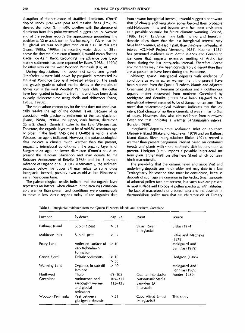
The radiocarbon chronology for the area does not unequivo- cally resolve the age of the organic layer. Because of its association with glacigenic sediments of the last glaciation (Evans, 1988a, 1990a), the upper, dark brown, diamicton (Dmm5, Dms5, Dmm(s)5) dates to the Late Wisconsinan. Therefore, the organic layer must be of mid-Wisconsinan age or older. If the finite AMS date (TO-485) is valid, a mid- Wisconsinan age is indicated. However, the palaeoecological data indicate a climate much warmer than the present, suggesting interglacial conditions. If the organic layer i s of Sangamonian age, the lower diamicton (Dmm3) could re- present the lllinoian Glaciation and may equate to the Robeson Aminozone of Retelle (1 986) and the Ellesmere Advance of England et al. (1981 1. Alternatively, the sediment package below the upper till may relate to some older interglacial interval, possibly even as old as late Pliocene to early Pleistocene time.
The paleoecological results indicate that the organic layer represents an interval when climate in the area was consider- ably warmer than present and conditions were comparable to those in low Arctic regions today. If the organics date
from a warm interglacial interval, it would suggest a northward shift of climate and vegetation zones beyond their probable mid-Holocene limits and beyond what has been envisioned as a possible scenario for future climatic warming (Edlund, 1986, 1987). Evidence from both marine and terrestrial deposits does show that the last interglacial interval may have been warmer, at least in part, than the present interglacial interval (CLIMAP Project Members, 1984). Koerner (1989) has presented evidence from Arctic islands and Greenland ice cores that suggests extensive melting of Arctic ice sheets during the last interglacial interval. Therefore, Arctic environments may have been considerably different than they are at present or have been during the Holocene.
Although sparse, interglacial deposits with evidence of conditions as warm as, or warmer than, the present have been reported from the Queen Elizabeth Islands and adjacent Greenland (Table 4). Remains of caribou and allochthonous organic matter recovered from northern Greenland by Meldgaard and Bennike (1989) have been assigned to an interglacial interval assumed to be of Sangamonian age. They noted that palaeoecological evidence indicates that the last interglacial climate of northern Greenland was similar to that of today. However, they also cite evidence from northwest Greenland that indicates a warmer Sangamonian interval (Funder, 1989).
Interglacial deposits from Makinson Inlet on southern Ellesmere Island (Blake and Matthews, 1979) and on Bathurst Island (Stuart River Interglaciation: Blake, 1974), record a warmer than present Sangamon interval based on contained insects and plants with more southerly distributions than at present. Hodgson (1 985) reports a possible interglacial site from even farther north on Ellesmere Island which contains birch macrofossi Is.
The possibility that the organic layer and associated and underlying deposits are much older and may date to a late Tertiary/early Pleistocene time must be considered, because deposits of such age are common in the Arctic. Small amounts of arboreal pollen taxa are present, but such taxa are present in most surface and Holocene pollen spectra at high latitudes. The lack of macrofossils of arboreal taxa and the absence of thermophilous pollen taxa that are characteristic of Tertiary
Table 4 Interglacial evidence from the Queen Elizabeth Islands and northern Greenland
Location Evidence Age (ka) Event Source
Bathurst Island Sub-till? peat > 51 Stuart River Interglacial
Makinson Inlet Sub-till peat > 52
Peary Land Antler on surface of > 40 Kap Kobenhavn Formation
Canon Fjord Deltaic sediments > 16 > 38
Warming Land Organics in sub-till > 40
Northwest Thule 69-1 05 Qarmat Interstadial Green land Aminozone and 105-1 15 Narssarssuk Stadia1
laminae
associated marine 11 5-1 36 Saunders 0 and glacial lnterstadial sediments
glacigenic deposits Interglacial? Wootton Peninsula Peat between > 51 Cape Alfred Ernest
Blake (1974)
Blake and Matthews (1 979) Meldgaard and Bennike (1989)
Hodgson (1 985)
Meldgaard and Bennike (1989) Funder (1 989)
This study

INTERGLACIAL SITE IN NORTHERN CANADA 261
deposits in the high Arctic eliminates such deposits as possible correlatives (Hills, 1975; Fyles, 1990; Matthews and Ovenden, 1990; Wang and Geurts, 1991). Other sites, such as Kap Kobenhavn Formation of Plio-Pleistocene age in north Greenland (Bennike, 1990), have pollen spectra similar to those of the Cape Alfred Ernest organic layer, although significant differences are apparent. Macrofossils document the occurrence of trees at Kap Kobenhavn and along with the pollen spectra indicate tree-line to tundra conditions, whereas the Cape Alfred Ernest spectra suggest low arctic shrub tundra without trees. Nevertheless, according to the pollen spectra, the Cape Alfred Ernest organics could represent an interglacial interval of late Pliocene o r early Pleistocene age.
Acknowledgements Invaluable logistical support was provided by the Polar Continental Shelf Project, Department of Energy, Mines and Resources, Ottawa. Funding was provided by the Boreal Institute for Northern Studies, University of Alberta. Indirect funding came from NSERCC grant no. A6680 awarded to Dr J. England, University of Alberta. Field assistance was provided by T. G. Fisher and U. Hawkins, University of Alberta, and discussions with Dr D. S. Lemmen (Geological Survey of Canada) and Dr J. England helped to formulate early ideas. Dr A. S. Dyke (Geological Survey of Canada) kindly submitted the organics for radiocarbon dating at the G.S.C. H. lette conducted the pollen analyses. Dr J. V. Matthews Jr. (Geological Survey of Canada) is thanked for examining the organic samples for Coleoptera. Dr L. Ovenden provided bryophyte analyses. Parts of this report form Contribution No. 21291 of the Geological Survey of Canada. Comments on the original manuscript by Drs S. A. Edlund, F. G. Fyles and J. T. Andrews were very helpful in revising the manuscript.
References
BEDNARSKI, J. 1986. Late Quaternary glacial and sea level events, Clements Markham Inlet, northern Ellesmere Island. Canadian lournal of Earth Sciences, 23, 1342-1 355.
BEDNARSKI, J. 1987. Glacial advances in Otto Fiord, Ellesmere Island, N. W.T. Abstracts, 16th Annual Arctic Workshop, Edmonton, Alberta, 4-5.
BENNIKE, 0. 1990. The Kap Kobenhavn Formation: stratigraphy and palaeobotany of a Plio-Pleistocene sequence in Peary Land, North Greenland. Meddelelser om Crernland, Geoscience, 23,
BLAKE, W., JR. 1974. Studies of glacial history in arctic Canada I I . Interglacial peat deposits on Bathurst Island. Canadian lournal of Earth Sciences, 11, 1025-1 042.
BLAKE, W., JR. 1980. Mid-Wisconsinan interstadial deposits beneath Holocene beaches, Cape Storm, Ellesmere Island, Arctic Canada. Abstracts, AMQUA 6th Biennial Meeting, Orono, Maine, pp. 2627.
BLAKE, W., JR. 1982. Terrestrial interstadial deposits, Ellesmere Island, N.W.T., Canada. Abstracts, AMQUA 7th Biennial Meeting, Seattle, Washington, 73.
BLAKE, W., JR. 1988. Geological Survey of Canada Radiocarbon Dates XXVII. Geological Survey of Canada Paper, 87-7.
BLAKE, W., JR. and MATTHEWS, J. V., JR. 1979. New data on an interglacial peat deposit near Makinson Inlet, Ellesmere Island, District of Franklin. Current Research, Geological Survey of Canada Paper, 79-1A, 157-164.
BOURGEOIS, J. C., KOERNER, 1. C. and ALT, 6. T. 1985. Airborne pollen: a unique air mass tracer, i ts influx to the Canadian High Arctic. Annals of Glaciology, 7, 109-1 16.
CLIMAP PROJECT MEMBERS 1984. The last interglacial ocean. Quaternary Research, 21, 123-224.
EDLUND, S. A. 1986. Modern Arctic vegetation distribution and its congruence with summer climate patterns. Proceedings, lmpact of
85 PP.
Climatic Change on the Canadian Arctic, 84-99. A Canadian Climate Program Workshop, Orillia, Ontario, 3-5 March 1986.
EDLUND, S. A. 1987. Effects of climatic change on diversity of vegetation in arctic Canada. IN: Preparing for Climatic Change, Proceedings of the First North American Conference on Preparing for Climatic Change: a Cooperative Approach, 27-29 October 1987, Washington, DC, 186-1 93.
EDLUND, S. A. and ALT, 6. T. 1989. Regional congruence of vegetation and summer climate patterns in the Queen Elizabeth Islands, Northwest Territories, Canada. Arctic, 42, 3-23.
ENGLAND, 1. 1983. Isostatic adjustments in a full glacial sea. Canadian lournal of Earth Sciences, 20, 895-917.
ENGLAND, J. 1987. Glaciation and evolution of the Canadian high arctic landscape. Geology, 15, 41 9-424.
ENGLAND, J. 1990. The late Quarternary history of Greely Fiord and its tributaries, east-central Ellesmere Island. Canadian lournal of Earth Sciences, 27, 255-270.
ENGLAND, J. and BEDNARSKI, J. 1989. Northeast Ellesmere Island (Quaternary stratigraphy and chronology). IN: Fulton, R. J. (ed.), Quaternary Geology of Canada and Greenland, Geological Survey of Canada, Ottawa: 459-464.
ENGLAND, J., BRADLEY, R. S. and STUCKENRATH, R. 1981. Multiple glaciations and marine transgressions, western Kennedy Channel, Northwest Territories, Canada. Boreas, 10, 71-89.
EVANS, D. J. A. 1988a. Glacial geomorphology and Late Quaternary history of Phillips Inlet and the Wootton Peninsula, Northwest Hlesmere Island, Canada. Unpublished PhD thesis, University of Alberta, Edmonton, Canada.
EVANS, D. J. A. 1988b. Evidence of multiple glaciations from northwest Ellesmere Island, N.W.T. Abstracts, 17th Annual Arctic Workshop, Boulder, Colorado, 19.
EVANS, D. J. A. 1989a. Apron entrainment at the margins of sub- polar glaciers, north-west Ellesmere Island, Canadian high arctic. lournal of Glaciology, 35, 31 7-324.
EVANS, D. J. A. 1989b. The nature of glacitectonic structures and sediments at sub-polar glacier margins, northwest Ellesmere Island, Canada. Geografiska Annaler, 71A, 113-123.
EVANS, D. J. A. 1990a. The last glaciation and relative sea level history of northwest Ellesmere Island, Canadian high arctic. journal of Quarternary Science, 5, 67-82.
EVANS, D. J. A. 1990b. The effect of glacier morphology on surficial geology and glacial stratigraphy in a high arctic mountainous terrain. Zeitschrift fur Geomorphologie, 34, 481-503.
FAEGRI, K. and IVERSEN, J. 1975. Textbook of Pollen Analysis. Hafner Press, New York, 295 pp.
FREDSKILD, 6. 1983. The Holocene vegetational development of the Godthabsfjord area, West Greenland. Meddelelser om Grmland, Geoscience, 10, 28 pp.
FUNDER, S. 1989. The Baffin Bay region during the last inter- glaciation: evidence from northwest Greenland. Cbgraphie phys- ique et Quaternaire, 43, 255-262.
FUNDER, S. and ABRAHAMSEN, N. 1988. Palynology in a polar desert, eastern North Greenland. Boreas, 17, 195-207.
FYLES, J. G. 1989. High terrace sediments, probably of Neogene age, west-central Ellesmere Island, Northwest Territories. Current Research Part D), Geological Survey of Canada, Paper, 89-1D, 101-104.
FYLES, J. G. 1990. Beaufort Formation (Late Tertiary) as seen from Prince Patrick Island, Arctic Canada. Arctic, 43, 393-403.
HILLS, L. V. 1975. Late Tertiary floras of arctic Canada, an interpretation. Proceedings of the Circumpolar Conference on Northern Ecology, 15-1 8 September, Ottawa, 63-71.
HODGSON, D. A. 1985. The last glaciation of west-central Ellesmere Island, Arctic Archipelago, Canada. Canadian journal of Earth Sciences, 22, 347-368.
HYVARINEN, H. 1985. Holocene pollen stratigraphy of Baird Inlet, east-central Ellesmere Island, arctic Canada. Boreas, 14, 19-32.
JACOBS, J. D., MODE, W. N. and DOWDESWELL, E. K. 1985. Contemporary pollen deposition and the distribution of Betula glandulosa at the limit of low Arctic tundra in southern Baffin Island, N.W.T., Canada. Arctic and Alpine Research, 17, 279-287.
KOERNER, R. M. 1989. Ice core evidence for extensive melting of

262 JOURNAL OF QUATERNARY SCIENCE
the Greenland Ice Sheet in the last interglacial. Science, 244, 964-967.
LEMMEN, D. S. 1988. The glacial history of Marvin Peninsula, Northern Ellesmere Island, and Ward Hunt Island, High Arctic Canada. Unpublished PhD thesis, University of Alberta, Edmonton, Canada.
LEMMEN, D. S. 1989. The last glaciation of Marvin Peninsula, northern Ellesmere Island, High Arctic, Canada. Canadian journal of Earth Sciences, 26, 257g2592.
LEMMEN, D. S. and ENGLAND, J. 1992. Multiple glaciations and sea level changes, northern Ellesmere Island, high arctic Canada. Boreas, 21, 137-152.
LEMMEN, D. S., EVANS, D. J. A. and ENGLAND, I . 1988. Ice shelves of northern Ellesmere Island. Canadian Landform Examples 10. Canadian Geographer, 32, 363-367.
MATTHEWS, J. V., JR. and OVENDEN, L. E. 1990. Late Tertiary plant macrofossils from localities in Arctichbarctic North America: a review of the data. Arctic, 43, 364-392.
MATTHEWS, J. V., JR., MOTT, R. J. and VINCENT, J.-S. 1986. Preglacial and interglacial environments of Banks Island: pollen and macrofossils from Duck Hawk Bluffs and related sites. Geographie physique et Quaternaire, XL, 279-298.
MELDGAARD, M. and BENNIKE, 0. 1989. Interglacial remains of caribou (Rangifer tarandus) and lemming (Dicrostonyx torquatus (?)) from North Greenland. Boreas, 18, 359-366.
MILLER, G. H., BRADLEY, R. S. and ANDREWS, J. T. 1975. The glaciation level and lowest equilibrium line altitude in the high Canadian Arctic: maps and climatic interpretation. Arctic and Alpine Research, 7, 155-1 68.
OVENDEN, L. E. 1989. Phillips Inlet, Wootton Peninsula, NW Ellesmere Island. Peat Report L041, Geological Survey of Canada, Ottawa.
RETELLE, M. J. 1986. Glacial geology and Quaternary marine stratigraphy of the Robeson Channel area, northeastern Ellesmere Island, Northwest Territories. Canadian lournal of Earth Sciences, 23, 1001-1012.
STEWART, T. G. 1988. Deglacial marine sediments of the Clements Markham Inlet, €llesmere Island, N.W.T., Canada. Unpublished PhD thesis, University of Alberta, Edmonton, Canada.
WANG, X-C. and GEURTS, M-A. 1991. Pollen analysis of Late Tertiary samples, Canadian Arctic Islands. A report submitted to the Geological Survey of Canada in partial fulfilment of the requirements for the Contract 23397-0-1 61 4/01 -SS, 23 pp.