Embed Size (px)
Citation preview

STOREYINSTITUTE,MEETINGHOUSE LANE,LANCASTER
ArchaeologicalBuildingInvestigation andTest Pit Evaluation
Oxford Archaeology North
June 2008
Lancaster City Council
Issue No: 2007-08/792OAN Job No: L9702NGR: SD 4742 6174

Storey Institute, Meeting House Lane, Lancaster: Archaeological Building Investigation and Test Pit Evaluation1
For the use of Lancaster City Council © OA North: June 2008
CONTENTS
CONTENTS ............................................................................................................... 1
SUMMARY ................................................................................................................ 3
ACKNOWLEDGEMENTS ............................................................................................ 4
1. INTRODUCTION ................................................................................................ 51.1 Circumstances Of The Project....................................................................... 5
2. METHODOLOGY ............................................................................................... 62.1 Project Background....................................................................................... 62.2 Building Investigation................................................................................... 62.3 Test Pits ........................................................................................................ 62.4 Archive......................................................................................................... 7
3. BACKGROUND .................................................................................................. 83.1 Introduction .................................................................................................. 83.2 Geology and Topography.............................................................................. 83.3 Historical Background .................................................................................. 8
4. BUILDING INVESTIGATION ............................................................................. 104.1 Introduction ................................................................................................ 104.2 The South Elevation.................................................................................... 104.3 The East Elevation ...................................................................................... 124.4 The North Elevation.................................................................................... 124.5 The West Elevation..................................................................................... 124.6 The Interior of the Storey Institute .............................................................. 13
5. TEST PIT EVALUATION .................................................................................. 145.1 Test Pit 1 .................................................................................................... 145.2 Test Pit 2 .................................................................................................... 145.3 Discussion .................................................................................................. 15
6. RECOMMENDATIONS...................................................................................... 166.1 Introduction ................................................................................................ 166.2 Recommendations....................................................................................... 16
7. BIBLIOGRAPHY .............................................................................................. 177.1 Secondary Sources...................................................................................... 17

Storey Institute, Meeting House Lane, Lancaster: Archaeological Building Investigation and Test Pit Evaluation2
For the use of Lancaster City Council © OA North: June 2008
8. ILLUSTRATIONS.............................................................................................. 188.1 List of Figures............................................................................................. 188.2 List of Plates ............................................................................................... 18
APPENDIX 1: PROJECT DESIGN.............................................................................. 20

Storey Institute, Meeting House Lane, Lancaster: Archaeological Building Investigation and Test Pit Evaluation3
For the use of Lancaster City Council © OA North: June 2008
SUMMARY
The Arts Development Officer for Lancaster City Council requested that OxfordArchaeology North (OA North) submit proposals to undertake a programme ofarchaeological evaluation at the Grade II listed Storey Institute (IoE numbers: 383092,383214) (SD 4742 6174), Meeting House Lane, Lancaster (Fig 1), prior to itsproposed refurbishment. This was in response to recommendations made by theSpecialist Advisor (Archaeology) and the Assistant Conservation Officer during ameeting on March 16th 2005. This programme of evaluation included a buildinginvestigation and several test pits excavated in the basement and in targeted areassurrounding the building. These elements were completed in June 2006 andNovember 2007.
The building investigation recorded the Storey Institute to an English Heritage Level Istandard, and therefore no interpretation or analysis was required. In addition, the testpits, which were excavated within the basement and the courtyard, revealed nosignificant remains aside from the construction horizon of the building.

Storey Institute, Meeting House Lane, Lancaster: Archaeological Building Investigation and Test Pit Evaluation4
For the use of Lancaster City Council © OA North: June 2008
ACKNOWLEDGEMENTS
Oxford Archaeology North (OA North) would like to thank Lancashire CountyCouncil for commissioning and supporting the project.
Chris Ridings and Karl Taylor undertook the building investigation, whilst JeremyBradley and Pascal Eloy undertook the test pit excavations. Chris Ridings and JeremyBradley wrote the report. Mark Tidmarsh produced the drawings. Alison Plummermanaged the project and also edited the report.
Storey Institute, Meeting House Lane, Lancaster: Archaeological Building Investigation and Test Pit Evaluation5
For the use of Lancaster City Council © OA North: June 2008
1. INTRODUCTION
1.1 CIRCUMSTANCES OF THE PROJECT
1.1.1 The Arts Development Officer for Lancaster City Council requested thatOxford Archaeology North (OA North) submit proposals to undertake aprogramme of archaeological evaluation at the Grade II listed Storey Institute(IoE numbers: 383092, 383214) (SD 4742 6174), Meeting House Lane,Lancaster (Fig 1), prior to its proposed refurbishment. This was in response torecommendations made by the Specialist Advisor (Archaeology) and theAssistant Conservation Officer during a meeting on March 16th 2005. Thebuilding is known to either directly overlie or be significantly close to thesouth area of the former Roman fort, as well as lying in close proximity to themedieval monastery and castle. Subsequently, this programme of evaluationincluded a building investigation conforming to English Heritage (2006) LevelI standard, whilst test pits were also excavated in the basement and in targetedareas surrounding the building. These elements were completed in June 2006and November 2007.
Storey Institute, Meeting House Lane, Lancaster: Archaeological Building Investigation and Test Pit Evaluation6
For the use of Lancaster City Council © OA North: June 2008
2. METHODOLOGY
2.1 PROJECT BACKGROUND
2.1.1 Following discussions with Lancaster City Council, the Specialist Advisor andthe Assistant Conservation Officer, a project design (Appendix 1) wasproduced by OA North. This was accepted and OA North was commissionedto undertake both the building investigation and the test pit evaluations, whichwere carried out in June 2006 and November 2007.
2.1.2 The project consisted of a Level I-type survey (English Heritage 2006) of theStorey Institute, which comprises a descriptive external record combined witha representative black and white print, colour slide and digital photographicrecord. The level does not require any documentary research to be undertakenor drawings to be produced
2.2 BUILDING INVESTIGATION
2.2.1 Descriptive Record: written records using OA North pro forma record sheetswere made of all principal external building elements, as well as any featuresof historical or architectural significance. Particular attention was also paid tothe relationship between parts of the buildings, especially those that wouldshow their development and any alterations. These records are essentiallydescriptive with only limited interpretation.
2.2.2 Photographs: photographs were taken with a 35mm camera to produce blackand white prints and colour slides. Additionally, a high-resolution digitalcamera was also used, in order to provide supplementary shots. Thisphotographic archive consists of general shots, as well as the principal featuresand elevations of the building.
2.3 TEST PITS
2.3.1 The programme of archaeological works required at least two test pits to beexcavated to establish the presence or absence of archaeological depositspertaining to the Roman forts of the first to third centuries, and/or anyextramural settlement associated with them. The test pits were to measure 2mby 2m and would not exceed 1.2m in depth. The test pits were located in theboiler room and in the courtyard of the Storey Institute prior to itsredevelopment.
2.3.2 The excavation of the test pit in the boiler room was dependant on theoutcome of the information to be provided by the LCC architect regarding thestructural stability of the wall and column in its immediate proximity.
2.3.3 The ground-breaking activities and reinstatement of the test pits wereundertaken by LCC’s appointed contractor. This included the locating of anyservices that could have posed a health and safety hazard.
Storey Institute, Meeting House Lane, Lancaster: Archaeological Building Investigation and Test Pit Evaluation7
For the use of Lancaster City Council © OA North: June 2008
2.3.4 Once the modern overburden had been removed, the test pits were manuallyexcavated by OA North field staff to the surface of the first significantarchaeological deposit, which was cleaned and inspected for features. Thetrenches were not excavated deeper than 1.2m to accommodate health andsafety constraints, and were excavated in a stratigraphical manner by hand toavoid damage to any archaeological features that may have been worthy ofpreservation in situ.
2.3.5 All information identified in the course of the site works was recordedstratigraphically, using a system, adapted from that used by Centre forArchaeology Service of English Heritage, with sufficient pictorial record(plans, sections and both monochrome contacts and colour photographs) toidentify and illustrate individual features.
2.3.7 Results of all field investigations were recorded on pro forma context sheets.The site archive included both a photographic record and accurate large-scaleplans and sections at an appropriate scale (1:50, 1:20 and 1:10). All artefactsand ecofacts were to be recorded using the same system, and were to behandled and stored according to standard practice (following current Instituteof Field Archaeologists guidelines) in order to minimise deterioration.
2.4 ARCHIVE
2.4.1 The results of all archaeological work carried out will form the basis for a fullarchive to professional standards, in accordance with current English Heritageguidelines (Management of Archaeological Projects, 2nd edition, 1991). Theoriginal record archive of project will be deposited with Preston RecordOffice.
2.4.2 The Arts and Humanities Data Service (AHDS) online database Online Accessto index of Archaeological Investigations (OASIS) will be completed as partof the archiving phase of the project.

Storey Institute, Meeting House Lane, Lancaster: Archaeological Building Investigation and Test Pit Evaluation8
For the use of Lancaster City Council © OA North: June 2008
3. BACKGROUND
3.1 INTRODUCTION
3.1.1 The Storey Institute is situated upon Castle Hill in Lancaster, and lies to theimmediate south of Lancaster Castle, which currently serves as a countycourts, prison and museum. As in the present, the area was particularlysignificant during the Roman period, being the location of several defensivefortifications between the first and fourth centuries. In light of this, thefollowing briefly outlines both the geology and topography of Castle Hill, aswell as focussing on its significance during the Roman occupation and duringthe medieval period.
3.2 GEOLOGY AND TOPOGRAPHY
3.2.1 Castle Hill rises to a maximum height of 25m above River Lune, and dropsdown to a bluff, overlooking the Lune, which was the focus for an extramuralsettlement in the Roman period and later the medieval town. This elevationmade an ideal position for defensive fortifications and its view of the riverLune was of primary strategic importance. It is known that narrow terraceswere built along the north-east slopes of Castle Hill in the eighteenth century(Potter et al 1988, 31), although the full extent to which Roman militaryengineers altered the topography has yet to be established.
3.2.2 The solid geology of Lancaster consists predominantly of Silesian (UpperCarboniferous) grey-brown or reddened, medium to coarse-grained sandstonesof the Pendle Grit Formation, which is part of the Millstone Grit Group(British Geological Survey 1992). These sandstones are thickly bedded withthin siltstone partings but with mixed sandstone/siltstone units near the top.The drift geology for the area has been mapped as glaciofluvial sheet depositsof clayey sands and gravels.
3.3 HISTORICAL BACKGROUND
3.1.1 This area of the town, known as Castle Hill, lies within the core of Roman andmedieval Lancaster, a major historic centre in northern England. The availableevidence indicates that the site was settled initially during the Roman period,towards the end of the first century AD, with the establishment of an auxiliaryfort in a strategic position above the lowest fording point of the River Lune(Jones and Shotter 1988) (Fig 3). Modifications to the fort during the early-mid second century included a conversion to stone-revetted ramparts and anenlargement of the fortified area. The line of the southern wall of the fort isconjectural, however, deposits discovered under the Storey Institute coulddenote activity alongside a road leading from the southern gate of the fort. Theposition of the fort’s eastern gate, to the north of the study area, wasestablished by rescue work in the 1970s (Jones and Shotter 1988); the presentday Church Street leads east from this gate retracing the route of a Romanroad.

Storey Institute, Meeting House Lane, Lancaster: Archaeological Building Investigation and Test Pit Evaluation9
For the use of Lancaster City Council © OA North: June 2008
3.1.2 During the mid fourth century, the fort was reoriented and rebuilt,incorporating a substantial circuit wall, known as the Wery Wall (Edwards1988, 21-2). It is presumed that these works were part of a programme ofcoastal defences, and may be viewed as a northern version of the Saxon ShoreFort tradition, perhaps indicating that Lancaster acted as a supply base for anIrish Sea fleet (ibid).
3.1.3 The evidence for the immediately post-Roman period is slight, based largelyupon isolated chance finds. However, it is probable that settlement persisted inthe vicinity. A hoard of ninth century stycas and several fragments of carvedstone crosses could indicate the site of an Anglian monastic foundation onCastle Hill, although place name evidence might suggest an ethnically mixedpopulation, including those of Norse decent (Penny 1981, 13). The DomesdaySurvey of 1080-86 records two independent vills of the manor of Halton,‘Loncastre’ and ‘Chercaloncastre’, the latter being in the area of the castle(ibid). Since the late eleventh century, the hill has been dominated by theNorman castle and the Priory, which was originally established c1094,presumably in the area of the earlier church (Jones and Shotter 1988). TheNorman castle was situated within the presumed southern boundary of theearlier two phases of Roman fort, but failed to reference the reoriented groundplan of the third phase of the fort, especially as elements of this were stillstanding.
3.1.4 The medieval town seems to have developed rapidly after the granting of aborough charter in 1193, which encouraged the establishment of full urbanfunctions, including a weekly market. There is some evidence to suggest that itwas founded on the scheme of the Roman extramural settlement and directlyinfluenced by it. Specifically, the medieval layout of Church Street wasstructured by the earlier Roman layout (Penny 1981, 12), inferring somecontinuity of settlement and significantly town planning. As is typical of manytowns of the period, the land flanking the streets was subdivided intoindividual burgage plots (Jones and Shotter 1988) and some of these, in theolder parts of town, may also have had Roman origins.

Storey Institute, Meeting House Lane, Lancaster: Archaeological Building Investigation and Test Pit Evaluation10
For the use of Lancaster City Council © OA North: June 2008
4. BUILDING INVESTIGATION
4.1 INTRODUCTION
4.1.1 The Storey Institute is a late nineteenth century Art Institute, designed byPaley and Austin, and built in their preferred Jacobean Revival style. In 1906,an extension comprising the rear (north) extent of the building was added. Thebuilding stands at three storeys high with an attic and cellar, has gardens to thewest, and is located on the corner of Meeting House Lane and Castle Hill inthe centre of Lancaster. Directly to the north of the institute is LancasterCastle, which is currently used as a county courts, prison and museum, whilstthe Castle Park area is known to have been the site of several Romanfortifications during the first to fourth centuries.
4.1.2 The building was constructed in two phases, with the first phase beingconstructed in 1887. This original structure includes the entire south façade ofMeeting House Lane, and incorporates the first four bays of the east elevationon Castle Hill. In 1906, an extension was added that includes the canted façadeon Castle Hill, the single storey structure to the north, which hithertofunctioned as the offices of Oxford Archaeology North, as well as theprojecting white brick extensions that feature within the central quad area ofthe building.
4.1.3 At the time of the survey, the building was still occupied, with the northernsection of the building providing office accommodation for OxfordArchaeology North and Litfest, whilst the original section of the building tothe south, functioned as the Storey Gallery and as a centre for furthereducation. In general terms, the building was still in a relatively good state ofrepair, although it was clear that some areas of the building required extensiverepairs and refurbishment.
4.1.4 Due to the ornate nature of the exterior of the building, each elevation will bedescribed individually, whereas the substantially plainer interiors only merit athematic, rather than room by room or floor by floor approach. It should alsobe noted that because the building lies on Castle Hill, the ground floor to thefront of the building is actually the basement at the rear of the building.Consequently, to avoid any confusion, the ground floor at the rear of thebuilding will be referred to as the first floor, and the first floor as the second,and an appropriate reminder will appear in parenthesis.
4.2 THE SOUTH ELEVATION
4.2.1 The main façade of the building lies on the north side of Meeting House Lane,and stands at three bays long, with an octagonal tower to the right of theelevation (Plate 1). To the west, there is a projecting gable facade for the ArtGallery, and a single storey studio and attic, which has a curved section ofwall featuring a gateway into the attached gardens. The principal fabric isashlar sandstone with rusticated quoins on the dressings and margins, whilstplain string-courses feature above the ground and first floors. On the shapedgable of the Art Gallery, there are two pairs of Ionic pilasters, of which, the

Storey Institute, Meeting House Lane, Lancaster: Archaeological Building Investigation and Test Pit Evaluation11
For the use of Lancaster City Council © OA North: June 2008
flanking pair rise to small acroteria formed by the first floor string course, andthese are topped by globe finials with tapered strapwork bases. The inner pairof pilasters continue to rise beyond this string course, whereby their shaftsbecome fluted. At the upper cornice, these are surmounted by panelled basesand globe finials.
4.2.2 In the centre of the Art Gallery facade, there is a bolection-moulded plaque,decorated with strapwork motifs and inscribed with the following: ‘INHONOREM VICTORIAE REGINAE NOSTRAE ANNIS L. REGNIFELICITER ACTIS THO STOREY EQVES D.D.D. A.D. MDCCCLXXXVII(Plate 2).
4.2.3 The main mansard roof and the small gablettes are laid with regular courses ofWelsh slate and leaded ridges, whilst the octagonal turret at the south-eastcorner of the building is surmounted by a cupola and porticoed spire laid withlead (Plate 3).
4.2.4 Access to the building is provided by a formal aedicular doorway on the rightof the elevation (Plate 4), which has a bolection-moulded architrave with anouter roll-moulding embellished with shaft rings. To either side of thisarchitrave, there is a pair of pilasters flanked by engaged Tuscan pillars thatfeature strapwork decoration around the base of their shafts. The pilasters riseto a closed, segmental fronton, which is decorated with a peacock’s tail, and afluted keystone/console supporting a saltire motif and globe finial. The Tuscanpillars rise to first floor height and are surmounted by globe finials withtapered, fluted bases. Additionally, a corbel course underpins the string coursedirectly above the fronton of the door, whilst towards the west end of thefacade, a smaller, more modest panel door affords access into the Art Gallery(Plate 5). Above the door, there is a plain leaded light, whilst the architrave isa simple roll-moulded affair. A gateway through the curved section of wall atthe extreme left of the elevation affords access into the gardens to the west ofthe building. This has a segmental, bolection-moulded, round-arch andscrolled, wrought iron gate.
4.2.5 The windows on the ground floor (including the octagonal tower) are pairedfour-over-four, horned sashes with roll-moulded surrounds, whilst those on thefirst floor have roll-moulded architraves with decorated heads featuring astrapwork motif. At roof level, there are three four-over-four sash dormers,which are decorated with roll-moulded architraves, surmounted by strapworkfrontons of varying styles, whilst the right dormer also has acroteria capped bystrapwork bases and globe finials. In addition, within the bays dividing thesedormers, lie three two-over-two horned sash dormer windows with timber,segmental frontons, and these are set back from the parapet of the mansardroof.
4.2.6 The windows of both the Art Gallery and the studio at the left end of thefacade, are comparable with those on the ground floor of the main elevationand tower, whilst the studio has a dormer similar to its counterparts on themain section of the elevation, albeit with a plainer, shaped fronton.Additionally, an occulus, decorated with pronounced keystones on its cardinal

Storey Institute, Meeting House Lane, Lancaster: Archaeological Building Investigation and Test Pit Evaluation12
For the use of Lancaster City Council © OA North: June 2008
points and a fluted console, supporting the upper string-course of the gable,lies on the attic floor of the Art Gallery.
4.3 THE EAST ELEVATION
4.3.1 This canted elevation is of comparable design to the south elevation andconsists of the original four bays, with a further canted façade dating to theearly twentieth century (Plate 6). This later extension has six bays, with theouter pairs of bays projecting forward, whilst the left pair rise to a shapedgable. On both the original phase and the extension, the windows arecomparable to the horned sashes on the south elevation, and feature roll-moulded surrounds, with strapwork and key stone decoration. Similarly, theoriginal phase of the elevation has five four-over-four sash dormers withstrapwork frontons, which are again divided by smaller horned sashes withsegmental heads. In contrast, the canted extension has a long timber atticdormer, which is set back from the corniced parapet, whilst the shaped gablehas an occulus comparable with that on the gable of Art Gallery.
4.4 THE NORTH ELEVATION
4.4.1 This constitutes part of the extension constructed during the early twentiethcentury, and is built with roughly-coursed sandstone rubble with well-cutstonework on the dressings and margins, whilst the striking in antis Doricportico at the west end of the elevation is built with ashlar sandstone (Plate 7).Within this portico, there are scrolled wrought-iron gates, whilst above, thereis a triglyph frieze and modillioned cornice, with a further cornice and finally,the dentilled pediment. The portico seems incongruous compared to the rest ofthe build and this is because it originally adorned the front of CawthorneHouse, built in the 1770s on the corner of Market Street and Fenton Street.The building was subsequently demolished and replaced by the Post Office atthe turn of the twentieth century.
4.4.2 The door to the rear (north) of the Storey Institute is a plain panel door, butfeatures an ex situ segmental hood, which is supported by corbels decoratedwith acanthus leaves, and an additional well-cut flush lintel and quoins. Thiswas part of the building that originally stood on the site, prior to its demolitionand the erection of the present building in 1906. The windows are four-over-four horned sashes, with stone mullions, well-cut lintels and projecting sills.
4.5 THE WEST ELEVATION
4.5.1 The west elevation comprises the rear of the original phase and the canted1906 extension, with the former being built mainly of dressed stone and thelatter, white glazed brick (Plates 8 and 9). In addition, there is a projectingsingle storey extension, which has a chamfered west elevation and shallowpitched roof in diminished courses of Welsh slate, that rises to a pavilion roof.The courtyard formed by these two phases of building is located at basementlevel with access provided by a set of stone steps with iron railings. Withinthis enclosed courtyard, there is a single-storey extension in white glazed brickand diminished courses of Welsh slate, which appears to be contemporary

Storey Institute, Meeting House Lane, Lancaster: Archaeological Building Investigation and Test Pit Evaluation13
For the use of Lancaster City Council © OA North: June 2008
with the build of the main elevation. The majority of this facade, whether it isthe original build or the later extension is quite unremarkable, particularly incomparison to the front elevations on Meeting House Lane and Castle Hill.However, of particular interest is a bay window on the ground floor (over thecourtyard) of the original building. This was designed by Shrigley and Huntand contains medallion figures representing the Arts, as well as some of theirmost distinguished proponents.
4.6 THE INTERIOR OF THE STOREY INSTITUTE
4.6.1 The Storey Institute is built on the steep slope of Castle Hill, which results in adiscrepancy in floor levels between the front and rear of the building.Subsequently, the ground floor at the front of the building is actually thebasement at the rear, whilst the basement at the front of the buildingcontaining the boiler room is essentially a sub-basement floor.
4.6.2 The majority of rooms on the ground, first, and second floors are for the mostpart uninspiring and utilitarian, being uniformly decorated with plain plasterand papered walls, plainly-moulded dado rails, skirting boards and timber-panelled dados (Plates 10–12). The ceilings are similarly painted plaster,whilst the floors are carpeted or laid with parquet, with the exception of thesub-basement, which is laid to concrete (Plate 13).
4.6.3 Notwithstanding this, several rooms, particularly at the south end of thebuilding are of interest, because of their elaborate design, and are worthy ofnote here. The most attractive room within the building is the main galleryspace of the building, which lies to the west end of the ground floor and is,therefore, part of the original phase of building. It has a vaulted ceiling, withstruts decorated with a foliate design that rises to a glazed raised ridge (Plate14). The walls are decorated with both a moulded picture rail and cornice,whilst the doors are aedicular in design with pectinated pediments finishedwith an oak leaf motif (Plate 15). Additionally, at the north end of the room,there is a substantial niche, which has a round arch trimmed with egg-and-dartmoulding, a scrolled and foliated console, and fluted pilasters (Plate 16). Tothe flanks of this arch, there are further fluted pilasters dressed with Ioniccapitals, whilst in the centre of the niche, there is a sculpture of QueenVictoria and Prince Albert, which is mounted upon a greyish-white marbleplinth that itself sits upon a red marble dais.
4.6.4 The rooms along the front of the ground floor are of a similar style, albeitmore restrained, whilst the space to the south-west corner of the building isinteresting in that it was designed as a lecture theatre and appears to be stillused in that capacity (Plate 17).
4.6.5 Of additional interest is the staircase at the front of the building, which hascast iron railings, a timber banister, and which is laid with high-quality,polished sandstone, which is possibly Haslingden (Plate 18). The ceiling onthe second floor is trimmed with a bolection moulding and is vaulted with acentral stair light of leaded glass, flanked by two ovoid plaster mouldings.

Storey Institute, Meeting House Lane, Lancaster: Archaeological Building Investigation and Test Pit Evaluation14
For the use of Lancaster City Council © OA North: June 2008
5. TEST PIT EVALUATION
5.1 TEST PIT 1
5.1.1 Test Pit 1 (Fig 2 and 3) was located in the courtyard to the Storey Institute.Due to issues of access to the building the test was reduced in size to 2m by1.60m. The current ground level lay between 28.48m OD in the south and28.48m OD in the north. The test pit was excavated down to a depth of 1.08m(27.26m OD). The natural was located some 50mm below the present surfacebetween 28.17m and 28.12m OD. Due to the presence of live services theworking width of the test pit was reduced a 1m wide strip on the west side.
5.1.2 The basal deposit within test pit comprised several large sandstone andlimestone boulders (104), the largest of which measured 0.70m by 0.45m.These boulders were located on the west facing section within the middle ofthe test pit. It was unclear whether they were part of a natural glacial deposit,or whether they formed part of a terrace used as a foundation for the buildingto the immediate west.
5.1.3 Sealing the boulders was a 0.70m deep layer of orange-brown clay (103).Again it was unclear whether this was a naturally deposited clay or whether itwas part of the posited foundation for the Storey Institute. This was in turnsealed by a 0.18m thick cobbled surface (102) with a clay basal layer. Thesouth end of this deposit had been cut by a 0.65m deep service trenchcontaining a east/west aligned 6” (153mm) cast iron pipe. The top of thisservice trench had been later cut by several more recent service trenches (106and 107) running in a north/south direction and occupying the whole of eastside of the test pit. The entire area was then sealed below a thin (50mm) layerof grey-brown clay (101), which had been used as a foundation layer for thestone setts, which formed the surface within this part of the Storey Institute.
5.2 TEST PIT 2
5.2.1 Test Pit 2 (Fig 2) was located within the boiler room of the Storey Institute.Due to issues of space and structural stability of the wall and column in itsimmediate proximity the size of the test pit was reduced to 1.5m by 1.5m. Theconcrete surface of the boiler room was removed under archaeologicalsupervision. The pit was excavated to a depth of 0.87m below the currentground level.
5.2.2 The lowest deposit recorded within the test pit was a 0.53m deep layer ofyellowish-brown sandy gravel (204). The gravel was composed of poorlysorted, sub-rounded stone of varying sizes (20-150mm), with occasionalcobbles up to 250mm. The deposit was examined via a sondage cut into thesouth-east corner of the test pit, which indicated that the gravel continuedbelow the level of the base of the test pit. The gravel was thought to be naturalin origin.

Storey Institute, Meeting House Lane, Lancaster: Archaeological Building Investigation and Test Pit Evaluation15
For the use of Lancaster City Council © OA North: June 2008
5.2.3 Lying above 204, was a thin layer of clean, reddish-brown clay (205). Thiswas sealed by in the south-west side of the test pit by a layer of brownish-yellow, clay sandy gravel (203). Overlying this and occupying the north-easthalf of the test pit was a layer of dark-grey clay (202) that contained smallamounts of plaster and the occasional brick fragments. This was in turn sealedby dark-grey, gritty silt (201), with occasional inclusions of cobbles andmachine made brick. Deposits 201-203 were thought to be consolidationlayers, probably representing the construction horizon for the cellar. The floorsurface (200) was composed of a thin concrete skim above compactedash/clinker layer.
5.3 DISCUSSION
5.3.1 The two test pits excavated in the courtyard (Test Pit 1) of the Storey Instituteand within the boiler room (Test Pit 2) revealed very limited archaeologicalremains, which appeared to be exclusively related to the construction of theStorey Institute. Test Pit 1 revealed a several large boulders, which it was notclear whether they were of natural or glacial origin, or part of a foundationlayer for the building, which was overlain by a thick layer of clay, and whichmay have served as a levelling layer. An earlier cobbled surface was seenbelow the present surface of stone setts.
5.3.2 Test Pit 2 revealed a deposit of natural gravel, possibly the fill of a palaeo-channel thought to run below the building (Rachel Newman pers comm). Thesealing layers were thought to represent the construction horizon for the StoreyInstitute.

Storey Institute, Meeting House Lane, Lancaster: Archaeological Building Investigation and Test Pit Evaluation16
For the use of Lancaster City Council © OA North: June 2008
6. RECOMMENDATIONS
6.1 INTRODUCTION
6.1.1 The present scheme of investigation and recording, prompted by therefurbishment of Lancaster’s Storey Institute, will provide a summary recordof the structure in its present condition.
6.2 RECOMMENDATIONS
6.2.1 Following the conclusion of the programme of archaeological evaluation andbuilding investigation, no further work is recommended.

Storey Institute, Meeting House Lane, Lancaster: Archaeological Building Investigation and Test Pit Evaluation17
For the use of Lancaster City Council © OA North: June 2008
7. BIBLIOGRAPHY
7.1 SECONDARY SOURCES
British Geological Survey, 1992, Nottingham
Edwards, BJN, 1988 The Wery Wall, in Roman Lancaster: Rescue Archaeology in anHistoric City 1970-75 (eds GDB Jones and DCA Shotter), Brigantia Monograph No.1, Manchester, 21-23
English Heritage, 1991, Management of Archaeological Projects, 2nd edn.
English Heritage, 2006 Understanding Historic Buildings: A Guide to GoodRecording Practice.
Jones, GDB, and Shotter, DCA, 1988 Roman Lancaster: Rescue Archaeology in anHistoric City 1970-75, Brigantia Monograph No. 1, Manchester
Potter T W, Andrews A J and White A J, The Primary Rampart: Old VicarageExcavations 1975, in Roman Lancaster: Rescue Archaeology in an Historic City1970-75 (eds GDB Jones and DCA Shotter), Brigantia Monograph, 1, Manchester,21-23

Storey Institute, Meeting House Lane, Lancaster: Archaeological Building Investigation and Test Pit Evaluation18
For the use of Lancaster City Council © OA North: June 2008
8. ILLUSTRATIONS
8.1 LIST OF FIGURES
Figure 1: Site Location
Figure 2: Test pit location plan
Figure 3: Plan of test pit 1
8.2 LIST OF PLATES
Plate 1: The south elevation of the Storey Institute
Plate 2: Plaque commemorating the opening of the building, with a dedication toQueen Victoria
Plate 3: The Tower on the south-east corner
Plate 4: The formal entrance to the Storey Institute on Meeting House Lane (southelevation)
Plate 5: Entrance to the Art Gallery on the south elevation
Plate 6: The canted 1906 extension on Castle Hill (east elevation)
Plate 7: The ex situ pediment, which originally adorned Cawthorne House
Plate 8: The west elevation of the canted extension dating to 1906
Plate 9: The original phase of the building (to the right) and the later 1906 extension.Note the bay window on the ground floor
Plate 10: General shot of a corridor within the Storey Institute
Plate 11: A typical room, in this instance at the south-east corner of the building
Plate 12: Typical view of the rooms within the original phase of the Storey Institute
Plate 13: General view of one of the rooms within the sub-basement
Plate 14: Detail of the ceiling within the gallery
Plate 15: Detail of one of the aedicular doors within the gallery
Plate 16: Detail of the statute of Queen Victoria and Prince Albert at the north end ofthe gallery
Plate 17: The lecture theatre at the south-west corner of the building
Plate 18: Detail of the staircase in the original phase of the building

Storey Institute, Meeting House Lane, Lancaster: Archaeological Building Investigation and Test Pit Evaluation19
For the use of Lancaster City Council © OA North: June 2008


Plate 1: The south elevation of the Storey Institute
Plate 2: Plaque commemorating the opening of the building, with a dedication toQueen Victoria

Plate 3: The Tower on the south-east corner

Plate 4: The formal entrance to the Storey Institute on Meeting House Lane (southelevation)

Plate 5: Entrance to the Art Gallery on the south elevation

Plate 6: The canted 1906 extension on Castle Hill (east elevation)
Plate 7: The ex situ pediment, which originally adorned Cawthorne House

Plate 8: The west elevation of the canted extension dating to 1906

Plate 9: The original phase of the building (to the right) and the later 1906 extension.Note the bay window on the ground floor

Plate 10: General shot of a corridor within the Storey Institute
Plate 11: A typical room, in this instance at the south-east corner of the building
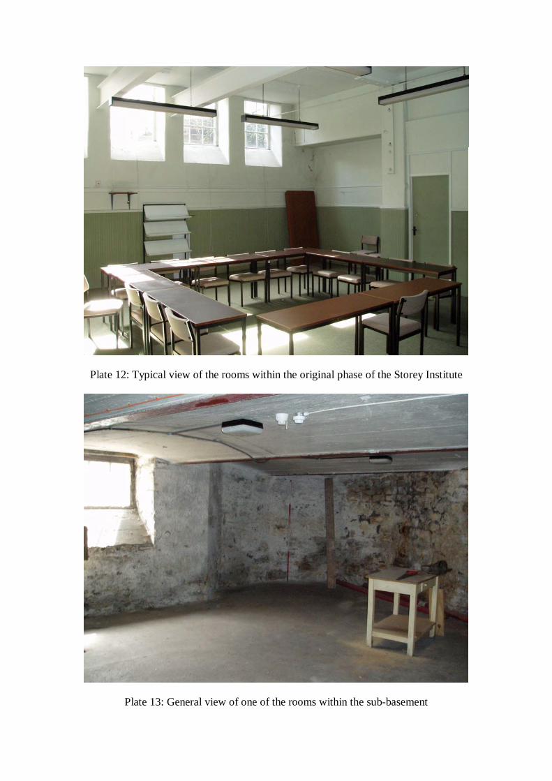
Plate 12: Typical view of the rooms within the original phase of the Storey Institute
Plate 13: General view of one of the rooms within the sub-basement

Plate 14: Detail of the ceiling within the gallery

Plate 15: Detail of one of the aedicular doors within the gallery

Plate 16: Detail of the statute of Queen Victoria and Prince Albert at the north end ofthe gallery

Plate 17: The lecture theatre at the south-west corner of the building
Plate 18: Detail of the staircase in the original phase of the building

Storey Institute, Meeting House Lane, Lancaster: Archaeological Building Investigation and Test Pit Evaluation20
For the use of Lancaster City Council © OA North: June 2008
APPENDIX 1: PROJECT DESIGN

Oxford Archaeology North Mill 3Moor Lane MillsMoor LaneLancasterLA1 1GFt: (01524 541000f: (01524) 848606e: [email protected]: www.oxfordarch.co.uk
Director and Chief Executive:David Jennings BA MIFA FSA
Private Limited Company Number: 1618597
Registered Charity Number: 285627
Registered Office: Oxford Archaeology Unit Ltd. Janus House, Osney Mead, Oxford, OX2 0ES