Embed Size (px)
Citation preview

Steve Gay - GIS Manager
Mid America Regional Council
Kansas City, MO

Mid-America Regional Council
• Association of Governments for the Kansas City Metro Region
• Voluntary organization made up of Local Governments
• We represent 8 counties in two states, with 116 cities

Mid-America Regional Council
• Seeks to build a stronger regional community through cooperation, leadership and planning.
• Enhance the effectiveness of Local Government
• Forum for addressing regional issues

Overview of KC Metro GIS
Regional Centerline
Aerial Photography Cooperative
Population Forecasting - Paint the Town
Regional Geospatial Homeland Security

KC Metro GIS
Committee of GIS professionals that address GIS issues that effect local governments in the MARC region
Communicate Knowledge and Expertise
Reduce costs through cooperative agreements
Develop Policies and Standards

Quarterly Meetings
Website -www.marc.org/gis/
Newsletter - Intersections
KC Metro GIS
Communication Tools

• Support e9-1-1 initiative– Wireless call reference– MSAG Synchronization– Public Safety Answering Points (PSAP)
Regional Centerline

9-1-1 Call Routing
Telco Central Office
e911 Call
RouterANI
PSAP BPSAP A
e911DBMSAG
ANI ANI
ANI ANI
ALI ALI

• MARC has Contracted with ESRI– Additional Centerline Functionality– Workflow Enhancements– Data Model Design
Regional Centerline

• MARC contracts with GeoComm for Centerline Maintenance
– Staffing– Hardware/Software– Data Model Design– Workflow Documentation
Regional Centerline

• Current Centerline Maintenance– Digital (GIS or CAD)– Hard copy– Cookie Cutter
Regional Centerline

• ESRI is Evaluating/Recommending– Data Standards– Data model similar to industry standard transportation
model– Workflow Enhancements
Regional Centerline
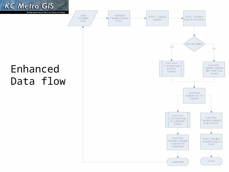
Street Centerline
Data
Jurisdiction Provides Data to
MARC
MARC Catalogs Updates
MARC Provides Data to GeoComm
Is Data Digital?Yes
No
GeoComm Digitizes Updates from Hard-Copy
Source
GeoComm Performs QC on
Updates
GeoComm Converts Data
to MARC Schema
GeoComm Provides Updated
Data Back to Jurisdiction
GeoComm Provides Updated
Data to MARC
MARC Provides Updated Data to
PSAP
GeoComm Converts Data to Jurisdiction
Schema
PSAPJurisdiction
Enhanced Data flow
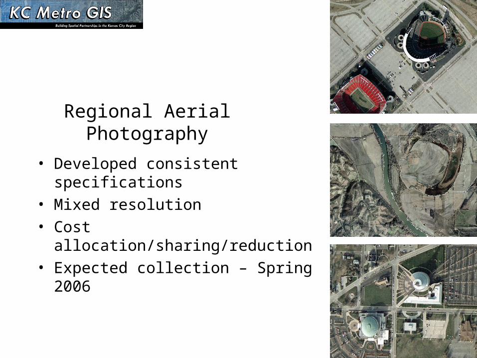
Regional Aerial Photography
• Developed consistent specifications• Mixed resolution • Cost allocation/sharing/reduction• Expected collection – Spring 2006

Proposed aerial
photography resolution

Beyond Orthophotography
• LIDAR quotes• Images/Data to support Contouring • Oblique imagery


Land Use and Population
Forecasting
and
Regional Parcel Data Collection

Land Use


Regional Homeland Security Geospatial and
Data Server Strategic Plan
Why a Strategic Plan?
• Use GIS to support Homeland Security and Public Safety
• Homeland Security funding? – Urban Area Security Initiatives
• Homeland Security Geospatial Work group– Regional Homeland Security Coordinating Committee– KC Metro GIS

Initial Questions:• GIS data for the region? • Software to be used during emergencies? • Server Hardware needs?• Can we integrate with Federal level initiatives?• How can we secure long term funding?
Geospatial Homeland Security Strategic Plan

Regional Data Server Needs Assessment
Initial Questions: • What are the current or proposed regional public safety
applications?• Server hardware required to support these
applications?• System Support? Data Center, Personnel and funding.• Is there opportunity to share resources?


Initial Steps• Selected Consultant - PBS&J • Kick-off meeting• Individual meetings in each county plus KCMO• Adopted an “All Hazards” approach
Development of the Plan

Stakeholders
• Emergency Managers
• GIS and IT Managers
• Police and Fire Personnel
• State and Federal representatives
• Public Health
• Utility
• Hospital

Needs Assessment Methods• Individual community interview sessions• Survey of capabilities and resources• Data Inventory Matrix • Evaluation of Existing Preparedness & Response
Plans

Summary of Needs Assessment
• GIS capabilities vary greatly• Data and Aerial Photography vary greatly (except
roads and property data)• Software platform most used – ESRI• Several Communities Utilize WebEOC

• Sharing data across State and County Boundaries• Critical Infrastructure Data Layers – inconsistent• Relationships between GIS and Emergency
Management• Published standards for collection and development of
data.
Gap Analysis

Key Plans:• Regional Homeland Security Strategy Plan• Natural Hazards Mitigation Plan• Federal Planning - National Preparedness Goal
Synthesis of Multiple Planning Efforts

Regional Homeland Security Strategic Plan
• Planning and Readiness• Coordination and effective Relationships• Adequate Resources• Training and Exercise

Natural Hazard Mitigation Plan

Source: DHS National Geospatial Preparedness Needs Assessment
Federal PlanningNational Preparedness Goal

Federal PlanningNational Preparedness Goal
All Hazards approach to national preparedness:
• Prevent
• Protect
• Respond
• Recover

• Collect the right GIS data• Make it sharable• Ensure its security• Integrate it into emergency operations
Geospatial Objectives

• Collect the right GIS data– Identification of key layers– Identifying who has what– Filling the gaps of priority data– Collection – methods and standards
Geospatial Objectives

• Make the Data sharable– Metadata
– Standards Naming conventions
– Software – Common Operating Picture
– Web Portals
– MOUs (data sharing and maintenance aggreements)
– Server needs (ownership, capacity, location, accessibility)– Connectivity needs
Geospatial Objectives
• Ensure the Data is Secure– Redundancy– Secure sites– Reconfigurable server and connectivity
Geospatial Objectives
• Integrate it into emergency operations – Daily uses– Training and exercises– Organizational structure– GIS Operations
Geospatial Objectives

Geospatial Homeland Security and Regional Data Server Plan
Next steps• Drafting a Strategic Plan• Education and Outreach Plan• Implementation Plan
– Priority of action items– Procedure for developing actions

Questions?
Steve Gay [email protected]
Steve Gay - GIS ManagerMid America Regional Council
Kansas City, MO