Embed Size (px)
Citation preview

Land Management
Glossary
Geographic Information Systems (GIS)
ITSD\GIEMSC
Prepared for USDA Farm Service Agency
6501 Beacon Drive Kansas City, MO 64133-4676
File Name: Glossary.dot
Glossary Page 1 of 24 May 03, 2006
Land Management Table of Contents
1. Introduction ..............................................................................................................................................................6 2. Abbreviation and Acronyms.....................................................................................................................................6
2.1 AML ............................................................................................................................................................6 2.2 COGO..........................................................................................................................................................6 2.3 DEM ............................................................................................................................................................6 2.4 DLG .............................................................................................................................................................6 2.5 DOQ.............................................................................................................................................................6 2.6 DPI...............................................................................................................................................................6 2.7 DRG.............................................................................................................................................................6 2.8 DTM ............................................................................................................................................................6 2.9 ESRI.............................................................................................................................................................6 2.10 FGDC...........................................................................................................................................................6 2.11 GDW............................................................................................................................................................6 2.12 GIEMSC ......................................................................................................................................................6 2.13 GIS...............................................................................................................................................................6 2.14 GPS..............................................................................................................................................................7 2.15 GRASS ........................................................................................................................................................7 2.16 HARN..........................................................................................................................................................7 2.17 LIS ...............................................................................................................................................................7 2.18 MDOQ .........................................................................................................................................................7 2.19 NAD.............................................................................................................................................................7 2.20 NSDI ............................................................................................................................................................7 2.21 PLSS ............................................................................................................................................................7 2.22 SDE..............................................................................................................................................................7 2.23 SDTS............................................................................................................................................................7 2.24 TIFF .............................................................................................................................................................7 2.25 TIGER..........................................................................................................................................................7 2.26 TIN...............................................................................................................................................................7 2.27 USGS ...........................................................................................................................................................7 2.28 UTM ............................................................................................................................................................7 2.29 WGS ............................................................................................................................................................7
3. Definitions................................................................................................................................................................8 3.1 Actors...........................................................................................................................................................8
3.1.1 Cartographer ..................................................................................................................................8 3.1.2 Environmental Systems Research Institute....................................................................................8 3.1.3 Federal Geographical Data Committee..........................................................................................8 3.1.4 Geospatial Information & Executive Management Systems Center..............................................8 3.1.5 United States Geological Survey ...................................................................................................8
3.2 Business Terms ............................................................................................................................................8 3.2.1 Arc Macro Language .....................................................................................................................8 3.2.2 ArcIMS..........................................................................................................................................8 3.2.3 ArcObjects.....................................................................................................................................8 3.2.4 ArcSDE .........................................................................................................................................8 3.2.5 ArcXML ........................................................................................................................................8 3.2.6 Demographic Data.........................................................................................................................8 3.2.7 Geographical Resource Analysis Support System.........................................................................9 3.2.8 Geospatial Data Warehouse...........................................................................................................9 3.2.9 Map................................................................................................................................................9 3.2.10 National Spatial Data Infrastructure ..............................................................................................9 3.2.11 Public Land Survey System...........................................................................................................9 3.2.12 Topologically Integrated Geographic Encoding and Referencing.................................................9
Glossary Page 2 of 24 May 03, 2006
Land Management 3.2.13 Term ..............................................................................................................................................9
3.3 Technical Terms ..........................................................................................................................................9 3.3.1 Absolute Coordinates ....................................................................................................................9 3.3.2 Address ..........................................................................................................................................9 3.3.3 Arc .................................................................................................................................................9 3.3.4 Area .............................................................................................................................................10 3.3.5 Azimuthal Projection...................................................................................................................10 3.3.6 Basemap ......................................................................................................................................10 3.3.7 Bearing ........................................................................................................................................10 3.3.8 Bounding Rectangle ....................................................................................................................10 3.3.9 Cadastral Survey..........................................................................................................................10 3.3.10 Cadastre .......................................................................................................................................10 3.3.11 Cartesian Coordinate ...................................................................................................................10 3.3.12 Cartography .................................................................................................................................10 3.3.13 Centroid .......................................................................................................................................10 3.3.14 Chord ...........................................................................................................................................11 3.3.15 Control Point ...............................................................................................................................11 3.3.16 Coordinate Geometry (COGO)....................................................................................................11 3.3.17 Coordinate System.......................................................................................................................11 3.3.18 Coordinates..................................................................................................................................11 3.3.19 Contiguous...................................................................................................................................11 3.3.20 Continuous Map ..........................................................................................................................11 3.3.21 Contour Mapping.........................................................................................................................11 3.3.22 Conversion...................................................................................................................................11 3.3.23 Coverage......................................................................................................................................12 3.3.24 Dangle .........................................................................................................................................12 3.3.25 Datum ..........................................................................................................................................12 3.3.26 Decimal Degrees..........................................................................................................................12 3.3.27 Digital Elevation Model ..............................................................................................................12 3.3.28 Digital Line Graph.......................................................................................................................12 3.3.29 Digital Orthophoto Quadrangles..................................................................................................12 3.3.30 Digital Raster Graphics ...............................................................................................................12 3.3.31 Digital Terrain Model ..................................................................................................................12 3.3.32 Digitize ........................................................................................................................................12 3.3.33 Dissolve .......................................................................................................................................12 3.3.34 Dots Per Inch ...............................................................................................................................13 3.3.35 Double-Precision Accuracy .........................................................................................................13 3.3.36 Edge Matching.............................................................................................................................13 3.3.37 Ellipsoid.......................................................................................................................................13 3.3.38 Envelope ......................................................................................................................................13 3.3.39 Equator ........................................................................................................................................13 3.3.40 False Easting................................................................................................................................13 3.3.41 False Northing .............................................................................................................................13 3.3.42 Feature .........................................................................................................................................13 3.3.43 Flattening.....................................................................................................................................13 3.3.44 Geocoding....................................................................................................................................14 3.3.45 Geodatabase.................................................................................................................................14 3.3.46 Geodataset ...................................................................................................................................14 3.3.47 Geographic Information System..................................................................................................14 3.3.48 Geoid ...........................................................................................................................................14 3.3.49 Global Positioning System ..........................................................................................................14 3.3.50 Graticule ......................................................................................................................................14 3.3.51 Great Circle .................................................................................................................................14 3.3.52 High Accuracy Reference Network.............................................................................................14 3.3.53 Hydrology....................................................................................................................................14 3.3.54 Hypsography................................................................................................................................14
Glossary Page 3 of 24 May 03, 2006

Land Management 3.3.55 Image ...........................................................................................................................................14 3.3.56 Image Processing.........................................................................................................................15 3.3.57 Interface.......................................................................................................................................15 3.3.58 Key Map ......................................................................................................................................15 3.3.59 Land Information System ............................................................................................................15 3.3.60 Latitude........................................................................................................................................15 3.3.61 Layer............................................................................................................................................15 3.3.62 Legend .........................................................................................................................................15 3.3.63 Line..............................................................................................................................................15 3.3.64 Location.......................................................................................................................................16 3.3.65 Longitude.....................................................................................................................................16 3.3.66 Map Scale ....................................................................................................................................16 3.3.67 Map Projection ............................................................................................................................16 3.3.68 Mercator Projection .....................................................................................................................16 3.3.69 Meridian ......................................................................................................................................16 3.3.70 Merging .......................................................................................................................................16 3.3.71 Metes and Bounds .......................................................................................................................16 3.3.72 North American Datum 1927 ......................................................................................................16 3.3.73 North American Datum 1983 ......................................................................................................17 3.3.74 North Arrow ................................................................................................................................17 3.3.75 Orientation...................................................................................................................................17 3.3.76 Orthophotograph..........................................................................................................................17 3.3.77 Overlay ........................................................................................................................................17 3.3.78 Overshoot ....................................................................................................................................17 3.3.79 Pan ...............................................................................................................................................17 3.3.80 Parcel ...........................................................................................................................................17 3.3.81 Photogrammetry ..........................................................................................................................17 3.3.82 Pixel.............................................................................................................................................17 3.3.83 Planar Coordinate System ...........................................................................................................17 3.3.84 Planimetric...................................................................................................................................18 3.3.85 Planimetric Map ..........................................................................................................................18 3.3.86 Point.............................................................................................................................................18 3.3.87 Polygon........................................................................................................................................18 3.3.88 Polygon-Arc Topology ................................................................................................................18 3.3.89 Polyline........................................................................................................................................18 3.3.90 Precision ......................................................................................................................................18 3.3.91 Prime Meridian ............................................................................................................................18 3.3.92 Projection.....................................................................................................................................18 3.3.93 Projected Coordinate System.......................................................................................................18 3.3.94 Quadrangle ..................................................................................................................................18 3.3.95 Quadrant ......................................................................................................................................19 3.3.96 Raster...........................................................................................................................................19 3.3.97 Rectification ................................................................................................................................19 3.3.98 Remote Sensing ...........................................................................................................................19 3.3.99 Rendering ....................................................................................................................................19 3.3.100 Resolution....................................................................................................................................19 3.3.101 Route ...........................................................................................................................................19 3.3.102 Rubber Sheeting ..........................................................................................................................19 3.3.103 Scale ............................................................................................................................................20 3.3.104 Shapefile ......................................................................................................................................20 3.3.105 Sliver Polygon .............................................................................................................................20 3.3.106 Snap Radius .................................................................................................................................20 3.3.107 Spatial Analysis ...........................................................................................................................20 3.3.108 Spatial Data .................................................................................................................................20 3.3.109 Spatial Data Transfer Standard....................................................................................................20 3.3.110 Spatial Grid..................................................................................................................................20
Glossary Page 4 of 24 May 03, 2006
Land Management 3.3.111 Spatial Reference.........................................................................................................................20 3.3.112 Sphere..........................................................................................................................................21 3.3.113 Spherical Coordinate System.......................................................................................................21 3.3.114 Spheroid.......................................................................................................................................21 3.3.115 State Plane Coordinate System....................................................................................................21 3.3.116 Style.............................................................................................................................................21 3.3.117 Symbol.........................................................................................................................................21 3.3.118 Symbology...................................................................................................................................21 3.3.119 Tagged Image File Format...........................................................................................................21 3.3.120 Thematic Map..............................................................................................................................21 3.3.121 Tile...............................................................................................................................................21 3.3.122 Topographic Feature....................................................................................................................21 3.3.123 Topology......................................................................................................................................21 3.3.124 Triangulated Irregular Network...................................................................................................22 3.3.125 Undershoot ..................................................................................................................................22 3.3.126 Union ...........................................................................................................................................22 3.3.127 Universal Transverse Mercator....................................................................................................22 3.3.128 Vector ..........................................................................................................................................22 3.3.129 Vertex ..........................................................................................................................................22 3.3.130 Warping .......................................................................................................................................22 3.3.131 World Geodetic System 1984......................................................................................................22 3.3.132 X-axis ..........................................................................................................................................22 3.3.133 Y-axis ..........................................................................................................................................22 3.3.134 Z-axis...........................................................................................................................................22 3.3.135 Zoom ...........................................................................................................................................22 3.3.136 Z...................................................................................................................................................22
Glossary Page 5 of 24 May 03, 2006
Land Management GIS Glossary
1. Introduction The glossary is used to define terminology specific to GIS, explaining terms that may be unfamiliar to the reader of the use-case descriptions or other project documents. This document can be used as an informal data dictionary, capturing data definitions so that use-case descriptions and other project documents can focus on what the system must do with the information.
1. Abbreviation and Acronyms
1.1 AML
Arc Macro Language
1.2 COGO
Coordinate Geometry
1.3 DEM
Digital Elevation Model
1.4 DLG
Digital Line Graph
1.5 DOQ
Digital Orthophoto Quadrangles
1.6 DPI
Dots Per Inch
1.7 DRG
Digital Raster Graphics
1.8 DTM
Digital Terrain Model
1.9 ESRI
Environmental Systems Research Institute
1.10 FGDC
Federal Geographical Data Committee
1.11 GDW
Geospatial Data Warehouse
1.12 GIEMSC
Geospatial Information & Executive Management Systems Center
1.13 GIS
Geographic Information System
Glossary Page 6 of 24 May 03, 2006
Land Management 1.14 GPS
Global Positioning System
1.15 GRASS
Geographical Resource Analysis Support System.
1.16 HARN
High Accuracy Reference Network
1.17 LIS
Land Information System
1.18 MDOQ
Mosaic Digital Ortho Quadrangles
1.19 NAD
North American Datum
1.20 NSDI
National Spatial Data Infrastructure
1.21 PLSS
Public Land Survey System
1.22 SDE
Spatial Data Engine
1.23 SDTS
Spatial Data Transfer Standard
1.24 TIFF
Tagged Image File Format
1.25 TIGER
Topologically Integrated Geographic Encoding and Referencing
1.26 TIN
Triangulated Irregular Network
1.27 USGS
United States Geological Survey
1.28 UTM
Universal Transverse Mercator
1.29 WGS
World Geodetic System
Glossary Page 7 of 24 May 03, 2006
Land Management 1. Definitions
1.29 Actors
1.29.0 Cartographer
One who practices the art and science of expressing graphically, usually through maps, the natural and social features of the earth.
1.29.0 Environmental Systems Research Institute
[Present the definition here. Provide as much information as the reader needs to understand the concept.]
1.29.0 Federal Geographical Data Committee
A group of individuals representing different U.S. Government agencies that provide or handle digital geographic data standards. Housed in the Department of Interior, the FGDC is charted to facilitate information and data sharing, and to coordinate federal activities in the geodata acquisition arena.
1.29.0 Geospatial Information & Executive Management Systems Center
1.29.0 United States Geological Survey
A scientific agency of the U.S. government, part of the Department of the Interior. The USGS is a fact-finding research agency that monitors, analyzes, and provides scientific understanding about natural resource issues and conditions, the environment, and natural hazards. The USGS is the primary civilian mapping agency in the United States. It produces digital and paper map products; aerial photography; and remotely sensed data on land cover, hydrology, geology, biology, and geography.
1.29 Business Terms
1.29.0 Arc Macro Language
A proprietary high-level algorithmic language for generating end-user applications in ArcInfo Workstation. Features include the ability to create on-screen menus, use and assign variables, control statement execution, and get and use map or page unit coordinates. AML includes an extensive set of commands that can be used interactively or in AML programs (macros), as well as commands that report on the status of ArcInfo environment settings.
1.29.0 ArcIMS
ESRI software that allows for centrally hosting and serving GIS maps, data, and applications for use on the Internet. The administrative framework lets users author configuration files, publish maps, design Web pages, and administer ArcIMS spatial servers.
1.29.0 ArcObjects
A library of software components that make up the foundation of ArcGIS. ArcGIS Desktop, ArcGIS Engine, and ArcGIS Server are all built on top of the ArcObjects libraries.
1.29.0 ArcSDE
Server software that provides a gateway for storing, managing, and using spatial data in an RDBMS.
1.29.0 ArcXML
A file format that provides a structured method for communication between all ArcIMS components. ArcXML defines content for services and is used for requests and responses between clients, the business logic tier, and servers.
1.29.0 Demographic Data
Characteristics of human populations, such as size, growth, density, distribution, and vital statistics.
Glossary Page 8 of 24 May 03, 2006

Land Management
1.29.0 Geographical Resource Analysis Support System
A public-domain raster GIS modeling product of the U.S. Army Corp of Engineer’s Construction Engineering Research Laboratory (USACERL)
1.29.0 Geospatial Data Warehouse
1.29.0 Map
An abstract representation of the physical features of a portion of the Earth's surface graphically displayed on a planar surface. Maps display signs, symbols, and spatial relationships among the features. They typically emphasize, generalize, and omit certain features from the display to meet design objectives.
1.29.0 National Spatial Data Infrastructure
A federally-mandated framework of spatial data that refers to U.S. locations, as well as the means of distributing and using that data effectively. It includes technologies, policies, standards, and human resources necessary to acquire, process, store, distribute, and improve the utilization of geospatial data in the United States. Developed and coordinated by the FGDC, the NSDI encompasses policies, standards, and procedures for organizations to cooperatively produce and share geographic data. The NSDI is being developed in cooperation with organizations from state, local, and tribal governments; the academic community; and the private sector.
1.29.0 Public Land Survey System
The description of the location of land in the United States using a survey system established by the federal government in 1785. The system is based on the concept of a township, a square parcel of land measuring six miles on each side. The township's position is described as being a number of six-mile units east of a north–south line (called the meridian) and north or south of an east–west line (called the baseline). Each township is divided into 36 sections, each of which is one mile square. A section is divided into quarters equal to 160 acres. The quarter section may be further divided into four 40 acre parcels. Also called the rectangular survey.
1.29.0 Topologically Integrated Geographic Encoding and Referencing
Format used by the U.S. Census Bureau to support census programs and surveys. It was used for the 1990 census. TIGER files contain street address ranges along lines and census tract/block boundaries. These descriptive data can be used to associate address information and census/demographic data to coverage features.
1.29.0 Term
Term Def
1.29 Technical Terms
1.29.0 Absolute Coordinates
Coordinates that are referenced to the origin of a given coordinate system.
1.29.0 Address
A designation of the location of a person's residence or workplace, an organization, or a building, most often consisting of numerical and text elements such as street number, street name, and city arranged in a particular format.
1.29.0 Arc
• On a map, a shape defined by a connected series of unique x,y coordinate pairs. An arc may be straight or curved.
Glossary Page 9 of 24 May 03, 2006
Land Management • A coverage feature class that represents lines and polygon boundaries. One line feature can contain many
arcs. Arcs are topologically linked to nodes and to polygons. Their attributes are stored in an arc attribute table (AAT). Nodes indicate the endpoints and intersections of arcs; they do not exist as independent features. Together, the from-node and the to-node define the direction of the arc.
1.29.0 Area
• A closed, two-dimensional shape defined by its boundary. Its extent is usually defined by its boundary or by a contiguous set of raster cells.
• A calculation of the size of a two-dimensional feature, measured in square units.
1.29.0 Azimuthal Projection
A map projection that transforms points from a spheroid or sphere onto a tangent or secant plane. The azimuthal projection is also known as a planar or zenithal projection.
1.29.0 Basemap
• A map depicting background reference information such as landforms, roads, landmarks, and political boundaries, onto which other, thematic information is placed. A basemap is used for locational reference and often includes a geodetic control network as part of its structure.
• A map to which GIS data layers are registered and re-scaled.
1.29.0 Bearing
The direction of a fixed point in relation to another fixed point, expressed as an angle from a known direction, usually north, and usually measured from 0 degrees at the reference direction clockwise through 360 degrees. Bearings are often referred to as true bearings, magnetic bearings, or assumed bearings, depending on whether the meridian is true, magnetic, or assumed.
1.29.0 Bounding Rectangle
The rectangle aligned with the coordinate axes and placed on a map display that encompasses a geographic feature or group of features or an area of interest. It is defined by minimum and maximum coordinates in the x and y directions and is used to represent, in a general way, the location of a geographic area.
1.29.0 Cadastral Survey
A boundary survey taken for the purposes of taxation.
1.29.0 Cadastre
Official map records pertaining to location, quantity, value and ownership of land parcels within a government jurisdiction. A record of interest in land encompassing both the nature and extents of interests. Cadastral information often includes other descriptive information about land parcels.
1.29.0 Cartesian Coordinate
Point whose location in space is expressed in terms of its distance above or below an X, a Y and a Z coordinate plane. Location of a point on a plane is expressed by two coordinate values, one representing the distance from the Y-axis and the other representing the distance from the X-axis.
1.29.0 Cartography
The art and science of expressing graphically, usually through maps, the natural and social features of the earth.
1.29.0 Centroid
The geometric center of a feature. Of a line, it is the midpoint; of a polygon, the center of area; of a three-dimensional figure, the center of volume.
Glossary Page 10 of 24 May 03, 2006
Land Management 1.29.0 Chord
A straight line that joins two points on a curve.
1.29.0 Control Point
• An accurately surveyed coordinate location for a physical feature that can be identified on the ground. Control points are used in a least squares adjustment as the basis for improving the spatial accuracy of all other points to which they are connected.
• One of various locations on a paper or digital map that has known coordinates and that is used to transform another dataset--spatially coincident but in a different coordinate system--into the coordinate system of the control point. Control points are used in digitizing data from paper maps, in georeferencing both raster and vector data, and in performing spatial adjustment operations such as rubber sheeting.
1.29.0 Coordinate Geometry (COGO)
• A set of algorithms for converting survey data (bearings, distances, and angles) into coordinate data.
• Automated mapping software used in land surveying that calculates locations using distances and bearings from known reference points.
1.29.0 Coordinate System
A reference framework consisting of a set of points, lines, and/or surfaces, and a set of rules, used to define the positions of points in space in either two or three dimensions. The Cartesian coordinate system and the geographic coordinate system used on the earth's surface are common examples of coordinate systems.
1.29.0 Coordinates
Values represented by x, y, and possibly z, that define a position in terms of a spatial reference framework. Coordinates are used to represent locations on the earth's surface relative to other locations.
1.29.0 Contiguous
• Of polygons: adjacent; having a common boundary; sharing an edge.
• Of raster cells: connected orthogonally or diagonally; or, sometimes, connected strictly orthogonally.
• Of TIN edges: having no gaps or overlaps.
1.29.0 Continuous Map
A means of storing a digital map as if it represented a continuous, unbroken surface. Many large GIS databases are broken into subfiles, which represent smaller sections of a larger area. These separate subfiles are referred to as tiles or facets. A continuous map allows the user to move in any and all directions without moving from file to file. Maintaining the illusion of a continuous map in a computer is a challenging problem because computers typically store data in strings, in linear order, on magnetic or optical storage media.
1.29.0 Contour Mapping
Display of contour lines, each of which represents a constant value, typically surface elevation, throughout its length.
1.29.0 Conversion
The process of transferring data derived from existing records and maps to a digital database. Conversion is a major input problem and can consume the greatest share of time in a GIS project.
Glossary Page 11 of 24 May 03, 2006

Land Management 1.29.0 Coverage
A data model for storing geographic features, a coverage stores a set of thematically associated data considered to be a unit. It usually represents a single layer, such as soils, streams, roads, or land use. In a coverage, features are stored as both primary features (points, arcs, polygons) and secondary features (tics, links, annotation). Feature attributes are described and stored independently in feature attribute tables.
1.29.0 Dangle
An endpoint of a line that is not connected to another line because the line features do not form closed loops. A dangle may be formed when the line extends too far past the line it is supposed to touch (an overshoot) or not quite far enough (an undershoot). A dangle is not always an error; for example, it can represent cul-de-sac or dead-end street segments.
1.29.0 Datum
The reference specifications of a measurement system, usually a system of coordinate positions on a surface (a horizontal datum) or heights above or below a surface (a vertical datum).
1.29.0 Decimal Degrees
Values of latitude and longitude expressed in decimal format rather than in degrees, minutes, and seconds.
1.29.0 Digital Elevation Model
A digital representation of a continuous variable over a two-dimensional surface by a regular array of z values referenced to a common datum. Digital elevation models are typically used to represent terrain relief. The format of the USGS digital elevation data sets.
1.29.0 Digital Line Graph
A form of digital map developed by the United States Geological Survey. DLGs supply users with the digital version of information printed on USGS topographical quadrangle maps.
1.29.0 Digital Orthophoto Quadrangles
A computer-generated image of an aerial photograph in which the image displacement caused by terrain relief and camera tilt has been removed. A DOQ combines the image characteristics of the original photograph with the georeferenced qualities of a map.
1.29.0 Digital Raster Graphics
A scanned image of a USGS standard series topological map, including all map collar information. The image inside the map neatline is georeferenced to the surface of the earth and fit to the Universal Transverse Mercator projection.
1.29.0 Digital Terrain Model
A method of transferring elevation data into a contoured surface or a three-dimensional display.
1.29.0 Digitize
The process of converting source materials, prepared manually, into the digital codes stored and processed by computers. Digitizing involves tracing map features into a computer using a digitizing tablet, graphics tablet, mouse or keyboard cursor.
1.29.0 Dissolve
Removing boundaries between adjacent polygons having the same value for a specific attribute. Combining polygons that would otherwise be assigned the same color or hatch pattern in a thematic map display. Process of aggregating neighboring polygons based on a matching value for some attribute.
Glossary Page 12 of 24 May 03, 2006
Land Management 1.29.0 Dots Per Inch
A measure of the resolution of graphics displays.
1.29.0 Double-Precision Accuracy
Refers to a high level of coordinate accuracy based on the possible number of significant digits that can be stored for each coordinate. Double-precision coverages store up to 15 significant digits per coordinate, retaining the accuracy of much less than one meter at a global extent.
1.29.0 Edge Matching
One digital map may encompass many paper maps, but when the paper maps are laid edge-to-edge, features running across boundaries of the map sheets are not always properly aligned. These misalignments occur for many reasons including survey error, cartographic generalization, and problems of map projection and compilation. Edge matching is a term applied to a variety of techniques employed to resolve these inconsistencies, including warping and rubber sheeting.
1.29.0 Ellipsoid
• A three-dimensional, closed geometric shape, all planar sections of which are ellipses or circles. An ellipsoid has three independent axes, and is usually specified by the lengths a, b, c of the three semi-axes. If an ellipsoid is made by rotating an ellipse about one of its axes, then two axes of the ellipsoid are the same, and it is called an ellipsoid of revolution, or spheroid. If the lengths of all three of its axes are the same, it is a sphere.
• When used to represent the earth, an oblate ellipsoid of revolution, made by rotating an ellipse about its minor axis.
1.29.0 Envelope
The rectangle defined by one or more geographical features in coordinate space, determined by the minimum and maximum coordinates in the x and y directions, as well as the ranges of any z- or m-values that the features may have.
1.29.0 Equator
The parallel of reference that is equidistant from the poles and defines the origin of latitude values as 0 degrees north or south.
1.29.0 False Easting
The linear value added to all x-coordinates of a map projection so that none of the values in the geographic region being mapped are negative.
1.29.0 False Northing
The linear value added to all y-coordinates of a map projection so that none of the values in the geographic region being mapped are negative.
1.29.0 Feature
A representation of a real-world object on a map i.e. streams, wells and parcels.
1.29.0 Flattening
A measure of how much an oblate spheroid differs from a sphere. The flattening is the ratio of the semi-major axis minus the semi-minor axis to the semi-major axis.
Glossary Page 13 of 24 May 03, 2006
Land Management 1.29.0 Geocoding
The process of finding the location of a street address on a map. The location can be an x, y coordinate or a feature such as a street segment, postal delivery location, or building. In GIS, geocoding requires a reference dataset that contains address attributes for the geographic features in the area of interest.
1.29.0 Geodatabase
A collection of geographic datasets for use by ArcGIS. There are various types of geographic datasets, including feature classes, attribute tables, raster datasets, network datasets, topologies, and many others.
1.29.0 Geodataset
Any organized collection of data in a geodatabase with a common theme.
1.29.0 Geographic Information System
An integrated collection of computer software, spatial data, related information, and supporting infrastructure used to visualize and analyze spatial relationships, model spatial processes, and manage spatial information. A GIS uses geography as its organizing principle.
1.29.0 Geoid
The figure of the earth considered as the surface, extended through the continents, where gravity has the value associated with mean sea level. The surface is perpendicular at every point to a plumb line, or direction of gravity. The geoid varies from the ellipsoid by as much as 80 meters above and 60 meters below its surface.
1.29.0 Global Positioning System
A worldwide radio-navigation system formed from a constellation of 24 satellites and their ground stations. These satellites continually broadcast their positions that allow a GPS receiver anywhere on earth to calculate its own location.
1.29.0 Graticule
A network of longitude and latitude lines on a map or chart that relates points on a map to their true locations on the earth.
1.29.0 Great Circle
Any circle or near circle produced by the intersection of a sphere and a flat plane that passes through the center of the sphere. The equator and all lines of longitude are great circles. Great circles are used in navigation, since the shortest path between any two points on the earth's surface lies on a great circle.
1.29.0 High Accuracy Reference Network
A resurvey and readjustment of NAD 1983 control points using GPS techniques. The resurvey date is often included as part of the datum name: NAD 1983 (1991) or NAD91.
1.29.0 Hydrology
Map data that describes the positions and characteristics of bodies of water.
1.29.0 Hypsography
Map data that describes the exact shape of the earth’s surface, usually in the form of contour lines, digital elevation models, or color shadings.
1.29.0 Image
• Digital representation of spatial data stored in raster format. Scanned photos, maps, diagrams, or remote sensing data (aerial photos, satellite scenes, radar telemetry) electronically stored as a raster (pixel) data set made up of either binary or integer values representing (singular or multiple) reflected light, heat, and/or other relative intensity measurements.
Glossary Page 14 of 24 May 03, 2006
Land Management • Exact copy of data in a file transferred to another medium.
• One of the three kinds of Data (spatial, textural and image).
1.29.0 Image Processing
• Enhancement - aid in the interpretation of an image by changing the display color and/or intensity of pixels (highlighting) that represent areas that share a common set (or range) of physical characteristics.
• Rectification - Fitting the image to a map base by eliminating distortion due to the curvature of the earth, position of the camera or scanner, and/or varying terrain elevation.
• Classification - Assigning pixies within an image to one category (land cover, soil category, etc.) or another according to their associated relative intensity measurements.
• Data Merging - superimposing vector data on top of image data.
1.29.0 Interface
• Surface forming a common boundary between adjacent regions, bodies, substances, or phases.
• Junction between two or more components of an information system. Typically, the link between the spatial database and non-graphic (DBMS) databases.
• Point of interaction or communication between a computer and any other entity, such as a printer or human operator.
1.29.0 Key Map
A highly generalized map used to provide a contexture reference for retrieving more detailed spatial data sets for specific geographic areas.
1.29.0 Land Information System
Manual or computer-based information system used to store, retrieve, display, and plot spatial and textural data relating primarily to land features and characteristics. Addresses a wide range of existing natural and cultural aspects of land within a mapped area including property ownership, tax assessment, zoning, land use, vegetation, soils, geology, hazardous areas, noise zones, surface and subsurface hydrology. Can also include overlays that address infrastructure systems including transportation, sewer, water, storm, electric, cable, and telephone and storm drainage.
1.29.0 Latitude
The first component of a spherical coordinate system used to record positions on the earth’s surface. Latitude indicates the angular distance north or south of the earth’s equator measured through 90 degrees.
1.29.0 Layer
In ArcGIS, a reference to a data source, such as a coverage, geodatabase feature class, raster, and so on, that defines how the data should be symbolized on a map. Layers can also define additional properties, such as which features from the data source are included. Layers can be stored in map documents (.mxd) or saved individually as layer files (.lyr). Layers are conceptually similar to themes in ArcView 3.x.
1.29.0 Legend
An explanation of the symbols, codes, names given to variables and other information appearing on a map drawing or chart. Includes a sample of each symbol, line pattern, shading, or hatching appearing on the map along with annotations describing the meaning of each.
1.29.0 Line
In spatial databases, a linear vector with only a start and endpoint, containing no intermediary (shape) turning points. A line feature is the alignment between two points representing within a spatial database a real world or theoretical feature, e.g., a road, stream or parcel boundary.
Glossary Page 15 of 24 May 03, 2006
Land Management 1.29.0 Location
• Distinct place in the real world.
• Position defined by a set of coordinates within a spatial database (i.e. pole, property corner, reported crime incident.)
• The storage space of digital data within an information storage system.
1.29.0 Longitude
The second component of a spherical coordinate system used to record east-west positions on the earth's surface, measured in degrees as the arc or position of the earth's equator intersected between the meridian of a given place and the prime meridian, which runs through Greenwich, England.
1.29.0 Map Scale
The relationship between distance on a map and the corresponding distance on the earth's surface. Map scale is often recorded as a representative fraction such as 1:1,000,000 (1 unit on the map represents a million units on the earth's surface) or 1:24,000 (1 unit on the map represents 24,000 units on the earth's surface). The terms "large" and small refer to the relative magnitude of the representative fraction. Since 1/1,000,000 is a smaller fraction than 1/24,000, the former is said to be a smaller scale. Small scales are often used to map large areas because each map unit covers a larger earth distance. Large-scale maps are employed for detailed maps of smaller areas.
1.29.0 Map Projection
A systematic conversion of locations on the Earth's surface from spherical to planar coordinates. Because the earth is three-dimensional, some method must be used to depict a map in two dimensions. Some projections preserve shape; others preserve accuracy of area, distance, or direction. However, any such representation distorts some parameter of the Earth's surface be it distance, area, shape, or direction.
1.29.0 Mercator Projection
A map projection designed by Gerardus Mercator, where the earth’s surface is drawn as it would appear if projected on a cylinder wrapped around the earth.
1.29.0 Meridian
A great circle on the earth that passes through the poles, often used synonymously with longitude. Meridians run north–south between the poles. From a prime meridian or 0 degrees longitude (usually the Greenwich prime meridian), measures of longitude are positive eastward by convention but may also be given as negative to the west and positive to the east, where they meet halfway around the globe at the line of 180 degrees longitude.
1.29.0 Merging
Combining input features from multiple input data sources of the same data type into a single, new, output feature class.
1.29.0 Metes and Bounds
A type of surveying in which the limits of a parcel are identified as relative distances and bearings from landmarks. Metes and bounds surveying is often used to survey areas that are irregularly shaped.
1.29.0 North American Datum 1927
The primary local geodetic datum and geographic coordinate system used to map the United States during the middle part of the 20th century, referenced to the Clarke spheroid of 1866 and an initial point at Meades Ranch, Kansas. Features on USGS topographic maps, including the corners of 7.5-minute quadrangle maps, are referenced to NAD27. It is gradually being replaced by the North American Datum of 1983.
Glossary Page 16 of 24 May 03, 2006
Land Management 1.29.0 North American Datum 1983
A geocentric datum and graphic coordinate system based on the Geodetic Reference System 1980 ellipsoid (GRS80). Mainly used in North America, its measurements are obtained from both terrestrial and satellite data.
1.29.0 North Arrow
A map symbol that shows the direction of north on the map, thereby showing how the map is oriented.
1.29.0 Orientation
Attribute of spatial features that describes the angle at which it is turned from its normal north south axis. Applies particularly to text or symbols, two point line features, and entire blocks of spatial features. For example, a water hydrant with an orientation of 30 degrees would be viewed with a declination of 120 degrees from the horizontal plane.
1.29.0 Orthophotograph
An aerial photograph in which the displacement of images has been removed and may also form the base map for many GIS programs.
1.29.0 Overlay
Something that is laid over or covers something else:
• A spatial operation in which two or more maps registered to a common coordinate system are superimposed, either digitally or on a transparent material, for the purpose of showing the relationships between features that occupy the same geographic space.
• In geoprocessing, the geometric intersection of multiple feature classes to combine, erase, modify or update features in a new output feature class.
1.29.0 Overshoot
Situation where a digital line extends past the intended boundary line, this extension past the intended juncture point is called a dangle.
1.29.0 Pan
To shift a map image relative to the display window without changing the viewing scale.
1.29.0 Parcel
A portion of the earth defined by a boundary inside of which certain assigned rights apply regarding occupancy and/or use of land, air or water. Can also include linked attributes that define the rules and conditions for exercising these rights.
1.29.0 Photogrammetry
The science of making reliable measurements of physical objects and the environment by measuring and plotting electromagnetic radiation data from aerial photographs and remote-sensing systems against land features identified in ground control surveys, generally in order to produce planimetric, topographic, and contour maps.
1.29.0 Pixel
Abbreviation for Picture Element, the smallest non-divisible image forming unit of a plot or video display. Each cell can have assigned attributes, in addition to color. In raster processing, pixels refer to a single cell within a matrix of grid cells.
1.29.0 Planar Coordinate System
A two-dimensional measurement system that locates features on a plane, based on their distance from an origin (0, 0) along two perpendicular axis.
Glossary Page 17 of 24 May 03, 2006
Land Management 1.29.0 Planimetric
Two-dimensional, showing no relief.
1.29.0 Planimetric Map
A map that displays only the x, y locations of features and represents only horizontal distances correctly. Typical features defined within a planimetric map include such natural and cultural features as streams, roads, shorelines, waterways, building footprints, reservoirs, bridges, roadways, overpasses, sidewalks and parking lots.
1.29.0 Point
A geometric element defined by a pair of x, y coordinates that represents a geographic feature too small to be displayed as a line or area; for example, the location of a mountain peak or a building location on a small- scale map.
1.29.0 Polygon
On a map, a closed shape defined by a connected sequence of x, y coordinate pairs, where the first and last coordinate pair is the same and all other pairs are unique.
1.29.0 Polygon-Arc Topology
In a polygon coverage, the list of topologically connected arcs that define the boundary of a polygon feature and the label point that links it to an attribute record in the coverage point attribute table.
1.29.0 Polyline
In ArcGIS software, a shape defined by one or more paths, where a path is a series of connected segments. If a polyline has more than one path (a multipart polyline) the paths may either branch or be discontinuous.
1.29.0 Precision
Refers to the level of measurement and exactness of description in a GIS database. Precise locational data may measure position to a fraction of a unit. Precise attribute information may specify the characteristics of features in great detail. It is important to realize, however, that precise data---no matter how carefully measured---may be inaccurate. Therefore, a distinction is made between precision and accuracy.
1.29.0 Prime Meridian
The line of longitude that runs through Greenwich, England, used as the origin (zero point) for longitudinal measurements.
1.29.0 Projection
A method by which the curved surface of the earth is portrayed on a flat surface. This generally requires a systematic mathematical transformation of the earth's graticule of lines of longitude and latitude onto a plane. It can be visualized as a transparent globe with a light bulb at its center (though not all projections emanate from the globe's center) casting lines of latitude and longitude onto a sheet of paper. Generally, the paper is either flat and placed tangent to the globe (a planar or azimuthal projection) or formed into a cone or cylinder and placed over the globe (cylindrical and conical projections). Every map projection distorts distance, area, shape, direction, or some combination thereof.
1.29.0 Projected Coordinate System
A reference system used to locate x, y, and z positions of point, line, and area features in two or three dimensions. A projected coordinate system is defined by a geographic coordinate system, a map projection, any parameters needed by the map projection, and a linear unit of measure.
1.29.0 Quadrangle
A rectangular map bounded by lines of latitude and longitude, often a map sheet in either the 7.5 minute or 15 minute series published by the U.S. Geological Survey. Also called a topo sheet.
Glossary Page 18 of 24 May 03, 2006

Land Management 1.29.0 Quadrant
• In a rectangular coordinate system, any of the quarters formed by the central intersection of x and y axes that divide a plane into four equal parts.
• One quarter of a circle, having an arc of 90 degrees.
1.29.0 Raster
Data displayed as discrete picture elements (pixels). A cellular data structure composed of rows and columns. Groups of cells represent features. The value of each cell represents the value of the feature. Image data is stored using this structure.
1.29.0 Rectification
A set of techniques for removing data errors through calculation or adjustment. In image processing, computer programs that remove distortion within a digital image, aerial photography or remotely sensed data by removing parallax errors due to relief (high ground being closer to the camera than low lying areas), camera tilt, corner and other distortions.
1.29.0 Remote Sensing
Collecting and interpreting information about the environment and the surface of the earth from a distance, primarily by sensing radiation that is naturally emitted or reflected by the earth's surface or from the atmosphere, or by sensing signals transmitted from a satellite and reflected back to it. Examples of remote-sensing methods include aerial photography, radar, and satellite imaging.
1.29.0 Rendering
The process of drawing to a display. The conversion of the geometry, coloring, texturing, lighting, and other characteristics of an object into a display image.
1.29.0 Resolution
The smallest detectable distance between features recorded on a digitizer, displayed on a graphics screen, or drawn by a plotter.
• "Display Resolution"; The density of the pixels that compose an image. The greater the number of pixels per square inch of screen, the greater the resolution. In print, resolution is measured in dots per inch (dpi).
• "Spatial Resolution" The smallest possible map feature that can be accurately displayed at a specified map scale. For example, in a 1:24000 scale map, a 50-foot distance between a roadway and railroad track centerline is one fortieth of an inch. Since the thinnest pen line width is presumed to be one fortieth of an inch, it is impossible to accurately represent the alignment of these two centerlines and still have a visible gap between them. To do this takes a smaller map scale (< 1:24000).
1.29.0 Route
• Any line feature, such as a street, highway, river, or pipe, that has a unique identifier and a measurement system stored with the geometry.
• A path through a network.
1.29.0 Rubber Sheeting
Spatial editing that attempts to correct errors by stretching a map to fit known control points or monuments, XY values of known coordinates within the survey control network are entered in conjunction with screen selections of the corresponding locations within the map overlay to be rubber sheeted. Each coordinate within the map overlay being processed is moved to the location of the prescribed control coordinate.
Glossary Page 19 of 24 May 03, 2006
Land Management 1.29.0 Scale
The extent of reduction needed to display a representation of the Earth's surface on a map. A statement of a measure on the map and the equivalent measure on the Earth's surface, often expressed as a representative fraction of distance, such as 1:24,000 (one unit of distance on the map represents 24,000 of the same units of distance on the Earth). Map scale can also be expressed as a statement of equivalence using different units; for example, 1 inch = 1 mile or 1 inch = 2,000 feet.
1.29.0 Shapefile
A vector data storage format for storing the location, shape, and attributes of geographic features and stored in a set of related files and contains one feature class.
1.29.0 Sliver Polygon
• Gap between two lines created erroneously by a scanner and its raster-vector software.
• Refers to polygons formed when two adjacent polygons do not abut along a single common line resulting in the creation of a very thin polygon being present between the larger two.
1.29.0 Snap Radius
Used to eliminate gaps (undershoots) and dangles (overshoots) in boundaries as a preparatory step to building polygon topology. A distance parameter defining the maximum gap or dangle that will be adjusted. For example, if a snap radius of 2 is prescribed, all gaps and dangles greater than two model units in size will not be adjusted. Instead their locations will be marked for subsequent editing. Once all gaps and dangles are less than 2 model units, software snaps all end points of all contiguous polygon boundary segments to a single location according to first-point-wins, averaging, and other algorithms.
1.29.0 Spatial Analysis
• The study of the locations and shapes of geographic features and the relationships between them. Spatial analysis is useful when evaluating suitability, when making predictions, and for gaining a better understanding of how geographic features and phenomena are located and distributed.
• The process of modeling spatial data and examining and interpreting the results. Spatial analysis is useful for evaluating suitability and capability, for estimating and predicting, and for interpreting and understanding. There are four traditional types of spatial analysis: topological overlay and contiguity analysis, surface analysis, linear analysis, and raster analysis.
1.29.0 Spatial Data
• Zero-dimensional features: Primitive Points; topological Node.
• One-dimensional features: Primitive Lines, Strings (multiple non-branching lines), arcs (mathematically defined curve; topological Links, chains, and rings.
• Two-dimensional features: Polygons defining enclosed areas, Pixels, and Grid Cells.
1.29.0 Spatial Data Transfer Standard
For transferring data between multiple geographic data management systems. Includes metadata that addresses internal spatial reference, completeness, positional and attribute accuracy, logical consistency, and data dictionary.
1.29.0 Spatial Grid
A two-dimensional grid system that spans a feature class. It is used to quickly locate features in a feature class that might match the criteria of a spatial search.
1.29.0 Spatial Reference
The coordinate system used to store a spatial dataset. For feature classes and feature datasets within a geodatabase, the spatial reference also includes the spatial domain.
Glossary Page 20 of 24 May 03, 2006

Land Management 1.29.0 Sphere
A three-dimensional shape whose center is equidistant from every point on its surface, made by revolving a circle around its diameter.
1.29.0 Spherical Coordinate System
A coordinate system measured on the surface of a sphere, usually expressed as angular distances.
1.29.0 Spheroid
• A three-dimensional shape obtained by rotating an ellipse about its minor axis, resulting in an oblate spheroid, or about its major axis, resulting in a prolate spheroid.
• When used to represent the earth, A three-dimensional shape obtained by rotating an ellipse about its minor axis, with dimensions that either approximate the earth as a whole, or with a part that approximates the corresponding portion of the geoid.
1.29.0 State Plane Coordinate System
System of X, Y coordinates defined by the USGS for each state. Locations are based on the distance from an origin point defined for each state.
1.29.0 Style
An organized collection of predefined colors, symbols, properties of symbols, and map elements. Styles promote standardization and consistency in mapping products.
1.29.0 Symbol
A graphic used to represent a geographic feature or class of features. Symbols can look like what they represent (tiny trees, railroads, houses), or they can be abstract shapes (points, lines, polygons), or characters. Symbols are usually explained in a map legend.
1.29.0 Symbology
The set of conventions, rules, or encoding systems that define how geographic features are represented with symbols on a map. A characteristic of a map feature may influence the size, color, and shape of the symbol used.
1.29.0 Tagged Image File Format
A commonly used format for the storage of digital imagery, these files typically end with a .tif extension.
1.29.0 Thematic Map
Representation of data to show trends or patterns. Data is highlighted or emphasized using properties and values, such as color and line width.
1.29.0 Tile
A subset of a GIS database that contains information about one sub-area of the overall digital map. Tiles are an effective way of dividing a continuous map into units that can be easily created, edited, and analyzed. The terms tile and facet are synonymous.
1.29.0 Topographic Feature
Spatial representation of the surface features of a place or region on a map, indicating their relative positions and elevations.
1.29.0 Topology
The spatial relationships between connecting or adjacent coverage features.
Glossary Page 21 of 24 May 03, 2006
Land Management 1.29.0 Triangulated Irregular Network
A vector data structure that partitions geographic space into contiguous, non-overlapping triangles. The vertices of each triangle are sample data points with x-, y-, and z-values. These sample points are connected by lines to form Delaunay triangles. TINs are used to store and display surface models.
1.29.0 Undershoot
A line that falls short of another line that it should intersect.
1.29.0 Union
A topological overlay of two or more polygon spatial datasets that preserves the features that fall within the spatial extent of either input dataset; that is, all features from both datasets are retained and extracted into a new polygon dataset.
1.29.0 Universal Transverse Mercator
A specific implementation of the transverse mercator projection, designed for common usage around the world. The UTM system divides the world into 60 east-west zones, each of which is six degrees of longitude wide. Each zone is projected individually.
1.29.0 Vector
Vector data is the storage of X, Y, Z coordinates connected to form points, lines, areas, and volumes. Vector data is best suited to store discrete, well-defined data that can clearly be delimited. Location of oil wells (points), street centerlines (lines), timber stands (areas), and groundwater tables (volumes) are good candidates for vector storage.
1.29.0 Vertex
One of a set of ordered x, y coordinate pairs that defines a line or polygon feature.
1.29.0 Warping
A method which can overcome some of the problems of edge matching, it can also be used to resolve registration problems arising from digitizing source maps of different scales, different projections, and varying coordinate systems.
1.29.0 World Geodetic System 1984
The most widely used geocentric datum and geographic coordinate system today, designed by the U.S. Department of Defense to replace WGS72. GPS measurements are based on WGS84.
1.29.0 X-axis
In a planar coordinate system, the horizontal line that runs right and left (east and west of) the origin (0,0).
1.29.0 Y-axis
In a planar coordinate system, the vertical line that runs above and below (north and south of) the origin (0,0). Numbers north of the origin are positive, and numbers south of it are negative.
1.29.0 Z-axis
In a spherical coordinate system, the vertical line that runs parallel to the earth's rotation, passing through 90 degrees north latitude, and perpendicular to the equatorial plane, where it crosses the x- and y- axes at the origin (0,0,0).
1.29.0 Zoom
To display a larger or smaller region of an onscreen map or image.
1.29.0 Z
[In]
Glossary Page 22 of 24 May 03, 2006

Land Management
Glossary Page 23 of 24 May 03, 2006
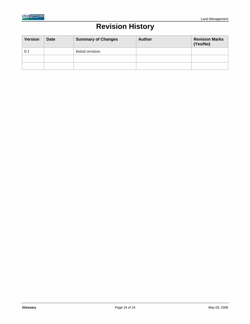
Land Management Revision History
Version Date Summary of Changes Author Revision Marks (Yes/No)
0.1 Initial revision.
Glossary Page 24 of 24 May 03, 2006