Embed Size (px)
Citation preview
HAW
AI’I
HAW
AI’I
HAW
AI’I
HAW
AI’I
HAW
AI’I
HAW
AI’I
HAW
AI’I
HAW
AI’I
HAW
AI’I
HAW
AI’I
STATUS OF CORAL REEFS IN THE HAWAIIAN ARCHIPELAGOSTATUS OF CORAL REEFS IN THE HAWAIIAN ARCHIPELAGOSTATUS OF CORAL REEFS IN THE HAWAIIAN ARCHIPELAGOSTATUS OF CORAL REEFS IN THE HAWAIIAN ARCHIPELAGOSTATUS OF CORAL REEFS IN THE HAWAIIAN ARCHIPELAGOSTATUS OF CORAL REEFS IN THE HAWAIIAN ARCHIPELAGOSTATUS OF CORAL REEFS IN THE HAWAIIAN ARCHIPELAGOSTATUS OF CORAL REEFS IN THE HAWAIIAN ARCHIPELAGOSTATUS OF CORAL REEFS IN THE HAWAIIAN ARCHIPELAGOSTATUS OF CORAL REEFS IN THE HAWAIIAN ARCHIPELAGO David Gulko, James Maragos, AlanDavid Gulko, James Maragos, AlanDavid Gulko, James Maragos, AlanDavid Gulko, James Maragos, AlanDavid Gulko, James Maragos, AlanDavid Gulko, James Maragos, AlanDavid Gulko, James Maragos, AlanDavid Gulko, James Maragos, AlanDavid Gulko, James Maragos, AlanDavid Gulko, James Maragos, Alan
Friedlander, Cynthia Hunter, and Russell BrainardFriedlander, Cynthia Hunter, and Russell BrainardFriedlander, Cynthia Hunter, and Russell BrainardFriedlander, Cynthia Hunter, and Russell BrainardFriedlander, Cynthia Hunter, and Russell BrainardFriedlander, Cynthia Hunter, and Russell BrainardFriedlander, Cynthia Hunter, and Russell BrainardFriedlander, Cynthia Hunter, and Russell BrainardFriedlander, Cynthia Hunter, and Russell BrainardFriedlander, Cynthia Hunter, and Russell Brainard
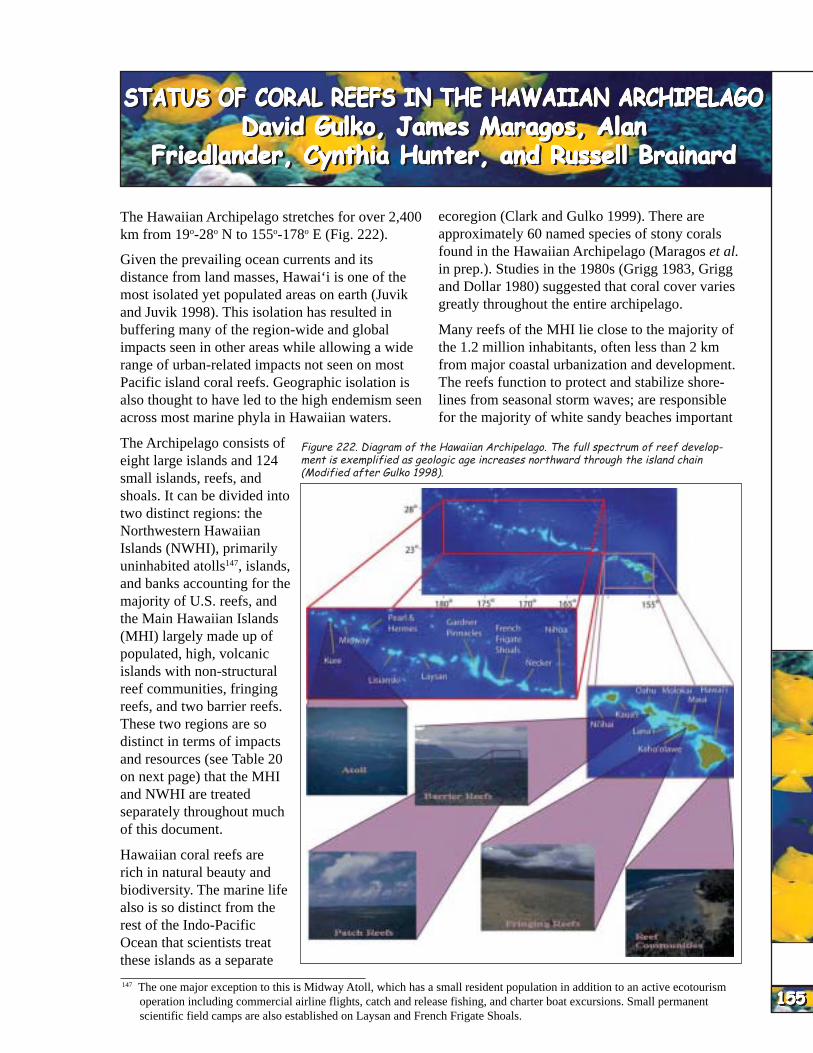
The Hawaiian Archipelago stretches for over 2,400 km from 19o-28o N to 155o-178o E (Fig. 222).
Given the prevailing ocean currents and its distance from land masses, Hawai‘i is one of the most isolated yet populated areas on earth (Juvik and Juvik 1998). This isolation has resulted in buffering many of the region-wide and global impacts seen in other areas while allowing a wide range of urban-related impacts not seen on most Pacific island coral reefs. Geographic isolation is also thought to have led to the high endemism seen across most marine phyla in Hawaiian waters.
The Archipelago consists of eight large islands and 124 small islands, reefs, and shoals. It can be divided into two distinct regions: the Northwestern Hawaiian Islands (NWHI), primarily uninhabited atolls147, islands, and banks accounting for the majority of U.S. reefs, and the Main Hawaiian Islands (MHI) largely made up of populated, high, volcanic islands with non-structural reef communities, fringing reefs, and two barrier reefs. These two regions are so distinct in terms of impacts and resources (see Table 20 on next page) that the MHI and NWHI are treated separately throughout much of this document.
Hawaiian coral reefs are rich in natural beauty and biodiversity. The marine life also is so distinct from the rest of the Indo-Pacific Ocean that scientists treat these islands as a separate
ecoregion (Clark and Gulko 1999). There are approximately 60 named species of stony corals found in the Hawaiian Archipelago (Maragos et al. in prep.). Studies in the 1980s (Grigg 1983, Grigg and Dollar 1980) suggested that coral cover varies greatly throughout the entire archipelago.
Many reefs of the MHI lie close to the majority of the 1.2 million inhabitants, often less than 2 km from major coastal urbanization and development. The reefs function to protect and stabilize shorelines from seasonal storm waves; are responsible for the majority of white sandy beaches important
147 The one major exception to this is Midway Atoll, which has a small resident population in addition to an active ecotourism operation including commercial airline flights, catch and release fishing, and charter boat excursions. Small permanent
Figure 222. Diagram of the Hawaiian Archipelago. The full spectrum of reef development is exemplified as geologic age increases northward through the island chain (Modified after Gulko 1998).
155155155155155155155155155155 scientific field camps are also established on Laysan and French Frigate Shoals.

HAW
AI’I
HAW
AI’I
HAW
AI’I
HAW
AI’I
HAW
AI’I
HAW
AI’I
HAW
AI’I
HAW
AI’I
HAW
AI’I
HAW
AI’I
156156156156156156156156156156
to the tourism industry; provide food products for Main Hawaiian Islands (MHI)Main Hawaiian Islands (MHI)Main Hawaiian Islands (MHI)Main Hawaiian Islands (MHI)Main Hawaiian Islands (MHI) recreational, subsistence, and commercial fishing
IntroductionIntroductionIntroductionIntroductionIntroductionfor residents and visitors; create Hawaii’s famous surfing spots; and are critically important to the The eight main islands that comprise the MHI (Fig. State’s $800 million per year marine tourism 223) range in age from 7 million years (Kaua‘i) to industry (Clark and Gulko 1999). less than a day old (portions of the eastern side of
Table 20. Summary of data on islands and reefs of the Hawaiian Archipelago (Sources: Clark and Gulko 1999, Maragos and Holthous 1999).
the island of Hawai‘i). A new volcanic island (Lo‘ihi) is presently forming about 975 m below the sea surface off the southeast coast of the island of Hawai‘i. This range of age along the chain of islands provides for the majority of recognized reef types to be present (Fig 224).
The MHI are largely comprised of populated, high volcanic islands with non-structural reef communities, fringing reefs, and two barrier reefs. Total reef area was estimated at 2,536 km2
(Hunter 1995). Detailed mapping of underwater benthic habitats is underway and expected to be done in 2002.
Culturally, the Polynesians who first settled the MHI had strong ties to coral reefs. According to the Hawaiian Hymn of Creation the Kumulipo, or coral polyp, was the first creature to emerge during creation. The presentation of corals as offerings during religious ceremonies also suggests the importance of these animals and the reefs they produce was not lost on the ancient Hawaiians. Coral reef resources provided food, medicines, building materials, and formed a portion of cultural and social customs important in ancient Hawai‘i.
Human impacts on Hawaiian coral reefs may have started the the construction of fish ponds atop reef flats throughout the MHI. Wide-scale degradation of
148 This includes NWHI areas such as French Frigate Shoals, Midway Atoll, and Kure.

HAW
AI’I
HAW
AI’I
HAW
AI’I
HAW
AI’I
HAW
AI’I
HAW
AI’I
HAW
AI’I
HAW
AI’I
HAW
AI’I
HAW
AI’I
Figure 223. View of Main Hawaiian Islands from space (Photo: NASA).
reefs began some 100 to 200 years ago with the expansion of Western influence on the islands. Livestock grazing and agriculture were the primary land uses on the islands of O‘ahu, Maui, Moloka‘i, and Lana‘i, contributing to erosion and sedimention on fringing reefs. Dredging and filling of near-shore reefs for residential, commercial, and military expansion increased in the last century148, resulting in further loss of reef habitat. Stream channelization and increased paving of land reduced sediment erosion but increased runoff. Despite these changes in coastal land use, the consensus of many ecologists is that nearshore reefs off the MHI, with a few exceptions, remain in relatively good condition.
Condition of ReefsCondition of ReefsCondition of ReefsCondition of ReefsCondition of Reefs
Algae and Higher Marine PlantsAlgae and Higher Marine PlantsAlgae and Higher Marine PlantsAlgae and Higher Marine PlantsAlgae and Higher Marine Plants – Abbott (1995) estimated over 400 species of marine algae are found throughout the Hawaiian Islands. Recent investigations suggest the majority of these species are red algae (Class Rhodophyta). This number
may be greatly underestimated (C. Smith pers. comm.). Endemism rates for most classes of Hawaiian algae are high. One endemic species of seagrass (Halophila hawaiiensis) is associated with shallow reef flats on Moloka‘i (Fig. 225).
CoralCoralCoralCoralCoral – Grigg (1993) examined coral species distribution throughout the MHI and found the islands of O‘ahu and Hawai‘i had the highest coral biodiversity. Hawaiian endemism is thought to be over 25% (Maragos 1995, Maragos et al. in prep.). The apparently limited distribution of some endemic coral species has raised concern for their potential extinction.
Recent analyses of data by the Hawai‘i Coral Reef Assessment and Monitoring Program (CRAMP) suggests live coral cover averages 18%149 for all sites surveyed. This estimate may be conservative, given the limited number of sites analyzed so far, and that the weight of information was taken in shallow water (2-3 m) relative to data from greater than 10 m where coral cover is often higher. Many reefs in Hawai‘i have live coral cover below 20 m.
Coral bleaching events that devastated reefs in many area of the
Figure 225. Halophila hawaiiensis is one of many Hawaiian endemic species (Photo: University of Hawaii Botany Department).
Figure 224. Timeline tracing the origins of the Hawaiian Islands and the Emperor Seamounts showing the formation and replacement of reef types over time (Modified after Gulko 1998).
149 With a range of 4-50%. 150 Resulting from persistently high sea surface temperatures associated with increased frequency of El Niño warming events. 157157157157157157157157157157

HAW
AI’I
HAW
AI’I
HAW
AI’I
HAW
AI’I
HAW
AI’I
HAW
AI’I
HAW
AI’I
HAW
AI’I
HAW
AI’I
HAW
AI’I
158158158158158158158158158158
Pacific during the last decade150 seemed to have missed the Hawaiian reefs. However, the corals are suspectible to locally elevated water temperatures and/or increased ultraviolet light penetration, often at the level of individual colonies (Jokiel and Coles 1990).
At least two type of coral disease commonly occur on Hawaiian reefs – general necroses and abnormal growth or ‘tumors’ (Hunter 1999). Necrotic coral tissues, whether caused by abrasion, predation, or pathogens, are rapidly invaded by fine filamentous algae and cyanobacteria (Fig. 226), followed by three potential outcomes: 1) recovery and overgrowth by adjacent healthy coral tissue, 2) successional change from turf to crustose coral-line algae on which new coral recruits become established, or 3) persistence of the turf community resulting in net loss of coral cover.
Coral diseases and tumors have been documented in most major reef-building coral species in the MHI: Porites lobata, P. compressa, Montipora capitata, M. patula, and Pocillopora meandrina (Peters et al. 1986, Hunter 1999).
Similar to other regions, incidence of coral disease on Hawaiian reefs does not appear to be consistently associated with known anthropogenic stressors (pollutants, proximity to urban centers; Glynn et al. 1984, Peters et al. 1986, Coles 1994, Hunter 1999). Preliminary pathological examination of two samples of diseased Porites coral tissues from Hanauma Bay, O‘ahu, identified bacterial associations that were similar to those associated with white-band bisease in Florida
Figure 226. Lobe coral (Porites lobata) showing tissue necroses, abnormal skeletal growth, and filamentous algae overgrowing live coral tissue (Photo: Cindy Hunter).
Figure 227. Lobsters are over-harvested in nearshore MHI waters (Photo: Donna Turgeon).
corals (Hunter 1999). No major die-off of corals has yet been documented due to disease outbreaks in Hawai‘i.
InvertebratesInvertebratesInvertebratesInvertebratesInvertebrates – Marine invertebrate biodiversity is relatively high in Hawai‘i. There are estimated to be over 100 sponge species (R. deFelice pers. comm.), 1071 species of marine molluscs (Kay 1995), 884 species of crustaceans (Eldredge 1995, Fig. 227), and 278 species of echinoderms (Eldredge and Miller 1995). Except for crustaceans, rates of endemism within these groups are among the highest in the Pacific.
Major outbreaks of the crown-of-thorns starfish (Acanthaster planci), which have occurred elsewhere in the Pacific, have been few in Hawai‘i. The last major occurrence was observed off Moloka‘i in the late 1960s and early 1970s (Branham et al. 1971, Gulko 1998). During this event, this seastar preyed on Montipora capitata, a species much less abundant than the dominant Porites species (J. Maragos pers. comm.). Lack of Acropora throughout the MHI, the dominance of Porites corals on most reefs151, and the islands’ overall isolation may help account for the lack of outbreaks.
FishFishFishFishFish – There are 557 species of reef and shore fishes in Hawai‘i (Randall 1995). The fish fauna in Hawai‘i is depauperate compared to the Indo-West Pacific from which it is derived and is characterized by a large number of endemic species (Hourigan and Reese 1987, Fig. 228). Hawai‘i possesses the highest percentage of endemic warm-water marine fish fauna found anywhere in the world (24.3%). Many of these species are
151 Corals in the family Acroporidae are among the favorite food items of crown-of-thorn starfish, while corals in the family Poritidae are not preferred, perhaps due to difficulty in digestion and symbiont defenses (Gulko 1998).
HAW
AI’I
HAW
AI’I
HAW
AI’I
HAW
AI’I
HAW
AI’I
HAW
AI’I
HAW
AI’I
HAW
AI’I
HAW
AI’I
HAW
AI’I
among the most common and abundant components of the fish assemblage (Randall 1996). Owing to its geographic and oceanographic isolation, a number of common fish families found throughout the Indo-Pacific region are poorly represented in Hawai‘i, particularly those with a short larval duration.
A steady decline in abundance of nearshore living resources in the MHI has been reported by fishermen and researchers over the past century (Shomura 1987). Overfishing is the major cause of the long-term statewide decline in fish abundance (Harman and Kitakaru 1988). Fishing pressure on nearshore resources in heavily populated areas appears to exceed the capacity of these resources to renew themselves (Smith 1993) and the abundance of reef fishes in areas not protected from fishing is substantially lower than in areas where fishing is prohibited (Grigg 1994).
Under-reporting by commercial fishers and the existence of a large number of recreational and subsistence fishers without licensing or reporting requirements, have resulted in uncertainty in catch statistics for the state (Lowe 1995). In an island state such as Hawai‘i, where as much as 35% of the resident population fishes (Hoffman and Yamauchi 1972, USFWS 1988), the recreational/subsistence catch may have a large impact on the nearshore marine resources.
Creel surveys in the MHI have shown the recreational catch to be equivalent to or greater than that reported in commercial fisheries landing data (Omnitrack 1991, Hamm and Lum 1992, Everson 1994). The few studies done in Hawai‘i to date have shown that recreational fishers take a higher diversity of species with a wider variety of gear types than do commercial fishers (Omnitrack 1991, Hamm and Lum 1992, Everson 1994). The recreational catch has been shown to be equal to or greater than the commercial catch for a number of important target species (Friedlander 1996). Hawai‘i is one of the few coastal states that does not require a saltwater recreational fishing license (Altman 1992).
A survey of the small-boat fisheries on O‘ahu, with emphasis on the recreational and subsistence fisheries, was conducted from March 1990 to May 1991 (Hamm and Lum 1992). About 41% of the total catch was identified as destined to be sold.
This figure is believed to be conservative since State law prohibits catch sales without a valid commercial fishing license. Only 22% of the fishers interviewed identified their catch as destined to be sold. Traps (65%) and nets (53%) had the highest proportion of sales. Creel surveys conducted at Kane‘ohe, Hanalei, and Hilo Bays have shown that there were significant differences between total and reported landings (Lowe 1995). Several gear types (spear, crab net, gill and surround net, trolling, and pole-and-line fishing) which are primarily recreation/subsistence in nature contribute much more to the total catch than is reported in commercial landings data.
In a creel survey conducted in Kane‘ohe Bay few fishers reported selling their catch (Everson 1994). Gill netters and surround netters had the highest percentage of catch sold (12%) while less than one percent of all other fishers reported selling their catch.
A comparison of fisheries landings from Hanalei Bay, Kaua‘i was made to State of Hawai‘i Department of Land and Natural Resources’ (DLNR) Division Aquatic Resources (DAR) commercial landings data and data obtained during a 1 1/2 year creel survey of the bay (Friedlander and Parrish 1997). On the whole, catches estimated from the creel survey were consistently higher than those reported to DAR. The differences ranged from a factor of less than two to more than 100 times the reported catch.
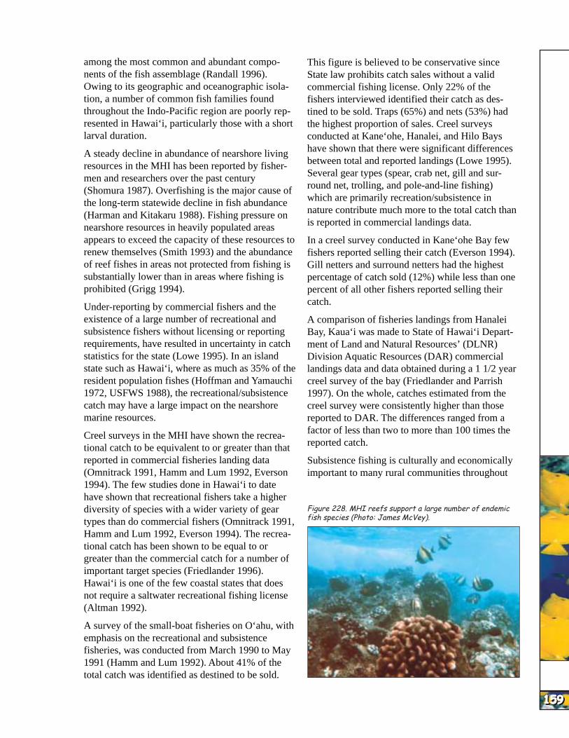
Subsistence fishing is culturally and economically important to many rural communities throughout
Figure 228. MHI reefs support a large number of endemic fish species (Photo: James McVey).
159159159159159159159159159159
HAW
AI’I
HAW
AI’I
HAW
AI’I
HAW
AI’I
HAW
AI’I
HAW
AI’I
HAW
AI’I
HAW
AI’I
HAW
AI’I
HAW
AI’I
NU
MB
ER
OF
PE
RM
ITS
IS
SU
ED
160160160160160160160160160160
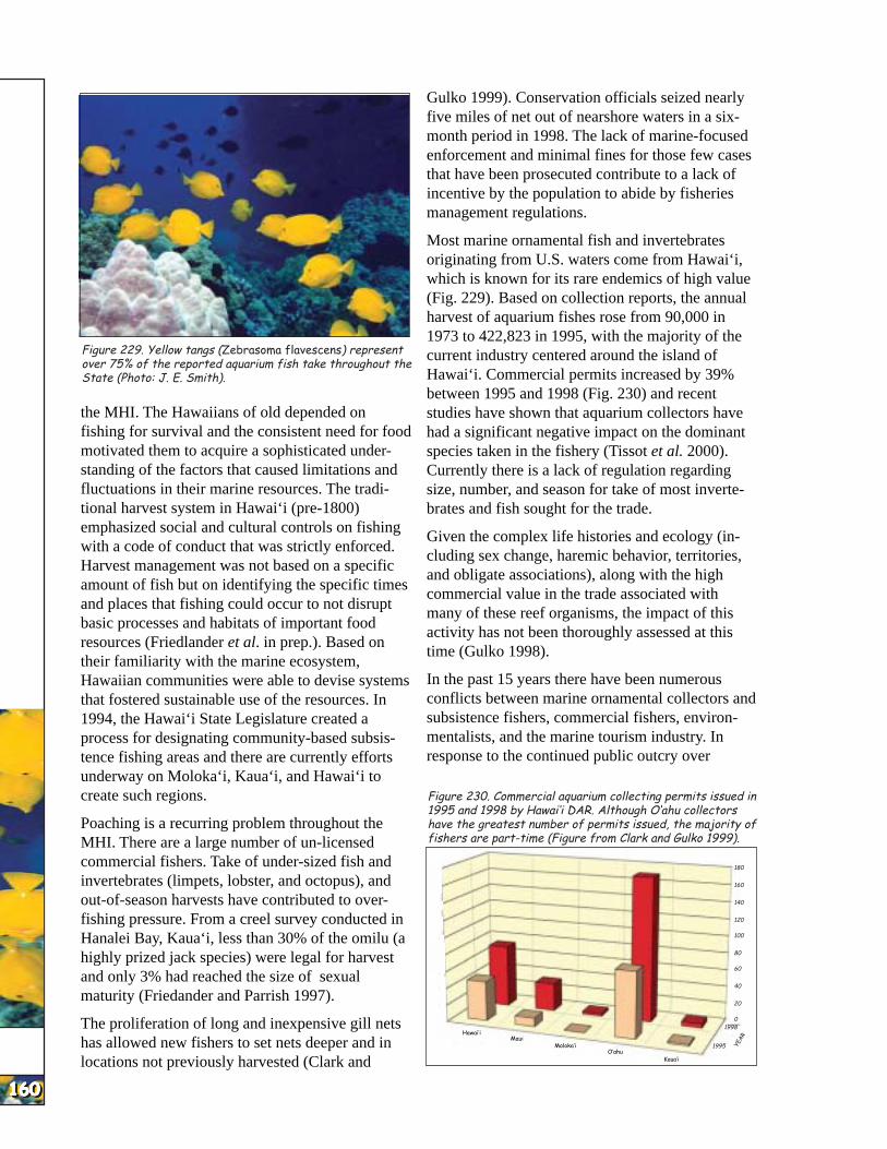
Figure 229. Yellow tangs (Zebrasoma flavescens) represent over 75% of the reported aquarium fish take throughout the State (Photo: J. E. Smith).
the MHI. The Hawaiians of old depended on fishing for survival and the consistent need for food motivated them to acquire a sophisticated understanding of the factors that caused limitations and fluctuations in their marine resources. The traditional harvest system in Hawai‘i (pre-1800) emphasized social and cultural controls on fishing with a code of conduct that was strictly enforced. Harvest management was not based on a specific amount of fish but on identifying the specific times and places that fishing could occur to not disrupt basic processes and habitats of important food resources (Friedlander et al. in prep.). Based on their familiarity with the marine ecosystem, Hawaiian communities were able to devise systems that fostered sustainable use of the resources. In 1994, the Hawai‘i State Legislature created a process for designating community-based subsistence fishing areas and there are currently efforts underway on Moloka‘i, Kaua‘i, and Hawai‘i to create such regions.
Poaching is a recurring problem throughout the MHI. There are a large number of un-licensed commercial fishers. Take of under-sized fish and invertebrates (limpets, lobster, and octopus), and out-of-season harvests have contributed to over-fishing pressure. From a creel survey conducted in Hanalei Bay, Kaua‘i, less than 30% of the omilu (a highly prized jack species) were legal for harvest and only 3% had reached the size of sexual maturity (Friedander and Parrish 1997).
The proliferation of long and inexpensive gill nets has allowed new fishers to set nets deeper and in locations not previously harvested (Clark and
Gulko 1999). Conservation officials seized nearly five miles of net out of nearshore waters in a six-month period in 1998. The lack of marine-focused enforcement and minimal fines for those few cases that have been prosecuted contribute to a lack of incentive by the population to abide by fisheries management regulations.
Most marine ornamental fish and invertebrates originating from U.S. waters come from Hawai‘i, which is known for its rare endemics of high value (Fig. 229). Based on collection reports, the annual harvest of aquarium fishes rose from 90,000 in 1973 to 422,823 in 1995, with the majority of the current industry centered around the island of Hawai‘i. Commercial permits increased by 39% between 1995 and 1998 (Fig. 230) and recent studies have shown that aquarium collectors have had a significant negative impact on the dominant species taken in the fishery (Tissot et al. 2000). Currently there is a lack of regulation regarding size, number, and season for take of most invertebrates and fish sought for the trade.
Given the complex life histories and ecology (including sex change, haremic behavior, territories, and obligate associations), along with the high commercial value in the trade associated with many of these reef organisms, the impact of this activity has not been thoroughly assessed at this time (Gulko 1998).
In the past 15 years there have been numerous conflicts between marine ornamental collectors and subsistence fishers, commercial fishers, environmentalists, and the marine tourism industry. In response to the continued public outcry over
Figure 230. Commercial aquarium collecting permits issued in 1995 and 1998 by Hawai‘i DAR. Although O‘ahu collectors have the greatest number of permits issued, the majority of fishers are part-time (Figure from Clark and Gulko 1999).
Hawai‘i
O‘ahu
180
160
140
120
100
80
60
40
20
0
Maui Moloka‘i
Kaua‘i
1998
1995 YEA
R

HAW
AI’I
HAW
AI’I
HAW
AI’I
HAW
AI’I
HAW
AI’I
HAW
AI’I
HAW
AI’I
HAW
AI’I
HAW
AI’I
HAW
AI’I
Figure 231. The newly designated West Hawai‘i Fish Replenishment Areas, or FRAS (Source: Hawaii DAR).
aquarium collecting, the Hawai‘i State legislature passed a bill in 1998 which focused on improving management of reef resources by establishing the West Hawai‘i Regional Fishery Management Area. A major component of the bill was to improve management of the aquarium industry by declaring a minimum of 30% of the western Hawai‘i island coastline as Fish Replenishment Areas (FRAs) and protect areas where aquarium fish collecting is prohibited. The FRAs restrict fish feeding by the commercial tour industry and eventually nonselective forms of fishing. Currently, over 35% of the West Hawai‘i coastline has been designated as FRAs (Fig. 231).
Commercial food harvest of invertebrates includes primarily limpets, octopus, lobster, and crabs. A wide variety of invertebrates are harvested for the marine ornamental trade. The harvest of sessile benthic invertebrates, especially the featherduster worm, (Sabellastarte sanctijosephi) for the aquarium trade often causes destruction of reef habitat during the collection process.
Figure 233. Endangered Hawaiian monk seals can still be seen on beaches of the MHI (Photo: James McVey).
In the final analysis, there is a realization that the harvest of fisheries resources in the MHI is under reported, making effective management of these resources difficult at this time.
Marine Reptiles and MammalsMarine Reptiles and MammalsMarine Reptiles and MammalsMarine Reptiles and MammalsMarine Reptiles and Mammals – There have been six species of sea turtles and 24 species of marine mammals reported on MHI reefs.
Sea turtles are fully protected under both Federal and State laws. The threatened green sea turtle (Chelonia mydas) makes use of the shallow waters of the MHI for herbivorous feeding and resting habitat, while the endangered Hawaiian hawksbill sea turtle (Eretmochelys imbricata) is thought to feed, rest, mate, and nest primarily in the MHI.
Figure 232. Tumors are much more common on turtles near the MHI (Photo: U. Keuper-Bennett and P. Bennett).
Prior to 1985, fibropapillomatosis (or turtle tumors) were rarely reported in Hawaiian green sea turtles in the MHI (Fig. 232). During the last ten years however, the numbers reported have increased dramatically. The condition is commonly found on turtles on Maui, Kaua‘i, and O‘ahu. Up to 60% of the turtles in Kane‘ohe Bay are infected (Balazs et al. 1998).
The yellow-bellied sea snake (Pelamis platurus) is sometimes seen at night offshore by fishers but rarely occurs in nearshore reef environments.
The endangered Hawaiian monk seal (Monachus schaunslandi) occurs primarily in the Northwestern Hawaiian Islands, but occasionally is found in near-shore waters and sometimes hauls out on beaches of the MHI (Fig. 233).
Water QualityWater QualityWater QualityWater QualityWater Quality – In the MHI, high nutrient
161161161161161161161161161161

HAW
AI’I
HAW
AI’I
HAW
AI’I
HAW
AI’I
HAW
AI’I
HAW
AI’I
HAW
AI’I
HAW
AI’I
HAW
AI’I
HAW
AI’I
162162162162162162162162162162
Figure 234. Nukoli Beach in Kaua‘i was closed to the public in 1998 when tarballs and dead oiled birds washed ashore following a spill off Barber’s Point, O‘ahu (Photo: Curtis Carlson).
levels are known to encourage algal growth that can cause overgrowth of living corals (Smith et al. 1981, Maragos et al. 1985). Algal blooms have been a recurring problem on reef flats off the southern and western coasts of Maui for nearly ten years. Hypnea, Sargassum, Dictyota, and Cladophora152 have all dominated the reef flat areas at various times, presumably due
Figure 235. The majority of the Hawaiianto nutrients leaching from urban population lives within 2 km of living
coral reefs (Photo: Hawai‘i DAR).cesspools, injection wells, and other non-point sources (Green 1997, Grigg 1997). Questions remain as to the influence of nutrients on the success of alien seaweed displacement of native corals (Woo, 2000). Nutrient enrichment (through either point or nonpoint source discharge) can also cause phytoplankton blooms limiting the sunlight necessary for most stony corals to survive. Additional concerns from runoff and seepage include bacteria and disease.
The Federal Clean Water Act requires a National Pollutant Discharge Elimination (NPDES) permit for any point source pollutant discharged into nearshore waters. Additionally, the Hawai‘i Coastal Zone Management Program and the Hawai‘i Department of Health are developing a Hawai‘i Coastal Nonpoint Source Pollution Control Plan to deal with discharges not covered under NPDES permits.
There has been a lack of standards for government agencies to follow when dealing with nutrient and pollutant discharges which take into account the specific impacts on corals and coral reef eco
systems; most of the existing guidelines are based on non-coral reef impacts.
Oil Spills and Toxic ChemicalsOil Spills and Toxic ChemicalsOil Spills and Toxic ChemicalsOil Spills and Toxic ChemicalsOil Spills and Toxic Chemicals – There is heavy reliance on imported oil in the islands, and therefore, oil and chemical spills are not uncommon. Most electricity production in the MHI is based on fossil fuels (Pfund 1992). Large urban populations, the military, and the tourist industry all use motor vehicles on all the major islands. More than 52 billion barrels per year of crude oil are brought to O‘ahu by large tanker vessels and then shipped to neighbor islands by inter-island barges.
Ship traffic, proximity of reefs to harbor entrances, and increasing numbers of vessel groundings have resulted in more oil spills. Pfund (1992) stated the USCG recorded a 200% increase in the number of oil spills from 1980 to 1990. While 40% of reported spills in the MHI are small153, there have been a number of large oil spills during the past two years (Clark and Gulko 1999). In most cases
these were either from ship groundings or release during oil offloading. In a recent case, a spill off O‘ahu caused the most damage when it washed ashore on Kaua‘i (Fig. 234).
In the past two years there have been a number of shore-based chemical spills from industrial or aquaculture sources (Clark and Gulko 1999). Sulfuric acid, PCBs, and refrigerants have
found their way onto nearshore reefs during the last year.
The projected large increase in cruise ship visits throughout the MHI154 has raised concerns over the constituents of the ‘gray water’ discharged by vessels in waters near Hawaiian reefs. Chemicals used to clean railings, decks, metal- and woodwork, drycleaning, and photoprocessing might find their way into nearshore waters during daily activities on these large vessels.
Harbors and urbanized, enclosed bays concentrate a wide variety of heavy metals, oils, PCBs, tributyltin (from boat paints), pesticides, and herbicides (Hunter et al. 1995, USFWS 1996, Green 1997). A majority of these areas in the MHI support coral reef organisms. High concentrations of
152 At press time a major bloom of the seaweed Cladophora sp. was occurring along the West Maui coast.

HAW
AI’I
HAW
AI’I
HAW
AI’I
HAW
AI’I
HAW
AI’I
HAW
AI’I
HAW
AI’I
HAW
AI’I
HAW
AI’I
HAW
AI’I
Table 21. Basic demographic and economic data for the islands of the Hawaiian Archipelago (derived from Juvik and Juvik 1998).
dieldrin and chlordane were found in oyster tissues sampled near stream mouths in Kane‘ohe Bay in 1991, five years after their use was banned in Hawai‘i. Lead, copper, chromium, and zinc were elevated in a number of samples, particularly near the southern, more urbanized, watersheds of the bay (Hunter et al. 1995). There has been scant research on the fate or action of potential toxicants in Hawaiian reef biota.
Research conducted in Kane‘ohe Bay by Peachey and Crosby (1995) showed a synergistic lethal effect of polycyclic aromatic hydrocarbons (PAHs) in seawater exposed to surface ultraviolet light. PAHs are produced as byproducts of municipal wastes and urban runoff, especially from oils used in automobiles and pavement. Ultraviolet light transforms the PAHs into toxic forms that kill crustaceans, polychaetes, and coral larvae.
Given the extensive urbanization of coastal areas in Hawai‘i, the large number of motor vehicles used on these small islands, and the channelization of streams and storm drains into nearshore reef environments, the phototoxicity posed by the introduction of PAHs has the potential to affect biodiversity and fisheries stocks.
Coastal Populations and ReefCoastal Populations and ReefCoastal Populations and ReefCoastal Populations and ReefCoastal Populations and Reef
Tourism 2000). The marine tourism industry is thought to bring over $800 million dollars per year into the State and employs over 7,000 people in over 1,000 small busi-nesses (Clark and Gulko 1999).
Commercial fishing revenues (ex-vessel value) generate another $68.5 million annually (NMFS 2001). Much of this (80-90%) is from pelagic, mostly longline fisheries, not coastal coral reef fisheries.
Environmental Pressures on Coral ReefsEnvironmental Pressures on Coral ReefsEnvironmental Pressures on Coral ReefsEnvironmental Pressures on Coral ReefsEnvironmental Pressures on Coral Reefs
Human StressesHuman StressesHuman StressesHuman StressesHuman Stresses – Nearshore coral reef environments in the MHI are subject to a range of human impacts, due in part to urbanization and the majority of the population living within a few kilometers of most major reefs (Gulko 1998, Fig 235). The impacts vary from island to island.
Alien SpeciesAlien SpeciesAlien SpeciesAlien SpeciesAlien Species – Some 19 species of macroalgae have been introduced to the island of O‘ahu since 1950 with at least four species being highly successful (Fig. 236). Some of these non-native species appear to have spread throughout the main Hawaiian Islands, while others are found so far only on O‘ahu. Recent studies have shown
163163163163163163163163163163
Figure 236. A time series of the same coral habitat over the period of EconomicsEconomicsEconomicsEconomicsEconomics a year. The large, massive Porites compressa colonies were overgrown
and killed by the invasive alga Kappaphycus alverezii. A. July 1998, B.
In 2000, an estimated 1.2 million people February 1999, C. April 1999, D. June 1999 (Photo from Woo 2000).
resided in the MHI (U.S. Bureau of the Census 2002). Since 1990, the size of MHI’s population has increased by 9.3% (U.S. Census Bureau 2002, Table 21). Over seven million visitors visit Hawaii; 88% of them engage in some form of marine water activity (State of Hawai‘i 2000).
Tourism is the largest industry, employer and revenue generator in the entire State. In 2000, visitor expenditures in Hawai’i totaled $10.9 billion (Hawai’i Department of Business, Economic Development, and
AAAAA BBBBB
CCCCC DDDDD
153 Less than 4,000 liters (1000 gallons). 154 See section on Ship Groundings.
HAW
AI’I
HAW
AI’I
HAW
AI’I
HAW
AI’I
HAW
AI’I
HAW
AI’I
HAW
AI’I
HAW
AI’I
HAW
AI’I
HAW
AI’I
164164164164164164164164164164
overgrowth and killing of coral by the alien alga species Kappaphycus spp. in Kane‘ohe Bay. These algae are thought to have caused a shift from a predominantly coral habitat to one characterized by a large, robust single species of seaweed in some areas of the bay (Woo 2000).
Such a habitat shift is thought to affect a range of processes from reef fish recruitment to trophic interactions and may have widespread influences on activities such as commercial fishing and the $800 million/yr marine tourism industry. Certain alien algae, such as Hypnea musiformis, often displace native or endemic algae which may be primary food items for the threatened Hawaiian green sea turtle (Chelonia mydas). Habitat shifts caused by these alien algal species may affect critical habitat necessary for feeding, resting, and
Figure 237. Now throughout the Hawaiian Archipelago, the blueline snapper is by far the most successful fish introduction (Photos: Richard Pyle).
mating for the endangered Hawaiian hawksbill sea turtle (Eretmochelys imbricata) (Gulko in press).
Many invertebrate species have been introduced, either accidentally or purposely, into Hawaiian waters (Eldredge 1994). Most have not had a documented effect on coral reefs. Alien sponges have been observed growing over corals in Kane‘ohe Bay, O‘ahu, and concerns have been raised about the introduced snowflake coral (Carijoa riisei) competing with shade-adapted corals in some areas (L. Eldredge pers. comm.).
At least 13 species of introduced marine fishes have become established in Hawai‘i (Eldredge 1994). Between 1951 and 1961, 11 demersal fish species – six groupers, four snappers, and the
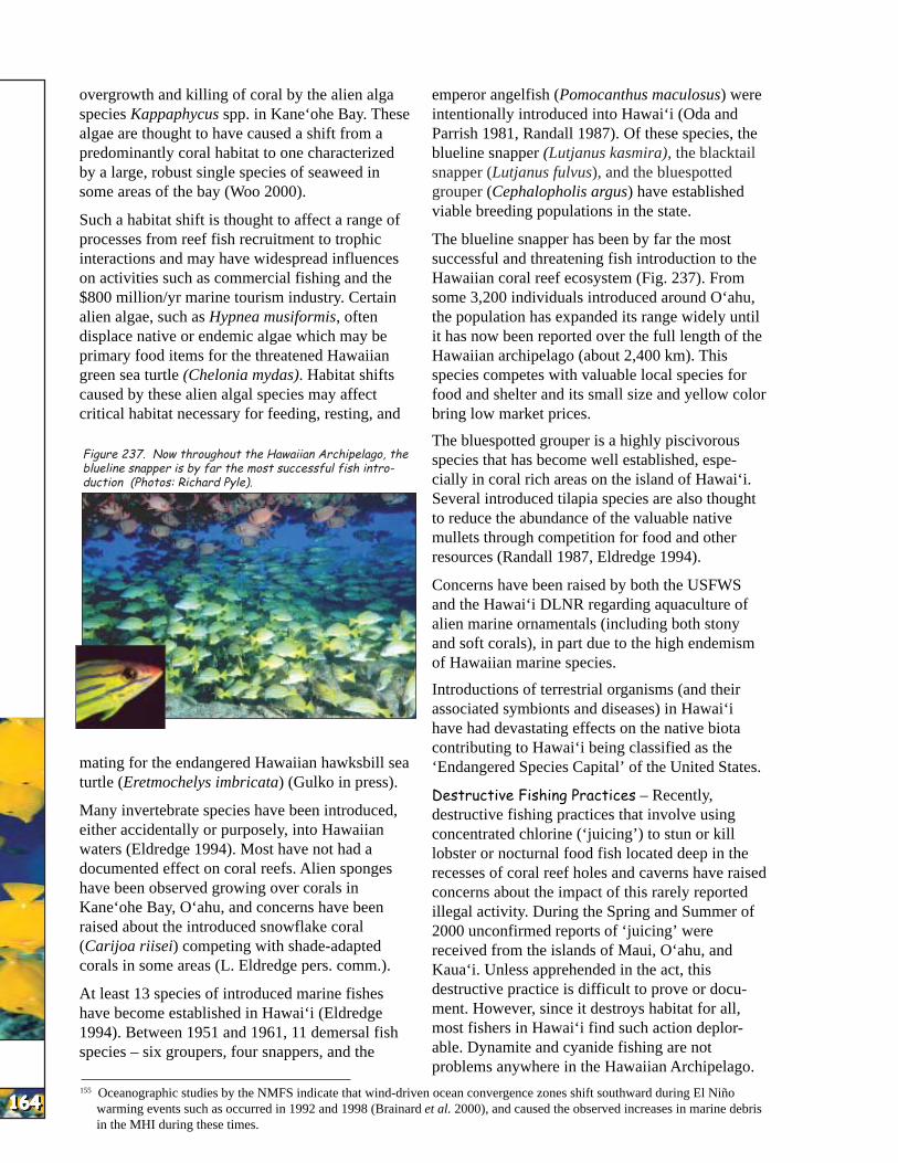
emperor angelfish (Pomocanthus maculosus) were intentionally introduced into Hawai‘i (Oda and Parrish 1981, Randall 1987). Of these species, the blueline snapper (Lutjanus kasmira), the blacktail snapper (Lutjanus fulvus), and the bluespotted grouper (Cephalopholis argus) have established viable breeding populations in the state.
The blueline snapper has been by far the most successful and threatening fish introduction to the Hawaiian coral reef ecosystem (Fig. 237). From some 3,200 individuals introduced around O‘ahu, the population has expanded its range widely until it has now been reported over the full length of the Hawaiian archipelago (about 2,400 km). This species competes with valuable local species for food and shelter and its small size and yellow color bring low market prices.
The bluespotted grouper is a highly piscivorous species that has become well established, especially in coral rich areas on the island of Hawai‘i. Several introduced tilapia species are also thought to reduce the abundance of the valuable native mullets through competition for food and other resources (Randall 1987, Eldredge 1994).
Concerns have been raised by both the USFWS and the Hawai‘i DLNR regarding aquaculture of alien marine ornamentals (including both stony and soft corals), in part due to the high endemism of Hawaiian marine species.
Introductions of terrestrial organisms (and their associated symbionts and diseases) in Hawai‘i have had devastating effects on the native biota contributing to Hawai‘i being classified as the ‘Endangered Species Capital’ of the United States.
Destructive Fishing Practices – Recently, destructive fishing practices that involve using concentrated chlorine (‘juicing’) to stun or kill lobster or nocturnal food fish located deep in the recesses of coral reef holes and caverns have raised concerns about the impact of this rarely reported illegal activity. During the Spring and Summer of 2000 unconfirmed reports of ‘juicing’ were received from the islands of Maui, O‘ahu, and Kaua‘i. Unless apprehended in the act, this destructive practice is difficult to prove or document. However, since it destroys habitat for all, most fishers in Hawai‘i find such action deplorable. Dynamite and cyanide fishing are not problems anywhere in the Hawaiian Archipelago.
155 Oceanographic studies by the NMFS indicate that wind-driven ocean convergence zones shift southward during El Niño warming events such as occurred in 1992 and 1998 (Brainard et al. 2000), and caused the observed increases in marine debris in the MHI during these times.
HAW
AI’I
HAW
AI’I
HAW
AI’I
HAW
AI’I
HAW
AI’I
HAW
AI’I
HAW
AI’I
HAW
AI’I
HAW
AI’I
HAW
AI’I
The extensive use of long gill nets throughout most of the MHI is thought to have caused localized depletion of reef fish through its effectiveness and non-selectivity. Bycatch of endangered species (sea turtles, Hawaiian monk seals) and breakage of high-relief coral colonies caused by untended nets continues despite State laws requiring that nets be checked at least every two hours and removed after four hours.
Collection of sessile benthic invertebrates for the marine ornamental trade has raised concerns about destruction of coral reef habitat from the removal of habitat-forming organisms such as anthozoans, sponges, bryozoans, and seaweeds. Extraction of cryptic or infaunal organisms, especially the featherduster worm, often leads to destruction of habitat through the collection process.
Marine Aquaculture – The Hawai‘i legislature recently passed a law that allows leasing of submerged lands for private enterprise. Two companies are currently seeking leases to conduct offshore aquaculture ventures. In both cases, proposed aquaculture facilities will be in close proximity to living coral reefs. Concerns raised by such activities relate primarily to eutrophication of coral reef habitat from excess feed and animal wastes diffusing out of the fish cages and into reef waters, the possibility of disease introduction to wild populations, introduction of alien species or symbionts, and aggregation of reef fish around these structures where they can be easily depleted.
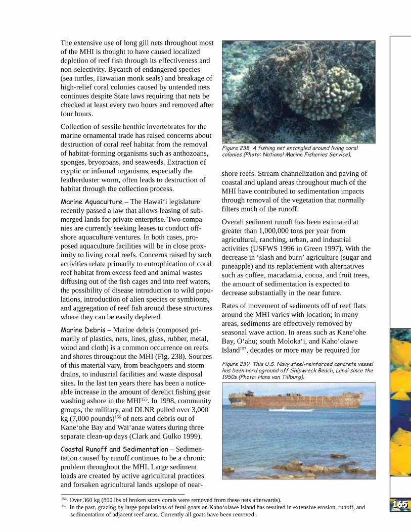
Marine Debris – Marine debris (composed primarily of plastics, nets, lines, glass, rubber, metal, wood and cloth) is a common occurrence on reefs and shores throughout the MHI (Fig. 238). Sources of this material vary, from beachgoers and storm drains, to industrial facilities and waste disposal sites. In the last ten years there has been a noticeable increase in the amount of derelict fishing gear washing ashore in the MHI155. In 1998, community groups, the military, and DLNR pulled over 3,000 kg (7,000 pounds)156 of nets and debris out of Kane‘ohe Bay and Wai‘anae waters during three separate clean-up days (Clark and Gulko 1999).
Coastal Runoff and Sedimentation – Sedimentation caused by runoff continues to be a chronic problem throughout the MHI. Large sediment loads are created by active agricultural practices and forsaken agricultural lands upslope of near-
Figure 238. A fishing net entangled around living coral colonies (Photo: National Marine Fisheries Service).
shore reefs. Stream channelization and paving of coastal and upland areas throughout much of the MHI have contributed to sedimentation impacts through removal of the vegetation that normally filters much of the runoff.
Overall sediment runoff has been estimated at greater than 1,000,000 tons per year from agricultural, ranching, urban, and industrial activities (USFWS 1996 in Green 1997). With the decrease in ‘slash and burn’ agriculture (sugar and pineapple) and its replacement with alternatives such as coffee, macadamia, cocoa, and fruit trees, the amount of sedimentation is expected to decrease substantially in the near future.
Rates of movement of sediments off of reef flats around the MHI varies with location; in many areas, sediments are effectively removed by seasonal wave action. In areas such as Kane‘ohe Bay, O‘ahu; south Moloka‘i, and Kaho‘olawe Island157, decades or more may be required for
Figure 239. This U.S. Navy steel-reinforced concrete vessel has been hard aground off Shipwreck Beach, Lanai since the 1950s (Photo: Hans van Tillburg).
156 Over 360 kg (800 lbs of broken stony corals were removed from these nets afterwards). 157 In the past, grazing by large populations of feral goats on Kaho‘olawe Island has resulted in extensive erosion, runoff, and
sedimentation of adjacent reef areas. Currently all goats have been removed. 165165165165165165165165165165

HAW
AI’I
HAW
AI’I
HAW
AI’I
HAW
AI’I
HAW
AI’I
HAW
AI’I
HAW
AI’I
HAW
AI’I
HAW
AI’I
HAW
AI’I
166166166166166166166166166166
accumulated sediments to be winnowed from reef flats.
Ship Groundings – Ship groundings are a persistent problem (Fig. 239). Over 16,000 commercial and recreational vessels are registered in the State of Hawai‘i; with the transient commercial and recreational vessels, over 18,500 ships ply the nearshore waters of the MHI annually. Given the close proximity of coral reefs to harbors, marinas, and channels, groundings occur frequently, primarily small recreational boats158. Such vessel groundings are often caused by broken moorings, inexperienced boaters, or faulty equipment. The situation with grounded recreational boats is compounded by a lack of coordination and timely notification between the agencies responsible for notification and the resource trustee often resulting in no assessment for environmental damage.
An additional concern related to shipping is the projected increase in large cruise ship traffic to the MHI. Hawai‘i has one cruise ship company which recently acquired a second large cruise ship and currently makes over 312 port calls in the MHI a year; large, international cruise ships made 97 port calls in 1998. This industry is projected to triple in the next four years (Clark and Gulko 1999). With limited port facilities and the desire to have ports of call throughout the islands, concerns have been raised regarding anchoring areas for these huge ships in close proximity to coral reefs on many of the neighbor islands. Freight vessel traffic is also projected to increase and harbor facilities (many of which are adjacent to coral reefs) will need to be expanded.
Tourism and Marine Recreation – Impacts from the tourism industry range from boating-associated impacts to development of coastal areas to overuse
of reef resources by commercial dive andFigure 240. Vessel groundings occurring between 1993 and 2000 in the MHI (Source: DOBOR, Hololulu Advertiser, Honolulu Star Bulletin). snorkel tours (Fig. 241).
Hawai‘i continues to be a majorTow Boats 1% Industrial Vessels destination for recreational SCUBA divers.
Freighters 3% Rodale’s Scuba Diving Magazine rated4%
Offshore Supply Vessels Hawai‘i as one of the top five most Fishing Boats popular diving destinations in the world1%
28% for the year 2000159; the tiny islet of Molokini was rated as the third best dive site world-wide.
Passenger Boats Concerns about overuse by commercialMilitary 59%
4%
A number of large vessels have grounded on MHI coral reefs in the last several years (Fig. 240). Two military amphibious vessels ran aground on reefs off the windward side of O‘ahu. In 1999 a large troop vessel struck a patch reef in Kane‘ohe Bay but was quickly removed. In 2000, a longlining fishing vessel (the F/V Van Loi) ran aground on a fringing reef directly adjacent to the shoreline of Kaua‘i while enroute to the NWHI; portions of that vessel still remain atop the reef. As with almost all civilian vessel groundings that occur in Hawai‘i, the parties responsible for groundings have not had to cover the majority of the cost for vessel salvage. For all vessels, restitution for physical damage to reef resources is rarely made.
tourism have led to early attempts at limiting access either by controlling entry
to parking facilities for coastal MPAs (Hanauma Bay MLCD) or by limiting the number of mooring permits available (Molokini MLCD). To minimize anchor damage from repetitive visits to major dive sites, DLNR, in partnership with the dive industry, has placed hundreds of day-use moorings around the MHI. A number of companies have introduced new technologies such as tourist submarines, underwater propulsion units, ‘seawalkers’ (a type of surface-supplied helmet rig), and rebreathers. Concerns exist related to lack of oversight for these activities and their potential impacts.
Marine tourism is often the dominant impact in the few areas of the State set aside as no-take MPAs. For example, over a million people a year visit the 0.65-km2 (1/4 square mile) reef of the no-take
158 Less than 15 m (46 feet). 159 Hawai‘i consistently ranks in the top ten for diving and snorkeling destinations.
HAW
AI’I
HAW
AI’I
HAW
AI’I
HAW
AI’I
HAW
AI’I
HAW
AI’I
HAW
AI’I
HAW
AI’I
HAW
AI’I
HAW
AI’I
Figure 241. Getting ready to dive for the first time, this class of new snorkelers is standing on the reef (Photo: Hawaii Division of Aquatic Resources).
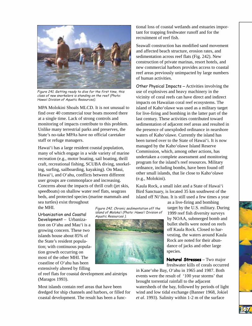
MPA Molokini Shoals MLCD. It is not unusual to find over 40 commercial tour boats moored there at a single time. Lack of strong controls and monitoring of impacts contribute to this problem. Unlike many terrestrial parks and preserves, the State’s no-take MPAs have no official caretaker staff or refuge managers.
Hawai‘i has a large resident coastal population, many of which engage in a wide variety of marine recreation (e.g., motor boating, sail boating, thrill craft, recreational fishing, SCUBA diving, snorkeling, surfing, sailboarding, kayaking). On Maui, Hawai‘i, and O‘ahu, conflicts between different user groups are commonplace and increasing. Concerns about the impacts of thrill craft (jet skis, speedboats) on shallow water reef flats, seagrass beds, and protected species (marine mammals and sea turtles) exist throughout the MHI.
tional loss of coastal wetlands and estuaries important for trapping freshwater runoff and for the recruitment of reef fish.
Seawall construction has modified sand movement and affected beach structure, erosion rates, and sedimentation across reef flats (Fig. 242). New construction of private marinas, resort hotels, and new commercial harbors provides access to coastal reef areas previously unimpacted by large numbers of human activities.
Other Physical Impacts – Activities involving the use of explosives and heavy machinery in the vicinity of coral reefs can have direct and indirect impacts on Hawaiian coral reef ecosystems. The island of Kaho‘olawe was used as a military target for live-firing and bombing in the latter part of the last century. These activities contributed toward sedimentation of adjacent reef areas and resulted in the presence of unexploded ordinance in nearshore waters of Kaho‘olawe. Currently the island has been turned over to the State of Hawai‘i. It is now managed by the Kaho‘olawe Island Reserve Commission, which, among other actions, has undertaken a complete assessment and monitoring program for the island’s reef resources. Military ordnance, including bombs, have been found off other small islands, that lie close to Kaho‘olawe (e.g., Molokini).
Kaula Rock, a small islet and a State of Hawai‘i Bird Sanctuary, is located 35 km southwest of the island off Ni‘ihau. It is still used a few times a year
as a live-firing and bombing
167167167167167167167167167167
Urbanization and Coastal Aquatic Resources ).Development – Urbanization on O‘ahu and Mau‘i is a growing concern. These two islands house about 85% of the State’s resident population; with continuous population growth occurring on most of the other MHI. The coastline of O‘ahu has been extensively altered by filling of reef flats for coastal development and airstrips (Maragos 1993).
Most islands contain reef areas that have been dredged for ship channels and harbors, or filled for coastal development. The result has been a func-
Figure 242. Chronic sedimentation off the target by the U.S. military. During island of Moloka‘i (Photo: Hawai‘i Division of 1999 reef fish diversity surveys
by NOAA, submerged bomb and bullet shells were noted on reefs off Kaula Rock. Closed to harvesting, the waters around Kaula Rock are noted for their abundance of jacks and other large species.
Natural StressesNatural StressesNatural StressesNatural StressesNatural Stresses – Two major freshwater kills of corals occurred
in Kane‘ohe Bay, O‘ahu in 1965 and 1987. Both events were the result of ‘100 year storms’ that brought torrential rainfall to the adjacent watersheds of the bay, followed by periods of light wind and low tidal exchange (Banner 1968, Jokiel et al. 1993). Salinity within 1-2 m of the surface
HAW
AI’I
HAW
AI’I
HAW
AI’I
HAW
AI’I
HAW
AI’I
HAW
AI’I
HAW
AI’I
HAW
AI’I
HAW
AI’I
HAW
AI’I
168168168168168168168168168168
was reduced to 15 ppt for 2-3 days, causing mass Hawaiian Archipelago. Warmer than normal SSTs mortality of corals and sedentary invertebrates on in Hawaiian waters are generally observed during the shallow reef tops and slopes. In both cases, La Niña cold events. delivery of large amounts of freshwater into the No major bleaching events were observed innearshore environment was facilitated by Hawai‘i during the 1997-98 worldwide coralchannelization of streambeds and paving of bleaching event. Hoegh-Guldberg (1999) in a recentlowland coastal areas throughout the watershed. report on the future of global bleaching events Differences in depth distributions of dominant reef suggested that the central Pacific, and especially corals on nearshore reefs in semi-estuarine Hawai‘i, will be among the last reefs to experience environments may be predicted by their relative major bleaching events. This is thought to be sensitivity to osmotic stress (Hunter and Krupp mostly due to Hawaii’s subtropical and north1997). After experimental treatment in conditions central location in regards to existing oceanic gyres similar to those generated by episodic rainfall and the broad expanse of deep water surrounding events (15 ppt salinity for 48 h), mortality was the islands. However, many of the corals live close highest in Montipora capitata, intermediate in to their maximum temperature limits and elevated Porites compressa, and lowest in Fungia scutaria. seawater temperatures may result in some level of In P. compressa, despite complete withdrawal of bleaching and/or mortality (Jokiel and Coles 1990). tissue from colony surfaces, intact mesenteries and undifferentiated tissues (and zooxanthellae) persist Current Conservation ManagementCurrent Conservation ManagementCurrent Conservation ManagementCurrent Conservation ManagementCurrent Conservation Management in a layer 2-7 mm below the skeletal surface.
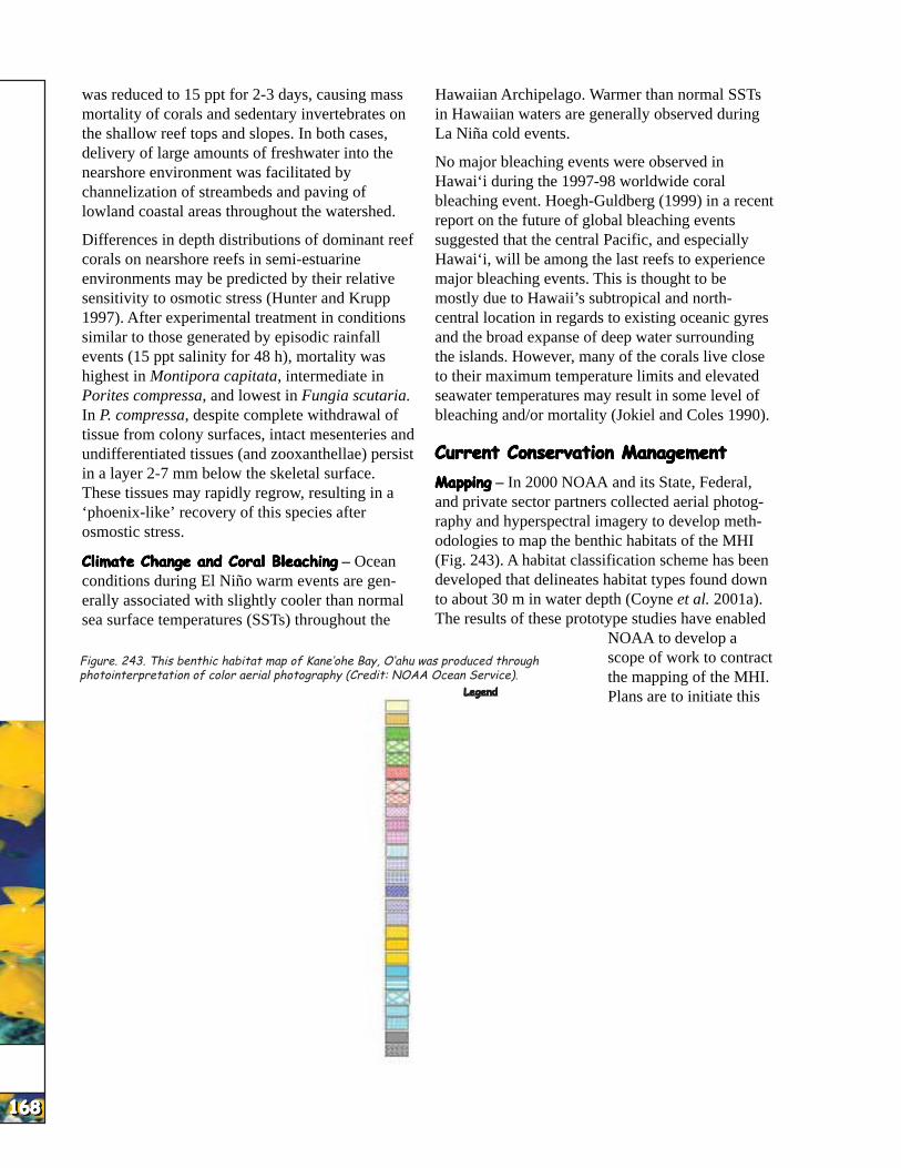
MappingMappingMappingMappingMapping – In 2000 NOAA and its State, Federal,These tissues may rapidly regrow, resulting in a and private sector partners collected aerial photog‘phoenix-like’ recovery of this species after raphy and hyperspectral imagery to develop methosmostic stress. odologies to map the benthic habitats of the MHI Climate Change and Coral BleachingClimate Change and Coral BleachingClimate Change and Coral BleachingClimate Change and Coral BleachingClimate Change and Coral Bleaching – Ocean (Fig. 243). A habitat classification scheme has been conditions during El Niño warm events are gen- developed that delineates habitat types found down erally associated with slightly cooler than normal to about 30 m in water depth (Coyne et al. 2001a). sea surface temperatures (SSTs) throughout the The results of these prototype studies have enabled
NOAA to develop a Figure. 243. This benthic habitat map of Kane‘ohe Bay, O‘ahu was produced through scope of work to contract photointerpretation of color aerial photography (Credit: NOAA Ocean Service). the mapping of the MHI.
LegendLegendLegendLegendLegend Plans are to initiate this Sand
Mud work in 2002 and Seagrass (Continuous) complete it in 2005.Seagrass (10-50%) Seagrass (50-90%) Research andResearch andResearch andResearch andResearch and Macroalgae (Continuous) Macroalgae (10-50%) MonitoringMonitoringMonitoringMonitoringMonitoring – Funds Macroalgae (50-90%) provided by Congress,Encrusting Coralline Algae (Cont.) Encrusting Coralline Algae (50-90%) through NOAA’s Ocean Encrusting Coralline Algae (10-50%) Service (NOS), helped Colonized Vertical Island Walls Patch Reef (Individual) establish the Hawai‘i Coral Head (Individual) Coral Reef Initiative Coral Head (Aggregated) Research ProgramColonized Pavement
Colonized Pave. with Sand/Surge Chan. (HCRI-RP); a Uncolonized Pavement partnership between theReef Rubble Uncolonized Pave. with Sand/Surge Chan. University of Hawai‘i Mangrove and the State of Hawai‘i Artificial Dredged Department of Land and Terrigenous Rubble Natural Resources,Cultural Unknown Division of Aquatic Land Resources.
HAW
AI’I
HAW
AI’I
HAW
AI’I
HAW
AI’I
HAW
AI’I
HAW
AI’I
HAW
AI’I
HAW
AI’I
HAW
AI’I
HAW
AI’I
Figure 244. A bleached finger coral (Porites compressa) colony in Kane‘ohe Bay, O‘ahu (Photo: James Maragos).
The goals of the HCRI-RP are to: • Assess major threats to coral reef ecosystems,
and provide information for more effective management,
• Advance the understanding of the biological and physical processes that affect the health of coral reefs and build management capacity,
• Develop a database to store and access data, • Conduct public awareness programs on the
threats to coral reefs, and • Implement education and training for coral reef
scientists and managers.
In June of 1998, DLNR and the East West Center co-sponsored the first Hawai‘i Coral Reef Monitoring Workshop (Maragos and Grober-Dunsmore, eds. 2000). Participants recognized that Hawaii’s coral reefs contribute hundreds of millions of dollars annually to the local economy through both tourism and fisheries, and that despite this importance, there were few programs in place to detect changes that might signal their existing or future degradation. In addition, it was also recognized that monitoring was an integral function of management. The workshop brought together regional and global experts in coral reef monitoring, coral reef research and coral reef management to compare existing methodologies and define protocols that would help revamp current management strategies and approaches.
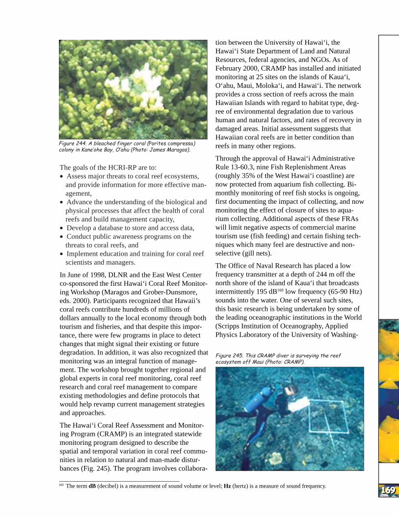
The Hawai‘i Coral Reef Assessment and Monitoring Program (CRAMP) is an integrated statewide monitoring program designed to describe the spatial and temporal variation in coral reef communities in relation to natural and man-made disturbances (Fig. 245). The program involves collabora
tion between the University of Hawai‘i, the Hawai‘i State Department of Land and Natural Resources, federal agencies, and NGOs. As of February 2000, CRAMP has installed and initiated monitoring at 25 sites on the islands of Kaua‘i, O‘ahu, Maui, Moloka‘i, and Hawai‘i. The network provides a cross section of reefs across the main Hawaiian Islands with regard to habitat type, degree of environmental degradation due to various human and natural factors, and rates of recovery in damaged areas. Initial assessment suggests that Hawaiian coral reefs are in better condition than reefs in many other regions.
Through the approval of Hawai‘i Administrative Rule 13-60.3, nine Fish Replenishment Areas (roughly 35% of the West Hawai‘i coastline) are now protected from aquarium fish collecting. Bimonthly monitoring of reef fish stocks is ongoing, first documenting the impact of collecting, and now monitoring the effect of closure of sites to aquarium collecting. Additional aspects of these FRAs will limit negative aspects of commercial marine tourism use (fish feeding) and certain fishing techniques which many feel are destructive and nonselective (gill nets).
The Office of Naval Research has placed a low frequency transmitter at a depth of 244 m off the north shore of the island of Kaua‘i that broadcasts intermittently 195 dB160 low frequency (65-90 Htz) sounds into the water. One of several such sites, this basic research is being undertaken by some of the leading oceanographic institutions in the World (Scripps Institution of Oceanography, Applied Physics Laboratory of the University of Washing-
Figure 245. This CRAMP diver is surveying the reef ecosystem off Maui (Photo: CRAMP).
160 The term dB (decibel) is a measurement of sound volume or level; Hz (hertz) is a measure of sound frequency. 169169169169169169169169169169
HAW
AI’I
HAW
AI’I
HAW
AI’I
HAW
AI’I
HAW
AI’I
HAW
AI’I
HAW
AI’I
HAW
AI’I
HAW
AI’I
HAW
AI’I
170170170170170170170170170170
Figure 246. The Hawaiian Islands Humpback Whale National Marine Sanctuary is one of many MPAs protecting Hawaiian coastal resources (Photo: Lewis Herman).
ton, Woods Hole Oceanographic Institution, and the Massachusetts Institute of Technology). The data collected may provide insight into the global warming debate and an understanding of multi-year ocean warming/cooling events such as El Niño and La Niña. Questions have been raised by various groups as to the possible impacts of this research activity on marine organisms ranging from reef fish and sea turtles to Hawaiian monk seals and humpback whales. Environmental analysis conducted by the Navy and determinations by regulatory agencies with jurisdiction over coastal resources and marine mammals have indicated the project will not have adverse impacts.
A wide range of volunteer monitoring programs exist in the MHI. The international volunteer monitoring program, Reef Check, conducts periodic surveys throughout the MHI. Impact-specific monitoring is conducted in a number of communities on various islands. In an effort to better coordinate these activities, provide for management applicability of the data collected, and minimize coral reef impacts caused by such volunteer activities themselves, DLNR has embarked on a program to create a number of materials for use by such groups:
• Best Practices Guidelines: a pamphlet that provides best management practices for various types of activities on Hawaiian coral reefs; planned to be distributed directly to the marine tourism industry.
• Visual Impact Card: uses photographs to train divers to identify specific types of coral reef impacts; for example, to distinguish coral disease from fish bites.
• Volunteer Monitoring Techniques Training Manual.
Both Federal and State agencies partner to involve volunteers and the community in alien species awareness, monitoring, and mitigation. Under the guidance of the USFWS, a large multi-agency161
partnership – Marine Ecosystems Global Informational Systems (MEGIS) Group – was formed over the last two years to create a computerized GIS database to share coral reef habitat maps and management data, initially for the Hawaiian Islands, and eventually for other portions of the U.S. Pacific.
In September of 1999, DLNR brought together a wide range of recognized Hawaiian academic experts and marine resource managers to develop a list of proposed Hawaiian marine species to be considered by the Federal government for candidate species status as allowed for under the Endangered Species Act (ESA). The list of recommendations needs to be sent as a petition for consideration to the NMFS Office of Protected Resources. Those species that successfully are classified as ‘Candidate Species’ will be considered by NMFS for possible addition to the List of Threatened and Endangered Species. At this stage, proposed candidate species status serves to notify the public, user groups, managers, and policy makers of concerns regarding these species162 that may warrant listing in the future and facilitate voluntary conservation efforts. A preliminary list of all species is reported in Maragos (2000).
The following criteria for listing species were proposed for consideration: restricted range, threats throughout range, limited dispersion, limited reproduction, prolonged time to reach maturity,
Figure 247. Percentage of coral reef area in the MHI regarding type of protection163 afforded natural resources
161 Includes Federal agencies (NOS, NMFS, NPS, USFWS, USGS), State Agencies (DLNR, Dept. of Planning, CZM), the academic community (the University of Hawaii and Bishop Museum), and other nongovernmental organizations.
162 Under the ESA, distinct vertebrate populations in addition to species can be considered for protection.

HAW
AI’I
HAW
AI’I
HAW
AI’I
HAW
AI’I
HAW
AI’I
HAW
AI’I
HAW
AI’I
HAW
AI’I
HAW
AI’I
HAW
AI’I
biological dependency (obligate associations with ary (Clark and Gulko 1999, Maragos 2000; Fig. other organisms), life history characteristics, 246; Table 22). Several no-take MLCDs around depleted food/prey, overfished (includes food, Hawai‘i have proven to be effective in increasing aquarium use, research use and bioprospecting) fish standing stock. Less restrictive MLCDs pro-and competitive exclusion. Examples of species selected by the group include a number of endemic corals which are currently limited in their range even within the Hawaiian Islands (Montipora dilatata, Porites pukoensis, Porites duerdeni); fish and invertebrates which have been overfished for food (Cellana talcosa, Epinephalus quernus, Epinephalus lanceolatus, Scarus perspicillatus), the marine ornamental trade (Heteractis malu, Centropyge loriculus), or research (Lingula reevii, Euprymna scolopes); and habitat-forming organisms of limited range threatened by human activities (Halophila hawaiiana).
MPAs and No-take ReservesMPAs and No-take ReservesMPAs and No-take ReservesMPAs and No-take ReservesMPAs and No-take Reserves – Closing areas to fishing is far from a new idea in the management of marine resources. Hawaiians used a variety of traditional marine resource management practices, which included ‘kapus’ or fishery closures. These closures were often imposed to ensure catches for special events or as a cache for when resources on the regular fishing grounds ran low. Various types of protected status currently exist for Hawaiian reefs and include Marine Life Conservation Districts (MLCDs), Fisheries Management Areas (FMAs), a Marine Laboratory Refuge, Natural Area Reserves (NARs), National Wildlife Refuges, and the Hawaiian Islands Humpback Whale National Marine Sanctu-
Table 22. Summary of data on coral reef marine protected areas (MPAs) of the Hawaiian Archipelago.
163 ‘MPA’ in this figure refers to Marine Protected Areas that afford some protection against certain forms of extraction, but may allow other types to occur; ‘No-take MPA’ refers to designated MPAs where no extraction is allowed. 171171171171171171171171171171

HAW
AI’I
HAW
AI’I
HAW
AI’I
HAW
AI’I
HAW
AI’I
HAW
AI’I
HAW
AI’I
HAW
AI’I
HAW
AI’I
HAW
AI’I
172172172172172172172172172172
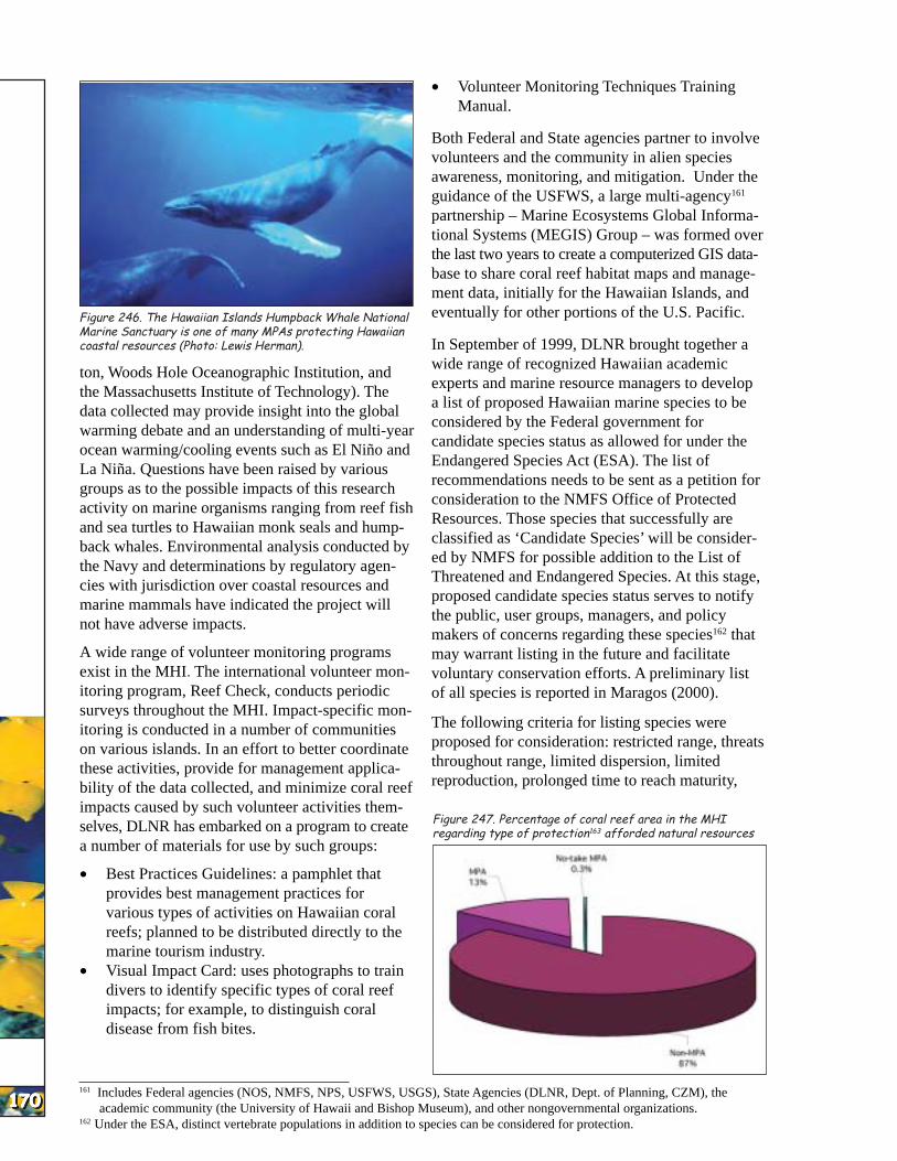
vide limited protection from consumptive practices and fish populations have not benefited significantly from the creation of these areas (Friedlander in press). In addition, certain MLCDs are popular tourist destinations and experience intensive non-consumptive impacts such as fish-feeding, large-scale commercial marine tourism, and tourist-related pollution (Gulko 1998). The new Kona Coast FMA, which restricts the collection of fish for the marine ornamental trade, appears to be increasing standing stocks of targeted fish species relative to nearby unprotected areas (Tissot et al. 2000). Despite their proven effectiveness, functional no-take areas account for only 0.3% of coastal areas in state waters (Fig. 247).
On the island of O‘ahu, there are three MLCDs and multiple FMAs. Hanauma Bay was established as the state’s first MLCD in 1967, and comprises 0.41 km2 (101 acres). Taking of all marine life is prohibited in the bay. The 0.1-km2 (25 acres) Pupukea MLCD is located on the north shore of O‘ahu and was established in 1983. Pole-and-line fishing is currently permitted from the shoreline, and taking of seaweed is also permitted. Spearfishing without SCUBA is permitted throughout this MLCD, and the use of nets is allowed in the MLCD’s northern portion. Established in 1988, the Waikiki MLCD is very small and comprises 0.3 km2 (76 acres) at one end of Waikiki Beach. The area consists of a low-relief reef flat that extends approximately 35 m out to a dredged channel. The marine area adjacent to the MLCD has been greatly altered by shoreline construction, beach nourishment, terrestrial inputs, and proximity to a large urban population. In
Figure 248. Comparison of fish standing stock (biomass) between various O‘ahu MPAs (Friedlander in press).
addition to these three MLCDs, the Waikiki-Diamond Head Shoreline Fisheries Management Area (FMA) is another regulated fishing area on O‘ahu. This area is adjacent to the Waikiki MLCD and extends eastward. The area is open to fishing on even-numbered years and closed on odd-numbered years. During the open years, nighttime spearfishing and the use of gillnets is prohibited. These four areas represent a wide variety of sizes, habitat types, and management strategies.
Notwithstanding differences in location, size, and habitat type there is a dramatic difference in fish biomass between the Hanauma Bay MLCD and the other protected areas (Fig. 248). A study by Brock and Kam (1993) showed that benefits derived from the Waikiki-Diamondhead Shoreline Fisheries Management Area closures were lost quickly when the area was reopened to fishing. As a result, the overall standing stock in the zone never exceeded 50 g/m2 during their study. The Pupukea MLCD is very small (0.1 km2) and allows a wide range of fishing activities. Not surprisingly, this area possesses the lowest standing stock of fish compared to the other protected areas on O‘ahu. These results point to the fact that a no-take MPA with good habitat diversity and complexity can have a positive effect on fish standing stock.
No-take MLCDs around other areas of Hawai‘i have also proven to be effective management strategies for increasing fish standing stock. Kealakekua Bay on the island of Hawai‘i was established as an MLCD in 1969 and Honolua-Mokuleia Bay on Maui was established as an MLCD in 1978.
All fishing is prohibited in specific subzones of these MPAs and the biomass of fish has increased steadily in these areas (Fig. 249) since their inception (Friedlander in press).
Gaps in Current Monitoring and ConservationGaps in Current Monitoring and ConservationGaps in Current Monitoring and ConservationGaps in Current Monitoring and ConservationGaps in Current Monitoring and Conservation CapacityCapacityCapacityCapacityCapacity
One of the primary problems is enforcement of existing laws and regulations. Additionally, while many State and Federal laws and regulations concern coral reefs or impacts on them, there are few that deal directly with the protection of reef ecosystems (Gulko 1998). Many State regulations have not kept up with new technologies, new uses of natural resources, or the changes required to deal
164 Hanauma Bay MLCD, Pupukea MLCD, Kealakekua MLCD, and Molokini MLCD are all heavily used (and marketed) by the marine tourism industry.
165 Currently, MLCD’s are designated based upon avail ability of public access and non-extractive use.

HAW
AI’I
HAW
AI’I
HAW
AI’I
HAW
AI’I
HAW
AI’I
HAW
AI’I
HAW
AI’I
HAW
AI’I
HAW
AI’I
HAW
AI’I
KG
/HE
CT
AR
E (
3-Y
EA
R M
OV
ING
AV
ER
AG
E)
700
600
500
400
300
200 1970 1975 1980 1985 1990 1995
3000
2500
2000
1500
1000
500
0 1970 1975 1980 1985 1990 1995
Figure 249. Comparison of fish standing stock at two neighbor island limited-take MPAs. Arrows represent year designated an MPA (from Friedlander in press).
with increased use versus diminished resources.
President Clinton’s Executive Order 13089 for Protection of U.S. Coral Reefs (1998), mandating federal agencies make better use of their programs to protect and enhance U.S. reefs, has not yet been effectively put to the test in the MHI. Of particular concern are federal oversight or funding of activities such as offshore aquaculture, bioprospecting, marine ornamental aquaculture, underwater sensor technology, and shoreline or harbor modification.
Current monitoring of fisheries activities in the MHI does not provide information on the recreational and subsistence fisheries that accounts for much of the catch on Hawaiian coral reefs. Future management designs will need to consider the habitat requirements and life histories of the species of interest as well as the extent of fishing pressure in the area and the degree of enforcement.
Overuse of MHI MPAs for the tourist trade164 and the lack of any true, fully protected reserves165 is quickly eliminating the opportunity to have even a small area in the MHI that represents a natural coral reef ecosystem. What the MHI needs is a true coral reef ecosystem reserve, where all extraction
activities would be restricted. Given the substantial overlap of user groups in many MHI reef areas, the increasing population, and the perpetual conflict between resource utilization and conservation166, creation of such a new type of MPA is unlikely in the MHI any time in the near future.
Northwestern Hawaiian Islands (NWHI)Northwestern Hawaiian Islands (NWHI)Northwestern Hawaiian Islands (NWHI)Northwestern Hawaiian Islands (NWHI)Northwestern Hawaiian Islands (NWHI)
IntroductionIntroductionIntroductionIntroductionIntroduction
The NWHI extend for more than 2,000 km (1,300 mi) to the northwest of the island of Kaua‘i. From Nihoa and Necker (roughly 7 and 10 million years old respectively) to Midway and Kure atolls (~28 million years old), the NWHI represent the older, emergent portion of the Archipelago (Fig 250). The majority of the islets and shoals remain uninhabited, although Midway, Kure, and French Frigate Shoals have all been occupied for extended periods by various government agencies over the latter portion of the last century.
With the exception of Midway Atoll, the entire NWHI is part of the State of Hawai‘i from the shoreline to 3 nmi from any emerged land. The USFWS manages Midway as a National Wildlife Refuge. Much of the rest of the NWHI167 is within the Hawaiian Islands National Wildlife Refuge, established by President Theodore Roosevelt in 1909, and administered by the USFWS. The near-shore reefs of the NWHI (with the exception of some species-specific and temporally-limited fisheries depletion) are in very good to excellent condition.
In addition, the Northwestern Hawaiian Islands Coral Reef Ecosystem Reserve was created by Executive Order 13178 on December 4, 2000. This
Figure 250. About 1,300 miles and 20 million years separate Nihoa (A) and Midway Atoll ecosystems (B) (Photos: Hawaii DAR)
166 The State legislature recently passed a regulation requiring extensive review of all new management rules for effects on small business.
167 Excluding Kure Atoll which is a State of Hawai‘i wildlife refuge. 173173173173173173173173173173
HAW
AI’I
HAW
AI’I
HAW
AI’I
HAW
AI’I
HAW
AI’I
HAW
AI’I
HAW
AI’I
HAW
AI’I
HAW
AI’I
HAW
AI’I
174174174174174174174174174174
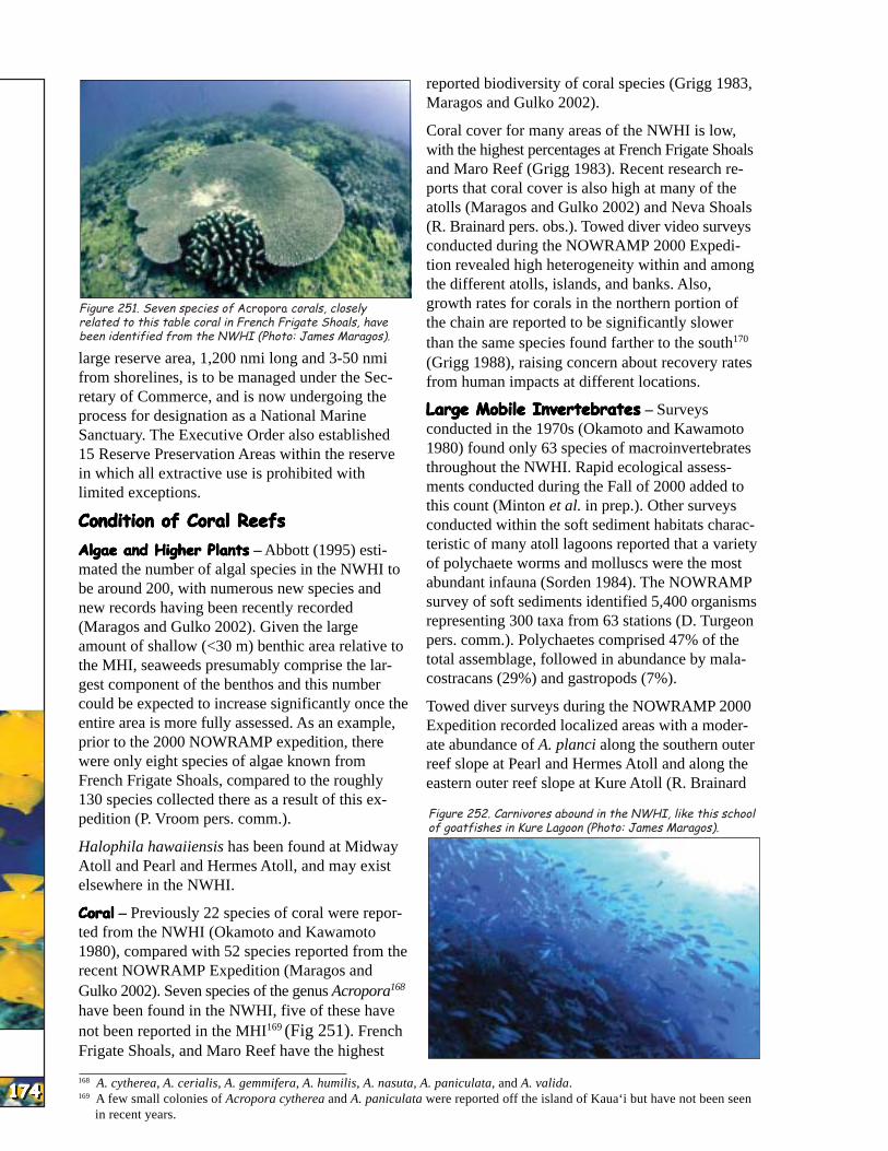
Figure 251. Seven species of Acropora corals, closely related to this table coral in French Frigate Shoals, have been identified from the NWHI (Photo: James Maragos).
large reserve area, 1,200 nmi long and 3-50 nmi from shorelines, is to be managed under the Secretary of Commerce, and is now undergoing the process for designation as a National Marine Sanctuary. The Executive Order also established 15 Reserve Preservation Areas within the reserve in which all extractive use is prohibited with limited exceptions.
Condition of Coral ReefsCondition of Coral ReefsCondition of Coral ReefsCondition of Coral ReefsCondition of Coral Reefs
Algae and Higher PlantsAlgae and Higher PlantsAlgae and Higher PlantsAlgae and Higher PlantsAlgae and Higher Plants – Abbott (1995) estimated the number of algal species in the NWHI to be around 200, with numerous new species and new records having been recently recorded (Maragos and Gulko 2002). Given the large amount of shallow (<30 m) benthic area relative to the MHI, seaweeds presumably comprise the largest component of the benthos and this number could be expected to increase significantly once the entire area is more fully assessed. As an example, prior to the 2000 NOWRAMP expedition, there were only eight species of algae known from French Frigate Shoals, compared to the roughly 130 species collected there as a result of this expedition (P. Vroom pers. comm.).
Halophila hawaiiensis has been found at Midway Atoll and Pearl and Hermes Atoll, and may exist elsewhere in the NWHI.
CoralCoralCoralCoralCoral – Previously 22 species of coral were reported from the NWHI (Okamoto and Kawamoto 1980), compared with 52 species reported from the recent NOWRAMP Expedition (Maragos and Gulko 2002). Seven species of the genus Acropora168
have been found in the NWHI, five of these have not been reported in the MHI169 (Fig 251). French Frigate Shoals, and Maro Reef have the highest
reported biodiversity of coral species (Grigg 1983, Maragos and Gulko 2002).
Coral cover for many areas of the NWHI is low, with the highest percentages at French Frigate Shoals and Maro Reef (Grigg 1983). Recent research reports that coral cover is also high at many of the atolls (Maragos and Gulko 2002) and Neva Shoals (R. Brainard pers. obs.). Towed diver video surveys conducted during the NOWRAMP 2000 Expedition revealed high heterogeneity within and among the different atolls, islands, and banks. Also, growth rates for corals in the northern portion of the chain are reported to be significantly slower than the same species found farther to the south170
(Grigg 1988), raising concern about recovery rates from human impacts at different locations.
Large Mobile InvertebratesLarge Mobile InvertebratesLarge Mobile InvertebratesLarge Mobile InvertebratesLarge Mobile Invertebrates – Surveys conducted in the 1970s (Okamoto and Kawamoto 1980) found only 63 species of macroinvertebrates throughout the NWHI. Rapid ecological assessments conducted during the Fall of 2000 added to this count (Minton et al. in prep.). Other surveys conducted within the soft sediment habitats characteristic of many atoll lagoons reported that a variety of polychaete worms and molluscs were the most abundant infauna (Sorden 1984). The NOWRAMP survey of soft sediments identified 5,400 organisms representing 300 taxa from 63 stations (D. Turgeon pers. comm.). Polychaetes comprised 47% of the total assemblage, followed in abundance by malacostracans (29%) and gastropods (7%).
Towed diver surveys during the NOWRAMP 2000 Expedition recorded localized areas with a moderate abundance of A. planci along the southern outer reef slope at Pearl and Hermes Atoll and along the eastern outer reef slope at Kure Atoll (R. Brainard
Figure 252. Carnivores abound in the NWHI, like this school of goatfishes in Kure Lagoon (Photo: James Maragos).
168 A. cytherea, A. cerialis, A. gemmifera, A. humilis, A. nasuta, A. paniculata, and A. valida. 169 A few small colonies of Acropora cytherea and A. paniculata were reported off the island of Kaua‘i but have not been seen
in recent years.

HAW
AI’I
HAW
AI’I
HAW
AI’I
HAW
AI’I
HAW
AI’I
HAW
AI’I
HAW
AI’I
HAW
AI’I
HAW
AI’I
HAW
AI’I
175175175175175175175175175175
pers. comm.). These occurrences were associated with dead or dying Pocillopora colonies in areas of low coral cover.
FishFishFishFishFish – A total of 266 species of fishes is listed from Midway Atoll of which 258 are reef and shore fishes (Randall et al. 1993). Cooler water temperatures, lack of certain high-island habitat types, and lower sampling effort may all contribute to the lower number of species compared to the main Hawaiian Islands. The reef fish community structure in the NWHI is different from other areas in the Hawaiian Archipelago owing to reduced abundance of herbivores (mostly surgeonfishes) and the increased importance of damselfishes and carnivores (mostly jacks, sharks, goatfishes, scorpionfishes, and big-eyes, Fig. 252). Reef fish trophic structure in the NWHI is dominated by carnivores in numerical abundance and biomass (Parrish et al. 1985, Fig. 253). The result is that the NWHI are among the few large reef ecosystems on the globe to remain predator-dominated and intact regarding fish assemblages (Friedlander et al. in prep.).
Because of the distances involved and the more exposed sea conditions, commercial fishers with large vessels (greater than 20 m) are the primary participants in the NWHI fisheries (Smith 1993). Commercial fishing in the NWHI within a 100 m depth targets mostly bottomfish and lobster, each of which is managed separately by the National Marine Fisheries Service (NMFS) through the actions of an advisory body: the Western Pacific Regional Fisheries Management Council (WPRFMC). Both of these fisheries are limited-entry with less than 20 vessels allowed to operate in either fishery.
There is currently concern over the declining abundance of lobsters in the NWHI, particularly in light of their potential importance as food for the endangered Hawaiian monk
B
Figure 254. Female (A) and male (B) masked angelfishes (Photos: James McVey).
Apex (Top) CarnivoreApex (Top) CarnivoreApex (Top) CarnivoreApex (Top) CarnivoreApex (Top) Carnivore
CarnivoreCarnivoreCarnivoreCarnivoreCarnivore
HerbivoreHerbivoreHerbivoreHerbivoreHerbivore
Primary ProducerPrimary ProducerPrimary ProducerPrimary ProducerPrimary Producer
Figure 253. The coral reef food web in French Frigate Shoals, NWHI (Modified after Polovina 1984).
seal171. A lawsuit was filed in federal court in 1999 regarding this issue. Before a ruling was issued, NMFS closed the fishery when it became apparent that some of the assumptions used in the lobster population assessment model were incorrect. Executive Order 13178, which established the NWHI Coral Reef Ecosystem Reserve, capped the lobster take at the 2000 catch level or zero take. Currently the NWHI lobster fishery remains closed.
Recreational and commercial fishing is prohibited within the 10-20 fathom isobath off most islands northwest of Kauai (varying with location) owing to their status as a National Wildlife Refuge managed by the USFWS, and their designation as critical habitat for the Hawaiian monk seal by the NMFS.
Mean standing stock of fish biomass on shallow reefs at French Frigate Shoals and Midway Atoll was almost twice as high as those reported from shallow reefs in the Main Hawaiian Islands (DeMartini et al. 1996). The difference in biomass among these locations may reflect the heavy fishing pressure on reef fishes in the MHI compared to the NWHI (Grigg
A
170 For example, lobe coral (Porites lobata) reportedly grows at an average of 11 mm/yr in parts of the MHI while the same species grows at only 0.3 mm/yr at the northern end of the chain.
171 Research has shown that lobster is a constituent of the monk seal diet. Studies on the importance of this component using fatty acid analysis and spew contents are underway by NMFS researchers.
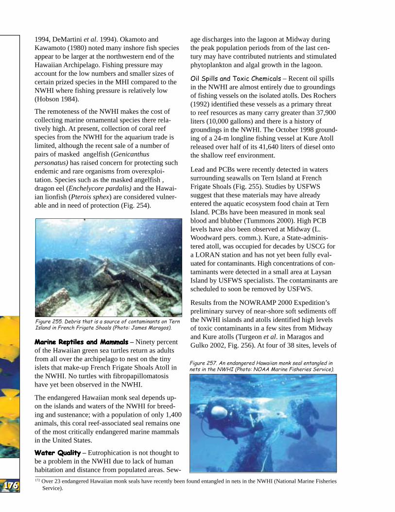
HAW
AI’I
HAW
AI’I
HAW
AI’I
HAW
AI’I
HAW
AI’I
HAW
AI’I
HAW
AI’I
HAW
AI’I
HAW
AI’I
HAW
AI’I
176176176176176176176176176176
1994, DeMartini et al. 1994). Okamoto and Kawamoto (1980) noted many inshore fish species appear to be larger at the northwestern end of the Hawaiian Archipelago. Fishing pressure may account for the low numbers and smaller sizes of certain prized species in the MHI compared to the NWHI where fishing pressure is relatively low (Hobson 1984).
The remoteness of the NWHI makes the cost of collecting marine ornamental species there relatively high. At present, collection of coral reef species from the NWHI for the aquarium trade is limited, although the recent sale of a number of pairs of masked angelfish (Genicanthus personatus) has raised concern for protecting such endemic and rare organisms from overexploitation. Species such as the masked angelfish , dragon eel (Enchelycore pardalis) and the Hawaiian lionfish (Pterois sphex) are considered vulnerable and in need of protection (Fig. 254).
Figure 255. Debris that is a source of contaminants on Tern Island in French Frigate Shoals (Photo: James Maragos).
Marine Reptiles and MammalsMarine Reptiles and MammalsMarine Reptiles and MammalsMarine Reptiles and MammalsMarine Reptiles and Mammals – Ninety percent of the Hawaiian green sea turtles return as adults from all over the archipelago to nest on the tiny islets that make-up French Frigate Shoals Atoll in the NWHI. No turtles with fibropapillomatosis have yet been observed in the NWHI.
The endangered Hawaiian monk seal depends upon the islands and waters of the NWHI for breeding and sustenance; with a population of only 1,400 animals, this coral reef-associated seal remains one of the most critically endangered marine mammals in the United States.
Water QualityWater QualityWater QualityWater QualityWater Quality – Eutrophication is not thought to be a problem in the NWHI due to lack of human habitation and distance from populated areas. Sew
age discharges into the lagoon at Midway during the peak population periods from of the last century may have contributed nutrients and stimulated phytoplankton and algal growth in the lagoon.
Oil Spills and Toxic Chemicals – Recent oil spills in the NWHI are almost entirely due to groundings of fishing vessels on the isolated atolls. Des Rochers (1992) identified these vessels as a primary threat to reef resources as many carry greater than 37,900 liters (10,000 gallons) and there is a history of groundings in the NWHI. The October 1998 grounding of a 24-m longline fishing vessel at Kure Atoll released over half of its 41,640 liters of diesel onto the shallow reef environment.
Lead and PCBs were recently detected in waters surrounding seawalls on Tern Island at French Frigate Shoals (Fig. 255). Studies by USFWS suggest that these materials may have already entered the aquatic ecosystem food chain at Tern Island. PCBs have been measured in monk seal blood and blubber (Tummons 2000). High PCB levels have also been observed at Midway (L. Woodward pers. comm.). Kure, a State-administered atoll, was occupied for decades by USCG for a LORAN station and has not yet been fully evaluated for contaminants. High concentrations of contaminants were detected in a small area at Laysan Island by USFWS specialists. The contaminants are scheduled to soon be removed by USFWS.
Results from the NOWRAMP 2000 Expedition’s preliminary survey of near-shore soft sediments off the NWHI islands and atolls identified high levels of toxic contaminants in a few sites from Midway and Kure atolls (Turgeon et al. in Maragos and Gulko 2002, Fig. 256). At four of 38 sites, levels of
Figure 257. An endangered Hawaiian monk seal entangled in nets in the NWHI (Photo: NOAA Marine Fisheries Service).
172 Over 23 endangered Hawaiian monk seals have recently been found entangled in nets in the NWHI (National Marine Fisheries Service).
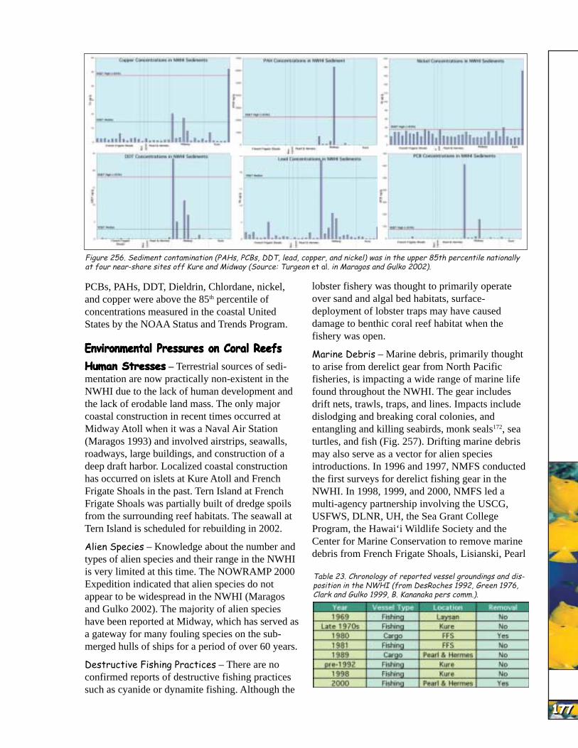
HAW
AI’I
HAW
AI’I
HAW
AI’I
HAW
AI’I
HAW
AI’I
HAW
AI’I
HAW
AI’I
HAW
AI’I
HAW
AI’I
HAW
AI’I
Figure 256. Sediment contamination (PAHs, PCBs, DDT, lead, copper, and nickel) was in the upper 85th percentile nationally at four near-shore sites off Kure and Midway (Source: Turgeon et al. in Maragos and Gulko 2002).
PCBs, PAHs, DDT, Dieldrin, Chlordane, nickel, and copper were above the 85th percentile of concentrations measured in the coastal United States by the NOAA Status and Trends Program.
Environmental Pressures on Coral ReefsEnvironmental Pressures on Coral ReefsEnvironmental Pressures on Coral ReefsEnvironmental Pressures on Coral ReefsEnvironmental Pressures on Coral Reefs
Human StressesHuman StressesHuman StressesHuman StressesHuman Stresses – Terrestrial sources of sedimentation are now practically non-existent in the NWHI due to the lack of human development and the lack of erodable land mass. The only major coastal construction in recent times occurred at Midway Atoll when it was a Naval Air Station (Maragos 1993) and involved airstrips, seawalls, roadways, large buildings, and construction of a deep draft harbor. Localized coastal construction has occurred on islets at Kure Atoll and French Frigate Shoals in the past. Tern Island at French Frigate Shoals was partially built of dredge spoils from the surrounding reef habitats. The seawall at Tern Island is scheduled for rebuilding in 2002.
Alien Species – Knowledge about the number and types of alien species and their range in the NWHI is very limited at this time. The NOWRAMP 2000 Expedition indicated that alien species do not appear to be widespread in the NWHI (Maragos and Gulko 2002). The majority of alien species have been reported at Midway, which has served as a gateway for many fouling species on the submerged hulls of ships for a period of over 60 years.
Destructive Fishing Practices – There are no confirmed reports of destructive fishing practices such as cyanide or dynamite fishing. Although the
lobster fishery was thought to primarily operate over sand and algal bed habitats, surface-deployment of lobster traps may have caused damage to benthic coral reef habitat when the fishery was open.
Marine Debris – Marine debris, primarily thought to arise from derelict gear from North Pacific fisheries, is impacting a wide range of marine life found throughout the NWHI. The gear includes drift nets, trawls, traps, and lines. Impacts include dislodging and breaking coral colonies, and entangling and killing seabirds, monk seals172, sea turtles, and fish (Fig. 257). Drifting marine debris may also serve as a vector for alien species introductions. In 1996 and 1997, NMFS conducted the first surveys for derelict fishing gear in the NWHI. In 1998, 1999, and 2000, NMFS led a multi-agency partnership involving the USCG, USFWS, DLNR, UH, the Sea Grant College Program, the Hawai‘i Wildlife Society and the Center for Marine Conservation to remove marine debris from French Frigate Shoals, Lisianski, Pearl
Table 23. Chronology of reported vessel groundings and disposition in the NWHI (from DesRoches 1992, Green 1976, Clark and Gulko 1999, B. Kananaka pers comm.).
177177177177177177177177177177
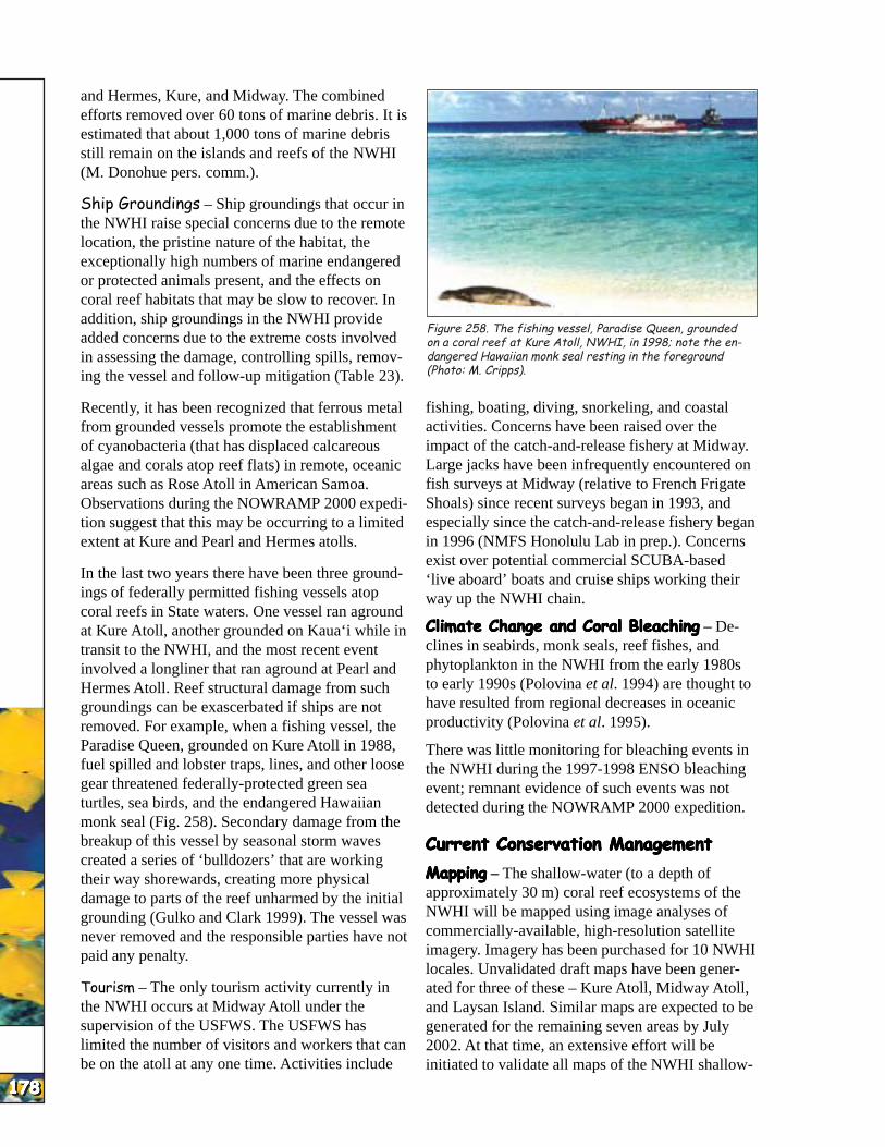
HAW
AI’I
HAW
AI’I
HAW
AI’I
HAW
AI’I
HAW
AI’I
HAW
AI’I
HAW
AI’I
HAW
AI’I
HAW
AI’I
HAW
AI’I
178178178178178178178178178178
and Hermes, Kure, and Midway. The combined efforts removed over 60 tons of marine debris. It is estimated that about 1,000 tons of marine debris still remain on the islands and reefs of the NWHI (M. Donohue pers. comm.).
Ship Groundings – Ship groundings that occur in the NWHI raise special concerns due to the remote location, the pristine nature of the habitat, the exceptionally high numbers of marine endangered or protected animals present, and the effects on coral reef habitats that may be slow to recover. In addition, ship groundings in the NWHI provide added concerns due to the extreme costs involved in assessing the damage, controlling spills, removing the vessel and follow-up mitigation (Table 23).
Recently, it has been recognized that ferrous metal from grounded vessels promote the establishment of cyanobacteria (that has displaced calcareous algae and corals atop reef flats) in remote, oceanic areas such as Rose Atoll in American Samoa. Observations during the NOWRAMP 2000 expedition suggest that this may be occurring to a limited extent at Kure and Pearl and Hermes atolls.
In the last two years there have been three groundings of federally permitted fishing vessels atop coral reefs in State waters. One vessel ran aground at Kure Atoll, another grounded on Kaua‘i while in transit to the NWHI, and the most recent event involved a longliner that ran aground at Pearl and Hermes Atoll. Reef structural damage from such groundings can be exascerbated if ships are not removed. For example, when a fishing vessel, the Paradise Queen, grounded on Kure Atoll in 1988, fuel spilled and lobster traps, lines, and other loose gear threatened federally-protected green sea turtles, sea birds, and the endangered Hawaiian monk seal (Fig. 258). Secondary damage from the breakup of this vessel by seasonal storm waves created a series of ‘bulldozers’ that are working their way shorewards, creating more physical damage to parts of the reef unharmed by the initial grounding (Gulko and Clark 1999). The vessel was never removed and the responsible parties have not paid any penalty.
Tourism – The only tourism activity currently in the NWHI occurs at Midway Atoll under the supervision of the USFWS. The USFWS has limited the number of visitors and workers that can be on the atoll at any one time. Activities include
Figure 258. The fishing vessel, Paradise Queen, grounded on a coral reef at Kure Atoll, NWHI, in 1998; note the endangered Hawaiian monk seal resting in the foreground (Photo: M. Cripps).
fishing, boating, diving, snorkeling, and coastal activities. Concerns have been raised over the impact of the catch-and-release fishery at Midway. Large jacks have been infrequently encountered on fish surveys at Midway (relative to French Frigate Shoals) since recent surveys began in 1993, and especially since the catch-and-release fishery began in 1996 (NMFS Honolulu Lab in prep.). Concerns exist over potential commercial SCUBA-based ‘live aboard’ boats and cruise ships working their way up the NWHI chain.
Climate Change and Coral BleachingClimate Change and Coral BleachingClimate Change and Coral BleachingClimate Change and Coral BleachingClimate Change and Coral Bleaching – Declines in seabirds, monk seals, reef fishes, and phytoplankton in the NWHI from the early 1980s to early 1990s (Polovina et al. 1994) are thought to have resulted from regional decreases in oceanic productivity (Polovina et al. 1995).
There was little monitoring for bleaching events in the NWHI during the 1997-1998 ENSO bleaching event; remnant evidence of such events was not detected during the NOWRAMP 2000 expedition.
Current Conservation ManagementCurrent Conservation ManagementCurrent Conservation ManagementCurrent Conservation ManagementCurrent Conservation Management
MappingMappingMappingMappingMapping – The shallow-water (to a depth of approximately 30 m) coral reef ecosystems of the NWHI will be mapped using image analyses of commercially-available, high-resolution satellite imagery. Imagery has been purchased for 10 NWHI locales. Unvalidated draft maps have been generated for three of these – Kure Atoll, Midway Atoll, and Laysan Island. Similar maps are expected to be generated for the remaining seven areas by July 2002. At that time, an extensive effort will be initiated to validate all maps of the NWHI shallow
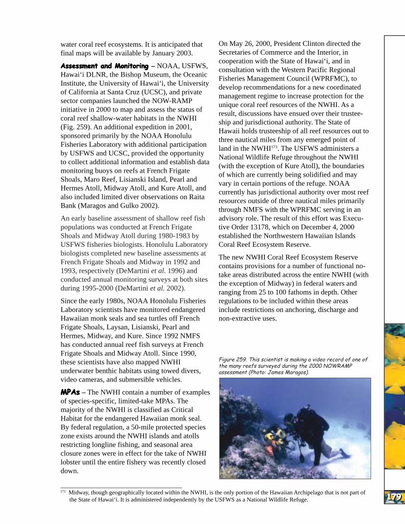
HAW
AI’I
HAW
AI’I
HAW
AI’I
HAW
AI’I
HAW
AI’I
HAW
AI’I
HAW
AI’I
HAW
AI’I
HAW
AI’I
HAW
AI’I
water coral reef ecosystems. It is anticipated that final maps will be available by January 2003.
Assessment and MonitoringAssessment and MonitoringAssessment and MonitoringAssessment and MonitoringAssessment and Monitoring – NOAA, USFWS, Hawai‘i DLNR, the Bishop Museum, the Oceanic Institute, the University of Hawai‘i, the University of California at Santa Cruz (UCSC), and private sector companies launched the NOW-RAMP initiative in 2000 to map and assess the status of coral reef shallow-water habitats in the NWHI (Fig. 259). An additional expedition in 2001, sponsored primarily by the NOAA Honolulu Fisheries Laboratory with additional participation by USFWS and UCSC, provided the opportunity to collect additional information and establish data monitoring buoys on reefs at French Frigate Shoals, Maro Reef, Lisianski Island, Pearl and Hermes Atoll, Midway Atoll, and Kure Atoll, and also included limited diver observations on Raita Bank (Maragos and Gulko 2002).
An early baseline assessment of shallow reef fish populations was conducted at French Frigate Shoals and Midway Atoll during 1980-1983 by USFWS fisheries biologists. Honolulu Laboratory biologists completed new baseline assessments at French Frigate Shoals and Midway in 1992 and 1993, respectively (DeMartini et al. 1996) and conducted annual monitoring surveys at both sites during 1995-2000 (DeMartini et al. 2002).
Since the early 1980s, NOAA Honolulu Fisheries Laboratory scientists have monitored endangered Hawaiian monk seals and sea turtles off French Frigate Shoals, Laysan, Lisianski, Pearl and Hermes, Midway, and Kure. Since 1992 NMFS has conducted annual reef fish surveys at French Frigate Shoals and Midway Atoll. Since 1990, these scientists have also mapped NWHI underwater benthic habitats using towed divers, video cameras, and submersible vehicles.
MPAsMPAsMPAsMPAsMPAs – The NWHI contain a number of examples of species-specific, limited-take MPAs. The majority of the NWHI is classified as Critical Habitat for the endangered Hawaiian monk seal. By federal regulation, a 50-mile protected species zone exists around the NWHI islands and atolls restricting longline fishing, and seasonal area closure zones were in effect for the take of NWHI lobster until the entire fishery was recently closed down.
On May 26, 2000, President Clinton directed the Secretaries of Commerce and the Interior, in cooperation with the State of Hawai‘i, and in consultation with the Western Pacific Regional Fisheries Management Council (WPRFMC), to develop recommendations for a new coordinated management regime to increase protection for the unique coral reef resources of the NWHI. As a result, discussions have ensued over their trusteeship and jurisdictional authority. The State of Hawaii holds trusteeship of all reef resources out to three nautical miles from any emerged point of land in the NWHI173. The USFWS administers a National Wildlife Refuge throughout the NWHI (with the exception of Kure Atoll), the boundaries of which are currently being solidified and may vary in certain portions of the refuge. NOAA currently has jurisdictional authority over most reef resources outside of three nautical miles primarily through NMFS with the WPRFMC serving in an advisory role. The result of this effort was Executive Order 13178, which on December 4, 2000 established the Northwestern Hawaiian Islands Coral Reef Ecosystem Reserve.
The new NWHI Coral Reef Ecosystem Reserve contains provisions for a number of functional no-take areas distributed across the entire NWHI (with the exception of Midway) in federal waters and ranging from 25 to 100 fathoms in depth. Other regulations to be included within these areas include restrictions on anchoring, discharge and non-extractive uses.
Figure 259. This scientist is making a video record of one of the many reefs surveyed during the 2000 NOWRAMP assessment (Photo: James Maragos).
173 Midway, though geographically located within the NWHI, is the only portion of the Hawaiian Archipelago that is not part of the State of Hawai‘i. It is administered independently by the USFWS as a National Wildlife Refuge. 179179179179179179179179179179

HAW
AI’I
HAW
AI’I
HAW
AI’I
HAW
AI’I
HAW
AI’I
HAW
AI’I
HAW
AI’I
HAW
AI’I
HAW
AI’I
HAW
AI’I
180180180180180180180180180180
Gaps in Current MonitoringGaps in Current MonitoringGaps in Current MonitoringGaps in Current MonitoringGaps in Current Monitoring
Multiple agency jurisdictional authority over reef resources raises questions about effective stewardship of the NWHI’s coral reefs, which is arguably the last major set of reef ecosystems left in the world that have not been heavily affected by human intrusion. The recent establishment of the NWHI Coral Reef Ecosystem Reserve should help sort out some of these conflicts and provide for a protective umbrella within Federal waters under which the various agencies can partner to effectively manage these unique resources. Currently State waters are not covered within this reserve and comparable effective State management structure or resources are lacking. This is of critical importance as many reef scientists feel that the majority of high biodiversity coral reef habitat in the NWHI is located within State waters. Current lack of regulations controlling extractive activities within NWHI waters pose a particular problem; the proposed State of Hawai‘i FMA for the NWHI may not fully close this gaping loophole to protecting this fragile and unique wilderness area.
Difficulties in patrolling and enforcing regulations throughout the 1,600 km (1,000 miles) length of the NWHI poses a problem in encouraging compliance from the various types of vessels (fishing, research, and eco-tourism) currently in the area and the large number of vessels expected to enter the area in the future. Creation of an automated Vessel Monitoring System (VMS), with a transmitting unit required on all vessels operating in the NWHI, and which automatically notifies both the ship in question and the appropriate enforcement and resource trustees of approach to protected or off-limits174 areas would go a long ways towards effectively solving this problem given the large distances and the extremely limited resources available to the USCG and the resource trustees. Efforts are currently underway to fund installation of VMS on various types of vessels, though how the vessels will be monitored and which agencies will have access to the data still needs to be worked out.
Management of the NWHI has been shared among agencies with differing missions. Reliance on the WPRFMC to advise NMFS on management of NWHI fisheries resources at levels that do not impact the sustainability of the fished species, nor
prevent reef ecosystem damage, may have been of limited success. Federal court litigation has occurred during the last two years relating to NMFS compliance with federal fisheries management and endangered species laws in the NWHI. The proposed draft WPRFMC Coral Reef Ecosystem Fisheries Management Plan (FMP) proposes to manage the coral reef ecosystems of the NWHI at an ecosystem level, yet excludes all other existing FMPs from the majority of listed management measures. Since many of the coral reef species are already listed under other existing FMPs (crustaceans, groupers, snappers, sharks) the ecosystem approach is still subordinate to single-species decision-making. Mechanisms (such as automated VMS, active zoning, mitigative bonding) that have been successful in other managed coral reef areas of the Pacific have not been incorporated fully into the existing or proposed WPRFMC’s FMPs for the NWHI.
The Hawaiian ArchipelagoThe Hawaiian ArchipelagoThe Hawaiian ArchipelagoThe Hawaiian ArchipelagoThe Hawaiian Archipelago
The last two sections of this report pertain to the entire Hawaiian Archipelago.
Government Policies, Laws, and LegislationGovernment Policies, Laws, and LegislationGovernment Policies, Laws, and LegislationGovernment Policies, Laws, and LegislationGovernment Policies, Laws, and Legislation
The majority of the shallow water coral reefs are under the jurisdictional authority of the State of Hawai‘i (primarily DLNR). Direct military control over areas of the NWHI has been phased out over the last 30 years; Midway was turned over to the USFWS, and the USCG abandoned LORAN stations at Kure and Tern Island (French Frigate Shoals) in the 1970s to 1980s.
In 1998, President Clinton signed Executive Order 13089 for Coral Reef Protection which mandated “All Federal agencies whose actions may affect U.S. coral reef ecosystems shall: a) identify their actions that may affect U. S. coral reef ecosystems; b) utilize their programs and authorities to protect and enhance the conditions of such ecosystems; and, to the extent permitted by law, c) ensure that any actions they authorize, fund, or carry out will not degrade the conditions of such ecosystems.”
This Executive Order also focused the resources of the various agencies of the federal government to assist the State and Territorial resource trustees in making serious inroads into protection of the
174 Depending on the type of activity that the vessel is engaged in.
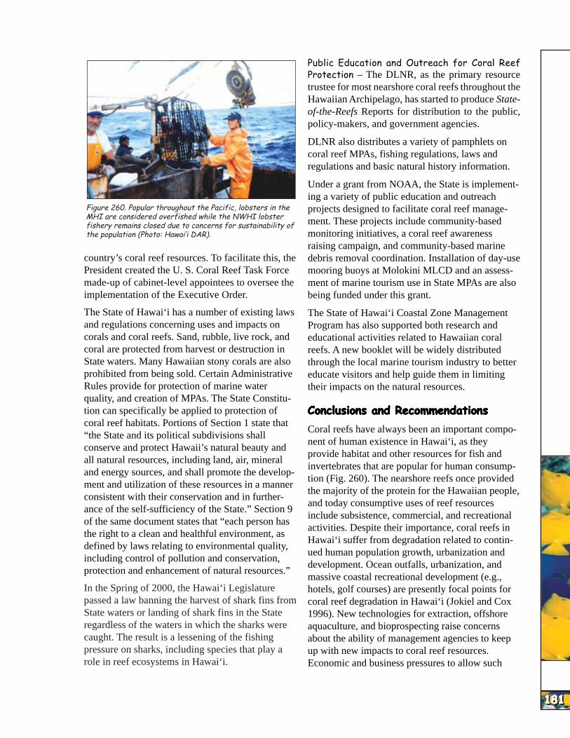
HAW
AI’I
HAW
AI’I
HAW
AI’I
HAW
AI’I
HAW
AI’I
HAW
AI’I
HAW
AI’I
HAW
AI’I
HAW
AI’I
HAW
AI’I
Figure 260. Popular throughout the Pacific, lobsters in the MHI are considered overfished while the NWHI lobster fishery remains closed due to concerns for sustainability of the population (Photo: Hawai‘i DAR).
country’s coral reef resources. To facilitate this, the President created the U. S. Coral Reef Task Force made-up of cabinet-level appointees to oversee the implementation of the Executive Order.
The State of Hawai‘i has a number of existing laws and regulations concerning uses and impacts on corals and coral reefs. Sand, rubble, live rock, and coral are protected from harvest or destruction in State waters. Many Hawaiian stony corals are also prohibited from being sold. Certain Administrative Rules provide for protection of marine water quality, and creation of MPAs. The State Constitution can specifically be applied to protection of coral reef habitats. Portions of Section 1 state that “the State and its political subdivisions shall conserve and protect Hawaii’s natural beauty and all natural resources, including land, air, mineral and energy sources, and shall promote the development and utilization of these resources in a manner consistent with their conservation and in furtherance of the self-sufficiency of the State.” Section 9 of the same document states that “each person has the right to a clean and healthful environment, as defined by laws relating to environmental quality, including control of pollution and conservation, protection and enhancement of natural resources.”
In the Spring of 2000, the Hawai‘i Legislature passed a law banning the harvest of shark fins from State waters or landing of shark fins in the State regardless of the waters in which the sharks were caught. The result is a lessening of the fishing pressure on sharks, including species that play a role in reef ecosystems in Hawai‘i.
Public Education and Outreach for Coral Reef Protection – The DLNR, as the primary resource trustee for most nearshore coral reefs throughout the Hawaiian Archipelago, has started to produce Stateof-the-Reefs Reports for distribution to the public, policy-makers, and government agencies.
DLNR also distributes a variety of pamphlets on coral reef MPAs, fishing regulations, laws and regulations and basic natural history information.
Under a grant from NOAA, the State is implementing a variety of public education and outreach projects designed to facilitate coral reef management. These projects include community-based monitoring initiatives, a coral reef awareness raising campaign, and community-based marine debris removal coordination. Installation of day-use mooring buoys at Molokini MLCD and an assessment of marine tourism use in State MPAs are also being funded under this grant.
The State of Hawai‘i Coastal Zone Management Program has also supported both research and educational activities related to Hawaiian coral reefs. A new booklet will be widely distributed through the local marine tourism industry to better educate visitors and help guide them in limiting their impacts on the natural resources.
Conclusions and RecommendationsConclusions and RecommendationsConclusions and RecommendationsConclusions and RecommendationsConclusions and Recommendations
Coral reefs have always been an important component of human existence in Hawai‘i, as they provide habitat and other resources for fish and invertebrates that are popular for human consumption (Fig. 260). The nearshore reefs once provided the majority of the protein for the Hawaiian people, and today consumptive uses of reef resources include subsistence, commercial, and recreational activities. Despite their importance, coral reefs in Hawai‘i suffer from degradation related to continued human population growth, urbanization and development. Ocean outfalls, urbanization, and massive coastal recreational development (e.g., hotels, golf courses) are presently focal points for coral reef degradation in Hawai‘i (Jokiel and Cox 1996). New technologies for extraction, offshore aquaculture, and bioprospecting raise concerns about the ability of management agencies to keep up with new impacts to coral reef resources. Economic and business pressures to allow such
181181181181181181181181181181

HAW
AI’I
HAW
AI’I
HAW
AI’I
HAW
AI’I
HAW
AI’I
HAW
AI’I
HAW
AI’I
HAW
AI’I
HAW
AI’I
HAW
AI’I
182182182182182182182182182182
impacts may have severe consequences for Hawai‘i where coral reefs represent a thin band of habitat directly next to the shore, yet are extremely important to the marine tourism industry which serves as a major lynchpin in the overall Hawaiian economy.
There are strong indications of overfishing for the majority of food fish and invertebrates in the MHI. Similar concerns are starting to be expressed in regards to the impact of the marine ornamental trade. These problems are compounded by the realization that the status of fisheries resources in the MHI are considerably under-reported, making proper management of these resources difficult at this time.
The coral reefs of the Hawaiian Archipelago represent not only the majority of U.S. reef area, but also a set of unique ecosystems of unusually high endemism and diversity of reef types, along with a uniquely predator-dominated fish assemblage within the NWHI. Given this, issues such as alien species introduction and marine ornamental collection175, are of stronger concern here then in many other coral reef areas.
Hawai‘i has a wide variety of types of MPAs which protect coral reef habitat to some extent, yet very little of MHI reefs are ‘No-take MPAs’ where extraction of any type is not allowed. With only 0.3% of the MHI coral reef habitat protected as ‘No-take MPAs,’ it’s going to be extremely challenging to meet the USCRTF’s established goal of setting aside a minimum of 20% of the representative coral reef habitat as ‘No-take MPA’ by the year 2010. Even those few areas that are currently ‘No-take MPAs’ in the MHI are exposed to heavy human usage for recreation and marine tourism potentially undermining their effectiveness in representing ‘natural’ coral reef ecosystems.
While new efforts and joint partnerships have been initiated by the resource trustee agencies, academia, nongovernmental organizations and the various communities themselves, more support (financial and political) for the existing and proposed efforts is needed in order to effectively sustain the exceptionally wide variety and area of coral reef habitat and resources found in the Hawaiian Archipelago.
175 Especially focused on rare or endangered species.