Embed Size (px)
Citation preview

STATEME T OF ENVIRONMENTAL EFFECTS
Ba. A. jiEaffia.^
Removal of Underground Petroleum Storage TanksLOT 2 DP 232587
217-221 GOULBURN STREET, CROOKWELLJUNE 2018
Reference No.: 1815
Prepared by:Laterals Planning1st Floor, 35 Montague Street(PO Box 1326) Goulburn NSW 2580Tel: (02)48210973Fax: (02) 4822 0777Email: narlisa laterals.com.au
Plamiing, Engineering & Management, EnvironmentalGoulburn Office:
1st Floor - 139 Auburn Street, PO Box 1326, Goulburn NSW 2580 . Phone: (02) 4821 0973 . Fax: (02) 4821 0954Mid North Coast Office:21 Station Street, Johns River NSW 2443 . Phone: (02) 6556 5194 . Fax: (02) 6556 5094laterals. com. au

PLANNING
CONTENTS
CONTENTS.................................................................................................................................................. _....,...2
1 INTRODUCTION/EXECUTIVE SUMMARY........................................................................................................ 3
1.1 HISTORYOF SITE....................................................................................................................................... _31. 2 CONSULTATION WITH COUNCIL..................................................................................................................3
2 SITE ANALYSIS..............................................................................................................................................^
2. 1 SITE DESCRIPTION.......................................................................................................................................^2.2 SITE LOCATION ANDCONTEXT......................................................................................................................42.3 SURROUNDING DEVELOPMENT..................................................................................................................^
3 PROPOSED DEVELOPMENT....................................................................................................................... 6
3. 1 ELEMENTS OFTHE PROPOSED DEVELOPMENT AND DESIGN STATEMENT....................................................63.2 DEVELOPMENT MATERIALS, OPERATIONAL DETAILS AND DEVELOPMENT MANAGMENT .........................83.3 ACCESS/PARKING......................................................................................................................................,..83.4 SIGNAGE.......................................................................................................................^.....,.......... . g3. 5 VEGETATION MANAGEMENT AND LANDSCAPING........................................................................................83. 6 BUSHFIRE PRONE LAND ..............................................................................................................................g3.7 WATER MANAGEMENT................................................................................................................................93.8 DEMOLITION............................................................................................................................................. _93.9 AMENDMENTS TO EXISTING CONSENT........................................................................................................93. 10 STAGING .............................................................................................................................................,.. ^. _9
4 LEGISLATION AND PLANNING CONTROLS ................................................................................................. 10
4. 1 LEGISLATION APPPLICABLE TO THE PROPOSED DEVELOPMENT................................................................ 10
5 ASSESSMENT OF PLANNING CONTROLS ...................................................................................................... 16
5.1 COMPLIANCE WITH PLANNING INSTRUMENTS AND CONTROLS............................................................... 165.2 TRAFFICACCESANDPARKING....................................................................................................................165.3 VISUALASSESSMENT................................................................................................................................. ^5.4 AMENITf ASSESSMENT............................................................................................................................. ie5.5 NOISE ASSESSMENT................................................................................................................................ 155. 6 PRIVACY AND OVERSHADOWING ASSESSMENT.......................................................................................... 165. 7 EROSION ANDSEDIMENTCONTROLASSESSMENT...................................................................................... 165.8 SOCIALANDECONOMICASSESSMENT......................................................................................................i65.9 HERITAGE AND ABORIGINAL OBJECTS ASSESSMENT................................................................................. 165.10 DEMOLITION ASSESSMENT........................................................................................................................ 175. 11 UTILITIESANDSERVICESASSESSMENT......................................................................................................175. 12 CONTAMINATED LAND ASSESSMENT........................................................................................................n5. 13 SUITABILIT/OFTHE SITE............................................................................................................................ 175. 14 SUBMISSIONS ...........................................................................................................................................n5. 15 PUBLIC INTEREST........................................................................................................................................ ig
6 CONCLUSIONS............................................................................................................................................. is
6 APPENDIX 1 - LEGISLATION POTENTIALLY APPLICABLE............................................................................... 19
7 APPENDIX 2 - LEGISLATIVE AND POLICY COMPLIANCE ............................................................................... 24
2

PLANNING
1 INTRODUCTION/EXECUTIVE SUMMARY
This Statement of Environmental Effects (SEE) is prepared for submission to Upper Lachlan ShireCouncil (Council) in support of a development application for removal of an undergroundpetroleum storage system.
The development involves the removal of 3 x 10,OOOL Underground Storage Tanks and remediationof the site.
The assessment of the land has provided for the consideration of existing natural features includingdrainage patterns, elevation, accessibility, and vegetation, all of which are identified as manageablewithin relevant legislation and guidelines.
The information regarding the proposed development is consolidated in the plans and detailsprovided in this report.
The report provides information about the site and the proposed development. Key planning issuesare discussed which, in combination with a summary assessment of the proposal against the headsof consideration in s4.15 of the Environmental Planning and Assessment Act 1979, represents therequired Statement of Environmental Effects.
1.1 HISTORY OF SITEThe site was previously used as a service station and vehicle repair centre until the site suffered abuilding fire in 2017.
1.2 CONSULTATION WITH COUNCILA email discussions were carried out with Upper Lachlan Shire Council.
PLANNING
2 SITE ANALYSIS
2.1 SITE DESCRIPTIONThe land is identified as Lot 2 DP 232587 and is addressed as 217 - 221 Goulburn Street, Crookwell.
The land has a north easterly aspect. None of the slopes exceed 18 degrees and all areas of the lotsare able to be developed or used for permissible purposes under Upper Lachlan LocalEnvironmental Plan 2010. There are defined waterways or drainage depressions on the land and noareas of slip or subsidence were identified.
The site is serviced with electricity and telephone.
The general nature of the site is shown on the aerial photograph and topographic map on thefollowing pages 6 & 7.
2.2 SITE LOCATION and CONTEXTThe site is located on the western side ofGoulburn Street and south side of the town ofCrookwell.
The site has access from Goulburn Street and East Street as well as a lane that runs along the rear.
The is urban in nature and lots range in size from approximately SOOsqm to over 2000sqm.
2.3 SURROUNDING DEVELOPMENTThe site is within a general urban area. Viewing the site from the aerial photograph the landsurrounding contains-
. To the north there are dwellings and vacant commercial development.
. To the east there are dwellings and the Crookwell Vet Hospital.
. To the south there are lots associated with this development, dwellings and CrookwellShowground.
. To the west are dwellings and Crookwell Swimming Pool

PLANNING
KIV[Vniytfittn. rvt'TT^ ny
. ihnn-i^ RiSl"n?r<:? . W;
^fff. tWf/^W
l TWK as h'aplqgi, ^ Sptel,v^- ..., . JMI L>^ .«. i'A"
f< '.7 tffil "S71ra':: *u? or"
trj. *. ! ..-.k. li.tUi'. [... " ill-/itrsf. '. i-^ WW
8
Tn.:vW
FV^ SJU\ &Wd«
IQCA&ITV ?LAM - AESIA1. A*APUPSS DECOMMISSlQNnMG
tOT 3D? 232587217.221 OOU16U STOGiT, CBOO WeLL
-I-
^ i/
Ilor . .-i Iki>.w*r«>
isa ?»is .-.jeaUi'J

PLANNING
PROPOSED DEVELOPMENT
3.1 ELEMENTS OF THE PROPOSED DEVELOPMENT and DESIGN STATEMENTThe development proposal involves:
1. The decommissioning and removal of the underground storage systems;2. The remediation of the site; and3. The carrying out of works as required by Council on the issue of development consent.
A plan of proposed development is shown on the following Site Plans on pages 9 & 10, including aplan which an aerial underlay.
The remainder of the site will remain as is with the fire damaged building to be looked at under aseparate future development application.

c^?^4~ ^
PLANNING
KEV. cT-wrt» eia.nriT^' nw
^hir-1 i. B<i»«»erc? &1 ^
^Wf-frV
' r>i?o- K vsKtas'M Sfffftli»< ^ . Art,' &A- &> . ?ri0
7*. ':7<e?l. 'S?1fw s. .tail vrrr
t".A «. :. . '.->(|ll.ii,i8'.u"vyopr.'.t'k ^' .»' ?ff»
.. (-». ». -..).. II- ISjta
. «rt" . *«. '- *
rhnifhin-kk-miln-.».. »<'*i tart* «»n».»-. ^. <»^u», H.t^-'»-ct. a. ,..*fV- k*-k t
LOCAUn PIAN - UPSS Tonk l.oegttonsUPSS DECOAAUISSIGNINES
I.QT 2 Df 232,587217. 331 GGyt» "N STftlET. CROG
<K», -<
lllV
Ef " II.l.nfclhl
(.tlit. Xli^iiliI&l

^.^.
PLANNING
3. 2 DEVELOPMENT MATERIALS, OPERATIONAL DETAILS AND DEVELOPMENT MANAGMENTThe scope of works includes:
. Washout and De-gassing of 3 x 10,000 Litre Tanks;
. LIST Pumping, purging and disposal of any product;
. UST Tank Disposal;
. Waste tank disposal certification;
. Excavation and stockpiling of material for validation;
. Waste Concrete disposal;
. Compacted sub base;
. Supply UPSS removal and validation to affected site area;
. Supply compactions testing as required.
3.3 ACCESS/PARKINGThe site has access from Goulburn Street and East Street. These works will not impact these access'or the existing onsite parking
3.4 SIGNAGENo signage is proposed.
3.5 VEGETATION MANAGEMENT and LANDSCAPINGClearing would not be necessary for any aspect of the development.
3.6 BUSHFIRE PRONE LANDThe site is not identified as Bushfire Prone Land on the bush fire prone land map.
PLANNING
3.7 WATER MANAGEMENTTemporary Pollution control will be installed prior to the start of decommissioning andremediation works, this will remain until the site has re-established.
3.8 DEMOLITION
No demolition is proposed. The demolition (or partial) of the fire damaged building will besubmitted as a separate development application.
3.9 AMENDMENTS TO EXISTING CONSENTThis proposal does not involve the amendment of any existing development consent.
3.10 STAGING
The development is not intended to be carried out in stages as defined by section 4.22 of theEnvironmental Planning and Assessment Act 1979.

PLANNING
4 LEGISLATION AND PLANNING CONTROLS
A full list of legislation and planning controls that could be applicable is included in Appendix 1 in section6 below. Those matters listed in Appendix 1 which would warrant further consideration are listed belowwith responses provided and in some cases further information is provided.
A general assessment of the relevant legislation is carried out in this section but in some instances moredetailed assessment is carried out in section 5.
4.1 LEGISLATION APPPLICABLE TO THE PROPOSED DEVELOPMENT
The entire list of legislation relevant to the site is included in Appendix 1. From the list of legislation inAppendix 1 the following legislation is considered applicable to be considered for the proposeddevelopment.
4. 1.1 Environmental Planning & Assessment Act 1979 and Regulation 2000(a) Ecolo ical Sustainable Develo ment ESD :The principles of ecologically sustainable development are as follows:
(a) the precautionary principle, namely, that if there are threats of serious or irreversibleenvironmental damage, lack of full scientific certainty should not be used as a reason forpostponing measures to prevent environmental degradation. In the application of theprecautionary principle, public and private decisions should be guided by:(i) careful evaluation to avoid, wherever practicable, serious or irreversible damage to the
environment, and
(ii) an assessment of the risk-weighted consequences of various options,
The development has been designed to utilise existing land and infrastructure that will result inthe least potential for adverse impact from works.
(b) inter-generational equity, namely, that the present generation should ensure that the health,diversity and productivity of the environment are maintained or enhanced for the benefit of futuregenerations,
The management of the development as discussed in this statement proposes the best abilityfor the development to maintain the existing environment. In relation to the protection ofcultural values the development is consistent with the character of the area.
(c) conservation of biological diversity and ecological integrity, namely, that conservation of biologicaldiversity and ecological integrity should be a fundamental consideration,
The design of the development provides the best opportunity for biological diversity andecological integrity of the site to be retained.
(d) improved valuation, pricing and incentive mechanisms, namely, that environmental factors shouldbe included in the valuation of assets and services, such as:(i) polluter pays, that is, those who generate pollution and waste should bear the cost of
containment, avoidance or abatement,(ii) the users of goods and services should pay prices based on the full life cycle of costs of
providing goods and services, including the use of natural resources and assets and theultimate disposal of any waste,
(iii) environmental goals, having been established, should be pursued in the most cost effectiveway/ by establishing incentive structures, including market mechanisms, that enable those
10

PLANNING
best placed to maximise benefits or minimise costs to develop their own solutions andresponses to environmental problems.
The design of the development is to enable development within the values of the site thatcurrently exists without adversely impacting on any adjacent or nearby site or development andwithout interfering with an existing basalt deposit on the land.
The establishment of the development within the Upper Lachlan Shire Council area places thedevelopment under the continuing management of Upper Lachlan Shire Council, which will,through rates and charges continue to manage the infrastructure for cultural and environmentprotection.
(b) Section 4.14 - Consultation and development consent-certain bush fire prone landThe development is not within bushfire prone land.
(c) Section 10.4 - DeclarationThe Applicant has declared on the Development Application form that there are no relevantpolitical donations or affiliations.
4.1.2 Road Act 1993The development will not involve the construction of a driveway access that will involve workson a public road and as such approval is not needed under S138 of the Act for the works on theroad at the access point to proposed Lots.
4. 1. 3 State Environmental Planning Policy No 55 - Remediation of LandSEPP 55 deals with the remediation of land and the consent authority is required to consider theitems listed under Clause 7. As stated by Clause 7:(1) A consent authority must not consent to the carrying out of any development on land unless:
(a) It has considered whether the land is contaminated, and(b) If the land is contaminated, it is satisfied that the land is suitable in its contaminated state (or will
be suitable, after remediation) for the purpose for which the development is proposed to becarried out, and
(c) If the land requires remediation to be made suitable for the purpose for which the developmen t isproposed to be carried out, it is satisfied that the land will be remediated before the land is usedfor that purpose.
(2) Before determining an application for consent to carry out development that would involve a changeof use on any of the land specified in subclause (4), the consent authority must consider a reportspecifying the findings of a preliminary investigation of the land concerned carried out in accordancewith the contaminated land planning guidelines.
(3) The applicant for development consent must carry out the investigation required by subclause (2) andmust provide a report on it to the consent authority. The consent authority may require the applicantto carry out, and provide a report on, a detailed investigation (as referred to in the contaminated landplanning guidelines) if it considers that the findings of the preliminary investigation warrant such aninvestigation.
(4) The land concerned is:(a) Land that is within an investigation area,(b) Land on which development for a purpose referred to in Table 1 to the contaminated land
planning guidelines is being, or is known to have been, carried out,(c) To the extent to which it is proposed to carry out development on it for residential, educational,
recreational or child care purposes, or for the purposes of a hospital-land:(i) in relation to which there is no knowledge (or incomplete knowledge) as to whether
development for a purpose referred to in Table 1 to the contaminated land planningguidelines has been carried out, and
11

^
PLANNING
(ii) On which it would have been lawful to carry out such development during any period inrespect of which there is no knowledge (or incomplete knowledge)."
Contaminated land is defined in SEPP 55 to mean land in, on or under which any substance ispresent at a concentration above the concentration at which the substance is normally presentin, on or under (respectively) land in the same locality, being a presence that presents a risk ofharm to human health or any other aspect of the environment.
A Preliminary Assessment is conducted below in Section 5.
4. 1.4 State Environmental Planning Policy (Rural Lands) 2008The Rural Planning Principles are as follows:(a) the promotion and protection of opportunities for current and potential productive and sustainable
economic activities in rural areas,(b) recognition of the importance of rural lands and agriculture and the changing nature of agriculture
and of trends, demands and issues in agriculture in the area, region or State,(c) recognition of the significance of rural land uses to the State and rural communities, including the
socfo/ and economic benefits of rural land use and development,(d) in planning for rural lands, to balance the social, economic and environmental interests of the
community,
(e) the identification and protection of natural resources, having regard to maintaining biodiversity,the protection of native vegetation, the importance of water resources and avoiding constrainedland,
(f) the provision of opportunities for rural lifestyle, settlement and housing that contribute to the socialonaf economic welfare of rural communities,
(g) the consideration of impacts on services and infrastructure and appropriate location whenproviding for rural housing,
(h) ensuring consistency with any applicable regional strategy of the Department of Planning or anyapplicable local strategy endorsed by the Director-General.
The site has a commercial zoning and is not effected by this SEPP.
4. 1.5 Upper Lachlan LEP 2010The site is within the Upper Lachlan Shire Local Government Area ('LGA') and the ULLEP 2010 isthe applicable Local Environmental Plan. ULLEP 2010 is a 'Standard Instrument LEP' prepared inaccordance with S33A of the EP&A Act, which was published and commenced on 9 July 2010.
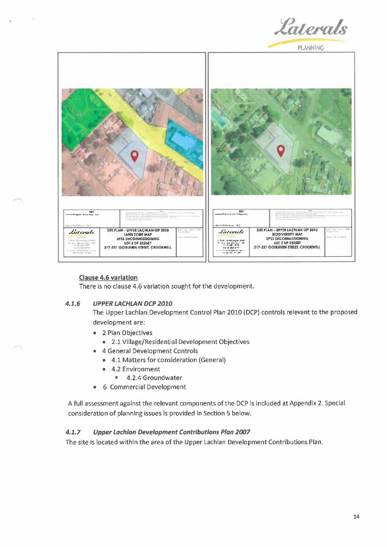
The site is within the B4 Mixed Use zone under Upper Lachlan Local Environmental Plan 2010. Thesite was used as a service station and vehicle repair station both of which are permissibledevelopment and uses within the B4 Mixed Use zone with consent under the zone subject tocompliance with various clauses detailed in this Statement. The Local Environmental Mapsapplicable are shown on the following page.
Under Upper Lachlan Local Environmental Plan 2010the land is also identified as:1. Has a no minimum lot size for subdivision.
2. Has no height of building limitation.3. Has no floor space ratio limitation4. Not affected by minerals or extractive resources5. Not subject to any land acquisition proposal6. Not containing a heritage item7. Not within a heritage conservation area8. Not flood liable
9. Is within an area of terrestrial biodiversity
12

i
3
">ff(0<y</)m
^uu
Ic
(D
c
£5
s0T-l
-!/>-0cco
(U£m
m
I(Uu
.fcUl
E£sE:
t-1fl
^'+s
I.2
i<u.c4-*
c
.c+->
?
bc
(0
i(D
I0u
(D
bc
J3
U3CMQ.Q-UJ(75k.0
s0.KUJLOc
1Iibc
u
iIu
%3a-(0
c
(0
bc
-0
<0
£(0fcw
ik-
^-a^
0
5(01-0
scco0^i</>
(Dc
0
%
IIlo-ac:CD
Iroc
^4-*
§bc
<u
u
Iro
<u1-0
-a
^E
i
I-»
0)
's
Ic
£.4-'
5
6c
t»-
.
$.
<u.sIJ2^=no
±:l_0
sc
roI.00in
23
^^
3
I-00c
s<.c-00^
's.r^Ul(0
IiI0c
BO
ro
£ID
c0
V
II§sttTO
s
I<"s
iJC
^l_
0
^0
4->ro
£
3w0
0vSo
ro{=3
ff<0si;:
^c0+->
I<y"'£a.
i£-0
s.a
-sI
in
s3Q.c0
'.ss
IIajIc
I
(D^
IU.c
b
+->
5^2<°
JC.
3+rf
bc
£.+^
5
i
cc
^D"a.
^c0
2
I'i00
.1-1
.c
§t-1
.s-0sQ.
^c
i-p
Ia.>.
2<uc0)56tO
i"^(0
"0.i8
.+->ro
, 200v
IiLOc0
y<yi/ic
inw3
^
PLANNING
^UftW/^
v"'f£i-K"r»;ss«un-"
.".i-^ys^ °
. ^.. -a"- -^..... -.
SITE ftAM - UftW lACHUkN wwwlAHDZONEMW
UnS DECOMMISSIONINGlOTibTiiiit?
217-221 GOUUURN StllEH, CtOOKWEU.
^lT^i^ ^^ CL'lr . ^^^JVl. 'Vf t rf~
ninn<, r»i^T<-p -y
rCfffc'yci^ sinriAN-wrEB LACHIAN iff »ioUODIVEKOT MAf
UPS DfCOMMUSiOHINGwviwssawf
217-221 GOUUUIN SIItEB. CBOOKWELL
Clause 4.6 variation
There is no clause 4. 6 variation sought for the development.
4.1.6 UPPER LACHLAN DCP 2010The Upper Lachlan Development Control Plan 2010 (DCP) controls relevant to the proposeddevelopment are:
. 2 Plan Objectives. 2. 1 Village/Residential Development Objectives
. 4 General Development Controls. 4. 1 Matters for consideration (General). 4.2 Environment
. 4.2.4 Groundwater
. 6 Commercial Development
A full assessment against the relevant components of the DCP is included at Appendix 2. Specialconsideration of planning issues is provided in Section 5 below.
4. 1. 7 Upper Lachlan Development Contributions Plan 2007
The site is located within the area of the Upper Lachlan Development Contributions Plan.
14
t,<?
PLANNING
4. 1.8 Upper Lachlan Section 94A Development Contributions Plan (2012)The development is not listed as a development type affected by this plan as such the developmentis considered exempt from the levy applied by the Contributions Plan.
15

,<?'
PLANNING
ASSESSMENT OF PLANNING CONTROLS
5. 1 COMPLIANCE WITH PLANNING INSTRUMENTS AND CONTROLS
1 The development is ancillary and incidental to the landuse of service centre and vehicle repairstation;
2 The proposal is consistent with the relevant section of the Upper Lachlan DCP 2010 and relevantCouncil plans and strategies.
5.2 TRAFFIC ACCES AND PARKINGThe proposal is for the decommissioning of underground petrol storage tanks and remediation ofthe lands. There will be no ongoing traffic or parking issues associated with the development asproposed.
5.3 VISUAL ASSESSMENTThe site fronts the main street of Crookwell, with the tanks being located at the front of thebuilding under what was the bowser forecourt (See plan). The tanks are underground with aconcrete cap, this will be removed to decommission the tanks and remediated with clean fill.There will not be a visual impact because of the development.
5.4 AMENITY ASSESSMENTThe development would not result in the construction of any works that would result in apotential decrease in amenity.
5.5 NOISE ASSESSMENTThe development would require the presence of machinery for the decommissioning andremediation.
Works for the development would be carried out during the hours of 7am to 5pm Monday toFriday, 7am and 1pm Saturday with no work on Sunday or Public holidays.
5.6 PRIVACY and OVERSHADOWING ASSESSMENTThe development does not involve any development that would result in privacy andovershadowing issues.
5.7 EROSION and SEDIMENT CONTROL ASSESSMENTErosion and Sediment Controls including sediment fencing and/or hay bales would be installed atthe downslope sections of the development sites until vegetation is re-established in areasaffected by construction works and not retained as hardstand.
5.8 SOCIAL AND ECONOMIC ASSESSMENTThe development would not result in any direct social or economic impact.
5.9 HERITAGE AND ABORIGINAL OBJECTS ASSESSMENTThe site is not located within a heritage conservation area and is not listed as a heritage item.
The development is not in an area of high elevation or located near any waterways of significance.As such an Aboriginal archaeological assessment has not been conducted.
It is anticipated that Council will apply a condition requiring that all works cease should anAboriginal item be unearthed during construction.
16
./^.'r- »
PLANNING
5. 10 DEMOLITION ASSESSMENTNo demolition is proposed for assessment. The demolition or partial demolition of the buildingthat was damaged by fire will be the subject of a future development application.
5.11 UTILITIES AND SERVICES ASSESSMENTThe site does have water and sewerage reticulation.
5.12 CONTAMINATED LAND ASSESSMENT
This report provides information from preliminary investigations pertinent to the developmentabout the potential for the site to contain contamination from previous activities. The assessmentis carried out in accordance with the 'Planning Guidelines for Contaminated Land' prepared by theDepartment of Urban Affairs and Planning and Environment Protection Authority in 1995. Thereport forms a key assessment in accordance with the heads of consideration in s4. 15 of theEnvironmental Planning and Assessment Act 1979.
5.13.1 Previous land uses
The land has been used for a service centre and vehicle repair station the past. There areno known other uses on the land.
5. 13. 2 Adjoining Land UsesAdjoining land uses are mainly residential, with some commercial and light industrialdevelopment.
5. 13. 3 Site InspectionA site inspection was carried out in June 2018. The nature of the pervious land uses suggeststhat there is the potential for contamination on the site.
5.13.4 Potentially Contaminating ActivitiesThe nature of the pervious land uses suggests that there is the potential for contaminationon the site. The site will have a full remediation as per the Department of Environment andConservations Decommissioning, Abandonment and Removal of UPSS guidelines (January2010) and Work Cover requirements.
5. 13.5 Remediation Activities
This application is part of the approvals process required to being remediation anddecommissioning works.
5. 13.6 Contaminated Land Assessment SummaryFrom this assessment there is potential contamination of the land which is the subject ofthe proposed development. This development is for the decommissioning, removal andremediation of the UPSS tanks that are the cause of the potential contamination.
5.13 SUITABILITY OF THE SITEThe development proposal as designed is considered suitable for the site and compatible withinthe locality.
5.14 SUBMISSIONSSubmissions regarding the development proposal have not been made at this stage.
17

PLANNING
5.15 PUBLIC INTERESTThere are no known issues of public interest that should preclude the consent of this developmentapplication. The public interest matters addressed through the 2020 Strategy are generallyconsidered in the above matters with no anticipated conflicts being created with communityexpectations.
6 CONCLUSIONS
The requirements of section 4. 15 of the Environmental Planning and Assessment Act 1979 have beentaken into consideration in the preparation of this development application.
The development proposal complies with the relevant provisions of the applicableenvironmental planning instruments, development control plans and the regulations exceptas discussed in Appendix 2 below.
There is no draft Environmental Planning Instrument applicable to the land.
No planning agreements, or draft planning agreements have been entered into or proposedin relation to this development.
The development proposal has been designed to minimise or eliminate any likely impacts ofthe development, including potential environmental impacts on the natural and builtenvironments, and the social and economic impacts in the locality.
The site is considered suitable for the development proposal as designed.
Submissions regarding the development proposal have not been made at this stage.
There are no known issues of public interest that should preclude the consent of thisdevelopment application.
Further details regarding the matters of consideration in relation to this development proposal aredetailed below in Appendix 2.
Given the merit of the design of the proposal and the absence of any significant adverse environmentalimpacts, the Development Application is considered to be in the public's interest and worthy of Council'ssupport.
18

PLANNING
APPENDIX 1 - LEGISLATION POTENTIALLY APPLICABLE
LEGISLATION ANDPLANNINGCONTROLS
Environmental Planning& Assessment Act 1979and Regulation 2000
RELEVANCE
2. 1 Ecolo ical Sustainable Develo ment ESD :The principles of ecologically sustainable development are as follows:
(a) the precautionary principle, namely, that if there are threats of serious orirreversible environmental damage, lack of full scientific certainty should not beused as a reason for postponing measures to prevent environmentaldegradation. In the application of the precautionary principle, public andprivate decisions should be guided by:(iii) careful evaluation to avoid, wherever practicable, serious or irreversible
damage to the environment, and(iv) an assessment of the risk-weighted consequences of various options,
(b) inter-generational equity, namely, that the present generation should ensurethat the health, diversity and productivity of the environment are maintained orenhanced for the benefit of future generations,
(c) conservation of biological diversity and ecological integrity, namely, thatconservation of biological diversity and ecological integrity should be afundamental consideration,
(d) improved valuation, pricing and incentive mechanisms, namely, thatenvironmental factors should be included in the valuation of assets andservices, such as:
(i) polluter pays, that is, those who generate pollution and waste should bearthe cost of containment, avoidance or abatement,
(ii) the users of goods and services should pay prices based on the full life cycleof costs of providing goods and services, including the use of naturalresources and assets and the ultimate disposal of any waste,
(iii) environmental goals, having been established, should be pursued in themost cost effective way, by establishing incentive structures, includingmarket mechanisms, that enable those best placed to maximise benefits orminimise costs to develop their own solutions and responses toenvironmental problems.
2. 2 Section 4. 10-Desi nated Develo ment
The development is not identified as designated development under Schedule 3of the EPA Regulations 2000.
2. 3 Section 4. 14-Bushfire Prone Land
Section 4. 14 of the Environmental Planning and Assessment Act 1979 requiresthat Council not grant approval for any development in a bush fire prone area(other than those developments covered by Section 100B of the Rural Fires Act1997) unless the proposal complies with Planning for Bush Fire Protection 2006 orthe Commissioner of the NSW Rural Fire Service has been consulted on any non-compliance. The consent authority is only required to consult with the NSW RuralFire Service (NSW RFS) under section 4. 14 when a proposed residential dwelling(i.e. infill) does not comply with the "acceptable solutions" of Planning for BushFire Protection 2006.
APPLICABILITY(FOR FURTHER
CONSIDERATION)
YES
NO
NO
Commonwealth
Legislation
2.4 Section 4.46-Inte rated Develo ment NO
Integrated development is development that, in order to be carried out, requiresdevelopment consent and one (1) or more specified approvals under a number ofother Acts.
The proposed development is not classified as 'integrated development'.
2.5 Section 7.4-Provisions of a Plannin A reement NO
The proposed development is not subject to the provisions of a VoluntaryPlanning Agreement under Section 7.4 EPA Act.
2. 6 Section 10. 4-Declaration NO
Section 10.4 EPA Act requires the declaration of donations/gifts in excess of$1000 within Section 5 of the Development Application form. The Applicant hasdeclared that there are no relevant political donations or affiliations.
The Environmental Protection and Biodiversity Conservation Act 1999 (EPBC Act) NOcommenced on 16th July 2000 and is administered by the Commonwealth
19

PLANNING
Road Act 1993
Local government Act.1953
Department of Environment, Water, Heritage and the Arts. Its primary objective is to"provide for the protection of the environment, especially those aspects of theenvironment that are matters of national environmental significance."
The development will not require clearing for any aspect of development.Under Section 138 of the Roads Act 1993, consent is required from the appropriateroads authority to:
NO
w
w
(c)or
(d)(e)
erect a structure or carry out a work in, on or over a public road, ordig up or disturb the surface of a public road, orremove or interfere with a structure, work or tree on a public road,
pump water into a public road from any land adjoining the road, or
connect a road (whether public or private) to a classified road,
The development will not involve the construction of a driveway access by utilisingexisting on site rural tracks.
Under Section 68 of the Local Government Act, consent is required from Council forthe following:
Port A Structures or places of public entertainment1. Install a manufactured home, moveable dwelling or associated structure on land
Port B Water supply, sewerage and stormwater drainage work1. Carry out water supply work2 Draw water from a council water supply or a standpipe or sell water so drown3 Install, alter, disconnect or remove a meter connected to a service pipe4 Carry out sewerage work5 Carry out stormwater drainage work6 Connect a private drain or sewer with a public drain or sewer under the control
of a council or with a drain or sewer which connects with such a public drain orsewer
Part C Management of waste1. For fee or reward, transport waste over or under a public place
2 Place waste in a public place3 Place a waste storage container in a public place4 Dispose of waste into a sewer of the council5 Install, construct or alter a waste treatment device or a human waste storage
facility or a drain connected to any such device or facility6 Operate a system of sewage management (within the meaning of section 68A)
Part D Community land1 Engage in a trade or business2 D/rect or procure a theatrical, musical or other entertainment for the public3 Construct a temporary enclosure for the purpose of entertainment4 For fee or reward, play a musical instrument or sing5 Set up, operate or use a loudspeaker or sound amplifying device6 Deliver a public address or hold a religious service or public meeting
Port E PuWtc roocte
1 Swing or hoist goods across or over any part of a public road by means of a lift,hoist or tackle projecting over the footway
2 Expose or allow to be exposed (whether for sale or otherwise) any article In oron or so as to overhang any part of the road or outside a shop window ordoorway abutting the road, or hang an article beneath an awning over the road
Part F Other activitiesA. Operate a public car park2 Operate a caravan park or camping ground3 Operate a manufactured home estate4 Install a domestic oil or solid fuel heating appliance, other than a portable
applianceE, Install or operate amusement devices (Construction Safety)3 Install or operate amusement devices (Local government Act)4 Use a standing vehicle or any article for the purpose of selling any article in a
public place5 Carry out an activity prescribed by the regulations or an activity of a class or
description prescribed by the regulations
The development would not require any approvals as no other development consent issought along with the subdivision application.
NO
20
^cs^wmi^PLANNING
State Environmental
Planning Policy Nol-Development Standards
State Environmental
Planning Policy (Exemptand ComplyingDevelopment Codes)2008State EnvironmentalPlanning Policy No 33-Hazardous and OffensiveDevelopment
State Environmental
Planning Policy No 44-Koala Habitat ProtectionState Environmental
Planning Policy No 55 -Remediation of Land
This Policy provides flexibility in the application of planning controls operating by NOvirtue of development standards in circumstances where strict compliance with thosestandards would, in any particular case, be unreasonable or unnecessary or tend tohinder the attainment of the objects specified in section 5 (a) (i) and (ii) of the Act.
The Proposed development does not seek flexibility of any development standard.No Exempt or Complying Development is sought for the proposed development. NO
SEPP 33 deals with the definition of, and control of. hazardous and offensive NO
developments. The policy also requires specified matters to be considered forproposals that are 'potentially hazardous' or 'potentially offensive' as defined by thelegislation.
SEPP 33 defines potentially offensive industry as:"o development for the purposes of an industry which, if the development were tooperate without employing any measures (including, for example, isolation fromexisting or likely future development on other land) to reduce or minimise its impact inthe locality or on the existing or likely future development on other land, would emit apolluting discharge (including for example, noise) in a manner which would have asignificant adverse impact in the locality or on the existing or likely future developmenton other land, and includes an offensive industry and an offensive storageestablishment."
According to the Department of Planning and Infrastructure publication entitledApplying SEPP 33 Guidelines dated January 2011, this development would not likely fallunder the definition "potentially offensive development" by deduction by not beingidentified as Designated Development.
The development would not involve any potentially offensive or hazardous activity.The sheds are proposed for the storage of farm equipment and vehicles. Theinstallation of erosions and sediment controls around the construction sites would notinvolve any potentially offensive or hazardous activity.A flora and fauna assessment undertaken for the quarry development does not NOidentify the site or adjoining land as supporting likely Koala habitat.
SEPP 55 deals with the remediation of land and the consent authority is required to YESconsider the items listed under Clause 7. As stated by Clause 7:(1) A consent authority must not consent to the carrying out of any development on
land unless:
(a) It has considered whether the land is contaminated, andfb) If the land is contaminated, it is satisfied that the land is suitable in its
contaminated state (or will be suitable, after remediation) for the purposefor which the development is proposed to be carried out, and
<c) If the land requires remediation to be made suitable for the purpose forwhich the development is proposed to be carried out, it is satisfied that theland will be remediated before the land is used for that purpose.
(2) Before determining an application for consent to carry out development thatwould involve a change of use on any of the land specified in subclouse (4), theconsent authority must consider a report specifying the findings of a preliminaryinvestigation of the land concerned carried out in accordance with thecontaminated land planning guidelines.
(3) The applicant for development consent must carry out the investigation requiredby subclause (2) and must provide a report on it to the consent authority. Theconsent authority may require the applicant to carry out, and provide a reporton, a detailed investigation (as referred to in the contaminated land planningguidelines) if it considers that the findings of the preliminary investigationwarrant such an investigation.
(4) The land concerned is:(a) Land that is within an investigation area,fb) Land on which development for a purpose referred to in Table 1 to the
contaminated land planning guidelines is being, or Is known to have been,carried out,
(c) To the extent to which it is proposed to carry out development on it forresidential, educational, recreational or child care purposes, or for thepurposes of a hospital-land:
21

PLANNING
State EnvironmentalPlanning Policy(Infrastructure) 2007
(i) in relation to which there is no knowledge (or incomplete knowledge)as to whether development for a purpose referred to in Table 1 to thecontaminated land planning guidelines has been carried out, and
(ii) On which it would have been lawful to carry out such developmentduring any period in respect of which there is no knowledge (orincomplete knowledge)."
Contaminated land is defined in SEPP 55 to mean land in, on or under which anysubstance is present at a concentration above the concentration at which thesubstance is normally present in, on or under (respectively) land in the same locality,being a presence that presents a risk of harm to human health or any other aspect ofthe environment.
A preliminary assessment is carried out.SEPP Infrastructure covers a range of infrastructure facility, development and worksand outlines permissibility. The SEPP also includes requirements for referrals to anumber of agencies where a proposal may impact upon an element, land or operationcontrolled by that authority.
The development is not of a kind referred to in the SEPP nor affects any land oroperation controlled by any authority.
NO
5tote Environmental
Planning Policy (Mining,Petroleum Production
and Extractive Industries)2007State Environmental
Planning Policy (RuralLands) 2008
The development is not of a type to which the SEPP applies.
The Rural Planning Principles are as follows:(a) the promotion and protection of opportunities for current and potential
productive and sustainable economic activities in rural areas,{b) recognition of the importance of rural lands and agriculture and the changing
nature of agriculture and of trends, demands and issues in agriculture in thearea, region or State,
(c) recognition of the significance of rural land uses to the State and ruralcommunities, including the social and economic benefits of rural land use anddevelopment,
(d) in planning for rural lands, to balance the social, economic and environmentalinterests of the community,
(e) the identification and protection of natural resources, having regard tomaintaining biodiversity, the protection of native vegetation, the importance ofwater resources and avoiding constrained land,
(f) the provision of opportunities for rural lifestyle, settlement and housing thatcontribute to the social and economic welfare of rural communities,
(g) the consideration of impacts on services and infrastructure and appropriatelocation when providing for rural housing,
(h) ensuring consistency with any applicable regional strategy of the Department ofPlanning or any applicable local strategy endorsed by the Director-General.
NO
NO
State Environmental
Planning Policy (State &Regional Development)2011
Upper LachlanLEP 2010
The development is not of a type identified as State or Regional Significance.
The site is within the Upper Lachlan Shire Local Government Area ('LGA') and theULLEP 2010 is the applicable Local Environmental Plan. ULLEP 2010 is a 'StandardInstrument LEP' prepared in accordance with S33A of the EP&A Act, which waspublished and commenced on 9 July 2010.
The site is within the B4 Mixed Use zone under Upper Lachlon Local Environmental Plan2010. The site was used as a service station and vehicle repair station both of which arepermissible development and uses within the B4 Mixed Use zone with consent underthe zone subject to compliance with various clauses detailed in th is Statement. The LocalEnvironmental Maps applicable are shown on the following page.
Under Upper Lachlan Local Environmental Plan 2010the land is also identified as;1. Has a no minimum lot size for subdivision.
2. Has no height of building limitation.3. Has no floor space ratio limitation4. Not affected by minerals or extractive resources5. Not subject to any land acquisition proposal
NO
YES
22

PLANNING
6. Not containing a heritage item7. Not within a heritage conservation area8. Not flood liable9. Is within an area of terrestrial biodiversity10. Not within an urban release area
11. In terms of clause 3.3 the land is-
a. not within the coastal waters;b. not a coastal lake;c. not included in SEPP 14 or SEPP 26;d. not an aquatic reserve;e. not within a wetland of international significance or a world heritage area;f. not within 100m of either item (c), (d) or (e)above;g. not identified as being of high Aboriginal cultural significance or high
biodiversity;h. not reserved as a state conservation area;
not dedicated for the preservation of flora, fauna, geological formations orfor other environmental protection purposes;
j. not within critical habitat.
Legislative compliance is generally provided in Appendix 1 with the consideration ofplanning issues in Section 5 below.
Compliance matters are addressed in detail in Chapter 4. 1 of this report.
Upper Lachlan DCP 2010Upper LachlanDevelopmentContributions Plan 2007
Upper Lachlan Section94A DevelopmentContributions Plan (2012)
YESNO
NO
23

PLANNING
APPENDIX 2 - LEGISLATIVE AND POLICY COMPLIANCE
aa:SdSSSe a^^^^^^ and co"ta'"ed wnhm the ^^ -...
PROVISION REQUIREMENT
UPPER LACHiAN LOCAL ENVIORNMENTAL PLAN 2010
Cl. 1.3
Aims of Plan
Subclause 2(a-)(k)
C1. 1.9A
The particular aims of this Plan are asfollows:
(a) to provide planning controls forUpper Lachlan and to update andconsolidate into one instrument thevarious planning controls that currentlyapply to Upper Lachlan,
(b) to encourage the sustainablemanagement, development andconservation of natural resources,
(c) to promote the use of ruralresources for agriculture and primaryproduction including fishing, forestry,mining and related processing, serviceand value adding industries,
(d) to protect and conserve theenvironmental and cultural heritage ofUpper Lachlan,
(e) to encourage new residents toUpper Lachlan by providing a range ofhousing opportunities in the maintowns and villages,
(f) toallowdevelopmentonlyifitoccurs in a manner that minimises risksdue to environmental hazards, andminimises risks to important elementsof the physical environment, includingwater quality,
(g) to promote and coordinate theorderly and economic use anddevelopment of land in Upper Lachlan,(h) to protect and enhancewatercourses, riparian habitats,wetlands and water quality withinUpper Lachlan's drinking watercatchments so as to enable theachievement of the water qualityobjectives.
(1) For the purpose of enablingSuspension of covenants, development on land in any zoneagreements and to be carried out in accordanceinstruments with this Plan or with a consent
granted under the Act, anyagreement, covenant or similarinstrument that restricts the
COMMENTS
The proposed development is designedwithin the framework of the LEP aridDCP and provides for:
. Development consistent with theorderly development of the land toa level anticipated in the planninginstrument;
. The design of the development toprovide for the sustainablemanagement of the land.
. To protect and conserve theenvironmental heritage of UpperLachlan
. Development that has beenplanned and forms part of theexpected management regime forthe rural locality;
. To protect and enhance waterquality within Upper Lachlan
COMPLIANCE
YES
There are no known covenants,agreements or instruments affectingthe land.
YES
24

PLANNING
PROVISION REQUIREMENT
carrying out of that developmentdoes not apply to the extentnecessary to serve that purpose.
(2) This clause does not apply:(a) to a covenant imposed by the
Council or that the Councilrequires to be imposed, or
(b) to any prescribed instrumentwithin the meaning of section183A of the Crown Lands Act1989, or
(c) to any conservation agreementwithin the meaning of theNational Parks and Wildlife Act1974, or
(d) to any Trust agreement withinthe meaning of the NatureConservation Trust Act 2001,or
(e) to any property vegetationplan within the meaning of theNative Vegetation Act 2003, or
(f) to any biobanking agreementwithin the meaning of Part 7Aof the Threatened SpeciesConservation Act 1995.
(3) This clause does not affect therights or interests of any publicauthority under any registeredinstrument.
COMMENTS COMPLIANCE
Cl. 2.3
Zone objectives and landuse table
B4 Mixed Use
. To provide a mixture of compatibleland uses.
. To integrate suitable business, office,residential, retail and otherdevelopment in accessible locations soas to maximise public transportpatronage and encourage walking andcycling.
Under the B4 Mixed Use zone theproposal addresses the objectives inthat-
1. The development will continue toprovide a mix of compatible landuses.
YES
Cl. 4.6
Exceptions todevelopment standards
No exception is sought to the minimum YESstandards for development of the land.
Cl. 5. 10
Heritage conservation
Cl. 5. 11
Bush fire hazardreduction
The site is not located within a heritageconservation area nor is there anyheritage item on the land.
YES
The site is not identified as bush fire YESprone land on the Bush Fire Prone LandMap.
Cl 6.1
Flood planning land
The site is not identified as floodplanning land on any Flood PlanningMap under Upper Lachlan LocalEnvironmental Plan 2010.
YES
25

PLANNING
PROVISION REQUIREMENT
Cl. 6.2
Biodiversity
a 6.4
Water
Cl.6.5
Earthworks
COMMENTS COMPLIANCE
The site is identified as biodiversity on YESthe Biodiversity Map under UpperLachlan Local Environmental Plan 2010.
The proposed development will notaffect any flora or fauna.
The land is mapped Riparian Zoneunder the Upper Lachlan LocalEnvironmental Plan 2010. The
proposed development will not impactthe Riparian zone.
The proposal will require earthworks YESthat are outside the exempt provisions.These works include the removal of theunderground tanks, remediation of thesoil and filling of the ground with cleanfill.
UPPER LACHLAN DEVELOPMENT CONTROL PLAN 2010
Section 2 Plan objectives
Section 2.1
Village/ResidentialDevelopment Objectives
Commercial/industriat/mixed usedevelopment:
. To enhance the scenic quality andamenity of commercial andindustrial streetscapes and publicplaces.
. To enhance the commercial amenityand economic viability of thecommercial centre.
. To promote active street levelfrontages in main streets.
. To minimise any potential adverseimpacts from commercial andindustrial premises on thesurrounding environment.
. To ensure the operation ofcommercial premises is compatiblewith and does not adversely impacton the amenity and character of anyadjoining residential uses.
In general terms the proposal:
1. Enhances the commercial amenityand economic viability of the zone;
2. Minimises the potential adverseimpacts from commercial premiseson the surrounding environment.
3. Ensures the commercial premisesdoes not adversely impact on theamenity and character of anyadjoining residential uses.
YES
Section 4 General development controls
Matters for consideration (General)Section 4.1
Matters forConsideration
(1) Development consent must not begranted to an application to carry outdevelopment on land within ZonesRU1, RU2, RU4, RU5, R2, R5, B2, B4,IN2, RE1, E2 and E3 unless the consentauthority is satisfied that the mattersunder subclause (2) have beenaddressed.
(2) Relevant matters for considerationare:
The development site is zone B4 MixedUse, is connected to all reticulatedservices, has all weather access, is notknown to contain minerals, coal,
petroleum etc.
The proposal will not impact waterquality or put pressure on existingresources.
YES.
26

c,<?
PLANNING
PROVISION REQUIREMENT
(a) the present use of the land for thepurposes of agriculture and thepotential of any land which is zonedRU1 or RU2 for sustained agriculturalproduction, and
(b) the impact of the development onthe retention or embellishment of therural character or environmental valueof the land, and
(c) the future recovery of known orprospective areas of valuable depositsof minerals, coal, petroleum, orextractive materials, and
(d) the standard and capacity of publicroads serving the land, and
(e) the need for all-weather access tothe development, and
(f) the land capability (including soilresources and soil stability), naturalconstraints and hazards of the land to
be subdivided in relation to the densityof the allotments proposed to becreated, and
(g) whether the land can beeconomically serviced by reticulatedsewer and water supply and the cost ofproviding, extending and maintainingpublic amenities and services, includingelectricity, to the development, and
(h) the availability of an adequatereticulated water supply and, wheresuch a supply is unavailable, the sourceand capacity of any alternate watersupply intended to service the needs ofthe development, and
(i) in unserviced areas:
(i) the findings of a geotechnicalreport/permeability test to ascertainwhether the land has adequatecapability for onsite disposal ofwaste water and the potentialimpact of such disposal on anygroundwater supplies used fordrinking and domestic consumption(if located within the Sydneydrinking water catchments, thefindings of such a report mustaddress Drinking Water CatchmentsRegional Environmental Plan No 1,and
(ii) the results of a detailed analysisdemonstrate the suitability foronsite disposal of wastes from thelots to be created, where thatanalysis has included consideration
COMMENTS COMPLIANCE
27

^
PLANNING
PROVISION
Section 4.2.3
Riparian Corridors
Section 4.2.4
Groundwater
REQUIREMENT
of: shape, ground cover,transpiration factors, the proximityof the proposed dwelling todrainage lines, the location of theproposed dwellings in relation to aproposed onsite wastewaterdisposal system and to each other,and the composition of the soil.
0) the availability of other utilityservices and social facilities havingregard to the likely demand for thoseservices or facilities and the cost of
their provision, and
(k) the implications of a future dwellinghouse on adjoining existing primaryindustry tanduses, and
(I) the impact on the rural and sceniccharacter of the area.
Objective
To maintain and enhance riparianbuffers to preserve the environmentalvalues associated with waterway andwetlands, having specific regard tofauna and flora habitats and
ecosystems, stream integrity (includingerosion management), land useimpacts and recreational/visualamenity.
Controls
Vegetation buffers should be providedadjacent the high bank of the water inaccordance with the followingrequirements (based on the order ofthe waterway):
. Strahler Stream Order 1 and 2 - 10metres,
* Stream Order 3 and 4-25 metres,and
. Stream Order 5-50 metres.
A riparian buffer of at least 50 metresshould be provided around theperimeter of any significant wetland.
All development (buildings, structures,infrastructure, etc. ) must be locatedoutside of these buffers.
Existing native vegetation within theriparian buffer should be maintainedand enhanced using local plant species.
Objective
These provisions seek to protect andenhance the water quality of
COMMENTS COMPLIANCE
The development site is mapped in theRiparian Zone, however the proposalwill not have any adverse impacts onthe corridor.
The development will have a positiveimpact on water quality by removingpotentially contaminating undergroundpetroleum tanks.
YES.
The proposed development willenhance the quality of thegroundwater system by removingpotentially contaminating underground
YES.
28

G,<3
PLANNING
PROVISION REQUIREMENT
groundwater systems as well asidentifying and protecting vulnerablegroundwater resources fromcontamination as a result of
inappropriate development.
Controls
Applicants must consider the extent towhich the development would affectthe groundwater resources in terms ofthe:
. Potential for ongoing impactsthrough the operation of thedevelopment, and
* Adequacy of the measures proposedto avoid, mitigate or remedy anyadverse affects of the proposeddevelopment.
Development consent must not begranted to development unless theapplicant has submitted a report withthe development application thataddresses, to the satisfaction of the
consent authority, the followingmatters:
(a) characteristics of the groundwaterpresent in the area,
(b) any potential risk of groundwater,contamination from on-site storage ordisposal of solid or liquid waste andchemicals,
(c) any potential adverse cumulativeimpacts on groundwater including theimpacts on groundwater extraction forpotable water supply or stock watersupply,
(d) a description of any proposedmeasures to be undertaken to avoid orameliorate any potential adverseimpact, and
(e) that the extraction isenvironmentally sustainable, i.e. doesnot exceed re-charge.
COMMENTS
petroleum tanks. The site will be fullyremediated as required by the UPSSregulations and NSW WorkcoverRequirements.
COMPLIANCE
Section 6 Commercial Development
Section 6.1
Commercial (B2 LocalCentre and B4 MixedUse Zones) - Crookwell
The development site has an existingstructure which was affected by a firein 2017. The lot had a service centreand vehicle repair business thatoperated from the site. The proposeddevelopment will remediate the site in
preparation for future development
YES
29

^\\
Aimai T
^Ct
.A
KEYProperty boundary lines
Notes1. This plan has been prepared for a development application to Council and should not be used for any other purpose.2. Dimensions and area are subject to survey and to Council requirements.3. There have been no title seardies undertaken with the Land & Property Infenmtton ofNSW in relation to the subject lands.4. No reliance should be placed on this plan for any financial dealing involving the land.5. These notes form an integral part of the plan.
Laterals Reference: 1815
J&tte^ct/sPLANNING
Is* Floor. 35 Montague StreetIPO Box 1326) Goulbum 2580
Ph 02 4821 0973Fax 02 4822 0777
En quines: www. toterafs. corn. a uABN 86 252 197269
LOCALITY PLAN - UPSS Tank LocationsUPSS DECOMMISSIONING
LOT 2 DP 232587217-221 GOULBURN STREET, CROOKWELL
Base map source: GoogleEarth Pro
Scale: Not calculated