Embed Size (px)
Citation preview

STATE OF CONNECTICUT
DEPARTMENT OF
ENVIRONMENTAL PROTECTION
79 Elm Street Hartford, CT 06106-5127 (860) 424-3704 Daniel Esty, Commissioner
STATE OF CONNECTICUT
INTEGRATED WATER QUALITY REPORT
Final – May 31, 2011
This document has been established pursuant to the requirements of Sections 305(b) and 303(d)
of the Federal Clean Water Act ___/s/ Betsey Wingfield _______________ __5/31/2011______ Betsey Wingfield, Chief Date Bureau of Water Protection and Land Reuse

Table of Contents Introduction and Report Overview .............................................................................................................. 1
Chapter 1 -Connecticut Consolidated Assessment and Listing Methodology ............................................. 4
Appendix 1A: Applicable Water Quality Standards and Criteria for Assessed Waters ............................ 25
Appendix 1B: Water Quality Criteria for Bacterial Indicators of Sanitary Quality .................................. 32
Appendix 1C: Dissolved Oxygen (DO) Criteria for Offshore Coastal Waters ......................................... 34
Chapter 2 – 305(b) Assessment Results ..................................................................................................... 35
Chapter 3 - List of Waterbodies Not Meeting Water Quality Standards ................................................ 201
References Cited ...................................................................................................................................... 401
Figure 1-1. Arcdocument GIS map export demonstrating how hypoxia map interpolations are overlain on a map of sampling station locations and assessment units. ................................................................. 17
Figure 1-2. ArcMap GIS map document export depicting assessment units overlain on shellfish growing area classifications. .............................................................................................................................. 21
Figure 1-3. Example of pivot table report showing percentage of segment area falling under each CT DA/BA classifications. ........................................................................................................................ 21
Figure 2-1. Waterbody segments assessed for one or more designated uses in 2010 ................................ 36
Figure 2-2. Waterbody segments assessed for aquatic life use in reporting cycle .................................... 37
Figure 2-3. Aquatic Life Use Support (ALUS) in Connecticut Rivers ..................................................... 38
Figure 2-4. Aquatic Life Use Support (ALUS) in Connecticut Lakes ...................................................... 38
Figure 2-5. Aquatic Life Use Support (ALUS) in Connecticut Estuaries ................................................. 39
Figure 2-6. Waterbody segments assessed for recreational use in reporting cycle .................................. 39
Figure 2-7. Recreation Support in Connecticut Rivers ............................................................................. 40
Figure 2-8. Recreation Support in Connecticut Lakes .............................................................................. 40
Figure 2-9. Recreation Support in Connecticut Estuaries ......................................................................... 41
Figure 2-10. Waterbody segments assessed for shellfishing use in reporting cycle ................................. 41
Figure 2-11. Shellfishing Use in Connecticut Estuaries .......................................................................... 42
Figure 2-12. Statewide Rivers Assessment of Aquatic Life Use Attainment based on 2002-2004 Probabilistic Sampling ........................................................................................................................ 43
Figure 2-13. Statewide Rivers Assessment of Recreational Use Attainment based on 2002-2004 Probabilistic Sampling ........................................................................................................................ 43
Figure 2-14. Connecticut River and Lake Basins Index ............................................................................ 44
Figure 2-15. Connecticut Estuary Basins Index ......................................................................................... 45
Table 1-1. Designated uses for surface waters as described in CT WQS and the IWQR. ........................... 5
Table 1-2. Aquatic Life Use Support (ALUS) categories and contributing decision criteria for wadeable streams. ................................................................................................................................................ 13
Table 1-4. Fish consumption use support and criteria. ............................................................................. 17
Table 1-5. Shellfish Harvesting use support as determined by shellfish growing area classifications ...... 19
Table 1-6. Decision criteria for various categories of recreational use support. ........................................ 23
Table 2-1. Designated use support summaries for rivers, lakes and estuaries. ......................................... 35
Table 2-2. Connecticut 305b Assessment Results ..................................................................................... 46
Table 3-1. US EPA Categories for Waterbodies Not Meeting State WQS ............................................. 202
Table 3-2. Connecticut Impaired Waters List ......................................................................................... 207
Table 3-3. Waterbodies with Adopted TMDLs (Category 4a) ................................................................ 365
Table 3-4. Pollution Control Measures for Category 4b Waterbody Segments ...................................... 373
Table 3-5. Nonpollutant Impairments (Category 4c) ............................................................................... 378
Table 3-6. Reconciliation List ................................................................................................................. 382
Table 3-7. Waterbodies Removed from Connecticut‟s Impaired Waters List ......................................... 393
Table 3-8. Priority List for TMDL Development of Impaired Waterbodies ........................................... 397

Table of Acronyms
303(d) Section 303(d) of the Federal Clean Water Act, which requires States to employ corrective actions to address waters impaired by one or more pollutants (also referred to the 303(d) list)
305(b) Section 305(b) of the Federal Clean Water Act, which requires States to assess and report on the status of their waters every two years
319(a) Section 319(a) of the Federal Clean Water Act, which requires States to prepare a report that identifies waters impaired by nonpoint source pollution, its sources and programs to reduce such pollution
ALUS Aquatic Life Use Support
AU Assessment Unit; a section of a waterbody for which water quality is determined
CFU Colony Forming Unit for bacteria enumeration
CSO Combined Sewer Overflow
CT CALM Connecticut Consolidated Assessment and Listing Methodology
CT DA/BA Connecticut Department of Agriculture, Bureau of Aquaculture
CT DEP Connecticut Department of Environmental Protection
CT DPH Connecticut Department of Public Health
CT WQS Connecticut Water Quality Standards
CWA (Federal) Clean Water Act
IWQR Integrated Water Quality Report
IWL Impaired Waters List; more formally known as the List of Connecticut Waterbodies Not Meeting Water Quality Standards
MMI Multimetric Index; used to assess the biological communities for Aquatic Life Use Support (ALUS)
NHD National Hydrography Dataset
RBP Rapid Bioassessment Protocols
RBV Rapid Bioassessment for Volunteers
SDWA (Federal) Safe Drinking Water Act
TMDL Total Maximum Daily Load
US EPA United States Environmental Protection Agency
USGS United States Geological Survey

1
STATE OF CONNECTICUT
INTEGRATED WATER QUALITY REPORT
PURSUANT TO
SEC. 305(b) AND 303(d) OF THE FEDERAL CLEAN WATER ACT
Introduction and Report Overview
This report was prepared to satisfy statutory reporting requirements pursuant to Sections 305(b) and 303(d) of the federal Clean Water Act (CWA). CWA Section 305(b) requires each State to monitor, assess and report on the quality of its waters relative to attainment of designated uses established by the State‟s Water Quality Standards. Section 303(d) of the CWA requires each State to compile a subset of that list identifying only those waters not meeting water quality standards and prioritize each impaired waterbody for Total Maximum Daily Load (TMDL) development or other management action. These reports are brought together in the Integrated Water Quality Report (IWQR) which is submitted to the United States Environmental Protection Agency (US EPA) every two years for review and, in the case of waters identified pursuant to Section 303(d), US EPA approval.
Chapter 1, Consolidated Assessment and Listing Methodology (CT CALM) describes the procedure used by the Connecticut Department of Environmental Protection (CT DEP) to assess the quality of the State‟s waters relative to attainment of Water Quality Standards (WQS). The CT CALM serves to document the protocols used by CT DEP to assess water quality data as well as establishing minimum standards for data acceptability to insure that only credible data are used to perform the assessments. Although the CT DEP relies most heavily on data collected as part of CT DEP‟s Ambient Monitoring Program, data from other state and federal agencies, local governments, drinking water utilities, volunteer organizations, and academic sources are also solicited and considered when making assessments.
Assessment information is stored in an US EPA-developed Access database, the Assessment Database Version Two (ADB V2). All waterbody assessment unit segments (AUs) are organized by a unique identification number (ID305b), which tracks the assessed uses and impairments through each assessment cycle. Both river and lake AUs are derived from basin numbers explained and cataloged in the Gazetteer
of Drainage Areas of Connecticut (Nosal, 1997). Stream and river segments are indexed to the National Hydrography Dataset (http://nhd.usgs.gov/) at a scale of 1:24,000, and lakes are geographically indexed to the CT DEP lakes data layer. Estuary segments were completely reorganized in the 2008 reporting cycle to better consider bathymetry, water quality, shellfish classification maps, and geographic extent as described in the CT DEP report entitled Summary Report & Users Guide Connecticut Coastal Assessment
And Segmentation Project Final – May 11, 2006 Ammended – October 3, 2007 (Streich, 2007). All AUs are created and geographically indexed using ArcGIS 9.3 software.
Chapter 2, 305(b) Assessment Results provides a series of tables presenting the results of CT DEP‟s
assessment of all readily available data relating to designated use attainment in Connecticut waters. Only those designated uses specifically identified in the CT WQS are assessed. Designated uses include “habitat for fish and aquatic life”, also referred to as Aquatic Life Use Support (ALUS), and “recreation”, and “fish consumption”, reflecting the principal designated uses assigned to all waters. Currently, there is a Statewide Advisory that recommends limiting the consumption of freshwater fish due to elevated levels of mercury in some species and a marine waters advisory recommending limiting the consumption of fish

2
due to elevated levels of polychlorinated biphenyls (PCBs). Where site-specific data are available on fish tissue levels of mercury or other potential contaminants, that information is assessed relative to issuance of a local advisory and is reported in this Chapter. Waters designated as drinking water supplies were assessed for drinking water use where assessment data is available. Marine waters are also assessed for shellfish harvesting uses in addition to the more general “habitat for fish and aquatic life” and
“recreation” uses. For this reporting cycle, any assessment based on data collected since the year 2005 was considered relevant even if no new data were collected between 2005 and 2009. Any past assessment indicating impairment of use was retained regardless of the age of the data pending new data indicating designated uses are Fully Supporting. A summary of assessment results is provided in Table 1.
Chapter 3, List of Connecticut Waterbodies Not Meeting Water Quality Standards, provides additional information concerning those assessed waters that do not currently meet water quality standards. Commonly referred to as the “Impaired Waters List” (IWL), this Chapter provides additional information specifying the designated use that is not Fully Supporting, possible causes for the impairment, and potential sources that contribute to those causes. The IWL also provides information concerning whether a Total Maximum Daily Load (TMDL) analysis is required pursuant to CWA Sec 303(d) for that waterbody and the priority assigned to TMDL development. Waters for which a TMDL is required constitute the State‟s 303(d) List and is subject to formal approval by US EPA. Also included on the IWL, however, are waters where the failure to support a designated use is not related to pollution such as waters that do not fully support aquatic life due to hydrologic (flow) alteration and waters where a TMDL has been established but implementation has not yet achieved consistency with the WQS. Waters that are projected to achieve consistency with the WQS and support all designated uses upon full implementation of a management program such as an approved Combined Sewer Overflow Control Plan or enforceable site-remediation cleanup are listed on the IWL but do not require development of a TMDL. A “Reconciliation List” is included in this Chapter highlighting changes to the listing status of individual waterbodies as well as any additions to the IWL since it was last revised in 2008.
Summary
Water quality in Connecticut has improved over the last few decades as a result of protective laws, remediation efforts and a substantial investment in improved wastewater treatment. There are still gains to be made in these areas. The projected costs for necessary upgrades and improvements to municipal sewage infrastructure, exclusive of phosphorus needs, are estimated to be approximately $3.572 billion over the next 20 years (US EPA, 2010a and b). Additionally, further improvements are needed with respect to stormwater management and nonpoint source pollution control.
Many of the remaining causes of impairment of Connecticut surface waters are difficult to identify (e.g., “cause unknown”) and/or correct (e.g., CSOs, urban stormwater runoff). Future management efforts will need to focus not only on wastewater treatment, collection and infrastructure, but also on control and mitigation of nonpoint pollution sources and coordinated watershed efforts. Initiatives will require input from the numerous public and private interests that regulate and oversee land use management and environmental policy, especially at the local level.
The CT DEP has staff focused on increasing awareness of Low Impact Development (LID) techniques for reducing stormwater and nonpoint runoff. We are working with our partners at the federal, state and local levels to provide information, educational materials and technical assistance in the application of LID techniques, building on existing programs such as the Governor‟s Responsible Growth Initiative, the

3
University of Connecticut‟s Extension System NEMO program and US EPA‟s Smart Growth Program. The goal is to build better relationships and promote LID management practices with local land use agencies, academic institutions, nonprofit groups, the building industry and the public. Incorporating LID into land use plans can decrease impervious surfaces and limit runoff, leading to improved water quality and recharge of our rivers, streams and groundwater supplies.
Further details for Water Pollution Control, Special State Concerns, Economic and Community
Costs, Benefits of Clean Water and Investments in Clean Water in Connecticut can be found in the 2006 Integrated Water Quality Report (305b and 303d) to Congress on CT DEP‟s website at
http://www.ct.gov/dep/iwqr .

4
Chapter 1 -Connecticut Consolidated Assessment and Listing Methodology
Introduction
The State of Connecticut submits an Integrated Water Quality Report (IWQR) to fulfill the reporting requirements of CWA Sections 305(b) and 303(d). The Connecticut Consolidated Assessment and Listing Methodology (CT CALM) documents the decision-making process for assessing and reporting in the IWQR on the quality of surface waters of the State. Section 305(b) requires biennial reporting of the quality of State waters relative to designated uses established in the Connecticut‟s Water Quality Standards (CT WQS, CT DEP 2002). The assessments conducted during this report cycle are based on the CT WQS adopted in 2002. With revisions to the CT WQS effective February 25, 2011, future assessments will reflect the revisions to the CT WQS.
The assessment and listing process outlined here should be viewed in context of the Federal CWA and CT WQS (CT DEP, 2002). The CWA is the primary federal law that protects our nation‟s surface waters,
including lakes, rivers, wetlands, estuaries and ocean waters. In authorizing the Act, Congress declared as a national goal the attainment, wherever possible, of “water quality, which provides for the protection and propagation of fish, shellfish and wildlife and provides for recreation in and on the water”. This goal is popularly referred to as the "fishable / swimmable" requirement of the CWA. In 1967, predating the CWA, the State of Connecticut adopted Water Quality Standards as required under Section 22a-426 of the Connecticut General Statutes to accomplish this and other water quality goals.
The CT WQS (CT DEP, 2002) document contains policy statements addressing the protection of water quality and a classification of state waters. Described for each class are: 1) allowable discharges; 2) numeric or narrative criteria for various parameters, such as dissolved oxygen and indicator bacteria, to maintain water quality; and 3) designated uses that should be supported. For example, the designated uses for Class A waters are: habitat for fish and other aquatic life and wildlife; potential drinking water supplies; recreational use; and water supply for industry and agriculture (Table1-1). CT DEP assesses whether the state waters meet the designated uses by categorizing them into levels of support.
Designated Uses Assessed for the IWQR
Table 1-1 identifies the designated uses for which waterbodies are assessed and associates these uses with the appropriate water quality classification.
Level of Support of Designated Uses
In making water quality assessments, each designated use of a waterbody is assigned a level of support (i.e., either Fully Supporting or not supporting), which characterizes whether or not the water is suitable for that use. The level of use support attainment is based upon available data and other reliable information. The following use support categories are currently used for reporting in the IWQR. These are general definitions. Refer to the section in this report entitled Assessment Methodology for specific information regarding the criteria for determining levels of support for each designated use.
Fully Supporting: The designated use is fully achieved in the waterbody.
Not Supporting: The designated use is not supported within the waterbody all of the time but may be supported some of the time.

5
Table 1-1. Designated uses for surface waters as described in CT WQS and the IWQR.
CT WQS and present
305(b)/303(d) Designated
Use
Applicable Class of
Water or Class Goal Functional Definition
Recreation AA, A, B, SA, SB
Swimming, water skiing, surfing or other full body contact activities (primary contact), as well as boating, canoeing, kayaking, fishing, aesthetic appreciation or other activities that do not require full body contact (secondary contact).
Habitat for fish and other aquatic life and wildlife. AA, A, B, SA, SB
Waters suitable for the protection, maintenance and propagation of a viable community of aquatic life and associated wildlife.
Not specified independently as a use, but implicit in “Habitat for fish and other...”
a CT will continue to report on Fish Consumption for 305(b)/303(d)
AA, A, B, SA, SB Waters supporting fish populations that are free of contaminants at concentrations that would limit human consumption.
Shellfish harvesting for direct human consumption where authorized.
SA
Waters from which shellfish can be harvested both recreationally and commercially and consumed directly without depuration or relay. Waters may be conditionally approved.
Commercial shellfish harvesting where authorized.
SB
Waters supporting commercial shellfish harvesting for transfer to a depuration plant or relay (transplant) to approved areas for purification prior to human consumption (may be conditionally approved); also support seed oyster harvesting
Existing or proposedb drinking water supplies. AA Waters presently used for public drinking water supply or
officially proposed for future public water supply.
Potential drinking water supplies. A Waters that have not been identified, officially, but may be
considered for public drinking water supply in the future.
Navigation AA, A, B, SA, SB Waters capable of being used for shipping, travel or other transportation by private, military or commercial vessels.
Water Supply for Industry AA, A, B, SA, SB Waters suitable for industrial supply.
Agriculture AA, A, B Waters suitable for general agricultural purposes. a Also addressed in CT WQS policy statement #14: “Surface waters… shall be free of chemical constituents in concentrations or
combinations which will… bioconcentrate or bioaccumulate in tissues of fish, shellfish and other aquatic organisms at levels which will impair the health of aquatic organisms or wildlife or result in unacceptable tastes, odors or health risks to human consumers…” b Surface waters identified as potential drinking water supplies in the Long Range Plan for Management of Water Resources prepared and adopted pursuant to Section 22a-352 of the Connecticut General Statutes shall be designated Class AA. The Commissioner may, with the concurrence of the Commissioner of the Department of Public Health, designate other surface waters as Class AA including surface waters that (1) have been designated a proposed drinking water supply in Connecticut‟s
Conservation and Development Policies Plan, (2) have been recommended for future use as a drinking water supply in the current approved water supply plan submitted and approved pursuant to Section 25-32d of the Connecticut General Statutes, (3) the Commissioner has issued a Diversion Permit authorizing use as a drinking water supply, or (4) have been identified in a request from a municipality for designation as a drinking water supply at a public hearing concerning water quality classifications.

6
Insufficient Information: Insufficient data/information is available to support an evaluation of attainment of designated uses in the waterbody.
Not Assessed: No current readily available information is available to assess use support.
Information Used to Assess Use Support
Depending on the waterbody and data availability, any one or combination of several types of data may be used to assess water quality and use support: ambient physical and chemical; benthic invertebrate and fish community; indicator bacteria; indicators of productivity and enrichment/eutrophication; aquatic toxicity; tissue contaminant; sediment chemistry/toxicity; and effluent analysis. Following guidance from US EPA (2005), the following sources of data and information are considered in conducting water quality assessments:
Results from recent ambient monitoring;
Recent Section 305(b) reports, 303(d) lists, and 319(a) nonpoint assessments;
Reports of water quality problems provided by local, state, territorial or federal agencies, volunteer monitoring networks, members of the public or academic institutions;
Fish and shellfish advisories, restrictions on water sports or recreational contact;
Reports of fish kills or abnormalities (deformities, lesions, tumors);
Safe Drinking Water Act source water assessments;
Superfund and Resource Conservation and Recovery Act reports; and
Results from predictive modeling, dilution calculations or landscape analysis.
The primary sources of assessment information for rivers are ambient monitoring data collected by CT DEP Planning and Standards staff, and physical, chemical and bacteria data collected at fixed sites by the United States Geological Survey (USGS). Lake assessments and trophic status are generally determined from studies conducted by CT DEP, the Connecticut Agricultural Experiment Station, USGS and Connecticut College since 1979 (Frink and Norvell, 1984; Canavan and Siver, 1995; Healy and Kulp, 1995; CT DEP, 1998) as well as recent studies by professional contractors. For estuaries, use assessments are based primarily on physical, chemical and biological monitoring by the CT DEP for the Long Island Sound Study and National Coastal Assessment (Strobel, 2000), bacterial monitoring for shellfish sanitation by the CT Department of Agriculture, Bureau of Aquaculture (CT DA/BA), and bathing beach monitoring by state and local authorities.
Reasonable efforts are also made to incorporate data from other state and federal agencies, municipalities, utilities, consultants, academia, and volunteer monitoring groups. Volunteer groups and academics that receive funding through Section 319 of the CWA have data reporting requirements, which encourages the sharing of information that may be useful for water quality assessments. The CT DEP also directs a monitoring program for volunteers from which usable assessment information is obtained. The details of this program, A Tiered Approach to Citizen – Based Monitoring of Wadeable Streams and Rivers, can be

7
obtained from the CT DEP, Bureau of Water Protection and Land Reuse, Water Monitoring and Assessment Program or online at http://www.dep.state.ct.us/wtr/volunmon/volmonindex.htm.
Other types of information that may be used for assessments include water quality surveys conducted by municipalities and discharge monitoring data from municipal sewage treatment plants, industries and remediation projects. CT DEP staff may conduct effluent or ambient toxicity tests as a follow-up to investigate suspected problems. Knowledge of a condition known to cause water quality impairment is also considered valid information for determining use support. For example, the presence of a combined sewer overflow (CSO) in a stream segment automatically precludes recreational use support. Use restrictions, such as beach closures and shellfishing restrictions, are also taken into consideration.
Data Quality and Degree of Confidence
The manner in which assessments are characterized and reported is determined to a large degree by the US EPA and software provided by them. For a number of years, Connecticut tracked waterbodies as either being “monitored” or “evaluated”. “Monitored” meant the assessment was based on sufficient and
scientifically defensible data less than five years old. If the data were more than five years old, not considered high quality, reflected limited sampling events, or if the assessment was made using other types of information, such as knowledge of a pollution source, the waterbody was considered “evaluated”.
Since 2006, the revised database provided by US EPA no longer supports this categorization. Rather, assessment types are given a confidence rating of low, fair, good and excellent. For each waterbody type the hierarchy is defined somewhat differently.
The minimum requirement for data to be considered for a water quality assessment is that the data are “sufficient and credible,” meaning that the quantity and quality of information can support a scientifically defensible assessment by an experienced professional familiar with waters of similar characteristics. Data quality requirements are described below in the section on Assessment Methodology.
Geographic and Temporal Extent of Assessment Coverage
Assessment Units
Waterbodies, such as streams, lakes or estuaries are divided into water quality assessment units (AUs, formerly called waterbody segments). Each unit is considered to have homogenous water quality (i.e., use support is uniform throughout the unit). Generally, streams units are delimited by features that may cause a change in water quality, such as a confluence with a tributary, a point source discharge, an impoundment or a significant change in land use. Lakes are generally assessed as one segment. Long Island Sound, including its embayments and river-mouth estuaries, was divided into 210 AUs based primarily on designated uses such as shellfishing and recreation and physical features such as depth and distance from shore.
All AUs are organized by a unique identification number (ID305b), which tracks assessment information stored in the Assessment Database Version Two (ADB V2) through each assessment cycle. Both river and lake AUs are derived from basin numbers explained and cataloged in the Gazetteer of Drainage
Areas of Connecticut (Nosal, 1997). Stream and river segments are indexed to the National Hydrography Dataset (http://nhd.u sgs.gov/) at a scale of 1:24,000, and lakes are geographically indexed to the CT DEP lakes data layer. Estuary segments were completely reorganized following the 2006 reporting cycle to better consider bathymetry, water quality, shellfish classification maps, and geographic extent as

8
described in the CT DEP report entitled Summary Report & Users Guide Connecticut Coastal Assessment
And Segmentation Project Final – May 11, 2006 Ammended – October 3, 2007 (Streich, 2007). All AUs are created and geographically indexed using ArcGIS 9.3 software.
Time Frame
Rivers and Streams: Probabilistic and Targeted Approaches
There are 5,830 river miles in the State of Connecticut; however, only 2,099.18 miles (781 assessment units) are tracked for 305(b) reporting. For this reporting cycle, any assessment based on data collected since the year 2005 was retained even if no new data were collected between 2005 and 2009. Prior assessments of impairment were retained regardless of the age of the data. Assessment units, which were Fully Supporting designated uses for the previous reporting cycle but for which no data had been collected since 2005, were placed into the “Not Assessed” category for this reporting cycle.
In 2005, CT DEP adopted a Comprehensive Ambient Water Quality Monitoring Strategy (CT DEP, 2005). This strategy incorporates a composite of targeted and probabilistic sampling designs for an ALUS assessment of rivers and streams. Targeted designs include a mix of sites visited on five-year, two-year and annual frequencies. Additionally, approximately 20 probabilistic sites are sampled annually. This combination is intended to provide sufficient targeted data to answer questions about the effectiveness of specific water pollution control activities and also support a statewide probabilistic ALUS assessment at the end of a five-year rotation. Sampling includes annual evaluations of benthic and fish community reference sites, focused monitoring (physical, chemical and/or biological) for TMDL development or other management actions, and follow-up to reported problems. Benthic and fish community data collected during 2007 and 2008 were evaluated for this reporting cycle.
Physical, chemical and bacteria data from the cooperative CT DEP/USGS long-term fixed-network were also reviewed for the time period April 2007- April 2009. This network of approximately thirty sites provides data for up to eight sampling events at each site per year on several major rivers and streams throughout the State.
Beach closure data, from the summers of 2008 and 2009, reported to CT DEP by the State Department of Public Health and local municipalities, and bacteria data collected by CT DEP and non-government organizations from October 2008 through October 2009 were evaluated to determine recreation use support.
Probabilistic monitoring data were first utilized during the 2006 reporting cycle and were generated from a project conducted jointly with US EPA Region 1 between fall 2002 and spring 2004. The probabilistic project included aquatic invertebrate and fish community surveys, periphyton surveys, and quarterly monitoring for water chemistry and indicator bacteria at approximately 70 sites. The project design provided a statistically valid sample of Connecticut‟s wadeable streams and, for the first time, the ability
to make statistically valid statements regarding the overall condition of wadeable streams of the State. Prior to this project, targeted stream sampling, including that conducted during a five-year rotating basin study (CT DEP, 1999), achieved maximum coverage of approximately 20% of perennial stream miles and generally focused on wastewater receiving streams and historically impaired waters.

9
For this reporting cycle the previous statewide probabilistic assessment remains in place (this assessment will be used as a baseline for subsequent probabilistic monitoring, which is being conducted on a five-year cycle that began in 2006).
Lakes
There are 64,973 acres of lakes in the State of Connecticut. Historically, Connecticut has assessed between 105 and 115 "significant public" lakes statewide for 305(b) reporting. Significance was based on a lake having state or federal public access, or providing unique or otherwise important habitats. A number of lakes and ponds have been added to the lake assessment list which have locally monitored bathing beaches or are believed to be impaired. For this reporting cycle, assessments were reviewed for 182 lakes throughout the State, totaling 30,437.36 acres.
In 2005, CT DEP contracted with Connecticut College to begin a statewide probabilistic lake-monitoring study of 60 lakes. Twenty lakes, chosen by a weighted random design, were monitored each year for a three-year period (2005-2007). Water column measures (nutrients, transparency, chlorophyll a) were used to determine lake trophic conditions for this reporting cycle. Both sediment chrysophyte and sediment diatom data were collected for this project, but analyses of these data were not available for this reporting cycle. These data will be incorporated into the lake assessments for the 2012 Integrated Water Quality Report.
During the summer of 2007 CT DEP participated in an US EPA sponsored project called the National Lakes Assessment (NLA). This project was based on a probabilistic sampling design that randomly selected lakes from across the United States for the purpose of producing a comprehensive assessment of trophic status of the nation‟s lakes. Fourteen lakes were sampled in Connecticut for a variety of limnological, biological and physical habitat parameters. Water column measures (nutrients, transparency, chlorophyll a) were used to determine lake trophic conditions for this reporting cycle. No data were available from this project for the assessment cycle, but may be utilized for the 2012 Integrated Water Quality Report.
CT DEP lakes management staff reviewed recent data from the above projects along with limited CT DEP surveys and data from CT DEP-administered grants to local entities. Also considered for this report were macrophyte data from the Connecticut Agricultural Experiment Station and CT DEP Natural History Survey staff. Beach closure data from 2008 and 2009 were evaluated to determine recreation use support.
Estuaries
There are 611.89 square miles of estuarine waters in the State of Connecticut, all of which are tracked for 305(b) reporting.
Long Island Sound is monitored year-round by CT DEP on a monthly schedule for dissolved oxygen and nutrients at 17 fixed stations; 25 - 30 stations are added for bi-weekly monitoring during summer months for dissolved oxygen (http://www.ct.gov/dep/cwp/view.asp?a=2719&q=325534&depNav_GID=1654). This monitoring is funded by the US EPA Long Island Sound Study (http://www.longislandsoundstudy. net). From 2000-2006, concurrent with this effort, CT DEP collected water quality, sediment, biological community and tissue data at as many as 40 offshore and harbor sites for a US EPA probabilistic monitoring program, the National Coastal Assessment (NCA;Strobel, 2000). For the national assessment,

10
representative stations in coastal harbors and offshore waters are chosen randomly to represent conditions of the entire Sound. Data from the LIS monitoring program and the NCA provide the basis for aquatic life use assessments.
Annual shellfish bed monitoring and sanitary surveys conducted by the CT DA/BA provide assessment information for shellfish use support.
Beach closure information as well as known sources of pollution, such as CSOs, are used to determine recreation use support.
All estuarine waters were re-assessed for this reporting cycle using the most recent available information. Dissolved oxygen data collected during the summers of 2008 and 2009 were used for this reporting cycle assessments. Beach closure information obtained from DPH for the 2008 -2009 beach seasons was used for the assessment cycle. Annual reports from CT DA/BA between 2001 and 2007 were used along with recently received information (letters dated 2009) about downgraded area classifications.
Management of Assessment information
Assessment data (e.g., AU descriptions, assessment methods, use support, causes and sources of impairment) are stored electronically in an Assessment Database (ADB) provided by the US EPA. During 2005, CT DEP transferred assessment information to the upgraded ADB version 2, which allows for categorization of waters for the consolidated 305(b)/303(d) report and tracks some TMDL information. This version is in use through the current assessment cycle. Data from the ADB are submitted to US EPA annually in electronic format in addition to the written biennial report.
Connecticut has been participating in a national effort to index assessed surface waters to the National Hydrography Dataset (NHD). In 2004, Connecticut obtained the NHD at 1:24,000 scale and began the indexing process. Currently all State surface waters are indexed. Beginning with the 2006 reporting cycle, all assessed river AUs have been indexed to the NHD. Estuary and lake AUs (polygons) are geographically represented and indexed to the existing CT DEP hydrography layer. CT DEP developed permanent estuary segmentation for Long Island Sound that was implemented in the 2008 reporting cycle.
Raw monitoring data are stored and managed in a Microsoft Access database developed by CT DEP Water Monitoring and Assessment staff. The database contains sampling results and meta-data collected by Planning and Standards staff since 1997. While CT DEP uses this in-house database for monitoring and assessment purposes, US EPA‟s National Data Warehouse (WQX) will be the ultimate repository for all monitoring results. Migration of CT DEP monitoring data to STORET began in 2003 with all beach data. Monitoring station information was added 2004, to be followed by chemical, physical, bacterial data, and biological community information. CT DEP received US EPA Data Exchange Grant which funded the redesign of the current MS Access database into SQL Server format which will provide seamless transfer of all water related data through the Water Quality Exchange (WQX) Network.
CT DEP TMDL staff maintains a separate Microsoft Access database to document progress of TMDL development and implementation. The database stores pertinent information regarding impaired waters including the status of the development and implementation of TMDLs or other management activities, and contact information for stakeholders/participants from CT DEP and other agencies for each project.

11
Assessment Methodology
Assessment procedures generally follow guidance provided by US EPA (1997) using a variety of information and data types. The CT DEP applies a "weight of evidence" approach when using multiple types of data. A waterbody is generally considered impaired when one or more sources of data or information indicate a water quality standard is not attained, providing that information is considered sufficient and credible. In resolving discrepancies in conflicting information, consideration is given to data quality, age, frequency and site-specific environmental factors. If reconciliation of conflicting data is not possible or the data are determined to be insufficient, the assessment unit is flagged for further monitoring.
Aquatic Life Use - River and Streams
Because the biological community of a stream integrates the effects of pollutants and other conditions over time, biological community assessment is the best and most direct measure of Aquatic Life Use Support (ALUS), or as stated in the CT WQS “Habitat for fish and other aquatic life and wildlife”. CT
DEP has used benthic macroinvertebrate community structure as the primary indicator of biological integrity since the mid-1970s. These data provide a relatively direct characterization of impairment and use support through comparison of sample communities to reference conditions (Table 1-2). Sampling and assessment methods for riffle habitats have evolved over time from Surber and multiplate samplers and counting all organisms that were collected. Since the late 1980‟s CT DEP has utilized a 2 m2 traveling kick net method for sampling hard-bottom, riffle habitats as described in Plafkin et al. (1989), Barbour et al. (1999), and CT DEP (1996). Benthic macroinvertebrate sampling data have been assessed through the 2006 cycle by using a modified version of the US EPA Rapid Bioassessment Protocol III.
Beginning with the 2008 assessment cycle, quantitative benthic macroinvertebrate assessments have been determined using a process that can take up to three steps. The first step utilized the primary assessment tool, the Connecticut calibrated multimetric index (MMI, Gerritsen and Jessup, 2007). The sites are sorted by the numeric results of the MMI (0-100) and are then converted into three categories, „Pass”, “Fail” and
“Inconclusive”. No additional steps are needed for sites that clearly pass or fail the MMI threshold. Inconclusive sites (within 10% of the threshold) move on to the second step, where the benthic macroinvertebrate taxa list is checked for the presence of sensitive “screening taxa” (see Screening
Approach, below) to try to obtain a definitive assessment. The benthic assessment process is complete for inconclusive sites that pass or fail this step. In the final step, the remaining inconclusive sites, after reviewing benthic community data, may be given a definitive assessment based on best professional judgment.
Probabilistic benthic sites are sampled following a benthic screening approach that uses the presence of pollution sensitive “screening taxa” to determine the benthic assessment in the field. The presence/absence of the screening taxa determines if sites “pass” or “fail” or are “inconclusive”. Inconclusive sites are then sampled processed and assessed following the standard methodology using the MMI.
Volunteer monitoring data from the CT DEP-sponsored Rapid Bioassessment for Volunteers was incorporated into assessments a number of cycles ago. The presence of four or more pollution sensitive “most wanted” invertebrate taxa reported at a given site results in an assessment category of “pass” (see http://www.dep.state.ct.us/wtr/volunmon/rbvpt1.pdf).

12
Occasionally, where habitat conditions are not optimal, a non-quantitative sample may be used to infer ALUS from a best professional judgment assessment.
It is important to note that while CT DEP employs the assessment methods described in Gerritsen and Jessup (2007), the actual criteria for benthic invertebrates in the CT WQS (CT DEP, 2002) are narrative, community descriptions, rather than numeric values.
Beginning in 1999, fish community sampling has been conducted at wadeable sites through a cooperative project with the CT DEP Fisheries Division (CT DEP, 2001). For this reporting cycle, fisheries data were evaluated using one of two multimetric indices based upon upstream watershed area (Kanno et al. 2009) and best professional judgment of fisheries and water quality monitoring staff biologists. Methods for fish monitoring are described in CT DEP (1996; 2001), Plafkin et al. (1989) and Barbour et al. (1999).
CT DEP documents streams and rivers affected by impoundments and water diversions as they come to our attention, however CT DEP has not conducted a comprehensive assessment of flow impairments. Flow alteration has been reported as an impairing cause in stream segments with known water diversions and documented dry streams, primarily by field staff during sampling events and recorded by digital photos. For example, a number of stream miles, as in the lower Farmington River and the entire Quinebaug River, are affected by extreme fluctuations in water levels resulting from hydropower generation. CT DEP staff have documented flow impairments on 1.4% of river miles, but 98.6% (2,333 river miles) are currently unassessed for flow. Similarly, a flow assessment was conducted for 1 of the 182 lakes tracked in this report. The extent of flow impairments is likely significantly under-represented in the assessment process.
Indirect measurements of ALUS such as ambient physical/chemical data, discharge monitoring reports, aquatic toxicity monitoring reports, and sediment chemistry data are also evaluated against water quality criteria established in CT WQS (CT DEP, 2002). These data may be used independently or supplement the weight of evidence for AUs with benthic invertebrate or fish community data. Decision criteria used in making ALUS assessments are provided in Table 1-2.
Aquatic Life Use – Lakes
Levels of support for aquatic life use are based on the best professional judgment of CT DEP Planning and Standards staff after reviewing the most recent available information from government agencies and/or reliable contractors and lake associations. Factors taken into consideration are known problems, such as chronic algal blooms, the extent of coverage by exotic invasive plants, and severe sedimentation, and results of surveys by fisheries biologists.

13
Table 1-2. Aquatic Life Use Support (ALUS) categories and contributing decision criteria for wadeable streams.
Aquatic Life Use Criteria / Indicators
Fully Supporting
Benthic community: benthic MMI, value >50 +/- 10% (Gerritsen, J. and B. Jessup. 2007) and meets narrative criteria in CT WQS*. Screening Approach data with 6 or more “Screening Taxa” RBV data submitted to CT DEP listed 4 or more pollution sensitive “Most Wanted”
invertebrates (see http://www.dep.state.ct.us/wtr/volunmon/rbvpt1.pdf) Fish community: species composition, trophic structure, and age class distribution as expected for an unimpaired stream of similar size. Conventional physical/chemical criteria are not exceeded. Measured toxicants do not exceed chronic toxicity criteria. No record of catastrophic events (e.g., chemical spills, fish kills) Biological communities show no evidence of impact from anthropogenic manipulations to stream flow. No evidence of chronic toxicity in ambient waters
Not Supporting
Benthic community: benthic MMI < 50 +/- 10% (Gerritsen, J. and B. Jessup. 2007), and does not meet narrative criteria in CT WQS*. Screening Approach data with 2 or less “Screening Taxa” Fish community: species composition, trophic structure and age class distribution significantly less than expected for a non-impacted stream of similar size; diversity and abundance of intolerant species reduced or eliminated; top carnivores rare or absent; trophic structure skewed toward omnivory. Physical/chemical or toxicant criteria exceeded in > 10% of samples. Biological communities show evidence of impact from anthropogenic manipulations to stream flow. Stream completely enclosed in conduit or cleared concrete trough. Documented catastrophic event (e.g., chemical spill, fish kill) from anthropogenic cause.
Insufficient Information
Some community data exist, but sampling was very limited and/or the results are ambiguous or conflicting, requiring follow-up monitoring.
* When a bioassessment falls on the border between two use support categories, use support is determined by staff biologists giving consideration to site conditions, certain sensitive taxa present, and other available data.
Lake trophic classifications, as listed in the CT WQS (CT DEP, 2002) are based on ambient measurements of four parameters: total phosphorus, total nitrogen, chlorophyll a, and secchi disc transparency in specified seasons. Lakes are classified as either oligotrophic, mesotrophic, eutrophic, or highly eutrophic based on the range of values for these four parameters. Macrophyte coverage and density are used to adjust the trophic classification based on water column data described above. While trophic status is not a direct measure of aquatic community health, highly eutrophic conditions, beyond what is naturally expected (given the relative size of the lake/pond and watershed, the origin of the lake/pond, and other physiographic parameters), or a documented trend toward cultural eutrophy may indicate impairment or a threat to aquatic life. A naturally eutrophic lake, having nutrient concentrations that support high levels of biological activity without any significant anthropogenic source, would not be considered impaired.
Lake trophic classifications were determined for all of the lakes that had new data since the previous reporting cycle. CT DEP lake management and monitoring staff then determined, by best professional judgment, the ALUS.

14
Aquatic Life Use – Estuaries
Aquatic life use assessments for estuaries are based primarily on dissolved oxygen and nutrient data (eutrophication assessments) collected by CT DEP‟s Long Island Sound monitoring staff as part of the US EPA Long Island Sound Study. Evaluations are supplemented by special studies, intensive surveys, fish trawl surveys and National Coastal Assessment (NCA) samples, when available. In cases where State water quality criteria are violated for a specific parameter as defined in the CT WQS (CT DEP, 2002), the waterbody is identified as impaired. Low dissolved oxygen, or hypoxia, in offshore waters and some embayments is the most frequently cited impairment of aquatic life (Table 1-3). CT DEP revised its dissolved oxygen criteria in 2001 for offshore bottom waters, based on risk assessment criteria published by US EPA (2000). Benthic community analyses conducted as part of the NCA (Strobel, 2000) are being used to support other findings on ALUS, but the coverage of LIS is not yet spatially or temporally adequate to support assessments on its own. CT DEP Marine Fisheries trawl data are also used to support low dissolved oxygen findings with respect to ALUS. Other information sources include tissue analyses, sediment analyses, irregular sampling (e.g., for spills, site assessments or research projects), and professional judgment evaluations of pollutant sources and water quality conditions.
Reasonable efforts are also made to incorporate data from other state (e.g., CT DA/BA, DPH) and federal agencies (e.g., USGS, ACOE, US EPA), municipalities, utilities, consultants, academia, and volunteer monitoring groups. CT DEP prefers that external data be collected under an US EPA or state approved Quality Assurance Project Plan, that laboratory analysis is conducted at a state certified laboratory, and sample data including QA/QC be documented in a citable report. Water quality data (dissolved oxygen, temperature, nutrients) collected by volunteers may be used in assessment determinations provided they are of documented quality.
For this reporting cycle, dissolved oxygen data were evaluated against the acute water quality criterion. CT DEP is in the process of developing assessment methodologies to evaluate/determine exceedances of the chronic criterion.
In nearshore waters, assessment units are evaluated against the acute dissolved oxygen criterion only where actual data/measurements are available. Generally, nearshore waters are defined as waters landward of the 5 meter depth contour and include assessment units in the inner estuary and shore categories (See Streich (2007) for details). Occasionally AUs in the midshore category are also included as nearshore waters. Data are reviewed for the summer period from May-September/October. First, the total number of samples collected during the index period is determined. Then the number of instances where the value/concentration is below the criterion is determined. Then number of criterion exceedances is divided by the total number of samples and multiplied by 100 to yield a percentage. ALUS is assessed as impaired if >10% of the samples exceed the criterion. Most available data in nearshore waters is from volunteers or other non-profit organizations. As noted above, in order to be utilized in assessments data need to be of known and documented quality. Additionally one year‟s worth of volunteer/non-profit sampling data are insufficient to make an ALUS determination.
For AUs in offshore waters containing CT DEP LIS sampling stations, actual data are used to determine the ALUS status. If less than 10% of the measurements show dissolved oxygen concentrations below standards the AUs is assessed as Fully Supporting the Aquatic Life Use. If greater than 10% of the samples violate standards the AU is assessed as not supporting. Data from the summer/hypoxia season (May-October) were reviewed. For data collected by CT DEP, only dissolved oxygen concentrations
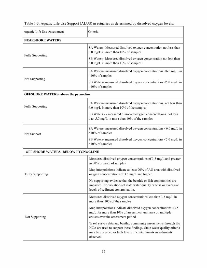
15
Table 1-3. Aquatic Life Use Support (ALUS) in estuaries as determined by dissolved oxygen levels.
Aquatic Life Use Assessment Criteria
NEARSHORE WATERS
Fully Supporting
SA Waters- Measured dissolved oxygen concentration not less than 6.0 mg/L in more than 10% of samples
SB Waters- Measured dissolved oxygen concentration not less than 5.0 mg/L in more than 10% of samples
Not Supporting
SA Waters- measured dissolved oxygen concentrations <6.0 mg/L in >10% of samples
SB Waters- measured dissolved oxygen concentrations <5.0 mg/L in >10% of samples
OFFSHORE WATERS- above the pycnocline
Fully Supporting
SA Waters- measured dissolved oxygen concentrations not less than 6.0 mg/L in more than 10% of the samples
SB Waters - - measured dissolved oxygen concentrations not less than 5.0 mg/L in more than 10% of the samples
Not Support
SA Waters- measured dissolved oxygen concentrations <6.0 mg/L in >10% of samples
SB Waters- measured dissolved oxygen concentrations <5.0 mg/L in >10% of samples
OFF SHORE WATERS- BELOW PYCNOCLINE
Fully Supporting
Measured dissolved oxygen concentrations of 3.5 mg/L and greater in 90% or more of samples
Map interpolations indicate at least 90% of AU area with dissolved oxygen concentrations of 3.5 mg/L and higher
No supporting evidence that the benthic or fish communities are impacted. No violations of state water quality criteria or excessive levels of sediment contamination.
Not Supporting
Measured dissolved oxygen concentrations less than 3.5 mg/L in more than 10% of the samples
Map interpolations indicate dissolved oxygen concentrations <3.5 mg/L for more than 10% of assessment unit area on multiple cruises over the assessment period
Trawl survey data and benthic community assessments through the NCA are used to support these findings. State water quality criteria may be exceeded or high levels of contaminants in sediments observed

16
determined using the Winkler titration method from the near bottom depth were used. Near bottom is defined as 1 m up from the sediment/water interface. Data were compiled by station. A total number of data points (n) were determined. The number of data points that were < 3.5 mg/L (acute criteria in offshore water below the pycnocline) was determined. That number was divided by the total number of samples and multiplied by 100 to give a percentage. If this percentage was >10% the ALUS was assessed as impaired. In segments with multiple stations, percentages from each station were reviewed. If conflicts arose (i.e., one station >10% measurements exceeded, other station <10%) the assessment was listed as impaired to be conservative. The 10% exceedance allowance is based on US EPA assessment guidance (US EPA, 1997).
Hypoxia map interpolations are used to determine the ALUS status in those offshore AUs that do not contain LIS sampling stations. Using GIS software, CT DEP LIS Monitoring Program staff create maps that depict the extent of low dissolved oxygen in the bottom waters of Long Island Sound based upon the data collected during the LISS bi-weekly hypoxia surveys from June through September. Maps are only created when concentrations fall below 4.8 mg/L. Concentrations between sampling stations are interpolated using the ArcGIS 9.3 Spatial Analyst Tool from ESRI, Inc.(Inverse Distance Weighted Average Method, see http://www.esri.com/news/arcuser/0704/files/interpolating.pdf ) Maps are available on the CT DEP website at http://www.ct.gov/dep/cwp/view.asp?a=2719&q=325532 &depNav_GID=1654. Additional details related to map production can be found in the draft Standard Operating Procedure document Preparation of Hypoxia Maps and Summaries for the Year
2010. The GIS raster data files are incorporated into a GIS map document created for assessment purposes. The files are overlain on a layer file of AUs to determine the location of sampling stations relative to AUs and to determine the frequency of excursions below the dissolved oxygen criterion (Figure 1-1). Using a manual method, the area tool in ArcGIS is used to measure the area of each segment that falls within the defined dissolved oxygen concentration classification scheme for each survey/cruise. For LIS purposes the classifications are: 0-0.99 mg/L, 1-1.99 mg/L, 2-2.99 mg/L, 3-3.49 mg/L, 3.5-4.79 mg/L, and >4.8 mg/L. If >10% of the assessment unit area falls below 3.5 mg/L, ALUS is assessed as impaired. The frequency of low dissolved oxygen events is determined based on the number of times the maps indicate dissolved oxygen concentrations fell below the criterion (i.e., X number of cruises < criterion/total number of cruises * 100).
Historic impairments based on dissolved oxygen data are carried forward. Historic impairments associated with sediment contamination will be carried forward through the assessment cycle. Many of these impairments were documented in old Water Quality Reports to Congress and date back to the late 1980s/early 1990s. Impairments were based on interviews with staff engineers and reports that indicated elevated levels of sediment contaminants (Stacey, 2007). Additional historic sources of data included the National Oceanic and Atmospheric Administration‟s Benthic Surveillance Program and Mussel Watch
Program, a project developed to analyze chemical and biological contaminant trends in sediment and bivalve tissue from over 280 coastal sites based on data collected from 1986 to the present (see http://ccma.nos.noaa.gov/stressors/pollution/nsandt/MussellWatch.html for more details.) Data collected for the NCA program (Strobel 2000), data compiled into a sediment dredge geodatabase by the CT DEP Office of Long Island Sound Program (O‟Brien, undated), and data provided by the CT DEP TMDL program (Bellucci, undated) were also used as supplemental sources.

17
Figure 1-1. Arcdocument GIS map export demonstrating how hypoxia map interpolations are overlain on a map of sampling station locations and assessment units.
Fish Consumption
Fish consumption use support is determined by site specific consumption advisories issued by the Connecticut Department of Public Health (CT DPH, 2010). The advisories are based on risk assessments conducted by CT DPH using fish tissue contaminant data. A statewide fish consumption advisory was issued for all species except trout < 15 inches in length in the mid-1990s due to mercury contamination. This advisory was based on statewide surveys of mercury contamination in fish from lakes (Neumann, 1996) and rivers (CT DEP, unpublished). A follow up study was completed in 2008 (Vokoun and Perkins, 2008) and the statewide fish consumption advisory was continued.
Therefore, in addition to fish consumption use support as determined by the criteria below (Table 1-4), all freshwaters of the State are considered impaired for fish consumption due to mercury contamination. Likewise, all estuarine waters are considered impaired for fish consumption due to a statewide advisory for PCB contamination in migratory striped bass and bluefish.
Table 1-4. Fish consumption use support and criteria. Fish Consumption
Assessment
Criteria
Fully Supporting No consumption advisory for any fish species or any consumer group, other than the statewide advisory for Mercury in freshwater fish or PCBs in migratory saltwater fish.
Not Supporting A consumption advisory exists for all or some fish species or for all or certain consumer groups, in addition to the statewide advisory for Mercury in freshwater fish or PCBs in migratory saltwater fish.

18
Shellfish Harvesting (in Estuaries)
Starting with the 2006 reporting cycle, shellfish harvesting has been divided into two designated uses as specified in the CT WQS (2002): shellfish harvesting suitable for direct human consumption (SA waters), and shellfish harvesting suitable for commercial operations requiring depuration or relay (SB waters).
The CT DA/BA is responsible for regulating shellfish harvesting. A shellfish growing area is defined by CT DA/BA as any area that supports or could support the growth and/or propagation of molluscan shellstock. Shellfish are defined by CT DA/BA as oysters, clams, mussels, and scallops, either shucked or in the shell, fresh or frozen, whole or in part. All shellfish growing areas are classified by CT DA/BA in accordance with the Interstate Shellfish Sanitation Conference (ISSC) National Shellfish Sanitation Program Model Ordinance (NSSP-MO) and CT General Statutes Chapter 491, Sec 26-192e. These classifications, summarized below, are established to minimize health risks and may restrict the taking and use of shellfish from some areas. They are based on fecal coliform bacteria standards as provided in the NSSP-MO (Interstate Shellfish Sanitation Conference, 2007).
APPROVED- Open for harvest of shellfish for direct human consumption
CONDITIONALLY APPROVED- A shellfishing area classification that predictably does not conform to "Approved" area criteria due to the occurrence of specified hydrologic or meteorological events or conditions, but will predictably return to the "Approved" area criteria.
RESTRICTED-RELAY/DEPURATION: A shellfishing area classification that conforms to NSSP-MO criteria that allows the area to be used by CT DA/BA licensed operations for the relaying of shellfish to a depuration plant for controlled purification, to designated beds in Approved or Conditionally Approved areas for natural cleansing, or to areas satisfactory to the CT DA/BA, excluding Prohibited, Conditionally Restricted-Relay, and Restricted-Relay areas. These shellfish may not be directly harvested for market nor consumed prior to the purification process involving relay or depuration.
RESTRICTED-RELAY: A shellfishing area classification where CT DA/BA allows aquaculture, relay or transplant activities in conformance to NSSP-MO criteria. Operations may be licensed to relay shellfish to designated beds in Approved or Conditionally Approved areas for natural cleansing. These shellfish may not be directly harvested for market or consumed prior to a minimum purification period of 14 consecutive days after being relayed to Approved or Conditionally Approved “open” areas with a
water temperature of 50 degrees Fahrenheit (10 degrees Celsius) or greater. CT DA/BA may require the shellfish purification time to be longer than 14 consecutive days, based upon shellfish purification verification studies.
CONDITIONALLY RESTRICTED-RELAY: A shellfishing area classification that predictably does not conform to Restricted-Relay area criteria due to the occurrence of specified events or conditions, but predictably returns to the Restricted-Relay area criteria.
PROHIBITED: A shellfishing area classification that prohibits the harvesting of shellfish for any purpose except depletion or aquaculture operations (such as seed oystering) licensed by the CT DA/BA.
US EPA guidance (Grubbs and Wayland, 2000 and US EPA, 2002) identifies that areas closed to shellfish harvesting due to administrative closures, and not based on monitoring data that indicated a

19
water quality impairment, should not be assessed as Not Supporting. These updates are incorporated into the CT CALM and were utilized for this reporting cycle. To determine attainment of water quality standards and for integrated reporting purposes, CT DEP utilizes CT DA/BA shellfish growing area classifications as follows:
Table 1-5. Shellfish Harvesting use support as determined by shellfish growing area classifications.
Class SA waters: Shellfish harvesting for direct human consumption where authorized.
Criteria
Fully Supporting Waters classified by CT DA/BA as Approved.
Not Supporting >10% of segment area classified by CT DA/BA as Prohibited, Conditionally Approved, Conditionally Restricted-relay, Restricted-relay, or Restricted-relay/depuration
Not Assessed Waters closed administratively due to a safety management zone around wastewater treatment plants or marinas, no water quality data available, or lack of resources.
Insufficient Information Waters closed administratively due to a lack of a current sanitary survey or insufficient monitoring data.
Class SB waters: Shellfish harvesting with depuration or relay where authorized.
Criteria
Fully Supporting Waters classified by CT DA/BA as Approved, Conditionally Approved, Conditionally restricted-relay, Restricted-relay/depuration.
Not Supporting >10% of segment area classified by CT DA/BA as Prohibited
Not Assessed Waters closed administratively due to a safety management zone around wastewater treatment plants or marinas, no water quality data available, or lack of resources.
Insufficient Information Waters closed administratively due to a lack of a current sanitary survey or insufficient monitoring data.

20
Administrative closures are established in areas around potential pollution sources, such as sewage outfalls and marinas/mooring fields, as a preventative measure to safeguard human health and preclude the harvest of possibly contaminated shellfish. A marina is defined in the NSSP-MO as “any water area
with a structure (docks, basin, floating docks, etc.) which is used for docking or otherwise mooring vessels, and constructed to provide temporary or permanent docking space for more than ten boats.
Areas may also be classified as prohibited due to incomplete sanitary surveys, lack of water quality data, or insufficient resources/interest.
Areas classified as prohibited for administrative reasons (i.e., around outfalls, marinas, no resources/interest) will not be considered as violating water quality standards and will be listed in the Integrated Water Quality Report as Not Assessed. Areas classified as prohibited due to incomplete sanitary surveys will also not be considered as violating water quality standards but will be listed in the Integrated Water Quality Report as Insufficient Information.
This approach is consistent with US EPA guidance published in 2000 (Grubbs and Wayland, 2000) and in Chapter 3 of the 2002 US EPA document Consolidated Assessment and Listing Methodology Toward a
Compendium of Best Practices. Additionally other coastal states within US EPA Regions 1 and 2 have adopted this approach.
In a number of towns, the CT DA/BA has placed restrictions on direct harvest of shellfish from the shoreline out to the mid-Sound state boundary. However, beyond a depth of 50 feet, there is essentially no shellfishing conducted at this time, and these waters are not regularly monitored. Therefore, for Integrated Reporting purposes, shellfish harvesting is not evaluated as a use in waters between the 50-foot depth contour and the state line. The lack of monitoring should not be construed to mean these deeper offshore waters do not achieve applicable water quality criteria for indicator bacteria.
It should be noted that CT DA/BA shellfish growing areas do not necessarily coincide with CT DEP waterbody segments (Figure 1-2). To determine use support, geographic information systems software (ArcMap 9.3) is utilized. All CT DEP segments from the various geographic areas (i.e., inner estuary, shore, midshore, and offshore) are merged into a single layer file. Then the shellfish area classifications are “unioned” with the merged layer file. The attribute table from this new layer is exported as a .dbf file.
Using Microsoft Excel, pivot tables (Figure 1-3) are created that list each classification present per segment along with size of the area falling completely within the segment. A total area is calculated for each class. The segment is then assessed based on the guidelines above. Sources of impairment are based on shellfish reports compiled by CT DA/BA on an annual, triennial or twelve year basis.

21
Figure 1-2. ArcMap GIS map document export depicting assessment units overlain on shellfish growing area classifications.
Segment ID Approved Conditionally
Approved
Conditionally
Restricted-
Relay
Conditionally
Restricted-
Relay/
Depuration
Prohibited Restricted-
Relay
Restricted-
Relay/
Depuration
Grand
Total
CT-C2_005 0.00% 0.00% 0.00% 0.00% 0.00% 100.00% 0.00% 100.00%
CT-C2_006 12.53% 66.60% 0.00% 0.00% 0.00% 20.87% 0.00% 100.00%
CT-C2_007 53.57% 26.95% 0.00% 0.00% 0.00% 19.48% 0.00% 100.00%
CT-C2_008 0.00% 46.29% 0.04% 23.56% 0.38% 29.73% 0.00% 100.00%
CT-C2_009 0.00% 100.00% 0.00% 0.00% 0.00% 0.00% 0.00% 100.00%
CT-C2_010 32.61% 66.04% 0.00% 0.00% 0.00% 1.34% 0.00% 100.00%
CT-C2_011 50.39% 42.53% 0.42% 0.00% 0.54% 6.12% 0.00% 100.00%
CT-C2_012 9.11% 4.01% 29.20% 0.00% 6.34% 51.34% 0.00% 100.00%
CT-C2_013 18.04% 81.15% 0.00% 0.00% 0.79% 0.02% 0.00% 100.00%
Figure 1-3. Example of pivot table report showing percentage of segment area falling under each CT

22
DA/BA classifications. Recreation
Recreation has historically been assessed for primary contact (full body contact activities such as swimming and water-skiing) and secondary contact (boating, fishing, etc.). Because the CT WQS (2002) do not distinguish waters that should support primary or secondary contact, all waters are assessed for “recreation”, inclusive of both levels of contact. Assessment is based on sanitary/safety considerations
and aesthetic/practical usability. Sanitary condition is determined from indicator bacteria data provided by CT DEP, USGS, volunteer, or municipal monitoring, along with sanitary surveys where appropriate. Aesthetic and practical usability is based on algae and/or macrophyte surveys, mostly for lakes (Table 1-6).
Enterococci group bacteria are used as the primary sanitary indicator organism in salt (estuarine) water, and Escherichia coli in fresh water (CT WQS, 2002). For salt water, 104 Colony Forming Units (CFU)/100 ml of Enterococci is the single sample criterion for designated bathing areas, 500 CFU/100 ml for other recreational uses, and 35 CFU/100 ml is the geometric mean criterion for any recreational use. In fresh water, 235 Colony Forming Units or CFU/100 ml of Escherichia coli is the single sample criterion for designated bathing areas, 410 CFU/100 ml for non-designated swimming areas, 576 CFU/100 ml for other recreational uses, and 126 CFU/100 ml is the geometric mean criterion for any recreational use.
A statewide probabilistic network for the assessment of recreational use support was established in 2006 pursuant to the most recent Comprehensive Ambient water Quality Monitoring Strategy (CT DEP, 2005). This network consists of 61 sites located on 52 rivers and streams. Both wadeable and non-wadeable rivers are monitored. A minimum of 8 samples is collected at each site per year during the bathing season (May through September) for a two-year period. The data are evaluated as described above. This network of sites is intended to produce a statistically valid sample that can be extrapolated to all State rivers and streams at the end of each two-year sampling period, which is coincident with the Integrated Report assessment cycle.
For AUs with designated bathing areas, beach closure information rather than actual indicator bacteria data is generally used to determine use support. Closures of public bathing areas are, for the most part, based on the results of weekly sampling for indicator bacteria during the swimming season. A complete discussion of Connecticut's practices related to beach monitoring and closure may be found in "Guidelines for Monitoring Bathing Waters and Closure Protocol" developed jointly by the Connecticut Department of Health, the CT DEP, the Connecticut Environmental Health Association, and the Connecticut Association of Directors of Health (CT DPH and CT DEP, 2003). Some local health departments implement administrative beach closures, which take effect after rainfall events of a pre-determined magnitude. In these cases, precipitation during the swimming season is also considered in evaluating beach closure information.
Additionally, beach personnel conduct daily inspections of shoreline bathing areas for evidence of contamination. State and local officials also utilize sanitary surveys of shorelines and watersheds as a primary tool to determine sanitary quality. Evidence of waste materials indicative of untreated sewage or human fecal contamination can be sufficient justification to support a beach closure decision by local or state authorities. Small quantities of temporary and/or transient sources of human fecal contamination

23
Table 1-6. Decision criteria for various categories of recreational use support.
Recreation
Assessment
Criteria / Indicators for designated public bathing areas
Fully Supporting Designated bathing area closed 10 % of swimming season or less, and Sanitary survey indicates no significant source a of human fecal contamination. Recreational use is in not hindered by weed or algal growth.
Not Supporting Designated bathing area closed more than 10% of swimming season, or Sanitary survey indicates potential for significant source of human fecal contamination. Algal or exotic weed growth precludes normal recreational use.
Criteria / Indicators for areas not designated as public bathing areas
Fully Supporting Sanitary survey indicates no significant source of human fecal contamination, and Reliable ambient monitoring data show no exceedances of indicator bacteria. Recreational use is not hindered excessive weed /algal growth.
Not Supporting Sanitary survey indicates potential for significant source of human fecal contamination; or (Rivers only) There are a minimum of 8 samples for the assessment period, and there is one or more exceedances of the single sample criteria for Escherichia coli (410 CFU b/ 100 ml for non-designated swimming areas, 576 CFU/100 ml for all other areas), or there is an exceedance of the geometric mean criteria (126 CFU/100 ml), or There are 2 - 7 samples for the assessment period, and there are two single sample exceedances over 1000 CFU/100 ml, or There are 5 - 7 samples for the assessment period and there is an exceedance of a geometric mean of 250 CFU/100 ml. Recreation not possible; river enclosed in conduit. Algal or exotic weed growth precludes normal recreational use.
Insufficient Information
Less than 8 samples in the assessment period and less than two samples that exceed 1000 CFU/100 ml. Or 5-7 samples with a geometric mean less than 250 CFU/100ml
a A significant source of human fecal contamination is one that originates from a fixed location and is transported to or within the waterbody (e.g., an untreated sewage discharge or a community with failing septic systems). b CFU refers to colony-forming-unit, which is the unit of measure for indicator bacteria. It is the general equivalent of one bacterium (one bacterium will grow into one colony when incubated on a plate of growth medium.)
transported to a site (e.g., diapers, tampons, medical items) would likely result in a beach closure. Significant sources of contamination from a fixed location within the AU, such as a CSO or failing septic system, would automatically result in an assessment of impairment.
In some lakes, recreation may also be impaired by excessive growth of aquatic invasive plants or algae, which hampers use by physical means (e.g., dense weeds prevent boat mobility) or creates aesthetically offensive conditions. Lakes for which no bacteria data exist may be considered Fully Supporting of recreation if the lake is situated completely within an undeveloped area or if there have been no complaints of illness or excessive aquatic plant growth, or, as in the case of some urban ponds, swimming is not allowed but other recreation activities are supported.

24
Drinking Water Supply
The CT DPH, in cooperation with the CT DEP, implements the federal Safe Drinking Water Act (SDWA) in Connecticut. The DPH tracks and reports on the water quality of public drinking water supplies within the context of the SDWA. CT DEP periodically surveys water utilities for information concerning closures, trophic status, and potential causes and sources of pollution. Trophic status is reported in a separate table in the 305(b) Report.
A number of Class AA tributaries to drinking water reservoirs are tracked and assessed in the ADB for 305(b) reporting. Assessment of these streams is based on standard measures of water quality (physical/chemical parameters, macroinvertebrate community, fish community, etc. where available), plus consideration of the potential causes and sources of pollution noted on water utility surveys.
Aesthetics
“Aesthetics” is not a designated use of waters in the CT WQS (2002); rather it is a narrative criterion.
Aesthetics is taken into consideration in recreational use assessments based on best professional judgment of CT DEP staff and complaints received from the public. Complaints are usually due to excessive growth of aquatic plants or chronic algal blooms in lakes and excessive growth of seaweeds or the presence of floatable debris in Long Island Sound.
Navigation
Navigation is assumed to be fully supported for all AA, A, B, SA and SB waters.
Agriculture, Industry
Agricultural uses are assumed to be fully supported for all AA, A, and B waters. Industrial use is assumed to be fully supported for all AA, A, B, SA and SB waters.

25
Appendix 1A: Applicable Water Quality Standards and Criteria for Assessed Waters
The information provided in this appendix has been excerpted from the Connecticut Water Quality Standards (2002) to provide reference material for the CT CALM. Refer to the full text of the Connecticut Water Quality Standards for further information and policy statements (www.ct.gov/dep/wqsc). Revisions to the CT WQS are effective as of February 25, 2011. The revised Standards will form the basis for future water quality assessments.
Allowable Discharges to Surface Waters:
(A) Class AA, A and SA surface waters: discharges may be permitted by the Commissioner from public or private drinking water treatment systems, dredging activity and dredge material dewatering operations, including the discharge of dredged or fill material and clean water discharges. In Class AA surface waters such discharges shall be subject to the approval of the Commissioner of Health Services. The Commissioner may authorize other discharges to surface waters with a Classification of SA, A or AA provided the Commissioner finds such discharge will be of short duration and is necessary to remediate surface water or ground water pollution. Any such discharge shall be treated or controlled to a level, which in the judgment of the Commissioner protects aquatic life and public health.
(B) Class B and SB surface waters: discharges may be permitted for all those allowed in Class AA, A and SA surface waters, cooling water discharges, discharges from municipal and industrial wastewater treatment systems and other discharges subject to the provisions of Section 22a-430 of the Connecticut General Statutes.

26
INLAND SURFACE WATERS CLASSES AND CRITERIA
CLASS AA
Designated Uses- These surface waters are designated for: existing or proposed drinking water supplies; habitat for fish and other aquatic life and wildlife; recreation; and water supply for industry and agriculture.
Parameter Criteria 1. Aesthetics Uniformly excellent.
2. Dissolved oxygen Not less than 5 mg/l at any time. 3. Sludge deposits-solid refuse- floating solids-oils and grease-scum
None other than of natural origin.
4. Color None other than of natural origin.
5. Suspended and settleable solids None in concentrations or combinations which would impair designated uses; none aesthetically objectionable; none which would significantly alter the physical or chemical composition of the bottom; none which would adversely impact aquatic organisms living in or on the bottom substrate.
6. Silt or sand deposits None other than of natural origin except as may result from normal agricultural, road maintenance, construction activity or dredging activity or discharge of dredged or fill materials provided all reasonable controls or Best Management Practices are used in such activities and all designated uses are protected and maintained.
7. Turbidity Shall not exceed 5 NTU over ambient levels and none exceeding levels necessary to protect and maintain all designated uses. All reasonable controls or Best Management Practices are to be used to control turbidity.
8. Indicator bacteria See Appendix B. 9. Taste and odor None other than of natural origin.
10. pH As naturally occurs. 11. Allowable temperature increase There shall be no changes from natural conditions that would impair any
existing or designated uses assigned to this Class and, in no case exceed 85 degrees F, or in any case raise the temperature of surface water more than 4 degrees F.
12. Chemical constituents
a) Phosphorus
b) Sodium
None in concentrations or combinations which would be harmful to designated uses. Refer to Water Quality Standards (2002) numbers 10, 12, 13, and 19.
None other than of natural origin
Not to exceed 20 mg/l
13. Benthic invertebrates which inhabit lotic waters
A wide variety of macroinvertebrate taxa should normally be present and all functional feeding groups should normally be well represented. Presence and productivity of aquatic species is not limited except by natural conditions, permitted flow regulation or irreversible cultural impacts. Water quality shall be sufficient to sustain a diverse macroinvertebrate community of indigenous species. Taxa within the Orders Plecoptera (stoneflies), Ephemeroptera (mayflies), Coleoptera (beetles) and Trichoptera (caddisflies) should be well represented.

27
CLASS A
Designated Uses - These surface waters are designated for: habitat for fish and other aquatic life and wildlife; potential drinking water supplies; recreation; and water supply for industry and agriculture.
Parameter Criteria
Aesthetics Uniformly excellent. Dissolved oxygen Not less than 5 mg/l at any time. Sludge deposits solid refuse – floating solids –oils and grease-scum.
None other than of natural origin.
Color None other than of natural origin
Suspended and settleable solids None in concentrations or combinations which would impair designated uses; none aesthetically objectionable; none which would significantly alter the physical or chemical composition of the bottom; none which would adversely impact aquatic organisms living in or on the bottom substrate.
Silt or sand deposits None other than of natural origin except as may result from normal agricultural, road maintenance, construction activity, dredging activity or the discharge of dredged or fill materials provided all reasonable controls or best management practices are used in such activities and all designated uses are protected and maintained.
Turbidity Shall not exceed 5 NTU over ambient levels and none exceeding levels necessary to protect and maintain all designated uses. All reasonable controls or Best Management Practices are to be used to control turbidity.
Indicator Bacteria See Appendix B. Taste and odor None other than of natural origin.
pH As naturally occurs. Allowable temperature increase There shall be no changes from natural conditions that would impair any existing or
designated uses assigned to this Class and, in no case exceed 85 degrees F, or in any case raise the temperature of surface water more than 4 degrees F.
Chemical constituents
Phosphorus
Sodium
None in concentrations or combinations which would be harmful to designated uses. Refer to Water Quality Standards (2002) numbers 10, 12, 13, and 19
None other than of natural origin
None other than of natural origin.
Benthic invertebrates which inhabit lotic waters
A wide variety of macroinvertebrate taxa should normally be present and all functional feeding groups should normally be well represented. Presence and productivity of aquatic species is not limited except by natural conditions, permitted flow regulation or irreversible cultural impacts. Water quality shall be sufficient to sustain a diverse macroinvertebrate community of indigenous species. Taxa within the Orders Plecoptera (stoneflies), Ephemeroptera (mayflies), Coleoptera (beetles) and Trichoptera (caddisflies) should be well represented.

28
CLASS B
Designated Uses - These surface waters are designated for: habitat for fish and other aquatic life and wildlife; recreation; and industrial and agricultural water supply.
Parameter Criteria
Aesthetics Good to excellent Dissolved oxygen Not less than 5 mg/l at any time.
Sludge deposits - solid refuse - floating solids - oil and grease – scum
None except for small amounts that may result from the discharge from a permitted
waste treatment facility and none exceeding levels necessary to protect and maintain all designated uses.
Color None which causes visible discoloration of the surface water outside of any designated zone of influence.
Suspended and settleable solids None in concentrations or combinations which would impair the most sensitive designated use; none aesthetically objectionable; none which would significantly alter the physical or chemical composition of the bottom; and none which would adversely impact aquatic organisms living in or on the bottom sediments; shall not exceed 10 mg/l over ambient concentrations.
Silt or sand deposits None other than of natural origin except as may result from normal agricultural, road maintenance, construction activity, dredging activity or discharge of dredged or fill materials provided all reasonable controls or Best Management Practices are used in such activities and all designated uses are protected and maintained.
Turbidity Shall not exceed 5 NTU over ambient levels and none exceeding levels necessary to protect and maintain all designated uses. All reasonable controls or Best Management Practices are to be used to control turbidity.
Indicator bacteria See Appendix B.
Taste and odor None that would impair any uses specifically assigned to this Class. pH 6.5 - 8.0
Allowable temperature increase There shall be no changes from natural conditions that would impair any existing or designated uses assigned to this Class and, in no case exceed 85 degrees F, or in any case raise the temperature of the receiving water more than 4 degrees F.
Chemical constituents None in concentrations or combinations which would be harmful to designated uses. Refer to Water Quality Standards (2002) numbers 10, 11, 12, 13, 17, and 19.
Benthic invertebrates which inhabit lotic waters
Water quality shall be sufficient to sustain a diverse macroinvertebrate community of indigenous species. All functional feeding groups and a wide variety of macroinvertebrate taxa shall be present; however one or more may be disproportionate in abundance. Waters which currently support a high quality aquatic community shall be maintained at that high quality. Presence and productivity of taxa within the Orders Plecoptera (stoneflies), Ephemeroptera (mayflies); and pollution intolerant Coleoptera (beetles) and Trichoptera (caddis- flies) may be limited due to cultural activities. Macroinvertebrate communities in waters impaired by cultural activities shall be restored to the extent practical through implementation of the department's procedures for control of pollutant discharges to surface waters and through Best Management Practices for non-point sources of pollution.

29
LAKE TROPHIC CATEGORIES
Criteria for Total Phosphorus, Total Nitrogen, Chlorophyll-a, and Secchi Disk Transparency appearing in the table below represent acceptable ranges for these parameters within which recreational uses will be fully supported and maintained for lakes in each trophic category. For the purpose of determining consistency with the water quality standards for lakes classified AA, A or B, an assessment of the natural trophic category of the lake, absent significant cultural impacts, must be performed to determine which criteria apply.
OLIGOTROPHIC May be Class AA, Class A, or Class B water. Low in plant nutrients. Low biological productivity characterized by the absence of macrophyte beds. High potential for water contact recreation. Parameters Criteria 1. Total Phosphorus 0-10 ug/l spring and summer 2. Total Nitrogen 0-200 ug/l spring and summer 3. Chlorophyll-a 0-2 ug/l mid-summer 4. Secchi Disk Transparency 6 + meters mid-summer
MESOTROPHIC May be Class AA, Class A, or Class B water. Moderately enriched with plant nutrients. Moderate biological productivity characterized by intermittent blooms of algae and/or small areas of macrophyte beds. Good potential for water contact recreation. Parameters Criteria 1. Total Phosphorus 10-30 ug/l spring and summer 2. Total Nitrogen 200-600 ug/l spring and summer 3. Chlorophyll-a 2-15 ug/l mid-summer 4. Secchi Disk Transparency 2-6 meters mid-summer
EUTROPHIC May be Class AA, Class A, or Class B water. Highly enriched with plant nutrients. High biological productivity characterized by frequent blooms of algae and/or extensive areas of dense macrophyte beds. Water contact recreation opportunities may be limited. Parameters Criteria 1. Total Phosphorus 30-50 ug/l spring and summer 2. Total Nitrogen 600-1000 ug/l spring and summer 3. Chlorophyll-a 15-30- ug/l mid-summer 4. Secchi Disk Transparency 1-2 meters mid-summer HIGHLY EUTROPHIC May be Class AA, Class A, or Class B water. Excessive enrichment with plant nutrients. High biological productivity, characterized by severe blooms of algae and/or extensive areas of dense macrophyte beds. Water contact recreation may be extremely limited. Parameters Criteria 1. Total Phosphorus 50 + ug/l spring and summer 2. Total Nitrogen 1000 + ug/l spring and summer 3. Chlorophyll-a 0-1 meters mid-summer

30
COASTAL WATERS, CLASSES & CRITERIA.
CLASS SA
Designated Uses - These surface waters are designated for: habitat for marine fish, other aquatic life and wildlife; shellfish harvesting for direct human consumption where authorized; recreation; industrial water supply; and navigation.
Parameter Criteria
Aesthetics Uniformly excellent.
Dissolved Oxygen Not less than 6.0 mg/l at any time in the nearshore waters of Long Island Sound, including harbors, embayments and estuarine tributaries.
Not less than 6.0 mg/l at any time in the offshore waters of Long Island Sound, above the seasonal pycnocline and throughout the Sound when no pycnocline is established.
Not less than 3.5 mg/l for offshore waters within and below the seasonal pycnocline. Cumulative periods of dissolved oxygen in the 3.5 - 4.8 mg/l range shall not exceed exposure parameters detailed in the Dissolved Oxygen (DO) Criteria for Offshore Coastal Waters at the end of this appendix.
Sludge Deposits- None other than of natural origin. solid refuse, floating-solids, oils and grease scum Color None other than of natural origin.
Suspended and None, other than of natural origin. settleable solids
Silt or sand deposits None other than of natural origin except as may result from normal agricultural. Road maintenance, construction activity, dredging activity or discharge of dredged or fill materials provided all easonable controls or Best Management Practices are used in such activities and all designated uses are protected and maintained.
Turbidity None other than of natural origin except as may result from normal agricultural, road maintenance, or construction activity, dredging activity or discharge of dredged or fill materials provided all reasonable controls and Best Management Practices are used to control turbidity and none exceeding levels necessary to protect and maintain all designated uses.
Indicator bacteria See Appendix B.
Taste and odor As naturally occurs.
pH 6.8 - 8.5
Allowable temperature There shall be no changes from natural conditions that would impair any existing or increase designated uses assigned to this Class and in no case exceed 83 degrees F, or in any case raise the temperature of the receiving water more than 4 degrees F. During the period including July, August, and September, the temperature of the receiving water shall not be raised more than 1.5 degrees F unless it can be shown that spawning and growth of indigenous organisms will not be significantly affected.
Chemical None in concentrations or combinations which would be harmful constituents to designated uses. constituents Refer to Water Quality Standards (2002) numbers 10, 12, 13, and 19.

31
CLASS SB
Designated Uses - These waters are designated for: habitat for marine fish, other aquatic life and wildlife; commercial shellfish harvesting where authorized; recreation; industrial water supply; and navigation.
Parameter Criteria
Aesthetics Good to excellent.
Dissolved Oxygen Not less than 5.0 mg/l at any time in the near shore water of Long Island Sound, including harbors, embayments and estuarine tributaries.
Not less than 5.0 mg/l at any time in the offshore waters of Long Island Sound above the seasonal pycnocline and throughout the Sound when no pycnocline is established.
Not less than 3.5 mg/l for offshore waters within and below the seasonal pycnocline. Cumulative periods of dissolved oxygen exposure in the 3.5 – 4.8 mg/l range shall not exceed parameters detailed in Appendix C.
Sludge deposits- solid None except for small amounts that may result from the discharge from refuse – floating solids grease waste treatment facility providing appropriate treatment and none – oils and grease scum exceeding levels necessary to protect and maintain all designated uses.
Color None resulting in obvious discoloration of the surface water outside of any designated zone of influence.
Suspended and settleable None in concentrations or combinations which would impair the designated uses; solids none aesthetically objectionable; none which would significantly alter the physical or
chemical composition of bottom sediments; none which would adversely impact organisms living in or on the bottom sediment.
Silt or sand deposits None other than of natural origin except as may result from normal agricultural, road maintenance, construction activity, dredging activity or discharge of dredged or fill materials provided all reasonable controls or Best Management Practices are used in such activities and all designated uses are protected and maintained.
Turbidity None other than of natural origin except as may result from normal agricultural, road maintenance, or construction activity, or discharge from a waste treatment facility providing appropriate treatment, dredging activity or discharge of dredged or fill materials provided all reasonable controls and Best Management Practices are used to control turbidity and none exceeding levels necessary to protect and maintain all designated uses.
Indicator bacteria See Appendix B.
Taste and odor As naturally occurs. None that would impair any uses specifically assigned to this Class.
pH 6.8 - 8.5
Allowable temperature There shall be no changes from natural conditions that increase would impair any existing or designated uses assigned to this Class and, in no case exceed 83 degrees F, or in any case raise the temperature of the receiving water more than 4 degrees F. During the period including July, August, and September, the temperature of the receiving water shall not be raised more than 1.5 degrees F unless it can be shown that spawning and growth of indigenous organisms will not be significantly affected.
Chemical constituents None in concentrations or combinations which would be harmful to the designated uses. Refer to Water Quality Standards (2002) numbers 10, 12, 13, and 19

32
Appendix 1B: Water Quality Criteria for Bacterial Indicators of Sanitary Quality SEE ALSO STANDARDS # 23 AND 25
DESIGNATED USE CLASS INDICATOR CRITERIA Freshwater
Drinking Water Supply (1) Existing / Proposed AA Total Coliform Monthly Moving Average less than 100/100 ml Single Sample Maximum 500/100ml
Potential A ---- --------
Recreation (2)(3)
Designated Swimming (4) AA, A, B Escherichia coli Geometric Mean less than 126/100ml Single Sample Maximum 235/100ml
Non-designated Swimming (5) AA, A, B Escherichia coli Geometric Mean less than 126/100ml Single Sample Maximum 406/100ml
All Other Recreational Uses AA, A, B Escherichia coli Geometric Mean less than 126/100ml Single Sample Maximum 576/100ml
Saltwater
Shellfishing
Direct Consumption SA Fecal Coliform Geometric Mean less than 14/100ml 90% of Samples less than 43/100ml
Commercial Harvesting SB Fecal Coliform Geometric Mean less than 88/100ml 90% of Samples less than 260/100ml Recreation
Designated Swimming (4) SA, SB Enterococci Geometric Mean less than 35/100ml Single Sample Maximum 104/100ml
All Other Recreational Uses SA, SB Enterococci Geometric Mean less than 35/100ml Single Sample Maximum 500/100ml Table Notes: (1) Criteria applies only at the drinking water supply intake structure. (2) Criteria for the protection of recreational uses in Class B waters do not apply when disinfect ion of sewage treatment plant effluents is not required consistent with Standard 23. See Standard # 25. (4) Procedures for monitoring and closure of bathing areas by State and Local Health Authorities are specified in: Guidelines for Monitoring Bathing Waters and Closure Protocol, adopted jointly by the Department of Environmental Protection and the Department of Public Health, May 1989, revised June 1992. (5) Includes areas otherwise suitable for swimming but which have not been designated by State or Local authorities as bathing areas, waters which support tubing, water skiing, or other recreational activities where full body contact is likely.

33
Guidelines for Use of Indicator Bacteria Criteria
Water Quality Classifications are reviewed approximately every three years at which time all available water quality monitoring data is considered along with other relevant information. Relevant information includes but is not limited to federal guidance concerning the scientific basis for deriving the criteria and the potential health risks associated with excursions above the criteria, recommended implementation procedures, and the results of sanitary surveys or other investigations into sources of indicator bacteria in the watershed. Public input is also solicited and considered in determining the existing water quality conditions and water quality goals. Nevertheless, the Water Quality Classification may not be an accurate representation of current water quality conditions at any particular site. For this reason, the Water Quality Classification should not be considered as a certification of quality by the State or an approval to engage in certain activities such as swimming or shellfish harvest

34
Appendix 1C: Dissolved Oxygen (DO) Criteria for Offshore Coastal Waters
Background: Offshore Coastal DO criteria are based on the Environmental Protection Agency‟s Ambient
Water Quality Criteria for Dissolved Oxygen (Saltwater): Cape Cod to Cape Hatteras (US EPA, 2000), noticed November 30, 2000 in the Federal Register (65(231):71317-71321).
Area Affected: DO criteria different from the 6.0 mg/l and 5.0 mg/l minimums for Class SA and SB offshore waters apply only in and below the pycnocline of Long Island Sound (LIS) where stratification occurs during warm, summer conditions. Offshore waters are defined as areas of LIS greater than 5m in depth at mean low water. Offshore waters above the pycnocline generally have ample DO from photosynthesis and wave-driven diffusion.
Cumulative DO exposure parameters: DO conditions in the area affected do not readily lend themselves to a single numeric criterion as is often done with toxic contaminants. Aquatic organisms are harmed based on a combination of minimum oxygen concentration and duration of the low DO excursion. A DO concentration of 4.8 mg/l would meet the chronic criteria for growth and protect estuarine organisms resident in LIS regardless of duration. If oxygen fell within a 0.5 mg/l incremental range below 4.8 mg/l (i.e., between 4.3 and 4.8 mg/l), a duration of 21 days or less would meet resource protection goals. Based upon the US EPA research and data, similar exposure allowances were used by the CT DEP for each 0.5 mg/l increment (see Table A1). he minimum DO level that can be associated with the draft US EPA DO criteria document (i.e. the level below which there would be no exposure period consistent with resource protection) is 2.3 mg/l. Given the environmental variability, CT DEP has used more protective minimum DO criteria of 3.5-3.8 mg/l with no more than 5 days exposure.
Because estuarine systems are variable, DO levels are unlikely to remain within one of the three incremental ranges presented in Table A1. Typically, DO conditions would fall through a range to a minimum and then begin to rebound depending on weather and stratification conditions. To account for this, the number of days within each incremental DO range is pro-rated, as follows. decimal fraction is calculated for each range, e.g., 10.5 days in the 4.3-4.8 mg/l range would produce a decimal fraction of 0.50 (10.5 days/21 days). As long as the sum of those fractions calculated for each range is less than 1.0, resource protection goals are maintained for larval recruitment.
Table A1. DO incremental ranges and duration (exposure) data to be applied to LIS in the area affected to ensure protection of larval recruitment. DO Range (mg/l) No. of Days Allowed Maximum Minimum 4.8 4.3 21 4.3 3.8 11 3.8 3.5 5

35
Chapter 2 – 305(b) Assessment Results Results of CT DEP‟s assessment of available data relating to attainment and support of designated uses
are summarized in Table 2-1 below. Individual river, lake, and estuarine waterbody assessments are presented in Table 2-2. Not all waterbodies are assessed for all designated uses and some waterbodies that were previously assessed as Fully Supporting may have been assessed as Not Assessed in this reporting cycle due to age limitations on assessment information. However, any water assessed as Not Supporting in a prior report retains that assessment until new monitoring data confirm that use is supported. The geographical coverage of assessed waters is presented in Figure 2-1.
Table 2-1. Designated use support summaries for rivers, lakes and estuaries.
USE SUPPORT 2010
FULLY
SUPPORTING
NOT
SUPPORTING
INSUFFICIENT
INFORMATION
TOTAL
ASSESSED
NOT
ASSESSED
TOTAL
TRACKED
Rivers
Aquatic Life Segments 221 167 62 450 331 781 Miles 862.36 451.17 200.11 1513.64 853.30 2366.94
Recreation
Segments 27 211 18 256 525 781
Miles 95.66 806.95 44.52 947.13 1419.81 2366.94
Fish Consumption b
Segments 758 18 776 5 781
Miles 2234.79 130.21 2365 1.94 2366.94
Drinking Water
Segments 0 1 1 103 104
Miles 0 1.24 1.24 376.93 378.17
Lakes
Aquatic Life Segments 148 17 165 17 182 Acres 29022.33 1158.90 30181.23 256.23 30437.46
Recreation
Segments 116 32 148 34 182
Acres 21878.25 4793.7 26671.95 3765.51 30437.46
Fish Consumption b
Segments 166 14 180 2 182
Acres 26647.15 3779.59 30426.74 10.72 30437.46
Drinking Water Segments 5 0 5 35 40 Acres 1190.33 0 1190.33 5844.62 7034.95
Potential Drinking Water
Segments 0 0 0 1 1
Acres 0 0 0 40.90 40.90
Estuaries
Marine Aquatic Life
Segments 26 71 4 101 109 210
Mi2 234.95 314.46 1.85 551.253 60.63 611.89
Recreation
Segments 54 19 1 74 136 210
Mi2 29.05 11.63 0.67 41.35 570.54 611.89
Fish Consumption b
Segments 206 4 210 0 210
Mi2 603.26 8.63 611.89 0 611.89
Shellfish Harvesting, Class SA Waters
Segments 7 122 129 4 133
Mi2 41.88 204.07 245.95 0.45 246.40
Shellfish Harvesting, Class SB Waters
Segments 26 29 55 5 60
Mi2 39.14 21.22 60.36 4.75 65.11 a “Total Tracked” refers to the waterbody sizes tracked in the Assessment Database (ADB V2). The total size of estuaries in the State is accounted for, but only a fraction of river miles and lake acres are tracked in the ADB V2. The total number of river miles estimated for Connecticut is 5,830 and the total number of lake acres is 64,973 (US EPA, 1993). b All freshwaters of the State are considered impaired for fish consumption and addressed by a statewide limited consumption advisory for all freshwater fish, except trout, due to atmospheric deposition of mercury. Similarly, all estuarine waters are

36
considered impaired for fish consumption and addressed by a statewide advisory on striped bass and bluefish due to PCB contamination. The waters summarized in these tables contain fish consumption advisories beyond the statewide advisories.
Figure 2-1. Waterbody segments assessed for one or more designated uses
Geographic coverage of use attainment for ALUS and recreational use support are provided in Figures 2-2 and 2-6, respectively. An index map to assist readers in locating segments of particular interest is provided immediately preceding the table of assessment results for individual waterbody segments. Waterbody assessment results are provided in ascending order by waterbody ID number. Inland water (rivers, streams, and lakes) are presented first, followed by estuarine waterbody segments. Waters assessed for drinking water use are listed at the end of Table 2-2.

37
Figure 2-2. Waterbody segments assessed for aquatic life use

38
Figure 2-3. Aquatic Life Use Support (ALUS) in Connecticut Rivers
Figure 2-4. Aquatic Life Use Support (ALUS) in Connecticut Lakes

39
Figure 2-5. Aquatic Life Use Support (ALUS) in Connecticut Estuaries
Figure 2-6. Waterbody segments assessed for recreational use

40
Figure 2-7. Recreation Support in Connecticut Rivers
Figure 2-8. Recreation Support in Connecticut Lakes

41
Figure 2-9. Recreation Support in Connecticut Estuaries
Figure 2-10. Waterbody segments assessed for shellfishing use

42
Figure 2-11. Shellfishing Use in Connecticut Estuaries
Probabilistic Survey Results
A great deal of progress was made during the last decade to expand the State‟s water quality monitoring network. Targeted stream sampling, including that conducted during a five-year rotating basin study, achieved maximum coverage of approximately 20% of perennial stream miles and is generally focused on wastewater receiving streams, historically impaired waters, and known unimpaired reference sites. A probabilistic study design was implemented to allow characterization of water quality on a statewide basis for tracking long-term trends in water quality. The initial effort, conducted jointly with US EPA Region I between fall 2002 and spring 2004 included aquatic invertebrate and fish community surveys, periphyton surveys, and four quarterly monitoring events for physical parameters, chemistry and indicator bacteria at approximately 70 sites. The results of this effort (Figures 2-12) provide a statistically valid sample of use attainment in Connecticut‟s wadeable streams and, for the first time, the ability to make statistically valid
projections regarding the overall condition of wadeable streams of the State.
In 2005, a new Comprehensive Ambient Water Quality Monitoring Strategy was adopted (http://www.ct.gov/dep/lib/dep/water/water_quality_management/ct_comp_amb_wtr_qual_monit_strat.pdf). This strategy incorporates a composite of targeted and probabilistic sampling designs to assess ALUS. Targeted designs for assessment of ALUS include a mix of sites visited on five-year, two-year and annual frequencies. Additionally, approximately 20 sites are selected randomly, supporting a statewide probabilistic assessment at the end of a five-year rotation.
This approach provides sufficient targeted data to answer questions regarding specific water pollution control activities while also supporting a statewide probabilistic assessment. Use support status included in this report for specific assessment units is based on targeted monitoring data collected in 2007 and 2008.

43
Fully Supporting
71%
Not Supporting
15%
Insufficient Information
14%
Figure 2-12. Statewide Rivers Assessment of Aquatic Life Use Attainment based on 2002-2004 Probabilistic Sampling
The probabilistic monitoring program was expanded in 2006. Bacteria sampling was added to provide a better baseline estimate of recreational use attainment statewide. A total of 61 randomly selected freshwater rivers were monitored over a two-year time period as part of this program. At least twenty samples were collected per site during the bathing season from May through August. Recreational use attainment assessments were performed as described in the CT CALM (Chapter 1). Eleven percent (11) of the probabilistic sites met criteria for recreational use support, while eighty-nine (89) failed (Figure 2-13).
Fully Supporting
15%
Not Supporting
85% Figure 2-13. Statewide Rivers Assessment of Recreational Use Attainment based on 2002-2004 Probabilistic Sampling
In 2005, CT DEP also embarked on a three-year effort to perform probabilistic monitoring of lake water quality to establish a baseline for use attainment in lakes. The program sets a goal of monitoring 60 lakes over a three-year period. Fieldwork has been completed, but laboratory and data analyses are not yet fully available. Through this effort, using a statistically representative sample of lakes, CT DEP will be able to achieve a comprehensive lake-assessment baseline as was accomplished with probabilistic wadeable stream monitoring.

44
Number Regional Name
10 Pawcatuck Main Stem
11 Wood
20 Southeast Shoreline
21 Southeast Eastern Complex
22 Southeast Western Complex
30 Thames Main Stem
31 Will imantic
32 Natchaug
33 French
34 Fivemile
35 Moosup
36 Pachaug
37 Quinebaug
38 Shetucket
39 Yantic
40 Connecticut Main Stem
41 Stony Brook
42 Scantic
43 Farmington
44 Park
45 Hockanum
46 Mattabesset
47 Salmon
48 Eightmile
50 South Central Shoreline
51 South Central Eastern Complex
52 Quinnipiac
53 South Central Western Complex
60 Housatonic Main Stem
61 Blackberry
62 Hollenbeck
63 Tenmile
64 Candlewood
65 Aspetuck
66 Stil l
67 Shepaug
68 Pomperaug
69 Naugatuck
70 Southwest Shoreline
71 Southwest Eastern
72 Saugatuck
73 Norwalk
74 Southwest Western Complex
81 Croton
Figure 2-14. Connecticut River and Lake Basins Index

45
CT-E1_## = Inner Estuary
CT-E2_## = Shore
CT-E3_## = Midshore
CT-E4_## = Offshore CT-C1_## = Inner Estuary
CT-C2_## = Shore
CT-C3_## = Midshore
CT-C4_## = Offshore CT-W1_## = Inner Estuary
CT-W2_## = Shore
CT-W3_## = Midshore
CT-W4_## = Offshore
Figure 2-15. Connecticut Estuary Basins Index

46
Table 2-2. Connecticut 305b Assessment Results

Connecticut 305b Assessment Results RIVERS TABLE 2-2
Use Support: FULL=Designated use Fully Supported NOT=Designated use Not Supported, See 303d listing for details. U=Not Assessed ///=Not applicable to Segment I= Insufficient Information to assess use FULL*=Refer to Connecticut Department of Environmental Protection Angler's Guide, or online at www.ct.gov/dep for more information about fish consumption advisories.
47
ID305B NAME LOCATION MILES
AQ
UA
TIC
LIF
E
RE
CR
EA
TIO
N
FIS
H
CO
NS
UM
PT
ION
CT1000-00_01 Pawcatuck River-01 From head of tide, Rte 1 crossing in Pawcatuck-Westerly, US to RI border. 5.38 U NOT FULL
CT1001-00_01 Wyassup Brook-01 From mouth at confluence with Green Fall River (on North side and parallel to Route 216 (Clarks Falls Road)), US to Wyassup Lake outlet (just US of Wyassup Road crossing), North Stonington.
5.27 FULL U FULL
CT1001-02_01 Pendleton Hill Brook (North Stonington)-01
Mouth at Spalding Pond portion of Wyassup brook, just DS of Route 49 crossing, US to HW, adjacent to route 49 at Wyassup Road intersection, North Stonington.
5.13 FULL U FULL*
CT1002-00_01 Green Fall River-01 From Rhode Island border (very close to mouth), US to confluence with Wyassup Brook (just US of Clarks Falls Road crossing), North Stonington. 1.47 FULL U FULL
CT1002-00_02 Green Fall River-02 From confluence with Wyassup Brook (just US of Clarks Falls Road crossing), North Stonington, US to Green Fall Pond (Reservoir) outlet dam, Voluntown. 5.18 FULL U FULL
CT1002-00_03 Green Fall River-03 From Green Fall Pond (Reservoir) inlet on northeast side, US to headwaters at Pachaug Wildlife Pond Dam (just south of Route 138 (Rockville Road)), Voluntown.
1.85 U U FULL
CT1004-00_01 Shunock River-01 From mouth at Pawcatuck River, US to Side Pond dam at outlet of Ripley Parks Pond (just south of Babcock Road), North Stonington Center. 4.37 FULL NOT FULL
CT1004-00_02 Shunock River-02 From inlet to Ripley Parks Pond (just south of Babcock Road), North Stonington center, US to headwaters (above Gallup pond, south side of Route 201). 3.92 U U FULL

Connecticut 305b Assessment Results RIVERS TABLE 2-2
Use Support: FULL=Designated use Fully Supported NOT=Designated use Not Supported, See 303d listing for details. U=Not Assessed ///=Not applicable to Segment I= Insufficient Information to assess use FULL*=Refer to Connecticut Department of Environmental Protection Angler's Guide, or online at www.ct.gov/dep for more information about fish consumption advisories.
48
ID305B NAME LOCATION MILES
AQ
UA
TIC
LIF
E
RE
CR
EA
TIO
N
FIS
H
CO
NS
UM
PT
ION
CT1100-00_01 Wood River (Voluntown)-01 From inlet to Hazard Pond (Rhode Island border) just DS of Bailey Pond Road crossing, Voluntown, US to Porter Pond outlet dam, just US of Porter Pond Road crossing, Sterling.
1.99 U U FULL
CT2000-30_01 Fenger Brook-01 From mouth at head of tide, Alewife Cove (just DS of Niles Hill Road (Route 213) crossing), US to headwaters (southeast of Clark Lane and Chester Street intersection), Waterford.
3.47 NOT NOT FULL
CT2102-00_01 Copps Brook-01 From mouth at Quiambog Cove (parallel to Cove Road), US to Palmer (Mystic) Reservoir outlet dam (just US of Jerry Brown Road crossing), Stonington. 0.77 NOT U FULL
CT2102-00_02 Copps Brook-02 From inlet to Palmer (Deans/Mystic) Reservoir (just DS of Pequot Trail (Route 234) road crossing), Stonington, US to headwaters (just US of Mystic Road (Route 201) crossing, North Stonington.
4.32 U U FULL*
CT2102-00-trib_01 Unnamed Trib to Copps Brook-01
From mouth at Copps Brook, just US of Quiambog Cove (parallel to Cove Road), US to headwaters near Jerry Brown Road, Stonington (intermittent). 0.66 NOT U FULL*
CT2103-00_01 Seth Williams Brook-01 From mouth at Whitford Brook on Ledyard/Stonington town line, US to Shewville Road crossing, Ledyard. 0.42 U U FULL*
CT2103-00_02 Seth Williams Brook-02 From Shewville Road crossong, US to Highlands POTW (DS of Town Farm Road, parallel to Shewville Road), Ledyard. 0.53 U U FULL*
CT2103-00_03 Seth Williams Brook-03 From Highlands POTW (DS of Town Farm Road crossing, parallel to Shewville Road), US to headwaters (US of Shewville Road crossing, south of Route 214 intersection), Ledyard.
2.1 U U FULL*

Connecticut 305b Assessment Results RIVERS TABLE 2-2
Use Support: FULL=Designated use Fully Supported NOT=Designated use Not Supported, See 303d listing for details. U=Not Assessed ///=Not applicable to Segment I= Insufficient Information to assess use FULL*=Refer to Connecticut Department of Environmental Protection Angler's Guide, or online at www.ct.gov/dep for more information about fish consumption advisories.
49
ID305B NAME LOCATION MILES
AQ
UA
TIC
LIF
E
RE
CR
EA
TIO
N
FIS
H
CO
NS
UM
PT
ION
CT2104-00_01 Whitford Brook-01
From mouth at head of Mystic River Estuary (at confluence with Haleys Brook, above Mystic River, DS of Route 27 crossing), Stonington/Groton town line, US to area east of the Shewville Road and Gallup Hill Road intersection, Ledyard/Stonington town line.
1.63 FULL U FULL*
CT2104-00_02a Whitford Brook-02a
From area east of the Shewville Road and Gallup Hill Road intersection, Ledyard/Stonington town line, US to entrance of "Lantern Hill" wellfield (west of Lantern Hill Road, in marsh parallel with Stony Pond), Ledyard/Stonington town line.
0.74 NOT U FULL*
CT2104-00_02b Whitford Brook-02b From entrance of "Lantern Hill" wellfield (west of Lantern Hill Road, in marsh parallel with Stony Pond), Ledyard/Stonington town line, US to confluence with Seth Williams Brook, Ledyard/Stonington town line.
0.43 U U FULL*
CT2104-00_03 Whitford Brook-03 From confluence with Seth Williams Brook, US to Whitford Pond outlet dam (just US of Whitford Road crossing), Ledyard/Stonington town line. 0.3 U U FULL*
CT2104-00_04 Whitford Brook-04 From inlet to Whitford Pond (northeast portion of pond), Ledyard/Stonington town line, US to Long Pond outlet dam (just US of Lantern Hill Road crossing), Ledyard.
0.89 U U FULL*
CT2202-00_01 Latimer Brook-01 From mouth at confluence with Niantic River (head of tide at Banning Cove inlet, just DS of Route 1 crossing, south side of I95, east of exit 75), US to confluence with Cranberry Meadow Brook (parallel with Route 161), East Lyme
4.23 U NOT FULL*
CT2202-00_02 Latimer Brook-02 From confluence with Cranberry Meadow Brook (parallel with Route 161), East Lyme, US to Beckwith Pond outlet dam (boundary of drinking water watershed, just US of Route 85 crossing), Montville.
3.43 U U FULL*
CT2202-00_03 Latimer Brook-03 From Beckwith Pond inlet (in marsh on northern side), US to headwaters at Barnes Reservoir outlet dam, Montville/Salem. 1.26 U U FULL*

Connecticut 305b Assessment Results RIVERS TABLE 2-2
Use Support: FULL=Designated use Fully Supported NOT=Designated use Not Supported, See 303d listing for details. U=Not Assessed ///=Not applicable to Segment I= Insufficient Information to assess use FULL*=Refer to Connecticut Department of Environmental Protection Angler's Guide, or online at www.ct.gov/dep for more information about fish consumption advisories.
50
ID305B NAME LOCATION MILES
AQ
UA
TIC
LIF
E
RE
CR
EA
TIO
N
FIS
H
CO
NS
UM
PT
ION
CT2203-00_01 Oil Mill Brook (East Lyme/Waterford)-01
Mouth on Niantic River, parallel to Oil Mill Road, Waterford/East Lyme town line, US to Route I95 crossing, Waterford. 0.26 U NOT FULL*
CT2204-03_01 Stony Brook (Waterford)-01 Mouth on Niantic River, DS of Oswegatchie Road crossing, US to ponded section on US side of Route 1 crossing, Waterford. 0.23 U NOT FULL*
CT2205-00_01 Pattagansett River-01 From head of tide, just DS of Route 156 crossing, US to Gorton Pond outlet dam (just US of Roxbury Road crossing, east of Route 161 intersection), East Lyme. 1.2 U U FULL*
CT2205-00_02 Pattagansett River-02 From inlet to Gorton Pond (northern side in marsh, just DS of I95 crossing), US to Pattagansett Lake outlet dam (just US of Route 1 crossing), East Lyme. 1.9 U U FULL*
CT2205-00_03 Pattagansett River-03 From inlet to Pattagansett Lake (northwest portion of lake), US to Powers Lake outlet dam (just US of Upper Pattagansett Road crossing), East Lyme. 0.95 U U FULL*
CT2206-00_01 Bride Brook-01 From head of estuary (salt water limit, just DS of Route 156 crossing), US to Bride Lake outlet dam (just US of North Bride Brook Road), East Lyme. 0.7 NOT NOT FULL*
CT2206-00_02 Bride Brook-02 From inlet to Bride Lake (northwest portion, just DS of North Bride Brook Road crossing), US to headwaters (marsh on south side of Route 1), East Lyme. 2.13 NOT U FULL*
CT3000-08_01 Flat Brook (Ledyard)-01 From mouth at confluence with Thames River (inlet to Long Cove, North of Navy Base) Gales Ferry/Ledyard, US to headwaters at unnamed pond, Groton (Brook runs North).
1.09 U NOT FULL*

Connecticut 305b Assessment Results RIVERS TABLE 2-2
Use Support: FULL=Designated use Fully Supported NOT=Designated use Not Supported, See 303d listing for details. U=Not Assessed ///=Not applicable to Segment I= Insufficient Information to assess use FULL*=Refer to Connecticut Department of Environmental Protection Angler's Guide, or online at www.ct.gov/dep for more information about fish consumption advisories.
51
ID305B NAME LOCATION MILES
AQ
UA
TIC
LIF
E
RE
CR
EA
TIO
N
FIS
H
CO
NS
UM
PT
ION
CT3001-00_01 Trading Cove Brook-01 From head of tide at confluence with Thames River (inlet to Trading Cove, just DS from Route 32 crossing), Norwich/Montville town line, US to headwaters (in marsh just US of Bozrah Road (Route 163) crossing), Montville.
7.24 FULL U FULL*
CT3003-00_01 Poquetanuck and Hewitt Brooks-01
From mouth of Poquetanuck Brook (at confluence with Thames River, inlet to Poquetanuck Cove, just DS of Poquetanuck Road (Route 2A) crossing), US to confluence with Hewitt Brook, then CONTINUES US in Hewitt Brook to Hallville Pond outlet dam.
1.69 U U FULL*
CT3004-00_01 Oxoboxo Brook-01 From mouth at head of tide (inlet to Gay Cemetery Pond, Horton Cove, Thames River), US to Wheeler Pond outlet dam, Montville. (Segment includes Rockland Pond)
2.62 U NOT FULL*
CT3004-00_02 Oxoboxo Brook-02 From inlet to Wheeler Pond (northwestern portion, DS of Meeting House Lane road crossing), US to Oxoboxo Lake outlet dam. (Includes Scholfield Pond) 2.95 U U FULL*
CT3005-01_01 Stony Brook (Montville)-01 Mouth on Horton Cove portion of Thames River, just DS of Route 32 crossing, US to confluence with unnamed tributary (3005-02), DS of Fitch Hill Road crossing, parallel to Gallivan Lane, Montville.
2.97 U U FULL*
CT3005-01_02 Stony Brook (Montville)-02 Confluence with unnamed tributary (3005-02), DS of Fitch Hill Road crossing, parallel to Gallivan Lane, US to Stony Brook reseervoir outlet, parallel to Noble Hill Road, Montville.
1.56 U U FULL*
CT3100-00_01 Willimantic River-01 From mouth at concluence with Shetucket River, Windham, US to confuence with the Tenmile River (at Columbia/Lebanon/Windham borders, just DS of Route 66 crossing). Entire segment parallels Route 66.
2.69 U U FULL*
CT3100-00_02 Willimantic River-02 From confluence with Tenmile River (at Columbia/Lebanon/Windham borders, just DS of Route 66 crossing), US to Eagleville Pond dam outlet (just US of Stonehouse Road crossing).
6.59 FULL NOT FULL*

Connecticut 305b Assessment Results RIVERS TABLE 2-2
Use Support: FULL=Designated use Fully Supported NOT=Designated use Not Supported, See 303d listing for details. U=Not Assessed ///=Not applicable to Segment I= Insufficient Information to assess use FULL*=Refer to Connecticut Department of Environmental Protection Angler's Guide, or online at www.ct.gov/dep for more information about fish consumption advisories.
52
ID305B NAME LOCATION MILES
AQ
UA
TIC
LIF
E
RE
CR
EA
TIO
N
FIS
H
CO
NS
UM
PT
ION
CT3100-00_03 Willimantic River-03 Inlet to Eagleville Pond (west of Route 32 and RailRoad tracks near Ravine Road intersection), Mansfield, US to I84 crossing (includes under highway crossing area), Willington/Tolland.
9.59 FULL NOT FULL*
CT3100-00_04 Willimantic River-04 From I84 crossing (includes under highway crossing area), Willington/Tolland, US to confluence with Bonemill Brook, Tolland. 3.11 FULL U FULL*
CT3100-00_05 Willimantic River-05 From confluence with Bonemill Brook (just DS of Route 32 crossing), Willington/Tolland, US to Stafford POTW (east of Route 32 (River Road)), Stafford.
1.65 U FULL FULL*
CT3100-00_06 Willimantic River-06 From Stafford POTW (east of Route 32 (River Road)), US to headwaters at confluence of Middle River and Furnace Brook. 0.4 U U FULL*
CT3100-03_01 Bonemill Brook-01 From mouth at confluence with Willimantic River, US to Sweetheart Lake outlet dam, Tolland. 0.19 U U FULL*
CT3100-03_02 Bonemill Brook-02 From inlet to Sweatheart Lake, Tolland, US to headwaters (US of Tolland Turnpike crossing), Ellington. 1.93 U U FULL*
CT3100-17_01 Cedar Swamp Brook (Mansfield)-01
From confluence with Willimantic River (segment03, in Eagleville Pond portion of river) just DS of Route 32 (Stafford Road) and RailRoad crossings, US to confluence with Nelson Brook, Mansfield.
1.54 U U FULL*
CT3100-17_02 Cedar Swamp Brook (Mansfield)-02
From confluence with Nelson Brook, US to Hunting Lodge Road crossing, Mansfield. 0.59 U U FULL*

Connecticut 305b Assessment Results RIVERS TABLE 2-2
Use Support: FULL=Designated use Fully Supported NOT=Designated use Not Supported, See 303d listing for details. U=Not Assessed ///=Not applicable to Segment I= Insufficient Information to assess use FULL*=Refer to Connecticut Department of Environmental Protection Angler's Guide, or online at www.ct.gov/dep for more information about fish consumption advisories.
53
ID305B NAME LOCATION MILES
AQ
UA
TIC
LIF
E
RE
CR
EA
TIO
N
FIS
H
CO
NS
UM
PT
ION
CT3100-17_03 Cedar Swamp Brook (Mansfield)-03
From Hunting Lodge Road crossing, US to Swamp Brook Pond outlet dam (just US of Route 44 crossing), Mansfield. 0.61 U U FULL*
CT3100-18_01 Nelson Brook (Mansfield)-01 From mouth at confluence with Cedar Swamp Brook, US to Birch Road crossing, Mansfield. 0.17 U U FULL*
CT3100-19_01 Eagleville Brook-01 From mouth at entrance to Eagleville Pond (lower eastern corner), US to confluence with Kings (Roberts) Brook (east side of North Eagleville Road), Mansfield.
0.68 NOT U FULL*
CT3100-19_02 Eagleville Brook-02 From confluence with Kings (Roberts) Brook (east side of North Eagleville Road), US to headwaters near UConn campus (just crossing Stadium Road), Mansfield.
1.67 NOT NOT FULL*
CT3101-03_01 Crystal Lake Brook (Stafford)-01
From mouth at confluence with Ellis Brook, HW of Edson Brook (DS of West Stafford Road (Route 190) crossing), US to Crystal Lake outlet dam (just US of Conklin Road crossing), Stafford.
2.18 FULL U FULL*
CT3102-00_01 Middle River (Stafford)-01 From mouth at confluence with Furnace Brook (above Willimantic River), US to 800Ft US of Route 32 crossing, Stafford Springs center. 0.23 U FULL FULL*
CT3102-00_02 Middle River (Stafford)-02 From 800Ft US of Route 32 crossing, Stafford Springs center, US to Orcutts Pond dam outlet (just US of Orcutville Road (Route319) crossing), Stafford. 3.92 U U FULL*
CT3102-00_03 Middle River (Stafford)-03 From Orcutts Pond inlet, US to State Line Pond outlet (on southern end, just US of Route 32 crossing), Stafford. 2.78 U U FULL*

Connecticut 305b Assessment Results RIVERS TABLE 2-2
Use Support: FULL=Designated use Fully Supported NOT=Designated use Not Supported, See 303d listing for details. U=Not Assessed ///=Not applicable to Segment I= Insufficient Information to assess use FULL*=Refer to Connecticut Department of Environmental Protection Angler's Guide, or online at www.ct.gov/dep for more information about fish consumption advisories.
54
ID305B NAME LOCATION MILES
AQ
UA
TIC
LIF
E
RE
CR
EA
TIO
N
FIS
H
CO
NS
UM
PT
ION
CT3102-03_01 Still Brook (Stafford)-01 From mouth at State Line Pond (lower east side, just DS of Whispering Pines Road crossing), US to first confluence with unnamed tributary (3102-04), Stafford.
0.3 U U FULL*
CT3103-00_01 Furnace Brook (Stafford)-01 From mouth at confluence with Middle River, US through concrete channel, stopping at US end of conrete channel (passes under RailRoad tracks and Route 14), Stafford.
0.18 NOT NOT FULL*
CT3103-00_02 Furnace Brook(Stafford)-02 From US end of conrete channel (just US of Route 14 crossing), US to Staffordville Reservoir oulet dam (just US of Upper Road crossing), Stafford. 4.93 U U FULL*
CT3103-01_01 Delphi Brook (Stafford)-01 Mouth at inlet to Staffordville Reservoir, between Delphi Road and Route 19, US to Connecticut/Massachusetts state line, parallel to Route 19, Staffoed. 1.46 FULL U FULL*
CT3104-00_01 Roaring Brook (Willington)-01 From mouth at confluence with Willimantic River (just DS from Route 32 crossing), US to Stafford Springs Reservoir No2 outlet (Willington, Stafford). 7.3 FULL U FULL*
CT3104-00_02 Roaring Brook (Stafford/Union)-02
From Stafford Springs Reservoir No2 inlet (just DS from South Road crossing), US to headwaters at Moore Pond outlet dam (Stafford Springs Reservoir No4). 3.42 U U FULL*
CT3104-00-2-L8_outlet_01 Ruby Lake outlet stream-01 From mouth at Roaring Brook, Wilington, US to wetland adjacent to truck stop,
SouthWest of Exit 71 off I84. 0.12 NOT U U
CT3104-00-2-L8_outlet_02 Ruby Lake outlet stream-02 From wetland adjacent to truck stop, SouthWest of Exit 71 off I84, Willington,
US to Ruby Lake outlet. 0.09 U U FULL*

Connecticut 305b Assessment Results RIVERS TABLE 2-2
Use Support: FULL=Designated use Fully Supported NOT=Designated use Not Supported, See 303d listing for details. U=Not Assessed ///=Not applicable to Segment I= Insufficient Information to assess use FULL*=Refer to Connecticut Department of Environmental Protection Angler's Guide, or online at www.ct.gov/dep for more information about fish consumption advisories.
55
ID305B NAME LOCATION MILES
AQ
UA
TIC
LIF
E
RE
CR
EA
TIO
N
FIS
H
CO
NS
UM
PT
ION
CT3104-01_01 Stickney Hill Brook-01 From mouth at confluence with Roaring Brook (just DS of Old Brown Road crossing), US to headwaters at small unnamed pond (just US of Stickney Hill Road crossing), Union.
2.32 FULL FULL FULL*
CT3106-00_01 Skungamaug River-01 From mouth at confluence with Hop River, Andover, US to headwaters (US of Old Tolland Road crossing), Tolland. 16.7 U NOT FULL*
CT3106-07_01 Spice Brook (Tolland)-01 From mouth at confluence with Chapins Meadow Brook, HW of Metcalf Brook (US of Grant Hill Road crossing), US to HW (just US of Route 31 crossing), Tolland.
2.32 FULL U FULL*
CT3108-00_01 Hop River (Willimantic-Bolton)-01
From mouth at confluence with Willimantic River (just south of Route 6), Willimantic, US to headwaters (near Route 6 and Stony Road intersection), Bolton.
15.12 FULL NOT FULL*
CT3108-07_01 Straddle Brook (Andover)-01 Mouth on Hop River, just DS of Route 6 crossing, US to Cider Mill Pond outlet, just US of Route 316 crossing, Andover. 0.59 U U FULL*
CT3108-07_02 Straddle Brook (Andover)-02 Cider Mill Pond inlet, just US of Route 316 crossing, US to confluence with Massinger Brook, US of Townsend Road crossing, Andover. 1.2 FULL U FULL*
CT3110-00_01 Tenmile River (Willimantic)-01 From mouth at confluence with Willimantic River (south of Route 66), Willimantic, US to Stiles Pond outlet dam, Lebanon. 8.67 U U FULL*
CT3200-00_01 Natchaug River-01
From mouth at confluence with Willimantic River, above Shetucket River (DS of Brick Top Road (Route 14) crossing), Windham, US to Willimantic Reservoir outlet dam (Natchaug River Dam), southwest of Windam Airport, Windham/Mansfield town border.
3.38 U NOT FULL*

Connecticut 305b Assessment Results RIVERS TABLE 2-2
Use Support: FULL=Designated use Fully Supported NOT=Designated use Not Supported, See 303d listing for details. U=Not Assessed ///=Not applicable to Segment I= Insufficient Information to assess use FULL*=Refer to Connecticut Department of Environmental Protection Angler's Guide, or online at www.ct.gov/dep for more information about fish consumption advisories.
56
ID305B NAME LOCATION MILES
AQ
UA
TIC
LIF
E
RE
CR
EA
TIO
N
FIS
H
CO
NS
UM
PT
ION
CT3200-00_02 Natchaug River-02
From Mansfield Hollow Reservoir inlet at Basset Bridge Road crossing (name changes to Station Road between North Windham Road and Route 6), Windham, US to headwaters (confluence of Bigalow Brook and Still River), Eastford.
11.03 FULL FULL FULL*
CT3201-00_01 Bungee Brook-01 From mouth at confluence with Still River, Eastford, US to Bungee Lake (Witches Woods Lake) outlet dam (just US of Route 198 crossing), Woodstock. 5.56 FULL U FULL*
CT3201-00_02 Bungee Brook-02 From Lake Bungee inlet (northeast portion of lake, just DS of Bungay Hill Road crossing), US to headwaters, US of 2nd Child Road crossing, Woodstock. Segment EXCLUDES Chamberlain Pond as separate waterbody.
1.83 U U FULL*
CT3202-00_01 Still River (Eastford)-01 Mouth at confluence with Bigelow Brook, above Natchaug River (on east side of Route 198 (Chaplin Road), US to confluence with Bungee Brook (just US of Brayman Hollow Road (Route 244) crossing), Eastford.
2.57 U U FULL*
CT3202-00_02 Still River (Eastford/Woodstock)-02
From confluence with Bungee Brook, Eastford, US to Dickenson Pond outlet dam (just US of Route 171 crossing). Woodstock. 4.01 FULL U FULL*
CT3203-00_01 Bigelow Brook-01 From mouth at confluence with Still River, above Natchaug River, Eastford, US to Eastford/Westford Road crossing, Ashford/Eastford town line (US of confluence with Branch Brook).
5.27 FULL U FULL*
CT3203-00_02 Bigelow Brook-02 From Eastford/Westford Road crossing, Ashford/Eastford town line (US of confluence with Branch Brook), US to Myers Pond outlet dam, Union. 4.75 U U FULL*
CT3203-10_01 Branch Brook (Eastford)-01 Confluence with Bigelow Brook, just DS of Westford Road crossing, US to confluence with unnamed Tributary, parallel to Kozy Corner Road, Eastford. 0.76 FULL U FULL*

Connecticut 305b Assessment Results RIVERS TABLE 2-2
Use Support: FULL=Designated use Fully Supported NOT=Designated use Not Supported, See 303d listing for details. U=Not Assessed ///=Not applicable to Segment I= Insufficient Information to assess use FULL*=Refer to Connecticut Department of Environmental Protection Angler's Guide, or online at www.ct.gov/dep for more information about fish consumption advisories.
57
ID305B NAME LOCATION MILES
AQ
UA
TIC
LIF
E
RE
CR
EA
TIO
N
FIS
H
CO
NS
UM
PT
ION
CT3204-00_01 Stonehouse Brook (Chaplin)-01 Mouth on Natchaug River, DS of Bedlam Road crossing, US to confluence with East Branch Stonehouse Brook, just over 1 mile US of Tower Hill Road crossing, Chaplin.
3.87 FULL U FULL*
CT3205-00_01 Squaw Hollow Brook-01 From mouth at confluence with Mount Hope River, US to confluence with Knowlton Brook (north side of Varga Road), Ashford. 0.91 U U FULL*
CT3205-01_02 Knowlton Brook-02 From mouth at confluence with Squaw Hollow Brook, US to confluence with Moritz Brook (oulet river for Moritz Pond), Ashford. 1.47 FULL U FULL*
CT3205-01_03 Knowlton Brook-03 From confluence with Moritz Brook (outlet river for Moritz Pond), US to confluence with Upton Pond outlet tributary (just DS from Upton Pond dam), Ashford.
0.57 U U FULL*
CT3206-00_01 Mount Hope River-01 From mouth at Mansfield Hollow Reservoir inlet, (DS of Atwoodville Road), US to first Route 89 (Mansfield Road) crossing, near southern Ashford border. 5.66 FULL U FULL*
CT3206-00_02 Mount Hope River-02 From first Route 89 (Mansfield Road) crossing, Ashford, US to headwaters at Morey Pond outlet dam, on Union/Ashford border. 9.99 U NOT FULL*
CT3206-09_01 Gardner Brook (Ashford)-01 Mouth at Mount Hope River, just DS from Route 89 crossing, US to HW, just US of Fitts Road, Ashford. 2.74 FULL U FULL*
CT3206-10_01 Bebbington Brook (Ashford)-01 From mouth at confluence with Mount Hope River (DS of Mansfield Road (Route 89) crossing), US to marsh enterance (adjacent to Bebbington Road at Slade Road intersection), Ashford.
1.86 FULL U FULL*

Connecticut 305b Assessment Results RIVERS TABLE 2-2
Use Support: FULL=Designated use Fully Supported NOT=Designated use Not Supported, See 303d listing for details. U=Not Assessed ///=Not applicable to Segment I= Insufficient Information to assess use FULL*=Refer to Connecticut Department of Environmental Protection Angler's Guide, or online at www.ct.gov/dep for more information about fish consumption advisories.
58
ID305B NAME LOCATION MILES
AQ
UA
TIC
LIF
E
RE
CR
EA
TIO
N
FIS
H
CO
NS
UM
PT
ION
CT3206-10_02 Bebbington Brook (Ashford)-02 From marsh enterance (adjacent to Bebbington Road at Slade Road intersection), US to HW (just US of Kennerson Reservoir Road crossing), Ashford.
1.8 U U FULL*
CT3207-00_01a Fenton River-01a From mouth at Mansfield Hollow Reservoir (Route 89/Warnerville Road crossing), US to Gurleyville Road Crossing, Mansfield. 3.82 FULL U FULL*
CT3207-00_01b Fenton River-01b From Gurleyville Road crossing, US to confluence with unnamed tributary (~1 mile US of Gurleyville road crossing), perpendicular to Hoursebarn Hill Road, Mansfield.
1.24 NOT U FULL*
CT3207-00_01c Fenton River-01c From confluence with unnamed tributary (~1 mile US of Gurleyville Road crossing), perpendicular to Hoursebarn Hill Road, US to Route 44 crossing, Mansfield.
0.95 FULL U FULL*
CT3207-00_02 Fenton River-02 From Route 44 crossing, Mansfield, US to headwaters (just US of Buchner Road crossing), Willington. 10.75 U U FULL*
CT3208-00_01 Sawmill Brook (Mansfield)-01 From mouth at confluence with Natchaug River (DS of Route 6 and Route 195 intersection crossing), Windham, US to Conantville Road crossing, Mansfield. 1.11 U U FULL*
CT3208-00_02 Sawmill Brook (Mansfield)-02 From Conantville Road crossing, US to headwaters (US of Spring Hill Road crossing), Mansfield. 3.92 U U FULL*
CT3300-00_01 French River-01 From mouth at confluence with Quinebaug River (just DS of West Thompson Flood Control dam), US to North Grosvenordale Pond outlet dam (just US of Buckley Hill Road crossing), Thompson.
4.61 U NOT FULL*

Connecticut 305b Assessment Results RIVERS TABLE 2-2
Use Support: FULL=Designated use Fully Supported NOT=Designated use Not Supported, See 303d listing for details. U=Not Assessed ///=Not applicable to Segment I= Insufficient Information to assess use FULL*=Refer to Connecticut Department of Environmental Protection Angler's Guide, or online at www.ct.gov/dep for more information about fish consumption advisories.
59
ID305B NAME LOCATION MILES
AQ
UA
TIC
LIF
E
RE
CR
EA
TIO
N
FIS
H
CO
NS
UM
PT
ION
CT3300-00_02 French River-02 From inlet to North Grosvenordale Pond (east of Route 12, just DS of Langers Pond), US to Massachusetts state line. Segment includes Langers Pond.
1.08 U U FULL*
CT3400-00_01 Fivemile River (Killingly)-01 From mouth at confluence with Quinebaug River (just DS of Route 6 crossing), Danielson, US through Fivemile Pond to river entrance at northwest portion.
0.95 U U FULL*
CT3400-00_02 Fivemile River (Killingly)-02 From entrance to Fivemile Pond (northwest portion), US to confluence with Attawaugan Brook, just west of Route 395 crossing.
4.52 U U FULL*
CT3400-00_03 Fivemile River (Killingly-Thompson)-03
From confluence with Attawaugan Brook (just west of Route 395 crossing), US to Quaddick Reservoir outlet dam (just US of Quaddick Road crossing). Segment includes Ballouville and Lower Ponds. 10.06 U U FULL*
CT3400-00_04 Fivemile River (Thompson)-04
From inlet to Quaddick Reservoir (northwest portion, also called Stump Pond), US to Little (Schoolhouse) Pond outlet dam (just US of Jezierski Road crossing), Thompson. 4.54 FULL U FULL*
CT3401-00_01 Rocky Brook-01
From mouth at confluence with Fivemile River (DS of New Road crossing), US to confluence with unnamed tributary near East Thompson Road (in marsh), Thompson. 0.72 U U FULL*
CT3401-00_02 Rocky Brook-02 From confluence with unnamed tributary (in marsh on south side of East Thompson Road), US to Massachusetts border, Thompson. 0.24 U FULL FULL*
CT3404-00_01 Whetstone Brook-01 From mouth at confluence with Fivemile River, US to Bog Meadow Reservoir outlet dam, Killingly. 4.64 U U FULL*
CT3404-06_01 Slater Brook (Killingly)-01 Mouth at Mashentuck Brook, just DS of Burlingame Road crossing, US to HW , US of Bailey Hill Road Crossing, Killingly. 2.6 FULL U FULL*
CT3500-00_01 Moosup River-01 From mouth at confluence with Quinebaug River, Plainfield, US to and including Plainfield North POTW outfall, Central Village. 1.77 U U FULL*

Connecticut 305b Assessment Results RIVERS TABLE 2-2
Use Support: FULL=Designated use Fully Supported NOT=Designated use Not Supported, See 303d listing for details. U=Not Assessed ///=Not applicable to Segment I= Insufficient Information to assess use FULL*=Refer to Connecticut Department of Environmental Protection Angler's Guide, or online at www.ct.gov/dep for more information about fish consumption advisories.
60
ID305B NAME LOCATION MILES
AQ
UA
TIC
LIF
E
RE
CR
EA
TIO
N
FIS
H
CO
NS
UM
PT
ION
CT3500-00_02 Moosup River-02 From POTW outfall (just DS from Black Hill Road crossing), Central Village, US to Brunswick Mill Dam #1(first impoundment in Almyville, parallel to Route 14), Plainfield.
4.01 FULL U FULL*
CT3500-00_03 Moosup River-03 From Brunswick Mill Dam #1 (first impoundment in Almyville, parallel to Route 14), Plainfield, US to Rhode Island border. 7.36 U NOT FULL*
CT3501-00_01 Quanduck Brook-01 From mouth at confluence with Moosup River, US to Rhode Island border (parallel with Snake Meadow Hill Road). 4.05 U U FULL*
CT3503-00_01 Ekonk Brook-01 From mouth at confluence with Moosup River (DS of River Street crossing), US to headwaters at Lockes Meadow Pond outlet dam, Plainfield. 4.5 FULL NOT FULL*
CT3600-00_01 Pachaug River-01 From mouth at confluence with Quinebaug River, Griswold, US to Ashland Pond outlet (just US of Ashland Street crossing). 0.77 U U FULL*
CT3600-00_02 Pachaug River-02 From Ashland Pond inlet (southeast portion, US of Norman Road crossing), US to Hopeville Pond outlet dam (DS of Edmund Road crossing), Griswold. 0.85 U U FULL*
CT3600-00_03 Pachaug River-03 From inlet of Hopeville Pond at Bitgood Road crossing, US to Patchaug Pond outlet dam (US of Voluntown Road (Route83) crossing, Griswold. 1.99 U U FULL*
CT3600-00_04 Pachaug River-04 From Doanville Pond inlet (just DS of Lillibridge Avenue crossing), Griswold, US to Beachdale Pond outlet dam, Voluntown. 1.1 U U FULL*

Connecticut 305b Assessment Results RIVERS TABLE 2-2
Use Support: FULL=Designated use Fully Supported NOT=Designated use Not Supported, See 303d listing for details. U=Not Assessed ///=Not applicable to Segment I= Insufficient Information to assess use FULL*=Refer to Connecticut Department of Environmental Protection Angler's Guide, or online at www.ct.gov/dep for more information about fish consumption advisories.
61
ID305B NAME LOCATION MILES
AQ
UA
TIC
LIF
E
RE
CR
EA
TIO
N
FIS
H
CO
NS
UM
PT
ION
CT3600-00_05 Pachaug River-05 From inlet to Beachdale Pond (just DS from Ekonk Hill Road (Route 49) crossing), US to Beach Pond outlet dam (parallel to North Shore Road), Voluntown.
2.66 U U FULL*
CT3600-05_01 Crooked Brook (Griswold)-01 From mouth at confluence with Patchaug River (just DS of Campbell Road crossing), US to Crooked Brook Pond dam at outlet of Welsh Pond, Griswold. 1.91 U U FULL*
CT3601-00_01 Great Meadow Brook-01 From mouth at confluence with Patchaug River, US to Mason-Gray Pond outlet dam (just US of Campbell Mill Road crossing), Voluntown. 1.12 U U FULL*
CT3604-00_01 Myron Kinney Brook-01 From mouth at Glasgo Pond inlet (southeast side) near Voluntown/Griswold border, US to headwaters, parallel to Pandleeton Hill Road (Route 49), North Stonington.
4.33 U U FULL*
CT3700-00_01 Quinebaug River-01 From mouth at confluence with Shetucket River, at Lisbon/Norwich border, US to Aspinook Pond outlet dam (US of River Road (Route 12) crossing), Lisbon/Griswold border.
7.46 NOT NOT FULL*
CT3700-00_02 Quinebaug River-02 From Aspinook Pond inlet (at Butts Bridge Road crossing), US to confuence with Mill Brook, Canterbury. 2.98 U FULL FULL*
CT3700-00_03 Quinebaug River-03 From confluence with Mill Brook, near Yawarsky Landfill, US to confluence with Moosup River (river forms town boundary for Canterbury and Plainfield). 6.3 U U FULL*
CT3700-00_04 Quinebaug River-04 From confluence with Moosup River (river forms town boundary for Canterbury and Plainfield), US to Putnum POTW (parallel to Kennedy Drive near I-395), Putnam.
17.61 NOT NOT FULL*

Connecticut 305b Assessment Results RIVERS TABLE 2-2
Use Support: FULL=Designated use Fully Supported NOT=Designated use Not Supported, See 303d listing for details. U=Not Assessed ///=Not applicable to Segment I= Insufficient Information to assess use FULL*=Refer to Connecticut Department of Environmental Protection Angler's Guide, or online at www.ct.gov/dep for more information about fish consumption advisories.
62
ID305B NAME LOCATION MILES
AQ
UA
TIC
LIF
E
RE
CR
EA
TIO
N
FIS
H
CO
NS
UM
PT
ION
CT3700-00_05 Quinebaug River-05 From just US of Putnum POTW (just DS of Railroad crossing), US to confluence with French River, Thompson. 3.32 NOT NOT FULL*
CT3700-00_06 Quinebaug River-06 From confluence with French River, US to West Thompson Flood Control Dam outlet (Thompson Reservoir. 0.22 U U FULL*
CT3700-00_07 Quinebaug River-07 From inlet to West Thompson Lake (Reservoir) just DS of Blain Road crossing, US to Massachusetts border (US of Route 197 crossing), Thompson. 6.4 FULL NOT FULL*
CT3708-00_01 Little River (Putnam)-01
From mouth at confluence with Quinebaug River (just DS of Route 44 crossing), Putnum, US to drinking water watershed boundary (outlet of marsh, parallel to Peake Brook Road, DS of Shepherds Pond), Woodstock (southeast corner).
2.64 FULL NOT FULL*
CT3708-00_02 Little River (Putnam)-02
From drinking water watershed boundary (outlet of marsh, parallel to Peake Brook Road, DS of Shepherds Pond), Woodstock (southeast corner), US to Roseland Lake outlet dam (includes confluence with Peake Brook and Shepherds Pond).
1.79 U U FULL*
CT3708-01_01 Muddy Brook (Woodstock)-01 From mouth at inlet to Roseland Lake, US to Route 197 crossing, Woodstock. 5.44 U NOT FULL*
CT3708-01_02 Muddy Brook (Woodstock)-02 From Route 197 crossing, US to confluence with Moss Brook (just DS of Route 169 crossing, Sherman corner area), Woodstock. 1.98 NOT U FULL*
CT3708-01_03 Muddy Brook (Woodstock)-03 From confluence with Moss Brook (just DS of Route 169 crossing, Sherman corner area), US to Muddy Pond outlet, Woodstock. 1.79 U U FULL*

Connecticut 305b Assessment Results RIVERS TABLE 2-2
Use Support: FULL=Designated use Fully Supported NOT=Designated use Not Supported, See 303d listing for details. U=Not Assessed ///=Not applicable to Segment I= Insufficient Information to assess use FULL*=Refer to Connecticut Department of Environmental Protection Angler's Guide, or online at www.ct.gov/dep for more information about fish consumption advisories.
63
ID305B NAME LOCATION MILES
AQ
UA
TIC
LIF
E
RE
CR
EA
TIO
N
FIS
H
CO
NS
UM
PT
ION
CT3708-10_01 North Running Brook-01 From mouth at confluence with Muddy Brook, US to runoff ditch from farm field (300Ft US of farm road crossing) (farm road crossing is 900Ft US of Muddy Brook confluence, farm road is off of Child Hill Road), Woodstock.
0.19 NOT U FULL*
CT3708-10_02 North Running Brook-02
From runoff ditch from farm field (300Ft US of farm road crossing) (farm road crossing is 900Ft US of Muddy Brook confluence, farm road is off of Child Hill Road), US to headwaters (parallel to Route 169, US of Joy Road crossing), Woodstock.
2.8 U U FULL*
CT3709-00_01 Wappaquoia Brook-01 From mouth at confluence with Mashamoquet Brook (east of Route 169), US to Hollow Pond outlet dam (just US of Brayman Hollow Road (Route 244) crossing), Pomfret.
3.23 U U FULL*
CT3710-00_01 Mashamoquet Brook-01 From mouth at confluence with Quinebaug River (parallel to Route 101 on north side), US to confluence with Wolf Den Brook (US of Route 101 crossing), Pomfret.
3.06 FULL U FULL*
CT3710-00_02 Mashamoquet Brook-02 From confluence with Wolf Den Brook (just US of Route 101 crossing), US to Taft Pond outlet dam (US of Taft Pond Road crossing), Pomfret. Includes diversion to swimming pond in Mashamoquet State Park.
4.36 FULL NOT FULL*
CT3710-01_01 Cemetary Brook (Pomfret)-01 From mouth at confluence with Nightengale Brook (near Taft Pond Road crossing), US to headwaters in marsh (US of Chase Hill Road crossing), Pomfret.
1.14 U U FULL*
CT3711-00_01 Blackwell Brook-01 From mouth at confluence with Quinebaug River in northeast corner of Canterbury, US to headwaters at small pond just US of Fay Road crossing, Pomfret.
13.82 U U FULL*
CT3712-02_01 Horse Brook-01 From mouth at confluence with Fry Brook (parallel to Community Avenue), US to headwaters (just US of Route 12 crossing), Plainfield. 3.24 U U FULL*

Connecticut 305b Assessment Results RIVERS TABLE 2-2
Use Support: FULL=Designated use Fully Supported NOT=Designated use Not Supported, See 303d listing for details. U=Not Assessed ///=Not applicable to Segment I= Insufficient Information to assess use FULL*=Refer to Connecticut Department of Environmental Protection Angler's Guide, or online at www.ct.gov/dep for more information about fish consumption advisories.
64
ID305B NAME LOCATION MILES
AQ
UA
TIC
LIF
E
RE
CR
EA
TIO
N
FIS
H
CO
NS
UM
PT
ION
CT3713-00_01 Mill Brook (Plainfield)-01 From mouth at confluence with Quinebaug River (DS of Weston Road crossing), Canterbury, US to RailRoad crossing, Plainfield. 1.99 U U FULL*
CT3713-00_02 Mill Brook (Plainfield)-02 From RailRoad crossing (DS of Route 12 crossing), Plainfield, US to headwaters in large wetland area, north of Rhode Road (east of I395), Griswold. 3.1 U U FULL*
CT3716-00_01 Broad Brook (Preston)-01 From mouth at confluence with Quinnebaug River (DS of Old Jewett City Road crossing), at the Preston/Lisbon/Griswold borders, US to Lewis Pond outlet dam (north side of Route 165, near intersection with Lewis Road), Preston.
4.73 NOT NOT FULL*
CT3800-00_01 Shetucket River-01 From end of estuary, at Route 2 crossing, US to Greenville dam, Norwich. 1.56 U NOT FULL*
CT3800-00_02 Shetucket River-02 From Greenville Dam, Norwich, US through Greenville Dam impoundment, Taftville Pond, and Occum Pond to Sprague (Baltic) WPCF, Sprague. 6.09 U U FULL*
CT3800-00_03 Shetucket River-03 From Sprague WPCF (near head of Occum Pond), US to confluence with Merrick Brook at Sprague/Scotland town line (DS of Scotland Dam). 4.7 FULL FULL FULL*
CT3800-00_04 Shetucket River-04 From confluence with Merrick Brook (DS of Scotland Dam), US to confuence with Cold Brook just DS from Franklin Mushroom Farm STP (on unnamed tributary).
2.18 U U FULL*
CT3800-00_05 Shetucket River-05 From confluence with Cold Brook (DS of Franklin Mushroom Farm STP from unnamed tributary), US to headwaters at confluence of Natchaug River and Willimantic River.
4.99 NOT NOT FULL*

Connecticut 305b Assessment Results RIVERS TABLE 2-2
Use Support: FULL=Designated use Fully Supported NOT=Designated use Not Supported, See 303d listing for details. U=Not Assessed ///=Not applicable to Segment I= Insufficient Information to assess use FULL*=Refer to Connecticut Department of Environmental Protection Angler's Guide, or online at www.ct.gov/dep for more information about fish consumption advisories.
65
ID305B NAME LOCATION MILES
AQ
UA
TIC
LIF
E
RE
CR
EA
TIO
N
FIS
H
CO
NS
UM
PT
ION
CT3802-00_01 Beaver Brook (Scotland)-01 From mouth at confluence with Merrick Brook (just DS of Bass Road), US to Route 14 (Huntington Road) crossing, Scotland. 1.38 U U FULL*
CT3802-01_01 Unnamed Tributary to Beaver Brook (Scotland)-01
Mouth on Beaver Brook, just US of Route 14, US to WH parallel to Ziegler Road, Scotland. 3.93 FULL U FULL*
CT3803-00_01 Merrick Brook-01 From mouth at confluence with Shetucket River (just DS of Station Road), Scotland, US to headwaters (just US of Goshen Road crossing), Chaplin. 12 U U FULL*
CT3805-00_01 Little River (Sprague)-01 From mouth at confluence with Shetucket River, Spraque/Lisbon, US to Versailles Pond outlet dam (just US of Paper Mill Road crossing). 0.55 U U FULL*
CT3805-00_02 Little River (Sprague)-02 From inlet to Versailles Pond (northwest corner of pond), US to Papermill Pond outlet dam, Sprague. 0.89 NOT U NOT
CT3805-00_03 Little River (Sprague)-03 From inlet to Paper Mill Pond, Sprague, US to headwaters at Hampton Reservoir outlet dam (just US of Kenyon Road crossong), Hampton. 1.79 FULL U FULL*
CT3805-00_04 Little River (Canterbury/Scotland/Hampton)-04
From Hanover Reservoir inlet, Canterbury, US to headwaters at Hampton Reservoir outlet dam (just US of Kenyon Road crossong), Hampton. 16.02 FULL U FULL*
CT3805-04_01 Murphy Brook (Hampton)-01 From mouth at confluence with Little River (just US of East Old Route 6 crossing), US to INLET to small pool (just DS of Robbins Street crossing), Hampton.
0.24 U U FULL*

Connecticut 305b Assessment Results RIVERS TABLE 2-2
Use Support: FULL=Designated use Fully Supported NOT=Designated use Not Supported, See 303d listing for details. U=Not Assessed ///=Not applicable to Segment I= Insufficient Information to assess use FULL*=Refer to Connecticut Department of Environmental Protection Angler's Guide, or online at www.ct.gov/dep for more information about fish consumption advisories.
66
ID305B NAME LOCATION MILES
AQ
UA
TIC
LIF
E
RE
CR
EA
TIO
N
FIS
H
CO
NS
UM
PT
ION
CT3805-04_02 Murphy Brook (Hampton)-02 From inlet to small pool (just DS of Robbins Street crossing), US to confluence with unnamed perennial tributary (just DS of Sarah Pearl Road crossing), Hampton.
0.46 FULL U FULL*
CT3900-00_01 Yantic River-01 From Vermont RailRoad crossing (just US of Falls Mill lower dam), Norwich, US to Fitchville Pond outlet dam (just US of Fitchville Road crossing), Bozrah. 6.46 FULL U FULL*
CT3900-00_02 Yantic River-02 From Fitchville Pond inlet (Haughton Road crossing, north side of Route 2, exit 23), Bozrah, US to headwaters at confluence of Sherman Brook and Deep River, Lebanon.
5.93 U U FULL*
CT3900-00_trib_01 Unnamed Trib, Yantic River (Norwich Landfill)-01
From mouth at confluence with Yantic River, just DS of RailRoad crossing (100m US of I395 crossing of Yantic River), US to Browning Pond outlet dam, Norwich (influenced by Landfill).
0.57 NOT U FULL*
CT3900-07_01 Kahn Brook-01 From mouth at confluence with Yantic River (just DS of Fitchville Road crossing), US to chicken farm road crossing, Bozrah. 0.61 NOT NOT FULL*
CT3900-07_02 Kahn Brook-02 From chicken farm road crossing, Bozrah, US to headwaters (near Lebanon Road (Route 87) US of Kahn Road crossing) Franklin. (Segment includes Kahn Pond).
2.34 U U FULL*
CT3900-09_01 Bentley Brook-01 From mouth at confluence with Yantic River (just DS of Route 2 crossing, on Bozrah/Norwich town border), US to headwaters, Gager Road, Bozrah. 2.24 U FULL FULL*
CT3903-00_01 Sherman Brook-01 From mouth at confluence with Deep River, above Yantic River, Lebanon, US to headwaters (just US of Lebanon Avenue (Route 16 crossing), Colchester. (Segment includes Sherman Pond).
5.01 U U FULL*

Connecticut 305b Assessment Results RIVERS TABLE 2-2
Use Support: FULL=Designated use Fully Supported NOT=Designated use Not Supported, See 303d listing for details. U=Not Assessed ///=Not applicable to Segment I= Insufficient Information to assess use FULL*=Refer to Connecticut Department of Environmental Protection Angler's Guide, or online at www.ct.gov/dep for more information about fish consumption advisories.
67
ID305B NAME LOCATION MILES
AQ
UA
TIC
LIF
E
RE
CR
EA
TIO
N
FIS
H
CO
NS
UM
PT
ION
CT3905-00_01 Pease Brook-01 From mouth at confluence with Yantic River, Bozrah, US to headwaters (just US of Burnham Road crossing, Lebanon 9.63 U U FULL*
CT3906-00_01 Gardner Brook-01 From mouth at confluence with Yantic River (inlet to Fitchville Pond, southeast side parallell to Route 163), US to Gardner Lake outlet dam (just US of Lake Road crossing), Bozrah.
4.84 U U FULL*
CT3907-00_01 Susquetonscut Brook-01
From mouth at confluence with Yantic River, bozrah/Norwich town border (just DS of RailRoad crossing), US to headwaters (just US of Bender Road crossing, along south side of Beaumont Highway and Rafferty Road intersection, Lebanon.
13.55 U U FULL*
CT4000-00_01 Connecticut River-01 From head of estuary at Chapman Pond outlet, East Haddam, US to northern most boundary of Hurd State Park, East Hampton. 10.27 U NOT NOT
CT4000-00_02 Connecticut River-02 From northern most boundary of Hurd State Park, East Hampton, US to confluence with Reservoir Brook (adjacent to Gildersleeve Island), Portland. 10.49 U NOT NOT
CT4000-00_03 Connecticut River-03 From Reservoir Brook confluence (adjacent to Gildersleeve Island), Portland, US to MA border. 35.26 U NOT NOT
CT4000-54_02 Clark Creek-02 From falls near Route 154 crossing, US to headwaters at confluence of Roaring and Deep Hollow Brooks, Haddam 0.46 U U FULL*
CT4003-00_01 Freshwater Brook-01 From mouth at confluence with Connecticut River (DS of RailRoad crossing), US to Elm Street crossing (between Washington Road and Moody Road), Enfield.
3.4 U U FULL*
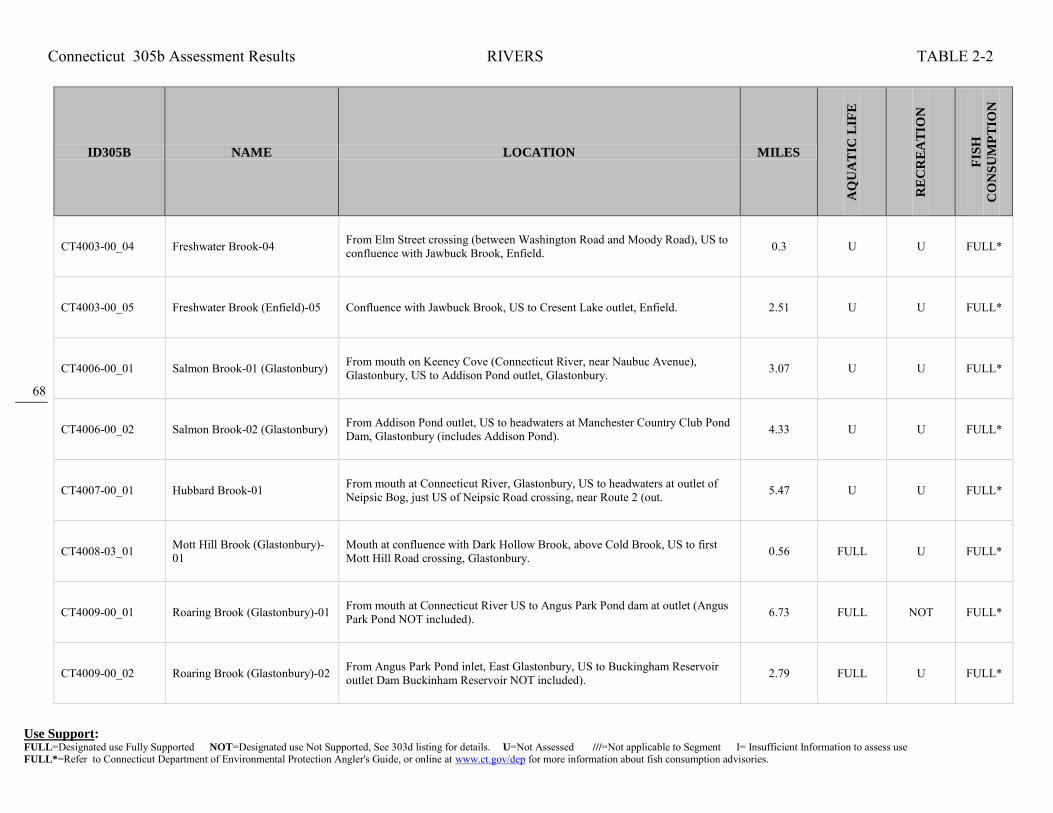
Connecticut 305b Assessment Results RIVERS TABLE 2-2
Use Support: FULL=Designated use Fully Supported NOT=Designated use Not Supported, See 303d listing for details. U=Not Assessed ///=Not applicable to Segment I= Insufficient Information to assess use FULL*=Refer to Connecticut Department of Environmental Protection Angler's Guide, or online at www.ct.gov/dep for more information about fish consumption advisories.
68
ID305B NAME LOCATION MILES
AQ
UA
TIC
LIF
E
RE
CR
EA
TIO
N
FIS
H
CO
NS
UM
PT
ION
CT4003-00_04 Freshwater Brook-04 From Elm Street crossing (between Washington Road and Moody Road), US to confluence with Jawbuck Brook, Enfield. 0.3 U U FULL*
CT4003-00_05 Freshwater Brook (Enfield)-05 Confluence with Jawbuck Brook, US to Cresent Lake outlet, Enfield. 2.51 U U FULL*
CT4006-00_01 Salmon Brook-01 (Glastonbury) From mouth on Keeney Cove (Connecticut River, near Naubuc Avenue), Glastonbury, US to Addison Pond outlet, Glastonbury. 3.07 U U FULL*
CT4006-00_02 Salmon Brook-02 (Glastonbury) From Addison Pond outlet, US to headwaters at Manchester Country Club Pond Dam, Glastonbury (includes Addison Pond). 4.33 U U FULL*
CT4007-00_01 Hubbard Brook-01 From mouth at Connecticut River, Glastonbury, US to headwaters at outlet of Neipsic Bog, just US of Neipsic Road crossing, near Route 2 (out. 5.47 U U FULL*
CT4008-03_01 Mott Hill Brook (Glastonbury)-01
Mouth at confluence with Dark Hollow Brook, above Cold Brook, US to first Mott Hill Road crossing, Glastonbury. 0.56 FULL U FULL*
CT4009-00_01 Roaring Brook (Glastonbury)-01 From mouth at Connecticut River US to Angus Park Pond dam at outlet (Angus Park Pond NOT included). 6.73 FULL NOT FULL*
CT4009-00_02 Roaring Brook (Glastonbury)-02 From Angus Park Pond inlet, East Glastonbury, US to Buckingham Reservoir outlet Dam Buckinham Reservoir NOT included). 2.79 FULL U FULL*

Connecticut 305b Assessment Results RIVERS TABLE 2-2
Use Support: FULL=Designated use Fully Supported NOT=Designated use Not Supported, See 303d listing for details. U=Not Assessed ///=Not applicable to Segment I= Insufficient Information to assess use FULL*=Refer to Connecticut Department of Environmental Protection Angler's Guide, or online at www.ct.gov/dep for more information about fish consumption advisories.
69
ID305B NAME LOCATION MILES
AQ
UA
TIC
LIF
E
RE
CR
EA
TIO
N
FIS
H
CO
NS
UM
PT
ION
CT4009-00_03 Roaring Brook (Glastonbury)-03 From Buckingham Reservoir inlet (Buckingham Res. NOT included), US to headwaters (Segment entirely within Manchester drinking water supply watershed).
2.38 U U FULL*
CT4011-00_01 Reservoir Brook (Portland)-01 Mouth on Connecticut River, DS Route 17 crossing, US to Portland Reservoir outlet, parallel to Old Marlborough Turnpike, Portland. 2.81 U U FULL*
CT4012-00_01 Carr Brook (Portland)-01 From mouth at Connecticut River, just DS of Route 17A crossing, US to Route 17 crossing, Portland. 0.96 U U FULL*
CT4012-00_02 Carr Brook (Portland)-02 Route 17 crossing, US to Kelseys Pond outlet, just US of Cox Road crossing, near intersection with Great Hill Road, Portland. 2.24 U U FULL*
CT4012-00_03 Carr Brook (Portland)-03 Kelseys Pond inlet, parallel to Cox Road, Portland, US to HW, East Hampton. 2.64 FULL U FULL*
CT4013-00_01 Sumner Brook-01 From mouth at Connecticut River, Middletown, US to confuence with Long Hill Brook. 0.97 U NOT FULL*
CT4013-00_02 Sumner Brook (Middletown)-02 Confluence with Long Hill Brook, parallel with Mill Street, US to Russells Pond OUTLET, DS of Russell Street crossing, Middletown. 0.52 NOT U FULL*
CT4013-00_03 Sumner Brook (Middletown)-03 Russells Pond OUTLET, DS of Russell Street crossing, Middletown, US to confluence with unnamed tributary, just US of Millbrook Road crossing, at Middletown/Durham/Haddam town lines.
3.94 U U FULL*

Connecticut 305b Assessment Results RIVERS TABLE 2-2
Use Support: FULL=Designated use Fully Supported NOT=Designated use Not Supported, See 303d listing for details. U=Not Assessed ///=Not applicable to Segment I= Insufficient Information to assess use FULL*=Refer to Connecticut Department of Environmental Protection Angler's Guide, or online at www.ct.gov/dep for more information about fish consumption advisories.
70
ID305B NAME LOCATION MILES
AQ
UA
TIC
LIF
E
RE
CR
EA
TIO
N
FIS
H
CO
NS
UM
PT
ION
CT4013-00_04 Sumner Brook (Middletown)-04 Confluence with unnamed tributary, just US of Millbrook Road crossing, at Middletown/Durham/Haddam town lines, US to HW at Millers Pond outlet, Durham.
2.06 FULL U FULL*
CT4013-08_01 Long Hill Brook-01 From mouth at Sumner Brook, US to Pameacha Pond outlet dam, just US of Pamecha Avenue crossing, Middletown. 0.45 U NOT FULL*
CT4014-03_01 Ponsett Brook (Haddam)-01 Mouth at Route 154 crossing, confluence with Candlewood Hill Brook, above Higganum Creek, US to Higganum Reservoir outlet, above Route 31 crossing, Haddam.
0.38 U U FULL*
CT4014-03_02 Ponsett Brook (Haddam)-02 From inlet to Higganum Reservoir, between Route 9 and Route 81, near Nelson Place, US to confluence with Saltpeter Brook, between Route 81 and Dish Mill Road, Haddam.
1.28 FULL U FULL*
CT4015-02_01 Beaver Meadow Brook-01 From mouth at confluence with Pole Bridge Brook (above Mill Creek), US to headwaters, just US of Beaver Meadow Road crossing, Haddam 2.62 FULL U FULL*
CT4016-01_01 Roaring Brook No 2 (Lyme/East Haddam)-01
Mouth at confluence with Hungerford Brook, above Whalebone Creek, just DS of Day Hill Road crossing, Lyme, US to HW at Martin Pond outlet, just US of Mount Parnassus Road crossing, East Haddam.
5.2 FULL U FULL*
CT4016-10_01 Hungerford Brook (East Haddam)-01
Mouth at confluence with Roaring Brook no2, above Whalebone Creek, near Day Hill Road crossing, US to HW pond between Mill Road and Petticoat Lane, East Haddam.
1.59 FULL U FULL*
CT4016-11_01 Hemlock Valley Brook (Lyme/East Haddam)-01
Mouth on CT-E1_031-SB estuary portion of Connecticut River, just DS of Route 148 crossing, Lyme, US to HW, just US of Bogel Road crossing, parallel to Smith Road, East Haddam.
4.9 FULL U FULL*

Connecticut 305b Assessment Results RIVERS TABLE 2-2
Use Support: FULL=Designated use Fully Supported NOT=Designated use Not Supported, See 303d listing for details. U=Not Assessed ///=Not applicable to Segment I= Insufficient Information to assess use FULL*=Refer to Connecticut Department of Environmental Protection Angler's Guide, or online at www.ct.gov/dep for more information about fish consumption advisories.
71
ID305B NAME LOCATION MILES
AQ
UA
TIC
LIF
E
RE
CR
EA
TIO
N
FIS
H
CO
NS
UM
PT
ION
CT4017-03_01 Pattaconk Brook-01 From mouth at confluence with Great Brook (US of head of Chester Creek in marsh), US to Cedar Lake outlet dam, just US of Route 148 crossing, Chester (Cedar Lake NOT included).
4 FULL U FULL*
CT4017-03_02 Pattaconk Brook-02 From Cedar Lake inlet, US to Pattaconk Reservoir oulet dam, Chester. 1.45 U U FULL*
CT4018-00-trib_01 Unnamed trib Deep River-01 From mouth at Deep River, US to headwaters near Deep River Transfer Station along Route 80, in Deep River 0.43 U U FULL*
CT4019-00_01 Falls River-01
From Falls River Pond oulet dam (separation of Connecticut River saltwater influence), Essex, US to dam at Tower Hill Lake outlet, Deep River (NOTincluding Messerschmidts or Wrights Ponds, both treated as separate waterbodies).
8.12 U U FULL*
CT4020-06_01 Mill Brook-01 (Old Lyme) From mouth at Lieutenant River, US to Upper Mill Pond outlet, just US from Sill Lane crossing, Old Lyme. 1.19 U U FULL*
CT4020-06_02 Mill Brook-02 (Old Lyme) From Upper Mill Pond dam at outlet (including Upper Mill Pond), US to Rogers Lake dam outlet. 0.72 U U FULL*
CT4021-00_01 Black Hall River-01 From head of tide (.25 miles DS of confluence with Sawmill Brook, and .50 miles DS of I95 crossing), US to Black Hall Pond outlet (Black Hall Pond, NOT included).
2.58 U U FULL*
CT4100-00_01 Stony Brook (Suffield)-01 From mouth at outlet on canal parallel to Connecticut River, US to confluence with Muddy Brook at railroad crossing, Suffield. 3.47 NOT U FULL*

Connecticut 305b Assessment Results RIVERS TABLE 2-2
Use Support: FULL=Designated use Fully Supported NOT=Designated use Not Supported, See 303d listing for details. U=Not Assessed ///=Not applicable to Segment I= Insufficient Information to assess use FULL*=Refer to Connecticut Department of Environmental Protection Angler's Guide, or online at www.ct.gov/dep for more information about fish consumption advisories.
72
ID305B NAME LOCATION MILES
AQ
UA
TIC
LIF
E
RE
CR
EA
TIO
N
FIS
H
CO
NS
UM
PT
ION
CT4100-00_02 Stony Brook (Suffield)-02 From confluence with Muddy Brook (at railroad crossing), US (paralell with airport) to DeGrayes Brook confluence, Suffield. 4.9 U U FULL*
CT4100-00_03 Stony Brook (Suffield)-03 From confluence with DeGrayes Brook (just northwest of airport), US to headwaters (the confluence of Rocky Gutter Brook and Rattlesnake Brook), Suffield.
4.27 NOT U FULL*
CT4101-00_01 Muddy Brook (Suffield)-01 From mouth at Stony Brook, Suffield, US to confluence with Philo Brook. 2.23 NOT NOT FULL*
CT4101-00_02 Muddy Brook (Suffield)-02 From confluence with Philo Brook US to headwaters (confluence of Still Brook and Spears Brook). 7.45 U U FULL*
CT4200-00_01 Scantic River-01 From mouth at Connecticut River, US to confluence with Broad Brook, East Windsor. 9.38 NOT U FULL*
CT4200-00_02 Scantic River-02 From confluence with Broad Brook, East Windsor, US to Somersville Pond outlet, Somers (passes Somers WPCF at upper end below lake). 13.56 U U FULL*
CT4200-00_03 Scantic River-03 From Somersville Pond inlet, Somers, US to MA border. 6.05 U U FULL*
CT4201-00_01 Watchaug Brook (Somers)-01 From mouth at confluence with Scantic River (DS of Watchaug Road crossing), US to CT/MA state border, Somers. 2.1 U NOT FULL*

Connecticut 305b Assessment Results RIVERS TABLE 2-2
Use Support: FULL=Designated use Fully Supported NOT=Designated use Not Supported, See 303d listing for details. U=Not Assessed ///=Not applicable to Segment I= Insufficient Information to assess use FULL*=Refer to Connecticut Department of Environmental Protection Angler's Guide, or online at www.ct.gov/dep for more information about fish consumption advisories.
73
ID305B NAME LOCATION MILES
AQ
UA
TIC
LIF
E
RE
CR
EA
TIO
N
FIS
H
CO
NS
UM
PT
ION
CT4203-00_01 Gulf Stream (Somers)-01 Mouth at Scantic River, US to Shady Lake outlet, just US of Route 83 crossing, Somers. 1.88 U U FULL*
CT4203-00_02 Gulf Stream (Somers)-02 Shady Lake outlet, just US of Route 83 crossing, US to confluence with Lievre Brook, just US of Gulf Road crossing, Somers. 1.3 FULL U FULL*
CT4205-00_01 Buckhorn Brook (Enfield)-01 From mouth at confluence with Scantic River, US to marsh (US of Town Farm Road crossing) near inlet from Tobacco Pond No 2, Enfield. 2.02 U NOT FULL*
CT4206-00_01 Broad Brook(East Windsor)-01 From mouth at Scantic River, US to Broad Brook Mill Pond, East Windsor, just US of Main Street (Route 191) crossing. 1.01 NOT NOT FULL*
CT4206-00_02 Broad Brook (East Windsor-Ellington)-02
From Broad Brook Mill Pond inlet, East Windsor, US to headwaters, Ellington, just US of Snipsic Forest Road crossing. 9.01 NOT NOT FULL*
CT4300-00_01 Farmington River-01 From mouth at Connecticut River, US to Rainbow Reservoir dam outlet, Windsor. 8.59 NOT U FULL*
CT4300-00_02 Farmington River-02 From inlet to Rainbow Reservoir (Route 187 crossing), Bloomfield, US to confluence with the Pequabuck River, Farmington. 19.38 FULL NOT FULL*
CT4300-00_03 Farmington River-03 From confluence with the Pequabuck River, Farminton, US to lower Collinsville dam (Collins Company Lower Dam, along route 179), Burlington. 8.46 FULL FULL FULL*

Connecticut 305b Assessment Results RIVERS TABLE 2-2
Use Support: FULL=Designated use Fully Supported NOT=Designated use Not Supported, See 303d listing for details. U=Not Assessed ///=Not applicable to Segment I= Insufficient Information to assess use FULL*=Refer to Connecticut Department of Environmental Protection Angler's Guide, or online at www.ct.gov/dep for more information about fish consumption advisories.
74
ID305B NAME LOCATION MILES
AQ
UA
TIC
LIF
E
RE
CR
EA
TIO
N
FIS
H
CO
NS
UM
PT
ION
CT4300-00_04 Farmington River-04 From lower Collinsvile dam (Collins Company Lower Dam near Route 179), Burlington, US to confluence with Still River, Barkhamsted. 15.01 FULL U FULL*
CT4300-00_05 Farmington River-05 From confluence with Still River, Barkhamsted, US to West Branch Reservoir outlet (Hogback Dam, just US of Durst Road crossing), Hartland. 2.41 U FULL FULL*
CT4300-09_01 Unnamed Tributary to Farmington River (New Hartford)-01
Mouth on Farmington River (West Branch), parallel to Route 44, US to HW between Johnycake Lane and Burgoyne Heights Road, New Hartford. 1.81 U U FULL*
CT4300-10_01 East Mountain Brook (New Hartford)-01
Confluecne with Farmington River, just DS of Route 44 crossing, US to confluence with Hallock Brook, New Hartford. 0.15 FULL U FULL*
CT4300-20_01 Unionville Brook (Farmington)-01
Mouth on Farmington River, DS of River Road crossing, US to Lake Garda outlet, just US of Burlington Road, Farmington. 1.11 U U FULL*
CT4300-32_01 Minister Brook (Simsbury)-01 Mouth on Farmington River, DS of Route 202/10 crossing, US to HW just east of Pine Glen Road, Simsbury. 1.82 U NOT FULL*
CT4300-33_01 Russell Brook (Simsbury)-01 Mouth on Farmington River, DS of Route 10 (202) road crossing, US to HW at White Fondation Pond, parallel to Deer Park Road, Simsbury. 1.25 U NOT FULL*
CT4300-39_01 Owens Brook (Simsbury)-01 Mouth on Farmington River, DS of Route 10 (202) road crossing, US to HW parallel to Owens Brook Blvd, between Musket Trail and Winterset Lane intersections with Owens Brook Blvd, Simsbury.
1.05 U NOT FULL*

Connecticut 305b Assessment Results RIVERS TABLE 2-2
Use Support: FULL=Designated use Fully Supported NOT=Designated use Not Supported, See 303d listing for details. U=Not Assessed ///=Not applicable to Segment I= Insufficient Information to assess use FULL*=Refer to Connecticut Department of Environmental Protection Angler's Guide, or online at www.ct.gov/dep for more information about fish consumption advisories.
75
ID305B NAME LOCATION MILES
AQ
UA
TIC
LIF
E
RE
CR
EA
TIO
N
FIS
H
CO
NS
UM
PT
ION
CT4300-44_01 Munnisunk Brook (Simsbury)-01
From mouth at confluence with Farmington River, US to Lake Basile outlet dam (US of Wolcott Road and RailRoad crossings), Simsbury. 0.89 U NOT FULL*
CT4300-48_01 Perkins Brook-01 From mouth on Farmington River at Rainbow Reservoir, Windsor, US to former Combustion Engineering outfall approximately 50 feet DS of Goodwin Pond outlet.
0.67 NOT U U
CT4300-50_01 Rainbow Brook-01 From mouth at Farmington River (just DS of Island below Rainbow Reservoir Dam), Windsor, US to headwaters, southwest portion of Bradley International Airport, Windsor Locks.
1.74 NOT U FULL*
CT4300-51_01 Seymour Hollow Brook-01
From mouth at Farmington River, Windsor (formerly tributary to Rainbow Brook, now channelized to Farmington, Gazetteer # based upon Rainbow Brook), US to headwaters, southest portion of Bradley International Airport, Windsor Locks.
1.36 NOT U FULL*
CT4300-54_01 Phelps Brook (Windsor)-01 Mouth at Farmington River, near Apple Tree Lane, US to Route 75 crossing, windsor. 0.39 U U FULL*
CT4302-00_01 Mad River (Winchester)-01 From mouth at Still River, US to Mad River Dam outlet, Winchester. 2.24 NOT NOT FULL*
CT4302-00_02a Mad River (Winchester)-02a From Mad River Dam outlet, Wincheter, US to outlet from Rugg Brook Reservoir. 1.77 U NOT FULL*
CT4302-00_02b Mad River (Winchester)-02b From confluence with Rugg Brook Reservoir outlet, US to diversion entrance for Rugg Brook Reservoir. 0.63 NOT U FULL*

Connecticut 305b Assessment Results RIVERS TABLE 2-2
Use Support: FULL=Designated use Fully Supported NOT=Designated use Not Supported, See 303d listing for details. U=Not Assessed ///=Not applicable to Segment I= Insufficient Information to assess use FULL*=Refer to Connecticut Department of Environmental Protection Angler's Guide, or online at www.ct.gov/dep for more information about fish consumption advisories.
76
ID305B NAME LOCATION MILES
AQ
UA
TIC
LIF
E
RE
CR
EA
TIO
N
FIS
H
CO
NS
UM
PT
ION
CT4302-00_03 Mad River (Winchester)-03 From diversion entrance for Rugg Brook Reservoir (boundary of drinking water watershed), US to headwaters at Spaulding Pond outlet dam, Norfolk. 5.17 FULL NOT FULL*
CT4302-04_01 Rugg Brook (Winchester)-01 Mouth at inlet to Rugg Brook Reservoir, just DS from Old Waterbury Turnpike crossing, US to HW, US of Route 263 crossing, Winchester. 3.29 FULL U FULL*
CT4302-05_01 Mill brook (Winchester/Norfolk)-01
Mouth at Mad River, just DS of Route 44 crossing, Winchester, US to HW, just US of Green Road crossing, Norfolk. 5.31 FULL U FULL*
CT4302-09_01 Indian Meadow Brook-01 From mouth at Mad River (just DS from Route 44/183 crossing), US to confluence with Colebrook Brook, Winchester 0.46 FULL FULL FULL*
CT4302-10_01 Colebrook Brook (Winchester/Colebrook)-01
Confluence with Indian Meadow Brook, just DS of Route 183 crossing, Winchester, US to HW, Colebrook. 3.58 FULL U FULL*
CT4302-13_01 Taylor Brook (Winchester)-01 Mouth on Highland Lake, just DS of Wakefield Boulevard crossing, US to HW, US of Hollow Hill Road crossing, Winchester. 2.12 FULL U FULL*
CT4303-00_02 Still River (Colebrook)-02 From confluence with Sandy Brook, Colebrook, US to Winchester (Winsted) POTW (east side of Route 8), Winsted. 2.67 NOT NOT FULL*
CT4303-00_03 Still River (Winsted)-03 From Winchester (Winsted) POTW, US to confuence with Mad River (just US of Route 44/183 crossing). 1.67 NOT NOT FULL*

Connecticut 305b Assessment Results RIVERS TABLE 2-2
Use Support: FULL=Designated use Fully Supported NOT=Designated use Not Supported, See 303d listing for details. U=Not Assessed ///=Not applicable to Segment I= Insufficient Information to assess use FULL*=Refer to Connecticut Department of Environmental Protection Angler's Guide, or online at www.ct.gov/dep for more information about fish consumption advisories.
77
ID305B NAME LOCATION MILES
AQ
UA
TIC
LIF
E
RE
CR
EA
TIO
N
FIS
H
CO
NS
UM
PT
ION
CT4303-00_04 Still River (Winsted/Torrington)-04
From confuence with Mad River (just US of Route 44/183 crossing), US to headwaters (on west side of Route 8, paralell with Exit 45 offramp), Torrington. 7.56 U FULL FULL*
CT4304-00_01 Sandy Brook (Colebrook)-01 From mouth at confluence with Still River (just DS of Old Forge Road crossing), Colebrook (Southeast), US to Massachusetts border, Norfolk (Northeast corner).
8.63 FULL FULL FULL*
CT4304-00_01a Sandy Brook (Barkhamsted/Colebrook)-01a
From mouth at confluence with Farmington River, Barkhamsted, US to confluence with Still River, Colebrook. NOTE this portion was formerly called Still River-01 (CT4303-00_01).
1.35 FULL NOT FULL*
CT4304-08_01 Center Brook-01 From mouth at Sandy Brook, US to Route 183 (Colebrook Rd) crossing, Colebrook. 1.28 FULL U FULL*
CT4305-00_01 Morgan Brook-01 From mouth at West Branch Farmington River, US to confluence with tributary 4305-04 (first confluence) on east side of Route 44, Barkhamsted. 0.69 FULL NOT FULL*
CT4305-00_02 Morgan Brook-02 From confluence with tributary 4305-04 (end of seg-01) east side of Route 44, US to East West Hill Road crossing area (50 meters US of East West Hill Road crossing, entrance of 9/12/05 home heating fuel spill), Barkhamsted.
1.41 U NOT FULL*
CT4305-00_03 Morgan Brook-03 From East West Hill Road crossing area (50 meters US of East West Hill Road crossing, entrance of 9/12/05 home heating fuel spill), US to confluence with Mallory Brook, Barkhamsted.
0.48 U U FULL*
CT4305-00_04 Morgan Brook-04 From confluence with Mallory Brook, US to West Hill Pond outlet dam, Barkhamsted. 1.52 FULL NOT FULL*

Connecticut 305b Assessment Results RIVERS TABLE 2-2
Use Support: FULL=Designated use Fully Supported NOT=Designated use Not Supported, See 303d listing for details. U=Not Assessed ///=Not applicable to Segment I= Insufficient Information to assess use FULL*=Refer to Connecticut Department of Environmental Protection Angler's Guide, or online at www.ct.gov/dep for more information about fish consumption advisories.
78
ID305B NAME LOCATION MILES
AQ
UA
TIC
LIF
E
RE
CR
EA
TIO
N
FIS
H
CO
NS
UM
PT
ION
CT4305-02_01 Mallory Brook-01 From confluence with Morgan Brook, US to Tennessee Gas pipeline crossing (near Barkhamsted and Winchester town line, south of Route 44), Barkhamsted. 1.54 U U FULL*
CT4305-02_02 Mallory Brook-02 From Tennessee Gas Pipeline Crossing (end of segment-01, near Barkhamsted and Winchester town line, south of Route 44), US to headwaters, Winchester. 0.7 FULL U FULL*
CT4306-00_01 Valley Brook-01 From mouth at northwestern most portion of Barkhamsted Reservoir, Hartland, US (towards northeast) to CT/MA state line. 0.73 FULL U FULL*
CT4307-00_01 Hubbard Brook-01 From mouth at northwestern most portion of Barkhamsted Reservoir, Hartland, US (towards northwest) to CT/MA state line. 0.57 U U FULL*
CT4308-00_01 Farmington River, East Branch-01
From mouth at Farmington River mainstem, New Hartford, US to Lake McDonough outlet dam. 1.11 NOT NOT FULL*
CT4308-01_01 Hurricane Brook (Hartland)-01 Mouth on Barkhamsted Reservoir, just DS of Route 20 crossing, US to HW at Emmons Pond, just US of Hurricane Brook Road crossing, Hartland. 2.24 FULL U FULL*
CT4308-11_01 Roaring Brook (Barkhamsted)-01
Mouth at inlet to Barkhamsted Reservoir, parallel to Kettle Brook, US to HW near Pine Mountain road, Barkhamsted. 2.4 FULL U FULL*
CT4308-13_01 Kettle Brook (Barkhamsted)-01 Mouth at inlet to Barkhamsted Reservoir, just DS of Ratlum Road crossing, US to HW just US of Route 219 crossing, Barkhamsted. 1.95 FULL U FULL*

Connecticut 305b Assessment Results RIVERS TABLE 2-2
Use Support: FULL=Designated use Fully Supported NOT=Designated use Not Supported, See 303d listing for details. U=Not Assessed ///=Not applicable to Segment I= Insufficient Information to assess use FULL*=Refer to Connecticut Department of Environmental Protection Angler's Guide, or online at www.ct.gov/dep for more information about fish consumption advisories.
79
ID305B NAME LOCATION MILES
AQ
UA
TIC
LIF
E
RE
CR
EA
TIO
N
FIS
H
CO
NS
UM
PT
ION
CT4308-15_01 Beaver Brook (Barkhamsted)-01 From mouth at northwestern corner of Lake McDonough (Compensating Reservoir), Barkhamsted, US to headwaters in Peoples State Forest, Hartland. 5.51 FULL U FULL*
CT4308-15-trib_01 Unnamed Tributary to Beaver Brook (Barkhamsted)-01
Mouth on Beaver Brook, just DS of Beaver Brook Road crossing, US to HW, US of Beaver Brook Road crossing, Barkhamsted. 0.38 FULL U FULL*
CT4308-18_01 Ratlum Brook (New Hartford)-01
From mouth at confluence with East Branch Farmington River (just DS of Farmington River Turnpike crossing), US to Sholom Pond outlet dam (parallel to Ratlum Road), New Hartford.
0.28 FULL U FULL*
CT4309-00_01 Cherry Brook (Canton)-01 From mouth at confluence with Farmington River (just DS of Albany Turnpike (Route 44) crossing), US to Barbourtown Road crossing, Canton. 2.05 FULL NOT FULL*
CT4309-00_02 Cherry Brook (Canton)-02 From Barbourtown road crossing (segment-01), US to confluence with unnamed tributary (outlet stream for Linsey Pond), just US of Meadow Road crossing, Canton.
0.66 U NOT FULL*
CT4309-00_03 Cherry Brook (Canton/Barkhamsted)-03
Confluence with unnamed tributary, just US of Meadow Road crossing and parallel to Route 179, Canton, US to HW, just US of Route 219 crossing, Barkhamsted.
6.64 FULL U FULL*
CT4309-02_01 Unnamed Tributary to Cherry Brook (Canton)-01
Mouth on Cherry Brook, just DS from Route 179 crossing, US to outlet of Tiltons Pond, just US of Route 179 crossing, Canton. 0.38 FULL U FULL*
CT4309-05_01 Barbour Brook (Canton)-01 Mouth on Cherry Brook, just DS from Barbourtown Road crossing, US to confluence with unnamed tributary, US of second Barbourtown Road crossing, Canton.
1.01 U U FULL*

Connecticut 305b Assessment Results RIVERS TABLE 2-2
Use Support: FULL=Designated use Fully Supported NOT=Designated use Not Supported, See 303d listing for details. U=Not Assessed ///=Not applicable to Segment I= Insufficient Information to assess use FULL*=Refer to Connecticut Department of Environmental Protection Angler's Guide, or online at www.ct.gov/dep for more information about fish consumption advisories.
80
ID305B NAME LOCATION MILES
AQ
UA
TIC
LIF
E
RE
CR
EA
TIO
N
FIS
H
CO
NS
UM
PT
ION
CT4310-00_01 Nepaug River-01 From mouth at confluence with Farmington River (southwest of Route 202 crossing), US to Nepaug Reservoir outlet dam. 0.9 NOT NOT FULL*
CT4310-00_02 Nepaug River-02 From inlet to Nepaug Reservoir (far wetern portion), US to headwaters (just above confluence with Cedar Swamp Brook, parallel with Niles Road), New Hartford.
7.73 FULL U FULL*
CT4310-01_01 Bakerville Brook-01 From mouth at Nepaug River, US to confluence with Torringford Brook (west of Cedar Lane crossing, along north side of Route 202), New Hartford. 1.01 FULL U FULL*
CT4310-01_02 Bakerville Brook (New Hartford)-02
Confluence with Torrington Brook, parallel with Route 202, US to HW near Pearl Rd (above Rt 202 crossing), New Hartford. 3.2 FULL U FULL*
CT4310-05_01 North Brook (New Hartford)-01 Mouth on North Nepaug Brook, between Route 219 and Maple Hollow Road, US to HW, between West Hill Road and Stub Hollow Road, New Hartford. 2.51 FULL U FULL*
CT4311-00_01 Burlington Brook-01
Mouth at Farmington River, US to headwaters at confluence of North and South Branches of Bunnell Brook), Burlington. Segment includes Burlington Brook name upto confluence with Bradley brook, then name changes to Bunnell Brook, but number stays constant.
4.78 U FULL FULL*
CT4311-06_01 Punch Brook (Burlington)-01 Mouth on Burlington Brook at Route 4 crossing, US to Punch Brook Pond outlet, Burlington. 0.65 FULL U FULL*
CT4312-00_01 Roaring Brook (Farmington)-01 From mouth at confluence with Farmington River (just DS of Farmington Avenue (Route 4) crossing), Farmington, US to Paparrazzo Dam outlet (just US of Mallard Drive crossing), Avon.
1.17 NOT NOT FULL*

Connecticut 305b Assessment Results RIVERS TABLE 2-2
Use Support: FULL=Designated use Fully Supported NOT=Designated use Not Supported, See 303d listing for details. U=Not Assessed ///=Not applicable to Segment I= Insufficient Information to assess use FULL*=Refer to Connecticut Department of Environmental Protection Angler's Guide, or online at www.ct.gov/dep for more information about fish consumption advisories.
81
ID305B NAME LOCATION MILES
AQ
UA
TIC
LIF
E
RE
CR
EA
TIO
N
FIS
H
CO
NS
UM
PT
ION
CT4312-00_02 Roaring Brook (Avon)-02 From Bellosquardo Pond INLET (US of Hollister Drive crossing at dam), US to Secret Lake outlet dam (US of Parkview Drive crossing), Avon. 2.69 U U FULL*
CT4312-00_03 Roaring Brook (Canton)-03 From Secret Lake INLET (at Avon/Canton town line), US to HW (US of Dry Bridge Road crossing, and parallel to Gracey Road), Canton. 2.26 U U FULL*
CT4312-01_01 Jim Brook (Canton)-01 Mouth on Roaring Brook between Washburn Road and Lawton Road, US to HW parallel to Sextons Hollow Road, Canton. 2.23 FULL U FULL*
CT4313-00_01 Poland River-01 From mouth at confluence with Pequabuck River, US to confluence with Marsh Brook (seg 2 begins), Plymouth. 0.42 U NOT FULL*
CT4313-00_02 Poland River-02 From confluence with Marsh Brook, US to confluence with unnamed brook 4313-03-1, US of Judd Road crossing (paralell with Route 72), Plymouth, CT. 0.71 FULL NOT FULL*
CT4313-00-trib_01 Powder Brook (Harwinton)-01 Mouth at inlet to Bristol Reservoir No4, Harwinton, US to HW, near Johnny Cake Mountain Road, Burlington. 1.35 U U FULL*
CT4314-00_01 Coppermine Brook (Bristol)-01 From mouth at Pequabuck River, US to New Britain drinking water watershed boundary and water diversion (just us of confluence with Polkville Brook), Bristol.
2.43 NOT NOT FULL*
CT4314-00_02 Coppermine Brook (Bristol)-02 From drinking water watershed boundary and water diversion (just US of confluence with Polkville Brook), US to headwaters (confluence of Whigville & Wildcat Brooks).
2.66 FULL U FULL*

Connecticut 305b Assessment Results RIVERS TABLE 2-2
Use Support: FULL=Designated use Fully Supported NOT=Designated use Not Supported, See 303d listing for details. U=Not Assessed ///=Not applicable to Segment I= Insufficient Information to assess use FULL*=Refer to Connecticut Department of Environmental Protection Angler's Guide, or online at www.ct.gov/dep for more information about fish consumption advisories.
82
ID305B NAME LOCATION MILES
AQ
UA
TIC
LIF
E
RE
CR
EA
TIO
N
FIS
H
CO
NS
UM
PT
ION
CT4314-05_01 Wildcat Brook Unnamed tributary-01
Unnamed tributary, from confluence with Wildcat Brook (West side, approximately 0.6 miles US from mouth of Wildcat Brook, parallel with Stone Road), Burlington.
0.81 U U FULL*
CT4315-00_01 Pequabuck River-01 From mouth at Farmington River, US to RailRoad crossing (US (south) of Route 72 crossing), Plainville. 5.37 NOT NOT FULL*
CT4315-00_02 Pequabuck River-02 From RailRoad crossing (US (south) of Route 72 crossing), Plainville, US to Bristol POTW outfall (DS of route 229 crossing), Bristol. 3.37 NOT NOT FULL*
CT4315-00_03 Pequabuck River-03 From Bristol POTW outfall (DS of route 229 crossing), US to exit of box culvert, downtown Bristol. 1.23 NOT NOT FULL*
CT4315-00_04 Pequabuck River-04 From exit of box culvert, US to entrance of box culvert (entire segment in culvert), center of Bristol. 0.33 NOT NOT FULL*
CT4315-00_05 Pequabuck River-05 From entrance to box culvert, center Bristol, US to Plymouth POTW (just DS of Canal Street (Route 72) crossing), Plymouth. 2.7 NOT NOT FULL*
CT4315-00_06 Pequabuck River-06 From Plymouth POTW (just DS of Canal Street (Route72) crossing), US to headwaters, South of Rocky Road, Harwinton. 5.46 NOT NOT FULL*
CT4315-08_01 South Mountain Brook (Bristol)-01
Mouth on Pequabuck River, just DS of Memorial Boulevard crossing, US to Clayton Manufacturing Dam outlet, parallel to Union Street, Bristol. 0.92 U U FULL*

Connecticut 305b Assessment Results RIVERS TABLE 2-2
Use Support: FULL=Designated use Fully Supported NOT=Designated use Not Supported, See 303d listing for details. U=Not Assessed ///=Not applicable to Segment I= Insufficient Information to assess use FULL*=Refer to Connecticut Department of Environmental Protection Angler's Guide, or online at www.ct.gov/dep for more information about fish consumption advisories.
83
ID305B NAME LOCATION MILES
AQ
UA
TIC
LIF
E
RE
CR
EA
TIO
N
FIS
H
CO
NS
UM
PT
ION
CT4315-08_02 South Mountain Brook (Bristol)-02
Clayton Manufacturing Dam inlet, parallel to Union Street, US to confluence with unnamed tributary, behind South Side School, near Tuttle Road, Bristol. 0.51 U U FULL*
CT4316-00_01 Thompson Brook (Avon)-01 From mouth at confluence with Farmington River (DS of Old Farms Road crossing), US to INLET of Beaverdam Pond (DS of old RailRoad crossing which is now a bike path), Avon.
1.91 FULL NOT FULL*
CT4316-00_02 Thompson Brook (Avon)-02 From INLET to Beaverdam Pond (DS of old RailRoad crossing which is now a bike path), US to HW at confluence of Big Brook and Chidsey Brook (just US of Thompson Road crossing), Avon.
1.24 U U FULL*
CT4316-01_01 Chidsey Brook (Avon)-01 Fom mouth at confluence with Big Brook, forming HW of Thompson Brook (DS of Scoville Road crossing), US to Lamonica Pond outlet (just US of West Avon Road crossing), Avon
1.34 FULL U FULL*
CT4317-00_01 Nod Brook-01 From mouth at dredge holes (Twin Lakes North & South) near Farmington River, Avon, US to headwaters (just US of Rocklyn Road crossing), Simsbury. 6.61 U NOT FULL*
CT4318-00_01 Hop Brook (Simsbury)-01 From mouth at Farmington River, US to headwaters at Tuller Reservoir, Simsbury. 6.74 FULL NOT FULL*
CT4318-03_01 Stratton Brook-01 From mouth at confluence with Hop Brook (just DS of Farms Village Road (Route 309) crossing), US to headwaters (near Bushy Hill Road (Route 167), Simsbury.
3.89 FULL U FULL*
CT4319-00_01a Salmon Brook, West Branch (Granby)-01a
From mouth at confluence with East Branch Salmon Brook (part of Salmon Brook mainstem), DS of Route 10/202 crossing, just to West of Route 189, Granby, US to Bissell Brook (just US of Route 10/202 crossing), Granby.
1.4 FULL NOT FULL*

Connecticut 305b Assessment Results RIVERS TABLE 2-2
Use Support: FULL=Designated use Fully Supported NOT=Designated use Not Supported, See 303d listing for details. U=Not Assessed ///=Not applicable to Segment I= Insufficient Information to assess use FULL*=Refer to Connecticut Department of Environmental Protection Angler's Guide, or online at www.ct.gov/dep for more information about fish consumption advisories.
84
ID305B NAME LOCATION MILES
AQ
UA
TIC
LIF
E
RE
CR
EA
TIO
N
FIS
H
CO
NS
UM
PT
ION
CT4319-00_01b Salmon Brook, West Branch (Granby)-01b
From confluence with Bissell Brook (US of Route 10/202 crossing), US to headwaters (just US of Route 179 (South Road) crossing), Hartland. 11.29 FULL NOT FULL*
CT4319-03_01 Enders Brook (Granby/Barkhamsted)-01
Confluence with West Branch Salmon River, adjacent to Route 219, Graby, US to HW, just US of Hayes Road crossing, Barkhamsted. 3.75 FULL U FULL*
CT4319-07_01 Beach Brook-01 From mouth at confluence with West Branch Salmon Brook, US to headwaters, Granby. 2.38 U U FULL*
CT4319-09_01 Unnamed Tributary to Salmon Brook (Granby)-01
Mouth on West Branch Salmon Brook, just DS of Simsbury Road crossing, US to HW, west of Weed Hill Road, Granby. 2.23 FULL U FULL*
CT4320-00_01 Salmon Brook (East Granby)-01 From mouth at confluence with Farmington River (DS of Floydville Road crossing), East Granby, US to Massachusetts border (includes Salmon Brook and East Branch Salmon Brook sections), Granby.
13.55 FULL NOT FULL*
CT4320-01_01 Unnamed Tributary to East Branch Salmon Brook (Granby)-01
Mouth on East Branch Salmon River, just DS of Route 189 crossing, Granby, US to Connecticut State Border with Massachusetts, parallel with Peck Orchard Road, Hartland.
0.87 FULL U FULL*
CT4320-02_01 Fox Brook (Hartland)-01 From mouth at confluence with East Branch Salmon Brook (just DS of Granville Road (Route 189) crossing), Granby, US to HW (just East of Pell Road, along the CT/MA border), Hartland.
2.55 FULL U FULL*
CT4320-05_01 Belden Brook-01 from mouth at confluence with East Branch Salmon Brook (just DS of Route 189 crossing), Granby, US to headwaters (just US of Granville Road crossing), Hartland
4.08 FULL U FULL*

Connecticut 305b Assessment Results RIVERS TABLE 2-2
Use Support: FULL=Designated use Fully Supported NOT=Designated use Not Supported, See 303d listing for details. U=Not Assessed ///=Not applicable to Segment I= Insufficient Information to assess use FULL*=Refer to Connecticut Department of Environmental Protection Angler's Guide, or online at www.ct.gov/dep for more information about fish consumption advisories.
85
ID305B NAME LOCATION MILES
AQ
UA
TIC
LIF
E
RE
CR
EA
TIO
N
FIS
H
CO
NS
UM
PT
ION
CT4320-08_01 Mountain Brook-01 From mouth at confluence with East Branch Salmon Brook, (just DS of Route 189 (Granville Road) crossing), US to headwaters (East of Silkey Road), Granby.
3.55 U U FULL*
CT4320-09_01 Dismal Brook-01 From mouth at confluence with East Branch of Salmon Brook (DS of Mountain Road crossing, near Route 189), Us to Massachusetts border (parallel to Loomis Street).
3.66 U U FULL*
CT4320-15_01 Hungary Brook (Granby)-01 Mouth on Salmon Brook, just DS of Griffin Road crossing, US to Notch Road crossing, Granby. 1.34 U U FULL*
CT4320-19_01 Mountain Brook (Suffield)-01 From mouth at confluence with Hungary Brook (just US of RailRoad crossing on Hungary Brook), US to confluence with unnamed tributary just US of Copper Hill Road crossing, Suffield.
1.37 U NOT FULL*
CT4321-00_01 Mill Brook (Windsor)-01 From mouth at confluence with Farmington River (DS of Palisado Avenue and RailRoad crossings), Windsor, US to Barber Pond Outlet dam (just US of Old Winsor Road (Route 305) crossing), Bloomfield.
4.56 NOT NOT FULL*
CT4321-00_02 Mill Brook (Bloomfield)-02 From Barber Pond INLET (near Windsor town line), Bloomfield, US to HW just US of Great Pond Drive crossing, Windsor. 1.96 U U FULL*
CT4400-00_01 Park river-01 From mouth at Connecticut River, US to confuence with North Branch Park River, just DS of I84 crossing at opening of conduit (US of Willow Street crossing).
2.39 NOT NOT FULL*
CT4400-01_01 South Branch Park River-01 From mouth at confluence with Park River, US to enterance of conduit (entire segment in pipe underground). 0.32 NOT NOT FULL*

Connecticut 305b Assessment Results RIVERS TABLE 2-2
Use Support: FULL=Designated use Fully Supported NOT=Designated use Not Supported, See 303d listing for details. U=Not Assessed ///=Not applicable to Segment I= Insufficient Information to assess use FULL*=Refer to Connecticut Department of Environmental Protection Angler's Guide, or online at www.ct.gov/dep for more information about fish consumption advisories.
86
ID305B NAME LOCATION MILES
AQ
UA
TIC
LIF
E
RE
CR
EA
TIO
N
FIS
H
CO
NS
UM
PT
ION
CT4400-01_02 South Branch Park River-02 From entrance of conduit (segment-01), US to confluence with Piper and Trout Brooks, between railroad tracks and Route 173 (New Britian avenue). 2.62 NOT NOT FULL*
CT4401-00_01 Bass Brook (New Britain)-01 Confluence with Piper Brook, parallel with Route 9, US to outlet of Lower Middle Pond, just US of Route 71 (Hartford Rd) crossing, New Britain. 2.27 U U FULL*
CT4402-00_01 Piper Brook-01 From mouth at confluence with Trout brook, above South Branch Park River, West Hartford, US (under New Britian Avenue), to conduit opening, US side of New Britain Ave (segment completely in conduit).
0.05 NOT NOT FULL*
CT4402-00_02 Piper Brook-02 From conduit entrance (segment-01) US side of New Britain Avenue, West Hartford, US into St. Marys Cemetary (just US of railroad crossing and parallel with Route 9) where pipe emerges from ground, New Britain.
5.81 NOT NOT FULL*
CT4403-00_01 Trout Brook-01 From mouth at confluence with Piper Brook, above South Branch Park River (just DS of railroad crossing, near New Britian Avenue), West Hartford, US under Route 84 exit 42 (Trout Brook Drive) ramp.
1.07 NOT NOT FULL*
CT4403-00_02 Trout Brook-02 From US side of Route 84 Exit 42 (Trout Brook) ramp, West Hartford, US to Park Road crossing (Entire segment flows through concrete channel). 0.88 NOT NOT FULL*
CT4403-00_03 Trout Brook-03 From Park Road crossing (just DS of Boulevard road crossing), US to Woodbridge Lake outlet dam, West Hartford. 5.95 NOT NOT FULL*
CT4403-07_01 South Branch Trout Brook (West Hartford)-01
Mouth at Trout Brook, under I84 exit 43 ramps, US to entrance of underground section at Park Road crossing, West Hartford. 0.22 U U FULL*

Connecticut 305b Assessment Results RIVERS TABLE 2-2
Use Support: FULL=Designated use Fully Supported NOT=Designated use Not Supported, See 303d listing for details. U=Not Assessed ///=Not applicable to Segment I= Insufficient Information to assess use FULL*=Refer to Connecticut Department of Environmental Protection Angler's Guide, or online at www.ct.gov/dep for more information about fish consumption advisories.
87
ID305B NAME LOCATION MILES
AQ
UA
TIC
LIF
E
RE
CR
EA
TIO
N
FIS
H
CO
NS
UM
PT
ION
CT4403-07_02 South Branch Trout Brook (West Hartford)-02
Underground section. Enterance of underground section at Park Road crossing, US to Route 173 (South Main Street) crossing, West Hartford. 0.36 U U FULL*
CT4404-00_01 North Branch Park River-01 From mouth at confluence with Park River just DS of I84 crossing, US to entrance of conduit (entire segment in pipe) near Farmingotn Avenue, Hartford. 0.51 NOT NOT FULL*
CT4404-00_02 North Branch Park River-02 From DS side of Farmington Avenue (at entrance of conduit), US to confluence with Wash Brook (just DS of confluence of Wash Brook and Beamans Brook), Bloomfield.
5.39 NOT NOT FULL*
CT4404-09_01 Wash Brook (Bloomfield)-01 Mouth on North Branch Park River, just DS of confluence with Beamans Brook, east of Kenwood Circle, US to confluence with Tumble Brook, just US of Route 189 crossing, Bloomfield.
1.67 U U FULL*
CT4500-00_01 Hockanum River-01 From mouth at Connecticut River, East Hartford, US to Cellu Company Dam, the first dam at Scotland Impoundment (two dams just DS of this dam), includes impounded water behind East Hartford town hall.
4.26 NOT U FULL*
CT4500-00_02 Hockanum River-02 From Cellu Company dam (first dam at Scotland Impoundment), US to confluence with South Fork Hockanum (AKA Hop) River, just US of "Laurel Lake", Manchester.
3.6 NOT NOT FULL*
CT4500-00_03 Hockanum River-03 From confluence with South Fork Hockanum (AKA Hop) River (just US of "Laurel Lake"), US to Union Pond outlet dam, Manchester. 3.42 NOT NOT FULL*
CT4500-00_04a Hockanum River-04a From inlet to Union Pond, Manchester, US to confluence with Tankerhoosen River, Vernon. 1.44 NOT NOT FULL*

Connecticut 305b Assessment Results RIVERS TABLE 2-2
Use Support: FULL=Designated use Fully Supported NOT=Designated use Not Supported, See 303d listing for details. U=Not Assessed ///=Not applicable to Segment I= Insufficient Information to assess use FULL*=Refer to Connecticut Department of Environmental Protection Angler's Guide, or online at www.ct.gov/dep for more information about fish consumption advisories.
88
ID305B NAME LOCATION MILES
AQ
UA
TIC
LIF
E
RE
CR
EA
TIO
N
FIS
H
CO
NS
UM
PT
ION
CT4500-00_04b Hockanum river-04b From confluence with Tankerhoosen River, Vernon, US to marsh (approximatly one mile DS of Dart Hill Road crossing, parallel to Route 83, near Neak Road), Vernon.
1.67 NOT NOT FULL*
CT4500-00_05 Hockanum River-05 From marsh exit (approximatly one mile DS of Dart Hill Road crossing, parallel to Route 83, near Neak Road), Vernon, US to Vernon POTW (just DS of Route 74 crossing).
2.48 NOT NOT FULL*
CT4500-00_06a Hockanum River-06a From Vernon POTW (just DS of Route 74 crossing), Vernon, US to Windsor Avenue crossing (Route 74), Vernon. 3.03 NOT NOT FULL*
CT4500-00_06b Hockanum River-06b From Windsor Avenue crossing (Route 74), Vernon, US to Vernon Ave, Vernon (Rockville). 0.93 NOT NOT FULL*
CT4500-00_07 Hockanum River-07 From Vernon Ave (outlet of culvert), Rockville, US to Paper Mill Pond outlet dam (inlet to culvert). 0.52 NOT NOT FULL*
CT4500-00_08 Hockanum river-08 From Paper Mill Pond outlet dam, Rockville, US to Shenipsit Lake outlet dam. 0.59 NOT FULL FULL*
CT4500-04_01 Ogden Brook (Vernon)-01 Mouth on Hockanum River, just DS of Thrall Road crossing, US to HW at JR High Pond, near Inland Drive, Vernon. 2.42 NOT U FULL*
CT4500-12_01 Lydall Brook (Manchester)-01 Mouth at Union Pond, to Route 83 crossing (underground conduit), Manchester. 0.3 U U FULL*

Connecticut 305b Assessment Results RIVERS TABLE 2-2
Use Support: FULL=Designated use Fully Supported NOT=Designated use Not Supported, See 303d listing for details. U=Not Assessed ///=Not applicable to Segment I= Insufficient Information to assess use FULL*=Refer to Connecticut Department of Environmental Protection Angler's Guide, or online at www.ct.gov/dep for more information about fish consumption advisories.
89
ID305B NAME LOCATION MILES
AQ
UA
TIC
LIF
E
RE
CR
EA
TIO
N
FIS
H
CO
NS
UM
PT
ION
CT4500-12_02 Lydall Brook (Manchester)-02 Route 83 crossing (end of underground conduit), US to outlet of Salters Pond, parallel to Lydall Street at Coleman Road intersection, Manchester. 1.05 NOT U FULL*
CT4500-12_03 Lydall Brook (Manchester)-03 Inlet of Salters Pond, parallel to Lydall Street at Ambassador Drive intersection, US to outlet of Lydall Street Reservoir No1, parallel to Lydall Street, Manchester.
1.01 U U FULL*
CT4500-14_01 Bigelow Brook (Manchester)-01 Confluence with Hockanum River, just DS of Hillard Street crossing, US to Adams Street crossing, Manchester. 0.27 FULL U FULL*
CT4500-14_02 Bigelow Brook (Manchester)-02 Adams Street crossing, US to stormwater outlet pipe, 1000 feet US of Route 44A crossing (Middle Turnpike), Manchester. 0.63 U U FULL*
CT4501-00_01 Charters Brook-01 From mouth at Shenipsit Lake Tolland US to headwaters near Webster Rd Ellington 6.22 FULL NOT FULL*
CT4503-00_01 Tankerhoosen River-01 From mouth at Hockanum River, Vernon (DS of Route 83/03 crossing near Manchester border ), US to Tankerhoosen Lake outlet dam, Vernon. 1.51 NOT FULL FULL*
CT4503-00_02 Tankerhoosen River-02 From Tankerhoosen Lake outlet dam (includes lake), Vernon, US to Walker Reservoir East outlet (headwater). 4.07 FULL FULL FULL*
CT4503-01_01 Gages Brook-01 From mouth at inlet to Walker Reservoir East (head of Tankerhoosen River), Vernon, US to headwaters at Mountain Springs Road Dam outlet (just US of Mountain Springs Road crossing), Tolland.
2 U U FULL*

Connecticut 305b Assessment Results RIVERS TABLE 2-2
Use Support: FULL=Designated use Fully Supported NOT=Designated use Not Supported, See 303d listing for details. U=Not Assessed ///=Not applicable to Segment I= Insufficient Information to assess use FULL*=Refer to Connecticut Department of Environmental Protection Angler's Guide, or online at www.ct.gov/dep for more information about fish consumption advisories.
90
ID305B NAME LOCATION MILES
AQ
UA
TIC
LIF
E
RE
CR
EA
TIO
N
FIS
H
CO
NS
UM
PT
ION
CT4504-00_01 South Fork Hockanum River (Manchester)-01
Mouth on Hockanum River, just DS of Thrall Road crossing, US to Folly Pond outlet, just US of Bidwell Street crossing, Manchester. 1.51 NOT U FULL*
CT4600-00_01 Mattabesset River-01 From mouth at Connecticut River, Cromwell, US to Route 3 crossing (south of Route 372 intersection). 3.31 U NOT FULL*
CT4600-00_02 Mattabesset River-02 From Route 3 crossing, Cromwell and Middletown Townline, US to High Pond Dam (just US of Berlin Street crossing), East Berlin. 3.65 NOT NOT FULL*
CT4600-00_03 Mattabesset River-03 From High Pond Dam just US of Berlin Street crossing, East Berlin, US to confluence with Willow Brook. 3.6 NOT NOT FULL*
CT4600-00_04 Mattabesset River-04 From confluence with Willow Brook, US to Kensington Dam at outlet of Railroad Pond (just US of Kensington Road crossing), Berlin. 2.83 NOT NOT FULL*
CT4600-00_05 Mattabesset River-05 From Kensington Dam at outlet of Railroad Pond (just US of Kensington Road crossing), Berlin, US to inlet of Paper Goods Pond (segment includes both ponds).
1.01 NOT U FULL*
CT4600-00_06 Mattabesset River-06 From inlet to Paper Goods Pond, US to Lower Hart Pond outlet dam (Both Lower and Upper Hart Ponds are not in segment). 1.32 NOT NOT FULL*
CT4600-00_07 Mattabesset River-07 From inlet to Upper Hart Pond (Both Lower and Upper Hart Ponds are not in segment), US to Wasel Reservoir inlet dam (segment includes Smith Brothers Pond).
1.6 U U FULL*

Connecticut 305b Assessment Results RIVERS TABLE 2-2
Use Support: FULL=Designated use Fully Supported NOT=Designated use Not Supported, See 303d listing for details. U=Not Assessed ///=Not applicable to Segment I= Insufficient Information to assess use FULL*=Refer to Connecticut Department of Environmental Protection Angler's Guide, or online at www.ct.gov/dep for more information about fish consumption advisories.
91
ID305B NAME LOCATION MILES
AQ
UA
TIC
LIF
E
RE
CR
EA
TIO
N
FIS
H
CO
NS
UM
PT
ION
CT4600-01_01 Stocking Brook-01 From mouth at confluence with Mattabesset River (just DS of Lower Hart Pond inlet), US to confluence with John Hall Brook (DS of Southington Road crossing), Berlin.
1.3 FULL U FULL*
CT4600-01_02 Stocking Brook-02 From confluence with John Hall Brook (DS of Southington Road crossing), US to Merimere Reservoir outlet dam (just US of West Peak Drive crossing), Berlin.
3.73 U U FULL*
CT4600-05_01 John Hall Brook-01 From mouth at confluence with Stocking Brook (DS of Southington Road crossing), US to Kenmere Reservoir OUTLET, Berlin. 1.02 FULL NOT FULL*
CT4600-05_02 John Hall Brook-02 From Kenmere Reservoir INLET, US to Hallmere Reservoir outlet dam, Berlin. 1 U NOT FULL*
CT4600-07_01 Little Brook (Rocky Hill)-01 From mouth at Mattabasset River US to source near Trinity Rd, Rocky Hill. 1.92 U NOT FULL*
CT4600-13_01 Spruce Brook (Berlin)-01 From mouth at Mattabasset River US to headwaters at confluence of East/West Spruce Brooks, above Lamentation Brook (Lamentation Mountain area). 4.17 U NOT FULL*
CT4600-22_01 Coles Brook-01 From mouth at Mattabasset River, US to headwaters above Shunpike Road (Route 3) crossing, Cromwell. 3.1 U NOT FULL*
CT4600-26_01 Miner Brook-01 From mouth at confluence with Mattabasset River, Cromwell/Middletown border, US to headwaters (in marsh just US (south) of Westfield Street crossing, parallel with Route 217), Middletown.
2.92 U NOT FULL*

Connecticut 305b Assessment Results RIVERS TABLE 2-2
Use Support: FULL=Designated use Fully Supported NOT=Designated use Not Supported, See 303d listing for details. U=Not Assessed ///=Not applicable to Segment I= Insufficient Information to assess use FULL*=Refer to Connecticut Department of Environmental Protection Angler's Guide, or online at www.ct.gov/dep for more information about fish consumption advisories.
92
ID305B NAME LOCATION MILES
AQ
UA
TIC
LIF
E
RE
CR
EA
TIO
N
FIS
H
CO
NS
UM
PT
ION
CT4600-27_01 Willow Brook (Cromwell)-01 From mouth at confluence with Mattabasset River (DS of Berlin Road (Route 372) crossing, US to headwaters, just US of Coles Road crossing (near junctin of Coles Road and Willow Brook Road), Cromwell.
1.38 U NOT FULL*
CT4600-27_trib_01 East Branch Willow Brook-01 From mouth at confluence with Willow brook (DS of Evergreen Road crossing), US to headwaters (in marsh US of Route 9 crossing, along west side of Shunpike Road (Route 3) area), Cromwell.
0.76 U NOT FULL*
CT4601-00_01 Belcher Brook-01 From mouth at Mattabasset River US to source at Silver Lake, Berlin. 3.74 U NOT FULL*
CT4601-01_01 Crooked Brook (Berlin)-01 From mouth at Belcher Brook (near Norton Road), US to Swede Pond outlet, Berlin. 1.15 U U FULL*
CT4601-01_02 Crooked Brook (Berlin)-02 From Swede Pond INLET, US to Elton Rd crossing, Berlin. 0.34 NOT U FULL*
CT4601-01_03 Crooked Brook (Berlin)-03 From Elton Rd crossing US to headwaters, Berlin. 0.73 U U FULL*
CT4601-02_01 Hatchery Brook-01 From mouth at confluence with Belcher Brook, US to area adjacent to Lions Club Pool (just US of Norton Road crossing), Berlin. 1.88 FULL U FULL*
CT4601-02_02 Hatchery Brook-02 From area adjacent to Lions Club Pool (just US of Norton Road crossing), US to headwaters in marsh (US of Orchard Road crossing) near Connecticut DEP, Kensington salmon hatchery, Berlin.
2.01 U U FULL*
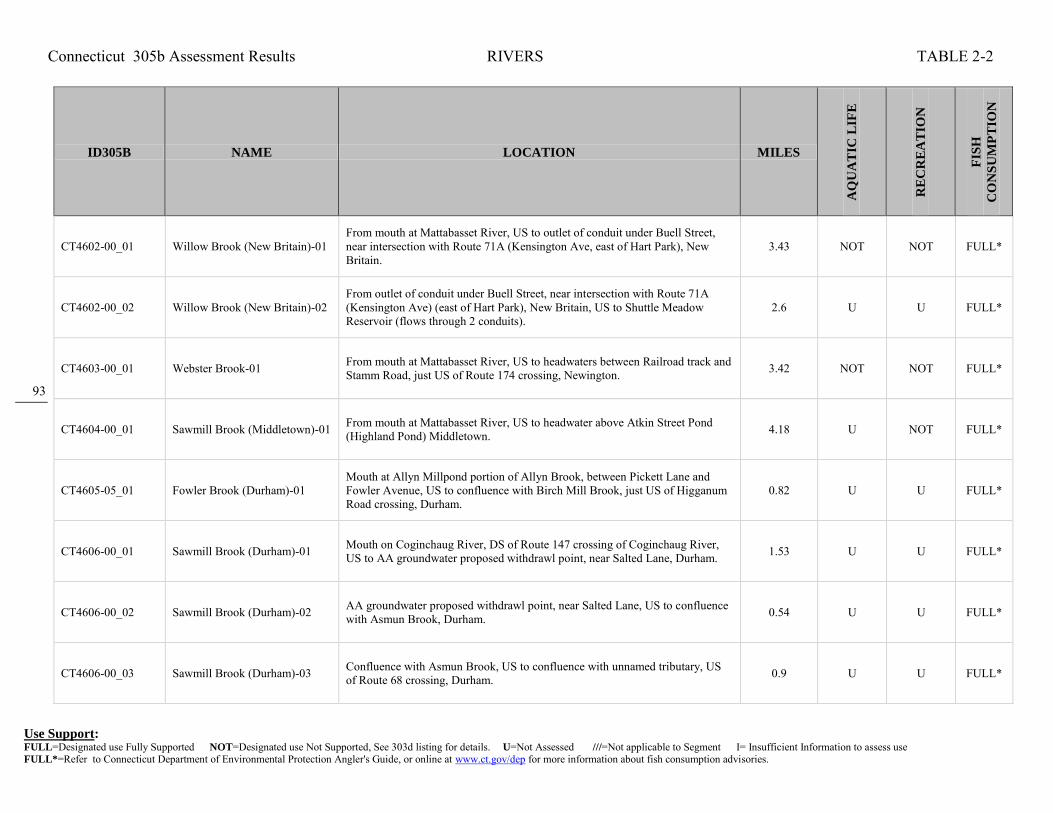
Connecticut 305b Assessment Results RIVERS TABLE 2-2
Use Support: FULL=Designated use Fully Supported NOT=Designated use Not Supported, See 303d listing for details. U=Not Assessed ///=Not applicable to Segment I= Insufficient Information to assess use FULL*=Refer to Connecticut Department of Environmental Protection Angler's Guide, or online at www.ct.gov/dep for more information about fish consumption advisories.
93
ID305B NAME LOCATION MILES
AQ
UA
TIC
LIF
E
RE
CR
EA
TIO
N
FIS
H
CO
NS
UM
PT
ION
CT4602-00_01 Willow Brook (New Britain)-01 From mouth at Mattabasset River, US to outlet of conduit under Buell Street, near intersection with Route 71A (Kensington Ave, east of Hart Park), New Britain.
3.43 NOT NOT FULL*
CT4602-00_02 Willow Brook (New Britain)-02 From outlet of conduit under Buell Street, near intersection with Route 71A (Kensington Ave) (east of Hart Park), New Britain, US to Shuttle Meadow Reservoir (flows through 2 conduits).
2.6 U U FULL*
CT4603-00_01 Webster Brook-01 From mouth at Mattabasset River, US to headwaters between Railroad track and Stamm Road, just US of Route 174 crossing, Newington. 3.42 NOT NOT FULL*
CT4604-00_01 Sawmill Brook (Middletown)-01 From mouth at Mattabasset River, US to headwater above Atkin Street Pond (Highland Pond) Middletown. 4.18 U NOT FULL*
CT4605-05_01 Fowler Brook (Durham)-01 Mouth at Allyn Millpond portion of Allyn Brook, between Pickett Lane and Fowler Avenue, US to confluence with Birch Mill Brook, just US of Higganum Road crossing, Durham.
0.82 U U FULL*
CT4606-00_01 Sawmill Brook (Durham)-01 Mouth on Coginchaug River, DS of Route 147 crossing of Coginchaug River, US to AA groundwater proposed withdrawl point, near Salted Lane, Durham. 1.53 U U FULL*
CT4606-00_02 Sawmill Brook (Durham)-02 AA groundwater proposed withdrawl point, near Salted Lane, US to confluence with Asmun Brook, Durham. 0.54 U U FULL*
CT4606-00_03 Sawmill Brook (Durham)-03 Confluence with Asmun Brook, US to confluence with unnamed tributary, US of Route 68 crossing, Durham. 0.9 U U FULL*

Connecticut 305b Assessment Results RIVERS TABLE 2-2
Use Support: FULL=Designated use Fully Supported NOT=Designated use Not Supported, See 303d listing for details. U=Not Assessed ///=Not applicable to Segment I= Insufficient Information to assess use FULL*=Refer to Connecticut Department of Environmental Protection Angler's Guide, or online at www.ct.gov/dep for more information about fish consumption advisories.
94
ID305B NAME LOCATION MILES
AQ
UA
TIC
LIF
E
RE
CR
EA
TIO
N
FIS
H
CO
NS
UM
PT
ION
CT4607-00_01 Coginchaug River-01 From mouth at Mattebessett River (at Cromwell border), US to downstream side of Route 3 crossing, Middletown. 1.87 U U FULL*
CT4607-00_02 Coginchaug River-02 From downstream side of Route 3 crossing, US to downstream side of Route 66 crossing (just US of Veterans Memorial Park), Middletown. 0.75 U NOT FULL*
CT4607-00_03 Coginchaug River-03 From downstream side of Route 66 crossing (just US of Veterans Memorial Park), US to Starr Mill Pond dam, Middletown. 0.6 U NOT FULL*
CT4607-00_04 Coginchaug River-04 From Starr Mill Pond Inlet, US (past Wadsworth Falls) to Strictland Road crossing, Middlefield. 4.19 U NOT FULL*
CT4607-00_05 Coginchaug River-05 From Strictland Road crossing, Middlefield, US to Meeting House Hill Road crossing, Durham. 4.95 U NOT FULL*
CT4607-00_06 Coginchaug River-06 From Meeting House Hill Road crossing, Durham, US to headwaters (US of Route 72 crossing, between Bluff Head and Broomstick Ledges), North Guilford.
3.59 FULL NOT FULL*
CT4607-02_01 Unnamed Tributary to Coginchaug River (Durham)-01
Mouth on Coginchaug River, just DS of Route 77 crossing, US to HW, US of Crooked Hill Road crossing, Durham. 0.78 U U FULL*
CT4607-03_01 Chalker Brook (Durham)-01 Mouth on Coginchaug River, DS of Route 77 crossing, US to Arrigonis Pond Number 3 outlet, Durham. 0.41 U U FULL*

Connecticut 305b Assessment Results RIVERS TABLE 2-2
Use Support: FULL=Designated use Fully Supported NOT=Designated use Not Supported, See 303d listing for details. U=Not Assessed ///=Not applicable to Segment I= Insufficient Information to assess use FULL*=Refer to Connecticut Department of Environmental Protection Angler's Guide, or online at www.ct.gov/dep for more information about fish consumption advisories.
95
ID305B NAME LOCATION MILES
AQ
UA
TIC
LIF
E
RE
CR
EA
TIO
N
FIS
H
CO
NS
UM
PT
ION
CT4607-05_01 Parmalee Brook (Durham)-01 Mouth on Coginchaug River, DS of Parmelee Hill Road crossing, US to confluence with unnamed tributary, just US of Saw Mill Road crossing, Durham.
1.94 U U FULL*
CT4607-08_01 Lyman Meadow Brook (Middlefield)-01
Mouth on Coginchaug River, US of Coginchaug River crossing of Miller Road, US to outlet of South Street Pond, US of RailRoad crossinf, Middlefield. 1.43 U NOT FULL*
CT4607-10_01 Ellen Doyle Brook (Middlefield)-01
Mouth on Coginchaug River, DS of Strickland Road crossing, US to confluence with unnamed tributary, just downstream of Gunsight Pond, parallel to Route 147 at West Street intersection, Middlefield.
0.83 U U FULL*
CT4607-12_01 Wadsworth Brook (Middlefield)-01
Mouth on Coginchaug River, DS of Wallace Way crossing, US to HW parallel with Cherry Hill Road, Middlefield. 1.2 U U FULL*
CT4607-13_01 Laurel Brook (Middletown)-01 Mouth on Coginchaug River, in Wadsworth Falls State Park, parallel to swimming area, near Route 157, US to unnamed pond outlet, just US of Red Road crossing, Middletown.
1.17 U NOT FULL*
CT4700-00_01 Salmon River-01 Mouth at Connecticut River, East Haddam, US to headwaters at confluence of Blackledge and Jeremy Rivers, Colchester. 10.41 FULL NOT FULL*
CT4700-02_01 Day Pond Brook (Colchester)-01 Confluence with Salmon River, US to Day Pond outlet, Colchester. 1.11 FULL U FULL*
CT4700-03_01 Flat Brook (East Hampton)-01 Mouth at Salmon River, DS of Route 16 crossing, US to HW, US of Daly Road crossing, East Hampton. 3.2 FULL U FULL*

Connecticut 305b Assessment Results RIVERS TABLE 2-2
Use Support: FULL=Designated use Fully Supported NOT=Designated use Not Supported, See 303d listing for details. U=Not Assessed ///=Not applicable to Segment I= Insufficient Information to assess use FULL*=Refer to Connecticut Department of Environmental Protection Angler's Guide, or online at www.ct.gov/dep for more information about fish consumption advisories.
96
ID305B NAME LOCATION MILES
AQ
UA
TIC
LIF
E
RE
CR
EA
TIO
N
FIS
H
CO
NS
UM
PT
ION
CT4700-09_01 Elbow Brook (East Hampton)-01
Confluence with Salmon River, US to HW (runs parallel to Route 196), East Hampton. 2.28 FULL U FULL*
CT4701-00_01 Raymond Brook (Hebron)-01 Mouth on Jeremy River, along Airline Trail, DS of Grayville Road crossing, US to Route 85 crossing, Hebron. 2.81 U U FULL*
CT4701-00_02 Raymond Brook (Hebron)-02 Route 85 crossing, Hebron, US to HW, near Basket Shop Road at Hebron/Columbia town line. 4.15 FULL U FULL*
CT4702-00_01 Judd Brook (Colchester/Hebron)-01
Mouth on Jeremy River, just US of Airline Trail crossing, Colchester/Hebron town line, US to crossing, US to confluence with unnamed tributary, just US of Route 85 crossing, Colchester.
2.44 FULL U FULL*
CT4703-00_01 Meadow Brook (Colchester)-01 From mouth at confluence with jeremy River (parallel to Route 2, US of Prospect Hill Road crossing), US to Lincoln Lake outlet dam on Levy Pond (just US of Levy Road crossing), Colchester.
3.07 FULL U FULL*
CT4703-00_02 Meadow Brook (Colchester)-02 From INLET to Levy Pond (just DS of Middletown Road (Route 16) crossing), US to HW at confluence of Cabin Brook and Nelkin Brook (adjacent to Lakeview Court), Colchester.
0.81 U U FULL*
CT4703-01_01 Cabin Brook-01 From mouth at confluence with Nelkin Brook (in marsh DS of Cabin Road crossing), US under Route 2/Route 11 interchange to confluence with small tributary near exit 20 ramp, Colchester.
1.53 NOT U FULL*
CT4703-01_02 Cabin Brook-02 From confluence with small tributary near exit 20 ramp (US of Route 2/Route 11 interchange), US to headwaters on south side of Parum Road (Route 354), north of Dutton Swamp (US of McDonald Road crossing), Colchester.
1.02 U U FULL*

Connecticut 305b Assessment Results RIVERS TABLE 2-2
Use Support: FULL=Designated use Fully Supported NOT=Designated use Not Supported, See 303d listing for details. U=Not Assessed ///=Not applicable to Segment I= Insufficient Information to assess use FULL*=Refer to Connecticut Department of Environmental Protection Angler's Guide, or online at www.ct.gov/dep for more information about fish consumption advisories.
97
ID305B NAME LOCATION MILES
AQ
UA
TIC
LIF
E
RE
CR
EA
TIO
N
FIS
H
CO
NS
UM
PT
ION
CT4705-00_01 Jeremy River-01 From mouth at confluence with Blackledge River, at head of Salmon River, US to Norton Paper Company Dam (just US of Route 149 crossing), North Westchester (Colchester).
1.17 FULL U FULL*
CT4705-00_02 Jeremy River-02 From Norton Paper Company Dam (just US of Route 149 crossing), North Westchester (Colchester), US to headwaters at Holbrook Pond, Hebron. 9.09 U U FULL*
CT4706-00_01 Fawn Brook (Marlborough)-01 Mouth on Blackledge River, just DS of Main Street crossing, Marlborough, US to confluence with West Branch Fawn Brook, parallel to Paper Mill Road, at Marlborough/Hebron town line.
2.05 FULL U FULL*
CT4707-00_01 Blackledge River-01 From mouth at confluence with Jeremy River, at head of Salmon River (near River Road), Colchester, US to headwaters (near Converse Road, just off Birch Mountain Road), Bolton.
16.35 FULL U FULL*
CT4707-02_01 French Brook (Bolton)-01 From mouth at confluence with Blackledge River (segment-01) DS of French Road crossing, US to Tinker Pond outlet Dam (US of Tinker Pond Road crossing), Bolton.
1 FULL U FULL*
CT4707-06_01 Flat Brook (Marlborough)-01 From mouth at Blackledge River (DS of Standish Drive crossing), Marlborough, US to headwaters at Diamond Lake, Glastonbury. 2.04 U U FULL*
CT4707-12_01 Lyman Brook-01 From mouth at Blackledge River, just US of South Main Street crossing (DS of Route 2, exit 15 offramp), US to headwaters, Marlborough. 3.82 FULL U FULL*
CT4708-00_01 Dickinson Creek (Colchester/Marlborough)-01
Mouth on Salmon River, just DS of Comstock Bridge crossing, Colchester, US to confluence with Fawn Hill Brook, just US of Flood Road crossing, Marlborough.
4.82 FULL U FULL*

Connecticut 305b Assessment Results RIVERS TABLE 2-2
Use Support: FULL=Designated use Fully Supported NOT=Designated use Not Supported, See 303d listing for details. U=Not Assessed ///=Not applicable to Segment I= Insufficient Information to assess use FULL*=Refer to Connecticut Department of Environmental Protection Angler's Guide, or online at www.ct.gov/dep for more information about fish consumption advisories.
98
ID305B NAME LOCATION MILES
AQ
UA
TIC
LIF
E
RE
CR
EA
TIO
N
FIS
H
CO
NS
UM
PT
ION
CT4709-00_01 Pine Brook-01 From mouth at Salmon River, Haddam, US to confluence with Pocotopaug Creek. 3.18 FULL U FULL*
CT4709-00_02 Pine Brook-02 From confluence with Pocotopaug Creek, US past Route 66 crossing, to headwaters just US of Clark Hill Road crossing, East Hampton. 4.51 U U FULL*
CT4709-04_01 Pocotopaug Creek-01 From mouth at Pine Brook (US of Route 151 crossing AND North of Wilkes Road), US to Old Chestnut Hill Road crossing, East Hampton. 1.74 FULL U FULL*
CT4709-04_02 Pocotopaug Creek-02 From Old Chestnut Hill Road crossing, East Hamption, US to Pocotopaug Lake outlet dam (just US of Route 66 crossing). 2.66 NOT U FULL*
CT4800-00_01 Eightmile River (Lyme)-01 From mouth at Connecticut River, Hamburg Cove (part of Connecticut River tidal area), US to headwaters at Peck Meadow Pond outlet dam. 12.22 FULL NOT FULL*
CT4800-01_01 Early Brook (East Haddam/Colchester)-01
Confluence with Eightmile River, near Salem Road, East Haddam, US to HW, just US of Alfred Drive crossing, Colchester 3.55 FULL U FULL*
CT4800-06_01 Muddy brook (East Haddam)-01 Mouth on Eightmile River, DS of Devils Hopyard Road crossing, US to outlet of Will Cone Pond, just US of Tater Hill Road crossing, East Haddam. 1.24 FULL U FULL*
CT4800-08_01 Burnhams Brook (East Haddam)-01
Confluence with Eightmile River, near Devils Hopyard Road, US to HW, US of Baker Road crossing, East Haddam. 2.52 FULL U FULL*

Connecticut 305b Assessment Results RIVERS TABLE 2-2
Use Support: FULL=Designated use Fully Supported NOT=Designated use Not Supported, See 303d listing for details. U=Not Assessed ///=Not applicable to Segment I= Insufficient Information to assess use FULL*=Refer to Connecticut Department of Environmental Protection Angler's Guide, or online at www.ct.gov/dep for more information about fish consumption advisories.
99
ID305B NAME LOCATION MILES
AQ
UA
TIC
LIF
E
RE
CR
EA
TIO
N
FIS
H
CO
NS
UM
PT
ION
CT4800-15_01 Tributary-Eightmile River (Lyme)-01
From mouth at west side of Eightmile River, just US of Macintosh Road crossing, US to headwaters, Lyme. 2.23 FULL U FULL*
CT4801-00_01 Harris Brook (Salem)-01 From mouth at East Branch Eightmile River (just DS of Old Farm Road crossing), US to Salter Farm Pond outlet dam on Byron Clark Pond (just US of Salter Road crossing), Salem.
1.19 FULL U FULL*
CT4802-00_01 Eightmile River, East Branch (Salem)-01
From mouth at Eight Mile River (DS of Route 156 crossing), Lyme, US to to headwaters at Major Kennys Pond (just US of Witch Meadow Road crossing), Salem.
8.03 FULL U FULL*
CT4803-00_01 Beaver Brook (Lyme)-01 From mouth at Eightmile River, along west side of Route 156, US to confluence with Cedar Pond Brook, Lyme. 1.86 FULL U FULL*
CT4803-01_01 Cedar Pond Brook (Lyme)-01 Mouth on Beaver Brook, DS of Beaver Brook Road crossing, US to Cedar Lake outlet, US of Beaver Brook Road crossing, Lyme. 1.74 FULL U FULL*
CT5000-55_01 Unnamed trib to Oyster River (Milford)-01
From Merwin Avenue crossing, US to RailRoad (Amtrak) crossing (just US of Quirkes Pond (included in segment)), Milford. 1.47 NOT U FULL*
CT5000-55_02 Unnamed trib to Oyster River (Milford)-02
From RailRoad (Amtrak) crossing (just US of Quirks Pond), US to headwaters (inlet to unnamed swamp), just US of Cascade Boulevard (entrance to Light Sources Inc.), Milford.
0.43 NOT U FULL*
CT5103-00_01 Menunketesuck River-01 From inlet to Chapman Pond (just DS of Pleasant Valley Road crossing), Westbrook, US to Lockwood Lake outlet dam on Bushy Pond (just US of Woods Lane crossing), Clinton.
2.03 U U FULL*

Connecticut 305b Assessment Results RIVERS TABLE 2-2
Use Support: FULL=Designated use Fully Supported NOT=Designated use Not Supported, See 303d listing for details. U=Not Assessed ///=Not applicable to Segment I= Insufficient Information to assess use FULL*=Refer to Connecticut Department of Environmental Protection Angler's Guide, or online at www.ct.gov/dep for more information about fish consumption advisories.
100
ID305B NAME LOCATION MILES
AQ
UA
TIC
LIF
E
RE
CR
EA
TIO
N
FIS
H
CO
NS
UM
PT
ION
CT5103-00_02 Menunketesuck River-02 From Bushy Pond inlet (just DS of Kelseytown Road crossing), Clinton, US to Kelseytown Reservoir outlet dam (just US of Kelseytown Brodge Road crossing), Clinton-Killingworth border.
1.78 NOT U FULL*
CT5103-00_03 Menunketesuck River-03 From Kelseytown Reservoir inlet (northeast corner), Clinton-Killingworth border, US to North Roast Meat Hill Road crossing (just US of Route 148 crossing), Killingworth.
5.17 FULL U FULL*
CT5104-00_01 Indian River (Clinton)-01 Head of tide at Indian Lake dam outlet, (DS end of Indian Lake, south side of I95), Clinton, US to headwaters (at wetland, just US of Hemlock Drive crossing, parallel to Route 81), Killingworth.
7.93 U U FULL*
CT5105-00_01 Chatfield Hollw Brook (Killingworth)-01
From mouth at confluence with Hammonasset River (DS of River Road crossing), US to Deer Lake outlet Dam, Killingworth. 1.03 FULL NOT FULL*
CT5105-00_02 Chatfield Hollow Brook (Killingworth)-02 Deer Lake inlet, US to foster Pond outlet, near Champlin Road, Killingworth. 1.02 U U FULL*
CT5105-00_03 Chatfield Hollow Brook (Killingworth)-03
Foster Pond inlet, just DS of Route 80 crossing, US to Schreeder Pond outlet, just US of Route 80 crossing, Killingworth. 0.43 U U FULL*
CT5105-00_04 Chatfield Hollow Brook (Killingworth)-04
Schreeder Pond inlet, parallel to Buck Road, US to confluence with Pond Meadow Brook (just DS of Old Mill Pond), Killingworth. 0.53 FULL U FULL*
CT5105-01_01 Pond Meadow Brook-01 From mouth at confluence with Chatfield Hollow Brook (just DS of Old Mill Pond outlet dam on Chatfield Hollow Brook, in Chatfield Hollow State Park), US to Kroupa Pond outlet dam (just US of Route 148 crossing), Killingworth.
0.7 U U FULL*

Connecticut 305b Assessment Results RIVERS TABLE 2-2
Use Support: FULL=Designated use Fully Supported NOT=Designated use Not Supported, See 303d listing for details. U=Not Assessed ///=Not applicable to Segment I= Insufficient Information to assess use FULL*=Refer to Connecticut Department of Environmental Protection Angler's Guide, or online at www.ct.gov/dep for more information about fish consumption advisories.
101
ID305B NAME LOCATION MILES
AQ
UA
TIC
LIF
E
RE
CR
EA
TIO
N
FIS
H
CO
NS
UM
PT
ION
CT5106-00_01 Hammonasset River-01 From saltwater limit at DS most portion of I95 crossing, Madison/Clinton town border, US to Hammonassett Reservoir outlet dam (just US of Route 80 crossing), Killingworth/Madison town border.
8.07 FULL U FULL*
CT5106-00_02 Hammonasset River-02 From Hammonassett Reservoir inlet (at northeastern most corner, just DS of Bunnell Bridge Road crossing), US to County Road crossing (just US of confluence with Bunker Hill Brook), Killingworth/Madison town border.
2.62 U U FULL*
CT5106-00_03 Hammonasset River-03 From County Road crossing (just US of confluence with Bunker Hill Brook), Killingworth/Madison town border, US to Madison Road (Route 79) crossing at Madison/Durham border.
3.43 U U FULL*
CT5107-00_01 Neck River-01 From head of tide (marsh exit, parallel to Neck Road, DS of Route 1 crossing), US to headwaters (just northeast of Roure 80 and Route 79 rotary intersection, and south of aqueduct), Madison.
9.49 U NOT FULL*
CT5108-00_01 East River (Guilford)-01 From Platner Dam (just US of Foot Bridge Road crossing, head of tide), US to 2nd unnamed tributary (below lakes), Guilford. 0.67 U NOT FULL*
CT5108-01_01 Iron Stream (Guilford)-01 Mouth at inlet to Upper Guilford Lakes, Guilford, US to confluence with Dowd Hollow Brook just US of Twin Bridge road crossing, Madison. 0.81 U U FULL*
CT5108-05_01 Dowd Hollow Brook (Madison)-01
Confluence with Iron Stream, DS of Route 80 crossing, US to Race Hill Road crossing, Madison. 1.13 U U FULL*
CT5108-05_02 Dowd Hollow Brook (Madison)-02 Race Hill Road crossing, US to water company diversion pipe, Madison. 1.59 FULL U FULL*

Connecticut 305b Assessment Results RIVERS TABLE 2-2
Use Support: FULL=Designated use Fully Supported NOT=Designated use Not Supported, See 303d listing for details. U=Not Assessed ///=Not applicable to Segment I= Insufficient Information to assess use FULL*=Refer to Connecticut Department of Environmental Protection Angler's Guide, or online at www.ct.gov/dep for more information about fish consumption advisories.
102
ID305B NAME LOCATION MILES
AQ
UA
TIC
LIF
E
RE
CR
EA
TIO
N
FIS
H
CO
NS
UM
PT
ION
CT5108-09_01 Little Meadow Brook (Guilford)-01
Mouth at inlet to Capello Pond, DS of Madison Road crossing, US to outlet of unnamed pond, parallel to Little Meadow Road (south of Meadow Hills Road intersection, southern most pond, three lakes in a row, top most is Mallers Pond), Guilford.
2.04 U U FULL*
CT5110-00_01 West River (Guilford)-01 From Route 1 crossing (just DS of confluence with Spinning Mill Brook), US to confluence with unnamed tributary from Thirsty Lake outlet (just DS of Flat Meadow Road crossing), Guilford.
2.22 U U FULL*
CT5110-00_02 West River (Guilford)-02
From confluence with unnamed tributary from Thirsty Lake outlet (just DS of Flat Meadow Road crossing), US to confuence with Branch Brook (just US of Race Hill Road crossing, parallel with Route 77), DS of lake Quonnipaug outlet dam, Guilford.
5.41 FULL U FULL*
CT5111-00_01 Branford River-01 From Route 1 crossing (just DS of I95 crossing), US to confluence with Notch Hill Brook (US of School Ground Road crossing). 2.91 U U FULL*
CT5111-00_02 Branford River-02 From confluence with Notch Hill Brook (US of School Ground Road crossing), Branford, US to Lake Gaillard outlet dam (southeast portion of lake), North Branford.
3.07 FULL U FULL*
CT5112-00_01 Farm River (East Haven)-01 From saltwater limit at marsh (just DS of MAin Street Anx. crossing, southwest of Lake Saltonstall outflow), East Haven, US (parallel to lake, around west side) to confluence with Burrs Brook (DS of Route 80 crossing), North Branford.
6.14 NOT NOT FULL*
CT5112-00_02 Farm River (East Haven)-02 From confluence with Burrs Brook (DS of Route 80 crossing), US to Pages Mill Pond outlet dam, US side of Mill Road crossing, North Branford. 1.24 NOT NOT FULL*
CT5112-00_03 Farm River (East Haven)-03 From Pages Mill Pond inlet, US to headwaters (just US of Hyla Lane crossing, near Middletown Avenue (Route 17) are), North Branford. 8.87 U U FULL*

Connecticut 305b Assessment Results RIVERS TABLE 2-2
Use Support: FULL=Designated use Fully Supported NOT=Designated use Not Supported, See 303d listing for details. U=Not Assessed ///=Not applicable to Segment I= Insufficient Information to assess use FULL*=Refer to Connecticut Department of Environmental Protection Angler's Guide, or online at www.ct.gov/dep for more information about fish consumption advisories.
103
ID305B NAME LOCATION MILES
AQ
UA
TIC
LIF
E
RE
CR
EA
TIO
N
FIS
H
CO
NS
UM
PT
ION
CT5112-10_01 Burrs Brook-01 From mouth at confluence with Farm River (just DS of Totoket Road crossing), US to Vic's Pond (on Tomasso property) outlet (part of hyro missing from NHD). Brook contributes to drinking water supply, Lake Saltonstall.
1.35 NOT U FULL*
CT5112-10-trib_01 Unnamed Tributary to Burrs Brook (North Branford)-01
Mouth on Burrs Brook, just DS of Doral Farms Road crossing, US to HW, near Route 22 and Twin Lakes Road intersection, North Branford. 0.64 U U FULL*
CT5200-00_01 Quinnipiac River-01 From Sackett Point Road crossing (west of I91, and east of Route 15), North Haven, US to Toelles Road crossing (head of tide), Wallingford/North Haven town border.
5.05 NOT NOT FULL*
CT5200-00_02 Quinnipiac River-02 From Toelles Road crossing (head of tide, just east of Route 15), Wallingford/North Haven town border, US to Hanover Pond outlet dam, Meriden. (Segment includes Community Lake portion)
8.5 NOT NOT FULL*
CT5200-00_03 Quinnipiac River-03 From Hanover Pond inlet (at Oregon Road crossing, DS enr of Quinnipiac Gorge), Meriden, US (through Gorge) to Waterworks (breached dam), just DS of Cheshire/Meriden town border (parallel to River Road (Route 70)).
1.29 NOT NOT NOT
CT5200-00_04 Quinnipiac River-04 From Waterworks (breached dam), just DS of Cheshire/Meriden town border (parallel to River Road (Route 70)), US to confluence with Tenmile River (US of Route 322 crossing, and US of Southington WPCF).
4.78 NOT NOT NOT
CT5200-00_05 Quinnipiac River-05 From confluence with Tenmile River (US of Route 322 crossing, and US of Southington WPCF), US to Queen Street (Route 10) crossing (US of RailRoad crossing, North of I-84 crossing), Southington.
8.32 NOT U NOT
CT5200-00_06 Quinnipiac River-06 From Queen Street (Route 10) crossing (US of RailRoad crossing, North of I-84 crossing), Southington, US to Hamlin Pond outlet dam (US of Pine Street crossing), Plainville.
3 NOT NOT NOT

Connecticut 305b Assessment Results RIVERS TABLE 2-2
Use Support: FULL=Designated use Fully Supported NOT=Designated use Not Supported, See 303d listing for details. U=Not Assessed ///=Not applicable to Segment I= Insufficient Information to assess use FULL*=Refer to Connecticut Department of Environmental Protection Angler's Guide, or online at www.ct.gov/dep for more information about fish consumption advisories.
104
ID305B NAME LOCATION MILES
AQ
UA
TIC
LIF
E
RE
CR
EA
TIO
N
FIS
H
CO
NS
UM
PT
ION
CT5200-00_07 Quinnipiac River-07 From Hamlin Pond inlet (northeast corner, just south of Route 72 and I84 connection and RailRoad), Plainville, US to headwaters at Dead Wood Swamp (west side of I84, near exit 37, just south of Route 6), Farmington.
3.5 NOT NOT FULL*
CT5200-02_01 Patton Brook-01 From mouth at confluence with Quinnipiac River (just DS of River Road crossing), US to headwaters at unnamed pond (US of confluence with Mill Pond tributary, just US of Malcein Drive crossing), Southington.
2.84 NOT U FULL*
CT5200-07_01 Honeypot Brook-01 Mouth at confluence with Quinnipiac River, (US of Blacks Road crossing), US to headwaters, US of Wiese Road crossing (near Route 70), Cheshire. 4.95 U U FULL*
CT5200-10_01 Meetinghouse Brook (Wallingford)-01
Mouth on Quinnipiac River, at Route 68 crossing, US to confluence with Spruce Glen Brook, parallel to Route 15, Wallingford. 1.15 NOT U FULL*
CT5200-23_01 Hemingway Creek-01 From saltwater limit (200m DS of Quinipiac Avenue crossing, just DS of RailRoad crossing), New Haven, US to Golf Pond outlet dam, East Haven. 0.74 NOT U FULL*
CT5201-00_01 Eightmile River (Southington)-01
From mouth at confluence with Quinnipiac River (DS of West Main Street crossing and just DS of RailRoad crossing), US to Grannis Pond outlet dam (just US of Churchhill Street crossing), Southington.
3.39 FULL U NOT
CT5201-00_02 Eightmile River (Southington)-02
From Grannis Pond inlet (just DS of Welch Road crossing), Southington, US to headwaters at Bristol Fish & Game Club Pond outlet dam, Wolcott. 2.37 U U FULL*
CT5201-04_01 Dayton Brook-01 From mouth at confluence with Eightmile River (west side of I84, south of Jude Lane), US to headwaters (just US of Sandra Lane crossing), Southington. 2.03 U U FULL*
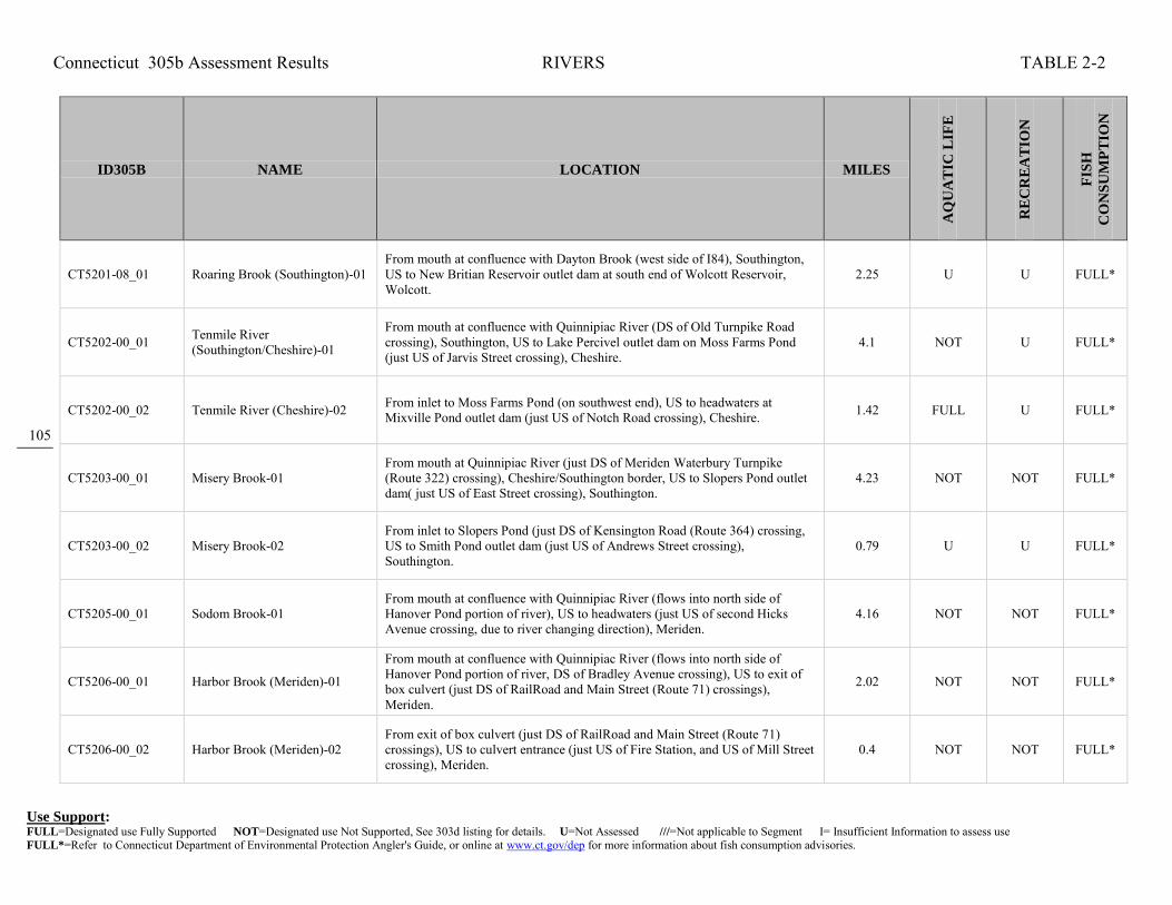
Connecticut 305b Assessment Results RIVERS TABLE 2-2
Use Support: FULL=Designated use Fully Supported NOT=Designated use Not Supported, See 303d listing for details. U=Not Assessed ///=Not applicable to Segment I= Insufficient Information to assess use FULL*=Refer to Connecticut Department of Environmental Protection Angler's Guide, or online at www.ct.gov/dep for more information about fish consumption advisories.
105
ID305B NAME LOCATION MILES
AQ
UA
TIC
LIF
E
RE
CR
EA
TIO
N
FIS
H
CO
NS
UM
PT
ION
CT5201-08_01 Roaring Brook (Southington)-01 From mouth at confluence with Dayton Brook (west side of I84), Southington, US to New Britian Reservoir outlet dam at south end of Wolcott Reservoir, Wolcott.
2.25 U U FULL*
CT5202-00_01 Tenmile River (Southington/Cheshire)-01
From mouth at confluence with Quinnipiac River (DS of Old Turnpike Road crossing), Southington, US to Lake Percivel outlet dam on Moss Farms Pond (just US of Jarvis Street crossing), Cheshire.
4.1 NOT U FULL*
CT5202-00_02 Tenmile River (Cheshire)-02 From inlet to Moss Farms Pond (on southwest end), US to headwaters at Mixville Pond outlet dam (just US of Notch Road crossing), Cheshire. 1.42 FULL U FULL*
CT5203-00_01 Misery Brook-01 From mouth at Quinnipiac River (just DS of Meriden Waterbury Turnpike (Route 322) crossing), Cheshire/Southington border, US to Slopers Pond outlet dam( just US of East Street crossing), Southington.
4.23 NOT NOT FULL*
CT5203-00_02 Misery Brook-02 From inlet to Slopers Pond (just DS of Kensington Road (Route 364) crossing, US to Smith Pond outlet dam (just US of Andrews Street crossing), Southington.
0.79 U U FULL*
CT5205-00_01 Sodom Brook-01 From mouth at confluence with Quinnipiac River (flows into north side of Hanover Pond portion of river), US to headwaters (just US of second Hicks Avenue crossing, due to river changing direction), Meriden.
4.16 NOT NOT FULL*
CT5206-00_01 Harbor Brook (Meriden)-01
From mouth at confluence with Quinnipiac River (flows into north side of Hanover Pond portion of river, DS of Bradley Avenue crossing), US to exit of box culvert (just DS of RailRoad and Main Street (Route 71) crossings), Meriden.
2.02 NOT NOT FULL*
CT5206-00_02 Harbor Brook (Meriden)-02 From exit of box culvert (just DS of RailRoad and Main Street (Route 71) crossings), US to culvert entrance (just US of Fire Station, and US of Mill Street crossing), Meriden.
0.4 NOT NOT FULL*

Connecticut 305b Assessment Results RIVERS TABLE 2-2
Use Support: FULL=Designated use Fully Supported NOT=Designated use Not Supported, See 303d listing for details. U=Not Assessed ///=Not applicable to Segment I= Insufficient Information to assess use FULL*=Refer to Connecticut Department of Environmental Protection Angler's Guide, or online at www.ct.gov/dep for more information about fish consumption advisories.
106
ID305B NAME LOCATION MILES
AQ
UA
TIC
LIF
E
RE
CR
EA
TIO
N
FIS
H
CO
NS
UM
PT
ION
CT5206-00_03 Harbor Brook (Meriden)-03 From culvert entrance (just US of Fire Station, and US of Mill Street crossing), US to Baldwins Pond outlet dam (just US of Westfield Road crossing), Meriden. 1.48 NOT U FULL*
CT5207-00_01 Wharton Brook-01 From mouth at confluence with Quinnipiac River (DS of Route 5 and RailRoad crossing), Wallingford/North Haven town borders, US to Simpson Pond outlet dam (US of Center Street (Route 150) crossing), Wallingford.
3.97 NOT U FULL*
CT5207-00_02 Wharton Brook-02 From inlet to Simpson Pond, US to North Farms Reservoir outlet dam (just US of Church Street (Route 68) crossing), Wallingford. 2.94 NOT U FULL*
CT5207-02_01 Allen Brook-01 From mouth at confluence with Wharton Brook (east of Route 5, south of exit 13 on/off ramp, I91), US to Allen Brook Pond outlet dam, Wallingford. 0.05 U NOT FULL*
CT5207-02_02 Allen Brook-02 From inlet to Allen Brook Pond (south of exit 13 on/off ramp, I91), Wallingford/North Haven town borders, US to headwaters (under I91, and then parallel along east side, stays to west side of RailRoad track), Wallingford.
1.8 U NOT FULL*
CT5208-00_01 Muddy River (North Haven)-01 From mouth at confluence with Quinnipiac River (saltwater limit, just DS of RailRoad crossing on west side of I91, south of Sackett Point Road), US to Muddy River Pond outlet dam, North Haven.
0.68 U U FULL*
CT5208-00_02a Muddy River (North Haven)-02a From Muddy River Pond inlet (east side of I91), North Haven, US to confluence with unnnamed tributary (outlet for Tamarac Swamp), just DS of Tyler Mill Road crossing, Wallingford.
8.1 U U FULL*
CT5208-00_02b Muddy River (Wallingford)-02b From confluence with unnnamed tributary (outlet for Tamarac Swamp), just DS of Tyler Mill Road crossing, Wallingford, US to MacKenzie Reservoir outlet dam (US of Northford Road crossing), Wallingford.
1.81 NOT U FULL*

Connecticut 305b Assessment Results RIVERS TABLE 2-2
Use Support: FULL=Designated use Fully Supported NOT=Designated use Not Supported, See 303d listing for details. U=Not Assessed ///=Not applicable to Segment I= Insufficient Information to assess use FULL*=Refer to Connecticut Department of Environmental Protection Angler's Guide, or online at www.ct.gov/dep for more information about fish consumption advisories.
107
ID305B NAME LOCATION MILES
AQ
UA
TIC
LIF
E
RE
CR
EA
TIO
N
FIS
H
CO
NS
UM
PT
ION
CT5208-00_03 Muddy River (Wallingford)-03 From MacKenzie Reservoir inlet (northeastern portion, just DS of Scard Road crossing), US to Spring Lake outlet dam (US of Durham Road crossing, east of I91), Wallingford.
1.98 U U FULL*
CT5208-00_04 Muddy Brook (Wallingford)-04 From Spring Lake outlet dam (US of Durham Road crossing, east of I91), US to Church Street (Route 68) crossing (just US of Killam Pond, and east of exit 15, I91), Wallingford. Segment includes Spring Lake.
0.86 U U FULL*
CT5208-10_01 Eightmile Brook (North Haven/North Branford)-01
Confluence with Muddy river, North Haven, US to Gail Drive crossing, North Branford. 0.89 U U FULL*
CT5208-11_01 Fivemile Brook (North Haven)-01
Confluence with Muddy river, just DS of Spring Road crossing, US to Fitch Street crossing, North Haven. 0.87 U U FULL*
CT5301-00_01 Willow Brook (Hamden)-01 From mouth at confluence with Mill River (DS of Willow Street crossing), Hamden, US to confluence with Brooksvale Stream (DS of South Brooksvale Road crossing), Cheshire. (River travels along RR track)
1.87 U U FULL*
CT5301-00_02 Willow Brook (Cheshire)-02 From confluence with Brooksvale Stream (DS of South Brooksvale Road crossing), US to HW near Timber Lane, Cheshire. (River travels along RR track)
3.84 U U FULL*
CT5301-02_01 Sanford Brook (Cheshire)-01 From mouth at confluence with Willow Brook (DS of South Brooksvale Road crossing), Cheshire, US to HW (just US of Candee Road crossing), Prospect. 2.68 FULL U FULL*
CT5302-00_01 Mill River (Hamden)-01 From Footbridge off of Park Road (US extent of saltwater influence), US to Lake Whitney outlet dam, Hamden. (Segment is tidally affected, but not saltwater).
0.41 FULL FULL FULL*

Connecticut 305b Assessment Results RIVERS TABLE 2-2
Use Support: FULL=Designated use Fully Supported NOT=Designated use Not Supported, See 303d listing for details. U=Not Assessed ///=Not applicable to Segment I= Insufficient Information to assess use FULL*=Refer to Connecticut Department of Environmental Protection Angler's Guide, or online at www.ct.gov/dep for more information about fish consumption advisories.
108
ID305B NAME LOCATION MILES
AQ
UA
TIC
LIF
E
RE
CR
EA
TIO
N
FIS
H
CO
NS
UM
PT
ION
CT5302-00_02 Mill River (Hamden/Cheshire)-02
From inlet to Lake Whitney (east side of Route 15, just DS of Connolly Parkway crossing), Hamden, US to Cook Hill Road crossing, Cheshire. 9.06 U NOT FULL*
CT5302-00_03 Mill River (Cheshire)-03 From Cook Hill Road crossing, Cheshire, US to headwaters (US of Williamsburg Drive crossing). 3.09 NOT U FULL*
CT5303-00_01 Sargent River-01 From mouth at confluence with West River (DS of Route 69 crossing) at inlet to Lake Dawson, Woodbridge, US to headwaters at Munson Road Pond outlet dam, Bethany (EXCLUDING Lake Glen and Lake Chamberlain).
3.96 FULL U FULL*
CT5304-00_01 Wintergreen Brook (New Haven)-01
Mouth on West River, DS of Blake Street crossing, US to confluence with Wilmot Brook, US of Wilmot Road crossing, New Haven. 1.42 U U FULL*
CT5304-00_02 Wintergreen Brook (New Haven)-02
Confluence with Wilmot Brook, US of Wilmot Road crossing, US to confluence with Belden Brook, US of Brookside Avenue crossing, New Haven. 0.26 U U FULL*
CT5304-00_03 Wintergreen Brook (New Haven)-03
Confluence with Belden Brook, US of Brookside Avenue crossing, New Haven, US to Lake Wintergreen outlet, US of Wintergreen Avenue crossing (near Route 15), Hamden.
1.22 U U FULL*
CT5305-00_01 West River (New Haven/Woodbridge)-01
From head of tide (tide gates) at Chapel Street crossing (just DS of Edgewood Park Pond), New Haven, US to Konolds Pond outlet dam (just US of Bradley Road crossing), Woodbridge.
3.23 NOT NOT FULL*
CT5305-00_02 West River (Woodbridge/Bethany)-02
From inlet to Konolds Pond (northern portion of lake, east side of Route 69), Woodbridge, US to Lake Bethany outlet dam, Bethany. Segment includes Lake Dawson and Lake Watrous.
4.9 U U FULL*

Connecticut 305b Assessment Results RIVERS TABLE 2-2
Use Support: FULL=Designated use Fully Supported NOT=Designated use Not Supported, See 303d listing for details. U=Not Assessed ///=Not applicable to Segment I= Insufficient Information to assess use FULL*=Refer to Connecticut Department of Environmental Protection Angler's Guide, or online at www.ct.gov/dep for more information about fish consumption advisories.
109
ID305B NAME LOCATION MILES
AQ
UA
TIC
LIF
E
RE
CR
EA
TIO
N
FIS
H
CO
NS
UM
PT
ION
CT5306-00_01 Indian River (Orange)-01 Confluence with Silver Brook, US to Route 1 crossing, Orange. 0.46 U U FULL*
CT5306-00_02 Indian River (Orange)-02 Route 1 crossing, US to HW, just US of Route 34 crossing, Orange. 3.27 U U FULL*
CT5306-01_01 Silver Brook (Orange)-01 From mouth at confluence with Indian River (just US of Indian Lake, parallel to Indian River Road), US to confluence with Trout Brook (just US of Smith Farm Road crossing), Orange.
1.6 NOT U FULL*
CT5306-01_02 Silver Brook (Orange)-02 From confluence with Trout Brook (just US of Smith Farm Road crossing), US to HW (west side of Dogburn Road, near Woodbridge town line), Orange. 3.1 U U FULL*
CT5307-00_01 Wepawaug River-01 From wepawaug Pond outlet dam (head of tide) at New Haven Avenue (Route 162) crossing, US to Route 1 crossing, Milford. Segment includes Wepawaug Pond and City Pond portions on river.
0.77 U NOT FULL*
CT5307-00_02 Wepawaug River-02 From Route 1 crossing, Milford, US to Lake Wepawaug inlet, Orange. Segment includes Lake Wepawaug portion on river. 4.2 U NOT FULL*
CT5307-00_03 Wepawaug River-03 From inlet to Lake Wepawaug, US to inlet to Wepawaug Reservoir (US of Route 34 crossing), Orange. Segment includes Wepawaug Reservoir portion of river.
2.33 FULL U FULL*
CT5307-00_04 Wepawaug River-04 From inlet to Wepawaug Reservoir, Orange, US to area east of Racebrook Road (Route 114), perpendicular to Milan Road, Woodbridge. 3.05 U U FULL*

Connecticut 305b Assessment Results RIVERS TABLE 2-2
Use Support: FULL=Designated use Fully Supported NOT=Designated use Not Supported, See 303d listing for details. U=Not Assessed ///=Not applicable to Segment I= Insufficient Information to assess use FULL*=Refer to Connecticut Department of Environmental Protection Angler's Guide, or online at www.ct.gov/dep for more information about fish consumption advisories.
110
ID305B NAME LOCATION MILES
AQ
UA
TIC
LIF
E
RE
CR
EA
TIO
N
FIS
H
CO
NS
UM
PT
ION
CT5307-00_05 Wepawaug River-05 From area east of Racebrook Road (Route 114), perpendicular to Milan Road, US to headwaters at Center Street Pond outlet dam (on Keenes Ice Pond), just US of Center Road (Route 14) crossing, Woodbridge,
0.99 U U FULL*
CT5307-04_01 Race Brook-01 From mouth at confluence with Wepawaug River near Mulberry Lane (about .5 miles DS of Route 152 crossing) Orange, US to headwaters, just US of Route 114 crossing, Woodbridge.
5.81 NOT U FULL*
CT6000-00_01 Housatonic River-01 From end of saltwater influence, at southern most portion of Wooster Island, Orange, US to confluence with Naugatuck River, Shelton/Derby town border. 3.17 U NOT FULL*
CT6000-00_02 Housatonic River-02 From confluence with Naugatuck River, US to Lake Housatonic outlet dam (Derby Dam), Shelton/Derby town border. (Between segment 02 and 03, are Lake Housatonic, Lake Zoar, and Lake Lillinonah, all independent waterbodies).
1.5 U NOT FULL*
CT6000-00_03 Housatonic River-03
From inlet to Lake Lillinonah (Northwestern most portion, DS of Lovers Leap Road crossing), at confluence with Town Farm Brook, New Milford/Bridgewater town border, US to Boardman Road crossing (between Route 7 and RailRoad tracks), New Milford.
5.09 U FULL NOT
CT6000-00_04 Housatonic River-04 From Boardman Road crossing (between Route 7 and RailRoad tracks), New Milford, US to Bull Bridge outlet dam (US of Bulls Bridge Road crossing, west side of Route 7), Kent.
8.05 U FULL NOT
CT6000-00_05 Housatonic River-05 From Bull Bridge OUTLET dam (US of Bulls Bridge Road crossing, west side of Route 7), US to confluence with Mauwee Brook (between River Road on west side, and RailRoad tracks on east), Kent.
6.66 U U NOT
CT6000-00_06 Housatonic River-06
From confluence with Mauwee Brook (between River Road on west side, and RailRoad tracks on east), Kent, US to Great Falls outlet dam, Salisbury/Canaan (Amesville) town border. (Segment follows river channel, not concrete passage from dam).
18.23 FULL NOT NOT

Connecticut 305b Assessment Results RIVERS TABLE 2-2
Use Support: FULL=Designated use Fully Supported NOT=Designated use Not Supported, See 303d listing for details. U=Not Assessed ///=Not applicable to Segment I= Insufficient Information to assess use FULL*=Refer to Connecticut Department of Environmental Protection Angler's Guide, or online at www.ct.gov/dep for more information about fish consumption advisories.
111
ID305B NAME LOCATION MILES
AQ
UA
TIC
LIF
E
RE
CR
EA
TIO
N
FIS
H
CO
NS
UM
PT
ION
CT6000-00_07 Housatonic River-07 From Great Falls outlet dam, Salisbury/Canaan (Amesville) town border (river channel, not concrete passage from dam), US alon Salisbury/North Canaan town border to Massachusetts border.
7.34 U U NOT
CT6000-12_01 Hatch Brook-01 From mouth at confluence with Housatonic River (just DS of Route 7 crossing), US to headwaters (just US of East Street crossing), Sharon. 2.73 U U FULL*
CT6000-14_01 Gunn Brook-01
From mouth at confluence with Housatonic River (DS of RailRoad crossing on north side of Swifts Bridge Road), Sharon/cornwall town border, US to headwaters (marsh US of Prichard Road crossing, above Spruce dam), Cornwall.
3.58 FULL U FULL*
CT6000-17_01 Stony Brook (Kent)-01 Mouth on Housatonic River, Kent, US to HW just US of Modley Road crossing, Sharon. 2.57 FULL U FULL*
CT6000-37_01 Town Farm Brook (New Milford)-01
From mouth at confluence with Housatonic River (Lake Lillinonah, segment CT6000-00+L1_01) just DS of Lake Lillinonah Road crossing, US to HW above New Milford Reservoir Number 4, New Milford.
4.57 U U FULL*
CT6000-42_01 Hop Brook (Brookfield)-01 From mouth at confluence with Housatonic River (Lake Lillinonah), US to Long Meadow Hill Road crossing, Brookfield. 1.49 FULL U FULL*
CT6000-45_01 Wewaka Brook (Bridgewater)-01
From mouth at confluence with Housatonic River (Lake Lillinonah) just DS of Route 133 crossing, US along Route 133 to outlet of Cider Millpond (dam washed out), Bridgewater.
0.64 NOT U FULL*
CT6000-56_01 Lee Brook-01 From mouth at confluence with Housatonic River (Lake Zoar portion, near Lee Farm Drive), US to headwaters (US of Georges Hill Road crossing), Southbury. 1.91 FULL U FULL*

Connecticut 305b Assessment Results RIVERS TABLE 2-2
Use Support: FULL=Designated use Fully Supported NOT=Designated use Not Supported, See 303d listing for details. U=Not Assessed ///=Not applicable to Segment I= Insufficient Information to assess use FULL*=Refer to Connecticut Department of Environmental Protection Angler's Guide, or online at www.ct.gov/dep for more information about fish consumption advisories.
112
ID305B NAME LOCATION MILES
AQ
UA
TIC
LIF
E
RE
CR
EA
TIO
N
FIS
H
CO
NS
UM
PT
ION
CT6000-62_01a Fivemile Brook (Oxford)-01a From mouth at confluence with Housatonic River (Lake Housatonic portion, DS of Route 34 crossing), US to confluence with unnamed tributary (parallel to Old Country Road and DS of Route 188 crossing), Oxford.
1.43 FULL U FULL*
CT6000-62_01b Fivemile Brook (Oxford)-01b From confluence with unnamed tributary (parallel to Old Country Road and DS of Route 188 crossing), US to headwaters in marsh (US of Moose Hill Road crossing), Oxford.
1.28 U U FULL*
CT6000-62-trib_01 Unnamed tributary to Fivemile Brook-01
From mouth at confluence with Fivemile Brook (at Saw Mill Pond portion), US to US side of Punkup Road crossing, Oxford. 0.53 U U FULL*
CT6000-64_01 Fourmile River (Seymour)-01 From mouth at Housatonic River (Lake Housatonic) DS of Route 34 crossing, US to Great Hill Reservoir outlet dam (parallel with Route 188), Seymour. 1 FULL U FULL*
CT6000-77_01 Twomile Brook (Derby/Orange)-01
Mouth on Housatonic River, DS of Derby Milford Road crossing, Derby/Orange town line, US to HW near Osborne Lane, Ansonia. 5.67 NOT U FULL*
CT6001-00_01 Sages Ravine Brook-01 from mouth at confluence with Schenob Brook, US to Under Mountain Road (Route 41) crossing, Salisbury. 0.66 U U FULL*
CT6001-00_02 Sages Ravine Brook-02 From Under Mountain Road (Route 41) crossing, Salisbury, US to Massachusetts state border, Salisbury. 0.68 U U FULL*
CT6004-00_01 Konkapot River-01 From Massachusetts state border (DS of Clayton Road crossing), US to Massachusetts state border (US of Old Turnpike Road crossing), North Canaan. (Small loop through northern Connecticut).
2.44 U U NOT

Connecticut 305b Assessment Results RIVERS TABLE 2-2
Use Support: FULL=Designated use Fully Supported NOT=Designated use Not Supported, See 303d listing for details. U=Not Assessed ///=Not applicable to Segment I= Insufficient Information to assess use FULL*=Refer to Connecticut Department of Environmental Protection Angler's Guide, or online at www.ct.gov/dep for more information about fish consumption advisories.
113
ID305B NAME LOCATION MILES
AQ
UA
TIC
LIF
E
RE
CR
EA
TIO
N
FIS
H
CO
NS
UM
PT
ION
CT6005-00_01 Factory Brook-01 From mouth at confluence with Spruce Swamp Creek (headwaters of Salmon Creek), US to Salsbury WPCF discharge (just DS of confluence with Burton Brook), Salisbury.
1.7 FULL U FULL*
CT6005-00_02 Factory Brook-02 From Salisbury WPCF discharge (just DS of confluence with Burton Brook), US to headwaters at Wonoskopomuc Lake outlet dam (just US of Ethan Allen Street crossing, US of Factory Pond, included in segment), Salisbury.
1.1 FULL U FULL*
CT6006-00_01 Spruce Swamp Creek-01 From mouth at confluence with Factory Brook (headwaters of Salmon Creek), US to headwaters at confluence of Garnett Brook and Moore Brook (US of Route 44 crossing, parallel with RailRoad tracks), Salisbury.
1.93 U U FULL*
CT6006-01_01 Moore Brook-01
From mouth at confluence with Garnett Brook (form headwaters of Spruce Swamp Creek, US of Route 44 crossing, parallel with RailRoad tracks), US to headwaters at Fisher Pond outlet dam (just US of Beaver Dam Road crossing), Salisbury.
2.99 U U FULL*
CT6007-00_01 Salmon Creek (Salisbury)-01 From mouth at confluence with Housatonic River (DS of Lime Rock Road (Route 112) crossing), Canaan/Salisbury town border, US to headwaters, at the confluence of Factory Brook and Spruce Swamp Creek, Salisbury.
6.95 FULL U FULL*
CT6008-00_01 Mill Brook (Cornwall)-01 From mouth at confluence with Housatonic River (just DS of Lower River Road crossing), Sharon/Cornwall town border, US to confluence with Heffers Brook (just US of Sharon Goshen Turnpike (Route 128) crossing), Cornwall.
1.63 FULL U FULL*
CT6008-00_02a Mill Brook (Cornwall)-02a From confluence with Heffers Brook (just US of Sharon Goshen Turnpike (Route 128) crossing), US to Rattlesnake Road crossing, Cornwall. 1.21 FULL U FULL*
CT6008-00_02b Mill Brook (Cornwall)-02b From Rattlesnake Road crossing, US to Headwaters at Cream Hill Lake outlet dam (US of Town Street crossing), Cornwall. 1.01 NOT U FULL*

Connecticut 305b Assessment Results RIVERS TABLE 2-2
Use Support: FULL=Designated use Fully Supported NOT=Designated use Not Supported, See 303d listing for details. U=Not Assessed ///=Not applicable to Segment I= Insufficient Information to assess use FULL*=Refer to Connecticut Department of Environmental Protection Angler's Guide, or online at www.ct.gov/dep for more information about fish consumption advisories.
114
ID305B NAME LOCATION MILES
AQ
UA
TIC
LIF
E
RE
CR
EA
TIO
N
FIS
H
CO
NS
UM
PT
ION
CT6009-00_01 Carse Brook (Sharon)-01 From mouth at confuence with Housatonic River (DS Route 7 crossing), US to headwaters (US of West Cornwall Road crossing), Sharon. 4.67 FULL U FULL*
CT6010-00_01 Furnace Brook (Cornwall)-01 From mouth at confluence with Housatonic River (just DS of Popple Swamp Road crossing) Sharon/Cornwall town border, US to headwaters at confluence of Valley Brook and Birdseye Brook (parallel to Valley Road), Cornwall.
3.98 FULL U FULL*
CT6011-00_01 Guinea Brook-01 From mouth at confluence with Housatonic River (DS of River Road crossing), Cornwall/Sharon town border, US to headwaters (US of Westwood 2 Road crossing), Sharon.
5.04 U U FULL*
CT6012-00_01 Kent Falls Brook (Kent)-01 From mouth at confluence with Housatonic River (just DS of Route 7 crossing), US to Carter Road crossing, Kent. 1.16 FULL U FULL*
CT6013-00_01 Cobble Brook-01 From mouth at confluence with Housatonic River (east bank, just DS of RailRoad crossing), US to headwaters (US of Segar Mountain Road (Route 341) crossing), Kent.
3.71 U U FULL*
CT6015-00_01 Macedonia Brook-01 From mouth at confluence with Housatonic River (DS of Schaghticoke Road crossing), US to Macedonia Road (Route 341) crossing, Kent. 0.41 U U FULL*
CT6015-00_02 Macedonia Brook-02 From Macedonia Road (Route 341) crossing, US to confluence with Pond Mountain Brook (US of Fuller Mountain Road crossing, along east side of Macedonia Brook Road), Kent.
2.31 FULL U FULL*
CT6015-00_03 Macedonia Brook-03
From confluence with Pond Mountain Brook (US of Fuller Mountain Road crossing, along east side of Macedonia Brook Road), US to confluence with unnamed tributary, outlet stream for Hilltop Pond (near Appalachian Trail), Kent.
2.62 FULL U FULL*

Connecticut 305b Assessment Results RIVERS TABLE 2-2
Use Support: FULL=Designated use Fully Supported NOT=Designated use Not Supported, See 303d listing for details. U=Not Assessed ///=Not applicable to Segment I= Insufficient Information to assess use FULL*=Refer to Connecticut Department of Environmental Protection Angler's Guide, or online at www.ct.gov/dep for more information about fish consumption advisories.
115
ID305B NAME LOCATION MILES
AQ
UA
TIC
LIF
E
RE
CR
EA
TIO
N
FIS
H
CO
NS
UM
PT
ION
CT6015-00_04 Macedonia Brook-04 From confluence with unnamed tributary, outlet stream for Hilltop Pond (near Appalachian Trail), Kent, US to headwaters in marsh, (US of Westwood 2 Road crossing), Sharon.
3.49 U U FULL*
CT6016-03_01 Bull Mountain Brook-01 From mouth at confluence with Womenshenuk Brook (DS of RailRoad and Browns Forge Road crossings), US to Mud Pond outlet, New Milford. 1.49 U U FULL*
CT6016-03_02 Bull Mountain Brook-02 From Mud Pond inlet (northeastern portion, DS of Canps Flat Road crossing), New Milford, US to headwaters at Geer Mountain Pond outlet dam (just US of Richard Road crossing, segment includes Irving Pond), Kent.
2.97 U U FULL*
CT6017-00_01 Morrissey Brook (New Milford)-01
Mouth at Housatonic River, just DS of Route 7 crossing, US to Gaylord Road crossing, New Milford. 1.35 U U FULL*
CT6017-00_02 Morrissey Brook (New Milford)-02 Gaylord Road crossing, New Milford, US to Route 39 crossing, sherman. 3.03 FULL U FULL*
CT6018-00_01 Pond Brook (Newtown)-01 From mouth at confluence with Lake Lillononah (just DS of Pond Brook Road crossing), US to confluence with Dingle Brook, Newtown. 0.17 FULL U FULL*
CT6019-00_01 Deep Brook-01 From mouth at confluence with Pootatuck River (south side of I84, near exit 10), US to headwaters at Deep Brook Pond outlet dam, parallel to Head of Meadow Road), Newtown.
5.25 FULL NOT FULL*
CT6020-00_01 Pootatuck River-01 From mouth at confluence with Housatonic River (west bank, DS of Walnut Tree Hill Road crossing), US to confluence with Newtown WPCF outflow (just DS of confluence with Deep Brook, US of I84 cossing), Newtown.
2.44 FULL U FULL*

Connecticut 305b Assessment Results RIVERS TABLE 2-2
Use Support: FULL=Designated use Fully Supported NOT=Designated use Not Supported, See 303d listing for details. U=Not Assessed ///=Not applicable to Segment I= Insufficient Information to assess use FULL*=Refer to Connecticut Department of Environmental Protection Angler's Guide, or online at www.ct.gov/dep for more information about fish consumption advisories.
116
ID305B NAME LOCATION MILES
AQ
UA
TIC
LIF
E
RE
CR
EA
TIO
N
FIS
H
CO
NS
UM
PT
ION
CT6020-00_02 Pootatuck River-02 From confluence with Newtown WPCF outflow (just DS of confluence with Deep Brook, US of I84 cossing), Newtown, US to headwaters at unnamed pond (parallel to Judd Road), Easton.
8.39 FULL U FULL*
CT6021-00_01 Kettletown Brook (Southbury)-01
From mouth at confluence with Housatonic River (Lake Zoar), US to confluence with unnammed tributary (just US of Kettletown State Park beach access road), Southbury.
0.39 FULL U FULL*
CT6022-00_01 Halfway River (Newtown/Monroe)-01
Mouth on Lake Zoar portion of Housatonic River, just DS of Route 34 crossing, Newtown/Monroe town line, US to confluence with Copper Mill Brook, parallel to RR track and Hammertown Road, along Newtown/Monroe town line.
2.9 FULL U FULL*
CT6023-00_01 Eightmile Brook (Oxford-Middlebury)-01
From mouth at confluence with Housatonic River (Lake Housatonic portion, just DS of Roosevelt Road (Route 34) crossing), Oxford, US to headwaters at Lake Quassapaug outlet dam (US of Route 64 crossing), Middlebury.
11.78 FULL U FULL*
CT6024-00_01 Means Brook (Shelton)-01 From mouth at confluence with Farmill River (parallel with Huntington Street), US to Means Brook Reservoir outlet dam (US of Chamberlain Drive crossing), Shelton.
2.55 U U FULL*
CT6024-00_02 Means Brook (Shelton)-02 From inlet to Means Brook Reservoir (just DS of Saw Mill City Road crossing), US to East Village Road crossing (NOTE: Aqueduct connects HW to Hurds Brook), Shelton.
3.2 U U FULL*
CT6025-00_01 Farmill River-01
From saltwater limit (head of marsh) at confluence with Housatonic River, US to Wilson Gardens Dog Pond outlet dam at River Road (Route 110) crossing (ponded portion), Shelton/Stratford town border. (Lower portion in LIS CT-C1_020-SB)
0.19 U U FULL*
CT6025-00_02 Farmill River-02 From River Road (Route 110) crossing (Wilson Gardens Dog Pond outlet dam), Shelton/Stratford town border, US to confluence with Means Brook (US of Sycamore Drive crossing), Shelton.
3.99 FULL NOT FULL*

Connecticut 305b Assessment Results RIVERS TABLE 2-2
Use Support: FULL=Designated use Fully Supported NOT=Designated use Not Supported, See 303d listing for details. U=Not Assessed ///=Not applicable to Segment I= Insufficient Information to assess use FULL*=Refer to Connecticut Department of Environmental Protection Angler's Guide, or online at www.ct.gov/dep for more information about fish consumption advisories.
117
ID305B NAME LOCATION MILES
AQ
UA
TIC
LIF
E
RE
CR
EA
TIO
N
FIS
H
CO
NS
UM
PT
ION
CT6025-00_03 Farmill River-03 From confluence with Means Brook (just DS of Huntington Street crossing), US to Far Mill (Isinglass) Reservoir outlet dam, just US of Farmill Street crossing (beginning of drinking water watershed), Shelton.
3.33 NOT U FULL*
CT6025-00_04 Farmill River-04 From Far Mill (Isinglass) Reservoir inlet (in drinking water watershed), Shelton, US to headwaters (just US of Elm Street crossing, Monroe Turnpike (Route 111) area), Monroe.
3.05 U U FULL*
CT6026-00_01 Pumpkin Ground Brook-01 From Mouth at confluence with Housatonic River (DS of River Road (MAin Street/Route 110) crossing) US to Beaver Dam Lake outlet dam (just US of Beaver Dam Road crossing), Stratford.
3.01 U U FULL*
CT6100-00_01 Blackberry River-01 From mouth at confluence with Housatonic River (at loop in river around island), US to confluence with North Canaan WPCF (near old RailRoad grade, currently trail), North Canaan.
0.78 FULL U NOT
CT6100-00_02a Blackberry River-02a From confluence with North Canaan WPCF (near old RailRoad grade, currently trail, DS of Route 44 crossing), US to drainage ditch at southwest boundary of Lime Quarry (parallel to Lower Road), North Canaan.
2.75 FULL NOT NOT
CT6100-00_02b Blackberry River-02b From drainage ditch at southwest boundary of Lime Quarry (parallel to Lower Road), US to Blast Furnace (Historical Park) at Lower Pond dam outlet on Iron Furnace Pond (perpendicular to Furnace Hill Road), North Canaan.
1.18 FULL U NOT
CT6100-00_03 Blackberry River-03
From Blast Furnace (Historical Park) at Lower Pond dam outlet on Iron Furnace Pond (perpendicular to Furnace Hill Road), North Canaan, US to confluence with North Brook (DS of Norfolk WPCF, south side of Route 44 at Ashpohtag Road intersection), Norfolk.
4.19 FULL U FULL*
CT6100-00_04 Blackberry River-04 From confluence with North Brook (DS of Norfolk WPCF, south side of Route 44 at Ashpohtag Road intersection), US to Norfolk WPCF outfall (US end of site), Norfolk.
0.46 U U FULL*

Connecticut 305b Assessment Results RIVERS TABLE 2-2
Use Support: FULL=Designated use Fully Supported NOT=Designated use Not Supported, See 303d listing for details. U=Not Assessed ///=Not applicable to Segment I= Insufficient Information to assess use FULL*=Refer to Connecticut Department of Environmental Protection Angler's Guide, or online at www.ct.gov/dep for more information about fish consumption advisories.
118
ID305B NAME LOCATION MILES
AQ
UA
TIC
LIF
E
RE
CR
EA
TIO
N
FIS
H
CO
NS
UM
PT
ION
CT6100-00_05 Blackberry River-05 From Norfolk WPCF outfall (DS end of site), US to headwaters at confluence of Wood Creek and Spaulding Brook (US of Blackberry Street crossing, parallel to Route 44), Norfolk.
1.03 U U FULL*
CT6101-00_01 Whiting River-01 From mouth at confluence with Blackberry River (just DS of Canaan Road (Route 44) crossing), US to College Hill Road crossing, North Canaan. 1.66 FULL U FULL*
CT6101-00_02 Whiting River (North Canaan)-02
From College Hill Road crossing, US to Whiting River Dam outlet, near CT state border with MA, US of Toby Hill Road crossing, North Canaan. 1.38 U U FULL*
CT6200-00_01 Hollenbeck River-01 From mouth at confluence with Housatonic River (DS of Point of Rock Road (Route 126) crossing), Canaan, US to headwaters (US of Cornwall Hollow Road (Route 43) crossing), Cornwall.
18.32 FULL NOT FULL*
CT6200-01_01 Bradford Brook-01 From mouth at confluence with Hollenbeck River (DS of Cornwall Hollow Road (Route 43) crossing), Cornwall, US to headwaters, Goshen. 1.98 U U FULL*
CT6200-05_01 Flat Brook (Canaan)-01 Mouth at Hollenbeck River, DS of Route 126 crossing, US to Music Mountain Road crossing, Canaan. 2.18 FULL U FULL*
CT6200-06_01 Whiting Brook (Canaan)-01 Mouth on Hollenbeck River, DS of Route 7 crossing, US to HW, US of Under Mountain Road crossing, Canaan. 3.62 FULL U FULL*
CT6201-00_01 Brown Brook (Canaan)-01 Confluence with Hollenbeck River, just DS of Route 63 crossing, US to confluence with North Branch Brown Brook, Canaan. 0.77 FULL U FULL*

Connecticut 305b Assessment Results RIVERS TABLE 2-2
Use Support: FULL=Designated use Fully Supported NOT=Designated use Not Supported, See 303d listing for details. U=Not Assessed ///=Not applicable to Segment I= Insufficient Information to assess use FULL*=Refer to Connecticut Department of Environmental Protection Angler's Guide, or online at www.ct.gov/dep for more information about fish consumption advisories.
119
ID305B NAME LOCATION MILES
AQ
UA
TIC
LIF
E
RE
CR
EA
TIO
N
FIS
H
CO
NS
UM
PT
ION
CT6202-00_01 Wangum Lake Brook (Canaan)-01
Mouth on Hollenbeck River, DS of Route 7 crossing, US to confluence with Cressy Brook, just US of Chattleton Road crossing, Canaan. 6.49 U U FULL*
CT6202-00_02 Wangum Lake Brook (Canaan)-02
Confluence with Cressy Brook, just US of Chattleton Road crossing, US to Lake Wangum outlet, Canaan. 0.98 U U FULL*
CT6300-00_01 Tenmile River (Sherman)-01 From mouth at confluence with Housatonic River, US to New York state border, Sherman/Kent town borders. 0.62 FULL U FULL*
CT6301-00_01 Mudge Pond Brook-01 From New York state border (DS of Sharon Valley Road crossing), US to confluence with Sharon WPCF outflow (US of King Hill Road crossing), Sharon.
1.22 U U FULL*
CT6301-00_02 Mudge Pond Brook-02 From confluence with Sharon WPCF outflow (US of King Hill Road crossing), US to Mudge Pond outlet dam (US of Millerton Road (Route 4) crossing), Sharon.
1.42 U U FULL*
CT6302-00_01 Mill Brook (Sharon)-01 From CT/NY border (US side of South Amenia Union Road crossing), US to confluence with Beebee Brook (just DS of Woods 1 road crossing), Sharon. 2.53 U U FULL*
CT6302-00_02 Mill Brook (Sharon)-02 From confluence with Beebee Brook (just DS of Woods 1 road crossing), US to Hatch Pond outlet dam (just US of Mitchelltown Road crossing and confluence with Bog Meadow Brook), Sharon.
1.66 U NOT FULL*
CT6302-01_01 Bog Meadow Brook (Sharon)-01 From mouth at confluence with Mill Brook (at Mitchell Town Road crossing), US to Ford Pond outlet dam (parallel to Route 4), Sharon. 1.13 FULL U FULL*

Connecticut 305b Assessment Results RIVERS TABLE 2-2
Use Support: FULL=Designated use Fully Supported NOT=Designated use Not Supported, See 303d listing for details. U=Not Assessed ///=Not applicable to Segment I= Insufficient Information to assess use FULL*=Refer to Connecticut Department of Environmental Protection Angler's Guide, or online at www.ct.gov/dep for more information about fish consumption advisories.
120
ID305B NAME LOCATION MILES
AQ
UA
TIC
LIF
E
RE
CR
EA
TIO
N
FIS
H
CO
NS
UM
PT
ION
CT6401-00_01 Sawmill Brook (Sherman)-01 From mouth at inlet to Candlewood Lake (northwest portion of lake, DS of Sawmill Road crossing), US to New Nork state border, Sherman. 2.38 U U FULL*
CT6500-00_01 Aspetuck River (New Milford)-01
From mouth at confluence with Housatonic River (DS of Housatonic Avenue crossing), New Milford, US to headwaters at North Spectacle Pond outlet (US of Segar Mountain Road (Route 341) crossing), Kent. (Includes West Branch portion above East Branch)
15.04 FULL U FULL*
CT6502-00_01 East Aspetuck River-01 From mouth at confluence with West Aspetuck River, US to Wellsville Avenue Crossing, New Milford. 1.27 U U FULL*
CT6502-00_02 East Aspetuck River-02 From Wellsville Avenue crossing, US to Wheaton Road Crossing (near Route 202, parallel to Old Mill Road), New Milford. 5.07 FULL U FULL*
CT6502-00_03 East Aspetuck River-03 From Wheaton Road Crossing (near Route 202, parallel to Old Mill Road), New Milford, US to Lake Waramaug outlet dam (just US of West Shore Road crossing), Washington.
3.49 U U FULL*
CT6502-01_01 Lake Waramaug Brook-01 From mouth at Lake Waramaug (northeast porotion, DS of Hopkins Road crossing), US to headwaters at Eel Pond outlet dam (US of of Route 45 crossing, parallel to Kent Road), Warren.
5.17 U U FULL*
CT6600-00_01 Still River (New Milford/Brookfield)-01
From mouth at confluence with Housatonic River (DS of RailRoad crossing), New Milford, US to Silvermine Road crossing (USGS station), Brookfield (just DS of Route 7 crossing, and DS of confluence with Charles Pickneys Brook), Brookfield.
8.48 NOT NOT FULL*
CT6600-00_02 Still River (Brookfield/Danbury)-02
From Silvermine Road crossing (USGS station), Brookfield (just DS of Route 7 crossing, and DS of confluence with Charles Pickneys Brook), US to confuence with Limekiln Brook (just US of I84 crossing), Danbury.
6.21 NOT NOT FULL*

Connecticut 305b Assessment Results RIVERS TABLE 2-2
Use Support: FULL=Designated use Fully Supported NOT=Designated use Not Supported, See 303d listing for details. U=Not Assessed ///=Not applicable to Segment I= Insufficient Information to assess use FULL*=Refer to Connecticut Department of Environmental Protection Angler's Guide, or online at www.ct.gov/dep for more information about fish consumption advisories.
121
ID305B NAME LOCATION MILES
AQ
UA
TIC
LIF
E
RE
CR
EA
TIO
N
FIS
H
CO
NS
UM
PT
ION
CT6600-00_03 Still River (Danbury)-03 From confuence with Limekiln Brook (just US of I84 crossing), US to confluence with Sympaug Brook (just US of Cross Street crossing), Danbury. 2.19 NOT NOT FULL*
CT6600-00_04 Still River (Danbury)-04 From confluence with Sympaug Brook (just US of Cross Street crossing), US to confluence with Padanaram Brook (just US of White Street crossing, river runs between RailRoad tracks), Danbury.
1.56 NOT U FULL*
CT6600-00_05 Still River (Danbury)-05 From confluence with Padanaram Brook (just US of White Street crossing, river runs between RailRoad tracks), US to Lake Kenosia outlet (just US of Kenosia Avenue crossing), Danbury.
3.87 NOT NOT FULL*
CT6600-00_06 Still River (Danbury)-06 From Lake Kenosia inlet, US to headwaters at marsh (just US of Mill Plain Road Cuttoff crossing, north of RailRoad crossing and I84), Danbury. 0.79 U U FULL*
CT6601-00_01 Miry Brook (Danbury)-01 From mouth at confluence with Still River (just DS of Backus Avenue crossing), Danbury, US to HW at North Ridgebury Pond outlet dam (just US of Aarons Court crossing), Ridgefield.
3.42 U NOT FULL*
CT6602-00_01 Kohanza Brook (Danbury)-01 From mouth at confluence with Padanaram Brook (DS of North Street crossing), US to Ridgewood Country Culb Pond outlet dam (adjacent to Franklin Street), Danbury.
1.14 U NOT FULL*
CT6603-00_01 Padanaram Brook-01 From mouth at confluence with Still River (just DS of Crosby Street crossing), US to headwaters at Padanaram Reservoir outlet dam (parallel to Padanaram Road), Danbury.
3.71 NOT NOT FULL*
CT6604-00_01 Sympaug Brook-01 From mouth at confluence with Still River (DS of Shelter Rock Road crossing, parallel to Cross Street), US to Greatpasture Road (Wooster Street) crossing, Danbury.
0.6 NOT NOT FULL*
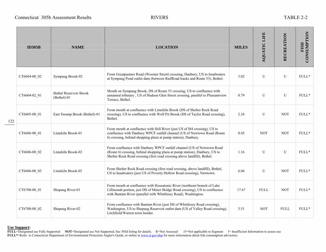
Connecticut 305b Assessment Results RIVERS TABLE 2-2
Use Support: FULL=Designated use Fully Supported NOT=Designated use Not Supported, See 303d listing for details. U=Not Assessed ///=Not applicable to Segment I= Insufficient Information to assess use FULL*=Refer to Connecticut Department of Environmental Protection Angler's Guide, or online at www.ct.gov/dep for more information about fish consumption advisories.
122
ID305B NAME LOCATION MILES
AQ
UA
TIC
LIF
E
RE
CR
EA
TIO
N
FIS
H
CO
NS
UM
PT
ION
CT6604-00_02 Sympaug Brook-02 From Greatpasture Road (Wooster Street) crossing, Danbury, US to headwaters at Sympaug Pond outlet dam (between RailRoad tracks and Route 53), Bethel. 3.02 U U FULL*
CT6604-02_01 Bethel Reservoir Brook (Bethel)-01
Mouth on Sympaug Brook, DS of Route 53 crossing, US to confluence with unnamed tributary , US of Hudson Glen Street crossing, parallel to Pleasantview Terrace, Bethel.
0.79 U U FULL*
CT6605-00_01 East Swamp Brook (Bethel)-01 From mouth at confluence with Limekiln Brook (DS of Shelter Rock Road crossing), US to confluence with Wolf Pit Brook (DS of Taylor Road crossing), Bethel.
2.34 U NOT FULL*
CT6606-00_01 Limekiln Brook-01 From mouth at confluence with Still River (just US of I84 crossing), US to confluence with Danbury WPCF outfall channel (US of Newtown Road (Route 6) crossing, behind shopping plaza at pump station), Danbury.
0.45 NOT NOT FULL*
CT6606-00_02 Limekiln Brook-02 From confluence with Danbury WPCF outfall channel (US of Newtown Road (Route 6) crossing, behind shopping plaza at pump station), Danbury, US to Shelter Rock Road crossing (first road crossing above landfill), Bethel.
1.16 U U FULL*
CT6606-00_03 Limekiln Brook-03 From Shelter Rock Road crossing (first road crossing, above landfill), Bethel, US to headwaters (just US of Poverty Hollow Road crossing), Newtown. 6.04 U NOT FULL*
CT6700-00_01 Shepaug River-01 From mouth at confluence with Housatonic River (northeast branch of Lake Lillinonah portion, just DS of Minor Bridge Road crossing), US to confluence with Bantam River (parallel with Whittlesey Road), Washington.
17.67 FULL NOT FULL*
CT6700-00_02 Shepaug River-02 From confluence with Bantam River (just DS of Whittlesey Road crossing), Washington, US to Shepaug Reservoir outlet dam (US of Valley Road crossing), Litchfield/Warren town border.
3.51 NOT FULL FULL*
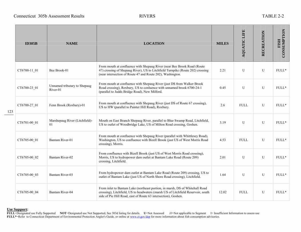
Connecticut 305b Assessment Results RIVERS TABLE 2-2
Use Support: FULL=Designated use Fully Supported NOT=Designated use Not Supported, See 303d listing for details. U=Not Assessed ///=Not applicable to Segment I= Insufficient Information to assess use FULL*=Refer to Connecticut Department of Environmental Protection Angler's Guide, or online at www.ct.gov/dep for more information about fish consumption advisories.
123
ID305B NAME LOCATION MILES
AQ
UA
TIC
LIF
E
RE
CR
EA
TIO
N
FIS
H
CO
NS
UM
PT
ION
CT6700-11_01 Bee Brook-01 From mouth at confluence with Shepaug River (near Bee Brook Road (Route 47) crossing of Shepaug River), US to Litchfield Turnpike (Route 202) crossing (near intersection of Route 47 and Route 202), Washington.
2.21 U U FULL*
CT6700-23_01 Unnamed tributary to Shepaug River-01
From mouth at confluence with Shepaug River (just DS from Walker Brook Road crossing), Roxbury, US to conluence with unnamed brook 6700-24-1 (parallel to Judds Bridge Road), New Milford.
0.45 U U FULL*
CT6700-27_01 Fenn Brook (Roxbury)-01 From mouth at confluence with Shepaug River (just DS of Route 67 crossing), US to HW (parallel to Painter Hill Road), Roxbury. 2.6 FULL U FULL*
CT6701-00_01 Marshepaug River (Litchfield)-01
Mouth on East Branch Shepaug River, parallel to Blue Swamp Road, Litchfield, US to outlet of Woodbridge Lake, US of Milton Road crossing, Goshen. 3.19 U U FULL*
CT6705-00_01 Bantam River-01 From mouth at confluence with Shepaug River (parallel with Whittlesey Road), Washington, US to confluence with Bizell Brook (just US of West Morris Road crossing), Morris.
4.53 FULL U FULL*
CT6705-00_02 Bantam River-02 From confluence with Bizell Brook (just US of West Morris Road crossing), Morris, US to hydropower dam outlet at Bantam Lake Road (Route 209) crossing, Litchfield.
2.01 U U FULL*
CT6705-00_03 Bantam River-03 From hydropower dam outlet at Bantam Lake Road (Route 209) crossing, US to outlet of Bantam Lake (just US of North Shore Road crossing), Litchfield. 1.64 U U FULL*
CT6705-00_04 Bantam River-04 From inlet to Bantam Lake (northeast portion, in marsh, DS of Whitehall Road crossing), Litchfield, US to headwaters (marsh US of Litchfield Reservoir, south side of Pie Hill Road, east of Route 63 intersection), Goshen.
12.02 FULL U FULL*

Connecticut 305b Assessment Results RIVERS TABLE 2-2
Use Support: FULL=Designated use Fully Supported NOT=Designated use Not Supported, See 303d listing for details. U=Not Assessed ///=Not applicable to Segment I= Insufficient Information to assess use FULL*=Refer to Connecticut Department of Environmental Protection Angler's Guide, or online at www.ct.gov/dep for more information about fish consumption advisories.
124
ID305B NAME LOCATION MILES
AQ
UA
TIC
LIF
E
RE
CR
EA
TIO
N
FIS
H
CO
NS
UM
PT
ION
CT6705-12_01 Hill Brook-01 From mouth at confluence with Bantam River (just DS of West Morris Road crossing, and DS of Litchfield WPCF outfall on Bantam River), US to headwaters (US of Old Forge Hollow Road crossing=dirt road), Litchfield.
2.64 U U FULL*
CT6800-00_01 Pomperaug River-01 From mouth at confluence with Housatonic River (DS of River Road crossing, near west side of I84, exit 13), US to confluence withTransylvania Brook (south side of East Flat Hill Road), Southbury.
2.74 FULL U FULL*
CT6800-00_02 Pomperaug River-02 From confluence withTransylvania Brook (south side of East Flat Hill Road), US to Flood Bridge Road crossing, Southbury. 1.97 FULL U FULL*
CT6800-00_03 Pomperaug River-03 From Flood Bridge Road crossing, US to confluence with Bullet Hill Brook (just DS of Heritage Road crossing), Southbury. (Segment includes Heritage Village POTW discharge)
1.31 U NOT FULL*
CT6800-00_04 Pomperaug River-04
From confluence with Bullet Hill Brook (just DS of Heritage Road crossing), Southbury, US to headwaters at confluence of Nonewaug River and Weekeepeemee River (just DS of Washington Road (Route 47) crossing), Woodbury.
7.38 FULL U FULL*
CT6800-02_01 South Brook-01 From mouth at confluence with Pomperaug River, US to Main Street (Route 6) crossing, Woodbury. 0.37 NOT U FULL*
CT6800-03_01 Stiles Brook-01 From mouth at confluence with Pomperaug River, US to Anna Stiles Pond outlet Dam (just US of Route 6 crossing), Southbury. 0.25 NOT U FULL*
CT6802-00_01 Nonewaug River-01 From mouth at confluence with Weekeepeemee River, above Pomperaug River (just DS of Washington Road (Route 47) crossing), US to confluence with Harvey Brook (parallel with Oldtown Farm Road), Woodbury.
4.45 FULL U FULL*

Connecticut 305b Assessment Results RIVERS TABLE 2-2
Use Support: FULL=Designated use Fully Supported NOT=Designated use Not Supported, See 303d listing for details. U=Not Assessed ///=Not applicable to Segment I= Insufficient Information to assess use FULL*=Refer to Connecticut Department of Environmental Protection Angler's Guide, or online at www.ct.gov/dep for more information about fish consumption advisories.
125
ID305B NAME LOCATION MILES
AQ
UA
TIC
LIF
E
RE
CR
EA
TIO
N
FIS
H
CO
NS
UM
PT
ION
CT6802-00_02 Nonewaug River-02 From confluence with Harvey Brook (parallel with Oldtown Farm Road), Woodbury, US to Big Meadow Pond (Judd Pond) Reservoir outlet dam (just US of Guernseytown Road crossing), Watertown.
4.3 FULL U FULL*
CT6802-00_03 Nonewaug River-03 From inlet to Big Meadow Pond (Judd Pond) Reservoir (just DS of Judd Farm Road (Route 132) crossing), US to headwaters, Watertown. 1.34 U U FULL*
CT6802-05_01 Harvey Brook-01 From mouth at confluence with Nonewaug River (just DS of Oldtown Farm Road crossing), US to headwaters, Woodbury (east side of Cowles Road, near Bethlehem border).
2.02 U U FULL*
CT6804-00_01 Weekeepeemee River-01 From mouth at confluence with Nonewaug River, above Pomeraug River (DS of Jacks Bridge Road crossing), Woodbury, US to headwaters in marsh (just US of Bergman Hill Road crossing, east of intersection with Todd Hill Road), Morris.
9.61 FULL U FULL*
CT6804-04_01 Wood Creek (Bethlehem)-01 From mouth at confluence with Weekeepeemee River (just DS of Guilds Hollow Road (Route132) crossing), US to headwaters at Zieglers Pond outlet dam (just US of Carmel Hill Road crossing), Bethlehem.
3.27 U U FULL*
CT6806-00_01 Transylvania brook-01 From mouth at confluence with Pomperaug River (just DS of East Flat Hill Road crossing), US to confluence with Spruce Brook (just US side of Southbury Training School STP), Southbury.
1.6 NOT U FULL*
CT6806-00_02 Transylvania Brook-02 From confluence with Spruce Brook (just US side of Southbury Training School STP), US to Gravel Pit Pond outlet dam (US of South Britian Road (Route 172) crossing), Southbury.
0.32 U NOT FULL*
CT6806-00_03 Transylvania Brook-03 From inlet to Gravel Pit Pond (northern side), Southbury, US to headwaters, Roxbury (near Woodbury town border). 3.81 U U FULL*
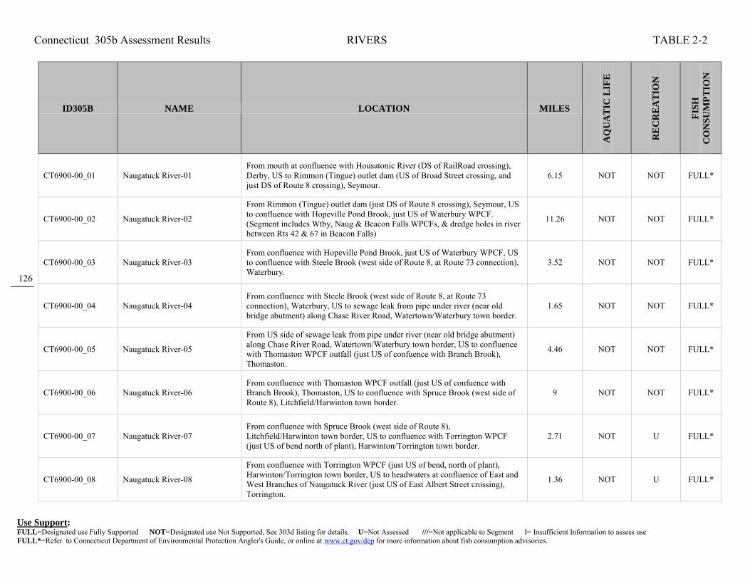
Connecticut 305b Assessment Results RIVERS TABLE 2-2
Use Support: FULL=Designated use Fully Supported NOT=Designated use Not Supported, See 303d listing for details. U=Not Assessed ///=Not applicable to Segment I= Insufficient Information to assess use FULL*=Refer to Connecticut Department of Environmental Protection Angler's Guide, or online at www.ct.gov/dep for more information about fish consumption advisories.
126
ID305B NAME LOCATION MILES
AQ
UA
TIC
LIF
E
RE
CR
EA
TIO
N
FIS
H
CO
NS
UM
PT
ION
CT6900-00_01 Naugatuck River-01 From mouth at confluence with Housatonic River (DS of RailRoad crossing), Derby, US to Rimmon (Tingue) outlet dam (US of Broad Street crossing, and just DS of Route 8 crossing), Seymour.
6.15 NOT NOT FULL*
CT6900-00_02 Naugatuck River-02
From Rimmon (Tingue) outlet dam (just DS of Route 8 crossing), Seymour, US to confluence with Hopeville Pond Brook, just US of Waterbury WPCF. (Segment includes Wtby, Naug & Beacon Falls WPCFs, & dredge holes in river between Rts 42 & 67 in Beacon Falls)
11.26 NOT NOT FULL*
CT6900-00_03 Naugatuck River-03 From confluence with Hopeville Pond Brook, just US of Waterbury WPCF, US to confluence with Steele Brook (west side of Route 8, at Route 73 connection), Waterbury.
3.52 NOT NOT FULL*
CT6900-00_04 Naugatuck River-04 From confluence with Steele Brook (west side of Route 8, at Route 73 connection), Waterbury, US to sewage leak from pipe under river (near old bridge abutment) along Chase River Road, Watertown/Waterbury town border.
1.65 NOT NOT FULL*
CT6900-00_05 Naugatuck River-05
From US side of sewage leak from pipe under river (near old bridge abutment) along Chase River Road, Watertown/Waterbury town border, US to confluence with Thomaston WPCF outfall (just US of confuence with Branch Brook), Thomaston.
4.46 NOT NOT FULL*
CT6900-00_06 Naugatuck River-06 From confluence with Thomaston WPCF outfall (just US of confuence with Branch Brook), Thomaston, US to confluence with Spruce Brook (west side of Route 8), Litchfield/Harwinton town border.
9 NOT NOT FULL*
CT6900-00_07 Naugatuck River-07 From confluence with Spruce Brook (west side of Route 8), Litchfield/Harwinton town border, US to confluence with Torrington WPCF (just US of bend north of plant), Harwinton/Torrington town border.
2.71 NOT U FULL*
CT6900-00_08 Naugatuck River-08
From confluence with Torrington WPCF (just US of bend, north of plant), Harwinton/Torrington town border, US to headwaters at confluence of East and West Branches of Naugatuck River (just US of East Albert Street crossing), Torrington.
1.36 NOT U FULL*

Connecticut 305b Assessment Results RIVERS TABLE 2-2
Use Support: FULL=Designated use Fully Supported NOT=Designated use Not Supported, See 303d listing for details. U=Not Assessed ///=Not applicable to Segment I= Insufficient Information to assess use FULL*=Refer to Connecticut Department of Environmental Protection Angler's Guide, or online at www.ct.gov/dep for more information about fish consumption advisories.
127
ID305B NAME LOCATION MILES
AQ
UA
TIC
LIF
E
RE
CR
EA
TIO
N
FIS
H
CO
NS
UM
PT
ION
CT6900-18_01 Jericho Brook-01 From mouth at confluence with Naugatuck River, Thomaston/Watertown town border, US to US-side of Route 8 crossing, Watertown. 0.07 U U FULL*
CT6900-18_02 Jericho Brook-02 From US-side of Route 8 Crossing (end of segment-01), US to headwaters at Jericho Brook Pond outlet dam (parallel to Nova Scotia Road), Watertown. 1.44 U U FULL*
CT6900-22_01 Great Brook (Waterbury)-01
From mouth at confluence with Naugatuck River (east bank, DS of West Liberty Street crossing), US to Great Brook Reservoir at Belleview Lake outlet dam (Reservoir in 2 sections, split bt Lakewood Drive), Waterbury. Most of segment in culvert under city.
1.98 NOT NOT FULL*
CT6900-27_01 Spruce Brook (Beacon Falls)-01 From mouth at confluence with Naugatuck River (DS of Cold Springs Road crossing), Naugatuck/Beacon Falls town border, US to headwaters (south of Andrew Mountain Road), Naugatuck.
2.82 FULL U FULL*
CT6900-28_01 Hockanum Brook (Beacon Falls)-01
From mouth at confluence with Naugatuck River (just DS of Main Street (Route 42) crossing), Beacon Falls, US to headwaters at Simpson Lake outlet dam (parallel to Beacon Road (Route 42)), Bethany.
3.17 FULL NOT FULL*
CT6900-37_01 Kinneytown Brook (Seymour)-01
From mouth at confluence with Naugatuck River (DS of Route 8 crossing), US to first Tributary on East, Seymour. 0.89 U U FULL*
CT6900-40_01 Beaver Brook (Ansonia)-01 Confluence with Naugatuck River, just DS of Route 115 crossing, US to Quillinian Reservoir outlet, Ansonia. 1.23 U U FULL*
CT6900-40_02 Beaver Brook (Ansonia)-02 Inlet of Quillinian Reservoir, Ansonia, US to Middle Reservoir outlet, just US of Route 313 crossing, Seymour. 1.1 U U FULL*

Connecticut 305b Assessment Results RIVERS TABLE 2-2
Use Support: FULL=Designated use Fully Supported NOT=Designated use Not Supported, See 303d listing for details. U=Not Assessed ///=Not applicable to Segment I= Insufficient Information to assess use FULL*=Refer to Connecticut Department of Environmental Protection Angler's Guide, or online at www.ct.gov/dep for more information about fish consumption advisories.
128
ID305B NAME LOCATION MILES
AQ
UA
TIC
LIF
E
RE
CR
EA
TIO
N
FIS
H
CO
NS
UM
PT
ION
CT6901-00_01 Hall Meadow Brook (Torrington)-01
Mouth at confluence with Hart Brook, above West Branch Farmington River, just US of Route 272 crossing, US to Hall Meadow Brook Reservoir outlet (dam), Torrington.
0.42 U U FULL*
CT6901-00_02 Hall Meadow Brook (Torrington)-02
Hall Meadow Brook Reservoir inlet (parallel to Route 272), Torrington, US to Goshen/Norfolk town line (parallel to Route 272). 3.16 FULL U FULL*
CT6901-00_03 Hall Meadow Brook (Norfolk)-03
Goshen/Norfolk town line (parallel to Route 272), US to HW, US of Meekertown Road crossing, Norfolk. 3.65 FULL U FULL*
CT6902-00_01 Hart Brook-01 From mouth at confluence with Hall Meadow Brook, above West Branch Naugatuck River (just US of Norfolk Road (Route 272) crossing), US to Reuben Hart Reservoir outlet dam, Torrington.
0.64 NOT U FULL*
CT6902-02_01 Jakes Brook (Torrington)-01 Mouth on Hart Brook, just DS of Route 272 crossing, US to HW near East Street, Goshen. 3.05 FULL U FULL*
CT6903-00_01 Nickelmine Brook (Torrington)-01
From mouth at confluence with West Branch Naugatuck River-03 (just DS of Norfolk Road crossing, US to Allen Dam Reservoir INLET (US of University Drive crossing), Torrington.
1.13 FULL U FULL*
CT6903-00_02 Nickelmine Brook (Torrington)-02
From Allen Dam Reservoir INLET (end of segment-01), Torrington, US to Hatchaluchi Reservoir INLET (beginning of segment-03), Goshen. 2.61 FULL U FULL*
CT6903-00_03 Nickelmine Brook (Goshen)-03 From inlet to Hatchaluchi Reservoir, US to HW (parallel to East Street), Goshen. 1.71 U U FULL*

Connecticut 305b Assessment Results RIVERS TABLE 2-2
Use Support: FULL=Designated use Fully Supported NOT=Designated use Not Supported, See 303d listing for details. U=Not Assessed ///=Not applicable to Segment I= Insufficient Information to assess use FULL*=Refer to Connecticut Department of Environmental Protection Angler's Guide, or online at www.ct.gov/dep for more information about fish consumption advisories.
129
ID305B NAME LOCATION MILES
AQ
UA
TIC
LIF
E
RE
CR
EA
TIO
N
FIS
H
CO
NS
UM
PT
ION
CT6903-02_01 Lovers Lane Brook-01 From mouth at confluence with Nickel Mine Brook (just DS of Goshen Road (Route 4) crossing), US to headwaters (marsh US of Weed Road crossing), Torrington.
2.89 U U FULL*
CT6904-00_01 West Branch Naugatuck River-01
From mouth at confluence with East Branch Naugatuck River, above Naugatuck River (US of East Albert Street crossing), US to Old Brass Mill Pond outlet dam (1st impoundment on river), just US of Church Street crossing, Torrington.
0.97 NOT U FULL*
CT6904-00_02 West Branch Naugatuck River-02
From Old Brass Mill Pond outlet dam (1st impoundment on river), just US of Church Street crossing, US through impoundment to inlet at Wolcott Avenue crossing, Torrington.
0.46 U U FULL*
CT6904-00_03 West Branch Naugatuck River-03
From inlet to impoundment at Wolcott Avenue crossing (head of Old Brass Mill Pond), US to Stillwater Pond outlet dam (just US of Brass Mill Dam Road crossing), Torrington.
2.1 FULL U FULL*
CT6904-00_04 West Branch Naugatuck River-04
From inlet to Stillwater Pond (DS of Norfolk Road (Route 272) crossing, pond is on east side of road), US to headwaters at confulence of Hart Brook and Hall Meadow Brook (US of Norfolk Road (Route 272) crossing), Torrington.
1.15 U U FULL*
CT6905-00_01 East Branch Naugatuck River-01 From mouth at confluence with West Branch Naugatuck River, above Naugatuck River (just DS of Franklin Drive crossing), US to North Elm Street Road (Route 4) crossing, Torrington.
1.33 NOT U FULL*
CT6905-00_02 East Branch Naugatuck River-02 From North Elm Street Road (Route 4) crossing, Torrington, US to headwaters at Lake Winchester outlet dam (just US of West Road crossing), Winchester. 7.67 FULL U FULL*
CT6906-00_01 Spruce Brook-01 From mouth at confluence with Naugatuck River (DS from RailRoad crossing, on west bank), US to confluence with Jefferson Hill Brook, Litchfield. 0.27 FULL U FULL*

Connecticut 305b Assessment Results RIVERS TABLE 2-2
Use Support: FULL=Designated use Fully Supported NOT=Designated use Not Supported, See 303d listing for details. U=Not Assessed ///=Not applicable to Segment I= Insufficient Information to assess use FULL*=Refer to Connecticut Department of Environmental Protection Angler's Guide, or online at www.ct.gov/dep for more information about fish consumption advisories.
130
ID305B NAME LOCATION MILES
AQ
UA
TIC
LIF
E
RE
CR
EA
TIO
N
FIS
H
CO
NS
UM
PT
ION
CT6906-00_02 Spruce Brook-02 From confluence with Jefferson Hill Brook, US to East Litchfield Road crosssing, Litchfield. 1.31 U U FULL*
CT6906-01_01 Jefferson Hill Brook-01 From mouth at confluence with Spruce Brook, US to headwaters (US of Buell Road crossing near East Litchfield Road), Litchfield. 2.58 U U FULL*
CT6907-00_01 Rock Brook (Harwinton)-01 Mouth on Leadmine Brook, just DS from Hollow Road crossing, Harwinton, US to HW, near Cotton Hill Road, New Hartford. 6.29 FULL U FULL*
CT6908-00_01 Leadmine Brook-01 From mouth at Naugatuck River (US from railroad crossing of Naugatuck River), Thomaston, US to confluence with Rock Brook (just US from South Road crossing), Harwinton.
2.76 FULL U FULL*
CT6910-00_01 Branch Brook-01 From mouth at confluence with Naugatuck River (DS of Route 8 crossing), US to Black Rock Dam outlet (along south side of Route 109), Watertown-Thomaston.
2.06 NOT U FULL*
CT6910-00_02 Branch Brook-02 From Black Rock Dam outlet (along south side of Route 109), US to Wigwam Reservoir outlet dam, Watertown-Thomaston. 1.91 NOT U FULL*
CT6911-00_01 Hancock Brook (Waterbury)-01 From mouth at confluence with Naugatuck River (segment-04) DS of Huntingdon Avenue and RailRoad crossings, US to Hancock Pond outlet dam (between Sheffield Street and RailRoad), Waterbury.
1.06 NOT U FULL*
CT6911-00_02 Hancock Brook (Waterbury)-02 From Hancock Pond OUTLET dam (between Sheffield Street and RailRoad), Waterbury, US to Hancock Brook Lake outlet dam (US of Greystone Pond and Greystone Road crossing), Plymouth.
2.19 U U FULL*

Connecticut 305b Assessment Results RIVERS TABLE 2-2
Use Support: FULL=Designated use Fully Supported NOT=Designated use Not Supported, See 303d listing for details. U=Not Assessed ///=Not applicable to Segment I= Insufficient Information to assess use FULL*=Refer to Connecticut Department of Environmental Protection Angler's Guide, or online at www.ct.gov/dep for more information about fish consumption advisories.
131
ID305B NAME LOCATION MILES
AQ
UA
TIC
LIF
E
RE
CR
EA
TIO
N
FIS
H
CO
NS
UM
PT
ION
CT6911-00_03 Hancock Brook (Plymouth)-03 From Hancock Brook Lake area INLET (DS of RailRoad crossing and Meyers Pond), Plymouth, US to HW above Allentown Road crossing, Bristol. 5.08 U U FULL*
CT6912-00_01 Steele Brook-01 From mouth at confluence with Naugatuck River (just DS of Route 8 crossing), US to Sherwood Medical (American Home Products) area (site is behind Municipal Stadium parking lot on northend of stadium property), Waterbury.
1.18 NOT NOT FULL*
CT6912-00_02 Steele Brook-02
From Sherwood Medical (American Home Products) area (site is behind Municipal Stadium parking lot on northend of stadium property), Waterbury, US to INLET of Heminway Pond (DS of Route 6 crossing, pond included in segment), Watertown.
3.78 NOT NOT FULL*
CT6912-00_03 Steele Brook-03 From INLET of Heminway Pond (DS of Route 6 crossing), Watertown, US to headwaters (in marsh US of Killorin Road and Litchfield Road (Route 63) crossing area).
3.59 U FULL FULL*
CT6914-00_01 Mad River (Waterbury)-01 From mouth at confluence with Naugatuck River (behind Roller Magic, off of Harvester Road), US to Route 69 crossing (US of I84 crossing, exit 22 area, and just US of Brass City Mall), Waterbury.
1.77 NOT NOT FULL*
CT6914-00_02 Mad River (Waterbury)-02 From Route 69 crossing (US of I84 crossing, exit 22 area, and just US of Brass City Mall), US to confluence with Beaver Pond Brook, just US of I84 crossing (Scovill Pond no longer exists), Waterbury.
1.01 NOT NOT FULL*
CT6914-00_03a Mad River (Waterbury)-03a
From confluence with Beaver Pond Brook, (just US of I84 crossing and DS of Plank Road crossing, in former Scovill Ponds section), Waterbury, US to confluence with Lily Brook (CT6914-06 Gazetteer, and called Finch Brook in NHD), Wolcott.
3.46 NOT NOT FULL*
CT6914-00_03b Mad River (Waterbury)-03b From confluence with Lily Brook (CT6914-06 Gazetteer, and called Finch Brook in NHD), US to Scoville Reservoir outlet dam (US of Nichol Road, parallel to Wolf Hill Road), Wolcott.
0.74 U U FULL*

Connecticut 305b Assessment Results RIVERS TABLE 2-2
Use Support: FULL=Designated use Fully Supported NOT=Designated use Not Supported, See 303d listing for details. U=Not Assessed ///=Not applicable to Segment I= Insufficient Information to assess use FULL*=Refer to Connecticut Department of Environmental Protection Angler's Guide, or online at www.ct.gov/dep for more information about fish consumption advisories.
132
ID305B NAME LOCATION MILES
AQ
UA
TIC
LIF
E
RE
CR
EA
TIO
N
FIS
H
CO
NS
UM
PT
ION
CT6914-00_04 Mad River (Waterbury)-04 From inlet to Scoville Reservoir (just US of Munson Road crossing), US to headwaters at Cedar Swamp Pond outlet dam, (just US of North Street crossing), northern Wolcott.
3.98 U U FULL*
CT6915-00_01 Fulling Mill Brook (Naugatuck)-01
From mouth at confluence with Naugatuck River (segment-02) DS of Route 8 crossing, US to Maple Hill Road crossing, Naugatuck. 1.51 FULL U FULL*
CT6915-00_02 Fulling Mill Brook (Prospect)-02
From Maple Hill Road crossing, Naugatuck, US to HW at Salem Road Pond Dam on Brewster Pond (parallel to Salem Road), Prospect. 2.06 U U FULL*
CT6916-00_01 Hop Brook (Naugatuck)-01
From mouth at confluence with Naugatuck River (DS of Bridge Street (Route 68) crossing and RailRoad crossing), Naugatuck, US to Hop Brook Lake outlet dam (flood control area along eastern side of Curch Street (Route 63)), Naugatuck/Waterbury town line.
1.44 U NOT FULL*
CT6917-00_01 Long Meadow Pond Brook-01 From mouth at confluence with Naugatuck River (DS of Elm Street crossing and RailRoad crossing), US to outlet of Naugatuck Ice Company Pond Dam (just US of Rubber Avenue crossing), Naugatuck.
0.94 NOT NOT FULL*
CT6917-00_02 Long Meadow Pond Brook-02 From Thurston Pond outlet dam just US of Rubber Avenue crossing (outlet of Naugatuck Ice Company Pond), US to Neumann Street crossing, Naugatuck. 0.91 U U FULL*
CT6917-00_03 Long Meadow Pond Brook-03 From Neumann Street crossing, US to Gunntown Road crossing, Naugatuck. 2 U U FULL*
CT6918-00_01 Beacon Hill Brook (Naugatuck)-01
From mouth at confluence with Naugatuck River, just DS of Route 8 crossing, US to confluence with Marks Brook, parallel with Margaret Circle, Naugatuck. 2.45 FULL U FULL*

Connecticut 305b Assessment Results RIVERS TABLE 2-2
Use Support: FULL=Designated use Fully Supported NOT=Designated use Not Supported, See 303d listing for details. U=Not Assessed ///=Not applicable to Segment I= Insufficient Information to assess use FULL*=Refer to Connecticut Department of Environmental Protection Angler's Guide, or online at www.ct.gov/dep for more information about fish consumption advisories.
133
ID305B NAME LOCATION MILES
AQ
UA
TIC
LIF
E
RE
CR
EA
TIO
N
FIS
H
CO
NS
UM
PT
ION
CT6918-00_02 Beacon Hill Brook (Bethany)-02 From confluence with Marks Brook, parallel with Margaret Circle, Naugatuck, US to Long Hill Reservoir outlet dam (US of Route 63 and parallel to Edwards Road) Bethany.
1.57 U U FULL*
CT6919-00_01 Bladens River-01 From mouth at confluence with Naugatuck River (just DS of New Haven Avenue (Route 8) and Derby Avenue (Route 67) crossings), US to North Street crossing (upper end of industrial area), Seymour.
0.68 NOT U FULL*
CT6919-00_02 Bladens River-02 From North Street crossing, DS of Paper Mill Pond (upper end of industrial area), Seymour, US to headwaters at Round Hill Pond outlet dam (US of Round Hill Road crossing), Bethany.
3.85 U U FULL*
CT6919-04_01 Unnamed tributary to Bladens River-01
From mouth at confluence with Bladen River (at Legion Pool section, north side of Silvermine Road), US to Bunting Road crossing, Seymour. 0.33 U U FULL*
CT6920-00_01 Little River (Seymour)-01 From mouth at confluence with Naugatuck River (just DS of River Street (Route313) crossing) Seymour, US to Swans Pond INLET (segment includes Swans Pond, on eastern side, parallel to Oxford Road (Route 67)), Oxford.
1.12 U U FULL*
CT6920-00_02 Little River (Seymour)-02 From Swans Pond INLET (segment 1 includes Swans Pond), US to confluence with Riggs Street Brook (just US of Oxford Road (Route 67) crossing), Oxford. 2.96 FULL U FULL*
CT6920-00_03 Little River (Seymour)-03 From confluence with Riggs Street Brook (just US of Oxford Road (Route 67) crossing), US to headwaters (US of North Larkey Road crossing), southeast side of Waterbury/Oxford Airport, Oxford.
4.49 U U FULL*
CT6920-03_01 Jacks Brook (Oxford)-01 Mouth at Little River, just DS of Route 67 crossing, US to confluence with Riggs Street Brook, parallel to Riggs Street at Cedar Lane intersection, Oxford. 0.62 U U FULL*

Connecticut 305b Assessment Results RIVERS TABLE 2-2
Use Support: FULL=Designated use Fully Supported NOT=Designated use Not Supported, See 303d listing for details. U=Not Assessed ///=Not applicable to Segment I= Insufficient Information to assess use FULL*=Refer to Connecticut Department of Environmental Protection Angler's Guide, or online at www.ct.gov/dep for more information about fish consumption advisories.
134
ID305B NAME LOCATION MILES
AQ
UA
TIC
LIF
E
RE
CR
EA
TIO
N
FIS
H
CO
NS
UM
PT
ION
CT6920-03_02 Jacks Brook (Oxford)-02 Confluence with Riggs Street Brook, parallel to Riggs Street at Cedar Lane intersection, US to Little Valley Road crossing, Oxford. 1.56 FULL U FULL*
CT7000-16_01 Muddy Brook (Westport)-01 From mouth at confluence with Mill Creek (LIS Estuary segment) on DS side of I95 Exit 18 ramp, US to HW (just US of Route 15 crossing), Westport. 4.17 NOT U FULL*
CT7000-22_01 Indian River (Westport)-01 From mouth at Saugatuck River (head of Burritt Cove, Saugatuck River Estuary, just DS of Saugatuck Avenue (Route 136) crossing), US to I95 crossing, Westport.
0.53 U NOT FULL*
CT7000-22_02 Indian River (Westport)-02 From I95 crossing, Westport, US to headwaters (portions of river in concrete channels and pipes), Norwalk. (Segment made from site map, actual hydro must be mapped to confirm underground portions)
0.94 U NOT FULL*
CT7102-00_01 Bruce Brook (Bridgeport/Stratford)-01
Mouth on Bridgeport Harbor at Route 113 crossing, US to Bruce Pond outlet, just US of Stratford Avenue and RR crossings, Bridgeport/Stratford town line. 0.87 U U FULL*
CT7102-00_02 Bruce Brook (Bridgeport/Stratford)-02
Inlet to Bruce Pond, US to Barnum Avenue crossing, Bridgeport/Stratford town line. 0.22 NOT NOT FULL*
CT7105-00_01 Pequonnock River-01 From end of esturay (DS of Glenwood Avenue crossing, along south side of Route 1), US to upper end of Bunnells (Beardsley Park) Pond (eastern side of Route 8, exit 6 area), Bridgeport. Segment includes Pond.
1.35 U U FULL*
CT7105-00_02 Pequonnock River-02 From inlet to Bunnells (Beardsley Park) Pond (eastern side of Route 8, exit 6 area), Bridgeport, US to Daniels Farm Road crossing (US of Route 25 crossing), Trumbull.
2.92 NOT U FULL*

Connecticut 305b Assessment Results RIVERS TABLE 2-2
Use Support: FULL=Designated use Fully Supported NOT=Designated use Not Supported, See 303d listing for details. U=Not Assessed ///=Not applicable to Segment I= Insufficient Information to assess use FULL*=Refer to Connecticut Department of Environmental Protection Angler's Guide, or online at www.ct.gov/dep for more information about fish consumption advisories.
135
ID305B NAME LOCATION MILES
AQ
UA
TIC
LIF
E
RE
CR
EA
TIO
N
FIS
H
CO
NS
UM
PT
ION
CT7105-00_03 Pequonnock River-03 From Daniels Farm Road crossing (US of Route 25 crossing), Trumbull, US to Monroe Turnpike (Route 111) crossing (near intersection with Route 25), Trumbull.
4.19 NOT FULL FULL*
CT7105-00_04 Pequonnock River-04 From Monroe Turnpike (Route 111) crossing (near intersection with Route 25), Trumbull, US to outlet of unnamed impoundment (US of Purdy Hill Road crossing, and US of Harsh Pond) Monroe.
1.83 U FULL FULL*
CT7105-00_05 Pequonnock River-05 From INLET to unnamed impoundment (northeastern portion of pond), US to headwaters at Stepney Pond outlet dam (just US of West Maiden Lane crossing), Monroe.
2.35 U NOT FULL*
CT7105-01_01 West Branch Pequonnock River-01
Mouth on Pequonnock River, DS of Maple Drive crossing, on Jewish Community Center property, US to outlet of West Poquonnock Reservoir, parallel to Route 25, Monroe.
1.51 U FULL FULL*
CT7106-00_01 Rooster River-01
From mouth at confluence with Ash Creek (US of I95 crossing, in area near end of Fairchild Avenue), Fairfield/Bridgeport town border, US to headwaters at confluence of Londons Brook and Horse Tavern Brook (US of Cornell Road crossing), Fairfield.
2.69 U NOT FULL*
CT7107-00_01 Cricker Brook (Fairfield)-01 From mouth at confluence with Swamp Mortar Reservoir (Mill River) parallel to Route 58 (Black Rock Turnpike), US to Hemlock Reservoir outlet dam, Fairfield.
1.69 U U FULL*
CT7107-00_02 Cricker Brook (Easton)-02 From confluence with Hemlocks Reservoir (DS of Wilson Road crossing), US to HW near Route 136, Easton. 2.5 U U FULL*
CT7108-00_01 Mill River (Fairfield)-01 From Sturges Road crossing (US of I95 crossing, end of estuary portion), US (through Perrys Millpond) to Samp Mortar Reservoir outlet dam (US of Samp Mortar Drive crossing), Fairfield.
2.84 U U FULL*

Connecticut 305b Assessment Results RIVERS TABLE 2-2
Use Support: FULL=Designated use Fully Supported NOT=Designated use Not Supported, See 303d listing for details. U=Not Assessed ///=Not applicable to Segment I= Insufficient Information to assess use FULL*=Refer to Connecticut Department of Environmental Protection Angler's Guide, or online at www.ct.gov/dep for more information about fish consumption advisories.
136
ID305B NAME LOCATION MILES
AQ
UA
TIC
LIF
E
RE
CR
EA
TIO
N
FIS
H
CO
NS
UM
PT
ION
CT7108-00_02a Mill River (Fairfield/Easton)-02a
From INLET to Samp Mortar Reservoir, Fairfield, US to confluence with unnamed tributary (US of South Park Avenue crossing, DS of Easton Reservoir and Canoe Brook confluence), Easton. (Segment does NOT include Lake Mohegan).
3.57 U NOT FULL*
CT7108-00_02b Mill River (Fairfield/Easton)-02b
From confluence with unnamed tributary (US of South Park Avenue crossing, DS of Easton Reservoir and Canoe Brook confluence), US to Easton Reservoir outlet dam (Lakeview Drive crossing on dam), Easton.
0.54 FULL NOT FULL*
CT7108-00_03 Mill River (Easton/Monroe)-03 From INLET to Easton Reservoir, Easton/Trumbull town border, US to headwaters at marsh (just US of Hattertown Road crossing), Monroe. 3.43 U U FULL*
CT7108-05_02 Unnamed tributary, Easton Reservoir (Snow Farm)-02
From confluence with unnamed tributary to Easton Reservoir (east of Sport Hill Road (Route 59)), US to outlet of pond on Phil Snow's farm, Easton. (Unnamed tributary flows into Easton Reservoir from western side)
0.3 NOT U FULL*
CT7109-00_01 Sasco Brook-01
From Bulkely Pond OUTLET dam (US side of Post Road East (Route 1) crossing), Westport/Fairfield town border, US to Hulls Farm Road crossing (just DS of Great Brook confluence), Westport/Fairfield town border. (Segment includes Buckley Pond)
1.42 NOT FULL FULL*
CT7109-00_02 Sasco Brook-02 From Hulls Farm Road crossing (just DS of Great Brook confluence), Westport/Fairfield town border, US to headwaters at marsh (US of Burr Street crossing), Fairfield.
5.2 U NOT FULL*
CT7109-00-trib_01 Unnamed tributary, Sasco Brook-01
From mouth at Sasco Brook (US of Old Road crossing), Westport/Fairfield town border, US to headwaters (US of Bulkley Avenue crossing), Westport. 0.34 U NOT FULL*
CT7109-02_01 Unnamed Tributary, Sasco Brook (Fairfield)-01
From mouth at confluence with Sasco Brook (DS Route 15 crossing), US to confluence with unnamed tributary, just DS of Merwins Lane crossing, Fairfield.
0.61 FULL U FULL*

Connecticut 305b Assessment Results RIVERS TABLE 2-2
Use Support: FULL=Designated use Fully Supported NOT=Designated use Not Supported, See 303d listing for details. U=Not Assessed ///=Not applicable to Segment I= Insufficient Information to assess use FULL*=Refer to Connecticut Department of Environmental Protection Angler's Guide, or online at www.ct.gov/dep for more information about fish consumption advisories.
137
ID305B NAME LOCATION MILES
AQ
UA
TIC
LIF
E
RE
CR
EA
TIO
N
FIS
H
CO
NS
UM
PT
ION
CT7109-06_01 Great Brook (Fairfield)-01 From mouth at confluence with Sasco Brook (just US of Hulls Farm Road crossing of Sasco Brook, east bank), US to first confluence with unnamed brook (just US of Morehouse Lane crossing, DS of marsh), Fairfield.
0.72 U NOT FULL*
CT7109-06_02 Great Brook (Fairfield)-02 From first confluence with unnamed brook (just US of Morehouse Lane crossing, DS of marsh), US to headwaters at marsh (US of Congress Street crossing, southwest of Cross highway and Hillside road intersection), Fairfield.
2.2 U FULL FULL*
CT7200-00_01 Saugatuck River-01 From Hydraulic Pond OUTLET dam (head of estuary, saltwater limit), US (through Hydraulic Pond and lower end of Lee Pond) to confluence with West Branch Saugatuck River (parallel with Ford Road), Westport.
1.74 FULL U FULL*
CT7200-00_02 Saugatuck River-02 From confluence with West Branch Saugatuck River (parallel with Ford Road), Westport, US (through upper end of Lee Pond) to Samuel Senior dam at Saugatuck Reservoir outlet, Weston.
6.46 U U FULL*
CT7200-00_03 Saugatuck River-03 From INLET to Saugatuck Reservoir at Newtown Turnpike (Route 53) crossing, US to confluence with Bogus Mountain Brook (US of Redding Road (Route 53) crossing, and parallel to Station Road), Redding.
4.36 FULL NOT FULL*
CT7200-00_04 Saugatuck River-04 From confluence with Bogus Mountain Brook (US of Redding Road (Route 53) crossing, and parallel to Station Road), Redding, US to headwaters, at Wataba Lake outlet dam (just US of Mountain Road crossing), Ridgefield.
5.53 FULL U FULL*
CT7200-03_01 Umpawaug Pond Brook (Redding)-01
Mouth on Saugatuck River, DS of Simpaug Turnpike crossing, US to HW above Steichens Ponds, just US of Old Redding Road crossing, Redding. 2.98 FULL U FULL*
CT7200-20-trib_02 Unnamed tributary Hawleys Brook-02
From confluence with main unnamed tributay to Hawleys Brook, US to private property (Golf course), Easton. (Entire segement is west of Blackrock Turnpike (Route 58), AND wset of golf course)
0.56 NOT U FULL*

Connecticut 305b Assessment Results RIVERS TABLE 2-2
Use Support: FULL=Designated use Fully Supported NOT=Designated use Not Supported, See 303d listing for details. U=Not Assessed ///=Not applicable to Segment I= Insufficient Information to assess use FULL*=Refer to Connecticut Department of Environmental Protection Angler's Guide, or online at www.ct.gov/dep for more information about fish consumption advisories.
138
ID305B NAME LOCATION MILES
AQ
UA
TIC
LIF
E
RE
CR
EA
TIO
N
FIS
H
CO
NS
UM
PT
ION
CT7200-21_01 Jennings Brook (Weston)-01 From mouth at confluence with Saugatuck River (DS Davis Hill Road crossing), US to 1st confluence with unnamed tributary adjacent to Treadwell Lane, Weston.
0.73 U U FULL*
CT7200-22_01 Beaver Brook (Weston)-01 From mouth at confluence with Saugatuck River (DS Slumber Lane crossing), US to confluence with Davidge Brook (adjacent to Glenwood Road), Weston. 1.02 U NOT FULL*
CT7200-24_01 Kettle Creek (Weston)-01 From mouth at confluence with Saugatuck River (DS of Good Hill Road crossing), US to confluence with unnamed tributary (DS of Kettle Creek Road crossing), Weston.
0.62 U NOT FULL*
CT7200-26_01 Poplar Plains Brook (Westport)-01
From mouth at confluence with Saugatuck River (Lee Pond section, just DS of Route 15 crossing), US to confluence with unnamed tributary US of Route 33 (Wilton Road) crossing (outlet for Keenes Pond), Westport.
0.5 U NOT FULL*
CT7201-00_01 Little River (Redding)-01 Mouth at inlet to Saugatuck Reservoir, parallel to Newtown Turnpike, US to outlet of Lower Park Pond, parallel to Route 58, Redding. 4.43 FULL U FULL*
CT7202-00_01 Aspetuck River (Westport-Easton)-01
From confuence with Saugatuck River (DS of Weston Road (ROUTE 57) crossing), Wetport, US to Aspetuck Reservoir outlet dam (US of Black Rock Turnpike (Route 58) crossing), Easton. (Segment passes through Pfeiffer Pond, Weston/Easton town border)
5.93 FULL NOT FULL*
CT7202-00_02 Aspetuck River (Easton-Newtown)-02
From INLET to Aspetuck Reservoir (northwestern side, parallel with Black Rock Turnpike (Route 58)), Easton, US to headwaters at unnamed pond (US of Poverty Hollow Road crossing), Newtown.
9.54 FULL U FULL*
CT7203-00_01 West Branch Saugatuck River-01
From mouth at confluence with Saugatuck River (DS of Pan Handle Lane crossing), Westport, US to Godfrey Road West crossing (just east of Old Orchard Drive intersection), Weston.
6.12 U NOT FULL*

Connecticut 305b Assessment Results RIVERS TABLE 2-2
Use Support: FULL=Designated use Fully Supported NOT=Designated use Not Supported, See 303d listing for details. U=Not Assessed ///=Not applicable to Segment I= Insufficient Information to assess use FULL*=Refer to Connecticut Department of Environmental Protection Angler's Guide, or online at www.ct.gov/dep for more information about fish consumption advisories.
139
ID305B NAME LOCATION MILES
AQ
UA
TIC
LIF
E
RE
CR
EA
TIO
N
FIS
H
CO
NS
UM
PT
ION
CT7203-00_02 West Branch Saugatuck River-02
From Godfrey Road West crossing (just east of Old Orchard Drive intersection), Weston, US to headwaters at unnamed pond between Gilbert Hill on west and Goodsell Hill (encircled by Farview Farm Road) on east, Redding.
3.14 U U FULL*
CT7203-00-trib_01 Unnamed tributary, West Branch Saugatuck River (Weston)-01
From mouth at confluence with West Branch Saugatuck River (DS Route 53 (Newtown Turnpike) crossing), US to unnamed pond outlet (US Birch Hill Road crossing), Weston.
0.39 U NOT FULL*
CT7300-00_01 Norwalk River-01 From Wall Street (Commerce Street) crossing (head of estuary/saltwater limit), Norwalk, US to confluence with Bryant Brook (DS of Wolfpit Road crossing), Wilton. (Segment includes Winnipauk Mill Pond and Deering Pond)
5.63 NOT NOT FULL*
CT7300-00_02 Norwalk River-02 From confluence with Bryant Brook (DS of Wolfpit Road crossing), US to Old Mill Road crossing (between Danbury Road (Route 7) and RialRoad tracks southeast of Georgetown), Wilton.
5.61 U NOT FULL*
CT7300-00_03a Norwalk River-03a From Old Mill Road crossing (between Danbury Road (Route 7) and RialRoad track, southeast of Georgetown), Wilton, US to confluence with Georgetown POTW outfall, Redding.
0.84 NOT NOT U
CT7300-00_03b Norwalk River-03b From confluence with Georgetown POTW outfall, US to EXIT of undergound (pipe) section (just US of RailRoad crossing), Redding. 0.2 U NOT U
CT7300-00_03c Norwalk River-03c From EXIT of undergound (pipe) section (just US of RailRoad crossing), US to Factory Pond outlet dam (entrance of underground section), Redding. (Factory Pond is a separate waterbody, between segment-03c and -04).
0.11 U U U
CT7300-00_04 Norwalk River-04 From INLET to Factory Pond (just DS of Danbury Road (Route 7) crossing), Wilton, US to confluence with Cooper Pond Brook (DS of Branchville Road, east of intersection with Route 7), Ridgefield.
0.7 FULL NOT FULL*

Connecticut 305b Assessment Results RIVERS TABLE 2-2
Use Support: FULL=Designated use Fully Supported NOT=Designated use Not Supported, See 303d listing for details. U=Not Assessed ///=Not applicable to Segment I= Insufficient Information to assess use FULL*=Refer to Connecticut Department of Environmental Protection Angler's Guide, or online at www.ct.gov/dep for more information about fish consumption advisories.
140
ID305B NAME LOCATION MILES
AQ
UA
TIC
LIF
E
RE
CR
EA
TIO
N
FIS
H
CO
NS
UM
PT
ION
CT7300-00_05 Norwalk River-05
From confluence with Cooper Pond Brook (DS of Branchville Road, east of intersection with Route 7), Ridgefield, US to headwaters at Little Pond outlet dam (US of confluence with Ridgefield Brook from west, on west side parallel to Route 7), Ridgefield.
4.85 U NOT FULL*
CT7300-02_01 Ridgefield Brook-01 From confluence with Norwalk River (DS of headwaters at Little Pond outlet dam, west side of Route 7), US to Taylors Pond outlet dam (US of Limestone Road crossing), Ridgefield.
1.05 U NOT FULL*
CT7300-02_02 Ridgefield Brook-02
From INLET to Taylor Pond (on southwest portion of pond, east of Barrow Mountain), US (south) to headwaters at outlet of Lounsebury Pond in southwest portion of Great Swamp, Ridgefield. (Segment includes outfall of Ridgefield POTW, upper Great Swamp area)
3.22 NOT NOT FULL*
CT7300-07_01 Cooper Pond Brook-01 From mouth at confluence with Norwalk River (DS of Ethan Allen Highway (Route 7) crossing), US to Candees Pond outlet dam, Ridgefield. 0.41 U U FULL*
CT7300-07_02 Cooper Pond Brook-02 From INLET to Candees Pond, US to headwaters at unnamed pond (on south side of Florida Hill Road, at intersection with Ivy Hill Road), Ridgefield. (Segment includes Grimes Pond and Johns Pond)
1.89 U U FULL*
CT7301-00_01 Comstock Brook (Wilton)-01 From mouth at confluence with Norwalk River (segment-02, just DS of Lovers Lane crossing), US to confluence with Barretts Brook (outlet for Popes Pond, parallel to Route 33, at intersection with Signal Hill Road), Wilton.
2.02 FULL U FULL*
CT7301-00_02 Comstock Brook (Wilton)-02 From confluence with Barretts Brook (outlet for Popes Pond, parallel to Route 33, at intersection with Signal Hill Road), US to HW (just west and parallel with Grey Rocks Road), Wilton.
2.29 U U FULL*
CT7302-00_01 Silvermine River-01 From Mouth at confluence with Norwalk River (northwest INLET to Deering Pond portion of river), US to Merritt Parkway (Route 15) crossing), Norwalk. (Segment includes Davis Pond)
0.98 U NOT FULL*

Connecticut 305b Assessment Results RIVERS TABLE 2-2
Use Support: FULL=Designated use Fully Supported NOT=Designated use Not Supported, See 303d listing for details. U=Not Assessed ///=Not applicable to Segment I= Insufficient Information to assess use FULL*=Refer to Connecticut Department of Environmental Protection Angler's Guide, or online at www.ct.gov/dep for more information about fish consumption advisories.
141
ID305B NAME LOCATION MILES
AQ
UA
TIC
LIF
E
RE
CR
EA
TIO
N
FIS
H
CO
NS
UM
PT
ION
CT7302-00_02 Silvermine River-02 From Merritt Parkway (Route 15) crossing), Norwalk, US to Grupes Reservoir outlet dam (US of Valley Road crossing), New Canaan. 5.49 U NOT FULL*
CT7302-13_trib_01 Unnamed tributary Belden Hill Brook-01
From mouth at confluence with Beldon Hill Brook (DS of Belden Hill Brook crossing of New Canaan Road (Route 106), DS of South Norwalk Reservoir), US to discharge source at Sisters of Notre Dame (discharge of private STPl), Wilton.
0.4 NOT U FULL*
CT7401-00_01 Fivemile River (New Canaan)-01
From INLET to Jacob Pond (DS of Amtrack crossing and Carolyn Court crossing), Norwalk/Darien town border, US to Old Norwalk Road crossing (0.2 Mi DS of POTW), New Canaan.
5.62 U U FULL*
CT7401-00_02 Fivemile River (New Canaan)-02
From Old Norwalk Road crossing (0.2 Mi DS of POTW), US to confluence with New Canaan POTW outfall, New Canaan. 0.23 NOT NOT FULL*
CT7401-00_03 Fivemile River (New Canaan)-03
From confluence with New Canaan POTW outfall, US to confluence with unnamed tributary (US of New Norwalk Road (Route 123) crossing, on northeastern side of Parade Hill Road, near Cemetary), New Canaan.
1.82 NOT U FULL*
CT7401-00_04 Fivemile River (New Canaan)-04
From confluence with unnamed tributary (US of New Norwalk Road (Route 123) crossing, on northeastern side of Parade Hill Road, near Cemetary), US to headwaters at New Canaan Reservoir dam outlet (US of Counrty Club Raod crossing), New Canaan.
1.69 U U FULL*
CT7403-00_01 Noroton River-01 From Post Road (Route 1) crossing (saltwater limit at head of Holly Pond), US to southwestern corner of St. John's Cemetary (river bend to west), Stamford/Darien town border.
2.3 NOT U FULL*
CT7403-00_02 Noroton River-02 From southwestern corner of St. John's Cemetary (river bend to west), Stamford/Darien town border, US to Merritt Parkway (Route 15) crossing (US of Raymonds Pond), New Canaan.
2.61 NOT U FULL*

Connecticut 305b Assessment Results RIVERS TABLE 2-2
Use Support: FULL=Designated use Fully Supported NOT=Designated use Not Supported, See 303d listing for details. U=Not Assessed ///=Not applicable to Segment I= Insufficient Information to assess use FULL*=Refer to Connecticut Department of Environmental Protection Angler's Guide, or online at www.ct.gov/dep for more information about fish consumption advisories.
142
ID305B NAME LOCATION MILES
AQ
UA
TIC
LIF
E
RE
CR
EA
TIO
N
FIS
H
CO
NS
UM
PT
ION
CT7403-00_03 Noroton River-03 From Merritt Parkway (Route 15) crossing (US of Raymonds Pond), US to headwaters (US of West Road crossing), New Canaan. 4.44 U U FULL*
CT7404-00_01 Mill River (New Canaan/Stamford)-01
Mouth on Rippowam River, near Ponus Ridge crossing of Rippowam River, US to Laurel Reservoir Dam, just US of Reservoir Lane crossing, along New Canaan/Stamford town line.
0.74 U U FULL*
CT7405-00_01 Rippowam River-01 From Rippowam River West Branch dam (head of tide, US of Route 1 and Main Street crossings), US to Merritt Parkway (Route 15) crossing (mid-way between exit 34 and exit 35), Stamford.
5.22 NOT U FULL*
CT7405-00_02 Rippowam River-02 From Merritt Parkway (Route 15) crossing (mid-way between exit 34 and exit 35), US to North Stamford Reservoir dam outlet (US of Interlaken Road crossing), Stamford.
2.09 NOT U FULL*
CT7405-00_03 Rippowam River-03
From North Stamford Reservoir INLET, Stamford, US to headwaters at Siscowit Reservoir outlet dam (US of Pinney Road (Route 124) crossing, parallel to Bowery Road near New York border), New Canaan. (segment fully in BHC Drinkingwater Watershed)
4.4 U U FULL*
CT7407-00_01 Mianus River-01 From Mianus Pond OUTLET dam (US side of Route 1 crossing, separation from upper portion of Cos Cob Harbor), US to Mianus Filter Plant dam outlet, Greenwich. (Mianus Pond included in segment)
1.95 U U FULL*
CT7407-00_02 Mianus River-02 From Mianus Filtration Plant dam outlet (impoundment at filtration plant), Greenwich, US to Sam Bargh Reservoir (Mianus Reservoir on topo) dam outlet (US of Farms Road crossing, near New York border), Stamford.
6.1 U U FULL*
CT7409-00_01 Horseneck Brook-01 From mouth at Greenwich Harbor (just DS of I95 crossing, at exit 3 offramp), US to Putnam Lake Reservoir outlet dam (just US of Dewart Road crossing), Greenwich.
5.78 NOT U FULL*

Connecticut 305b Assessment Results RIVERS TABLE 2-2
Use Support: FULL=Designated use Fully Supported NOT=Designated use Not Supported, See 303d listing for details. U=Not Assessed ///=Not applicable to Segment I= Insufficient Information to assess use FULL*=Refer to Connecticut Department of Environmental Protection Angler's Guide, or online at www.ct.gov/dep for more information about fish consumption advisories.
143
ID305B NAME LOCATION MILES
AQ
UA
TIC
LIF
E
RE
CR
EA
TIO
N
FIS
H
CO
NS
UM
PT
ION
CT7410-00_01 East Branch Byram River-01
From confuence with Byram River (northeast portion of Toll Gate Pond section of river, between Route 15 and Riversville Road), US to Old Pond outlet dam (just US of Old Mill Road crossing, first impoundment DS of John Street site), Greenwich.
2.79 U U FULL*
CT7410-00_02 East Branch Byram River-02 From Old Pond INLET (first impoundment DS of John Street site), US to New York state border (US of Chitwick Pond Road crossing), Greenwich. (Segment includes Lake Mead
2.61 U U FULL*
CT7410-02_01 Converse Pond Brook (Greenwich)-01
Mouth on East Branch Byram River, just DS of Route 15 crossing, US to confluence with unnamed tributary (7410-04), just US of Round Hill Road crossing, parallel to Route 15 at exit 28 offramp, Greenwich.
1.27 U U FULL*
CT7410-02_02 Converse Pond Brook (Greenwich)-02
Confluence with unnamed tributary (7410-04), just DS of Route 15 crossing, parallel to Route 15 at exit 28 offramp, US to Center Pond outlet, parallel to Route 15, south of Old Mill Road, Greenwich.
0.59 U U FULL*
CT7410-02_03 Converse Pond Brook (Greenwich)-03
Center Pond INLET, parallel to Route 15, DS of Old Mill Road crossing, US to confluence with Wilshire Pond Brook, where water class changes from A to AA, parallel to Lake Avenue, Greenwich.
1.05 U U FULL*
CT7411-00_01 Byram River-01
From head of tide (US of Route 1 crossing, at INLET to ponded portion of river, just DS of Upland Street East area), US to Pemberwick outlet dam (US of Comly Avenue crossing, and US of confluence with Pemberwick Brook, Greenwich.
0.49 NOT NOT FULL*
CT7411-00_02 Byram River-02 From Pemberwick outlet dam (US of Comly Avenue crossing, and US of confluence with Pemberwick Brook, US to New York border (on eastern side of I684, in marsh), Greenwich. (Segment includes several ponds with dams)
6.95 U U FULL*
CT7411-09_01 Pemberwick Brook (Greenwich)-01
From mouth at confluence with Byram River (segment-01) just DS of Pemberwick Road crossing, US to Indian Spring Pond outlet dam (US of Glenville Road crossing), Greenwich.
0.97 U U FULL*

Connecticut 305b Assessment Results RIVERS TABLE 2-2
Use Support: FULL=Designated use Fully Supported NOT=Designated use Not Supported, See 303d listing for details. U=Not Assessed ///=Not applicable to Segment I= Insufficient Information to assess use FULL*=Refer to Connecticut Department of Environmental Protection Angler's Guide, or online at www.ct.gov/dep for more information about fish consumption advisories.
144
ID305B NAME LOCATION MILES
AQ
UA
TIC
LIF
E
RE
CR
EA
TIO
N
FIS
H
CO
NS
UM
PT
ION
CT7411-09_02 Pemberwick Brook (Greenwich)-02
From Indian Spring Pond OUTLET dam (US of Glenville Road crossing), US to HW (just south of Lismore Lane and Round Hill Road intersection), Greenwich. 1.83 U U FULL*
CT8101-00_01 Quaker Brook-01
From New York state border (DS of Merritts Pond, parallel to Route 37, north of intersection with Haviland Hollow Road), New Fairfield, US to New York state border (along south side of Chapel Hill Road), Sherman. (Segment includes 6 ponds/lakes)
4.78 U U FULL*
CT8104-00_01 Titicus River-01
From New York state border (in large marsh along north side of North Salem Road (Route 116)), US to headwaters (at unnamed marsh, US of Old West Mountain Road crossing), Ridgefield. (Segment includes several ponds and marshes)
6.34 U NOT FULL*

Connecticut 305b Assessment Results LAKES TABLE 2-2
Use Support: FULL=Designated use Fully Supported NOT=Designated use Not Supported, See 303d listing for details. U=Not Assessed ///=Not applicable to Segment I= Insufficient Information to assess use FULL*=Refer to Connecticut Department of Environmental Protection Angler's Guide, or online at www.ct.gov/dep for more information about fish consumption advisories.
145
145 145
ID305B NAME LOCATION ACRES
AQ
UA
TIC
LIF
E
RE
CR
EA
TIO
N
FIS
H
CO
NS
UM
PT
ION
CT1001-00-1-L1_01 Wyassup Lake (North Stonington) North central North Stonington, east of Rte 49. Headwaters of Wyassup Brook. 98.94 FULL NOT NOT
CT1002-00-1-L1_01 Green Falls Reservoir (Voluntown) SE Voluntown, east of Rte 49, south of Rte 138, in Pachaug State Forest 46.15 FULL FULL FULL
CT1100-00-1-L1_01 Porter Pond (Sterling) Headwaters of Wood River near Rhode Island border, Sterling. 10.4 FULL U FULL
CT2104-00-1-L1_01 Lantern Hill Pond (Ledyard/North Stonington)
Border of Ledyard and North Stonington; now part of Mashentucket Reservation. 20.06 FULL FULL FULL
CT2104-00-1-L2_01 Long Pond (Ledyard/North Stonington) Ledyard, North Stonington border. 111.31 FULL FULL FULL
CT2107-00-1-L1_01 Morgan Pond (Ledyard) South side of Sandy Hollow Road, West of Route 117 intersection, ledyard. 146.22 FULL U FULL
CT2107-00-1-L6_01 Groton (Poquonnock) Reservoir (Groton) Groton 194.68 FULL U FULL
CT2203-00-1-L2_01 Konomoc, Lake (Waterford/Montville) Waterford 288.66 FULL FULL FULL
CT2205-00-1-L1_01 Powers Lake (East Lyme) East Lyme, Headwaters of Pataganset River. 146.5 FULL FULL FULL
CT2205-00-1-L2_01 Pataganset Lake (East Lyme) East Lyme, Pataganset River system. 125.7 FULL FULL FULL
CT2205-00-1-L3_01 Gorton Pond (East Lyme) East Lyme. Impoundment of Pataganset River. 52.41 FULL FULL FULL

Connecticut 305b Assessment Results LAKES TABLE 2-2
Use Support: FULL=Designated use Fully Supported NOT=Designated use Not Supported, See 303d listing for details. U=Not Assessed ///=Not applicable to Segment I= Insufficient Information to assess use FULL*=Refer to Connecticut Department of Environmental Protection Angler's Guide, or online at www.ct.gov/dep for more information about fish consumption advisories.
146
146 146
ID305B NAME LOCATION ACRES
AQ
UA
TIC
LIF
E
RE
CR
EA
TIO
N
FIS
H
CO
NS
UM
PT
ION
CT2205-02-1-L1_01 Dodge Pond (East Lyme) East Lyme; near Niantic village center, east of Rte 161, north of Rte 156. 29.59 FULL FULL NOT
CT3002-02-1-L2_01 Amos Lake (Preston) East of Rte 164, Preston. 112.42 FULL NOT FULL
CT3002-04-1-L1_01 Avery Pond (Preston) East of Rte 164, north of Rte 2, Preston. 45.62 FULL FULL FULL
CT3002-06-1-L1_01 Lake Of Isles (North Stonington) Near western border of North Stonington, north of Rte 2. 91.25 FULL FULL FULL
CT3100-00-3-L1_01 Eagleville Pond (Coventry/Mansfield)
Impoundment of Willimantic River, just south of Mansfield Depot, along Mansfield/ Coventry border. 79.49 FULL FULL FULL
CT3101-03-1-L1_01 Crystal Lake (Ellington/Stafford) Northeast section of Ellington, small part in southwestern section of Stafford. 187.38 FULL FULL FULL
CT3105-00-1-L1_01 Waumgumbaug Lake (Coventry) East - Central Coventry 374.45 FULL FULL FULL
CT3106-06-1-L2_01 Crandall Pond (Cider Mill Pond) (Tolland)
Cider Mill Road, Tolland (just north of I84, in Crandall Park) formerly CT3106-00-2-L2_01 (wrong waterbody) 2.63 U NOT FULL
CT3108-02-1-L2_01 Bolton Lake, Middle (Vernon) Southeast section of Vernon. 117.2 FULL FULL FULL
CT3108-02-1-L3_01 Bolton Lake, Lower (Bolton/Vernon)
Mostly in NE corner of Bolton, continues into SE corner of Vernon. 176.46 FULL FULL FULL
CT3108-13-1-L1_01 Columbia Lake (Columbia) NW Columbia 277.28 FULL FULL FULL
CT3109-01-1-L1_01 Mono Pond (Columbia) Southern Columbia, south of Rte 66. 101.98 FULL FULL FULL

Connecticut 305b Assessment Results LAKES TABLE 2-2
Use Support: FULL=Designated use Fully Supported NOT=Designated use Not Supported, See 303d listing for details. U=Not Assessed ///=Not applicable to Segment I= Insufficient Information to assess use FULL*=Refer to Connecticut Department of Environmental Protection Angler's Guide, or online at www.ct.gov/dep for more information about fish consumption advisories.
147
147 147
ID305B NAME LOCATION ACRES
AQ
UA
TIC
LIF
E
RE
CR
EA
TIO
N
FIS
H
CO
NS
UM
PT
ION
CT3200-01-1-L1_01 Halls Pond (Eastford/Ashford) SW corner of Eastford. 83.16 FULL FULL FULL
CT3201-01-1-L1_01 Black Pond (Woodstock) Eastern Woodstock, south of Rte 197. 71.88 FULL FULL FULL
CT3202-00-1-L1_01 Keach Pond (Woodstock) Woodstock 29.69 FULL FULL FULL
CT3203-00-1-L1_01 Mashapaug Lake (Union) Northeastern Union near MA border. 297.92 FULL FULL FULL
CT3203-00-1-L2_01 Bigelow Pond (Union) DS of Mashapaug Lake in northern Union. 25.8 FULL FULL FULL
CT3206-00-1-L1_01 Morey Pond (Union/Ashford) Straddles Ashford - Union line and is split by Rte 84. 47.22 FULL FULL FULL
CT3206-00-1-L2_01 Chaffee, Lake (Ashford) Ashford 52.15 FULL FULL FULL
CT3206-12-1-L1_01 Knowlton Pond (Ashford) Ashford 110.95 FULL FULL FULL
CT3207-16-1-L1_01 Bicentennial Pond (Mansfield) Impoundment of Schoolhouse Brook, Spring Hill area of Mansfield 6.05 U NOT FULL
CT3300-00-3+L3_01 North Grosvenordale Pond Impoundment (Thompson)
Impoundment of French River in north central Thompson, near MA border. 58.66 FULL FULL FULL
CT3400-00-1-L1_01 Little (Schoolhouse) Pond (Thompson)
Norhteast corner of Thompson, near MA border. Headwaters of Fivemile River. 65.82 FULL FULL FULL
CT3400-00-2-L11_01 Quaddick Reservoir (Thompson) Southeast corner of Thompson; impoundment of the Fivemile River. 391.3 FULL FULL FULL

Connecticut 305b Assessment Results LAKES TABLE 2-2
Use Support: FULL=Designated use Fully Supported NOT=Designated use Not Supported, See 303d listing for details. U=Not Assessed ///=Not applicable to Segment I= Insufficient Information to assess use FULL*=Refer to Connecticut Department of Environmental Protection Angler's Guide, or online at www.ct.gov/dep for more information about fish consumption advisories.
148
148 148
ID305B NAME LOCATION ACRES
AQ
UA
TIC
LIF
E
RE
CR
EA
TIO
N
FIS
H
CO
NS
UM
PT
ION
CT3404-01-1-L1_01 Killingly Pond (Killingly/Rhode Island)
Norhteast corner of Killingly on RI border; a little over half of the lake is within CT. 120.48 FULL FULL FULL
CT3502-07-1-L1_01 Moosup Pond (Plainfield) Northeast section of Plainfield. 89.27 FULL FULL FULL
CT3600-00-1-L1_01 Beach Pond (Voluntown/Rhode Island) Eastern border of Voluntown with RI. 407.6 FULL FULL FULL
CT3600-00-3-L3_01 Beachdale Pond (Voluntown) Impoundment of Pachaug River, Voluntown; US of Glasgo and DS of Beach Ponds. 37.32 FULL FULL FULL
CT3600-00-3-L5_01 Doaneville Pond (Griswold/Voluntown)
Eastern border of Griswold just overlapping Voluntown border, north of Rte 165 and east of Sheldon Rd. Pond formerly considered part of Glasgo Pond; separated from Glasgo Pond by Sheldon Rd.
68.36 FULL FULL FULL
CT3600-00-3-L6_01 Glasgo Pond (Griswold/Voluntown)
Impoundment of Pachaug River, near Griswold/Voluntown border, begining on west side of Sheldon Road Crossing, and DS to east side of Route 201 crossing (Includes portion south of Route 165 crossing). Doaneville Pond portion NOT included.
104.29 FULL FULL FULL
CT3600-00-3-L7_01 Pachaug Pond (Griswold) Impoundment of Pachaug River, eastern Griswold. 836.92 FULL FULL FULL
CT3600-00-3-L8_01 Hopeville Pond (Griswold) Impoundment of Pachaug River, Griswold; ds of Pachaug Pond. 106.6 FULL FULL FULL
CT3605-00-1-L1_01 Billings Lake (North Stonington) North central North Stonington. 94.88 FULL FULL FULL
CT3605-01-1-L1_01 Anderson Pond (North Stonington) North central North Stonington 49.18 FULL FULL FULL
CT3700-00-2+L1_01 West Thompson Lake (Thompson) Impoundment of Quinebaug River in Thompson. 189.28 NOT NOT FULL

Connecticut 305b Assessment Results LAKES TABLE 2-2
Use Support: FULL=Designated use Fully Supported NOT=Designated use Not Supported, See 303d listing for details. U=Not Assessed ///=Not applicable to Segment I= Insufficient Information to assess use FULL*=Refer to Connecticut Department of Environmental Protection Angler's Guide, or online at www.ct.gov/dep for more information about fish consumption advisories.
149
149 149
ID305B NAME LOCATION ACRES
AQ
UA
TIC
LIF
E
RE
CR
EA
TIO
N
FIS
H
CO
NS
UM
PT
ION
CT3700-00-5+L4_01 Aspinook Pond (Canterbury/Griswold/Lisbon)
Impoundment of Quinebaug River, parts in Canterbury, Griswold, & Lisbon (DS of Segment 02 in Quinebaug River) 308.86 FULL NOT FULL
CT3700-23-1-L1_01 Alexander Lake (Killingly) Dayville section of Killingly. 189.55 FULL FULL FULL
CT3700-28-1-L1_01 Wauregan (Quinebuag) Pond (Killingly) Southwestern corner of Killingly. 71.06 FULL FULL FULL
CT3705-00-1-L1_01 Griggs Pond (Woodstock) Northwest corner of Woodstock. 37.56 FULL FULL FULL
CT3708-00-1-L1_01 Roseland Lake (Woodstock) Southeast section of Woodstock. 96.38 FULL NOT FULL
CT3708-01-1-L1_01 Muddy Pond (Woodstock) headwaters of Muddy Brook, near MA border, Woodstock 38.42 U FULL FULL
CT3800-00-6+L3_01 Spaulding Pond (Norwich) Mohegan Park, Norwich (Mohegan Park Rd) 14.3 U NOT FULL
CT3800-05-1-L4_01 Big Pond (Lebanon/Windham) Lebanon 38.55 FULL U FULL
CT3805-00-3-L5_01 Hanover Reservoir (Sprague/Canterbury) Sprague 22.85 FULL FULL FULL
CT3805-00-3-L6_01 Papermill Pond (Sprague) Impoundment of Little River, Sprague. 77.15 U U NOT
CT3805-00-3-L7_01 Versailles Pond (Sprague) Impoundment of Little River, southeast corner of Sprague. 57.2 NOT U NOT
CT3900-00-4-L1_01 Fitchville Pond (Bozrah) Split by Rte 2 in Bozrah, impoundment of Yantic River. 58.54 FULL FULL FULL

Connecticut 305b Assessment Results LAKES TABLE 2-2
Use Support: FULL=Designated use Fully Supported NOT=Designated use Not Supported, See 303d listing for details. U=Not Assessed ///=Not applicable to Segment I= Insufficient Information to assess use FULL*=Refer to Connecticut Department of Environmental Protection Angler's Guide, or online at www.ct.gov/dep for more information about fish consumption advisories.
150
150 150
ID305B NAME LOCATION ACRES
AQ
UA
TIC
LIF
E
RE
CR
EA
TIO
N
FIS
H
CO
NS
UM
PT
ION
CT3900-00-UL_pond_01
Browning Pond (Norwich Landfill)-01
Located southwest of Route 2/32, near exit 27 offramp, along Browning Road (rivers entering and exiting pond are intermittent), Norwich (influenced by Landfill).
0.58 NOT U FULL
CT3900-01-1-L1_01 Red Cedar Lake (Lebanon) South corner of Lebanon. 132.92 FULL FULL FULL
CT3900-11-1-L1_01 Bog Meadow Reservoir (Norwich) Norwich 91.15 FULL FULL FULL
CT3902-00-1-L1_01 Williams Pond (Lebanon) Lebanon 250.3 FULL U FULL
CT3906-00-1-L1_01 Gardner Lake (Salem/Montville/Bozrah) At junction of Salem, Montville and Bozrah. 527.29 FULL FULL FULL
CT4000-40-1-L1_01 Great Hill Pond (Portland) Great Hill Pond Road, Portland, 0.75 miles due north of Rt. 66, near East Hampton border. 71.91 FULL FULL FULL
CT4009-00-2-L4_01 Angus Park Pond (Glastonbury) Impoundment of Roaring Brook, east of Rte 83 Glastonbury. 9.35 U NOT U
CT4010-00-1-L1_01 1860 Reservoir (Griswold Pond) (Wethersfield)
Southwestern Wethersfiled, near Rocky Hill and Newington borders, west side of Highland Street (headwater of Goff Brook).
27.22 FULL FULL FULL
CT4013-00-1-L1_01 Millers Pond (Durham) Durham 29.87 FULL FULL FULL
CT4013-05-1-L1_01 Crystal Lake (Middletown) South of Randolph Road, Middletown. 30.96 FULL NOT FULL
CT4013-08-1-L1_01 Dooley Pond (Middletown) East of Rt 17, Middletown, 1.5 miles South of Randolph Rd. 15.24 FULL FULL FULL
CT4014-03-2-L1_01 Higganum Reservoir (Haddam) West of Rt 81 just south of Higganum center. 26.4 FULL FULL FULL

Connecticut 305b Assessment Results LAKES TABLE 2-2
Use Support: FULL=Designated use Fully Supported NOT=Designated use Not Supported, See 303d listing for details. U=Not Assessed ///=Not applicable to Segment I= Insufficient Information to assess use FULL*=Refer to Connecticut Department of Environmental Protection Angler's Guide, or online at www.ct.gov/dep for more information about fish consumption advisories.
151
151 151
ID305B NAME LOCATION ACRES
AQ
UA
TIC
LIF
E
RE
CR
EA
TIO
N
FIS
H
CO
NS
UM
PT
ION
CT4017-03-1-L3_01 Pattaconk Reservoir (Chester) 1.25 miles north of Rt 148, Cockaponset State Forest, Chester. 52.25 FULL FULL FULL
CT4017-03-1-L4_01 Cedar Lake (Chester) North of Rt. 148, Chester. 70.65 FULL FULL FULL
CT4017-04-1-L1_01 Turkey Hill Reservoir (Haddam/Chester)
Straddles southern border of Haddam with Chester. Located within Cockaponset State Forest, bounded by Cedar Lake Road and Filley Road.
75.9 FULL FULL FULL
CT4019-00-1-L3_01 Messerschmidt Pond (Westbrook/Deep River) Rt 145 Westbrook; straddles Westbrook/Deep River border. 81.67 FULL FULL FULL
CT4019-00-1-L4_01 Wrights Pond (Westbrook/Deep River/Essex) Meeting point of Westbrook, Deep River and Essex. 29.74 FULL FULL FULL
CT4020-06-1-L1_01 Rogers Lake (Lyme/Old Lyme) Lyme - Old Lyme border. 275.37 FULL FULL FULL
CT4200-00-4-L2_01 Somersville Pond (Somers) Near eastern border of Somers with Enfield; pond is south of intersection of Rte 190 and Rte 186. 40.9 FULL U FULL
CT4300-00-1+L1_01 Colebrook River (Reservoir) Lake (Colebrook)
Northeast corner of Colbrook, extends slightly into MA and Hartland. 852.34 FULL FULL FULL
CT4300-00-1+L2_01 West Branch Reservoir (Colebrook/Hartland) Colebrook 201.82 FULL FULL FULL
CT4300-00-5+L5_01 Rainbow Reservoir (Windsor/Bloomfield/East Granby)
Northwest corner of Windsor. Impoundment of the Farmington River. 214.44 NOT U FULL
CT4300-05-1-L2_01 Howells Pond (Hartland) Northwest corner of Hartland, Dish Mill Road. 14.32 FULL FULL FULL
CT4302-16-1-L1_01 Highland Lake (Winchester) Southeast corner of Winchester. 448.18 FULL FULL FULL

Connecticut 305b Assessment Results LAKES TABLE 2-2
Use Support: FULL=Designated use Fully Supported NOT=Designated use Not Supported, See 303d listing for details. U=Not Assessed ///=Not applicable to Segment I= Insufficient Information to assess use FULL*=Refer to Connecticut Department of Environmental Protection Angler's Guide, or online at www.ct.gov/dep for more information about fish consumption advisories.
152
152 152
ID305B NAME LOCATION ACRES
AQ
UA
TIC
LIF
E
RE
CR
EA
TIO
N
FIS
H
CO
NS
UM
PT
ION
CT4303-02-1-L1_01 Burr Pond (Torrington) South of Burr Mountain Rd, Northeast corner of Torrington. 83.39 FULL FULL FULL
CT4304-05-2-L2_01 Triangle, Lake (Colebrook) Northwest corner of Colebrook (North Colebrook area); lake is east of Rte 183, access by Prock Hill Road on YMCA Camp Jewelll property.
49.2 FULL U FULL
CT4305-00-1-L1_01 West Hill Pond (New Hartford/Barkhamsted) Northwest corner of New Hartford. 245.54 FULL FULL FULL
CT4308-00-1-L2_01 Compensating Res. (L. McDonough) (Barkhamsted/New Hartford)
Southeast Barkhamsted - northeast New Hartford. 385.75 FULL FULL NOT
CT4315-05-1-L1_01 Birge Pond (Bristol) West of Rt 69 and Pond Street, Bristol 11.84 FULL FULL FULL
CT4315-10-1-L1_01 Pine Lake (Malones Pond) (Bristol) East Bristol, south of Pine Street 8.13 FULL FULL FULL
CT4318-03-1-L1_01 Stratton Brook Park Pond (Simsbury)
Small impoundment of Stratton Brook, Simsbury; south of Rte 309. 2.35 U FULL FULL
CT4321-00-1-L2_01 Barber Pond (Bloomfield/Windsor) NE corner of Bloomfield, near Windsor border, N of Newberry Road. 9.4 U U FULL
CT4401-00-1-L1_01 Batterson Park Pond (Farmington/New Britain) Southeast Farmington - northeastern border of New Britain. 145.49 FULL NOT FULL
CT4402-04-2-L1_01 Mill Pond (Newington) Municipal park in Newington; S of Rt 175 near intersection of Rts 175 and 176 2.71 FULL U FULL
CT4500-00-1-L1_01 Shenipsit Lake (Tolland/Ellington/Vernon)
At meeting point of Ellington, Vernon and Tolland. CT Water Company watershed. 511.85 FULL U FULL
CT4500-00-3-L3_01 Union Pond (Manchester) Impoundment of Hockanum River in Manchester at Union Street. 49.9 NOT FULL NOT

Connecticut 305b Assessment Results LAKES TABLE 2-2
Use Support: FULL=Designated use Fully Supported NOT=Designated use Not Supported, See 303d listing for details. U=Not Assessed ///=Not applicable to Segment I= Insufficient Information to assess use FULL*=Refer to Connecticut Department of Environmental Protection Angler's Guide, or online at www.ct.gov/dep for more information about fish consumption advisories.
153
153 153
ID305B NAME LOCATION ACRES
AQ
UA
TIC
LIF
E
RE
CR
EA
TIO
N
FIS
H
CO
NS
UM
PT
ION
CT4500-14-1-L1_01 Center Spring Park Pond (Manchester) Center of Manchester, impoundment of Bigalow Brook. 5.87 FULL FULL FULL
CT4601-00-1-L2_01 Silver Lake (Berlin/Meriden) Southeast corner of Berlin, extending slightly into northeast Meriden. 140.58 NOT FULL NOT
CT4607-00-UL_pond_01
Wadsworth Falls Park Pond (Middletown)
Small pond within Wadsworth Falls State Park, between mouths of Laurel Brook and Wadsworth Brook, Middlefield. 1.37 U NOT U
CT4607-10-1-L1_01 Beseck Lake (Middlefield) East central Middlefield. 112.83 NOT NOT FULL
CT4700-02-1-L1_01 Day Pond (Cholchester) Impoundment and headwaters of Day Pond Brook. Day Pond Road, Colchester (east of Rte. 149). 7.35 U FULL FULL
CT4704-00-1-L3_01 Babcock Pond (Colchester) South of Rt 16, southeastern Colchester. Within Babcock Pond Wildlife Management Area. 122.76 FULL FULL FULL
CT4705-00-1-L1_01 Holbrook Pond (Hebron) Northeast corner of Hebron; northeast of Rt 85. 68.67 FULL FULL FULL
CT4707-00-2-L2_01 Gay City Pond (Hebron) Gay City State Park. Impoundment of Black Ledge River. NW corner of Hebron. 5.14 U NOT FULL
CT4708-00-2-L1_01 Terramuggus, Lake (Marlborough) Intersection of Routes 2 & 66, northwest corner of Marlborough. 81.29 FULL FULL FULL
CT4709-04-1-L1_01 Pocotopaug Lake (East Hampton) North of Rt 66, East Hampton. 502.28 FULL NOT FULL
CT4710-00-1-L1_01 Bashan Lake (East Haddam) North Central East Haddam, drains to Moodus Reservoir. 265.54 FULL FULL FULL
CT4710-00-1-L2_01 Moodus Reservoir (East Haddam) Northeast East Haddam. 440.74 FULL FULL FULL

Connecticut 305b Assessment Results LAKES TABLE 2-2
Use Support: FULL=Designated use Fully Supported NOT=Designated use Not Supported, See 303d listing for details. U=Not Assessed ///=Not applicable to Segment I= Insufficient Information to assess use FULL*=Refer to Connecticut Department of Environmental Protection Angler's Guide, or online at www.ct.gov/dep for more information about fish consumption advisories.
154
154 154
ID305B NAME LOCATION ACRES
AQ
UA
TIC
LIF
E
RE
CR
EA
TIO
N
FIS
H
CO
NS
UM
PT
ION
CT4710-06-1-L1_01 Pickerel Lake (Colchester/East Haddam)
Southeast corner of Colchester, extending slightly into E. Haddam. Drains to Moodus Reservoir 82.11 FULL NOT FULL
CT4800-04-1-L1_01 Hayward Lake (East Haddam) Northeast corner of East Haddam. 172.41 FULL FULL FULL
CT4800-10-1-L1_01 Norwich Pond (Lyme) Southeast corner of Lyme, located within Nehantic State Forest. Drains to Uncas Lake. 29.4 FULL FULL FULL
CT4800-16-1-L2_01 Uncas Pond (Lyme) Southeast Lyme, located within Nehantic State Forest. 69.03 FULL FULL FULL
CT5105-00-2-L1_01 Schreeder Pond (Killingworth) Chatfield Hollow State Park. Impoundment of Chatfield Hollow Brook, US of Rte 80 crossing, Killingworth. 3.94 FULL FULL FULL
CT5105-00-2-L2_01 Foster Pond (Killingworth) South of Rt. 80, across from Chatfield Hollow State Park, Killingworth. 27.92 FULL FULL FULL
CT5110-04-1-L1_01 Quonnipaug Lake (Guilford) Guilford just east of Rt 77, 2 miles north of Rt 80. 96.1 FULL FULL FULL
CT5111-09-1-L1_01 Cedar Pond (North Branford) South of Lake Gaillard, North Branford, just upstream of Linsley Pond along Pisgah Brook (trib to Branford River). 21.58 NOT NOT FULL
CT5111-09-1-L2_01 Linsley Pond (Branford/North Branford)
South of Lake Gaillard, North Branford, just downstream of Cedar Pond along Pisgah Brook (trib to Branford River). Linsley Pond straddles Branford-North Branford town line.
22.92 NOT NOT FULL
CT5111-09-2-L3_01 Branford Supply Pond, Northwest (Branford)
Northwest Branford Supply Pond receives water from Pisgah Brook and Pine Gutter Brook (Int trib to Pisgah Brook). Discharges to Southeast Branford Supply Pond. Ponds located on north side of I95 (east of Lake Saltonstall area).
9.39 NOT U FULL
CT5111-09-2-L3_02 Branford Supply Pond, Southeast (Branford)
Southeast Branford Supply Pond located on north side of I95, receives water from northwest Branford Supply Pond, and discharges to Pisgah Brook below ponds (continues into Branford River below Route 1 crossing).
17.05 U U FULL
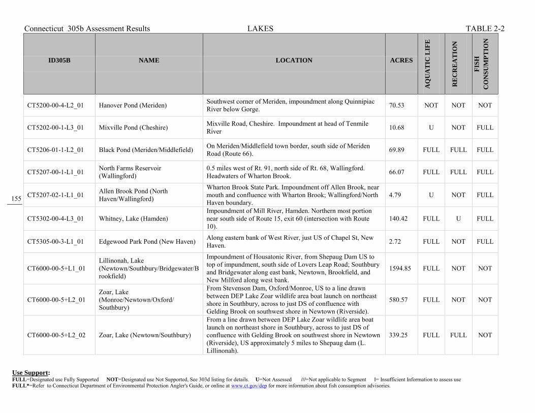
Connecticut 305b Assessment Results LAKES TABLE 2-2
Use Support: FULL=Designated use Fully Supported NOT=Designated use Not Supported, See 303d listing for details. U=Not Assessed ///=Not applicable to Segment I= Insufficient Information to assess use FULL*=Refer to Connecticut Department of Environmental Protection Angler's Guide, or online at www.ct.gov/dep for more information about fish consumption advisories.
155
155 155
ID305B NAME LOCATION ACRES
AQ
UA
TIC
LIF
E
RE
CR
EA
TIO
N
FIS
H
CO
NS
UM
PT
ION
CT5200-00-4-L2_01 Hanover Pond (Meriden) Southwest corner of Meriden, impoundment along Quinnipiac River below Gorge. 70.53 NOT NOT NOT
CT5202-00-1-L3_01 Mixville Pond (Cheshire) Mixville Road, Cheshire. Impoundment at head of Tenmile River 10.68 U NOT FULL
CT5206-01-1-L2_01 Black Pond (Meriden/Middlefield) On Meriden/Middlefield town border, south side of Meriden Road (Route 66). 69.89 FULL FULL FULL
CT5207-00-1-L1_01 North Farms Reservoir (Wallingford)
0.5 miles west of Rt. 91, north side of Rt. 68, Wallingford. Headwaters of Wharton Brook. 66.07 FULL FULL FULL
CT5207-02-1-L1_01 Allen Brook Pond (North Haven/Wallingford)
Wharton Brook State Park. Impoundment off Allen Brook, near mouth and confluence with Wharton Brook; Wallingford/North Haven boundary.
4.79 U NOT FULL
CT5302-00-4-L3_01 Whitney, Lake (Hamden) Impoundment of Mill River, Hamden. Northern most portion near south side of Route 15, exit 60 (intersection with Route 10).
140.42 FULL U FULL
CT5305-00-3-L1_01 Edgewood Park Pond (New Haven) Along eastern bank of West River, just US of Chapel St, New Haven. 2.72 FULL NOT FULL
CT6000-00-5+L1_01 Lillinonah, Lake (Newtown/Southbury/Bridgewater/Brookfield)
Impoundment of Housatonic River, from Shepaug Dam US to top of impundment, south side of Lovers Leap Road; Southbury and Bridgewater along east bank, Newtown, Brookfield, and New Milford along west bank.
1594.85 FULL NOT NOT
CT6000-00-5+L2_01 Zoar, Lake (Monroe/Newtown/Oxford/ Southbury)
From Stevenson Dam, Oxford/Monroe, US to a line drawn between DEP Lake Zoar wildlife area boat launch on northeast shore in Southbury, across to just DS of confluence with Gelding Brook on southwest shore in Newtown (Riverside).
580.57 FULL NOT NOT
CT6000-00-5+L2_02 Zoar, Lake (Newtown/Southbury)
From a line drawn between DEP Lake Zoar wildlife area boat launch on northeast shore in Southbury, across to just DS of confluence with Gelding Brook on southwest shore in Newtown (Riverside), US approximately 5 miles to Shepaug dam (L. Lillinonah).
339.25 FULL FULL NOT

Connecticut 305b Assessment Results LAKES TABLE 2-2
Use Support: FULL=Designated use Fully Supported NOT=Designated use Not Supported, See 303d listing for details. U=Not Assessed ///=Not applicable to Segment I= Insufficient Information to assess use FULL*=Refer to Connecticut Department of Environmental Protection Angler's Guide, or online at www.ct.gov/dep for more information about fish consumption advisories.
156
156 156
ID305B NAME LOCATION ACRES
AQ
UA
TIC
LIF
E
RE
CR
EA
TIO
N
FIS
H
CO
NS
UM
PT
ION
CT6000-00-5+L4_01 Housatonic, Lake (Shelton/Derby/Seymour/Oxford/ Monroe)
From Lake Housatonic Dam (Derby Dam), US to Stevenson Dam (division of lower Lake Zoar and upper Lake Housatonic) Oxford/Monroe. First major impoundment of Housatonic River.
346.29 FULL NOT NOT
CT6000-88-1-L1_01 Brewsters Pond (Stratford) Stratford, east of Main Street (Rte 113). 4.02 NOT FULL NOT
CT6002-00-1-L1_01 Washining Lake (Twin Lakes, Eastern) (Salisbury) Northestern Salisbury 565.31 FULL FULL FULL
CT6005-00-1-L1_01 Wononscopomuc (Lakeville) Lake (Salisbury) South central Salisbury. 348.14 FULL FULL FULL
CT6005-04-1-L1_01 Riga Lake (Salisbury) Northwestern Salisbury, small portion crossws the New York border. 155.9 FULL FULL FULL
CT6005-04-1-L2_01 South Pond (Salisbury) Northwest corner of Salisbury, at the end of Mt. Riga Road. Downstream of Riga Lake, on private property managed by Mt. Riga, Inc.
123 FULL U FULL
CT6008-00-1-L1_01 Cream Hill Lake (Cornwall) Northeastern Cornwall. 67.31 FULL FULL FULL
CT6015-00-1-L1_01 Peck Pond (Sharon) Sharon 27.33 FULL U FULL
CT6016-00-1-L2_01 Leonard Pond (Kent) Central Kent, headwaters of Womenshenuck Brook. 20.14 FULL U FULL
CT6016-00-1-L3_01 Hatch Pond (Kent) South central Kent, DS of Leonard Pond along Womenshenuck Brook. 65.66 NOT NOT FULL
CT6018-00-1-L1_01 Taunton Pond (Newtown) Central Newtown. 124.61 FULL U FULL
CT6023-00-1-L1_01 Quassapaug, Lake (Middlebury/Woodbury) Northwestern Middlebury; headwaters of Eightmile Brook. 296.89 FULL FULL FULL

Connecticut 305b Assessment Results LAKES TABLE 2-2
Use Support: FULL=Designated use Fully Supported NOT=Designated use Not Supported, See 303d listing for details. U=Not Assessed ///=Not applicable to Segment I= Insufficient Information to assess use FULL*=Refer to Connecticut Department of Environmental Protection Angler's Guide, or online at www.ct.gov/dep for more information about fish consumption advisories.
157
157 157
ID305B NAME LOCATION ACRES
AQ
UA
TIC
LIF
E
RE
CR
EA
TIO
N
FIS
H
CO
NS
UM
PT
ION
CT6100-04-1-L1_01 Wood Creek Pond (Norfolk) North-central Norfolk, near MA border; headwaters of Wood Creek. 147.62 FULL FULL FULL
CT6202-00-1-L1_01 Wangum, Lake (Canaan) Canaan 177.88 FULL U FULL
CT6301-00-1-L1_01 Wononpakook, Lake (Salisbury) Located west of Route 41, Southwestern Salisbury (also known as Long Pond). 167.5 FULL U FULL
CT6301-00-2-L2_01 Mudge Pond (Sharon) Northwest Sharon. 211.17 FULL FULL FULL
CT6301-08-1-L1_01 Indian Lake (Sharon/NY State Line) Sharon 195.81 FULL FULL FULL
CT6302-00-1-L1_01 Hatch Pond (Sharon) Sharon 19.82 FULL FULL FULL
CT6302-01-1-L2_01 Ford Pond (Sharon) Sharon 22.9 FULL FULL FULL
CT6400-00-1-L5_01 Candlewood, Lake (New Fairfield/Danbury/Sherman/New Milford)
Parts of Brookfield, Danbury, New Milford, New Farfield, & Sherman. 5085.67 FULL FULL FULL
CT6400-03-1-L1_01 Squantz Pond (New Fairfield/Sherman)
Northeast corner of New Fairfield and into Sherman; a large cove of Candlewood Lake, contained by Squantz Pond Dam at Route 39 crossing.
266.81 FULL FULL FULL
CT6402-00-1-L1_01 Ball Pond (New Fairfield) New Fairfield 80.7 FULL NOT FULL
CT6500-00-1-L1_01 South Spectacle Pond (Kent) East central Kent at headwaters of the West Aspetuck River. 82.26 FULL FULL FULL
CT6502-00-1-L2_01 Waramaug, Lake (Kent/Warren/Washington)
Southwest corner of Warren, Northwest corner of Washington; headwaters of East Aspetuck River. 640.81 FULL FULL FULL

Connecticut 305b Assessment Results LAKES TABLE 2-2
Use Support: FULL=Designated use Fully Supported NOT=Designated use Not Supported, See 303d listing for details. U=Not Assessed ///=Not applicable to Segment I= Insufficient Information to assess use FULL*=Refer to Connecticut Department of Environmental Protection Angler's Guide, or online at www.ct.gov/dep for more information about fish consumption advisories.
158
158 158
ID305B NAME LOCATION ACRES
AQ
UA
TIC
LIF
E
RE
CR
EA
TIO
N
FIS
H
CO
NS
UM
PT
ION
CT6600-01-1-L3_01 Kenosia, Lake (Danbury) Impoundment of Still River, Danbury. 56.75 FULL NOT FULL
CT6700-03-1-L2_01 Mohawk Pond (Goshen/Cornwall) Goshen - Cornwall boundary within Mohawk State Forest. 16.34 FULL FULL FULL
CT6701-00-1-L1_01 Tyler Lake (Goshen) West central Goshen; headwaters of Marshepaug River. 187.22 FULL FULL FULL
CT6701-01-1-L1_01 West Side Pond (Goshen) West central Goshen; drains to West Side Pond Brook to Tyler Lake 40.37 FULL FULL FULL
CT6703-00-2-L1_01 Dog Pond (Goshen) South central Goshen; along West Branch of Bantam River 65.77 FULL FULL FULL
CT6705-00-3-L3_01 Bantam Lake (Litchfield/Morris) Litchfield, Morris 955.45 FULL FULL FULL
CT6705-14-1-L1_01 Mount Tom Pond (Litchfield/Morris/Wahington)
Northwest corner of Morris, southwest corner of Litchfield, within Mount Tom State Park. 55.14 FULL FULL FULL
CT6802-12-1-L1_01 Cat Swamp Pond (Woodbury) Woodbury 28.57 FULL U FULL
CT6804-02-1-L1_01 Long Meadow Pond (Bethlehem/Morris) North central Bethlehem, borders Morris. 101.41 FULL FULL FULL
CT6900-40-1-L1_01 Beaver Lake (Seymour) Seymour 68.82 FULL FULL FULL
CT6900-42-1-L1_01 Upper Derby Hill Reservoir (Derby) Derby 29.93 FULL U FULL
CT6904-00-3-L1_01 Stillwater Pond (Torrington) Impoundment of West Branch of the Naugatuck River, Torrington; east of Rte 272. 93.52 FULL FULL FULL

Connecticut 305b Assessment Results LAKES TABLE 2-2
Use Support: FULL=Designated use Fully Supported NOT=Designated use Not Supported, See 303d listing for details. U=Not Assessed ///=Not applicable to Segment I= Insufficient Information to assess use FULL*=Refer to Connecticut Department of Environmental Protection Angler's Guide, or online at www.ct.gov/dep for more information about fish consumption advisories.
159
159 159
ID305B NAME LOCATION ACRES
AQ
UA
TIC
LIF
E
RE
CR
EA
TIO
N
FIS
H
CO
NS
UM
PT
ION
CT6905-00-1-L3_01 Winchester, Lake (Winchester) HUC: 01100005 248.07 FULL FULL FULL
CT6905-00-1-L4_01 Park Pond (Winchester) Southwest corner of Winchester; drains to East Branch of Naugatuck River 74.95 FULL FULL FULL
CT6909-00-2-L1_01 Northfield (Reservoir) Brook Lake (Thomaston)
Impoundment of Northfield Brook, northeast corner of Thomaston. 5.3 FULL NOT FULL
CT6910-14-1-L3_01 Black Rock Lake (Watertown) Impoundment of Purgatory Brook (trib to Branch Brook), Watertown; west of Rte 6. 9.48 U FULL FULL
CT6911-07-1-L1_01 Plymouth Lake (Plymouth) Plymouth 44.85 FULL U FULL
CT6912-05-1-L2_01 Winnemaug, Lake (Watertown) Southwest Watertown. 112.87 FULL FULL FULL
CT6914-06-1-L1_01 Hitchcock Lake (Wolcott) Southeast corner of Wolcott, near Cheshire border. 100.3 FULL NOT FULL
CT6914-09-1-L2_01 Chestnut Hill Reservoir (Wolcott) Near western border of Wolcott, north side of Lyman Road, west of Route 69. 65.19 FULL U FULL
CT6916-00-3-L4_01 Hop Brook Lake (Waterbury/Middlebury)
Impoundment of Hop Brook, Waterbury/Naugatuck/Middlebury. 25.77 U NOT FULL
CT7103-00-2-L3_01 Success Lake (Bridgeport) US of Stillman Pond, Pembroke Lakes & Yellowmill Channel, Bridgeport. 15.79 NOT U FULL
CT7103-00-2-L4_01 Stillman Pond (Bridgeport) Upstream of Yellow Mill Channel, Bridgeport. Downstream of Success Lake. 4.97 FULL U NOT
CT7103-00-2-L5_01 Pembroke Lakes (Bridgeport) Just upstream of Yellow Mill Channel, US side of RailRoad crossing, and DS of Stillman Pond and Route 1 crossing, Bridgeport. (Includes Arms Pond, Remington Arms Company
2.74 NOT U FULL

Connecticut 305b Assessment Results LAKES TABLE 2-2
Use Support: FULL=Designated use Fully Supported NOT=Designated use Not Supported, See 303d listing for details. U=Not Assessed ///=Not applicable to Segment I= Insufficient Information to assess use FULL*=Refer to Connecticut Department of Environmental Protection Angler's Guide, or online at www.ct.gov/dep for more information about fish consumption advisories.
160
160 160
ID305B NAME LOCATION ACRES
AQ
UA
TIC
LIF
E
RE
CR
EA
TIO
N
FIS
H
CO
NS
UM
PT
ION
Pond, and Barnum Avenue Pond)
CT7105-10-1-L2_01 Forest, Lake (Bridgeport) Headwaters of Island Brook, a tributary to the Pequonnock River, Bpt. 66.58 FULL FULL FULL
CT7108-00-3-L3_01 Mohegan, Lake (Fairfield) Impoundment of Mill River, Fairfield; upstream of Samp Mortar Reservoir 14.95 U FULL FULL
CT7200-00-3-L5_01 Saugatuck Reservoir (Weston/Easton/Redding) Weston 823.11 FULL U FULL
CT7301-04-1-L2_01 Popes Pond (Wilton) Wilton 82.47 FULL U FULL
CT7407-00-3-L14_01 Bargh (Mianus) Reservoir (Stamford)
Impoundment of the Mianus River in the NW corner of Stamford. 161.43 FULL U FULL
CT7409-00-1-L3_01 Putnam Lake Reservoir (Greenwich) Impoundment of Horseneck Brook, just south of Rt. 15, Greenwich. 95.56 NOT U FULL
CT8104-00-2-L5_01 Mamanasco Lake (Ridgefield) Northwest Ridgefield. 85.9 NOT NOT FULL

Connecticut 2010, 305b Assessment Results ESTUARIES TABLE 2-2
Use Support: FULL=Designated use Fully Supported NOT=Designated use Not Supported, See 303d listing for details. U=Not Assessed ///=Not applicable to Segment I= Insufficient Information to assess use FULL*=Refer to Connecticut Department of Environmental Protection Angler's Guide, or online at www.ct.gov/dep for more information about fish consumption advisories.
161
ID305B NAME LOCATION
MIL
ES S
QU
AR
E
MA
RIN
E A
QU
ATI
C L
IFE
REC
REA
TIO
N
DIR
ECT
SHEL
LFIS
H
CO
MM
ERC
IAL
SHEL
LFIS
H
FISH
C
ON
SUM
PTIO
N
CT-C1_001 LIS CB Inner - Patchogue And Menunketesuck Rivers
See Fig.2-15 for Boundaries. Central portion of LIS, Inner Estuary, Patchogue and Menunketesuck Rivers from mouths at Grove Beach Point, US to saltwater limits just above I95 crossing, and at I95 crossing respectively, Westbrook.
0.182 U U NOT //// FULL
CT-C1_002-SB LIS CB Inner - Inner Clinton Harbor, Clinton
See Fig.2-15 for Boundaries. Central portion of LIS, Inner Estuary, SB water of inner Clinton Harbor, including mouths of Hammonasset, Indian, Hammock Rivers, and Dudley Creek (includes Esposito Beach), Clinton.
0.372 NOT U //// FULL FULL
CT-C1_003-SB LIS CB Inner - Hammonasset River, Clinton
See Fig.2-15 for Boundaries. Central portion of LIS, Inner Estuary, Hammonasset River SB water from mouth at inner Clinton Harbor, US to SA/SB water quality line between Currycross Road and RR track, Clinton.
0.072 U U //// NOT FULL
CT-C1_004-SB LIS CB Inner - Hayden Creek, Clinton
See Fig.2-15 for Boundaries. Central portion of LIS, Inner Estuary, Hayden Creek SB water from mouth at Hammonasset River (parallel with Pratt Road), US to saltwater limit near Maple Avenue (off Route 1), Clinton.
0.009 NOT U //// NOT FULL
CT-C1_005 LIS CB Inner - Clinton Harbor (SA Inputs), Clinton
See Fig.2-15 for Boundaries. Central portion of LIS, Inner Estuary, (DISCONTINUOUS SEGMENT) SA water of upper Hammonasset, Indian, Hammock Rivers, Dudley Creek and other small tributaries, from SA/SB water quality line, US to saltwater limits, Clinton.
0.138 U U NOT //// FULL
CT-C1_006 LIS CB Inner - East and Neck Rivers, Guilford
See Fig.2-15 for Boundaries. Central portion of LIS, Inner Estuary, from mouth of East River at outlet into Guilford Harbor, US to saltwater limit at Planter Pond outlet (includes Neck River from mouth to above River Edge Farms Road, Guilford.
0.151 U U NOT //// FULL
CT-C1_007 LIS CB Inner - West River, Guilford
See Fig.2-15 for Boundaries. Central portion of LIS, Inner Estuary, from mouth of West River at outlet into Guilford Harbor, US to saltwater limit at Route 1 crossing, Guilford.
0.047 U U NOT //// FULL
CT-C1_008 LIS CB Inner - Joshua Cove, Beattie Pond, Guilford
See Fig.2-15 for Boundaries. Central portion of LIS, Inner Estuary, from mouth at outlet into Joshua Cove, US to saltwater limit above Route 146 and RR crossing (includes Beattie Pond), Guilford.
0.104 U U U //// FULL

Connecticut 2010, 305b Assessment Results ESTUARIES TABLE 2-2
Use Support: FULL=Designated use Fully Supported NOT=Designated use Not Supported, See 303d listing for details. U=Not Assessed ///=Not applicable to Segment I= Insufficient Information to assess use FULL*=Refer to Connecticut Department of Environmental Protection Angler's Guide, or online at www.ct.gov/dep for more information about fish consumption advisories.
162
ID305B NAME LOCATION
MIL
ES S
QU
AR
E
MA
RIN
E A
QU
ATI
C L
IFE
REC
REA
TIO
N
DIR
ECT
SHEL
LFIS
H
CO
MM
ERC
IAL
SHEL
LFIS
H
FISH
C
ON
SUM
PTIO
N
CT-C1_009-SB LIS CB Inner - Inner Branford Harbor, Branford
See Fig.2-15 for Boundaries. Central portion of LIS, Inner Estuary, from Branford Point, US to SA/SB water quality line at RR crossing above Route 146 crossing, Branford.
0.314 U U //// NOT FULL
CT-C1_010 LIS CB Inner - Branford River, Branford
See Fig.2-15 for Boundaries. Central portion of LIS, Inner Estuary, SA water from SA/SB water quality line at RR crossing above Route 146 crossing, US to saltwater limit near Route 1, Branford.
0.026 U U NOT //// FULL
CT-C1_011 LIS CB Inner - Farm River, East Haven
See Fig.2-15 for Boundaries. Central portion of LIS, Inner Estuary, SA water from SA/SB water quality line at Route 142 (Short Beach Road), US to saltwater limit above RR crossing and near Route 1, East Haven/Branford.
0.066 U U NOT //// FULL
CT-C1_012 LIS CB Inner - Morris Creek, East Haven
See Fig.2-15 for Boundaries. Central portion of LIS, Inner Estuary, SA water from SA/SB water quality line at New Haven Harbor (near Lighthouse Point Beach) to, US to saltwater limit above Route 337, East Haven/New Haven.
0.016 NOT U NOT //// FULL
CT-C1_013-SB LIS CB Inner - New Haven Harbor, New Haven
See Fig.2-15 for Boundaries. Central portion of LIS, Inner Estuary, Inner New Haven Harbor from Sandy Point to I95 crossing (mouth of Quinnipiac and Mill Rivers, and mouth of West River), New Haven/West Haven.
2.343 NOT NOT //// NOT FULL
CT-C1_014-SB LIS CB Inner - Quinnipiac River (mouth), New Haven
See Fig.2-15 for Boundaries. Central portion of LIS, Inner Estuary, from mouth at I95 crossing, US Quinnipiac River to Sackett Point Road (includes Mill River mouth BELOW Chapel Street crossing), North Haven.
0.626 NOT NOT //// NOT FULL
CT-C1_015-SB LIS CB Inner - West River (Lower), West Haven
See Fig.2-15 for Boundaries. Central portion of LIS, Inner Estuary, from mouth just DS of I95 crossing (City Point, New Haven Harbor), US to SA/SB water quality line at Route 1 crossing, West Haven.
0.065 NOT NOT //// NOT FULL
CT-C1_016 LIS CB Inner - Cove River, West Haven
See Fig.2-15 for Boundaries. Central portion of LIS, Inner Estuary, from mouth at West Haven West Beach (just DS of Ocean Avenue crossing), US to saltwater limit near Riverview Terrace, West Haven.
0.008 NOT U NOT //// FULL
CT-C1_017 LIS CB Inner - Oyster River, Milford
See Fig.2-15 for Boundaries. Central portion of LIS, Inner Estuary, from mouth at Oyster River Beach (just DS of New Haven Avenue crossing), US to saltwater limit near Woodmont Road, Milford.
0.012 NOT U NOT //// FULL

Connecticut 2010, 305b Assessment Results ESTUARIES TABLE 2-2
Use Support: FULL=Designated use Fully Supported NOT=Designated use Not Supported, See 303d listing for details. U=Not Assessed ///=Not applicable to Segment I= Insufficient Information to assess use FULL*=Refer to Connecticut Department of Environmental Protection Angler's Guide, or online at www.ct.gov/dep for more information about fish consumption advisories.
163
ID305B NAME LOCATION
MIL
ES S
QU
AR
E
MA
RIN
E A
QU
ATI
C L
IFE
REC
REA
TIO
N
DIR
ECT
SHEL
LFIS
H
CO
MM
ERC
IAL
SHEL
LFIS
H
FISH
C
ON
SUM
PTIO
N
CT-C1_018-SB LIS CB Inner - Milford Harbor & Gulf Pond, Milford
See Fig.2-15 for Boundaries. Central portion of LIS, Inner Estuary, from mouth at Burns Point, The Gulf, US Milford Harbor to New Haven Avenue crossing (saltwater limit), and US Indian River (through Gulf Pond) to saltwater limit US of I95 crossing, Milford.
0.272 U U //// NOT FULL
CT-C1_019-SB LIS CB Inner - Housatonic River (mouth), Milford
See Fig.2-15 for Boundaries. Central portion of LIS, Inner Estuary, from mouth between Sniffens Point and Milford Point, US to Route 1 crossing (includes Nells Island area, lower Beaver Brook to saltwater limit, Goose Island, Crimbo Point), Milford/Stratford.
0.805 NOT U //// NOT FULL
CT-C1_020-SB LIS CB Inner - Housatonic River (lower), Milford
See Fig.2-15 for Boundaries. Central portion of LIS, Inner Estuary, from Route 1 crossing, US to Route 15 crossing (includes Peacock, Carting, Long, Popes, and Fowler Islands, and mouth of Pumpkin Ground Brook) Milford/Stratford.
0.741 U U //// U FULL
CT-C1_021-SB LIS CB Inner - Housatonic River (Upper), Orange
See Fig.2-15 for Boundaries. Central portion of LIS, Inner Estuary, from Route 15 crossing, US to just below Wooster Island (includes Great Flats, and mouth of Farmill River) Orange/Shelton.
0.402 NOT U //// U FULL
CT-C1_022 LIS CB Inner - West River (Upper), West Haven
See Fig.2-15 for Boundaries. Central portion of LIS, Inner Estuary, from SA/SB water quality line at Route 1 crossing, US past Route 34 crossing to southside of Edgewood Avenue (near Edgewood Park Pond), West Haven.
0.063 NOT NOT NOT //// FULL
CT-C1_023-SB LIS CB Inner - Mill River (mouth), New Haven/Hamden
See Fig.2-15 for Boundaries. Central portion of LIS, Inner Estuary, from mouth at confluence with Quinnipiac River (Chapel Street crossing), New Haven, US to Footbridge crossing (just US of East Rock Road crossing), Hamden.
0.068 NOT NOT //// NOT FULL
CT-C2_001 LIS CB Shore - Westbrook Harbor (East), Westbrook
See Fig.2-15 for Boundaries. Central portion of LIS from Fiske Lane to Old Saltworks Road (includes Middle Beach), out approximately 1000 ft offshore, Westbrook.
0.244 U FULL NOT //// FULL
CT-C2_002 LIS CB Shore - Westbrook Harbor (West), Westbrook
See Fig.2-15 for Boundaries. Central portion of LIS from Portside Drive near Patchogue River outlet to Fiske Lane (includes Westbrook Town Beach), out approximately 1000 ft offshore, Westbrook.
0.231 U FULL NOT //// FULL

Connecticut 2010, 305b Assessment Results ESTUARIES TABLE 2-2
Use Support: FULL=Designated use Fully Supported NOT=Designated use Not Supported, See 303d listing for details. U=Not Assessed ///=Not applicable to Segment I= Insufficient Information to assess use FULL*=Refer to Connecticut Department of Environmental Protection Angler's Guide, or online at www.ct.gov/dep for more information about fish consumption advisories.
164
ID305B NAME LOCATION
MIL
ES S
QU
AR
E
MA
RIN
E A
QU
ATI
C L
IFE
REC
REA
TIO
N
DIR
ECT
SHEL
LFIS
H
CO
MM
ERC
IAL
SHEL
LFIS
H
FISH
C
ON
SUM
PTIO
N
CT-C2_003 LIS CB Shore - Clinton Beach, Clinton
See Fig.2-15 for Boundaries. Central portion of LIS from Kelsey Point to Grove Beach Point area (to Portside Drive, includes Patchogue River outlet), out approximately 1000 ft offshore, Clinton/Westbrook.
0.516 U U NOT //// FULL
CT-C2_004 LIS CB Shore - Outer Clinton Harbor, Clinton
See Fig.2-15 for Boundaries. Central portion of LIS from West Rock to Kelsey Point area (outer Clinton Harbor SA water includes Hammonasset, Indian, and Hammock River outlets, and Town Beach), out approximately 1000 ft offshore, Clinton.
0.505 U FULL NOT //// FULL
CT-C2_005 LIS CB Shore - Hammonasset Beach, Madison
See Fig.2-15 for Boundaries. Central portion of LIS from Webster Point to West Rock area (includes Hammonasset State Park Beach), out approximately 1000 ft offshore, Madison.
0.583 U FULL NOT //// FULL
CT-C2_006 LIS CB Shore - Madison Beaches (East), Madison
See Fig.2-15 for Boundaries. Central portion of LIS from West Warf to Webster Point area (includes West Warf and East Warf Beaches, Tuxis Island, and tidal Fence Creek ), out approximately 1000 ft offshore, Madison.
0.399 U FULL NOT //// FULL
CT-C2_007 LIS CB Shore - Madison Beaches (West), Madison
See Fig.2-15 for Boundaries. Central portion of LIS from Hogshead Point to West Warf area (includes Surf Club Beach, Chipman Point), out approximately 1000 ft offshore, Madison.
0.482 U FULL NOT //// FULL
CT-C2_008 LIS CB Shore - Guilford Harbor, Guilford
See Fig.2-15 for Boundaries. Central portion of LIS from Mulberry Point to Hogshead Point area (includes Jacobs Beach, Guilford Point), out approximately 1000 ft offshore, Guilford.
0.481 U FULL NOT //// FULL
CT-C2_009 LIS CB Shore - Indian Cove, Guilford
See Fig.2-15 for Boundaries. Central portion of LIS from Sachem Head to Mulberry Point area (includes Vineyard Point), out approximately 1000 ft offshore, Guilford.
0.431 U U NOT //// FULL
CT-C2_010 LIS CB Shore - Joshua Cove & Island Bay, Guilford
See Fig.2-15 for Boundaries. Central portion of LIS from Clark Point to Sachem Head area (includes Horse and Foskett Islands), out approximately 1000 ft offshore, Guilford.
0.738 U U NOT //// FULL

Connecticut 2010, 305b Assessment Results ESTUARIES TABLE 2-2
Use Support: FULL=Designated use Fully Supported NOT=Designated use Not Supported, See 303d listing for details. U=Not Assessed ///=Not applicable to Segment I= Insufficient Information to assess use FULL*=Refer to Connecticut Department of Environmental Protection Angler's Guide, or online at www.ct.gov/dep for more information about fish consumption advisories.
165
ID305B NAME LOCATION
MIL
ES S
QU
AR
E
MA
RIN
E A
QU
ATI
C L
IFE
REC
REA
TIO
N
DIR
ECT
SHEL
LFIS
H
CO
MM
ERC
IAL
SHEL
LFIS
H
FISH
C
ON
SUM
PTIO
N
CT-C2_011 LIS CB Shore - Stony Creek (East), Branford
See Fig.2-15 for Boundaries. Central portion of LIS from Flying Point to Clark Point area (includes Hoadley Neck, Narrows Island), out approximately 1000 ft offshore, Branford/Guilford.
0.546 U U NOT //// FULL
CT-C2_012 LIS CB Shore - Stony Creek (West), Branford
See Fig.2-15 for Boundaries. Central portion of LIS from Brown Point to Flying Point area (includes Stony Creek Beach, Saint Helena Island, Juniper Point, Pleasant Point), out approximately 1000 ft offshore, Branford.
0.379 U FULL NOT //// FULL
CT-C2_013 LIS CB Shore - Indian Neck, Branford
See Fig.2-15 for Boundaries. Central portion of LIS from Clam Island to Brown Point area (includes Haycock Point), out approximately 1000 ft offshore, Branford.
0.567 U U NOT //// FULL
CT-C2_014-SB LIS CB Shore - Branford Harbor, Branford
See Fig.2-15 for Boundaries. Central portion of LIS from Johnson Point to Clam Island area (includes Branford Point Beach, Lovers Island, Indian Neck Point, Linden Point), out approximately 1000 ft offshore, Branford.
0.648 U FULL //// FULL FULL
CT-C2_015-SB LIS CB Shore - Pages Cove, Branford
See Fig.2-15 for Boundaries. Central portion of LIS from Mansfield Point to Johnson Point area (includes Clark Avenue Beach, Farm River Gut, Kelsey Island, Gull Rocks), out approximately 1000 ft offshore, Branford.
0.731 U FULL //// FULL FULL
CT-C2_016-SB LIS CB Shore - New Haven Harbor (East), East Haven
See Fig.2-15 for Boundaries. Central portion of LIS from Morgan Point to Mansfield Point area (includes East Haven Beach, South End Point, Momauguin), out approximately 1000 ft offshore, East Haven.
0.371 U FULL //// FULL FULL
CT-C2_017-SB LIS CB Shore - Morris Cove, New Haven
See Fig.2-15 for Boundaries. Central portion of LIS from Black Rock to Morgan Point area (includes Lighthouse Point Beach, Lighthouse Point, South End), out approximately 1000 ft offshore, New Haven.
0.586 NOT FULL //// FULL FULL
CT-C2_018-SB LIS CB Shore - New Haven Harbor (West), West Haven
See Fig.2-15 for Boundaries. Central portion of LIS from Oyster River Point to Sandy Point area (includes West Haven West Beach, West Haven East Beach, West Shore, Sandy Point), out approximately 1000 ft offshore, West Haven.
0.789 NOT FULL //// NOT FULL
CT-C2_019-SB LIS CB Shore - New Haven Harbor (West), Milford
See Fig.2-15 for Boundaries. Central portion of LIS from Merwin Point to Oyster River Point area (includes Woodmont Beach, Oyster River outlet), out approximately 1000 ft offshore, Milford.
0.295 U FULL //// FULL FULL

Connecticut 2010, 305b Assessment Results ESTUARIES TABLE 2-2
Use Support: FULL=Designated use Fully Supported NOT=Designated use Not Supported, See 303d listing for details. U=Not Assessed ///=Not applicable to Segment I= Insufficient Information to assess use FULL*=Refer to Connecticut Department of Environmental Protection Angler's Guide, or online at www.ct.gov/dep for more information about fish consumption advisories.
166
ID305B NAME LOCATION
MIL
ES S
QU
AR
E
MA
RIN
E A
QU
ATI
C L
IFE
REC
REA
TIO
N
DIR
ECT
SHEL
LFIS
H
CO
MM
ERC
IAL
SHEL
LFIS
H
FISH
C
ON
SUM
PTIO
N
CT-C2_020-SB LIS CB Shore - New Haven Harbor (SWest), Milford
See Fig.2-15 for Boundaries. Central portion of LIS from SA/SB water quality line at Pond Point to Merwin Point area (includes Anchor Beach #1, Anchor Beach #2, Morningside), out approximately 1000 ft offshore, Milford.
0.385 U FULL //// FULL FULL
CT-C2_021 LIS CB Shore - Bayview, Milford
See Fig.2-15 for Boundaries. Central portion of LIS from SA/SB water quality line at Welches Point to SA/SB water quality line at Pond Point area (includes only SA water between New Haven Harbor and Gulf), out approximately 1000 ft offshore, Milford.
0.331 U U FULL //// FULL
CT-C2_022-SB LIS CB Shore - The Gulf, Milford
See Fig.2-15 for Boundaries. Central portion of LIS from SA/SB WQ line at Western end of Silver Sands State Park Beach to SA/SB WQ line at Welches Point area (includes Silver Sands and Gulf Beaches) all SB water in The Gulf out to Charles Island, Milford.
0.593 U FULL //// FULL FULL
CT-C2_023 LIS CB Shore - Walnut Beach, Milford
See Fig.2-15 for Boundaries. Central portion of LIS from SA/SB WQ line at Milford Point to SA/SB WQ line at Silver Sands State Park Beach area (includes Walnut Beach, all SA, Housatonic River mouth to The Gulf), out approximately 1000 ft offshore, Milford.
0.577 U FULL NOT //// FULL
CT-C2_024-SB LIS CB Shore - Housatonic River mouth, Stratford
See Fig.2-15 for Boundaries. Central portion of LIS from SA/SB WQ line at Stratford Point to SA/SB WQ line at Milford Point area (includes Short Beach, entire mouth of Housatonic River) all SB waters out approximately 1000-4000 ft offshore, Stratford.
0.64 NOT FULL //// NOT FULL
CT-C3_001 LIS CB Midshore - Westbrook Harbor, Westbrook
See Fig.2-15 for Boundaries. Central portion of LIS from approximately 1000 ft offshore (Westbrook Harbor), out to 50 ft contour and basin boundary separating Eastern/Central.
2.692 FULL U NOT //// FULL
CT-C3_002 LIS CB Midshore - Duck Island area, Clinton
See Fig.2-15 for Boundaries. Central portion of LIS from approximately 1000 ft offshore (Clinton Beach, includes Duck Island and Menunketesuck Island areas), out to 50 ft contour, Clinton.
3.619 FULL U NOT //// FULL
CT-C3_003 LIS CB Midshore - Outer Clinton Harbor, Clinton
See Fig.2-15 for Boundaries. Central portion of LIS from approximately 1000 ft offshore (Clinton Harbor), out to 50 ft contour, Clinton. 2.524 FULL U NOT //// FULL

Connecticut 2010, 305b Assessment Results ESTUARIES TABLE 2-2
Use Support: FULL=Designated use Fully Supported NOT=Designated use Not Supported, See 303d listing for details. U=Not Assessed ///=Not applicable to Segment I= Insufficient Information to assess use FULL*=Refer to Connecticut Department of Environmental Protection Angler's Guide, or online at www.ct.gov/dep for more information about fish consumption advisories.
167
ID305B NAME LOCATION
MIL
ES S
QU
AR
E
MA
RIN
E A
QU
ATI
C L
IFE
REC
REA
TIO
N
DIR
ECT
SHEL
LFIS
H
CO
MM
ERC
IAL
SHEL
LFIS
H
FISH
C
ON
SUM
PTIO
N
CT-C3_004 LIS CB Midshore - Hammonasset Beach area, Madison
See Fig.2-15 for Boundaries. Central portion of LIS from approximately 1000 ft offshore (Madison Beaches, inlcuding area nearshore Hammonasset Beach State Park), out to 50 ft contour, Madison.
5.554 FULL U NOT //// FULL
CT-C3_005 LIS CB Midshore - Madison See Fig.2-15 for Boundaries. Central portion of LIS from approximately 1000 ft offshore (Hogshead Point), out to 50 ft contour, Madison. 8.348 FULL U FULL //// FULL
CT-C3_006 LIS CB Midshore - Outer Guilford Harbor, Guilford
See Fig.2-15 for Boundaries. Central portion of LIS from approximately 1000 ft offshore (Guilford Harbor), out to 50 ft contour, Guilford. 8.364 FULL U NOT //// FULL
CT-C3_007 LIS CB Midshore - Sachem Head Harbor, Guilford
See Fig.2-15 for Boundaries. Central portion of LIS from approximately 1000 ft offshore (Sachem Head), out to 50 ft contour, Guilford. 7.089 FULL U FULL //// FULL
CT-C3_008 LIS CB Midshore - Branford See Fig.2-15 for Boundaries. Central portion of LIS from approximately 1000 ft offshore (Haycock Point to Smith Island), out to 50 ft contour, Branford. 8.379 FULL U FULL //// FULL
CT-C3_009-I LIS CB Midshore - Thimble Islands, Branford
See Fig.2-15 for Boundaries. Central portion of LIS from approximately 1000 ft offshore (Thimble Islands), out to 50 ft contour, Branford. 1.457 FULL U NOT //// FULL
CT-C3_010 LIS CB Midshore - Indian Neck, Branford
See Fig.2-15 for Boundaries. Central portion of LIS from approximately 1000 ft offshore (Indian Neck, Little Point), out to 50 ft contour, Branford. 8.554 FULL U NOT //// FULL
CT-C3_011 LIS CB Midshore - East Haven See Fig.2-15 for Boundaries. Central portion of LIS, SA water from SA/SB water boundary along outer New Haven and Branford Harbors out to 50 ft contour, East Haven.
8.152 NOT U NOT //// FULL
CT-C3_012-SB LIS CB Midshore - Outer Branford Harbor, Branford
See Fig.2-15 for Boundaries. Central portion of LIS from approximately 1000 ft offshore (East Haven Town Beach to Clam Island), out to extent of SB water at SA/SB water quality line for outer Branford Harbor, Branford.
3.83 FULL U //// FULL FULL
CT-C3_013-SB LIS CB Midshore - New Haven Harbor, East Haven
See Fig.2-15 for Boundaries. Central portion of LIS from approximately 1000 ft offshore (South End, Morgan Point), out to extent of SB water at SA/SB water quality line for outer New Haven Harbor, East Haven.
6.051 NOT U //// FULL FULL

Connecticut 2010, 305b Assessment Results ESTUARIES TABLE 2-2
Use Support: FULL=Designated use Fully Supported NOT=Designated use Not Supported, See 303d listing for details. U=Not Assessed ///=Not applicable to Segment I= Insufficient Information to assess use FULL*=Refer to Connecticut Department of Environmental Protection Angler's Guide, or online at www.ct.gov/dep for more information about fish consumption advisories.
168
ID305B NAME LOCATION
MIL
ES S
QU
AR
E
MA
RIN
E A
QU
ATI
C L
IFE
REC
REA
TIO
N
DIR
ECT
SHEL
LFIS
H
CO
MM
ERC
IAL
SHEL
LFIS
H
FISH
C
ON
SUM
PTIO
N
CT-C3_014-SB LIS CB Midshore - New Haven Harbor, West Haven
See Fig.2-15 for Boundaries. Central portion of LIS from approximately 1000 ft offshore (Morningside to West Shore), out to extent of SB water at SA/SB water quality line for outer New Haven Harbor, Milford/West Haven.
7.961 NOT U //// FULL FULL
CT-C3_015-SB LIS CB Midshore - New Haven Harbor, New Haven
See Fig.2-15 for Boundaries. Central portion of LIS from approximately 1000 ft offshore (West Shore to Morgan Point), from Sandy Point out to segments CT-C3_013/014, outer New Haven Harbor, West Haven/New Haven.
4.561 NOT U //// FULL FULL
CT-C3_016 LIS CB Midshore - West Haven See Fig.2-15 for Boundaries. Central portion of LIS, SA water from SA/SB water boundary along outer New Haven Harbor, out to 50 ft contour, West Haven.
6.121 NOT U NOT //// FULL
CT-C3_017 LIS CB Midshore - Milford See Fig.2-15 for Boundaries. Central portion of LIS, SA water from SA/SB water boundary along outer New Haven Harbor, out to 50 ft contour, Milford. 8.095 NOT U NOT //// FULL
CT-C3_018 LIS CB Midshore - Fort Trumbull, Milford
See Fig.2-15 for Boundaries. Central portion of LIS from approximately 1000 ft offshore (Silver Sands State Park area, water beyond Island), out to 50 ft contour, Milford.
11.311 NOT U FULL //// FULL
CT-C3_019-I LIS CB Midshore - Outer Silver Sand Beach, Milford
See Fig.2-15 for Boundaries. Central portion of LIS from SA/SB water quality line along beach, out to Island (THE GULF SA water inside of Island at Silver Sands State Park Beach), Milford.
0.573 U U NOT //// FULL
CT-C3_020 LIS CB Midshore - Milford Point, Milford
See Fig.2-15 for Boundaries. Central portion of LIS from approximately 1000 ft offshore (SA water surrounding SB water, outer mouth of Housatonic River), out to 50 ft contour, Milford.
10.663 NOT U NOT //// FULL
CT-C4_001 LIS CB Offshore - Madison See Fig.2-15 for Boundaries. Central portion of LIS from 50ft contour to CT/NY State line. 37.978 FULL U //// //// FULL
CT-C4_002 LIS CB Offshore - Guilford See Fig.2-15 for Boundaries. Central portion of LIS from 50ft contour to CT/NY State line. 27.166 FULL U //// //// FULL
CT-C4_003 LIS CB Offshore - East Haven See Fig.2-15 for Boundaries. Central portion of LIS from 50ft contour to CT/NY State line. 35.333 FULL U //// //// FULL

Connecticut 2010, 305b Assessment Results ESTUARIES TABLE 2-2
Use Support: FULL=Designated use Fully Supported NOT=Designated use Not Supported, See 303d listing for details. U=Not Assessed ///=Not applicable to Segment I= Insufficient Information to assess use FULL*=Refer to Connecticut Department of Environmental Protection Angler's Guide, or online at www.ct.gov/dep for more information about fish consumption advisories.
169
ID305B NAME LOCATION
MIL
ES S
QU
AR
E
MA
RIN
E A
QU
ATI
C L
IFE
REC
REA
TIO
N
DIR
ECT
SHEL
LFIS
H
CO
MM
ERC
IAL
SHEL
LFIS
H
FISH
C
ON
SUM
PTIO
N
CT-C4_004 LIS CB Offshore - West Haven See Fig.2-15 for Boundaries. Central portion of LIS from 50ft contour to CT/NY State line. 34.332 NOT U //// //// FULL
CT-C4_005 LIS CB Offshore - Milford See Fig.2-15 for Boundaries. Central portion of LIS from 50ft contour to CT/NY State line. 24.248 NOT U //// //// FULL
CT-E1_001-SB LIS EB Inner - Pawcatuck River (01), Stonington
See Fig.2-15 for Boundaries. Eastern portion of LIS, Inner Estuary in Pawcatuck River from Stanton Weir Point US to Saltwater limit, parallel to RR and Mechanic Street, Clarks Village, (Stonington).
0.103 NOT U //// NOT FULL
CT-E1_002-SB LIS EB Inner - Pawcatuck River (02), Stonington
See Fig.2-15 for Boundaries. Eastern portion of LIS, Inner Estuary in Pawcatuck River from mouth at Pawcatuck Point, US to Stanton Weir Point. 0.313 FULL U //// FULL FULL
CT-E1_003 LIS EB Inner - Inner Wequetequock Cove, Stonington
See Fig.2-15 for Boundaries. Eastern portion of LIS, Inner Estuary, Inner Wequetequock Cove from RR crossing US to Saltwater limit, in two lopes adjacent to Route 1, Stonington.
0.094 U U NOT //// FULL
CT-E1_004-SB LIS EB Inner - Outer Stonington Harbor, Stonington
See Fig.2-15 for Boundaries. Eastern portion of LIS, Inner Estuary, Outer Stonington Harbor from SB/SA water quality boundary near Wamphassuc Point to offshore Stonington Point, US to RR crossing, Stonington.
0.638 U FULL //// FULL FULL
CT-E1_005 LIS EB Inner - Inner Stonongton Harbor, Stonington
See Fig.2-15 for Boundaries. Eastern portion of LIS, Inner Estuary, Inner Stonington Harbor from SB/SA water quality boundary at RR crossing, US to Saltwater limit near Route 1 crossing, Stonington.
0.226 U FULL NOT //// FULL
CT-E1_006 LIS EB Inner - Inner Quiambaug Cove, Stonington
See Fig.2-15 for Boundaries. Eastern portion of LIS, Inner Estuary, Inner Quiambaug Cove from RR crossing, US to Saltwater limit, above Route 1 crossing, adjacent to Cove Road, Stonington.
0.114 U U NOT //// FULL
CT-E1_007-SB LIS EB Inner - Mystic River (Mouth), Stonington
See Fig.2-15 for Boundaries. Eastern portion of LIS, Inner Estuary, Mouth of Mystic River Estuary from RR crossing, US to Saltwater limit, above Route 95 crossing, adjacent to Mill Street, Stonington (Old Mystic).
0.453 U U //// FULL FULL
CT-E1_008-SB LIS EB Inner - Mystic Harbor, Groton
See Fig.2-15 for Boundaries. Eastern portion of LIS, Inner Estuary, Mystic Harbor from Morgan Point to RR crossing at mouth of Mystic River (includes waters North of Mason Island), Groton.
0.954 U FULL //// FULL FULL

Connecticut 2010, 305b Assessment Results ESTUARIES TABLE 2-2
Use Support: FULL=Designated use Fully Supported NOT=Designated use Not Supported, See 303d listing for details. U=Not Assessed ///=Not applicable to Segment I= Insufficient Information to assess use FULL*=Refer to Connecticut Department of Environmental Protection Angler's Guide, or online at www.ct.gov/dep for more information about fish consumption advisories.
170
ID305B NAME LOCATION
MIL
ES S
QU
AR
E
MA
RIN
E A
QU
ATI
C L
IFE
REC
REA
TIO
N
DIR
ECT
SHEL
LFIS
H
CO
MM
ERC
IAL
SHEL
LFIS
H
FISH
C
ON
SUM
PTIO
N
CT-E1_009 LIS EB Inner - Beebe Cove (Mystic Harbor), Groton
See Fig.2-15 for Boundaries. Eastern portion of LIS, Inner Estuary, Beebe Cove (Mystic Harbor) waters west of two RR crossings along shore, Groton. 0.207 U U NOT //// FULL
CT-E1_010 LIS EB Inner - Palmer Cove (Inner), Groton
See Fig.2-15 for Boundaries. Eastern portion of LIS, Inner Estuary, Inner Palmer Cove waters from North side of Groton Long Point Road crossing, past RR crossings to saltwater limit, Groton.
0.113 U U NOT //// FULL
CT-E1_011-SB LIS EB Inner - Mumford Cove (Inner), Groton
See Fig.2-15 for Boundaries. Eastern portion of LIS, Inner Estuary, Inner Mumford Cove along east side of Bluff Point State Park shore, and North of Groton Long Point to saltwater limit near RR crossing, Groton.
0.219 U U //// NOT FULL
CT-E1_012 LIS EB Inner - Poquonuck River (Mouth), Groton
See Fig.2-15 for Boundaries. Eastern portion of LIS, Inner Estuary, Poquonuck River from mouth at Baker Cove (along East of Groton-New London Airport), US to saltwater limit just US of RR crossing, Groton.
0.367 U U NOT //// FULL
CT-E1_013 LIS EB Inner - Baker Cove, Groton
See Fig.2-15 for Boundaries. Eastern portion of LIS, Inner Estuary, Baker cove from Avery Point and tip of Pine Island, to mouth of Poquonuck River (South of Groton-New London Airport), Groton.
0.314 U U NOT //// FULL
CT-E1_014-SB LIS EB Inner - Thames River (Mouth), New London
See Fig.2-15 for Boundaries. Eastern portion of LIS, Inner Estuary, mouth of Thames River from Eastern Point (North of Avery Point), US to I95 crossing (Includes Inner New London Harbor), Groton.
1.994 NOT FULL //// NOT FULL
CT-E1_015-SB LIS EB Inner - Thames River (middle), Ledyard
See Fig.2-15 for Boundaries. Eastern portion of LIS, Inner Estuary, Thames River from I95 crossing, US to just below outlet of Poquetanuck Cove (near Walden Island), and adjacent to Route 12 at Cardinal Lane intersection, Ledyard.
3.316 NOT NOT //// NOT FULL
CT-E1_016-SB LIS EB Inner - Thames River (Upper), Norwich
See Fig.2-15 for Boundaries. Eastern portion of LIS, Inner Estuary, Thames River from just below outlet of Poquetanuck Cove (near Walden Island), adjacent to Route 12 at Cardinal Lane intersection, US to first dams in Yantic and Shetucket Rivers, Norwich.
1.555 NOT NOT //// NOT FULL
CT-E1_017 LIS EB Inner - Alewife Cove, Waterford/New London
See Fig.2-15 for Boundaries. Eastern portion of LIS, Inner Estuary, Alewife Cove from outlet at Waterford Beach Park Picnic Area, US to Saltwater limit at Niles Hill Road crossing, Waterford.
0.063 NOT U NOT //// FULL
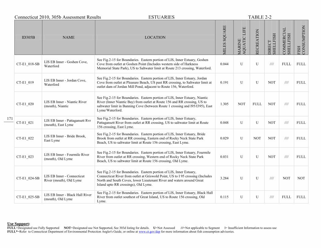
Connecticut 2010, 305b Assessment Results ESTUARIES TABLE 2-2
Use Support: FULL=Designated use Fully Supported NOT=Designated use Not Supported, See 303d listing for details. U=Not Assessed ///=Not applicable to Segment I= Insufficient Information to assess use FULL*=Refer to Connecticut Department of Environmental Protection Angler's Guide, or online at www.ct.gov/dep for more information about fish consumption advisories.
171
ID305B NAME LOCATION
MIL
ES S
QU
AR
E
MA
RIN
E A
QU
ATI
C L
IFE
REC
REA
TIO
N
DIR
ECT
SHEL
LFIS
H
CO
MM
ERC
IAL
SHEL
LFIS
H
FISH
C
ON
SUM
PTIO
N
CT-E1_018-SB LIS EB Inner - Goshen Cove, Waterford
See Fig.2-15 for Boundaries. Eastern portion of LIS, Inner Estuary, Goshen Cove from outlet at Goshen Point (Includes western side of Harkness Memorial State Park), US to Saltwater limit at Route 213 crossing, Waterford.
0.044 U U //// FULL FULL
CT-E1_019 LIS EB Inner - Jordan Cove, Waterford
See Fig.2-15 for Boundaries. Eastern portion of LIS, Inner Estuary, Jordan Cove from outlet at Pleasure Beach, US past RR crossing, to Saltwater limit at outlet dam of Jordan Mill Pond, adjacent to Route 156, Waterford.
0.191 U U NOT //// FULL
CT-E1_020 LIS EB Inner - Niantic River (mouth), Niantic
See Fig.2-15 for Boundaries. Eastern portion of LIS, Inner Estuary, Niantic River (Inner Niantic Bay) from outlet at Route 156 and RR crossing, US to saltwater limit in Banning Cove (between Route 1 crossing and I95/I395), East Lyme/Waterford.
1.305 NOT FULL NOT //// FULL
CT-E1_021 LIS EB Inner - Pattagansett Rvr (mouth), East Lyme
See Fig.2-15 for Boundaries. Eastern portion of LIS, Inner Estuary, Pattagansett River from outlet at RR crossing, US to saltwater limit at Route 156 crossing, East Lyme.
0.048 U U NOT //// FULL
CT-E1_022 LIS EB Inner - Bride Brook, East Lyme
See Fig.2-15 for Boundaries. Eastern portion of LIS, Inner Estuary, Bride Brook from outlet at RR crossing, Eastern end of Rocky Neck State Park Beach, US to saltwater limit at Route 156 crossing, East Lyme.
0.029 U NOT NOT //// FULL
CT-E1_023 LIS EB Inner - Fourmile River (mouth), Old Lyme
See Fig.2-15 for Boundaries. Eastern portion of LIS, Inner Estuary, Fourmile River from outlet at RR crossing, Western end of Rocky Neck State Park Beach, US to saltwater limit at Route 156 crossing, Old Lyme.
0.031 U U NOT //// FULL
CT-E1_024-SB LIS EB Inner - Connecticut River (mouth), Old Lyme
See Fig.2-15 for Boundaries. Eastern portion of LIS, Inner Estuary, Connecticut River from outlet at Griswold Point, US to I 95 crossing (Includes North and South Coves, lower Lieutenant River and waters around Great Island upto RR crossings), Old Lyme.
3.284 U U //// NOT NOT
CT-E1_025-SB LIS EB Inner - Black Hall River (mouth), Old Lyme
See Fig.2-15 for Boundaries. Eastern portion of LIS, Inner Estuary, Black Hall River from outlet southest of Great Island, US to Route 156 crossing, Old Lyme.
0.115 U U //// FULL FULL

Connecticut 2010, 305b Assessment Results ESTUARIES TABLE 2-2
Use Support: FULL=Designated use Fully Supported NOT=Designated use Not Supported, See 303d listing for details. U=Not Assessed ///=Not applicable to Segment I= Insufficient Information to assess use FULL*=Refer to Connecticut Department of Environmental Protection Angler's Guide, or online at www.ct.gov/dep for more information about fish consumption advisories.
172
ID305B NAME LOCATION
MIL
ES S
QU
AR
E
MA
RIN
E A
QU
ATI
C L
IFE
REC
REA
TIO
N
DIR
ECT
SHEL
LFIS
H
CO
MM
ERC
IAL
SHEL
LFIS
H
FISH
C
ON
SUM
PTIO
N
CT-E1_026-SB LIS EB Inner - Black Hall River (upper), Old Lyme
See Fig.2-15 for Boundaries. Eastern portion of LIS, Inner Estuary, Black Hall River from Route 156 crossing, US to saltwater limit at Mile Creek Road crossing, Old Lyme.
0.041 U U //// NOT FULL
CT-E1_027-SB LIS EB Inner - Duck River, Old Lyme
See Fig.2-15 for Boundaries. Eastern portion of LIS, Inner Estuary, Duck River from RR crossing near Route 156 crossing, US to saltwater limit at Elm Street, Old Lyme.
0.007 U NOT //// NOT FULL
CT-E1_028-SB LIS EB Inner - Leiutenant River, Old Lyme
See Fig.2-15 for Boundaries. Eastern portion of LIS, Inner Estuary, Leiutenant River from Route 156 crossing, US to saltwater limit adjacent to Longacre Lane, Old Lyme.
0.105 U NOT //// U FULL
CT-E1_029-SB LIS EB Inner - Connecticut River (Lower), Essex
See Fig.2-15 for Boundaries. Eastern portion of LIS, Inner Estuary, Connecticut River from I95 crossing, US to area just above Brockway Island, Essex.
3.182 U U //// U NOT
CT-E1_030 LIS EB Inner - Hamburg Cove/Eightmile River (mouth), Lyme
See Fig.2-15 for Boundaries. Eastern portion of LIS, Inner Estuary, Hamburg Cove (Eightmile River from mouth on Connecticut River near Brockway Island, US to saltwater limit adjacent to Cove Road (just South of intersection with Route 156), Essex.
0.181 U U //// //// FULL
CT-E1_031-SB LIS EB Inner - Connecticut River (upper), Chester
See Fig.2-15 for Boundaries. Eastern portion of LIS, Inner Estuary, Connecticut River from area just above Brockway Island, US to saltwater limit just above Chapman Pond inlet (adjacent to Gillette Castle State Park), East Haddam.
2.13 U U //// //// NOT
CT-E1_032 LIS EB Inner - Oyster River Area, Old Saybrook
See Fig.2-15 for Boundaries. Eastern portion of LIS, Inner Estuary, Oyster River, Plum Bank Creek, and Back River from mouths on Indian Harbor, US to saltwater limits (Oyster River is to RR crossing above Route 1), Old Saybrook.
0.098 U U NOT //// FULL
CT-E2_001 LIS EB Shore - Wequetequock Cove, Stonington
See Fig.2-15 for Boundaries. Eastern portion of LIS from RR crossing on east side of Wequetequock cove to mouth of Pawcatuck River, out approximately 1000 ft offshore (Little Narragansett Bay).
0.619 FULL FULL NOT //// FULL

Connecticut 2010, 305b Assessment Results ESTUARIES TABLE 2-2
Use Support: FULL=Designated use Fully Supported NOT=Designated use Not Supported, See 303d listing for details. U=Not Assessed ///=Not applicable to Segment I= Insufficient Information to assess use FULL*=Refer to Connecticut Department of Environmental Protection Angler's Guide, or online at www.ct.gov/dep for more information about fish consumption advisories.
173
ID305B NAME LOCATION
MIL
ES S
QU
AR
E
MA
RIN
E A
QU
ATI
C L
IFE
REC
REA
TIO
N
DIR
ECT
SHEL
LFIS
H
CO
MM
ERC
IAL
SHEL
LFIS
H
FISH
C
ON
SUM
PTIO
N
CT-E2_002 LIS EB Shore - Stonington Point, Stonington
See Fig.2-15 for Boundaries. Eastern portion of LIS from Stonington Point to RR crossing on west side of Wequetequock Cove, out approximately 1000 ft offshore.
0.668 U U NOT //// FULL
CT-E2_003 LIS EB Shore - Outer Quiambaug Cove, Stonington
See Fig.2-15 for Boundaries. Eastern portion of LIS from Mouth of inner Quiambaug Cove at RR crossing to SB/SA water quality boundary at mouth of Stonington Harbor, out approximately 1000 ft offshore.
0.388 U U NOT //// FULL
CT-E2_004 LIS EB Shore - Wilcox Cove (Mason Is.), Stonington
See Fig.2-15 for Boundaries. Eastern portion of LIS from tip of Mason Island to Mouth of inner Quiambaug Cove, out approximately 1000 ft offshore. 0.694 U U NOT //// FULL
CT-E2_005 LIS EB Shore - Mouth Mystic River, Stonington
See Fig.2-15 for Boundaries. Eastern portion of LIS from western most tip of Mason Island along SB/SA water quality boundary to eastern most tip of Mason Island, out approximately 1000 ft offshore.
0.35 U U NOT //// FULL
CT-E2_006 LIS EB Shore - West Cove (Groton Long Pt), Groton
See Fig.2-15 for Boundaries. Eastern portion of LIS from tip of Groton Long Point to Morgan Point at SB/SA water quality boundary for Mystic River mouth, out approximately 1000 ft offshore.
0.422 U FULL NOT //// FULL
CT-E2_007 LIS EB Shore - Outer Mumford Cove, Groton
See Fig.2-15 for Boundaries. Eastern portion of LIS from Mumford Point to eastern most tip of Groton Long Point (includes outer Mumford cove and all of Venetian Harbor), out approximately 1000 ft offshore.
0.555 U U NOT //// FULL
CT-E2_008 LIS EB Shore - Bluff Point, Groton
See Fig.2-15 for Boundaries. Eastern portion of LIS from SB/SA water quality boundary at Bushy Point Beach to Mumford Point, out approximately 1000 ft offshore.
0.235 U U NOT //// FULL
CT-E2_009-SB LIS EB Shore - Thames River Mouth (East), Groton
See Fig.2-15 for Boundaries. Eastern portion of LIS from Eastern Point in mouth of Thames River to SB/SA water quality boundary at Bushy Point Beach, out approximately 1000 ft offshore.
0.4 NOT FULL //// FULL FULL
CT-E2_010-SB LIS EB Shore - Thames Rvr Mouth (West), New London
See Fig.2-15 for Boundaries. Eastern portion of LIS from mouth of Alewife Cove to Quinnipeag Rocks along western shore of Thames River mouth, out approximately 1000 ft offshore (SB Water Quality).
0.299 NOT FULL //// FULL FULL

Connecticut 2010, 305b Assessment Results ESTUARIES TABLE 2-2
Use Support: FULL=Designated use Fully Supported NOT=Designated use Not Supported, See 303d listing for details. U=Not Assessed ///=Not applicable to Segment I= Insufficient Information to assess use FULL*=Refer to Connecticut Department of Environmental Protection Angler's Guide, or online at www.ct.gov/dep for more information about fish consumption advisories.
174
ID305B NAME LOCATION
MIL
ES S
QU
AR
E
MA
RIN
E A
QU
ATI
C L
IFE
REC
REA
TIO
N
DIR
ECT
SHEL
LFIS
H
CO
MM
ERC
IAL
SHEL
LFIS
H
FISH
C
ON
SUM
PTIO
N
CT-E2_011-SB LIS EB Shore - Thames Rvr Mouth (West), Waterford
See Fig.2-15 for Boundaries. Eastern portion of LIS from Magonk Point to mouth of Alewife Cove, out approximately 1000 ft offshore (SB Water Quality).
0.486 NOT FULL //// FULL FULL
CT-E2_012 LIS EB Shore - Outer Jordan Cove, Waterford
See Fig.2-15 for Boundaries. Eastern portion of LIS from Millstone Point to SB/SA water quality boundary at Magonk Point, out approximately 1000 ft offshore. Waters adjacent to Millstone Power Plant.
0.465 U FULL NOT //// FULL
CT-E2_013 LIS EB Shore - Niantic Bay (East), Waterford
See Fig.2-15 for Boundaries. Eastern portion of LIS from Smith Avenue at junction with Route 156 to Millstone Point, out approximately 1000 ft offshore. Waters adjacent to Millstone Power Plant.
0.444 NOT U NOT //// FULL
CT-E2_014 LIS EB Shore - Niantic Bay (West), East Lyme
See Fig.2-15 for Boundaries. Eastern portion of LIS from Pond Point to Smith Avenue at junction with Route 156, out approximately 1000 ft offshore. Waters adjacent to Millstone Power Plant.
0.302 NOT FULL NOT //// FULL
CT-E2_015 LIS EB Shore - Niantic Bay (Black Pt), East Lyme
See Fig.2-15 for Boundaries. Eastern portion of LIS from Point East of Griswald Island, past Black Point to Pond Point in Niantic Bay, out approximately 1000 ft offshore.
0.554 NOT U NOT //// FULL
CT-E2_016 LIS EB Shore - Pattagansett River Mouth, East Lyme
See Fig.2-15 for Boundaries. Eastern portion of LIS from Seal Rock (Great Neck) to Point East of Griswald Island (entire mouth of Pattagansett River, including area around Watts Island), out approximately 1000 ft offshore.
0.322 U U NOT //// FULL
CT-E2_017 LIS EB Shore - Rocky Neck (Fourmile Rvr), Old Lyme
See Fig.2-15 for Boundaries. Eastern portion of LIS from Hatchett Point to Seal Rock (Great Neck) Includes Rocky Neck State Park Beach, out approximately 1000 ft offshore.
0.531 U FULL NOT //// FULL
CT-E2_018 LIS EB Shore - Soundview Beach, Old Lyme
See Fig.2-15 for Boundaries. Eastern portion of LIS from SB/SA water quality boundary at Hawks Nest Beach area to Hatchett Point (Includes Soundview Beach), out approximately 1000 ft offshore.
0.332 U FULL NOT //// FULL
CT-E2_019-SB LIS EB Shore - CT River Mouth (East), Old Lyme
See Fig.2-15 for Boundaries. Eastern portion of LIS from Griswold Point to SB/SA water quality boundary at Hawks Nest Beach area (Includes White Sands Beach), out approximately 1000 ft offshore. (SB water)
0.423 U FULL //// FULL FULL

Connecticut 2010, 305b Assessment Results ESTUARIES TABLE 2-2
Use Support: FULL=Designated use Fully Supported NOT=Designated use Not Supported, See 303d listing for details. U=Not Assessed ///=Not applicable to Segment I= Insufficient Information to assess use FULL*=Refer to Connecticut Department of Environmental Protection Angler's Guide, or online at www.ct.gov/dep for more information about fish consumption advisories.
175
ID305B NAME LOCATION
MIL
ES S
QU
AR
E
MA
RIN
E A
QU
ATI
C L
IFE
REC
REA
TIO
N
DIR
ECT
SHEL
LFIS
H
CO
MM
ERC
IAL
SHEL
LFIS
H
FISH
C
ON
SUM
PTIO
N
CT-E2_020 LIS EB Shore - Willard Bay, Old Saybrook
See Fig.2-15 for Boundaries. Eastern portion of LIS from Cornfield Point to SB/SA water quality boundary at Lynde Point, out approximately 1000 ft offshore. (SB water)
0.5 U U NOT //// FULL
CT-E2_021 LIS EB Shore - Plum Bank, Old Saybrook
See Fig.2-15 for Boundaries. Eastern portion of LIS from Plum Bank Creek to Cornfield Point (includes Town Beach), out approximately 1000 ft offshore. 0.182 U FULL NOT //// FULL
CT-E2_022 LIS EB Shore - Indiantown Harbor, Old Saybrook
See Fig.2-15 for Boundaries. Eastern portion of LIS from Long Rock to Plum Bank Creek (includes the mouth of Oytser River and Back River, and Plum Bank Creek), out approximately 1000 ft offshore.
0.389 U FULL NOT //// FULL
CT-E3_001 LIS EB Midshore - Stonington See Fig.2-15 for Boundaries. Eastern portion of LIS from approximately 1000 ft offshore (Little Narragansett Bay), out to CT/NY State line. 0.585 U U NOT //// FULL
CT-E3_002 LIS EB Midshore - Stonington Harbor
See Fig.2-15 for Boundaries. Eastern portion of LIS from approximately 1000 ft offshore, Enders Island to Stonington Point, out to CT/NY State line. 4.414 U U FULL //// FULL
CT-E3_003 LIS EB Midshore - Groton, Mystic River
See Fig.2-15 for Boundaries. Eastern portion of LIS from approximately 1000 ft offshore, Groton Long Point to Enders Island, out to CT/NY State line. 2.853 U U NOT //// FULL
CT-E3_004 LIS EB Midshore - Groton, Thames River
See Fig.2-15 for Boundaries. Eastern portion of LIS from SB/SA water quality boundary out to 50 ft contour offshore of Goshen Point, Waterford, to approximately 1000 ft offshore, Groton Long Point, out to CT/NY State line.
6.738 U U NOT //// FULL
CT-E3_005-SB LIS EB Midshore - Waterford, Thames River
See Fig.2-15 for Boundaries. Eastern portion of LIS from SB/SA water quality boundary, approximately 1000 ft offshore of Magonk Point, Waterford to BushyPoint, Groton, out to SB/SA water quality boundary (Thames River mouth).
5.256 NOT U //// FULL FULL
CT-E3_006 LIS EB Midshore - Niantic Bay See Fig.2-15 for Boundaries. Eastern portion of LIS from approximately 1000 ft offshore Black Point, East Lyme to Magonk Point (SB/SA water quality boundary) Waterford, out to 50 ft contour (Niantic Bay).
6.179 NOT U NOT //// FULL
CT-E3_007 LIS EB Midshore - East Lyme, Rocky Neck
See Fig.2-15 for Boundaries. Eastern portion of LIS from approximately 1000 ft offshore Hatchett Point to Black Point, East Lyme, out to 50 ft contour (offshore of mouths of Fourmile and Pattagasett Rivers).
2.93 U U NOT //// FULL
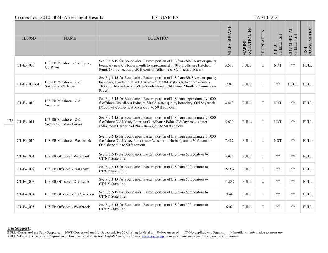
Connecticut 2010, 305b Assessment Results ESTUARIES TABLE 2-2
Use Support: FULL=Designated use Fully Supported NOT=Designated use Not Supported, See 303d listing for details. U=Not Assessed ///=Not applicable to Segment I= Insufficient Information to assess use FULL*=Refer to Connecticut Department of Environmental Protection Angler's Guide, or online at www.ct.gov/dep for more information about fish consumption advisories.
176
ID305B NAME LOCATION
MIL
ES S
QU
AR
E
MA
RIN
E A
QU
ATI
C L
IFE
REC
REA
TIO
N
DIR
ECT
SHEL
LFIS
H
CO
MM
ERC
IAL
SHEL
LFIS
H
FISH
C
ON
SUM
PTIO
N
CT-E3_008 LIS EB Midshore - Old Lyme, CT River
See Fig.2-15 for Boundaries. Eastern portion of LIS from SB/SA water quality boundary near CT River mouth to approximately 1000 ft offshore Hatchett Point, Old Lyme, out to 50 ft contour (offshore of Connecticut River).
3.517 FULL U NOT //// FULL
CT-E3_009-SB LIS EB Midshore - Old Saybrook, CT River
See Fig.2-15 for Boundaries. Eastern portion of LIS from SB/SA water quality boundary, Lynde Point in CT river mouth Old Saybrook, to approximately 1000 ft offshore East of White Sands Beach, Old Lyme (Mouth of Connecticut River).
2.89 FULL U //// FULL FULL
CT-E3_010 LIS EB Midshore - Old Saybrook
See Fig.2-15 for Boundaries. Eastern portion of LIS from approximately 1000 ft offshore Guardhous Point, to SB/SA water quality boundary, Old Saybrook (Mouth of Connecticut River), out to 50 ft contour.
4.409 FULL U NOT //// FULL
CT-E3_011 LIS EB Midshore - Old Saybrook, Indian Harbor
See Fig.2-15 for Boundaries. Eastern portion of LIS from approximately 1000 ft offshore Old Kelsey Point, to Guardhouse Point, Old Saybrook, (outer Indiantown Harbor and Plum Bank), out to 50 ft contour.
5.639 FULL U NOT //// FULL
CT-E3_012 LIS EB Midshore - Westbrook See Fig.2-15 for Boundaries. Eastern portion of LIS from approximately 1000 ft offshore Old Kelsey Point (outer Westbrook Harbor), out to 50 ft contour. Odd shape due to 50 ft contour.
7.407 FULL U NOT //// FULL
CT-E4_001 LIS EB Offshore - Waterford See Fig.2-15 for Boundaries. Eastern portion of LIS from 50ft contour to CT/NY State line. 5.935 FULL U //// //// FULL
CT-E4_002 LIS EB Offshore - East Lyme See Fig.2-15 for Boundaries. Eastern portion of LIS from 50ft contour to CT/NY State line. 15.984 FULL U //// //// FULL
CT-E4_003 LIS EB Offhsore - Old Lyme See Fig.2-15 for Boundaries. Eastern portion of LIS from 50ft contour to CT/NY State line. 11.837 FULL U //// //// FULL
CT-E4_004 LIS EB Offshore - Old Saybrook See Fig.2-15 for Boundaries. Eastern portion of LIS from 50ft contour to CT/NY State line. 9.44 FULL U //// //// FULL
CT-E4_005 LIS EB Offshore - Westbrook See Fig.2-15 for Boundaries. Eastern portion of LIS from 50ft contour to CT/NY State line. 6.07 FULL U //// //// FULL

Connecticut 2010, 305b Assessment Results ESTUARIES TABLE 2-2
Use Support: FULL=Designated use Fully Supported NOT=Designated use Not Supported, See 303d listing for details. U=Not Assessed ///=Not applicable to Segment I= Insufficient Information to assess use FULL*=Refer to Connecticut Department of Environmental Protection Angler's Guide, or online at www.ct.gov/dep for more information about fish consumption advisories.
177
ID305B NAME LOCATION
MIL
ES S
QU
AR
E
MA
RIN
E A
QU
ATI
C L
IFE
REC
REA
TIO
N
DIR
ECT
SHEL
LFIS
H
CO
MM
ERC
IAL
SHEL
LFIS
H
FISH
C
ON
SUM
PTIO
N
CT-W1_001-SB
LIS WB Inner - Bridgeport Harbor, Bridgeport
See Fig.2-15 for Boundaries. Western portion of LIS from SA/SB water quality line at mouth at Pleasure Beach area, US to saltwater limit in Pequonnock River and Lewis Gut (includes Yellow Mill Channel, Johnsons Creek, all SB water of Harbor area), Bridgeport.
1.434 NOT NOT //// NOT FULL
CT-W1_002-SB
LIS WB Inner - Black Rock Harbor, Bridgeport
See Fig.2-15 for Boundaries. Western portion of LIS, Inner Estuary, from SA/SB water quality line at mouth at Fayerweather Island area, US to saltwater limit at I95 (includes Burr Creek, Cedar Creek, all SB water of Harbor area), Bridgeport.
0.442 NOT NOT //// NOT FULL
CT-W1_003-SB
LIS WB Inner - Ash Creek, Fairfield
See Fig.2-15 for Boundaries. Western portion of LIS, Inner Estuary, from SA/SB water quality line at mouth near South Benson Road, US to saltwater limit at I95, Fairfield/Bridgeport.
0.157 NOT NOT //// NOT FULL
CT-W1_004 LIS WB Inner - Pine Creek, Fairfield
See Fig.2-15 for Boundaries. Western portion of LIS, Inner Estuary, from mouth at Pine Creek Point, US to saltwater limit at Oldfield Road crossing, Fairfield.
0.06 U U NOT //// FULL
CT-W1_005 LIS WB Inner - Southport Harbor, Fairfield
See Fig.2-15 for Boundaries. Western portion of LIS, Inner Estuary, from mouth parallel to Willow Street, US to Harbor Road crossing, Fairfield. 0.072 U U NOT //// FULL
CT-W1_006 LIS WB Inner - Mill River, Fairfield
See Fig.2-15 for Boundaries. Western portion of LIS, Inner Estuary, from Harbor Road crossing, US to saltwater limit at Sturges Road crossing (includes Mill Pond section of Mill River), Fairfield.
0.033 NOT NOT NOT //// NOT
CT-W1_007 LIS WB Inner - Sasco Brook, Westport
See Fig.2-15 for Boundaries. Western portion of LIS, Inner Estuary, from mouth DS of Pequot Avenue crossing, US to saltwater limit at Route 1 crossing, Westport/Fairfield.
0.022 U NOT NOT //// FULL
CT-W1_008 LIS WB Inner - Sherwood Millpond, Westport
See Fig.2-15 for Boundaries. Western portion of LIS, Inner Estuary, from mouth at Compo Cove, US to saltwater limit south of RR and I95 (includes Mill Creek, Grove Point, and all of Greens Farm Brook surrounding Sherwood Island State Park), Westport.
0.168 U U NOT //// FULL

Connecticut 2010, 305b Assessment Results ESTUARIES TABLE 2-2
Use Support: FULL=Designated use Fully Supported NOT=Designated use Not Supported, See 303d listing for details. U=Not Assessed ///=Not applicable to Segment I= Insufficient Information to assess use FULL*=Refer to Connecticut Department of Environmental Protection Angler's Guide, or online at www.ct.gov/dep for more information about fish consumption advisories.
178
ID305B NAME LOCATION
MIL
ES S
QU
AR
E
MA
RIN
E A
QU
ATI
C L
IFE
REC
REA
TIO
N
DIR
ECT
SHEL
LFIS
H
CO
MM
ERC
IAL
SHEL
LFIS
H
FISH
C
ON
SUM
PTIO
N
CT-W1_009 LIS WB Inner - Grays Creek, Westport
See Fig.2-15 for Boundaries. Western portion of LIS, Inner Estuary, from SA/SB water quality line at mouth on Saugatuck River Estuary, US to saltwater limit at Compo Road, Westport.
0.036 U U NOT //// FULL
CT-W1_010-SB
LIS WB Inner - Saugatuck River (mouth), Westport
See Fig.2-15 for Boundaries. Western portion of LIS, Inner Estuary, from SA/SB water quality line at mouth of Saugatuck River Estuary (at Bluff Point across to Owenoke), US to RR crossing, DS of I95 crossing (includes Kitts Island, Burritt Cove), Westport.
0.645 U U //// NOT FULL
CT-W1_011 LIS WB Inner - Saugatuck River, Westport
See Fig.2-15 for Boundaries. Western portion of LIS, Inner Estuary, from SA/SB water quality line at RR crossing (DS of I95 crossing), US to saltwater limit at Hydraulic Pond outlet Dam, Westport.
0.189 U U U //// FULL
CT-W1_012-SB
LIS WB Inner - Norwalk Harbor, Norwalk
See Fig.2-15 for Boundaries. Western portion of LIS, Inner Estuary, from SA/SB water quality line at mouth of Norwalk Harbor (Calf Pasture Point), US to saltwater limit at Wall Street Crossing (EXCLUDES eastern cove of Marvin Beach), Norwalk.
0.942 NOT NOT //// NOT FULL
CT-W1_013-SB
LIS WB Inner - Norwalk Hrbr (MarvinBeach), Norwalk
See Fig.2-15 for Boundaries. Western portion of LIS, Inner Estuary, eastern embayment of Norwalk Harbor, from Gregory Point to Fitch Point into shore (includes Marvin Beach), Norwalk.
0.044 NOT NOT //// FULL FULL
CT-W1_014-SB
LIS WB Inner - Fivemile River (mouth), Norwalk
See Fig.2-15 for Boundaries. Western portion of LIS, Inner Estuary, from SA/SB water quality line at mouth of Harbor (Butlers Island to Roton Point), US to saltwater limit at Cudlipp Street Crossing (Route 136), Norwalk.
0.164 U U //// NOT FULL
CT-W1_015-SB
LIS WB Inner - Cove Harbor, Stamford
See Fig.2-15 for Boundaries. Western portion of LIS, Inner Estuary, from SA/SB water quality line at mouth (Greenway Island to Pratt Island Two), to Holly Pond outlet at Brush Island (includes Quigley, East (Cove Island), and Weed Beaches), Stamford/Darien.
0.466 U FULL //// NOT FULL
CT-W1_016-SB
LIS WB Inner - Holly Pond, Stamford
See Fig.2-15 for Boundaries. Western portion of LIS, Inner Estuary, from Holly Pond outlet at Brush Island (flows into Cove Harbor), US to saltwater limit at Route 1 crossing (just DS of I95 crossing), Stamford/Darien.
0.31 U U //// NOT FULL

Connecticut 2010, 305b Assessment Results ESTUARIES TABLE 2-2
Use Support: FULL=Designated use Fully Supported NOT=Designated use Not Supported, See 303d listing for details. U=Not Assessed ///=Not applicable to Segment I= Insufficient Information to assess use FULL*=Refer to Connecticut Department of Environmental Protection Angler's Guide, or online at www.ct.gov/dep for more information about fish consumption advisories.
179
ID305B NAME LOCATION
MIL
ES S
QU
AR
E
MA
RIN
E A
QU
ATI
C L
IFE
REC
REA
TIO
N
DIR
ECT
SHEL
LFIS
H
CO
MM
ERC
IAL
SHEL
LFIS
H
FISH
C
ON
SUM
PTIO
N
CT-W1_017-SB
LIS WB Inner - Stamford Harbor (mouth), Stamford
See Fig.2-15 for Boundaries. Western portion of LIS, Inner Estuary, from SA/SB water quality line at mouth of Harbor (Davenport Point to Shippan Point), up to Cook Road and across to Yacht Club, Stamford.
0.436 U U //// FULL FULL
CT-W1_018-SB
LIS WB Inner - Stamford Harbor (Inner), Stamford
See Fig.2-15 for Boundaries. Western portion of LIS, Inner Estuary, from Cook Road and across to Yacht Club, US to saltwater limit in both the West (Route 137 crossing above I95 crossing) and East (Jefferson Street) Branches of Harbor, Stamford.
0.318 NOT U //// U FULL
CT-W1_019 LIS WB Inner - Cos Cob Harbor (upper), Greenwich
See Fig.2-15 for Boundaries. Western portion of LIS, Inner Estuary, from RR crossing, US to saltwater limit at Mianus River Dam, Route 1 crossing (includes I95 bridge crossing), Greenwich.
0.132 U U U //// FULL
CT-W1_020 LIS WB Inner - Indian Harbor (upper), Greenwich
See Fig.2-15 for Boundaries. Western portion of LIS, Inner Estuary, upper Indian Harbor (lower portion of Greenwich Creek) from Davis Avenue crossing, US to saltwater limit at West Brother Drive crossing (includes I95 crossing), Greenwich.
0.025 NOT U U //// FULL
CT-W1_021-SB
LIS WB Inner - Greenwich Harbor, Greenwich
See Fig.2-15 for Boundaries. Western portion of LIS, Inner Estuary, from SA/SB water quality line at mouth of Greenwich Harbor (Round Island to Smith Cove), US to saltwater limit just below I95 (mouth of Horseneck Brook), Greenwich.
0.104 NOT U //// NOT FULL
CT-W1_022-SB
LIS WB Inner - Byram River (CT), Greenwich
See Fig.2-15 for Boundaries. Western portion of LIS, Inner Estuary, from SA/SB water quality line at mouth of Byram River, US to saltwater limit just above Route 1 crossing, out to CT/NY border (includes CT half of River), I95 crosses river in seg, Greenwich.
0.037 U NOT //// NOT FULL
CT-W2_001 LIS WB Shore - Lordship, Stratford
See Fig.2-15 for Boundaries. Western portion of LIS from Point No Point area to SA/SB WQ line at Stratford Point (includes Long Beach (Marnick's), SB water is at mouth of Housatonic River) out approximately 1000 ft offshore, Stratford.
0.409 U FULL NOT //// FULL
CT-W2_002 LIS WB Shore - Long Beach, Stratford
See Fig.2-15 for Boundaries. Western portion of LIS from SA/SB WQ line at Pleasure Beach to Point No Point area (includes Long Beach (Proper), SB water is Bridgeport Harbor) out approximately 1000 ft offshore, Stratford.
0.458 U FULL NOT //// FULL

Connecticut 2010, 305b Assessment Results ESTUARIES TABLE 2-2
Use Support: FULL=Designated use Fully Supported NOT=Designated use Not Supported, See 303d listing for details. U=Not Assessed ///=Not applicable to Segment I= Insufficient Information to assess use FULL*=Refer to Connecticut Department of Environmental Protection Angler's Guide, or online at www.ct.gov/dep for more information about fish consumption advisories.
180
ID305B NAME LOCATION
MIL
ES S
QU
AR
E
MA
RIN
E A
QU
ATI
C L
IFE
REC
REA
TIO
N
DIR
ECT
SHEL
LFIS
H
CO
MM
ERC
IAL
SHEL
LFIS
H
FISH
C
ON
SUM
PTIO
N
CT-W2_003 LIS WB Shore - Seaside Park Beach, Bridgeport
See Fig.2-15 for Boundaries. Western portion of LIS from tip of Fayerweather Island to SA/SB WQ line at Bridgeport Harbor area (includes Seaside Park Beach, SB water is Bridgeport Harbor) out approximately 1000 ft offshore, Bridgeport.
0.492 U FULL NOT //// FULL
CT-W2_004 LIS WB Shore - Outer Bridgeport Harbor, Fairfield
See Fig.2-15 for Boundaries. Western portion of LIS from Shoal Point to tip of Fayerweather Island (includes Penfield Beach, Jennings Beach, Ash Creek outlet) out approximately 1000 ft offshore, Fairfield.
0.407 U FULL NOT //// FULL
CT-W2_005 LIS WB Shore - Pine Creek Point, Fairfield
See Fig.2-15 for Boundaries. Western portion of LIS from Pine Creek Point area to Shoal Point (includes South Pine Creek Beach, Pine Creek outlet) out approximately 1000 ft offshore, Fairfield.
0.37 U FULL NOT //// FULL
CT-W2_006 LIS WB Shore - Southport Harbor (East), Fairfield
See Fig.2-15 for Boundaries. Western portion of LIS from inner Southport Harbor outlet to Pine Creek Point area (includes Sasco Beach, Kense Point) out approximately 1000 ft offshore, Fairfield.
0.183 U FULL NOT //// FULL
CT-W2_007 LIS WB Shore - Southport Harbor (West), Fairfield
See Fig.2-15 for Boundaries. Western portion of LIS from Beachside Lane area to inner Southport Harbor outlet area (includes Southport Beach, Sasco Brook outlet) out approximately 1000 ft offshore, Fairfield.
0.188 U FULL NOT //// FULL
CT-W2_008 LIS WB Shore - Green Farms, Westport
See Fig.2-15 for Boundaries. Western portion of LIS from Burying Hill Road to Beachside Lane area (includes Burying Hill Beach, Frost Point) out approximately 1000 ft offshore, Westport.
0.237 U FULL NOT //// FULL
CT-W2_009 LIS WB Shore - Compo Cove, SISP, Westport
See Fig.2-15 for Boundaries. Western portion of LIS from Compo Cove to Burying Hill Road area (includes Sherwood Island State Park Beach, Sherwood Point, Sherwood Millpond outlet, Greens Farms Brook outlet) out approximately 1000 ft offshore, Westport.
0.324 U FULL NOT //// FULL
CT-W2_010 LIS WB Shore - Compo Beach, Cedar Point, Westport
See Fig.2-15 for Boundaries. Western portion of LIS from Saugatuck Shores area to Compo Cove (includes Compo Beach, Cedar Point, Saugatuck River outlet, Owenoke) out approximately 1000 ft offshore, Westport.
0.419 U FULL NOT //// FULL

Connecticut 2010, 305b Assessment Results ESTUARIES TABLE 2-2
Use Support: FULL=Designated use Fully Supported NOT=Designated use Not Supported, See 303d listing for details. U=Not Assessed ///=Not applicable to Segment I= Insufficient Information to assess use FULL*=Refer to Connecticut Department of Environmental Protection Angler's Guide, or online at www.ct.gov/dep for more information about fish consumption advisories.
181
ID305B NAME LOCATION
MIL
ES S
QU
AR
E
MA
RIN
E A
QU
ATI
C L
IFE
REC
REA
TIO
N
DIR
ECT
SHEL
LFIS
H
CO
MM
ERC
IAL
SHEL
LFIS
H
FISH
C
ON
SUM
PTIO
N
CT-W2_011 LIS WB Shore - Canfield Island, Westport
See Fig.2-15 for Boundaries. Western portion of LIS from just west of Canfield Island to Saugatuck Shores area (includes Canfiled Island, Saugatuck Shores, Seymour Point) out approximately 1000 ft offshore, Westport.
0.43 U U NOT //// FULL
CT-W2_012 LIS WB Shore - Outer Norwalk Harbor(East), Norwalk
See Fig.2-15 for Boundaries. Western portion of LIS from midpoint of outer Norwalk Harbor to just west of Canfield Island area (includes Calf Pasture Beach, Shady Beach, Calf Pasture Point) out approximately 1000 ft offshore, Norwalk.
0.258 NOT FULL NOT //// FULL
CT-W2_013 LIS WB Shore - Outer Norwalk Harbor(West), Norwalk
See Fig.2-15 for Boundaries. Western portion of LIS from just west of Hoyt Island to midpoint of outer Norwalk Harbor (includes Hickory Bluff Beach, Hoyt Island, Keyser Point) out approximately 1000 ft offshore, Norwalk.
0.365 NOT FULL NOT //// FULL
CT-W2_014 LIS WB Shore - Wilson Cove, Farm Creek, Norwalk
See Fig.2-15 for Boundaries. Western portion of LIS from Norton Point to just west of Hoyt Island (includes Rowayton Beach, Bell Island, Wilson Point) out approximately 1000 ft offshore, Norwalk.
0.424 U FULL NOT //// FULL
CT-W2_015 LIS WB Shore - Fivemile River Estuary, Darien
See Fig.2-15 for Boundaries. Western portion of LIS from Fish Islands to Norton Point (includes Bell Island Beach, Fish Islands, Contentment Island, Butlers Island, Fivemile River mouth, Roton Point) out approximately 1000 ft offshore, Darien.
0.342 U FULL NOT //// FULL
CT-W2_016 LIS WB Shore - Scott Cove, Darien
See Fig.2-15 for Boundaries. Western portion of LIS from Long Neck Point to Fish Islands (includes Hay Island, Great Island) out approximately 1000 ft offshore, Darien.
0.718 U U NOT //// FULL
CT-W2_017 LIS WB Shore - Darien Cove, Darien
See Fig.2-15 for Boundaries. Western portion of LIS from Greenway Island area of outer Cove Harbor to Long Neck Point (includes Pear Tree Point Beach, Nash Island, Darien River mouth) out approximately 1000 ft offshore, Darien.
0.498 U FULL NOT //// FULL
CT-W2_018 LIS WB Shore - Westcott Cove, Stamford
See Fig.2-15 for Boundaries. Western portion of LIS from near intersection of Hobson Street and Sea Beach Drive to Greenway Island area of outer Cove Harbor (includes West Beach, Cummings Beach, Vincent Island) out approximately 1000 ft offshore, Stamford.
0.366 U FULL NOT //// FULL

Connecticut 2010, 305b Assessment Results ESTUARIES TABLE 2-2
Use Support: FULL=Designated use Fully Supported NOT=Designated use Not Supported, See 303d listing for details. U=Not Assessed ///=Not applicable to Segment I= Insufficient Information to assess use FULL*=Refer to Connecticut Department of Environmental Protection Angler's Guide, or online at www.ct.gov/dep for more information about fish consumption advisories.
182
ID305B NAME LOCATION
MIL
ES S
QU
AR
E
MA
RIN
E A
QU
ATI
C L
IFE
REC
REA
TIO
N
DIR
ECT
SHEL
LFIS
H
CO
MM
ERC
IAL
SHEL
LFIS
H
FISH
C
ON
SUM
PTIO
N
CT-W2_019 LIS WB Shore - Stamford Harbor, Stamford
See Fig.2-15 for Boundaries. Western portion of LIS from Peck Point to near intersection of Hobson Street and Sea Beach Drive (includes Flathead Rocks, Davenport Point, Shippan Point, outer Stamford Harbor) out approximately 1000 ft offshore, Stamford.
0.524 U U NOT //// FULL
CT-W2_020 LIS WB Shore - Stamford Harbor (West), Greenwich
See Fig.2-15 for Boundaries. Western portion of LIS from Greenwich Point to Peck Point (includes Greenwich Point Beach, western potion of Stamford Harbor) out approximately 1000 ft offshore, Greenwich.
0.54 U FULL NOT //// FULL
CT-W2_021 LIS WB Shore - Greenwich Cove, Greenwich
See Fig.2-15 for Boundaries. Western portion of LIS from Todd Point to Greenwich Point (includes Elias Point, Greenwich Island, Pelican Island, Flat Neck Point, Greenwich Cove) out approximately 1000 ft offshore, Greenwich.
1.244 U U NOT //// FULL
CT-W2_022 LIS WB Shore - Cos Cob Harbor, Greenwich
See Fig.2-15 for Boundaries. Western portion of LIS from Tweed Island to Todd Point (includes Horse Island, Goose Island, Cos Cob Cove) out approximately 1000 ft offshore, Greenwich.
0.704 U U NOT //// FULL
CT-W2_023 LIS WB Shore - Smith Cove, Indian Hrbr, Greenwich
See Fig.2-15 for Boundaries. Western portion of LIS from Field Point to Tweed Island (includes Round Island, Tweed Island, Smith Cove, Indian Harbor) out approximately 1000 ft offshore, Greenwich.
0.374 NOT U NOT //// FULL
CT-W2_024 LIS WB Shore - Byram Harbor, Greenwich
See Fig.2-15 for Boundaries. Western portion of LIS from just west of Shore Island to Field Point (includes Shore Island, Rich Island, Farwells Island, Game Cock Island, Byram Harbor) out approximately 1000 ft offshore, Greenwich.
0.34 U NOT NOT //// FULL
CT-W2_025 LIS WB Shore - Byram Harbor (West), Greenwich
See Fig.2-15 for Boundaries. Western portion of LIS from NY/CT border at Byram River to just west of Shore Island (includes mouth of Byram River, Byram Point) out approximately 1000 ft offshore, Greenwich.
0.244 U U NOT //// FULL
CT-W3_001 LIS WB Midshore - Lordship, Stratford
See Fig.2-15 for Boundaries. Western portion of LIS from approximately 1000 ft offshore (Point No Point, Lordship), out to 50 ft contour, Stratford. Odd shape due to 50 ft contour.
7.916 NOT U NOT //// FULL

Connecticut 2010, 305b Assessment Results ESTUARIES TABLE 2-2
Use Support: FULL=Designated use Fully Supported NOT=Designated use Not Supported, See 303d listing for details. U=Not Assessed ///=Not applicable to Segment I= Insufficient Information to assess use FULL*=Refer to Connecticut Department of Environmental Protection Angler's Guide, or online at www.ct.gov/dep for more information about fish consumption advisories.
183
ID305B NAME LOCATION
MIL
ES S
QU
AR
E
MA
RIN
E A
QU
ATI
C L
IFE
REC
REA
TIO
N
DIR
ECT
SHEL
LFIS
H
CO
MM
ERC
IAL
SHEL
LFIS
H
FISH
C
ON
SUM
PTIO
N
CT-W3_002 LIS WB Midshore - Bridgeport Hbr, East, Bridgeport
See Fig.2-15 for Boundaries. Western portion of LIS from approximately 1000 ft offshore (Inner Bridgeport Harbor, Lewis Gut, Pleasure Beach area), out to 50 ft contour, Bridgeport.
8.083 NOT U NOT //// FULL
CT-W3_003 LIS WB Midshore - Bridgeport Hbr, West, Bridgeport
See Fig.2-15 for Boundaries. Western portion of LIS from approximately 1000 ft offshore (Grover Hill, Fayerweather Island, Seaside Beach area), out to 50 ft contour, Bridgeport. Odd shape due to 50 ft contour.
6.059 NOT U NOT //// FULL
CT-W3_004 LIS WB Midshore - Shoal Point, Fairfield
See Fig.2-15 for Boundaries. Western portion of LIS from approximately 1000 ft offshore (Shoal Point and outer Black Rock Harbor area), out to 50 ft contour, Fairfield.
4.155 NOT U NOT //// FULL
CT-W3_005 LIS WB Midshore - Southport Harbor, Fairfield
See Fig.2-15 for Boundaries. Western portion of LIS from approximately 1000 ft offshore (Frost Point to Pine creek Point area), out to 50 ft contour, Fairfield. 5.275 NOT U NOT //// FULL
CT-W3_006 LIS WB Midshore - Sherwood Point, Westport
See Fig.2-15 for Boundaries. Western portion of LIS from approximately 1000 ft offshore (Saugatuck River mouth, Compo Cove, Sherwood Island Sate Park area), out to 50 ft contour, Westport.
9.69 NOT U NOT //// FULL
CT-W3_007 LIS WB Midshore - Offshore Norwalk Islands,Norwalk
See Fig.2-15 for Boundaries. Western portion of LIS from line just beyond cluster of Norwalk Islands (Sheffield Island to Cockenoe Island area), out to 50 ft contour, Norwalk.
5.663 NOT U NOT //// FULL
CT-W3_008-I LIS WB Midshore - Norwalk Islands, Norwalk
See Fig.2-15 for Boundaries. Western portion of LIS from approximately 1000 ft offshore (Norton Point to Seymour Point, includes all Norwalk Islands area), out to line just beyond Sheffield Island to Cockenoe Island, Norwalk.
5.94 NOT U NOT //// FULL
CT-W3_009 LIS WB Midshore - Outer Fivemile R Estuary, Darien
See Fig.2-15 for Boundaries. Western portion of LIS from approximately 1000 ft offshore (outer Scott Cove near Fish Islands to Norton Point area), out to 50 ft contour, Darien.
2.453 NOT U NOT //// FULL
CT-W3_010 LIS WB Midshore - Outer Cove Harbor, Darien
See Fig.2-15 for Boundaries. Western portion of LIS from approximately 1000 ft offshore (off of Long neck Point, outer Cove Harbor, Darien Cove, Scott Cove area), out to 50 ft contour, Darien.
2.113 NOT U NOT //// FULL

Connecticut 2010, 305b Assessment Results ESTUARIES TABLE 2-2
Use Support: FULL=Designated use Fully Supported NOT=Designated use Not Supported, See 303d listing for details. U=Not Assessed ///=Not applicable to Segment I= Insufficient Information to assess use FULL*=Refer to Connecticut Department of Environmental Protection Angler's Guide, or online at www.ct.gov/dep for more information about fish consumption advisories.
184
ID305B NAME LOCATION
MIL
ES S
QU
AR
E
MA
RIN
E A
QU
ATI
C L
IFE
REC
REA
TIO
N
DIR
ECT
SHEL
LFIS
H
CO
MM
ERC
IAL
SHEL
LFIS
H
FISH
C
ON
SUM
PTIO
N
CT-W3_011 LIS WB Midshore - Outer Westcott Cove, Stamford
See Fig.2-15 for Boundaries. Western portion of LIS from approximately 1000 ft offshore (Shippan Point to Greenway Island, outer Westcott Cove, Cove Harbor, Darien Cove, Scott Cove areas), out to 50 ft contour, Stamford.
2.404 NOT U NOT //// FULL
CT-W3_012 LIS WB Midshore - Outer Stamford Harbor, Greenwich
See Fig.2-15 for Boundaries. Western portion of LIS from approximately 1000 ft offshore (Greenwich Point to Shippan Point area), out to 50 ft contour, Greenwich/Stamford.
2.101 NOT U NOT //// FULL
CT-W3_013 LIS WB Midshore - Outer Cos Cob Harbor, Greenwich
See Fig.2-15 for Boundaries. Western portion of LIS from approximately 1000 ft offshore (Bush Island to Greenwich Point area), out to 50 ft contour, Greenwich.
2.378 NOT U NOT //// FULL
CT-W3_014 LIS WB Midshore - Outer Captain Harbor, Greenwich
See Fig.2-15 for Boundaries. Western portion of LIS from Connecticut New York state line just beyond Great Captain Island to east of Wee Captain Island, out to 50 ft contour, Greenwich.
2.007 NOT U FULL //// FULL
CT-W3_015-I LIS WB Midshore - Captain Harbor, Greenwich
See Fig.2-15 for Boundaries. Western portion of LIS from approximately 1000 ft offshore (Byrant Point at Connecticut/New York state line, to Brush Island, Captain Harbor area), out to just beyond Great Captain Island to Wee Captain Island, Greenwich.
3.422 NOT FULL NOT //// FULL
CT-W4_001 LIS WB Offshore - Bridgeport See Fig.2-15 for Boundaries. Western portion of LIS from 50ft contour to CT/NY State line. 19.767 NOT U //// //// FULL
CT-W4_002 LIS WB Offshore - Fairfield See Fig.2-15 for Boundaries. Western portion of LIS from 50ft contour to CT/NY State line. 26.403 NOT U //// //// FULL
CT-W4_003 LIS WB Offshore - Norwalk See Fig.2-15 for Boundaries. Western portion of LIS from 50ft contour to CT/NY State line. 15.06 NOT U //// //// FULL
CT-W4_004 LIS WB Offshore - Darien See Fig.2-15 for Boundaries. Western portion of LIS from 50ft contour to CT/NY State line. 16.767 NOT U //// //// FULL
CT-W4_005 LIS WB Offshore - Greenwich See Fig.2-15 for Boundaries. Western portion of LIS from 50ft contour to CT/NY State line. 11.753 NOT U //// //// FULL

Connecticut 2010, 305b Assessment Results DRINKING WATER TABLE 2-2
Use Support: FULL=Designated use Fully Supported NOT=Designated use Not Supported, See 303d listing for details. U=Not Assessed ///=Not applicable to Segment I= Insufficient Information to assess use FULL*=Refer to Connecticut Department of Environmental Protection Angler's Guide, or online at www.ct.gov/dep for more information about fish consumption advisories.
185
ID305B NAME LOCATION SIZE UNITS
DR
INK
ING
WA
TE
R
CT2102-00_02 Copps Brook-02 From inlet to Palmer (Deans/Mystic) Reservoir (just DS of Pequot Trail (Route 234) road crossing), Stonington, US to headwaters (just US of Mystic Road (Route 201) crossing, North Stonington.
4.32 MILES U
CT2107-00-1-L1_01 Morgan Pond (Ledyard) South side of Sandy Hollow Road, West of Route 117 intersection, ledyard. 146.22 ACRES U
CT2107-00-1-L6_01 Groton (Poquonnock) Reservoir (Groton) Groton 194.68 ACRES U
CT2202-00_03 Latimer Brook-03 From Beckwith Pond inlet (in marsh on northern side), US to headwaters at Barnes Reservoir outlet dam, Montville/Salem. 1.26 MILES U
CT2203-00-1-L2_01 Konomoc, Lake (Waterford/Montville) Waterford 288.66 ACRES U
CT3002-02-1-L2_01 Amos Lake (Preston) East of Rte 164, Preston. 112.42 ACRES U
CT3002-04-1-L1_01 Avery Pond (Preston) East of Rte 164, north of Rte 2, Preston. 45.62 ACRES U
CT3002-06-1-L1_01 Lake Of Isles (North Stonington) Near western border of North Stonington, north of Rte 2. 91.25 ACRES U
CT3104-00_02 Roaring Brook (Stafford/Union)-02
From Stafford Springs Reservoir No2 inlet (just DS from South Road crossing), US to headwaters at Moore Pond outlet dam (Stafford Springs Reservoir No4).
3.42 MILES U
CT3104-01_01 Stickney Hill Brook-01 From mouth at confluence with Roaring Brook (just DS of Old Brown Road crossing), US to headwaters at small unnamed pond (just US of Stickney Hill Road crossing), Union.
2.32 MILES U

Connecticut 2010, 305b Assessment Results DRINKING WATER TABLE 2-2
Use Support: FULL=Designated use Fully Supported NOT=Designated use Not Supported, See 303d listing for details. U=Not Assessed ///=Not applicable to Segment I= Insufficient Information to assess use FULL*=Refer to Connecticut Department of Environmental Protection Angler's Guide, or online at www.ct.gov/dep for more information about fish consumption advisories.
186
ID305B NAME LOCATION SIZE UNITS
DR
INK
ING
WA
TE
R
CT3200-00_02 Natchaug River-02
From Mansfield Hollow Reservoir inlet at Basset Bridge Road crossing (name changes to Station Road between North Windham Road and Route 6), Windham, US to headwaters (confluence of Bigalow Brook and Still River), Eastford.
11.03 MILES U
CT3200-01-1-L1_01 Halls Pond (Eastford/Ashford) SW corner of Eastford. 83.16 ACRES U
CT3201-00_01 Bungee Brook-01 From mouth at confluence with Still River, Eastford, US to Bungee Lake (Witches Woods Lake) outlet dam (just US of Route 198 crossing), Woodstock.
5.56 MILES U
CT3201-00_02 Bungee Brook-02 From Lake Bungee inlet (northeast portion of lake, just DS of Bungay Hill Road crossing), US to headwaters, US of 2nd Child Road crossing, Woodstock. Segment EXCLUDES Chamberlain Pond as separate waterbody.
1.83 MILES U
CT3201-01-1-L1_01 Black Pond (Woodstock) Eastern Woodstock, south of Rte 197. 71.88 ACRES U
CT3202-00_01 Still River (Eastford)-01 Mouth at confluence with Bigelow Brook, above Natchaug River (on east side of Route 198 (Chaplin Road), US to confluence with Bungee Brook (just US of Brayman Hollow Road (Route 244) crossing), Eastford.
2.57 MILES U
CT3202-00_02 Still River (Eastford/Woodstock)-02
From confluence with Bungee Brook, Eastford, US to Dickenson Pond outlet dam (just US of Route 171 crossing). Woodstock. 4.01 MILES U
CT3202-00-1-L1_01 Keach Pond (Woodstock) Woodstock 29.69 ACRES U
CT3203-00_01 Bigelow Brook-01 From mouth at confluence with Still River, above Natchaug River, Eastford, US to Eastford/Westford Road crossing, Ashford/Eastford town line (US of confluence with Branch Brook).
5.27 MILES U

Connecticut 2010, 305b Assessment Results DRINKING WATER TABLE 2-2
Use Support: FULL=Designated use Fully Supported NOT=Designated use Not Supported, See 303d listing for details. U=Not Assessed ///=Not applicable to Segment I= Insufficient Information to assess use FULL*=Refer to Connecticut Department of Environmental Protection Angler's Guide, or online at www.ct.gov/dep for more information about fish consumption advisories.
187
ID305B NAME LOCATION SIZE UNITS
DR
INK
ING
WA
TE
R
CT3203-00_02 Bigelow Brook-02 From Eastford/Westford Road crossing, Ashford/Eastford town line (US of confluence with Branch Brook), US to Myers Pond outlet dam, Union. 4.75 MILES U
CT3203-00-1-L1_01 Mashapaug Lake (Union) Northeastern Union near MA border. 297.92 ACRES U
CT3203-00-1-L2_01 Bigelow Pond (Union) DS of Mashapaug Lake in northern Union. 25.8 ACRES U
CT3204-00_01 Stonehouse Brook (Chaplin)-01
Mouth on Natchaug River, DS of Bedlam Road crossing, US to confluence with East Branch Stonehouse Brook, just over 1 mile US of Tower Hill Road crossing, Chaplin.
3.87 MILES U
CT3206-00_01 Mount Hope River-01 From mouth at Mansfield Hollow Reservoir inlet, (DS of Atwoodville Road), US to first Route 89 (Mansfield Road) crossing, near southern Ashford border.
5.66 MILES U
CT3206-00_02 Mount Hope River-02 From first Route 89 (Mansfield Road) crossing, Ashford, US to headwaters at Morey Pond outlet dam, on Union/Ashford border. 9.99 MILES U
CT3206-00-1-L1_01 Morey Pond (Union/Ashford) Straddles Ashford - Union line and is split by Rte 84. 47.22 ACRES U
CT3206-00-1-L2_01 Chaffee, Lake (Ashford) Ashford 52.15 ACRES U
CT3206-09_01 Gardner Brook (Ashford)-01
Mouth at Mount Hope River, just DS from Route 89 crossing, US to HW, just US of Fitts Road, Ashford. 2.74 MILES U
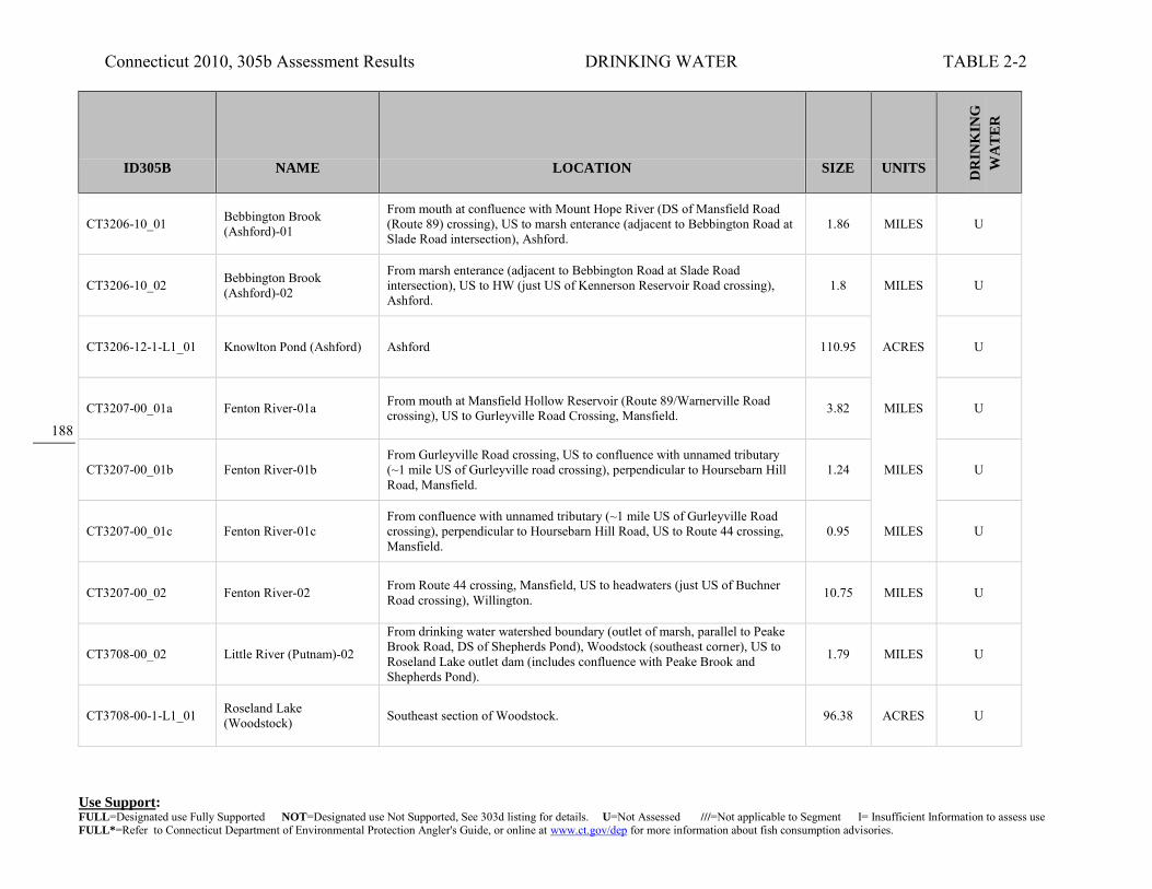
Connecticut 2010, 305b Assessment Results DRINKING WATER TABLE 2-2
Use Support: FULL=Designated use Fully Supported NOT=Designated use Not Supported, See 303d listing for details. U=Not Assessed ///=Not applicable to Segment I= Insufficient Information to assess use FULL*=Refer to Connecticut Department of Environmental Protection Angler's Guide, or online at www.ct.gov/dep for more information about fish consumption advisories.
188
ID305B NAME LOCATION SIZE UNITS
DR
INK
ING
WA
TE
R
CT3206-10_01 Bebbington Brook (Ashford)-01
From mouth at confluence with Mount Hope River (DS of Mansfield Road (Route 89) crossing), US to marsh enterance (adjacent to Bebbington Road at Slade Road intersection), Ashford.
1.86 MILES U
CT3206-10_02 Bebbington Brook (Ashford)-02
From marsh enterance (adjacent to Bebbington Road at Slade Road intersection), US to HW (just US of Kennerson Reservoir Road crossing), Ashford.
1.8 MILES U
CT3206-12-1-L1_01 Knowlton Pond (Ashford) Ashford 110.95 ACRES U
CT3207-00_01a Fenton River-01a From mouth at Mansfield Hollow Reservoir (Route 89/Warnerville Road crossing), US to Gurleyville Road Crossing, Mansfield. 3.82 MILES U
CT3207-00_01b Fenton River-01b From Gurleyville Road crossing, US to confluence with unnamed tributary (~1 mile US of Gurleyville road crossing), perpendicular to Hoursebarn Hill Road, Mansfield.
1.24 MILES U
CT3207-00_01c Fenton River-01c From confluence with unnamed tributary (~1 mile US of Gurleyville Road crossing), perpendicular to Hoursebarn Hill Road, US to Route 44 crossing, Mansfield.
0.95 MILES U
CT3207-00_02 Fenton River-02 From Route 44 crossing, Mansfield, US to headwaters (just US of Buchner Road crossing), Willington. 10.75 MILES U
CT3708-00_02 Little River (Putnam)-02
From drinking water watershed boundary (outlet of marsh, parallel to Peake Brook Road, DS of Shepherds Pond), Woodstock (southeast corner), US to Roseland Lake outlet dam (includes confluence with Peake Brook and Shepherds Pond).
1.79 MILES U
CT3708-00-1-L1_01 Roseland Lake (Woodstock) Southeast section of Woodstock. 96.38 ACRES U

Connecticut 2010, 305b Assessment Results DRINKING WATER TABLE 2-2
Use Support: FULL=Designated use Fully Supported NOT=Designated use Not Supported, See 303d listing for details. U=Not Assessed ///=Not applicable to Segment I= Insufficient Information to assess use FULL*=Refer to Connecticut Department of Environmental Protection Angler's Guide, or online at www.ct.gov/dep for more information about fish consumption advisories.
189
ID305B NAME LOCATION SIZE UNITS
DR
INK
ING
WA
TE
R
CT3708-01_01 Muddy Brook (Woodstock)-01 From mouth at inlet to Roseland Lake, US to Route 197 crossing, Woodstock. 5.44 MILES U
CT3708-01_02 Muddy Brook (Woodstock)-02
From Route 197 crossing, US to confluence with Moss Brook (just DS of Route 169 crossing, Sherman corner area), Woodstock. 1.98 MILES U
CT3708-01_03 Muddy Brook (Woodstock)-03
From confluence with Moss Brook (just DS of Route 169 crossing, Sherman corner area), US to Muddy Pond outlet, Woodstock. 1.79 MILES U
CT3708-01-1-L1_01 Muddy Pond (Woodstock) headwaters of Muddy Brook, near MA border, Woodstock 38.42 ACRES U
CT3708-10_01 North Running Brook-01 From mouth at confluence with Muddy Brook, US to runoff ditch from farm field (300Ft US of farm road crossing) (farm road crossing is 900Ft US of Muddy Brook confluence, farm road is off of Child Hill Road), Woodstock.
0.19 MILES U
CT3708-10_02 North Running Brook-02
From runoff ditch from farm field (300Ft US of farm road crossing) (farm road crossing is 900Ft US of Muddy Brook confluence, farm road is off of Child Hill Road), US to headwaters (parallel to Route 169, US of Joy Road crossing), Woodstock.
2.8 MILES U
CT3900-11-1-L1_01 Bog Meadow Reservoir (Norwich) Norwich 91.15 ACRES U
CT4008-03_01 Mott Hill Brook (Glastonbury)-01
Mouth at confluence with Dark Hollow Brook, above Cold Brook, US to first Mott Hill Road crossing, Glastonbury. 0.56 MILES U
CT4009-00_03 Roaring Brook (Glastonbury)-03
From Buckingham Reservoir inlet (Buckingham Res. NOT included), US to headwaters (Segment entirely within Manchester drinking water supply watershed).
2.38 MILES U

Connecticut 2010, 305b Assessment Results DRINKING WATER TABLE 2-2
Use Support: FULL=Designated use Fully Supported NOT=Designated use Not Supported, See 303d listing for details. U=Not Assessed ///=Not applicable to Segment I= Insufficient Information to assess use FULL*=Refer to Connecticut Department of Environmental Protection Angler's Guide, or online at www.ct.gov/dep for more information about fish consumption advisories.
190
ID305B NAME LOCATION SIZE UNITS
DR
INK
ING
WA
TE
R
CT4017-04-1-L1_01 Turkey Hill Reservoir (Haddam/Chester)
Straddles southern border of Haddam with Chester. Located within Cockaponset State Forest, bounded by Cedar Lake Road and Filley Road. 75.9 ACRES U
CT4200-00_03 Scantic River-03 From Somersville Pond inlet, Somers, US to MA border. 6.05 MILES U
CT4200-00-4-L2_01 Somersville Pond (Somers) Near eastern border of Somers with Enfield; pond is south of intersection of Rte 190 and Rte 186. 40.9 ACRES U(P)
CT4201-00_01 Watchaug Brook (Somers)-01
From mouth at confluence with Scantic River (DS of Watchaug Road crossing), US to CT/MA state border, Somers. 2.1 MILES U
CT4203-00_01 Gulf Stream (Somers)-01 Mouth at Scantic River, US to Shady Lake outlet, just US of Route 83 crossing, Somers. 1.88 MILES U
CT4203-00_02 Gulf Stream (Somers)-02 Shady Lake outlet, just US of Route 83 crossing, US to confluence with Lievre Brook, just US of Gulf Road crossing, Somers. 1.3 MILES U
CT4300-00-1+L1_01 Colebrook River (Reservoir) Lake (Colebrook)
Northeast corner of Colbrook, extends slightly into MA and Hartland. 852.34 ACRES U
CT4300-00-1+L2_01 West Branch Reservoir (Colebrook/Hartland) Colebrook 201.82 ACRES U
CT4302-00_03 Mad River (Winchester)-03 From diversion entrance for Rugg Brook Reservoir (boundary of drinking water watershed), US to headwaters at Spaulding Pond outlet dam, Norfolk. 5.17 MILES U

Connecticut 2010, 305b Assessment Results DRINKING WATER TABLE 2-2
Use Support: FULL=Designated use Fully Supported NOT=Designated use Not Supported, See 303d listing for details. U=Not Assessed ///=Not applicable to Segment I= Insufficient Information to assess use FULL*=Refer to Connecticut Department of Environmental Protection Angler's Guide, or online at www.ct.gov/dep for more information about fish consumption advisories.
191
ID305B NAME LOCATION SIZE UNITS
DR
INK
ING
WA
TE
R
CT4302-04_01 Rugg Brook (Winchester)-01
Mouth at inlet to Rugg Brook Reservoir, just DS from Old Waterbury Turnpike crossing, US to HW, US of Route 263 crossing, Winchester. 3.29 MILES U
CT4308-00-1-L2_01
Compensating Res. (L. McDonough) (Barkhamsted/New Hartford)
Southeast Barkhamsted - northeast New Hartford. 385.75 ACRES FULL
CT4308-01_01 Hurricane Brook (Hartland)-01
Mouth on Barkhamsted Reservoir, just DS of Route 20 crossing, US to HW at Emmons Pond, just US of Hurricane Brook Road crossing, Hartland. 2.24 MILES U
CT4308-11_01 Roaring Brook (Barkhamsted)-01
Mouth at inlet to Barkhamsted Reservoir, parallel to Kettle Brook, US to HW near Pine Mountain road, Barkhamsted. 2.4 MILES U
CT4308-13_01 Kettle Brook (Barkhamsted)-01
Mouth at inlet to Barkhamsted Reservoir, just DS of Ratlum Road crossing, US to HW just US of Route 219 crossing, Barkhamsted. 1.95 MILES U
CT4310-00_02 Nepaug River-02 From inlet to Nepaug Reservoir (far wetern portion), US to headwaters (just above confluence with Cedar Swamp Brook, parallel with Niles Road), New Hartford.
7.73 MILES U
CT4310-01_02 Bakerville Brook (New Hartford)-02
Confluence with Torrington Brook, parallel with Route 202, US to HW near Pearl Rd (above Rt 202 crossing), New Hartford. 3.2 MILES U
CT4310-05_01 North Brook (New Hartford)-01
Mouth on North Nepaug Brook, between Route 219 and Maple Hollow Road, US to HW, between West Hill Road and Stub Hollow Road, New Hartford. 2.51 MILES U
CT4313-00-trib_01 Powder Brook (Harwinton)-01
Mouth at inlet to Bristol Reservoir No4, Harwinton, US to HW, near Johnny Cake Mountain Road, Burlington. 1.35 MILES U
(P) indicates a Potential Drinking Water Supply

Connecticut 2010, 305b Assessment Results DRINKING WATER TABLE 2-2
Use Support: FULL=Designated use Fully Supported NOT=Designated use Not Supported, See 303d listing for details. U=Not Assessed ///=Not applicable to Segment I= Insufficient Information to assess use FULL*=Refer to Connecticut Department of Environmental Protection Angler's Guide, or online at www.ct.gov/dep for more information about fish consumption advisories.
192
ID305B NAME LOCATION SIZE UNITS
DR
INK
ING
WA
TE
R
CT4314-00_02 Coppermine Brook (Bristol)-02
From drinking water watershed boundary and water diversion (just US of confluence with Polkville Brook), US to headwaters (confluence of Whigville & Wildcat Brooks).
2.66 MILES U
CT4314-05_01 Wildcat Brook Unnamed tributary-01
Unnamed tributary, from confluence with Wildcat Brook (West side, approximately 0.6 miles US from mouth of Wildcat Brook, parallel with Stone Road), Burlington.
0.81 MILES U
CT4315-10-1-L1_01 Pine Lake (Malones Pond) (Bristol) East Bristol, south of Pine Street 8.13 ACRES U
CT4500-00-1-L1_01 Shenipsit Lake (Tolland/Ellington/Vernon)
At meeting point of Ellington, Vernon and Tolland. CT Water Company watershed. 511.85 ACRES FULL
CT4501-00_01 Charters Brook-01 From mouth at Shenipsit Lake Tolland US to headwaters near Webster Rd Ellington 6.22 MILES U
CT4600-00_07 Mattabesset River-07 From inlet to Upper Hart Pond (Both Lower and Upper Hart Ponds are not in segment), US to Wasel Reservoir inlet dam (segment includes Smith Brothers Pond).
1.6 MILES U
CT4600-05_02 John Hall Brook-02 From Kenmere Reservoir INLET, US to Hallmere Reservoir outlet dam, Berlin. 1 MILES U
CT4606-00_02 Sawmill Brook (Durham)-02
AA groundwater proposed withdrawl point, near Salted Lane, US to confluence with Asmun Brook, Durham. 0.54 MILES U
CT4606-00_03 Sawmill Brook (Durham)-03
Confluence with Asmun Brook, US to confluence with unnamed tributary, US of Route 68 crossing, Durham. 0.9 MILES U

Connecticut 2010, 305b Assessment Results DRINKING WATER TABLE 2-2
Use Support: FULL=Designated use Fully Supported NOT=Designated use Not Supported, See 303d listing for details. U=Not Assessed ///=Not applicable to Segment I= Insufficient Information to assess use FULL*=Refer to Connecticut Department of Environmental Protection Angler's Guide, or online at www.ct.gov/dep for more information about fish consumption advisories.
193
ID305B NAME LOCATION SIZE UNITS
DR
INK
ING
WA
TE
R
CT4607-00_06 Coginchaug River-06 From Meeting House Hill Road crossing, Durham, US to headwaters (US of Route 72 crossing, between Bluff Head and Broomstick Ledges), North Guilford.
3.59 MILES U
CT4607-02_01 Unnamed Tributary to Coginchaug River (Durham)-01
Mouth on Coginchaug River, just DS of Route 77 crossing, US to HW, US of Crooked Hill Road crossing, Durham. 0.78 MILES U
CT5103-00_03 Menunketesuck River-03 From Kelseytown Reservoir inlet (northeast corner), Clinton-Killingworth border, US to North Roast Meat Hill Road crossing (just US of Route 148 crossing), Killingworth.
5.17 MILES U
CT5106-00_02 Hammonasset River-02 From Hammonassett Reservoir inlet (at northeastern most corner, just DS of Bunnell Bridge Road crossing), US to County Road crossing (just US of confluence with Bunker Hill Brook), Killingworth/Madison town border.
2.62 MILES U
CT5106-00_03 Hammonasset River-03 From County Road crossing (just US of confluence with Bunker Hill Brook), Killingworth/Madison town border, US to Madison Road (Route 79) crossing at Madison/Durham border.
3.43 MILES U
CT5112-00_02 Farm River (East Haven)-02
From confluence with Burrs Brook (DS of Route 80 crossing), US to Pages Mill Pond outlet dam, US side of Mill Road crossing, North Branford. 1.24 MILES NOT
CT5112-00_03 Farm River (East Haven)-03
From Pages Mill Pond inlet, US to headwaters (just US of Hyla Lane crossing, near Middletown Avenue (Route 17) are), North Branford. 8.87 MILES U
CT5112-10_01 Burrs Brook-01
From mouth at confluence with Farm River (just DS of Totoket Road crossing), US to Vic's Pond (on Tomasso property) outlet (part of hyro missing from NHD). Brook contributes to drinking water supply, Lake Saltonstall.
1.35 MILES U
CT5112-10-trib_01 Unnamed Tributary to Burrs Brook (North Branford)-01
Mouth on Burrs Brook, just DS of Doral Farms Road crossing, US to HW, near Route 22 and Twin Lakes Road intersection, North Branford. 0.64 MILES U

Connecticut 2010, 305b Assessment Results DRINKING WATER TABLE 2-2
Use Support: FULL=Designated use Fully Supported NOT=Designated use Not Supported, See 303d listing for details. U=Not Assessed ///=Not applicable to Segment I= Insufficient Information to assess use FULL*=Refer to Connecticut Department of Environmental Protection Angler's Guide, or online at www.ct.gov/dep for more information about fish consumption advisories.
194
ID305B NAME LOCATION SIZE UNITS
DR
INK
ING
WA
TE
R
CT5208-00_02a Muddy River (North Haven)-02a
From Muddy River Pond inlet (east side of I91), North Haven, US to confluence with unnnamed tributary (outlet for Tamarac Swamp), just DS of Tyler Mill Road crossing, Wallingford.
8.1 MILES U
CT5208-00_03 Muddy River (Wallingford)-03
From MacKenzie Reservoir inlet (northeastern portion, just DS of Scard Road crossing), US to Spring Lake outlet dam (US of Durham Road crossing, east of I91), Wallingford.
1.98 MILES U
CT5208-00_04 Muddy Brook (Wallingford)-04
From Spring Lake outlet dam (US of Durham Road crossing, east of I91), US to Church Street (Route 68) crossing (just US of Killam Pond, and east of exit 15, I91), Wallingford. Segment includes Spring Lake.
0.86 MILES U
CT5301-00_01 Willow Brook (Hamden)-01
From mouth at confluence with Mill River (DS of Willow Street crossing), Hamden, US to confluence with Brooksvale Stream (DS of South Brooksvale Road crossing), Cheshire. (River travels along RR track)
1.87 MILES U
CT5301-00_02 Willow Brook (Cheshire)-02
From confluence with Brooksvale Stream (DS of South Brooksvale Road crossing), US to HW near Timber Lane, Cheshire. (River travels along RR track)
3.84 MILES U
CT5301-02_01 Sanford Brook (Cheshire)-01
From mouth at confluence with Willow Brook (DS of South Brooksvale Road crossing), Cheshire, US to HW (just US of Candee Road crossing), Prospect. 2.68 MILES U
CT5302-00_02 Mill River (Hamden/Cheshire)-02
From inlet to Lake Whitney (east side of Route 15, just DS of Connolly Parkway crossing), Hamden, US to Cook Hill Road crossing, Cheshire. 9.06 MILES U
CT5302-00_03 Mill River (Cheshire)-03 From Cook Hill Road crossing, Cheshire, US to headwaters (US of Williamsburg Drive crossing). 3.09 MILES U
CT5302-00-4-L3_01 Whitney, Lake (Hamden) Impoundment of Mill River, Hamden. Northern most portion near south side of Route 15, exit 60 (intersection with Route 10). 140.42 ACRES FULL
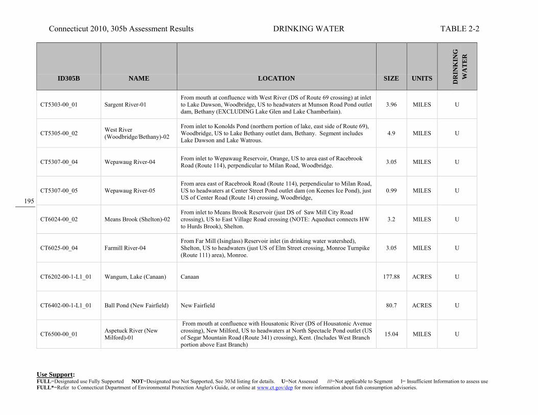
Connecticut 2010, 305b Assessment Results DRINKING WATER TABLE 2-2
Use Support: FULL=Designated use Fully Supported NOT=Designated use Not Supported, See 303d listing for details. U=Not Assessed ///=Not applicable to Segment I= Insufficient Information to assess use FULL*=Refer to Connecticut Department of Environmental Protection Angler's Guide, or online at www.ct.gov/dep for more information about fish consumption advisories.
195
ID305B NAME LOCATION SIZE UNITS
DR
INK
ING
WA
TE
R
CT5303-00_01 Sargent River-01 From mouth at confluence with West River (DS of Route 69 crossing) at inlet to Lake Dawson, Woodbridge, US to headwaters at Munson Road Pond outlet dam, Bethany (EXCLUDING Lake Glen and Lake Chamberlain).
3.96 MILES U
CT5305-00_02 West River (Woodbridge/Bethany)-02
From inlet to Konolds Pond (northern portion of lake, east side of Route 69), Woodbridge, US to Lake Bethany outlet dam, Bethany. Segment includes Lake Dawson and Lake Watrous.
4.9 MILES U
CT5307-00_04 Wepawaug River-04 From inlet to Wepawaug Reservoir, Orange, US to area east of Racebrook Road (Route 114), perpendicular to Milan Road, Woodbridge. 3.05 MILES U
CT5307-00_05 Wepawaug River-05 From area east of Racebrook Road (Route 114), perpendicular to Milan Road, US to headwaters at Center Street Pond outlet dam (on Keenes Ice Pond), just US of Center Road (Route 14) crossing, Woodbridge,
0.99 MILES U
CT6024-00_02 Means Brook (Shelton)-02 From inlet to Means Brook Reservoir (just DS of Saw Mill City Road crossing), US to East Village Road crossing (NOTE: Aqueduct connects HW to Hurds Brook), Shelton.
3.2 MILES U
CT6025-00_04 Farmill River-04 From Far Mill (Isinglass) Reservoir inlet (in drinking water watershed), Shelton, US to headwaters (just US of Elm Street crossing, Monroe Turnpike (Route 111) area), Monroe.
3.05 MILES U
CT6202-00-1-L1_01 Wangum, Lake (Canaan) Canaan 177.88 ACRES U
CT6402-00-1-L1_01 Ball Pond (New Fairfield) New Fairfield 80.7 ACRES U
CT6500-00_01 Aspetuck River (New Milford)-01
From mouth at confluence with Housatonic River (DS of Housatonic Avenue crossing), New Milford, US to headwaters at North Spectacle Pond outlet (US of Segar Mountain Road (Route 341) crossing), Kent. (Includes West Branch portion above East Branch)
15.04 MILES U

Connecticut 2010, 305b Assessment Results DRINKING WATER TABLE 2-2
Use Support: FULL=Designated use Fully Supported NOT=Designated use Not Supported, See 303d listing for details. U=Not Assessed ///=Not applicable to Segment I= Insufficient Information to assess use FULL*=Refer to Connecticut Department of Environmental Protection Angler's Guide, or online at www.ct.gov/dep for more information about fish consumption advisories.
196
ID305B NAME LOCATION SIZE UNITS
DR
INK
ING
WA
TE
R
CT6500-00-1-L1_01 South Spectacle Pond (Kent) East central Kent at headwaters of the West Aspetuck River. 82.26 ACRES U
CT6600-00_06 Still River (Danbury)-06 From Lake Kenosia inlet, US to headwaters at marsh (just US of Mill Plain Road Cuttoff crossing, north of RailRoad crossing and I84), Danbury. 0.79 MILES U
CT6600-01-1-L3_01 Kenosia, Lake (Danbury) Impoundment of Still River, Danbury. 56.75 ACRES FULL
CT6700-00_01 Shepaug River-01 From mouth at confluence with Housatonic River (northeast branch of Lake Lillinonah portion, just DS of Minor Bridge Road crossing), US to confluence with Bantam River (parallel with Whittlesey Road), Washington.
17.67 MILES U
CT6700-00_02 Shepaug River-02 From confluence with Bantam River (just DS of Whittlesey Road crossing), Washington, US to Shepaug Reservoir outlet dam (US of Valley Road crossing), Litchfield/Warren town border.
3.51 MILES U
CT6700-03-1-L2_01 Mohawk Pond (Goshen/Cornwall) Goshen - Cornwall boundary within Mohawk State Forest. 16.34 ACRES U
CT6700-27_01 Fenn Brook (Roxbury)-01 From mouth at confluence with Shepaug River (just DS of Route 67 crossing), US to HW (parallel to Painter Hill Road), Roxbury. 2.6 MILES U
CT6701-00_01 Marshepaug River (Litchfield)-01
Mouth on East Branch Shepaug River, parallel to Blue Swamp Road, Litchfield, US to outlet of Woodbridge Lake, US of Milton Road crossing, Goshen.
3.19 MILES U
CT6701-00-1-L1_01 Tyler Lake (Goshen) West central Goshen; headwaters of Marshepaug River. 187.22 ACRES U

Connecticut 2010, 305b Assessment Results DRINKING WATER TABLE 2-2
Use Support: FULL=Designated use Fully Supported NOT=Designated use Not Supported, See 303d listing for details. U=Not Assessed ///=Not applicable to Segment I= Insufficient Information to assess use FULL*=Refer to Connecticut Department of Environmental Protection Angler's Guide, or online at www.ct.gov/dep for more information about fish consumption advisories.
197
ID305B NAME LOCATION SIZE UNITS
DR
INK
ING
WA
TE
R
CT6701-01-1-L1_01 West Side Pond (Goshen) West central Goshen; drains to West Side Pond Brook to Tyler Lake 40.37 ACRES U
CT6703-00-2-L1_01 Dog Pond (Goshen) South central Goshen; along West Branch of Bantam River 65.77 ACRES U
CT6705-00_01 Bantam River-01 From mouth at confluence with Shepaug River (parallel with Whittlesey Road), Washington, US to confluence with Bizell Brook (just US of West Morris Road crossing), Morris.
4.53 MILES U
CT6705-00_02 Bantam River-02 From confluence with Bizell Brook (just US of West Morris Road crossing), Morris, US to hydropower dam outlet at Bantam Lake Road (Route 209) crossing, Litchfield.
2.01 MILES U
CT6705-00_03 Bantam River-03 From hydropower dam outlet at Bantam Lake Road (Route 209) crossing, US to outlet of Bantam Lake (just US of North Shore Road crossing), Litchfield. 1.64 MILES U
CT6705-00_04 Bantam River-04 From inlet to Bantam Lake (northeast portion, in marsh, DS of Whitehall Road crossing), Litchfield, US to headwaters (marsh US of Litchfield Reservoir, south side of Pie Hill Road, east of Route 63 intersection), Goshen.
12.02 MILES U
CT6705-00-3-L3_01 Bantam Lake (Litchfield/Morris) Litchfield, Morris 955.45 ACRES U
CT6705-12_01 Hill Brook-01 From mouth at confluence with Bantam River (just DS of West Morris Road crossing, and DS of Litchfield WPCF outfall on Bantam River), US to headwaters (US of Old Forge Hollow Road crossing=dirt road), Litchfield.
2.64 MILES U
CT6705-14-1-L1_01 Mount Tom Pond (Litchfield/Morris/Wahington)
Northwest corner of Morris, southwest corner of Litchfield, within Mount Tom State Park. 55.14 ACRES U

Connecticut 2010, 305b Assessment Results DRINKING WATER TABLE 2-2
Use Support: FULL=Designated use Fully Supported NOT=Designated use Not Supported, See 303d listing for details. U=Not Assessed ///=Not applicable to Segment I= Insufficient Information to assess use FULL*=Refer to Connecticut Department of Environmental Protection Angler's Guide, or online at www.ct.gov/dep for more information about fish consumption advisories.
198
ID305B NAME LOCATION SIZE UNITS
DR
INK
ING
WA
TE
R
CT6802-00_03 Nonewaug River-03 From inlet to Big Meadow Pond (Judd Pond) Reservoir (just DS of Judd Farm Road (Route 132) crossing), US to headwaters, Watertown. 1.34 MILES U
CT6900-40_02 Beaver Brook (Ansonia)-02 Inlet of Quillinian Reservoir, Ansonia, US to Middle Reservoir outlet, just US of Route 313 crossing, Seymour. 1.1 MILES U
CT6900-40-1-L1_01 Beaver Lake (Seymour) Seymour 68.82 ACRES U
CT6902-00_01 Hart Brook-01 From mouth at confluence with Hall Meadow Brook, above West Branch Naugatuck River (just US of Norfolk Road (Route 272) crossing), US to Reuben Hart Reservoir outlet dam, Torrington.
0.64 MILES U
CT6903-00_02 Nickelmine Brook (Torrington)-02
From Allen Dam Reservoir INLET (end of segment-01), Torrington, US to Hatchaluchi Reservoir INLET (beginning of segment-03), Goshen. 2.61 MILES U
CT6903-00_03 Nickelmine Brook (Goshen)-03
From inlet to Hatchaluchi Reservoir, US to HW (parallel to East Street), Goshen. 1.71 MILES U
CT6907-00_01 Rock Brook (Harwinton)-01
Mouth on Leadmine Brook, just DS from Hollow Road crossing, Harwinton, US to HW, near Cotton Hill Road, New Hartford. 6.29 MILES U
CT7107-00_02 Cricker Brook (Easton)-02 From confluence with Hemlocks Reservoir (DS of Wilson Road crossing), US to HW near Route 136, Easton. 2.5 MILES U
CT7108-00_03 Mill River (Easton/Monroe)-03
From INLET to Easton Reservoir, Easton/Trumbull town border, US to headwaters at marsh (just US of Hattertown Road crossing), Monroe. 3.43 MILES U

Connecticut 2010, 305b Assessment Results DRINKING WATER TABLE 2-2
Use Support: FULL=Designated use Fully Supported NOT=Designated use Not Supported, See 303d listing for details. U=Not Assessed ///=Not applicable to Segment I= Insufficient Information to assess use FULL*=Refer to Connecticut Department of Environmental Protection Angler's Guide, or online at www.ct.gov/dep for more information about fish consumption advisories.
199
ID305B NAME LOCATION SIZE UNITS
DR
INK
ING
WA
TE
R
CT7108-05_02 Unnamed tributary, Easton Reservoir (Snow Farm)-02
From confluence with unnamed tributary to Easton Reservoir (east of Sport Hill Road (Route 59)), US to outlet of pond on Phil Snow's farm, Easton. (Unnamed tributary flows into Easton Reservoir from western side)
0.3 MILES U
CT7200-00_03 Saugatuck River-03 From INLET to Saugatuck Reservoir at Newtown Turnpike (Route 53) crossing, US to confluence with Bogus Mountain Brook (US of Redding Road (Route 53) crossing, and parallel to Station Road), Redding.
4.36 MILES U
CT7200-00_04 Saugatuck River-04 From confluence with Bogus Mountain Brook (US of Redding Road (Route 53) crossing, and parallel to Station Road), Redding, US to headwaters, at Wataba Lake outlet dam (just US of Mountain Road crossing), Ridgefield.
5.53 MILES U
CT7200-00-3-L5_01 Saugatuck Reservoir (Weston/Easton/Redding) Weston 823.11 ACRES U
CT7200-03_01 Umpawaug Pond Brook (Redding)-01
Mouth on Saugatuck River, DS of Simpaug Turnpike crossing, US to HW above Steichens Ponds, just US of Old Redding Road crossing, Redding. 2.98 MILES U
CT7201-00_01 Little River (Redding)-01 Mouth at inlet to Saugatuck Reservoir, parallel to Newtown Turnpike, US to outlet of Lower Park Pond, parallel to Route 58, Redding. 4.43 MILES U
CT7202-00_02 Aspetuck River (Easton-Newtown)-02
From INLET to Aspetuck Reservoir (northwestern side, parallel with Black Rock Turnpike (Route 58)), Easton, US to headwaters at unnamed pond (US of Poverty Hollow Road crossing), Newtown.
9.54 MILES U
CT7301-00_02 Comstock Brook (Wilton)-02
From confluence with Barretts Brook (outlet for Popes Pond, parallel to Route 33, at intersection with Signal Hill Road), US to HW (just west and parallel with Grey Rocks Road), Wilton.
2.29 MILES U
CT7301-04-1-L2_01 Popes Pond (Wilton) Wilton 82.47 ACRES U

Connecticut 2010, 305b Assessment Results DRINKING WATER TABLE 2-2
Use Support: FULL=Designated use Fully Supported NOT=Designated use Not Supported, See 303d listing for details. U=Not Assessed ///=Not applicable to Segment I= Insufficient Information to assess use FULL*=Refer to Connecticut Department of Environmental Protection Angler's Guide, or online at www.ct.gov/dep for more information about fish consumption advisories.
200
ID305B NAME LOCATION SIZE UNITS
DR
INK
ING
WA
TE
R
CT7404-00_01 Mill River (New Canaan/Stamford)-01
Mouth on Rippowam River, near Ponus Ridge crossing of Rippowam River, US to Laurel Reservoir Dam, just US of Reservoir Lane crossing, along New Canaan/Stamford town line.
0.74 MILES U
CT7405-00_03 Rippowam River-03
From North Stamford Reservoir INLET, Stamford, US to headwaters at Siscowit Reservoir outlet dam (US of Pinney Road (Route 124) crossing, parallel to Bowery Road near New York border), New Canaan. (segment fully in BHC Drinkingwater Watershed)
4.4 MILES U
CT7407-00_01 Mianus River-01 From Mianus Pond OUTLET dam (US side of Route 1 crossing, separation from upper portion of Cos Cob Harbor), US to Mianus Filter Plant dam outlet, Greenwich. (Mianus Pond included in segment)
1.95 MILES U
CT7407-00_02 Mianus River-02 From Mianus Filtration Plant dam outlet (impoundment at filtration plant), Greenwich, US to Sam Bargh Reservoir (Mianus Reservoir on topo) dam outlet (US of Farms Road crossing, near New York border), Stamford.
6.1 MILES U
CT7407-00-3-L14_01 Bargh (Mianus) Reservoir (Stamford) Impoundment of the Mianus River in the NW corner of Stamford. 161.43 ACRES U
CT7409-00-1-L3_01 Putnam Lake Reservoir (Greenwich) Impoundment of Horseneck Brook, just south of Rt. 15, Greenwich. 95.56 ACRES FULL
CT8101-00_01 Quaker Brook-01
From New York state border (DS of Merritts Pond, parallel to Route 37, north of intersection with Haviland Hollow Road), New Fairfield, US to New York state border (along south side of Chapel Hill Road), Sherman. (Segment includes 6 ponds/lakes)
4.78 MILES U
CT8104-00_01 Titicus River-01
From New York state border (in large marsh along north side of North Salem Road (Route 116)), US to headwaters (at unnamed marsh, US of Old West Mountain Road crossing), Ridgefield. (Segment includes several ponds and marshes)
6.34 MILES U
CT8104-00-2-L5_01 Mamanasco Lake (Ridgefield) Northwest Ridgefield. 85.9 ACRES U
201
Chapter 3 - List of Waterbodies Not Meeting Water Quality Standards
The List of Connecticut Waterbodies Not Meeting Water Quality Standards, (“Impaired Waters List”, IWL) has been developed by the Connecticut Department of Environmental Protection (CT DEP) as required under Section 303(d) of the Federal Clean Water Act (CWA). The CWA is the primary Federal law that protects our nation‟s surface waters, including lakes, rivers, and coastal areas. Through passage of the CWA, the United States Congress established a national goal of achieving and maintaining “water quality which
provides for the protection and propagation of fish, shellfish, and wildlife, and recreation in and on the water wherever attainable” (CWA Section 101(a) (2)). Development of the Connecticut IWL is part of a broad effort to achieve these goals including: 1) adoption of Water Quality Standards; 2) monitoring and assessment of surface waters to evaluate consistency with those standards; 3) prioritizing those waters that are not currently meeting Water Quality Standards for development of Total Maximum Daily Load (TMDL) analyses and other management plans to bring waterbodies into compliance with Water Quality Standards; and (4) implementation of those TMDLs or management plans ultimately achieving consistency with the Water Quality Standards.
The State of Connecticut has adopted Water Quality Standards as required under Section 22a – 426 of the Connecticut General Statutes and Section 303 of the CWA. The Connecticut Water Quality Standards (CT WQS) contain policy statements concerning the protection of water quality and describe the system used by Connecticut to classify all waters in the State based on quality and use. Two elements of the CT WQS critical to the IWL are the establishment of waterbody designated uses (e.g. Habitat for Fish, Other Aquatic Life and Wildlife, Recreation, etc.) and the specified Water Quality Criteria to protect and support those uses. Physical, chemical, and biological monitoring data are compared to the Water Quality Criteria in the CT WQS to assess whether or not a waterbody is meeting designated uses. All waterbodies that are determined to not be Fully Supporting one or more designated uses as specified in the CT WQS are included on the IWL.
The Connecticut Consolidated Assessment and Listing Methodology (CT CALM) for 305(b) and 303(d) Reporting (Chapter 1) was used as a guidance document for the assessment of surface waters. Waterbody assessments were conducted using ambient monitoring data collected by CT DEP, as well as other relevant data that met data requirements specified by the CT CALM. The IWL contains all those waterbodies in Connecticut that have been assessed by CT DEP as not meeting one or more designated uses in accordance with CT CALM. The IWL is revised every two years as required by the CWA. The last update to the Connecticut IWL was completed by CT DEP and approved by the Federal Environmental Protection Agency (US EPA) in 2008. The IWL is used by CT DEP as a document to plan and prioritize management activities, including the development of TMDLs.
The IWL includes all waterbody impairments that have been assigned to US EPA Categories 4 and 5 in accordance with the CT CALM. Categories 4 and 5 constitute two of US EPA‟s five-category approach for classifying the WQS attainment status for each waterbody segment. IWL category definitions are listed in Table 3-1.

202
Table 3-1. US EPA Categories for Waterbodies Not Meeting State WQS
US EPA reviews the rationale and supporting assessment information for inclusion of any waterbody segment impairment in Category 4 to insure that these waters are appropriately categorized. However, formal approval of Category 4 listings is not required under Section 303(d) of the CWA. Waterbody impairments listed in Category 5 constitute the regulatory 303(d) list which is subject to US EPA review and approval pursuant to 40 CFR 130.7.
Category 4a
US EPA Category 4a consists of waterbodies impaired for one or more designated uses that have an established TMDL where a pollutant has been identified as the cause of the impairment. TMDLs have been established for a total of 120 waterbody segments. Thirty-two of these 4a segments are new for this reporting cycle. CT DEP maintains a Microsoft AccessTM database in order to organize information and document the progress of TMDL development and implementation. This database stores information including participant rosters, waterbody information, ambient monitoring data, facility monitoring data, and tracks the effectiveness of Best Management Practices (BMPs) and regulatory actions in achieving TMDL goals.
Category 4b
US EPA Category 4b includes waters where other pollution control requirements are expected to address the impairment. The CT DEP has identified 14 waterbody segments where other pollution control requirements are reasonably expected to result in the attainment of water quality standards in the near future. Each segment is described in detail including updated information on the implementation status of the various pollution controls being utilized in the segment. Examples of other pollution control requirements include Consent Orders, CT DEP approved Combined Sewer Overflow Control Plans, Remedial Action Plans, Restoration Plans, other plans or studies where activities in progress are expected to result in attainment of the applicable water quality standards and designated uses. Waters are not assigned to this category unless there is reasonable assurance that compliance with the requirements will result in attainment of uses and there are provisions for follow-up monitoring to track progress. In the event that follow-up monitoring indicates that the other pollution control requirements will fall short of achieving the goal of attaining standards, segments will be reassigned to US EPA Category 5 and a TMDL developed.
CATEGORY DEFINITION
4a A TMDL to address a specific pollutant combination has been approved or established by US EPA.
4b A use impairment caused by a pollutant is being addressed by the State through pollution control requirements other than a TMDL.
4c A use is impaired, but the impairment is not caused by a pollutant.
5 Available data and/or information indicate that at least one designated use is not being supported and a TMDL is needed.

203
Category 4c
US EPA Category 4c includes waterbody segments that do not meet an applicable water quality standard which is the result of pollution but is not caused by a pollutant. The Clean Water Act defines pollution as "the man-made or man-induced alteration of the chemical, physical, biological, and radiological integrity of water". In this case, the pollution is not from a chemical contaminant, but it is from a human impact. This type of pollution requires management measures to meet the applicable water quality standard. Some examples of this pollution include lack of adequate flow, stream channelization, and invasive species. The table of 4c segments is not to be considered a comprehensive listing of all known impaired segments in this category. Current assessment protocols have not covered the entirety of waterbodies across the State of Connecticut to determine all impairments due to nonpollutant sources.
Category 5
US EPA Category 5 includes waters where available data and/or information indicate that at least one designated use is not being supported, and a TMDL is needed. A total of 425 waterbody segments have been assigned to US EPA Category 5 based on an assessment performed by CT DEP consistent with the CT CALM.
It is expected that the ongoing assessment of surface waters for 305(b) reporting may result in a change in the US EPA category that for that waterbody as new information is obtained. For example, a waterbody listed in US EPA Category 5 may be reassigned to US EPA Category 4b if other pollution control requirements are determined to be the most effective option for attaining water quality standards. Thus, the assessment of surface waters for 305(b) reporting is an iterative process that may result in the re-classification of waterbodies to different categories based on new assessment data or changes in US EPA regulations or guidance relating to the assessment and listing process.
Determining Causes and Sources of Impairment
Monitoring and assessment data collected in support of determining the attainment of water quality standards and designated uses in surface waters is generally insufficient to provide specific indication of the causes or sources of any observed impairment. CT DEP has historically provided information on potential causes of impairment in advance of the conduct of a TMDL. These data are currently contained in Table 3-2, but are general in nature and speculative. It should not be taken as a definitive determination of the causes or sources contributing to the observed impairment. Similarly, there may be causes not identified within this report as the listing of potential causes is not based on data and may omit contributing sources. The actual causes and sources contributing to water quality impairments can only be determined through a thorough stressor identification study conducted in support of TMDL development. Once a waterbody or segment is designated for TMDL development, a more thorough investigative study is conducted to identify causes and sources of impairment. These investigations may include more intensive ambient water quality sampling, aquatic toxicity studies, sediment or fish tissue analysis and/or dilution calculations of known discharges.
Prioritization of Waters for TMDL Development
CT DEP has identified waterbody segments for which TMDLs are expected to be prepared during through 2012 (Table 3-8). Waters are prioritized for TMDL development based on threats to human health, the potential for a TMDL analysis to result in improved water quality, providing support to regulatory programs

204
designed to improve water quality and comments received during the public review of the proposed 303(d) list. Changes may be made from this list based on data availability or the need to revise priorities to address additional water quality concerns. TMDLs for additional waters may be completed during 2011 through 2012 dependent upon data availability and staff resources.
Delisting of Impaired (303(d)) Waters
The assessment of surface waters for 305(b) reporting is an on-going process that will result in the removal of some waterbodies from the 303(d) portion of the IWL, and the addition of others. A waterbody is removed from the 303(d) List when an assessment of relevant data conducted in accordance with the CT CALM (Chapter 1) confirms attainment of water quality standards. Additionally, waterbodies may be delisted when:
An error was made in the initial listing causing an erroneous listing. Erroneous listings include those based on anecdotal information (information, often transmitted orally and undocumented, which cannot be confirmed through direct observation or measurement using generally accepted, reproducible analytical methods). In these circumstances, the waterbody usually was moved into US EPA category 2 (supporting for some uses, other uses not assessed) or more often category 3 (no or insufficient data available to make any assessment).
Quality controlled data, which are acceptable to CT DEP, demonstrate that designated uses are being met for the waterbody (with or without implementation of a TMDL).
Revisions in Water Quality Standards and Criteria result in a change in assessment from non-attainment to attainment.
The waterbody or assessment unit meets conditions described in 4a – 4c in the listing methodology above. These AUs will continue to be listed as impaired until water quality standards are met, although the regulatory requirement to adopt a TMDL will no longer apply.
Public Participation
As described previously, the CT DEP solicits data and information from a variety of sources, including volunteer groups, other federal and State agencies, municipalities, utilities, and academia to incorporate into the assessment process. Additionally, there is a public review process for the 303(d) List and listing methodology. Public comments are particularly relevant to the process of establishing priorities for the development of TMDLs and other management plans for impaired waters included in Categories 4 and 5.
CT IMPAIRED WATERS LIST – TABLE 3-3
The Impaired Waters List (Table 3-2) provides a comprehensive account of all assessment units (AUs) that do not support designated uses, and includes impaired use(s), cause(s), and potential source(s). All AUs are organized by a unique identification number (ID305b), which tracks assessment information stored in the Assessment Database Version Two (ADB V2) through each assessment cycle. Both river and lake AUs are derived from basin numbers explained and cataloged in the Gazetteer of Drainage Areas of Connecticut (Nosal, 1997). Stream and river segments are indexed to the National Hydrography Dataset (http://nhd.uss.gov/) at a scale of 1:24,000, and lakes are geographically indexed to the CT DEP lakes data layer. Estuary segments were completely reorganized since the 2006 reporting cycle to better consider

205
bathymetry, water quality, shellfish classification maps, and geographic extent as described in the CT DEP report entitled Summary Report & Users Guide Connecticut Coastal Assessment And Segmentation Project
Final – May 11, 2006 Ammended – October 3, 2007 (Streich, 2007). All AUs are created and geographically indexed using ArcGIS 9.3 software.
Additional information concerning those assessed segments for which a TMDL has been established by DEP and approved by US EPA (Category 4a) is provided in Table 3-3. For those waters assigned to US EPA‟s
Category 4b, a description of the non TMDL-based pollution control requirements expected to result in full attainment of Water Quality Standards is provided in Table 3-4. Table 3-5 provides information on these segments listed in US EPA Category 4c (nonpollutant impairments).
RECONCILIATION OF THE IMPAIRED WATERS LISTS – TABLE 3-6
For this reporting cycle, the CT DEP conducted an assessment of all waters where data were available as of October 1, 2009. This resulted in the removal and addition of waterbodies where the assessment status was determined to have changed based on assessment data. These changes include all segments proposed for delisting as well as changes to impairment categories, causes, and potential sources. In some cases, waterbody names and location descriptions have been refined, as well as waterbody segment size. Several waterbody segments were divided into two or more segments to more accurately portray the area impaired. Some waterbodies underwent a change in US EPA categories. Table 3-6 lists waterbodies newly added to the impaired waters list, category changes, new use impairments, category additions and segment splits that have occurred since the 2008 listing cycle for rivers and lakes. Since the 2006 list, the estuary segment geometry for assessments was completely revised to provide greater consistency between monitoring results and designated uses.
WATERBODIES REMOVED FROM CONNECTICUT‟S IMPAIRED WATERS LIST - TABLE 3-7
A total of 17 segments have been delisted from the Impaired Waters List and a table of these waterbodies is included in the report (Table 3-7). This table details all segments that have re-attained a Fully Supporting status for one or all of their uses during the past two years of assessments. Several stream segments are delisted due to additional new data showing that the segment meets recreation use goals. Two sites originally were listed in Category 4b, due to fish kills from chemical spills and recent field surveys show that the fish populations have rebounded and are thriving, causing the proposed delisting. Finally, many coastal segments are proposed for delisting since the original impairment was based not on data but on administrative actions taken by the CT Bureau of Aquaculture.
TMDL PRIORITY RANKING OF IMPAIRED WATERS – TABLE 3-8
In previous cycles, a TMDL priority ranking was provided for all impaired waterbodies in Category 5. The waterbodies received a high, medium or low (H, M, L) ranking for each impairment cause. The ranking was based on available data for a given parameter within the impaired waterbody, but this method did not incorporate the details of TMDL planning nor indicate a timeline for TMDL development. For this reporting cycle, the previous rankings were removed and a new table (Table 3-8) is provided to indicate the TMDL development of specific waterbodies. The table lists the impaired waterbodies by year which are planned for TMDL development within the next report cycle.

206
For additional information concerning the CT DEP‟s monitoring program assessment process or status of TMDL development and implementation please contact:
Connecticut Department of Environmental Protection Bureau of Water Protection and Land Reuse
Planning and Standards Division 79 Elm St
Hartford, CT 06106

207
Table 3-2. Connecticut Impaired Waters List

208
TABLE 3 - 2. CONNECTICUT IMPAIRED WATERS LIST Pawcatuck River-01 Waterbody Name Waterbody Segment ID CT1000-00_01
Location From head of tide, Rte 1 crossing in Pawcatuck-Westerly, US to RI border. Waterbody Segment Size 5.38 Miles Recreation Impaired Designated Use
Cause Potential Source Escherichia coli Source Unknown Category 5
Wyassup Lake (North Stonington) Waterbody Name Waterbody Segment ID CT1001-00-1-L1_01 Location North central North Stonington, east of Rte 49. Headwaters of Wyassup Brook. Waterbody Segment Size 98.94 Acres
Fish Consumption Impaired Designated Use Cause Potential Source Mercury Source Unknown, Atmospheric Deposition - Toxics Category 5
Recreation Impaired Designated Use Cause Potential Source Non-Native Aquatic Plants Source Unknown Category 4c
Shunock River-01 Waterbody Name Waterbody Segment ID CT1004-00_01 Location From mouth at Pawcatuck River, US to Side Pond dam at outlet of Ripley Parks Pond (just south of
Babcock Road), North Stonington Center. Waterbody Segment Size 4.37 Miles
Recreation Impaired Designated Use Cause Potential Source Escherichia coli Source Unknown Category 5
Fenger Brook-01 Waterbody Name Waterbody Segment ID CT2000-30_01 Location From mouth at head of tide, Alewife Cove (just DS of Niles Hill Road (Route 213) crossing), US to
headwaters (southeast of Clark Lane and Chester Street intersection), Waterford. Waterbody Segment Size 3.47 Miles
Habitat for Fish, Other Aquatic Life and Wildlife Impaired Designated Use Cause Potential Source Cause Unknown Source Unknown, Unspecified Urban Stormwater Category 5
Recreation Impaired Designated Use Cause Potential Source Enterococcus Unspecified Urban Stormwater, Source Unknown Category 5

209
TABLE 3 - 2. CONNECTICUT IMPAIRED WATERS LIST Copps Brook-01 Waterbody Name Waterbody Segment ID CT2102-00_01
Location From mouth at Quiambog Cove (parallel to Cove Road), US to Palmer (Mystic) Reservoir outlet dam (just US of Jerry Brown Road crossing), Stonington.
Waterbody Segment Size 0.77 Miles
Habitat for Fish, Other Aquatic Life and Wildlife Impaired Designated Use Cause Potential Source Cause Unknown Flow Alterations from Water Diversions, Upstream Impoundments (e.g., Pl-566 NRCS Structures) Category 5 Cause Potential Source Other flow regime alterations Upstream Impoundments (e.g., Pl-566 NRCS Structures), Flow Alterations from Water Diversions Category 4c
Unnamed Trib to Copps Brook-01 Waterbody Name Waterbody Segment ID CT2102-00-trib_01 Location From mouth at Copps Brook, just US of Quiambog Cove (parallel to Cove Road), US to headwaters
near Jerry Brown Road, Stonington (intermittent). Waterbody Segment Size 0.66 Miles
Habitat for Fish, Other Aquatic Life and Wildlife Impaired Designated Use Cause Potential Source Other flow regime alterations Source Unknown Category 4c
Whitford Brook-02a Waterbody Name Waterbody Segment ID CT2104-00_02a Location From area east of the Shewville Road and Gallup Hill Road intersection, Ledyard/Stonington town
line, US to entrance of "Lantern Hill" wellfield (west of Lantern Hill Road, in marsh parallel with Stony Pond), Ledyard/Stonington town line.
Waterbody Segment Size 0.74 Miles
Habitat for Fish, Other Aquatic Life and Wildlife Impaired Designated Use Cause Potential Source Other flow regime alterations Baseflow Depletion from Groundwater Withdrawals, Flow Alterations from Water Diversions Category 4c
Latimer Brook-01 Waterbody Name Waterbody Segment ID CT2202-00_01 Location From mouth at confluence with Niantic River (head of tide at Banning Cove inlet, just DS of Route 1
crossing, south side of I95, east of exit 75), US to confluence with Cranberry Meadow Brook (parallel with Route 161), East Lyme
Waterbody Segment Size 4.23 Miles
Recreation Impaired Designated Use Cause Potential Source Escherichia coli Source Unknown Category 5
Oil Mill Brook (East Lyme/Waterford)-01 Waterbody Name Waterbody Segment ID CT2203-00_01 Location Mouth on Niantic River, parallel to Oil Mill Road, Waterford/East Lyme town line, US to Route I95
crossing, Waterford. Waterbody Segment Size 0.26 Miles
Recreation Impaired Designated Use Cause Potential Source Escherichia coli Source Unknown Category 5
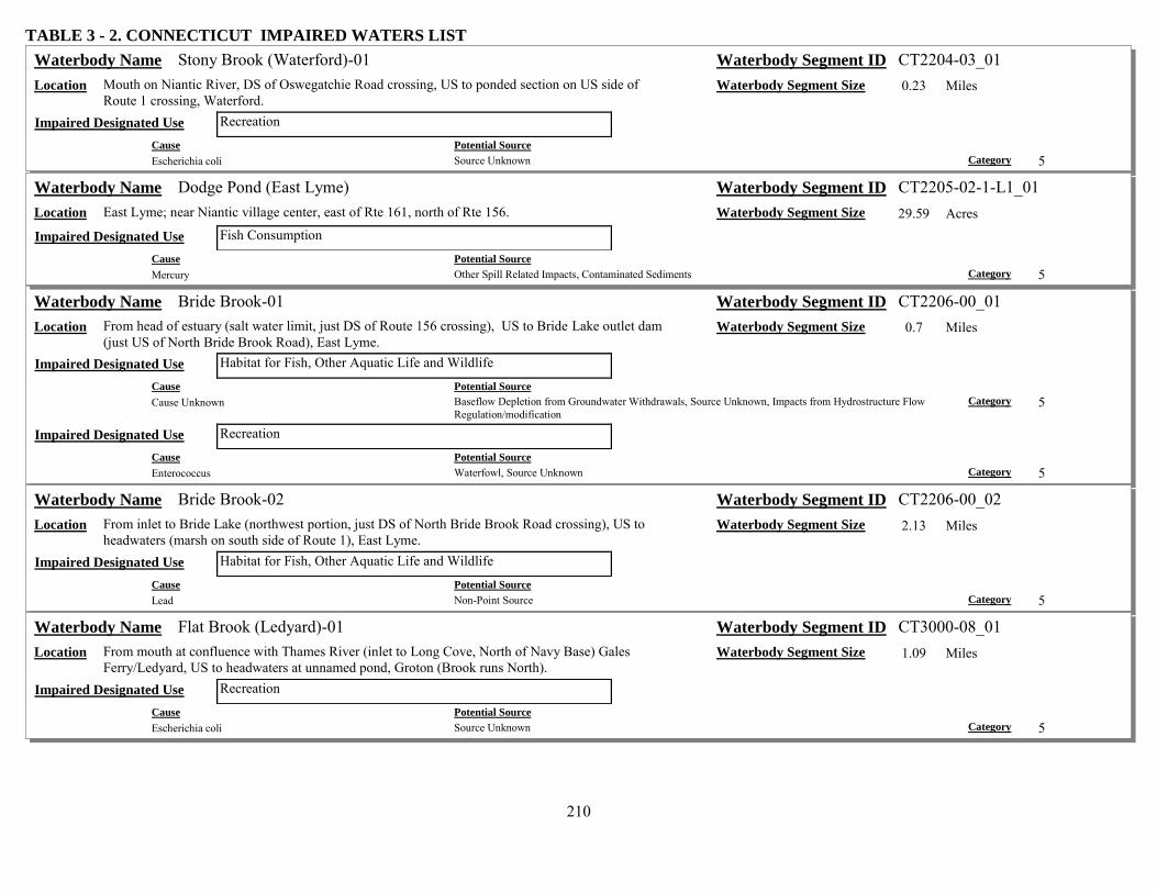
210
TABLE 3 - 2. CONNECTICUT IMPAIRED WATERS LIST Stony Brook (Waterford)-01 Waterbody Name Waterbody Segment ID CT2204-03_01
Location Mouth on Niantic River, DS of Oswegatchie Road crossing, US to ponded section on US side of Route 1 crossing, Waterford.
Waterbody Segment Size 0.23 Miles
Recreation Impaired Designated Use Cause Potential Source Escherichia coli Source Unknown Category 5
Dodge Pond (East Lyme) Waterbody Name Waterbody Segment ID CT2205-02-1-L1_01 Location East Lyme; near Niantic village center, east of Rte 161, north of Rte 156. Waterbody Segment Size 29.59 Acres
Fish Consumption Impaired Designated Use Cause Potential Source Mercury Other Spill Related Impacts, Contaminated Sediments Category 5
Bride Brook-01 Waterbody Name Waterbody Segment ID CT2206-00_01 Location From head of estuary (salt water limit, just DS of Route 156 crossing), US to Bride Lake outlet dam
(just US of North Bride Brook Road), East Lyme. Waterbody Segment Size 0.7 Miles
Habitat for Fish, Other Aquatic Life and Wildlife Impaired Designated Use Cause Potential Source Cause Unknown Baseflow Depletion from Groundwater Withdrawals, Source Unknown, Impacts from Hydrostructure Flow
Regulation/modification Category 5
Recreation Impaired Designated Use Cause Potential Source Enterococcus Waterfowl, Source Unknown Category 5
Bride Brook-02 Waterbody Name Waterbody Segment ID CT2206-00_02 Location From inlet to Bride Lake (northwest portion, just DS of North Bride Brook Road crossing), US to
headwaters (marsh on south side of Route 1), East Lyme. Waterbody Segment Size 2.13 Miles
Habitat for Fish, Other Aquatic Life and Wildlife Impaired Designated Use Cause Potential Source Lead Non-Point Source Category 5
Flat Brook (Ledyard)-01 Waterbody Name Waterbody Segment ID CT3000-08_01 Location From mouth at confluence with Thames River (inlet to Long Cove, North of Navy Base) Gales
Ferry/Ledyard, US to headwaters at unnamed pond, Groton (Brook runs North). Waterbody Segment Size 1.09 Miles
Recreation Impaired Designated Use Cause Potential Source Escherichia coli Source Unknown Category 5

211
TABLE 3 - 2. CONNECTICUT IMPAIRED WATERS LIST Amos Lake (Preston) Waterbody Name Waterbody Segment ID CT3002-02-1-L2_01
Location East of Rte 164, Preston. Waterbody Segment Size 112.42 Acres Recreation Impaired Designated Use
Cause Potential Source Chlorophyll-a On-site Treatment Systems (Septic Systems and Similar Decentralized Systems), Waterfowl, Source
Unknown Category 5
Cause Potential Source Excess Algal Growth Source Unknown, Waterfowl, On-site Treatment Systems (Septic Systems and Similar Decentralized
Systems) Category 5
Cause Potential Source Nutrient/Eutrophication Biological Indicators On-site Treatment Systems (Septic Systems and Similar Decentralized Systems), Source Unknown,
Waterfowl Category 5
Oxoboxo Brook-01 Waterbody Name Waterbody Segment ID CT3004-00_01 Location From mouth at head of tide (inlet to Gay Cemetery Pond, Horton Cove, Thames River), US to
Wheeler Pond outlet dam, Montville. (Segment includes Rockland Pond) Waterbody Segment Size 2.62 Miles
Recreation Impaired Designated Use Cause Potential Source Escherichia coli Source Unknown Category 5
Willimantic River-02 Waterbody Name Waterbody Segment ID CT3100-00_02 Location From confluence with Tenmile River (at Columbia/Lebanon/Windham borders, just DS of Route 66
crossing), US to Eagleville Pond dam outlet (just US of Stonehouse Road crossing). Waterbody Segment Size 6.59 Miles
Recreation Impaired Designated Use Cause Potential Source Escherichia coli Source Unknown Category 5
Willimantic River-03 Waterbody Name Waterbody Segment ID CT3100-00_03 Location Inlet to Eagleville Pond (west of Route 32 and RailRoad tracks near Ravine Road intersection),
Mansfield, US to I84 crossing (includes under highway crossing area), Willington/Tolland. Waterbody Segment Size 9.59 Miles
Recreation Impaired Designated Use Cause Potential Source Escherichia coli Source Unknown Category 5
Eagleville Brook-01 Waterbody Name Waterbody Segment ID CT3100-19_01 Location From mouth at entrance to Eagleville Pond (lower eastern corner), US to confluence with Kings
(Roberts) Brook (east side of North Eagleville Road), Mansfield. Waterbody Segment Size 0.68 Miles
Habitat for Fish, Other Aquatic Life and Wildlife Impaired Designated Use Cause Potential Source Cause Unknown Source Unknown Category 4a

212
TABLE 3 - 2. CONNECTICUT IMPAIRED WATERS LIST Eagleville Brook-02 Waterbody Name Waterbody Segment ID CT3100-19_02
Location From confluence with Kings (Roberts) Brook (east side of North Eagleville Road), US to headwaters near UConn campus (just crossing Stadium Road), Mansfield.
Waterbody Segment Size 1.67 Miles
Habitat for Fish, Other Aquatic Life and Wildlife Impaired Designated Use Cause Potential Source Cause Unknown Streambank Modifications/destabilization, Site Clearance (Land Development or Redevelopment),
Unspecified Urban Stormwater, Landfills Category 4a
Recreation Impaired Designated Use Cause Potential Source Escherichia coli Source Unknown Category 5
Furnace Brook (Stafford)-01 Waterbody Name Waterbody Segment ID CT3103-00_01 Location From mouth at confluence with Middle River, US through concrete channel, stopping at US end of
conrete channel (passes under RailRoad tracks and Route 14), Stafford. Waterbody Segment Size 0.18 Miles
Habitat for Fish, Other Aquatic Life and Wildlife Impaired Designated Use Cause Potential Source Physical substrate habitat alterations Channelization Category 4c
Recreation Impaired Designated Use Cause Potential Source Escherichia coli Source Unknown Category 5 Cause Potential Source Physical substrate habitat alterations Channelization Category 4c
Ruby Lake outlet stream-01 Waterbody Name Waterbody Segment ID CT3104-00-2-L8_outlet_01 Location From mouth at Roaring Brook, Wilington, US to wetland adjacent to truck stop, SouthWest of Exit 71
off I84. Waterbody Segment Size 0.12 Miles
Habitat for Fish, Other Aquatic Life and Wildlife Impaired Designated Use Cause Potential Source Diesel Fuel Accidental release/Spill, Accidental release/Spill Category 4b Cause Potential Source Sulfates Accidental release/Spill, Accidental release/Spill Category 4b
Skungamaug River-01 Waterbody Name Waterbody Segment ID CT3106-00_01 Location From mouth at confluence with Hop River, Andover, US to headwaters (US of Old Tolland Road
crossing), Tolland. Waterbody Segment Size 16.7 Miles
Recreation Impaired Designated Use Cause Potential Source Escherichia coli Source Unknown Category 5

213
TABLE 3 - 2. CONNECTICUT IMPAIRED WATERS LIST Crandall Pond (Cider Mill Pond) (Tolland) Waterbody Name Waterbody Segment ID CT3106-06-1-L2_01
Location Cider Mill Road, Tolland (just north of I84, in Crandall Park) formerly CT3106-00-2-L2_01 (wrong waterbody)
Waterbody Segment Size 2.63 Acres
Recreation Impaired Designated Use Cause Potential Source Escherichia coli Source Unknown Category 5
Hop River (Willimantic-Bolton)-01 Waterbody Name Waterbody Segment ID CT3108-00_01 Location From mouth at confluence with Willimantic River (just south of Route 6), Willimantic, US to
headwaters (near Route 6 and Stony Road intersection), Bolton. Waterbody Segment Size 15.12 Miles
Recreation Impaired Designated Use Cause Potential Source Escherichia coli Source Unknown Category 5
Natchaug River-01 Waterbody Name Waterbody Segment ID CT3200-00_01 Location From mouth at confluence with Willimantic River, above Shetucket River (DS of Brick Top Road
(Route 14) crossing), Windham, US to Willimantic Reservoir outlet dam (Natchaug River Dam), southwest of Windam Airport, Windham/Mansfield town border.
Waterbody Segment Size 3.38 Miles
Recreation Impaired Designated Use Cause Potential Source Escherichia coli Source Unknown Category 5
Mount Hope River-02 Waterbody Name Waterbody Segment ID CT3206-00_02 Location From first Route 89 (Mansfield Road) crossing, Ashford, US to headwaters at Morey Pond outlet
dam, on Union/Ashford border. Waterbody Segment Size 9.99 Miles
Recreation Impaired Designated Use Cause Potential Source Escherichia coli Source Unknown Category 5
Fenton River-01b Waterbody Name Waterbody Segment ID CT3207-00_01b Location From Gurleyville Road crossing, US to confluence with unnamed tributary (~1 mile US of
Gurleyville road crossing), perpendicular to Hoursebarn Hill Road, Mansfield. Waterbody Segment Size 1.24 Miles
Habitat for Fish, Other Aquatic Life and Wildlife Impaired Designated Use Cause Potential Source Other flow regime alterations Flow Alterations from Water Diversions, Baseflow Depletion from Groundwater Withdrawals Category 4c

214
TABLE 3 - 2. CONNECTICUT IMPAIRED WATERS LIST Bicentennial Pond (Mansfield) Waterbody Name Waterbody Segment ID CT3207-16-1-L1_01
Location Impoundment of Schoolhouse Brook, Spring Hill area of Mansfield Waterbody Segment Size 6.05 Acres Recreation Impaired Designated Use
Cause Potential Source Escherichia coli Source Unknown Category 5
French River-01 Waterbody Name Waterbody Segment ID CT3300-00_01 Location From mouth at confluence with Quinebaug River (just DS of West Thompson Flood Control dam),
US to North Grosvenordale Pond outlet dam (just US of Buckley Hill Road crossing), Thompson. Waterbody Segment Size 4.61 Miles
Recreation Impaired Designated Use Cause Potential Source Escherichia coli Source Unknown Category 5
Moosup River-03 Waterbody Name Waterbody Segment ID CT3500-00_03 Location From Brunswick Mill Dam #1 (first impoundment in Almyville, parallel to Route 14), Plainfield, US
to Rhode Island border. Waterbody Segment Size 7.36 Miles
Recreation Impaired Designated Use Cause Potential Source Escherichia coli Source Unknown Category 5
Ekonk Brook-01 Waterbody Name Waterbody Segment ID CT3503-00_01 Location From mouth at confluence with Moosup River (DS of River Street crossing), US to headwaters at
Lockes Meadow Pond outlet dam, Plainfield. Waterbody Segment Size 4.5 Miles
Recreation Impaired Designated Use Cause Potential Source Escherichia coli Source Unknown Category 5
Quinebaug River-01 Waterbody Name Waterbody Segment ID CT3700-00_01 Location From mouth at confluence with Shetucket River, at Lisbon/Norwich border, US to Aspinook Pond
outlet dam (US of River Road (Route 12) crossing), Lisbon/Griswold border. Waterbody Segment Size 7.46 Miles
Habitat for Fish, Other Aquatic Life and Wildlife Impaired Designated Use Cause Potential Source Cause Unknown Source Unknown Category 5
Recreation Impaired Designated Use Cause Potential Source Escherichia coli Source Unknown Category 5

215
TABLE 3 - 2. CONNECTICUT IMPAIRED WATERS LIST Quinebaug River-04 Waterbody Name Waterbody Segment ID CT3700-00_04
Location From confluence with Moosup River (river forms town boundary for Canterbury and Plainfield), US to Putnum POTW (parallel to Kennedy Drive near I-395), Putnam.
Waterbody Segment Size 17.61 Miles
Habitat for Fish, Other Aquatic Life and Wildlife Impaired Designated Use Cause Potential Source Cause Unknown Source Unknown Category 5
Recreation Impaired Designated Use Cause Potential Source Escherichia coli Source Unknown Category 5
Quinebaug River-05 Waterbody Name Waterbody Segment ID CT3700-00_05 Location From just US of Putnum POTW (just DS of Railroad crossing), US to confluence with French River,
Thompson. Waterbody Segment Size 3.32 Miles
Habitat for Fish, Other Aquatic Life and Wildlife Impaired Designated Use Cause Potential Source Cause Unknown Source Unknown Category 5
Recreation Impaired Designated Use Cause Potential Source Enterococcus Source Unknown, Agriculture Category 5 Cause Potential Source Escherichia coli Source Unknown, Agriculture Category 5
Quinebaug River-07 Waterbody Name Waterbody Segment ID CT3700-00_07 Location From inlet to West Thompson Lake (Reservoir) just DS of Blain Road crossing, US to Massachusetts
border (US of Route 197 crossing), Thompson. Waterbody Segment Size 6.4 Miles
Recreation Impaired Designated Use Cause Potential Source Escherichia coli Source Unknown Category 5

216
TABLE 3 - 2. CONNECTICUT IMPAIRED WATERS LIST West Thompson Lake (Thompson) Waterbody Name Waterbody Segment ID CT3700-00-2+L1_01
Location Impoundment of Quinebaug River in Thompson. Waterbody Segment Size 189.28 Acres Habitat for Fish, Other Aquatic Life and Wildlife Impaired Designated Use
Cause Potential Source Chlorophyll-a Agriculture, Sources Outside State Jurisdiction or Borders, Internal Nutrient Recycling, Municipal Point
Source Discharges, Source Unknown Category 5
Cause Potential Source Excess Algal Growth Source Unknown, Agriculture, Sources Outside State Jurisdiction or Borders, Municipal Point Source
Discharges, Internal Nutrient Recycling Category 5
Cause Potential Source Nutrient/Eutrophication Biological Indicators Municipal Point Source Discharges, Internal Nutrient Recycling, Source Unknown, Sources Outside State
Jurisdiction or Borders, Agriculture Category 5
Recreation Impaired Designated Use Cause Potential Source Chlorophyll-a Source Unknown, Sources Outside State Jurisdiction or Borders, Agriculture, Internal Nutrient Recycling Category 5
Cause Potential Source Excess Algal Growth Source Unknown, Sources Outside State Jurisdiction or Borders, Agriculture, Internal Nutrient Recycling Category 5
Cause Potential Source Nutrient/Eutrophication Biological Indicators Agriculture, Source Unknown, Sources Outside State Jurisdiction or Borders, Internal Nutrient Recycling Category 5
Aspinook Pond (Canterbury/Griswold/Lisbon) Waterbody Name Waterbody Segment ID CT3700-00-5+L4_01 Location Impoundment of Quinebaug River, parts in Canterbury, Griswold, & Lisbon (DS of Segment 02 in
Quinebaug River) Waterbody Segment Size 308.86 Acres
Recreation Impaired Designated Use Cause Potential Source Chlorophyll-a Source Unknown Category 5 Cause Potential Source Excess Algal Growth Source Unknown Category 5 Cause Potential Source Nutrient/Eutrophication Biological Indicators Source Unknown Category 5
Little River (Putnam)-01 Waterbody Name Waterbody Segment ID CT3708-00_01 Location From mouth at confluence with Quinebaug River (just DS of Route 44 crossing), Putnum, US to
drinking water watershed boundary (outlet of marsh, parallel to Peake Brook Road, DS of Shepherds Pond), Woodstock (southeast corner).
Waterbody Segment Size 2.64 Miles
Recreation Impaired Designated Use Cause Potential Source Escherichia coli Source Unknown Category 5
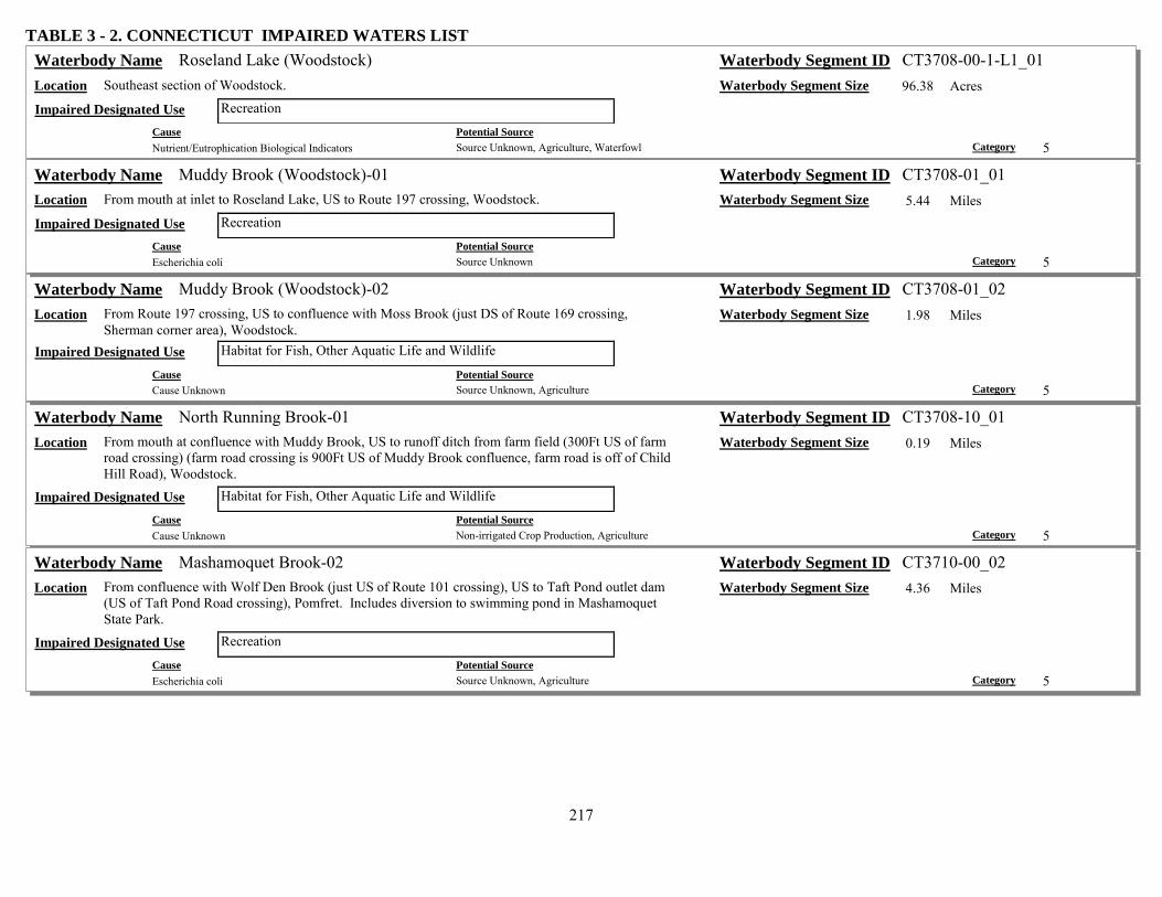
217
TABLE 3 - 2. CONNECTICUT IMPAIRED WATERS LIST Roseland Lake (Woodstock) Waterbody Name Waterbody Segment ID CT3708-00-1-L1_01
Location Southeast section of Woodstock. Waterbody Segment Size 96.38 Acres Recreation Impaired Designated Use
Cause Potential Source Nutrient/Eutrophication Biological Indicators Source Unknown, Agriculture, Waterfowl Category 5
Muddy Brook (Woodstock)-01 Waterbody Name Waterbody Segment ID CT3708-01_01 Location From mouth at inlet to Roseland Lake, US to Route 197 crossing, Woodstock. Waterbody Segment Size 5.44 Miles
Recreation Impaired Designated Use Cause Potential Source Escherichia coli Source Unknown Category 5
Muddy Brook (Woodstock)-02 Waterbody Name Waterbody Segment ID CT3708-01_02 Location From Route 197 crossing, US to confluence with Moss Brook (just DS of Route 169 crossing,
Sherman corner area), Woodstock. Waterbody Segment Size 1.98 Miles
Habitat for Fish, Other Aquatic Life and Wildlife Impaired Designated Use Cause Potential Source Cause Unknown Source Unknown, Agriculture Category 5
North Running Brook-01 Waterbody Name Waterbody Segment ID CT3708-10_01 Location From mouth at confluence with Muddy Brook, US to runoff ditch from farm field (300Ft US of farm
road crossing) (farm road crossing is 900Ft US of Muddy Brook confluence, farm road is off of Child Hill Road), Woodstock.
Waterbody Segment Size 0.19 Miles
Habitat for Fish, Other Aquatic Life and Wildlife Impaired Designated Use Cause Potential Source Cause Unknown Non-irrigated Crop Production, Agriculture Category 5
Mashamoquet Brook-02 Waterbody Name Waterbody Segment ID CT3710-00_02 Location From confluence with Wolf Den Brook (just US of Route 101 crossing), US to Taft Pond outlet dam
(US of Taft Pond Road crossing), Pomfret. Includes diversion to swimming pond in Mashamoquet State Park.
Waterbody Segment Size 4.36 Miles
Recreation Impaired Designated Use Cause Potential Source Escherichia coli Source Unknown, Agriculture Category 5

218
TABLE 3 - 2. CONNECTICUT IMPAIRED WATERS LIST Broad Brook (Preston)-01 Waterbody Name Waterbody Segment ID CT3716-00_01
Location From mouth at confluence with Quinnebaug River (DS of Old Jewett City Road crossing), at the Preston/Lisbon/Griswold borders, US to Lewis Pond outlet dam (north side of Route 165, near intersection with Lewis Road), Preston.
Waterbody Segment Size 4.73 Miles
Habitat for Fish, Other Aquatic Life and Wildlife Impaired Designated Use Cause Potential Source Cause Unknown Source Unknown Category 5
Recreation Impaired Designated Use Cause Potential Source Escherichia coli Source Unknown Category 5
Shetucket River-01 Waterbody Name Waterbody Segment ID CT3800-00_01 Location From end of estuary, at Route 2 crossing, US to Greenville dam, Norwich. Waterbody Segment Size 1.56 Miles
Recreation Impaired Designated Use Cause Potential Source Escherichia coli Combined Sewer Overflows Category 5
Shetucket River-05 Waterbody Name Waterbody Segment ID CT3800-00_05 Location From confluence with Cold Brook (DS of Franklin Mushroom Farm STP from unnamed tributary),
US to headwaters at confluence of Natchaug River and Willimantic River. Waterbody Segment Size 4.99 Miles
Habitat for Fish, Other Aquatic Life and Wildlife Impaired Designated Use Cause Potential Source Cause Unknown Source Unknown Category 5
Recreation Impaired Designated Use Cause Potential Source Escherichia coli Source Unknown Category 5
Spaulding Pond (Norwich) Waterbody Name Waterbody Segment ID CT3800-00-6+L3_01 Location Mohegan Park, Norwich (Mohegan Park Rd) Waterbody Segment Size 14.3 Acres
Recreation Impaired Designated Use Cause Potential Source Escherichia coli Waterfowl Category 5

219
TABLE 3 - 2. CONNECTICUT IMPAIRED WATERS LIST Little River (Sprague)-02 Waterbody Name Waterbody Segment ID CT3805-00_02
Location From inlet to Versailles Pond (northwest corner of pond), US to Papermill Pond outlet dam, Sprague. Waterbody Segment Size 0.89 Miles
Fish Consumption Impaired Designated Use Cause Potential Source Mercury Contaminated Sediments, Landfills, Source Unknown, Industrial Point Source Discharge Category 5 Cause Potential Source Polychlorinated biphenyls Industrial Point Source Discharge, Landfills, Contaminated Sediments, Source Unknown Category 5
Habitat for Fish, Other Aquatic Life and Wildlife Impaired Designated Use Cause Potential Source Cause Unknown Landfills, Source Unknown, Contaminated Sediments, Industrial Point Source Discharge Category 5 Cause Potential Source Whole Effluent Toxicity (WET) Landfills, Contaminated Sediments, Industrial Point Source Discharge, Source Unknown Category 5
Papermill Pond (Sprague) Waterbody Name Waterbody Segment ID CT3805-00-3-L6_01 Location Impoundment of Little River, Sprague. Waterbody Segment Size 77.15 Acres
Fish Consumption Impaired Designated Use Cause Potential Source Mercury Contaminated Sediments, Industrial Point Source Discharge Category 5 Cause Potential Source Polychlorinated biphenyls Industrial Point Source Discharge, Contaminated Sediments Category 5
Versailles Pond (Sprague) Waterbody Name Waterbody Segment ID CT3805-00-3-L7_01 Location Impoundment of Little River, southeast corner of Sprague. Waterbody Segment Size 57.2 Acres
Fish Consumption Impaired Designated Use Cause Potential Source Mercury Industrial Point Source Discharge, Contaminated Sediments Category 5 Cause Potential Source Polychlorinated biphenyls Contaminated Sediments, Industrial Point Source Discharge Category 5
Habitat for Fish, Other Aquatic Life and Wildlife Impaired Designated Use Cause Potential Source Nutrient/Eutrophication Biological Indicators Industrial Point Source Discharge, Source Unknown Category 5

220
TABLE 3 - 2. CONNECTICUT IMPAIRED WATERS LIST Unnamed Trib, Yantic River (Norwich Landfill)-01 Waterbody Name Waterbody Segment ID CT3900-00_trib_01
Location From mouth at confluence with Yantic River, just DS of RailRoad crossing (100m US of I395 crossing of Yantic River), US to Browning Pond outlet dam, Norwich (influenced by Landfill).
Waterbody Segment Size 0.57 Miles
Habitat for Fish, Other Aquatic Life and Wildlife Impaired Designated Use Cause Potential Source Ammonia (Un-ionized) Landfills, Discharges from Biosolids (SLUDGE) Storage, Application or Disposal Category 5 Cause Potential Source Copper Discharges from Biosolids (SLUDGE) Storage, Application or Disposal, Landfills Category 5 Cause Potential Source Dissolved oxygen saturation Landfills, Discharges from Biosolids (SLUDGE) Storage, Application or Disposal Category 5 Cause Potential Source Lead Landfills, Discharges from Biosolids (SLUDGE) Storage, Application or Disposal Category 5 Cause Potential Source Nutrient/Eutrophication Biological Indicators Discharges from Biosolids (SLUDGE) Storage, Application or Disposal, Landfills Category 5 Cause Potential Source Organic Enrichment (Sewage) Biological Indicators Landfills, Discharges from Biosolids (SLUDGE) Storage, Application or Disposal Category 5
Browning Pond (Norwich Landfill)-01 Waterbody Name Waterbody Segment ID CT3900-00-UL_pond_01 Location Located southwest of Route 2/32, near exit 27 offramp, along Browning Road (rivers entering and
exiting pond are intermittent), Norwich (influenced by Landfill). Waterbody Segment Size 0.58 Acres
Habitat for Fish, Other Aquatic Life and Wildlife Impaired Designated Use Cause Potential Source Ammonia (Un-ionized) Landfills, Discharges from Biosolids (SLUDGE) Storage, Application or Disposal Category 5 Cause Potential Source Copper Discharges from Biosolids (SLUDGE) Storage, Application or Disposal, Landfills Category 5 Cause Potential Source Dissolved oxygen saturation Landfills, Discharges from Biosolids (SLUDGE) Storage, Application or Disposal Category 5 Cause Potential Source Lead Discharges from Biosolids (SLUDGE) Storage, Application or Disposal, Landfills Category 5 Cause Potential Source Nutrient/Eutrophication Biological Indicators Landfills, Discharges from Biosolids (SLUDGE) Storage, Application or Disposal Category 5 Cause Potential Source Organic Enrichment (Sewage) Biological Indicators Landfills, Discharges from Biosolids (SLUDGE) Storage, Application or Disposal Category 5

221
TABLE 3 - 2. CONNECTICUT IMPAIRED WATERS LIST Kahn Brook-01 Waterbody Name Waterbody Segment ID CT3900-07_01
Location From mouth at confluence with Yantic River (just DS of Fitchville Road crossing), US to chicken farm road crossing, Bozrah.
Waterbody Segment Size 0.61 Miles
Habitat for Fish, Other Aquatic Life and Wildlife Impaired Designated Use Cause Potential Source Cause Unknown Source Unknown Category 5
Recreation Impaired Designated Use Cause Potential Source Enterococcus Agriculture, Animal Feeding Operations (NPS), Source Unknown Category 5
Connecticut River-01 Waterbody Name Waterbody Segment ID CT4000-00_01 Location From head of estuary at Chapman Pond outlet, East Haddam, US to northern most boundary of Hurd
State Park, East Hampton. Waterbody Segment Size 10.27 Miles
Fish Consumption Impaired Designated Use Cause Potential Source Polychlorinated biphenyls Source Unknown, Sources Outside State Jurisdiction or Borders Category 5
Recreation Impaired Designated Use Cause Potential Source Escherichia coli Source Unknown Category 5
Connecticut River-02 Waterbody Name Waterbody Segment ID CT4000-00_02 Location From northern most boundary of Hurd State Park, East Hampton, US to confluence with Reservoir
Brook (adjacent to Gildersleeve Island), Portland. Waterbody Segment Size 10.49 Miles
Fish Consumption Impaired Designated Use Cause Potential Source Polychlorinated biphenyls Source Unknown, Sources Outside State Jurisdiction or Borders Category 5
Recreation Impaired Designated Use Cause Potential Source Enterococcus Sources Outside State Jurisdiction or Borders, Combined Sewer Overflows, Source Unknown Category 5 Cause Potential Source Escherichia coli Sources Outside State Jurisdiction or Borders, Combined Sewer Overflows, Source Unknown Category 5

222
TABLE 3 - 2. CONNECTICUT IMPAIRED WATERS LIST Connecticut River-03 Waterbody Name Waterbody Segment ID CT4000-00_03
Location From Reservoir Brook confluence (adjacent to Gildersleeve Island), Portland, US to MA border. Waterbody Segment Size 35.26 Miles Fish Consumption Impaired Designated Use
Cause Potential Source Polychlorinated biphenyls Sources Outside State Jurisdiction or Borders, Source Unknown, Municipal Point Source Discharges Category 5
Recreation Impaired Designated Use Cause Potential Source Enterococcus Source Unknown, Sources Outside State Jurisdiction or Borders, Municipal Point Source Discharges,
Combined Sewer Overflows Category 5
Cause Potential Source Escherichia coli Municipal Point Source Discharges, Source Unknown, Sources Outside State Jurisdiction or Borders,
Combined Sewer Overflows Category 5
Roaring Brook (Glastonbury)-01 Waterbody Name Waterbody Segment ID CT4009-00_01 Location From mouth at Connecticut River US to Angus Park Pond dam at outlet (Angus Park Pond NOT
included). Waterbody Segment Size 6.73 Miles
Recreation Impaired Designated Use Cause Potential Source Escherichia coli Source Unknown Category 5
Angus Park Pond (Glastonbury) Waterbody Name Waterbody Segment ID CT4009-00-2-L4_01 Location Impoundment of Roaring Brook, east of Rte 83 Glastonbury. Waterbody Segment Size 9.35 Acres
Recreation Impaired Designated Use Cause Potential Source Escherichia coli Source Unknown, Waterfowl Category 5
Sumner Brook-01 Waterbody Name Waterbody Segment ID CT4013-00_01 Location From mouth at Connecticut River, Middletown, US to confuence with Long Hill Brook. Waterbody Segment Size 0.97 Miles
Recreation Impaired Designated Use Cause Potential Source Escherichia coli Sanitary Sewer Overflows (Collection System Failures) Category 5
Sumner Brook (Middletown)-02 Waterbody Name Waterbody Segment ID CT4013-00_02 Location Confluence with Long Hill Brook, parallel with Mill Street, US to Russells Pond OUTLET, DS of
Russell Street crossing, Middletown. Waterbody Segment Size 0.52 Miles
Habitat for Fish, Other Aquatic Life and Wildlife Impaired Designated Use Cause Potential Source Cause Unknown Source Unknown Category 5

223
TABLE 3 - 2. CONNECTICUT IMPAIRED WATERS LIST Crystal Lake (Middletown) Waterbody Name Waterbody Segment ID CT4013-05-1-L1_01
Location South of Randolph Road, Middletown. Waterbody Segment Size 30.96 Acres Recreation Impaired Designated Use
Cause Potential Source Escherichia coli Unspecified Urban Stormwater, Source Unknown, Waterfowl Category 5
Long Hill Brook-01 Waterbody Name Waterbody Segment ID CT4013-08_01 Location From mouth at Sumner Brook, US to Pameacha Pond outlet dam, just US of Pamecha Avenue
crossing, Middletown. Waterbody Segment Size 0.45 Miles
Recreation Impaired Designated Use Cause Potential Source Escherichia coli Sanitary Sewer Overflows (Collection System Failures) Category 5
Stony Brook (Suffield)-01 Waterbody Name Waterbody Segment ID CT4100-00_01 Location From mouth at outlet on canal parallel to Connecticut River, US to confluence with Muddy Brook at
railroad crossing, Suffield. Waterbody Segment Size 3.47 Miles
Habitat for Fish, Other Aquatic Life and Wildlife Impaired Designated Use Cause Potential Source Cause Unknown Source Unknown Category 5
Stony Brook (Suffield)-03 Waterbody Name Waterbody Segment ID CT4100-00_03 Location From confluence with DeGrayes Brook (just northwest of airport), US to headwaters (the confluence
of Rocky Gutter Brook and Rattlesnake Brook), Suffield. Waterbody Segment Size 4.27 Miles
Habitat for Fish, Other Aquatic Life and Wildlife Impaired Designated Use Cause Potential Source Cause Unknown Source Unknown Category 5
Muddy Brook (Suffield)-01 Waterbody Name Waterbody Segment ID CT4101-00_01 Location From mouth at Stony Brook, Suffield, US to confluence with Philo Brook. Waterbody Segment Size 2.23 Miles
Habitat for Fish, Other Aquatic Life and Wildlife Impaired Designated Use Cause Potential Source Cause Unknown Source Unknown Category 5
Recreation Impaired Designated Use Cause Potential Source Escherichia coli Source Unknown Category 5
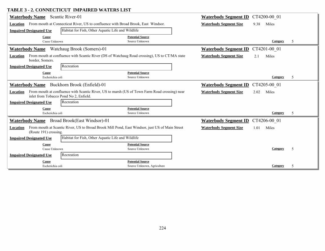
224
TABLE 3 - 2. CONNECTICUT IMPAIRED WATERS LIST Scantic River-01 Waterbody Name Waterbody Segment ID CT4200-00_01
Location From mouth at Connecticut River, US to confluence with Broad Brook, East Windsor. Waterbody Segment Size 9.38 Miles Habitat for Fish, Other Aquatic Life and Wildlife Impaired Designated Use
Cause Potential Source Cause Unknown Source Unknown Category 5
Watchaug Brook (Somers)-01 Waterbody Name Waterbody Segment ID CT4201-00_01 Location From mouth at confluence with Scantic River (DS of Watchaug Road crossing), US to CT/MA state
border, Somers. Waterbody Segment Size 2.1 Miles
Recreation Impaired Designated Use Cause Potential Source Escherichia coli Source Unknown Category 5
Buckhorn Brook (Enfield)-01 Waterbody Name Waterbody Segment ID CT4205-00_01 Location From mouth at confluence with Scantic River, US to marsh (US of Town Farm Road crossing) near
inlet from Tobacco Pond No 2, Enfield. Waterbody Segment Size 2.02 Miles
Recreation Impaired Designated Use Cause Potential Source Escherichia coli Source Unknown Category 5
Broad Brook(East Windsor)-01 Waterbody Name Waterbody Segment ID CT4206-00_01 Location From mouth at Scantic River, US to Broad Brook Mill Pond, East Windsor, just US of Main Street
(Route 191) crossing. Waterbody Segment Size 1.01 Miles
Habitat for Fish, Other Aquatic Life and Wildlife Impaired Designated Use Cause Potential Source Cause Unknown Source Unknown Category 5
Recreation Impaired Designated Use Cause Potential Source Escherichia coli Source Unknown, Agriculture Category 5

225
TABLE 3 - 2. CONNECTICUT IMPAIRED WATERS LIST Broad Brook (East Windsor-Ellington)-02 Waterbody Name Waterbody Segment ID CT4206-00_02
Location From Broad Brook Mill Pond inlet, East Windsor, US to headwaters, Ellington, just US of Snipsic Forest Road crossing.
Waterbody Segment Size 9.01 Miles
Habitat for Fish, Other Aquatic Life and Wildlife Impaired Designated Use Cause Potential Source Cause Unknown Source Unknown, Animal Feeding Operations (NPS), Livestock (Grazing or Feeding Operations) Category 5
Recreation Impaired Designated Use Cause Potential Source Escherichia coli Livestock (Grazing or Feeding Operations), Source Unknown, Animal Feeding Operations (NPS) Category 5
Farmington River-01 Waterbody Name Waterbody Segment ID CT4300-00_01 Location From mouth at Connecticut River, US to Rainbow Reservoir dam outlet, Windsor. Waterbody Segment Size 8.59 Miles
Habitat for Fish, Other Aquatic Life and Wildlife Impaired Designated Use Cause Potential Source Other flow regime alterations Impacts from Hydrostructure Flow Regulation/modification, Upstream Impoundments (e.g., Pl-566 NRCS
Structures) Category 4c
Farmington River-02 Waterbody Name Waterbody Segment ID CT4300-00_02 Location From inlet to Rainbow Reservoir (Route 187 crossing), Bloomfield, US to confluence with the
Pequabuck River, Farmington. Waterbody Segment Size 19.38 Miles
Recreation Impaired Designated Use Cause Potential Source Escherichia coli Source Unknown Category 5
Rainbow Reservoir (Windsor/Bloomfield/East Granby) Waterbody Name Waterbody Segment ID CT4300-00-5+L5_01 Location Northwest corner of Windsor. Impoundment of the Farmington River. Waterbody Segment Size 214.44 Acres
Habitat for Fish, Other Aquatic Life and Wildlife Impaired Designated Use Cause Potential Source Other flow regime alterations Impacts from Hydrostructure Flow Regulation/modification Category 4c
Minister Brook (Simsbury)-01 Waterbody Name Waterbody Segment ID CT4300-32_01 Location Mouth on Farmington River, DS of Route 202/10 crossing, US to HW just east of Pine Glen Road,
Simsbury. Waterbody Segment Size 1.82 Miles
Recreation Impaired Designated Use Cause Potential Source Escherichia coli Source Unknown Category 5

226
TABLE 3 - 2. CONNECTICUT IMPAIRED WATERS LIST Russell Brook (Simsbury)-01 Waterbody Name Waterbody Segment ID CT4300-33_01
Location Mouth on Farmington River, DS of Route 10 (202) road crossing, US to HW at White Fondation Pond, parallel to Deer Park Road, Simsbury.
Waterbody Segment Size 1.25 Miles
Recreation Impaired Designated Use Cause Potential Source Escherichia coli Source Unknown Category 5
Owens Brook (Simsbury)-01 Waterbody Name Waterbody Segment ID CT4300-39_01 Location Mouth on Farmington River, DS of Route 10 (202) road crossing, US to HW parallel to Owens Brook
Blvd, between Musket Trail and Winterset Lane intersections with Owens Brook Blvd, Simsbury. Waterbody Segment Size 1.05 Miles
Recreation Impaired Designated Use Cause Potential Source Escherichia coli Source Unknown Category 5
Munnisunk Brook (Simsbury)-01 Waterbody Name Waterbody Segment ID CT4300-44_01 Location From mouth at confluence with Farmington River, US to Lake Basile outlet dam (US of Wolcott
Road and RailRoad crossings), Simsbury. Waterbody Segment Size 0.89 Miles
Recreation Impaired Designated Use Cause Potential Source Escherichia coli Source Unknown Category 5
Perkins Brook-01 Waterbody Name Waterbody Segment ID CT4300-48_01 Location From mouth on Farmington River at Rainbow Reservoir, Windsor, US to former Combustion
Engineering outfall approximately 50 feet DS of Goodwin Pond outlet. Waterbody Segment Size 0.67 Miles
Habitat for Fish, Other Aquatic Life and Wildlife Impaired Designated Use Cause Potential Source Cobalt Contaminated Sediments, Contaminated Sediments, Industrial Point Source Discharge, Industrial Point
Source Discharge Category 4b
Cause Potential Source Uranium Contaminated Sediments, Contaminated Sediments, Industrial Point Source Discharge, Industrial Point
Source Discharge Category 4b

227
TABLE 3 - 2. CONNECTICUT IMPAIRED WATERS LIST Rainbow Brook-01 Waterbody Name Waterbody Segment ID CT4300-50_01
Location From mouth at Farmington River (just DS of Island below Rainbow Reservoir Dam), Windsor, US to headwaters, southwest portion of Bradley International Airport, Windsor Locks.
Waterbody Segment Size 1.74 Miles
Habitat for Fish, Other Aquatic Life and Wildlife Impaired Designated Use Cause Potential Source Ethylene Glycol Airports Category 4a Cause Potential Source Propylene Glycol Airports Category 4a
Seymour Hollow Brook-01 Waterbody Name Waterbody Segment ID CT4300-51_01 Location From mouth at Farmington River, Windsor (formerly tributary to Rainbow Brook, now channelized to
Farmington, Gazetteer # based upon Rainbow Brook), US to headwaters, southest portion of Bradley International Airport, Windsor Locks.
Waterbody Segment Size 1.36 Miles
Habitat for Fish, Other Aquatic Life and Wildlife Impaired Designated Use Cause Potential Source Ethylene Glycol Airports Category 4a Cause Potential Source Propylene Glycol Airports Category 4a
Mad River (Winchester)-01 Waterbody Name Waterbody Segment ID CT4302-00_01 Location From mouth at Still River, US to Mad River Dam outlet, Winchester. Waterbody Segment Size 2.24 Miles
Habitat for Fish, Other Aquatic Life and Wildlife Impaired Designated Use Cause Potential Source Cause Unknown Source Unknown Category 5
Recreation Impaired Designated Use Cause Potential Source Escherichia coli Source Unknown Category 5
Mad River (Winchester)-02a Waterbody Name Waterbody Segment ID CT4302-00_02a Location From Mad River Dam outlet, Wincheter, US to outlet from Rugg Brook Reservoir. Waterbody Segment Size 1.77 Miles
Recreation Impaired Designated Use Cause Potential Source Escherichia coli Source Unknown Category 5

228
TABLE 3 - 2. CONNECTICUT IMPAIRED WATERS LIST Mad River (Winchester)-02b Waterbody Name Waterbody Segment ID CT4302-00_02b
Location From confluence with Rugg Brook Reservoir outlet, US to diversion entrance for Rugg Brook Reservoir.
Waterbody Segment Size 0.63 Miles
Habitat for Fish, Other Aquatic Life and Wildlife Impaired Designated Use Cause Potential Source Other flow regime alterations Flow Alterations from Water Diversions Category 4c
Mad River (Winchester)-03 Waterbody Name Waterbody Segment ID CT4302-00_03 Location From diversion entrance for Rugg Brook Reservoir (boundary of drinking water watershed), US to
headwaters at Spaulding Pond outlet dam, Norfolk. Waterbody Segment Size 5.17 Miles
Recreation Impaired Designated Use Cause Potential Source Escherichia coli Source Unknown Category 5
Still River (Colebrook)-02 Waterbody Name Waterbody Segment ID CT4303-00_02 Location From confluence with Sandy Brook, Colebrook, US to Winchester (Winsted) POTW (east side of
Route 8), Winsted. Waterbody Segment Size 2.67 Miles
Habitat for Fish, Other Aquatic Life and Wildlife Impaired Designated Use Cause Potential Source Cause Unknown Source Unknown Category 5
Recreation Impaired Designated Use Cause Potential Source Escherichia coli Source Unknown Category 5
Still River (Winsted)-03 Waterbody Name Waterbody Segment ID CT4303-00_03 Location From Winchester (Winsted) POTW, US to confuence with Mad River (just US of Route 44/183
crossing). Waterbody Segment Size 1.67 Miles
Habitat for Fish, Other Aquatic Life and Wildlife Impaired Designated Use Cause Potential Source Cause Unknown Source Unknown Category 5
Recreation Impaired Designated Use Cause Potential Source Escherichia coli Source Unknown Category 5

229
TABLE 3 - 2. CONNECTICUT IMPAIRED WATERS LIST Sandy Brook (Barkhamsted/Colebrook)-01a Waterbody Name Waterbody Segment ID CT4304-00_01a
Location From mouth at confluence with Farmington River, Barkhamsted, US to confluence with Still River, Colebrook. NOTE this portion was formerly called Still River-01 (CT4303-00_01).
Waterbody Segment Size 1.35 Miles
Recreation Impaired Designated Use Cause Potential Source Escherichia coli Source Unknown Category 5
Morgan Brook-01 Waterbody Name Waterbody Segment ID CT4305-00_01 Location From mouth at West Branch Farmington River, US to confluence with tributary 4305-04 (first
confluence) on east side of Route 44, Barkhamsted. Waterbody Segment Size 0.69 Miles
Recreation Impaired Designated Use Cause Potential Source Escherichia coli Source Unknown Category 5
Morgan Brook-02 Waterbody Name Waterbody Segment ID CT4305-00_02 Location From confluence with tributary 4305-04 (end of seg-01) east side of Route 44, US to East West Hill
Road crossing area (50 meters US of East West Hill Road crossing, entrance of 9/12/05 home heating fuel spill), Barkhamsted.
Waterbody Segment Size 1.41 Miles
Recreation Impaired Designated Use Cause Potential Source Escherichia coli Source Unknown Category 5
Morgan Brook-04 Waterbody Name Waterbody Segment ID CT4305-00_04 Location From confluence with Mallory Brook, US to West Hill Pond outlet dam, Barkhamsted. Waterbody Segment Size 1.52 Miles
Recreation Impaired Designated Use Cause Potential Source Escherichia coli Source Unknown Category 5
Farmington River, East Branch-01 Waterbody Name Waterbody Segment ID CT4308-00_01 Location From mouth at Farmington River mainstem, New Hartford, US to Lake McDonough outlet dam. Waterbody Segment Size 1.11 Miles
Habitat for Fish, Other Aquatic Life and Wildlife Impaired Designated Use Cause Potential Source Other flow regime alterations Upstream Impoundments (e.g., Pl-566 NRCS Structures), Flow Alterations from Water Diversions Category 4c
Recreation Impaired Designated Use Cause Potential Source Other flow regime alterations Flow Alterations from Water Diversions, Upstream Impoundments (e.g., Pl-566 NRCS Structures) Category 4c

230
TABLE 3 - 2. CONNECTICUT IMPAIRED WATERS LIST Compensating Res. (L. McDonough) (Barkhamsted/New Hartford) Waterbody Name Waterbody Segment ID CT4308-00-1-L2_01
Location Southeast Barkhamsted - northeast New Hartford. Waterbody Segment Size 385.75 Acres Fish Consumption Impaired Designated Use
Cause Potential Source Mercury Atmospheric Deposition - Toxics Category 5
Cherry Brook (Canton)-01 Waterbody Name Waterbody Segment ID CT4309-00_01 Location From mouth at confluence with Farmington River (just DS of Albany Turnpike (Route 44) crossing),
US to Barbourtown Road crossing, Canton. Waterbody Segment Size 2.05 Miles
Recreation Impaired Designated Use Cause Potential Source Escherichia coli Source Unknown Category 5
Cherry Brook (Canton)-02 Waterbody Name Waterbody Segment ID CT4309-00_02 Location From Barbourtown road crossing (segment-01), US to confluence with unnamed tributary (outlet
stream for Linsey Pond), just US of Meadow Road crossing, Canton. Waterbody Segment Size 0.66 Miles
Recreation Impaired Designated Use Cause Potential Source Escherichia coli Source Unknown Category 5
Nepaug River-01 Waterbody Name Waterbody Segment ID CT4310-00_01 Location From mouth at confluence with Farmington River (southwest of Route 202 crossing), US to Nepaug
Reservoir outlet dam. Waterbody Segment Size 0.9 Miles
Habitat for Fish, Other Aquatic Life and Wildlife Impaired Designated Use Cause Potential Source Other flow regime alterations Upstream Impoundments (e.g., Pl-566 NRCS Structures), Flow Alterations from Water Diversions Category 4c
Recreation Impaired Designated Use Cause Potential Source Other flow regime alterations Upstream Impoundments (e.g., Pl-566 NRCS Structures), Flow Alterations from Water Diversions Category 4c
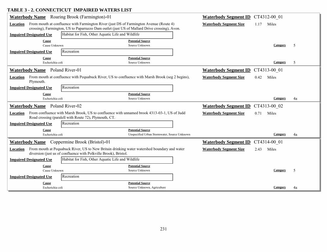
231
TABLE 3 - 2. CONNECTICUT IMPAIRED WATERS LIST Roaring Brook (Farmington)-01 Waterbody Name Waterbody Segment ID CT4312-00_01
Location From mouth at confluence with Farmington River (just DS of Farmington Avenue (Route 4) crossing), Farmington, US to Paparrazzo Dam outlet (just US of Mallard Drive crossing), Avon.
Waterbody Segment Size 1.17 Miles
Habitat for Fish, Other Aquatic Life and Wildlife Impaired Designated Use Cause Potential Source Cause Unknown Source Unknown Category 5
Recreation Impaired Designated Use Cause Potential Source Escherichia coli Source Unknown Category 5
Poland River-01 Waterbody Name Waterbody Segment ID CT4313-00_01 Location From mouth at confluence with Pequabuck River, US to confluence with Marsh Brook (seg 2 begins),
Plymouth. Waterbody Segment Size 0.42 Miles
Recreation Impaired Designated Use Cause Potential Source Escherichia coli Source Unknown Category 4a
Poland River-02 Waterbody Name Waterbody Segment ID CT4313-00_02 Location From confluence with Marsh Brook, US to confluence with unnamed brook 4313-03-1, US of Judd
Road crossing (paralell with Route 72), Plymouth, CT. Waterbody Segment Size 0.71 Miles
Recreation Impaired Designated Use Cause Potential Source Escherichia coli Unspecified Urban Stormwater, Source Unknown Category 4a
Coppermine Brook (Bristol)-01 Waterbody Name Waterbody Segment ID CT4314-00_01 Location From mouth at Pequabuck River, US to New Britain drinking water watershed boundary and water
diversion (just us of confluence with Polkville Brook), Bristol. Waterbody Segment Size 2.43 Miles
Habitat for Fish, Other Aquatic Life and Wildlife Impaired Designated Use Cause Potential Source Cause Unknown Source Unknown Category 5
Recreation Impaired Designated Use Cause Potential Source Escherichia coli Source Unknown, Agriculture Category 4a

232
TABLE 3 - 2. CONNECTICUT IMPAIRED WATERS LIST Pequabuck River-01 Waterbody Name Waterbody Segment ID CT4315-00_01
Location From mouth at Farmington River, US to RailRoad crossing (US (south) of Route 72 crossing), Plainville.
Waterbody Segment Size 5.37 Miles
Habitat for Fish, Other Aquatic Life and Wildlife Impaired Designated Use Cause Potential Source Cause Unknown Unspecified Urban Stormwater, Municipal Point Source Discharges Category 5
Recreation Impaired Designated Use Cause Potential Source Escherichia coli Unspecified Urban Stormwater, Source Unknown Category 4a
Pequabuck River-02 Waterbody Name Waterbody Segment ID CT4315-00_02 Location From RailRoad crossing (US (south) of Route 72 crossing), Plainville, US to Bristol POTW outfall
(DS of route 229 crossing), Bristol. Waterbody Segment Size 3.37 Miles
Habitat for Fish, Other Aquatic Life and Wildlife Impaired Designated Use Cause Potential Source Cause Unknown Municipal Point Source Discharges, Unspecified Urban Stormwater, Industrial Point Source Discharge Category 5
Recreation Impaired Designated Use Cause Potential Source Escherichia coli Unspecified Urban Stormwater, Source Unknown, Industrial Point Source Discharge, Municipal Point
Source Discharges Category 4a
Pequabuck River-03 Waterbody Name Waterbody Segment ID CT4315-00_03 Location From Bristol POTW outfall (DS of route 229 crossing), US to exit of box culvert, downtown Bristol. Waterbody Segment Size 1.23 Miles
Habitat for Fish, Other Aquatic Life and Wildlife Impaired Designated Use Cause Potential Source Cause Unknown Municipal Point Source Discharges, Source Unknown, Industrial Point Source Discharge, Unspecified
Urban Stormwater Category 5
Cause Potential Source Zinc Unspecified Urban Stormwater, Municipal Point Source Discharges, Source Unknown, Industrial Point
Source Discharge Category 5
Recreation Impaired Designated Use Cause Potential Source Escherichia coli Source Unknown Category 4a

233
TABLE 3 - 2. CONNECTICUT IMPAIRED WATERS LIST Pequabuck River-04 Waterbody Name Waterbody Segment ID CT4315-00_04
Location From exit of box culvert, US to entrance of box culvert (entire segment in culvert), center of Bristol. Waterbody Segment Size 0.33 Miles
Habitat for Fish, Other Aquatic Life and Wildlife Impaired Designated Use Cause Potential Source Physical substrate habitat alterations Channelization Category 4c
Recreation Impaired Designated Use Cause Potential Source Escherichia coli Source Unknown Category 4a Cause Potential Source Physical substrate habitat alterations Channelization Category 4c
Pequabuck River-05 Waterbody Name Waterbody Segment ID CT4315-00_05 Location From entrance to box culvert, center Bristol, US to Plymouth POTW (just DS of Canal Street (Route
72) crossing), Plymouth. Waterbody Segment Size 2.7 Miles
Habitat for Fish, Other Aquatic Life and Wildlife Impaired Designated Use Cause Potential Source Cause Unknown Source Unknown Category 5
Recreation Impaired Designated Use Cause Potential Source Escherichia coli Source Unknown Category 4a
Pequabuck River-06 Waterbody Name Waterbody Segment ID CT4315-00_06 Location From Plymouth POTW (just DS of Canal Street (Route72) crossing), US to headwaters, South of
Rocky Road, Harwinton. Waterbody Segment Size 5.46 Miles
Habitat for Fish, Other Aquatic Life and Wildlife Impaired Designated Use Cause Potential Source Cause Unknown Source Unknown Category 5
Recreation Impaired Designated Use Cause Potential Source Escherichia coli Source Unknown Category 4a
Thompson Brook (Avon)-01 Waterbody Name Waterbody Segment ID CT4316-00_01 Location From mouth at confluence with Farmington River (DS of Old Farms Road crossing), US to INLET of
Beaverdam Pond (DS of old RailRoad crossing which is now a bike path), Avon. Waterbody Segment Size 1.91 Miles
Recreation Impaired Designated Use Cause Potential Source Escherichia coli Source Unknown Category 5

234
TABLE 3 - 2. CONNECTICUT IMPAIRED WATERS LIST Nod Brook-01 Waterbody Name Waterbody Segment ID CT4317-00_01
Location From mouth at dredge holes (Twin Lakes North & South) near Farmington River, Avon, US to headwaters (just US of Rocklyn Road crossing), Simsbury.
Waterbody Segment Size 6.61 Miles
Recreation Impaired Designated Use Cause Potential Source Escherichia coli Source Unknown Category 5
Hop Brook (Simsbury)-01 Waterbody Name Waterbody Segment ID CT4318-00_01 Location From mouth at Farmington River, US to headwaters at Tuller Reservoir, Simsbury. Waterbody Segment Size 6.74 Miles
Recreation Impaired Designated Use Cause Potential Source Escherichia coli Source Unknown Category 5
Salmon Brook, West Branch (Granby)-01a Waterbody Name Waterbody Segment ID CT4319-00_01a Location From mouth at confluence with East Branch Salmon Brook (part of Salmon Brook mainstem), DS of
Route 10/202 crossing, just to West of Route 189, Granby, US to Bissell Brook (just US of Route 10/202 crossing), Granby.
Waterbody Segment Size 1.4 Miles
Recreation Impaired Designated Use Cause Potential Source Escherichia coli Source Unknown Category 5
Salmon Brook, West Branch (Granby)-01b Waterbody Name Waterbody Segment ID CT4319-00_01b Location From confluence with Bissell Brook (US of Route 10/202 crossing), US to headwaters (just US of
Route 179 (South Road) crossing), Hartland. Waterbody Segment Size 11.29 Miles
Recreation Impaired Designated Use Cause Potential Source Escherichia coli Source Unknown Category 5
Salmon Brook (East Granby)-01 Waterbody Name Waterbody Segment ID CT4320-00_01 Location From mouth at confluence with Farmington River (DS of Floydville Road crossing), East Granby, US
to Massachusetts border (includes Salmon Brook and East Branch Salmon Brook sections), Granby. Waterbody Segment Size 13.55 Miles
Recreation Impaired Designated Use Cause Potential Source Escherichia coli Source Unknown Category 5

235
TABLE 3 - 2. CONNECTICUT IMPAIRED WATERS LIST Mountain Brook (Suffield)-01 Waterbody Name Waterbody Segment ID CT4320-19_01
Location From mouth at confluence with Hungary Brook (just US of RailRoad crossing on Hungary Brook), US to confluence with unnamed tributary just US of Copper Hill Road crossing, Suffield.
Waterbody Segment Size 1.37 Miles
Recreation Impaired Designated Use Cause Potential Source Escherichia coli Source Unknown Category 5
Mill Brook (Windsor)-01 Waterbody Name Waterbody Segment ID CT4321-00_01 Location From mouth at confluence with Farmington River (DS of Palisado Avenue and RailRoad crossings),
Windsor, US to Barber Pond Outlet dam (just US of Old Winsor Road (Route 305) crossing), Bloomfield.
Waterbody Segment Size 4.56 Miles
Habitat for Fish, Other Aquatic Life and Wildlife Impaired Designated Use Cause Potential Source Cause Unknown Source Unknown Category 5
Recreation Impaired Designated Use Cause Potential Source Escherichia coli Source Unknown Category 5
Park river-01 Waterbody Name Waterbody Segment ID CT4400-00_01 Location From mouth at Connecticut River, US to confuence with North Branch Park River, just DS of I84
crossing at opening of conduit (US of Willow Street crossing). Waterbody Segment Size 2.39 Miles
Habitat for Fish, Other Aquatic Life and Wildlife Impaired Designated Use Cause Potential Source Physical substrate habitat alterations Channelization Category 4c
Recreation Impaired Designated Use Cause Potential Source Escherichia coli Combined Sewer Overflows Category 5 Cause Potential Source Physical substrate habitat alterations Channelization Category 4c

236
TABLE 3 - 2. CONNECTICUT IMPAIRED WATERS LIST South Branch Park River-01 Waterbody Name Waterbody Segment ID CT4400-01_01
Location From mouth at confluence with Park River, US to enterance of conduit (entire segment in pipe underground).
Waterbody Segment Size 0.32 Miles
Habitat for Fish, Other Aquatic Life and Wildlife Impaired Designated Use Cause Potential Source Cause Unknown Unspecified Urban Stormwater, Source Unknown Category 5 Cause Potential Source Physical substrate habitat alterations Channelization Category 4c
Recreation Impaired Designated Use Cause Potential Source Escherichia coli Unspecified Urban Stormwater, Combined Sewer Overflows Category 5 Cause Potential Source Physical substrate habitat alterations Channelization Category 4c
South Branch Park River-02 Waterbody Name Waterbody Segment ID CT4400-01_02 Location From entrance of conduit (segment-01), US to confluence with Piper and Trout Brooks, between
railroad tracks and Route 173 (New Britian avenue). Waterbody Segment Size 2.62 Miles
Habitat for Fish, Other Aquatic Life and Wildlife Impaired Designated Use Cause Potential Source Cause Unknown Loss of Riparian Habitat, Unspecified Urban Stormwater, Combined Sewer Overflows Category 5 Cause Potential Source Physical substrate habitat alterations Channelization, Loss of Riparian Habitat Category 4c
Recreation Impaired Designated Use Cause Potential Source Escherichia coli Unspecified Urban Stormwater, Combined Sewer Overflows Category 5 Cause Potential Source Physical substrate habitat alterations Channelization Category 4c
Batterson Park Pond (Farmington/New Britain) Waterbody Name Waterbody Segment ID CT4401-00-1-L1_01 Location Southeast Farmington - northeastern border of New Britain. Waterbody Segment Size 145.49 Acres
Recreation Impaired Designated Use Cause Potential Source Chlorophyll-a Highway/Road/Bridge Runoff (Non-construction Related), Waterfowl, Post-development Erosion and
Sedimentation, Unspecified Urban Stormwater Category 4a
Cause Potential Source Excess Algal Growth Unspecified Urban Stormwater, Waterfowl, Post-development Erosion and Sedimentation,
Highway/Road/Bridge Runoff (Non-construction Related) Category 4a
Cause Potential Source Nutrient/Eutrophication Biological Indicators Unspecified Urban Stormwater, Waterfowl, Highway/Road/Bridge Runoff (Non-construction Related), Post-
development Erosion and Sedimentation Category 4a
237
TABLE 3 - 2. CONNECTICUT IMPAIRED WATERS LIST Piper Brook-01 Waterbody Name Waterbody Segment ID CT4402-00_01
Location From mouth at confluence with Trout brook, above South Branch Park River, West Hartford, US (under New Britian Avenue), to conduit opening, US side of New Britain Ave (segment completely in conduit).
Waterbody Segment Size 0.05 Miles
Habitat for Fish, Other Aquatic Life and Wildlife Impaired Designated Use Cause Potential Source Physical substrate habitat alterations Channelization Category 4c
Recreation Impaired Designated Use Cause Potential Source Physical substrate habitat alterations Channelization Category 4c
Piper Brook-02 Waterbody Name Waterbody Segment ID CT4402-00_02 Location From conduit entrance (segment-01) US side of New Britain Avenue, West Hartford, US into St.
Marys Cemetary (just US of railroad crossing and parallel with Route 9) where pipe emerges from ground, New Britain.
Waterbody Segment Size 5.81 Miles
Habitat for Fish, Other Aquatic Life and Wildlife Impaired Designated Use Cause Potential Source Cause Unknown Unspecified Urban Stormwater, Combined Sewer Overflows, Source Unknown, Sanitary Sewer Overflows
(Collection System Failures) Category 5
Recreation Impaired Designated Use Cause Potential Source Escherichia coli Sanitary Sewer Overflows (Collection System Failures), Combined Sewer Overflows, Unspecified Urban
Stormwater, Source Unknown Category 5
Trout Brook-01 Waterbody Name Waterbody Segment ID CT4403-00_01 Location From mouth at confluence with Piper Brook, above South Branch Park River (just DS of railroad
crossing, near New Britian Avenue), West Hartford, US under Route 84 exit 42 (Trout Brook Drive) ramp.
Waterbody Segment Size 1.07 Miles
Habitat for Fish, Other Aquatic Life and Wildlife Impaired Designated Use Cause Potential Source Cause Unknown Loss of Riparian Habitat, Combined Sewer Overflows, Unspecified Urban Stormwater Category 5 Cause Potential Source Physical substrate habitat alterations Loss of Riparian Habitat, Channelization Category 4c
Recreation Impaired Designated Use Cause Potential Source Escherichia coli Unspecified Urban Stormwater, Combined Sewer Overflows Category 5

238
TABLE 3 - 2. CONNECTICUT IMPAIRED WATERS LIST Trout Brook-02 Waterbody Name Waterbody Segment ID CT4403-00_02
Location From US side of Route 84 Exit 42 (Trout Brook) ramp, West Hartford, US to Park Road crossing (Entire segment flows through concrete channel).
Waterbody Segment Size 0.88 Miles
Habitat for Fish, Other Aquatic Life and Wildlife Impaired Designated Use Cause Potential Source Cause Unknown Channelization, Loss of Riparian Habitat, Combined Sewer Overflows, Unspecified Urban Stormwater Category 5
Cause Potential Source Physical substrate habitat alterations Loss of Riparian Habitat, Channelization Category 4c
Recreation Impaired Designated Use Cause Potential Source Escherichia coli Combined Sewer Overflows, Unspecified Urban Stormwater Category 5 Cause Potential Source Physical substrate habitat alterations Channelization, Loss of Riparian Habitat Category 4c
Trout Brook-03 Waterbody Name Waterbody Segment ID CT4403-00_03 Location From Park Road crossing (just DS of Boulevard road crossing), US to Woodbridge Lake outlet dam,
West Hartford. Waterbody Segment Size 5.95 Miles
Habitat for Fish, Other Aquatic Life and Wildlife Impaired Designated Use Cause Potential Source Cause Unknown Loss of Riparian Habitat, Unspecified Urban Stormwater, Combined Sewer Overflows Category 5 Cause Potential Source Physical substrate habitat alterations Loss of Riparian Habitat, Channelization Category 4c
Recreation Impaired Designated Use Cause Potential Source Escherichia coli Unspecified Urban Stormwater, Combined Sewer Overflows Category 5 Cause Potential Source Physical substrate habitat alterations Channelization, Loss of Riparian Habitat Category 4c

239
TABLE 3 - 2. CONNECTICUT IMPAIRED WATERS LIST North Branch Park River-01 Waterbody Name Waterbody Segment ID CT4404-00_01
Location From mouth at confluence with Park River just DS of I84 crossing, US to entrance of conduit (entire segment in pipe) near Farmingotn Avenue, Hartford.
Waterbody Segment Size 0.51 Miles
Habitat for Fish, Other Aquatic Life and Wildlife Impaired Designated Use Cause Potential Source Physical substrate habitat alterations Channelization Category 4c
Recreation Impaired Designated Use Cause Potential Source Escherichia coli Combined Sewer Overflows Category 5 Cause Potential Source Physical substrate habitat alterations Channelization Category 4c
North Branch Park River-02 Waterbody Name Waterbody Segment ID CT4404-00_02 Location From DS side of Farmington Avenue (at entrance of conduit), US to confluence with Wash Brook
(just DS of confluence of Wash Brook and Beamans Brook), Bloomfield. Waterbody Segment Size 5.39 Miles
Habitat for Fish, Other Aquatic Life and Wildlife Impaired Designated Use Cause Potential Source Cause Unknown Unspecified Urban Stormwater, Combined Sewer Overflows Category 5
Recreation Impaired Designated Use Cause Potential Source Escherichia coli Unspecified Urban Stormwater, Combined Sewer Overflows Category 5
Hockanum River-01 Waterbody Name Waterbody Segment ID CT4500-00_01 Location From mouth at Connecticut River, East Hartford, US to Cellu Company Dam, the first dam at
Scotland Impoundment (two dams just DS of this dam), includes impounded water behind East Hartford town hall.
Waterbody Segment Size 4.26 Miles
Habitat for Fish, Other Aquatic Life and Wildlife Impaired Designated Use Cause Potential Source Cause Unknown Unspecified Urban Stormwater, Source Unknown Category 5

240
TABLE 3 - 2. CONNECTICUT IMPAIRED WATERS LIST Hockanum River-02 Waterbody Name Waterbody Segment ID CT4500-00_02
Location From Cellu Company dam (first dam at Scotland Impoundment), US to confluence with South Fork Hockanum (AKA Hop) River, just US of "Laurel Lake", Manchester.
Waterbody Segment Size 3.6 Miles
Habitat for Fish, Other Aquatic Life and Wildlife Impaired Designated Use Cause Potential Source Cause Unknown Unspecified Urban Stormwater, Municipal Point Source Discharges, Source Unknown Category 5
Recreation Impaired Designated Use Cause Potential Source Escherichia coli Unspecified Urban Stormwater, Source Unknown Category 5
Hockanum River-03 Waterbody Name Waterbody Segment ID CT4500-00_03 Location From confluence with South Fork Hockanum (AKA Hop) River (just US of "Laurel Lake"), US to
Union Pond outlet dam, Manchester. Waterbody Segment Size 3.42 Miles
Habitat for Fish, Other Aquatic Life and Wildlife Impaired Designated Use Cause Potential Source Cause Unknown Unspecified Urban Stormwater, Source Unknown Category 5
Recreation Impaired Designated Use Cause Potential Source Escherichia coli Source Unknown Category 5
Hockanum River-04a Waterbody Name Waterbody Segment ID CT4500-00_04a Location From inlet to Union Pond, Manchester, US to confluence with Tankerhoosen River, Vernon. Waterbody Segment Size 1.44 Miles
Habitat for Fish, Other Aquatic Life and Wildlife Impaired Designated Use Cause Potential Source Cause Unknown Municipal Point Source Discharges, Source Unknown, Unspecified Urban Stormwater Category 5
Recreation Impaired Designated Use Cause Potential Source Escherichia coli Source Unknown Category 5
Hockanum river-04b Waterbody Name Waterbody Segment ID CT4500-00_04b Location From confluence with Tankerhoosen River, Vernon, US to marsh (approximatly one mile DS of Dart
Hill Road crossing, parallel to Route 83, near Neak Road), Vernon. Waterbody Segment Size 1.67 Miles
Habitat for Fish, Other Aquatic Life and Wildlife Impaired Designated Use Cause Potential Source Cause Unknown Municipal Point Source Discharges, Source Unknown, Unspecified Urban Stormwater Category 5
Recreation Impaired Designated Use Cause Potential Source Escherichia coli Source Unknown Category 5
241
TABLE 3 - 2. CONNECTICUT IMPAIRED WATERS LIST Hockanum River-05 Waterbody Name Waterbody Segment ID CT4500-00_05
Location From marsh exit (approximatly one mile DS of Dart Hill Road crossing, parallel to Route 83, near Neak Road), Vernon, US to Vernon POTW (just DS of Route 74 crossing).
Waterbody Segment Size 2.48 Miles
Habitat for Fish, Other Aquatic Life and Wildlife Impaired Designated Use Cause Potential Source Cause Unknown Municipal Point Source Discharges, Source Unknown, Unspecified Urban Stormwater Category 5
Recreation Impaired Designated Use Cause Potential Source Escherichia coli Source Unknown Category 5
Hockanum River-06a Waterbody Name Waterbody Segment ID CT4500-00_06a Location From Vernon POTW (just DS of Route 74 crossing), Vernon, US to Windsor Avenue crossing (Route
74), Vernon. Waterbody Segment Size 3.03 Miles
Habitat for Fish, Other Aquatic Life and Wildlife Impaired Designated Use Cause Potential Source Cause Unknown Channelization, Agriculture, Unspecified Urban Stormwater, Habitat Modification - other than
Hydromodification Category 5
Recreation Impaired Designated Use Cause Potential Source Alterations in wetland habitats Habitat Modification - other than Hydromodification, Channelization Category 4c Cause Potential Source Escherichia coli Unspecified Urban Stormwater, Agriculture Category 5
Hockanum River-06b Waterbody Name Waterbody Segment ID CT4500-00_06b Location From Windsor Avenue crossing (Route 74), Vernon, US to Vernon Ave, Vernon (Rockville). Waterbody Segment Size 0.93 Miles
Habitat for Fish, Other Aquatic Life and Wildlife Impaired Designated Use Cause Potential Source Cause Unknown Unspecified Urban Stormwater, Agriculture, Habitat Modification - other than Hydromodification,
Channelization Category 5
Recreation Impaired Designated Use Cause Potential Source Alterations in wetland habitats Channelization, Habitat Modification - other than Hydromodification Category 4c Cause Potential Source Escherichia coli Unspecified Urban Stormwater, Source Unknown, Agriculture Category 5

242
TABLE 3 - 2. CONNECTICUT IMPAIRED WATERS LIST Hockanum River-07 Waterbody Name Waterbody Segment ID CT4500-00_07
Location From Vernon Ave (outlet of culvert), Rockville, US to Paper Mill Pond outlet dam (inlet to culvert). Waterbody Segment Size 0.52 Miles
Habitat for Fish, Other Aquatic Life and Wildlife Impaired Designated Use Cause Potential Source Physical substrate habitat alterations Channelization Category 4c
Recreation Impaired Designated Use Cause Potential Source Physical substrate habitat alterations Channelization Category 4c
Hockanum river-08 Waterbody Name Waterbody Segment ID CT4500-00_08 Location From Paper Mill Pond outlet dam, Rockville, US to Shenipsit Lake outlet dam. Waterbody Segment Size 0.59 Miles
Habitat for Fish, Other Aquatic Life and Wildlife Impaired Designated Use Cause Potential Source Cause Unknown Source Unknown, Upstream Impoundments (e.g., Pl-566 NRCS Structures), Impacts from Hydrostructure
Flow Regulation/modification Category 5
Union Pond (Manchester) Waterbody Name Waterbody Segment ID CT4500-00-3-L3_01 Location Impoundment of Hockanum River in Manchester at Union Street. Waterbody Segment Size 49.9 Acres
Fish Consumption Impaired Designated Use Cause Potential Source Chlordane Contaminated Sediments, Unspecified Urban Stormwater Category 5
Habitat for Fish, Other Aquatic Life and Wildlife Impaired Designated Use Cause Potential Source Excess Algal Growth Post-development Erosion and Sedimentation, Unspecified Urban Stormwater Category 5 Cause Potential Source Nutrient/Eutrophication Biological Indicators Post-development Erosion and Sedimentation, Unspecified Urban Stormwater Category 5 Cause Potential Source Sedimentation/Siltation Unspecified Urban Stormwater, Post-development Erosion and Sedimentation Category 5
Ogden Brook (Vernon)-01 Waterbody Name Waterbody Segment ID CT4500-04_01 Location Mouth on Hockanum River, just DS of Thrall Road crossing, US to HW at JR High Pond, near Inland
Drive, Vernon. Waterbody Segment Size 2.42 Miles
Habitat for Fish, Other Aquatic Life and Wildlife Impaired Designated Use Cause Potential Source Cause Unknown Source Unknown Category 5

243
TABLE 3 - 2. CONNECTICUT IMPAIRED WATERS LIST Lydall Brook (Manchester)-02 Waterbody Name Waterbody Segment ID CT4500-12_02
Location Route 83 crossing (end of underground conduit), US to outlet of Salters Pond, parallel to Lydall Street at Coleman Road intersection, Manchester.
Waterbody Segment Size 1.05 Miles
Habitat for Fish, Other Aquatic Life and Wildlife Impaired Designated Use Cause Potential Source Cause Unknown Source Unknown Category 5
Charters Brook-01 Waterbody Name Waterbody Segment ID CT4501-00_01 Location From mouth at Shenipsit Lake Tolland US to headwaters near Webster Rd Ellington Waterbody Segment Size 6.22 Miles
Recreation Impaired Designated Use Cause Potential Source Escherichia coli Source Unknown Category 5
Tankerhoosen River-01 Waterbody Name Waterbody Segment ID CT4503-00_01 Location From mouth at Hockanum River, Vernon (DS of Route 83/03 crossing near Manchester border ), US
to Tankerhoosen Lake outlet dam, Vernon. Waterbody Segment Size 1.51 Miles
Habitat for Fish, Other Aquatic Life and Wildlife Impaired Designated Use Cause Potential Source Cause Unknown Upstream Impoundments (e.g., Pl-566 NRCS Structures), Impacts from Hydrostructure Flow
Regulation/modification, Source Unknown Category 5
South Fork Hockanum River (Manchester)-01 Waterbody Name Waterbody Segment ID CT4504-00_01 Location Mouth on Hockanum River, just DS of Thrall Road crossing, US to Folly Pond outlet, just US of
Bidwell Street crossing, Manchester. Waterbody Segment Size 1.51 Miles
Habitat for Fish, Other Aquatic Life and Wildlife Impaired Designated Use Cause Potential Source Cause Unknown Source Unknown Category 5
Mattabesset River-01 Waterbody Name Waterbody Segment ID CT4600-00_01 Location From mouth at Connecticut River, Cromwell, US to Route 3 crossing (south of Route 372
intersection). Waterbody Segment Size 3.31 Miles
Recreation Impaired Designated Use Cause Potential Source Escherichia coli Source Unknown Category 4a
244
TABLE 3 - 2. CONNECTICUT IMPAIRED WATERS LIST Mattabesset River-02 Waterbody Name Waterbody Segment ID CT4600-00_02
Location From Route 3 crossing, Cromwell and Middletown Townline, US to High Pond Dam (just US of Berlin Street crossing), East Berlin.
Waterbody Segment Size 3.65 Miles
Habitat for Fish, Other Aquatic Life and Wildlife Impaired Designated Use Cause Potential Source Cause Unknown Sanitary Sewer Overflows (Collection System Failures), Unspecified Urban Stormwater Category 5
Recreation Impaired Designated Use Cause Potential Source Escherichia coli Sanitary Sewer Overflows (Collection System Failures), Unspecified Urban Stormwater, Source Unknown Category 4a
Mattabesset River-03 Waterbody Name Waterbody Segment ID CT4600-00_03 Location From High Pond Dam just US of Berlin Street crossing, East Berlin, US to confluence with Willow
Brook. Waterbody Segment Size 3.6 Miles
Habitat for Fish, Other Aquatic Life and Wildlife Impaired Designated Use Cause Potential Source Cause Unknown Landfills, Unspecified Urban Stormwater, Agriculture, Sanitary Sewer Overflows (Collection System
Failures) Category 5
Recreation Impaired Designated Use Cause Potential Source Escherichia coli Source Unknown Category 4a
Mattabesset River-04 Waterbody Name Waterbody Segment ID CT4600-00_04 Location From confluence with Willow Brook, US to Kensington Dam at outlet of Railroad Pond (just US of
Kensington Road crossing), Berlin. Waterbody Segment Size 2.83 Miles
Habitat for Fish, Other Aquatic Life and Wildlife Impaired Designated Use Cause Potential Source Cause Unknown Unspecified Urban Stormwater, Agriculture Category 5
Recreation Impaired Designated Use Cause Potential Source Escherichia coli Source Unknown Category 4a
Mattabesset River-05 Waterbody Name Waterbody Segment ID CT4600-00_05 Location From Kensington Dam at outlet of Railroad Pond (just US of Kensington Road crossing), Berlin, US
to inlet of Paper Goods Pond (segment includes both ponds). Waterbody Segment Size 1.01 Miles
Habitat for Fish, Other Aquatic Life and Wildlife Impaired Designated Use Cause Potential Source Cause Unknown Unspecified Urban Stormwater Category 5

245
TABLE 3 - 2. CONNECTICUT IMPAIRED WATERS LIST Mattabesset River-06 Waterbody Name Waterbody Segment ID CT4600-00_06
Location From inlet to Paper Goods Pond, US to Lower Hart Pond outlet dam (Both Lower and Upper Hart Ponds are not in segment).
Waterbody Segment Size 1.32 Miles
Habitat for Fish, Other Aquatic Life and Wildlife Impaired Designated Use Cause Potential Source Cause Unknown Source Unknown, Golf Courses, Site Clearance (Land Development or Redevelopment) Category 5
Recreation Impaired Designated Use Cause Potential Source Escherichia coli Source Unknown Category 4a
John Hall Brook-01 Waterbody Name Waterbody Segment ID CT4600-05_01 Location From mouth at confluence with Stocking Brook (DS of Southington Road crossing), US to Kenmere
Reservoir OUTLET, Berlin. Waterbody Segment Size 1.02 Miles
Recreation Impaired Designated Use Cause Potential Source Escherichia coli Source Unknown Category 4a
John Hall Brook-02 Waterbody Name Waterbody Segment ID CT4600-05_02 Location From Kenmere Reservoir INLET, US to Hallmere Reservoir outlet dam, Berlin. Waterbody Segment Size 1 Miles
Recreation Impaired Designated Use Cause Potential Source Escherichia coli Source Unknown Category 4a
Little Brook (Rocky Hill)-01 Waterbody Name Waterbody Segment ID CT4600-07_01 Location From mouth at Mattabasset River US to source near Trinity Rd, Rocky Hill. Waterbody Segment Size 1.92 Miles
Recreation Impaired Designated Use Cause Potential Source Escherichia coli Source Unknown Category 4a
Spruce Brook (Berlin)-01 Waterbody Name Waterbody Segment ID CT4600-13_01 Location From mouth at Mattabasset River US to headwaters at confluence of East/West Spruce Brooks, above
Lamentation Brook (Lamentation Mountain area). Waterbody Segment Size 4.17 Miles
Recreation Impaired Designated Use Cause Potential Source Escherichia coli Source Unknown Category 4a

246
TABLE 3 - 2. CONNECTICUT IMPAIRED WATERS LIST Coles Brook-01 Waterbody Name Waterbody Segment ID CT4600-22_01
Location From mouth at Mattabasset River, US to headwaters above Shunpike Road (Route 3) crossing, Cromwell.
Waterbody Segment Size 3.1 Miles
Recreation Impaired Designated Use Cause Potential Source Escherichia coli Source Unknown, Sanitary Sewer Overflows (Collection System Failures), Unspecified Urban Stormwater Category 4a
Miner Brook-01 Waterbody Name Waterbody Segment ID CT4600-26_01 Location From mouth at confluence with Mattabasset River, Cromwell/Middletown border, US to headwaters
(in marsh just US (south) of Westfield Street crossing, parallel with Route 217), Middletown. Waterbody Segment Size 2.92 Miles
Recreation Impaired Designated Use Cause Potential Source Escherichia coli Source Unknown Category 4a
Willow Brook (Cromwell)-01 Waterbody Name Waterbody Segment ID CT4600-27_01 Location From mouth at confluence with Mattabasset River (DS of Berlin Road (Route 372) crossing, US to
headwaters, just US of Coles Road crossing (near junctin of Coles Road and Willow Brook Road), Cromwell.
Waterbody Segment Size 1.38 Miles
Recreation Impaired Designated Use Cause Potential Source Escherichia coli Source Unknown Category 4a
East Branch Willow Brook-01 Waterbody Name Waterbody Segment ID CT4600-27_trib_01 Location From mouth at confluence with Willow brook (DS of Evergreen Road crossing), US to headwaters (in
marsh US of Route 9 crossing, along west side of Shunpike Road (Route 3) area), Cromwell. Waterbody Segment Size 0.76 Miles
Recreation Impaired Designated Use Cause Potential Source Escherichia coli Source Unknown Category 5
Belcher Brook-01 Waterbody Name Waterbody Segment ID CT4601-00_01 Location From mouth at Mattabasset River US to source at Silver Lake, Berlin. Waterbody Segment Size 3.74 Miles
Recreation Impaired Designated Use Cause Potential Source Escherichia coli Source Unknown Category 4a

247
TABLE 3 - 2. CONNECTICUT IMPAIRED WATERS LIST Silver Lake (Berlin/Meriden) Waterbody Name Waterbody Segment ID CT4601-00-1-L2_01
Location Southeast corner of Berlin, extending slightly into northeast Meriden. Waterbody Segment Size 140.58 Acres Fish Consumption Impaired Designated Use
Cause Potential Source Mercury Atmospheric Deposition - Toxics Category 5
Habitat for Fish, Other Aquatic Life and Wildlife Impaired Designated Use Cause Potential Source Nutrient/Eutrophication Biological Indicators Internal Nutrient Recycling Category 5 Cause Potential Source Turbidity Sediment Resuspension (Clean Sediment), Internal Nutrient Recycling Category 5
Crooked Brook (Berlin)-02 Waterbody Name Waterbody Segment ID CT4601-01_02 Location From Swede Pond INLET, US to Elton Rd crossing, Berlin. Waterbody Segment Size 0.34 Miles
Habitat for Fish, Other Aquatic Life and Wildlife Impaired Designated Use Cause Potential Source Other flow regime alterations Flow Alterations from Water Diversions, Baseflow Depletion from Groundwater Withdrawals Category 4c
Willow Brook (New Britain)-01 Waterbody Name Waterbody Segment ID CT4602-00_01 Location From mouth at Mattabasset River, US to outlet of conduit under Buell Street, near intersection with
Route 71A (Kensington Ave, east of Hart Park), New Britain. Waterbody Segment Size 3.43 Miles
Habitat for Fish, Other Aquatic Life and Wildlife Impaired Designated Use Cause Potential Source Cause Unknown Source Unknown, Unspecified Urban Stormwater, Sanitary Sewer Overflows (Collection System Failures) Category 5
Recreation Impaired Designated Use Cause Potential Source Escherichia coli Source Unknown Category 4a
Webster Brook-01 Waterbody Name Waterbody Segment ID CT4603-00_01 Location From mouth at Mattabasset River, US to headwaters between Railroad track and Stamm Road, just
US of Route 174 crossing, Newington. Waterbody Segment Size 3.42 Miles
Habitat for Fish, Other Aquatic Life and Wildlife Impaired Designated Use Cause Potential Source Cause Unknown Source Unknown Category 5
Recreation Impaired Designated Use Cause Potential Source Escherichia coli Source Unknown Category 4a

248
TABLE 3 - 2. CONNECTICUT IMPAIRED WATERS LIST Sawmill Brook (Middletown)-01 Waterbody Name Waterbody Segment ID CT4604-00_01
Location From mouth at Mattabasset River, US to headwater above Atkin Street Pond (Highland Pond) Middletown.
Waterbody Segment Size 4.18 Miles
Recreation Impaired Designated Use Cause Potential Source Escherichia coli Source Unknown Category 4a
Coginchaug River-02 Waterbody Name Waterbody Segment ID CT4607-00_02 Location From downstream side of Route 3 crossing, US to downstream side of Route 66 crossing (just US of
Veterans Memorial Park), Middletown. Waterbody Segment Size 0.75 Miles
Recreation Impaired Designated Use Cause Potential Source Escherichia coli Agriculture, Source Unknown Category 4a
Coginchaug River-03 Waterbody Name Waterbody Segment ID CT4607-00_03 Location From downstream side of Route 66 crossing (just US of Veterans Memorial Park), US to Starr Mill
Pond dam, Middletown. Waterbody Segment Size 0.6 Miles
Recreation Impaired Designated Use Cause Potential Source Escherichia coli Agriculture, Source Unknown Category 4a
Coginchaug River-04 Waterbody Name Waterbody Segment ID CT4607-00_04 Location From Starr Mill Pond Inlet, US (past Wadsworth Falls) to Strictland Road crossing, Middlefield. Waterbody Segment Size 4.19 Miles
Recreation Impaired Designated Use Cause Potential Source Escherichia coli Source Unknown, Agriculture Category 4a
Coginchaug River-05 Waterbody Name Waterbody Segment ID CT4607-00_05 Location From Strictland Road crossing, Middlefield, US to Meeting House Hill Road crossing, Durham. Waterbody Segment Size 4.95 Miles
Recreation Impaired Designated Use Cause Potential Source Escherichia coli Agriculture, Source Unknown Category 4a
Coginchaug River-06 Waterbody Name Waterbody Segment ID CT4607-00_06 Location From Meeting House Hill Road crossing, Durham, US to headwaters (US of Route 72 crossing,
between Bluff Head and Broomstick Ledges), North Guilford. Waterbody Segment Size 3.59 Miles
Recreation Impaired Designated Use Cause Potential Source Escherichia coli Source Unknown, Agriculture Category 4a

249
TABLE 3 - 2. CONNECTICUT IMPAIRED WATERS LIST Wadsworth Falls Park Pond (Middletown) Waterbody Name Waterbody Segment ID CT4607-00-UL_pond_01
Location Small pond within Wadsworth Falls State Park, between mouths of Laurel Brook and Wadsworth Brook, Middlefield.
Waterbody Segment Size 1.37 Acres
Recreation Impaired Designated Use Cause Potential Source Escherichia coli Waterfowl, Source Unknown Category 5
Lyman Meadow Brook (Middlefield)-01 Waterbody Name Waterbody Segment ID CT4607-08_01 Location Mouth on Coginchaug River, US of Coginchaug River crossing of Miller Road, US to outlet of South
Street Pond, US of RailRoad crossinf, Middlefield. Waterbody Segment Size 1.43 Miles
Recreation Impaired Designated Use Cause Potential Source Cause Unknown Source Unknown Category 5 Cause Potential Source Escherichia coli Source Unknown Category 5
Beseck Lake (Middlefield) Waterbody Name Waterbody Segment ID CT4607-10-1-L1_01 Location East central Middlefield. Waterbody Segment Size 112.83 Acres
Habitat for Fish, Other Aquatic Life and Wildlife Impaired Designated Use Cause Potential Source Chlorophyll-a Internal Nutrient Recycling, Source Unknown Category 5 Cause Potential Source Excess Algal Growth Source Unknown, Internal Nutrient Recycling Category 5 Cause Potential Source Phosphorus (Total) Source Unknown, Internal Nutrient Recycling Category 5
Recreation Impaired Designated Use Cause Potential Source Chlorophyll-a Source Unknown, Internal Nutrient Recycling Category 5 Cause Potential Source Excess Algal Growth Source Unknown, Internal Nutrient Recycling Category 5 Cause Potential Source Phosphorus (Total) Source Unknown, Internal Nutrient Recycling Category 5
Laurel Brook (Middletown)-01 Waterbody Name Waterbody Segment ID CT4607-13_01 Location Mouth on Coginchaug River, in Wadsworth Falls State Park, parallel to swimming area, near Route
157, US to unnamed pond outlet, just US of Red Road crossing, Middletown. Waterbody Segment Size 1.17 Miles
Recreation Impaired Designated Use Cause Potential Source Escherichia coli Source Unknown Category 5

250
TABLE 3 - 2. CONNECTICUT IMPAIRED WATERS LIST Salmon River-01 Waterbody Name Waterbody Segment ID CT4700-00_01
Location Mouth at Connecticut River, East Haddam, US to headwaters at confluence of Blackledge and Jeremy Rivers, Colchester.
Waterbody Segment Size 10.41 Miles
Recreation Impaired Designated Use Cause Potential Source Escherichia coli Source Unknown Category 5
Cabin Brook-01 Waterbody Name Waterbody Segment ID CT4703-01_01 Location From mouth at confluence with Nelkin Brook (in marsh DS of Cabin Road crossing), US under Route
2/Route 11 interchange to confluence with small tributary near exit 20 ramp, Colchester. Waterbody Segment Size 1.53 Miles
Habitat for Fish, Other Aquatic Life and Wildlife Impaired Designated Use Cause Potential Source Cause Unknown Source Unknown Category 5
Gay City Pond (Hebron) Waterbody Name Waterbody Segment ID CT4707-00-2-L2_01 Location Gay City State Park. Impoundment of Black Ledge River. NW corner of Hebron. Waterbody Segment Size 5.14 Acres
Recreation Impaired Designated Use Cause Potential Source Escherichia coli Waterfowl Category 4a
Pocotopaug Creek-02 Waterbody Name Waterbody Segment ID CT4709-04_02 Location From Old Chestnut Hill Road crossing, East Hamption, US to Pocotopaug Lake outlet dam (just US
of Route 66 crossing). Waterbody Segment Size 2.66 Miles
Habitat for Fish, Other Aquatic Life and Wildlife Impaired Designated Use Cause Potential Source Cause Unknown Source Unknown, Unspecified Urban Stormwater, Industrial Point Source Discharge Category 5
Pocotopaug Lake (East Hampton) Waterbody Name Waterbody Segment ID CT4709-04-1-L1_01 Location North of Rt 66, East Hampton. Waterbody Segment Size 502.28 Acres
Recreation Impaired Designated Use Cause Potential Source Chlorophyll-a Source Unknown Category 5 Cause Potential Source Excess Algal Growth Source Unknown Category 5 Cause Potential Source Nutrient/Eutrophication Biological Indicators Source Unknown Category 5
251
TABLE 3 - 2. CONNECTICUT IMPAIRED WATERS LIST Pickerel Lake (Colchester/East Haddam) Waterbody Name Waterbody Segment ID CT4710-06-1-L1_01
Location Southeast corner of Colchester, extending slightly into E. Haddam. Drains to Moodus Reservoir Waterbody Segment Size 82.11 Acres Recreation Impaired Designated Use
Cause Potential Source Non-Native Aquatic Plants Source Unknown Category 4c
Eightmile River (Lyme)-01 Waterbody Name Waterbody Segment ID CT4800-00_01 Location From mouth at Connecticut River, Hamburg Cove (part of Connecticut River tidal area), US to
headwaters at Peck Meadow Pond outlet dam. Waterbody Segment Size 12.22 Miles
Recreation Impaired Designated Use Cause Potential Source Escherichia coli Source Unknown Category 5
Unnamed trib to Oyster River (Milford)-01 Waterbody Name Waterbody Segment ID CT5000-55_01 Location From Merwin Avenue crossing, US to RailRoad (Amtrak) crossing (just US of Quirkes Pond
(included in segment)), Milford. Waterbody Segment Size 1.47 Miles
Habitat for Fish, Other Aquatic Life and Wildlife Impaired Designated Use Cause Potential Source Cause Unknown Contaminated Sediments, Highway/Road/Bridge Runoff (Non-construction Related) Category 5
Unnamed trib to Oyster River (Milford)-02 Waterbody Name Waterbody Segment ID CT5000-55_02 Location From RailRoad (Amtrak) crossing (just US of Quirks Pond), US to headwaters (inlet to unnamed
swamp), just US of Cascade Boulevard (entrance to Light Sources Inc.), Milford. Waterbody Segment Size 0.43 Miles
Habitat for Fish, Other Aquatic Life and Wildlife Impaired Designated Use Cause Potential Source Mercury Industrial Point Source Discharge, Contaminated Sediments, Industrial Point Source Discharge, Accidental
release/Spill, Accidental release/Spill, Contaminated Sediments Category 4b
Menunketesuck River-02 Waterbody Name Waterbody Segment ID CT5103-00_02 Location From Bushy Pond inlet (just DS of Kelseytown Road crossing), Clinton, US to Kelseytown Reservoir
outlet dam (just US of Kelseytown Brodge Road crossing), Clinton-Killingworth border. Waterbody Segment Size 1.78 Miles
Habitat for Fish, Other Aquatic Life and Wildlife Impaired Designated Use Cause Potential Source Other flow regime alterations Upstream Impoundments (e.g., Pl-566 NRCS Structures), Flow Alterations from Water Diversions Category 4c

252
TABLE 3 - 2. CONNECTICUT IMPAIRED WATERS LIST Chatfield Hollw Brook (Killingworth)-01 Waterbody Name Waterbody Segment ID CT5105-00_01
Location From mouth at confluence with Hammonasset River (DS of River Road crossing), US to Deer Lake outlet Dam, Killingworth.
Waterbody Segment Size 1.03 Miles
Recreation Impaired Designated Use Cause Potential Source Escherichia coli Source Unknown Category 5
Neck River-01 Waterbody Name Waterbody Segment ID CT5107-00_01 Location From head of tide (marsh exit, parallel to Neck Road, DS of Route 1 crossing), US to headwaters (just
northeast of Roure 80 and Route 79 rotary intersection, and south of aqueduct), Madison. Waterbody Segment Size 9.49 Miles
Recreation Impaired Designated Use Cause Potential Source Escherichia coli Source Unknown Category 5
East River (Guilford)-01 Waterbody Name Waterbody Segment ID CT5108-00_01 Location From Platner Dam (just US of Foot Bridge Road crossing, head of tide), US to 2nd unnamed tributary
(below lakes), Guilford. Waterbody Segment Size 0.67 Miles
Recreation Impaired Designated Use Cause Potential Source Escherichia coli Source Unknown Category 5

253
TABLE 3 - 2. CONNECTICUT IMPAIRED WATERS LIST Cedar Pond (North Branford) Waterbody Name Waterbody Segment ID CT5111-09-1-L1_01
Location South of Lake Gaillard, North Branford, just upstream of Linsley Pond along Pisgah Brook (trib to Branford River).
Waterbody Segment Size 21.58 Acres
Habitat for Fish, Other Aquatic Life and Wildlife Impaired Designated Use Cause Potential Source Chlorophyll-a Unspecified Urban Stormwater Category 4a Cause Potential Source Dissolved oxygen saturation Category 4a Cause Potential Source Excess Algal Growth Unspecified Urban Stormwater Category 4a Cause Potential Source Nutrient/Eutrophication Biological Indicators Unspecified Urban Stormwater, Surface Mining Category 4a Cause Potential Source Turbidity Unspecified Urban Stormwater, Surface Mining Category 4a
Recreation Impaired Designated Use Cause Potential Source Chlorophyll-a Unspecified Urban Stormwater Category 4a Cause Potential Source Excess Algal Growth Unspecified Urban Stormwater Category 4a Cause Potential Source Nutrient/Eutrophication Biological Indicators Unspecified Urban Stormwater, Surface Mining Category 4a Cause Potential Source Turbidity Unspecified Urban Stormwater, Surface Mining Category 4a

254
TABLE 3 - 2. CONNECTICUT IMPAIRED WATERS LIST Linsley Pond (Branford/North Branford) Waterbody Name Waterbody Segment ID CT5111-09-1-L2_01
Location South of Lake Gaillard, North Branford, just downstream of Cedar Pond along Pisgah Brook (trib to Branford River). Linsley Pond straddles Branford-North Branford town line.
Waterbody Segment Size 22.92 Acres
Habitat for Fish, Other Aquatic Life and Wildlife Impaired Designated Use Cause Potential Source Chlorophyll-a Unspecified Urban Stormwater Category 4a Cause Potential Source Dissolved oxygen saturation Category 4a Cause Potential Source Excess Algal Growth Unspecified Urban Stormwater Category 4a Cause Potential Source Nutrient/Eutrophication Biological Indicators Unspecified Urban Stormwater, Surface Mining Category 4a Cause Potential Source Turbidity Unspecified Urban Stormwater, Surface Mining Category 4a
Recreation Impaired Designated Use Cause Potential Source Chlorophyll-a Unspecified Urban Stormwater Category 4a Cause Potential Source Excess Algal Growth Unspecified Urban Stormwater Category 4a Cause Potential Source Nutrient/Eutrophication Biological Indicators Unspecified Urban Stormwater, Surface Mining Category 4a Cause Potential Source Turbidity Unspecified Urban Stormwater, Surface Mining Category 4a
Branford Supply Pond, Northwest (Branford) Waterbody Name Waterbody Segment ID CT5111-09-2-L3_01 Location Northwest Branford Supply Pond receives water from Pisgah Brook and Pine Gutter Brook (Int trib to
Pisgah Brook). Discharges to Southeast Branford Supply Pond. Ponds located on north side of I95 (east of Lake Saltonstall area).
Waterbody Segment Size 9.39 Acres
Habitat for Fish, Other Aquatic Life and Wildlife Impaired Designated Use Cause Potential Source Sedimentation/Siltation Streambank Modifications/destabilization, Post-development Erosion and Sedimentation Category 5 Cause Potential Source Total Suspended Solids (TSS) Post-development Erosion and Sedimentation, Streambank Modifications/destabilization Category 5 Cause Potential Source Turbidity Post-development Erosion and Sedimentation Category 5

255
TABLE 3 - 2. CONNECTICUT IMPAIRED WATERS LIST Farm River (East Haven)-01 Waterbody Name Waterbody Segment ID CT5112-00_01
Location From saltwater limit at marsh (just DS of MAin Street Anx. crossing, southwest of Lake Saltonstall outflow), East Haven, US (parallel to lake, around west side) to confluence with Burrs Brook (DS of Route 80 crossing), North Branford.
Waterbody Segment Size 6.14 Miles
Habitat for Fish, Other Aquatic Life and Wildlife Impaired Designated Use Cause Potential Source Cause Unknown Source Unknown Category 5
Recreation Impaired Designated Use Cause Potential Source Escherichia coli Source Unknown Category 5
Farm River (East Haven)-02 Waterbody Name Waterbody Segment ID CT5112-00_02 Location From confluence with Burrs Brook (DS of Route 80 crossing), US to Pages Mill Pond outlet dam, US
side of Mill Road crossing, North Branford. Waterbody Segment Size 1.24 Miles
Existing or proposed drinking water Impaired Designated Use Cause Potential Source Escherichia coli Animal Feeding Operations (NPS), Managed Pasture Grazing, Agriculture Category 5
Habitat for Fish, Other Aquatic Life and Wildlife Impaired Designated Use Cause Potential Source Cause Unknown Agriculture, Animal Feeding Operations (NPS), Managed Pasture Grazing Category 5
Recreation Impaired Designated Use Cause Potential Source Escherichia coli Source Unknown, Managed Pasture Grazing, Animal Feeding Operations (NPS), Agriculture Category 5
Burrs Brook-01 Waterbody Name Waterbody Segment ID CT5112-10_01 Location From mouth at confluence with Farm River (just DS of Totoket Road crossing), US to Vic's Pond (on
Tomasso property) outlet (part of hyro missing from NHD). Brook contributes to drinking water supply, Lake Saltonstall.
Waterbody Segment Size 1.35 Miles
Habitat for Fish, Other Aquatic Life and Wildlife Impaired Designated Use Cause Potential Source Sodium Surface Mining Category 5 Cause Potential Source Turbidity Surface Mining Category 5

256
TABLE 3 - 2. CONNECTICUT IMPAIRED WATERS LIST Quinnipiac River-01 Waterbody Name Waterbody Segment ID CT5200-00_01
Location From Sackett Point Road crossing (west of I91, and east of Route 15), North Haven, US to Toelles Road crossing (head of tide), Wallingford/North Haven town border.
Waterbody Segment Size 5.05 Miles
Habitat for Fish, Other Aquatic Life and Wildlife Impaired Designated Use Cause Potential Source Cause Unknown Site Clearance (Land Development or Redevelopment), Municipal Point Source Discharges, Landfills,
Industrial Point Source Discharge Category 5
Recreation Impaired Designated Use Cause Potential Source Escherichia coli Unspecified Urban Stormwater, Site Clearance (Land Development or Redevelopment), Source Unknown,
Industrial Point Source Discharge Category 4a
Quinnipiac River-02 Waterbody Name Waterbody Segment ID CT5200-00_02 Location From Toelles Road crossing (head of tide, just east of Route 15), Wallingford/North Haven town
border, US to Hanover Pond outlet dam, Meriden. (Segment includes Community Lake portion) Waterbody Segment Size 8.5 Miles
Habitat for Fish, Other Aquatic Life and Wildlife Impaired Designated Use Cause Potential Source Cause Unknown Source Unknown, Site Clearance (Land Development or Redevelopment), Municipal Point Source
Discharges, Landfills, Industrial Point Source Discharge, Unspecified Urban Stormwater Category 5
Recreation Impaired Designated Use Cause Potential Source Escherichia coli Site Clearance (Land Development or Redevelopment), Source Unknown, Unspecified Urban Stormwater,
Industrial Point Source Discharge Category 4a
Quinnipiac River-03 Waterbody Name Waterbody Segment ID CT5200-00_03 Location From Hanover Pond inlet (at Oregon Road crossing, DS enr of Quinnipiac Gorge), Meriden, US
(through Gorge) to Waterworks (breached dam), just DS of Cheshire/Meriden town border (parallel to River Road (Route 70)).
Waterbody Segment Size 1.29 Miles
Fish Consumption Impaired Designated Use Cause Potential Source Polychlorinated biphenyls Above Ground Storage Tank Leaks (Tank Farms), Landfills Category 5
Habitat for Fish, Other Aquatic Life and Wildlife Impaired Designated Use Cause Potential Source Cause Unknown Above Ground Storage Tank Leaks (Tank Farms), Site Clearance (Land Development or Redevelopment),
Municipal Point Source Discharges, Landfills, Impacts from Hydrostructure Flow Regulation/modification, Baseflow Depletion from Groundwater Withdrawals, Unspecified Urban Stormwater, Source Unknown
Category 5
Recreation Impaired Designated Use Cause Potential Source Escherichia coli Site Clearance (Land Development or Redevelopment), Unspecified Urban Stormwater, Source Unknown Category 4a

257
TABLE 3 - 2. CONNECTICUT IMPAIRED WATERS LIST Quinnipiac River-04 Waterbody Name Waterbody Segment ID CT5200-00_04
Location From Waterworks (breached dam), just DS of Cheshire/Meriden town border (parallel to River Road (Route 70)), US to confluence with Tenmile River (US of Route 322 crossing, and US of Southington WPCF).
Waterbody Segment Size 4.78 Miles
Fish Consumption Impaired Designated Use Cause Potential Source Polychlorinated biphenyls Above Ground Storage Tank Leaks (Tank Farms), Landfills Category 5
Habitat for Fish, Other Aquatic Life and Wildlife Impaired Designated Use Cause Potential Source Cause Unknown Unspecified Urban Stormwater, Baseflow Depletion from Groundwater Withdrawals, Source Unknown,
Above Ground Storage Tank Leaks (Tank Farms), Site Clearance (Land Development or Redevelopment), Impacts from Hydrostructure Flow Regulation/modification, Landfills
Category 5
Recreation Impaired Designated Use Cause Potential Source Escherichia coli Unspecified Urban Stormwater, Source Unknown, Site Clearance (Land Development or Redevelopment) Category 4a
Quinnipiac River-05 Waterbody Name Waterbody Segment ID CT5200-00_05 Location From confluence with Tenmile River (US of Route 322 crossing, and US of Southington WPCF), US
to Queen Street (Route 10) crossing (US of RailRoad crossing, North of I-84 crossing), Southington. Waterbody Segment Size 8.32 Miles
Fish Consumption Impaired Designated Use Cause Potential Source Polychlorinated biphenyls Above Ground Storage Tank Leaks (Tank Farms), Landfills Category 5
Habitat for Fish, Other Aquatic Life and Wildlife Impaired Designated Use Cause Potential Source Cause Unknown Impacts from Hydrostructure Flow Regulation/modification, Landfills, Above Ground Storage Tank Leaks
(Tank Farms), Baseflow Depletion from Groundwater Withdrawals, Source Unknown, Site Clearance (Land Development or Redevelopment), Municipal Point Source Discharges
Category 5

258
TABLE 3 - 2. CONNECTICUT IMPAIRED WATERS LIST Quinnipiac River-06 Waterbody Name Waterbody Segment ID CT5200-00_06
Location From Queen Street (Route 10) crossing (US of RailRoad crossing, North of I-84 crossing), Southington, US to Hamlin Pond outlet dam (US of Pine Street crossing), Plainville.
Waterbody Segment Size 3 Miles
Fish Consumption Impaired Designated Use Cause Potential Source Polychlorinated biphenyls Above Ground Storage Tank Leaks (Tank Farms), Landfills Category 5
Habitat for Fish, Other Aquatic Life and Wildlife Impaired Designated Use Cause Potential Source Cause Unknown Municipal Point Source Discharges, Landfills, Above Ground Storage Tank Leaks (Tank Farms), Baseflow
Depletion from Groundwater Withdrawals, Unspecified Urban Stormwater, Site Clearance (Land Development or Redevelopment), Source Unknown, Impacts from Hydrostructure Flow Regulation/modification
Category 5
Recreation Impaired Designated Use Cause Potential Source Escherichia coli Source Unknown Category 4a
Quinnipiac River-07 Waterbody Name Waterbody Segment ID CT5200-00_07 Location From Hamlin Pond inlet (northeast corner, just south of Route 72 and I84 connection and RailRoad),
Plainville, US to headwaters at Dead Wood Swamp (west side of I84, near exit 37, just south of Route 6), Farmington.
Waterbody Segment Size 3.5 Miles
Habitat for Fish, Other Aquatic Life and Wildlife Impaired Designated Use Cause Potential Source Cause Unknown Unspecified Urban Stormwater, Channelization, Surface Mining, Source Unknown Category 5 Cause Potential Source Physical substrate habitat alterations Channelization Category 4c
Recreation Impaired Designated Use Cause Potential Source Escherichia coli Source Unknown Category 4a

259
TABLE 3 - 2. CONNECTICUT IMPAIRED WATERS LIST Hanover Pond (Meriden) Waterbody Name Waterbody Segment ID CT5200-00-4-L2_01
Location Southwest corner of Meriden, impoundment along Quinnipiac River below Gorge. Waterbody Segment Size 70.53 Acres Fish Consumption Impaired Designated Use
Cause Potential Source Polychlorinated biphenyls Above Ground Storage Tank Leaks (Tank Farms) Category 5
Habitat for Fish, Other Aquatic Life and Wildlife Impaired Designated Use Cause Potential Source Nutrient/Eutrophication Biological Indicators Unspecified Urban Stormwater, Municipal Point Source Discharges, Non-Point Source Category 5 Cause Potential Source Sedimentation/Siltation Highway/Road/Bridge Runoff (Non-construction Related), Non-Point Source, Unspecified Urban
Stormwater Category 5
Recreation Impaired Designated Use Cause Potential Source Enterococcus Non-Point Source Category 5
Patton Brook-01 Waterbody Name Waterbody Segment ID CT5200-02_01 Location From mouth at confluence with Quinnipiac River (just DS of River Road crossing), US to headwaters
at unnamed pond (US of confluence with Mill Pond tributary, just US of Malcein Drive crossing), Southington.
Waterbody Segment Size 2.84 Miles
Habitat for Fish, Other Aquatic Life and Wildlife Impaired Designated Use Cause Potential Source Cause Unknown Source Unknown Category 5
Meetinghouse Brook (Wallingford)-01 Waterbody Name Waterbody Segment ID CT5200-10_01 Location Mouth on Quinnipiac River, at Route 68 crossing, US to confluence with Spruce Glen Brook, parallel
to Route 15, Wallingford. Waterbody Segment Size 1.15 Miles
Habitat for Fish, Other Aquatic Life and Wildlife Impaired Designated Use Cause Potential Source Cause Unknown Source Unknown Category 5
Hemingway Creek-01 Waterbody Name Waterbody Segment ID CT5200-23_01 Location From saltwater limit (200m DS of Quinipiac Avenue crossing, just DS of RailRoad crossing), New
Haven, US to Golf Pond outlet dam, East Haven. Waterbody Segment Size 0.74 Miles
Habitat for Fish, Other Aquatic Life and Wildlife Impaired Designated Use Cause Potential Source Cause Unknown Source Unknown Category 5

260
TABLE 3 - 2. CONNECTICUT IMPAIRED WATERS LIST Eightmile River (Southington)-01 Waterbody Name Waterbody Segment ID CT5201-00_01
Location From mouth at confluence with Quinnipiac River (DS of West Main Street crossing and just DS of RailRoad crossing), US to Grannis Pond outlet dam (just US of Churchhill Street crossing), Southington.
Waterbody Segment Size 3.39 Miles
Fish Consumption Impaired Designated Use Cause Potential Source Polychlorinated biphenyls Above Ground Storage Tank Leaks (Tank Farms), Above Ground Storage Tank Leaks (Tank Farms) Category 4b
Tenmile River (Southington/Cheshire)-01 Waterbody Name Waterbody Segment ID CT5202-00_01 Location From mouth at confluence with Quinnipiac River (DS of Old Turnpike Road crossing), Southington,
US to Lake Percivel outlet dam on Moss Farms Pond (just US of Jarvis Street crossing), Cheshire. Waterbody Segment Size 4.1 Miles
Habitat for Fish, Other Aquatic Life and Wildlife Impaired Designated Use Cause Potential Source Cause Unknown Landfills, Source Unknown, Unspecified Urban Stormwater Category 5
Mixville Pond (Cheshire) Waterbody Name Waterbody Segment ID CT5202-00-1-L3_01 Location Mixville Road, Cheshire. Impoundment at head of Tenmile River Waterbody Segment Size 10.68 Acres
Recreation Impaired Designated Use Cause Potential Source Escherichia coli Source Unknown Category 5
Misery Brook-01 Waterbody Name Waterbody Segment ID CT5203-00_01 Location From mouth at Quinnipiac River (just DS of Meriden Waterbury Turnpike (Route 322) crossing),
Cheshire/Southington border, US to Slopers Pond outlet dam( just US of East Street crossing), Southington.
Waterbody Segment Size 4.23 Miles
Habitat for Fish, Other Aquatic Life and Wildlife Impaired Designated Use Cause Potential Source Cause Unknown Flow Alterations from Water Diversions, Irrigated Crop Production, Baseflow Depletion from Groundwater
Withdrawals Category 5
Cause Potential Source Other flow regime alterations Irrigated Crop Production, Baseflow Depletion from Groundwater Withdrawals, Flow Alterations from
Water Diversions Category 4c
Recreation Impaired Designated Use Cause Potential Source Escherichia coli Source Unknown Category 4a

261
TABLE 3 - 2. CONNECTICUT IMPAIRED WATERS LIST Sodom Brook-01 Waterbody Name Waterbody Segment ID CT5205-00_01
Location From mouth at confluence with Quinnipiac River (flows into north side of Hanover Pond portion of river), US to headwaters (just US of second Hicks Avenue crossing, due to river changing direction), Meriden.
Waterbody Segment Size 4.16 Miles
Habitat for Fish, Other Aquatic Life and Wildlife Impaired Designated Use Cause Potential Source Cause Unknown Unspecified Urban Stormwater, Baseflow Depletion from Groundwater Withdrawals, Impacts from
Hydrostructure Flow Regulation/modification, Upstream Impoundments (e.g., Pl-566 NRCS Structures), Source Unknown
Category 5
Recreation Impaired Designated Use Cause Potential Source Escherichia coli Source Unknown, Upstream Impoundments (e.g., Pl-566 NRCS Structures), Unspecified Urban Stormwater Category 4a
Harbor Brook (Meriden)-01 Waterbody Name Waterbody Segment ID CT5206-00_01 Location From mouth at confluence with Quinnipiac River (flows into north side of Hanover Pond portion of
river, DS of Bradley Avenue crossing), US to exit of box culvert (just DS of RailRoad and Main Street (Route 71) crossings), Meriden.
Waterbody Segment Size 2.02 Miles
Habitat for Fish, Other Aquatic Life and Wildlife Impaired Designated Use Cause Potential Source Cause Unknown Baseflow Depletion from Groundwater Withdrawals, Impacts from Hydrostructure Flow
Regulation/modification, Upstream Impoundments (e.g., Pl-566 NRCS Structures), Source Unknown, Unspecified Urban Stormwater
Category 5
Recreation Impaired Designated Use Cause Potential Source Escherichia coli Illicit Connections/Hook-ups to Storm Sewers, Source Unknown Category 4a
Harbor Brook (Meriden)-02 Waterbody Name Waterbody Segment ID CT5206-00_02 Location From exit of box culvert (just DS of RailRoad and Main Street (Route 71) crossings), US to culvert
entrance (just US of Fire Station, and US of Mill Street crossing), Meriden. Waterbody Segment Size 0.4 Miles
Habitat for Fish, Other Aquatic Life and Wildlife Impaired Designated Use Cause Potential Source Physical substrate habitat alterations Channelization Category 4c
Recreation Impaired Designated Use Cause Potential Source Escherichia coli Illicit Connections/Hook-ups to Storm Sewers, Source Unknown Category 4a Cause Potential Source Physical substrate habitat alterations Channelization Category 4c

262
TABLE 3 - 2. CONNECTICUT IMPAIRED WATERS LIST Harbor Brook (Meriden)-03 Waterbody Name Waterbody Segment ID CT5206-00_03
Location From culvert entrance (just US of Fire Station, and US of Mill Street crossing), US to Baldwins Pond outlet dam (just US of Westfield Road crossing), Meriden.
Waterbody Segment Size 1.48 Miles
Habitat for Fish, Other Aquatic Life and Wildlife Impaired Designated Use Cause Potential Source Cause Unknown Baseflow Depletion from Groundwater Withdrawals, Upstream Impoundments (e.g., Pl-566 NRCS
Structures), Unspecified Urban Stormwater, Impacts from Hydrostructure Flow Regulation/modification, Source Unknown
Category 5
Wharton Brook-01 Waterbody Name Waterbody Segment ID CT5207-00_01 Location From mouth at confluence with Quinnipiac River (DS of Route 5 and RailRoad crossing),
Wallingford/North Haven town borders, US to Simpson Pond outlet dam (US of Center Street (Route 150) crossing), Wallingford.
Waterbody Segment Size 3.97 Miles
Habitat for Fish, Other Aquatic Life and Wildlife Impaired Designated Use Cause Potential Source Cause Unknown Source Unknown, Golf Courses, Post-development Erosion and Sedimentation, Site Clearance (Land
Development or Redevelopment) Category 5
Wharton Brook-02 Waterbody Name Waterbody Segment ID CT5207-00_02 Location From inlet to Simpson Pond, US to North Farms Reservoir outlet dam (just US of Church Street
(Route 68) crossing), Wallingford. Waterbody Segment Size 2.94 Miles
Habitat for Fish, Other Aquatic Life and Wildlife Impaired Designated Use Cause Potential Source Cause Unknown Source Unknown Category 5
Allen Brook-01 Waterbody Name Waterbody Segment ID CT5207-02_01 Location From mouth at confluence with Wharton Brook (east of Route 5, south of exit 13 on/off ramp, I91),
US to Allen Brook Pond outlet dam, Wallingford. Waterbody Segment Size 0.05 Miles
Recreation Impaired Designated Use Cause Potential Source Escherichia coli Source Unknown Category 4a
Allen Brook-02 Waterbody Name Waterbody Segment ID CT5207-02_02 Location From inlet to Allen Brook Pond (south of exit 13 on/off ramp, I91), Wallingford/North Haven town
borders, US to headwaters (under I91, and then parallel along east side, stays to west side of RailRoad track), Wallingford.
Waterbody Segment Size 1.8 Miles
Recreation Impaired Designated Use Cause Potential Source Escherichia coli Source Unknown Category 4a

263
TABLE 3 - 2. CONNECTICUT IMPAIRED WATERS LIST Allen Brook Pond (North Haven/Wallingford) Waterbody Name Waterbody Segment ID CT5207-02-1-L1_01
Location Wharton Brook State Park. Impoundment off Allen Brook, near mouth and confluence with Wharton Brook; Wallingford/North Haven boundary.
Waterbody Segment Size 4.79 Acres
Recreation Impaired Designated Use Cause Potential Source Escherichia coli Unspecified Urban Stormwater Category 4a
Muddy River (Wallingford)-02b Waterbody Name Waterbody Segment ID CT5208-00_02b Location From confluence with unnnamed tributary (outlet for Tamarac Swamp), just DS of Tyler Mill Road
crossing, Wallingford, US to MacKenzie Reservoir outlet dam (US of Northford Road crossing), Wallingford.
Waterbody Segment Size 1.81 Miles
Habitat for Fish, Other Aquatic Life and Wildlife Impaired Designated Use Cause Potential Source Other flow regime alterations Upstream Impoundments (e.g., Pl-566 NRCS Structures), Agriculture Category 4c Cause Potential Source Temperature, water Agriculture, Upstream Impoundments (e.g., Pl-566 NRCS Structures), Flow Alterations from Water
Diversions Category 4c
Mill River (Hamden/Cheshire)-02 Waterbody Name Waterbody Segment ID CT5302-00_02 Location From inlet to Lake Whitney (east side of Route 15, just DS of Connolly Parkway crossing), Hamden,
US to Cook Hill Road crossing, Cheshire. Waterbody Segment Size 9.06 Miles
Recreation Impaired Designated Use Cause Potential Source Escherichia coli Source Unknown Category 5
Mill River (Cheshire)-03 Waterbody Name Waterbody Segment ID CT5302-00_03 Location From Cook Hill Road crossing, Cheshire, US to headwaters (US of Williamsburg Drive crossing). Waterbody Segment Size 3.09 Miles
Habitat for Fish, Other Aquatic Life and Wildlife Impaired Designated Use Cause Potential Source Cause Unknown Source Unknown Category 5

264
TABLE 3 - 2. CONNECTICUT IMPAIRED WATERS LIST West River (New Haven/Woodbridge)-01 Waterbody Name Waterbody Segment ID CT5305-00_01
Location From head of tide (tide gates) at Chapel Street crossing (just DS of Edgewood Park Pond), New Haven, US to Konolds Pond outlet dam (just US of Bradley Road crossing), Woodbridge.
Waterbody Segment Size 3.23 Miles
Habitat for Fish, Other Aquatic Life and Wildlife Impaired Designated Use Cause Potential Source Cause Unknown Upstream Impoundments (e.g., Pl-566 NRCS Structures), Unspecified Urban Stormwater, Impacts from
Hydrostructure Flow Regulation/modification, Combined Sewer Overflows Category 5
Recreation Impaired Designated Use Cause Potential Source Escherichia coli Combined Sewer Overflows, Unspecified Urban Stormwater Category 5
Edgewood Park Pond (New Haven) Waterbody Name Waterbody Segment ID CT5305-00-3-L1_01 Location Along eastern bank of West River, just US of Chapel St, New Haven. Waterbody Segment Size 2.72 Acres
Recreation Impaired Designated Use Cause Potential Source Escherichia coli Unspecified Urban Stormwater, Waterfowl Category 5
Silver Brook (Orange)-01 Waterbody Name Waterbody Segment ID CT5306-01_01 Location From mouth at confluence with Indian River (just US of Indian Lake, parallel to Indian River Road),
US to confluence with Trout Brook (just US of Smith Farm Road crossing), Orange. Waterbody Segment Size 1.6 Miles
Habitat for Fish, Other Aquatic Life and Wildlife Impaired Designated Use Cause Potential Source Cause Unknown Source Unknown Category 5
Wepawaug River-01 Waterbody Name Waterbody Segment ID CT5307-00_01 Location From wepawaug Pond outlet dam (head of tide) at New Haven Avenue (Route 162) crossing, US to
Route 1 crossing, Milford. Segment includes Wepawaug Pond and City Pond portions on river. Waterbody Segment Size 0.77 Miles
Recreation Impaired Designated Use Cause Potential Source Escherichia coli Source Unknown, Waterfowl Category 5
Wepawaug River-02 Waterbody Name Waterbody Segment ID CT5307-00_02 Location From Route 1 crossing, Milford, US to Lake Wepawaug inlet, Orange. Segment includes Lake
Wepawaug portion on river. Waterbody Segment Size 4.2 Miles
Recreation Impaired Designated Use Cause Potential Source Escherichia coli Source Unknown, Waterfowl Category 5

265
TABLE 3 - 2. CONNECTICUT IMPAIRED WATERS LIST Race Brook-01 Waterbody Name Waterbody Segment ID CT5307-04_01
Location From mouth at confluence with Wepawaug River near Mulberry Lane (about .5 miles DS of Route 152 crossing) Orange, US to headwaters, just US of Route 114 crossing, Woodbridge.
Waterbody Segment Size 5.81 Miles
Habitat for Fish, Other Aquatic Life and Wildlife Impaired Designated Use Cause Potential Source Other flow regime alterations Flow Alterations from Water Diversions Category 4c
Housatonic River-01 Waterbody Name Waterbody Segment ID CT6000-00_01 Location From end of saltwater influence, at southern most portion of Wooster Island, Orange, US to
confluence with Naugatuck River, Shelton/Derby town border. Waterbody Segment Size 3.17 Miles
Recreation Impaired Designated Use Cause Potential Source Escherichia coli Unspecified Urban Stormwater Category 5
Housatonic River-02 Waterbody Name Waterbody Segment ID CT6000-00_02 Location From confluence with Naugatuck River, US to Lake Housatonic outlet dam (Derby Dam),
Shelton/Derby town border. (Between segment 02 and 03, are Lake Housatonic, Lake Zoar, and Lake Lillinonah, all independent waterbodies).
Waterbody Segment Size 1.5 Miles
Recreation Impaired Designated Use Cause Potential Source Escherichia coli Unspecified Urban Stormwater Category 5
Housatonic River-03 Waterbody Name Waterbody Segment ID CT6000-00_03 Location From inlet to Lake Lillinonah (Northwestern most portion, DS of Lovers Leap Road crossing), at
confluence with Town Farm Brook, New Milford/Bridgewater town border, US to Boardman Road crossing (between Route 7 and RailRoad tracks), New Milford.
Waterbody Segment Size 5.09 Miles
Fish Consumption Impaired Designated Use Cause Potential Source Polychlorinated biphenyls Contaminated Sediments, Sources Outside State Jurisdiction or Borders, Industrial Point Source Discharge Category 4b
Housatonic River-04 Waterbody Name Waterbody Segment ID CT6000-00_04 Location From Boardman Road crossing (between Route 7 and RailRoad tracks), New Milford, US to Bull
Bridge outlet dam (US of Bulls Bridge Road crossing, west side of Route 7), Kent. Waterbody Segment Size 8.05 Miles
Fish Consumption Impaired Designated Use Cause Potential Source Polychlorinated biphenyls Sources Outside State Jurisdiction or Borders, Industrial Point Source Discharge, Contaminated Sediments Category 4b

266
TABLE 3 - 2. CONNECTICUT IMPAIRED WATERS LIST Housatonic River-05 Waterbody Name Waterbody Segment ID CT6000-00_05
Location From Bull Bridge OUTLET dam (US of Bulls Bridge Road crossing, west side of Route 7), US to confluence with Mauwee Brook (between River Road on west side, and RailRoad tracks on east), Kent.
Waterbody Segment Size 6.66 Miles
Fish Consumption Impaired Designated Use Cause Potential Source Polychlorinated biphenyls Industrial Point Source Discharge, Sources Outside State Jurisdiction or Borders, Contaminated Sediments Category 4b
Housatonic River-06 Waterbody Name Waterbody Segment ID CT6000-00_06 Location From confluence with Mauwee Brook (between River Road on west side, and RailRoad tracks on
east), Kent, US to Great Falls outlet dam, Salisbury/Canaan (Amesville) town border. (Segment follows river channel, not concrete passage from dam).
Waterbody Segment Size 18.23 Miles
Fish Consumption Impaired Designated Use Cause Potential Source Polychlorinated biphenyls Industrial Point Source Discharge, Contaminated Sediments, Sources Outside State Jurisdiction or Borders Category 4b
Recreation Impaired Designated Use Cause Potential Source Escherichia coli Source Unknown Category 5
Housatonic River-07 Waterbody Name Waterbody Segment ID CT6000-00_07 Location From Great Falls outlet dam, Salisbury/Canaan (Amesville) town border (river channel, not concrete
passage from dam), US alon Salisbury/North Canaan town border to Massachusetts border. Waterbody Segment Size 7.34 Miles
Fish Consumption Impaired Designated Use Cause Potential Source Polychlorinated biphenyls Sources Outside State Jurisdiction or Borders, Industrial Point Source Discharge, Contaminated Sediments Category 4b

267
TABLE 3 - 2. CONNECTICUT IMPAIRED WATERS LIST Lillinonah, Lake (Newtown/Southbury/Bridgewater/Brookfield) Waterbody Name Waterbody Segment ID CT6000-00-5+L1_01
Location Impoundment of Housatonic River, from Shepaug Dam US to top of impundment, south side of Lovers Leap Road; Southbury and Bridgewater along east bank, Newtown, Brookfield, and New Milford along west bank.
Waterbody Segment Size 1594.85 Acres
Fish Consumption Impaired Designated Use Cause Potential Source Polychlorinated biphenyls Contaminated Sediments, Sources Outside State Jurisdiction or Borders, Industrial Point Source Discharge Category 4b
Recreation Impaired Designated Use Cause Potential Source Chlorophyll-a Unspecified Urban Stormwater, Municipal Point Source Discharges, Agriculture, Non-Point Source Category 5 Cause Potential Source Debris/Floatables/Trash Unspecified Urban Stormwater, Non-Point Source Category 5 Cause Potential Source Excess Algal Growth Municipal Point Source Discharges, Unspecified Urban Stormwater, Agriculture, Non-Point Source Category 5 Cause Potential Source Nutrient/Eutrophication Biological Indicators Municipal Point Source Discharges, Unspecified Urban Stormwater, Agriculture, Non-Point Source Category 5 Cause Potential Source Taste and Odor Agriculture, Unspecified Urban Stormwater, Municipal Point Source Discharges, Non-Point Source Category 5
Zoar, Lake (Monroe/Newtown/Oxford/Southbury) Waterbody Name Waterbody Segment ID CT6000-00-5+L2_01 Location From Stevenson Dam, Oxford/Monroe, US to a line drawn between DEP Lake Zoar wildlife area boat
launch on northeast shore in Southbury, across to just DS of confluence with Gelding Brook on southwest shore in Newtown (Riverside).
Waterbody Segment Size 580.57 Acres
Fish Consumption Impaired Designated Use Cause Potential Source Polychlorinated biphenyls Contaminated Sediments, Industrial Point Source Discharge, Sources Outside State Jurisdiction or Borders Category 4b
Recreation Impaired Designated Use Cause Potential Source Escherichia coli Source Unknown Category 5
Zoar, Lake (Newtown/Southbury) Waterbody Name Waterbody Segment ID CT6000-00-5+L2_02 Location From a line drawn between DEP Lake Zoar wildlife area boat launch on northeast shore in Southbury,
across to just DS of confluence with Gelding Brook on southwest shore in Newtown (Riverside), US approximately 5 miles to Shepaug dam (L. Lillinonah).
Waterbody Segment Size 339.25 Acres
Fish Consumption Impaired Designated Use Cause Potential Source Polychlorinated biphenyls Industrial Point Source Discharge, Contaminated Sediments, Sources Outside State Jurisdiction or Borders Category 4b

268
TABLE 3 - 2. CONNECTICUT IMPAIRED WATERS LIST Housatonic, Lake (Shelton/Derby/Seymour/Oxford/Monroe) Waterbody Name Waterbody Segment ID CT6000-00-5+L4_01
Location From Lake Housatonic Dam (Derby Dam), US to Stevenson Dam (division of lower Lake Zoar and upper Lake Housatonic) Oxford/Monroe. First major impoundment of Housatonic River.
Waterbody Segment Size 346.29 Acres
Fish Consumption Impaired Designated Use Cause Potential Source Polychlorinated biphenyls Sources Outside State Jurisdiction or Borders, Industrial Point Source Discharge, Contaminated Sediments Category 4b
Recreation Impaired Designated Use Cause Potential Source Escherichia coli Source Unknown Category 5
Wewaka Brook (Bridgewater)-01 Waterbody Name Waterbody Segment ID CT6000-45_01 Location From mouth at confluence with Housatonic River (Lake Lillinonah) just DS of Route 133 crossing,
US along Route 133 to outlet of Cider Millpond (dam washed out), Bridgewater. Waterbody Segment Size 0.64 Miles
Habitat for Fish, Other Aquatic Life and Wildlife Impaired Designated Use Cause Potential Source Physical substrate habitat alterations Habitat Modification - other than Hydromodification Category 4c
Twomile Brook (Derby/Orange)-01 Waterbody Name Waterbody Segment ID CT6000-77_01 Location Mouth on Housatonic River, DS of Derby Milford Road crossing, Derby/Orange town line, US to HW
near Osborne Lane, Ansonia. Waterbody Segment Size 5.67 Miles
Habitat for Fish, Other Aquatic Life and Wildlife Impaired Designated Use Cause Potential Source Cause Unknown Source Unknown Category 5
Brewsters Pond (Stratford) Waterbody Name Waterbody Segment ID CT6000-88-1-L1_01 Location Stratford, east of Main Street (Rte 113). Waterbody Segment Size 4.02 Acres
Fish Consumption Impaired Designated Use Cause Potential Source Chlordane Source Unknown Category 5
Habitat for Fish, Other Aquatic Life and Wildlife Impaired Designated Use Cause Potential Source Excess Algal Growth Category 5 Cause Potential Source Nutrient/Eutrophication Biological Indicators Unspecified Urban Stormwater Category 5 Cause Potential Source Oxygen, Dissolved Category 5

269
TABLE 3 - 2. CONNECTICUT IMPAIRED WATERS LIST Konkapot River-01 Waterbody Name Waterbody Segment ID CT6004-00_01
Location From Massachusetts state border (DS of Clayton Road crossing), US to Massachusetts state border (US of Old Turnpike Road crossing), North Canaan. (Small loop through northern Connecticut).
Waterbody Segment Size 2.44 Miles
Fish Consumption Impaired Designated Use Cause Potential Source Mercury Source Unknown Category 5
Mill Brook (Cornwall)-02b Waterbody Name Waterbody Segment ID CT6008-00_02b Location From Rattlesnake Road crossing, US to Headwaters at Cream Hill Lake outlet dam (US of Town
Street crossing), Cornwall. Waterbody Segment Size 1.01 Miles
Habitat for Fish, Other Aquatic Life and Wildlife Impaired Designated Use Cause Potential Source Cause Unknown Source Unknown, Animal Feeding Operations (NPS) Category 5
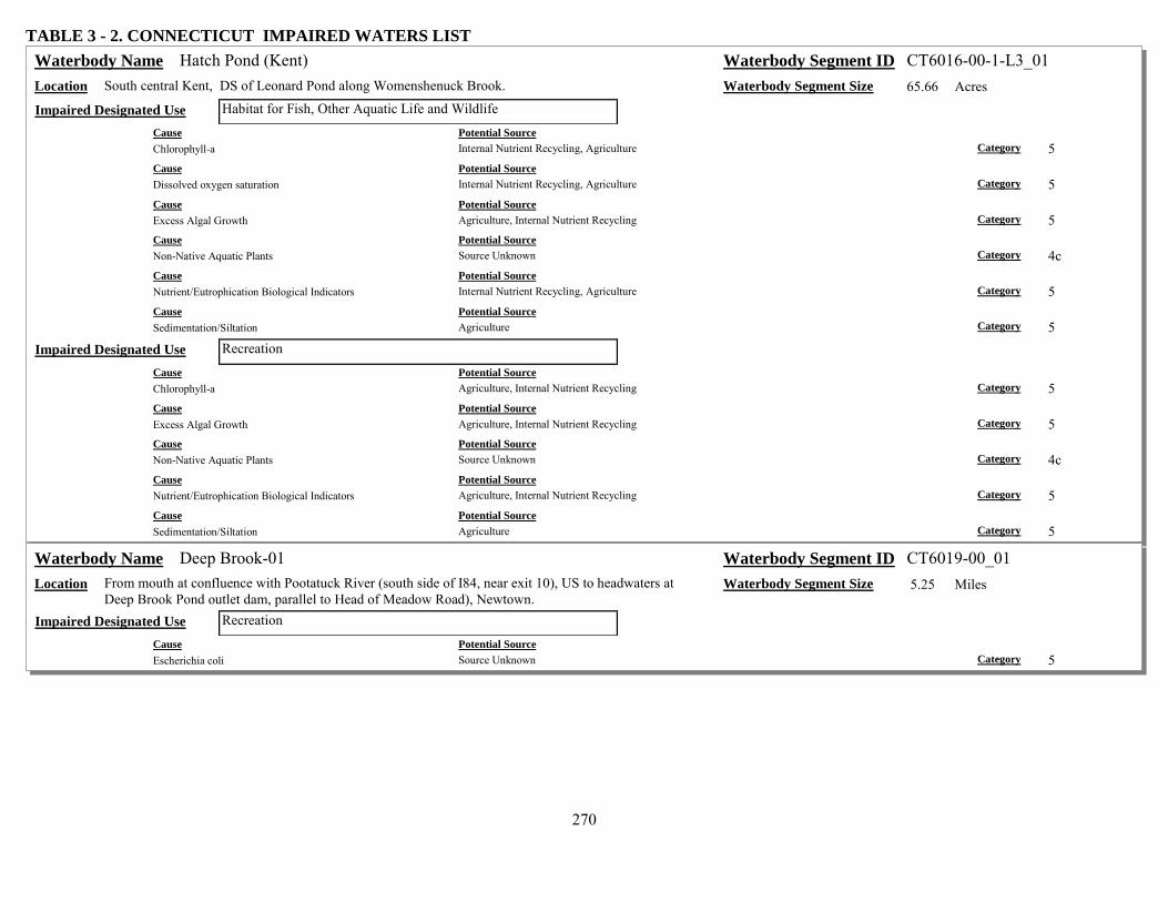
270
TABLE 3 - 2. CONNECTICUT IMPAIRED WATERS LIST Hatch Pond (Kent) Waterbody Name Waterbody Segment ID CT6016-00-1-L3_01
Location South central Kent, DS of Leonard Pond along Womenshenuck Brook. Waterbody Segment Size 65.66 Acres Habitat for Fish, Other Aquatic Life and Wildlife Impaired Designated Use
Cause Potential Source Chlorophyll-a Internal Nutrient Recycling, Agriculture Category 5 Cause Potential Source Dissolved oxygen saturation Internal Nutrient Recycling, Agriculture Category 5 Cause Potential Source Excess Algal Growth Agriculture, Internal Nutrient Recycling Category 5 Cause Potential Source Non-Native Aquatic Plants Source Unknown Category 4c Cause Potential Source Nutrient/Eutrophication Biological Indicators Internal Nutrient Recycling, Agriculture Category 5 Cause Potential Source Sedimentation/Siltation Agriculture Category 5
Recreation Impaired Designated Use Cause Potential Source Chlorophyll-a Agriculture, Internal Nutrient Recycling Category 5 Cause Potential Source Excess Algal Growth Agriculture, Internal Nutrient Recycling Category 5 Cause Potential Source Non-Native Aquatic Plants Source Unknown Category 4c Cause Potential Source Nutrient/Eutrophication Biological Indicators Agriculture, Internal Nutrient Recycling Category 5 Cause Potential Source Sedimentation/Siltation Agriculture Category 5
Deep Brook-01 Waterbody Name Waterbody Segment ID CT6019-00_01 Location From mouth at confluence with Pootatuck River (south side of I84, near exit 10), US to headwaters at
Deep Brook Pond outlet dam, parallel to Head of Meadow Road), Newtown. Waterbody Segment Size 5.25 Miles
Recreation Impaired Designated Use Cause Potential Source Escherichia coli Source Unknown Category 5

271
TABLE 3 - 2. CONNECTICUT IMPAIRED WATERS LIST Farmill River-02 Waterbody Name Waterbody Segment ID CT6025-00_02
Location From River Road (Route 110) crossing (Wilson Gardens Dog Pond outlet dam), Shelton/Stratford town border, US to confluence with Means Brook (US of Sycamore Drive crossing), Shelton.
Waterbody Segment Size 3.99 Miles
Recreation Impaired Designated Use Cause Potential Source Escherichia coli Source Unknown Category 5
Farmill River-03 Waterbody Name Waterbody Segment ID CT6025-00_03 Location From confluence with Means Brook (just DS of Huntington Street crossing), US to Far Mill
(Isinglass) Reservoir outlet dam, just US of Farmill Street crossing (beginning of drinking water watershed), Shelton.
Waterbody Segment Size 3.33 Miles
Habitat for Fish, Other Aquatic Life and Wildlife Impaired Designated Use Cause Potential Source Other flow regime alterations Upstream Impoundments (e.g., Pl-566 NRCS Structures), Flow Alterations from Water Diversions Category 4c
Blackberry River-01 Waterbody Name Waterbody Segment ID CT6100-00_01 Location From mouth at confluence with Housatonic River (at loop in river around island), US to confluence
with North Canaan WPCF (near old RailRoad grade, currently trail), North Canaan. Waterbody Segment Size 0.78 Miles
Fish Consumption Impaired Designated Use Cause Potential Source Polychlorinated biphenyls Above Ground Storage Tank Leaks (Tank Farms), Sources Outside State Jurisdiction or Borders Category 5
Blackberry River-02a Waterbody Name Waterbody Segment ID CT6100-00_02a Location From confluence with North Canaan WPCF (near old RailRoad grade, currently trail, DS of Route 44
crossing), US to drainage ditch at southwest boundary of Lime Quarry (parallel to Lower Road), North Canaan.
Waterbody Segment Size 2.75 Miles
Fish Consumption Impaired Designated Use Cause Potential Source Polychlorinated biphenyls Sources Outside State Jurisdiction or Borders, Above Ground Storage Tank Leaks (Tank Farms) Category 5
Recreation Impaired Designated Use Cause Potential Source Escherichia coli Source Unknown Category 5

272
TABLE 3 - 2. CONNECTICUT IMPAIRED WATERS LIST Blackberry River-02b Waterbody Name Waterbody Segment ID CT6100-00_02b
Location From drainage ditch at southwest boundary of Lime Quarry (parallel to Lower Road), US to Blast Furnace (Historical Park) at Lower Pond dam outlet on Iron Furnace Pond (perpendicular to Furnace Hill Road), North Canaan.
Waterbody Segment Size 1.18 Miles
Fish Consumption Impaired Designated Use Cause Potential Source Polychlorinated biphenyls Sources Outside State Jurisdiction or Borders, Above Ground Storage Tank Leaks (Tank Farms) Category 5
Hollenbeck River-01 Waterbody Name Waterbody Segment ID CT6200-00_01 Location From mouth at confluence with Housatonic River (DS of Point of Rock Road (Route 126) crossing),
Canaan, US to headwaters (US of Cornwall Hollow Road (Route 43) crossing), Cornwall. Waterbody Segment Size 18.32 Miles
Recreation Impaired Designated Use Cause Potential Source Escherichia coli Source Unknown Category 5
Mill Brook (Sharon)-02 Waterbody Name Waterbody Segment ID CT6302-00_02 Location From confluence with Beebee Brook (just DS of Woods 1 road crossing), US to Hatch Pond outlet
dam (just US of Mitchelltown Road crossing and confluence with Bog Meadow Brook), Sharon. Waterbody Segment Size 1.66 Miles
Recreation Impaired Designated Use Cause Potential Source Escherichia coli Source Unknown Category 5
Ball Pond (New Fairfield) Waterbody Name Waterbody Segment ID CT6402-00-1-L1_01 Location New Fairfield Waterbody Segment Size 80.7 Acres
Recreation Impaired Designated Use Cause Potential Source Chlorophyll-a Unspecified Urban Stormwater, On-site Treatment Systems (Septic Systems and Similar Decentralized
Systems) Category 5
Cause Potential Source Excess Algal Growth Unspecified Urban Stormwater, On-site Treatment Systems (Septic Systems and Similar Decentralized
Systems) Category 5
Cause Potential Source Nutrient/Eutrophication Biological Indicators Unspecified Urban Stormwater, On-site Treatment Systems (Septic Systems and Similar Decentralized
Systems) Category 5

273
TABLE 3 - 2. CONNECTICUT IMPAIRED WATERS LIST Still River (New Milford/Brookfield)-01 Waterbody Name Waterbody Segment ID CT6600-00_01
Location From mouth at confluence with Housatonic River (DS of RailRoad crossing), New Milford, US to Silvermine Road crossing (USGS station), Brookfield (just DS of Route 7 crossing, and DS of confluence with Charles Pickneys Brook), Brookfield.
Waterbody Segment Size 8.48 Miles
Habitat for Fish, Other Aquatic Life and Wildlife Impaired Designated Use Cause Potential Source Cause Unknown Golf Courses, Unspecified Urban Stormwater, Municipal Point Source Discharges Category 5
Recreation Impaired Designated Use Cause Potential Source Escherichia coli Unspecified Urban Stormwater, Source Unknown Category 5
Still River (Brookfield/Danbury)-02 Waterbody Name Waterbody Segment ID CT6600-00_02 Location From Silvermine Road crossing (USGS station), Brookfield (just DS of Route 7 crossing, and DS of
confluence with Charles Pickneys Brook), US to confuence with Limekiln Brook (just US of I84 crossing), Danbury.
Waterbody Segment Size 6.21 Miles
Habitat for Fish, Other Aquatic Life and Wildlife Impaired Designated Use Cause Potential Source Cause Unknown Golf Courses, Unspecified Urban Stormwater, Municipal Point Source Discharges Category 5
Recreation Impaired Designated Use Cause Potential Source Escherichia coli Source Unknown, Unspecified Urban Stormwater Category 5
Still River (Danbury)-03 Waterbody Name Waterbody Segment ID CT6600-00_03 Location From confuence with Limekiln Brook (just US of I84 crossing), US to confluence with Sympaug
Brook (just US of Cross Street crossing), Danbury. Waterbody Segment Size 2.19 Miles
Habitat for Fish, Other Aquatic Life and Wildlife Impaired Designated Use Cause Potential Source Cause Unknown Golf Courses, Unspecified Urban Stormwater Category 5
Recreation Impaired Designated Use Cause Potential Source Escherichia coli Source Unknown Category 5
Still River (Danbury)-04 Waterbody Name Waterbody Segment ID CT6600-00_04 Location From confluence with Sympaug Brook (just US of Cross Street crossing), US to confluence with
Padanaram Brook (just US of White Street crossing, river runs between RailRoad tracks), Danbury. Waterbody Segment Size 1.56 Miles
Habitat for Fish, Other Aquatic Life and Wildlife Impaired Designated Use Cause Potential Source Cause Unknown Unspecified Urban Stormwater, Source Unknown Category 5

274
TABLE 3 - 2. CONNECTICUT IMPAIRED WATERS LIST Still River (Danbury)-05 Waterbody Name Waterbody Segment ID CT6600-00_05
Location From confluence with Padanaram Brook (just US of White Street crossing, river runs between RailRoad tracks), US to Lake Kenosia outlet (just US of Kenosia Avenue crossing), Danbury.
Waterbody Segment Size 3.87 Miles
Habitat for Fish, Other Aquatic Life and Wildlife Impaired Designated Use Cause Potential Source Cause Unknown Unspecified Urban Stormwater, Source Unknown Category 5
Recreation Impaired Designated Use Cause Potential Source Escherichia coli Source Unknown Category 5
Kenosia, Lake (Danbury) Waterbody Name Waterbody Segment ID CT6600-01-1-L3_01 Location Impoundment of Still River, Danbury. Waterbody Segment Size 56.75 Acres
Recreation Impaired Designated Use Cause Potential Source Chlorophyll-a Unspecified Urban Stormwater, Source Unknown, Natural Sources Category 4a Cause Potential Source Excess Algal Growth Source Unknown, Natural Sources, Unspecified Urban Stormwater Category 4a Cause Potential Source Non-Native Aquatic Plants Source Unknown Category 4c Cause Potential Source Nutrient/Eutrophication Biological Indicators Source Unknown, Natural Sources, Unspecified Urban Stormwater Category 4a
Miry Brook (Danbury)-01 Waterbody Name Waterbody Segment ID CT6601-00_01 Location From mouth at confluence with Still River (just DS of Backus Avenue crossing), Danbury, US to HW
at North Ridgebury Pond outlet dam (just US of Aarons Court crossing), Ridgefield. Waterbody Segment Size 3.42 Miles
Recreation Impaired Designated Use Cause Potential Source Escherichia coli Source Unknown Category 5
Kohanza Brook (Danbury)-01 Waterbody Name Waterbody Segment ID CT6602-00_01 Location From mouth at confluence with Padanaram Brook (DS of North Street crossing), US to Ridgewood
Country Culb Pond outlet dam (adjacent to Franklin Street), Danbury. Waterbody Segment Size 1.14 Miles
Recreation Impaired Designated Use Cause Potential Source Escherichia coli Source Unknown Category 5

275
TABLE 3 - 2. CONNECTICUT IMPAIRED WATERS LIST Padanaram Brook-01 Waterbody Name Waterbody Segment ID CT6603-00_01
Location From mouth at confluence with Still River (just DS of Crosby Street crossing), US to headwaters at Padanaram Reservoir outlet dam (parallel to Padanaram Road), Danbury.
Waterbody Segment Size 3.71 Miles
Habitat for Fish, Other Aquatic Life and Wildlife Impaired Designated Use Cause Potential Source Cause Unknown Unspecified Urban Stormwater, Upstream Impoundments (e.g., Pl-566 NRCS Structures), Loss of Riparian
Habitat Category 5
Cause Potential Source Physical substrate habitat alterations Channelization, Loss of Riparian Habitat Category 4c
Recreation Impaired Designated Use Cause Potential Source Escherichia coli Source Unknown Category 5
Sympaug Brook-01 Waterbody Name Waterbody Segment ID CT6604-00_01 Location From mouth at confluence with Still River (DS of Shelter Rock Road crossing, parallel to Cross
Street), US to Greatpasture Road (Wooster Street) crossing, Danbury. Waterbody Segment Size 0.6 Miles
Habitat for Fish, Other Aquatic Life and Wildlife Impaired Designated Use Cause Potential Source Cause Unknown Source Unknown, Unspecified Urban Stormwater Category 5
Recreation Impaired Designated Use Cause Potential Source Escherichia coli Source Unknown Category 5
East Swamp Brook (Bethel)-01 Waterbody Name Waterbody Segment ID CT6605-00_01 Location From mouth at confluence with Limekiln Brook (DS of Shelter Rock Road crossing), US to
confluence with Wolf Pit Brook (DS of Taylor Road crossing), Bethel. Waterbody Segment Size 2.34 Miles
Recreation Impaired Designated Use Cause Potential Source Escherichia coli Source Unknown Category 5

276
TABLE 3 - 2. CONNECTICUT IMPAIRED WATERS LIST Limekiln Brook-01 Waterbody Name Waterbody Segment ID CT6606-00_01
Location From mouth at confluence with Still River (just US of I84 crossing), US to confluence with Danbury WPCF outfall channel (US of Newtown Road (Route 6) crossing, behind shopping plaza at pump station), Danbury.
Waterbody Segment Size 0.45 Miles
Habitat for Fish, Other Aquatic Life and Wildlife Impaired Designated Use Cause Potential Source Copper Municipal Point Source Discharges, Landfills Category 4a Cause Potential Source Zinc Landfills, Municipal Point Source Discharges Category 4a
Recreation Impaired Designated Use Cause Potential Source Escherichia coli Source Unknown Category 5
Limekiln Brook-03 Waterbody Name Waterbody Segment ID CT6606-00_03 Location From Shelter Rock Road crossing (first road crossing, above landfill), Bethel, US to headwaters (just
US of Poverty Hollow Road crossing), Newtown. Waterbody Segment Size 6.04 Miles
Recreation Impaired Designated Use Cause Potential Source Escherichia coli Source Unknown Category 5
Shepaug River-01 Waterbody Name Waterbody Segment ID CT6700-00_01 Location From mouth at confluence with Housatonic River (northeast branch of Lake Lillinonah portion, just
DS of Minor Bridge Road crossing), US to confluence with Bantam River (parallel with Whittlesey Road), Washington.
Waterbody Segment Size 17.67 Miles
Recreation Impaired Designated Use Cause Potential Source Escherichia coli Source Unknown Category 5
Shepaug River-02 Waterbody Name Waterbody Segment ID CT6700-00_02 Location From confluence with Bantam River (just DS of Whittlesey Road crossing), Washington, US to
Shepaug Reservoir outlet dam (US of Valley Road crossing), Litchfield/Warren town border. Waterbody Segment Size 3.51 Miles
Habitat for Fish, Other Aquatic Life and Wildlife Impaired Designated Use Cause Potential Source Other flow regime alterations Flow Alterations from Water Diversions, Upstream Impoundments (e.g., Pl-566 NRCS Structures) Category 4c

277
TABLE 3 - 2. CONNECTICUT IMPAIRED WATERS LIST Pomperaug River-03 Waterbody Name Waterbody Segment ID CT6800-00_03
Location From Flood Bridge Road crossing, US to confluence with Bullet Hill Brook (just DS of Heritage Road crossing), Southbury. (Segment includes Heritage Village POTW discharge)
Waterbody Segment Size 1.31 Miles
Recreation Impaired Designated Use Cause Potential Source Escherichia coli Source Unknown Category 5
South Brook-01 Waterbody Name Waterbody Segment ID CT6800-02_01 Location From mouth at confluence with Pomperaug River, US to Main Street (Route 6) crossing, Woodbury. Waterbody Segment Size 0.37 Miles
Habitat for Fish, Other Aquatic Life and Wildlife Impaired Designated Use Cause Potential Source Other flow regime alterations Flow Alterations from Water Diversions Category 4c
Stiles Brook-01 Waterbody Name Waterbody Segment ID CT6800-03_01 Location From mouth at confluence with Pomperaug River, US to Anna Stiles Pond outlet Dam (just US of
Route 6 crossing), Southbury. Waterbody Segment Size 0.25 Miles
Habitat for Fish, Other Aquatic Life and Wildlife Impaired Designated Use Cause Potential Source Other flow regime alterations Flow Alterations from Water Diversions Category 4c
Transylvania brook-01 Waterbody Name Waterbody Segment ID CT6806-00_01 Location From mouth at confluence with Pomperaug River (just DS of East Flat Hill Road crossing), US to
confluence with Spruce Brook (just US side of Southbury Training School STP), Southbury. Waterbody Segment Size 1.6 Miles
Habitat for Fish, Other Aquatic Life and Wildlife Impaired Designated Use Cause Potential Source Ammonia (Un-ionized) Municipal Point Source Discharges Category 4a Cause Potential Source Chlorine Municipal Point Source Discharges Category 4a Cause Potential Source Copper Municipal Point Source Discharges Category 4a Cause Potential Source Zinc Municipal Point Source Discharges Category 4a
Transylvania Brook-02 Waterbody Name Waterbody Segment ID CT6806-00_02 Location From confluence with Spruce Brook (just US side of Southbury Training School STP), US to Gravel
Pit Pond outlet dam (US of South Britian Road (Route 172) crossing), Southbury. Waterbody Segment Size 0.32 Miles
Recreation Impaired Designated Use Cause Potential Source Enterococcus Source Unknown Category 5

278
TABLE 3 - 2. CONNECTICUT IMPAIRED WATERS LIST Naugatuck River-01 Waterbody Name Waterbody Segment ID CT6900-00_01
Location From mouth at confluence with Housatonic River (DS of RailRoad crossing), Derby, US to Rimmon (Tingue) outlet dam (US of Broad Street crossing, and just DS of Route 8 crossing), Seymour.
Waterbody Segment Size 6.15 Miles
Habitat for Fish, Other Aquatic Life and Wildlife Impaired Designated Use Cause Potential Source Cause Unknown Municipal Point Source Discharges, Sanitary Sewer Overflows (Collection System Failures), Unspecified
Urban Stormwater, Industrial Point Source Discharge Category 5
Recreation Impaired Designated Use Cause Potential Source Escherichia coli Unspecified Urban Stormwater, Illicit Connections/Hook-ups to Storm Sewers, Source Unknown, Sanitary
Sewer Overflows (Collection System Failures) Category 4a
Naugatuck River-02 Waterbody Name Waterbody Segment ID CT6900-00_02 Location From Rimmon (Tingue) outlet dam (just DS of Route 8 crossing), Seymour, US to confluence with
Hopeville Pond Brook, just US of Waterbury WPCF. (Segment includes Wtby, Naug & Beacon Falls WPCFs, & dredge holes in river between Rts 42 & 67 in Beacon Falls)
Waterbody Segment Size 11.26 Miles
Habitat for Fish, Other Aquatic Life and Wildlife Impaired Designated Use Cause Potential Source Cause Unknown Sanitary Sewer Overflows (Collection System Failures), Dredge Mining, Municipal Point Source
Discharges, Unspecified Urban Stormwater, Industrial Point Source Discharge Category 5
Recreation Impaired Designated Use Cause Potential Source Escherichia coli Illicit Connections/Hook-ups to Storm Sewers, Source Unknown, Unspecified Urban Stormwater, Sanitary
Sewer Overflows (Collection System Failures) Category 4a
Naugatuck River-03 Waterbody Name Waterbody Segment ID CT6900-00_03 Location From confluence with Hopeville Pond Brook, just US of Waterbury WPCF, US to confluence with
Steele Brook (west side of Route 8, at Route 73 connection), Waterbury. Waterbody Segment Size 3.52 Miles
Habitat for Fish, Other Aquatic Life and Wildlife Impaired Designated Use Cause Potential Source Cause Unknown Source Unknown, Unspecified Urban Stormwater, Municipal Point Source Discharges, Industrial Point
Source Discharge, Sanitary Sewer Overflows (Collection System Failures) Category 5
Recreation Impaired Designated Use Cause Potential Source Escherichia coli Source Unknown, Unspecified Urban Stormwater, Sanitary Sewer Overflows (Collection System Failures),
Illicit Connections/Hook-ups to Storm Sewers Category 4a

279
TABLE 3 - 2. CONNECTICUT IMPAIRED WATERS LIST Naugatuck River-04 Waterbody Name Waterbody Segment ID CT6900-00_04
Location From confluence with Steele Brook (west side of Route 8, at Route 73 connection), Waterbury, US to sewage leak from pipe under river (near old bridge abutment) along Chase River Road, Watertown/Waterbury town border.
Waterbody Segment Size 1.65 Miles
Habitat for Fish, Other Aquatic Life and Wildlife Impaired Designated Use Cause Potential Source Cause Unknown Unspecified Urban Stormwater, Sanitary Sewer Overflows (Collection System Failures), Industrial Point
Source Discharge, Municipal Point Source Discharges Category 5
Recreation Impaired Designated Use Cause Potential Source Escherichia coli Illicit Connections/Hook-ups to Storm Sewers, Sanitary Sewer Overflows (Collection System Failures),
Source Unknown, Unspecified Urban Stormwater Category 4a
Naugatuck River-05 Waterbody Name Waterbody Segment ID CT6900-00_05 Location From US side of sewage leak from pipe under river (near old bridge abutment) along Chase River
Road, Watertown/Waterbury town border, US to confluence with Thomaston WPCF outfall (just US of confuence with Branch Brook), Thomaston.
Waterbody Segment Size 4.46 Miles
Habitat for Fish, Other Aquatic Life and Wildlife Impaired Designated Use Cause Potential Source Whole Effluent Toxicity (WET) Unspecified Urban Stormwater, Municipal Point Source Discharges, Dredge Mining, Industrial Point Source
Discharge Category 4a
Recreation Impaired Designated Use Cause Potential Source Escherichia coli Unspecified Urban Stormwater, Source Unknown, Illicit Connections/Hook-ups to Storm Sewers Category 4a
Naugatuck River-06 Waterbody Name Waterbody Segment ID CT6900-00_06 Location From confluence with Thomaston WPCF outfall (just US of confuence with Branch Brook),
Thomaston, US to confluence with Spruce Brook (west side of Route 8), Litchfield/Harwinton town border.
Waterbody Segment Size 9 Miles
Habitat for Fish, Other Aquatic Life and Wildlife Impaired Designated Use Cause Potential Source Cause Unknown Source Unknown Category 5
Recreation Impaired Designated Use Cause Potential Source Escherichia coli Source Unknown, Illicit Connections/Hook-ups to Storm Sewers, Unspecified Urban Stormwater Category 4a
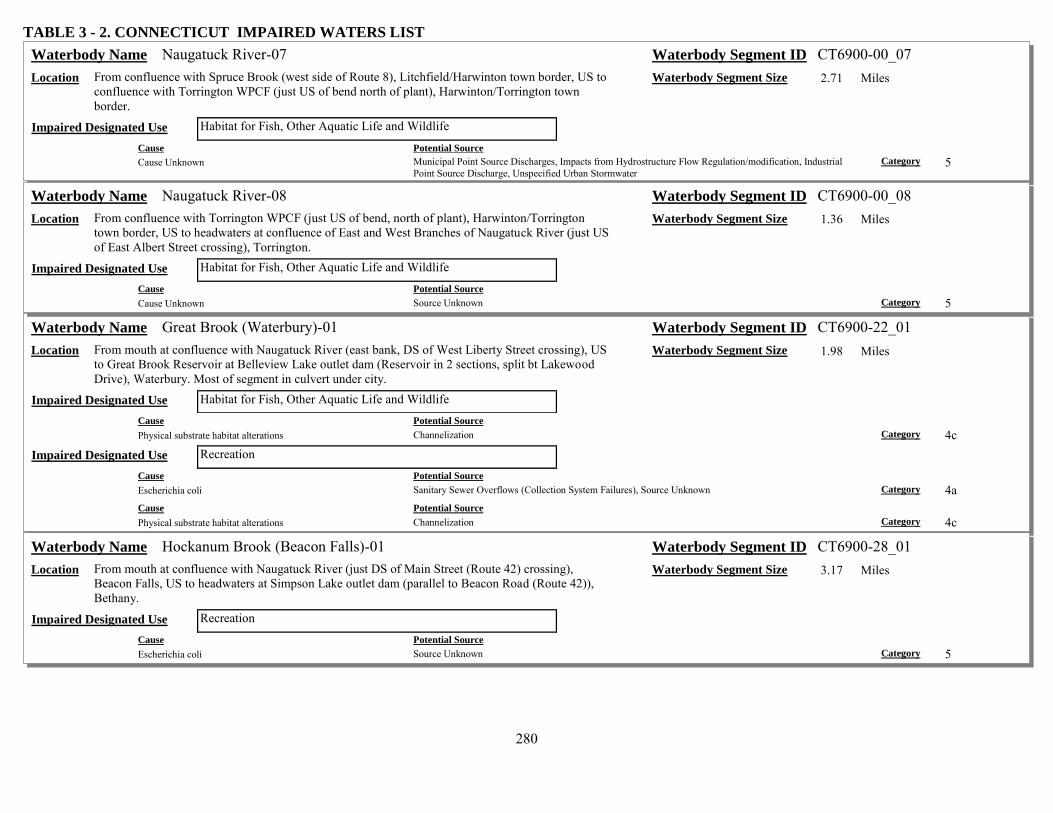
280
TABLE 3 - 2. CONNECTICUT IMPAIRED WATERS LIST Naugatuck River-07 Waterbody Name Waterbody Segment ID CT6900-00_07
Location From confluence with Spruce Brook (west side of Route 8), Litchfield/Harwinton town border, US to confluence with Torrington WPCF (just US of bend north of plant), Harwinton/Torrington town border.
Waterbody Segment Size 2.71 Miles
Habitat for Fish, Other Aquatic Life and Wildlife Impaired Designated Use Cause Potential Source Cause Unknown Municipal Point Source Discharges, Impacts from Hydrostructure Flow Regulation/modification, Industrial
Point Source Discharge, Unspecified Urban Stormwater Category 5
Naugatuck River-08 Waterbody Name Waterbody Segment ID CT6900-00_08 Location From confluence with Torrington WPCF (just US of bend, north of plant), Harwinton/Torrington
town border, US to headwaters at confluence of East and West Branches of Naugatuck River (just US of East Albert Street crossing), Torrington.
Waterbody Segment Size 1.36 Miles
Habitat for Fish, Other Aquatic Life and Wildlife Impaired Designated Use Cause Potential Source Cause Unknown Source Unknown Category 5
Great Brook (Waterbury)-01 Waterbody Name Waterbody Segment ID CT6900-22_01 Location From mouth at confluence with Naugatuck River (east bank, DS of West Liberty Street crossing), US
to Great Brook Reservoir at Belleview Lake outlet dam (Reservoir in 2 sections, split bt Lakewood Drive), Waterbury. Most of segment in culvert under city.
Waterbody Segment Size 1.98 Miles
Habitat for Fish, Other Aquatic Life and Wildlife Impaired Designated Use Cause Potential Source Physical substrate habitat alterations Channelization Category 4c
Recreation Impaired Designated Use Cause Potential Source Escherichia coli Sanitary Sewer Overflows (Collection System Failures), Source Unknown Category 4a Cause Potential Source Physical substrate habitat alterations Channelization Category 4c
Hockanum Brook (Beacon Falls)-01 Waterbody Name Waterbody Segment ID CT6900-28_01 Location From mouth at confluence with Naugatuck River (just DS of Main Street (Route 42) crossing),
Beacon Falls, US to headwaters at Simpson Lake outlet dam (parallel to Beacon Road (Route 42)), Bethany.
Waterbody Segment Size 3.17 Miles
Recreation Impaired Designated Use Cause Potential Source Escherichia coli Source Unknown Category 5
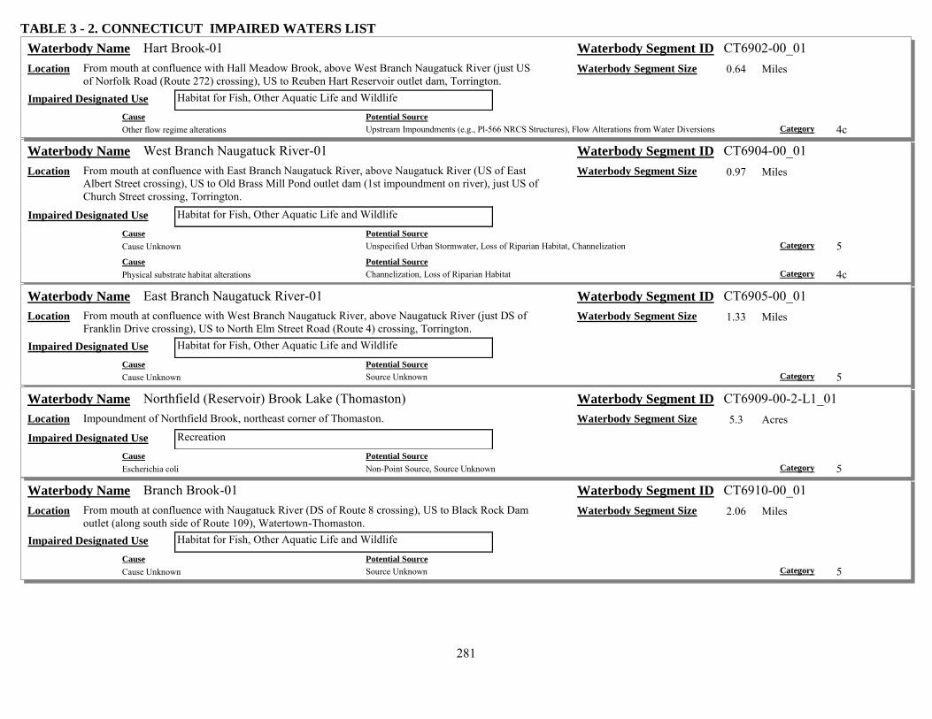
281
TABLE 3 - 2. CONNECTICUT IMPAIRED WATERS LIST Hart Brook-01 Waterbody Name Waterbody Segment ID CT6902-00_01
Location From mouth at confluence with Hall Meadow Brook, above West Branch Naugatuck River (just US of Norfolk Road (Route 272) crossing), US to Reuben Hart Reservoir outlet dam, Torrington.
Waterbody Segment Size 0.64 Miles
Habitat for Fish, Other Aquatic Life and Wildlife Impaired Designated Use Cause Potential Source Other flow regime alterations Upstream Impoundments (e.g., Pl-566 NRCS Structures), Flow Alterations from Water Diversions Category 4c
West Branch Naugatuck River-01 Waterbody Name Waterbody Segment ID CT6904-00_01 Location From mouth at confluence with East Branch Naugatuck River, above Naugatuck River (US of East
Albert Street crossing), US to Old Brass Mill Pond outlet dam (1st impoundment on river), just US of Church Street crossing, Torrington.
Waterbody Segment Size 0.97 Miles
Habitat for Fish, Other Aquatic Life and Wildlife Impaired Designated Use Cause Potential Source Cause Unknown Unspecified Urban Stormwater, Loss of Riparian Habitat, Channelization Category 5 Cause Potential Source Physical substrate habitat alterations Channelization, Loss of Riparian Habitat Category 4c
East Branch Naugatuck River-01 Waterbody Name Waterbody Segment ID CT6905-00_01 Location From mouth at confluence with West Branch Naugatuck River, above Naugatuck River (just DS of
Franklin Drive crossing), US to North Elm Street Road (Route 4) crossing, Torrington. Waterbody Segment Size 1.33 Miles
Habitat for Fish, Other Aquatic Life and Wildlife Impaired Designated Use Cause Potential Source Cause Unknown Source Unknown Category 5
Northfield (Reservoir) Brook Lake (Thomaston) Waterbody Name Waterbody Segment ID CT6909-00-2-L1_01 Location Impoundment of Northfield Brook, northeast corner of Thomaston. Waterbody Segment Size 5.3 Acres
Recreation Impaired Designated Use Cause Potential Source Escherichia coli Non-Point Source, Source Unknown Category 5
Branch Brook-01 Waterbody Name Waterbody Segment ID CT6910-00_01 Location From mouth at confluence with Naugatuck River (DS of Route 8 crossing), US to Black Rock Dam
outlet (along south side of Route 109), Watertown-Thomaston. Waterbody Segment Size 2.06 Miles
Habitat for Fish, Other Aquatic Life and Wildlife Impaired Designated Use Cause Potential Source Cause Unknown Source Unknown Category 5

282
TABLE 3 - 2. CONNECTICUT IMPAIRED WATERS LIST Branch Brook-02 Waterbody Name Waterbody Segment ID CT6910-00_02
Location From Black Rock Dam outlet (along south side of Route 109), US to Wigwam Reservoir outlet dam, Watertown-Thomaston.
Waterbody Segment Size 1.91 Miles
Habitat for Fish, Other Aquatic Life and Wildlife Impaired Designated Use Cause Potential Source Other flow regime alterations Upstream Impoundments (e.g., Pl-566 NRCS Structures), Flow Alterations from Water Diversions Category 4c
Hancock Brook (Waterbury)-01 Waterbody Name Waterbody Segment ID CT6911-00_01 Location From mouth at confluence with Naugatuck River (segment-04) DS of Huntingdon Avenue and
RailRoad crossings, US to Hancock Pond outlet dam (between Sheffield Street and RailRoad), Waterbury.
Waterbody Segment Size 1.06 Miles
Habitat for Fish, Other Aquatic Life and Wildlife Impaired Designated Use Cause Potential Source Cause Unknown Source Unknown Category 5
Steele Brook-01 Waterbody Name Waterbody Segment ID CT6912-00_01 Location From mouth at confluence with Naugatuck River (just DS of Route 8 crossing), US to Sherwood
Medical (American Home Products) area (site is behind Municipal Stadium parking lot on northend of stadium property), Waterbury.
Waterbody Segment Size 1.18 Miles
Habitat for Fish, Other Aquatic Life and Wildlife Impaired Designated Use Cause Potential Source Copper Industrial Land Treatment, Industrial Point Source Discharge Category 4a
Recreation Impaired Designated Use Cause Potential Source Escherichia coli Unspecified Urban Stormwater, Source Unknown, Illicit Connections/Hook-ups to Storm Sewers Category 4a
Steele Brook-02 Waterbody Name Waterbody Segment ID CT6912-00_02 Location From Sherwood Medical (American Home Products) area (site is behind Municipal Stadium parking
lot on northend of stadium property), Waterbury, US to INLET of Heminway Pond (DS of Route 6 crossing, pond included in segment), Watertown.
Waterbody Segment Size 3.78 Miles
Habitat for Fish, Other Aquatic Life and Wildlife Impaired Designated Use Cause Potential Source Cause Unknown Landfills, Source Unknown, Channelization, Unspecified Urban Stormwater Category 5 Cause Potential Source Iron Landfills, Source Unknown, Unspecified Urban Stormwater Category 5
Recreation Impaired Designated Use Cause Potential Source Escherichia coli Unspecified Urban Stormwater, Illicit Connections/Hook-ups to Storm Sewers, Source Unknown Category 4a
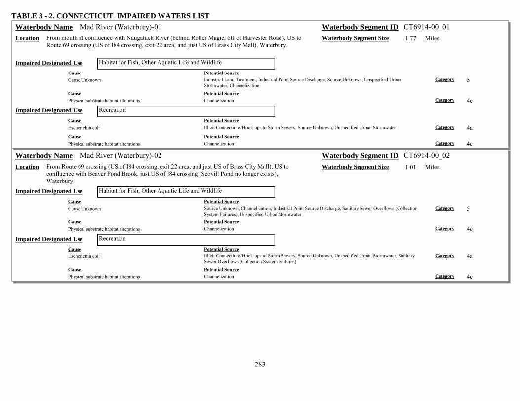
283
TABLE 3 - 2. CONNECTICUT IMPAIRED WATERS LIST Mad River (Waterbury)-01 Waterbody Name Waterbody Segment ID CT6914-00_01
Location From mouth at confluence with Naugatuck River (behind Roller Magic, off of Harvester Road), US to Route 69 crossing (US of I84 crossing, exit 22 area, and just US of Brass City Mall), Waterbury.
Waterbody Segment Size 1.77 Miles
Habitat for Fish, Other Aquatic Life and Wildlife Impaired Designated Use Cause Potential Source Cause Unknown Industrial Land Treatment, Industrial Point Source Discharge, Source Unknown, Unspecified Urban
Stormwater, Channelization Category 5
Cause Potential Source Physical substrate habitat alterations Channelization Category 4c
Recreation Impaired Designated Use Cause Potential Source Escherichia coli Illicit Connections/Hook-ups to Storm Sewers, Source Unknown, Unspecified Urban Stormwater Category 4a Cause Potential Source Physical substrate habitat alterations Channelization Category 4c
Mad River (Waterbury)-02 Waterbody Name Waterbody Segment ID CT6914-00_02 Location From Route 69 crossing (US of I84 crossing, exit 22 area, and just US of Brass City Mall), US to
confluence with Beaver Pond Brook, just US of I84 crossing (Scovill Pond no longer exists), Waterbury.
Waterbody Segment Size 1.01 Miles
Habitat for Fish, Other Aquatic Life and Wildlife Impaired Designated Use Cause Potential Source Cause Unknown Source Unknown, Channelization, Industrial Point Source Discharge, Sanitary Sewer Overflows (Collection
System Failures), Unspecified Urban Stormwater Category 5
Cause Potential Source Physical substrate habitat alterations Channelization Category 4c
Recreation Impaired Designated Use Cause Potential Source Escherichia coli Illicit Connections/Hook-ups to Storm Sewers, Source Unknown, Unspecified Urban Stormwater, Sanitary
Sewer Overflows (Collection System Failures) Category 4a
Cause Potential Source Physical substrate habitat alterations Channelization Category 4c

284
TABLE 3 - 2. CONNECTICUT IMPAIRED WATERS LIST Mad River (Waterbury)-03a Waterbody Name Waterbody Segment ID CT6914-00_03a
Location From confluence with Beaver Pond Brook, (just US of I84 crossing and DS of Plank Road crossing, in former Scovill Ponds section), Waterbury, US to confluence with Lily Brook (CT6914-06 Gazetteer, and called Finch Brook in NHD), Wolcott.
Waterbody Segment Size 3.46 Miles
Habitat for Fish, Other Aquatic Life and Wildlife Impaired Designated Use Cause Potential Source Cause Unknown Unspecified Urban Stormwater, Channelization, Industrial Point Source Discharge, Source Unknown Category 5 Cause Potential Source Physical substrate habitat alterations Channelization Category 4c
Recreation Impaired Designated Use Cause Potential Source Escherichia coli Unspecified Urban Stormwater, Source Unknown, Illicit Connections/Hook-ups to Storm Sewers Category 4a
Hitchcock Lake (Wolcott) Waterbody Name Waterbody Segment ID CT6914-06-1-L1_01 Location Southeast corner of Wolcott, near Cheshire border. Waterbody Segment Size 100.3 Acres
Recreation Impaired Designated Use Cause Potential Source Escherichia coli Unspecified Urban Stormwater, Source Unknown Category 5
Hop Brook (Naugatuck)-01 Waterbody Name Waterbody Segment ID CT6916-00_01 Location From mouth at confluence with Naugatuck River (DS of Bridge Street (Route 68) crossing and
RailRoad crossing), Naugatuck, US to Hop Brook Lake outlet dam (flood control area along eastern side of Curch Street (Route 63)), Naugatuck/Waterbury town line.
Waterbody Segment Size 1.44 Miles
Recreation Impaired Designated Use Cause Potential Source Escherichia coli Source Unknown Category 4a
Hop Brook Lake (Waterbury/Middlebury) Waterbody Name Waterbody Segment ID CT6916-00-3-L4_01 Location Impoundment of Hop Brook, Waterbury/Naugatuck/Middlebury. Waterbody Segment Size 25.77 Acres
Recreation Impaired Designated Use Cause Potential Source Escherichia coli Non-Point Source, Agriculture, Source Unknown, Unspecified Urban Stormwater, Waterfowl Category 5

285
TABLE 3 - 2. CONNECTICUT IMPAIRED WATERS LIST Long Meadow Pond Brook-01 Waterbody Name Waterbody Segment ID CT6917-00_01
Location From mouth at confluence with Naugatuck River (DS of Elm Street crossing and RailRoad crossing), US to outlet of Naugatuck Ice Company Pond Dam (just US of Rubber Avenue crossing), Naugatuck.
Waterbody Segment Size 0.94 Miles
Habitat for Fish, Other Aquatic Life and Wildlife Impaired Designated Use Cause Potential Source Cause Unknown Source Unknown Category 5
Recreation Impaired Designated Use Cause Potential Source Escherichia coli Unspecified Urban Stormwater, Source Unknown Category 4a
Bladens River-01 Waterbody Name Waterbody Segment ID CT6919-00_01 Location From mouth at confluence with Naugatuck River (just DS of New Haven Avenue (Route 8) and
Derby Avenue (Route 67) crossings), US to North Street crossing (upper end of industrial area), Seymour.
Waterbody Segment Size 0.68 Miles
Habitat for Fish, Other Aquatic Life and Wildlife Impaired Designated Use Cause Potential Source Cause Unknown Source Unknown Category 5
Muddy Brook (Westport)-01 Waterbody Name Waterbody Segment ID CT7000-16_01 Location From mouth at confluence with Mill Creek (LIS Estuary segment) on DS side of I95 Exit 18 ramp,
US to HW (just US of Route 15 crossing), Westport. Waterbody Segment Size 4.17 Miles
Habitat for Fish, Other Aquatic Life and Wildlife Impaired Designated Use Cause Potential Source Cause Unknown Source Unknown Category 5
Indian River (Westport)-01 Waterbody Name Waterbody Segment ID CT7000-22_01 Location From mouth at Saugatuck River (head of Burritt Cove, Saugatuck River Estuary, just DS of
Saugatuck Avenue (Route 136) crossing), US to I95 crossing, Westport. Waterbody Segment Size 0.53 Miles
Recreation Impaired Designated Use Cause Potential Source Alterations in wetland habitats Drainage/Filling/Loss of Wetlands Category 4c Cause Potential Source Escherichia coli Source Unknown, On-site Treatment Systems (Septic Systems and Similar Decentralized Systems) Category 5 Cause Potential Source Iron Source Unknown, Drainage/Filling/Loss of Wetlands Category 5

286
TABLE 3 - 2. CONNECTICUT IMPAIRED WATERS LIST Indian River (Westport)-02 Waterbody Name Waterbody Segment ID CT7000-22_02
Location From I95 crossing, Westport, US to headwaters (portions of river in concrete channels and pipes), Norwalk. (Segment made from site map, actual hydro must be mapped to confirm underground portions)
Waterbody Segment Size 0.94 Miles
Recreation Impaired Designated Use Cause Potential Source Escherichia coli Source Unknown Category 5 Cause Potential Source Iron Drainage/Filling/Loss of Wetlands, Source Unknown Category 5
Bruce Brook (Bridgeport/Stratford)-02 Waterbody Name Waterbody Segment ID CT7102-00_02 Location Inlet to Bruce Pond, US to Barnum Avenue crossing, Bridgeport/Stratford town line. Waterbody Segment Size 0.22 Miles
Habitat for Fish, Other Aquatic Life and Wildlife Impaired Designated Use Cause Potential Source Cause Unknown Source Unknown Category 5
Recreation Impaired Designated Use Cause Potential Source Escherichia coli Source Unknown Category 5
Success Lake (Bridgeport) Waterbody Name Waterbody Segment ID CT7103-00-2-L3_01 Location US of Stillman Pond, Pembroke Lakes & Yellowmill Channel, Bridgeport. Waterbody Segment Size 15.79 Acres
Habitat for Fish, Other Aquatic Life and Wildlife Impaired Designated Use Cause Potential Source Lead Industrial Point Source Discharge, Contaminated Sediments Category 5 Cause Potential Source Mercury Contaminated Sediments, Industrial Point Source Discharge Category 5
Stillman Pond (Bridgeport) Waterbody Name Waterbody Segment ID CT7103-00-2-L4_01 Location Upstream of Yellow Mill Channel, Bridgeport. Downstream of Success Lake. Waterbody Segment Size 4.97 Acres
Fish Consumption Impaired Designated Use Cause Potential Source Cadmium Contaminated Sediments, Industrial Point Source Discharge Category 5 Cause Potential Source Lead Industrial Point Source Discharge, Contaminated Sediments Category 5 Cause Potential Source Mercury Industrial Point Source Discharge, Contaminated Sediments Category 5

287
TABLE 3 - 2. CONNECTICUT IMPAIRED WATERS LIST Pembroke Lakes (Bridgeport) Waterbody Name Waterbody Segment ID CT7103-00-2-L5_01
Location Just upstream of Yellow Mill Channel, US side of RailRoad crossing, and DS of Stillman Pond and Route 1 crossing, Bridgeport. (Includes Arms Pond, Remington Arms Company Pond, and Barnum Avenue Pond)
Waterbody Segment Size 2.74 Acres
Habitat for Fish, Other Aquatic Life and Wildlife Impaired Designated Use Cause Potential Source Lead Contaminated Sediments, Industrial Point Source Discharge Category 5 Cause Potential Source Polychlorinated biphenyls Industrial Point Source Discharge, Contaminated Sediments Category 5
Pequonnock River-02 Waterbody Name Waterbody Segment ID CT7105-00_02 Location From inlet to Bunnells (Beardsley Park) Pond (eastern side of Route 8, exit 6 area), Bridgeport, US to
Daniels Farm Road crossing (US of Route 25 crossing), Trumbull. Waterbody Segment Size 2.92 Miles
Habitat for Fish, Other Aquatic Life and Wildlife Impaired Designated Use Cause Potential Source Cause Unknown Source Unknown Category 5
Pequonnock River-03 Waterbody Name Waterbody Segment ID CT7105-00_03 Location From Daniels Farm Road crossing (US of Route 25 crossing), Trumbull, US to Monroe Turnpike
(Route 111) crossing (near intersection with Route 25), Trumbull. Waterbody Segment Size 4.19 Miles
Habitat for Fish, Other Aquatic Life and Wildlife Impaired Designated Use Cause Potential Source Cause Unknown Source Unknown Category 5
Pequonnock River-05 Waterbody Name Waterbody Segment ID CT7105-00_05 Location From INLET to unnamed impoundment (northeastern portion of pond), US to headwaters at Stepney
Pond outlet dam (just US of West Maiden Lane crossing), Monroe. Waterbody Segment Size 2.35 Miles
Recreation Impaired Designated Use Cause Potential Source Escherichia coli Source Unknown Category 5
Rooster River-01 Waterbody Name Waterbody Segment ID CT7106-00_01 Location From mouth at confluence with Ash Creek (US of I95 crossing, in area near end of Fairchild Avenue),
Fairfield/Bridgeport town border, US to headwaters at confluence of Londons Brook and Horse Tavern Brook (US of Cornell Road crossing), Fairfield.
Waterbody Segment Size 2.69 Miles
Recreation Impaired Designated Use Cause Potential Source Escherichia coli Combined Sewer Overflows Category 4a

288
TABLE 3 - 2. CONNECTICUT IMPAIRED WATERS LIST Mill River (Fairfield/Easton)-02a Waterbody Name Waterbody Segment ID CT7108-00_02a
Location From INLET to Samp Mortar Reservoir, Fairfield, US to confluence with unnamed tributary (US of South Park Avenue crossing, DS of Easton Reservoir and Canoe Brook confluence), Easton. (Segment does NOT include Lake Mohegan).
Waterbody Segment Size 3.57 Miles
Recreation Impaired Designated Use Cause Potential Source Escherichia coli Source Unknown Category 4a
Mill River (Fairfield/Easton)-02b Waterbody Name Waterbody Segment ID CT7108-00_02b Location From confluence with unnamed tributary (US of South Park Avenue crossing, DS of Easton Reservoir
and Canoe Brook confluence), US to Easton Reservoir outlet dam (Lakeview Drive crossing on dam), Easton.
Waterbody Segment Size 0.54 Miles
Recreation Impaired Designated Use Cause Potential Source Escherichia coli Source Unknown Category 4a
Unnamed tributary, Easton Reservoir (Snow Farm)-02 Waterbody Name Waterbody Segment ID CT7108-05_02 Location From confluence with unnamed tributary to Easton Reservoir (east of Sport Hill Road (Route 59)), US
to outlet of pond on Phil Snow's farm, Easton. (Unnamed tributary flows into Easton Reservoir from western side)
Waterbody Segment Size 0.3 Miles
Habitat for Fish, Other Aquatic Life and Wildlife Impaired Designated Use Cause Potential Source Cause Unknown Agriculture, Source Unknown Category 5
Sasco Brook-01 Waterbody Name Waterbody Segment ID CT7109-00_01 Location From Bulkely Pond OUTLET dam (US side of Post Road East (Route 1) crossing), Westport/Fairfield
town border, US to Hulls Farm Road crossing (just DS of Great Brook confluence), Westport/Fairfield town border. (Segment includes Buckley Pond)
Waterbody Segment Size 1.42 Miles
Habitat for Fish, Other Aquatic Life and Wildlife Impaired Designated Use Cause Potential Source Cause Unknown Source Unknown Category 5
Sasco Brook-02 Waterbody Name Waterbody Segment ID CT7109-00_02 Location From Hulls Farm Road crossing (just DS of Great Brook confluence), Westport/Fairfield town border,
US to headwaters at marsh (US of Burr Street crossing), Fairfield. Waterbody Segment Size 5.2 Miles
Recreation Impaired Designated Use Cause Potential Source Escherichia coli Source Unknown, On-site Treatment Systems (Septic Systems and Similar Decentralized Systems),
Unspecified Urban Stormwater Category 4a

289
TABLE 3 - 2. CONNECTICUT IMPAIRED WATERS LIST Unnamed tributary, Sasco Brook-01 Waterbody Name Waterbody Segment ID CT7109-00-trib_01
Location From mouth at Sasco Brook (US of Old Road crossing), Westport/Fairfield town border, US to headwaters (US of Bulkley Avenue crossing), Westport.
Waterbody Segment Size 0.34 Miles
Recreation Impaired Designated Use Cause Potential Source Escherichia coli Source Unknown, Unspecified Urban Stormwater Category 5
Great Brook (Fairfield)-01 Waterbody Name Waterbody Segment ID CT7109-06_01 Location From mouth at confluence with Sasco Brook (just US of Hulls Farm Road crossing of Sasco Brook,
east bank), US to first confluence with unnamed brook (just US of Morehouse Lane crossing, DS of marsh), Fairfield.
Waterbody Segment Size 0.72 Miles
Recreation Impaired Designated Use Cause Potential Source Escherichia coli Unspecified Urban Stormwater, Source Unknown Category 5
Saugatuck River-03 Waterbody Name Waterbody Segment ID CT7200-00_03 Location From INLET to Saugatuck Reservoir at Newtown Turnpike (Route 53) crossing, US to confluence
with Bogus Mountain Brook (US of Redding Road (Route 53) crossing, and parallel to Station Road), Redding.
Waterbody Segment Size 4.36 Miles
Recreation Impaired Designated Use Cause Potential Source Escherichia coli Source Unknown Category 5
Unnamed tributary Hawleys Brook-02 Waterbody Name Waterbody Segment ID CT7200-20-trib_02 Location From confluence with main unnamed tributay to Hawleys Brook, US to private property (Golf
course), Easton. (Entire segement is west of Blackrock Turnpike (Route 58), AND wset of golf course)
Waterbody Segment Size 0.56 Miles
Habitat for Fish, Other Aquatic Life and Wildlife Impaired Designated Use Cause Potential Source Other flow regime alterations Source Unknown Category 4c
Beaver Brook (Weston)-01 Waterbody Name Waterbody Segment ID CT7200-22_01 Location From mouth at confluence with Saugatuck River (DS Slumber Lane crossing), US to confluence with
Davidge Brook (adjacent to Glenwood Road), Weston. Waterbody Segment Size 1.02 Miles
Recreation Impaired Designated Use Cause Potential Source Escherichia coli Source Unknown Category 5

290
TABLE 3 - 2. CONNECTICUT IMPAIRED WATERS LIST Kettle Creek (Weston)-01 Waterbody Name Waterbody Segment ID CT7200-24_01
Location From mouth at confluence with Saugatuck River (DS of Good Hill Road crossing), US to confluence with unnamed tributary (DS of Kettle Creek Road crossing), Weston.
Waterbody Segment Size 0.62 Miles
Recreation Impaired Designated Use Cause Potential Source Escherichia coli Source Unknown Category 5
Poplar Plains Brook (Westport)-01 Waterbody Name Waterbody Segment ID CT7200-26_01 Location From mouth at confluence with Saugatuck River (Lee Pond section, just DS of Route 15 crossing),
US to confluence with unnamed tributary US of Route 33 (Wilton Road) crossing (outlet for Keenes Pond), Westport.
Waterbody Segment Size 0.5 Miles
Recreation Impaired Designated Use Cause Potential Source Escherichia coli Source Unknown Category 5
Aspetuck River (Westport-Easton)-01 Waterbody Name Waterbody Segment ID CT7202-00_01 Location From confuence with Saugatuck River (DS of Weston Road (ROUTE 57) crossing), Wetport, US to
Aspetuck Reservoir outlet dam (US of Black Rock Turnpike (Route 58) crossing), Easton. (Segment passes through Pfeiffer Pond, Weston/Easton town border)
Waterbody Segment Size 5.93 Miles
Recreation Impaired Designated Use Cause Potential Source Escherichia coli Source Unknown Category 5
West Branch Saugatuck River-01 Waterbody Name Waterbody Segment ID CT7203-00_01 Location From mouth at confluence with Saugatuck River (DS of Pan Handle Lane crossing), Westport, US to
Godfrey Road West crossing (just east of Old Orchard Drive intersection), Weston. Waterbody Segment Size 6.12 Miles
Recreation Impaired Designated Use Cause Potential Source Escherichia coli Source Unknown Category 5
Unnamed tributary, West Branch Saugatuck River (Weston)-01 Waterbody Name Waterbody Segment ID CT7203-00-trib_01 Location From mouth at confluence with West Branch Saugatuck River (DS Route 53 (Newtown Turnpike)
crossing), US to unnamed pond outlet (US Birch Hill Road crossing), Weston. Waterbody Segment Size 0.39 Miles
Recreation Impaired Designated Use Cause Potential Source Escherichia coli Source Unknown Category 5

291
TABLE 3 - 2. CONNECTICUT IMPAIRED WATERS LIST Norwalk River-01 Waterbody Name Waterbody Segment ID CT7300-00_01
Location From Wall Street (Commerce Street) crossing (head of estuary/saltwater limit), Norwalk, US to confluence with Bryant Brook (DS of Wolfpit Road crossing), Wilton. (Segment includes Winnipauk Mill Pond and Deering Pond)
Waterbody Segment Size 5.63 Miles
Habitat for Fish, Other Aquatic Life and Wildlife Impaired Designated Use Cause Potential Source Cause Unknown Unspecified Urban Stormwater, Source Unknown Category 5 Cause Potential Source Sedimentation/Siltation Source Unknown Category 5
Recreation Impaired Designated Use Cause Potential Source Escherichia coli Unspecified Urban Stormwater, Source Unknown Category 4a
Norwalk River-02 Waterbody Name Waterbody Segment ID CT7300-00_02 Location From confluence with Bryant Brook (DS of Wolfpit Road crossing), US to Old Mill Road crossing
(between Danbury Road (Route 7) and RialRoad tracks southeast of Georgetown), Wilton. Waterbody Segment Size 5.61 Miles
Recreation Impaired Designated Use Cause Potential Source Escherichia coli Source Unknown Category 4a
Norwalk River-03a Waterbody Name Waterbody Segment ID CT7300-00_03a Location From Old Mill Road crossing (between Danbury Road (Route 7) and RialRoad track, southeast of
Georgetown), Wilton, US to confluence with Georgetown POTW outfall, Redding. Waterbody Segment Size 0.84 Miles
Habitat for Fish, Other Aquatic Life and Wildlife Impaired Designated Use Cause Potential Source Cause Unknown Industrial Land Treatment, Source Unknown Category 5
Recreation Impaired Designated Use Cause Potential Source Escherichia coli Source Unknown Category 4a
Norwalk River-03b Waterbody Name Waterbody Segment ID CT7300-00_03b Location From confluence with Georgetown POTW outfall, US to EXIT of undergound (pipe) section (just US
of RailRoad crossing), Redding. Waterbody Segment Size 0.2 Miles
Recreation Impaired Designated Use Cause Potential Source Escherichia coli Source Unknown Category 4a

292
TABLE 3 - 2. CONNECTICUT IMPAIRED WATERS LIST Norwalk River-04 Waterbody Name Waterbody Segment ID CT7300-00_04
Location From INLET to Factory Pond (just DS of Danbury Road (Route 7) crossing), Wilton, US to confluence with Cooper Pond Brook (DS of Branchville Road, east of intersection with Route 7), Ridgefield.
Waterbody Segment Size 0.7 Miles
Recreation Impaired Designated Use Cause Potential Source Escherichia coli Source Unknown Category 4a
Norwalk River-05 Waterbody Name Waterbody Segment ID CT7300-00_05 Location From confluence with Cooper Pond Brook (DS of Branchville Road, east of intersection with Route
7), Ridgefield, US to headwaters at Little Pond outlet dam (US of confluence with Ridgefield Brook from west, on west side parallel to Route 7), Ridgefield.
Waterbody Segment Size 4.85 Miles
Recreation Impaired Designated Use Cause Potential Source Escherichia coli Source Unknown Category 4a
Ridgefield Brook-01 Waterbody Name Waterbody Segment ID CT7300-02_01 Location From confluence with Norwalk River (DS of headwaters at Little Pond outlet dam, west side of Route
7), US to Taylors Pond outlet dam (US of Limestone Road crossing), Ridgefield. Waterbody Segment Size 1.05 Miles
Recreation Impaired Designated Use Cause Potential Source Escherichia coli Source Unknown Category 4a
Ridgefield Brook-02 Waterbody Name Waterbody Segment ID CT7300-02_02 Location From INLET to Taylor Pond (on southwest portion of pond, east of Barrow Mountain), US (south) to
headwaters at outlet of Lounsebury Pond in southwest portion of Great Swamp, Ridgefield. (Segment includes outfall of Ridgefield POTW, upper Great Swamp area)
Waterbody Segment Size 3.22 Miles
Habitat for Fish, Other Aquatic Life and Wildlife Impaired Designated Use Cause Potential Source Cause Unknown Landfills, Municipal Point Source Discharges, Natural Sources, Unspecified Urban Stormwater Category 5
Recreation Impaired Designated Use Cause Potential Source Escherichia coli Source Unknown, Waterfowl, Unspecified Urban Stormwater Category 4a

293
TABLE 3 - 2. CONNECTICUT IMPAIRED WATERS LIST Silvermine River-01 Waterbody Name Waterbody Segment ID CT7302-00_01
Location From Mouth at confluence with Norwalk River (northwest INLET to Deering Pond portion of river), US to Merritt Parkway (Route 15) crossing), Norwalk. (Segment includes Davis Pond)
Waterbody Segment Size 0.98 Miles
Recreation Impaired Designated Use Cause Potential Source Escherichia coli Source Unknown Category 4a
Silvermine River-02 Waterbody Name Waterbody Segment ID CT7302-00_02 Location From Merritt Parkway (Route 15) crossing), Norwalk, US to Grupes Reservoir outlet dam (US of
Valley Road crossing), New Canaan. Waterbody Segment Size 5.49 Miles
Recreation Impaired Designated Use Cause Potential Source Escherichia coli Source Unknown Category 5
Unnamed tributary Belden Hill Brook-01 Waterbody Name Waterbody Segment ID CT7302-13_trib_01 Location From mouth at confluence with Beldon Hill Brook (DS of Belden Hill Brook crossing of New Canaan
Road (Route 106), DS of South Norwalk Reservoir), US to discharge source at Sisters of Notre Dame (discharge of private STPl), Wilton.
Waterbody Segment Size 0.4 Miles
Habitat for Fish, Other Aquatic Life and Wildlife Impaired Designated Use Cause Potential Source Chlorine Inappropriate Waste Disposal Category 4a
Fivemile River (New Canaan)-02 Waterbody Name Waterbody Segment ID CT7401-00_02 Location From Old Norwalk Road crossing (0.2 Mi DS of POTW), US to confluence with New Canaan POTW
outfall, New Canaan. Waterbody Segment Size 0.23 Miles
Habitat for Fish, Other Aquatic Life and Wildlife Impaired Designated Use Cause Potential Source Cause Unknown Landfills, Source Unknown, Municipal Point Source Discharges, Unspecified Urban Stormwater Category 5
Recreation Impaired Designated Use Cause Potential Source Escherichia coli Source Unknown Category 5
Fivemile River (New Canaan)-03 Waterbody Name Waterbody Segment ID CT7401-00_03 Location From confluence with New Canaan POTW outfall, US to confluence with unnamed tributary (US of
New Norwalk Road (Route 123) crossing, on northeastern side of Parade Hill Road, near Cemetary), New Canaan.
Waterbody Segment Size 1.82 Miles
Habitat for Fish, Other Aquatic Life and Wildlife Impaired Designated Use Cause Potential Source Cause Unknown Unspecified Urban Stormwater, Source Unknown Category 5

294
TABLE 3 - 2. CONNECTICUT IMPAIRED WATERS LIST Noroton River-01 Waterbody Name Waterbody Segment ID CT7403-00_01
Location From Post Road (Route 1) crossing (saltwater limit at head of Holly Pond), US to southwestern corner of St. John's Cemetary (river bend to west), Stamford/Darien town border.
Waterbody Segment Size 2.3 Miles
Habitat for Fish, Other Aquatic Life and Wildlife Impaired Designated Use Cause Potential Source Cause Unknown Source Unknown Category 5
Noroton River-02 Waterbody Name Waterbody Segment ID CT7403-00_02 Location From southwestern corner of St. John's Cemetary (river bend to west), Stamford/Darien town border,
US to Merritt Parkway (Route 15) crossing (US of Raymonds Pond), New Canaan. Waterbody Segment Size 2.61 Miles
Habitat for Fish, Other Aquatic Life and Wildlife Impaired Designated Use Cause Potential Source Cause Unknown Source Unknown Category 5
Rippowam River-01 Waterbody Name Waterbody Segment ID CT7405-00_01 Location From Rippowam River West Branch dam (head of tide, US of Route 1 and Main Street crossings), US
to Merritt Parkway (Route 15) crossing (mid-way between exit 34 and exit 35), Stamford. Waterbody Segment Size 5.22 Miles
Habitat for Fish, Other Aquatic Life and Wildlife Impaired Designated Use Cause Potential Source Cause Unknown Source Unknown Category 5
Rippowam River-02 Waterbody Name Waterbody Segment ID CT7405-00_02 Location From Merritt Parkway (Route 15) crossing (mid-way between exit 34 and exit 35), US to North
Stamford Reservoir dam outlet (US of Interlaken Road crossing), Stamford. Waterbody Segment Size 2.09 Miles
Habitat for Fish, Other Aquatic Life and Wildlife Impaired Designated Use Cause Potential Source Cause Unknown Source Unknown Category 5
Horseneck Brook-01 Waterbody Name Waterbody Segment ID CT7409-00_01 Location From mouth at Greenwich Harbor (just DS of I95 crossing, at exit 3 offramp), US to Putnam Lake
Reservoir outlet dam (just US of Dewart Road crossing), Greenwich. Waterbody Segment Size 5.78 Miles
Habitat for Fish, Other Aquatic Life and Wildlife Impaired Designated Use Cause Potential Source Cause Unknown Source Unknown Category 5

295
TABLE 3 - 2. CONNECTICUT IMPAIRED WATERS LIST Putnam Lake Reservoir (Greenwich) Waterbody Name Waterbody Segment ID CT7409-00-1-L3_01
Location Impoundment of Horseneck Brook, just south of Rt. 15, Greenwich. Waterbody Segment Size 95.56 Acres Habitat for Fish, Other Aquatic Life and Wildlife Impaired Designated Use
Cause Potential Source Alterations in wetland habitats Habitat Modification - other than Hydromodification Category 4c
Byram River-01 Waterbody Name Waterbody Segment ID CT7411-00_01 Location From head of tide (US of Route 1 crossing, at INLET to ponded portion of river, just DS of Upland
Street East area), US to Pemberwick outlet dam (US of Comly Avenue crossing, and US of confluence with Pemberwick Brook, Greenwich.
Waterbody Segment Size 0.49 Miles
Habitat for Fish, Other Aquatic Life and Wildlife Impaired Designated Use Cause Potential Source Cause Unknown Sources Outside State Jurisdiction or Borders, Source Unknown, Highway/Road/Bridge Runoff (Non-
construction Related) Category 5
Recreation Impaired Designated Use Cause Potential Source Escherichia coli Illicit Connections/Hook-ups to Storm Sewers, Source Unknown Category 5
Titicus River-01 Waterbody Name Waterbody Segment ID CT8104-00_01 Location From New York state border (in large marsh along north side of North Salem Road (Route 116)), US
to headwaters (at unnamed marsh, US of Old West Mountain Road crossing), Ridgefield. (Segment includes several ponds and marshes)
Waterbody Segment Size 6.34 Miles
Recreation Impaired Designated Use Cause Potential Source Escherichia coli Source Unknown Category 5
Mamanasco Lake (Ridgefield) Waterbody Name Waterbody Segment ID CT8104-00-2-L5_01 Location Northwest Ridgefield. Waterbody Segment Size 85.9 Acres
Habitat for Fish, Other Aquatic Life and Wildlife Impaired Designated Use Cause Potential Source Excess Algal Growth On-site Treatment Systems (Septic Systems and Similar Decentralized Systems), Non-Point Source Category 5 Cause Potential Source Non-Native Aquatic Plants Source Unknown Category 4c
Recreation Impaired Designated Use Cause Potential Source Excess Algal Growth On-site Treatment Systems (Septic Systems and Similar Decentralized Systems), Non-Point Source Category 5 Cause Potential Source Non-Native Aquatic Plants Source Unknown Category 4c

296
TABLE 3 - 2. CONNECTICUT IMPAIRED WATERS LIST LIS CB Inner - Patchogue And Menunketesuck Rivers Waterbody Name Waterbody Segment ID CT-C1_001
Location See Fig.2-15 for Boundaries. Central portion of LIS, Inner Estuary, Patchogue and Menunketesuck Rivers from mouths at Grove Beach Point, US to saltwater limits just above I95 crossing, and at I95 crossing respectively, Westbrook.
Waterbody Segment Size 0.182 Square Miles
Shellfish Harvesting for Direct Consumption Where Authorized Impaired Designated Use Cause Potential Source Fecal Coliform Residential Districts, Waterfowl, Non-Point Source, Marina/Boating Sanitary On-vessel Discharges,
Unspecified Urban Stormwater, On-site Treatment Systems (Septic Systems and Similar Decentralized Systems)
Category 5
LIS CB Inner - Inner Clinton Harbor, Clinton Waterbody Name Waterbody Segment ID CT-C1_002-SB Location See Fig.2-15 for Boundaries. Central portion of LIS, Inner Estuary, SB water of inner Clinton Harbor,
including mouths of Hammonasset, Indian, Hammock Rivers, and Dudley Creek (includes Esposito Beach), Clinton.
Waterbody Segment Size 0.372 Square Miles
Habitat for Marine Fish, Other Aquatic Life and Wildlife Impaired Designated Use Cause Potential Source Dissolved oxygen saturation Non-Point Source, On-site Treatment Systems (Septic Systems and Similar Decentralized Systems),
Atmospheric Deposition - Nitrogen, Unspecified Urban Stormwater, Residential Districts Category 5
Cause Potential Source Nutrient/Eutrophication Biological Indicators On-site Treatment Systems (Septic Systems and Similar Decentralized Systems), Atmospheric Deposition -
Nitrogen, Residential Districts, Non-Point Source, Unspecified Urban Stormwater Category 5
Cause Potential Source Oxygen, Dissolved Residential Districts, Non-Point Source, On-site Treatment Systems (Septic Systems and Similar
Decentralized Systems), Atmospheric Deposition - Nitrogen, Unspecified Urban Stormwater Category 5
LIS CB Inner - Hammonasset River, Clinton Waterbody Name Waterbody Segment ID CT-C1_003-SB Location See Fig.2-15 for Boundaries. Central portion of LIS, Inner Estuary, Hammonasset River SB water
from mouth at inner Clinton Harbor, US to SA/SB water quality line between Currycross Road and RR track, Clinton.
Waterbody Segment Size 0.072 Square Miles
Commercial Shellfish Harvesting Where Authorized Impaired Designated Use Cause Potential Source Fecal Coliform On-site Treatment Systems (Septic Systems and Similar Decentralized Systems), Residential Districts,
Waterfowl, Non-Point Source, Marina/Boating Sanitary On-vessel Discharges, Unspecified Urban Stormwater
Category 5

297
TABLE 3 - 2. CONNECTICUT IMPAIRED WATERS LIST LIS CB Inner - Hayden Creek, Clinton Waterbody Name Waterbody Segment ID CT-C1_004-SB
Location See Fig.2-15 for Boundaries. Central portion of LIS, Inner Estuary, Hayden Creek SB water from mouth at Hammonasset River (parallel with Pratt Road), US to saltwater limit near Maple Avenue (off Route 1), Clinton.
Waterbody Segment Size 0.009 Square Miles
Commercial Shellfish Harvesting Where Authorized Impaired Designated Use Cause Potential Source Fecal Coliform Residential Districts, Unspecified Urban Stormwater, Waterfowl Category 5
Habitat for Marine Fish, Other Aquatic Life and Wildlife Impaired Designated Use Cause Potential Source Copper Industrial Point Source Discharge, Unspecified Urban Stormwater Category 4a Cause Potential Source Lead Unspecified Urban Stormwater Category 4a Cause Potential Source Zinc Industrial Point Source Discharge, Unspecified Urban Stormwater Category 4a
LIS CB Inner - Clinton Harbor (SA Inputs), Clinton Waterbody Name Waterbody Segment ID CT-C1_005 Location See Fig.2-15 for Boundaries. Central portion of LIS, Inner Estuary, (DISCONTINUOUS SEGMENT)
SA water of upper Hammonasset, Indian, Hammock Rivers, Dudley Creek and other small tributaries, from SA/SB water quality line, US to saltwater limits, Clinton.
Waterbody Segment Size 0.138 Square Miles
Shellfish Harvesting for Direct Consumption Where Authorized Impaired Designated Use Cause Potential Source Fecal Coliform Unspecified Urban Stormwater, On-site Treatment Systems (Septic Systems and Similar Decentralized
Systems), Non-Point Source, Waterfowl, Residential Districts, Marina/Boating Sanitary On-vessel Discharges
Category 5
LIS CB Inner - East and Neck Rivers, Guilford Waterbody Name Waterbody Segment ID CT-C1_006 Location See Fig.2-15 for Boundaries. Central portion of LIS, Inner Estuary, from mouth of East River at outlet
into Guilford Harbor, US to saltwater limit at Planter Pond outlet (includes Neck River from mouth to above River Edge Farms Road, Guilford.
Waterbody Segment Size 0.151 Square Miles
Shellfish Harvesting for Direct Consumption Where Authorized Impaired Designated Use Cause Potential Source Fecal Coliform Unspecified Urban Stormwater, On-site Treatment Systems (Septic Systems and Similar Decentralized
Systems), Residential Districts, Waterfowl, Non-Point Source, Marina/Boating Sanitary On-vessel Discharges
Category 5

298
TABLE 3 - 2. CONNECTICUT IMPAIRED WATERS LIST LIS CB Inner - West River, Guilford Waterbody Name Waterbody Segment ID CT-C1_007
Location See Fig.2-15 for Boundaries. Central portion of LIS, Inner Estuary, from mouth of West River at outlet into Guilford Harbor, US to saltwater limit at Route 1 crossing, Guilford.
Waterbody Segment Size 0.047 Square Miles
Shellfish Harvesting for Direct Consumption Where Authorized Impaired Designated Use Cause Potential Source Fecal Coliform Marina/Boating Sanitary On-vessel Discharges, Residential Districts, On-site Treatment Systems (Septic
Systems and Similar Decentralized Systems), Waterfowl, Unspecified Urban Stormwater, Non-Point Source Category 5
LIS CB Inner - Inner Branford Harbor, Branford Waterbody Name Waterbody Segment ID CT-C1_009-SB Location See Fig.2-15 for Boundaries. Central portion of LIS, Inner Estuary, from Branford Point, US to
SA/SB water quality line at RR crossing above Route 146 crossing, Branford. Waterbody Segment Size 0.314 Square Miles
Commercial Shellfish Harvesting Where Authorized Impaired Designated Use Cause Potential Source Fecal Coliform Unspecified Urban Stormwater, Non-irrigated Crop Production, Waterfowl, Marina/Boating Sanitary On-
vessel Discharges, Residential Districts Category 5
LIS CB Inner - Branford River, Branford Waterbody Name Waterbody Segment ID CT-C1_010 Location See Fig.2-15 for Boundaries. Central portion of LIS, Inner Estuary, SA water from SA/SB water
quality line at RR crossing above Route 146 crossing, US to saltwater limit near Route 1, Branford. Waterbody Segment Size 0.026 Square Miles
Shellfish Harvesting for Direct Consumption Where Authorized Impaired Designated Use Cause Potential Source Fecal Coliform Non-Point Source, Unspecified Urban Stormwater, Waterfowl, Marina/Boating Sanitary On-vessel
Discharges, Residential Districts Category 5
LIS CB Inner - Farm River, East Haven Waterbody Name Waterbody Segment ID CT-C1_011 Location See Fig.2-15 for Boundaries. Central portion of LIS, Inner Estuary, SA water from SA/SB water
quality line at Route 142 (Short Beach Road), US to saltwater limit above RR crossing and near Route 1, East Haven/Branford.
Waterbody Segment Size 0.066 Square Miles
Shellfish Harvesting for Direct Consumption Where Authorized Impaired Designated Use Cause Potential Source Fecal Coliform Residential Districts, Waterfowl, Non-Point Source, Unspecified Urban Stormwater, Marina/Boating
Sanitary On-vessel Discharges Category 5

299
TABLE 3 - 2. CONNECTICUT IMPAIRED WATERS LIST LIS CB Inner - Morris Creek, East Haven Waterbody Name Waterbody Segment ID CT-C1_012
Location See Fig.2-15 for Boundaries. Central portion of LIS, Inner Estuary, SA water from SA/SB water quality line at New Haven Harbor (near Lighthouse Point Beach) to, US to saltwater limit above Route 337, East Haven/New Haven.
Waterbody Segment Size 0.016 Square Miles
Habitat for Marine Fish, Other Aquatic Life and Wildlife Impaired Designated Use Cause Potential Source Dissolved oxygen saturation Residential Districts, Municipal Point Source Discharges, Non-Point Source, Unspecified Urban
Stormwater, Industrial Point Source Discharge, Combined Sewer Overflows, Atmospheric Deposition - Nitrogen
Category 5
Cause Potential Source Nutrient/Eutrophication Biological Indicators Marina/Boating Sanitary On-vessel Discharges, Atmospheric Deposition - Nitrogen, Unspecified Urban
Stormwater, Non-Point Source, Waterfowl, Residential Districts, Municipal Point Source Discharges, Industrial Point Source Discharge, Combined Sewer Overflows
Category 5
Cause Potential Source Oil and Grease Contaminated Sediments Category 5 Cause Potential Source Oxygen, Dissolved Non-Point Source, Unspecified Urban Stormwater, Municipal Point Source Discharges, Residential
Districts, Atmospheric Deposition - Nitrogen, Combined Sewer Overflows, Industrial Point Source Discharge
Category 5
Cause Potential Source Polychlorinated biphenyls Contaminated Sediments Category 5
Shellfish Harvesting for Direct Consumption Where Authorized Impaired Designated Use Cause Potential Source Fecal Coliform Waterfowl, Unspecified Urban Stormwater, Residential Districts, Non-Point Source Category 5

300
TABLE 3 - 2. CONNECTICUT IMPAIRED WATERS LIST LIS CB Inner - New Haven Harbor, New Haven Waterbody Name Waterbody Segment ID CT-C1_013-SB
Location See Fig.2-15 for Boundaries. Central portion of LIS, Inner Estuary, Inner New Haven Harbor from Sandy Point to I95 crossing (mouth of Quinnipiac and Mill Rivers, and mouth of West River), New Haven/West Haven.
Waterbody Segment Size 2.343 Square Miles
Commercial Shellfish Harvesting Where Authorized Impaired Designated Use Cause Potential Source Fecal Coliform Combined Sewer Overflows, Wet Weather Discharges (Point Source and Combination of Stormwater, SSO
or CSO), Marina/Boating Sanitary On-vessel Discharges, Waterfowl, Residential Districts, Municipal Point Source Discharges, Unspecified Urban Stormwater
Category 5
Habitat for Marine Fish, Other Aquatic Life and Wildlife Impaired Designated Use Cause Potential Source Dissolved oxygen saturation Residential Districts, Wet Weather Discharges (Point Source and Combination of Stormwater, SSO or
CSO), Municipal Point Source Discharges, Combined Sewer Overflows, Atmospheric Deposition - Nitrogen, Unspecified Urban Stormwater, Non-Point Source, Industrial Point Source Discharge
Category 5
Cause Potential Source Nutrient/Eutrophication Biological Indicators Unspecified Urban Stormwater, Non-Point Source, Atmospheric Deposition - Nitrogen, Combined Sewer
Overflows, Wet Weather Discharges (Point Source and Combination of Stormwater, SSO or CSO), Residential Districts, Municipal Point Source Discharges, Industrial Point Source Discharge
Category 5
Cause Potential Source Oil and Grease Source Unknown Category 5 Cause Potential Source Oxygen, Dissolved Unspecified Urban Stormwater, Combined Sewer Overflows, Municipal Point Source Discharges, Industrial
Point Source Discharge, Atmospheric Deposition - Nitrogen, Wet Weather Discharges (Point Source and Combination of Stormwater, SSO or CSO), Non-Point Source, Residential Districts
Category 5
Cause Potential Source Polychlorinated biphenyls Contaminated Sediments Category 5
Recreation Impaired Designated Use Cause Potential Source Enterococcus Combined Sewer Overflows, Waterfowl, Unspecified Urban Stormwater, Residential Districts, Wet Weather
Discharges (Point Source and Combination of Stormwater, SSO or CSO) Category 5

301
TABLE 3 - 2. CONNECTICUT IMPAIRED WATERS LIST LIS CB Inner - Quinnipiac River (mouth), New Haven Waterbody Name Waterbody Segment ID CT-C1_014-SB
Location See Fig.2-15 for Boundaries. Central portion of LIS, Inner Estuary, from mouth at I95 crossing, US Quinnipiac River to Sackett Point Road (includes Mill River mouth BELOW Chapel Street crossing), North Haven.
Waterbody Segment Size 0.626 Square Miles
Commercial Shellfish Harvesting Where Authorized Impaired Designated Use Cause Potential Source Fecal Coliform Non-Point Source, Combined Sewer Overflows, Unspecified Urban Stormwater, Wet Weather Discharges
(Point Source and Combination of Stormwater, SSO or CSO), Municipal Point Source Discharges, Marina/Boating Sanitary On-vessel Discharges, Waterfowl
Category 5
Habitat for Marine Fish, Other Aquatic Life and Wildlife Impaired Designated Use Cause Potential Source Dissolved oxygen saturation Municipal Point Source Discharges, Residential Districts, Industrial Point Source Discharge, Combined
Sewer Overflows, Unspecified Urban Stormwater, Atmospheric Deposition - Nitrogen, Non-Point Source, Wet Weather Discharges (Point Source and Combination of Stormwater, SSO or CSO)
Category 5
Cause Potential Source Nutrient/Eutrophication Biological Indicators Unspecified Urban Stormwater, Industrial Point Source Discharge, Combined Sewer Overflows, Non-Point
Source, Wet Weather Discharges (Point Source and Combination of Stormwater, SSO or CSO), Municipal Point Source Discharges, Atmospheric Deposition - Nitrogen, Residential Districts
Category 5
Cause Potential Source Oil and Grease Source Unknown Category 5 Cause Potential Source Oxygen, Dissolved Atmospheric Deposition - Nitrogen, Unspecified Urban Stormwater, Municipal Point Source Discharges,
Residential Districts, Non-Point Source, Combined Sewer Overflows, Industrial Point Source Discharge, Wet Weather Discharges (Point Source and Combination of Stormwater, SSO or CSO)
Category 5
Cause Potential Source Polychlorinated biphenyls Contaminated Sediments Category 5
Recreation Impaired Designated Use Cause Potential Source Enterococcus Combined Sewer Overflows, Waterfowl, Residential Districts, Wet Weather Discharges (Point Source and
Combination of Stormwater, SSO or CSO), Unspecified Urban Stormwater Category 5

302
TABLE 3 - 2. CONNECTICUT IMPAIRED WATERS LIST LIS CB Inner - West River (Lower), West Haven Waterbody Name Waterbody Segment ID CT-C1_015-SB
Location See Fig.2-15 for Boundaries. Central portion of LIS, Inner Estuary, from mouth just DS of I95 crossing (City Point, New Haven Harbor), US to SA/SB water quality line at Route 1 crossing, West Haven.
Waterbody Segment Size 0.065 Square Miles
Commercial Shellfish Harvesting Where Authorized Impaired Designated Use Cause Potential Source Fecal Coliform Marina/Boating Sanitary On-vessel Discharges, Unspecified Urban Stormwater, Waterfowl, Non-Point
Source, Residential Districts Category 5
Habitat for Marine Fish, Other Aquatic Life and Wildlife Impaired Designated Use Cause Potential Source Dissolved oxygen saturation Residential Districts, Non-Point Source, Municipal Point Source Discharges, Industrial Point Source
Discharge, Combined Sewer Overflows, Wet Weather Discharges (Point Source and Combination of Stormwater, SSO or CSO), Unspecified Urban Stormwater, Atmospheric Deposition - Nitrogen
Category 5
Cause Potential Source Nutrient/Eutrophication Biological Indicators Municipal Point Source Discharges, Unspecified Urban Stormwater, Atmospheric Deposition - Nitrogen,
Non-Point Source, Wet Weather Discharges (Point Source and Combination of Stormwater, SSO or CSO), Residential Districts, Industrial Point Source Discharge, Combined Sewer Overflows
Category 5
Cause Potential Source Oil and Grease Source Unknown Category 5 Cause Potential Source Oxygen, Dissolved Atmospheric Deposition - Nitrogen, Residential Districts, Combined Sewer Overflows, Industrial Point
Source Discharge, Non-Point Source, Unspecified Urban Stormwater, Municipal Point Source Discharges, Wet Weather Discharges (Point Source and Combination of Stormwater, SSO or CSO)
Category 5
Cause Potential Source Polychlorinated biphenyls Contaminated Sediments Category 5
Recreation Impaired Designated Use Cause Potential Source Enterococcus Unspecified Urban Stormwater, Waterfowl, Combined Sewer Overflows, Wet Weather Discharges (Point
Source and Combination of Stormwater, SSO or CSO), Residential Districts Category 5

303
TABLE 3 - 2. CONNECTICUT IMPAIRED WATERS LIST LIS CB Inner - Cove River, West Haven Waterbody Name Waterbody Segment ID CT-C1_016
Location See Fig.2-15 for Boundaries. Central portion of LIS, Inner Estuary, from mouth at West Haven West Beach (just DS of Ocean Avenue crossing), US to saltwater limit near Riverview Terrace, West Haven.
Waterbody Segment Size 0.008 Square Miles
Habitat for Marine Fish, Other Aquatic Life and Wildlife Impaired Designated Use Cause Potential Source Dissolved oxygen saturation Industrial Point Source Discharge, Municipal Point Source Discharges, Atmospheric Deposition - Nitrogen,
Unspecified Urban Stormwater, Residential Districts, Non-Point Source, Combined Sewer Overflows Category 5
Cause Potential Source Nutrient/Eutrophication Biological Indicators Atmospheric Deposition - Nitrogen, Non-Point Source, Combined Sewer Overflows, Industrial Point Source
Discharge, Residential Districts, Unspecified Urban Stormwater, Municipal Point Source Discharges Category 5
Cause Potential Source Oxygen, Dissolved Residential Districts, Atmospheric Deposition - Nitrogen, Combined Sewer Overflows, Industrial Point
Source Discharge, Unspecified Urban Stormwater, Municipal Point Source Discharges, Non-Point Source Category 5
Cause Potential Source Polychlorinated biphenyls Landfills, Industrial Point Source Discharge Category 5
Shellfish Harvesting for Direct Consumption Where Authorized Impaired Designated Use Cause Potential Source Fecal Coliform Unspecified Urban Stormwater, Residential Districts, Waterfowl, Non-Point Source, Marina/Boating
Sanitary On-vessel Discharges Category 5

304
TABLE 3 - 2. CONNECTICUT IMPAIRED WATERS LIST LIS CB Inner - Oyster River, Milford Waterbody Name Waterbody Segment ID CT-C1_017
Location See Fig.2-15 for Boundaries. Central portion of LIS, Inner Estuary, from mouth at Oyster River Beach (just DS of New Haven Avenue crossing), US to saltwater limit near Woodmont Road, Milford.
Waterbody Segment Size 0.012 Square Miles
Habitat for Marine Fish, Other Aquatic Life and Wildlife Impaired Designated Use Cause Potential Source Dissolved oxygen saturation Residential Districts, Unspecified Urban Stormwater, Non-Point Source, Industrial Point Source Discharge,
Municipal Point Source Discharges, Atmospheric Deposition - Nitrogen, Combined Sewer Overflows Category 5
Cause Potential Source Nutrient/Eutrophication Biological Indicators Unspecified Urban Stormwater, Municipal Point Source Discharges, Industrial Point Source Discharge,
Combined Sewer Overflows, Atmospheric Deposition - Nitrogen, Non-Point Source, Residential Districts Category 5
Cause Potential Source Oxygen, Dissolved Combined Sewer Overflows, Non-Point Source, Atmospheric Deposition - Nitrogen, Residential Districts,
Unspecified Urban Stormwater, Municipal Point Source Discharges, Industrial Point Source Discharge Category 5
Cause Potential Source Polychlorinated biphenyls Landfills, Industrial Point Source Discharge Category 5
Shellfish Harvesting for Direct Consumption Where Authorized Impaired Designated Use Cause Potential Source Fecal Coliform Unspecified Urban Stormwater, Residential Districts, Waterfowl, Marina/Boating Sanitary On-vessel
Discharges, Non-Point Source Category 5
LIS CB Inner - Milford Harbor & Gulf Pond, Milford Waterbody Name Waterbody Segment ID CT-C1_018-SB Location See Fig.2-15 for Boundaries. Central portion of LIS, Inner Estuary, from mouth at Burns Point, The
Gulf, US Milford Harbor to New Haven Avenue crossing (saltwater limit), and US Indian River (through Gulf Pond) to saltwater limit US of I95 crossing, Milford.
Waterbody Segment Size 0.272 Square Miles
Commercial Shellfish Harvesting Where Authorized Impaired Designated Use Cause Potential Source Fecal Coliform Non-Point Source, Waterfowl, Residential Districts, Marina/Boating Sanitary On-vessel Discharges,
Unspecified Urban Stormwater Category 5

305
TABLE 3 - 2. CONNECTICUT IMPAIRED WATERS LIST LIS CB Inner - Housatonic River (mouth), Milford Waterbody Name Waterbody Segment ID CT-C1_019-SB
Location See Fig.2-15 for Boundaries. Central portion of LIS, Inner Estuary, from mouth between Sniffens Point and Milford Point, US to Route 1 crossing (includes Nells Island area, lower Beaver Brook to saltwater limit, Goose Island, Crimbo Point), Milford/Stratford.
Waterbody Segment Size 0.805 Square Miles
Commercial Shellfish Harvesting Where Authorized Impaired Designated Use Cause Potential Source Fecal Coliform Marina/Boating Sanitary On-vessel Discharges, Municipal Point Source Discharges, Residential Districts,
Waterfowl, Non-Point Source, Unspecified Urban Stormwater Category 5
Habitat for Marine Fish, Other Aquatic Life and Wildlife Impaired Designated Use Cause Potential Source Copper Industrial/Commercial Site Stormwater Discharge (Permitted), Industrial Point Source Discharge, Landfills,
Airports Category 5
Cause Potential Source Dioxin (including 2,3,7,8-TCDD) Landfills, Industrial Point Source Discharge Category 5 Cause Potential Source Polychlorinated biphenyls Landfills, Industrial Point Source Discharge Category 5 Cause Potential Source Zinc Landfills, Airports, Industrial Point Source Discharge, Industrial/Commercial Site Stormwater Discharge
(Permitted) Category 5
LIS CB Inner - Housatonic River (Upper), Orange Waterbody Name Waterbody Segment ID CT-C1_021-SB Location See Fig.2-15 for Boundaries. Central portion of LIS, Inner Estuary, from Route 15 crossing, US to
just below Wooster Island (includes Great Flats, and mouth of Farmill River) Orange/Shelton. Waterbody Segment Size 0.402 Square Miles
Habitat for Marine Fish, Other Aquatic Life and Wildlife Impaired Designated Use Cause Potential Source Alterations in wetland habitats Dredge Mining Category 4c Cause Potential Source Dissolved oxygen saturation Dredge Mining, Residential Districts, Non-Point Source, Landfills, Atmospheric Deposition - Nitrogen,
Unspecified Urban Stormwater, Municipal Point Source Discharges Category 5
Cause Potential Source Nutrient/Eutrophication Biological Indicators Residential Districts, Landfills, Non-Point Source, Atmospheric Deposition - Nitrogen, Dredge Mining,
Unspecified Urban Stormwater, Municipal Point Source Discharges Category 5
Cause Potential Source Oxygen, Dissolved Dredge Mining, Atmospheric Deposition - Nitrogen, Municipal Point Source Discharges, Residential
Districts, Unspecified Urban Stormwater, Non-Point Source, Landfills Category 5

306
TABLE 3 - 2. CONNECTICUT IMPAIRED WATERS LIST LIS CB Inner - West River (Upper), West Haven Waterbody Name Waterbody Segment ID CT-C1_022
Location See Fig.2-15 for Boundaries. Central portion of LIS, Inner Estuary, from SA/SB water quality line at Route 1 crossing, US past Route 34 crossing to southside of Edgewood Avenue (near Edgewood Park Pond), West Haven.
Waterbody Segment Size 0.063 Square Miles
Habitat for Marine Fish, Other Aquatic Life and Wildlife Impaired Designated Use Cause Potential Source Dissolved oxygen saturation Unspecified Urban Stormwater, Atmospheric Deposition - Nitrogen, Combined Sewer Overflows, Industrial
Point Source Discharge, Wet Weather Discharges (Point Source and Combination of Stormwater, SSO or CSO), Residential Districts, Non-Point Source, Municipal Point Source Discharges
Category 5
Cause Potential Source Nutrient/Eutrophication Biological Indicators Non-Point Source, Atmospheric Deposition - Nitrogen, Combined Sewer Overflows, Wet Weather
Discharges (Point Source and Combination of Stormwater, SSO or CSO), Municipal Point Source Discharges, Residential Districts, Unspecified Urban Stormwater, Industrial Point Source Discharge
Category 5
Cause Potential Source Oil and Grease Source Unknown Category 5 Cause Potential Source Oxygen, Dissolved Wet Weather Discharges (Point Source and Combination of Stormwater, SSO or CSO), Municipal Point
Source Discharges, Atmospheric Deposition - Nitrogen, Non-Point Source, Unspecified Urban Stormwater, Industrial Point Source Discharge, Residential Districts, Combined Sewer Overflows
Category 5
Cause Potential Source Polychlorinated biphenyls Contaminated Sediments Category 5
Recreation Impaired Designated Use Cause Potential Source Enterococcus Combined Sewer Overflows, Unspecified Urban Stormwater, Wet Weather Discharges (Point Source and
Combination of Stormwater, SSO or CSO), Residential Districts, Waterfowl Category 5
Shellfish Harvesting for Direct Consumption Where Authorized Impaired Designated Use Cause Potential Source Fecal Coliform Non-Point Source, Unspecified Urban Stormwater, Industrial Point Source Discharge,
Industrial/Commercial Site Stormwater Discharge (Permitted), Residential Districts Category 5

307
TABLE 3 - 2. CONNECTICUT IMPAIRED WATERS LIST LIS CB Inner - Mill River (mouth), New Haven/Hamden Waterbody Name Waterbody Segment ID CT-C1_023-SB
Location See Fig.2-15 for Boundaries. Central portion of LIS, Inner Estuary, from mouth at confluence with Quinnipiac River (Chapel Street crossing), New Haven, US to Footbridge crossing (just US of East Rock Road crossing), Hamden.
Waterbody Segment Size 0.068 Square Miles
Commercial Shellfish Harvesting Where Authorized Impaired Designated Use Cause Potential Source Fecal Coliform Unspecified Urban Stormwater, Combined Sewer Overflows, Non-Point Source, Marina/Boating Sanitary
On-vessel Discharges, Waterfowl, Municipal Point Source Discharges, Wet Weather Discharges (Point Source and Combination of Stormwater, SSO or CSO)
Category 5
Habitat for Marine Fish, Other Aquatic Life and Wildlife Impaired Designated Use Cause Potential Source Dissolved oxygen saturation Upstream Impoundments (e.g., Pl-566 NRCS Structures), Natural Sources, Flow Alterations from Water
Diversions, Impacts from Hydrostructure Flow Regulation/modification, Combined Sewer Overflows, Urban runoff/storm sewers, Changes in tidal circulation/flushing, Impervious surface/parking lot runoff
Category 5
Cause Potential Source Oxygen, Dissolved Natural Sources, Impacts from Hydrostructure Flow Regulation/modification, Upstream Impoundments
(e.g., Pl-566 NRCS Structures), Flow Alterations from Water Diversions, Combined Sewer Overflows, Urban runoff/storm sewers, Changes in tidal circulation/flushing, Impervious surface/parking lot runoff
Category 5
Recreation Impaired Designated Use Cause Potential Source Enterococcus Combined Sewer Overflows Category 5
LIS CB Shore - Westbrook Harbor (East), Westbrook Waterbody Name Waterbody Segment ID CT-C2_001 Location See Fig.2-15 for Boundaries. Central portion of LIS from Fiske Lane to Old Saltworks Road (includes
Middle Beach), out approximately 1000 ft offshore, Westbrook. Waterbody Segment Size 0.244 Square Miles
Shellfish Harvesting for Direct Consumption Where Authorized Impaired Designated Use Cause Potential Source Fecal Coliform Residential Districts, Waterfowl, Non-Point Source, Unspecified Urban Stormwater, Marina/Boating
Sanitary On-vessel Discharges, On-site Treatment Systems (Septic Systems and Similar Decentralized Systems)
Category 5
LIS CB Shore - Westbrook Harbor (West), Westbrook Waterbody Name Waterbody Segment ID CT-C2_002 Location See Fig.2-15 for Boundaries. Central portion of LIS from Portside Drive near Patchogue River outlet
to Fiske Lane (includes Westbrook Town Beach), out approximately 1000 ft offshore, Westbrook. Waterbody Segment Size 0.231 Square Miles
Shellfish Harvesting for Direct Consumption Where Authorized Impaired Designated Use Cause Potential Source Fecal Coliform On-site Treatment Systems (Septic Systems and Similar Decentralized Systems), Marina/Boating Sanitary
On-vessel Discharges, Residential Districts, Unspecified Urban Stormwater, Non-Point Source, Waterfowl Category 5

308
TABLE 3 - 2. CONNECTICUT IMPAIRED WATERS LIST LIS CB Shore - Clinton Beach, Clinton Waterbody Name Waterbody Segment ID CT-C2_003
Location See Fig.2-15 for Boundaries. Central portion of LIS from Kelsey Point to Grove Beach Point area (to Portside Drive, includes Patchogue River outlet), out approximately 1000 ft offshore, Clinton/Westbrook.
Waterbody Segment Size 0.516 Square Miles
Shellfish Harvesting for Direct Consumption Where Authorized Impaired Designated Use Cause Potential Source Fecal Coliform Residential Districts, Waterfowl, Non-Point Source, Unspecified Urban Stormwater, Marina/Boating
Sanitary On-vessel Discharges Category 5
LIS CB Shore - Outer Clinton Harbor, Clinton Waterbody Name Waterbody Segment ID CT-C2_004 Location See Fig.2-15 for Boundaries. Central portion of LIS from West Rock to Kelsey Point area (outer
Clinton Harbor SA water includes Hammonasset, Indian, and Hammock River outlets, and Town Beach), out approximately 1000 ft offshore, Clinton.
Waterbody Segment Size 0.505 Square Miles
Shellfish Harvesting for Direct Consumption Where Authorized Impaired Designated Use Cause Potential Source Fecal Coliform Residential Districts, Unspecified Urban Stormwater, Waterfowl, On-site Treatment Systems (Septic
Systems and Similar Decentralized Systems), Marina/Boating Sanitary On-vessel Discharges, Non-Point Source
Category 5
LIS CB Shore - Hammonasset Beach, Madison Waterbody Name Waterbody Segment ID CT-C2_005 Location See Fig.2-15 for Boundaries. Central portion of LIS from Webster Point to West Rock area (includes
Hammonasset State Park Beach), out approximately 1000 ft offshore, Madison. Waterbody Segment Size 0.583 Square Miles
Shellfish Harvesting for Direct Consumption Where Authorized Impaired Designated Use Cause Potential Source Fecal Coliform Waterfowl, Unspecified Urban Stormwater, Marina/Boating Sanitary On-vessel Discharges, Residential
Districts, Non-Point Source, On-site Treatment Systems (Septic Systems and Similar Decentralized Systems)
Category 5
LIS CB Shore - Madison Beaches (East), Madison Waterbody Name Waterbody Segment ID CT-C2_006 Location See Fig.2-15 for Boundaries. Central portion of LIS from West Warf to Webster Point area (includes
West Warf and East Warf Beaches, Tuxis Island, and tidal Fence Creek ), out approximately 1000 ft offshore, Madison.
Waterbody Segment Size 0.399 Square Miles
Shellfish Harvesting for Direct Consumption Where Authorized Impaired Designated Use Cause Potential Source Fecal Coliform Residential Districts, Waterfowl, Non-Point Source, Marina/Boating Sanitary On-vessel Discharges,
Unspecified Urban Stormwater, On-site Treatment Systems (Septic Systems and Similar Decentralized Systems)
Category 5

309
TABLE 3 - 2. CONNECTICUT IMPAIRED WATERS LIST LIS CB Shore - Madison Beaches (West), Madison Waterbody Name Waterbody Segment ID CT-C2_007
Location See Fig.2-15 for Boundaries. Central portion of LIS from Hogshead Point to West Warf area (includes Surf Club Beach, Chipman Point), out approximately 1000 ft offshore, Madison.
Waterbody Segment Size 0.482 Square Miles
Shellfish Harvesting for Direct Consumption Where Authorized Impaired Designated Use Cause Potential Source Fecal Coliform Unspecified Urban Stormwater, Residential Districts, Marina/Boating Sanitary On-vessel Discharges,
Waterfowl, On-site Treatment Systems (Septic Systems and Similar Decentralized Systems), Non-Point Source
Category 5
LIS CB Shore - Guilford Harbor, Guilford Waterbody Name Waterbody Segment ID CT-C2_008 Location See Fig.2-15 for Boundaries. Central portion of LIS from Mulberry Point to Hogshead Point area
(includes Jacobs Beach, Guilford Point), out approximately 1000 ft offshore, Guilford. Waterbody Segment Size 0.481 Square Miles
Shellfish Harvesting for Direct Consumption Where Authorized Impaired Designated Use Cause Potential Source Fecal Coliform Unspecified Urban Stormwater, On-site Treatment Systems (Septic Systems and Similar Decentralized
Systems), Residential Districts, Waterfowl, Marina/Boating Sanitary On-vessel Discharges, Non-Point Source
Category 5
LIS CB Shore - Indian Cove, Guilford Waterbody Name Waterbody Segment ID CT-C2_009 Location See Fig.2-15 for Boundaries. Central portion of LIS from Sachem Head to Mulberry Point area
(includes Vineyard Point), out approximately 1000 ft offshore, Guilford. Waterbody Segment Size 0.431 Square Miles
Shellfish Harvesting for Direct Consumption Where Authorized Impaired Designated Use Cause Potential Source Fecal Coliform Waterfowl, Marina/Boating Sanitary On-vessel Discharges, Residential Districts, On-site Treatment Systems
(Septic Systems and Similar Decentralized Systems), Non-Point Source, Unspecified Urban Stormwater Category 5
LIS CB Shore - Joshua Cove & Island Bay, Guilford Waterbody Name Waterbody Segment ID CT-C2_010 Location See Fig.2-15 for Boundaries. Central portion of LIS from Clark Point to Sachem Head area (includes
Horse and Foskett Islands), out approximately 1000 ft offshore, Guilford. Waterbody Segment Size 0.738 Square Miles
Shellfish Harvesting for Direct Consumption Where Authorized Impaired Designated Use Cause Potential Source Fecal Coliform Waterfowl, Marina/Boating Sanitary On-vessel Discharges, Unspecified Urban Stormwater, Non-Point
Source, On-site Treatment Systems (Septic Systems and Similar Decentralized Systems), Residential Districts
Category 5

310
TABLE 3 - 2. CONNECTICUT IMPAIRED WATERS LIST LIS CB Shore - Stony Creek (East), Branford Waterbody Name Waterbody Segment ID CT-C2_011
Location See Fig.2-15 for Boundaries. Central portion of LIS from Flying Point to Clark Point area (includes Hoadley Neck, Narrows Island), out approximately 1000 ft offshore, Branford/Guilford.
Waterbody Segment Size 0.546 Square Miles
Shellfish Harvesting for Direct Consumption Where Authorized Impaired Designated Use Cause Potential Source Fecal Coliform Non-Point Source, Marina/Boating Sanitary On-vessel Discharges, On-site Treatment Systems (Septic
Systems and Similar Decentralized Systems), Waterfowl, Residential Districts, Unspecified Urban Stormwater
Category 5
LIS CB Shore - Stony Creek (West), Branford Waterbody Name Waterbody Segment ID CT-C2_012 Location See Fig.2-15 for Boundaries. Central portion of LIS from Brown Point to Flying Point area (includes
Stony Creek Beach, Saint Helena Island, Juniper Point, Pleasant Point), out approximately 1000 ft offshore, Branford.
Waterbody Segment Size 0.379 Square Miles
Shellfish Harvesting for Direct Consumption Where Authorized Impaired Designated Use Cause Potential Source Fecal Coliform Residential Districts, On-site Treatment Systems (Septic Systems and Similar Decentralized Systems),
Marina/Boating Sanitary On-vessel Discharges, Waterfowl, Non-Point Source, Unspecified Urban Stormwater
Category 5
LIS CB Shore - Indian Neck, Branford Waterbody Name Waterbody Segment ID CT-C2_013 Location See Fig.2-15 for Boundaries. Central portion of LIS from Clam Island to Brown Point area (includes
Haycock Point), out approximately 1000 ft offshore, Branford. Waterbody Segment Size 0.567 Square Miles
Shellfish Harvesting for Direct Consumption Where Authorized Impaired Designated Use Cause Potential Source Fecal Coliform Unspecified Urban Stormwater, Non-Point Source, Marina/Boating Sanitary On-vessel Discharges,
Waterfowl, On-site Treatment Systems (Septic Systems and Similar Decentralized Systems), Residential Districts
Category 5
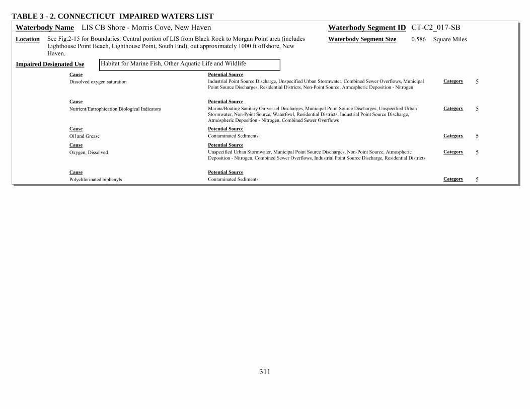
311
TABLE 3 - 2. CONNECTICUT IMPAIRED WATERS LIST LIS CB Shore - Morris Cove, New Haven Waterbody Name Waterbody Segment ID CT-C2_017-SB
Location See Fig.2-15 for Boundaries. Central portion of LIS from Black Rock to Morgan Point area (includes Lighthouse Point Beach, Lighthouse Point, South End), out approximately 1000 ft offshore, New Haven.
Waterbody Segment Size 0.586 Square Miles
Habitat for Marine Fish, Other Aquatic Life and Wildlife Impaired Designated Use Cause Potential Source Dissolved oxygen saturation Industrial Point Source Discharge, Unspecified Urban Stormwater, Combined Sewer Overflows, Municipal
Point Source Discharges, Residential Districts, Non-Point Source, Atmospheric Deposition - Nitrogen Category 5
Cause Potential Source Nutrient/Eutrophication Biological Indicators Marina/Boating Sanitary On-vessel Discharges, Municipal Point Source Discharges, Unspecified Urban
Stormwater, Non-Point Source, Waterfowl, Residential Districts, Industrial Point Source Discharge, Atmospheric Deposition - Nitrogen, Combined Sewer Overflows
Category 5
Cause Potential Source Oil and Grease Contaminated Sediments Category 5 Cause Potential Source Oxygen, Dissolved Unspecified Urban Stormwater, Municipal Point Source Discharges, Non-Point Source, Atmospheric
Deposition - Nitrogen, Combined Sewer Overflows, Industrial Point Source Discharge, Residential Districts Category 5
Cause Potential Source Polychlorinated biphenyls Contaminated Sediments Category 5

312
TABLE 3 - 2. CONNECTICUT IMPAIRED WATERS LIST LIS CB Shore - New Haven Harbor (West), West Haven Waterbody Name Waterbody Segment ID CT-C2_018-SB
Location See Fig.2-15 for Boundaries. Central portion of LIS from Oyster River Point to Sandy Point area (includes West Haven West Beach, West Haven East Beach, West Shore, Sandy Point), out approximately 1000 ft offshore, West Haven.
Waterbody Segment Size 0.789 Square Miles
Commercial Shellfish Harvesting Where Authorized Impaired Designated Use Cause Potential Source Fecal Coliform Industrial Point Source Discharge, Unspecified Urban Stormwater, Non-Point Source, Waterfowl, Combined
Sewer Overflows, Residential Districts, Marina/Boating Sanitary On-vessel Discharges Category 5
Habitat for Marine Fish, Other Aquatic Life and Wildlife Impaired Designated Use Cause Potential Source Dissolved oxygen saturation Combined Sewer Overflows, Unspecified Urban Stormwater, Atmospheric Deposition - Nitrogen,
Residential Districts, Municipal Point Source Discharges, Non-Point Source, Industrial Point Source Discharge
Category 5
Cause Potential Source Nutrient/Eutrophication Biological Indicators Waterfowl, Atmospheric Deposition - Nitrogen, Residential Districts, Non-Point Source, Municipal Point
Source Discharges, Unspecified Urban Stormwater, Marina/Boating Sanitary On-vessel Discharges, Industrial Point Source Discharge, Combined Sewer Overflows
Category 5
Cause Potential Source Oil and Grease Contaminated Sediments Category 5 Cause Potential Source Oxygen, Dissolved Non-Point Source, Industrial Point Source Discharge, Municipal Point Source Discharges, Residential
Districts, Atmospheric Deposition - Nitrogen, Unspecified Urban Stormwater, Combined Sewer Overflows Category 5
Cause Potential Source Polychlorinated biphenyls Contaminated Sediments Category 5
LIS CB Shore - Walnut Beach, Milford Waterbody Name Waterbody Segment ID CT-C2_023 Location See Fig.2-15 for Boundaries. Central portion of LIS from SA/SB WQ line at Milford Point to SA/SB
WQ line at Silver Sands State Park Beach area (includes Walnut Beach, all SA, Housatonic River mouth to The Gulf), out approximately 1000 ft offshore, Milford.
Waterbody Segment Size 0.577 Square Miles
Shellfish Harvesting for Direct Consumption Where Authorized Impaired Designated Use Cause Potential Source Fecal Coliform Waterfowl, Non-Point Source, Residential Districts, Marina/Boating Sanitary On-vessel Discharges,
Unspecified Urban Stormwater Category 5

313
TABLE 3 - 2. CONNECTICUT IMPAIRED WATERS LIST LIS CB Shore - Housatonic River mouth, Stratford Waterbody Name Waterbody Segment ID CT-C2_024-SB
Location See Fig.2-15 for Boundaries. Central portion of LIS from SA/SB WQ line at Stratford Point to SA/SB WQ line at Milford Point area (includes Short Beach, entire mouth of Housatonic River) all SB waters out approximately 1000-4000 ft offshore, Stratford.
Waterbody Segment Size 0.64 Square Miles
Commercial Shellfish Harvesting Where Authorized Impaired Designated Use Cause Potential Source Fecal Coliform Non-Point Source, Marina/Boating Sanitary On-vessel Discharges, Unspecified Urban Stormwater,
Waterfowl, Municipal Point Source Discharges, Residential Districts Category 5
Habitat for Marine Fish, Other Aquatic Life and Wildlife Impaired Designated Use Cause Potential Source Copper Industrial/Commercial Site Stormwater Discharge (Permitted), Industrial Point Source Discharge, Airports,
Landfills Category 5
Cause Potential Source Dioxin (including 2,3,7,8-TCDD) Landfills, Industrial Point Source Discharge Category 5 Cause Potential Source Polychlorinated biphenyls Landfills, Industrial Point Source Discharge Category 5 Cause Potential Source Zinc Landfills, Industrial Point Source Discharge, Industrial/Commercial Site Stormwater Discharge (Permitted),
Airports Category 5
LIS CB Midshore - Westbrook Harbor, Westbrook Waterbody Name Waterbody Segment ID CT-C3_001 Location See Fig.2-15 for Boundaries. Central portion of LIS from approximately 1000 ft offshore (Westbrook
Harbor), out to 50 ft contour and basin boundary separating Eastern/Central. Waterbody Segment Size 2.692 Square Miles
Shellfish Harvesting for Direct Consumption Where Authorized Impaired Designated Use Cause Potential Source Fecal Coliform Marina/Boating Sanitary On-vessel Discharges, Residential Districts, Waterfowl, Non-Point Source,
Unspecified Urban Stormwater Category 5
LIS CB Midshore - Duck Island area, Clinton Waterbody Name Waterbody Segment ID CT-C3_002 Location See Fig.2-15 for Boundaries. Central portion of LIS from approximately 1000 ft offshore (Clinton
Beach, includes Duck Island and Menunketesuck Island areas), out to 50 ft contour, Clinton. Waterbody Segment Size 3.619 Square Miles
Shellfish Harvesting for Direct Consumption Where Authorized Impaired Designated Use Cause Potential Source Fecal Coliform Non-Point Source, Unspecified Urban Stormwater, Residential Districts, On-site Treatment Systems (Septic
Systems and Similar Decentralized Systems), Waterfowl, Marina/Boating Sanitary On-vessel Discharges Category 5

314
TABLE 3 - 2. CONNECTICUT IMPAIRED WATERS LIST LIS CB Midshore - Outer Clinton Harbor, Clinton Waterbody Name Waterbody Segment ID CT-C3_003
Location See Fig.2-15 for Boundaries. Central portion of LIS from approximately 1000 ft offshore (Clinton Harbor), out to 50 ft contour, Clinton.
Waterbody Segment Size 2.524 Square Miles
Shellfish Harvesting for Direct Consumption Where Authorized Impaired Designated Use Cause Potential Source Fecal Coliform Non-Point Source, Unspecified Urban Stormwater, Marina/Boating Sanitary On-vessel Discharges,
Residential Districts, Waterfowl Category 5
LIS CB Midshore - Hammonasset Beach area, Madison Waterbody Name Waterbody Segment ID CT-C3_004 Location See Fig.2-15 for Boundaries. Central portion of LIS from approximately 1000 ft offshore (Madison
Beaches, inlcuding area nearshore Hammonasset Beach State Park), out to 50 ft contour, Madison. Waterbody Segment Size 5.554 Square Miles
Shellfish Harvesting for Direct Consumption Where Authorized Impaired Designated Use Cause Potential Source Fecal Coliform Residential Districts, On-site Treatment Systems (Septic Systems and Similar Decentralized Systems),
Waterfowl, Non-Point Source, Marina/Boating Sanitary On-vessel Discharges, Unspecified Urban Stormwater
Category 5
LIS CB Midshore - Outer Guilford Harbor, Guilford Waterbody Name Waterbody Segment ID CT-C3_006 Location See Fig.2-15 for Boundaries. Central portion of LIS from approximately 1000 ft offshore (Guilford
Harbor), out to 50 ft contour, Guilford. Waterbody Segment Size 8.364 Square Miles
Shellfish Harvesting for Direct Consumption Where Authorized Impaired Designated Use Cause Potential Source Fecal Coliform Residential Districts, On-site Treatment Systems (Septic Systems and Similar Decentralized Systems),
Marina/Boating Sanitary On-vessel Discharges, Non-Point Source, Unspecified Urban Stormwater, Waterfowl
Category 5
LIS CB Midshore - Thimble Islands, Branford Waterbody Name Waterbody Segment ID CT-C3_009-I Location See Fig.2-15 for Boundaries. Central portion of LIS from approximately 1000 ft offshore (Thimble
Islands), out to 50 ft contour, Branford. Waterbody Segment Size 1.457 Square Miles
Shellfish Harvesting for Direct Consumption Where Authorized Impaired Designated Use Cause Potential Source Fecal Coliform Unspecified Urban Stormwater, Waterfowl, Non-Point Source, Residential Districts, Marina/Boating
Sanitary On-vessel Discharges Category 5

315
TABLE 3 - 2. CONNECTICUT IMPAIRED WATERS LIST LIS CB Midshore - Indian Neck, Branford Waterbody Name Waterbody Segment ID CT-C3_010
Location See Fig.2-15 for Boundaries. Central portion of LIS from approximately 1000 ft offshore (Indian Neck, Little Point), out to 50 ft contour, Branford.
Waterbody Segment Size 8.554 Square Miles
Shellfish Harvesting for Direct Consumption Where Authorized Impaired Designated Use Cause Potential Source Fecal Coliform Waterfowl, Non-Point Source, Residential Districts, On-site Treatment Systems (Septic Systems and Similar
Decentralized Systems), Marina/Boating Sanitary On-vessel Discharges, Unspecified Urban Stormwater Category 5
LIS CB Midshore - East Haven Waterbody Name Waterbody Segment ID CT-C3_011 Location See Fig.2-15 for Boundaries. Central portion of LIS, SA water from SA/SB water boundary along
outer New Haven and Branford Harbors out to 50 ft contour, East Haven. Waterbody Segment Size 8.152 Square Miles
Habitat for Marine Fish, Other Aquatic Life and Wildlife Impaired Designated Use Cause Potential Source Dissolved oxygen saturation Unspecified Urban Stormwater, Residential Districts, Combined Sewer Overflows, Non-Point Source, Wet
Weather Discharges (Point Source and Combination of Stormwater, SSO or CSO), Atmospheric Deposition - Nitrogen, Industrial Point Source Discharge, Municipal Point Source Discharges
Category 4a
Cause Potential Source Nitrogen (Total) Wet Weather Discharges (Point Source and Combination of Stormwater, SSO or CSO), Non-Point Source,
Municipal Point Source Discharges, Industrial Point Source Discharge, Combined Sewer Overflows, Atmospheric Deposition - Nitrogen, Unspecified Urban Stormwater, Residential Districts
Category 4a
Cause Potential Source Nutrient/Eutrophication Biological Indicators Combined Sewer Overflows, Unspecified Urban Stormwater, Residential Districts, Wet Weather Discharges
(Point Source and Combination of Stormwater, SSO or CSO), Municipal Point Source Discharges, Industrial Point Source Discharge, Atmospheric Deposition - Nitrogen, Non-Point Source
Category 4a
Cause Potential Source Oxygen, Dissolved Atmospheric Deposition - Nitrogen, Municipal Point Source Discharges, Industrial Point Source Discharge,
Residential Districts, Wet Weather Discharges (Point Source and Combination of Stormwater, SSO or CSO), Non-Point Source, Unspecified Urban Stormwater, Combined Sewer Overflows
Category 4a
Shellfish Harvesting for Direct Consumption Where Authorized Impaired Designated Use Cause Potential Source Fecal Coliform Unspecified Urban Stormwater, Waterfowl, Residential Districts, Marina/Boating Sanitary On-vessel
Discharges, Non-Point Source Category 5

316
TABLE 3 - 2. CONNECTICUT IMPAIRED WATERS LIST LIS CB Midshore - New Haven Harbor, East Haven Waterbody Name Waterbody Segment ID CT-C3_013-SB
Location See Fig.2-15 for Boundaries. Central portion of LIS from approximately 1000 ft offshore (South End, Morgan Point), out to extent of SB water at SA/SB water quality line for outer New Haven Harbor, East Haven.
Waterbody Segment Size 6.051 Square Miles
Habitat for Marine Fish, Other Aquatic Life and Wildlife Impaired Designated Use Cause Potential Source Dissolved oxygen saturation Non-Point Source, Atmospheric Deposition - Nitrogen, Source Unknown, Unspecified Urban Stormwater,
Residential Districts Category 4a
Cause Potential Source Nitrogen (Total) Source Unknown, Atmospheric Deposition - Nitrogen, Unspecified Urban Stormwater, Industrial Point
Source Discharge, Municipal Point Source Discharges, Residential Districts, Non-Point Source Category 4a
Cause Potential Source Nutrient/Eutrophication Biological Indicators Non-Point Source, Source Unknown, Residential Districts, Atmospheric Deposition - Nitrogen, Unspecified
Urban Stormwater Category 4a
Cause Potential Source Oxygen, Dissolved Unspecified Urban Stormwater, Non-Point Source, Source Unknown, Atmospheric Deposition - Nitrogen,
Residential Districts Category 4a
LIS CB Midshore - New Haven Harbor, West Haven Waterbody Name Waterbody Segment ID CT-C3_014-SB Location See Fig.2-15 for Boundaries. Central portion of LIS from approximately 1000 ft offshore
(Morningside to West Shore), out to extent of SB water at SA/SB water quality line for outer New Haven Harbor, Milford/West Haven.
Waterbody Segment Size 7.961 Square Miles
Habitat for Marine Fish, Other Aquatic Life and Wildlife Impaired Designated Use Cause Potential Source Dissolved oxygen saturation Residential Districts, Non-Point Source, Unspecified Urban Stormwater, Municipal Point Source
Discharges, Atmospheric Deposition - Nitrogen, Industrial Point Source Discharge, Source Unknown Category 4a
Cause Potential Source Nitrogen (Total) Unspecified Urban Stormwater, Municipal Point Source Discharges, Industrial Point Source Discharge,
Source Unknown, Non-Point Source, Atmospheric Deposition - Nitrogen, Residential Districts Category 4a
Cause Potential Source Nutrient/Eutrophication Biological Indicators Non-Point Source, Atmospheric Deposition - Nitrogen, Industrial Point Source Discharge, Municipal Point
Source Discharges, Source Unknown, Unspecified Urban Stormwater, Residential Districts Category 4a
Cause Potential Source Oxygen, Dissolved Non-Point Source, Municipal Point Source Discharges, Atmospheric Deposition - Nitrogen, Source
Unknown, Industrial Point Source Discharge, Unspecified Urban Stormwater, Residential Districts Category 4a

317
TABLE 3 - 2. CONNECTICUT IMPAIRED WATERS LIST LIS CB Midshore - New Haven Harbor, New Haven Waterbody Name Waterbody Segment ID CT-C3_015-SB
Location See Fig.2-15 for Boundaries. Central portion of LIS from approximately 1000 ft offshore (West Shore to Morgan Point), from Sandy Point out to segments CT-C3_013/014, outer New Haven Harbor, West Haven/New Haven.
Waterbody Segment Size 4.561 Square Miles
Habitat for Marine Fish, Other Aquatic Life and Wildlife Impaired Designated Use Cause Potential Source Dissolved oxygen saturation Combined Sewer Overflows, Unspecified Urban Stormwater, Non-Point Source, Atmospheric Deposition -
Nitrogen, Industrial Point Source Discharge, Municipal Point Source Discharges, Residential Districts Category 4a
Cause Potential Source Nutrient/Eutrophication Biological Indicators Unspecified Urban Stormwater, Non-Point Source, Waterfowl, Residential Districts, Municipal Point Source
Discharges, Marina/Boating Sanitary On-vessel Discharges, Atmospheric Deposition - Nitrogen, Combined Sewer Overflows, Industrial Point Source Discharge
Category 4a
Cause Potential Source Oil and Grease Contaminated Sediments Category 5 Cause Potential Source Oxygen, Dissolved Atmospheric Deposition - Nitrogen, Non-Point Source, Residential Districts, Municipal Point Source
Discharges, Industrial Point Source Discharge, Combined Sewer Overflows, Unspecified Urban Stormwater Category 4a
Cause Potential Source Polychlorinated biphenyls Contaminated Sediments Category 5

318
TABLE 3 - 2. CONNECTICUT IMPAIRED WATERS LIST LIS CB Midshore - West Haven Waterbody Name Waterbody Segment ID CT-C3_016
Location See Fig.2-15 for Boundaries. Central portion of LIS, SA water from SA/SB water boundary along outer New Haven Harbor, out to 50 ft contour, West Haven.
Waterbody Segment Size 6.121 Square Miles
Habitat for Marine Fish, Other Aquatic Life and Wildlife Impaired Designated Use Cause Potential Source Dissolved oxygen saturation Municipal Point Source Discharges, Residential Districts, Atmospheric Deposition - Nitrogen, Combined
Sewer Overflows, Wet Weather Discharges (Point Source and Combination of Stormwater, SSO or CSO), Unspecified Urban Stormwater, Non-Point Source, Industrial Point Source Discharge
Category 4a
Cause Potential Source Nitrogen (Total) Non-Point Source, Industrial Point Source Discharge, Atmospheric Deposition - Nitrogen, Residential
Districts, Combined Sewer Overflows, Wet Weather Discharges (Point Source and Combination of Stormwater, SSO or CSO), Municipal Point Source Discharges, Unspecified Urban Stormwater
Category 4a
Cause Potential Source Nutrient/Eutrophication Biological Indicators Wet Weather Discharges (Point Source and Combination of Stormwater, SSO or CSO), Atmospheric
Deposition - Nitrogen, Unspecified Urban Stormwater, Non-Point Source, Residential Districts, Combined Sewer Overflows, Municipal Point Source Discharges, Industrial Point Source Discharge
Category 4a
Cause Potential Source Oxygen, Dissolved Non-Point Source, Unspecified Urban Stormwater, Wet Weather Discharges (Point Source and Combination
of Stormwater, SSO or CSO), Municipal Point Source Discharges, Combined Sewer Overflows, Residential Districts, Atmospheric Deposition - Nitrogen, Industrial Point Source Discharge
Category 4a
Shellfish Harvesting for Direct Consumption Where Authorized Impaired Designated Use Cause Potential Source Fecal Coliform Marina/Boating Sanitary On-vessel Discharges, Waterfowl, Non-Point Source, Residential Districts,
Unspecified Urban Stormwater Category 5

319
TABLE 3 - 2. CONNECTICUT IMPAIRED WATERS LIST LIS CB Midshore - Milford Waterbody Name Waterbody Segment ID CT-C3_017
Location See Fig.2-15 for Boundaries. Central portion of LIS, SA water from SA/SB water boundary along outer New Haven Harbor, out to 50 ft contour, Milford.
Waterbody Segment Size 8.095 Square Miles
Habitat for Marine Fish, Other Aquatic Life and Wildlife Impaired Designated Use Cause Potential Source Dissolved oxygen saturation Residential Districts, Unspecified Urban Stormwater, Municipal Point Source Discharges, Combined Sewer
Overflows, Atmospheric Deposition - Nitrogen, Non-Point Source, Wet Weather Discharges (Point Source and Combination of Stormwater, SSO or CSO), Industrial Point Source Discharge
Category 4a
Cause Potential Source Nitrogen (Total) Industrial Point Source Discharge, Non-Point Source, Wet Weather Discharges (Point Source and
Combination of Stormwater, SSO or CSO), Municipal Point Source Discharges, Unspecified Urban Stormwater, Combined Sewer Overflows, Atmospheric Deposition - Nitrogen, Residential Districts
Category 4a
Cause Potential Source Nutrient/Eutrophication Biological Indicators Residential Districts, Unspecified Urban Stormwater, Atmospheric Deposition - Nitrogen, Combined Sewer
Overflows, Municipal Point Source Discharges, Non-Point Source, Wet Weather Discharges (Point Source and Combination of Stormwater, SSO or CSO), Industrial Point Source Discharge
Category 4a
Cause Potential Source Oxygen, Dissolved Wet Weather Discharges (Point Source and Combination of Stormwater, SSO or CSO), Industrial Point
Source Discharge, Unspecified Urban Stormwater, Combined Sewer Overflows, Municipal Point Source Discharges, Non-Point Source, Atmospheric Deposition - Nitrogen, Residential Districts
Category 4a
Shellfish Harvesting for Direct Consumption Where Authorized Impaired Designated Use Cause Potential Source Fecal Coliform Marina/Boating Sanitary On-vessel Discharges, Residential Districts, Non-Point Source, Waterfowl,
Unspecified Urban Stormwater Category 5
LIS CB Midshore - Fort Trumbull, Milford Waterbody Name Waterbody Segment ID CT-C3_018 Location See Fig.2-15 for Boundaries. Central portion of LIS from approximately 1000 ft offshore (Silver
Sands State Park area, water beyond Island), out to 50 ft contour, Milford. Waterbody Segment Size 11.311 Square Miles
Habitat for Marine Fish, Other Aquatic Life and Wildlife Impaired Designated Use Cause Potential Source Dissolved oxygen saturation Municipal Point Source Discharges, Combined Sewer Overflows, Atmospheric Deposition - Nitrogen,
Industrial Point Source Discharge, Unspecified Urban Stormwater, Non-Point Source, Residential Districts Category 4a
Cause Potential Source Nitrogen (Total) Non-Point Source, Unspecified Urban Stormwater, Marina/Boating Sanitary On-vessel Discharges,
Atmospheric Deposition - Nitrogen, Industrial Point Source Discharge, Residential Districts, Combined Sewer Overflows
Category 4a
Cause Potential Source Nutrient/Eutrophication Biological Indicators Non-Point Source, Residential Districts, Marina/Boating Sanitary On-vessel Discharges, Industrial Point
Source Discharge, Combined Sewer Overflows, Atmospheric Deposition - Nitrogen, Unspecified Urban Stormwater
Category 4a
Cause Potential Source Oxygen, Dissolved Natural Sources, Municipal Point Source Discharges, Residential Districts, Industrial Point Source
Discharge, Combined Sewer Overflows, Atmospheric Deposition - Nitrogen, Unspecified Urban Stormwater Category 4a
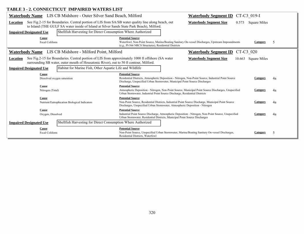
320
TABLE 3 - 2. CONNECTICUT IMPAIRED WATERS LIST LIS CB Midshore - Outer Silver Sand Beach, Milford Waterbody Name Waterbody Segment ID CT-C3_019-I
Location See Fig.2-15 for Boundaries. Central portion of LIS from SA/SB water quality line along beach, out to Island (THE GULF SA water inside of Island at Silver Sands State Park Beach), Milford.
Waterbody Segment Size 0.573 Square Miles
Shellfish Harvesting for Direct Consumption Where Authorized Impaired Designated Use Cause Potential Source Fecal Coliform Waterfowl, Non-Point Source, Marina/Boating Sanitary On-vessel Discharges, Upstream Impoundments
(e.g., Pl-566 NRCS Structures), Residential Districts Category 5
LIS CB Midshore - Milford Point, Milford Waterbody Name Waterbody Segment ID CT-C3_020 Location See Fig.2-15 for Boundaries. Central portion of LIS from approximately 1000 ft offshore (SA water
surrounding SB water, outer mouth of Housatonic River), out to 50 ft contour, Milford. Waterbody Segment Size 10.663 Square Miles
Habitat for Marine Fish, Other Aquatic Life and Wildlife Impaired Designated Use Cause Potential Source Dissolved oxygen saturation Residential Districts, Atmospheric Deposition - Nitrogen, Non-Point Source, Industrial Point Source
Discharge, Unspecified Urban Stormwater, Municipal Point Source Discharges Category 4a
Cause Potential Source Nitrogen (Total) Atmospheric Deposition - Nitrogen, Non-Point Source, Municipal Point Source Discharges, Unspecified
Urban Stormwater, Industrial Point Source Discharge, Residential Districts Category 4a
Cause Potential Source Nutrient/Eutrophication Biological Indicators Non-Point Source, Residential Districts, Industrial Point Source Discharge, Municipal Point Source
Discharges, Unspecified Urban Stormwater, Atmospheric Deposition - Nitrogen Category 4a
Cause Potential Source Oxygen, Dissolved Industrial Point Source Discharge, Atmospheric Deposition - Nitrogen, Non-Point Source, Unspecified
Urban Stormwater, Residential Districts, Municipal Point Source Discharges Category 4a
Shellfish Harvesting for Direct Consumption Where Authorized Impaired Designated Use Cause Potential Source Fecal Coliform Non-Point Source, Unspecified Urban Stormwater, Marina/Boating Sanitary On-vessel Discharges,
Residential Districts, Waterfowl Category 5
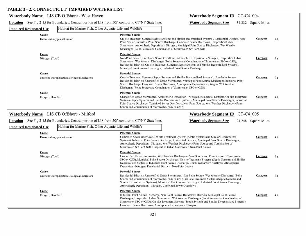
321
TABLE 3 - 2. CONNECTICUT IMPAIRED WATERS LIST LIS CB Offshore - West Haven Waterbody Name Waterbody Segment ID CT-C4_004
Location See Fig.2-15 for Boundaries. Central portion of LIS from 50ft contour to CT/NY State line. Waterbody Segment Size 34.332 Square Miles Habitat for Marine Fish, Other Aquatic Life and Wildlife Impaired Designated Use
Cause Potential Source Dissolved oxygen saturation On-site Treatment Systems (Septic Systems and Similar Decentralized Systems), Residential Districts, Non-
Point Source, Industrial Point Source Discharge, Combined Sewer Overflows, Unspecified Urban Stormwater, Atmospheric Deposition - Nitrogen, Municipal Point Source Discharges, Wet Weather Discharges (Point Source and Combination of Stormwater, SSO or CSO)
Category 4a
Cause Potential Source Nitrogen (Total) Non-Point Source, Combined Sewer Overflows, Atmospheric Deposition - Nitrogen, Unspecified Urban
Stormwater, Wet Weather Discharges (Point Source and Combination of Stormwater, SSO or CSO), Residential Districts, On-site Treatment Systems (Septic Systems and Similar Decentralized Systems), Municipal Point Source Discharges, Industrial Point Source Discharge
Category 4a
Cause Potential Source Nutrient/Eutrophication Biological Indicators On-site Treatment Systems (Septic Systems and Similar Decentralized Systems), Non-Point Source,
Residential Districts, Unspecified Urban Stormwater, Municipal Point Source Discharges, Industrial Point Source Discharge, Combined Sewer Overflows, Atmospheric Deposition - Nitrogen, Wet Weather Discharges (Point Source and Combination of Stormwater, SSO or CSO)
Category 4a
Cause Potential Source Oxygen, Dissolved Unspecified Urban Stormwater, Atmospheric Deposition - Nitrogen, Residential Districts, On-site Treatment
Systems (Septic Systems and Similar Decentralized Systems), Municipal Point Source Discharges, Industrial Point Source Discharge, Combined Sewer Overflows, Non-Point Source, Wet Weather Discharges (Point Source and Combination of Stormwater, SSO or CSO)
Category 4a
LIS CB Offshore - Milford Waterbody Name Waterbody Segment ID CT-C4_005 Location See Fig.2-15 for Boundaries. Central portion of LIS from 50ft contour to CT/NY State line. Waterbody Segment Size 24.248 Square Miles
Habitat for Marine Fish, Other Aquatic Life and Wildlife Impaired Designated Use Cause Potential Source Dissolved oxygen saturation Combined Sewer Overflows, On-site Treatment Systems (Septic Systems and Similar Decentralized
Systems), Industrial Point Source Discharge, Residential Districts, Municipal Point Source Discharges, Atmospheric Deposition - Nitrogen, Wet Weather Discharges (Point Source and Combination of Stormwater, SSO or CSO), Unspecified Urban Stormwater, Non-Point Source
Category 4a
Cause Potential Source Nitrogen (Total) Unspecified Urban Stormwater, Wet Weather Discharges (Point Source and Combination of Stormwater,
SSO or CSO), Municipal Point Source Discharges, On-site Treatment Systems (Septic Systems and Similar Decentralized Systems), Industrial Point Source Discharge, Combined Sewer Overflows, Atmospheric Deposition - Nitrogen, Residential Districts, Non-Point Source
Category 4a
Cause Potential Source Nutrient/Eutrophication Biological Indicators Residential Districts, Unspecified Urban Stormwater, Non-Point Source, Wet Weather Discharges (Point
Source and Combination of Stormwater, SSO or CSO), On-site Treatment Systems (Septic Systems and Similar Decentralized Systems), Municipal Point Source Discharges, Industrial Point Source Discharge, Atmospheric Deposition - Nitrogen, Combined Sewer Overflows
Category 4a
Cause Potential Source Oxygen, Dissolved Industrial Point Source Discharge, Non-Point Source, Residential Districts, Municipal Point Source
Discharges, Unspecified Urban Stormwater, Wet Weather Discharges (Point Source and Combination of Stormwater, SSO or CSO), On-site Treatment Systems (Septic Systems and Similar Decentralized Systems), Combined Sewer Overflows, Atmospheric Deposition - Nitrogen
Category 4a

322
TABLE 3 - 2. CONNECTICUT IMPAIRED WATERS LIST LIS EB Inner - Pawcatuck River (01), Stonington Waterbody Name Waterbody Segment ID CT-E1_001-SB
Location See Fig.2-15 for Boundaries. Eastern portion of LIS, Inner Estuary in Pawcatuck River from Stanton Weir Point US to Saltwater limit, parallel to RR and Mechanic Street, Clarks Village, (Stonington).
Waterbody Segment Size 0.103 Square Miles
Commercial Shellfish Harvesting Where Authorized Impaired Designated Use Cause Potential Source Fecal Coliform Non-Point Source, Municipal Point Source Discharges, Marina/Boating Sanitary On-vessel Discharges,
Waterfowl, Unspecified Urban Stormwater Category 5
Habitat for Marine Fish, Other Aquatic Life and Wildlife Impaired Designated Use Cause Potential Source Dissolved oxygen saturation Residential Districts, Atmospheric Deposition - Nitrogen, Waterfowl, Marina/Boating Sanitary On-vessel
Discharges, Unspecified Urban Stormwater, Municipal Point Source Discharges Category 5
Cause Potential Source Nutrient/Eutrophication Biological Indicators Waterfowl, Unspecified Urban Stormwater, Atmospheric Deposition - Nitrogen, Marina/Boating Sanitary
On-vessel Discharges, Municipal Point Source Discharges, Residential Districts Category 5
Cause Potential Source Oxygen, Dissolved Unspecified Urban Stormwater, Marina/Boating Sanitary On-vessel Discharges, Municipal Point Source
Discharges, Residential Districts, Atmospheric Deposition - Nitrogen, Waterfowl Category 5
LIS EB Inner - Inner Wequetequock Cove, Stonington Waterbody Name Waterbody Segment ID CT-E1_003 Location See Fig.2-15 for Boundaries. Eastern portion of LIS, Inner Estuary, Inner Wequetequock Cove from
RR crossing US to Saltwater limit, in two lopes adjacent to Route 1, Stonington. Waterbody Segment Size 0.094 Square Miles
Shellfish Harvesting for Direct Consumption Where Authorized Impaired Designated Use Cause Potential Source Fecal Coliform Waterfowl, On-site Treatment Systems (Septic Systems and Similar Decentralized Systems),
Marina/Boating Sanitary On-vessel Discharges, Unspecified Urban Stormwater, Residential Districts Category 5
LIS EB Inner - Inner Stonongton Harbor, Stonington Waterbody Name Waterbody Segment ID CT-E1_005 Location See Fig.2-15 for Boundaries. Eastern portion of LIS, Inner Estuary, Inner Stonington Harbor from
SB/SA water quality boundary at RR crossing, US to Saltwater limit near Route 1 crossing, Stonington.
Waterbody Segment Size 0.226 Square Miles
Shellfish Harvesting for Direct Consumption Where Authorized Impaired Designated Use Cause Potential Source Fecal Coliform Unspecified Urban Stormwater, Waterfowl, Residential Districts, Marina/Boating Sanitary On-vessel
Discharges Category 5

323
TABLE 3 - 2. CONNECTICUT IMPAIRED WATERS LIST LIS EB Inner - Inner Quiambaug Cove, Stonington Waterbody Name Waterbody Segment ID CT-E1_006
Location See Fig.2-15 for Boundaries. Eastern portion of LIS, Inner Estuary, Inner Quiambaug Cove from RR crossing, US to Saltwater limit, above Route 1 crossing, adjacent to Cove Road, Stonington.
Waterbody Segment Size 0.114 Square Miles
Shellfish Harvesting for Direct Consumption Where Authorized Impaired Designated Use Cause Potential Source Fecal Coliform Residential Districts, On-site Treatment Systems (Septic Systems and Similar Decentralized Systems),
Marina/Boating Sanitary On-vessel Discharges, Waterfowl, Unspecified Urban Stormwater Category 5
LIS EB Inner - Beebe Cove (Mystic Harbor), Groton Waterbody Name Waterbody Segment ID CT-E1_009 Location See Fig.2-15 for Boundaries. Eastern portion of LIS, Inner Estuary, Beebe Cove (Mystic Harbor)
waters west of two RR crossings along shore, Groton. Waterbody Segment Size 0.207 Square Miles
Shellfish Harvesting for Direct Consumption Where Authorized Impaired Designated Use Cause Potential Source Fecal Coliform Waterfowl, Unspecified Urban Stormwater, Residential Districts, Marina/Boating Sanitary On-vessel
Discharges Category 5
LIS EB Inner - Palmer Cove (Inner), Groton Waterbody Name Waterbody Segment ID CT-E1_010 Location See Fig.2-15 for Boundaries. Eastern portion of LIS, Inner Estuary, Inner Palmer Cove waters from
North side of Groton Long Point Road crossing, past RR crossings to saltwater limit, Groton. Waterbody Segment Size 0.113 Square Miles
Shellfish Harvesting for Direct Consumption Where Authorized Impaired Designated Use Cause Potential Source Fecal Coliform Marina/Boating Sanitary On-vessel Discharges, Upstream Impoundments (e.g., Pl-566 NRCS Structures),
Waterfowl, Residential Districts, On-site Treatment Systems (Septic Systems and Similar Decentralized Systems)
Category 5
LIS EB Inner - Mumford Cove (Inner), Groton Waterbody Name Waterbody Segment ID CT-E1_011-SB Location See Fig.2-15 for Boundaries. Eastern portion of LIS, Inner Estuary, Inner Mumford Cove along east
side of Bluff Point State Park shore, and North of Groton Long Point to saltwater limit near RR crossing, Groton.
Waterbody Segment Size 0.219 Square Miles
Commercial Shellfish Harvesting Where Authorized Impaired Designated Use Cause Potential Source Fecal Coliform Marina/Boating Sanitary On-vessel Discharges, Residential Districts, Unspecified Urban Stormwater,
Waterfowl Category 5
LIS EB Inner - Poquonuck River (Mouth), Groton Waterbody Name Waterbody Segment ID CT-E1_012 Location See Fig.2-15 for Boundaries. Eastern portion of LIS, Inner Estuary, Poquonuck River from mouth at
Baker Cove (along East of Groton-New London Airport), US to saltwater limit just US of RR crossing, Groton.
Waterbody Segment Size 0.367 Square Miles
Shellfish Harvesting for Direct Consumption Where Authorized Impaired Designated Use Cause Potential Source Fecal Coliform Residential Districts, Waterfowl, Unspecified Urban Stormwater, Marina/Boating Sanitary On-vessel
Discharges Category 5

324
TABLE 3 - 2. CONNECTICUT IMPAIRED WATERS LIST LIS EB Inner - Baker Cove, Groton Waterbody Name Waterbody Segment ID CT-E1_013
Location See Fig.2-15 for Boundaries. Eastern portion of LIS, Inner Estuary, Baker cove from Avery Point and tip of Pine Island, to mouth of Poquonuck River (South of Groton-New London Airport), Groton.
Waterbody Segment Size 0.314 Square Miles
Shellfish Harvesting for Direct Consumption Where Authorized Impaired Designated Use Cause Potential Source Fecal Coliform Unspecified Urban Stormwater, Marina/Boating Sanitary On-vessel Discharges, Residential Districts,
Waterfowl Category 5
LIS EB Inner - Thames River (Mouth), New London Waterbody Name Waterbody Segment ID CT-E1_014-SB Location See Fig.2-15 for Boundaries. Eastern portion of LIS, Inner Estuary, mouth of Thames River from
Eastern Point (North of Avery Point), US to I95 crossing (Includes Inner New London Harbor), Groton.
Waterbody Segment Size 1.994 Square Miles
Commercial Shellfish Harvesting Where Authorized Impaired Designated Use Cause Potential Source Fecal Coliform On-site Treatment Systems (Septic Systems and Similar Decentralized Systems), Unspecified Urban
Stormwater, Waterfowl, Residential Districts, Non-Point Source, Marina/Boating Sanitary On-vessel Discharges
Category 5
Habitat for Marine Fish, Other Aquatic Life and Wildlife Impaired Designated Use Cause Potential Source Dissolved oxygen saturation Unspecified Urban Stormwater, Residential Districts, Municipal Point Source Discharges Category 5 Cause Potential Source Estuarine Bioassessments Municipal Point Source Discharges, Unspecified Urban Stormwater, Residential Districts Category 5 Cause Potential Source Oxygen, Dissolved Unspecified Urban Stormwater, Residential Districts, Municipal Point Source Discharges Category 5

325
TABLE 3 - 2. CONNECTICUT IMPAIRED WATERS LIST LIS EB Inner - Thames River (middle), Ledyard Waterbody Name Waterbody Segment ID CT-E1_015-SB
Location See Fig.2-15 for Boundaries. Eastern portion of LIS, Inner Estuary, Thames River from I95 crossing, US to just below outlet of Poquetanuck Cove (near Walden Island), and adjacent to Route 12 at Cardinal Lane intersection, Ledyard.
Waterbody Segment Size 3.316 Square Miles
Commercial Shellfish Harvesting Where Authorized Impaired Designated Use Cause Potential Source Fecal Coliform Municipal Point Source Discharges, Waterfowl, Unspecified Urban Stormwater, Non-Point Source,
Marina/Boating Sanitary On-vessel Discharges, Residential Districts Category 5
Habitat for Marine Fish, Other Aquatic Life and Wildlife Impaired Designated Use Cause Potential Source Dissolved oxygen saturation Residential Districts, Unspecified Urban Stormwater, Municipal Point Source Discharges Category 5 Cause Potential Source Estuarine Bioassessments Residential Districts, Municipal Point Source Discharges, Unspecified Urban Stormwater Category 5 Cause Potential Source Oxygen, Dissolved Municipal Point Source Discharges, Unspecified Urban Stormwater, Residential Districts Category 5
Recreation Impaired Designated Use Cause Potential Source Enterococcus Unspecified Urban Stormwater, Sanitary Sewer Overflows (Collection System Failures), Industrial Point
Source Discharge, Waterfowl, Marina/Boating Sanitary On-vessel Discharges Category 5

326
TABLE 3 - 2. CONNECTICUT IMPAIRED WATERS LIST LIS EB Inner - Thames River (Upper), Norwich Waterbody Name Waterbody Segment ID CT-E1_016-SB
Location See Fig.2-15 for Boundaries. Eastern portion of LIS, Inner Estuary, Thames River from just below outlet of Poquetanuck Cove (near Walden Island), adjacent to Route 12 at Cardinal Lane intersection, US to first dams in Yantic and Shetucket Rivers, Norwich.
Waterbody Segment Size 1.555 Square Miles
Commercial Shellfish Harvesting Where Authorized Impaired Designated Use Cause Potential Source Fecal Coliform Combined Sewer Overflows, Agriculture, Non-Point Source, Waterfowl, Residential Districts, Unspecified
Urban Stormwater Category 5
Habitat for Marine Fish, Other Aquatic Life and Wildlife Impaired Designated Use Cause Potential Source Dissolved oxygen saturation Unspecified Urban Stormwater, Atmospheric Deposition - Nitrogen, Combined Sewer Overflows, Municipal
Point Source Discharges, Residential Districts, Non-Point Source, Agriculture Category 5
Cause Potential Source Estuarine Bioassessments Category 5 Cause Potential Source Nutrient/Eutrophication Biological Indicators Category 5 Cause Potential Source Oxygen, Dissolved Category 5
Recreation Impaired Designated Use Cause Potential Source Enterococcus Combined Sewer Overflows, Agriculture, Unspecified Urban Stormwater, Waterfowl Category 5
LIS EB Inner - Alewife Cove, Waterford/New London Waterbody Name Waterbody Segment ID CT-E1_017 Location See Fig.2-15 for Boundaries. Eastern portion of LIS, Inner Estuary, Alewife Cove from outlet at
Waterford Beach Park Picnic Area, US to Saltwater limit at Niles Hill Road crossing, Waterford. Waterbody Segment Size 0.063 Square Miles
Habitat for Marine Fish, Other Aquatic Life and Wildlife Impaired Designated Use Cause Potential Source Dissolved oxygen saturation Non-Point Source, Residential Districts Category 5 Cause Potential Source Nutrient/Eutrophication Biological Indicators Residential Districts, Non-Point Source Category 5 Cause Potential Source Oxygen, Dissolved Residential Districts, Non-Point Source Category 5
Shellfish Harvesting for Direct Consumption Where Authorized Impaired Designated Use Cause Potential Source Fecal Coliform Waterfowl, Residential Districts, Unspecified Urban Stormwater, Non-Point Source Category 5

327
TABLE 3 - 2. CONNECTICUT IMPAIRED WATERS LIST LIS EB Inner - Jordan Cove, Waterford Waterbody Name Waterbody Segment ID CT-E1_019
Location See Fig.2-15 for Boundaries. Eastern portion of LIS, Inner Estuary, Jordan Cove from outlet at Pleasure Beach, US past RR crossing, to Saltwater limit at outlet dam of Jordan Mill Pond, adjacent to Route 156, Waterford.
Waterbody Segment Size 0.191 Square Miles
Shellfish Harvesting for Direct Consumption Where Authorized Impaired Designated Use Cause Potential Source Fecal Coliform Marina/Boating Sanitary On-vessel Discharges, Unspecified Urban Stormwater, Residential Districts,
Waterfowl Category 5
LIS EB Inner - Niantic River (mouth), Niantic Waterbody Name Waterbody Segment ID CT-E1_020 Location See Fig.2-15 for Boundaries. Eastern portion of LIS, Inner Estuary, Niantic River (Inner Niantic Bay)
from outlet at Route 156 and RR crossing, US to saltwater limit in Banning Cove (between Route 1 crossing and I95/I395), East Lyme/Waterford.
Waterbody Segment Size 1.305 Square Miles
Habitat for Marine Fish, Other Aquatic Life and Wildlife Impaired Designated Use Cause Potential Source Cause Unknown Source Unknown Category 5 Cause Potential Source Estuarine Bioassessments Flow Alterations from Water Diversions, Unspecified Urban Stormwater, Marina/Boating Sanitary On-
vessel Discharges, Residential Districts Category 5
Cause Potential Source Nutrient/Eutrophication Biological Indicators Residential Districts, Unspecified Urban Stormwater Category 5
Shellfish Harvesting for Direct Consumption Where Authorized Impaired Designated Use Cause Potential Source Fecal Coliform Unspecified Urban Stormwater, Marina/Boating Sanitary On-vessel Discharges, On-site Treatment Systems
(Septic Systems and Similar Decentralized Systems), Residential Districts, Waterfowl Category 5
LIS EB Inner - Pattagansett Rvr (mouth), East Lyme Waterbody Name Waterbody Segment ID CT-E1_021 Location See Fig.2-15 for Boundaries. Eastern portion of LIS, Inner Estuary, Pattagansett River from outlet at
RR crossing, US to saltwater limit at Route 156 crossing, East Lyme. Waterbody Segment Size 0.048 Square Miles
Shellfish Harvesting for Direct Consumption Where Authorized Impaired Designated Use Cause Potential Source Fecal Coliform Residential Districts, Unspecified Urban Stormwater, Marina/Boating Sanitary On-vessel Discharges, On-
site Treatment Systems (Septic Systems and Similar Decentralized Systems), Waterfowl, Non-Point Source Category 5
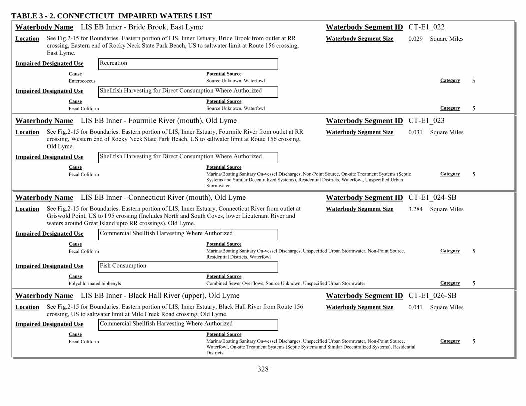
328
TABLE 3 - 2. CONNECTICUT IMPAIRED WATERS LIST LIS EB Inner - Bride Brook, East Lyme Waterbody Name Waterbody Segment ID CT-E1_022
Location See Fig.2-15 for Boundaries. Eastern portion of LIS, Inner Estuary, Bride Brook from outlet at RR crossing, Eastern end of Rocky Neck State Park Beach, US to saltwater limit at Route 156 crossing, East Lyme.
Waterbody Segment Size 0.029 Square Miles
Recreation Impaired Designated Use Cause Potential Source Enterococcus Source Unknown, Waterfowl Category 5
Shellfish Harvesting for Direct Consumption Where Authorized Impaired Designated Use Cause Potential Source Fecal Coliform Source Unknown, Waterfowl Category 5
LIS EB Inner - Fourmile River (mouth), Old Lyme Waterbody Name Waterbody Segment ID CT-E1_023 Location See Fig.2-15 for Boundaries. Eastern portion of LIS, Inner Estuary, Fourmile River from outlet at RR
crossing, Western end of Rocky Neck State Park Beach, US to saltwater limit at Route 156 crossing, Old Lyme.
Waterbody Segment Size 0.031 Square Miles
Shellfish Harvesting for Direct Consumption Where Authorized Impaired Designated Use Cause Potential Source Fecal Coliform Marina/Boating Sanitary On-vessel Discharges, Non-Point Source, On-site Treatment Systems (Septic
Systems and Similar Decentralized Systems), Residential Districts, Waterfowl, Unspecified Urban Stormwater
Category 5
LIS EB Inner - Connecticut River (mouth), Old Lyme Waterbody Name Waterbody Segment ID CT-E1_024-SB Location See Fig.2-15 for Boundaries. Eastern portion of LIS, Inner Estuary, Connecticut River from outlet at
Griswold Point, US to I 95 crossing (Includes North and South Coves, lower Lieutenant River and waters around Great Island upto RR crossings), Old Lyme.
Waterbody Segment Size 3.284 Square Miles
Commercial Shellfish Harvesting Where Authorized Impaired Designated Use Cause Potential Source Fecal Coliform Marina/Boating Sanitary On-vessel Discharges, Unspecified Urban Stormwater, Non-Point Source,
Residential Districts, Waterfowl Category 5
Fish Consumption Impaired Designated Use Cause Potential Source Polychlorinated biphenyls Combined Sewer Overflows, Source Unknown, Unspecified Urban Stormwater Category 5
LIS EB Inner - Black Hall River (upper), Old Lyme Waterbody Name Waterbody Segment ID CT-E1_026-SB Location See Fig.2-15 for Boundaries. Eastern portion of LIS, Inner Estuary, Black Hall River from Route 156
crossing, US to saltwater limit at Mile Creek Road crossing, Old Lyme. Waterbody Segment Size 0.041 Square Miles
Commercial Shellfish Harvesting Where Authorized Impaired Designated Use Cause Potential Source Fecal Coliform Marina/Boating Sanitary On-vessel Discharges, Unspecified Urban Stormwater, Non-Point Source,
Waterfowl, On-site Treatment Systems (Septic Systems and Similar Decentralized Systems), Residential Districts
Category 5

329
TABLE 3 - 2. CONNECTICUT IMPAIRED WATERS LIST LIS EB Inner - Duck River, Old Lyme Waterbody Name Waterbody Segment ID CT-E1_027-SB
Location See Fig.2-15 for Boundaries. Eastern portion of LIS, Inner Estuary, Duck River from RR crossing near Route 156 crossing, US to saltwater limit at Elm Street, Old Lyme.
Waterbody Segment Size 0.007 Square Miles
Commercial Shellfish Harvesting Where Authorized Impaired Designated Use Cause Potential Source Fecal Coliform Non-Point Source, Unspecified Urban Stormwater, Residential Districts, Marina/Boating Sanitary On-vessel
Discharges, Waterfowl Category 5
Recreation Impaired Designated Use Cause Potential Source Enterococcus Waterfowl, Source Unknown Category 5
LIS EB Inner - Leiutenant River, Old Lyme Waterbody Name Waterbody Segment ID CT-E1_028-SB Location See Fig.2-15 for Boundaries. Eastern portion of LIS, Inner Estuary, Leiutenant River from Route 156
crossing, US to saltwater limit adjacent to Longacre Lane, Old Lyme. Waterbody Segment Size 0.105 Square Miles
Recreation Impaired Designated Use Cause Potential Source Enterococcus Waterfowl, Source Unknown Category 5
LIS EB Inner - Connecticut River (upper), Chester Waterbody Name Waterbody Segment ID CT-E1_031-SB Location See Fig.2-15 for Boundaries. Eastern portion of LIS, Inner Estuary, Connecticut River from area just
above Brockway Island, US to saltwater limit just above Chapman Pond inlet (adjacent to Gillette Castle State Park), East Haddam.
Waterbody Segment Size 2.13 Square Miles
Fish Consumption Impaired Designated Use Cause Potential Source Polychlorinated biphenyls Unspecified Urban Stormwater, Source Unknown, Combined Sewer Overflows Category 5
LIS EB Inner - Oyster River Area, Old Saybrook Waterbody Name Waterbody Segment ID CT-E1_032 Location See Fig.2-15 for Boundaries. Eastern portion of LIS, Inner Estuary, Oyster River, Plum Bank Creek,
and Back River from mouths on Indian Harbor, US to saltwater limits (Oyster River is to RR crossing above Route 1), Old Saybrook.
Waterbody Segment Size 0.098 Square Miles
Shellfish Harvesting for Direct Consumption Where Authorized Impaired Designated Use Cause Potential Source Fecal Coliform Unspecified Urban Stormwater, Non-Point Source, Residential Districts, Waterfowl, Marina/Boating
Sanitary On-vessel Discharges, On-site Treatment Systems (Septic Systems and Similar Decentralized Systems)
Category 5

330
TABLE 3 - 2. CONNECTICUT IMPAIRED WATERS LIST LIS EB Shore - Wequetequock Cove, Stonington Waterbody Name Waterbody Segment ID CT-E2_001
Location See Fig.2-15 for Boundaries. Eastern portion of LIS from RR crossing on east side of Wequetequock cove to mouth of Pawcatuck River, out approximately 1000 ft offshore (Little Narragansett Bay).
Waterbody Segment Size 0.619 Square Miles
Shellfish Harvesting for Direct Consumption Where Authorized Impaired Designated Use Cause Potential Source Fecal Coliform Unspecified Urban Stormwater, On-site Treatment Systems (Septic Systems and Similar Decentralized
Systems), Waterfowl, Residential Districts, Marina/Boating Sanitary On-vessel Discharges Category 5
LIS EB Shore - Stonington Point, Stonington Waterbody Name Waterbody Segment ID CT-E2_002 Location See Fig.2-15 for Boundaries. Eastern portion of LIS from Stonington Point to RR crossing on west
side of Wequetequock Cove, out approximately 1000 ft offshore. Waterbody Segment Size 0.668 Square Miles
Shellfish Harvesting for Direct Consumption Where Authorized Impaired Designated Use Cause Potential Source Fecal Coliform Unspecified Urban Stormwater, Marina/Boating Sanitary On-vessel Discharges, Waterfowl, Residential
Districts, On-site Treatment Systems (Septic Systems and Similar Decentralized Systems) Category 5
LIS EB Shore - Outer Quiambaug Cove, Stonington Waterbody Name Waterbody Segment ID CT-E2_003 Location See Fig.2-15 for Boundaries. Eastern portion of LIS from Mouth of inner Quiambaug Cove at RR
crossing to SB/SA water quality boundary at mouth of Stonington Harbor, out approximately 1000 ft offshore.
Waterbody Segment Size 0.388 Square Miles
Shellfish Harvesting for Direct Consumption Where Authorized Impaired Designated Use Cause Potential Source Fecal Coliform On-site Treatment Systems (Septic Systems and Similar Decentralized Systems), Marina/Boating Sanitary
On-vessel Discharges, Residential Districts, Waterfowl, Unspecified Urban Stormwater Category 5
LIS EB Shore - Wilcox Cove (Mason Is.), Stonington Waterbody Name Waterbody Segment ID CT-E2_004 Location See Fig.2-15 for Boundaries. Eastern portion of LIS from tip of Mason Island to Mouth of inner
Quiambaug Cove, out approximately 1000 ft offshore. Waterbody Segment Size 0.694 Square Miles
Shellfish Harvesting for Direct Consumption Where Authorized Impaired Designated Use Cause Potential Source Fecal Coliform Unspecified Urban Stormwater, On-site Treatment Systems (Septic Systems and Similar Decentralized
Systems), Residential Districts, Marina/Boating Sanitary On-vessel Discharges, Waterfowl Category 5

331
TABLE 3 - 2. CONNECTICUT IMPAIRED WATERS LIST LIS EB Shore - Mouth Mystic River, Stonington Waterbody Name Waterbody Segment ID CT-E2_005
Location See Fig.2-15 for Boundaries. Eastern portion of LIS from western most tip of Mason Island along SB/SA water quality boundary to eastern most tip of Mason Island, out approximately 1000 ft offshore.
Waterbody Segment Size 0.35 Square Miles
Shellfish Harvesting for Direct Consumption Where Authorized Impaired Designated Use Cause Potential Source Fecal Coliform Marina/Boating Sanitary On-vessel Discharges, Unspecified Urban Stormwater, Residential Districts,
Waterfowl Category 5
LIS EB Shore - West Cove (Groton Long Pt), Groton Waterbody Name Waterbody Segment ID CT-E2_006 Location See Fig.2-15 for Boundaries. Eastern portion of LIS from tip of Groton Long Point to Morgan Point at
SB/SA water quality boundary for Mystic River mouth, out approximately 1000 ft offshore. Waterbody Segment Size 0.422 Square Miles
Shellfish Harvesting for Direct Consumption Where Authorized Impaired Designated Use Cause Potential Source Fecal Coliform Non-Point Source, On-site Treatment Systems (Septic Systems and Similar Decentralized Systems),
Waterfowl, Residential Districts, Marina/Boating Sanitary On-vessel Discharges Category 5
LIS EB Shore - Outer Mumford Cove, Groton Waterbody Name Waterbody Segment ID CT-E2_007 Location See Fig.2-15 for Boundaries. Eastern portion of LIS from Mumford Point to eastern most tip of
Groton Long Point (includes outer Mumford cove and all of Venetian Harbor), out approximately 1000 ft offshore.
Waterbody Segment Size 0.555 Square Miles
Shellfish Harvesting for Direct Consumption Where Authorized Impaired Designated Use Cause Potential Source Fecal Coliform Residential Districts, Unspecified Urban Stormwater, Waterfowl, Marina/Boating Sanitary On-vessel
Discharges Category 5
LIS EB Shore - Bluff Point, Groton Waterbody Name Waterbody Segment ID CT-E2_008 Location See Fig.2-15 for Boundaries. Eastern portion of LIS from SB/SA water quality boundary at Bushy
Point Beach to Mumford Point, out approximately 1000 ft offshore. Waterbody Segment Size 0.235 Square Miles
Shellfish Harvesting for Direct Consumption Where Authorized Impaired Designated Use Cause Potential Source Fecal Coliform Marina/Boating Sanitary On-vessel Discharges, Waterfowl, Unspecified Urban Stormwater Category 5

332
TABLE 3 - 2. CONNECTICUT IMPAIRED WATERS LIST LIS EB Shore - Thames River Mouth (East), Groton Waterbody Name Waterbody Segment ID CT-E2_009-SB
Location See Fig.2-15 for Boundaries. Eastern portion of LIS from Eastern Point in mouth of Thames River to SB/SA water quality boundary at Bushy Point Beach, out approximately 1000 ft offshore.
Waterbody Segment Size 0.4 Square Miles
Habitat for Marine Fish, Other Aquatic Life and Wildlife Impaired Designated Use Cause Potential Source Dissolved oxygen saturation Residential Districts, Municipal Point Source Discharges, Unspecified Urban Stormwater Category 5 Cause Potential Source Estuarine Bioassessments Residential Districts, Municipal Point Source Discharges, Unspecified Urban Stormwater Category 5 Cause Potential Source Oxygen, Dissolved Unspecified Urban Stormwater, Municipal Point Source Discharges, Residential Districts Category 5
LIS EB Shore - Thames Rvr Mouth (West), New London Waterbody Name Waterbody Segment ID CT-E2_010-SB Location See Fig.2-15 for Boundaries. Eastern portion of LIS from mouth of Alewife Cove to Quinnipeag
Rocks along western shore of Thames River mouth, out approximately 1000 ft offshore (SB Water Quality).
Waterbody Segment Size 0.299 Square Miles
Habitat for Marine Fish, Other Aquatic Life and Wildlife Impaired Designated Use Cause Potential Source Dissolved oxygen saturation Residential Districts, Unspecified Urban Stormwater, Municipal Point Source Discharges Category 5 Cause Potential Source Estuarine Bioassessments Residential Districts, Municipal Point Source Discharges, Unspecified Urban Stormwater Category 5 Cause Potential Source Oxygen, Dissolved Municipal Point Source Discharges, Residential Districts, Unspecified Urban Stormwater Category 5
LIS EB Shore - Thames Rvr Mouth (West), Waterford Waterbody Name Waterbody Segment ID CT-E2_011-SB Location See Fig.2-15 for Boundaries. Eastern portion of LIS from Magonk Point to mouth of Alewife Cove,
out approximately 1000 ft offshore (SB Water Quality). Waterbody Segment Size 0.486 Square Miles
Habitat for Marine Fish, Other Aquatic Life and Wildlife Impaired Designated Use Cause Potential Source Dissolved oxygen saturation Municipal Point Source Discharges, Unspecified Urban Stormwater, Residential Districts Category 5 Cause Potential Source Estuarine Bioassessments Municipal Point Source Discharges, Unspecified Urban Stormwater, Residential Districts Category 5 Cause Potential Source Oxygen, Dissolved Unspecified Urban Stormwater, Municipal Point Source Discharges, Residential Districts Category 5

333
TABLE 3 - 2. CONNECTICUT IMPAIRED WATERS LIST LIS EB Shore - Outer Jordan Cove, Waterford Waterbody Name Waterbody Segment ID CT-E2_012
Location See Fig.2-15 for Boundaries. Eastern portion of LIS from Millstone Point to SB/SA water quality boundary at Magonk Point, out approximately 1000 ft offshore. Waters adjacent to Millstone Power Plant.
Waterbody Segment Size 0.465 Square Miles
Shellfish Harvesting for Direct Consumption Where Authorized Impaired Designated Use Cause Potential Source Fecal Coliform Unspecified Urban Stormwater, Residential Districts, On-site Treatment Systems (Septic Systems and
Similar Decentralized Systems), Waterfowl, Marina/Boating Sanitary On-vessel Discharges Category 5
LIS EB Shore - Niantic Bay (East), Waterford Waterbody Name Waterbody Segment ID CT-E2_013 Location See Fig.2-15 for Boundaries. Eastern portion of LIS from Smith Avenue at junction with Route 156 to
Millstone Point, out approximately 1000 ft offshore. Waters adjacent to Millstone Power Plant. Waterbody Segment Size 0.444 Square Miles
Habitat for Marine Fish, Other Aquatic Life and Wildlife Impaired Designated Use Cause Potential Source Cause Unknown Source Unknown Category 5
Shellfish Harvesting for Direct Consumption Where Authorized Impaired Designated Use Cause Potential Source Fecal Coliform Marina/Boating Sanitary On-vessel Discharges, Residential Districts, Waterfowl, Unspecified Urban
Stormwater Category 5
LIS EB Shore - Niantic Bay (West), East Lyme Waterbody Name Waterbody Segment ID CT-E2_014 Location See Fig.2-15 for Boundaries. Eastern portion of LIS from Pond Point to Smith Avenue at junction
with Route 156, out approximately 1000 ft offshore. Waters adjacent to Millstone Power Plant. Waterbody Segment Size 0.302 Square Miles
Habitat for Marine Fish, Other Aquatic Life and Wildlife Impaired Designated Use Cause Potential Source Cause Unknown Source Unknown Category 5
Shellfish Harvesting for Direct Consumption Where Authorized Impaired Designated Use Cause Potential Source Fecal Coliform Waterfowl, Residential Districts, Marina/Boating Sanitary On-vessel Discharges, Unspecified Urban
Stormwater, On-site Treatment Systems (Septic Systems and Similar Decentralized Systems), Non-Point Source
Category 5

334
TABLE 3 - 2. CONNECTICUT IMPAIRED WATERS LIST LIS EB Shore - Niantic Bay (Black Pt), East Lyme Waterbody Name Waterbody Segment ID CT-E2_015
Location See Fig.2-15 for Boundaries. Eastern portion of LIS from Point East of Griswald Island, past Black Point to Pond Point in Niantic Bay, out approximately 1000 ft offshore.
Waterbody Segment Size 0.554 Square Miles
Habitat for Marine Fish, Other Aquatic Life and Wildlife Impaired Designated Use Cause Potential Source Cause Unknown Source Unknown Category 5
Shellfish Harvesting for Direct Consumption Where Authorized Impaired Designated Use Cause Potential Source Fecal Coliform Waterfowl, Residential Districts, Marina/Boating Sanitary On-vessel Discharges, On-site Treatment Systems
(Septic Systems and Similar Decentralized Systems), Unspecified Urban Stormwater, Source Unknown Category 5
LIS EB Shore - Pattagansett River Mouth, East Lyme Waterbody Name Waterbody Segment ID CT-E2_016 Location See Fig.2-15 for Boundaries. Eastern portion of LIS from Seal Rock (Great Neck) to Point East of
Griswald Island (entire mouth of Pattagansett River, including area around Watts Island), out approximately 1000 ft offshore.
Waterbody Segment Size 0.322 Square Miles
Shellfish Harvesting for Direct Consumption Where Authorized Impaired Designated Use Cause Potential Source Fecal Coliform Non-Point Source, Waterfowl, Residential Districts, Marina/Boating Sanitary On-vessel Discharges,
Unspecified Urban Stormwater, On-site Treatment Systems (Septic Systems and Similar Decentralized Systems)
Category 5
LIS EB Shore - Rocky Neck (Fourmile Rvr), Old Lyme Waterbody Name Waterbody Segment ID CT-E2_017 Location See Fig.2-15 for Boundaries. Eastern portion of LIS from Hatchett Point to Seal Rock (Great Neck)
Includes Rocky Neck State Park Beach, out approximately 1000 ft offshore. Waterbody Segment Size 0.531 Square Miles
Shellfish Harvesting for Direct Consumption Where Authorized Impaired Designated Use Cause Potential Source Fecal Coliform Source Unknown, Waterfowl Category 5
LIS EB Shore - Soundview Beach, Old Lyme Waterbody Name Waterbody Segment ID CT-E2_018 Location See Fig.2-15 for Boundaries. Eastern portion of LIS from SB/SA water quality boundary at Hawks
Nest Beach area to Hatchett Point (Includes Soundview Beach), out approximately 1000 ft offshore. Waterbody Segment Size 0.332 Square Miles
Shellfish Harvesting for Direct Consumption Where Authorized Impaired Designated Use Cause Potential Source Fecal Coliform Unspecified Urban Stormwater, Non-Point Source, Marina/Boating Sanitary On-vessel Discharges, On-site
Treatment Systems (Septic Systems and Similar Decentralized Systems), Waterfowl, Residential Districts Category 5

335
TABLE 3 - 2. CONNECTICUT IMPAIRED WATERS LIST LIS EB Shore - Willard Bay, Old Saybrook Waterbody Name Waterbody Segment ID CT-E2_020
Location See Fig.2-15 for Boundaries. Eastern portion of LIS from Cornfield Point to SB/SA water quality boundary at Lynde Point, out approximately 1000 ft offshore. (SB water)
Waterbody Segment Size 0.5 Square Miles
Shellfish Harvesting for Direct Consumption Where Authorized Impaired Designated Use Cause Potential Source Fecal Coliform Waterfowl, Marina/Boating Sanitary On-vessel Discharges, Unspecified Urban Stormwater, Non-Point
Source, Residential Districts Category 5
LIS EB Shore - Plum Bank, Old Saybrook Waterbody Name Waterbody Segment ID CT-E2_021 Location See Fig.2-15 for Boundaries. Eastern portion of LIS from Plum Bank Creek to Cornfield Point
(includes Town Beach), out approximately 1000 ft offshore. Waterbody Segment Size 0.182 Square Miles
Shellfish Harvesting for Direct Consumption Where Authorized Impaired Designated Use Cause Potential Source Fecal Coliform Marina/Boating Sanitary On-vessel Discharges, Waterfowl, Non-Point Source, Unspecified Urban
Stormwater, On-site Treatment Systems (Septic Systems and Similar Decentralized Systems), Residential Districts
Category 5
LIS EB Shore - Indiantown Harbor, Old Saybrook Waterbody Name Waterbody Segment ID CT-E2_022 Location See Fig.2-15 for Boundaries. Eastern portion of LIS from Long Rock to Plum Bank Creek (includes
the mouth of Oytser River and Back River, and Plum Bank Creek), out approximately 1000 ft offshore.
Waterbody Segment Size 0.389 Square Miles
Shellfish Harvesting for Direct Consumption Where Authorized Impaired Designated Use Cause Potential Source Fecal Coliform Unspecified Urban Stormwater, Non-Point Source, Residential Districts, On-site Treatment Systems (Septic
Systems and Similar Decentralized Systems), Marina/Boating Sanitary On-vessel Discharges, Waterfowl Category 5
LIS EB Midshore - Stonington Waterbody Name Waterbody Segment ID CT-E3_001 Location See Fig.2-15 for Boundaries. Eastern portion of LIS from approximately 1000 ft offshore (Little
Narragansett Bay), out to CT/NY State line. Waterbody Segment Size 0.585 Square Miles
Shellfish Harvesting for Direct Consumption Where Authorized Impaired Designated Use Cause Potential Source Fecal Coliform Unspecified Urban Stormwater, Marina/Boating Sanitary On-vessel Discharges, On-site Treatment Systems
(Septic Systems and Similar Decentralized Systems), Residential Districts, Waterfowl Category 5
LIS EB Midshore - Groton, Mystic River Waterbody Name Waterbody Segment ID CT-E3_003 Location See Fig.2-15 for Boundaries. Eastern portion of LIS from approximately 1000 ft offshore, Groton
Long Point to Enders Island, out to CT/NY State line. Waterbody Segment Size 2.853 Square Miles
Shellfish Harvesting for Direct Consumption Where Authorized Impaired Designated Use Cause Potential Source Fecal Coliform Unspecified Urban Stormwater, Marina/Boating Sanitary On-vessel Discharges, On-site Treatment Systems
(Septic Systems and Similar Decentralized Systems), Waterfowl, Residential Districts Category 5

336
TABLE 3 - 2. CONNECTICUT IMPAIRED WATERS LIST LIS EB Midshore - Groton, Thames River Waterbody Name Waterbody Segment ID CT-E3_004
Location See Fig.2-15 for Boundaries. Eastern portion of LIS from SB/SA water quality boundary out to 50 ft contour offshore of Goshen Point, Waterford, to approximately 1000 ft offshore, Groton Long Point, out to CT/NY State line.
Waterbody Segment Size 6.738 Square Miles
Shellfish Harvesting for Direct Consumption Where Authorized Impaired Designated Use Cause Potential Source Fecal Coliform Waterfowl, Residential Districts, Marina/Boating Sanitary On-vessel Discharges, Unspecified Urban
Stormwater Category 5
LIS EB Midshore - Waterford, Thames River Waterbody Name Waterbody Segment ID CT-E3_005-SB Location See Fig.2-15 for Boundaries. Eastern portion of LIS from SB/SA water quality boundary,
approximately 1000 ft offshore of Magonk Point, Waterford to BushyPoint, Groton, out to SB/SA water quality boundary (Thames River mouth).
Waterbody Segment Size 5.256 Square Miles
Habitat for Marine Fish, Other Aquatic Life and Wildlife Impaired Designated Use Cause Potential Source Dissolved oxygen saturation Residential Districts, Unspecified Urban Stormwater, Municipal Point Source Discharges Category 4a Cause Potential Source Estuarine Bioassessments Municipal Point Source Discharges, Residential Districts, Unspecified Urban Stormwater Category 5 Cause Potential Source Oxygen, Dissolved Unspecified Urban Stormwater, Residential Districts, Municipal Point Source Discharges Category 4a
LIS EB Midshore - Niantic Bay Waterbody Name Waterbody Segment ID CT-E3_006 Location See Fig.2-15 for Boundaries. Eastern portion of LIS from approximately 1000 ft offshore Black Point,
East Lyme to Magonk Point (SB/SA water quality boundary) Waterford, out to 50 ft contour (Niantic Bay).
Waterbody Segment Size 6.179 Square Miles
Habitat for Marine Fish, Other Aquatic Life and Wildlife Impaired Designated Use Cause Potential Source Cause Unknown Source Unknown Category 5
Shellfish Harvesting for Direct Consumption Where Authorized Impaired Designated Use Cause Potential Source Fecal Coliform Waterfowl, Unspecified Urban Stormwater, Marina/Boating Sanitary On-vessel Discharges, Residential
Districts Category 5

337
TABLE 3 - 2. CONNECTICUT IMPAIRED WATERS LIST LIS EB Midshore - East Lyme, Rocky Neck Waterbody Name Waterbody Segment ID CT-E3_007
Location See Fig.2-15 for Boundaries. Eastern portion of LIS from approximately 1000 ft offshore Hatchett Point to Black Point, East Lyme, out to 50 ft contour (offshore of mouths of Fourmile and Pattagasett Rivers).
Waterbody Segment Size 2.93 Square Miles
Shellfish Harvesting for Direct Consumption Where Authorized Impaired Designated Use Cause Potential Source Fecal Coliform Non-Point Source, Waterfowl, Residential Districts, On-site Treatment Systems (Septic Systems and Similar
Decentralized Systems), Unspecified Urban Stormwater, Marina/Boating Sanitary On-vessel Discharges Category 5
LIS EB Midshore - Old Lyme, CT River Waterbody Name Waterbody Segment ID CT-E3_008 Location See Fig.2-15 for Boundaries. Eastern portion of LIS from SB/SA water quality boundary near CT
River mouth to approximately 1000 ft offshore Hatchett Point, Old Lyme, out to 50 ft contour (offshore of Connecticut River).
Waterbody Segment Size 3.517 Square Miles
Shellfish Harvesting for Direct Consumption Where Authorized Impaired Designated Use Cause Potential Source Fecal Coliform Unspecified Urban Stormwater, Marina/Boating Sanitary On-vessel Discharges, Waterfowl, On-site
Treatment Systems (Septic Systems and Similar Decentralized Systems), Residential Districts Category 5
LIS EB Midshore - Old Saybrook Waterbody Name Waterbody Segment ID CT-E3_010 Location See Fig.2-15 for Boundaries. Eastern portion of LIS from approximately 1000 ft offshore Guardhous
Point, to SB/SA water quality boundary, Old Saybrook (Mouth of Connecticut River), out to 50 ft contour.
Waterbody Segment Size 4.409 Square Miles
Shellfish Harvesting for Direct Consumption Where Authorized Impaired Designated Use Cause Potential Source Fecal Coliform On-site Treatment Systems (Septic Systems and Similar Decentralized Systems), Waterfowl, Residential
Districts, Non-Point Source, Marina/Boating Sanitary On-vessel Discharges, Unspecified Urban Stormwater Category 5
LIS EB Midshore - Old Saybrook, Indian Harbor Waterbody Name Waterbody Segment ID CT-E3_011 Location See Fig.2-15 for Boundaries. Eastern portion of LIS from approximately 1000 ft offshore Old Kelsey
Point, to Guardhouse Point, Old Saybrook, (outer Indiantown Harbor and Plum Bank), out to 50 ft contour.
Waterbody Segment Size 5.639 Square Miles
Shellfish Harvesting for Direct Consumption Where Authorized Impaired Designated Use Cause Potential Source Fecal Coliform Residential Districts, Unspecified Urban Stormwater, Waterfowl, On-site Treatment Systems (Septic
Systems and Similar Decentralized Systems), Non-Point Source, Marina/Boating Sanitary On-vessel Discharges
Category 5

338
TABLE 3 - 2. CONNECTICUT IMPAIRED WATERS LIST LIS EB Midshore - Westbrook Waterbody Name Waterbody Segment ID CT-E3_012
Location See Fig.2-15 for Boundaries. Eastern portion of LIS from approximately 1000 ft offshore Old Kelsey Point (outer Westbrook Harbor), out to 50 ft contour. Odd shape due to 50 ft contour.
Waterbody Segment Size 7.407 Square Miles
Shellfish Harvesting for Direct Consumption Where Authorized Impaired Designated Use Cause Potential Source Fecal Coliform Marina/Boating Sanitary On-vessel Discharges, Non-Point Source, Waterfowl, Unspecified Urban
Stormwater, Residential Districts Category 5
LIS WB Inner - Bridgeport Harbor, Bridgeport Waterbody Name Waterbody Segment ID CT-W1_001-SB Location See Fig.2-15 for Boundaries. Western portion of LIS from SA/SB water quality line at mouth at
Pleasure Beach area, US to saltwater limit in Pequonnock River and Lewis Gut (includes Yellow Mill Channel, Johnsons Creek, all SB water of Harbor area), Bridgeport.
Waterbody Segment Size 1.434 Square Miles
Commercial Shellfish Harvesting Where Authorized Impaired Designated Use Cause Potential Source Fecal Coliform Unspecified Urban Stormwater, Combined Sewer Overflows, Non-Point Source, Residential Districts,
Waterfowl, Marina/Boating Sanitary On-vessel Discharges Category 5
Habitat for Marine Fish, Other Aquatic Life and Wildlife Impaired Designated Use Cause Potential Source Dissolved oxygen saturation Residential Districts, Non-Point Source, Atmospheric Deposition - Nitrogen, Unspecified Urban Stormwater Category 5
Cause Potential Source Nutrient/Eutrophication Biological Indicators Atmospheric Deposition - Nitrogen, Residential Districts, Non-Point Source, Unspecified Urban Stormwater Category 5
Cause Potential Source Oxygen, Dissolved Atmospheric Deposition - Nitrogen, Non-Point Source, Unspecified Urban Stormwater, Residential Districts Category 5
Cause Potential Source Polychlorinated biphenyls Contaminated Sediments Category 5 Cause Potential Source Polycyclic Aromatic Hydrocarbons (PAHs) (Aquatic Ecosystems)
Contaminated Sediments Category 5
Recreation Impaired Designated Use Cause Potential Source Enterococcus Combined Sewer Overflows, Wet Weather Discharges (Point Source and Combination of Stormwater, SSO
or CSO) Category 5

339
TABLE 3 - 2. CONNECTICUT IMPAIRED WATERS LIST LIS WB Inner - Black Rock Harbor, Bridgeport Waterbody Name Waterbody Segment ID CT-W1_002-SB
Location See Fig.2-15 for Boundaries. Western portion of LIS, Inner Estuary, from SA/SB water quality line at mouth at Fayerweather Island area, US to saltwater limit at I95 (includes Burr Creek, Cedar Creek, all SB water of Harbor area), Bridgeport.
Waterbody Segment Size 0.442 Square Miles
Commercial Shellfish Harvesting Where Authorized Impaired Designated Use Cause Potential Source Fecal Coliform Non-Point Source, Combined Sewer Overflows, Marina/Boating Sanitary On-vessel Discharges, Waterfowl,
Residential Districts, Unspecified Urban Stormwater Category 5
Habitat for Marine Fish, Other Aquatic Life and Wildlife Impaired Designated Use Cause Potential Source Dissolved oxygen saturation Industrial Point Source Discharge, Non-Point Source, Combined Sewer Overflows, Unspecified Urban
Stormwater, Municipal Point Source Discharges, Residential Districts, Landfills Category 5
Cause Potential Source Estuarine Bioassessments Source Unknown Category 5 Cause Potential Source Nutrient/Eutrophication Biological Indicators Landfills, Industrial Point Source Discharge, Municipal Point Source Discharges, Residential Districts, Non-
Point Source, Unspecified Urban Stormwater, Combined Sewer Overflows Category 5
Cause Potential Source Oil and Grease Contaminated Sediments, Unspecified Urban Stormwater, Combined Sewer Overflows, Landfills Category 5 Cause Potential Source Oxygen, Dissolved Unspecified Urban Stormwater, Combined Sewer Overflows, Industrial Point Source Discharge, Landfills,
Municipal Point Source Discharges, Residential Districts, Non-Point Source Category 5
Cause Potential Source Polychlorinated biphenyls Other Spill Related Impacts, Contaminated Sediments, Landfills Category 5 Cause Potential Source Polycyclic Aromatic Hydrocarbons (PAHs) (Aquatic Ecosystems)
Combined Sewer Overflows, Landfills, Other Spill Related Impacts Category 5
Recreation Impaired Designated Use Cause Potential Source Enterococcus Combined Sewer Overflows, Wet Weather Discharges (Point Source and Combination of Stormwater, SSO
or CSO) Category 5

340
TABLE 3 - 2. CONNECTICUT IMPAIRED WATERS LIST LIS WB Inner - Ash Creek, Fairfield Waterbody Name Waterbody Segment ID CT-W1_003-SB
Location See Fig.2-15 for Boundaries. Western portion of LIS, Inner Estuary, from SA/SB water quality line at mouth near South Benson Road, US to saltwater limit at I95, Fairfield/Bridgeport.
Waterbody Segment Size 0.157 Square Miles
Commercial Shellfish Harvesting Where Authorized Impaired Designated Use Cause Potential Source Fecal Coliform Residential Districts, Unspecified Urban Stormwater, Combined Sewer Overflows, Non-Point Source,
Waterfowl, Marina/Boating Sanitary On-vessel Discharges Category 5
Habitat for Marine Fish, Other Aquatic Life and Wildlife Impaired Designated Use Cause Potential Source Gold Contaminated Sediments, Industrial Point Source Discharge Category 5 Cause Potential Source Silver Contaminated Sediments, Industrial Point Source Discharge Category 5
Recreation Impaired Designated Use Cause Potential Source Enterococcus Combined Sewer Overflows, Industrial Point Source Discharge, Unspecified Urban Stormwater,
Marina/Boating Sanitary On-vessel Discharges, Non-Point Source, Waterfowl, Residential Districts Category 5
LIS WB Inner - Pine Creek, Fairfield Waterbody Name Waterbody Segment ID CT-W1_004 Location See Fig.2-15 for Boundaries. Western portion of LIS, Inner Estuary, from mouth at Pine Creek Point,
US to saltwater limit at Oldfield Road crossing, Fairfield. Waterbody Segment Size 0.06 Square Miles
Shellfish Harvesting for Direct Consumption Where Authorized Impaired Designated Use Cause Potential Source Fecal Coliform Non-Point Source, Unspecified Urban Stormwater, Waterfowl, Marina/Boating Sanitary On-vessel
Discharges, Residential Districts Category 5
LIS WB Inner - Southport Harbor, Fairfield Waterbody Name Waterbody Segment ID CT-W1_005 Location See Fig.2-15 for Boundaries. Western portion of LIS, Inner Estuary, from mouth parallel to Willow
Street, US to Harbor Road crossing, Fairfield. Waterbody Segment Size 0.072 Square Miles
Shellfish Harvesting for Direct Consumption Where Authorized Impaired Designated Use Cause Potential Source Fecal Coliform Unspecified Urban Stormwater, Non-Point Source, Residential Districts, Waterfowl, Marina/Boating
Sanitary On-vessel Discharges Category 5

341
TABLE 3 - 2. CONNECTICUT IMPAIRED WATERS LIST LIS WB Inner - Mill River, Fairfield Waterbody Name Waterbody Segment ID CT-W1_006
Location See Fig.2-15 for Boundaries. Western portion of LIS, Inner Estuary, from Harbor Road crossing, US to saltwater limit at Sturges Road crossing (includes Mill Pond section of Mill River), Fairfield.
Waterbody Segment Size 0.033 Square Miles
Fish Consumption Impaired Designated Use Cause Potential Source Lead Contaminated Sediments, Contaminated Sediments, Industrial Point Source Discharge, Industrial Point
Source Discharge Category 4b
Habitat for Marine Fish, Other Aquatic Life and Wildlife Impaired Designated Use Cause Potential Source Chromium (total) Industrial Point Source Discharge, Contaminated Sediments Category 4b Cause Potential Source Chromium, hexavalent Contaminated Sediments, Industrial Point Source Discharge Category 4b Cause Potential Source Lead Contaminated Sediments, Contaminated Sediments, Industrial Point Source Discharge, Industrial Point
Source Discharge Category 4b
Recreation Impaired Designated Use Cause Potential Source Chromium (total) Industrial Point Source Discharge, Contaminated Sediments Category 4b Cause Potential Source Chromium, hexavalent Industrial Point Source Discharge, Contaminated Sediments Category 4b Cause Potential Source Lead Contaminated Sediments, Contaminated Sediments, Industrial Point Source Discharge, Industrial Point
Source Discharge Category 4b
Shellfish Harvesting for Direct Consumption Where Authorized Impaired Designated Use Cause Potential Source Fecal Coliform Waterfowl, Non-Point Source, Residential Districts, Unspecified Urban Stormwater Category 5
LIS WB Inner - Sasco Brook, Westport Waterbody Name Waterbody Segment ID CT-W1_007 Location See Fig.2-15 for Boundaries. Western portion of LIS, Inner Estuary, from mouth DS of Pequot
Avenue crossing, US to saltwater limit at Route 1 crossing, Westport/Fairfield. Waterbody Segment Size 0.022 Square Miles
Recreation Impaired Designated Use Cause Potential Source Escherichia coli Unspecified Urban Stormwater, On-site Treatment Systems (Septic Systems and Similar Decentralized
Systems), Source Unknown, Waterfowl, Residential Districts Category 5
Cause Potential Source Fecal Coliform On-site Treatment Systems (Septic Systems and Similar Decentralized Systems), Source Unknown,
Waterfowl, Residential Districts, Unspecified Urban Stormwater Category 5
Shellfish Harvesting for Direct Consumption Where Authorized Impaired Designated Use Cause Potential Source Fecal Coliform Residential Districts, On-site Treatment Systems (Septic Systems and Similar Decentralized Systems),
Unspecified Urban Stormwater, Non-Point Source, Waterfowl Category 5

342
TABLE 3 - 2. CONNECTICUT IMPAIRED WATERS LIST LIS WB Inner - Sherwood Millpond, Westport Waterbody Name Waterbody Segment ID CT-W1_008
Location See Fig.2-15 for Boundaries. Western portion of LIS, Inner Estuary, from mouth at Compo Cove, US to saltwater limit south of RR and I95 (includes Mill Creek, Grove Point, and all of Greens Farm Brook surrounding Sherwood Island State Park), Westport.
Waterbody Segment Size 0.168 Square Miles
Shellfish Harvesting for Direct Consumption Where Authorized Impaired Designated Use Cause Potential Source Fecal Coliform Non-Point Source, Marina/Boating Sanitary On-vessel Discharges, Residential Districts, Waterfowl,
Unspecified Urban Stormwater Category 5
LIS WB Inner - Grays Creek, Westport Waterbody Name Waterbody Segment ID CT-W1_009 Location See Fig.2-15 for Boundaries. Western portion of LIS, Inner Estuary, from SA/SB water quality line at
mouth on Saugatuck River Estuary, US to saltwater limit at Compo Road, Westport. Waterbody Segment Size 0.036 Square Miles
Shellfish Harvesting for Direct Consumption Where Authorized Impaired Designated Use Cause Potential Source Fecal Coliform Unspecified Urban Stormwater, Non-Point Source, Waterfowl, Residential Districts, On-site Treatment
Systems (Septic Systems and Similar Decentralized Systems), Marina/Boating Sanitary On-vessel Discharges
Category 5
LIS WB Inner - Saugatuck River (mouth), Westport Waterbody Name Waterbody Segment ID CT-W1_010-SB Location See Fig.2-15 for Boundaries. Western portion of LIS, Inner Estuary, from SA/SB water quality line at
mouth of Saugatuck River Estuary (at Bluff Point across to Owenoke), US to RR crossing, DS of I95 crossing (includes Kitts Island, Burritt Cove), Westport.
Waterbody Segment Size 0.645 Square Miles
Commercial Shellfish Harvesting Where Authorized Impaired Designated Use Cause Potential Source Fecal Coliform Unspecified Urban Stormwater, Non-Point Source, Waterfowl, Marina/Boating Sanitary On-vessel
Discharges, Residential Districts Category 5

343
TABLE 3 - 2. CONNECTICUT IMPAIRED WATERS LIST LIS WB Inner - Norwalk Harbor, Norwalk Waterbody Name Waterbody Segment ID CT-W1_012-SB
Location See Fig.2-15 for Boundaries. Western portion of LIS, Inner Estuary, from SA/SB water quality line at mouth of Norwalk Harbor (Calf Pasture Point), US to saltwater limit at Wall Street Crossing (EXCLUDES eastern cove of Marvin Beach), Norwalk.
Waterbody Segment Size 0.942 Square Miles
Commercial Shellfish Harvesting Where Authorized Impaired Designated Use Cause Potential Source Fecal Coliform Residential Districts, Marina/Boating Sanitary On-vessel Discharges, Non-Point Source, Unspecified Urban
Stormwater, Waterfowl, Combined Sewer Overflows Category 5
Habitat for Marine Fish, Other Aquatic Life and Wildlife Impaired Designated Use Cause Potential Source Dissolved oxygen saturation Unspecified Urban Stormwater, Residential Districts, Municipal Point Source Discharges, Non-Point
Source, Industrial Point Source Discharge, Atmospheric Deposition - Nitrogen Category 5
Cause Potential Source Lead Industrial Point Source Discharge, Contaminated Sediments, Source Unknown, Landfills Category 5 Cause Potential Source Mercury Industrial Point Source Discharge, Landfills, Source Unknown, Combined Sewer Overflows Category 5 Cause Potential Source Nitrogen (Total) Municipal Point Source Discharges, Atmospheric Deposition - Nitrogen, Non-Point Source, Unspecified
Urban Stormwater, Industrial Point Source Discharge, Residential Districts Category 5
Cause Potential Source Nutrient/Eutrophication Biological Indicators Unspecified Urban Stormwater, Municipal Point Source Discharges, Atmospheric Deposition - Nitrogen,
Industrial Point Source Discharge, Non-Point Source, Residential Districts Category 5
Cause Potential Source Oxygen, Dissolved Non-Point Source, Municipal Point Source Discharges, Atmospheric Deposition - Nitrogen, Unspecified
Urban Stormwater, Residential Districts, Industrial Point Source Discharge Category 5
Recreation Impaired Designated Use Cause Potential Source Enterococcus Municipal Point Source Discharges, Waterfowl, Marina/Boating Sanitary On-vessel Discharges, Combined
Sewer Overflows, Non-Point Source, Residential Districts, Unspecified Urban Stormwater Category 5

344
TABLE 3 - 2. CONNECTICUT IMPAIRED WATERS LIST LIS WB Inner - Norwalk Hrbr (MarvinBeach), Norwalk Waterbody Name Waterbody Segment ID CT-W1_013-SB
Location See Fig.2-15 for Boundaries. Western portion of LIS, Inner Estuary, eastern embayment of Norwalk Harbor, from Gregory Point to Fitch Point into shore (includes Marvin Beach), Norwalk.
Waterbody Segment Size 0.044 Square Miles
Habitat for Marine Fish, Other Aquatic Life and Wildlife Impaired Designated Use Cause Potential Source Dissolved oxygen saturation Industrial Point Source Discharge, Residential Districts, Unspecified Urban Stormwater, Atmospheric
Deposition - Nitrogen, Municipal Point Source Discharges, Non-Point Source Category 5
Cause Potential Source Nitrogen (Total) Atmospheric Deposition - Nitrogen, Non-Point Source, Residential Districts, Unspecified Urban
Stormwater, Industrial Point Source Discharge, Municipal Point Source Discharges Category 5
Cause Potential Source Nutrient/Eutrophication Biological Indicators Unspecified Urban Stormwater, Atmospheric Deposition - Nitrogen, Non-Point Source, Residential
Districts, Industrial Point Source Discharge, Municipal Point Source Discharges Category 5
Cause Potential Source Oxygen, Dissolved Unspecified Urban Stormwater, Atmospheric Deposition - Nitrogen, Industrial Point Source Discharge,
Municipal Point Source Discharges, Residential Districts, Non-Point Source Category 5
Recreation Impaired Designated Use Cause Potential Source Enterococcus Waterfowl, Combined Sewer Overflows, Marina/Boating Sanitary On-vessel Discharges, Unspecified Urban
Stormwater, Residential Districts, Municipal Point Source Discharges, Non-Point Source Category 5
LIS WB Inner - Fivemile River (mouth), Norwalk Waterbody Name Waterbody Segment ID CT-W1_014-SB Location See Fig.2-15 for Boundaries. Western portion of LIS, Inner Estuary, from SA/SB water quality line at
mouth of Harbor (Butlers Island to Roton Point), US to saltwater limit at Cudlipp Street Crossing (Route 136), Norwalk.
Waterbody Segment Size 0.164 Square Miles
Commercial Shellfish Harvesting Where Authorized Impaired Designated Use Cause Potential Source Fecal Coliform Waterfowl, Non-Point Source, On-site Treatment Systems (Septic Systems and Similar Decentralized
Systems), Residential Districts, Unspecified Urban Stormwater, Marina/Boating Sanitary On-vessel Discharges
Category 5
LIS WB Inner - Cove Harbor, Stamford Waterbody Name Waterbody Segment ID CT-W1_015-SB Location See Fig.2-15 for Boundaries. Western portion of LIS, Inner Estuary, from SA/SB water quality line at
mouth (Greenway Island to Pratt Island Two), to Holly Pond outlet at Brush Island (includes Quigley, East (Cove Island), and Weed Beaches), Stamford/Darien.
Waterbody Segment Size 0.466 Square Miles
Commercial Shellfish Harvesting Where Authorized Impaired Designated Use Cause Potential Source Fecal Coliform Marina/Boating Sanitary On-vessel Discharges, Waterfowl, Residential Districts, Non-Point Source,
Unspecified Urban Stormwater, On-site Treatment Systems (Septic Systems and Similar Decentralized Systems)
Category 5

345
TABLE 3 - 2. CONNECTICUT IMPAIRED WATERS LIST LIS WB Inner - Holly Pond, Stamford Waterbody Name Waterbody Segment ID CT-W1_016-SB
Location See Fig.2-15 for Boundaries. Western portion of LIS, Inner Estuary, from Holly Pond outlet at Brush Island (flows into Cove Harbor), US to saltwater limit at Route 1 crossing (just DS of I95 crossing), Stamford/Darien.
Waterbody Segment Size 0.31 Square Miles
Commercial Shellfish Harvesting Where Authorized Impaired Designated Use Cause Potential Source Fecal Coliform On-site Treatment Systems (Septic Systems and Similar Decentralized Systems), Residential Districts,
Waterfowl, Non-Point Source, Marina/Boating Sanitary On-vessel Discharges, Unspecified Urban Stormwater
Category 5
LIS WB Inner - Stamford Harbor (Inner), Stamford Waterbody Name Waterbody Segment ID CT-W1_018-SB Location See Fig.2-15 for Boundaries. Western portion of LIS, Inner Estuary, from Cook Road and across to
Yacht Club, US to saltwater limit in both the West (Route 137 crossing above I95 crossing) and East (Jefferson Street) Branches of Harbor, Stamford.
Waterbody Segment Size 0.318 Square Miles
Habitat for Marine Fish, Other Aquatic Life and Wildlife Impaired Designated Use Cause Potential Source Dissolved oxygen saturation Atmospheric Deposition - Nitrogen, Unspecified Urban Stormwater, Non-Point Source, Municipal Point
Source Discharges, Residential Districts Category 5
Cause Potential Source Nutrient/Eutrophication Biological Indicators Residential Districts, Atmospheric Deposition - Nitrogen, Unspecified Urban Stormwater, Municipal Point
Source Discharges, Non-Point Source Category 5
Cause Potential Source Oxygen, Dissolved Municipal Point Source Discharges, Unspecified Urban Stormwater, Atmospheric Deposition - Nitrogen,
Residential Districts, Non-Point Source Category 5
LIS WB Inner - Indian Harbor (upper), Greenwich Waterbody Name Waterbody Segment ID CT-W1_020 Location See Fig.2-15 for Boundaries. Western portion of LIS, Inner Estuary, upper Indian Harbor (lower
portion of Greenwich Creek) from Davis Avenue crossing, US to saltwater limit at West Brother Drive crossing (includes I95 crossing), Greenwich.
Waterbody Segment Size 0.025 Square Miles
Habitat for Marine Fish, Other Aquatic Life and Wildlife Impaired Designated Use Cause Potential Source Dissolved oxygen saturation Residential Districts, Municipal Point Source Discharges, Non-Point Source, Unspecified Urban Stormwater Category 5
Cause Potential Source Nutrient/Eutrophication Biological Indicators Municipal Point Source Discharges, Unspecified Urban Stormwater, Non-Point Source, Residential Districts Category 5
Cause Potential Source Oxygen, Dissolved Residential Districts, Unspecified Urban Stormwater, Municipal Point Source Discharges, Non-Point Source Category 5

346
TABLE 3 - 2. CONNECTICUT IMPAIRED WATERS LIST LIS WB Inner - Greenwich Harbor, Greenwich Waterbody Name Waterbody Segment ID CT-W1_021-SB
Location See Fig.2-15 for Boundaries. Western portion of LIS, Inner Estuary, from SA/SB water quality line at mouth of Greenwich Harbor (Round Island to Smith Cove), US to saltwater limit just below I95 (mouth of Horseneck Brook), Greenwich.
Waterbody Segment Size 0.104 Square Miles
Commercial Shellfish Harvesting Where Authorized Impaired Designated Use Cause Potential Source Fecal Coliform Marina/Boating Sanitary On-vessel Discharges, Residential Districts, Waterfowl, Non-Point Source,
Unspecified Urban Stormwater Category 5
Habitat for Marine Fish, Other Aquatic Life and Wildlife Impaired Designated Use Cause Potential Source Dissolved oxygen saturation Municipal Point Source Discharges, Residential Districts, Unspecified Urban Stormwater, Non-Point Source Category 5
Cause Potential Source Nutrient/Eutrophication Biological Indicators Municipal Point Source Discharges, Unspecified Urban Stormwater, Residential Districts, Non-Point Source Category 5
Cause Potential Source Oxygen, Dissolved Non-Point Source, Unspecified Urban Stormwater, Municipal Point Source Discharges, Residential Districts Category 5
LIS WB Inner - Byram River (CT), Greenwich Waterbody Name Waterbody Segment ID CT-W1_022-SB Location See Fig.2-15 for Boundaries. Western portion of LIS, Inner Estuary, from SA/SB water quality line at
mouth of Byram River, US to saltwater limit just above Route 1 crossing, out to CT/NY border (includes CT half of River), I95 crosses river in seg, Greenwich.
Waterbody Segment Size 0.037 Square Miles
Commercial Shellfish Harvesting Where Authorized Impaired Designated Use Cause Potential Source Fecal Coliform Waterfowl, Sanitary Sewer Overflows (Collection System Failures), Unspecified Urban Stormwater, Non-
Point Source, Residential Districts, Marina/Boating Sanitary On-vessel Discharges, Illicit Connections/Hook-ups to Storm Sewers, Sources Outside State Jurisdiction or Borders
Category 5
Recreation Impaired Designated Use Cause Potential Source Enterococcus Sources Outside State Jurisdiction or Borders, Residential Districts, Sanitary Sewer Overflows (Collection
System Failures), Non-Point Source, Waterfowl, Unspecified Urban Stormwater, Marina/Boating Sanitary On-vessel Discharges, Illicit Connections/Hook-ups to Storm Sewers
Category 5
LIS WB Shore - Lordship, Stratford Waterbody Name Waterbody Segment ID CT-W2_001 Location See Fig.2-15 for Boundaries. Western portion of LIS from Point No Point area to SA/SB WQ line at
Stratford Point (includes Long Beach (Marnick's), SB water is at mouth of Housatonic River) out approximately 1000 ft offshore, Stratford.
Waterbody Segment Size 0.409 Square Miles
Shellfish Harvesting for Direct Consumption Where Authorized Impaired Designated Use Cause Potential Source Fecal Coliform Marina/Boating Sanitary On-vessel Discharges, Residential Districts, Non-Point Source, Waterfowl,
Unspecified Urban Stormwater Category 5

347
TABLE 3 - 2. CONNECTICUT IMPAIRED WATERS LIST LIS WB Shore - Long Beach, Stratford Waterbody Name Waterbody Segment ID CT-W2_002
Location See Fig.2-15 for Boundaries. Western portion of LIS from SA/SB WQ line at Pleasure Beach to Point No Point area (includes Long Beach (Proper), SB water is Bridgeport Harbor) out approximately 1000 ft offshore, Stratford.
Waterbody Segment Size 0.458 Square Miles
Shellfish Harvesting for Direct Consumption Where Authorized Impaired Designated Use Cause Potential Source Fecal Coliform Waterfowl, Unspecified Urban Stormwater, Residential Districts, Marina/Boating Sanitary On-vessel
Discharges, Non-Point Source Category 5
LIS WB Shore - Seaside Park Beach, Bridgeport Waterbody Name Waterbody Segment ID CT-W2_003 Location See Fig.2-15 for Boundaries. Western portion of LIS from tip of Fayerweather Island to SA/SB WQ
line at Bridgeport Harbor area (includes Seaside Park Beach, SB water is Bridgeport Harbor) out approximately 1000 ft offshore, Bridgeport.
Waterbody Segment Size 0.492 Square Miles
Shellfish Harvesting for Direct Consumption Where Authorized Impaired Designated Use Cause Potential Source Fecal Coliform Unspecified Urban Stormwater, Combined Sewer Overflows, Residential Districts, Non-Point Source,
Marina/Boating Sanitary On-vessel Discharges, Waterfowl Category 5
LIS WB Shore - Outer Bridgeport Harbor, Fairfield Waterbody Name Waterbody Segment ID CT-W2_004 Location See Fig.2-15 for Boundaries. Western portion of LIS from Shoal Point to tip of Fayerweather Island
(includes Penfield Beach, Jennings Beach, Ash Creek outlet) out approximately 1000 ft offshore, Fairfield.
Waterbody Segment Size 0.407 Square Miles
Shellfish Harvesting for Direct Consumption Where Authorized Impaired Designated Use Cause Potential Source Fecal Coliform Non-Point Source, Unspecified Urban Stormwater, Combined Sewer Overflows, Marina/Boating Sanitary
On-vessel Discharges, Residential Districts, Waterfowl Category 5
LIS WB Shore - Pine Creek Point, Fairfield Waterbody Name Waterbody Segment ID CT-W2_005 Location See Fig.2-15 for Boundaries. Western portion of LIS from Pine Creek Point area to Shoal Point
(includes South Pine Creek Beach, Pine Creek outlet) out approximately 1000 ft offshore, Fairfield. Waterbody Segment Size 0.37 Square Miles
Shellfish Harvesting for Direct Consumption Where Authorized Impaired Designated Use Cause Potential Source Fecal Coliform Marina/Boating Sanitary On-vessel Discharges, Residential Districts, Waterfowl, Non-Point Source,
Unspecified Urban Stormwater Category 5

348
TABLE 3 - 2. CONNECTICUT IMPAIRED WATERS LIST LIS WB Shore - Southport Harbor (East), Fairfield Waterbody Name Waterbody Segment ID CT-W2_006
Location See Fig.2-15 for Boundaries. Western portion of LIS from inner Southport Harbor outlet to Pine Creek Point area (includes Sasco Beach, Kense Point) out approximately 1000 ft offshore, Fairfield.
Waterbody Segment Size 0.183 Square Miles
Shellfish Harvesting for Direct Consumption Where Authorized Impaired Designated Use Cause Potential Source Fecal Coliform Non-Point Source, Unspecified Urban Stormwater, Waterfowl, Residential Districts, Marina/Boating
Sanitary On-vessel Discharges Category 4a
LIS WB Shore - Southport Harbor (West), Fairfield Waterbody Name Waterbody Segment ID CT-W2_007 Location See Fig.2-15 for Boundaries. Western portion of LIS from Beachside Lane area to inner Southport
Harbor outlet area (includes Southport Beach, Sasco Brook outlet) out approximately 1000 ft offshore, Fairfield.
Waterbody Segment Size 0.188 Square Miles
Shellfish Harvesting for Direct Consumption Where Authorized Impaired Designated Use Cause Potential Source Fecal Coliform Non-Point Source, Unspecified Urban Stormwater, Residential Districts, Waterfowl, Marina/Boating
Sanitary On-vessel Discharges Category 4a
LIS WB Shore - Green Farms, Westport Waterbody Name Waterbody Segment ID CT-W2_008 Location See Fig.2-15 for Boundaries. Western portion of LIS from Burying Hill Road to Beachside Lane area
(includes Burying Hill Beach, Frost Point) out approximately 1000 ft offshore, Westport. Waterbody Segment Size 0.237 Square Miles
Shellfish Harvesting for Direct Consumption Where Authorized Impaired Designated Use Cause Potential Source Fecal Coliform Marina/Boating Sanitary On-vessel Discharges, Unspecified Urban Stormwater, Non-Point Source,
Residential Districts, Waterfowl Category 4a
LIS WB Shore - Compo Cove, SISP, Westport Waterbody Name Waterbody Segment ID CT-W2_009 Location See Fig.2-15 for Boundaries. Western portion of LIS from Compo Cove to Burying Hill Road area
(includes Sherwood Island State Park Beach, Sherwood Point, Sherwood Millpond outlet, Greens Farms Brook outlet) out approximately 1000 ft offshore, Westport.
Waterbody Segment Size 0.324 Square Miles
Shellfish Harvesting for Direct Consumption Where Authorized Impaired Designated Use Cause Potential Source Fecal Coliform Marina/Boating Sanitary On-vessel Discharges, Residential Districts, Unspecified Urban Stormwater, Non-
Point Source, Waterfowl Category 5

349
TABLE 3 - 2. CONNECTICUT IMPAIRED WATERS LIST LIS WB Shore - Compo Beach, Cedar Point, Westport Waterbody Name Waterbody Segment ID CT-W2_010
Location See Fig.2-15 for Boundaries. Western portion of LIS from Saugatuck Shores area to Compo Cove (includes Compo Beach, Cedar Point, Saugatuck River outlet, Owenoke) out approximately 1000 ft offshore, Westport.
Waterbody Segment Size 0.419 Square Miles
Shellfish Harvesting for Direct Consumption Where Authorized Impaired Designated Use Cause Potential Source Fecal Coliform Unspecified Urban Stormwater, Marina/Boating Sanitary On-vessel Discharges, Residential Districts,
Waterfowl, Non-Point Source Category 5
LIS WB Shore - Canfield Island, Westport Waterbody Name Waterbody Segment ID CT-W2_011 Location See Fig.2-15 for Boundaries. Western portion of LIS from just west of Canfield Island to Saugatuck
Shores area (includes Canfiled Island, Saugatuck Shores, Seymour Point) out approximately 1000 ft offshore, Westport.
Waterbody Segment Size 0.43 Square Miles
Shellfish Harvesting for Direct Consumption Where Authorized Impaired Designated Use Cause Potential Source Fecal Coliform Waterfowl, Unspecified Urban Stormwater, Non-Point Source, Marina/Boating Sanitary On-vessel
Discharges, Residential Districts Category 5
LIS WB Shore - Outer Norwalk Harbor(East), Norwalk Waterbody Name Waterbody Segment ID CT-W2_012 Location See Fig.2-15 for Boundaries. Western portion of LIS from midpoint of outer Norwalk Harbor to just
west of Canfield Island area (includes Calf Pasture Beach, Shady Beach, Calf Pasture Point) out approximately 1000 ft offshore, Norwalk.
Waterbody Segment Size 0.258 Square Miles
Habitat for Marine Fish, Other Aquatic Life and Wildlife Impaired Designated Use Cause Potential Source Dissolved oxygen saturation Non-Point Source, Residential Districts, Municipal Point Source Discharges, Atmospheric Deposition -
Nitrogen, Landfills, Industrial Point Source Discharge, Unspecified Urban Stormwater Category 5
Cause Potential Source Nitrogen (Total) Residential Districts, Landfills, Industrial Point Source Discharge, Atmospheric Deposition - Nitrogen, Non-
Point Source, Unspecified Urban Stormwater, Municipal Point Source Discharges Category 5
Cause Potential Source Nutrient/Eutrophication Biological Indicators Municipal Point Source Discharges, Unspecified Urban Stormwater, Landfills, Atmospheric Deposition -
Nitrogen, Residential Districts, Industrial Point Source Discharge, Non-Point Source Category 5
Cause Potential Source Oxygen, Dissolved Unspecified Urban Stormwater, Industrial Point Source Discharge, Municipal Point Source Discharges,
Atmospheric Deposition - Nitrogen, Landfills, Residential Districts, Non-Point Source Category 5
Shellfish Harvesting for Direct Consumption Where Authorized Impaired Designated Use Cause Potential Source Fecal Coliform Unspecified Urban Stormwater, Non-Point Source, Waterfowl, Marina/Boating Sanitary On-vessel
Discharges, Residential Districts Category 5

350
TABLE 3 - 2. CONNECTICUT IMPAIRED WATERS LIST LIS WB Shore - Outer Norwalk Harbor(West), Norwalk Waterbody Name Waterbody Segment ID CT-W2_013
Location See Fig.2-15 for Boundaries. Western portion of LIS from just west of Hoyt Island to midpoint of outer Norwalk Harbor (includes Hickory Bluff Beach, Hoyt Island, Keyser Point) out approximately 1000 ft offshore, Norwalk.
Waterbody Segment Size 0.365 Square Miles
Habitat for Marine Fish, Other Aquatic Life and Wildlife Impaired Designated Use Cause Potential Source Dissolved oxygen saturation Non-Point Source, Industrial Point Source Discharge, Atmospheric Deposition - Nitrogen, Landfills,
Municipal Point Source Discharges, Unspecified Urban Stormwater, Residential Districts Category 5
Cause Potential Source Nitrogen (Total) Non-Point Source, Industrial Point Source Discharge, Atmospheric Deposition - Nitrogen, Landfills,
Residential Districts, Unspecified Urban Stormwater, Municipal Point Source Discharges Category 5
Cause Potential Source Nutrient/Eutrophication Biological Indicators Industrial Point Source Discharge, Atmospheric Deposition - Nitrogen, Landfills, Residential Districts,
Unspecified Urban Stormwater, Municipal Point Source Discharges, Non-Point Source Category 5
Cause Potential Source Oxygen, Dissolved Unspecified Urban Stormwater, Atmospheric Deposition - Nitrogen, Industrial Point Source Discharge,
Residential Districts, Landfills, Municipal Point Source Discharges, Non-Point Source Category 5
Shellfish Harvesting for Direct Consumption Where Authorized Impaired Designated Use Cause Potential Source Fecal Coliform Waterfowl, Marina/Boating Sanitary On-vessel Discharges, Unspecified Urban Stormwater, Residential
Districts, Non-Point Source Category 5
LIS WB Shore - Wilson Cove, Farm Creek, Norwalk Waterbody Name Waterbody Segment ID CT-W2_014 Location See Fig.2-15 for Boundaries. Western portion of LIS from Norton Point to just west of Hoyt Island
(includes Rowayton Beach, Bell Island, Wilson Point) out approximately 1000 ft offshore, Norwalk. Waterbody Segment Size 0.424 Square Miles
Shellfish Harvesting for Direct Consumption Where Authorized Impaired Designated Use Cause Potential Source Fecal Coliform Non-Point Source, Marina/Boating Sanitary On-vessel Discharges, Unspecified Urban Stormwater,
Residential Districts, Waterfowl Category 5
LIS WB Shore - Fivemile River Estuary, Darien Waterbody Name Waterbody Segment ID CT-W2_015 Location See Fig.2-15 for Boundaries. Western portion of LIS from Fish Islands to Norton Point (includes Bell
Island Beach, Fish Islands, Contentment Island, Butlers Island, Fivemile River mouth, Roton Point) out approximately 1000 ft offshore, Darien.
Waterbody Segment Size 0.342 Square Miles
Shellfish Harvesting for Direct Consumption Where Authorized Impaired Designated Use Cause Potential Source Fecal Coliform Residential Districts, On-site Treatment Systems (Septic Systems and Similar Decentralized Systems),
Unspecified Urban Stormwater, Non-Point Source, Waterfowl, Marina/Boating Sanitary On-vessel Discharges
Category 5

351
TABLE 3 - 2. CONNECTICUT IMPAIRED WATERS LIST LIS WB Shore - Scott Cove, Darien Waterbody Name Waterbody Segment ID CT-W2_016
Location See Fig.2-15 for Boundaries. Western portion of LIS from Long Neck Point to Fish Islands (includes Hay Island, Great Island) out approximately 1000 ft offshore, Darien.
Waterbody Segment Size 0.718 Square Miles
Shellfish Harvesting for Direct Consumption Where Authorized Impaired Designated Use Cause Potential Source Fecal Coliform Source Unknown Category 5
LIS WB Shore - Darien Cove, Darien Waterbody Name Waterbody Segment ID CT-W2_017 Location See Fig.2-15 for Boundaries. Western portion of LIS from Greenway Island area of outer Cove
Harbor to Long Neck Point (includes Pear Tree Point Beach, Nash Island, Darien River mouth) out approximately 1000 ft offshore, Darien.
Waterbody Segment Size 0.498 Square Miles
Shellfish Harvesting for Direct Consumption Where Authorized Impaired Designated Use Cause Potential Source Fecal Coliform Waterfowl, On-site Treatment Systems (Septic Systems and Similar Decentralized Systems), Unspecified
Urban Stormwater, Non-Point Source, Marina/Boating Sanitary On-vessel Discharges, Residential Districts Category 5
LIS WB Shore - Westcott Cove, Stamford Waterbody Name Waterbody Segment ID CT-W2_018 Location See Fig.2-15 for Boundaries. Western portion of LIS from near intersection of Hobson Street and Sea
Beach Drive to Greenway Island area of outer Cove Harbor (includes West Beach, Cummings Beach, Vincent Island) out approximately 1000 ft offshore, Stamford.
Waterbody Segment Size 0.366 Square Miles
Shellfish Harvesting for Direct Consumption Where Authorized Impaired Designated Use Cause Potential Source Fecal Coliform Residential Districts, Unspecified Urban Stormwater, Non-Point Source, Marina/Boating Sanitary On-vessel
Discharges, Waterfowl Category 5
LIS WB Shore - Stamford Harbor, Stamford Waterbody Name Waterbody Segment ID CT-W2_019 Location See Fig.2-15 for Boundaries. Western portion of LIS from Peck Point to near intersection of Hobson
Street and Sea Beach Drive (includes Flathead Rocks, Davenport Point, Shippan Point, outer Stamford Harbor) out approximately 1000 ft offshore, Stamford.
Waterbody Segment Size 0.524 Square Miles
Shellfish Harvesting for Direct Consumption Where Authorized Impaired Designated Use Cause Potential Source Fecal Coliform Waterfowl, Non-Point Source, Marina/Boating Sanitary On-vessel Discharges, Unspecified Urban
Stormwater, Residential Districts Category 5

352
TABLE 3 - 2. CONNECTICUT IMPAIRED WATERS LIST LIS WB Shore - Stamford Harbor (West), Greenwich Waterbody Name Waterbody Segment ID CT-W2_020
Location See Fig.2-15 for Boundaries. Western portion of LIS from Greenwich Point to Peck Point (includes Greenwich Point Beach, western potion of Stamford Harbor) out approximately 1000 ft offshore, Greenwich.
Waterbody Segment Size 0.54 Square Miles
Shellfish Harvesting for Direct Consumption Where Authorized Impaired Designated Use Cause Potential Source Fecal Coliform Non-Point Source, Waterfowl, Residential Districts, Unspecified Urban Stormwater, Marina/Boating
Sanitary On-vessel Discharges Category 5
LIS WB Shore - Greenwich Cove, Greenwich Waterbody Name Waterbody Segment ID CT-W2_021 Location See Fig.2-15 for Boundaries. Western portion of LIS from Todd Point to Greenwich Point (includes
Elias Point, Greenwich Island, Pelican Island, Flat Neck Point, Greenwich Cove) out approximately 1000 ft offshore, Greenwich.
Waterbody Segment Size 1.244 Square Miles
Shellfish Harvesting for Direct Consumption Where Authorized Impaired Designated Use Cause Potential Source Fecal Coliform Waterfowl, Non-Point Source, Residential Districts, Marina/Boating Sanitary On-vessel Discharges,
Unspecified Urban Stormwater Category 5
LIS WB Shore - Cos Cob Harbor, Greenwich Waterbody Name Waterbody Segment ID CT-W2_022 Location See Fig.2-15 for Boundaries. Western portion of LIS from Tweed Island to Todd Point (includes
Horse Island, Goose Island, Cos Cob Cove) out approximately 1000 ft offshore, Greenwich. Waterbody Segment Size 0.704 Square Miles
Shellfish Harvesting for Direct Consumption Where Authorized Impaired Designated Use Cause Potential Source Fecal Coliform Non-Point Source, Marina/Boating Sanitary On-vessel Discharges, On-site Treatment Systems (Septic
Systems and Similar Decentralized Systems), Waterfowl, Unspecified Urban Stormwater, Residential Districts
Category 5
353
TABLE 3 - 2. CONNECTICUT IMPAIRED WATERS LIST LIS WB Shore - Smith Cove, Indian Hrbr, Greenwich Waterbody Name Waterbody Segment ID CT-W2_023
Location See Fig.2-15 for Boundaries. Western portion of LIS from Field Point to Tweed Island (includes Round Island, Tweed Island, Smith Cove, Indian Harbor) out approximately 1000 ft offshore, Greenwich.
Waterbody Segment Size 0.374 Square Miles
Habitat for Marine Fish, Other Aquatic Life and Wildlife Impaired Designated Use Cause Potential Source Dissolved oxygen saturation Residential Districts, Municipal Point Source Discharges, Unspecified Urban Stormwater, Non-Point Source Category 5
Cause Potential Source Nutrient/Eutrophication Biological Indicators Municipal Point Source Discharges, Non-Point Source, Residential Districts, Unspecified Urban Stormwater Category 5
Cause Potential Source Oxygen, Dissolved Residential Districts, Municipal Point Source Discharges, Unspecified Urban Stormwater, Non-Point Source Category 5
Shellfish Harvesting for Direct Consumption Where Authorized Impaired Designated Use Cause Potential Source Fecal Coliform Marina/Boating Sanitary On-vessel Discharges, Unspecified Urban Stormwater, Residential Districts, Non-
Point Source, Waterfowl Category 5
LIS WB Shore - Byram Harbor, Greenwich Waterbody Name Waterbody Segment ID CT-W2_024 Location See Fig.2-15 for Boundaries. Western portion of LIS from just west of Shore Island to Field Point
(includes Shore Island, Rich Island, Farwells Island, Game Cock Island, Byram Harbor) out approximately 1000 ft offshore, Greenwich.
Waterbody Segment Size 0.34 Square Miles
Recreation Impaired Designated Use Cause Potential Source Enterococcus Highway/Road/Bridge Runoff (Non-construction Related), Sources Outside State Jurisdiction or Borders,
Non-Point Source, Waterfowl, Illicit Connections/Hook-ups to Storm Sewers, Sanitary Sewer Overflows (Collection System Failures), Residential Districts, Unspecified Urban Stormwater, Marina/Boating Sanitary On-vessel Discharges
Category 5
Shellfish Harvesting for Direct Consumption Where Authorized Impaired Designated Use Cause Potential Source Fecal Coliform Waterfowl, Illicit Connections/Hook-ups to Storm Sewers, Residential Districts, Marina/Boating Sanitary
On-vessel Discharges, Sanitary Sewer Overflows (Collection System Failures), Sources Outside State Jurisdiction or Borders, Highway/Road/Bridge Runoff (Non-construction Related), Unspecified Urban Stormwater, Non-Point Source
Category 5
354
TABLE 3 - 2. CONNECTICUT IMPAIRED WATERS LIST LIS WB Shore - Byram Harbor (West), Greenwich Waterbody Name Waterbody Segment ID CT-W2_025
Location See Fig.2-15 for Boundaries. Western portion of LIS from NY/CT border at Byram River to just west of Shore Island (includes mouth of Byram River, Byram Point) out approximately 1000 ft offshore, Greenwich.
Waterbody Segment Size 0.244 Square Miles
Shellfish Harvesting for Direct Consumption Where Authorized Impaired Designated Use Cause Potential Source Fecal Coliform Sanitary Sewer Overflows (Collection System Failures), Sources Outside State Jurisdiction or Borders,
Residential Districts, Unspecified Urban Stormwater, Non-Point Source, Marina/Boating Sanitary On-vessel Discharges, Waterfowl, Illicit Connections/Hook-ups to Storm Sewers, Highway/Road/Bridge Runoff (Non-construction Related)
Category 5
LIS WB Midshore - Lordship, Stratford Waterbody Name Waterbody Segment ID CT-W3_001 Location See Fig.2-15 for Boundaries. Western portion of LIS from approximately 1000 ft offshore (Point No
Point, Lordship), out to 50 ft contour, Stratford. Odd shape due to 50 ft contour. Waterbody Segment Size 7.916 Square Miles
Habitat for Marine Fish, Other Aquatic Life and Wildlife Impaired Designated Use Cause Potential Source Dissolved oxygen saturation Industrial Point Source Discharge, Combined Sewer Overflows, Non-Point Source, Residential Districts,
Atmospheric Deposition - Nitrogen, Unspecified Urban Stormwater, Municipal Point Source Discharges Category 4a
Cause Potential Source Nitrogen (Total) Residential Districts, Combined Sewer Overflows, Industrial Point Source Discharge, Atmospheric
Deposition - Nitrogen, Non-Point Source, Unspecified Urban Stormwater, Municipal Point Source Discharges
Category 4a
Cause Potential Source Nutrient/Eutrophication Biological Indicators Combined Sewer Overflows, Industrial Point Source Discharge, Unspecified Urban Stormwater,
Atmospheric Deposition - Nitrogen, Non-Point Source, Residential Districts, Municipal Point Source Discharges
Category 4a
Cause Potential Source Oxygen, Dissolved Residential Districts, Combined Sewer Overflows, Municipal Point Source Discharges, Non-Point Source,
Atmospheric Deposition - Nitrogen, Unspecified Urban Stormwater, Industrial Point Source Discharge Category 4a
Shellfish Harvesting for Direct Consumption Where Authorized Impaired Designated Use Cause Potential Source Fecal Coliform Residential Districts, Non-Point Source, Unspecified Urban Stormwater, Marina/Boating Sanitary On-vessel
Discharges, Combined Sewer Overflows, Waterfowl Category 5

355
TABLE 3 - 2. CONNECTICUT IMPAIRED WATERS LIST LIS WB Midshore - Bridgeport Hbr, East, Bridgeport Waterbody Name Waterbody Segment ID CT-W3_002
Location See Fig.2-15 for Boundaries. Western portion of LIS from approximately 1000 ft offshore (Inner Bridgeport Harbor, Lewis Gut, Pleasure Beach area), out to 50 ft contour, Bridgeport.
Waterbody Segment Size 8.083 Square Miles
Habitat for Marine Fish, Other Aquatic Life and Wildlife Impaired Designated Use Cause Potential Source Dissolved oxygen saturation Non-Point Source, Atmospheric Deposition - Nitrogen, Unspecified Urban Stormwater, Combined Sewer
Overflows, Residential Districts Category 4a
Cause Potential Source Nitrogen (Total) Atmospheric Deposition - Nitrogen, Residential Districts, Unspecified Urban Stormwater, Non-Point
Source, Combined Sewer Overflows Category 4a
Cause Potential Source Nutrient/Eutrophication Biological Indicators Combined Sewer Overflows, Unspecified Urban Stormwater, Atmospheric Deposition - Nitrogen, Non-
Point Source, Residential Districts Category 4a
Cause Potential Source Oxygen, Dissolved Category 4a
Shellfish Harvesting for Direct Consumption Where Authorized Impaired Designated Use Cause Potential Source Fecal Coliform Residential Districts, Non-Point Source, Marina/Boating Sanitary On-vessel Discharges, Combined Sewer
Overflows, Unspecified Urban Stormwater Category 5
LIS WB Midshore - Bridgeport Hbr, West, Bridgeport Waterbody Name Waterbody Segment ID CT-W3_003 Location See Fig.2-15 for Boundaries. Western portion of LIS from approximately 1000 ft offshore (Grover
Hill, Fayerweather Island, Seaside Beach area), out to 50 ft contour, Bridgeport. Odd shape due to 50 ft contour.
Waterbody Segment Size 6.059 Square Miles
Habitat for Marine Fish, Other Aquatic Life and Wildlife Impaired Designated Use Cause Potential Source Dissolved oxygen saturation Residential Districts, Source Unknown, Unspecified Urban Stormwater, Combined Sewer Overflows, Non-
Point Source Category 4a
Cause Potential Source Nitrogen (Total) Residential Districts, Combined Sewer Overflows, Atmospheric Deposition - Nitrogen, Non-Point Source,
Unspecified Urban Stormwater Category 4a
Cause Potential Source Nutrient/Eutrophication Biological Indicators Residential Districts, Combined Sewer Overflows, Unspecified Urban Stormwater, Non-Point Source Category 4a Cause Potential Source Oxygen, Dissolved Combined Sewer Overflows, Residential Districts, Non-Point Source, Source Unknown, Unspecified Urban
Stormwater Category 4a
Shellfish Harvesting for Direct Consumption Where Authorized Impaired Designated Use Cause Potential Source Fecal Coliform Non-Point Source, Residential Districts, Marina/Boating Sanitary On-vessel Discharges, Combined Sewer
Overflows, Waterfowl, Unspecified Urban Stormwater Category 5

356
TABLE 3 - 2. CONNECTICUT IMPAIRED WATERS LIST LIS WB Midshore - Shoal Point, Fairfield Waterbody Name Waterbody Segment ID CT-W3_004
Location See Fig.2-15 for Boundaries. Western portion of LIS from approximately 1000 ft offshore (Shoal Point and outer Black Rock Harbor area), out to 50 ft contour, Fairfield.
Waterbody Segment Size 4.155 Square Miles
Habitat for Marine Fish, Other Aquatic Life and Wildlife Impaired Designated Use Cause Potential Source Dissolved oxygen saturation Atmospheric Deposition - Nitrogen, Residential Districts, Combined Sewer Overflows, Unspecified Urban
Stormwater, Non-Point Source, Industrial Point Source Discharge, Municipal Point Source Discharges Category 4a
Cause Potential Source Nitrogen (Total) Combined Sewer Overflows, Municipal Point Source Discharges, Industrial Point Source Discharge,
Atmospheric Deposition - Nitrogen, Unspecified Urban Stormwater, Non-Point Source, Residential Districts Category 4a
Cause Potential Source Nutrient/Eutrophication Biological Indicators Combined Sewer Overflows, Industrial Point Source Discharge, Municipal Point Source Discharges,
Residential Districts, Non-Point Source, Atmospheric Deposition - Nitrogen, Unspecified Urban Stormwater Category 4a
Cause Potential Source Oxygen, Dissolved Municipal Point Source Discharges, Combined Sewer Overflows, Residential Districts, Unspecified Urban
Stormwater, Atmospheric Deposition - Nitrogen, Non-Point Source, Industrial Point Source Discharge Category 4a
Shellfish Harvesting for Direct Consumption Where Authorized Impaired Designated Use Cause Potential Source Fecal Coliform Waterfowl, Non-Point Source, Residential Districts, Marina/Boating Sanitary On-vessel Discharges,
Combined Sewer Overflows, Unspecified Urban Stormwater Category 5

357
TABLE 3 - 2. CONNECTICUT IMPAIRED WATERS LIST LIS WB Midshore - Southport Harbor, Fairfield Waterbody Name Waterbody Segment ID CT-W3_005
Location See Fig.2-15 for Boundaries. Western portion of LIS from approximately 1000 ft offshore (Frost Point to Pine creek Point area), out to 50 ft contour, Fairfield.
Waterbody Segment Size 5.275 Square Miles
Habitat for Marine Fish, Other Aquatic Life and Wildlife Impaired Designated Use Cause Potential Source Dissolved oxygen saturation Industrial Point Source Discharge, Non-Point Source, Atmospheric Deposition - Nitrogen, Unspecified
Urban Stormwater, Residential Districts, Municipal Point Source Discharges Category 4a
Cause Potential Source Nitrogen (Total) Marina/Boating Sanitary On-vessel Discharges, Unspecified Urban Stormwater, Residential Districts,
Industrial Point Source Discharge, Atmospheric Deposition - Nitrogen, Non-Point Source Category 4a
Cause Potential Source Nutrient/Eutrophication Biological Indicators Industrial Point Source Discharge, Unspecified Urban Stormwater, Non-Point Source, Atmospheric
Deposition - Nitrogen, Residential Districts, Municipal Point Source Discharges Category 4a
Cause Potential Source Oxygen, Dissolved Industrial Point Source Discharge, Atmospheric Deposition - Nitrogen, Municipal Point Source Discharges,
Unspecified Urban Stormwater, Residential Districts, Non-Point Source Category 4a
Shellfish Harvesting for Direct Consumption Where Authorized Impaired Designated Use Cause Potential Source Fecal Coliform Non-Point Source, Residential Districts, Unspecified Urban Stormwater, Waterfowl, Marina/Boating
Sanitary On-vessel Discharges Category 4a
LIS WB Midshore - Sherwood Point, Westport Waterbody Name Waterbody Segment ID CT-W3_006 Location See Fig.2-15 for Boundaries. Western portion of LIS from approximately 1000 ft offshore (Saugatuck
River mouth, Compo Cove, Sherwood Island Sate Park area), out to 50 ft contour, Westport. Waterbody Segment Size 9.69 Square Miles
Habitat for Marine Fish, Other Aquatic Life and Wildlife Impaired Designated Use Cause Potential Source Dissolved oxygen saturation Atmospheric Deposition - Nitrogen, Municipal Point Source Discharges, Residential Districts, Non-Point
Source, Unspecified Urban Stormwater, Industrial Point Source Discharge Category 4a
Cause Potential Source Nitrogen (Total) Industrial Point Source Discharge, Residential Districts, Atmospheric Deposition - Nitrogen, Unspecified
Urban Stormwater, Municipal Point Source Discharges, Non-Point Source Category 4a
Cause Potential Source Nutrient/Eutrophication Biological Indicators Residential Districts, Unspecified Urban Stormwater, Non-Point Source, Atmospheric Deposition -
Nitrogen, Industrial Point Source Discharge, Municipal Point Source Discharges Category 4a
Cause Potential Source Oxygen, Dissolved Industrial Point Source Discharge, Atmospheric Deposition - Nitrogen, Municipal Point Source Discharges,
Non-Point Source, Unspecified Urban Stormwater, Residential Districts Category 4a
Shellfish Harvesting for Direct Consumption Where Authorized Impaired Designated Use Cause Potential Source Fecal Coliform Residential Districts, Unspecified Urban Stormwater, Non-Point Source, Marina/Boating Sanitary On-vessel
Discharges, Waterfowl Category 5

358
TABLE 3 - 2. CONNECTICUT IMPAIRED WATERS LIST LIS WB Midshore - Offshore Norwalk Islands,Norwalk Waterbody Name Waterbody Segment ID CT-W3_007
Location See Fig.2-15 for Boundaries. Western portion of LIS from line just beyond cluster of Norwalk Islands (Sheffield Island to Cockenoe Island area), out to 50 ft contour, Norwalk.
Waterbody Segment Size 5.663 Square Miles
Habitat for Marine Fish, Other Aquatic Life and Wildlife Impaired Designated Use Cause Potential Source Dissolved oxygen saturation Industrial Point Source Discharge, Atmospheric Deposition - Nitrogen, Municipal Point Source Discharges,
Residential Districts, Non-Point Source, Unspecified Urban Stormwater Category 4a
Cause Potential Source Nitrogen (Total) Non-Point Source, Unspecified Urban Stormwater, Municipal Point Source Discharges, Atmospheric
Deposition - Nitrogen, Industrial Point Source Discharge, Residential Districts Category 4a
Cause Potential Source Nutrient/Eutrophication Biological Indicators Non-Point Source, Unspecified Urban Stormwater, Municipal Point Source Discharges, Atmospheric
Deposition - Nitrogen, Industrial Point Source Discharge, Residential Districts Category 4a
Cause Potential Source Oxygen, Dissolved Industrial Point Source Discharge, Municipal Point Source Discharges, Unspecified Urban Stormwater,
Atmospheric Deposition - Nitrogen, Non-Point Source, Residential Districts Category 4a
Shellfish Harvesting for Direct Consumption Where Authorized Impaired Designated Use Cause Potential Source Fecal Coliform Marina/Boating Sanitary On-vessel Discharges, Unspecified Urban Stormwater, Non-Point Source,
Residential Districts Category 5
LIS WB Midshore - Norwalk Islands, Norwalk Waterbody Name Waterbody Segment ID CT-W3_008-I Location See Fig.2-15 for Boundaries. Western portion of LIS from approximately 1000 ft offshore (Norton
Point to Seymour Point, includes all Norwalk Islands area), out to line just beyond Sheffield Island to Cockenoe Island, Norwalk.
Waterbody Segment Size 5.94 Square Miles
Habitat for Marine Fish, Other Aquatic Life and Wildlife Impaired Designated Use Cause Potential Source Dissolved oxygen saturation Unspecified Urban Stormwater, Residential Districts, Municipal Point Source Discharges, Non-Point
Source, Landfills, Industrial Point Source Discharge, Atmospheric Deposition - Nitrogen Category 4a
Cause Potential Source Nitrogen (Total) Atmospheric Deposition - Nitrogen, Unspecified Urban Stormwater, Industrial Point Source Discharge,
Non-Point Source, Residential Districts, Landfills, Municipal Point Source Discharges Category 4a
Cause Potential Source Nutrient/Eutrophication Biological Indicators Unspecified Urban Stormwater, Non-Point Source, Residential Districts, Landfills, Municipal Point Source
Discharges, Atmospheric Deposition - Nitrogen, Industrial Point Source Discharge Category 4a
Cause Potential Source Oxygen, Dissolved Municipal Point Source Discharges, Residential Districts, Non-Point Source, Atmospheric Deposition -
Nitrogen, Landfills, Industrial Point Source Discharge, Unspecified Urban Stormwater Category 4a
Shellfish Harvesting for Direct Consumption Where Authorized Impaired Designated Use Cause Potential Source Fecal Coliform Waterfowl, Unspecified Urban Stormwater, Marina/Boating Sanitary On-vessel Discharges, Residential
Districts, Non-Point Source Category 5

359
TABLE 3 - 2. CONNECTICUT IMPAIRED WATERS LIST LIS WB Midshore - Outer Fivemile R Estuary, Darien Waterbody Name Waterbody Segment ID CT-W3_009
Location See Fig.2-15 for Boundaries. Western portion of LIS from approximately 1000 ft offshore (outer Scott Cove near Fish Islands to Norton Point area), out to 50 ft contour, Darien.
Waterbody Segment Size 2.453 Square Miles
Habitat for Marine Fish, Other Aquatic Life and Wildlife Impaired Designated Use Cause Potential Source Dissolved oxygen saturation Industrial Point Source Discharge, Atmospheric Deposition - Nitrogen, Residential Districts, Non-Point
Source, Unspecified Urban Stormwater, Municipal Point Source Discharges Category 4a
Cause Potential Source Nitrogen (Total) Unspecified Urban Stormwater, Non-Point Source, Residential Districts, Industrial Point Source Discharge,
Atmospheric Deposition - Nitrogen, Municipal Point Source Discharges Category 4a
Cause Potential Source Nutrient/Eutrophication Biological Indicators Residential Districts, Industrial Point Source Discharge, Unspecified Urban Stormwater, Non-Point Source,
Municipal Point Source Discharges, Atmospheric Deposition - Nitrogen Category 4a
Cause Potential Source Oxygen, Dissolved Non-Point Source, Residential Districts, Municipal Point Source Discharges, Industrial Point Source
Discharge, Atmospheric Deposition - Nitrogen, Unspecified Urban Stormwater Category 4a
Shellfish Harvesting for Direct Consumption Where Authorized Impaired Designated Use Cause Potential Source Fecal Coliform Non-Point Source, Marina/Boating Sanitary On-vessel Discharges, Unspecified Urban Stormwater,
Residential Districts, Waterfowl Category 5
LIS WB Midshore - Outer Cove Harbor, Darien Waterbody Name Waterbody Segment ID CT-W3_010 Location See Fig.2-15 for Boundaries. Western portion of LIS from approximately 1000 ft offshore (off of
Long neck Point, outer Cove Harbor, Darien Cove, Scott Cove area), out to 50 ft contour, Darien. Waterbody Segment Size 2.113 Square Miles
Habitat for Marine Fish, Other Aquatic Life and Wildlife Impaired Designated Use Cause Potential Source Dissolved oxygen saturation Atmospheric Deposition - Nitrogen, Unspecified Urban Stormwater, Industrial Point Source Discharge,
Municipal Point Source Discharges, Residential Districts, Non-Point Source Category 4a
Cause Potential Source Nitrogen (Total) Unspecified Urban Stormwater, Municipal Point Source Discharges, Industrial Point Source Discharge,
Atmospheric Deposition - Nitrogen, Non-Point Source, Residential Districts Category 4a
Cause Potential Source Nutrient/Eutrophication Biological Indicators Industrial Point Source Discharge, Atmospheric Deposition - Nitrogen, Municipal Point Source Discharges,
Residential Districts, Non-Point Source, Unspecified Urban Stormwater Category 4a
Cause Potential Source Oxygen, Dissolved Industrial Point Source Discharge, Municipal Point Source Discharges, Non-Point Source, Residential
Districts, Unspecified Urban Stormwater, Atmospheric Deposition - Nitrogen Category 4a
Shellfish Harvesting for Direct Consumption Where Authorized Impaired Designated Use Cause Potential Source Fecal Coliform Waterfowl, Marina/Boating Sanitary On-vessel Discharges, Unspecified Urban Stormwater, Non-Point
Source, Residential Districts Category 5

360
TABLE 3 - 2. CONNECTICUT IMPAIRED WATERS LIST LIS WB Midshore - Outer Westcott Cove, Stamford Waterbody Name Waterbody Segment ID CT-W3_011
Location See Fig.2-15 for Boundaries. Western portion of LIS from approximately 1000 ft offshore (Shippan Point to Greenway Island, outer Westcott Cove, Cove Harbor, Darien Cove, Scott Cove areas), out to 50 ft contour, Stamford.
Waterbody Segment Size 2.404 Square Miles
Habitat for Marine Fish, Other Aquatic Life and Wildlife Impaired Designated Use Cause Potential Source Dissolved oxygen saturation Residential Districts, Industrial Point Source Discharge, Atmospheric Deposition - Nitrogen, Municipal
Point Source Discharges, Unspecified Urban Stormwater, Non-Point Source Category 4a
Cause Potential Source Nitrogen (Total) Industrial Point Source Discharge, Residential Districts, Municipal Point Source Discharges, Atmospheric
Deposition - Nitrogen, Unspecified Urban Stormwater, Non-Point Source Category 4a
Cause Potential Source Nutrient/Eutrophication Biological Indicators Atmospheric Deposition - Nitrogen, Industrial Point Source Discharge, Municipal Point Source Discharges,
Unspecified Urban Stormwater, Non-Point Source, Residential Districts Category 4a
Cause Potential Source Oxygen, Dissolved Atmospheric Deposition - Nitrogen, Municipal Point Source Discharges, Residential Districts, Non-Point
Source, Industrial Point Source Discharge, Unspecified Urban Stormwater Category 4a
Shellfish Harvesting for Direct Consumption Where Authorized Impaired Designated Use Cause Potential Source Fecal Coliform Unspecified Urban Stormwater, Marina/Boating Sanitary On-vessel Discharges, Residential Districts,
Waterfowl, Non-Point Source Category 5
LIS WB Midshore - Outer Stamford Harbor, Greenwich Waterbody Name Waterbody Segment ID CT-W3_012 Location See Fig.2-15 for Boundaries. Western portion of LIS from approximately 1000 ft offshore (Greenwich
Point to Shippan Point area), out to 50 ft contour, Greenwich/Stamford. Waterbody Segment Size 2.101 Square Miles
Habitat for Marine Fish, Other Aquatic Life and Wildlife Impaired Designated Use Cause Potential Source Dissolved oxygen saturation Non-Point Source, Residential Districts, Unspecified Urban Stormwater, Atmospheric Deposition -
Nitrogen, Industrial Point Source Discharge, Municipal Point Source Discharges Category 4a
Cause Potential Source Nitrogen (Total) Non-Point Source, Unspecified Urban Stormwater, Atmospheric Deposition - Nitrogen, Industrial Point
Source Discharge, Residential Districts, Municipal Point Source Discharges Category 4a
Cause Potential Source Nutrient/Eutrophication Biological Indicators Industrial Point Source Discharge, Non-Point Source, Unspecified Urban Stormwater, Residential Districts,
Municipal Point Source Discharges, Atmospheric Deposition - Nitrogen Category 4a
Cause Potential Source Oxygen, Dissolved Non-Point Source, Atmospheric Deposition - Nitrogen, Industrial Point Source Discharge, Municipal Point
Source Discharges, Residential Districts, Unspecified Urban Stormwater Category 4a
Shellfish Harvesting for Direct Consumption Where Authorized Impaired Designated Use Cause Potential Source Fecal Coliform Marina/Boating Sanitary On-vessel Discharges, Residential Districts, Waterfowl, Unspecified Urban
Stormwater, Non-Point Source Category 5

361
TABLE 3 - 2. CONNECTICUT IMPAIRED WATERS LIST LIS WB Midshore - Outer Cos Cob Harbor, Greenwich Waterbody Name Waterbody Segment ID CT-W3_013
Location See Fig.2-15 for Boundaries. Western portion of LIS from approximately 1000 ft offshore (Bush Island to Greenwich Point area), out to 50 ft contour, Greenwich.
Waterbody Segment Size 2.378 Square Miles
Habitat for Marine Fish, Other Aquatic Life and Wildlife Impaired Designated Use Cause Potential Source Dissolved oxygen saturation Non-Point Source, Residential Districts, Municipal Point Source Discharges, Unspecified Urban
Stormwater, Atmospheric Deposition - Nitrogen, Industrial Point Source Discharge Category 4a
Cause Potential Source Nitrogen (Total) Residential Districts, Industrial Point Source Discharge, Municipal Point Source Discharges, Unspecified
Urban Stormwater, Atmospheric Deposition - Nitrogen, Non-Point Source Category 4a
Cause Potential Source Nutrient/Eutrophication Biological Indicators Unspecified Urban Stormwater, Non-Point Source, Residential Districts, Industrial Point Source Discharge,
Atmospheric Deposition - Nitrogen, Municipal Point Source Discharges Category 4a
Cause Potential Source Oxygen, Dissolved Non-Point Source, Residential Districts, Atmospheric Deposition - Nitrogen, Unspecified Urban
Stormwater, Industrial Point Source Discharge, Municipal Point Source Discharges Category 4a
Shellfish Harvesting for Direct Consumption Where Authorized Impaired Designated Use Cause Potential Source Fecal Coliform Unspecified Urban Stormwater, Marina/Boating Sanitary On-vessel Discharges, Non-Point Source,
Residential Districts, Waterfowl Category 5
LIS WB Midshore - Outer Captain Harbor, Greenwich Waterbody Name Waterbody Segment ID CT-W3_014 Location See Fig.2-15 for Boundaries. Western portion of LIS from Connecticut New York state line just
beyond Great Captain Island to east of Wee Captain Island, out to 50 ft contour, Greenwich. Waterbody Segment Size 2.007 Square Miles
Habitat for Marine Fish, Other Aquatic Life and Wildlife Impaired Designated Use Cause Potential Source Dissolved oxygen saturation Atmospheric Deposition - Nitrogen, Residential Districts, Municipal Point Source Discharges, Non-Point
Source, Industrial Point Source Discharge, Unspecified Urban Stormwater, Illicit Connections/Hook-ups to Storm Sewers
Category 4a
Cause Potential Source Nitrogen (Total) Residential Districts, Industrial Point Source Discharge, Non-Point Source, Municipal Point Source
Discharges, Unspecified Urban Stormwater, Illicit Connections/Hook-ups to Storm Sewers, Atmospheric Deposition - Nitrogen
Category 4a
Cause Potential Source Organic Enrichment (Sewage) Biological Indicators Residential Districts, Municipal Point Source Discharges, Industrial Point Source Discharge, Atmospheric
Deposition - Nitrogen, Non-Point Source, Unspecified Urban Stormwater, Illicit Connections/Hook-ups to Storm Sewers
Category 5
Cause Potential Source Oxygen, Dissolved Non-Point Source, Illicit Connections/Hook-ups to Storm Sewers, Industrial Point Source Discharge,
Municipal Point Source Discharges, Residential Districts, Atmospheric Deposition - Nitrogen, Unspecified Urban Stormwater
Category 4a

362
TABLE 3 - 2. CONNECTICUT IMPAIRED WATERS LIST LIS WB Midshore - Captain Harbor, Greenwich Waterbody Name Waterbody Segment ID CT-W3_015-I
Location See Fig.2-15 for Boundaries. Western portion of LIS from approximately 1000 ft offshore (Byrant Point at Connecticut/New York state line, to Brush Island, Captain Harbor area), out to just beyond Great Captain Island to Wee Captain Island, Greenwich.
Waterbody Segment Size 3.422 Square Miles
Habitat for Marine Fish, Other Aquatic Life and Wildlife Impaired Designated Use Cause Potential Source Dissolved oxygen saturation Unspecified Urban Stormwater, Sources Outside State Jurisdiction or Borders, Atmospheric Deposition -
Nitrogen, Residential Districts, Non-Point Source, Illicit Connections/Hook-ups to Storm Sewers, Wet Weather Discharges (Point Source and Combination of Stormwater, SSO or CSO), Industrial Point Source Discharge, Municipal Point Source Discharges
Category 4a
Cause Potential Source Nitrogen (Total) Category 4a Cause Potential Source Nutrient/Eutrophication Biological Indicators Category 4a Cause Potential Source Oxygen, Dissolved Category 4a
Shellfish Harvesting for Direct Consumption Where Authorized Impaired Designated Use Cause Potential Source Fecal Coliform Industrial Point Source Discharge, Unspecified Urban Stormwater, Illicit Connections/Hook-ups to Storm
Sewers, Marina/Boating Sanitary On-vessel Discharges, Municipal Point Source Discharges, Residential Districts, Waterfowl, Non-Point Source, Wet Weather Discharges (Point Source and Combination of Stormwater, SSO or CSO), Sources Outside State Jurisdiction or Borders
Category 5
LIS WB Offshore - Bridgeport Waterbody Name Waterbody Segment ID CT-W4_001 Location See Fig.2-15 for Boundaries. Western portion of LIS from 50ft contour to CT/NY State line. Waterbody Segment Size 19.767 Square Miles
Habitat for Marine Fish, Other Aquatic Life and Wildlife Impaired Designated Use Cause Potential Source Dissolved oxygen saturation Industrial Point Source Discharge, Atmospheric Deposition - Nitrogen, Municipal Point Source Discharges,
Residential Districts, Non-Point Source, Unspecified Urban Stormwater, Combined Sewer Overflows Category 4a
Cause Potential Source Nitrogen (Total) Unspecified Urban Stormwater, Residential Districts, Municipal Point Source Discharges, Industrial Point
Source Discharge, Combined Sewer Overflows, Atmospheric Deposition - Nitrogen, Non-Point Source Category 4a
Cause Potential Source Nutrient/Eutrophication Biological Indicators Industrial Point Source Discharge, Atmospheric Deposition - Nitrogen, Residential Districts, Municipal
Point Source Discharges, Combined Sewer Overflows, Unspecified Urban Stormwater, Non-Point Source Category 4a
Cause Potential Source Oxygen, Dissolved Municipal Point Source Discharges, Atmospheric Deposition - Nitrogen, Unspecified Urban Stormwater,
Non-Point Source, Residential Districts, Industrial Point Source Discharge, Combined Sewer Overflows Category 4a

363
TABLE 3 - 2. CONNECTICUT IMPAIRED WATERS LIST LIS WB Offshore - Fairfield Waterbody Name Waterbody Segment ID CT-W4_002
Location See Fig.2-15 for Boundaries. Western portion of LIS from 50ft contour to CT/NY State line. Waterbody Segment Size 26.403 Square Miles Habitat for Marine Fish, Other Aquatic Life and Wildlife Impaired Designated Use
Cause Potential Source Dissolved oxygen saturation Residential Districts, Non-Point Source, Municipal Point Source Discharges, Atmospheric Deposition -
Nitrogen, Combined Sewer Overflows, Industrial Point Source Discharge, Unspecified Urban Stormwater Category 4a
Cause Potential Source Nitrogen (Total) Industrial Point Source Discharge, Unspecified Urban Stormwater, Non-Point Source, Municipal Point
Source Discharges, Combined Sewer Overflows, Atmospheric Deposition - Nitrogen, Residential Districts Category 4a
Cause Potential Source Nutrient/Eutrophication Biological Indicators Atmospheric Deposition - Nitrogen, Residential Districts, Non-Point Source, Municipal Point Source
Discharges, Unspecified Urban Stormwater, Combined Sewer Overflows, Industrial Point Source Discharge Category 4a
Cause Potential Source Oxygen, Dissolved Unspecified Urban Stormwater, Atmospheric Deposition - Nitrogen, Residential Districts, Non-Point
Source, Municipal Point Source Discharges, Combined Sewer Overflows, Industrial Point Source Discharge Category 4a
LIS WB Offshore - Norwalk Waterbody Name Waterbody Segment ID CT-W4_003 Location See Fig.2-15 for Boundaries. Western portion of LIS from 50ft contour to CT/NY State line. Waterbody Segment Size 15.06 Square Miles
Habitat for Marine Fish, Other Aquatic Life and Wildlife Impaired Designated Use Cause Potential Source Dissolved oxygen saturation Industrial Point Source Discharge, Atmospheric Deposition - Nitrogen, Unspecified Urban Stormwater,
Non-Point Source, Residential Districts, Combined Sewer Overflows, Municipal Point Source Discharges Category 4a
Cause Potential Source Nitrogen (Total) Non-Point Source, Combined Sewer Overflows, Industrial Point Source Discharge, Atmospheric Deposition
- Nitrogen, Residential Districts, Unspecified Urban Stormwater, Municipal Point Source Discharges Category 4a
Cause Potential Source Nutrient/Eutrophication Biological Indicators Combined Sewer Overflows, Industrial Point Source Discharge, Atmospheric Deposition - Nitrogen,
Residential Districts, Non-Point Source, Municipal Point Source Discharges, Unspecified Urban Stormwater Category 4a
Cause Potential Source Oxygen, Dissolved Unspecified Urban Stormwater, Residential Districts, Non-Point Source, Atmospheric Deposition -
Nitrogen, Combined Sewer Overflows, Industrial Point Source Discharge, Municipal Point Source Discharges
Category 4a

364
TABLE 3 - 2. CONNECTICUT IMPAIRED WATERS LIST LIS WB Offshore - Darien Waterbody Name Waterbody Segment ID CT-W4_004
Location See Fig.2-15 for Boundaries. Western portion of LIS from 50ft contour to CT/NY State line. Waterbody Segment Size 16.767 Square Miles Habitat for Marine Fish, Other Aquatic Life and Wildlife Impaired Designated Use
Cause Potential Source Dissolved oxygen saturation Industrial Point Source Discharge, Residential Districts, Atmospheric Deposition - Nitrogen, Combined
Sewer Overflows, Municipal Point Source Discharges, Non-Point Source, Unspecified Urban Stormwater Category 4a
Cause Potential Source Nitrogen (Total) Residential Districts, Industrial Point Source Discharge, Atmospheric Deposition - Nitrogen, Unspecified
Urban Stormwater, Non-Point Source, Municipal Point Source Discharges, Combined Sewer Overflows Category 4a
Cause Potential Source Nutrient/Eutrophication Biological Indicators Industrial Point Source Discharge, Non-Point Source, Residential Districts, Municipal Point Source
Discharges, Atmospheric Deposition - Nitrogen, Combined Sewer Overflows, Unspecified Urban Stormwater
Category 4a
Cause Potential Source Oxygen, Dissolved Non-Point Source, Municipal Point Source Discharges, Combined Sewer Overflows, Residential Districts,
Atmospheric Deposition - Nitrogen, Industrial Point Source Discharge, Unspecified Urban Stormwater Category 4a
LIS WB Offshore - Greenwich Waterbody Name Waterbody Segment ID CT-W4_005 Location See Fig.2-15 for Boundaries. Western portion of LIS from 50ft contour to CT/NY State line. Waterbody Segment Size 11.753 Square Miles
Habitat for Marine Fish, Other Aquatic Life and Wildlife Impaired Designated Use Cause Potential Source Dissolved oxygen saturation Unspecified Urban Stormwater, Industrial Point Source Discharge, Combined Sewer Overflows, Municipal
Point Source Discharges, Non-Point Source, Atmospheric Deposition - Nitrogen, Residential Districts Category 4a
Cause Potential Source Nitrogen (Total) Residential Districts, Atmospheric Deposition - Nitrogen, Combined Sewer Overflows, Unspecified Urban
Stormwater, Municipal Point Source Discharges, Non-Point Source, Industrial Point Source Discharge Category 4a
Cause Potential Source Nutrient/Eutrophication Biological Indicators Non-Point Source, Municipal Point Source Discharges, Industrial Point Source Discharge, Combined Sewer
Overflows, Atmospheric Deposition - Nitrogen, Unspecified Urban Stormwater, Residential Districts Category 4a
Cause Potential Source Oxygen, Dissolved Atmospheric Deposition - Nitrogen, Municipal Point Source Discharges, Residential Districts, Industrial
Point Source Discharge, Unspecified Urban Stormwater, Non-Point Source, Combined Sewer Overflows Category 4a

365
Table 3-3. Waterbodies with Adopted TMDLs (Category 4a)

Table 3-3 Waterbodies with Adopted TMDLs (Category 4a)
366
TMDL Designated Use Cause Waterbody Segment ID Waterbody Name Date
Established
US EPA
Approved
Pequabuck River Subregional Basin E.coli TMDL
Recreation Escherichia coli
CT4315-00_01
Pequabuck River 10/15/2009 11/25/2009
CT4315-00_02 CT4315-00_03 CT4315-00_04 CT4315-00_05 CT4315-00_06
Recreation Escherichia coli CT4314-00_01 Coppermine Brook Recreation Escherichia coli CT4313-00_02 Poland River
Quinnipiac River Regional Basin E.coli TMDL
Recreation Escherichia coli
CT5200-00_01
Quinnipiac River
6/6/2008 7/14/2008
CT5200-00_02 CT5200-00_03 CT5200-00_04 CT5200-00_06 CT5200-00_07
Recreation Escherichia coli CT5206-00_01 Harbor Brook CT5206-00_02 Recreation Escherichia coli CT5203-00_01 Misery Brook Recreation Escherichia coli CT5205-00_01 Sodom Brook
Naugatuck River Regional Basin E.coli TMDL
Recreation Escherichia coli
CT6900-00_06
Naugatuck River
5/6/2008 6/4/2008
CT6900-00_05 CT6900-00_04 CT6900-00_03 CT6900-00_02 CT6900-00_01
Recreation Escherichia coli CT6912-00_02 Steele Brook CT6912-00_01 Recreation Escherichia coli CT6900-22_01 Great Brook
Recreation Escherichia coli CT6914-00_03a
Mad River CT6914-00_02 CT6914-00_01
Recreation Escherichia coli CT6916-00_01 Hop Brook
Recreation Escherichia coli CT6917-00_01 Long Meadow Pond Brook
Northeast Regional Mercury TMDL Mercury All State waterbodies 12/20/2007 12/20/2007

Table 3-3 Waterbodies with Adopted TMDLs (Category 4a)
367
TMDL Designated Use Cause Waterbody Segment ID Waterbody Name Date
Established
US EPA
Approved
Southport Harbor TMDL
Shellfish Harvesting for Direct Consumption Where Authorized
Fecal Coliform CT-W2_006 LIS WB Shore - Southport Harbor (East), Fairfield
9/19/2007 10/26/2007
Eagleville Brook Impervious Cover TMDL
Habitat for Fish, Other Aquatic Life and Wildlife
Impervious Cover CT3100-19_02 Eagleville Brook-02 2/8/2007 3/28/2007
Eagleville Brook Impervious Cover TMDL
Habitat for Fish, Other Aquatic Life and Wildlife
Impervious Cover CT3100-19_01 Eagleville Brook-01 2/8/2007 3/28/2007
Norwalk River Regional Basin TMDL
Recreation Escherichia coli
CT7300-00_01 Norwalk River-01
12/1/2005 2/16/2006
CT7300-00_02 Norwalk River-02 CT7300-00_03a Norwalk River-03a CT7300-00_03b Norwalk River-03b CT7300-00_04 Norwalk River-04 CT7300-00_05 Norwalk River-05 CT7300-02_01 Ridgefield Brook-01 CT7300-02_02 Ridgefield Brook-02 CT7302-00_01 Silvermine River-01
Cedar Pond TMDL
Habitat for Fish, Other Aquatic Life and Wildlife & Recreation
Chlorophyll-a, Excess Algal Growth, Nutrient/Eutrophication Biological Indicators
CT5111-09-1-L1_01 Cedar Pond (North Branford) 12/1/2005 12/29/2005
Linsley Pond TMDL
Habitat for Fish, Other Aquatic Life and Wildlife & Recreation
Chlorophyll-a, Excess Algal Growth, Nutrient/Eutrophication Biological Indicators
CT5111-09-1-L2_01 Linsley Pond (Branford/North Branford)
12/1/2005 12/29/2005
Allen Brook, Allen Brook Pond, Gay City Pond and Schreeder Pond
Recreation Escherichia coli CT5207-02-1-L1_01 Allen Brook Pond (North Haven/Wallingford) 11/29/2006 1/4/2007
CT5207-02_02 Allen Brook-02

Table 3-3 Waterbodies with Adopted TMDLs (Category 4a)
368
TMDL Designated Use Cause Waterbody Segment ID Waterbody Name Date
Established
US EPA
Approved
E.coli TMDL CT5207-02_01 Allen Brook-01 CT4707-00-2-L2_01 Gay City Pond (Hebron)
CT5105-00-2-L1_01 Schreeder Pond (Killingworth)
Mattabesset River Regional Basin E.coli TMDL
Recreation Escherichia coli
CT4600-00_01 Mattabesset River-01
6/1/2005 7/29/2005
CT4600-00_02 Mattabesset River-02 CT4600-00_03 Mattabesset River-03 CT4600-00_04 Mattabesset River-04 CT4600-00_06 Mattabesset River-06 CT4600-05_01 John Hall Brook-01 CT4600-05_02 John Hall Brook-02
CT4600-07_01 Little Brook (Rocky Hill)-01
CT4600-13_01 Spruce Brook (Berlin)-01
CT4600-22_01 Coles Brook-01 CT4600-26_01 Miner Brook-01
CT4600-27_01 Willow Brook (Cromwell)-01
CT4601-00_01 Belcher Brook-01
CT4602-00_01 Willow Brook (New Britain)-01
CT4603-00_01 Webster Brook-01
CT4604-00_01 Sawmill Brook (Middletown)-01
CT4607-00_02 Coginchaug River-02 CT4607-00_03 Coginchaug River-03 CT4607-00_04 Coginchaug River-04 CT4607-00_05 Coginchaug River-05 CT4607-00_06 Coginchaug River-06
Mill River, Rooster River and Sasco Brook E.coli TMDL
Recreation Escherichia coli
CT7108-00_02a Mill River (Fairfield/Easton)-02a
3/8/2005 5/4/2005 CT7108-00_02b Mill River (Fairfield/Easton)-02b
CT7106-00_01 Rooster River-01 CT7109-00_01 Sasco Brook-01

Table 3-3 Waterbodies with Adopted TMDLs (Category 4a)
369
TMDL Designated Use Cause Waterbody Segment ID Waterbody Name Date
Established
US EPA
Approved
CT7109-00_02 Sasco Brook-02
Upper Naugatuck River TMDL
Habitat for Fish, Other Aquatic Life and Wildlife
Whole Effluent Toxicity (WET) CT6900-00_05 Naugatuck River-05 3/1/2005 8/17/05
Batterson Park Pond TMDL Recreation
Chlorophyll-a, Excess Algal Growth, Nutrient/Eutrophication Biological Indicators
CT4401-00-1-L1_01 Batterson Park Pond (Farmington/New Britain)
11/29/2004 12/16/2004
Kenosia Lake TMDL Recreation
Chlorophyll-a, Excess Algal Growth, Nutrient/Eutrophication Biological Indicators
CT6600-01-1-L3_01 Kenosia, Lake (Danbury) 8/6/2004 9/21/2004
Limekiln Brook TMDL
Habitat for Fish, Other Aquatic Life and Wildlife
Copper, Zinc CT6606-00_01 Limekiln Brook-01 6/5/2002
8/12/2002 (Cu, Zn, Chlorine),
1/3/2003 (Ammonia)
Hayden Creek TMDL
Habitat for Marine Fish, Other Aquatic Life and Wildlife
Copper, Lead, Zinc CT-C1_004-SB LIS CB Inner - Hayden Creek, Clinton 1/31/2002 4/29/2002
Upper Willimantic River TMDL
Habitat for Fish, Other Aquatic Life and Wildlife & Recreation
Copper, Lead, Zinc CT3100-00_05 Willimantic River-05 4/25/2001 6/1/2001
Transylvania Brook TMDL
Habitat for Fish, Other Aquatic Life and Wildlife
Ammonia (Un-ionized), Chlorine, Copper, Zinc
CT6806-00_01 Transylvania brook-01 2/22/2001 3/27/2001
Steele Brook TMDL
Habitat for Fish, Other Aquatic Life and Wildlife
Copper CT6912-00_01 Steele Brook-01 12/22/2000 1/25/2001
Long Island Sound TMDL
Habitat for Marine Fish,
Dissolved oxygen saturation, Nitrogen CT-C3_011 LIS CB Midshore - East
Haven 12/1/2000 4/2/2001

Table 3-3 Waterbodies with Adopted TMDLs (Category 4a)
370
TMDL Designated Use Cause Waterbody Segment ID Waterbody Name Date
Established
US EPA
Approved
Other Aquatic Life and Wildlife
(Total), Nutrient/Eutrophication Biological Indicators, Oxygen, Dissolved
CT-C3_013-SB LIS CB Midshore - New Haven Harbor, East Haven
CT-C3_014-SB LIS CB Midshore - New Haven Harbor, West Haven
CT-C3_015-SB LIS CB Midshore - New Haven Harbor, New Haven
CT-C3_016 LIS CB Midshore - West Haven
CT-C3_017 LIS CB Midshore - Milford
CT-C3_018 LIS CB Midshore - Fort Trumbull, Milford
CT-C3_020 LIS CB Midshore - Milford Point, Milford
CT-C4_004 LIS CB Offshore - West Haven
CT-C4_005 LIS CB Offshore - Milford
CT-E3_005-SB LIS EB Midshore - Waterford, Thames River
CT-W3_001 LIS WB Midshore - Lordship, Stratford
CT-W3_002 LIS WB Midshore - Bridgeport Hbr, East, Bridgeport
CT-W3_003 LIS WB Midshore - Bridgeport Hbr, West, Bridgeport
CT-W3_004 LIS WB Midshore - Shoal Point, Fairfield
CT-W3_005 LIS WB Midshore - Southport Harbor, Fairfield

Table 3-3 Waterbodies with Adopted TMDLs (Category 4a)
371
TMDL Designated Use Cause Waterbody Segment ID Waterbody Name Date
Established
US EPA
Approved
CT-W3_006 LIS WB Midshore - Sherwood Point, Westport
CT-W3_007 LIS WB Midshore - Offshore Norwalk Islands,Norwalk
CT-W3_008-I LIS WB Midshore - Norwalk Islands, Norwalk
CT-W3_009 LIS WB Midshore - Outer Fivemile R Estuary, Darien
CT-W3_010 LIS WB Midshore - Outer Cove Harbor, Darien
CT-W3_011 LIS WB Midshore - Outer Westcott Cove, Stamford
CT-W3_012 LIS WB Midshore - Outer Stamford Harbor, Greenwich
CT-W3_013 LIS WB Midshore - Outer Cos Cob Harbor, Greenwich
CT-W3_014 LIS WB Midshore - Outer Captain Harbor, Greenwich
CT-W3_015-I LIS WB Midshore - Captain Harbor, Greenwich
CT-W4_001 LIS WB Offshore - Bridgeport
CT-W4_002 LIS WB Offshore - Fairfield
CT-W4_003 LIS WB Offshore - Norwalk
CT-W4_004 LIS WB Offshore - Darien

Table 3-3 Waterbodies with Adopted TMDLs (Category 4a)
372
TMDL Designated Use Cause Waterbody Segment ID Waterbody Name Date
Established
US EPA
Approved
CT-W4_005 LIS WB Offshore - Greenwich
Tributary to Belden Hill Brook TMDL
Habitat for Fish, Other Aquatic Life and Wildlife
Chlorine CT7302-13_trib_01 Unnamed tributary Belden Hill Brook-01 5/17/2000 6/9/2000
Rainbow Brook TMDL
Habitat for Fish, Other Aquatic Life and Wildlife
Ethylene Glycol, Propylene Glycol CT4300-50_01 Rainbow Brook-01 10/15/1999 12/10/1999
Seymour Hollow Brook TMDL
Habitat for Fish, Other Aquatic Life and Wildlife
Ethylene Glycol, Propylene Glycol CT4300-51_01 Seymour Hollow
Brook-01 10/15/1999 12/10/1999
Sasco Brook TMDL Recreation Fecal Coliform
TMDL was revised in 2005, see Mill River, Rooster River and Sasco Brook E.coli TMDL
Sasco Brook 12/30/1999 6/9/2000
Factory Brook TMDL
Habitat for Fish, Other Aquatic Life and Wildlife & Recreation
Ammonia, Copper, Lead, Zinc, Chlorine CT6005-00_01 Factory Brook-01 9/30/1999 2/3/2000
*Waterbodies are currently meeting designated uses targeted in TMDL.

373
Table 3-4. Pollution Control Measures for Category 4b Waterbody Segments

Table 3-4. Pollution Control Measures for Category 4b Waterbody Segments
374
Waterbody Segment
ID
Waterbody Name Pollution Control Measures
CT3104-00-2-L8_outlet_01
Ruby Lake outlet stream-01 As a result of a release of diesel fuel in February 2003, TravelCenters of America (TA) entered into Consent Order WC5392 on October 14, 2003. The consent order required a site investigation into the extent and degree of contamination and upgrades to the stormwater collection system. Release investigation activities and improvements to the stormwater management system since 2003 include the following: removal of impacted soils from, and modifications to, the stormwater detention basin; cleaning of the affected portions of the stormwater conveyance system and catch basins; cleaning of, and improvements to, the existing 18,000 gallon oil/water separator that receives most of the site runoff; installation of a diesel UST containment area; replacement of an existing oil/water separator with a dedicated 6,000 gallon spill containment tank to receive spills and leaks from the diesel UST pad and the diesel dispensing area; excavation and removal of impacted soils encountered during site improvement activities; and increased site and equipment inspections. NPDES Permit No. CT0029520 was reissued to TA on July 24, 2009 for the discharge of stormwater to a Tributary of Roaring Brook. The permit requires quarterly monitoring for a variety of parameters at the inlet and outlet of the stormwater detention basin, and monthly monitoring for oil and grease and the BTEX components (benzene, toluene, ethylbenzene, and xylene) within the basin. A review of Discharge Monitoring Reports submitted by TA indicates that these parameters are typically not detected in the monthly samples. In addition, the permit required the submittal of an updated Stormwater Pollution Prevention Plan for the review of the commissioner. On March 15, 2010, TA submitted an Integrated Contingency Plan for the review of the commissioner. This document combines the components of the Spill Prevention, Control and Countermeasure Plan required by 40 CFR 112 and the Stormwater Pollution Prevention Plan required by NPDES Permit No. CT0029520. The Integrated Contingency Plan was reviewed by Department staff and a comment letter sent to the permittee on 7/20/2010. A response to that review letter has not yet been received.
CT4300-48_01 Perkins Brook-01 This waterbody segment is listed as impaired for Habitat for Fish, Other Aquatic Life and Wildlife use due to the presence of sediment contaminated with cobalt and uranium. Contamination is due to historical discharges to the Brook by Combustion Engineering Inc. (CEI) during the manufacture of uranium fuel rods for the military. The site is a privately-owned Formerly Utilized Defense Site (FUDS). The Superfund Amendments and Reauthorization Act of 1986 (SARA) amended the Comprehensive Environmental Response, Compensation, and Liability Act (CERCLA) and also created, through §211, the Defense Environmental Restoration Program (DERP). DERP assigns the Secretary of Defense the responsibility to carry out response actions for environmental contamination at FUDS. Interim corrective measures under RCRA Corrective Action were taken by Combustion Engineering, Inc. to remove contamination and were overseen by the Army Corps of Engineers (ACOE). Combustion Engineering, Inc submitted a decommissioning plan to the Nuclear Regulatory Commission, which was approved in Fall 2007. Instream sediment removal will be completed within 2-3 years under the Formerly Utilized Sites Remedial Action Program (FUSRAP). Sediment cleanup levels for radionuclides are 19 milliRem as required by the State of Connecticut. The cleanup level in sediments is protective of both human health and the environment and consistent with CT WQS #14. The State ensures that hazardous waste remediation sites in Connecticut must adhere to CT WQS as specified in Standard #14. The Surface Water Protection criteria used by the State‟s remediation programs
are based on the Water Quality Criteria as contained in the Connecticut WQS. CEI submitted an application for a 401 Water Quality Certificate to CT DEP in May and this document is currently under review by CT DEP. The application details the remediation plans for Perkins Brook and surrounding wetlands, including sediment removal and stream diversion tactics. Assuming the application is approved, follow-up monitoring at the site will occur at

Table 3-4. Pollution Control Measures for Category 4b Waterbody Segments
375
Waterbody Segment
ID
Waterbody Name Pollution Control Measures
the site to determine if remediation activities have been successful at meeting water quality goals.
CT5000-55_02 Unnamed trib to Oyster River (Milford)-02
This waterbody is impaired for Habitat for Fish, Other Aquatic Life and Wildlife use due to mercury detected in the sediment and fish tissue in several studies. Light Sources Inc., a light bulb manufacturer, was determined to be the source of the mercury in the waterbody. A court-issued clarification (12/04/03) of the court‟s Memorandum of
Decision (05/27/03) requires the manufacturer to remediate the waterbody and achieve a level of 0.2 mg/kg for mercury in the sediment. This level is based on toxicity to environmental receptors as well as the potential for mercury to bioaccumulate and once achieved, it is expected that uses will be maintained. The instream cleanup level for mercury in the sediments must be protective of both human health and the environment and consistent with CT WQS #14. Currently, the manufacturer is characterizing the extent of contamination and will develop a remedial action plan shortly thereafter. In October 2008, the company submitted a report detailing additional sampling to define the nature and extent of mercury contamination within the wetlands. The report also included proposals for the remedial activities in certain areas as well as an ecological risk assessment. All submitted reports are currently under review by CT DEP. Following conclusion of review and response from the company to any comments, the company will be required to update and revise the activities for all necessary further investigation and remedial actions required by the permanent injunction order and/or otherwise approved by CT DEP. Additionally, follow-up monitoring to determine the effectiveness of any remedial actions will be required for the site.
CT5201-00_01 Eightmile River (Southington)-01
The fish consumption impairment of the Eightmile River was caused by a release of PCBs from nearby storage tanks that resulted in elevated levels of PCBs in fish tissue. The impacted area has been remediated and follow-up fish tissue analysis indicates that PCBs in fish have decreased to acceptable levels. The Health Department continues to maintain the fish consumption advisory until confirmatory fish tissue sampling is conducted. The CT DEP Fisheries Division has not collected fish tissue samples from Eightmile River due to resource allocation. Sampling collection ability is being evaluated by fisheries staff and a collection in fall of is a goal for the CT DEP. Pending receipt of the tissue sampling data, showing improved results, the consumption advisory will be removed by the Health Department, and this waterbody will be recommended for delisting of the impairment.
CT6000-00_03 Housatonic River-03 The Housatonic River from the Derby-Shelton Dam to the Massachusetts border, which includes Lake Housatonic, Lake Zoar, and Lake Lillinonah, is listed for a CT DPH fish consumption advisory as a result of the bioaccumulation of polychlorinated biphenyls (PCBs). The PCBs originated in Pittsfield, Massachusetts from transformer manufacturing between 1932 and 1977 by the General Electric Company (GE). PCBs were released into the soil, groundwater, river and other media. In 2000, the U.S. District Court approved a Consent Decree which specified a detailed process for evaluating contamination and addressing areas for cleanup. Three distinct areas have been identified for remediation activities: the ½ mile (immediately adjacent and downstream of the GE facility); the 1 ½ mile (immediately below the ½ mile and ending at the confluence of the East and West Branches); and Rest of River (confluence of the East and West Branches, which form the mainstem of the Housatonic, down through MA and CT to Long Island Sound). Cleanup of contaminated river sediment and bank soil in the ½ mile section and 1 ½ mile section were completed by GE in 2002 and by EPA in 2007, respectively. In 2003, GE completed a RCRA Facility Investigation Report (RFI) which documented all sampling investigations and delineated the nature and extent of constituents in the Rest of River section. By 2006, EPA had finalized the
CT6000-00_04 Housatonic River-04
CT6000-00_05 Housatonic River-05
CT6000-00_06 Housatonic River-06
CT6000-00_07 Housatonic River-07
CT6000-00-5+L1_01 Lillinonah, Lake (Newtown/Southbury/ Bridgewater/Brookfield)
CT6000-00-5+L2_01 Zoar, Lake (Monroe/Newtown/Oxford/ Southbury)

Table 3-4. Pollution Control Measures for Category 4b Waterbody Segments
376
Waterbody Segment
ID
Waterbody Name Pollution Control Measures
CT6000-00-5+L2_02 Zoar, Lake (Newtown/Southbury)
ecological (ERA) and human health (HHRA) risk assessments as well as a modeling study. Also in 2006, GE received approval for Interim Media Protection Goals (IMPGs) for human and ecological receptors found to be at risk in Rest of River. GE received approval in 2007 for a Corrective Measures Study Proposal (CMS-P) that sets forth the work plan for the Corrective Measures Study (CMS), which proposes clean-up alternatives for the Rest of the River. After GE submitted the CMS in 2008, EPA issued a letter of comment that required GE to address several specific points and to revise the CMS. In January 2009, GE requested to study an additional set of remedial alternatives which would be an addendum to the CMS-P. EPA agreed to the request, but required GE to include some specific remedial alternatives. GE submitted the additional remedial alternatives in August 2009 and EPA issued a conditional approval in January that required GE to respond to comments not yet addressed in the 2008 letter of comment for the CMS. After much discussion between GE, EPA, other federal and state agencies, GE invoked a formal dispute resolution with EPA pertaining to the conditional approval. In June 2010, EPA's Office of Site Remediation and Restoration issued a final decision in which EPA and GE agreed to a proposed schedule for submitting a revised CMS. Subsequently, GE is scheduled to submit a revised CMS to EPA in October which will include responses to EPA comments with exemptions on specific items as modified by the dispute resolution. Because of the complexity of the remediation decision process, it is difficult to predict when a Final Cleanup Decision or additional remediation activities would be completed. Monitoring of fish and aquatic macroinvertebrates in the CT portion of the Housatonic River has been occurring through an independent, voluntary agreement between CT DEP and GE which is anticipated to continue through any additional remediation activities. The waterbody is expected to meet water quality standards for Fish Consumption in Connecticut upon project completion. Further information about the project can be found on EPA's website at http://www.epa.gov/region01/ge/index.html.
CT6000-00-5+L4_01 Housatonic, Lake (Shelton/Derby/Seymour/ Oxford/Monroe)

Table 3-4. Pollution Control Measures for Category 4b Waterbody Segments
377
Waterbody Segment
ID
Waterbody Name Pollution Control Measures
CT-W1_006 LIS WB Inner - Mill River, Fairfield
This waterbody segment is impaired for Fish Consumption (blue crabs), Habitat for Fish, Other Aquatic Life and Wildlife, and Contact Recreation due to the presence of sediments contaminated with lead. Investigations conducted by the CT DEP indicated that property formerly owned and operated by Exide Corporation and acquired in 1983 by International Nickel Corporation (INCO) a subsidiary of Exide Group Inc. (Exide), is the source of lead contamination. A unilateral order was issued by the CT DEP to Exide, which requires the implementation of remedial measures necessary to abate contamination of the upland property as well as within these waterbodies. In accordance with the order, remediation of the upland property began in 2005 and CT DEP and INCO are developing remediation goals to restore and maintain Fish Consumption, Habitat for Fish, Other Aquatic Life and Wildlife, and Contact Recreation uses in upper and lower Mill pond. A remedial action plan (RAP) to implement the goals and monitor the effectiveness of cleanup will be developed after the goals have been finalized. Preliminary remedial goals for the protection of human health and the environment have been proposed by INCO and reviewed by the CT DEP and CT DPH. The CT DEP requested INCO conduct additional studies to support the remedial goals they have proposed. A final study was submitted to CT DEP in 2004. CT DEP met with INCO in Spring 2007 to discuss the final study and clean-up goals. In December 2007 CT DEP requested that INCO provide final clean-up goals, a plan of action for cleanup, and development of a RAP. CT DEP is working through the legal processes brought forth by INCO to finalize these requests. In 2009, INCO conducted additional studies to update the delineation of the nature and extent of lead contamination within the Mill River. They also conducted additional toxicity test studies in support of their proposal to revise the ecologically-based sediment remediation goal. The report proposing revised remedial goals was submitted in May and is currently under review by CT DEP. While this document is under review, the company is beginning preparations for the Remedial Action Plan (RAP) and arrangement of necessary permit applications. Additionally, CT DEP is in contact with Superior Plating, which has also contributed contaminants to the river. Discussions with Superior Plating focus on activities needed to address their contributions to the contamination in the Mill River. Following completion of the project, the designated uses are anticipated to be restored and will be assessed in accordance with the RAP.

378
Table 3-5. Nonpollutant Impairments (Category 4c)

Table 3-5. Nonpollutant Impairments (Category 4c)
379
Waterbody Segment ID Waterbody Name Impaired Use Cause Potential Source
CT1001-00-1-L1_01 Wyassup Lake (North Stonington) Recreation Non-Native Aquatic Plants Source Unknown
CT2102-00-trib_01 Unnamed Trib to Copps Brook-01 Habitat for Fish, Other Aquatic Life and Wildlife
Other flow regime alterations Source Unknown
CT2104-00_02a Whitford Brook-02a Habitat for Fish, Other Aquatic Life and Wildlife
Other flow regime alterations
Baseflow Depletion from Groundwater Withdrawals, Flow Alterations from Water Diversions
CT3103-00_01 Furnace Brook (Stafford)-01 Habitat for Fish, Other Aquatic Life and Wildlife
Physical substrate habitat alterations Channelization
CT3207-00_01b Fenton River-01b Habitat for Fish, Other Aquatic Life and Wildlife
Other flow regime alterations
Baseflow Depletion from Groundwater Withdrawals, Flow Alterations from Water Diversions
CT4300-00_01 Farmington River-01 Habitat for Fish, Other Aquatic Life and Wildlife
Other flow regime alterations
Upstream Impoundments, Impacts from Hydrostructure Flow Regulation/modification
CT4300-00-5+L5_01 Rainbow Reservoir (Windsor/Bloomfield/East Granby)
Habitat for Fish, Other Aquatic Life and Wildlife
Other flow regime alterations
Impacts from Hydrostructure Flow Regulation/modification
CT4302-00_02b Mad River (Winchester)-02b Habitat for Fish, Other Aquatic Life and Wildlife
Other flow regime alterations Flow Alterations from Water Diversions
CT4308-00_01 Farmington River, East Branch-01 Habitat for Fish, Other Aquatic Life and Wildlife
Other flow regime alterations
Upstream Impoundments , Flow Alterations from Water Diversions
CT4308-00_01 Farmington River, East Branch-01 Recreation Other flow regime alterations
Upstream Impoundments, Flow Alterations from Water Diversions
CT4310-00_01 Nepaug River-01 Habitat for Fish, Other Aquatic Life and Wildlife
Other flow regime alterations
Upstream Impoundments, Flow Alterations from Water Diversions
CT4310-00_01 Nepaug River-01 Recreation Other flow regime alterations
Upstream Impoundments, Flow Alterations from Water Diversions
CT4315-00_04 Pequabuck River-04 Habitat for Fish, Other Aquatic Life and Wildlife
Physical substrate habitat alterations Channelization
CT4400-00_01 Park River-01 Habitat for Fish, Other Aquatic Life and Wildlife
Physical substrate habitat alterations Channelization
CT4402-00_01 Piper Brook-01 Habitat for Fish, Other Aquatic Life and Wildlife
Physical substrate habitat alterations Channelization
CT4402-00_01 Piper Brook-01 Recreation Physical substrate habitat alterations Channelization

Table 3-5. Nonpollutant Impairments (Category 4c)
380
Waterbody Segment ID Waterbody Name Impaired Use Cause Potential Source
CT4404-00_01 North Branch Park River-01 Habitat for Fish, Other Aquatic Life and Wildlife
Physical substrate habitat alterations Channelization
CT4500-00_07 Hockanum River-07 Habitat for Fish, Other Aquatic Life and Wildlife
Physical substrate habitat alterations Channelization
CT4500-00_07 Hockanum River-07 Recreation Physical substrate habitat alterations Channelization
CT4601-01_02 Crooked Brook (Berlin)-02 Habitat for Fish, Other Aquatic Life and Wildlife
Other flow regime alterations
Flow Alterations from Water Diversions, Baseflow Depletion from Groundwater Withdrawals
CT4710-06-1-L1_01 Pickerel Lake (Colchester/East Haddam) Recreation Non-Native Aquatic
Plants Source Unknown
CT5103-00_02 Menunketesuck River-02 Habitat for Fish, Other Aquatic Life and Wildlife
Other flow regime alterations
Flow Alterations from Water Diversions, Upstream Impoundments
CT5206-00_02 Harbor Brook (Meriden)-02 Habitat for Fish, Other Aquatic Life and Wildlife
Physical substrate habitat alterations Channelization
CT5208-00_02b Muddy River (Wallingford)-02b Habitat for Fish, Other Aquatic Life and Wildlife
Other flow regime alterations Agriculture, Upstream Impoundments
CT5208-00_02b Muddy River (Wallingford)-02b Habitat for Fish, Other Aquatic Life and Wildlife Temperature, water Agriculture, Upstream Impoundments,
Flow Alterations from Water Diversions
CT5307-04_01 Race Brook-01 Habitat for Fish, Other Aquatic Life and Wildlife
Other flow regime alterations Flow Alterations from Water Diversions
CT6000-45_01 Wewaka Brook (Bridgewater)-01 Habitat for Fish, Other Aquatic Life and Wildlife
Physical substrate habitat alterations
Habitat Modification - other than Hydromodification
CT6025-00_03 Farmill River-03 Habitat for Fish, Other Aquatic Life and Wildlife
Other flow regime alterations
Upstream Impoundments, Flow Alterations from Water Diversions
CT6700-00_02 Shepaug River-02 Habitat for Fish, Other Aquatic Life and Wildlife
Other flow regime alterations
Flow Alterations from Water Diversions, Upstream Impoundments
CT6800-02_01 South Brook-01 Habitat for Fish, Other Aquatic Life and Wildlife
Other flow regime alterations Flow Alterations from Water Diversions
CT6800-03_01 Stiles Brook-01 Habitat for Fish, Other Aquatic Life and Wildlife
Other flow regime alterations Flow Alterations from Water Diversions
CT6900-22_01 Great Brook (Waterbury)-01 Habitat for Fish, Other Aquatic Life and Wildlife
Physical substrate habitat alterations Channelization
CT6902-00_01 Hart Brook-01 Habitat for Fish, Other Aquatic Life and Wildlife
Other flow regime alterations
Upstream Impoundments, Flow Alterations from Water Diversions

Table 3-5. Nonpollutant Impairments (Category 4c)
381
Waterbody Segment ID Waterbody Name Impaired Use Cause Potential Source
CT6910-00_02 Branch Brook-02 Habitat for Fish, Other Aquatic Life and Wildlife
Other flow regime alterations
Upstream Impoundments, Flow Alterations from Water Diversions
CT7200-20-trib_02 Unnamed tributary Hawleys Brook-02
Habitat for Fish, Other Aquatic Life and Wildlife
Other flow regime alterations Source Unknown
CT7409-00-1-L3_01 Putnam Lake Reservoir (Greenwich)
Habitat for Fish, Other Aquatic Life and Wildlife
Alterations in wetland habitats
Habitat Modification - other than Hydromodification

382
Table 3-6. Reconciliation List

Table 3-6. Reconcilliation List
383
Waterbody Segment ID Waterbody Name Impaired Designated Use Category Change Type Activity and Status Delisting
CT1004-00_01 Shunock River-01 Recreation 5 New Use Impairment New Recreation Impairment. No CT2202-00_01 Latimer Brook-01 Recreation 5 New Use Impairment New Recreation Impairment. No
CT2203-00_01 Oil Mill Brook (East Lyme/Waterford)-01 Recreation 5 New to Impaired Waters
List New Recreation Impairment. No
CT2204-03_01 Stony Brook (Waterford)-01 Recreation 5 New to Impaired Waters List New Recreation Impairment. No
CT3106-06-1-L2_01 Crandall Pond (Cider Mill Pond) (Tolland) Recreation 5 New to Impaired Waters
List New Recreation Impairment. No
CT3300-00_01 French River-01 Recreation 5 New Use Impairment New Recreation Impairment. No
CT3401-00_02 Rocky Brook-02 Recreation 2 Category Change
Category change from 5 to 2. Waterbody segment is meeting water quality standards for Recreation uses based on monitoring data.
Yes
CT3700-00_02 Quinebaug River-02 Recreation 2 Category Change
Category change from 5 to 2. Waterbody segment is meeting water quality standards for Recreation uses based on monitoring data.
Yes
CT3700-00_05 Quinebaug River-05 Habitat for Fish, Other Aquatic Life and Wildlife
5 New Use Impairment New Habitat for Fish, Other Aquatic Life and Wildlife Impairment. No
CT3800-00_03 Shetucket River-03 Recreation 2 Category Change
Category change from 5 to 2. Waterbody segment is meeting water quality standards for Recreation uses based on monitoring data.
Yes
CT3800-00_05 Shetucket River-05 Habitat for Fish, Other Aquatic Life and Wildlife
5 New Use Impairment New Habitat for Fish, Other Aquatic Life and Wildlife Impairment. No
CT3800-00_05 Shetucket River-05 Recreation 5 New Use Impairment New Recreation Impairment. No CT4000-00_01 Connecticut River-01 Recreation 5 New Use Impairment New Recreation Impairment. No
CT4013-00_02 Sumner Brook (Middletown)-02
Habitat for Fish, Other Aquatic Life and Wildlife
5 New Use Impairment New Habitat for Fish, Other Aquatic Life and Wildlife Impairment. No
CT4100-00_01 Stony Brook (Suffield)-01 Habitat for Fish, Other Aquatic Life and Wildlife
5 New Use Impairment New Habitat for Fish, Other Aquatic Life and Wildlife Impairment. No
CT4300-00_02 Farmington River-02 Recreation 5 New Use Impairment New Recreation Impairment. No

Table 3-6. Reconcilliation List
384
Waterbody Segment ID Waterbody Name Impaired Designated Use Category Change Type Activity and Status Delisting
CT4300-32_01 Minister Brook (Simsbury)-01 Recreation 5 New to Impaired Waters
List New Recreation Impairment. No
CT4300-33_01 Russell Brook (Simsbury)-01 Recreation 5 New to Impaired Waters
List New Recreation Impairment. No
CT4300-39_01 Owens Brook (Simsbury)-01 Recreation 5 New to Impaired Waters List New Recreation Impairment. No
CT4302-00_03 Mad River (Winchester)-03 Recreation 5 New Use Impairment New Recreation Impairment. No
CT4304-00_01a Sandy Brook (Barkhamsted/Colebrook)-01a
Recreation 5 New to Impaired Waters List New Recreation Impairment. No
CT4309-00_01 Cherry Brook (Canton)-01 Recreation 5 New Use Impairment New Recreation Impairment. No
CT4312-00_01 Roaring Brook (Farmington)-01 Recreation 5 New Use Impairment New Recreation Impairment. No
CT4313-00_01 Poland River Recreation 4a Change Category
Category change from 2 to 4a. A TMDL was applied in the segment for the recreation designated use. The TMDL was based on information from associated segments in the Poland and Pequabuck Rivers.
No
CT4313-00_02 Poland River Recreation 4a Change Category Category change from 5 to 4a. A TMDL was developed for the segment based on the impaired designated use.
No
CT4314-00_01 Coppermine Brook Recreation 4a Change Category Category change from 5 to 4a. A TMDL was developed for the segment based on the impaired designated use.
No
CT4315-00_01 Pequabuck River Recreation 4a Change Category Category change from 5 to 4a. A TMDL was developed for the segment based on the impaired designated use.
No
CT4315-00_02 Pequabuck River Recreation 4a Change Category Category change from 5 to 4a. A TMDL was developed for the segment based on the impaired designated use.
No
CT4315-00_03 Pequabuck River Recreation 4a Change Category Category change from 5 to 4a. A TMDL was developed for the segment based on the impaired designated use.
No
CT4315-00_04 Pequabuck River Recreation 4a Change Category Category change from 5 to 4a. A TMDL was developed for the segment based on the impaired designated use.
No

Table 3-6. Reconcilliation List
385
Waterbody Segment ID Waterbody Name Impaired Designated Use Category Change Type Activity and Status Delisting
CT4315-00_05 Pequabuck River Recreation 4a Change Category Category change from 5 to 4a. A TMDL was developed for the segment based on the impaired designated use.
No
CT4315-00_05 Pequabuck River-05 Habitat for Fish, Other Aquatic Life and Wildlife
5 New Use Impairment New Habitat for Fish, Other Aquatic Life and Wildlife Impairment. No
CT4315-00_06 Pequabuck River Recreation 4a Change Category Category change from 5 to 4a. A TMDL was developed for the segment based on the impaired designated use.
No
CT4315-00_06 Pequabuck River-06 Habitat for Fish, Other Aquatic Life and Wildlife
5 New Use Impairment New Habitat for Fish, Other Aquatic Life and Wildlife Impairment. No
CT4316-00_01 Thompson Brook (Avon)-01 Recreation 5 New Use Impairment New Recreation Impairment. No CT4317-00_01 Nod Brook-01 Recreation 5 New Use Impairment New Recreation Impairment. No CT4318-00_01 Hop Brook (Simsbury)-01 Recreation 5 New Use Impairment New Recreation Impairment. No
CT4319-00_01b Salmon Brook, West Branch (Granby)-01b Recreation 5 New Use Impairment New Recreation Impairment. No
CT4321-00_01 Mill Brook (Windsor)-01 Recreation 5 New Use Impairment New Recreation Impairment. No CT4500-00_03 Hockanum River-03 Recreation 5 New Use Impairment New Recreation Impairment. No CT4500-00_04b Hockanum river-04b Recreation 5 New Use Impairment New Recreation Impairment. No
CT4500-04_01 Ogden Brook (Vernon)-01 Habitat for Fish, Other Aquatic Life and Wildlife
5 New Use Impairment New Habitat for Fish, Other Aquatic Life and Wildlife Impairment. No
CT4500-12_02 Lydall Brook (Manchester)-02
Habitat for Fish, Other Aquatic Life and Wildlife
5 New Use Impairment New Habitat for Fish, Other Aquatic Life and Wildlife Impairment. No
CT4504-00_01 South Fork Hockanum River (Manchester)-01
Habitat for Fish, Other Aquatic Life and Wildlife
5 New Use Impairment New Habitat for Fish, Other Aquatic Life and Wildlife Impairment. No
CT4601-02_01 Hatchery Brook-01 Habitat for Fish, Other Aquatic Life and Wildlife
2 Category Change
Category change from 5 to 2. Waterbody is currently meeting water quality standards for Habitat for Fish, Other Aquatic Life and Wildlife based on monitoring data.
Yes
CT4603-00_01 Webster Brook-01 Habitat for Fish, Other Aquatic Life and Wildlife
5 New Use Impairment New Habitat for Fish, Other Aquatic Life and Wildlife Impairment. No

Table 3-6. Reconcilliation List
386
Waterbody Segment ID Waterbody Name Impaired Designated Use Category Change Type Activity and Status Delisting
CT4607-08_01 Lyman Meadow Brook (Middlefield)-01 Recreation 5 New to Impaired Waters
List New Recreation Impairment. No
CT4607-13_01 Laurel Brook (Middletown)-01 Recreation 5 New to Impaired Waters
List New Recreation Impairment. No
CT5105-00_01 Chatfield Hollw Brook (Killingworth)-01 Recreation 5 New Use Impairment New Recreation Impairment. No
CT5200-00_1 Quinnipiac River Recreation 4a Change Category Category change from 5 to 4a. A TMDL was developed for the segment based on the impaired designated use.
No
CT5200-00_2 Quinnipiac River Recreation 4a Change Category Category change from 5 to 4a. A TMDL was developed for the segment based on the impaired designated use.
No
CT5200-00_3 Quinnipiac River Recreation 4a Change Category Category change from 5 to 4a. A TMDL was developed for the segment based on the impaired designated use.
No
CT5200-00_4 Quinnipiac River Recreation 4a Change Category Category change from 5 to 4a. A TMDL was developed for the segment based on the impaired designated use.
No
CT5200-00_5 Quinnipiac River Recreation 4a Change Category Category change from 5 to 4a. A TMDL was developed for the segment based on the impaired designated use.
No
CT5200-00_6 Quinnipiac River Recreation 4a Change Category Category change from 5 to 4a. A TMDL was developed for the segment based on the impaired designated use.
No
CT5200-00_7 Quinnipiac River Recreation 4a Change Category Category change from 5 to 4a. A TMDL was developed for the segment based on the impaired designated use.
No
CT5200-02_01 Patton Brook-01 Habitat for Fish, Other Aquatic Life and Wildlife
5 New Use Impairment New Habitat for Fish, Other Aquatic Life and Wildlife Impairment. No
CT5200-10_01 Meetinghouse Brook (Wallingford)-01
Habitat for Fish, Other Aquatic Life and Wildlife
5 New Use Impairment New Habitat for Fish, Other Aquatic Life and Wildlife Impairment. No
CT5203-00_01 Misery Brook Recreation 4a Change Category Category change from 5 to 4a. A TMDL was developed for the segment based on the impaired designated use.
No

Table 3-6. Reconcilliation List
387
Waterbody Segment ID Waterbody Name Impaired Designated Use Category Change Type Activity and Status Delisting
CT5205-00_01 Sodom Brook Recreation 4a Change Category Category change from 5 to 4a. A TMDL was developed for the segment based on the impaired designated use.
No
CT5206-00_01 Harbor Brook Recreation 4a Change Category Category change from 5 to 4a. A TMDL was developed for the segment based on the impaired designated use.
No
CT5206-00_02 Harbor Brook Recreation 4a Change Category Category change from 5 to 4a. A TMDL was developed for the segment based on the impaired designated use.
No
CT5207-00_02 Wharton Brook-02 Habitat for Fish, Other Aquatic Life and Wildlife
5 New Use Impairment New Habitat for Fish, Other Aquatic Life and Wildlife Impairment. No
CT5302-00_01 Mill River-01
Recreation; Habitat for Fish, Other Aquatic Life and Wildlife
2 Category Change
Category change from 4b to 2. Segment listed for both uses due to a combined sewer overflow (CSO) system. The actual source was identified as a malfunctioning municipal sewer system. The source has been resolved as repairs were completed in August 2007, and this segment was delisted in the cycle.
Yes
CT5302-00_03 Mill River (Cheshire)-03 Habitat for Fish, Other Aquatic Life and Wildlife
5 New Use Impairment New Habitat for Fish, Other Aquatic Life and Wildlife Impairment. No
CT6000-00_04 Housatonic River-04 Recreation 2 Category Change
Category change from 5 to 2. Waterbody segment is meeting water quality standards for Recreation uses based on monitoring data.
Yes
CT6000-77_01 Twomile Brook (Derby/Orange)-01
Habitat for Fish, Other Aquatic Life and Wildlife
5 New Use Impairment New Habitat for Fish, Other Aquatic Life and Wildlife Impairment. No
CT6302-00_02 Mill Brook (Sharon)-02 Recreation 5 New Use Impairment New Recreation Impairment. No CT6700-00_01 Shepaug River-01 Recreation 5 New Use Impairment New Recreation Impairment. No
CT6900-00_01 Naugatuck River Recreation 4a Change Category Category change from 5 to 4a. A TMDL was developed for the segment based on the impaired designated use.
No
CT6900-00_02 Naugatuck River Recreation 4a Change Category Category change from 5 to 4a. A TMDL was developed for the segment based on the impaired designated use.
No

Table 3-6. Reconcilliation List
388
Waterbody Segment ID Waterbody Name Impaired Designated Use Category Change Type Activity and Status Delisting
CT6900-00_03 Naugatuck River Recreation 4a Change Category Category change from 5 to 4a. A TMDL was developed for the segment based on the impaired designated use.
No
CT6900-00_04 Naugatuck River Recreation 4a Change Category Category change from 5 to 4a. A TMDL was developed for the segment based on the impaired designated use.
No
CT6900-00_05 Naugatuck River Recreation 4a Change Category Category change from 5 to 4a. A TMDL was developed for the segment based on the impaired designated use.
No
CT6900-00_06 Naugatuck River Recreation 4a Change Category Category change from 5 to 4a. A TMDL was developed for the segment based on the impaired designated use.
No
CT6900-22_01 Great Brook Recreation 4a Change Category Category change from 5 to 4a. A TMDL was developed for the segment based on the impaired designated use.
No
CT6912-00_01 Steele Brook Recreation 4a Change Category Category change from 5 to 4a. A TMDL was developed for the segment based on the impaired designated use.
No
CT6912-00_02 Steele Brook Recreation 4a Change Category Category change from 5 to 4a. A TMDL was developed for the segment based on the impaired designated use.
No
CT6914-00_01 Mad River Recreation 4a Change Category Category change from 5 to 4a. A TMDL was developed for the segment based on the impaired designated use.
No
CT6914-00_02 Mad River Recreation 4a Change Category Category change from 5 to 4a. A TMDL was developed for the segment based on the impaired designated use.
No
CT6914-00_03a Mad River Recreation 4a Change Category Category change from 5 to 4a. A TMDL was developed for the segment based on the impaired designated use.
No
CT6916-00_01 Hop Brook Recreation 4a Change Category Category change from 5 to 4a. A TMDL was developed for the segment based on the impaired designated use.
No
CT6917-00_01 Long Meadow Pond Brook Recreation 4a Change Category Category change from 5 to 4a. A TMDL was developed for the segment based on the impaired designated use.
No

Table 3-6. Reconcilliation List
389
Waterbody Segment ID Waterbody Name Impaired Designated Use Category Change Type Activity and Status Delisting
CT7102-00_02 Bruce Brook (Bridgeport/Stratford)-02 Recreation 5 New to Impaired Waters
List New Recreation Impairment. No
CT7102-00_02 Bruce Brook (Bridgeport/Stratford)-02
Habitat for Fish, Other Aquatic Life and Wildlife
5 New to Impaired Waters List
New Habitat for Fish, Other Aquatic Life and Wildlife Impairment. No
CT7105-00_05 Pequonnock River-05 Recreation 5 New Use Impairment New Recreation Impairment. No
CT7108-00_02b Mill River Habitat for Fish, Other Aquatic Life and Wildlife
2 Category Change
Category change from 4b to 2. Waterbody is currently meeting water quality standards for Habitat for Fish, Other Aquatic Life and Wildlife based on monitoring data.
Yes
CT7109-00_01 Sasco Brook-01 Recreation 2 Category Change
Category change from 5 to 2. Waterbody segment is meeting water quality standards for Recreation uses based on monitoring data.
Yes
CT7405-00_02 Rippowam River-02 Habitat for Fish, Other Aquatic Life and Wildlife
5 New Use Impairment New Habitat for Fish, Other Aquatic Life and Wildlife Impairment. No
CT7409-00_01 Horseneck Brook-01 Habitat for Fish, Other Aquatic Life and Wildlife
5 New Use Impairment New Habitat for Fish, Other Aquatic Life and Wildlife Impairment. No
CT-C1_008 LIS CB Inner - Joshua Cove, Beattie Pond, Guilford
Shellfish Harvest for Consumption 2 Category Change
Category change from 5 to 2. Listing for the waterbody segment was not based on available data, but instead, compared the CT DEP Water Quality Class to the CT Bureau of Aquaculture Classification (these two categories are not interchangeable). The CT Bureau of Aquaculture is the governing agency for shellfishing in CT and previous administrative actions by the agency had determined the area to be an inadequate use of Shellfish Harvest. The assessment status of the waterbody segment was changed to Not Assessed.
Yes

Table 3-6. Reconcilliation List
390
Waterbody Segment ID Waterbody Name Impaired Designated Use Category Change Type Activity and Status Delisting
CT-C1_020-SB LIS CB Inner - Housatonic River (lower), Milford
Shellfish Harvest for Consumption 2 Category Change
Category change from 5 to 2. Listing for the waterbody segment was not based on available data, but instead, compared the CT DEP Water Quality Class to the CT Bureau of Aquaculture Classification (these two categories are not interchangeable). The CT Bureau of Aquaculture is the governing agency for shellfishing in CT and previous administrative actions by the agency had determined the area to be an inadequate use of Shellfish Harvest. The assessment status of the waterbody segment was changed to Not Assessed.
Yes
CT-C1_021-SB LIS CB Inner - Housatonic River (Upper), Orange
Shellfish Harvest for Consumption 2 Category Change
Category change from 5 to 2. Listing for the waterbody segment was not based on available data, but instead, compared the CT DEP Water Quality Class to the CT Bureau of Aquaculture Classification (these two categories are not interchangeable). The CT Bureau of Aquaculture is the governing agency for shellfishing in CT and previous administrative actions by the agency had determined the area to be an inadequate use of Shellfish Harvest. The assessment status of the waterbody segment was changed to Not Assessed.
Yes
CT-E1_028-SB LIS EB Inner - Leiutenant River, Old Lyme
Shellfish Harvest for Consumption 2 Category Change
Category change from 5 to 2. Listing for the waterbody segment was not based on available data, but instead, compared the CT DEP Water Quality Class to the CT Bureau of Aquaculture Classification (these two categories are not interchangeable). The CT Bureau of Aquaculture is the governing agency for shellfishing in CT and previous administrative actions by the agency had determined the area to be an inadequate use of Shellfish Harvest. The assessment status of the waterbody segment was changed to Not Assessed.
Yes

Table 3-6. Reconcilliation List
391
Waterbody Segment ID Waterbody Name Impaired Designated Use Category Change Type Activity and Status Delisting
CT-E1_029-SB LIS EB Inner - Connecticut River (Lower), Essex
Shellfish Harvest for Consumption 2 Category Change
Category change from 5 to 2. Listing for the waterbody segment was not based on available data, but instead, compared the CT DEP Water Quality Class to the CT Bureau of Aquaculture Classification (these two categories are not interchangeable). The CT Bureau of Aquaculture is the governing agency for shellfishing in CT and previous administrative actions by the agency had determined the area to be an inadequate use of Shellfish Harvest. The assessment status of the waterbody segment was changed to Not Assessed.
Yes
CT-W1_011 LIS WB Inner - Saugatuck River, Westport
Shellfish Harvest for Consumption 2 Category Change
Category change from 5 to 2. Listing for the waterbody segment was not based on available data, but instead, compared the CT DEP Water Quality Class to the CT Bureau of Aquaculture Classification (these two categories are not interchangeable). The CT Bureau of Aquaculture is the governing agency for shellfishing in CT and previous administrative actions by the agency had determined the area to be an inadequate use of Shellfish Harvest. The assessment status of the waterbody segment was changed to Not Assessed.
Yes
CT-W1_018-SB LIS WB Inner - Stamford Harbor (Inner), Stamford
Shellfish Harvest for Consumption 2 Category Change
Category change from 5 to 2. Listing for the waterbody segment was not based on available data, but instead, compared the CT DEP Water Quality Class to the CT Bureau of Aquaculture Classification (these two categories are not interchangeable). The CT Bureau of Aquaculture is the governing agency for shellfishing in CT and previous administrative actions by the agency had determined the area to be an inadequate use of Shellfish Harvest. The assessment status of the waterbody segment was changed to Not Assessed.
Yes

Table 3-6. Reconcilliation List
392
Waterbody Segment ID Waterbody Name Impaired Designated Use Category Change Type Activity and Status Delisting
CT-W1_019 LIS WB Inner - Cos Cob Harbor (upper), Greenwich
Shellfish Harvest for Consumption 2 Category Change
Category change from 5 to 2. Listing for the waterbody segment was not based on available data, but instead, compared the CT DEP Water Quality Class to the CT Bureau of Aquaculture Classification (these two categories are not interchangeable). The CT Bureau of Aquaculture is the governing agency for shellfishing in CT and previous administrative actions by the agency had determined the area to be an inadequate use of Shellfish Harvest. The assessment status of the waterbody segment was changed to Not Assessed.
Yes
CT-W1_020 LIS WB Inner - Indian Harbor (upper), Greenwich
Shellfish Harvest for Consumption 2 Category Change
Category change from 5 to 2. Listing for the waterbody segment was not based on available data, but instead, compared the CT DEP Water Quality Class to the CT Bureau of Aquaculture Classification (these two categories are not interchangeable). The CT Bureau of Aquaculture is the governing agency for shellfishing in CT and previous administrative actions by the agency had determined the area to be an inadequate use of Shellfish Harvest. The assessment status of the waterbody segment was changed to Not Assessed.
Yes
CT-W2_016 LIS WB Shore - Scott Cove, Darien
Shellfish Harvest for Consumption 5 New Use Impairment New Shellfish Harvest Impairment. No

393
Table 3-7. Waterbodies Removed from Connecticut‟s Impaired Waters List
Table 3-7. Waterbodies Removed from Connecticut‟s Impaired Waters List
394
Waterbody Segment
ID
Waterbody Name Impaired Use Comments/Reason for Delisting
CT3401-00_02 Rocky Brook-02 Recreation Segment listed from a probabilistic data monitoring point. New data collected during this reporting cycle indicates Fully Supporting for recreational use.
CT3700-00_02 Quinebaug River-02 Recreation Segment listed from monitoring data. New data collected in this reporting cycle indicates Fully Supporting for recreational use in the segment.
CT3800-00_03 Shetucket River-03 Recreation Segment listed from monitoring data. New data collected in this reporting cycle indicates Fully Supporting for recreational use in the segment.
CT4601-02_01 Hatchery Brook-01 Habitat for Fish, Other Aquatic Life and Wildlife
Original listing due to a fishkill. New data collected in this reporting cycle indicates ALUS Fully Supporting due to rebounded fish population.
CT5302-00_01 Mill River-01
Recreation; Habitat for Fish, Other Aquatic Life and Wildlife
Segment listed for both uses due to a combined sewer overflow (CSO) system. The actual source was identified as a malfunctioning municipal sewer system. The source has been resolved as repairs were completed in August 2007, and this segment was delisted in this reporting cycle.
CT6000-00_04 Housatonic River-04 Recreation Segment listed from monitoring data. New data collected in this reporting cycle indicates Fully Supporting for recreational use in the segment.
CT7108-00_02b Mill River Habitat for Fish, Other Aquatic Life and Wildlife
Original listing is for chlorine spill and related fishkill. Previous years of fish population counts showed that this segment‟s fish population had not rebounded
from spill. fish survey from CT DEP fisheries confirms that the fish population has rebounded and the segment is supporting healthy numbers of wild brook trout.
CT7109-00_01 Sasco Brook-01 Recreation
Segment listed in 2004 from monitoring data. A Total Maximum Daily Load (TMDL) analysis for recreation use was completed in 2005 for Sasco Brook. New data collected in this reporting cycle indicates Fully Supporting for recreational use in the segment.
CT-C1_008 LIS CB Inner - Joshua Cove, Beattie Pond, Guilford
Shellfish Harvest for Consumption
Original listing for the waterbody segment was not based on available monitoring data; but instead, by comparing CT DEP Water Quality Class to the CT Bureau of Aquaculture Classification (these two categories are not interchangeable). The CT Bureau of Aquaculture is the governing agency for shellfishing in CT and similar administrative actions previously taken by the agency had determined the area to be an inadequate use of Shellfish Harvest. The assessment status of the waterbody segment was changed to Not Assessed.
CT-C1_020-SB LIS CB Inner - Housatonic River (lower), Milford
Shellfish Harvest for Consumption
Original listing for the waterbody segment was not based on available monitoring data; but instead, by comparing CT DEP Water Quality Class to the CT Bureau of Aquaculture Classification (these two categories are not interchangeable). The CT Bureau of Aquaculture is the governing agency for shellfishing in CT and similar administrative actions previously taken by the agency had determined the area to be an inadequate use of Shellfish Harvest. The assessment status of the waterbody segment was changed to Not Assessed.

Table 3-7. Waterbodies Removed from Connecticut‟s Impaired Waters List
395
Waterbody Segment
ID
Waterbody Name Impaired Use Comments/Reason for Delisting
CT-C1_021-SB LIS CB Inner - Housatonic River (Upper), Orange
Shellfish Harvest for Consumption
Original listing for the waterbody segment was not based on available monitoring data; but instead, by comparing CT DEP Water Quality Class to the CT Bureau of Aquaculture Classification (these two categories are not interchangeable). The CT Bureau of Aquaculture is the governing agency for shellfishing in CT and similar administrative actions previously taken by the agency had determined the area to be an inadequate use of Shellfish Harvest. The assessment status of the waterbody segment was changed to Not Assessed.
CT-E1_028-SB LIS EB Inner - Leiutenant River, Old Lyme
Shellfish Harvest for Consumption
Original listing for the waterbody segment was not based on available monitoring data; but instead, by comparing CT DEP Water Quality Class to the CT Bureau of Aquaculture Classification (these two categories are not interchangeable). The CT Bureau of Aquaculture is the governing agency for shellfishing in CT and similar administrative actions previously taken by the agency had determined the area to be an inadequate use of Shellfish Harvest. The assessment status of the waterbody segment was changed to Not Assessed.
CT-E1_029-SB LIS EB Inner - Connecticut River (Lower), Essex
Shellfish Harvest for Consumption
Original listing for the waterbody segment was not based on available monitoring data; but instead, by comparing CT DEP Water Quality Class to the CT Bureau of Aquaculture Classification (these two categories are not interchangeable). The CT Bureau of Aquaculture is the governing agency for shellfishing in CT and similar administrative actions previously taken by the agency had determined the area to be an inadequate use of Shellfish Harvest. The assessment status of the waterbody segment was changed to Not Assessed.
CT-W1_011 LIS WB Inner - Saugatuck River, Westport
Shellfish Harvest for Consumption
Original listing for the waterbody segment was not based on available monitoring data; but instead, by comparing CT DEP Water Quality Class to the CT Bureau of Aquaculture Classification (these two categories are not interchangeable). The CT Bureau of Aquaculture is the governing agency for shellfishing in CT and similar administrative actions previously taken by the agency had determined the area to be an inadequate use of Shellfish Harvest. The assessment status of the waterbody segment was changed to Not Assessed.
CT-W1_018-SB LIS WB Inner - Stamford Harbor (Inner), Stamford
Shellfish Harvest for Consumption
Original listing for the waterbody segment was not based on available monitoring data; but instead, by comparing CT DEP Water Quality Class to the CT Bureau of Aquaculture Classification (these two categories are not interchangeable). The CT Bureau of Aquaculture is the governing agency for shellfishing in CT and similar administrative actions previously taken by the agency had determined the area to be an inadequate use of Shellfish Harvest. The assessment status of the waterbody segment was changed to Not Assessed.
CT-W1_019 LIS WB Inner - Cos Cob Harbor (upper), Greenwich
Shellfish Harvest for Consumption
Original listing for the waterbody segment was not based on available monitoring data; but instead, by comparing CT DEP Water Quality Class to the CT Bureau of Aquaculture Classification (these two categories are not interchangeable). The CT Bureau of Aquaculture is the governing agency for shellfishing in CT and

Table 3-7. Waterbodies Removed from Connecticut‟s Impaired Waters List
396
Waterbody Segment
ID
Waterbody Name Impaired Use Comments/Reason for Delisting
similar administrative actions previously taken by the agency had determined the area to be an inadequate use of Shellfish Harvest. The assessment status of the waterbody segment was changed to Not Assessed.
CT-W1_020 LIS WB Inner - Indian Harbor (upper), Greenwich
Shellfish Harvest for Consumption
Original listing for the waterbody segment was not based on available monitoring data; but instead, by comparing CT DEP Water Quality Class to the CT Bureau of Aquaculture Classification (these two categories are not interchangeable). The CT Bureau of Aquaculture is the governing agency for shellfishing in CT and similar administrative actions previously taken by the agency had determined the area to be an inadequate use of Shellfish Harvest. The assessment status of the waterbody segment was changed to Not Assessed.

397
Table 3-8. Priority List for TMDL Development of Impaired Waterbodies

Table 3-8. Priority List for TMDL Development of Impaired Waterbodies
398
SEGMENT ID WATERBODY DESIGNATED USE TMDL PRIORITY CT3503-00_01 Ekonk Brook-01 Recreation 2011 CT4303-00_02 Still River (Colebrook)-02 Recreation 2011 CT4303-00_03 Still River (Winsted)-03 Recreation 2011 CT4319-00_01a Salmon Brook, West Branch (Granby)-01a Recreation 2010 CT4319-00_01b Salmon Brook, West Branch (Granby)-01b Recreation 2010 CT4320-00_01 Salmon Brook (East Granby)-01 Recreation 2010 CT4320-19_01 Mountain Brook (Suffield)-01 Recreation 2010 CT4400-00_01 Park River-01 Recreation 2011 CT4400-01_01 South Branch Park River-01 Recreation 2011 CT4400-01_02 South Branch Park River-02 Recreation 2011 CT4402-00_02 Piper Brook-02 Recreation 2011 CT4403-00_01 Trout Brook-01 Recreation 2011 CT4403-00_02 Trout Brook-02 Recreation 2011 CT4403-00_03 Trout Brook-03 Recreation 2011 CT4404-00_01 North Branch Park River-01 Recreation 2011 CT4404-00_02 North Branch Park River-02 Recreation 2011 CT4500-00_02 Hockanum River-02 Recreation 2010 CT4500-00_03 Hockanum River-03 Recreation 2010 CT4500-00_04a Hockanum River-04a Recreation 2010 CT4500-00_04b Hockanum river-04b Recreation 2010 CT4500-00_05 Hockanum River-05 Recreation 2010 CT4500-00_06a Hockanum River-06a Recreation 2010 CT4500-00_06b Hockanum River-06b Recreation 2010 CT4501-00_01 Charters Brook-01 Recreation 2010 CT6019-00_01 Deep Brook-01 Recreation 2011 CT6600-00_01 Still River (New Milford/Brookfield)-01 Recreation 2011 CT6600-00_02 Still River (Brookfield/Danbury)-02 Recreation 2011 CT6600-00_03 Still River (Danbury)-03 Recreation 2011 CT6600-00_05 Still River (Danbury)-05 Recreation 2011 CT6601-00_01 Miry Brook (Danbury)-01 Recreation 2011 CT6602-00_01 Kohanza Brook (Danbury)-01 Recreation 2011 CT6603-00_01 Padanaram Brook-01 Recreation 2011
Table 3-8. Priority List for TMDL Development of Impaired Waterbodies
399
SEGMENT ID WATERBODY DESIGNATED USE TMDL PRIORITY CT6604-00_01 Sympaug Brook-01 Recreation 2011 CT6605-00_01 East Swamp Brook (Bethel)-01 Recreation 2011 CT6606-00_01 Limekiln Brook-01 Recreation 2011 CT6606-00_03 Limekiln Brook-03 Recreation 2011 CT8104-00_01 Titicus River-01 Recreation 2011 CT1000-00_01 Pawcatuck River-01 Recreation 2011 CT3100-00_02 Willimantic River-02 Recreation 2011 CT3100-00_03 Willimantic River-03 Recreation 2011 CT3100-19_02 Eagleville Brook-02 Recreation 2011 CT3103-00_01 Furnace Brook (Stafford)-01 Recreation 2011 CT3106-00_01 Skungamaug River-01 Recreation 2011 CT3108-00_01 Hop River (Willimantic-Bolton)-01 Recreation 2011 CT4200-00_01 Scantic River-01 Habitat for Fish, Other Aquatic Life and Wildlife 2011 CT4201-00_01 Watchaug Brook (Somers)-01 Recreation 2011 CT4205-00_01 Buckhorn Brook (Enfield)-01 Recreation 2011 CT4206-00_01 Broad Brook(East Windsor)-01 Habitat for Fish, Other Aquatic Life and Wildlife 2011 CT4206-00_01 Broad Brook(East Windsor)-01 Recreation 2011 CT4206-00_02 Broad Brook (East Windsor-Ellington)-02 Habitat for Fish, Other Aquatic Life and Wildlife 2011 CT4206-00_02 Broad Brook (East Windsor-Ellington)-02 Recreation 2011 CT4709-04-1-L1_01 Pocotopaug Lake (East Hampton) Recreation 2011 CT7300-00_01 Norwalk River-01 Habitat for Fish, Other Aquatic Life and Wildlife 2012 CT7300-00_03a Norwalk River-03a Habitat for Fish, Other Aquatic Life and Wildlife 2012 CT3700-00_05 Quinebaug River-05 Habitat for Fish, Other Aquatic Life and Wildlife 2012 CT3700-00_05 Quinebaug River-05 Recreation 2012 CT3700-00_07 Quinebaug River-07 Recreation 2012 CT3700-00-2+L1_01 West Thompson Lake (Thompson) Recreation 2012 CT3700-00-2+L1_01 West Thompson Lake (Thompson) Habitat for Fish, Other Aquatic Life and Wildlife 2012
CT3708-00_01 Little River (Putnam)-01 Recreation 2012 CT3708-01_01 Muddy Brook (Woodstock)-01 Recreation 2012 CT3708-10_01 North Running Brook-01 Habitat for Fish, Other Aquatic Life and Wildlife 2012 CT3710-00_02 Mashamoquet Brook-02 Recreation 2012 CT3805-00_02 Little River (Sprague)-02 Fish Consumption 2012

Table 3-8. Priority List for TMDL Development of Impaired Waterbodies
400
SEGMENT ID WATERBODY DESIGNATED USE TMDL PRIORITY CT3805-00_02 Little River (Sprague)-02 Habitat for Fish, Other Aquatic Life and Wildlife 2012 CT3805-00-3-L6_01 Papermill Pond (Sprague) Fish Consumption 2012 CT3805-00-3-L7_01 Versailles Pond (Sprague) Fish Consumption 2012 CT3805-00-3-L7_01 Versailles Pond (Sprague) Habitat for Fish, Other Aquatic Life and Wildlife 2012 CT4800-00_01 Eightmile River (Lyme)-01 Recreation 2012 CT5112-10_01 Burrs Brook-01 Habitat for Fish, Other Aquatic Life and Wildlife 2012 CT5302-00_01 Mill River (Hamden)-01 Recreation 2012 CT5302-00_02 Mill River (Hamden/Cheshire)-02 Recreation 2012 CT5305-00_01 West River (New Haven/Woodbridge)-01 Habitat for Fish, Other Aquatic Life and Wildlife 2012 CT5305-00_01 West River (New Haven/Woodbridge)-01 Recreation 2012 CT5305-00-3-L1_01 Edgewood Park Pond (New Haven) Recreation 2012 CT5306-01_01 Silver Brook (Orange)-01 Habitat for Fish, Other Aquatic Life and Wildlife 2012 CT5307-00_01 Wepawaug River-01 Recreation 2012 CT5307-00_02 Wepawaug River-02 Recreation 2012

401
References Cited
Barbour, M.T., J. Gerritsen, B.D. Snyder and J.B. Stribling. 1999. Rapid Bioassessment Protocols for Use in
Streams and Wadeable Rivers: Periphyton, Benthic Macroinvertebrates and Fish, Second Edition. EPA 841-B-99-002. U.S. Environmental Protection Agency; Office of Water; Washington D.C.
Bellucci, C. TMDL information. CT Dept. of Environmental Protection, Bureau of Water Protection and
Land Reuse, Planning and Standards Division, Hartford, CT. Personal communication to P. Stacey, CT Dept. of Environmental Protection, Bureau of Water Protection and Land Reuse, Planning and Standards Division Hartford, CT.
Canavan, R.W. IV and P.A. Siver. 1995. Connecticut Lakes: A Study of Chemical and Physical Properties
of Fifty-six Connecticut lakes. Connecticut College Arboretum, New London, CT. CT DEP. 1996. Quality Assurance Project Plan for Ambient Biological Monitoring. CT Dept. of
Environmental Protection, Bureau of Water Management, Planning Division, Hartford, CT. CT DEP. 1998. Trophic Classifications of Twelve Connecticut Lakes. CT Dept. of Environmental
Protection, Bureau of Water Management, Lakes Program, Hartford, CT. CT DEP. 1999. Ambient Monitoring Strategy for Rivers and Streams: Rotating Basin Approach. CT Dept.
of Environmental Protection, Bureau of Water Management, Planning Division, Hartford, CT. CT DEP. 2001. Quality Assurance Project Plan for Monitoring Fish Community Structure. CT Dept. of
Environmental Protection, Bureau of Water Management, Planning Division, Hartford, CT. CT DEP. 2002. Water Quality Standards. CT Dept. of Environmental Protection, Bureau of Water
Management, Planning Division, Hartford, CT. http://www.dep.state.ct.us/wtr/wq/wqs.pdf CT DEP. 2005. Connecticut Comprehensive Ambient Water Quality Monitoring Strategy. CT Dept. of
Environmental Protection, Bureau of Water Management, Planning Division, Hartford, CT. CT DEP. 2010. Connecticut Angler’s Guide, 2010. CT Dept. of Environmental Protection, Bureau of
Natural Resources, Fisheries Division, Hartford, CT. CT DEP. Unpublished data. CT Dept. of Environmental Protection, Bureau of Water Management, Planning
Division, Hartford, CT CT DPH and CT DEP. 2003. State of Connecticut Guidelines for Monitoring Bathing Water and Closure
Protocol: revised 2003. CT Dept. of Health Services, CT Dept. of Environmental Protection, Hartford, CT.
CT DPH. 2010. [Online] If I Catch it, Can I Eat It? A Guide to Eating Fish Safely Connecticut Fish
Consumption Advisory. Connecticut Department of Public Health, Hartford, CT

402
http://www.ct.gov/dph/lib/dph/environmental_health/eoha/pdf/english_if_i_catch_it_2010.pdf Webpage last updated 10/8/2010.
Frink, C.R. and W.A. Norvell. 1984. Chemical and Physical Properties of Connecticut Lakes. The
Connecticut Agricultural Experiment Station, New Haven, CT. Gerritsen, J. and B. Jessup. 2007. Calibration of the Biological Condition Gradient for High Gradient
Streams of Connecticut. Tetra Tech, Inc. Owings Mills, MD. prepared for US EPA, Office of Science and Technology and the CT DEP.
Grubbs, G. H. and R.H. Wayland. 2000. [Online] Guidance: Use of Fish and Shellfish Advisories and
Classifications in 303(d) and 305(b) Listing Decisions (October 24, 2000) WQSP-00-03 United States Environmental Protection Agency, Office of Water, Washington, DC. Accessed 10/21/09 http://www.epa.gov/waterscience/standards/library/shellfish.pdf website last updated 9/29/09
Healy, D.F. and K.P. Kulp. 1995. Water Quality Characteristics of Selected Public Recreational Lakes and
Ponds in Connecticut. U.S. Geologic Survey Water-Resources Investigations Report 95-4098, prepared in cooperation with the State of Connecticut Department of Environmental Protection, Hartford, CT.
Interstate Shellfish Sanitation Conference. 2007. [Online] Guide for the Control of Molluscan Shellfish 2007.
U.S. Department of Health and Human Services, Public Health Service, Food and Drug Administration. http://www.fda.gov/Food/FoodSafety/Product-SpecificInformation/Seafood/FederalStatePrograms/NationalShellfishSanitationProgram/ucm046353.htm last updated 9/21/09.
Kanno, Y., et al.. 2009. Development of dual fish multi-metric indices of biological condition for streams
with characteristic thermal gradients and low species richness. Ecol. Indicat. (2009), doi:10.1016/j.ecolind.2009.09.004
Neumann, R.M., R.J. Carley, C.P. Perkins, and R. Pirrie. 1996. Preliminary Assessment of Total Mercury
Concentrations in Fishes from Connecticut Water Bodies. Department of Natural Resource Management and Engineering and Environmental Research Institute. University of Connecticut, Storrs, CT.
Nosal, T. 1997. Gazetteer of Drainage Areas of Connecticut. Water Resources Bulletin Number 35. CT
Department of Environmental Protection. Available at http://www.cteco.uconn.edu/docs/wrb/WRB45_Gazetteer_of_Drainage_Areas_of_Connecticut.pdf
O‟Brien, K. undated. OLISP sediment geodatabase. CT Department of Environmental Protection Bureau of Water Protection and Land Reuse, Office of Long Island Sound Programs, Hartford, CT.
Plafkin, J.L., M.T. Barbour, K.D. Porter, S.K. Gross, and R.M. Hughes. 1989. Rapid Bioassessment
Protocols for use in Streams and Rivers: Benthic Macroinvertebrates and Fish. EPA/444/4-89-00. U.S. Environmental Protection Agency, Office of Water, Washington, DC.

403
Stacey, P. 2007. RE: determination of impairment based on sediment contamination- CALM update State of Connecticut, Department of Environmental Protection, Bureau of Water Protection and Land Reuse, Division Director, Hartford, CT. Email to Katie O‟Brien-Clayton, Department of Environmental Protection, Bureau of Water Protection and Land Reuse dated 12/27/2007.
Streich, K. 2007. Summary Report & Users Guide Connecticut Coastal Assessment And Segmentation
Project Final - May 11, 2006 Amended - October 3, 2007 State of Connecticut. Department of Environmental Protection. Hartford, CT
Strobel, C.J. 2000. Coastal 2000 - Northeast Component: Field Operation Manual. EPA/620/R-00.002.
U.S. Environmental Protection Agency, National Health and Environmental Effects Research Laboratory, Atlantic Ecology Division, Narragansett, RI.
US EPA. 1997. Guidelines for Preparation of the Comprehensive State Water Quality Assessments (305(b)
Reports) and Electronic Updates: Report Contents. EPA-841-B-97-002A. U.S. Environmental Protection Agency, Office of Water, Washington, DC.
US EPA. 2000. Ambient aquatic life water quality criteria for dissolved oxygen (saltwater): Cape Cod to
Cape Hatteras. EPA-822-R-00-012. U.S. Environmental Protection Agency, Office of Water, Washington, DC. 49 p.
US EPA. 2002. [Online] Consolidated Assessment and Listing Methodology Toward a
Compendium of Best Practices/. First Edition. July 2002. U.S. Environmental Protection Agency, Office of Wetlands, Oceans, and Watersheds, Washington, D.C. http://www.epa.gov/owow/monitoring/calm.html accessed 10/22/09 website last updated April 23, 2007.
US EPA. 2005. Guidance for 2006 Assessment, Listing and Reporting Requirements Pursuant to Sections
303(d), 305(b) and 314 of the Clean Water Act. U.S. Environmental Protection Agency, Assessment and Watershed Protection Division, Office of Water, United States Protection Agency, Washington, DC.
US EPA. 2010a. [Online] Clean Watersheds Needs Survey 2008 Report to Congress. EPA-832-R-10-002.
U.S. Environmental Protection Agency, Office of Wastewater Management, Municipal Support Division, Sustainable Management Branch, Washington, D.C. http://water.epa.gov/scitech/datait/databases/cwns/upload/cwns2008rtc.pdf Accessed 11/4/2010.
US EPA. 2010b. [Online] Connecticut Clean Watersheds Needs Survey 2008. EPA-832-R-10-002. U.S.
Environmental Protection Agency, Office of Wastewater Management, Municipal Support Division, Sustainable Management Branch, Washington, D.C. http://water.epa.gov/scitech/datait/databases/cwns/upload/ct08.pdf Accessed 11/4/2010.
Vokoun, J.C and C.R. Perkins. 2008. Second Statewide Assessment of Mercury Contamination in Fish Tissue
from Connecticut Lakes (2005-2006) Department of Natural Resource Management and Center for Environmental Sciences and Engineering. University of Connecticut, Storrs, CT.