Embed Size (px)
Citation preview

DPR 523A (1/95) *Required Information 02_Ft MacArthur_CRnom.doc
State of California Primary #_________________________________ DEPARTMENT OF PARKS AND RECREATION HRI# __________________________________
PRIMARY RECORD DRAFT Trinomial _________________________________ NRHP Status Code_________________________ Other Listings __________________________________________________________ Review Code_______________________ Reviewer_______________ Date________ Page 1 of 42 *Resource Name or #: Upper Reservation of Fort Mac Arthur Historic District P1. Other Identifier:. Angles Gate Park, City of Los Angeles *P2 Location: 1 Not for Publication g Unrestricted *a. County of Los Angeles and (P2c, P2e, and P2b or P2d. Attach a Location Map as necessary.) *b. USGS 7.5’ Quad____________ Date_____________ T____; R____; ___ ¼ of Sec____; _____B.M.
c. Address: at 3601 S. Gaffey Street, San Pedro, California, 90731 d. UTM: (Give more than one for large and/or linear resources) Zone 11S, 380184.40mE/ 3730898.90mN e. Other Location Data: Assessor Parcel Numbers: 7469018904; 7469018907; 7469018903.
*P3a. Description: Upper Reservation of Fort MacArthur Historic District (Upper Reservation), commonly known as Angels Gate Park, consists of a 64-acre section of the original Upper Reservation of Fort MacArthur. The Upper Reservation is located in the San Pedro area of the City of Los Angeles. Residential neighborhoods border the nominated property on the east and west sides; a school site borders to the north, and the Pacific Ocean is on the south. The United States Army established Fort MacArthur in 1914 to defend the Los Angeles harbor through the use of seacoast artillery gun batteries and fortifications positioned from Ventura (northern end) to Laguna Beach (southern end) along the California coastline. Later, the Upper Reservation’s mission expanded to providing air defense for the Metropolitan Los Angeles area south to San Diego. The Upper Reservation contains 48 contributing resources (buildings, objects, and structures) constructed during its use as a military installation that reflect its history. One contributing resource, Battery Osgood-Farley, was listed on the National Register in 1974. Three noncontributing resources within the district’s boundaries were constructed during the period of significance, but no longer retain sufficient integrity to convey their significance. See District Record form and individual Primary Record forms for a detailed description of the Upper Reservation of Fort Mac Arthur Historic District, resource tables, and the district’s individual resources. (Continued on Continuation Sheet 5) *P3b Resource Attributes: HP11, HP34 *P4. Resources Present: Building Structure Object g District Element of District other (Isolates, etc.) P5a Photograph or Drawing:
FORT MACARTHUR UPPER RESERVATION (Green Boundary).
P5b. Description of Photo: Aerial photograph obtained from Google Earth, in electronic format, originally photographed 2005. *P6. Date Constructed/Age and Source gHistoric Prehistoric Both Original construction began1915, upper reservation cantonment, the Camp A4, followed by the 700 series Building in 1940, with Nike era resources added in 1953 as modified in 1961 By the US Army District Corps of Engineers. *P7. Owner and Address City of Los Angeles, Managed by the Department of Parks and Recreation, 200 No. Main St., Los Angeles, CA 90012 United States Coastguard *P8. Recorded by: Frank H. Evans, 430 E San Jose Avenue, Unit A, Burbank, CA 91501-2654 *P9. Date Recorded: July 10, 2007 *P10 Survey Type: “California Register Nomination
*P11 Report Citation: WWII & US Army Mobilization Program: A History of 700 and 800 Series Cantonment Construction, *Attachments; None gLocation Map g Continuation Sheet gBuilding, Structure and Object Record Archaeological Record g District Record g Linear Feature Record Milling Station Record Rock Art Record Artifact Record Photograph Record g Other (List): Sketch Map and Location Map

DPR 523A (1/95) *Required Information
State of California Primary #_________________________________ DEPARTMENT OF PARKS AND RECREATION HRI# _________________________________ DISTRICT RECORD Trinomial __________________________ Page 2 of 42 *NRHP Status Code________________________________
*Resource Name or #: (Assigned by recorder) Upper Reservation of Fort Mac Arthur Historic District D1. Historic Name: Fort MacArthur, Upper Reservation D2. Common Name Angles Gate Park, City of Los Angeles. *D3. Detailed Description: Upper Reservation of Fort MacArthur Historic District (Upper Reservation), commonly known as Angels Gate Park, consists of a 64-acre section of the original Upper Reservation of Fort MacArthur, which was established in 1914 by the United States Army for defense of the Los Angeles harbor. The Upper Reservation was one of a network of sites equipped with seacoast artillery gun batteries and fortifications positioned along the California coastline from Ventura (northern end) to Laguna Beach (southern end). Later, the Upper Reservation’s mission expanded to providing air defense for the Metropolitan Los Angeles area south to San Diego. The Upper Reservation played a vital and critical role in preserving peace and protecting both civilian and military assets from 1914 until 1975, maintaining deployment technological weapons systems ranging from early seacoast artillery gun batteries to surface to air guided missile systems armed with nuclear warheads.. The Upper Reservation contains 48 contributing resources (buildings, objects, and structures) constructed during its use as a military installation that reflect its history. One contributing resource, Battery Osgood-Farley, was listed on the National Register in 1974. Three noncontributing resources within the district’s boundaries were constructed during the period of significance, but no longer retain sufficient integrity to convey their significance. (See Continuation Sheet 11) *D4. Boundary Description: Assessors Parcel Numbers 7469018904; 7469018907; 7469018903. (See Continuation Sheet 18) *D5. Boundary Justification: The District is 64 acres of the original 114 acres of the Upper Reservation of Fort MacArthur, and includes parcels transferred in 1979 from the United States Army to the City of Los Angeles, Department of Recreation and Parks, to establish Angels Gate Park, and the United States Coast Guard by Quit Claim deed. Title to the remaining 50 acres was transferred to the Los Angeles Unified School District. The property under the ownership of the Los Angeles Unified School District was not surveyed or studied in preparing this nomination and is outside of the boundaries of this nomination. If warranted through additional study, the Upper Reservation of Fort MacArthur Historic District nomination may be amended at a later date to increase the district boundaries to include this area. D6. Significance: Theme Defense from Enemy Sea or Air Attack Area: Los Angeles Metropolitan – Southern California Period of Significance: 1914 - 1975 Applicable Criteria 1 (Discuss district's importance in terms of its historical context as defined by theme, period of significance, and geographic scope. Also address the
integrity of the district as a whole.) The Upper Reservation of Fort MacArthur Historic District (Upper Reservation) is eligible for listing in the California Register under Criterion 1 for associations with the vital and critical role the Upper Reservation played in the defense of Los Angeles Harbor and the Metropolitan Los Angeles area against enemy attack. From the time of its initial construction 1914 through 1975, the Upper Reservation played a vital and critical role in maintaining peace and protecting both civilian and military assets. During its early period, 1914 through World War II, the Upper Reservation was the site of state-of-the-art deployment technological weapons systems ranging from early seacoast artillery gun batteries and fortification. During the Air Defense period (early 1950’s to 1975) the United States Army Air Defense Command tested the use of State Army National Guard troops to man and operate the complex Nike Missile Systems. This was a unique first and was latter adopted in almost all of the over 20 air defense sectors throughout the United State. Battery D of the 251st Artillery was the first Nike Missile Battery to score a perfect 100 on it’s Annual Practice. Further the use of Sentry Dogs for Launcher area security was first tested in the Los Angeles Defense and adopted throughout the United States. In this context, the Upper Reservation meets Special Consideration 2, historical resources that have achieved significance within the past fifty years. (See Continuation Sheet 20) *D7. References (Give full citations including the names and addresses of any informants, where possible.): “Los Angeles-Long Beach Harbor Areas Cultural Resource Survey” prepared for the U.S. Army engineer District, Los Angeles, California, as submitted buy Dr Lois J Weinman, Principal Investigator and Dr. E Gary Stikel, April 1978. (See Continuation Sheet 40) *D8. Evaluator: ____Frank H. Evans (US Army Artillery Commissioned Officer)______ Date: __July 10, 2007____ Affiliation and Address: _Local Military Historian of Air Defense and Seacoast Artillery fortifications. __430 East San Jose Avenue, Unit A, Burbank, California 91501-2654_________________________________________

DPR 523L (1/95) *Required information
Page 3 of 42 *Resource Name or # (Assigned by recorder) Upper Reservation of Fort Mac Arthur Historic District *Recorded by: Fort MacArthur Museum Association (Frank H. Evans) *Date 06/15/2007 gContinuation 1 Sketch Map
State of California Χ The Resources Agency Primary # DEPARTMENT OF PARKS AND RECREATION HRI # CONTINUATION SHEET Trinomial

DPR 523A (1/95) *Required Information
State of California Primary #_________________________________ DEPARTMENT OF PARKS AND RECREATION HRI# _________________________________ LOCATION MAP Trinomial __________________________ Page 4 of 42 *Resource Name or #: (Assigned by recorder) Upper Reservation of Fort Mac Arthur Historic District *Map Name: San Pedro, Los Angeles Scale_1”=1,760 feet_ *Date of map: 1985 (Map Revised by Frank H. Evans, Feb 21, 2007) Street Map of Long Brach Area by North American Maps, PO Box 5850, San Francisco, CA 94101 *Recorded by: Fort MacArthur Museum Association (Frank H. Evans) *Date 06/15/2007 gContinuation 1 Update ___________________________________________________________________________________________________________
White Point Park Listed on State Register
Angels Gate Park
XNorth Location Map Depicts thematic district link to White Point (listed on the California State Register) and the Upper Reservation shown as Angles Gate Park.

State of California Primary #_________________________________ DEPARTMENT OF PARKS AND RECREATION HRI# _________________________________ CONTINUATION SHEET Trinomial __________________________ Page 5 of 42 pages *Resource Name or #: Upper Reservation of Fort Mac Arthur Historic District Recorded by_______ Fort MacArthur Museum Association (Frank H. Evans) _____ Date: ______06/15/2007_____________ gContinuation 1 Update __________________________________________________________________________________________________________
DPR 523A (1/95) *Required Information
CONTINUATION OF BOTH PRIMARY AND DISTRICT RECORDS:
NOTE: Paragraph alpha character indicates record form P) Primary record, D) District Record
ABBREVIATIONS Used throughout the nomination Acq Acquisition Radar Bldg Building Btry Btty Battery (An Artillery Combat Line Unit) HIPAR High Power Acquisition Radar OR High
Intensity Pulsed Acquisition Radar IFC Integrated Fire Control LOPAR Low Power Acquisition Radar ALSO
KNOWN AS Acq or Acquisition Radar MTR Missile Tracking Radar TRR Target Ranging Radar TTR Target Tracking Radar M&S Maintenance and Service (bldg) often referred
to as the ‘Corridor Building’ Ft Fort
*P3a. District Description: (Continued from Page 1) Throughout the period of significance (1914-1975), several major construction projects took place within the Upper Reservation district boundaries. Buildings were built to support the military operations initially for the gun batteries in 1915. Some buildings were demolished to accommodate newer facilities completed in 1940. The original buildings, objects and structures of 1915 (most located on top of the Upper Reservation hill), housed officers and enlisted personnel and latter gave way for demolition, to be followed by construction of the present day 700 Series Cantonment buildings, which were completed June 30th, 1940, and many which remain standing and in use today. In 1935, construction on Camp A4 began and was completed the same year (buildings then and now numbered in 600 series, located near the Korean Bell Monument at the entrance). Camp A4 added an additional 16 buildings to those on top of the hill. Seven (7) of the original 600 series buildings remain in use today. Building usages were changed multiple times to meet the requirements of the immediate military mission. Often mess hall floor plans were modified for use as administrative buildings, barracks for other uses as classrooms, etc. The Upper Reservation was built to operate and support several sea coast artillery gun batteries, supported the buildup of troop levels as a reception center, was used to train and support reserve units, and played a significant role in the final days of Air Defense Artillery.
Paragraph Form Item Page *P3a Primary Record (cont) Description 05 Resource Tables 07-10 *D3 District Record (cont) Detailed Description 12 *D4
District Record (cont) Boundary Description 18
*D5 District Record (cont) Boundary Justification 18 *D6 District Record (cont) Significance 20 Evaluation 30 *D7 District Record References 39

State of California Primary #_________________________________ DEPARTMENT OF PARKS AND RECREATION HRI# _________________________________ CONTINUATION SHEET Trinomial __________________________ Page 6 of 42 pages *Resource Name or #: Upper Reservation of Fort Mac Arthur Historic District Recorded by_______ Fort MacArthur Museum Association (Frank H. Evans) _____ Date: ______06/15/2007_____________ gContinuation 1 Update __________________________________________________________________________________________________________
DPR 523A (1/95) *Required Information
Despite the numerous alterations over time, the district retains a high degree of integrity over its 61-year period of significance as a military installation. Each one of the remaining buildings retains sufficient integrity to support the overall integrity of the district. The district itself possesses sufficient historic character and appearance to be recognizable in its historic role and conveys its historic significance. Anyone with past military or civilian experience or knowledge of the Upper Reservation would immediately identify it today. Below outlines the district’s integrity within the seven aspects of integrity used to evaluate historical resources. Integrity of resources is justified throughout this nomination. Setting of the buildings is the same as constructed and adds to the integrity of the district. Land contour remain unchanged. The roads and sidewalks have been maintained as originally constructed. Use of he original above ground utilities has been retained. The surrounding ocean views have been preserved for each of the contributing resources. Location - adjacent to the other Fort MacArthur facilities (the Middle Reservation and White Point Nike Site) is significant recapturing the sense of the historic events and persons for the period of significance. Location of each individual resource is retained. Design was of a military type structure to house and support troops, and for the gun emplacements. The design is definitely military and of the period of use. The buildings, objects and structures of he Upper Reservation defiantly display the technology of seacoast artillery and air defense artillery as well as its military functions. The massive concrete fortifications, with high tech radar towers The individual resource’s elements of organization, space, proportion, scale, technology, ornamentation, and materials support the integral historical district. The spatial relationships between the reinforced concrete gun fortifications, to the modern radar towers, with the location of support buildings and barracks, the layout and materials of above ground utilities, walkways and roads; and the relationship of other features, further enhances the contribution to the historic district. Materials are definitely significant. The use of world war era reinforced concrete for the gun fortifications, then the use of new constructed concrete block buildings for the air defense cold war era, and the very significant use of wooden temporary buildings in the war time cantonment construction concept for military expansion all further enhance the Upper Reservation as a district. Workmanship has little degradation and continues to display the same appearance as the original military wooden cantonment building as they were constructed. The design, materials and workmanship remain in tact since little modification or changes have been made to the original as built conditions, which enhances the individual integrity, further supporting the district integrity. Any slight modification was to support changes in mission and are reflected accordingly. The workmanship reflects the technology of the weapons systems, and reveals the use of defense weapons systems on a local, regional and national level. Feeling is reflected by the dominate use and presence of the remaining temporary wooden military cantonment 700 series buildings. It definitely reflects the properties feeling as reflected by the WWII buildings. Association is retained since the place where the events (seacoast artillery harbor defense and air defense artillery defense) are the same when the activity occurred and the resources are sufficiently intact to convey that relationship to an observer, as the presence of physical features convey the property's historic character. The Contributing Resources and Non-Contributing Resources tables below list each specific building(s), object(s) or structures(s) by individual Resource Identifier Numbers, resource name, year built, square footage, and UTM Coordinates. Resource Identifiers identify each resource on individual Primary Record forms, tables, maps and diagrams. The attached Primary Record forms describe each contributing resource.
TABLE NOTES: - Resources in the Contributing Table above Retains enough Integrity of the Seven (7) characteristics to be listed. Those in the Non
Contributing Table have lost one or more of the characteristics to be considered as Non-Contributing. - Y-Yes, N-No, D-Degraded/Diminished, R-Remains, U-Unknown - Historical Resource Numbers are not consecutive. Some numbers intentionally missing. Resource numbers with a 2nd digit X did not have a
building number assigned and are assigned here for reference purposes. - ‘Building-Structure Described’ – is the original name for the building as built, and not necessarily the usage over the years. Often a mess
hall plan was used and modified as an administrative building. Also over the years of usage buildings were adapted for different purposes. - 7X1, *x2 etc., are resources without original military assigned building numbers – the numbers assigned for continuity in the nomination. - Building numbers ending in an alpha character is the current number used by he Los Angeles Department of Recreation and Parks
(1) Historical Resource Numbers are generally the original Army building numbers assigned. They are used throughout the forms and maps to provide continuity.

State of California Primary #_________________________________ DEPARTMENT OF PARKS AND RECREATION HRI# _________________________________ CONTINUATION SHEET Trinomial __________________________ Page 7 of 42 pages *Resource Name or #: Upper Reservation of Fort Mac Arthur Historic District Recorded by_______ Fort MacArthur Museum Association (Frank H. Evans) _____ Date: ______06/15/2007_____________ gContinuation 1 Update __________________________________________________________________________________________________________
DPR 523A (1/95) *Required Information
(2) Resources used or constructed specifically for the Nike Air Defense Integrated Fire Control (IFC) Site
CONTRIBUTING RESOURCES
Historical Resource Number (Building Number)
Building-Structure
Year Built
Capacity and/or Footage
UTM Coordinates
610 Camp A4
LATRINE 08/10/1935 800 SqFt 11S 380043.69mE 3730881.08mN
611 Camp A4
BARRACKS – RESERVE AFFAIRS
08/10/1935 1,270 SqFt 11S 380071.15mE 37300882.42mN
612 Camp A4
BARRACKS RESERVE AFFAIRS 08/10/1935 1,270 SqFt 11S 380094.22mE 3730883.51mN
613 Camp A4
BARRACKS – SENIOR B.O.Q. 08/10/1935 1,270 SqFt 11S, 380127.34mE 3730873.19mN
615 Camp A4
BARRACKS – RESERVE AFFAIRS
08/10/1935 1,270 SqFt 11S 380159.87mE 3730882.60mN
616 Camp A4
BARRACKS – GUARD HOUSE & OFFICERS CLUB
08/10/1935 1,270 SqFt 11S 380185.77mE 37308876.99mN
617 Camp A4
BARRACKS – RESERVE AFFAIRS
08/10/1935 1,270 SqFt 11S 380174.93mE 3730853.62mN
624 Camp A4
BARRACKS – RESERVE AFFAIRS
08/10/1935 1,270 SqFt 11S 380146.02mE 3730853.17mE
630 Camp A4
Battery 241 and Dept of the Navy Explosive Storage – 578th EOD Detachment
1942 Undetermined 11S 380111.91mE 3730684.59mN
641 Camp A4
1,000 Inch Pistol Range (Backstop/ backboard)
8/10/1935 Approx 2,800 Sq/Ft
11S 380030.45mE 3730682.59mN
700 BATTERY OSGOOD – FARLEY 9/10/ 1919 Unknown – large complex – varies
11S 379901.37mE 3730939.80mN
701 STORAGE – ASSOCIATED WITH OSGOOD-FARLEY (Oil)
Oct 10, 1919 122 ft/sq 11S 379886.16mN 3730998.12mN

State of California Primary #_________________________________ DEPARTMENT OF PARKS AND RECREATION HRI# _________________________________ CONTINUATION SHEET Trinomial __________________________ Page 8 of 42 pages *Resource Name or #: Upper Reservation of Fort Mac Arthur Historic District Recorded by_______ Fort MacArthur Museum Association (Frank H. Evans) _____ Date: ______06/15/2007_____________ gContinuation 1 Update __________________________________________________________________________________________________________
DPR 523A (1/95) *Required Information
Historical Resource Number (Building Number)
Building-Structure
Year Built
Capacity and/or Footage
UTM Coordinates
711 Signal Repair Shop - 306th Psyop Det
1940 1,945ft2 11S 379830.25mE 3731087.82mN
712 SIGNAL REPAIR SHOP – 306TH PSYOP DET.
1940 2,425 ft2 11S 379823mE 3731064.10mN
713 K9-SENTRY DOG CEMETERY Approx 1941
75’ x 35’ 2,625ft.sq
11S 379869.25nE 3731080.29mN
802-J Nike Air Defense
GENERATOR BLDG (2)
Nov 1954 Upgraded Apr61
32’ by 78’, as 2,730 ft/sq
11S 380101.33mE 3730972.16mN
804 Nike Air Defense
HIPAR TOWER PAD (2) Apr 1961 (updated)
To be determined 11S 380121.46mN 3731033.48mN
8X1 Nike Air Defense
ACQUISITION RADAR PAD (2) Nov 1954 2,290 SqFt 11s 380082.10mE 3730960.47mN
8X2 Nike Air Defense
MTR Pad (2)
Nov 1954 2,290 SqFt 11S 380055mE 3730959.89
807 Nike Air Defense
TRR Tower (2)
Apr 1961 867ft/sq platform surface area
11S 308085.03mE 3730990.88mN
808 Water Pump House 6-30-1940 Unknown, unable to measure bldg depth to be amended
11S 380025.54mE 3731069.98mN
815-K Nike Air Defense
M&S Bldg (Corridor) (2)
Nov 1954 Upgraded Apr61
Approximately 12’ by 20’ 240 ft/sq
11S 380080.19mE 3730975.12mN
817 Nike Air Defense
Sentry Building (2)
Nov 1954 25 ft/sq 11S 380044.32mE 3731051.12 mN
818 Water Tank
6-30-1940 37ft diameter 4,300 ft/sq
11S 380024.07mE 3731048.16mN
820 Swimming Pool 1943 110ft by 55 ft 11S 380149.30mE 3731248.48mN
821-A 700 Series Cantonment
Barracks – 2 story Classroom – 49th Med Det.
6-30-1940 2,250ft/sq 11S 380165.01mE 3731130.80mN

State of California Primary #_________________________________ DEPARTMENT OF PARKS AND RECREATION HRI# _________________________________ CONTINUATION SHEET Trinomial __________________________ Page 9 of 42 pages *Resource Name or #: Upper Reservation of Fort Mac Arthur Historic District Recorded by_______ Fort MacArthur Museum Association (Frank H. Evans) _____ Date: ______06/15/2007_____________ gContinuation 1 Update __________________________________________________________________________________________________________
DPR 523A (1/95) *Required Information
Historical Resource Number (Building Number)
Building-Structure
Year Built
Capacity and/or Footage
UTM Coordinates
822-B 700 Series Cantonment
Class Room– 297 M.I. Detachment 6-30-1940 2,250ft/sq 11S 380143.45mE 3731144.14Mn
823-C 700 Series Cantonment
Latrine 6-30-1940 25’ by 50’ 750 ft/sq
11S 380146.32mE 3731169.49mN
824 700 Series Cantonment
Barracks 6-30-1940 2,250ft/sq 11S 380127.28mE 3731183.56mN
825 700 Series Cantonment
Latrine 6-30-1940 25’ by 50’ 750 ft/sq
11S 380127.28mE 3731208.10mN
826 700 Series Cantonment
Barracks – Reserve Affairs Included 6-30-1940 2,250ft/sq 11S 380108.83mE 3731225.78mN
827 700 Series Cantonment
Latrine 6-30-1940 25’ by 50’ 750 ft/sq
11S 380109.38mE 3731251.91mN
828 700 Series Cantonment
Barracks – RESERVE AFFAIRS 6-30-1940 2,250ft/sq 11S 38008.15 3731272.15mN
837 700 Series Cantonment
Mess Hall 6-30-1940 100’ by 30’ 3,000 ft/sq
11S 380035.74mE 3731271.44mN
838 700 Series Cantonment
Barracks – RESERVE AFFAIRS 6-30-1940 2,250ft/sq 11S 380047.26mE 3731249.88mN
839 700 Series Cantonment
Mess Hall 6-30-1940 100’ by 30’ 3,000 ft/sq
11S 380055.27mE 3731226.89mN
840 700 Series Cantonment
Barracks – RESERVE AFFAIRS 6-30-1940 2,250ft/sq 11S 380067.03mE 3731207.16mN
841-E 700 Series Cantonment
MESS HALL 6-30-1940 100’ by 30’ 3,000 ft/sq
11S 380073.75mE 3731184.19mN
842-D 700 Series Cantonment
ADMIN – 115TH MI GROUP Bldg 6-30-1940 11S 380083.84 3731164.31mN
843 COAST ARTY MONUMENT (Proper)
6-30-1940 N/A 11S 380096.77mE 3731159.68mN
844 FLAG POLE 6-30-1940 N/A 11S 380085.95mE 3731154.59mN

State of California Primary #_________________________________ DEPARTMENT OF PARKS AND RECREATION HRI# _________________________________ CONTINUATION SHEET Trinomial __________________________ Page 10 of 42 pages *Resource Name or #: Upper Reservation of Fort Mac Arthur Historic District Recorded by_______ Fort MacArthur Museum Association (Frank H. Evans) _____ Date: ______06/15/2007_____________ gContinuation 1 Update __________________________________________________________________________________________________________
DPR 523A (1/95) *Required Information
Historical Resource Number (Building Number)
Building-Structure
Year Built
Capacity and/or Footage
UTM Coordinates
845-G 700 Series Cantonment
ADMIN 6-30-1940 Unknown 11S 380056.42mE 3731137.68mN
846-H 700 Series Cantonment
ADMIN- SIGNAL FILM STORAGE & AUDIO VISUAL
6-30-1940 Unsown 11S 380030.06mE 3731134.55mN
847-F 700 Series Cantonment
ADMIN 6-30-1940 Unknown 11S 380034.34mE 3731182.07mN
848 700 Series Cantonment
SIGNAL PHOTO LAB 6-30-1940 100’ by 25’ 2,500 ft/sq
11S 380015.87mE 3731299.95mN
882 BASE END STATION 1915 Unknown To be evaluated
11S 380040.80 mE/ 3730953.28mN
883 BASE END STATION 1915 Unknown to be evaluated
11S 380116.44mE, 3730997.98mN
885 BATTERY LEARY MERRIAM 1916-1919 undetermined 11S 380080.19mE 3730975.12mN
NON-CONTRIBUTING RESOURCES
Historical ResourceNumber (Building Number)
Building-Structure
Year Built
Capacity and/or Footage
UTM Coordinates
803
HIPAR BLDG (2)
Apr 1961 Unknown – to be determined
11S 380105.81mN 3731016.46mN
809-I Storage (Merriam Oil)
9-10-1919 Unknown, inaccessible.
11S 380123.00mE 3731088.56mN
8X3 UNDER-GROUND TUNNELS/ADITS To be further Investigated Historically an extremely important resource.
1942 4,900 linear feet plus of multiple segments
Covers the major boundaries of the Angles Gate Park district. See the Primary Record, B.S.O. Record and Report, and Linear Report forms attached.

State of California Primary #_________________________________ DEPARTMENT OF PARKS AND RECREATION HRI# _________________________________ CONTINUATION SHEET Trinomial __________________________ Page 11 of 42 pages *Resource Name or #: Upper Reservation of Fort Mac Arthur Historic District Recorded by_______ Fort MacArthur Museum Association (Frank H. Evans) _____ Date: ______06/15/2007_____________ gContinuation 1 Update __________________________________________________________________________________________________________
DPR 523A (1/95) *Required Information
Of the original twenty-eight (28) 700 Series Cantonment buildings constructed within the District boundaries, now known as Angles Gate Park, 18 remain intact and in use today. Each of the individual remaining 18 buildings retain sufficient character to identify the district for the original construction and periods of use. Although some minor changes have been made over the years, many are part of the historical changes in alternate military use, and others are so minimal as to be almost unidentifiable. The main harbor of Los Angels was defended in large part by three gun batteries positioned at the upper reservation, two of which are located on the Angles Gate Park property or the Upper Reservation, whose boundaries are being nominated as the Historic District. The gun batteries were truly works of complex technology of the times and one of them, Battery Osgood-Farley is listed on the National Register (PH0065293, 10/16/1974). They presented massive artillery protection of the west coast in general, Los Angels Harbor in specific. Also, of special emphasis and particular uniqueness was the construction of some 4,900 feet of underground tunneling between the 2 gun batteries, several barracks and headquarters buildings, and several portals with expansions planned. The only other such undertaking was at Corregidor as a 1932 public works project. Much of the underground tunnel system has not been surveyed or no longer exists. The underground tunnel system is a noncontributing resource to this nomination. The original 28 Upper Reservation buildings of 1915 housed both officers and enlisted personnel and latter gave way for construction of the 700 Series Cantonment buildings which were completed June 30th, 1940. The Army completed building Camp A4 in 1935, which added an additional 16 buildings, 7 remaining in use today. Camp A4 buildings are identified on Mapping and Tables with Building Numbers 610 through 6X1. The upper reservation played a major role implementing the original 700 Series Cantonment buildings. Of the original 28 700 Series Cantonment buildings constructed within the District boundaries, now known as Angles Gate Park, 18 remain intact. 700 Series Cantonment buildings are identified on Mapping and Tables. The Upper Reservation is unique in having the only Taft era seacoast artillery gun batteries in the United States (others being of the Endicott type), made use of Civil Conservation Corps (C.C.C.) for construction, and in its final days of twenty years, converted to use as an air defense missile system headquarters and launcher facility. The Upper Reservation is further enhanced by the existence of am Olympic size swimming. Over many years existing buildings and seacoast artillery fortifications have supported re-adaptive use to accommodate such operations as the Marine Exchange, which provides for harbor entrance control and security from the Leary-Merriam gun fortification and missile site resources; then Fort MacArthur Museum’s displays with battery Osgood-Farley; and top of the hill where the Angles Gate Cultural Center occupies eleven (11) of the 700 Series Cantonment Buildings for use as Art Studios; two (2) separate Railroad Clubs each operating in separate buildings; and three (3) other buildings occupied by the South Bay Young Marines. One of the Camp A4 buildings functions as a headquarters for the Izaak Walton League of America; while the Korean Friendship Bell Memorial rests atop of the Battery 241gun fortification, and it’s Information Center displays are located in a Camp A4 building. Hostelling International uses another five (5) of the Camp A4 buildings for offices and housing. These resources are truly a model representing historical adaptive reuse, and need to be afforded historical recognition and protection. The Mission was to provide for the Los Angeles Harbor defense against enemy attack from the sea, then latter as defense from enemy attack from the air of the Metropolitan Los Angeles area, south to San Diego, with the Upper Reservation of Fort MacArthur playing a vital and critical role in maintaining peace and protecting both civilian and military assets from 1914 until 1975, deployment technological weapons systems from seacoast artillery gun batteries to surface to air guided missile systems armed with nuclear warheads. It was in large part from this passive defense that the freedom of the Southwest United States was maintained during the period of significance, 1914 - 1975.

State of California Primary #_________________________________ DEPARTMENT OF PARKS AND RECREATION HRI# _________________________________ CONTINUATION SHEET Trinomial __________________________ Page 12 of 42 pages *Resource Name or #: Upper Reservation of Fort Mac Arthur Historic District Recorded by_______ Fort MacArthur Museum Association (Frank H. Evans) _____ Date: ______06/15/2007_____________ gContinuation 1 Update __________________________________________________________________________________________________________
DPR 523A (1/95) *Required Information
*D3. CONTINUATION OF DISTRICT RECORD Detailed Description (Continued from Page 2) During WWII major harbor defenses existed from north most Puget Sound, Washington, down to the Columbia River, Washington; then Harbor Defenses of San Francisco to the Harbor Defense of Los Angels and finally San Diego. The Los Angeles Harbor Defense extended north to Ventura and south to Abalone Point – Laguna Beach, California. Over the years, since the beginning of the 1900’s, Fort MacArthur’s weapons systems originated with seacoast artillery for a naval threat, to the skies of an air attack with anti-aircraft artillery gun batteries, then finally to air defense artilleries surface –to-air missile batteries. Theses weapons systems as well as other missions assigned to Fort MacArthur required various buildings, structures and other objects to be constructed in support of the missions at the time. Often older structures gave way to newer buildings in between major construction projects. The troubles in the Far East and heightening tensions in Europe caused congress in 1908 to plan for strong defenses in San Pedro. In 1909 congress approved an expansive construction that focused on four (4) fourteen (14) inch guns, eight (8) twelve (12) inch mortars, and four (4) three (3) inch guns. The low elevation limitation of the 14 inch guns mandated use of high elevated trajectory guns to hit near targets, and to plant and maintain a mine field at the harbor entrance. This authorized the construction of buildings for a four (4) company sized post. In1910 additional property was acquired for $249,000. In 1914 construction began on the property, divided into two (2) sections to be known as the Upper and Lower Reservations. The Upper Reservation was sixty-three point sixty seven (64) acres, more or less. Over the years many major and minor construction programs had been untaken. The most significant where the original construction of the port in 1914, followed by A4 Camp at the upper reservation in 1935, then the 700 Series Cantonment completed June 1940, and finally construction of the Nike Air Defense Missile Site Fire Control elements beginning in 1954. This nomination focuses on the Upper Reservation (as defined specifically herein) as a Historical District know as Angles Gate Park, City of Los Angeles (Fort MacArthur Upper Reservation), with the existing buildings that remained at the end of the Army’s use when it was quit claim deeded to the City of Los Angeles, June 27th 1979, as recorded ion the Los Angeles County September 12th, 1979 (79-1016123). (NOTE: A more detailed explanation of the period is set forth in the History section of this nomination). Since the Army shifted use of the buildings from time to time, made some slight modifications here and there, and sometimes constructed or demolished a building or two here and there, a precise detailed explanation cannot be established. Missions and use often changed from year to year, often supporting secondary mission troops. The nomination focuses on the entire land of the Upper Reservation as defined herein and the buildings owned and operated by the City of Los Angeles, Recreation and Parks, last numbered by the US Army as the 200 series buildings, many now renumbered by the City of Los Angeles Recreation and Parks as buildings A through K., to accommodate to the Angles Gate Cultural Center. Originally permanent construction on the Upper Reservation, comprising 140 acres, known as Camp Merriam, under the supervision of Lt Colonel (later Colonel) Harry W. Newton beginning on July 9th, 1917 and completed as far as buildings were concerned on July 5th, 1918. In 940, the Army completed construction of the series 700 Cantonments at the Upper Reservation, as they now stand.. Many buildings bear the original building 800 sequence and some have been designated by an alpha character by the City of Los Angeles, Department of Recreation an Parks; also the gun fortifications of Batteries Leary and Merriam, and Osgood Farley. The buildings located in the lower portion is the original A4 Camp and numbered in the 600 sequence (original numbers used today) ORIGINAL CONSTRUCTION OF THE UPPER RESERVATION – CAMP MERRIAM Work began in 1917 of the Upper Reservation of Fort MacArthur as a critical part of the entire post, which also included the lower reservation and middle reservation (which are not included in this nomination). Fort MacArthur was a permanent Coast Artillery Post for the protection of Los Angeles harbor, and was located at San Pedro, in the harbor district, and 23 miles Southeast of the City of Los Angeles, of which it forms a part. Fort MacArthur was divided into the Upper and Lower Reservations, the Upper Reservation on Point Firmin comprising 130 acres, being the habitat of the big 14 inch disappearing guns and 12 inch mortar batteries, and most of the semi-permanent construction erected for the training of Coast Artillerymen during the war, while at the Lower Reservation, of about 40 acres, situated on both sides of Pacific Avenue, was located the permanent post, built to accommodate approximately four companies of Coast Artillery. Reference was made to the construction at both Upper and Lower Reservations affected through other
State of California Primary #_________________________________ DEPARTMENT OF PARKS AND RECREATION HRI# _________________________________ CONTINUATION SHEET Trinomial __________________________ Page 13 of 42 pages *Resource Name or #: Upper Reservation of Fort Mac Arthur Historic District Recorded by_______ Fort MacArthur Museum Association (Frank H. Evans) _____ Date: ______06/15/2007_____________ gContinuation 1 Update __________________________________________________________________________________________________________
DPR 523A (1/95) *Required Information
agencies than the Construction Division, merely for the purpose of conveying a mental picture of Fort MacArthur in its entirety, lest a description of the more recent construction alone should prove misleading. The permanent construction of the Upper and Lower reservations, built under lump sum contracts with various contractors tot different lines of work, was erected under the supervision of Major (afterwards Lieutenant Colonel and later full Colonel) Harry W. Newton, Constructing Quartermaster, under instructions from the Quartermaster General, bearing date February 9, 1917, and amended by telegraph March 31, 1917. Construction work was begun July 9, 1917, and completed, as far as the buildings were concerned, May 25, 1918, and as to the installation of the equipment and utilities, by July 5, 1918, with the exception of the underground outside electric distribution system which was not completed until the middle of October 1918. Thoroughly modern devices were employed throughout for street and inside lighting, heating, sanitation, fire protection, water distribution and the means of communication, the latter system including call bells, speaking tubes and intra-post telephones. The roads, walks, curbing and drainage, installed later by the Construction Division, are discussed in detail below. When construction was begun at the Upper Reservation under the Construction Division, December 8, 1917, much work had been done, chiefly under the direction of the U. S. District Engineer, in preparing sites; building emplacements and installing the 14-inch disappearing guns and the 12-inch mortars; the construction of a concrete underground reservoir of 101,200 gallons capacity and connecting same with the batteries, power and fire control conduit lines; the construction of a sewer system from all batteries to connect with the City system or the Pacific Ocean; pumping stations to lift water to the reservoir and to force same to the batteries; the erection of observing stations; the construction of concrete roads from the main gate to all battery sites; the fencing of 102 acres prior to the later purchase of 28 acres for the second cantonment in 1918, and the building of a temporary hospital 32’ x 166’, by the Post Quartermaster, at an expense of $5975, same being completed during August 1917. Under the construction division 135 frame buildings of varying dimensions were erected, together with the installation of such utilities as water, gas, sewers, fire-protection, heating, lights, roads, walks and curbs and the purchase of 27.63 acres of additional site, at a total outlay of $617,764.83, to which should be added $6805.16 money value of materials shipped from Camp Stanley and expended on construction at Fort MacArthur. Under the Construction Division, beginning with the first cantonment, 1,690,000 F.B.M. of lumber and 4810 barrels of cement were used. 9509 feet of concrete roads, varying in ‘width from 9 to 50 feet; 6433 feet of concrete walks, varying in width from 3 to 7 feet; 9399 feet of board walks, from 2 to 8 feet in width; 8400 feet of concrete curbing; 6429 feet of sewer pipe; 38 manholes; 3154 feet of cast iron water pipe; 3750 feet of gas pipe, and 5125 feet of electric wire were placed, and 110 feet of iron conduit; was laid 5n trench. Camp A4 (C.C.C.) The project covered in the Camp A4 Construction was the erection of fourteen building, a garage, cooler building, and gasoline storage building, with the necessary utilities, comprising a complete unit which was completed August 10, 1935. C.C.C. Camp at the Upper Reservation of Fort MacArthur, San Pedro, California. As the country suffered the economic woes of The Great Depression, Franklin D. Roosevelt extolled the virtues of hard work. It was in his acceptance of the Democratic nomination for president in July, 1932 that FDR began his conservation movement, proposing putting city men to work restoring the country to its "former beauty." According to Harry Rossoll, the Civilian Conservation Corps, or C.C.C., was "a massive salvage operation destined to become the most popular experiment of the New Deal.” In his first 100 days in office, President Roosevelt approved several measures as part of his "New Deal," including the Emergency Conservation Work Act (E.C.W.), better known as the Civilian Conservation Corps (C.C.C.). With that action, he brought together the nation's young men and the land in an effort to save them both. Roosevelt proposed to recruit thousands of unemployed young men, enlist them in a peacetime army, and send them to battle the erosion and destruction of the nation's natural resources. More than any other New Deal agency, the C.C.C. is considered to be an extension of Roosevelt's personal philosophy. Originally three possible sites for the camp in the Upper Reservation were considered. Due to the general broken terrain and absence of a level or gently sloping site large enough to accommodate not only the necessary buildings included in the camp, but also the areas for future tent camp expansion as shown in the layout plan prepared by the Quartermaster Ninth Corps Area, and considered of primary importance, the site running generally north end south and parallel to Gaffey Street was finally selected as the only area which

State of California Primary #_________________________________ DEPARTMENT OF PARKS AND RECREATION HRI# _________________________________ CONTINUATION SHEET Trinomial __________________________ Page 14 of 42 pages *Resource Name or #: Upper Reservation of Fort Mac Arthur Historic District Recorded by_______ Fort MacArthur Museum Association (Frank H. Evans) _____ Date: ______06/15/2007_____________ gContinuation 1 Update __________________________________________________________________________________________________________
DPR 523A (1/95) *Required Information
would meet the basic requirements of the project. In the final selection of this site, large weight was given to the ready availability of existing utilities installed in Gaffey Street, and to the excellent existing paved streets adjacent to the site and the existing road net of the Upper Reservation. However, it: was not possible to plan the camp layout in accordance with either of the two layout plans prepared by the Ninth Corps Area Quartermaster. One plan showed the buildings in one long line with tent camp expansion area in the rear of the line at buildings. The other’ plan indicated two lines of buildings, back to back, with two future tent camp expansion areas extending from the two lines of buildings. An “L’ shape plan was selected as the only one which would meet the basic requirements of the problem and also fit the limited level area of the only feasible site available in the Upper Reservation. A drawing of the proposed location and plot plan of the camp was submitted to the Commanding General, Ninth Corps Area for approval. Approval of the proposed location on Gaffey Street and of the plot plan was received in radiogram HNCA dated June 12, 1935. A general plan of the camp and a plot plan showing the proposed plan of future tent camp expansion areas are included herein. All work was by purchase of materials and hire of labor. Labor was obtained from the San Pedro Building Trades Council. All wages paid were in conformance with prevailing scales in this vicinity. Landscaping, construction of drainage facilities, retaining walls, and walkways were accomplished by WPA and CCC projects in the years 1935-1939. In the original plans, it was not contemplated to paint the exterior surfaces of the buildings. The project was completed on the basis. Authorization was received at a later date to paint all buildings. Painting in this report is treated as a separate project and is reported as such. TYPE OF CONSTRUCTION: The Quartermaster Ninth Corps Area furnished working drawings of the buildings. The general type of construction was wood frame. The footings were concrete piers 16” x 16” and 12” below the natural grade. Posts were 6” x 6”; girders 4” x 6”; joists 2” x 6”. The walls are 1” x 6” drop siding on 2” x 4” studs 2’4” centered, with a double 2” x 4” plate. The sub-floors are 1” x 8” shiplap. The finished floors are 1” x 4” tongue and groove V.G.D.F. “C” grade.~ Rafters are 2” x 4” centered 2’-4”. Roof sheathing is 1” x 8” shiplap. The roofing was square tab composition shingles. The plate lines are 7’-0. The roof pitch was 8 in 12. All lumber was No. 2 Common Douglas Fir. The inside surfaces of all exterior walls and roofs are insulated with 1/2” Timlock insulating board installed between the siding or sheathing and the studs or rafters. The garage was corrugated iron on three sides and the roof. The front wall was open. All buildings were painted with two coats t lead and oil based paint. Due to the sloping nature of the terrain, large storage spaces, which were not developed in the project, were available under all buildings at the lower end.
Buildings: Officers’ Quarters: 63’6” x 20’ 0” Accommodations including a common bath and sitting room for four officers, grade of Captain and Lieutenants and accommodations, including a bath and sitting room for six members of the project staff. Barracks: eight buildings each 53’-0” x 20’ 0”. Twenty-six men each, total 208 men. Administration Building: 63’6” x 20’0” Storage Space Recreation Building: 63’6” x 20’0” Mess Hall: U shape. 95’0” x20’0” with two wings, each 43’6” x 20’0”. In the middle corner of the west wing was a storeroom with storage space of 290 sq. ft. Infirmary and Part Barracks: 63’6” x 20”0”. Infirmary 6 beds; Barracks 14 men Educational Building: 42’0” x 20’0”. Bathhouse-Latrine: 40’2” x 20/0” 18 showerheads, 2wash benches; l2water closets, I urinal A laundry 20’0” x 20’0” consisting of a cement floor; side walls 5’0” high and roof is attached to the bathhouse. The only equipment was a galvanized iron lined wash bench 4’8” x 12’0”. Cooler building: 16’6” x 12’0”. Latticed screened walls, cement floor. Garage: 40’6” x 22’0”. 4 cars. 5 sides and roof corrugated iron, front wall open. Nfloor. Gasoline storage building: 6,-0’ x 6’0’. Pumping plant, tanks, reservoir, none, City water.
Utilities: The camp end buildings were located to utilize best the installed utilities, later and gas services were extended from the city mains in Gaffey Street. Electric current was obtained from the existing line in the Upper Reservation adjacent to the site. See plan of buildings in this report. Sewage connection was made to the 6” city line in 57th Street 6’sO’ East of the manhole.

State of California Primary #_________________________________ DEPARTMENT OF PARKS AND RECREATION HRI# _________________________________ CONTINUATION SHEET Trinomial __________________________ Page 15 of 42 pages *Resource Name or #: Upper Reservation of Fort Mac Arthur Historic District Recorded by_______ Fort MacArthur Museum Association (Frank H. Evans) _____ Date: ______06/15/2007_____________ gContinuation 1 Update __________________________________________________________________________________________________________
DPR 523A (1/95) *Required Information
Gas: The 2’ city gas main in Gaffey Street extending North from the alley between 36th Street and 37th Street was tapped and 1 1/2’ black pipe line extended to the meter where shown. Construction of Camp A4: (See: Primary Records on Buildings 610 thru 630 and 6X1) Conditions were generally favorable throughout the construction period. The Only difficulty encountered was the scarcity of competent, experienced mechanics, chiefly carpenters. This was due in a large measure to the great volume of construction work in progress in this area, including the large school reconstruction program, and several Public Works projects as wall, as considerable private, work, The better mechanics ware engaged on other work and were not available for a project of this nature extending over a very short period of time. This condition was reflected to a noticeable extent in the labor costs of the project. The mechanics available for this work ware not capable of producing finished work in the amounts normally to be expected of skilled carpenters. The worst were laid off promptly, but the results obtained from the replacements were disappointing and advantages accrued. An attempt was made the make the best of an unfavorable labor condition, but the result was that labor costs ran considerab1y over the estimates and an additional allotment of funds had to be obtained to complete the project. The quality of workmanship was satisfactory. Actual construction was started June 19, 1955 end completed August 8, 1935. All labor was furnished by the San Pedro Building Trades Councils. Methods, The extremely simple and identical nature of the buildings indicated a standardization of operations. In general, after the footings ware poured, selected crews ware started at the Northwest corner of the camp and followed each other around the L, that is one crew erected posts, the next girders, joists, etc. As the floors were finished, the crews followed thru on the wall construction. All exterior walls were framed completely finished on the floors, including sills and plates, studs, window frames, screening, insulation board and siding. The finished walls were then raised in 63’0” or 20’0” sections by placing carpenters along the wall at three foot intervals and raising the wall at a signal to prevent twisting and bending of the long sections. This method proved satisfactory. Several changes were made in the specifications during construction. At that time, the entire lumber industry on the Pacific Coast was tied up by a general strike in the Northwest. Stocks in the Los Angeles yards were at the very lowest point in years. All vessels carrying lumber ware tied up. None of the bidder for rough lumber was able to furnish lumber in accordance with the following portions of the specifications: ‘All lumber shall be air-dried and shall not exceed a moisture content of 19% in 90% of the pieces of an item in a shipment and the remainder shall not exceed 22%,’ All bidders submitted identical addenda to their tenders stating it was impossible to furnish lumber in the quantities required to comply with the moisture content specified, due to conditions in the industry brought about by the general strike. This matter had been brought to the attention of the Commanding General Ninth Corps Area in a letter May 31, 1935, and the stipulation attached to all bid forms by the bidders was included in a radiogram’ June 14, 1935, reporting the amounts of low bids, Authorization was received by radiogram June 15, 1935 ‘to’ use such lumber as you may be able to secure suitable for construction,” All lumber used was the best obtainable from yard stocks and was satisfactory. Composition shingles ware substituted for the prepared composition roofing specified by authority of HNCA, radiograms dated June 21 and 25, 1935. The additional cost to the, government was $758.13. Experience in other C.C.C. Camps in this District indicated that the icebox shown in the standard drawings was too small for satisfac-tory service in this size camp. A larger portable, sectional, walk-in box was constructed and installed in A-4. Its outside dimensions were 8’0” wide x 6’0” deep x 10’0” high. It was insulated with two layers of 1” firtex. It had an outside icing door. A 3 1/2” concrete floor was provided in the entire kitchen and storeroom Supervision of the work was provided as follows: One Reserve Officer, 1st Lieutenant. Engineer Reserve, and one civilian foreman paid at the rate of $1.25 per hour, the prevailing wage in that vicinity. The maximum number of men employed on the work at any one time was 52.
Principal Events Construction of Camp A4 - 1935. Jun 5 — Received directions HNCA proceed construction at cost not to exceed
$19,000.00. Jun 5 — Invitation to bidders mailed out. Jun 2 — Received approval of Gaffey St. location and camp layout submitted.

State of California Primary #_________________________________ DEPARTMENT OF PARKS AND RECREATION HRI# _________________________________ CONTINUATION SHEET Trinomial __________________________ Page 16 of 42 pages *Resource Name or #: Upper Reservation of Fort Mac Arthur Historic District Recorded by_______ Fort MacArthur Museum Association (Frank H. Evans) _____ Date: ______06/15/2007_____________ gContinuation 1 Update __________________________________________________________________________________________________________
DPR 523A (1/95) *Required Information
Jun 4 — Bids opened. Low bid reported to HNCA by radiogram. Jun 4 — Sent letter to HNCA with the estimate of construction costs. Jun 8 — Received authority’ to expend $19,871.14 for construction of camp. Jun 9 — Construction started. Jun30 — Construction 50% completed. Jul 15 — Construction 75% completed. Jul 29 — Requested authority to expend additional $2480.45 to complete
constriction, Aug 1 — Construction 85% completed. Aug10 — Construction completed except painting. Painting is carried as separate
project
World War II and the U.S. Army Mobilization Program: 700 Series Cantonment Construction Latter to support the World War II and the U.S. Army Mobilization Program, the original buildings of the upper reservation were removed and replaced with a group of buildings of the 700 Series Cantonment Construction. The 1940 700 series Cantonment Construction at the Upper Reservation of Fort MacArthur involved the construction of certain framed, walled and floored tents; temporary barracks, Mess Halls, motor sheds, lavatories, ward, warehouse, a recreation room and guard house, with necessary utilities, roads, walks, aprons, approaches, including the grading and preparation of sites for structures, hereinafter more fully described, and to make a completed project with buildings ready for occupancy and utilities for use. Labor skilled and unskilled used on the construction of this project was obtained from relief sources and furnished by a W.P.A. State Sponsored project, 0.P. 65-3-07-103. The work of grading to afford proper building levels; to control surface drain and prevent erosion was accomplished by use of W.P.A. labor, rental of mechanized equipment, and the purchase of necessary materials. Preparation of roads, averaging 30’ wide had been repaired by grading and widening where necessary, treated with one course of No. 2 rock, oiled, rolled, re-spread with one course of No. 3 rock, rolled, oiled, covered with a course of No. 4 and rolled to a finished grade. Hard Surfacing (Sites, aprons and approaches) as sites for Motor Sheds, 50’ x 110’, with a 46’x122’ apron between each shed, area for grease racks and approaches, brought to a hard surface by applying the following formula: “One (1) course of No. 2 rock spread to approximately 25 pounds to one square foot and rolled to form a flat and smooth surface. This surface was covered with hot oil. Oil conformed to Department of Public Works Standard Specifications; grade of oil No. 100 to 120 penetration was spread at rate of 3/4 gallons net to 1 square yard. Over this oiled surface was laid one (1) course of No. 3 rock, spread to cover not less than ten (10) pounds to one (1) square foot. This surface was rolled in the same as No. 2 rock above, and catered with oil as specified for No. 2 rock above, with a uniform spread of not less than one half (1/2) gallon net per square yard. This oiled surface was then covered with a spread of No. 4 rock, laid not less than three (3) pounds to one (1) square foot and rolled to a finished surface.” The following units were constructed according to the 700 Series Cantonment Construction blue prints: Tents, floored, walled & screened; Barracks, Q.M.G. Plan 700-288, B-36; Mess Halls, 700-293, M—38; Latrines, 700-285, L-5; Barrack (used as Guard House), 700—261, B-14; Warehouse, 700—293, -38 (This plan above was used as being most adaptable to changes necessary to construct an economical and practical warehouse); Recreation Building, Q.M.G. Plan 700—293, M—38 (This plan was used, eliminating kitchen and allied installations); Yard Building, 2.M.G. Plan 462, W-1; Medical Barracks, Q.M.G. Plan 700-433, B-3; Motor Sheds, Q.M.G. Plan 700-372, SD-17; Gasoline Filling Stations - 10,000 gallon under-ground gasoline tank installed in filling station.
DESCRIPTION OF COMPLETED PROJECT Barracks, temporary, (Q.M.G. Plan 700—268, B-36), Wooden, frame, drop siding. Roof, composition shingles. Footings, wood on concrete blocks. Heating, natural gas. Capacity, 79 men. Equipped with 79 built in lockers. Mess Halls, temporary, Q.M.G., Plan 700-293, M-38, Wooden, frame, drop siding. Roof,

State of California Primary #_________________________________ DEPARTMENT OF PARKS AND RECREATION HRI# _________________________________ CONTINUATION SHEET Trinomial __________________________ Page 17 of 42 pages *Resource Name or #: Upper Reservation of Fort Mac Arthur Historic District Recorded by_______ Fort MacArthur Museum Association (Frank H. Evans) _____ Date: ______06/15/2007_____________ gContinuation 1 Update __________________________________________________________________________________________________________
DPR 523A (1/95) *Required Information
composition shingles. Footings, wood, on concrete blocks. Capacity, 210 men. Floors, wooden, Mess Hall end. Floors, concrete, kitchen end. Lavatories, temporary, Q.M.G., Plan 700-285, L—5. Wooden, frame, drop siding. Roof, composition shingles. Concrete floor and footings. Capacity, 200 men. Barracks, 1 story, used as Guard House, Q.M.G. Plan 700-261, B-14. Wooden, frame, drop siding. Roof, composition shingles. Footings, wood, on concrete blocks. Capacity, 42 men. Warehouse, (less kitchen) Q.M.G. Plan 700-293, M-38. Wooden, frame construction, 1 story, drop siding. Roof, composition shingles. Footings, wood on concrete blocks. Capacity, 3,125 square feet floor space. Recreation Building, 1 story, Q.M.G. Plan 700-293, M-38, less kitchen. Wooden, frame, drop siding. Roof, composition shingles. Footings, wood on concrete blocks. Capacity, 3,125 square feet floor space. Ward Building, Q.M.G. Plan 700—462, W-1. Wooden, frame, 1 story, drop siding. Roof, composition shingles. Footings, wood on concrete blocks. Capacity, 31 beds. Medical Barracks, Q.M.GH. Plan 700-433, B-3. Wooden, frame, outside stucco finish. Roof, composition shingles. Footings, wood on concrete blocks. Capacity, 46 men. Lockers, 24 built in. Motor Shed Q.M.G. Plan 700-372, SD 17 Wooden frame. Roof, corrugated iron. Footings, wood columns, 6”x6”, set on concrete blocks. Flooring, continuous macadam, 3” thick under and between each shed. Capacity, 9 double bays, each building, each bay 48’ deep and 12’ wide on centers of 6’ columns. Average capacity, 2 trucks, to one bay. 9 on Upper Reservation. (NOT PART OF DISTRICT)
Utilities for the Camp Site: (a) Water System: (Exterior) Fire Protection: (Exterior) Existing fire hydrants already installed hade been utilized. As these, in the opinion of the Quartermaster office and concurred in by the City Fire Department, were considered insufficient for necessary protection, one additional fire hydrant was installed, and to take care of the need beyond this installation 1400 linear feet of concrete sidewalks, 3 feet wide and 3 inches thick were laid in the newly constructed cantonment area, connecting barracks with Mess Halls, lavatories, and allied buildings in this area. All items of construction on the Emergency Housing Program were completed by June 30, 1940. Nike Air Defense Period The technological advances of World War II brought about the end of the use of fizzed Seacoast Artillery guns by the U.S. Army to defend American coastlines. It was apparent by 1945 that any attack on the continental United States would be from the sky. The big guns that used to protect the coastline from naval attack could not protect from an air attack. The United States briefly deployed Anti Aircraft Artillery gun batteries around cities and throughout the United States in semi permanent facilities realizing that surface to air missiles would soon be deployed. Fort MacArthur assumed the air defense role for the greater Los Angeles Area. In early 1950s, property acquisition was underway, construction [plans drawn and construction begun for sixteen (16) Nike Ajax surface to air Missile sites. The Los Angeles Air Defense Sector was under the command of the 47th Artillery Brigade. Fort MacArthur was home of one of the Nike Sites. The Site was composed of three area, administrative, fire control and launcher area. The Administrative and Launcher area for site 43 were located at White Point and has been listed on the California Register of Historic Places. Construction during the Cold War involved integrating new missions at existing installations. With the construction
State of California Primary #_________________________________ DEPARTMENT OF PARKS AND RECREATION HRI# _________________________________ CONTINUATION SHEET Trinomial __________________________ Page 18 of 42 pages *Resource Name or #: Upper Reservation of Fort Mac Arthur Historic District Recorded by_______ Fort MacArthur Museum Association (Frank H. Evans) _____ Date: ______06/15/2007_____________ gContinuation 1 Update __________________________________________________________________________________________________________
DPR 523A (1/95) *Required Information
of administrative buildings and barracks, the use of cinder block walls replaced the use of wooden frame walls. Architectural styles reflected national trends but were overshadowed by utilitarian and functional qualities. In some cases, the exterior appearance of a building left few clues as to its purpose or function. However the shape and form of Nike buildings being adapted for the specific uses, made the overall site readily identifiable by anyone whoever served on such a facility. The Command and Control facility was located within the seacoast artillery battery Leary. A concrete block building knows as the Maint6ennace and service Building was constructed to connect two transportable trailers. Also a generator building, tr5acking and acquisition radar antenna concrete pads were constructed, a sentry building, and security fencing was built. Constructed of the Nike site facilities was completed in 1956. In December 1960 construction began for the Construction during the Cold War involved integrating new missions at existing installations. With the construction of administrative buildings and barracks, the use of cinder block walls replaced the use of wooden frame walls. Architectural styles reflected national trends but were overshadowed by utilitarian and functional qualities. In many cases, the exterior appearance of a building left few clues as to its purpose or function, with the addition of some structures and modification of others to the Nike Hercules conversion program. In April 1961 the conversion construction was competed. Detailed construction records are not available, however, limited ‘as built’ blueprints have been located for the Nike site construction and modifications. The U.S. Army adopted sets of blue prints for the construction of buildings and facilities to provide for the permanent installation of the Nike Missile Systems. The historical resources located with Batteries Leary-Merriam for the Integrated Fire control site was built according to these plans. The resources remain today with Nloss of historical integrity and meet the requirements of criteria 1, 3 and 4 for historical significance. *D4. Boundary Description (Continued from Page 2): All real property is in the City of Los Angeles, County of Los Angeles, State of California, and described as whole as follows: Beginning at the intersection of the Easterly line of Roxbury Street, San Pedro District of the City of Los Angeles, with the. Northerly line of Thirty-Sixth Street; thence North 67° 54’ West along the said Northerly line of Thirty—Sixth Street a distance of 1,349.70 feet to a point in the Easterly line of Alma Street; thence along the said Easterly line of Alma Street North 26° 16’ East a distance of 237.43 feet; thence North 20° 39’ East a distance of 190.17 feet; thence North 36° .39’ East a distance of 119.82 feet; thence North 21° 39” East a distance of 214.02 feet; thence North 42° 06’ East a distance of 78.14 feet; thence North 32° 06’ East a distance of 278.64 feet; thence North 10° 06’ East a distance of 167.70 feet: thence SouthG7° 54’ East a distance of 978.57 feet; thence North 22° 06’ East a distance of 31.21 feet; thence South 67° 54’ East along the said Southerly line of Thirty-First Street to a distance of 1,116.41 feet to its intersection with the Westerly line of Gaffey Street; thence South 0° 19’ East along the said Westerly line of Gaffey Street a distance of 924.11 feet to its intersection with the Westerly extension of the Southerly line of Thirty-Fourth Street; thence North 89° 41’ East along the said Southerly line of Thirty—Fourth Street a distance of 320 feet; thence South 0° 19’ East a distance of 600 feet to a point in the Northerly line of Thirty-Sixth Street; thence South 89° 41’ West along the said Northerly line of Thirty-Sixth Street and Westerly extension thereof, a distance of 320 feet to its intersection with the aforementioned Westerly line of Gaffey Street; thence South 0° 19’ East along the said Westerly line of Gaffey Street a distance of 1,884.91 feet; thence North 62° 44’ West along the Southerly line of a right of way 100 feet wide, easement for which was reserved to the Grantors for a public highway, a distance of 482.56 feet; thence North 20° 07’ West along the said Southerly line of a right of way 100 feet wide, a distance of 118.15 feet; thence North 62° 49’.West a distance of 199•94 feet, more or less, to a point in the mean high water line of the Pacific Ocean (San Pedro Channel); thence along the said meat, high water line of the Pacific Ocean (San Pedro Channel) Worth 24° 40’ West a distance of 344.27 feet; thence North 53° 41’ West a distance of 41g.20 feet; thence North 55° 33’ West a distance of 364.07 feet; thence North 80° 42’ West a distance of 363.42 feet; thence North 22° 06’ East along the aforementioned Easterly line of Roxbury Street, a distance of 1,366.34 feet, more or less, to the Point of Beginning. *D5 Boundary Justification (Continued from Page 2) In addition, the U.S. Coast Guard was deeded a small area (acreage undetermined) under the same quit claim deed, described as follows. The Acreage provides for expansion building using the original Nike Hercules IFC HIPAR radar receiver/transmitter and power generator building number 803 a Non-Contributing resource. Most of the building sits upon the underground portions of the Battery Leary-Merriam gun fortification. This location was selected for viewing advantage and does not to use the battery structurally as a foundation. The property lines have been provided by map according to the J. Gordon Townley JD, Realty Specialist, United

State of California Primary #_________________________________ DEPARTMENT OF PARKS AND RECREATION HRI# _________________________________ CONTINUATION SHEET Trinomial __________________________ Page 19 of 42 pages *Resource Name or #: Upper Reservation of Fort Mac Arthur Historic District Recorded by_______ Fort MacArthur Museum Association (Frank H. Evans) _____ Date: ______06/15/2007_____________ gContinuation 1 Update __________________________________________________________________________________________________________
DPR 523A (1/95) *Required Information
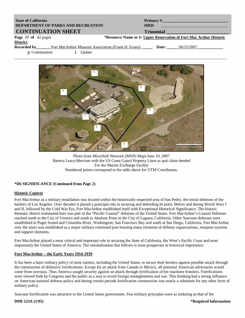
States Coast Guard, Maintenance & Logistics Command Pacific, 1301 Clay Street, Ste.# 700N, Oakland, CA 94612-5203 (p) 510.637.5540. As depicted in the map below, the site follows the shown fence line as highlighted and indicated. The property line begins at point 1 (the south east corner of the building, proceeding north around the perimeter counter clockwise to points 2 through 6, returning to the south east side of the Marine Exchange Building. The coordinate points correspond to the table below for UTM Values of the property boundaries.
DIAGRAM POINT Nr
NGS program UTMS to convert NAD83 or NAD27 Geodetic Positions to Universal Transverse Mercator (UTM
NGS NORTH(Y) EAST(X) ZONE CONVERGENCE SCALE METERS METERS DD MM SS.ss
1 33º 42’ 44.10” N 118º 17’ 38.26” W 3730290.356 472762.090 11S -0 9 47.36
0.99960915
2 33º 42’ 43.38” N 118º 17’ 37.78” W
3730268.146 472774.381 11S -0 9 47.09 0.99960914
3 33º 42’ 44.94” N 118º 17’ 36.83” W
3730316.122 472798.970 11S -0 9 46.57 0.99960912
4 33º 42’ 45.70” N 118º 17’ 37.19” W
3730316.122 472798.970 11S -0 9 46.57 0.99960912
5 33º 42’ 46.06” N 118º 17’ 38.45” W
3730350.734 472757.372 11S -0 9 47.48 0.99960915
6 33º 42’ 45.21” N 118º 17’ 39.39” W
3730324.625 472733.103 11S -0 9 47.99 0.99960917
7 33º 42’ 44.44” N 118º 17’ 38.59” W
3730300.852 472753.626 11S -0 9 47.55 0.99960915
State of California Primary #_________________________________ DEPARTMENT OF PARKS AND RECREATION HRI# _________________________________ CONTINUATION SHEET Trinomial __________________________ Page 20 of 42 pages *Resource Name or #: Upper Reservation of Fort Mac Arthur Historic District Recorded by_______ Fort MacArthur Museum Association (Frank H. Evans) _____ Date: ______06/15/2007_____________ gContinuation 1 Update __________________________________________________________________________________________________________
DPR 523A (1/95) *Required Information
Photo from MicroSoft Network (MSN) Maps June 10, 2007
Battery Leary-Merriam with the US Coast Guard Property Lines as quit claim deeded For the Marine Exchange Facility
Numbered points correspond to the table above for UTM Coordinates.
*D6 SIGNIFICANCE (Continued from Page 2) Historic Context Fort MacArthur as a military installation was located within the historically respected area of San Pedro, the initial defenses of the harbors of Los Angeles. Over decades it played a principal role in securing and defending its ports. Before and during World Wars I and II, followed by the Cold War Era, Fort MacArthur established itself with Exceptional Historical Significance. The historic thematic district nominated here was part of the “Pacific Coastal” defenses of the United States. Fort MacArthur’s Coastal Defenses reached north to the City of Ventura and south to Abalone Point in the City of Laguna, California. Other Seacoast defenses were established in Puget Sound and Columbia River, Washington; San Francisco Bay and south at San Diego, California. Fort MacArthur over the years was established as a major military command post housing many elements of defense organizations, weapons systems and support elements.
Fort MacArthur played a most critical and important role in securing the State of California, the West’s Pacific Coast and most importantly the United States of America. The rationalization that follows is most prosperous in historical importance.
Fort MacArthur – the Early Years 1914-1939
It has been a basic military policy of most nations, including the United States, to secure their borders against possible attack through the construction of defensive fortifications. Except for an attack from Canada or Mexico, all potential American adversaries would come from overseas. Thus America sought security against an attack through fortification of her maritime frontiers. Fortifications were viewed both by Congress and the public as a way to avoid foreign entanglements and war. This thinking had a strong influence on American national defense policy and during certain periods fortification construction was nearly a substitute for any other form of military policy.
Seacoast fortification was attractive to the United States government. Few military principles were as enduring as that of the

State of California Primary #_________________________________ DEPARTMENT OF PARKS AND RECREATION HRI# _________________________________ CONTINUATION SHEET Trinomial __________________________ Page 21 of 42 pages *Resource Name or #: Upper Reservation of Fort Mac Arthur Historic District Recorded by_______ Fort MacArthur Museum Association (Frank H. Evans) _____ Date: ______06/15/2007_____________ gContinuation 1 Update __________________________________________________________________________________________________________
DPR 523A (1/95) *Required Information
superiority of guns ashore over those afloat. The United States had a long shoreline, a weak navy (at least until the early 20th Century), and a concern about foreign attack. The use of seacoast fortifications also complied with another long standing American military tradition— militia forces. Seacoast fortifications, once constructed, could be maintained by a caretaker force.
In 1883, the Navy began a new construction program for the first time since the Civil War. The Navy’s new ships were designed to be offensive rather than defensive weapons. This change in naval policy, along with the advances in weapon technology, required a new system of coastal defenses which would safeguard the harbors and free the Navy for its new role. In 1885 President Cleveland appointed a joint Army, Navy and civilian board to evaluate proposals for new defenses that was headed by Secretary of War William C. Endicott. The board recommended a massive $127 million construction program. Funding for construction of a more modest building program began in 1890, under the direction of the Army Corps of Engineers, of gun batteries and mine fields at 29 important harbors— including San Diego, San Francisco, the Columbia River and Puget Sound.
In 1905, President Theodore Roosevelt convened another board, this one under his Secretary of War William N. Taft, to update and review the progress on the earlier board’s program. Most of the changes recommended by this board were technical; such as adding more searchlights, electrification including lighting, communications and projectile handling, and a more sophisticated optical aiming technique. The Board also recommended the fortification of key harbors in the newly acquired territories of Cuba, the Philippines, Panama, and Hawaii. These two modern programs gave the United States a coastal defense system that was equal to any other nation by the beginning of World War I.
War Department planners realized the need to provide adequate harbor defense for the fast growing Los Angeles sea terminal at San Pedro Bay. Troubles in the Far East, and tensions heightening in Europe caused War Department planners in 1908 to project plans for a strong harbor defensive installation at San Pedro. The plan was approved in 1909 by Congress, adding it the existing construction programs. The plan called for the construction of gun emplacements to hold four 14-inch guns, eight 12-inch mortars, and four 3-inch guns, with facilities to plant and maintain a mine field at the harbor entrance as well as buildings for a four company artillery post. However, the Government Reserve was deemed to be too far inland to be an effective site for the emplacement of the guns. Money was authorized to buy additional property at location more seaward. In 1910 a large section of land at Point Fermin was purchased from William G. Kerchoff and George H. Peck for $249,000.
Four years later, on October 31, 1914, the first construction work began on permanent harbor defenses at San Pedro. The Army practice was to name posts after deceased military officers, hence: “Under the provisions of paragraph 201, Army Regulations, the military reservation at Point Fermin, Cal., is named Fort MacArthur, in honor of Lieutenant General Arthur MacArthur, Jr., United States Army, who died September 5, 1912”.—General Orders No. 1, War Department, 1914.
The land comprising the Fort MacArthur Reservations was physically divided into two sections separated by about 5 city blocks of private residences and a sloping hillside: The old Government Reservation, located between Pacific Avenue and San Pedro Bay roughly between 22nd and 28th Streets, was the site of the quarters, barracks, and other buildings housing the permanent garrison and was renamed the Lower Reservation. The Point Fermin lands, located along Gaffey Road roughly between 30th Street and Point Fermin, was the site for the actual gun emplacements, and was renamed the Upper Reservation. Soon the original 28 Upper Reservation buildings of 1915, were constructed to house the officers and enlisted personnel to man, operate and support the seacoast artillery batteries Osgood-Farley and Leary Merriam.
Then construction of those reinforced concrete batteries to hold the 14-inch disappearing carriage rifles and the 12-inch mortars began in 1915. In the fall of 1917 the guns themselves arrived. The arrival of each gun tube was an important event. Each of the 14-inch tubes weighed about 110,000 pounds. This weight was much heavier than “house-movers” normally handled. Some days the guns were moved only a few feet. Snaking the tubes up San Pedro hill became increasingly difficult with the arrival of each new weapon. The pavement was deeply gouged and rutted as the wheels of the house-mover dollies were driven into pavement by the concentrated weights.
Upon completion of the construction in 1919, the fort had four 14-inch rifles (Batteries Osgood-Farley and Lear-Merriam – contributing resources to this nomination), eight 12-inch mortars (Battery Barlow-Saxon – presently on the Upper Reservation but located outside of the district boundaries) and 4 3-inch rapid fire guns (not present). The 14-inch guns delivered a 1560 lb. shell 14

State of California Primary #_________________________________ DEPARTMENT OF PARKS AND RECREATION HRI# _________________________________ CONTINUATION SHEET Trinomial __________________________ Page 22 of 42 pages *Resource Name or #: Upper Reservation of Fort Mac Arthur Historic District Recorded by_______ Fort MacArthur Museum Association (Frank H. Evans) _____ Date: ______06/15/2007_____________ gContinuation 1 Update __________________________________________________________________________________________________________
DPR 523A (1/95) *Required Information
miles out to sea. Protected by walls of 20 ft. reinforced concrete and earth walls, the guns were mounted on ingenious disappearing carriages which appeared over their parapets only long enough to fire. Underground concrete bunkers next to the gun emplacements protected the ammunition. Each of the four guns received a separate name: Batteries Osgood, Farley, Merriam and Leary. The 12-inch mortars were similarly emplaced further back from the ocean and were designed to deliver their 700 lb. shells in high arcs to land on the lightly armored decks of approaching enemy ships to a maximum range of 11 miles. The eight guns were divided into two batteries John Barlow and Saxton, each consisting of two pits of two guns each. The reinforced concrete gun emplacements of the 14inch batteries are contributing resources, however the guns themselves and the disappearing carriages have been removed. The museum of Fort MacArthur has displays depicting the operational batteries and scale models of the guns.
The 4th Company, Fort Winfield Scott, California (originally the 38th Company of Artillery), consisting of two officers and ninety-eight enlisted men, commanded by Captain Stanley S. Ross, Coast Artillery Corps, arrived at the Upper Reservation of Fort MacArthur for duty on March 23, 1917. This company was re-designated the 1st Company, Fort MacArthur, and assumed the mission of post operating company. The unit was later re-designated as the 3rd Company, Antiaircraft, prior to its departure for France in November 1917. Three new companies were organized on July 10, 1917, under provisions of General Orders No. 62, War Department, 1917. The Second Coast Defense Command, California, National Guard, consisting of eight companies, band and sanitary detachment, was drafted into Federal Service August 5th, 1917, under authority of the President’s Draft, dated July 30, 1917, and General Orders No. 16, War Department, 1917, and proceeded to Fort MacArthur August 14, 1917.
BEWTEEN THE WARS
As Fort MacArthur returned to its peacetime mission as a Coast Artillery post, interest and attention to the problems of the Fort diminished on both local and national level. There were, however, occasional flurries of interest and excitement.
The U. S. Army Hospital at Fort MacArthur was constructed in 1918 with an original capacity of 23 beds. Further construction in 1942 and again in 1952 increased the designated bed capacity to 60.
During an inspection trip in April 1924, Brig. Gen. Henry D. Todd, Commanding Ninth Coast Artillery District, stated that the guns at Fort MacArthur were too few and too short ranged to fulfill the mission of defense of the harbor. Although his statements were true, the nation as a whole was more interested in disarmament, and locally, the robbery of the paymaster’s safe at the Fort a few months later created more interest in the newspaper columns.
Also in 1924, the Coast Artillery Corps was reorganized and the regimental structure was re-instituted. The bulk of the units that were once part of the old 3rd Regiment of Artillery were already stationed on the Pacific coast, so on July 1, the units were gathered as the 3rd Coast Artillery Regiment was constituted in a ceremony at its new headquarters at Fort MacArthur, with Major George Ruhlen, Jr., commanding. The Third had a long illustrious history which dated back to the origins of the Army in the Revolutionary War. It had been disbanded along with the other regiments of artillery in 1901.
Concern over Los Angeles’ meager defenses prompted the allotment of two new 14-inch railway guns to Fort MacArthur. In 1925 the first one arrived at Fort MacArthur with much publicity and fanfare. These guns were mounted on special carriages that could be moved by rail to their firing positions. They could fire their 1400 lb projectiles a distance of 27 miles. They were initially stored on the Lower Reservation on a side spur that had a single special firing platform built on the in 1926. During the next few years, a few practice and test firings of that gun and the other big guns were conducted. The blast of firing was felt in the homes, in many sections of San Pedro. The command made an effort to give advance warning to residents and householders, and gave every assistance to them in filing of claims for damages. But, each time firings were held, many householders either disregarded the warnings or failed to take recommended precautions. The outcry against the firings by some of the residents soon reached fever pitch. By 1928 the firings became a political issue, and the War Department was forced to issue orders that further firings would be permitted at Fort MacArthur. A second 14 inch railway gun arrived in 1929 and was quietly parked next to its sister on the Lower Reservation.
The summer of 1926 was a busy time at Fort MacArthur’s Upper Reservation, Camp A4 area (Buildings 610-624) with the initiation of the Citizen’s Military Training Camps (CMTC). Under that program, men between the ages of 17 to 24 received military training for 28 days each summer. They were fed, housed and clothed and received instruction in basic military subjects. Many of these

State of California Primary #_________________________________ DEPARTMENT OF PARKS AND RECREATION HRI# _________________________________ CONTINUATION SHEET Trinomial __________________________ Page 23 of 42 pages *Resource Name or #: Upper Reservation of Fort Mac Arthur Historic District Recorded by_______ Fort MacArthur Museum Association (Frank H. Evans) _____ Date: ______06/15/2007_____________ gContinuation 1 Update __________________________________________________________________________________________________________
DPR 523A (1/95) *Required Information
individuals, after four of these summer sessions and additional tests and instruction, were offered reserve commissions in the Army. During the lull between the wars, Fort MacArthur was used to house companies of the Civilian Conservation Corps, and was also used by the California National Guard for its summer training camp.
Meanwhile, although strict neutrality and isolationism was the popular theme politically during the thirties in the United States, the War Department foresaw the need for a different, improved type of harbor defense. Theory emphasis shifted from the heavy coastal defense weapons to that of antiaircraft and antisubmarine defense warfare. And, although the large guns were still an important part of the defense system, three batteries of the 63rd Coast Artillery (AA) were assigned to Fort MacArthur from Fort Scott, Calif., in March 1930, to man antiaircraft gun emplacements on the Upper Reservation of Fort MacArthur. The gun emplacements have all but disappeared, however some positions of them have been unearthed outside the district boundaries on the Upper Reservation property of the Los Angeles Unified School District. As the number of men assigned to the 3rd Coast Artillery continued to diminish, the 63rd became the largest unit on the post. The men of the 63rd made frequent trips out to the Mojave firing range (later renamed Fort Irwin), and to a practice area near March Airfield in Riverside (later named Camp Haan) for antiaircraft artillery gunnery practice.
While the antiaircraft defenses at Fort MacArthur were being strengthened with the assignment of additional personnel during the mid-thirties, members of Headquarters Battery, Third Coast Artillery, received training in firing the big guns, but not at Fort MacArthur. In 1937, the two 14-inch railway rifles were moved south and fired from a training site at Don, California (in what is now Camp Pendleton, forty miles north of San Diego). Commenting on the successful firings, the Los Angeles Times stated that these two rifles were the only two modern long range heavy railroad guns in the continental United States. The next year they were brought up north and fired from a position just to the north of Santa Barbara.
Fort MacArthur – the War Years 1940-1949
By the late 1930s, there was considerable doubt in military circles as to the effectiveness of the most of the existing harbor defense armament guarding the United States. Of the heavy artillery at Fort MacArthur only the two 14-inch railway guns could be classed as modern armament. The 14-inch rifles of Batteries Osgood, Farley, Merriam and Leary had a slow rate of fire compared to current naval armament. The range of both the 14-inch disappearing guns and the 12-inch mortars of Batteries Barlow and Saxton was so short that they were considered to be ineffective against most heavy caliber naval capital ships. In addition, the fire control methods used with these batteries involved extensive hand plotting. This method was very accurate against stationary or very slow targets, but was only of marginal effectiveness against high speed ships.
The troubles in Europe and Asia in the late 1930s prompted further action. Recognizing the limited effectiveness of the existing weapons, a new harbor defense construction was initiated to rearm the major seaports of the United States with modern weapons to match the range and firepower of the capital ships afloat at that time and with extensive overhead protection against bombardment by airplanes. In 1940, the Army’s Harbor Defense Board prepared a report which surveyed the state of existing defenses and proposed an updated construction program to protect American naval installations and major harbors in the continental United States (CONUS). The Board proposed to use 16 inch guns and mounts developed in the 1920s in a new casemated battery design as the main armament to defend these harbor locations. In all, the report proposed to build 27 new 16 inch gun batteries, revamp 20 existing 12 inch and 16 inch gun batteries and build 50 new 6 inch gun batteries at 18 locations around the CONUS. The board recommended the abandonment of 128 older Endicott and Taft era batteries after the new program was complete. The new plan was approved in September of 1940. The Los Angeles harbor area was to receive 5 new gun batteries along with an extensive system of fire control stations. This harbor defense construction program produced a comprehensive set of seacoast fortifications at 33 locations, the most extensive and uniform construction program ever undertaken by the United States.
On September 9, 1941 the first sentry dog unit of the K-9 Command was formed at Fort MacArthur. It was first organized on a trial basis in December 1940. The first dogs for the unit were recruited directly from their owners at Pershing Square in downtown Los Angeles after extensive newspaper publicity. Sgt Robert H. Pearce was designated head trainer, and the unit became the nucleus of the internationally famous K-9 Command, US Army. The Sentry Dog Cemetery (Resource 713) is a contributing resource to this district nomination. It contains the remains of many of the sentry dogs in the program.
WAR!

State of California Primary #_________________________________ DEPARTMENT OF PARKS AND RECREATION HRI# _________________________________ CONTINUATION SHEET Trinomial __________________________ Page 24 of 42 pages *Resource Name or #: Upper Reservation of Fort Mac Arthur Historic District Recorded by_______ Fort MacArthur Museum Association (Frank H. Evans) _____ Date: ______06/15/2007_____________ gContinuation 1 Update __________________________________________________________________________________________________________
DPR 523A (1/95) *Required Information
At the 1135 hour, Sunday December 7, 1941, Colonel William W. Hicks, Commanding Officer, Harbor Defense of Los Angeles, the Third Coast Artillery, and Fort MacArthur, learned of the Japanese attack on Pearl Harbor. He immediately ordered all fortifications manned, all mobile batteries moved into previously selected positions and service ammunition issued to all units. The strength of the post at that time was 163 officers and 1,869 enlisted men. Realizing the importance of Los Angeles as a prime military target in any move by the Japanese directed against the west coast, the officers and men of Fort MacArthur braced themselves for imminent attack. Liaison was established with law enforcement agencies and top civil officials in Los Angeles. Soon after news of the attack on Pearl Harbor reached the public, there was an influx of curious citizens in the Harbor area. Although perhaps well-meaning, their presence crowded the area and tended to hamper operations. During the remainder of December 7 and throughout the following day numerous conflicting reports were received regarding the presence of Japanese submarines, surface craft and airplanes in the coastal waters. With each report, gun crews were alerted and scanned the ocean and sky.
Additional 155 mm and 3-inch antiaircraft guns were added to the Los Angeles defenses. The military “dug in” and prepared an extensive set of plans for tunnels to turn Fort MacArthur into an underground fortress, connecting the Middle and Upper Reservations. Only some of the tunnels were completed and only those on the Upper Reservation have been documented. The tunnels on the Upper Reservation have b en detailed extensively on maps and blue prints.
Throughout the early months of 1942, numerous sightings of enemy submarines were reported in the coastal waters, and several vessels reported torpedo attacks. There were a number of actual attacks on American shipping by Japanese submarines. The freighter Absaroka, loaded with lumber, was torpedoed off Point Fermin and the SS Montebeio was sunk by torpedo and shell fire off San Simeon.
Although none of Fort MacArthur’s big guns ever went into action, the day following the torpedoing of the Absoroka, Battery “F”, 105th Field Artillery Battalion, fired 10 rounds of smaller ammunition at what was reported to be an enemy submarine approximately 4,000 yards offshore near Redondo Beach California. It was believed to be the same submarine which had torpedoed the freighter the previous day. All trace of the submarine had disappeared after the shelling. The unit was cited for its action against the submarine at the end of the war.
On the evening of February 23, 1942, a submarine surfaced about one mile offshore north of Santa Barbara and fired 15 rounds into the oil field installation at Elwood. There were no casualties; however, one derrick was hit and destroyed, and one pumping unit was damaged. The shelling lasted, in all, about 25 minutes. Naval Operations Base sent three planes and two destroyers to the area. The planes dropped flares and depth charges to keep the submarine submerged until the destroyers arrived. At 0451 on February 24, the Navy reported that the patrol vessel Amethyst had made contact with a submarine three miles southwest of Point Vicente and was dropping depth charges. The Amethyst also reported that she had evaded a torpedo aimed at her.
Construction on the new harbor defense gun emplacements began in late 1942. As these new weapons were readied, the older guns were inactivated. In January 1944, Batteries Osgood, Farley, Merriam and Leary (Resource Identifiers 700 and 885) were inactivated. Battery Leary-Merriam’s emplacement structure was converted into the Harbor Entrance Command Post and Harbor Defense Command Post (HECP-HDCP) to monitor all incoming traffic. As the war moved closer towards Japan, the harbor defense construc-tion program was delayed. Although the new batteries were essentially completed, they were immediately put in caretaker status. There was also a great deal of building construction on both the Upper Reservation to house the men temporarily stationed at the Fort.
Located as Fort MacArthur was near, the movie industry capital of Hollywood, the post canteen attracted its share of celebrities, who volunteered their time to visit and entertain the men. A number of talented musicians, playwrights and actors were stationed at the post during the war years. Several members of the Fort MacArthur garrison put together an entertainment review of comedy sketches and songs called the “Yardbird Review.” The show was so successful that it was revamped and opened to the public as “Hey, Rookie!” The money raised by the show was used to fund various recreational improvements at Fort MacArthur, including the construction of a swimming pool on the Upper Reservation.
A Separation Center was activated at Fort MacArthur on July 1, 1945, the month before the surrender of Japan. Many of the same facilities of the Recruit Reception and Training Center which had been used to transform civilians into soldiers were now put to use to process soldiers back into civilian life. The Recruit Reception and Training Center itself did not close until April 1, 1946. It had been

State of California Primary #_________________________________ DEPARTMENT OF PARKS AND RECREATION HRI# _________________________________ CONTINUATION SHEET Trinomial __________________________ Page 25 of 42 pages *Resource Name or #: Upper Reservation of Fort Mac Arthur Historic District Recorded by_______ Fort MacArthur Museum Association (Frank H. Evans) _____ Date: ______06/15/2007_____________ gContinuation 1 Update __________________________________________________________________________________________________________
DPR 523A (1/95) *Required Information
in operation less than six years, but in that time some 750,000 men had been inducted into the Army through its facilities. The Separation Center at Fort MacArthur became fully operational after the surrender of Japan. It closed in less than a year later on 4pril 16, 1946. Sergeant Howard 0. McIntosh had the honor of being the 150,710th serviceman discharged at Fort MacArthur since the center was activated.
After the War
Like many other military installations, Fort MacArthur’s Upper Reservation was reduced to practically caretaker status. There were barely enough troops to maintain the new armament, and much of the old armament which had long been a fixture at Fort MacArthur was in the process of being dismantled and sold for scrap. The disappearing rifles of Batteries Osgood, Farley, and Merriam and Leary were to be disposed of. The only remaining guns at Fort MacArthur were the 6-inch guns of Battery #241, which remained until 1956.
It was apparent that the day of seacoast artillery was past, outdated by the airplane, the missile, and new amphibious landing techniques. By 1950, almost all of the big guns were scrapped, all the harbor defense commands dismantled and the Coast Artillery Corps abolished as a separate branch of the Army. The old coast defense reservations were either converted to other uses by the military or declared surplus.
By June 1948 the personnel strength at Fort MacArthur had dropped to 300 troops. These troops were primarily concerned with overseeing the dismantling of the large guns, and maintaining the antiaircraft and mobile batteries. To many it appeared that Fort MacArthur, denuded of its large seacoast artillery, was about to sink into the lassitude so characteristic of military installations in a caretaker status. However, due to the planning, vision, and ability of some of the leaders at Fort MacArthur and the Headquarters, Sixth US Army, Presidio of San Francisco, such was not the case. Fort MacArthur came back to life with the implementation of what was called the “Fort MacArthur Plan.”
During the days of the “Great Demobilization” of 1945 and 1946, the US Army, reluctant to lose all the training and experience vested in its wartime soldiers, strongly urged all of the soldiers to join the Organized Reserves when they were separated from service. Thousands did join the Organized Reserves, but as time passed it became more and more apparent that the Reserves required increased training in order to maintain their effectiveness.
It was difficult to refurbish old skills and learn new ones under the existing Reserve setup. Most of the Reserve Training Centers had limited areas available for field training. Field training facilities were available at Regular Army posts, but most Reserves were reluctant to leave their jobs or families for the time required to travel to those posts and return home.
The “Fort MacArthur Plan” essentially was an effort to encourage the Reservists to report for the required training by encouraging them to bring their families with them. When the idea was explained to General Mark W. Clark, Commander of Sixth US Army, in 1948 he gave his enthusiastic support. General Clark won approval from the Department of Army for a trial program of the “Fort MacArthur Plan” at Fort MacArthur in November 1948. When the Reservist reported on Saturday morning for his monthly training, he would settle his dependents in the Hostess House facilities before reporting to his training area. The Reservist trained with his unit, handled equipment of his specialty and became familiar with the equipment and tactics he might be called upon to use in any future emergency. In the meantime, his dependents utilized the facilities of the Fort.
The Plan was such a success that Fort MacArthur on weekends looked almost as busy as when the Reception and Training Center was in full operation during World War II. About one thousand Reservists were training at the Fort each weekend, and the program was approved for adoption nationwide.
In February 1949 the fixed defenses at Fort MacArthur wrote their own epitaph in flames. Most of the heavy coast defense ordnance was gone, and with the demise of the ordnance, large stocks of smokeless powder for the guns had to be disposed of. The powder was useless for any other purpose and was an expense to maintain. Therefore, it was burned. The smoke and flames wrote an end to one period of the history of Fort MacArthur, but events were soon to bring a new era to the Fort.

State of California Primary #_________________________________ DEPARTMENT OF PARKS AND RECREATION HRI# _________________________________ CONTINUATION SHEET Trinomial __________________________ Page 26 of 42 pages *Resource Name or #: Upper Reservation of Fort Mac Arthur Historic District Recorded by_______ Fort MacArthur Museum Association (Frank H. Evans) _____ Date: ______06/15/2007_____________ gContinuation 1 Update __________________________________________________________________________________________________________
DPR 523A (1/95) *Required Information
The U.S. Army NIKE Missile Program
It was apparent by the end of World War II that any attack on the continental United States in the latter half of the 20th Century would first come from the sky; the big guns that used to protect the coastline from attack by overseas armadas could not be used to stop new armadas that could fly overhead and a new defense system, based on ground-launched surface-to-air missiles (SAM), was developed to replace it. The SAM system was utilized under the same tactical considerations as the big seacoast guns had been during the previous century—as a deterrent against an attack by another nation.
Project “Nike” (named after the winged goddess of victory in Greek mythology) was based on a 17 August 1944 memorandum written by 1st Lt. Jacob W. Schaefer in which he proposed the design of a rocket that could be controlled from the ground. Development was started in 1945, but slowed by the end of the war.
The deteriorating international situation in Europe and Asia during the years 1948-49 prompted new concern over the state of American continental defenses. The nearly nonexistent United States AA defenses needed to be upgraded. The Nike missile was still in the development stage, so gun units would have to be used until the missiles could be deployed. The outbreak of the Korean War finally brought about new changes. On 1 July 1950, the Army Reorganization Act combined all the Army’s artillery units into a single arm. It also established the Army Antiaircraft Command (ARAACOM), which was responsible for manning, training and equipping the Army’s AA units.
The development of the Nike missile system was brought back up to speed in 1950. In December, 1953, the first NIKE AJAX surface-to-air missile battery became operational at Fort Meade, Maryland. These supersonic missiles were the first ground based anti-air missile systems to become operational in the United States. As soon as the required storage shelters, fire control equipment, missiles, and trained crews could be prepared the NIKE AJAX missile batteries replaced the gun batteries as the backbone of the Army anti-aircraft defense. Construction of the Nike battery sites was carried out during the years 1952-1954, followed by the “conversion” of AAA units to missile units. In 1954 the US Air Force’s Continental Air Defense Command (CONAD, which was later unified with Canadian and nominally Mexican air defenses as NORAD, the North American Air Defense Command in 1957) was established, to better integrate the tactical command for responding to an aerial attack threat. By 1957 all of the Army’s AAA units were converted to missile units and on 21 March 1957 ARAACOM became ARADCOM—the Army Air Defense Command—in light of its new mission. All units were henceforth carried the designation “Air Defense” Artillery. Beginning in 1958 units of the National Guard were trained to operate the Nike sites to accommodate manpower cuts in the regular Army. This transfer of Nike sites from Regular Army units to National Guard units would continue throughout the Nike period.
The Nike-Ajax was the first ground-based supersonic anti-aircraft missile system to become operational in the United States. The Nike-Ajax had a range of about 30 miles. It was initially rocketed to supersonic speed by a solid rocket booster and sustained in flight by a liquid-fueled rocket motor. Nike missiles employ the so-called “command guidance” system in which the major control equipment is ground-based and not part of the expendable missile. Separate radars simultaneously located and tracked both the target and the Nike missile. Data from these radars was fed to the electronic data processing equipment which sent “commands” to the missi1~ in flight to guide it to intercept the target. The Nike missiles were deployed in underground magazines at sites in a circular pattern around key American industrial and military locations.
In 1953, just as the Nike-Ajax missile system was being implemented, research and development began on a longer ranged surface-to-air missile. The Nike-Hercules was an improved version of the Nike-Ajax. The Hercules had a longer range and was completely powered by solid fuels, eliminating the troublesome and dangerous liquid fueling procedure of the Nike-Ajax. It also had the capability of being armed with a nuclear warhead. Conversion of the system proceeded during the years 1957-1964. Improved versions of the Nike-Hercules missiles system were deployed beginning in 1961. Nike-Hercules batteries had an improved acquisition radar system. The new Nike-Hercules system also brought with it an improved command coordinating system. Beginning in 1960, the missile batteries of each Defense Area was coordinated from a center located at the area’s Army Air Defense Command Post (AADCP).These systems operated under the tactical command of the Air Force’s Semi-automatic Ground Environment system (SAGE) which acted as the NORAD Sector Control Center (NSCC) in managing air battles.

State of California Primary #_________________________________ DEPARTMENT OF PARKS AND RECREATION HRI# _________________________________ CONTINUATION SHEET Trinomial __________________________ Page 27 of 42 pages *Resource Name or #: Upper Reservation of Fort Mac Arthur Historic District Recorded by_______ Fort MacArthur Museum Association (Frank H. Evans) _____ Date: ______06/15/2007_____________ gContinuation 1 Update __________________________________________________________________________________________________________
DPR 523A (1/95) *Required Information
Fort MacArthur – the Final Army Years 1950-1982
On June 25, 1950, North Korea broke an uneasy truce with South Korea by driving south across the 38th parallel. The United States at once brought this transgression before an emergency session of the Security Council of the United Nations. The temporary absence of Soviet Russia, which was boycotting the Council, cleared the way on June 25 for prompt passage of a resolution terming the action of the North Koreans a breach of peace. Taking this resolution as justifying the immediate extension of aid to the victims of aggression, President Truman ordered U. S. forces to give support to the South Koreans. The Reserve training that had been initiated under the “Fort MacArthur Plan” proved invaluable in this crisis.
The United States Army was developing a new continental defensive system to replace the scrapped seacoast artillery. The new system featured the Nike surface-to-air missiles for defense against bomber formations. The advent of the Korean War hastened its deployment. The 47th Artillery Brigade arrived at Fort MacArthur on permanent change of station orders and assumed command of anti-aircraft defenses of the Southern California area. The units under its direct command were the 466th Antiaircraft artillery Battalion (AAABn) with 75 mm guns, the 77th AAABn, the 544th AAABn, and 55 1st AAABn, all with 90 mm guns. The 77th was later replaced by the 720th AAABn, California National Guard. By 1957, these units, along with the 933rd AAABn, were converted to Nike battalions.
One Nike battery was emplaced at White Point (listed on the California State Register as a Historic District) and on the Upper Reservation in 1954 (Resource Identifiers 802J, 803, 804, 8X1, 8X2, 807, 808, 809I, 815K and 817), along with 15 other sites in the greater Los Angeles area. Most of the original 16 Nike sites have been demolished, however some do remain as alternate use and some preserved. On completion the Nike missile sites of the 47th Artillery Brigade presented a “ring of supersonic steel” around an area of 25,000 square miles. Nike sites were located from the mountains near Chatsworth on the northwest to Garden Grove on the southwest, from the San Gabriel Mountain Range on the north to the coastal areas of the Palos Verdes Peninsula on the south.
Headquarters III Corps departed from Fort MacArthur for Fort Hood, Texas, on April 15, 1954. At that time the mission of Fort MacArthur became twofold. As Headquarters Southern California Sub-district of the California Military District, and Headquarters Fort MacArthur, the post had the mission of command supervision and training of all U. S. Army Reserve units and personnel, and ROTC units in Southern California, as well as the mission of providing logistical support to the 47th Artillery Brigade. As a part of the Reserve mission, the post at one time maintained some 60,000 personnel records in the Reserve Personnel Management Division of the AG Office.
On September 1, 1954, by direction of the Secretary of Defense, elements of all military services with air defense capabilities were combined into a single air defense system with headquarters in Colorado Springs. The new command, CONAD, was directed by the Joint Chiefs of Staff, with the US Air Force as executive agent, and included the US Army Air Defense Command, the US Air Force Air Defense Command, and US Naval Forces. This reorganization provided for closer integration of all elements of the air defense system to secure greater defense in depth and better utilization of available information and facilities.
On September 27, 1955, Battery “D” 554th AAA Missile Battery at Point Vicente had the honor of being the first Nike site to be shown to non-military personnel. In addition to numerous civic leaders, fifty newsmen from all over the Los Angeles area attended the unveiling. This action did much to gain public acceptance and understanding of the part the Nike missile batteries played in the air defense.
On June 1, 1957, the 720th AAA Battalion (90mm gun) was reorganized and redesignated as the 720th Missile Battalion (Nike-Ajax). This was the first National Guard unit to ever be designated as a missile unit. On September 14, 1958, the 47th Artillery Brigade (AD) turned over operational control of four Nike-Ajax missile batteries to the California National Guard. Battery A—Site LA4O at Long Beach, Battery B—Site LA57 at Torrance, Battery C—Site LA7O and Battery D—Site LA73 at the dual Playa Del Rey site. The Headquarters and Headquarters Battery were established at Site LA4O at Long Beach. This was the first time a National Guard unit assumed operational control of a Nike missile battery and was to serve as a model for the eventual takeover of all Nike sites by the National Guard.
In November 1958, the 47th Artillery Brigade scored another first with the introduction of Army sentry dogs to guard missile sites.

State of California Primary #_________________________________ DEPARTMENT OF PARKS AND RECREATION HRI# _________________________________ CONTINUATION SHEET Trinomial __________________________ Page 28 of 42 pages *Resource Name or #: Upper Reservation of Fort Mac Arthur Historic District Recorded by_______ Fort MacArthur Museum Association (Frank H. Evans) _____ Date: ______06/15/2007_____________ gContinuation 1 Update __________________________________________________________________________________________________________
DPR 523A (1/95) *Required Information
Four specially trained sentry dogs and their handlers were assigned to guarding the Chatsworth Nike-Hercules site. These men were members of the first group of 28 dogs and handlers sent by the U.S. Army Air Defense Command to Fort Benning for training in August 1958. Approximately 500 dogs and handlers were required to put the sentry dog program into operation at the nation’s Nike sites.
Beginning in 1957, the second generation Nike missiles were deployed around the United States. Conversion of the sites in the Los Angeles area proceeded during the years 1957-1964. Only nine of the sites were converted to Nike-Hercules. The new Nike-Hercules system also brought with it an improved command coordinating system. The Missile Master facility at Fort MacArthur became opera-tional in December 1960, provided early warning information for the Upper Reservation Nike Site. Prior to that the 47th Artillery Brigade (AD) achieved a nation-wide first in September 1958 when operational control of four Nike-Ajax missiles sites previously manned by the 865th Missile Battalion were turned over to the California National Guard’s 4th Missile Battalion, 251st Artillery. This turn over of Nike sites to the Army National Guard served as a standard and a pathfinder for the turnover of the Nike sites in the United States to the National Guard.
Improving public relations within the area where the Nike batteries were located became more of a challenge as the Nike-Ajax missiles were replaced with the more powerful Nike-Hercules missiles. The possibility that nuclear warheads were to be stored at the Nike-Hercules sites was disturbing to many people. It took an expensive education program and several years of a perfect safety record before many people accepted the fact that the nuclear warheads—stored, handled, and if ever necessary, fired by trained crews, offered danger to the communities they defended.
The action of Fort MacArthur personnel in late January 1956 in dispatching troops and disaster relief items to aid flood control authorities in the Los Angeles area won extensive praise from civilian leaders. Less than a year later the Army joined civilians in fighting forest fires in the Malibu area. The main Army efforts had to be devoted to protecting the Nike sites that were threatened by the fires. Nike site was damaged, but the flames came close to one site.
In 1958 the title (Air Defense) was added to the designation of the 47th Artillery Brigade. Some 2,000 officers and men made up the 47th Artillery Brigade which was comprised of the Brigade headquarters, the 108th Artillery Group, and the 12th Artil1~ery Group at Pasadena. The 12th Group was composed of two missile battalions: the 1st Missile Battalion, 56th Artillery in Pasadena and the 4th Missile Battalion, 65th Artillery located in Van Nuys. There were two battalions directly under the command of the 108th Group: the 3rd Missile Battalion, 57th Artillery and the 4th Missile Battalion, 251st Artillery. The latter was manned by personnel of the California National Guard.
The 47th Artillery Brigade (AD) also participated prominently in planning for the turn over of Nike-Hercules missiles sites to Army National Guard. Because or the security requirements connected with the nuclear warheads, the turnover of the Nike-Hercules sites was much more complicated. Nevertheless, the required planning and procedures were completed, and the first of the Nike-Hercules sites of the 47th Brigade was turned over to the Army National Guard in 1962.
In May of 1959, the 720th AA Battalion (CARNG) was redesignated as the 4th Missile Battalion (Nike-Hercules) 251st Artillery, California Army National Guard. Batteries B and C remained Nike-Ajax batteries. Batteries A and D were reorganized, but remained at their original stations. On March 6, 1963, Batteries A and D entered Nike-Hercules training at USARADCEN, Fort Bliss, Texas, and returned on April 29, 1963. On May 1, 1963, Batteries A and D closed their Nike-Ajax sites (Long Beach Site LA4O and Playa Del Rey Site LA73) and moved to new stations. Battery A moved to Site LA32—Stanton, and Battery D moved to Site LA43—Fort MacArthur, for on-site training with active Army crews. On June 27, 1963, Batteries A and D assumed the Nike-Hercules operational mission at Stanton and Fort MacArthur (Sites LA32 and LA43). On January 2, 1964, Batteries B and C began Nike-Hercules training at Fort Bliss, Texas. On April 23, 1964, Batteries B and C left their stations at Sites LA7O and LA73 (Playa Del Rey) and assumed operational control of the Nike-Hercules sites at LASS—Point Vicente (Battery B) and LA29—Brea (Battery C).
In July 1963, Fort MacArthur became the main link in the Defense Communications chain in the immediate Los Angeles area for the Army, the Navy, the Air Force and other Governmental agencies with the opening of the Commercial Refile Communications Center.

State of California Primary #_________________________________ DEPARTMENT OF PARKS AND RECREATION HRI# _________________________________ CONTINUATION SHEET Trinomial __________________________ Page 29 of 42 pages *Resource Name or #: Upper Reservation of Fort Mac Arthur Historic District Recorded by_______ Fort MacArthur Museum Association (Frank H. Evans) _____ Date: ______06/15/2007_____________ gContinuation 1 Update __________________________________________________________________________________________________________
DPR 523A (1/95) *Required Information
Fort MacArthur received many requests from civil agencies for assistance and support during various emergency situations. Typical of these was a request made in August 1964 by the U. S. Forestry service for manpower assistance in fighting a forest fire in the rugged Santa Monica Mountains which destroyed several homes and endangered many others. On August 17 fifty soldiers dispatched from the Fort upon approval of Commanding General, Sixth U. S. Army, to lend assistance. The fire was brought under control the following day, and the Los Angeles County Board of Supervisors recognized the post for its assistance in a resolution passed on August 24.
On numerous occasions Fort MacArthur received requests to support exercises and maneuvers held in the desert areas of California. The 1964 Operation Desert Strike, one of the largest exercises to be held in the Sixth Army area, was supported by the installation with personnel, supplies and transportation.
Fort MacArthur’s mission of providing administrative and logistical support to Air Defense, Reserve and ROTC units was expanded on July 1, 1965 to include support to Reserve and ROTC units in Arizona and Southern Nevada, as well as Southern California. Budget requirements to carry out those missions exceeded $40 million annually.
As the Vietnam war escalated during the latter part of 1965, there was a sharp increase in the number of Reservists utilizing the training facilities at Fort MacArthur. Meanwhile, the new Army Community Service Program was established which provided assistance and guidance to dependents of military personnel residing in the area apart from their sponsors. In early 1966, the personal notification to next of kin of deceased Army Personnel was put into effect, with Fort MacArthur being the central control point for the densely-populated Southern California area.
On November 15, 1968, as part of the internal reorganization of the Army Air Defense Command (ARADCOM), the 47th Artillery Brigade was transferred east. the Army Air Defense command at Fort MacArthur became the 19th Artillery Group (Air Defense). This change was made to align ARADCOM units in accordance with a reorganization of the North American Air Defense Command (NORAD).
In addition to the purely military aspects of its operation, Fort MacArthur continued its tradition of community involvement. The 72d Army Band played in numerous parades and was available for various gatherings in the area. No parade held up to 1974 was considered complete unless a marching contingent from Fort MacArthur was present. The soldiers and civilian personnel contributed freely of their time in sponsoring or monitoring youth activities.
The Army Closure of Fort MacArthur
Changing military and fiscal priorities in the late 1960s and early 1970s brought and end to the Army’s major use of Fort MacArthur. Changing administrations at the Nations Capitol, increased costs of the Vietnam War in both manpower and dollars brought about major cutbacks in funding for Air Defense. Many non military and non technical commentators have made inaccurate statements Nike Hercules became obsolete. The fact is, Nike Hercules was used in foreign countries until the 1990’s. One major technological problem was the use of vacuum technology in the Fire Control Systems. However, NATO authorized major modifications introducing solid state and digital computer circuits and Nike Hercules remained operation overseas for another twenty (20) years.
The Nike-Hercules missile system was designed for defense against attack by large to small formations of manned bombers and Cruise Missiles. As the perceived threat decreased, from bomber attack to missile attack, the usefulness of the Nike-Hercules diminished. Finally the large manpower requirements of the existing Nike Missile batteries and their diminished kill probability factor to effectively defend against ICBMs spelled the end of the Nike programs The US Army continued its research and development on the SAN-D system which was latter fielded as the Patriot.
In 1967, a gradual decrease in ARADCOM units began thru deactivations. In February 1974 ARADCOM ordered all existing CONUS Nike batteries closed by the end of the year. ARADCOM itself was inactivated on 30 June 1975. The new strategic American continental defense was based on its ICBM nuclear deterrent and naval might abroad. New SAM systems were developed to fulfill the role of anti-missile defense and be used in conjunction with the Nike-Hercules system, but they eventually proved to be unsatisfactory.
On February 4, 1974, Department of the Army announced that the post would be closed as an economy measure. The remaining

State of California Primary #_________________________________ DEPARTMENT OF PARKS AND RECREATION HRI# _________________________________ CONTINUATION SHEET Trinomial __________________________ Page 30 of 42 pages *Resource Name or #: Upper Reservation of Fort Mac Arthur Historic District Recorded by_______ Fort MacArthur Museum Association (Frank H. Evans) _____ Date: ______06/15/2007_____________ gContinuation 1 Update __________________________________________________________________________________________________________
DPR 523A (1/95) *Required Information
missile sites in and around Los Angeles were closed, the land excessed, and the 19th Artillery Group deactivated by July 1, 1974. Meanwhile, in the Spring of 1974, the Post Commander submitted an Administrative and Logistical Plan requesting that the middle reservation of Fort MacArthur be retained for support of Active and Reserve Army units in Southern California.
On June 25, 1974, Department of the Army announced that the plan was accepted for implementation and the Fort would not be closed entirely. All land, except the middle reservation (97 acres with 115 buildings), was declared excess to Army needs and was to be disposed of in accordance with governing procedures. These excessed areas were:
Area of Ft MacArthur
Acreage Buildings Building Square Footage
Lower Reservation 53 acres 54 buildings 33,000 sq ft
Hospital Area 5 acres 19 buildings 73,879 sq ft
Upper Reservation* 116 acres
103 buildings 325,000 sq ft
White Point 150 acres
25 buildings 51,000 sq ft
Point Vicente 88 acres 25 buildings 46,000 sq ft
Total 412 acres
226 buildings 828,879 sq ft
*(Less 2 acres to Coast Guard. Battery Osgood-Farley was placed on the National Register of Historic Places and part of the reservation was designated the site for the construction of Korean Friendship Bell, a gift from the Republic of South Korea.)
On January 1, 1975, Fort MacArthur was realigned as a sub-installation under Fort Ord. Plans were then implemented to reduce the military and civilian workforce and close out the upper and lower reservations as well as the hospital area. On July 1, 1975, Fort MacArthur was officially inactivated as a separate installation and became a sub-post of Fort Ord. The Post Commander of Fort MacArthur became the Deputy Post Commander under the Commander, Fort Ord and 7th Infantry Division. The remaining work force was designated US Army Support Detachment, Fort MacArthur (USASDFMA), and all activities were consolidated on the middle reservation. In 1978, the Army announced that it would transfer its support units from Fort MacArthur to the Los Alamitos Armed Forces Reserve Center and would declare the remaining land excess.
Historic Evaluation The Upper Reservation of Fort MacArthur played numerous specific and unique roles during the period of significance (1914 to 1975) in the defense of California’s coastline. Fort MacArthur’s first mission was to defend the harbors of Los Angels by using Seacoast Artillery gun batteries and fortifications located from Ventura north to Laguna Beach south along the California coastline, and then later defending over 4,000 square miles of air space in the metropolitan Los Angeles area, south to San Diego. The District’s extant resources provide a physical expression of this mission. The 14 inch disappearing seacoast artillery gun batteries Osgood-Farley (listed on the National Register) and Leary-Merriam are the only Taft type design constructed in the continental Unites States, all others are of the Endicott type. The 700 Series Cantonment Wooden Temporary Buildings (Numbered on map and table with 800 numbers) are unique in that they are the only ones known have been built without water and sewage utilities, being supplemented with external latrine buildings. All other 700 series buildings in the Continental United States have internal latrines. Additionally, the district is unique with buildings of Camp A4 having been built around 1935, by the Civil Conservation Corps (CCC). The Hey Rookie Swimming pool was used in many unique ways and is connected with many public celebrities. Also, the use of the facilities as a reception center to process soldiers into the military is connected to many celebrities from the Los Angeles areas film and entertainment industries. The underground tunnels (although unable to be investigated in detail to determine integrity as a contributing

State of California Primary #_________________________________ DEPARTMENT OF PARKS AND RECREATION HRI# _________________________________ CONTINUATION SHEET Trinomial __________________________ Page 31 of 42 pages *Resource Name or #: Upper Reservation of Fort Mac Arthur Historic District Recorded by_______ Fort MacArthur Museum Association (Frank H. Evans) _____ Date: ______06/15/2007_____________ gContinuation 1 Update __________________________________________________________________________________________________________
DPR 523A (1/95) *Required Information
resource) are important because no other seacoast artillery site had such a tunnel fortification. Forty MacArthur was truly the Corregidor of the West Coast. During the Air Defense period (early 1950’s to 1975) the United States Army Air Defense Command tested the use of State Army National Guard troops to man and operate the complex Nike Missile Systems on the Upper Reservation. This was a unique first and was latter adopted in almost all of the over 20 air defense sectors throughout the United State. Battery D of the 251st Artillery was the first Nike Missile Battery to score a perfect 100 on its Annual Practice. Further the use of Sentry Dogs for Launcher area security was first tested in the Los Angeles Defense and adopted throughout the United States. The Upper Reservation of Fort MacArthur is associated with events of WWI, WWII, and the Cold War era contributing to the broad patterns of local, regional and national history, including the cultural heritage of California and the United States, yielding, and having the potential to yield, information important to the history of the local area, California, or the nation pertaining to Seacoast Defenses. The entire Upper Reservation District, as nominated, was surveyed as part of the “Los Angeles-Long Beach Harbor Areas Cultural Resource Survey” prepared for the U.S. Army engineer District, Los Angeles, California, as submitted buy Dr Lois J Weinman, Principal Investigator and Dr. E Gary Stikel, April 1978, which stated that “The city should maintain these properties in perpetuity,” and “From a historical point of view it would be a great loss if any of these emplacements were to be destroyed. The United States has escaped the kind of warfare that plagued Europe for centuries and caused the nations there to construct massive fortifications. Consequently, we have comparatively little to study. These emplacements are all that remain of the largest and most powerful fixed coast defense artillery on the West Coast. Further, ‘Fort MacArthur is the only Taft period fortification in the Continental United States (others being the Endicott period or prior, and World War II) so its emplacements are somewhat different than those found in San Diego, San Francisco, Columbia River, Puget Sound, etc.’ With the introduction of aerial warfare such fortifications are to remain forever obsolete. Even Fort MacArthur lies close to being marked off as disposable land. These rare sites provide a resource for students of the history of technology and warfare and bring alive the written word upon which we too often depend. A hundred years from now their value as tools to uncover the history of land defense will be even greater”. This alone is justification for listing on the California Register as a Historical District. In the seminal work on army construction practices, World War II and the U.S. Army Mobilization Program: A History of 700 and 800 Series Cantonment Construction, authors Diane Shaw Wasch, Perry Bush, Keith Landreth, et al. James Glass, Ph.D. Arlene R. Kriv, Editor, discuss the importance of the 700 Series Cantonment construction as follows: These buildings are historically important. Sheltering few celebrities, their architecture is straightforward, based on simple calculations of cost, efficiency and speed of construction. Yet for forty years, millions of American “citizen-soldiers” passed through these buildings on their way to the battlefields of Western Europe, the South Pacific, Korea, and Vietnam. These structures loom large in the memories of millions of present-day Americans, for whom military service was a central, formative experience. From the preservation of social history—which documents the historical experience of ordinary individuals or the masses” –these simple structures are historically important as any mansion. From the perspective of architectural history, the war mobilization buildings are significant for their design, construction and technological innovation. Techniques such as standardization of plans, prefabrication of units, and assembly-line approach to construction were largely pioneered in the construction of these mobilization structures. They were also partially responsible for raising the building standards to include such amenities as central heating, indoor plumbing and electricity. Mobilization construction also had a tremendous impact on the economy, facilitating the recovery of the building industry following the Great Depression.”
The six months that followed the Japanese attack on Pearl Harbor were ones of special concern to the residents of the states of Washington, Oregon and California, especially to those who lived along the coast. The unbroken string of Japanese victories that continued into the beginning of 1942 seemed to bring the war closer and closer to American shores. Concern over the possibility that the Japanese would attack the mainland American cities brought a consistent flow of rumor, misinformation and false alarms, especially in the Los Angeles area. Innumerable stories of the sighting of Japanese submarines, planes, and ships, hostile Japanese encounters with American Navy, Army and civilian personnel, victorious sinking of Japanese submarines, Japanese espionage agents operating secret signaling devices and plotting sabotage abounded and persist to this day. Most of the stories are fictitious, but there was enough activity along the shoreline to give credence to some of the stories and form the basis for others. These facts alone provided justification for the coastal defenses of he Los Angeles Harbor.
The lands that made up the parts of the Fort MacArthur military reservation in San Pedro, California contain a number of historically

State of California Primary #_________________________________ DEPARTMENT OF PARKS AND RECREATION HRI# _________________________________ CONTINUATION SHEET Trinomial __________________________ Page 32 of 42 pages *Resource Name or #: Upper Reservation of Fort Mac Arthur Historic District Recorded by_______ Fort MacArthur Museum Association (Frank H. Evans) _____ Date: ______06/15/2007_____________ gContinuation 1 Update __________________________________________________________________________________________________________
DPR 523A (1/95) *Required Information
significant structures that were part of the US Army’s defenses of the continental coastline during the years 19 14-1974. By the time of its closure as an active Army post in 1982, For MacArthur had served for nearly 70 years and was an integral part of the nation’s military defenses, spanning the era of large seacoast artillery to antiaircraft missiles. Part of the post is still used today as a sub-post of the U.S. Air Force Los Angeles Air Force Base.
The post’s primary mission was to protect the harbor facilities of the city of Los Angeles from hostile forces with emplaced seacoast artillery. Due to the late development of San Pedro Bay as a harbor, Fort MacArthur had the distinction of being the only coastal defense post in the contiguous 48 states to receive a complete set of the late modern type of armament installed under the “Taft Board” Fortification Program. The other harbors in the Lower 48 States had been armed under the earlier “Endicott Board” fortification program, while the other “Taft Board” construction was carried out at the overseas possessions.
Structures remain from every major event and development during those years—the large concrete gun batteries built to defend the Los Angles Harbor during the first World War (one of the few collections of such defenses built on the shores of the continental US during this era), the barracks built to house the men of the permanent garrison, temporary barracks built to house the men mobilized during the World War I, temporary gun defenses used between the two World Wars, barracks built to house the men mobilized during World War II, extensive underground tunnels built in case of invasion by the forces of Imperial Japan, newer concrete gun batteries built during the later World War II years, and the missile defenses built during the Cold War years.
Battery Osgood-Farley is the only unmodified 14inch Taft Era, publicly accessible battery of its vintage in the continental United States. The condition of the battery is excellent when compared to other gun batteries around the nation’s shoreline. The battery is now home to the Fort MacArthur Museum, a component of the City of Los Angeles Department of Recreations and Parks. The power room has been nearly completely restored with much of its original equipment. A newly acquired generator has been installed and runs. Work is progressing on the creation of a full size reproduction of the gun once mounted in Battery Osgood, and to restore a powder magazine, a shell magazine and a plotting room in the battery. As these projects are accomplished, Battery Osgood-Farley will be one of the most fully restored modern-era gun battery in the United States.
Battery Leary-Merriam is unique in that it was associated with all three phases of these defenses, first as a 14inch Taft Era gun battery, then as the HECP/HDCP, and finally as Nike Surface to Air Guided Missile Site 43 IFC (Integrated Fire Control). Currently used by the Marine Exchange the Nike IFC Site (Resource Identifiers 802J, 803, 804, 8X1, 8X2, 807, 808, 809I, 815K and 817), and the Angels Gate Cultural Center, it has been slightly modified but Integrity remains.
Battery 241 (Resource Identifier 630) Remains intact (even though the Korean Bell Monument was constructed on top of it), still holds its 3 Worthington-powered General Electric generators and much of the other power equipment, one of the few batteries that retains its original power equipment, and is a contributing resource to the district.
World War I cantonment buildings As the only major Army facility in the Los Angeles metropolitan area, Fort MacArthur’s Upper Reservation served in part as the recruiting and training center for Southern California during World War I. A cantonment area composed of barracks, Mess Halls, latrines and a hospital was built on the Upper Reservation (Resource Identifiers in the 600 series) to house the new recruits. During the 1930s, the barracks were used to house the men of the Citizens’ Military Training Corps (CMTC), the Reserve Officer’s Training Corps (ROTC) and the National Guard during their regular training sessions at Fort MacArthur. Most of the WWI cantonment barracks still remain. The Los Angeles Unified School District has jurisdiction over the northern half of the Upper Reservation. Currently, the district uses the area for several functions including: the Wilmington Skills Center, facilities for both San Pedro and Angels Gate High Schools, the Point Fermin Outdoor School, a storage area, and a maintenance yard.
The Upper Reservation holds an important collection of artifacts tied to both the Army lifestyle and to the Army’s role in the protection of the American continental coastline from invasion. The remains on the Fort MacArthur reserves, which are in good condition for the most part, clearly trace the development of American coastal defenses, from the all gun era of the turn of the century to missile era of today, and many of these sites can be restored for interpretive purposes. Three phases of American defenses can be viewed all with in a short distance of one another, which gives Los Angeles one of the finest visual interpretations of American coastal defenses in the nation.

State of California Primary #_________________________________ DEPARTMENT OF PARKS AND RECREATION HRI# _________________________________ CONTINUATION SHEET Trinomial __________________________ Page 33 of 42 pages *Resource Name or #: Upper Reservation of Fort Mac Arthur Historic District Recorded by_______ Fort MacArthur Museum Association (Frank H. Evans) _____ Date: ______06/15/2007_____________ gContinuation 1 Update __________________________________________________________________________________________________________
DPR 523A (1/95) *Required Information
The WWI barracks area and the WWII barracks area on the Upper Reservation were a part of the garrison life of the Coast Artillery soldier of the 1920s and 1930s and the Air Defense Artillery man of the 1950s, 1960s and 1970s. The barracks also played a role in the training of the CMTC, ROTC, and the National Guard soldiers during those years. Significantly, the barracks themselves were built as part of the two great American Army mobilizations of the 20th Century, for World War I and World War II. Of equal importance were the frantic defense measures taken during the early years of World War II, in which it was proposed to build an entire underground barracks and hospital to survive a possible attack by the forces of Japan. Some of these tunnels and trenches were actually built and a number of significant remains can still be seen on the Upper Reservation grounds. Taken together these structures interpret the roles the US Army played in the home front during these years.
Temporary Wooden Cantonment Buildings - 700 Series Historians have described the years 1937 through 1941 as no ordinary time in US History, some of the structures built on Fort MacArthur’s Upper Reservation were the direct result of National Defense Planning at the beginning of the Second World War. At this time in history, the majority of Congress and the populace of the United States strongly advocated neutrality with regard to the outbreak of hostilities in Europe. With the rapid succession of German victories in 1939-40, President Franklin Delano Roosevelt declared a State of Limited Emergency for the United States and its possessions. In 1937 under the leadership of Army Chief of staff, General Malin Craig, a plan for increasing the size of the Army. The Protective Mobilization Plan of 1937 called for inducting the National Guard into the Regular Army. President Roosevelt authorized increases in enlisted strengths of the Regular Army and National Guard to 227,000 and 235,000 respectively. This increase in troop strength was intended to provide the nation with an equipped and trained force in the event of enemy attack. This plan marked the first time in the history of the United States that a definite mobilization plan began before the advent of war. Along with the increases for the National Guard and Regular Army, there was a moderate attempt at improving existing facilities. Fort MacArthur was amongst the very few military bases that received new structures. Work on the Upper Reservation began in 1938 and would continue with other new defense oriented plans. With the fall of the Low Countries and France in 1940, President Roosevelt led the United States to adopt a newer and even larger plan for expanding National Defense efforts. In the summer of 1940, Army Chief of Staff, General George C. Marshall and Secretary of War Henry L. Stimson following Roosevelt’s concepts embarked on a program to defend not only the United States, but the entire Western Hemisphere. The plan called for expanding the Army and its fortifications and the construction of a two ocean Navy. At this time, even the isolationist leaning Congress saw the effects of global aggression and moved to approve the national defense expansion plans drawn up by the President and the military leaders. The result was that the Army received six billion dollars for its expansion/construction plans. This one-year sum was greater than the Army’s annual budget for the previous sixteen years combined. The goal was to establish a fully equipped, fully housed Army force of 1,200,000 men by October 1941. To build this force the President authorized the Selective Service and Training Act of 1940. This was the first peace-time draft in the nation’s history. The National Guard was completely Federalized and the Organized reserves were called into active service. In the last six months of 1940 the Army more than doubled its size and would grow even larger in 1941. The Army quickly began a massive building project throughout the nation constructing new facilities to house this new force. Fort MacArthur was part of this massive expansion. The Los Angeles Herald Examiner noted on March 10, 1941 that Fort MacArthur will be spending $310,000 on construction at the Upper Reservation as part of the new National Defense Plan. The Payroll for the 400 workers employed in the expansion program will be $100,000. The new national plan was in 1941 already making an obvious economic impact on the local community. While the plan affecting the local economy it was also being recognized as an historical event at the National level. Congress authorized the American Defense Service Medal in June of 1941for military personnel serving the nation during the State of limited Emergency that existed from September 8, 1939 to December 7, 1941. Medals are commonly used to denote historical events in military history. The Protective Mobilization Plan of 1937 and The State of Limited Emergency and the massive military expansion during this time period are very significant to national, state and local history. The structures on the Upper Reservation of Fort MacArthur are a significant link to this extraordinary period in US history and demonstrate this unique and important part of our past. Upper Reservation Area CCC Camp A-4 Period of consideration 1933-1945 President Roosevelt’s New Deal policies from 1933 through 1941 are some of the most significant parts of 20th century United States history. The New Deal so drastically changed the relationship between the individual and Federal government that some historians refer to the era as that of a “revolution”. It represents the country’s efforts at preserving the American economic and political system. For the United States Army, This period at first represents some of the most innovative and original ideas at maintaining a strong

State of California Primary #_________________________________ DEPARTMENT OF PARKS AND RECREATION HRI# _________________________________ CONTINUATION SHEET Trinomial __________________________ Page 34 of 42 pages *Resource Name or #: Upper Reservation of Fort Mac Arthur Historic District Recorded by_______ Fort MacArthur Museum Association (Frank H. Evans) _____ Date: ______06/15/2007_____________ gContinuation 1 Update __________________________________________________________________________________________________________
DPR 523A (1/95) *Required Information
military for defense during a period of economic uncertainty. The Army was forced to make new plans to keep the country prepared while enduring severe budget cuts from the national trend toward isolationism. In order to preserve the American way during the Depression required unprecedented legislation and appropriations. In April 1933, congress passes Emergency Conservation Work Act more commonly referred to as the Civilian Conservation Corps (CCC). One of the first relief agencies employed as part of the New Deal. This agency was tasked with securing employment for one and a half million able bodied, unemployed young men. The CCC could not handle this task alone so support was to be derived from the Army. President Roosevelt ordered the Army to mobilize these unemployed men. The Army had suffered enormous cutbacks in manpower, funding and equipment in the years following the “War To End All Wars”. Congress and the American public saw no need to maintain such a large Army as the nation drifted into and isolationist mindset that took in little consideration for National Defense. In seven short weeks the under-budgeted, understaffed Army mobilized 310,000 men in 1,315 Camps. The mobilization however had unintended consequences. The War Department had to assign 3,000 Regular Army Officers and many enlisted personnel to administer the functions of the newly created CCC. The result was that tactical units were stripped of their leadership, unit training was brought to a standstill and deployment readiness was almost non-existent. By 1935 the Army would call in over 9,300 Reserve Officers to take over the demands brought on by the creation of the CCC Camps. Fort MacArthur played a key part in the early CCC organization for Southern California. Towards the middle of 1933, Fort MacArthur had been established as a CCC District Headquarters for Southern California, and at this time district was formally introduced as the Fort MacArthur District. In the first year the district comprised 36 camps in the greater Los Angeles area. In September 1933 The Forestry News Digest records that CCC activities in the southland will be the creation of new truck trails, fire break construction, erosion control and camp ground clearing. The early experiments in the rugged mountains of Southern California showed that many new CCC enrollees were not prepared for the rigors of the work details. On October 2, 1933, The Fort MacArthur District newspaper CCC NEWS describes a new function of the camp as it began operations as a “conditioning camp”. It was determined that a period of two weeks would be required to prepare the men prior to assignment to the various camps throughout the southland. Since Fort MacArthur was already a military post with personnel and equipment that were regularly used for conditioning it was only natural the Fort would ideally suit the needs of the CCC. By the end of 1933, the CCC in California built 381 miles of forest roads, 379 miles of telephone lines, built 105 buildings 82 miles of fire breaks, cleared 99 miles of roadsides including the removal of 464,000 dead trees, cleared 2,599 acres of camp sites, and built 350 check dams for erosion control and these were statistics for the first six months only. The Fort MacArthur district was part of this massive project in California and was running 36 camps efficiently. In 1935 Fort MacArthur was the District Headquarters but it was also a designated a regular CCC site, Camp A-4 was built with regular CCC programming. However, in 1936 it was decided that CCC, now up and running and had a staff of civilians who could now take over more of the CCC operations and reduce the burden on Army staff. On May 1, 1936 the Fort MacArthur District ceased to exist and a new Los Angeles District was created with its Headquarters in Van Nuys. Camp A-4 was closed as a CCC conditioning Camp but Fort MacArthur continued to supply officers and men for the Camps of the newly created Los Angeles District. Throughout the course of the early CCC’s history, Fort MacArthur played a significant part in its operations in Southern California. While the CCC was a very widespread it is often overlooked today. There are few areas where one can see where these men trained and worked. The fact that the Fort served first as the District Headquarters and a conditioning camp and secondly as a provider of officers and administrative personnel makes Fort MacArthur and the remaining structures of Camp A-4 very rare components of this National Agency and its association with the American experience. As a tangible link to the revolutionary policies and practices of the New Deal this buildings are a significant part of our National, State and Local history. The remaining buildings of Camp A-4 have other historical significance with regard to the Army’s operations during the inter-war period. In the official quartermaster books for the Upper Reservation these buildings are listed as CCC, ROTC and CMTC buildings. In 1920, Congress passed the National Defense Act of 1920. The Act provided for a larger and better regulated Reserve Officers’ Training Corps (ROTC) program. Since the Nation was caught off guard in WWI, it had taken a year to fully mobilize an effective fighting for deployment to France, ROTC was designed to provide a corps of trained officers to assist with future mobilizations. This was a new plan for the Army. Traditionally the nation reacted to the advent of war and seldom bothered with spending large sums of money to prepare for future wars. ROTC was something of a compromise. The Army could afford to train College students for one month a year actually at an Army facility, for the remainder of the year the Army would provide the school with officers serving as

State of California Primary #_________________________________ DEPARTMENT OF PARKS AND RECREATION HRI# _________________________________ CONTINUATION SHEET Trinomial __________________________ Page 35 of 42 pages *Resource Name or #: Upper Reservation of Fort Mac Arthur Historic District Recorded by_______ Fort MacArthur Museum Association (Frank H. Evans) _____ Date: ______06/15/2007_____________ gContinuation 1 Update __________________________________________________________________________________________________________
DPR 523A (1/95) *Required Information
instructors. In doing so, they maintained contact with the prospective officers and could provide recruitment opportunities as well. The Army would neither have to feed, house and pay the men full time, yet they could still retain a pool of trained men for deployment in a national emergency. In this way the Army would save large amounts of money yet still have what they needed when the time came. Employing Officers as instructors was also much cheaper than maintaining them as unit commanders. In this way ROTC would greatly assist the Army in a time of shortages. By 1928 there were 85,000 students throughout the country involved in 325 schools. At Fort MacArthur, the buildings of CCC Camp A-4 were used by ROTC units in the Los Angeles area for their annual summer training programs. In this way, Fort MacArthur was contributing to the Los Angeles pool of ready reserves. ROTC was just one way that the Army used innovative practices to keep national defense strong when the need was not seen by politicians and the general public. Another unique program started by the Army was the Citizen’s Military Training Camps (CMTC). CMTC was started in 1919 as an alternative to compulsory military service. The program was proposed and started by the Military Training Camps Association with the goal of providing yet another, even larger pool of potential officers and men for the Army for use in emergency mobilization. The program was designed primarily for high school aged boys who could attend camp for four consecutive summers. The courses, basic, red, white and blue would build upon each successive years experience. For example, a participant in the basic class might receive instruction in vary basic military procedures, care of uniforms and equipment, basic military conditioning, classes in military protocol and the like. The red course would advance into detailed instruction on military equipment and its relation to the larger unit or group associated with the host unit and the white class actually employed the participant in field maneuvers with the equipment and the blue class focused on leadership for all the CMTC participants. At the end of the program a young man who had successfully passed all four courses might receive an application as a reserve officer. Those who failed to pass or dropped out would still have received some basic training, which would a minimal contribution to the Army’s plan for trained men, this would be a huge improvement over someone that had received no training at all. Starting in 1921 with a total of 30,000 participants CMTC grew rapidly. By 1927, Fort MacArthur had been selected as a CMTC facility and began operations in that summer. In these early years of the program CMTC was housed in the WWI barracks of the Upper Reservation. In 1936 the first CMTC class was housed in the recently vacated, former CCC Camp A-4 buildings. 123 participants joined the Camp that summer. The different training cycles of course included military discipline but also the men were able to fire machine guns adding a special element and a hook for the next year’s course. CMTC continued using these buildings until 1940. With the advent of the Draft, there was no longer a need for CMTC summer classes. It is estimated that some 1500 men attended the regular CMTC at Fort MacArthur from 1927 through 1940. The program had provided the Army with a method of keeping some men trained for emergency mobilization. There were other, separate CMTC participants who received their first taste of military life at CMTC at Fort MacArthur. These were the segregated black CMTC men that trained at the former Camp A-4 from 1938 to 1940. From its inception in 1921 the Army made no accommodation for young black men to participate in the CMTC programs. The NAACP complained vigorously that CMTC training should be open to all persons regardless of color. The Army, reflected the opinions of much of the rest of the country and adopted the policy of segregation and practiced discriminatory policies throughout its operations. The NAACP stated in 1924 Negroes were not being admitted to CMT Camps {sic} that were paid for by the Federal Government and that such camps were supposed to be open to all American males of proper age. The Army dragged its feet for more than a decade but finally, in 1938 a CMTC camp for colored men was proposed. It was to be scheduled for Fort MacArthur in the former CCC Camp A-4. This marked the first time on the entire Pacific Coast that a CMTC course was offered to black men. 100 men entered the Fort On August 9, 1938 for formal induction into the month long program. Some came from as far away as El Centro and Blythe. Regardless of the distance, these young men wanted to participate. All 100 completed their courses, 15 men were in the red course, it is not known what experience made them eligible for the advanced placement and 85 began in the basic course. This first black CMTC program was a huge success and for those that participated it was an experience they would never forget. In 1939 another black CMTC program was scheduled. Curiously, the 1938 class had been for the Coast Artillery. In 1939 the program was changed to that of the Infantry with the main teaching cadre coming from the 25th Infantry Regiment, an all black unit stationed at Fort Huachuca in Arizona. It is speculated that the policy of segregation in the Army was to pertain event to the training cadres of the CMTC programs. Whatever the case the 1939 camp proceeded as scheduled with 104 participants. The 1939 Camp was visited by Col. E.A. Stockton, Commanding Officer of Fort MacArthur and of the 63rd Coast Artillery (Anti-Aircraft). Along with Stockton came Congressman D. Lane Powers, their purpose was inspection of the Camp and equipment but there may have been political purposes as well, as the NAACP was demanding that more blacks be permitted to attend the Camps and join the Army as well. In 1940 the CMTC camp for black participants returned, this time with 76 enrollees. The uniforms used this year were more modern and the troops were issued sun helmets in addition to their

State of California Primary #_________________________________ DEPARTMENT OF PARKS AND RECREATION HRI# _________________________________ CONTINUATION SHEET Trinomial __________________________ Page 36 of 42 pages *Resource Name or #: Upper Reservation of Fort Mac Arthur Historic District Recorded by_______ Fort MacArthur Museum Association (Frank H. Evans) _____ Date: ______06/15/2007_____________ gContinuation 1 Update __________________________________________________________________________________________________________
DPR 523A (1/95) *Required Information
other uniform accessories. This was the same issue for that of the White CMTC program, which had taken place in the previous month. Perhaps a modest attempt at parity between the white and black Camps but still a step forward. A special visitor attended this camp. It was Colonel Louis Augustus Carter, Army Chaplain’s Corps. Col. Carter was appointed a first Lieutenant Chaplain in 1910 and retired 6 months before the 1940 Camp. His attendance was an inspiration to all of the young black men attending the camp. Carter had 30 years service with the Army and had achieved a very high rank, his presence made the camp all the more significant to the participants. When the 1940 class closed in September, few realized that this would be the end of CMTC. For those that attended, some have said it was the best experience of their lives. Many of the black CMTC members went on to join black units that fought in WWII. Charles Bussey became a Tuskegee Airman and flew every type of single seat fighter plane in the US inventory during WWII and became a decorated combat officer during the Korean War. When CMTC ceased all operations in 1940, the Army assumed control of the buildings of the former CC buildings of Camp A-4. The buildings served as temporary housing for troops until the more modern buildings at the top of the Upper Reservation were completed in late 1940 and early 1941. After Pearl Harbor, the buildings became part of the housing for local defense troops and the anti-aircraft batteries. Originally, troops from Battery F, 3rd CA occupied these buildings. By late 1942, an independent air defense battery was established. The 732nd Coast Artillery Battery (Anti-Aircraft). This specialized unit was raised from troops at the Fort and staffed by new draftees that were classified as “Limited Service” These troops were suitable for military service but not for deployment overseas. Some were older, some had minor physical deficiencies but all were dedicated and professional with their military duties. In 1944 the 732nd was disbanded and the building were used for Signal troops. By the end of the war the buildings had seen a variety of uses and are significant historically as examples of older structures that were continually adopted for the various needs of the Army during wartime. The remaining buildings at Camp A-4 were part of several distinct and important “revolutionary” government operations. From 1935 as a CCC Camp to 1936 as ROTC and CMTC site, From 1938 to 1940 as the Headquarters for the first and only African American CMTC camp on the West Coast, then from 1941-1945 as support buildings for soldiers of the Harbor Defenses of Los Angeles. Given the varied roles of these structures, they are linked to several significant episodes in United States history from 1935 to 1945. They are tangible links to the New Deal’s CCC program, they are a very significant part of the Army’s innovative ROTC and CMTC programs, the only surviving structures of the Army’s CMTC program offered to African Americans and finally they are an important component of the Harbor Defenses of Los Angeles during WWII. In these ways these structures are directly linked to several significant aspects of US history. Hey Rookie Pool Significance The “Hey Rookie Pool” was built in 1943 as a direct result of revenue generated by the “Hey Rookie” show that was written, directed and performed by Fort MacArthur Soldiers. “Hey Rookie” origins lay with the creative mind of Sgt. Percy (Johnny) Walker a World War One veteran with experience as a combat soldier and entertainer from the Great War as it was then known. After President Roosevelt authorized the draft, Walker re-enlisted to assist with the massive influx of soldiers into the Army. He was posted to Fort MacArthur and there was assigned to Battery A. By September 1941, Walker had devised a plan for a mobile entertainment troop that would be available to performances to soldiers wherever they were stationed. He reminded Col. Hicks that in France after the Armistice, the troops had nothing to do and many resorted to criminal activity to alleviate their boredom, he advised that the new draftees might have similar reactions to their military service. He approached Col. W.W. Hicks and outlined the plan and called the show the “Yardbird Review #1”. Hicks approved of the plan and authorized release of funds from the Fort’s Athletic and Recreation fund which totaled $400. Everything else was to be volunteered or donated. Walker set about his task and secured a 22 passenger bus, a former military 5 ton truck and a truck chassis that was converted into a trailer. From this he created a mobile stage complete with awnings, an orchestra pit, lighting, a waiting room and props. From the ranks of the Fort he assembled 65 men as writers, performers and musicians and they set about creating a show. Just as the show was developed, Pearl harbor was attacked placing everyone on alert status which slowed down the progress. However, Walker felt more than ever that the show was needed and would be successful. Early in 1942 progress continued on developing the show. During peacetime, the garrison at Fort MacArthur was around 1800 officers and men. After the outbreak of hostilities the number of soldiers requiring services from the Fort MacArthur Command numbered 30,000. Walker argued that the time was right to begin the show.

State of California Primary #_________________________________ DEPARTMENT OF PARKS AND RECREATION HRI# _________________________________ CONTINUATION SHEET Trinomial __________________________ Page 37 of 42 pages *Resource Name or #: Upper Reservation of Fort Mac Arthur Historic District Recorded by_______ Fort MacArthur Museum Association (Frank H. Evans) _____ Date: ______06/15/2007_____________ gContinuation 1 Update __________________________________________________________________________________________________________
DPR 523A (1/95) *Required Information
On April 22, 1942 Yardbird Review #1” opened to the troops stationed at Fort MacArthur proper. The show was an immediate success and Walker and his men were authorized to travel to the outlying positions of the Harbor Defenses of Los Angeles. Throughout the summer of 1942 the “Yardbirds” as the men were now called, toured throughout Southern California. In September, the Special Service Officer of the Fort, Captain Charles D. Sauvinet suggested that the show might be performed for a civilian audience. Together with prominent civilian leaders it was decided to perform the show at the Long Beach Municipal Auditorium. On September 4, the show opened to the public with tremendous success. Sauvinet decided to try the event once more on September 28th and 29th. Again the show was played to a packed house. Over $4,000 was generated from these shows for the athletic and Recreation Fund. With recommendations from professionals it was determined that the all soldier show could possibly be a major success at a public venue. The professionals fined tuned the skits and songs and suggested a new name since the esoteric “Yardbird Review” might not be understood by the public at large. “Hey Rookie” was the name chosen for the production and its start date was selected for October 12. Walker and Sauvinet secured the Belasco Theater on 11th and main downtown Los Angeles for the show. The men would be ferried back and forth from the Fort and the Theater. The show with its new name was again a huge success. So successful, that it would run from October 11, 1942 until June 6, 1943 averaging 8 shows per week. The show entertained 298,066 persons during its 9 month run at the Belasco including 62,540 servicemen and women. The show generated $351,890 for the Fort’s Athletic and Recreation Fund. The show was so successful that the Army High Command ordered it sent overseas to entertain the troops in the field. The show ran for another year and a half entertaining troops in North Africa, Italy and the China Burma India Theater of Operations where it was finally disbanded. The members who stayed with the show from start to finish earned three battle stars for their campaign ribbons denoting service in an active combat sector. When the show was closed down in 1945 the men had made nearly 1,000 performances on four continents. While the show left Fort MacArthur it left the Fort a unique legacy that can still be seen today in the form of “Hey Rookie” Swimming Pool #2. Most of the cast never saw it but thousands of non cast members were able to enjoy it. When the show left in June 1943, Sauvinet was promoted to Major and had an enormous pot of money to spend from the Fort’s Athletic and Recreation Fund. The funds were used to support various military charities in the area but also built a theater, a bowling alley and two large swimming pools, one on the Middle Reservation and one on the Upper Reservation, “Hey Rookie Pool #1 and “Hey Rookie” Pool #2. The pools had an obvious recreational use but Pool #2 also had a more military purpose. From 1943 to 1945 Fort MacArthur was inducting thousands of soldiers into the Army. Some of these soldiers would wait for nearly two weeks before being shipped out for their training. Most of these troops would be heading overseas via ship transport. While on board ships the troops were exposed to the possibility of being torpedoed by enemy submarines. There was concern that many of the new draftees did not know how to swim. The ability to swim could save lives and Pool #2 would be used to train soldiers in basic swimming techniques before they left for the regular Army training. Throughout the duration of the war, this pool was used for these purposes in addition to the recreational functions. The pool soon took on a new role as the war progressed, that as a venue for fund raising and morale building activities. In 1943 Howard Ploessel was inducted into the Army at Fort MacArthur. Ploessel was an Olympic diver scheduled to participate in the 1940 Olympic Games. World War Two dashed his plans and opportunities for the Olympics. Upon entering the service, the Fort MacArthur administrative officers reviewed his past experience and pulled him from the line of inductees. They placed him in charge of the two new “Hey Rookie” pools. Ploessels wife Velma (Dunn) was a silver medalist from the 1936 Berlin games and together they came up with a unique plan to use the pools for the war effort. Velma was a PE teacher and swim coach at San Pedro and Huntington Park High Schools. She developed a swimming program that featured the girls from the two schools performing synchronized maneuvers. She called the program the “Aquacades” and the girls formed a special team called the Southern California Aquabelles. On May 28, 1944, over 2,000 people attended the first Aquacade and they were a tremendous success. The girls enjoyed it, the soldiers marveled at it and the Service Command saw great potential. On July 10,1944 The San Pedro News Pilot noted that funds from the “Hey Rookie” program had been used to create the Aquacades and that the new programs were building on the success of “Hey Rookie” and generating even more funds for the war effort. It was soon determined that the Aquabelles should go on tour for a series of War Bond drives. Fort MacArthur and both “Hey Rookie” pools would remain their training facility and the show began to tour the southland with regularity. The Aquabelles swam at local high schools, The US Maritime Training Station on Catalina Island, the Los Angeles Olympic Swimming Stadium, the Biltmore Hotel in Santa Barbara, the Camp Roberts post swimming pool and they even traveled by B-17 bomber to Tucson Army Air Base Arizona to perform. On August 16,1944 The Los Angeles Examiner announced the Aquabelles as the “beautifully synchronized swimming team” that will participate in the Examiner’s annual swimming and Diving meet. The programs were halted at the en of Summer 1944 but resumed once again in June 1945 and continued until August. By the

State of California Primary #_________________________________ DEPARTMENT OF PARKS AND RECREATION HRI# _________________________________ CONTINUATION SHEET Trinomial __________________________ Page 38 of 42 pages *Resource Name or #: Upper Reservation of Fort Mac Arthur Historic District Recorded by_______ Fort MacArthur Museum Association (Frank H. Evans) _____ Date: ______06/15/2007_____________ gContinuation 1 Update __________________________________________________________________________________________________________
DPR 523A (1/95) *Required Information
end of the war, the Southern California Aquabelles helped the United States Treasury Department raise $26,000,000 for the Seventh War Loan. They were formally recognized at the 7th War Loan GI Dinner and Aquacade at the Beverly Hills Hotel on July 2, 1945. Shortly after this performance, each member of the Aquabelles was presented with a certificate from the United States Treasury Department for their service on behalf of the War Finance Program. The Aquabelles and Pool #2 represent the tremendous ability of Fort MacArthur to improvise and adapt during wartime utilizing a variety of resources and even the ability of creating their own resources during the tumultuous years of the Second World War. While the Fort’s Command was not directly involved in combat, it greatly assisted the war effort in ways that other posts throughout the country could not. “Hey Rookie Pool #2 is directly related to history of Fort MacArthur, the “Hey Rookie” show, the Southern California Aquabelles and their tremendous and very unique contribution to the national war effort during World War Two. As such, it is a very unique resource that affected thousands of people and is a legacy to the commitment and determination of the American spirit during one of the most difficult periods in the nation’s history.

State of California Primary #_________________________________ DEPARTMENT OF PARKS AND RECREATION HRI# _________________________________ CONTINUATION SHEET Trinomial __________________________ Page 39 of 42 pages *Resource Name or #: Upper Reservation of Fort Mac Arthur Historic District Recorded by_______ Fort MacArthur Museum Association (Frank H. Evans) _____ Date: ______06/15/2007_____________ gContinuation 1 Update __________________________________________________________________________________________________________
DPR 523A (1/95) *Required Information
*D7. References (Continued from Page 2)
Anon., Historical and Pictorial Review of the Harbor Defenses of Los Angeles, Fort MacArthur California 1941, Army and Navy Pub. Co., Inc., Baton Rouge, LA; Shreveport, LA; Nashville, TN, 1941.
Anon., “Officer’s Station List (August 1, 1940),” Coast Artillery Journal Vol. 83 (Jul.-Aug. 1940) following page 392.
Anon., Regimental History, 19th Regiment of Artillery (C.A. C.) Fort MacArthur, California, December25, 1918, Times Mirror Printing and Binding House, Los Angeles, CA, 1918.
Baker, Flora T., “A Childhood at Fort MacArthur,” San Pedro Bay Hist. Soc. Shoreline Vol. 7, No. 2 (Nov. 1980) pp. 4, 10.
Baker, Flora T, “Fort MacArthur—The Old Government Reservation or the 500 Varas Square,” San Pedro Bay Hist. Soc. Shoreline Vol. 8 (Sept 1988) pp 2 1—22.
Barnard, Roy S., The History of ARADCOM, Volume 1, the Gun Era 1950-1955, Headquarters ARADCOM Historical Project ARAD 5M-I, reprinted by the Fort MacArthur Military Press, San Pedro, CA.
Berhow, Mark A. The Harbor Defense of Los Angeles, A Reference Manual, The Fort MacArthur Military Press, San Pedro, CA 1992.
Berhow, Mark A., “Efforts Towards the Historic Preservation of Harbor Defense Sites: the Saga of Fort MacArthur and the Harbor Defenses of Los Angeles 1975-1992,” Coast Defense Study Group Journal Vol. 7, Iss. 1 (Feb. 1993) pp. 21-29.
Berhow, Mark A., American Seacoast Defenses, a Reference Guide, CDSG Press, Be! Air, MD 1999.
Birkhimer, William E. “The Third Regiment of Artillery” The Army of the United States, Edited byT. E Rodenbough and W.
L. Hasken, pp. 328-350, Maynard, Merrill and Company, NY 1896. Originally published in the Journal of the Military Service Institution of the United States 14 (1893) pp.458-490.
Cagle, Mary T. Development, Production, and Deployment of the NIKE AJAX Guided Missile System, 1945-1959, AOMC/ ARGMA, 30 Jun 59.
Cagle, Mary T, History of the NIKE HERCULES Weapon System, Historical Monograph Project Number AMC 75 M, Historical Division, Army Missile Command, Redstone Arsenal, AL, 19 Apr 73.
Coast Artillery School Publications, Fire Control and Position Finding for Seacoast Artillery, The Bookshop, Fort Monroe, VA (Ndate).
Commission on Wartime Relocation and Internment of Civilians, Report, Personal Justice Denied, G.P.O., Washington, DC, 1982.
Conn, Stetson, Engelman, Rose C. and Fairchild, Byron, Guarding the United States and its Outposts, United States Army in World War II, Western Hemisphere series, Center of Military History, United States Army, Washington, DC, 1964, 1989.
“Fort MacArthur News”, Vol. VII, No. 11, dated 3 May, 1957, published article “Sixteen Nike Batteries Ready for Action.” Anon “Hey Rookie” Souvenir booklet, Homer Boelter Lithography Ltd. Los Angeles CA 1943
Coulter, Tom, “The Fort’s Future,” San Pedro Bay Hist. Soc. Shoreline Vol. 7 No. 2 (Nov. 1980) pp. 23—24.
Floyd, Dale R., Defending America’s Coasts 1775-1950, a Bibliography, Office of History, United States Army Corps of Engineers EP 870-1-57, Alexandria, VA, Government Printing Office, Wash. DC, 1997.
Floyd, Dale R., United States Coast Defense 1775—1 950, a Bibliography, Govt. Printing Office Washington, D.C. 1985.

State of California Primary #_________________________________ DEPARTMENT OF PARKS AND RECREATION HRI# _________________________________ CONTINUATION SHEET Trinomial __________________________ Page 40 of 42 pages *Resource Name or #: Upper Reservation of Fort Mac Arthur Historic District Recorded by_______ Fort MacArthur Museum Association (Frank H. Evans) _____ Date: ______06/15/2007_____________ gContinuation 1 Update __________________________________________________________________________________________________________
DPR 523A (1/95) *Required Information
Gebhard, David, Lauren Bricker and David Bricker, Fort MacArthur, San Pedro; Los Angeles, California 1822—1941, a Public Report, Department of the Air Force, Headquarters Space Division (AFSC) Los Angeles, CA, 1982.
Gillingham, Robert Cameron. The Rancho San Pedro, Dominguez Estate Co., Cole-Holmquist Press, Los Angeles, 1961.
Gurney Gene, The Pictorial History of the United States Army Crown Publishers New York, NY 1966
Gustafson, David, “Bunker’s Bunker,” San Pedro Bay Hist. Soc. Shoreline Vol. 6 (Sept. 1979) pp. 21—22.
Gustafson, David, “Fort MacArthur and the MacArthur’s,” San Pedro Bay Hist. Soc. Shoreline Vol. 7 No. 2 (Nov. 1980) pp. 6—7.
Gustafson, David, “The Great Los Angeles Air Raid,” San Pedro Bay Hist. Soc. Shoreline Vol. 7 No. 2 (Nov. 1980) pp. 11—12.
Harlan Davidson Inc. Wheeling, Illinois 1986 Hatheway, Roger, Historical Cultural Resources Survey and Evaluation of the Nike Missile Site at Fort MacArthur, White Point, Los Angeles County, California, U.S. Army Corps of Engineers, Los Angeles, CA Feb. 1987.
Hatheway, Roger, Historical Cultural Resources Survey and Evaluation of the Nike Missile Sites in the Angeles National Forest, Los Angeles County, California, U.S. Army Corps of Engineers, Los Angeles, CA Feb. 1987. Hess, Gary, The United States at War 1941-1945 The American History Series
IL, Defense Publishing Service, Rock Ilsand, IL.
Lewis, Emanual R., Seacoast Fortification of the United States, an Introductory History, Naval Institute Press, Annapolis, MD 1970, 1979.
Lonnequist, J.C. and Winkler, D.E, To Defend and Deter: the Legacy of the United States Cold War Missile Program, MacArthur Military Press, San Pedro, CA 1992 (Reprint from 1945 edition)
McKenny, Janice E. Air Defenses Artillery, Army Lineage Series, Center of Military History, United States Army, Washington, D.C., 1985.
McMaster, B.N., J.B. Sosebee, W.C. Fraser, K.C. Govro, C.E Jones, S.A. Grainger, and K.A. Civitarese, Historical Overview of the Nike Missile System, DR)(TH-AS-IA-83016, Environmental Science and Engineering, Inc., Gainsville, FL, prepared for US Army Toxic and Hazardous Material Agency, Aberdeen Proving Ground, MD 1984.
Moeller, Stephen P. “Vigilant and Invincible, United States Army Air Defense Command.” Air Defense Artillery HQDA PB 44-95-3, May-June 1995, pp2-42
Moeller, Stephen P., “Vigilant and Invincible: The United States Army Air Defense Command and the Defense of the Continental United States,” ADA Magazine, HQDA PB 44-95-3, May June 1995, pp. 2-42. ADA Magazine Online http://147.71.21 0.23/vigilant/Default.htm.
Monet, John R. Lt. Col. Harbor Defenses of Los Angeles in World War Two Fort
Monett, John R., Lester Cole and Jack C. Cleland, Harbor Defenses of Los Angeles in World War II, (Npublisher) 1945 (reprinted by the Fort MacArthur Military Press 1992), (partially reprinted in the San Pedro Bay Hist. Soc. Shoreline Vol. 12, No. 1 (Aug. 1985) pp 1—40).
Morgan, Mark and Mark A. Berhow, Rings of Supersonic Steel, Air Defenses of the United States Army 1950-1979, Fort MacArthur Military Press, San Pedro, CA 1996.
Noel, Cynthia J., “Camp Haan—Only Ghost Remain,” Council on America’s Military Past Periodical, Vol. XVI, No. 2, pp. 14-23, July, 1989.

State of California Primary #_________________________________ DEPARTMENT OF PARKS AND RECREATION HRI# _________________________________ CONTINUATION SHEET Trinomial __________________________ Page 41 of 42 pages *Resource Name or #: Upper Reservation of Fort Mac Arthur Historic District Recorded by_______ Fort MacArthur Museum Association (Frank H. Evans) _____ Date: ______06/15/2007_____________ gContinuation 1 Update __________________________________________________________________________________________________________
DPR 523A (1/95) *Required Information
Office of the Chief of Military History, History of the Western Defense Command, 17 Mar. 1941- 30 Sept. 1945, Volumes 1- 7. Center of Military History, Carlisle Barracks, PA. Volumes 1-3 reprinted by the Fort MacArthur Military Press, San Pedro, CA.
Ordnance Department, Instructions for Mounting, Using, and Caring for Disappearing Carriages L.E, Models of 1907 and 1907M1 for 14 Inch Guns Models of 1907MI and 1910, Govt. Printing Office Washington, D.C., 1917.
Ordnance Department, Instructions for Mounting, Using, and Caring for Mortar Carriages, Model of J896MIII, for 12 Inch Mortars Model of 1912, Govt. Printing Office Washington, D.C. 1915.
Sarty, Roger F., Coast Artillery 1815— 1914, Historical Arms Series No. 21, Museum Restoration Service Alexandria Bay, NY 1988.
Schopp Jean (Dobbs) Southern California Aquabelles Scrap book, Unpublished 1945 Sherfy, Marcella, and W. Ray Luce, National Register Bulletin Guidelines for Evaluating and Nominating Properties that Have Achieved Significance Within the Past Fifty Years, US Department of the Interior, National Park Services, National Register of Historic Places; Revised 1990, 1998, Originally published 1979.
Small, Charles S., California’s Railway Guns and their Home at Fort MacArthur, Railhead Publications, Canton, OH, 1984. Strandberg John E. and Roger James Bender, The Call of Duty R. James Bender Publishing, San Jose, CA 1994 The Fort MacArthur Alert Various dates 1942-1945
The R. 0. TC. Manual, Coast Artillery, Basic, 9th Edition, Military Service Publishing Company, Harrisburg, PA, 1938.
Turhollow, Anthony E, A History of the Los Angeles District, U.S. Army Corps of Engineers 1898—1965, U.S.A.C.E., L.A. Dist. Los Angeles, CA, 1975.
U.S. Army Corps of Engineers, “Reports of Completed Works, Harbor Defenses of Los Angeles,” (copies of sheets for individual constructions, collection from National Archives, various dates).
U.S. Army, “Annexes to Harbor Defense Project, Harbor Defenses of Los Angeles,” Report, April 6, 1936, National Ar-chives.
U.S. Army, “Annexes to Harbor Defense Project, Harbor Defenses of Los Angeles,” Report, July 1944, National Archives.
U.S. Congress, “Report of the National Coast Defense Board. . . on the Coast Defenses of the United States and the Insular Possessions,” (The Taft Board Report) Senate Document No. 248, 59th Congress, 1st Session, G.P.O., Washington D.C., 1906.
U.S. Congress, “Seacoast Fortifications, San Pedro, California,” Senate Document No. 656, 60th Congress, 2nd Session, G.P.O., Washington, D.C. 1909.
US Army Air Defense Digest, 1966”, Fort Bliss Texas: US Army Air Defense Center US Army Air Defense Digest, 1972”, Fort Bliss Texas: US Army Air Defense Center USACERL Special Report 97/01 Nov. 1996, United States Army Construction Engineering Research Lab, Champaign,
Various authors, various articles, The Fort MacArthur Alert, the official publication of the Fort MacArthur Museum Association, 1988-1999.
Vickery, Oliver, “The World War I Experience at Fort MacArthur,” San Pedro Bay Hist. Soc. Shoreline Vol. 7, No. 2 (Nov. 1980) pp. 5.
War Department, Coast Artillery Gunners’ Instruction, Fixed Seacoast Artillery, First and Second Class Gunners, Army Coast Artillery Technical Manual, TM 4-305, Government Publishing Office, Washington, DC (April 10, 1942).
War Department, Drill Regulations for Coast Artillery, United States Army, 1914, Govt. Printing Off., Washington, D.C.

State of California Primary #_________________________________ DEPARTMENT OF PARKS AND RECREATION HRI# _________________________________ CONTINUATION SHEET Trinomial __________________________ Page 42 of 42 pages *Resource Name or #: Upper Reservation of Fort Mac Arthur Historic District Recorded by_______ Fort MacArthur Museum Association (Frank H. Evans) _____ Date: ______06/15/2007_____________ gContinuation 1 Update __________________________________________________________________________________________________________
DPR 523A (1/95) *Required Information
War Department, Seacoast Artillery Fire Control and Position Finding, Army Coast Artillery Field Manual FM 4-15, Government Printing Office, Washington, DC (1940).
Webber, Bert, Silent Siege-Ill, Japanese Attacks Against North America in World War II, Webb Research Group, Medford, OR 1992.
Weinman, Lois J., Los Angeles—Long Beach Harbor Areas Regional Cultural History, Los Angeles County, California, U.S. Army Corps of Engineers, Los Angeles District Los Angeles, CA 1978.
Winslow, E.E., Notes on Seacoast Fornication Construction, Occasional Papers No. 61, Engineering School, United States Army, Govt. Pub. Office, Wash. DC 1920 (reprinted CDSG Press, Bel Air, MD 1994).
Young, Donald, “Japanese Sub Attacked Off Redondo Beach, December 25, 1941,” San Pedro Bay Hist. Soc. Shoreline Vol. 7 No. 2 (Nov. 1980) pp. 9.
Young, Donald, “The Sinking of the Absoroka,”San Pedro Bay Hist. Soc. Shoreline Vol. 7 No. 2 (Nov. 1980) pp. 8, 10.
Young, Donald, Wartime Palos Verdes, (Npublisher) 1985.
Zink, Robert, “The Forts of Wherever #11, The Seacoast Defenses of Los Angeles,” Coast Defense Study Group News, Vol. 5 No. 2 (May 1991) pp. 29.

DPR 523A (1/95) *Required information
Page 1 of 1 *Resource Name or #: Upper Reservation of Ft MacArthur Historic District (Historic Resource #610) P1. Other Identifier: Camp A4 Latrine *P2. Location: o Not for Publication g Unrestricted *a. County Los Angeles County and (P2c, P2e, and P2b or P2d. Attach a Location Map as necessary.) *b. USGS 7.5' Quad Date T ; R ; ¼ of ¼ of Sec ; B.M. c. Address Angles Gate Park, 3601 S Gaffey St City San Pedro, CA Zip 90731 d. UTM: (Give more than one for large and/or linear resources) Zone 11S, 380043.69mE 3730881.08mN Other Locational Data: Main Location Map Name: San Pedro Quadrangle Scale: 1:24000 Date 1964, Photo-revised 1981 San Pedro, take Gaffey Street S to 36nd Street, enter (east) main entrance onto Leavenworth Road at the Angles Gate Park entrance sign *P3a. Description: Contributing Resource. This 40’ 0” x 20’ 0” Camp A4 Latrine building was built in 1935. The building sits on a concrete slab foundation. It is covered by a gable roof with a raised ridge cap sheathed with red asphalt shingle. Windows are wood-frame, double-hung obscure glass. Original construction is further detailed in the district Primary record and District Record. The building retains integrity to the period of significance. Alterations to the building during the period of significance include stuccoing exterior walls and interior modification to provide additional women facilities. The building is now used as a public rest room for men and women. *P3b. Resource Attributes: (List attributes and codes) HP14, HP35 *P4. Resources Present: gBuilding oStructure oObject oSite oDistrict gElement of District oOther
P5b. Description of Photo: (view, date, accession #) 900x675 digital resolution, color, south/east side of building facing north/west..taken March 6, 2007, , *P6. Date Constructed/Age and Source: gHistoric o Prehistoric o Both Construction date determined from the Quarters Master Completion report as Aug 10, 1935, Ft MacArthur Museum Association, San Pedro, California *P7. Owner and Address: Owned by City of Los Angeles, Managed by the Department of Parks and Recreation, 200 No. Main St., Los Angeles, CA 90012 *P8. Recorded by: (Name, affiliation, and address) Frank H. Evans, 430 E San Jose Avenue, Unit A, Burbank, CA 91501-2654 *P9. Date Recorded: July 10, 2007 *P10. Survey Type: California Register nomination
*P11. Report Citation: (Cite survey report and other sources, or enter "none.") NONE *Attachments: oNONE oLocation Map oContinuation Sheet oBuilding, Structure, and Object Record oArchaeological Record oDistrict Record oLinear Feature Record oMilling Station Record oRock Art Record oArtifact Record oPhotograph Record o Other (List):
State of California — The Resources Agency Primary # DEPARTMENT OF PARKS AND RECREATION HRI # PRIMARY RECORD Trinomial NRHP Status Code Other Listings Review Code Reviewer Date

DPR 523A (1/95) *Required information
Page 1 of 1 *Resource Name or #: Upper Reservation of Ft MacArthur Historic District (Resource # 611) P1.Other Identifier: Camp A4 Barracks – Reserve Affairs *P2. Location: o Not for Publication g Unrestricted *a. County Los Angeles County and (P2c, P2e, and P2b or P2d. Attach a Location Map as necessary.) *b. USGS 7.5' Quad Date T ; R ; ¼ of ¼ of Sec ; B.M. c. Address Angles Gate Park, 3601 S Gaffey St City San Pedro, CA Zip 90731 d. UTM: (Give more than one for large and/or linear resources) Zone 11S, 380071.15mE 37300882.42mN Other Locational Data: Map Name: San Pedro Quadrangle Scale: 1:24000 Date 1964, Photo revised 1981 San Pedro, take Gaffey Street south to 36nd Street, entering Leavenworth Road at the Angles Gate Park entrance sign *P3a. Description: Contributing Resource. This Camp A4 barracks building was built in 1935. It measures 63’ 6” x 20’ 0” and accommodated 26 enlisted men. A gabled roof sheathed with asphalt shingle covers the rectangular building. Concrete stairs with metal railings provide access to the raised primary entrance, which is a wood door with nine lights in the upper half. The U.S. Army added exterior stucco, steel casement windows, the concrete entrance stairs, and ventilators during the period of significance. It is situated among other similar buildings. Comparison of photographs from the historic period indicates a strong retention of integrity. Original construction is further detailed in the district Primary record and District Record. Originally it was constructed as a single story Enlisted Mans Barracks. *P3b. Resource Attributes: (List attributes and codes) HP14, HP35 *P4. Resources Present: gBuilding oStructure oObject oSite oDistrict gElement of District oOther (Isolates, etc.) P5b. Description of Photo: (view, date, accession #) Front toward south, taken facing north, digital photo 900x675 resolution
(color) taken 3/10/2007 *P6. Date Constructed/Age and
Source: gHistoric o Prehistoric o Both Construction date determined from the Quarter Master Completion report as Aug 10, 1935 *P7. Owner and Address: Owned by City of Los Angeles, Managed by the Department of Parks and Recreation, 200 No. Main St., Los Angeles, CA *P8. Recorded by: Ft MacArthur Museum Association, San Pedro, CA. P9. Date Recorded: July 10, 2007 *P10. Survey Type: California Register nomination. *P11. Report Citation: (Cite survey report and other sources, or enter "none.") NONE
*Attachments: oNONE oLocation Map oContinuation Sheet oBuilding, Structure, and Object Record oArchaeological Record oDistrict Record oLinear Feature Record oMilling Station Record oRock Art Record oArtifact Record oPhotograph Record o Other (List):
State of California — The Resources Agency Primary # DEPARTMENT OF PARKS AND RECREATION HRI # PRIMARY RECORD Trinomial NRHP Status Code Other Listings Review Code Reviewer Date
P5a. Photograph or Drawing (Photograph required for buildings, structures, and objects.)

DPR 523A (1/95) *Required information
Page 1 of 1 *Resource Name or #: Upper Reservation of Ft MacArthur Historic District (Resource Nr 612) P1.Other Identifier: Camp A4 Barracks – Reserve Affairs *P2. Location: o Not for Publication g Unrestricted *a. County Los Angeles County and (P2c, P2e, and P2b or P2d. Attach a Location Map as necessary.) *b. USGS 7.5' Quad Date T ; R ; ¼ of ¼ of Sec ; B.M. c. Address Angles Gate Park 3601 Gaffey St City San Pedro CA Zip 90731 d. UTM: (Give more than one for large and/or linear resources) Zone 11S, 380094.22mE 3730883.51mN e. Other Locational Data: Map Name: San Pedro Quadrangle Scale: 1:24000 Date 1964, Photo revised 1981 San Pedro, take Gaffey Street south to 36nd Street, turn right (east) entering Leavenworth Road at the Angles Gate Park entrance sign *P3a. Description: Contributing Resource. This Camp A4 barracks building was built in 1935. It measures 63’ 6” x 20’ 0” and accommodated 26 enlisted men. A gabled roof sheathed with asphalt shingle covers the rectangular building. Concrete stairs with metal railings provide access to the raised primary entrance, which is a wood door with nine lights in the upper half. The U.S. Army added exterior stucco, steel casement windows, the concrete entrance stairs, and ventilators during the period of significance. It is situated among other similar buildings. Comparison of photographs from the historic period indicates a strong retention of integrity. Original construction is further detailed in the district Primary record and District Record. Originally it was constructed as a single story Enlisted Mans Barracks.
*P3b. Resource Attributes: (List attributes and codes) HP14, HP35 *P4. Resources Present: gBuilding oStructure oObject oSite oDistrict gElement of District oOther (Isolates, etc.) P5b. Description of Photo: (view, date, accession #) Front toward south(Pacific Ocean) taken facing north, digital photo 900x675 resolution (color) taken 3/10/2007 *P6. Date Constructed/Age and Source: gHistoric o Prehistoric o Both Construction date determined from the Quarter Master Completion report as Aug 10, 1935 *P7. Owner and Address: Owned by City of Los Angeles, Managed by the Department of Parks and Recreation, 200 No. Main St., Los Angeles, CA *P8. Recorded by: Ft MacArthur Museum Association, San Pedro, CA. P9. Date Recorded: July 10, 2007
*P10. Survey Type: California Register nomination.. *P11. Report Citation: (Cite survey report and other sources, or enter "none.") NONE *Attachments: oNONE oLocation Map oContinuation Sheet oBuilding, Structure, and Object Record oArchaeological Record oDistrict Record oLinear Feature Record oMilling Station Record oRock Art Record oArtifact Record oPhotograph Record o Other (List):
State of California — The Resources Agency Primary # DEPARTMENT OF PARKS AND RECREATION HRI # PRIMARY RECORD Trinomial NRHP Status Code Other Listings Review Code Reviewer Date
P5a. Photograph or Drawing (Photograph required for buildings, structures, and objects.)

DPR 523A (1/95) *Required information
Page 1 of 1 *Resource Name or #: Upper Reservation of Ft MacArthur Historic District (Resource Nr 613) P1.Other Identifier: Camp A4 Barracks – Senior B.O.Q. *P2. Location: o Not for Publication g Unrestricted *a. County Los Angeles County and (P2c, P2e, and P2b or P2d. Attach a Location Map as necessary.) *b. USGS 7.5' Quad Date T ; R ; ¼ of ¼ of Sec ; B.M. c. Address Angles Gate Park 3601 S Gaffey St City San Pedro CA Zip 90731 d. UTM: (Give more than one for large and/or linear resources) Zone 11S, 380127.34mE 3730873.19mN e. Other Locational Data: Map Name: San Pedro Quadrangle Scale: 1:24000 Date 1964, Photo revised 1981 San Pedro, take Gaffey Street south to 36nd Street, turn entering Leavenworth Road at the Angles Gate Park entrance sign *P3a. Description: Contributing Resource. This Camp A4 barrack building measuring 63’ 6” x 20’ 0” was built in 1935. It has a cross gable roof sheathed in red asphalt shingle. Two raised ridge vents are capped with gable roofs. Walls are stucco. Fenestration is steel casements. Concrete stairs with metal railings accesses entrance doors. Original construction is further detailed in the district Primary record and District Record. The building retains integrity. Originally it was constructed as a single story Enlisted Mans Barracks. *P3b. Resource Attributes: (List attributes and codes) HP14, HP35 *P4. Resources Present:g Building oStructure oObject oSite oDistrict gElement of District oOther (Isolates, etc.) P5b. Description of Photo: (view, date, accession #) Front toward south(Pacific Ocean) taken facing north, digital photo 900x675 resolution (color) taken 3/10/2007
*P6. Date Constructed/Age and Source: g Historic o Prehistoric o Both Construction date determined from the Quarters Master Completion report as Aug 10, 1935 *P7. Owner and Address: Owned by City of Los Angeles, Managed by the Department of Parks and Recreation, 200 No. Main St., Los Angeles, CA 90012 *P8. Recorded by: Ft MacArthur Museum Association, San Pedro, CA. *P9. Date Recorded: July 10, 2007 *P10. Survey Type: California Register nomination. *P11. Report Citation: (Cite survey report and other sources, or enter "none.") NONE *Attachments: oNONE oLocation Map o
Continuation Sheet oBuilding, Structure, and Object Record oArchaeological Record oDistrict Record oLinear Feature Record oMilling Station Record oRock Art Record oArtifact Record oPhotograph Record o Other (List):
State of California — The Resources Agency Primary # DEPARTMENT OF PARKS AND RECREATION HRI # PRIMARY RECORD Trinomial NRHP Status Code Other Listings Review Code Reviewer Date
P5a. Photograph or Drawing (Photograph required for buildings, structures, and
objects.)

DPR 523A (1/95) *Required information
Page 1 of 1 *Resource Name or #: Upper Reservation of Ft MacArthur Historic District (Historic Resource #615) P1.Other Identifier: Camp A4 Barracks – Reserve Affairs *P2. Location: o Not for Publication g Unrestricted *a. County Los Angeles County and (P2c, P2e, and P2b or P2d. Attach a Location Map as necessary.) *b. USGS 7.5' Quad Date T ; R ; ¼ of ¼ of Sec ; B.M. c. Address Angles Gate Park 3601 S Gaffey City San Pedro CA Zip 90731 d. UTM: (Give more than one for large and/or linear resources) Zone 11S, 380159.87mE 3730882.60mN e. Other Locational Data: Map Name: San Pedro Quadrangle Scale: 1:24000 Date 1964, Photo revised 1981 San Pedro, take Gaffey Street south to 36nd Street, turn entering Leavenworth Road at the Angles Gate Park entrance sign *P3a. Description: Contributing Resource. This Camp A4 barracks building was built in 1935. It measures 63’ 6” x 20’ 0” and accommodated 26 enlisted men. A gabled roof sheathed with asphalt shingle covers the rectangular building. Concrete stairs with metal railings provide access to the raised primary entrance. The U.S. Army added exterior stucco, steel casement windows, the concrete entrance stairs, and ventilators during the period of significance. It is situated among other similar buildings. Comparison of photographs from the historic period indicates a strong retention of integrity. Original construction is further detailed in the district Primary record and District Record. Originally it was constructed as a single story Enlisted Mans Barracks. P3b.Resource Attributes: (List attributes and codes) HP14, HP35 *P4. Resources Present: gBuilding oStructure oObject oSite oDistrict gElement of District oOther * P5b. Description of Photo: Front toward south(Pacific Ocean) taken facing north, digital photo 900x675 resolution (color) taken 3/10/2007
*P6. Date Constructed/Age and Source: gHistoric o Prehistoric oBoth Construction date determined from the Quarters Master Completion report as Aug 10, 1935 *P7. Owner and Address: Owned by City of Los Angeles, Managed by the Department of Parks and Recreation, 200 No. Main St., Los Angeles, CA 90012 *P8. Recorded by: Ft MacArthur Museum Association, (Frank Evans) San Pedro, CA. *P9. Date Recorded: July 10, 2007 *P10. Survey Type: California Register nomination *P11. Report Citation: (Cite survey report and other sources, or enter "none.") NONE
*Attachments: oNONE oLocation Map oContinuation Sheet oBuilding, Structure, and Object Record oArchaeological Record oDistrict Record oLinear Feature Record oMilling Station Record oRock Art Record oArtifact Record oPhotograph Record o Other (List):
State of California — The Resources Agency Primary # DEPARTMENT OF PARKS AND RECREATION HRI # PRIMARY RECORD Trinomial NRHP Status Code Other Listings Review Code Reviewer Date
P5a. Photograph or Drawing (Photograph required for buildings, structures, and objects.)

DPR 523A (1/95) *Required information
Page 1 of 1 *Resource Name or #: Upper Reservation of Ft MacArthur Historic District (Resource #616) P1. Other Identifier: Camp A4 Barracks – Guard House & Officers Club *P2. Location: o Not for Publication g Unrestricted *a. County and (P2c, P2e, and P2b or P2d. Attach a Location Map as necessary.) *b. USGS 7.5' Quad Date T ; R ; ¼ of ¼ of Sec ; B.M. c. Address Angles Gate Park 3601 S Gaffey St City San Pedro CA Zip 90731 d. UTM: (Give more than one for large and/or linear resources) Zone 11S, 380185.77mE 37308876.99mN e. Other Locational Data: (e.g., parcel #, directions to resource, elevation, etc., as appropriate) San Pedro, take Gaffey Street south to 36nd Street, turn entering Leavenworth Road at the Angles Gate Park entrance sign **P3a. Description Contributing Resource. This Camp A4 barracks building was built in 1935. It measures 63’ 6” x 20’ 0” and accommodated 26 enlisted men. A gabled roof sheathed with asphalt shingle covers the rectangular building. The U.S. Army added exterior stucco, steel casement windows, and ventilators during the period of significance. It is situated among other similar buildings. Comparison of photographs from the historic period indicates a strong retention of integrity. Original construction is further detailed in the district Primary record and District Record. Originally it was constructed as a single story Enlisted Mans Barracks. *P3b. Resource Attributes: (List attributes and codes) HP14, HP35 *P4. Resources Present:gBuilding oStructure oObject oSite oDistrict gElement of District oOther P5b. Description of Photo: Rear building north side taken facing south, digital photo 900x675 resolution (color) taken 3/10/2007 *P6. Date Constructed/Age and Source: gHistoric o Prehistoric o Both Construction date
determined from the Quarters Master Completion report as Aug 10, 1935 *P7. Owner and Address: Owned by City of Los Angeles, Managed by the Department of Parks and Recreation, 200 No. Main St., Los Angeles, CA 90012 *P8. Recorded by: Ft MacArthur Museum Association, San Pedro, CA. *P9. Date Recorded: July 10, 2007 *P10. Survey Type: California Register nomination. *P11. Report Citation: (Cite survey report and other sources, or enter "none.") NONE *Attachments: oNONE oLocation Map oContinuation Sheet oBuilding, Structure, and Object Record
oArchaeological Record oDistrict Record oLinear Feature Record oMilling Station Record oRock Art Record oArtifact Record oPhotograph Record o Other (List):
State of California — The Resources Agency Primary # DEPARTMENT OF PARKS AND RECREATION HRI # PRIMARY RECORD Trinomial NRHP Status Code Other Listings Review Code Reviewer Date
P5a. Photograph or Drawing (Photograph required for buildings, structures, and objects.)

DPR 523A (1/95) *Required information
Page 1 of 1 *Resource Name or #: Upper Reservation of Ft MacArthur Historic District (Historic Resource #617) P1. Other Identifier: Camp A4 Barracks, Reserve Affairs; Angles Gate Park, Izaak Walton League Center, San Pedro, CA *P2. Location: o Not for Publication g Unrestricted *a. County Los Angeles County and (P2c, P2e, and P2b or P2d. Attach a Location Map as necessary.) *b. USGS 7.5' Quad Date T ; R ; ¼ of ¼ of Sec ; B.M. c. Address Angles Gate Park 3601 S Gaffey St City San Pedro CA Zip 90731 d. UTM: (Give more than one for large and/or linear resources) Zone 11S, 380174.93mE 3730853.62mN e. Other Locational Data: Map Name: San Pedro Quadrangle Scale: 1:24000 Date 1964, Photo revised 1981 San Pedro, take Gaffey Street south to 36nd Street, turn entering Leavenworth Road at the Angles Gate Park entrance sign *P3a. Description: This Camp A4 barracks building was built in 1935. It measures 63’ 6” x 20’ 0” and accommodated 26 enlisted men. A gabled roof sheathed with asphalt shingle covers the rectangular building. The U.S. Army added exterior stucco, steel casement windows, and ventilators during the period of significance. It is situated among other similar buildings. Comparison of photographs from the historic period indicates a strong retention of integrity. Original construction is further detailed in the district Primary record and District Record. Originally it was constructed as a single story Enlisted Mans Barracks. *P3b. Resource Attributes: (List attributes and codes) HP14, HP35 *P4. Resources Present: gBuilding oStructure oObject oSite oDistrict gElement of District oOther (Isolates, etc.) P5b. Description of Photo: (view, date, accession #) Front toward south(Pacific Ocean) taken facing north, digital photo 900x675
resolution (color) taken 3/10/2007 *P6. Date Constructed/Age and
Source: gHistoric o Prehistoric o Both Construction date determined from the Quarters Master Completion report as Aug 10, 1935 *P7. Owner and Address: Owned by City of Los Angeles, Managed by the Department of Parks and Recreation, 200 No. Main St., Los Angeles, CA 90012 *P8. Recorded by: Ft MacArthur Museum Association (Frank Evans), San Pedro, CA. *P9. Date Recorded: July 10, 2007 *P10. Survey Type: California Register nomination. *P11. Report Citation: (Cite survey report and other sources, or enter "none.") NONE *Attachments: oNONE oLocation Map oContinuation Sheet oBuilding, Structure, and Object Record
oArchaeological Record oDistrict Record oLinear Feature Record oMilling Station Record oRock Art Record oArtifact Record oPhotograph Record o Other (List):
State of California — The Resources Agency Primary # DEPARTMENT OF PARKS AND RECREATION HRI # PRIMARY RECORD Trinomial NRHP Status Code Other Listings Review Code Reviewer Date
P5a. Photograph or Drawing (Photograph required for buildings, structures, and objects.)

DPR 523A (1/95) *Required information
Page 1 of 1 *Resource Name or #: Upper Reservation of Ft MacArthur Historic District (Resource Nr 624) P1.Other Identifier: Camp A4 Barracks/Reserve Affairs; Angles Gate Park, Friendship Bell Information-Exhibit Center *P2. Location: o Not for Publication g Unrestricted *a. County Los Angles County and (P2c, P2e, and P2b or P2d. Attach a Location Map as necessary.) *b. USGS 7.5' Quad Date T ; R ; ¼ of ¼ of Sec ; B.M. c. Address Angles Gate Park 3601 S Gaffey St City San Pedro CA Zip 90731 d. UTM: (Give more than one for large and/or linear resources) Zone 11S, 380146.02mE 3730853.17mE e. Other Locational Data: Map Name: San Pedro Quadrangle Scale: 1:24000 Date 1964, Photo revised 1981 San Pedro, take Gaffey Street south to 36nd Street, turn entering Leavenworth Road at the Angles Gate Park entrance sign **P3a. Description: Contributing Resource. This Camp A4 barracks building was built in 1935. It measures 63’ 6” x 20’ 0” and accommodated 26 enlisted men. A gabled roof sheathed with asphalt shingle covers the rectangular building. Concrete stairs with metal railings provide access to the raised primary entrance. A concrete ramp also leads to the primary entrance. The U.S. Army added exterior stucco, steel casement windows, the concrete entrance stairs and ramp, and ventilators during the period of significance. It is situated among other similar buildings. Comparison of photographs from the historic period indicates a strong retention of integrity. Original construction is further detailed in the district Primary record and District Record. Originally it was constructed as a single story Enlisted Mans Barracks. Now part of museum display for the Korean Bell Monument. Flag Pole has been added. *P3b. Resource Attributes: (List attributes and codes) HP14, HP35 *P4. Resources Present: gBuilding oStructure oObject oSite oDistrict gElement of District oOther P5b. Description of Photo: Rear building north side taken facing south, digital photo 900x675 resolution (color) taken
3/10/2007 *P6. Date Constructed/Age and Source: gHistoric o Prehistoric o Both Construction date determined from the Quarters Master Completion report as Aug 10, 1935 *P7. Owner and Address: Owned by City of Los Angeles, Managed by the Department of Parks and Recreation, 200 No. Main St., Los Angeles, CA 90012 *P8. Recorded by: Ft MacArthur Museum Association (Frank Evans), San Pedro, CA. *P9. Date Recorded: July 10, 2007 *P10. Survey Type: California Register nomination. *P11. Report Citation: (Cite survey report and other sources, or enter "none.") NONE
*Attachments: oNONE Location Map oContinuation Sheet oBuilding, Structure, and Object Record oArchaeological Record oDistrict Record oLinear Feature Record oMilling Station Record oRock Art Record oArtifact Record oPhotograph Record o Other (List):
State of California — The Resources Agency Primary # DEPARTMENT OF PARKS AND RECREATION HRI # PRIMARY RECORD Trinomial NRHP Status Code Other Listings Review Code Reviewer Date
P5a. Photograph or Drawing (Photograph required for buildings, structures, and objects.)

DPR 523A (1/95) *Required information
Page 1 of 2 *Resource Name or #: Upper Reservation of Ft MacArthur Historic District (Resource #630) P1. Other Identifier: Camp A4 Battery 241 and Department of the Navy Explosive Storage – 578 EOD Detachment; Angles Gate Park, Korean Bell, San Pedro, CA *P2. Location: o Not for Publication g Unrestricted *a. County Los Angeles County and (P2c, P2e, and P2b or P2d. Attach a Location Map as necessary.) *b. USGS 7.5' Quad Date T ; R ; ¼ of ¼ of Sec ; B.M. c. Address 3601 S Gaffey St City San Pedro California Zip 90731
d. UTM: (Give more than one for large and/or linear resources) Zone 11S, 380111.91mE 3730684.59mN e. Other Locational Data: In San Pedro, take Gaffey Street south to 36nd Street, turn right (east) entering Leavenworth
Road at the Angles Gate Park entrance sign *P3a. Description: Contributing Resource. Camp A4 Battery 241 was constructed of reinforced concrete, with a maze of many underground rooms and corridors, with heavy steel doors with exposed concrete entrances along terraced hillsides. Details are depicted in the diagram that follows. It housed two 6 inch T2M1 Shielded Long Range M4 Barbette Guns. Unlike the other batteries, it was not decommissioned until 1956. "One of the landmark features of this battery design was the use of both optical instruments and radar for targeting as well as an early mechanical computer for calculating the firing solution. The 200 series battery was also relatively inexpensive and quick to build because the amount of concrete used to protect their magazines was substantially less than batteries of the previous generation. The Korean Friendship Bell monument, a gift from the Republic of South Korea, was constructed on top of Battery 241 in 1976. *P3b. Resource Attributes: (List attributes and codes) HP14, HP11
P4. Resources Present: Building Structure oObject oSite oDistrict Element of District oOther (Isolates, etc.) P5b. Description of Photo: Aerial photograph obtained from Google Earth, in electronic format, originally photographed 2005. *P6. Date Constructed/Age and Source g Historic Prehistoric Both Original construction began 1942 for Battery 241 and the Korean Bell was constructed in 1976. *P7. Owner and Address: Owned by City of Los Angeles, Managed by the Department of Parks and Recreation, 200 No. Main St., Los Angeles, CA 90012 *P8. Recorded by: Ft MAcAtrthur Museum Association (FCrank Evans) San Pedro, CA. *P9. Date Recorded: July 10, 2007
*P10. Survey Type: California Register nomination *P11. Report Citation: (Cite survey report and other sources, or enter "none.") NONE
State of California — The Resources Agency Primary # DEPARTMENT OF PARKS AND RECREATION HRI # PRIMARY RECORD Trinomial NRHP Status Code Other Listings Review Code Reviewer Date _______________________
P5a. Photograph or Drawing
Korean Bell shown constructed on top of the Battery 241 structure. No alterations to the Battery structure of its integrity have been effected. To the left of the Korean bell are the two circular gun poits with concrete tunnel entrances right of the bottom gun pit.

DPR 523A (1/95) *Required information
*Attachments: oNONE oLocation Map gContinuation Sheet oBuilding, Structure, and Object Record oArchaeological Record oDistrict Record oLinear Feature Record oMilling Station Record oRock Art Record oArtifact Record oPhotograph Record o Other (List):

State of California Primary #______________________________ DEPARTMENT OF PARKS AND RECREATION HRI# ___________________ CONTINUATION SHEET Trinomial __________________________ Page 2 of 2 pages *Resource Name or #: Upper Reservation of Fort MacArthur Historic District (Resource #630) Recorded by:_______ Fort MacArthur Museum Association (Frank H. Evans) _____ Date: ______06/15/2007_______
gContinuation Update ______________________________________________________________________________________________________
DPR 523A (1/95) *Required Information

State of California Primary #______________________________ DEPARTMENT OF PARKS AND RECREATION HRI# ___________________ CONTINUATION SHEET Trinomial __________________________ Page 2 of 2 pages *Resource Name or #: Upper Reservation of Fort MacArthur Historic District (Resource #630) Recorded by:_______ Fort MacArthur Museum Association (Frank H. Evans) _____ Date: ______06/15/2007_______
gContinuation Update ______________________________________________________________________________________________________
DPR 523A (1/95) *Required information
Page 1 of 2 *Resource Name or #: Upper Reservation of Ft MacArthur Historic District (Resource #641) P1.Other Identifier: Camp A4 Pistol Range *P2. Location: o Not for Publication g Unrestricted *a. County Los Angeles County and (P2c, P2e, and P2b or P2d. Attach a Location Map as necessary.) *b. USGS 7.5' Quad Date T ; R ; ¼ of ¼ of Sec ; B.M. c. Address Angles Gate Park 3601 S Gaffey St City San Pedro CA Zip 90731 d. UTM: (Give more than one for large and/or linear resources) Zone 11S, 380030.45mE 3730682.59mN e. Other Locational Data: Map Name: San Pedro Quadrangle Scale: 1:24000 Date 1964, Photorevised 1981 San Pedro take Gaffey Street So to 36nd Street, turn right (east) enter Leavenworth Road at the Angles Gate Park entrance sign *P3a.Description: (Describe resource and its major elements. Include design, materials, condition, alterations, size, setting, and boundaries) A massive concrete structure 140 feet in length, approximately 10 feet deep, unknown height (estimated at 20 feet), with a totally open front and a poured reinforced concrete back and angled sides, with sloping roof remains. The structure is reported as being used to catch shot fired on he range and was called a backstop or backboard. No specific information was disclosed during the research – survey on Resource 641. It is assumed the building was used as facilities for administration and logistical support of the 20 point, one thousand (1,000) inch pistol range by the 47th Brigade and the 19th Air Defense Artillery Group as late as 1972. *P3b. Resource Attributes: (List attributes and codes) HP14, HP11 P4. Resources Present: Building gStructure oObject oSite oDistrict gElement of District oOther (Isolates, etc.) P5b. Description of Photo: Color digital 1024 x 768, structure faces south, photo taken facing north-east, March 10, 2007
*P6. Date Constructed/Age and Source g Historic o Prehistoric oBoth Original construction 08/10/1935 *P7. Owner and Address: Owned by City of Los Angeles, Managed by the Department of Parks and Recreation, 200 No. Main St., Los Angeles, CA 90012 *P8. Recorded by: Ft MacArthur Museum Association (Frank Evans) San Pedro, CA. *P9. Date Recorded: July 10, 2007 *P10. Survey Type: California Register nomination. *P11. Report Citation: (Cite survey report and other sources, or enter "none.") NONE *Attachments: oNONE oLocation Map oContinuation Sheet oBuilding, Structure, and Object Record oArchaeological Record oDistrict
Record oLinear Feature Record oMilling Station Record oRock Art Record oArtifact Record oPhotograph Record o Other (List):
State of California — The Resources Agency Primary # DEPARTMENT OF PARKS AND RECREATION HRI # PRIMARY RECORD Trinomial NRHP Status Code Other Listings Review Code Reviewer Date
P5a. Photograph or Drawing (Photograph required for buildings, structures, and objects.)

DPR 523A (1/95) *Required information
Page 1 of 1 *Resource Name or # Upper Reservation of Ft MacArthur Historic District (Historic Resource #700) P1. Other Identifier: Seacoast Artillery Gun Batteries Osgood and Farley; Fort MacArthur Museum *P2. Location: o Not for Publication g Unrestricted *a. County Los Angeles County and (P2c, P2e, and P2b or P2d. Attach a Location Map as necessary.) *b. USGS 7.5' Quad San Pedro Date T ; R ; ¼ of ¼ of Sec ; B.M. c. Address 3601 Gaffey St. City San Pedro CA Zip 90731 d. UTM: (Give more than one for large and/or linear resources) 11S, 379901.37mE 3730939.80mN e. Other Locational Data: Enter Main Entrance to Angles Gate Park from Gaffey Street South in San Pedro California, Battery located on the left side of Leavenworth Drive. *P3a. Description: Contributing Resource. Batteries Osgood - Farley was listed on the National Register of Historic Places on Oct 16, 1974, Reference No.74000526. They are located on 20.0 acres at the Upper Reservation of Fort MacArthur. They were constructed to contain two 14-inch disappearing rifles that could fire a 1560-pound projectile about 17 miles out to sea. The barrel lengths of the guns were 48 feet, 6 inches. Construction began in Sep 15, 1916 and was completed in Oct 10, 1919. The batteries were named after Brigadier General Henry B. Osgood of the Coast Artillery Corps and Brigadier General Joseph P. Farley of the Ordinance Department at the time. Both were veterans of the Civil War. The batteries protected the Los Angeles Harbor beginning W.W.I until January 1944, when the guns were dismantled and cut up for scrap. The gun was obsolete by the start of W.W.II as the 16-inch guns of battle ships out-ranged Battery Osgood-Farley's guns by at least 8 miles. It used to house the Battery Commander Station, plotting room, powder magazine, shell rooms, radio room, storage, and connecting corridors and tunnels. It’s now the home of the Fort MacArthur Museum.
*P3b. Resource Attributes: HP11, HP34
*P4. Resources Present: oBuilding gStructure oObject oSite District gElement of District oOther (Isolates, etc.) P5b. Description of Photo: Aerial of Ft Macarthur Museum collection taken 2006, altitude unknown, facing South toward Pacific Ocean (Far Top) *P6. Date Constructed/Age and Source: gHistoric o Prehistoric o Both - Construction completed in the fall of 1917, US Army Corps of engineers, sub-contracted. *P7. Owner and Address: City of Los Angeles, , 200 N Main St, Los Angeles CA 90012 *P8. Recorded by: Fort MacArthur Museum Association, 3601mS Gaffey St., San Pedro, CA 90731 *P9. Date Recorded: 10 Jul 2007 *P10. Survey Type: California Register nomination.
*P11. Report Citation: National Register of Historic Places Nomination, Approved Oct 16, 1974, PH0065 *Attachments: gNONE oLocation Map Continuation Sheet oBuilding, Structure, and Object Record oArchaeological Record oDistrict Record oLinear Feature Record oMilling Station Record oRock Art Record oArtifact Record oPhotograph Record oOther (List): (NONE ATTACHED)
State of California — The Resources Agency Primary # DEPARTMENT OF PARKS AND RECREATION HRI # PRIMARY RECORD Trinomial NRHP Status Code Other Listings Review Code Reviewer Date
P5a. Photograph or Drawing - AERIAL PHOTO OF BATTERIES OSGOOD AND FARLEY
Photo Credit: Fort MacArthur Museum Association, 2007
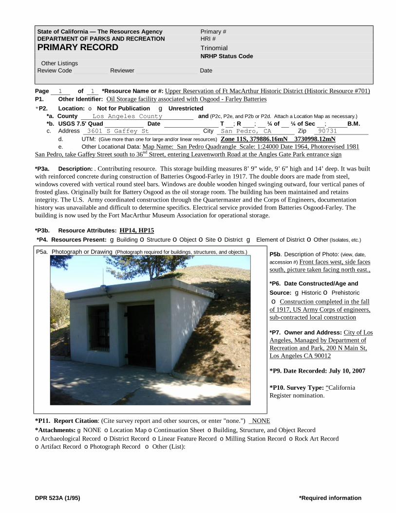
DPR 523A (1/95) *Required information
Page 1 of 1 *Resource Name or #: Upper Reservation of Ft MacArthur Historic District (Historic Resource #701) P1. Other Identifier: Oil Storage facility associated with Osgood - Farley Batteries *P2. Location: o Not for Publication g Unrestricted *a. County Los Angeles County and (P2c, P2e, and P2b or P2d. Attach a Location Map as necessary.) *b. USGS 7.5' Quad Date T ; R ; ¼ of ¼ of Sec ; B.M. c. Address 3601 S Gaffey St City San Pedro, CA Zip 90731 d. UTM: (Give more than one for large and/or linear resources) Zone 11S, 379886.16mN 3730998.12mN e. Other Locational Data: Map Name: San Pedro Quadrangle Scale: 1:24000 Date 1964, Photorevised 1981 San Pedro, take Gaffey Street south to 36nd Street, entering Leavenworth Road at the Angles Gate Park entrance sign *P3a. Description: . Contributing resource. This storage building measures 8’ 9” wide, 9’ 6” high and 14’ deep. It was built with reinforced concrete during construction of Batteries Osgood-Farley in 1917. The double doors are made from steel, windows covered with vertical round steel bars. Windows are double wooden hinged swinging outward, four vertical panes of frosted glass. Originally built for Battery Osgood as the oil storage room. The building has been maintained and retains integrity. The U.S. Army coordinated construction through the Quartermaster and the Corps of Engineers, documentation history was unavailable and difficult to determine specifics. Electrical service provided from Batteries Osgood-Farley. The building is now used by the Fort MacArthur Museum Association for operational storage. *P3b. Resource Attributes: HP14, HP15 *P4. Resources Present: gBuilding oStructure oObject oSite oDistrict g Element of District oOther (Isolates, etc.)
P5b. Description of Photo: (view, date, accession #) Front faces west, side faces south, picture taken facing north east., *P6. Date Constructed/Age and Source: gHistoric o Prehistoric o Construction completed in the fall of 1917, US Army Corps of engineers, sub-contracted local construction *P7. Owner and Address: City of Los Angeles, Managed by Department of Recreation and Park, 200 N Main St, Los Angeles CA 90012 *P9. Date Recorded: July 10, 2007 *P10. Survey Type: “California Register nomination.
*P11. Report Citation: (Cite survey report and other sources, or enter "none.") NONE *Attachments: gNONE oLocation Map oContinuation Sheet oBuilding, Structure, and Object Record oArchaeological Record oDistrict Record oLinear Feature Record oMilling Station Record oRock Art Record oArtifact Record oPhotograph Record o Other (List):
State of California — The Resources Agency Primary # DEPARTMENT OF PARKS AND RECREATION HRI # PRIMARY RECORD Trinomial NRHP Status Code Other Listings Review Code Reviewer Date
P5a. Photograph or Drawing (Photograph required for buildings, structures, and objects.)

DPR 523A (1/95) *Required information
Page 1 of 1 *Resource Name or #: Upper Reservation of Ft MacArthur Historic District (Historic Resource #711) P1. Other Identifier: Signal Repair Shop – 306th Psyop Det. *P2. Location: o Not for Publication g Unrestricted *a. County Los Angeles County and (P2c, P2e, and P2b or P2d. Attach a Location Map as necessary.) *b. USGS 7.5' Quad Date T ; R ; ¼ of ¼ of Sec ; B.M. c. Address 3601 S Gaffey St City San Pedro Zip 90731 d. UTM: (Give more than one for large and/or linear resources) Zone 11S, 379830.25mE 3731087.82mN e. Other Locational Data: Map Name: San Pedro Quadrangle Scale: 1:24000 Date 1964, Photo-revised 1981 San Pedro, take Gaffey Street south to 36nd Street, enter Leavenworth Road at the Angles Gate Park entrance sign *P3a. Description: Contributing resource. The shop building measures 101’ 2” by 24’ 8”. It was constructed of corrugated
galvanized steel sheets on a steel frame, and was originally built to house searchlight equipment. It has been maintained over the years and retains integrity to the period of significance. Documentation only available to a Report of Completed Works – Searchlight Fortifications (Fire control or Torpedo Structure) form 2, Corrected to April 10, 1942. At that time the value of the building was $8,114.39. The building’s elevation is 235.5 feet above sea level. Although it had a water supply, it did not have sewerage or latrine facilities and was not heated. It was considered as a permanent type building. The document indicated the building existed as far back as 9-11-1940. The building is now used by the Fort MacArthur Museum Association for both shop facilities to maintain museum equipment such as military vehicles; it is also used to store materials and parts. A detailed blueprint is attached
*P3b. Resource Attributes: (List attributes and codes) HP14, HP35 *P4. Resources Present: gBuilding oStructure oObject oSite oDistrict gElement of District oOther P5b. Description of Photo: Front East end, facing west photo 900x675 resolution (color) taken 3/10/2007
*P6. Date Constructed/Age and Source: gHistoric o Prehistoric o Both Construction date determined from the Quarters Master Completion report as Aug 10, 1935 *P7. Owner and Address: Owned by City of Los Angeles, Managed by the Department of Parks and Recreation, 200 No. Main St., Los Angeles, CA 90012 *P8. Recorded by: Frank H. Evans, 430 E San Jose Avenue, Unit A, Burbank, CA 91501-2654 *P9. Date Recorded: July 10, 2007 *P10. Survey Type: California Register nomination. *P11. Report Citation: (Cite survey report and other sources, or enter "none.")
NONE *Attachments: gNONE oLocation Map oContinuation Sheet oBuilding, Structure, and Object Record oArchaeological Record oDistrict Record oLinear Feature Record oMilling Station Record oRock Art Record oArtifact Record oPhotograph Record o Other (List
State of California — The Resources Agency Primary # DEPARTMENT OF PARKS AND RECREATION HRI # PRIMARY RECORD Trinomial NRHP Status Code Other Listings Review Code Reviewer Date
P5a. Photograph or Drawing (Photograph required for buildings, structures, and objects.)

DPR 523A (1/95) *Required information
Page 1 of 3 *Resource Name or #: Upper Reservation of Ft MacArthur Historic District (Historic Resource #712) P1. Other Identifier: Signal Repair Shop – 306th Psyop Det. *P2. Location: o Not for Publication g Unrestricted *a. County Los Angeles County and (P2c, P2e, and P2b or P2d. Attach a Location Map as necessary.) *b. USGS 7.5' Quad Date T ; R ; ¼ of ¼ of Sec ; B.M. c. Address 3601 S Gaffey St City San Pedro Zip 90731 d. UTM: (Give more than one for large and/or linear resources) Zone 11S, 379823mE 3731064.10mN e. Other Locational Data: Map Name: San Pedro Quadrangle Scale: 1:24000 Date 1964, Photo-revised 1981 San Pedro, take Gaffey Street south to 36nd Street, turn entering Leavenworth Road at the Angles Gate Park entrance sign *P3a.Description: Contributing resource. Building 712 measures 101’ 2” by 24’ 8”. It was constructed of corrugated galvanized steel sheets on a steel frame, was originally built to house searchlight equipment. It has been maintained over the years and retains integrity to the period of significance. Documentation only available to a Report of Completed Works – Searchlight Fortifications (Fire control or Torpedo Structure) form 2, Corrected to April 10, 1942. At that time the value of the building was $8,114.39. The building’s elevation is 235.5 feet above sea level. Although it had a water supply, it did not have sewerage or latrine facilities, and was not heated. It was considered as a permanent type building. The document indicated the building existed as far back as 9-11-1940. The building is now used by the Fort MacArthur Museum Association for both shop facilities to maintain museum equipment such as military vehicles; it is also used to store materials and parts. *P3b. Resource Attributes: (List attributes and codes) HP14, HP35 *P4. Resources Present: gBuilding oStructure oObject oSite oDistrict gElement of District oOther
P5b. Description of Photo: Front east end, north facing side, building faces east. Photo 900x675 resolution (color) taken 3/10/2007 *P6. Date Constructed/Age and Source: gHistoric o Prehistoric o Both Construction date determined from the Quarters Master Completion report as Aug 10, 1935 *P7. Owner and Address: Owned by City of Los Angeles, Managed by the Department of Parks and Recreation, 200 No. Main St., Los Angeles, CA 90012 *P8. Recorded by: Frank H. Evans, 430 E San Jose Avenue, Unit A, Burbank, CA 91501-2654 *P9. Date Recorded: July 10, 2007 *P10. Survey Type: “California Register” nomination
*P11. Report Citation: (Cite survey report and other sources, or enter "none.") NONE *Attachments: gNONE oLocation Map oContinuation Sheet oBuilding, Structure, and Object Record oArchaeological Record oDistrict Record oLinear Feature Record oMilling Station Record oRock Art Record oArtifact Record oPhotograph Record o Other (List )
State of California — The Resources Agency Primary # DEPARTMENT OF PARKS AND RECREATION HRI # PRIMARY RECORD Trinomial NRHP Status Code Other Listings Review Code Reviewer Date
P5a. Photograph or Drawing (Photograph required for buildings, structures, and objects.)

DPR 523A (1/95) *Required information
Page 1 of 4 *Resource Name or #: Upper Reservation of Ft MacArthur Historic District (Historic Resource # 713) P1. Other Identifier: K9-Sentry Dog Cemetery *P2. Location: o Not for Publication g Unrestricted *a. County Los Angeles County and (P2c, P2e, and P2b or P2d. Attach a Location Map as necessary.) *b. USGS 7.5' Quad Date T ; R ; ¼ of ¼ of Sec ; B.M. c. Address 3601 S Gaffey St City San Pedro Zip 90731 d. UTM: (Give more than one for large and/or linear resources) Zone 11S, 379869.25nE 3731080.29mN e. Other Locational Data: Map Name: San Pedro Quadrangle Scale: 1:24000 Date 1964, Photo-revised 1981 San Pedro, Gaffey Street south to 36nd Street, turn entering Leavenworth Road at the Angles Gate Park entrance sign *P3a.Description: Contributing resource. The Sentry Dog-K9 Cemetery was established about 1941. This unique resource measures about 75’ by 35’ or 2,625 ft/sq. It contains multiple earthen plots, some marked with simple wooden markers identifying the buried sentry dog. The first sentry dog unit of the K-9 Command was formed at Fort MacArthur September 9, 1941. It was first organized on a trial basis in December 1940. The first dogs for the unit were recruited directly from their owners at Pershing Square in downtown Los Angeles after extensive newspaper publicity. Sgt Robert H. Pearce was designated head trainer, and the unit became the nucleus of the internationally famous K-9 Command, US Army. The Sentry Dog Cemetery contains the remains of many of the sentry dogs in the program. This has a unique historical link to the entire area, for both the World War I/II and Cold War eras. It retains integrity to the period of significance. *P3b. Resource Attributes: HP40 HP14 HP15 *P4. Resources Present: oBuilding oStructure gObject oSite oDistrict gElement of District oOther
P5b. Description of Photo: Photo facing north west 900x675 resolution (color) taken 3/10/2007 *P6. Date Constructed/Age and Source: gHistoric o Prehistoric o Both Construction date determined from the Quarters Master Completion report as Aug 10, 1935 *P7. Owner and Address: Owned by City of Los Angeles, Managed by the Department of Parks and Recreation, 200 No. Main St., Los Angeles, CA 90012 *P8. Recorded by: Frank H. Evans, 430 E San Jose Avenue, Unit A, Burbank, CA 91501-2654 *P9. Date Recorded: July 10, 2007 P10. Survey Type: California Register nomination
*P11. Report Citation: (Cite survey report and other sources, or enter "none.") NONE *Attachments: gNONE oLocation Map oContinuation Sheet oBuilding, Structure, and Object Record oArchaeological Record oDistrict Record oLinear Feature Record oMilling Station Record oRock Art Record oArtifact Record oPhotograph Record o Other (List)
State of California — The Resources Agency Primary # DEPARTMENT OF PARKS AND RECREATION HRI # PRIMARY RECORD Trinomial NRHP Status Code Other Listings Review Code Reviewer Date
P5a. Photograph or Drawing

DPR 523A (1/95) *Required information
Page 1 of 1 *Resource Name or #: Upper Reservation of Ft MacArthur Historic District (Resource Nr 802-J) Nike Generator Building P1. Other Identifier: Angles Gate Park, San Pedro, CA. *P2. Location: o Not for Publication g Unrestricted *a. County Los Angeles County and (P2c, P2e, and P2b or P2d. Attach a Location Map as necessary.) *b. USGS 7.5' Quad Date T ; R ; ¼ of ¼ of Sec ; B.M. c. Address Angles Gate Park 3601 S Gaffey St City San Pedro Zip 90731 d. UTM: (Give more than one for large and/or linear resources) Zone 11S, 380101.33mE / 3730972.16mN
e.. Other Locational Data: Main Location Map Name: San Pedro Quadrangle Scale: 1:24000 Date 1964, Photo-revised 1981 From Gaffey Street at 36th Street enter the East Main Entrance, turn right and proceed up the hill on Leary Merriam
Drive. Generator is on the left below the Marine Exchange Building. *P3a. Description: This CONTRIBUTING resource served during the Nike era (1951 to 1975) as the64ft by 28ft concrete block generator building. Originally 30ft by 28ft it was built to house the electrical power generators equipment for the tactical power and also the utility power for the site. In 1961 a 34ft by 28 ft addition was constructed to house generators for the HIPAR building and radar. The tarred gravel roof is flat sloping away from the front to back. Originally and currently painted light green. Horizontal steel casement windows originally installed are still in use. The building retains integrity and retains the appearance as originally built, although a few modifications have been made to the front side main access doors and artist graphics painted on the walls..
*P3b. Resource Attributes: (List attributes and codes) HP14, HP35 *P4. Resources Present: g Building Structure oObject oSite oDistrict gElement of District oOther (Isolates, etc.) P5b. Description of Photo: (view, date, accession #)900x675 digital resolution, color, photo taken on north side of pad facing south . *P6. Date Constructed/Age and Source: gHistoric o Prehistoric o Both Built initially in 1956, US Army Corps of Engineers, with new generators added during Nike Hercules conversion. *P7. Owner and Address: Owned by City of Los Angeles, Managed by the Department of Parks and Recreation, 200 No. Main St., Los Angeles, CA 90012 *P8. Recorded by: (Name, affiliation, and address) Ft MacArthur
Museum Association (Frank Evans) *P9. Date Recorded: July 10, 2007 *P10. Survey Type: California Register nomination.. *P11. Report Citation: (Cite survey report and other sources, or enter "none.") NONE *Attachments: oNONE oLocation Map Continuation Sheet oBuilding, Structure, and Object Record oArchaeological Record oDistrict Record oLinear Feature Record oMilling Station Record oRock Art Record
State of California — The Resources Agency Primary # DEPARTMENT OF PARKS AND RECREATION HRI # PRIMARY RECORD Trinomial NRHP Status Code Other Listings Review Code Reviewer Date
P5a. Photograph or Drawing (Photograph required for buildings, structures, and objects.)

DPR 523A (1/95) *Required information
oArtifact Record oPhotograph Record o Other (List):

DPR 523A (1/95) *Required information
Page 1 of 3 *Resource Name or #: Upper Reservation of Ft MacArthur Historic District (Resource Nr 804) Nike HIPAR Tower Pad P1. Other Identifier: Marine Exchange, San Pedro, CA *P2. Location: o Not for Publication g Unrestricted *a. County Los Angeles County and (P2c, P2e, and P2b or P2d. Attach a Location Map as necessary.) *b. USGS 7.5' Quad Date T ; R ; ¼ of ¼ of Sec ; B.M. c. Address 3601 So Gaffey St City San Pedro Zip 90731 d. UTM: (Give more than one for large and/or linear resources) Zone 11S, 380121.46mN 3731033.48mN Other Locational Data: Main Location Map Name: San Pedro Quadrangle Scale: 1:24000 Date 1964, Photo-revised 1981
From Gaffey Street at 36th Street enter the East Main Entrance, turn right and proceed up the hill on Leary Merriam Drive. To the top – adjacent to the Marine Exchange.
*P3a. Description: A CONTRIBUTING hexagon concrete base foundation, 47 feet across with 26 foot side lengths, approximately with 28 inch side depths, that supported the High Power/High Intensity Pulsed Acquisition Radar (HIPAR) antenna tower with random. The foundation is located beside the original HIPAR building, which has been extensively modified. The original radar, its 50-foot tower and the geodesic dome have been removed, leaving only the grass area around the radar and the footings of its tower. The remains however has integrity based upon the description as a foundation or base. The base is located over the underground concrete Battery Leary – Merriam gun fortification. Tower was typical of all Improved Nike Hercules Air Defense Surface to Air Missile Sites. Tower was prefabricated in two standard heights.. On this site, the high-power acquisition radar (HIPAR) was once located.
P5a. Photograph or Drawing (Photograph required for buildings, structures, objects *P3b. Resource Attributes: HP14, HP35 *P4. Resources Present: oBuilding gStructure oObject oSite oDistrict gElement of District oOther (Isolates, etc.) P5b. Description of Photo: (view, date, accession #)900x675 digital color, photo of the west facing entrance – north facing street side, looking south. Mar 10, 2007. *P6. Date Constructed/Age and Source: gHistoric o Prehistoric o Both Construction completed April 1961 as part of the Improved Nike Hercules conversion program. *P7. Owner and Address: U.S. Coast Guard, Chief Civil Engineering Division, 1301 Clay St, Ste 700N, Oakland, CA 94612
*P8. Recorded by: Fort MacArthur Museum Association (Frank H. Evans), San Pedro, CA. *P9. Date Recorded: July 10, 2007 *P10. Survey Type: California Register nomination. *P11. Report Citation: (Cite survey report and other sources, or enter "none.") NONE *Attachments: oNONE oLocation Map oContinuation Sheet oBuilding, Structure, and Object Record oArchaeological Record oDistrict Record oLinear Feature Record oMilling Station Record oRock Art Record oArtifact Record oPhotograph Record o Other (List)
State of California — The Resources Agency Primary # DEPARTMENT OF PARKS AND RECREATION HRI # PRIMARY RECORD Trinomial NRHP Status Code Other Listings Review Code Reviewer Date
Blocked ar ea depicts location of the hexagon (six sided) antenna base foundation remains

DPR 523A (1/95) *Required information
Page 1 of __1 *Resource Name or #: Upper Reservation of Ft MacArthur Historic District (Resource Nr 8X1) Nike Acquisition-LOPAR Radar Pad P1. Other Identifier: Angles Gate Park, San Pedro, CA_______________________________________________________________ *P2. Location: o Not for Publication g Unrestricted *a. County Los Angeles County and (P2c, P2e, and P2b or P2d. Attach a Location Map as necessary.) *b. USGS 7.5' Quad Date T ; R ; ¼ of ¼ of Sec ; B.M. c. Address Angles Gate Park, 3601 S Gaffey St City San Pedro, CA Zip 90731 d. UTM: (Give more than one for large and/or linear resources) Zone 11s, 380082.10mE 3730960.47mN Other Locational Data: Main Location Map Name: San Pedro Quadrangle Scale: 1:24000 Date 1964, Photo-revised 1981 P3a. Description: A`CONTRIBUTING resource. During 1951 to 1975 the 27ft diameter round tank like structure of
poured reinforced concrete served as the foundation for the Acquisition Radar Antenna Assembly, for both the original Nike Ajax Surface to Air Missile Defense system, then the Nike Hercules antenna (no changes during installation of the Improved Nike Hercules). The thickness is unknown. Three concrete steps on the north-east side supported radar antenna maintenance. The location supported mandatory radar coverage. At 3’ from the edge are bolts to secure a covering radome that was added at some date after initial; construction. The pad has imbedded steel bolts which permitted tie down of the antenna assembly. A radome (radar dome) protected the antenna assembly from Pacific Ocean wind gusts. Consideration was given during original construction to minimize expansion and contraction of the
concrete during weather changes since the antenna platform had to be level at all-times. *P3b. Resource Attributes: (List attributes and codes) HP14, HP35 *P4. Resources Present: o Building gStructure oObject oSite oDistrict gElement of District oOther (Isolates, etc.) P5b. Description of Photo: (view, date, accession #)900x675 digital resolution, color, photo taken on north side of pad facing south to ward Pacific Ocean . *P6. Date Constructed/Age and Source: gHistoric o Prehistoric o Both Construction completed Nov 1954 by US Army Corps of Engineers under numerous local contractors. Built from drawings from US Army Corps of Engineers based upon nationally adopted design *P7. Owner and Address: Owned by City of
Los Angeles, Managed by the Department of Parks and Recreation, 200 No. Main St., Los Angeles, CA 90012 *P8. Recorded by: The Fort MacArthur Museum Association (Frank H. Evans) San Pedro CA, *P9. Date Recorded: July 10, 2007 *P10. Survey Type: “California Register” nomination *P11. Report Citation: (Cite survey report and other sources, or enter "none.") NONE *Attachments: oNONE oLocation Map oContinuation Sheet oBuilding, Structure, and Object Record oArchaeological Record oDistrict Record oLinear Feature Record oMilling Station Record oRock Art Record oArtifact Record oPhotograph Record o Other (List):
State of California — The Resources Agency Primary # DEPARTMENT OF PARKS AND RECREATION HRI # PRIMARY RECORD Trinomial NRHP Status Code Other Listings Review Code Reviewer Date
P5a. Photograph or Drawing
L:eft: Acquisition Radar (LOPAR) Antenna Concrete Pad (foundation for the radar antenna assembly pictured on the right. Pad remains; antenna was removed upon Nike Site deactivation. The pad along with other Nike Resources contributes to the Districts Integrity.

DPR 523A (1/95) *Required information
Page 1 of 1 *Resource Name or #: Upper Reservation of Ft MacArthur Historic District (Resource Nr 8X2) Nike Missile Tracking Radar [MTR] Antenna Pad P1. Other Identifier: Angles Gate Park, Los Angeles Department of Recreation and Parks, San Pedro, CA *P2. Location: o Not for Publication g Unrestricted *a. County Los Angeles County and (P2c, P2e, and P2b or P2d. Attach a Location Map as necessary.) *b. USGS 7.5' Quad Date T ; R ; ¼ of ¼ of Sec ; B.M. c. Address Angles Gate Park, 3601 S Gaffey St City San Pedro, CA Zip 90731 d. UTM: (Give more than one for large and/or linear resources) Zone 11S, 380055mE 3730959.89 Other Locational Data: Main Location Map Name: San Pedro Quadrangle Scale: 1:24000 Date 1964, Photo-revised 1981 San Pedro, take Gaffey Street S to 36nd Street, turn entering Leavenworth Road at the Angles Gate Park entrance *P3a. Description: The Concrete foundation is a CONTRIBUTING Resource. It’s thickness is unknown -the diameter is
27ft end to end. At 3’ from the edge of the concrete is a non-typical concrete ring varying in height up to 8 inches high and 5 inches thick. This was the pad for the Missile Tracking Radar - MTR, for both the original Nike Ajax Surface to Air Missile Defense system and latter the Nike Hercules antenna. The pad has imbedded bolts which permitted tie down the antenna base.
*P3b. Resource Attributes: (List attributes and codes) HP14, HP35 *P4. Resources Present: o Building gStructure oObject oSite oDistrict gElement of District oOther (Isolates, etc.) P5b. Description of Photo: (view, date, accession #)900x675 digital resolution, color, photo taken on north side of pad facing south . *P6. Date Constructed/Age and Source: gHistoric o Prehistoric o Both Construction date determined from the Quarters Master Completion report as Aug 10, 1935 *P7. Owner and Address: Owned by City of Los Angeles, Managed by the Department of Parks and Recreation, 200 No. Main St., Los Angeles, CA 90012 *P8. Recorded by: (Name, affiliation, and address) Ft MacArthur Museum Association (Frank Evans) San Pedro, CA *P9. Date Recorded: July 10, 2007
*P10. Survey Type: California Register nomination *P11. Report Citation: (Cite survey report and other sources, or enter "none.") NONE *Attachments: gNONE oLocation Map oContinuation Sheet oBuilding, Structure, and Object Record oArchaeological Record oDistrict Record oLinear Feature Record oMilling Station Record oRock Art Record oArtifact Record oPhotograph Record o Other (List):
State of California — The Resources Agency Primary # DEPARTMENT OF PARKS AND RECREATION HRI # PRIMARY RECORD Trinomial NRHP Status Code Other Listings Review Code Reviewer Date
P5a. Photograph or Drawing (Photograph required for buildings, structures, and objects.)

DPR 523A (1/95) *Required information
Page 1 of 1 *Resource Name or #: Upper Reservation of Ft MacArthur Historic District (Resource Nr 807) Nike Target Ranging Radar Tower (TTR) *P1. Other Identifier: Angles Gate Park, San Pedro, CA *P2. Location: o Not for Publication g Unrestricted *a. County Los Angeles County and (P2c, P2e, and P2b or P2d. Attach a Location Map as necessary.) *b. USGS 7.5' Quad Date T ; R ; ¼ of ¼ of Sec ; B.M. c. Address Angles Gate Park, 3601 S Gaffey St City San Pedro, CA Zip 90731 d. UTM: (Give more than one for large and/or linear resources) Zone 11S, 308085.03mE 3730990.88mN Other Locational Data: Main Location Map Name: San Pedro Quadrangle Scale: 1:24000 Date 1964, Photo-revised 1981 San Pedro, take Gaffey Street S to 36th Street, turn right (east) entering Leavenworth Road at the Angles Gate Park entrance. *P3a. Description: This CONTRIBUTING district resource’s hexagon shaped top platform is 30’ diameter (side to side) and it’s 6 sides are 17’ each. The height is estimated to be 20 feet. The tower is a poured reinforced concrete column. A steel safety railing is attached to the 6 sides (one side detached when the antenna was removed). Tower is located with the gun pit of Battery Merriam (Resource 885).Metal covering establishes uniform expansion and contraction. A vertical metal ladder provided access to the platform. It was an addition to the Fire Control during ‘Improved Nike Hercules Upgrade’ in 1961. The standard issues Target Ranging Radar – TRR was mounted on top of the radar tower. An attached ladder provided for the Fire Control personnel to access the topside antenna for maintenance. Cables interconnected the antenna assembly on top of the tower with the Tracking Station Van adjacent to the Nike Maintenance and Service Building (Nr 815) for
power and signal transmissions. P5a. Photograph or Drawing (Photograph required for buildings, structures, and objects.) *P3b. Resource Attributes: (List attributes and codes) HP14, HP35 *P4. Resources Present: o Building gStructure oObject oSite oDistrict gElement of District oOther (Isolates, etc.) P5b. Description of Photo: (view, date, accession #)900x675 digital resolution, color, photo taken on north side of pad facing south . *P6. Date Constructed/Age and Source: gHistoric o Prehistoric o Both Tower was constructed in April 1961 during the upgrade for the Improved Nike Hercules system by the US Army Corps of Engineers under subcontract. *P7. Owner and Address: Owned by City of Los Angeles, Managed by the Department of Parks and Recreation, 200 No. Main St., Los Angeles, CA 90012 *P8. Recorded by: Ft MacArthur Museum
Association (Frank Evans) San Pedro, CA *P9. Date Recorded: July 10, 2007 *P10. Survey Type California Register Nomination. *P11. Report Citation: (Cite survey report and other sources, or enter "none.") NONE *Attachments: oNONE oLocation Map oContinuation Sheet oBuilding, Structure, and Object Record oArchaeological Record oDistrict Record oLinear Feature Record oMilling Station Record oRock Art Record
State of California — The Resources Agency Primary # DEPARTMENT OF PARKS AND RECREATION HRI # PRIMARY RECORD Trinomial NRHP Status Code Other Listings Review Code Reviewer Date
5a. Nike Hercules Fire Control Target Ranging Radar - TRR Antenna Tower

DPR 523A (1/95) *Required information
oArtifact Record oPhotograph Record o Other (List):
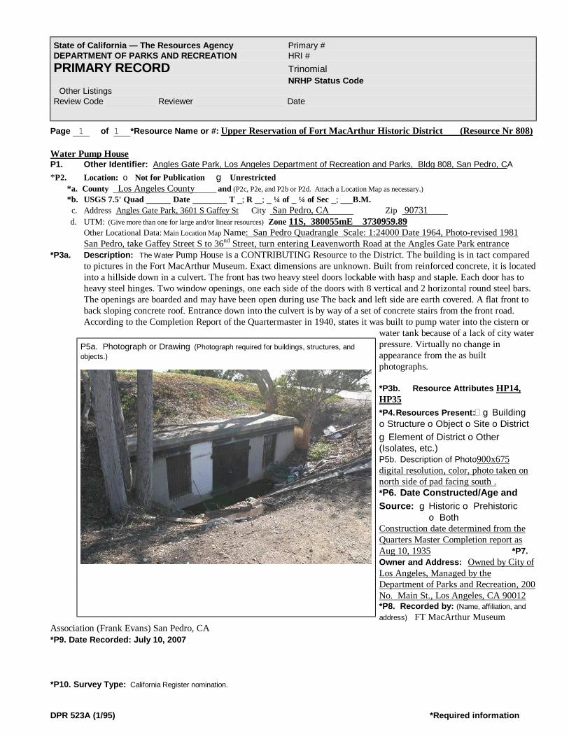
DPR 523A (1/95) *Required information
Page 1 of 1 *Resource Name or #: Upper Reservation of Fort MacArthur Historic District (Resource Nr 808) Water Pump House P1. Other Identifier: Angles Gate Park, Los Angeles Department of Recreation and Parks, Bldg 808, San Pedro, CA *P2. Location: o Not for Publication g Unrestricted *a. County Los Angeles County and (P2c, P2e, and P2b or P2d. Attach a Location Map as necessary.) *b. USGS 7.5' Quad Date T ; R ; ¼ of ¼ of Sec ; B.M. c. Address Angles Gate Park, 3601 S Gaffey St City San Pedro, CA Zip 90731 d. UTM: (Give more than one for large and/or linear resources) Zone 11S, 380055mE 3730959.89 Other Locational Data: Main Location Map Name: San Pedro Quadrangle Scale: 1:24000 Date 1964, Photo-revised 1981 San Pedro, take Gaffey Street S to 36nd Street, turn entering Leavenworth Road at the Angles Gate Park entrance *P3a. Description: The Water Pump House is a CONTRIBUTING Resource to the District. The building is in tact compared
to pictures in the Fort MacArthur Museum. Exact dimensions are unknown. Built from reinforced concrete, it is located into a hillside down in a culvert. The front has two heavy steel doors lockable with hasp and staple. Each door has to heavy steel hinges. Two window openings, one each side of the doors with 8 vertical and 2 horizontal round steel bars. The openings are boarded and may have been open during use The back and left side are earth covered. A flat front to back sloping concrete roof. Entrance down into the culvert is by way of a set of concrete stairs from the front road. According to the Completion Report of the Quartermaster in 1940, states it was built to pump water into the cistern or
water tank because of a lack of city water pressure. Virtually no change in appearance from the as built photographs. *P3b. Resource Attributes HP14, HP35 *P4. Resources Present: gBuilding oStructure oObject oSite oDistrict gElement of District oOther (Isolates, etc.) P5b. Description of Photo900x675 digital resolution, color, photo taken on north side of pad facing south . *P6. Date Constructed/Age and Source: gHistoric o Prehistoric o Both Construction date determined from the Quarters Master Completion report as Aug 10, 1935 *P7. Owner and Address: Owned by City of Los Angeles, Managed by the Department of Parks and Recreation, 200 No. Main St., Los Angeles, CA 90012 *P8. Recorded by: (Name, affiliation, and address) FT MacArthur Museum
Association (Frank Evans) San Pedro, CA *P9. Date Recorded: July 10, 2007 *P10. Survey Type: California Register nomination.
State of California — The Resources Agency Primary # DEPARTMENT OF PARKS AND RECREATION HRI # PRIMARY RECORD Trinomial NRHP Status Code Other Listings Review Code Reviewer Date
P5a. Photograph or Drawing (Photograph required for buildings, structures, and objects.)

DPR 523A (1/95) *Required information
*P11. Report Citation: (Cite survey report and other sources, or enter "none.") NONE *Attachments: oNONE oLocation Map oContinuation Sheet oBuilding, Structure, and Object Record oArchaeological Record oDistrict Record oLinear Feature Record oMilling Station Record oRock Art Record oArtifact Record oPhotograph Record o Other (List):

DPR 523A (1/95) *Required information
Page 1 of 3 *Resource Name or #:Upper Reservation of Fort MacArthur Historic District (Resource Br 815) Nike Maintenance & Service Bldg (Corridor Building) P1. Other Identifier: Angles Gate Park, San Pedro, CA *P2. Location: o Not for Publication g Unrestricted *a. County Los Angeles County and (P2c, P2e, and P2b or P2d. Attach a Location Map as necessary.) *b. USGS 7.5' Quad Date T ; R ; ¼ of ¼ of Sec ; B.M. c. Address 3601 So Gaffey St City San Pedro Zip 90731 d. UTM: (Give more than one for large and/or linear resources) Zone 11S, 380047.26mE 3731249.88mN Other Locational Data: Main Location Map Name: San Pedro Quadrangle Scale: 1:24000 Date 1964, Photo-revised 1981
From Gaffey Street at 36th Street enter the East Main Entrance, turn right and proceed up the hill on Leary Merriam Drive. To the top – adjacent to the Marine Exchange.
*P3a. Description: The 720 square foot Maintenance and Service Building (M&S) is a CONTRIBUTING Resource to the District. A “T” shaped concrete block building, jhas been and is painted light green, with tarred gravel flat sloping roofs, the building served to interconnect to permanently emplaced movable radar and control system trailers. The building was constructed within Battery Leary gun emplacement. Two trailer mounted radar vans backed against the building and rested semi-permanently upon large wooden blocks. The M&S Building provided access to each of the two radar vans. It is located within Seacoast Artillery Battery Leary Gun Pit.(Resource Nr 885). Two access doors are located front and back.
(Continued) *P3b. Resource Attributes: HP14, HP35 *P4. Resources Present: g Building oStructure oObject oSite oDistrict gElement of District oOther (Isolates, etc.) P5b. Description of Photo: (view, date, accession #)900x675 digital resolution, color, photo taken of the west facing entrance – north facing street side, looking south. Mar 10, 2007. *P6. Date Constructed/Age and Source: gHistoric o Prehistoric o Both Construction completed June 30, 1940. Was beginning of Historical 700 Series Cantonment. Blue Print 700-268, B-36 *P7. Owner and Address: Owned by City of Los Angeles, Managed by the Department of Parks and Recreation, 200 No. Main St., Los Angeles, CA 90012
*P8. Recorded by: Ft MacArthur Museum Association (Frank Evans) San Pedro, CA *P9. Date Recorded: July 10, 2007 *P10. Survey Type: California Register nomination. *P11. Report Citation: (Cite survey report and other sources, or enter "none.") NONE *Attachments: oNONE oLocation Map oContinuation Sheet oBuilding, Structure, and Object Record oArchaeological Record oDistrict Record oLinear Feature Record oMilling Station Record oRock Art Record oArtifact Record oPhotograph Record o Other (List)
State of California — The Resources Agency Primary # DEPARTMENT OF PARKS AND RECREATION HRI # PRIMARY RECORD Trinomial NRHP Status Code Other Listings Review Code Reviewer Date
P5a. Photograph or Drawing (Photograph required for buildings, structures, objects

DPR 523A (1/95) *Required information
Page 1 of 2 *Resource Name or #: Upper Reservation of Ft MacArthur Historic District (Resource Nr 817) Nike Fire Control Sentry Building P1. Other Identifier: Angles Gate Park, Los Angeles Department of Recreation and Parks, San Pedro, CA *P2. Location: o Not for Publication g Unrestricted *a. County Los Angeles County and (P2c, P2e, and P2b or P2d. Attach a Location Map as necessary.) *b. USGS 7.5' Quad Date T ; R ; ¼ of ¼ of Sec ; B.M. c. Address Angles Gate Park, 3601 S Gaffey St City San Pedro, CA Zip 90731 d. UTM: (Give more than one for large and/or linear resources) Zone 11S, 380044.32mE 3731051.12 mN Other Locational Data: Main Location Map Name: San Pedro Quadrangle Scale: 1:24000 Date 1964, Photo-revised 1981 San Pedro, take Gaffey Street S to 36nd Street, turn entering Leavenworth Road at the Angles Gate Park entrance *P3a. Description: The CONTRIBUTING Resource to the District is a sentry building. It was constructed from concrete blocks on a poured concrete foundation slan for the Nike Ajax systems Integrated Fire Control Area (IFC). The 25 ft/sq building is constructed on a poured concrete slab and made of standard concrete block. It has three windows on each side (north, east and west. Entrance was thru a door on the south side which faces the roadway entering the Fire Control site thru an underground tunnel (part of the Battery Leary Merriam [Resource Nr 885]). Originally painted light green, the paint is badly peeled, however integrity remains.
P5a. Photograph or Drawing (Photograph required for buildings, structures, and objects.) *P3b. Resource Attributes: (List attributes and codes) HP14, HP35 *P4. Resources Present: gBuilding oStructure oObject oSite oDistrict gElement of District oOther (Isolates, etc.) P5b. Description of Photo: (view, date, accession #)900x675 digital resolution, color, photo taken of south entrance and west facing side – taken facing east. *P6. Date Constructed/Age and Source: gHistoric o Prehistoric o Both Construction date determined as 1954 *P7. Owner and Address: Owned by City of Los Angeles, Managed by the Department of Parks and Recreation, 200 No. Main St., Los Angeles, CA 90012 *P8. Recorded by: Ft MacArthur Museum Association (Frank Evans) San Pedro, CA *P9. Date Recorded: July 10, 2007
*P10. Survey Type: California Register nomination. *P11. Report Citation: (Cite survey report and other sources, or enter "none.") NONE *Attachments: oNONE oLocation Map oContinuation Sheet oBuilding, Structure, and Object Record oArchaeological Record oDistrict Record oLinear Feature Record oMilling Station Record oRock Art Record oArtifact Record oPhotograph Record o Other (List):
State of California — The Resources Agency Primary # DEPARTMENT OF PARKS AND RECREATION HRI # PRIMARY RECORD Trinomial NRHP Status Code Other Listings Review Code Reviewer Date

DPR 523A (1/95) *Required information
Page 1 of 1 *Resource Name or #: Upper Reservation of Ft MacArthur Historic District (Resource Nr 919) Water Tank - Cistern P1. Other Identifier: Angles Gate Park, Los Angeles Department of Recreation and Parks, Bldg 808, San Pedro, CA *P2. Location: o Not for Publication g Unrestricted *a. County Los Angeles County and (P2c, P2e, and P2b or P2d. Attach a Location Map as necessary.) *b. USGS 7.5' Quad Date T ; R ; ¼ of ¼ of Sec ; B.M. c. Address Angles Gate Park, 3601 S Gaffey St City San Pedro, CA Zip 90731 d. UTM: (Give more than one for large and/or linear resources) Zone 11S, 380024.07mE 3731048.16mN Other Locational Data: Main Location Map Name: San Pedro Quadrangle Scale: 1:24000 Date 1964, Photo-revised 1981 San Pedro, take Gaffey Street S to 36nd Street, turn entering Leavenworth Road at the Angles Gate Park entrance. *P3a. Description: The CONTRIBUTING Resource to the District is a 37 foot diameter concrete subterranean cistern water tank. It was built during the original Upper Reservation development in 1915. The City was unable to supply the needed water needed to the facility so the US Army had to install a system to pump water topside and store it and provide the needed water pressure require for distribution. The pumps in building 808 supplied the water to the cistern system.
*P3b. Resource Attributes: (List attributes and codes) AH5, HP14, HP35 *P4. Resources Present: o Building gStructure oObject oSite oDistrict gElement of District oOther (Isolates, etc.) P5b. Description of Photo: (view, date, accession #)900x675 digital resolution, color, photo taken of cistern top facing noth-west. *P6. Date Constructed/Age and Source: gHistoric o Prehistoric o Both Construction date determined from the Quarters Master Completion report as 1917 *P7. Owner and Address: Owned by City of Los Angeles, Managed by the Department of Parks and Recreation, 200 No. Main St., Los Angeles, CA 90012 *P8. Recorded by: (Name, affiliation, and address) Frank H. Evans, 430 E San Jose Avenue, Unit A, Burbank, CA 91501-2654 *P9. Date Recorded: July 10, 2007
*P10. Survey Type: California Register nomination. *P11. Report Citation: (Cite survey report and other sources, or enter "none.") NONE *Attachments: oNONE oLocation Map oContinuation Sheet oBuilding, Structure, and Object Record oArchaeological Record oDistrict Record oLinear Feature Record oMilling Station Record oRock Art Record oArtifact Record oPhotograph Record o Other (List):
State of California — The Resources Agency Primary # DEPARTMENT OF PARKS AND RECREATION HRI # PRIMARY RECORD Trinomial NRHP Status Code Other Listings Review Code Reviewer Date
P5a. Photograph or Drawing (Photograph required for buildings, structures, and objects.)

DPR 523A (1/95) *Required Information
Page 1 of 1 *Resource Name or #: Upper Reservation of Ft MacArthur Historic District - Historic Resource Nr 820 P1. Other Identifier: Angles Gate Park, Los Angeles Department of Recreation and Parks, Swimming Pool, San Pedro *P2. Location: o Not for Publication g Unrestricted *a. County Los Angeles County and (P2c, P2e, and P2b or P2d. Attach a Location Map as necessary.) *b. USGS 7.5' Quad Date T ; R ; ¼ of ¼ of Sec ; B.M. c. Address Angles Gate Park, 3601 S Gaffey St City San Pedro, CA Zip 90731 d. UTM: (Give more than one for large and/or linear resources) Zone 11S, 380149.30mE 3731248.48mN Other Locational Data: Main Location Map USGS San Pedro Quadrangle Scale: 1:24000 Date 1964, Photo-revised 1981 *P3a. Description: The pool is a CONTRIBUTING resource to the district and was built for the United States Army on the hillside along Gaffey Street overlooking the Pacific Ocean and the entrance of the Los Angeles – Long Beach Harbors. The pool measurements from side to side at both ends are 50 feet wide at top and bottom, and 110 feet long end to end. . The structural parts of the pool are constructed of reinforced concrete, which is in exceptional condition except for a minor crack here or there. A large dressing room complex and equipment rooms were built beneath the pool structure itself. It appears structurally sound despite graffiti. The entire circumference of the pool is caped on all sides with a tiled “coping” (The material that covers the first twelve inches of horizontal surface at the pools edge, the cap or top lip on the pool wall that provides a finished edge around the pool) 12 inch. The inside walls of the pool have a trough its entire circumference with acts as a water return with periodically spaced grates and a continuous tile formed handrail.
*P3b. Resource Attributes: (List attributes and codes) HP14, HP35 *P4. Resources Present: o Building gStructure oObject oSite oDistrict gElement of District oOther (Isolates, etc.) P5b. Description of Photo: (view, date, accession # (900x675 digital resolution, color, photo taken of pool on south side facing north east.. *P6. Date Constructed/Age and Source: gHistoric o Prehistoric o Both Construction date determined as 1943. *P7. Owner and Address: Owned by City of Los Angeles, Managed by the Department of Parks and Recreation, 200 No. Main St., Los Angeles, CA 90012 *P8. Recorded by: Frank H. Evans, 430 E San Jose Avenue, Unit A, Burbank, CA 91501-2654
*P9. Date Recorded: July 10, 2007 *P10. Survey Type: California Register nomination *P11. Report Citation: (Cite survey report and other sources, or enter "none.") NONE *Attachments: oNONE oLocation Map oContinuation Sheet oBuilding, Structure, and Object Record oArchaeological Record oDistrict Record oLinear Feature Record oMilling Station Record oRock Art Record oArtifact Record oPhotograph Record o Other (List
State of California — The Resources Agency Primary # DEPARTMENT OF PARKS AND RECREATION HRI # PRIMARY RECORD Trinomial NRHP Status Code Other Listings Review Code Reviewer Date
P5a. Photograph or Drawing (Photograph required for buildings, structures, and objects.)

DPR 523A (1/95) *Required information
Page 1 of 1 *Resource Name or #: Upper Reservation of Ft MacArthur Historic District (Resource #821-A) P1. Other Identifier: 700 Series Cantonment Barracks; Angles Gate Cultural Center Building “D” *P2. Location: o Not for Publication g Unrestricted *a. County Los Angeles County and (P2c, P2e, and P2b or P2d. Attach a Location Map as necessary.) *b. USGS 7.5' Quad Date T ; R ; ¼ of ¼ of Sec ; B.M. c. Address 3601 So Gaffey St City San Pedro Zip 90731 d. UTM: (Give more than one for large and/or linear resources) Zone 11S, 380101.33mE / 3730972.16mN
e.. Other Locational Data: Main Location Map Name: San Pedro Quadrangle Scale: 1:24000 Date 1964, Photo-revised 1981 From Gaffey Street at 36th Street enter the East Main Entrance, turn right and proceed up the hill on Leary Merriam
Drive. To the top – building 821 first on the right . *P3a. Description: Contributing Resource. The 700 Series Cantonment Barracks building was built as a 2 story wooden
frame 79 Man capacity barracks with drop siding, roof was composition shingles. 24 double hung, 12 glass panes (3x4 – 6 top 6 bottom), wood stairways each side to the second floor. First floor entrances each side and one end with either wood stairs or concrete stoops. The units at Ft MacArthur are unique in that they had no plumbing and external latrines were provided, a concept to support adjacent tent encampments. Cost $6,619.00. Now under lease from the city of Los Angeles to the Angles Gate Cultural Center as Administration and a Gallery, known as Bldg “A”.
*P3b. Resource Attributes: (List attributes and codes) HP14, HP35 *P4. Resources Present: g Building oStructure oObject oSite oDistrictgElement of District oOther (Isolates, etc.)
P5b. Description of Photo: (view, date, accession #)900x675 digital resolution, color, photo taken on west side of building facing east *P6. Date Constructed/Age and Source: gHistoric o Prehistoric o Both Construction completed June 30, 1940. Was beginning of Historical 700 Series Cantonment. Blue Print 700-268, B-36 *P7. Owner and Address: Owned by City of Los Angeles, Managed by the Department of Parks and Recreation, 200 No. Main St., Los Angeles, CA 90012 *P8. Recorded by: Fort MacArthur Museum Association )Frank Evans) San Pedro, CA *P9. Date Recorded: July 10, 2007 *P10. Survey Type: California Register nomination. *P11. Report Citation: (Cite survey report and other sources, or enter "none.") NONE
*Attachments: gNONE oLocation Map Continuation Sheet oBuilding, Structure, and Object Record oArchaeological Record oDistrict Record oLinear Feature Record oMilling Station Record oRock Art Record oArtifact Record oPhotograph Record o Other (List)
State of California — The Resources Agency Primary # DEPARTMENT OF PARKS AND RECREATION HRI # PRIMARY RECORD Trinomial NRHP Status Code Other Listings Review Code Reviewer Date
P5a. Photograph or Drawing (Photograph required for buildings, structures,
t

DPR 523A (1/95) *Required information
Page 1 of 1 *Resource Name or #: Upper Reservation of Fort MacArthur Historic District (Resource Nr 822-B) P1. Other Identifier: 700 Series Cantonment Barracks; Angles Gate Cultural Center Building “D” *P2. Location: o Not for Publication g Unrestricted *a. County Los Angeles County and (P2c, P2e, and P2b or P2d. Attach a Location Map as necessary.) *b. USGS 7.5' Quad Date T ; R ; ¼ of ¼ of Sec ; B.M. c. Address 3601 So Gaffey St City San Pedro Zip 90731 d. UTM: (Give more than one for large and/or linear resources) Zone 11S, 380143.45mE 3731144.14mN
e.. Other Locational Data: Main Location Map Name: San Pedro Quadrangle Scale: 1:24000 Date 1964, Photo-revised 1981 From Gaffey Street at 36th Street enter the East Main Entrance, turn right and proceed up the hill on Leary Merriam
Drive. To the top – building 822 second on the right. *P3a. Description: Contributing resource. The barrack building was built as a 2-story wood frame 79 Man capacity barracks
with drop siding, roof was composition shingles. 24 double hung, 12 glass panes (3x4 – 6 top 6 bottom), wood stairways each side to the second floor. First floor entrances each side and one end with either wood stairs or concrete stoops. The units at Ft MacArthur are unique in that they had no plumbing and external latrines were provided, a concept to support adjacent tent encampments. Cost $6,619.00. Originally used as a barracks, and now under lease from he city of Los Angeles to the Angles Gate Cultural Center as Artist Studio “B”.
*P3b. Resource Attributes: HP14, *P4. Resources Present: g Building oStructure oObject oSite oDistrict gElement of District oOther (Isolates, etc.)
P5b. Description of Photo: (view, date, accession #)900x675 digital resolution, color, photo taken on south-west side of building facing east, Mar 10, 2007. *P6. Date Constructed/Age and Source: gHistoric o Prehistoric o Both Construction completed June 30, 1940. Was beginning of Historical 700 Series Cantonment. Blue Print 700-268, B-36 *P7. Owner and Address: Owned by City of Los Angeles, Managed by the Department of Parks and Recreation, 200 No. Main St., Los Angeles, CA 90012 *P8. Recorded by: Ft MacArthur Museum Association (Frank Evans) San Pedro, CA *P9. Date Recorded: July 10, 2007 *P10. Survey Type: California Register nomination.
*P11. Report Citation: (Cite survey report and other sources, or enter "none.") NONE *Attachments: gNONE oLocation Map oContinuation Sheet oBuilding, Structure, and Object Record oArchaeological Record oDistrict Record oLinear Feature Record oMilling Station Record oRock Art Record oArtifact Record oPhotograph Record o Other (List)
State of California — The Resources Agency Primary # DEPARTMENT OF PARKS AND RECREATION HRI # PRIMARY RECORD Trinomial NRHP Status Code Other Listings Review Code Reviewer Date
P5a. Photograph or Drawing (Photograph required for buildings, structures,
t

DPR 523A (1/95) *Required information
Page 1 of 1 *Resource Name or #: Upper Reservation of Fort MacArthur Historic District (Resource Nr 823-C) P1. Other Identifier: 700 Series Cantonment Barracks; Angles Gate Cultural Center Building “C” *P2. Location: o Not for Publication g Unrestricted *a. County Los Angeles County and (P2c, P2e, and P2b or P2d. Attach a Location Map as necessary.) *b. USGS 7.5' Quad Date T ; R ; ¼ of ¼ of Sec ; B.M. c. Address 3601 So Gaffey St City San Pedro Zip 90731 d. UTM: (Give more than one for large and/or linear resources) Zone 11S, 380146.32mE 3731169.49mN Other Locational Data: Main Location Map Name: San Pedro Quadrangle Scale: 1:24000 Date 1964, Photo-revised 1981
From Gaffey Street at 36th Street enter the East Main Entrance, turn right and proceed up the hill on Leary Merriam Drive. To the top – building 823 is third building on the right after the two 2 story buildings.
*P3a. Description: This CONTRIBUTING Resource building was built as a single story wooden frame latrine with drop siding. Roof was composition shingles, concrete floor and footings. One end with 3 windows, one side with 5 windows and adoor with concrete stoop. Concrete walkways leading to the building. Windows are wooden double hung with 12 panes of glass 3x4 top and 3x4 bottom. Cost $ 5,289.57. Originally used as a mess halls and latter converted for other functions. Was a latrine during the 1970s with the Reserve Affairs Barracks. Used by the Angles Gate Cultural Center as Studio “C”.
*P3b. Resource Attributes: HP14, HP35 *P4. Resources Present: g Building oStructure oObject oSite oDistrict gElement of District oOther (Isolates, etc.)
P5b. Description of Photo: (view, date, accession #)900x675 digital resolution, color, photo taken of the west facing entrance – south facing street side and west side , looking north. Mar 10, 2007. *P6. Date Constructed/Age and Source: gHistoric o Prehistoric o Both Construction completed June 30, 1940. Was beginning of Historical 700 Series Cantonment. Blue Print 700-238, L-5 *P7. Owner and Address: Owned by City of Los Angeles, Managed by the Department of Parks and Recreation, 200 No. Main St., Los Angeles, CA 90012 *P8. Recorded by: Frank H. Evans, 430 E San Jose Avenue, Unit A, Burbank, CA 91501-2654 *P9. Date Recorded: July 10, 2007 *P10. Survey Type: California Register Nomination
*P11. Report Citation: (Cite survey report and other sources, or enter "none.") NONE *Attachments: oNONE oLocation Map gContinuation Sheet oBuilding, Structure, and Object Record oArchaeological Record oDistrict Record oLinear Feature Record oMilling Station Record oRock Art Record oArtifact Record oPhotograph Record o Other (List)
State of California — The Resources Agency Primary # DEPARTMENT OF PARKS AND RECREATION HRI # PRIMARY RECORD Trinomial NRHP Status Code Other Listings Review Code Reviewer Date
P5a. Photograph or Drawing (Photograph required for buildings, structures, objects

DPR 523A (1/95) *Required information
Page 1 of 1 *Resource Name or #: Upper Reservation of Fort MacArthur Historic District (Resource Nr 824) P1. Other Identifier: 700 Series Cantonment Barracks; Angles Gate Cultural Center Building “D” *P2. Location: o Not for Publication g Unrestricted *a. County Los Angeles County and (P2c, P2e, and P2b or P2d. Attach a Location Map as necessary.) *b. USGS 7.5' Quad Date T ; R ; ¼ of ¼ of Sec ; B.M. c. Address 3601 So Gaffey St City San Pedro Zip 90731 d. UTM: (Give more than one for large and/or linear resources) Zone 11S, 380127.28mE 3731183.56mN Other Locational Data: Main Location Map Name: San Pedro Quadrangle Scale: 1:24000 Date 1964, Photo-revised 1981
From Gaffey Street at 36th Street enter the East Main Entrance, turn right and proceed up the hill on Leary Merriam Drive. To the top – building 824 fourth building on the right – beyond gated (locked) fence.
*P3a. Description Contributing Resource. The building was built as a 2 story wood-frame, 79 Man capacity barracks with drop siding, roof was composition shingles. 24 double hung, 12 glass panes (3x4 – 6 top 6 bottom), wood stairways each side to the second floor. First floor entrances each side and one end with either wood stairs or concrete stoops. The units at Ft MacArthur are unique in that they had no plumbing and external latrines were provided, a concept to support adjacent tent encampments. Cost $6,619.00. Originally used as a barracks, and now by the Belmont Shore Railroad Club.
*P3b. Resource Attributes: HP14, *P4. Resources Present: g Building oStructure oObject oSite oDistrict gElement of District oOther (Isolates, etc.)
P5b. Description of Photo: (view, date, accession #)900x675 digital resolution, color, photo taken on south facing entrance. Mar 10, 2007. *P6. Date Constructed/Age and Source: gHistoric o Prehistoric o Both Construction completed June 30, 1940. Was beginning of Historical 700 Series Cantonment. Blue Print 700-268, B-36 *P7. Owner and Address: Owned by City of Los Angeles, Managed by the Department of Parks and Recreation, 200 No. Main St., Los Angeles, CA 90012 *P8. Recorded by: Fort MacArthur Museum Association (Frank Evans) San Pedro, CA> *P9. Date Recorded: July 10, 2007 *P10. Survey Type: California Register nomination.
*P11. Report Citation: (Cite survey report and other sources, or enter "none.") NONE *Attachments: gNONE oLocation Map oContinuation Sheet oBuilding, Structure, and Object Record oArchaeological Record oDistrict Record oLinear Feature Record oMilling Station Record oRock Art Record oArtifact Record oPhotograph Record o Other (List)
State of California — The Resources Agency Primary # DEPARTMENT OF PARKS AND RECREATION HRI # PRIMARY RECORD Trinomial NRHP Status Code Other Listings Review Code Reviewer Date
P5a. Photograph or Drawing (Photograph required for buildings, structures, objectst

DPR 523A (1/95) *Required information
Page 1 of 1 *Resource Name or #: Upper Reservation of Fort MacArthur Historic District (Resource Nr 825) P1. Other Identifier: 700 Series Cantonment Latrine *P2. Location: o Not for Publication g Unrestricted *a. County Los Angeles County and (P2c, P2e, and P2b or P2d. Attach a Location Map as necessary.) *b. USGS 7.5' Quad Date T ; R ; ¼ of ¼ of Sec ; B.M. c. Address 3601 So Gaffey St City San Pedro Zip 90731 d. UTM: (Give more than one for large and/or linear resources) Zone 11S, 380127.28mE 3731208.10mN Other Locational Data: Main Location Map Name: San Pedro Quadrangle Scale: 1:24000 Date 1964, Photo-revised 1981
From Gaffey Street at 36th Street enter the East Main Entrance, turn right and proceed up the hill on Leary Merriam Drive. To the top – building 825 is the fifth building on the right.
*P3a. Description: Contributing resource. The building was built as a single story wooden frame latrine with drop siding. Roof was composition shingles, concrete floor and footings. One end with 3 windows, one side with 5 windows and a door with concrete stoop. Has concrete walkways leading to the building. Windows are wood double hung with 12 panes of glass 3x4 top and 3x4 bottom. Cost $ 5,289.57. Originally used as a mess halls and later converted for other functions. Was a latrine during the 1970s with the Reserve Affairs Barracks. Building currently appears not to be used and has some structural damage to the foundation but does not degrade the integrity.
*P3b. Resource Attributes: HP14, HP35 *P4. Resources Present: g Building oStructure oObject oSite oDistrict gElement of District oOther (Isolates, etc.)
P5b. Description of Photo: (view, date, accession #)900x675 digital resolution, color, photo taken of the east facing side and south facing street end, looking north-west. Mar 10, 2007. *P6. Date Constructed/Age and Source: gHistoric o Prehistoric o Both Construction completed June 30, 1940. Was beginning of Historical 700 Series Cantonment. Blue Print 700-238, L-5 *P7. Owner and Address: Owned by City of Los Angeles, Managed by the Department of Parks and Recreation, 200 No. Main St., Los Angeles, CA 90012 *P8. Recorded by: Ft MacArthur Museum Association (Frank Evans) San Pedro, CA *P9. Date Recorded: July 10, 2007 *P10. Survey Type: California Register nomination.
*P11. Report Citation: (Cite survey report and other sources, or enter "none.") NONE *Attachments: gNONE oLocation Map oContinuation Sheet oBuilding, Structure, and Object Record oArchaeological Record oDistrict Record oLinear Feature Record oMilling Station Record oRock Art Record oArtifact Record oPhotograph Record o Other (List)
State of California — The Resources Agency Primary # DEPARTMENT OF PARKS AND RECREATION HRI # PRIMARY RECORD Trinomial NRHP Status Code Other Listings Review Code Reviewer Date
P5a. Photograph or Drawing (Photograph required for buildings, structures, objects

DPR 523A (1/95) *Required information
Page 1 of 1 *Resource Name or #: Upper Reservation of Fort MacArthur Historic District (Resource Nr 826) P1. Other Identifier: 700 Series Cantonment Barracks; Angles Gate Park, Recreation and Parks Maintenance Section *P2. Location: o Not for Publication g Unrestricted *a. County Los Angeles County and (P2c, P2e, and P2b or P2d. Attach a Location Map as necessary.) *b. USGS 7.5' Quad Date T ; R ; ¼ of ¼ of Sec ; B.M. c. Address 3601 So Gaffey St City San Pedro Zip 90731 d. UTM: (Give more than one for large and/or linear resources) Zone 11S, 380108.83mE 3731225.78mN Other Locational Data: Main Location Map Name: San Pedro Quadrangle Scale: 1:24000 Date 1964, Photo-revised 1981
From Gaffey Street at 36th Street enter the East Main Entrance, turn right and proceed up the hill on Leary Merriam Drive. To the top – building 826 fourth building on the right – beyond gated (locked) fence.
*P3a. Description: Contributing resource. The building was built as a 2 story wood frame, 79 Man capacity barracks with drop siding, roof was composition shingles. 24 double hung, 12 glass panes (3x4 – 6 top 6 bottom), wooden stairways each side to the second floor. First floor entrances each side and one end with either wooden stairs or concrete stoops. The units at Ft MacArthur are unique in that they had no plumbing and external latrines were provided, a concept to support adjacent tent encampments. Cost $6,619.00. Originally used as an enlisted men’s barracks, and now for the maintenance personnel of the City of Los Angeles, Department of Recreation and Parks, Pacific Region.
*P3b. Resource Attributes: HP14, HP35 *P4. Resources Present: g Building oStructure oObject oSite oDistrict gElement of District oOther (Isolates, etc.)
P5b. Description of Photo: (view, date, accession # (900x675 digital resolution, color, photo taken on south facing entrance. Mar 10, 2007. *P6. Date Constructed/Age and Source: gHistoric o Prehistoric o Both Construction completed June 30, 1940. Was beginning of Historical 700 Series Cantonment. Blue Print 700-268, B-36 *P7. Owner and Address: Owned by City of Los Angeles, Managed by the Department of Parks and Recreation, 200 No. Main St., Los Angeles, CA 90012 *P8. Recorded by: Ft MacArthur Museum Association (Frank Evans) San Pedro, CA *P9. Date Recorded: July 10, 2007 *P10. Survey Type: California Register nomination.
*P11. Report Citation: (Cite survey report and other sources, or enter "none.") NONE *Attachments: gNONE oLocation Map Continuation Sheet oBuilding, Structure, and Object Record oArchaeological Record oDistrict Record oLinear Feature Record oMilling Station Record oRock Art Record oArtifact Record oPhotograph Record o Other (List)
State of California — The Resources Agency Primary # DEPARTMENT OF PARKS AND RECREATION HRI # PRIMARY RECORD Trinomial NRHP Status Code Other Listings Review Code Reviewer Date
P5a. Photograph or Drawing (Photograph required for buildings, structures, objects

DPR 523A (1/95) *Required information
Page 1 of 1 *Resource Name or #: Upper Reservation of Fort MacArthur Historic District (Resource Nr 827) P1. Other Identifier: 700 Series Cantonment Latrine *P2. Location: o Not for Publication g Unrestricted *a. County Los Angeles County and (P2c, P2e, and P2b or P2d. Attach a Location Map as necessary.) *b. USGS 7.5' Quad Date T ; R ; ¼ of ¼ of Sec ; B.M. c. Address 3601 So Gaffey St City San Pedro Zip 90731 d. UTM: (Give more than one for large and/or linear resources) Zone 11S, 380109.38mE 3731251.91mN Other Locational Data: Main Location Map Name: San Pedro Quadrangle Scale: 1:24000 Date 1964, Photo-revised 1981
From Gaffey Street at 36th Street enter the East Main Entrance, turn right and proceed up the hill on Leary Merriam Drive. To the top – building 827 is the seventh building on the right.
*P3a. Description: Contributing resource. This building was built as a single story wooden frame latrine with drop siding. Roof was composition shingles, concrete floor and footings. One end with 3 windows, one side with 5 windows and a door with concrete stoop. Has concrete walkways leading to the building. Windows are wooden double hung with 12 panes of glass 3x4 top and 3x4 bottom Cost $ 5,289.57. Originally used as a mess halls and later converted for other functions. Was a latrine during the 1970s with the Reserve Affairs Barracks. The building is currently used by he maintenance group of he Los Angeles Department of Recreation and Parks, Pacific Region.
*P3b. Resource Attributes: HP14, HP35 *P4. Resources Present: g Building oStructure oObject oSite oDistrict gElement of District oOther (Isolates, etc.)
P5b. Description of Photo: (view, date, accession #)900x675 digital resolution, color, photo taken of the east facing side and south facing street side and, looking north. Mar 10, 2007. *P6. Date Constructed/Age and Source: gHistoric o Prehistoric o Both Construction completed June 30, 1940. Was beginning of Historical 700 Series Cantonment. Blue Print 700-238, L-5 *P7. Owner and Address: Owned by City of Los Angeles, Managed by the Department of Parks and Recreation, 200 No. Main St., Los Angeles, CA 90012 *P8. Recorded by: Fort MacArthur Museum Association (Frank Evans) San Pedro, CA *P9. Date Recorded: July 10, 2007 *P10. Survey Type: California Register nomination
*P11. Report Citation: (Cite survey report and other sources, or enter "none.") NONE *Attachments: gNONE oLocation Map oContinuation Sheet oBuilding, Structure, and Object Record oArchaeological Record oDistrict Record oLinear Feature Record oMilling Station Record oRock Art Record oArtifact Record oPhotograph Record o Other (List)
State of California — The Resources Agency Primary # DEPARTMENT OF PARKS AND RECREATION HRI # PRIMARY RECORD Trinomial NRHP Status Code Other Listings Review Code Reviewer Date
P5a. Photograph or Drawing (Photograph required for buildings, structures, objects

DPR 523A (1/95) *Required information
Page 1 of 1 *Resource Name or #: Upper Reservation of Fort MacArthur Historic District (Resource Nr 828) P1. Other Identifier: 700 Series Cantonment Barracks, Reserve Affairs *P2. Location: o Not for Publication g Unrestricted *a. County Los Angeles County and (P2c, P2e, and P2b or P2d. Attach a Location Map as necessary.) *b. USGS 7.5' Quad Date T ; R ; ¼ of ¼ of Sec ; B.M. c. Address 3601 So Gaffey St City San Pedro Zip 90731 d. UTM: (Give more than one for large and/or linear resources) Zone 11S, 38008.15 3731272.15mN Other Locational Data: Main Location Map Name: San Pedro Quadrangle Scale: 1:24000 Date 1964, Photo-revised 1981
From Gaffey Street at 36th Street enter the East Main Entrance, turn right and proceed up the hill on Leary Merriam Drive. To the top – building 828 eighth building on the right – beyond the double locked gates..
*P3a. Description: This contributing resource was built as a 2 story wood frame, 79 Man capacity barracks with drop siding, roof was composition shingles. 24 double hung, 12 glass panes (3x4 – 6 top 6 bottom), wooden stairways each side to the second floor. First floor entrances each side and one end with either wooden stairs or concrete stoops. The units at Ft MacArthur are unique in that they had no plumbing and external latrines were provided, a concept to support adjacent tent encampments. Cost $6,619.00. Originally used as an enlisted men’s barracks, and now by the South Bay Young Marines.
*P3b. Resource Attributes: HP14, HP35 *P4. Resources Present: g Building oStructure oObject oSite oDistrict gElement of District oOther (Isolates, etc.)
P5b. Description of Photo: (view, date, accession # 900x675 digital resolution, color, photo taken of the south facing entrance – west facing side, looking east. Mar 10, 2007. *P6. Date Constructed/Age and Source: gHistoric o Prehistoric o Both Construction completed June 30, 1940. Was beginning of Historical 700 Series Cantonment. Blue Print 700-268, B-36 *P7. Owner and Address: Owned by City of Los Angeles, Managed by the Department of Parks and Recreation, 200 No. Main St., Los Angeles, CA 90012 *P8. Recorded by: Fort MacArthur Museum Association (Frank Evans) San Pedro, CA *P9. Date Recorded: July 10, 2007 *P10. Survey Type: California Register nomination
*P11. Report Citation: (Cite survey report and other sources, or enter "none.") NONE *Attachments: gNONE oLocation Map oContinuation Sheet oBuilding, Structure, and Object Record oArchaeological Record oDistrict Record oLinear Feature Record oMilling Station Record oRock Art Record oArtifact Record oPhotograph Record o Other (List)
State of California — The Resources Agency Primary # DEPARTMENT OF PARKS AND RECREATION HRI # PRIMARY RECORD Trinomial NRHP Status Code Other Listings Review Code Reviewer Date
P5a. Photograph or Drawing (Photograph required for buildings, structures, objects
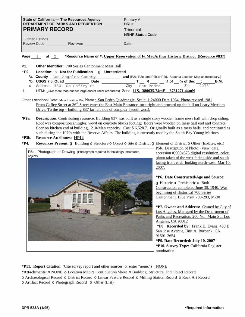
DPR 523A (1/95) *Required information
Page 1 of 2 *Resource Name or #: Upper Reservation of Ft MacArthur Historic District (Resource #837) P1. Other Identifier: 700 Series Cantonment Mess Hall *P2. Location: o Not for Publication g Unrestricted *a. County Los Angeles County and (P2c, P2e, and P2b or P2d. Attach a Location Map as necessary.) *b. USGS 7.5' Quad Date T ; R ; ¼ of ¼ of Sec ; B.M. c. Address 3601 So Gaffey St City San Pedro Zip 90731 d. UTM: (Give more than one for large and/or linear resources) Zone 11S, 380035.74mE 3731271.44mN Other Locational Data: Main Location Map Name: San Pedro Quadrangle Scale: 1:24000 Date 1964, Photo-revised 1981
From Gaffey Street at 36th Street enter the East Main Entrance, turn right and proceed up the hill on Leary Merriam Drive. To the top – building 837 far left side of complex (south west).
*P3a. Description: Contributing resource. Building 837 was built as a single story wooden frame mess hall with drop siding.
Roof was composition shingles, wood on concrete blocks footing; floors were wooden on mess hall end and concrete floor on kitchen end of building,. 210-Man capacity. Cost $ 6,528.7. Originally built as a mess halls, and continued as such during the 1970s with the Reserve Affairs. The building is currently used by the South Bay Young Marines.
*P3b. Resource Attributes: HP14 *P4. Resources Present: g Building oStructure oObject oSite oDistrict gElement of District oOther (Isolates, etc.)
P5b. Description of Photo: (view, date, accession #)900x675 digital resolution, color, photo taken of the west facing side and south facing front end, looking north-west. Mar 10, 2007. *P6. Date Constructed/Age and Source: gHistoric o Prehistoric o Both Construction completed June 30, 1940. Was beginning of Historical 700 Series Cantonment. Blue Print 700-293, M-38 *P7. Owner and Address: Owned by City of Los Angeles, Managed by the Department of Parks and Recreation, 200 No. Main St., Los Angeles, CA 90012 *P8. Recorded by: Frank H. Evans, 430 E San Jose Avenue, Unit A, Burbank, CA 91501-2654 *P9. Date Recorded: July 10, 2007 *P10. Survey Type: California Register nomination
*P11. Report Citation: (Cite survey report and other sources, or enter "none.") NONE *Attachments: oNONE oLocation Map gContinuation Sheet oBuilding, Structure, and Object Record oArchaeological Record oDistrict Record oLinear Feature Record oMilling Station Record oRock Art Record oArtifact Record oPhotograph Record o Other (List)
State of California — The Resources Agency Primary # DEPARTMENT OF PARKS AND RECREATION HRI # PRIMARY RECORD Trinomial NRHP Status Code Other Listings Review Code Reviewer Date
P5a. Photograph or Drawing (Photograph required for buildings, structures, objects

DPR 523A (1/95) *Required information
Page 1 of 1 *Resource Name or #: Upper Reservation of Ft MacArthur Historic District (Resource # 838) P1. Other Identifier: 700 Series Cantonment Barracks, Reserve Affairs *P2. Location: o Not for Publication g Unrestricted *a. County Los Angeles County and (P2c, P2e, and P2b or P2d. Attach a Location Map as necessary.) *b. USGS 7.5' Quad Date T ; R ; ¼ of ¼ of Sec ; B.M. c. Address 3601 So Gaffey St City San Pedro Zip 90731 d. UTM: (Give more than one for large and/or linear resources) Zone 11S, 380047.26mE 3731249.88mN Other Locational Data: Main Location Map Name: San Pedro Quadrangle Scale: 1:24000 Date 1964, Photo-revised 1981
From Gaffey Street at 36th Street enter the East Main Entrance, turn right and proceed up the hill on Leary Merriam Drive.
*P3a. Description: This contributing resource was built as a 2 story wood frame, 79 Man capacity barracks with drop siding, roof was composition shingles. 24 double hung, 12 glass panes (3x4 – 6 top 6 bottom), wood stairways each side to the second floor. First floor entrances each side and one end with either wood stairs or concrete stoops. The units at Ft MacArthur are unique in that they had no plumbing and external latrines were provided, a concept to support adjacent tent encampments. Cost $6,619.00. Originally used as a enlisted men’s barracks, in 1970s as a Reserve Affairs Barracks and now by the South Bay Young Marines.
*P3b. Resource Attributes: HP14, HP35 *P4. Resources Present: g Building oStructure oObject oSite oDistrict gElement of District oOther (Isolates, etc.)
P5b. Description of Photo: (view, date, accession #)900x675 digital resolution, color, photo taken of the north facing entrance – west side, facing south. Mar 10, 2007. *P6. Date Constructed/Age and Source: gHistoric o Prehistoric o Both Construction completed June 30, 1940. Was beginning of Historical 700 Series Cantonment. Blue Print 700-268, B-36 *P7. Owner and Address: Owned by City of Los Angeles, Managed by the Department of Parks and Recreation, 200 No. Main St., Los Angeles, CA 90012 *P8. Recorded by: Fort MacArthur Museum Association (Frank Evans) San Pedro, CA *P9. Date Recorded: July 10, 2007 *P10. Survey Type: California Register nomination.
*P11. Report Citation: (Cite survey report and other sources, or enter "none.") NONE *Attachments: gNONE oLocation Map oContinuation Sheet oBuilding, Structure, and Object Record oArchaeological Record oDistrict Record oLinear Feature Record oMilling Station Record oRock Art Record oArtifact Record oPhotograph Record o Other (List)
State of California — The Resources Agency Primary # DEPARTMENT OF PARKS AND RECREATION HRI # PRIMARY RECORD Trinomial NRHP Status Code Other Listings Review Code Reviewer Date
P5a. Photograph or Drawing (Photograph required for buildings, structures, objects

DPR 523A (1/95) *Required information
Page 1 of 2 *Resource Name or #: Upper Reservation of Ft MacArthur Historic District (Resource Nr 839) P1. Other Identifier: : 700 Series Cantonment Mess Hall *P2. Location: o Not for Publication g Unrestricted *a. County Los Angeles County and (P2c, P2e, and P2b or P2d. Attach a Location Map as necessary.) *b. USGS 7.5' Quad Date T ; R ; ¼ of ¼ of Sec ; B.M. c. Address 3601 So Gaffey St City San Pedro Zip 90731 d. UTM: (Give more than one for large and/or linear resources) Zone 11S, 380055.27mE 3731226.89mN Other Locational Data: Main Location Map Name: San Pedro Quadrangle Scale: 1:24000 Date 1964, Photo-revised 1981
From Gaffey Street at 36th Street enter the East Main Entrance, turn right and proceed up the hill on Leary Merriam Drive. To the top – building 839 is fourth on left side.
*P3a. Description: Contributing resource. Building 839 was built as a single story wood frame mess hall with drop siding.
Roof was composition shingles, wood on concrete blocks footing. Floors were wood on mess hall end and concrete floor on kitchen end of building, 210 Man Capacity. Cost $ 6,528.7. Originally built as a mess hall, and continued as such during the 1970s with the Reserve Affairs. The maintenance group of the Los Angeles Department of Recreation and Parks, Pacific Region currently use the building.
*P3b. Resource Attributes: HP14 *P4. Resources Present: g Building oStructure oObject oSite oDistrict gElement of District oOther (Isolates, etc.)
P5b. Description of Photo: (view, date, accession #)900x675 digital resolution, color, photo taken of the west facing side and north facing front end, looking south-west. Mar 10, 2007. *P6. Date Constructed/Age and Source: gHistoric o Prehistoric o Both Construction completed June 30, 1940. Was beginning of Historical 700 Series Cantonment. Blue Print 700-293, M-38 *P7. Owner and Address: Owned by City of Los Angeles, Managed by the Department of Parks and Recreation, 200 No. Main St., Los Angeles, CA 90012 *P8. Recorded by: Frank H. Evans, 430 E San Jose Avenue, Unit A, Burbank, CA 91501-2654 *P9. Date Recorded: July 10, 2007 *P10. Survey Type: California Register nomination
*P11. Report Citation: (Cite survey report and other sources, or enter "none.") NONE *Attachments: oNONE oLocation Map gContinuation Sheet oBuilding, Structure, and Object Record oArchaeological Record oDistrict Record oLinear Feature Record oMilling Station Record oRock Art Record oArtifact Record oPhotograph Record o Other (List)
State of California — The Resources Agency Primary # DEPARTMENT OF PARKS AND RECREATION HRI # PRIMARY RECORD Trinomial NRHP Status Code Other Listings Review Code Reviewer Date
P5a. Photograph or Drawing (Photograph required for buildings, structures, objects

DPR 523A (1/95) *Required information
Page 1 of 1 *Resource Name or #: Upper Reservation of Ft MacArthur Historic District (Resource Nr 840) P1. Other Identifier: 700 Series Cantonment Barracks *P2. Location: o Not for Publication g Unrestricted *a. County Los Angeles County and (P2c, P2e, and P2b or P2d. Attach a Location Map as necessary.) *b. USGS 7.5' Quad Date T ; R ; ¼ of ¼ of Sec ; B.M. c. Address 3601 So Gaffey St City San Pedro Zip 90731 d. UTM: (Give more than one for large and/or linear resources) Zone 11S, 380067.03mE 3731207.16mN Other Locational Data: Main Location Map Name: San Pedro Quadrangle Scale: 1:24000 Date 1964, Photo-revised 1981
From Gaffey Street at 36th Street enter the East Main Entrance, turn right and proceed up the hill on Leary Merriam Drive. To the top – building 840 is third building on the left – inside the double locked gates..
*P3a. Description: This contributing resource was built as a 2 story wood frame, 79 Man capacity barracks with drop siding, roof was composition shingles. 24 double hung, 12 glass panes (3x4 – 6 top 6 bottom), wood stairways each side to the second floor. First floor entrances each side and one end with either wooden stairs or concrete stoops. The units at Ft MacArthur are unique in that they had no plumbing and external latrines were provided, a concept to support adjacent tent encampments. Cost $6,619.00. Originally used as a enlisted men’s barracks, and now by the maintenance group of the Los Angeles Department of Recreation and Parks, Pacific Region.
*P3b. Resource Attributes: HP14, HP35 *P4. Resources Present: g Building oStructure oObject oSite oDistrict gElement of District oOther (Isolates, etc.)
P5b. Description of Photo: (view, date, accession # 900x675 digital resolution, color, photo taken of the west facing side, north facing street entrance – photo taken from street looking south-east. Mar 10, 2007. *P6. Date Constructed/Age and Source: gHistoric o Prehistoric o Both Construction completed June 30, 1940. Was beginning of Historical 700 Series Cantonment. Blue Print 700-268, B-36 *P7. Owner and Address: Owned by City of Los Angeles, Managed by the Department of Parks and Recreation, 200 No. Main St., Los Angeles, CA 90012 *P8. Recorded by: Ft MacArthur Museum Association (Frank Evans) San Pedro, CA *P9. Date Recorded: July 10, 2007 *P10. Survey Type: California Register nomination
*P11. Report Citation: (Cite survey report and other sources, or enter "none.") NONE *Attachments: gNONE oLocation Map oContinuation Sheet oBuilding, Structure, and Object Record oArchaeological Record oDistrict Record oLinear Feature Record oMilling Station Record oRock Art Record oArtifact Record oPhotograph Record o Other (List)
State of California — The Resources Agency Primary # DEPARTMENT OF PARKS AND RECREATION HRI # PRIMARY RECORD Trinomial NRHP Status Code Other Listings Review Code Reviewer Date
P5a. Photograph or Drawing (Photograph required for buildings, structures, objects

DPR 523A (1/95) *Required information
Page 1 of 1 *Resource Name or #: Upper Reservation of Ft MacArthur Historic District (Resource # 841-E) P1. Other Identifier: 700 Series Cantonment Mess Hall; Angles Gate Cultural Center, Angles Gate Park, Studio “E” *P2. Location: o Not for Publication g Unrestricted *a. County Los Angeles County and (P2c, P2e, and P2b or P2d. Attach a Location Map as necessary.) *b. USGS 7.5' Quad Date T ; R ; ¼ of ¼ of Sec ; B.M. c. Address 3601 So Gaffey St City San Pedro Zip 90731 d. UTM: (Give more than one for large and/or linear resources) Zone 11S, 380073.75mE 3731184.19mN Other Locational Data: Main Location Map Name: San Pedro Quadrangle Scale: 1:24000 Date 1964, Photo-revised 1981
From Gaffey Street at 36th Street enter the East Main Entrance, turn right and proceed up the hill on Leary Merriam Drive. To the top – building 841 left side second building.
*P3a. Description: Building 841 was built as a single story wooden frame mess hall with drop siding. Roof was composition
shingles, wood on concrete blocks footing; floors were wooden on mess hall end and concrete floor on kitchen end of building,. 210 Man Capacity. Cost $ 6,528.7. Originally built as a mess halls, and continued as such during the 1970s with the Reserve Affairs. The building is currently used by the Angles Gate Cultural Center as an art studio (E).
*P3b. Resource Attributes: HP14 *P4. Resources Present: g Building oStructure oObject oSite oDistrict gElement of District oOther (Isolates, etc.) P5b. Description of Photo: (view, date, accession #)900x675 digital resolution, color, photo taken of the west facing side and
south street facing front end, looking south-west. Mar 10, 2007. *P6. Date Constructed/Age and Source: gHistoric o Prehistoric o Both Construction completed June 30, 1940. Was beginning of Historical 700 Series Cantonment. Blue Print 700-293, M-38 *P7. Owner and Address: Owned by City of Los Angeles, Managed by the Department of Parks and Recreation, 200 No. Main St., Los Angeles, CA 90012 *P8. Recorded by: Frank H. Evans, 430 E San Jose Avenue, Unit A, Burbank, CA 91501-2654 *P9. Date Recorded: July 10, 2007 *P10. Survey Type: California Register nomination *P11. Report Citation: (Cite survey report and other sources, or enter "none.") NONE
*Attachments: oNONE oLocation Map gContinuation Sheet oBuilding, Structure, and Object Record oArchaeological Record oDistrict Record oLinear Feature Record oMilling Station Record oRock Art Record oArtifact Record oPhotograph Record o Other (List)
State of California — The Resources Agency Primary # DEPARTMENT OF PARKS AND RECREATION HRI # PRIMARY RECORD Trinomial NRHP Status Code Other Listings Review Code Reviewer Date
P5a. Photograph or Drawing (Photograph required for buildings, structures, objects

DPR 523A (1/95) *Required information
Page 1 of 2 *Resource Name or #: Upper Reservation of Ft MacArthur Historic District (Resource # 842D) P1. Other Identifier: 700 Series Cantonment Administration; Angles Gate Cultural Center, Angles Gate Park, Studio “D” *P2. Location: o Not for Publication g Unrestricted *a. County Los Angeles County and (P2c, P2e, and P2b or P2d. Attach a Location Map as necessary.) *b. USGS 7.5' Quad Date T ; R ; ¼ of ¼ of Sec ; B.M. c. Address 3601 So Gaffey St City San Pedro Zip 90731 d. UTM: (Give more than one for large and/or linear resources) Zone 11S, 380083.84 3731164.31mN Other Locational Data: Main Location Map Name: San Pedro Quadrangle Scale: 1:24000 Date 1964, Photo-revised 1981
From Gaffey Street at 36th Street enter the East Main Entrance, turn right and proceed up the hill on Leary Merriam Drive. To the top – building 842 left side first building.
*P3a. Description: Contributing resource. Building 842 was built as a single story wood frame mess hall with drop siding. Roof was composition shingles, wood on concrete blocks footing; floors were wood on mess hall end and concrete floor on kitchen end of building,. 210 Man Capacity. Cost $ 6,528.7. Originally built as a mess hall, and continued as such during the 1970s. Administration Building for the 115th Military Intelligence Group. Affairs. The building is currently used by the Angles Gate Cultural Center as an art studio (D).
*P3b. Resource Attributes: HP14 *P4. Resources Present:g Building oStructure oObject oSite oDistrict gElement of District oOther (Isolates, etc.) P5b. Description of Photo: (view, date, accession # (900x675 digital resolution, color, photo taken of the front east side looking
west. Mar 10, 2007. *P6. Date Constructed/Age and Source: gHistoric o Prehistoric o Both Construction completed June 30, 1940. Was beginning of Historical 700 Series Cantonment. Blue Print 700-293, M-38 *P7. Owner and Address: Owned by City of Los Angeles, Managed by the Department of Parks and Recreation, 200 No. Main St., Los Angeles, CA 90012 *P8. Recorded by: Frank H. Evans, 430 E San Jose Avenue, Unit A, Burbank, CA 91501-2654 *P9. Date Recorded: July 10, 2007 *P10. Survey Type: California Register Nomination *P11. Report Citation: (Cite survey report and other sources, or enter "none.") NONE *Attachments: oNONE oLocation Map
gContinuation Sheet oBuilding, Structure, and Object Record oArchaeological Record oDistrict Record oLinear Feature Record oMilling Station Record oRock Art Record oArtifact Record oPhotograph Record o Other (List)
State of California — The Resources Agency Primary # DEPARTMENT OF PARKS AND RECREATION HRI # PRIMARY RECORD Trinomial NRHP Status Code Other Listings Review Code Reviewer Date
P5a. Photograph or Drawing (Photograph required for buildings, structures, objects

DPR 523A (1/95) *Required information
Page 1 of 3 *Resource Name or #: Upper Reservation of Ft MacArthur Historic District (Resource # 843) P1. Other Identifier: Upper Reservation Seacoast Artillery Monument Angles Gate Park, Battery Osgood-Farley, San Pedro, California *P2. Location: o Not for Publication g Unrestricted *a. County Los Angeles County and (P2c, P2e, and P2b or P2d. Attach a Location Map as necessary.) *b. USGS 7.5' Quad Date T ; R ; ¼ of ¼ of Sec ; B.M. c. Address 3601 So Gaffey St City San Pedro Zip 90731 d. UTM: (Give more than one for large and/or linear resources) Zone 11S, 380096.77mE 3731159.68mN Other Locational Data: Main Location Map Name: San Pedro Quadrangle Scale: 1:24000 Date 1964, Photo-revised 1981
From Gaffey Street at 36th Street enter the East Main Entrance, on left side at Battery Osgood Farley. *P3a. Description: Contributing resource. Wood and glass paneled Seacoast Artillery Monument and measures 8’3” wide by 14’ 9” overall height. The Coast Artillery Monument was originally located in front of the right side of the Administrative building #842. At an unknown time, it was removed and relocated to Fort MacArthur, Lower Reservation (Main Post), and subsequently relocated to its present site at the Fort MacArthur Museum. Although it is not at the original position, the process of movement was to protect destruction by vandals; however it also has been part of changes that occurred in history. Closing of the Upper Reservation, departure of the Regular Army from the Lower Reservation (Main Post) is all part of history of Fort MacArthur, and relocation of the monument is a part of that history. The monument is now adjacent to a flagpole again and is displayed for viewing at the museum, which is within the District being nominated. It is next to Battery Osgood-Farley, a National Register gun fortification. Even though the monument was relocated to a new site, the monument has not been modified. It’s historical integrity has not been lost. *P3b. Resource Attributes: HP14 *P4. Resources Present: oBuilding gStructure oObject oSite oDistrict gElement of District oOther (Isolates, etc.) P5b. Description of Photo: (view, date, accession # 900x675 digital resolution, color, photo taken of the front west side looking
south. Mar 10, 2007. *P6. Date Constructed/Age and Source: gHistoric o Prehistoric o Both Construction completed June 30, 1942. *P7. Owner and Address: Owned by City of Los Angeles, Managed by the Department of Parks and Recreation, 200 No. Main St., Los Angeles, CA 90012 *P8. Recorded by: Frank H. Evans, 430 E San Jose Avenue, Unit A, Burbank, CA 91501-2654 *P9. Date Recorded: July 10, 2007 *P10. Survey Type: California Register nomination *P11. Report Citation: (Cite survey report and other sources, or enter "none.") NONE *Attachments: oNONE oLocation Map gContinuation Sheet oBuilding, Structure, and Object RecordoArchaeological Record oDistrict Record oLinear Feature Record
oMilling Station Record oRock Art Record oArtifact Record oPhotograph Record o Other (List)
State of California — The Resources Agency Primary # DEPARTMENT OF PARKS AND RECREATION HRI # PRIMARY RECORD Trinomial NRHP Status Code Other Listings Review Code Reviewer Date
P5a. Photograph or Drawing (Photograph required for buildings, structures, objects

DPR 523A (1/95) *Required information
Page 1 of 2 *Resource Name or #: Upper Reservation of Ft MacArthur Historic District (Resource # 844) P1. Other Identifier: Wood Flag Pole Angles Gate Park, City of Los Angeles, San Pedro, CA. *P2. Location: o Not for Publication g Unrestricted *a. County Los Angeles County and (P2c, P2e, and P2b or P2d. Attach a Location Map as necessary.) *b. USGS 7.5' Quad Date T ; R ; ¼ of ¼ of Sec ; B.M. c. Address 3601 So Gaffey St City San Pedro Zip 90731 d. UTM: (Give more than one for large and/or linear resources) Zone 11S, 380085.95mE 3731154.59mN Other Locational Data: Main Location Map Name: San Pedro Quadrangle Scale: 1:24000 Date 1964, Photo-revised 1981 *P3a. Description: The flag pole was originally constructed of wood, tapered from large base to a narrow top, of octagon shape and installed in 1940. It uses the standard rope and pulley assembly to hoist the colors full mast. It is unusual to find wooden flag poles in service today. The flag pole is adjacent to the monument pad and in front of the headquarters building. Flag pole was planed on its sides into a octagonal shape, starting at the base and working to the top where it becomes round. The height is unknown.
*P3b. Resource Attributes: HP26 *P4. Resources Present: oBuilding gStructure oObject oSite oDistrict gElement of District oOther (Isolates, etc.)
P5b. Description of Photo: (view, date, accession #)900x675 digital resolution, color, photo taken in front of building 842 looking south, Mar 10, 2007. *P6. Date Constructed/Age and Source: gHistoric o Prehistoric o Both Construction completed 1940, Was beginning of Historical 700 Series Cantonment. *P7. Owner and Address: Owned by City of Los Angeles, Managed by the Department of Parks and Recreation, 200 No. Main St., Los Angeles, CA 90012 *P8. Recorded by: Frank H. Evans, 430 E San Jose Avenue, Unit A, Burbank, CA 91501-2654 *P9. Date Recorded: July 10, 2007 *P10. Survey Type: California Register nomination *P11. Report Citation: (Cite survey report and other
sources, or enter "none.") NONE *Attachments: oNONE oLocation Map gContinuation Sheet oBuilding, Structure, and Object Record oArchaeological Record oDistrict Record oLinear Feature Record oMilling Station Record oRock Art Record oArtifact Record oPhotograph Record o Other (List)
State of California — The Resources Agency Primary # DEPARTMENT OF PARKS AND RECREATION HRI # PRIMARY RECORD Trinomial NRHP Status Code Other Listings Review Code Reviewer Date
P5a. Photograph or Drawing (Photograph required for buildings, structures,
objects

DPR 523A (1/95) *Required information
Page 1 of 2 *Resource Name or #: Upper Reservation of Ft MacArthur Historic District (Resource # 845G) P1. Other Identifier: 700 Series Cantonment Admin. Bldg; Angles Gate Park, Angles Gate Cultural Center, Studio G *P2. Location: o Not for Publication g Unrestricted *a. County Los Angeles County and (P2c, P2e, and P2b or P2d. Attach a Location Map as necessary.) *b. USGS 7.5' Quad Date T ; R ; ¼ of ¼ of Sec ; B.M. c. Address 3601 So Gaffey St City San Pedro Zip 90731 d. UTM: (Give more than one for large and/or linear resources) Zone 11S, 380056.42mE 3731137.68mN Other Locational Data: Main Location Map Name: San Pedro Quadrangle Scale: 1:24000 Date 1964, Photo-revised 1981 From Gaffey Street at 36th Street enter the East Main Entrance, turn right and proceed up the hill on Leary Merriam Drive. To the top – first left, first right on Oro Road, first building on left. *P3a. Description: Contributing resource. Building 845 was built as a single story wood frame mess hall with drop siding. Roof was composition shingles, wood on concrete blocks footing; floors were wood on mess hall end and concrete floor on kitchen end of building,. Little available information. Appears to have been originally built as a mess hall. In the 1970s used for administration–signal film and visual storage. Presently used as an Art Studio G and restroom for the Angles Gate Cultural Center. It appears the building was not constructed with the original 700 series buildings. Maps of what is called Camp Merriam dated May 6, 1940, show 4 buildings where buildings 845-848 now stand as being of different shapes. Also this building 845, along with building 846 are also not on the map, which means they where constructed sometime after the others completed before May 6, 1940. However some other discrepancies exist when using maps and dates to determine structure presence. No blue print numbers are available for the building. It is possible however, this may have been constructed from print 700-433, B-3, a 46 man Medical Barracks. However this cannot be verified at present but is considered to be an accurate assumption until latter verified. Additional research will be conducted and this record amended at a future date. *P3b. Resource Attributes: HP14 *P4. Resources Present: g Building oStructure oObject oSite oDistrict gElement of District oOther (Isolates, etc.)
P5b. Description of Photo: (view, date, accession #)900x675 digital resolution, color, photo taken of the north facing side and west facing back end, looking south-east. Mar 10, 2007. *P6. Date Constructed/Age and Source: gHistoric o Prehistoric o Both Construction completed June 30, 1940. Was beginning of Historical 700 Series Cantonment. Blue Print 700-293, M-38 *P7. Owner and Address: Owned by City of Los Angeles, Managed by the Department of Parks and Recreation, 200 No. Main St., Los Angeles, CA 90012 *P8. Recorded by: Frank H. Evans, 430 E San Jose Avenue, Unit A, Burbank, CA 91501-2654 *P9. Date Recorded: July 10, 2007 *P10. Survey Type California Register nomination
*P11. Report Citation: (Cite survey report and other sources, or enter "none.") NONE *Attachments: oNONE oLocation Map gContinuation Sheet oBuilding, Structure, and Object Record oArchaeological Record oDistrict Record oLinear Feature Record oMilling Station Record oRock Art Record oArtifact Record oPhotograph Record o Other (List)
State of California — The Resources Agency Primary # DEPARTMENT OF PARKS AND RECREATION HRI # PRIMARY RECORD Trinomial NRHP Status Code Other Listings Review Code Reviewer Date
P5a. Photograph or Drawing (Photograph required for buildings, structures, objects
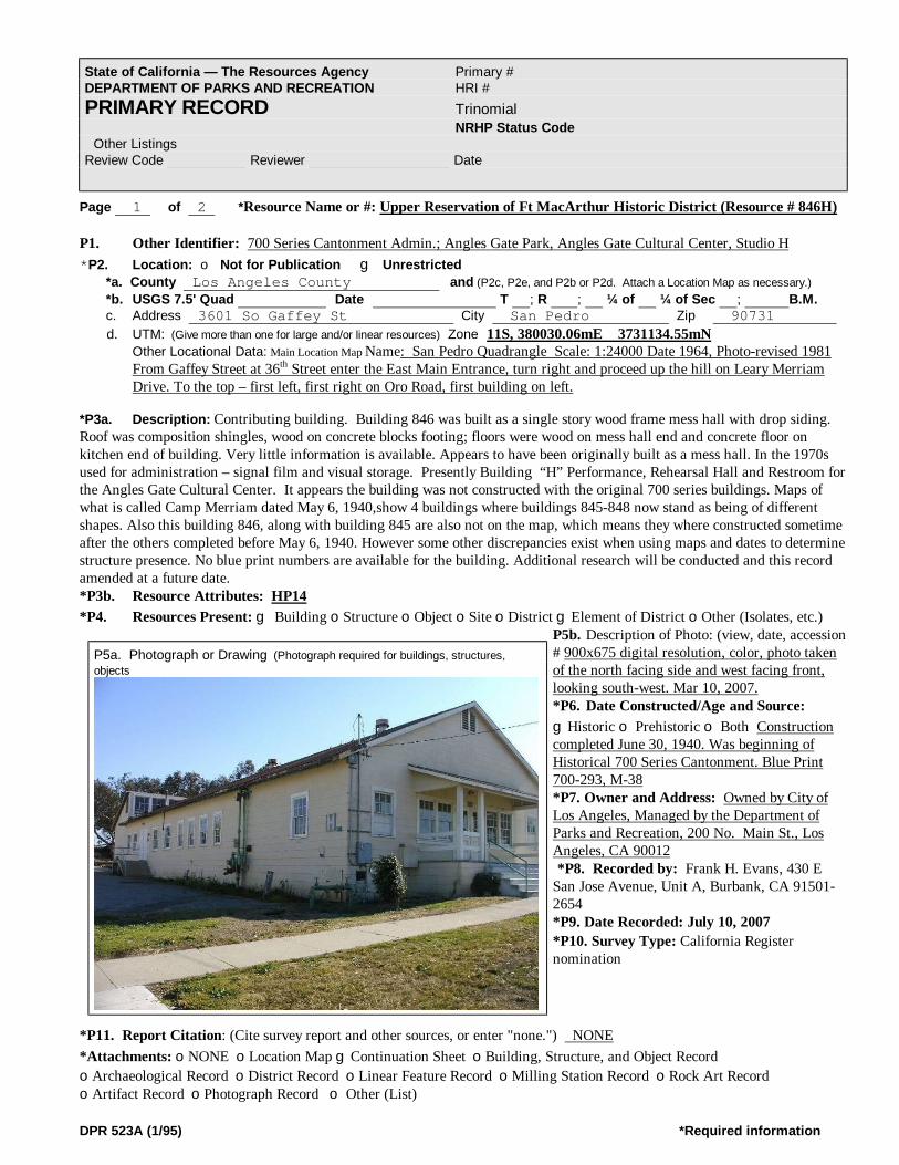
DPR 523A (1/95) *Required information
Page 1 of 2 *Resource Name or #: Upper Reservation of Ft MacArthur Historic District (Resource # 846H) P1. Other Identifier: 700 Series Cantonment Admin.; Angles Gate Park, Angles Gate Cultural Center, Studio H *P2. Location: o Not for Publication g Unrestricted *a. County Los Angeles County and (P2c, P2e, and P2b or P2d. Attach a Location Map as necessary.) *b. USGS 7.5' Quad Date T ; R ; ¼ of ¼ of Sec ; B.M. c. Address 3601 So Gaffey St City San Pedro Zip 90731 d. UTM: (Give more than one for large and/or linear resources) Zone 11S, 380030.06mE 3731134.55mN Other Locational Data: Main Location Map Name: San Pedro Quadrangle Scale: 1:24000 Date 1964, Photo-revised 1981
From Gaffey Street at 36th Street enter the East Main Entrance, turn right and proceed up the hill on Leary Merriam Drive. To the top – first left, first right on Oro Road, first building on left.
*P3a. Description: Contributing building. Building 846 was built as a single story wood frame mess hall with drop siding. Roof was composition shingles, wood on concrete blocks footing; floors were wood on mess hall end and concrete floor on kitchen end of building. Very little information is available. Appears to have been originally built as a mess hall. In the 1970s used for administration – signal film and visual storage. Presently Building “H” Performance, Rehearsal Hall and Restroom for the Angles Gate Cultural Center. It appears the building was not constructed with the original 700 series buildings. Maps of what is called Camp Merriam dated May 6, 1940,show 4 buildings where buildings 845-848 now stand as being of different shapes. Also this building 846, along with building 845 are also not on the map, which means they where constructed sometime after the others completed before May 6, 1940. However some other discrepancies exist when using maps and dates to determine structure presence. No blue print numbers are available for the building. Additional research will be conducted and this record amended at a future date. *P3b. Resource Attributes: HP14 *P4. Resources Present: g Building oStructure oObject oSite oDistrict gElement of District oOther (Isolates, etc.)
P5b. Description of Photo: (view, date, accession # 900x675 digital resolution, color, photo taken of the north facing side and west facing front, looking south-west. Mar 10, 2007. *P6. Date Constructed/Age and Source: gHistoric o Prehistoric o Both Construction completed June 30, 1940. Was beginning of Historical 700 Series Cantonment. Blue Print 700-293, M-38 *P7. Owner and Address: Owned by City of Los Angeles, Managed by the Department of Parks and Recreation, 200 No. Main St., Los Angeles, CA 90012 *P8. Recorded by: Frank H. Evans, 430 E San Jose Avenue, Unit A, Burbank, CA 91501-2654 *P9. Date Recorded: July 10, 2007 *P10. Survey Type: California Register nomination
*P11. Report Citation: (Cite survey report and other sources, or enter "none.") NONE *Attachments: oNONE oLocation Map gContinuation Sheet oBuilding, Structure, and Object Record oArchaeological Record oDistrict Record oLinear Feature Record oMilling Station Record oRock Art Record oArtifact Record oPhotograph Record o Other (List)
State of California — The Resources Agency Primary # DEPARTMENT OF PARKS AND RECREATION HRI # PRIMARY RECORD Trinomial NRHP Status Code Other Listings Review Code Reviewer Date
P5a. Photograph or Drawing (Photograph required for buildings, structures, objects

DPR 523A (1/95) *Required information
Page 1 of 2 *Resource Name or #: Upper Reservation of Ft MacArthur Historic District (Resource # 847) P1. Other Identifier: 700 Series Ward Building; Angles Gate Park, Angles Gate Cultural Center, Studio “F” *P2. Location: o Not for Publication g Unrestricted *a. County Los Angeles County and (P2c, P2e, and P2b or P2d. Attach a Location Map as necessary.) *b. USGS 7.5' Quad Date T ; R ; ¼ of ¼ of Sec ; B.M. c. Address 3601 So Gaffey St City San Pedro Zip 90731 d. UTM: (Give more than one for large and/or linear resources) Zone 11S, 380034.34mE 3731182.07mN Other Locational Data: Main Location Map Name: San Pedro Quadrangle Scale: 1:24000 Date 1964, Photo-revised 1981
From Gaffey Street at 36th Street enter the East Main Entrance, turn right and proceed up the hill on Leary Merriam Drive. To the top – first left, first right on Oro Road, second building on the left.
*P3a. Description: Contributing resource. Building 847 was built as a single story wood frame medical ward with drop siding. Roof was composition shingles, wood on concrete blocks footing; floors were wood on mess hall end and concrete floor on kitchen end of building,. Very little information is available. Appears to have been originally built as a 31 bed Medical Ward. In the 1970s used for administration – signal film and visual storage. Presently Central Classroom and Restrooms for the Angles Gate Cultural Center – building F. Was an administrative building in the 1970s. It appears the building was not constructed with the original 700 series buildings. Maps of what is called Camp Merriam dated May 6, 1940, show 4 buildings where buildings 845-848 now stand as being of different shapes. Also this building 847, along with building 845 and 846 are also not on the map, which means they where constructed sometime after the others completed before May 6, 1940. However some other discrepancies exist when using maps and dates to determine structure presence. No blue print numbers are available for the building, however based on facts in the completion report, it is assumed it was originally the31 man Medical ward – of the 700-462, W-1 type. Additional research will be conducted and this record amended at a future date.
*P3b. Resource Attributes: HP14 *P4. Resources Present: g Building oStructure oObject oSite oDistrict gElement of District oOther (Isolates, etc.)
P5b. Description of Photo: (view, date, accession # 900x675 digital resolution, color, aerial MSN photo taken of the south facing side, looking north-east dated 2007. *P6. Date Constructed/Age and Source: gHistoric o Prehistoric o Both Construction completed June 30, 1940. Was beginning of Historical 700 Series Cantonment. Blue Print 700-462. W1 *P7. Owner and Address: Owned by City of Los Angeles, Managed by the Department of Parks and Recreation, 200 No. Main St., Los Angeles, CA 90012 *P8. Recorded by: Frank H. Evans, 430 E San Jose Avenue, Unit A, Burbank, CA 91501-2654 *P9. Date Recorded: July 10, 2007 *P10. Survey Type: California Register nomination
*P11. Report Citation: (Cite survey report and other sources, or enter "none.") NONE *Attachments: oNONE oLocation Map gContinuation Sheet oBuilding, Structure, and Object Record oArchaeological Record oDistrict Record oLinear Feature Record oMilling Station Record oRock Art Record oArtifact Record oPhotograph Record o Other (List)
State of California — The Resources Agency Primary # DEPARTMENT OF PARKS AND RECREATION HRI # PRIMARY RECORD Trinomial NRHP Status Code Other Listings Review Code Reviewer Date
P5a. Photograph or Drawing (Photograph required for buildings, structures, objects

DPR 523A (1/95) *Required information
Page 1 of 2 *Resource Name or #: Fort MacArthur, Upper Reservation 700 Series, Signal Lab Bldg 848 P1. Other Identifier: Angles Gate Park, Hi-Railers Club, San Pedro, California *P2. Location: o Not for Publication g Unrestricted *a. County Los Angeles County and (P2c, P2e, and P2b or P2d. Attach a Location Map as necessary.) *b. USGS 7.5' Quad Date T ; R ; ¼ of ¼ of Sec ; B.M. c. Address 3601 So Gaffey St City San Pedro Zip 90731 d. UTM: (Give more than one for large and/or linear resources) Zone 11S, 380015.87mE 3731299.95mN
Other Locational Data: Main Location Map Name: San Pedro Quadrangle Scale: 1:24000 Date 1964, Photo-revised 1981 From Gaffey Street at 36th Street enter the East Main Entrance, turn right and proceed up the hill on Leary Merriam Drive.
To the top – first left, first right on Oro Road, last building on the left. *P3a. Description: Building 847 was built as a single story wooden frame with drop siding. Roof was composition shingles, wood on concrete blocks footing; floors were wooden,. Very little information is available. In the 1970s used as a signal photo lab. Also at some point was an auto shop. Presently used for the Hi-Railers model railroading club house It appears the building was not constructed with the original 700 series buildings. Maps of what is called Camp Merriam dated May 6, 1940, show 4 buildings where buildings 845-848 now stand as being of different shapes. Also this building 848, along with building 845 and 846 are also not on the map, which means they where constructed sometime after the others completed before May 6, 1940. However some other discrepancies exist when using maps and dates to determine structure presence. No blue print numbers are available for the building. Additional research will be conducted and this record amended at a future date. It however does meet the 50 year requirement and determined to be a contributing resource. *P3b. Resource Attributes: HP14 *P4. Resources Present: g Building oStructure oObject oSite oDistrict gElement of District oOther (Isolates, etc.)
P5b. Description of Photo: (view, date, accession # 900x675 digital resolution, color, west facing side, south facing end, looking north-east dated Mar 10, 2007. *P6. Date Constructed/Age and Source: gHistoric o Prehistoric o Both Construction completed June 30, 1940. Was beginning of Historical 700 Series Cantonment. Blue Print 700-462. W1 *P7. Owner and Address: Owned by City of Los Angeles, Managed by the Department of Parks and Recreation, 200 No. Main St., Los Angeles, CA 90012 *P8. Recorded by: Frank H. Evans, 430 E San Jose Avenue, Unit A, Burbank, CA 91501-2654 *P9. Date Recorded: July 10, 2007 *P10. Survey Type: California Register Nomination
*P11. Report Citation: (Cite survey report and other sources, or enter "none.") NONE *Attachments: oNONE oLocation Map gContinuation Sheet oBuilding, Structure, and Object Record oArchaeological Record oDistrict Record oLinear Feature Record oMilling Station Record oRock Art Record oArtifact Record oPhotograph Record o Other (List)
State of California — The Resources Agency Primary # DEPARTMENT OF PARKS AND RECREATION HRI # PRIMARY RECORD Trinomial NRHP Status Code Other Listings Review Code Reviewer Date
P5a. Photograph or Drawing (Photograph required for buildings, structures, objects
DPR 523A (1/95) *Required information
Page 1 of 2 *Resource Name or #: Upper Reservation of Ft MacArthur Historic District – Base End Station (Resource Nr. 882) P1. Other Identifier: Angles Gate Park, San Pedro, CA *P2. Location: o Not for Publication g Unrestricted *a. County Los Angeles County and (P2c, P2e, and P2b or P2d. Attach a Location Map as necessary.) *b. USGS 7.5' Quad Date T ; R ; ¼ of ¼ of Sec ; B.M. c. Address 3601 Gaffey St So City San Pedro Zip 90731 d. UTM: (Give more than one for large and/or linear resources) Zone 11S , 380040.80 mE/ 3730953.28mN e. Other Locational Data: Main Location Map Name: San Pedro Quadrangle Scale: 1:24000 Date 1964, Photo-revised 1981
From Gaffey Street at 36th Street enter the East Main Entrance, turn right and proceed up the hill on Leary Merriam Drive. to the top.
*P3a. Description: Beginning in the 1920's, these small concrete "bunkers" were built in several groups on the Upper Reservation, Point Fermin, White Point, Sea Bench and at Point Vicente of Fort MacArthur . These stations were located some distance from their respective emplacements along a measured base line. During World War II additional fire control stations were built for the new weapons systems then under construction to protect the Los Angeles Harbor and the coastline. These structures are technically known as base-end stations, although they are some times called fire control stations, observation stations or fire control bunkers. They are often mistaken for "pill boxes" or machine gun positions. This BES was designated as B4
1 S41 for Battery 240, Bolsa Chica Beach, California south of the Upper Reservation Fort MacArthur approximately 15 miles.
(Continued) *P3b. Resource Attributes: (List attributes and codes) HP11 *P4. Resources Present:oBuilding gStructure oObject oSite District gElement of District oOther (Isolates, etc.) P5b. Description of Photo: (view, date, accession #) Color photo - Base End Station (BES882) March 3, 2007, Digital format 2304 x 1728 DCM42 camera, facing from south to north onhillside in front of the Nike Fire Control Site. *P6. Date Constructed/Age and Source: gHistoric o Prehistoric o Both (unknown – prior to 11Sep1943 *P7. Owner and Address: City of Los Angeles, Department of Parks & Recreation, 200 No. Main St., Los Angeles, CA 90012
*P8. Recorded by: Ft MacArthur Museum Association (Frank Evans), San Pedro, CA *P9. Date Recorded: July 10, 2007 *P10. Survey Type: California Register nomination. *Attachments: oNONE oLocation Map gContinuation Sheet oBuilding, Structure, and Object Record oArchaeological Record oDistrict Record oLinear Feature Record oMilling Station Record oRock Art Record oArtifact Record oPhotograph Record o Other (List):
State of California — The Resources Agency Primary # DEPARTMENT OF PARKS AND RECREATION HRI # PRIMARY RECORD Trinomial NRHP Status Code Other Listings Review Code Reviewer Date
P5a. Photograph or Drawing (Photograph required for buildings, structures, and objects.)
Base End Station (BES882) Located beneath the Missile Tracking Radar Pad
Picture - Digital Photo taken Mar 3, 900 x 675 resolution Ft MacArthur Museum Association Diagram - Completed Works Report 24 August 1944, Archives Ft MacArthur Museum, San Pedro, CA

State of California Primary #__________________________ DEPARTMENT OF PARKS AND RECREATION HRI# _____________________ CONTINUATION SHEET Trinomial __________________________
DPR 523A (1/95) *Required Information
*P3a. Description: (Continued) This particular Base End Station (BES882) is a one (1) level dug in reinforced concrete structure located adjacent to and beneath the Cold War Era Nike Air Defense Missile Tracking Radar Antenna Pad depicting continuity between the World War Seacoast artillery and Cold War defense systems. It cost $3,483.22 to build, obtained electrical power form Batteries Leary Merriam, measuring 16 feet 6 inches overall width, 16’4” deep and 8’ 7.5” height, located at an altitude of 295’ above sea level. . Detailed specifications follow below. Base-end stations contained various optical instruments for making observations of the target. The standard issue for Coast Artillery was the Model 1910A1 Azimuth Telescope which was used to determine horizontal angles of the azimuth to the target from the base-end station. A second and much more complex instrument was the Depression Position Finder (DPF). The DPF was used to determine the vertical azimuth of the target from the base-end station. BES882 utilized one of each DPF and an Azimuth instruments. Azimuth telescopes were mounted on concrete columns, depression range finders were mounted on large eight sided concrete bases. This base end station used both types in all levels of the single and 2 level stations. In the horizontal base system base-end observing stations were placed at each end of a known base line laid out along the coast line. This line constituted the known leg of a triangle. The base line did not necessarily run back in a direct line to the gun position. The displacement of the guns and other factors were calculated by the plotting room. The stations were designated as B' (Prime) and B" (Secondary). The station closest to the directing point was designated as B'. There were several groups of base end stations to allow for combat casualties and target tracking from different points of view. The Fort MacArthur Museum and the San Pedro Bay Historical Society made a joint effort to save some of the 1920's era fire control stations at White Point. We were partially successful. One World War I era fire control station will be preserved in place. The Battery Commander's station for Battery Bunker will be preserved in place, and one of the World War I era fire control station will be moved off its base line and restored for viewing. The Based End Station has been sealed from public access and has not been modified over the years, except for normal wear and tear from the elements and time. The complex interior and features are not visible since it was built into the hillside and concealed for security with its slotted openings readily visible. Fort MacArthur Museum Association, San Pedro, CA.

State of California Primary #__________________________ DEPARTMENT OF PARKS AND RECREATION HRI# _____________________ CONTINUATION SHEET Trinomial __________________________
DPR 523A (1/95) *Required information
Page 1 of 2 *Resource Name or #: Upper Reservation of Fort MacArthur Historic District, Resource #883 - Base End Station P1. Other Identifier: None *P2. Location: o Not for Publication g Unrestricted *a. County Los Angeles County and (P2c, P2e, and P2b or P2d. Attach a Location Map as necessary.) *b. USGS 7.5' Quad Date T ; R ; ¼ of ¼ of Sec ; B.M. c. Address Angles Gate Pk, 3601 S Gaffey St City San Pedro Zip 90731 d. UTM: (Give more than one for large and/or linear resources) Zone 11S, 380116.44mE, 3730997.98mN e. Other Locational Data: Main Location Map Name: San Pedro Quadrangle Scale: 1:24000 Date 1964, Photo-revised 1981 From Gaffey Street at 36th Street enter the East Main Entrance, turn right and proceed up the hill on Leary Merriam Drive. to the top. *P3a. Description: Beginning in the 1920's, these small concrete "bunkers" were built in several groups on the Upper Reservation, Point Fermin, White Point, Sea Bench and at Point Vicente of Fort MacArthur . These stations were located some distance from their respective emplacements along a measured base line. During World War II additional fire control stations were built for the new weapons systems then under construction to protect the Los Angeles Harbor and the coastline. These structures are technically known as base-end stations, although they are some times called fire control stations, observation stations or fire control bunkers. They are often mistaken for "pill boxes" or machine gun positions. This BES was designated as
BC3 B43 S4
3 - B62 S6
2 for Battery 241, on the Upper Reservation under the Korean Bell Monument. (Continued) *P3b. Resource Attributes: (List attributes and codes) *P4. Resources Present:oBuilding gStructure oObject oSite oDistrict gElement of District oOther (Isolates, etc.) P5b. Description of Photo: (view, date, accession #) Color photo - Base End Station (BES88) March 3, 2007, Digital format 2304 x 1728 DCM42 camera, facing from south to north on hillside in front of the Nike Fire Control Site (Marine Exchange). *P6. Date Constructed/Age and Source: gHistoric o Prehistoric o Both (unknown – prior to 11 Sep 1943) *P7. Owner and Address: City of Los Angeles, managed by Department of Parks and Recreation, 200 No. Main St., Los
Angeles, CA 90012 *P8. Recorded by: (Fort MacArthur Museum Association by Frank Evans, San Pedro CA. *P9. Date Recorded: July 19, 2007 *P10. Survey Type: California Register nomination. *Attachments: gNONE oLocation Map gContinuation Sheet oBuilding, Structure, and Object Record oArchaeological Record oDistrict Record oLinear Feature Record oMilling Station Record oRock Art Record oArtifact Record oPhotograph Record o Other (List):
State of California — The Resources Agency Primary # DEPARTMENT OF PARKS AND RECREATION HRI # PRIMARY RECORD Trinomial NRHP Status Code Other Listings Review Code Reviewer Date
P5a. Photograph or Drawing (Photograph required for buildings, structures, and objects.)
Base End Station (BES883) Located beneath the Missile Tracking Radar Pad Digital Photo taken Mar 3, 900 x 675 resolution Ft MacArthur Museum Association

State of California Primary #__________________________ DEPARTMENT OF PARKS AND RECREATION HRI# _____________________ CONTINUATION SHEET Trinomial __________________________ Page 2 of 3 pages *Resource Name or #: Upper Reservation of Fort MacArthur Historic District (Resource Nr 883) Base End Station Recorded by:_______ Fort MacArthur Museum Association (Frank H. Evans) _____ Date: ______06/15/2007_____________ gContinuation 1 Update __________________________________________________________________________________________________________
DPR 523A (1/95) *Required information
*P3a. Description: (Continued) Tracking Radar Antenna Pad depicting continuity between the World War Seacoast artillery and Cold War defense systems. It cost $ 3, 483.22 to build, obtained electrical power form Batteries Leary Merriam, measuring 16 feet 6 inches overall width, 16’4” deep and 8’ 7.5” height, located at an altitude of 295’ above sea level, using 1 – DPF and 1 – azimuth observation instruments, Detailed specifications follow below. Base-end stations contained various optical instruments for making observations of the target. The standard issue for Coast Artillery was the Model 1910A1 Azimuth Telescope which was used to determine horizontal angles of the azimuth to the target from the base-end station. A second and much more complex instrument was the Depression Position Finder (DPF). The DPF was used to determine the vertical azimuth of the target from the base-end station. Azimuth telescopes were mounted on concrete columns, depression range finders were mounted on large eight sided concrete bases. This base end station used both types in all levels of the single and 2 level stations. In the horizontal base system base-end observing stations were placed at each end of a known base line laid out along the coast line. This line constituted the known leg of a triangle. The base line did not necessarily run back in a direct line to the gun position. The displacement of the guns and other factors were calculated by the plotting room. The stations were designated as B' (Prime) and B" (Secondary). The station closest to the directing point was designated as B'. There were several groups of base end stations to allow for combat casualties and target tracking from different points of view. The Fort MacArthur Museum and the San Pedro Bay Historical Society made a joint effort to save some of the 1920's era fire control stations at White Point. We were partially successful. One World War I era fire control station will be preserved in place. The Battery Commander's station for Battery Bunker will be preserved in place, and one of the World War I era fire control station will be moved off its base line and restored for viewing. The Based End Station has been sealed from public access and has not been modified over the years, except for normal wear and tear from the elements and time. The complex interior and features are not visible since it was built into the hillside and concealed for security with its slotted openings readily visible.

State of California Primary #__________________________ DEPARTMENT OF PARKS AND RECREATION HRI# _____________________ CONTINUATION SHEET Trinomial __________________________ Page 3 of 3 pages *Resource Name or #: Upper Reservation of Fort MacArthur Historic District (Resource Nr 883) Base End Station Recorded by:_______ Fort MacArthur Museum Association (Frank H. Evans) _____ Date: ______06/15/2007_____________ gContinuation 1 Update __________________________________________________________________________________________________________
DPR 523A (1/95) *Required information
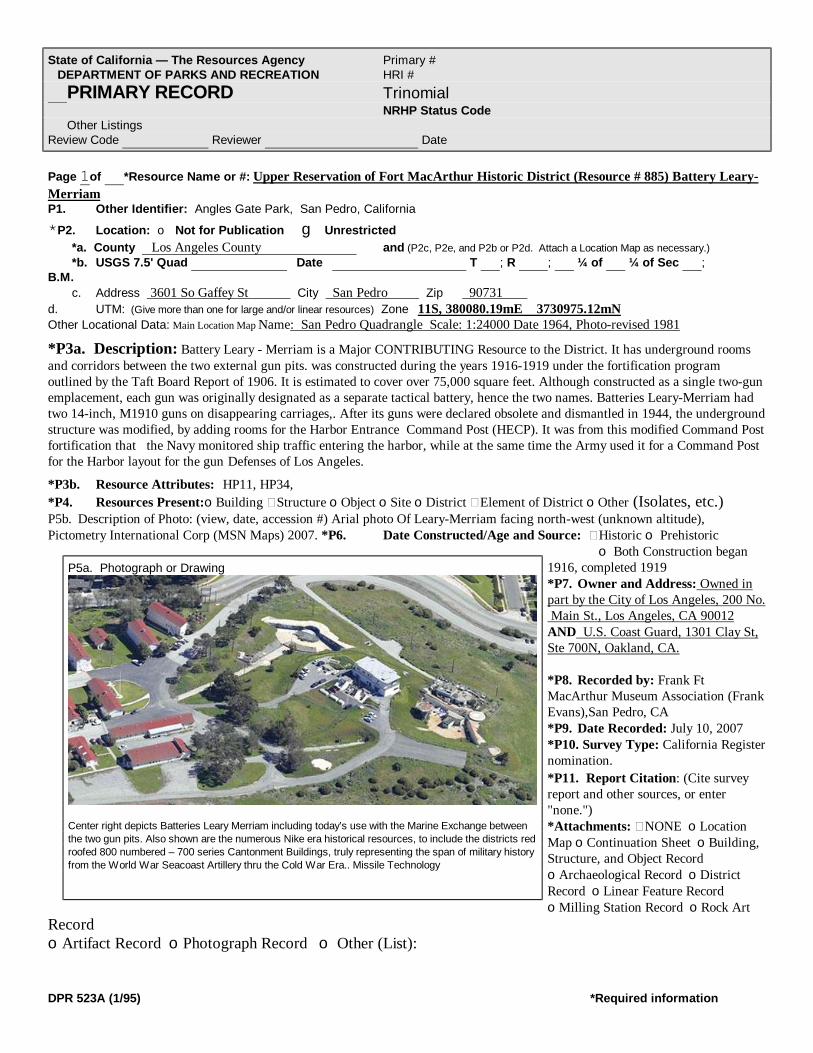
State of California — The Resources Agency Primary # DEPARTMENT OF PARKS AND RECREATION HRI # PRIMARY RECORD Trinomial NRHP Status Code Other Listings Review Code Reviewer Date
DPR 523A (1/95) *Required information
Page 1of *Resource Name or #: Upper Reservation of Fort MacArthur Historic District (Resource # 885) Battery Leary-Merriam P1. Other Identifier: Angles Gate Park, San Pedro, California *P2. Location: o Not for Publication g Unrestricted *a. County Los Angeles County and (P2c, P2e, and P2b or P2d. Attach a Location Map as necessary.) *b. USGS 7.5' Quad Date T ; R ; ¼ of ¼ of Sec ; B.M. c. Address 3601 So Gaffey St City San Pedro Zip 90731 d. UTM: (Give more than one for large and/or linear resources) Zone 11S, 380080.19mE 3730975.12mN Other Locational Data: Main Location Map Name: San Pedro Quadrangle Scale: 1:24000 Date 1964, Photo-revised 1981
*P3a. Description: Battery Leary - Merriam is a Major CONTRIBUTING Resource to the District. It has underground rooms and corridors between the two external gun pits. was constructed during the years 1916-1919 under the fortification program outlined by the Taft Board Report of 1906. It is estimated to cover over 75,000 square feet. Although constructed as a single two-gun emplacement, each gun was originally designated as a separate tactical battery, hence the two names. Batteries Leary-Merriam had two 14-inch, M1910 guns on disappearing carriages,. After its guns were declared obsolete and dismantled in 1944, the underground structure was modified, by adding rooms for the Harbor Entrance Command Post (HECP). It was from this modified Command Post fortification that the Navy monitored ship traffic entering the harbor, while at the same time the Army used it for a Command Post for the Harbor layout for the gun Defenses of Los Angeles.
*P3b. Resource Attributes: HP11, HP34, *P4. Resources Present:oBuilding Structure oObject oSite oDistrict Element of District oOther (Isolates, etc.) P5b. Description of Photo: (view, date, accession #) Arial photo Of Leary-Merriam facing north-west (unknown altitude), Pictometry International Corp (MSN Maps) 2007. *P6. Date Constructed/Age and Source: Historic o Prehistoric
o Both Construction began 1916, completed 1919 *P7. Owner and Address: Owned in part by the City of Los Angeles, 200 No. Main St., Los Angeles, CA 90012 AND U.S. Coast Guard, 1301 Clay St, Ste 700N, Oakland, CA. *P8. Recorded by: Frank Ft MacArthur Museum Association (Frank Evans),San Pedro, CA *P9. Date Recorded: July 10, 2007 *P10. Survey Type: California Register nomination. *P11. Report Citation: (Cite survey report and other sources, or enter "none.") *Attachments: NONE oLocation Map oContinuation Sheet oBuilding, Structure, and Object Record oArchaeological Record oDistrict Record oLinear Feature Record oMilling Station Record oRock Art
Record oArtifact Record oPhotograph Record o Other (List):
P5a. Photograph or Drawing
Center right depicts Batteries Leary Merriam including today’s use with the Marine Exchange between the two gun pits. Also shown are the numerous Nike era historical resources, to include the districts red roofed 800 numbered – 700 series Cantonment Buildings, truly representing the span of military history from the World War Seacoast Artillery thru the Cold War Era.. Missile Technology

State of California Primary #_________________________________ DEPARTMENT OF PARKS AND RECREATION HRI# _________________________________ CONTINUATION SHEET Trinomial __________________________ 1 of 1 *Resource Name or Upper Reservation, Ft MacArthur Histric District #885 Recorded by:_______ Fort MacArthur Museum Association (Frank H. Evans) Date: 06/15/2007 Continuation 1 Update ________________________________________________________________________________________________
DPR 523A (1/95) *Required information
*P3a. Description: (Continuation) Blue print copies are attached for comparison of battery and latter for use as the command posts. Details of dates, costs, construction, specifications and dimensions are included on the drawings. During the mid 1950s and into the mid 1970’s, the structure was used as the Integrated Fire Control (IFC) area for the Nike Ajax and latter the Nike Hercules Air Defense Missile System of Site 43, the fort MacArthur Nike Site. The Nike Sites Launcher Area was at White Point, a few miles to the west and was placed on the States of California’s Historical Register in 2001. The Nike sites Battery Control/Director Station trailer and the Radar Control/Tracking Station Trailer were both attached to a Maintenance and Service (Corridor) Building; two tracking radars towers, and an Acquisition Radar were located within Battery Leary's gun pit. The HIPAR Radar building was built over the underground structure of Leary-Merriam. The HIPAR Radar tower was adjacent to the Merriam gun pit and the generator building built in front of Battery Leary. The HIPAR building is now part of the Marine Exchange Building, a modern day equivalent of the Navy's old HECP. The underground portions of Batteries Leary – Merriam are beneath the land now owned by the Unites States Coast Guard which was quit claim deeded after being declared excess. Exactly what portions of the magazine are under US Coast Guard property has not been determined. A survey would need to be completed to detail coexistence of historical resources. Right of way and right of entry has been granted to the US Coast Guard in the quit claim deed (original document was modified to correct data and filed in the Los Angeles County Recorders Office, document 79-1016123, Sep 12. 1979). The same document deeded surrounding land to the City of Angeles, Department of Recreation and Parks. Because of the complicated structure, dimensions and figures are provided in the following drawings and tables obtained from historical documents archived at the Fort MacArthur Museum, San Pedro, California, and not indicated throughout this description. Construction History: Such protection or defense was developed around major caliber rifles (cannons) and electrically controlled mine fields. As previously mentioned the Coast or Harbor Defenses we-re the responsibility of the Army and the delegated branch of service for such defenses was the Coast Artillery. The design of such gun emplacements or fortifications at this period of time had retreated from a casement type of installation, in which the armament would be visible to offshore attacking naval ships, to the placing of the fortification at the ground level or line, the construction being compatible to the terrain - thus the net result was a gun emplacement or fortification which was at ground level and not visible to observation by off-shore attacking naval ships. To make such an emplacement or fortification practical, a rifle (cannon) was developed upon what was known as a disappearing carriage. This rifle (cannon) was not visible above the terrain level except when in the position to fire. All fire control was by remotely located base—end fire control n stations employing optical instruments for tracking of the target. The azimuth reading of these base end stations was translated into position location of the target graphically on a plotting board within the gun emplacements. Since the area of defense was incorporated within a local plane grid coordinate system, theoretically the gun emplacement should inflict a direct hit upon the target with each round of ammunition fired. However, the laws of ballistics, winds, earth rotation, heights and the ammunition (powder) made such an accomplishment difficult. It was upon the firing command that the rifle upon the disappearing carriage was
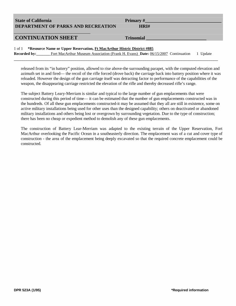
State of California Primary #_________________________________ DEPARTMENT OF PARKS AND RECREATION HRI# _________________________________ CONTINUATION SHEET Trinomial __________________________ 1 of 1 *Resource Name or Upper Reservation, Ft MacArthur Histric District #885 Recorded by:_______ Fort MacArthur Museum Association (Frank H. Evans) Date: 06/15/2007 Continuation 1 Update ________________________________________________________________________________________________
DPR 523A (1/95) *Required information
released from its “in battery” position, allowed to rise above-the surrounding parapet, with the computed elevation and azimuth set in and fired— the recoil of the rifle forced (drove back) the carriage back into battery position where it was reloaded. However the design of the gun carriage itself was detracting factor to performance of the capabilities of the weapon, the disappearing carriage restricted the elevation of the rifle and thereby decreased rifle’s range. The subject Battery Leary-Merriam is similar and typical to the large number of gun emplacements that were constructed during this period of time— it can be estimated that the number of gun emplacements constructed was in the hundreds. Of all these gun emplacements constructed-it may be assumed that they all are still in existence, some on active military installations being used for other uses than the designed capability; others on deactivated or abandoned military installations and others being lost or overgrown by surrounding vegetation. Due to the type of construction; there has been no cheap or expedient method to demolish any of these gun emplacements.
The construction of Battery Lear-Merriam was adapted to the existing terrain of the Upper Reservation, Fort MacArthur overlooking the Pacific Ocean in a southeasterly direction. The emplacement was of a cut and cover type of construction - the area of the emplacement being deeply excavated so that the required concrete emplacement could be constructed.

DPR 523A (1/95) *Required information
Page _1_ of ___1 *Resource Name or #: Upper Reservation of Ft MacArthur Historic District -Tunnels and Adits (Historic Resource Number 8X3) P1. Other Identifier:. Angles Gate Park, Los Angeles Recreation and Parks, San Pedro, CA *P2 Location: Not for Publication g Unrestricted *a. County of Los Angeles and (P2c, P2e, and P2b or P2d. Attach a Location Map as necessary.) *b. USGS 7.5’ Quad____________ Date_____________ T____; R____; ___ ¼ of Sec____; _____B.M.
c. Address: at 3601 S. Gaffey Street, San Pedro, California, 90731 d. UTM: (Give more than one for large and/or linear resources) Zone _11S__, __380184.40mE/ ___3730898.90_mN e. Other Location Data: Tunnels interconnect throughout Angles Gate Park, segments over 4,960 feet underground.
*P3a. Description: Tunnels currently considered as NON-CONTRIBUTING. 4,960’ of underground tunnels of 14 segments, constructed with natural earthen walls, floors and ceilings, with wooden shoring and reinforcements. They present a very unique and unusual resource, interconnecting buildings and artillery gun batteries. One known entrance is located at 32nd Street and Gaffey, and is fenced to preclude vandal entrance. The opening is approximately 7’ by 8’. The tunnels could not be safely investigated inside during the nomination survey. HOWEVER, the tunnels hold exceedingly great potentials for disclosure of additional historical and technical data upon proper thorough, proper and complete investigation. A group of research engineers at the Carnegie Mellon University is working on surveying these tunnels with remote controlled infrared photographic robots. *P3b. Resource Attributes: (List attributes and codes) HP43 HP11 P4. Resources Present: o Building gStructure
oObject oSite oDistrict gElement of District oOther (Isolates, etc.) P5b. Description of Photo: (view, date, accession #) Tunnel Survey Map – Upper Reservation, Ft. MacArthur California, Office of the Post Engineers. 1 inch equal 50 feet, Jan 15, 1944. Tunnels below ground are not visible for photography of area *P6. Date Constructed/Age and
Source: gHistoric o Prehistoric o Both Constructed in 1942 *P7.Owner and Address: City of Los Angeles, 200 No. Main St., Los Angeles, CA 90012. *P8. Recorded by: Ft MacArthur Museum Association San Pedro, CA *P9. Date Recorded: July 10,2007 *P10. Survey Type: California Register nomination *P11. Report Citation: (Cite survey report and other sources, or enter "none.") None known
*Attachments: oNONE oLocation Map oContinuation Sheet oBuilding, Structure, and Object Record oArchaeological Record oDistrict Record Linear Feature Record oMilling Station Record oRock Art Record
State of California — The Resources Agency Primary # DEPARTMENT OF PARKS AND RECREATION HRI # PRIMARY RECORD Trinomial NRHP Status Code Other Listings Review Code Reviewer Date
P5a. Photograph or Drawing
Map depicting major segments proposed and major segments completed. Tunnels and Adits interconnected Batteries Osgood-Farley and Leary/Merriam to the barracks, and provided for 4 portals. 4,950 feet plus of tunnels were constructed and completed.

DPR 523A (1/95) *Required information
oArtifact Record oPhotograph Record Other (List):