Embed Size (px)
Citation preview
STANDING ROCK RESERVATION ?List of Topics
BACKGROUND � Reservation Overview�
� Regional Geologic Overview
GEOLOGIC OVERVIEW�
� Summary of Play Types � Regional Production Overview
CONVENTIONAL PLAY TYPES � Play 1 - Cretaceous Muddy/Dakota/Lakota Play � Play 2 - Mississippian Shoreline Play � Play 3 - Ordovician Red River Play
CONVENTIONAL/UNCONVENTIONAL PLAY TYPES � Play 4 - Cretaceous Pierre/Niobrara Biogenic Gas Plays � Play 5 - Cretaceous Pierre/Greenhorn Limestone Play � Play 6 - Pennsylvanian Leo Play � Play 7 - Cretaceous Carlile Shale/Turner Sandstone Play � Play 8 - Cretaceous Shannon/Sussex Sands Play
REFERENCES
Standing Rock Reservation
OVERVIEW
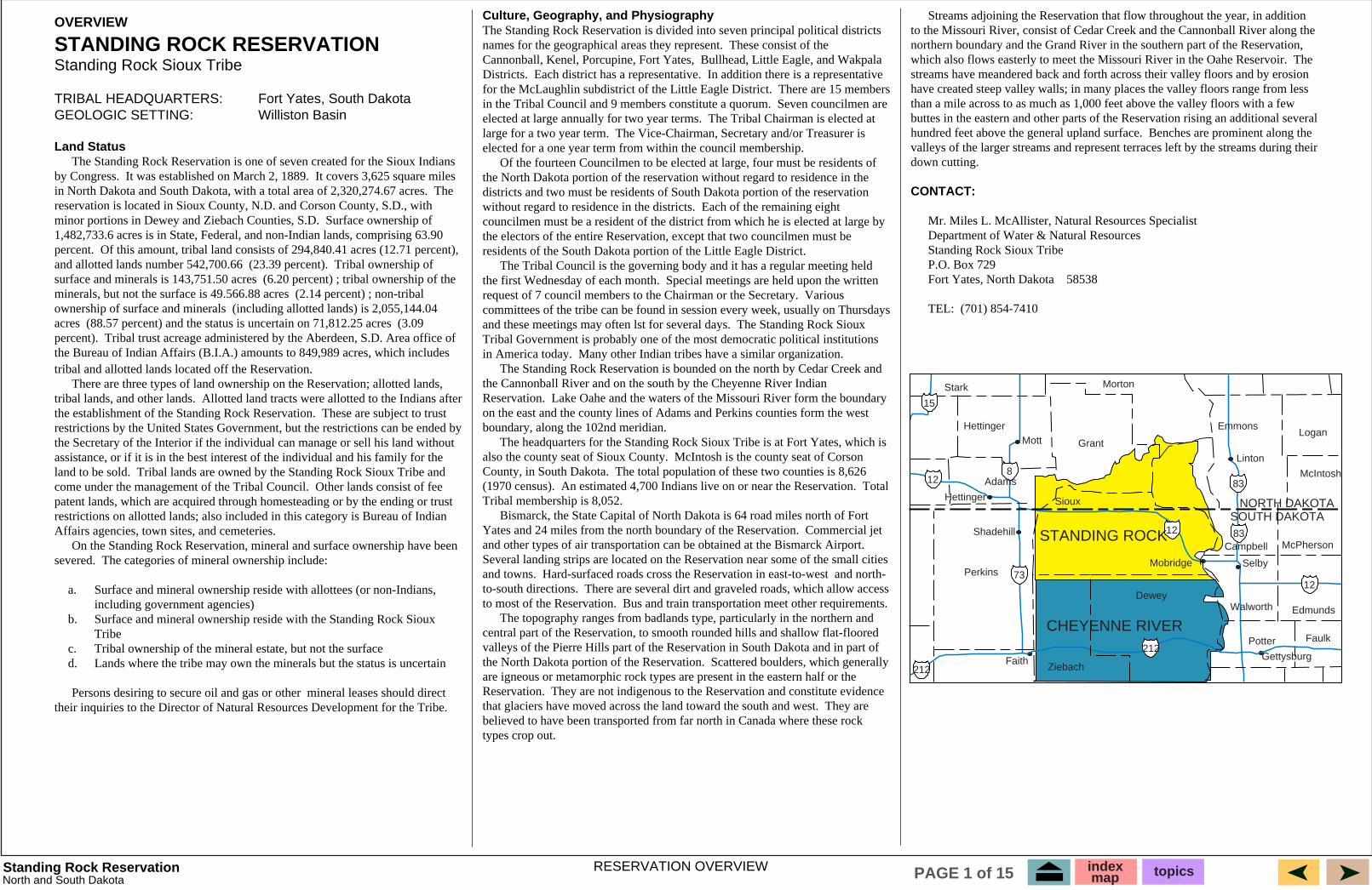
STANDING ROCK RESERVATION Standing Rock Sioux Tribe
TRIBAL HEADQUARTERS: � Fort Yates, South Dakota GEOLOGIC SETTING: � � Williston Basin
Land Status � by Congress. It was established on March 2, 1889.
The
minor portions in Dewey and Ziebach Counties, S.D.
percent. and allotted lands number 542,700.66 (23.39 percent). surface and minerals is 143,751.50 acres minerals, but not the surface is 49.566.88 acres ownership of surface and minerals acres (3.09 percent).
tribal and allotted lands located off the Reservation. � tribal lands, and other lands. the establishment of the Standing Rock Reservation.
land to be sold. come under the management of the Tribal Council.
Affairs agencies, town sites, and cemeteries. � severed. The categories of mineral ownership include:
a.� � � including government agencies) b.� � � Tribe c.� d.�
� Persons desiring to secure oil and gas or other
Culture, Geography, and Physiography
names for the geographical areas they represent. Cannonball, Kenel, Porcupine, Fort Yates, Districts. Each district has a representative. for the McLaughlin subdistrict of the Little Eagle District. There are 15 members in the Tribal Council and 9 members constitute a quorum.
The Tribal Chairman is elected at large for a two year term.
�
without regard to residence in the districts.
� the first Wednesday of each month.
Various
and these meetings may often lst for several days.
in America today. �
Reservation.
boundary, along the 102nd meridian. � also the county seat of Sioux County. County, in South Dakota. (1970 census). Total Tribal membership is 8,052. �
Commercial jet
and towns. and north-to-south directions. to most of the Reservation. �
the North Dakota portion of the Reservation.
Reservation. They are
types crop out.
�
The
hundred feet above the general upland surface.
down cutting.
CONTACT:
� Mr. Miles L. McAllister, Natural Resources Specialist � Department of Water & Natural Resources � Standing Rock Sioux Tribe � P.O. Box 729 � Fort Yates, North Dakota 58538
� TEL: (701) 854-7410
73
8
15
83
83
12
212
212
Mott
Faith
Selby
Linton
Gettysburg
Mobridge
Hettinger
Shadehill
Perkins
Hettinger
Grant
Stark Morton
Adams
Emmons Logan
McIntosh
Edmunds
McPherson
Potter Faulk
Walworth
Campbell
Dewey
Ziebach
Sioux
12
12
STANDING ROCK
CHEYENNE RIVER
NORTH DAKOTA SOUTH DAKOTA
RESERVATION OVERVIEW North and South Dakota
index map topicsPAGE 1 of 15
The Standing Rock Reservation is one of seven created for the Sioux Indians It covers 3,625 square miles
in North Dakota and South Dakota, with a total area of 2,320,274.67 acres. reservation is located in Sioux County, N.D. and Corson County, S.D., with
Surface ownership of 1,482,733.6 acres is in State, Federal, and non-Indian lands, comprising 63.90
Of this amount, tribal land consists of 294,840.41 acres (12.71 percent), Tribal ownership of
(6.20 percent) ; tribal ownership of the (2.14 percent) ; non-tribal
(including allotted lands) is 2,055,144.04 (88.57 percent) and the status is uncertain on 71,812.25 acres
Tribal trust acreage administered by the Aberdeen, S.D. Area office of the Bureau of Indian Affairs (B.I.A.) amounts to 849,989 acres, which includes
There are three types of land ownership on the Reservation; allotted lands, Allotted land tracts were allotted to the Indians after
These are subject to trust restrictions by the United States Government, but the restrictions can be ended by the Secretary of the Interior if the individual can manage or sell his land without assistance, or if it is in the best interest of the individual and his family for the
Tribal lands are owned by the Standing Rock Sioux Tribe and Other lands consist of fee
patent lands, which are acquired through homesteading or by the ending or trust restrictions on allotted lands; also included in this category is Bureau of Indian
On the Standing Rock Reservation, mineral and surface ownership have been
Surface and mineral ownership reside with allottees (or non-Indians, �
Surface and mineral ownership reside with the Standing Rock Sioux �
Tribal ownership of the mineral estate, but not the surface Lands where the tribe may own the minerals but the status is uncertain
mineral leases should direct their inquiries to the Director of Natural Resources Development for the Tribe.
The Standing Rock Reservation is divided into seven principal political districts These consist of the
Bullhead, Little Eagle, and Wakpala In addition there is a representative
Seven councilmen are elected at large annually for two year terms.
The Vice-Chairman, Secretary and/or Treasurer is elected for a one year term from within the council membership.
Of the fourteen Councilmen to be elected at large, four must be residents of the North Dakota portion of the reservation without regard to residence in the districts and two must be residents of South Dakota portion of the reservation
Each of the remaining eight councilmen must be a resident of the district from which he is elected at large by the electors of the entire Reservation, except that two councilmen must be residents of the South Dakota portion of the Little Eagle District.
The Tribal Council is the governing body and it has a regular meeting held Special meetings are held upon the written
request of 7 council members to the Chairman or the Secretary. committees of the tribe can be found in session every week, usually on Thursdays
The Standing Rock Sioux Tribal Government is probably one of the most democratic political institutions
Many other Indian tribes have a similar organization. The Standing Rock Reservation is bounded on the north by Cedar Creek and
the Cannonball River and on the south by the Cheyenne River Indian Lake Oahe and the waters of the Missouri River form the boundary
on the east and the county lines of Adams and Perkins counties form the west
The headquarters for the Standing Rock Sioux Tribe is at Fort Yates, which is McIntosh is the county seat of Corson
The total population of these two counties is 8,626 An estimated 4,700 Indians live on or near the Reservation.
Bismarck, the State Capital of North Dakota is 64 road miles north of Fort Yates and 24 miles from the north boundary of the Reservation. and other types of air transportation can be obtained at the Bismarck Airport. Several landing strips are located on the Reservation near some of the small cities
Hard-surfaced roads cross the Reservation in east-to-west There are several dirt and graveled roads, which allow access
Bus and train transportation meet other requirements. The topography ranges from badlands type, particularly in the northern and
central part of the Reservation, to smooth rounded hills and shallow flat-floored valleys of the Pierre Hills part of the Reservation in South Dakota and in part of
Scattered boulders, which generally are igneous or metamorphic rock types are present in the eastern half or the
They are not indigenous to the Reservation and constitute evidence that glaciers have moved across the land toward the south and west. believed to have been transported from far north in Canada where these rock
Streams adjoining the Reservation that flow throughout the year, in addition to the Missouri River, consist of Cedar Creek and the Cannonball River along the northern boundary and the Grand River in the southern part of the Reservation, which also flows easterly to meet the Missouri River in the Oahe Reservoir. streams have meandered back and forth across their valley floors and by erosion have created steep valley walls; in many places the valley floors range from less than a mile across to as much as 1,000 feet above the valley floors with a few buttes in the eastern and other parts of the Reservation rising an additional several
Benches are prominent along the valleys of the larger streams and represent terraces left by the streams during their
Regional GeologyStanding Rock Reservation
42
41
BF
BK FP
BR
SR
Weldon-Brockton Fault
Cedar C
reek
Anticline
Miles CityArch
Cat Creek Fault
Syncline
Sumatra Syncline
Blood Creek
Willow CreekFault
Lake Basin FaultNye-BowlerFault
Bull Mountains
Basin
WheatlandSyncline
CrazyMountains
Basin
Sw
eetgrass A
rch
Bowdoin
Dom
e Fault
Porcupine Dome
Poplar Fault
Poplar Dome
Nes
son
Ant
iclin
e
BASIN
Wind
River
BASIN
BIGHORN
WIND RIVER
Mtns
Bighorn M
tns
AbsarokaM
tns Owl
Creek Mtns
BeartoothMtns
Pryor Mtns
Little Belt
Mtns
Judith Mtns Big
Snowy Mtns
OVERTHRUST
BELT
Little Rocky Mtns
Bearpaw Uplift
Sweetwater
Uplift
Casper Mtn Fau
lt
Har
tville
Upl
ift
Casper
Arch
RED DESERT BASIN
HANNA BASIN
ALLIANCE BASIN
GREEN RIVER BASIN
WASHAKE BASIN
Rock Springs Uplift
POWDER RIVER
BASIN
Black Hills Uplift
Laramie Mtns
Medicine
Bow
Mtns
Sierra
Madre Mtns
Chadron
Arch
WILLISTON
BASIN
Uinta Mtns
Hogeland Basin
Alberta Shel f 114
112 110 108 106 104 102 100 98 49
48
47
46
45
44
43
105 103 101 99 97
113 111 109 107
NORTH DAKOTA
NEBRASKA
MONTANA
IDAHO WYOMING
UTAH
COLORADO
CANADA
UNITED STATES
EXPLANATION
Precambrian Basement Uplifts
Other Uplifts or Basins
Anticline
Syncline
FaultsCenezoic Volcanic Fields
Reservations X-sectionA A'
BASIN LARAMIE
SOUTH DAKOTA
SR - Standing Rock BR - Fort Berthold FP - Fort Peck
BK - Fort Belknap BF - Blackfeet
Hinsdale
4000
3000
2000
1000
0
-1000
-2000
-3000
-4000
-8000
-7000
-6000
-5000
104 103-30 103 102-30 102 101-30 101 100-30 100 99-30 99 98-30 98
WEST EAST B'B
Standing Rock
Longitude Values (Degrees)
Cambrian
Precambrian
Tertiary
Upper Cretaceous
Niobrara / Greenhorn
Cambrian
Ele
vatio
n (
Fe
et)
SilurianDevonian
Glacial
Muddy / Newcastle Dakota
Lakota
Jurassic Triassic
Permian
Mississippian
Dawson Bay
Ordovician
Lower Cretacous Muddy / Mowry
Tertiary
Upper Cretaceous
Niobrara / Greenhorn
Pennsylvanian
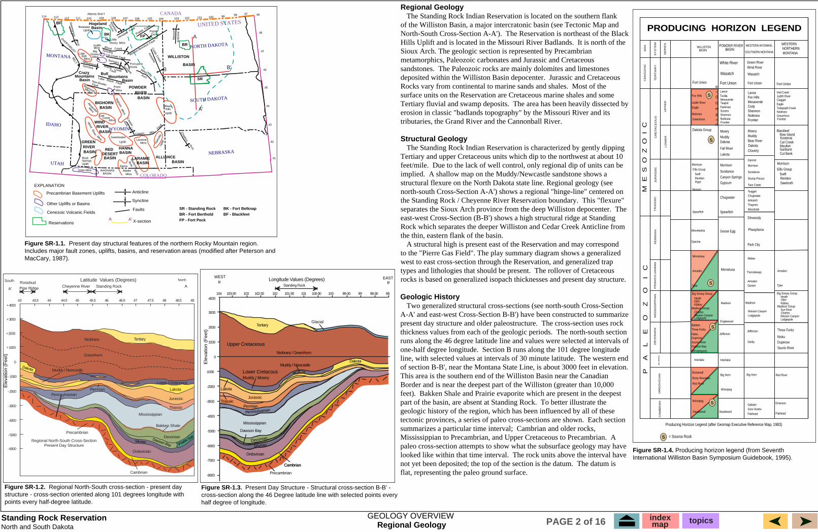
Figure SR-1.1. Present day structural features of the northern Rocky Mountain region. Includes major fault zones, uplifts, basins, and reservation areas (modified after Peterson and MacCary, 1987).
North and South Dakota
Producing Horizon Legend (after Geomap Executive Reference Map, 1983)
= Source Rock
PRODUCING HORIZON LEGEND
Judith River
Niobrara
Greenhorn
Dakota Group
Nesson
Spearfish
Minnekahta
Opeche
Minnelusa
Amsden
Heath
Kibbey
Lodgepole
Bakken Three Forks Nisku Duperow Souris River
Winnipegosis
Red River
Winnipeg
Mowry
Muddy
Fall River
Sundance
Canyon Springs
Gypsum
Chugwater
Spearfish
Goose Egg
Minnelusa
Madison
Lance Fox Hills Mesaverde Cody Shannon
Frontier
Mowry Muddy Bear River
Cloverly
Ankareh Thaynes Woodside
Dinwoody
Park City
Weber
Amsden Darwin
Darby
Madison
Lodgepole
Gallatin
Flathead
Blackleaf Bow Island
Cat Creek Moulton
Cut Bank
Amsden
Heath
Kibbey
Sun River
Lodgepole
Three Forks
Nisku Duperow
Souris River
Red River
Flathead
WESTERN WYOMING
SOUTHERN MONTANA
WESTERN NORTHERN MONTANA
WILLISTON BASIN
POWDER RIVER BASIN
SE
RIE
S
SY
ST
EM
ER
A
TE
RT
IAR
Y
CE
NO
ZO
IC
CR
ETA
CE
OU
S
UP
PE
RLO
WE
R
JU
RA
SS
ICT
RIA
SS
ICP
ER
MIA
NP
EN
NS
YLV
AN
IAN
MIS
SIS
SIP
PIA
ND
EV
ON
IAN
S
ILU
RIA
NO
RD
OV
ICIA
NC
AM
BR
IAN
M E
S
O
Z
O
I
CP
A
L
E
O
Z
O
I
C
B
I O
G
E
N
I
C
Sundance
Stump-Preuss
Twin Creek
Ellis Group
Reirdon Sawtooth
WasatchWasatch
Lance
Parkman Sussex Shannon Niobrara
Hell Creek Judith River
Eagle
Niobrara Greenhorn
Winnipeg
Tensleep
Swift Swift
Fort Union Fort Union
Teckla
Teapot
Telegraph Creek
Figure SR-1.4. Producing horizon legend (from Seventh International Williston Basin Symposium Guidebook, 1995).
S
S
S
S
S
S
Fort UnionFort Union
�Morrison
Ellis Group
Reirdon Piper
Morrison Gannet
Morrison Morrison
Nugget Chugwater
Phosphoria
Tyler Tyler
Big Snowy Group
Otter
Madison Group Charles Mission Canyon
Englewood
Mission Canyon
Big Snowy Group
Otter
Madison Group
Charles Mission Canyon
Dawson Bay
Jefferson Jefferson
Interlake Interlake
Stonewall
Stony Mountain Big Horn Big Horn
Deadwood Deadwood Gros Ventre
Emerson
White River Green River Wind River
Fox Hills
Eagle
Mesaverde
Frontier
Niobrara Frontier
Clagget
Dakota
Lakota
Dakota
Kootenai
Sunburst
GEOLOGY OVERVIEW
Figure SR-1.2. Regional North-South cross-section - present day structure - cross-section oriented along 101 degrees longitude with points every half-degree latitude.
A
A'
B B'
North
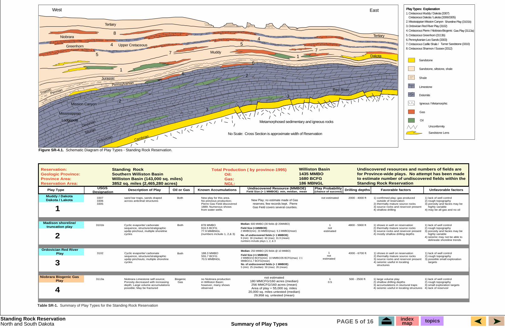
Regional Geology � The Standing Rock Indian Reservation is located on the southern flank of the Williston Basin, a major intercratonic basin (see Tectonic Map and North-South Cross-Section A-A'). The Reservation is northeast of the Black Hills Uplift and is located in the Missouri River Badlands. It is north of the Sioux Arch. The geologic section is represented by Precambrian metamorphics, Paleozoic carbonates and Jurassic and Cretaceous sandstones. The Paleozoic rocks are mainly dolomites and limestones deposited within the Williston Basin depocenter. Jurassic and Cretaceous Rocks vary from continental to marine sands and shales. Most of the surface units on the Reservation are Cretaceous marine shales and some Tertiary fluvial and swamp deposits. The area has been heavily dissected by erosion in classic "badlands topography" by the Missouri River and its tributaries, the Grand River and the Cannonball River.
Structural Geology � The Standing Rock Indian Reservation is characterized by gently dipping Tertiary and upper Cretaceous units which dip to the northwest at about 10 feet/mile. Due to the lack of well control, only regional dip of units can be implied. A shallow map on the Muddy/Newcastle sandstone shows a structural flexure on the North Dakota state line. Regional geology (see north-south Cross-Section A-A') shows a regional "hinge-line" centered on the Standing Rock / Cheyenne River Reservation boundary. This "flexure" separates the Sioux Arch province from the deep Williston depocenter. The east-west Cross-Section (B-B') shows a high structural ridge at Standing Rock which separates the deeper Williston and Cedar Creek Anticline from the thin, eastern flank of the basin. � A structural high is present east of the Reservation and may correspond to the "Pierre Gas Field". The play summary diagram shows a generalized west to east cross-section through the Reservation, and generalized trap types and lithologies that should be present. The rollover of Cretaceous rocks is based on generalized isopach thicknesses and present day structure.
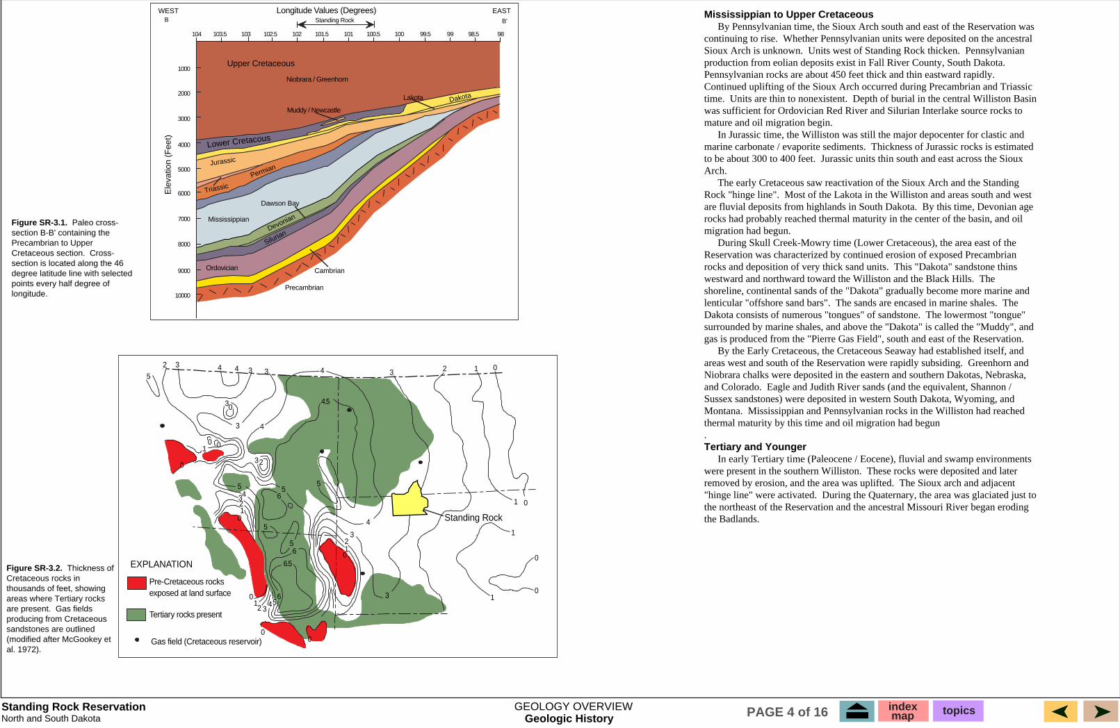
Geologic History � Two generalized structural cross-sections (see north-south Cross-Section A-A' and east-west Cross-Section B-B') have been constructed to summarize present day structure and older paleostructure. The cross-section uses rock thickness values from each of the geologic periods. The north-south section runs along the 46 degree latitude line and values were selected at intervals of one-half degree longitude. Section B runs along the 101 degree longitude line, with selected values at intervals of 30 minute latitude. The western end of section B-B', near the Montana State Line, is about 3000 feet in elevation. This area is the southern end of the Williston Basin near the Canadian Border and is near the deepest part of the Williston (greater than 10,000 feet). Bakken Shale and Prairie evaporite which are present in the deepest part of the basin, are absent at Standing Rock. To better illustrate the geologic history of the region, which has been influenced by all of these tectonic provinces, a series of paleo cross-sections are shown. Each section summarizes a particular time interval; Cambrian and older rocks, Mississippian to Precambrian, and Upper Cretaceous to Precambrian. A paleo cross-section attempts to show what the subsurface geology may have looked like within that time interval. The rock units above the interval have not yet been deposited; the top of the section is the datum. The datum is flat, representing the paleo ground surface.
Figure SR-1.3. Present Day Structure - Structural cross-section B-B' -cross-section along the 46 Degree latitude line with selected points every half degree of longitude.
Regional North-South Cross-Section Present Day Structure
-6000
-5000
-4000
-3000
-2000
-1000
0
+1000
+2000
+3000
+4000
South Latitude Values (Degrees) Standing RockCheyenne RiverPine Ridge
Rosebud
A' A
TertiaryNiobrara
Greenhorn
Lower Cretaceous
Lakota
Jurassic
Triassic
Pennsylvanian
Mississippian
Devonian
Bakken Shale
Ordovician
Cambrian
Precambrian
Muddy / Newcastle
Permian
Dakota
Silurian Dawson Bay Prairie
Salt
Ele
vatio
n (F
eet)
43 44 45 46 47 48 4943.5 44.5 45.5 46.5 47.5 48.5
index map topicsPAGE 2 of 16
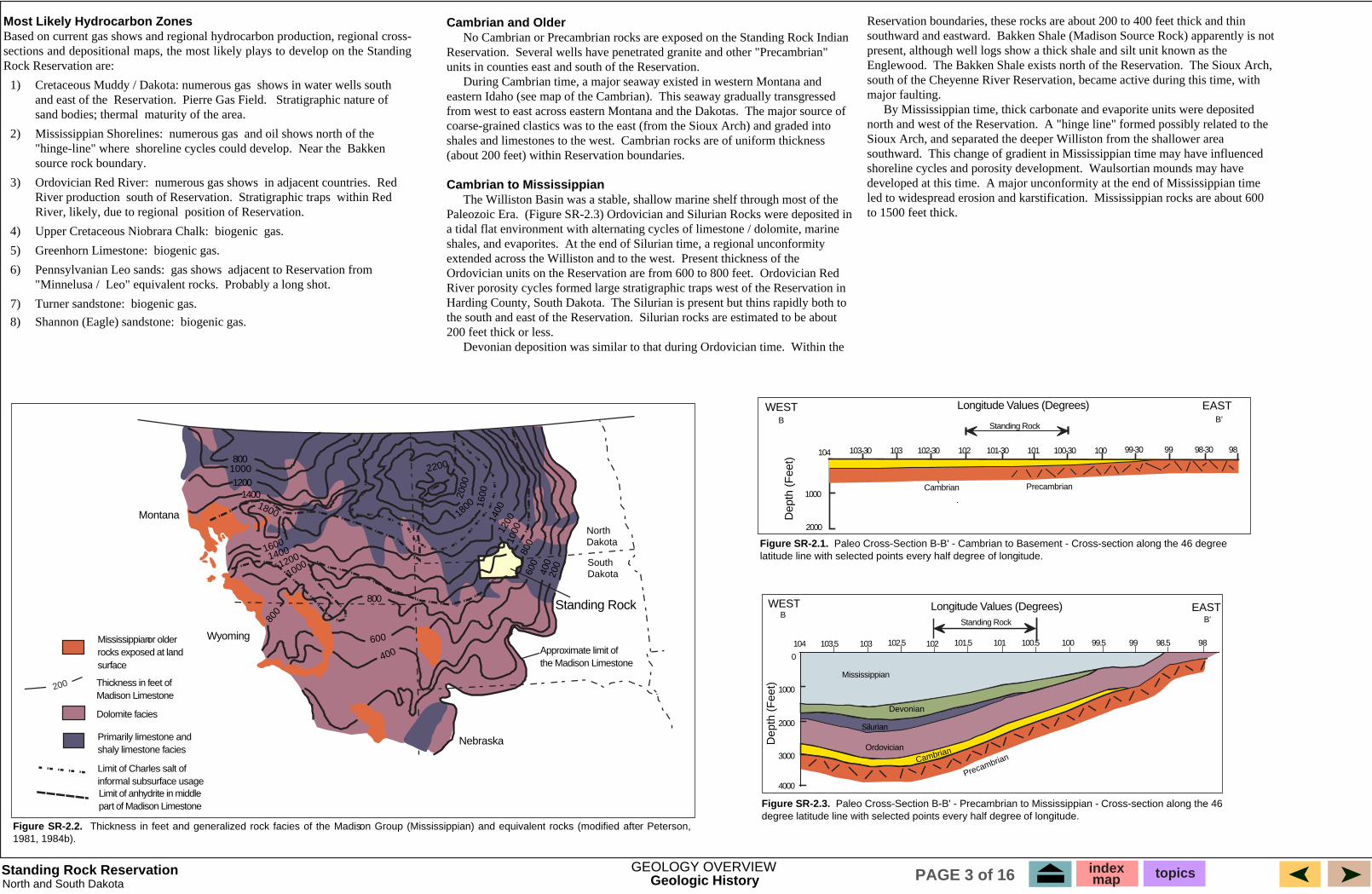
Most Likely Hydrocarbon Zones
Rock Reservation are:
1)� Cretaceous Muddy / Dakota: numerous gas and east of the Reservation. Pierre Gas Field. sand bodies; thermal maturity of the area.
2)� Mississippian Shorelines: numerous gas "hinge-line" where shoreline cycles could develop. Bakken source rock boundary.
3)� Ordovician Red River: numerous gas shows Red River production south of Reservation. Stratigraphic traps within Red
position of Reservation.
biogenic gas.
5) � Greenhorn Limestone: biogenic gas.
gas shows "Minnelusa / Leo" equivalent rocks. Probably a long shot.
7) � Turner sandstone: biogenic gas.
biogenic gas.
Dep
th (
Fee
t)
9898.59999.5100100.5101101.5102102.5103103.5104
0
1000
2000
3000
4000
WEST B
EAST B'
Mississippian
Cambrian
Precambrian
Devonian
800
1200 1400
800
Montana
Mississippian
1000
1800
16001400
1200
1000
800
600
400
North Dakota
South Dakota20
040
0
600
1000
800
120014
00
1600
1800
2000
2200
Cambrian and Older � Reservation. units in counties east and south of the Reservation. � eastern Idaho (see map of the Cambrian). from west to east across eastern Montana and the Dakotas.
shales and limestones to the west. (about 200 feet) within Reservation boundaries.
Cambrian to Mississippian � Paleozoic Era.
shales, and evaporites. extended across the Williston and to the west.
Ordovician Red
Harding County, South Dakota. the south and east of the Reservation. 200 feet thick or less. � Within the
southward and eastward.
Englewood. The Sioux Arch,
major faulting. � north and west of the Reservation.
southward. shoreline cycles and porosity development. developed at this time. led to widespread erosion and karstification. to 1500 feet thick.
104 103-30 103 102-30
B WEST
102 101-30
1000
2000
Dep
th (
Fee
t) 101 100-30 100 99-30 99 98-30 98
B'
EAST
Figure SR-2.2.1981, 1984b).
Figure SR-2.1.
Figure SR-2.3.
200
Based on current gas shows and regional hydrocarbon production, regional cross-sections and depositional maps, the most likely plays to develop on the Standing
shows in water wells south Stratigraphic nature of
and oil shows north of the Near the
in adjacent countries.
River, likely, due to regional
4) � Upper Cretaceous Niobrara Chalk:
6) � Pennsylvanian Leo sands: adjacent to Reservation from
8) � Shannon (Eagle) sandstone:
Longitude Values (Degrees) Standing Rock
Silurian
Ordovician
Wyoming
Nebraska
or older rocks exposed at land surface
Thickness in feet of Madison Limestone
Dolomite facies
Primarily limestone and shaly limestone facies
Limit of Charles salt of informal subsurface usage Limit of anhydrite in middle part of Madison Limestone
Approximate limit of the Madison Limestone
Standing Rock
No Cambrian or Precambrian rocks are exposed on the Standing Rock Indian Several wells have penetrated granite and other "Precambrian"
During Cambrian time, a major seaway existed in western Montana and This seaway gradually transgressed
The major source of coarse-grained clastics was to the east (from the Sioux Arch) and graded into
Cambrian rocks are of uniform thickness
The Williston Basin was a stable, shallow marine shelf through most of the (Figure SR-2.3) Ordovician and Silurian Rocks were deposited in
a tidal flat environment with alternating cycles of limestone / dolomite, marine At the end of Silurian time, a regional unconformity
Present thickness of the Ordovician units on the Reservation are from 600 to 800 feet. River porosity cycles formed large stratigraphic traps west of the Reservation in
The Silurian is present but thins rapidly both to Silurian rocks are estimated to be about
Devonian deposition was similar to that during Ordovician time.
Reservation boundaries, these rocks are about 200 to 400 feet thick and thin Bakken Shale (Madison Source Rock) apparently is not
present, although well logs show a thick shale and silt unit known as the The Bakken Shale exists north of the Reservation.
south of the Cheyenne River Reservation, became active during this time, with
By Mississippian time, thick carbonate and evaporite units were deposited A "hinge line" formed possibly related to the
Sioux Arch, and separated the deeper Williston from the shallower area This change of gradient in Mississippian time may have influenced
Waulsortian mounds may have A major unconformity at the end of Mississippian time
Mississippian rocks are about 600
Cambrian
Longitude Values (Degrees)
Standing Rock
Precambrian
Thickness in feet and generalized rock facies of the Madison Group (Mississippian) and equivalent rocks (modified after Peterson,
Paleo Cross-Section B-B' - Cambrian to Basement - Cross-section along the 46 degree latitude line with selected points every half degree of longitude.
Paleo Cross-Section B-B' - Precambrian to Mississippian - Cross-section along the 46 degree latitude line with selected points every half degree of longitude.
Standing Rock Reservation GEOLOGY OVERVIEW index topicsmapGeologic History PAGE 3 of 16North and South Dakota
Geologic History Standing Rock Reservation North and South Dakota
Mississippian to Upper Cretaceous � continuing to rise. Sioux Arch is unknown. Units west of Standing Rock thicken. Pennsylvanian
time. Units are thin to nonexistent.
mature and oil migration begin. � marine carbonate / evaporite sediments. to be about 300 to 400 feet. Arch. � Rock "hinge line". are fluvial deposits from highlands in South Dakota.
migration had begun. �
rocks and deposition of very thick sand units. The
lenticular "offshore sand bars". The � � Dakota consists of numerous "tongues" of sandstone.
� Greenhorn and
and Colorado.
Montana. thermal maturity by this time and oil migration had begun . Tertiary and Younger � were present in the southern Williston. removed by erosion, and the area was uplifted. "hinge line" were activated.
the Badlands.
B B'
Upper Cretaceous
Mississippian
104 103.5 103 102.5 102 101.5 101 100.5 100 99.5 99 98.5 98
1000
2000
3000
4000
5000
6000
7000
8000
9000
10000
Ele
vatio
n (F
eet)
Dakota
Lower Cretacous
Jurassic
Triassic
Permian
Devonian
Silurian Figure SR-3.1. Paleo cross-section B-B' containing the Precambrian to Upper Cretaceous section. Cross-section is located along the 46 degree latitude line with selected points every half degree of longitude.
3 34 4
30
4 5
2
0
1
3
3
4
5 43
2 1
0
00
5 6
5
5
6.5
6 54
321
0
0 1 2
3
4
3
4.5
3 2 1 0
1
1
1
0
0
0
0 0
5
6
32
Figure SR-3.2. Thickness of Cretaceous rocks in thousands of feet, showing areas where Tertiary rocks are present. Gas fields producing from Cretaceous sandstones are outlined (modified after McGookey et al. 1972).
GEOLOGY OVERVIEW index map topicsPAGE 4 of 16
By Pennsylvanian time, the Sioux Arch south and east of the Reservation was Whether Pennsylvanian units were deposited on the ancestral
production from eolian deposits exist in Fall River County, South Dakota. Pennsylvanian rocks are about 450 feet thick and thin eastward rapidly. Continued uplifting of the Sioux Arch occurred during Precambrian and Triassic
Depth of burial in the central Williston Basin was sufficient for Ordovician Red River and Silurian Interlake source rocks to
In Jurassic time, the Williston was still the major depocenter for clastic and Thickness of Jurassic rocks is estimated
Jurassic units thin south and east across the Sioux
The early Cretaceous saw reactivation of the Sioux Arch and the Standing Most of the Lakota in the Williston and areas south and west
By this time, Devonian age rocks had probably reached thermal maturity in the center of the basin, and oil
During Skull Creek-Mowry time (Lower Cretaceous), the area east of the Reservation was characterized by continued erosion of exposed Precambrian
This "Dakota" sandstone thins westward and northward toward the Williston and the Black Hills. shoreline, continental sands of the "Dakota" gradually become more marine and
The sands are encased in marine shales. The lowermost "tongue"
surrounded by marine shales, and above the "Dakota" is called the "Muddy", and gas is produced from the "Pierre Gas Field", south and east of the Reservation.
By the Early Cretaceous, the Cretaceous Seaway had established itself, and areas west and south of the Reservation were rapidly subsiding. Niobrara chalks were deposited in the eastern and southern Dakotas, Nebraska,
Eagle and Judith River sands (and the equivalent, Shannon / Sussex sandstones) were deposited in western South Dakota, Wyoming, and
Mississippian and Pennsylvanian rocks in the Williston had reached
In early Tertiary time (Paleocene / Eocene), fluvial and swamp environments These rocks were deposited and later
The Sioux arch and adjacent During the Quaternary, the area was glaciated just to
the northeast of the Reservation and the ancestral Missouri River began eroding
EAST Longitude Values (Degrees) WEST
Niobrara / Greenhorn
Muddy / Newcastle
Lakota
Dawson Bay
Ordovician Cambrian
Precambrian
Standing Rock
EXPLANATION
Pre-Cretaceous rocks exposed at land surface
Tertiary rocks present
Standing Rock
Gas field (Cretaceous reservoir)
Reservation:Geologic Province:Province Area:Reservation Area:
Standing RockSouthern Williston BasinWilliston Basin (143,000 sq. miles)3852 sq. miles (2,465,280 acres)
Total Production ( by province-1995)� Oil:� Gas:� NGL:
Williston Basin1435 MMBO1680 BCFG186 MBNGL
Undiscovered resources and numbers of fields arefor Province-wide plays. No attempt has been madeto estimate number of undiscovered fields within theStanding Rock Reservation
Play Type USGS Designation
Unfavorable factorsFavorable factorsDrilling depthsPlay Probability(chance of success)
Undiscovered Resource (MMBOE)Field Size (> 1 MMBOE) min, median, meanKnown AccumulationsOil or GasDescription of Play
Muddy / DakotaDakota / Lakota
1
330733063305
sand bar traps, sands drapedacross anticlinal structures
not estimatedNew play for this area.No previous production;Pierre Gas Field discovered1889; Numerous shows from water wells.
2000 - 4000 ft 1) confirmed play; gas produced outside of reservation2) thermally mature source rocks3) source rocks and reservoir present4) shallow drilling
1) lack of well control2) rough topography3) porosity and facies may be highly variable4) may be all gas and no oil
Both
Madison shoreline/truncation play
2
3101b Cyclic evaporite/ carbonatesequence, structure/stratigraphicupdip pinchout, multiple shorelinecycles
1not
estimated
878 MMBO916.5 BCFG77.9 MMBNGL(numbers include 1, 2,& 3)
4800 - 5900 ft 1) shows in well on reservation2) thermally mature source rocks3) source rocks and reservoir present4) mostly shallow drilling depths
1) lack of well control2) rough topography3) porosity and facies may be highly variable4) seismic may not be able to delineate shoreline trends
Both
3
Niobrara Biogenic GasPlay
4
3113a Niobrara Limestone self-source;Porosity decreased with increasingdepth; Large volume accumulationspossible; May be fractured
10.5
no Niobrara productionin Williston Basin;however, many showsobserved
not estimated180 MMCFG/160 acres (median)256 MMCFG/160 acres (mean)Area of play = 55,000 sq. miles
20,000 sq. miles untested (median)29,958 sq. untested (mean)
500 - 2500 ft 1) large volume play2) shallow drilling depths3) accumulations in stuctural traps4) seismic useful in locating structures
1) lack of well control2) rough topography3) small exploration targets4) lack of reservoir
BiogenicGas
Ordovician Red RiverPlay 1
notestimated
3102 Cyclic evaporite/ carbonatesequence, structure/stratigraphicupdip pinchouts; multiple shorelinecycles
188.3 MMBO555.7 BCFG70.5 MMBNGL
4000 - 6700 ft 1) shows in well on reservation2) thermally mature source rocks3) source rocks and reservoir present4) seismic useful in locating structures
1) lack of well control2) rough topography3) possible small exploration targets
Both
Play Types: Explanation1. Cretaceous Muddy / Dakota (3307) Cretaceous Dakota / Lakota (3306/3305)2. Mississippian Mission Canyon Shoreline Play (3101b)3. Ordovician Red River Play (3102)
4. Cretaceous Pierre / Niobrara-Biogenic Gas Play (3113a)
5. Cretaceous Greenhorn (3113b)
6. Pennsylvanian Leo Sands (3303)7. Cretaceous Carlile Shale / Turner Sandstone (3310)
8. Cretaceous Shannon / Sussex (3312)
Sandstone
Sandstone, siltstone, shale
Shale
Limestone
Dolomite
Igneous / Metamorphic
Gas
Oil
Unconformity
Sandstone Lens
Tertiary
Niobrara
Greenhorn Upper Cretaceous
Jurassic
Mission Canyon
Mississippian
Lodgepole Metamorphosed sedimentary and igneous rocks
No Scale: Cross Section is approximate width of Reservation
Red River
DakotaMuddy
Tertiary4
57
16
7
8
4
5
16
2
2
3
3
West East
TriassicPermian
Pennsylvanian
Devonian
Silurian
OrdovicianCambrian
Figure SR-4.1. Schematic Diagram of Play Types - Standing Rock Reservation.
Standing Rock Reservation
Table SR-1. Summary of Play Types for the Standing Rock Reservation
North and South Dakota Summary of Play Types
�New Play; no estimate made of Gasreserves; few records kept. PierreGas Field covers several counties.
Median: 600 MMBO (30 fields @ 20MMBO)
Field Size (>1MMBOE)2 MMBO(min) 20 MMBO(max) 5.3 MMBO(mean)
No. of undiscovered fields (> 1 MMBOE)9 (min) 30 (median) 60 (max) 31.9 (mean)numbers include plays 1, 2, & 3
Median: 250 MMBO (25 fields @ 10 MMBO)
Field Size (>1 MMBOE)2 MMBO/10 BCFG(min) 10 MMBO/35 BCFG(max) 2.1 MMBO/11.7 BCFG(mean)No. of undiscovered fields (> 1 MMBOE)5 (min) 25 (median) 50 (max) 26 (mean)
indexmap topicsPAGE 5 of 16
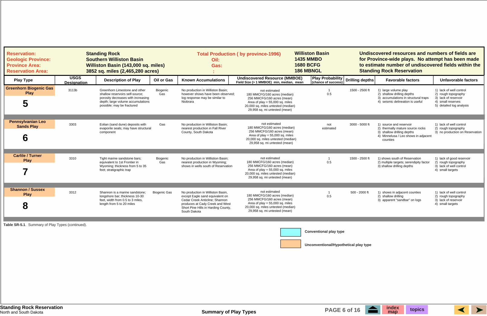
Reservation: Geologic Province: Province Area: Reservation Area:
Standing Rock Southern Williston Basin Williston Basin (143,000 sq. miles) 3852 sq. miles (2,465,280 acres)
Total Production ( by province-1996) � Oil: � Gas: � :
Williston Basin 1435 MMBO 1680 BCFG 186 MBNGL
Undiscovered resources and numbers of fields are for Province-wide plays. No attempt has been made to estimate number of undiscovered fields within the Standing Rock Reservation
Play Type USGS Designation
Unfavorable factorsFavorable factorsDrilling depthsPlay Probability (chance of success)
Undiscovered Resource (MMBOE) Field Size (> 1 MMBOE) min, median, mean
Known AccumulationsOil or GasDescription of Play
Greenhorn Biogenic Gas Play
5
3113b Greenhorn Limestone and other shallow reservoirs self-source; porosity decreases with increasing depth; large volume accumulations possible; may be fractured
1 0.5
No production in Williston Basin; however shows have been observed; log response may be similar to Niobrara
1500 - 2500 ft 1) large volume play 2) shallow drilling depths 3) accumulations in structural traps 4) seismic delineation is useful
1) lack of well control 2) rough topography 3) lack of reservoir 4) small reserves 5) detailed log analysis
Biogenic Gas
Pennsylvanian Leo Sands Play
6
3303 Eolian (sand dune) deposits with evaporite seals; may have structural component
not estimated
No production in Williston Basin; nearest production in Fall River County, South Dakota
3000 - 5000 ft 1) source and reservoir 2) thermally mature source rocks 3) shallow drilling depths 4) Minnelusa / Leo shows in adjacent
counties
1) lack of well control 2) rough topography 3) no production on Reservation
Gas
Carlile / Turner Play
7
3310 Tight marine sandstone bars; equivalent to 1st Frontier in Wyoming; thickness from 5 to 35 feet; stratigraphic trap
1 0.5
No production in Willistion Basin; nearest production in Wyoming; shows in wells south of Reservation
1500 - 2500 ft 1) shows south of Reservation 2) multiple targets; serendipity factor 3) shallow drilling depths
1) lack of good reservoir 2) rough topography 3) lack of well control 4) small targets
Biogenic Gas
Shannon / Sussex Play
8
3312 Shannon is a marine sandstone; longshore bar; thickness 10-30 feet, width from 0.5 to 3 miles, length from 5 to 20 miles
1 0.5
No production in Williston Basin, except Eagle sand equivalent on Cedar Creek Anticline; Shannon produces at Cady Creek and West Short Pine Hills in Harding County, South Dakota
500 - 2000 ft 1) shows in adjacent counties 2) shallow drilling 3) apparent "sandbar" on logs
1) lack of well control 2) rough topography 3) lack of reservoir 4) small targets
Biogenic Gas
not estimated 180 MMCFG/160 acres (median) 256 MMCFG/160 acres (mean) Area of play = 55,000 sq. miles
20,000 sq. miles untested (median) 29,958 sq. mi untested (mean)
not estimated 180 MMCFG/160 acres (median) 256 MMCFG/160 acres (mean) Area of play = 55,000 sq. miles
20,000 sq. miles untested (median) 29,958 sq. mi untested (mean)
not estimated 180 MMCFG/160 acres (median) 256 MMCFG/160 acres (mean) Area of play = 55,000 sq. miles
20,000 sq. miles untested (median) 29,958 sq. mi untested (mean)
not estimated 180 MMCFG/160 acres (median) 256 MMCFG/160 acres (mean) Area of play = 55,000 sq. miles
20,000 sq. miles untested (median) 29,958 sq. mi untested (mean)
Standing Rock Reservation
Table SR-5.1. Summary of Play Types (continued).
Conventional play type
Unconventional/Hypothetical play type
Summary of Play TypesNorth and South Dakota index map topicsPAGE 6 of 16
4800
4900
5000
5100
5200
5300
5400
5500
5600
5700
5800Duperow
Nisku
Englewood
Lodgepole
Mission Canyon
Resistivity
Scale Change
SP
SP Resistivity
Stony Mtn.
RedRiver
6300
6400
6600
6700
Core"B"
"C"
"D"
DST 1
DST 2
Rec'd 3510 sl. gassyswtr.
Rec'd 450 MC swtr.6500
129
130T
N
23
22
21
T
N
T
N
T
N
T
N
20T
N
19T
N
18T
N
T131
N
T132
N
T133
N
T134
N
R 80 W R 79 WR 82 W R 81 WR 84 WR 85 W R 83 WR 87 WR 88 W R 86 WR 90 W R 89 W
R 18 E R 19 E R 20 E R 21 E R 22 E R 23 E R 24 E R 25 E R 26 E R 27 E R 28 E R 29 E R 30 E
Sioux County North Dakota
Corson County South Dakota
STRUCTURE AND SHOWS
Reservation BoundaryStructure Contour (Dakota-Newcastle-Muddy)
Contour Interval = 100 feet
Shows
Niobrara MississippianGreenhorn Red RiverMuddy / Dakota
Cedar Creek
Canno
nball
River
GrandRiver
LAKE OAHE
-120
0
-110
0
-100
0 -900
-800
-700
-600
-500
-400
-300
-200
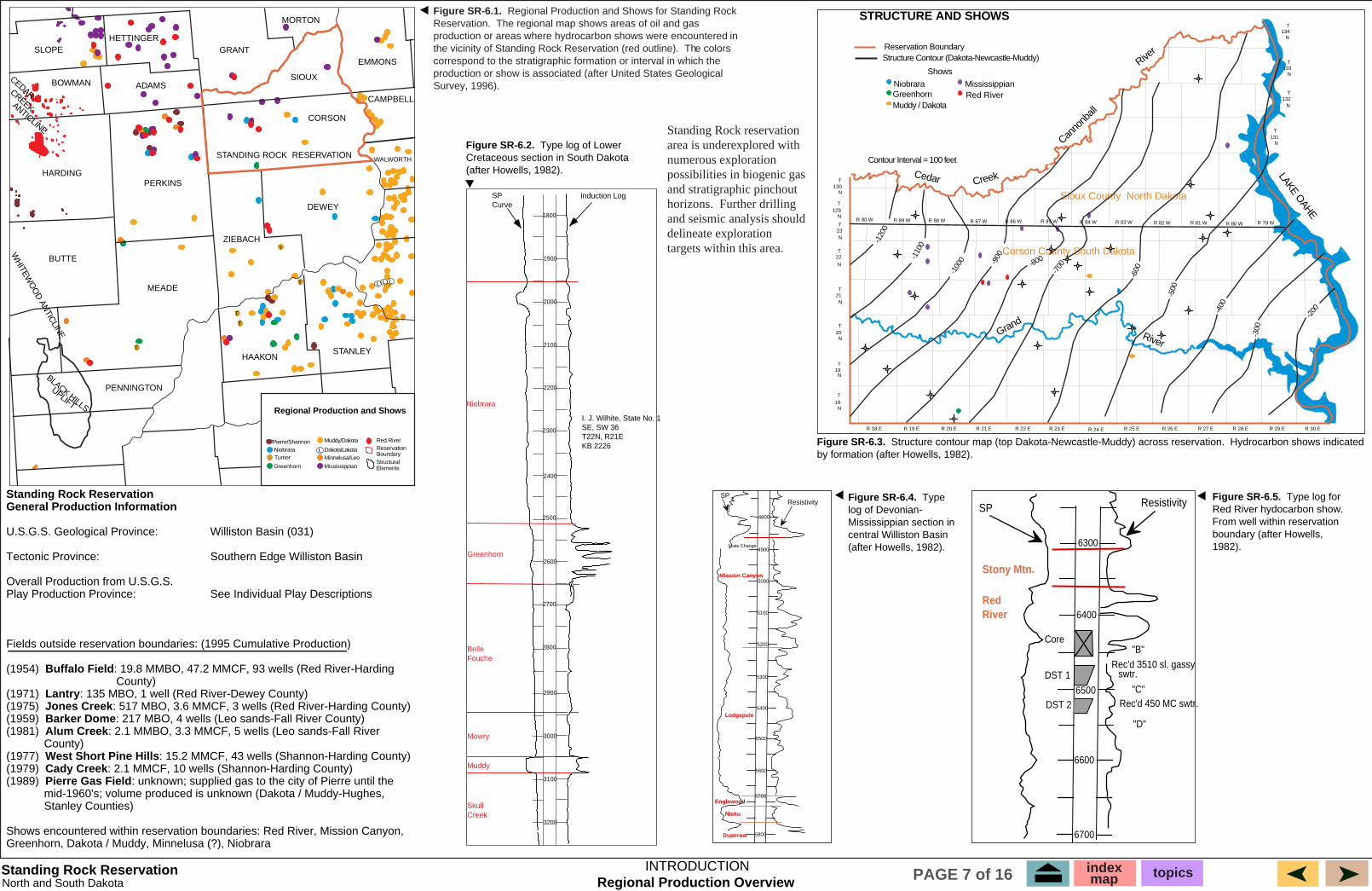
Figure SR-6.5. Type log for Red River hydocarbon show. From well within reservation boundary (after Howells, 1982).
Figure SR-6.4. Type log of Devonian-Mississippian section in central Williston Basin (after Howells, 1982).
Figure SR-6.3. Structure contour map (top Dakota-Newcastle-Muddy) across reservation. Hydrocarbon shows indicated by formation (after Howells, 1982).
Induction LogSPCurve
I. J. Wilhite, State No. 1SE, SW 36T22N, R21EKB 2226
Niobrara
Greenhorn
BelleFouche
Mowry
Muddy
SkullCreek
1800
1900
2000
2100
2200
2300
2400
2500
2600
2700
2800
2900
3000
3100
3200
Standing Rock ReservationNorth and South Dakota
INTRODUCTION
Figure SR-6.1. Regional Production and Shows for Standing Rock Reservation. The regional map shows areas of oil and gas production or areas where hydrocarbon shows were encountered in the vicinity of Standing Rock Reservation (red outline). The colors correspond to the stratigraphic formation or interval in which the production or show is associated (after United States Geological Survey, 1996).
Standing Rock ReservationGeneral Production Information
U.S.G.S. Geological Province: � � Williston Basin (031)
Tectonic Province: � � � Southern Edge Williston Basin
Overall Production from U.S.G.S.Play Production Province:� � See Individual Play Descriptions
Fields outside reservation boundaries: (1995 Cumulative Production)
(1954) Buffalo Field: 19.8 MMBO, 47.2 MMCF, 93 wells (Red River-Harding � �� � County)(1971) Lantry: 135 MBO, 1 well (Red River-Dewey County)(1975) Jones Creek: 517 MBO, 3.6 MMCF, 3 wells (Red River-Harding County)(1959) Barker Dome: 217 MBO, 4 wells (Leo sands-Fall River County)(1981) Alum Creek: 2.1 MMBO, 3.3 MMCF, 5 wells (Leo sands-Fall River � � County)(1977) West Short Pine Hills: 15.2 MMCF, 43 wells (Shannon-Harding County)(1979) Cady Creek: 2.1 MMCF, 10 wells (Shannon-Harding County)(1989) Pierre Gas Field: unknown; supplied gas to the city of Pierre until the � � mid-1960's; volume produced is unknown (Dakota / Muddy-Hughes, � � Stanley Counties)
Shows encountered within reservation boundaries: Red River, Mission Canyon,Greenhorn, Dakota / Muddy, Minnelusa (?), Niobrara
Figure SR-6.2. Type log of Lower Cretaceous section in South Dakota (after Howells, 1982).
T
T
T
T
T
Regional Production and Shows
SLOPE
BOWMAN
HETTINGERGRANT
MORTON
EMMONS
SIOUX
CORSON
CAMPBELL
WALWORTH
STANLEYHAAKON
ZIEBACH
DEWEY
PERKINSHARDING
ADAMS
BUTTE
MEADE
PENNINGTON
STANDING ROCK RESERVATION
BLACK HILLS
UPLIFT
WH
ITEWO
OD
ANTIC
LINE
CEDARCREEKANTICLINE
Pierre/Shannon
GreenhornT
Muddy/Dakota
Dakota/LakotaMinnelusa/Leo
Mississippian
ReservationBoundary
L
L L L
Turner
Red River
Niobrara
Structural Elements
Standing Rock reservation area is underexplored with numerous exploration possibilities in biogenic gas and stratigraphic pinchout horizons. Further drilling and seismic analysis should delineate exploration targets within this area.
Regional Production Overviewindexmap topicsPAGE 7 of 16
SLOPE HETTINGER
GRANT EMMONS
CORSON
CAMPBELL
DEWEY
PERKINS HARDING
MEADE
Pierre Gas Field
BLACK HILLS
UPLIFT
WH
ITEWO
OD
ANTIC
LINE
CEDARCREEKANTICLINE
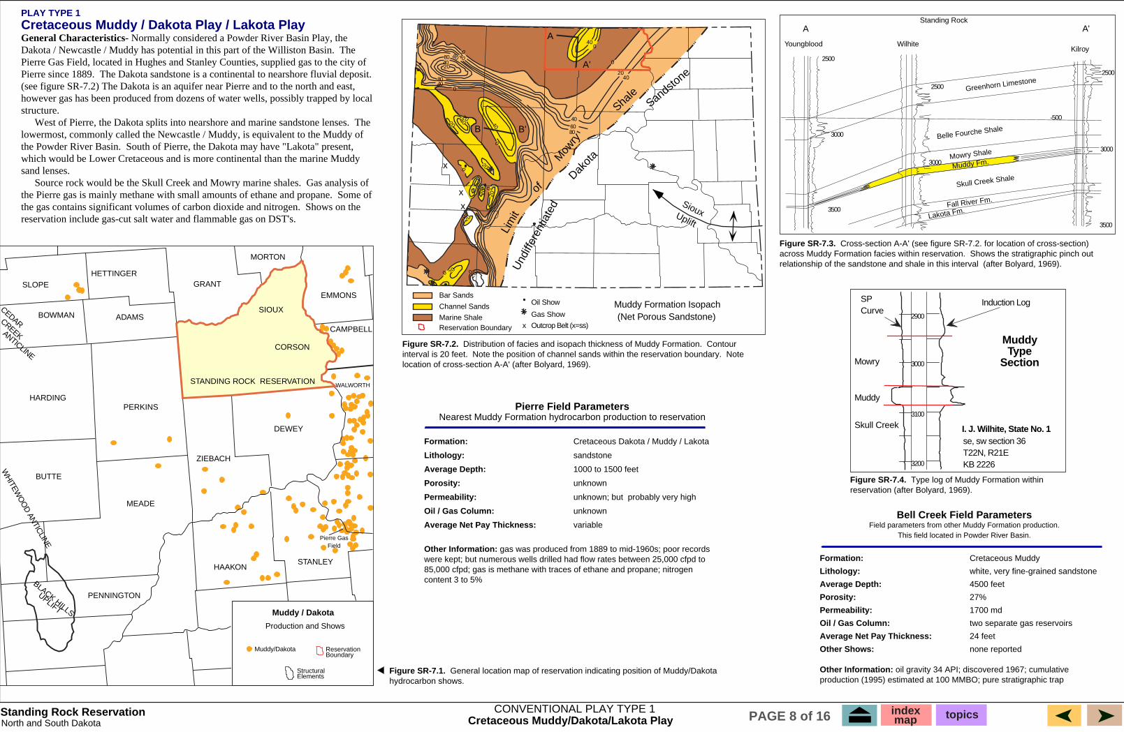
Figure SR-7.2. Contour interval is 20 feet. Note location of cross-section A-A' (after Bolyard, 1969).
A
Wilhite
-500
2500
3000
3500
3000
2500
2500
3000
3500
A'
Greenhorn Limestone
Belle Fourche Shale
Mowry Shale
Muddy Fm.
Skull Creek Shale
Fall River Fm.
Lakota Fm.
Figure SR-7.4. Type log of Muddy Formation within reservation (after Bolyard, 1969).
Figure SR-7.1.hydrocarbon shows.
80 40
80 40
80 60 40
Channel Sands
Outcrop Belt (x=ss)x
x
x
x
B
20
80 400
0
204020
200
0 40 B'
0
20200
20
0
20
20
0
SiouxUplift
0 40
0
20 40
A
A'
Lim
it
of
Mow
ry
Shale
Sandstone
Dakot
a
Und
iffer
entia
ted
Bar Sands
Reservation Boundary
PLAY TYPE 1 Cretaceous Muddy / Dakota Play / Lakota Play General Characteristics- Normally considered a Powder River Basin Play, the
The
Pierre since 1889.
structure. � The
the Powder River Basin.
sand lenses. � Gas analysis of
Some of Shows on the
SIOUX
Figure SR-7.3.across Muddy Formation facies within reservation. relationship of the sandstone and shale in this interval
Reservation Boundary
Pierre Field Parameters
Formation:� Cretaceous Dakota / Muddy / Lakota
Lithology: � sandstone
Average Depth:� 1000 to 1500 feet
Porosity:� unknown
Permeability:� unknown; but probably very high
Oil / Gas Column:� unknown
Average Net Pay Thickness:� variable
Other Information: gas was produced from 1889 to mid-1960s; poor records
content 3 to 5%
Bell Creek Field Parameters Field parameters from other Muddy Formation production.
This field located in Powder River Basin.
Formation:� Cretaceous Muddy
Lithology: � white, very fine-grained sandstone
Average Depth: � 4500 feet
Porosity: � 27%
Permeability: � 1700 md
Oil / Gas Column: � two separate gas reservoirs
Average Net Pay Thickness: � 24 feet
Other Shows: � none reported
Other Information: oil gravity 34 API; discovered 1967; cumulative
Muddy
Section
se, sw section 36 T22N, R21E KB 2226
Induction LogSP
2900
3000
3100
3200
Muddy
Skull Creek I. J. Wilhite, State No. 1
Muddy/Dakota
Structural Elements
Muddy / Dakota
Production and Shows
BOWMAN
MORTON
WALWORTH
STANLEY HAAKON
ZIEBACH
ADAMS
BUTTE
PENNINGTON
STANDING ROCK RESERVATION
Distribution of facies and isopach thickness of Muddy Formation. Note the position of channel sands within the reservation boundary.
Kilroy Youngblood
Standing Rock
General location map of reservation indicating position of Muddy/Dakota
Marine Shale
Oil Show
Gas Show Muddy Formation Isopach (Net Porous Sandstone)
Dakota / Newcastle / Muddy has potential in this part of the Williston Basin. Pierre Gas Field, located in Hughes and Stanley Counties, supplied gas to the city of
The Dakota sandstone is a continental to nearshore fluvial deposit. (see figure SR-7.2) The Dakota is an aquifer near Pierre and to the north and east, however gas has been produced from dozens of water wells, possibly trapped by local
West of Pierre, the Dakota splits into nearshore and marine sandstone lenses. lowermost, commonly called the Newcastle / Muddy, is equivalent to the Muddy of
South of Pierre, the Dakota may have "Lakota" present, which would be Lower Cretaceous and is more continental than the marine Muddy
Source rock would be the Skull Creek and Mowry marine shales. the Pierre gas is mainly methane with small amounts of ethane and propane. the gas contains significant volumes of carbon dioxide and nitrogen. reservation include gas-cut salt water and flammable gas on DST's.
Cross-section A-A' (see figure SR-7.2. for location of cross-section) Shows the stratigraphic pinch out
(after Bolyard, 1969).
Nearest Muddy Formation hydrocarbon production to reservation
were kept; but numerous wells drilled had flow rates between 25,000 cfpd to 85,000 cfpd; gas is methane with traces of ethane and propane; nitrogen
production (1995) estimated at 100 MMBO; pure stratigraphic trap
Type
Curve
Mowry
Standing Rock Reservation CONVENTIONAL PLAY TYPE 1 index topicsmapNorth and South Dakota Cretaceous Muddy/Dakota/Lakota Play PAGE 8 of 16
�
�
Canada
U.S.A.
Carnduff
Elmore
Mouse River Park
Lake
Darling
Lone Tree
Wabek
Plaza
Lucky Mound
Centennial
Sherwood Shoreline
Burke
North Dakota
Renville
Bottineou
Mountrail
Ward McHenry
McLean
North Dakota
shown Area
Figure SR-8.3. Sherwood Shoreline trend and position of major oil fields (after Sperr, et al, 1993).
R 87 WR 88 W
Plaza Field
(Bluell Production)
Wabek Field
(Sherwood Prod.)
T 153 N
T 152 N
-5200
-5300
-5400
-5500
Figure SR-8.4. Sherwood structure map containing Plaza and Wabek fields (after Sperr, et al, 1993).
General Characteristics - This play is an extension of the northeast shelf play which produces from Sherwood and Bluell porosity cycles.
� � �
The updip seal can either be an evaporite or a shale. shales within the evaporite sequence. center of the basin and immature on the flanks. migration is thought to have occurred in Late Cretaceous.
Mississippian time. just outside the reservation boundaries.
Analog Fields (outside Reservation)
Plaza:� � 2.6 MMBO, 1.7 MMCF, from 20 wells, 3-4 MMBO � � � � ultimate (Bluell)
Wabek: 5.1 MMBO, 3.6 MMCF, from 18 wells, 6-7 MMBO � � � � ultimate (Sherwood)
Figure SR-8.2. General location map of reservation indicating position of
Figure SR-6.1. Thickness in feet and generalized rock facies of the Madison Group (Mississippian) and equivalent rocks (modified (after Peterson, 1981, 1984b).
800
1200 1400
800
Montana
1000
1800
16001400
1200
1000
800
600
400
North Dakota
South Dakota20
040
0
600
1000
800
120014
00
1600
1800
2000
2200
Mississippian or older rocks exposed at land surface
Primarily limestone and shaly limestone facies
subsurface usage
of Madison Limestone
Wabek Field Parameters
Formation:� Mississippian Mission Canyon, Sherwood � subinterval
Lithology:� light brown to brown, peloidal, oolitic, pisolitic, � � � intraclastic and composite grain wackestone � � to grainstone
Average Depth:� 7300 to 7350 feet
Porosity:� intergranular, vugular, and interparticle, 6-26%; � � � average of 10%
Permeability:� unknown
Oil / Gas Column:� 100 feet
Average Net Pay Thickness:� 26 feet
Other Shows:� information not available
Other Information:
Plaza Field Parameters
Formation:� Mississippian Mission Canyon, Bluell subinterval
Lithology:� light brown to brown, peloidal, oolitic, pisolitic, � � � intraclastic and composite grain wackestone� � to grainstone
Average Depth:� 7400 to 7500 feet
Porosity:� intergranular, vugular, and intraparticle, 6-16%
Permeability:� unknown
Oil / Gas Column: � at least 120 feet, oil / water contact is currently � unknown� � �
Average Net Pay Thickness:� 6 feet
Other Shows:� information not available
SLOPE HETTINGER
GRANT EMMONS
CORSON
CAMPBELL
PERKINS HARDING
MEADE
DEWEY
BLACK HILLS
UPLIFT
WH
ITEWO
OD
ANTIC
LINE
CEDARCREEKANTICLINE
Mississippian
Structural Elements
Reservation Boundary
SIOUX
Mississippian
PLAY TYPE 2
Mississippian Shoreline Play
The Mississippian subcrops (truncated by Triassic Spearfish), in descending order eastward: Midale, Bluell, Sherwood, Mohall, Glenburn, Landa, Wayne, and finally Lodgepole.
Several of the lower cycles should be present on the reservation. Reservoirs are dolomitized carbonates of either algal, oolitic, or bioherm banks in one or more of the above mentioned intervals.
Source rock could be the Bakken Shale or one of the marine Source rocks are thermally mature in the
Onset of oil generation and Time regional cross-
sections indicate the presence of a paleoridge and shelf area during Devonian and Bakken Shale is apparently on the north side of this ridge,
Shows in the Mississippian include oil staining in core, oil flecks, gas and mud emulsion, and free gas recovery on DST.
� �
Mississippian hydrocarbon shows (after Peterson and MacCary, 1987).
Wyoming
Nebraska
Thickness in feet of Madison Limestone
Dolomite facies
Approximate limit of the Madison Limestone
Standing Rock
Limit of Charles salt of informal
Limit of anhydrite in middle part
due to the shoreline sequences, lower cycles may exist at Standing Rock as opposed to the Sherwood / Bluell cycles; detailed log correlation from the center of the basin would be required to determine which cycles are present
BOWMAN
MORTON
WALWORTH
STANLEY HAAKON
ZIEBACH
ADAMS
BUTTE
PENNINGTON
STANDING ROCK RESERVATION
Production and Shows
Standing Rock Reservation CONVENTIONAL PLAY TYPE 2 index topicsmapNorth and South Dakota Mississippian Shoreline Play PAGE 9 of 16
0
-2600
Montana
110 105 100
48
46
44
42
300
100 300
300
500
300
700 500
500
300
100
North Dakota
SLOPE HETTINGER
GRANT EMMONS
CORSON
CAMPBELL
DEWEY
PERKINS HARDING
MEADE
BLACK HILLS
UPLIFT
WH
ITEWO
OD
ANTIC
LINE
CEDARCREEKANTICLINE
Figure SR-9.1.equivalent rocks (after Peterson; 1981, 1984b).
Figure SR-9.2. General location map of reservation indicating position of Red River hydrocarbon shows.
5/932: BOPD / BWPD
Oil Gas Mud
Core w/ oil stain
Ziebach County
45/130
25 / 650 65 bopd
24 / 62 10 / 75
240 / 960
4 / 7
5 / 932
R 21 E R 22 E
2 N
T 1 3 N
T 1
-2800
-2700
-2600
-2600
-2700
-2800
-2600
-2800
Lantry Field
Figure SR-9.3. Structure contour map and production of Red River Fm, Lantry Field.
Standing Rock Reservation
PLAY TYPE 3
Ordovician Red River Play
General Characteristics - The Red River Formation is the second most productive formation in the Williston Basin.
source, and seal. � Creek Anticline.
County are thought to be primarily stratigraphic traps. � pinches out on the basin flanks. River Formation are thought to be the primary source rock. Hydrocarbon
�
in core, and gas and oil cut mud and water on DST's.
Lantry Field Parameters
Formation: � Ordovician Red River
Lithology: � limestone / dolomite
Average Depth: � 5000 feet
Porosity: � 10%
Permeability: � unknown
Oil / Gas Column: � unknown
Average Net Pay Thickness: � 30 feet
Other Formations with Shows:� Mission Canyon, � Stony Mountain, and Red River
Other Information: initial IP 24 BOPD; gravity 22 API; 62 BWPD; cumulative
water.
SIOUX
Buffalo Field Parameters (an example of Cedar Creek Anticline production)
Formation: � Ordovician Red River
Lithology: � limestone / dolomite
Average Depth: � 8600 feet
Porosity: � 20%
Permeability:� unknown
Oil / Gas Column: � unknown
Average Net Pay Thickness: � 15 feet
Other Formations with Shows:� Charles and Red River
Other Information:
stratigraphic trap
CONVENTIONAL PLAY TYPE 3 Ordovician Red River PlayNorth and South Dakota
200
Explanation
Reservation Boundary
Structural Elements
index map topicsPAGE 10 of 16
Wyoming
Nebraska
South Dakota
Approximate limit of the Red River Fm. Ordovician or older
rocks exposed at land surface Thickness in feet of Red River Formation
Dolomite facies
Limestone and Dolomite facies
Oilfield, Red River reservoir
BOWMAN
MORTON
WALWORTH
STANLEY HAAKON
ZIEBACH
ADAMS
BUTTE
PENNINGTON
STANDING ROCK RESERVATION
Thickness in feet and generalized rock facies of the Red River (Ordovician) and
Dewey County, South Dakota Red River Production,
and Structure
Water
C.I.: 25 feet
Dewey County
Lantry
Reservoirs are dolomites and dolomitic limestones formed from bioclastic mounds and tidal flat deposits. Cyclic episodes of carbonate, evaporite, and organic rich shale provide reservoir,
Major accumulations are found on structural noses such as Nesson and Cedar Smaller fields are found in fold structures draped over
basement fault blocks, or small, carbonate mounds. Accumulations in Harding
Source rock is thermally mature to overmature at the basin center, and Winnipeg shale and marine shale of the Red
generation and migration is estimated to have begun in Late Paleozoic time. The nearest Red River production is thirty miles south of the reservation in
Dewey County. Shows are present within the reservation and include oil staining
production (1995) 135 MBO, 5.2 MMBW, 1 well; Dewey County; primarily a structural / stratigraphic trap; also produces large volumes of 140 degree formation
initial IP 80 BOPD; gravity 30 API; 200 BWPD; cumulative � production (1995) 19.8 MMBO, 47.2 MMCF, 93 wells; Harding County; primarily a
Red River Production and Shows
Red River
Induction LogSP
1800
1900
2000
2100
Niobrara Type SectionI.J. Wilhite State No. 1SE SW 36T 22 N, R 21 EKB 2226
Niobrara
Gamma Ray Porosity (LS) Porosity (LS)
Neutron Porosity
Crossoverin Gas Zone
Slight Crossoverin Gas Zone
Neutron PorosityDensity Porosity
Run One - soon afterdrilling gas zone
Run Two - 17 days afterdrilling gas zone
0 200 60 45 30 15 60 45 30 15
PIE
RR
EN
IOB
RA
RA
Sm
oky
Hill
Mem
ber
Sha
ron
Spr
ings
25002600
25002600
2800 2800
2600
2500
25002400
2300
2200
2200
Cheyenne Co.Sherman Co.
Wheeler
BenkelmanLow
2100
CherryCreek, East
St. Francis
2100
2000
2000
Armel
BeecherIsland
Vernon
2000
Low
Low
Col
orad
o
Kan
sas
R44W 43 42 41 40 39 38 R37W
T1S
2
3
4
5
Figure SR-10.6. Structure map on top of the Niobrara Formation, northwestern Kansas showing a Niobrara gas field (in red). Contour interval is 100 feet. Hypothetical or unconventional play analog for Ft. Berthold reservation (after Lockridge and Pollastro, 1988).
Formations
Ser
ies
Sys
tem
Tert
iary
Pale
oce
ne
Fort Union Formation
Hell Creek Formation
Fox Hills Sandstone
Bearpaw Shale
Judith River Formation
Claggett Shale PierreShale
EagleSandstone Gammon
Shale
Niobrara Formation
Carlile Shale
Greenhorn Formation
Up
per
Cre
tace
ou
s
Lo
wer
Belle Fourche Shale
Mowry Shale
Muddy Sandstone
Skull Creek Shale
Fall River Sandstone
Kootenai Formation
Sunburst SS Mbr.
Cut Bank SS Mbr.unconformity
Morrison Formation
Jura
ssic
Up
pe
r
unconformity
nonmarine rocks
coastalsandstones
calcareous rocks
marine siltstonesand shales
Figure SR-10.3. General correlation chart of Cretaceous rocks in Rice and Shurr's study area (after Rice and Shurr, 1980).
Figure SR-10.4. Niobrara type section (after Lockridge and Pollastro, 1988).
Figure SR-10.5. Example of effect of driling time and invasion on density and neutron porosity logs (FDC and CNL). J-W Operating No. 2 Kitzmiller, NW NW Sec. 4, 4-T3N-R45W, Yuma County, Colorado(after Lockridge and Pollastro, 1988).
burial > 3000'Ø could be<35%
burial between3000-4000'Ø could be30-35%
Lim
it
ofoccurre
nceof
Nio
brar
a F
m.
Area
ofburial
below4000'
3000'
NorthDakota
SouthDakota
Nebraska
Kansas
OklahomaNewMexico
Colorado
Wyoming
Montana
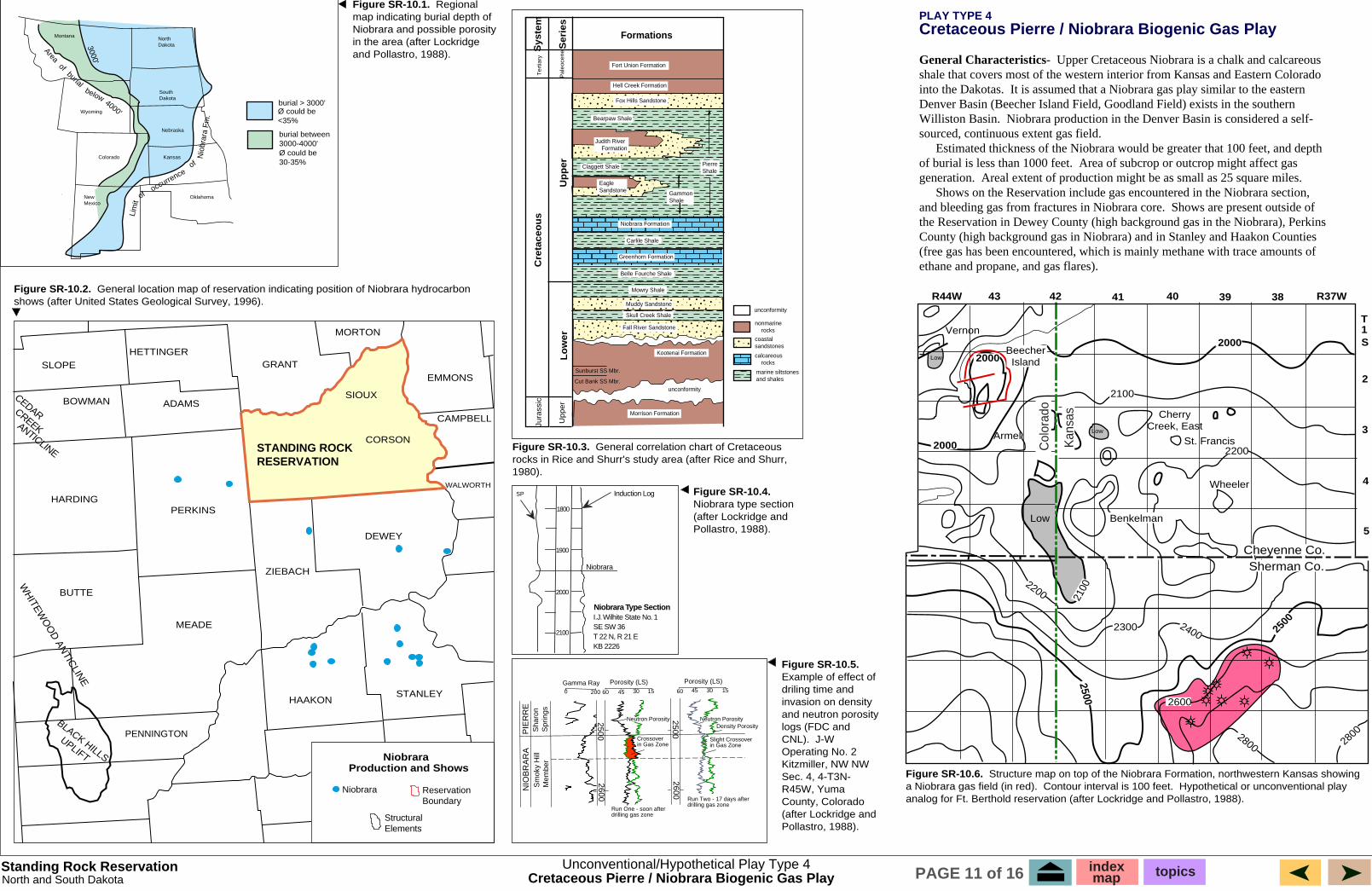
Figure SR-10.1. Regional map indicating burial depth of Niobrara and possible porosity in the area (after Lockridge and Pollastro, 1988).
Figure SR-10.2. General location map of reservation indicating position of Niobrara hydrocarbon shows (after United States Geological Survey, 1996).
Standing Rock ReservationNorth and South Dakota
PLAY TYPE 4Cretaceous Pierre / Niobrara Biogenic Gas Play
General Characteristics- Upper Cretaceous Niobrara is a chalk and calcareous shale that covers most of the western interior from Kansas and Eastern Colorado into the Dakotas. It is assumed that a Niobrara gas play similar to the eastern Denver Basin (Beecher Island Field, Goodland Field) exists in the southern Williston Basin. Niobrara production in the Denver Basin is considered a self-sourced, continuous extent gas field.� Estimated thickness of the Niobrara would be greater that 100 feet, and depth of burial is less than 1000 feet. Area of subcrop or outcrop might affect gas generation. Areal extent of production might be as small as 25 square miles.� Shows on the Reservation include gas encountered in the Niobrara section, and bleeding gas from fractures in Niobrara core. Shows are present outside of the Reservation in Dewey County (high background gas in the Niobrara), Perkins County (high background gas in Niobrara) and in Stanley and Haakon Counties (free gas has been encountered, which is mainly methane with trace amounts of ethane and propane, and gas flares).
Unconventional/Hypothetical Play Type 4
NiobraraProduction and Shows
SLOPE
BOWMAN
HETTINGERGRANT
MORTON
EMMONS
SIOUX
CORSON
CAMPBELL
WALWORTH
STANLEYHAAKON
ZIEBACH
DEWEY
PERKINSHARDING
ADAMS
BUTTE
MEADE
PENNINGTON
STANDING ROCKRESERVATION
BLACK HILLS
UPLIFT
WH
ITEWO
OD
ANTIC
LINE
CEDARCREEKANTICLINE
Structural Elements
Reservation Boundary
Niobrara
Cretaceous Pierre / Niobrara Biogenic Gas Play indexmap topicsPAGE 11 of 16
CretaceousEpeiric Seaway
United States
Mexico Cuba
Canada
Alaska Greenland
CretaceousEpeiric Seaway
CretaceousEpeiric Seaway
0
Figure SR-11.3. Paleogeographic map of North America during Late Cretaceous time, showing the extent of the Cretaceous seaway (after Rice and Shurr, 1980).
Figure SR-11.4. Greenhorn type section (after Rice and Shurr, 1980).
112 110 108 106 104 102
48
47
46
45
44
49United States
LimestoneShaly LimestoneShaleSandstoneShaly Sandstone
Explanation
No
rth
Dak
ota
So
uth
Dak
ota
Formations
Ser
ies
Sys
tem
Te
rtia
ry
Pa
leo
cen
eFort Union Formation
Hell Creek Formation
Fox Hills Sandstone
Bearpaw Shale
Judith River Formation
Claggett Shale PierreShale
EagleSandstone Gammon
Shale
Niobrara Formation
Carlile Shale
Greenhorn Formation
Up
per
Cre
tace
ou
s
Lo
wer
Belle Fourche Shale
Mowry Shale
Muddy Sandstone
Skull Creek Shale
Fall River Sandstone
Kootenai Formation
Sunburst SS Mbr.
Cut Bank SS Mbr.unconformity
Morrison Formation
Jura
ssic
Up
pe
r
unconformity
nonmarine rocks
coastalsandstones
calcareous rocks
marine siltstonesand shales
Figure SR-11.5. Facies map for interval 2 (Belle Fourche, Greenhorn, and equivalents) (after Rice and Shurr, 1980).
Figure SR-11.1. General correlation chart of Cretaceous rocks in Rice and Shurr's study area - Montana, Wyoming, North and South Dakota (after Rice and Shurr, 1980).
Standing Rock ReservationNorth and South Dakota
SP Induction Log
2500
2600
2700
Greenhorn
Belle Fouche
GreenhornType
Section
I.J. Wilhite State No. 1
SE SW 36
T 22 N, R 21 E
KB 2226
PLAY TYPE 5
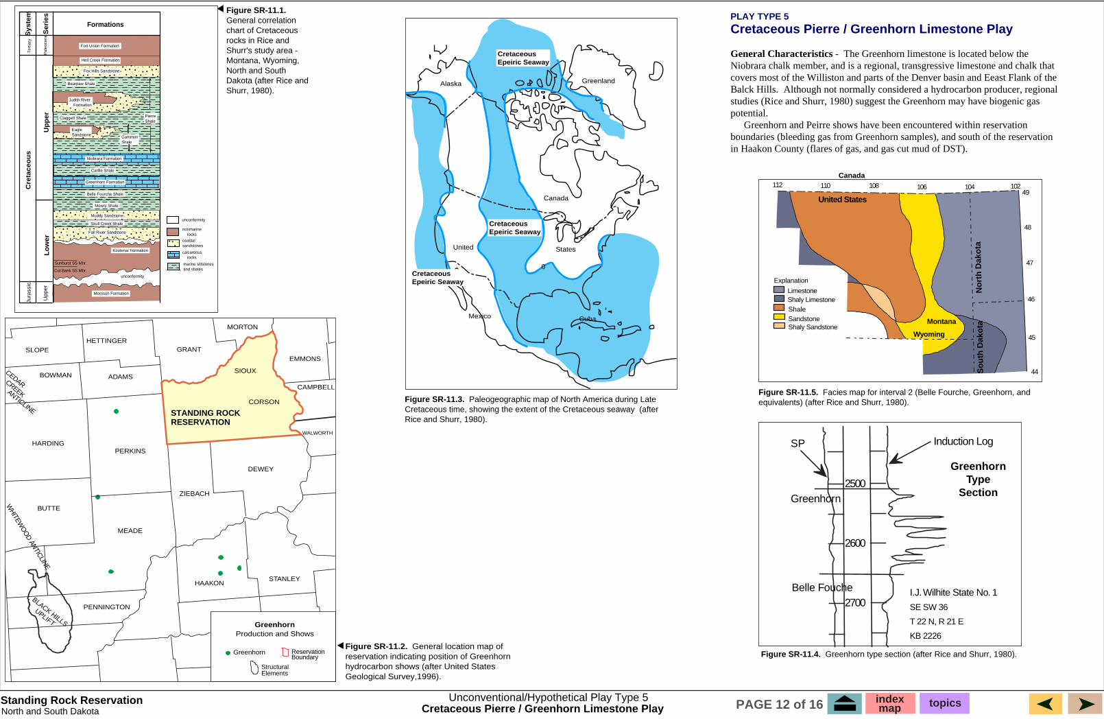
Cretaceous Pierre / Greenhorn Limestone Play
General Characteristics - The Greenhorn limestone is located below the Niobrara chalk member, and is a regional, transgressive limestone and chalk that covers most of the Williston and parts of the Denver basin and Eeast Flank of the Balck Hills. Although not normally considered a hydrocarbon producer, regional studies (Rice and Shurr, 1980) suggest the Greenhorn may have biogenic gas potential.� Greenhorn and Peirre shows have been encountered within reservation boundaries (bleeding gas from Greenhorn samples), and south of the reservation in Haakon County (flares of gas, and gas cut mud of DST).
Figure SR-11.2. General location map of reservation indicating position of Greenhorn hydrocarbon shows (after United States Geological Survey,1996).
Unconventional/Hypothetical Play Type 5
SLOPE
BOWMAN
HETTINGERGRANT
MORTON
EMMONS
SIOUX
CORSON
CAMPBELL
WALWORTH
STANLEYHAAKON
ZIEBACH
DEWEY
PERKINSHARDING
ADAMS
BUTTE
MEADE
PENNINGTON
STANDING ROCK RESERVATION
BLACK HILLS
UPLIFT
WHITEW
OO
D ANTICLINE
CEDARCREEKANTICLINE
Structural Elements
Reservation Boundary
Greenhorn
GreenhornProduction and Shows
Cretaceous Pierre / Greenhorn Limestone Play
Montana
Wyoming
Canada
indexmap topicsPAGE 12 of 16
Alum Creek
Edgemont
NE Indian Creek
Indian Creek
Red Bird
Mule Creek
32N
35N
12S
3S
9E1E
29N
Cotto
nwoo
d Cr
eek
Chi
lson
Cas
cade
Wyo
min
g
Muddy
Sundance
Spearfish
Goose Egg
Minnekahta
Minnelusa
"Leo"
Atokan
Bell Madison
Scale
0 100 200
500
Minnelusa / Leo
SLOPE HETTINGER
GRANT EMMONS
CORSON
CAMPBELL
DEWEY
PERKINS HARDING
MEADE
BLACK HILLS
UPLIFT
WH
ITEWO
OD
ANTIC
LINE
CEDARCREEKANTICLINE
Figure SR-12.1.hydrocarbon shows.
Standing Rock Reservation
Figure SR-12.2. Generalized stratigraphic section of the Upper Pennsylvanian interval (after Cardinal and Sherer, 1984).
Figure SR-12.3. Index map of Pennsylvanian Leo producing fields (after Cardinal and Sherer, 1984).
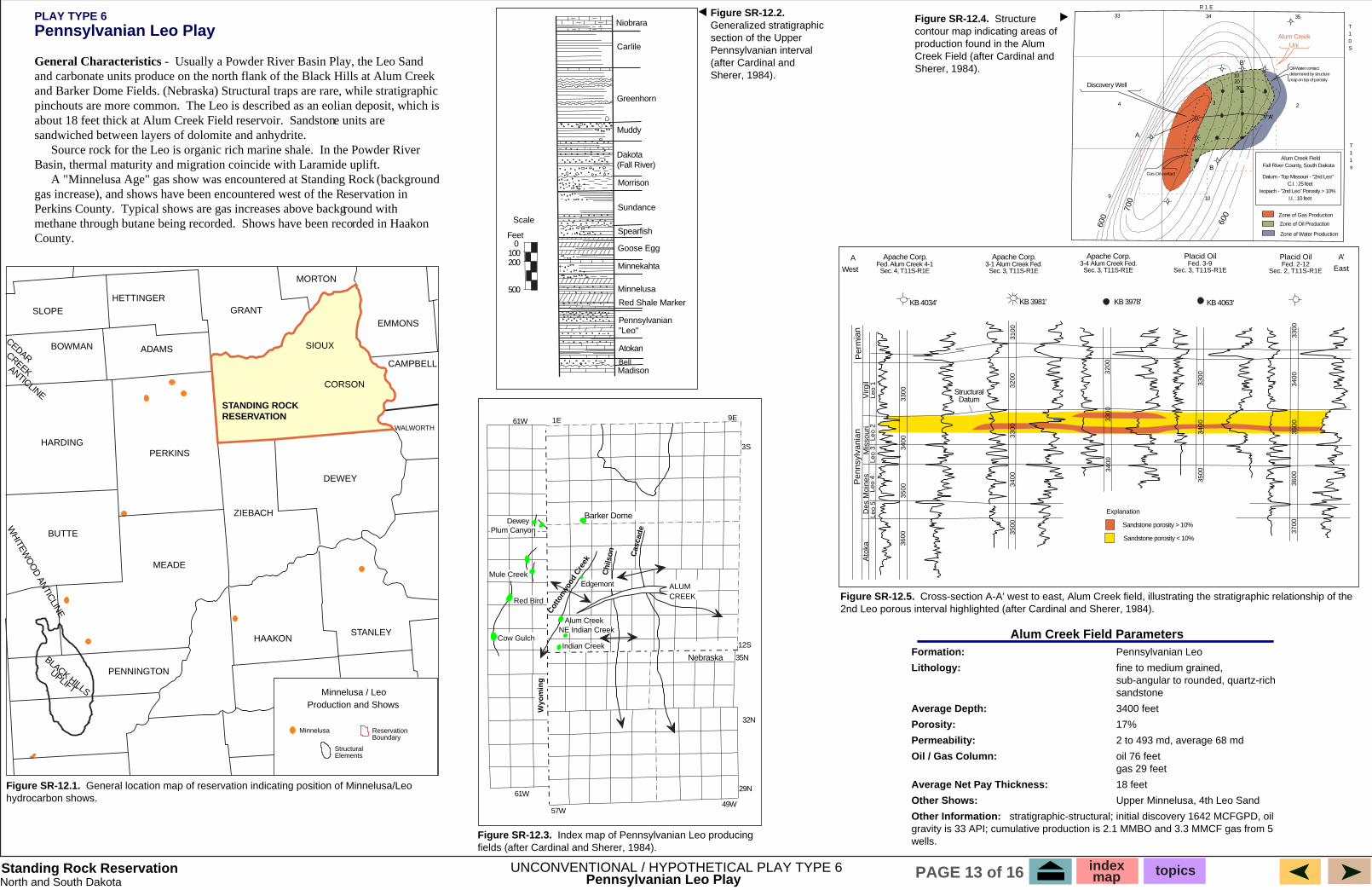
PLAY TYPE 6 Pennsylvanian Leo Play
General Characteristics - Usually a Powder River Basin Play, the Leo Sand
pinchouts are more common. about 18 feet thick at Alum Creek Field reservoir. sandwiched between layers of dolomite and anhydrite. � Source rock for the Leo is organic rich marine shale.
�
Perkins County. methane through butane being recorded. County.
Datum
A Placid Oil Placid Oil A'
East
KB 4034' KB 3981' KB 3978' KB 4063'
Sandstone porosity > 10%
Sandstone porosity < 10%
Explanation
Per
mia
n P
enns
ylva
nian
V
irgil
Des
Moi
nes
Mis
sour
i A
toka
Le
o 1
Leo
2Le
o 3
Leo
4Le
o 5
3300
3400
3500
3600
3300
3400
3500
3300
3400
3500
3300
3400
32
00
3200
31
00
3300
3400
3500
3600
3700
Figure SR-12.5.
R 1 E
T 1 0 S
T 1 1 s
9 10
234
33 34 35
A'
A
B
B'
Gas-Oil contact
Alum Creek Uni
map on top of porosity 10 20 30
Zone of Oil Production
Zone of Gas Production
600
600
700
Alum Creek Field
SIOUX
Minnelusa
Structural Elements
Reservation Boundary
Figure SR-12.4. Structure contour map indicating areas of production found in the Alum Creek Field (after Cardinal and Sherer, 1984).
Alum Creek Field Parameters Formation:� Pennsylvanian Leo
Lithology:� fine to medium grained, � sub-angular to rounded, quartz-rich � sandstone
Average Depth:� 3400 feet
Porosity:� 17%
Permeability:� 2 to 493 md, average 68 md
Oil / Gas Column:� oil 76 feet � gas 29 feet
Average Net Pay Thickness:� 18 feet
Other Shows:� Upper Minnelusa, 4th Leo Sand
Other Information:
wells.
UNCONVENTIONAL / HYPOTHETICAL PLAY TYPE 6Pennsylvanian Leo Play
index map topicsPAGE 13 of 16
North and South Dakota
Barker Dome
Cow Gulch
Dewey Plum Canyon
Nebraska
ALUM CREEK
61W
49W 61W
57W
Niobrara
Carlile
Greenhorn
Dakota (Fall River)
Morrison
Red Shale Marker
Pennsylvanian
Feet
Production and Shows
BOWMAN
MORTON
WALWORTH
STANLEY HAAKON
ZIEBACH
ADAMS
BUTTE
PENNINGTON
STANDING ROCK RESERVATION
General location map of reservation indicating position of Minnelusa/Leo
and carbonate units produce on the north flank of the Black Hills at Alum Creek and Barker Dome Fields. (Nebraska) Structural traps are rare, while stratigraphic
The Leo is described as an eolian deposit, which is Sandstone units are
In the Powder River Basin, thermal maturity and migration coincide with Laramide uplift.
A "Minnelusa Age" gas show was encountered at Standing Rock (background gas increase), and shows have been encountered west of the Reservation in
Typical shows are gas increases above background with Shows have been recorded in Haakon
Structural
West
Apache Corp. Fed. Alum Creek 4-1 Sec. 4, T11S-R1E
Apache Corp. 3-1 Alum Creek Fed. Sec. 3, T11S-R1E
Apache Corp. 3-4 Alum Creek Fed. Sec. 3, T11S-R1E
Fed. 3-9 Sec. 3, T11S-R1E
Fed. 2-12 Sec. 2, T11S-R1E
Cross-section A-A' west to east, Alum Creek field, illustrating the stratigraphic relationship of the 2nd Leo porous interval highlighted (after Cardinal and Sherer, 1984).
Discovery Well
Oil-Water contact determined by structure
Zone of Water Production
Fall River County, South Dakota
Datum - Top Missouri - "2nd Leo" C.I. : 25 feet
Isopach - "2nd Leo" Porosity > 10% I.I. : 10 feet
stratigraphic-structural; initial discovery 1642 MCFGPD, oil gravity is 33 API; cumulative production is 2.1 MMBO and 3.3 MMCF gas from 5
Shaly Limestone Shale Sandstone
Explanation
11 11 108 106 104 102 49
48
47
46
45
44
Canada
United States
Montana
Wyoming
North Dakota
South Dakota
Montana
Hill Creek
Eastend Fm.
Battle Fm.
Oldman Fm.
Claggett Shale
Eagle SS Gammon Shale
Medicine Hat SS
First Whit
Fish Scale SS
Muddy SS
Shale
Shale
Col
orad
o G
roup
B
elle
Edm
on-
ton
Gp.
Gre
en
horn
Fm
.
T
T
T
T
T
SLOPE HETTINGER
GRANT EMMONS
SIOUX
CORSON
CAMPBELL
DEWEY
PERKINS HARDING
MEADE
T
BLACK HILLS
UPLIFT
WHITEW
OO
D ANTICLINE
CEDARCREEKANTICLINE
Cretaceous Epeiric Seaway
United States
Mexico Cuba
Canada
Alaska Greenland
Cretaceous Epeiric Seaway
Cretaceous Epeiric Seaway
0
BEARPAW MTNS
DOWDOIN DOME
FOX HILLS SS
BEARPAW SHALE
ST MARY RIVER FM
JUDITH RIVER FM
ARDMORE BENTONITE BED
PIERRE SHALE
WEST FLANK WILLISTON BASIN
HELL CREEK FM.
CLAGGETT SHALE
EAGLE SS
VIRGELLE SS
MARIAS RIVER SHALE
TELEGRAPH CREEK FM.
GAMMON SHALE
NIOBRARA FM
MOWRY SHALE
CARLILE SHALEBELLE FOURCHE SH
BLACKLEAF FM
VAUGHN MBR
MUDDY SS
SKULLCREEK SHALE
Upper CretaceousLower Cretaceous
GREENHORN FM
TW
O M
ED
ICIN
E F
OR
MA
TIO
N
BEARPAW SHALE HORSETHIEF SANDSTONE FOX
HILLS SS
WILLOW CREEK FM (PART)
NONMARINE ROCKS
COASTAL SANDSTONE
CALCAREOUS SHALE CHALK & LIMESTONE
MARINE SHALE & SILTSTONE
90 Mi 150 Mi180 Mi
GLACIER NAT'L PARK
A A'
Figure SR-13.2.shows (after United States Geological Survey, 1996).
Figure SR-13.3. Paleographic map of North America during Late Cretaceous time, showing the extent of the Cretaceous seaway (after Rice and Shurr, 1980).
Figure SR-13.1. Regional north- south cross-section (after Rice and Shurr, 1980).
Figure SR-13.5.Rice and Shurr, 1980).
Figure SR-13.4. Correlation chart of selected Cretaceous rocks in
Turner
Structural Elements
Reservation Boundary
Cretaceous Carlile Shale / Turner Sandstone Play
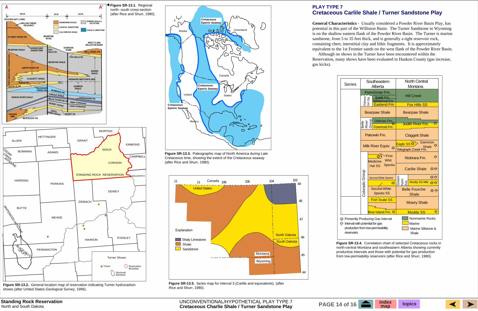
General Characteristics - Usually considered a Powder River Basin Play, has potential in this part of the Williston Basin. is on the shallow eastern flank of the Powder River Basin. The Turner is marine
containing chert, interstitial clay and lithic fragments.
�
gas kicks).
Series Southeastern
Alberta North Central
Frenchman Fm.
Fox Hills SS Whitemud Fm.
Bearpaw Shale Bearpaw Shale
Judith River Fm. Foremost Fm.
Pakowki Fm.
Telegraph Creek Fm. Milk River Equiv.
Specks
Second White Specks
Second White Specks SS
Bow Island Fm.
Mowry Shale
Belle Fourche
Mosby SS Mbr.
Carlile Shale
Niobrara Fm.
Nonmarine Rocks
Marine
Marine Siltstone &
Presently Producing Gas Interval Interval with potential for gas production from low-permeability reservoirs
Riv
erG
roup
Turner Shows
BOWMAN
MORTON
WALWORTH
STANLEY HAAKON
ZIEBACH
ADAMS
BUTTE
PENNINGTON
STANDING ROCK RESERVATION
General location map of reservation indicating Turner hydrocarbon facies map for interval 3 (Carlile and equivalents). (after
north-central Montana and southeastern Alberta showing currently productive intervals and those with potential for gas production from low-permiability reservoirs (after Rice and Shurr, 1980).
PLAY TYPE 7
The Turner Sandstone in Wyoming
sandstone, from 5 to 35 feet thick, and is generally a tight reservoir rock, It is approximately
equivalent to the 1st Frontier sands on the west flank of the Powder River Basin. Although no shows in the Turner have been encountered within the
Reservation, many shows have been evaluated in Haakon County (gas increase,
Standing Rock Reservation UNCONVENTIONAL/HYPOTHETICAL PLAY TYPE 7 index topicsmapNorth and South Dakota Cretaceous Charlie Shale / Turner Sandstone Play PAGE 14 of 16
1 4
Calcareous Shale
Chalk
Sandstone
Shale
Explanation NW
SE
Eagle Sandstone
of Pierre ShaleShannon Sandstone Member
Gammon Shale
Montana NW SE
1 2 3 4
0
0 0
0 0
10
10
10 0
20 0
20
10 0
0
10
20
10 0
0
0 10
0
0
103104105106
46
45 Montana
Wyoming
North Dakota
South Dakota
30
A
B C
D Montana
Williston Basin
Hills Basin
44
45
46
106 104
Coastal Plain
Uplands
Shelf
Pierre / Shannon Production and Shows
SLOPE
BOWMAN
HETTINGER GRANT
MORTON
EMMONS
SIOUX
CORSON
CAMPBELL
WALWORTH
STANLEYHAAKON
ZIEBACH
DEWEY
PERKINS HARDING
ADAMS
BUTTE
MEADE
PENNINGTON
STANDING ROCK RESERVATION
WH
ITEWO
OD
ANTIC
LINE
�
CEDAR�CREEK�
ANTICLINE
�
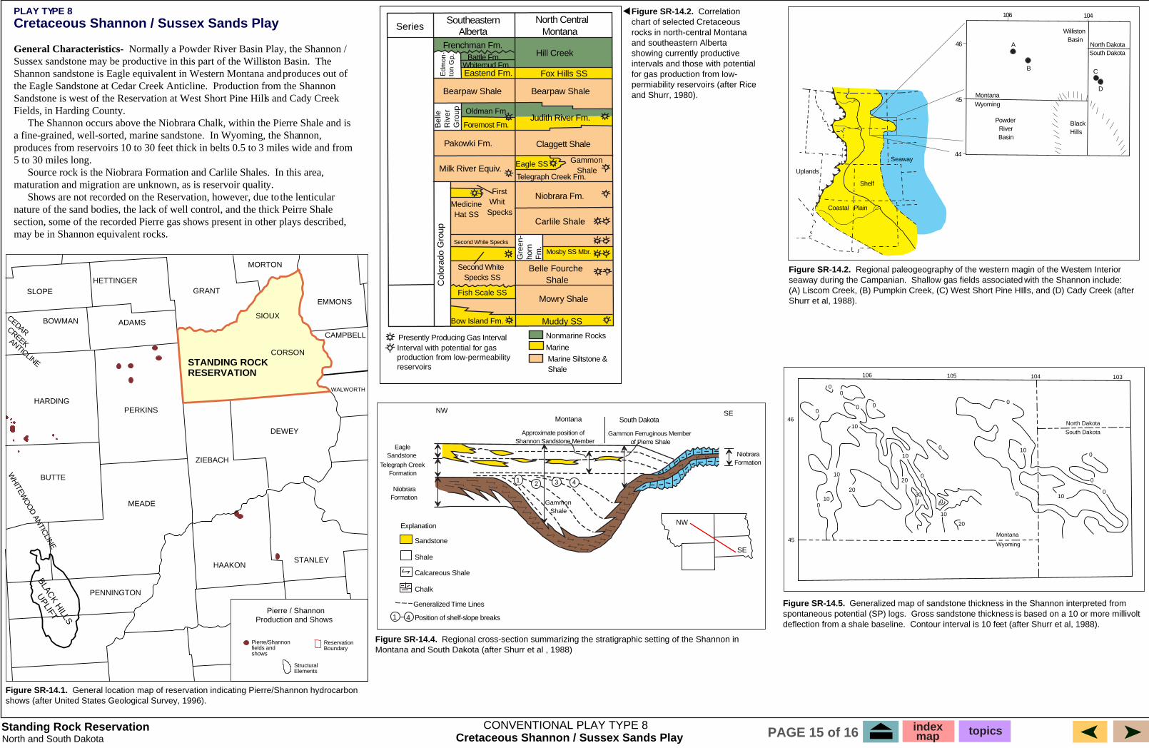
CONVENTIONAL PLAY TYPE 8 Cretaceous Shannon / Sussex Sands Play
Standing Rock Reservation North and South Dakota
Cretaceous Shannon / Sussex Sands Play
General Characteristics- Normally a Powder River Basin Play, the Shannon / The
the Eagle Sandstone at Cedar Creek Anticline.
Fields, in Harding County. �
5 to 30 miles long. � Source rock is the Niobrara Formation and Carlile Shales. In this area,
�
may be in Shannon equivalent rocks.
Figure SR-14.5. spontaneous potential (SP) logs. deflection from a shale baseline.
Figure SR-14.2.seaway during the Campanian.
Shurr et al, 1988).
Montana
Hill Creek
Eastend Fm.
Battle Fm.
Oldman Fm.
Claggett Shale
Eagle SS Gammon Shale
Medicine Hat SS
First Whit
Fish Scale SS
Muddy SS
Shale
Shale
Col
orad
o G
roup
B
elle
Riv
erG
roup
Edm
on-
ton
Gp.
Gre
en
horn
Fm
.
Figure SR-14.2. Correlation chart of selected Cretaceous rocks in north-central Montana and southeastern Alberta showing currently productive intervals and those with potential for gas production from lowpermiability reservoirs (after Rice and Shurr, 1980).
Figure SR-14.1.shows (after United States Geological Survey, 1996).
Figure SR-14.4. Montana and South Dakota (after Shurr et al , 1988)
Structural Elements
Reservation Boundary
Pierre/Shannon fields and shows
BLACK H
ILLS
UPLIFT
index map topicsPAGE 15 of 16
Generalized Time Lines
Position of shelf-slope breaks
Telegraph Creek Formation
Niobrara Formation
Niobrara Formation
Gammon Ferruginous Member Approximate position of
South Dakota
Wyoming
South Dakota North Dakota
Black Powder River
Seaway
PLAY TYPE 8
Sussex sandstone may be productive in this part of the Williston Basin. Shannon sandstone is Eagle equivalent in Western Montana and produces out of
Production from the Shannon Sandstone is west of the Reservation at West Short Pine Hills and Cady Creek
The Shannon occurs above the Niobrara Chalk, within the Pierre Shale and is a fine-grained, well-sorted, marine sandstone. In Wyoming, the Shannon, produces from reservoirs 10 to 30 feet thick in belts 0.5 to 3 miles wide and from
maturation and migration are unknown, as is reservoir quality. Shows are not recorded on the Reservation, however, due to the lenticular
nature of the sand bodies, the lack of well control, and the thick Peirre Shale section, some of the recorded Pierre gas shows present in other plays described,
Generalized map of sandstone thickness in the Shannon interpreted from Gross sandstone thickness is based on a 10 or more millivolt Contour interval is 10 feet (after Shurr et al, 1988).
Regional paleogeography of the western magin of the Western Interior Shallow gas fields associated with the Shannon include:
(A) Liscom Creek, (B) Pumpkin Creek, (C) West Short Pine HIlls, and (D) Cady Creek (after
Series Southeastern
Alberta North Central
Frenchman Fm.
Fox Hills SS Whitemud Fm.
Bearpaw Shale Bearpaw Shale
Judith River Fm. Foremost Fm.
Pakowki Fm.
Telegraph Creek Fm. Milk River Equiv.
Specks
Second White Specks
Second White Specks SS
Bow Island Fm.
Mowry Shale
Belle Fourche
Mosby SS Mbr.
Carlile Shale
Niobrara Fm.
Nonmarine Rocks
Marine
Marine Siltstone &
General location map of reservation indicating Pierre/Shannon hydrocarbon
Regional cross-section summarizing the stratigraphic setting of the Shannon in
Interval with potential for gas production from low-permeability reservoirs
Presently Producing Gas Interval
Standing Rock Reservation
General References Cardinal, D. F. and Sherer, M., 1984, "Alum Creek Field, Fall River County,
South Dakota", Thirty-fifth Annual Field Conference, Wyoming Geological Association Guidebook, p. 169-182.
Shurr, George W., Nelson, C.L. and Jenkins, J.T. Jr., 1988, "Prediction of Sandstone Geometry in the Upper Cretaceous Shannon Sandstone in the Northern Powder River Basin", Thirty-ninth Field Conference, Wyoming
Anderson, Robert C., 1995, The Oil and Gas Opportunity on Indian Lands-Exploration Policies and Procedures, Bureau of Indian Affairs, Division of Energy and Mineral Resources, General Publication G-95-3, 158 p.
Dolson, John, Mueller, D., Evetts, M.J. and Stein, J.A., March 1991, "Regional Paleotopographic Trends and Production, Muddy Sandstone (Lower Cretaceous), Central and Northern Rocky Mountains", American
Geological Association Guidebook, p. 217-228.
Sperr, J.T., et al., 1993, "Wabek and Plaza Fields: Carbonate Shoreline Traps in the Williston Basin of North Dakota"; North Dakota Geologic Survey Field
Beeman, William R., et al., 1996, Digital Map Data, Text and Graphical Images Association of Petroleum Geologists Bulletin, Volume 75/3, p. 409-35. Study, No. 1.
in Support of the 1995 Assessment of United States Oil and Gas Resources, United States Geological Survey, Digital Data Series DDS-35, CD ROM.
Dolten, Gordon L. and Fox, James E., 1996, "Powder River Basin Province (033)", Tabular Data, Text, and Graphical Images in Support of the 1995
Weimer, R. J., et al., October 1982, "Tectonic Influence on Sedimentation, Early Cretaceous, East Flank Powder River Basin, Wyoming and South Dakota",
Charpenteir, Ronald R., et al., 1996, Tubular Data, Text, and Graphical Images in Support of the 1995 National Assessment of United States Oil and Gas Resources, United States Geological Survey, Digital Data Series DDS-36, CD ROM.
National Assessment of United States Oil and Gas Resources, United States Geological Survey, Digital Data Series DDS-36, CD ROM.
Editors, Petroleum Information, 1984, "Buffalo Field Red River Pool - Harding County, South Dakota",Williston Basin Field Summaries, Petroleum
Colorado School of Mines Quarterly, Volume 77, No. 4.
Wing, Monta E., 1938 (1952), "A Structural Survey of the Pierre Gas Field, South Dakota"; Report of Investigation No. 29, South Dakota State Geological Survey, 21 p.
Gautier, Donald L., et al., 1996, 1995 National Assessment of United States Oil and Gas Resources - Results, Methodology, and Supporting Data, United States Geological Survey Digital Data Series DDS-30 Release 2.
Information.
________, 1984, "Jones Creek Field Red River Pool - Harding County, South Dakota", Williston Basin Field Summaries, Petroleum Information.
Wulf, George R., 1968, "Lower Cretaceous Muddy Sandstone in the Northern Rockies", Black Hills Area, South Dakota, Montana, Wyoming, Wyoming Geological Association, 20th Field Conference Guidebook, p. 29-34
_______________., et al., 1995, 1995 National Assessment of United States Oil and Gas Resources, Overview of the 1995 National Assessment of Potential Additions to Technically Recoverable Resources of Oil and Gas - Onshore and State Waters of the United States, United States Geological Survey Circular 1118, 20 p.
________, 1984, "Lantry Field Red River Pool - Dewey County, South Dakota", Williston Basin Field Summaries, Petroleum Information.
Howells, Lewis, 1982, "Geohydrology of the Standing Rock Indian Reservation North and South Dakota", Hydrologic Investigations Atlas, United States
Standing Rock - Map References
Executive Reference Map 334, 1985 edition, Extended Area, Northern Rocky Mountains, Geomap Company.
Mallory, William Wyman, et al., 1972, Geologic Atlas of the Rocky Mountain Region, Rocky Mountain Association of Geologists ,331 p.
Geological Survey, G3701, svar U5, HA-644.
LeFeur, Richard D, and McCloskey, Jerry G., 1995, "Depositional History of the
Executive Reference Map 321, 1983 edition, Southern Williston Basin, Geomap Company.
Peterson, James A. and MacCary, Lawrence M., 1987, "Regional Stratigraphy and General Petroleum Geology of the U.S. Portion of the Williston Basin and Adjacent Areas", Williston Basin: Anatomy of a Cratonic Oil Province, Rocky Mountain Association of Geologists, p. 9-43.
Newcastle Formation (Lower Cretaceous), Williston Basin, North Dakota, South Dakota, and Eastern Montana", Seventh International Williston Basin Symposium, Montana Geological Society, Billings, Montana, p. 411-416.
Lockridge, John P. and Pollastro, Richard M., 1988, "Shallow Upper Cretaceous
Indian Land Areas, 1992, United States Department of the Interior - Bureau of Indian Affairs.
Clayton, Lee, et al., 1980, Geological Map of North Dakota, North Dakota Geological Survey.
Rice, Dudley D. and Shurr, George W., July 1980, "Shallow, Low-Permeability Reservoirs of the Northern Great Plains - Assessment of their Natural Gas Resources", American Association of Petroleum Geologists Bulletin, Volume 64/7, p. 969-987.
Niobrara Gas Fields in the Eastern Denver Basin", Carbonate Symposium, Rocky Mountain Association of Geologists, p. 63-74.
Nixon, R. P., January 1973, "Oil Source Beds in Cretaceous Mowry Shale of Northwestern Interior United States", American Association of Petroleum
Darton, N. H., et al., 1951, Geological Map of South Dakota, United States Geological Survey.
Ross, Clyde p., et al., 1958, Geological Map of Montana, Montana Bureau of
Willette, Donna C., et al., 1996, "Oil and Gas Atlas on Indian Lands", Indian Geologists Bulletin, v. 57/1, p. 136-161. Mines.
Resources Building Partnerships, Sixth Annual Energy and Minerals Conference, Bureau of Indian Affairs, Division of Energy and Mineral Resources, 10 p.
Petersen, James A., 1996, "Williston Basin Province (031)", Tabular Data, Text, and Graphical Images in Support of the 1995 National Assessment of United States Oil and Gas Resources, United States Geological Survey, Digital Data Series DDS-36, CD ROM.
Standing Rock - Fields and Articles _________________, 1996, "Sioux Province (032)", Tabular Data, Text, and
Anderson, Sydney B., 1967, "Where North Dakota's Best Newcastle Sand Trends are Located", Report of Investigations Number 46, North Dakota Geological Survey, 5 p.
Graphical Images in Support of the 1995 National Assessment of United States Oil and Gas Resources, Unied States Geological Survey, Digital Data Series DDS-36, CD ROM.
Bolyard, Dudley W., 1969, "Muddy Sand Oil Potential in South Dakota", Montana Geological Society, Eastern Montana Symposium, p. 85-94.
Reishus, Mark, 1968, "The Newcastle Formation in the Williston Basin of North Dakota", Report of Investigation 47, North Dakota Geological Survey, p. 26.
Bretz, Richard, 1981, "List of Natural Gas Occurrences in South Dakota by County", Open-File Report No. 2-BAS, South Dakota State Geological Survey, 147 p.
Schoon, Robert A., 1971, "Geology and Hydrology of the Dakota Formation in South Dakota", Report of Investigation 104, South Dakota Geological Survey, p. 38.
Standing Rock Reservation North and South Dakota
REFERENCES PAGE 16 of 16 index map topics