Embed Size (px)
Citation preview

St Marys Urban Design and Traffic Management Strategy
Break O'Day Council Municipal Management Plan
February 2015

This report has been prepared for Break O’Day Council in accordance with the scope of services provided by TCG
Planning. This report should only be used only for the purpose for which it was expressly prepared and shall not be
reproduced by any third party in part or full without the permission of TCG Planning.
Significant Sections of this document incorporate (where referenced) the report prepared by Bitzios Consulting;
contracted by TCG Planning for Break O’ Day Council, entitled ‘St Marys Traffic Study’ (Project Ref: P1064, Version
003, Issued 30 September 2013), which forms the Existing Traffic and Pedestrian/Cycle Analysis (Part 4.2) of this
Strategy) and Traffic, Transport and Pedestrian and Urban Design Framework (Part 6) and Implementation Plan (Part
8).
Document Status Approved For Issue
Author Reviewer Signature Date
Draft Nadine Page Elaine Treglown Authorised 25.8.2014
Draft V2 Nadine Page Nadine Page Authorised 27.08.2014
Final Nadine Page Elaine Treglown
03.02.2015

3
______________________________________
________________________________________________________________________________________________________
tcg planning St Marys Urban Design & Traffic Management Strategy
Contents
1 Executive Summary ................................................................................................................ 4 2 Introduction ............................................................................................................................. 6
2.1 The Study Area ...................................................................................................................... 6 2.2 Strategic Context - The Municipal Management Plan (MMP) ..................................... 10 2.3 Objectives ............................................................................................................................ 10 2.4 Methodology ....................................................................................................................... 10 2.5 Consultation ........................................................................................................................ 11
3 Document Review ................................................................................................................. 15 4 Town Centre Issues Analysis/Assessment ........................................................................... 17
4.1 SWOT Analysis ...................................................................................................................... 17 4.2 Issues Paper Outcomes ...................................................................................................... 17 4.3 Built Form Analysis ............................................................................................................... 19 4.2 Analysis of Existing Traffic, Parking Issues, and Pedestrian and Cyclist Movement .. 30
5 Strategy Vision and Guiding Principles ............................................................................... 37 6 Traffic, Transport, Pedestrian and Cycling Framework ....................................................... 38
6.1 Traffic Management .......................................................................................................... 38 6.2 Parking Strategies ............................................................................................................... 39 6.4 Pedestrian and Cycling Strategies ................................................................................... 42 6.5 Signpost Strategies .............................................................................................................. 43
7 Urban Design Framework .................................................................................................... 44 7.1 Consolidate the Township and Active Land Uses .......................................................... 44 7.2 Key Sites and Recommended Land Use Zone Amendments ...................................... 45 7.3 Recommended Land Sale/Purchase .............................................................................. 50 7.4 Township Entry Statements ................................................................................................ 50 7.5 Open Space Linkages ........................................................................................................ 50 7.6 Vistas/Visual Linkages and Scenic Features .................................................................... 51 7.7 Streetscape and Landscape Treatments (Public Domain) .......................................... 51 7.8 Streetscape Improvements (Private Domain) ................................................................ 52
8 Masterplan and Strategy Implementation .......................................................................... 56
Appendix 1: Document Review ................................................................................................... 62 Appendix 2: Approved Concept Plans for St Marys Streetscape Project ................................ 80 Appendix 3: St Marys Arts, Culture & Heritage Precinct Concept Plans .................................. 82

4
______________________________________
________________________________________________________________________________________________________
tcg planning St Marys Urban Design & Traffic Management Strategy
1 Executive Summary
The St Marys Urban Design and Traffic Management Strategy provides a framework to guide the future use and
development of the Township of St Marys, the largest inland rural centre within the Break O'Day Municipality.
The Strategy has been prepared by TCG Planning, with significant input by Bitzios Consulting through the traffic
management component of this work entitled 'St Marys Traffic Study' (Project Ref: P1064, Version 003, Issued 30
September 2013). All traffic-related content is sourced from this Study, and is re-formatted to present in a more
consistent manner with this overall Strategy document (referenced accordingly).
Part 2 of the Strategy 'Introduction' outlines and describes the Study Area (generally comprising the
commercially-zoned area of the town), within the context of the Break O'Day Municipality. Part 1 also outlines
the strategic context of the Strategy as it relates to the overall Municipal Management Plan (MMP) and its
various components, which will establish priorities for Break O'Day Council over the next ten year period. This
part of the Strategy also outlines the objectives of the Strategy, and details the methodology and stakeholder
consultation undertaken during its preparation (as identified in the Service Agreement/Brief for the Strategy
project).
Part 3 'Document Review' provides an overview and summary of the themes and issues identified within existing
local, regional and state-wide studies, strategies and documents previously which are of relevance to the St
Marys Strategy. Appendix 1 provides a more detailed summary outline of the content, outcomes and
recommendations of the documents reviewed.
Part 4 'Town Centre Issues Analysis/Assessment' identifies in detail the existing issues relevant to the township of St
Marys for the urban design/built form (presented in this document in distinct precincts within the town); and for
the traffic, parking and pedestrian and cyclist movement (as identified by Bitzios Consulting). From the
consultation, review of existing documents, and a thorough analysis of the town, the key matters to be
addressed in the future planning of St Marys have been identified, and include economy and employment,
linkages, and town centre quality and amenity. The strengths, weaknesses, opportunities and threats faced by
St Marys have also been identified.
From the community consultation, analysis of the township and document review Part 5 'Strategy Vision and
Guiding Principles' establishes the following Vision: "St Marys will:
retain its historic and creative and unique image and character within its existing area;
continue to value and preserve its picturesque, “clean and green” township and surrounds;
be a vibrant centre supported by welcomed visitors, local residents and economies;
have a legible and attractive town centre that encourages locals and visitors to stop to visit."
The Vision is underpinned by seven Guiding Principles and which form the basis for the St Marys Urban Design
and Traffic/Transport Framework/Strategy. "This Strategy will:
1. Improve the pedestrian experience
2. maintain the road safety

5
______________________________________
________________________________________________________________________________________________________
tcg planning St Marys Urban Design & Traffic Management Strategy
3. integrate traffic mixes
4. better manage existing parking
5. improve connectivity
6. create a 'central' area to the township
7. improve the visual quality of the public and private domain"
Part 6 'Traffic, Transport, Pedestrian and Cycling Framework' identified strategies and actions on how the existing
vehicular and pedestrian environment could be improved for the future (as outlined by Bitzios Consulting's
Study). The framework addresses traffic management measures, strategies for improved parking, pedestrian
and cyclist movement, and improvements to signposting throughout the township.
Part 7 'Urban Design Framework' outlines the recommended strategies and actions for change from a built form
and land use perspective. Recommended strategies include: consolidation of the township and active land
uses; recommended land sale and purchase strategies; development of key sites; provision of township entry
statements; and recommended improvements to the public and private domain.
Part 8 'Masterplan and Strategy Implementation' provides two plans:
'Traffic, Transport, Pedestrian and Cycle Framework' and
'Land Use and Urban Design Framework'
which form an overall corresponding Masterplan to guide the future use and development of the Township of St
Marys. In addition, an Implementation Table is provided listing all of the recommended actions (and associated
cost estimates, within short, medium and long term timeframes) to achieve this Strategy. It is considered that
the implementation of this Strategy will achieve the identified Vision for the township of St Marys and serve the
town well into the future.

6
______________________________________
________________________________________________________________________________________________________
tcg planning St Marys Urban Design & Traffic Management Strategy
2 Introduction
2.1 The Study Area
Site and Context: Location and Setting
St Marys is located within the Break O’Day Municipality in the north-east of Tasmania. The township is located
within the Fingal Valley at the junction of the Esk Highway and Gray Road/Elephant Pass Road, and is located
11 kilometres from the coast to the east, approximately 21 kilometres from Fingal to the west, and 130 kilometres
to the Regional Centre of Launceston (measured by road distance). Refer to Figure 1 indicating the location of
St Marys in its regional context and Figure 2 for an aerial view of the township.
St Marys is located with a picturesque landscape setting. The St Marys Rivulet flows through the town and is an
attractive feature. There are significant views from many parts of the township to the Ben Lomond ranges
beyond to the north west, Nicholas Range and Mount Nicholas to the north, the St Patricks Head Peak to the
east and Final Tier range to the south. The peaks of Mount Nicholas and St Patricks Head are a constant
imposing presence observed from St Marys and are a strong visual feature of the landscape.
The population of St Marys (800 within the broader suburb, with and 511 residing within the township) is
supported by a commercial centre located near and at the intersection of the two main roads. Surrounding
the commercial centre are several streets of residential allotments, with semi-rural and rural properties beyond.
The wider township area features a school, sportsgrounds, golf course, cemetery and a hospital. A sewage
treatment plant services the township and is located to the east of the township.
Break O'Day
Municipality
Figure 1: Location of St Marys: Regional Context (Map Source: TCG Planning/Niche Environment and Heritage, from date source Break O'Day Council and LIST)

7
______________________________________
________________________________________________________________________________________________________
tcg planning St Marys Urban Design & Traffic Management Strategy
Figure 2: Aerial Photograph indicating the key features of the township of St Marys and immediate surrounds (Source: http://maps.thelist.tas.gov.au/listmap/app/list/map)
St Marys
Community
Health
Centre
Former St
Marys
Railway
Station
Wombat
Walk Reserve
St Marys
Rivulet
S.T.P
Town Centre
Esk Main Rd
To coast
(Falmouth,
Scamander)
St
Patricks
Head
St Marys
District
High School
To coast (Chain of
Lagoons
Sports Facilities

8
______________________________________
________________________________________________________________________________________________________
tcg planning St Marys Urban Design & Traffic Management Strategy
Defining the Study Area
This Strategy, entitled the 'St Marys Urban Design and Traffic Management Strategy' considers the overall issues
affecting the township of St Marys but focuses on the town centre, the “hub” of economic and social activity of
the population of St Marys.
It is acknowledged that the town centre does not sit in isolation and the town centre needs to be considered
within the context of surrounding lands. However, it is the town centre that requires a framework for the key
elements of the township to be addressed, being traffic and transport infrastructure, streetscape and
landscape treatments, open space and the identification of key development sites. Therefore, this study does
not propose built form outcomes for areas outside of the St Marys Town Centre, however it does address
important linkages, associations and opportunities outside this area.
The St Marys Town Centre comprises the retail, commercial and civic uses along Main Street and Storey Street
and forms the study area for this Strategy (refer Map 1). Section 4 of this document describes the Town Centre
in the context of five precincts, each having special characteristics (Main Street West; Main Street Central –
North; Main Street Central – South; Main Street - East; and Storey Street).


10
______________________________________
________________________________________________________________________________________________________
tcg planning St Marys Urban Design & Traffic Management Strategy
2.2 Strategic Context - The Municipal Management Plan (MMP)
In September 2012 TCG Planning, together with its specialist consultant team, was engaged by Break O’Day
Council to prepare Council’s Municipal Management Plan (MMP), which includes the preparation and
integration of a number of reports, plans and strategies (including this Urban Design and Traffic Management
Strategy).
The aim of the MMP is to ensure that future development in the Municipality is undertaken in a strategic and
integrated manner. The Plan will establish priorities for works over a 10 year period in order to provide
appropriate infrastructure for residents and visitors to the area; promote ongoing tourism while acknowledging
and protecting the values of the natural environment; improve the physical appearance and functionality and
livability of the towns; and encourage economic growth and future prosperity of the Municipality. The MMP will
be a comprehensive strategic planning document that will provide an action plan identifying what needs to be
undertaken to achieve the identified priorities.
The MMP will also consolidate a number of studies which have previously been prepared by Council or which
are under preparation. Many of the specialist background documents that will inform the MMP will be prepared
and/or coordinated by TCG Planning, together with the specialist project team.
2.3 Objectives
This Urban Design and Traffic Management Strategy has been developed in accordance with the Project Brief
prepared by Break O'Day Council. The Objectives of the project are to:
Weave the environment and built form influences with the social, cultural and economic influences in the
Municipality;
Promote, stimulate and facilitate the established vision for the Municipality;
Understand the Municipality’s historical development, natural heritage, urban form, diverse social, cultural
and scenic character, and economic influences;
Enhance the identity and character of the Municipality by managing and guiding future use and
development; and
Provide an overall strategy and program of works that can be progressively implemented.
2.4 Methodology
This Strategy has been undertaken by
Reviewing existing data and studies;
Assessing and identifying existing issues (presented within an initial issues paper in January 2013);
Analysing the Urban Design of the township (Built Form, Traffic, Cycling and Spatial Aspects);
Identifying Opportunities, Constraints, Strengths and Weaknesses;
Developing Goals, Objectives, Principles, Strategies and Structure Plans;
Masterplanning Land Uses and Traffic/Transport Interactions);
Preparing a Framework Document;
11
______________________________________
________________________________________________________________________________________________________
tcg planning St Marys Urban Design & Traffic Management Strategy
Preparing an implementation plan and associated strategic costing of major items.
Bitzios Consulting was commissioned by TCG Planning for Break O'Day Council in November 2012 to prepare the
Traffic Study component of this Strategy which is entitled 'St Marys Traffic Study' (Project Ref: P1064, Version 003,
Issued 30 September 2013). Where indicated, significant content of the Bitzios is presented within this document
and is re-formatted to be more consistent with this overall Strategy.
2.5 Consultation
Overview of MMP Consultation Strategy
Engagement with key stakeholders (including focus groups, the community, business groups, government
agencies) was a major component of the overall MMP project. Effective engagement will ensure that the MMP
(including all of its components, such as this Strategy for St Marys) responds to community needs; involves
various sectors at appropriate stages in the project; provides opportunity to participate in a variety of ways; and
ensures that information on the project is readily accessible. TCG Planning prepared a Consultation Strategy
(dated October 2012) to ensure that consultation is widely undertaken, is inclusive and is effective in its delivery
and outcomes.
Consultation and engagement commenced in October 2012 and continued through preparation of the
various strategies, as shown in Table 1 below. At the time of completion of this document, Stages 1, 2 and 3 are
complete and Stage 4 is soon to occur.
Table 1: Consultation Process Summary, MMP Project
Consultation Stage Consultation Methods
Stage 1: Scoping and Issues
Stormwater/flooding, economic issues, climate change,
airstrip operations, community infrastructure requirements,
and traffic management concerns for St Helens and St
Marys.
Staff Workshops
Targeted Surveys
Focus Group Meetings
(Business Meeting, St Helens; Developer’s Forum and St
Marys Business owners)
Stage 2: Discussion of Guiding Principles
Guiding principles, draft masterplans and draft strategies,
particularly in relation to stormwater matters, economic
outcomes and urban design/master-planning options for St
Helens and St Marys. Prior to the holding of the
consultation sessions Council’s web page will be updated
with a summary of the outcomes from the final Issues
Paper,
Issues Paper Completion
Staff Feedback on Issues Paper
Internal Staff/Councillor Workshop
Community Engagement and Drop-in Sessions
Staff Workshop-Steering Committee
Stage 3: Consultation
Land Use Issues: Prior to the preparation of the Land Use
Strategy and MMP Priorities list and finalisation of the
Recreation and Open Space Plan and Coast Park
Concept Plan.
Targeted Surveys with user groups
Stage 4: Workshopping Outcomes
Masterplans and MMP
Staff Workshop/Steering Committee – Draft Reports
Formal exhibition of the draft Land Use Strategy
Staff Workshop-Steering Committee – Draft MMP focusing
on costings and priority works
Final MMP Presentation

12
______________________________________
________________________________________________________________________________________________________
tcg planning St Marys Urban Design & Traffic Management Strategy
Stakeholder Consultation by Bitzios Consulting (Traffic Management Component)
Bitzios Consulting, as part of the 'St Marys Traffic Study' (Project Ref: P1064, Version 003, Issued 30 September
2013) undertook the following stakeholder consultation (p 31):
Council Site Inspection: A site inspection was conducted with Council officers on 3rd and 4th September 2012.
Key past and current issues were highlighted and discussed. Some of the issues identified included:
Draft proposals for the Main Street prepared by DIER;
Previous traffic report completed by SKM and its relevance;
Previous town streetscaping plan and its relevance;
Concerns over safety of angle parking and lack of pedestrian crossing facilities within the town; and need to
improve signage.
Community Engagement: A community engagement forum was conducted on 21 March 2013 between 5pm
and 6.20pm at St Marys Sports Hall. The key issues raised from the forum are summarised as
Priority should be fix footpaths;
Line marking improvements to the main street would be welcomed;
The road extension from Steiglitz to St Marys Pass will assist the St Helens Point Road intersection;
A general lack of pedestrian crossing facilities in the area, in particular the pedestrian movement from
Cameron Street across Main Street and then from Groom Street across Story Street and onwards to the
school;
Relocating town park to near town hall is a good idea;
Council should focus on delivering one or two projects.
Consultation with Department of Infrastructure, Energy and Resources (DIER): A meeting was held with DIER
transport planning representative of 22 March 2013. Discussions surrounded the proposed Main Street design
and potential interim options until the scheme secured the necessary funding to be delivered. Any short term
line marking option that involved shifting centre-line would require the underlying pavement condition to be
verified. The cross fall is also likely to be rectified under any change to the location of the central barrier line.
Suggested signposting improvements and further pedestrian and road linkage suggestions were also noted and
appeared to be generally well-accepted.
Other Consultation Outcomes
In addition to the above, the consultation process to date has focused on the community in the form of
feedback from workshops held in November 2012, “drop-in” sessions held in February 2013 and a review of the
50 written responses to the MMP community survey and individual written submissions. The issues which were
identified in relation the St Marys Urban Design and Traffic Management Strategy are summarised below
(adapted from the Consultation Outcomes Stages 1 and 2 report (TCG Planning, 26 April 2013).

13
______________________________________
________________________________________________________________________________________________________
tcg planning St Marys Urban Design & Traffic Management Strategy
Of the community survey respondents, 10% of respondents were St Marys residents who raised a number of
issues and suggestions (generally reflecting the community workshop issues listed below). General issues that
arose from the Round 1 and 2 workshops, focus group meetings and ‘drop in sessions' held in November 2012,
March and July 2013 are listed below.
Business – area has improved over the last 8 years but business activity hasn’t within the last 2 years.
There are some people moving into the area for an early retirement.
The average income within the St Mary’s area isn’t high.
We need to make St Mary’s a key destination within the map.
New Council /CEO have recognized importance of St Mary’s and the hinterland (previously too much of a
coastal focus).
We need to transition St Mary’s into a must- see destination not just a drive through.
The need for a more positive focus for the area.
Break O’ Day needs to improve footpaths and the look of the town.
St Mary’s – historic town need to recognize the heritage: mining and rail (end of line).
Need some lateral thinking for future development of area and tourism.
Funding needed for cycling and walking track from Fingal to St Mary’s
Have discussed the option of a picnic area but would need a trail to bring people to town.
The development of historic museum. Break O’ Day Council bought an old railway station. A resident won
the right to operate the museum with the help of volunteers.
Tourism- There is a concept to develop a history trail with all the key cultural sites.
Use land adjacent to the museum as a space to hold an annual car show. Potential to be a major
attraction for the town.
Basic maintenance of town has not been upheld.
St Mary’s needs a decent footpath and there are no trails in the area.
Desire for a walk to be available from Fingal to St Mary’s- although might prove difficult.
Parking outside fire station is necessary – Council land to south of Groom Street would be a perfect location
for it.
Need footpath/pram ramp installations.
Enforce standard grade requirements for driveways.
Implement edge linemarking and kerb extensions.
Debate on whether there is a need for parking restrictions on Main Street. Business owners are using this
parking but this gives a sense of activity.
Consider redevelopment of town hall to promote identity.
Look at Telstra lane - flow through laneway.
The town already has many trees.
Parking in front of Cameron Park needs a tidy-up.
Main Street East - toilets are tucked away in park and not visible.
Parking in Main Street East is often used by vehicles for the service station.

14
______________________________________
________________________________________________________________________________________________________
tcg planning St Marys Urban Design & Traffic Management Strategy
Some enthusiastic individual written submissions were received relevant to St Marys Township, as summarised
below:
St Mary’s Railway Station
The importance that the St Mary’s railway station in becoming a focal point of the St Mary’s area.
Extending the station to become a transport museum for Break O’ Day; have a convict memorial wall; sheds
with displays of produce that was transported by rail; create an area into a small working historical village
with onsite crafts people showing their talents.
The woodcraft guild produces excellent work.
Have a walking track from St Mary’s to Mt Nicolas or from St Mary’s to Fingal- have history points along the
way telling of the transport history of the era.
Agricultural show
Revive small agricultural shows such as St Mary’s agricultural show which ran from 1893 to 1966.
In addition, TCG Planning undertook a telephone interview in December 2012 with one of the shop tenants who
made the following comments on issued faced in the St Marys township:
Supportive of the parking improvements proposed as unattractive at the moment.
The eastern part of the town is missing out on these improvements (admitted quieter).
Need to make the town more welcoming, friendly and hospitable. Currently visitors are not encouraged to
stay. Need welcoming outdoor seating like Bicheno.
The uneven footpath is inhospitable to people with disabilities.
Car parks are taken up by "lazy" locals - should be discouraged from driving.
The town needs attractors (improved park; more eateries).
Council staff cutbacks are reflected in neglected upgrades of public spaces.
Landowners are not making fundamental improvements to buildings and as a result, the town looks
dilapidated. Need to encourage improvements to be made.
Consideration was also given to the community consultation outcomes provided in the 'Break O Day Council
Strategic Planning Process Community Feedback December 2010' (prepared by the Learning Revolution). This
document presented the data collection process, and provided a summary of community feedback (from
workshops and meetings and written submissions held in late 2012 for the Break O Day 5 year Strategic Plan (to
2015). Refer to Appendix 1 (Document Review) for an outline of these outcomes, which accord with the more
recent consultation received during the processes above for the MMP and for this Strategy.

15
______________________________________
________________________________________________________________________________________________________
tcg planning St Marys Urban Design & Traffic Management Strategy
3 Document Review
Appendix 1 provides an review and overview/summary of the content, outcomes and recommendations of
existing local, regional and state-wide studies, strategies, documents and maps previously prepared, which are
of relevance to the St Marys Urban Design and Traffic Management Strategy (listed below). Where considered
appropriate, these documents have been incorporated in the recommendations of this Strategy.
Regional Land Use Strategy of Northern Tasmania (Northern Tasmania Development and JMG Engineers
and Planners, 2011)
Vision East 2030 - The East Coast Land Use Framework (December 2009)
Break O Day Council Strategic Planning Process Community Feedback December 2010 (The Learning
Revolution)
Break O’Day Council Strategic Plan 2011-2015
Break O’Day Council Annual Plan 2012/2013 (Adopted 25 June 2012)
Break O’Day Settlement Strategy (Break O'Day Council, November 1996)
Review of Settlement Strategy – Recommendations for Future Action (Planet Planning, November 2008)
St Marys Traffic Management Review (Sinclair Knight Mertz, 2006)
St Marys Streetscape: Proposed Draft Layouts for Parallel and Angle Parking Options (Break O’Day Council
Report, Acting Manager Works and Infrastructure, 15 October 2012)
St Marys Townscape Project (for St Marys Association for Community Development, 1995)
Break O’Day Council Community Plan 2000-2005
An Economic Development Profile of the Break O’Day Municipality (St Marys and St Helens and District
Chambers of Commerce, 1995)
Break O’Day Tourism Development Strategy 2012-2017 (Adam Saddler Consulting and Sarah Lebski and
Associates, 2012)
Economic Development Strategy, Break O’Day LGA (MCa - Michael Connell & Associates, August 2013)
Break O'Day Arts and Cultural Strategy (TCG Planning, 2014)
Community Infrastructure Design Guide' for Break O'Day Council (Architects Edmiston Jones, May 2013)
The above reviewed documents confirms the role of St Marys as a rural town centre within the settlement
hierarchy of the Municipality and Region. This function should be strengthened and sustained by maintaining
and consolidating retail attractions, local employment opportunities and public amenities and service to create
a vibrant and sustainable community. In addition, the town centre should be enhanced by encouraging
people to linger beyond that required for their retail needs, by providing a good quality public realm including
provision of particular public open space focus (ie a town square for community events and social networking);
and entertainment, dining and indoor recreational opportunities. The Regional Strategy also identifies the need
to support the development of the tourism sector and to recognise, retain and protect visual landscape
qualities and corridors. Further, it identifies the need to recognise, retain and protect cultural heritage values for
their character, culture, sense of place and contribution to our understanding of history.

16
______________________________________
________________________________________________________________________________________________________
tcg planning St Marys Urban Design & Traffic Management Strategy
The settlement hierarchy for a ‘rural town’ further emphasises that St Marys should be highly accessible by
cycling or walking from the surrounding area to enhance local access and, if appropriate, ideally be adjacent
to a public transport corridor. St Marys is acknowledged in the strategy as a historic settlement area with a
‘mining’ heritage. Rural towns are also described as mostly residing in flat areas adjacent to rivers and
containing a ‘main street’ with a high pedestrian amenity. As the ‘main street’ in St Marys currently has a low
pedestrian amenity, this is an area that will require particular attention during the ‘masterplanning’ phase for
the town centre.
All documents note that St Marys is a hinterland town experiencing decline in its population and key economic
industries. The importance of the road linkages to the coast through St Marys is highlighted and the issue of the
management in accordance with their hierarchy and the condition of these roads is of primary importance.
Clearly, the view of the community is that the town of St Marys is picturesque, is “clean and green”, historic and
artistic and promotes a boutique and sustainable image and character, all of which should be preserved. All of
these qualities are sought to be retained and therefore should be celebrated as key principles and vision for the
St Marys Urban Design and Traffic Management Strategy.
The need for activities for families and youth and employment opportunities were also key feedback issues,
which also should be acknowledged in the Strategy. The need to increase tourism was also a common theme
in the documents reviewed, in addition to need to improve the visual attractiveness of the Town Centre, with
the provision of an identifiable/attractive town centre and definition of town entrances and a streetscape plan.
The separation of pedestrian and traffic, parking and footpath upgrades in the main street and measures to
slow traffic were also common issues mentioned in all of the documents. Council has resolved in 2012 to
upgrade the central area of the Main Street commercial area by a parallel parking option to meet DIER
requirements, however it is noted that the residents overwhelmingly prefer the existing angled parking
arrangements for this part of the town.
The need for an attraction for tourists in particular (for example the St Marys walking and cycle trails and rail
journey west to Fingal; and Arts, Culture and Heritage Precinct) were oft-cited projects that could achieve this
aim.
The key issues for the future of St Marys are well summarised by the outcomes of the Economic Development
Strategy, Break O’Day LGA (MCa , Michael Connell & Associates, August 2013) which are:
Stabilising population and encouraging growth of the population in the area is required. There is a need to
arrest the population decline and this is dependent on local jobs and business opportunities.
Offering education and training opportunities for young people.;
Developing infrastructure to attract visitors - museum, car museum, rail trail and national park trails.
Improvements in the town centre to enrich its village atmosphere. An increase in visitor numbers will
provide a boost to local cafes and businesses.

17
______________________________________
________________________________________________________________________________________________________
tcg planning St Marys Urban Design & Traffic Management Strategy
4 Town Centre Issues Analysis/Assessment
This section identifies the existing urban design, traffic, parking and movement issues relevant to the township of
St Marys. From the consultation, review of existing documents, and a thorough analysis of the town through site
inspects, the key matters to be addressed in the future planning of St Marys have been identified.
4.1 SWOT Analysis
The document review and analysis of the Town Centre identified the following strengths, weaknesses,
opportunities and threats for St Marys Township, as summarised in the table below:
Table 2: SWOT Analysis/Summary of Issues – St Marys
Strengths Weaknesses
scenic compact township;
historic village character;
general consistent building scale;
artistic community;
tourist route to coast;
service centre with some facilities;
community feel;
parking availability
lack of employment and economic opportunities;
limited commercial viability (and associated vacancies
and lack of vibrancy);
cyclical tourism season;
tourists tend to “pass through”;
high vehicle speed;
lack quality and consistency of public domain.
Opportunities Threats
vacant sites;
increased housing;
promotion of rural living lifestyle;
enhancement of existing buildings and public domain
(including alteration of traffic and parking environment)
affordable housing in a rural environment
recently (2012) approved Hardrock Coal operations near
Fingal - increase jobs from 70 to 260-280 persons
limitations to road connection;
dependence on coastal tourism;
further decline
need to arrest population decline (depends on local jobs
and business opportunities)
4.2 Issues Paper Outcomes
There is a plethora of existing documentation relating to the region and the municipality applicable to St Marys
(refer Appendix 1). A review of this documentation, in addition to the consultation revealed a range of issues
relevant to consideration for this urban design and traffic management framework, however the three key
overarching themes that arose relate to (i) the economy and employment; (ii) the importance of linkages to
the town and (iii) the qualities and quality of the township and town centre.
Economy and Employment
The existing documentation and planning strategies confirms the township of St Marys as being a rural town
centre within the Municipality and North-East Region in terms of town settlement hierarchy.
This function should be strengthened by maintaining and consolidating retail attractions within the existing town
centre and township boundaries and creating local employment opportunities (especially for youth), and

18
______________________________________
________________________________________________________________________________________________________
tcg planning St Marys Urban Design & Traffic Management Strategy
public amenities and services to create a vibrant and sustainable community. The Planning Scheme (existing
and proposed draft) support this role.
St Marys is a hinterland town that has a low population and declining key economic industries, which limits
viable local businesses and local employment. However, St Marys does have a prominent role as a service
centre in the Fingal Valley, having a service centre, hospital, library, and café culture, and an area for rural
lifestyle retreat living. Further, the town has the potential to develop further/increase its economic health from
more rural living opportunities, increasing population targets and cottage industries, and tourism (refer also to
the issue of ‘Linkages’ below).
Linkages
Its location at the intersection of main roads and the role of the town as a gateway to the east coast (by day-
trippers and tourists) is a key opportunity to improve the economic success of St Marys, although it is recognised
that the tourist market is cyclical and is generally restricted to the warmer months. If St Marys is to harness this
opportunity in terms of increased patronage to retail premises, it must entice visitors to stay longer rather than
them “passing through” (refer also to the issue of ‘Town Centre Amenity’ below).
The importance of the road linkages to the coast through St Marys is highlighted and the issue of the
management in accordance with their hierarchy and the condition of these roads is of primary importance
(although no specific improvement are proposed within state, regional or municipal strategies), Consideration
of hazards and risks (eg. landslip and bushfire) along this link is also important.
Qualities of St Marys and Town Centre Amenity
St Marys is acknowledged in the documentation and by the community as a historic settlement area with a
‘mining’ heritage character, which should be protected. The town is picturesque, “clean and green”, artistic
and has a boutique and sustainable village image and character. All of these qualities are sought to be
retained and therefore should be celebrated as key principles and vision.
In addition the town centre should be enhanced by encouraging people to linger beyond that required for
their retail needs though providing a good quality public realm, and entertainment, dining and recreational
opportunities. Creating a stronger “sense of place” and more attractive visual and built form environment are
ways that this can be achieved include maintaining infrastructure, and enhancing local image and identity
(public art etc), the slowing of vehicle traffic and improving the pedestrian experience and environment.

19
______________________________________
________________________________________________________________________________________________________
tcg planning St Marys Urban Design & Traffic Management Strategy
4.3 Built Form Analysis
The St Marys Town Centre comprises the retail, commercial, residential, open space and civic uses along Main
Street and Storey Streets. The built form analysis identified five precincts (listed below). All buildings in St Marys
are predominantly one storey, with some two storey commercial buildings. Some buildings exhibit historical
architectural features, while some are more modern structures. The identified precincts are:
Main Street West – Former St Marys Railway Station (now museum); cottages and open parkland character
with row of mature oak trees (northern side); and emergency services building and café/deli (southern side)
Main Street Central – North: Escape café/gallery and town hall and memorial flanked by cottages and
vacant land at each end of the precinct; parallel on-street parking interrupted by town hall separate
entry/egress driveways. Well defined footpath in good condition and adjacent attractive landscaping in
town hall area result in a quality public domain, although could be further improved.
Main Street Central – South: Main commercial hub comprising predominantly one storey buildings built to
the street frontage. A range of building styles exist, with some requiring improved streetscape treatment.
The footpath is not landscaped and 45 degree angle parking (nose to kerb).
Storey Street: The eastern side of the street exhibits attractive heritage character; the western side is a mix of
building styles and quality with many “gaps”.
Main Street East: Attractive streetscape with bridge crossing and rivulet parkland/riparian areas; a library,
the adjacent park and the busy bakery are attractors to this area, which also has a range of uses, some
vacant and/or underutilised for a commercial area. Footpath is non-existent or haphazard.
A detailed analysis of the qualities of each precinct is provided on the following pages.

20
______________________________________
________________________________________________________________________________________________________
tcg planning St Marys Urban Design & Traffic Management Strategy
Main Street West
This precinct (between Cameron Street and the St Marys Railway Museum) is considered to be the western
gateway to the township of St Marys (refer Map 2). The heritage listed former St Marys Railways Station property
is now owned by Break O'Day Council and has been converted to a Museum. There is limited signage on
approach to the museum and township in general.
A row of one storey cottages are located on both sides of the Esk Highway/Main Street. On approaching the
township (after Clive Street), the one storey modern brick Anglican Church and Cameron Park are the land uses
located on the northern side of Main Street, which also features a superb row of mature oak trees situated
within the road reserve. The church building has a large setback comprising a lawn and landscaping, providing
a park-like character. There is no on-street parking on this side of the road (except for the bitumen extension
described below) due to the narrow width on the northern side of road the centreline. There a several picnic
tables located between these trees. A concrete footpath in reasonably good condition is located between
Clive and Cameron Streets. At the eastern termination of the row of oak trees (in front of Cameron Park), there
is a bitumen extension to the road edge right to the edge of the footpath, presumably for overflow parking for
the township. This area is unsightly, at levels uneven to the road and is not physically separated (by a kerb,
bollards or the like) from the footpath.
The southern side of Main Street comprises two buildings occupied by St Marys Emergency and Fire Services
and a fruit and vegetable shop, both one storey. The Emergency and Fire Services building is relatively new
rendered masonry building, and has a wide frontage (to accommodate garaging of emergency vehicles),
flanked by two pitched gables features at either side of the building. The building is set back from the street
frontage approximately 3-4 metres. To the east of this building and located on the corner of Cameron Street is
a small traditional-style corner store built to the street frontage and wrapping around the corner, with the entry
door at corner angle of the shop. The exterior of the building is decorative and exhibits artistic character, with
small wall murals and blackboards indicating goods from the store. Canvas window awnings and a detailed
timber door also contribute to this character. The footpath on this side of the road is in good condition and
comprises grey pavers. The road edge is kerb and guttering. At grade on-street parallel parking is available in
front of these properties.


22
______________________________________
________________________________________________________________________________________________________
tcg planning St Marys Urban Design & Traffic Management Strategy
Main Street Central - North
This precinct is located between Cameron and Franks Streets on the northern side of Main Street, at the centre
of the commercial centre (refer Map 3).
A large vacant property (owned by the Department of Housing) is located at the eastern end of this precinct
(corner). Adjacent to this property to the east is a single storey timber clad cottage, then a large one storey,
single gable, hall-style timber clad building (currently vacant), formerly used as an art gallery/cafe/tourism
information centre. This building exhibits character and has significant street presence. Some cottage-style
landscaping and public art is located within the street setback. Separated by an access driveway and
adjacent parking access is the one storey town hall building and associated car parking to the rear. The town
hall has a large setback from the street comprising lawn and the town’s war memorial cenotaph with a second
driveway egress. Adjacent to the town hall to the east is a semi- vacant property occupied by a dilapidated
garage (an attractive single storey timber clad cottage was demolished in recent years). To the rear of this
property and the town hall are tennis courts, a small tennis clubhouse and a property (No. 23b) owned by the
Department of Education comprising demountable education buildings for St Marys District High School East
Coast Education Centre behind). At the eastern end of this precinct, to Franks Street are three vacant
properties. This provides a significant "gap" in the township.
The road reserve comprises a number of mature oak trees and a continuous footpath comprising ochre pavers
in good condition. More recently planted street trees form an attractive streetscape. A small graded berm
separates the footpath down to the kerb and guttering, also in good condition appearing to be constructed in
recent years. A small concrete recess exists between the road pavement edge and the gutter. There is a kerb
extension at Cameron Street that provides a pedestrian connection to the southern side of the street. The
precinct has four driveway crossings (two for the Town Hall property) allowing ample on-street parallel parking.
The road reserve comprises a number of directional and tourism signs which have potential to be
consolidated/reviewed to reduce visual clutter and avoid confusion to motorists.


24
______________________________________
________________________________________________________________________________________________________
tcg planning St Marys Urban Design & Traffic Management Strategy
Main Street Central - South
The southern side of Main Street (between Cameron and Franks Street) comprises the majority of commercial
premises, in the centre of the township of St Marys (refer Map 4).
There is no street planting on this side of the street, and the footpath comprises aging concrete in varied
condition. Forty-five degree (nose-in) on-street parking exists in this precinct. A discussion on a recent Council
report on alternative options for this arrangement was considered in October 2012 (where Council resolved to
undertake streetscape works to implement parallel parking - a discussion is provided at Appendix 1 of this
report). The height of the kerbing that exists adjacent to the angle problem is a key issue that needs to be
addressed as identified in Part 4.2 of this document.
With the exception of two buildings (which are two storeys), all buildings in this precinct are one storey in height
and the majority are built to the front property frontage. There is a mix of building styles, materials and features.
All properties have a direct and/or active street frontage, with vehicular access to the rear laneway. Only the
pharmacy and gift shop (Nos. 46 and 40 Main Street) have awnings extending beyond the front property
boundary over the footpath. There is a wide range of uses including pharmacy, supermarket, post office,
clothing boutique, and cafe. A former service station (notably vacant for several years) is located at the
eastern end of the precinct (corner of Cameron Street). There is opportunity to significantly improve the visual
appearance of the buildings and public domain of this precinct.


26
______________________________________
________________________________________________________________________________________________________
tcg planning St Marys Urban Design & Traffic Management Strategy
Storey Street
The Storey Street precinct is located on St Marys town centre’s second main road access where it intersects with
Main Street (refer Map 5). Storey Street links to Storey Street/Grey Road/Elephant Pass Road, the second road
linkage to the coast. Parallel on-street parking is available on either side of Storey Street. An intersection with
an unnamed and unsealed lane is located on the western side of Storey Street, which provides direct vehicular
access to the Police Station, and rear lane access to commercial properties within the Main Street Central
(south) precinct. There is a continuous paved footpath on the eastern side of Storey Street, however the
pavement material is inconsistent. On the western side of Storey Street, grey paving (consistent with that in form
of the Hotel building opposite) exists at the “Junction Corner” tourism information structure (and adjacent
building), but terminates at the vacant property north of the service lane where a short portion of footpath is
missing. There is no street planting within this precinct. There is opportunity for a town entrance statement as
one enters the town from the south (Elephants Pass), as was recommended in the 1995 St Mary Townscape
Project (at the Storey Street/Groom Street intersection).
The eastern side of Storey Street exhibits significant historical architectural character by the historic two storey
hotel building, and one storey buildings occupied by a newsagent, “Purple Possum” cafe and wholefoods
(having wide continuous street awnings) and “Mount Elephant Fudge” shops. The latter shop also has a street
awning separated from the adjacent shops. There is a vacant property between the hotel building and
newsagent, which provides a significant “gap” in this part of the streetscape. To the south of the “Mount
Elephant Fudge” shop is a one storey historic cottage. Adjoining to the south is a driveway and underutilised
front portion of a property occupied by a residential complex comprising villas/flats (St Marys Outreach Centre)
set back a significant distance from the street. The picturesque timber Salvation Army church building adjoins
this property to the south.
The western side of the street, commencing from the northern end, comprises a covered (by a pitched roof)
tourism information structure/column. The small, awkwardly-shaped site is owned by Council. A mural
depicting the local landscape and historical images of the area is located on the eastern wall of the adjoining
building. This feature was recommended as an important key project (referred to as the “Junction Corner
Project”) by the 1995 St Mary Townscape Project, and was later implemented via Council and State
Government funding. The Townscape Project correctly identified this site (then vacant) as a focal point for the
town and was required as a “welcoming hospitality site” and “crucial to improved visitor trade” which needed
to compliment early architecture, provide focal street activity, and provide pedestrian amenity (including
optional shelter for bus patrons). The significance of the site is concurred with, however the structure is dated
and arguably not the best utilisation of the site, and is not complimented by accessible and legible parking
necessary for a tourist information site. The one storey building to the south is built to the front property
boundary and currently vacant and underutilised. Across the unnamed lane to the south is the Police Station,
which is a two storey, red brick, flat-roofed building typical of the 1960s-70s period. The building lacks character
or interest and there is opportunity for improvements to the building’s appearance and contribution to the
streetscape.


28
______________________________________
________________________________________________________________________________________________________
tcg planning St Marys Urban Design & Traffic Management Strategy
Main Street East
This attractive precinct is separated from the western part of the town by a bridge traversing the St Marys Rivulet
(refer Map 6). The road narrows at the bridge and with it the alignment of the pedestrian pathways which
comprise varied materials and condition, although some recent upgrading to the footpaths have occurred in
recently. On street parking is parallel, with the exception of a small parking area in front of the library which
accommodates seven cars at 90 degree configuration for the entire width of the site, leaving a minimal
footpath in front of this property.
The northern side of Main Street comprises the Riverside Park, a scenic open space that celebrates the natural
environment of the rivulet within the attractive town setting, including views of the bridge, Hotel and
commercial buildings beyond. There are numerous facilities within the park, including a covered barbeque
area, picnic tables, a playground, and public toilets (notably hidden from view by the library building as the
only publicly accessible facilities in the township), all in good condition. The park also features short walking
trails on both sides of the bank linking to Franks Street and over the bridge. The small Library adjoins the park
and is set back from the street to make way for parking and entry ‘gateway’ structure. Two residential cottages
are located to the east and are well screened by established vegetation, including several trees located on the
road reserve/footpath area, which is very narrow at this point. The one storey “Gone Rustic Studio and Gallery”
is located further to the east and is built on (or possible in front of) the front property boundary. A concrete
space in front of this building exhibits frequent use for car parking for visitors to the gallery, which adjoins the
road pavement of Main Street and is potentially dangerous and impedes pedestrian access. A one storey
weatherboard cottage exhibiting historic character features adjoins to the east and is located on the same
property as the driveway access and fuel pumps of a service station/workshop business. The service station
office and workshop is located on the adjacent property to the east and is the eastern-most commercial
premises within the town.
On the southern side of Main Street (adjacent to the bridge) is a heritage listed residence, well screened from
the street by advanced vegetation. Separated by a driveway access to the east is a historical double-gabled
timber clad building occupied by the St Marys Bakery (also a listed heritage item) which has an awning and
picket fence built to the property frontage. A small single storey vacant building (comprising faux brick front
façade and timber clad remaining exterior) is located on the adjacent property to the east and has an awning
with posts extending over the footpath and a zero setback to the side setback, being Aulichs Lane. This
property is underdeveloped and has a large “gap” separating the bakery building. On the eastern side of
Aulichs Lane (comprising the eastern limit to the commercial buildings on this side of Main Street) is a one storey
commercial building built to the street frontage comprising two tenancies (the western one is vacant, and the
smaller Architectural Design Studio). This building has large display windows and no street awnings. At the rear
of this building (accessed by and fronting Aulichs Lane) is a large workshop building. The Aulichs Lane (east
side) streetscape is characterised by angled and uneven frontages to the buildings.


30
______________________________________
________________________________________________________________________________________________________
tcg planning St Marys Urban Design & Traffic Management Strategy
4.2 Analysis of Existing Traffic, Parking Issues, and Pedestrian and Cyclist
Movement
Bitzios Consulting was commissioned by TCG Planning for Break O'Day Council in November 2012 to prepare the
Traffic Study component of this Strategy and is entitled 'St Marys Traffic Study' (Project Ref: P1064, Version 003,
Issued 30 September 2013). Significant extracts from the Bitzios report is presented within this document and is
re-formatted to be more consistent with this overall Strategy (referenced accordingly adjacent to each
heading below). Refer also Section 5 'Traffic, Transport and Pedestrian Framework' of this document which
presents recommendations on these identified issues.
Road Hierarchy (Section 3.1, p10)
The Tasmanian State Road Hierarchy is specified by DIER. The State road hierarchy maps show that Main Street
is a Category 3 – Regional Access Road and Story Street / Elephant Pass Road is a Category 5 – Other Road.
Regional Access Roads are intended to facilitate:
connection of smaller regional resource bases with trunk and regional freight roads;
local commercial interaction;
sub-regional and inter-regional freight movement by connecting with trunk and regional freight roads;
sub-regional passenger vehicle movement and connection to trunk and regional freight roads; and
sub-regional tourist movement and connection to trunk and regional freight roads.
Other Roads are intended to:
log transport – but they are not the most important log transport roads, and experience fluctuation in use;
and
farm property access – for purposes including delivery of fuel and supplies, stock transport, crop delivery and
milk pick-up.
The above road hierarchy presents a functional hierarchy focussed on freight transport needs. More traditional
road hierarchies in its most simplistic form are as follows:
Arterial roads carry through traffic external to the specific area.
Sub arterial roads carry through traffic between multiple specific areas and the arterial roads.
Collector streets are located within the specific area, providing indirect and direct access for land uses
within the specific area to the road network. These streets should carry no traffic external to the specific
area.
Local streets are bounded by the collector streets with low speed environments and pedestrian priority. Their
function is to provide direct property access.
Based on the more traditional functional hierarchy, Map 7 shows the existing road hierarchy in St Marys.
The road hierarchy is somewhat disjointed and does not provide any east-west connectivity parallel to Main
Street. There are opportunities to consider implementing rear-lane ways or access streets providing improved
opportunities to circulate around the town centre. Whilst this is unlikely to be a short term need, it is a matter for
consideration towards the development of a longer term masterplan.


32
______________________________________
________________________________________________________________________________________________________
tcg planning St Marys Urban Design & Traffic Management Strategy
Traffic Volumes and Safety (Sections 3.2 and 3.3, p11-12)
A review of existing traffic volumes (2012) was undertaken and were annualised to the peak (January) and off-
peak (June) periods and increased by 1.25% per annum to reflect 2012 traffic conditions. This analysis revealed
that traffic volumes within the town centre are extremely low. For example, the Esk Highway (Main Street) had a
daily traffic volume in the peak (January) of 2486 vehicles, 1544 in the off-peak (July) and approximated
annualised volume of 3000 vehicles. Traffic congestion will not be of any concern for many years to come. The
key issue surrounding the village centre revolves around the need to create enough friction on the main street
to slow tourist traffic within the town centre. This needs to be combined with interesting road-side attractions
and improved road-side signage to encourage tourists to ‘stop’, rather than passing ‘through’ the town centre.
The Tasmanian Freight Survey 2008-09 – Data Summary Report states that Esk-Main Road only carries in the order
of 60 trucks per day (towards the western end of the road corridor). The truck movements through St Marys are
expected to be even lower. Notwithstanding this, a competing management issue for this road space is the
need to suitably cater for heavy vehicle movements whilst also catering for local and tourist traffic.
Crash data for a five year period between 2006 and 2011 was provided by DIER. The crash information does
not suggest that there is any single major crash type of concern.
Traffic Issues (Section 3.2, p14)
Main Street resides on the Esk Highway and is controlled by the State Government. It is 100kph either side of the
St Marys township. The key traffic issue relating to Main Street is the need to overcome the inconsistent road
environment where the pavement widths are narrow (7m width) in the 100kph speed zone, which then leads
into a much wider (18m width) road section approaching the town centre where the speed limit reduces to
50kph. Figure 3 shows the width of the road formation through the town centre and in particular at the key
intersection of Main Street and Story Street.
Figure 3: Main Street / Story Street Intersection (Photo: Bitzios Consulting)

33
______________________________________
________________________________________________________________________________________________________
tcg planning St Marys Urban Design & Traffic Management Strategy
The 50kph speed reduction needs to coincide with a narrowing of the road formation and introduction of
roadside elements to suggest that there is a reason for reducing the speed limit. From the east, there is an
existing road narrowing with the location of the existing town bridge. This provides an opportunity to provide an
effective entry statement to the heart of the town centre. Figure 4 shows the approach to the town centre from
the east. Conflicting with this road narrow is the presence of a consistent 50kph speed limit which extends too
far to the east. Consideration should be given to reviewing the speed limit to the east of the town centre with
the 50kph speed limit starting closer to Aulichs Lane.
Lane Widths
DIER’s Road Hazard Management Guide states that the width of a traffic lane influences the ease with which
vehicles can operate in that lane. Austroads specifies appropriate lane widths for urban and rural environments
in Section 12 of Urban Road Design and Section 11 of Rural Road Design respectively. However, the
recommended lane widths and shoulder widths for the various categories of Tasmanian roads differ from the
Austroads requirements and are shown in Table 3 below. Adopting the above road design standards, and
considering the existing Main Street formation width is 18m, there is ample opportunity to improve the
management of the road space through the main street.
Table 3: Recommended lane widths
(Table 3.1 Bitzios Consulting)
Road category
Daily Traffic 1 2 3 4 5
0-1000 N/A 3.0m 3.0m 2.75m As warranted
1000-2500 N/A 3.0m 3.0m 2.75m As warranted
2500-5000 3.5m 3.5m 3.0m 3.0m As warranted
5000 plus 3.5m 3.5m 3.25m 3.0m As warranted
Figure 4: Road Narrowing from the East (Photo: Bitzios Consulting)

34
______________________________________
________________________________________________________________________________________________________
tcg planning St Marys Urban Design & Traffic Management Strategy
Traffic Management
Due to the short length of the St Marys main street, and with the main activities also branching down Story
Street, it is very easy to drive past St Marys, Marys without having any opportunity to slow down or turn around.
The provision of a roundabout will address most of these needs, however based on the traffic volumes alone,
the implementation of such a facility is unlikely to be warranted for many years to come.
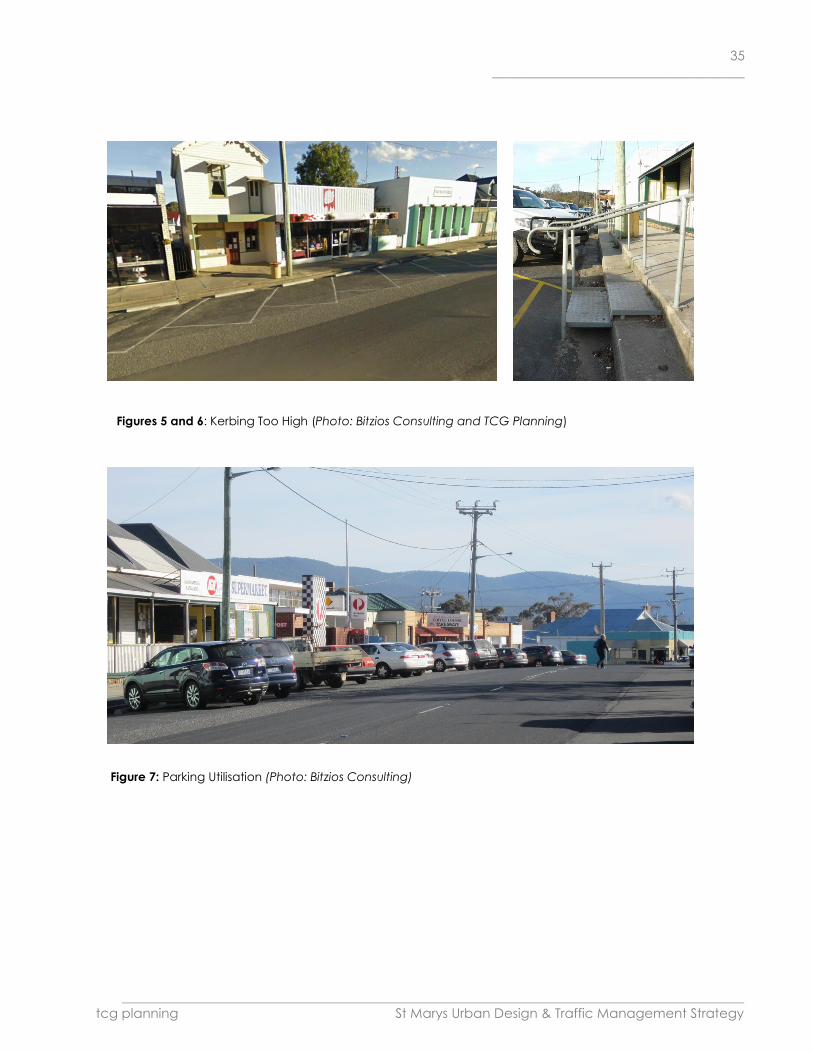
A key issue that requires rectification in the short term is the height of the kerbing that exists adjacent to the
angle parking. Figures 5 and 6 shows the kerb heights in relation to the road levels.
Parking (Section 3.5, p17-19)
Parking Supply
Site observations revealed that the on-street parking areas were occupied between 30%-80% throughout the
main part of the day (refer Figure 7). Currently there are no parking areas set aside for persons with a disability.
The bakery located on the eastern side of the town bridge was noticed to be popular, with a high turnover of
parkers particularly in the morning period. Most of the people parking in the bays along Main Street and Storey
Street only stayed for a short duration, whilst there were a number of vehicles which appeared to park all day,
suggesting they were shop owners or employees.
Parking Configuration
Community consultation to date has suggested that it is desired to retain the angle parking on the main street,
whilst Storey Street should retain its parallel parking arrangement. Angle parking is often preferred for smaller
town precincts as the spaces are typically more convenient to access for drop-in trips (ie Post
Office/Groceries/Coffee).
With an adjustment to the pavement levels to address the kerb height and inclusion of improved parking bays
and edge line marking, a formalisation of the existing arrangements could be a suitable arrangement in the
interim.
The installation of edge line marking should be considered for installation within the core town centre area. The
parallel parking spaces should also be line marked through this area as well. The area considered appropriate
for additional line marking in the first instance is shown in Map 9.
35
______________________________________
________________________________________________________________________________________________________
tcg planning St Marys Urban Design & Traffic Management Strategy
Figures 5 and 6: Kerbing Too High (Photo: Bitzios Consulting and TCG Planning)
Figure 7: Parking Utilisation (Photo: Bitzios Consulting)

36
______________________________________
________________________________________________________________________________________________________
tcg planning St Marys Urban Design & Traffic Management Strategy
Pedestrian and Cycle Facilities (Section 3.6, p19-20)
Site observation revealed a number of students in the morning walking between Frank Street and the local
school. In the afternoon peak period there was also a number of students seen to be returning from the school.
Throughout the day there were a number of people walking from the eastern residential areas into town. Whilst
footpaths have been provided for most part of the core town areas and connections to key destinations, there
were only a number of areas where suitable widths were provided. These areas include the northern side of
Main Street, east of the town bridge near the library and bakery and along the northern side of Gardiners Creek
Road down to Cameron Street. This will become problematic in the future as the ageing community begins to
increasingly access the town centre via mobility scooters.
Site observations also revealed a short section of missing footpath along Story Street, between the rear service
lane and Main Street (refer Figure 8). This should be prioritised for improvements.
St Mary currently does not have any formal on-street or off-street cycle facilities. During the site observations no
cyclists were noticed within the town centre area.
Wide road formations and a lack of dedicated pedestrian crossing facilities exist within the town centre. As the
traffic volumes are low, there is no current crash trend or known pedestrian to vehicle conflict in the area. Some
anecdotal evidence exists that pedestrian safety is compromised as people cross Main Street in conflict with a
reversing angled parked car. Figure 9 shows the existing pedestrian crossing point adjacent to the town bridge
and Figure 10 shows a kerb extension as already installed at Cameron Street.
Figure 8 (top left):
Missing Footpath Section, Storey Street
Figure 9 (top right):
Pedestrian Facility Town Bridge
Figure 10 (bottom left):
Kerb Extension Cameron Street
(All photos: Bitzios Consulting)

37
______________________________________
________________________________________________________________________________________________________
tcg planning St Marys Urban Design & Traffic Management Strategy
5 Strategy Vision and Guiding Principles
A “Vision” indicates outcomes sought to be achieved by the Urban Design and Traffic Management Strategy
and summarises the community’s goals and aspirations for St Marys.
The Break O’Day Council’s Vision for the Municipality (Strategic Plan 2011-2015) is:
“To ensure an active, forward-looking and well-managed community creating a unique and desirable
place to live, work and visit.”
Based on the community consultation, analysis of the township and document review, the following Vision for St
Marys has been developed:
VISION
St Marys will:
retain its historic, creative and unique character within its existing area.
continue to value and preserve its picturesque, “clean and green” township and surrounds.
be a vibrant centre supported by welcomed visitors, local residents and economies.
have a legible and attractive town centre that encourages locals and visitors to stop to visit.
The Vision is underpinned by seven Guiding Principles and which form the basis for the St Marys Urban Design
and Traffic/Transport Framework/Strategy. Each of the following Principles are embedded in this Framework in
the following sections of this document.
GUIDING PRINCIPLES
This Strategy will:
Improve the pedestrian experience: to encourage locals and tourists alike to stop and stay and improve
amenity and access for the less mobile.
maintain the road safety: that exists in the town by improving parking configurations and pedestrian
facilities.
integrate traffic mixes: by considering all of the traffic types using the road network, especially cycling.
better manage existing parking: especially as the demand for parking along the Main Street intensifies.
improve connectivity: for vehicle traffic, pedestrians and cycling to improve accessibility and directness of
travel.
create a 'central' area to the township by providing a "heart of town" and associated road treatments.
improve the visual quality of the public and private domain: via streetscape upgrades and buildings and
signage within the town centre.

38
______________________________________
________________________________________________________________________________________________________
tcg planning St Marys Urban Design & Traffic Management Strategy
6 Traffic, Transport, Pedestrian and Cycling Framework
Section 4 identified the key existing traffic, parking, cycling and pedestrian issues within the township of St Marys.
From this work, Bitzios Consulting identified strategies and actions as to how the vehicular and pedestrian
environment could be improved (within the document 'St Marys Traffic Study' (Project Ref: P1064, Version 003,
Issued 30 September 2013). This section outlines the recommended framework for change and comprises
extracts from the Bitzios Consulting Study (re-formatted to be more consistent with this overall Strategy and
referenced accordingly). Map 9 (provided in Part 8 of this Strategy) is the overall traffic, transport, pedestrian
and cycle framework recommended for St Marys and the following discussion should be read in conjunction
with this Plan.
6.1 Traffic Management
Due to the short length of the St Marys main street, and with the main activities also branching down Story
Street, it is very easy to drive past St Marys without having any opportunity to slow down or turn around. The
provision of a roundabout will address most of these needs, however based on the traffic volumes alone, the
implementation of such a facility is unlikely to be warranted for many years to come. It is understood that DIER
has previously rejected Council and community requests for the installation of a roundabout as a ‘gateway’
treatment on Main Street due to the need to provide for heavy vehicle movements through the town centre.
Examples of the types of roundabout treatments adopted in other centres are shown in Figure 11. The locations
chosen are seen to suitably cater for heavy vehicle traffic whilst also providing the visual cue that motorists have
arrived at a local centre.
Beechworth
Perimbula
Moruya
Byron Bay
Figure 11: Roundabout Examples (Photo: Bitzios Consulting)

39
______________________________________
________________________________________________________________________________________________________
tcg planning St Marys Urban Design & Traffic Management Strategy
Whilst the provision of a roundabout may provide for a longer term solution once the town has matured, in the
shorter term, treatments such as edge line marking and kerb extensions can be cheaply implemented to
introduce a series of road narrowings along the main street. Refer to example photographs at Figures 12 and 13
at page 41. Figure 12 provides examples of a number of smaller centres where the main street has been
designed to be narrower and more intimate, resulting in lower vehicle speeds commensurate with the speed
environment expected for a pedestrianised town centre. Such measures will also assist in reinforcing the sense
of arrival to St Marys and creating a town centre identity.
The Council-adopted parallel parking Streetscape improvements (refer Section 6.2 below) will reduce the road
footprint substantially, providing greater opportunities for improved 'main street' public areas as well as
pedestrian crossing facilities. The reduced roadway width will also provide an impression of a busy vibrant town
centre, slowing traffic down and encouraging tourists to stop and visit (p. 26 existing issues summary)
In addition, consideration should be given to reducing the 50km/hr zone to the east to increase its effectiveness.
The start of the zone should coincide with a 'gateway' treatment to the immediate east of the town centre (in
the vicinity of a library).
Improvements to line marking, combined with effective signposting of parking areas and key local destinations,
along with roadside vertical elements such as banners, street lighting and trees can all assist with reducing
vehicles speeds and improving the legibility of the town centre.
To address the issue of height of the kerbing that exists adjacent to the angle parking, the road should be re-
profiled and raised to a suitable level to achieve the relevant standard. The wheel stops may then be removed
and the parking bays marked in accordance with AS2890.5.
6.2 Parking Strategies
Approved Streetscape Works
A report to Council on 15 October 2012 was submitted on two parking options that were presented to the
community on 25th September 2012 (entitled 'St Marys Streetscape: Proposed Draft Layouts for Parallel and
Angle parking Options' (Break O’Day Council Reports, Acting Manager Works and Infrastructure, 15 October
and 19 November 2012).
The options focussed around including a pedestrian refuge area within Main Street and considered angle
parking or parallel parking solutions.
The community opted for a ‘do nothing’ option wanting the existing situation to be retained, whilst the Council
submitted report supported DIER’s preferred option to convert the angle parking to parallel parking (refer
Concept Plan at Appendix 2). The main reasoning for supporting DIER’s position was that the current parking
configuration was considered to be non-compliant with relevant standards, and the final solution would have
to be approved by DIER, limiting the recommended way forward to conform with the state’s position.
The Council Officer’s recommendation was that Council:
Receive the report;
Acknowledge the community decision to take no action, except improve the footpath;

40
______________________________________
________________________________________________________________________________________________________
tcg planning St Marys Urban Design & Traffic Management Strategy
Agree the progress the parallel parking option as the only viable option available;
Agree to progress the design and construction works.
Following consideration of the report, Council resolved that “this item be deferred to the November Council
meeting until the following information is provided:
Costing and report for what is required for the footpath repairs;
Review of angle parking to maximize spaces – remove outstands;
Motorbike parking be removed;
Outstands near Smith’s garage be reduced;
Investigate options to reduce the footpath on the southern side to allow vehicles to be closer to shop
fronts.”
Council subsequently resolved at its meeting of 19 November 2012 to support the Officer’s recommendation
(progress parallel parking option).
Parking Supply (Section 3.5.1, p17-18)
During the quieter months it would be considered acceptable for employees/shop owners to park outside of
their shop, but during peak periods it is more beneficial for the town to have the parking bays restricted to one
hour or two hour parking. As the town matures, additional overflow parking will be required to be considered.
Site servicing will also become slightly more problematic. Consideration should be given to extending the
existing rear lane-way and creating ‘back of shop’ at-grade parking.
Potential re-development of the town hall site could also assist with creating a formal at-grade off-street parking
area for visitors to the town. Map 9 shows the potential location for a series of at-grade car parking areas and
rear service lane connectivity.
Disabled Parking (Section 3.5.3, p19)
Consultation with the community should occur to determine if there is a demand for such a need and if so,
where the space/s should be allocated. It should be noted that the dimension requirements for an on-street
disabled car space is substantially more than a general car space due to the need to provide for an increased
level of access.
Parking Confuguration (Section 3.5.2, p18-19 and 4.7, p29)
With an adjustment to the pavement levels to address the kerb height and inclusion of improved parking bay
and edge line marking, a formalisation of the existing parking arrangements (angled parking on Main Street
and parallel parking on Storey Street) could be a suitable arrangement in the interim.
The installation of edge line marking should be considered for installation within the core town centre area. The
parallel parking spaces should also be line marked through this area as well. The area considered appropriate
for additional line marking in the first instance is shown on Map 9.
Figure 13 provides a comparison between what currently exists and potentially what could exist within the main
street area which is more attractive outcome for the interface of the pedestrian footpath and shopfronts to
attract tourists to 'drop in' for a visit.

41
______________________________________
________________________________________________________________________________________________________
tcg planning St Marys Urban Design & Traffic Management Strategy
Figure 13: Example Footpath Improvement for Main
Street (Photo: Bitzios Consulting)
Figure 12: On-Street Parking / Main Street Examples
(Photo: Bitzios Consulting)

42
______________________________________
________________________________________________________________________________________________________
tcg planning St Marys Urban Design & Traffic Management Strategy
6.4 Pedestrian and Cycling Strategies
Pedestrian Facilities (Section 3.6, p19)
Strategies will need to be implemented to gradually upgrade the existing footpath areas to a suitable width,
particularly for footpaths identified as being inadequate (the northern side of Main Street, east of the town
bridge near the library and bakery and along the northern side of Gardiners Creek Road down to Cameron
Street). This will become problematic in the future as the ageing community begins to increasingly access the
town centre via mobility scooters.
Many residential streets are yet to include a pavement footpath and rely on the grassed verge for access (eg.
Frank Street) and missing footpath along Storey Street, between the rear service lane and Main Street (refer
Figure 8 earlier in this report). This should be prioritised for improvements.
Pedestrian Crossing Facilities (Section 3.6.3, p 20-21)
Recent ‘main street’ options focussed on including a pedestrian refuge along Main Street to assist with
pedestrian movements across the wide main road. Another method for assisting pedestrians crossing a road is
to install roadside kerb extensions to physically narrow the entire road formation. Combined with edge line
marking this can be an effective tool in reducing vehicle speeds, providing a series of dedicated crossing points
and reducing the crossing distance.
The kerb extension already installed at Cameron Street improves the pedestrian amenity but is lacking the
associated edge line marking or treatment on the opposite side of the road to finalise the intent. These types of
treatments are also required at the Frank Street intersection and Storey Street intersection.
Cycle Facilities (Section 3.6.2, p20)
Based on the current very low cycle usage it would be difficult to justify the funding required to provide
dedicated on-street or off-street facilities within the town centre. The road widths within the town centre are
generally wide and the traffic volumes are low enough for safe shared on-road use.
A program of widening existing narrow footpaths to cater for mobility scooters will also assist with catering for
younger cyclists off-street.
Pedestrian/Cycle Connectivity (Section 3.6.4, p22)
With the medical facility located on Gardiners Creek Road and the newly established footpath, consideration
should be given to try and provide an improved connection from Gardiners Creek Road through to town hall.
Opening pedestrian access from the Gardiners Creek Road catchment area through to town hall may be
ideally completed as part of a re-development of the town hall site.
In addition, a pedestrian / cycle connection from Newman Street to Aulichs Lane will assist with providing direct
connections for locals into the town centre encouraging a greater proportion of walking trips.
As developments occur along the main street and demands for ‘back of shop’ parking initiates, a series of
pedestrian walk-throughs should be created to increase the permeability from the at-grade car park to the
main street. Map 9 shows the suggested connections.

43
______________________________________
________________________________________________________________________________________________________
tcg planning St Marys Urban Design & Traffic Management Strategy
Footpath Crossfall (Section 3.6.5, p22)
Figure 14 shows the change in crossfall that exists when crossing a driveway. Council should development a
standard drawing which depicts a required driveway grade when crossing the footpath area to ensure a
consistent footpath crossfall along its entire length.
6.5 Signpost Strategies
Figure 15 shows the location of the existing signage at the main Story Street intersection. The majority of the
important directional signage is obscured by vegetation. Figure 16 shows the tourist related signage that exists
on approaching the main intersection. The information tourist signs provide little impact on encouraging a
visitor to stop in St Marys. The ‘Touring Route’ sign in fact tells the motorists to drive through St Marys and either
turn right or go straight ahead (which are the only two options available at the next major intersection) which
makes it a redundant sign. The Townscape Project completed in 1995 for St Marys provides a good starting
point to develop a local signage strategy to approach DIER for approval.
Consideration should be given to identifying a pullover area on approach to St Marys, possibly near the historic
rail station where a tourist information board can be displayed, explaining to motorists all the things they can do
and see in the region, assuming that they are on their way to the east coast. Alternatively, provide a tourist
information board near the Town Hall/town park (with appropriate guidance signage for motorists approaching
from all directions).
Figure 14 (top left): Changing Footpath Grades
due to Driveway
Figure 15 (bottom left): Existing obscured
directional signage at Main Street/Storey Street
intersection
Figure 16 (bottom right): Existing directional
signage at western approach to township
(All photos: Bitzios Consulting)

44
______________________________________
________________________________________________________________________________________________________
tcg planning St Marys Urban Design & Traffic Management Strategy
7 Urban Design Framework
Section 4 identified the urban design issues that need to be addressed within the town, including an analysis of
the built form of the study area. Together with the issues raised in the analysis of traffic-related matters, this
section outlines the recommended framework for change from a built form and land use perspective. Map 10
(provided in Part 8 of this Strategy) is the overall Urban Design framework recommended for St Marys which
illustrates each of the strategies and the following discussion should be read in conjunction with this Plan.
7.1 Consolidate the Township and Active Land Uses Spatially, the St Marys township is long and linear, with several vacant parcels of land within key central areas of
the township. Many existing buildings within the central commercial area are also vacant and/or underutilised.
While the main commercial activities are focused on the southern side of Main Street and the eastern side of
Storey Street, as identified earlier in this document, the township is easy to "pass by." In addition, some key
premises are located at the extreme ends of the township (Museum/former St Marys railway Station at the far
western end, and the bakery, riverside park, library, service station and "Gone Rustic" gallery located across the
rivulet bridge within the Main Street East precinct).
The separation of active land uses and underutilised existing premises gives the impression of a dormant town,
when this is not necessarily so. The number of vacant lots and/or existing buildings are significant, and it is
considered that there is an oversupply of commercially-zoned properties in St Marys. St Marys would benefit
from the consolidation of community and commercial land uses to activate the streetscape, make the
township more legible to visitors, and make businesses and commercial properties more viable. This, together
with some increased population/dwellings within walkable distance of the township will go a long way to
improving the vitality of the township and viability of commercial properties.
To achieve this, it is recommended that the long term land use strategy is to reduce the community and
commercial zoning and land uses from the eastern part of St Marys (on the eastern side of the Rivulet) and only
allow lower-order commercial and residential uses. Encouraging the relocation of the popular library and future
higher order uses to the central part of the town would greatly assist in the activation of St Marys. Uses such as
the bakery and gallery would retain existing use rights in their current location, however should future relocation
be contemplated, re-siting within the central part of town would also be encouraged. Refer to the "Key Sites"
section below for suggested locations for these uses. Even if St Marys experienced a "boom" in the future (not
anticipated), the suggested reduced commercial and community zoned precinct would be sufficient to cater
for the business and community uses of the township. An analysis of the existing commercial floor space,
existing available business/community purpose-zoned land and anticipated future commercial/retail floor
space needs for St Marys in the Draft Land Use and Development Strategy currently being prepared by TCG
Planning confirmed this.
While some of the buildings within the Main Street East precinct are historically commercial buildings and have
commercial aesthetic with associated minimal setbacks from the street (Bakery, Gone Rustic, former Cranks
and Tinkerers building and attached building design studio), none are architecturally significant and warrant

45
______________________________________
________________________________________________________________________________________________________
tcg planning St Marys Urban Design & Traffic Management Strategy
retention as commercial buildings (with the exception of the Bakery Building which is heritage listed). Some of
these buildings are vacant and have been for some time anyway (former Cranks and Tinkerers building, faux
brick cottage to the east of the bakery).
To strongly reinforce the consolidation of the township to the west, this precinct should be rezoned to General
Residential. The challenge will be the successful encouragement by landowners for conversion of these
buildings and/or demolition and redevelopment to a residential use. While set close to the street, the Bakery
building could be used for the purposes of a dwelling, but would require acoustic treatment. In addition, it may
be possible for the library building could be converted to a dwelling. The remaining buildings would be more
difficult to convert and, being on large allotments, would be better utilised for residential redevelopment.
However, a General Residential zone will severely limit the future re-use of existing buildings, which were
constructed for a commercial purpose. An alternative zone could be the Mixed Use zone which allows for a mix
of uses (including commercial and residential) to allow the continuation of these historically-built commercial
building for a commercial purpose. However, as a range of commercial uses are permitted under the Scheme
under the Mixed Use zone, this would do little to consolidate the active uses in the township as is the intention of
this Strategy. If a Mixed Use zoning was applied, a special performance criteria/acceptable solution should
apply to this area indicating that lower order business uses (eg. business and professional services, visitor
accommodation and home businesses) should be encouraged. Higher-order business uses (retail, food services)
and community uses should be located in the core/centre of the township on the western side of the Rivulet.
Alternatively, a Local Area Plan could be prepared to meet this objective.
7.2 Key Sites and Recommended Land Use Zone Amendments Within the context of the above Strategy to consolidate the town centre activity, there are numerous sites within
the township of St Marys that deserve attention to elevate visitation and appearance, and/or have potential to
meet the Vision of being a vibrant town centre and to meet the Guiding Principle of providing a town centre
identity.
1. Museum and Proposed Arts, Culture, Open Space and Heritage Precinct
This site is the historically significant and listed St Marys Railway Station is owned by Council and is currently
tenanted by the "Cranks and Tinkerers Museum" which is well supported by locals and visitors alike. Break O'Day
Council have developed a plan and costings for this site for an Arts, Culture, Open Space and Heritage
Precinct. The briefing document prepared by Council states that "the site is to be developed with the
necessary infrastructure which will underpin arts, cultural and heritage activities within the municipality. The aim
is to provide sufficient infrastructure and space to support and conserve Break O'Day's arts, culture, and
heritage which reflects our community aspirations and builds a sense of pride and identity for the area."
Concept plans have been prepared (refer Appendix 3) which proposes use of the former railway station
building as a visitor and tourist facility, gallery space; use of railway carriages for displays, workshops and studios;
woodcraft guild workshop; new "cranks and tinkerers" building museum and workshop; carpark; footpath linking

46
______________________________________
________________________________________________________________________________________________________
tcg planning St Marys Urban Design & Traffic Management Strategy
township; outdoor event space; picnic area and rail trail. This development has been costed at $7,991,000
(2012).
This proposal is fully supported and would be a welcome facility for St Marys that meets the Vision of the
community. If this proposal proceeds, it is fundamental that it is complimentary to the town, and does not
compete with visitation by tourists with existing and future businesses of the central town. It would be an
undesirable outcome for visitors to stop at the Arts, Culture, Open Space and Heritage Precinct and not also
visit the centre of town.
There should be clear signposting well in advance (ie. to the west) for approaching motorists of both the
distance to the Museum/proposed Precinct facilities (once developed), in addition to the amenities within the
town centre (including parking).
The development of this facility supports the Strategy to consolidate the town centre activity by deleting the
commercially-zoned land on the Main Street East precinct. The development of the Arts, Culture, Open Space
and Heritage Precinct will further elongate the activity which could be potentially detrimental to the vitality of
the township if key attractors to the town were retained in the Main Street East Precinct.
2. Cameron Street Park
This land, owned by Break O'Day Council, is a passive open space comprising a few trees, a picnic table and a
waste bin. A hardstand parking area is located on the main Street Road reserve, with some adjacent picnic
tables. The levels of this park are lower than the road level and is underutilised, being on the western "edge" of
the commercial zone. This park is not considered to be an attractive stopping point for visitors and locals. St
Marys needs a rest park in the eastern part of the township for visitors, however an alternative site which has
better visibility for visitors and higher amenity would be more appropriate. The semi-vacant land to the east of
the town hall site (No. 25 Main Street) is an obvious alternative (as described below), in association with an
upgrading of the Town Hall site. Consideration could be given to rezoning the existing Cameron Street Park
(zoned Open Space) to General Residential and developed for residential purposes.
3. No. 21 Main Street (former eScape cafe and gallery)
This substantial building contributes positively to the character of the streetscape and should be retained. The
building has been vacant for a number of years and for sale without success. Council is encouraged to enter
into negotiations with the Department of Education towards the purchase of this property for the purpose of a
relocated St Marys Library. The building, subject to feasibility study, could have potential for adaptive re-use as
a library. This use would require a coordinated redevelopment of the adjacent Town Hall site to accommodate
shared (improved) parking areas for library patrons. The use of this site as a library would have a number of
advantages: it would be a key attractor to the western (main) precinct of St Marys, contributing to a more
active and viable centre; and the location of a library adjacent to the Town Hall would promote the northern
side of Main Street (together with the recommended Town Park at 25 Main Street) as a "civic, education and
visitor precinct". The land owned by the Department of Education to the rear of the Town Hall (No. 23b,
occupied by the St Marys District High School East Coast Education Centre) is also a suitable and
complimentary land use to be included within this precinct. In addition, No. 21 Main Street has legal access
from an access driveway from Cameron Street. This accessway could also provide a pedestrian linkage

47
______________________________________
________________________________________________________________________________________________________
tcg planning St Marys Urban Design & Traffic Management Strategy
recommended in the Traffic, Transport, Pedestrian and Cycle Framework. Rezoning to Community Uses is
recommended to consolidate this precinct.
4. Town Hall Site (No. 23 Main Street)
The refurbished Town Hall is an asset to the township and should be celebrated and promoted as the "centre of
town" with increased usage, supported by on-site parking improvements. The irregular-shaped allotment is
large, however requires an overall redesign to the surrounding parking and access areas, including re-grading.
This could encompass the unused grassed area to the east of the Town Hall building adjacent to the tennis
club. This site should be well sign-posted and be made available for tourist parking in the event that on-street
parking is not available. Refer below to 25 Main Street property.
5. No. 25 Main Street
This privately owned semi-vacant site enjoys a strategic legible, highly visible and central position in the town
adjacent to the Town Hall. This is considered to be an appropriate site for a town park/market square and
visitor information/stopping point. Together with appropriate sign-posting in advance, the site could be
consolidated with the adjacent Town Hall land and developed to accommodate off-street parking area
(noting there are also ample on-street parking opportunities on Main Street in front of and near to the site). The
consolidation of this land with the Town Hall site provides an opportunity to redesign the two existing access
driveways to the Town Hall land, and to extend a landscaped areas across the front of the Town Hall
(incorporating the war memorial) across to the new town park, which could incorporate picnic tables, a small
children's playground and a visitor information board. Toilet amenities could also be provided in this new park
property, or alternatively (if appropriate) the existing Town Hall facilities could be utilised for this purpose. The
information board could be a secondary and complimentary facility with that provided at the St Marys Arts,
Culture, Open Space and Heritage Precinct located further to the west, which will also be accessed by visitors.
At this central point the township is observable to the visitor, and opportunities exist to amble around the town.
Consideration could be given to selling the existing Cameron Street Park, which as discussed above, is more
suited to residential use. The funds could be utilised for purchase of No. 25 Main Street, which could be rezoned
to community purpose consistent with the adjacent Town Hall and Tennis Club land, which could also be better
connected within this scheme.
6. Vacant and/or Underutilised "Book-end" sites within Main Street (North) Precinct
These vacant and/or underutilised properties are key sites within the township and should be developed as to
promote activity within the township. While the sites are currently zoned Local Business, it is considered that
there is ample existing business-zoned land in the township (even with the recommended reductions to the
Local Business zone in the Main Street - East precinct), and that these site should be developed for residential
purposes (including housing for aged persons), given the proximity to the town amenities. There is, however,
scope for mixed used development comprising small commercial or business premises, including home business.
Hence, it is recommended that the zoning of these lots be altered to a Mixed Use zone which permits a range
of uses, including residential (without the requirement for a commercial component). These sites should be
developed/redeveloped with quality one and two storey design, consistent with the heritage character of the
township. No vehicular access should be allowed from Main Street and access should be from Cameron and

48
______________________________________
________________________________________________________________________________________________________
tcg planning St Marys Urban Design & Traffic Management Strategy
Franks Street only (to maximise on-street parking for the town, and to maintain safety by minimising additional
vehicular movements to/from the Main Street/Esk Highway).
6a. Western End:
No. 17 Main Street (corner of Cameron Street): This large parcel of land, owned by the Department of Housing
enjoys an excellent strategic location in the township, being directly across the road from the main commercial
precinct, is visible upon entry to the township on approach from the west, has a side-street access, and has a
slightly elevated position.
No. 19 to the east is a large privately-owned allotment and is occupied by a small cottage and outbuildings to
the rear (accessed by a lane/right of way). Consideration could be given to the Department of Housing
acquiring this property (should it become available at a future date) and consolidating with the lot it owns to
the west, for an integrated development outcome.
6b. Eastern End:
Vacant properties on the corner of Main Street and Franks Street (Lot 1 and No. 27) and underutilised
commercially-zoned property fronting Franks Street. This land is a very large and visible site, the entire site(s)
being the terminating view upon entering the town from the south (Storey Street).
7. Corner of Main Street and Storey Street
This small Council-owned property (zoned open space) contains a shelter structure with tourist information
which was one of the projects recommended by the 1995 St Marys Townscape Project. The Townscape Project
report correctly identified this site - "the Junction Corner" - as a very significant site and townscape focus. The
structure, which adheres to the sketch in the document, however is now dated and has become a blight on
the streetscape. The unsightly gap sought to be filled by the structure arguable has not met the intent, and the
site deserves a more permanent and higher quality urban outcome.
It is recommended that this land is rezoned to Local Business (the site having limited open space value) and
incentives should be considered for consolidating the site with one or two lots to the west (Main Street) and the
vacant (former service station?) building/property to the south (and possibly the vacant property adjoining the
laneway further to the south). The corner site has an excellent aspect and has potential to be a site for the
development of a high quality contemporary infill two storey commercial building that addresses the corner
and respects the architectural heritage precinct of Storey Street. Being north-east facing, the street level would
capitalise on the sunny aspect to incorporate extensive glazing for an active use, such as a cafe/bakery.
Figure 17: Existing Land Use Zones of St Marys
Township
Light Blue: Local Business
Buff: Community Purpose
Green: Open Space
Red: General Residential
(Source: Excerpt from Land Zoning Map No. 70
of the Break O'Day Interim Planning Scheme
2013)


50
______________________________________
________________________________________________________________________________________________________
tcg planning St Marys Urban Design & Traffic Management Strategy
7.3 Recommended Land Sale/Purchase
Section 7.2 above discussed key sites and made some strategic recommendations for alternative land uses
within the study area and associated sale/purchase of certain site. In summary, these are listed as follows:
Department of Education: to facilitate relocation of library to central commercial area - sell existing library
(31 Main Street) and, if feasible and suitable, relocate to existing building at No. 21 Main Street (Key Site No,
3).
Break O'Day Council: sell Cameron Street Park (Key Site No. 2) and rezone and sell for residential
use/development. Purchase partially vacant land at No. 25 Main Street (Key site No. 5) for the purposes of
a town park.
Break O'Day Council: sell small open space zoned land on corner of Storey Street and Main Road (Key Site
No. 7), rezone to commercial and consolidate with one or more adjoining properties for the purposes of
developing a high quality infill commercial premises sympathetic to heritage character of precinct.
Alternatively, Council could retain the corner allotment and purchase the adjoining sites and champion the
development of the site.
Department of Primary Industry, Parks, Water and Environment: own a land-locked site to the north of the
land occupied by the St Marys District High School East Coast Education Centre (No. 23b Main Street,
accessed Town Hall site. This site is predominately vacant and zoned Community Purpose. It is unclear
what the proposed future use of this government-owned site is. This is potentially a site suitable for rezoning
for residential purposes and sold to better utilise state government funds, such as the development of the
vacant Department of Housing site at 17 Main Street.
7.4 Township Entry Statements
The township should have three bespoke consistent sculptural and artistic entry statements that reflect the
creativity of the St Marys Community (to be complimented by clear and coordinated directional signage to key
sites in the township, particularly parking and tourist information):
at the southern approach to the town (on the northern side of the bridge on Storey Street)
at the eastern approach to the township near Aulichs Lane,
at the western approach, prior to the proposed St Marys Arts, Culture and Heritage Precinct. In addition, a
directional sign several hundred metres westward of the St Marys Arts, Culture and Heritage Precinct site
should be installed advising of the distance to the site, in addition to the facilities within the town centre so it
is clear what facilities are available to the visitor on approach form the west.
Refer also to the 'Community Infrastructure Design Guide' for Break O'Day Council prepared by Architects
Edmiston Jones (May 2013). This Design Guide recommended St Marys be within a 'Country' catchment style.
7.5 Open Space Linkages
As identified earlier, the Cameron Street Park is underutilised, ill-sited as a park for visitors and locals and it is
recommended that this site be rezoned and sold for residential development. A more appropriate site for a
town park is adjacent to the Town Hall, which can act as the civic square and meeting place for locals and
central stopping location for visitors to the town. The park on the eastern side of the town (Wombat Walk/St

51
______________________________________
________________________________________________________________________________________________________
tcg planning St Marys Urban Design & Traffic Management Strategy
Marys Rivulet) provides picnic and playground facilities, and is considered to be a more nature-based
experience than a town park that is complimentary to the St Marys open space experience.
7. 6 Vistas/Visual Linkages and Scenic Features
St Marys, being located in the Esk Valley is surrounded by mountain ranges and is overlooked by the nearby
peaks of Mount Nicholas and St Patricks Head. The ranges and peaks are a constant imposing presence
observed from St Marys and are a strong visual feature of the landscape. The existing road orientation (east-
west Main Street/Esk Highway) and north-south cross streets assist in the promotion and preservation of these
important visual linkages. The limitation of building within the township of St Marys to two storeys, will maintain
these view lines. The recommended town park location on the northern side of Main Street will further promote
vistas of St Patricks Head in particular, to be enjoyed by locals and visitors to this site.
7.7 Streetscape and Landscape Treatments (Public Domain)
Together with the recommended Strategies within the Traffic, Transport, Pedestrian and Cycle Framework, the
following improvements to the public domain are recommended:
Northern side of Town: The hardstand parking in front of the existing Cameron Street Park is unsightly and should
be turfed and planted with two or three oak trees to complete the attractive avenue of trees in this precinct.
The remaining footpath treatment (including street tree planting) on the northern side of the road (between
Cameron and Franks Street) are attractive and in good condition and no further works are necessary.
Southern side of Town: Upgrading of the footpath material/treatment is required to the southern side of Main
Street within the central commercial precinct (between Cameron and Storey Street) and Storey Street
commercial zone. Some street trees are also recommended on the southern side of Main Street to soften the
built form and provide points of interest/vertical elements to the township. Some street trees are also
recommended at the southern entry to the town (Storey Street) to compliment and complete the existing
attractive avenue approach to St Marys from this direction.
General: Very importantly, all public domain areas within the entire township (including parks) should be
provided with updated consistently-themed and designed community infrastructure (picnic tables and shelters,
bench seats, bollards, rubbish bins, lighting, planter boxes and signage). It is recommended that a review and
replacement of all of the community infrastructure should be undertaken in accordance with the principles
outlined in the 'Community Infrastructure Design Guide' for Break O'Day Council prepared by Architects
Edmiston Jones (May 2013). This Design Guide recommended St Marys be within a 'Country' catchment style.
The artistic and creative community of St Marys deserves bespoke community infrastructure that reflects this
identity and to improve the attractiveness and associated resident pride for the town.
Public Art and Events: St Marys is a creative community which is displayed through existence of galleries and
museums, in addition to public art within the township, including the town mural (corner of Main Street and
Storey Street), at the entrance to the Community Health Centre and annual the "Wrapped in St Marys" festival.
This positive creative spirit should be enhanced through the gradual acquisition/provision of public art
throughout the town (with public and privately-owned sites to be selected via a Public Art Policy), in addition to
the encouragement and promotion of new and expanded events to foster civic pride and attract visitors to the
town.

52
______________________________________
________________________________________________________________________________________________________
tcg planning St Marys Urban Design & Traffic Management Strategy
7.8 Streetscape Improvements (Private Domain)
The key areas for improvement to the private domain are to some of the existing commercial buildings in the
central precincts of the town (Main Street South and Storey Street). Given this is the area where consolidation of
activity, the priority focus should be for upgrading and developing this area. Buildings not listed in the table
below may still require attention, however are generally in sound aesthetic condition. The table below identifies
priority actions for facades of specific properties within the township. It is recommended Council investigate
strategies for incentives to property owners for facade improvements, such as a dollar for dollar financial
incentive (eg. of up to 50% facade upgrade costs for up to $5,000, to a Council budgetary cap per annum).
This approach has been implemented successfully in precincts within regional centres of Wollongong and
Newcastle in New South Wales.
Other general improvements to private properties that should be encouraged and incentivised by Council are:
integrated signage policy for the commercial precinct;
upgrade external facades (paintwork), fencing and gardens) of all historic cottages within the township, in
particular, west of Clive Street; Storey Street and Groom Street.
Table 4: Recommended Improvements to Certain Properties within St Marys Town Centre
Photograph Street Number & Address and Current Building Use
Summary of Recommended Improvements
25 Main Street (North side) - Vacant
Council to acquire, consolidate with town hall land (No. 23 to the
right) and develop as a town park.
23 Main Street - Town Hall
Undertake integrated landscape works and driveway redesign in
association with recommended acquired site to the east (No. 23 -
refer above)
28 Main Street (southern side): Vacant former service station
Unsightly dilapidating building. However the building is a Classic 50’s
building form which is fairly rare Because of the splayed aspect this
building has a significant impact on the street. Redevelop or
upgrade for commercial use. Provide “in-use” image. Co-ordinate
overall colour scheme.

53
______________________________________
________________________________________________________________________________________________________
tcg planning St Marys Urban Design & Traffic Management Strategy
No. 32-34 Main Street
These shops & the ones next door should present individuality. This
can be achieved by using the opportunity for integrated, well
designed and sympathetic fascia advertising showing the type of
business, removal of lower brick to expose the original shop fronts
and/or rendering of the dated brickwork. Original fascia visible
could be concealed by a sign or brick
34 Main Street. Use Unknown
Remove brickwork to reveal original weatherboard. Remove arched
gateway. Paint and add some window awnings. Remove brick wall
and landscape to soften streetscape, or render and paint existing or
replace with a timber open fence. Open up frontage to achieve
active frontage to street.
36 Main Street. Post Office
A classic 60’s building now rare, with retro chequerboard period
detail and sign on vertical element. Potential national estate listing
investigate reinstatement of original signage “St Marys Post Office
(date)". Retain brick finish. Relocate phone box: contributes to
footpath clutter.
38 Main Street. Supermarket. Listed Heritage item
Building with dormers: A very strong element in the street character
retain as is and protected. Supermarket signage to be reviewed.
Potential to activate frontage by increasing glazing on western
portion of building (built to property frontage).
46 Main Street - retail uses
Eastern tenancy: Potential for a trade conscious multi-colour
scheme, with some focus placed on the doorway. However
recommend this shop (and potentially western tenancy also) be
consolidated with corner site (see below).
Western building: Facia sign appropriate. Simple glazed building with
appropriate active frontage.

54
______________________________________
________________________________________________________________________________________________________
tcg planning St Marys Urban Design & Traffic Management Strategy
Corner of Main and Storey Streets (owned by Council)
“Junction Corner” tourism information structure/column site is out-
dated. Opportunities for consolidation of this property with the
adjoining allotment(s) should be explored for redevelopment. This
redevelopment could be a one or two storey building of high design
quality that compliments the hotel building and town character and
should celebrate its prominent corner site by being built to the street
edge. The mural could be relocated to another site in the town, for
example the Town Hall.
55 Storey Street - Vacant (Former Service Station)
This building has potential to be converted to an alternative use, with
the current garage doors removed and glazed for an active street
and attractive street frontage (eg. art gallery). However, the best
outcome for this site would be for demolition and consolidation with
the "Junction Corner" site to the north as described above.
1 Storey Street (Vacant Land north of Newsagent)
This is an unsightly gap in a significant streetscape. The
redevelopment of this site is warranted (one or two storey
commercial building). Strong design guidelines should apply to
respect the heritage significance of the adjacent hotel and historic
character of the streetscape. Consideration should be given to
continuation of the footpath awning of the Newsagent building to
the south.
4 Storey Street: Police Station
This building has potential for streetscape improvement by rendering
the over brickwork, and possibly adding an appropriate veranda as
architectural enhancement & function. A formal gate, pergola,
planting, and picket fence could also contribute to the appearance
of the streetscape.
52 Main Street: Bakery (Heritage Listed)
This building provides heritage character to the township and should
be preserved. The building fronts the property boundary with an
awning over the footpath. The building typography is suited to a
commercial use.

55
______________________________________
________________________________________________________________________________________________________
tcg planning St Marys Urban Design & Traffic Management Strategy
54 Main Street: Vacant small shop
This building has limited architectural significance and potential for
re-use and is located on a large allotment. Hence, it is
recommended that demolition and redevelopment of the site
occurs for residential purposes. The redeveloped site should
incorporate a minimal setback across the entire frontage to
continue the built form pattern of the Bakery next door to the west
and 56 Main Street to the east (see below). Strong design guidelines
should apply to respect the heritage significance of the adjacent
Bakery character of the streetscape.
56 Main Street: Two commercial premises (east: architectural design
studio; west: vacant)
This building has good street presence and character, with
significant potential for improved appearance/upgrade. However,
the western tenancy and large workshop at the rear has been
vacant for some time, and is considered to have limited suitable uses
(eg. a cottage industry with a retail outlet at the front would be
suitable). The proposed St Marys Arts, Culture and Heritage Precinct,
with its proposed museum and workshop spaces, may however fulfil
this need and reduce the demand for occupation of this existing
building for a creative workshop purpose.
39-41 Main Street: Service Station
This building/property requires general cosmetic improvements and
interest. Some landscaping and improvements to the expansive
hard-stand area are required, in addition to more tidy vehicle
parking and storage on the site.
37 Main Street: Gone Rustic Gallery and Studio
This is a good example of how an attractive and appropriate
building renovation/re-use can occur. Signage is also low key and
appropriate. The gallery and studio is a popular attraction for locals
and visitors to the town.
31 Main Street: Library
The library building, while having an appropriate use and built form
within the park-side setting/context, is popular and is a key attractor
to the town. The on-site parking and location of the building away
from the commercial core does not encourage visitors of the library
to utilise other services of the town. The activity generated by this
facility needs to occur at the core of the town (to the west).
Therefore this site (and the Main Street East precinct) should be used
as an alternative low-order non-tourist/non-retail/non-community
purpose (eg. office, commercial, residential).

56
______________________________________
________________________________________________________________________________________________________
tcg planning St Marys Urban Design & Traffic Management Strategy
8 Masterplan and Strategy Implementation The key identified outcomes of the Traffic, Transport, Pedestrian and Cycling Framework (Section 6) and Urban
Design Framework (Section 7) are illustrated in the Maps 9 and 10.
Table 5 within this Section lists each of the actions recommended within this document to achieve the Vision
and Guiding Principles that underpin this Urban Design and Traffic Management Strategy (reproduced below).
VISION - St Marys will:
retain its historic, creative and unique character within its existing area;
continue to value and preserve its picturesque, “clean and green” township and surrounds;
be a vibrant centre supported by welcomed visitors, local residents and economies;
have a legible and attractive town centre that encourages locals and visitors to stop to visit.
GUIDING PRINCIPLES - This Strategy will recommend outcomes that:
1. Improve the pedestrian experience: to encourage locals and tourists alike to stop and stay and improve
amenity and access for the less mobile.
2. Maintain the road safety: that exists in the town by improving parking configurations and pedestrian
facilities.
3. Integrate traffic mixes: by considering all of the traffic types using the road network, especially cycling.
4. Better manage existing parking: especially as the demand for parking along the Main Street intensifies.
5. Improve connectivity: for vehicle traffic, pedestrians and cycling to improve accessibility and directness of
travel.
6. Create a 'central' area to the township by providing a "heart of town" and associated road treatments.
7. Improve the visual quality of the public and private domain: via streetscape upgrades and buildings and
signage within the town centre.
Each recommended Action within the Implementation table below references the relevant Guiding Principles
to be achieved, and is set out in short, medium and long term timeframes together with the estimated cost.
Unless otherwise indicated in the table, the responsibility for all actions is to be led by Break O'Day Council.
Other stakeholders may be required to be involved in many of the actions, in particular DIER with respect to
works within Main Street/Esk Highway which is within its jurisdiction.


58
______________________________________
________________________________________________________________________________________________________
tcg planning St Marys Urban Design & Traffic Management Strategy
This Page has been intentionally been left blank

60
______________________________________
________________________________________________________________________________________________________
tcg planning St Marys Urban Design & Traffic Management Strategy
Table 5: Implementation Table
(adapted from Tables 6.1, 6.2 and 6.3 of Bitzios Consulting report)
Action No.
(Guiding
Principle #)
Key Action/Recommendation
Approx
Cost ($)
Short Term Actions (1-3 years)
1 (GP 1) Install missing footpath on western side of Story Street. $5,000
2 (GP 1, 2) Install missing pram ramp on north west corner of the Groom Street / Story Street
intersection.
$500
3 (GP 1, 2) Provide a pedestrian crossing facility to cater for students crossing from Franks Street
to Story Street.
$10,000
4 (GP 1, 2) Enforce AS2890 grade requirements for driveways across footpath areas to ensure
appropriate cross falls.
---
5 (GP 3, 5) Implement edge line marking for the 50kph zone (Main Street and Story Street).
Consider all road users including cyclists.
$10,000
6 (GP 6) Appoint a St Marys Town Centre Project Manager to liaise with relevant
stakeholders to commence the recommended strategies within Section 7.1:
consolidation of active land uses; and Sections 7.2 (Key Sites) and 7.6
(Recommended Land Sale/Purchase). Could be an existing Council Officer's
position or a new part time contract position.
$30,000pa
7 (GP 6, ) Amend Planning Scheme to rezone land within Study Area as recommended in this
report (refer Map 8)
Main Street East Precinct from Local Business to Mixed Use of Residential zone
and to be used for low-order business use or residential;
Cameron Street Park to for residential zone;
Junction corner site from Open Space to Local Business;
Nos. 21 and 25 Main Street from Local Business to Community Purpose;
17, 19 and 27 Main Street (Main Street North Precinct) from Local Business to
Mixed Use zone
Utilise
existing
internal
staff
resources
8 (GP 6, 7) Commission artist to design three entry statements (then construction and
installation) at the three entry points of the town nominated in this Strategy (to be
coordinated with a Municipal-wide 'country catchment' style/design as
recommended by the Community Infrastructure Design Guide (Architects Edmiston
Jones)
$20,000
9 (GP 7) Prepare, adopt and implement in stages consistent community infrastructure for the
entire township as recommended by the Community Infrastructure Design Guide
(Architects Edmiston Jones)
$15,000
10 (GP 7) Implement the recommendations of the Break O'Day Arts and Cultural Strategy - in
particular the 'Identity' actions (39 and 41) for the identification of public art sites
within St Marys and ongoing "creative township" approach to development
--
11 (GP 7) Council investigate and implement strategies for incentives to property owners for
facade improvements within the town centre, such as a dollar for dollar financial
incentive (eg. of up to 50% facade upgrade costs for up to $3,000, to a Council
budgetary cap per annum). Priority should be given to buildings identified in Table
4 and cottages within the township, particularly Clive, Storey and Groom Streets.
$25,000pa
(5 years
$125K)
12 (GP 6, 7) Prepare an integrated signage guidelines for all commercial properties within the
Study Area and provide incentives for removal/replacement of inappropriate
signage in accordance with the guidelines.
$5,000
13 (6, 7) Implement planting along Storey Street (near Groom Street intersection) where
gaps exist to the existing avenue approach from the south (northern side of bridge)
$2,000

61
______________________________________
________________________________________________________________________________________________________
tcg planning St Marys Urban Design & Traffic Management Strategy
Medium Term Actions (3-10 years)
14 (GP 1) Install pedestrian fencing for steep drop off towards the eastern end of town. $10,000
15 (GP 1, 2) Install footpath along Franks Street between Main Street and Grant Street $20,000
16 (GP 1,2) Maintain and update existing footpaths on Story Street through to the school $50,000
17
GP 1, 2, 3,
4, 5)
Implement parallel parking scheme as presented by DIER and endorsed by Council
for the Main Street, addressing kerb heights and additional pedestrian crossing
facilities. This design should incorporate more street planting on the southern side of
Main Street and improved finished to footpath surface along main tourist/retail
area of Main street (south side)
--
18 (GP 3) Consider implementing parking restrictions along Main Street during peak seasons. --
19 (GP 1, 2) Install guardrail along the bend for the eastbound movement at the eastern end of
town.
$35,000
20 (GP 5) Improve directional signage so that it is clear and visible $10,000
21
(GP 5, 6, 7)
Improve tourist signage to promote people to stop at St Marys. $5,000
22
(GP1,2,3, 6)
Implement kerb extensions to support edge line marking within the 50kph zone,
particularly the Cameron Street/Main Street, Franks Street / Main Street and Groom
Street / Story Street intersections.
$15,000
23
(GP 2, 3, 5)
Implement appropriate edge line marking for other roads within township for cyclist
safety
$2,000
24 (GP 6, 7) Implement proposed St Marys Arts, Culture, Open Space and Heritage Precinct at
the former St Marys Railway Station site (including rail trail)
$7,991,000
25 (
GP 1, 4, 7)
Remove hardstand parking in front of Cameron Street Park, install kerbing, turf and
plant with 2-3 Oak trees to complete avenue between Cameron and Franks
Streets.
$4,000
26
(GP 6)
St Marys Town Centre Project Manager (part time) to implement/facilitate
recommended strategies within Section 7.1: consolidation of active land uses; and
Sections 7.2 (Key Sites) and 7.6 (Recommended Land Sale/Purchase)
$30,000pa
Long Term Actions (> 10 years)
27
(GP 1, 3, 5)
Provide formal pedestrian connection from Aulichs Lane through to Newman Street
28
(GP 1, 6, 7)
Provide improved finished to footpath surface along main tourist / retail area of
main street (all areas)
29
(GP 2,3,4,5)
Extend rear service lane through to Cameron Street.
30
(GP 1,2,4,5)
Promote pedestrian walk-throughs between longer term rear parking areas and the
main street.
31
(GP 1,5)
Promote a direct pedestrian path of travel from Gardeners Road into town via town
hall.
32
(GP 2,3,5)
Plan for overflow parking to exist at rear of Main Street.

62
______________________________________
________________________________________________________________________________________________________
tcg planning St Marys Urban Design & Traffic Management Strategy
Appendix 1: Document Review This Appendix to the Strategy provides and review and overview/summary of the content, outcomes and
recommendations of existing local, regional and state-wide studies, strategies, documents and maps previously
prepared, which are of relevance to the St Marys Urban Design and Traffic Management Strategy.
Regional Land Use Strategy of Northern Tasmania (Northern Tasmania Development and JMG Engineers and
Planners, 2011)
The Regional Land Use Strategy of Northern Tasmania (RLUSNT), which includes Break O’Day Municipality, was
prepared by Northern Tasmania Development and JMC Engineers & Planners as a final document in September
2011. The document is a 20 year strategic plan for the region’s future development and planning to 2032 for
integrated infrastructure, land use development and transport planning based upon economic, social and
environmental strategies. The purpose of the RLUS is to create the regional strategic planning land use policy
intent for the future planning directives of the development of Northern Tasmania derived from the vision for the
State as outlined in by Tasmania Together, objectives of the Tasmanian Resource Management and Planning
System (RMPS), and the Land Use Planning and Approvals Act 1993.
Part A of the document ‘Introduction’ identifies the context of the strategy, including the characteristics of the
region. Issues identified in this part include attributes of the region (eg. diverse landscapes, coastal areas and
tourist product; major tourist destinations and state gateways) and significant changes (shifting regional
economy - less reliance on agriculture and manufacturing and greater emphasis on tertiary and service sector
including tourism, and small and medium businesses) and an aging population. Key regional challenges are
isolation (although global communication technology can stem this), maximizing regional location and position
(to infrastructure), aging population and decreasing workforce and workforce labour supply and skill shortage.
Part B ‘Region Vision and Strategic Directions’ identifies the vision for Northern Tasmania to be achieved through
four key regional goals:
1. Facilitating economic competitiveness and innovation – productivity;
2. Enhancing livability;
3. Maximizing sustainability to develop community resilience;
4. Providing strategic and transparent leadership – integrated governance.
Each goal has ‘strategic directions’ and a total of ten (10) strategic directions are provided identifying how the
goals will be addressed. In terms of the Urban Design and Traffic Management Strategy for St Marys, the
following Strategic Directions are relevant:
Goal 1 ‘Facilitate economic development through competitiveness and innovation strategies (productivity) by
integrating land use and infrastructure planning (inclusive of transport) that achieves leverage and value from
the return of investment into infrastructure provision” by the following Strategic Directions:
2. Adopt an integrated and coordinated approach to all of government infrastructure, transport and land use
planning by achieving the following strategy objectives:
(b) Co-ordinate transport planning and land use planning by:
i. safeguarding planned network improvements;
ii. identifying key transport networks and future networks; and
iii. understanding growth predictions.
(c) Encourage sustainable modes of transport by:
i. protecting the rail and road network from encroachment of sensitive issues;
ii. ensuring traffic impacts and car parking are adequately considered;
iii. encouraging greater cycling, walking and public transport use.
3. Develop a thorough understanding of key industry needs, including future demand and spatial (location)
requirements by achieving the following strategy objectives:
(b) to support Tourism, Culture and the Arts by:
i. recognising the drivers of tourism including natural values, heritage, food and wine, and local character;
ii. providing for the development of tourism products including accommodation to meet the requirements of
the industry.
(c) To support retail and commercial development (businesses) by:

63
______________________________________
________________________________________________________________________________________________________
tcg planning St Marys Urban Design & Traffic Management Strategy
i. developing a regional activity centres hierarchy.
Goal 2: Enhance community and social development through liveability measures to create healthy, strong
and vibrant urban and rural settlements in accordance with the regional land use categories and related
regional planning policies” by the following Strategic Directions:
4. Develop an Urban Growth Boundary Area and settlement strategy by achieving the following strategy
objectives:
(a) Establish an urban settlement hierarchy based on the most appropriate locations for future population
growth and urban centres within an Urban Growth Boundary Area.
6. Value local character by achieving the following strategy objectives:
(a) Recognise the important role that character has on our economy and sense of place.
(c) promote local identification and protection of unique character.
Goal 3: Adopt and maximise sustainability measures for new development and develop stronger community
resilience to social and environmental change, such as threats of climate change, changing socio-economic
demographics and prevailing economic development conditions” by the following Strategic Direction:
9. Develop planning scheme provisions to advance sustainability development, adapt to and mitigate the
impacts of climate change and reduce energy emissions by achieving the following objectives:
Building Design, Reuse and Recycling
a) provide strategic support and incentives for the reuse of old buildings and other redevelopment in
preference to green field development.
b) identify known or foreseeable impacts of climate change such as sea level rises, flood risk and land stability
and adopting a precautionary approach to the location of new development.
Integrated Sustainable Transport Design
a) encourage access by means other than private car and creating opportunity and infrastructure for
sustainable transport;
b) ensure that residential and freight transport and travel demands are central concerns in the location of
new development; and
c) ensure full consideration is given to creating and securing opportunities for sustainable transport initiatives
such as improved access to walking, cycling and public and freight transport networks.
Part C: ‘Regional Planning Land Use Categories’ defines three key regional land use categories (urban growth
boundary areas; rural; and natural environmental area) to achieve the desired regional outcomes.
Part D ‘Regional Planning Strategic Policies and Maps’ sets out the desired regional outcomes for the region,
namely:
Regional strategic planning directions/principles necessary to achieve those outcomes;
Specific strategic policies to be applied to guide state and local government planning process and
decision making; and
Specific regional planning projects and programs to be implemented over the life of the plan.
The desired regional policy outcomes are integrated and holistic and appear in the document under the
following headings – each of the listed issues below have numerous ‘Policies and Actions’
Regional Settlement Network;
Regional Activity Centre Network
Regional Infrastructure Network
Regional Economic Development
Social Infrastructure and Community
Regional Environment
Under ‘Regional Settlement Network’ population projections are provided, based upon municipality or Council
area only. Break O’Day is expected to experience a 1.6% growth to 2032. The various settlements are given to a
hierarchy and St Marys is classed as a ‘Rural Town’ (p43-46) within this hierarchy, having the following
descriptions:
Rural Towns and Villages

64
______________________________________
________________________________________________________________________________________________________
tcg planning St Marys Urban Design & Traffic Management Strategy
Rural Towns and smaller Rural Villages specialize and complement each other based on better use of local
infrastructure and driven by improved local services. Many of these local communities will be empowered
by high-speed broadband connections and improved transport services. Such settlements are small scale
residential and service centres that service a local area and depending on location, passing visitors. They
reflect both relatively small scale and limited scope of service. Some have seen the location of a sub-
regional facility such as a district school and/or multi-purpose health centre and aged care facility, which
in combination acts as an attractor, provides a wider local focus and supports a range of retail services.
Places such as Bridport, Greens Beach, Cressy, Carrick, Hagley, Ross, St Marys and Fingal are generally
typified by their location on flat land backing onto a river, the coast or along a major historic route or as a
result of an historic use such as mining (ie St Marys). Often many heritage buildings remain intact and in
some locations streets and precincts retain their original buildings and parks. The street pattern is often
large grid with wide streets, with many having mature trees and wide parking bays. The main street usually
has a high level of pedestrian amenity and the buildings are usually consistent in bulk and form. “
Regional Activity Centres Network
St Marys is identified to contain facilities and services of an activity centre network. The RLUSNT states that
activity centre networks are to:
create economic growth by co-locating a mix of land uses;
concentrate goods and services more efficiently;
provide appropriate locations for government investment in public transport, health, education, cultural
and entertainment facilities;
provide a focus for community and social interaction;
encourage multi-purpose trips and shorter travel distances to reduce demand for private travel;
integrate land use and transport to support walking, cycling and public transport; and
accommodate higher density residential development, employment and trip-generating activities.
The settlement hierarchy for a ‘rural town’ further emphasises that St Marys should be highly accessible by
cycling or walking from the surrounding area to enhance local access, and if appropriate ideally be adjacent
to a public transport corridor.
Part 4.5 ‘Regional Activity Centres Network’ identifies a hierarchy with St Marys being a ‘Rural Town Centre’
(p70-71).
St Marys is acknowledged in the strategy as a historic settlement area with a ‘mining’ heritage. Rural towns are
also described and mostly residing in flat areas adjacent to rivers and containing a ‘main street’ with a high
pedestrian amenity. As the ‘main street’ in St Marys currently has a low pedestrian amenity this is an area that
will require particular attention during the ‘masterplanning’ phase for the town centre.
Regional Infrastructure Network
The RLUSNT commits to a number of short term and long term infrastructure priorities. There is no mention of
strategic intent to improve the Esk Highway or the road access between St Marys and St Helens.
Table of Policies and Actions
Regional Land Use Strategy of Northern Tasmania – Relevant Policies and Actions: Stemming from the strategic
directions are specific regional policies and actions. The following table identifies the key Policies and Actions
relevant to the Urban Design and Traffic Management Strategy for the town of St Marys:
Table 6: Regional Policies and Actions (Source: Adapted from various tables within the RLUSNT)
Policy Action
Regional Settlement Networks
RNS-P5 Focus higher density residential and mixed-use
development in and around regional activity centres and
public transport nodes and corridors.
RNS-A8 Ensure that settlement boundaries are clearly
identified at the local level for all significant activity
centres.
RNS-P6 Include in new development areas a diversity of
land uses, employment opportunities and housing types at
densities that support walkable communities, shorter
vehicle trips and efficient public transport services.
RNS-A9 Ensure planning schemes provide detailed
planning provisions to encourage well-designed new
urban communities.

65
______________________________________
________________________________________________________________________________________________________
tcg planning St Marys Urban Design & Traffic Management Strategy
Table 6: Regional Policies and Actions (Source: Adapted from various tables within the RLUSNT)
Policy Action
Integrated Land Use and Transport
RNS-P7 Ensure new development utilises existing
infrastructure or can be provided with timely transport
infrastructure, community services and employment.
RNS-A10 Prioritise amendments to planning schemes to
support new urban growth areas and re-development sites
with access to existing or planned transport infrastructure
namely to support delivery of transit oriented development
outcomes in activity centres and identified transit nodes
(i.e. bus interchanges) on priority transit corridors.
RNS-P8 Apply transit oriented development principles and
practices to the planning and development of transit
nodes, having regard for local circumstances and
character.
RNS-P9 Plan new public transport routes, facilities and high-
frequency services to ensure safe and convenient
passenger accessibility, and support the interrelationship
between land use and transport.
RNS-P10 Undertake land use and transport planning
concurrently and sequence development with timely
infrastructure provision.
RNS-P11 Connect active transport routes to improve
accessibility and encourage transport use by a broader
range of people.
RNS-A11 The strategy will be further informed by the
2012 Northern Integrated Transport Plan. Future iterations
of the strategy are to ensure planning schemes provide
appropriate zoning patterns and supporting land use
activities with regard to:
identification of transport demands and infrastructure
required;
protection of key transport corridors from
incompatible land uses, and
creation of sustainable land use patterns that
maximise efficient use of all future transportation
modes i.e. road/rail, freight routes (including land and
sea ports), and public transport, pedestrian and
cyclists networks.
RNS-P12 Manage car parking provision in regional activity
centres and high-capacity transport nodes to support
walking, cycling and public transport accessibility.
RNS-A12 Promote the region’s Activity Centres network as
multi-functional mixed use areas that provide a focus for
integrating higher residential development outcomes,
delivering of social and community facilities and services,
and public transport provision.
RNS-13 Ensure all new development within walking
distance of a transit node or regional activity centre
maximises pedestrian amenity, connectivity and safety.
Regional Activity Centres Network
RAC-P1 Maintain and consolidate the Regional Activity
Centres network to ensure future urban development
consolidates and reinforces the spatial hierarchy of existing
centres through reuse and redeveloping existing buildings
and land to integrate a mix of land uses including the
coordinated provision of residential development, retail,
commercial, business, administration, social and
community facilities, public and active transport provision
and associated infrastructure.
RAC-A1 Integrate the Regional Activity Centres Network
into government policy and strategies (ie strategic plans,
corporate plans, planning schemes and capital works
programs.
RAC-A2 Ensure that zoning and land use provisions under
Planning Schemes minimise the potential for
decentralisation of functions outside of the Regional
Activity Centres Network and reinforces the spatial
hierarchy, role and function of centres.
RAC-P4 Promote and support the role of lower order
activity centres, particularly neighbourhood and rural town
centres, in revitalising and strengthening the local
community and sustaining a viable population base for
regional and rural communities and the development of
new neighbourhood and local centres where this is
warranted by local population growth within the Urban
Growth Boundary Areas.
RAC-A5 Ensure the lower order activity centres are
sustained through a local residential strategy or
development plan that strengthens their role and function
by maintaining and consolidating retail attractions, local
employment opportunities and public amenities and
service to create vibrant and sustainable regional and
rural communities.
RAC-P5 Ensure safe and amenable access for all members
of the community to Activity Centres by supporting active
transport opportunities to encourage people to walk,
cycle and use public transport to access Activity Centres.
RAC-A6 Ensure planning schemes have consistent policy,
planning and design provisions to support and maximise
public transport and pedestrian and cycle access to the
hierarchy of activity centres;
RAC-A7 Support the improved use of public transport and
alternative modes of transport, pedestrian amenity and
urban environment in a coordinated and consistent

66
______________________________________
________________________________________________________________________________________________________
tcg planning St Marys Urban Design & Traffic Management Strategy
Table 6: Regional Policies and Actions (Source: Adapted from various tables within the RLUSNT)
Policy Action
manner between the higher order activity centres.
RAC-P6 Improve the integration of public transport with
Activity Centre planning, particularly where it relates to
higher order activity centres.
RAC-P7 Coordinate with state agencies such as DIER to
ensure the ongoing delivery of high quality, high frequency
public transport that meets the needs and expectations of
the community and supports the Regional Activity Centres
network.
RAC-A8 Ensure planning schemes support integrated land
use and transport planning principles to reinforce the role
and function of the Regional Activity Centres network.
RAC-A9 Ensure transport strategies and future infrastructure
provision support the role and function of the Regional
Activity Centres network.
RAC-P10 Provide for a range of land uses to be
incorporated into activity centres appropriate to their role
and function within the hierarchy of activity centres.
RAC-A13 Focus higher density residential and mixed-use
development in and around regional activity centres and
public transport nodes and corridors.
RAC-A14 Planning scheme controls on uses, height and
residential density should reflect the Regional Activity
Centres Network.
RAC-P11 Develop activity centres with street frontage
retail layouts instead of parking lot dominant retailing, with
the exception of Specialist Activity Centres where the
defined character or purpose requires otherwise.
RAC-P14 Investigate capital improvements works to
improve pedestrian safety and access to activity centres
and precincts and progressively develop an
implementation of capital works improvements to the
region’s activity centres.
RAC-P15 Coordinate joint agreements on the range of
future needs for community, social and recreation facilities
and amenities with relevant providers and state agencies.
RAC-P16 Coordinate joint agreement with relevant
providers and state agencies on the most effective spatial
distribution of future social facilities and services to the
community. In this context:
Consider the co-location of facilities and services
with the activity centre network;
Develop a policy framework and guidelines for social
community services and facilities and appropriate activity
centres as part of the considered overall planning and
development of these centres and precincts.
RAC-A17 Enhance activity centres by encouraging people
to linger beyond that required for their retail needs though
providing:
A good quality public realm including provisions of
particular public open space focus (ie a town square for
community events and social networking; and
Entertainment, dinning and indoor recreational
opportunities.
RAC-A18 Introduce and assessment process (within the
context of the existing legislative framework) relating to the
quality of design for prominent buildings within the
Principal Activity Centre.
RAC-A19 Investigate strategies to deliver a coordinated
approach to the delivery of key facilities and services to
the community consistent with the relative order of the
Regional Activity Centres network.
Tourism
ED-P9 Ensure tourism business development is guided by
informed research and economic strategies that develop
key strategies, initiatives and projects to enhance the
range of tourism and visitor experiences within the
Northern Region.
ED-A14 As part of the Region’s Economic Development
Plan consider the regions tourism strategy focus on market
position and feasible numbers, segmentation and
conversion to optimise revenue and yield to expand and
enhance the range of tourism and visitor experiences and
address broad issues affecting tourism, including skills
shortages, improving competitiveness and marketing and
the following specific items:
Complement the regions Open Space Strategy with a
cultural heritage considerations;
Facilitate supply side support programs to deliver on a
strategy for existing and new operators;
Identify key tourism investment sites; and
Promote support tourism infrastructure investments as
part of the regions Infrastructure Plan.
ED-A15 Support the implementation of the Trail of Tin
Dragon Master Plan 2004 and prioritise the completion of
all 18 key projects that the master plan identifies to
complete the trail.
ED-P10 Support the development of the tourism sector
through land use planning by ensuring land use planning
policies and principles do not unnecessarily restrict tourism
use and development.
ED-A16 Ensure that planning schemes do not unnecessarily
restrict new innovations in the tourism sector and
acknowledge that planning schemes cannot always
predict future tourist sites/developments and other
planning processes such as S 43A applications can provide

67
______________________________________
________________________________________________________________________________________________________
tcg planning St Marys Urban Design & Traffic Management Strategy
Table 6: Regional Policies and Actions (Source: Adapted from various tables within the RLUSNT)
Policy Action
avenues for consideration with appropriate strategic
support.
ED-A17 Enhance distinctive local characteristics and
landscapes.
Cultural Heritage
CH-P01 Recognise, retain and protect cultural heritage
values in the region for their character, culture, sense of
place, contribution to our understanding of history.
CH-A01 Investigate planning means to recognise and list
places, precincts of heritage significance within planning
schemes and spatially define them with associated map
overlays. – Separate cultural heritage places and
landscapes
CH-A02 Ensure that planning schemes include triggers to
enable appropriate planning assessment of impacts to the
key values of heritage listed places, precincts and
landscapes.
CH-P03 Standardise statutory heritage management at
the local level as much as possible.
CH-A05 Listings in planning schemes should be based on a
common regional inventory template and heritage
provisions should be consistent in structure and expression.
CH-A06 Base heritage management upon the Burra
Charter with heritage provisions in planning schemes
drafted to confirm with relevant principles therein.
CH-A07 State and local government, in consultation with
the community, to determine an agreed set of criteria for
determining the relative significance of important
landscapes of regional significance.
CH-A08 Assess landscape values within the region to
determine and provide protective mechanisms for
landscapes of regional significance.
Coast and Waterways (St Helens)
CW-P03 Minimising or avoiding use or development in
areas subject to areas of high costal hazard.
CW-A04 Planning schemes shall include provisions for land
adjoining the coast, that:
Restricts development so as to minimise long term risk to
life and property and its impact on the coastal process.
Require that the impact of engineering works on
coastal processes is adequately assessed against
appropriate engineering standards and best practice.
CWA-05 Identify those areas at high risk of sea level rise,
storm surge inundation and shoreline recession through the
use of overlays or zones within planning Schemes.
CW-P04 Protect the visual integrity of coastal landscapes. CW-A06 Planning schemes shall include, where
appropriate, provisions to protect the visual amenity of the
coast.
Landscape and Scenic Amenity
LSA-P01 Protect the scenic/landscape amenity of key
regional tourism routes (shown in Map 11). Recognise the:
Importance of scenic landscapes as viewed from major
roads and tourist routes/destinations as contributing to
economic basis of the tourism industry as well as local
visual amenity;
Importance of natural/native vegetation in contributing
to scenic values of rural and coastal areas generally, with
particular emphasis on prominent topographical feature;
and
Need to protect skylines and prominent hillsides from
obtrusive developments/works.
LSA-A01 Ensure planning schemes identify scenic corridors
associated with identified tourism routes via the
application of an overlay.
LSA-A02 Develop a regionally-consistent approach to
determining scenic corridor overlays around identified
tourism routes.
LSA-A03 Ensure planning schemes include performance
criteria for development within scenic corridor overlays
that address following considerations:
Location of development to avoid skylines, ridgelines
and prominent location;
Establishment and/or retention of existing vegetation to
provide screening in combination with other requirements
for hazard management;
Bulk and form of building and earthworks and the ability
of development to blend with the landscape;
Obstructive impacts materials, finishes and colours of
building will have on the landscape; and
Whether existing native or significant exotic vegetation

68
______________________________________
________________________________________________________________________________________________________
tcg planning St Marys Urban Design & Traffic Management Strategy
Table 6: Regional Policies and Actions (Source: Adapted from various tables within the RLUSNT)
Policy Action
within the corridor is managed to retain the visual values
from the touring route.
Vision East 2030 - The East Coast Land Use Framework (December 2009)
The Vision East 2030 document is the land use framework for the north-east coast of Tasmania (a ‘sub-region’ of
Northern Tasmania). This document not only encompasses Break O’Day, but also Glamorgan Spring Bay,
Tasman and the parts of Sorell. The document provides guidance for the implementation of new planning
schemes to provide consistency across the East Coast region. The aim of Vision East 2030 seeks to enhance the
community and economic potential of the East Coast, to manage its natural assets, set up a settlement
hierarchy and investigate transport links between these settlements. A specific vision was provided for Break
O’Day municipality, being the promotion of St Helens as one of the sub-regional service centres and improving
tourist accessibility whilst maintaining a sense of seclusion to protect the coastal landscapes. In the settlement
hierarchy, St Helens is classed as a district town, with a high growth scenario, while St Marys is classed as a
township with medium growth scenario.
The document acknowledges that urban settlements have generally developed in coastal locations (p9) and it
is expected that household size will decline, the population will continue to continue to be dominated by the
older cohorts. This will demand a range of housing types. Many of the issues for the future within the document
relate to coastal areas, and as St Marys is located in the coastal hinterland, the document has limited
application to the Strategy.
The Framework does not specify heritage sites and places, (p14) however notes the various protection
legislation and mechanisms, and notes as an issue that sites can be at risk from inappropriate development. In
terms of industry (p15), the coal mining operations located at St Marys and associated coal washing facility (at
nearby Fingal) are recognized in the document. The long term viability of many of region’s industries (including
mining and forestry) is recognized as an issue for the future. With respect to transport linkages (p15) St Marys is
located on the Esk Highway, being a “secondary roads which link the Midlands to the East Coast” (St Marys Pass
and Elephants Pass, the main route being the Tasman Highway to the north). The Framework indicates that
other transport options (including sustainable options) within the region are limited. Callows Coaches services St
Marys (with connections to Hobart). Road and road condition is noted as the primary issue for the region. The
Framework document indicates that Infrastructure (p17) is limited to main settlements.
'Planning Actions' to ensure that each settlement fulfils the role and function identified in the Settlement
Heirarchy is provided (p25) and includes identification of a settlement boundary, preparation of a structure plan
and a commercial centre strategy. The Framework document defines a commercial centres strategy as
“focusing on enhancing the commercial functions of a town. The strategy would be less detailed than a
masterplan and could focus on actions such as landscaping, signage and parking improvements.”
The Framework identifies the need to consider and manage areas subject to natural hazards and risks (p37),
including bushfire and landslip (the Pass roads), which could impact on the township of St Marys. Directly
relevant to the St Marys Urban Design and Traffic Management Strategy is the Built Form ‘Context and Issue’
(p41) which indicates that “the standard of built form can heavily influence whether a land use is successful in
achieving sustainability goals and contributing positively to the environment. The built form issue which the Land
Use Framework seeks to address is: The siting, design and sustainability of buildings.”
Policy 1 is “Ensure developments are sensitively sited and designed having regard to best practice urban design
and sustainability principles.” Actions:
EH31 “Include location and design requirements in the planning schemes for buildings and structures”; and
EH32 to “include illustrative design guidelines in the planning schemes to assist applicants in understanding
acceptable design outcomes.”
The Linkages and Service Provision Principle (p49) refers to an alternative road heirchy (provided at Appendix E
of the Framwork). This map indicates the routes through St Marys and the linking Elephant Pass and St Mary pass
bieng “primary arterial roads” however no improvements to this road linkages are proposed. Key policies within
the Framenwork are to “1. Ensure the roads are managed in accordance with their classification in the road

69
______________________________________
________________________________________________________________________________________________________
tcg planning St Marys Urban Design & Traffic Management Strategy
heirarchy and the state’s Road and Rail Asset Schedule and 2. Ensure roads service the higher order centres
(district towns, towns and tourist precincts) in the Settlement Hierarchy as a priority.” Other relevant Policies and
Actions relevant to St Marys include:
1. Ensure developments within close proximity to rail lines take into account DIER’s Road and Rail Asset
Schedule.
2. Encouragement of the continued and potentially extended provison of bus services between key towns in
the Settlement Heirarchy and Hobart and Launceston
3. Enhance walking and cycling opportunities in Urban and non-urban areas
4. Encourage the establishment of tracks and trails that provide recreational opportunities for cyclists, walkers
and horse riders.
Relevance to St Marys Urban Design and Traffic Management Strategy:
The Vision East 2030 document acknowledges St Marys as a hinterland town experiencing decline of its
population and key economic industries. The importance of the road linkages to the coast through St Marys is
highlighted and the issue of the management in accordance with their hierarchy and the condition of these
roads is of primary importance (although no specific improvement are proposed within the policy), in addition
to consideration of hazards and risks (eg. landslip and bushfire).
The document includes Planning Actions to ensure that each settlement fulfils the role and function identified in
the Settlement Hierarchy, includes identification of a settlement boundary, preparation of a structure plan and
a commercial centre strategy. The Framework document defines a commercial centres strategy as “focusing
on enhancing the commercial functions of a town. The strategy would be less detailed than a masterplan and
could focus on actions such as landscaping, signage and parking improvements.” It is considered that the St
Marys Urban Design and Traffic Management Strategy could fulfil part of this role.
St Marys Urban Design and Traffic Management Strategy should address the Built Form ‘Context and Issue’
Policy and Actions (p41) to the siting, design and sustainability of buildings.” Using best practice urban design
principles and location and design requirements for buildings and structures”.
Break O Day Council Strategic Planning Process Community Feedback December 2010 (The Learning
Revolution)
This document presents the data collection process, and a summary of community feedback (from workshops
and meetings and written submissions held in late 2012 for the Break O Day 5 year Strategic Plan (to 2015). All
community stakeholders were asked to answer questions of: What their vision is for the region, the key issues for
the Council to focus on to achieve that vision, and what are the key opportunities for the Council to achieve
that vision? The document is sorted into themes.
Summary of Community Feedback at Workshops - workshops were held across the Municipality at 8 towns and
villages, including St Marys and with 5 targeted groups. A total of 875 comments were collected and collated
form the total community consultation across the Municipality. Comments relevant to St Marys are provided
below:
Chamber of Commerce: greater growth and development for the region including housing development,
diversity of development, industry development and in particular tourism development.
Developers: A vision for more decentralized, unserviced and rural residential style living, with an attractive
lifestyle for all those who live here. That development is attractive lifestyle for all who live here. That
development is attractive for retirees, incorporates rural residential clusters away from the towns and low
residential density at towns edge. It is important that development is not a ;one size fits all’ approach. Also,
industry development and growth for the region. Eg, intensive agriculture developments and tourism.
Developers support the intention of ‘Vision East’.
St Marys: St Marys is a friendly, safe and family oriented community that is considered a destination for both
tourists and residents alike. There is a uniqueness in the community that defines it, in particular its focus on
art space and activities, the environment and small boutique businesses. There is an approach to
development that enables small blocks to be made available whilst at the same time ensuring that
development is balanced in line with the needs of the environment. Infrastructure has been developed
and upgraded including walking paths, bike trails and roads. Services ensure recycling in line with a clean
and green image and provides appropriate health facilities for all ages. There are activities and events that
attract tourists and provide for residents and in particular youth.

70
______________________________________
________________________________________________________________________________________________________
tcg planning St Marys Urban Design & Traffic Management Strategy
Whole Municipality - Summary of Written Submissions (321 received):
Vision: Categories of vision theme comments received that had over 10% include infrastructure (18.7%);
tourism (14.3%); community environment (10.5%) and environment (10%).
Issues and Opportunities: 890 issues and opportunities received. The main comments included infrastructure
– in order: roads; general infrastructure; bikes/pathways; foreshore, phone/broadband; parking, energy -
tourism (9.9%): environment (9.7%); development (4.6%).
The following table provides a list is adapted from Appendix 1 of the Community Feedback from the December
2010 workshop held at St Marys:
Table 7: Community Feedback from the December 2010 workshop held at St Marys
Source: App 1, Break O Day Council Strategic Planning Process Community Feedback Dec 2010 (Learning Revolution)
Category Vision Comments
Activities - Arts Arts and Art space
Attractions Develop a focus for the town eg. sculpture art with visiting artists
Cat management Cat management policy
Community consultation Better communication from state and federal government; clear and open communication
between council and ratepayers
Community environment Social and community groups; friendly, safe and child friendly community – activities to suit;
make St Marys a destination for new residents and visitors.
Community events Make the town a destination – have regular community festivals to attract people and give
it a buzz
Council Specific Night time community meetings; incentives offered to householders
Development More flexibility for eco housing to be built; small blocks in hinterland not good for farming;
recognise common law rights under fee simple; cap on development; common sense with
coastal development; South Sister Development;
Economic Development promotion of local farm and food products and flowers; boutique business encouragement;
sustainable business in environmentally friendly location;
Education Expand school environment and adult education; expand agricultural studies.
Environment Known as genuinely clean and green region; weed control; low carbon footprint; no more
tree plantation; develop natural environment assets;
History and culture History centre room; promote history
Industry Farmland is still productive for food – farmland not rated out of existence
Infrastructure 'Tardis upgrade' – current information – interpretation
Infrastructure-roads Upgrading of major roads to Launceston and St Marys
Infrastructure-
walkways/bikeways
Cycleways, trails, horse trails joining towns – St Marys to Fingal rail easement converted to
multi use trail
Open Space Council-owned land at corner of Groom and Storey Streets to be kept in perpetuity as
public open space and developed by community as park and art space. Potentially as
venue for sculpture park
Planning Stop foreign ownership of farm land
Planning Scheme Clear and objective guidelines written for council approvals; stop rezoning
Promotion Promote natural beauty
Recycling and waste Clean water-recycling done property; recycling depot for residents to deposit and sort
items with no charge to residents; recycle bins
Services Maintain volunteer services (fire SES, Ambulance; Service clubs); on line centre;
Services - Elderly aged care hostel; user friendly for an aging community – exercise equipment in town and
volunteer support.
Relevance to St Marys Urban Design and Traffic Management Strategy:
Clearly the community feedback from the town of St Marys confirms the view by residents of the town as
picturesque, being “clean and green”, artistic and having a boutique and sustainable image and character.
All of these qualities are sought to be retained and therefore should be celebrated as key principles and vision
for the St Marys Urban Design and Traffic Management Strategy. Communication and road/transport linkages
are of importance as is the promotion of tourism, the heritage and history of the area. The need for activities for
families and youth and employment opportunities were also key feedback issues, which also should be
acknowledged in the Strategy.
Break O’Day Council Strategic Plan 2011-2015
The BOD Strategic Plan will play a vital role in guiding the future directions of the Break O’Day Community and
the Council. It draws on extensive community consultation process (discussed above) which was completed in

71
______________________________________
________________________________________________________________________________________________________
tcg planning St Marys Urban Design & Traffic Management Strategy
February 2011 and has been further refined to focus on key outcomes which can be achieved by Council
working on conjunction with the community and all relevant key stakeholders. The overall ‘Vision’ and ‘Mission’
is provided below:
Vision: To ensure an active, forward looking and well managed community creating a unique and desirable
place to live, work and visit.
Mission: We value the natural and built environment that supports us and will ensure resources are utilized
responsibly and effectively nurturing, empowering and communicating with one another.
The Strategic Plan identifies five (5) key goal areas that will be addressed by the BOD Council over the life of the
Plan. The strategies for each goal provide more detail about what is to be achieved, including performance
measures which will judge Council’s performance over the life of the plan. The Goal areas identified are as
follows:
Community Building: Build capacity to improve community spirit and enhance a sense of well being
Environment and Planning: Ensure sustainable management of natural and built resources is respectful to
our unique location
Leadership and Governance: Provide strong and informed leadership and effective management of
community resources; empowering and involving the community at all levels
Economic Development” Achieve sustainable economic development
Asset Management: Ensure the efficient and effective provision of appropriate community assets.
Relevance to St Marys Urban Design and Traffic Management Strategy:
The preparation of the St Helens and St Marys Urban Design and Traffic Management Strategy should achieve
the overall Vision for the Council, being “to ensure an active, forward looking and well managed community
creating a unique and desirable place to live, work and visit” in addition to achieving the above five key goals.
Specifically, under the Goal of Asset Management: “Ensure the efficient and effective provision of appropriate
community assets” by the strategy of (1)Provide a strategic framework for Council to manage, ,maintain,
enhance and develop open space and associated public realm areas for the benefit of residents and visitors
via the Activity of “Prepar(ing) a Municipal Management Plan (MMP) that incorporates the following
components: Urban Design Framework.”
Break O’Day Council Annual Plan 2012/2013 (Adopted 25 June 2012)
The Annual Plan was adopted on 25 June 2012 and updates the Break O’Day Strategic Plan 2011-2015. A
detailed breakdown of asset management objectives for the year is included, as well as identifying new
projects for asset management. The MMP project (and the Urban Design Framework component) is identified
within this Plan to be delivered.
Break O’Day Settlement Strategy (Break O'Day Council, November 1996)
The Settlement Strategy set out matters to inform the Break O’Day Planning Scheme 1996 with the underlying
principle that all development should be economically, socially and environmentally sustainable, and within the
goals and objectives of the (then) strategic plan of Council. A vision was set for each township, as well as
direction for rural development, urban design, town centres roads, major tourist developments, forestry, farming
and reserves identified as ‘Elements’ of the Strategy. A settlement strategy map was established which
demonstrated areas of resource management, and resource production across the region. Detailed
investigations including natural resource assets, and population projects were included to inform the planning
scheme.
While this document is sixteen years old, there are still relevant issues or ‘Elements’ (which apply to the whole
Municipality) that are still very relevant for consideration for Break O Day Municipality within the context of the St
Marys Urban Design and Traffic Management Strategy, summarised below:
Constraints:
broader social changes including aging population and endemic unemployment especially for people
under the age of 25;
the fragile and significant nature of many of the Municipality’s environmental resources – particularly the
coastal areas, rivers and watercourses and its biological reserves;
existing infrastructure investments, and the limited resources available for major new investments;

72
______________________________________
________________________________________________________________________________________________________
tcg planning St Marys Urban Design & Traffic Management Strategy
economic trends, particularly the decline in traditional economic activities.
Opportunities:
The existing and evolving agricultural base;
High quality and extent of environmental assets;
High quality of service provision in most urban settlements;
Opportunity for investment in alternative agricultural and tourism activities;
The skills and knowledge available in the local community;
The remaining resource base in forestry, mining and fishing.
Development in Key Centres:
The Strategy identifies that “the main settlements in the Municipality have different characteristics which
influence their planning and potential for development. It is intended that they are the main foci for new
development.” For the towns of St Marys/Fingal, Mangana, Mathinna and Weldborough the following was
identified:
Development and redevelopment within existing settlement boundaries;
Extension of services to land within defined town boundaries;
Town Centre improvement;
Maintain infrastructure
Provide opportunities for new forms of development to widen local economic base;
Protect and enhance local heritage.
Urban Design:
Use of ‘planning credits’ to promote quality development in all areas;
All infill development to be subject to consideration of effects on surrounding areas;
Special consideration to be given to development on highly visible sites;
Protection of important views and vistas;
Adoption and implementation of AMCORD through the planning scheme;
Code for design and construction of public works;
Promotion of development that minimizes ground disturbance;
Adoption of a signs code for all urban areas-consistent public signage.
Town Centres
Identifiable/attractive town centres;
Definition of town entrances;
Separation of pedestrians and traffic;
Highlight assets eg. history room;
Urban design theme and streetscape plan for each major centre.
Roads
All road development to support settlement strategy and be considered as part of the overall development
of the Municipality;
Emphasis on better traffic management, especially in towns and settlements;
Bypasses of town centres using existing road networks;
Shared carriageways – pedestrians/cyclists;
Roadside signage subject to State Signs Code and enforcement of existing controls (no advertising outside
town boundaries and visible from public roads except in accordance with code)
Planning Issues
The following issues were identified in the strategy as a result of the inadequacy of past planning instruments to
be better managed in the future:
Sprawl of urban settlements (mostly coastal);
Poor visual amenity: of land clearance and impacting on view corridors. There is a need to maintain visual
backdrops;
Poor standard of design and constructions: of both buildings and public works that do not fit in with the
environment, colours and designs; little amenity considerations; public signage is ad hoc and of a low
standard; streetscapes are confused and messy and landscaping does not build on high quality of the
physical environment. Will decline if not addressed. Lack of innovation in new development.
Vehicle conflict: no facilities for cyclists and conflict between through and local traffic particularly St Marys
and St Helens. Should be provision for heavy vehicles.

73
______________________________________
________________________________________________________________________________________________________
tcg planning St Marys Urban Design & Traffic Management Strategy
Incremental growth: management of urban settlements is required;
Lowest common denominator development: of subdivision and construction further degrades and reduces
the quality of both the built and natural environment.
Declining in development densities: land resources need to be used effectively
Relevance to St Marys Urban Design and Traffic Management Strategy: The Settlement Strategy recommends
the following key issues for the townships (including St Marys):
Development and redevelopment within existing settlement boundaries;
Extension of services to land within defined town boundaries;
Town Centre improvement, with Identifiable/attractive town centres and definition of town entrances and
Urban design theme and streetscape plan for each major centre.
Maintain infrastructure
Provide opportunities for new forms of development to widen local economic base;
Protect and enhance local heritage.
Separation of pedestrians and traffic.
Review of Settlement Strategy – Recommendations for Future Action (Planet Planning, November 2008)
A detailed review of Settlement (Break O’Day Settlement Strategy 1995) Strategy was undertaken in November
2008 by Planet Planning Pty Ltd and provided an updated and more relevant investigation into the settlements
and land use since the settlement strategy of 1995 and for the purpose of informing the new state and regional
templates for new planning schemes. The Strategy analysed the current land use zones as well as investigating
demographic trends contributing to land supply. The individual townships were examined and direction
provided to recommend future land use zones for the towns and settlements.
In terms of St Helens and St Marys, the following key matters were identified in the report:
5. Community Values (p17): Community surveys were undertaken throughout the Municipality to reveal that it
consistently identifies that local values relate to relaxed lifestyle, tranquility, natural beauty, seaside feel and
village atmosphere. A clean image and pristine environment were attributes that residents want to retain, in
addition to natural beauty, views, ocean, trees, scenery, serenity, remoteness and ambience were common
ideals worth preserving. In terms of built form, neighbourhood character, sense of place and the visual
environment were seen as important in terms of preserving and enhancing small town diversity, local image
and identity. There is a strong sense of community in small towns. Tourism was identified as an opportunity and
there needs to be a tourism and residential balance to maintain local amenity, the environment and lifestyle.
Suggestions for improvements include:
St Helens Town Centre improvements;
Rural residential lifestyle;
Sustainable local shopping centres;
Infrastructure improvements;
Development control – buildings and subdivisions;
Protection of environmental amenity and character;
A balance between tourism and local amenity;
Well located industry;
Public open space links;
Recycling and waste management.
4. Analysis of Land Use Zones (p13): 4.2 The Commercial Zone: There are no comprehensive plans for
commercial areas within the Municipality and an integrated approach is needed to provide direction on how
centres could be improved. Town centres are the foci of community life and vitality. Key question to be
addressed: what level of commercial activity and community service should be provided in different types of
centres. Different objectives to guide development depending on the size of the town centres would ensure
that small centres are economic drivers and retain their local distinctiveness while larger centres such as St
Helens CBD is developed as the major centre. A study of retail and commercial centres should be
commissioned to provide direction on matters that relate to land use, movement and built form. The
application of a Mixed Use Zone in all commercial centres should be considered to encourage a mix of
commercial uses and housing choice.

74
______________________________________
________________________________________________________________________________________________________
tcg planning St Marys Urban Design & Traffic Management Strategy
8.’The Study of Place’ (p26-27) discusses the opportunities and constraints for the settlement of St Marys (Section
8.5). It is worthwhile reproducing Section 8.5 which succinctly describes the background and review outcomes
relating to St Marys:
“St Marys has a rich history associated with convict construction of St Marys Pass (1843-1846); railway
access to the area in 1866; dairy farms and coal mines including both Cornwall and Mount Nicholas Mines
and hydro electricity in 1932. Farming fortunes have fluctuated through the years, whereas once there
were fifty local dairy farms supplying two cheese factories, none remains today. All the land has
converted to wool and meat production.
Economic activity in St Marys has tended to change with the times and appears to be entering a new
phase of economic growth associated with tourism and as a rural lifestyle retreat on the gateway to the
east coast. The village has grown in prominence with the development of an information and service
centre, hospital, library, and café culture. As such St Marys could become the main service centre of the
Fingal Valley.
St Marys commercial centre is located on a junction of roads and acts as a gateway to destinations on the
east coast. The small compact centre is developing and the economic health of the service centre is
assured due to its location and intersection of main roads and the role of the town as a gateway to the
east coast.
In the St Marys there are 106 vacant properties of various sizes that have unimproved land value. These lots
are either vacant land or used as marginal grazing land. Under the Scheme a dwelling cannot be built on
these parcels of land.
A Rural Living Zone should be introduced to provide residential development on large lots in a non-urban
setting. It should be expected that infrastructure services may be limited and residential amenity will be
influenced by the rural character of land around St Marys .”
Section 8.7 'Inland Towns’ (including St Marys) and notes their economic marginalisation due to low local
residential populations living around smaller rural towns. Mining continues around Fingal and St Marys however
economic activity is not as robust as when mining was a fully fledged industry in its own right. The small
population has resulted in a decline in the number of viable commercial businesses and local employment in
these towns. Towns are likely to survive with more rural living opportunities, further development of cottage
industries and tourism. Council should define what level of services should be provided to small settlements.
Pyengana has successfully turned to agriculture (specialising in cheese making) and forestry. Residential
development in the Natural resources Zone could make commercial development and services in these areas
more sustainable. Local Area Plans should be completed for small towns to ensure the populations targets are
set for towns and to identify for strategies to maintain services to local centres and provide local convenience
shopping for the district. People in small towns identify with local history and there are tourism related projects;
tourism interpretation and signage that will help fan local activity in the area and foster healthy lifestyles in
remote places.
10. Conclusions (p35): The report identifies that the Settlement Strategy is out of date and does not provide
enough direction to resolve contemporary planning issues such as the use of unproductive land in the natural
Resources Zone, the development of sustainable urban centres, neighbourhood character, environmental
management and climate change. There is sufficient land in the Urban Zone to accommodate residential
development based on existing development trends.
Land around former mining towns, located in the Natural Resource Zone should be rezoned to a new Urban
Living Zone that permits rural residential living. Local residential populations living in and around small towns
need to be increased to a sustainable local population. Local Areas Plans have been recommended to be
completed (which identify assets, values and objectives) for all urban settlements to guide future development.
Generally commercial centres are looking tired and lacking vibrancy. It is proposed to introduce a Mixed Use
Zone to stimulate investment in shopping centres.
St Marys Traffic Management Review (Sinclair Knight Mertz, 2006)
The St Marys Traffic Management Review was completed by SKM in 2006 and focussed on addressing traffic
issues raised by Break O’Day Council following a public meeting held in St Marys.

75
______________________________________
________________________________________________________________________________________________________
tcg planning St Marys Urban Design & Traffic Management Strategy
The study is comprehensive and makes detailed positive recommendations in relation to the ‘main street’
summarised as follows:
gateway treatments as suggested in the St Marys Townscape project would calm traffic if supported with
other measures;
the 50kph section of road ‘stretches the limits’ of the speed limits process;
installation of kerb-outs to improve pedestrian crossing movements near the staggered intersections of
Frank Street and Story Street with Main Road as well as the Cameron Street intersection;
edge lines be installed, combined with kerb-outs to narrow the road and have a calming effect on vehicle
speeds;
the 45 degree angle parking complied with the Australian Standards however required maintenance /
upgrading to current signage standards. It is understood that this maintenance is yet to be carried out;
installation of a median strip and edge lines would narrow the lanes having a calming effect on traffic
whilst also facilitate safe cross road pedestrian movements. This would however require the angle parking
to be removed. This option was recently presented to the community and the outcomes of that process is
discussed below;
installation of speed camera has not been successful to date.
The need for speed cameras is normally dictated by a function of a history of traffic volumes, vehicle speeding
and a poor crash record. The crash data and traffic volume data would suggest that this will remain a low
priority for the foreseeable future.
The report mentions discussions with DIER and the inability to provide roundabout ‘gateway’ treatments due to
the need to provide for heavy vehicle movements through the town centre. This issue warrants further
discussion as there are some positive examples of heritage/tourist based centres which have used a
roundabout (or roundabouts) as ‘gateway’ treatments to the town centre to promote a sense of ‘arrival’ to a
destination. The difficulty however will be on how to justify the expenditure when the economic return is not
expected to be as great.
(Source: text above extracted from Bitzios Consulting 'St Marys Traffic Report (2013, p8).
St Marys Streetscape: Proposed Draft Layouts for Parallel and Angle Parking Options (Break O’Day Council
Report, Acting Manager Works and Infrastructure, 15 October 2012)
A report to Council on 15 October 2012 was submitted on two parking options that were presented to the
community on 25th September 2012. The options focussed around including a pedestrian refuge area within
Main Street and considered angle parking or parallel parking solutions. The community opted for a ‘do nothing’
option wanting the existing situation to be retained, whilst the Council submitted report supported DIER’s
preferred option to convert the angle parking to parallel parking. The main reasoning for supporting DIER’s
position was that the current parking configuration was considered to be non-compliant with relevant
standards, and the final solution would have to be approved by DIER, limiting the recommended way forward
to conform with the state’s position. Developing a solution that meets both DIER’s requirements and the local
communities’ objectives will be a key challenge for St Marys.
The Council Officer’s recommendation was that Council:
Receive the report;
Acknowledge the community decision to take no action, except improve the footpath;
Agree the progress the parallel parking option as the only viable option available;
Agree to progress the design and construction works.
Following consideration of the report, Council resolved that “this item be deferred to the November Council
meeting until the following information is provided:
Costing and report for what is required for the footpath repairs;
Review of angle parking to maximize spaces – remove outstands;
Motorbike parking be removed;
Outstands near Smith’s garage be reduced;
Investigate options to reduce the footpath on the southern side to allow vehicles to be closer to shop
fronts.”

76
______________________________________
________________________________________________________________________________________________________
tcg planning St Marys Urban Design & Traffic Management Strategy
Council subsequently resolved at its meeting of 19 November to support the Officer’s recommendation
(progress parallel parking option).
St Marys Townscape Project (for St Marys Association for Community Development, 1995)
The St Mary’s Townscape Project was a community-based development programme requested by St Mary’s
Association for Community Development (SMACD) and completed in 1995. The project was jointly funded by
the Australia Council Community, Art, Environment and Design Program, and Break O’Day Council and
coordinated by Hobart City Council. The project team comprised consultants with urban designer/project
management, art and community, heritage management, landscape and recreation and liaison and research
expertise.
The townscape project resulted in a document that identified nineteen (19) specific projects which were
derived from extensive community consultation and are based on expressed community desire, town and
regional character, town infrastructure, community assets, cultural identity and trade considerations. The
ultimate goal was “the enhancement and development of community life through:
Town identity and uniqueness
Value to the region and to the island
Hospitality and attraction
Traffic and pedestrian comfort
Hinterland recreation, scenery and heritage
Future business and residential growth” (p9).”
The nineteen Projects identified were:
1. Town Hall Square: create a general meeting area, establish markets and enhance presentation.
2. Junction Corner: utilise very significant site, fill in unsightly gap with shelter for regional directory
(implemented).
3. Roundabout: for town character enhancement and slow traffic and traveller awareness.
4. The River Bend Park: enhance attraction of toilet, play and parkland facilities. Celebrate river. Some works
implemented.
5. The Bridges: potential redevelopment of all 3 bridges, promotes walking throughout town.
6. Main Street Promenade: planting program to create avenue. Partly implemented.
7. Cameron Street Park: landscape works.
8. Town and Regional Signs: complex project, potential to upgrade and promote town's image. Urgent
project. Guidelines provided.
9. Visitor Information: clear direction to attractions, Junction Corner project.
10. Street Furniture and Public Art: enhance sense of place and hospitality.
11. Street and Road Works: road to South Sister, kerbs and traffic calming required.
12. Town Planting: for visual enhancement.
13. Hinterland Planting
14. Walking Tracks and Scenery
15. Cemeteries;
16. Sight and Sound Park
17. Heritage, Conservation and Interpretation
18. Building and Property Image
19. Other Miscellaneous Works
While this project/document was undertaken seventeen (17) years ago, many of the aims, issues, themes and
recommended projects are still very relevant to the township and community of St Marys and should not be
ignored. A high level of detail and resources was provided in the project and therefore has been reviewed and
considered in the process of undertaking the St Marys Urban Design and Traffic Management Strategy. This
review has identified that some of the projects identified in the document have been implemented, while many
have not. In addition, some recommended projects (whether implemented or not) are now considered to be
outdated and irrelevant, or could be modified in a similar theme.
Break O’Day Council Community Plan 2000-2005
The Community Plan 2000-2005 (although now expired) contains several worthwhile issues and objectives
relevant to the township of St Marys. The Vision Statement is considered to still be relevant to the township “A
cohesive yet diversified municipality which is well managed and looking forward in its desire to attain economic
77
______________________________________
________________________________________________________________________________________________________
tcg planning St Marys Urban Design & Traffic Management Strategy
and physical sustainability. Such an outcome is to be based on a thorough appreciation of the quality of life
afforded by its unique environment.”
The Plan identifies the following ‘key issues’ that need to be addressed within the term of the Plan, each having
objectives, strategies and performance indicators - Community Building; Culture and the Arts; Employment;
Government Services; Infrastructure Standards; Tourism; Environment and Township Image.
The following specific aims are relevant to St Marys UD&TMS:
Township Image states “a welcoming and vibrant atmosphere for the main townships of the Break O ‘Day area
will provide a positive image for the community. This can be achieved through the revitalization of existing
infrastructure and the completion of key projects.” The Objective to “provide for the development of fresh
township images for major and minor settlements” to be achieved by:
1. Improve effective operation of the existing Committees for the four (4) main townships;
2. Provide necessary resources to support the operation of the Committees;
3. Encourage involvement of community members and groups in order to foster community provide and
ownership;
4. Develop projects from existing or future Township plans;
5. Offer opportunities to small settlements to develop a township image for their community;
6. Set achievable priorities based on a five (5) year works.
The identified performance indicators are (1) Completion of projects and (2) Community involvement.
An Economic Development Profile of the Break O’Day Municipality (St Marys and St Helens and District
Chambers of Commerce, 1995)
This study investigated each of the major economic sectors within the Municipality and identifies strategies to
achieve economic strength. In terms of the township of St Marys, the opportunities presented as a service
centre benefiting from a healthy economy in all sectors, but especially form increased ecotourism and
development of related service industries such as tourist accommodation. Increased residential development
(small independent villas) for elderly was also identified as an opportunity for areas close to towns. In terms of
the retail sector, the following was stated with respect to St Marys:
“Retail trade at St Marys has recovered after decreasing in 1993. The decline was due in part to a general
downturn in the rural sector, mining and forestry. The opening of a new coastal road between Falmouth
and Chain of Lagoons, which enables some tourist traffic to bypass St Marys, has had some effect on
businesses relying on this passing trade.
While Fingal and St Marys businesses enjoy increased patronage associated with the annual cyclical nature
of the local retail sector, visitors do not tend to stay for extended periods in these towns; preferring instead to
overnight at the coastal holiday resorts. Consequently, retail establishments are supported by loyal locals
and visitors ‘passing through’ or on day trips. These factors determine the successful retail establishment.”
Break O’Day Tourism Development Strategy 2012-2017 (Adam Saddler Consulting and Sarah Lebski and
Associates, 2012)
The Break O’Day Tourism Development Strategy identified that whilst there was growth in visitors to the area in
2009/2010, there has been a dramatic reduction in visitations in 2011. A key focus of the strategy is the need to
lobby for support for an alternative ‘robust and safe’ road link between St Marys and St Helens. The strategy
also discusses developing initiatives that provide ‘year round’ benefits. The key issue surrounding the viability of
providing an alternative high quality traffic route is the low traffic volumes that exist in the area and the low
return on investment that would be expected (from a traffic perspective only).
Break O’Day Transport Masterplan (Bitzios Consulting, 17 March 2014)
The Break O’Day Transport Masterplan will provide overarching guiding principles and infrastructure solutions to
the management of the movement of people and goods through the region over the next 20 years. The key
recommendations from the Masterplan report for St Marys are:
St Marys walking and cycle trails and rail journey west to Fingal;

78
______________________________________
________________________________________________________________________________________________________
tcg planning St Marys Urban Design & Traffic Management Strategy
Break O'Day gateway: Develop Arts, Culture and Heritage Precinct (new shared path link to town centre;
formalise parking and access road; formalise pedestrian crossing locations; railway station hub; picnic and
open space)
Develop Traffic Management Plan Concept (reduce road width with kerb extensions and landscaping;
review parking to increase supply and improve traffic flow; formalise pedestrian crossing locations; review
street lighting and provide streetscaping).
Economic Development Strategy, Break O’Day LGA (MCa <Michael Connell & Associates, August 2013)
This report provides an economic development strategy for Break O’Day LGA. It outlines major indicators and
trends and identifies key issues for the region and for future economic development. The following is an extract
from Appendix B of the report entitled "St Marys Issues" which summarises the economic issues relevant to St
Marys:
"B.1 Regional Economy
The town of St Marys operates as a small service centre for the local population. This is reflected in: local retail
businesses servicing a local market and the rural area; hospital and health service that services a regional
market; and a limited number of local jobs in the area, mainly in retail and health and education. There are few
businesses outside of retail (mainly building and construction tradespersons). The visitor market mainly comprises
campers, persons staying at B&Bs and persons travelling through to the coast. For residents, the area offers
affordable housing options relative to housing prices in coastal locations.
B.2 Employment
Reflecting the age structure, the labour force participation rate of males is below that for other locations in
Break O Day. A total of 230 residents of St Marys were in employment in 2011. There was a clear division of
labour on a gender basis. Employed males were concentrated in several sectors: agriculture and forestry (15%);
mining (15%), government (13%), construction (12%) and manufacturing (8%). Females were concentrated in:
health care and social assistance (32%); education (14%), government (14%), retail (13%) and accommodation
and food services (13%).
Industry - the only current growth is in mining activity: mining is expanding with the development of Hardrock
Coal’s operations near Fingal. When the Hardrock operations are at their peak, direct mining industry
employment will increase from the current 70 (at Cornwall Mines) to a total of around 260-280 persons.
B.3 Future of the Area
The future of the area is dependent on population growth and increasing visitor numbers.
Population: the area offers affordable housing in a rural environment. There is a need to arrest the
population decline and this is dependent on local jobs and business opportunities.
Development of the visitor market requires a number of components and several local concepts have
been suggested by local business people.
o Building on the car heritage, with the proposal for the development of a car museum on the site
adjacent to the museum.
o Development of a history trail: linking the mining and rail heritage with a walking track and cycle track
between Fingal station and St Marys station (museum). This requires a restoration of the Fingal station
building. The concept includes sculptures that link rail and mining history.
o National parks -linking of reserves and improvements in walking tracks.
o An increase in visitor numbers will provide a boost to local cafes.
Some key issues for the town are:
Population - stabilising population and encouraging growth of the population in the area.
Young people - offering education and training opportunities for young people (eg. trades training at the St
Helens Trade Training Centre). The centre is designed for programs in construction, electrical, automotive,
agriculture and cookery and hospitality.
Developing infrastructure to attract visitors - museum, car museum, rail trail and national park trails.
Improvements in the town centre to enrich its village atmosphere."
79
______________________________________
________________________________________________________________________________________________________
tcg planning St Marys Urban Design & Traffic Management Strategy
Break O'Day Arts and Cultural Strategy (TCG Planning, 2014)
The following is an extracts from the (Executive Summary, p5) which outlines the role of the content and
outcomes of the Strategy:
"Art, Culture and Heritage play a significant role in expressing the character of the population of the Break
O'Day Municipality. In recognising this important aspect of the community, Break O'Day Council has
commissioned the preparation of this Arts and Cultural Strategy to seek to strengthen this identity of the
community by identifying ways to better connect the community and coordinate cultural development.
This document identifies the Aims and Methodology of the Strategy (Part 2), and how the fostering of Arts and
Cultural development fits within the existing local, regional, state and national contexts (Part 3).
Part 4 of this document defines Arts and Culture and identifies the types of arts and cultural activities and trends
that exist, providing examples of these within the Break O'Day area. Part 5 provides an analysis of existing arts
and cultural facilities and activities within the Municipality, including identification of demographic and
economic considerations, and outcomes of the targeted surveys of the local arts sector and wider community
consultation. Six key themes were identified, being Identity, Events, Facilities and Infrastructure, Management,
Promotion, and Connections.
Further analysis of the Arts and Cultural sector within Break O'Day is provided in Part 6, summarising key trends,
existing and potential funding opportunities, existing and potential venues for the creative activities within the
local community, and opportunities and constraints for the development of arts and culture in the context of
the six themes identified and for stimulating economic development in the Municipality.
Part 7 provides a Strategy, comprising the Key Aims, four strategy Themes (Management, Connections, Identity
and Community Expression and Creativity) , forming the basis for the Action Plan which is a list of 55
recommended action items. The Strategy reveals that a much greater level of coordination is required for the
development of arts and culture in Break O'Day and a key recommendation is the employment of an Arts and
Cultural Officer by Council, in addition to the elevation of arts and cultural activities and priorities within
Council's Budget."
Community Infrastructure Design Guide for Break O'Day Council (Architects Edmiston Jones, May 2013)
The purpose of the 'Community Infrastructure Design Guide' aims to establish a manual for the selection and
placement of urban infrastructure within the different townships of the Break O'Day Municipality. As part of this
work, Architects Edmiston Jones have:
Reviewed existing infrastructure via field investigation.
Undertaken an inventory of existing typical infrastructure items (seating, tables, signage, bollards, exercise
stations, bbq's, garbage bin enclosure etc) noting the current general condition; and
Undertaken a review of national trends and precedents from other Councils.
“Coast and Country” catchments were identified for the purposes of inform the design of future infrastructure
items including:
allowing for streamlined design decisions regarding future infrastructure items;
providing stronger connections among the townships; and
longevity of themes as they are objective observations that allow for flexibility in interpreting the character
themes.
St Marys was identified as being within the country catchment (together with Fingal, Pyengana, Mathinna,
Mangana, Cornwell and Weldborough), noting the common history of the 'country' towns involved industry in
grazing, mining; tin and coal, forestry and the post line from the north to the east coast.
The Guide provides siting and design guidelines for each community infrastructure type to ensure the selection
process is streamlined to ensure quality and visual coherency to the product choices.

80
______________________________________
________________________________________________________________________________________________________
tcg planning St Marys Urban Design & Traffic Management Strategy
Appendix 2: Approved Concept Plans for St Marys Streetscape Project
(SKM for Break O'Day Council,, 2012)

| 10/1
2.1
2.5
S
t Mary
s S
treets
cap
e
86

82
______________________________________
________________________________________________________________________________________________________
tcg planning St Marys Urban Design & Traffic Management Strategy
Appendix 3: St Marys Arts, Culture and Heritage Precinct Briefing
Document and Concept Plans
(Jennifer Binns for Break O'Day Council, 2012)

19
ISSUE: This brief summarises the development of a St Marys Arts, Culture and Heritage Precinct to be located at the gateway to the township of St Marys. BACKGROUND: Art, Culture and Heritage play a significant role in expressing our Municipality’s character. In March, 2011 Break O’Day Council purchased the Railway Station located on the Esk Main Road with a view to establishing an Art, Cultural and Heritage and open space precinct at the entrance to St Marys. DISCUSSION: The site is to be developed with the necessary infrastructure which will underpin arts, cultural and heritage activities within the municipality. The aim is to provide sufficient infrastructure and space to support and conserve Break O’Day’s arts, culture and heritage which reflects our community aspirations and builds a sense of pride and identity for the area. The outcomes to be achieved from this project are:
That creativity is developed and nurtured;
That our community participates, appreciates and celebrates diversity;
That creative leisure and learning is enjoyed and accessible to everyone;
That past and present heritage collections and stories are collected, managed and preserved for future generations;
That creative business ventures thrive and return wealth to our community. A cost estimate of the total project has been provided: $7,991,134.00 Breakdown of costs: Works within existing Railway Station: 200,300.00 Purchase of railway carriages 179,850.00 Work within existing Woodcraft Building 262,225.00 Defining carparks and roads 474,650.00 New building – Cranks & Tinkerers Museum 672,250.00 New Rail Trail – Fingal to St Marys 3,521,500.00 Footpaths, outdoor event space and picnic space 405,370.00 Design, construction costs, fees & charges 2,274,989.00 RECOMMENDATION: That Council supports the development of the St Marys Arts, Culture and Heritage Precinct at an estimated cost of $7,991,134.00. ATTACHMENT/S: Conceptual Plans – St Marys Arts, Culture and Heritage Precinct
BRIEFING DOCUMENT ST MARYS ARTS, CULTURE AND HERITAGE PRECINCT
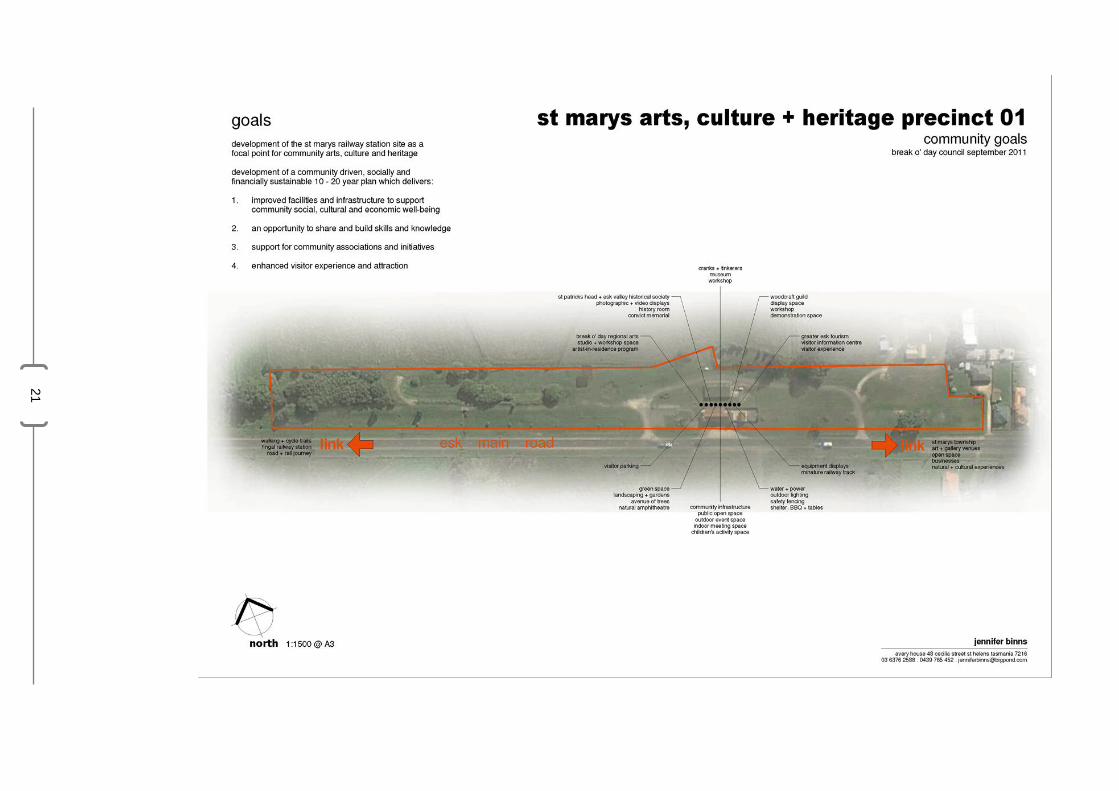
21

22

23

24

25