Embed Size (px)
Citation preview


Stakeholder Acknowledgement District 4 is pleased to acknowledge the time and contributions of stakeholders and partner agencies to this TCR. Development of system planning documents such as this one is dependent upon the participation and cooperation of key stakeholders. This TCR represents a cooperative planning effort for SR 61. Representatives of the Alameda County Transportation Commission (Alameda CTC), Alameda County and the Cities of Alameda, Oakland and San Leandro provided essential information, advice and feedback for the preparation of this document.
This TCR will be posted on the Caltrans District 4 System Planning website at: http://www.dot.ca.gov/dist4/systemplanning/
Document Preparation
The District 4 Office of System and Regional Planning would like to acknowledge the contributions made by the District 4 Office of Public Affairs, Photography Branch and the Office of System and Regional Planning, Geographic Information System (GIS) and Technical Support Branch during the preparation of the SR 61 TCR. The SR 61 TCR was prepared by:
JOHN MCKENZIE Associate Transportation Planner Office of System Planning System Planning East Branch CAMERON OAKES District Branch Chief Office of System Planning System Planning East Branch
Please contact below for any questions about this TCR:
Caltrans District 4 Division of Transportation Planning and Local Assistance
P.O. Box 23660, Oakland, CA 94623‐0660 http://www.dot.ca.gov/dist4/systemplanning

Table of Contents I. Transportation Concept Report Contents 1
II. State and Local Responsibility 1
III. Corridor Overview 2
• Corridor Description 3
• Trip Information 3
• Transit Services 4 • Bicycle and Pedestrian Facilities 6 • Environmental Factors 7
IV. Corridor Performance 10
• Corridor Performance 10 • Traffic Information 10 • Corridor Issues 14 • Highway Improvement Projects 15
V. Corridor Concept 16
• Summary and Rational 16
• Relinquishment 16 VI. Appendices 17
A. Route Legislative Description 17 B. Major and Minor Collector Cross Streets 18 C. Freeway Agreement(s) 19

Figures
Figure 1. SR 61 Segment Map 2 Figure 2. Regional Transit Network Service Area Map 5 Figure 3. SR 61 Environmental Factors Map 8 Figure 4. SR 61 Sea Level Rise Map 9 Figure 5. SR 61 AM Peak LOS (map) 11 Figure 6. SR 61 PM Peak LOS (map) 12
Tables
Table 1. SR 61 Corridor Mode Split 3 Table 2. AC Transit SR 61 Route and Origins‐Destinations 4 Table 3. SR 61 Intersection Data 6 Table 4. SR 61 2005 Traffic Data 13 Table 5. SR 61 2035 Traffic Data 13 Table 6. SR 61 Corridor Concept Summary 16
Photography
SR 61‐ Central Avenue looking south towards 8th Street, City of Alameda (2011) Cover SR 61‐ Doolittle Drive looking south towards Partee Way, City of Oakland (2011) 1 SR‐61‐Doolittle Drive looking north towards 98th Avenue, City of Oakland (2011) 10

California Department of Transportation, District 4 – August 2012 Page 1
I. Transportation Concept Report Contents
The following pages provide an overall route description and summary information on each route segment. Each summary includes a segment map, a segment overview and data tables. A list of future projects for each segment is also included. These projects are separated into three categories:
1. Programmed—projects included in the State Transportation Improvement Program (STIP), State Highway Operations and Protection Plan (SHOPP), or Transportation Improvement Program (TIP);
2. Planned—projects included in an approved Regional Transportation Plan (RTP); 3. Conceptual—projects not yet included in a planning or programming document, but are
recommended to maintain mobility and access along the segment.
Project listings include a brief description and estimated completion year.
II. State and Local Responsibility
Improvements to the State Highway System are the responsibility of both Caltrans and local agencies, collaboratively planned, developed and implemented through the regional transportation planning and project development process. Such improvements will provide for the safe and effective management and operation of new and existing transportation facilities through the use of demand reduction and operational management strategies. Developments affecting this route and the regional State Highway System may necessitate that local jurisdictions provide nexus‐based, proportional fair‐share funding for future highway improvements.

California Department of Transportation, District 4 – August 2012 Page 2
III. Corridor Overview
Figure 1. SR 61 Segment Map.

California Department of Transportation, District 4 – August 2012 Page 3
Corridor Description State Route (SR) 61 is a 7.1 mile long four‐lane conventional highway connecting SR 112 and Webster Street in the City of Alameda. The route begins at SR 112 (Davis Street) then proceeds north through the Cities of San Leandro and Oakland before ending at Webster Street in the City of Alameda. The route includes the San Leandro Bay Bridge (#33 0086) which connects Alameda and Bay Farm Islands and is maintained and operated by the County of Alameda. The route consists of one segment:
Segment A: SR 112 (Davis Street) to Webster Street – ALA PM 14.80 – 21.967.
Section 361 of the Highway and Streets Code provides the legislative description of SR 61, shown in Appendix A.
The purpose of SR 61, outlined in the Caltrans 1985 Route Concept Report (RCR), ultimately was to relieve future congestion on I‐880 and connect traversable State Routes 112 and 260 to the interstate system. The RCR describes SR 61 as a single segment beginning at SR 112 (Davis St.) and ending at Webster Street.
Trip Information The most notable land uses and trip generators along SR 61 are the Oakland International Airport, FedEx Facility, Harbor Bay Business Park and Bay Farm Island. 220 new residential units are being proposed by the Chuck Corica Golf Complex (116 units) and Harbor Bay Village VI (104 units). New development such as these combined with existing industrial, commercial, residential and airport related traffic will be the leading contributors to traffic on SR 61. Although traffic problems may be persistent, access to and from and along the corridor, and to the areas west of the corridor remains continuous. Some 2.5 percent of the traffic on SR 61 is truck movements. Of these trucks 25.5 percent are five axle trucks. Table 1 below lists the modal split data for the Cities of San Leandro, Alameda and Oakland.
Transit Services AC Transit provides transit service to the Cities of Alameda, Oakland and San Leandro along SR 61. The range of transit service consists of limited service shuttles and seven day a week Local, Night Owl and Transbay service. With the exception of Transbay routes OX and W which only run between the City of Alameda and the San Francisco Transbay Terminal the remaining shuttle, local, Nightowl and Transbay routes originate outside the SR 61 corridor but traverse SR 61 as part of their routes. All the routes serving the SR 61 corridor make connections to the regional and statewide transportation system including Bay Area Regional Transit District (BART), The San Francisco Transbay Terminal, The Alameda/Oakland Ferry and the Oakland International Airport. The Bayfarm Park and Ride Lot located at the intersection of Island Drive and SR 61 is served by AC Transit Transbay route OX as well as local routes 20 and 21. The City of Alameda operates a free shuttle five days a week with ½ hour headways between the College of Alameda and Lake Merritt BART. Table 2 below, displays which AC Transit
SOV HOV Transit Walk *Other Telecommute
San Leandro 70.4% 10.7% 12.1% 2.3% 1.6% 2.8%
Alameda 63.5% 9.7% 14.7% 4.2% 2.6% 5.1%
Oakland 57.5% 10.0% 16.9% 4.4% 4.8% 6.5%

California Department of Transportation, District 4 – August 2012 Page 4
routes serve the Cities along the SR 61 corridor, their origins and destinations and their connection points to the larger transportation system whereas Figure 2, on the next page provides an overview of the regional transportation network service area.
AC
Transit Route
Transit Route Origins-Destinations
Alameda/Oakland Ferry
Fruitvale BART
Coliseum BART
SF Transbay Terminal
Oakland Int Airport
14 x 20 x x 21 x x X
39 x 47 x
51A (851) x x 54 x 62 x
314 x x 339 x 356 x x
O x x x x
OX x x
W x x Table 2. AC Transit SR 61 Route and origins‐destinations. Legend: Yellow = local service, Orange=shuttle service, Green=transbay service

California Department of Transportation, District 4 – August 2012 Page 5
Regional Transit Network Service Area Map
Figure 2. Regional Transit Network Service Area Map.

California Department of Transportation, District 4 – August 2012 Page 6
Bicycle and Pedestrian Facilities Non‐motorized vehicles are allowed on SR 61. Pedestrian access along and across SR 61 is provided by a continuous network of city sidewalks and shared signalized intersections with adjoining local streets. Class II and III bicycle facilities on local city streets as well as the regional Class I Bay Trail Multiple Use Trail (MUT) that allow bicycle connections to and from SR 61. In addition these facilities provide users with the ability to access a variety of destinations such as The East Bay Regional Park District, Martin Luther King, Oyster Bay Shoreline and Crown Beach Regional Parks. Surrounding historical landmarks such as Jack London Square and adjacent Priority Development and Conservation Areas are also in reach. AC Transit Local and Transbay and Bay Area Regional Transit District (BART) service are available at the Fruitvale, West Oakland and Lake Merritt stations. Complete Streets Deputy Directive 64 Revision # 16 directs Caltrans to consider the access needs of all users as part of its planning and project development. Table 3, below notes some key characteristics of intersections along SR 61.
Intersection Signalized Y/N
Pedestrian Countdown Timer Y/N
Raised Median
Y/N
Number of Lanes
Crossed
Number of Marked
Crossings Davis St (SR-112) / Doolittle Dr (SR-61) Y N Y 7 3
Doolittle Dr (SR-61) / Hegenberger Rd. Y N Y 7 2
Doolittle Dr(SR-61) / Harbor Bay Pkwy. N N N 6 2
Doolittle Dr (SR-61) / Island Dr. Y N Y 5 0
Otis Dr.(SR-61) / Fernside Blvd. Y N N 5 1
Otis Dr.(SR-61) / High St. Y Y N 5 4
Otis Dr.(SR-61) / Broadway Ave. Y Y N 5 4
Broadway Ave. (SR-61) / San Jose Ave. N N N 3 4
Broadway Ave. (SR-61) / Encinal Ave. Y N N 4 4
Encinal Ave. (SR-61) / Park St. Y Y N 5 4
Encinal Ave. (SR-61) / Oak St. Y Y N 4 4
Encinal Ave. (SR-61) / Willow St. Y Y N 4 4
Encinal Ave. (SR-61) / Grand Ave. Y Y N 4 4
Encinal Ave. (SR-61) / Morton St. N N N 4 3
Encinal Ave.- (SR 61) / Sherman Ave. Y N Y 4 3
Central Ave. (SR 61) / 8Th St. Y Y N 4 4
Central Ave. (SR 61) / Webster St. END of route Y Y N 4 3
Table 3. SR 61 Intersection Data.

California Department of Transportation, District 4 – August 2012 Page 7
Environmental Factors The environmental factors map on the following page (Figure 3) depicts environmental issues in the vicinity of SR 61. Species of concern found along the corridor include the California Tiger Salamander (ambystoma tigrinum), Western Snowy Plover (Charadrius Alexandrinni Nivosuss), California Seablite (Suaeda Californica), Robust Spineflower (Choriazanther Robusta) and Adobe Sanicle (Sanicula maritime). There are concentrations of underground and submerged hazardous waste sites at the southern end and just north of the corridor as SR 61 passes through the City of Alameda. The corridor features the Bay Farm Island Bridge which was constructed before 1955, but is not eligible to be listed on the National Register of Historic Places (NRHP)1. The Alameda Naval Air Station Priority Development Area (PDA), Oakland Gateway and East Bay Greenway Priority Conservation Areas (PCA) are within the route’s area of influence.
Sea Level Rise The 2009 Vulnerability of Transportation Systems to Sea Level Rise Preliminary Assessment and 2011 Caltrans Guidance on Incorporating Sea Level Rise state that segments along the SR 61 corridor (constructed and unconstructed) would be affected by a 55 inch rise in the sea level. Executive Order (EO) S‐13‐08 (November 2008) directs State agencies planning construction projects in areas vulnerable to sea level rise to begin planning for potential impacts by considering a range of sea level rise scenarios for the years 2050 and 2100 in project planning. Project Initiation Documents will investigate whether future projects may need to avoid or mitigate any identified risks associated with climate change. Although EO S‐13‐08 allows for some exemptions for routine maintenance projects and or projects programmed for construction through 2013, the intent is to plan ahead to assess project vulnerability and reduce anticipated risks associated with sea level rise. Figure 4 on Page 9 illustrates an SR 61 Sea Level Rise Map for years 2050 and 2100.
SR‐61 Emergency Evacuation /Tsunami Route The segment of SR 61 (Doolittle Drive south of Otis Drive) as well as SR 260 (Webster Street east of Atlantic Avenue) and the recently seismically retrofitted Park Street, Fruitvale and High Street Bridges are designated as primary evacuation routes by the City of Alameda. The remaining segments of SR 61 within the City of Alameda are designated as access routes to these primary evacuation routes and several emergency operations staging areas.
1 Source: Caltrans, 2010 Update of the Historical Bridge Inventory

California Department of Transportation, District 4 – August 2012 Page 8
SR 61 Environmental Factors Map
Figure 3. SR 61 Environmental Factors Map.

California Department of Transportation, District 4 – August 2012 Page 9
SR 61 Sea Level Rise Map
Figure 4. SR 61 Sea Level Rise Map. Source: United States Geological Survey
California Department of Transportation, District 4 – August 2012 Page 10
IV. Corridor Performance
Corridor Performance Between April 1st, 2007 and March 31st, 2010 there were a total of 207 accidents on SR 61: of these 2 involved fatalities and 59 included injuries. Most of these accidents, 38% occurred on the route segment between Broadway Avenue and Sherman Street.* Figures 5 and 6 on the following pages display the 2010 AM and PM Peak level Level Of Service (LOS) for SR 61. Level of Service is a qualitative measure describing operational conditions within a traffic stream and their perceptions by motorists where LOS A represents the best conditions and LOS F represents the worst. The Alameda CTC 2010 Level of Service (LOS) Monitoring Report reports that during the AM and PM Peak periods the two to four lane, 45 to 50 mph segments south of Island Drive retain near free flow conditions with levels of service fluctuating between A and B. Level Of Service decreases on the four lane, 25 mph segments of SR 61 north of High Street as it fluctuates between B and C and is at its worst along the four lane, 35 mph segment of SR 61 including the San Leandro Bay Bridge between Island Drive and High Street.
Traffic Information The Alameda CTC 2011 Travel Demand Model predicts that in the next 25 years vehicular traffic on SR 61 is expected to increase between 25 and 31% with the largest increase being predicted for the segment of the route between Hegenberger Road and Island Drive. Short term planned improvements include construction of a signalized intersection connecting Oakland International Airport’s North Field to SR 61 via Earhart Avenue. Other projects include Asphalt/Concrete Overlay and Landscaping between SR 112 and Hegenberger Road. On Page 13, Tables 4 and 5 provide directional traffic data information for years 2005 and 2035. *Source: 3‐year Caltrans Traffic Accident Surveillance and Analysis System data. Source: District 4 Office of Traffic Safety.

California Department of Transportation, District 4 – August 2012 Page 11
State Route 61 AM Peak Levels of Service
Figure 5. SR 61 AM Peak LOS. Source: ACTC 2010 LOS Monitoring Report

California Department of Transportation, District 4 – August 2012 Page 12
State Route 61 PM Peak Levels of Service
Figure 6. SR 61 PM Peak LOS. Source Alameda CTC 2010 LOS Monitoring Report

California Department of Transportation, District 4 – August 2012 Page 13
Table 4. SR 61 2005 Traffic Data: Alameda CTC Countywide Travel Demand Model, August 2011 Note: NA=Not Applicable
Table 5. SR 61 2035 Traffic Data: Alameda CTC Countywide Travel Demand Model, August 2011 V/C = Volume to Capacity, a measure of sufficient capacity of a travel lane. A V/C of “1” would be at capacity.
SR 61 Traffic Data 2005
Directional
NB SB NB SB NB SB
Segment % of Trucks
AM PK HR
AM PK HR
PM PK HR
PM PK HR
AADT V/C* AADT V/C
SR 84 to Davis St. (unconstructed) NA NA NA NA NA NA NA
Davis St. to Hegenberger Rd. 5.3% 2105 1030 2051 2092 29471 .75 23003 .74
Hegenberger Rd. to Island Dr. 3.81% 983 1082 1375 1062 11663 .49 12414 .38
Island Dr. to Broadway Ave. 2.51% 1779 1589 1982 1906 19174 .70 20476 .68
Broadway Ave. to Encinal Ave. 2.51% 407 216 385 403 3847 .50 3267 .50
Encinal Ave. to Sherman Ave 2.51% 273 203 340 413 3225 .42 3080 .51
Sherman Ave. to Webster St. 1.34% 259 252 336 298 3109 .42 3380 .37
SR 260 to I‐580 (unconstructed) NA NA NA NA NA NA NA NA NA
SR 61 Traffic Data 2035
Directional
NB SB NB SB NB SB
Segment Description AM PK HR
AM PK HR
PM PK HR
PM PK HR
AADT V/C* AADT V/C
SR 84 to Davis St. (unconstructed) NA NA NA NA NA
NA NA
NA
Davis St. to Hegenberger Rd. 2828 1029 2310 2552 33903 1.01 33181 .91
Hegenberger Rd. to Island Dr. 1793 1994 2077 1788 20113 .74 20500 .71
Island Dr. to Broadway Ave. 1407 2407 2845 1772 29242 1.01 30730 .86
Broadway Ave. to Encinal Ave. 595 810 859 712 8702 1.07 6731 1.01
Encinal Ave. to Sherman Ave 430 426 731 467 4089 .91 5890 .58
Sherman Ave. to Webster St. 296 345 438 407 5083 .54 5390 .43
SR 260 to I‐580 (unconstructed) NA NA NA NA NA
NA NA
NA
California Department of Transportation, District 4 – August 2012 Page 14
Corridor Issues Operations During peak hours of operations, particularly in the PM southbound direction, LOS levels deteriorate due to high levels of congestion at intersections along the corridor in the City of Alameda. The two places along the corridor with the lowest PM Peak LOS readings are at the junction of SR 61 and SR 260 (Central Ave.) and at Island Drive. SR 61 operations are affected by local surface streets connecting to SR 61, adjacent State routes (SR 260 and SR 112) and diversion due to congestion or incidents on I‐880. Dual signing of SR‐61 According to its Legislative description, SR 61 begins at SR 112 (Davis Street) and ends at SR 260 (Central Avenue). However the segments of SR 112 (Davis Street) and SR 260 between SR 61 and I‐880 are dual signed as SR 61 suggesting continuation of the route when the Legislative description suggests otherwise. SR ‐61 Relinquishment District 4 has identified SR 61 from Hegenberger Road to Webster Street as a candidate for relinquishment, meaning the Department is willing to consider transfer of this portion of the route to local ownership. Discussions with the Cities of Oakland and Alameda regarding their interest in relinquishment are pending. Among the justifications for relinquishment of SR 61 from Hegenberger Road to Webster Street is its primary serving of local traffic, and it being identified as a secondary highway in Assembly Bill (AB) 2259. AB 2259 from the 1995‐96 legislative session was a proposal to amend Section 361 of the Streets and Highways Code to designate a primary and secondary system among the State Highway System. The legislation authorized the CTC and Caltrans to pursue relinquishment agreements for routes designated as secondary. While this legislation was not enacted, the primary/secondary designations established in this legislation remains useful to Caltrans planning functions. The portion of SR 61 from SR 112/Davis Street to Hegenberger Road provides important regional access to the Oakland International Airport, and as a result is not considered a candidate for relinquishment. Bicycle – Pedestrian Upgrade Americans with Disabilities Act (ADA) pedestrian access within the SR 61 corridor. Possible recommendations include increasing the number of pedestrian crossings, refreshing crosswalk/ limit line markings, installing Accessible Pedestrian Signals (APS) and curb ramps. Upgrade the existing bicycle network with bicycle detection at intersections, bike lanes/markings, way finding signage as well as closing gaps in the network. Right of Way There is no unutilized right of way available beyond the existing facility as described.

California Department of Transportation, District 4 – August 2012 Page 15
Highway Improvement Projects
Programmed • SR 61 San Leandro Bay Bridge # 33 0086 Remodel Machinery Room. This project is funded with
$2.7 Million in SHOPP funds. Estimated completion date is 2017/18. Project EA TBD. • SR 112 Roadway Rehabilitation from the SR 112 junction with SR 61 to the SR 112 Junction with
SR 185. This project is funded with $8 Million in SHOPP funds. Estimated completion date is 2016/17. Project EA 27320K.
• SR 61 Variable locations. Install source control measures to control erosion. This project is funded with $3.6 Million in SHOPP funds. Estimated completion date is 2014/15. Project EA TBD.
• Webster Street SMART Corridor. Implementation of advance technology and Intelligent Transportation Systems (ITS) strategies in order to establish a communication system that would link the ITS field elements to the Cities of Alameda and Oakland. The project is funded with a combination of CMAQ, Caltrans FHWA, TFCA and local match funds, total cost $1.6 Million. TIP ID # ALA 090024. Estimated completion date December 2013.
Planned
• Improve access to Oakland International Airport North Field, connecting State Route 61 (Doolittle Drive) with Earhart Road and extending infield area at North Field. It is anticipated that this project will be funded with $10.0 Million in regional‐state funds. RTP ID # 22084.
• Improve Bicycle and Pedestrian Infrastructure. To provide funding for bicycle and pedestrian networks in the City of Alameda. It is anticipated that this project will be funded with $15.6 Million in regional, state or local funds. RTP ID # 240191.
• Rapid Bus Service – City of Alameda and Alameda Point PDA – Implement Rapid Bus Service from Alameda Point PDA via Webster Street, Lincoln Avenue, Tilden Way, Fruitvale Avenue Bridge (Miller Sweeney Bridge) and Fruitvale Avenue to Fruitvale BART. It is anticipated that this project will be funded with $9.0 Million in regional‐state or local funds. RTP ID # 240077.
• Close the gap in the regional Bay Trail between Harbor Bay Drive and Swan Way by constructing a Class I facility along the shoreline of the East Bay Regional Park District Martin Luther King Regional Park east of SR 61. Project cost and funding source TBD.
Conceptual
• In order to improve the corridor LOS: Implement corridor management strategies such as signal coordination with connecting routes and major arterials, restricting turn movements into adjacent residential streets, driver advisories and emergency vehicle and transit signal priority.
• Adjust signal timing and phasing at the Adams Ave., Eden Rd., Island Dr., and Swan Way intersections and construct additional pedestrian crossings.
• Upgrade existing SR 61 intersections to address Americans with Disability Act (ADA) and Deputy Directive (DD) 64 R1 – Complete Streets issues by constructing ADA complacent ramps at intersections and install accessible pedestrian signals (APS) at all SR 61 intersections. Improving crosswalk markings where needed. Reduce curb radiuses at the SR 61 /SR 112 (Davis Street) intersection in order to reduce or eliminate off tracking of large vehicles.

California Department of Transportation, District 4 – August 2012 Page 16
V. Corridor Concept
Summary and Rational The Corridor Concept conveys Caltrans’ vision for a route with respect to corridor capacity and operations for a 25‐year planning horizon, and is shown in Table 5 below. The future route concept for Segment A is to maintain the existing four‐lane conventional facility while improving bicycle and pedestrian connections at the intersections and improve signal operations. Planned and programmed intersection and operational improvements are expected to address existing operational issues and provide an acceptable level of service.
Relinquishment Relinquishment of SR 61 is of interest to the District; the issue is pending discussions with the Cities of Alameda and Oakland. An alternative is re‐designation of SR 61 as part of SR 112 or SR 260 to provide a traversable route to I‐880. Should SR 61 remain on the State Highway System, the District recommends the segments of SR 112 and SR 260, currently signed as SR 61, be signed appropriately (as SR 112 and SR 260) so the constructed portion of State Route 61 is the same as it’s description in Section 361 of the Streets and Highway Code. The City of Alameda has requested the District possibly consider a conceptual future crossing between Alameda and Oakland.
Segment Cities Segment Description Existing Facility 25-Year Concept
Facility A
PM 14.80 – 21.97 San Leandro to
Alameda SR 112 to Central
Ave. 4C 4C
Table 6. SR 61 Corridor Concept Summary. Legend: C=Conventional, PM=Post Mile, SR=State Route
California Department of Transportation, District 4 – August 2012 Page 17
VI. Appendences Appendix A: Route Legislative Description The Streets and Highway Code Section 361 documents the Legislative Description for State Route 61:
• Route 61 is from Route 84 near Newark to Route 580 near Albany via the vicinity of San Leandro and Oakland International Airport and via Alameda.
• No portion of Route 61 shall be constructed as a freeway north of Hegenberger Road.
Assembly Bill 2259 (1995‐96) amends section 361 of the Highway and Streets Code
361. (a) Route 61 (secondary) is from Route 84 near Newark to Route 580 near Albany via the vicinity of San Leandro and Oakland International Airport and via Alameda.
(b) No portion of Route 61 shall be constructed as a freeway north of Hegenberger Road.

California Department of Transportation, District 4 – August 2012 Page 18
Appendix B: SR 61 Major and Minor Collector Cross Streets SR 61/Adams Avenue SR 61/Airport Drive/Hegenberger Road SR 61/Swan Way SR 61/Harbor Bay Parkway SR 61/Island Drive SR 61/Fernside Boulevard SR 61/High Street SR 61/Broadway Avenue SR 61/ San Jose Avenue SR 61/ Encinal Avenue SR 61/Park Street SR 61/Oak Street SR 61/Willow Street SR 61/Grand Street SR 61/Morton Street SR 61/Sherman Street SR 61/ Eighth Street SR 61/ Webster Street
California Department of Transportation, District 4 – August 2012 Page 19
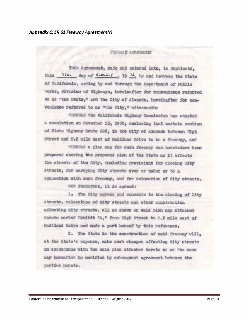
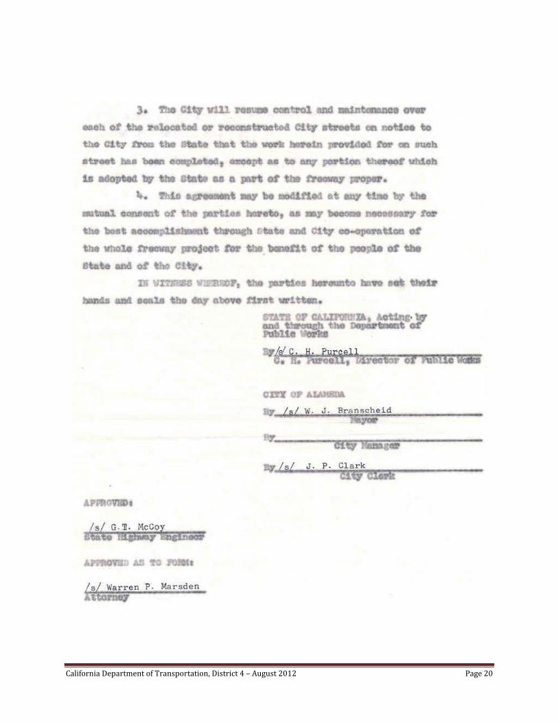
Appendix C: SR 61 Freeway Agreement(s)
California Department of Transportation, District 4 – August 2012 Page 20

California Department of Transportation, District 4 – August 2012 Page 21