Embed Size (px)
Citation preview
July 19, 2011
1
SR-12 Comprehensive Corridor Evaluation
and Corridor Management Plan,
from SR-29 to I-5
Corridor Improvement Strategies
Draft Technical Memorandum
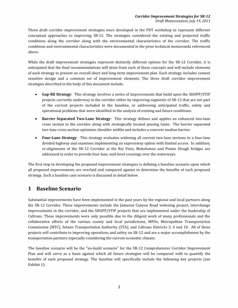
The purpose of the memorandum is to present recommendations for improvement strategies for the SR-12
Corridor. This is the fourth in a series of technical memoranda for the SR-12 Comprehensive Corridor
Improvement Plan and builds upon information presented in the documents below. The prior documents are
available on the project website and include:
Final SR-12 Environmental Scan – April 2011
Final SR-12 Existing Conditions Technical (ECT) Report – April 2011
Draft SR-12 Future Conditions Technical (FCT) Report – April 2011
The draft strategies recommended in this technical memo were developed in a workshop fashion on April 14,
2011, with the members of the Project Development Team (PDT). The PDT workshop participants included
transportation professionals representing Caltrans, Metropolitan Planning Organizations (MPOs), counties
and the consulting team charged with preparing this study.
The draft corridor improvement strategies will be presented to the Technical Advisory Group (TAG),
stakeholders and general public during outreach activities that will be held in the summer of 2011. Based on
input received during the outreach, the corridor improvement strategies will be finalized and evaluated. The
results of the evaluation, including recommendations for short and long-term improvement to SR-12, will be
presented for review during a round of outreach planned in the fall of 2011.
Summary
This memorandum documents a baseline case against which the proposed strategies will be evaluated and
recommends the corridor improvement strategies that will be carried forward for further evaluation by the
project team and subsequent review by the PDT. The baseline case includes projects already planned,
programmed or underway along SR-12 including the Jameson Canyon widening project, planned
improvements to the I-80/I-680/SR-12 interchange, and five other Caltrans State Highway Operation and
Protection Program (SHOPP) or State Transportation Improvements Program (STIP) projects.
Corridor Improvement Strategies for SR-12 Draft Memorandum, July 19, 2011
2
Three draft corridor improvement strategies were developed in the PDT workshop to represent different
conceptual approaches to improving SR-12. The strategies considered the existing and projected traffic
conditions along the corridor along with the environmental characteristics of the corridor. The traffic
conditions and environmental characteristics were documented in the prior technical memoranda referenced
above.
While the draft improvement strategies represent distinctly different options for the SR-12 Corridor, it is
anticipated that the final recommendations will draw from each of these concepts and will include elements
of each strategy to present an overall short and long-term improvement plan. Each strategy includes context
sensitive design and a common set of improvement elements. The three draft corridor improvement
strategies described in the body of this document include:
Gap-fill Strategy: This strategy involves a series of improvements that build upon the SHOPP/STIP
projects currently underway in the corridor either by improving segments of SR-12 that are not part
of the current projects included in the baseline, or addressing anticipated traffic, safety and
operational problems that were identified in the analysis of existing and future conditions.
Barrier Separated Two-Lane Strategy: This strategy defines and applies an enhanced two-lane
cross section to the corridor along with strategically located passing lanes. The barrier separated
two-lane cross section optimizes shoulder widths and includes a concrete median barrier.
Four-Lane Strategy: This strategy evaluates widening all current two-lane sections to a four-lane
divided highway and examines implementing an expressway option with limited access. In addition,
re-alignments of the SR-12 Corridor at the Rio Vista, Mokelumne and Potato Slough bridges are
addressed in order to provide four-lane, mid-level crossings over the waterways.
The first step in developing the proposed improvement strategies is defining a baseline scenario upon which
all proposed improvements are overlaid and compared against to determine the benefits of each proposed
strategy. Such a baseline case scenario is discussed in detail below.
1 Baseline Scenario
Substantial improvements have been implemented in the past years by the regional and local partners along
the SR-12 Corridor. These improvements include the Jameson Canyon Road widening project, interchange
improvements in the corridor, and the SHOPP/STIP projects that are implemented under the leadership of
Caltrans. These improvements were only possible due to the diligent work of many professionals and the
collaborative efforts of the various county and local jurisdictions, MPOs, Metropolitan Transportation
Commission (MTC), Solano Transportation Authority (STA), and Caltrans Districts 3, 4 and 10. All of these
projects will contribute to improving operations and safety on SR-12 and are a major accomplishment by the
transportation partners especially considering the current economic climate.
The baseline scenario will be the “no-build scenario” for the SR-12 Comprehensive Corridor Improvement
Plan and will serve as a basis against which all future strategies will be compared with to quantify the
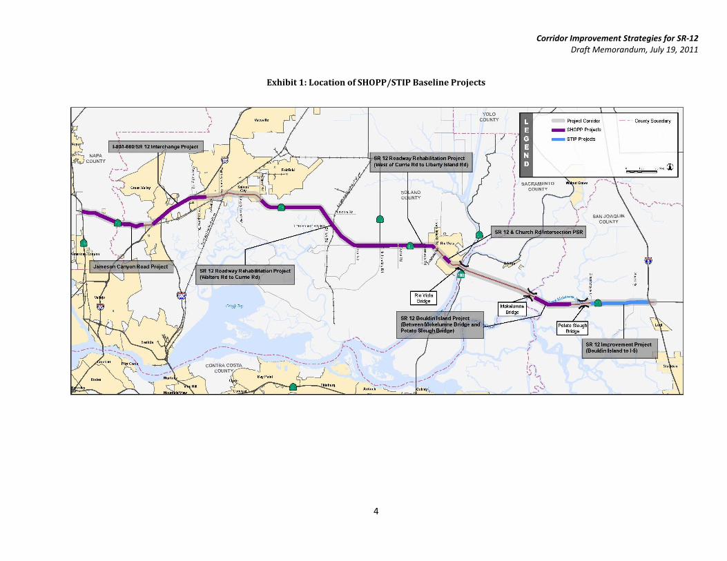
benefits of each proposed strategy. The baseline will specifically include the following key projects (see
Exhibit 1):
Corridor Improvement Strategies for SR-12 Draft Memorandum, July 19, 2011
3
Jameson Canyon Road (current status: completed design)
I-80/I-680/SR-12 interchange Phase I - Includes improvements to Green Valley Road, I-80/680 and
the Suisun Valley Road interchanges along with the Beck Avenue interchange (current status:
completing environmental clearance)
SHOPP Project - SR-12 Roadway Rehabilitation Project (Walters Road to Currie Road) (current
status: project complete)
SHOPP Project - SR-12 Roadway Rehabilitation Project (West of Currie Road to Liberty Island Road)
(current status: completed design)
SHOPP Project - SR-12 and Church Road Intersection PSR (current status: environmental clearance
needed)
SHOPP Project - SR-12 Bouldin Island Project (Between Mokelumne Bridge and Potato Slough
Bridge) (current status: completed design)
STIP Project - SR-12 Improvement Project (from Bouldin Island to I-5) (current status: completed
design)
The SHOPP and STIP projects involve rehabilitating pavement structural sections, construction of standard
outside shoulder widths, implementation of intersection improvements, construction of a park and ride lot,
provision of passing lanes, and ITS elements. The above projects are expected to be completed by 2015 which
will change the physical configuration of SR-12 as compared to today’s conditions.
Corridor Improvement Strategies for SR-12 Draft Memorandum, July 19, 2011
4
Exhibit 1: Location of SHOPP/STIP Baseline Projects
Corridor Improvement Strategies for SR-12 Draft Memorandum, July 19, 2011
5
2 Elements Common to All Strategies
Several transportation features were identified as essential elements for all strategies. These elements are
designed to promote mobility and safety along the corridor. Common elements which will be included in each
improvement strategy include pedestrian, bicycle and transit facilities, transit, ITS elements, bridge
operations, alignments, sea level rise, soil conditions and agricultural access. A brief discussion of each
element follows.
2.1 Pedestrian Facilities
Pedestrian facilities currently exist in the urbanized areas which include Fairfield/Suisun City and Rio Vista.
Other segments of SR-12 do not serve land uses that attract or generate pedestrian traffic and do not include
pedestrian facilities for baseline conditions.
Pedestrian facilities in Fairfield/Suisun City exist between Main Street and Woodlark Drive and generally
consist of pedestrian pathways and sidewalks interconnected by pedestrian crossings at intersections in the
residential areas. Pedestrian facilities, approximately five feet in width, exist on either side of the corridor
within Rio Vista and provide access to surrounding businesses and residential communities. However, the
pedestrian facility is discontinuous with no delineation such as curb and gutter to separate the pedestrian
facility from the roadway. Sidewalk in this location also transitions frequently between a walkway and a
shoulder.
The Rio Vista Bridge provides a five foot walkway on either side of the structure. Access to the walkway is
obtained by a stairwell which leads to a parking lot adjacent to the bridge structure approach at the south
west end. The walkway terminates at the east end of the bridge and ties into the existing shoulder of the
corridor.
A pedestrian facility currently exists on the north side of the Mokelumne Bridge. It is approximately five feet
wide and traverses along the length of bridge. The pedestrian facility is situated behind a concrete barrier
which separates the facility from the westbound travel way and shoulder. The sidewalk transitions into the
existing shoulder at both ends of the bridge.
The Potato Slough Bridge provides a five foot walkway on the south side of the structure. Access to the
walkway is located adjacent to the eastbound shoulder with no pavement marking or signs to delineate the
transition. The walkway terminates at the east end of the bridge and ties into the existing shoulder of the
corridor. Proposed physical improvements to both bridge structures will be discussed further in bridge re-
alignment alternatives developed in Section 3.3, Four-Lane Alternative Strategy.
Context sensitive design principles will be employed to enhance the pedestrian facilities in the vicinity of Rio
Vista which will be accompanied by a better definition of the curb cuts and walkways in Rio Vista between
Main Street and North Front Street.
Corridor Improvement Strategies for SR-12 Draft Memorandum, July 19, 2011
6
2.2 Bicycle Facilities
SR-12 functions as a vital link between various bicycle routes and provides connectivity across various
waterways in the region. Several bicycle facilities are planned for the corridor including a 20-mile Class II
Bikeway (Bike Lane) or Class III Bikeway (Bike Route) between Walters Road and the Rio Vista Bridge, and a
Class II bikeway along Jameson Canyon Road, from Red Top Road to the Napa County Line. It is to be noted
that the 20-mile Class II facility is in its initial planning stages and is currently not identified as a high-priority
project.
Several gaps in bike facilities will exist after the implementation of the planned baseline projects along SR-12.
In addition, bicycle facilities included in the baseline conditions do not provide upgraded bicycle facilities on
the Rio Vista, Mokelumne, and Potato Slough bridges. Bicyclists on SR-12 will have to use the existing
sufficient width shoulders of the roadway to cross over the waterways.
For the gap-fill and barrier separated two-lane strategies being developed for SR-12, the improvements will
accommodate bicycle traffic in the eight-foot wide outside shoulder area of the roadway. This typical roadway
cross section is described in Highway Design Manual section 1003.2 (3) and shown in Exhibit 5, and bike lane
signing will be supplemented with R25 (park off pavement) signs, or R26 (no parking) signs. However,
existing bridge shoulders will not be widened. The proposed strategies will provide bicycle connectivity to
cross delta routes by providing improved bike facilities in the shoulder of the roadway throughout the
corridor.
The four-lane strategy will include widening the roadway cross section and bridges to four lanes with
standard shoulder, which would accommodate bicycle traffic along SR-12. In addition, the four-lane strategy
will bridge the existing gap in bike lanes at Travis Air Force Base.
2.3 Transit
Public transportation in the SR-12 Corridor currently provides options for additional travel modes. The major
transit services operating in the corridor are bus routes provided by Fairfield and Suisun Transit (FAST), Rio
Vista Delta Breeze, and South County Transit (SCT/LINK) in Galt. Travel forecasts for year 2035 indicate that
the transit mode share in the corridor will be on the order of two percent1, which is not a significant share.
Implementation of park and ride facilities will promote better transit utilization, relieve vehicular demand on
over-subscribed segments of the corridor, and provide better connectivity and convenience for the transit
user. All recommended strategies will evaluate the potential for a new park and ride lot in the vicinity of the
Walters Road and SR-12 intersection. Implementation of a park and ride facility in this location may help
reduce trips on the more congested parts of SR-12 through Suisun City/Fairfield and help existing transit
routes to serve their patrons better.
The need for a park and ride facility in the vicinity of the SR-160 and SR-12 intersection will also be evaluated
as part of all improvement strategies. A park and ride facility at this location is projected to offer better
connectivity to other regional transit routes along SR-160. Capacity improvements to SR-12 as a part of all
1 State Route 12 Corridor Transit Study, prepared for Solano Transportation Authority and Napa County
Transportation Planning Agency by Urbitran Associates, January 2006, p. 55.
Corridor Improvement Strategies for SR-12 Draft Memorandum, July 19, 2011
7
improvement strategies are also projected to provide better reliability and travel times for transit service
vehicles that currently use SR-12.
2.4 Intelligent Transportation Systems (ITS)
Existing ITS infrastructure along the SR-12 Corridor is located in the western segment of the corridor, from I-
80 to the Rio Vista Bridge. The existing ITS elements currently servicing the corridor include several Portable
Changeable Message Signs (PCMS) and Speed Radar Signs (or Driver Feedback Signs). Additional ITS
elements including extinguishable message signs and changeable message signs will be implemented in the
near future for the easterly segments of SR-12, in the vicinity of I-5, and which are included in the baseline
case scenario for SR-12. Use of portable changeable message signs and radar powered speed signs has helped
increase driver compliance and safety in the recent past. Refer to the ECT report for additional details related
to existing ITS elements.
Proposed improvement strategies for SR-12 will include implementation of ITS infrastructure and enhanced
ITS coverage for segments of the corridor that do not have any ITS elements in the baseline case scenario.
These segments are sections of SR-12 between Walters Road and Rio Vista and the sections of SR-12 between
Mokelumne Bridge and North Guard Road. Proposed strategies for mainline SR-12 will include the
implementation of ITS features such as:
Extinguishable Message Signs (EMS) – that may help improve the operational characteristics of
moveable bridges and advance warning;
Changeable Message Signs (CMS) – at congested locations to improve communications with the
driver, improve driver expectancy and safety; and
Traffic Monitoring Station (TMS)
Addition of these new ITS elements will enhance traffic enforcement (e.g.: radar controlled speed limit signs),
provide better driver information (e.g.: CMS and EMS) and promote safety (e.g.: advance warning signs). In
addition to these features, advance warning signs and changeable message signs will be implemented
upstream of the moveable bridge approaches as a part of the improvement strategies. These ITS elements will
help warn drivers of the impending closures in advance and are anticipated to help improve bridge cycle
times while enhancing safety for vehicles that have to stop abruptly for bridge openings on SR-12.
2.5 Bridge Operations
The moveable bridges at the Sacramento and the Mokelumne rivers on SR-12 impact traffic operations
significantly by increasing travel times on SR-12 due to bridge opening operations. The equipment used to
control the opening/closing cycles of both bridges are dated and inefficient. They currently operate with less
than optimal efficiency resulting in longer cycle time which impacts vehicular traffic on SR-12 and the marine
traffic crossing SR-12. Furthermore, breakdowns of bridge machinery, for as long as a week, have been
reported in the past which lead to disruption of both vehicular and waterborne traffic flow.
The Rio Vista Bridge is frequently opened because of waterborne freight and goods movements, to and from
the Port of Sacramento. A longer bridge opening duration is often needed due to the larger size vessels.
Typical bridge opening/closure cycles exceed 13 minutes. In addition, during the summer months, there is an
Corridor Improvement Strategies for SR-12 Draft Memorandum, July 19, 2011
8
increase in the need for openings due to recreational boating. The bridge openings lead to significant queues
and delays on SR-12; delays which are documented in greater detail in the FCT report.
The Mokelumne Bridge is one of the most frequently opened bridges in the state. Due to maritime laws that
give right-of-way priority to marine traffic, the bridge opens frequently and at various times of the day
without regard to SR-12 traffic volumes. Heavy congestion and delay are a result of these frequent openings.
Congestion at the Rio Vista and Mokelumne bridges is expected to increase by 2035 as a direct result of a
projected increase in the number of openings for future conditions.
Two enhancement approaches will be considered to improve operations at the bridges. Bridge equipment
upgrades and implementation of additional ITS elements will be considered for the gap-fill improvement
strategy and the barrier separated two-lane strategy. Replacement of the existing bridge with a medium or
high level non-movable bridge will be considered at both locations for the four-lane option.
Bridge improvements proposed for the barrier separated two-lane strategy including optimization of bridge
operations, along with implementation of advance signage, ITS elements and signals, will help improve
opening/closure cycle times. Upgrades to bridge control equipment along with enhanced ITS equipment will
allow for more responsive traffic stoppage/release times which will in turn reduce delays for both vehicular
and marine traffic.
Bridge improvements proposed in the four-lane strategy highway option entail re-construction along with re-
alignment of the Rio Vista and Mokelumne bridges. The re-constructed bridges will provide a higher
clearance from the water surface, which eliminates the need for a moveable bridge, and will also include a
four-lane section which provides additional throughput capacity on SR-12.
2.6 New SR-12 Alignments
Several options that entailed re-alignment of SR-12 were considered as possible strategies. These strategies
are designed to achieve reductions in impacts to the physical environment and/or improve safety by
addressing non-standard geometry. In addition, the new SR-12 alignments would include constructing new
four-lane bridges to improve mainline capacity. Constraints observed during the analysis of SR-12 alignments
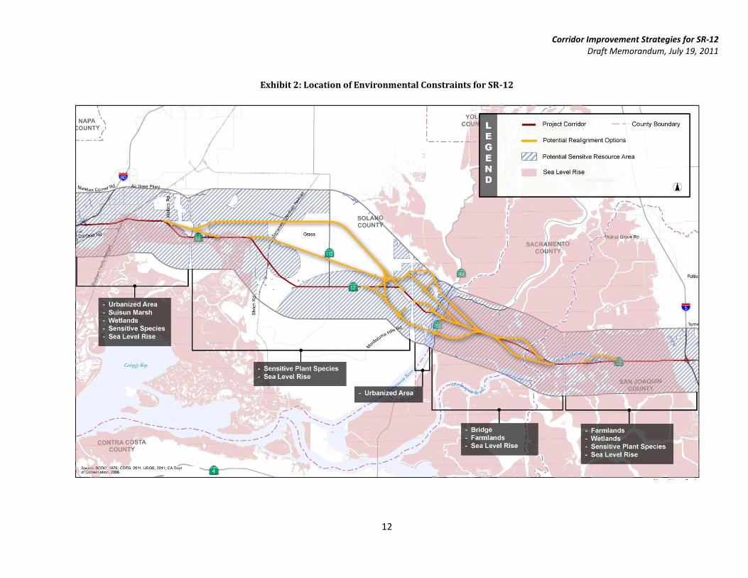
are shown in Exhibit 2 and discussed briefly below.
2.6.1 Section from I-80 to the Fairfield Area
In this section, SR-12 east of I-80 traverses built up urban areas and presents little to no opportunities for re-
alignment. Re-alignment of SR-12 through Fairfield/Suisun City have extensive impacts to urbanized areas
and offer little to no benefits in return. Re-alignment of SR-12 to the south of the current alignment would
place the new route in the Suisun Marsh area where it would impact wetlands and sensitive species.
Therefore, alignment of SR-12 in this area was not carried forward as a viable option since this would result
in major impacts to the urbanized area to the north and significant impacts to the highly sensitive
environmental resources to the south.
2.6.2 Section east of Fairfield to Rio Vista
In this section, several re-alignment options were considered but did not provide identifiable benefits. The
segment of SR-12 from Walters Road to the Rio Vista River traverses areas with sensitive plant species and
wetlands. Re-alignments that were designed to bypass these sensitive areas and route SR-12 to the north
Corridor Improvement Strategies for SR-12 Draft Memorandum, July 19, 2011
9
were considered for this section from Fairfield to Rio Vista. Re-alignment of SR-12 did not help avoid impacts
to any of the environmental resources. In addition, presence of the Travis Air Force Base precluded certain
re-alignment options and placed significant constraints on most re-alignment options for this section.
Therefore, re-alignment of SR-12 in this area was not carried forward as a viable option since this would
result in major impacts to sensitive environmental resources and did not produce any benefits.
2.6.3 Rio Vista Bridge Area
Two realignments to the north and one realignment to the south of the existing SR-12 Corridor were
considered in the Rio Vista Bridge study. The preferred alternative for a re-aligned four-lane Rio Vista Bridge
will be consistent with the findings of the Rio Vista Bridge study recently completed by STA. Each realignment
option will provide a four-lane cross section for the four-lane option (see Exhibit 8). The bridge will be a
higher profile elevation and will eliminate the need for bridge openings to accommodate waterborne freight
and goods movement.
2.6.4 Rio Vista Bridge to I-5
This 16 mile segment of SR-12 extends from just east of the Rio Vista Bridge to I-5, and includes the
Mokelumne Bridge and the Potato Slough Bridge traversing the Sacramento-San Joaquin River Delta. Most of
the SR-12 segments for this section traverse the Sacramento-San Joaquin River Delta. The Sacramento-San
Joaquin River Delta is one of California’s most important natural resources and is the largest estuary in the
western United States extending far beyond the immediate vicinity of the corridor to the north and south as
shown in Exhibit 2. This environmentally sensitive estuary also includes productive farmlands and
recreational opportunities. Re-alignment of SR-12 will impact farmland, wetlands and areas with sensitive
plant species.
As a result of these significant environmental impacts and the absence of potential benefits from re-aligning
SR-12, any new alignments north or south of the existing SR-12 alignment are deemed less favorable than
upgrading and improving the existing SR-12 alignment. Therefore, it was concluded that the baseline case
should focus on improvements to SR-12 on its existing alignment or areas immediately adjacent to it.
Re-alignment of the Mokelumne Bridge and the Potato Slough Bridge locations will be considered. Similar to
the Rio Vista Bridge, re-alignment of SR-12 at this location will consist of construction of new four-lane
bridges over the waterway. Re-alignment of these bridges will be considered only for the four-lane strategy
and is further described in Section 3.3.
For this section of SR-12, alternatives were explored that included improving the structural characteristics of
the paved areas by surcharging the existing soils and constructing robust, sub-base on engineered fill with
wick-drains. In addition, an option of elevating the roadway on viaduct (bridge structure) was also reviewed.
In terms of realigning SR-12 through this area, no advantage was identified from an environmental
perspective.
The general finding was that the robust at-grade pavement design that is being used by Caltrans for the
Bouldin Island project built at, or adjacent to the existing SR-12 alignment, is a reasonable approach for the
purposes of this study and no advantage could be identified for unilaterally raising SR-12 in this area on
viaduct. Moreover, a viaduct section poses problems with access to parcels and farmlands, and in the
extreme event these low-lying areas were inundated due to levy failure, there is no identifiable justification
for preserving access via this section of SR-12. For these reasons, the Project Development Team concluded
Corridor Improvement Strategies for SR-12 Draft Memorandum, July 19, 2011
10
that two-lane improvement scenarios should focus on generally at-grade improvements to SR-12 on its
existing alignment or areas immediately adjacent to it.
In the case of the four-lane improvement scenarios, re-alignments of SR-12 in the areas of the Mokelumne
and Potato Slough Bridges will be needed to adjust the bridge profiles to mid-level height to provide for four-
lane crossing. In these areas, SR-12 will essentially be on elevated structure, or viaduct. Since the distance
between the Mokelumne and Potato Slough Bridges is in the range of five miles, a continuous four-lane
viaduct beginning west of the Mokelumne crossing to east of Potato Slough will be examined. This effectively
would elevate SR-12 a distance of nearly seven miles through the Sacramento-San Joaquin River Delta.
2.7 Sea Level Rise
A growing concern in coastal communities is the potential impacts to infrastructure caused by projected sea
level rise for future years. Caltrans has begun looking at infrastructure that could be threatened by sea level
rise and is developing design approaches for new and reconstructed facilities in coastal areas that account for
sea level rise and associated wave run-up. The low ground elevation areas in the SR-12 Corridor face the
greatest threat from rising sea level, particularly during high storm tide events. The SR-12 Corridor, south of
Travis Air Force Base and north of Suisun Marsh, is in a low-lying area.
As shown in Exhibit 2, projected impacts of sea level rise indicate that developed areas west of Rio Vista
including Suisun City and Fairfield will be inundated. Also, inundation in this area is projected to impact
segments of SR-12 between Rio Vista and the I-5 interchange and access to the Travis Air Force Base.
However, there is no concrete policy guidance nor are there directives on definitive corridor enhancement
measures for such a dire scenario.
Strategies that involve re-alignment of SR-12 or re-construction of bridges will include design options that
provide adequate clearance to mitigate the impact of sea level rise. Given the anticipated extent of impact of
sea level rise to surrounding communities far beyond the extents of SR-12, the PDT group felt that there was
not sufficient policy guidance to formulate a corridor-wide mitigation plan and that the development of a
region-wide mitigation plan was outside the scope of this study.
2.8 Soil Conditions
The geology and geotechnical conditions for a majority of the corridor, especially in the Sacramento-San
Joaquin River Delta area, present many issues as the Delta soils, which consist of peat and clay layers, are
highly compressible. Roadways built over these soil conditions are subject to settlement and require long-
term maintenance to address pavement cracking, deterioration, and decreased service life.
Segments of SR-12 in the Sacramento-San Joaquin River Delta area are highly subject to flooding due to the
aging levee system. Maintenance and repair of the levee system is critical to ensure the preservation of low-
lying areas; however, obtaining the resources and funding has been and will continue to be a challenge. These
levees were built over a century ago, when modern engineering analyses and techniques were not available,
and they were built on top of poor organic soils that have compressed and displaced through the years.
Significant subsiding of the levees has occurred in the past years, and they continue to be a highly expensive
maintenance issue.
A strategy discussed to combat the poor soil consolidation and settlement concerns of the Delta marsh
include installing a wick drain system and surcharging to speed up consolidation of underlying soils. This
method entails placing embankment material over the proposed grade to surcharge the soil while the wick
Corridor Improvement Strategies for SR-12 Draft Memorandum, July 19, 2011
11
drains, located underneath the pavement area, capture water and filter it through the channels within the
wick drain core. A collector pipe will then feed the captured water into an existing drainage structure or ditch.
The relevance of this option is to reduce settlement of the roadway.
Engineering mitigation techniques will be included as a part of the improvement for all strategies. These
mitigation techniques, which could be used upon further analysis, include soil replacement with lightweight
fills, soil stabilization, soil and pavement reinforcing and/or use of wick drains or material surcharging
loading to accelerate soil consolidation. The Bouldin Island SHOPP project employed soil surcharge
techniques combined with implementation of wick drains to address soil related issues. However, all of these
techniques are costly engineering mitigation options that introduce additional complexity and demand
careful construction staging.
2.9 Agricultural Access
Agricultural traffic often crosses SR-12 to access farmlands on either side of the corridor. This travel pattern
is currently possible due to absence of any barriers in the median. While the implementation of median
barriers as a part of future alternatives promotes corridor safety, the barriers will pose a hindrance to
agricultural traffic wanting to cross SR-12. All future improvement strategies will consider the need for
agricultural crossing.
Corridor Improvement Strategies for SR-12 Draft Memorandum, July 19, 2011
12
Exhibit 2: Location of Environmental Constraints for SR-12
Corridor Improvement Strategies for SR-12 Draft Memorandum, July 19, 2011
13
3 Recommended Corridor Improvement Strategies
A series of strategies was developed after review of historical data, consideration of corridor constraints and
corridor needs. The strategies are classified into three broad categories based on the scope and extent of the
proposed improvements. The strategies being considered for future years are a gap-fill strategy, the barrier
separated two-lane strategy, and the four-lane strategy. Each strategy’s construction requirement varies and
results in a different cross-section for the corridor.
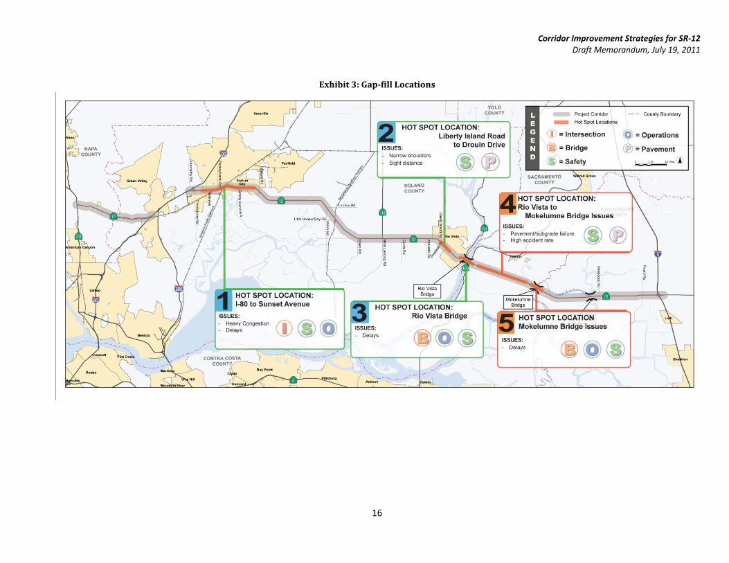
3.1 Gap-fill Strategy
The gap-fill strategy identifies improvements for spot locations throughout the corridor that have been
identified as having deficiencies that are not addressed by the improvements in the baseline scenario. The
objective of identifying these locations is to develop specific improvement strategies that further enhance the
improvements generated by the programmed projects in the baseline scenario. These locations currently are
not addressed as a part of the currently programmed improvements or SHOPP/STIP projects. These
deficiencies include poor intersection configurations, non-standard shoulder widths, pavement and subgrade
failure, and the frequency of bridge openings.
Each of these deficiencies has directly contributed to increased congestion and delays. These deficiencies can
be categorized into the areas of operations, safety, roadway pavement and geometry. Gap-fill strategies have
been identified to address these localized issues. The gap-fill strategy will build upon and supplement the
planned SHOPP/STIP projects. Four specific areas have been identified as gap-fills within the corridor and are
identified in Exhibit 3.
3.1.1 Location 1: Between Beck Avenue and Sunset Avenue
The first gap-fill location includes several intersections which are projected to experience heavy congestion
and delays. These intersections are located just east of the SR-12/I-80 interchange on SR-12 and adjacent to
the I-680/I-80/SR-12 interchange. Intersections that will be improved for this location include Chadbourne
Avenue, Beck Avenue, Pennsylvania Avenue, Marina Avenue, Grizzly Island Road, and Walters Road., In
addition to the spacing of these signalized intersections, absence of adequate capacity at these intersections
combined with a significant proportion of truck traffic has led to deterioration in operating speeds during
peak times. Additional time required by heavy vehicles to reach cruising speeds has led to uneven lane usage
and queuing issues. Each of the existing intersections are at-grade with the exception of Marina Avenue which
is grade separated.
Potential improvements to address the intersections listed above include converting the mixed use section of
the corridor to a six-lane expressway. This strategy includes consideration for grade separated intersections
while also controlling access from SR-12. A frontage roads system would be provided to maintain existing
access to properties impacted by access consolidation. Impacts resulting from these improvements include
acquiring additional right-of-way which in turn impacts residential and commercial properties, wetlands,
sensitive species, as well as protected areas adjacent to the roadway. In addition, capacity improvements to
these segments will result in elimination of bottlenecks that store traffic demand. Elimination of bottlenecks
in this segment of the corridor will result in higher demand arriving at downstream intersections which could
lead to yet unrealized operational issues at downstream locations.
Corridor Improvement Strategies for SR-12 Draft Memorandum, July 19, 2011
14
3.1.2 Location 2: Between Liberty Island Road and Drouin Drive
The second location consists of segments of SR-12 between Liberty Island Road and Drouin Drive just west of
Rio Vista. These roadway segments currently have narrow shoulders and inadequate sight-distance on both
the eastbound and westbound approaches. Potential improvements to address these issues include provision
of standard width shoulders and additional earth work to ensure that adequate sight distances are
maintained. These enhancements will improve safety, pavement and ride quality through this segment.
3.1.3 Location 3: Rio Vista Bridge
Operational issues experienced at the Rio Vista Bridge are discussed under section 2.5. Bridge related
improvements include optimizing bridge openings through a series of ITS elements along with advance
warning signs. Advance warning or variable message signs alerting motorist of closures are recommended
approximately half mile upstream of the bridge approaches. These message boards will be inter-connected to
the signal timer at the bridge crossing as well as the bridge operations tower to ensure lines of
communication between all devices. The implementation of these devices will ensure a safe and efficient
stoppage of mainline SR-12 traffic and expedite the opening/closure of the bridge for marine traffic. As a part
of the gap-fill strategy, additional safety improvements in the form of channelizers and shoulders
improvements will be performed for the bridge approach from Drouin Drive to Rio Vista Bridge.
3.1.4 Location 4: Rio Vista to Mokelumne Bridge
This location consists of the approaches to both the Rio Vista and Mokelumne bridges. Segments of SR-12 in
this location experience significant congestion during bridge opening/closure cycles and are often
accompanied by sluggish queue recovery cycles. Review of traffic demand for future conditions indicates that
available capacity for baseline conditions may not be adequate to accommodate projected demand. This
absence of projected capacity will further intensify the congestion related issues at both bridges. The
intersection of SR-12 and SR-160 currently experiences operational issues related to merging maneuvers
mainly because the two lane transition at the departure legs are too short to allow faster moving vehicles to
pass slower vehicles.
In addition to these operational issues, additional pavement deficiencies exist at this location. Poor
underlying soils, peat and clay soils, between the Rio Vista Bridge and Mokelumne Bridge have severely
eroded the pavement sections causing cracking, humps, and differential settlement. This is a direct result of
the highly compressible nature of the underlying soil and has compromised the pavement life expectancy and
increased the maintenance cost for Caltrans since frequent patches and repairs are required. Safety has also
been an issue as two head-on collisions have been reported in prior years.
Improvements to address these issues include extending the two-lane cross-section for eastbound and
westbound departure legs for the intersection of SR-12 and SR-160 to allow for better passing opportunities
and to ensure safe merging operations; developing a structural engineered pavement section to combat the
easily eroded soil and subgrade, similar to the SR-12 Bouldin Island SHOPP project; and installing a median
barrier or channelizers to reduce the potential for a motorist encroaching into the opposing lane. Impacts
from the proposed strategy may include purchasing right-of-way which would in-turn impact wetlands,
sensitive species, and prime farmland areas.
Corridor Improvement Strategies for SR-12 Draft Memorandum, July 19, 2011
15
3.1.5 Location 5: Mokelumne Bridge
The Mokelumne Bridge experiences operational issues as discussed under section 2.5. Gap-fill improvements,
including optimizing bridge openings through a series of ITS elements similar to the improvements listed for
Location 3, will help improve the operational characteristics of these bridges by reducing opening and closing
times.
Corridor Improvement Strategies for SR-12 Draft Memorandum, July 19, 2011
16
Exhibit 3: Gap-fill Locations
Corridor Improvement Strategies for SR-12 Draft Memorandum, July 19, 2011
17
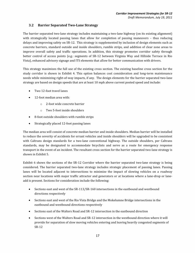
3.2 Barrier Separated Two-Lane Strategy
The barrier separated two-lane strategy includes maintaining a two-lane highway (on its existing alignment)
with strategically located passing lanes that allow for completion of passing maneuvers – thus reducing
delays and improving safety on SR-12. This strategy is supplemented by inclusion of design elements such as
concrete barriers, standard outside and inside shoulders, rumble strips, and addition of clear zone areas to
improve overall safety and traffic operations. In addition, this strategy promotes corridor safety through
better control of access points (e.g.: segments of SR-12 between Virginia Way and Hillside Terrace in Rio
Vista), enhanced advisory signage and ITS elements that allow for better communication with drivers.
This strategy maximizes the full use of the existing cross section. The existing baseline cross section for the
study corridor is shown in Exhibit 4. This option balances cost consideration and long-term maintenance
needs while minimizing right-of-way impacts, if any. The design elements for the barrier separated two-lane
strategy are based on design speeds that are at least 10 mph above current posted speed and include:
Two 12-foot travel lanes
12-foot median area with:
o 2-foot wide concrete barrier
o Two 5-foot inside shoulders
8-foot outside shoulders with rumble strips
Strategically placed 12-foot passing lanes
The median area will consist of concrete median barrier and inside shoulders. Median barrier will be installed
to reduce the severity of accidents for errant vehicles and inside shoulders will be upgraded to be consistent
with Caltrans design standards for a two-lane conventional highway. The outside shoulders, per Caltrans
standards, may be designated to accommodate bicyclists and serve as a route for emergency response
transport in the event of an incident. The resultant cross section for the barrier separated two-lane strategy is
shown in Exhibit 5.
Exhibit 6 shows the sections of the SR-12 Corridor where the barrier separated two-lane strategy is being
considered. The barrier separated two-lane strategy includes strategic placement of passing lanes. Passing
lanes will be located adjacent to intersections to minimize the impact of slowing vehicles on a roadway
section near locations with major traffic attractor and generators or at locations where a lane-drop or lane-
add is present. Sections for consideration include the following:
Sections east and west of the SR-113/SR-160 intersections in the eastbound and westbound
directions respectively
Sections east and west of the Rio Vista Bridge and the Mokelumne Bridge intersections in the
eastbound and westbound directions respectively
Sections east of the Walters Road and SR-12 intersection in the eastbound direction
Sections west of the Walters Road and SR-12 intersection in the westbound direction where it will
provide for separation of slow moving vehicles entering and leaving heavily congested segments of
SR-12
Corridor Improvement Strategies for SR-12 Draft Memorandum, July 19, 2011
18
Implementation of barriers may limit the ability of vehicles to cross SR-12 to access properties. Such
movements will be accommodated through wide turn lanes that allow U-turns at intersections. Exhibit 7
shows the sections where implementation of passing lanes is being considered. These improvements are
projected to improve travel speeds on SR-12 at key locations in the corridor. Comparison of proposed
roadway enhancements for the barrier separated two-lane strategy against projected demand for SR-12
(refer to the FCT for a detailed discussion) indicates that the barrier separated two-lane strategy may not
offer required capacity for several segments. These segments include:
SR-12 from Beck Avenue to Walters Road: Requires one additional lane in each direction combined
with grade separated intersections in addition to the barrier separated two-lane improvements
SR-12 from SR 113 to Hillside Terrace: Requires one additional lane in each direction in addition to
the barrier separated two-lane improvements
Rio Vista and Mokelumne bridges: Requires elimination of bridge openings
SR-12 from Mokelumne Bridge to Glasscock Road: Requires one additional lane in each direction in
addition to the barrier separated two-lane improvements
Provision of passing lanes for some of these locations as a part of the barrier separated two-lane option along
with presence of bottlenecks in the west end of the corridor (SR-12 from Beck Avenue to Walters Road) is
expected to help reduce the duration and intensity of congestion due to slow moving vehicles.
Corridor Improvement Strategies for SR-12 Draft Memorandum, July 19, 2011
19
Exhibit 4: Typical Cross Section – Baseline Conditions
Corridor Improvement Strategies for SR-12 Draft Memorandum, July 19, 2011
20
Exhibit 5: Typical Cross Section – Barrier Separated Two-Lane Strategy
Corridor Improvement Strategies for SR-12 Draft Memorandum, July 19, 2011
21
Exhibit 6: Barrier Separated Two-Lane Strategy
Corridor Improvement Strategies for SR-12 Draft Memorandum, July 19, 2011
22
Exhibit 7: Location of Passing Lanes
Corridor Improvement Strategies for SR-12 Draft Memorandum, July 19, 2011
23
3.3 Four-Lane Alternative Strategy
This strategy offers the highest capacity for SR-12 when compared to other improvement strategies. This
strategy will improve operational capacity on SR-12 by converting the two-lane conventional highway to a
four-lane conventional highway on its existing alignment for all segments of SR-12 except the Rio Vista and
Mokelumne bridges. Re-alignment and re-construction of the Rio Vista and Mokelumne bridges is also
included in this strategy. The implication of a four-lane expressway will be examined in detail as a variant to
the conventional highway.
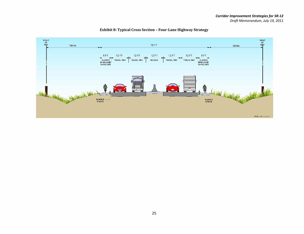
Design elements for this strategy include concrete barriers, standard outside and inside shoulders, rumble
strips, and clear zones. The proposed typical section items for a four-lane strategy are based on design
criteria for a four-lane rural conventional highway and include:
Four 12-foot travel lanes
12-foot median area with:
o Provision of rumble strips for the left shoulder as an initial step
o Implementation of a 2-foot wide concrete barrier as a subsequent mitigation when
warranted
o Two 5-foot inside shoulders
8-foot outside shoulders with rumble strips
Median barrier as well as inside shoulders will be provided to be consistent with Caltrans design standards
and to address safety issues observed during the safety analysis of the corridor. In addition, rumble strips will
be provided on the shoulders to enhance safety for the corridor. The outside shoulders, per Caltrans
standards, will accommodate bicyclists and also serve as a route for emergency response transport in the
event of an incident. A typical cross section for a conventional four-lane highway is shown in Exhibit 8.
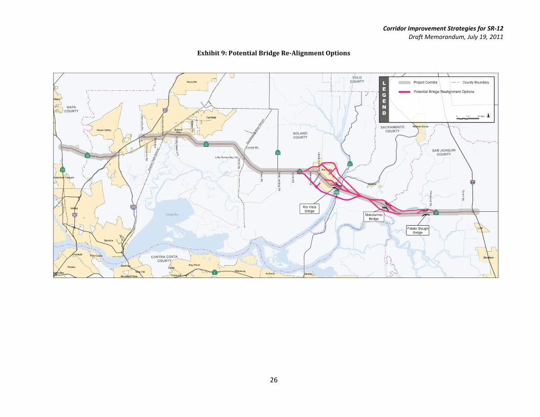
The four-lane strategy will also evaluate the potential for re-alignment of the existing two-lane Rio Vista,
Mokelumne and Potato Slough bridges. Refer to Exhibit 9 for re-alignment locations. Re-alignment of the
bridges was evaluated due to three primary considerations:
1.) The continuous four-lane section, cross section of the corridor, and the need for the bridges to match
the overall design template of the rest of the corridor
2.) Construction of a bridge would require re-alignment because it cannot widen over the existing
structure nor may it maintain traffic operations during the construction period
3.) Delays caused by bridge openings
Re-alignment strategies for the Rio Vista Bridge will build upon alternatives developed in the Rio Vista Bridge Study. These alternatives included:
Mid-level moveable bridge adjacent to existing bridge
Tunnel option underneath Sacramento River
High level crossing north of Rio Vista
High level crossing south of Rio Vista
Corridor Improvement Strategies for SR-12 Draft Memorandum, July 19, 2011
24
Re-alignment options at the Mokelumne Bridge include options to shift the bridge north or south of its
current location. The Potato Slough Bridge option examined re-aligning the bridge north of its existing
location. In an effort to minimize impacts to the surrounding developments, the bridge strategies weighed
efforts to minimize impacts to surrounding businesses and farmland while also providing necessary lateral
clearance to account for the swinging span during the construction phase. To mitigate items listed above,
proposed structures should examine implementation of a mid to high level bridge and these structures
should provide adequate clearance over the river beds to minimize the number of openings. Consideration for
clearance above the river beds should also account for sea level rise. Improvements to the horizontal and
vertical geometry will need to account for approach grades into the bridge as well as horizontal curvature to
tie-in to the existing alignment corridor. Adequate sight distances should also be provided.
Comparison of proposed roadway enhancements for the four-lane strategy against projected demand for SR-
12 (refer to the FCT for a detailed discussion) indicates that the four-lane strategy may not offer required
capacity for certain segments of SR-12 such as segments between Beck Avenue and Walters Road. Additional
mitigation measures for such areas may be identified during the next phase of the design task.
Corridor Improvement Strategies for SR-12 Draft Memorandum, July 19, 2011
25
Exhibit 8: Typical Cross Section – Four-Lane Highway Strategy
Corridor Improvement Strategies for SR-12 Draft Memorandum, July 19, 2011
26
Exhibit 9: Potential Bridge Re-Alignment Options
Corridor Improvement Strategies for SR-12 Draft Memorandum, July 19, 2011
27
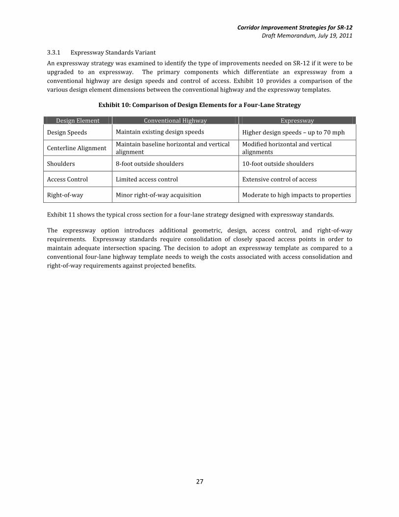
3.3.1 Expressway Standards Variant
An expressway strategy was examined to identify the type of improvements needed on SR-12 if it were to be
upgraded to an expressway. The primary components which differentiate an expressway from a
conventional highway are design speeds and control of access. Exhibit 10 provides a comparison of the
various design element dimensions between the conventional highway and the expressway templates.
Exhibit 10: Comparison of Design Elements for a Four-Lane Strategy
Design Element Conventional Highway Expressway
Design Speeds Maintain existing design speeds Higher design speeds – up to 70 mph
Centerline Alignment Maintain baseline horizontal and vertical alignment
Modified horizontal and vertical alignments
Shoulders 8-foot outside shoulders 10-foot outside shoulders
Access Control Limited access control Extensive control of access
Right-of-way Minor right-of-way acquisition Moderate to high impacts to properties
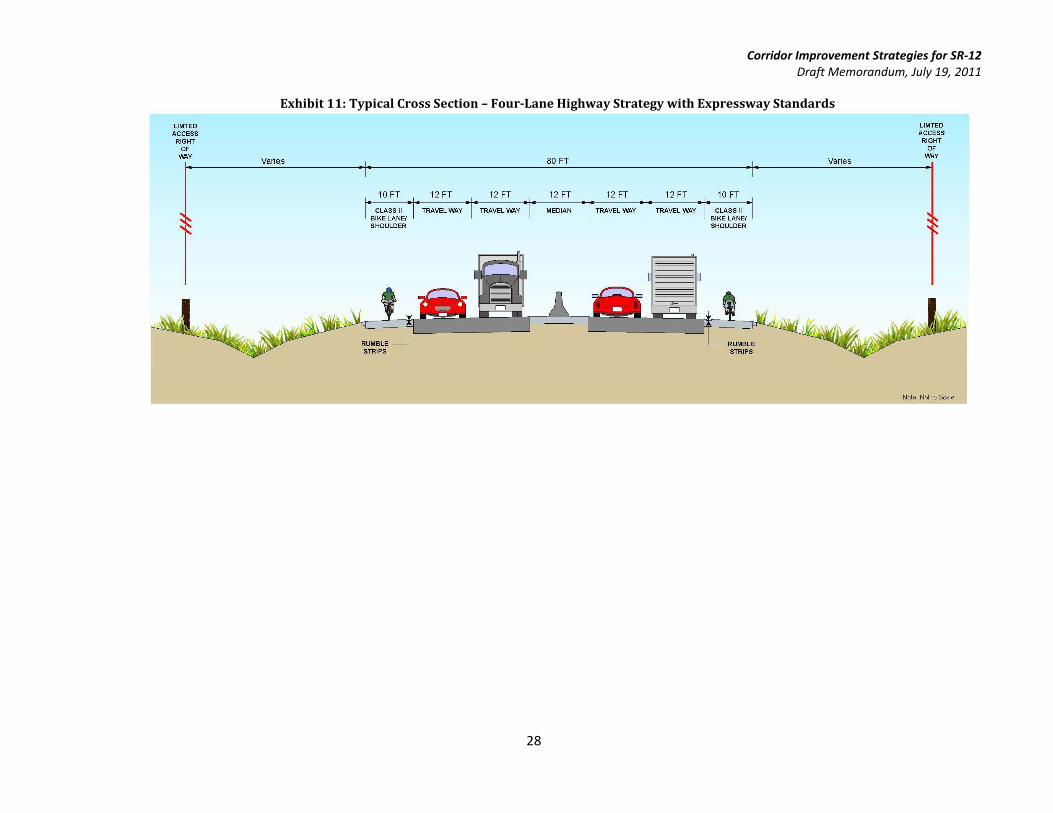
Exhibit 11 shows the typical cross section for a four-lane strategy designed with expressway standards.
The expressway option introduces additional geometric, design, access control, and right-of-way
requirements. Expressway standards require consolidation of closely spaced access points in order to
maintain adequate intersection spacing. The decision to adopt an expressway template as compared to a
conventional four-lane highway template needs to weigh the costs associated with access consolidation and
right-of-way requirements against projected benefits.
Corridor Improvement Strategies for SR-12 Draft Memorandum, July 19, 2011
28
Exhibit 11: Typical Cross Section – Four-Lane Highway Strategy with Expressway Standards
Corridor Improvement Strategies for SR-12 Draft Memorandum, July 19, 2011
29
4 Criteria for Evaluation of Strategies
The above strategies have been analyzed and the next step is to evaluate the strategies using a wide range of
evaluation criteria, both quantitative and qualitative, that capture a broad range of corridor goals. Such
criteria will support the regions’ Sustainable Communities Strategy initiative. Potential evaluation criteria
include several quantitative factors such as:
Mobility Metrics: All mobility benefits are measured in terms of vehicular miles of travel and hours
of delay and travel. Vehicular miles of travel is a measure of the corridor’s ability to accommodate
travel demand for the corridor. Vehicular hours of travel and vehicular hours of delay indicate the
ability of the corridor to process demand without delays. In addition, maximum delay and queue
length will be quantified at bottleneck locations. Vehicular metrics will be translated to obtain person
metrics for all analysis locations. Comparative analysis of these metrics between improvement
strategies and the baseline scenario will be used to rank the various strategies. For example, a lower
vehicle miles of travel value accompanied by a higher vehicular hours of travel for a strategy (when
compared to the baseline scenario) represents the presence of noticeable delay on a corridor for that
strategy. Average vehicle occupancy rates will then be applied to the above metrics to obtain person
measures of effectiveness.
Air Quality: Average operating characteristics including travel speeds, travel flow and queuing
information will be used to calculate vehicular emissions for various strategies. These emission
values will be then be compared to the baseline scenario to determine the influence of each strategy
on vehicular emissions.
Cost: Summary of costs for the various improvement strategies will include capital costs and
construction costs along with operations and maintenance costs. Capital costs include the
construction, right-of-way acquisition, vehicle procurement (transit), and mitigation costs.
Construction costs include mainline, ramps, intersections, bridges, signalization, erosion control,
drainage, maintenance of traffic, and mobilization. Operations and maintenance costs include labor
and materials for maintenance and repairs, utilities, financing, etc.
Qualitative measures of effectiveness that will be reviewed to assess the viability and benefits of each strategy
include:
Transportation System Effectiveness: Ability of the strategies to decrease distressed lane-miles of
state highways.
Safety: Ability of the strategies to enhance safety for all modes of travel including mitigation of any
safety issues for identified baseline conditions.
Economic Vitality: This criterion will discuss benefits offered by the various alternatives in
improving regional connectivity, improved reliability for people and goods along with improved
travel times.
Environmental Impact: Ability of the strategies to avoid or minimize impacts to threatened and
endangered species, critical habitat, wetlands and waters, farmlands and protected areas.
Healthy and Safe Communities: Ability of the strategies to increase average daily walking or biking
per person for transportation purposes.