Embed Size (px)
Citation preview
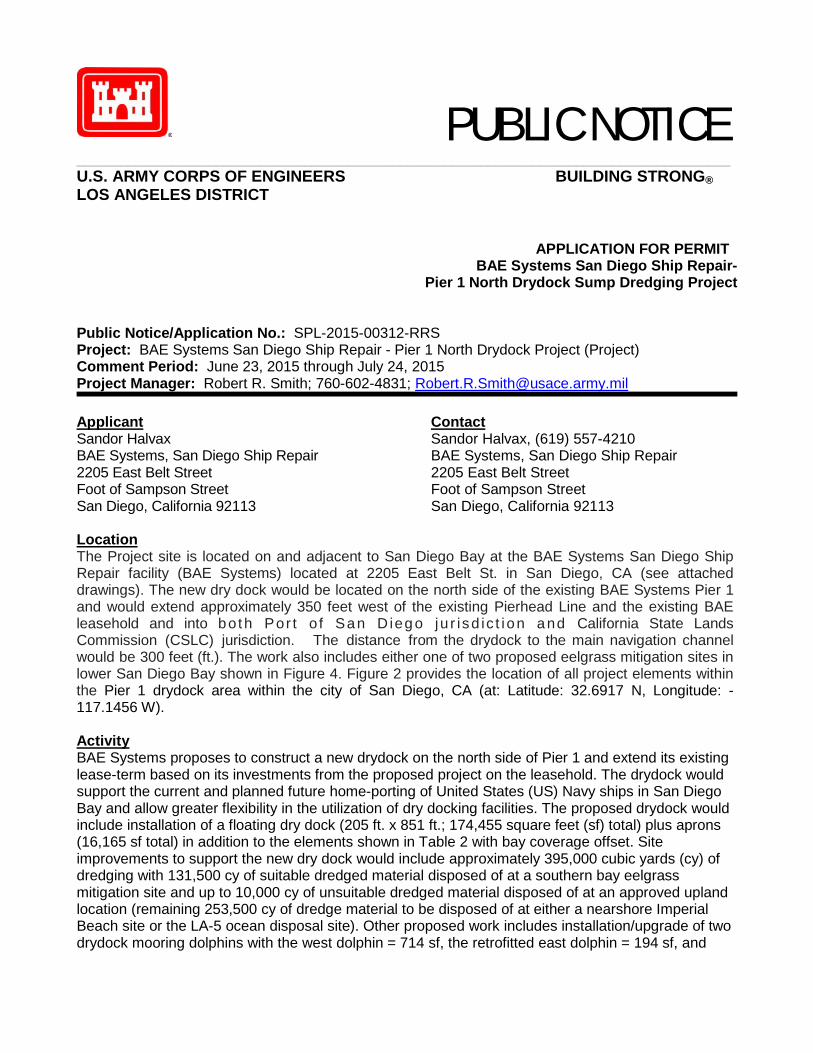
PUBLIC NOTICE _________________________________________________________________________________________
U.S. ARMY CORPS OF ENGINEERS BUILDING STRONG® LOS ANGELES DISTRICT
APPLICATION FOR PERMIT BAE Systems San Diego Ship Repair-
Pier 1 North Drydock Sump Dredging Project Public Notice/Application No.: SPL-2015-00312-RRS Project: BAE Systems San Diego Ship Repair - Pier 1 North Drydock Project (Project) Comment Period: June 23, 2015 through July 24, 2015 Project Manager: Robert R. Smith; 760-602-4831; [email protected] Applicant Sandor Halvax BAE Systems, San Diego Ship Repair 2205 East Belt Street Foot of Sampson Street San Diego, California 92113
Contact Sandor Halvax, (619) 557-4210 BAE Systems, San Diego Ship Repair 2205 East Belt Street Foot of Sampson Street San Diego, California 92113
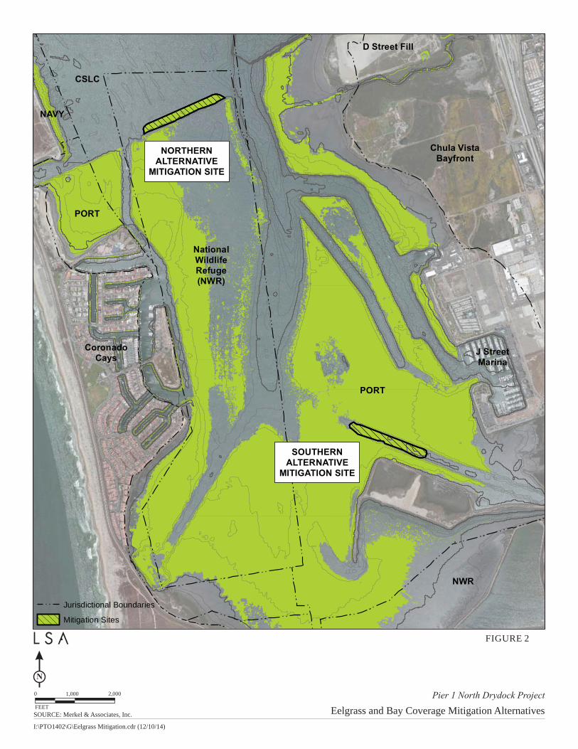
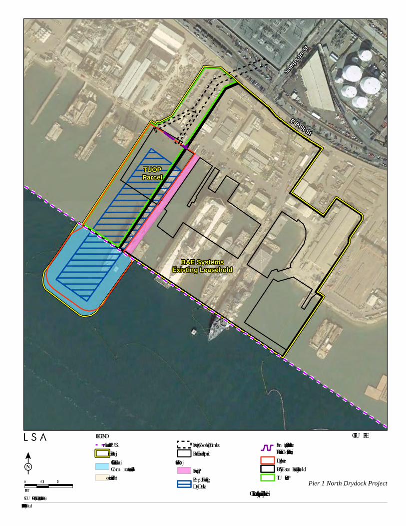
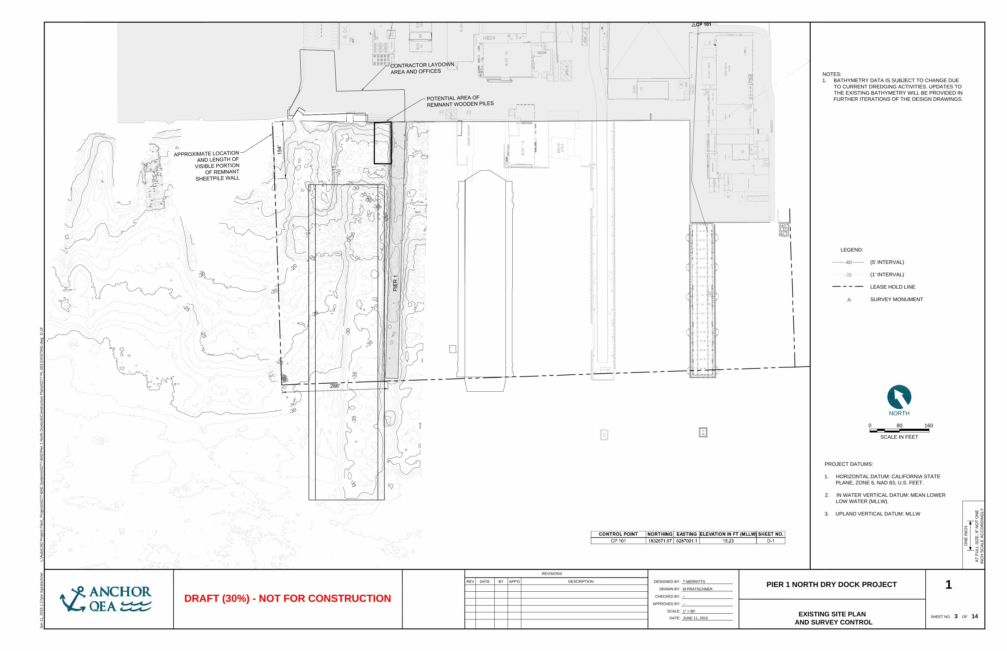
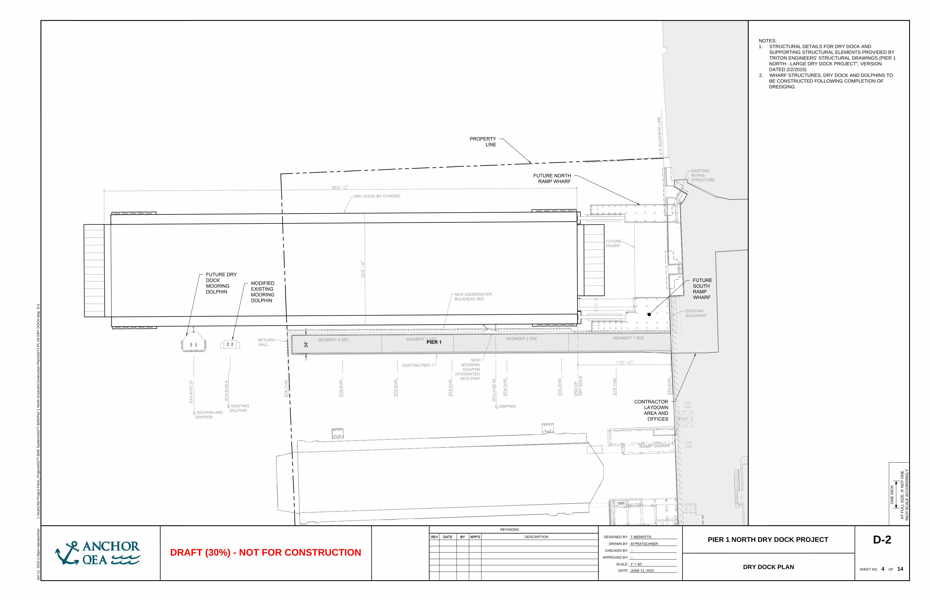
Location The Project site is located on and adjacent to San Diego Bay at the BAE Systems San Diego Ship Repair facility (BAE Systems) located at 2205 East Belt St. in San Diego, CA (see attached drawings). The new dry dock would be located on the north side of the existing BAE Systems Pier 1 and would extend approximately 350 feet west of the existing Pierhead Line and the existing BAE leasehold and into both Por t o f San D ieg o ju r isd ic t ion and California State Lands Commission (CSLC) jurisdiction. The distance from the drydock to the main navigation channel would be 300 feet (ft.). The work also includes either one of two proposed eelgrass mitigation sites in lower San Diego Bay shown in Figure 4. Figure 2 provides the location of all project elements within the Pier 1 drydock area within the city of San Diego, CA (at: Latitude: 32.6917 N, Longitude: -117.1456 W). Activity BAE Systems proposes to construct a new drydock on the north side of Pier 1 and extend its existing lease-term based on its investments from the proposed project on the leasehold. The drydock would support the current and planned future home-porting of United States (US) Navy ships in San Diego Bay and allow greater flexibility in the utilization of dry docking facilities. The proposed drydock would include installation of a floating dry dock (205 ft. x 851 ft.; 174,455 square feet (sf) total) plus aprons (16,165 sf total) in addition to the elements shown in Table 2 with bay coverage offset. Site improvements to support the new dry dock would include approximately 395,000 cubic yards (cy) of dredging with 131,500 cy of suitable dredged material disposed of at a southern bay eelgrass mitigation site and up to 10,000 cy of unsuitable dredged material disposed of at an approved upland location (remaining 253,500 cy of dredge material to be disposed of at either a nearshore Imperial Beach site or the LA-5 ocean disposal site). Other proposed work includes installation/upgrade of two drydock mooring dolphins with the west dolphin = 714 sf, the retrofitted east dolphin = 194 sf, and
2
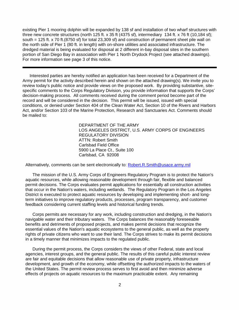
existing Pier 1 mooring dolphin will be expanded by 138 sf and installation of two wharf structures with three new concrete structures (north 125 ft. x 35 ft (4375 sf), intermediary 134 ft. x 76 ft (10,184 sf); south = 125 ft. x 70 ft.(8750 sf) for total 23,309 sf) and construction of permanent sheet pile wall on the north side of Pier 1 (80 ft. in length) with on-shore utilities and associated infrastructure. The dredged material is being evaluated for disposal at 2 different in-bay disposal sites in the southern portion of San Diego Bay in association with Pier 1 North Drydock Project (see attached drawings). For more information see page 3 of this notice.
Interested parties are hereby notified an application has been received for a Department of the Army permit for the activity described herein and shown on the attached drawing(s). We invite you to review today’s public notice and provide views on the proposed work. By providing substantive, site-specific comments to the Corps Regulatory Division, you provide information that supports the Corps’ decision-making process. All comments received during the comment period become part of the record and will be considered in the decision. This permit will be issued, issued with special conditions, or denied under Section 404 of the Clean Water Act, Section 10 of the Rivers and Harbors Act, and/or Section 103 of the Marine Protection, Research and Sanctuaries Act. Comments should be mailed to:
DEPARTMENT OF THE ARMY LOS ANGELES DISTRICT, U.S. ARMY CORPS OF ENGINEERS REGULATORY DIVISION ATTN: Robert Smith Carlsbad Field Office 5900 La Place Ct., Suite 100 Carlsbad, CA 92008
Alternatively, comments can be sent electronically to: [email protected] The mission of the U.S. Army Corps of Engineers Regulatory Program is to protect the Nation's
aquatic resources, while allowing reasonable development through fair, flexible and balanced permit decisions. The Corps evaluates permit applications for essentially all construction activities that occur in the Nation's waters, including wetlands. The Regulatory Program in the Los Angeles District is executed to protect aquatic resources by developing and implementing short- and long-term initiatives to improve regulatory products, processes, program transparency, and customer feedback considering current staffing levels and historical funding trends.
Corps permits are necessary for any work, including construction and dredging, in the Nation's
navigable water and their tributary waters. The Corps balances the reasonably foreseeable benefits and detriments of proposed projects, and makes permit decisions that recognize the essential values of the Nation's aquatic ecosystems to the general public, as well as the property rights of private citizens who want to use their land. The Corps strives to make its permit decisions in a timely manner that minimizes impacts to the regulated public.
During the permit process, the Corps considers the views of other Federal, state and local agencies, interest groups, and the general public. The results of this careful public interest review are fair and equitable decisions that allow reasonable use of private property, infrastructure development, and growth of the economy, while offsetting the authorized impacts to the waters of the United States. The permit review process serves to first avoid and then minimize adverse effects of projects on aquatic resources to the maximum practicable extent. Any remaining
3
unavoidable adverse impacts to the aquatic environment are offset by compensatory mitigation requirements, which may include restoration, enhancement, establishment, and/or preservation of aquatic ecosystem system functions and services. Evaluation Factors
The decision whether to issue a permit will be based on an evaluation of the probable impact including cumulative impacts of the proposed activity on the public interest. That decision will reflect the national concern for both protection and utilization of important resources. The benefit, which reasonably may be expected to accrue from the proposal must be balanced against its reasonably foreseeable detriments. All factors which may be relevant to the proposal will be considered including the cumulative effects thereof. Factors that will be considered include conservation, economics, aesthetics, general environmental concerns, wetlands, cultural values, fish and wildlife values, flood hazards, flood plain values, land use, navigation, shoreline erosion and accretion, recreation, water supply and conservation, water quality, energy needs, safety, food production and, in general, the needs and welfare of the people. In addition, if the proposal would discharge dredged or fill material, the evaluation of the activity will include application of the EPA Guidelines (40 CFR Part 230) as required by Section 404 (b)(1) of the Clean Water Act.
The Corps of Engineers is soliciting comments from the public; Federal, state, and local agencies and officials; Indian tribes; and other interested parties in order to consider and evaluate the impacts of this proposed activity. Any comments received will be considered by the Corps of Engineers to determine whether to issue, modify, condition or deny a permit for this proposal. To make this decision, comments are used to assess impacts on endangered species, historic properties, water quality, general environmental effects, and the other public interest factors listed above. Comments are used in the preparation of an Environmental Assessment and/or an Environmental Impact Statement pursuant to the National Environmental Policy Act. Comments are also used to determine the need for a public hearing and to determine the overall public interest of the proposed activity. Preliminary Review of Selected Factors
EIS Determination- A preliminary determination has been made an environmental impact statement is not required for the proposed work.
Water Quality- The applicant is required to obtain water quality certification, under Section 401 of the Clean Water Act, from the California Regional Water Quality Control Board. Section 401 requires any applicant for an individual Section 404 permit provide proof of water quality certification to the Corps of Engineers prior to permit issuance.
Coastal Zone Management (CZMA)- The applicant has certified the proposed activity would comply with and would be conducted in a manner consistent with the approved State Coastal Zone Management Program. For those projects in or affecting the coastal zone, the Federal Coastal Zone Management Act requires that prior to issuing the Corps authorization for the project, the applicant must obtain concurrence from the California Coastal Commission the project is consistent with the State's Coastal Zone Management Plan.
Essential Fish Habitat (EFH)- The Corps of Engineers preliminary determination indicates the proposed dredging and construction activities may adversely affect EFH and federally managed species in the Coastal Pelagics and Pacific Groundfish Fishery Management Plans. Pursuant to Section 305(b)(2) of the Magnuson-Stevens Fishery Conservation and Management Act (MSA), the Los Angeles District hereby requests initiation of EFH consultation for the proposed project. This notice initiates the EFH consultation requirements of the Act. In order to comply with the
4
Magnuson-Stevens Fishery Conservation and Management Act (MSA), pursuant to 50 CFR 600.920(e)(3), I am providing, enclosing, or otherwise identifying the following information:
1. Description of the proposed action: See project description on page 5 of this public notice.
2. On site inspection information: Onsite turbidity and work will be monitored. See baseline information on page 5 of this public notice.
3. Analysis of the potential adverse effects on EFH: The Project drydock work and dredging/disposal work would directly impact EFH resources due to direct mortality to coastal pelagic fish within the bay from dredging and disposal work along with turbidity and wharf noise construction impacts. Project will adversely impact eelgrass that will have an adverse effect on EFH resources but will be mitigated per the California Eelgrass Mitigation Policy (CEMP).
4. Proposed minimization, conservation, or mitigation measures: Project will use Best Management Practices (BMPs) such as a turbidity curtain, onsite turbidity monitoring and work cessation procedures, also per the Corps and EPA Inland Testing Manual (ITM) consultation for the Project up to 10,000 cubic yards of the total dredge volume, dredged from the area outside of the Shipyard Sediment Site Cleanup footprint, has been deemed to not be suitable for ocean disposal or beneficial reuse and will be taken to a landfill which will have long term beneficial effects to EFH resources. Unsuitable material will be disposed of at an appropriately permitted upland landfill. All eelgrass impacts will be mitigated per the CEMP. 5. Conclusions regarding effects of the proposed project on EFH: The Project may adversely affect EFH resources due to direct mortality and turbidity impacts to EFH resources and requires consultation with NOAA Fisheries for the Project because no programmatic or general EFH consultations can cover the entire project’s work.
Therefore, it is my initial determination the proposed activity may adversely affect EFH or federally managed fisheries in California waters. My final determination relative to project impacts and the need for mitigation measures is subject to review by and coordination with the NOAA Fisheries. If I do not receive written comments (regular mail or e-mail) within the 30-day notification period, I will assume concurrence by NOAA Fisheries.
Cultural Resources- The latest version of the National Register of Historic Places has been consulted and this site is not listed. This review constitutes the extent of cultural resources investigations by the District Engineer, and he is otherwise unaware of the presence of such resources. Due to previous disturbances in the project area the Corps has made a preliminary determination that there would be a “No potential to cause effects to cultural resources” based on previous dredging and pier construction work in the project area.
Endangered Species- Preliminary determinations indicate the proposed activity would not affect federally-listed endangered or threatened species, or their critical habitat. Therefore, formal consultation under Section 7 of the Endangered Species Act does not appear to be required at this time. However, the applicant has proposed to implement avoidance measures for Green Sea Turtle (monitoring, work cessation, and pile driving noise and impact reduction procedures) and the California least terns (monitoring, work cessation, turbidity curtain) to be employed.
Public Hearing- Any person may request, in writing, within the comment period specified in this notice, that a public hearing be held to consider this application. Requests for public hearing shall state with particularity the reasons for holding a public hearing.
5
Proposed Activity for Which a Permit is Required
Basic Project Purpose- The basic project purpose comprises the fundamental, essential, or irreducible purpose of the proposed project, and is used by the Corps to determine whether the applicant's project is water dependent (i.e., requires access or proximity to or siting within the special aquatic site to fulfill its basic purpose). Establishment of the basic project purpose is necessary only when the proposed activity would discharge dredged or fill material into a special aquatic site (e.g., wetlands, pool and riffle complex, mudflats, eelgrass, coral reefs). Project fills are proposed within a special aquatic sites (eelgrass), therefore identification of the basic project purpose is required and the basic project purpose for the proposed project is marine vessel construction and repair. The project is water dependent.
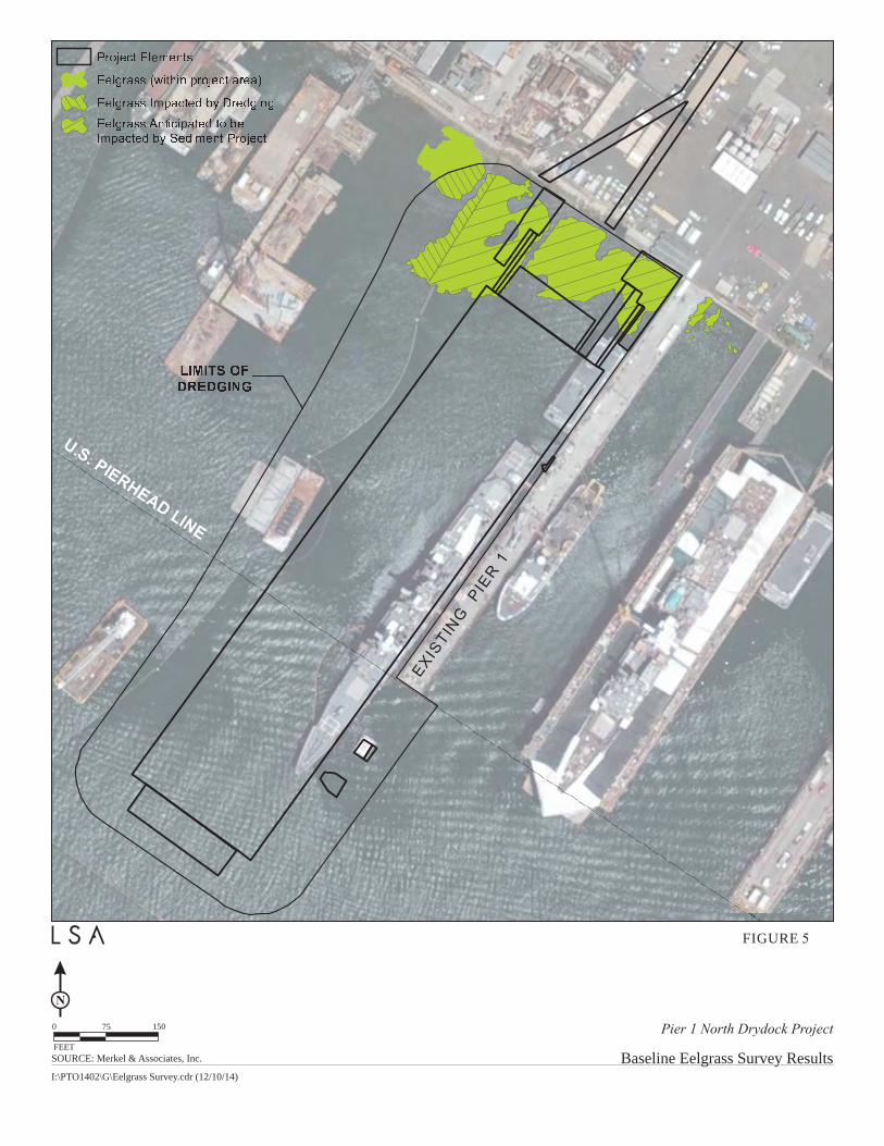
Overall Project Purpose- The overall project purpose serves as the basis for the Corps' 404(b)(1) alternatives analysis and is determined by further defining the basic project purpose in a manner that more specifically describes the applicant's goals for the project, and which allows a reasonable range of alternatives to be analyzed. The proposed project objectives include the following: Construct and operate shipyard repair facilities that maximize the use of existing waterways, available shoreline, and existing land; Retain and expand current ship repair business operations by BAE Systems, in order to provide economic and employment benefits to the District and the San Diego region; Modernize the BAE Systems shipyard by providing a new drydock facility, including associated improvements, and ship repair services, to meet the needs of the current and anticipated ship fleet of military and commercial customers; Invest in new shipyard infrastructure that will enhance the short- and long-term attractiveness and viability of San Diego Bay and the region to military and commercial ship operators for construction and repair. Dredging is needed to create an adequate berthing depth (-65 feet mean lower low water (MLLW)) for the new dry dock to be submerged so that ships may be loaded and unloaded for maintenance and repair. The overall project purpose is to construct drydock facilities within San Diego Bay to adequately service the current and anticipated fleet of military and commercial vessels on the west coast of the United States. Additional Project Information Baseline information- The project area is within a working shipyard and consists of hard structures including concrete block riprap revetments, vertical bulkhead wall, piers, and pier pilings. The extension of the new drydock extends into the bay near the Federal channel and the Corps is evaluating the impacts to the Federal channel in accordance with the Section 408 process. The bottom habitat is primarily unvegetated mud bottom, with some vegetated habitat (eelgrass) in the shallow areas adjacent to the riprap revetments and bulkhead wall. The slope of the bottom is moderately steep and the project area extends from a high elevation of approximately 0 feet MLLW to a depth of approximately 31 feet MLLW at the bayward edge of the Pier 1 drydock. The survey of in water habitats completed in August 1, 2014 found eelgrass in the shallow water of the project area (less than 12 ft MLLW) adjacent to rip rap revetments along the SDG&E cooling tunnels which has now been dredged by the Cleanup and Abatement order project, and along the bulkhead wall to the north and south of Pier 1 (Figure 3). A total of 0.99 acres (43,124 ft2) of eelgrass was found within the survey area (west of Pier 1 and just east of Pier 1) during the August 2014 survey. This acreage includes eelgrass within and immediately adjacent to the Pier 1 drydock, ramp wharves, and pedestrian walkways and the dredge footprint for the project, as well as a small area of eelgrass to the north of and outside of the anticipated impact area. Fish species typically found in this habitat include round stingrays (Urobatis halleri), barred sand bass (Paralabrax nebulifer), spotted sand bass (Paralabrax maculatofasciatus), specklefin midshipman (Porichthys myriaster), and black croaker (Cheilotrema saturnum). Invertebrates on the surface of this habitat are sparse, but evidence of burrowing invertebrate activity is apparent, likely from bivalves (Chione spp., Macoma nasuta), the
6
amphipod (Grandidierella japonica), and bay ghost shrimp (Neotrypaea sp.) Project description- The entire BAE proposed plan for the area for the project includes three components, a real estate lease component, a drydock component, and a Silvergate Power Plant cooling tunnels removal component. The Corps permit action includes only the drydock component which would include installation of the floating drydock. The installation of a drydock along the north side of the existing Pier 1 within the BAE Systems shipyard will allow for repair and maintenance activities (such as exterior hull repair, shaft repair, propeller and rudder repair, and replacement of valves and fittings below the waterline) which cannot normally be conducted while a vessel is afloat. The drydock is projected to have 10 submergences (40 hours per year) per year for vessel repair without impacting the bottom directly. The cooling tunnel component (not a part of permit) includes removal of two sets of intake/discharge cooling tunnels that were previously installed by San Diego Gas & Electric (SDG&E) and used by the former SDG&E Silvergate Power Plant located on the two acre parcel north of BAE Systems. BAE Systems currently leases approximately 9.8 acres of land and 16.6 acres of water from the District. This lease is scheduled to expire on August 31, 2034. Based on its investments proposed as part of the Proposed Project, BAE Systems proposes to extend the lease term of its existing leasehold with the District. Additionally, BAE Systems proposes to lease, on a long term basis the approximately 2.0 acre (landside) and 4.0 acre (waterside) parcel (lease set to expire on October 31, 2019). The long term lease may include, but would not be limited to, an amendment to BAE Systems existing lease. Additional State Lands lease area would also be required to accommodate the dredging, mooring dolphins, and drydock operations that extend beyond the Pierhead line. The proposed drydock would be located on the north side of existing BAE Systems Pier 1 and would extend onto the Tidelands Use and Occupancy Permit (TUOP) parcel and approximately 350 feet past the U.S. Pierhead Line and existing BAE leasehold and into California State Lands Commission (CSLC) jurisdiction. The distance from the drydock to the main navigation channel would be 300 feet. The attached drawings provide the location of all project elements as described below:
1) Shoreline Improvements: Improvements will include a permanent submerged cantilever sheet pile bulkhead wall placed along the TUOP parcel to replace the current rock revetment. This project element is being completed as part of the Shipyard Sediment Site Cleanup and Abatement project currently underway within BAE Systems shipyard and has been previously evaluated under that project. Prior to implementation of the proposed project, the shoreline area along the TUOP parcel will receive improvements including a permanent submerged cantilever sheet pile bulkhead wall planned in support of the Shipyard Sediment Site Cleanup and Abatement Order No. R9-2012-0024(CAO). The submerged wall will consist of two separate installations, one 65-foot section and a second 15-foot section.
2) Underwater Improvements: To prevent undermining of Pier 1 during site dredging, an
underwater wall of cantilevered king piles will be installed along the north side of Pier 1. These underwater improvements will allow for dredging adjacent to the pier without adverse effects. In 2014 surveys found eelgrass in the shallow water of the project area (less than 12 ft MLLW) adjacent to rip rap revetments along the SDG&E cooling tunnels, and along the bulkhead wall to the north and south of Pier 1 (Figure 3). A total of 0.99 acres (43,124 ft2) of eelgrass was found within the survey area (west of Pier 1 and just east of Pier 1) during the August 2014 survey. This acreage includes eelgrass within and immediately adjacent to the Pier 1 drydock, ramp wharves, and pedestrian walkways and the dredge footprint for the project, as well as a small area of eelgrass to the north of and outside of the anticipated impact area.

7
3) Dredging: The drydock footprint will be dredged to a depth of -65 feet MLLW. The
Corps and EPA concluded a suitability determination in January 2015. Based on preliminary bathymetric survey data, dredging is anticipated to generate approximately 395,000 cubic yards (cy) of sediment with 131,500 cy of suitable dredged material disposed of at a southern eelgrass mitigation site and up to 10,000 cy of unsuitable dredged material disposed of at an approved upland location. The remaining 253,500 cy of dredge material not taken to an upland site, or the southern eelgrass mitigation site, would be disposed of at either a nearshore Imperial Beach site or the LA-5 ocean disposal site. Dredge material has been tested for contaminants and sediment approved for ocean disposal will be disposed of at ocean disposal site LA-5, located approximately 13 miles west of the project site and at one of two evaluated other locations in southern San Diego Bay. Some sediment (up to 131,500 cy) may be used for beneficial reuse in San Diego Bay or a nearshore ocean area, or at Imperial Beach per the Corps approved Sampling and Analysis Plan prepared by AMEC and approved by the Corps and EPA in January 2012. Up to 10,000 cubic yards of the total dredge volume, dredged from the area outside of the Shipyard Sediment Site Cleanup footprint, is not suitable for ocean disposal or beneficial reuse per the initial Corps and EPA suitability determination. Unsuitable material will be disposed of at an appropriately permitted upland landfill.
4) Wharf construction: Two ramp wharves designed for accessing the drydock will be
constructed adjacent to and westward of the bulkhead and would extend from the U.S. Bulkhead Line approximately 125 linear feet bayward. The ramp wharves will be constructed of three independent concrete structures with the northernmost structure measuring approximately 125 feet by 35 feet, the southernmost structure measuring approximately 125 feet by 70 feet, and the intermediary structure measuring 134 feet by 76 feet with a combined total area of approximately 23,309 sf. The elevation of the wharves will be approximately +13 feet MLLW. The ramp wharf decks will be a composite structure consisting of precast planks topped with cast-in-place reinforced concrete and reinforcing bar.
Two pedestrian walkways are expected to add an additional 1,098 square feet of
coverage and a vehicle ramp would add 2,112 sf for a total square footage of 3,396 sf of coverage. To ensure that there are no project conflicts associated with the drydock structures and the proposed future removal of the tunnels, the northern and intermediary ramp wharves would be constructed following the future removal of the cooling water tunnels. The deck support system will require pile driving and will consist of both vertical and batter piles. A total of 84 concrete 24-inch octagonal vertical and batter piles are anticipated to support the three new ramp wharves.
5) Mooring Dolphins: Two new mooring dolphins will be constructed approximately 344
feet and 890 feet offshore (west) of the U.S. Bulkhead Line. Each dolphin will be 26 feet by 33 feet in size and include a 4-foot thick concrete deck. The western mooring dolphin will be supported by 26 concrete 24-inch octagonal piles and outfitted with two 100-ton double bitts. The eastern mooring dolphin will be retrofitted into the existing Pier 1, thus minimizing an increase in bay coverage for that dolphin.
A total of 20 new concrete 24-inch octagonal piles will be installed to support the
eastern mooring dolphin. The western mooring dolphin will be located west of the existing Pier 1 mooring dolphin and will be have an area of approximately 753 square feet. The existing western Pier 1 mooring dolphin will be expanded by approximately 140 square feet to serve as a secondary mooring to the western end of
8
the drydock. Three new piles will be added to support this expanded structure.
6) Floating Drydock. The new floating drydock will be approximately 205 feet in width and 851 feet in length (a total area of 174,455 square feet) and will have aprons (a total of 16,165 square feet) attached on each end. Electrical and mechanical utilities will be installed on the drydock and onshore to support the drydock. The Corps permit only covers the initial construction of the drydock and not the long term operation of the new drydock as such operations are outside the scope of the Corps permit.
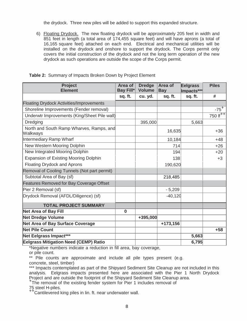
Table 2: Summary of Impacts Broken Down by Project Element
Project Element
Area of Dredge Area of Bay
Eelgrass Impacts***
Piles Bay Fill* Volume
sq. ft. cu. yd. sq. ft. sq. ft. # Floating Drydock Activities/Improvements Shoreline Improvements (Fender removal) -75+ Underwtr Improvements (King/Sheet Pile wall) 750 lf++ Dredging 395,000 5,663 North and South Ramp Wharves, Ramps, and
Walkways
16,635
+36
Intermediary Ramp Wharf 10,184 +48 New Western Mooring Dolphin 714 +26 New Integrated Mooring Dolphin 194 +20 Expansion of Existing Mooring Dolphin 138 +3 Floating Drydock and Aprons 190,620
Removal of Cooling Tunnels (Not part permit) Subtotal Area of Bay (sf) 218,485
Features Removed for Bay Coverage Offset Pier 2 Removal (sf) - 5,209 Drydock Removal (AFDL/Diligence) (sf) -40,120
TOTAL PROJECT SUMMARY Net Area of Bay Fill 0 Net Dredge Volume +395,000 Net Area of Bay Surface Coverage +173,156 Net Pile Count +58 Net Eelgrass Impact*** 5,663 Eelgrass Mitigation Need (CEMP) Ratio
6,795
*Negative numbers indicate a reduction in fill area, bay coverage, or pile count. ** Pile counts are approximate and include all pile types present (e.g. concrete, steel, timber) *** Impacts contemplated as part of the Shipyard Sediment Site Cleanup are not included in this analysis. Eelgrass impacts presented here are associated with the Pier 1 North Drydock Project and are outside the footprint of the Shipyard Sediment Site Cleanup area. +The removal of the existing fender system for Pier 1 includes removal of 75 steel H-piles. ++Cantilevered king piles in lin. ft. near underwater wall.
9
Proposed Mitigation– The proposed mitigation may change as a result of comments received in
response to this public notice, the applicant's response to those comments, and/or the need for the project to comply with the 404(b)(1) Guidelines and the Corps mitigation rule. Project impacts are shown in Table 2 but the Corps does not typically require mitigation for over-water coverage as opposed to direct fill but shall consider the effects of shading and the need for mitigation. Resource agencies may require mitigation for new over-water coverage. In consideration of the above, the proposed mitigation sequence (avoidance/minimization/compensation), as applied to the proposed project is summarized below: Avoidance: The project includes a new drydock that will be a floating permanently moored vessel over open bay areas that is attached to the pier and dolphins to float above the bay bottom at various depths over largely unvegetated marine areas with some eelgrass impacts. Due to the existing configuration of Pier 1 and the shipyard shore facilities the proposed project site on the north side of Pier 1 was chosen by the applicant. The Corps will be requesting that the applicant provide a Section 404(b)(1) alternatives analysis that reviews both onsite and offsite alternatives and proper sequencing per the Section 404(b)(1) guidelines. Other shipyard drydock sites both onsite and offsite will be evaluated. The project will impact eelgrass and due to the floating drydock operational constraints cannot avoid some eelgrass impacts that will be mitigated in accordance with the CEMP. No wetlands are to be impacted because there are no wetlands in the project area. Avoidance of fill impacts to largely unvegetated substrate marine subtidal areas has been replaced with largely coverage shading from the aprons, docks, wharves, pile, and drydock impacts. The shoreline adjacent to the SDG&E cooling tunnels and Pier 1 has recent ly been dredged as a part of the Cleanup and Abatement Order – North project to a depth of -12 f t . MLLW. The project seeks to maximize the use of a largely degraded and disturbed industrial shipyard marine habitat to provide the major elements of the proposed project which involve: dredging of the Pier 1 north drydock footprint to -65 feet MLLW, construction of the new Pier 1 north drydock and aprons along with three ramp wharves and associated pedestrian and vehicle ramps, construction of a new western mooring dolphin, expansion of the existing western mooring dolphin and construction of a new eastern mooring dolphin as a retrofit to the existing Pier 1. The project also includes installation of an underwater wall of cantilevered King piles to prevent undermining of Pier 1 during dredging. The only instance where pilings are considered to be bay fill is when they are installed in a manner where they have the effect of fill. In such an instance, piles result in changes in water circulation patterns. The current project does not include the installation of pilings to function as bay fill. The Pier 1 drydock project site is in central San Diego Bay in an area of low water velocity. Water velocities in San Diego Bay peak in the narrower portion of the bay located northwest of the Coronado Bay Bridge, and then decrease as the Bay becomes wider southeast of the Bridge. Areas with low water velocities are less impacted by impediments (such as pier piles) placed in the field of flow. As a result, it is not anticipated that installation of the more additional piles would meaningfully alter water velocities, sedimentation rates, or circulation patterns in the bay. However, increased piles would be expected to increase the biological productivity of the area by providing greater primary substrate and increased exposure of organisms to the water column.
Minimization: The applicant will use a turbidity curtain and monitoring of any construction for any adverse turbidity or in-water construction techniques. Other minimization measures for the Green Sea Turtle (Chelonia mydas: GST) will include monitoring and work cessation/pile driving procedures for GST impact minimization and California least terns (Sterna antillarum browni; CLT) from April 1st to September 15. Compensation: The project overall would result in a net increase in bay surface area coverage of 168,425 square feet, and a net increase of 58 piles. Additionally, the project is anticipated to result in impacts of 5,663 sf (0.13 acre) of eelgrass habitat which will be mitigated in accordance with CEMP for a total of 6,795 sf of new eelgrass creation. The Corps has not made a determination on the increase in bay surface coverage and resulting mitigation needs and welcomes comments. The installation of the new ramp wharves and mooring dolphins for the Pier 1 drydock would result in installation of 133 octagonal 24-inch concrete piles. This increase would be partially offset by the removal of 75 steel H-beam piles that support the fender system for the existing Pier 1. These deteriorated piles would be removed along with the ag ing fender system prior to construction of the ramp wharves and new floating drydock which would help to restore the substrate area.
Proposed Special Conditions
No permit special conditions are proposed at this time. For additional information please call Robert Smith of my staff at 760-602-4831 or via e-mail at [email protected]. This public notice is issued by the Chief, Regulatory Division.
Regulatory Program Goals: • To provide strong protection of the nation's aquatic environment, including wetlands. • To ensure the Corps provides the regulated public with fair and reasonable decisions. • To enhance the efficiency of the Corps’ administration of its regulatory program.
__________________________________________________________
DEPARTMENT OF THE ARMY LOS ANGELES DISTRICT, U.S. ARMY CORPS OF ENGINEERS
Carlsbad Field Office 5900 La Place Ct., Suite 100
Carlsbad, CA 92008 WWW.SPL.USACE.ARMY.MIL/MISSIONS/REGULATORY

ATTACHED DRAWINGS & FIGURES
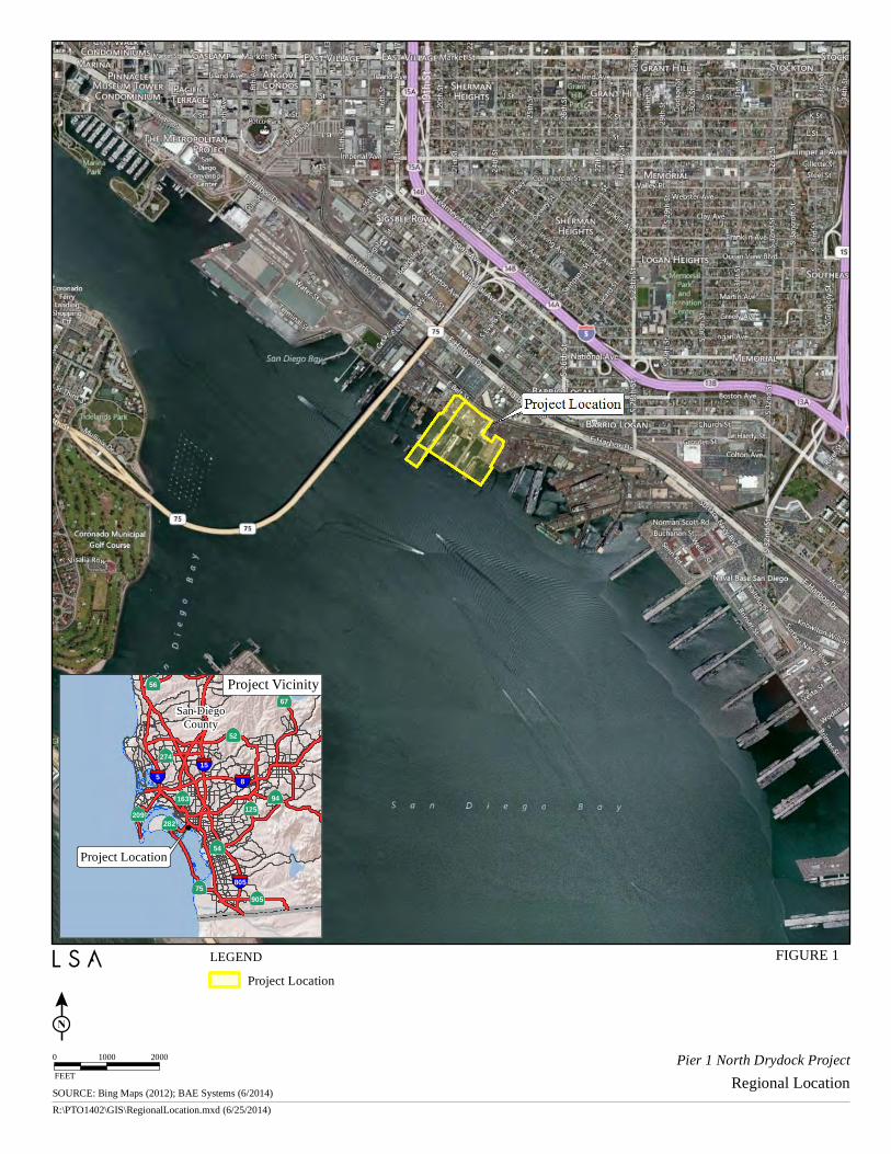
SOURCE: Bing Maps (2012); BAE Systems (6/2014)R:\PTO1402\GIS\RegionalLocation.mxd (6/25/2014)
FIGURE 1
Pier 1 North Drydock ProjectRegional Location
0 1000 2000FEET
Project Location
San DiegoCounty
282
56
274
54
209
67
905
125
75
163 94
52
158
805
5
Project Vicinity
LEGENDProject Location
National
Wildlife
Refuge
(NWR)
PORT
J Street
Marina
Coronado
Cays
PORT
D Street Fill
CSLC
NWR
Jurisdictional Boundaries
Mitigation Sites
NAVY
Chula Vista
BayfrontNORTHERN
ALTERNATIVE
MITIGATION SITE
SOUTHERN
ALTERNATIVE
MITIGATION SITE
I:\PTO1402\G\Eelgrass Mitigation.cdr (12/10/14)
Pier 1 North Drydock Project
FIGURE 2
Eelgrass and Bay Coverage Mitigation AlternativesFEET
2,0001,0000
N
SOURCE: Merkel & Associates, Inc.
BAE SystemsExisting Leasehold
Sampso
n St
E Belt St
TUOPParcel
SOU RCE: Goog le Earth (2013); BAE Sy stem s (9/2014)R:\PTO1402\GIS\ProjectFeatures.m xd (1/5/2015)
FIGU RE 3
Pier 1 North Drydock ProjectProject Overview and Applicable Jurisdictions
LEGENDU .S. Pierhead LineProject Lim itsCalifornia State LandsCom m ission JurisdictionPort Jurisdiction
Existing Cooling TunnelsRem edial Footprint
Project FeaturesExisting Pier 1Proposed FloatingDry Dock
Subm erged Cantilever Sheet PileBulkhead Wall – Part of Separate ProjectDredge AreaBAE Sy stem s Existing LeaseholdTU OP Parcel0 137.5 275
FEET
DESCRIPTIONAPP'DDATE BY
REVISIONS
REV
ON
E IN
CH
AT
F
ULL S
IZ
E, IF
N
OT
O
NE
IN
CH
S
CA
LE
A
CC
OR
DIN
GLY
DESIGNED BY:
APPROVED BY:
CHECKED BY:
DRAWN BY:
DATE:
SCALE:
SHEET NO. OF
Ju
n 11, 2015 1:17p
m m
pratschner L:\A
utoC
AD
P
roject F
iles\_P
rojects\0277-B
AE
S
ystem
s\0277-B
AE
\P
ier 1 N
orth
D
ryd
ock\C
on
stru
ctio
n P
la
ns\0
27
7 P
L-0
03
E
XIS
TIN
G.d
wg
D
-1F
1
EXISTING SITE PLAN
3 14
T MERRITTS
M PRATSCHNER
--
--
1" = 80'
JUNE 11, 2015
0
SCALE IN FEET
80 160
NORTH
PROJECT DATUMS:
1. HORIZONTAL DATUM: CALIFORNIA STATE
PLANE, ZONE 6, NAD 83, U.S. FEET.
2. IN WATER VERTICAL DATUM: MEAN LOWER
LOW WATER (MLLW).
3. UPLAND VERTICAL DATUM: MLLW
LEGEND:
(5' INTERVAL)
(1' INTERVAL)
LEASE HOLD LINE
SURVEY MONUMENT
-40
-38
AND SURVEY CONTROL
PIER 1 NORTH DRY DOCK PROJECT
DRAFT (30%) - NOT FOR CONSTRUCTION
NOTES:
1. BATHYMETRY DATA IS SUBJECT TO CHANGE DUE
TO CURRENT DREDGING ACTIVITIES. UPDATES TO
THE EXISTING BATHYMETRY WILL BE PROVIDED IN
FURTHER ITERATIONS OF THE DESIGN DRAWINGS.
Pier 1 North Drydock Project
FIGURE 5
Baseline Eelgrass Survey ResultsFEET
150750
N
SOURCE: Merkel & Associates, Inc.
I:\PTO1402\G\Eelgrass Survey.cdr (12/10/14)
T
m
p
m
e
t
DESCRIPTIONAPP'DDATE BY
REVISIONS
REV
ON
E IN
CH
AT
F
ULL S
IZ
E, IF
N
OT
O
NE
IN
CH
S
CA
LE
A
CC
OR
DIN
GLY
DESIGNED BY:
APPROVED BY:
CHECKED BY:
DRAWN BY:
DATE:
SCALE:
SHEET NO. OF
Ju
n 11, 2015 2:26pm
m
pratschner L:\A
utoC
AD
P
roject F
iles\_P
rojects\0277-B
AE
S
ystem
s\0277-B
AE
\P
ier 1 N
orth
D
ryd
ock\C
on
stru
ctio
n P
la
ns\0
27
7 P
L-0
4 D
RY
D
OC
K.d
wg
D
-2
D-2
DRY DOCK PLAN
4 14
T MERRITTS
M PRATSCHNER
--
--
1" = 50'
JUNE 11, 2015
APP'DREV DATE BY
PIER 1 NORTH DRY DOCK PROJECT
NOTES:
1. STRUCTURAL DETAILS FOR DRY DOCK AND
SUPPORTING STRUCTURAL ELEMENTS PROVIDED BY
TRITON ENGINEERS' STRUCTURAL DRAWINGS (PIER 1
NORTH - LARGE DRY DOCK PROJECT", VERSION
DATED 2/2/2015)
2. WHARF STRUCTURES, DRY DOCK AND DOLPHINS TO
BE CONSTRUCTED FOLLOWING COMPLETION OF
DREDGING.
DRAFT (30%) - NOT FOR CONSTRUCTION
24' GATE
CENTRAL
LIFT
STATION
Q/A
SECOND
FLOOR
LOFT
(SECOND
FLOOR)
CE
NT
RA
L
TO
OL
R
M
PIER 1
LIFT
STATION
DOCUMENT
CENTER
MAIN
GATE
BREAK
AREA
BLDG 1
TRANS
BLDG 13
FACILITIES
BLDG 5
STRUCTURAL
SHOP
BLDG 75
PMO
Q/A
PLANNING
GOV'T
BLDG 6 & 7
PIPE SHOP
RIGGING LOFT
Z
O
N
E
2
ZONE 14
ZONE 8
MAIN
GATE