Embed Size (px)
Citation preview

DRAFT DPV2_ConstructionYard_Indio_NTPR_AdminDraft_110908_GC.docx
Southern California Edison
Documentation for Compliance
with the
Opinion Granting a Certificate of
Public Convenience and Necessity (CPCN)
Notice to Proceed Request for
Indio Construction Yard
Devers‐Palo Verde No. 2 Transmission Line Project (DPV2)
September 2011

DRAFT DPV2_ConstructionYard_Indio_NTPR_AdminDraft_110908_GC.docx i
Table of Contents
Section Page
1.0 INTRODUCTON ................................................................................................... 1
2.0 SITE LOCATION AND CONDITIONS ...................................................................... 2
3.0 PROJECT COMPONENTS ..................................................................................... 2
3.1 Construction Activities and Operation Components/Activities ........................ 2
3.1.1 Site Preparation ............................................................................................... 3
3.1.2 Access Routes .................................................................................................. 3
3.1.3 Underground and Aboveground Activities...................................................... 3
3.1.4 Activity Schedule ............................................................................................. 4 Figures 1 Project Location Map 2 Indio Construction Yard Site, Water Source and Access Map
Tables 1 Required Environmental Submittals: APM, MM and BO Measure Table 2 Permits Appendices A Biological Review, Indio Construction Yard, DPV2 B Cultural Resources Assessment of Indio Construction Yard, DPV2
DRAFT DPV2_ConstructionYard_Indio_NTPR_AdminDraft_110908_GC.docx 1
1.0 INTRODUCTON
This Notice to Proceed Request (NTPR) describes the development and temporary use of
the Indio Construction Yard (Indio Yard) for the Devers‐Palo Verde No. 2 500kV
Transmission Line (DPV2) Project.
This Notice to Proceed (NTP) will be applicable for all activities associated with the Indio
Yard proposed to serve the DPV2 Project. The DPV2 Project is described in the DPV2 Project
Final Environmental Impact Report and Final Environmental Impact Statement (FEIR/FEIS)
and supplemented in the Project Refinements No. 1 and Project Refinements No. 2
(collectively, the Refinements Documents) submitted to the CPUC on June 24, 2010 and
October 8, 2010, respectively. In addition, CPUC approved a final SEIR on July 14, 2011 for
the Expansion of the Colorado River Substation. The project Record of Decision was
approved and signed on July 13, 2011. The Indio Yard was not included in the approval
documents, but is consistent with the environmental documents listed above.
All applicable FEIR/FEIS Applicant Proposed Measures (APMs), Mitigation Measures (MMs),
and the Federal Endangered Species Act Section 7 Biological Opinion (BO) conservation
measures have been identified, and will be implemented or completed prior to
commencement of the construction associated with this NTPR (see Table 1). Also attached
to this NTPR is a table summarizing the permits associated with the scope of work described
herein (see Table 2). Monitoring and reporting on implementation of APMs, MMs, and BOs
will be conducted in accordance with the DPV2 Mitigation Monitoring Compliance and
Reporting Plan issued by the CPUC.
Biological resources associated with the construction yard are described and illustrated in
the Indio Construction Yard Biological Review (Appendix A). Additionally, required
preconstruction surveys for biological resources will be conducted prior to start of
construction, as applicable, and as described in Table 1. Cultural resources associated with
the construction yard are described and illustrated in the Indio Construction Yard Cultural
Resources Assessment (Appendix B).

DRAFT DPV2_ConstructionYard_Indio_NTPR_AdminDraft_110908_GC.docx 2
2.0 SITE LOCATION AND CONDITIONS The DPV2 Project spans approximately 153 miles from the proposed Colorado River
Substation approximately 10 miles southwest of Blythe, California, through Devers
Substation near Palm Springs, California, to Valley Substation in Menifee, California (Figure
1). The proposed yard is strategically located to support construction of the Colorado to
Devers portion of the 500 kV transmission line.
The Indio Yard is an approximate 8‐acre privately‐owned property located directly north of
Dr Carreon Boulevard, east of Calhoun Street and south of Date Avenue, in the City of Indio,
California (Figure 2). The 8‐acre site has an adjacent concrete building wall on the west site
of the yard boundary and existing fence to the north of the yard. The Assessor Parcel
Numbers are 612130013 and 612130014. The water source, a fire hydrant, is located
adjacent to the yard at the southwest corner, as indentified in Figure 2.
3.0 PROJECT COMPONENTS The Indio Yard will serve as a material and equipment storage yard to support construction
activities associated with DPV2. This section describes the Project components, including
site facilities, operations, and site work associated with the proposed construction yard.
Operating hours for the construction yard is planned to be from approximately 7:00 a.m. to
6:00 p.m. weekdays or in accordance with an alternative schedule established by the local
jurisdiction. SCE has dedicated a DPV2 toll‐free information line (866)602‐3782 and website
(www.sce.com/dpv2) for this project. The information line is the designated public
notification contact for DPV2, as described in the Project Wide Construction Notification
Plan.
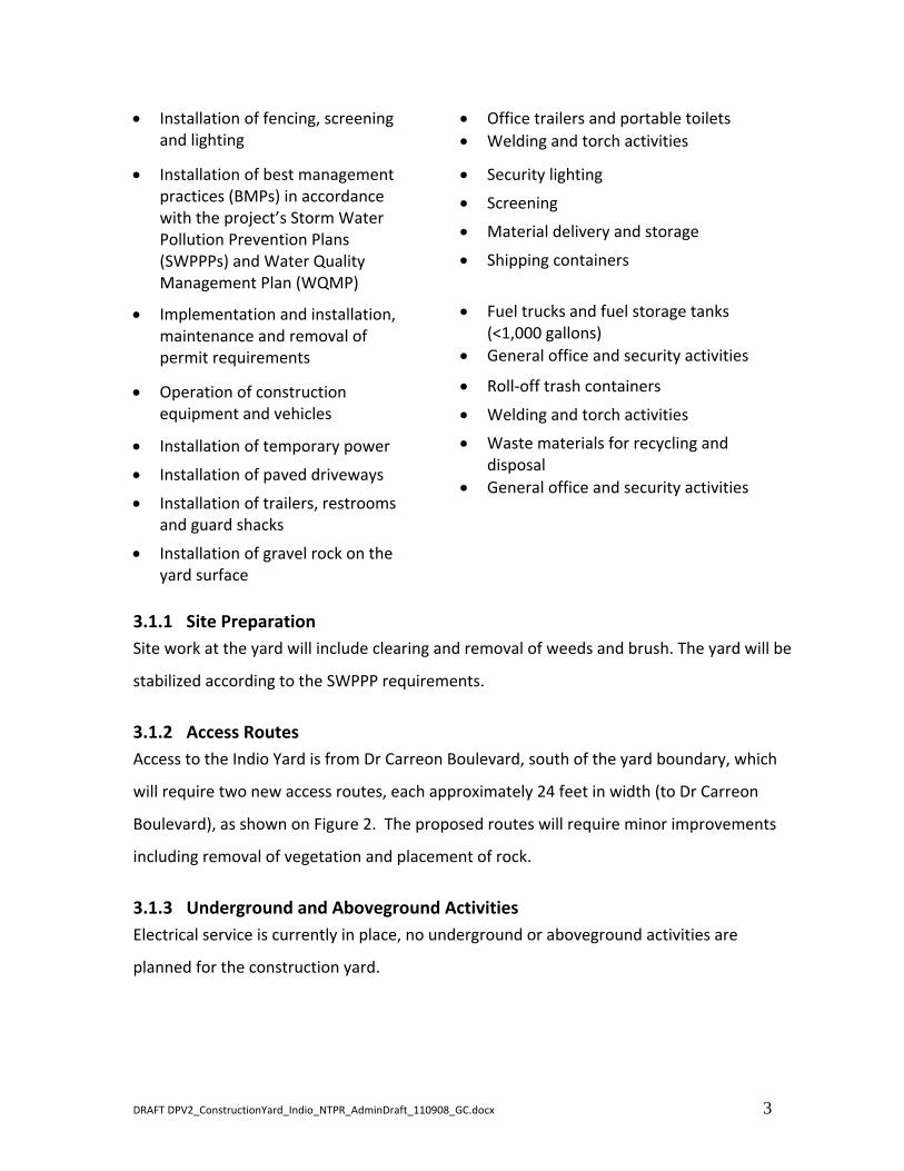
3.1 Construction Activities and Operation Components/Activities Following is a list of components and activities that will possibly be present or occurring
throughout the operation of the yard:
Construction Activities Operation components and activities
Grubbing of vegetation Marshaling location/vehicle parking
DRAFT DPV2_ConstructionYard_Indio_NTPR_AdminDraft_110908_GC.docx 3
Installation of fencing, screening and lighting
Office trailers and portable toilets
Welding and torch activities
Installation of best management practices (BMPs) in accordance with the project’s Storm Water Pollution Prevention Plans (SWPPPs) and Water Quality Management Plan (WQMP)
Security lighting
Screening
Material delivery and storage
Shipping containers
Implementation and installation, maintenance and removal of permit requirements
Fuel trucks and fuel storage tanks (<1,000 gallons)
General office and security activities
Operation of construction equipment and vehicles
Roll‐off trash containers
Welding and torch activities
Installation of temporary power
Installation of paved driveways
Installation of trailers, restrooms and guard shacks
Installation of gravel rock on the yard surface
Waste materials for recycling and disposal
General office and security activities
3.1.1 Site Preparation
Site work at the yard will include clearing and removal of weeds and brush. The yard will be
stabilized according to the SWPPP requirements.
3.1.2 Access Routes
Access to the Indio Yard is from Dr Carreon Boulevard, south of the yard boundary, which
will require two new access routes, each approximately 24 feet in width (to Dr Carreon
Boulevard), as shown on Figure 2. The proposed routes will require minor improvements
including removal of vegetation and placement of rock.
3.1.3 Underground and Aboveground Activities
Electrical service is currently in place, no underground or aboveground activities are
planned for the construction yard.

DRAFT DPV2_ConstructionYard_Indio_NTPR_AdminDraft_110908_GC.docx 4
3.1.4 Activity Schedule
Construction of the yard would commence in mid‐September 2011. The Indio Yard will take
approximately 4 weeks to construct, and would remain in operation until project
completion.

#*
#*
#*#*
#*#*
#*
#*
#*
#*
!.
!.
!.
!.
!.!.
!.
!.
!.
!.
Existing Edison 12kV Overhead Line
DESERT CENTER/RICE ROAD (HWY 17
7)
San BernardinoNational Forest
San BernardinoNational Forest
Joshua TreeNational Park
Marine Corps BaseTwentynine Palms
Chocolate MountainsAerial Gunnery Range
Marine Corps BaseCamp Pendleton
Salton Sea
Indio YardBlythe Yard
Perris Yard
Devers Yard
Menifee Yard
Beaumont Yard
Desert Center Yard 2Chiriaco Summit Yard
Desert Center Yard 1
Riverside County
San Bernardino County
Imperial CountySan Diego County La PazCounty,Arizona
VISTA
VALLEY
DEVERS
COLORADORIVER
SAN BERNARDINO
Palm Springs
Indio
Perris
Murrieta
Redlands
Hemet
Moreno Valley
Yucaipa
Twentynine Palms
Yucca Valley
Temecula
Coachella
Banning
Blythe
Oceanside
San Jacinto
Vista
La Quinta
San Bernardino
Beaumont
Riverside
Palm Desert
Highland
Hesperia
Colton
Lake Elsinore
Rancho Mirage
Calimesa
Cathedral City
Desert Hot Springs
Indian Wells
Loma Linda
Big Bear Lake
Canyon Lake
Escondido
Hemet
Indio
Redlands
Redlands
Big Bear Lake
§̈¦10
§̈¦15
UV60
UV30
1 inch = 10 Miles
RiversideCounty
San BernardinoCounty
ImperialCounty
San DiegoCounty
Source: Southern California Edison / ESRI Imagery Source: Eagle Aerial Images 2007-2009,1 foot Pixel Resolution
Indio ConstructionYard 2011
Southern California Edison (SCE) has no reason to believe that there are anyinaccuracies or defects with information incorporated in this work and make no representations of any kind, including, but not limited to, the warrantiesof merchantability or fitness for a particular use, nor are any such warrantiesto be implied, with respect to the information or data, furnished herein. Nopart of this map may be reproduced or transmitted in any form or by anymeans electronic or mechanical, including phototcopying and recording
Project features shown represent best available data as ofMay 16, 2011. Project features may change.
system, except as expressly permitted in writing by SCE.I:\D
PV
2_P
ote
ntia
l Ya
rds\
MX
Ds\
Ind
ioY
ard
_O
verv
iew
.mxd
USGS 7.5 Minute Quad "CORN SPRING, CALIF."
CONSTRUCTION YARDOVERVIEW MAP
FIGURE 1
0 5 10
Miles
Legend
#* Proposed Substation
#* Existing Substation
DPV2 Proposed 500 kV RouteColorado River to Devers
Devers to Valley
!. DPV2 Construction Yards
Telecom LinesI

DR CARREON BLVDDR CARREON BLVD
Indio 1 Yard(Approximate Total Area = 8.3 Acres)
APN 612130013 APN 612130014
_̂!
Existing Fire Hydrant
Access Route Access Route
Property andDisturbance Boundary
Fence Line
!
ExistingPower Pole
!
ProposedPower Pole
I:\D
PV
2_P
ote
ntia
l Ya
rds\
MX
Ds\
Ind
ioY
ard
.mxd
Prepared By: Bill Dochnahl Date: August 31, 2011
Issued For:
Projection: NAD 83 UTM Zone 11
Project Number:
I
Southern California Edison (SCE) has no reason to believe that there are any inaccuracies or defects with informationincorporated in this work and make no representations of any kind, including, but not limited to, the warranties ofmerchantability or fitness for a particular use, nor are any such warranties to be implied, with respect to the information ordata, furnished herein. No part of this map may be reproduced or transmitted in any form or by any means electronicor mechanical, including phototcopying and recording system, except as expressly permitted in writing by SCE.
Proposed TemporaryConstruction Yard
0 200 400
Feet
Indio Yard1 inch = 200 feet
(City of Indio, CA)
Figure 2

ource Area
MM/APM Measure Timing
Indio
Comments
Table 1
Required Environmental Submittals: APM, MM and BO Measure Table
Indio Construction Yard, DPV2
Preconstruction* During Construction Post Construction
Note: This table contains USFWS Conservation Measures (BO) in addition to the Mitigation Measures (MM) and Applicant Proposed Measures (APM) from the MMCRP.
Reso
Agriculture
MM AG‐1a
Establish agreement and coordinate construction activities with agricultural Landowners. Sixty (60) days prior to the start of project construction,
Southern California Edison (SCE) shall secure a signed agreement with property owners of Farmland (Prime Farmland, Farmland of Statewide
Importance, Unique Farmland) and Williamson Act lands that will be used for construction and operation of the project, access and spur roads, staging
areas, and other project‐related activities. The purpose of this agreement will be to set forth the use of Prime Farmland, Farmland of Statewide
Importance, Unique Farmland, and Williamson Act lands during construction in order to: (1) schedule proposed construction activities at a location and
time when damage to agricultural operations would be minimized, and (2) ensure that any areas damaged or disturbed by construction are restored to a
condition mutually agreed upon by the landowner and SCE. SCE shall coordinate with the agricultural landowners in the affected areas where Farmland
or Williamson Act land will be temporarily disturbed in order to determine when and where construction should occur in order to minimize damage to
agricultural operations. This includes avoiding construction during peak planting, growing, and harvest seasons. If damage or destruction does occur, SCE
shall perform restoration activities on the disturbed area in order to return the area to a pre‐determined condition or the pre‐construction condition,
whichever option is agreed upon by the landowner and SCE. This could include activities such as soil preparation, regarding, and reseeding. This measure
Pre‐construction,
during and post
construction
NO
The Indio Construction Yard is not located near farmland,
and therefore this measure does not apply to the Indio
Construction Yard.
applies to agricultural landowners with land that is impacted by the Proposed Project. SCE shall provide proof of the continued use of Farmland and/or
Williamson Act lands through the submittal of a signed agreement between an individual property owner and SCE. The signed agreements shall be
submitted to the CPUC and BLM for review and approval prior to the start of construction.
Agriculture
MM AG‐4a
Locate transmission towers and pulling/splicing stations to avoid agricultural operations. SCE shall site transmission towers and pulling/splicing stations
in locations that minimize impacts to active agricultural operations. Specifically, SCE shall comply with the following measures when siting transmission
towers and splicing/pulling stations within areas where active cultivated farmland would be removed through the presence of structures:
• SCE shall avoid orchards, vineyards, row crops, and furrow‐irrigated crops where towers would interfere with irrigation and harvest activities.
• SCE shall avoid irrigation canals and ditches.
• SCE shall align towers adjacent to field boundaries and parallel to rows (if located in row crops), and shall avoid diagonal orientations and angular
alignments within agricultural land.
• SCE shall match tower spans with existing DPV1 towers within agricultural land.
• SCE shall construct towers with heights and spacing to minimize safety hazards to aerial applicators flying in the Palo Verde Valley (CA) and other
agricultural areas;
• SCE shall consult with the Palo Verde Irrigation District (PVID) regarding tower placement to minimize disruption to PVID facilities;
• SCE shall document and provide proof of compliance with the above listed items 90 days prior to the start of Proposed Project construction This
Pre‐construction NO
There are no agricultural operations adjacent to the
Indio Construction Yard and therefore this mitigation
measure does not apply.
• SCE shall document and provide proof of compliance with the above listed items 90 days prior to the start of Proposed Project construction. This
documentation shall be submitted to the CPUC and the BLM for review and approval prior to the start of construction, and reviewed with affected
landowners during coordination presented in Mitigation Measure AG 1a (Establish agreement and coordinate construction activities with agricultural
landowners).
DPV2 Construction Yard NTPR Table 1: Required Environmental Submittals. 9/8/2011 1 of 51

Resource Area
MM/APM Measure Timing
Indio
Comments
Develop and Implement a Fugitive Dust Emission Control Plan: SCE shall develop and implement a Fugitive Dust Emission Control Plan (FDECP) for
construction work. Measures to be incorporated into the plan include, but are not limited to the APMs (A‐1 and A‐5 through A‐7) and the following,
which also incorporate and revise the requirements of APMs A‐2 through A‐4 to make them definitive and enforceable:
CARB certified non‐toxic soil binders shall be applied to all active unpaved roadways, unpaved staging areas, and unpaved parking area(s) throughout
construction (as allowed by responsible agencies such as the BLM or USFWS) in amounts meeting manufacturer’s recommendations to meet the CARB
certification fugitive dust reduction efficiency of 84 percent.
Air Quality
MM AQ‐1a
Water the disturbed areas of the active construction sites, where CARB certified soil binders have not been applied, at least three times per day.
Enclose, cover, water three times daily, or apply non‐toxic soil binders according to manufacturer’s specifications to exposed piles with a five percent or
greater silt content.
Install wheel washers/cleaners or wash the wheels of trucks and other heavy equipment where vehicles exit the site or unpaved access roads and sweep
paved streets daily with water sweepers if visible soil material from the construction sites or unpaved access roads are carried onto adjacent public
streets.
Establish a vegetative ground cover or allow natural revegetation to occur on temporarily disturbed areas following the completion of construction (in
compliance with biological resources impact mitigation measures), or otherwise create stabilized surfaces on all unpaved areas at each of the
construction sites within 21 days after active construction operations have ceased.
Increase the frequency of watering, or implement other additional fugitive dust mitigation measures, to all disturbed fugitive dust emission sources
when wind speeds (as instantaneous wind gusts) exceed 25 miles per hour (mph).
Travel route planning will be completed to identify required travel routes to minimize unpaved road travel to each construction site to the extent
feasible.
Pre‐Construction
and during
construction
YES
This measure is addressed through the Project‐wide
Mitigation Plan approved on 4/18/11. This plan will be
implemented during construction.
Quality
MM AQ‐1bUse ultra low‐sulfur diesel fuel. CARB‐certified ultra low‐sulfur diesel (ULSD) fuel containing 15 ppm sulfur or less shall be used in all diesel‐powered
t ti i t
During
t tiYES
This measure will be implemented during construction.
F l h d ill b k t it
Air Q
Qconstruction equipment. construction Fuel purchase records will be kept onsite.
Air
Quality
MM AQ‐1c Restrict engine idling to 10 minutesDuring
constructionYES This measure will be implemented during construction.
Air Quality
MM AQ‐1d
Use lower emitting off‐road diesel‐fueled equipment. All off‐road construction diesel engines not registered under CARB’s Statewide Portable Equipment
Registration Program, which have a rating of 50 hp or more, shall meet, at a minimum, the Tier 2 California Emission Standards for Off‐Road
Compression‐Ignition Engines as specified in California Code of Regulations, Title 13, section 2423(b)(1) unless that such engine is not available for a
particular item of equipment. In the event a Tier 2 engine is not available for any off‐road engine larger than 100 hp, that engine shall be equipped with a
Tier 1 engine. In the event a Tier 1 engine is not available for any off‐road engine larger than 100 hp, that engine shall be equipped with a catalyzed
diesel particulate filter (soot filter), unless certified by engine manufacturers that the use of such devices is not practical for specific engine types.
Equipment properly registered under and in compliance with CARB’s Statewide Portable Equipment Registration Program are considered to comply with
this mitigation measure.
During
constructionYES
This measure will be implemented during construction.
Off‐road equipment records shall be kept in each vehicle
and be available to the monitors if requested.
ity
Air Qual
MM AQ‐1eUse on road vehicles that meet California on road standards. All on road construction vehicles working within California shall meet all applicable
California on road emission standards and shall be licensed in the State of California. This does not apply to construction worker personal vehicles.
During
constructionYES This measure will be implemented during construction.
Air
Quality
MM AQ‐1fUse lower emitting off‐road gasoline‐fueled equipment. All off‐road stationary and portable gasoline powered equipment shall have EPA Phase 1/Phase
2 compliant engines, where the specific engine requirement shall be based on the new engine standard in effect two years prior to the initiating project
construction.
During
constructionYES This measure will be implemented during construction.
DPV2 Construction Yard NTPR Table 1: Required Environmental Submittals. 9/8/2011 2 of 51

Resource Area
MM/APM Measure Timing
Indio
Comments
Air Quality
MM AQ‐1g
Reduce helicopter use during construction. Helicopter use shall be limited in California to that necessary for conductor installation, using helicopters of
the smallest practical size and helicopters shall not be used for delivering supplies or personnel within California federal or State ozone nonattainment
areas except as specifically excepted by the CPUC due to limitations in road access and/or to reduce other adverse environmental impacts associated
with road construction/travel (such as to biological resources or cultural resources).
During
constructionNO
The Indio Construction Yard does not require the use of
helicopters, therefore this measure doesn’t apply.
ity
Schedule deliveries outside of peak hours For marshalling and construction yards west of the eastern border of the City of Indio all material deliveries
Air Qual
MM AQ‐1hSchedule deliveries outside of peak hours. For marshalling and construction yards west of the eastern border of the City of Indio, all material deliveries
to the yards and from the yards to the construction sites shall be scheduled to occur outside of peak “rush hour” traffic hours (7:00 to 10:00 a.m. and
4:00 to 7:00 pm) to the extent feasible, and other truck trips during peak traffic hours shall be minimized to the extent feasible.
During
constructionYES
This measure will be implemented once the yards are
complete, during material delivery.
Air Quality
MM AQ‐1i
Obtain NOx emission offsets. SCE shall obtain NOx emission reduction credits or offsets in sufficient quantities to offset construction emissions of NOx
that exceed the South Coast Air Basin ozone nonattainment area federal General Conformity Rule applicability threshold as determined in the General
Conformity analysis for the project. The emission offset method shall comply with SCAQMD rules and regulations, and offsets shall be obtained by SCE
prior to construction.
Pre‐construction NO
The Devers‐Valley #2 alternative is in the South Coast Air
Basin, but construction during the 2011 calendar year
will not exceed the applicable de minimus thresholds,
therefore this measure doesn't apply to the Indio
Construction Yard.
Air Quality
APM A‐1Heavy duty off‐road diesel engines would be properly tuned and maintained to manufacturers specs to ensure minimum emissions under normal
operations
During
constructionYES This measure will be implemented during construction.
Quality
APM A‐2Water or chemical dust suppressants would be applied to unstabilized disturbed areas and/or unpaved roads in sufficient quantity and frequency to
i i bili d f
During
iYES This measure will be implemented during construction.
Air Q maintain a stabilized surface construction
p g
Air Quality
APM A‐3Water or water‐based chemical additives would be used in such quantities to control dust on areas with extensive traffic including unpaved access roads;
water, organic polymers, lignin compounds, or conifer resin compounds would be used depending upon availability, cost and soil type.
During
constructionYES This measure will be implemented during construction.
Air Quality
APM A‐4Surfaces permanently disturbed by construction activities would be covered or treated with a dust suppressant after completion of activities at each site
of disturbance
During and post
constructionYES
This measure will be implemented during and post
construction as applicable.
Air Quality
APM A‐5 Vehicle speeds on unpaved roadways would be restricted to 15 mph.During
constructionYES This measure will be implemented during construction.
tyAir Qualit
APM A‐6 Vehicles hauling dirt would be covered by tarps or other means.During
constructionYES This measure will be implemented during construction.
Air Quality
APM A‐7Site construction workers would be staged offsite at or near paved intersections and workers would be shuttled in crew vehicles to construction sites as
part of the construction contract SCE would require bidders to submit a construction transportation plan describing how workers would travel to the
jobsite.
Pre‐construction
and during
construction
NO
The Indio Construction Yard is a marshalling area for
construction workers. During operation of the yard,
construction workers will be staged within the
boundaries of the yard. If the contractor will need to
park outside of the yard boundaries, a Transportation
Plan will be provided prior to construction.
DPV2 Construction Yard NTPR Table 1: Required Environmental Submittals. 9/8/2011 3 of 51

Resource Area
MM/APM Measure Timing
Indio
Comments
use Gas Emissions
MM (SEIR)
GHG‐1
Avoid sulfur hexafluoride emissions. SCE shall ensure that project equipment, specifically the circuit breakers at the Colorado River Substation, maintains
a leakage rate of 0.5 percent per year or less for sulfur hexafluoride (SF6). To accomplish this, SCE shall include this limit as a performance specification
for the gas insulated switchgear that would be installed as part of the project. Maintenance, repair, and replacement of all gas insulated switchgear shall
be consistent with manufacturer’s recommendations for achieving this performance specification and in compliance with CARB regulations for reducing
Pre‐construction NOThis measure applies to the CRS expansion and does not
apply to the Indio Construction Yard.
Green
hou
sulfur hexafluoride emissions from gas insulated switchgear (17 CCR 95350).
Biology
MM B‐1a
Prepare and implement a Habitat Restoration/Compensation Plan. SCE shall restore all areas disturbed by project construction, including temporary
disturbance areas around tower construction sites, laydown/staging areas, temporary access and spur roads, and existing tower locations that are
removed during construction of the Proposed Project. Where onsite restoration is planned for mitigation of temporary impacts to sensitive vegetation
communities, SCE shall identify a qualified Habitat Restoration Specialist to be approved by the CPUC/BLM. Hydroseeding, drill seeding, or an otherwise
proved restoration technique shall be utilized on all disturbed surfaces using a locally endemic native seed mix approved by the CPUC/CDFG/ADGF/FWS
and BLM. SCE shall flag the limits of disturbance at each construction site. The Plan shall incorporate the measures identified in the June 2006
Memorandum of Understanding regarding vegetation management along rights‐of‐way for electrical transmission and distribution facilities on Federal
lands. In project areas that occur in the WRCMSHCP plan area, SCE shall use the applicable Best Management Practices identified in the WRCMSHCP.
The creation or restoration of habitat shall be monitored for five years after mitigation site construction, or until established success criteria are met, to
assess progress and identify potential problems with the restoration site. Remedial activities (e.g., additional planting, weeding, or erosion control) shall
be taken during the monitoring period if necessary to ensure the success of the restoration effort If the mitigation fails to meet the established
Pre‐construction,
during and post
construction
YES
A project‐wide Habitat Restoration and Compensation
Mitigation Plan has been prepared which addresses this
measure. This measure applies to vegetated areas
disturbed by construction activities.
be taken during the monitoring period if necessary to ensure the success of the restoration effort. If the mitigation fails to meet the established
performance criteria after the five‐year maintenance and monitoring period, monitoring shall extend beyond the five‐year period until the criteria are
met or unless otherwise noted by the CPUC/BLM.
Biology
MM B‐2a
Conduct invasive and noxious weed inventory. SCE shall survey the project corridor, including access roads, for populations of invasive and noxious
weeds prior to the start of construction. All populations of invasive and noxious weeds within 500 feet of each tower location shall be flagged prior to
construction. The Applicant shall submit a Noxious Weed Control Plan to BLM, CPUC, ADGF, CDFG, and/or USFWS at least 60 days prior to the start of
construction. The weed control plan shall specify the location of existing weed populations; measures to control introduction and spread of noxious
weeds in the project corridor; worker training, specifications, and inspection procedures for construction materials and equipment used in the project
corridor; post‐construction monitoring for noxious weeds; and eradication and control methods.
Known populations of invasive and noxious weeds in the project corridor shall be evaluated by BLM, CPUC, CDFG, and USFWS to identify candidates for
eradication. Selected weed populations shall then be eradicated prior to construction. All seeds and straw material shall be certified weed free. All gravel
and fill material used during project construction and maintenance shall be certified weed free by the local County Agriculture Commissioner's Office.
Pre‐construction
and during
construction
YES
Baseline inventories have been completed and standard
weed control measures will be implemented. A project‐
wide Noxious Weed Management Plan has been
prepared which addresses this measure. This plan was
submitted to the CPUC on 4/15/11.
DPV2 Construction Yard NTPR Table 1: Required Environmental Submittals. 9/8/2011 4 of 51

Resource Area
MM/APM Measure Timing
Indio
Comments
Implement control measures for invasive and noxious weeds. SCE shall adhere to the BLM management guidelines for reducing the potential for the
introduction of noxious weeds and invasive, non‐native plant species by implementation of the following standards:
Wash all equipment and vehicles. Vehicles and all equipment must be washed BEFORE AND AFTER entering all project sites unless otherwise directed in
writing by the BLM. This includes wheels, undercarriages, bumpers and all parts of the vehicle. In addition, all tools such as chain saws, hand clippers,
pruners, etc., must also be washed BEFORE AND AFTER entering all project areas. For example, vehicles traveling into contaminated areas are the main
dispersal mechanism for yellow star‐thistle All washing must take place where rinse water is collected and disposed of in either a sanitary sewer or aThis measure, in compliance with the Noxious Weed
Biology
MM B‐2b
dispersal mechanism for yellow star‐thistle. All washing must take place where rinse water is collected and disposed of in either a sanitary sewer or a
landfill.
Keep written logs. When vehicles and equipment are washed, a daily log must be kept stating the location, date and time, types of equipment, methods
used and staff present. The log shall contain the signature of the responsible crewmember.
Written logs will be available for CPUC/BLM inspection and shall be turned in to BLM on a weekly basis.
Post‐construction weed abatement on the Coachella Valley Preserve. Post‐construction follow‐up weed abatement will be conducted on the work areas
within the Coachella Valley Preserve and Kofa National Wildlife Refuge. Weed abatement will be conducted during the spring following construction and
prior to when the weeds establish flowers or produce seeds.
During and post
constructionYES
Management Plan will be implemented during
construction. A wash station will be located within the
Blythe construction yard. In compliance with the plan, a
daily log will be kept for each vehicle and equipment.
Biology
MM B‐5a
Conduct pre‐construction surveys and monitoring for breeding birds. SCE shall conduct protocol level surveys for nesting birds if construction activities
are scheduled to occur during the breeding season for raptors and other migratory birds. Surveys shall be conducted in areas within 500 feet of tower
sites, laydown/staging areas, substation sites, and access road/spur road locations. SCE shall be responsible for designating a CPUC/BLM‐approved
qualified biologist who can conduct pre‐construction surveys and monitoring for breeding birds. If State or federally listed birds with active nests are
found, a biological monitor shall establish a 500‐foot buffer around the nest and no activities will be allowed within the buffer until the young have
fledged from the nest or the nest fails. The biological monitor shall conduct regular monitoring of the nest to determine success/failure and to ensure
Pre‐construction
and during
construction
YES
Preconstruction nesting bird surveys during the
appropriate time of year will be required at the Indio
Construction Yard due to potentially suitable nesting
habitat for some avian species; if breeding birds with
active nests are found, a biological monitor will establish that project activities are not conducted within the 500‐foot buffer until the nesting cycle is complete or the nest fails. The biological monitor shall be
responsible for documenting the results of the surveys and the ongoing monitoring. A 300‐ft buffer shall be implemented in the event that raptors or
other species protected under the MBTA are located. This buffer will be evaluated after consultation with the CPUC/BLM/CDFG and USFWS.
a suitable buffer around the nest for ground‐based
construction activities.
Biology
MM B‐6a
Develop a transplanting plan. In coordination with the BLM, SCE shall prepare a transplanting plan in compliance with both Arizona and California laws
and regulations regarding native and sensitive plants, prior to project construction activities. The plan will provide details on the plants being
transplanted, including which species and how many individuals of each species; where the plants will be transplanted; how the plants will be
transplanted; how the plants will be maintained during the transplanting efforts; and if the plants will be used to re‐vegetated disturbed areas of the
construction site. As a condition of the plan, a pre‐construction survey will be conducted to mark (using bright‐colored flagging) all plants that will be
transplanted. Some cacti will need to be transplanted facing the same direction as they currently face (in other words, the north side of the plant must
stay facing the north); these cacti will be identified in the plan and appropriately marked to identify which side faces north. For listed plant species SCE
shall identify if the plants can be avoided. If avoidance is not possible, SCE shall purchase off site mitigation in coordination with the USFWS and CDFG.
Pre‐construction
and during
construction
NONo transplantable species were found on the Indio
Construction Yard site during biological surveys.
DPV2 Construction Yard NTPR Table 1: Required Environmental Submittals. 9/8/2011 5 of 51

Resource Area
MM/APM Measure Timing
Indio
Comments
Conduct pre‐construction tortoise surveys. Prior to construction, SCE shall survey the transmission line corridor for desert tortoise burrows and pallets
within fourteen (14) days preceding construction. Tortoise burrows and pallets encountered within the construction zone (if any) will be conspicuously
flagged by the surveying biologist(s) and avoided during all construction activities.
During construction activities, SCE shall inspect under equipment and vehicles prior to moving equipment. If tortoises are encountered, the vehicle will
not be moved until such animals have voluntarily moved to a safe distance away from the parked vehicle or a qualified biologist moves the tortoise.
Biology
MM B‐7b
SCE shall monitor construction activities in all areas with the potential to support desert tortoise.
Desert tortoises will be handled only by a FWS/CDFG permitted and authorized tortoise handler and only when necessary. New latex gloves will be used
when handling each desert tortoise to avoid the transfer of infectious diseases between animals. Desert tortoises will be moved the minimum distance
possible within appropriate habitat to ensure their safety. In general, desert tortoises will not be moved in excess of 1,000 feet for adults and 300 feet
for hatchlings.
Desert tortoises that are found above ground and need to be moved will be placed in the shade of a shrub. All desert tortoises removed from burrows
will be placed in an unoccupied burrow of approximately the same size as the one from which it was removed. All excavation of desert tortoise burrows
will be done using hand tools, either by, or under the direct supervision of, an authorized tortoise handler. If an existing burrow is unavailable, an
authorized tortoise handler will construct or direct the construction of a burrow of similar shape, size, depth, and orientation as the original burrow.
Desert tortoises moved during inactive periods will be monitored for at least two days after placement in the new burrows to ensure their safety. An
authorized tortoise handler will be allowed some judgment and discretion to ensure that survival of the desert tortoise is likely.
If desert tortoises need to be moved at a time of the day when ambient temperatures could harm them (less than 40 degrees F or greater than 90
degrees F), they will be held overnight in a clean cardboard box. These desert tortoises shall be kept in the care of an authorized tortoise handler under
Pre‐construction
and during
construction
NO
The Indio Construction Yard does not support suitable
habitat for desert tortoise; preconstruction surveys are
not required.
appropriate controlled temperatures and released the following day when temperatures are favorable. All cardboard boxes will be appropriately
discarded after one use.
All desert tortoises moved will be marked for future identification. An identification number using the acrylic paint/epoxy covering technique should be
placed on the fourth costal scute. No notching would be authorized.
Biology
MM B‐7c
Purchase mitigation lands for impacts to tortoise habitat. Following construction, SCE shall acquire lands to compensate for the loss of tortoise habitat
within the Category II and III management areas in Arizona and California. The amount of land to be acquired will depend on the acreage of disturbance
within these management areas. Acquired lands will be in a nearby area of good tortoise density and within tortoise habitat. BLM and SCE shall conduct
a field inspection of the disturbed areas after completion of construction of the transmission line to determine the exact acreage required for
compensation. The lands purchased will be transferred to the United States and be administered by the BLM. Land may be transferred to the BLM
and/or incorporated into an existing management area.
Post‐Construction NO
The Indio Construction Yard does not support suitable
habitat for desert tortoise. Compensation for impacts is
not required for this site.
Purchase mitigation lands for impacts to fringe‐toed lizard habitat. SCE shall purchase or enhance lands for all permanent loss of habitat that are within
the Coachella Valley fringe‐toed lizard Critical Habitat unless otherwise directed by the USFWS Biological Opinion for the Proposed Project. Mitigation
L d h ll b d t i d i lt ti ith th USFWS CDFG d CPUC
Biology
MM B‐7d
Lands shall be determined in consultation with the USFWS, CDFG, and CPUC.
Clearing work areas of CVFTL in the Coachella Valley Preserve. A temporary fence or other effective barrier that does not allow lizards to enter the work
areas shall be constructed around the perimeter of each of the work areas in the refuge. Any lizards found within the barrier shall be relocated outside
of the work areas.
Duration of Surveys for fringe‐toed lizard and flat‐tailed horned lizard. Surveys for CVFTL and FTHL shall be conducted during the appropriate seasons
(May 1 through the end of summer) and conditions for species identification. The duration of the surveys shall coincide with the duration of construction
activities in potential habitat for these species (particularly on the Coachella Valley Preserve) that occurs during the summer season. For any areas of
suitable habitat, this measure shall apply. Construction shall not occur on the Preserve or in other potential habitat areas outside of the detection period
for FTHL.
During and Post
construction NO
The Indio Construction Yard does not support suitable
habitat for the Coachella Valley fringe‐toed lizard;
therefore, this measure does not apply.
DPV2 Construction Yard NTPR Table 1: Required Environmental Submittals. 9/8/2011 6 of 51

Resource Area
MM/APM Measure Timing
Indio
Comments
Conduct focused surveys for California gnatcatchers. SCE shall conduct protocol level surveys for California Gnatcatchers in all areas supporting suitable
coastal sage or Riversidean sage scrub habitats that may be affected by the project (San Bernardino to Vista Substation and San Bernardino Junction to
San Bernardino Substation). This will include a minimum 300 foot buffer around construction areas. Presence/absence of this species shall be
determined prior to construction activities. If direct impacts to coastal California gnatcatcher occupied habitat cannot be avoided, then impacts to this
species shall be addressed through either the Section 7 or Section 10(a)(1)(B) Process under the Federal Endangered Species Act of 1973, as amended
and consistent with the WRCMSHCP. SCE shall complete compliance with the Federal Endangered Species Act prior to Project construction. After
Biology
MM B‐7e
definition of suitable habitat, the following requirements apply:
• Construction activities shall be restricted within coastal sage scrub habitat during the gnatcatcher breeding season (March 15 July 31);
• SCE shall implement the applicable Best Management practices in the WRSMSHCP;
• SCE shall restore, create, or enhance on site coastal sage scrub habitat; and/or
• SCE shall purchase land or mitigation bank credits at an appropriate ratio to offset impacts to gnatcatchers and their habitat.
Pre‐construction,
during and post
construction
NO
The Indio Construction Yard does not support suitable
habitat for coastal California gnatcatchers; therefore,
focused surveys are not required.
ogy
MM B 7f
Conduct focused surveys for Stephens’ kangaroo rat and San Bernardino kangaroo rat. Prior to the implementation of construction in areas that support
suitable habitat for Stephens’ kangaroo rat and San Bernardino kangaroo rat (Calimesa and San Timoteo Canyon). SCE shall conduct focused surveys to
determine if sign (burrows, scat, and etc.) of these species is present in all areas within 100 feet that would be permanently or temporarily affected by
construction activities. All surveys shall be conducted by a qualified biologist who holds the appropriate Federal FWS permits to conduct trapping surveys
f th i If i i f d t b t th SCE h ll d t f d t i di t t d t l t d t i
Pre‐construction,
d i d t NO
The Indio Construction Yard does not support suitable
habitat for Stephens' kangaroo rat or San Bernardino
Biolo MM B‐7f for these species. If sign is found to be present, then SCE shall conduct focused trapping surveys according to accepted protocols to determine
presence/absence of these species. If these species are found, then SCE shall implement measure to avoid direct impacts, including the placement of
exclusion fencing around work areas where impacts will occur, trapping of animals from inside impact areas, and placement of those animals outside of
exclusion fencing until construction is completed. A qualified biological monitor shall be present during construction to ensure that animals are not
harmed. Following completion of construction, SCE shall remove all exclusion fencing and recontour the soils to the pre‐construction condition.
during and post
construction
NOp g
kangaroo rat; therefore, focused surveys are not
required.
Biology
MM B‐8a
Conduct surveys for listed plant species. SCE shall conduct focused surveys for listed and sensitive plants prior to construction, Surveys shall be
conducted during the appropriate floristic period necessary for the identification of sensitive plant species in all suitable habitat located within the
Project ROW and within 100’ of all surface disturbing activities. Populations of sensitive plants shall be flagged and mapped prior to construction. If listed
plants are located during the focused surveys, then modification of the placement of towers, access roads, laydown areas, and other ground disturbing
activities would be implemented in order to avoid listed plants. If listed plants cannot be avoided, SCE shall be responsible for the translocation of plants
and/or collection of seeds from existing populations that would be impacted and the planting/seeding of these plants in adjacent suitable portions of the
ROW that would not be affected by Proposed Project construction or maintenance activities. Impacts to listed plant species would addressed through
the context of a biological opinion.
Pre‐construction
and during
construction
NOThere is no suitable habitat for listed plant species.
Focused surveys for listed plants are not required.
Biology
MM B‐9aConduct pre‐construction surveys. SCE shall conduct pre‐construction surveys for sensitive wildlife in any area subject to project disturbance. Surveys
shall be conducted during a time of year when these species are known to be active. The location of sensitive species identified during the pre‐
construction surveys shall be identified on project maps.
Pre‐construction YES
Preconstruction surveys will be conducted to ensure
impacts to sensitive plant and wildlife species are
minimized to the extent possible.
DPV2 Construction Yard NTPR Table 1: Required Environmental Submittals. 9/8/2011 7 of 51

Resource Area
MM/APM Measure Timing
Indio
Comments
Biology
MM B‐9b
Conduct biological monitoring. SCE shall conduct biological monitoring of the project area including the laydown, staging, access roads, and any area
subject to project disturbance. The biological monitor shall look for sensitive wildlife species (including forest watchlist animals and Forest Service Region
5 sensitive species) that may be located within or immediately adjacent to the construction areas. If sensitive species are found, the biological monitor
shall move them out of harm’s way (listed species require take authorization) to avoid direct impacts to these species. In the event that the wildlife
species may cause harm to the biologist, the biologist shall notify the construction crews and monitor the species until it moves out of harms way. The
results of all monitoring shall be recorded in daily monitoring notes that shall be included as part of the required monitoring reports for the project The
During
constructionYES
Biological monitors will be present during establishment
of the Indio Construction Yard and as‐needed during
operational activities.results of all monitoring shall be recorded in daily monitoring notes that shall be included as part of the required monitoring reports for the project. The
SCE shall notify the CPUC/BLM if any sensitive species are located during construction of the project. The SCE shall notify the Forest Service of all
sensitive species found on Forest Service land.
Biology
MM B‐9c
Implement a Worker Environmental Awareness Program. A Worker Environmental Awareness Program (WEAP) shall be implemented for construction
crews by a qualified biologist(s) provided by SCE and approved by the CPUC/BLM prior to the commencement of construction activities. Training
materials and briefings shall include but not be limited to, discussion of the Federal and State Endangered Species Acts, the consequences of
noncompliance with these acts, identification and values of sensitive plant and wildlife species and significant natural plant community habitats, fire
protection measures, sensitivities of working on forest service lands and identification of Forest Service sensitive species and MIS wildlife species,
hazardous substance spill prevention and containment measures, and review of mitigation requirements. Training materials and a course outline shall be
provided to the CPUC and BLM for review and approval at least 30 days prior to the start of construction. Training materials and updates of training
materials shall also be provided to the Forest Service for review and comment. SCE shall provide to the CPUC and BLM a list of construction personnel
who have completed training, and this list shall be updated by SCE as required when new personnel start work. No construction worker may work in the
field for more than 5 days without receiving the WEAP.
Pre‐construction,
and during
construction
YES
A project‐wide mitigation plan has been prepared which
addresses this measure. WEAP training is required for all
field personnel working on the Project.
Biology
MM B‐9d
Conduct pre‐construction reptile surveys. Prior to construction, SCE shall conduct surveys in areas of suitable habitat for Sonoran desert tortoise,
common chuckwalla, banded Gila monster, and desert rosy boa within 48 hours prior to the start of construction activities. If common chuckwallas,
banded Gila monsters and/or desert rosy boas are found on the construction site, they will be relocated to nearby suitable habitat outside the
construction area. Following the clearance surveys, exclusion fencing will be erected or a biological monitor will be onsite during construction activities.
• If potentially suitable burrows or rock piles are found, they will be checked for occupancy. Occupied burrows will be flagged and avoided (employing a
50 foot buffer) during construction. If the burrow cannot be avoided, it will be excavated and the occupant relocated to an unoccupied burrow outside
the construction area and of approximately the same size as the one from which it was removed. If an existing burrow is unavailable, the biologist will
construct or direct the construction of a burrow of similar shape, size, depth, and orientation as the original. Trenches, holes, or other excavations will be
examined for banded Gila monster prior to filling. If individuals are found, the biological monitor will relocate them to nearby suitable habitat.
• During construction, if a common chuckwalla, banded Gila monster, and/or desert rosy boa occur on the project site, construction activities adjacent
to the individual’s location will be halted and the animal will be allowed to move away from the construction site. If the individual is not moving, a
qualified biologist will relocate it to nearby suitable habitat outside the construction area. It shall be placed in the shade of a shrub. The Forest Service
will be notified of any sensitive wildlife identified on NFS lands. Also during construction, if a Sonoran desert tortoise occurs on the project site,
construction activities adjacent to the individuals location will be halted and the Guidelines for Handling Sonoran Desert Tortoises Encountered During
Construction Projects will be followed by qualified personnel
Pre‐construction
and during
construction
NO
The Indio Construction Yard does not contain suitable
habitat for sensitive reptiles; however, general
preconstruction surveys will be conducted.
Construction Projects will be followed by qualified personnel.
DPV2 Construction Yard NTPR Table 1: Required Environmental Submittals. 9/8/2011 8 of 51

Resource Area
MM/APM Measure Timing
Indio
Comments
Conduct pre‐construction surveys and owl relocation. Prior to construction, SCE shall conduct pre‐construction surveys for the western burrowing owl.
Surveys shall be conducted prior to ground disturbance activities in appropriate areas within the potential impact areas of the project to determine the
presence of burrowing owls and to ensure clearance of these areas. If active owl burrows are discovered during pre‐construction surveys, owls would be
evicted from the burrows using either active or passive techniques as recommended by the BLM and Burrowing Owl Consortium. Owl relocation, as well
as discouragement of owls from returning to the site, will occur in the following manner:
Biology
MM B‐9e
During the non‐breeding season (September 1 through January 31), burrowing owls occupying the Proposed Project site will be evicted by passive
relocation. Passive relocation would include installation of one‐way doors on burrow entrances that would let owls out of the burrow but would not let
them back in.
If construction is to occur during the breeding season (February 1 through August 31) and prior to the relocation of the owls, 75 meter (246 foot)
protective buffers would be maintained around burrows occupied by owls until a BLM approved biologist approves other action. Other actions could
include passive relocation if it is determined that owls have not begun laying eggs or postponement of construction in the area until the young are
fledged and no longer dependent upon the nest burrow.
Once fledglings are capable of independent survival and adult non‐breeding owls have successfully been relocated offsite, potential owl habitat (squirrel
burrows) would be collapsed in order to keep the owls from returning. Ground squirrels would be removed from the site by trapping and relocation or
by other approved means. Following squirrel removal, existing ground squirrel burrows would be destroyed.
Pre‐construction
and during
construction
NO
The Indio Construction Yard does not contain suitable
habitat for burrowing owls; however, general
preconstruction surveys will be conducted.
ogy
MM B 9f
Perform construction outside of breeding and lambing period. Construction activities conducted within suitable habitat near Burnt Mountain,
Harquahala Mountain, and Kofa NWR shall not occur during the period of the year when bighorn sheep are lambing (from January 1 to April 30). A pre‐Pre‐construction
and during NOThe Indio Construction Yard does not support bighorn
Biolo MM B‐9f
construction survey for bighorn sheep shall be conducted on Forest Service lands prior to construction and maintenance of the transmission lines. If
bighorn sheep are found, then SCE shall consult with the Forest Service, USFWS, and Bighorn Institute to identify appropriate avoidance measures.
and during
construction
NOsheep habitat; therefore this measure does not apply.
Biology
MM B‐9g
Conduct pre‐construction surveys and relocation for American badger. Prior to construction, SCE shall conduct pre‐construction surveys for American
Badger. Surveys will be conducted prior to ground disturbance activities in areas that contain habitat for this species. Badger dens located outside the
project area shall be flagged for avoidance. Unoccupied dens located in the right of way shall be covered to prevent the animal from re‐occupying the
den prior to construction. If occupied dens are identified in the area of the ROW that must be disturbed, the CDFG/BLM/Forest Service shall be
consulted regarding options for action. Hand‐excavation is an option if occupied dens cannot be avoided, but alternatives shall be considered due to
potential danger to biologists. Dens shall only be hand–excavated before or after the breeding season (February 1–May 30). Any relocation of badgers
shall take place after consultation with the BLM, Forest Service, and CDFG.
Pre‐construction
and during
construction
NO
The Indio Construction Yard does not support American
badger habitat. If badgers are found during construction
clearance surveys and cannot be avoided, relocation will
be conducted.
ogy
MM B 9h
Conduct pre‐construction surveys for roosting bats. SCE shall conduct surveys focused surveys for suitable roosting habitat or nursery sites for sensitive
bats at the tower location, access/spur roads, and laydown/staging areas that occur in rocky areas or in areas where caves or old mines are present. If
suitable roosting/nursery sites are found, then focused surveys shall be conducted to determine if the sites support sensitive bat species. If sensitive bat
species occur at these sensitive roosting/nursery sites, then tower‐specific adjustments and adjustments of the locations of access/spur roads and Pre construction NO
The Indio Construction Yard does not support suitable
areas for roosting bats; therefore this measure does not
Biol MM B‐9h
laydown/staging areas shall be made to avoid these sites. If towers, access/spur roads, and/or laydown/staging areas cannot avoid these sites, then
construction of the towers, roads, and establishment of laydown/staging areas shall be delayed until the breeding cycles for the sensitive bats are
completed. SCE shall consult with a bat specialist in order to determine when the breeding cycle for the sensitive bats are completed. SCE shall
document the results of the surveys and any avoidance of roosting/nursery sites for sensitive bats.
Pre‐construction NO areas for roosting bats; therefore, this measure does not
apply.
Biology
MM B‐9i
Schedule construction when the Coachella Valley round‐tailed squirrel is dormant. SCE shall conduct pre‐construction surveys for Coachella Round Tailed
Squirrels prior to construction to identify locations of nesting colonies. Placement of footings, roads, and laydown areas shall avoid nesting colonies of
this species. If this species is identified within the ROW, construction activities shall be scheduled only during periods when this species is dormant
(between August 1 and February 28).
Pre‐ construction NO
The Indio Construction Yard does not support Coachella
valley round‐tailed squirrel habitat; therefore, this
measure does not apply.
DPV2 Construction Yard NTPR Table 1: Required Environmental Submittals. 9/8/2011 9 of 51

Resource Area
MM/APM Measure Timing
Indio
Comments
Biology
MM B‐13aDemonstrate compliance with the Western Riverside County MSHCP. SCE shall provide documentation that it has complied with the provisions of the
MSHCP.
Pre‐construction
and during
construction
NO
This measure applies to locations within the the San
Gorgonio River/San Bernardino‐San Jacinto Mountains
Linkage of the Western Riverside County MSHCP.
This measure applies to locations within the the San
Biology
MM B‐13bImplement the Best Management Practices required by the Western Riverside County MSHCP. SCE shall provide documentation that is has implemented
the Best Management Practices set forth in Appendix C of the Western Riverside MSCHP.
During
constructionNO
Gorgonio River/San Bernardino‐San Jacinto Mountains
Linkage of the Western Riverside County MSHCP. Erosion
control measures and Best Management Practices
(BMPs) will be implemented as directed in the
Stormwater Pollution Prevention Plans (SWPPP).
Biology
MM B‐15a
Utilize collision‐reducing techniques in installation of transmission lines. SCE shall install the transmission line utilizing APLIC standards for collision‐
reducing techniques as outlined in “Mitigating Bird Collisions with Power Lines: The State of the Art in 1994 (APLIC, 1996).”
• Placement of towers and lines will not be located significantly above existing transmission line towers and lines, topographic features, or tree lines to
the maximum extent practicable.
• Overhead lines that occur significantly above the above‐mentioned features and that are located in highly utilized avian flight paths will be marked
utilizing aerial marker spheres, swinging plates, spiral vibration dampers, bird flight diverters, avifauna spirals, or other diversion device as to be visible
to birds and reduce avian collisions with lines.
Pre‐construction
and during
construction
NO
The Indio Construction Yard does not require the
construction of towers; therefore this measure does not
apply.
Biology
MM B‐16a
Prepare and implement a raven control plan. SCE shall prepare a common raven control plan that identifies the purpose of conducting raven control,
provides training in how to identify raven nests and how to determine whether a nest belongs to a raven or a raptor species, describes the seasonal
limitations on disturbing nesting raptors species (excluding ravens), describes the procedure for obtaining a permit from the USFWS’s Division of
Migratory Birds, and describes procedures for documenting the activities on an annual basis. SCE shall gain approval of the plan from the USFWS’s
Division of Migratory Birds. SCE shall provide this raven control plan to all transmission line companies that conduct operations within the ROW.
Pre‐, during, and
post‐constructionNO
This measure applies to locations that support desert
tortoise. The Indio Construction Yard does not support
desert tortoise habitat; therefore, this measure does not
apply.
Biology
MM B‐18aNo Activities in Riparian Conservation Areas. The final project design will include protective measures that prohibit construction activities on NFS lands in
Riparian Conservation Areas in compliance with the Forest Plan. Examples of activities that will NOT be allowed include ground disturbance, adding
potable water to these areas while implementing erosion control measures, and removing water from the waterways.
Pre‐construction
and during
construction
NOThis measure applies to areas within the San Bernardino
National Forest; therefore, this measure does not apply.
Biology
APM B‐1
Vegetation: Avoid direct disturbance of highly sensitive features (as identified in E. Linwood Smith’s (1985) Impact Assessment/Mitigation Planning
Chart; see Appendix E) with spanning and careful local adjustment in tower footing placement. (BLM B‑5.1 Vegetation)4 [Note: The reference to
Appendix E is unknown. There is no Appendix E as part of the BLM right‐of‐way grant (provided from PEA Appendix A). However, the Smith report itself
is found in FSEIS (1988) as Appendix B, Study of Desert Bighorn Sheep.]
Pre‐construction NO
The Indio Construction Yard does not contain habitat for
highly sensitive features, nor does it require construction
of towers.
Biology
APM B‐2Vegetation: Avoid the introduction of noxious weeds and/or other invasive species through standard noxious weed measurements. This will benefit most
of the species covered by the [Coachella Valley Multiple Species Habitat Conservation] plan. (SCE)
During
constructionYES
The Indio Construction Yard is not located on BLM land;
however, standard weed control measures will be
implemented as stated in the Project Weed Control Plan.
Biology
APM B‐4Vegetation/Wildlife: Avoid sand compaction at all sites in the Coachella Valley. This will benefit such species as the giant sand treader cricket, Coachella
Valley Jerusalem cricket, and Coachella Valley milkvetch. (SCE)
During
constructionNO
The Indio Construction Yard is not located within the
Coachella Valley, nor does it support suitable habitat for
these species.
DPV2 Construction Yard NTPR Table 1: Required Environmental Submittals. 9/8/2011 10 of 51

Resource Area
MM/APM Measure Timing
Indio
Comments
Biology
APM B‐6 Vegetation: Avoid vehicular travel in washes to protect triple‐ridged milkvetch. (SCE)During
constructionNO
The Indio Construction Yard does not support suitable
habitat for this species.
ogy
APM B 7 V i /Wildlif i i i h h ld i l d (SC )During
NO Th I di C i Y d d l d
Biolo APM B‐7 Vegetation/Wildlife: No activities whatever should occur in wetland areas. (SCE)
g
constructionNO The Indio Construction Yard does not support wetlands.
Biology
APM B‐8
Vegetation: Provide additional detailed surveys and tower‐specific adjustments as needed prior to construction for major sensitive feature sites (e.g.,
concentrations of sensitive plants, individual palm trees, woody dune or wash communities) which cannot be easily avoided by spanning. (See Appendix
B of the Devers–Palo Verde No. 2 EIR [1987] and Appendix E of the SEIS [1988].) The methodologies and results of these surveys must be submitted to
and approved in writing by the BLM Authorized Officer. (BLM B‑5.2 Vegetation)
Pre‐construction NO
The Indio Construction Yard does not support habitat for
highly sensitive features, nor does it require construction
of towers.
Biology
APM B‐9Vegetation: Initiate transplant efforts for Ferocactus and Coryphantha as soon as probable losses can be determined. Any plans for transplanting must
be developed in consultation with a BLM botanist and approved in writing by the BLM Authorized Officer. (BLM B‑5.4 Vegetation)
Pre‐construction
and during
construction
NOThe Indio Construction Yard does not support Ferocactus
and Coryphantha species.
Biology
APM B‐11Vegetation: The Authorized Officer may require vegetation in certain areas to be cleared by hand tools. Scalping of top soil and removal of low growing
vegetation will not be allowed unless authorized by the Authorized Officer. (BLM B‑5.6 Vegetation)
Pre‐construction
and during
t ti
NOThe Indio Construction Yard does not support sensitive
vegetation communities.
B
g y ( g )construction
g
Biology
APM B‐12Vegetation: Where possible, towers or access roads will be located so as to avoid sensitive plants or plant communities. Where this is not feasible,
affected individual plants will be transplanted. Towers will also be placed so that lines will span critical wildlife habitat. (BLM B‑5.7 Vegetation)
Pre‐construction
and during
construction
NO
The Indio Construction Yard does not contain habitat for
highly sensitive features, nor does it require construction
of towers or access roads.
Biology
APM B‐13 Vegetation: Tower sites will be selected to allow maximum spacing of sensitive features. (BLM B‑5.8 Vegetation) Pre‐construction NOThe Indio Construction Yard will not require the
construction of towers.
Biology
APM B‐14 Vegetation: Minimize the area needed for equipment operation and material storage and assembly. (BLM B‑5.3 Vegetation) Pre‐construction YES
The Indio Construction Yard was selected to minimize
impacts to biological resources. The site is highly
disturbed.
y Pre construction
Biology
APM B‐18Wildlife: Disturbed areas – To the maximum extent possible, transmission pylons and poles, equipment storage areas, and wire‐pulling sites should be
sited in a manner that avoids desert tortoise burrows. (SCE)
Pre‐construction
and during
construction
NOThe Indio Construction Yard does not support suitable
desert tortoise habitat.
Biology
APM B‐19Wildlife: Restoration – Whenever possible, spur roads and access roads and other disturbed sites created during construction should be recontoured and
restored. (SCE)
Pre‐construction,
during and post
construction
YES
If required, the Indio Construction Yard will be
recontoured following construction activities. However,
no vegetated land covers will be disturbed requiring
restoration.
DPV2 Construction Yard NTPR Table 1: Required Environmental Submittals. 9/8/2011 11 of 51

Resource Area
MM/APM Measure Timing
Indio
Comments
Biology
APM B‐20Wildlife: Ravens – All transmission lines should be designed in a manner that would reduce the likelihood of nesting by common ravens. Each
transmission line company should remove any common raven nests that are found on its structures. Transmission line companies must obtain a permit
from USFWS's Division of Migratory Birds to take common ravens or their nests. (SCE)
Pre‐construction,
during and post
construction
NOThe Indio Construction Yard will not require the
construction of towers.
gy Wildlife: No clearing of or other disturbance to riparian habitats. If unavoidable, riparian habitats must be replaced or restored. This action will benefit Pre‐construction The Indio Construction Yard does not support riparian
Biolog
APM B‐21 several riparian bird species including summer tanager, yellow warbler, yellow breasted chat, least Bell's vireo, and southwestern willow flycatcher.
(SCE)
and during
construction
NOThe Indio Construction Yard does not support riparian
habitat.
Biology
APM B‐22 Wildlife: Avoid impact to mesquite‐dominated habitats to protect crissal thrasher. (SCE)
Pre‐construction
and during
construction
NOThe Indio Construction Yard does not support mesquite‐
dominated habitat.
Biology
APM B‐23 Wildlife: Minimize impact to or removal of creosote bush to benefit LeConte's thrasher. (SCE)
Pre‐construction
and during
construction
NOThe Indio Construction Yard does not support suitable
habitat for LeConte's thrasher.
Biology
APM B‐24 Wildlife: Avoid any alterations to the vegetation structure of Washington fan palm oases to benefit southern yellow bat. (SCE)
Pre‐construction
and during
construction
NOThe Indio Construction Yard does not support
Washington fan palm oases.
Biology
APM B‐25 Wildlife: Avoid any alterations of mesquite hummock habitat to benefit Coachella Valley round‐tailed ground squirrel. (SCE)
Pre‐construction
and during
construction
NOThe Indio Construction Yard does not support mesquite
hummock habitat.
Biology
APM B‐26Wildlife: Wash communities along the entire route and sand dune communities in the Coachella Valley (see Map 10‑AZ in the Draft SEIS and Figure
4.5‑1 in the CPUC Draft EIR, 1987) will be spanned to the extent possible. (BLM B‑5.2 Wildlife)
Pre‐construction
and during
construction
NOThe Indio Construction Yard will not require the
construction of towers.
Biology
APM B‐27Wildlife: Prior to construction activities, the Holder shall have a qualified tortoise biologist present a class or briefing to construction workers. Subjects
addressed shall include tortoise sensitivity to human disturbance, daily and seasonal activity patterns, and proper handling for removal from roadways.
(BLM B‑5.4 Wildlife)
Pre‐construction
and during
construction
NO
The Indio Construction Yard does not support suitable
habitat for desert tortoise. However, WEAP training is
required for all construction personnel working on the
project.
ogy
APM B 28
Wildlife: The Holder shall hire a qualified tortoise biologist to conduct daily inspections of roads and work areas within tortoise habitat during the
tortoise season of activity (February 15 to June 15, July 15 to October 15). Tortoises found to be in jeopardy will be removed to a nearby site. Tortoises During NO
The Indio Construction Yard does not support suitable
Biol APM B‐28
may be held for short periods, if judged necessary, to allow construction crews to pass through an area. The Holder will provide proper facilities for such
temporary holding. (BLM B‑5.6 Wildlife)
constructionNO
desert tortoise habitat.
Biology
APM B‐29Wildlife: The Holder shall restrict the speed on all roads within tortoise habitat to a maximum of 25 miles per hour. The Holder is responsible for
ensuring compliance with this limit by its employees. (BLM B‑5.6 Wildlife)
During
constructionNO
The Indio Construction Yard does not support suitable
desert tortoise habitat.
DPV2 Construction Yard NTPR Table 1: Required Environmental Submittals. 9/8/2011 12 of 51

Resource Area
MM/APM Measure Timing
Indio
Comments
Biology
APM B‐30
Wildlife: Within tortoise habitat in California, spur roads shall not be bladed except where necessary to allow access for construction vehicles. Required
vehicles shall enter on one pathway which is flagged and developed only by the passage of vehicles crushing vegetation. The spur shall be flagged by a
qualified tortoise biologist prior to use. The spur shall avoid tortoise burrows and large perennial plants, yet be as short as possible within these
requirements.
Pre‐construction
and during
construction
NOThe Indio Construction Yard does not support suitable
desert tortoise habitat.
Biology
APM B‐31Wildlife: Any desert tortoise observed on access roads or work areas will be moved immediately away from the roadway into safe areas. (BLM B‑5.8
Wildlife)
During
constructionNO
The Indio Construction Yard does not support suitable
desert tortoise habitat.
Biology
APM B‐32
Wildlife; In areas considered to comprise suitable tortoise habitat, or other areas where tortoise are observed, all access roads and tower construction
sites will be surveyed by a qualified biologist to delineate burrows or individuals for protection. Burrows near construction sites will be clearly delineated
on the ground. Road, footing, and work area alignments should be modified to the extent possible to avoid adversely affecting any tortoise burrows
encountered during these surveys. Where tortoise burrows will be unavoidably destroyed, they should be excavated carefully using hand tools, under
the supervision of a field biologist with demonstrated prior experience with this species. See Map 11‑AZ in Appendix F in the Draft EIS (1988) and Figure
4.5‑2 in the Devers–Palo Verde No. 2 EIR (1987). Also see Appendix E for link and milepost descriptions and mitigation measures. (BLM B‑5.9 Wildlife)
Pre‐construction
and during
construction
NOThe Indio Construction Yard does not support suitable
desert tortoise habitat.
Biology
APM B‐33Wildlife: If possible, no new roads, tower sitings, or spur roads will be built in blow sand areas. However, if new spur roads are required through wind‐
blown sand habitat, the road will be returned to natural conditions and effectively closed (gated or bermed) following construction. Pre‐construction
ill id tif i d bl d d h bit t (BLM B 5 10 Wildlif )
Pre‐construction
and during
t ti
NOThe Indio Construction Yard does not support wind‐
blown sand habitat.
B surveys will identify wind‐blown sand dune habitats. (BLM B‑5.10 Wildlife) construction
Biology
APM B‐34
Wildlife: Where the project crosses through the Coachella Valley Preserve, the Holder will cooperate with the Preserve in closing (gating) existing access
roads. (a) A qualified biologist will also be present with work crews to survey and clear work areas daily for Coachella Valley fringe‐toed lizard (CVFTL),
flat‐tailed horned lizard (FTHL), and other sensitive species in the Preserve and sand dune communities from Link 14 (Milepost 7.6) to Link 16 (Milepost
5.0) to identify if any additional areas of occupied CVFTL and FTHL habitat are present along the route or at construction staging areas. (b) This survey
will be conducted during appropriate seasons (March 15 to May 15) and conditions for species identification. For any areas of suitable habitat, this
measure will apply.
In the Coachella Valley, compacted soils should be scarified and seeded with a mix of native plant seeds, including bugseed (Dicoria canescens ), to promote revegetation of plant species valuable to the lizard.
Construction activity and surface disturbance will be prohibited during the period from January 1 to March 31 for the protection of the bighorn sheep
lambing areas. These areas along the proposed route include Link 2 (Milepost 29.0 to 34.0) and Link 6 (Milepost 0.0 to 6.0). (BLM B‑5.11 Wildlife)
During
construction and
post construction.
NOThe Indio Construction Yard is not located within the
Coachella Valley Preserve.
Biology
APM B‐35Wildlife: Avoid upland areas where desert tortoises might occur and/or have a biologist present during construction activities that involve earth moving
in order to move any tortoises (in burrows or cover‐sites, or on the surface) that would likely be impacted. (BLM B‑5.17 Wildlife)
During
constructionNO
The Indio Construction Yard does not support suitable
desert tortoise habitat.
Biology
APM B‐36Wildlife: Avoid construction activities that would tend to create wind barriers that might result in sand stabilization in order to minimize impacts to
populations of the Coachella Valley fringe‐toed lizard. (BLM B‑5.18 Wildlife)
During
constructionNO
The Indio Construction Yard does not support wind‐
blown sand habitat or suitable Coachella Valley fringe‐
toed lizard habitat.
DPV2 Construction Yard NTPR Table 1: Required Environmental Submittals. 9/8/2011 13 of 51

Resource Area
MM/APM Measure Timing
Indio
Comments
Biology
APM B‐37
Wildlife: Mitigation for the coastal California gnatcatcher should include protocol‐driven pre‐construction surveys. If gnatcatchers are found to be
present, suitable habitat should be avoided, including relocating towers and access. If habitat cannot be avoided, SCE should either restore damaged
habitat, as at the Weapons Support Facility, Fallbrook Detachment, San Diego County (Soil Ecology and Research Group, 2004), or participate in land set‐
aside programs such as the Natural Community Conservation Planning program (NCCP). Another potential mitigation action would be that of assisting in
the provision of funding for monitoring programs that may be undertaken through the Western Riverside County Multiple Species Habitat Conservation
Plan
Pre‐, during, and
post construction.NO
The Indio Construction Yard does not support suitable
coastal California gnatcatcher habitat.
Plan.
Biology
APM B‐38Wildlife: For least Bell’s vireo, suitable habitat would be completely avoided by relocating tower sites and/or associated access roads. If avoidance is not
possible and the habitat is damaged or lost, SCE should participate in habitat banking programs or provide funding through the Western Riverside
County Multiple Species Habitat Conservation Plan for plan‐related monitoring of this species.
Pre‐construction
and during
construction
NOThe Indio Construction Yard does not support suitable
least Bell's vireo habitat.
Biology
APM B‐39 Wildlife: Stephens’ kangaroo rat habitat would be avoided, where possible.
Pre‐construction
and during
construction
NOThe Indio Construction Yard does not support suitable
habitat for the Stephens' kangaroo rat.
Minimize off‐site impacts to Harwood‘s eriastrum, Harwood’s milk‐vetch, and flat‐seeded spurge habitat. SCE and their contractors or affiliates shall
Biology MM (SEIR) B‐
8b
avoid adverse impacts to Harwood‘s eriastrum, Harwood’s milk‐vetch, and flat‐seeded spurge habitat (i.e., sandfields and dunes) adjacent to the project
site that may result from project construction or operation, such as equipment staging, spoils transport or storage, weed control, soil tackifiers or
stabilization agents, collection and disposal of accumulating aeolian sand, or erosion. SCE shall prepare and implement a focused Special‐Status Plant
Impact Avoidance and Minimization Plan to describe specific measures to be taken during substation construction and operation to minimize impacts to
Harwood‘s eriastrum, Harwood’s milk‐vetch, and flat‐seeded spurge habitat. The Plan shall include consideration of the following components:
1. Delineation of the limits of construction disturbance area on‐site prior to beginning of construction (the construction disturbance area includes
equipment staging areas, spoils transport or storage areas, access routes and all other areas that may be temporarily disturbed by construction);
2. Preconstruction surveys to identify and designate suitable habitat (whether occupied or not) for any of these species throughout the construction
disturbance area and a 250‐foot buffer are surrounding it;
3. Specific measures to be implemented and monitored throughout substation construction and operation, including but not limited to a. prevent
overspray of herbicides, pesticides, soil tackifiers, or other potential toxins into suitable habitat during weed control or other site maintenance activities.
b. on‐site management of runoff to prevent nuisance runoff from draining into suitable habitat and prevent erosion of the habitat during heavy rains.
c. management and control of weeds on and adjacent to the site to prevent weed invasions into suitable adjacent special‐status plant habitat;
d. prevent damage to suitable special‐status plant habitat that may result from collecting or disposing accumulating sand;
4. Schedule and format for reporting to CPUC on implementation and progress of the components listed above.
The Plan shall be reviewed and approved by the CPUC at least 60 days prior to construction.
Prior to start of
constructionNO
This measure applies to the CRS expansion and does not
apply to the Indio Construction Yard.
DPV2 Construction Yard NTPR Table 1: Required Environmental Submittals. 9/8/2011 14 of 51

Resource Area
MM/APM Measure Timing
Indio
Comments
Provide compensatory mitigation and restoration/enhancement of protected land for impacts to sand dune habitat. To mitigate for habitat loss and
direct impacts to Mojave fringe‐toed lizards, SCE shall acquire compensatory habitat. If sufficient acreage (in accordance with the ratios below) is not
available, SCE shall enhance or restore marginal MFTL habitat. Requirements
and performance standards of each of these options is described below.
Acquisition of Compensatory Habitat Compensation lands shall be purchased in fee or in easement in whole or in part, at the following ratios:
� 3:1 mitigation for direct impacts to stabilized and partially stabilized sand dunes (approximately 8 acres or final acreage permanently impacted by the
Project footprint plus any permanent disturbance areas required for moving accumulated sand); and
Biology
MM (SEIR) B‐9j
Project footprint plus any permanent disturbance areas required for moving accumulated sand); and
� 0.5:1 mitigation for indirect impacts to stabilized and partially stabilized sand dunes (1,365 acres indirectly impacted by the Project, including indirect
impacts of moving accumulated sand). If compensation lands are acquired, SCE shall provide funding for the acquisition in fee title or in easement, initial
habitat improvements, and long‐term maintenance and management of the compensation lands. The compensation lands for direct impacts (at a 3:1
ratio) must be stabilized and partially stabilized sand dune habitat.
1. Criteria for Compensation Lands: The compensation lands selected for acquisition shall:
a. Provide suitable habitat for Mojave fringe‐toed lizards, and, aside from the minimum amount of stabilized and partially stabilized sand dunes
described above, may also include sand drifts over playas or sandy Sonoran creosote bush scrub;
b. Be within the Chuckwalla Valley with potential to contribute to Mojave fringe‐toed
lizard habitat connectivity and build linkages between known populations of Mojave
fringe‐toed lizards and preserve lands with suitable habitat;
c. Be near larger blocks of lands that are either already protected or planned for protection, or which could feasibly be protected long‐term by a public
resource agency or a non‐governmental organization dedicated to habitat preservation;
d. Provide quality habitat for Mojave fringe‐toed lizard that has the capacity to regenerate naturally when disturbances are removed;
e. Not have a history of intensive recreational use or other disturbance that might make
habitat recovery and restoration infeasible;
f. Not be characterized by high densities of invasive species, either on or immediately adjacent to the parcels under consideration, that might jeopardize
Prior to start of
constructionNO
This measure applies to the CRS expansion and does not
apply to the Indio Construction Yard.
habitat recovery and restoration;
g. Not contain hazardous wastes that cannot be removed to the extent the site is suitable for habitat;
h. Not be subject to property constraints (i.e. mineral leases, cultural resources); and
i. Be on land for which long‐term management is feasible.
2. Security for Implementation of Mitigation: SCE shall provide financial assurances to the CPUC, BLM, and CDFG to guarantee that an adequate level of
funding is available to implement the acquisitions and enhancement of Mojave fringe‐toed lizard habitat as described
in this condition. Financial assurance can be provided to the CPUC and CDFG in the form of an irrevocable letter of credit, a pledged savings account or
th f f it (“S it ”) P i t b itti th S it t th CPUC th P j t h ll bt i
Biology
BO‐1At least 60 days prior to the initiation of ground‐disturbing activities, SCE will designate a field contact representative (FCR) who will be responsible for
overseeing compliance with project specifications and all conservation measures outlined in this biological/conference opinion.
During
ConstructionNO
This conservation measure applies to areas that support
suitable habitat for the desert tortoise, Coachella Valley
milk‐vetch, Coachella Valley fringe‐toed lizard, flat‐tailed
horned lizard, and Stephens' kangaroo rat. The Indio
Construction Yard does not support suitable habitat for
these species.
The FCR will be on site for all ground‐disturbing activities within kangaroo rat, milk‐vetch, fringe‐toed and horned lizard, and tortoise habitat, and will
h th th it t h lt ll k ti iti th t t i li ith th j t’ ti d i id t l t k t t t
Biology
BO‐2
have the authority to halt all work activities that are not in compliance with the project’s conservation measures and incidental take statement
requirements. The FCR will be responsible for ensuring that any activities found to be out of compliance with the conservation measures are corrected
immediately and the corrective action documented. The following incidents will require immediate cessation of non‐compliant construction activities
causing the incident, including (1) imminent threat of injury or death to kangaroo rats, milk‐vetch, fringe‐toed lizard and horned lizards, and tortoises; (2)
unauthorized handling of a kangaroo rat, milkvetch, fringe‐toed and horned lizard, or tortoise, regardless of intent; (3) operation of construction
equipment or vehicles outside the project footprint cleared of kangaroo rats, milk‐vetch, fringe‐toed or horned lizards, and tortoises, except on
designated roads, and (4) construction activity without a Authorized or Qualified Biologist where one is required. If the Authorized or Qualified Biologist
and FCR do not agree on an issue, the BLM’s compliance officer will be contacted for resolution. All parties may refer the resolution to the BLM’s
authorized officer.
During
ConstructionNO
This conservation measure applies to areas that support
suitable habitat for the desert tortoise, Coachella Valley
milk‐vetch, Coachella Valley fringe‐toed lizard, flat‐tailed
horned lizard, and Stephens' kangaroo rat. The Indio
Construction Yard does not support suitable habitat for
these species.
DPV2 Construction Yard NTPR Table 1: Required Environmental Submittals. 9/8/2011 15 of 51

Resource Area
MM/APM Measure Timing
Indio
Comments
Biology
BO‐3
The FCR will coordinate with the Authorized or Qualified Biologist to provide a monthly written report to the BLM, Service, and CDFG, detailing
completed and ongoing construction‐related compliance activities, any non‐compliance issues pertaining to the kangaroo rat, milk‐vetch, fringe‐toed or
horned lizard, and tortoise, and any incidental observations of healthy, injured, or dead individuals of these species. The Authorized or Qualified Biologist
will coordinate his/her activities with the FCR as frequently as needed to effectively implement the project’s conservation measures.
During
ConstructionNO
This conservation measure applies to areas that support
suitable habitat for the desert tortoise, Coachella Valley
milk‐vetch, Coachella Valley fringe‐toed lizard, flat‐tailed
horned lizard, and Stephens' kangaroo rat. The Indio
Construction Yard does not support suitable habitat for
these speciesthese species.
Biology
BO‐4
All final contract documents involving project construction activities that relate to the project’s conservation measures will ensure (a) the FCR is vested
with oversight authority for all activities of contractors and subcontractors in the action area, including the halting of any project‐related activities; (b) all
contractors and subcontractors are obligated to adhere to any orders issued by the FCR addressing compliance issues with the project’s conservation
measures; (c) adherence of all project‐related activities and designs to the requirements of the conservation measures; and (d) the obligation of all
workers in the action area to complete the WEAP (see CM 14) and immediately report the observation of any healthy, injured, or dead kangaroo rats,
milk‐vetch, fringe‐toed or horned lizards, or tortoises or crushed milk‐vetch to the FCR or Authorized or Qualified Biologist, whoever is first available.
During
ConstructionNO
This conservation measure applies to areas that support
suitable habitat for the desert tortoise, Coachella Valley
milk‐vetch, Coachella Valley fringe‐toed lizard, flat‐tailed
horned lizard, and Stephens' kangaroo rat. The Indio
Construction Yard does not support suitable habitat for
these species.
Biology
BO‐5
Should any kangaroo rats, milk‐vetch, fringe‐toed or horned lizards, or tortoises be injured or killed, or milk‐vetch crushed during ground‐disturbing
activities, all activities in the immediate area will be halted, and the FCR and/or Authorized or Qualified Biologist will be immediately contacted. The FCR,
Authorized or Qualified Biologist will be responsible for reporting the incident (via fax or email) to the BLM, Service, and CDFG within 24 hours of the
incident.
During
ConstructionNO
This conservation measure applies to areas that support
suitable habitat for the desert tortoise, Coachella Valley
milk‐vetch, Coachella Valley fringe‐toed lizard, flat‐tailed
horned lizard, and Stephens' kangaroo rat. The Indio
Construction Yard does not support suitable habitat for
these species.
Biology
BO‐6
Prior to the initiation of ground‐disturbing activities, all work area boundaries associated with temporary and permanent disturbances will be
conspicuously staked, flagged, or marked to minimize surface disturbance activities. All workers will strictly limit activities and vehicles to the designated
work areas.
During
ConstructionYES
The Indio Construction Yard may contain native
vegetation that would be crushed instead of removed.
This measure will be implemented during construction.
Biology
BO‐7
Removal of perennial, native vegetation in work areas will be avoided to the maximum extent practicable, particularly while accessing pulling and
splicing stations and during pulling and splicing activities. Access to work areas in undisturbed habitat will be achieved by crushing, instead of removal, to
the maximum extent practicable.
During
ConstructionYES
The Indio Construction Yard may contain native
vegetation that would be crushed instead of removed.
This measure will be implemented during construction.
Biology
BO‐8To minimize harassment or killing of wildlife and to prevent the introduction of destructive animal diseases to native wildlife populations, project
personnel will not be allowed to bring pets into the action area.
During
ConstructionYES This measure will be implemented during construction.
Biology
BO‐9During construction‐related activities, motor vehicles will be limited to maintained roads, designated routes, and areas identified as permanently or
temporarily impacted by construction of the project.
During
ConstructionYES This measure will be implemented during construction.
ology
BO‐10Motor vehicle speed along project routes and existing access roads within modeled, critical, and/or occupied habitat for the kangaroo rat, fringe‐toed or
horned lizard or tortoise will not exceed 25 miles per hour (mph) Speed limits will be clearly marked and all workers will be made aware of these limits
During
ConstructionNO
This conservation measure applies to areas that support
suitable habitat for the desert tortoise, Coachella Valley
Bi horned lizard, or tortoise will not exceed 25 miles per hour (mph). Speed limits will be clearly marked and all workers will be made aware of these limits. Construction
milk‐vetch, Coachella Valley fringe‐toed lizard, flat‐tailed
Biology
BO‐11All project components (e.g., towers, spur roads, pulling/splicing stations, construction yards/staging areas) will be located as to avoid sensitive plants
and plant communities, or sensitive animals (e.g., burrows) to the maximum extent practicable.
During
ConstructionYES This measure will be implemented during construction.
Biology
BO‐12Construction yards and helicopter assembly sites will be located outside of kangaroo rat, fringe‐toed lizard, and horned lizard habitat (modeled, critical,
or occupied habitat).
During
ConstructionNO
The Indio Construction Yard does not support potential
kangaroo rat, fringe‐toed lizard, or horned lizard
habitats.
DPV2 Construction Yard NTPR Table 1: Required Environmental Submittals. 9/8/2011 16 of 51

Resource Area
MM/APM Measure Timing
Indio
Comments
Biology
BO‐13
All auger holes, trenches, pits, or other steep‐sided excavations that pose a hazard to kangaroo rats, fringe‐toed or horned lizards, or tortoises will be
securely fenced or covered when unattended to prevent accidental death or injury. At the start and end of each workday, and just before backfilling, all
excavations will be inspected for trapped animals. If found, trapped animals will be removed by the Authorized or Qualified Biologist.
During
ConstructionNO
The Indio Construction Yard does not support potential
kangaroo rat, fringe‐toed lizard, horned lizard, or desert
tortoise habitats.
SCE will prepare a Worker Education and Awareness Program (WEAP) that will be presented by the FCR or Authorized or Qualified Biologist to all existing
and new employees/contractors prior to their involvement in any onsite project activities The WEAP at a minimum will consist of the following
Biology
BO‐14
and new employees/contractors prior to their involvement in any onsite project activities. The WEAP, at a minimum, will consist of the following
elements for kangaroo rat, milk‐vetch, fringe‐toed lizard, horned lizard, and tortoise: (a) distribution, general behavior, and ecology, (b) species
sensitivity to human activities, (c) legal protection, (d) penalties for violation of State and Federal laws, (e) worker responsibilities for trash disposal and
safe/humane treatment of species found in the action area and associated reporting requirements, (f) handout materials summarizing all the contractual
obligations and protective requirements specified in the biological/conference opinion, and (g) requirements and penalties regarding adherence to
speed limits in the project footprint. The outline of the WEAP will be submitted to the BLM, Service, and CDFG for review and approval at least 60 days
prior to the initiation of surface‐disturbing activities. The names of all employees, contractors, etc., who have participated in the WEAP will be kept on
file at the project field construction office.
During
ConstructionYES
WEAP training will be provided to all field personnel
prior to groundbreaking.
Biology
BO‐15
To prevent the spread of invasive nonnative plant species (as designated by BLM or the California Department of Food and Agriculture) into previously
uninfested areas, a Qualified Botanist or Range Ecologist5 will survey all proposed work areas prior to construction within the transmission line corridor.
Any areas that contain BLM‐ and/or State‐listed invasive plant species will be clearly demarcated in the field. All construction activities, vehicle
operation, material and equipment storage, and any other surface disturbing activities will be prohibited in the demarcated area. If avoidance is not
possible in the demarcated zone, the invasive plant species will be removed via acceptable mechanical, cultural, or herbicidal methods approved by the
BLM, Service, and CDFG.
Prior to entering the action area for the first time, all ground‐disturbing equipment will be thoroughly cleaned at one of the wash stations at a
construction yard to ensure against the introduction of invasive nonnative plants. The wash stations will be located outside of suitable habitat for
During
ConstructionYES
This measure, in compliance with the Noxious Weed
Management Plan, will be implemented during
construction. A wash station will be located within the
Blythe Construction Yard. In compliance with the plan, a
daily log will be kept for each vehicle and equipment.
kangaroo rat, milk‐vetch, fringe‐toed lizard, horned lizard, and tortoise.
Biology
BO‐16
Immediately after completion of construction‐related activities, the FCR or designated representative will record the perimeter of the post‐construction
project footprint, including all tower pads, spur roads, pulling and splicing stations and access routes, substation components, and other project‐related
infrastructure in a GIS‐compatible format to verify the extent of project disturbance. The GIS coverage layer will be provided to the BLM, Service, and
CDFG within 90 days of completing construction; the coverage will be compared to impact acreages estimated in this biological/conference opinion to
determine final ground‐disturbance associated with project construction. If final impact acreages are less than those estimated in Table 1 of this
biological/conference opinion, SCE will receive a mitigation credit that could be applied to mitigation for future activities along the DPV1/DVP2 ROW.
During
ConstructionNO
This conservation measure applies to areas that support
suitable habitat for the desert tortoise, Coachella Valley
milk‐vetch, Coachella Valley fringe‐toed lizard, flat‐tailed
horned lizard, and Stephens' kangaroo rat. The Indio
Construction Yard does not support suitable habitat for
these species.
Biology
BO‐17
During construction‐related activities in occupied habitat, a Qualified Biologist will install exclusion fencing around work areas where impacts will occur,
trap animals from inside impact areas, and relocate trapped animals out of harm’s way outside of exclusion fencing until construction is completed. The
Qualified Biologist will be present during construction to ensure that animals are not harmed. Following completion of construction, SCE will remove all
exclusion fencing and recontour the soils to the preconstruction condition. The name and qualifications of the Qualified Biologist will be submitted to the
Service and CDFG for approval at least 30 days prior to project construction in occupied kangaroo rat habitat.
During
ConstructionNO
The Indio Construction Yard does not support modeled
or potential Stephens' kangaroo rat habitat.
y
Th I di C i Y d d d l d
Biolog
BO‐18 During construction in suitable habitat, work will only occur during daylight hours and no night lighting will be used in kangaroo rat habitat.During
ConstructionNO
The Indio Construction Yard does not support modeled
or potential Stephens' kangaroo rat habitat.
Biology
BO‐19During construction in suitable habitat, a load spreading device (e.g., plywood) will be used to reduce impacts to burrow systems. Load spreading devices
must be removed each night.
During
ConstructionNO
The Indio Construction Yard does not support modeled
or potential Stephens' kangaroo rat habitat.
Biology
BO‐20To reduce the potential for kangaroo rats to utilize access roads, and therefore be subject to impact, along the DPV2 alignment, earthen berm heights
will not exceed 13 centimeter (cm) [5 inches (in)] in height in suitable habitat.
During
ConstructionNO
The Indio Construction Yard does not support modeled
or potential Stephens' kangaroo rat habitat.
DPV2 Construction Yard NTPR Table 1: Required Environmental Submittals. 9/8/2011 17 of 51

Resource Area
MM/APM Measure Timing
Indio
Comments
Biology
BO‐21 No fuel modification will be conducted in suitable habitat.During
ConstructionNO
The Indio Construction Yard does not support modeled
or potential Stephens' kangaroo rat habitat.
To partially offset the impacts of permanent and temporary/long‐term losses of kangaroo rat habitat associated with the proposed project, SCE will
acquire at least 0.08 ha (0.20 ac) and restore/enhance at least 1.13 ha (2.80 ac) of kangaroo rat habitat. The compensation ratio will be 1:1 for
permanent and temporary/long term impacts to kangaroo rat habitat [0 08 ha (0 20 ac) of permanent impacts ×1 = 0 08 ha (0 20 ac); and 1 13 ha (2 80
Biology
BO‐22
permanent and temporary/long‐term impacts to kangaroo rat habitat [0.08 ha (0.20 ac) of permanent impacts ×1 = 0.08 ha (0.20 ac); and 1.13 ha (2.80
ac) of temporary/long term impacts ×1 = 1.13 ha (2.80 ac)]. Permanent impacts will be offset through the purchase of 0.08 ha (0.20 ac) of occupied
kangaroo rat habitat within the Southwestern Riverside County Multiple Species Reserve. Payment of $2,800 (at $14,000/ac) will be made to the
Metropolitan Water District of Southern California for acquisition of kangaroo rat habitat prior to any project work within kangaroo rat habitat.
Temporary impacts will be offset by the restoration or enhancement of 1.13 ha (2.80 ac) of kangaroo rat habitat within the Lake Perris State Recreation
Area portion of the San Jacinto Lake Perris Stephens’ Kangaroo Rat Reserve as designated within the Habitat Conservation Plan for the Stephens’
Kangaroo Rat in Riverside County. The habitat enhancement will consist of nonnative grass suppression by mowing, hand clearing and/or fusillade
application in kangaroo rat habitat. The enhancement will be funded by SCE (at $1,050/ac) and be carried out under the direction of the California
Department of Parks and Recreation. SCE will provide payment of $2,940 to the California Department of Parks and Recreation prior to the initiation of
construction in kangaroo rat habitat.
During
ConstructionNO
The Indio Construction Yard does not support modeled
or potential Stephens' kangaroo rat habitat.
Biology
BO‐23To the extent possible, all construction activities in modeled habitat will be conducted outside of the seed germination and growing season, generally
January to May.
During
ConstructionNO
The Indio Construction Yard does not support modeled
or potential Coachella Valley milk‐vetch habitat.
Biology
BO‐24
A Qualified Biologist will conduct preconstruction focused surveys in areas of the project in modeled habitat in the winter (generally January and
February) preceding initiation of ground disturbing activities and be present throughout construction activities in modeled habitat. The name and
qualifications of the Qualified Biologist will be submitted to the BLM and Service for approval at least 30 days prior to project construction in modeled
h bit t
During
ConstructionNO
The Indio Construction Yard does not support modeled
or potential Coachella Valley milk‐vetch habitat.habitat.
Biology
BO‐25
Milk‐vetch locations identified during the preconstruction surveys will be delineated on aerial photography, incorporated into the construction
management plans, and avoided to the maximum extent possible. Where avoidance is not possible, SCE will develop a Plant Salvage Plan to be
submitted to the BLM and Service for approval 30 days prior to the initiation of ground disturbing activities where milk‐vetch will be impacted. The
Salvage plan will include, but is not limited to, seed collection and storage at an appropriate facility (e.g., Rancho Santa Ana Botanical Garden), reseeding
in appropriate existing or restored habitat, or other similar activities. Salvage will be conducted by a Qualified Biologist.
During
ConstructionNO
The Indio Construction Yard does not support modeled
or potential Coachella Valley milk‐vetch habitat.
DPV2 Construction Yard NTPR Table 1: Required Environmental Submittals. 9/8/2011 18 of 51

Resource Area
MM/APM Measure Timing
Indio
Comments
To partially offset the impacts of permanent and temporary/long‐term losses of milk‐vetch modeled habitat associated with the proposed project, SCE
will acquire at least 50.99 ha (126 ac) of milk‐vetch habitat. The compensation ratio will be 2:1 for permanent and temporary/long‐term impacts to milk‐
vetch modeled habitat [25.50 ha (63 ac) of impact ×2 = a total of 50.99 ha (126 ac)]. The lands will be purchased either by SCE or SCE can deposit funds
with the National Fish and Wildlife Foundation (NFWF) account governed by the Renewable Energy Action Team/NFWF Memorandum of Agreement
Biology
BO‐26
with the National Fish and Wildlife Foundation (NFWF) account governed by the Renewable Energy Action Team/NFWF Memorandum of Agreement
(REAT/NFWF MOA 2010); if funds are deposited with NFWF, a compensation fee will be assessed based on current fair market appraised value for the
specific geographic area in which the acquisition occurs. The acquired lands will occur in milk‐vetch habitat with equivalent function and value. The
replacement habitat is intended to benefit the population of milk‐vetch adversely affected by the project, and will be located within or adjacent to
priority conservation areas in the Coachella Valley Multiple Species Habitat Conservation Plan (CVMSHCP) with comparable or better habitat value. The
BLM and Service will coordinate to reach mutual agreement on the selection and ownership/management of acquired lands. If funds are provided to
NFWF, the compensation (1) funds will be provided prior to project construction, (2) lands will be acquired prior to completion of project construction,
and (3) lands will be conserved in perpetuity by a legal mechanism agreed to by the three agencies. If the conservation lands are acquired directly by
SCE, steps #2 and #3 will apply. Regardless of the acquisition method (by SCE or NFWF), SCE will establish a management fund for the agency that owns
and manages the acquired lands. The management fund will consist of an interest‐bearing account (as described in the REAT/NFWF MOA), with the
amount of capital commensurate to generate sufficient interest to fund all monitoring, management, and protection of the acquired lands, including
reasonable administrative overhead, biological monitoring, improvements to carrying capacity, law enforcement measures, and other actions designed
to protect or improve the habitat values of the acquired lands. A Property Analysis Record, as described at:
http://cnlm.org/cms/index.php?option=com_content&task=view&id=21&Itemid=155or comparable method, will be conducted by SCE and reviewed by
the BLM and Service to determine the management needs and costs described above, which then will be used to calculate the amount of capital needed
for the management fund. This management fund will be held and managed by NFWF or another entity approved by the BLM and Service.
During
ConstructionNO
The Indio Construction Yard does not support modeled
or potential Coachella Valley milk‐vetch habitat.
gy To the extent possible, all construction activities within modeled/blow sand habitat will be conducted during the active season, between April and D i
The Indio Construction Yard does not support modeled
Biolog
BO‐27
p , / g , p
October (inclusive of both months). Construction activities in modeled/blow sand habitat may be extended beyond the active season if exclusionary
fencing is installed during the active season.
During
ConstructionNO or potential fringe‐toed or flat‐tailed horned lizard
habitat.
Biology
BO‐28
A Qualified Biologist will conduct preconstruction clearance surveys immediately prior to the initiation of ground disturbing activities during the active
season, between April and October inclusive of both months), in modeled/blow sand habitat and be present during all construction activities in these
areas. The name and qualifications of the Qualified Biologist will be submitted to the BLM, Service, and CDFG for approval at least 30 days prior to
project construction in modeled/blow sand habitat.
During
ConstructionNO
The Indio Construction Yard does not support modeled
or potential fringe‐toed or flat‐tailed horned lizard
habitat.
Biology
BO‐29If fringe‐toed or horned lizards are found, the Qualified Biologist will capture and relocate any individuals to the nearest suitable habitat in
modeled/blow sand habitat outside of the DPV1/DPV2 ROW.
During
ConstructionNO
The Indio Construction Yard does not support modeled
or potential fringe‐toed or flat‐tailed horned lizard
habitat.
DPV2 Construction Yard NTPR Table 1: Required Environmental Submittals. 9/8/2011 19 of 51

Resource Area
MM/APM Measure Timing
Indio
Comments
To partially offset the impacts of permanent and temporary/long term losses of fringe toed The security will be in the amount of $413,600 based on the
following estimated costs of implementing the mitigation, monitoring and reporting requirements: land acquisition costs for impacts to habitat,
calculated at $3,000.00/ac for 35.61 ha (88 ac): $264,000; costs of enhancing mitigation lands, calculated at $250.00/ac: $22,000; long term
maintenance and management, calculated at $1,450.00/ac: $127,600. Even if the security is provided, SCE must complete the required acquisition,
protection and transfer of all lands and record the required conservation easements, deed restriction, or other protection measures no later than 18
months after the start of ground disturbing activities. lizard habitat, SCE will acquire at least 35.61 ha (88 ac) of fringe‐toed lizard habitat. The
compensation ratio will be 2:1 for permanent and temporary/long‐term impacts to fringe toed lizard modeled habitat [7.28 ha (18 ac) of impact ×2 = a
Biology
BO‐30
total of 14.57 ha (36 ac)] and
critical habitat [10.52 ha (26 ac) of impact ×2 = a total of 21.04 ha (52 ac)]. The lands will be purchased either by SCE or SCE can deposit funds with the
NFWF under the account governed by the REAT/NFWF MOA (REAT/NFWF MOA 2010); if funds are deposited with NFWF, a compensation fee will be
assessed based on current fair market appraised value for the specific geographic area in which the acquisition occurs. The acquired lands will occur in
fringe‐toed lizard habitat with equivalent function and value. The replacement habitat is intended to benefit the population of fringe‐toed lizard
adversely affected by the project; therefore, replacement habitat to offset impacts to fringe‐toed lizard modeled habitat will be located within or
adjacent to priority conservation areas in the CVMSHCP with comparable or better habitat value and habitat acquired for impacts to fringe‐toed lizard
critical habitat will be located within designated critical habitat with
comparable or better habitat value. The BLM, Service, and CDFG will coordinate to reach mutual agreement on the selection and
ownership/management of acquired lands. If critical habitat for fringe‐toed lizard is not available from willing sellers, alternative compensation lands of
equivalent or better habitat function and value in modeled habitat will be considered. If funds are provided to NFWF, the compensation (1) funds will be
provided no later than 30 days prior to ground disturbance, (2) lands will be acquired no later than 18 months after ground‐disturbing activity, and (3)
lands will be conserved in perpetuity by a legal mechanism agreed to by the three agencies. SCE will establish a management fund for the agency that
owns and manages the acquired lands. The management fund will consist of an interest‐bearing account (as described in the REAT/NFWF MOA), with
the amount of capital commensurate to generate sufficient interest to fund all monitoring, management, and protection of the acquired lands, including
reasonable administrative overhead, biological monitoring, improvements to carrying capacity, law enforcement measures, and other actions designed
to protect or improve the habitat values of the acquired lands A
During
ConstructionNO
The Indio Construction Yard does not support modeled
or potential fringe‐toed or flat‐tailed horned lizard
habitat.
to protect or improve the habitat values of the acquired lands. A
Property Analysis Record, as described at:
http://cnlm.org/cms/index.php?option=com_content&task=view&id=21&Itemid=155 or
comparable method, will be conducted by SCE and reviewed by the BLM, Service, and
CDFG, to determine the management needs and costs described above, which then will be
used to calculate the amount of capital needed for the management fund. This management
fund will be held and managed by NFWF or another entity approved by the BLM, Service,
and CDFG.
DPV2 Construction Yard NTPR Table 1: Required Environmental Submittals. 9/8/2011 20 of 51

Resource Area
MM/APM Measure Timing
Indio
Comments
To partially offset the impacts of permanent and temporary/long‐term losses of horned lizard habitat, SCE will acquire at least 12.95 ha (32 ac) of horned
lizard habitat. The compensation ratio will be 2:1 for permanent and temporary/long‐term impacts to horned lizard modeled habitat [6.47 ha (16 ac) of
impact ×2 = a total of 12.95 ha (32 ac)]. The lands will be purchased either by SCE or SCE can deposit funds with the NFWF under the account governed
by the REAT/NFWF MOA (REAT/NFWF MOA 2010); if funds are deposited with NFWF, a compensation fee will be assessed based on current fair market
appraised value for the specific geographic area in which the acquisition occurs. The acquired lands will occur in horned lizard habitat with equivalent
function and value. The replacement habitat is intended to benefit the population of horned lizard adversely affected by the project, and will be located
Biology
BO‐31
function and value. The replacement habitat is intended to benefit the population of horned lizard adversely affected by the project, and will be located
within or adjacent to priority conservation areas in the
CVMSHCP with comparable or better habitat value. The BLM and Service will coordinate to reach mutual agreement on the selection and
ownership/management of acquired lands. If funds are provided to NFWF, the compensation (1) funds will be provided prior to project construction, (2)
lands will be acquired prior to completion of project construction, and (3) lands will be conserved in perpetuity by a legal mechanism agreed to by the
three agencies. If the conservation lands are acquired directly by SCE, steps #2 and #3 will apply. Regardless of the acquisition method (by SCE or NFWF),
SCE will establish a management fund for the agency that owns and manages the acquired lands. The management fund will consist of an interest‐
bearing account (as described in the REAT/NFWF MOA), with the amount of capital commensurate to generate sufficient interest to fund all monitoring,
management, and protection of the acquired lands, including reasonable administrative overhead, biological monitoring, improvements to carrying
capacity, law enforcement measures, and other actions designed to protect or improve the habitat values of the acquired lands. A Property Analysis
Record, as described at: http://cnlm.org/cms/index.php?option=com_content&task=view&id=21&Itemid=155 or comparable method, will be conducted
by SCE and reviewed by the BLM and Service to determine the management needs and costs described above, which then will be used to calculate the
amount of capital needed for the management fund. This management fund will be held and managed by NFWF or another entity approved by the BLM
and Service.
During
ConstructionNO
The Indio Construction Yard does not support modeled
or potential fringe‐toed or flat‐tailed horned lizard
habitat.
Biology
BO‐32To the extent possible, all construction activities in modeled, critical, and occupied habitat will be conducted when tortoises are less active, generally
November to March.
During
ConstructionNO
The Indio Construction Yard does not support modeled,
critical, or occupied desert tortoise habitat.B critical, or occupied desert tortoise habitat.
Biology
BO‐33
An Authorized Biologist will be present during all construction activities in tortoise habitat modeled, critical habitat, and/or occupied habitat) during the
tortoise’s more active season (April thru May and September thru October). The name and qualifications of the Authorized Biologist will be submitted on
the Service’s Desert Tortoise Authorized Biologist Request Form (September 2009) or most current version to the BLM, Service, and CDFG for approval
at least 30 days prior to initiation of ground‐disturbing activities in tortoise habitat.
During
ConstructionNO
The Indio Construction Yard does not support modeled,
critical, or occupied desert tortoise habitat.
Biology
BO‐34The Authorized Biologist will conduct clearance surveys and tortoise handling following procedures outlined in the Service’s Desert Tortoise Field Manual
(December 2009) or more current Service guidance.
During
ConstructionNO
The Indio Construction Yard does not support modeled,
critical, or occupied desert tortoise habitat.
Biology
BO‐35
The Authorized Biologist will conduct preconstruction clearance surveys immediately prior to initiation of ground disturbing activities in tortoise habitat
regardless of the time of year. The goal of a clearance survey is to find all tortoises on the surface and in burrows that could be harmed by construction
activities. Surveys will cover 100 percent of the acreage to be disturbed. All potential burrows within 30.5 m (100 ft) of construction activity will be
marked and avoided to the extent practicable. Those that cannot be avoided will be excavated by the Authorized Biologist.
During
ConstructionNO
The Indio Construction Yard does not support modeled,
critical, or occupied desert tortoise habitat.
ology
BO‐36Tortoises found on the surface during preconstruction clearance surveys or during construction activities will be moved out of harm’s way and released
within 500 m (1 640 ft) from point of collection
During
ConstructionNO
The Indio Construction Yard does not support modeled,
critical or occupied desert tortoise habitatBi within 500 m (1,640 ft) from point of collection. Construction critical, or occupied desert tortoise habitat.
Biology
BO‐37
Tortoises found in burrows during preconstruction clearance surveys or during construction activities during the species’ less active period (November to
March) will be avoided to the extent practicable. Those that cannot be avoided will be excavated and the tortoise removed, blocked into an artificial or
empty natural burrow within 500 m (1,640 ft) from the construction area, and monitored until construction activities in the area are complete.
Excavation, creation of artificial burrows, and handling of eggs, juveniles and adults will be conducted in accordance with the Service’s Desert Tortoise
Field Manual (December 2009) or more current Service guidance.
During
ConstructionNO
The Indio Construction Yard does not support modeled,
critical, or occupied desert tortoise habitat.
DPV2 Construction Yard NTPR Table 1: Required Environmental Submittals. 9/8/2011 21 of 51

Resource Area
MM/APM Measure Timing
Indio
Comments
Biology
BO‐38
During construction, parked vehicles will be inspected prior to being moved. If a tortoise is found beneath a vehicle, the Authorized Biologist will be
contacted to move the animal out of harm’s way, or the vehicle will not be moved until the tortoise leaves on its own accord. The Authorized Biologist
will be responsible for taking appropriate measures to ensure that any tortoises moved in this manner is not exposed to temperature extremes which
could be harmful to the animal.
During
ConstructionNO
The Indio Construction Yard does not support modeled,
critical, or occupied desert tortoise habitat.
ology
BO‐39 Constructed road berms in modeled, critical, and occupied habitat will be less than 30.48 cm (12 in) in height and have slopes less than 30 degrees.During
C iNO
The Indio Construction Yard does not support modeled,
l d d h bBio
, , p ( ) g p gConstruction
NOcritical, or occupied desert tortoise habitat.
Biology
BO‐40
A trash collection system will be established to ensure that all food and other trash that could attract tortoise predators is properly disposed of in self‐
closing, sealable containers with lids that latch to prevent wind, common ravens, and mammals from opening containers. All trash receptacles will be
regularly inspected and emptied to prevent spillage and maintain sanitary conditions, and removed from the project footprint when construction
activities are complete.
During
ConstructionNO
The Indio Construction Yard does not support modeled,
critical, or occupied desert tortoise habitat.
Biology
BO‐41 Road‐killed animals or other carcasses detected in the DPV2 ROW access road during DPV2‐related construction activities will be picked up and disposed
of immediately (e.g., removal to a landfill or disposal at SCE facility). For special‐status species road‐kill, the Qualified Biologist or FCR will contact CDFG
and Service within 1 working day of receipt of the carcass for guidance on disposal or storage of the carcass.
During
ConstructionYES This measure will be implemented during construction.
Raven Control Plan: SCE will implement a Raven Control Plan (RCP) to minimize avian predation on tortoise for the 30 year life of the proposed project.
The goal of the RCP will be to utilize methods to deter raven depredation of juvenile tortoises, as well as other wildlife species that may be listed or may
be considered sensitive, in order to ensure that overall numbers of tortoises along DPV2 do not decrease. The plan will incorporate an adaptive
management strategy that will be implemented immediately following construction and evaluated after 5 years of monitoring. The following activities
will be implemented as part of the RCP: (1) Common Raven Nest Monitoring and (2) Contribution to the Raven Management Plan. Common Raven Nest
Monitoring: A Qualified Biologist(s) or Service‐approved SCE designee with expertise identifying common raven nests and tortoise remains (e.g., carcass,
Biology
BO‐42
shell and bone fragments) will conduct surveys for the presence of common raven nests on DPV2 tower structures and for the presence of tortoise
remains within a 15‐m (49‐ft) radius of each tower in tortoise modeled, critical, and occupied habitat. The name and
qualifications of the Qualified Biologist will be submitted to the BLM, Service, and CDFG
for approval 30 days before the commencement of monitoring each year. Nest surveys will be conducted at least once per month, between the 15th and
last day of each month, during the primary common raven nest building period (February to May) and will begin the first common raven nesting season
following the completion of tower construction in tortoise habitat. Nest surveys methods may include vehicular windshield surveys or pedestrian
surveys, as appropriate. In the event that a common raven is documented initiating a new nesting attempt during the May surveys, follow up visits to
that nest will be made in the subsequent months to establish whether or not the pair is bringing tortoises back to the nest. Throughout the survey
period, if tortoise remains are found below an active nest, SCE will document the remains and verify the nesting status of the common ravens (e.g.,
incubating, feeding nestlings), herein referred to as offending ravens, and notify the BLM, Service, and CDFG verbally (via phone call) and in writing (via
email or fax) within 24 hours of documenting the remains. Upon being notified, the Service will contact the Common
Raven Management Working Group which will coordinate immediate removal of the offending common raven(s). SCE will establish a Cooperative
Service agreement with USDA/APHIS allowing for Wildlife Services to conduct the removal efforts of offending common raven(s) within the DPV2 ROW.
SCE will be responsible for expenses attributed to removal of offending ravens nesting on DPV2 towers. Also, at least once per year outside of the avian
breeding season and the tortoise’s more active season (April thru May and September thru October), SCE will remove all previously documented
offending raven nests from all DPV2 tower structures along the surveyed transmission line and completely dispose of the nesting material so that it is no
longer available for use for nest building (e g removal to a landfill or disposal at SCE facility) Raven nest removal will be scheduled in a manner that
Post Construction NO
The Raven Control Plan will be implemented post
construction. Since the construction yards are temporary
features, they do not fall under the requirements listed
in the project raven control plan.
longer available for use for nest building (e.g., removal to a landfill or disposal at SCE facility). Raven nest removal will be scheduled in a manner that
does not impact personnel safety or system reliability. The Qualified Biologist(s) or Service‐approved SCE designee will also conduct nest surveys at the
Devers and Colorado River substations. Surveys will begin in February and will continue through May, occurring between the 15th and last day of each
month. If an active common raven nest is located, searches for the presence of tortoise remains within a 15‐m (49‐ft) radius of the nest will be
conducted. If tortoise remains are found, SCE will follow the same procedure outlined above. Similarly, offending ravens nesting on the substation
facilities will be removed in accordance with the aforementioned procedures. Raven nest removal will be scheduled in a manner that does not impact
personnel safety or system reliability. SCE will submit a report on the survey effort and a GIS layer to the Service of all the nests recorded during the year
within 90 days of the last survey effort. The Service will be responsible for sharing the nest information with the Common Raven Management Work
Group. An evaluation of the effectiveness of this conservation measure will be reviewed by SCE, the BLM, Service, and CDFG on an annual basis in order
DPV2 Construction Yard NTPR Table 1: Required Environmental Submittals. 9/8/2011 22 of 51

Resource Area
MM/APM Measure Timing
Indio
Comments
To partially offset the impacts of permanent and temporary/long‐term losses of tortoise habitat, SCE will acquire at least 670.16 ha (1,656 ac) of tortoise
habitat. For impacts to habitat in the Chuckwalla Critical Habitat Unit (CHU) or Chuckwalla Desert Wildlife Management Area (DWMA) but outside of
modeled habitat, the compensation ratio will be 5:1 for permanent and temporary/long‐term impacts to tortoise habitat [63.54 ha (157 ac) of impact × 5
for a total of 1,939.78 ha (785 ac)]. For habitat in the Chuckwalla CHU or DWMA also identified as modeled habitat, the compensation ratio also will be
5:1 [43.71 ha (108 ac) of impact × 5 for a total of 218.53 ha (540 ac)]. For impacts to modeled habitat outside the Chuckwalla CHU or DWMA, the
compensation ratio will be 1:1 for permanent and temporary/long‐term impacts to tortoise habitat [72.84 ha (180 ac) of impact × 1 for a total of 72.84
ha (180 ac)] For impacts to occupied habitat
Biology
BO‐43
ha (180 ac)]. For impacts to occupied habitat
outside the Chuckwalla CHU, DWMA, or modeled habitat, the compensation ratio will also be 1:1 [61.11 ha (151 ac) of impact × 1 for a total of 61.11 ha
(151 ac)]. The lands will be purchased either by SCE or SCE can deposit funds with the NFWF under the REAT account governed by the REAT/NFWF MOA
(REAT/NFWF MOA 2010); if funds are deposited with the NFWF, a compensation fee will be assessed based on current fair market appraised value for
the specific geographic area in which the acquisition occurs. The acquired lands will occur in tortoise habitat with equivalent function and value. The
replacement habitat is intended to benefit the population of tortoises adversely affected by the project. Therefore, replacement habitat will be acquired
to offset impacts as follows: (a) habitat intended to replace modeled habitat in the CVMSHCP area will be located within or adjacent to priority
conservation areas in the CVMSHCP area, (b) habitat
intended to compensate for impacts to critical habitat in the CVMSHCP area will be located within critical habitat in the CVMSHCP area, (c) habitat
intended to compensate for impacts to critical habitat outside of the CVMSHCP area will be located within critical habitat in the NECO plan area, and (d)
habitat intended to replace occupied habitat outside of the CVMSHCP area and outside of critical habitat will be located within the NECO plan area. The
BLM, Service, and CDFG will coordinate to reach mutual agreement on the selection and ownership/management of acquired lands. If funds are
provided to NFWF, the compensation (1) funds will be provided no later than
30 days prior to ground disturbance, (2) lands will be acquired no later than 18 months after ground‐disturbing activity, and (3) lands will be conserved in
perpetuity by a legal mechanism agreed to by the three agencies. SCE will establish a management fund for the
agency that owns and manages the acquired lands. The management fund will consist of an interest‐bearing account (as described in the REAT/NFWF
MOA), with the amount of capital commensurate to generate sufficient interest to fund all monitoring, management,
During
ConstructionNO
The Indio Construction Yard does not support modeled,
critical, or occupied desert tortoise habitat.
and protection of the acquired lands, including reasonable administrative overhead, biological monitoring, improvements to carrying capacity, law
enforcement measures, and other actions designed to protect or improve the habitat values of the acquired lands. A
Property Analysis Record, as described at: http://cnlm.org/cms/index.php?option=com_content&task=view&id=21&Itemid=155 or comparable method,
will be conducted by the SCE and reviewed by the BLM, Service, and CDFG, to determine the management needs and costs described above, which then
will be used to calculate the amount of capital needed for the management fund. This management fund will be held and managed by NFWF or another
entity approved by the BLM, Service, and CDFG. If conservation lands are acquired directly by SCE they must meet the CDFG’s fully mitigated standard.
Lands purchased outside of the CVMSHCP area will be transferred in fee title to CDFG, a CDFG‐approved non‐profit organization qualified pursuant to
C lif i G t C d ti 65965 th t tit ith ith ti t d d t i ti th t ti
Biology
BO‐44
General O&M Plan. SCE will submit an O&M Plan for the DPV2 project to the BLM, Service, and CDFG within 90 days following the completion of
construction activities. The project‐specific O&M Plan will specify the location of maintained facilities, patrol and inspection procedures, detailed
description of routine O&M activities, location of suitable habitat for listed plant and wildlife species covered in this biological/conference opinion,
measures to avoid and minimize impacts to listed plants and wildlife, and procedures for action and reporting during non‐routine maintenance activities.
The O&M plan will include biological resource maps compiled during the DPV2 project’s construction phase to be used to determine location of suitable
habitat for listed species covered by this biological/conference opinion. The worker education program for sensitive biological resource prepared for
project construction will be adapted for O&M activities and be provided to O&M crews when working in suitable habitat for listed species.
Post Construction NO
This measure pertains to post‐construction operations
and maintenance phase activities and does not apply to
temporary activities associated with the Indio
Construction Yard.
Biology
BO‐45
Annual O&M Work Plan. SCE will submit an annual O&M work plan to the BLM, CDFG, and Service at least 3 months prior to the initiation of Class 1 and
Class 2 O&M activities planned each calendar year. The annual O&M work plan will specify all routine O&M activities anticipated to occur in the given
year and include maps depicting the location of anticipated O&M activities relative to the location of modeled, critical, and/or occupied habitat for the
kangaroo rat, milk‐vetch, fringe‐toed and horned lizards, and tortoise, and list the conservation measures from this biological/conference opinion that
will be implemented to avoid, minimize, and offset impacts to these species.
Post Construction NO
This measure pertains to post‐construction operations
and maintenance phase activities and does not apply to
temporary activities associated with the Indio
Construction Yard.
Biology
BO‐46
Annual Reporting. SCE will report on the status of all O&M activities identified in the annual O&M work plan as part of the annual report [required as a
Term and Condition of this biological/conference opinion (see “Terms and Conditions” section below)]. Annual reporting will include a description of the
O&M activities initiated, in progress, and completed, the location of these activities, the amount of new ground disturbance in kangaroo rat, milk‐vetch,
fringe‐toed and horned lizard, and tortoise modeled, critical and/or occupied habitat requiring additional habitat compensation.
Post Construction NO
This measure pertains to post‐construction operations
and maintenance phase activities and does not apply to
temporary activities associated with the Indio
Construction Yard.
DPV2 Construction Yard NTPR Table 1: Required Environmental Submittals. 9/8/2011 23 of 51

Resource Area
MM/APM Measure Timing
Indio
Comments
Biology
BO‐47
Class 4 (Emergency Repair) O&M Activities. During emergency repairs, all Conservation Measures will be followed to the extent practicable. Within 2
business days of the start of emergency repairs, SCE will notify the BLM, Service, and CDFG verbally (via telephone) of the type of repairs anticipated, the
location of the repairs relative to sensitive species habitat, and whether or not an Authorized or Qualified Biologist will be on site during repairs. Once
the emergency has been abated, any unavoidable environmental damage will be reported to the project FCR or Qualified Biologist, who will submit a
written report of such impacts to the BLM, Service, and CDFG and any other government agencies having jurisdiction over the emergency actions within
14 days of completion of emergency repair activities. If required by the BLM, Service, CDFG, or government agencies, the FCR or Qualified Biologist will
Post Construction NO
This measure pertains to post‐construction operations
and maintenance phase activities and does not apply to
temporary activities associated with the Indio
Construction Yardy p g y p q y , , , g g , Q g
develop a reasonable and feasible mitigation plan consistent with the Conservation Measures and any permits previously issued for the project by the
governmental agencies.
Construction Yard.
Biology
BO‐48SCE will offset additional impacts to kangaroo rat, milk‐vetch, fringe‐toed or horned lizard, and tortoise modeled, critical, occupied, or suitable habitat
associated with Class 2 and Class 4 O&M activities following the process and compensation ratios identified in CMs 22, 26, 30, 31, and 43 above.Post Construction NO
This measure pertains to post‐construction operations
and maintenance phase activities and does not apply to
temporary activities associated with the Indio
Biology
BO‐49
Routine Maintenance Limits. The area limits of project maintenance activities will be limited to the permanent disturbance areas noted on the final
design engineering drawings and the vegetation‐free buffers [typically 0.61 to 1.52 m (2 to 5 ft) beyond berm’s or road’s edge] for access and fire
prevention along roads as described in the Routine ROW road maintenance (Class 2) description. Routine maintenance activity will be restricted to and
confined within those limits. In addition, maintenance personnel will keep vehicles on existing roads. No paint or permanent discoloring agents will be
applied to rocks or vegetation to indicate limits of maintenance activity where any sensitive biological resources or wildlife habitats occur. Temporary
demarcation methods such as flagging tape, pin flags, or wooden stakes will be used when necessary to ensure that all workers strictly limit activities
and vehicles to the designated work areas.
Post Construction NO
This measure pertains to post‐construction operations
and maintenance phase activities and does not apply to
temporary activities associated with the Indio
Construction Yard.
ogy
This measure pertains to post‐construction operations
and maintenance phase activities and does not apply to
Biolo BO‐50 All existing and new employees/contractors will undergo the WEAP (see CM 14) prior to their involvement in all Class 1 and Class 2 O&M activities. Post Construction NO
and maintenance phase activities and does not apply to
temporary activities associated with the Indio
Construction Yard.
Biology
BO‐51
During Class 2, ground‐disturbing O&M activities in occupied habitat, a Qualified Biologist will determine if trapping is necessary to reduce harm to
kangaroo rats. If kangaroo rats are found in the disturbance area, and the work will take less than 2 days to complete the Qualified Biologist will trap the
area and hold kangaroo rats until the project is complete. If the Class 2 O&M activity will take more than 2 days, an exclusionary fence will be installed
around the work areas where impacts will occur. The area will then be trapped and animals from inside the impact area will be relocated out of harm’s
way, outside of exclusion fencing until construction is completed. Following completion of O&M activities in the area occupied by kangaroo rats, SCE will
remove all exclusion fencing and recontour the soils to the preconstruction condition. The name and qualifications of the Qualified Biologist will be
submitted to the BLM, Service and CDFG for approval at least 30 days prior to O&M activities in occupied kangaroo rat habitat.
Post Construction NO
This measure pertains to post‐construction operations
and maintenance phase activities and does not apply to
temporary activities associated with the Indio
Construction Yard.
Biology
BO‐52
A Qualified Biologist will be present during Class 2, ground‐disturbing O&M activities conducted in modeled habitat during the species’ seed germination
and growing season, generally January to May. The name and qualifications of the Qualified Biologist will be submitted to the BLM and Service for
approval at least 30 days prior to project construction in modeled habitat. Milk‐vetch locations identified during the preconstruction surveys will be
surveyed to determine if additional germination has occurred. Any milkvetch locations found during O&M activities will be marked (e.g., flagging tape,
pin flags, wooden stakes) and avoided to the maximum extent possible. Where avoidance is not possible, milk‐vetch plants will be salvaged following the
Post Construction NO
This measure pertains to post‐construction operations
and maintenance phase activities and does not apply to
temporary activities associated with the Indio p g , ) p p , p g g
Plant Salvage Plan (see CM 25). The name and qualifications of the Qualified Biologist will be submitted to the BLM, Service, and CDFG for approval at
least 30 days prior to O&M activities in modeled habitat.
Construction Yard.
Biology
BO‐53
Class 2, ground‐disturbing O&M activities within modeled/blow sand habitat, defined in the post‐construction O&M Plan Maps, will be conducted
between April and October (inclusive of both months) when air temperature is above 75 degrees Fahrenheit to minimize potential impacts to fringe‐toed
and horned lizards.
Post Construction NO
This measure pertains to post‐construction operations
and maintenance phase activities and does not apply to
temporary activities associated with the Indio
DPV2 Construction Yard NTPR Table 1: Required Environmental Submittals. 9/8/2011 24 of 51

Resource Area
MM/APM Measure Timing
Indio
Comments
Biology
BO‐54
To reduce direct impacts to fringe‐toed and horned lizards during O&M activities, a Qualified Biologist will monitor all Class 2 ground‐disturbing activities
within modeled/blow sand habitat. The Qualified Biologist(s) will be present throughout ground disturbing O&M activities in modeled/blow sand habitat
to identify, capture, and relocate any individuals to the nearest suitable habitat outside of the DPV1/DPV2 ROW. The name and qualifications of the
Qualified Biologist will be submitted to the BLM, Service, and CDFG for approval at least 30 days prior to O&M activities in modeled/blow sand habitat.
Post Construction NO
This measure pertains to post‐construction operations
and maintenance phase activities and does not apply to
temporary activities associated with the Indio
Construction Yard.
During the tortoise’s most active season (April thru May and September thru October), operators of heavy equipment (such as road graders) will be
Biology
BO‐55
During the tortoise s most active season (April thru May and September thru October), operators of heavy equipment (such as road graders) will be
accompanied by an Authorized Biologist during Class 2 ground‐disturbing O&M activities in tortoise modeled, critical habitat, and/or occupied habitat.
The Authorized Biologist will have the responsibility and authority to halt all project activity should danger to a tortoise arise. Work will proceed only
after hazards to the tortoise are removed, the tortoise is no longer at risk, or the tortoise has been moved from harm’s way of its own will or by the
Authorized Biologist. The name and qualifications of the Authorized Biologist will be submitted on the Service’s Desert Tortoise Authorized Biologist
Request Form (September 2009) or most current version to the BLM, Service, and CDFG for approval at least 30 days prior to initiation of ground
disturbing O&M activities in tortoise habitat.
Post Construction NO
This measure pertains to post‐construction operations
and maintenance phase activities and does not apply to
temporary activities associated with the Indio
Construction Yard.
d Paleo
ntological
MM C‐1a
Inventory and evaluate cultural resources in Final APE. Prior to construction and all other surface disturbing activities, the Applicant shall have conducted
and submitted for approval by the BLM (and the USFS, on San Bernardino National Forest land and the THPO on Agua Caliente land) an inventory of
cultural resources within the project’s final Area of Potential Effect. The nature and extent of this inventory shall be determined by the BLM in
consultation with the appropriate State Historic Preservation Officer (SHPO) and shall be based upon project engineering specifications (BLM B‐9.1).
Results of this inventory shall also be filed with appropriate State repositories and local governments. As part of the inventory, the Applicant shall
conduct field surveys of sufficient nature and extent to identify cultural resources that would be affected by tower pad construction, reconductoring
activities, access road installation, and transmission line construction and operation. At a minimum, field surveys shall be conducted along newly
proposed access roads, new construction yards, new tower sites, and any other projected areas of potential ground disturbance outside of the Pre‐construction YES
The Indio material yards is located within the previously
surveyed areas (DeCarlo and Eckhardt 2011. A cultural
resources summary report has been submitted to the agencies
under separate cover from this NTP There are no known
Cultural and
previously surveyed potential impact areas. Site‐specific field surveys also shall be undertaken at all projected areas of impact within the previously
surveyed corridor that coincide with previously recorded resource locations. The selected right‐of‐way shall be staked prior to the cultural resource field
surveys (based on BLM B‐9.2). As part of the inventory report, the Applicant shall evaluate the significance of all affected cultural resources on the basis
of surface observations and provide recommendations with regard to their eligibility for the National Register of Historic Places (NRHP) or local registers.
Preliminary determinations of NRHP eligibility will be made by the BLM, in consultation with the appropriate local governments, the USFS (on USFS
land), and the appropriate SHPO or THPO (based on BLM B‐9.3).
under separate cover from this NTP. There are no known
cultural resources within the APE.
DPV2 Construction Yard NTPR Table 1: Required Environmental Submittals. 9/8/2011 25 of 51

Resource Area
MM/APM Measure Timing
Indio
Comments
l
Avoid and protect potentially significant resources. On the basis of preliminary National Register of Historic Places (NRHP) eligibility assessments
(Mitigation Measure C‐1a) the BLM may require the relocation of the line, ancillary facilities, or temporary facilities or work areas, if any, where
relocation would avoid or reduce damage to cultural resource values (based on BLM B‐9.5). Where operationally feasible, potentially NRHP‐eligible
resources shall be protected from direct project impacts by project redesign.
Cultural and Paleo
ntologica
MM C‐1b
Where the BLM decides that potentially NRHP‐eligible cultural resources cannot be protected from direct impacts by project redesign, the Applicant
shall undertake additional studies to evaluate the resources’ NRHP‐eligibility and to recommend further mitigative treatment. The nature and extent of
this evaluation shall be determined by the BLM in consultation with the appropriate State Historic Preservation Officer (SHPO) and shall be based upon
final project engineering specifications. Evaluations will be based on surface remains, subsurface testing, archival and ethnographic resources, and in the
framework of the historic context and important research questions of the project area. Results of those evaluation studies and recommendations for
mitigation of project effects shall be incorporated into a Historic Properties Treatment Plan consistent with Mitigation Measure C‐1c (Develop and
implement Historic Properties Treatment Plan).
All potentially NRHP‐eligible resources (as determined by the BLM) that will not be affected by direct impacts, but are within 50 feet of direct impact
areas will be designated as Environmentally Sensitive Areas (ESAs). Protective fencing, or other markers, at the BLM’s discretion, shall be erected and
maintained to protect ESAs from inadvertent trespass for the duration of construction in the vicinity. Construction personnel and equipment shall be
instructed on how to avoid ESAs. ESAs shall not be identified specifically as cultural resources. A monitoring program shall be developed as part of the
Historic Properties Treatment Plan and implemented by the Applicant to ensure the effectiveness of ESAs.
Pre‐construction
and during
construction
NONo cultural resourecs are located with the APE. In the evnet of
unanticapated cultural resources, the Plan of Development for
Constructin Yards will be implemented (Williams 2011).
DPV2 Construction Yard NTPR Table 1: Required Environmental Submittals. 9/8/2011 26 of 51

Resource Area
MM/APM Measure Timing
Indio
Comments
Develop and implement Historic Properties Treatment Plan. Upon approval of the inventory report and the National Register of Historic Places (NRHP)‐
eligibility evaluations by the BLM, consistent with Mitigation Measures C‐1a (Inventory and evaluate cultural resources in Final APE) and C‐1b (Avoid and
protect potentially significant resources), the Applicant shall prepare and submit for approval a Historic Properties Treatment Plan (HPTP) for NRHP‐
eligible cultural resources to mitigate or avoid identified impacts. Treatment of cultural resources shall follow the procedures established by the Advisory
Council on Historic Preservation for compliance with Section 106 of the National Historic Preservation Act and other appropriate State and local
regulations. Avoidance, recordation, and data recovery will be used as mitigation alternatives (BLM B‐9.4). The HPTP shall be submitted to the BLM and
CPUC for review and approval
Cultural and Paleo
ntological
MM C‐1c
CPUC for review and approval.
As part of the HPTP, the Applicant shall prepare a research design and a scope of work for evaluation of cultural resources and for data recovery or
additional treatment of NRHP‐eligible sites that cannot be avoided. Data recovery on most resources would consist of sample excavation and/or surface
artifact collection, and site documentation. A possible exception would be a site where burials, cremations, or sacred features are discovered that
cannot be avoided.
The HPTP shall define and map all known NRHP‐eligible properties in or within 50 feet of all project APEs and shall identify the cultural values that
contribute to their NRHP‐eligibility. A cultural resources protection plan shall be included that details how NRHP‐eligible properties will be avoided and
protected during construction. Measures shall include, at a minimum, designation and marking of Environmentally Sensitive Areas (ESAs), archaeological
monitoring, personnel training, and effectiveness reporting. The plan shall detail: what measures will be used; how, when, and where they will be
implemented; and how protective measures and enforcement will be coordinated with construction personnel.
The HPTP shall also define any additional areas that are considered to be of high‐sensitivity for discovery of buried NRHP‐eligible cultural resources,
including burials, cremations, or sacred features. The HPTP shall detail provisions for monitoring construction in these high‐sensitivity areas. It shall also
detail procedures for halting construction, making appropriate notifications to agencies, officials, and Native Americans, and assessing NRHP‐eligibility in
the event that unknown cultural resources are discovered during construction. For all unanticipated cultural resource discoveries, the HPTP shall detail
Pre‐construction
and during
construction
NO
Per the DPV2, PA Section VI.A. "...potentially eligible resources
within the APE that have not had a consensus or formal
determination of NRHP eligibility, NRHP eligibility may be
assumed if effects to the resources can be avoided by
engineering design of the Undertaking." Per Section VI.B "B.
Where the implementation of the Undertaking may adversely
affect a cultural resource, BLM, in consultation with the other
signatories and concurring parties, shall evaluate and develop
a determination of eligibility.." Per section XII.A, XII.A.1 and
XII.A.1.a ..." some construction‐related activities, those listed
in stipulation XII.A.1 below, would be allowed to proceed in
those portions of the Undertaking’s APE where cultural studies
have been completed and where no adverse effect to Historic
Properties has been found."
the methods, the consultation procedures, and the timelines for assessing NRHP‐eligibility, formulating a mitigation plan, and implementing treatment.
Mitigation and treatment plans for unanticipated discoveries shall be approved by the BLM and CPUC, appropriate local governments, appropriate
Native Americans, and the appropriate State Historic Preservation Officer prior to implementation.
The HPTP shall include provisions for analysis of data in a regional context, reporting of results within one year of completion of field studies, curation of
artifacts (except from private land) and data (maps, field notes, archival materials, recordings, reports, photographs, and analysts’ data) at a facility that
is approved by BLM, and dissemination of reports to local and State repositories, libraries, and interested professionals. The BLM will retain ownership of
tif t ll t d f BLM d l d Th A li t h ll tt t t i i i f tif t f i t l h ld l d t b t d ith th
Paleontological
MM C‐1d
Conduct data recovery to reduce adverse effects. If National Register of Historic Places (NRHP)‐eligible resources, as determined by the BLM and SHPO,
cannot be protected from direct impacts of the Proposed Project, data‐recovery investigations shall be conducted by the Applicant to reduce adverse
effects to the characteristics of each property that contribute to its NRHP eligibility. For sites eligible under Criterion d, significant data would be
recovered through excavation and analysis. For properties eligible under Criteria a, b, or c, data recovery may include historical documentation,
photography, collection of oral histories, architectural or engineering documentation, preparation of a scholarly work, or some form of public awareness
or interpretation. Data gathered during the evaluation phase studies and the research design element of the Historic Properties Treatment Plan (HPTP)
shall guide plans and data thresholds for data recovery; treatment will be based on the resource’s research potential beyond that realized during
resource recordation and evaluation studies. If data recovery is necessary, sampling for data‐recovery excavations will follow standard statistical
Pre‐construction,
during and post NONo cultural resourecs are located with the APE. In the evnet of
unanticapated cultural resources, the Plan of Development for
Cultural and P y y, p g y
sampling methods, but sampling will be confined, as much as possible, to the direct impact area. Data‐recovery methods, sample sizes, and procedures
shall be detailed in the HPTP consistent with Mitigation Measure C‐1c (Develop and implement Historic Properties Treatment Plan) and implemented by
the Applicant only after approval by the BLM and CPUC. Following any field investigations required for data recovery, the Applicant shall document the
field studies and findings, including an assessment of whether adequate data were recovered to reduce adverse project effects, in a brief field closure
report. The field closure report shall be submitted to the BLM and CPUC for their review and approval, as well as to appropriate State repositories and
local governments. Construction work within 100 feet of cultural resources that require data recovery fieldwork shall not begin until authorized by the
BLM or CPUC, as appropriate.
g p
construction
p , p
Constructin Yards will be implemented (Williams 2011).
DPV2 Construction Yard NTPR Table 1: Required Environmental Submittals. 9/8/2011 27 of 51

Resource Area
MM/APM Measure Timing
Indio
Comments
al
Monitor construction. The Applicant shall implement archaeological monitoring by a professional archaeologist during subsurface construction
disturbance at all locations identified in the Historic Properties Treatment Plan (HPTP). Full‐time monitoring shall occur when ground disturbing activities
take place at all archaeological High‐Sensitivity Areas described above and at all cultural resource Environmentally Sensitive Areas (ESAs). These
locations and their protection boundaries shall be defined and mapped in the HPTP. Intermittent monitoring may occur in areas of moderate
archaeological sensitivity at the discretion of the BLM and CPUC Archaeological monitoring shall be conducted by a qualified archaeologist familiar with
Cultural and Paleo
ntologica
MM C‐1e
archaeological sensitivity at the discretion of the BLM and CPUC. Archaeological monitoring shall be conducted by a qualified archaeologist familiar with
the types of historical and prehistoric resources that could be encountered within the project, and under direct supervision of a principal archaeologist.
The qualifications of the principal archaeologist and archaeological monitors shall be approved by the BLM and CPUC. A Native American monitor may
be required at culturally sensitive locations specified by the BLM following government‐to‐government consultation with Native American tribes. The
monitoring plan in the HPTP shall indicate the locations where Native American monitors will be required and shall specify the tribal affiliation of the
required Native American monitor for each location. The Applicant shall retain and schedule any required Native American monitors.
Compliance with and effectiveness of the cultural resources monitoring plan shall be documented by the Applicant in a monthly report to be submitted
to the BLM and CPUC, and, on San Bernardino National Forest, to the USFS, and on Agua Caliente land, to the THPO, or the duration of project
construction. In the event that cultural resources are not properly protected by ESAs, all project work in the immediate vicinity shall be diverted by the
archaeological monitor until authorization to resume work has been granted by the BLM and CPUC. The Applicant shall notify the BLM of any damage to
cultural resource ESAs. The Applicant shall consult with the BLM to mitigate damages and to increase effectiveness of ESAs. At the discretion of the BLM
and CPUC, such mitigation may include, but not be limited to modification of protective measures, refinement of monitoring protocols, data‐recovery
investigations, or payment of compensatory damages in the form of non‐destructive cultural resources studies or protection.
Pre‐construction
and during
construction
NONo cultural resourecs are located with the APE. In the evnet of
unanticapated cultural resources, the Plan of Development for
Constructin Yards will be implemented (Williams 2011).
Train construction personnel. All construction personnel shall be trained regarding the recognition of possible buried cultural remains and protection of
Cultural and Paleo
ntological
MM C‐1f
all cultural resources, including prehistoric and historic resources during construction, prior to the initiation of construction or ground disturbing
activities. The Applicant shall complete training for all construction personnel. Training shall inform all construction personnel of the procedures to be
followed upon the discovery of archaeological materials, including Native American burials. Training shall inform all construction personnel that
Environmentally Sensitive Areas (ESAs) must be avoided and that travel and construction activity must be confined to designated roads and areas. All
personnel shall be instructed that unauthorized collection or disturbance of artifacts or other cultural materials on or off the right‐of‐way by the
Applicant, his representatives, or employees will not be allowed. Violators will be subject to prosecution under the appropriate State and federal laws
and violations will be grounds for removal from the project. Unauthorized resource collection or disturbance may constitute grounds for the issuance of
a stop work order (BLM B‐9.11). The following issues shall be addressed in training or in preparation for construction:
• All construction contracts shall include clauses that require construction personnel to attend training so they are aware of the potential for
inadvertently exposing buried archaeological deposits, their responsibility to avoid and protect all cultural resources, and the penalties for collection,
vandalism, or inadvertent destruction of cultural resources.
• The Applicant shall provide a background briefing for supervisory construction personnel describing the potential for exposing cultural resources, the
location of any potential ESA, and procedures and notifications required in the event of discoveries by project personnel or archaeological monitors.
Supervisors shall also be briefed on the consequences of intentional or inadvertent damage to cultural resources. Supervisory personnel shall enforce
restrictions on collection or disturbance of artifacts or other cultural resources
Pre‐construction
and during
construction
YES
A cultural/paleontological WEAP has been submitted and
accepted by the CPUC. This WEAP training will be required for
all construction personal prior to development or use of all
yards.
restrictions on collection or disturbance of artifacts or other cultural resources.
• Upon discovery of potential buried cultural materials by archaeologists or construction personnel, or damage to an ESA, work in the immediate area of
the find shall be diverted and the Applicant’s archaeologist notified. Once the find has been inspected and a preliminary assessment made, the
Applicant’s archaeologist will consult with the BLM to make the necessary plans for evaluation and treatment of the find(s) or mitigation of adverse
effects to ESAs.
DPV2 Construction Yard NTPR Table 1: Required Environmental Submittals. 9/8/2011 28 of 51

Resource Area
MM/APM Measure Timing
Indio
Comments
If human remains and/or cultural items (funerary objects)
defined by the NAGPRA are inadvertently discovered during
Cultural and Paleo
ntological
MM C‐2a
Consult agencies and Native Americans. If human remains are discovered during construction, all work will be diverted from the area of the discovery
and the BLM authorized officer will be informed immediately. The Applicant shall follow all State and federal laws, statutes, and regulations that govern
the treatment of human remains. The Applicant shall assist and support the BLM in all required government‐to‐government consultations with Native
Americans and appropriate agencies and commissions, as requested by the BLM. The Applicant shall comply with and implement all required actions and
studies that result from such consultations, as directed by the BLM.
During
constructionYES
defined by the NAGPRA are inadvertently discovered during
construction activities, all work in the vicinity of the find will
cease within a 5200‐foot radius of the remains, the area will be
protected by posting a monitor or construction worker to
ensure that no additional disturbance occurs, the monitor will
contact SCE archaeologist Audry Williams who will notify the
Riverside County Coroner, BLM Field Manager, and BLM
archaeologist George Kline pursuant to Section (3)(d)(1) of the
NAGPRA. If the discovery occurs at the end of the work day,
the area must be secured by posting a guard and covering the
area with heavy metal plates (if remains are found below
surface in a trench) until the BLM Field Manager provides
specific protection and treatment guidance.
Cultural and Paleo
ntological
MM C‐3a
Complete consultation with Native American and other Traditional Groups. The Applicant shall provide assistance to the BLM, as requested by the BLM,
to complete required government‐to‐government consultation with interested Native American tribes and individuals (Executive Memorandum of April
29, 1994 and Section 106 of the National Historic Preservation Act) and other Traditional Groups to assess the impact of the Proposed Project on
Traditional Cultural Properties or other resources of Native American concern. As directed by the BLM, the Applicant shall undertake required
treatments, studies, or other actions that result from such consultation. Written documentation of the completion of all pre‐construction actions shall
be submitted by the Applicant and approved by the BLM at least 30 days before commencement of construction activities. Actions that are required
during or after construction shall be defined, detailed, and scheduled in the Historic Properties Treatment Plan and implemented by the Applicant,
consistent with Mitigation Measure C‐1c (Develop and implement Historic Properties Treatment Plan).
Pre‐construction
and during
construction
YESConsultation with Native Americans is on going between the
BLM and tribes who have expressed interest in the DPV2
project.
and
ogical
Inventory paleontological resources in Final APE. Prior to construction and all other surface‐disturbing activities, the Applicant shall have conducted and
The material yards are located within the previously
paleontological inventory area for the DPV2 Project (CH2M Hill
Cultural a
Paleontolo
MM C‐4asubmitted for approval an inventory of potentially significant paleontological resources, based on field inspection of areas of high or undetermined
paleontological sensitivity, that will be affected by the project as determined by the BLM and CPUC. As part of the inventory report, the Applicant shall
evaluate and refine the paleontological sensitivity modeling of sediments that will be affected.
Pre‐construction YES2010) and have been submitted to the agencies under
separate cover from this NTP. The inventory concluded that
the material yards are located in low sensitivity for
paleontological resources to occur.
DPV2 Construction Yard NTPR Table 1: Required Environmental Submittals. 9/8/2011 29 of 51

Resource Area
MM/APM Measure Timing
Indio
Comments
d Paleo
ntological
MM C‐4b
Develop Paleontological Monitoring and Treatment Plan. The Applicant shall, upon approval of the paleontological inventory report by the BLM and
CPUC, prepare and submit for approval a plan to mitigate identified impacts. The Paleontological Monitoring and Treatment Plan shall identify
construction impact areas of high sensitivity for encountering significant resources and the depths at which those resources are likely to be discovered.
The Plan shall outline a coordination strategy to ensure that all construction disturbance in high sensitivity sediments will be monitored full‐time by
qualified professionals. Sediments of undetermined sensitivity will be spot‐checked. The Plan shall detail the significance criteria to be used to determine
which resources will be avoided or recovered for their data potential. The Plan shall also detail methods of recovery, post‐excavation preparation and Pre‐construction NO
The material yards are located within the previously
paleontological inventory area for the DPV2 Project (CH2M Hill
2010) and have been submitted to the agencies under
separate cover from this NTP. The inventory concluded that
Cultural and p y p p p
analysis of specimens, final curation of specimens at a federally recognized, accredited facility, data analysis, and reporting. The Plan shall specify that all
paleontological work undertaken by the Applicant on public land shall be carried out by qualified professionals on a currently valid Paleontological
Collecting Permit for the appropriate State. Notices to proceed will be issued by the BLM CPUC following approval of the Paleontological Monitoring and
Treatment Plan.
p y
the material yards are located in low sensitivity for
paleontological resources to occur.
Cultural and Paleo
ntological
MM C‐4c
Monitor construction for paleontology. Based on the paleontological sensitivity assessment and Monitoring and Treatment Plan consistent with
Mitigation Measure C‐4b (Develop Paleontological Monitoring and Treatment Plan), the Applicant shall conduct full‐time construction monitoring in
areas where and when sediments of high paleontological sensitivity will be disturbed. Construction activities shall be diverted when data recovery of
significant fossils is warranted.
During
constructionNO
The inventory concluded that the material yards are located in
low sensitivity for paleontological resources to occur. Areas of
low paleontological sensitivity do not require monitoring.
Furthermore, the perpetration of the yards will not reach
excavation depths that are likely to encounter paleontological
resources.
l
Cultural and
Paleo
ntologica
MM C‐4dConduct paleontological data recovery. If avoidance of significant paleontological resources is not feasible or appropriate, treatment (including recovery,
specimen preparation, data analysis, curation, and reporting) shall be carried out by the Applicant, in accordance with the BLM‐approved Treatment
Plan per Mitigation Measure C‐4b (Develop Paleontological Monitoring and Treatment Plan).
During
constructionNO
The inventory concluded that the material yards are located in
low sensitivity for paleontological resources to occur. The
perpetration of the yards will not reach excavation depths that
are likely to encounter paleontological resources and
therefore, do not require data recovery.
DPV2 Construction Yard NTPR Table 1: Required Environmental Submittals. 9/8/2011 30 of 51

Resource Area
MM/APM Measure Timing
Indio
Comments
Train construction personnel. All construction personnel shall be trained regarding the recognition of possible buried paleontological resources and
protection of all paleontological resources during construction, prior to the initiation of construction or ground‐disturbing activities. The Applicant shall
complete training for all construction personnel. Training shall inform all construction personnel of the procedures to be followed upon the discovery of
paleontological materials. Training shall inform all construction personnel that Environmentally Sensitive Areas (ESAs) must be avoided and that travel
and construction activity must be confined to designated roads and areas. All personnel shall be instructed that unauthorized collection or disturbance of
federally protected fossils on or off the right‐of‐way by the Applicant, his representatives, or employees will not be allowed. Violators will be subject to
Cultural and Paleo
ntological
MM C‐4e
y p g y y pp , p , p y j
prosecution under the appropriate State and federal laws and will be grounds for removal from the project. Unauthorized resource collection or
disturbance may constitute grounds for the issuance of a stop work order (BLM B‐9.11). The following issues shall be addressed in training or in
preparation for construction:
• All construction contracts shall include clauses that require construction personnel to attend training so they are aware of the potential for
inadvertently exposing buried paleontological deposits, their responsibility to avoid and protect all such resources, and the penalties for collection,
vandalism, or inadvertent destruction of paleontological resources.
• The Applicant shall provide a background briefing for supervisory construction personnel describing the potential for exposing paleontological
resources, the location of any potential ESA, and procedures and notifications required in the event of discoveries by project personnel or
paleontological monitors. Supervisory personnel shall enforce restrictions on collection or disturbance of fossils.
• Upon discovery of potential buried paleontological materials by paleontologists or construction personnel, work in the immediate area of the find shall
be diverted and the Applicant’s paleontologist notified. Once the find has been inspected and a preliminary assessment made, the Applicant’s
paleontologist will notify the BLM and CPUC and proceed with data recovery in accordance with the approved Treatment Plan consistent with Mitigation
Measure C‐5b (Develop Paleontological Monitoring and Treatment Plan).
Pre‐construction
and during
construction
YES
A cultural/paleontological WEAP has been submitted and
accepted by the CPUC. This WEAP training will be required for
all construction personal prior to development or use of all
yards.
DPV2 Construction Yard NTPR Table 1: Required Environmental Submittals. 9/8/2011 31 of 51

Resource Area
MM/APM Measure Timing
Indio
Comments
Protect and monitor NRHP‐eligible properties. Protect and monitor NRHP‐eligible properties. The Applicant shall design and implement a long‐term plan
to protect National Register of Historic Places (NRHP)‐eligible sites from direct impacts of project operation and maintenance and from indirect impacts,
such as erosion that result from the presence of the project. The plan shall be developed in consultation with the BLM to design measures that will be
effective against project maintenance impacts and project ‐related vehicular impacts. The plan shall also include protective measures for NRHP‐eligible
properties within the DPV corridor that will experience operational and access impacts as a result of the Proposed Project. The proposed measures may
include restrictive fencing or gates permanent access road closures signage stabilization of erosion site capping site patrols and
Cultural and Paleo
ntological
MM C‐5a
include restrictive fencing or gates, permanent access road closures, signage, stabilization of erosion, site capping, site patrols, and
interpretive/educational programs, or other measures that will be effective for protecting NRHP‐eligible properties. The plan shall be property specific
and shall include provisions for monitoring and reporting its effectiveness and for addressing inadequacies or failures that result in damage to NRHP‐
eligible properties. The plan shall be submitted to the BLM and CPUC for review and approval at least 30 days prior to project operation.
Monitoring of selected sites shall be conducted annually by a professional archaeologist for a period of five years. Monitoring shall include inspection of
all site loci and defined surface features, documented by photographs from fixed photo monitoring stations and written observations. A monitoring
report shall be submitted to the BLM and CPUC within one month following the annual resource monitoring. The report shall indicate any properties that
have been impacted by erosion or vehicle or maintenance impacts. For properties that have been impacted, the Applicant shall provide
recommendations for mitigating impacts and for improving protective measures. After the fifth year of resource monitoring, the BLM or CPUC, as
appropriate, will evaluate the effectiveness of the protective measures and the monitoring program. Based on that evaluation, the BLM or CPUC may
require that the Applicant revise or refine the protective measures, or alter the monitoring protocol or schedule. If the BLM does not authorize alteration
of the monitoring protocol or schedule, those shall remain in effect for the duration of project operation.
If the annual monitoring program identifies adverse effects to National Register of Historic Places (NRHP)‐eligible properties from operation or long‐term
presence of the project, or if, at any time, the Applicant, BLM or CPUC become aware of such adverse effects, the Applicant shall notify the BLM and
CPUC immediately and implement mitigation for adverse changes, as directed by the BLM and CPUC. At the discretion of the BLM and CPUC, such
Pre‐construction
and post
construction
NONo cultural resourecs are located with the APE. In the evnet of
unanticapated cultural resources, the Plan of Development for
Constructin Yards will be implemented (Williams 2011).
y p g g , y ,
mitigation may include, but not be limited to modification of protective measures, refinement of monitoring protocols, data recovery investigations, or
payment of compensatory damages in the form of non‐destructive cultural resources studies or protection.
Cultural and
Paleo
ntological
APM C‐7
When necessary to relocate the proposed line, ancillary facilities, temporary facilities, or work areas as a result of inventory, onsite avoidance decisions,
or the Holder’s approved request for relocation, the Holder shall inventory the proposed new locations for cultural resources and provide inventory
results to the Authorized Officer prior to construction. Any mitigation deemed necessary by the Authorized Officer shall be completed prior to
undertaking any surface disturbing activities. (BLM B‐9.7)
Pre‐construction
and during
construction
YESWhere fessible, project compents have been moved to avoid
culutral resources. No construction activities will take place
unilt all mitigation measures are implemented.
tural and
ontological
APM C‐8All cultural resource work undertaken by the Holder on public lands shall be carried out by qualified professionals designated on a currently valid Cultural
Resource Use Permit for the appropriate State. (BLM B‐9.8)
Pre‐construction
and during
construction
NOAll cultural invetory has been completed under BLM ARPA
permits and Filed Work Authorization. All yards are located on
private property
Cult
Paleo construction private property.
Cultural and
Paleo
ntological
APM C‐9Notices to proceed (NTP) will be issued following completion, and approval by the Authorized Officer, of any fieldwork determined necessary through
the inventory, evaluation, and consultation process described above. (BLM B‐9.9)Pre‐construction YES This NTP will be submitted to both the CPUC and the BLM.
DPV2 Construction Yard NTPR Table 1: Required Environmental Submittals. 9/8/2011 32 of 51
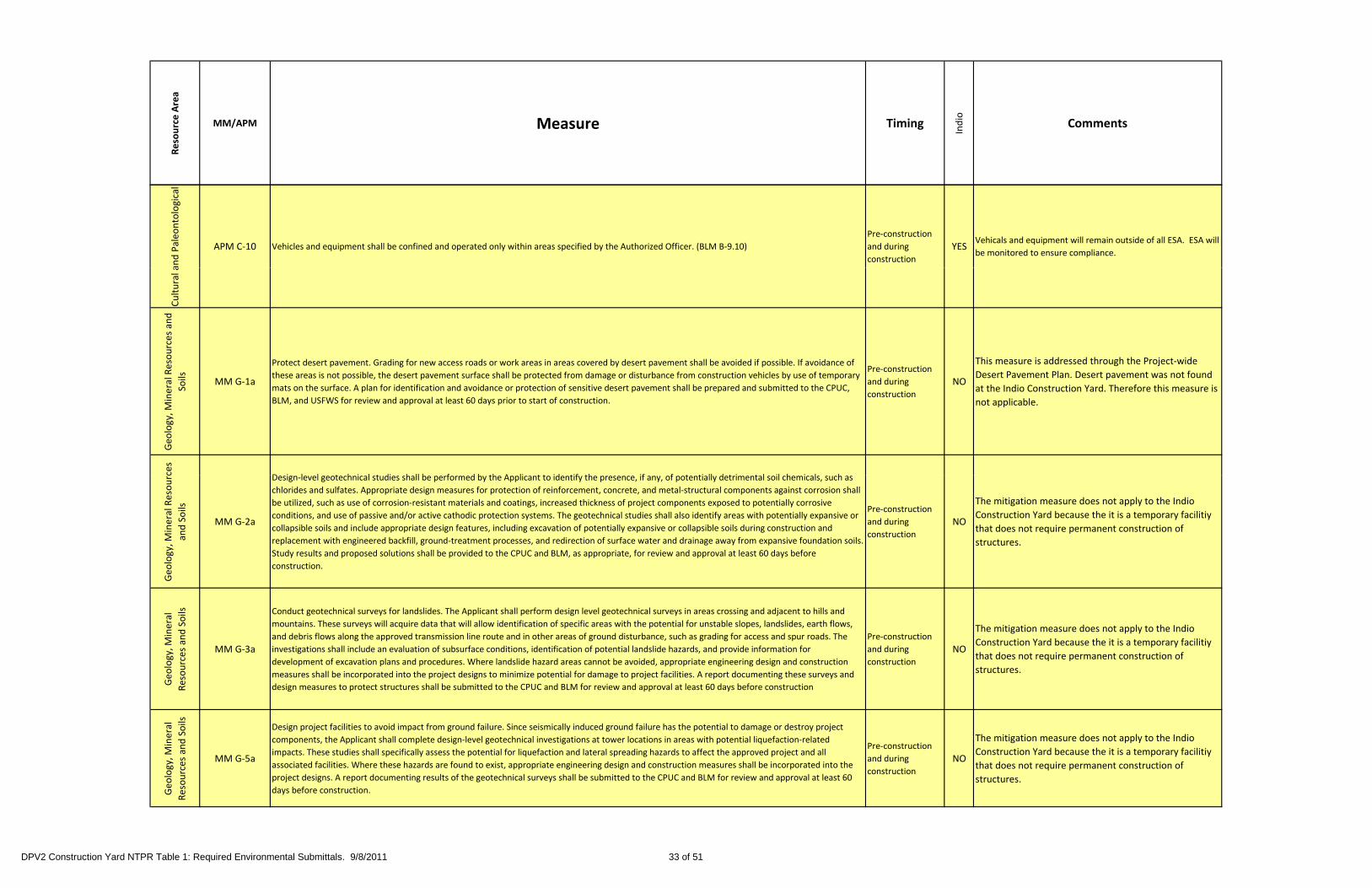
Resource Area
MM/APM Measure Timing
Indio
Comments
and Paleo
ntological
APM C‐10 Vehicles and equipment shall be confined and operated only within areas specified by the Authorized Officer. (BLM B‐9.10)
Pre‐construction
and during
construction
YESVehicals and equipment will remain outside of all ESA. ESA will
be monitored to ensure compliance.
Cultural a
Geo
logy, M
ineral Resources and
Soils MM G‐1a
Protect desert pavement. Grading for new access roads or work areas in areas covered by desert pavement shall be avoided if possible. If avoidance of
these areas is not possible, the desert pavement surface shall be protected from damage or disturbance from construction vehicles by use of temporary
mats on the surface. A plan for identification and avoidance or protection of sensitive desert pavement shall be prepared and submitted to the CPUC,
BLM, and USFWS for review and approval at least 60 days prior to start of construction.
Pre‐construction
and during
construction
NO
This measure is addressed through the Project‐wide
Desert Pavement Plan. Desert pavement was not found
at the Indio Construction Yard. Therefore this measure is
not applicable.
ces
D i l l t h i l t di h ll b f d b th A li t t id tif th if f t ti ll d t i t l il h i l h
Geo
logy, M
ineral Resourc
and Soils
MM G‐2a
Design‐level geotechnical studies shall be performed by the Applicant to identify the presence, if any, of potentially detrimental soil chemicals, such as
chlorides and sulfates. Appropriate design measures for protection of reinforcement, concrete, and metal‐structural components against corrosion shall
be utilized, such as use of corrosion‐resistant materials and coatings, increased thickness of project components exposed to potentially corrosive
conditions, and use of passive and/or active cathodic protection systems. The geotechnical studies shall also identify areas with potentially expansive or
collapsible soils and include appropriate design features, including excavation of potentially expansive or collapsible soils during construction and
replacement with engineered backfill, ground‐treatment processes, and redirection of surface water and drainage away from expansive foundation soils.
Study results and proposed solutions shall be provided to the CPUC and BLM, as appropriate, for review and approval at least 60 days before
construction.
Pre‐construction
and during
construction
NO
The mitigation measure does not apply to the Indio
Construction Yard because the it is a temporary facilitiy
that does not require permanent construction of
structures.
Geo
logy, M
ineral
esources and Soils
MM G‐3a
Conduct geotechnical surveys for landslides. The Applicant shall perform design level geotechnical surveys in areas crossing and adjacent to hills and
mountains. These surveys will acquire data that will allow identification of specific areas with the potential for unstable slopes, landslides, earth flows,
and debris flows along the approved transmission line route and in other areas of ground disturbance, such as grading for access and spur roads. The
investigations shall include an evaluation of subsurface conditions, identification of potential landslide hazards, and provide information for
development of excavation plans and procedures. Where landslide hazard areas cannot be avoided, appropriate engineering design and construction
measures shall be incorporated into the project designs to minimize potential for damage to project facilities. A report documenting these surveys and
Pre‐construction
and during
construction
NO
The mitigation measure does not apply to the Indio
Construction Yard because the it is a temporary facilitiy
that does not require permanent construction of
structures.
G
Re design measures to protect structures shall be submitted to the CPUC and BLM for review and approval at least 60 days before construction
Geology, M
ineral
Resources and Soils
MM G‐5a
Design project facilities to avoid impact from ground failure. Since seismically induced ground failure has the potential to damage or destroy project
components, the Applicant shall complete design‐level geotechnical investigations at tower locations in areas with potential liquefaction‐related
impacts. These studies shall specifically assess the potential for liquefaction and lateral spreading hazards to affect the approved project and all
associated facilities. Where these hazards are found to exist, appropriate engineering design and construction measures shall be incorporated into the
project designs. A report documenting results of the geotechnical surveys shall be submitted to the CPUC and BLM for review and approval at least 60
days before construction.
Pre‐construction
and during
construction
NO
The mitigation measure does not apply to the Indio
Construction Yard because the it is a temporary facilitiy
that does not require permanent construction of
structures.
DPV2 Construction Yard NTPR Table 1: Required Environmental Submittals. 9/8/2011 33 of 51

Resource Area
MM/APM Measure Timing
Indio
Comments
ology, M
ineral
ources and Soils
MM G‐6a
Coordinate with quarry operations. Operations and management personnel for the Indio Pit quarry shall be consulted regarding locations of active
mining and for coordination of construction activities in and through those areas. A plan to avoid or minimize interference with mining operations shall
be prepared in conjunction with mine/quarry operators prior to construction. SCE shall document compliance with this measure prior to the start of
construction by submitting the plan to the CPUC and BLM for review at least 60 prior to the start of construction.
Pre‐construction
and during
construction
NO
The mitigation measure does not apply to the Indio
Construction Yard because the it is a temporary facilitiy
that does not require permanent construction of
structures.
Geo
Reso
structures.
Geo
logy, M
ineral
Resources and Soils
MM G‐7a
Minimize project structures within active fault zones. SCE shall perform a geologic/geotechnical study to confirm the location of mapped traces of active
and potentially faults crossed by the project route. For crossings of active faults, the towers shall be placed as far as feasible outside the area of mapped
fault traces. Compliance with this measure shall be documented to the CPUC and BLM in a report submitted for review and approval at least 60 days
prior to the start of construction.
Pre‐construction
and during
construction
NO
The mitigation measure does not apply to the Indio
Construction Yard because the it is a temporary facilitiy
that does not require permanent construction of
structures.
Geo
logy,
Mineral
Resources and
Soils APM G‐1 The line will be located to minimize the disruption of any active mining operations. (BLM B‐2.1) Pre‐construction NO
This mitigation measure does not apply to the Indio
Construction Yard because it is not located near any
quarry or mining operations.
Geo
logy, M
ineral Resources and
Soils APM G‐2
Individual transmission towers will not be sited on nor straddle the mapped traces of any known fault that has been designated active or potentially
active. In areas where known faults are present, the Holder will visually check the tower site area before clearing, and will check the tower footing holes
for any trace of a previously unmapped fault. If manifestations of a fault are found, construction will immediately stop at that site and the Holder will
consult with the Holder’s Geologist and the BLM Authorized Officer. The Holder’s Geologist and the BLM Authorized Officer will determine if it is a fault
trace and if so, will ascertain if it is active, potentially active, or inactive. (BLM B‐2.2)
Pre‐construction NO
This measure does not apply because the Indio
Construction Yard does not require construction of
transmission towers.
Resources
Towers will be located so that the line will span the surface traces of active and potentially active faults such that a relative lateral surface displacement
Geology, M
ineral R
and
Soils APM G‐3
Towers will be located so that the line will span the surface traces of active and potentially active faults such that a relative lateral surface displacement
would shorten the span between towers, and thus avoid potential line breaks. Where this is not feasible, the Holder will incorporate slack spans to
bridge the fault(s) such that the projected lateral surface displacement, as forecast by the Holder’s Geologist and accepted by the BLM Authorized
Officer, will not structurally affect the associated towers. (BLM B‐2.3)
Pre‐construction NO
This measure does not apply because the Indio
Construction Yard does not require construction of
transmission towers.
DPV2 Construction Yard NTPR Table 1: Required Environmental Submittals. 9/8/2011 34 of 51

Resource Area
MM/APM Measure Timing
Indio
Comments
esources and Soils
In general an appropriate tower design which accounts for lateral wind loads and conductor loads exceeds any credible seismic loading (groundshaking)This measure does not apply because the Indio
Geo
logy, M
ineral Re APM G‐4
In general, an appropriate tower design which accounts for lateral wind loads and conductor loads exceeds any credible seismic loading (groundshaking).
(BLM B‐2.4)Pre‐construction NO Construction Yard does not require construction of
transmission towers.
Geology, M
ineral
Resources and Soils
APM G‐5Towers will be located to avoid areas of highly sensitive dune sand areas. Where these areas cannot be avoided, towers will be located to minimize
disturbance to the deposits at a site approved by the BLM Authorized Officer. (BLM B 2.5. Note: Text here omits references to specific figures and maps
in the original [1987 88] DEIR and DEIS.)
Pre‐construction NO
This measure does not apply because the Indio
Construction Yard does not require construction of
transmission towers.
neral
and
Geo
logy, M
in
Resources a
Soils APM G‐6
Wherever feasible to minimize the potential for slope instability, towers will be located to avoid gullies or active drainages, and over‐steepened slopes.
(BLM B‐2.6)Pre‐construction NO
This measure does not apply because the Indio
Construction Yard does not require construction of
transmission towers.
Geo
logy, M
ineral
Resources and Soils
APM G‐7
SCE will provide a list of sites where helicopter construction is recommended. The Authorized Officer may require, on a site‐specific basis, helicopter
assisted construction in sensitive areas. Sensitive areas are those that exhibit both (1) high erosion potential and/or slope instability; and (2) a lack of
existing stub roads within a reasonable distance of the tower site or existing access that is not suitable for upgrading to accommodate conventional
tower construction or line stringing equipment, and where it is determined that, after field review, the issues of erosion and/or slope instability cannot
be successfully mitigated through implementation of accepted engineering practices. (BLM B‐2.7)
Pre‐construction NO
This measure does not apply because the Indio
Construction Yard does not require helicopter assisted
construction.
Resources and
Mitigation of potentially significant impacts to the western end of the proposed transmission line due to (1) potential surface fault rupture along the
Banning, Mission Creek, and Mecca Hills faults, and (2) potential for severe seismic shaking can be achieved by standard design methods listed below:
a Towers will be sited so as not to straddle active fault traces Pre‐construction This measure does not apply because the Indio
Geo
logy, M
ineral R
Soils APM G‐8
a. Towers will be sited so as not to straddle active fault traces.
b. The alignment will be designed to cross an active fault such that future rupture on the fault would not cause excessive stress on the line or the towers.
c. Standard foundation and structural design measures will be utilized to minimize the impact from severe seismic shaking. (BLM B‐2.8)
Pre construction
and during
construction
NO
This measure does not apply because the Indio
Construction Yard does not require construction of
transmission towers.
DPV2 Construction Yard NTPR Table 1: Required Environmental Submittals. 9/8/2011 35 of 51

Resource Area
MM/APM Measure Timing
Indio
Comments
Geo
logy,
Mineral
Resources and
Soils APM G‐9 Appropriate design of tower foundations will be used to reduce the potential for settlement and compaction. (BLM B‐2.9) Pre‐construction NO
This measure does not apply because the Indio
Construction Yard does not require construction of
transmission towers.
Geo
logy, M
ineral
Resources and Soils
APM G‐10
New access roads and soil disturbance will be avoided or minimized in all areas designated as having high erosion hazards or potential slope instability. If
the Authorized Officer, after consultation and review of alternatives (including helicopter or helicopter assisted construction), deems the proposed new
access road feasible, design plans must be submitted for approval, in writing, prior to construction. (BLM B‐3.1. Note: Text here omits references to
specific figures and maps in the original (1987‐88) DEIR and DEIS.)
Pre‐construction NO
The Indio Construction Yard is relatively flat areas and
are not within high erosion potential areas, therefore
this measure doesn't apply.
Geo
logy, M
ineral
Resources and Soils
APM G‐11
New access roads, which are required, will be designed to minimize ground disturbance from grading. They will follow natural ground contours as closely
as possible and include specific features for road drainage, including water bars on slopes over 25 percent. Other measures could include drainage dips,
side ditches, slope drains, and velocity reducers. Where temporary crossings are constructed, the crossings will be restored and repaired as soon as
possible after completion of the discrete action associated with construction of the line in the area. (BLM B‐3.2)
Pre‐construction,
during and post
construction
NONo new access roads are required for the Indio
Construction Yard.
Geo
logy,
Mineral
Resources and
Soils APM G‐12
Side casting of soil during grading will be minimized. Excess soil and excavated soil will be properly stabilized or, dispersed around tower construction
sites or on stub or access roads. (BLM B‐3.3)
During
constructionNO
The Indio Construction Yard is completely developed so
no side casting will occur, therefore this measure doesn’t
apply.
Geo
logy, M
ineral
Resources and
Soils APM G‐13
During grading operations, care would be exercised to minimize side casting. No earth would be removed below final elevations, and no cuts would be
made deeper than necessary for clearing and road construction. (SCE)
During
constructionNO
The Indio Construction Yard is completely developed so
no side casting will occur, therefore this measure doesn’t
apply.
Mineral
and Soils
Upon completion of construction any drainage deficiencies would be corrected to prevent future erosion Trees and brush would be cleared only when Upon completion of construction, this measure will be
Geology, M
Resources a
APM G‐14Upon completion of construction, any drainage deficiencies would be corrected to prevent future erosion. Trees and brush would be cleared only when
necessary to provide electrical clearance, line reliability, or suitable access for maintenance and construction. (SCE)Post construction YES
Upon completion of construction, this measure will be
implemented if required.
DPV2 Construction Yard NTPR Table 1: Required Environmental Submittals. 9/8/2011 36 of 51

Resource Area
MM/APM Measure Timing
Indio
Comments
esources and Soils
Counterpoise may need to be installed if the local soil conditions indicate that the soil has a resistance above 30 ohms. This is accomplished by attaching Pre‐construction This measure does not apply because the Indio
Geo
logy, M
ineral Re APM G‐15 a 0.375‐inchcable to the tower steel. The cable is installed 1 foot underground and extends approximately 100 feet within the ROW from two or more
footings.
and during
construction
NO Construction Yard does not require construction of
transmission towers.
Geology, M
ineral
Resources and
Soils APM G‐16 The line would be located to minimize the disruption of any active mining operations. (SCE) Pre‐construction NO
The Indio Construction Yard is not located near any
active mining operations.
eral
Soils
Geo
logy, M
in
Resources and
APM G‐17Appropriate tower design would be used to mitigate the potential for impacts from very strong seismic groundshaking. In general, an appropriate tower
design which accounts for lateral wind loads and conductor loads during line stringing exceeds any credible seismic loading (groundshaking). (SCE)Pre‐construction NO
This measure does not apply because the Indio
Construction Yard does not require construction of
transmission towers.
Geology, M
ineral Resources
and Soils
APM G‐18Whenever possible to minimize the potential for slope instability, towers would be located to avoid gullies or active drainages, and over‐steepened
slopes. (SCE)
Pre‐construction
and during
construction
NO
This measure does not apply because the Indio
Construction Yard does not require construction of
transmission towers.
Geo
logy, M
ineral
Resources and Soils
APM G‐19
New access roads, where required, would be designed to minimize ground disturbance from grading. They would follow natural ground contours as
closely as possible and include specific features for road drainage, including water bars on slopes over 25 percent. Other measures could include
drainage dips, side ditches, slope drains, and velocity reducers. Where temporary crossings are constructed, the crossings would be restored and
repaired as soon as possible after completion of the discrete action associated with construction of the line. Side casting of soil during grading would be
minimized. Excess soil would be properly stabilized, or if necessary, hauled to an approved disposal site. (SCE)
Pre‐construction
and during
construction
NONo new access roads are required for the Indio
Construction Yard.
DPV2 Construction Yard NTPR Table 1: Required Environmental Submittals. 9/8/2011 37 of 51

Resource Area
MM/APM Measure Timing
Indio
Comments
drology and W
ater
Resources
MM H‐1a
Restore disturbed soil with re‐vegetation or construction of permanent erosion‐control structures. Soil disturbance at towers and access roads shall be
the minimum necessary and designed to prevent long‐term erosion through revegetation or construction of permanent erosion control structures
according to plans to be reviewed and approved by the U.S. Forest Service. Copies of the final approved plans shall be submitted to the CPUC/BLM for
their files.
Pre‐construction,
during and post‐
construction
NO
This measure does not apply because the Indio
Construction Yard does not require construction of
transmission towers.
Hyd
Hydrology and
Water Resources
MM H‐6a
Design diversion dikes or other site remediation's to avoid damage to adjacent property. Where diversion dikes are required to protect towers or other
project structures from flooding or erosion, these dikes shall be so designed as to avoid increasing the risk of erosion or flooding onto adjacent property
where life, existing improvements or land values could be threatened. Diversion dike designs shall be submitted to the CPUC and BLM for review and
approval at least 60 days prior to construction.
Pre‐construction NOThe Indio Construction Yard is completely developed and
does not require diversion dikes.
and W
ater Resources
APM W‐1
During the first year following construction, potential soil erosion sites will be inspected by the Holder after each major rainstorm as access permits. For
the purpose of this measure, a major rainstorm is defined as any singular storm where the total precipitation exceeds the arithmetic mean for similar
events in the area and results in flooding. Examples include cloudbursts (high quantity – short duration) or storms where saturated soils produce runoff
(high quantity – long duration). (BLM B‐4.1)
Post‐Construction YES This measure will be implemented post construction.
Hydrology a (high quantity long duration). (BLM B 4.1)
Hydrology and
Water Resources
APM W‐2 Construction equipment will be kept out of flowing stream channels except when absolutely necessary to construct crossings. (BLM B‐4.2)
Pre‐construction
and during
construction
NOThe Indio Construction Yard is not adjacent to flowing
channels.
Hydrology and
Water Resources
APM W‐3 Erosion control and hazardous material plans will be incorporated into the construction bidding specifications to ensure compliance. (BLM B‐4.3)
Pre‐construction
and during
construction
YES
An erosion control plan will be prepared for the Indio
Construction Yard and will be incorporated into the
construction bidding specifications.
Hydrology and
Water Resources
APM W‐4Appropriate design of tower footing foundations, such as raised foundations and/or enclosing flood dikes, will be used to prevent scour and/or
inundation by a 100‐year flood.
Pre‐construction
and during
construction
NO
This measure does not apply because the Indio
Construction Yard does not require construction of
transmission towers.
DPV2 Construction Yard NTPR Table 1: Required Environmental Submittals. 9/8/2011 38 of 51
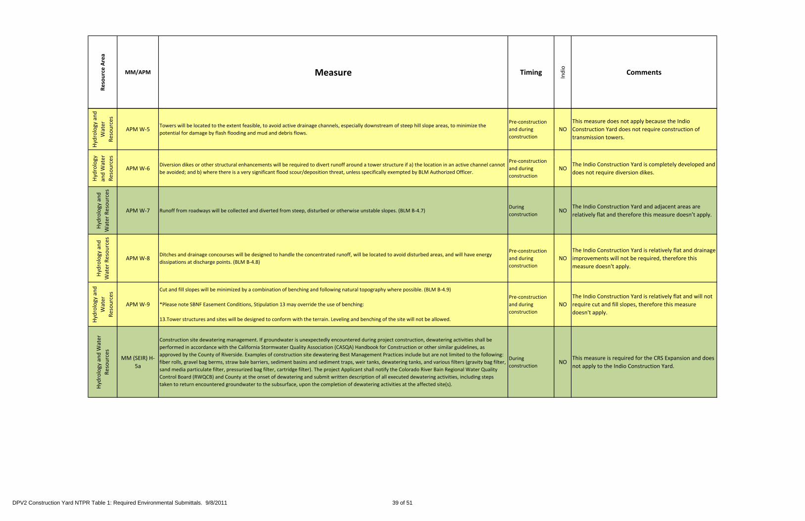
Resource Area
MM/APM Measure Timing
Indio
Comments
Hydrology and
Water
Resources
APM W‐5Towers will be located to the extent feasible, to avoid active drainage channels, especially downstream of steep hill slope areas, to minimize the
potential for damage by flash flooding and mud and debris flows.
Pre‐construction
and during
construction
NO
This measure does not apply because the Indio
Construction Yard does not require construction of
transmission towers.
y r s
Hydrology
and W
ate
Resources
APM W‐6Diversion dikes or other structural enhancements will be required to divert runoff around a tower structure if a) the location in an active channel cannot
be avoided; and b) where there is a very significant flood scour/deposition threat, unless specifically exempted by BLM Authorized Officer.
Pre‐construction
and during
construction
NOThe Indio Construction Yard is completely developed and
does not require diversion dikes.
Hydrology and
Water Resources
APM W‐7 Runoff from roadways will be collected and diverted from steep, disturbed or otherwise unstable slopes. (BLM B‐4.7)During
constructionNO
The Indio Construction Yard and adjacent areas are
relatively flat and therefore this measure doesn’t apply.
Hydrology and
Water Resources
APM W‐8Ditches and drainage concourses will be designed to handle the concentrated runoff, will be located to avoid disturbed areas, and will have energy
dissipations at discharge points. (BLM B‐4.8)
Pre‐construction
and during
construction
NO
The Indio Construction Yard is relatively flat and drainage
improvements will not be required, therefore this
measure doesn't apply.
W
Hydrology and
Water
Resources
APM W‐9
Cut and fill slopes will be minimized by a combination of benching and following natural topography where possible. (BLM B‐4.9)
*Please note SBNF Easement Conditions, Stipulation 13 may override the use of benching:
13.Tower structures and sites will be designed to conform with the terrain. Leveling and benching of the site will not be allowed.
Pre‐construction
and during
construction
NO
The Indio Construction Yard is relatively flat and will not
require cut and fill slopes, therefore this measure
doesn't apply.
Hydrology and W
ater
Resources
MM (SEIR) H‐
5a
Construction site dewatering management. If groundwater is unexpectedly encountered during project construction, dewatering activities shall be
performed in accordance with the California Stormwater Quality Association (CASQA) Handbook for Construction or other similar guidelines, as
approved by the County of Riverside. Examples of construction site dewatering Best Management Practices include but are not limited to the following:
fiber rolls, gravel bag berms, straw bale barriers, sediment basins and sediment traps, weir tanks, dewatering tanks, and various filters (gravity bag filter,
sand media particulate filter, pressurized bag filter, cartridge filter). The project Applicant shall notify the Colorado River Bain Regional Water Quality
Control Board (RWQCB) and County at the onset of dewatering and submit written description of all executed dewatering activities, including steps
taken to return encountered groundwater to the subsurface, upon the completion of dewatering activities at the affected site(s).
During
constructionNO
This measure is required for the CRS Expansion and does
not apply to the Indio Construction Yard.
DPV2 Construction Yard NTPR Table 1: Required Environmental Submittals. 9/8/2011 39 of 51

Resource Area
MM/APM Measure Timing
Indio
Comments
Water Resources
MM (SEIR) H‐
Groundwater Well Contingency Plan. Prior to issuance of construction permits, the Applicant shall prepare a Groundwater Well Contingency Plan (Plan)
to drill and construct a secondary supply well that would supplement groundwater production rates from the primary supply well, should the pumping
capacity (daily yields) of the primary well become inadequate to meet the project requirements. The Plan shall identify the following features of the
secondary supply well, should it be needed:
� location within the Colorado River Substation (CRS) site;
� proximity to existing wells (private and/or municipal); Prior to start of This measure is required for the CRS Expansion and does
Hydrology and W
MM (SEIR) H
7a
� proximity to existing wells (private and/or municipal);
� estimated total depth, well screen depth, diameter, and estimated yield; and
� time required to have the well drilled, constructed, developed and fully operational.
The Plan shall also specify what conditions would trigger use of the second supply well, as well as the person responsible for determining when to utilize
the second supply well. The County of Riverside shall be notified prior to installation of the secondary supply well,
should it be necessary. The Applicant shall submit the Groundwater Well Contingency Plan to the CPUC and the County of Riverside for review and
approval thirty (30) days before the start of extraction of groundwater for construction or operation.
Prior to start of
constructionNO
This measure is required for the CRS Expansion and does
not apply to the Indio Construction Yard.
Groundwater Monitoring and Reporting. Prior to issuance of construction permits and prior to any groundwater pumping activities, a Groundwater
Monitoring and Reporting Plan (Plan) shall be prepared by a Certified Hydrogeologist (CHG) and submitted by the Applicant (SCE) to the California Public
Utilities Commission (CPUC) for review and approval. The Plan shall provide detailed methodology for monitoring background and site groundwater
levels, water quality, and flow.
Monitoring shall be performed during pre‐construction, construction, and project operation with the intent to establish pre‐construction and
project‐related groundwater level and water quality trends that can be quantitatively compared against observed and simulated trends near the project
pumping well(s). During pre‐construction monitoring, it shall be determined whether groundwater can be pumped from above the Colorado River
accounting surface of 234 feet above mean sea level (amsl). If it is not possible to verify that groundwater for the Proposed Project would be exclusively
pumped from above the Colorado River accounting surface, then Mitigation Measure H‐7c (Water Supply Plan for Use of Colorado River Water) would
b d
Hydrology and W
ater Resources
MM (SEIR) H‐
7b
be required.
The monitoring wells shall include locations up‐gradient, lateral, and down‐gradient of all project supply wells and a minimum of three offsite
down‐gradient wells. Water quality monitoring shall include annual sampling and testing for Total Dissolved Solids (TDS), which include
minerals, salts, and metals dissolved in water. Water quality samples shall be drawn from project supply wells, one up‐gradient well, and a minimum of
two down‐gradient offsite wells.
The Plan shall include a schedule for submittal of both quarterly (construction only) and annual (operations) monitoring data reports by the Applicant to
the CPUC.
During the project construction period, quarterly water level monitoring data reports shall be submitted to CPUC for review and approval. In addition,
for at least the first 5 years of the project from the initiation of project construction, annual summary reports shall also be
submitted to CPUC for review and approval. At a minimum, these annual summary reports shall include:
� Daily usage, monthly range, and monthly average of daily water usage in gallons per day;
� Total water used on a monthly and annual basis in acre‐feet;
� Summary of all water level and water quality data; and
� Identification of trends that indicate potential for offsite wells to experience deterioration of water level or water quality.
Based on the results of the quarterly and annual trend analyses during the first 5 years of the project from the initiation of project construction, the
Applicant shall determine if the project pumping has resulted in water level decline of 5 feet or more below the baseline trend
at nearby private wells If drawdown of 5 feet or more occurs at off‐site wells the Applicant shall immediately reduce groundwater pumping until water
Pre‐construction NOThis measure is required for the CRS Expansion and does
not apply to the Indio Construction Yard.
at nearby private wells. If drawdown of 5 feet or more occurs at off site wells, the Applicant shall immediately reduce groundwater pumping until water
levels stabilize or recover, sustaining drawdown of less than 5 feet. Alternatively, the Applicant shall provide compensation
to the well owner, including reimbursement of increased energy costs, or deepening the well or pump setting.
After the first 5 years of project, the Applicant and CPUC shall jointly evaluate the effectiveness of the Groundwater Monitoring and Reporting Plan and
determine if monitoring frequencies, laboratory testing program, or procedures should be revised or eliminated.
Th A li t h ll fil l “N ti f E t ti d Di i f W t ” ith th St t W t R C t l B d i d ith W t
DPV2 Construction Yard NTPR Table 1: Required Environmental Submittals. 9/8/2011 40 of 51

Resource Area
MM/APM Measure Timing
Indio
Comments
Water Supply Plan for Use of Colorado River Water. If pre‐construction groundwater monitoring conducted in compliance with Mitigation Measure H‐7b
(Groundwater Monitoring and Reporting Plan) indicates that groundwater pumping for the Proposed Project would
draw water from below the Colorado River accounting surface of 234 feet above mean sea level (amsl), the Applicant (SCE) shall undertake one or more
of the activities identified below to mitigate project impacts to flows in the Colorado River. These activities shall result
in replacement of water used by the project over the life of the project. Measures of water conservation should be considered in the following order of
priority:
� Payment for irrigation improvements in Palo Verde Irrigation District (PVID);
Hydrology and W
ater Resources
MM (SEIR) H‐
7c
� Payment for irrigation improvements in Palo Verde Irrigation District (PVID);
� Purchase of water allotments within the Colorado River Basin that will be held in reserve;
� Use of tertiary treated water;
� Implementation of water conservation programs in the floodplain communities of the Chuckwalla Valley Groundwater Basin, the Palo Verde Mesa
Groundwater Basin, and/or Colorado River; and/or
� Participation in the U.S. Bureau of Land Management’s (BLM) Tamarisk Removal Program.
If the Applicant has filed an application to the U.S. Bureau of Reclamation (USBR) to obtain an allocation of water from the Colorado River, these
allocations can be used to satisfy some or all of the water offsets needed to comply with this condition on an acre‐foot per acrefoot
basis. Use of any other options for water offsets will require the Applicant to demonstrate to the satisfaction of CPUC that the appropriate amounts of
water will be conserved. The activities proposed for mitigation will be outlined in a Water Supply Plan that will be
provided to the CPUC for review and approval prior to the onset of groundwater pumping at the project site. The Water Supply Plan shall include the
following at a minimum:
� Identification of water offset activities and associated water source(s) to replace the quantity of water diverted from the Colorado River over the life of
the project on an acre‐foot per acre‐foot basis;
� Demonstration of the Applicant’s legal entitlement to the water or ability to conduct the activity;
� Include a discussion of any needed governmental approval of the identified activities, including a discussion of whether that approval that requires;
� Discuss whether any governmental approval of the identified activities will be needed, and, if so, whether that additional approval will require
Pre‐construction NOThis measure is required for the CRS Expansion and does
not apply to the Indio Construction Yard.
compliance with CEQA or NEPA;
� Demonstration of how water diverted from the Colorado River will be replaced for each identified activity;
� An estimated schedule of completion for each identified activity;
� Performance measures that would be used to evaluate the amount of water replaced by each identified activity;
� Monitoring and Reporting Plan outlining the steps necessary and proposed frequency of reporting to show that each identified activity is achieving the
intended benefits and replacing Colorado River diversions; and
� If the application for allocation from the Colorado River is accepted by the USBR, the Applicant shall submit to the CPUC for their approval, a copy of a
t ll ti f th C l d Ri i d b th i t
DPV2 Construction Yard NTPR Table 1: Required Environmental Submittals. 9/8/2011 41 of 51
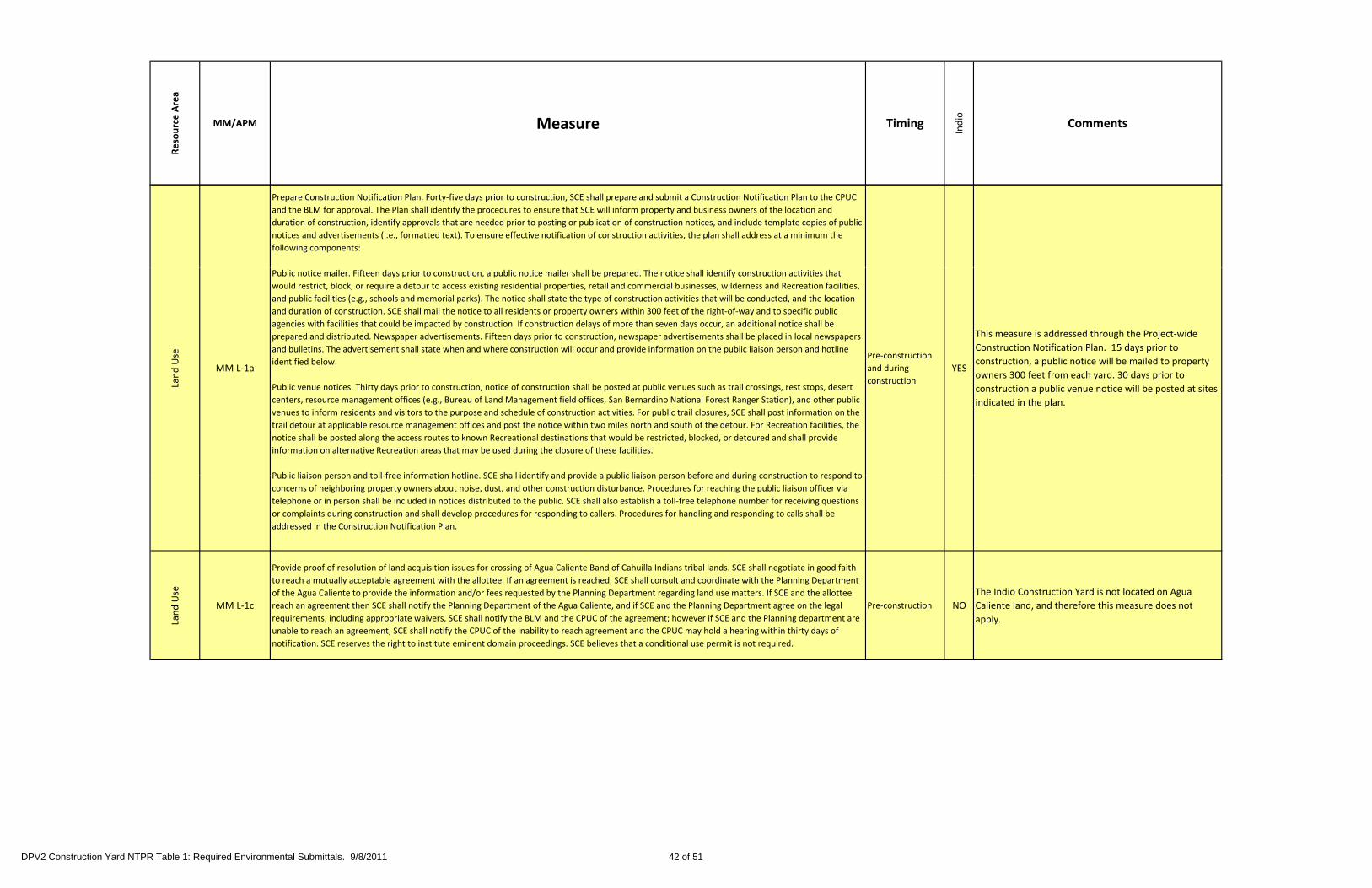
Resource Area
MM/APM Measure Timing
Indio
Comments
Prepare Construction Notification Plan. Forty‐five days prior to construction, SCE shall prepare and submit a Construction Notification Plan to the CPUC
and the BLM for approval. The Plan shall identify the procedures to ensure that SCE will inform property and business owners of the location and
duration of construction, identify approvals that are needed prior to posting or publication of construction notices, and include template copies of public
notices and advertisements (i.e., formatted text). To ensure effective notification of construction activities, the plan shall address at a minimum the
following components:
Land Use
MM L‐1a
Public notice mailer. Fifteen days prior to construction, a public notice mailer shall be prepared. The notice shall identify construction activities that
would restrict, block, or require a detour to access existing residential properties, retail and commercial businesses, wilderness and Recreation facilities,
and public facilities (e.g., schools and memorial parks). The notice shall state the type of construction activities that will be conducted, and the location
and duration of construction. SCE shall mail the notice to all residents or property owners within 300 feet of the right‐of‐way and to specific public
agencies with facilities that could be impacted by construction. If construction delays of more than seven days occur, an additional notice shall be
prepared and distributed. Newspaper advertisements. Fifteen days prior to construction, newspaper advertisements shall be placed in local newspapers
and bulletins. The advertisement shall state when and where construction will occur and provide information on the public liaison person and hotline
identified below.
Public venue notices. Thirty days prior to construction, notice of construction shall be posted at public venues such as trail crossings, rest stops, desert
centers, resource management offices (e.g., Bureau of Land Management field offices, San Bernardino National Forest Ranger Station), and other public
venues to inform residents and visitors to the purpose and schedule of construction activities. For public trail closures, SCE shall post information on the
trail detour at applicable resource management offices and post the notice within two miles north and south of the detour. For Recreation facilities, the
notice shall be posted along the access routes to known Recreational destinations that would be restricted, blocked, or detoured and shall provide
information on alternative Recreation areas that may be used during the closure of these facilities.
Public liaison person and toll free information hotline SCE shall identify and provide a public liaison person before and during construction to respond to
Pre‐construction
and during
construction
YES
This measure is addressed through the Project‐wide
Construction Notification Plan. 15 days prior to
construction, a public notice will be mailed to property
owners 300 feet from each yard. 30 days prior to
construction a public venue notice will be posted at sites
indicated in the plan.
Public liaison person and toll‐free information hotline. SCE shall identify and provide a public liaison person before and during construction to respond to
concerns of neighboring property owners about noise, dust, and other construction disturbance. Procedures for reaching the public liaison officer via
telephone or in person shall be included in notices distributed to the public. SCE shall also establish a toll‐free telephone number for receiving questions
or complaints during construction and shall develop procedures for responding to callers. Procedures for handling and responding to calls shall be
addressed in the Construction Notification Plan.
Land Use
MM L‐1c
Provide proof of resolution of land acquisition issues for crossing of Agua Caliente Band of Cahuilla Indians tribal lands. SCE shall negotiate in good faith
to reach a mutually acceptable agreement with the allottee. If an agreement is reached, SCE shall consult and coordinate with the Planning Department
of the Agua Caliente to provide the information and/or fees requested by the Planning Department regarding land use matters. If SCE and the allottee
reach an agreement then SCE shall notify the Planning Department of the Agua Caliente, and if SCE and the Planning Department agree on the legal
requirements, including appropriate waivers, SCE shall notify the BLM and the CPUC of the agreement; however if SCE and the Planning department are
unable to reach an agreement, SCE shall notify the CPUC of the inability to reach agreement and the CPUC may hold a hearing within thirty days of
notification. SCE reserves the right to institute eminent domain proceedings. SCE believes that a conditional use permit is not required.
Pre‐construction NO
The Indio Construction Yard is not located on Agua
Caliente land, and therefore this measure does not
apply.
DPV2 Construction Yard NTPR Table 1: Required Environmental Submittals. 9/8/2011 42 of 51

Resource Area
MM/APM Measure Timing
Indio
Comments
se
Coordinate construction schedule with public and community facilities. SCE shall coordinate with the public and community facilities and services listed
below regarding the construction schedule and duration in order to minimize impacts to these land uses. The purpose of this measure is to work with
sensitive land uses that would be impacted by construction and to identify construction times/periods that would have the least impact to peak use of
these public and community facilities. This coordination could result in limiting or avoiding construction during school sessions, identifying hauling routes
that do not conflict with school commute routes, or working with the memorial parks to address funeral procession routes and noise sensitivities. Thirty
days prior to construction, SCE shall document its coordination efforts including contact persons, information provided, and comments received, and
submit this documentation to the California Public Utilities Commission and the Bureau of Land Management None of the facilities listed in the mitigation measure are
Land Us
MM L‐1esubmit this documentation to the California Public Utilities Commission and the Bureau of Land Management.
• Schools near the project route: Beaumont Middle School and High School, Calvary Christian School, Chavez Elementary School, Terrace View
Elementary School, public elementary school on East Canyon Vista Drive.
• San Gorgonio Memorial Park
• Desert Lawn Memorial Park
• Banning Municipal Airport
• Grandview Baptist Church
Pre‐construction NO
None of the facilities listed in the mitigation measure are
near the Indio Construction Yard, and therefore this
mitigation measure does not apply.
Land Use
APM L‐2Although the Holder (SCE) may restore and maintain existing access roads, they cannot be either widened or upgraded without approval of the
Authorized Officer. (BLM B 1.1)
Pre‐construction
and during
construction
NOThe measure does not apply because there will not be
any widening of existing access roads.
Use
APM L 8Link 14 crosses an open pit gravel operation. Potential impacts would be mitigated during construction by coordinating with the owner/operator to avoid
Pre‐construction
and during NO
This mitigation measure does not apply to the Indio
Construction Yard because it is not within an open pit
Land APM L‐8
critical mining periods and high volume earth‐moving days. Operational mitigation would include spanning the mine. (SCE)and during
construction
NO Construction Yard, because it is not within an open pit
gravel operation.
Noise
MM N‐1a
Implement best management practices for construction noise. SCE shall employ the following noise‐suppression techniques to minimize the impact of
temporary construction noise and avoid possible violations of local rules, standards, and ordinances:
• Construction noise shall be confined to daytime, weekday hours (e.g., 7:00 a.m. to 6:00 p.m.)
or an alternative schedule established by the local jurisdiction;
• Construction equipment shall use noise reduction features (e.g., mufflers and engine shrouds) that are no less effective than those originally installed
by the manufacturer;
• Construction traffic shall be routed away from residences and schools, where feasible;
• Unnecessary construction vehicle use and idling time shall be minimized to the extent feasible.
Th bili li i i hi l idli i i d d h f i i i i d h d h hi l d d
During
constructionYES This measure will be implemented during construction.
The ability to limit construction vehicle idling time is dependent upon the sequence of construction activities and when and where vehicles are needed
or staged. A “common sense” approach to vehicle use shall be applied; if a vehicle is not required for use immediately or continuously for construction
activities, its engine should be shut off. (Note: certain equipment, such as large diesel‐powered vehicles, require extended idling for warm‐up and
repetitive construction tasks )
Noise
APM N‐1The proposed construction would comply with local noise ordinances. There may be a need to work outside of the aforementioned local ordinances in
order to take advantage of low electrical draw periods during the nighttime hours. SCE would comply with variance procedures requested by local
authorities if required. (SCE)
Pre‐construction
and during
construction
YES
Project construction will comply with local noise
ordinances or would obtain a variance . The measure will
be implemented during construction.
DPV2 Construction Yard NTPR Table 1: Required Environmental Submittals. 9/8/2011 43 of 51

Resource Area
MM/APM Measure Timing
Indio
Comments
Public Health &
Safety
MM P‐1aDevelop Hazardous Substance Control and Emergency Response Plan. A Hazardous Substance Control and Emergency Response Plan shall be prepared
for the project, and a copy shall be kept on site (or in vehicles) during construction and maintenance of the project. SCE shall document compliance by
submitting the plan to the CPUC or BLM or USFWS, as appropriate, for review and approval at least 60 days before the start of construction.
Pre‐construction
and during
construction
YES
This measure is addressed through the Project‐wide
Hazardous Substance Control and Emergency Response
Plan.
Public Health & Safety
MM P‐1b
Conduct environmental training and monitoring program. An environmental training program shall be established to communicate environmental
concerns and appropriate work practices, including spill prevention, emergency response measures, and proper Best Management Practice (BMP)
implementation, to all field personnel prior to the start of construction. The training program shall emphasize site‐specific physical conditions to improve
hazard prevention (e.g., identification of potentially hazardous substances) and shall include a review of all site‐specific plans, including but not limited
to, the project’s Storm Water Pollution Prevention Plan and the Hazardous Substances Control and Emergency Response Plan. SCE shall document
compliance by (a) submitting to the CPUC or BLM or USFWS, as appropriate, for review and approval an outline of the proposed Environmental Training
and Monitoring Program, and (b) maintaining for monitor review a list of names of all construction personnel who have completed the training program.
Best Management Practices, as identified in the project Storm Water Pollution Prevention Plan and the Hazardous Substances Control and Emergency
Response Plan, shall be implemented during the construction of the project to minimize the risk of an accidental release and provide the necessary
information for emergency response.
Pre‐construction
and during
construction
YES
A WEAP was prepared to address this measure and will
presented to construction personnel prior to
construction.
alth &
ty Ensure proper disposal of construction waste. All non‐hazardous construction and demolition waste, including trash and litter, garbage, and other solid During
This measure will be implemented during construction.
Public He
Safet
MM P‐1c waste shall be disposed of properly. Petroleum products, and other potentially hazardous materials, shall be removed to a hazardous waste facility
permitted or otherwise authorized to treat, store, or dispose of such materials.
During
constructionYES Hazardous waste manifests, if obtained, will be kept
onsite.
Public Health &
Safety
MM P‐1d
Maintain emergency spill supplies and equipment. Hazardous material spill kits shall be maintained at all construction sites for small spills. This shall
include oil‐absorbent material, tarps, and storage drums to be used to contain and control any minor releases. Emergency spill supplies and equipment
shall be kept adjacent to all work areas and staging areas, and shall be clearly marked. Detailed information for responding to accidental spills and for
handling any resulting hazardous materials shall be provided in the project’s Hazardous Substances Control and Emergency Response Plan.
During
constructionYES This measure will be implemented during construction.
Public Health &
Safety
MM P‐2a
Identify pesticide/herbicide contamination. Soil samples shall be collected in construction areas where the land has historically or is currently being
farmed to identify the possibility of and to delineate the extent of pesticide and/or herbicide contamination. Excavated materials containing elevated
levels of pesticide or herbicide will require special handling and disposal procedures. Standard dust suppression procedures (as defined in Mitigation
Measure AQ‐1a shall be used in construction areas to reduce airborne emissions of these contaminants and reduce the risk of exposure to workers and
the public. Regulatory agencies for the states of Arizona or California (as appropriate) and the appropriate county shall be contacted to provide oversight
di th h dli t t t d/ di l ti
Pre‐construction
and during
construction
NO
The Indio Construction Yard does not occur on
historically farmed land, therefore this measure doesn’t
apply.
P regarding the handling, treatment, and/or disposal options.
Public Health & Safety
MM P‐3a
Observe exposed soil for evidence of contamination. During grading or excavation work, the construction contractor shall observe the exposed soil for
visual evidence of contamination. If visual contamination indicators are observed during construction, the contractor shall stop work until the material is
properly characterized and appropriate measures are taken to protect human health and the environment. The contractor shall comply with all local,
State, and federal requirements for sampling and testing, and subsequent removal, transport, and disposal of hazardous materials. Additionally, in the
event that evidence of contamination is observed, the contractor shall document the exact location of the contamination and shall immediately notify
the CPUC or BLM, describing proposed actions. A weekly report listing encounters with contaminated soils and describing actions taken shall be
submitted to the CPUC or BLM.
During
constructionYES This measure will be implemented during construction.
DPV2 Construction Yard NTPR Table 1: Required Environmental Submittals. 9/8/2011 44 of 51

Resource Area
MM/APM Measure Timing
Indio
Comments
Public Health &
Safety
MM P‐4a
Prepare Spill Prevention, Countermeasure, and Control Plans. To minimize, avoid, and/or clean up unforeseen spill of hazardous materials during
operation of the proposed facilities, SCE shall update or prepare, if necessary, the Spill Prevention, Countermeasure, and Control plan for each
substation, series capacitors, and the switchyard. SCE shall document compliance by providing a copy of the Spill Prevention, Control, and
Countermeasures plans to the CPUC or BLM or USFWS, as appropriate, for review and approval at least 60 days before the start of operation.
During
constructionNO
The Indio Construction Yard will not contain 1,320
gallons of hazardous materials, therefore this measure
doesn't apply.
&
Public Health &
Safety
MM PS‐1aLimit the conductor surface electric gradient. As part of the design and construction process for the Proposed Project, the Applicant shall limit the
conductor surface electric gradient in accordance with the IEEE Radio Noise Design Guide.Pre‐construction NO
This measure does not apply because the Indio
Construction Yard does not require construction of
transmission towers.
Public Health &
Safety
MM PS‐1bDocument and Resolve Electronic Interference Complaints. After energizing the transmission line, SCE shall respond to and document all
radio/television/equipment interference complaints received and the responsive action taken. These records shall be made available to the CPUC for
review upon request. All unresolved disputes shall be referred by SCE to the CPUC for resolution.
Post‐construction NO
This measure does not apply because the Indio
Construction Yard does not require construction of
transmission towers.
Health &
fety
MM PS‐2a
Implement Grounding Measures. As part of the siting and construction process for the Proposed Project, SCE shall identify objects (such as fences, metal
buildings, and pipelines) within and near the right‐of‐way that have the potential for induced voltages and shall implement electrical grounding of Post‐Construction NO
This measure does not apply because the Indio
Construction Yard does not require construction of
Public H
Saf MM PS‐2a
metallic objects in accordance with SCE’s standards. The identification of objects shall document the threshold electric field strength and metallic object
size at which grounding becomes necessary.
Post‐Construction NO Construction Yard does not require construction of
transmission towers.
Transportation &
Traffic
MM T‐7a
Repair roadways damaged by construction activities. If roadways, sidewalks, medians, curbs, shoulders, or other such features are damaged by the
project’s construction activities, as determined by the CPUC Environmental Monitor or the affected public agency, SCE shall coordinate repairs with the
affected public agencies and ensure that any such damage is repaired to the pre‐construction condition within 60 days from the end of all construction
within each affected county.
During and post‐
constructionYES
This measure will be implemented during or post
construction if required.
Visual
MM V‐1a
Reduce visibility of construction activities and equipment. Substation construction sites and all staging and material and equipment storage areas,
including storage sites for excavated materials shall be appropriately located away from areas of high public visibility. If visible from nearby roads,
residences, public gathering areas, or recreational areas, facilities, or trails, construction sites and staging and storage areas shall be visually screened
using temporary screening fencing. Fencing will be of an appropriate design and color for each specific location.Pre‐construction
and during
construction
YESThis measure is addressed through the Project‐wide
Construction Screening Plan. Additionally, avoid construction in areas visible from recreation facilities and areas during holidays and periods of heavy recreational use. This measure
encompasses BLM permit requirements BLM B‐7.1 and B‐7.2. SCE shall submit final construction plans demonstrating compliance with this measure to
the BLM and CPUC for review and approval at least 60 days prior to the start of construction.
construction
DPV2 Construction Yard NTPR Table 1: Required Environmental Submittals. 9/8/2011 45 of 51

Resource Area
MM/APM Measure Timing
Indio
Comments
ual
b
Reduce construction night lighting impacts. SCE shall design and install all lighting at construction and storage yards and staging areas such that light
bulbs and reflectors are not visible from public viewing areas; lighting does not cause reflected glare; and illumination of the project facilities, vicinity,
and nighttime sky is minimized. SCE shall submit a Construction Lighting Mitigation Plan to the BLM and CPUC for review and approval at least 90 days
prior to the start of construction or the ordering of any exterior lighting fixtures or components, whichever comes first. SCE shall not order any exterior
lighting fixtures or components until the Construction Lighting Mitigation Plan is approved by the BLM and CPUC. The Plan shall include but is not
necessarily limited to the following: Pre‐construction This measure is addressed through the Project‐wide
Visu MM V‐1b
• Lighting shall be designed so exterior light fixtures are hooded, with lights directed downward or toward the area to be illuminated and so that
backscatter to the nighttime sky is minimized. The design of the lighting shall be such that the luminescence or light sources is shielded to prevent light
trespass outside the project boundary
• All lighting shall be of minimum necessary brightness consistent with worker safety
• High illumination areas not occupied on a continuous basis shall have switches or motion detectors to light the area only when occupied
and during
construction
YESThis measure is addressed through the Project wide
Construction Lighting Plan.
Visual
MM V‐2a
Reduce in‐line views of land scars. Construct access or spur roads at appropriate angles from the originating, primary travel facilities to minimize
extended, in‐line views of newly graded terrain. Contour grading should be used where possible to better blend graded surfaces with existing terrain.
SCE shall submit final construction plans demonstrating compliance with this measure to the BLM and CPUC for review and approval at least 60 days
prior to the start of construction.
Pre‐construction
and during
construction
NO
The Indio Construction Yard does not require
construction of access or spur roads, therefore this
measure doesn't apply.
sual
MM V‐2b
Reduce visual contrast from unnatural vegetation lines. In those areas where views of land scars are unavoidable, the boundaries of disturbed areas
should be aggressively revegetated to create a less distinct and more natural‐appearing line to reduce visual contrast. Furthermore, all graded roads and
areas not required for on‐going operation maintenance or access shall be returned to pre‐construction conditions This measure partially encompasses
Pre‐construction
and during NOThe Indio Construction Yard is on previously developed
Vis MM V 2b areas not required for on going operation, maintenance, or access shall be returned to pre construction conditions. This measure partially encompasses
BLM permit requirement BLM B‑7.9. SCE shall submit final construction and restoration plans demonstrating compliance with this measure to the BLM
and CPUC for review and approval at least 60 days prior to the start of construction.
and during
construction
NOland.
Visual
MM V‐2c
Reduce color contrast of land scars. In those areas where views of land scars from sensitive public viewing locations are unavoidable, disturbed soils shall
be treated with Eonite or similar treatments to reduce the visual contrast created by the lighter‐colored disturbed soils with the darker vegetated
surroundings. SCE will consult with the Authorized Officer on a site‐by‐site basis for the use of Eonite. This measure partially encompasses BLM permit
requirement BLM B‐6.4
Pre‐construction
and during
construction
NOThe Indio Construction Yard is on previously developed
land.
DPV2 Construction Yard NTPR Table 1: Required Environmental Submittals. 9/8/2011 46 of 51

Resource Area
MM/APM Measure Timing
Indio
Comments
Reduce visual contrast of towers and conductors. The following design measures are to be applied to all new structures and conductors in order to
reduce the degree of visual contrast caused by the new facilities:
• all new and replacement structures are to as closely as possible match the design of the existing structures with which they will be seen
• all new and replacement structures are to be paired as closely as possible with the existing structure(s) in the corridor in order to avoid or reduce the
Visual
MM V‐3a
number of off‐setting (from existing structures) tower placements
• all new and replacement structures are to match the heights of the existing DPV1 structures to the extent possible as dictated by variation in terrain
• all new and reconductored spans are to match existing conductor spans as closely as possible in order to avoid or reduce the occurrence of
unnecessary visual complexity associated with asynchronous conductor spans, particularly at sensitive crossings such as Salome Highway, I‐10, U.S. 95,
Colorado River, SR 78, Dillon Road, SR 62, Whitewater Canyon Road, and San Timoteo Canyon Road
• all new conductors are to be non‐specular in design in order to reduce conductor visibility and visual contrast
• no new access roads are to be constructed downhill from existing or proposed towers to reduce the potential for skylining. SCE shall provide to the
CPUC and BLM a Project Design Plan demonstrating implementation of this measure at least 90 days prior to the start of construction, and shall not
commence construction until the Project Design Plan has been approved CPUC and BLM.
Pre‐construction NO
This measure does not apply because the Indio
Construction Yard does not require construction of
transmission towers.
Reduce Visual Contrast Associated with Ancillary Facilities. SCE shall submit to BLM and CPUC a Surface Treatment Plan describing the application of
colors and textures to all facility structures buildings walls fences and components comprising all ancillary facilities including substations/switchyards
Visual
MM V‐6a
colors and textures to all facility structures, buildings, walls, fences, and components comprising all ancillary facilities including substations/switchyards,
series capacitor banks, and optical repeater stations. The Surface Treatment Plan must reduce glare and minimize visual intrusion and contrast by
blending the facilities with the landscape. The Treatment Plan shall be submitted to BLM and CPUC for approval at least 90 days prior to (a) ordering the
first structures that are to be color treated during manufacture, or (b) construction of any of the ancillary facility component, whichever comes first. If
the BLM or CPUC notifies SCE that revisions to the Plan are needed before the Plan can be approved, within 30 days of receiving that notification, SCE
shall prepare and submit for review and approval a revised Plan. The Surface Treatment Plan shall include:
specification, and 11”x17” color simulations at life size scale, of the treatment proposed for use on project structures, including structures treated during
manufacture
a list of each major project structure, building, tower and/or pole, and fencing specifying the color(s) and finish proposed for each (colors must be
identified by name and by vendor brand or a universal designation)
a detailed schedule for completion of the treatment
a procedure to ensure proper treatment maintenance for the life of the project.
Pre‐construction NO
A Surface Treatment Plan is required for permanently
ancillary facilities. The Indio Construction Yard is a
temporary facility, therefore this measure does not
apply.
SCE shall not specify to the vendors the treatment of any buildings or structures treated during manufacture, or perform the final treatment on any
buildings or structures treated on site, until SCE receives notification of approval of the Treatment Plan by the BLM and CPUC. Within 30 days following
the start of commercial operation, SCE shall notify the BLM and CPUC that all buildings and structures are ready for inspection.
DPV2 Construction Yard NTPR Table 1: Required Environmental Submittals. 9/8/2011 47 of 51

Resource Area
MM/APM Measure Timing
Indio
Comments
al
Reduce night lighting impacts. SCE shall design and install all permanent lighting such that light bulbs and reflectors are not visible from public viewing
areas; lighting does not cause reflected glare; and illumination of the project facilities, vicinity, and nighttime sky is minimized.
SCE shall submit a Lighting Mitigation Plan to the BLM and CPUC for review and approval at least 90 days prior to ordering any permanent exterior
lighting fixtures or components. SCE shall not order any exterior lighting fixtures or components until the Lighting Mitigation Plan is approved by the BLM
and CPUC. The Plan shall include but is not necessarily limited to the following:Pre‐construction
A Permanent Lighting Plan is required for permanently
ancillary facilities The Indio Construction Yard is a
Visua
MM V‐6c• lighting shall be designed so exterior light fixtures are hooded, with lights directed downward or toward the area to be illuminated and so that
backscatter to the nighttime sky is minimized. The design of the lighting shall be such that the luminescence or light sources is shielded to prevent light
trespass outside the project boundary
• all lighting shall be of minimum necessary brightness consistent with worker safety • high illumination areas not occupied on a continuous basis shall
have switches or motion detectors to light the area only when occupied.
and during
construction
NOancillary facilities. The Indio Construction Yard is a
temporary facility, therefore this measure does not
apply.
Visual
MM V‐40a
Reduce visual contrast of towers and conductors. The following design measures are to be applied to all new structures and conductors in order to
reduce the degree of visual contrast caused by the new facilities: (a) all new structures are to as closely as possible match the design of the existing
structures with which they will be seen; (b) all new structures are to be paired as closely as possible with the existing structure(s) in the corridor in order
to avoid or reduce the number of off‐setting (from existing structures) tower placements; (c) all new structures are to match the heights of the existing D‐
V1 structures to the extent possible as dictated by variation in terrain; (d) all new spans are to match existing conductor spans as closely as possible in
order to avoid or reduce the occurrence of unnecessary visual complexity associated with asynchronous conductor spans, particularly at sensitive
crossings such as SR 62 I‐10 SR 111 SR 243 SR 79 Gilman Springs Road Ramona Expressway Menifee Road and SR 74; (e) all new conductors are to
Pre‐construction
and during NO
This measure does not apply because the Indio
Construction Yard does not require construction of
V crossings such as SR 62, I 10, SR 111, SR 243, SR 79, Gilman Springs Road, Ramona Expressway, Menifee Road, and SR 74; (e) all new conductors are to
be non‐specular in design in order to reduce conductor visibility and visual contrast, and (f) no new access roads are to be constructed downhill from
existing or proposed towers to reduce the potential for skylining.
SCE shall provide to the CPUC, BLM, and Forest Service a Project Design Plan demonstrating implementation of this measure at least 90 days prior to
the start of construction, and shall not commence construction until the Project Design Plan has been approved by the CPUC, BLM, and Forest Service.
construction transmission towers.
DPV2 Construction Yard NTPR Table 1: Required Environmental Submittals. 9/8/2011 48 of 51

Resource Area
MM/APM Measure Timing
Indio
Comments
Reduce visual contrast of towers and conductors on San Bernardino National Forest land. The following design measures are to be applied to all new
structures and conductors on SBNF land based on SCE’s consultation with SBNF staff prior to completion of final design. The details of these measures
shall be developed:
In all areas:
• Transmission lines should have a permanent coloring of dark gray.
• All towers not back‐dropped on mid‐slope should have permanent coloring of cool mid‐gray (battleship gray)
Visual
MM V‐40b
• All towers not back‐dropped on mid‐slope should have permanent coloring of cool mid‐gray (battleship gray).
In mid‐slope areas (as defined by SBNF):
• All towers and concrete bases on slopes which could serve as backdrops (mid‐slope) should be painted olive drab.
• Tower pads should be left uneven without leveling.
• No construction roads shall be built.
• Towers shall be constructed by air support.
At ridge crossing and mid‐slope (as defined by SBNF):
• Towers should be constructed of lower profile to closer “hug” the top of the ridge to avoid tower silhouetting.
• Graphic studies from dominant view sites should be used to best place towers where they would be best back‐dropped from expected viewing
points.
• All towers and concrete bases on slopes which could serve as backdrops (mid‐slope) should be painted olive drab.
• Tower pads should be left uneven without leveling.
• No construction roads shall be built.
• Towers should be constructed by air support.
Pre‐construction NO
This measure does not apply because the Indio
Construction Yard does not require construction of
transmission towers.
Reduce visual contrast of towers and conductors near the Pacific Crest Trail.
For towers located south of I‐10 and outside of the SBNF, the following provisions apply:
Wh t ld b ti bl b k d d tili iti ti t d f id l d Rid C i SBNF l d ( d fi d i
Visual
MM V‐40c
• Where towers could be practicably back‐dropped, utilize mitigation suggested for mid‐slope and Ridge Crossing on SBNF lands (as defined in
Mitigation Measure V‐40b).
• The PCT shall not be crossed with construction roads.
• Locate towers so that the PCT is in the middle of the span (if this does not involve placement of extra or taller span towers to accomplish such
action).
Pre‐construction
and during
construction
NO
This measure does not apply because the Indio
Construction Yard does not require construction of
transmission towers.
Visual
APM V‐1 Non‐specular conductors will be used [to reduce glare and visual contrast]. (BLM B‐6.1)4 [bracketed text added by SCE] Pre‐construction NO
This measure does not apply because the Indio
Construction Yard does not require construction of
transmission towers.
Visual
APM V‐2
For the proposed alignment, tower spacing will correspond to the spacing of the existing transmission line structures. Additionally, new tower heights
will be adjusted such that the top elevations of each set of towers (new and existing) are horizontal with each other. This will coordinate perceptions of
towers and conductors as one element. Site‐specific conditions will determine when such mitigation is feasible. Other exceptions to these two measures
are where towers will be sited to avoid sensitive features and/or to allow conductors to clearly span features. (BLM B‐6.2) [PEA adds: “SCE will comply
with the above mitigation measure to the extent possible. However, the ISO has specified that the capacity of the line be 2700 amps under normal
conditions and 3600 amps under emergency conditions. This capacity rating is an increase from the 1988DPV2 capacity rating. This capacity rating
necessitates that the heights of some of the proposed Devers‐Harquahala towers be slightly taller than [adjacent towers] and in some locations tower
Pre‐construction NO
This measure does not apply because the Indio
Construction Yard does not require construction of
transmission towers.
necessitates that the heights of some of the proposed Devers Harquahala towers be slightly taller than [adjacent towers], and in some locations tower
spacing may not correspond to the adjacent DPV1 structures, to provide adequate ground clearance.” (PEA, p. 6‐31)
Visual
APM V‐3At all highway and recreation routes‐of‐travel crossings, including the Colorado River, towers will be placed at the maximum feasible distance, and when
feasible,[except in locations where matching existing tower spacing is deemed appropriate].(BLM B‐6.3) [From “and where feasible,” the BLM text reads
“…at right angles, from the crossing.” SCE has replaced this phrase in the bracketed text.]
Pre‐construction NO
This measure does not apply because the Indio
Construction Yard does not require construction of
transmission towers.
Visual
APM V‐4 Improvements to existing access and new access will be accomplished according to Mitigation Measures 1 and 2 as identified under soils. (BLM B‑6.4) Pre‐construction NOThe Indio Construction Yard does not require
improvements or new access roads.
DPV2 Construction Yard NTPR Table 1: Required Environmental Submittals. 9/8/2011 49 of 51

Resource Area
MM/APM Measure Timing
Indio
Comments
Visual
APM V‐5Standard tower spacing would be modified to correspond with spacing of existing transmission line towers where feasible and within limits of standard
tower design to reduce visual contrast. (BLM B‐6.8a)Pre‐construction NO
This measure does not apply because the Indio
Construction Yard does not require construction of
transmission towers.
Visual
APM V‐6Towers would be placed so as to avoid features and/or to allow conductors to clearly span the feature (within limits of standard tower design) to
minimize the amount of sensitive feature disturbed and/or reduce visual contrast (e.g., avoiding skyline situations through placement of tower to one
side of a ridge or adjusting tower location to avoid highly visible locations and utilize screening of nearby landforms). (BLM B‐6.8b)
Pre‐construction NO
This measure does not apply because the Indio
Construction Yard does not require construction of
transmission towersside of a ridge or adjusting tower location to avoid highly visible locations and utilize screening of nearby landforms). (BLM B 6.8b) transmission towers.
Visual
APM V‐7 The proposed steel lattice towers would be constructed using a dulled galvanized steel finish, which would result in visual contrast reduction. (SCE) Pre‐construction NO
This measure does not apply because the Indio
Construction Yard does not require construction of
transmission towers.
Visual
APM V‐8 Non‐specular conductors would be used to reduce glare and resulting visual contrast. Pre‐construction NO
This measure does not apply because the Indio
Construction Yard does not require construction of
transmission towers.
Visual
APM V‐9Towers would be located adjacent to existing structures where feasible. Exceptions are at locations where the tower heights and/or spans would be
modified based on terrain features allowing for adequate conductor clearance to ground and other facilities within the right‐of‐way. (SCE)Pre‐construction NO
This measure does not apply because the Indio
Construction Yard does not require construction of
transmission towers.
Visual
APM V‐10At all highway and recreation routes‐of‐travel crossings, including the I‐10 crossing, towers would be placed at the maximum feasible distance, except in
locations where matching existing tower spacing is deemed appropriate, and when feasible, at 90 degree angles from the crossing. (SCE)Pre‐construction NO
This measure does not apply because the Indio
Construction Yard does not require construction of
transmission towers.
Coordinate construction schedule and activities with the authorized officer for the recreation area. No less than 40 days prior to construction, SCE shall
coordinate construction activities and the project construction schedule with the authorized officer of the recreation areas listed below. SCE shall
h d l t ti ti iti t id h ti l i d i l di j h lid i di ti ith d t th di ti f th
Wilderness and Recreation
MM WR‐1a
schedule construction activities to avoid heavy recreational use periods, including major holidays, in coordination with, and at the discretion of the
authorized officer. SCE shall locate construction equipment to avoid temporary preclusion of recreation areas per the recommendations of the
authorized officer. SCE shall also prepare a public notice of construction activities consistent with Mitigation Measure L‐1a (Prepare Construction
Notification Plan). SCE shall document its coordination efforts with the authorized officer, and provide this documentation to the California Public
Utilities Commission and the Bureau of Land Management 30 days prior to construction.
San Jacinto Wilderness Area
Santa Rosa and San Jacinto Mountains National Monument
San Bernardino National Forest
Pacific Crest National Scenic Trail
Chuckwalla Valley Dune Thicket Area of Critical Environmental Concern
Alligator Rock Area of Critical Environmental Concern
Coachella Valley Preserve and Coachella Valley Fringe‐Toed Lizard Area of Critical Environmental Concern
Potrero Area of Critical Environmental Concern
BLM off‐highway vehicle trails in Shavers Valley
Indio Hills Palms State Park
Pre‐construction
and during
construction
NO
This measure is addressed through the Project‐wide
Construction Notification Plan. The Indio Construction
Yard does not impact recreational areas addressed in the
measure therefore this measure doesn't apply.
Wilderness and
Recreation
MM WR‐1b
Provide a temporary detour for Pacific Crest National Scenic Trail users. No less than 40 days prior to construction, SCE shall coordinate with the USDA
Forest Service to establish a temporary detour of the trail to avoid hazardous construction areas. SCE shall prepare a public notice of the temporary trail
closure and information on the trail detour consistent with Mitigation Measure L‐1a (Prepare Construction Notification). SCE shall document its
coordination efforts with the USDA Forest Service and submit this documentation to the CPUC/BLM 30 days prior to construction.
Pre‐construction NO
This measure is addressed through the Project‐wide
Construction Notification Plan. The Indio Construction
Yard is not located in proximity to the PCT, therefore this
measure does not apply.
DPV2 Construction Yard NTPR Table 1: Required Environmental Submittals. 9/8/2011 50 of 51

Resource Area
MM/APM Measure Timing
Indio
Comments
nd Recreation
MM WR 3a
Coordinate tower and road locations with the authorized officer for the recreation area. Where the proposed route crosses the recreation areas listed
below, SCE shall coordinate with the authorized officer to determine specific tower site and spur road locations in order to minimize impacts to
recreational resources. This coordination shall occur no less than 30 days prior to the start of construction. SCE shall document its coordination with the
authorized officer and shall submit this documentation to the CPUC and BLM prior to initiating project construction.
Santa Rosa and San Jacinto Mountains National Monument
San Bernardino National Forest Pre construction NO
This measure does not apply because the Indio
Construction Yard does not require construction of
Wilderness an MM WR‐3a San Bernardino National Forest
Pacific Crest National Scenic Trail
San Jacinto Wilderness Area
Chuckwalla Valley Dune Thicket ACEC
Alligator Rock ACEC
Coachella Valley Preserve and Coachella Valley Fringe‐Toed Lizard ACEC
Pre‐construction NO Construction Yard does not require construction of
transmission towers.
DPV2 Construction Yard NTPR Table 1: Required Environmental Submittals. 9/8/2011 51 of 51

City of Indio Temporary Use Permit Yes The permits are required for temporary trailers. City of Indio Encroachment Permit (Commercial Driveway Approach) Yes Encroachment permit required for driveway access.
Regional Water Quality Control Board, Region 7 (Colorado River)
Storm Water Construction General Permit 2009-0009-DWD (SWPPP) (R7) Yes SWPPP has been prepared for the Indio construction yard.
Table 2Permits Required for the Indio Construction Yard, DPV2
Local Permits
Regional Level Permits
Agency Permit Name CommentsIndio
DPV2_REG_INDIOCYBIOREVIEW_20110902_V2_CARLISS
Devers-Palo Verde No. 2 500 kV Transmission Line Project
Indio Construction Yard Biological Review
Prepared for
Southern California Edison
September 2011
Prepared by
6 Hutton Centre Drive
Suite 700 Santa Ana, CA 92707
BLM
Non BLM
Applies to the following Project Work Elements: Colorado River to
Devers Transmission Line
Devers to Valley Transmission
Line
Colorado River
Substation Devers
Substation Valley
Substation
Construction Yards and Helicopter Landing Zones
Distribution and Telecom
Lines

ii DPV2_REG_INDIOCYBIOREVIEW_20110902_V2_CARLISS
This page intentionally left blank.

DPV2_REG_INDIOCYBIOREVIEW_20110902_V2_CARLISS i
Executive Summary
The Indio Construction Yard Biological Review (Report) documents the results of the biological review for the temporary Indio Construction Yard (site) proposed for Southern California Edison’s (SCE) Devers-Palo Verde No. 2 Transmission Line Project (Project or DPV2). The biological review is based on previous biological surveys and reports, as well as a field review conducted by CH2M HILL biologists on July 13, 2011, to evaluate habitat, to identify presence or absence of sensitive species, and to identify any potential jurisdictional waters adjacent to or within the proposed construction yard boundary.
The site would support activities associated with the construction of DPV2. This biological review was conducted to evaluate refinements to the Project that have occurred since the Final Environmental Impact Report/Environmental Impact Statement (Final EIR/EIS) for the Project was certified by the California Public Utilities Commission (CPUC) in 2007 and subsequently modified as a California-only project by the CPUC (contingent upon California Independent System Operators [CAISO] approval) in 2009. Additionally, the evaluation was conducted in compliance with the mitigation measure and Applicant Proposed Measure (APM) requirements for construction of the Project as outlined in the DPV2 Final EIR/EIS (CPUC, 2006).
Detailed environmental studies and field surveys were completed for the proposed and alternative transmission line route as required by the National Environmental Policy Act (NEPA) and California Environmental Policy Act (CEQA) process, as included in the Final EIR/EIS for DPV2. As a result of project refinements, this construction yard is now planned for use, but was not included in the Final EIR/EIS.
Activities conducted during the site visit included a habitat assessment for special-status species, recording incidental plant or wildlife observations, vegetation mapping, identification of invasive plant species, and a preliminary delineation of potential jurisdictional waters.
The site is disturbed and surrounded by developed land. Because of its heavily disturbed nature, the area holds little value for most plant and wildlife species. No special-status plants or wildlife were observed during the survey, and no jurisdictional waters were observed within the survey area.
The site has disturbed, sandy soils that provide marginally suitable habitat for special-status Abrams’ spurge and Borrego milk-vetch species. Potentially suitable bat roosting habitat is located in the palm trees bordering the lot directly north of the site. Several open ponds of water are also located 0.4 miles east of the site at the Valley Sanitary District; these ponds provide potentially suitable foraging grounds for bats. Based on the results of the habitat assessment, literature review, and site survey, focused pre-construction surveys are recommended for special-status bat species. Pre-construction nesting bird surveys will be required, because the site provides some potentially suitable nesting habitat for avian species (Mitigation Measure B-5a) in the shrubs and trees growing scattered throughout the property. If breeding birds with active nests or bats with active roosts are found, a biological

DEVERS-PALO VERDE NO. 2 TRANSMISSION LINE PROJECT INDIO CONSTRUCTION YARD BIOLOGICAL REVIEW EXECUTIVE SUMMARY
ii DPV2_REG_INDIOCYBIOREVIEW_20110902_V2_CARLISS
monitor will establish a buffer (subject to adjustment based on local factors) around the nest/roost for ground-based construction activities.
This report summarizes the literature review and results of the field survey conducted for the Indio Construction Yard. Table ES-1 provides a summary of the DPV2 Final EIR/EIS Biological Resource mitigation measures, Applicant Proposed Measures (APMs), Supplemental Environmental Impact Report (SEIR) biological resource mitigation measures, and United States Fish and Wildlife Service (USFWS) conservation measures and identifies those applicable to the Indio Construction Yard.

DEVERS—PALO VERDE NO. 2 TRANSMISSION LINE PROJECT INDIO CONSTRUCTION YARD BIOLOGICAL REVIEW
EXECUTIVE SUMMARY
DPV2_REG_INDIOCYBIOREVIEW_20110902_V2_CARLISS
TABLE ES-1
DPV2 Final EIR/EIS Biological Resource Mitigation Measures and Applicant Proposed Measures Applicable to the Indio Construction Yard Indio Construction Yard Biological Review
Mitigation Measure Description
Mitigation Measure
Applicable?
Suitable Habitat
Present?
Sensitive Species
Observed Onsite?
Previous Studies or
Reports Comments
MM B-1a Prepare and implement a Habitat Restoration/ Compensation Plan
X − − CH2M HILL,
2011a
Applies to vegetated areas disturbed by construction activities. Although the yard is heavily disturbed, it will be stabilized or restored in accordance with the lease agreement.
MM B-1b Coordinate tower placement with United States Fish and Wildlife Service/Bureau of Land Management (USFWS/BLM)
− − − −
Applies to tower placement, not applicable.
MM B-2a Conduct invasive and noxious weed inventory
X − − GANDA,
2011; CH2M HILL, 2011b
Baseline inventories have been completed, and standard weed control measures will be implemented per the guidelines established in the Project Noxious Weed Control Plan.
MM B-2b Implement control measures for invasive and noxious weeds
X − − CH2M HILL,
2011b
Baseline inventories have been completed, and standard weed control measures will be implemented per the guidelines established in the Project Weed Control Plan.
MM B-5a Conduct preconstruction surveys and monitoring for breeding birds
X − − GANDA,
2011
Pre-construction nesting bird surveys during the appropriate time of year will be required due to potentially suitable nesting habitat for some avian species; if breeding birds with active nests are found, a biological monitor will establish a suitable buffer around the nest for ground-based construction activities.
MM B-6a Develop a transplanting plan − − −
GANDA, 2011, CH2M HILL, 2011c
No transplantable species were observed onsite.

DEVERS—PALO VERDE NO. 2 TRANSMISSION LINE PROJECT INDIO CONSTRUCTION YARD BIOLOGICAL REVIEW
EXECUTIVE SUMMARY
DPV2_REG_INDIOCYBIOREVIEW_20110902_V2_CARLISS i
TABLE ES-1
DPV2 Final EIR/EIS Biological Resource Mitigation Measures and Applicant Proposed Measures Applicable to the Indio Construction Yard Indio Construction Yard Biological Review
Mitigation Measure Description
Mitigation Measure
Applicable?
Suitable Habitat
Present?
Sensitive Species
Observed Onsite?
Previous Studies or
Reports Comments
MM B-7b Conduct preconstruction tortoise surveys − − −
GANDA, 2011
The site does not contain suitable habitat for desert tortoise; pre-construction surveys are not required.
MM B-7c Purchase mitigation lands for impacts to tortoise habitat
− − − GANDA,
2011
The site does not contain suitable habitat for desert tortoise. Compensation for impacts is not required for this site.
MM B-7d Purchase mitigation lands for impacts to fringe-toed lizard habitat
− − − GANDA,
2011
The site is not within modeled or critical habitat for fringe-toed lizard. Compensation for impacts is not required for this site.
MM B-7e Conduct focused surveys for California gnatcatchers − − −
GANDA, 2011
There is no suitable habitat for California gnatcatchers. Focused surveys are not required.
MM B-7f Conduct focused surveys for Stephens’ kangaroo rat and San Bernardino kangaroo rat
− − − GANDA,
2011
There is no occupied or suitable habitat for Stephens’ kangaroo rat and San Bernardino kangaroo rat. Focused surveys are not required.
MM B-8a Conduct surveys for listed plant species
− − − GANDA,
2011
Although the site does contain sandy soils, it is highly disturbed and unlikely to contain potentially suitable habitat for listed plant species.
MM B-9a Conduct preconstruction surveys
X −
Pre-construction surveys will be conducted to ensure impacts to sensitive plant and wildlife species are minimized to the extent possible.
MM B-9b Conduct biological monitoring X − − −
Biological monitoring will be conducted to ensure compliance with the Project conservation measures.

DEVERS—PALO VERDE NO. 2 TRANSMISSION LINE PROJECT INDIO CONSTRUCTION YARD BIOLOGICAL REVIEW EXECUTIVE SUMMARY
ii DPV2_REG_INDIOCYBIOREVIEW_20110902_V2_CARLISS
TABLE ES-1
DPV2 Final EIR/EIS Biological Resource Mitigation Measures and Applicant Proposed Measures Applicable to the Indio Construction Yard Indio Construction Yard Biological Review
Mitigation Measure Description
Mitigation Measure
Applicable?
Suitable Habitat
Present?
Sensitive Species
Observed Onsite?
Previous Studies or
Reports Comments
MM B-9c Implement a Worker Environmental Awareness Program (WEAP)
X − − − WEAP training is required for all field personnel working on the Project.
MM B-9d Conduct preconstruction reptile surveys
− − − GANDA,
2011
The site does not contain suitable habitat for sensitive reptiles; however, general pre-construction surveys will be conducted.
MM B-9e Conduct preconstruction surveys and owl relocation
− − − GANDA,
2011 The site does not contain suitable habitat for burrowing owls.
MM B-9f Perform construction outside of breeding and lambing period
− − − −
Applies to locations on BLM or Forest Service land where bighorn sheep breeding or lambing may occur. Not applicable.
MM B-9g Conduct preconstruction surveys and relocation for American badger
− − − GANDA,
2011
The site is highly disturbed and contains a homeless encampment. There is no suitable habitat for badgers onsite.
MM B-9h Conduct preconstruction surveys for roosting bats
X − − GANDA,
2011
Pre-construction surveys for roosting bats will be required due to potentially suitable bat roosting habitat north of the site. If bat roosts are found, a biological monitor will establish a suitable buffer around the roost for ground-based construction activities.
MM B-9i Schedule construction when the Coachella Valley round-tailed squirrel is dormant
− − − GANDA,
2011
There is no suitable habitat for Coachella Valley round-tailed squirrel onsite.

DEVERS—PALO VERDE NO. 2 TRANSMISSION LINE PROJECT INDIO CONSTRUCTION YARD BIOLOGICAL REVIEW
EXECUTIVE SUMMARY
DPV2_REG_INDIOCYBIOREVIEW_20110902_V2_CARLISS iii
TABLE ES-1
DPV2 Final EIR/EIS Biological Resource Mitigation Measures and Applicant Proposed Measures Applicable to the Indio Construction Yard Indio Construction Yard Biological Review
Mitigation Measure Description
Mitigation Measure
Applicable?
Suitable Habitat
Present?
Sensitive Species
Observed Onsite?
Previous Studies or
Reports Comments
MM B-13a Demonstrate compliance with the Western Riverside County Multiple Species Habitat Conservation Plant (MSHCP)
− − − −
Not applicable. Only applies to locations within the San Gorgonio/San Bernardino-San Jacinto Mountains Linkage of the Western Riverside County MSHCP boundaries.
MM B-13b Implement the BMPs required by the Western Riverside County MSHCP
− − − −
Not applicable. Only applies to locations within the San Gorgonio/San Bernardino-San Jacinto Mountains Linkage of the Western Riverside County MSHCP boundaries.
MM B-15a Use collision-reducing techniques in installation of transmission lines
− − − − Not applicable. Applies to transmission lines.
MM B-16a Prepare and implement a raven control plan
− − − −
Not applicable. Applies to permanent transmission line features in locations that support desert tortoise. The site is a temporary feature that will not be in operation after completion of the Project. Raven control methods are outlined in the Project USFWS biological opinion.
MM B-18a No activities in Riparian Conservation Areas − − − −
Not applicable. Applies to locations within the San Bernardino National Forest.
APM B-1 Avoid direct disturbance of highly sensitive features with spanning and careful local adjustment in tower footing placement
− − − −
Not applicable. Applies to tower placement.

DEVERS—PALO VERDE NO. 2 TRANSMISSION LINE PROJECT INDIO CONSTRUCTION YARD BIOLOGICAL REVIEW EXECUTIVE SUMMARY
iv DPV2_REG_INDIOCYBIOREVIEW_20110902_V2_CARLISS
TABLE ES-1
DPV2 Final EIR/EIS Biological Resource Mitigation Measures and Applicant Proposed Measures Applicable to the Indio Construction Yard Indio Construction Yard Biological Review
Mitigation Measure Description
Mitigation Measure
Applicable?
Suitable Habitat
Present?
Sensitive Species
Observed Onsite?
Previous Studies or
Reports Comments
APM B-2 Avoid the introduction of noxious weeds and/or other invasive species through standard noxious weed measures
X − − −
The site is not located on BLM land; however, standard weed control measures will be implemented as stated in the Project Weed Control Plan.
APM B-4 Avoid sand compaction at all sites in the Coachella Valley − − −
GANDA, 2011
Not applicable. The site is located in a previously disturbed area; it is not within dune habitat.
APM B-6 Avoid vehicular travel in washes to protect triple-ribbed milk-vetch − − −
GANDA, 2011
The site does not contain washes or suitable habitat for triple-ribbed milk-vetch.
APM B-7 No activities whatsoever should occur in wetland areas
− − − GANDA,
2011 Not applicable. The site is not located in a wetland.
APM B-8 Provide additional detailed surveys and tower-specific adjustments as needed prior to construction for major sensitive feature sites which cannot be easily avoided by spanning
− − − −
Not applicable. Applies to the tower siting.
APM B-9 Initiate transplant efforts for Ferocactus and Coryphantha as soon as probable losses can be determined
− − − GANDA, 2011
Not applicable. No Ferocactus or Coryphantha were observed.
APM B-11 The Authorized Officer may require vegetation in certain areas to be cleared by hand tools. Scalping of top soil and removal of low growing vegetation will not be allowed unless authorized by the Authorized Officer.
− − − GANDA, 2011
Not applicable. The site is not located in a sensitive vegetation community.

DEVERS—PALO VERDE NO. 2 TRANSMISSION LINE PROJECT INDIO CONSTRUCTION YARD BIOLOGICAL REVIEW
EXECUTIVE SUMMARY
DPV2_REG_INDIOCYBIOREVIEW_20110902_V2_CARLISS v
TABLE ES-1
DPV2 Final EIR/EIS Biological Resource Mitigation Measures and Applicant Proposed Measures Applicable to the Indio Construction Yard Indio Construction Yard Biological Review
Mitigation Measure Description
Mitigation Measure
Applicable?
Suitable Habitat
Present?
Sensitive Species
Observed Onsite?
Previous Studies or
Reports Comments
APM B-12 Where possible, towers or access roads will be located so as to avoid sensitive plants or plant communities. Where this is not feasible, affected individual plants will be transplanted.
− − − −
Not applicable. Applies to towers and access roads.
APM B-13 Tower sites will be selected to allow maximum spacing of sensitive features.
− − − − Not applicable. Applies to towers.
APM B-14 Minimize the area needed for equipment operation and material storage and assembly
X − − − Yards are designed and sited to minimize impacts.
APM B-18 To the maximum extent possible, transmission pylons and poles, equipment storage areas, and wire-pulling sites should be sited in a manner that avoids desert tortoise burrows.
− − − GANDA,
2011
Not applicable. The site is not within suitable desert tortoise habitat.
APM B-19 Whenever possible, spur roads and access roads and other disturbed sites created during construction should be recontoured and restored.
X − − CH2M HILL,
2011a
If required, the site will be rehabilitated in accordance with the Project Habitat Restoration Plan and lease agreement.
APM B-20 All transmission lines should be designed in a manner that would reduce the likelihood of nesting by common ravens
− − − −
Not applicable. Applies to transmission lines.
APM B-21 No clearing of or other disturbance to riparian habitats.
− − − GANDA,
2011
The site is not located in riparian habitat. This measure was originally for the West of Devers project alternative that is no longer under consideration.

DEVERS—PALO VERDE NO. 2 TRANSMISSION LINE PROJECT INDIO CONSTRUCTION YARD BIOLOGICAL REVIEW EXECUTIVE SUMMARY
vi DPV2_REG_INDIOCYBIOREVIEW_20110902_V2_CARLISS
TABLE ES-1
DPV2 Final EIR/EIS Biological Resource Mitigation Measures and Applicant Proposed Measures Applicable to the Indio Construction Yard Indio Construction Yard Biological Review
Mitigation Measure Description
Mitigation Measure
Applicable?
Suitable Habitat
Present?
Sensitive Species
Observed Onsite?
Previous Studies or
Reports Comments
APM B-22 Avoid impacts to mesquite-dominated habitats to protect crissal thrasher.
− − − GANDA,
2011
Not applicable. The site does not contain mesquite-dominated habitat.
APM B-23 Minimize impacts to or removal of creosote bush to benefit LeConte’s thrasher.
− − − GANDA,
2011
Not applicable. The site does not contain suitable habitat for LeConte’s thrasher.
APM B-24 Avoid any alterations to the vegetation structure of Washington fan palm oases to benefit southern yellow bat
− − − GANDA,
2011
Not applicable. The site does not contain Washington fan palm oases.
APM B-25 Avoid any alterations of mesquite hummock habitat to benefit Coachella Valley round-tailed ground squirrel
− − − GANDA,
2011
Not applicable. The site does not contain mesquite hummock habitat.
APM B-26 Wash communities along the entire route and sand dune communities in the Coachella Valley will be spanned to the extent possible.
− − − GANDA,
2011
Not applicable. Applies to tower construction.
APM B-27 Prior to construction activities, the Holder shall have a qualified tortoise biologist present a class or briefing to construction workers.
X − − GANDA,
2011
Not applicable. The site is not within suitable habitat for desert tortoise. However, WEAP training is required for all field personnel working on the Project.
APM B-28 The Holder shall hire a qualified tortoise biologist to conduct daily inspections of roads and work areas within tortoise habitat during the tortoise season of activity.
− − − GANDA,
2011
Not applicable. The site is not within suitable habitat for desert tortoise.
APM B-29 The Holder shall restrict the speed on all roads within tortoise habitat to a maximum of 25 miles per hour.
− − − GANDA,
2011
Not applicable. The site is not within suitable habitat for desert tortoise.

DEVERS—PALO VERDE NO. 2 TRANSMISSION LINE PROJECT INDIO CONSTRUCTION YARD BIOLOGICAL REVIEW
EXECUTIVE SUMMARY
DPV2_REG_INDIOCYBIOREVIEW_20110902_V2_CARLISS vii
TABLE ES-1
DPV2 Final EIR/EIS Biological Resource Mitigation Measures and Applicant Proposed Measures Applicable to the Indio Construction Yard Indio Construction Yard Biological Review
Mitigation Measure Description
Mitigation Measure
Applicable?
Suitable Habitat
Present?
Sensitive Species
Observed Onsite?
Previous Studies or
Reports Comments
APM B-30 Within tortoise habitat in California, spur roads shall not be bladed except where necessary to allow access for construction vehicles.
− − − GANDA,
2011
Not applicable. The site is not within suitable habitat for desert tortoise.
APM B-31 Any desert tortoise observed on access roads or work areas will be moved immediately away from the roadway into safe areas.
− − − GANDA,
2011
Not applicable. The site is not within suitable habitat for desert tortoise.
APM B-32 In areas considered to comprise suitable tortoise habitat, or other areas where tortoise are observed, all access roads and tower construction sites will be surveyed by a Qualified Biologist to delineate burrows or individuals for protection.
− − − GANDA,
2011
Not applicable. The site is not within suitable habitat for desert tortoise.
APM B-33 If possible, no new roads, tower sitings, or spur roads will be built in blow sand areas. However, if spur roads are required through wind-blown sand habitat, the road will be returned to natural conditions and effectively closed following construction.
− − − GANDA,
2011
Not applicable. There is no blow sand habitat present at the site.
APM B-34 Where the Project crosses through the Coachella Valley Preserve, the Holder will cooperate with the Preserve in closing existing access roads.
− − − −
Not applicable. The site is not located in the Coachella Valley Preserve.

DEVERS—PALO VERDE NO. 2 TRANSMISSION LINE PROJECT INDIO CONSTRUCTION YARD BIOLOGICAL REVIEW EXECUTIVE SUMMARY
viii DPV2_REG_INDIOCYBIOREVIEW_20110902_V2_CARLISS
TABLE ES-1
DPV2 Final EIR/EIS Biological Resource Mitigation Measures and Applicant Proposed Measures Applicable to the Indio Construction Yard Indio Construction Yard Biological Review
Mitigation Measure Description
Mitigation Measure
Applicable?
Suitable Habitat
Present?
Sensitive Species
Observed Onsite?
Previous Studies or
Reports Comments
APM B-35 Avoid upland areas where desert tortoises might occur and/or have a biologist present during construction activities that involve earth moving in order to move any tortoises that would likely be impacted
− − − GANDA,
2011
Not applicable. The site is not within suitable habitat for desert tortoise.
APM B-36 Avoid construction activities that would tend to create wind barriers that might result in sand stabilization in order to minimize impacts to populations of the Coachella Valley fringe-toed lizard
− − − GANDA,
2011
Not applicable. The site is not located in the blow sand areas.
APM B-37 Mitigation for the coastal California gnatcatcher should include protocol-driven preconstruction surveys.
− − − GANDA,
2011
Not applicable. The site is not located in suitable habitat for California gnatcatcher.
APM B-38 For least Bell’s vireo, suitable habitat would be completely avoided by relocating tower sites and/or associated access roads.
− − − GANDA,
2011
Not applicable. The site is not located in suitable habitat for least Bell’s vireo. This measure applied to the west of Devers alternative that is no longer under consideration.
APM B-39 Stephens’ kangaroo rat habitat would be avoided, where possible.
− − − GANDA,
2011
Not applicable. The site does not contain suitable habitat for Stephens’ kangaroo rat.
MM (SEIR)
B‐8b Minimize off‐site impacts to
Harwood‘s eriastrum, Harwood’s milk‐vetch, and flat‐seeded spurge
habitat.
− − − −
Not applicable. This measure is specific to the Colorado River Substation.
MM (SEIR)
B‐9j
Provide compensatory mitigation and restoration/enhancement of protected land for impacts to sand dune habitat.
− − − −
Not applicable. This measure is specific to the Colorado River Substation.

DEVERS—PALO VERDE NO. 2 TRANSMISSION LINE PROJECT INDIO CONSTRUCTION YARD BIOLOGICAL REVIEW
EXECUTIVE SUMMARY
DPV2_REG_INDIOCYBIOREVIEW_20110902_V2_CARLISS ix
TABLE ES-1
DPV2 Final EIR/EIS Biological Resource Mitigation Measures and Applicant Proposed Measures Applicable to the Indio Construction Yard Indio Construction Yard Biological Review
Mitigation Measure Description
Mitigation Measure
Applicable?
Suitable Habitat
Present?
Sensitive Species
Observed Onsite?
Previous Studies or
Reports Comments
CM‐1 60 days prior to the initiation of
ground‐disturbing activities, SCE will
designate a field contact representative (FCR)
- - - GANDA,
2011
Not applicable. The site is not located in special-status species habitat.
CM‐2 The FCR will be onsite for all
ground‐disturbing activities within
kangaroo rat, milk‐vetch, fringe‐toed
and horned lizard, and tortoise habitat.
- - - GANDA,
2011
Not applicable. The site is not located in special-status species habitat.
CM‐3 Provide a monthly written report to the BLM, Service, and CDFG, detailing completed and ongoing construction‐related compliance
activities, any non‐compliance issues
pertaining to the kangaroo rat, milk‐vetch, fringe‐toed or horned
lizard, and tortoise, and any incidental observations of healthy, injured, or dead individuals of these species
- - - GANDA,
2011
Not applicable. The site is not located in special-status species habitat.
CM‐4 All contract documents involving project construction activities that relate to project’s conservation measures ensure the FCR is vested with oversight for all activities of contractors and subcontractors in the action area
X − − GANDA,
2011
This measure will be implemented.

DEVERS—PALO VERDE NO. 2 TRANSMISSION LINE PROJECT INDIO CONSTRUCTION YARD BIOLOGICAL REVIEW EXECUTIVE SUMMARY
x DPV2_REG_INDIOCYBIOREVIEW_20110902_V2_CARLISS
TABLE ES-1
DPV2 Final EIR/EIS Biological Resource Mitigation Measures and Applicant Proposed Measures Applicable to the Indio Construction Yard Indio Construction Yard Biological Review
Mitigation Measure Description
Mitigation Measure
Applicable?
Suitable Habitat
Present?
Sensitive Species
Observed Onsite?
Previous Studies or
Reports Comments
CM‐5 Should any kangaroo rats,
milk‐vetch, fringe‐toed or horned
lizards, or tortoises be injured or
killed, or milk‐vetch crushed during
ground‐disturbing activities, all
activities in the immediate area will be halted
- - - GANDA,
2011
Not applicable. The site is not located in special-status species habitat.
CM‐6 Prior to the initiation of ground‐disturbing activities, all work
area boundaries associated with temporary and permanent disturbances will be conspicuously staked, flagged, or marked to minimize surface disturbance activities
X − − −
This measure will be implemented.
CM‐7 Removal of perennial, native vegetation in work areas will be avoided to the maximum extent practicable,
− − − GANDA,
2011
The site is highly disturbed and contains minimal native.
CM‐8 Project personnel will not be allowed to bring pets into the action area.
X − − − This measure will be implemented.
CM‐9 Motor vehicles will be limited to maintained roads, designated routes, and areas identified as permanently or temporarily impacted by construction of the project.
X − − −
This measure will be implemented.

DEVERS—PALO VERDE NO. 2 TRANSMISSION LINE PROJECT INDIO CONSTRUCTION YARD BIOLOGICAL REVIEW
EXECUTIVE SUMMARY
DPV2_REG_INDIOCYBIOREVIEW_20110902_V2_CARLISS xi
TABLE ES-1
DPV2 Final EIR/EIS Biological Resource Mitigation Measures and Applicant Proposed Measures Applicable to the Indio Construction Yard Indio Construction Yard Biological Review
Mitigation Measure Description
Mitigation Measure
Applicable?
Suitable Habitat
Present?
Sensitive Species
Observed Onsite?
Previous Studies or
Reports Comments
CM‐10 Motor vehicle speed along project routes and existing access roads within modeled, critical, and/or occupied habitat for the kangaroo
rat, fringe‐toed or horned lizard, or
tortoise will not exceed 25 miles per hour (mph). Speed limits will be clearly marked and all workers will be made aware of these limits.
- - - -
Not applicable. The site is not located in special-status species habitat. However, a speed limit of 15 mph will be observed on the entire project.
CM‐11 All project components (e.g., towers, spur roads, pulling/splicing stations, construction yards/staging areas) will be located as to avoid sensitive plants and plant communities, or sensitive animals (e.g., burrows) to the maximum extent practicable.
X − − −
This measure will be implemented.
CM‐12 Construction yards and helicopter assembly sites will be located outside of kangaroo rat, fringe‐toed
lizard, and horned lizard habitat (modeled, critical, or occupied habitat).
− − − −
Not applicable. The site is not located in special-status species habitat.
CM‐13 All holes trenches pits or other steep‐sided excavations that pose a
hazard to kangaroo rats fringe‐toed
or horned lizards or tortoises will be securely fenced or covered when unattended to prevent accidental death or injury.
- - - -
Not applicable. The site is not located in special-status species habitat.
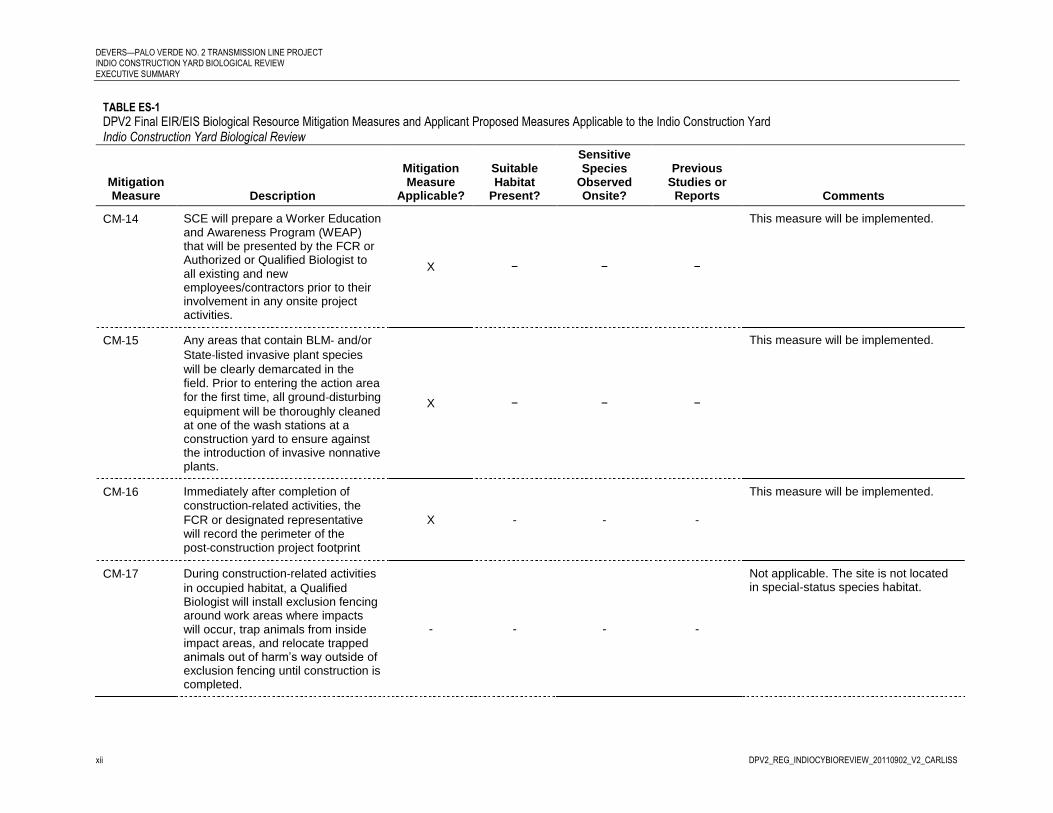
DEVERS—PALO VERDE NO. 2 TRANSMISSION LINE PROJECT INDIO CONSTRUCTION YARD BIOLOGICAL REVIEW EXECUTIVE SUMMARY
xii DPV2_REG_INDIOCYBIOREVIEW_20110902_V2_CARLISS
TABLE ES-1
DPV2 Final EIR/EIS Biological Resource Mitigation Measures and Applicant Proposed Measures Applicable to the Indio Construction Yard Indio Construction Yard Biological Review
Mitigation Measure Description
Mitigation Measure
Applicable?
Suitable Habitat
Present?
Sensitive Species
Observed Onsite?
Previous Studies or
Reports Comments
CM‐14 SCE will prepare a Worker Education and Awareness Program (WEAP) that will be presented by the FCR or Authorized or Qualified Biologist to all existing and new employees/contractors prior to their involvement in any onsite project activities.
X − − −
This measure will be implemented.
CM‐15 Any areas that contain BLM‐ and/or
State‐listed invasive plant species
will be clearly demarcated in the field. Prior to entering the action area for the first time, all ground‐disturbing
equipment will be thoroughly cleaned at one of the wash stations at a construction yard to ensure against the introduction of invasive nonnative plants.
X − − −
This measure will be implemented.
CM‐16 Immediately after completion of
construction‐related activities, the
FCR or designated representative will record the perimeter of the post‐construction project footprint
X - - -
This measure will be implemented.
CM‐17 During construction‐related activities
in occupied habitat, a Qualified Biologist will install exclusion fencing around work areas where impacts will occur, trap animals from inside impact areas, and relocate trapped animals out of harm’s way outside of exclusion fencing until construction is completed.
- - - -
Not applicable. The site is not located in special-status species habitat.

DEVERS—PALO VERDE NO. 2 TRANSMISSION LINE PROJECT INDIO CONSTRUCTION YARD BIOLOGICAL REVIEW
EXECUTIVE SUMMARY
DPV2_REG_INDIOCYBIOREVIEW_20110902_V2_CARLISS xiii
TABLE ES-1
DPV2 Final EIR/EIS Biological Resource Mitigation Measures and Applicant Proposed Measures Applicable to the Indio Construction Yard Indio Construction Yard Biological Review
Mitigation Measure Description
Mitigation Measure
Applicable?
Suitable Habitat
Present?
Sensitive Species
Observed Onsite?
Previous Studies or
Reports Comments
CM‐18 During construction in suitable habitat, work will only occur during daylight hours and no night lighting will be used in kangaroo rat habitat.
− − − GANDA,
2011
Not applicable. The site is not located in Stephens’ kangaroo rat habitat.
CM 19 During construction in suitable habitat, a load spreading device (e.g., plywood) will be used to reduce impacts to burrow systems.
− − − GANDA,
2011
Not applicable. The site is not located in Stephens’ kangaroo rat habitat.
CM‐20 To reduce the potential for kangaroo rats to utilize access roads, and therefore be subject to impact, along the DPV2 alignment, earthen berm heights will not exceed 13 centimeter (cm) [5 inches (in)] in height in suitable habitat.
− − − GANDA,
2011
Not applicable. The site is not located in Stephens’ kangaroo rat habitat.
CM‐21 No fuel modification will be conducted in suitable habitat
− − − GANDA,
2011 Not applicable. The site is not located in Stephens’ kangaroo rat habitat.
CM 22 To partially offset the impacts of permanent and temporary/long‐term
losses of kangaroo rat habitat associated with the proposed project, SCE will acquire at least 0.08 ha (0.20 ac) and restore/enhance at least 1.13 ha (2.80 ac) of kangaroo rat habitat.
− − − GANDA,
2011
Not applicable. The site is not located in Stephens’ kangaroo rat habitat.
CM‐23 To the extent possible, all construction activities in modeled habitat will be conducted outside of the seed germination and growing season, generally January to May.
- - - GANDA,
2011
Not applicable. The site is not located in Coachella Valley milk-vetch habitat.

DEVERS—PALO VERDE NO. 2 TRANSMISSION LINE PROJECT INDIO CONSTRUCTION YARD BIOLOGICAL REVIEW EXECUTIVE SUMMARY
xiv DPV2_REG_INDIOCYBIOREVIEW_20110902_V2_CARLISS
TABLE ES-1
DPV2 Final EIR/EIS Biological Resource Mitigation Measures and Applicant Proposed Measures Applicable to the Indio Construction Yard Indio Construction Yard Biological Review
Mitigation Measure Description
Mitigation Measure
Applicable?
Suitable Habitat
Present?
Sensitive Species
Observed Onsite?
Previous Studies or
Reports Comments
CM‐24 A Qualified Biologist will conduct preconstruction focused surveys in areas of the project in modeled habitat in the winter (generally January and February) preceding initiation of ground disturbing activities and be present throughout construction activities in modeled habitat.
- - - GANDA,
2011
Not applicable. The site is not located in Coachella Valley milk-vetch habitat.
CM‐25 Milk‐vetch locations identified during
the preconstruction surveys will be delineated on aerial photography, incorporated into the construction management plans, and avoided to the maximum extent possible.
- - - GANDA,
2011
Not applicable. The site is not located in Coachella Valley milk-vetch habitat.
CM‐26 To partially offset the impacts of permanent and temporary/long‐term
losses of milk‐vetch modeled habitat
associated with the proposed project, SCE will acquire at least 50.99 ha (126 ac) of milk‐vetch habitat.
- - - GANDA,
2011
Not applicable. The site is not located in Coachella Valley milk-vetch habitat.
CM‐27 To the extent possible, all construction activities within modeled/blow sand habitat will be conducted during the active season, between April and October (inclusive of both months).
- - - GANDA,
2011
Not applicable. The site is not located in blow sand habitat.

DEVERS—PALO VERDE NO. 2 TRANSMISSION LINE PROJECT INDIO CONSTRUCTION YARD BIOLOGICAL REVIEW
EXECUTIVE SUMMARY
DPV2_REG_INDIOCYBIOREVIEW_20110902_V2_CARLISS xv
TABLE ES-1
DPV2 Final EIR/EIS Biological Resource Mitigation Measures and Applicant Proposed Measures Applicable to the Indio Construction Yard Indio Construction Yard Biological Review
Mitigation Measure Description
Mitigation Measure
Applicable?
Suitable Habitat
Present?
Sensitive Species
Observed Onsite?
Previous Studies or
Reports Comments
CM‐28 A Qualified Biologist will conduct preconstruction clearance surveys immediately prior to the initiation of ground disturbing activities during the active season, between April and October inclusive of both months), in modeled/blow sand habitat and be present during all construction activities in these areas.
- - - GANDA,
2011
Not applicable. This site is not located in blow sand habitat.
CM‐29 If fringe‐toed or horned lizards are
found, the Qualified Biologist will capture and relocate any individuals to the nearest suitable habitat in modeled/blow sand habitat outside of the DPV1/DPV2 ROW.
- - - GANDA,
2011
Not applicable. This site is not located in fringe-toed or horned lizard habitat.
CM‐30 To partially offset the impacts of permanent and temporary/long-term losses of fringe-toed lizard habitat, SCE will acquire at least 35.61 ha (88 ac) of fringe-toed lizard habitat.
- - - GANDA,
2011
Not applicable. This site is not located in fringe-toed lizard habitat.
CM‐31 To partially offset the impacts of permanent and temporary/long-term losses of horned lizard habitat, SCE will acquire at least 12.95 ha (32 ac) of horned lizard habitat.
- - - GANDA,
2011
Not applicable. This site is not located in horned lizard habitat.
CM‐32 To the extent possible, all construction activities in modeled, critical, and occupied habitat will be conducted when tortoises are less active, generally November to March.
- - - GANDA,
2011
Not applicable. The site is not located in desert tortoise habitat.

DEVERS—PALO VERDE NO. 2 TRANSMISSION LINE PROJECT INDIO CONSTRUCTION YARD BIOLOGICAL REVIEW EXECUTIVE SUMMARY
xvi DPV2_REG_INDIOCYBIOREVIEW_20110902_V2_CARLISS
TABLE ES-1
DPV2 Final EIR/EIS Biological Resource Mitigation Measures and Applicant Proposed Measures Applicable to the Indio Construction Yard Indio Construction Yard Biological Review
Mitigation Measure Description
Mitigation Measure
Applicable?
Suitable Habitat
Present?
Sensitive Species
Observed Onsite?
Previous Studies or
Reports Comments
CM‐33 An Authorized Biologist will be present during all construction activities in tortoise habitat (modeled, critical habitat, and/or occupied habitat) during the tortoise’s more active season (April thru May and September thru October).
- - - GANDA,
2011
Not applicable. The site is not located in desert tortoise habitat.
CM‐34 The Authorized Biologist will conduct clearance surveys and tortoise handling following procedures outlined in the Service’s Desert Tortoise Field Manual (December 2009) or more current Service guidance.
- - - GANDA,
2011
Not applicable. The site is not located in desert tortoise habitat.
CM‐35 The Authorized Biologist will conduct preconstruction clearance surveys immediately prior to initiation of ground disturbing activities in tortoise habitat regardless of the time of year.
- - - GANDA,
2011
Not applicable. The site is not located in desert tortoise habitat.
CM‐36 Tortoises found on the surface during preconstruction clearance surveys or during construction activities will be moved out of harm’s way and released within 500 m (1,640 ft) from point of collection.
- - - GANDA,
2011
Not applicable. The site is not located in desert tortoise habitat.
CM‐37 Tortoises found in burrows during preconstruction clearance surveys or during construction activities during the species’ less active period (November to March) will be avoided to the extent practicable.
- - - GANDA,
2011
Not applicable. The site is not located in desert tortoise habitat.

DEVERS—PALO VERDE NO. 2 TRANSMISSION LINE PROJECT INDIO CONSTRUCTION YARD BIOLOGICAL REVIEW
EXECUTIVE SUMMARY
DPV2_REG_INDIOCYBIOREVIEW_20110902_V2_CARLISS xvii
TABLE ES-1
DPV2 Final EIR/EIS Biological Resource Mitigation Measures and Applicant Proposed Measures Applicable to the Indio Construction Yard Indio Construction Yard Biological Review
Mitigation Measure Description
Mitigation Measure
Applicable?
Suitable Habitat
Present?
Sensitive Species
Observed Onsite?
Previous Studies or
Reports Comments
CM‐38 During construction, parked vehicles will be inspected prior to being moved.
- - - GANDA,
2011
Not applicable. The site is not located in desert tortoise habitat.
CM‐39 Constructed road berms in modeled, critical, and occupied habitat will be less than 30.48 cm (12 in) in height and have slopes less than 30 degrees.
- - - GANDA,
2011
Not applicable. The site is not located in desert tortoise habitat.
CM‐40 A trash collection system will be established to ensure that all food and other trash that could attract tortoise predators is properly disposed of in self-closing, sealable containers with lids that latch to prevent wind, common ravens, and mammals from opening containers.
X X X -
This measure will be implemented.
CM‐41 Road-killed animals or other carcasses detected in the DPV2 ROW access road during DPV2-related construction activities will be picked up and disposed of immediately (e.g., removal to a landfill or disposal at SCE facility).
X − − -
This measure will be implemented.
CM‐42 SCE will implement a Raven Control Plan (RCP) to minimize avian predation on tortoise for the 30-year life of the proposed project.
− − − GANDA,
2011
Not applicable. This site is not located in desert tortoise habitat.
CM‐43 To partially offset the impacts of permanent and temporary/long-term losses of tortoise habitat, SCE will acquire at least 670.16 ha (1,656 ac) of tortoise habitat.
− − − GANDA,
2011
Not applicable. This site is not located in desert tortoise habitat.

DEVERS—PALO VERDE NO. 2 TRANSMISSION LINE PROJECT INDIO CONSTRUCTION YARD BIOLOGICAL REVIEW EXECUTIVE SUMMARY
xviii DPV2_REG_INDIOCYBIOREVIEW_20110902_V2_CARLISS
TABLE ES-1
DPV2 Final EIR/EIS Biological Resource Mitigation Measures and Applicant Proposed Measures Applicable to the Indio Construction Yard Indio Construction Yard Biological Review
Mitigation Measure Description
Mitigation Measure
Applicable?
Suitable Habitat
Present?
Sensitive Species
Observed Onsite?
Previous Studies or
Reports Comments
CM‐44 SCE will submit an O&M Plan for the DPV2 project to the BLM, Service, and CDFG within 90 days following the completion of construction activities.
− − − −
Not application. This is a temporary construction yard. This measure is for post-construction O&M activities.
CM‐45 SCE will submit an annual O&M work plan to the BLM, CDFG, and Service at least 3 months prior to the initiation of Class 1 and Class 2 O&M activities planned each calendar year.
− − − −
Not application. This is a temporary construction yard. This measure is for post-construction O&M activities.
CM‐46 SCE will report on the status of all O&M activities identified in the annual O&M work plan as part of the annual report
− − − −
Not application. This is a temporary construction yard. This measure is for post-construction O&M activities.
CM‐47 During emergency repairs, all Conservation Measures will be followed to the extent practicable.
− − − − Not application. This is a temporary construction yard. This measure is for post-construction O&M activities.
CM‐48 SCE will offset additional impacts to kangaroo rat, milk-vetch, fringe-toed or horned lizard, and tortoise modeled, critical, occupied, or suitable habitat associated with Class 2 and Class 4 O&M activities following the process and compensation ratios identified in CMs 22, 26, 30, 31, and 43 above.
− − − GANDA,
2011
Not applicable. The site is not located in special-status species habitat. No compensation is required.

DEVERS—PALO VERDE NO. 2 TRANSMISSION LINE PROJECT INDIO CONSTRUCTION YARD BIOLOGICAL REVIEW
EXECUTIVE SUMMARY
DPV2_REG_INDIOCYBIOREVIEW_20110902_V2_CARLISS xix
TABLE ES-1
DPV2 Final EIR/EIS Biological Resource Mitigation Measures and Applicant Proposed Measures Applicable to the Indio Construction Yard Indio Construction Yard Biological Review
Mitigation Measure Description
Mitigation Measure
Applicable?
Suitable Habitat
Present?
Sensitive Species
Observed Onsite?
Previous Studies or
Reports Comments
CM‐49 The area limits of project maintenance activities will be limited to the permanent disturbance areas noted on the final design engineering drawings and the vegetation-free buffers [typically 0.61 to 1.52 m (2 to 5 ft) beyond berm’s or road’s edge] for access and fire prevention along roads as described in the Routine ROW road maintenance (Class 2) description.
− − − −
Not application. This is a temporary construction yard. This measure is for post-construction O&M activities.
CM-50 All existing and new employees/contractors will undergo the WEAP (see CM 14) prior to their involvement in all Class 1 and Class 2 O&M activities.
− − − −
Not application. This is a temporary construction yard. This measure is for post-construction O&M activities.
CM‐51 During Class 2, ground-disturbing O&M activities in occupied habitat, a Qualified Biologist will determine if trapping is necessary to reduce harm to kangaroo rats.
− − − GANDA,
2011
Not applicable. The site is not located in special-status kangaroo rat habitat.
CM‐52 A Qualified Biologist will be present during Class 2, ground-disturbing O&M activities conducted in modeled habitat during the species’ seed germination and growing season, generally January to May.
− − − GANDA,
2011
Not applicable. The site is not located in special-status kangaroo rat habitat.

DEVERS—PALO VERDE NO. 2 TRANSMISSION LINE PROJECT INDIO CONSTRUCTION YARD BIOLOGICAL REVIEW EXECUTIVE SUMMARY
xx DPV2_REG_INDIOCYBIOREVIEW_20110902_V2_CARLISS
TABLE ES-1
DPV2 Final EIR/EIS Biological Resource Mitigation Measures and Applicant Proposed Measures Applicable to the Indio Construction Yard Indio Construction Yard Biological Review
Mitigation Measure Description
Mitigation Measure
Applicable?
Suitable Habitat
Present?
Sensitive Species
Observed Onsite?
Previous Studies or
Reports Comments
CM‐53 Class 2, ground-disturbing O&M activities within modeled/blow sand habitat, defined in the post-construction O&M Plan Maps, will be conducted between April and October (inclusive of both months) when air temperature is above 75 degrees Fahrenheit to minimize potential impacts to fringe-toed and horned lizards.
− − − −
Not applicable. The site is not located in fringe-toed or horned lizard blow sand habitat. This is a post-construction O&M activity.
CM‐54 To reduce direct impacts to fringe-toed and horned lizards during O&M activities, a Qualified Biologist will monitor all Class 2 ground-disturbing activities within modeled/blow sand habitat.
− − − GANDA,
2011
Not applicable. The site is not located in fringe-toed or horned lizard blow sand habitat. This is a post-construction O&M activity.
CM‐55 During the tortoise’s most active season (April thru May and September thru October), operators of heavy equipment (such as road graders) will be accompanied by an Authorized Biologist during Class 2 ground-disturbing O&M activities in tortoise modeled, critical habitat, and/or occupied habitat.
− − − GANDA,
2011
Not applicable. The site is not located in desert tortoise habitat. This is a post-construction O&M activity.
Notes: ac – acre(s) BLM – Bureau of Land Management CDFG – California Department of Fish and Game cm – centimeter(s) CM – conservation measure
e.g. – for example FCR – field contact representative ft – feet; foot ha – hectare(s) in – inch(es)
m – meter(s)MSHCP – Multiple Species Habitat Conservation Plan O&M – operations and maintenance ROW – right-of-way WEAP – Worker Environmental Awareness Program

DEVERS—PALO VERDE NO. 2 TRANSMISSION LINE PROJECT INDIO CONSTRUCTION YARD BIOLOGICAL REVIEW
EXECUTIVE SUMMARY
DPV2_REG_INDIOCYBIOREVIEW_20110902_V2_CARLISS xxi
This page intentionally left blank.

DPV2_REG_INDIOCYBIOREVIEW_20110902_V2_CARLISS
Contents
Executive Summary ...................................................................................................................... i
Acronyms and Abbreviations ................................................................................................... ii
1.0 Introduction ..................................................................................................................... 1
2.0 Project Overview ............................................................................................................. 1 2.1 Site Location ......................................................................................................... 2 2.2 Project Description .............................................................................................. 2
2.2.1 Site Description ...................................................................................... 2 2.2.2 Work Description ................................................................................... 2
3.0 Methods ............................................................................................................................ 1 3.1 Literature Review ................................................................................................ 1 3.2 Habitat Suitability Assessments ....................................................................... 1 3.3 Focused Surveys .................................................................................................. 2
3.3.1 Vegetation Community Mapping ....................................................... 2 3.3.2 Jurisdictional Delineation ..................................................................... 2 3.3.3 Plant Surveys .......................................................................................... 2 3.3.4 Special-status Wildlife Surveys ............................................................ 5
4.0 Results ............................................................................................................................... 1 4.1 Habitat Assessment ............................................................................................ 1 4.2 Plants .................................................................................................................... 1
4.2.1 Special-status Plants .............................................................................. 1 4.2.2 Invasive Plant Species ........................................................................... 6
4.3 Wildlife ................................................................................................................. 6 4.4 Vegetation Communities ................................................................................. 10
4.4.1 Developed Land ................................................................................... 10 4.4.2 Non-natural Vegetation Communities ............................................. 11
4.5 Jurisdictional Water (Hydrologic) Features .................................................. 11
5.0 Impact Summary ............................................................................................................. 1 5.1 Plants .................................................................................................................... 1 5.2 Wildlife ................................................................................................................. 1 5.3 Vegetation Communities ................................................................................... 1 5.4 Jurisdictional Water (Hydrologic) Features .................................................... 1
6.0 Conclusions ...................................................................................................................... 1
7.0 References ........................................................................................................................ 1

DEVERS—PALO VERDE NO. 2 TRANSMISSION LINE PROJECT INDIO CONSTRUCTION YARD BIOLOGICAL REVIEW
ACRONYMS AND ABBREVIATIONS
Appendix
A Photographs
Tables
1 DPV2 Final EIR/EIS Biological Resource Mitigation Measures, Applicant Proposed Measures, SEIR Biological Resource Mitigation Measures, and USFWS Conservation Measures Applicable to the Indio Construction Yard 2 Special-status Plant Species with Potential to Occur within the Survey Area 3 Special-status Wildlife Species with Potential to Occur within the Survey Area
Figures
1 Project Location Map 2A Site Map 2B Vegetation Communities

DPV2_REG_INDIOCYBIOREVIEW_20110902_V2_CARLISS ii
Acronyms and Abbreviations
Global
APM Applicant Proposed Measure
BLM Bureau of Land Management
CAISO California Independent System Operator
CEQA California Environmental Quality Act
CPCN Certificate of Public Convenience and Necessity
CPUC California Public Utilities Commission
CSLC California State Lands Commission
DPV1 Devers-Palo Verde No. 1 Transmission Line
DPV2 Devers-Palo Verde No. 2 Transmission Line Project
DSWTP Desert Southwest Transmission Line Project
EIR/EIS Environmental Impact Report/Environmental Impact Statement
kV kilovolt
NEPA National Environmental Policy Act
Project Devers-Palo Verde No. 2 Transmission Line Project
ROW right-of-way
SBNF San Bernardino National Forest
SCE Southern California Edison
USDA United States Department of Agriculture
USFS United States Forest Service
USFWS United States Fish and Wildlife Service
Report Specific
BMP best management practice
Cal-IPC California Invasive Plant Council
CDFA California Department of Food and Agriculture
CDFG California Department of Fish and Game

DEVERS—PALO VERDE NO. 2 TRANSMISSION LINE PROJECT INDIO CONSTRUCTION YARD BIOLOGICAL REVIEW
ACRONYMS AND ABBREVIATIONS
DPV2_REG_INDIOCYBIOREVIEW_20110902_V2_CARLISS iii
CDNPA California Desert Native Plant Act
CNDDB California Natural Diversity Database
CNPS California Native Plant Society
GPS Global Positioning System
MSHCP Multiple Species Habitat Conservation Plan
quad quadrangle
Report Indio Construction Yard Biological Review
RPR rare plant rank
site Indio Construction Yard
SWPPP Stormwater Pollution Prevention Plan
USACE United States Army Corp of Engineers
USGS United States Geological Survey

DPV2_REG_INDIOCYBIOREVIEW_20110902_V2_CARLISS 1
1.0 Introduction
The Indio Construction Yard Biological Review (Report) summarizes the results of the biological review conducted for the Indio Construction Yard (site) as an element of Southern California Edison’s (SCE) Devers-Palo Verde No. 2 500 kV Transmission Line Project (Project or DPV2). The study area included the 8.25-acre site and a 200-foot buffer, for a total of 22.15 acres. This biological review was conducted to evaluate refinements to the Project that have occurred since the Final Environmental Impact Report/Environmental Impact Statement (Final EIR/EIS) for the Project was certified by the California Public Utilities Commission (CPUC) in 2007 and subsequently modified as a California-only project by the CPUC (contingent upon California Independent System Operators [CAISO] approval) in 2009.

DEVERS—PALO VERDE NO. 2 TRANSMISSION LINE PROJECT INDIO CONSTRUCTION YARD BIOLOGICAL REVIEW 1.0 INTRODUCTION
2 DPV2_REG_INDIOCYBIOREVIEW_20110902_V2_CARLISS
This page intentionally left blank

DPV2_REG_INDIOCYBIOREVIEW_20110902_V2_CARLISS 1
2.0 Project Overview
SCE’s DPV2 will be constructed to provide electrical transmission infrastructure to deliver new conventional and renewable generation from the Blythe area to the CAISO grid. The Project will consist of a new 500 kilovolt (kV) electric transmission line, including fiber optic communication lines, upgrades to the Valley and Devers substations, and the new Colorado River Substation. The transmission line will extend approximately 153 miles from the proposed Colorado River Substation approximately 10 miles southwest of Blythe, California, through Devers Substation near Palm Springs, California, to Valley Substation in Menifee, California (See Figure 1: Project Location Map). Based on final design plans, the CPUC made a decision to allow inclusion of the Desert Southwest Transmission Line Project (DSWTP) Midpoint Substation site, which is the Colorado River Substation in the DPV2
Project1 (CPUC, 2009).
The DPV2 transmission line will be located within SCE’s right-of-way (ROW) parallel to the existing 500 kV Devers-Palo Verde No. 1 (DPV1) Transmission Line. The ROW traverses multiple jurisdictions including private, Riverside County, California State Lands Commission (CSLC), and federal lands. Federal lands are administered by the Bureau of Land Management (BLM), United States Forest Service (USFS), and United States Fish and Wildlife Service (USFWS).
The Project will consist of the following work elements:
Colorado River Substation to Devers Substation transmission line (Colorado River to Devers), including the new series capacitor bank adjacent to the existing DPV1 series capacitor bank
Devers Substation to Valley Substation transmission line (Devers to Valley)
New Colorado River Substation including dead-end structures, circuit breakers, and disconnect switches
Devers Substation expansion, including installation of a 500 kV line shunt reactor bank, dead-end structures, circuit breakers, and disconnect switches
Valley Substation upgrade, including installation of a 500 kV dead-end structure, circuit breakers, and disconnect switches
Distribution line extension for Colorado River Substation light and power
Telecommunication facilities
Temporary facilities such as construction yards, helicopter landing zones, and access and spur roads to support construction activities
1 The Colorado River Substation location is analyzed as the Midpoint Substation site in the DSWTP Final EIR/EIS, published by the Imperial Irrigation District and BLM in October 2005; it is also included in the DPV2 Final EIR/EIS as part of the Desert Southwest Transmission Project Alternative.

DEVERS—PALO VERDE NO. 2 TRANSMISSION LINE PROJECT INDIO CONSTRUCTION YARD BIOLOGICAL REVIEW 2.0 PROJECT OVERVIEW
2 DPV2_REG_INDIOCYBIOREVIEW_20110902_V2_CARLISS
The CPUC and BLM prepared a combined Final EIR/EIS (CPUC, 2006) evaluating potential impacts of the Project on the existing environment. Upon receipt of the Record of Decision, this Report may be amended to reflect the information in the clearance and approval documents.
2.1 Site Location
The proposed Indio Construction Yard is located directly north of Dr. Carreon Boulevard, east of Calhoun Street, and south of Date Avenue in the city of Indio, Riverside County, California (See Figure 2A: Site Map). The property is in the Indio United States Geological Survey (USGS) 7.5-minute quadrangle (quad). The Riverside County Assessor’s Parcel Numbers are 612130013 and 612130014. The site is surrounded by suburban development for at least four miles in all directions.
2.2 Project Description
2.2.1 Site Description
The proposed use of the Indio Yard is to support construction of the Colorado River Substation-Devers segment of DPV2. The proposed yard is approximately 8.25 acres on land that has been entirely disturbed by past construction activities (See Figure 2B: Vegetation Communities). Recently, the site has remained vacant allowing some invasive shrubs to become established and homeless people to establish camps. The site is bordered by developed and landscaped land to the north, the side of a building to the west, developed and disturbed land to the south, and disturbed land to the east. The average elevation of the Yard is 27 feet below mean sea level.
2.2.2 Work Description
The site will serve as a material and equipment storage yard to support construction activities associated with DPV2. Table 1 presents a list of facilities and activities that may be present or active at the site throughout the duration of the Project.
TABLE 1
Facilities and Activities Potentially Present or Active at the Site Throughout the Duration of the Project Indio Construction Yard Biological Review
Facilities Activities
Office trailers
Portable toilets
Security lighting
Screening
Material delivery and storage
Shipping containers
Fuel trucks and fuel storage tanks (less than 1,000 gallons)
Roll-off trash containers
Waste materials for recycling and disposal
Vehicle parking
Grubbing of vegetation
Installation of fencing and lighting
Installation of best management practices (BMPs) in accordance with the project’s Stormwater Pollution Prevention Plans (SWPPPs)
Implementation, installation, maintenance, and removal of permit requirements
Operation of construction equipment and vehicles
Installation of temporary power
Welding and torch activities
General office and security activities
Marshalling location

DEVERS-PALO VERDE NO. 2 TRANSMISSION LINE PROJECT INDIO CONSTRUCTION YARD BIOLOGICAL REVIEW
2.0 PROJECT OVERVIEW
DPV2_REG_INDIOCYBIOREVIEW_20110902_V2_CARLISS 3
Materials stored at the Indio Construction Yard may include the following:
Hardware
Tower steel
Insulators
Conductor reels
Signage
Consumables, such as fuel and joint compound
SWPPP materials, such as straw wattles, gravel bags, and silt fences
Waste materials for recycling or disposal
Upon completion of the Project, surplus materials, facilities, and services will be removed.

DEVERS—PALO VERDE NO. 2 TRANSMISSION LINE PROJECT INDIO CONSTRUCTION YARD BIOLOGICAL REVIEW 2.0 PROJECT OVERVIEW
4 DPV2_REG_INDIOCYBIOREVIEW_20110902_V2_CARLISS
The page intentionally left blank

DPV2_REG_INDIOCYBIOREVIEW_20110902_V2_CARLISS 1
3.0 Methods
The following section describes the methods used to review and assess biological resources associated with the proposed Indio Construction Yard.
3.1 Literature Review
Potential special-status species lists were queried from the California Natural Diversity Database (CNDDB), California Native Plant Society (CNPS), and USFWS databases for the Project. A nine-USGS-7.5-minute quad query was used for the CNDDB and CNPS lists, which includes the survey area quad and all adjacent quads. Species lists were derived from the following quads: Indio, Myoma, West Berdoo Canyon, Rockhouse Canyon, Thermal Canyon, Mecca, Valerie, and Martinez Mountain.
Plant and wildlife species were considered to be of special-status if they met one or more of the following criteria:
A species identified by the USFWS as endangered, threatened, proposed, or candidate for listing, or species of concern (USFWS, 1996; 2006; 2010a)
A species identified by the California Department of Fish and Game (CDFG) as endangered, threatened, proposed, or candidate for listing, rare, or species of special concern (CDFG, 2009a; CDFG, 2011)
Special species as defined by the CNDDB (CNDDB, 2011)
Designated by the CNPS in its California Rare Plant Rank (RPR) Inventory (CNPS, 2011)
Included in the Western Riverside Multiple Species Habitat Conservation Plan (Dudek, 2003)
Although SCE is exempt from the requirements of the California Desert Native Plant Act (CDNPA), biologists evaluated the potential for plant species protected by the CDNPA as well as invasive plant species based on their status in one or more of these categories:
Included on the lists of weeds by the California Invasive Plant Council (Cal-IPC) (2006)
Included in the weed list of California Department of Food and Agriculture (CDFA, 2010)
Those species protected by the CDNPA (CDFA, 2010b)
3.2 Habitat Suitability Assessments
A habitat suitability assessment was conducted to determine the presence of vegetation communities that could support special-status wildlife and plant species, and determine the need for focused surveys of species identified during the literature review. Potentially suitable habitat was assessed using species-specific requirements including:

DEVERS—PALO VERDE NO. 2 TRANSMISSION LINE PROJECT INDIO CONSTRUCTION YARD BIOLOGICAL REVIEW 3.0 METHODS
2 DPV2_REG_INDIOCYBIOREVIEW_20110902_V2_CARLISS
Vegetation type (for example, active sand dunes)
Habitat components (for example, substrate type, vegetation hummocks)
Species specific sign (for example, burrows, scat, feathers)
Other indicators of potentially suitable habitat for identified special-status species
Wildlife species were also detected during field surveys by sight, calls, tracks, scat, or other signs. In addition to observed species, expected wildlife usage of the area was determined according to known habitat preferences of regional wildlife species and knowledge of their relative distribution in the area. Special-status plant and wildlife species were given a potential for occurrence based on a scale of no, low, moderate, or high potential to occur. No potential to occur indicates that there is no suitable habitat for the species. Low potential to occur indicates that there is marginal suitable habitat present. Moderate potential to occur indicates that suitable habitat is present and the species has documented ranges in the area. High potential to occur indicates that there is optimal habitat and/or the species was found in the survey area. No trapping or focused surveys for special-status or nocturnal species was conducted.
Plant species encountered during the field surveys were identified and recorded. Latin and common names of plants follow the Jepson Manual (Hickman, 1996) or more recent published taxonomical revisions of genera. The area was surveyed for habitat and soil conditions that are known to support special-status plant species.
3.3 Focused Surveys
3.3.1 Vegetation Community Mapping
Vegetation mapping of the Indio Construction Yard and a 200-foot buffer was conducted during the July 2011 field survey (GANDA, 2011). When possible, vegetation nomenclature followed the List of Terrestrial Natural Communities (CDFG, 2003) and the List of California Vegetation Alliances (CDFG, 2009b); however, developed and non-natural lands are not described on these lists.
3.3.2 Jurisdictional Delineation
Preliminary identification and mapping of aquatic resources potentially falling under the jurisdiction of the United States Army Corp of Engineers (USACE) or CDFG was conducted during the July 2011 field survey. The extent of these features, when found, were mapped based on aerial photographs, USGS topographic maps, the National Wetlands Inventory (USFWS, 2010b), global positioning system (GPS) data, and notes recorded in the field.
3.3.3 Plant Surveys
Special-status Plant Surveys
Biologists performed reconnaissance-level special-status plant surveys during the site visit in July 2011. Meandering transects were walked to provide 100 percent coverage over the survey area. Twenty-eight special-status species were identified in the nine-quad literature search as having the potential to occur within the study area. Out of those 28 species, 8 had known distributions, habitats, or elevational ranges that precluded their possible occurrence in the vicinity of the site; and these 8 species were not further considered (San Bernardino milk-vetch [Astragalus bernardinus], Booth’s evening primrose [Camissonia boothii ssp. boothii],

DEVERS-PALO VERDE NO. 2 TRANSMISSION LINE PROJECT INDIO CONSTRUCTION YARD BIOLOGICAL REVIEW
3.0 METHODS
DPV2_REG_INDIOCYBIOREVIEW_20110902_V2_CARLISS 3
prickle-leaf [Hecastocleis shockleyi], shaggy-haired alumroot [Heuchera hirsutissima], Santa Rosa Mountains leptosiphon [Leptosiphon floribundus ssp. hallii], California marina [Marina orcuttii var. orcuttii], creamy blazing star [Mentzelia tridentate], and Sonoran maiden fern [Thelypteris puberula var. sonorensis]). The remaining 20 species were used as the target list for the habitat assessment (see Table 2).
TABLE 2
Special-status Plant Species with the Potential to Occur within the Survey Area Indio Construction Yard Biological Review
Scientific Name Common Name
Statusa
USFWS/CA/MSHCP/CNPS Habitat Potential for Occurrence
Abronia villosa var. aurita
chaparral sand-verbena
--/SR/--/1B.1 Chaparral, coastal scrub.
None. No potential to occur.
No suitable habitat present.
Antirrhinum cyathiferum
Deep Canyon snapdragon
--/SR/--/2.3 Sonoran desert scrub, rocky sites.
None. No potential to occur.
No suitable habitat present.
Astragalus lentiginosus var. borreganus
Borrego milk-vetch
--/SR/--/4.3 Mojavean and Sonoran desert scrub. Sandy flats and semi-stabilized dunes.
Low. Marginal habitat within
known range.
Astragalus lentiginosus var. coachellae
Coachella Valley milk-vetch
FE/SR/--/1B.2 Sonoran desert scrub, sandy flats, washes, dunes.
None to Low. Sandy soils
present onsite, but highly unlikely potential for seeds from other populations to travel onto the site.
Astragalus tricarinatus
triple-ribbed milk-vetch
FE/SR/--/1B.2 Joshua tree woodland, Sonoran desert scrub.
None. No potential to occur.
No suitable habitat present.
Ayenia compacta
California ayenia
--/SR/--/2.3 Mojavean and Sonoran desert scrub. Washes and dry canyons.
None. No potential to occur.
No suitable habitat present.
Bursera microphylla
little-leaf elephant tree
--/SR/--/2.3 Sonoran desert scrub. Hillsides, washes, canyon sides, rocky sites.
None. No potential to occur.
No suitable habitat present.
Chamaesyce abramsiana
Abrams' spurge
--/SR/--/2.2 Mojavean desert scrub, Sonoran desert scrub.
Low. Marginal habitat
present.
Chamaesyce arizonica
Arizona spurge
--/SR/--/2.3 Sonoran desert scrub. None. No potential to occur.
No suitable habitat present.
Ditaxis claryana
glandular ditaxis
--/SR/--/2.2 Mojavean desert scrub, Sonoran desert scrub, in dry washes and on rocky hillsides.
None. No potential to occur.
No suitable habitat present.

DEVERS—PALO VERDE NO. 2 TRANSMISSION LINE PROJECT INDIO CONSTRUCTION YARD BIOLOGICAL REVIEW 3.0 METHODS
4 DPV2_REG_INDIOCYBIOREVIEW_20110902_V2_CARLISS
TABLE 2
Special-status Plant Species with the Potential to Occur within the Survey Area Indio Construction Yard Biological Review
Scientific Name Common Name
Statusa
USFWS/CA/MSHCP/CNPS Habitat Potential for Occurrence
Ditaxis serrata var. californica
California ditaxis
--/SR/--/3.2 Sonoran desert scrub; on Sandy washes and alluvial fans.
None. No potential to occur.
No suitable habitat present.
Nemacaulis denudata var. gracilis
slender cottonheads
--/SR/--/2.2 Coastal dunes, desert dunes, Sonoran desert scrub.
None. No potential to occur.
No suitable habitat present.
Phaseolus filiformis
slender-stem bean
--/SR/--/2.1
Sonoran desert scrub; gravelly washes.
None. No potential to occur.
No suitable habitat present.
Saltugilia latimeri
Latimer's woodland-gilia
--/SR/--/1B.2 Chaparral, Mojavean desert scrub. Rocky or sandy substrate.
None. No potential to occur.
No suitable habitat present.
Selaginella eremophila
desert spike-moss
--/SR/--/2.2 Sonoran desert scrub. Prefers shaded sites, gravelly soils, and crevices.
None. No potential to occur.
No suitable habitat present.
Senna covesii
Coves' cassia
--/SR/--/2.2 Sonoran desert scrub; dry, sandy desert washes, slopes.
None. No potential to occur.
No suitable habitat present.
Stemodia durantifolia
purple stemodia
--/SR/--/2.1 Sonoran desert scrub. None. No potential to occur.
Out of elevation range of species.
Wislizenia refracta ssp. palmeri
Palmer's jackass clover
--/SR/--/2.2 Chenopod scrub, Sonoran desert scrub, Sonoran thorn woodland, desert dunes, desert wash.
None. No potential to occur.
No suitable habitat present.
Wislizenia refracta ssp. refracta
jackass clover
--/SR/--/2.2 Playas, desert dunes, Mojavean and Sonoran desert scrub.
None. No potential to occur.
No suitable habitat present.
Xylorhiza cognata
Mecca-aster
--/SR/--/1B.2 Sonoran desert scrub; steep canyon slopes in sandstone and clay.
None. No potential to occur.
No suitable habitat present.
Notes: Source: Nine-quad CNDDB and CNPS search conducted June 30, 2011
aConservation status abbreviations:
USFWS designations: FE: Endangered FT: Threatened FC: Candidate
California state designations: SE: Endangered ST: Threatened SR: Rare
CA – California MSHCP – Multiple Species Habitat Conservation Plan WR – Covered in the Western Riverside MSHCP

DEVERS-PALO VERDE NO. 2 TRANSMISSION LINE PROJECT INDIO CONSTRUCTION YARD BIOLOGICAL REVIEW
3.0 METHODS
DPV2_REG_INDIOCYBIOREVIEW_20110902_V2_CARLISS 5
Invasive Plant Species
An invasive plant species is a non-native plant that is included on the weed lists of the CDFA or Cal-IPC (CDFA, 2010; Cal-IPC, 2006). Biologists recorded the presence of invasive plant species and their location on field datasheets within the site boundary and 200-foot buffer area. Invasive plant species were noted on field mapping, but not mapped with GPS units.
3.3.4 Special-status Wildlife Surveys
Reconnaissance level surveys were conducted to record incidental observations of special-status wildlife species. Biologists meandered within the proposed yard location giving special attention to potentially suitable habitat for special-status wildlife species: Aeolian sand dunes, raised berms, potential bat roosting locations, and so forth. Biologists recorded any observations of active or inactive nests within the proposed site and 200-foot buffer. Representative photographs were taken at direct or indirect species sign where applicable. No protocol-level wildlife surveys were conducted during the July 2011 field survey. Twenty-three special-status species were identified in the CNDDB search as having the potential to occur within the study area. Out of those 23 species, four (desert pupfish [Cyprinodon macularius], yellow-breasted chat [Icteria virens], peninsular bighorn sheep [Ovis canadensis nelson], and Couch's spadefoot [Scaphiopus couchii]) had known distributions, habitats, or elevational ranges that precluded their possible occurrence in the vicinity of the site and were not further considered. The remaining 19 species were used as the target list for the habitat assessment (see Table 3).

DEVERS—PALO VERDE NO. 2 TRANSMISSION LINE PROJECT INDIO CONSTRUCTION YARD BIOLOGICAL REVIEW 3.0 METHODS
6 DPV2_REG_INDIOCYBIOREVIEW_20110902_V2_CARLISS
TABLE 3
Special-status Wildlife Species with the Potential to Occur within the Survey Area Indio Construction Yard Biological Review
Scientific Name Common Name
Statusa
FWS/CA/MSHCP Habitat
Potential for Occurrence
Antrozous pallidus
pallid bat
--/SSC/-- Open dry habitats with rocky areas for roosting.
Low. May roost in
nearby buildings.
Athene cunicularia
burrowing owl
--/SSC/-- Open, dry annual or perennial grasslands, deserts, scrublands.
None. Within range, but
no suitable habitat present.
Chaetodipus fallax fallax
northwestern San Diego pocket mouse
--/SSC/-- Coastal scrub, chaparral, grasslands, sagebrush, etc; sandy, herbaceous areas.
None. No potential to
occur. No suitable habitat present. Out of range.
Chaetodipus fallax pallidus
pallid San Diego pocket mouse
--/SSC/-- Desert border areas like desert wash, desert scrub, pinyon-juniper, etc.
None. No potential to
occur. No suitable habitat present. Out of range.
Euderma maculatum
spotted bat
--/SSC/-- Occupies arid deserts through grasslands through mixed conifer forests. Roosts in cliffs.
None. No potential to
occur. No suitable roosting habitat present.
Eumops perotis californicus
western mastiff bat
--/SSC/-- Open, semi-arid to arid habitats; roosts in crevices in cliff faces, buildings, and trees.
Low. Potentially
suitable roosting habitat in nearby palm trees.
Gopherus agassizii
desert tortoise
FT/ST/-- Desert scrub, desert wash, Joshua tree woodland.
None. No potential to
occur. No suitable habitat present.
Lanius ludovicianus
loggerhead shrike
--/SSC/-- Broken woodlands; savannahs, pinyon-juniper, Joshua tree, and riparian woodlands; desert oases scrub and washes.
None. No potential to
occur. No suitable nesting habitat present.
Lasiurus xanthinus
western yellow bat
--/SSC/-- Valley foothill riparian, desert riparian, desert wash, and palm oases.
Low. Potential roosting
habitat in nearby palm trees.
Neotoma lepida intermedia
San Diego desert woodrat
--/SSC/-- Coastal scrub w/ moderate-dense canopies; rocky outcrops, cliffs, and slopes.
None. No potential to
occur. No suitable habitat present.
Nyctinomops femorosaccus
pocketed free-tailed bat
--/SSC/-- Pine-juniper woodlands, desert scrub, palm oasis, desert wash, and desert riparian. Rocky areas with high cliffs.
None. No potential to
occur. No suitable roosting habitat present.
Perognathus longimembris bangsi
Palm Springs pocket mouse
--/SSC/-- Creosote-dominated desert scrub.
None. No potential to
occur. No suitable

DEVERS-PALO VERDE NO. 2 TRANSMISSION LINE PROJECT INDIO CONSTRUCTION YARD BIOLOGICAL REVIEW
3.0 METHODS
DPV2_REG_INDIOCYBIOREVIEW_20110902_V2_CARLISS 7
TABLE 3
Special-status Wildlife Species with the Potential to Occur within the Survey Area Indio Construction Yard Biological Review
Scientific Name Common Name
Statusa
FWS/CA/MSHCP Habitat
Potential for Occurrence
habitat present.
Phrynosoma mcallii
Flat-tailed horned lizard
FC/SSC/-- Desert dunes, Mojavean desert scrub, Sonoran desert scrub and Joshua tree woodland.
None. No potential to
occur. No suitable habitat or food source present.
Taxidea taxus
American badger
--/SSC/-- Dry, open shrub, forest, and herbaceous habitats with friable soils.
None. No potential to
occur. No suitable habitat present.
Toxostoma crissale
crissal thrasher
--/SSC/-- Nests in dense vegetation along desert streams/washes.
None. No potential to
occur. No suitable nesting habitat present.
Toxostoma lecontei
Le Conte’s thrasher
--/SSC/-- Nests in dense, spiny shrubs or cacti in desert wash habitat.
None. No potential to
occur. No suitable nesting habitat present.
Uma Inornata
Coachella Valley fringe-toed lizard
--/SSC/-- Fine, loose, windblown sand in sand dunes, desert scrub.
None. No potential to
occur. No suitable blowsand habitat present.
Xerospermophilus tereticaudus chlorus
Palm Springs round-tailed ground squirrel
--/SSC/-- Desert succulent scrub, desert wash, desert scrub, alkali scrub, and levees.
None. No potential to
occur. No suitable habitat present.
Source: Nine-quad CNDDB search conducted July 11, 2011
Notes: aConservation status abbreviations:
USFWS designations: FE: Endangered FT: Threatened FC: Candidate
California state designations: SE: Endangered ST: Threatened SR: Rare SSC: Species of Special Concern
CA – California WR – Covered in the Western Riverside MSHCP

DEVERS—PALO VERDE NO. 2 TRANSMISSION LINE PROJECT INDIO CONSTRUCTION YARD BIOLOGICAL REVIEW 3.0 METHODS
8 DPV2_REG_INDIOCYBIOREVIEW_20110902_V2_CARLISS
This page intentionally left blank.
DPV2_REG_INDIOCYBIOREVIEW_20110902_V2_CARLISS 1
4.0 Results
The following section summarizes the results from the biological surveys and reviews listed in Section 3 of this report.
4.1 Habitat Assessment
During the July 2011 field survey, potentially suitable habitat for sensitive plants and wildlife species was observed within the Indio Construction Yard survey area. The site has disturbed, sandy soils that provide marginally suitable habitat for special-status Abrams’ spurge, Arizona spurge, Borrego milk-vetch, and Coachella Valley milk-vetch species. Potentially suitable bat roosting habitat is located in the palm trees bordering the lot directly north of the site. There are also several open ponds of water located 0.4 miles east of the site at the Valley Sanitary District that provide potentially suitable foraging grounds for bats.
4.2 Plants
4.2.1 Special-status Plants
During the July 2011 surveys, no special-status plant species were observed within the survey area. Special-status plants not observed, but identified in the literature search as having the potential to occur on the Project site are described below. Surveys were conducted outside of the blooming period for Abrams’ spurge, Arizona spurge, Borrego milk-vetch, California ayenia, Coachella Valley milk-vetch, Coves’cassia, creamy blazing star, Deep Canyon snapdragon, desert spike moss, glandular ditaxis, Latimer’s woodland gilia, Mecca-aster, San Bernardino milk-vetch, slender cottonheads, slender-stem bean, and triple-ribbed milk-vetch. However, the milk-vetches should have been visible as dry remains; the ayenia, cassia and ditaxis are low subshrubs or shrubs and would be seen; and the Mecca-aster is very observable with the dry flowers remaining and obvious.
Chaparral Sand-verbena (Abronia villosa var. aurita)
Chaparral sand-verbena is an annual herb in the Four-O’-Clock family (Nyctaginaceae) found in chaparral and coastal scrub communities. It is often associated with sandy areas. It ranges in elevation from 260 to 5,680 feet (CNPS, 2011). It has no state or federal listing status, but is included on CNPS List 1B.1, indicating that it is rare, threatened, or endangered in California and elsewhere, with a high threat level in California. In California, chaparral sand-verbena has been found in Imperial, Los Angeles, Orange, Riverside, San Bernardino, San Diego, and Ventura counties (CNPS, 2011). The closest known occurrence of chaparral sand-verbena is approximately 3 miles northwest of the site off Indio Boulevard (UC/JEPS 2011). A one-hundred percent coverage survey of the site was conducted during the blooming period for this species and no individuals were observed onsite.
Deep Canyon Snapdragon (Antirrhinum cyathiferum)
Deep Canyon snapdragon is an annual herb in the Plantain family (Plantaginaceae) found in Sonoran desert scrub communities. It is often associated with rocky areas. It ranges in elevation from 0 to 2,625 feet (CNPS, 2011). It has no state or federal listing status, but is

DEVERS-PALO VERDE NO. 2 TRANSMISSION LINE PROJECT INDIO CONSTRUCTION YARD BIOLOGICAL REVIEW 4.0 RESULTS
2 DPV2_REG_INDIOCYBIOREVIEW_20110902_V2_CARLISS
included on the CNPS List 2.3, indicating that it is rare, threatened, or endangered in California, but more common elsewhere, with a low threat level in California. In California, Deep Canyon snapdragon is only known to occur in two locations in the Deep Canyon area in Riverside County, over 10 miles southwest of the site (CNPS, 2011). A one-hundred percent coverage survey of the site was conducted and no suitable habitat for this species was observed onsite.
Borrego Milk-vetch (Astragalus lentiginosus var. borreganus)
Borrego milk-vetch is an annual herb in the Pea family (Fabaceae) found on sandy substrates within Mojavean and Sonoran desert scrub communities. It is often associated with sandy flats, washes, outwash fans, and sometimes grows on sand dunes. It ranges in elevation from 100 to 900 feet. It has no state or federal listing status, but is included on CNPS List 4.3, indicating that it is a plant of limited distribution (CNPS, 2011). In California, Borrego milk-vetch has been found only in Riverside County (CNPS, 2011). The closest known occurrence of Borrego milk-vetch is approximately 4.5 miles northwest of the site, northeast of the Interstate 10 Freeway interchange at Jefferson (UC/JEPS, 2011). There is marginal habitat for Borrego milk-vetch onsite, and it is within its known range. There is a low potential for this species to occur onsite. A one-hundred percent coverage survey of the site was conducted for this species and no visible remains were observed onsite.
Coachella Valley Milk-vetch (Astragalus lentiginosus var. coachellae)
Coachella Valley milk-vetch is an annual to perennial herb in the Pea family (Fabaceae) found in desert dunes and Sonoran desert scrub communities. It is often associated with sandy flats, washes, outwash fans, and sometimes grows on dunes. It ranges in elevation from 130 to 2,160 feet. It has no state listing status, but is federally endangered and is included on CNPS List 1B.2, indicating that it is rare, threatened, or endangered in California and elsewhere, with a moderate threat level in California (CNPS, 2011). In California, Coachella Valley milk-vetch has been found only in Riverside County (CNPS, 2011). The closest occurrence of Coachella Valley milk-vetch is over 12.5 miles northwest of the site, 3 miles east of Date Palm Drive; and the site is surrounded by a minimum of approximately 4 miles of developed land cover in all directions (UC/JEPS, 2011). While potentially suitable disturbed, sandy habitat conditions for this species exists onsite, the aforementioned factors make the possibility of Coachella Valley milk-vetch seeds being transported onto the site highly unlikely.
Triple-ribbed Milk-vetch (Astragalus tricarinatus)
Triple-ribbed milk-vetch is a shrub in the Pea family (Fabaceae) found in Joshua tree woodland and Sonoran desert scrub. It is often associated with hot, rocky slopes in canyons and along edge of boulder-strewn desert washes, with creosote bush and brittle bush. It ranges in elevation from 1,485 to 3,930 feet (CNPS, 2011). It has no state listing status, but is federally endangered and is included on CNPS List 1B.2, indicating that it is rare, threatened, or endangered in California and elsewhere, with a moderate threat level in California. In California, triple-ribbed milk-vetch has been found in Riverside and San Bernardino counties (CNPS, 2011). The closest known occurrence of triple-ribbed milk-vetch is over 10.5 miles northwest of the site off Thousand Palms Canyon Road (UC/JEPS, 2011). During a one-hundred percent coverage survey of the site, no visible remains of this species and no suitable habitat for this species were observed onsite.

DEVERS-PALO VERDE NO. 2 TRANSMISSION LINE PROJECT INDIO CONSTRUCTION YARD BIOLOGICAL REVIEW
4.0 RESULTS
DPV2_REG_INDIOCYBIOREVIEW_20110902_V2_CARLISS 3
California Ayenia (Ayenia compacta)
California ayenia is a perennial herb in the Cacao family (Sterculiaceae) found in Mojavean desert scrub and Sonoran desert scrub communities. It is also associated with sandy and gravelly washes in the desert as well as dry desert canyons. It ranges in elevation from 495 to 3,615 feet (CNPS, 2011). It has no state or federal listing status, but is included on CNPS List 2.3, indicating that it is rare, threatened, or endangered in California, but more common elsewhere (ibid.), with a low threat level in California. In California, California ayenia has been found in Riverside, San Bernardino, and San Diego counties (CNPS, 2011). The closest known location of California ayenia is over 9 miles southwest of the site in the Canyons of the Santa Rosa Mountains (UC/JEPS, 2011). A one-hundred percent coverage survey of the site revealed no suitable habitat for this species.
Little-leaf Elephant Tree (Bursera microphylla)
Little-leaf elephant tree is a perennial deciduous tree in the Torchwood family (Burseraceae) found in Sonoran desert scrub communities. It is often associated with rocky areas. It ranges in elevation from 656 to 2,297 feet (CNPS, 2011). It has no state or federal listing status, but is included on the CNPS List 2.3, indicating that it is rare, threatened, or endangered in California, but more common elsewhere, with a low threat level in California. In California, little-leaf elephant tree has been found in Imperial, Riverside, and San Diego counties (CNPS, 2011). The closest known location of little-leaf elephant tree is over 13 miles southwest of the site in Martinez Canyon in the Santa Rosa Mountains (UC/JEPS, 2011). No little-leaf elephant trees were observed during a one-hundred percent coverage survey of the site.
Abrams' Spurge (Chamaesyce abramsiana)
Abrams’ spurge is an annual herb in the Spurge family (Euphorbiaceae) found in Mojavean desert scrub and Sonoran desert scrub communities. It is often associated with sandy soils. It ranges in elevation from 16 feet below sea level to 3,002 feet above sea level (CNPS, 2011). It has no state or federal listing status, but is included on CNPS List 2.2, indicating that it is rare, threatened, or endangered in California, but more common elsewhere, with a moderate threat level in California (CNPS, 2011). In California, Abrams’ spurge has been found in Imperial, Riverside, San Bernardino, and San Diego counties. The closest known occurrence of Abrams’ spurge is approximately 5.3 miles northwest of the site on Country Club Drive east of Palm Desert (UC/JEPS, 2011). There is marginal habitat for Abrams’ spurge present onsite, giving it a low potential to occur.
Arizona Spurge (Chamaesyce arizonica)
Arizona spurge is a perennial herb in the Spurge family (Euphorbiaceae) found on sandy soils in Sonoran desert scrub communities. It ranges in elevation from 165 to 990 feet (CNPS, 2011). It has no state or federal listing status, but is included on CNPS List 2.3, indicating that it is rare, threatened, or endangered in California, but more common elsewhere, with a low threat level in California. In California, Arizona spurge has been found in Imperial, Riverside, and San Diego counties (CNPS, 2011). The closest known occurrence of Arizona spurge is over 20 miles west-northwest of the site in Andreas Canyon (UC/JEPS, 2011). This species was not observed during a one-hundred percent coverage survey of the site.

DEVERS-PALO VERDE NO. 2 TRANSMISSION LINE PROJECT INDIO CONSTRUCTION YARD BIOLOGICAL REVIEW 4.0 RESULTS
4 DPV2_REG_INDIOCYBIOREVIEW_20110902_V2_CARLISS
Glandular Ditaxis (Ditaxis claryana)
Glandular ditaxis is a perennial herb in the Spurge family (Euphorbiaceae) found in Mojavean desert scrub and Sonoran desert scrub communities on sandy soils. It ranges in elevation from 0 to 1,526 feet (CNPS, 2011). It has no state or federal listing status, but is included on CNPS List 2.2, indicating that it is rare, threatened, or endangered in California, but more common elsewhere, with a moderate threat level in California (CNPS, 2011). In California, glandular ditaxis has been found in Imperial, Riverside, and San Bernardino counties. The closest known occurrence of glandular ditaxis is approximately one mile northwest of the site on the side of Interstate-10 (UC/JEPS, 2011). During a one-hundred percent coverage survey of the site, this species was not observed.
California Ditaxis (Ditaxis serrata var. californica)
California ditaxis is a perennial herb in the Spurge family (Euphorbiaceae) found in Sonoran desert scrub communities. It ranges in elevation from 98 to 3,280 feet (CNPS, 2011). It has no state or federal listing status, but is included on CNPS List 3.2, indicating that it needs further review, with a moderate threat level in California (CNPS, 2011). California, ditaxis is known from fewer than twenty occurrences in Imperial, Riverside, San Bernardino, and San Diego counties. The closest known occurrence of California ditaxis is approximately 7 miles southwest of the site at the eastern foot of Indio Mountain (UC/JEPS, 2011). During a one-hundred percent coverage survey of the site, this species was not observed.
Slender Cottonheads (Nemacaulis denudata var. gracilis)
Slender cottonheads is an annual herb in the Knotweed family (Polygonaceae) found in coastal dunes, desert dunes, and sandy habitats within Sonoran desert scrub communities. It ranges in elevation from 165 to 1,320 feet (CNPS, 2011). It has no state or federal listing status, but is included on CNPS List 2.2, indicating that it is rare, threatened, or endangered in California, but more common elsewhere, with a moderate threat level in California (CNPS, 2011). In California, slender cottonheads has been found in Imperial, Riverside, San Bernardino, and San Diego counties. The closest known occurrence of slender cottonheads is over 6.5 miles west-northwest of the site growing in the sand dunes at the intersection of Bay Club Drive and Highway 111 (UC/JEPS, 2011). No suitable habitat for this species was observed during a one-hundred percent coverage survey of the site.
Slender-stem Bean (Phaseolus filiformis)
Slender-stem bean is an annual herb in the Pea family (Fabaceae) found in Sonoran desert scrub communities. The elevation range is unknown for this plant. It has no state or federal listing status, but is included on CNPS List 2.1, indicating that it is rare, threatened, or endangered in California, but more common elsewhere, with a very high threat level in California (CNPS, 2011). In California, slender-stem bean is known from only one occurrence in the Coachella Valley in Riverside County, over 13 miles south of the site at the desert foot of the Santa Rosa Mountains (CNPS, 2011). No suitable habitat for this species was observed during a one-hundred percent coverage survey of the site.
Latimer’s Woodland Gilia (Saltugilia latimeri)
Latimer’s woodland gilia is an annual herb in the Phlox family (Polemoniaceae) found in chaparral, pinyon and juniper woodland, and Mojavean desert scrub communities. It is often associated with rocky or sandy substrates. It ranges in elevation from 1,320 to 6,270

DEVERS-PALO VERDE NO. 2 TRANSMISSION LINE PROJECT INDIO CONSTRUCTION YARD BIOLOGICAL REVIEW
4.0 RESULTS
DPV2_REG_INDIOCYBIOREVIEW_20110902_V2_CARLISS 5
feet (CNPS, 2011). It has no state or federal listing status, but is included on CNPS List 1B.2, indicating that it is rare, threatened, or endangered in California and elsewhere, with a moderate threat level in California. In California, Latimer’s woodland gilia has been found in Inyo, Kern, Riverside, and San Bernardino counties (CNPS, 2011). The closest known occurrence of Latimer’s woodland gilia is over 15.5 miles southwest of the site in the San Jacinto Mountains region (UC/JEPS, 2011). The site is below the usual elevational range of this species, and during a one-hundred percent coverage survey no suitable habitat for this species was observed.
Desert Spike-moss (Selaginella eremophila)
Desert spike-moss is a rhizomatous herb in the Clubmoss family (Selaginellaceae) found on gravelly or rocky substrate within Sonoran desert scrub communities. It is often associated with shaded sites, gravelly soils, and crevices among rocks. It ranges in elevation from 660 to 2,970 feet (CNPS, 2011). It has no state or federal listing status, but is included on CNPS List 2.2, indicating that it is rare, threatened, or endangered in California, but more common elsewhere, with a moderate threat level in California. In California, desert spike-moss has been found in Riverside and San Diego counties. The closest known occurrence of desert spike-moss is approximately 16 miles west-northwest of the site in Eagle Canyon (UC/JEPS 2011). No suitable habitat for this species was observed during a one-percent coverage survey of the site.
Coves' Cassia (Senna covesii)
Coves’ cassia is a perennial herb in the Pea family (Fabaceae) found in sandy Sonoran desert scrub communities. It ranges in elevation from 1,001 to 3,510 feet (CNPS 2011). It has no state or federal listing status, but is included on CNPS List 2.2, indicating that it is rare, threatened or endangered in California, but more common elsewhere (CNPS 2011), with a moderate threat level in California. In California, Coves’ cassia has been found in Imperial, Riverside, San Bernardino, and San Diego counties. The closest known occurrence of Coves’ cassia is a historic record approximately 3 miles southeast of the site near 9th Avenue (UC/JEPS 2011). The site is below the usual elevational range of this species, and no suitable habitat was observed onsite.
Purple Stemodia (Stemodia durantifolia)
Purple stemodia is a perennial herb in the Figwort family (Scrophulariaceae) found in Sonoran Desert Scrub communities. It is often associated with sandy soils and mesic sites. It ranges in elevation from 590 to 990 feet (CNPS, 2011). It has no state or federal listing status, but is included on CNPS List 2.1, indicating that it is rare, threatened, or endangered in California, but more common elsewhere, with a high threat level in California. In California, purple stemodia has been found in Riverside and San Diego counties. The closest occurrence of purple stemodia is approximately 16 miles west-northwest of the site in Eagle Canyon (UC/JEPS 2011). A one-hundred percent coverage survey was conducted during the blooming period for this species, and no individuals were observed onsite.
Palmer's Jackass Clover (Wislizenia refracta ssp. palmeri)
Palmer’s jackass clover is a perennial deciduous herb in the Cleome family (Cleomaceae) found in chenopod scrub, desert dunes, Sonoran desert scrub, and Sonoran thorn woodland communities. It ranges in elevation from 0 to 984 feet (CNPS, 2011). It has no state or federal

DEVERS-PALO VERDE NO. 2 TRANSMISSION LINE PROJECT INDIO CONSTRUCTION YARD BIOLOGICAL REVIEW 4.0 RESULTS
6 DPV2_REG_INDIOCYBIOREVIEW_20110902_V2_CARLISS
listing status, but is included on CNPS List 2.2, indicating that it is rare, threatened, or endangered in California, but more common elsewhere (CNPS, 2011), with a moderate threat level in California. In California, Palmer’s jackass clover has been found in Riverside, San Bernardino, and San Diego counties. A one-hundred percent coverage survey was conducted during the blooming period for this species, and no individuals were observed onsite.
Jackass Clover (Wislizenia refracta ssp. refracta)
Jackass clover is an annual herb in the Caper family (Capparaceae) found in desert dunes, Sonoran desert scrub, Mojavean desert scrub, and Playas communities. It ranges in elevation from 1,969 to 2,625 feet (CNPS, 2011). It has no state or federal listing status, but is included on CNPS List 2.2, indicating that it is rare, threatened, or endangered in California, but more common elsewhere (CNPS, 2011), with a moderate threat level in California. In California, jackass clover has been found in Riverside and San Bernardino counties. A one-hundred percent coverage survey was conducted during the blooming period for this species, and no individuals were observed onsite.
Mecca-aster (Xylorhiza cognata)
Mecca-aster is a perennial herb in the Aster family (Asteraceae) found in Sonoran desert scrub. It ranges in elevation from 66 to 1,312 feet (CNPS, 2011.) It has no state or federal listing status, but is included on the CNPS List 1B.2, indicating that it is rare, threatened, or endangered in California and elsewhere, with a moderate threat level in California. In California, Mecca-aster is found in Imperial and Riverside counties. This species was not observed during a one-hundred percent coverage survey of the site.
4.2.2 Invasive Plant Species
Russian thistle (Salsola tragus) shrubs were observed growing scattered throughout the site. Russian thistle is a widespread species typically found in desert dunes, desert scrub, and alkali playa habitats. It is given a Limited rating by the Cal-IPC Invasive Plant Inventory. Limited species are defined as being invasive, but their ecological impacts are minor on a statewide level or there was not enough information to justify a higher score. Their reproductive biology and other attributes result in low to moderate rates of invasiveness. Ecological amplitude and distribution are generally limited, but these species may be locally persistent and problematic (Cal-IPC, 2006).
4.3 Wildlife
No special-status wildlife species or sign were observed during the July 2011 biological surveys. Special-status wildlife not observed, but identified in the literature search as having the potential to occur on the Project site, are described below (CNDDB, 2011).
Pallid Bat (Antrozous pallidus)
Pallid bat is a CDFG Species of Special Concern found in deserts, grasslands, shrublands, woodlands, and forests. It prefers open, dry habitats with rocky areas for roosting that will protect bats against high temperatures. This species is very sensitive to disturbance of roosting sites (CNDDB, 2011). Primary diet consists of arthropods caught on the ground after an aerial search (NatureServe, 2011). Pallid bats have been found in Riverside County, and could potentially use buildings in the buffer zone of the site for roosting.

DEVERS-PALO VERDE NO. 2 TRANSMISSION LINE PROJECT INDIO CONSTRUCTION YARD BIOLOGICAL REVIEW
4.0 RESULTS
DPV2_REG_INDIOCYBIOREVIEW_20110902_V2_CARLISS 7
Burrowing Owl (Athene cunicularia)
The burrowing owl is a CDFG Species of Special Concern. Optimum habitat for this species includes open, dry grasslands, and deserts and scrublands characterized by low-growing vegetation (CNDDB, 2011). Burrowing owls are also found in open areas near human habitation such as vacant lots, golf courses, perimeters of agricultural fields, abandoned agriculture fields, and banks of irrigation canals (NatureServe, 2011). Burrowing owls are subterranean nesters and depend on burrowing mammals, most notably, the California ground squirrel. No burrows, potential burrow sites, or suitable foraging grounds for burrowing owl were observed during a one-hundred percent coverage survey of the site.
Northwestern San Diego Pocket Mouse (Chaetodipus fallax fallax)
The northwestern San Diego pocket mouse is a CDFG Species of Special Concern known to occur in coastal scrub, chaparral, grasslands, sagebrush, and so forth in Los Angeles, Riverside, San Bernardino, and San Diego counties. It prefers sandy, herbaceous areas usually in association with rocks or coarse gravel (CNDDB, 2011). The closest known occurrence to the site is in Thousand Palms Canyon in Riverside County (CNDDB, 2011). No suitable habitat for this species was observed during a one-hundred percent coverage survey of the site.
Pallid San Diego Pocket Mouse (Chaetodipus fallax pallidus)
The pallid San Diego pocket mouse is a CDFG Species of Special Concern known to occur most commonly in desert border areas in eastern San Diego County. It has also been found in Imperial, Riverside, and San Bernardino counties. Preferable habitat for this species includes desert communities, and especially sandy, herbaceous areas in association with rocks or coarse gravel (CNDDB, 2011). The closest known occurrence to the site is over 15 miles away in the Santa Rosa Mountain (CNDDB, 2011). No suitable habitat for this species was observed onsite during a one-hundred percent coverage survey.
Spotted Bat (Euderma maculatum)
The spotted bat is a CDFG Species of Special Concern known to occupy a wide variety of habitats from arid deserts and grasslands through mixed conifer forests. It roosts in rock crevices in cliffs or caves and feeds over water and along washes. Diet consists almost entirely of moths (CNDDB, 2011). The closest known occurrence to the site is approximately 12 miles southeast in the Colorado Desert (CNDDB, 2011). No suitable habitat for this species was observed onsite during a one-hundred percent coverage survey.
Western Mastiff Bat (Eumops perotis californicus)
The western mastiff bat is a CDFG Species of Special Concern known to occur in many open, semi-arid habitats including conifer and deciduous woodlands, coastal scrub, grasslands, and chaparral. It roosts in crevices in cliff faces, high buildings, trees, and tunnels (CNDDB, 2011). The western mastiff bat forages for insects at considerable heights, over extensive areas, and for long periods. The closest known occurrence to the site is in Coachella, California, in Riverside County (CNDDB, 2011). There is a low potential that western mastiff bats could roost in the palm trees north of the site and forage over the nearby holding ponds.

DEVERS-PALO VERDE NO. 2 TRANSMISSION LINE PROJECT INDIO CONSTRUCTION YARD BIOLOGICAL REVIEW 4.0 RESULTS
8 DPV2_REG_INDIOCYBIOREVIEW_20110902_V2_CARLISS
Desert Tortoise (Gopherus agassizii)
The desert tortoise is a state and federally threatened species occurring in the Mojave and Sonoran deserts. The range is separated into six recovery units through southwestern Utah, southern Nevada, southeastern California, and western Arizona in the United States between elevations 0 to 5,577 feet. Desert tortoise habitat includes sandy flats, rocky foothills, alluvial fans, washes, and canyons in mostly creosote bush scrub and Joshua tree woodland. Suitable habitat also includes friable suitable soils used for burrow construction. Desert tortoise diet consists of herbaceous annual plants, grasses, and occasionally cacti. Protocol level surveys target the two most active times of year: March to June and September to October. No suitable habitat for this species was observed onsite during a one-hundred percent coverage survey.
Loggerhead Shrike (Lanius ludovicianus)
The loggerhead shrike is a CDFG Species of Special Concern that occurs in Los Angeles, Riverside, San Bernardino, and San Diego counties in southern California. Habitat preferences include short vegetation in both natural and non-natural communities. Loggerhead shrikes occur in the highest densities in open-canopied valley and foothill woodlands, various riparian communities, pinyon-juniper, juniper, and Joshua tree woodlands. They also utilize non-natural communities such as fenced pastures, utility wires, abandoned orchards, roadsides, and agriculture fields, especially with sites to impale prey. Typical diet includes segmented invertebrates such as grasshoppers, but may include small birds, rodents, and lizards. Breeding season is from March through May with young becoming independent in July or August. The closest know occurrence of loggerhead shrike to the site is along the southern border of the Coachella Valley National Wildlife Refuge in Riverside County (CNDDB, 2011). No suitable habitat for this species was observed onsite during a one-hundred percent coverage survey.
Western Yellow Bat (Lasiurus xanthinus)
The western yellow bat is a CDFG Species of Special Concern known to occur in Imperial, Los Angeles, Orange, Riverside, San Bernardino, and San Diego counties (NatureServe, 2011). Preferable habitat includes valley foothill riparian, desert riparian, desert wash, and palm oases. It most commonly roosts in palm trees and forages over water and among trees. The closest known western yellow bat occurrence to the site is just over a mile to the northwest in Indio, California (CNDDB, 2011). There is a moderate potential that western yellow bats could roost in the palm trees north of the site and forage over the nearby holding ponds.
San Diego Desert Woodrat (Neotoma lepida intermedia)
The San Diego desert woodrat is a CDFG Species of Special Concern that occurs in coastal scrub habitat of southern California from San Diego County to San Luis Obispo County. This species is particularly abundant in rock outcrops, rocky cliffs and slopes, and areas with moderate to dense canopies (CNDDB, 2011). The closest known San Diego desert woodrat occurrence to the site is over 9 miles to the north near Thousand Palms Road in Desert Hot Springs, California (CNDDB, 2011). No suitable habitat for this species was observed onsite during a one-hundred percent coverage survey.

DEVERS-PALO VERDE NO. 2 TRANSMISSION LINE PROJECT INDIO CONSTRUCTION YARD BIOLOGICAL REVIEW
4.0 RESULTS
DPV2_REG_INDIOCYBIOREVIEW_20110902_V2_CARLISS 9
Pocketed Free-tailed Bat (Nyctinomops femorosaccus)
The pocketed free-tailed bat is a CDFG Species of Special Concern that occurs in a variety of habitats in southern California including pine-juniper woodlands, desert scrub, palm oases, desert washes, and desert riparian. Preferred habitats have rocky areas with high cliffs for roosting (CNDDB, 2011). The closest known pocketed free-tailed bat occurrence to the site is approximately 13 miles to the southeast near Painted Canyon in Chuckwalla, California (CNDDB, 2011). There is a low potential that pocketed free-tailed bats could roost in the palm trees north of the site and forage over the nearby holding ponds.
Palm Springs Pocket Mouse (Perognathus longimembris bangsi)
The Palm Springs pocket mouse is a CDFG Species of Special Concern that is most common in creosote-dominated desert scrub habitats in Imperial and Riverside counties. This species is rarely found on rocky sites and is found in all canopy coverage classes (CNDDB, 2011). The closest known Palm Springs pocket mouse occurrence to the site is approximately 2.4 miles to the northeast at the base of the southern end of the Indio Hills in Indio, California (CNDDB, 2011). No suitable habitat for this species was observed onsite during a one-hundred percent coverage survey.
Flat-tailed Horned Lizard (Phrynosoma mcallii)
The flat-tailed horned lizard is a CDFG Species of Special Concern. In California, their range is restricted to areas with fine sand and sparse vegetation in central Riverside, eastern San Diego, and Imperial counties. Suitable vegetation types are creosote bush scrub, washes, and other desert scrub habitats with alkali or succulent species. Flat-tailed horned lizards prefer to eat harvester ants; however they will consume other arthropods. This species may be active any time of the year that temperatures are mild, but peaks of activity occur in spring, early-summer, and in the fall (NatureServe, 2011). No suitable habitat for this species was observed onsite during a one-hundred percent coverage survey.
American Badger (Taxidea taxus)
The American badger is a CDFG Species of Special Concern that occurs in drier stages of most shrub, forest, and herbaceous habitats with friable soils. This species requires sufficient food (burrowing rodents), friable soils, and open, uncultivated ground (CNDDB, 2011). When inactive, individuals occupy underground burrows they dig. Young are born in underground burrows between March and May (NatureServe, 2011). The closest known occurrence of an American badger to the site is a single non-specific record in Indio, California (CNDDB, 2011). No suitable habitat for this species was observed onsite during a one-hundred percent coverage survey.
Crissal Thrasher (Toxostoma crissale)
The crissal thrasher is a CDFG Species of Special Concern that is a resident of southeastern California deserts in desert riparian and desert wash habitats. It nests in dense vegetation along streams and washes (CNDDB, 2011). The closest known occurrence of a crissal thrasher to the site is a single nonspecific historic record in Indio, California (CNDDB, 2011). No suitable habitat for this species was observed onsite during a one-hundred percent coverage survey.
DEVERS-PALO VERDE NO. 2 TRANSMISSION LINE PROJECT INDIO CONSTRUCTION YARD BIOLOGICAL REVIEW 4.0 RESULTS
10 DPV2_REG_INDIOCYBIOREVIEW_20110902_V2_CARLISS
Le Conte’s Thrasher (Toxostoma lecontei)
Le Conte’s thrasher is a CDFG Species of Special Concern desert resident that occurs in Imperial, Inyo, Kern, Los Angeles, Riverside, and San Bernardino counties in California. Preferable habitat includes open desert wash, desert scrub, alkali desert scrub, and desert succulent scrub habitats. This species commonly nests in a dense, spiny shrub or densely branched cactus in desert wash habitat (CNDDB, 2011). Diet includes insects, spiders, scorpions, small fruits, seeds, and sometimes lizards and small snakes (NatureServe, 2011). The closest known occurrence of a Le Conte’s thrasher to the site is a single non-specific record in Indio, California (CNDDB, 2011). No suitable habitat for this species was observed onsite during a one-hundred percent coverage survey.
Coachella Valley Fringe-toed Lizard (Uma Inornata)
The Coachella Valley fringe-toed lizard is a federally threatened and state endangered species that is limited to sandy areas in the Coachella Valley in Riverside County. Habitat requirements include fine, loose, wind-blown sand (for burrowing) interspersed with hardpan and widely spaced desert shrubs (CNDDB, 2011). Clutches of two to four eggs are laid from April to September, with hatchlings appearing between June and early September (NatureServe, 2011). No suitable habitat for this species was observed onsite during a one-hundred percent coverage survey.
Palm Springs Round-tailed Ground Squirrel (Xerospermophilus tereticaudus chlorus)
Palm Springs round-tailed ground squirrel is a CDFG Species of Special Concern that is restricted to the Coachella Valley in Riverside County. Habitat includes desert succulent scrub, desert wash, desert scrub, alkali scrub, and levees. Preference is given to open, flat, grassy areas in fine-textured, sandy soil (CNDDB, 2011). The closest known occurrence of Palm Springs round-tailed ground squirrel to the site is 2.6 miles to the northeast on the east side of Dillon Road, 0.3 miles above the Coachella Canal (CNDDB, 2011). No suitable habitat for this species was observed onsite during a one-hundred percent coverage survey.
4.4 Vegetation Communities
The survey area is characterized by disturbed and developed land covers, including disturbed sandy soils, paved surfaces, roads, and buildings. Site photographs are located in Appendix A: Photographs.
No sensitive vegetation communities were observed within the survey area.
4.4.1 Developed Land
Developed areas are not described in the List of Terrestrial Natural Communities (CDFG, 2003) or the List of California Vegetation Alliances (CDFG, 2009a) because they are not naturally occurring communities in California. Areas mapped as developed include roads, buildings, and structures. Vegetation in these areas, if present at all, is usually sparse, dominated by weedy herbaceous species, or part of the landscaping associated with development. Developed areas occur across a wide range of elevations, topographic orientations, and soil types.
DEVERS-PALO VERDE NO. 2 TRANSMISSION LINE PROJECT INDIO CONSTRUCTION YARD BIOLOGICAL REVIEW
4.0 RESULTS
DPV2_REG_INDIOCYBIOREVIEW_20110902_V2_CARLISS 11
4.4.2 Non-natural Vegetation Communities
Disturbed land is not described in the List of Terrestrial Natural Communities (CDFG, 2003) or the List of California Vegetation Alliances (CDFG, 2009a), because they have been significantly altered by humans or animals. The disturbed land cover present within the study area consists mainly of sandy soils previously disturbed heavily by construction activities. There are signs of a past dust palliative application, and some scattered invasive shrubs are growing onsite.
4.5 Jurisdictional Water (Hydrologic) Features
The survey area is located within the Salton Sea Watershed (Hydrolic Unit Code 18100200) within a developed area. No potentially jurisdictional waters were identified within the study area.

DEVERS-PALO VERDE NO. 2 TRANSMISSION LINE PROJECT INDIO CONSTRUCTION YARD BIOLOGICAL REVIEW 4.0 RESULTS
12 DPV2_REG_INDIOCYBIOREVIEW_20110902_V2_CARLISS
This page left intentionally blank.

DPV2_REG_INDIOCYBIOREVIEW_20110902_V2_CARLISS 1
5.0 Impact Summary
As described in Section 2.2.2 of this Review, the Indio Construction Yard will be used as a material and equipment storage yard. Ground disturbance associated with the yard will be limited to the disturbed land as shown in Figure 2B: Vegetation Communities.
5.1 Plants
No rare plants were observed within the study area during the biological resource field surveys conducted in July 2011, but marginal habitat for Abrams’ spurge and Borrego milk-vetch was observed onsite. Surveys were conducted outside of the bloom period for Abrams’ spurge, Arizona spurge, Borrego milk-vetch, California ayenia, Coachella Valley milk-vetch, Coves’ cassia, creamy blazing star, Deep Canyon snapdragon, desert spike moss, glandular ditaxis, Latimer’s woodland gilia, Mecca-aster, San Bernardino milk-vetch, slender cottonheads, slender-stem bean, and triple-ribbed milk-vetch. However, the milk-vetches should have been visible as dry remains, the ayenia, cassia, and ditaxis are low subshrubs or shrubs and would be seen, and the Mecca-aster is very observable with the dry flowers remaining and obvious.
Russian thistle was observed onsite during the July 2011 survey. If invasive plant species are observed during the pre-construction surveys, actions to reduce and/or eliminate the propagation and spread of noxious and invasive weeds within the Project and surrounding areas will be taken in accordance with the Project Noxious Weed Control Plan.
5.2 Wildlife
No special-status wildlife species or sign were observed during the biological surveys.
Potential avian nesting habitat was observed in the shrubs and trees in and around the site. Establishment of the construction yard is anticipated to occur outside of the nesting and breeding bird season. However, future nesting bird surveys during the appropriate time of year will be conducted. If breeding birds with active nests are found, a biological monitor will establish a suitable buffer around the nest for ground-based construction activities.
Potential bat roosting habitat was observed in the palm trees north of the site. If bats with active roosts are found, a biological monitor will establish a suitable buffer around the roost for ground-based construction activities.
5.3 Vegetation Communities
No natural vegetation communities are present within the survey area, because it is located in a disturbed and developed area. No sensitive communities would be impacted by Project activities.
5.4 Jurisdictional Water (Hydrologic) Features
No potentially jurisdictional waters were identified within the site boundary.

DEVERS-PALO VERDE NO. 2 TRANSMISSION LINE PROJECT INDIO CONSTRUCTION YARD BIOLOGICAL REVIEW 5.0 IMPACT SUMMARY
2 DPV2_REG_INDIOCYBIOREVIEW_20110902_V2_CARLISS
This page intentionally left blank

DPV2_REG_INDIOCYBIOREVIEW_20110902_V2_CARLISS 1
6.0 Conclusions
No special-status plants or wildlife were observed during the survey. Based on the results of the habitat assessment, literature review, and site survey, pre-construction focused surveys are recommended for special-status bat species. Pre-construction nesting bird surveys will be required if construction begins during the breeding and nesting season (generally February through Auust), because the shrubs and trees inside the yard provide some potentially suitable nesting habitat for avian species (Mitigation Measure B-5a). If breeding birds with active nests are found, a biological monitor shall establish a buffer (subject to adjustment based on local factors) around the nest for ground‐based construction activities.

DEVERS—PALO VERDE NO. 2 TRANSMISSION LINE PROJECT INDIO CONSTRUCTION YARD BIOLOGICAL REVIEW 6.0 CONCLUSIONS
2 DPV2_REG_INDIOCYBIOREVIEW_20110902_V2_CARLISS
This page intentionally left blank.

DPV2_REG_INDIOCYBIOREVIEW_20110902_V2_CARLISS 1
7.0 References
Biosystems Analysis, Inc. 1989. Endangered Species Alert Program Manual: Species Accounts and Procedures. Southern California Edison Environmental Affairs Division. Available at: http://www.sce.com/nrc/bioarc/0812_ESAM.pdf.
California Department of Fish and Game (CDFG). 2003. List of California Terrestrial Natural Communities Recognized by the California Natural Diversity Database (CNDDB). September. Wildlife and Habitat Data Analysis Branch, Vegetation Classification and Mapping Program.
California Department of Fish and Game (CDFG). 2003. List of California Terrestrial Natural Communities Recognized by the California Natural Diversity Database (CNDDB). Wildlife and Habitat Data Analysis Branch, Vegetation Classification and Mapping Program. Available at: http://www.dfg.ca.gov/biogeodata/ vegcamp/pdfs/natcomlist.pdf.
California Department of Fish and Game (CDFG). 2009a. Special Animals. Biogeographic Data Branch California Natural Diversity Database. July. Available at: http://www.dfg.ca.gov/ biogeodata/cnddb/pdfs/SPAnimals.pdf.
California Department of Fish and Game (CDFG). 2009b. List of California Vegetation Alliances. Biogeographic Data Branch, Vegetation Classification and Mapping Program.
California Department of Fish and Game (CDFG). 2011. Special Vascular Plants, Bryophytes, and Lichens List. Biogeographic Data Branch California Natural Diversity Database. Available at: http://www.dfg.ca.gov/biogeodata/cnddb/pdfs/SPPlants.pdf.
California Department of Food and Agriculture (CDFA). 2010. Notes on Identification, Biology, and Management of Plants Defined as Noxious Weeds by California Law. Division of Plant Health and Pest Preventions Services. Available at: http://www.cdfa.ca.gov/phpps/ipc/ encycloweedia/encycloweedia_hp.htm.
California Invasive Plant Council (Cal-IPC). 2006. California Invasive Plant Inventory Database. Cal-IPC Publication 2006a-02. California Invasive Plant Council: Berkeley, California. Available at: http://www.cal-ipc.org/ip/inventory/weedlist.php.
California Native Plant Society (CNPS). 2011. Inventory of Rare and Endangered Plants (online edition, v8-01a). California Native Plant Society. Sacramento, California. Accessed on June 30, 2011.
California Natural Diversity Database (CNDDB). 2011. RareFind3, version 3.1.1. Electronic database. Sacramento, California.
California Public Utilities Commission Energy Division (CPUC) 2006. Environmental Impact Report/Environmental Impact Statement for the Devers-Palo Verde No. 2 Transmission Line Project. Final. October 24. ftp://www.cpuc.ca.gov/Environment/info/aspen/dpv2/toc-feir.htm. Accessed on December 4, 2009.
DEVERS—PALO VERDE NO. 2 TRANSMISSION LINE PROJECT INDIO CONSTRUCTION YARD BIOLOGICAL REVIEW 7.0 REFERENCES
2 DPV2_REG_INDIOCYBIOREVIEW_20110902_V2_CARLISS
California Public Utilities Commission Energy Division (CPUC). 2007. [Final] Decision 07-01-040, Granting a Certificate of Public Convenience and Necessity for the Devers-Palo Verde No. 2 Transmission Line Project. January 25.
California Public Utilities Commission Energy Division (CPUC). 2009. Decision Modifying Decision 07-01-040 Granting A Certificate of Public Convenience And Necessity. November 20.
CH2M HILL. 2011a. Draft Final Habitat Restoration and Compensation Plan. Prepared for Southern California Edison.
CH2M HILL. 2011b. Draft Final Noxious Weed Control Plan. Prepared for Southern California Edison.
CH2M HILL 2011c. Draft Final Transplanting Plan. Prepared for Southern California Edison.
Dudek and Associates, Inc. 2003. Western Riverside County Multiple Species Habitat Conservation Plan. Volume I: The Plan. Prepared for Riverside County Transportation and Land Management Agency. Approved June 17, 2003.
Garcia and Associates (GANDA). 2011. Reconnaissance-level Biological Survey Results of Proposed Construction Yards Calhoun-Site 9, Ave 45-Site 10, and Dr. Carreon Blvd.-Site 15.
Hickman, J.C., ed. 1996. The Jepson Manual: Higher Plants of California. Third printing with corrections. Berkeley and Los Angeles, California: University of California Press.NatureServe. 2011. NatureServe Explorer. Version 7.1 Available at: http://www.natureserve.org/explorer/servlet/NatureServe. Accessed on August 22, 2011.
Sawyer, J.O., T. Keeler-Wolf, and J.M. Evens. 2009. A Manual of California Vegetation. 2nd ed. Sacramento, California: California Native Plant Society.
The University and Jepson Herbaria of the University of California at Berkeley (UC/JEPS). 2011. Consortium of California Herbaria. Available at: http://ucjeps.berkeley.edu/cgi-bin/get_consort.pl.
United States Fish and Wildlife Service (USFWS). 1996. Guidelines for Conducting and Reporting Botanical Inventories for Federally Listed, Proposed, and Candidate Plants. September 23. Available at: http://www.fws.gov/sacramento/es/documents/ listed_plant_survey_guidelines.htm.
United States Fish and Wildlife Service (USFWS). 1996. Guidelines for Conducting and Reporting Botanical Inventories for Federally Listed, Proposed, and Candidate Plants. September 23. Available at: http://www.fws.gov/sacramento/es/documents/ listed_plant_survey_guidelines.htm.
United States Fish and Wildlife Service (USFWS). 2010a. List of federally listed threatened & endangered species which may occur in Los Angeles, Orange, San Diego, Imperial, Riverside, and San Bernardino counties, CA.
United States Fish and Wildlife Service (USFWS). 2010b. DPV2 Endangered Species Act (ESA) Biological and Conference Opinion.

DPV2_REG_INDIOCYBIOREVIEW_20110902_V2_CARLISS
Figures

DPV2_REG_INDIOCYBIOREVIEW_20110902_V2_CARLISS
This page intentionally left blank.

#
#
#
")
")
")
")
")
")
")
")
")")
Marine Corps Base Twentynine Palms
Arizona
PacificOcean
Chocolate MountainsAerial Gunnery Range
SaltonSea
Marine Corps BaseCamp Pendleton
San BernardinoNational Forest
San BernardinoNational Forest
ClevelandNational Forest
ClevelandNational Forest
Joshua Tree National Park
VICTORVILLE
ONTARIO
APPLE VALLEY
CHINO
CHINO HILLS
REDLANDS
UPLAND
MONTCLAIR
Poway
BORREGOSPRINGS
EncinitasRamona
San Clemente
San Diego Country EstatesRancho Santa Fe
Fairbanks RanchSolana Beach
SALTONCITY
Brawley
PALOVERDE
WestmorlandBrawley
RIVERSIDE
PALM SPRINGS
INDIO
CORONA
PERRIS
HEMET
LA QUINTA
MURRIETA
BLYTHE
MORENO VALLEY
TEMECULA
BEAUMONTBANNING
LAKE ELSINORE
COACHELLA
PALM DESERT
SAN JACINTO
CALIMESA
RANCHO MIRAGE
CATHEDRAL CITY
DESERT HOT SPRINGS
INDIAN WELLS
CANYON LAKE MENIFEE
§̈¦10
§̈¦15
§̈¦215
§̈¦10
S a n B e r n a r d i n o C o u n t yS a n B e r n a r d i n o C o u n t y
R i v e r s i d e C o u n t yR i v e r s i d e C o u n t y
I m p e r i a l C o u n t yI m p e r i a l C o u n t yS a n D i e g o C o u n t yS a n D i e g o C o u n t y
O r a n g eO r a n g eC o u n t yC o u n t y
VALLEYVALLEY
DEVERSDEVERS
COLORADO RIVERCOLORADO RIVER
Anza-BorregoDesert State Park
PotreroACEC
Alligator RockACEC
Ea gle Mountain R
ailroad
Southern Pacific Ra ilroad
Southern Pacific Railroad
ÃÅ79
ÃÅ74
ÃÅ111
Perris Yard
Beaumont Yard
Menifee Yard FIGURE 2a, 2b
ÃÅ111
ÃÅ79
ÃÅ74
ÃÅ243
ÃÅ111
ÃÅ79
Devers Yard
Blythe Yard
Summit Yard
Desert Center Yard 1 Desert Center Yard 2
Figure 1LEGEND
\\ga
lt\P
roj\S
oC
alE
DIS
ON
\40
22
50
\Ma
pF
iles\
Pla
ns\
NT
PR
_In
dio
Ya
rds\
Bio
Re
vie
w_
20
11-0
8-1
6\F
ig1
_Y
ard
Alte
rna
te_I
nd
io_
AP
_11
08
25
.mxd
IDevers-Palo Verde No.2
Transmission Line Project 2011
1 inch = 11 miles
0 11
Miles
# Proposed Substation
# Existing Substation
DPV2 Proposed 500 kV RouteColorado River to Devers (CR-D)
Devers to Valley (DV2)
") Proposed Yard Location
") Potential Yard Location
County Boundary
Railroad
Interstate/US Route
Land OwnershipFederal Tribal Military Park/Forest
Private State Water Body
Area of Critical Environmental Concern (BLM)
Contains Transmission InformationDistribution limited to FERC
Standards of Conduct
CONFIDENTIALContains
Critical Electric Infrastructure InformationIf any questions contact
Edison Corporate Security (626) 302-7875for handling/storage requirements.
Source: Southern California Edison / CaliforniaResources Agency Legacy Project 2005 / USDAForest Service / ESRIImage Source: ESRI - Microsoft Virtual Earthonline mapping
Project features shown represent best availableSCE data as of August 14, 2011. Project featuresmay change.
Southern California Edison (SCE) has no reason to believe that there are anyinaccuracies or defects with information incorporated in this work and makeno representations of any kind, including, but not limited to, the warrantiesof merchantability or fitness for a particular use, nor are any such warrantiesto be implied, with respect to the information or data, furnished herein. No part of this map may be reproduced or transmitted in any form or by anymeans electronic or mechanical, including photo copying and recordingsystem, except as expressly permitted in writing by SCE.
Incorporated Cities
PROJECT LOCATION MAPINDIO CONSTRUCTION YARDI
1 inch = 11 miles
0 11
Miles

DPV2_REG_INDIOCYBIOREVIEW_20110902_V2_CARLISS
This page intentionally left blank.

DATE AVEC
ALH
OU
N S
T
DR CARREON BLVD
FIR ST
TAMARISK AVE
CY
PR
ES
S S
T
SP
RU
CE
ST
¬«111
AP
N: 6
12
13
001
3
AP
N: 6
12
13
001
4
0 300
Feet
\\ga
lt\p
roj\S
oC
alE
DIS
ON
\40
225
0\M
ap
File
s\P
lan
s\N
TP
R_
Ind
ioY
ard
s\B
ioR
evi
ew
_2
011-
08
-16
\Fig
2a_
Ya
rdA
ltern
ate
_In
dio
_A
P_
20
11-0
8-2
5.m
xd
1 inch = 300 feet
ISource: Southern California Edison / California ResourcesAgency Legacy Project 2005 / USDA Forest Service / ESRI /County of RiversideImagery Source: 2007, 2008, 2009 1ft resolution flown aerialimagery, Eagle Aerial Imaging.
Project features shown represent best available data as of July22, 2011. Project features may change.
2011Southern California Edison (SCE) has no indication or reason to believe thatthere are any inaccuracies or defects with information incorporated in thiswork and make no representations of any kind, including, but not limited to,the warranties of merchantability or fitness for a particular use, nor areany such warranties to be implied, with respect to the information or data,furnished herein. No part of this map may be reproduced or transmitted inany form or by any means, electronic or mechanical, including photocopyingand recording system, except as expressly permitted in writing by SCE.
Devers-Palo Verde No.2Transmission Line Project
Indio Construction Yard
200 ft Survey Buffer
DRAFT FOR REVIEW
SITE MAPINDIO CONSTRUCTION YARD
LEGEND
Figure 2a
S a n B e r n a r d i n o C o u n t y
R i v e r s i d e C o u n t y
I m p e r i a l C o u n t yS a n D i e g oC o u n t y
Lo s An ge l e s
Co u nt y
INDICATED FEATURES MAY NOT REPRESENT FINAL CONFIGURATION

DPV2_REG_INDIOCYBIOREVIEW_20110902_V2_CARLISS
This page intentionally left blank.

DATE AVE
CA
LHO
UN
ST
DR CARREON BLVD
FIR ST
TAMARISK AVE
CY
PR
ES
S S
T
SP
RU
CE
ST
¬«111
DLDEV
DL
AP
N: 6
12
13
001
3
AP
N: 6
12
13
001
4
0 300
Feet
\\ga
lt\p
roj\S
oC
alE
DIS
ON
\40
225
0\M
ap
File
s\P
lan
s\N
TP
R_
Ind
ioY
ard
s\B
ioR
evi
ew
_2
011-
08
-16
\Fig
2b_
Ya
rdA
ltern
ate
_A
P_
20
11-0
8-2
5.m
xd
1 inch = 300 feet
ISource: Southern California Edison / California ResourcesAgency Legacy Project 2005 / USDA Forest Service / ESRI /County of RiversideImagery Source: 2007, 2008, 2009 1ft resolution flown aerialimagery, Eagle Aerial Imaging.
Project features shown represent best available data as of July22, 2011. Project features may change.
2011Southern California Edison (SCE) has no indication or reason to believe thatthere are any inaccuracies or defects with information incorporated in thiswork and make no representations of any kind, including, but not limited to,the warranties of merchantability or fitness for a particular use, nor areany such warranties to be implied, with respect to the information or data,furnished herein. No part of this map may be reproduced or transmitted inany form or by any means, electronic or mechanical, including photocopyingand recording system, except as expressly permitted in writing by SCE.
Devers-Palo Verde No.2Transmission Line Project
Indio Construction Yard VegetationDeveloped LandDisturbed Land
DRAFT FOR REVIEW
LEGEND
Figure 2b
S a n B e r n a r d i n o C o u n t y
R i v e r s i d e C o u n t y
I m p e r i a l C o u n t yS a n D i e g oC o u n t y
Lo s An ge l e s
Co u nt y
INDICATED FEATURES MAY NOT REPRESENT FINAL CONFIGURATION
BIOLOGICAL RESOURCESINDIO CONSTRUCTION YARD

DPV2_REG_INDIOCYBIOREVIEW_20110902_V2_CARLISS
This page intentionally left blank.

DPV2_REG_INDIOCYBIOREVIEW_20110902_V2_CARLISS
Appendix A Photographs

DPV2_REG_INDIOCYBIOREVIEW_20110902_V2_CARLISS
This page intentionally left blank.

DPV2_REG_INDIOCYBIOREVIEW_20110902_V2_CARLISS A-1
PHOTO 1
View of Indio Construction Yard Facing North
PHOTO 2
View of Indio Construction Yard Facing Southwest
PHOTO 3
View of the North End of the Indio Yard Showing Palm Trees and Squatter Camps

DPV2_REG_INDIOCYBIOREVIEW_20110902_V2_CARLISS A-1
This page intentionally left blank.

1
Devers-Palo Verde No. 2 Transmission Line Project,
NTPR Request Indio Construction Yard Cultural Resources Assessment
The Southern California Edison Company (SCE) requests a NTPR for the Indio Construction Yard. The Indio Yard is an approximate 8-acre privately-owned property located directly north of Dr Carreon Boulevard, east of Calhoun Street and south of Date Avenue, in the City of Indio, California. The 8-acre site has an adjacent block wall on the west site of the yard boundary. The Assessor Parcel Numbers are 612130013 and 612130014 (Figure 1). A cultural resources records search and survey was completed (DeCarlo and Eckhardt 2011). No cultural resources are located within the Area of Potential Effect (APE) of the Indio Yard. It is recommended that no further archaeological work is required. The use of this yard does not have the potential to impact cultural resources. In the event of an unanticipated discovery, this area would be subject to the Plan of Discovery for the Material Construction Yards (Williams 2011). References DeCarlo, Matthew M. and Williams T. Eckhardt. 2011. Cultural Resources Inventory of Three Alternate Construction Yards and the Desert Center DC-2 Yard Distribution Alignment for the Southern California Edison (SCE) Devers-Palo Verde 2 (DPV2) Project, Riverside County, California Williams, Audry. 2011. Plan of Discovery for the Preparation of the Material Construction Yards for the Devers-Palo Verde No. 2 Transmission Line Project, Riverside County, California.

APN 612130013 APN 612130014
DR CARREON BLVD
TAMARISK AVE
Dr. Carreon Blvd. - Site 15(Approximate Total Area = 8.3 Acres)
Prepared By: Derek RossKenny Construction Company
Date: June 23, 2011
Issued For: ConstructionYard Research
Projection: NAD 83 UTM Zone 11
Project: DPV2
I
Southern California Edison (SCE) has no reason to believe that there are any inaccuracies or defects w ith informationincorporated in this work and make no representations of any kind, including, but not limited to, the warranties ofmerchantability or fitness for a particular use, nor are any such warranties to be implied, with respect to the information ordata, furnished herein. No part of this map may be reproduced or transmitted in any form or by any means electronicor mechanical, including phototcopying and recording system, except as expressly permitted in writing by SCE.I
Indio Construction Yard
Dr. Carreon Blvd. - Site 15
§̈¦15
VICINITY MAP
I 10
INDIO BLVD
OASI
S ST
DILLON RD
AVENUE 48
JACK
SON
ST
HY 86S
HWY 111
45TH AVE
CALH
OUN
ST
DR CARREON BLVD
REQUA AVE
KING
ST
CABAZON AVE
INDIO SPRINGS DR
MILES AVEBLISS AVE
AVENUE 47
COMM
ERCE
ST
MITCHELL DR
ALBION DR
HEIFI
TZ D
R
HARR
ISON
ST
DATE AVE
RUBI
DOUX
ST
EAST
CITRUS AVEVAN BUREN ST
BARRYMORE ST
ARAB
IA S
T
LUZO
N ST
MILLAY CT
BOGART DR
LUPINE AVE
NANCY DR
STOWERS
DILLION RD OFRP
EAGLE AVE
SAGE
ST
BATA
AN S
T
IXTAPA AVE
LEROY WAY
VARG
AS R
D
MANGO WALK ST
BRIS
TOL S
T
FIR AVE
I 10
HY 86S
AVENUE 48
VAN
BURE
N ST
1 inch = 200 feet
0 400200 Feet
Vicinity Map
116°12'12.4"W, 33°42'28.1"N