Embed Size (px)
Citation preview
115
PAGES news • Vol 17 • No 3 • October 2009
Scie
nce
Hig
hlig
hts:
Pal
eolim
nolo
gySouth American lake paleo-records across the Pampean RegionFeliPe gaRcía-RodRíguez1, e. PioVano2, l. del PueRto1, h. inda1, S. Stutz3, R. BRacco1, d. PanaRio1, F. cóRdoBa2, F. SylVeStRe4 and d. aRiztegui5 1Oceanology Section, Faculty of Science, University of the Republic, Montevideo, Uruguay; [email protected], National University of Cordoba, Argentina; 3Faculty of Exact and Natural Sciences, National University of Mar Del Plata, Argentina; 4Aix-Marseille University, IRD, CNRS, CEREGE, Aix-en-Provence, France; 5Section of Earth and Environmental Sciences, University of Geneva, Switzerland.
Paleolimnological studies of shallow lakes in the Pampean plains of South America provide detailed information on their response to both climate and anthropogenically-induced changes through time.
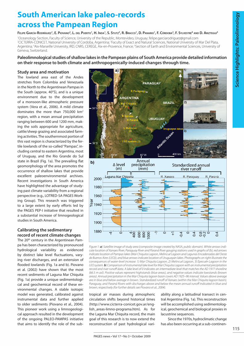
Study area and motivationThe lowland area east of the Andes stretches from Colombia and Venezuela in the North to the Argentinean Pampas in the South (approx. 40°S), and is a unique environment due to the development of a monsoon-like atmospheric pressure system (Vera et al., 2006). A mild climate dominates the more than 750,000 km2 region, with a mean annual precipitation ranging between 600 and 1200 mm, mak-ing the soils appropriate for agriculture, cattle/sheep grazing and associated farm-ing activities. The southernmost portion of this vast region is characterized by the fer-tile lowlands of the so-called “Pampas”, in-cluding central to eastern Argentina, most of Uruguay, and the Rio Grande do Sul state in Brazil (Fig. 1a). The prevailing flat geomorphology of the area promotes the occurrence of shallow lakes that provide excellent paleoenvironmental archives. Recent investigations in South America have highlighted the advantage of study-ing past climate variability from a regional perspective (e.g., LOTRED-SA PAGES Work-ing Group). This research was triggered to a large extent by early efforts led by the PAGES PEP-I initiative that resulted in a substantial increase of limnogeological studies in South America.
Calibrating the sedimentary record of recent climate changesThe 20th century in the Argentinean Pam-pa has been characterized by pronounced hydrological variability as evidenced by distinct lake level fluctuations, vary-ing river discharges, and an extension of flooded lowlands (Fig. 1a and b). Piovano et al. (2002) have shown that the most recent sediments of Laguna Mar Chiquita (Fig. 1a) provide a unique sedimentologi-cal and geochemical record of these en-vironmental changes. A stable isotopic model was generated, calibrated against instrumental data and further applied to older sediments (Piovano et al., 2004). This pioneer work using a limnogeologi-cal approach resulted in the development of the ongoing PALEO-PAMPAS initiative that aims to identify the role of the sub-
tropical air masses during atmospheric circulation shifts beyond historical times (http://www.cicterra-conicet.gov.ar/eng-lish_areas-limno-programa.htm). As for the Laguna Mar Chiquita record, the main goal of this research is to now extend the reconstruction of past hydrological vari-
ability along a latitudinal transect in cen-tral Argentina (Fig. 1a). This reconstruction will be accomplished using sedimentolog-ical, geochemical and biological proxies in lacustrine sequences.
Since the 1970s, hydroclimatic change has also been occurring at a sub-continen-
Figure 1: a) Satellite image of study area (composite image created by NASA, public domain). White arrows indi-cate location of Xanaes River, Paraguay River and Paraná River gauging stations used in graphs of (b), red arrows indicate location of Pampas lakes (Mar Chiquita Lagoon, Melincué Lagoon and Lagunas Encadenadas del Oeste de Buenos Aires (LEO)), and blue arrows indicate location of Uruguayan lakes. Photographs on right illustrate the consequences of water-level increase: 1) Mar Chiquita Lagoon, 2) Melincué Lagoon, 3) Epecuén Lagoon in the LEO system. b) Comparison of instrumental lake level for Mar Chiquita Lagoon with an instrumental precipitation record and river runoff data. A lake level of 0 indicates an intermediate level that matches the AD 1977 shoreline (66.5 m asl). Positive values represent highstands (blue areas), and negative values indicate lowstands (brown areas). Annual precipitation in the Mar Chiquita lagoon basin covers AD 1925–96 interval. Values above average are in blue and below average in brown. Standardized runoff of Xanaes (within the Mar Chiquita lagoon basin), Paraguay, and Paraná Rivers with discharges above and below the mean annual runoff indicated in blue and brown, respectively (for further details see Piovano et al., 2004).

116
PAGES news • Vol 17 • No 3 • October 2009
Scie
nce
Hig
hlig
hts:
Pal
eolim
nolo
gy tal scale, covering the vast and productive
region of southeastern South America (SESA) between 22°S and 40°S. Thus, it af-fects Uruguay, Paraguay, and subtropical regions of Argentina and Brazil. The close correspondence between the 20th century hydrological variability in both Pampean lakes and large-scale fluvial systems (e.g., Río Paraná; Río Paraguay; Fig. 1) highlights the significance of these Pampean lacus-trine archives for reconstructing the past activity of the monsoonal system at a sub-continental scale.
Recent investigations in lake basins in Uruguay (~34°S, 54°W; Fig. 1) have shown a clear nutrient enrichment during the past 70 years associated with a well-documented increase in human impact in the region (García-Rodríguez et al., 2002; 2004; Inda et al., 2008). Present-day nutri-ent levels of anthropogenically-disturbed lakes indicate highly eutrophic condi-tions. Although, these conditions are also affected by other factors, such as basin morphometry, lake-use, catchment geol-ogy and climate, it seems clear that the most intense eutrophication is related to the human impact of the past century (Fig. 2). Paleolimnological results indicate that, over long timescales, similar trophic states to those observed at present existed dur-ing the Holocene, due to climate and sea level variations (García-Rodríguez et al., 2004; del Puerto et al., 2006).
Holocene variability The methods used on the most recent sediments of Laguna Mar Chiquita have now been applied down core on the older sediments. Results from these analyses show substantial regional hydrological variability since Late Glacial times and throughout the Holocene (Piovano et al., 2009). In addition, dominant dry condi-tions were observed during cold phases, such as those occurring during the mid-Holocene or the Little Ice Age (LIA), where-as wet conditions prevailed during warm climatic phases such as the Medieval Cli-matic Anomaly (MCA) or the late 20th cen-tury. Paleohydrological reconstructions suggest that the magnitude of the MCA wet phase was comparable to that of the present-day conditions. Thus, the results emerging from the PALEO-PAMPAS initia-tive have: a) lengthened the time-frame of existing instrumental datasets of climate variability; b) reconstructed past hydro-logical variability within a broad region of SESA including new sites in the Río de la Plata/Paraná Basin; c) resolved this vari-ability at decadal timescale for the past 200-300 years and during older time win-dows; and d) analyzed past hydroclimatic
scenarios at times of either little or no an-thropogenic impact.
Similarly, research in Uruguayan lakes (Fig. 1) has focused on Holocene paleolim-nological variations of coastal lacustrine systems linked to changes in sea level, as well as in climate and anthropogenic impact. Diatoms, chrysophyte cysts, opal phytoliths, and palynomorphs have been used as biological proxies for changes in lake trophic status, salinity, and climate. Diatom taxonomy studies of both recent and fossil taxa in Uruguay led to the de-scription of 101 new diatom species and one new genus (Metzeltin et al., 2005; Metzeltin and García-Rodríguez, 2003). Al-though the new diatom species have not yet been calibrated versus environmental data, the ecological/trophic preferences have been documented. Trophic state and salinity changes were also inferred after adapting the cyst to diatom ratio findings (Smol, 1985) to temperate/subtropical lagoons influenced by sea-level changes (García-Rodríguez, 2006). The reliability of the ratio to infer changes in paleosalini-ties was successfully tested in other Uru-guayan lakes by Inda (2009). In addition to biological indicators, geochemical proxies have been used to infer nutrients and lake productivity (Bracco et al., 2005; del Puer-to et al., 2006; García-Rodríguez, 2006). These results demonstrated that the Ho-locene eutrophication of coastal lakes was controlled by sea-level variations and cli-mate change. Higher trophic states were observed during marine regression events
and climatic warming, while transgression and climate cooling led to lower trophic states (Fig. 2).
Thus, both modern limnological and paleolimnological data should be com-bined when designing the best possible management strategies, with paleolim-nological data being especially useful for identifying the different causes and effects of eutrophication. Specific research efforts are currently being undertaken to compile an opal phytolith atlas as a taxonomic and ecological basis for both paleoclimatic and paleobotanical investigations. Concomi-tantly, opal phytolith assemblages from cattle enclosure sites are being studied to obtain quantitative data in view of distin-guishing grazing and natural impacts on their distribution, thereby providing more realistic climate reconstructions. The com-bined use of opal phytoliths and pollen is thus an ideal approach to achieve more complete and reliable reconstructions of both climate and vegetation change. In the Buenos Aires province (Argentina), in-tensive fieldwork is being undertaken in several coastal lakes in view of multi-proxy reconstructions.
Conclusions and outlookAlthough paleolimnological studies in the Argentinean and Uruguayan Pampas are relatively incipient, they have already pro-vided critical information on the regional response of aquatic systems to climate variability. The combined results of these research initiatives highlight the key role
Figure 2: Conceptual paleolimnological model displaying the relationship between trophic development of Uru-guayan lakes (purple line), climate change in the region (black line) and Holocene sea-level curves (colored lines) observed in Uruguayan lakes. Temperature and humidity curves were reconstructed from opal phytolith data (Bracco et al., 2005; Inda et al., 2006; del Puerto et al., 2006; 2008; 2009). Sea level curves reconstructed from stratigraphical and topographical data.

117
PAGES news • Vol 17 • No 3 • October 2009
Scie
nce
Hig
hlig
hts:
Pal
eolim
nolo
gy
of the subtropical region of South Ameri-ca (i.e., the transition between the tropics and the extra tropics) in deciphering the forcing factors of past changes in atmo-spheric circulation. Both Argentinean and Uruguayan Holocene paleolimnologi-cal records indicate similar paleoclimatic trends, i.e. dominant dry conditions were observed during cold phases, whereas wet conditions prevailed during warm climatic phases. To our knowledge, this is the first attempt to integrate paleoclimatic data for the whole Pampean region. In ad-dition, our results underscore the need to reinforce paleoclimate research at mid-lat-itudes in South America, in an attempt to fully appreciate natural climate variability
beyond the instrumental record, as well as to design new strategies for the sus-tainable development of ecosystems and natural resources.
AcknowledgementsPEDECIBA, SNI-ANII and CSIC-Program “Contratación de investigadores provenientes del exterior” (Uruguay) are thanked for finan-cial support. Part of this study was supported by Argentina through funding of CONICET (PIP 5947; PIP 112-200801-00808), FONCYT (PICT Nº 25594 and PICT 2006-00625) and SECyT (UNC).
ReferencesBracco, R., Inda, H., del Puerto, L., Castiñeira, C, Sprechmann, P. and
García-Rodríguez, F., 2005: Relationships between Holocene sea level variation, trophic development and climate change in Negra Lagoon, southern Uruguay, Journal of Paleolimnology, 33: 252-262.
del Puerto, L, García-Rodríguez, F., Inda H., Bracco, R., Castiñeira, C., J.B. and Adams, J.B., 2006: Paleolimnological evidence of Holocene paleoclimatic changes in Lake Blanca, southern Uruguay, Journal of Paleolimnology, 36: 151-163.
García-Rodríguez, F., 2006: Inferring paleosalinity changes using the chrysophyte cyst to diatom ratio in coastal shallow temperate/subtropical lagoons influenced by sea level changes, Journal of Paleolimnology, 36,165-173.
Piovano, E., Ariztegui, D., Bernasconi, S.M. and McKenzie, J.A., 2004: Stable isotopic record of hydrological changes in subtropical Laguna Mar Chiquita (Argentina) over the last 230 years, The Holocene, 14(4): 525-535.
Piovano, E.L., Ariztegui, D., Córdoba, F., Cioccale, M. and Sylvestre, F., 2009: Hydrological variability in South America below the Tropic of Capricorn (Pampas and Patagonia, Argentina) during the last 13.0 In: Vimeux, F. et al., (Eds.), Past climate variability in South America and Surrounding regions: From the Last Glacial Maximum to the Holocene, Developments in Paleoenvironmental Research Series (DPER), pp 323-351,
For full references please consult:www.pages-igbp.org/products/newsletters/ref2009_3.html
Results of recent sediment drilling activities in deep crater lakes ReinhaRd Pienitz1, m. melleS2 and B. zolitSchka3
1Aquatic Paleoecology Laboratory, Centre for Northern Studies, Université Laval, Quebec City, Canada; [email protected] of Geology and Mineralogy, University of Cologne, Germany; [email protected] 3GEOPOLAR, Institute of Geography, University of Bremen, Germany; [email protected]
Long terrestrial sediment records from deep crater lakes reveal precious paleoclimate archives.
Since the beginning of concerted efforts to extract long continental paleoclimate archives from lacustrine sediment records (see Leroy and Williams, 1996; Ariztegui, 1999), the terrestrial paleoclimate com-munity has made substantial progress in providing precious paleoclimatic infor-mation from a number of sites in both hemispheres. Here we report on the latest achievements and progress made in three of these projects that concern large and deep crater lakes.
Laguna Potrok AikeThe Potrok Aike Maar Lake Sediment Ar-chive Drilling Project (PASADO) is a deep lake drilling project sponsored by the In-ternational Continental Scientific Drilling Program (ICDP), as well as the German and Swiss National Science Foundations, Natu-ral Sciences and Engineering Research Council of Canada, the Swedish Vetens-kapsradet, and the University of Bremen (Haberzettl et al., 2007). Laguna Potrok Aike (51˚59.0’ S, 70˚21.0’ W; 113 m asl, di-ameter 3.5 km, water depth 100 m; Fig. 1a) is a late Quaternary volcanic crater lake in southern Patagonia (Argentina). From September through November 2008, sedi-ment cores were retrieved by an interna-tional team from all funding countries and the United States using the GLAD800 drill rig. A total of 513 m of sediments were re-covered from two sites in seven holes and
resulted in a composite sediment length of 107 m, potentially representing a la-custrine archive of southern hemispheric environmental change of the past ca. 80 ka. Core sections and sediments are now stored and archived in the GEOPOLAR lake core repository at the University of Bremen. Various non-destructive analyses (multi-sensor core logger, digital photog-raphy and radiography, reflectance pho-tospectrometry, magnetic susceptibility, XRF scanning) are almost complete while sub-sampling of the cores is underway for analyses of biotic and abiotic proxies (pol-len, diatoms, chironomids, stable isotopes, rock- and paleomagnetics, geochemistry, grain size, mineralogy, pigments, organic petrology, microbial activity). Moreover, radiometric and luminescence dating techniques and tephrochronology will be applied to assure the best possible time control. The analysis of this unique Southern Hemisphere sediment record will provide insights into lacustrine eco-system response to climate forcing since the onset of the last glacial, and will allow correlation of this record with marine and Antarctic counterparts to detect land-ocean-cryosphere-atmosphere interac-tions. Information on the latest progress of this research project can be found at http://www.pasado.uni-bremen.de or http://www.icdp-online.org/contenido/
icdp/front_content.php?idcat=722, or by contacting Bernd Zolitschka.
Pingualuit Crater LakePingualuit Crater Lake (61˚17’N, 73˚41’W; 520 m asl, diameter 3.4 km, cover photo) resulted from a meteoritic impact that oc-curred ca. 1.4 million years ago. Due to its unique bowl-shaped morphometry (270 m deep, almost perfectly circular), the lake bottom should have escaped glacial ero-sion. Based on a single punctual seismic survey, the uppermost 8.5 m of sediments were recovered (overall length of all sedi-ment sections = 11.2 m) through the ice at a water depth of 260 m by an international team in early May 2007 (Fig. 1b). High-res-olution physical (CAT-Scan, Multi Sensor Core Logger, diffuse spectral reflectance), geochemical (ITRAX core scanner, carbon and nitrogen contents, δ13C of the organic matter), and magnetic (magnetic suscepti-bility, natural, anhysteretic, isothermal and saturation isothermal remanent magneti-zations) analyses were performed. Two main lithofacies were clearly identified by the different measurements, which likely represent successive interglacial-glacial cycles. Most of the sediment consists of light grey silts containing several angular rock fragments, characterized by very low organic carbon content, relatively high density and magnetic susceptibility, and therefore suggesting deposition during

Full Reference List: Angulo, R.J, Lessa, G.C. and de Souza, M.C., 2006: A critical review of mid-to late Holocene sea-level
fluctutions on the eastern Brazilian coastline, Quaternary Science Reviews, 25: 486-506. Bracco, R., Inda, H., del Puerto, L., Castiñeira, C, Sprechmann, P. and García-Rodríguez, F., 2005: Relationships
between Holocene sea level variation, trophic development and climate change in Negra Lagoon, southern Uruguay, Journal of Paleolimnology, 33: 252-262.
Bracco, R., García-Rodríguez, F., del Puerto, L., Inda, H. and Castiñeira, C., 2008: Holocene relative sea-level variation inferred from records in the basin of Castillos. In: Structure and function of world shallow lakes, Book of Abstracts, Punta del Este, Uruguay. p. 75.
Cavallotto, J.L., Violante, R.A. and Parker, G., 2004: Sea-level fluctuations during the last 8600 years in the de la Plata River (Argentina), Quaternary International, 114: 155–165.
del Puerto L., 2009: Silicofitolitos como Indicadores Paleoambientales: bases comparativas y reconstrucción paleoclimática a partir del Pleistoceno Tardío en el SE del Uruguay, M.Sc. Thesis PEDECIBA, Facultad de Ciencias, Universidad de la República, Montevideo, 189.
del Puerto, L., Inda, H. and García-Rodríguez, F., 2008: Reconstrucción Paleoambiental para el Holoceno medio y tardío en la cuenca de la Laguna Negra: el aporte de los indicadores biosilíceos. In: Korstanje, A. and Babot, P. (Eds), Matices Interdisciplinarios en Estudios Fitolíticos y de Otros Microfósiles, BAR International Series 1870: 119-129.
del Puerto, L, García-Rodríguez, F., Inda H., Bracco, R., Castiñeira, C., J.B. and Adams, J.B., 2006: Paleolimnological evidence of Holocene paleoclimatic changes in Lake Blanca, southern Uruguay, Journal of Paleolimnology, 36: 151-163.
García-Rodríguez, F., Mazzeo N, Sprechmann P., Metzeltin D., Sosa F., Treutler H.C., Renom M., Scharf B. and Gaucher C., 2002: Paleolimnological assessment of human impacts in Lake Blanca, SE Uruguay, Journal of Paleolimnology, 28: 457-468.
García-Rodríguez, F. et al., 2004: Holocene trophic state changes in relation to sea level variation in Lake Blanca, SE Uruguay, Journal of Paleolimnology, 31: 99-115.
Inda, H., 2009: Paleolimnología de cuerpos de agua someros del sudeste del Uruguay: evolución holocénica e impacto humano, M.Sc. Thesis. PEDECIBA-Biología, Universidad de la República.
Inda, H. et al., 2008: Mid-Holocene palaeoenvironmental reconstruction and recent human impact in Laguna del Diario, SE Uruguay. In: Structure and function of world shallow lakes, Book of Abstracts, Punta del Este, Uruguay, 77.
Isla, F., 1998: Holocene coastal evolution of Buenos Aires, Quaternary of South America and Antarctic Peninsula, 11: 297-321
Martin, L. and Suguio, K., 1992: Variation of coastal dynamics during the last 7000 years recorded in beachridge plains associated with river mouths: example from the Central Brazilian Coast, Palaeogeography, Palaeoclimatology, Palaeoecology, 99: 119-140.
Metzeltin, D., Lange-Bertalot, H. and García-Rodríguez, F., 2005: Diatoms of Uruguay. In: H. Lange-Bertalot (Ed.). Iconographia Diatomologica, Vol. 15. A.R.G. Gantner Verlag, Koeltz Scientific Books, Königstein, 737 pp.
Metzeltin, D. and García Rodríguez, F., 2003: Las Diatomeas Uruguayas, DIRAC Ediciones, Facultad de Ciencias, Montevideo, Uruguay, 208 pp.
Piovano, E., Ariztegui, D. and Damatto Moreira, S., 2002: Recent environmental changes in Laguna Mar Chiquita (Central Argentina): A sedimentary model for a highly variable saline lake, Sedimentology, 49: 1371-1384.
Smol, J.P., 1985: The ratio of diatom frustules to chrysophycean statospores: a useful paleolimnological index, Hydrobiologia, 123: 199-208.
Vera, C. et al., 2006: Towards a unified view of the American Monsoon System, Journal of Climate, 19: 4977-5000.


![Easy paleo spaghetti recipe with tomato sauce [Paleo, Keto]](https://img.dokumen.tips/doc/110x75/58aa1fde1a28abff6b8b5931/easy-paleo-spaghetti-recipe-with-tomato-sauce-paleo-keto.jpg)