Embed Size (px)
Citation preview
Journal of Ocean, Mechanical and Aerospace -Science and Engineering-, Vol.27
January 20, 2016
13 Published by International Society of Ocean, Mechanical and Aerospace Scientists and Engineers
Soil Investigation for Determining Aquifer Position at Pasir Impun Area, Bandung, West Java Using Resistivity Method
Wenner Configuration
Diyan Parwatiningtyas,a,*, Dasmo,a and Achmad Sjamsuri,a
a)Lecturer at Department of physics, Faculty of Engineering, Mathematics and Natural Sciences, Indraprasta PGRI University, Jakarta, Indonesia *Corresponding author: [email protected], [email protected] Paper History Received: 23-December-2015 Received in revised form: 5-January-2015 Accepted: 20-January-2016 ABSTRACT At this time, we owning many geophysics methods that can be used to optimize investigation and natural source exploration under layer surface, one of them is Georesistivity method. Georesistivity method is one of geophysics method that study about electricity in the earth and also to detect an object in the surface layer area of earth. The following, a technology is showed to investigation and analyzed aquifer at botanical garden area, Mekarmanik village, Pasir Impun, East Bandung West Java, using Georesistivity method, Wenner Configuration. In this research, will be do Georesistivity method with Wenner configuration and be processed with using inversion from software Res2DIV, and Isopach aquifer contour mapping, which previous be done the topography correction. Based on the inversion obtained, we be obtain to interpret some points which showed aquifer position, are as follow : 1). Line 1 on location 1, with the distance of extend is between 78 – 140 metre on surface layer. (It has medium aquifer) which the resistivity is 800 ohm metre, and also has porosity and volum value 25% and 945,9 m3 with the depth is 60 metre. Its formation rocks at this location are sandstone, and limestone, anticline topography, dominated by normal fault which the trend is NE-SW. 2). Line 6 on location 1 (The highest aquifer) with the distance of extend is between 26 – 182 metre 26 - 160 metre, which the resistivity is 100 – 300 ohm metre, porosity and volum value are 14,14 – 18,26% and 1160,85 m3, with the depth target is 70 metre. Its formation rocks at this location are sandstone, alluvial and limestone, syncline
topography, dominated by normal fault which the trend is NE-SW. And then the third is line 8 on location 2 with the distance of extend is between 26 – 182 metre, the resistivity is 100 ohm metre, which its porosity and volum are 14,14 %, and 264 m3, with depth target is 35 metre. It has undulation topography which the trend is SE – SW dominated by normal fault, and its formation rocks are tuff, sandstone, gravel formation. KEY WORDS: Geological stucture condition, Geophysich method of Wenner Configuration, Interpretation for aquifer position. NOMENCLATURE
NE North East SW South West m3 Metre Cubic �� Apparent Resistivity (Ohm.m) V Voltage (mV) mV milliVolt � Electric Current (mA) mA milliAmpere � Geometric Wenner factor (metre) 1.0 INTRODUCTION Water has an important role to human life. Almost 90% human life needs water, because it is needed for human body, water transportation tool, industry, generator, and irrigation. Talk about water usage, in case that happen at Mekarmanik Village, the study area is botanical garden, located in Pasir Impun East
Journal of Ocean, Mechanical and Aerospace -Science and Engineering-, Vol.27
January 20, 2016
14 Published by International Society of Ocean, Mechanical and Aerospace Scientists and Engineers
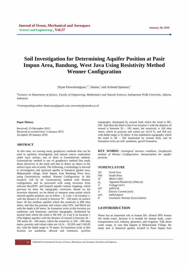
Bandung, in West Jawa Province, where the society in its around is difficult to obtain water. One of the obstacle's factor is difficulties of the geological structure and soil condition at the area, causing some people difficult to find the position of water resources. Tectonic intensity in this area is very high dominated by anticline structure with direction trend from west to east, (NWW-SEE). This Area is normal fracture, which its direction trend is same with anticline structure and its penetration into basement. Pasir Impun consist of reservoir rock which its velocity is moderate (smaller than subsidence velocity) and its rock formation is limestone, colory grey (Harsono and Fuadi, 2005). Beside that, this location was formed from volcano residual soil, consisted of breksi, tuff, tuff''s grain, sand stone, dust. Some types of its soil are : Red clay, and grey volcano soil (Wesley, 2001). To overcome this problem, we conducted a necessary geophysics method to interpret geological structure and found the information about the location of water resources position in this area. One of the mentioned method is georesistivity method. Georesistivity method is one of the geophycics methods that study about electricity flow inside the earth and to detect it in the earth surface (In this matter to potential measuring, current measuring, and elektromagnetic's field) which happen natural or caused by current injection into the earth. Example : Self Potential method, Telluric current, Magnetotelluric, Electromagnetic, Induce Polarization (IP), Resistivity method, etc. In this research, to identification the location of water resources in this area, we using Georesistivity method, Resistivity Sounding. It also known as Drilling Resistivity, Probing Resistivity, and etc. This method is studying about resistivity rock under earth surface according to vertical direction. In this method, sounding point measurement be done with changed the distance of electrode. To change the distance of electrode, be done beginning from the smallest distance until the largest distance according to gradual. Electrode's distance is comparable with the deepness of earth surface layer which detected. It means, if the distance of electrode is large, then the earth surface layer will be deeper. Sounding Resistivity, was familiar known as various of kind electroda's configuration. Among its are : Wenner's Configuration, Schlumberger, Bipol-dipol, Lee Partision, Line Source, gradien's System 3 point, etc. In this research, our aim is to analyze geological structure condition at botanical garden Mekarmanik village, Pasir Impun, East Bandung, and to find the location of the water resources, using georesistivity method, with Wenner configuration. The location map of aquifer investigation is shown in figure 1.
Figure 1: Location map of Mekarmanik Village.
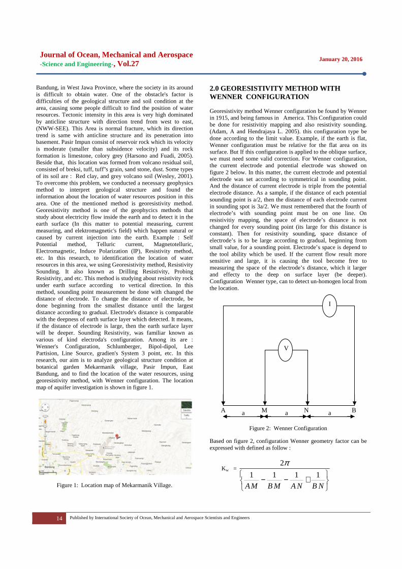
2.0 GEORESISTIVITY METHOD WITH WENNER CONFIGURATION Georesistivity method Wenner configuration be found by Wenner in 1915, and being famous in America. This Configuration could be done for resistivitiy mapping and also resistivity sounding. (Adam, A and Hendrajaya L. 2005). this configuration type be done according to the limit value. Example, if the earth is flat, Wenner configuration must be relative for the flat area on its surface. But If this configuration is applied to the oblique surface, we must need some valid correction. For Wenner configuration, the current electrode and potential electrode was showed on figure 2 below. In this matter, the current electrode and potential electrode was set according to symmetrical in sounding point. And the distance of current electrode is triple from the potential electrode distance. As a sample, if the distance of each potential sounding point is a/2, then the distance of each electrode current in sounding spot is 3a/2. We must remembered that the fourth of electrode’s with sounding point must be on one line. On resistivitiy mapping, the space of electrode’s distance is not changed for every sounding point (its large for this distance is constant). Then for resistivity sounding, space distance of electrode’s is to be large according to gradual, beginning from small value, for a sounding point. Electrode’s space is depend to the tool ability which be used. If the current flow result more sensitive and large, it is causing the tool become free to measuring the space of the electrode’s distance, which it larger and effecty to the deep on surface layer (be deeper). Configuration Wenner type, can to detect un-homogen local from the location.
Figure 2: Wenner Configuration
Based on figure 2, configuration Wenner geometry factor can be expressed with defined as follow :
Kw =
+−−NBNAMBMA
1111
2π
I
V
A M N B a a a
Journal of Ocean, Mechanical and Aerospace -Science and Engineering-, Vol.27
January 20, 2016
15 Published by International Society of Ocean, Mechanical and Aerospace Scientists and Engineers
=
+−−
aaaa
1
2
1
2
112π
=2πa (1)
Then for Wenner Configuration equation is :
I
Vaaw
∆= πρ 2 (2)
Where :
ρaw = Resistivity on Wenner configuration.
ΔV= Potential Voltage (Volt).
I = Electric Current (Ampere).
3.0 RESEARCH METHODOLOGY The research area is at Botanical Garden Mekarmanik Village, Cimenyan district, Pasir Impun East Bandung West Java Province, which located at 6o51’15.43”S – 107o41’9.03” E. This reasearch method consist of two part.
1. Pre Processing : On this phase we do some investigation at research location. this Investigation was do to analyze geological structure and the characteristic of water flow. Then from this phase, we mapping 9 line for water track in horizontal direction (is shown in figure 7). Investigation to recognize location was started from early January until 30 June 2014.
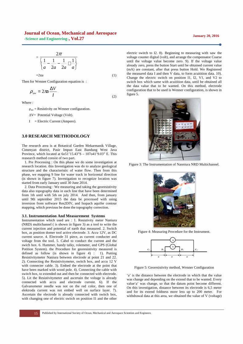
2. Data Processing : We measuring and taking the georesistivity data also topography data in each line that have been determined from 1th until with 5th on july 2014. And then, from january until 9th september 2015 the data be processed with using inversion from software Res2DIV, and Isopach aquifer contour mapping, which previous be done the topography correction. 3.1. Instrumentation And Measurement Systems Instrumentation which used are : 1. Resistivity meter Naniura (NRD) multichannel ( is shown in figure 3) as a tool to write the current injection and potential of earth that measured. 2. Switch box, as position domer tool active electrode. 3. Accu 12V, as DC current source. 4. Electrode 31 piece, as current conducter and voltage from the tool. 5. Cabel to conduct the current and the swich box. 6. Hammer, handy talky, rolemeter, and GPS (Global Potition System). the Procedure for georesistivity measured is defined as follow (is shown in figure 4) : 1). Putting Resistivitymeter Naniura between electrode at point 21 and 22. 2). Connecting the Resistivitymeter, switch box, and accu 12 V with connecter cable. 3). Embed the electrode at the point that have been marked with wood pole. 4). Connecting the cable with switch box, to extended out and then be connected with electrode. 5). Lit the Resistivitymeter and ascertain the voltage is already connected with accu and electrode current. 6). If the Galvanometer needle was not on the red color, then one of elektroda current was not embed well on surface layer. 7). Ascertain the electrode is already connected with switch box, with changing one of electric switch on position I1 and the other
electric switch to I2. 8). Beginning to measuring with saw the voltage counter digital (volt), and arrange the compensator Coarse until the voltage value become zero. 9). If the voltage value already zero, press the button Start until be obtained current value (mA) are constant, after that press button Hold. We Registered the measured data I and then V data, to form acuitition data. 10). Change the electric switch on position I1, I2, V1, and V2 to switch box which same with acuitition data, until be obtained all the data value that to be wanted. On this method, electrode configuration that to be used is Wenner configuration, is shown in figure 5.
Figure 3: The Instrumentation of Nanniura NRD Multichannel.
Figure 4: Measuring Procedure for the Instrument.
Figure 5: Georesistivity method, Wenner Configuration
‘a’ is the distance between the electrode in which that the value was change and depending on the extend that to be wanted. Every value‘a’ was change, so that the datum point become different. On this investigation, distance between its electrode is 6,5 meter and for its extend foldness more less up to 200 meter. For withdrawal data at this area, we obtained the value of V (voltage)
Journal of Ocean, Mechanical and Aerospace -Science and Engineering-, Vol.27
January 20, 2016
16 Published by International Society of Ocean, Mechanical and Aerospace Scientists and Engineers
and I (current) that was read from instrument, and after be fold with Ks (Geometric Factor), be obtained the ρa value (apparent resistivity). The equation to obtain apparent resistivity value is (Adam, A and Hendrajaya L. 2005) :
�� � ��
� (3)
where :
�� : Apparent Resistivity (Ohm.m)
: Voltage (mV)
� : Current (mA)
� : Geometric Wenner factor (metre)
( � � 2�� ) which � is electrode space.
Next, this value will be processed using the software Res2Div and Isopach contour mapping. The result was showed on image enhancement, which this result will be interpreted be assist with geological map. 4.0 DESCRIPTION AND DATA PROCESSING For the phase of data processing, we using Microsoft Excel software to calculate the apparent resistivity on each datum point. After apparent resistivity be obtained, the mentioned value be made in Notepad format according to formatted data input from software that will be used for data processing (It was explained in figure 6).
Figure 6: Exterminate bad datum point
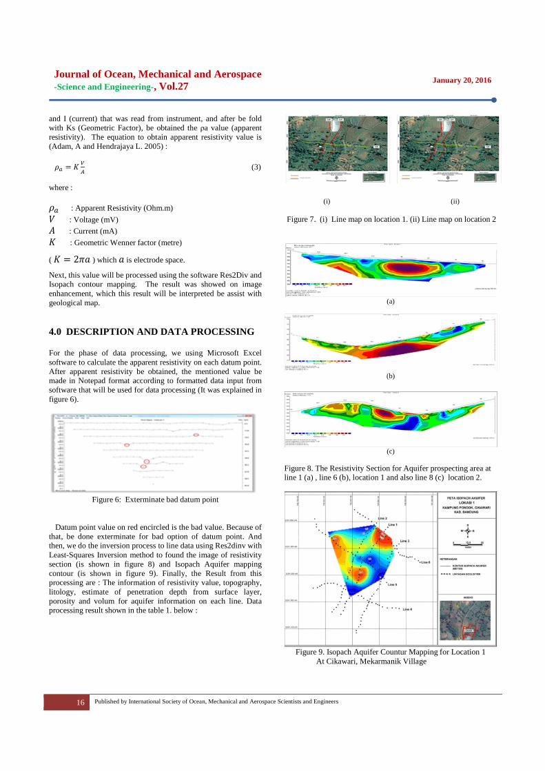
Datum point value on red encircled is the bad value. Because of that, be done exterminate for bad option of datum point. And then, we do the inversion process to line data using Res2dinv with Least-Squares Inversion method to found the image of resistivity section (is shown in figure 8) and Isopach Aquifer mapping contour (is shown in figure 9). Finally, the Result from this processing are : The information of resistivity value, topography, litology, estimate of penetration depth from surface layer, porosity and volum for aquifer information on each line. Data processing result shown in the table 1. below :
(i) (ii) Figure 7. (i) Line map on location 1. (ii) Line map on location 2
(a)
(b)
(c)
Figure 8. The Resistivity Section for Aquifer prospecting area at line 1 (a) , line 6 (b), location 1 and also line 8 (c) location 2.
Figure 9. Isopach Aquifer Countur Mapping for Location 1
At Cikawari, Mekarmanik Village
Journal of Ocean, Mechanical and Aerospace -Science and Engineering-, Vol.27
January 20, 2016
17 Published by International Society of Ocean, Mechanical and Aerospace Scientists and Engineers
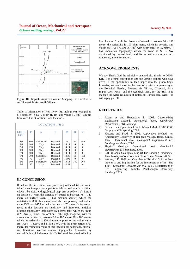
Figure 10: Isopach Aquifer Countur Mapping for Location 2 At Cikawari, Mekarmanik Village. Table 1: Information of Resistivity (ρ), litology (σ), topograhpy (T), porosity (φ (%)), depth (D (m) and volum (V (m3)) aquifer from each line at location 1 and location 2.
LOCATION 1 & 2
LINE/ LOC
Ρ Σ T Φ D V
1/1 2/1 3/1 4/1 5/1 6/1 7/2 8/2 9/2
800 100 150 100 100 300 70 100 90
Sandstone Clay Clay Clay Clay
Sandstone Clay
Sandstone Clay
Descend Descend Descend Descend Descend Descend Descend
Undulation Descend
25 14,14 14,14 14,14 14,14 18,26 11,95 14,14 10,54
70 0 0 0 0 60 0
350
946 0 0 0 0
1160 0
264 0
5.0 CONCLUSION
Based on the inversion data processing obtained (is shown in table 1), we interpret some points which showed aquifer position, which it be assist with geological map. Are as follow : 1). Line 1 on location 1, with the distance of extend is between 78 – 140 metre on surface layer. (It has medium aquifer) which the resistivity is 800 ohm metre, and also has porosity and volum value 25% and 945,9 m3 with the depth is 70 metre. Its formation rocks at this location are sandstone, and limestone, anticline descend topography, dominated by normal fault which the trend is NE-SW. 2). Line 6 on location 1 (The highest aquifer) with the distance of extend is between 26 – 182 metre 26 - 160 metre, which the resistivity is 300 ohm metre, porosity and volum value are 14,14 – 18,26% and 1160,85 m3, with the depth target is 60 metre. Its formation rocks at this location are sandstone, alluvial and limestone, syncline descend topography, dominated by normal fault which the trend is NE-SW. And then the third is line
8 on location 2 with the distance of extend is between 26 – 182 metre, the resistivity is 100 ohm metre, which its porosity and volum are 14,14 %, and 264 m3, with depth target is 35 metre. It has undulation topography which the trend is SE – SW dominated by normal fault, and its formation rocks are tuff, sandstone, gravel formation. ACKNOWLEDGEMENTS
We say Thank God the Almighty one and also thanks to DPPM DIKTI as a fund contribution and the Omase comitte who have given us the opportunity to load paper into the proceedings. Likewise, we say thanks to the team of workers in geosurvey at the Botanical Garden, Mekarmanik Village, Cikawari, Pasir Impun West Java, and the reasearch team, for the trust to to manage the water resources of Botanical Garden area, well. God will repay you all.
REFERENCES 1. Adam, A and Hendrajaya L. 2005. Georesistivity
Exploration Method, Operational book, Geophysich Departement, ITB Bandung.
2. Geoelectrical Operasional Book, Manual Mode ES-G1 OXO Geophysical Prospecting 2009 .
3. Harsono and Fuadi S. 2005. Application Method on Anisotrophy Resistivity at Bangoan Village, Blora, Central Java, Operational book., Geophysich Departement, ITB Bandung, on March, 2005.
4. Physical Geology. Operational book, Geophysich departement, ITB Bandung, 2005.
5. P.H Silitonga, Geological Map Of The Bandung Quadrangle, Java, Geological research and Departement Centre, 2003.
6. Wesley, L.D. 2001. An Overview of Residual Soils in Java, Indonesia, and Implication for the Interpretation of In – Situ Test. Proceeding Geotechnical Pile 2005. Departement of Civil Engginering Katholik Parahyangan University, Bandung, 2005


![Official Universitas Indraprasta PGRI · Website : Email : university@unindra.ac.id ED ARAN Nomor : 22/WR]SE/UNINDRA/V1/2020 Tentang Pelaksanaan Ujian Tugas Akhir/Skripsi dan Tesis](https://img.dokumen.tips/doc/110x75/607cc3ea2219680cdf029d14/official-universitas-indraprasta-pgri-website-email-university-ed-aran-nomor.jpg)


