Embed Size (px)
Citation preview

1
Site Analysis Final Paper
Laurel Falls
LAR 582 013
May 10, 2010
INTRODUCTION
When I first entered the Design School (as it was called then) as a freshman student a while
back, I was informed that the journey that I was about to embark on was first and foremost about
making artifacts; that this was the essential function of the designer. I’ve spent a good deal of my
life studying art and artifacts, making them myself, moving them around for other people to view
and taking care of them in order to preserve them for future generations. Increasingly what I am
concerned with is the space in-between objects; what connects one thing to another and what of
it?
The goal of this paper is to look on the range of significant design processes currently being
utilized in the practice of landscape architecture and reflect on how they have impacted and
altered my approach to analysis and design.
DESIGN VALUES
My core values as a designer are that any intervention on the land enhances sustainability,
creates a more cohesive community and respects and augments the character of a place. Every
site is unique and requires a thorough investigation of the physical, ecological and cultural
attributes that interact to form the matrix of constraints and opportunities for a particular site and
subsequent program (La Gro, p. ix).
METHODS OF ANALYSIS AND PLANNING
In the second edition of Site Analysis: A Contextual Approach to Sustainable Land Planning and
Site Design, author James A. La Gro, Jr. promotes a “context-sensitive” approach to development
that involves limiting inherent site problems and embracing assets of the site. By doing this, he
says planners can
1. Reduce long-term maintenance needs;
2. Reduce risks to life a property from natural hazards; and
3. Create higher-quality built environments.

2
He advocates site analysis as a comprehensive overlay process that evaluates a broad array of
characteristics based on each unique site and program (La Gro, pp. ix-x).
La Gro’s approach expounds Ian McHarg’s seminal book Design with Nature (1969), which
proposed a system of analyzing the layers of a site in order to compile a complete understanding
of the qualitative attributes of a place. McHarg would give every qualitative aspect of the site a
layer, such as the history, hydrology, topography, vegetation, etc. The overlay of the various
systems would reveal critical information that could be used to further inform design decisions.
Thus, McHarg developed innovations in design process and method; defensible processes based
on science, fact and data that centered on importance of ecology.
The overlay method was popularized by several of McHarg’s students at the University of
Pennsylvania School of Design, most notably Carl Steinitz and Nicholas Muhlenberg, and
became the foundation of today's Geographic Information Systems (GIS) software.
Carl Steinitz in his 1979 book Defensible Processes for Regional Design establishes six design
processes and ranks them by effectiveness. The first process is an internalized one, based only
on the designer’s personal experience and intuition. The second process is the Survey, Analysis,
Design method (or SAD). The pitfall of this process is that while scientific data is gathered, it is
often not connected to design decisions in a meaningful way. The third process is the one taught
most frequently in design schools which is The Design Process and includes five stages: problem
statement, data inventory, analysis, synthesis, evaluation. The fourth process is McHarg’s overlay
method to analyze site suitability.
At this point, Steinitz goes further to outline two more design processes. His fifth process includes
the use of predictive models made possible by computer technology to simulate multiple
outcomes. His sixth process establishes a clear pathway for project stakeholders to come
together and through exploring alternative scenarios, arrive at solutions that reflect the core
values of that particular community. The resulting design is thus tailored to that particular region.
He points out that as projects become larger, it is beneficial to use both predictive models and
public participation. These are the most defensible processes of analysis for Stienitz (Steinitz, pp.
14-22).
Colleagues of McHarg were extremely influential as landscape architects as well such as
Lawrence Halprin, Laurie Olin, Robert Hanna (co-founded Hanna/Olin in 1976), Rolf and Leslie

3
Sauer (co-founded Andropogon Associates), and Colin and Carol Franklin (co-founded
Andropogon Associates), among others.
Elizabeth Meyer, in her essay “Site Citations” from Site Matters: Design Concepts, Histories, and
Strategies (Burns and Kahn), writes about how increasingly in the 1960s, landscape architectural
practice shifted outside of the boundaries of art, likely due to large sites (suburban housing
developments, shopping mall, corporate headquarters) and the shift towards ecological thinking.
Site practices such as those outlined in Ian McHarg’s Design with Nature (1969) and Lawrence
Halprin’s RSVP Cycles (1969) preferred systems to objects; they emphasized that every site is
unique and intrinsically linked to its particular context and surrounding systems, solutions for the
site reference everything in and around the site and cannot be transported elsewhere, site
solutions are intimately connected to place (Meyer, pp. 117-8). This is particularly important to
note the paradigm shift in thinking that embraces systems over formalism and object making, a
core tenet of Modernism.
This leads to an equally significant paradigm shift that has happened since Design with Nature
that has to do with what is considered the boundaries of a site. Kristina Hill in her essay “Shifting
Sites,” also in Site Matters: Design Concepts, Histories, and Strategies (Burns and Kahn)
explains that, “In the past, many designers in ecological planning and design sought to conserve
the biological resources of a site by “defending” it against external influences — essentially
treating valuable sites as fortresses to be walled off and protected from the influence of a hostile
matrix . . . boundaries should not be treated as real biophysical phenomena, but rather, be
stretched, shrunken, and re-envisioned across multiple landscape scales. Designers must come
to treat these edge zones as dynamic, like weather patterns, and not as artifacts that deserve
permanent memorialization simply because they once existed.” (Hill, pp. 144-5). It is this
perspective with regard to the suspension of fixed boundaries of a site that continues to inform
and enrich the work of contemporary landscape architectural practice and designers such as
Michael Van Valkenburg, James Corner, Peter Walker, George Hargreaves and Peter Latz.
RELEVENT CASE STUDIES
Frederick Law Olmstead emphasized the role of public parks role as a democratic equalizer for
the city. Like Olmstead, contemporary designers like Peter Latz and James Corner share in the
understanding of the technical complexity of layering the constructed landscape upon the natural
one and recognize the need for intertwined processes of critical assessment in order to create
diverse and changing landscapes rather than singular compositions.

4
This perspective along with the restricted amount of land within urban cores in which to develop
new parks has given rise to a new typology of park – the linear park. In her essay, “A New Kind of
Park” in Landscape Transformed, Diane Balmori posits that the linear park has arisen in response
to post-industrialization and the redevelopment of inherently linear connected spaces into parks,
such as railroads and industrial corridors within a dense urban hub. The linear park affords
connectivity as opposed to isolation and disconnection that she says characterizes many
traditional urban parks. She writes that, “The linear park opens pathways to diverse
neighborhoods and new recreational spaces and experiences of nature; it invites exploration of
alternate modes of transport and of cultural resources. . . These trails mend the community fabric
by drawing people together along a common way, as once town streets did before the
automobile.” (Balmori pp. 45-46). The following case studies exemplify the how these
connections can be made by connecting green spaces in a linear fashion.
Buffalo Bayou Promenade, Houston, TX
Landscape Architect: SWA Group
Client: City of Houston
Site Size: ± 23 Ac
Date: 2008
PPhotos: www.swagroup.com
Project Description
Buffalo Bayou Promenade is a large-scale project designed to revitalize the community and
natural habitat along the 1.2-mile reach of Buffalo Bayou in downtown Houston. The resulting 23-
acre recreation area has transformed a derelict urban wasteland, passed over by entangled
freeways, into a thriving urban waterfront. Among the improvements it has put in place are
extensive naturalized landscaping along the bayou’s gently sloping banks, continuous biking and
hiking trails on both sides of the bayou, public art, canoe and kayak launch sites, dramatic
outdoor lighting, wayfinding and interpretive signage, 12 new street-to-bayou entries, and an
elegant steel-and-concrete pedestrian bridge that connects the north and south sides of the
bayou in downtown for the first time. Wildlife—ducks, herons, turtles, and fish— have returned to
this stretch of the bayou from Sabine to Bagby Streets. The new parks, now restored to
ecological balance, enhance civic, recreational, and commercial settings and link key cultural and
entertainment venues like the Hobby Center for the Performing Arts and Bayou Place. The
revitalized waterfront has become the locale for many community events, such as concerts,
festivals, boat tours, and family-oriented educational events. The success of the Sabine-to-Bagby
Promenade offers a model of how to transform a neglected and run-down natural waterway into a
vital public treasure. (Source: ULI Case Studies)

5
Promenade Plantée, Paris, France
Landscape Architect: Jacques Vergely
Architect: Philippe Mathieux
Client: City of Paris and SEMAEST,
Société d’Economie Mixte
d’Aménagement de l’Est Parisien
Site Size: 3 miles
Date: 1993
Photos: www.promenade-plantee.org
Project Description
Located in the 12th arrondissement of Paris is a park like no other in the world. Built in what is
considered one of the older, working class neighborhoods of the city, the Promenade Plantée
represents one piece of a continued park policy in Paris to create new public open spaces out of
old infrastructure and industrial sites. In Paris new spaces are built to both connect to other green
spaces and connect old/new and geographically disparate parts of the city with each other. In the
development and construction of the Promenade Plantée, the city met not only their larger policy
goals but also built the first ever elevated park in the world.
Of even more significance to Paris is the way the Promenade Plantée revitalized a section of the
city that had been considered somewhat hard-scrabble and unwelcoming. Through the
incorporation of gardens, shops, paths, and links to neighborhoods and streets, the park has
proven to be a huge draw to tourists and Parisians both. The area is considered to be safe, well-
lit and patrolled, and well maintained. The commercial space for artists and shopkeepers has also
led to the kind of small-scale, locally owned business development desired in the neighborhood
(Clemmons, pp. 58-65).

6
The High Line, New York City
Landscape Architect: James Corner Field
Operations
Architect: Diller Scofidio + Renfro
Planting Designer: Piet Oudolf
Client: City of New York
Site Size: 1.5 miles
Date: 2009
Photo: www.thehighline.org
Project Description
The High Line is a linear park built on top of a derelict elevated train track along the west side of
lower Manhattan. When all sections are complete, the High Line will be a mile-and-a-half-long
elevated park, running through the West Side neighborhoods of the Meatpacking District, West
Chelsea and Clinton/Hell's Kitchen.
Section One of the High Line, which opened to the public on June 9, runs from Gansevoort Street
to 20th Street. Designed by James Corner, the High Line Park very effectively uses the existing
infrastructure of the raised freight rail that once supplied the many industries that functioned along
its route. Much like the industrial park transformations in Europe, such as Emscher Park in
Germany’s Ruhr Valley, the High Line also works as a community builder. It literally connects
communities through an attractive and cleverly designed park system while paying homage to the
area’s industrial origins.
Photos: Laurel Falls

7
Duisburg Nord Landscape Park, Ruhr
Valley, Germany
Landscape Architect: Latz + Partner
Client: Development Company of Nordrhein-
Westfalen and the city of Duisburg
Site Size: ± over 200 hectares; Former
industrial site - 20 hectares
Date: 1991-2000
Photos: www.arch.hku.hk
Project Description
The design of Duisburg Nord Landscape Park illustrates how it is possible to integrate parts of
urban or ex-urban infrastructure such as new sewage plants and artificial wetlands. Latz and
Partner preserved the remains of old industrial installations in Germany’s Ruhr Valley as history
and allow the structures to be used for public enjoyment. The contradictions between the
vegetative interventions and industrial remains add to the park’s overall effect.
Once one of the most polluted and environmentally devastated regions of the world, the Ruhr
district has been reborn. With the "International Building Exhibition (IBA) at Emscher Park"
initiated in 1989, the run-down industrial landmarks of the region have been transformed to serve
new recreational uses while still preserving the area's rich history. The redevelopment has given
the region a greener image, created a more cohesive community and maintained the area’s
identity. (www.sustainablecities.dk)

8
DESIGN PROCESS
This spring, as a part of my studies at the College of Design, our studio class looked at an area in
Southeast Raleigh for potential re-development. The overall site included Martin Luther King
Boulevard to the north, Garner Street to the west, Peterson Street to the south and State Street to
the east. Within these boundaries are Fred J. Carnage Middle School, the Walnut Creek Wetland
Center and the new extension of the Capitol Area Greenway System. Of note are several vacant
parcels of land along Peterson Street to the west of Carnage Middle School. In the case of the
Peterson Street Redevelopment Project, as we came to call it, there were several available sites
for development within the project boundaries; it was up to each student to choose one or more
locations and assign an appropriate program.
My design process followed the steps outlined by La Gro in Site Analysis: A Contextual Approach
to Sustainable Land Planning and Site Design most closely, beginning with a phase of intense
site immersion and data collection related to the physical, biological and cultural attributes of the
site. Data on physical attributes included information from aerial maps, Raleigh planimetrics,
topography, traffic data, field documentation and photographs. Biological data also came from
maps and class analysis of hydrology, water quality, habitat, vegetation and riparian buffers.
Cultural information was gathered from personal interaction with stakeholders: faculty and
students at Carnage Middle School, community leaders, representatives from the Walnut Creek

9
Wetland Center, city planners and landscape architects who have proposed redevelopment plans
in the immediate area.
SITE ANALYSIS AND PLANNING EXAMPLES
The collected data was then synthesized and used to identify patterns for enhancement and
adaptation, identify appropriate and developable areas, and identify opportunities for increased
performance of eco-processes. (ASLA.org).
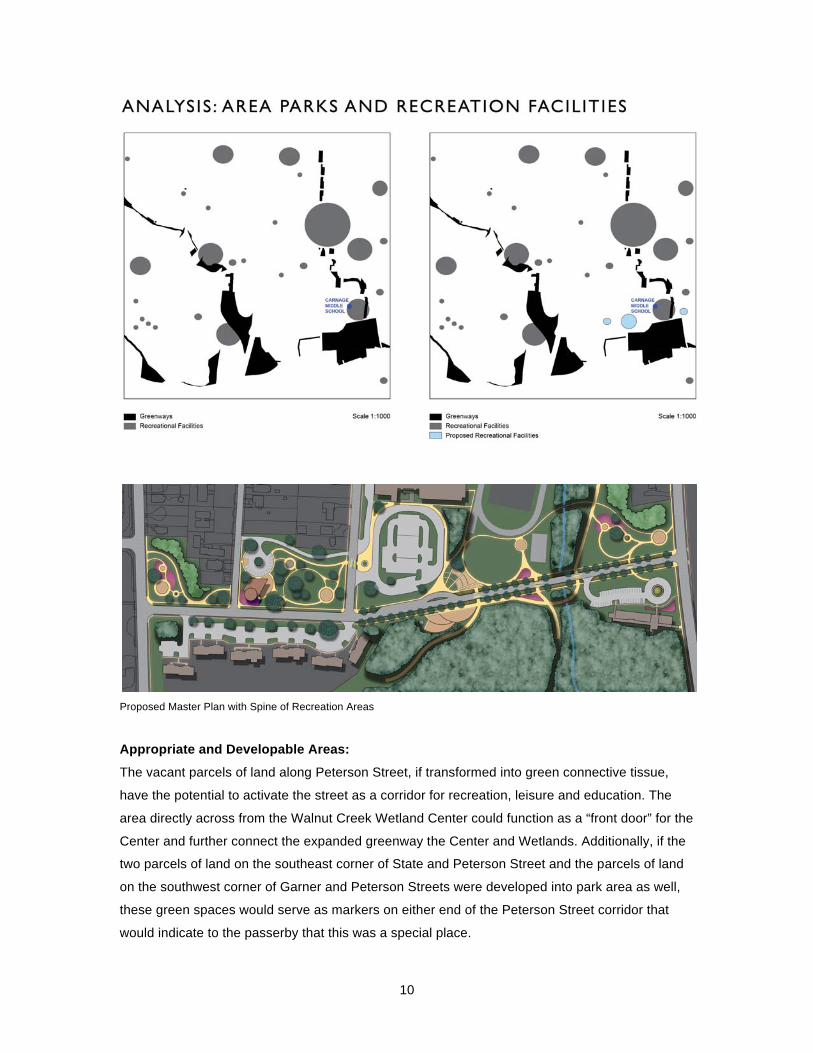
Patterns for Enhancement and Adaptation:
Instead of focusing on the constraints of the are, I chose to embrace the educational aspect of the
wetland and potential to expand and connect parcels of land into a larger linear park and
recreation area for Raleigh with unique programming that would continue to transform the area
into a destination. One of the drivers for this decision was the lack of community parks and
recreation areas in the immediate vicinity.
10
Proposed Master Plan with Spine of Recreation Areas
Appropriate and Developable Areas:
The vacant parcels of land along Peterson Street, if transformed into green connective tissue,
have the potential to activate the street as a corridor for recreation, leisure and education. The
area directly across from the Walnut Creek Wetland Center could function as a “front door” for the
Center and further connect the expanded greenway the Center and Wetlands. Additionally, if the
two parcels of land on the southeast corner of State and Peterson Street and the parcels of land
on the southwest corner of Garner and Peterson Streets were developed into park area as well,
these green spaces would serve as markers on either end of the Peterson Street corridor that
would indicate to the passerby that this was a special place.

11
One of the ideas to come out of the analysis was the importance of allowing for permeable
boundaries to alleviate isolated functions and areas. For example, Carnage Middle School is
largely fenced off from the surrounding community and the wetland across the street. Where
physical fences are not present, the large expanse of Peterson Road behaves as a barrier, as
does the immense parking lot on the southeast corner of the property. Students waiting for buses
and car pickup are corralled into a very small and rather undesirable area close to the heart of the
school.
Student Waiting Area for Buses

12
There is potential along the south edge of Carnage Middle School to allow for an additional car
pickup/drop off area and waiting area for students. Additionally, the soil from the cuts in the grade
to create this area can be used as fill across Peterson Street to allow for a series of shallow plaza
areas that step down into the wetland, providing an additional gathering and event area and an
extended outdoor classroom space closer to the Wetland Center and wetland itself.

13
Opportunities for Increased Performance of Eco-processes:
The wetlands represent one of the lowest-lying areas topographically in Raleigh, subject to
flooding. There are issues with stormwater runoff from the buildings and massive parking lot that
serves Carnage Middle School. By shrinking Peterson Street, re-grading adjacent areas that tend
to collect standing water and incorporating stormwater BMPs such as bioswales, runoff can be
dispersed and filtered before it enters the wetland.
Grading Plan
Section looking east
REFLECTION
During the course of conducting research for this paper into the variety of design processes and
how they have augmented the nature of landscape architecture as a profession, I ran across a
new term that I am very interested in investigating, Pattern-Assisted Design. This term was
mentioned in connection with the work process of landscape architect Kathryn Gustafson, who is
known to move between diagramming, sketching and model making, particularly by sculpting clay

14
in order to resolve her designs. I am very interested in learning how to layer the information that is
gathered during the site inventory phase in a way that informs design. I think I started to make
some of these connections during this project, but did not go far enough.
The most valuable processes for me in the course of working on this project were creating
diagrams based on patterns that emerged from layering information and building a digital model
of the one of the key areas in my design. Both of these methods allowed me to quickly identify
deficiencies and opportunities that I had overlooked. Using both of these techniques earlier in the
process, combined with generating sections and perspectives would help to create stronger
design possibilities.

15
BIBLIOGRAPHY
Amidon, Jane. Moving Horizons : The Landscape Architecture of Kathryn Gustafson and
Partners. Basel ; Boston: Birkhäuser-Publishers for Architecture, 2005. Web.
Balmori, Diane. “A New Kind of Park.” In Landscape Transformed. Academy Editions. London;
Lanham, Md.: Academy Editions; Distributed to the trade in the USA by National Book
Network, 1996, pp. 44-47.
Clemens, Marilyn. "Three Green Miles: A Planted Promenade Provides a Linear Greenspace for
Eastern Paris." Landscape Architecture v. 90, no. 2 (2000): 58-65.
Cranz, Galen. The Politics of Park Design : A History of Urban Parks in America. Cambridge,
Mass.: MIT Press, 1982. Web.
“Emscher Park: From Dereliction to Scenic Landscapes” http://sustainablecities.dk/en/city-
projects/cases/emscher-park-from-dereliction-to-scenic-landscapes
Hill, Kristina. “Shifting Sites.” In Site Matters: Design Concepts, Histories, and Strategies. Burns,
Carol, and Andrea Kahn, ed. New York: Routledge, 2004, pp. 131-155.
LaGro, James A. Site Analysis : A Contextual Approach to Sustainable Land Planning and Site
Design. 2nd ed. Hoboken, N.J.: John Wiley & Sons, 2008. Web.
McHarg, Ian L. Design with Nature. 25th anniversary ed. New York: J. Wiley, 1992; 1969. Web.
Meyer, Elizabeth. “Site Citations: The Grounds of Modern Landscape Architecture.” In Site
Matters: Design Concepts, Histories, and Strategies. Burns, Carol, and Andrea Kahn, ed.
New York: Routledge, 2004, pp. 93-129.
Steinitz, Carl. Defensible Processes for Regional Landscape Design. 2, no.1 Vol. Washington,
D.C.: American Society for Landscape Architects, 1979. Web.
Vidiella, Alex Sanchez. The Sourcebook of Contemporary Landscape Design. New York; Enfield:
Collins Design; Publishers Group UK distributor, 2008. Web.