Embed Size (px)
Citation preview
Wayfinding Management: Models & Methods in Healthcare Environments

3 Wayfinding Management: Models & Methods in Healthcare Environments | © Sign Research Foundation
CASE STUDY |
3 Wayfinding Management: Models & Methods in Healthcare Environments | © Sign Research Foundation Wayfinding Management: Models & Methods in Healthcare Environments | © Sign Research Foundation 1
Introduction
Wayfinding Management: Models & Methods in Healthcare Environments
Large healthcare institutions are in a constant state of flux: departments moving, facilities expanding, renovations always underway. Visitors rely on wayfinding elements like signs and maps to guide them through these ever-changing landscapes. And therefore it is critical to keep these tools up-to-date and accurate as facilities change and grow. This study investigates the people, processes, and tools that some of the leading large medical facilities in the U.S. have put into place to manage their wayfinding systems, from static signage to wayfinding apps. The case studies provide the basis for best practices that medical center leaders may employ as they establish or improve their own wayfinding systems and operations. Many of these best practices may be applied outside healthcare —to any complex facility that experiences churn and growth.In this report, the reader will find seven case studies, each of which highlights a particular best practice in wayfinding management. These protocols focus on operational and organizational systems that support a permanent commitment to making it as easy as possible for visitors to navigate these massive and often overwhelming facilities.
Project Advisory TeamTeresa Cox, President, APCO Sign SystemsBarbara Huelat, Principal, Huelat DavisJennifer Kovacs Silvis, Editor-in-Chief, Healthcare Design MagazineAnna Sharp, Creative Director, Two TwelveSteven Stamper, Principal, fd2s
Researcher/Author: Leslie Wolke, Founder, MapWell StudioPlease note: the author has consulted for some of the institutions cited in this report.
Project MethodologyThe five-member project Advisory Team suggested institutions to contact for this study. The goal was to identify large, recognized medical centers in the U.S. and interview staff members responsible for signage and wayfinding. Interviews were conducted between July and September of 2017.
2 Wayfinding Management: Models & Methods in Healthcare Environments | © Sign Research Foundation
Cincinnati Children’s Hospital Medical Center,Cincinnati, Ohio
Cleveland Clinic, Cleveland, Ohio
MD Anderson Cancer Center, Houston, Texas
Case Studies
SIZE:Main campus is 6.5 million square feet (589 beds) and an additional 2.5 million square feet of neighborhood outpatient clinics
RECOGNITION: No. 3 children’s hospital in nation, U.S. News & World Report’s 2017-18 Best Children’s Hospitals
INTERVIEWEE: Jason D. Luthy, LEED AP, Space and Occupancy Planner, Design, Construction, and Space Management
SIZE: Main campus is 9 million square feet (1,400 beds), 44 buildings on 167 acres; 9 Regional hospitals in northeast Ohio; urgent care, rehab, and 3 international locations
SIZE: Main campus is more than 16 million square feet (665 beds); 5 regional centers in Houston, plus national and international locations
RECOGNITION: No. 2 hospital in nation, U.S. News & World Report’s 2017-18 Best Hospitals
RECOGNITION: No. 1 cancer hospital in nation, U.S. News & World Report’s 2017-18 Best Hospitals
INTERVIEWEES: Joseph J. Strauss, Director, Planning & Design and Tom Federico, Signage Department Manager, Planning & Design
INTERVIEWEE:Amber Felts, Senior Facilities Project Manager, Wayfinding Services, Facilities Management Administration
2 Wayfinding Management: Models & Methods in Healthcare Environments | © Sign Research Foundation Wayfinding Management: Models & Methods in Healthcare Environments | © Sign Research Foundation 3
Penn State Health Milton S. Hershey Medical Center, Hershey, Pennsylvania
SIZE: 27 buildings on a 20-acre campus(738 beds)
RECOGNITION: No. 1 in New York State and New York metro area (combined with Weill Cornell Medical Center), U.S. News & World Report’s 2017-18 Best Hospitals
INTERVIEWEE: Mercedes Perry, Visitor Information Services
SIZE: Main campus is 5 million square feet (606 beds) on a 550-acre campus
RECOGNITION: Nationally ranked in 6 specialties, U.S. News & World Report’s 2017-18 Best Hospitals
INTERVIEWEE: Scott Garner, Trade Supervisor
SIZE: More than 11 million square feet with three major campuses
RECOGNITION: No. 1 in California and No. 5 in the nation, U.S. News & World Report’s 2017-18 Best Hospitals
INTERVIEWEE: Natalia Gil-Hurtado, Wayfinding, Design and Construction
SIZE:7 million square feet (811 beds)
RECOGNITION: Nationally ranked in 4 specialties, U.S. News & World Report’s 2017-18 Best Hospitals
INTERVIEWEE:Stephen Tarnoki, Assistant Director, Space Planning, Real Estate Management and Architectural Services, Office of the Dean
NewYork-Presbyterian/Columbia University Irving Medical Center, New York, New York
UCSF Health, San Francisco, California
University of Chicago Medicine, Chicago, Illinois
4 Wayfinding Management: Models & Methods in Healthcare Environments | © Sign Research Foundation
Wayfinding can be defined as the art and science of helping people find their way. When people are lost, they look for any clue in the environment to re-orient themselves and get to their destination; these clues could include signs, architectural cues, information desk attendants, printed maps, informational kiosks, and more recently, smartphones. When all these components are orchestrated into a coherent system, visitors can confidently navigate the environment, even if it is a complex maze of connected buildings, like most hospitals.
So, one clue that a medical center understands the importance of a centralized approach to wayfinding is to find the word in a staff member’s title. Natalia Gil-Hurtado’s title is “Wayfinding” within the Design and
Construction Department of UCSF Health in San Francisco, a position she’s held for six years.
UCSF Health consists of over 11 million square feet of research and clinical facilities in three large campuses at Parnassus Heights, Mission Bay, and Mount Zion with over twenty clinics in Northern California. Gil-Hurtado is responsible for all the wayfinding components: signage for about 2.6 million square feet of visitor-facing space across the three campuses, all the printed map handouts, and navigational content published on the website and accessible through the network of onsite wayfinding touchscreens.
To manage all this content, UCSF Health’s internal IT department built a custom
sign management system based on features developed by wayfinding design firm fd2s, the designer of the institution’s integrated wayfinding program. In the tool, Gil-Hurtado can search and sort existing signs, generate new sign packages, and manage the master list of destination names.
In her role as the wayfinding manager, Gil-Hurtado collaborates with her colleagues in Major Capital Projects on large-scale construction like the Benioff Children’s Hospital that opened in 2015, as well as smaller scale renovations and remodels managed by Design & Construction. Sign requests from employees also come to her through an in-house ticketing system. Since there is no formal sign shop within UCSF Health, Gil-Hurtado contracts with outside sign vendors and installers.
An important part of the wayfinding system is the collection of printed maps that are available at information desks, physicians’ offices and on the website. Specialty maps have been designed to address particularly confusing journeys.
CASE STUDY | UCSF Health, San Francisco, California
UCSF Health’s wayfinding manager navigates across disciplines and departmentsSearch for “wayfinding” in “healthcare” on LinkedIn, and only 13 of the site’s 500 million profiles will result—three of whom were interviewed for this report. Search for “signs,” and the number grows nearly twenty-fold, but still modest compared to “facilities” (9,500+) or “marketing” (57,000+).
SIZE: More than 11 million square feet with three major campuses
RECOGNITION: No. 1 in California and No. 5 in the nation, U.S. News & World Report’s 2017-18 Best Hospitals
INTERVIEWEE: Natalia Gil-Hurtado, Wayfinding, Design and Construction
4 Wayfinding Management: Models & Methods in Healthcare Environments | © Sign Research Foundation Wayfinding Management: Models & Methods in Healthcare Environments | © Sign Research Foundation 5
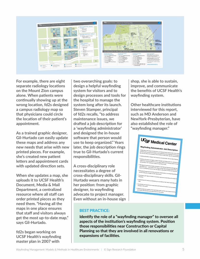
For example, there are eight separate radiology locations on the Mount Zion campus alone. When patients were continually showing up at the wrong location, fd2s designed a campus radiology map so that physicians could circle the location of their patient’s appointment.
As a trained graphic designer, Gil-Hurtado can easily update these maps and address any new needs that arise with new printed pieces. For example, she’s created new patient letters and appointment cards with updated direction sets.
When she updates a map, she uploads it to UCSF Health’s Document, Media & Mail Department, a centralized resource where all staff can order printed pieces as they need them. “Having all the maps in one place ensures that staff and visitors always get the most up-to-date map,” says Gil-Hurtado.
fd2s began working on UCSF Health’s wayfinding master plan in 2007 with
two overarching goals: to design a helpful wayfinding system for visitors and to design processes and tools for the hospital to manage the system long after its launch. Steven Stamper, principal of fd2s recalls, “to address maintenance issues, we drafted a job description for a ‘wayfinding administrator’ and designed the in-house software that person would use to keep organized.” Years later, the job description rings true to Gil-Hurtado’s current responsibilities.
A cross-disciplinary role necessitates a degree of cross-disciplinary skills. Gil-Hurtado wears many hats in her position: from graphic designer, to wayfinding advocate to project manager. Even without an in-house sign
shop, she is able to sustain, improve, and communicate the benefits of UCSF Health’s wayfinding system.
Other healthcare institutions interviewed for this report, such as MD Anderson and NewYork-Presbyterian, have also established the role of “wayfinding manager.”
BEST PRACTICE: Identify the role of a “wayfinding manager” to oversee all aspects of the institution’s wayfinding system. Position those responsibilities near Construction or Capital Planning so that they are involved in all renovations or expansions of facilities.
Wayfinding Administrator Job DescriptionCollaborating with Design & Construction and Medical Center administration, this individual will be responsible for
maintaining the accuracy and integrity of the wayfinding system (Pathway) on Parnassus, Mount Zion, and Mission
Bay sites as well as the possibility of future Medical Center sites. Specific responsibilities include:• Identifyingfacilitieschanges,bothtemporaryandpermanent,thatwillaffectPathway.•Meetingwithpracticemanagers,projectmanagersanddesignteamstounderstandcapitalimprovement
projectsandrelaytheimportanceofaccuratelymodifyingthePathwaysystemtorespondtorelevantprojects;
participatinginCICmeetingstospeaktowayfindingissues.•ManagingallwayfindingchangesasprojectsinthePathwayWayfindingManagementTool(PWMT)and
associatedtools—fromnoticeofthechange,throughsignpackagesandpunchlistreports,andassessingthe
impactofoverlappingprojects.Seenextpagefordescriptionsoftoolsandresources.•ManagingtheapprovedwayfindingnamesforalldestinationsintheWayfindingManagementTooland
communicating any changes to other departments.• CoordinatingwithSigns&Graphicstoproducesignsandcoordinatingwithvendorsforsignagefabricationand
installation.
• CoordinatingwithCampusandMarketingonanyinitiativesthatimpactwayfindingandwayfindingtoolssuchas
maps.
• Coordinatingwithdepartmentsresponsiblestafftrainingandinternalcommunicationsinordertoinformstaffof
changes to the system.
• Analyzingusageandusabilityofthewayfindingsystemwiththeaidofreportsfromthemanagementtoolwithan
eye toward improvements and enhancements to the system.Required Skills•MinimumofaBachelorsdegree,preferablyinarchitecture,facilitiesmanagement,orconstructionadministration.
• Tenyearsworkexperienceinenvironmentalgraphicdesign,architecture,constructionadministrationorfacilities
management, preferably in a healthcare or academic setting.•Mustbeself-motivatedandself-directed.Thispositionrequiresextremeattentiontodetailandtheabilityto
managemultipleongoingprojectsoveranextendedtimeframeofmonthstoyearsinduration.• KnowledgeofAutoCAD,MicrosoftOffice,andtheabilitytoquicklymastercustomsoftwareandprocessesdesigned
forthePathwaysystem.KnowledgeofDreamweaverisbeneficial.
80
280
Presidio
Golden Gate Park
LincolnPark
BuenaVistaPark
101
101
101
101
1
1
Marina Blvd.
Bay St.
Van
Ness A
ve.
Fran
klin S
t.
Gough S
t.O
ctavia
16th St.
17th St. Mariposa St.
Divisad
ero S
t.
Arg
uello B
lvd.
Post St.Sutter St.Bush St.
4th S
t.H
osp
ital St.
Owens St.
6th St.5th St.
7th St.
King S
t.
Towns
end S
t.
Bay B
ridge
to/ f
rom
Oak
land
Channel St.
2nd St.
Pine St.California St.
California St.
Clement St.
Lake St.
Geary Blvd.
Euclid Ave.
Turk St.
Balboa Blvd.
Golden Gate Ave.
Pacific Ave.
Fulton St.
Lincoln Way
Irving St.
5th A
ve.
7th A
ve.
Stanyan
St.
Presid
io A
ve.
Walnut S
t.M
asonic Ave.
Laurel S
t.W
ood
Linc
oln
Blv
d.
25th A
ve.
19th
Ave.
20th A
ve.
35th A
ve.35
th A
ve.
32nd A
ve.
14th
Ave.
46th
Ave.
46th A
ve.
Great H
wy.
Sunset B
lvd.
Park P
residio
Blvd
.
Crossover D
r.
Clayton S
t.
3rd
2nd
Judah St.
Parnassus Ave.Carl St.Frederick St.
Duboce Ave.
Kirkham St.
Sco
tt St.
Pierce S
t.
Fell St.
Fell St.
Oak St.
Fillm
ore S
t.
Lombard St.Lombard St. Columbus Ave.
Mo
ntgomery S
t.S
ansome S
t.
Pine St.
Geary Blvd.
O’Farrell St.
Embarcadero
Missio
n S
t.
Gu
errero S
t.
Eu
reka
S.V
an N
ess Ave.
Po
trero A
ve.
Mar
ket S
t.
Broadway St.
To Golden Gate Bridge
Howar
d St.
Folso
m S
t.
Bryan
t St.
10th St.
Berry
St.
3rd S
t.
Battery S
t.
4th St.
3rd St.
7th St.
Arguello
Kezar Dr.
UCSF at Mount Zion
UCSF at Parnassus Heights
N
UCSF at China Basin
UCSF at Mission Bay
From Mount Zion to other UCSF Radiology Sites
For customized maps and information visit:pathway.ucsfmedicalcenter.org
1. Turn left out of UCSF Parking Garage (east on Sutter St.)
2. Turn right on Divisadero St.3. Turn left on Golden Gate Ave.4. Turn right on Van Ness Ave.5. Turn left on Fell St.6. Slight right on 10th St.7. Turn left on Bryant St.8. Turn right on 4th St.9. Turn Left on King St./ Willie Mays Plaza10. Take first right on 3rd St. and turn right
into Parking Garage.
From Mount Zion Garage to China Basin
1. Turn left out of UCSF Parking Garage (east on Sutter St.)
2. Turn right on Divisadero St.3. Turn left on Golden Gate Ave.4. Turn right on Van Ness Ave.
(stay in left two lanes)
5. Turn left on 16th St.6. Continue past 7th St. and follow
signs to parking
From Mount Zion Garage to Mission Bay
1. Turn left out of UCSF Parking Garage (east on Sutter St.)
2. Take right on Divisadero St.3. Turn right on Turk St.4. Turn left on Stanyan St. 5. Turn right on Carl St., which
becomes Irving St.6. Turn left into UCSF Parking Garage
on Irving St.
From Mount Zion Garage to Parnassus Heights Garage UCSF at Mount Zion is accessible via
Muni bus routes: 2–Clement (wheelchair accessible), 38–Geary (wheelchair accessible), 1–California and 24–Divisadero.
UCSF at China Basin is one block from the CalTrain Depot. In addition it is also accessible via the Muni N–Judah Light Rail and Muni bus lines 10, 12, 30, 45, and 47.
For more information, visit Muni’s website at sfmuni.com.
Public Transportation
Mount Zion Radiology Map
Sutter St.
Post St.
Sco
tt S
t.
Pie
rce
St.
Bro
der
ick
St.
Erk
son
Ct.
Garden St.
Bush St.
Div
isad
ero
St.
Div
isad
ero
St.
Geary Blvd.
Geary Blvd.
2320Sutter
2300SutterMedical
Building 32380 Sutter St.
Women’sHealthCenter2356 Sutter St.
1635Divisadero
Hospital1600 Divisadero St.
MedicalBuilding 12330 Post St.
Helen DillerCancer Center1600 Divisadero St.
2255Post
2186Geary
2299 Post
2233Post
2211Post
1515Scott
OsherBuilding
1545 Divisadero St.
Ronald McDonald House
MedicalBuilding 21701 Divis. St.
DialysisBuilding1675 Scott St.
CancerResearchBuilding
UCSFParkingGarage2420 Sutter St.
2655Bush
N
Helen Diller Cancer Center – Elevator H
Floor Destination
2 Radiology / H2906 (Breast Imaging)
Breast Ultrasound
Diagnostic Mammography
Women’s Health Center – Elevator J
Floor Destination
1 Radiology / J146
Mammography
2 Radiology / J226
Ultrasound
Information Desk
Pathway
A Landmark Elevators
(Designated by letters
A, C, H, and J) Patient Drop–Off Valet ParkingEntrance (Accessible)
Medical Building 1
Floor Destination
1 Radiology / M100
CT MRI
May 2017
http://campuslifeservices.ucsf.edu/clsforms/documentsmedia/wfmaps/
Public Parking
Hospital – Elevator A
Floor Destination
1 Radiology Library / A118B
1 Radiology / A142
Bone Density
CT MRI Ultrasound
2 Cardiovascular Diagnostic Services
EKG/ECG
2 Radiology / A219
Interventional
Nuclear Medicine
X–Ray
Mount Zion Radiology Locations
CASE STUDY | Penn State Health Milton S. Hershey Medical Center, Hershey, Pennsylvania
6 Wayfinding Management: Models & Methods in Healthcare Environments | © Sign Research Foundation
Children’sHospitalFloor 1
Children’s HospitalEntrance
Same Day UnitSDU
Pedestrian BridgeTo University Physician Center
UPC
SouthOperating Room
PACURecovery Room
Surgical IntensiveCare Unit Waiting Area
SICU
Stairs ToFirst Floor
MainHospitalFloor 2
SurgicalIntermediate
Care Unit
SouthElevator
Inside Walking Directions to UPC
MC-5924-15 REV022616 REORDER at http://infonet.hmc.psu.edu/strategicservices/printshop/services/index.htm use code at left for description
STOPFor UPC
take Radiology Elevator to
second floor
Lobby
400
300
12001100
200
100
14001300
1010
502
520
600
700
800
Entrance 2
Entrance 1
Entrance 3
Entrance 4
Elevators
To Centerview
Parking Garage
Directory
Patient Care Destinations Floor Suite
Allergy, Asthma & Immunology 1 1300
Anesthesia Preoperative Evaluation 1 1300
Audiology 1 400
Dermatology 1 100
Endocrinology 1 300
Endoscopy 2 2000
I.O. Silver Cardiovascular Specialties Clinic 1 600
Lab
1 520
Medicine Specialties 1 300
Medicine Suite/Gastroenterology/Pulmonary 2 2400
Nephrology 1 300
Neurotology 1 400
Ophthalmology 1 800
Otolaryngology/Head & Neck Surgery 1 400
Pain Management Center 3 3300
Pediatric Specialties 1 1100
Pediatric Surgery 1 400
Plastic & Reconstructive Surgery 3 3200
Pharmacy, Outpatient 1 1200
Pulmonary Function Lab 2 2018
Radiology/X-ray 1 502
Renal Dialysis 1 1400
Surgery Specialties 3 3100
Other Destinations Floor Suite
Academic Offices for Gastroenterology 4 4100
ATM
1 Lobby
Bridge to Hospital 1
Corner Café 2 2012
Conference Room 1 1010
Dermatology Administration 4 4300
Dermatology Research 2 2010
Health Information Services/Medical Records G G300
Vending
1 1004
Building Map
U.Ed. MED 09-9965 SS REV 9/24/2012
Destinations
REORDER at http://infonet.hmc.psu.edu/strategicservices/printshop/services/index.htm use U.Ed. code for description
Elevator
Gift Shop
Restroom
Phones
Information ATMStairs
ParkingLegend
Lobby
400
300
12001100
200
100
1400
Bridge to Hospital1300
1010
502
520
600
700
800Entrance 1
Entrance 3
Entrance 4
Elevators
To Centerview
Parking Garage
Directory
Patient Care Destinations Floor Suite
Allergy, Asthma & Immunology 1 1300
Anesthesia Preoperative Evaluation 1 1300
Audiology
1 400
Dermatology
1 100
Endocrinology
1 300
Endoscopy
2 2000
I.O. Silver Cardiovascular Specialties Clinic 1 600
Lab
1 520
Medicine Specialties 1 300
Medicine Suite/Gastroenterology/Pulmonary 2 2400
Nephrology
1 300
Neurotology
1 400
Ophthalmology
1 800
Otolaryngology/Head & Neck Surgery 1 400
Pain Management Center 3 3300
Pediatric Specialties 1 1100
Pediatric Surgery 1 400
Plastic & Reconstructive Surgery 3 3200
Pharmacy, Outpatient 1 1200
Pulmonary Function Lab 2 2018
Radiology/X-ray
1 502
Renal Dialysis
1 1400
Surgery Specialties 3 3100
Other Destinations Floor Suite
Academic Offices for Gastroenterology 4 4100
ATM
1 Lobby
Bridge to Hospital 1
Corner Café
2 2012
Conference Room 1 1010
Dermatology Administration 4 4300
Dermatology Research 2 2010
Health Information Services/Medical Records G G300
Vending
1 1004
You are on Floor
University Physician Center
Building Map
YouAreHere
University Physician Center First Floor Main Entrance First Floor
Garner manages an in-house sign shop of three employees who are responsible for all interior and exterior signage across the site, plus over 80 specialty practices and clinics in eight central Pennsylvania counties. His shop has a wide range of capabilities—from printing inserts for the interior wayfinding and identification signs that are based on an APCO modular system, to fabricating 10-foot-high aluminum-frame vehicular signs, to generating large-scale elevator graphics and banners for marketing initiatives.
Using a web-based custom maintenance system, any of the institution’s 10,000 employees can request a new sign. Scott’s team also coordinates with space planners and project managers in the Construction Group on renovations, expansions and temporary signage needs.
At the heart of this system are three permanent cross-department committees overseeing consistency and compliance. Each group looks at wayfinding from a unique perspective and weighs in on specific issues:
SIZE: Main campus is 5 million square feet (606 beds) and 12 buildings on a 500-acre campus
RECOGNITION: Nationally ranked in 6 specialties, U.S. News & World Report’s 2017-18 Best Hospitals
INTERVIEWEE: Scott Garner, Trade Supervisor
Permanent, interdepartmental wayfinding committees at Penn State Health Milton S. Hershey Medical Center keep the system accurate, consistent and visitor-focusedWith a campus of over 550 acres housing over a dozen interconnected research and clinical buildings, “we really are our own city,” says Scott E. Garner, Trade Supervisor at Penn State Health’s Milton S. Hershey Medical Center in Hershey, Pennsylvania.
Wayfinding Management: Models & Methods in Healthcare Environments | © Sign Research Foundation 7
҉ The Sign Committee owns the Sign Policy, the guidelines for content and use of signage at the medical center. They evaluate issues at a system level, and moderate requests for signs not covered under the Sign Standards.
҉ The Wayfinding Committee, composed of upper management from Facilities and from the Hospital, provides what Garner calls “checks and balances,” always considering the performance of wayfinding tools from a visitor’s perspective.
҉ The Campus Maps Team is responsible for all maps on campus, whether printed on signs, published on the website, or as handouts at information desks. The three members of the team (one each from Marketing, Facilities, and Space Planning) hear feedback from patients and visitors, and invite staff from patient-facing departments like Patient Affairs and Radiology to collaborate on an array of helpful maps.
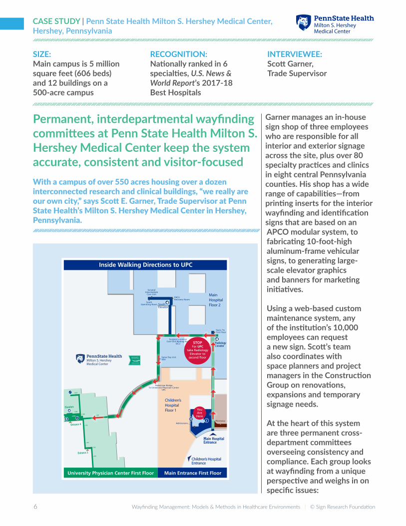
These committees address wayfinding challenges as they arise. For example, the Campus Maps Team found that patients were having a difficult time navigating from the Hospital to the University
Physician Center, a building connected by a second floor pedestrian bridge. In response, the team designed a route map handout for the hospital’s information desk staff.
Teresa Cox, President, APCO Sign Systems toured the campus recently: “I was able to witness how they responded to requests for additional signs by uncovering underlying issues—some that could be better solved by management, not by putting up more signs.”
Together, the charters of these standing committees demonstrate the institution’s commitment to keeping wayfinding tools accurate, coherent, and visitor-focused as their facilities change and grow. Wayfinding is seen as an ongoing, shared responsibility, not as a component of discrete construction projects or as the sole ownership of a single department in Facilities. As a member of all three committees, Scott Garner finds these processes and tools make a difference: “While it is a challenge to keep up with incoming requests, the committees, the policy, and the standards all streamline the work.”
Other healthcare institutions have found value in permanent wayfinding committees. At Cleveland Clinic, a standing wayfinding committee of about a dozen representatives from Signage, Marketing, Executive Administration, Interior Design, IT, Patient Appointments, and the Red Coats (paid patient navigators) meets every six weeks to review wayfinding needs and assess solutions.
The wayfinding committee at Cincinnati Children’s weighs in on department name changes and reviews results of patient surveys. And at University of Chicago Medicine, the branding committee defines the formal names of departments to ensure consistency across all communication channels.
BEST PRACTICE:Inaugurate a permanent wayfinding committee with participants from patient-facing departments, facilities, and marketing to monitor and continually improve all aspects of visitor wayfinding.
8 Wayfinding Management: Models & Methods in Healthcare Environments | © Sign Research Foundation
CASE STUDY | Cleveland Clinic, Cleveland, Ohio
Cleveland Clinic is recognized as the number-two hospital in the country according to U.S. News & World Report’s Best Hospitals 2017-18. Along with its main campus of 44 buildings on 167 acres in Cleveland, the institution
SIZE: Main campus is 9 million square feet (1,400 beds), 44 buildings on 167 acres; 9 regional hospitals in northeast Ohio; urgent care, rehab, and 3 international locations
RECOGNITION: No. 2 hospital in nation, U.S. News & World Report’s 2017-18 Best Hospitals
INTERVIEWEES: Joseph J. Strauss, Director, Planning & Design and Tom Federico, Signage Department Manager, Planning & Design
Cleveland Clinic sets the standard, and follows it systematically“The goal is to have all our facilities consistent from building to building and have each facility easily recognized as a Cleveland Clinic facility” explains Tom Federico, Signage Department Manager at Cleveland Clinic in Cleveland, Ohio. Federico manages an in-house sign department of four designers, fabricators and installers, and works closely with Joseph Strauss, Director of Planning & Design.

8 Wayfinding Management: Models & Methods in Healthcare Environments | © Sign Research Foundation Wayfinding Management: Models & Methods in Healthcare Environments | © Sign Research Foundation 9
owns nine regional hospitals in northeastern Ohio; medical centers in Florida, Toronto, Las Vegas, and Abu Dhabi; along with over a hundred regional care centers in Ohio. The Planning & Design Department and its Signage Department are responsible for all these distant locations.
Employees order signs through an intranet-based system and Federico estimates they process about 360 orders per month—one order could be for one sign or for a whole floor.
For new construction, like the Taussig Cancer Center that opened recently, Federico meets with the design team early in the project, reviewing the architect’s schematic design package and assigning room numbers according to their standard numbering system. It is important to note that systematic room numbering supports a logical wayfinding system, as well as setting the foundation for later expansions and additions.
Those numbers become part of the Building Maintenance System, so the new building can already be tracked, far before it opens. When the project is further along, Federico programs sign placement and messages and in the last stages of construction, Federico’s team installs all the interior signs.
“When we do a new building, we don’t design new signage — it all comes from the Sign Standards Manual,” says Federico.
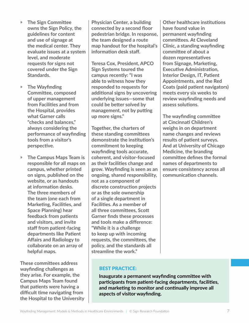
The Sign Standards, drafted in 2007 and updated in 2012, address the vast majority of needs, from an ADA acrylic window plaque to a building entry sign. As owner of the 117-page manual, Federico has eliminated some sign types over the years to simplify the options.
Codifying a system of signs into a manual is certainly not a new idea—most environmental designers draft standards as a core deliverable of their engagements. But Cleveland Clinic has taken additional steps to ensure that the standards are followed consistently: ҉ Entrusting the Signage
Department to manage all institutional signage projects, on campus and at remote locations, as part of their centralized Planning & Design Department.
҉ Collaborating on large-scale projects early in the design process to apply room numbering standards to new construction,
setting the logic and foundation for the wayfinding system.
҉ Investing in in-house capabilities with designers, fabricators and installers on staff, which guarantees that the quality of signs adhere to the standard.
Federico sums up the importance of the Sign Standards: “They are an essential part of our overall brand strategy. Consistency in presentation is key, whether it’s printed material, web sites, signage, office decor, or furniture.”
All seven institutions studied in this report maintain Sign Standards. Some institutions like UCSF Health and MD Anderson rolled out their new standards in campus-wide initiatives; others like Cincinnati Children’s Hospital have implemented them in a series of larger construction projects, updating the campus one area at a time. A third option is to re-sign major visitor walkways and public areas first, in order to deliver the greatest benefit to visitors.
BEST PRACTICE:Invest in a formalized system of Sign Standards and tune processes and departments to enact, support and administer those standards across the institution and its satellite locations.
10 Wayfinding Management: Models & Methods in Healthcare Environments | © Sign Research Foundation
CASE STUDY | NewYork-Presbyterian/Columbia University Irving Medical Center, New York, New York
Advancing wayfinding through in-house evangelism and training at NewYork-Presbyterian/Columbia University Irving Medical Center“On any given day, the average visitor spent all or part of their travel time being lost.” That’s how wayfinding and design consultant Sylvia Harris summed up the experience of navigating NewYork-Presbyterian’s 20-acre campus in Washington Heights, New York in 2001.
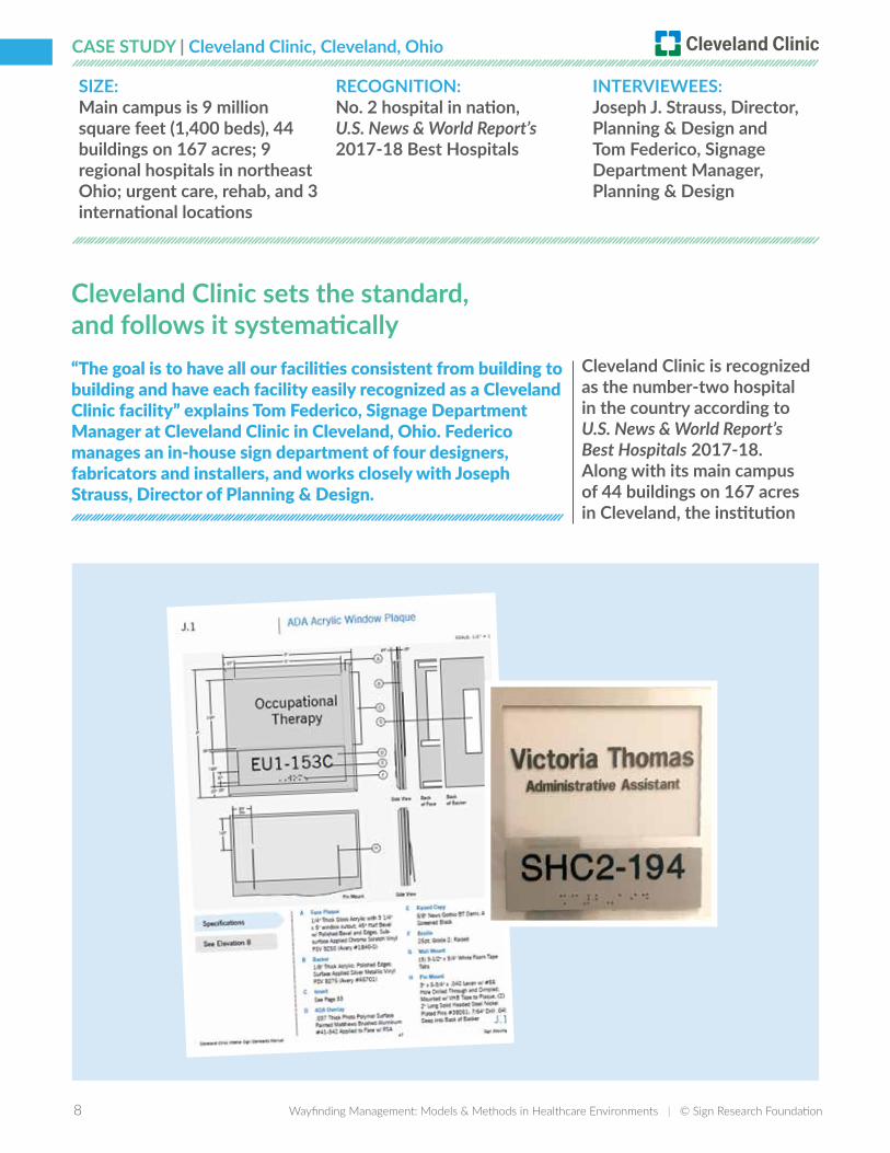
Low scores in patient satisfaction surveys conducted by Press Ganey, the patient experience measurement firm, had alerted hospital administrators to the visitor-confusion problem and in response, they launched an initiative that led to the design and implementation of a comprehensive wayfinding system. Harris (then principal of Sylvia Harris, LLC and later founder of Citizen Research & Design) led an executive steering committee that oversaw the effort, which transformed from a stand-alone project into a funded and centralized department: Visitor Information Services.
Mercedes Perry was the first person to hold the “Visitor Information Services” title in 2004 and continues in that role today. She sees her job as elevating signage as a priority within any given remodel or expansion. “Eighty percent
SIZE: 27 buildings on a 20-acre campus (738 beds)
RECOGNITION: No. 1 in New York State and New York metro area (combined with Weill Cornell Medical Center), U.S. News & World Report’s 2017-18 Best Hospitals
INTERVIEWEE: Mercedes Perry, Visitor Information Services
10 Wayfinding Management: Models & Methods in Healthcare Environments | © Sign Research Foundation Wayfinding Management: Models & Methods in Healthcare Environments | © Sign Research Foundation 11
of our job is protecting and marketing the sign standards,” citing the sign guidelines that were developed by Cloud Gehshan in 2005. Twelve years later, visitors encounter a very consistent palette of signs even as the campus has sprouted several major new buildings.
Perry attributes the consistent expansion of the system to an exercise in in-house evangelism. Perry collaborated with Human Resources to “market” the wayfinding system, in the form of the sign standards, to every chair of every department across the campus. “It was a dog and pony show,” Perry remembers, presenting the system at the last 10 minutes of department and physician group meetings — and it took about a year to make the rounds across the campus.
In those meetings, Perry explained how the new wayfinding system would improve the patient experience, and this resonated with staff. When they saw new signs go up, they knew why. “There was some push-back, but in the end, they were convinced,” says Perry.A second wave of meetings had been planned: sessions to train staff on the new destination names that had been formalized during the wayfinding project. Harris had envisioned two programs: training for front-line staff like the security guards that
work at the main information desk and adding a module to the two-day new employee orientation.
These programs were never implemented, but Perry considers them “a must. We have employees who have been here 40 years and some who have been here three months—everyone learns building names differently.”
Establishing a consistent wayfinding vocabulary of building and destination names is critical to the success of the wayfinding system. Whether its a patient appointment letter, a section of the website, or a sign on a wall, all wayfinding tools should use the same set of nomenclature to guide visitors to their destination.
And perhaps even more important than creating that single source of place names is educating the staff to use those names consistently.
Staff members are the face of the institution and when visitors are lost, they often seek advice from anyone with a badge or a lab coat. Employees also feel a sense of ownership of their
environment, so they can become the best advocates of a change—like a new sign system—if they understand its goals and are involved in its launch.
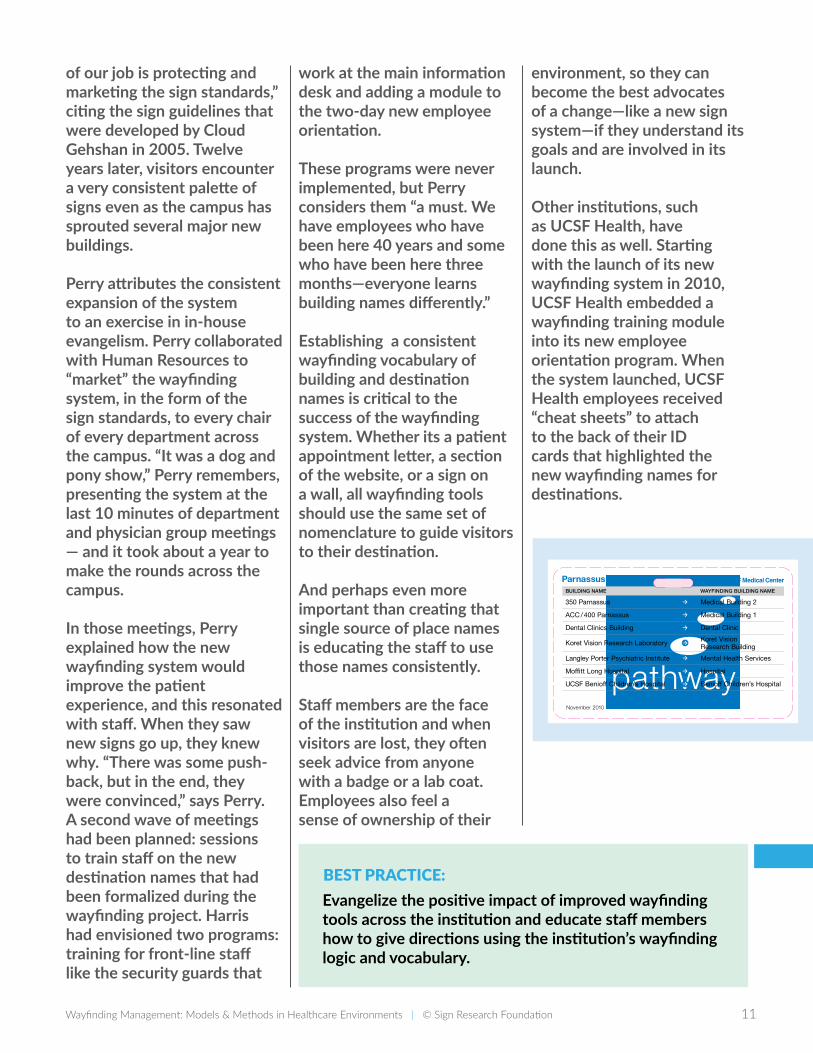
Other institutions, such as UCSF Health, have done this as well. Starting with the launch of its new wayfinding system in 2010, UCSF Health embedded a wayfinding training module into its new employee orientation program. When the system launched, UCSF Health employees received “cheat sheets” to attach to the back of their ID cards that highlighted the new wayfinding names for destinations.
BEST PRACTICE:Evangelize the positive impact of improved wayfinding tools across the institution and educate staff members how to give directions using the institution’s wayfinding logic and vocabulary.
FD2S INC. © 2009 FD2S INC. PROJECT NAME/PROJECT CODE ISSUES/REVISIONS PAGE TITLE / ELEMENT TYPE SHEET NUMBER
500 ChiconAustin, Texas 78702tel 512 476 7733fax 512 473 2202www.fd2s.com
All rights reserved. The intellectual property, concepts, and designs contained in this document are the exclusive property of fd2s inc.
Neither the document nor the information it contains may be copied, disclosed to others, or used in connection with any work or project other than the specific project for which it has been prepared and developed, without the written consent of fd2s inc.
UCSF Medical CenterCommunication Tools08UCSF VARIOUS
23OCT2008 Design Development16DEC2008 Design Development26JAN2009 Design Development30MAR2009 Design Development11MAY2009 Design Development09JUN2009 Design Development09NOV2009 Final
43
Employee Reference Card
Context for UseA small card for staff members that acts as a reference guide
for name changes.
Size3.416"w x 2.16h
with .16"r rounded corners
and punched hole.
Format & ReproductionSame as ID Badge
Viewing Distance12"
Information• Building name changes
• Elevatornamechanges
Mount Zion—Side A Shown at 150% of actual size
Parnassus—Side A Shown at 150% of actual size
Mount Zion—Side B Shown at 150% of actual size
Printing Diagram
Parnassus—Side B Shown at 150% of actual size
1701 Divisadero Medical Building 2
2330 Post Medical Building 1
2356 Sutter / J Building Women’s Health Center
2380 Sutter / Shumate Building Medical Building 3
Hellman Building Hospital
UCSF Helen Diller FamilyComprehensive Cancer Center
Helen Diller Cancer Center
BUILDING NAME WAYFINDING BUILDING NAME
Mount Zion
Cancer Center Elevators Elevator
Hellman Building Elevator Elevator
Hospital Main Elevators Elevator
Women’s Health Center /J Building Elevators Elevator
H
C
A
J
WAYFINDING ELEVATOR NAMEELEVATOR NAME
Mount Zion
350 Parnassus Medical Building 2
ACC / 400 Parnassus Medical Building 1
Dental Clinics Building Dental Clinic
Koret Vision Research Laboratory Koret Vision Research Building
Langley Porter Psychiatric Institute Mental Health Services
Moffi tt Long Hospital Hospital
UCSF Benioff Children’s Hospital Benioff Children’s Hospital
WAYFINDING BUILDING NAMEBUILDING NAME
Parnassus Heights
November 2010
ACC ElevatorsElevator
Clinical Sciences ElevatorsElevator
Elevator J / Food CourtElevator
Long Hospital ElevatorsElevator
Millberry Union ElevatorsElevator
Moffi tt Hospital ElevatorsElevator
Parking Garage Main ElevatorsElevator
UC Hall ElevatorsElevator
ELEVATOR NAMEWAYFINDING ELEVATOR NAME
A
C
D
L
F
M
G
U
Parnassus Heights
Employee Reference CardExamples
12 Wayfinding Management: Models & Methods in Healthcare Environments | © Sign Research Foundation
CASE STUDY | University of Chicago Medicine, Chicago, Illinois
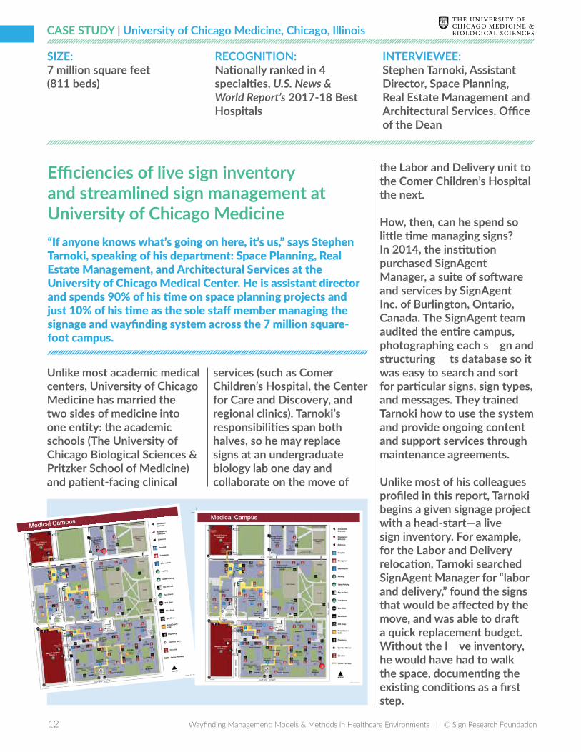
Efficiencies of live sign inventory and streamlined sign management at University of Chicago Medicine“If anyone knows what’s going on here, it’s us,” says Stephen Tarnoki, speaking of his department: Space Planning, Real Estate Management, and Architectural Services at the University of Chicago Medical Center. He is assistant director and spends 90% of his time on space planning projects and just 10% of his time as the sole staff member managing the signage and wayfinding system across the 7 million square-foot campus.
Unlike most academic medical centers, University of Chicago Medicine has married the two sides of medicine into one entity: the academic schools (The University of Chicago Biological Sciences & Pritzker School of Medicine) and patient-facing clinical
services (such as Comer Children’s Hospital, the Center for Care and Discovery, and regional clinics). Tarnoki’s responsibilities span both halves, so he may replace signs at an undergraduate biology lab one day and collaborate on the move of
████████████████████████████████████████████████████████████████████████████████████████████████
Medical Campus
331M-1-A20.1-001
████████████████████
████
████████████████████
████████████████████████
████
████████████████████
████Medical Campus
331M-1-B98.8-003
the Labor and Delivery unit to the Comer Children’s Hospital the next.
How, then, can he spend so little time managing signs? In 2014, the institution purchased SignAgent Manager, a suite of software and services by SignAgent Inc. of Burlington, Ontario, Canada. The SignAgent team audited the entire campus, photographing each sign and structuring its database so it was easy to search and sort for particular signs, sign types, and messages. They trained Tarnoki how to use the system and provide ongoing content and support services through maintenance agreements.
Unlike most of his colleagues profiled in this report, Tarnoki begins a given signage project with a head-start—a live sign inventory. For example, for the Labor and Delivery relocation, Tarnoki searched SignAgent Manager for “labor and delivery,” found the signs that would be affected by the move, and was able to draft a quick replacement budget. Without the live inventory, he would have had to walk the space, documenting the existing conditions as a first step.
SIZE:7 million square feet (811 beds)
RECOGNITION: Nationally ranked in 4 specialties, U.S. News & World Report’s 2017-18 Best Hospitals
INTERVIEWEE: Stephen Tarnoki, Assistant Director, Space Planning, Real Estate Management and Architectural Services, Office of the Dean
12 Wayfinding Management: Models & Methods in Healthcare Environments | © Sign Research Foundation Wayfinding Management: Models & Methods in Healthcare Environments | © Sign Research Foundation 13
Next, he brought on a designer who used the institution’s sign standards to develop the series of signs and messages required on both sides of the move. At the end of the project, he sent lists of all new and replaced signs to SignAgent to add to his database.
A crucial component of the medical center’s wayfinding system is the campus map
BEST PRACTICE:Document and track all aspects of the existing sign system—sign locations, messages, sign types, and destination names—to gain efficiencies in sign projects and to sustain the accuracy of the system as a whole.
that highlights pedestrian pathways to and around the main buildings. Each elevator lobby features a campus map sign with a “You are here” dot to orient visitors.
When a new parking garage opened, SignAgent built a particularly helpful shortcut to help Tarnoki update the 332 maps across the campus. Each campus map sign is made up of two art files: the campus
base map and an overlay with the “You are here” dot pointing to the sign’s (and the visitor’s) location.
After the designer added the new garage to the base map, Tarnoki uploaded the new art file to SignAgent, replacing all instances of the base map. The “You are here” dots remained in their unique placements on a layer above the base map so when Tarnoki searched for all campus map signs, they were all updated and the system generated a 332-page PDF to print all the replacement maps, each labeled with its unique sign location number. As Tarnoki says, “there’s still work to do, but not the arduous, painful work.”
It is difficult to manage something without the tools to quantify it. With a live sign inventory, estimated budgets are more accurate and the sign system itself retains its integrity as destinations move: no errant signs are left behind.
Spotlight on Wayfinding and Signage Management ToolsSignage is often seen as merely a modest and late addition to a large construction project. This perception is compounded by the paucity of tools available to manage signage, compared to other aspects of construction. Without an industry standard software platform, most institutions manage their signage on an ad-hoc basis—relying on a stash of outdated sign packages from previous projects and beginning every project with an audit to see what’s actually on the walls.
That said, there are a variety of ways to organize and maintain sign data and wayfinding content today:
҉ SignAgent and PAM Wayfinding offer sign management software.
҉ Sign locations and messages can be added to AutoDesk AutoCAD floor plans, AutoDesk Revit models, and PlanGrid documents.
҉ Custom fields and functions to manage signage can be created within ARCHIBUS Web-Central or ServiceNow.
҉ Facilities and asset management systems that track inventory and equipment can also track signs.
҉ A departmental database can be created to manage annotated location plans, signs and destination names.
҉ A spreadsheet of official destination names can streamline the process of keeping all names consistent across media.
14 Wayfinding Management: Models & Methods in Healthcare Environments | © Sign Research Foundation
CASE STUDY | Cincinnati Children’s Hospital Medical Center, Cincinnati, Ohio
Cincinnati Children’s Hospital Medical Center: ask the visitors, and then ask them again“Why do you ask the same questions over and over again?” asks a mom in a Patient Orientation video on the Cincinnati Children’s website. Her question is about the refrains of “what’s your name? what’s your birth date?” that every medical professional asks when they visit a patient’s room. The reason is, of course, to double check that they are visiting the right patient—a common safety precaution.
But that same question could be posed to the medical center’s Design, Construction and Space Management Department, which is responsible for the main campus of 6.5 million square feet along with about two and a half million square feet of neighborhood outpatient clinics. They’ve asked the same questions
over and over again for eight years—surveying patients, visitors, and staff about their experience at the Medical Center.
Jason Luthy, Space and Occupancy Planner within the Design, Construction, and Space Management Department explains that large construction projects,
Survey Data
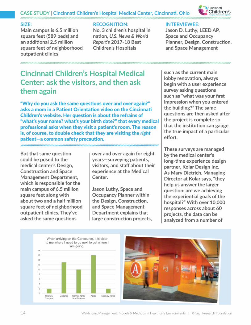
What was your first impression when you entered the campus? (n=43)• Wayfinding uncertainty 27.91% (n=12)
What was your first impression when you entered the building? (n=45)• Wayfinding uncertainty 35.56% (n=16)• Wayfinding confidence 22.22% (n=10)
What helped you find your way the most? (n=45)• Signs 60% (n=27)• Information Desk 33.33% (n=15)• Staff 31.11% (n=14)• I’ve been here before 15.56% (n=7)
0
2
4
6
8
10
12
14
16
18
Strongly Disagree
Disagree Neither Agree Nor Disagree
Agree Strongly Agree
When arriving on the Concourse, it is clear to me where I need to go next to get where I
am going.
Column1
such as the current main lobby renovation, always begin with a user experience survey asking questions such as “what was your first impression when you entered the building?” The same questions are then asked after the project is complete so that the institution can gauge the true impact of a particular effort.
These surveys are managed by the medical center’s long-time experience design partner, Kolar Design Inc. As Mary Dietrich, Managing Director at Kolar says, “they help us answer the larger question: are we achieving the experiential goals of the hospital?” With over 10,000 responses across about 60 projects, the data can be analyzed from a number of
SIZE:Main campus is 6.5 million square feet (589 beds) and an additional 2.5 million square feet of neighborhood outpatient clinics
RECOGNITION: No. 3 children’s hospital in nation, U.S. News & World Report’s 2017-18 Best Children’s Hospitals
INTERVIEWEE: Jason D. Luthy, LEED AP, Space and Occupancy Planner, Design, Construction, and Space Management
14 Wayfinding Management: Models & Methods in Healthcare Environments | © Sign Research Foundation Wayfinding Management: Models & Methods in Healthcare Environments | © Sign Research Foundation 15
viewpoints and provides insights much more far-reaching than the visual impact of a sunnier lobby.
As the Kolar team delves deeper into this longitudinal dataset, they are looking for measurable differences that may lead to larger observations. For example, do people rate their overall experience differently based on the length of stay of their child as an inpatient? If so, those findings may illuminate specific issues to be addressed in inpatient facilities versus outpatient areas.
When patients are asked about their experience at a hospital, their answers rarely fit cleanly into departmental disciplines such as facilities or clinical operations. “Each survey has global and local impacts” Dietrich explains. That’s why Luthy’s department regularly shares these results across the institution.
Luthy recalls a surprising insight from pre-project observations, patient/family feedback and later validated by subsequent surveys. “We found that the garage itself is really a lobby,” since a common entry scenario is that a parent may drive into the garage and drop off the other parent and child at the hospital entrance, and then find parking. That new definition of the garage-as-lobby informed the interior design and architecture of
the renovation. The design team of Kolar Design and GBBN Architects reworked the elevator lobbies to include more prominent landmarks and wayfinding information, and made the overall entry a bit more like a welcoming front door than a back door.
Whether it’s called “patient-centered design,” “evidence-based design” or “participatory design,” there is a great deal to be learned from listening to visitors. Hospital administrators are often susceptible to a certain myopia about their hospitals—they’ve grown accustomed to the eccentricities of their environments, like the dead-end corridor or the hidden elevator lobby.
Observing visitors as they navigate or reading their survey responses can reveal the true experience of often-anxious caregivers and patients. Structured pre- and post-surveys like those fielded at Cincinnati Children’s elevate the importance of wayfinding initiatives and provide metrics to gauge future improvements.
Other healthcare institutions have found value in user research as well. Cleveland Clinic hosts an annual “Empathy + Innovation Summit,” championing the value of user research in improving the patient experience.
Both Cleveland Clinic and MD Anderson have chartered patient advisory councils—the volunteer members make themselves available for surveys and research activities. Last year, MD Anderson piloted an indoor wayfinding app and invited members of the Patient and Family Advisory Group to “test-drive” the app. Their feedback informed subsequent decisions about a larger roll-out.
MD Anderson performed several user research activities during the initial design and launch of their wayfinding program, including staff surveys about hard-to-find destinations and interviews to explore visitor comprehension of names and icons of its wayfinding landmarks.
UCSF undertook research studies in the design phase of their wayfinding touchscreens, asking visitors to “click” through paper prototypes to generate direction sets. Their input led to a more streamlined interface.
BEST PRACTICE:Employ visitor research tools like surveys on a regular basis to evaluate the effectiveness of wayfinding tools and to improve the overall visitor experience.
16 Wayfinding Management: Models & Methods in Healthcare Environments | © Sign Research Foundation
CASE STUDY | MD Anderson Cancer Center, Houston, Texas
A commitment to digital wayfinding tools for visitors and for staff at MD Anderson Cancer CenterIn 2003, MD Anderson Cancer Center, the nation’s number 1 cancer hospital according to U.S. News and World Report’s Best Hospitals 2017-18, broke ground on the largest capital-planning project in its history—adding over 40% more clinical and research space to its already massive six million square foot campus Texas Medical Center in Houston, Texas. A small fraction of that construction budget was earmarked to improve wayfinding across the campus.
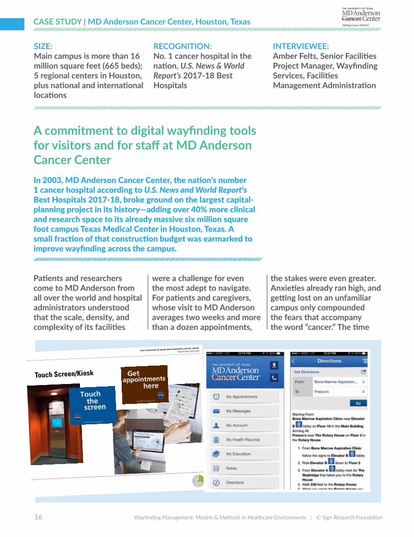
The University of Texas MD Anderson Cancer Center
Wayfinding Services
Touch Screen/Kiosk
Patients and researchers come to MD Anderson from all over the world and hospital administrators understood that the scale, density, and complexity of its facilities
were a challenge for even the most adept to navigate. For patients and caregivers, whose visit to MD Anderson averages two weeks and more than a dozen appointments,
the stakes were even greater. Anxieties already ran high, and getting lost on an unfamiliar campus only compounded the fears that accompany the word “cancer.” The time
SIZE: Main campus is more than 16 million square feet (665 beds); 5 regional centers in Houston, plus national and international locations
RECOGNITION: No. 1 cancer hospital in the nation, U.S. News & World Report’s 2017-18 Best Hospitals
INTERVIEWEE:Amber Felts, Senior Facilities Project Manager, Wayfinding Services, Facilities Management Administration
16 Wayfinding Management: Models & Methods in Healthcare Environments | © Sign Research Foundation Wayfinding Management: Models & Methods in Healthcare Environments | © Sign Research Foundation 17
was right to invest in a comprehensive wayfinding system that would cater to its community and could grow in tandem with the institution’s vast expansion plans.
Over a six-year collaboration with design consulting firm fd2s, MD Anderson launched an integrated suite of wayfinding tools: from pocket maps to a new interior and exterior sign system, to architectural landmarks and articulated pedestrian paths, to an innovative collection of digital wayfinding tools.
These digital tools—a wayfinding website and a network of on-site wayfinding touchscreens supported by a wayfinding management system for staff to manage it all—launched in 2005, the pre-dawn of the mobile age. (Google Maps launched that year and the iPhone didn’t debut until two years later. )
To manage all the components of the system, MD Anderson created a new department, Wayfinding Services, now in Facilities Management Administration. Amber Felts leads the department of ten employees, including designers/project managers and a sign shop offering digital printing, engraving and sign fabrication capabilities as well as sign installation.
Starting in 2005 and continuing today, the website and touchscreens offer
visitors the ability to plan their journey to their appointments at MD Anderson—giving them directions to the closest parking garage to their destination and then walking directions all the way to the check-in desk.
At launch, MD Anderson staff were not entirely confident that visitors would take advantage of these new tools, but testing new technologies and building foundations for future needs is a part of the culture at this academic medical center.
And in fact, the onsite touchscreens, some of the first to be installed at a large medical center, proved to be a valuable guide—approximately 50,000 sets of walking directions were generated from the 20 touchscreens within the first year.
The wayfinding website wasalso a welcome resource forpeople planning their trips tothe medical center. At first, itoffered only driving directionsfrom various parts of Houstonbut later enhancementsincluded integration withGoogle Maps, so that visitorscould get customized directionsfrom their home address.
Always an early adapter of technology, MD Anderson launched its own app in 2013, and included the same ability to generate custom directions to any campus destination.
It was clear that patients and visitors appreciated these new tools and grew to expect up-to-date wayfinding information at the tip of their fingers.
“We all rely on our smartphones to navigate, and inside MD Anderson we want to make wayfinding as seamless as possible,” says Felts. She has sponsored user research activities to inform the upgrades to wayfinding technology.
MD Anderson is in the midst of planning for a second generation of leading-edge wayfinding tools. In the last few years, MD Anderson has piloted indoor location technology, using Bluetooth beacons to provide indoor “GPS-like” navigation. Wayfinding Services invited members of the institution’s Patient and Family Advisory Group to “test-drive” the app in the pilot environment and their input is driving decisions about a larger roll-out.The wayfinding management system is just as vital a tool for the staff of Wayfinding Services as the front-of-house wayfinding tools have become to MD Anderson’s visitors.
Wayfinding Services staff manage all the destination names, wayfinding logic, and sign locations and messages in one centralized repository. The system is a proprietary application designed by fd2s and built by a custom software
18 Wayfinding Management: Models & Methods in Healthcare Environments | © Sign Research Foundation
development firm. In addition to housing all wayfinding data, the system feeds content to the website, app, and touchscreens.
When a department moves, a project manager in Felts’ department can review the live sign inventory, place new signs on the master AutoCAD plans, and generate sign artwork all from the tool. The artwork is printed by the in-house sign shop, fabricated and installed by staff. When a project is complete, changes are “published” to the website, app, and touchscreens.
Steven Stamper, principal of fd2s, explains the importance of this centralized approach: “MD Anderson’s wayfinding management system is the single source of truth for the institution, and guarantees that maps and directions are accurate no matter where patients encounter them.”
The unique capabilities that were built into the wayfinding maintenance system have served the institution well. Now the department is planning to leverage ARCHIBUS, an enterprise space management system, for expanded wayfinding management capabilities.
It wasn’t an easy decision to invest in wayfinding technology in 2004, but the smartphone has redefined MD Anderson’s expectations—and our confidence—in navigating
unfamiliar environments. Today, visitor-facing wayfinding technology has become a required element of any wayfinding system.
Both UCSF and Cleveland Clinic have invested in robust digital wayfinding tools.
҉ UCSF’s wayfinding website helps visitors preplan their routes to medical appointments and touchscreens offer onsite directions.
҉ Cleveland Clinic’s app lists all their locations and offers links to the smartphone’s default mapping app to generate custom directions.
BEST PRACTICE:Fulfill visitors’ expectations by integrating wayfinding guidance in digital tools like the institution’s website and app.
18 Wayfinding Management: Models & Methods in Healthcare Environments | © Sign Research Foundation Wayfinding Management: Models & Methods in Healthcare Environments | © Sign Research Foundation 19
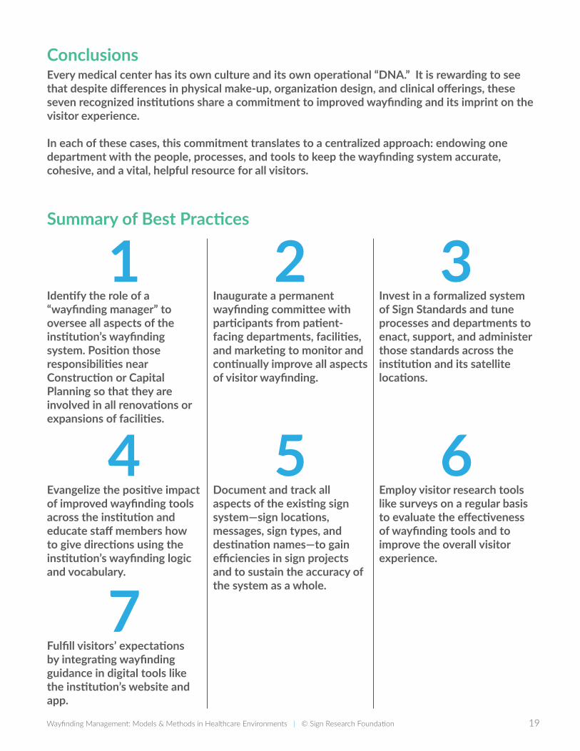
ConclusionsEvery medical center has its own culture and its own operational “DNA.” It is rewarding to see that despite differences in physical make-up, organization design, and clinical offerings, these seven recognized institutions share a commitment to improved wayfinding and its imprint on the visitor experience.
In each of these cases, this commitment translates to a centralized approach: endowing one department with the people, processes, and tools to keep the wayfinding system accurate, cohesive, and a vital, helpful resource for all visitors.
Summary of Best Practices
1Identify the role of a “wayfinding manager” to oversee all aspects of the institution’s wayfinding system. Position those responsibilities near Construction or Capital Planning so that they are involved in all renovations or expansions of facilities.
2Inaugurate a permanent wayfinding committee with participants from patient-facing departments, facilities, and marketing to monitor and continually improve all aspects of visitor wayfinding.
3Invest in a formalized system of Sign Standards and tune processes and departments to enact, support, and administer those standards across the institution and its satellite locations.
4 Evangelize the positive impact of improved wayfinding tools across the institution and educate staff members how to give directions using the institution’s wayfinding logic and vocabulary.
5 Document and track all aspects of the existing sign system—sign locations, messages, sign types, and destination names—to gain efficiencies in sign projects and to sustain the accuracy of the system as a whole.
6 Employ visitor research tools like surveys on a regular basis to evaluate the effectiveness of wayfinding tools and to improve the overall visitor experience.
7Fulfill visitors’ expectations by integrating wayfinding guidance in digital tools like the institution’s website and app.
20 Wayfinding Management: Models & Methods in Healthcare Environments | © Sign Research Foundation
Additional ReadingKelsea Gurski, Linda S. Jones, and Mark VanderKlipp, “5 Building Blocks of Wayfinding,” Healthcare Design Magazine, December 14, 2016.
Sylvia Harris, “Wayfinding Lessons learned from NewYork-Presbyterian/Columbia University Medical Center,” Healthcare Design Magazine, April 30, 2009.
Jennifer Silvis, “Wayfinding Tools that Do More and Cost Less,” Healthcare Design Magazine, December 19, 2011.
Craig Berger, Wayfinding: Designing and Implementing Graphic Navigational Systems (Brighton: RotoVision, 2005)
Chris Calori, Signage and Wayfinding Design: A complete Guide to Creating Graphic Design (Systems 2nd Edition (Hoboken, Wiley, 2015.)
David Gibson, The Wayfinding Handbook: Information Design for Public Places (Princeton: Princeton Architectural Press, 2009.)
PHOTO CREDIT: Cover and page 14: Joe Harrison, JH Photography.
AcknowledgmentsMany thanks to the members of the project Advisory Team, the interviewees, and colleagues who contributed to this study.Teresa CoxMary DietrichTom FedericoAmber FeltsScott GarnerVirginia GehshanNatalia Gil-HurtadoSylvia Harris (in memoriam)Barbara HuelatJason D. LuthyMarlene Parrish Mercedes Perry Jennifer Kovacs Silvis Anna Sharp Steven Stamper Joseph J. Strauss Steven Tarnoki Jacob Vanstaalduinen Robert L. Wolke

20 Wayfinding Management: Models & Methods in Healthcare Environments | © Sign Research Foundation Wayfinding Management: Models & Methods in Healthcare Environments | © Sign Research Foundation 21
DID YOU FIND THIS REPORT
USEFUL? Support more research like this
with a tax-deductible contribution.
Donate now at givetosrf.org.
@SignResearch
PUBLISHED BY:
WWW.SIGNRESEARCH.ORGThis report remains the property of the Sign Research Foundation.
None of the information contained within can be used, republished or reprinted without express permission from the Sign Research Foundation.
© Sign Research Foundation
![wayfinding interpreti]e branding - Studio L'Imagestudiolimage.com/downloads/Wayfinding-Urban.pdf · Wayfinding Program In the heart of Chinatown, bilingual wayfinding signage directs](https://img.dokumen.tips/doc/110x75/5e8e6c5f99e6632d522e7817/wayfinding-interpretie-branding-studio-l-wayfinding-program-in-the-heart-of.jpg)