Embed Size (px)
Citation preview

SG Sustainable Oils Cameroon Limited
C/O Dr Isidore Nse TIMTI No. 5 Nambeke Street, P.O. Box 64 Limbe
Southwest Region, Cameroon Tel: 237 33 33 23 46
Tel/Fax: 237 33 33 23 75 E-mail: [email protected]
ENVIRONMENTAL SOCIAL IMPACT ASSESSMENT
PREPARED FOR
SG SUSTAINABLE OILS CAMEROON LTD.
BY
H & B Consulting
Immeuble HAJAL CENTER – 6Th Floor – Suite 604 P O Box 2986 Yaoundé Cameroon (237) 22 22 38 90 – (237) 99 92 67 07 [email protected] www.handb-consulting.com
4800 Hampden Lane - Suite 200 Bethesda, MD 20814
Phone : 1-240-752-1564 Fax : 1-240-482-3759
[email protected] www.handb-consulting.com

SGSOC ESIA
SGSOC i August 2011
Table of Contents
1 Introduction ............................................................................................................................ 1-1 1.1 Project Objective ...................................................................................................................... 1-1 1.2 Background and Need ............................................................................................................ 1-2 1.3 Document Organization ........................................................................................................ 1-4
2 Policy, Legal, and Administrative Framework ............................................................ 2-5 2.1 Corporate Commitments ...................................................................................................... 2-5 2.2 Cameroon Legal and Regulatory Framework ............................................................... 2-7
2.2.1 National Environmental Legislation .......................................................................................... 2-7 2.2.2 Health & Safety Legislation ......................................................................................................... 2-16 2.2.3 Labor Legislation ............................................................................................................................. 2-17 2.2.4 Land Tenure and Land Use Legislation .................................................................................. 2-17 2.2.5 Agricultural Legislation ................................................................................................................ 2-18 2.2.6 Liquid and Solid Waste ................................................................................................................. 2-19 2.2.7 The Ministry of Environment and Nature Protection (MINEP) ................................... 2-19
2.3 International Conventions and Treaties ....................................................................... 2-26 2.3.1 UN Framework on Climate Change .......................................................................................... 2-26 2.3.2 CITES .................................................................................................................................................... 2-26 2.3.3 Convention for Co-operation in the Protection and Development of the Marine and Coastal Environment of the West and Central African Region .................................................... 2-26 2.3.4 Convention on the Conservation of Nature and Natural Resources .......................... 2-27 2.3.5 The Central African Forests Commission (COMIFAC) ..................................................... 2-27 2.3.6 Vienna Convention for the Protection of the Ozone Layer ............................................ 2-27 2.3.7 Montreal Protocol ........................................................................................................................... 2-28 2.3.8 Convention on Biological Diversity ......................................................................................... 2-28 2.3.9 Global Strategy for Plant Conservation .................................................................................. 2-28 2.3.10 United Nations Framework Convention on Climate Change ................................... 2-29 2.3.11 Kyoto Protocol ............................................................................................................................. 2-29 2.3.12 United Nations Convention to Combat Desertification .............................................. 2-29 2.3.13 Stockholm Convention on Persistent Organic Pollutants ......................................... 2-30 2.3.14 Convention on the Prior Informed Consent Procedure for Certain Hazardous Chemicals and Pesticides in International Trade .............................................................................. 2-30 2.3.15 Ramsar Convention ................................................................................................................... 2-30 2.3.16 International Convention on Civil Liability for Oil Pollution Damage ................. 2-30 2.3.17 International Covenant on Economic, Social and Cultural Rights (accessed by Cameroon in 1984) ........................................................................................................................................ 2-31 2.3.18 United Nations Convention on the elimination of all Forms of Discrimination against Women - 1979 .................................................................................................................................. 2-31 2.3.19 United Nations Convention of the Rights of the Child - 1989 .................................. 2-31
2.4 International Financing Institutions .............................................................................. 2-31 2.4.1 Equator Principles and IFC Performance Standards ........................................................ 2-31
2.5 Good Industry Practice ........................................................................................................ 2-39 2.5.1 Roundtable on Sustainable Palm Oil ....................................................................................... 2-39 2.5.2 High Conservation Value Forest (HCVF) ............................................................................... 2-40
3 Project Description ............................................................................................................ 3-41 3.1 Overview ................................................................................................................................... 3-41
3.1.1 Concession ......................................................................................................................................... 3-43 3.2 Current Project Status ......................................................................................................... 3-44 3.3 Oil Palm Nurseries ................................................................................................................ 3-45

SGSOC ESIA
SGSOC ii August 2011
3.3.1 Overview ............................................................................................................................................. 3-45 3.3.2 Nursery Development ................................................................................................................... 3-47 3.3.3 Nursery Operations ........................................................................................................................ 3-51
3.4 Plantations ............................................................................................................................... 3-53 3.4.1 Overview ............................................................................................................................................. 3-53 3.4.2 Plantation Development ............................................................................................................... 3-55
3.5 Palm Oil Mill ............................................................................................................................ 3-61 3.5.1 Overview ............................................................................................................................................. 3-61 3.5.2 Mill Development ............................................................................................................................ 3-62 3.5.3 Mill Operations ................................................................................................................................. 3-63
3.6 Civil Infrastructure ............................................................................................................... 3-68 3.6.1 Overview ............................................................................................................................................. 3-68 3.6.2 Transportation Development and Operations .................................................................... 3-68 3.6.3 Water Supply Development and Operations ....................................................................... 3-72 3.6.4 Electricity ............................................................................................................................................ 3-72 3.6.5 Solid Waste Disposal Facilities .................................................................................................. 3-73 3.6.6 Communications .............................................................................................................................. 3-73
3.7 Social Infrastructure ............................................................................................................ 3-73 3.8 Workforce ................................................................................................................................ 3-75
3.8.1 Construction ...................................................................................................................................... 3-75 3.8.2 Operations .......................................................................................................................................... 3-75
3.9 Schedule .................................................................................................................................... 3-77 3.10 Environmental Discharges During Operations .......................................................... 3-77
3.10.1 Air and Particulate Emissions ............................................................................................... 3-77 3.10.2 Noise ................................................................................................................................................ 3-78 3.10.3 Liquid Effluents ........................................................................................................................... 3-79 3.10.4 Solid Wastes ................................................................................................................................. 3-80
3.11 Decommissioning .................................................................................................................. 3-82 3.12 Alternatives Considered ..................................................................................................... 3-82
4 Baseline Environmental and Social Conditions ....................................................... 4-84 4.1 Impact Area Definitions ...................................................................................................... 4-84 4.2 Site Description ...................................................................................................................... 4-86 4.3 Physical Environment .......................................................................................................... 4-89
4.3.1 Climate and Meteorology ............................................................................................................. 4-89 4.3.2 Air Quality and Noise ..................................................................................................................... 4-94 4.3.3 Topography and Visual Resources ........................................................................................... 4-95 4.3.4 Geology, Soils, and Seismicity .................................................................................................... 4-95 4.3.5 Surface Water Resources ............................................................................................................. 4-96 4.3.6 Groundwater Resources ............................................................................................................... 4-98
4.4 Flora and Vegetation ............................................................................................................ 4-98 4.4.1 Methodology ...................................................................................................................................... 4-98 4.4.2 Biodiversity Value of the Concession .................................................................................... 4-103
4.5 Fauna ....................................................................................................................................... 4-104 4.5.1 Methodology .................................................................................................................................... 4-104 4.5.2 Regional Background and Context ......................................................................................... 4-105 4.5.3 Wildlife Habitats of the Concession ....................................................................................... 4-109
4.6 Protected and Significant Resource Areas ................................................................ 4-115 4.7 Protected Species ............................................................................................................... 4-116
4.7.1 Sensitive and Protected Flora Species .................................................................................. 4-117 4.7.2 Sensitive and Protected Fauna Species ................................................................................ 4-118
4.8 Social Zone of Influence.................................................................................................... 4-118 4.9 Existing Social Conditions ............................................................................................... 4-118
4.9.1 Methodology .................................................................................................................................... 4-118
SGSOC ESIA
SGSOC iii August 2011
4.9.2 General Demographics ................................................................................................................ 4-121 4.9.3 Social and Political Organization ............................................................................................ 4-123 4.9.4 Ethnicity ............................................................................................................................................ 4-124 4.9.5 Household Infrastructure and Services ............................................................................... 4-126 4.9.6 Communication services and news sources ...................................................................... 4-126 4.9.7 Roads and transportation .......................................................................................................... 4-126 4.9.8 Education & Health Services ..................................................................................................... 4-128 4.9.9 Household Income and Expenditures ................................................................................... 4-131 4.9.10 Livelihood Activities ............................................................................................................... 4-132 4.9.11 The Business Environment .................................................................................................. 4-133 4.9.10 Land Tenure ............................................................................................................................... 4-133 4.9.11 Cultural Resources and Archaeology ............................................................................... 4-134 4.9.12 Non-Governmental Organizations (NGOs) .................................................................... 4-134
4.10 Needs Assessment of Social Services ........................................................................... 4-135 4.11 Public Attitudes and Perceptions ................................................................................. 4-135
5 Potential Impacts, Mitigation, and Residual Impacts ......................................... 5-137 5.1 Methodology ......................................................................................................................... 5-137
5.1.1 Extent, Duration, and Intensity of the Impact ................................................................... 5-139 5.1.2 Evaluation of the Importance of the Impacts .................................................................... 5-141
5.2 Impacting Activities ........................................................................................................... 5-141 5.2.1 Nursery Development ................................................................................................................. 5-142 5.2.2 Nursery Operations ...................................................................................................................... 5-145 5.2.3 Plantation Development ............................................................................................................. 5-149 5.2.4 Plantation Operations ................................................................................................................. 5-155 5.2.5 Oil Mill Development ................................................................................................................... 5-160 5.2.6 Oil Mill Operations ........................................................................................................................ 5-165 5.2.7 Infrastructure Development ..................................................................................................... 5-173 5.2.8 Infrastructure Operations.......................................................................................................... 5-177
5.3 Summary of Impacts to the Environmental and Social Components ............... 5-181 5.4 Additional Mitigation Measures .................................................................................... 5-191
5.4.1 Greenhouse Gas Emissions........................................................................................................ 5-191 5.4.2 Loss of Natural Vegetation ........................................................................................................ 5-191 5.4.3 Risk of Invasive Species .............................................................................................................. 5-192 5.4.4 Loss of Fauna in the Concession ............................................................................................. 5-192 5.4.5 Loss of Fauna Outside the Concession .................................................................................. 5-193 5.4.6 Increased Hunting Pressure Inside the Concession ........................................................ 5-193 5.4.7 Loss of Biodiversity Inside the Concession ........................................................................ 5-194 5.4.8 Loss of Biodiversity Outside the Concession ..................................................................... 5-195 5.4.9 Loss of Traditional Livelihood Activities Inside the Concession ............................... 5-195 5.4.10 Increased Health Risks During Construction ............................................................... 5-196
6 Public Consultations ...................................................................................................... 6-197 6.1 Introduction ......................................................................................................................... 6-197 6.2 Methodology ......................................................................................................................... 6-198 6.3 Project Stakeholders ......................................................................................................... 6-198 6.4 Summary of Consultations .............................................................................................. 6-200 6.5 Planned Consultations ...................................................................................................... 6-202
7 Environmental and Social Management Plan ....................................................... 7-203 7.1 Introduction ......................................................................................................................... 7-203 7.2 Organizational Responsibility ....................................................................................... 7-204 7.3 ESMP Measures.................................................................................................................... 7-204
7.3.1 Flora and Fauna Management Plan ....................................................................................... 7-205 7.3.2 Waste Management Plan ............................................................................................................ 7-207

SGSOC ESIA
SGSOC iv August 2011
7.3.3 Erosion and Sedimentation Management Plan ................................................................. 7-209 7.3.4 Employment, Training, and Awareness Management Plan ......................................... 7-211 7.3.5 Water Management Plan ............................................................................................................ 7-212 7.3.6 Chemical Management Plan ...................................................................................................... 7-213 7.3.7 Air Quality Management Plan .................................................................................................. 7-215 7.3.8 Vegetation Clearing and Biomass Management Plan ..................................................... 7-215 7.3.9 Emergency Response and Incident Management Plan .................................................. 7-216 7.3.10 Cultural Heritage Management Plan ................................................................................ 7-218 7.3.11 Traffic and Vehicle Management Plan ............................................................................. 7-218 7.3.12 Social Investment Plan ........................................................................................................... 7-219 7.3.13 Health, Safety, and Security Management Plan ........................................................... 7-219 7.3.14 Community Health & Safety Plan ...................................................................................... 7-221 7.3.15 Stakeholder Engagement Plan ............................................................................................ 7-222 7.3.16 Resettlement Action Plan ..................................................................................................... 7-223 7.3.17 Conceptual Closure and Reclamation Plan .................................................................... 7-223
7.4 Estimated Expenditures for the Social Investment Plan and Mitigation Activities 7-225
7.4.1 Estimated Expenditures for the Social Investment Plan............................................... 7-225 7.4.2 Estimated Expenditures of Mitigation Activities ............................................................. 7-229
7.5 ........................................................................................................................................................... 7-237 7.6 Training Programs ............................................................................................................. 7-238 7.7 Monitoring ............................................................................................................................ 7-238 7.8 Implementation Schedule ............................................................................................... 7-239
8 Conclusion ......................................................................................................................... 8-241
9 References ......................................................................................................................... 9-243

SGSOC ESIA
SGSOC v August 2011
List of Tables
Table 1 Concession Land Area by Usage ........................................................................... 3-43 Table 2 Plantation Development Phases ............................................................................. 3-44 Table 3 Nursery Development Schedule ............................................................................ 3-47
Table 4 Pre-Nursery and Nursery Fertilization ................................................................... 3-52 Table 5 Plantation Development Schedule ......................................................................... 3-53 Table 6 Mill Development Schedule .................................................................................. 3-62 Table 7 Typical Residence Types ....................................................................................... 3-74 Table 8 Estimated Number of Employees .......................................................................... 3-76
Table 9 Effluent Production and Treatment ........................................................................ 3-79 Table 10 Land Application System..................................................................................... 3-80
Table 11 Monthly Rainfall Data for Pamol Plantation in Ndian (mm) .............................. 4-90 Table 12 Days with Rainfall for Pamol Plantation in Ndian .............................................. 4-91 Table 13 Mean Monthly Rainfall and Temperature of the Project Area ............................ 4-93 Table 14 Forest Condition Score ........................................................................................ 4-99 Table 15 Profile of RBS Samples and Results of Bio-Quality Assessment ..................... 4-101
Table 16 Summary of Licensed Logging Companies in the Project Area ....................... 4-109 Table 17 Mammals Potentially Occurring in the Project Areas with Degree of Threat ... 4-111 Table 18 IUCN Red Listed Floral Species Recorded in the Survey ................................. 4-117 Table 19 Protected Fauna Species Potentially Detected in the Concession ..................... 4-118
Table 20 Households and Population Distribution of the Study Area .............................. 4-122 Table 21 Decision-Making Process by Village ................................................................ 4-123
Table 22 Ethnic Composition in the Study Area Based on Survey Responses ................ 4-125
Table 23 Hospitals and Health Centers Identified in the Survey ...................................... 4-129
Table 24 Needs by Subdivision ........................................................................................ 4-135 Table 25 Determination of Impact Importance ................................................................. 5-140 Table 26 Determination of the Importance of an Impact .................................................. 5-141
Table 27 Typical Characteristics of POME ...................................................................... 5-169 Table 28 The Public Consultation Program ...................................................................... 6-199
Table 29 Estimated Expenditures for the Social Investment Plan .................................... 7-225 Table 30 Estimated Expenditures of Mitigation Activities............................................... 7-230 Table 31 Tentative ESMP Development Schedule ........................................................... 7-240

SGSOC ESIA
SGSOC vi August 2011
List of Figures
Figure 1 Stakeholder Engagement ....................................................................................... 2-38
Figure 2 Location of SGSOC Project Area......................................................................... 3-42 Figure 3 Nursery Locations ................................................................................................ 3-46 Figure 4 Block A Nursery Site............................................................................................ 3-48 Figure 5 Block A Nursery Site............................................................................................ 3-48 Figure 6 Recycling Used Polybags ...................................................................................... 3-50
Figure 7 Recycling Used Polybags ...................................................................................... 3-50 Figure 8 Plantation Development ........................................................................................... 54
Figure 9 Cover Crop ........................................................................................................... 3-56 Figure 10 Process Flow ....................................................................................................... 3-64 Figure 11 Access Roads to Project Area ............................................................................. 3-69 Figure 12 Road Condition from Kumba Mundemba .......................................................... 3-70 Figure 13 Road Condition from Kumba to Mundemba ....................................................... 3-70
Figure 14 Road from Mundemba to Block B ...................................................................... 3-71 Figure 15 Road from Mundemba to Block B ...................................................................... 3-71 Figure 16 Sources of waste from a Palm Oil Mill .............................................................. 3-77 Figure 17 Simplified Process Flow Diagram ...................................................................... 3-81
Figure 18 Project Location.................................................................................................. 4-88 Figure 19 Hydrology Map of the Concession ..................................................................... 4-97
Figure 20 Vegetation Plot Distribution ............................................................................. 4-100
Figure 21 Results of Bioquality Assessments ................................................................... 4-104
Figure 22 Regional Fauna Context ................................................................................... 4-107 Figure 23 Map Reflecting Licensed Areas that Were Logged ......................................... 4-110 Figure 24 Regional Mapping of Protected Areas ............................................................. 4-116
Figure 25 Mundemba and Toko Roads .............................................................................. 4-127 Figure 26 Nguti Roads ...................................................................................................... 4-127
Figure-27 SGSOC Map of Schools and Health Facilities ................................................ 4-131 Figure 28 Typical Elephant Trench .................................................................................. 7-207

SGSOC ESIA
SGSOC vii August 2011
List of Abbreviations
Banyang-Mbo Wildlife Sanctuary BMW Sanctuary
Carbon Dioxide CO2
Central African Forests Commission COMIFAC
Certificat d‘Etude Primaire CEP
Convention on Biological Diversity CBD
Convention on International Trade in Endangered Species of Wild Fauna and Flora CITES
crude palm oil CPO
Dioxinx PCDDs
Direct area of influence DAI
Directly affected area DAA
Divisional officer DO
Empty fruit bunches EFB
Environmental and Social Impact Assessment ESIA
Environmental and Social Management Plan ESMP
Environmental Impact Assessment EIA
Environmental, Health and Safety EHS
Equator Principle Financial Institutions EPFI
First School Leaving Certificate FSLC
free fatty acid FFA
free, prior and informed consultation FPIC
fresh fruit bunch FFB
Genetic Heat Indices GHI
Geographic Information System GIS
Global Positioning System GPS
good International Industry Practice GIIP
Greenhouse Gas GHG
Health and Safety Management Plan HSMP
Health, Safety and Environment Officer HSEO
Health, Safety, Environment, and Community HSEC
Hectare ha
high conservation value HCV
High Conservation Value Forest HCVF
human immunodeficiency virus / acquired immunodeficiency syndrome HIV/AIDS
Indirect area of influence IAI
Institute of Agricultural Research for Development IRAD
Integrated Health and Safety Plan IHSP
Integrated Pest Management program IPM
Inter-Ministerial Committee IMC
Inter-Ministerial Environmental Committee CIE
International Finance Corporation IFC

SGSOC ESIA
SGSOC viii August 2011
International Institute for Sustainable Development IISD
International Maritime Organization‘s IMO
International Union for Conservation of Nature IUCN
Kilometer Km
Korup National Park KNP
liters/second l/s
Material Safety Data Sheets MSDS
Memorandums of Understanding MOU
Meter M
meters above sea level masl.
Methane CH4
Metric ton MT
metric tons/hour MT/hr
Millimeter mm
Ministry of Commerce MINCOMMERCE
Ministry of Energy and Water MINEE
Ministry of Labor and Social Security MINTSS
Ministry of Agriculture and Rural Development MINADER
Ministry of Commerce MINCOMMERCE
Ministry of Defence MINDEF
Ministry of Energy and Water Resources MINEE
Ministry of Environment and Nature Protection MINEP
Ministry of Environment and Protection of Nature MINEP
Ministry of Forestry and Wildlife MINFOF
Ministry of Industry, Mines and Technological Development MINIMIDT
Ministry of Livestock, Fisheries and Animal Industries MINEPIA
Ministry of Planning, Development Programming and Regional Development MINEPLDAT
Ministry of Public Health MINSANTE
Ministry of Public Works MINTP
Ministry of Scientific Research and Innovation MINRESI
Ministry of Small-and-Medium-sized Enterprises, Social Economy and Handicraft MINPMEESA
Ministry of State Property and Land Tenure MINDAF
Ministry of Territorial Administration and Decentralization MINATD
Ministry of Tourism MINTOUR
Ministry of Transport MINT
Ministry of Urban Development and Housing MINDUH
Monitoring and Surveillance System MSS
National Environmental Management Plan NEMP
non-communicable diseases NCDs
non-forest timber products NFTPs
Non-Governmental Organizations NGOs
occupational, safety and health OSH

SGSOC ESIA
SGSOC ix August 2011
oil-water separators OWS
Organization for Economic Cooperation and Development OECD
palm kernel oil PKO
Palm Oil Mill Effluent POME
Particulate Matter PM
persistent organic pollutants POPs
Persistent Organic Pollutants POP
personnel protective equipment PPE
proper Monitoring and Surveillance System MSS
rapid botanic survey RBS
revolutions per minute rpm
Roundtable on Sustainable Palm Oil RSPO
Senior Divisional Officer SDO
sexually transmitted diseases STI's
SG Sustainable Oils Cameroon, Ltd. SGSOC
small-and-medium-sized businesses SMEs
standard operating procedures SOPs
Sulfur Dioxide SO2
tuberculosis TB
United Nations Conference on Environment and Development UNCED
United Nations Environment Program UNEP
United Nations Food & Agriculture Organization FAO
United Nations Framework Convention on Climate Change UNFCCC or FCCC
watts per square meter W/m²
World Bank Group WBG
World Database of Protect Areas WDPA
World Health Organization WHO
SGSOC ESIA
SGSOC x August 2011
EXECUTIVE SUMMARY
Introduction SG Sustainable Oils Cameroon, Ltd. (SGSOC) intends to develop a commercial-grade oil palm project
(Project) in the Republic of Cameroon. The primary objective of the Project is to design, construct and
operate an oil palm plantation and associated palm oil processing mills. SGSOC is committed to
developing and maintaining a sustainable, environmentally sensitive oil palm Project with wide-reaching
benefits for many aspects of the Cameroon economy and the local communities. To this end, SGSOC
is abiding by the Principles & Criteria of the Roundtable on Sustainable Palm Oil (RSPO), and intends
for its palm oil to be RSPO certified. With its parent company, SGSO, already a member of RSPO,
SGSOC is working to become a significant contributor to the movement for sustainable palm oil
production, thereby setting the standards for others in the industry.
SGSOC and the Government of Cameroon signed an agreement (Establishment Convention) for the
development and operation of the Project within an area of 73,086 ha in Southwest Cameroon
(Concession) on September 17, 2009. SGSOC expects the total area planted to be approximately
60,000 ha. The remaining area of the Concession will be protected as zones for environmentally or
socially sensitive resources, lands for plantation infrastructure and social infrastructure and lands for
village livelihood activities.
The Project will provide significant benefits, some of which include:
direct sustainable employment for 7,000 – 8,000 individuals;
indirect employment for several thousand other individuals operating small-and-medium-sized
businesses (SMEs);
decrease in the rural exodus from Southwest Cameroon;
investment in education for surrounding communities;
investment in healthcare for surrounding communities;
housing;
access to clean water and electricity; and,
tax revenues for the Government.
SGSOC ESIA
SGSOC xi August 2011
This document serves as the executive summary (Executive Summary) for SGSOC‘s
Environmental and Social Impact Assessment (ESIA). The ESIA describes the Project, its potential
positive impacts and recommendations to enhance them, and its potential negative impacts and
how to avoid or mitigate them.
The terms of reference for the ESIA are in Annex 1.
Legal Framework, Consultation, and Participation
SGSOC will develop and operate the Project in accordance with international, national and regional
policies, guidelines, laws and regulations. Furthermore, the Project will use input received during public
consultations to help guide and shape the Project‘s activities.
International, National and Regional Policies, Guidelines, Laws and Regulations
The international, national and regional policies, guidelines, laws and regulations include:
internal corporate mandates, policies and best practice commitments;
Cameroon strategies, legislation, permits and approvals;
RSPO Principles;
IFC Performance Standards;
Equator Principles;
guidelines of the UN Global Compact; and,
good International Industry Practice (GIIP) that helps define leading industry practices.
These are described in greater detail in the full ESIA report.
Consultations and Participation In accordance with ESIA guidelines, SGSOC has carried out a number of public consultations. These
public consultations have helped SGSOC identify potential impacts and evaluate recommendations to
the Project. The main objectives of these public consultations have been to:
introduce the Project to key stakeholders;
adhere to the public consultation requirements of Cameroon legislation and the IFC standards; and,
understand and address stakeholders‘ issues and concerns.
SGSOC ESIA
SGSOC xii August 2011
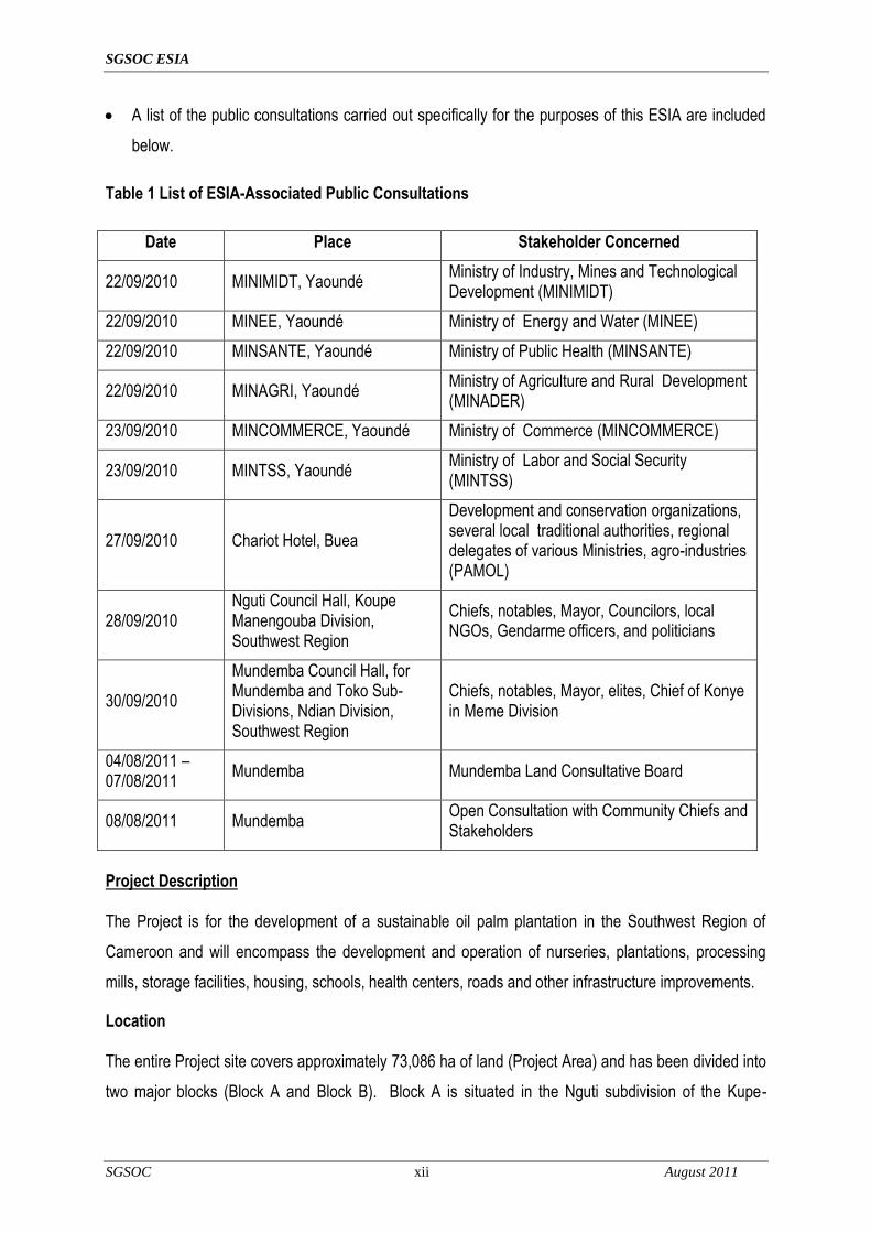
A list of the public consultations carried out specifically for the purposes of this ESIA are included
below.
Table 1 List of ESIA-Associated Public Consultations
Date Place Stakeholder Concerned
22/09/2010 MINIMIDT, Yaoundé Ministry of Industry, Mines and Technological Development (MINIMIDT)
22/09/2010 MINEE, Yaoundé Ministry of Energy and Water (MINEE)
22/09/2010 MINSANTE, Yaoundé Ministry of Public Health (MINSANTE)
22/09/2010 MINAGRI, Yaoundé Ministry of Agriculture and Rural Development (MINADER)
23/09/2010 MINCOMMERCE, Yaoundé Ministry of Commerce (MINCOMMERCE)
23/09/2010 MINTSS, Yaoundé Ministry of Labor and Social Security (MINTSS)
27/09/2010 Chariot Hotel, Buea
Development and conservation organizations, several local traditional authorities, regional delegates of various Ministries, agro-industries (PAMOL)
28/09/2010 Nguti Council Hall, Koupe Manengouba Division, Southwest Region
Chiefs, notables, Mayor, Councilors, local NGOs, Gendarme officers, and politicians
30/09/2010
Mundemba Council Hall, for Mundemba and Toko Sub-Divisions, Ndian Division, Southwest Region
Chiefs, notables, Mayor, elites, Chief of Konye in Meme Division
04/08/2011 – 07/08/2011
Mundemba Mundemba Land Consultative Board
08/08/2011 Mundemba Open Consultation with Community Chiefs and Stakeholders
Project Description The Project is for the development of a sustainable oil palm plantation in the Southwest Region of
Cameroon and will encompass the development and operation of nurseries, plantations, processing
mills, storage facilities, housing, schools, health centers, roads and other infrastructure improvements.
Location The entire Project site covers approximately 73,086 ha of land (Project Area) and has been divided into
two major blocks (Block A and Block B). Block A is situated in the Nguti subdivision of the Kupe-

SGSOC ESIA
SGSOC xiii August 2011
Manenguba Division and covers about 42,486 ha, while Block B is located within the Mundemba and
Toko subdivisions of the Ndian Division and covers an approximate area of 30,600 ha.
The Project Area was selected based upon the following criteria:
recommendations from the Government of Cameroon;
designation as agricultural land by the Government of Cameroon;
proximity to Kumba Town and to Cameroon‘s economic capital (Douala), which has a port and
international airport;
the fertility of its soil;
synergies with other palm oil production facilities;
land that had been previously logged and is not covered by any existing ecological protections,
thereby enabling SGSOC to build-out a sustainable oil palm operation consistent with RSPO
Principles and Criteria;
suitable climate for oil palm production with suitable rainfall and ideal temperatures; and,
abundant, available labor in need of employment.
The figure below provides an illustration of the Project Area in the Mundemba, Toko and Nguti
subdivisions.

SGSOC ESIA
SGSOC xiv August 2011
Figure 1 Project Area
Project Development
The development of the plantation will occur in four phases, with each phase lasting approximately one
year. At the end of phase four, the Project will have prepared and planted 60,000 ha of land with oil
palms. In order to achieve this objective, the Project will require a number of development activities,
which include expanding nurseries, clearing vegetation, establishing civil infrastructure and establishing
social infrastructure.
Nurseries The nursery sites will be prepared using a combination of manual labor, chainsaws and mechanical
preparation with bulldozers and similar equipment. All work will be conducted in accordance with a
Vegetation Clearing and Biomass Management Plan and RSPO Principles and Criteria. The topsoil
from the cleared area is used to fill polybags in which the oil palm seeds will be planted manually. The
seeds are tended in the polybags to until they are planted in the field after 12-18 months.
Vegetation Clearing and Biomass Management

SGSOC ESIA
SGSOC xv August 2011
The Project Area will be prepared using a combination of manual labor, chainsaws, and mechanical
preparation with bulldozers and similar equipment. Tree trunks, branches, leaves, and all biomass left
after commercial timber is removed will be stacked in windrows and recycled as organic compost. This
practice is in line with RSPO‘s requirements to increase soil fertility, help control erosion and help
prevent soil degradation.
Civil Infrastructure
The Project will require a number of investments in civil infrastructure to prepare for full operations.
These include investments in roads, water supply, electricity and solid waste disposal facilities.
Roads A network of roads will be used to transport fresh fruit bunch (FFB) from the plantations to the palm oil
mills. Such roads are typically three meters wide for in-field transportation and five meters wide for
roads to the mill. Roads will be built with bulldozers, leveled with graders and compacted.
Water Supply The water required for the Project is expected to be supplied by local streams or extracted from
boreholes where surface water is not available. Water consumption during construction will vary
significantly, as the volume of consumption will depend on work activities.
Electricity
At the nurseries and other areas where power requirements are relatively small, diesel generators will
be installed. The electricity at the mills will be provided by highly efficient internal boilers and steam
turbines using the biomass from the oil extraction process as fuel.
Solid Waste Disposal Facilities
In addition to agricultural waste, which can be recycled as fertilizer, the Project will generate waste from
other sources. The quantities will be considerably smaller, but will require correct recycling or disposal
in order to not significantly impact the environment. This waste will be disposed of in accordance with
the legislation of Cameroon (Law 96/12 or 5/8/96 Articles 42 - 56).
Social Infrastructure

SGSOC ESIA
SGSOC xvi August 2011
Construction of housing will be required to support the Project workforce that does not already live in
local villages. It is expected that 70% of the workforce will be drawn from existing residents. The
housing construction plan developed for the Project is based on providing housing for the 30% non-
resident workers. The build-out of the housing units will vary consistent with the field build out of the
Project.
Project Operations Oil Palm Plantation
The plantation will be subdivided into planting blocks for efficient management and operation, including:
24 Estates - 2,500 ha per Estate;
12 Complexes - 5,000 ha per Complex; and,
3 Regions - 20,000 ha per Region.
The operations of the oil palm plantation will require a substantial amount of investment in land
development, equipment, infrastructure and warehouses. The development of these resources will be
organized according to the division of the 24 2,500 hectare estates. The oil palm mills will most likely
act as the primary sites for offices, storage, housing and workshops, as well as the sources of water
and power for these facilities.
Palm Oil Mill It is anticipated that five mills, each with a processing capacity of 60 metric tons/hour (MT/hr) are
required for the Project at full build-out. It is also anticipated that the mill superstructure and ancillary
buildings will be constructed to accommodate a maximum processing capacity of 75 MT/hr. To
increase the mill output from 60 to 75 MT/hr, additional digester presses and cross conveyors can be
installed.
The mills being designed for the Project will use state-of-the-art technologies with the oil extraction
processes. In line with the RSPO requirements, the following areas / activities will be adhered to and
implemented:
compliance with local/international environmental, labor, health and safety regulations;
preparation and documentation of standard operating procedures (SOPs) on prudent milling
practices, including housekeeping and maintenance areas;
SGSOC ESIA
SGSOC xvii August 2011
preparation of an efficient water management plan and establishment of monitoring controls to
reduce consumption and waste;
preparation and implementation of health and safety policies; and,
formal and structured training programs for mill employees on occupational, safety and health
(OSH) issues.
Decommissioning The estimated productive life of an oil palm tree is 25 to 30 years, and the quantity of FFB produced
declines as the trees age. Therefore, most plantations replant their trees once FFB yields begin to
decline significantly. Replanting activities include:
the establishment of a new nursery;
removal of the old palm trees;
biomass management of the old trees that are being replaced;
field lining and holing for the new trees; and,
transfer of the seedlings from the nursery.
If plantations choose not to replant and rather abandon the aging trees, activities include:
the removal of equipment and structures; and,
site restoration / rehabilitation.
Project Alternatives
An oil palm plantation that can ultimately be certified by the RSPO has specific requirements in terms of
soils, rainfall, elevation, temperature, existing land uses, previous land uses and existing habitat types.
SGSOC required a relatively large area, about 73,000 ha, in order to get the total usable area required
for planting, about 60,000 ha, that it required for its large-scale Project. Given these requirements, the
Government of Cameroon reviewed its portfolio of available agricultural land and decided to grant
SGSOC its Concession in the present location.
Once the Concession was granted, SGSOC worked with the Government of Cameroon to improve the
Concession boundaries and Project by removing all areas from the Concession within 3 km of the
Korup National Park (KNP) so that forests would not be cleared within that buffer zone. SGSOC also
SGSOC ESIA
SGSOC xviii August 2011
worked with Government of Cameroon to remove some potentially higher value forests from the
Concession and replace those with previously logged areas.
There are no suitable alternative locations for the oil palm plantation within Cameroon.
Baseline Environmental and Social Conditions Climate and Meteorology
The climate is hot and humid with two unequal seasons, one being wet, and the other dry. The wet
season runs from mid-March to the end of October. The climate in the Concession is influenced by the
presence of the massif Mountains of Cameroon, and specifically by Mount Kupe.
The temperature varies rarely throughout the year with a mean monthly maximum in the dry season of
31.8ºC and in the wet season of 30.2ºC. Solar radiation also varies little, ranging from about 199 to
248 watts per square meter (W/m²).
Air Quality
Few industries are present in the area, and transportation by land and air is very limited. Therefore, it is
anticipated that air quality is not significantly affected by emissions from human activities. Some
impacts are expected due to the dry, Harmattan winds from the Sahara that bring dust and particulates,
as well as smoke and particulates, from seasonal burning of brush for agricultural purposes.
Noise The noise sources are limited to the natural fauna in the area and the intermittent passage of
motorcycles and timber trucks. Therefore, the noise levels are quite low.
Topography
The topography of the Nguti area is primarily flat to undulating terrain. Altitudes within the neighboring
Banyang-Mbo Wildlife Sanctuary (BMW Sanctuary) vary from about 120 to 1760 meters above sea
level (masl). The southern part of the Concession represents a small northern extension of the Bakossi
Hills and rises to over 1700 meters.
Geology
SGSOC ESIA
SGSOC xix August 2011
IRAD conducted an extensive analysis on over 400 samples of the soil and land within the Project
Area. Overall they found its soil good for producing high-yielding oil palms. Six main geological types
have been identified from Mundemba and the KNP support zone, which include recent alluvium,
Cretaceous sediments, Mio-Pliocene sediments, Pre-Cambrian gneiss, Tertiary (older) basalt, and
Tertiary dolerite (Sources: MINPAT, 1989, Gartlan, 1985). Cretaceous and Mio-Pliocene sediments
with recent alluvium in the creeks and marshes dominate the Mosongeseli-Isangele area. Isolated
basaltic plateaus, which rise above the general level of sediments, also occur. The Mundemba-Toko
area consists largely of basaltic lava flows produced from volcanoes in the Rumpi Hills.
Water Resources
The region is rich in surface water networks, with many small and temporary streams. The Bake River
and its tributaries form the basis for the hydrographic net of the forest. The Bake River originates from
the Nkwende Hills and flows in a southerly direction to the south of the Osirayib village. Downstream,
the Bakebe River joins Bake River near the Ayong village, and the Bake River continues flowing in a
northwesterly direction. Three upper tributaries of the Cross River, the Mbu or Mbe, the Mfi-Mie, and
the Bashuwe, also drain the BMW Sanctuary. All of these rivers originate from the Bakossi Mountains
south of the BMW Sanctuary and then empty to the Manyu River.
Flora
A total of 403 vascular plant species belonging to 272 genera and 81 families were recorded in the
Concession. Families rich in species (e.g. represented by more than 10 species with number of
species indicated in parenthesis) included Fabaceae (49), Rubiaceae (36), Euphorbiaceae (30),
Apocynaceae (22), Malvaceae (22; including Tiliaceae, Sterculiaceae & Bombacaceae), Annonaceae
(18), Meliaceae (12), Moraceae (11) and Sapindaceae (11). In contrast, 24 families had only one
species recorded.
Only one Black Star (e.g. endemic) species (Cylicomorpha solmsii) and six Gold Star species
(Afrostyrax lepidophyllus, Amanoa strobilacea, Cola buntingii, Dicranolepis disticha, Dasylepis
racemosa and Dichapetalum tomentosum) were recorded.
Fauna
Over 106 different species were recorded in the Concession. Of the species detected or encountered,
the majority are common species in Cameroon with wide distribution in the lowland forest region.
Furthermore, extensive human use and commercial logging activity has degraded the forests and
SGSOC ESIA
SGSOC xx August 2011
habitats of the Concession such that critical habitat for the International Union for Conservation of
Nature (IUCN) listed species are now only found in the surrounding protected areas of the Korup
National Park (KNP), BMW Sanctuary, the Bakossi Mountains National Park, Rumpi Hills and Mount
Cameroon.
The forest elephant (Loxodonta a. cyclotis), however, is an exception to these findings. The forest
elephant is listed as endangered by the IUCN (2002), and feeding signs were recorded at the boundary
of the Concession and Sanctuary close to River Boa. Hence, there seems to be local migration
between the river and the Sanctuary, potentially indicating forest elephant activity at the edge of the
Concession. When developing the area near the River Boa, mitigation measures will be taken to
provide both a buffer zone, as well as an elephant trench, to help protect the forest elephants and the
plantation.
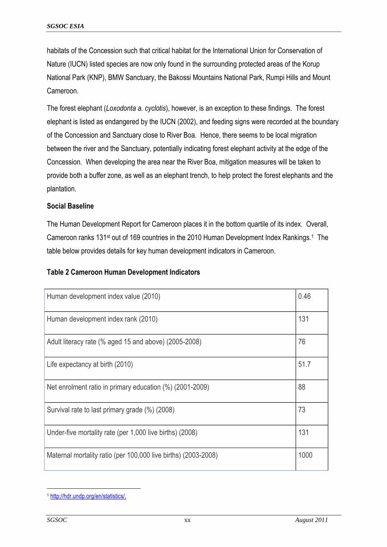
Social Baseline The Human Development Report for Cameroon places it in the bottom quartile of its index. Overall,
Cameroon ranks 131st out of 169 countries in the 2010 Human Development Index Rankings.1 The
table below provides details for key human development indicators in Cameroon.
Table 2 Cameroon Human Development Indicators
Human development index value (2010) 0.46
Human development index rank (2010) 131
Adult literacy rate (% aged 15 and above) (2005-2008) 76
Life expectancy at birth (2010) 51.7
Net enrolment ratio in primary education (%) (2001-2009) 88
Survival rate to last primary grade (%) (2008) 73
Under-five mortality rate (per 1,000 live births) (2008) 131
Maternal mortality ratio (per 100,000 live births) (2003-2008) 1000
1 http://hdr.undp.org/en/statistics/.

SGSOC ESIA
SGSOC xxi August 2011
Additionally, primary and secondary research was undertaken to develop a clear understanding of the
social baseline for inhabitants within the Project Area. The primary sources were obtained from field
surveys and interviews, and secondary sources were gathered from several data sources such as
books, research papers, internet searches and Government publications. The results are summarized
below and can be found in more detail in the ESIA.
The primary land use in the Concession is agriculture, consisting of shifting cultivation (slash-and-burn)
for primary subsistence purposes, vegetable gardens to supplement subsistence crops (cassava,
plantains, bananas, coco yams), and cash crops, such as cocoa, coffee and oil palm. Livestock
production is poor in the area, and domestic animals are raised more for ceremonial occasions and
honored guests rather than for wide consumption.
General social services such as roads, hospitals, schools clean water and electricity were less evident
in remote hamlets than in pre-urban settlements. Villagers typically receive news and information
through the radio, and communicate by mobile phone and community meanings. There does not
appear to be any availability of Internet services. Most of the villagers had heard of the Project, and
many expressed interest in working with SGSOC.
Potential Major Project Impacts
This section consolidates the major impacts for the environmental and social components to determine
the significance of the aggregated impacts on that component, assuming all proposed mitigation
measures are implemented. If, after the implementation of all proposed mitigation measures, a high
impact exists, then that component will be further analyzed, and additional mitigation and/or monitoring
measures are proposed in the following section.
Table 3 Major Environmental and Social Impacts
Medium Affected
Project Phase
Activity/Source of Impact
Effects of the Impact
Evaluation of the Importance of the Impact
Intensity Extent Duration Importance

SGSOC ESIA
SGSOC xxii August 2011
Medium Affected
Project Phase
Activity/Source of Impact
Effects of the Impact
Evaluation of the Importance of the Impact
Intensity Extent Duration Importance
Air Quality
Nursery, plantation, mill
and infrastructure development.
Combustion emissions and
clearing of biomass.
Creation of GHG from certain combustion gases,
as well as clearing of biomass that will either decay or be burned and
will therefore contribute to climate change until the
plantation areas are replanted.
Medium International Short-term Major
Air Quality
Nursery, plantation, mill
and infrastructure development.
Combustion emissions and
production of palm oil that could offset
burning of fossil fuels; use of biomass
for steam and electricity generation; digestion of POME,
which will create methane and CO2,
both GHGs.
Creation of GHGs that will contribute to climate
change, but with offsets due to use of biomass for
electricity and steam generation, and possible use of palm oil as fossil
fuel replacement.
Low International Long-term Major
Flora
Construction and operation of
mills and infrastructure.
Relatively small areas of land will be cleared of vegetation in five locations for
mills and social infrastructure.
Land will be cleared of natural vegetation and
either replaced with man-made structures or limited
vegetation.
High Local Permanent Major
Flora
Construction and operation of
nurseries and plantations.
Approximately 60,000 ha of land will
be cleared and replaced with oil palms and cover
crops.
Natural vegetation will be lost.
High Local Permanent Major
Flora
Operations of the mills,
infrastructure, nurseries, and
plantations.
Transportation between the
Concession and port facilities and other
sources of supply for Project operations can bring invasive species into the
area. Large areas of land will be visited
often by people with access to outside
areas.
Large extent of land in the plantation will be
vulnerable to colonization by invasive species, which then have the ability to invade non-
plantation areas. Low Regional Long-term Major
Fauna
Construction and operation of
mills, and infrastructure.
Relatively small areas of land will be cleared of vegetation in five locations for
mills and social infrastructure.
Mobile fauna will flee to surrounding areas with
intact vegetation, if possible, creating
increased competition for habitat and resources,
and less mobile fauna will maybe destroyed during
the clearing.
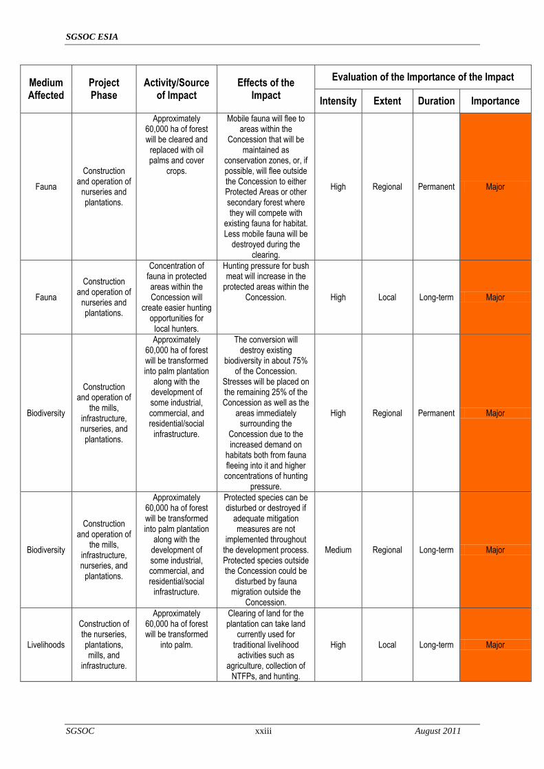
High Local Permanent Major
SGSOC ESIA
SGSOC xxiii August 2011
Medium Affected
Project Phase
Activity/Source of Impact
Effects of the Impact
Evaluation of the Importance of the Impact
Intensity Extent Duration Importance
Fauna
Construction and operation of
nurseries and plantations.
Approximately 60,000 ha of forest will be cleared and
replaced with oil palms and cover
crops.
Mobile fauna will flee to areas within the
Concession that will be maintained as
conservation zones, or, if possible, will flee outside the Concession to either Protected Areas or other secondary forest where they will compete with
existing fauna for habitat. Less mobile fauna will be
destroyed during the clearing.
High Regional Permanent Major
Fauna
Construction and operation of
nurseries and plantations.
Concentration of fauna in protected areas within the Concession will
create easier hunting opportunities for
local hunters.
Hunting pressure for bush meat will increase in the
protected areas within the Concession. High Local Long-term Major
Biodiversity
Construction and operation of
the mills, infrastructure, nurseries, and
plantations.
Approximately 60,000 ha of forest will be transformed into palm plantation
along with the development of some industrial, commercial, and residential/social
infrastructure.
The conversion will destroy existing
biodiversity in about 75% of the Concession.
Stresses will be placed on the remaining 25% of the Concession as well as the
areas immediately surrounding the
Concession due to the increased demand on
habitats both from fauna fleeing into it and higher
concentrations of hunting pressure.
High Regional Permanent Major
Biodiversity
Construction and operation of
the mills, infrastructure, nurseries, and
plantations.
Approximately 60,000 ha of forest will be transformed into palm plantation
along with the development of some industrial, commercial, and residential/social
infrastructure.
Protected species can be disturbed or destroyed if
adequate mitigation measures are not
implemented throughout the development process. Protected species outside the Concession could be
disturbed by fauna migration outside the
Concession.
Medium Regional Long-term Major
Livelihoods
Construction of the nurseries, plantations, mills, and
infrastructure.
Approximately 60,000 ha of forest will be transformed
into palm.
Clearing of land for the plantation can take land
currently used for traditional livelihood
activities such as agriculture, collection of
NTFPs, and hunting.
High Local Long-term Major

SGSOC ESIA
SGSOC xxiv August 2011
Medium Affected
Project Phase
Activity/Source of Impact
Effects of the Impact
Evaluation of the Importance of the Impact
Intensity Extent Duration Importance
Livelihoods
Construction of the nurseries, plantations, mills, and
infrastructure.
Approximately 1000 construction jobs will be created over the
course of the 12-year development phase.
These jobs will have a significant positive
influence both on those that secure the jobs as well as people that will
sell goods and services to the construction workers and to SGSOC and its
contractors
High National Short-term Major
Livelihoods Operation of all
the facilities
Approximately 7,500 full time employees will be hired by the Project when fully
operational.
These jobs will have a significant positive
influence both on those that secure the jobs as well as people that will
sell goods and services to the workers and to
SGSOC during operations.
High National Long-term Major
Livelihoods Operation of Infrastructure
facilities.
Educational opportunities will be
provided to the children of plantation workers for free and may be extended to
children of non-workers that live
within the Concession
depending on cost-sharing
arrangements with the Government.
These opportunities will greatly expand both the numbers of people that
will have access to education as well as the quality of that education.
Transition to a more cash-based economy will also decrease the need for
children to choose between school and
working on family farms.
High Local Long-term Major
Livelihoods Operations of infrastructure
facilities.
Improved health care facilities will be provided to the
plantation workers and may be
extended to non-workers that live
within the Concession
depending on cost-sharing
arrangements with the Government.
These opportunities will greatly expand both the numbers of people that
will have access to health care as well as the quality
of that care. High Local Long-term Major
Livelihoods Construction of infrastructure
facilities
Roads will be improved to allow for
smooth communication and
transportation between the
concession area and markets.
Local inhabitants will benefit from improved
roads which will allow for easier commercial and
social travel and communication.
High Local Long-term Major

SGSOC ESIA
SGSOC xxv August 2011
Medium Affected
Project Phase
Activity/Source of Impact
Effects of the Impact
Evaluation of the Importance of the Impact
Intensity Extent Duration Importance
Livelihoods Operations of infrastructure
facilities.
Housing for employees will be
constructed.
Improved quality of life for employees and their
families High Local Long-term Major
Government Revenues
Operations of infrastructure
facilities.
Taxes paid by SGSOC and employees.
Very significant increase in local and national tax
revenue. Medium National Long-term Major
Mitigation Measures
SGSOC will make significant investment throughout the life of the Project in order minimize the negative
impact of activities related to construction, land clearing and agriculture operations. In addition, over the first
ten years of the Project, approximately CAF 75 billion will be spent on creating positive impact for the
community in areas such as roads development, clean water infrastructure, schools, health centers,
outgrower programs and anti-poaching programs. Some of the important mitigation measures are
summarized below.
Greenhouse Gas Emissions
The planting of oil palm trees and cover crops over most of the area cleared will offset the clearing of
biomass. Electricity and steam generation during operations will be generated from burning of biomass
wastes from the mill operations, and will therefore be GHG neutral – a benefit over burning fossil fuels.
Production of biofuels shall offset burning of fossil fuels on equipment used in the Concession during
normal operation. SGSOC will also capture methane (a significant GHG) produced by the digestion of
POME and use that as fuel for the mill.
Loss of Natural Vegetation
Natural vegetation, in the form of secondary forest, will be cleared for Project development. Buffers of
existing vegetation will be maintained between the plantation and both KNP and the BMW Sanctuary,
and buffers will be maintained around waterways. In addition, HCV forest areas, vegetation on steep
slopes (greater than 30º), and sacred sites as well as agricultural land used by the villages within the
Concession will remain in their current state.
Risk of Invasive Species
SGSOC ESIA
SGSOC xxvi August 2011
The Project will monitor the occurrence of invasive species both to protect the natural environment and
to protect the plantation against all types of pests. If invasive species are identified, they will be
eradicated by manual methods if possible, then by biological methods, and finally by chemical means.
Loss of Fauna in the Concession Loss of fauna in the Concession will be likely due to the loss of habitat during land clearing for Project
development. Buffers of existing vegetation will be maintained between the plantation and both KNP
and the BMW Sanctuary, and buffers will be maintained around waterways. In addition, HCVF areas,
vegetation on steep slopes (greater than 30º), and sacred sites within the Concession will remain
untouched by the Project. Fauna will be able to use these areas for habitat, but the decrease in total
available habitat will result in an overall loss of fauna.
Loss of Fauna Outside the Concession The composition of fauna populations outside the Concession will be impacted by due to the migration
of some mobile fauna from cleared areas to un-cleared or protected areas. The Project is mitigating
impacts on the KNP and BMW Sanctuary by providing for buffer zones within the Concession between
cleared areas and these protected areas of 3 km and 500 m, respectively. Part of the purpose of these
buffer zones is to absorb and attenuate the changes in fauna populations before those changes can
reach the protected areas.
Increased Hunting Pressure
In order to decrease the demand for local bush meat, SGSOC will take the following measures:
decrease hunting pressure in the Concession by ensuring that adequate supplies of meat other
than local bush meat as well as other protein sources are available in stores and markets within the
Concession;
educate its employees on the adverse impacts of hunting and consuming bush meat;
to the degree possible, prohibit and enforce prohibitions on hunting inside the Concession;
sponsor education programs in local villages about the adverse impacts of hunting and consuming
bush meat; and
sponsor programs to transition hunters to other, sustainable livelihood activities.
Loss of Traditional Livelihood Activities
SGSOC ESIA
SGSOC xxvii August 2011
Traditional livelihood activities inside the Concession such as subsistence agriculture, gathering and
use of NTFPs, and hunting will be adversely impacted by the Project due primarily to the loss of land
available for these activities. These activities can be replaced to a large degree by full-time
employment provided by the Project, employment provided by businesses that will be established with
the support of SGSOC, and the implementation of modern agriculture programs. Additionally, these
activities can continue to be practiced, but likely to a lower intensity level, within the areas that will not
be cleared by the Project.
Increased Health Risks During Construction
The Project will attempt to recruit most of its construction workers from the immediate area, thus
minimizing the number of single men migrating for work. SGSOC will also ensure that it and its
contractors provide adequate training and enforcement of codes of conduct to minimize worker
participation in risky activities. In order to further mitigate this potential impact, SGSOC will conduct
community training and awareness programs.
Monitoring and Management
The Project will develop a detailed Environmental and Social Monitoring Plan to monitor key elements
of both the biophysical and human environments. The purpose of this monitoring will be to ensure that
significant impacts were correctly identified in the assessment process, then to monitor the
effectiveness of the mitigation measures. The results of monitoring activities will be regularly reviewed
to determine if existing management measures are adequate, or if those measures need to be revised,
deleted, or supplemented.
Overall Impact Assessment
The ESIA has identified the Project‘s activities that could impact the existing environmental and social
conditions of the Project Area and has provided an assessment for the degree of impact which may
result. Mitigation plans have been developed for each identified negative impact of the Project while
the positive impacts will be accentuated. Monitoring and management will play a key role moving
forward in order to maintain the effectiveness of the mitigation initiatives.
Environmental Project Assessment
The most significant impacts of the Project will be associated with Project development. In particular,
clearing of existing vegetation to allow for planting will be a significant impact during Project

SGSOC ESIA
SGSOC xxviii August 2011
development. Mitigation plans have been established to limit the impact of this activity which include
clearing land with manual and mechanical processes according to RSPO guidelines; creating buffer
zones between the Project and protected areas; creating of buffer zones near rivers and streams;
identifying and protecting HCV areas within the Concession which include steep slopes, primary
forests, sacred areas, and agricultural land used by the local inhabitants. Beyond these, no mitigation
measures other than decreasing the plantation size is available to significantly mitigate the loss of
natural vegetation, which would reduce the Project‘s significant positive social benefit, therefore no
additional mitigation measures are proposed for this impact.
The chance for unplanned events and their potential consequences associated with this Project is very
low due to the controlled nature of its development. Emergency plans and flexible development
practices are being developed to allow for effective response to unforeseen impacts connected with the
Project‘s development and operations.
Mitigation measures will be monitored and reviewed regularly to ensure their adherence and
effectiveness. Any contractors employed as part of the Project development will be expected to follow
the mitigation plans and commitments made by SGSOC.
Socioeconomic Project Assessment Formal and informal meetings with the communities within the Project Area have revealed strong
support amongst most community members and chiefs. The communities recognize that the significant
and long-term investment in the area will bring significant improvements in the day-to-day quality of life
for many within the community as well as provide significant employment opportunities.
Among the numerous socioeconomic benefits associated with the Project are
Direct sustainable employment for 7,000 – 8,000 individuals;
Increased knowledge and skills from operation and training;
Indirect employment for several thousand other individuals within small- and medium-sized
businesses;
Support for local small holders and farm operators;
Decrease in the rural exodus from Southwest Cameroon;
Investment in education for local communities;
Investment in healthcare for local communities;

SGSOC ESIA
SGSOC xxix August 2011
Increased public awareness of the socioeconomic needs of the local communities for roads,
healthcare, and other infrastructure and social investments at an international, national, and
community level through consultations and the publication of documents;
Employee housing;
Access to clean water and electricity; and,
Tax revenues for the Government.
Maintaining continued communication through a coherent policy of interaction and exchange with the
local populations is essential for a lasting constructive relationship. In particular, there continues to be
concern among some local individuals that the Project will take land which is currently in use for
agricultural or residential purposes. SGSOC is committed to respect the current boundaries of villages
and farmlands, as well as to provide growth zones for the communities, and it is essential to continue to
emphasize this policy. Additionally, some inhabitants may believe SGSOC will construct new roads
connecting villages through protected areas and other locations. While SGSOC will work with national
and international governments and NGOs to improve the road network, it is the jurisdiction of the
Government of Cameroon to identify and plan new roads, particularly within protected areas.

SGSOC ESIA
SGSOC xxx August 2011
RÉSUMÉ NON TECHNIQUE Introduction
La demande en huile de palme est en augmentation à cause de l‘utilisation de plus en plus croissante
des huiles végétales pour la production des biocarburants et la consommation de ce type d‘huile dans
les pays en voie de développement tels que le Cameroun. Actuellement, les premiers producteurs
d‘huile de palme sont l‘Indonésie et la Malaisie, qui produisent environ 80% de la production mondiale.
Les ressources agricoles disponibles pour le développement de l‘Afrique fourniront des bénéfices aux
populations locales en quête d‘emploi et servent de source fiable d‘huile de palme. De nombreuses
agences internationales de développement et d‘organisations non gouvernementales (ONG) militent
pour l‘accroissement de la production d‘huile de palme en Afrique de l‘Ouest en raison de ses effets
positifs sur l‘emploi et d‘autres avantages sociaux.
SG Sustainable Oils Cameroon, Ltd. (SGSOC) entend développer un Projet de production d‘huile de
palme commerciale en République du Cameroun (Projet). Le premier objectif du Projet est de
concevoir, construire et faire fonctionner des unités de transformation d‘huile de palme. SGSOC est
engagé à développer et à mener un Projet d‘huile de palme respectant les normes environnementales
qui aura des bénéfices énormes sur plusieurs segments de l‘économie camerounaise et sur les
communautés locales. A cet effet, SGSOC produira de l‘huile de palme certifiée RSPO (Table ronde
sur l‘Huile de Palme Durable). Une fois certifiée, SGSOC sera un contributeur important du mouvement
pour une production durable de l‘huile de palme, fixant les normes pour les autres opérateurs de ce
domaine.
SGSOC et le Gouvernement du Cameroun ont signé la Convention d‘établissement pour la mise en
place et le fonctionnement du Projet sur une superficie de 73,086 ha au Sud-ouest Cameroun
(Concession) le 17 Septembre 2009. SGSOC prévoit que la surface cultivée totale soit d‘environ
60,000 ha. La surface restante de la Concession sera protégée en tant que zone comprenant des
ressources sensible sur le plan environnemental ou social, des infrastructures des plantations et des
infrastructures sociales ainsi que des terres pour les activités de subsistance des villageois.
Le Projet apportera des avantages significatifs à savoir:
Des emplois directs pour 7000 – 8000 individus;
Des emplois indirects pour plusieurs milliers de personnes possédant des petites et moyennes entreprises;

SGSOC ESIA
SGSOC xxxi August 2011
La baisse de l‘exode rural partir du Sud-ouest Cameroun;
Investissement dans l‘éducation pour les communautés riveraines;
Investissement dans les soins de santé pour les communautés riveraines;
Logement;
Accès à l‘eau potable et à l‘électricité; et,
Recettes fiscales pour le Gouvernement.
Cadre légal, Consultation, et Participation SGSOC aidera le Projet à fonctionner selon les politiques, directives et réglementations internationales,
nationales et régionales. En outre, le Projet utilisera les informations recueillies pendant les
consultations publiques pour orienter et calibrer les activités du Projet.
Politiques, Directives et Réglementations Internationales, Nationales et Régionales
Parmi les politiques, directives et réglementations internationales, nationales et régionales, l‘on peut
citer:
missions, politiques et meilleurs pratiques internes des entreprises;
stratégies, législation, permis et autorisations du Cameroun;
Principes de RSPO;
normes de performance de l‘IFC;
Principes de l‘Equateur;
les Directives de l‘UN Global Compact; et,
les Bonnes pratiques industrielles internationales (GIIP) qui aident à définir les meilleures
pratiques industrielles.
Ils sont décrits en détail dans le rapport de l‘EIES.
Consultations et Participation Conformément aux directives de l‘EIES, SGSOC a mené une série de consultations publiques pour
l‘EIES Durant la préparation du présent rapport. Ces auditions publiques ont servi à identifier les
problèmes potentiels et à proposer des recommandations au Projet. Les principaux objectifs des
auditions publiques menées dans le cadre le l‘EIES ont permis:

SGSOC ESIA
SGSOC xxxii August 2011
de présenter le Projet aux principales parties prenantes;
de remplir les exigences de la législation camerounaise en matière d‘auditions publiques et les
normes de l‘IFC; et,
de comprendre et de répondre aux préoccupations et problèmes des parties prenantes.
Une liste des auditions publiques menées pour l‘EIES est jointe ci-dessous.
Table 1 Liste des Auditions Publiques
Date Place Partenaires concernés
22/09/2010 MINIMIDT, Yaoundé Ministère des Mines et du Développement
Technologique(MINIMIDT)
22/09/2010 MINEE, Yaoundé Ministère de l‘Energie et de l‘Eau (MINEE)
22/09/2010 MINSANTE, Yaoundé Ministère de la Santé Publique(MINSANTE)
22/09/2010 MINAGRI, Yaoundé Ministère de l‘Agriculture et du Développement
Rural(MINADER)
23/09/2010 MINCOMMERCE, Yaoundé Ministère du Commerce (MINCOMMERCE)
23/09/2010 MINTSS, Yaoundé Ministère du Travail et de la Sécurité Sociale
(MINTSS)
27/09/2010 Chariot Hotel, Buea
Organisations de développent et de
conservation, plusieurs autorités locales,
traditionnelles, des délégués régionaux de
divers Ministères, des entreprises
agroindustrielles (PAMOL)
Nguti Council Hall,
Département du Koupe
Manengouba, Région du Sud-
ouest
Chefs, notables, Maires, Conseillers, ONG
locales, officiers de Gendarmerie et politiciens
30/09/2010
Mundemba Council Hall, pour
les arrondissements de
Mundemba et Toko,
Département du Ndian
Région du Sud-ouest
Chefs, notables, Maires, élites, Chef de Konye
dans le Département de la Meme
04/08/2011 – Mundemba Mundemba Land Consultative Board
SGSOC ESIA
SGSOC xxxiii August 2011
07/08/2011
08/08/2011 Mundemba
Les chiffres ci-dessous illustrent la zone de la
Concession dans les arrondissements de à
Mundemba, Toko, et Nguti.
Description du Projet Le Projet de concerne la création d‘une plantation d‘huile de palme durable dans la région du sud-ouest
Cameroun. Ce Projet englobera la création et l‘entretien des pépinières, d‘usines de traitement, de
structures de stockage, de logements et d‘autres améliorations des infrastructures.
Situation L‘ensemble du site du Projet comprend environ 73,086 ha de terrain (Zone du Projet) et a été divisé en
deux grands blocs (Bloc A et Bloc B). Le Bloc A est situé dans l‘arrondissement de Nguti dans le
Département du Kupe-Manenguba et couvre environ 42,486 ha, tandis que le bloc B est situé dans les
arrondissements de Mundemba et Toko, Département du Ndian Division et couvre environ 30,600 ha.
Le site du Projet a été sélectionné selon les critères suivants:
recommandations du Gouvernement du Cameroun;
désignation en tant que terres agricoles par le Gouvernement du Cameroun;
proximité avec la ville de Kumba et de la capitale économique du Cameroun(Douala), qui
possède un port et un aéroport international;
fertilité des sols;
synergies avec d‘autres unités de production d‘huile de palme;
des terres sur lesquelles des arbres ont été coupés précédemment et ne sont pas couverte par
la protection écologiques, permettant à SGSOC de créer une usine durable d‘huile de palme
conforme aux normes RSPO;
un climat adéquat pour la production d‘huile de palme avec une pluviométrie et des
températures idéales; et,
une main d‘œuvre abondante et disponible enquête d‘emplois.

SGSOC ESIA
SGSOC xxxiv August 2011
Figure 1 Carte de la Zone sous Concession à Mundemba, Toko et Nguti
Développement du Projet
La création de la plantation se déroulera en quatre phases dont chacune durera un an. A la fin de la
quatrième phase, le Projet aura préparé et planté des palmiers sur 60 000 ha de terres. Afin
d‘atteindre cet objectif, le Projet mènera un certain nombre d‘activités de développement comprenant
l‘extension des pépinières, le désherbage, la mise sur pied d‘infrastructures civiles et sociales.
Pépinières
Elles seront préparées à l‘aide de travailleurs manuels, de scies à moteur, de bulldozers ou
d‘équipements similaires. Tous les travaux seront menées conformément au plan de défrichage et de
gestion de la biomasse, et aux directives RSPO. La couche arable des zones défrichées est utilisée
pour remplir les sachets en plastic dans lesquels les rejetons de palmiers seront plantés manuellement.
Les semences sont conservés dans ces sachets en plastic jusqu‘à leur mise en terre 12 à 18 mois plus
tard.
Déblaiement et Gestion de la Biomasse
SGSOC ESIA
SGSOC xxxv August 2011
La Zone de Projet sera préparée à l‘aide de travailleurs manuels, de scies à moteur, de bulldozers ou
d‘équipements similaires. Les trocs, branches et feuilles d‘arbres et toute la biomasse laissée après
utilisation sur la Zone de Projet ainsi que le bois commercial seront enlevée placée en andains, puis
recyclés en engrais organique. Cette pratique est conforme aux exigences RSPO pour accroître la
fertilité des sols, lutter contre l‘érosion et prévenir la dégradation des sols.
Infrastructures Civiles
Le Projet nécessitera un certain nombre d‘investissements en infrastructures civiles pour préparer sa
mise en route effective. Il s‘agit entre autres des routes, de l‘adduction d‘eau, de l‘électricité et
d‘installation de stockage des déchets solides.
Les Routes
Un réseau de routes sera utilisé pour acheminer les FFB des plantations vers les usines d‘huile de
palme. Ces routes auront une largeur de 3 mètres à l‘intérieur des plantations et de 5 mètres des
plantations vers l‘usine. Les routes seront crées par les bulldozers, aplanies par les niveleuses et
compactées.
Adduction d’eau L‘eau nécessaire pour le Projet devrait être fournie par les sources locales ou extraite des bornes
fontaines là où l‘au de surface est disponible. La consommation d‘eau pendant la phase de
construction variera de façon significative car le volume de consommation dépendra des activités sur le
terrain.
Electricité Dans les pépinières et les autres zones où les besoins en énergie sont relativement faibles, des
groupes électrogènes diesel seront installés. L‘électricité de l‘usine sera fournie par des chaudières
internes très efficaces et des turbines à vapeur alimentées par la biomasse issue de l‘extraction de
l‘huile.
Stockage de Déchets Solides En plus des déchets agricoles, qui peuvent être recyclés en engrais, le Projet générera des déchets
d‘autres sources. Les quantités seront considérablement plus petites, mais elles nécessiteront un
recyclage ou un stockage correct afin de ne pas avoir un impact important sur l‘environnement. Ces
SGSOC ESIA
SGSOC xxxvi August 2011
déchets seront stockés conformément aux dispositions de la législation camerounaise (Loi 96/12 ou
5/8/96 Articles 42 - 56).
Infrastructures Sociales
La construction des logements sera nécessaire pour héberger les travailleurs qui ne résident pas dans
les villages voisins. 70% de la main d‘œuvre proviendra des villageois qui résident près des sites du
Projet. Le plan de construction des logements préparé pour le Projet prévoit la fourniture de logements
à 30% de travailleurs non résidents. La construction des logements dépendra de l‘avancement du
Projet.
Opérations du Projet La Palmeraie La palmeraie sera divisée en blocs, pour une meilleure gestion et un meilleur fonctionnement:
24 parcelles – 2 500 ha par parcelle
12 Complexes – 5 000 ha par Complexe
3 Régions – 20 000 ha par Région
Le fonctionnement de la palmeraie nécessitera un grand investissement dans la préparation du terrain,
l‘équipement, les infrastructures et les magasins. Le développement de ces ressources sera organisé
en parcelles de 24 2 500 hectares. L‘usine d‘huile de palme servira de premier site pour les bureaux,
le stockage, les logements et les ateliers ainsi que de source d‘eau et d‘énergie pour ces installations.
Usine d’Huile de Palme L‘on prévoit que cinq unités de traitement d‘une capacité de 60 tonnes/métriques par heure (MT/h) sont
nécessaires pour le Projet dans sa phase pleinement opérationnelle. Pour accroître la productivité de
l‘usine de 60 à 75 MT/h, l‘on peut installer des cuves de digestion des presses et des transporteurs
transversaux additionnels.
Les broyeurs conçus pour ce Projet utiliseront des technologies de pointe en matière d‘extraction
d‘huile. Conformément aux exigences de RSPO, les domaines d‘activités suivants seront respectés:
conformité aux réglementations locales/internationales en matière environnemental, du travail,
de la santé et de sûreté;
SGSOC ESIA
SGSOC xxxvii August 2011
préparation et documentation des Instructions permanents d‘opération (IPO) sur les pratiques
prudentes en matière de broyage, y compris l‘administration interne et la maintenance;
préparation d‘un plan efficace de gestion de l‘eau et établissement de contrôles afin de réduire
la consommation et les déchets;
préparation et mise en œuvre de politiques sanitaires et de sûreté ; et,
programmes de formation structurés pour les employés de l‘usine sur les questions
professionnelles, sanitaires et de sûreté (OSH).
Démantèlement La durée de vie d‘un palmier est de 20 à 30 ans, et la quantité de FFB produite baisse au fur et à
mesure que le palmier vieillit. Par conséquent, la plupart des plantations replantent leurs arbres à partir
du moment où la production de FFB commence à baisser de manière significative. Les activités de
replantation comprennent:
la création d‘une nouvelle pépinière;
la coupe des vieux palmiers;
la gestion de la biomasse des vieux palmiers en cours de remplacement;
l‘alignement du sol et le creusage des trous pour les nouveaux arbres et,
le transfert des semences de la pépinière vers la plantation.
Si l‘on choisit de ne pas replanter et d‘abandonner les vieux arbres, les activités comprennent:
le démantèlement des équipements et des structures; et,
la restauration/réhabilitation du site.
Alternatives du Projet Une palmeraie qui peut finalement être certifiée RSPO comporte des exigences spécifiques en termes
de sols, pluviométrie, altitude, température, utilisation en cours des terres, utilisation ancienne des
terres et types d‘habitats existants. SGSOC a exigé une surface relativement large, environ 73 000 ha,
afin de disposer de toute la surface nécessaire pour la plantation, environ 60 000 ha pour ce type de
Projet de grande envergure. Etant donné ces exigences, le Gouvernement of Cameroun a révisé son

SGSOC ESIA
SGSOC xxxviii August 2011
portefeuille de terres agricoles disponibles et décidé d‘accorder à SGSOC sa Concession dans le site
actuel.
Une fois la Concession accordée, SGSOC a travaillé avec Gouvernement of Cameroun pour améliorer
les limites de la Concession et le Projet en excluant les zones situées à 3km du KNP pour éviter que la
forêt soit détruite dans cette zone tampon. SGSOC a aussi travaillé avec Gouvernement of Cameroun
pour épargner certaines forêts à haute valeur ajoutée dans les Concessions et remplacer celles qui ont
fait l‘objet d‘exploitation forestière préalable.
Il n‘existea pas de meilleur site pour établir une palmeraie au Cameroun.
.
Conditions Environnementales et Sociales de Référence Climat et Météorologie
Le climat est chaud et humide et comprend deux saisons inégales, l‘une étant sèche et l‘autre humide.
La saison humide s‘étend de mi-mars à la fin d‘octobre. Le climat dans la zone sous Concession est
influencé par la présence des massifs montagneux du Cameroun, et surtout du Mont Koupe.
La température varie rarement au cours de l‘année avec un maximum moyen en saison sèche de
31,8ºC et en saison des pluies de 30,2ºC. Le rayonnement solaire varie aussi peu et se situe entre 199
et 248 w/m.
Qualité de l’air
Peu d‘industries sont présentes dans la zone et le transport par voie terrestre et aérienne est très
limité ; par conséquent on estime que la qualité de l‘air n‘est pas affectée de façon significative par les
émissions dues à l‘activité humaine. Certains impacts devraient être dus aux vents secs de l‘harmattan
provenant du Sahara qui transportent des poussières et des particules, ainsi qu‘à la fumée et aux
particules provenant des feux de brousse allumés à des fins agricoles.
Bruit
Les sources de bruit sont limitées à la faune naturelle de la zone et au passage intermittent des
motocyclettes et des grumiers. Par conséquent, les niveaux de bruit sont très faibles.
Topographie

SGSOC ESIA
SGSOC xxxix August 2011
La topographie de la zone de Nguti area est plane et comprend des terrains ondulés. L‘altitude au
sein du sanctuaire de BMW varie entre 120 et 1760 masl. La partie Sud de la Concession présente
une petite extension septentrionale des collines Bakossi et s‘élève à plus de 1700 masl.
Géologie L‘IRAD a analysé plus de 400 échantillons de sols et de terre dans la zone de la Concession. Il a
conclu que la zone de la Concession et ses terres sont bonnes pour la culture des palmiers à huile.
Six principaux types géologiques ont été identifies à Mundemba et à la zone de KNP qui comprend
des alluvions récents, des sédiments crétacées, des sédiments mi-pliocènes, du gneiss précambrien,
du basalte tertiaire (ancien) et du dolérite tertiaire (Sources: MINPAT, 1989, Gartlan, 1985). Les
sédiments crétacés et mi-pliocènes et des alluvions récents dans les ruisseaux et les marais dominent
la zone Mosongeseli-Isangele. Des plateaux basaltiques isolés, qui s‘élèvent au-dessus du niveau
moyen des sédiments sont aussi présents. La zone Mundemba-Toko comprend essentiellement des
coulées de lave basaltique produites par les volcans de montagnes Rumpi.
Ressources hydrauliques La région est riche en réseaux d‘eau de surface, et comprend plusieurs petits cours d‘eau temporaires.
Le fleuve Bake River et ses affluents forment l base du réseau hydrographique de la forêt. il tire sa
source des montagnes Nkwende Hills et coule en direction du Sud vers le village Osirayib. En aval, la
rivière Bakebe rejoin le fleuveBake River près du village Ayong, et le fleuve Bake River continue à
couler en direction du nord-ouest. Trois affluents de Cross River, le Mbu ou Mbe, le Mfi-Mie, et le
Bashuwe, alimentent aussi le BMW Sanctuary. Toutes ces rivières tirent leur source des Bakossi
Mountains situées au sud du BMW Sanctuary et se jettent dans le feluve Manyu.
La Flore
Un total de 403 espèces de plantes vasculaires appartenant à 272 genres et 81 familles ont été
enregistrées dans la Concession. Familles riches en espèces (e.g. représentées par plus de 10
espèces a avec le nombre d‘espèces indiqué entre parenthèses) comprenant Fabacées (49),
Rubiacées (36), Euphorbiacées (30), Apocynacées (22), Malvacées (22; y compris Tiliacées,
Sterculiacées & Bombacacées), Annonacées (18), Méliacées (12), Moracées (11) and Sapindacées
(11). Par contre, 24 familles n‘avaient qu‘une espèce enregistrée.

SGSOC ESIA
SGSOC xl August 2011
Une seule espèce d‘étoile noire (e.g. endémique) (Cylicomorpha solmsii) et six espèces d‘étoiles d‘or
(Afrostyrax lepidophyllus, Amanoa strobilacée, Cola buntingii, Dicranolepis disticha, Dasylepis
racemosa et Dichapetalum tomentosum) ont été enregistrées.
Faune Plus de 106 différentes espèces ont été enregistrées au sein de la Concession. Parmi les espèces
identifiées ou rencontrées, la plupart sont communes au Cameroun et se retrouvent largement dans la
région des plaines forestières. En outre, les activités humaines et l‘exploitation forestière extensive ont
dégradé les forêts et l‘habitat dans la zone de la Concession, notamment l‘habitat des espèces listées
par l‘UICN qui ne se retrouvent plus que dans les zones protégées alentours, telles que le Parc
National de Korup le Sanctuaire de la faune de Banyang Mbo (BMW), le Parc national des Montagnes
Bakossi, les collines du Rumpi Hills, et le Mont Cameroun.
L‘éléphant de forêt (Loxodonta a. cyclotis), cependant, est une exception à ces résultats. Il est
enregistré en tant qu‘espèce menacée par l‘UICN (2002) et des signes d‘alimentations ont été
enregistrés aux abords de la Concession et du sanctuaire, près de la rivière Boa. Donc, il semblerait y
avoir une migration locale entre la rivière et le sanctuaire, ce qui indique une activité potentielle de
l‘éléphant de forêt à la lisière de la Concession. En développant la zone située près de la rivière Boa,
des mesures d‘atténuation seront prises afin de fournir une zone tampon et de créer une fosse à
éléphant pour essayer de protéger à la fois les éléphants et les plantations.
Situation Sociale
Le Rapport sur le Développement humain place le Cameroun au bas de son classement. Ainsi, le
Cameroun est 131ème sur 169 pays dans le classement de 2010 de l‘indice du Développement
humain.2 Le tableau ci-dessous fournit des détails sur les principaux indicateurs du développement
humain au Cameroun.
Table 2 Principaux Indicateurs du Développement Humain au Cameroun
Valeur de l‘indice du développement humain (2010) 0,46
Classement en matière d‘indice du développement humain (2010) 131
2 http://hdr.undp.org/en/statistics/

SGSOC ESIA
SGSOC xli August 2011
Taux d‘alphabétisation des adultes (% aged 15 and above) (2005-2008) 76
Espérance de vie à la naissance(2010) 51,7
Taux de scolarisation net dans l‘enseignement primaire (%) (2001-2009) 88
Taux d‘élèves ayant achevé les études primaires (%) (2008) 73
Taux de mortalité des enfants de moins de cinq ans (pour 1000 enfants vivants à la
naissance) (2008)
131
Taux de mortalité maternelle (pour 100000 naissances) (2003-2008) 1000
En outre, des recherches primaires et secondaires ont été effectuées pour mieux comprendre la
situation sociale des habitants de la Zone du Projet. Les sources primaires ont été obtenues à partir
des enquêtes et des entretiens menés sur le terrain, tandis que les sources secondaires ont été
obtenues de sources de données telles que; les livres, les Projets de recherche, l‘internet, les
publications du gouvernement. Les résultats sont résumés ci-dessous et sont détaillés dans l‘EIES.
Le premier usage des terres dans la Concession c‘est l‘agriculture, notamment la culture itinérante sur
brûlis (slash-and-burn) pour satisfaire les besoins de subsistance primaires, les jardins potagers
complètent les plantes de subsistance (manioc, plantains, bananes, macabos), et les cultures de rente
telles que le cacao, le café et le palmier à huile. L‘élevage est faible dans la zone et les animaux
domestiques sont élevés surtout pour les cérémonies et pour honorer les invités, plutôt que pour une
large consommation.
Les services sociaux généraux tels que les routes, les hôpitaux, les écoles et l‘électricité étaient moins
évidents dans les villages reculés que dans les bourgades préurbaines. Sur les 32 villages enquêtés,
un seul disposait d‘électricité, quatorze avaient des écoles, quatre des dispensaires et cinq avaient des
bornes fontaines. Dans l‘ensemble, le signal TV était mauvais ou inexistant, les villageois se
contentant uniquement de regarder des films enregistrés sur leurs téléviseurs. Il n‘existait pas de
service internet dans tous les villages. Sur les 32 villages, dix sept ont exprimé comme premier besoin
les routes, sept ont placé les hôpitaux au premier rang, six ont demandé des bornes fontaines en
premier, deux ont place les écoles comme priorité, tandis que deux ont classé l‘électricité au premier
rang de leurs priorités. Les routes occupent le premier rang dans la mesure où les villageois se
plaignent de ne pouvoir écouler leurs produits agricoles, leur principale activité, du fait du mauvais état

SGSOC ESIA
SGSOC xlii August 2011
des routes. Des soins de santé de qualité et des bornes fontaines sont considérés plus comme un luxe
que comme une nécessité.
Impacts Potentiels du Projet Ce chapitre présente l‘impact sur chacune des composantes environnementale et sociale afin de
déterminer l‘ampleur des impacts cumulés sur cette composante en supposant que toutes les mesures
d‘atténuation soient appliquées. Si, après la mise en œuvre de toutes les mesures d‘atténuation
proposées un impact élevé existe, alors la composante sera analysée davantage et des mesures
d‘atténuation additionnelles proposées dans le chapitre suivant.
Table 3 Impacts Potentiels du Projet
Milieu Affecté
Phase du Projet
Activité/Source de l’impact
Effets de l’impact Evaluation de l’importance de l’impact
Intensité Etendue Durée Importance
Combustion émissions
enlèvement de la biomasse
Création du GHG à partir de certains gaz de combustion et de l‘enlèvement de la
biomasse qui vont soit se décomposer soit
être brûlés, contribuant au changement
climatique jusqu‘au replantage dans la
zone de la plantation.
Moyenne International Court terme Majeure
Emissions de gaz de combustion et
production d‘huile de palme qui pourrait
compenser le brulage
combustibles fossiles; utilisation
de la biomasse pour la génération de la
vapeur et de l‘électricité; digestion
de POME qui générera du
Méthane et du CO2, deux GHGs
Création de GHG qui contribuera au changement
climatique à l‘échelle globale, mais avec
une compensation due à l‘utilisation de la
biomasse pour produire l‘électricité et la vapeur et l‘utilisation possible de l‘huile de
palme comme substitut au
combustible fossile
Faible Internationale Long terme Majeure
Flore
Construction et fonctionnement de l‘usine et des infrastructures
Des parcelles de terre relativement
petites seront défrichées sur cinq sites pour l‘usine et les infrastructures
sociales
Le terrain sera défriché et la
végétation naturelle remplacée par les
structures humaines ou par une végétation
limitée
Forte Locale Permanente Majeure
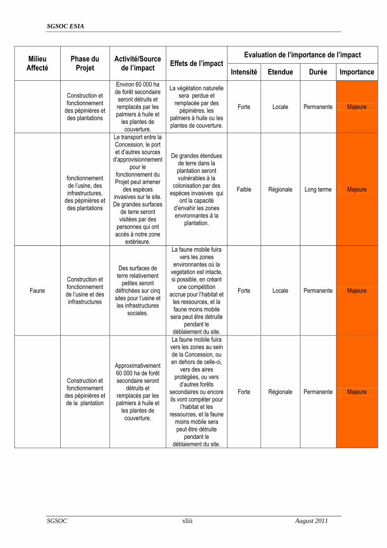
SGSOC ESIA
SGSOC xliii August 2011
Milieu Affecté
Phase du Projet
Activité/Source de l’impact
Effets de l’impact Evaluation de l’importance de l’impact
Intensité Etendue Durée Importance
Construction et fonctionnement
des pépinières et des plantations
Environ 60 000 ha de forêt secondaire
seront détruits et remplacés par les palmiers à huile et
les plantes de couverture.
La végétation naturelle sera perdue et
remplacée par des pépinières, les
palmiers à huile ou les plantes de couverture.
Forte Locale Permanente Majeure
fonctionnement de l‘usine, des infrastructures,
des pépinières et des plantations
Le transport entre la Concession, le port et d‘autres sources
d‘approvisionnement pour le
fonctionnement du Projet peut amener
des espèces invasives sur le site. De grandes surfaces
de terre seront visitées par des
personnes qui ont accès à notre zone
extérieure.
De grandes étendues de terre dans la plantation seront vulnérables à la
colonisation par des espèces invasives qui
ont la capacité d‘envahir les zones environnantes à la
plantation.
Faible Régionale Long terme Majeure
Faune
Construction et fonctionnement de l‘usine et des infrastructures
Des surfaces de terre relativement
petites seront défrichées sur cinq sites pour l‘usine et les infrastructures
sociales.
La faune mobile fuira vers les zones
environnantes où la vegetation est intacte, si possible, en créant
une compétition accrue pour l‘habitat et
les ressources, et la faune moins mobile
sera peut être détruite pendant le
déblaiement du site.
Forte Locale Permanente Majeure
Construction et fonctionnement
des pépinières et de la plantation
Approximativement 60 000 ha de forêt secondaire seront
détruits et remplacés par les palmiers à huile et
les plantes de couverture.
La faune mobile fuira vers les zones au sein de la Concession, ou en dehors de celle-ci,
vers des aires protégées, ou vers
d‘autres forêts secondaires ou encore ils vont compéter pour
l‘habitat et les ressources, et la faune
moins mobile sera peut être détruite
pendant le déblaiement du site.
Forte Régionale Permanente Majeure

SGSOC ESIA
SGSOC xliv August 2011
Milieu Affecté
Phase du Projet
Activité/Source de l’impact
Effets de l’impact Evaluation de l’importance de l’impact
Intensité Etendue Durée Importance
La concentration de la faune dans les
aires protégées au sein de la
Concession facilitera la chasse pour les chasseurs locaux.
La pression de la chasse pour la viande
de brousse augmentera dans les aires protégées au
sein de la Concession.
Forte Locale Long terme Majeure
Biodiversité
Construction et fonctionnement de l‘usine, des infrastructures,
des pépinières et des plantations
Environ 60 000 ha de forêt secondaire seront transformés en palmeraie, avec le développement d‘infrastructures
industrielles, commerciales, résidentielles et
sociales
La conversion détruira la biodiversité
existante dans environ 75% de la
Concession. L‘accent sera mis sur les 25%
restants et sur la zone qui entoure la
Concession en raison de la croissance de la demande en habitat
pour la faune en fuite et les fortes
concentrations de la pression de la
chasse...
Forte Régionale Permanente Majeure
Les espèces protégées peuvent être perturbées ou
détruites si les mesures d‘atténuation adéquates ne sont pas appliquées pendant le
processus. Les espèces protégées
hors de la Concession pourraient être
perturbées par la migration de la faune
hors de la Concession.
Moyen Régionale Long terme Majeure
Moyens de subsistance
Construction des pépinières, des plantations, de l‘usine et des infrastructures
Environ 500 à1000 emplois dans la
construction seront créés au cours de la
phase de développement de
4 ans.
Ces emplois auront un impact positif
significatif sur ceux qui les occuperont et sur
les personnes qui vendront les biens et
services aux employés ainsi que sur SGSOC et ses entrepreneurs
Forte Nationale Court terme Majeure

SGSOC ESIA
SGSOC xlv August 2011
Milieu Affecté
Phase du Projet
Activité/Source de l’impact
Effets de l’impact Evaluation de l’importance de l’impact
Intensité Etendue Durée Importance
Le déblaiement des terres pour les
plantations peut ravir les terres utilisées
pour des activités de subsistance
traditionnelles telles que l‘agriculture, la
cueillette des PFNL et la chasse.
Forte Locale Long terme Majeure
Fonctionnement
de toutes les installations
Environ 7500 employés à temps
plein seront nécessaires dans la
phase opérationnelle du
Projet.
Ces emplois auront une influence positive sur les employés, et sur les vendeurs de
biens et services ainsi que sur SGSOC
pendant les opérations.
Forte Nationale Long terme Majeure
Fonctionnement
des infrastructures
Des opportunités de formation seront
fournies gratuitement aux
enfants des travailleurs de la
plantation et peuvent être
élargies aux enfants des non travailleurs qui vivent dans la
Concession en fonction des
arrangements de partage des frais
avec le gouvernement
Ces opportunités vont grandement
augmenter le nombre de personnes qui
auront accès à l‘éducation et la qualité
dudit accès. La transition vers une
économie plus monétaire diminuera
aussi la nécessité pour les enfants de choisir
entre l‘école et le travail dans les
plantations familiales
Forte Locale Long terme Majeur
Fonctionnement des installations
Des structures sanitaires
améliorées seront fournies aux
travailleurs de la plantation et
pourraient être élargies aux non travailleurs vivant
dans la Concession, en fonction du coût
et des arrangements avec le
Gouvernement
Ces opportunités vont accroitre grandement
le nombre de personnes qui auront accès aux soins de santé et la qualité
desdits soins.
Forte Locale Long terme Majeure

SGSOC ESIA
SGSOC xlvi August 2011
Milieu Affecté
Phase du Projet
Activité/Source de l’impact
Effets de l’impact Evaluation de l’importance de l’impact
Intensité Etendue Durée Importance
Moyens de subsistance
Construction des infrastructures
Les routes seront améliorées pour faciliter la communication et le transportation entre les différentes parties de la Concession et les marchés.
Les locaux bénéficieront des routes améliorées, ce qui facilitera les échanges commerciaux, les déplacements et la communication.
Forte Locale Long terme Majeure
Moyens de subsistance
Fonctionnement des installations
Des maisons pour les employés seront construites.
Amélioration de la qualité de vie des employés et de leurs familles.
Forte Locale Long terme Majeure
Gouvernement Revenues
Fonctionnement des installations
Taxes payées par SGSOC et ses employés.
Accroissement significatif des revenues des taxes locales et nationales.
Moyen Nationale Long terme Majeure
Mesures d’Atténuation Emissions des Gaz à Effet de Serre
La plantation des palmiers à huile et des plantes de couverture sur la grande partie de la surface va
compenser la destruction de la biomasse. La production de l‘électricité et de la vapeur pendant les
opérations proviendra du brûlage des déchets de biomasse lors des opérations de l‘usine, et aura un
GHG neutre- un avantage sur le brûlage des combustibles fossiles. La production des biocarburants
compensera le brûlage des combustibles fossiles sur les équipements utilisés dans les Concessions
pendant les opérations normales. SGSOC peut capturer le méthane (un GHG significatif) produit par la
digestion de POME et l‘utiliser comme combustible pour l‘usine.
Perte de la Végétation Naturelle
La végétation naturelle, qui a la forme de forêt secondaire, sera déblayée pour le développement du
Projet. Des zones tampon de végétation existante seront maintenues entre la plantation et le PNK et le
sanctuaire BMW, et des zones tampon seront maintenues le long des voies d‘eau. En outre, les zones
forestières HCV comprenant des forêts primaires, des végétations en forte pente (plus de 30°), et les
sites sacrés ainsi que les terres agricoles utilisées par les villageois au sein de la Concession, seront
conservés.
Risques des Espèces Invasives

SGSOC ESIA
SGSOC xlvii August 2011
Le Projet va surveiller l‘arrivée des espèces invasives pour protéger l‘environnement naturel et pour
protéger la plantation contre tous types de parasites. Si des espèces invasives sont identifiées, elles
sont éradiquées par des moyens manuels, si possible, ensuite par des moyens biologique, enfin par
des moyens chimiques.
Perte de la Faune dans la Concession Elle est liée à la perte de la végétation naturelle, dans les forêts secondaires qui seront détruites pour
la mise en place du Projet. Des zones tampon de la végétation existante seront maintenues entre la
plantation et le PNK et le sanctuaire BMW, et des zones tampon seront maintenues le long des voies
d‘eau. En outre, les zones forestières HCV comprenant des forêts primaires, des végétations en forte
pente (plus de 30°), et les sites sacrés ainsi que les terres agricoles utilisées par les villageois au sein
de la Concession, seront conservés. La faune pourra utiliser ces zones pour leur habitat, mais la baisse
du nombre total habitats entraînera dans l‘ensemble, la perte de la faune.
Perte de la Faune hors de la Concession
La composition des populations fauniques hors de la Concession sera modifiée par l‘enlèvement et la
migration de certaines faunes ambulantes des zones déboisées vers les zones non déboisées ou
protégées. Le Projet atténue les impacts sur le KNP et le sanctuaire BMW en fournissant une zone
tampon au sein de la Concession, entre les zones déboisées et ces zones protégées de 3 km et 500 m
respectivement. Ces zones tampon ont en partie pour rôle d‘absorber et d‘atténuer les variations des
populations fauniques avant que ces changements n‘atteignent les zones protégées.
Pression de Chasse Croissante Pour réduire la demande de la viande de brousse locale, le SGSOC doit prendre les mesures
suivantes:
Réduire la pression de chasse au sein de la Concession en veillant à ce qu‘un
approvisionnement en viande autre que la viande de brousse locale ainsi que d‘autres sources
de protéine soient disponibles dans les magasins et les marchés de la Concession;
Informer ses employés sur les effets néfaste de la chasse et la consommation de la viande de
brousse;
Interdire la chasse au sein de la Concession et appliquer autant que possible ces interdictions;

SGSOC ESIA
SGSOC xlviii August 2011
Financer les programmes d‘éducation sur les effets néfastes de la chasse et de la
consommation de la viande de brousse dans les villages locaux; et,
Financer les programmes pour assure la transition des chasseurs vers d‘autres activités de
subsistance durables.
Perte de la Biodiversité au Sein de la Concession La zone choisie pour le Projet est une zone que le gouvernement a réservée au développement de
l‘agriculture en raison du fait qu‘il y avait été précédemment perturbé. Au sein de la Concession, les
zones de forêt HCV, notamment, les forêts primaires, la végétation sur en pentes fortes (supérieur à
environ 30º), et les sites sacrés ainsi que la terre agricole utilisée par les villages au sein de la
Concession ne seront pas touchées par le Projet, préservant ainsi certaines biodiversités locales. Par
ailleurs, les zones tampon des végétations existantes seront maintenues entre la plantation et les
sanctuaires de KNP et BMW. Les zones tampon seront aussi maintenues autour des voies d‘eau,
préservant ainsi d‘autres zones de biodiversité.
Perte de la Biodiversité hors de la Concession
La biodiversité hors de la Concession sera modifiée essentiellement par la migration de certaines
faunes ambulantes des zones déboisées vers les zones non déboisées. Le Projet atténue les impacts
sur le KNP et le sanctuaire BMW en fournissant une zone tampon au sein de la Concession, entre les
zones déboisées et ces zones protégées de 3 km et 500 m respectivement. Ces zones tampon ont en
partie pour rôle d‘absorber et d‘atténuer les variations des populations fauniques avant que ces
changements n‘atteignent les zones protégées.
Perte des Activités de Subsistance Traditionnelles Le Projet aura un effet néfaste sur les activités de subsistance au sein de la Concession à l‘instar de
l‘agriculture de subsistance, de la cueillette et de l‘utilisation des PFNL et de la chasse, essentiellement
en raison de la perte de la terre disponible pour mener ces activités due au défrichement de la
végétation et sa conversion en palmeraie. Ces activités peuvent être remplacées en grande partie par
des emplois à temps pleins crées par le Projet et la petite et moyenne entreprise indirecte qui sera
mise en place. Par ailleurs, les populations peuvent continuer à mener ces activités, mais si possible à
une faible intensité, dans les zones qui ne seront pas déboisées par le Projet.
Accroissement des Problèmes de Santé Pendant la Phase de Construction

SGSOC ESIA
SGSOC xlix August 2011
Le Projet tentera de recruter la plupart des employés de la construction dans les environs immédiats,
minimisant ainsi le nombre de personnes seules qui migreront pour travailler. SGSOC va également
s‘assurer que elle et ses entrepreneurs fournissement une formation adéquate et appliquent les codes
de conduits afin de minimiser la participation des travailleurs aux activités à risqué. Afin d‘atténuer
davantage cet impact potentiel, SGSOC devrait mener des programmes de sensibilisation et de
formation communautaires pour s‘assurer que les populations locales comprennent les risques liées à
la participation aux activités économiques à risque pour des gains à court terme.
Contrôle et Gestion Le Projet développera un plan détaillé de contrôle environnemental et social pour surveiller les
éléments clés de l‘environnement biophysique et humain. Le but de ce contrôle est de s‘assurer que
les impacts significatifs ont été correctement identifiés dans l‘étude, ensuite contrôler l‘efficacité des
mesures d‘atténuation. Les résultats des activités de contrôle seront régulièrement revissés afin de
déterminer si les mesures de gestion existantes sont adéquates, ou si ces mesures doivent être
révisées, annulées ou complétées.
Evaluation de l’Impact Global
L‘EIES a identifié des activités qui pourraient avoir un impact sur les conditions environnementales et
sociales existantes dans la zone du Projet et a fourni une évaluation du degré d‘impact qui peut en
résulter. Des plans d‘atténuation ont été élaborés pour chaque impact négatif identifié alors que les
impacts positifs seront accentués. Le contrôle et la gestion joueront un rôle essentiel dans le maintien
de l‗efficacité des initiatives d‘atténuation.
Evaluation Environnementale du Projet
Les impacts les plus significatifs du Projet seront associés à la mise sur pied de ce dernier. En
particulier, la destruction de la végétation existante pour permettre la plantation aura un impact
significatif pendant la mise en place du Projet. Des plans d‘atténuation ont été mis en place pour limiter
l‘impact de cette activité qui comprend le déblaiement par des moyens manuel ou mécaniques
conformément aux directives de RSPO; la création de zones tampon entre le Projet et les aires
protégées ; la création de zones tampon le long des voies d‘eau ; l‘identification des zones de
protection HCV au sein de la Concession qui comprennent des pentes fortes, des forêts primaires, des
sites sacrés et les terres agricoles utilisées par les populations locales. Au-delà de ces aspects, il
n‘existe pas d‘autres mesures d‘atténuation en dehors de la réduction de la taille des plantations,
SGSOC ESIA
SGSOC l August 2011
permettant d‘atténuer de façon significative la perte de la végétation naturelle, qui pourrait les effets
sociaux bénéfiques du Projet, par conséquent il n‘y a pas d‘autre mesure d‘atténuation proposée pour
cet impact.
La possibilité de survenue d‘un événement inattendu et ses conséquences potentielle est très faible en
raison du caractère manuel et contrôlé de sa mise en place. Des plans d‘urgence et des pratiques de
développement souples sont en train d‘être mis en place pour permettre ne réponse efficace à des
impacts imprévus liés à la mise en place et au fonctionnement du Projet.
Des mesures d‘atténuation seront contrôlées et révisées régulièrement afin de garantir leur adhésion et
leur efficacité. Tout entrepreneur employé par le Projet devra respecter les plans d‘atténuation et les
engagements pris par SGSOC.
Evaluation Socio-économique du Projet Il ressort des rencontres formelles et informelles avec les communautés localisées au sein de la Zone
du Projet que la plupart des membres des communautés ainsi que leurs chefs apportent un appuis de
taille au développement du Projet. Les communautés reconnaissent qu‘un important investissement à
long terme dans la zone améliorera de manière substantielle le quotidien de nombreux membres de la
communauté et fournira des opportunités d‘emploi dynamique.
Les nombreux avantages socio-économiques que générera le Projet sont, entre autres
des emplois directs durables pour 7.000 – 8.000 personnes;
le renforcement des connaissances et des expériences résultant de l‘exercice et de la
formation relatifs au Projet;
des emplois indirects pour des milliers d‘autres personnes exerçant au sein des petites et
moyennes entreprises;
l‘appui aux petits exploitants locaux;
la réduction de l‘exode rural du Sud Ouest du Cameroun;
l‘investissement dans le domaine de l‘éducation en faveur des communautés locales;
l‘investissement en matière des soins de santé en faveur des communautés locales;
le renforcement de la sensibilisation publique au sujet des besoins socio-économique des
communautés locales en matière de routes, de soins de santé, et autres infrastructures, ainsi

SGSOC ESIA
SGSOC li August 2011
des investissements sociaux aux niveaux international, national et communautaire, à travers
la consultation et la publication des documents
l‘hébergement;
l‘accès à l‘eau potable et à l‘électricité; et,
les recettes fiscales pour le gouvernement.
Le maintien d‘une communication permanente à travers une politique cohérente d‘interaction et
d‘échange avec les populations locales est d‘une importance capital pour des rapports constructifs
durables. En particulier, certains membres des communautés locales expriment encore leur inquiétude
quant au fait le Projet arrachera des terres actuellement utilisées pour l‘agriculture ou à des fins
résidentielles. Le SGSOC est déterminé à respecter les limites actuelles des villages et des terres
agricoles, et à fournir des zones de croissance aux communautés. Il est important de continuer à
mettre l‘accent sur cette politique. Par ailleurs, certains habitants pourraient croire que le SGSOC
construira de nouveaux réseaux routiers pour relier les villages à travers les zones protégées et autres
localités. Bien que le SGSOC travaillera avec les gouvernements et ONG internationaux et nationaux
en vue d‘améliorer le réseau routier, il incombe au gouvernement camerounais d‘identifier et de
planifier les nouveaux réseaux routiers, en particulier dans les zones protégées.
Le coût du Plan de Gestion environnementale et social du Projet s‘élève à soixante quinze (75)
milliards de francs CFA.

SGSOC ESIA
SGSOC 1-1 August 2011
1 Introduction
SG Sustainable Oils Cameroon (SGSOC) plans to develop an oil palm plantation in Cameroon (the
Project). The Project is located approximately 250 km from the port of Douala and located in the Kupe
Manenguba and Ndian divisions of the Southwest Region. The Project involves the development of
nurseries, a nucleus plantation, processing mills and other infrastructure to support the production and
distribution of commercial grade crude palm oil (CPO) and palm kernel oil (PKO) for domestic and
export sales based on market conditions.
The Project sponsor is SGSOC. SGSOC is the Cameroonian subsidiary of Herakles Farms, an
American multinational, which is the Investor and the Operator of the Project. SGSOC is based in
Limbe, Cameroon.
1.1 Project Objective
The primary objective of the Project is to design, construct and operate an oil palm plantation and
associated palm oil processing mills. SGSOC is committed to developing and maintaining a
sustainable, environmentally sensitive oil palm Project which will have wide reaching benefits for many
aspects of the Cameroon economy and the local communities. To this end, it has a goal of becoming
RSPO (Roundtable on Sustainable Palm Oil) certified. Once certified, SGSOC will be a significant
contributor to the movement for sustainable palm oil production, thereby setting the standards for
others in the industry.
The Southewest region of Cameroon has climatic conditions making it ideally located for the cultivation
of oil palm; however, the benefits of sustainable oil palm cultivation on Cameroon‘s available
agricultural lands have not been fully realized. SGSOC plans to construct and operate the Project on
land designated by the Government for agricultural development that is currently underutilized.
SGSOC and the Government of Cameroon signed an agreement (the Establishment Convention) for
the development and operation of the Project within an area of 73,086 ha in Southwest Cameroon
(Concession) on September 17, 2009. SGSOC expects the total area planted to be approximately
60,000 ha. The remaining area of the Concession will be protected as zones for environmentally or
socially sensitive resources, plantation infrastructure and social infrastructure, and lands for village
livelihood activities.

SGSOC ESIA
SGSOC 1-2 August 2011
The Project and its primary supporting facilities consist of the following:
Nurseries – Several nurseries will be established to provide seedlings to the plantation. Each
nursery will be between 125 to 150 ha in size.
Plantation – The plantation will be established over four phases, with each phase lasting
approximately one year, on the Concession. Buffer zones between the planted areas and national
parks, high conservation value (HCV) areas, and water bodies. The total planted area within the
Concession is expected to be approximately 60,000 ha and the plantation is expected to generate
1,800,000 MT of fresh fruit bunches (FFB) annually at peak capacity.
Processing Mills –Five mills will be constructed to process the FFB into CPO and PKO. The
processing of the FFB will include sterilization, stripping, washing, mixing, extraction, clarification,
finishing, and oil production. Each mill is designed to process 60 MT/hr of FFB.
Social Infrastructure – The plantation will be divided into five complexes, one for each mill, to
organize the Project operations. Construction of clinics, schools, housing and other social
infrastructure is planned and will be distributed among each complex to support the workforce
required to operate the Project.
Palm oil is the primary source for vegetable oil worldwide. The food industry is the predominant palm
oil end market, accounting for about 77% of CPO consumption and 25% of PKO consumption. Palm oil
is frequently used for cooking in restaurants and in homes, as an emulsifier in creams and sauces, as
an ingredient in baked goods, and as an essential raw material in several types of margarines.
Palm oil also has numerous non-food applications. It serves as a base for most soaps and liquid
detergents and is also a key component in cosmetics, personal care products, lubricating greases,
glues, and printing inks. CPO is also an industrial lubricant used during the manufacture of steel and
as a substitute for non-renewable petroleum based fuels.
The Project is expected to have the capacity to generate, at peak output, 400,000 MT of CPO and
40,000 MT of PKO annually for domestic use and export.
1.2 Background and Need
Demand for palm oil is increasing due to the growing use of vegetable oils for biodiesel production and
the increased consumption of vegetable oil in developing countries including Cameroon. Currently, the
primary producers of palm oil are Indonesia and Malaysia; together accounting for approximately 80%
SGSOC ESIA
SGSOC 1-3 August 2011
of the world production. Development of Africa‘s available agricultural resources will provide benefits to
local populations in need of sustainable employment and serve as a reliable regional source for palm
oil. Numerous international development agencies and non-governmental organizations (NGOs), such
as the United Nations Food & Agriculture Organization (FAO) and World Bank, have advocated
increasing palm oil production in West Africa due to its positive effect on employment and other social
benefits.
The Project will provide significant benefits, some of the benefits include:
Direct sustainable employment for 7,000 – 8,000 individuals;
Indirect employment for several thousand other individuals operating small and medium sized
businesses;
Decrease the rural exodus from Southwest Cameroon;
Investment in education for surrounding communities;
Investment in healthcare for surrounding;
Housing;
Access to clean water and electricity; and
Tax revenues for the Government
Upon approval of the ESIA by the Government of Cameroon, SGSOC plans to use the seedlings from
the initial nurseries to begin the first phase of planting.
SGSOC is committed to ensuring that local communities and cultures are not adversely affected, to
actively engaging with the local communities throughout the life of the Project, and to promoting
biodiversity. To support its analysis, SGSOC has completed the following studies to establish baseline
conditions, quantify positive and negative impacts, and establish mitigation measures as necessary:
wildlife study;
vegetation study;
socioeconomic study; and
high conservation value study.

SGSOC ESIA
SGSOC 1-4 August 2011
1.3 Document Organization
This document consists of the following sections:
Executive Summary, consisting of a discussion of significant findings and recommended actions;
Introduction (Section 1), this section;
Policy, Legal, and Administrative Framework (Section 2), which discusses the framework within
which the ESIA was performed and the Project will be developed;
Project Description (Section 3), which describes the proposed Project, its rationale, Project
phases, work force and schedule;
Baseline Environmental and Social Conditions (Section 4), which describes the relevant
physical, biological and socioeconomic conditions in the area of Project direct and indirect
influence;
Potential Impacts, Mitigation, and Residual Impacts (Section 5), which assesses the Project‘s
potential positive and negative direct and indirect impacts;
Public Consultations (Section 6), which describes the public consultation activities associated
with the ESIA;
Environmental and Social Management Plan (Section 7), which describes the mitigation,
monitoring, and institutional measures to be taken during construction and operation to mitigate
adverse impacts, offset them or reduce them to acceptable levels, and to enhance the positive
effects of the Project;
Conclusion (Section 8), which summarizes the report; and,
References (Section 9), which lists the sources of information used in preparation of the ESIA.

SGSOC ESIA
SGSOC 2-5 August 2011
2 Policy, Legal, and Administrative Framework
SGSOC is committed to meeting the spirit and intent of a number of international, national and
regional policies, guidelines, laws and regulations. These include:
Internal corporate mandates, policies, and best practice commitments;
Cameroon strategies, legislation, permits, and approvals;
RSPO Principles;
IFC Performance Standards;
Equator Principles;
Guidelines of the UN Global Compact; and
Good International Industry Practice (GIIP) that helps define leading industry practices
This regulatory and administrative framework for the Project is described in the following sections,
along with the targets for environmental and regulatory compliance, and a summary of the current
status of Project permitting.
2.1 Corporate Commitments
The main objective of SGSOC is to develop a sustainable oil palm Project in the Republic of
Cameroon to produce commercial grade crude palm oil (CPO), and palm kernel oil (PKO) for
domestic and export sales based on market conditions.
The mission of SGSOC includes the following:
to develop an environmentally and socially sustainable oil palm Project in Cameroon;
to provide commercial grade palm oil for both local and external markets - Cameroon imported
approximately 38,000 tonnes of CPO in 2010;
to improve social programs and quality of life in the rural areas;
to encourage solutions to local food security and economic development through smallholder
farmer support;

SGSOC ESIA
SGSOC 2-6 August 2011
to create long-term sustainable jobs to reduce unemployment (at full build-out, it is planned
that the Project would employ 7,000 to 8,000 workers and in so doing help reduce poverty, and
rural exodus; and
to act as a model for sustainable, environmentally sensitive, agricultural development in
emerging markets.
SGSOC is a member of the Roundtable on Sustainable Palm Oil (RSPO), which is a not-for-profit
association comprised of stakeholders from the seven sectors of the palm oil industry - oil palm
producers, palm oil processors or traders, consumer goods manufacturers, retailers, banks, and
investors, environmental or nature conservation NGOs, and social or developmental NGOs. It was
formed in 2004 with the objective to promote the growth and use of sustainable oil palm products
through credible global standards and engagement of stakeholders.
RSPO members have several Principles and Criteria to follow for sustainable palm oil production:
Principle 1: Commitment to transparency;
Principle 2: Compliance with applicable laws and regulations;
Principle 3: Commitment to long-term economic and financial viability;
Principle 4: Use of appropriate best practices by growers and millers;
Principle 5: Environmental responsibility and conservation of natural resources and
biodiversity;
Principle 6: Responsible consideration of employees, and of individuals and communities
affected by growers and mills;
Principle 7: Responsible development of new plantings; and
Principle 8: Commitment to continuous improvement in key areas of activity.
SGSOC is committed to the sustainable development and long-term involvement in protecting the
environmental quality and human interests in Cameroon, including the health and safety of its
people. SGSOC‘s social and environmental programs aim to continually improve environmental

SGSOC ESIA
SGSOC 2-7 August 2011
and safety performance in the workplace, maintain multi-directional communication among
SGSOC, local communities, Government, and interested stakeholders.
SGSOC will develop the capabilities and support mechanisms necessary to administer its social
and environmental management programs. Implementation will require establishing a strong
corporate culture emphasizing understanding and commitment to environment and social
compliance.
2.2 Cameroon Legal and Regulatory Framework
This section outlines elements of Cameroon‘s environmental legislation in general and legislation
governing the development, construction, and operation of the Project, and includes the following
subsections:
national environmental legislation;
other national legislation;
international conventions and treaties; and,
international guidelines.
2.2.1 National Environmental Legislation
2.2.1.1 Framework Law on the Environment
Cameroon has a comprehensive environmental legislation. The legislation provides for the
establishment of a National Environmental Management Plan (NEMP) adopted by the Government
in 1996. This plan is specified in Law No. 96/12 of 5 August 1996.
The Framework Law on the Environment covers the following aspects:
Part I – General Provisions;
Part II – Formulation, coordination and financing of environmental action and setting up of a
National Fund for the Environment;

SGSOC ESIA
SGSOC 2-8 August 2011
Part III – Environmental management (environmental impacts/audits; protection of the
atmosphere; protection of continental and inland waters; erosion control; protection of human
settlements; classified establishments; management of chemical and hazardous substances;
noise and olfactory nuisances; management of natural biological resources; natural risks and
catastrophes); and,
Part IV – Responsibilities and sanctions; infringements and sanctions; miscellaneous and final
provisions.
According to the Framework Law on the Environment, the implementation of any industrial
development project in Cameroon that may endanger or impact the environment or the existing
ecological system of the project area is subject to the conduct of an Environmental Impact
Assessment (EIA). It is governed by Decree No. 2005/0577/PM of 23 February 2005, which
summarizes the procedures for the preparation of EIAs and Order No. 0070/MINEP of 22 April
2005, which establishes categories of operations subject to EIAs. Preparation of EIA is the sole
responsibility of the owner or promoter of a proposed project or undertaking and is carried out at
his or her expense.
The Ministry of Environment and Protection of Nature (MINEP) is responsible for issues relating to
the environment, including the conduct of Environmental Impact Assessments.
The Framework Law on the Environment is strengthened and embellished by decrees and orders
to make it workable and practical in all respects.
The basic principles for the formulation of the framework legislation on the environment include:
precaution principle in view of the limits of current knowledge;
polluter pays principle;
prevention and corrective action principle;
principle of participation;
principle of liability and mutual decision; and,
principle of substitution (see Section 9 of Law No. 96/12 of 5 August 1996).

SGSOC ESIA
SGSOC 2-9 August 2011
Section 9 of this Law lists the basic principles of the rational management of the environment and
natural resources, namely:
1. The precaution principle according to which lack of certainty, in view of current scientific
and technical knowledge, should not retard the adoption of effective and appropriate
measures to prevent risks that may cause serious and irreversible damage to the
environment at economically acceptable cost.
2. The polluter pays principle according to which the cost of measures to prevent, reduce and
control pollution and rehabilitate polluted areas is be borne by the polluter.
3. The prevention and corrective action principle seeks to minimize of threats to the
environment through the use of the best techniques at economically acceptable cost.
4. The principle of participation according to which:
a. Each citizen shall have access to information on the environment, including
information on hazardous substances and activities;
b. Each citizen shall have the obligation to preserve the environment and contribute
to its protection;
c. Corporate bodies and private citizens shall, in all their activities, conform to the
same requirements; and,
d. Decisions concerning the environment shall be taken after consultation with the
sectors of activity or groups concerned, or after a public debate when they are of a
general nature.
5. The principle of liability according to which any person who, through his actions, creates
conditions likely to endanger human health and the environment shall eliminate or cause
the said conditions to be eliminated such as to avoid the said effects; and
6. The principle of substitution according to which in the absence of a written general or
specific rule of law on environmental protection, the identified customary norm of a given
land, accepted as more efficient for environmental protection, shall apply.

SGSOC ESIA
SGSOC 2-10 August 2011
It should be noted that Section 9 (f) of Cameroon‘s Framework Law on the Environment provides
for substitution where certain rules are omitted or missing in the Law. This Section stipulates that
where a general or specific rule relating the environment is not provided for in the Framework Law,
a rule derived from other regulations or a rule from another context that will be more efficient with
regard to the protection of the environment may be used. Regarding environmental impact
assessments, Section 17 of the Law No. 96/12 of 5 August 1996 stipulates that:
―The promoter or owner of any development, project, labour or equipment, which is likely to
endanger the environment, owing to its dimension, nature or the impact of its activities on the
natural environment shall carry out an environmental impact assessment. This assessment
shall determine the direct or indirect incidence of the said project on the ecological balance of
the zone where the plant is located or any other region, the physical environment and quality of
life of populations and the impact on the environment in general.‖
―The environmental impact assessment shall be included in the file submitted for public
investigation where such a procedure is provided for.‖
―The impact assessment shall be carried out at the expense of the promoter.‖
According to Section 19(2), the impact assessment shall of necessity comprise:
the analysis of the initial state of the site and its environment;
reasons for choosing the site;
evaluation of the anticipated consequences of the implementation of the project on the site and
its natural and human environment;
outline of the measures envisaged by the promoter or owner to eliminate, reduce and, if
possible, compensate for the harmful consequences of the project on the environment and
estimates of the ensuing cost; and,
presentation of other possible solutions and reasons for selecting the project from the
perspective of environmental protection.

SGSOC ESIA
SGSOC 2-11 August 2011
According to Section 20 (2) of Law No.96/12 of 5 August 1996, where the impact assessment is
not known or the impact assessment procedure is totally or partially disrespected, the competent
Administration, or where necessary, the Administration in charge of the environment, shall demand
the implementation of appropriate emergency procedures to suspend the work envisaged or
already initiated. These emergency procedures shall be initiated without prejudice to the sanctions
provided for by this Law.
2.2.1.2 Conduct of environmental impact assessments
Decree No. 2005/0577/PM of 23 February 2005 defines the conditions for the conduct of
environmental impact assessments, including:
the content of the environmental impact study;
the procedure for the formulation and approval of the environmental assessment study; and,
In Article 11, it stipulates that an environmental impact study must be carried out with the
participation of the population concerned through consultations and public hearings with a view
to obtaining their opinions regarding the project.
2.2.1.3 Terms of Reference for EIAs
Order No. 00001/MINEP of 13 February 2007 defines the terms of reference for EIAs, including
guidelines for the preparation of the terms of reference for impact assessment studies.
2.2.1.4 Regulations governing water resources
Law No. 98/005 of 14 April 1998 defines regulations governing water resources and procedures
pertaining to water and general principles for environmental management and protection of public
health. Section 4 prohibits acts that could impair the quality of surface, ground or seawater, or
jeopardize public health, as well as marine fauna and flora, which are prejudicial to economic
development and tourist activities.
According to Section 6, any natural person or owner of installations likely to pollute water must take
all the necessary measures to limit or remove this effect. It also stipulates that any person who

SGSOC ESIA
SGSOC 2-12 August 2011
produces or stores waste must eliminate or recycle it in approved installations. Furthermore,
promoters must inform the public on the effects of waste production, storage or recycling on water,
the environment or public health, as well as on the associated preventive measures or
compensation.
2.2.1.5 Establishments classified as dangerous, unhealthy or obnoxious
The construction and operation of the Oil Palm Mills, given the presence of fuel tanks, boilers, and
heavy machinery, will be subject to these Laws. Law No. 98/015 of 14 July 1998 relates to
establishments classified as dangerous, unhealthy or obnoxious. It stipulates in its Sections 5, 7, 9
and 12 that the manager of a class I establishment must conduct studies on dangers in accordance
with conditions laid down by regulations. Concerning the protection of the interests referred to in
Section 2 of this Law, the Minister in charge of classified establishments shall, under conditions laid
down by regulations, demarcate a security zone around Class I establishments within which
building of homes and the carrying out of any other activity incompatible with the functioning of the
said establishment shall be forbidden.
According to Sections 25 and 26, classified establishments that pollute the environment shall be
liable to an annual pollution tax and those that import equipment used in eliminating greenhouse
gases, carbon dioxide and chloroflurocarbons from their production processes or products, or to
reduce any form of pollution, shall be granted a reduced customs tariffs on such equipment in the
proportions, and for periods determined as and when necessary by the finance Law.
2.2.1.6 Establishments classified as dangerous, unhygienic and obnoxious
The construction and operation of the oil palm mills, given the presence of fuel tanks, boilers, and
heavy machinery, will be subject to these Laws. Decree No. 99/818/PM of 9 November 1999
defines the conditions for the establishment and exploitation of establishments classified as
dangerous, unhygienic and obnoxious and provides the conditions for the approval of individuals to
inspect, control and audit establishments classified as dangerous, unhygienic, or obnoxious. The
inspection, control and audit of establishments classified as dangerous, unhealthy or obnoxious is
a prerogative of the Ministry in charge of classified establishments. However, the Ministry may
approve individuals to inspect, control and audit establishments classified as dangerous,
unhygienic, or obnoxious under the conditions laid down by this decree. Article 11 of this decree

SGSOC ESIA
SGSOC 2-13 August 2011
provides that within the framework of monitoring waste in the environment, the decree lays down
guidelines for the analysis and measures to control the establishments and monitor their impacts
on the environment.
2.2.1.7 Forestry, wildlife and fisheries regulations
Law No. 94/01 of the 20th of January 1994, repeals all previous contradictory regulations regarding
forestry, wildlife and fisheries, in particular Law No. 81/13 of 27 November 1981 to lay down
forestry, wildlife and fisheries regulations. The Law and its implementing instruments lay down
forestry, wildlife and fisheries regulations in order to attain general objectives of forestry, wildlife
and fisheries policy within the framework of integrated management to ensure sustainable
conservation and use of the said resources and of the various ecosystems. It is comprised of
seven parts:
General Provisions;
Protection of Nature and Biodiversity;
Forests;
Wildlife;
Fisheries;
Prosecution of Offences; and,
Miscellaneous and Final Provisions.
Part II prohibits the lighting, without prior authorization, of a fire that may cause damage to the
vegetation of the national forest estate. The clearing of all or part of a State or Council forest shall
be subject to total or partial declassification of such forest while the initiation of any development
project likely to perturb a forest or aquatic environment shall be subject to a prior EIA.
Furthermore, it envisages methods for establishment of pastures or classification of protected
areas in forest zones to ensure the conservation of land or biodiversity.
Part III distinguishes two main categories of forests: (i) permanent or classified forests, which are
lands used solely for forestry and/or as a wildlife habitat; and (ii) non-permanent or unclassified

SGSOC ESIA
SGSOC 2-14 August 2011
forests, which comprise forest lands that may be used for other purposes than forestry. Permanent
forests cover at least 30% of the total area of the national territory and comprise State forests and
Council forests. For their part, non-permanent forests are forests on non-permanent forest land
comprising communal forests, community forests and forests belonging to private individuals or
companies.
2.2.1.8 Implementation of forestry regulations
Decree No. 94/436/PM is the implementing instrument of Law No. 94/01 of 20 January 1994,
particularly concerning provisions governing forests, protection of nature and biodiversity. It is
comprised of 109 articles divided into eight parts.
2.2.1.9 Decree on the conditions of implementing forestry regulations
Decree No. 95/531/PM of 23 August 1995 determines the conditions of implementing forestry
regulations, and defines the terms and conditions for the implementation of forestry, wildlife and
fisheries regulations in Cameroon. It governs the exploitation of forest products in the country. It
consists of 151 articles dealing with topics like the protection of biodiversity, forest management,
and the processing and marketing of forest products. The decree prohibits bush fires, which are
subject to authorization by local administrative authorities. The decree stipulates that any individual
or corporate body wishing to sell harvested timber must obtain a license. However, the
implementation of any project in the forest is subject to an EIA, especially projects that are likely to
destroy the natural habitat. According to Article 151, three Ministers (the Ministers of the
Environment and Forestry; the Economy and Finance and the Industrial and Commercial
Development) are responsible for the implementation of this decree.
2.2.1.10 Conditions for the implementation of wildlife regulations
Decree No. 95-466/PM of 20 July 1995 lays down the conditions for the implementation of wildlife
regulations and the implementation of Law No. 94/1 of 20 January 1994 to lay down forestry,
wildlife and fisheries regulations. It includes 88 articles divided into six parts:
General Provisions;
Protection of Wildlife and Biodiversity;
Wildlife Management;

SGSOC ESIA
SGSOC 2-15 August 2011
Prosecution of Offences;
Miscellaneous Provisions; and,
Transitional and Final Provisions.
2.2.1.11 Protection of national parks
Law No. 78-23 of December 02, 1978, relates to the protection of national parks. It determines the
components of infringements if perpetrated in national parks and buffer zones and lays down the
methods of reporting infringements and their corresponding sanctions.
2.2.1.12 Control of Pest Control Products
Law No. 2003/003 of 21 April 2003 lays down the principles and rules governing phytosanitary
protection in Cameroon. Pest control protection shall be carried out through:
the setting, adoption and adaptation of norms in the country;
the prevention and control of plant and plant product pests;
the use of pest control products that are safe for humans, animals and the environment;
the dissemination and popularization of appropriate pest control techniques;
the control of the import and export of pest control products, plants, plant products and other
regulated items that may lead to the release of plant pests; and,
the control, throughout the national territory, of pest control products, plants and plant products
that may serve as vectors of harmful organisms.
2.2.1.13 Decree No. 2001/165/PM of 8 May 2001 specifies conditions for the protection of
surface and ground water resources against pollution
Under Cameroon‘s Water Law (Law No. 98/005 of 14 April 1998) water is a natural resource within the common heritage of the country. The state is responsible for managing the country‘s water resources and facilitating access for the entire population. The Government passed several water resource–related decrees in 2001, among which are:
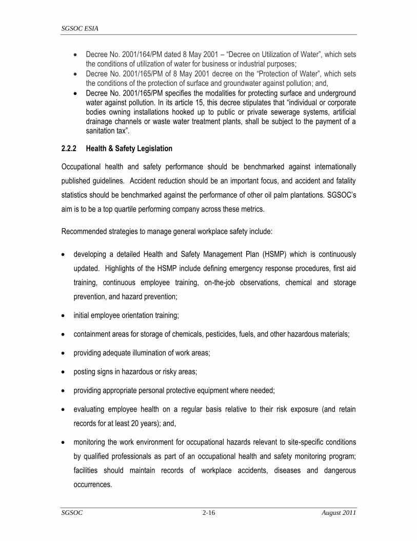
SGSOC ESIA
SGSOC 2-16 August 2011
Decree No. 2001/164/PM dated 8 May 2001 – ―Decree on Utilization of Water‖, which sets the conditions of utilization of water for business or industrial purposes;
Decree No. 2001/165/PM of 8 May 2001 decree on the ―Protection of Water‖, which sets the conditions of the protection of surface and groundwater against pollution; and,
Decree No. 2001/165/PM specifies the modalities for protecting surface and underground water against pollution. In its article 15, this decree stipulates that ―individual or corporate bodies owning installations hooked up to public or private sewerage systems, artificial drainage channels or waste water treatment plants, shall be subject to the payment of a sanitation tax‖.
2.2.2 Health & Safety Legislation
Occupational health and safety performance should be benchmarked against internationally
published guidelines. Accident reduction should be an important focus, and accident and fatality
statistics should be benchmarked against the performance of other oil palm plantations. SGSOC‘s
aim is to be a top quartile performing company across these metrics.
Recommended strategies to manage general workplace safety include:
developing a detailed Health and Safety Management Plan (HSMP) which is continuously
updated. Highlights of the HSMP include defining emergency response procedures, first aid
training, continuous employee training, on-the-job observations, chemical and storage
prevention, and hazard prevention;
initial employee orientation training;
containment areas for storage of chemicals, pesticides, fuels, and other hazardous materials;
providing adequate illumination of work areas;
posting signs in hazardous or risky areas;
providing appropriate personal protective equipment where needed;
evaluating employee health on a regular basis relative to their risk exposure (and retain
records for at least 20 years); and,
monitoring the work environment for occupational hazards relevant to site-specific conditions
by qualified professionals as part of an occupational health and safety monitoring program;
facilities should maintain records of workplace accidents, diseases and dangerous
occurrences.
SGSOC ESIA
SGSOC 2-17 August 2011
Decree No. 039/MTPS of 26 November 1984 explains general measures for hygiene and safety at
the work place. This decree regulates the respective obligations of employers and employees, the
composition of hygiene and safety work committees, defines general terms relating to hygiene,
inter alia, construction, ventilation, temperature and lighting, food, security and transport measures,
dangerous substances and rules for prevention and fire fighting, and the establishment of methods
of control and sanctions.
2.2.3 Labor Legislation
Cameroon's labor-management relations are governed by the labor code enacted in 1992. The
code restores:
collective bargaining and employee-employer primacy in the negotiation of wages;
eliminates fixed zonal wage scales;
abolishes employment by level of education;
eliminates Government control over layoffs and firings; and,
reduces Government involvement in the management of labor unions.
Cameroon is a party to the ILO Convention on the Protection of Labor Rights.
2.2.4 Land Tenure and Land Use Legislation
The establishment of a legal framework for land tenure and property rights in 1974 put in place a
process for land rights registration in Cameroon:
Ordinance No. 74-1 of 6th July 1974 to establish rules governing land tenure,
Ordinance No. 74-2 of 6th July 1974 to establish rules governing state lands, and,
Ordinance No. 74-3 of 6th July 1974 concerning the procedure governing expropriation for a
public purpose and the terms and conditions of compensation.
Other decrees followed:
Decree No. 76-165 of 27th April 1976 to establish the conditions for obtaining land certificates;

SGSOC ESIA
SGSOC 2-18 August 2011
Decree No. 76-166 of 27th April 1976 to establish the terms and conditions of management of
national lands; and,
Decree No. 76-167 of 27th April 1976 to establish the terms and conditions of management of
the private property of the State.
Cameroon‘s primary land code, Ordinances No. 74-1 and 74-2 created a land tenure system based
on land registration:
all privately owned land must be registered and titled to retain its character as private land;
and,
all unregistered land is deemed to be either public land, which is held by the state on behalf of
the public, or national land.
The Laws were intended to encourage foreign investment in Cameroon as they effectively clarified
private property rights and made all unregistered land available for investment.
The Ministry of State Property and Land Tenure (MINDAF) is the primary public actor in the land
sector. MINDAF has authority over all land, but many of its objectives are largely focused on state
land. MINDAF has overall responsibility for land allocations, land development, and land surveys.
2.2.5 Agricultural Legislation
Law No. 2001/014 of 23 July 2001 relates to seed activities. This Law identifies the conditions for
conducting seeding activities in Cameroon. It seeks to support agricultural development by
enhancing the results of agriculture research through improving plant diversity; preventing unfair
competition; guaranteeing the quality of seeds distributed to farmers; and promoting the
conservation of national phytogenetic resources. According to this Law, seed activities are carried
out under the control of the State, which specifies technical standards regarding seeds and
ensures quality control and certification of seeds. Seed activities are subject to a prior declaration.
The import, production and marketing of seeds are subordinated to the conditions defined by a joint
decree of the Ministry in charge of agriculture and the Ministry in charge of commerce. Any person
carrying out seed activities must keep a registry of transactions per species, variety and category.

SGSOC ESIA
SGSOC 2-19 August 2011
All seed and plant species are classified in three categories: basic seeds, certified seeds, and
standard seeds. The basic seeds and certified seeds produced in Cameroon must be certified by
the seed administration. Any seeds marketed in Cameroon must be subject to quality control by the
seed administration. An Official Catalogue of species and varieties has been established in which
plant varieties developed or introduced in Cameroon are registered.
2.2.6 Liquid and Solid Waste
The legislation concerning liquid waste is of essential consideration in the construction of a palm oil
extraction mill as well as the management of large quantities of solid waste resulting from the
processing of palm nuts.
It will be necessary to consider the following Laws and decrees:
Decree No. 2001/164/PM of 8 May 2001 – ―Decree on Utilization of Water‖, which sets the conditions of utilization of water for business or industrial purposes
Decree No. 2001/165/PM of 8 May 2001 decree on the ―Protection of Water‖, which sets the conditions of the protection of surface and groundwater against pollution
Law No. 98/015 of 14 July 1998 relating to establishments classified as dangerous, unhealthy or inconvenient
Decree No. 99/818/PM of 9 November 1999 to define the conditions for the establishment and exploitation of establishments classified as dangerous, unhealthy and inconvenient
2.2.7 The Ministry of Environment and Nature Protection (MINEP)
The Ministry of Environment and Protection of Nature set up by Decree No. 2004/320 of 8
December 2004 is responsible for the development, coordination and implementation of the
national environmental policy. It:
coordinates and monitors regional or international co-operation regarding the environment;
defines measures for the rational management of natural resources in conjunction with the
ministries and specialized corporations concerned;
disseminates information to stimulate participation in the management and preservation of the
environment;
develops sector-based master plans for the protection of the environment in collaboration with
the interested ministries; and,
SGSOC ESIA
SGSOC 2-20 August 2011
negotiates agreements and international conventions relating to the protection of the
environment and their implementation.
It is this MINEP that approves EIAs.
2.2.7.1 Decree No. 2004/320 of 8 December 2004 to reorganize the MINEP
In order to assist MINEP in its development, coordination, execution, environment control, and
sustainable development missions, other Ministries intervene at various levels in their areas of
competence within the Inter-Ministerial Environmental Committee (CIE) set up by the Framework
Law whose organization and functioning is governed by Decree No. 2001/718/PM of 3 September
2001. CIE also issues an opinion on EIAs before the decision of MINEP to approve an EIA.
MINEP has formulated Guidelines on Environmental Measures which define major principles to be
followed and considered during the implementation of forestry projects.
2.2.7.2 The Inter-Ministerial Committee (IMC)
Decree No. 2001/718/PM of 3 September 2001 lays down the organization and functions of the
IMC set up by the Framework Law. Under the terms of this decree, the IMC‘s role is to assist the
Government in the development, coordination, execution and control of national policies on the
environment and sustainable development (Article 2 (1). This decree recently was modified and
supplemented by decree N° 2006/1577/PM of 11 September 2006 to take into account the new
structure of the Government. The IMC, which comprises 17 members, will have to issue its opinion
on this EIA.
The 17 members represent the following Ministries:
the Ministry of Territorial Administration and Decentralization (MINATD);
the Ministry of Agriculture and Rural Development (MINADER);
the Ministry of Defence (MINDEF) ;
the Ministry of Urban Development and Housing (MINDUH);
the Ministry of State Property and Land Tenure (MINDAF);

SGSOC ESIA
SGSOC 2-21 August 2011
the Ministry of Livestock, Fisheries and Animal Industries (MINEPIA);
the Ministry of Energy and Water Resources(MINEE);
the Ministry of Environment and Nature Protection (MINEP);
the Ministry of Forestry and Wildlife (MINFOF);
the Ministry of Industry, Mines and Technological Development (MINIMIDT);
the Ministry of Planning, Development Programming and Regional Development
(MINEPLDAT);
the Ministry of Small-and-Medium-sized Enterprises, Social Economy and Handicraft(s)
(MINPMEESA);
the Ministry of Scientific Research and Innovation (MINRESI);
the Ministry of Public Health (MINSANTE);
the Ministry of Tourism (MINTOUR);
the Ministry of Transport (MINT); and,
the Ministry of Public Works (MINTP).
2.2.7.3 The Ministry of Forestry and Wildlife (MINFOF)
The Minister of Forestry and Wildlife is in charge of the development, implementation and
evaluation of Government‘s policy on forestry and wildlife. For this reason, it is responsible for:
the management and protection of forests of the national domain;
the development and control of the execution of regeneration, afforestation, and forest
establishment and inventory programs;
the control of compliance with regulations in the area of forest development by various
stakeholders;
the application of the administrative sanctions when it is necessary;
relations with professional organizations of the forestry sector;
SGSOC ESIA
SGSOC 2-22 August 2011
establishment and management of botanical gardens; and,
the application of international conventions ratified by Cameroon.
It is responsible for the supervision of the National Forestry Development Agency, the National
Forestry Commission, the National Wildlife School, as well as relations with the United Nations
Food and Agriculture Organization, regarding the forest.
2.2.7.4 The Ministry of Industry, Mines and Technological Development (MINIMIDT)
This Ministry is directly concerned with ESIAs. MINIMIDT, which was set up by Decree No.
2005/260 of 15 July 2005, is responsible, inter alia for:
the promotion of ecologically sustainable industrial development in conjunction with the
administrations concerned;
ensuring the monitoring and technical control of hazardous, harmful or inconvenient
establishments regarding safety, hygiene and health together with the administrations
concerned; and,
the development and implementation of quality control programs.
2.2.7.5 The Ministry of Public Health (MINSANTE)
The Minister of Public Health is responsible for the continuous development, implementation and
evaluation of the Government‘s public health policy. For this reason it:
ensures the organization, management and development of public hospitals, as well as
inspection of the private health establishments;
is responsible for preventive medicine;
controls the activities of pharmacists, dental surgeons and medical professionals, and
supervises the corresponding medical professional associations and public health
organizations; and,

SGSOC ESIA
SGSOC 2-23 August 2011
contributes to the initial and continuous training of doctors, pharmacists and ancillary health
personnel.
It supervises public health establishments and organizations. The head of MINSANTE is assisted
by a Secretary of State.
2.2.7.6 The Ministry of Energy and Water Resources (MINEE)
The Ministry of Energy and Water Resources is placed under the authority of a Minister whose role
is to develop, implement and evaluate the Government‘s policy on the production, transportation
and distribution of energy and water. Accordingly, it is in charge of:
the development of Governmental plans and strategies concerning energy and water supply;
the prospection, search for and exploitation of water in urban and rural areas; and,
the promotion of new sources of energy, in conjunction with the Ministry in charge of scientific
research.
It is responsible for the supervision of establishments and corporations in charge of the production,
transportation, storage and distribution of electricity, gas, oil and water, and the Cameroon Oil
Transportation Company.
2.2.7.7 The Ministry of State Property and Land Tenure (MINDAF)
MINDAF is responsible for the management of State private property as well as goods, furniture
and buildings.
2.2.7.8 The Ministry of Agriculture and Rural Development (MINADER)
The Ministry of Agriculture and Rural Development is responsible for the:
development, planning and realization of Governmental programs related to agriculture and
rural development;
monitoring and protection of various agricultural chemicals and pest control;
SGSOC ESIA
SGSOC 2-24 August 2011
design of strategies and methods to guarantee food safety and self-sufficiency, as well as
monitoring of their implementation;
identification and promotion of new agricultural products for export;
collection, production and analysis of agricultural statistics;
dissemination of information and agricultural extension to producers;
management coordination regarding agricultural crisis situations;
follow-up of agricultural professional organizations;
investment promotion by average and large operations in the agricultural sector;
control of agricultural and co-operative training and control of private agricultural training, in
collaboration with the Ministry in charge of vocational training concerning the rural
development of farmers‘ managerial staff and agricultural extension services; and,
participation in programplanning to improve living conditions in rural areas (promotion of
community development and agricultural engineering).
2.2.7.9 The Ministry of Commerce (MINCOMMERCE)
The Ministry of Commerce is headed by a Minister assisted by a Secretary of State. The Minister is
responsible for the development, implementation and evaluation of the Government‘s trade policy.
Accordingly, MINCOMMERCE is responsible for:
the development, implementation and evaluation of strategies for promoting Cameroonian
products;
the promotion and defence of quality control for export products;
the search for new markets for Cameroonian products;
monitoring international trade on national agricultural produce;
control of compliance with standards regarding importation, in conjunction with the Minister in
charge of standardization;
SGSOC ESIA
SGSOC 2-25 August 2011
development of regulations regarding prices and ensuring their application;
the monitoring of inflation;
promotion and control of healthy competition;
organization and supervision of trade fairs;
development of standards of measure, quality control instruments and follow-up of their
application, in conjunction with the Minister in charge of standardization;
negotiation and follow-up of the implementation of the trade agreements;
follow-up of trade statistics;
follow-up of relations with international organizations operating in the domain of international
trade;
development or homologation of standards of presentation, conservation and distribution of
convenience goods and ensuring that economic operators comply with standards, in
collaboration with the Minister in charge of standardization;
imposing sanctions in the event of fraud or non-compliance with set standards; and,
promotion of the competitiveness of Cameroonian products on foreign markets.
The Ministry of Commerce has a Private Secretariat, 2 (two) technical advisers, an Inspection
General, decentralized services, external services and a Secretary of State.
2.2.7.10 The Ministry of Labour and Social Work (MINTSS)
The Ministry of Labour and Social Security is headed by a Minister who is responsible for the
development, implementation and evaluation of Government‘s policy and programmes in the
domains of industrial relations, the status of workers and social security. Accordingly, it is
responsible for:
ensuring the application of fair labour standards and international conventions ratified by
Cameroon;
development and implementation of the policy of safety and social security; and,

SGSOC ESIA
SGSOC 2-26 August 2011
relationships with the institutions of the United Nations system and the African Union
specialized in the domain of labour.
It is the supervisory authority of the National Social Insurance Fund.
2.3 International Conventions and Treaties
Cameroon is a signatory to a number of international conventions relating to the environment,
climate, endangered species of wild fauna and flora. The most relevant conventions for SGSOC
are listed below.
2.3.1 UN Framework on Climate Change
Though Cameroon is a signatory to the United Nations Framework Convention on Climate Change
and the Kyoto Protocol, as a non-Annex country, it is not required to reduce its emissions of carbon
dioxide or other greenhouse gases into the atmosphere. In view of the international commitments,
however, it would be considered a poor environmental practice to emit large quantities of these
gases into the atmosphere.
2.3.2 CITES
The Convention on International Trade in Endangered Species of Wild Fauna and Flora (CITES) is
an international agreement between governments drafted as a result of a resolution adopted in
1963 at a meeting of members of the International Union for Conservation of Nature (IUCN). The
text of the convention was agreed upon in 1973, and CITES entered into force on 1 July 1975. Its
aim is to ensure that international trade in species of wild animals and plants does not threaten
their survival. It accords varying degrees of protection to more than 33,000 plant and animal
species. Cameroon‘s accession date was 5 June 1981, and its date of entry into force was 3
September 1981.
2.3.3 Convention for Co-operation in the Protection and Development of the Marine and
Coastal Environment of the West and Central African Region
This Convention covers the marine environment, coastal zones and related inland waters that fall
within the jurisdiction of West and Central African States, and applies to CPO exported by sea.

SGSOC ESIA
SGSOC 2-27 August 2011
The resolution was adopted on 23 March 1981 in Abidjan. This resolution came into force in
Cameroon on 5 August 1984.
2.3.4 Convention on the Conservation of Nature and Natural Resources
The objectives of the Convention on the Conservation of Nature and Natural Resources (Algiers,
1968) are:
to enhance environmental protection;
to foster the conservation and sustainable use of natural resources; and,
to harmonize and coordinate policies in these fields with a view to achieving ecologically
rational, economically sound and socially acceptable development policies and programs.
2.3.5 The Central African Forests Commission (COMIFAC)
COMIFAC was established in 2005 at a summit of the Central Africa Heads of State in Brazzaville
to act as a regional forum for the conservation and sustainable joint management of forest
ecosystems in Central Africa. The countries include Cameroon, Central African Republic,
Democratic Republic of Congo, Equatorial Guinea, Gabon, Chad, Burundi, Sao Tomé and
Rwanda. The Central African Forest Commission (COMIFAC) is the primary authority for decision-
making and coordination of sub-regional actions and initiatives on conservation and sustainable
management of the Congo Basin forests.
2.3.6 Vienna Convention for the Protection of the Ozone Layer
The Vienna Convention for the Protection of the Ozone Layer (Vienna Convention) was signed in
1985. It includes the Montreal Protocol on Substances that Deplete the Ozone Layer, which was
signed in Montreal in 1987. The Vienna Convention acts as a framework for international efforts to
protect the ozone layer. However, it does not include legally binding reduction goals for the use of
CFCs, the main chemical agents causing ozone depletion. These are set out in the accompanying
Montreal Protocol.

SGSOC ESIA
SGSOC 2-28 August 2011
2.3.7 Montreal Protocol
The Montreal Protocol on Substances that Deplete the Ozone Layer (Montreal Protocol), a protocol
to the Vienna Convention, is an international treaty designed to protect the ozone layer by phasing
out the production of a number of substances believed to be responsible for ozone depletion. The
treaty was opened for signature on 16 September 1987, and entered into force on 1 January 1989,
followed by a first meeting in Helsinki in May 1989. Since then, it has been revised seven times, in
1990 (London), 1991 (Nairobi), 1992 (Copenhagen), 1993 (Bangkok), 1995 (Vienna), 1997
(Montreal), and 1999 (Beijing). It is believed that adherence to the international agreement will lead
to the recovery of the ozone layer by 2050.
2.3.8 Convention on Biological Diversity
The Convention on Biological Diversity (CBD), known informally as the Biodiversity Convention, is
an international legally binding treaty adopted in Rio de Janeiro in June 1992. The CBD has three
main goals, including:
conservation of biological diversity (or biodiversity);
sustainable use of its components; and,
fair and equitable sharing of benefits arising from genetic resources.
In other words, its objective is to develop national strategies for the conservation and sustainable
use of biological diversity. It is often considered as the key document regarding sustainable
development. The Convention was opened for signature at the Earth Summit in Rio de Janeiro on
5 June 1992 and entered into force on 29 December 1993. This convention came into force in
Cameroon on 17 January 1995. Law No. 94/1 and its implementing instruments reflect its
application at the national level.
2.3.9 Global Strategy for Plant Conservation
In April 2002, the parties of the CBD adopted the recommendations of the Grand Canarias
Declaration calling for a Global Plant Conservation Strategy, and adopted a 16-point plan aimed at
reducing the rate of plant extinction around the world by 2010.

SGSOC ESIA
SGSOC 2-29 August 2011
2.3.10 United Nations Framework Convention on Climate Change
The United Nations Framework Convention on Climate Change (UNFCCC or FCCC) is an
international environmental treaty drafted at the United Nations Conference on Environment and
Development (UNCED), otherwise known as the Earth Summit, held in Rio de Janeiro from 3 to 14
June 1992. The objective of the treaty is to stabilize greenhouse gas concentrations in the
atmosphere at a level that would prevent dangerous anthropogenic interference with the climate
system. The UNFCCC was opened for signature on 9 May 1992, after an Intergovernmental
Negotiating Committee produced the text of the Framework Convention as a report following its
meeting in New York from 30 April to 9 May 1992. It came into force on 21 March 1994. As of
December 2009, UNFCCC had 192 parties. Cameroon ratified the UNFCCC on 19 October 1994.
2.3.11 Kyoto Protocol
The Kyoto Protocol is the protocol to the UNFCCC aimed at fighting global warming. The
UNFCCC is an international environmental treaty whose goal is to ensure the ―stabilization of
greenhouse gas concentrations in the atmosphere at a level that would prevent dangerous
anthropogenic interference with the climate system.‖ The Protocol was initially adopted on 11
December 1997 in Kyoto, Japan, and entered into force on 16 February 2005. As of November
2009, 187 states had signed and ratified the protocol. Cameroon is also signatory to the Kyoto
Protocol, which entered into force in February 2005.
2.3.12 United Nations Convention to Combat Desertification
The United Nations Convention to Combat Desertification is aimed at combating desertification and
mitigating the effects of drought through national action programmes that incorporate long-term
strategies supported by international cooperation and partnership arrangements.
The Convention to Combat Desertification, the only one stemming from the direct recommendation
of the Conference's Agenda 21, was adopted in Paris on 17 June 1994 and came into force in
December 1996. It is the first and only internationally legally binding framework set up to address
the problem of desertification. The Convention to Combat Desertification is based on the principles
of participation, partnership and decentralization - the linchpins of good governance and
sustainable development. It now has 193 country Parties to the Convention, giving it a truly global
scope.

SGSOC ESIA
SGSOC 2-30 August 2011
2.3.13 Stockholm Convention on Persistent Organic Pollutants
The Stockholm Convention on Persistent Organic Pollutants (Stockholm Convention) is an
international environmental treaty that aims to eliminate or restrict the production and use of
persistent organic pollutants (POPs). Negotiations for the Stockholm Convention were completed
on 23 May 2001 in Stockholm and the convention came into force on 17 May 2004 with ratification
by an initial 128 parties and 151 signatories. Co-signatories agree to outlaw nine of the dozen
designated dirty chemicals, limit the use of DDT to malaria control, and curtail inadvertent
production of dioxins and furans.
2.3.14 Convention on the Prior Informed Consent Procedure for Certain Hazardous
Chemicals and Pesticides in International Trade
The Rotterdam Convention on the Prior Informed Consent Procedure for Certain Hazardous
Chemicals and Pesticides in International Trade, commonly known simply as the Rotterdam
Convention, is a multilateral treaty to promote shared responsibilities in relation to the importation
of hazardous chemicals. The Rotterdam Convention promotes the sharing of information and calls
on exporters of hazardous chemicals to use proper labelling, include directions on safe handling,
and inform purchasers of any known restrictions or bans. Parties can decide whether to allow or
ban the importation of chemicals listed in the treaty, and exporting countries are obliged to ensure
compliance by producers within their jurisdiction.
2.3.15 Ramsar Convention
The Ramsar Convention on Wetlands of International Importance (Ramsar Convention) is an
international treaty for the conservation and sustainable utilization of wetlands. It stems the
progressive encroachment on and loss of wetlands now and in the future, recognizing the
fundamental ecological functions of wetlands and their economic, cultural, scientific, and
recreational value.
2.3.16 International Convention on Civil Liability for Oil Pollution Damage
The International Maritime Organization‘s (IMO) International Convention on Civil Liability for Oil
Pollution Damage (Convention on Civil Liability) was signed in 1969 to ensure adequate
compensation for oil pollution damage resulting from maritime casualties involving oil tankers. The
SGSOC ESIA
SGSOC 2-31 August 2011
Convention on Civil Liability places the liability for such damage on the owner of the ship from
which the polluting petroleum escaped or was discharged. It was ratified on 17 May 1984 and
came into force on 12 August 1984. It is covered by Law No. 83/16 of 21 July 1983.
2.3.17 International Covenant on Economic, Social and Cultural Rights (accessed by
Cameroon in 1984)
It is a multilateral treaty adopted by the United Nations General Assembly on December 16, 1966,
and it commits its parties to work toward the granting of economic, social, and cultural rights to
individuals, including labor rights and the right to health, the right to education, and the right to an
adequate standard of living.
2.3.18 United Nations Convention on the elimination of all Forms of Discrimination against
Women - 1979
In this Convention, the term "discrimination against women" shall mean any distinction, exclusion
or restriction made on the basis of sex which has the effect or purpose of impairing or nullifying the
recognition, enjoyment or exercise by women, irrespective of their marital status, on a basis of
equality of men and women, of human rights and fundamental freedoms in the political, economic,
social, cultural, civil or any other field.‘ Ratified by Cameroon, 23 August 1994.
2.3.19 United Nations Convention of the Rights of the Child - 1989
This Convention outlines children‘s civil, political and basic human rights and includes their right to
education and to end child labor and other forms of economic and or sexual exploitation. Ratified
by Cameroon, January 1993.
2.4 International Financing Institutions
2.4.1 Equator Principles and IFC Performance Standards
Leading industry practice for international projects in emerging markets is generally drawn from the
international lending community. The Equator Principles were established in 2003 through the
voluntary participation several Equator Principle Financial Institutions (EPFI) to ensure that the
projects that were financed were developed in a manner that is socially responsible and reflect

SGSOC ESIA
SGSOC 2-32 August 2011
sound environmental management practices. The Principles apply to all new project financings
globally with total project capital costs of US$ 10 million or more. The ten Equator Principles are:
Principle 1 – Review and Categorization: Obliges the categorization of projects based on the
magnitude of potential impacts and risks in accordance with the social and environmental
screening criteria of the IFC;
Principle 2 – Social and Environmental Assessment: Requires the evaluation of social and
environmental impacts and risks and the identification of mitigation and management
measures that are needed to reduce impacts to acceptable levels;
Principle 3 – Applicable Social and Environmental Standards: Establishes the IFC
Performance Standards and Environmental, Health and Safety (EHS) Guidelines to
complement the host country legislation as the basis for social and environmental
performance;
Principle 4 – Action Plan and Management System: Requires the development of a plan for
implementing the mitigation measures, corrective actions and monitoring measures necessary
to manage the impacts and risks identified by the Assessment;
Principle 5 – Consultation and Disclosure: Obliges free, prior and informed consultation and
the facilitation of informed participation for projects that may have significant adverse impacts
to local communities and the public disclosure of the Assessment and Action Plan in a
culturally appropriate manner;
Principle 6 – Grievance Mechanism: Requires that an appropriate grievance process be
included as part of the management system and that affected communities are informed of the
process;
Principle 7 – Independent Review: Calls for an independent social or environmental expert to
review the Assessment, Action Plan, and consultation process to assess compliance with the
Principles;
Principle 8 – Covenants: Incorporates into the lending covenants compliance with host country
requirements, Action Plan implementation commitments, periodic reporting of social and
environmental performance, and facility decommissioning and closure where appropriate;

SGSOC ESIA
SGSOC 2-33 August 2011
Principle 9 – Independent Monitoring and Reporting: Calls for an independent social and/or
environmental expert to verify monitoring and reporting information; and
Principle 10 – EPFI Reporting: Commits the EPFI to publicly report its Equator Principles
implementation process and experience on an annual basis.
Principle 3 expressly cross references and incorporates the IFC‘s Performance Standards and the
World Bank Group (WBG)/IFC EHS Guidelines, thus obliging projects seeking financing from
EPFIs to apply IFC Performance Standards, WBG/IFC General EHS Guidelines, and the
applicable WBG/IFC Industry-Specific EHS Guidelines.
Similarly, IFC has developed its own policies, which apply specifically to IFC investments. These
include i) the Policy on Disclosure of Information, which defines IFC‘s obligations to disclose
information about itself and its activities; and ii) the Policy on Social and Environmental
Sustainability which defines IFC‘s role and responsibility in supporting project performance in
partnership with project sponsors.
At the project level, which applies to both IFC and EPFI investments, the Performance Standards,
Guidance Notes, EHS Guidelines, and best practice materials are applicable.
The Performance Standards define a project‘s role and responsibilities for managing health, safety,
environmental, and community issues to receive and retain IFC and/or Equator-participating lender

SGSOC ESIA
SGSOC 2-34 August 2011
support. The Performance Standards are summarized below, followed by more detailed content
definitions.
Performance Standard 1 – Social and Environmental Assessment and Management Systems:
This standard seeks to identify and assess the social and environmental impacts of a project,
including cumulative and/or sectoral impacts and technically and financially feasible
alternatives, and to avoid, minimize, and manage any unavoidable adverse impacts to people,
their communities, and their environment. It mandates that communities be appropriately
engaged in the process and promotes improved environmental and social performance
through effective management systems;
Performance Standard 2 – Labor and Working Conditions: This standard seeks to establish,
maintain, and improve the working relationship between workers and management. It
mandates equal opportunity and fair treatment of workers and protects against child and/or
forced labor practices. It demands that the workplace offer safe and healthy working
conditions that promote the health and welfare of the employees. This Social and
Environmental Assessment gives due consideration to the protection of workers, provides
detail on the Project‘s human resources management system, and promotes the health and
safety of workers and local communities;
Performance Standard 3 – Pollution Prevention and Abatement: This standard is intended to
minimize adverse impacts on human health and the environment by minimizing pollution and
reducing emissions that contribute to climate change. The 2007 EHS Guidelines give
guidance for evaluating and selecting pollution prevention and control techniques for projects.
These Guidelines contain the performance levels and measures that are normally acceptable
and applicable to projects. When host country regulations differ from the levels and measures
presented in the EHS Guidelines, project proponents will achieve whichever is more stringent.
If less stringent levels or measures are appropriate in view of specific project circumstances,
the proponent will provide full and detailed justification for any proposed alternatives. This
justification will demonstrate that the choice for any alternate performance levels is consistent
with the overall requirements of this PS;
Performance Standard 4 – Community Health, Safety, and Security: This standard limits risks
and impacts to the local communities associated with all phases of a project, including unusual

SGSOC ESIA
SGSOC 2-35 August 2011
conditions. It requires that the health and safety risks be evaluated during all phases of a
project and that preventative measures be implemented to a level that is commensurate with
the risk. It also gives consideration for the risks posed by security arrangements. Security
arrangements must be guided by the principles of proportionality, good international practices
in terms of hiring, rules of conduct, training, equipping and monitoring of such personnel, and
applicable law. The use of force is typically not sanctioned, and a grievance process must be
established to allow affected communities to express concerns about the security
arrangements and acts of security personnel;
Performance Standard 5 – Land Acquisition and Involuntary Resettlement: This standard
seeks to avoid and minimize involuntary resettlement and to mitigate unavoidable adverse
impacts through compensation for loss of economic assets and economic and standard of
living restoration measures. Resettlement measures are intended to aim at improving
economic and livelihood conditions;
Performance Standard 6 – Biodiversity Conservation and Sustainable Natural Resource
Management: This standard calls for the balancing of conservation of biodiversity and the
promotion of sustainable management of natural resources.
Performance Standard 7 – Indigenous Peoples: This standard ensures that project
development respects the dignity, human rights, and cultures of indigenous peoples and
avoids adverse impacts to their traditions and values. It seeks to establish and maintain
ongoing relationships and to foster good faith and informed participation of indigenous peoples
when projects are located on traditional or customary lands and to respect and preserve those
cultures and practices; and
Performance Standard 8 – Cultural Heritage: This standard protects cultural heritage sites
from project-related impacts and promotes the equitable sharing of benefits from the use of
cultural heritage in business activities.
These Performance Standards, and all IFC reference documents, are included at http://www.ifc.org
and are supported by Guidance Notes for each Performance Standard. Guidance Notes are
companion documents to the Performance Standards that provide additional information on roles,
responsibilities and fulfilling IFC expectations.

SGSOC ESIA
SGSOC 2-36 August 2011
Documents relevant to various aspects of SGSOC‘s Project implementation include, but are not
limited to, the following IFC and WBG publications:
Pollution Prevention and Abatement Handbook (1999);
Handbook for Preparing a Resettlement Plan (1999);
Guidance Note G: Assessment and Management of Cumulative Impacts (2001);
Investing in People: Sustaining Communities through Improved Business Practice (2001);
Good Practice Note: HIV/AIDS in the Workplace (2002);
Good Practice Note: Addressing Social Dimensions of Private Sector Projects (2003);
Good Practice Note: Number 4, Managing Retrenchment (2005);
Good Practice Note: Non-Discrimination and Equal Opportunity (2006);
Guidance Note 6: Biodiversity Conservation and Sustainable Natural Resource Management
(2007);
Stakeholder Engagement: A Good Practice Handbook for Companies doing Business in
Emerging Markets (2007); and,
Good Practice Note: Addressing Grievances from Project-Affected Communities (2009).
The Environmental, Health, and Safety (EHS) Guidelines (the EHS Guidelines) are technical
reference documents designed to assist a wide range of users including project proponents,
financiers, facility managers, and other decision makers by providing relevant industry background
and technical information. This information supports actions aimed at avoiding, minimizing, and
controlling environmental, health, and safety impacts during the construction, operation, and
decommissioning phases of a project or facility.
The General EHS Guidelines are organized to capture common themes which are applicable to
any industry sector and project. The General EHS Guidelines and the Industry Sector EHS
Guidelines are designed to be used jointly. On complex projects such as this, multiple industry-
sector guidelines are applicable per the list below.

SGSOC ESIA
SGSOC 2-37 August 2011
Environmental, Health, and Safety Guidelines General Guidelines (May 2007)
Environmental, Health, and Safety Guidelines for Plantations (April 2007); and,
Environmental, Health, and Safety Guidelines for Vegetable Processing (April 2007).
The EHS Guidelines contain the performance levels and measures that are generally considered to
be achievable in new facilities at reasonable costs by existing technology. Application of the EHS
Guidelines to existing facilities may involve the establishment of site-specific targets with an
appropriate timetable for achieving them. The applicability of the EHS Guidelines may need to be
established for each project based on the results of an environmental assessment where site-
specific variables, such as host country context, assimilative capacity of the environment, and other
project factors are taken into account. The applicability of specific technical recommendations
should be based on the professional opinion of qualified and experienced persons.
Stakeholder engagement is an important part of complying with Equator Principles (Principle 5)
and IFC Performance Standards (PS 1). The purpose of stakeholder engagement is to build and
maintain a constructive relationship with affected communities. The nature and frequency of
engagement should be in-line with the risks to and adverse impacts on the communities.
Engagement must be free of external manipulation, interference, or coercion, and intimidation, and
conducted on the basis of timely, relevant, understandable and accessible information.
Disclosure of relevant project information helps affected communities understand the risks, impacts
and opportunities of the project. If communities may be affected by risks or adverse impacts from
the project, the project proponent must provide such communities with access to information on the
purpose, nature and scale of the project, the duration of proposed project activities, and any risks
to and potential impacts on such communities.
If affected communities may be subject to risks or adverse impacts from a project, consultation
must be undertaken in a manner that affords affected communities the opportunity to express their
views on project risks, impacts, and mitigation measures and have due consideration given to that
input in project decision-making. This consultation should begin early in the ESIA process, focus
on the risks and adverse impacts and the measures and actions envisaged for their mitigation, and
be carried out in a manner that is inclusive and culturally appropriate.

SGSOC ESIA
SGSOC 2-38 August 2011
Figure 1 Stakeholder Engagement
The more significant the potential risks and impacts are for a project, the more rigorous the
stakeholder engagement program must be. For higher risk projects with the potential for significant
adverse impacts on affected communities, the consultation process will require their free, prior and
informed consultation (FPIC) and facilitate informed community participation. Informed
participation involves organized and iterative consultation and the incorporation of community
views on matters that directly affect them directly into the project decision-making process. This
may include proposed mitigation measures, the sharing of development benefits and opportunities,
and implementation issues.
The Stakeholder Engagement Plan and Resettlement Action Plan Framework (see Section 8)
elaborate on stakeholder engagement activities for the SGSOC Project.
Equator Principles (Principle 2) and IFC Performance Standards (PS 1) also oblige an evaluation
of cumulative and sectoral impacts where projects are likely to have potentially significant adverse
social or environmental impacts that are sensitive, diverse, or unprecedented. Evaluations should
normally cover the cumulative impacts of other regionally relevant proposed developments and for

SGSOC ESIA
SGSOC 2-39 August 2011
reasonably foreseeable expansions to relevant existing developments. The analysis considers the
combined effects the relevant activities as they accumulate over time and space. Additional
discussion on the IFC Performance Standards and Guidance Notes related to cumulative impacts
is addressed in Section 7.0.
2.5 Good Industry Practice
Guidelines and standards of other international organizations relevant to leading industry practice
standards may include WHO, United Nations Environment Program (UNEP), the International
Institute for Sustainable Development (IISD) and the Organization for Economic Cooperation and
Development (OECD). These guidelines are typically incorporated into leading industry practice
considerations as appropriate based on site-specific conditions and national context.
2.5.1 Roundtable on Sustainable Palm Oil
SGSOC‘s parent company, SG Sustainable Oils (SGSO), is a member of the Roundtable on
Sustainable Palm Oil (RSPO), which is a not-for-profit association comprised of stakeholders from
the seven sectors of the palm oil industry, including oil palm producers, palm oil processors or
traders, consumer goods manufacturers, retailers, banks, and investors, environmental or nature
conservation NGOs, and social or developmental NGOs. It was formed in 2004 with the objective
to promote the growth and use of sustainable oil palm products through credible global standards
and engagement of stakeholders.
The members have several Principles and Criteria to follow for sustainable palm oil production:
Principle 1: Commitment to transparency;
Principle 2: Compliance with applicable laws and regulations;
Principle 3: Commitment to long-term economic and financial viability;
Principle 4: Use of appropriate best practices by growers and millers;
Principle 5: Environmental responsibility and conservation of natural resources and
biodiversity;

SGSOC ESIA
SGSOC 2-40 August 2011
Principle 6: Responsible consideration of employees and of individuals and communities
affected by growers and mills;
Principle 7: Responsible development of new plantings
(An HCV assessment must be conducted prior to any conversion); and
Principle 8: Commitment to continuous improvement in key areas of activity.
2.5.2 High Conservation Value Forest (HCVF)
The forest necessary to maintain or enhance one or more High Conservation Values (HCVs),
which include:
HCV1. Forest areas containing globally, regionally or nationally significant concentrations of
biodiversity values (e.g. endemism, endangered species);
HCV2. Forest areas containing globally, regionally or nationally significant large landscape
level forests, contained within, or containing the management unit, where viable populations of
most if not all naturally occurring species exist in natural patterns of distribution and
abundance;
HCV3. Forest areas that are in or contain rare, threatened or endangered ecosystems;
HCV4. Forest areas that provide basic services of nature in critical situations (e.g. watershed
protection, erosion control);
HCV5. Forest areas fundamental to meeting basic needs of local communities (e.g.
subsistence, health); and,
HCV6. Forest areas critical to local communities‘ traditional cultural identity (areas of cultural,
ecological, economic or religious significance identified in cooperation with such local
communities).

SGSOC ESIA
SGSOC 3-41 August 2011
3 Project Description
3.1 Overview
The Project includes the development of a sustainable oil palm plantation in the Southwest Region
of Cameroon. Project implementation encompasses the development of nurseries, processing
mills, storage facilities, housing and other infrastructure improvements.
The entire Project site covers approximately 73,086 ha of land (Project Area) and has been divided
into two major blocks (Block A and Block B). Block A is situated in the Nguti subdivision of the
Kupe-Manenguba Division and covers about 42,486 ha, while Block B is located within the
Mundemba and Toko subdivisions of the Ndian Division and covers an approximate area of
30,600 ha.

SGSOC ESIA
SGSOC 3-42 August 2011
Figure 2 Location of SGSOC Project Area
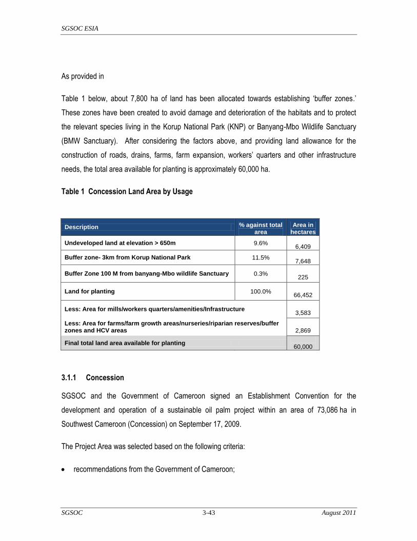
SGSOC ESIA
SGSOC 3-43 August 2011
As provided in
Table 1 below, about 7,800 ha of land has been allocated towards establishing ‗buffer zones.‘
These zones have been created to avoid damage and deterioration of the habitats and to protect
the relevant species living in the Korup National Park (KNP) or Banyang-Mbo Wildlife Sanctuary
(BMW Sanctuary). After considering the factors above, and providing land allowance for the
construction of roads, drains, farms, farm expansion, workers‘ quarters and other infrastructure
needs, the total area available for planting is approximately 60,000 ha.
Table 1 Concession Land Area by Usage
Description % against total area
Area in hectares
Undeveloped land at elevation > 650m 9.6%
6,409
Buffer zone- 3km from Korup National Park 11.5%
7,648
Buffer Zone 100 M from banyang-Mbo wildlife Sanctuary 0.3%
225
Land for planting 100.0%
66,452
Less: Area for mills/workers quarters/amenities/Infrastructure
3,583
Less: Area for farms/farm growth areas/nurseries/riparian reserves/buffer zones and HCV areas
2,869
Final total land area available for planting
60,000
3.1.1 Concession
SGSOC and the Government of Cameroon signed an Establishment Convention for the
development and operation of a sustainable oil palm project within an area of 73,086 ha in
Southwest Cameroon (Concession) on September 17, 2009.
The Project Area was selected based on the following criteria:
recommendations from the Government of Cameroon;

SGSOC ESIA
SGSOC 3-44 August 2011
designation as agricultural land by the Government of Cameroon;
proximity to Kumba Town and to Cameroon‘s economic capital (Douala), which has a port and
international airport;
the fertility of its soil;
synergies with other palm oil production facilities;
land that had been previously logged and is not covered by any existing ecological protections,
thereby enabling SGSOC to build-out a sustainable oil palm operation consistent with RSPO
policies;
suitable climate for oil palm production with good rainfall and ideal temperatures; and
abundant, available labor in need of employment.
The Establishment Convention includes the term of the lease as well as surface rental fees land
and usage rights. Final land decrees are currently being processed by the office of the President.
Annex 2 contains signatures of the Establishment Convention and related land rights documents.
3.2 Current Project Status
The implementation of the approximately 60,000 ha plantation is planned to be executed in 4
phases, as illustrated below.
Table 2 Plantation Development Phases
Phase Phase 1 Phase 2 Phase 3 Phase 4
Planting
Phases Per Year To-Date
1 7,500 7,500 7,500
2 21,000 21,000 28,500
3 21,000 21,000 49,500
4 10,500 10,500 60,000
Total (Hectares)
SGSOC ESIA
SGSOC 3-45 August 2011
3.3 Oil Palm Nurseries
3.3.1 Overview
The Project has initially developed three nurseries to support the plantation (see Figure 3). The
first nursery is in the village of Talangaye, Nguti in Block A. Two additional nurseries have been
established in Block B at Lipenja and Fabe.

SGSOC ESIA
SGSOC 3-46 August 2011
Figure 3 Nursery Locations

SGSOC ESIA
SGSOC 3-47 August 2011
3.3.2 Nursery Development
The development of the nursery in Block A began in August 2010. A total of about 6 ha were
established to support planting of the first 700 ha of field planting.
The completion of the nurseries in Block A and Block B are expected to follow the schedule
outlined in Table 3.
Table 3 Nursery Development Schedule
Phase Hectares Germinated Seeds Remarks Phase Hectares Germinated Seeds Remarks
Required (180/ha) Required (180/ha)
1 75 9000005000 ha
planting1 38 450000
2500 ha
planting
2 225 270000015000 ha
planting2 90 1080000
6000 ha
planting
3 225 270000015000 ha
planting3 90 1080000
6000 ha
planting
4 75 9000005000 ha
planting4 83 990000
5500 ha
planting
Total Seeds 7200000 3600000
NURSERY BLOCK A NURSERY BLOCK B
NURSERIES IMPLEMENTATION PLAN
3.3.2.1 Access Roads to Nursery Sites
Access to the nurseries from Douala is available via a paved road to Kumba (about 140 km). From
Kumba to the nursery locations in Block A and B, the roads are predominantly unpaved. These dirt
roads are not well maintained and become difficult to traverse during the rainy season.
The Block A nursery site is accessible from Kumba via Nguti (about 100 km). Block B site is
accessible from Kumba via Mundemba (about 116 km).
3.3.2.2 Site Clearing and Biomass Management
The nursery sites will be prepared using a combination of manual labor, chainsaws, and
mechanical preparation with bulldozers and similar equipment. Tree trunks, branches and leaves,
and all biomass left after use on the Project Area and commercial timber is removed, will be
stacked in windrows and recycled as organic compost. After tree and shrub removal is completed,
a bulldozer will gather topsoil from the cleared area to provide fill for the seedling bags. All work
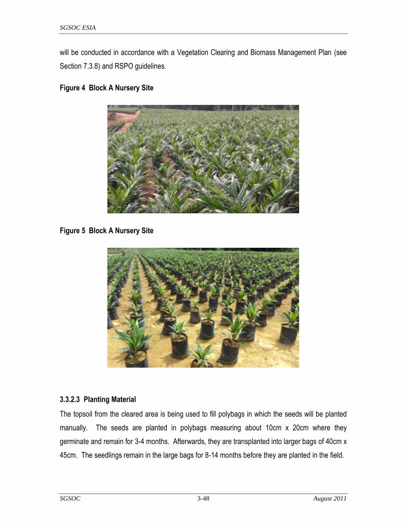
SGSOC ESIA
SGSOC 3-48 August 2011
will be conducted in accordance with a Vegetation Clearing and Biomass Management Plan (see
Section 7.3.8) and RSPO guidelines.
Figure 4 Block A Nursery Site
Figure 5 Block A Nursery Site
3.3.2.3 Planting Material
The topsoil from the cleared area is being used to fill polybags in which the seeds will be planted
manually. The seeds are planted in polybags measuring about 10cm x 20cm where they
germinate and remain for 3-4 months. Afterwards, they are transplanted into larger bags of 40cm x
45cm. The seedlings remain in the large bags for 8-14 months before they are planted in the field.

SGSOC ESIA
SGSOC 3-49 August 2011
Figure 6 Recycling Used Polybags
Figure 7 Recycling Used Polybags
Once ready for transferring or field planting, the polybag is torn to release and permanently plant
the seedling. The torn polybags are collected and recycled in accordance with the Waste
Management Plan.

SGSOC ESIA
SGSOC 3-50 August 2011
Figure 6 Recycling Used Polybags
Figure 7 Recycling Used Polybags
3.3.2.4 Walkways Within the Nursery
Footpaths will be established, enabling the workers to freely move tools and other required
equipment throughout the nursery.

SGSOC ESIA
SGSOC 3-51 August 2011
3.3.3 Nursery Operations
The nurseries will be operated seven days per week in two shifts. Management and operations of
the nurseries will ensure the development of healthy oil palms by actively managing irrigation,
fertilizer, pests, weeds and other factors.
3.3.3.1 Irrigation
If required, irrigation water will be mechanically pumped from the Bakube River to support the
nursery in Block A and the Libanaenie River and the Desapa River to support the nurseries in
Block B. Based on the rainfall data for the Project Area, it is expected that the water drawn from
the rivers will be limited due to the high amount of rainfall. During the dry season, watering will be
done every other day when it does not rain more than about 10 mm. Water will be pumped from
the river into a tank that is tractor-driven or fixed, and plants will be watered using a hose or
watering can in accordance with a Water Management Plan (see Section 7.3.5).
3.3.3.2 Applying Fertilizers and Agro-Chemicals
It is anticipated that the seedlings will be maintained by the application of different fertilizers and
agro-chemicals including at approximately the rates indicated in Table 4.
herbicides;
insecticide combined 5 grams/plant/month for three months in a year; and,
fertilizers N/P/K/Mg.

SGSOC ESIA
SGSOC 3-52 August 2011
Table 4 Pre-Nursery and Nursery Fertilization
Weed control will be done in accordance with manufacturers‘ recommendations and a detailed
Chemical Management Plan (see 7.3.6). This will include the policies outlined below:
Weeds inside the polybags will be manually removed.
Use of hormonal herbicides shall be avoided (e.g. 2,4-D amine, triclopyr, etc).
A spray shield (cone) will be used to avoid spray drift.
For general weed control, an herbicide will be used, as per manufacturers‘ recommendations.
3.3.3.3 Staffing
At full build-out, each nursery is expected employ the following staff:
6 supervisors;
6 overseers;
6 head men; and,
50 nursery workers.

SGSOC ESIA
SGSOC 3-53 August 2011
3.4 Plantations
3.4.1 Overview
The implementation plan for the plantation is expected to be executed in four phases over a period
of several years. The indicative plan is illustrated below:
Table 5 Plantation Development Schedule
Block A Block B Total
Phase Hectares Hectares Hectares
1 5000 2500 7500
2 15000 6000 21000
3 15000 6000 21000
4 5000 5500 10500
The proposed development plan for Blocks A and B of the Concession will be generally based on
the above, and as detailed on the map provided in Figure 8.

SGSOC ESIA
SGSOC 54 August 2011
Figure 8 Plantation Development

SGSOC ESIA
SGSOC 3-55 August 2011
SGSOC has selected high yielding oil palm hybrid planting material from the Institute of Agricultural
Research for Development (IRAD), which is headquartered in Cameroon at P.O. Box: 2067 / 2123 –
Yaoundé, Cameroun. Based on data provided by IRAD, the peak FFB yields achievable with suitable
soil, climatic conditions, and best agronomy practices range from 30 to 32 tons/ha. In the calculation of
the FFB yield profile for the Project Area, the following factors were taken into consideration:
utilization of the appropriate planting material: Tenera (DxP) Fusarium tolerant oil palm seeds;
historic rainfall in the Project Area and the distribution of that rainfall throughout the months;
duration of sunlight (BTUs) in the Project Area throughout each month;
historic temperature variation including averages, maximums, and minimums for each month;
elevation of the land;
appropriate fertilizer management including nursery fertilization and in-field fertilization; and,
efficient management and agronomy practices.
Based on these factors, the 60,000 ha plantation is expected to produce approximately 1,800,000 MT
per year at peak output.
3.4.2 Plantation Development
3.4.2.1 Access Roads
The Project will require a network of roads to transport FFB from the plantations to the palm oil mills.
Such roads are typically 3 meters wide for in-field transportation and 5 meters wide for roads to the mill.
Road surfaces are typically made with laterite, while bridges and culverts are made with timber, stones,
cement, iron rods, concrete and sand. Roads will be built with bulldozers, leveled with graders and
compacted.
3.4.2.2 Vegetation Clearing and Biomass Management
The Project Area will be prepared using a combination of manual labor, chainsaws, and mechanical
preparation with bulldozers and similar equipment. Tree trunks, branches and leaves, and all biomass
left after use on the Project Area and commercial timber is removed, will be stacked in windrows and
recycled as organic compost. This practice is in line with RSPO‘s requirements to increase soil fertility,
help control erosion, and help to prevent soil degradation. After tree and shrub removal, a grader will
level the site, and remaining debris will be placed in the windrows or will be mechanically mulched.

SGSOC ESIA
SGSOC 3-56 August 2011
All vegetation clearing and associated biomass management will be conducted in accordance with a
Vegetation Clearing and Biomass Management Plan (see Section 7.3.8).
3.4.2.3 Terracing and Drainage
In view of the high rainfall in the Project Area, terraces are important to minimize soil erosion. In line
with the RSPO guidelines and best practices, areas with slopes greater than 30° will not be developed.
Rather, they will be maintained and potentially regenerate into full forest cover for biodiversity
purposes.
The natural drainage capacity of land depends on the relief, permeability, and water retention capacity
of the soils in the area. An efficient drain network will be established to allow for proper root aeration
and infiltration of storm water into the soil column.
Limits on development of areas with greater than 30° slopes will be incorporated into the Vegetation
Clearing and Biomass Management Plan (see Section 8.3.8), and requirements for drainage facilities
will be incorporated into the Erosion and Sedimentation Management Plan (see Section 7.3.3)
3.4.2.4 Leguminous Cover Crop
SGSOC anticipates use of fast-growing leguminous cover crops to help minimize soil erosion by
reducing the soil compaction from rain, impeding surface run-off and enhancing nitrogen availability in
the soil. A ground-cover such as Mucuna bracteata will be established, as illustrated in Figure 9.
Figure 9 Cover Crop

SGSOC ESIA
SGSOC 3-57 August 2011
3.4.2.5 Soil Moisture Conservation
During plantation development, work will be undertaken to improve infiltration and retention of the rain-
water in the soil. The standard practices to be adopted include:
diversion of water from roads into field: diversion drains will be constructed by cutting small outlets
on both sides of the road in a herring-bone pattern at approximately 20-25m intervals to provide
additional moisture to the field and to reduce road damage; and,
avoidance of soil compaction: heavy machinery will only be used for felling of tree trunks and
construction of terraces and roads during planting; for FFB infield collection, only light vehicles will
be allowed; soil compaction effects in a particular area will be considered prior to deciding on a
suitable type of machine to be used.
3.4.2.6 Planting
Before planting begins, SGSOC will lay out the field design to ensure efficient utilization of the land at a
density of 143 palms/ha - consistent with industry best practices. The palms will be transported from the
nursery to the field with tippers, tractors or flatbed trucks. The palms are lifted into the truck or tractor
and transported to the planting site in the field, where each palm will be planted and fertilized.
3.4.2.7 Plantation Operations and Infrastructure
The plantation will be subdivided into the following planting blocks for efficient management and
operation:
24 Estates - 2,500 ha per Estate;
12 Complexes - 5,000 ha per Complex; and,
3 Regions - 20,000 ha per Region.
The development and operations of the oil palm plantation will require a substantial amount of
investment in land development, equipment, infrastructure and warehouses. The development of these
resources will be organized according to the division of the 24 2,500 hectare estates. The oil palm mills
will most likely act as the primary site for offices, storage, housing and workshops, as well as the source
of water and power for these facilities.

SGSOC ESIA
SGSOC 3-58 August 2011
3.4.2.8 Harvesting
Field workers will harvest ripe FFB manually and place the cut FFB in mini-tractors or wheelbarrows to
bring them to the roadsides for collection. The FFB will then be loaded into a truck or tractor and
transported to the palm oil mill. Loose fruit will be manually gathered into baskets and loaded into
transport vehicles using bags so that they may also be brought to the mill.
3.4.2.9 Soil Moisture Conservation
During operations, measures will be taken to collect rainfall by improving infiltration and retention of the
rainwater and make it available to the palms. The standard industry practices to be adopted are listed
below.
Establishment of vegetative ground cover - Soft vegetative ground covers will be maintained in the
inter-rows and inter-palm areas to improve water infiltration and reduce soil erosion. Only the palm
circles will be clean-weeded to facilitate fruit collection. For very dry areas, a cleared area with a
radius of about 1-1.25m should suffice.
Placement of pruned fronds - Pruned fronds will be placed in the inter-rows and spread as widely
as possible to provide a larger mulching area. In hilly areas, the pruned fronds will be arranged
across the slopes to intercept rainwater and to reduce the velocity/erosive power of the water
surface flow.
Empty fruit bunches (EFB) mulching - EFB mulching will be practiced for the areas in close
proximity to the palm oil mills. This practice should result in significant savings in fertilizer
application.
3.4.2.10 Soil Fertility Maintenance
Ideally, once the proper nutrient levels are attained in the soil, the total nutrient input to the soil
(including those from soil mineralization and compost) should equal the quantity lost in harvested fruits
to maintain soil fertility status. Loss of nutrients in wastes will be minimized to the extent possible, and
such efficiencies will be managed as part of the Chemical Management Plan (Section 7.3.6). To
remain economically sustainable, most soils require some form of fertilizer input.

SGSOC ESIA
SGSOC 3-59 August 2011
Fertilizer recommendations will be determined on a scientific basis drawing upon results of foliar and
soil analyses. SGSOC‘s agronomists will recommend the minimum fertilizer application to balance
optimum yield while avoiding waste.
Leguminous cover crops will be planted in the early stage of field planting. These crops will fix large
amounts of nitrogen in their root nodules (using the free nitrogen in the air) and then release this
nutrient to the roots of the trees.
The decomposing frond heaps will provide a good substrate for roots to grow and also encourage
beneficial micro flora and fauna activity.
Tree trunks, branches, leaves, and other biomass left after the merchantable timber is removed will be
stacked in the windrows to be recycled in the field as organic compost. This practice can increase soil
fertility and help to prevent soil degradation, and it is consistent with RSPO‘s recommendations.
EFB mulching will be practiced in estates in close proximity to FFB mills and with undulating terrain.
EFB mulching greatly improves the inherent soil‘s physical and chemical properties. Substantial
amounts of EFB can be used in young new plantings to promote good early root establishment. The
application of recycled Palm Oil Mill Effluent (POME) can reduce moisture stress during dry or drought
seasons. The tractor-tanker and furrow systems are the two main methods adopted in estates. As the
distance between the mill and application site is crucial for successful implementation, the practice is
limited to the sites near the mills.
3.4.2.11 Pest and Disease Management
The pests and diseases that could affect palm growth and FFB yields in Cameroon are minimal. The
common insect pest is the oil palm leaf miner beetle (Coelaenomenodera minuta), and the common
fungal diseases include oil palm wilt caused by Fusarium oxysporum and basal stem rot caused by
Ganoderma. However, the planting material produced by IRAD and used in this Project are fusarium
tolerant, whilst the oil palm leaf miner can be effectively controlled by biological means (Timti, 1991).
Infection by Ganoderma will be monitored and eliminated to avoid spread. Any chemical controls will
be in accordance with the Chemical Management Plan (see Section 7.3.6).
An effective Integrated Pest Management program (IPM) should involve a combination of chemical,
cultural, biological, and physical practices, as well as the implementation of a proper Monitoring and
Surveillance System (MSS). The MSS will provide information on the pests‘ presence and activity to

SGSOC ESIA
SGSOC 3-60 August 2011
determine the right time to control a particular pest. This systematic pest control strategy will result in
effective control with minimal chemical usage (see the Chemical Management Plan (Section 7.3.6)).
Under natural conditions, the population of leaf-eating pests such as nettle caterpillars and bagworms
are kept under control by various insect predators. To promote and sustain a high predator population,
beneficial host plants (e.g. Cassia cobanensis, Euphorbia heterophylla and Antigonon leptosus)
will be established in the field to provide food, shelter and breeding sites for the beneficial insects.
Early warning surveillance systems will be established in locations prone to leaf-eating pest outbreaks.
The system (with pest monitoring teams) will monitor pest population level to enable quick action when
critical levels are exceeded. Through such actions, the amount of insecticide used for leaf-eater control
will be minimized and significant economic losses due to serious outbreaks should be avoided.
Rodents are the most common vertebrate pest in oil palm plantations. An integrated approach to
rodent control will be practiced using the barn owl (Tyto alba) as a biological control agent, as well as
the use of traps.
The Rhinoceros beetle is a major pest in new oil palm plantings, and various methods can be
implemented to keep its population under control. To prevent beetle population build-up, good ground
covers similar to Mucuna bracteata and Pueraria javanica will be established to reduce breeding sites
in the oil palm fields.
The beetle population will be monitored closely using pheromone traps. When their population is low
(e.g. less than 10 beetles/trap/week), a physical approach of hand-picking adult beetles from freshly
attached palms and grub collection from rotting chips will be practiced as a control measure. When the
population levels become high, insecticides will be used to ensure that the young palms are not
seriously damaged.
3.4.2.12 Staffing
Based on current working practices in Malaysia, Indonesia and other mature palm growers, the average
land-to-worker ratio is about 12 ha to 1 worker. For this Project, due to the inexperienced workforce,
the estimated ratio is expected to be 8 ha to 1 worker.
Based on a 60,000 ha plantation, the total number of employees is therefore anticipated to be
approximately 7,500.

SGSOC ESIA
SGSOC 3-61 August 2011
3.5 Palm Oil Mill
3.5.1 Overview
The mills being designed for this Project will use state-of-the-art technologies with the oil extraction
processes such as:
sterilization technology;
elimination of overhead cranes/rail-lines/cages;
automatic controls at various stages of process control;
composting plant;
methane recovery and power generation;
kernel crushing plant;
efficient water management (e.g. recycling of water); and,
other new emerging technologies in mill process controls.
In line with the RSPO requirements, the following areas / activities will be adhered to and implemented:
compliance with local/international environmental, labour, health and safety regulations;
preparation and documentation of standard operating procedures (SOPs) on prudent milling
practices, including housekeeping and maintenance areas;
preparation of an efficient water management plan and establishment of monitoring controls to
reduce consumption and waste;
preparation and implementation of health and safety policies; and,
formal and structured training programs for mill employees on occupational, safety and health
(OSH) issues.
It is anticipated that five mills, each with a processing capacity of 60 metric tons/hour (MT/hr) are
required for this Project at full build-out. It is also anticipated that the mill superstructure and ancillary
buildings will be constructed to accommodate a maximum processing capacity of 75 MT/hr. To
increase the mill output from 60 to 75 MT/hr, additional digesters and cross conveyors can be installed.

SGSOC ESIA
SGSOC 3-62 August 2011
During the first year of harvesting, it is expected that the mill will be equipped with a single digester
press and conveyor for a 15 MT/hr processing capacity. The number of digesters and presses can
then be increased as the FFB yields from the plantation increase.
3.5.2 Mill Development
3.5.2.1 Palm Oil Mills
The table below provides an indicative summary of the mill ordering and construction schedule for
these 5 mills during the duration of the planting program:
Table 6 Mill Development Schedule
Mills Year of Year of
60 TPH Construction Commission
1 2013 2015
2 2015 2017
3 2017 2019
4 2019 2021
5 2021 2023
Three drainage systems will be installed as follows:
a drainage system for processing effluents;
a drainage system for rainwater; and,
a drainage system for workshops through an oil/water separator system.
The effluent from each of these systems will be monitored in accordance with an Environmental and
Social Monitoring Plan (see Section 7.7).
3.5.2.2 Kernel Crushing Plants
It is anticipated that the Project will require two central kernel-crushing plants at full build-out. Both of
the plants will be strategically situated to minimize negative biodiversity and social impacts, as well as
to optimize management, transport and overhead costs. Criteria for such siting includes:
avoidance of populated areas;

SGSOC ESIA
SGSOC 3-63 August 2011
access to transportation systems; and,
avoidance of protected habitat areas.
3.5.3 Mill Operations
3.5.3.1 Production Process and Description of Mill
Field workers will harvest FFBs from the trees, which will then be transported to the mills in trucks.
After having been weighed at the weighbridge, these bunches will be unloaded at the receiving dock an
on to a loading ramp. As described below, the FFB will then undergo processing, which includes
sterilization, threshing, digestion, pressing, extraction, clarification, finishing, defibration and palm
kernel production.

SGSOC ESIA
SGSOC 3-64 August 2011
Figure 10 Process Flow
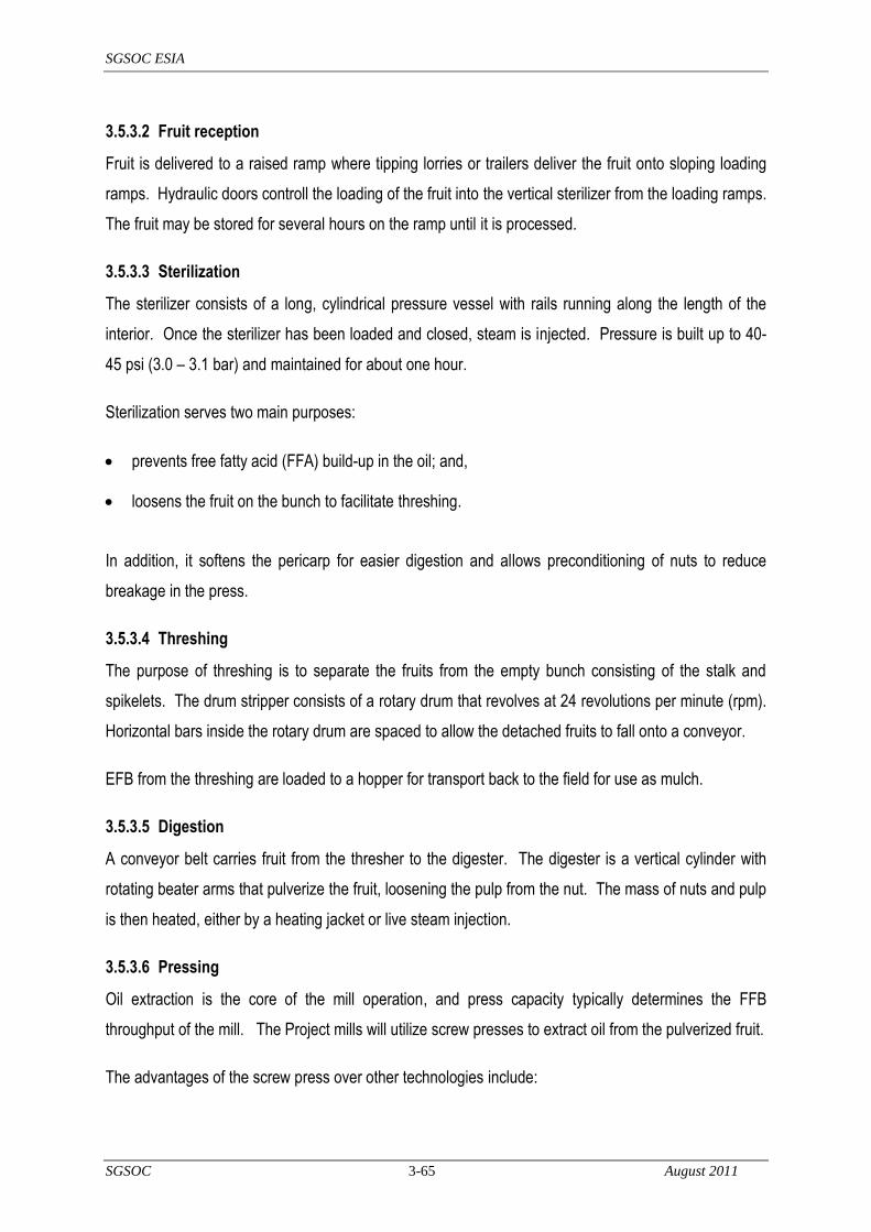
SGSOC ESIA
SGSOC 3-65 August 2011
3.5.3.2 Fruit reception
Fruit is delivered to a raised ramp where tipping lorries or trailers deliver the fruit onto sloping loading
ramps. Hydraulic doors controll the loading of the fruit into the vertical sterilizer from the loading ramps.
The fruit may be stored for several hours on the ramp until it is processed.
3.5.3.3 Sterilization
The sterilizer consists of a long, cylindrical pressure vessel with rails running along the length of the
interior. Once the sterilizer has been loaded and closed, steam is injected. Pressure is built up to 40-
45 psi (3.0 – 3.1 bar) and maintained for about one hour.
Sterilization serves two main purposes:
prevents free fatty acid (FFA) build-up in the oil; and,
loosens the fruit on the bunch to facilitate threshing.
In addition, it softens the pericarp for easier digestion and allows preconditioning of nuts to reduce
breakage in the press.
3.5.3.4 Threshing
The purpose of threshing is to separate the fruits from the empty bunch consisting of the stalk and
spikelets. The drum stripper consists of a rotary drum that revolves at 24 revolutions per minute (rpm).
Horizontal bars inside the rotary drum are spaced to allow the detached fruits to fall onto a conveyor.
EFB from the threshing are loaded to a hopper for transport back to the field for use as mulch.
3.5.3.5 Digestion
A conveyor belt carries fruit from the thresher to the digester. The digester is a vertical cylinder with
rotating beater arms that pulverize the fruit, loosening the pulp from the nut. The mass of nuts and pulp
is then heated, either by a heating jacket or live steam injection.
3.5.3.6 Pressing
Oil extraction is the core of the mill operation, and press capacity typically determines the FFB
throughput of the mill. The Project mills will utilize screw presses to extract oil from the pulverized fruit.
The advantages of the screw press over other technologies include:
SGSOC ESIA
SGSOC 3-66 August 2011
continuous operation, resulting in less labour required versus the hydraulic press, which is a ‗batch‘
process;
higher throughput, requiring less investment in buildings and machinery;
less power required for a given throughput;
easier nut/fiber separation due to the low oil content after pressing; and,
a scalable range of throughput rates.
The digested mixture of fiber, oil, and nuts is forced through a perforated press cylinder by the rotation
of the screw. Adjustable cones restrict the exit of the mass so that pressure forces the oil from the
pulverized fruit.
3.5.3.7 Clarification, drying and storage
The palm oil from the press consists of a mixture of oil, water, and other ‗non-oily solids‘ (mainly dirt and
fiber). The mixture is screened to remove larger particles of debris before being transferred to the
continuous settling tanks. The mixture is fed into the middle of the tank, while separated oil is steadily
removed from the top and waste (sludge) from the bottom. The oil and waste fractions are then
centrifuged.
Finally, the oil must be dried by the use of vapor extraction units or vacuum dryers to prevent FFA
formation by autocatalytic hydrolysis.
The oil will be stored in steel tanks, which will contain heating coils to prevent crystallization and
subsequent settling out of the solid phase. The tanks may be filled with carbon dioxide or another inert
gas above the oil to prevent oxidation.
The sensitivity of palm oil to higher temperatures is well established, and the temperature during
storage and in transit is controlled between 32 and 40°C, with loading and unloading temperatures
between 50 and 55°C. Temperatures will be kept as low as possible to minimize deterioration in quality
during storage.
3.5.3.8 Sludge Processing
The waste sludge removed from the bottom of the continuous settling tanks consists of water, solids
and oil. The sludge is passed through a decanter for separation. The decanter separates the sludge
into its liquid and solid components.

SGSOC ESIA
SGSOC 3-67 August 2011
The heavy solid material is fed into an effluent drier using waste heat from the exhaust of the boilers to
dry the solid waste into pellets or grains which will be used as organic fertilizer for the plantation.
The liquid sludge is fed into a centrifugal sludge separator. The oil is recovered from by the sludge
separator and recycled to the continuous settling tank.
3.5.3.9 Kernel handling
The cake coming from the press consists of nuts and moist fiber with some residual oil. To extract the
kernels, it is necessary to separate the nuts from the fiber, crack the nuts, and separate the kernels
from the cracked shells.
Fiber separation: This may be pneumatic, mechanical or hydraulic, but pneumatic fiber separators
have become the standard in modern mills. In the most commonly used type, the fiber–nut mixture,
partially dried, passes from a ‗cake breaker‘ conveyor into a vertical airstream sufficient to carry the
fiber upwards while the nuts fall into a smaller, lower rotating drum. Air also passes through this drum,
carrying any light particles upwards to join the main flow.
Kernel drying: Fresh kernels have a moisture content of about 20% and therefore must be dried in
order to be stored without deterioration. Drying is usually done in a silo - the fresh kernels are fed in at
the top, warm air is blown upwards from below, and dry kernels (7% moisture) are removed at the base.
The kernels can also be steam-sterilized for five to six minutes before drying, and the FFA of the kernel
oil will then remain below 1% after storage for six months or more.
Nut screening and cracking: The clean nuts may be dried in a nut silo, or if the drying during fiber
separation has been sufficient, they may be conveyed straight to screens for grading by size before
cracking. In nut-cracking machines using centrifugal force, the nuts are fed through a central spindle,
rotating at 1600–2200 rpm, and propelled out against the wall of the cracker. A new development has
been the self-sorting nutcracker called a ripple mill cracker. A ripple mill cracker incorporates grading
slots and pitching blades, which grade the nuts knocks them against a wall for cracking; this makes
prior nut screening unnecessary. The ripple mill cracker has the advantage that prior nut conditioning is
not required, and it is now widely used.
Kernel and Shell Separation: To separate the cracked mixture into kernels and shells, the wet
separation method is applied. During this process, the kernel and shell mixture is fed into a tank
containing clay and water. The specific gravity of the clay-water mixture allows for separation of the

SGSOC ESIA
SGSOC 3-68 August 2011
kernels from the shells based on their different densities. The separated kernel is washed and dried in
the kernel silos for duration of about 14 hours.
Kernel oil extraction: After being dried to about 6% moisture content, the palm kernel is conveyed to
the kernel crushing plant. The kernels are crushed and pressed to extract the palm kernel oil. The
palm kernel cake, generated during the first stage of pressing, is conveyed to a second stage of
pressing to extract the maximum amount of palm kernel oil. The palm kernel cake remaining after the
second stage of pressing is packed in bags for dispatch as animal feed.
3.6 Civil Infrastructure
3.6.1 Overview
It is expected that the Project will utilize existing infrastructure, and improvements to the infrastructure
in the Project Area will be required to support the development and operation of the Project.
The sections below describe the status of the existing infrastructure and the improvements that may be
required.
3.6.2 Transportation Development and Operations
3.6.2.1 Access Roads
The existing road network from the port of Douala to the Project Area consists of bituminized and gravel
roads. It is expected that entrances to the Project Area will be established in Mundemba and Nguti.

SGSOC ESIA
SGSOC 3-69 August 2011
Figure 11 Access Roads to Project Area
The road from Douala to Kumba is approximately 140 km long and is tarred. The distance from Kumba
to Mundemba is approximately 116 km. The 116 km stretch is gravel and requires improvement,
though noticeable efforts have been taken by the Government to upgrade the road by resurfacing and
grading.
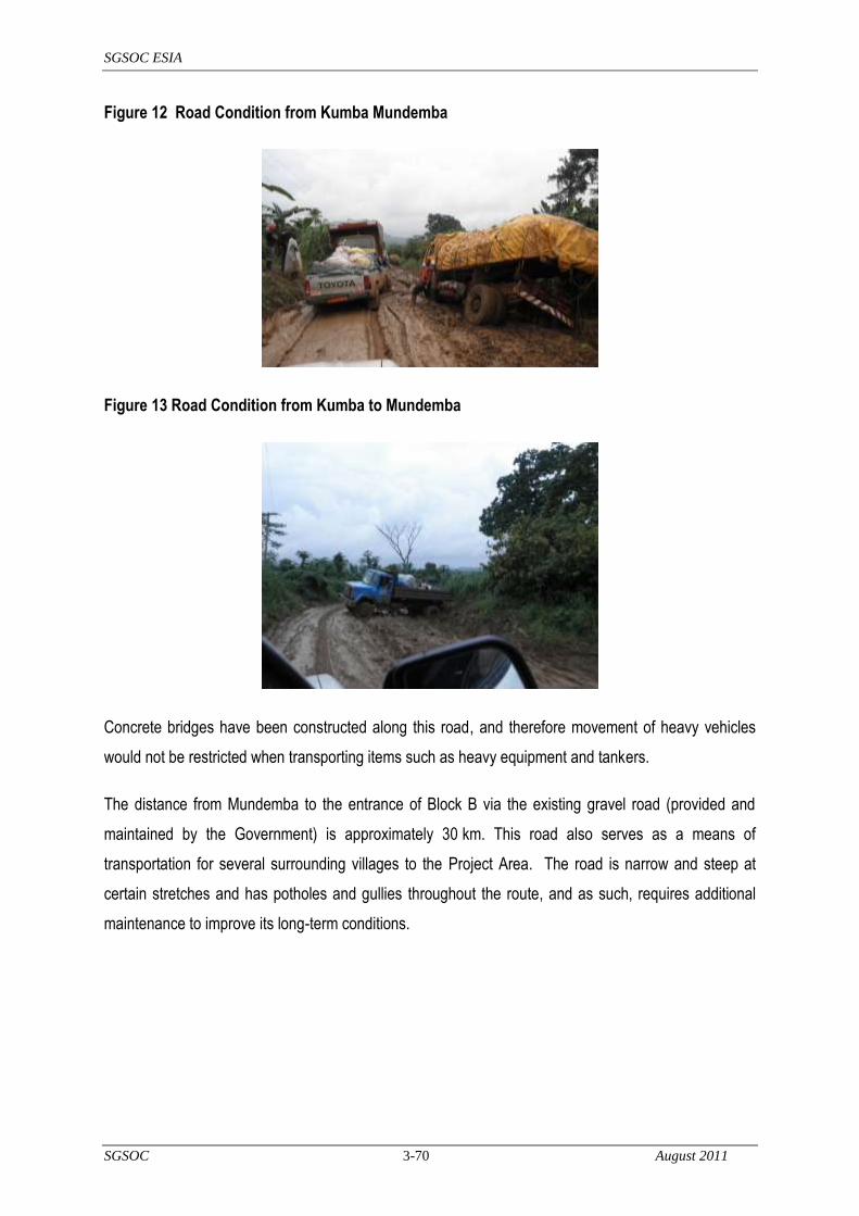
SGSOC ESIA
SGSOC 3-70 August 2011
Figure 12 Road Condition from Kumba Mundemba
Figure 13 Road Condition from Kumba to Mundemba
Concrete bridges have been constructed along this road, and therefore movement of heavy vehicles
would not be restricted when transporting items such as heavy equipment and tankers.
The distance from Mundemba to the entrance of Block B via the existing gravel road (provided and
maintained by the Government) is approximately 30 km. This road also serves as a means of
transportation for several surrounding villages to the Project Area. The road is narrow and steep at
certain stretches and has potholes and gullies throughout the route, and as such, requires additional
maintenance to improve its long-term conditions.
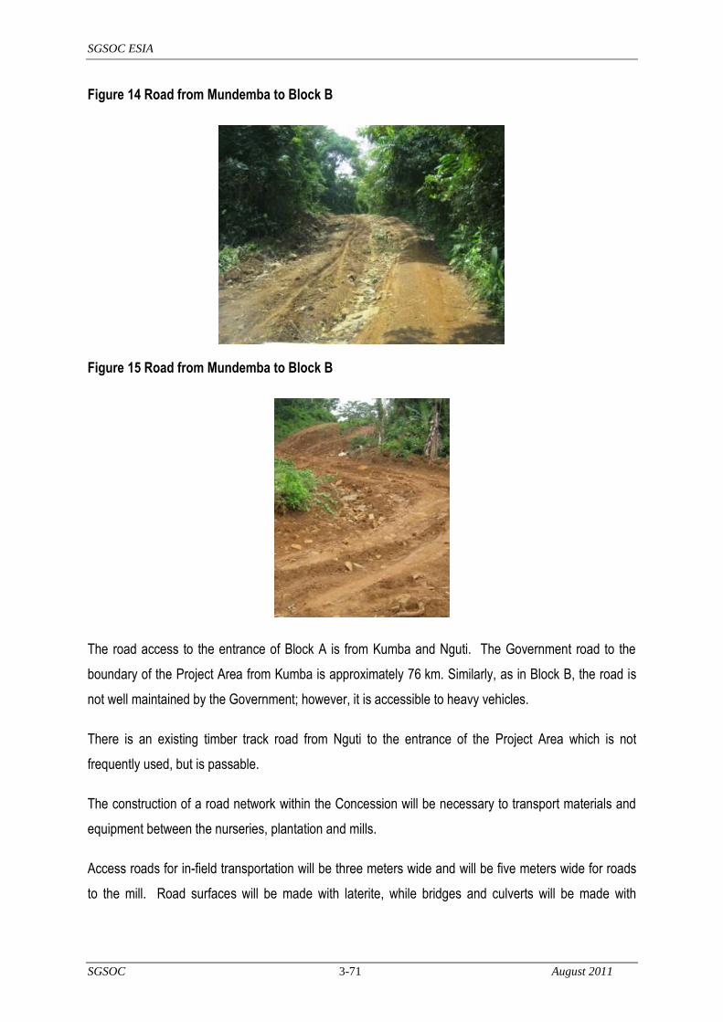
SGSOC ESIA
SGSOC 3-71 August 2011
Figure 14 Road from Mundemba to Block B
Figure 15 Road from Mundemba to Block B
The road access to the entrance of Block A is from Kumba and Nguti. The Government road to the
boundary of the Project Area from Kumba is approximately 76 km. Similarly, as in Block B, the road is
not well maintained by the Government; however, it is accessible to heavy vehicles.
There is an existing timber track road from Nguti to the entrance of the Project Area which is not
frequently used, but is passable.
The construction of a road network within the Concession will be necessary to transport materials and
equipment between the nurseries, plantation and mills.
Access roads for in-field transportation will be three meters wide and will be five meters wide for roads
to the mill. Road surfaces will be made with laterite, while bridges and culverts will be made with

SGSOC ESIA
SGSOC 3-72 August 2011
stones, wood, cement, iron rods, concrete and sand. Roads are created with bulldozers, leveled with
graders, and compacted with compactors. Labor for bridges, culverts and road machinery is required.
3.6.2.2 Storage and transport facilities
The palm oil will be transported from each mill via tanker truck or barged by river to Douala or the Port
of Tiko for bulk storage.
The Port of Tiko is expected to be used to export the exportable portion of the Project‘s CPO and PKO
products to the global market. The depth at the port is between five to six meters in its docking area
and allows for a maximum draft of 5.5 meters.
Approximately 5 to 10 hectares of land is necessary at the port for the construction of storage (tank
farm) for the CPO and PKO. Approximately 20 tanks, each with a capacity of about 3,000 MT per tank
are anticipated. The CPO and PKO can be stored for at least one month provided the temperature is
regulated and there is no increase in FFA and moisture levels.
The ancillary port facilities will likely include housing for the installation staff and workers, a
weighbridge, pumping facilities and security services.
3.6.3 Water Supply Development and Operations
The water required for the Project is expected to be supplied by local streams or extracted from
boreholes where surface water is not available. Process water will be required to have a low silicate
level. Potable water will need to be free of heavy metals and within safe bacteriological parameters.
The Concession is located in a high rainfall zone. The estimated water consumption for all purposes,
namely processing and consumption during the construction phases, could reach 400 to 500 m3 per
day. Water consumption during construction will vary significantly as the volume of consumption will
depend on daily activities.
3.6.4 Electricity
The electrical power required for the Project will provided by diesel and gas generators. At the
nurseries and other areas where power requirements are relatively small, diesel generators will be
installed. The electricity at the mills will be provided by highly efficient internal boilers and steam
turbine using the biomass from the oil extraction process as fuel.

SGSOC ESIA
SGSOC 3-73 August 2011
3.6.5 Solid Waste Disposal Facilities
It is expected that the agri-waste generated by the Project will be used as fuel for the internal power
generating facility; excess will be recycled and returned to the fields. The agri-waste is non-toxic, and
its nutrient value helps maintain soil fertility.
The Project will perform engineering studies to potentially use large steel tanks as closed digesters in
which biogas is collected, and once more circulated to ensure good mixing, allowing for the collection
and use of the biogas. According to estimates, a 1200 MT/day mill can produce approximately
20,000 m3 of biogas per day with approximately 5,300 kcal/m3 of energy content.
In addition to the agri–waste, the Project will generate waste from other sources. The quantities will be
considerably smaller, but will require correct recycling or disposal in order to not significantly impact the
environment. Some of this waste will consist of hazardous waste, such as discarded car and
equipment batteries, empty drums, and other debris. Non–hazardous waste, such as office waste,
household waste, paper, cardboard, glass, wood, building materials and rubbish, will also result.
This waste will be disposed of in accordance with the legislation of Cameroon (Law 96/12 or 5/8/96
Articles 42 - 56). The Project will prepare a Waste Management Plan to provide specific details on how
each type of waste will be handled.
3.6.6 Communications
Telephone service via existing networks is available within the Project Area. This network will be
extended to the administrative and housing areas developed for the Project.
3.7 Social Infrastructure
As part of this ESIA, a socioeconomic and needs assessment study was conducted in the Project Area
by H & B Consulting USA (Cameroon division) during the months of December 2010 and January 2011.
The study is one of several planned to inform SGSOC plans for social infrastructure.
Each mill will form the center of the infrastructure to support the workforce. The typical planned
amenities for each infrastructure center are comprised of the following:
executive bungalows;
staff houses;
workers‘ quarters;

SGSOC ESIA
SGSOC 3-74 August 2011
elementary schools;
health clinics;
community halls;
office and administrative facilities;
utilities, including water supply, sanitary wastewater facilities, and electricity; and,
recreational facilities such as football fields.
The details of the social infrastructure improvements required for the Project are detailed in the sections
below.
Construction of housing will be required to support the Project workforce that does not already live in
local villages. It is expected that 70% of the workforce will be drawn from existing residents. The
housing construction plan developed for the Project is based on providing housing for the 30% non-
resident workers. The build out of the housing units will vary consistent with the field build out of the
Project.
The housing units are categorized as indicated in Table 7.
Table 7 Typical Residence Types
The housing and neighborhood settlements for the Project will also integrate the following infrastructure
for a conducive and healthy environment for all of its residents:
waste water treatment;
long term sustainable sanitation systems;

SGSOC ESIA
SGSOC 3-75 August 2011
solid waste management;
sealed septic tanks; and,
rainwater harvesting.
3.8 Workforce
3.8.1 Construction
The construction of the Project is expected to extend over several years. The work will be concentrated
on clearing lands for the plantation, planting, building access roads, constructing mills, housing and
other supporting infrastructure.
It is expected that over 7,500 employees will be required to complete construction of the Project with
most of these being required to develop and then operate the plantation. The Project will give
preference to local villagers for employment.
During the construction of the Project, housing and other amenities will be required to support the
workforce that comes from outside the general Project Area.
3.8.2 Operations
3.8.2.1 Size
Based on current working practices in Malaysia, Indonesia, and other mature palm oil producers, the
labor inputs for nurseries, immature and young mature areas require at least one worker for every
six ha. Upon the introduction of full mechanization, the labor ratio can reach one worker for every
12 ha. Mechanization practices will be implemented mainly on areas that require high labor inputs such
in-field collection of FFB, evacuation of FFB, aerial and mechanical fertilizing and spraying.
Mechanization of this nature can only be introduced when the palms are more than six years old.
For this Project, the estimated labor ratio is one worker for every eight ha. This ratio is an average over
a period of 25 years after considering mechanization and training of the workforce.
The total estimated number of employees required to develop 60,000 ha hectares of oil palm plantation
would be approximately 7,500 employees. Table 8 provides an estimate of the number of Project
employees over time.

SGSOC ESIA
SGSOC 3-76 August 2011
Table 8 Estimated Number of Employees
Planting Phase Hectares No. of Employees
1 7,500 938
2 21,000 2,625
3 21,000 2,625
4 10,500 1,313
Total 60,000 7,500
3.8.2.2 Recruitment
The Project will give preference to local villagers for employment. Consideration will also be given to
recruit working family teams to reduce the number of housing units required.
Specialized and structured training will be carried out to upgrade skills of the locals with the aim that
they will eventually fulfill the day-to-day operations at all levels of management.
The training program will be provided and designed on a structured modular basis. Generally, the
modules will comprise of the following topics:
Planning, Scheduling, Prioritizing, Action, Supervisory Skills and Innovativeness;
Budget Management;
Managing Staff Discipline and Driving Performance;
Dealing with Labour Disputes and Understanding Local Labour Laws;
Driving Effective Execution on Key Tasks;
Coaching for Poor Performance (Motivational);
Communicating with Difficult Workers;
Building Interpersonal Capability;
Educating Illiterate Workers on Key Field Standards;
Team Building, Creativity and Thinking Skills;
Mechanization – Regular Maintenance and Repairs; and,
RSPO principles and criteria on Occupational, Safety and Health (OSH) issues.

SGSOC ESIA
SGSOC 3-77 August 2011
3.9 Schedule
The first fruit will be harvested approximately 30 months after the Phase I planting. The construction of
the first mill and associated facilities will commence during Phase I planting and is expected to be
completed in 15 to 18 months. The final stage of planting is expected to be completed within four
phases. The final mill is expected to be completed within twelve years.
3.10 Environmental Discharges During Operations
The Project will generate waste and other environmental discharges. An illustration of the waste
generated by palm oil extraction is presented in Figure 16 below:
Figure 16 Sources of waste from a Palm Oil Mill
(Source: http://www.adb.org/Documents/Reports/Consultant/36557-INO/36557-INO-TACR-AppendixVII.pdf)
In accordance with RSPO guidelines, waste will be reduced, recycled, re-used and disposed of in an
environmentally and socially responsible manner. The sections that follow provide additional detail on
the sources and quantity of waste generated.
3.10.1 Air and Particulate Emissions
The Project will generate air emissions including Sulfur Dioxide (SO2), Carbon Dioxide (CO2), Methane
(CH4) and Particulate Matter (PM) from the following sources:
electric generators;
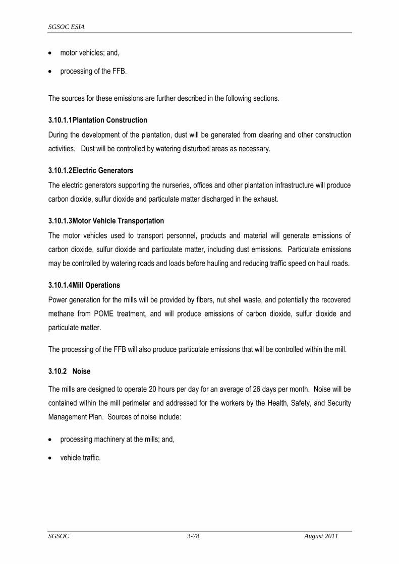
SGSOC ESIA
SGSOC 3-78 August 2011
motor vehicles; and,
processing of the FFB.
The sources for these emissions are further described in the following sections.
3.10.1.1 Plantation Construction
During the development of the plantation, dust will be generated from clearing and other construction
activities. Dust will be controlled by watering disturbed areas as necessary.
3.10.1.2 Electric Generators
The electric generators supporting the nurseries, offices and other plantation infrastructure will produce
carbon dioxide, sulfur dioxide and particulate matter discharged in the exhaust.
3.10.1.3 Motor Vehicle Transportation
The motor vehicles used to transport personnel, products and material will generate emissions of
carbon dioxide, sulfur dioxide and particulate matter, including dust emissions. Particulate emissions
may be controlled by watering roads and loads before hauling and reducing traffic speed on haul roads.
3.10.1.4 Mill Operations
Power generation for the mills will be provided by fibers, nut shell waste, and potentially the recovered
methane from POME treatment, and will produce emissions of carbon dioxide, sulfur dioxide and
particulate matter.
The processing of the FFB will also produce particulate emissions that will be controlled within the mill.
3.10.2 Noise
The mills are designed to operate 20 hours per day for an average of 26 days per month. Noise will be
contained within the mill perimeter and addressed for the workers by the Health, Safety, and Security
Management Plan. Sources of noise include:
processing machinery at the mills; and,
vehicle traffic.

SGSOC ESIA
SGSOC 3-79 August 2011
3.10.3 Liquid Effluents
There are several sources of liquid effluent from the mill operations (palm oil mill effluents or POME).
These include:
condensate from bunch sterilising;
waste water/sludge from clarification centrifuges; and,
waste water from kernel washing and separation.
POME consists of a mixture of these liquid wastes. It is thick, brownish, colloidal slurry of water, oil,
and cellulosic residues. This material is biodegraded by populations of micro-organisms in processes
that can be anaerobic, aerobic or facultative; often all three are applied sequentially.
The anaerobic process produces methane, carbon dioxide and traces of hydrogen sulfide, while the
aerobic process produces only carbon dioxide. Both produce residual solid material. The anaerobic
stage is a two-stage process, in which the first stage produces organic acids. These acids are broken
down in the second stage to prevent the development of an extremely low pH in the POME.
The POME must be treated prior to being discharged into nature or any municipal drainage system. In
order to treat the POME, it is necessary to allow it to stand in specially constructed anaerobic ponds.
This will allow the anaerobic bacteria to decompose the POME and raise the pH level sufficiently to
allow it to be discharged legally into the field.
The treated POME will be used for irrigating the palms by constructing flatbeds between the oil palm
interrows in the fields.
The quantity of the treated effluent produced and land application details for a 60MT/hr Palm oil mill are
detailed Table 9 and Table 10 below.
Table 9 Effluent Production and Treatment
Effluent to FFB ratio 0.24*
Quantity produced 69,120,000 liters/year *The low effluent to FFB ratio is due to the installation of a decanter in the Mill

SGSOC ESIA
SGSOC 3-80 August 2011
Table 10 Land Application System
System Cascading Flatbeds
Dimension of each flatbed 2m long x 1.5m wide x 0.2m deep
Capacity of a flatbed 600 liters
Total number of flatbeds 2,865
BOD of digested POME for land application
Less than 1,000 ppm
Nitrogen content of digested POME Approximately 120 ppm
Application rate Equivalent to 500kg N/ha
Total area required for application 12 to 16 ha
The beneficial effects of POME application to land can be summarised as follows:
increases soil pH;
increases soil organic matter;
increases soil microflora and microfauna population and activity;
increases soil moisture and improves soil moisture retention;
improves root development and proliferation; and,
zero water-course discharge.
3.10.4 Solid Wastes
3.10.4.1 Nursery and Plantation Development
After clearing the site, the felled trees and underbrush are removed from the nursery area to naturally
decompose and to be later used as compost.
3.10.4.2 Mill Operations
The solid waste resulting from the production of palm oil can be divided into two categories, agri–waste
and general waste. The agri-waste consists of the EFBs, fibers and the palm kernel shells.
The approximate waste production per 1,000 kilograms of FFB is described in the figure below.

SGSOC ESIA
SGSOC 3-81 August 2011
Figure 17 Simplified Process Flow Diagram
Raw materials shown in red
Waste (agri - waste) in blue
Final product in orange
The first type of agri-waste that is produced in the process of palm oil extraction is the palm bunch
stem, sometimes referred to as EFB. These are the stems to which the palm nut, together with its
mesocarp, is attached. It is estimated that this agri–waste represents about 22% of the weight of the
total of FFB. The EFB will be returned to the fields to be used as mulch.
The second type of agri–waste generated is the fiber that surrounds the palm nut, or the fiber contained
in the mesocarp. It is estimated that this agri–waste represents about 13.5% of the weight of the total
of FFB. The fiber will be returned to the fields to maintain soil fertility status or packaged in bags to be
sold as animal feed.
The third type of agri–waste generated consists of shells of the palm nut. This agri–waste is generated
in the extraction of the kernel of the palm oil nut. It is estimated that this agri–waste represents about
STERILISATION
STRIPPER
EXTRACTION
NUT/FIBER
SEPARATOR CLARIFICATION
NUT CRACKER
50 Kg Kernel
200 Kg CPO
20% CPO
4% KERNEL
1000 kg FFB
220 kg EFB
135 kg Fibers
55 kg Nut Shells

SGSOC ESIA
SGSOC 3-82 August 2011
5.5% of the weight of the total of FFB. The shells will be utilized in the mill furnaces to generate
electricity.
In addition to the agri–waste, the Project will generate waste from other sources. The quantities will be
considerably smaller, but will require correct recycling or disposal in order to not impact the
environment. Some of this waste will consist of hazardous waste, such as discarded car and equipment
batteries, empty drums, paint debris, and hydrocarbon contaminated debris from workshops. Non–
hazardous waste, such as office waste, household waste, paper, cardboard, glass, wood, building
materials and rubbish, will also result.
These wastes will be processed and handled according to the Waste Management Plan included in the
ESMP chapter of the ESIA.
3.11 Decommissioning
The estimated life of an oil palm tree is 25 to 30 years, and the quantity of FFB produced declines as
the trees age. Therefore, most plantations replant their trees once FFB yields begin to decline
significantly. Replanting activities include:
the establishment of a new nursery;
removal of the old palm trees;
biomass management of the old trees that are being replaced;
field lining and holing for the new trees; and,
transfer of the seedlings from the nursery.
If a plantation chooses not to replant and rather abandon the aging trees, activities include:
the removal of equipment and structures; and,
site restoration / rehabilitation.
3.12 Alternatives Considered
An oil palm plantation that can ultimately be certified by the RSPO has specific requirements in terms of
soils, rainfall, elevation, temperature, existing land uses, previous land uses, and existing habitat types.
SGSOC required a relatively large area, about 73,000 ha, in order to get the total usable area required

SGSOC ESIA
SGSOC 3-83 August 2011
for planting, about 60,000 ha, that it required for its large-scale Project. Given these requirements, the
Government of Cameroon reviewed its portfolio of available agricultural land and decided to grant
SGSOC its Concession in the present location.
Once the Concession was granted, SGSOC worked with the Government of Cameroon to improve the
Concession boundaries and Project by removing all areas from the Concession within 3 km of the KNP
so that forests would not be cleared within that buffer zone. SGSOC also worked with Government of
Cameroon to remove some potentially higher value forests from the Concession and replace those with
previously logged areas.
SGSOC considered various oil palm species, but ultimately decided upon the Tenera DxP Fusarium
Tolerant planting material, which is native to the area, to avoid introducing non-native species, and to
use a species adapted to the area that would require less inputs in terms of fertilizers, soil treatments,
and irrigation.
SGSOC considered various options for palm oil mill design and has selected a design that provides
significant benefits in terms of efficiently recycling waste streams for energy generation, mulch, organic
fertilizer, and irrigation. SGSOC is still considering the option of capturing methane and using it for
power generation on-site.

SGSOC ESIA
SGSOC 4-84 August 2011
4 Baseline Environmental and Social Conditions
This section describes physical, biological, and socioeconomic conditions in the proposed Project Area
prior to commencement of construction works (e.g. baseline conditions). This information provides a
basis to estimate potential impacts of the Project and includes information that is critical to decision
making regarding Project design, construction and operation, mitigation measures, and monitoring
programs. The primary information sources used to establish the environmental and social baseline
conditions were:
detailed site reconnaissance of the Project area;
collection and analysis of environmental and social baseline data;
Geographic Information System (GIS) mapping of the Project Area;
Global Positioning System (GPS) mapping of farms, schools, health centers and rivers; and,
review of existing data, documents and reports (see Section 9, Bibliography, for complete list of
references cited in this ESIA).
4.1 Impact Area Definitions
The environmental and social conditions are described in this section with the perspective of providing
the necessary detail for an assessment of how they may be affected by the Project. Baseline
conditions are described for the following three areas:
Directly affected area (DAA);
Direct area of influence (DAI); and,
Indirect area of influence (IAI).
These areas provide the baseline against which data collected as part of monitoring during construction
and operation can be compared to assist in identification and implementation of mitigation actions, if
needed.
The IAI is intended to encompass the area where the Project‘s indirect impacts are expected to occur.
Some of these Project impacts may be more geographically diffuse than others. For example, some of
the Project‘s positive impacts (e.g. increased jobs and decreased reliance on imported palm oil) are
SGSOC ESIA
SGSOC 4-85 August 2011
national in scale, whereas physical or biological impacts from deforestation will be geographically
limited. Physical and biological environmental impacts typically have very different spatial patterns of
distribution from socioeconomic impacts; therefore, different IAI limits have been adopted for each
case.
The DAI is where direct Project impacts are expected to occur, and is wholly contained in the IAI. Thus,
the DAI is geographically more limited than the IAI and contains the Project‘s direct footprint (e.g. DAA),
as well as surrounding buffers to ensure that all directly affected areas are included in the DAI. Hence,
description of baseline conditions within the IAI applies also to the DAI.
The DAA is entirely contained within the DAI, therefore, the description of baseline conditions within the
DAI applies also to the DAA.
The baseline survey methodology also varies according to scale of analysis. Within the IAI, information
used for environmental and social baseline characterization relies primarily on secondary sources,
including regional studies, quantitative information, and cartography. On the other hand,
characterization of the environmental and social baseline within the DAI relies more heavily on primary
data collection (field baseline surveys) and includes more detail. These field baseline surveys also
serve to characterize baseline conditions in the DAA, because the DAA is fully included in the DAI.
DAA limits are important in the impact assessment process and, when overlaid over DAI baseline
maps, provide the basis for quantifying several key Project impacts (forest clearing, land use and
others).
The IAI for the physical and biological environments includes the rivers downstream of the Concession,
which may be impacted by plantation operations. For initial analysis purposes, the IAI is assumed to
include 5 km of river outside the Concession. The remainder of the IAI for the physical and biological
environment consists of a 3-km-wide strip around the plantation.
The DAI limits for the physical and biological environment include the DAA of the plantation
components plus a 500-m buffer. The DAI also includes the area to be occupied by construction
camps, service roads, borrow pits, surplus material deposits, and other construction support
infrastructure, plus a 500-m buffer surrounding these areas.
SGSOC ESIA
SGSOC 4-86 August 2011
A flexible and broad definition of socioeconomic area of influence was established for use in the ESIA.
Within the socioeconomic area of influence are people identified as potentially directly or indirectly
affected by the Project, regardless of the degree of affect. This includes:
directly impacted people living or working within the Concession and possibly those living outside
the Concession, but using a portion of the Concession for their livelihood activities;
communities outside of the Concession that may benefit from employment opportunities provided
by the Project, or that may be affected by immigration generated by the Project; and,
persons living or working along the rivers downstream of the Concession.
While these people can be considered to make up an area of direct influence, which is conceived as
the area within which the Project‘s direct impacts will be contained, this does not mean that all of the
DAI will be affected; rather, it is an indicator of the risk of impact.
It is also important to note that both the environmental and social areas of influence are established
with some degree of flexibility. They provide focus to the baseline survey design and to impact
assessment procedures in the ESIA context. They are also established with the intent of providing the
baseline against which data collected as part of monitoring during construction and operation can be
compared to assist in definition and implementation of mitigation actions, if needed.
4.2 Site Description
The Concession consists of a 30,600 ha block of land in Mundemba and a 42,486 ha block of land in
Nguti under long-term lease for the development of an oil palm plantation, palm oil mills, and
associated facilities. SGSOC conducted biological and social surveys in the Concession to provide an
understanding of the existing biophysical and social baseline conditions.
Biogeographically, the Concession is located in the Guineo-Congolian forest region, which is known for
its extensive tracts of lowland humid forest. Intact Congolian Coastal Forest is one of Africa‘s richest
habitats in terms of forest birds, mammals and plant diversity, and is home to half of the endemic plants
of west tropical Africa, including six families of plants that are found only in tropical Africa (Source:
WWF, 2003).
The Concession, however, is located on land that has been previously logged, and where re-growth is
approximately 30 years old or younger.

SGSOC ESIA
SGSOC 4-87 August 2011
Four protected areas exist in the vicinity of the Concession, including the:
Korup National Park (KNP), a Category II area as defined by the World Database of Protect
Areas (WDPA) 2006 version;
Banyang Mbo Wildlife Sanctuary (the BMW Sanctuary), a Category VI area as listed by the
WDPA;
Mount Bakossi National Park, a Category II area as listed by the WDPA; and,
Rumpi Hills Wildlife Reserve, a Category VI area as listed by the WDPA.
The Concession does not overlap with any protected areas. SGSOC has set aside a 3 km buffer zone
within the Concession between the remainder of the Concession and KNP to minimize the potential for
indirect impacts on the KNP. In addition, SGSOC has set aside a 100 m buffer zone within the
Concession between the remainder of the Concession and the BMW Sanctuary.
The Concession falls within the Mamfe, Kupe-Manenguba, Bangem and Mundemba political
Subdivisions of Cameroon (see Figure 18).
KNP, in the Ndian division, is the only remaining intact portion of the extensive forest of western central
Africa that originally spread from the Niger Delta eastwards to Cameroon and south through Equatorial
Guinea and Gabon. Located at the centre of the Guinea Congolian forest refugium (Sources: Maley,
1996; Maley & Brenac, 1998), KNP may be the best remaining example of this forest type.

SGSOC ESIA
SGSOC 4-88 August 2011
Figure 18 Project Location

SGSOC ESIA
SGSOC 4-89 August 2011
4.3 Physical Environment
The following sections describe the physical environment of the Concession, including the climate
(temperature, rainfall, winds, humidity, and solar radiation), surface water resources, groundwater
resources, air quality, noise, geology, soils and seismic characteristics.
4.3.1 Climate and Meteorology
The climate is hot and humid with two unequal seasons, one being wet, and the other dry (Source:
Nchanji and Plumptre; personal communication). The wet season runs from mid-March to the end of
October (Sources: Lawson, 2000; Bechem and Nchangi, 2001). The climate in the Concession is
influenced by the presence of the massif Mountains of Cameroon, and specifically by Mount Kupe
(Source: Nambu, 2001).
4.3.1.1 Rainfall
Rainfall is highly seasonal; there is a single prolonged wet season, and rainfall peaks towards the end
of August and September, with an average exceeding 5,000 mm per year. However, there is a distinct
dry season from December to February with an average rainfall of 100 mm during the period.
The average annual rainfall and its distribution over 12 months are important for palm growth and FFB
production. The rainfall graphs obtained from IRAD for the Ndian and Kumba districts and the most
recent climatic records obtained from the Ndian Estate at the Pamol plantation in Mundemba are taken
as a reference to the climate conditions for the Project Area (see Table 11 and Table 12 below).

SGSOC ESIA
SGSOC 4-90 August 2011
Table 11 Monthly Rainfall Data for Pamol Plantation in Ndian (mm)
Year/Month 1998 1999 2000 2001 2002 2003 2004 2005 2006 2007 2008 Averages
January 27 106 113 54 0 76 19 11 109 0 19 49
February 62 169 42 2 77 86 5 117 209 71 22 78
March 208 173 126 241 208 119 220 236 304 263 167 206
April 451 267 148 299 292 563 151 614 363 321 378 350
May 419 344 468 476 363 637 917 579 381 330 301 474
June 509 340 507 653 565 284 701 835 325 622 541 535
July 831 548 732 864 889 907 729 841 997 741 704 798
August 787 651 969 905 956 1050 599 764 856 692 644 807
September 740 553 721 970 534 596 563 1113 722 571 711 709
October 747 871 518 679 535 304 576 569 406 538 415 560
November 237 375 246 300 290 369 257 288 261 336 464 311
December 89 39 146 48 93 154 17 172 13 279 171 111
TOTALS 5,107 4,436 4,736 5,491 4,802 5,145 4,754 6,139 4,946 4,764 4,537 4,987

SGSOC ESIA
SGSOC 4-91 August 2011
Table 12 Days with Rainfall for Pamol Plantation in Ndian
Year/Month 1998 1999 2000 2001 2002 2003 2004 2005 2006 2007 2008 Averages
January 3 9 9 2 0 7 3 2 11 0 0 4
February 3 14 3 0 4 9 2 10 14 5 5 6
March 10 18 9 15 20 10 9 17 19 14 14 14
April 19 17 15 18 19 21 20 7 19 21 21 18
May 19 15 15 21 17 24 19 16 18 19 19 18
June 18 22 19 23 22 20 20 26 16 27 27 22
July 26 21 26 23 25 22 21 26 24 25 25 24
August 29 23 27 31 30 31 27 28 23 26 26 27
September 27 26 28 28 27 20 22 30 25 26 26 26
October 24 29 27 25 20 22 23 23 20 24 24 24
November 22 21 22 12 12 20 18 17 14 19 19 18
December 8 3 4 3 6 3 4 8 1 12 12 6
TOTALS 208 218 204 201 202 209 188 210 204 218 218 207

SGSOC ESIA
SGSOC 4-92 August 2011
Based on the above information, the following are the salient points of the rainfall data for the Project
Area:
the annual rainfall received ranges from 4,400 to 5,500 mm which is considered more than
adequate for oil palms;
90% to 95% of the rainfall falls in 9 months (e.g. between March to November);
the heaviest rainfall months are July and August, receiving a monthly rainfall as high as 1,000 mm
per month; and,
the normal dry season starts in December and continues until February.
Rainstorms can be extremely local and rainfall intensity may be very high. High intensity rainfall
combined with the presence of steep slopes make it particularly important to protect the soil surface as
much as possible from direct exposure to rain.
In recent years, extended dry periods are reported by residents to have resulted in forest streams
drying up and killing epiphytes as well as trees and plants rooted in thin soils.

SGSOC ESIA
SGSOC 4-93 August 2011
4.3.1.2 Temperature
The temperature varies rarely throughout the year, with a mean monthly maximum in the dry season of
31.8ºC, and in the wet season of 30.2ºC. Solar radiation also varies little, ranging from about 199 to
248 watts per meter squared W/m². Table 13 below shows the mean monthly rainfall and temperature.
Table 13 Mean Monthly Rainfall and Temperature of the Project Area
Month Rainfall (mm) Max Avg Daily
Temp (ºC) Min Avg Daily
Temp (ºC)
Jan 38 31.6 21.9
Feb 58 32.8 23
March 221 32.6 23.1
April 329 32.1 23.4
May 459 30.5 22.8
June 564 30.4 22.8
July 913 28.7 22.3
Aug 914 27.8 22.3
Sept 691 28.8 22.3
Oct 668 29.7 22.5
Nov 341 30.7 22.8
Dec 76 31.1 23.1
Total 5272 30.6 22.6
(Source: Thomas et al 2003)
The monthly mean minimum and maximum temperatures for the Project Area are given in Table 13.
Based on the this information, the following are the salient points of the monthly minimum and
maximum temperature figures received in Pamol‘s Ndian Estate:
the monthly mean minimum temperature ranges between 21.5°C and 24.0°C, and mostly between
22°C and 23.5°C;
the monthly mean maximum temperature ranges between 26°C to 34°C, and mostly between 28°C
to 32°C; and,

SGSOC ESIA
SGSOC 4-94 August 2011
during the heavy rainfall from July to September, the mean maximum temperatures are lower (e.g.
ranging from 27°C to 29.5°C).
4.3.1.3 Evapotranspiration
Evapotranspiration is estimated to average not less than 4 mm per day. Hence, months with less than
120 mm of rain are considered dry months (Source: Zimmermann, 2000). The mean annual relative
humidity is 83%. The mean daily maximum is 98%, and the minimum is 66%.
4.3.1.4 Solar Radiation
Solar radiation is low compared to other wet tropical localities, although it is more uniform throughout
the year. It is greatest during the early wet season (March-May), decreasing during the peak rains in
July and August, and rising again in the late wet season (October to December). During the dry
season, solar radiation values fall slightly due to the seasonal Harmattan dust storms (Source: Newbery
et al, 1998).
Northeasterly trade winds from the Sahara prevail during the dry season, while southwesterly winds, or
the Atlantic moist monsoons, are prevalent during the wet season. Wind speeds are generally low, at
less than 5 or 10 kmh. Convectional thunderstorms, involving high winds and sudden squalls, are
common at the beginning and end of the wet season and may cause extensive damage to the forest
and its edges. Generally, however, wind is not an important feature of the area (Source: Gartlan,
1985).
4.3.2 Air Quality and Noise
Few industries are present in the area, and transportation by land and air is very limited. Therefore, it is
anticipated that air quality is not significantly affected by emissions from human activities. Some
impacts are expected due to the dry Harmattan winds from the Sahara that bring dust and particulates,
as well as smoke and particulates from seasonal burning of brush for agricultural purposes.
The noise sources are limited to the natural fauna in the area and the intermittent passage of
motorcycles and timber trucks. Therefore the noise levels are quite low.
Measurements of ambient air quality or noise levels were not made during this field study because air
quality is expected to be good based on the lack of development in the area.

SGSOC ESIA
SGSOC 4-95 August 2011
4.3.3 Topography and Visual Resources
The topography of the Nguti area is primarily flat to undulating terrain. Altitudes within the BMW
Sanctuary vary from about 120 to 1760 meters above sea level (masl; Sources: Nambu, 2001; Lincoln
et al 2002). The southern part of the Concession represents a small northern extension of the Bakossi
Hills and rises to over 1700 masl (Source: Lincoln et al 2002).
4.3.4 Geology, Soils, and Seismicity
IRAD collected in excess of 400 soil samples from various points throughout the Concession for
analysis. Overall they found the Concession area and its soil good for producing high yield oil palms,
provided the use of cover crops, fertilizer and good plantation management practices in order to
improve the nutrient mix of the soil and prevent erosion.
This area is located near the coast where rocks originated from Precambrian Gneiss basement
complex (Source: Hawkins and Brunt 1965). The soils are eroded with igneous intrusions of various
ages and types. The highly weathered rocks identified as synentic porphyry is a base rock form of
granite. Soils tend to be deeper in the southern two thirds of the alluvium plains and thinner, drier, and
stony in the northern parts. Because of the very high rainfall, soils tend to become skeletal and sandy
near the surface and nutrient poor (Source: Newbery et al 1997).
The central and northern regions of the BMW Sanctuary are uplifted basalt with some exposed granite
outcrops (Source: Powell et al 1994). The eastern sections consist of basalt lava flow that originated in
the interior of the Rumpi Hills and Mt. Manengouba (Source: Powell et al 2002). Lava flow, which
originated in the Kwendi Hills, is also present between Manyemen and Baro (Source: Land Resources
Development Center, 1987). Most of the rest of the KNP support zone, including the Ejagham Forest
Reserve and the Nkwende Hills, are geologically similar to KNP (Source: Powell et al 1994).
Six main geological types have been identified from Mundemba and the KNP support zone, which
include recent alluvium, Cretaceous sediments, Mio-Pliocene sediments, Pre-Cambrian gneiss, Tertiary
(older) basalt, and Tertiary dolerite (Sources: MINPAT, 1989; Gartlan, 1985). Cretaceous and Mio-
Pliocene sediments with recent alluvium in the creeks and marshes dominate the Mosongeseli-Isangele
area. Isolated basaltic plateaus, which rise above the general level of sediments, also occur. The
Mundemba-Toko area consists largely of basaltic lava flows produced from volcanoes in the Rumpi
Hills.

SGSOC ESIA
SGSOC 4-96 August 2011
These flows now form a broadly semicircular, stepped and dissected plateau from Fabe in the west, to
Ebemi Bakundu in the east, reaching as far as Masaka Bima and Babiabanga in the north. The vast
majority of KNP (113,000 ha) consists mainly of precambrian basement rock of two closely related
types: ectinites, quartzites and gneisses predominate in the east, with gneisses, embrechites and areas
of syntectonic granite in the west. To the east of KNP in the Manyemen-Baro area, there is an area of
basalt lava flow, generally at a lower altitude than the Mundemba-Toko area, and emanating from the
Nkwende Hills (Sources: MINPAT, 1989; Gartlan, 1985).
In 1987, the Land Resources Development Centre surveyed three areas adjacent to KNP (Source:
LRDC, 1987). No consistent catenary pattern was found relating soils and their landscape position; the
soils information available is necessarily generalized. Differences in soils due to parent material were
also found to be slight, except that soils derived from basalt generally had higher clay content and were
less stony than those from other parent materials. It was concluded that farming systems, in which
food crops, tree crops and forest trees, are closely integrated are generally well suited to the soils in the
area.
4.3.5 Surface Water Resources
The region is rich in surface water networks, with many small and seasonal streams. The Bake River
and its tributaries form the basis for the hydrographic net of the forest. The Bake River originates from
the Nkwende Hills and flows in a southerly direction to the south of the Osirayib village. Downstream,
the Bakebe River joins the Bake River near the Ayong village, and the Bake River continues flowing in
a northwesterly direction. Three upper tributaries of the Cross River, the Mbu or Mbe, the Mfi-Mie, and
the Bashuwe, also drain the BMW Sanctuary (Source: Powell, 1997). All of these rivers originate from
the Bakossi Mountains south of the BMW Sanctuary (Source: Powell, 1997) and then empty to the
Manyu River. In the southern part of the forest, there are small water bodies, rocky waterfalls and
escarpment all draining into larger water bodies that vary in size with the seasons (Source: Nambu,
2001). Water is used for washing and cooking. Little or no information exists on water quality
parameters in this portion of the Concession.

SGSOC ESIA
SGSOC 4-97 August 2011
Figure 19 Hydrology Map of the Concession

SGSOC ESIA
SGSOC 4-98 August 2011
Some water, soil, and noise samples were taken to represent the baseline conditions of the
environment around the nursery site. Results may be found in Annex 3.
4.3.6 Groundwater Resources
Very little or no information exists on the size, depth, quality and/or use of ground water.
4.4 Flora and Vegetation
The information contained in this section is a compilation of literature reviews, interviews and surveys in
and around 20 locations in the Concession.
4.4.1 Methodology
The primary information for this section was gathered through site surveys carried out in January 2011
on 73,086 ha of the Concession3, using a rapid botanic survey (RBS) technique (Source: Hawthorne, &
Abu-Juam, 1995). The objective of the survey was to obtain baseline vegetation and flora information
to include in the ESIA.
RBS aims to provide a rapid, yet penetrating and detailed assessment of the vascular plant biodiversity
and vegetation in an area in relation to the landscape, and to provide information on various aspects of
plant distribution.
Following a reconnaissance survey and an interpretation of aerial vegetation imagery, sample sites for
major plant communities were chosen as study areas in relation to their positions in landscape and
ecological characteristics (e.g. river bottoms, hilltops, slopes, wetlands etc.). All vascular plant species
encountered were recorded within the sample unit. When the species discovery frequency was less
than approximately one in two minutes, the sample was stopped.
Relative abundance scores in the sample area (1=scattered, 2=common, 3= very abundant) were
allocated to each species, reflecting their abundance in the sampled area. Structure and condition of
the vegetation was assessed on a scale of one to six, based on a forest condition scoring system in
Table 14.
3 This area represents the amount of the total Concession that was surveyed and does not include the buffer zones between the Concession and KNP and the BMW Sanctuary.

SGSOC ESIA
SGSOC 4-99 August 2011
Table 14 Forest Condition Score
Table 15 in the next section provides a complete list of sites with their descriptions and locations.
Figure 20 below indicates the locations of the 20 sample points in Blocks A and B of the Concession,
respectively. All 20 samples were located in varied vegetation cover types and landscapes.
Score Definition
1 EXCELLENT with few signs of (<2%) of human disturbance (logging/farms) or fire
damage, with good canopy and virgin or late secondary forest throughout.
2 GOOD with < 10% heavily disturbed. Logging damage restricted or light and well
dispersed. Fire damage none or peripheral.
3 SLIGHTLY DEGRADED: Obviously disturbed or degraded and usually patchy, but
with good forest predominant; max. 25% with serious scars and poor regeneration; max. 50% slightly disturbed, with broken upper canopy.
4 MOSTLY DEGRADED: Obviously disturbed and patchy, but with bad forest
predominant; 25 - 50% serious scars, but max. 75% heavily disrupted canopy or forest lightly burnt throughout.
5
VERY POOR: Forest with coherent canopy <25% (more than three quarters disturbed), or more than half the forest with serious scars and poor or no forest regeneration, or almost all heavily burnt with conspicuous Chromolaena odorata and other pioneers throughout. Not, however, qualifying as condition 6.
6
NO SIGNIFICANT FOREST LEFT: Almost all deforested with savanna, plantation or farm, etc; < 2% good forest, or 2 - 5% very disturbed forest left, or 5 – 10% left in extremely poor condition (e.g. as scattered trees or riverine fragments, remnants with little chance of surviving 10 years).
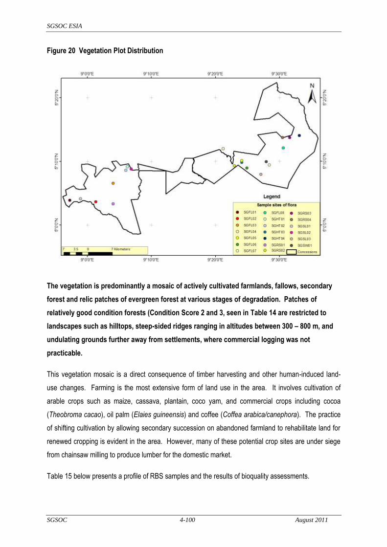
SGSOC ESIA
SGSOC 4-100 August 2011
Figure 20 Vegetation Plot Distribution
The vegetation is predominantly a mosaic of actively cultivated farmlands, fallows, secondary
forest and relic patches of evergreen forest at various stages of degradation. Patches of
relatively good condition forests (Condition Score 2 and 3, seen in Table 14 are restricted to
landscapes such as hilltops, steep-sided ridges ranging in altitudes between 300 – 800 m, and
undulating grounds further away from settlements, where commercial logging was not
practicable.
This vegetation mosaic is a direct consequence of timber harvesting and other human-induced land-
use changes. Farming is the most extensive form of land use in the area. It involves cultivation of
arable crops such as maize, cassava, plantain, coco yam, and commercial crops including cocoa
(Theobroma cacao), oil palm (Elaies guineensis) and coffee (Coffea arabica/canephora). The practice
of shifting cultivation by allowing secondary succession on abandoned farmland to rehabilitate land for
renewed cropping is evident in the area. However, many of these potential crop sites are under siege
from chainsaw milling to produce lumber for the domestic market.
Table 15 below presents a profile of RBS samples and the results of bioquality assessments.

SGSOC ESIA
SGSOC 4-101 August 2011
Table 15 Profile of RBS Samples and Results of Bio-Quality Assessment
Sample
Name
Landscape
Position Soil Location Vegetation Notes
Lat/Long (UTM) Alt.
(m)
Species
Richness
Bioquality Indices
North East GHI EI PI
SGSL01 Slope Dark-brown
gravelly
± 1.5km along
Fabe – Meangwe-2
road
Open upper-canopy secondary forest
with dense undergrowth
498016
560253
353
90
48.8
24.4
40.0
SGSL02 Slope Pale-brown
sandy
± 6km NE of
Mokango village
Relatively good multi-story forest with
thin undergrowth
512616
568877
487
81
48.1
22.2
40.7
SGSL03 Slope Dark sandy-
clay Undefined
Disturbed forest with open upper
canopy and few emergents
550015
567344
509
80
57.5
28.7
57.5
SGSW0
1 Swamp Dark clay
± 2km North of
New Konye
Swamp dominated by Raphia, Uapaca
and Hallea species
551594
571007
507
71
83.0
15.4
67.6
SGRS01 Riverside Rocky ± 1km East of
Beboka
Disturbed riverine vegetation with
clumps of Bamboo dominant
507421
558776
632
91
52.7
19.7
70.3
SGRS02 Riverside Rocky
Nursery site; ±
0.5km SE of
Talangaye
Good multi-story close canopy forest
542365
569831
366
86
77.9
20.9
32.5
SGRS03 Riverside Pale sandy B/n Mungo Ndor
& Bombe Konye Degraded riverine forest
558312
577968
292
46
36.9
23.9
91.3
SGRS04 Riverside Gravelly ± 2km NW of
Mungo Ndor
Disturbed forest;
open canopy and shrubby undergrowth
556298
577952
329
105
58.0
17.1
67.1
SGHT01 Hilltop Rocky
boulders
± 5km NE of
Mokango
Fairly good multi-story forest;
undergrowth dense with climbers
511539
569570
664
94
97.8
15.9
48.9
SGHT02 Hilltop Rocky hard
pan
± 2km NE of
Mokango
Degraded forest patch; trees short &
shrubby; Millettia spp dominant
511044
568525
684
79
35.4
20.2
79.7
SGHT03 Hilltop Pale sandy-
clay
± 6km East of
Talangaye
Very good close canopy, multi-story
forest; undergrowth thin
544511
570791
447
75
97.3
28.0
47.6
SGHT04 Hilltop Dark sandy-
clay
± 1km NE of
Bombe Konye
Degraded forest patch surrounded by
farms; undergrowth shrubby with
dense climber tangles
561155
578549
335
98
39.7
18.3
44.8

SGSOC ESIA
SGSOC 4-102 August 2011
Table 15 (continued) Sample
Name
Landscape
Position
Soil Location Vegetation Notes Lat/Long (UTM) Alt.
(m)
Species
Richness
Bioquality Indices
North East GHI EI PI
SGFL01 Flatland Dark
sandy-clay
± 3km SW of Fabe Secondary forest patch; undergrowth
being cleared prior to tree felling for
farming
494932
559812
263
68
32.3
26.4
39.7
SGFL02 Flatland Brown
sandy-clay
± 3km W of Ndiba
village
Fallow farmland or farm bush; ≤10 yrs
old, being cleared for farming
502371
559376
589
85
58.8
11.7
50.5
SGFL03 Flatland Dark
sandy-clay
± 6km W of
Lipenja village
Relatively good multi-story forest with
emergents; undergrowth thin
507441
564749
631
83
56.6
21.6
44.5
SGFL04 Flatland Dark brown
sandy clay
On Ayong road; ±
4km off the
junction
Secondary forest; undergrowth dense
with climbers tangles
539124
574745
263
84
52.3
14.2
52.3
SGFL05 Flatland Yellowish
clay
± 8km East of
Talangaye
Heavily logged forest with disrupted
canopy; climbers and pioneer species
dominant
544495
571304
438
91
47.2
14.2
65.9
SGFL06 Flatland Pale brown
sandy-clay
± 6km East of
Talangaye
Disturbed forest on recovery from
logging damage
546000
569162
498
82
52.4
21.3
67.0
SGFL07 Flatland Pale brown
sandy clay
± 2km NE of New
Konye village
Degraded secondary forest;
undergrowth herbaceous & shrubby
552416
570086
534
89
68.5
17.9
78.6
SGFL08 Flatland Reddish
sandy clay
± 5km SW of
Mungo Ndor
Relatively good multi-story forest with
emergents; undergrowth thin
556479 575010 381 90 36.6
25.5 63.3

SGSOC ESIA
SGSOC 4-103 August 2011
A total of 403 vascular plant species belonging to 272 genera and 81 families were recorded in the
Concession. Families rich in species (e.g. represented by more than 10 species with number of species
indicated in parenthesess) included Fabaceae (49), Rubiaceae (36), Euphorbiaceae (30), Apocynaceae
(22), Malvaceae (22; including Tiliaceae, Sterculiaceae & Bombacaceae), Annonaceae (18), Meliaceae
(12), Moraceae (11) and Sapindaceae (11). In contrast, 24 families had only one species recorded.
Thirty-six species (8.9% of 403 species) occurred in more than half of the samples, while 100 species
(24.9% of 403 species) had only one record in all of the samples. The most abundant and widely
distributed species were recorded in more than 75% of the samples. These are Massularia acuminata,
Pycnanthus angolensis, Rhektophyllum camerunense, Microdesmis puberula, Palisota hirsuta, Carpol obia
lutea, Piptadenistrum africanum, Rothmania hispida and Anthonotha macrophylla.
Species composition in the Concession reveals that it is composed of 71% trees and shrubs, 19.1% lianas
and climbers, 8.9% herbaceous species and 1.2% vascular epiphytes. Common large diameter tree
species recorded include Piptadeniastrum africanum, Klainedoxa gabunensis and Ceiba pentandra.
Lianas and climbers are abundant in disturbed forests. They vary greatly in size, ranging from slender-
stemmed twining plants in the understory, such as Calycobolus africanus, to giant woody lianas in genera
such as Agelaea, Combretum, Salacia and Strychnos, whose stems can reach out into and above the
canopies.
Vascular epiphytes are much less common except for the aroid Rektophyllum and ferns such as Asplenium
africanum and Microsorium punctatum. Forest floor herbs are well represented and abundant. Notable
among them are Geophila repens, D.obvallata, Hymenocoleus, Leptaspis cochleata, Ataenidia spp,
Marantochloa spp and Sarcophrynium brachystachys. The presence of the root parasite Thonningia
sanguinea was also evident in some samples.
4.4.2 Biodiversity Value of the Concession
Figure 21 is a graphical representation of bioquality scores calculated for the 20 samples. Genetic Heat
Indices (GHI) obtained for the samples ranges from a minimum of 32.5 to a maximum of 97.8, with an
average of 56.9 for the whole Concession.4 These values are insignificant compared with global scale and
an average value of 300 obtained from Mt. Cameroon (Source: Hawthorne, 1998). The absence of global
4 See Annex 4 for an explanation of Genetic Heat Index (GHI)
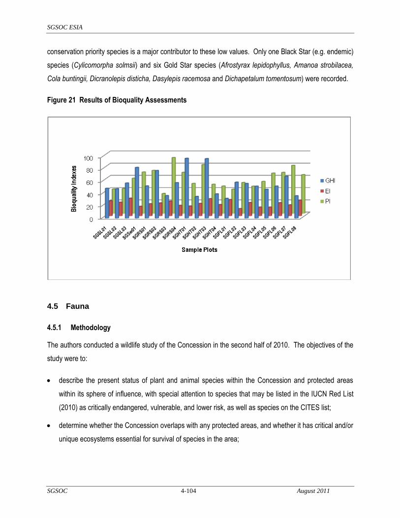
SGSOC ESIA
SGSOC 4-104 August 2011
conservation priority species is a major contributor to these low values. Only one Black Star (e.g. endemic)
species (Cylicomorpha solmsii) and six Gold Star species (Afrostyrax lepidophyllus, Amanoa strobilacea,
Cola buntingii, Dicranolepis disticha, Dasylepis racemosa and Dichapetalum tomentosum) were recorded.
Figure 21 Results of Bioquality Assessments
4.5 Fauna
4.5.1 Methodology
The authors conducted a wildlife study of the Concession in the second half of 2010. The objectives of the
study were to:
describe the present status of plant and animal species within the Concession and protected areas
within its sphere of influence, with special attention to species that may be listed in the IUCN Red List
(2010) as critically endangered, vulnerable, and lower risk, as well as species on the CITES list;
determine whether the Concession overlaps with any protected areas, and whether it has critical and/or
unique ecosystems essential for survival of species in the area;
SGSOC ESIA
SGSOC 4-105 August 2011
ascertain as far as possible from the available biodiversity data whether any critical habitat (as defined
by IFC's Performance Standard 6) is present in the Concession; and,
assist in ascertaining if there are any high conservation value forests (HCVF) within the Concession, as
recognized by the RSPO Principles and Criteria.
The research involved three basic steps and methodologies:
a desktop biodiversity review, based in the Korup project office in Mundemba, WWF Coastal forest
project in Limbe, WWF Yaoundé office, WCS Yaoundé office, MINFOF office in Buea and various
internet sources (see Section 8);
fieldwork (both biological surveys and local interviews) based in the Concession; and,
follow-up literature review based on results of field work.
The fieldwork was conducted between the 24th of June to the 3rd of July 2010 in the Concession and
surrounding areas. Research was principally conducted at three sites, although a broader local habitat
survey was also carried out. For each site, the team assessed habitat types and vegetation structure,
completed species inventories for mammals, birds and plants and interviewed communities proximal to
each impact site on the existence of larger wildlife species. The team also reconnoitered the local area
north and south of each of the sites using ‗recce‘ transects to assess the local habitat condition, and to
provide an understanding of habitat connectivity, wildlife migratory corridors, sites of congregation for water
birds and relative importance of the sites for biodiversity.
4.5.2 Regional Background and Context
Within the vicinity of the Project Area are the protected areas of the KNP (Ndian Division), BMW Sanctuary
(Kupe-Manengouba Division), Nta Ali Forest Reserve and Ejagham Forest Reserve (Manyu Division),
Mount Bakossi National Park (Kupe-Manengouba Division) and Rumpi Hills Forest Reserve (Ndian and
Kupe-Manengouba Divisions). Of all of these protected areas listed, only the KNP and BMW Sanctuary
have approved management plans with some conservation and enforcement activities.
The fauna in the Nguti area is mostly recorded from the BMW Sanctuary. The Sanctuary was created for
the protection of certain species like the drill (Mandrillus leucophaeus), elephant (Loxodonta Africana),

SGSOC ESIA
SGSOC 4-106 August 2011
buffalo (Syncerus caffer) and crocodile (Source: BirdLife International 2009). The Sanctuary is currently
under pressure from logging, hunting and agricultural encroachment. The populations of some large
species have been seriously affected by unsustainable hunting. Common species hunted include duikers
and deer (Cephalophus spp), porcupines (Atherurus spp) and pangolins (Phataginus spp).
The Rumpi Hills are known to be an important area for diversity and endemism including fish (Source:
Schliewen, 1996), butterflies (Source: Larsen, 1997), birds (Source: Usongo, 1995), herpetofauna (Source:
Lawson, 1992) and plants (Source: Thomas, 1995).
KNP is reported to contain one quarter of all of Africa‘s primate species and represents a particularly
important site for primate conservation. KNP is reputedly the most diverse lowland site in Africa (Source:
Rodewald et al, 1994) in terms of birds, with a total of 410 bird species recorded so far in 53 families. KNP
is also reported to contain 82 reptiles and 92 amphibians, a number of them endemic to the lowland
rainforest eco-region, of which KNP is an example. They include 3 Caecilian species (limbless worm-like
amphibians), 89 species of frogs and toads (among them 8 species that are not described), 2 tortoises, 2
aquatic turtles, 15 lizards, 5 chameleons, 3 crocodiles and 55 snakes. About 130 different kinds of fish
species are known within KNP. It has been estimated that KNP contains at least 950 species of butterflies;
equivalent to more than a quarter of the total number of known afro-tropical species. KNP also includes
species of a much more restricted distribution including a number of endemic species such as the Giant
Otter Shrew (Potamogale velox) and Calabar Angwantibo (Arctocebus calabarensis). Fishermen on the
southern Munaya River have reported the presence of the hippopotamus (Hippopotamus amphibius) and
claim that Manatee (Trichechus senegalensis) may be found in the deep stretches of the Akwen gorge a
little north of the Park boundary (Source: Reid, 1989).
The KNP and its support zone is reported to contain endangered species including the drill (Mandrillus
leucophaeus), red colobus (Piliocolobus preussi), chimpanzee (Pan troglodytes), water chevrotain
(Hyemoschus aquaticus), elephant (Loxodonta africana) and buffalo (Syncerus caffer). However, hunting
pressure is much higher in the support zone compared to the park itself and the surrounding forest
reserves. It is likely that certain species such as leopard, golden cat, yellow-backed duiker and giant
pangolin are locally extinct within the support zone, whilst others such as red colobus, drill and chimpanzee
remain vulnerable to extinction (Sources: Usongo, 1995; Infield, 1988; Waltert, 2000; Steiner, 2001).
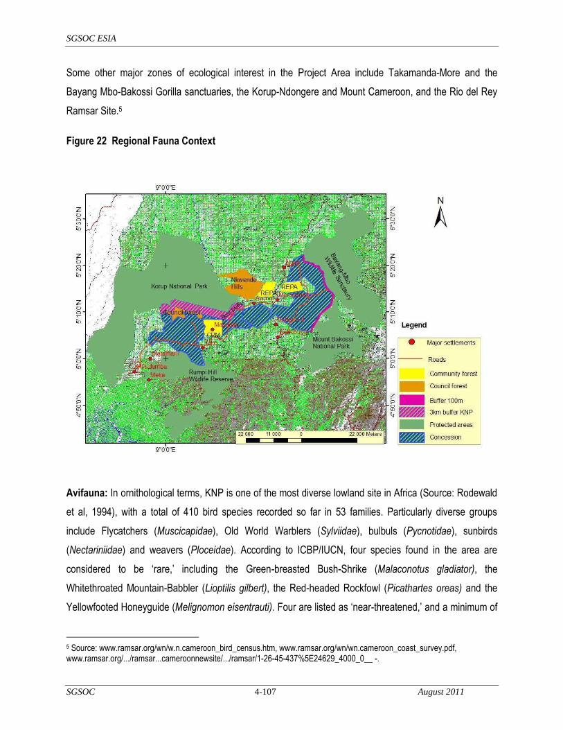
SGSOC ESIA
SGSOC 4-107 August 2011
Some other major zones of ecological interest in the Project Area include Takamanda-More and the
Bayang Mbo-Bakossi Gorilla sanctuaries, the Korup-Ndongere and Mount Cameroon, and the Rio del Rey
Ramsar Site.5
Figure 22 Regional Fauna Context
Avifauna: In ornithological terms, KNP is one of the most diverse lowland site in Africa (Source: Rodewald
et al, 1994), with a total of 410 bird species recorded so far in 53 families. Particularly diverse groups
include Flycatchers (Muscicapidae), Old World Warblers (Sylviidae), bulbuls (Pycnotidae), sunbirds
(Nectariniidae) and weavers (Ploceidae). According to ICBP/IUCN, four species found in the area are
considered to be ‗rare,‘ including the Green-breasted Bush-Shrike (Malaconotus gladiator), the
Whitethroated Mountain-Babbler (Lioptilis gilbert), the Red-headed Rockfowl (Picathartes oreas) and the
Yellowfooted Honeyguide (Melignomon eisentrauti). Four are listed as ‗near-threatened,‘ and a minimum of
5 Source: www.ramsar.org/wn/w.n.cameroon_bird_census.htm, www.ramsar.org/wn/wn.cameroon_coast_survey.pdf, www.ramsar.org/.../ramsar...cameroonnewsite/.../ramsar/1-26-45-437%5E24629_4000_0__ -.
SGSOC ESIA
SGSOC 4-108 August 2011
40 are considered as ‗threatened.‘ The African Grey Parrot (Psittacus erithacus) is heavily hunted for the
export trade.
Herpetofauna: Amphibians and reptiles of the KNP have been partially surveyed by Sanderson (1936),
Perret (1966), Amiet (1978) and Stucki-Stirn (1979). More recent studies by Lawson (1992, 1993) indicate
that the KNP has the highest herpetofaunal diversity known for a single locality in tropical Africa,
comparable to that of the most diverse neotropical sites. The KNP contains 82 reptiles and 92 amphibians,
a number of them endemic to the area. They include 3 Caecilian species (limbless worm-like Amphibians),
89 species of frogs and toads (among them 8 species are not described), 2 tortoises, 2 aquatic turtles, 15
lizards, 5 chameleons, 3 crocodiles and 55 snakes. Amphibians listed as endangered or vulnerable include
Bufo superciliaris and Nectophryne afra. The Nile Crocodile (Crocodylus niloticus) was formerly common in
the rivers, creeks and estuaries between Ekondo Titi and Ndian, but has become much rarer in recent
years due to human predation. The Pygmy African Crocodile (Osteolaemus tetraspis) is still fairly common
in the region, but is also heavily hunted. Likewise, two species of Forest Tortoise (Kinixys erosa and K.
homeana) are heavily exploited and their status is of particular concern. Adults and tadpoles of the frogs,
Conraua robusta and Trichobatrachus robustus, are considered to be a local delicacy; women and children
sometimes travel extensive distances in remote areas to harvest them.
Fish: Peculiar to this zone are colonies of sting-rays, typically marine snappers (Lutjanus spp.) and jack
(Trachynotus goreensis), all living over 300 kms from the sea. About 130 different kinds of fish species are
known within Korup region.
Rivers draining the Korup region are not uniform in their taxonomic composition and diversity of fish. Three
distinct zones can be distinguished (Source: Reid, 1989):
The Akpa-Yafe and Upper Ndian of southern Korup are only moderately diverse in terms of the range
of taxonomic groups present and are rather impoverished in terms of numbers of fish species. The
zone does not contain any Nilo-Sudanian species and is assumed to have lost much of their original
Lower Guinean fish fauna due to a prehistoric catastrophe.
The Lower Ndian of southern Korup differs from both other zones in the predominance of marine fish
like the Barracuda (Sphyraena spp.) and Groupers (Serranus spp.) The high taxonomic diversity of this
zone is noteworthy.

SGSOC ESIA
SGSOC 4-109 August 2011
The Upper Cross (including Munaya or Bake River) has by far the greatest overall diversity including a
number of endemic species. In addition to characteristic Lower Guinean species, the zone contains,
remarkably, a substantial Nilo-Sudanian component of which the Nile Perch (Lates niloticus) is a typical
representative. Peculiar to this zone are colonies of Sting-rays, typically Marine snappers (Lutjanus sp).
4.5.3 Wildlife Habitats of the Concession
A review of the literature on the Project Area indicated that primary habitat within the Concession is
extremely limited due to extensive historical human activity within the area. Information obtained from
archives of the Forestry Department indicate that commercial forest exploitation has been going on in the
country for the past 60 years, and that the forested regions of the Centre, Littoral, and the Southwest have
been subjected to very intensive logging. It is on record that in the Project Area, forest areas were given out
for logging to timber companies and individuals in the form of exploitation licenses, the sale of standing
volume or under prepaid permits. Table 16 provides a summary of licensed companies that logged the
Mundemba, Toko, and Nguti areas since 1980, and Figure 23 indicates the areas that were logged during
this period of time.
Table 16 Summary of Licensed Logging Companies in the Project Area
No Company Period Area (ha) License No.
1 BOPROFOC 1979-1984 40.000 1713
2 MUKETE 1980-1985 114,650 1724
3 CIF 1985-1990 26,500 1759
4 CAFECO 1992-1997 22.224 1824
5 FAKO TIMBER CO 1993-1998 21,842 1827 Source: Cameroon Interactive Atlas Version 2.0, 2006

SGSOC ESIA
SGSOC 4-110 August 2011
Figure 23 Map Reflecting Licensed Areas that Were Logged
The Mundemba/Toko section of the Concession, which has not been included as part of several of the
logging contracts, is heavily occupied by village settlements and was not given out for logging because the
local communities had logged, farmed and hunted the land. Forests in areas close to Fabe and Mokange
have been regenerating from centuries of human land use (Source: Letouzey, 1985).
Due to the extensive human activity in the Project Area, the protected areas surrounding the Concession
house the most important fauna in the region. From the desktop studies, several IUCN-listed species and
their critical habitats are found only in the protected areas of the KNP and BMW Sanctuary, and not within
the SGSOC Concession. These findings were confirmed by the fieldwork as outlined in the following
sections.
4.5.3.1 Mammals of the Concession
The desktop review provided a list of fauna and flora species potentially occurring in the surrounding
protected areas. Over 30 IUCN species were found to potentially occur in the protected areas. This led field

SGSOC ESIA
SGSOC 4-111 August 2011
teams to ascertain the priority species, habitats and ecological processes which constitute the principal,
significant and critical biodiversity components within the Project Area of influence.
Table 17 Mammals Potentially Occurring in the Project Areas with Degree of Threat
English name Scientific Name Status
Preuss`s guenon Cercopithecus preussi Endangered
Gorilla Gorilla gorilla diehli Endangered
Drill Mandrillus leucophaeus Endangered
Chimpanzee Pan troglodytes Endangered
Red-eared guenon Cercopithecus erythrotis Vulnerable
Leopard Panthera pardus Near threatened
Allen's galago Galago alleni Near threatened
Hippopotamus Hippopotamus amphibious Threatened
Collared mangabey Cercocebus torquatus Near threatened
African golden cat Felis aurata Vulnerable
Collared mangabey Cercocebus torquatus Near threatened
Yellow-backed duiker Cephalophus silvicultor Near threatened
Bay duiker Cephalophus dorsalis Near threatened
Sitatunga Tragelaphus spekeii Near threatened
Elephant Loxodonta africana Near threatened
Giant pangolin Manis gigantea Threatened
Although there are high concentrations of threatened mammals in the protected areas, none was found to
be present in the Concession from either the literature review or field work and experience in this area. This
is certainly the result of significant hunting and logging activities which have caused most of the animals to
seek security and forage in the protected areas. The region as a whole holds a significant diversity of
mammals, as expected for the Guinea-Congolian lowland forest of Cameroon. The mammal diversity in the
entire region is not, however, dependent on the Concession, but rather the large protected areas of the
KNP and BMW Sanctuary, and other protected areas.

SGSOC ESIA
SGSOC 4-112 August 2011
Of special interest during this study were forest elephants, gorillas, chimpanzees and guenons, as they had
been identified as HCV species potentially occurring within the Project Area.
Forest elephant
The BMW Sanctuary is an area inhabited by forest elephants. Elephant hunting both for ivory and meat
seems to have been an important activity in the area, thus reducing numbers drastically. The forest
elephant (Loxodonta a. cyclotis) is listed as endangered by the IUCN (2002), and feeding signs were
recorded at the boundary of the Concession and Sanctuary close to River Boa. Hence, there seems to be
local migration between the river and the Sanctuary, potentially indicating forest elephant activity at the
edge of the Concession. When developing the area near the river Boa, care will need to be taken to
provide both a buffer zone, as well as an elephant trench to help protect the forest elephants and the
plantation.
Gorillas and chimpanzees
No ground or tree nests were recorded during the survey in the Concession, although review indicates the
presence of the endangered gorilla (Gorilla gorilla diehli) in the region in the Takamanda National Park, and
the chimpanzee (Pan troglodytes) in the KNP. These species are confined to the Parks for safety where
poaching is forbidden. The local populations that were interviewed have stated that they have never seen a
gorilla in the Concession.
Guenons
Cercopithcus mona pogonias, the crowned guenon, occurs in Central African rainforest from Cross River to
River Zaire and Itimbiri. It seems to prefer dense forest with a relatively unbroken canopy. Both primary and
secondary forests are inhabited, although densities have been reported to decline significantly in degraded
areas (Source: Blom et al 1992). None was confirmed in the Concession.
Cercopithecus nictitans, the putty nosed guenon, is a rain forest species of West and Central Africa that
inhabits both primary and secondary evergreen forests from lowland to montane. It is apparently more
successful in mature forest than in younger successional stages (Source: Struhsaker, 1969). In general,
constraints from the habitat are believed to be less than those from competing primates (Source: Kingdon,
1997), but its relative abundance was significantly reduced in some degraded areas in Gabon (Source:
Blom, et al 1992). These are common species in the entire lowland rainforest without any degree of threat.

SGSOC ESIA
SGSOC 4-113 August 2011
Development of the Project will originate at the roads and high population centers and progress outward,
thereby allowing fauna to move into protected areas around the Concession.
4.5.3.2 Avifauna of the Concession
Over 98 species of bird were recorded as part of this survey, which are included in Annex 5. Of the species
recorded, several appear on the CITES list and include:
Psittacus erithacus,
Kaupifalco monogrammicus,
Turtur tympanistria,
Tauraco macrorhynchus, and,
Oriolus brachyrhynchus.
However, these are all common species in Cameroon with wide distribution in the lowland forest region.
No major habitats such as sandy surfaces that could serve as breeding sites for birds, or mudflats for
congregatory migratory and resident water birds exist within the Concession. Field studies did not confirm
the presence of nesting sites for birds of conservation concern in the Concession, such as rock faces
holding Grey-necked Picathartes ((Picathartes oreas) (IUCN, CITES species which are also covered by
Cameroon legislation)).
The preservation of HCVs within the Concession at HCV locations, along steep slopes and bordering rivers
will provide refuge for birds moving throughout the Concession, as well as ensure a diverse set of habitats
is available to them.
4.5.3.3 Fish and Herpetofauna
None of the threatened species reviewed was found to occur in the Concession. However, recognizing that
these groups often show complex and fine patterns of endemism to specific sites, efforts are being made to
ensure the protection of key potential habitats. Perennial rivers will have a 20 M buffer zone from the
typical high water mark on each side established, and seasonal or intermittent streams (those that do not
flow year round) will also be considered for buffer zones. Furthermore, effluent from the mills will not be
returned to the rivers, thereby limiting the impact of the mill operations on the temperature or chemical
SGSOC ESIA
SGSOC 4-114 August 2011
make-up of the river. Finally, SGSOC will monitor the general condition of the aquatic habitat downstream
of its nurseries to ensure that its water withdrawals are not creating significant stresses to that habitat and if
so, SGSOC shall develop plans to install wells to replace enough of the surface water usage to mitigate
significant impacts.
4.5.3.4 Assessment of Critical Habitat
―Habitat required for the survival of IUCN species‖: Literature review confirmed the following key fauna
IUCN-listed species within the KNP and BMW Sanctuary: Elephant Loxodonta Africana (near threatened)
Preuss‘s red colobus Procolobus badius preussi (endangered), Preuss‘s guenon Cercopithecus preussi
(vulnerable), russet-eared guenon Cercopithecus erythrotis (vulnerable), Leopard Panthera pardus (near
threatened), Allen's Bushbaby Galago alleni (near threatened), Collared Mangabey Cercocebus torquatus
(near threatened), Yellow-backed Duiker Cephalophus silvicultor (near threatened), Bay Duiker
Cephalophus dorsalis (near threatened). Species listed by the Convention on International Trade of
Endangered Species (CITES) have also been recorded in the KNP. African Manatee Trichechus
senegalensis has been reported to exist locally by the inhabitants in the deep stretches of the Akwen gorge
a little north of the KNP, but has not been reported to be within the Concession areas. Key habitat for
these species exists within the KNP and BMW protected areas, but was not reported in the Concession
area.
―Sites holding special significance for endemic and restricted range species‖: The protected areas hold
species endemic to Cameroon like the Mount Kupe Bush-shrike Telophorus kupeensis, and ―restricted
range‖ species including the Forest Swallow (Hirundo fuliginosa) and Grey-necked Picathartes (Picathartes
oreas). These protected species have not been recorded within the Concession.
―Sites critical to the survival of migratory species‖. Such sites have not been recorded or were not seen in
the Concession.
―Areas supporting globally significant concentrations of congregatory species‖. Such areas of
concentrations did not exist in the Concession.
―Areas with species associated with key evolutionary processes and ecosystem services‖. The Concession
area did not qualify under this criterion.

SGSOC ESIA
SGSOC 4-115 August 2011
Based on this review, it is likely only the inaccessible areas of the Concession forests, such as on steep
slopes or at high elevations, may have small portions HCVF (Source: Comisky et al., 2003).
4.6 Protected and Significant Resource Areas
The Project was mapped in relation to known regions and areas recognized as global conservation
priorities (e.g. nationally protected areas, endemic bird areas, and IUCN-recognized areas). It is situated
nearby six major zones of ecological interest in the Southwest Region of Cameroon, including the KNP,
BMW Sanctuary Takamanda-More, the Banyang Mbo-Bakossi Gorilla sanctuaries, Rumpi Hills, Mount
Bakossi National Park and Mount Cameroon (see Figure 24).
The Korup project area is composed of:
The KNP (1256 km²);
The support zone, which includes the park as well as a peripheral zone (3820 km²);
Three forest reserves in the support zone, including Ejagham (783 km²), Nta-Ali (313 km²) and Rumpi
Hills (438 km²); and,
A human population of about 50,000 living in 187 villages, 5 of which are in the KNP, and 27 of which
are very close to the park within a 3-km zone (Source: Korup National Park Management Plan 2008-
2012).
The BMW Sanctuary is approximately 66,000 ha in size, and lies between the towns of Nguti and Bangem,
to the east of the Nguti-Mamfe road. It also shares a common river with the Concession in the Nguti
region, but will be separated from plantation activities by a 100 m buffer to be provided by SGSOC.
Situated between KNP to the west and Santchou to the east, Banyang Mbo falls naturally into two sections,
a northern block of about 34,000 ha, lying between 200 and 500 m, where the terrain is generally flat, and a
mountainous southern part (which represents a small northern extension of the Bakossi mountains), where
the land rises to over 1,700 m. The vegetation in the northern block is coastal evergreen rainforest while in
the south, it is a mix of mid-altitude and montane forest. The two sectors are separated by a transition
zone of inselbergs supporting low-canopy forest.

SGSOC ESIA
SGSOC 4-116 August 2011
The BMW Sanctuary was gazetted in 1996 when the pre-existing Banyang Mbo Forest Reserve was
extended to include the mountains. The sanctuary was created for the protection of certain mammal
species and crocodiles. It is under pressure from logging, hunting and encroachment—there are a number
of villages within the sanctuary boundaries.
The Bakossi National Park is south of the Concession and is comprised of about 29,320 ha, while the
Rumpi Hills Forest Reserve, also located to the south of the Concession, is comprised of about 45,675 ha.
Figure 24 Regional Mapping of Protected Areas
4.7 Protected Species
The goal of the IUCN Red List is to document and highlight organisms that face a higher risk of global
extinction. A sample-based checklist obtained from the survey was evaluated using the IUCN Red List of
threatened species version 2010. (Source: www.iucn.redlist.org IUCN Red List).
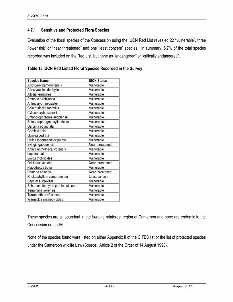
SGSOC ESIA
SGSOC 4-117 August 2011
4.7.1 Sensitive and Protected Flora Species
Evaluation of the floral species of the Concession using the IUCN Red List revealed 22 ―vulnerable‖, three
―lower risk‖ or ―near threatened‖ and one ―least concern‖ species. In summary, 5.7% of the total species
recorded was included on the Red List, but none as ―endangered‖ or ―critically endangered‖.
Table 18 IUCN Red Listed Floral Species Recorded in the Survey
Species Name IUCN Status
Afrostyrax kamerunensis Vulnerable
Afrostyrax lepidophyllus Vulnerable
Albizia ferruginea Vulnerable
Amanoa strobilacea Vulnerable
Antrocaryon micraster Vulnerable
Cola butingii/umbratilis Vulnerable
Cylicomorpha solmsii Vulnerable
Entandrophragma angolense Vulnerable
Entandrophragma cylindricum Vulnerable
Garcinia epunctata Vulnerable
Garcinia kola Vulnerable
Guarea cedrata Vulnerable
Hallea ledermannii/stipulosa Vulnerable
Irvingia gabonensis Near threatened
Khaya anthotheca/ivorensis Vulnerable
Lophira alata Vulnerable
Lovoa trichilioides Vulnerable
Oricia suaveolens Near threatened
Placodiscus boya Vulnerable
Pouteria aningeri Near threatened
Rhektophyllum camerunense Least concern
Sapium aubrevillei Vulnerable
Schumanniophyton problematicum Vulnerable
Terminalia ivorensis Vulnerable
Turraeanthus africanus Vulnerable
Warneckia memecyloides Vulnerable
These species are all abundant in the lowland rainforest region of Cameroon and none are endemic to the
Concession or the IAI.
None of the species found were listed on either Appendix II of the CITES list or the list of protected species
under the Cameroon wildlife Law (Source: Article 2 of the Order of 14 August 1998).

SGSOC ESIA
SGSOC 4-118 August 2011
4.7.2 Sensitive and Protected Fauna Species
Table 19 Protected Fauna Species Potentially Detected in the Concession
Common Name Scientific Name Status Comments
Forest elephant Loxodonta Africana EN Feeding signs seen at the edge of the Concession near MBWS and river Mbu
Literature review confirmed the following IUCN-listed fauna species within the KNP and BMW Sanctuary:
Elephant Loxodonta Africana (near threatened) Preuss‘s red colobus Procolobus badius preussi
(endangered), Preuss‘s guenon Cercopithecus preussi (vulnerable), russet-eared guenon Cercopithecus
erythrotis (vulnerable), Leopard Panthera pardus (near threatened), Allen's Bushbaby Galago alleni (near
threatened), Collared Mangabey Cercocebus torquatus (near threatened), Yellow-backed Duiker
Cephalophus silvicultor (near threatened) and Bay Duiker Cephalophus dorsalis (near threatened). Of
these interviews, literature review, and field work the only species indicated as potentially occuring within
the Concession is the elephant.
Species listed by CITES have also been recorded in the KNP. African Manatee (Trichechus senegalensis)
have been reported to exist locally by inhabitants in the deep stretches of the Akwen gorge, a little north of
the KNP, but have not been reported to be within the Concession.
4.8 Social Zone of Influence
The Social Zone of Influence of the Project is focused on villages occupying or within 5 km of the Project.
These villages will experience the most immediate impacts from the Project among the inhabitants of the
Nguti, Mundemba, and Toko sub-divisions.
4.9 Existing Social Conditions
4.9.1 Methodology
As part of the ESIA, H & B Consulting USA (Cameroon division) conducted a socioeconomic and needs
assessment survey (the ―Survey‖) around the Concession area during the months of December 2010 and
January 2011.

SGSOC ESIA
SGSOC 4-119 August 2011
The objectives of the Survey were to:
enable a sound understanding of the potential impacts of the Project and other Project components on
the concerned communities or villages; and to,
assess current and potential needs of the impacted communities and households so as to better
understand potential strategies of addressing them as the Project is gradually implemented.
The Survey area extends into two divisions, Kupe-Manenguba and Ndian, and three sub-divisions within
those two divisions, Nguti, Toko, and Mundemba, all in the Southwest Region of Cameroon. The areas are
differentiated by language, culture and ethnic diversity.
The Survey area was divided into three distinct sections based on accessibility and proximity. Three teams
of enumerators were formed, with one assigned to survey each section. Most villages around the
Concession area were surveyed. However, logistics and scheduling prevented the enumerators from
visiting all of the villages. The few villages that were not included will be revisited at a later date. A
combination of quantitative and qualitative survey techniques was applied; household and village interviews
were conducted, and in some cases, informal interviews were carried out to maximize the amount of
information obtained. Whenever possible, participatory maps of each village were drawn. Altogether, 31
villages were surveyed and 259 questionnaires were administered, of which 131 were in Nguti, 63 were in
Toko and 65 were in Mundemba.
The major issues addressed include:
basic demographic information;
village governance and decision-making processes;
household structures and access to resources and services;
the economy, production systems and division of labor and land;
household income and expenditures;
culture and sacred sites;
priority needs per village;

SGSOC ESIA
SGSOC 4-120 August 2011
knowledge and expectations of the SGSOC Project;
potentially negative environmental and socioeconomic impacts of the Project, and mitigation or
avoidance measures; and,
potentially positive environmental and socioeconomic impacts of the Project, and measures to enhance
these benefits.
Three types of questionnaires were administered across the villages, including a:
village questionnaire (14 in Nguti, seven in Toko and seven in Mundemba);
focus group questionnaire (24 in Nguti, 12 in Toko and four in Mundemba); and, a
household questionnaire (93 in Nguti, 44 in Toko and 54 in Mundemba).
Village questionnaires were administered to groups of villagers in order to aggregate data from a broad
number of sources at once, and also to create an environment in which the responses could be cross-
referenced amongst participants as the questionnaire was completed. Focus group questionnaires were
administered in a similar manner to specific groups of villagers, such as farmers, hunters, fishermen or
women, in order to gain a variety of perspectives. Village questionnaires and focus group questionnaires
included the same questions. Household questionnaires included household-specific questions, and were
administered to households willing and available to participate in the Survey.
The Survey started with a village briefing by the team leader, and if possible, production of a participatory
map of the village with the village leaders. Focus groups were also conducted separately. Household
interviews were randomly selected to avoid biases. In most villages, at least one village interview, two to
three focus group interviews and between two to nine household interviews were conducted, depending on
the village population and household numbers. Where possible, pictures were taken of the villages and
working sessions.
Some secondary sources were referenced to contextualize Survey results. Additionally, SGSOC
developed several maps to complement data from the Survey.

SGSOC ESIA
SGSOC 4-121 August 2011
4.9.1.1 Limitations of the Survey
The following issues limited the results of the Survey.
Due to security concerns, it was necessary for the enumerators to travel with armed guards, and the
presence of the guards and guides may have influenced some of the participants in their responses.
Some village Chiefs were not served with invitations before the interviews, and therefore were unable
to organize their people to attend to the surveys. As a result, some villagers were not well aware of the
Project even though SGSOC had had a series of meetings with the village representatives. In some
cases, villagers were called back from their farms to attend the interview, and some participants
became impatient with the length of the surveys.
Some village Chiefs instructed their residents not to talk to the enumerators or answer any questions,
possibly due to constraints caused by village elders or elites that did not want the Project due to
unknown reasons.
Some members of the community may not have wanted to be singled out for interviews due to fear of
scrutiny by the remainder of the community.
The logistics of the Survey were somewhat hindered by inaccessibility due to bad roads and poor
infrastructure facilities.
Due to time constraints, the teams were only able to spend several hours in each village.
4.9.2 General Demographics
Table 20 provides a summary of the location of each village in terms of the political division and sub-
division, the number of households reported in each village and the population of each village. It should be
noted that in some villages, such as Talangaye, residents may not be present year-round, and therefore
may not have been captured in this data.

SGSOC ESIA
SGSOC 4-122 August 2011
Table 20 Households and Population Distribution of the Study Area
Source: H & B Consulting Field Survey 2010
Subdivision Village name Households Population
MUNDEMBA Esoki Bima 35 140
Fabe 36 200
Kuma batanga 05 37
Masaka Bima 9 165
Meangwe 100 500
Meta Ngolo 8 33
Mokanga Bima 24 370
Ndiba 12 110
NGUTI Ayong 80 650
Babensi I 50 750
Babensi II 32 600
Badum 100 400
Baro 65 450
Betock 50 500
Ediengo 23 123
Ekenge 30 500
Ekita 25 300
Manyemen 500 6000
New Konye 23 150
Ofrikpabi 15 150
Osirayib 15 65
Sikam 18 70
Talangaye 54 600
TOKO Babiabanga Batanga 15 110
Banyo Batanga 12 141
Bareka Batanga 20 560
Lipenja 60 801
Lobe Batanga 4 11
Manya Batanga 4 20
Mayenke Batanga 2 2
Tombe Batanga 9 92
TOTAL 1,435 14,600

SGSOC ESIA
SGSOC 4-123 August 2011
4.9.3 Social and Political Organization
Based on responses from the village and focus group questionnaires, villages make decisions either
through consensus, a Traditional or Village Council, Chiefs, Chiefs and their Kingmakers (who choose the
Chiefs), or a combination of these methods. Chiefs must be approved and installed by the Administration
(DO or SDO). The below table illustrates decision-making processes based on the Survey results.
Table 21 Decision-Making Process by Village
Subdivision Village Processes
MUNDEMBA Fabe Traditional/Village Council
Kuma Bima Traditional/Village Council
Esoki Bima NA
Meagwe Community Consensus
Meta Ngolo Community Consensus
Masaka Bima NA
Mokango Bima Community Consensus
Ndiba Community Consensus
NGUTI Ayong Traditional/Village Council
Babensi I Traditional/Village Council / Chiefs
Babensi II Traditional/Village Council / Kingmakers and Chiefs
Badum Traditional/Village Council / Chiefs
Baro Community Consensus
Betock NA
Ediengo Traditional/Village Council
Ekenge Traditional/Village Council
Ekita Community Consensus / Kingmakers and Chiefs
Manyemen Community Consensus / Traditional/Village Council
New Konye Traditional/Village Council
Ofrikpabi Traditional/Village Council
Osirayib Traditional/Village Council / Chiefs
Sikam Community Consensus
Talangaye Traditional/Village Council / Chiefs
TOKO Babiabanga Batanga Community Consensus
Banyo Batanga Traditional/Village Council
Bareka Batanga Community Consensus
Lipenja Community Consensus
Lobe Batanga Community Consensus
Manya Batanga Community Consensus
Mayenke Batanga Chief
Tombe Batanga Community Consensus

SGSOC ESIA
SGSOC 4-124 August 2011
Source: H & B Consulting Field Survey 2010
4.9.4 Ethnicity
Based on responses to the village questionnaires, the known ethnic composition of the villages is shown in
the following table. Most of the non-natives are laborers and traders; the most numerous of which are the
Northwesterners who provide farm labor, Nigerians who are small traders, and the Bakundus. Some of the
ethnic data was unknown or incomplete for certain villages.
Pidgin and local languages are most commonly spoken in the area.

SGSOC ESIA
SGSOC 125 August 2011
Table 22 Ethnic Composition in the Study Area Based on Survey Responses
Subdivision Village Ethnicity
MUNDEMBA Esoki Bima NA
Fabe 40% Christian Fabe (indigenous); 40% Christian Bima (indigenous)
Kuma Bima 100% Christian Bima (indigenous)
Masaka Bima NA
Meagwe 100% Christian Ngolo (indigenous)
Meta Ngolo 100% Christian Ngolo (indigenous)
Mokango Bima 100% Christian Bima (indigenous)
Ndiba 100% Christian Ngolo (indigenous)
NGUTI Ayong 40% Christian Njikwa (non-indigenous); 20% Christian Ngie (non-indigenous); 15% Christian Bakoni (indigenous); 15% Traditional Oroko (non-indigenous); 10% Christian Mundom (non-indigenous)
Babensi I 90% Christian Bassossi; 5% Christian Bakundu; 3% Christian Northwest (non-indigenous); 2% Christian Nigerian (non-indigenous)
Babensi II 92% Christian Bassossi; 5% Christian Oroko; 2% Christian Akwaya; 1% Christian Northwest (non-indigenous)
Badum 97% Christian Bakossi (indigenous); 1.5% Christian Akwaya (non-indigenous); .7% Bamegi (non-indigenous); .3% Christian Nigerian (non-indigenous)
Baro 98% Christian Upper Balong (indigenous); 2% Christian Nigerian (non-indigenous)
Betock NA
Ediengo 98% Christian Bassossi; 2% Christian Nigerian (non-indigenous)
Ekenge 98% Christian Bassossi (indigenous); 1% Christian Northwest (non-indigenous); .5% Christian Akwaya (non-indigenous); .5% Christian Nigerian (non-indigenous)
Ekita 20% Christian Bakundu; 15% Christian Northwest (non-indigenous)
Manyemen 60% Christian Upper Balong; 10% Christian Nigerian (non-indigenous); 10% Mangu; 10% Christian Ngie; 5% Traditional Oroko; 2% Muslim Hausa; 1% Christian Bafut
New Konye 90% Christian Bassossi (indigenous); 10% Christian Northwest (non-indigenous)
Ofrikpabi 10% Christian Bassossi (indigenous); 5% Christian Nigerian (non-indigenous); 5% Christian Bertous (non-indigenous)
Osirayib 99% Christian Upper Balong (indigenous); 1% Traditional Oroko (non-indigenous)
Sikam 70% Christian Bakundu (non-indigenous); 20% Christian Sikam (indigenous); 5% Traditional Oroko (non-indingeous); 4% Christian Batabga (non-indigenous); 1% Christian Mboh
Talangaye 75% Christian Bafor (indigenous); 25% Christian Northwest (non-indigenous)
TOKO Babiabanga Batanga
92% Christian Batanga (indigenous); 2% Christian Ekondotti (non-indigenous); 2% Christian Bafor (non-indigenous); 2% Christian Bakossi (non-indigenous)
Banyo Batanga 88% Christian Batanga; 3% Christian Iwasa; 3% Christian Ikoti; 2% Christian Mongale; 1% Christian Ewondo; 1% Christian Bakweri
Bareka Batanga
94% Christian Batanga (indigenous); 6% Toko (non-indigenous)
Lipenja 40% Christian Batanga (indigenous); 20% Christian Northwest (non-indigenous); 10% Christian Bakossi (non-indigenous); 10% Ekondotti; 10% Christian Bafor
Lobe Batanga 100% Christian Batanga (indigenous)
Manya Batanga
100% Christian Batanga (indigenous)
Mayenke Batanga
100% Christian Batanga (indigenous)
Tombe Batanga
82% Christian Batanga (indigenous); 9% Christian Ndoe (indigenous)
Source: H & B Consulting Field Survey 2010

SGSOC ESIA
SGSOC 126 August 2011
4.9.5 Household Infrastructure and Services
Based on the household questionnaire responses, most homes are made of wood, brick, a combination of
grass and mud or corrugated iron. Villagers frequently have a storage shed or similar structures for farming
and keeping animals. Many homes have latrines. Households use wood for cooking and heat, and
kerosene for light. Several villages in Nguti and Toko reported occasional use of a village or personal
generator for electricity.
Based on information gathered from the household questionnaires, only eight villages reported the
presence of taps or pipe-borne water, most of which were in Nguti, and some of which were in poor
condition. No taps or pipe-borne water were reported in Toko. Springs and streams of varying quality are
therefore the main sources of water for the villagers. They tend to use certain streams and springs for
cooking and drinking, and others for bathing and cleaning.
Respondents reported mixed availability of sanitation services. Nguti appears to offer more services than
the other two sub-divisions. Some villages, particularly in Toko, reported no sanitation services at all.
Waste is typically disposed of behind the home, in a dug pit or in the bush. Some use the waste as
compost for fertilizing crops, and others burn it.
4.9.6 Communication services and news sources
Approximately 30 to 40 percent of the respondents to this part of the questionnaire reported mobile phone
ownership. Most retrieve their news from the radio or community meetings. Very few have televisions, and
most do not read the newspaper. There was no Internet access reported.
4.9.7 Roads and transportation
Most villages do not have access to tarred roads. Roads are more frequently simple dirt or laterite paths.
Partial maps of roads were developed by SGSOC, as illustrated in the below figures. Due to the lack of
paved roads, transportation between villages is therefore very difficult. Respondents reported that typical
travel is by foot, motorcycles, bicycles, buses, trucks, Okada (motorcycle taxis), and occasionally,
automobiles and automobile taxis.
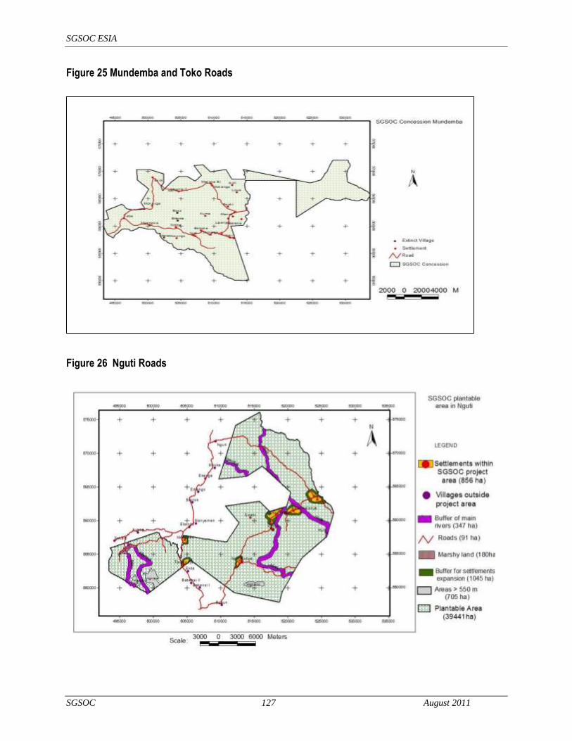
SGSOC ESIA
SGSOC 127 August 2011
Figure 25 Mundemba and Toko Roads
Figure 26 Nguti Roads
SGSOC ESIA
SGSOC 128 August 2011
4.9.8 Education & Health Services
4.9.8.1 Education
Over half of the members of the surveyed households have received some level of education, as many
responded with ―primary school,‖ ―FSLC‖ (First School Leaving Certificate) or ―CEP‖ (Certificat d‘Etude
Primaire). In addition to the Survey, SGSOC also partially mapped schools and hospitals, as illustrated in
Figure-27. Primary schools were recorded in Fabe, Meangwe, Mokango Bima, Lipenja, Sikam, Ayong,
Talangaye, Babensi I, Badum, New Konye, Ekenge, Baro, Banyo Batanga and Bareka Batanga. A
technical school was recorded in Lipenja. The map also identified some primary and secondary schools, as
well as a technical school, in villages not included in the Survey.
Children frequently must walk long distances to attain their education, and the tuition per student per year is
typically about 3,000 CFA, with the lowest reported tuition at 1,500 CFA and the highest at 15,000 CFA.
The schools operate approximately six to eight hours per day and lack electricity, fresh water, books,
adequate building infrastructure and teaching staff. Education is the main reason respondents reported for
migration.
4.9.8.2 Human Health
The Survey results also show that villagers frequently have to travel long distances on bad roads for
medical treatment. There are cases in which pregnant women have given birth along the road in search of
proper medical care. The below table illustrates the health centers and hospitals used by each village,
according to the Survey results. This data was cross-referenced with the map assembled by SGSOC which
partially surveyed the area, as illustrated in Figure-27.
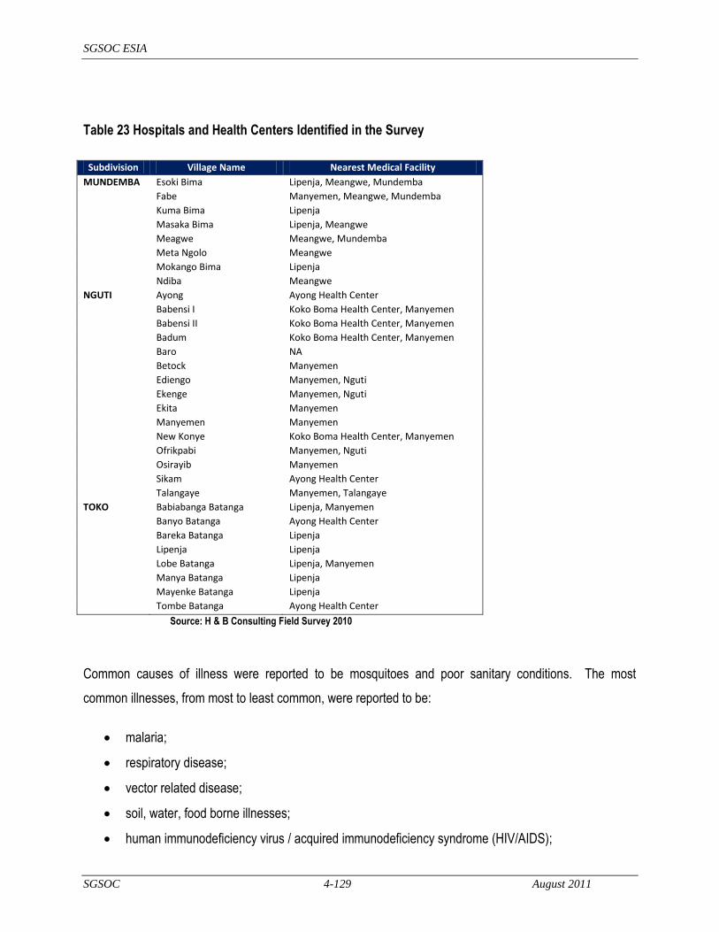
SGSOC ESIA
SGSOC 4-129 August 2011
Table 23 Hospitals and Health Centers Identified in the Survey
Subdivision Village Name Nearest Medical Facility
MUNDEMBA Esoki Bima Lipenja, Meangwe, Mundemba
Fabe Manyemen, Meangwe, Mundemba
Kuma Bima Lipenja
Masaka Bima Lipenja, Meangwe
Meagwe Meangwe, Mundemba
Meta Ngolo Meangwe
Mokango Bima Lipenja
Ndiba Meangwe
NGUTI Ayong Ayong Health Center
Babensi I Koko Boma Health Center, Manyemen
Babensi II Koko Boma Health Center, Manyemen
Badum Koko Boma Health Center, Manyemen
Baro NA
Betock Manyemen
Ediengo Manyemen, Nguti
Ekenge Manyemen, Nguti
Ekita Manyemen
Manyemen Manyemen
New Konye Koko Boma Health Center, Manyemen
Ofrikpabi Manyemen, Nguti
Osirayib Manyemen
Sikam Ayong Health Center
Talangaye Manyemen, Talangaye
TOKO Babiabanga Batanga Lipenja, Manyemen
Banyo Batanga Ayong Health Center
Bareka Batanga Lipenja
Lipenja Lipenja
Lobe Batanga Lipenja, Manyemen
Manya Batanga Lipenja
Mayenke Batanga Lipenja
Tombe Batanga Ayong Health Center
Source: H & B Consulting Field Survey 2010
Common causes of illness were reported to be mosquitoes and poor sanitary conditions. The most
common illnesses, from most to least common, were reported to be:
malaria;
respiratory disease;
vector related disease;
soil, water, food borne illnesses;
human immunodeficiency virus / acquired immunodeficiency syndrome (HIV/AIDS);

SGSOC ESIA
SGSOC 4-130 August 2011
sexually transmitted diseases (STI's);
accidents/injuries;
zoonotic disease;
tuberculosis (TB);
nutrition-related disease;
cultural health practices;
exposure to potentially hazardous materials;
psychosocial; and,
non-communicable diseases (NCDs).
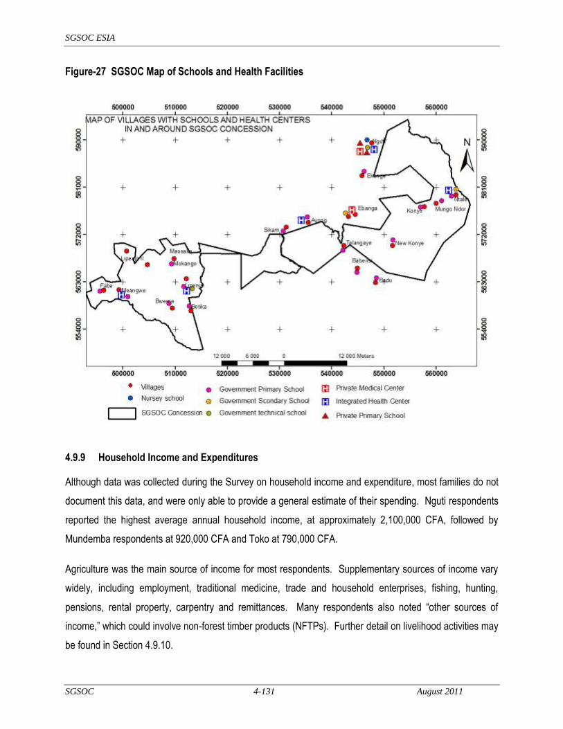
SGSOC ESIA
SGSOC 4-131 August 2011
Figure-27 SGSOC Map of Schools and Health Facilities
4.9.9 Household Income and Expenditures
Although data was collected during the Survey on household income and expenditure, most families do not
document this data, and were only able to provide a general estimate of their spending. Nguti respondents
reported the highest average annual household income, at approximately 2,100,000 CFA, followed by
Mundemba respondents at 920,000 CFA and Toko at 790,000 CFA.
Agriculture was the main source of income for most respondents. Supplementary sources of income vary
widely, including employment, traditional medicine, trade and household enterprises, fishing, hunting,
pensions, rental property, carpentry and remittances. Many respondents also noted ―other sources of
income,‖ which could involve non-forest timber products (NFTPs). Further detail on livelihood activities may
be found in Section 4.9.10.
SGSOC ESIA
SGSOC 4-132 August 2011
Many household heads reported that they spend more money than they earn. If so, the extra money is
likely obtained from Jangi (the traditional banking system) and loans from friends. On average, Nguti
respondents reported the highest annual household expenditures at approximately 2,100,000 CFA, followed
by Toko at approximately 530,000 CFA and Mundemba at 380,000 CFA. Common expenditures across the
sub-divisions included, from most common to least common, food, clothing, education and health and
kerosene. Respondents spend the most on education, followed by food, fuel, clothing and health.
4.9.10 Livelihood Activities
The primary land use among the villages is agriculture. The most common crops reported in the study
include millet, cocoa, cassava, oil palm, beans, rice and fruit. Cocoa and oil palm products are typically
cash crops, but significant income was also reported for other crops, as well, indicating some level of
market activity and trade. Many respondents noted selling agricultural products from their homes or in
markets. Commercial or cash crop farming is done using family labor, and occasionally outside labor.
Outside laborers are typically Nigerians and people from the other regions of Cameroon. Diversification is
the survival strategy for farmers in the study area. In addition to ensuring the household with adequate food
all year round, mixed cropping is included in the main plantations. Although Survey results indicated that
cattle and horses are not common in the sub-divisions, many households do keep chickens, and some keep
goats, sheep and pigs. Farm animals are both eaten and sold.
Locally caught fish are widely consumed and represent a significant source of animal protein in local diets,
Fishing is a seasonal occupation done by both men and women, with least activity during the wet season.
Commonly caught fish include mud fish, dog fish, cat fish, tilapia and Banga fish, to name a few. Methods
used include hook and line, sleeping hooks, basket traps, nylon nets of various designs and the poisoning
of streams. Poisoning of small brooks and streams with vegetable toxins derived from the macerated fruits
of Strychnos aculeata, Blya supida and Massularia acuminata is an ancient traditional practice (Source:
Reid, 1989). Some participants in the survey complained of a deteriorating quality of rivers and streams
due to poisoning.
Fuel wood is commonly collected from farmlands and the forests, with the species collected varying across
ethnic groups and collection normally being done by women. Recently, with the use of engine saws, more
wood may be collected in a short time for commercial purposes (Source: Management Plan of Korup
National Park and its Peripheral Zone 2008-2012).
SGSOC ESIA
SGSOC 4-133 August 2011
Collecting, processing, and marketing of NTFPs traditionally have represented a major source of income for
women, and increasingly for men and youths. These products include kola nuts (Cola and Garcinia spp.),
country onion (Afrostyrax lepidophyllus), njabe (Baillonella toxisperma), bush mango (Irvingia gabonensis),
eru (Gnetum spp.), shell nut (Poga oleosa), njansang (Ricinodendron heudelotti), chewing sticks (Garcinia
mannii and Massularia acuminate) and numerous medicinal plants. Alcoholic beverage (palm wine) is
sapped from Raffia palm (Raphia hookeriana) and oil palm (Elaeis guineensis). Bush mango, eru and
njansang have a high economic value. Many of these products are commonly collected from farm, fallow
and secondary growth forests. There is also reliance on bush meat as a protein source.
4.9.11 The Business Environment
Provision stores were reported in Mokango Bima, Fabe, Meangwe, Tombe Batanga, Bareka Batanga and
Tombe Batanga. In each village, the store was opened by a villager, and most were under four years old.
However, the store in Mokango Bima was reported to have opened 15 years ago. The stores typically sell
basic products ranging from packaged foods to personal care products, kerosene and pencils.
There do not appear to be any manufacturers in the region. However, respondents in Toko reported
several locally owned businesses, including a basket weaver, a cane chair weaver, a carpenter and a farm
bag producer, all of which have been operating from 30 to 50 years.
4.9.10 Land Tenure
Respondents noted that land distributed in several ways. It can be inherited through the family and owned
in a traditional sense, and it can also be distributed in a customary manner by the Traditional or Village
Council. It can also be communal and held on a community basis by the village. Land ownership is
typically regarded as a birthright by the native inhabitants. Non-natives must either rent or buy their land
from the Traditional or Village Council. In some cases, migrants are allowed to cultivate annual crops
(maize, beans, cassava, etc.) for a short period of time before the land is given back to the native owners.
Rich migrants can rent farms from natives.
Land conflicts occasionally exist between neighbors due to encroachment of territory for farming reasons or
when boundaries are not respected. Such conflicts are primarily resolved in the Traditional or Village

SGSOC ESIA
SGSOC 4-134 August 2011
Council and only in rare cases are they taken to the Administration (D.O.) for resolution. Some land
conflicts also exist between villages, and the Village Councils typically reconcile such disputes, as well.
4.9.11 Cultural Resources and Archaeology
Although largely Christian, surveyed villages also have superstitious and religious beliefs. Nearly all
reported sacred sites, at which any of the following activities are performed:
invocation or worship of ancestors‘ souls;
punishment of criminals;
settlement of disputes;
death rituals and burials;
prayer;
dancing and cleansing;
war rituals;
land ceremonies;
decision making;
rituals for prosperity;
hunting;
agriculture;
coronation; and / or,
women‘s gatherings.
Typically, rules are associated with a given sacred site, any of which may or may not include no farming, no
hunting, no fishing, no felling trees or clearing, no bathing, no drinking, no presence of women and / or no
strangers. Some sites are guarded by a villager, while others are believed to be guarded by a supernatural
power, and others are not guarded at all.
4.9.12 Non-Governmental Organizations (NGOs)
Only four villages that participated in the Survey reported a presence of NGOs. They included:
Babensi II, where WUE (Slow & Steady) has operated for five years, providing services related to
trainings, food crops, animal husbandry and income generation;

SGSOC ESIA
SGSOC 4-135 August 2011
Ekenge, where Ekenge Youths CIG has operated for five years, providing services related to
sustainable development and farming for youths;
Osirayib, where OFA has operated for 16 years, providing services related to provision of
seedlings; and,
Banyo Batanga, where Let‘s Try & See has operated since November 2010, providing Njangi
services.
4.10 Needs Assessment of Social Services
Survey participants were asked to rank their top three priority needs. Their responses are summarized in
the below table.
Table 24: Needs by Subdivision
Subdivision Priority #1 Priority #2 Priority #3 Priority #4 Priority #5
MUNDEMBA Roads Health Center Electricity Educational Facilities Water
NGUTI Water Electricity Health Centers Roads Educational Facilities
TOKO Roads Health Center Educational Facilities Water Electricity
Source: H & B Consulting Field Survey 2010
4.11 Public Attitudes and Perceptions
A vast majority of respondents knew about the SGSOC Project and had a favorable opinion of it. Most
expressed expectations of positive impacts. In particular, they noted economic development, job creation,
and improved road, clean water, health center and school development.
In regards to job creation, the respondents indicated that there is a significant amount of experience among
the local population in oil palm cultivation, and many expressed interest in working for SGSOC, particularly
the youths. Several respondents commented that higher unemployment would likely reduce youth unrest.

SGSOC ESIA
SGSOC 4-136 August 2011
When asked how SGSOC could best communicate with the villages, most Survey respondents specified
community meetings. Many also specified radio, brochures and the development of improved
communication networks as means of enhancing communication between SGSOC and the villages.

SGSOC ESIA
SGSOC 5-137 August 2011
5 Potential Impacts, Mitigation, and Residual Impacts
This chapter discusses the environmental and social impacts, positive and negative, that may result from
the Project. An impact is any change to a resource or receptor brought about by the presence of a project
component or by the execution of a project related activity.
Potential impacts on environmental and social resources arising from the proposed development include
direct and indirect (both permanent and temporary) impacts within the development area and its
surroundings. There is also potential for some of these impacts to be cumulative.
This chapter is structured as follows:
Section 5.1 provides a description of the methodology used to assess impacts.
Section 5.2 summarizes the potential impacting activities (e.g. nursery development, nursery
operations, plantation development, plantation operations, mill development, etc.) and summarizes the
potential impacts, as applicable, to the environmental and social components including air, soil, water,
flora, fauna, and human.
Section 5.3 aggregates the impacts to the various environmental and social components and provides
an assessment of the significance of the impacts on each of those components, assuming already
planned mitigation measures.
Section 5.4 proposes additional mitigation measures for any impacts identified in Section 5.3 as ‗Major‘
and assesses the significance of those impacts after the application of the mitigation measures.
5.1 Methodology
The Terms of Reference for the ESIA, which were determined during the scoping study, established the
anticipated environmental and social impacts considered to be potentially significant and therefore requiring
detailed assessment. Several specific field surveys, such as the wildlife/fauna and flora surveys and the
socioeconomic study, have therefore been conducted.

SGSOC ESIA
SGSOC 5-138 August 2011
The purposes of the impact assessment and mitigation recommendations are:
to identify and evaluate the significance of potential impacts on identified receptors and resources,
according to widely accepted and defined assessment criteria;
to develop and describe measures that should be taken to avoid or minimize any potential adverse
impacts, and to enhance potential benefits; and,
to report the significance of the residual impacts that remain following mitigation.
This analysis uses the Leopold matrix (Source: Leopold et al., 1971), which is the best-known matrix
methodology available for predicting the impact of a project on the environment. The Leopold matrix is a
two-way table that lists project activities at different stages on one axis and components of the biological,
physical, human and economic environment on the other. Potential impacts are marked with a diagonal line
in corresponding boxes.
After identifying the Project‘s potential impacts using the Leopold matrix, the analysis used another matrix
called the Fecteau matrix to help indicate the levels of importance of each impact. The Fecteau matrix is
used to evaluate, one-by-one, the most important interactions in the Leopold matrix based on the sensitivity
of the environmental component and the extent, intensity and duration of each impact. In each unit that
shows a significant interaction between an environmental action and element, the importance of the impact
is evaluated with a subjective value and is entered in the corresponding unit (Source: André, P. 2003, chap.
9.2).
Characteristics of environmental impacts vary. The main parameters used to characterize and assess
impacts are the:
nature of the impact;
intensity of the impact;
extent or location of the impact;
duration of the impact; and,
importance of the impact.

SGSOC ESIA
SGSOC 5-139 August 2011
These parameters are described below.
The most obvious impacts are those directly related to the project that can be directly attributed in space
and time to the causal action. Indirect or secondary impacts generally cause less obvious changes
occurring later and farther from the source of impact.
In general, cumulative effects are caused by the amplification of an impact when combined with the impacts
of other projects completed recently or underway. Considered individually, these impacts may be
insignificant, but together, they become important by virtue of their concentration in space or time. The
effects may be cumulative through the addition or interaction of different impacts such that the overall effect
is greater than the sum of individual effects.
5.1.1 Extent, Duration, and Intensity of the Impact
In general, importance of an impact is expressed in terms of severity (major, moderate or minor) and takes
into account the extent, duration, and intensity as described in Table 25 below.
Sometimes it is impossible to determine the significance of impact due to lack of knowledge or because the
impact can be both positive and negative.

SGSOC ESIA
SGSOC 5-140 August 2011
Table 25 Determination of Impact Importance
Importance
Extent
Local – impacts are predicted to affect only the project area
Regional – impacts are predicted to affect the region as determined by administrative boundaries (in this case, the Southwest Region of Cameroon)
National – impacts are predicted to affect nationally important environmental resources
International – impacts are predicted to affect internationally important resources, such as areas protected by international conventions
Duration
Temporary – impacts are predicted to be of short duration and occasional
Short-term – impacts are predicted to last only for the duration of the construction period
Long-term – impacts are predicted to continue for the life of the project, but cease when the project stops operating
Permanent – impacts are predicted to cause a permanent change in the affected receptor or resource (e.g. removal or destruction of ecological habitat) that endures substantially beyond the project lifetime
Intensity
Negligible – impacts on the environment are predicted to not be detectable, or there are no perceptible changes to people‘s way of life
Low – impacts are predicted to affect the environment in such a way that natural functions and processes are not affected or the communities are able to adapt
Medium – the affected environment is predicted to be altered, but natural functions and processes continue, albeit in a modified way, or the communities are able to adapt with some difficulties
High – natural functions or processes are predicted to be altered to the extent that they will temporarily or permanently cease, or the communities affected will not be able to adapt to changes
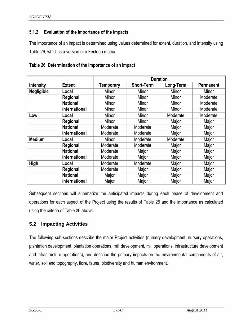
SGSOC ESIA
SGSOC 5-141 August 2011
5.1.2 Evaluation of the Importance of the Impacts
The importance of an impact is determined using values determined for extent, duration, and intensity using
Table 26, which is a version of a Fecteau matrix.
Table 26 Determination of the Importance of an Impact
Duration
Intensity Extent Temporary Short-Term Long-Term Permanent
Negligible Local Minor Minor Minor Minor
Regional Minor Minor Minor Moderate
National Minor Minor Minor Moderate
International Minor Minor Minor Moderate
Low Local Minor Minor Moderate Moderate
Regional Minor Minor Major Major
National Moderate Moderate Major Major
International Moderate Moderate Major Major
Medium Local Minor Moderate Moderate Major
Regional Moderate Moderate Major Major
National Moderate Major Major Major
International Moderate Major Major Major
High Local Moderate Moderate Major Major
Regional Moderate Major Major Major
National Major Major Major Major
International Major Major Major Major
Subsequent sections will summarize the anticipated impacts during each phase of development and
operations for each aspect of the Project using the results of Table 25 and the importance as calculated
using the criteria of Table 26 above.
5.2 Impacting Activities
The following sub-sections describe the major Project activities (nursery development, nursery operations,
plantation development, plantation operations, mill development, mill operations, infrastructure development
and infrastructure operations), and describe the primary impacts on the environmental components of air,
water, soil and topography, flora, fauna, biodiversity and human environment.

SGSOC ESIA
SGSOC 5-142 August 2011
5.2.1 Nursery Development
SGSOC anticipates developing three nurseries in a phased approach, with one in Nguti (near the village of
Talangaye) and two in Mundemba (near the villages of Lipenja and Fabe). During the first year of
operations, the nursery in Nguti will only be approximately 6 ha in size. It is expected to remain only in the
Nguti location for the first two years of operation, growing to about 125 to 150 ha during that period.
Ultimately, all three nurseries are expected to grow to a cumulative total of about 375 to 450 ha after four
years of operation in all three locations.
Preparing these sites includes the following major activities (see Section 3.3.2 for additional information):
improving existing access roads;
establishing temporary work camps;
clearing the sites on a phased basis;
disposing of cleared vegetation; and,
constructing storage facilities, work buildings and utilities for nursery operations.
These activities have the potential for the impacts described below.
5.2.1.1 Air
Combustion Emissions - Cleared vegetation will not be burned, but used for mulching and erosion control,
as well as other purposes, and will have no contribution to combustion emissions. Heavy equipment will be
used to improve roads and clear vegetation, thus causing combustion emissions, but this activity will be
local, short-term and negligible intensity.
Fugitive Dust - Clearing of vegetated land can increase the potential for fugitive dust, but this will be
naturally mitigated by the relatively high humidity, rainfall, relatively short duration when cleared land will not
be occupied by seedlings, and compaction of soil when the land is not occupied by seedlings, thus resulting
in a local, short-term and negligible intensity impact.
Noise – Use of heavy equipment during development will create noise impacts in the immediate area, but
these will be local, short-term and low intensity.

SGSOC ESIA
SGSOC 5-143 August 2011
5.2.1.2 Water
Surface Water Quality – Nursery development will not use significant amounts of chemicals or create a
potential for significant soil erosion and sedimentation (see below). Therefore, impacts to surface water
quality are expected to be local, temporary, and low intensity, if any impacts do occur.
Surface Water Quantity – Development of the nurseries will not use significant amounts of water.
Therefore, no significant impacts to surface water quantity are anticipated.
Groundwater Quality and Quantity – Development of the nurseries will not utilize groundwater and will not
impact groundwater unless there is an accidental spill of chemicals during construction. Therefore, impacts
to groundwater are not anticipated.
5.2.1.3 Soil and Topography
Landforms – Relatively level sites will be selected for the nurseries resulting in no significant impacts to
landforms from nursery development or operation.
Soil Erosion – Soil erosion occurs when water, primarily stormwater, runs uncontrolled across exposed or
unprotected soil. The nurseries will be developed and expanded as needed with each phase of
development being relatively small and occurring on relatively flat ground. Topsoil from the site will be
collected and stockpiled for use in the poly-bags used to grow seedlings. SGSOC will implement a Project-
wide Erosion and Sedimentation Management Plan to manage erosion on both a site-wide basis and for all
stockpiles. As a result of the above, impacts from soil erosion are anticipated to be local, short-term and of
negligible to low-intensity.
Soil Contamination – During site development, the only significant use of regulated or hazardous
substances will be petroleum products for the heavy equipment. SGSOC will implement the Chemical
Management Plan for use of chemicals including petroleum products. It will also have the Emergency
Response and Incident Management Plan in place for managing spills or releases in the event of an
accident. Any impacts to soil from contamination resulting from accidents would be expected to be local,
temporary and of low intensity.
5.2.1.4 Flora
Loss of Natural Vegetation – Nurseries will be located so that they do not impact any important habitat or
areas of ecological importance that are identified for protection. Development of the nurseries will cause

SGSOC ESIA
SGSOC 5-144 August 2011
the loss of approximately 375 to 450 ha of secondary forest over a four-year period due to clearing required.
This clearing will be done in accordance with a Vegetation Clearing and Biomass Management Plan to
ensure that only areas that are intended to be cleared are affected, and that all cleared biomass is utilized in
the best manner reasonable. The loss of this natural vegetation can only be mitigated through minimizing
the clearing to the smallest possible area for the entire Project and by leaving higher quality forest intact in
accordance with RSPO‘s Principles & Criteria and best practices, which SGSOC plans to do. Losses to
vegetation will be long-term, local and high intensity.
Invasive Species – The development of the nurseries is not anticipated to have any significant risk of
spreading invasive species.
5.2.1.5 Fauna
Loss of Habitat – When construction personnel and equipment mobilize to the site and begin clearing, the
mobile fauna will migrate to areas outside the nursery and its immediate vicinity, and the less mobile
species or individuals will be lost. SGSOC will ensure that this initial mobilization phase and clearing
operations are conducted according to a Vegetation Clearing and Biomass Management Plan that provides
an opportunity for mobile individuals to migrate outside the area. The individuals that do migrate outside of
the nursery area will compete with existing populations and are likely to cause changes to the biodiversity
for a few kilometers around each nursery development. The loss of habitat and resulting loss of fauna will
be permanent, local (within the Concession) and high intensity.
5.2.1.6 Biodiversity
Biodiversity Loss – The biodiversity loss from nursery construction will be complete due to the land clearing
required. On its own, this biodiversity loss is small in terms of total area required (approximately 375 to
450 ha for all nurseries). While this impact will be permanent and high intensity, it will be local in extent.
Protected Species – SGSOC will use its Flora and Fauna Management Plan to ensure that its site clearing
activities identify and provide agreed, species-specific mitigation measures should any protected species be
encountered during the clearing operations.
5.2.1.7 Human
Employment and Livelihood Activities – Employment will be created during the construction period for a
relatively small number of people. Many of the jobs will be unskilled and therefore available to local

SGSOC ESIA
SGSOC 5-145 August 2011
residents with no specific training. This will be a positive impact that is low intensity, temporary, but likely
regional in extent.
Education – Development of the nurseries can provide local workers with exposure to international worker
health and safety practices (see Health, Safety, and Security Management Plan and Employment, Training,
and Awareness Management Plan) that can better prepare these construction workers for full-time
employment in the Project. This will be a positive impact that is low to negligible intensity, potentially long-
term, and local in extent.
Health, Safety and Security – Construction workers will be provided with health services and local workers
will be given priority for full-time jobs with the Project. This is a low intensity, short-term and local benefit.
Construction workers from outside the area, many of whom could be single males, can bring and/or spread
communicable or infectious diseases to the local communities, including sexually transmitted diseases and
HIV/AIDS. Single workers with money and others that come into the area to exploit the increased economic
activities associated with construction can increase incidents related to alcohol, drugs, and crime. These
impacts will be mitigated on the construction employee side by the Health, Safety, and Security
Management Plan and Employment, Training, and Awareness Management Plan, and on the community
side by the community aspects of the Health, Safety, and Security Management Plan. Due to the small
workforce required for construction of the nurseries, this is estimated to be a medium intensity, regional, and
short-term impact.
Cultural Resources – Nurseries will be located to avoid impacts to cultural resources. Therefore, no
impacts are anticipated. This will be done in accordance with the Cultural Heritage Management Plan,
which will include provisions in the event of chance finds in the field. As a result, these impacts are
expected to be negligible, local and temporary.
5.2.2 Nursery Operations
During the first year of operations, the nurseries will only total approximately 28 ha in size. This will
ultimately grow to approximately 375 to 450 ha after four years of operation.
Nursery operations will include filling polybags with topsoil stockpiled during clearing operations, caring for
seedlings by appropriate watering, fertilizing, and pest control for 8 to 14 months, then transporting the
seedlings to the plantation for planting. SGSOC anticipates using surface water from a nearby river to

SGSOC ESIA
SGSOC 5-146 August 2011
water seedlings every other day when it does not rain, applying fertilizer on a weekly or monthly schedule
depending on the age of the seedling and controlling weeds and pests manually or by chemicals, depending
on the species. At full build-out the nurseries are expected to employ about 300 to 500 people. See
Section 3.3.3 for further information.
These activities have the potential for the following impacts.
5.2.2.1 Air
Combustion Emissions – Vehicles, generators, and pumps will be used for nursery operations causing
combustion emissions. Although this activity will be long-term, the impacts will be local and of negligible
intensity.
Fugitive Dust – Operation of the nursery does not have the potential for creating fugitive dust due to the
relatively high humidity and rainfall amounts, coupled with the need to ensure that seedlings receive water
at least every other day. In addition, the compaction of soil within the nursery and relatively short duration
when cleared land is not occupied by seedlings further reduces the potential for fugitive dust. The resulting
impact will be long-term, but local and of negligible intensity.
Noise – Use of power equipment will create noise impacts in the immediate area, resulting in impacts that
are long-term, but local and of negligible intensity.
5.2.2.2 Water
As per the Establishment Convention, SGSOC has the exclusive right within the Production Area to take
and use, free of charge (but not to sell to any other person without the written approval of Government),
such water, earth, stones, rocks, sand, clay, and gravel having no significant commercial mineral value
other than as aggregate, filler or other construction material, as SGSOC may consider necessary or useful
for its agreed-upon activities, without the need to obtain any further authorization or pay any further fees.6
Surface Water Quality – SGSOC will ensure that erosion control measures are implemented during site
development so increased sediment loads in nearby surface water bodies are not expected. Nursery
operation will use relatively small amounts of fuels for operating equipment, and fertilizers and herbicides for
6 Any activity conducted pursuant to this clause may not be considered mining. This clause is also pursuant to SGSOC‘s obligation with respect to the environment to be as prescribed by applicable Law, including the Environmental Code, and the Equator Principles, as applicable.

SGSOC ESIA
SGSOC 5-147 August 2011
care of the seedlings. Because the use of these substances raises the potential for spills and contamination
of surface water or groundwater, SGSOC will implement measures to ensure that all chemicals are used
responsibly and in accordance with manufacturers recommendations (see Chemical Management Plan)
and that contingency plans are in place in the event of accidents to minimize impacts to human health and
the environment (see Emergency Response and Incident Management Plan). As a result, any accidents
that do happen and cause contamination of surface water are expected to be short-term, local and low
intensity.
Surface Water Quantity – Nursery operations will use surface water from nearby rivers to ensure that
seedlings receive water if it does not rain at least 10 mm a day. When this condition is met, most likely in
the December to March timeframe, the initial nursery development will withdraw water at the rate of about
18 liters/second (l/s) over an 8-hour period for the first three months, then at a rate of 90-108 l/s for months
9 to 12. Consequently, the need for this water will be highest when flows in the rivers are likely at relatively
low levels. This level of withdrawal is not expected to create significant impacts based on observations of
the river and consultations with local inhabitants and officials. However, if significant impacts do occur,
SGSOC will install wells to supplement the surface water withdrawals. Such a need for supplemental wells
will be determined based upon the Flora and Fauna Management Plan, Water Management Plan, and
Stakeholder Engagement Plan. Depending on the specific circumstances, the worst-case scenario for this
impact is that it is temporary, local and high intensity.
Groundwater Quality and Quantity – Operation of the nurseries will not utilize groundwater unless required
to mitigate impacts to other surface water users and will not impact groundwater quality unless there is an
accidental spill of fuels or chemicals (see Surface Water Quality above). If wells are installed, they will be
installed by qualified installation contractors after adequate studies to ensure that other groundwater users
would not be significantly impacted. Therefore, impacts to groundwater are not anticipated, but should they
occur, they would be expected to be temporary, local and low intensity.
5.2.2.3 Soil and Topography
Landforms – There will be no impacts to landforms from nursery operation.
Soil Erosion – The potential for soil erosion during operations will be minimized by implementation of control
measures during development in accordance with the Project-wide Erosion and Sedimentation
Management Plan. At the commencement of operations, SGSOC will monitor areas down-gradient from

SGSOC ESIA
SGSOC 5-148 August 2011
the nursery to ensure that the appropriate erosion and sediment control measures were installed and are
working as planned, and modify any structures that are not working correctly. As a result of the above, no
significant impacts from soil erosion are anticipated.
Soil Contamination – Operation of the nurseries will not impact soils unless there is an accidental spill of
fuels or chemicals (see Surface Water Quality above); therefore impacts to soil are not anticipated, but
should they occur, they would be expected to be temporary, local and low intensity.
5.2.2.4 Flora
Loss of Natural Vegetation – Operation of the nursery will not cause any additional loss of natural
vegetation.
Invasive Species – Nursery operations do not require significant transport of goods, materials or supplies,
so the potential for introduction of invasive species is low. As part of its program to monitor the health of the
nursery, SGSOC will include a program to monitor for invasive species in its Chemical Management Plan to
identity infestations so they can be controlled before spreading.
5.2.2.5 Fauna
Loss of Habitat – All habitat loss will occur during the nursery development stage. Fauna that can co-exist
with human activities will re-establish themselves once nursery operations begin, but this will not result in a
significant positive impact.
5.2.2.6 Biodiversity
Loss of Biodiversity – All biodiversity loss will occur during the nursery development stage.
5.2.2.7 Human
Employment and Livelihood Activities – At full build-out, the three nurseries are expected to employ
approximately 300 to 500 people full-time and provide a compensation package that allows workers to
improve their standard of living over subsistence agriculture alternatives. This employment will be a positive
impact that is low intensity, but long-term and likely regional in extent.
Education – Workers in the nurseries will be trained in international worker health and safety practices (see
Health, Safety, and Security Management Plan and Employment, Training, and Awareness Management
SGSOC ESIA
SGSOC 5-149 August 2011
Plan) and their children will have access to the schools that SGSOC will build as part of its infrastructure
development. This will be a positive impact that is medium intensity, long-term, and likely regional in extent.
Health, Safety and Security – SGSOC‘s full-time nursery employees and their immediate families will be
provided with health services as part of their compensation package. These employees are expected to
come from both the local area (estimated 70%) and from outside (estimated 30%). Since these positions
will be permanent and full-time, it is expected that workers from outside the area will bring their families and
most likely live within residential developments that SGSOC will construct. This provision of health care
services to full-time employees is a medium intensity, long-term and local benefit.
Because these will be full-time positions and it is anticipated that workers will bring their families, the
potential for increases in the incidence of communicable or infectious diseases in the local communities,
including sexually transmitted diseases and HIV/AIDS, is much lower than during the construction phase.
To the extent they are or become an issue, these impacts will be mitigated on the construction employee
side by the Health, Safety, and Security Management Plan and Employment, Training, and Awareness
Management Plan, and on the community side by the community aspects of the Health, Safety, and
Security Management Plan. Due to the above, this impact is estimated to be low intensity and local, but
long-term.
Cultural Resources – No impacts to cultural resources due to nursery operations are anticipated.
5.2.3 Plantation Development
SGSOC anticipates developing the approximately 60,000 ha plantation in a four-phased approach starting
with an initial clearing of about 7,500 ha in Phase I. As per the Establishment Convention, SGSOC has the
exclusive right within the Production Area to plant, cut and utilize timber, to the extent SGSOC deems
necessary, for the construction and maintenance of infrastructure, without need to obtain any further
authorization or pay any further fees, subject to its obiligations with respect to the environment prescribed
by applicable Law, including the Environmental Code and Equator Principles.
Preparing and developing the plantation includes the following major activities (see Section 3.4.2 for
additional information):
improving existing and building new access roads to maintain the plantations and transport FFB to the
palm oil mills;

SGSOC ESIA
SGSOC 5-150 August 2011
clearing pre-approved sites on a phased basis (up to about 39,000 ha over four phases in Nguti and up
to about 21,000 ha over three to four phases in Mundemba);
utilizing merchantable timber, utilizing any remaining vegetation for beneficial purposes, and disposing
of any remaining vegetation;
constructing erosion control measures, including the planting of appropriate cover crops, on all cleared
areas and terraces on certain areas with slopes of less than approximately 30º;
implementing measures to improve infiltration and retention of rainwater; and,
planting seedlings delivered from the nurseries.
These activities have the potential for the following impacts.
5.2.3.1 Air
Combustion Emissions - Cleared vegetation will only be burned if it cannot be used for all other constructive
purposes (e.g. merchantable timber, mulching, erosion control) and if specific analyses indicate that burning
is the best option. Minimizing the burning will minimize this contribution to combustion emissions. Heavy
equipment will be used to improve roads, clear vegetation, and shape land, and vehicles will be used to
transport people and seedling as well as other uses, all of which will cause combustion emissions. For
each segment of the plantation that is developed, this activity will be local, short-term and low intensity.
Fugitive Dust - Clearing of vegetated land on these scales and for these durations will increase the potential
for fugitive dust, but this will be naturally mitigated by the relatively high humidity and rainfall. In addition,
the minimal burning of cleared vegetation and planting of cover crops will help control dust for the relatively
short duration when cleared land will not be covered in some manner. As a result, the impacts during
development will be local, short-term and low intensity.
Noise – Use of heavy equipment during development will create noise impacts in the immediate area, but
these will be local, short-term and low intensity.
5.2.3.2 Water
Surface Water Quality – Plantation development, including road development, will require crossings of
streams and clearing of significant areas of land resulting in a high potential for erosion and sedimentation
given the relatively high rainfall amounts and topography of the area. The absence of vegetation also
SGSOC ESIA
SGSOC 5-151 August 2011
allows a greater proportion of direct rainfall to reach the ground, which causes an increase in surface runoff
and decreased infiltration and transpiration. Use of heavy machinery on site will require re-fueling and
some maintenance activities in the field. The presence of significant numbers of workers in the field for
prolonged periods will increase the probability of sanitary impacts.
In accordance with RSPO Principles and Criteria and best practices, SGSOC will ensure that its
contractors:
cross streams in the fewest reasonable locations and only utilize approved stream crossing procedures
in accordance with the Erosion and Sedimentation Management Plan for both permanent and
temporary crossings;
maintain the buffer areas around rivers, and where applicable, streams;
plan for implementation of erosion and sedimentation control measures prior to the start of clearing and
implement those measures in accordance with the Erosion and Sedimentation Management Plan
throughout the clearing process; and,
plant cover crops as soon as practical after the clearing and earth moving activities are finished.
Implementation of these measures should result in this impact being limited to a regional area, having a
short-term duration, and medium intensity.
Surface Water Quantity – Development of the individual plantation phases will not consume significant
amounts of water. However, as noted above under Surface Water Quality, decreased vegetation cover will
increase rainfall runoff, thus increasing the amount of precipitation reaching surface water bodies. This
increase in rainfall runoff will diminish once a cover crop is established and the incremental increase in
flows will decrease with distance from the cleared areas. This impact is expected to be short-term, local,
and low intensity.
Groundwater Quality and Quantity – Development of the plantation will not utilize groundwater. As noted
above under Surface Water Quality, it could decrease the amount of water that infiltrates to the groundwater
until a suitable cover crop is established, thus affecting groundwater quantity. Development should not
affect groundwater quality unless there is an accidental spill of chemicals during construction. However,
this potential impact is mitigated by appropriate controls on the use of chemicals and procedures in the

SGSOC ESIA
SGSOC 5-152 August 2011
event of a spill or release. As a result, these impacts are expected to be short-term, local, and negligible in
intensity.
5.2.3.3 Soil and Topography
Landforms – Plantation development may require terracing of certain slopes less then about 30º. It will also
include the construction of access roads both within the plantation and between plantation components and
the oil mills. The terracing will balance cut and fill quantities, and will not affect either steeper slopes or
higher elevations, thus blending the topographic changes into the existing level or very steep slopes.
Anticipated impacts will be local, permanent, but low intensity.
Soil Erosion – Plantation development will require vegetation clearing and earth movement for terracing of
certain slopes below 30º, as well as construction of roads both within the plantation and between plantation
components and the oil mills. This cleared land will increase the potential for soil erosion. Topsoil from the
site will be collected and stockpiled where roads are constructed and terracing is required. SGSOC will
implement a Project-wide Erosion and Sedimentation Management Plan to manage erosion, including the
implementation of erosion control measures at the start of earth moving activities and the planting of cover
crops as soon as those activities are completed. As a result of the above, impacts from soil erosion are
anticipated to be local, short-term and of low intensity.
Soil Contamination – During plantation development, the only significant use of regulated or hazardous
substances will be petroleum products for the heavy equipment. SGSOC will implement Project-wide
procedures for use of chemicals, including petroleum products, the Chemical Management Plan and have in
place a plan for managing spills or releases in the event of an accident, the Emergency Response and
Incident Management Plan. Any impacts to soil from contamination resulting from accidents would be
expected to be local, temporary, and of low intensity.
5.2.3.4 Flora
Loss of Natural Vegetation – Development of the entire plantation will cause the loss of approximately
60,000 ha of secondary forests over an approximate four-year period due to clearing required for the
plantation. This clearing will be done in accordance with a Vegetation Clearing and Biomass Management
Plan to ensure that only areas that are intended to be cleared are affected, and that all cleared biomass is
utilized in the best manner reasonable. The loss of this natural vegetation can only be mitigated by
minimizing the clearing to the smallest possible area for the entire Project and by leaving higher quality

SGSOC ESIA
SGSOC 5-153 August 2011
forest intact in accordance with RSPO Principles and Criteria and best practices, which SGSOC plans to do.
Losses to vegetation will be long-term, local and high intensity.
Invasive Species – The transport of goods, materials, and supplies to the Concession has the potential to
introduce plant species that are not naturally present in the Project area. These might be species from
coastal areas or overseas, in the case of importation of plantation supplies or mill components. The
introduction of these species could result in their spread on-site and in surrounding areas. If these species
do not have natural biological controls, they could become nuisance species. Invasive species are difficult
to control when there is constant communication between areas (e.g. between the port and Concession).
As part of its initiative to monitor the health of the plantation, SGSOC will include a program to monitor for
invasive species in its Chemical Management Plan to identity infestations so they can be controlled before
spreading.
5.2.3.5 Fauna
Loss of Habitat – When construction personnel and equipment mobilize to the site and begin clearing, the
mobile fauna will migrate to areas outside the area being cleared and its immediate vicinity, and the less
mobile species or individuals will be lost. SGSOC will ensure that this initial mobilization phase and clearing
operations are conducted according to a Vegetation Clearing and Biomass Management Plan and Flora
and Fauna Management Plan that provides an opportunity for mobile individuals to migrate outside the work
area. The individuals that do migrate outside of the area will compete with existing populations and likely
cause changes to the biodiversity for a few kilometers around each area actively being cleared for
plantation development. The loss of habitat and resulting loss of fauna will be permanent, local (within the
Concession) and high intensity.
5.2.3.6 Biodiversity
Biodiversity Loss – The biodiversity loss from plantation construction will be significant due to the
approximately 60,000 ha of land clearing required of second stage forest. While this impact will be
permanent and high intensity, it will be local in extent.
Protected Species – SGSOC will use its Flora and Fauna Management Plan to ensure that its site clearing
activities identify and provide agreed, species-specific mitigation measures, should any protected species
be encountered during the clearing operations. Depending on the status of the species and agreed
SGSOC ESIA
SGSOC 5-154 August 2011
mitigation measures, SGSOC may physically move, encourage to move on their own or protect in-place the
species.
5.2.3.7 Human
Employment and Livelihood Activities – Clearing for the plantation will result in losses of some traditional
livelihood opportunities, particularly those related to Non-Timber Forest Products (NTFPs) and hunting. The
common NTFP species of the Concession area include country onion, bush pepper, bush mango, bitter
kola, red cola, monkey cola, njabe, and other spice species. Villagers also depend on medicinal plants for
health care. This loss will be offset by the employment opportunities provided by the Project. Employment
will be created during the four-phase plantation development period for a relatively large number of people.
Many of the jobs will be unskilled and therefore available to local residents with no specific training. These
jobs can serve as stepping-stones for the good quality workers to obtain full-time employment with the
Project during operations. This will be a positive impact that is medium intensity, temporary and regional in
extent.
Education – Development of the plantations can provide local workers with exposure to international worker
health and safety practices (see Health, Safety, and Security Management Plan and Employment, Training,
and Awareness Management Plan) that can better prepare these construction workers for full time
employment in the Project. This will be a positive impact that is medium intensity, potentially long-term and
local in extent.
Health, Safety and Security – Construction workers will be provided with health services, and local workers
will be given priority for full-time jobs with the Project. Due to the number of workers involved, this is a
medium intensity, short-term and local benefit.
Construction workers from outside the area, many of whom could be single males, can bring and/or spread
communicable or infectious diseases to the local communities, including sexually transmitted diseases and
HIV/AIDS. Single workers with money and others that come into the area to exploit the increased economic
activities associated with construction can increase incidents related to alcohol, drugs and crime. These
impacts will be mitigated on the construction employee side by the Health, Safety, and Security
Management Plan and Employment, Training, and Awareness Management Plan, and on the community
side by the community aspects of the Health, Safety, and Security Management Plan. This is estimated to
be a medium intensity, regional and short-term impact.
SGSOC ESIA
SGSOC 5-155 August 2011
Cultural Resources – Plantation facilities will be located to avoid impacts to cultural resources therefore no
impacts are anticipated. This will be done in accordance with the Cultural Heritage Management Plan,
which will include provisions in the event of chance finds in the field. As a result, these impacts are
expected to be negligible, local and temporary.
5.2.4 Plantation Operations
When fully built out, the plantation is expected to consist of 24 Estates, each about 2,500 ha in area, for a
total operation encompassing about 60,000 ha.
Operating the plantation itself includes the following major activities (see Section 3 for additional
information):
harvesting ripe FFBs manually and transporting them to roadsides for transport to the mill;
maintaining infrastructure such as roads, erosion control measures and soil moisture conservation
measures;
maintaining soil fertility through the use of organic and inorganic fertilizers;
controlling pests and diseases manually, with biological controls and with pesticides and herbicides;
and,
pruning and general maintenance of the trees, and replacement of aged trees with new ones.
These activities will require approximately one worker for each eight ha and will have the potential for the
impacts described below.
5.2.4.1 Air
Combustion Emissions – Equipment and vehicles will be used for maintenance activities, but more
importantly, for the collection and transport of FFBs to the oil mills, which will cause combustion emissions.
Each of the five oil mills will have a capacity to process 60 MT of FFB per hour or 374,400 MT per year.
This tonnage would require transport of an average distance from various plantation collection points to the
mills. If it is assumed that each truck carries about 10 MT of FFB at a time, the number of roundtrips
required would be approximately 37,500 per mill. If the average roundtrip distance traveled by the vehicles

SGSOC ESIA
SGSOC 5-156 August 2011
is estimated at 10 km and the average emission rate for is carbon dioxide is 125 grams per km7, then the
total emissions from FFB transportation per year is approximately 470 MT.
A similar calculation can be done for the transportation of the CPO to the port assuming 200,000 MT of oil
per year, 20 MT/tankers, 400 km per roundtrip, and carbon dioxide emissions of 750 grams per km for a
tanker, with the result being about 3,000 MT per year.
The impact from this activity will be regional, long-term and of moderate intensity.
Fugitive Dust – Transportation along unpaved roads will increase the potential for fugitive dust, but this will
be naturally mitigated somewhat by the relatively high rainfall. The Traffic and Vehicle Management Plan
will require Project vehicles to travel at safe speeds on all roads, which will also mitigate dust generation
from excessive speed. As a result, the impacts during operation will be local, temporary and low intensity.
Noise – The primary source of noise in the plantations will be vehicles. The Traffic and Vehicle
Management Plan will require Project vehicles to travel at safe speeds and be well maintained, thus
minimizing noise generation and resulting impacts on humans and fauna. The impacts during plantation
operations will be local and long-term, but low intensity.
5.2.4.2 Water
Surface Water Quality – The primary risk to surface water and groundwater quality during operations is the
use of chemicals as fertilizers, and for the control of pests and diseases. Otherwise, the use of petroleum
products in vehicles and for power equipment produces the risk of spills. The average density of workers on
the site will be low, about one worker for every eight ha, but in practice, groups of workers will be
concentrated for short periods of time in smaller areas, thus increasing the potential for impacts to water
quality from improper sanitary procedures.
SGSOC will minimize the use of chemicals by close monitoring of the health of the plantation, by
maximizing the use of biological or organic methods of disease and pest control and by providing the
correct balance of nutrients to the soil. The procedures to support and control the use of chemicals, as well
as the use of petroleum products will be outlined in the Chemical Management Plan and the Traffic and
Vehicle Management Plan. In the event of an accidental release of any chemical, SGSOC will implement
7 This value comes from ADEME (Agence de l‘Environnement et de la Maitrise de l‘Energie - France) and varies with type, age, and condition of the vehicle, and the fuel used.
SGSOC ESIA
SGSOC 5-157 August 2011
its Emergency Response and Incident Management Plan to control and mitigate impacts from any
reasonably foreseeable accident. Finally, SGSOC will provide appropriate training (see Employment,
Training, and Awareness Management Plan) and equipment (see Health, Safety, and Security Management
Plan) to ensure that its workers have appropriate facilities to control sanitary discharges and the knowledge
to understand the importance of using those facilities.
Implementation of these measures should result in the impacts to surface water quality from plantation
operation, should they occur, being limited to the local area, having a short-term duration and medium
intensity.
Surface Water Quantity – Operation of the plantation will not consume water except for that required for
mixing and applying chemicals. Due to the relatively small amounts required, this impact is expected to be
temporary, local and negligible intensity.
Groundwater Quality and Quantity – Operation of the plantation will not utilize groundwater. As noted
above under Surface Water Quality, the potential exists for chemicals or sanitary waste to impact surface
water quality, and that same potential exists for groundwater. The same management measures proposed
above for Surface Water Quality will protect groundwater quality. As a result, these impacts are expected to
be temporary, local and negligible in intensity.
5.2.4.3 Soil and Topography
Landforms – All landform modifications will occur during plantation development as noted above and are
anticipated to result in impacts that will be local, permanent but low intensity.
Soil Erosion – Plantation operations will not result in significant potential for soil erosion, as mechanical
measures will be implemented during plantation development and all ground surfaces, except for roads,
should be covered with mulch or vegetation. Plantation operation will include the monitoring and
maintenance of the permanent erosion control measures implemented during development. As a result of
the above, impacts from soil erosion are anticipated to be local, temporary and of negligible intensity.
Soil Contamination – During plantation operation, chemicals and petroleum products will be used as noted
under Water Quality above. SGSOC will implement Project-wide procedures for use of chemicals, including
petroleum products, as defined in the Chemical Management Plan and have in place a plan for managing
spills or releases in the event of an accident (see the Emergency Response and Incident Management
SGSOC ESIA
SGSOC 5-158 August 2011
Plan). Any impacts to soil from contamination resulting from accidents would be expected to be local,
temporary and of low intensity.
5.2.4.4 Flora
Loss of Natural Vegetation – Development of the entire plantation will cause the loss of approximately
60,000 ha of secondary forests over the four-phase development period. Vegetation will be replaced with
the planting of cover crops and oil palms, but the loss of this natural vegetation can only be mitigated by
minimizing the clearing to the smallest possible area for the entire Project and by leaving higher quality
forest intact in accordance with RSPO Principles and Criteria and best practices, which SGSOC has
provided for in its plans.
The areas within the Concession that will be maintained in their natural state include:
a 3 km buffer zone between the area used for the plantation and the KNP;
a 100 m buffer zone between the area used for the plantation and the BMW Sanctuary;
a 20 m buffer to be provided along the high water mark of each side of all rivers, and where applicable,
streams, in the plantation;
areas with slopes greater than about 30º;
land required for livelihood activities of villages; and,
sacred sites identified by villages.
Losses of natural vegetation will be long-term, local and high intensity.
Invasive Species – The transport of goods, materials, and supplies to the Concession has the potential to
introduce plant species that are not naturally present in the Project area. These might be species from
coastal areas or overseas, in the case of importation of plantation supplies or mill components. The
introduction of these species could result in their spread on-site and in surrounding areas. If these species
do not have natural biological controls, they could become nuisance species. Invasive species are difficult
to control when there is constant communication between areas (e.g. between the port and Concession).
As part of its program to monitor the health of the plantation, SGSOC will include a program to monitor for
invasive species in its Chemical Management Plan to identity infestations so they can be controlled before

SGSOC ESIA
SGSOC 5-159 August 2011
spreading. With the planned monitoring and mitigation measures, this impact is expected to be temporary,
local and low intensity.
5.2.4.5 Fauna
Loss of Habitat – All habitat loss will occur during the plantation development stage. Fauna that can co-
exist with human activities and the types of habitat available in a managed palm plantation will re-establish
themselves once operations begin.
There are a few elephant feeding sites that occur at the boundary of BMW Sanctuary with the Concession,
but the majority of elephants are confined in the protected areas. SGSOC is implementing a buffer zone
between its planting areas and BMW Sanctuary to mitigate any impacts. Some elephants have been seen
in the SGSOC Concession near the city of Nguti. The oil palm is likely to provide another attraction for the
elephants, therefore increasing the likelihood of human – elephant conflicts and destruction of the
plantations without implementation mitigation measures. Before developing plantations near the boundary
with the BMW Sanctuary buffer zone, SGSOC will survey for potential elephant activity and possibly install
barriers as indicated in the Flora and Fauna Management Plan.
Continuing impacts can occur because the plantations will change the existing vegetation cover that exists
between the KNP and BMW Sanctuary and the existing band of secondary forest provides corridors that
may be used for intermittent access to feeding areas. This impact is expected to be permanent, local and
medium intensity.
5.2.4.6 Biodiversity
Loss of Biodiversity – All major biodiversity loss will occur during the plantation development stage, and the
area will experience a reduction in biodiversity with the planting of palms and cover crops.
5.2.4.7 Human
Employment and Livelihood Activities – At full build-out, the plantation is expected to employ 7,500 people
full time and provide a compensation package that allows workers to improve their standard of living over
subsistence agriculture alternatives. SGSOC estimates that about 70% or about 5,250 of these employees
will come from villages within the Concession, and the remaining approximately 2,250 will come from
outside. Most of the local people will move from subsistence-based livelihoods to a cash economy and will
therefore need to purchase much of their food, which can create more opportunities for those that remain as

SGSOC ESIA
SGSOC 5-160 August 2011
farmers. All of the employees from outside the Concession will need to purchase food. This will be a
positive impact that is high intensity, long-term and regional in extent.
Education – Workers in the plantation will be trained in international worker health and safety practices (see
Health, Safety, and Security Management Plan and Employment, Training, and Awareness Management
Plan), and their children will have access to the schools that SGSOC will build as part of its infrastructure
development. This will be a positive impact that is high intensity, long-term, and likely regional in extent.
Health, Safety and Security – SGSOC‘s full-time plantation employees and their immediate families will be
provided with health services as part of their compensation package. These employees are expected to
come from both the local area (estimated 70%) and from outside (estimated 30%). Since these positions
will be permanent and full-time, it is expected that workers from outside the area will bring their families and
most likely live within residential developments that SGSOC will construct. This provision of health care
services to full-time employees is a high intensity, long-term and local benefit.
Because these will be full-time positions and it is anticipated that workers will bring their families, the
potential for increases in the incidence of communicable or infectious diseases in the local communities,
including sexually transmitted diseases and HIV/AIDS, is much lower than during the construction phase.
To the extent they are or become an issue, these impacts will be mitigated on the construction employee
side by the Health, Safety, and Security Management Plan and Employment, Training, and Awareness
Management Plan, and on the community side by the community aspects of the Health, Safety, and
Security Management Plan. Due to the above, this impact is estimated to be low intensity and local, but
long-term.
Cultural Resources – No impacts to cultural resources due to plantation operations are anticipated.
5.2.5 Oil Mill Development
It is anticipated that five mills, each with a processing capacity of about 60 MT/hr will be developed for this
Project at full build-out. These will be developed over about a five-year period and will lag plantation
development by about a year, so that the mills are ready as the oil palms mature and start producing
adequate quantities of FFBs to feed the mills.

SGSOC ESIA
SGSOC 5-161 August 2011
Mill development is described in Section 3.5.2 and can be summarized as follows:
improving existing and building new access roads to transport FFB to the palm oil mills and the oil
produced to the end users;
clearing pre-approved sites;
utilizing merchantable timber, utilizing other vegetation for beneficial purposes, and disposing of any
remaining vegetation;
conducting the earthworks necessary to prepare the site for erection of the mill and its supporting
facilities; and,
restoring any areas disturbed for construction, but not needed for mill facilities.
These activities have the potential for the impacts described below.
5.2.5.1 Air
Combustion Emissions - Cleared vegetation will only be burned after it is used for all other constructive
purposes (e.g. merchantable timber, mulching, erosion control) and when specific analyses indicate that
burning is the best option. Minimizing the burning will minimize this contribution to combustion emissions.
Heavy equipment will be used to improve roads, clear vegetation, shape land and erect the mill structures,
while vehicles will be used to transport people, materials and supplies, all of which will cause combustion
emissions. For each mill that is developed, the impacts of this activity will be primarily local, short-term and
low intensity.
Fugitive Dust - Clearing of vegetation and shaping the land for construction will increase the potential for
fugitive dust, but this will be naturally mitigated by the relatively high humidity and rainfall, as well as the
relatively small and isolated area that will need to be cleared for each mill. Some fugitive dust will be
created by vehicle traffic on un-paved roads. SGSOC‘s Traffic and Vehicle Management Plan will mitigate
these impacts. As a result, the impacts during development will be local, short-term and low intensity.
Noise – Use of heavy equipment during development will create noise impacts in the immediate area, but
these will be local, short-term and low intensity.
SGSOC ESIA
SGSOC 5-162 August 2011
5.2.5.2 Water
Surface Water Quality – Mill sites should be located away from perennial streams, which will minimize the
potential for impacts to surface water quality during mill development. Erosion is a potential problem, but
the mills will be physically separated from streams. Use of heavy machinery on site will require re-fueling
and some maintenance activities in the field. The presence of significant numbers of workers in the field for
prolonged periods will increase the probability of sanitary impacts.
In accordance with the RSPO Principles and Criteria and best practices, SGSOC will ensure that its
contractors plan for implementation of erosion and sedimentation control measures prior to the start of
clearing and implement those measures in accordance with the Erosion and Sedimentation Management
Plan throughout the construction process. It will also ensure that its contractors put in place adequate
chemical, hazardous materials, and vehicle management plans to protect surface water supplies during
normal construction activities, and have an adequate Emergency Response and Incident Management Plan
to address reasonably foreseeable accidents. Finally, all contractors will be required to have a Health,
Safety, and Security Management Plan to ensure there are proper facilities to manage sanitary discharges.
Implementation of these measures should result in the impact from mill construction being local, short-term
and low intensity.
Surface Water Quantity – Development of the individual mills will not consume significant amounts of
surface water. This impact is expected to be temporary, local and negligible intensity.
Groundwater Quality and Quantity – Development of the mills will require some groundwater for
construction activities that, along with changes in land use, could decrease the amount of surface water that
infiltrates to the groundwater and could slightly affect groundwater quantity. Development should not affect
groundwater quality unless there is an accidental spill of chemicals during construction. This potential
impact is mitigated by appropriate controls on the use of chemicals (see Chemical Management Plan) and
procedures in the event of a spill or release (see Emergency Response and Incident Management Plan).
As a result, these impacts are expected to be temporary, local, and negligible in intensity.

SGSOC ESIA
SGSOC 5-163 August 2011
5.2.5.3 Soil and Topography
Landforms – Depending on the final site selection, mill development may require some landform changes,
but these are expected to be minor and very localized. Any impacts that do occur will be local, permanent
and negligible intensity.
Soil Erosion – Clearing of vegetation and earthmoving activities for site development will increase the
potential for erosion. SGSOC will implement a Project-wide Erosion and Sedimentation Management Plan
to manage erosion, including the implementation of erosion control measures at the start of earth moving
activities. As a result, impacts from soil erosion are anticipated to be local, temporary and of low intensity.
Soil Contamination – During mill development, the primary use of regulated or hazardous substances will be
petroleum products for the heavy equipment with secondary uses related to specific construction activities.
SGSOC will implement Project-wide procedures for use of chemicals, including petroleum products, and will
require its contractor to develop a job-specific Chemical Management Plan and to have in place an
Emergency Response and Incident Management Plan for managing spills or releases in the event of an
accident. Any impacts to soil from contamination resulting from accidents would be expected to be local,
temporary and of low intensity.
5.2.5.4 Flora
Loss of Natural Vegetation – Development of each mill will cause the loss of approximately 10 to 12 ha of
secondary forests due to clearing required for the mills. The loss of this natural vegetation can only be
mitigated through by minimizing the clearing to the smallest possible area for the entire Project and by
leaving higher quality forest intact in accordance with the RSPO Principles and Criteria and best practices,
which SGSOC plans to do. Losses to vegetation will be long-term, local and high intensity.
Invasive Species – The development of the mills is not anticipated to have any significant risk of spreading
invasive species.
5.2.5.5 Fauna
Loss of Habitat – When construction personnel and equipment mobilize to the site and begin clearing, the
mobile fauna will migrate to areas outside the mill and its immediate vicinity, and the less mobile species or
individuals will be lost. SGSOC will ensure that this initial mobilization phase and clearing operations are
conducted according to a Vegetation Clearing and Biomass Management Plan that provides an opportunity
SGSOC ESIA
SGSOC 5-164 August 2011
for mobile individuals to migrate outside the area. The individuals that do migrate outside of the area will
compete with existing populations and likely cause changes to the biodiversity for a few kilometers around
each development. The loss of habitat and resulting loss of fauna will be permanent, local (within the
Concession) and high intensity.
5.2.5.6 Biodiversity
Biodiversity Loss – The biodiversity loss from mill construction will be complete due to the land clearing
required. On its own, this biodiversity loss is small in terms of total area required (approximately nine ha for
each mill) of the large amounts of similar second stage forest that is available in the region. While this
impact will be permanent and high intensity, it will be local in extent.
Protected Species – SGSOC will use its Flora and Fauna Management Plan to ensure that its site clearing
activities identify and provide agreed, species-specific mitigation measures, should any protected species
be encountered during the clearing operations. Depending on the status of the species and agreed
mitigation measures, SGSOC may physically move, encourage to move on their own or protect in-place the
species.
5.2.5.7 Human
Employment and Livelihood Activities – Employment will be created during the four-phase mill development
period. Due to the complexity of the mills, many of the jobs will be skilled, and training will be performed by
expatriates from various equipment suppliers. There will be some transfer of technology and skills during
the installation process, especially since the Project will require five mills. Trained Cameroonians will then
be able to use those skills for future palm oil or other industrial developments within the country. This will
be a positive impact that is medium intensity, long-term and regional in extent.
Education – Development of the mills can provide Cameroonian workers with exposure to and training in
the technical skills necessary to install, commission and operate a palm oil mill, as well as exposure to
international worker health and safety practices (see Health, Safety, and Security Management Plan and
Employment, Training, and Awareness Management Plan). This exposure and training can prepare these
workers for full-time employment in the mills as operators or provide them with valuable experience for
future work constructing palm oil mills and other industrial facilities. This will be a positive impact that is
medium intensity, potentially long-term and regional in extent.
SGSOC ESIA
SGSOC 5-165 August 2011
Health, Safety and Security – Construction workers will be provided with health services, and local workers
will be given priority for full-time jobs with the Project. This is a medium intensity, short-term and local
benefit.
Construction workers from outside the area, many of whom could be single males, can bring and/or spread
communicable or infectious diseases to the local communities, including sexually transmitted diseases and
HIV/AIDS. Single workers with money and others that come into the area to exploit the increased economic
activities associated with construction can increase incidents related to alcohol, drugs, and crime. These
impacts will be mitigated on the construction employee side by the Health, Safety, and Security
Management Plan and Employment, Training, and Awareness Management Plan, and on the community
side by the community aspects of the Health, Safety, and Security Management Plan. This is estimated to
be a medium intensity, regional and short-term impact.
Cultural Resources – Mill facilities will be located to avoid impacts to cultural resources. Therefore, no
impacts are anticipated. This will be done in accordance with the Cultural Heritage Management Plan,
which will include provisions in the event of chance finds in the field. As a result, these impacts are
expected to be negligible, local and temporary.
5.2.6 Oil Mill Operations
Each mill will consist of internal processes to sterilize, separate and purify the palm oil. Mill operations are
described in Section 3.5.3 and can be summarized as follows for the production of oil:
mills will receive FFBs on trucks where they will be loaded into hoppers and can be stored for a few
hours before processing begins;
the FFBs will be sterilized inside pressure vessels where steam is introduced into the vessel, then after
about an hour, the sterilized FFBs are extracted and the steam is vented to the atmosphere;
a stripper will mechanically separate the fruits from the FFB with the fruits moving on in the process and
the stripped or empty fruit bunches being transported back to the plantation for use as mulch;
the separated fruits will then move to the digester where they will be pulverized and heated before
moving to the press, with the steam used for heating being vented to the atmosphere;

SGSOC ESIA
SGSOC 5-166 August 2011
oil will be extracted from the pulverized fruits by a mechanical press whose outputs are crude palm oil
(CPO) and press cake;
the CPO is clarified using gravity and centrifuges, with the palm oil moving on for further processing,
and the remaining liquids being discharged to effluent ponds; and,
water is then removed from the oil using vapor extraction units or vacuum dryers, with the vapor being
vented to the atmosphere, and the final product is stored in tanks for ultimate transport to end users.
The press cake, which consists of nuts and moist fiber with some residual oil, is further processed to extract
the palm kernel oil (PKO) generally as described below:
palm nuts are separated from fiber and other materials using a pneumatic system and drums, with the
fiber being transported to the boiler house to be used as fuel and the nuts moving on in the process for
screening and cracking;
the nuts are then cracked using mechanical means with the shells being sent to the boiler house as fuel
for steam generation and the kernels moving on in the process; and,
the kernels are then dried in a silo using warmed air and then processed using the same methods as for
the fruits – that is, they will be digested (e.g. pulverized and heated), then pressed to extract the crude
oil, then clarified and finally dried and stored for final sale.
Energy for these processes will be generated on-site using biomass from the process itself. Shells, fibers,
and other biomass will be burned in a boiler to generate steam. This steam will be used for the heating and
drying activities described above, and also to generate electricity in a steam turbine.
These activities have the potential for the below impacts.
5.2.6.1 Air
Combustion Emissions – Equipment and vehicles will be used for maintenance activities, but more
importantly for the collection and transport of FFBs to the oil mills and oil from the mills to the end user,
which will cause combustion emissions. In addition, combustion emissions will occur from burning palm oil
fibers and nutshells in the mill powerplant and on a sporadic basis, from the burning of petroleum products
in stand-by fossil fuel generators to supplement electricity generated by the on-site biomass powerplant.

SGSOC ESIA
SGSOC 5-167 August 2011
These emissions will consist of CO, CO2, SO2, NO, NO2, PM10, and other products of combustion, such as
volatile hydrocarbons. The majority of these will be combustion emissions from the mill, which will be
discharged through a stack about 12-15 m above ground level, thus decreasing exposure in the immediate
area where human occupation will be highest, and dissipating pollutants over a larger area.
The carbon emitted from the powerplant burning fiber and shells will not contribute to GHG since fuel is
biomass and is provided as a byproduct of the palm oil mill process. All stand-by generators will be new
and respect modern criteria for exhaust gases. All SGSOC vehicles used to transport materials and people
on the plantation will be new and comply with modern criteria for exhaust gases.
The combined impacts from these activities that create combustion emissions will be regional, long-term,
and medium intensity.
Digestion Emissions – The mills will create a liquid effluent, known as Palm Oil Mill Effluent (POME),
comprised of the sludge from the bottom of the oil clarifiers (about 500 kg of sludge for each 1000 kg of FFB
processed by the mill). The POME will be pumped to ponds where it will be anaerobically digested before
being used within the plantation as organic fertilizer. The primary emissions from these ponds will be
methane (CH4) and CO2. The methane produced by one 60 MT/hr mill in one year is estimated at
1,740 MT.8 Each MT of methane is equivalent in Global Warming Potential to about 21 MT of CO2.
Therefore, five palm oil mills will produce the equivalent of about 180,000 MT of CO2 per year. The Project
will evaluate options to recapture the methane and use it for power generation.
Process Emissions – Emissions will also occur from the oil mills mostly in the form of vapor discharges.
The powerplants for the mills will burn biomass generated in the mills and discharge primarily combustion
gases and particulates. The impact from this activity will be regional, long-term and low intensity.
Fugitive Dust – Transportation along unpaved roads will increase the potential for fugitive dust where
activities are occurring, but the relatively high rainfall will naturally mitigate this potential impact. The Traffic
and Vehicle Management Plan will require Project vehicles to travel at safe speeds on all roads, which will
also mitigate dust generation from excessive speed. As a result, the impacts during operation will be local,
temporary and low intensity. 8 60 MT/hr of FFB generates 36 m3/hr of POME or 224,640 m3/yr (20hrs/day x 26 days/mo x 12 mo/yr). Average COD for POME is estimated to be 50,000 mg/L by Ma (2000) resulting in an annual COD of 11,232 MT. Using IPCC AM0013/version 02 default values of 0.21 kg of CH4/kg of COD and 0.738 as the methane conversion value provides 1,740 MT of methane (11,232 x 0.21 x 0.738). See http://cdm.unfccc.int/EB/015/eb15repan4.pdf.
SGSOC ESIA
SGSOC 5-168 August 2011
Noise – The primary source of noise associated with the mills will be the equipment inside the mills
themselves, and a secondary source will be vehicles. Noise in the mills will be monitored, and the workers
protected by SGSOC‘s Health, Safety, and Security Management Plan. The mills will be sited so that they
are surrounded by oil palm plantation, so impacts to humans and wildlife will be minimized. The Traffic and
Vehicle Management Plan will require Project vehicles to travel at safe speeds and be well maintained, thus
minimizing noise generation and resulting impacts on humans and fauna. At the boundary of the mills, the
impacts during mill operations will be local and long-term and low intensity.
5.2.6.2 Water
Surface Water Quality – Each mill will have three primary streams of surface water discharge:
stormwater runoff;
oil-water separator discharges; and,
POME discharges.
Stormwater runoff will be managed by the stormwater management design, which will first divert runoff
around the site and into a natural drainage course, then collect on-site stormwater and route it away from
chemical storage and similar areas to avoid potential contamination.
Stormwater and wastewater sources (e.g. truck washing facilities) that originate in areas containing
petroleum substances will be routed through oil-water separators (OWS) to trap oil and grease before
discharging the stormwater to the environment.
Typically, the production of CPO requires one ton of water, over half of which becomes POME (Source:
Ma, 1999). POME comprises a combination of wastewater from three main sources (clarification ~60%,
sterilization ~36% and hydrocyclone units ~4%). The typical characteristics of POME are provided in Table
27.
The high BOD5, COD, TSS, and acidity in the POME requires treatment prior to being discharged to the
environment under both Cameroon limits9 and IFC guidelines due to potential impacts on aquatic life due to
DO depletion, turbidity, and acidity. SGSOC will treat the POME in specially constructed ponds for several
9 Decree 2001/165/PM of May 8, 2001.
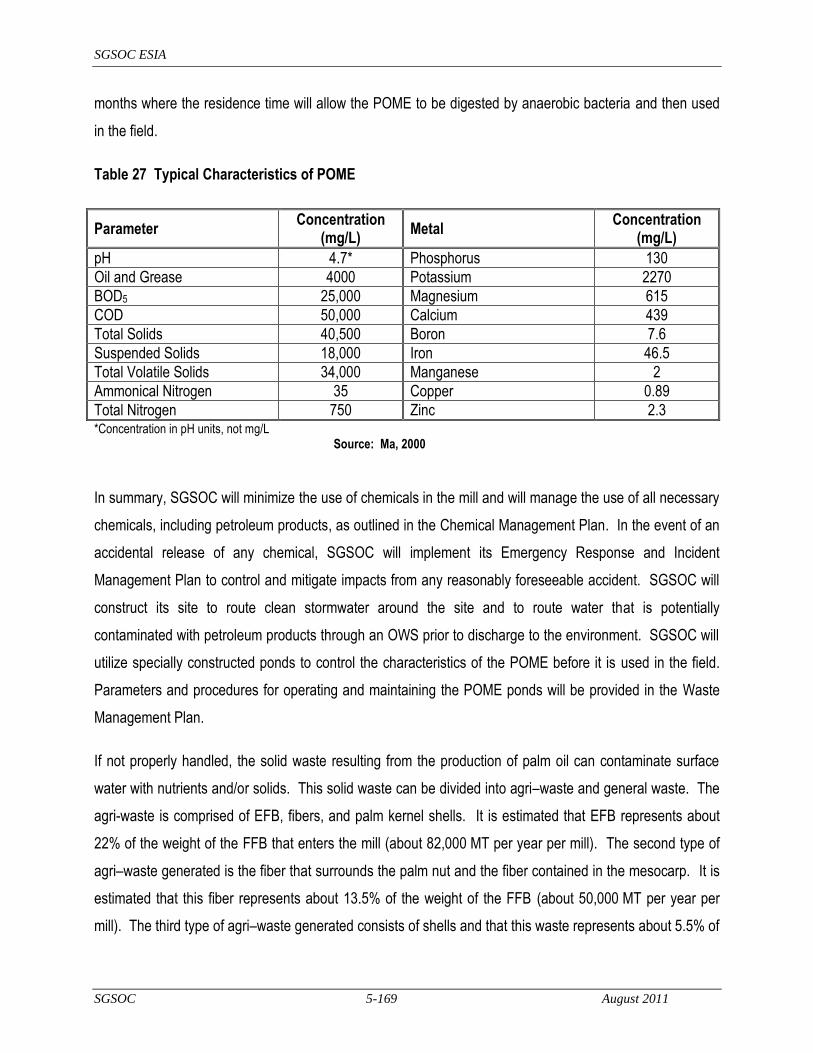
SGSOC ESIA
SGSOC 5-169 August 2011
months where the residence time will allow the POME to be digested by anaerobic bacteria and then used
in the field.
Table 27 Typical Characteristics of POME
Parameter Concentration
(mg/L) Metal
Concentration (mg/L)
pH 4.7* Phosphorus 130
Oil and Grease 4000 Potassium 2270
BOD5 25,000 Magnesium 615
COD 50,000 Calcium 439
Total Solids 40,500 Boron 7.6
Suspended Solids 18,000 Iron 46.5
Total Volatile Solids 34,000 Manganese 2
Ammonical Nitrogen 35 Copper 0.89
Total Nitrogen 750 Zinc 2.3 *Concentration in pH units, not mg/L
Source: Ma, 2000
In summary, SGSOC will minimize the use of chemicals in the mill and will manage the use of all necessary
chemicals, including petroleum products, as outlined in the Chemical Management Plan. In the event of an
accidental release of any chemical, SGSOC will implement its Emergency Response and Incident
Management Plan to control and mitigate impacts from any reasonably foreseeable accident. SGSOC will
construct its site to route clean stormwater around the site and to route water that is potentially
contaminated with petroleum products through an OWS prior to discharge to the environment. SGSOC will
utilize specially constructed ponds to control the characteristics of the POME before it is used in the field.
Parameters and procedures for operating and maintaining the POME ponds will be provided in the Waste
Management Plan.
If not properly handled, the solid waste resulting from the production of palm oil can contaminate surface
water with nutrients and/or solids. This solid waste can be divided into agri–waste and general waste. The
agri-waste is comprised of EFB, fibers, and palm kernel shells. It is estimated that EFB represents about
22% of the weight of the FFB that enters the mill (about 82,000 MT per year per mill). The second type of
agri–waste generated is the fiber that surrounds the palm nut and the fiber contained in the mesocarp. It is
estimated that this fiber represents about 13.5% of the weight of the FFB (about 50,000 MT per year per
mill). The third type of agri–waste generated consists of shells and that this waste represents about 5.5% of

SGSOC ESIA
SGSOC 5-170 August 2011
the weight of the FFB (about 21,000 MT per year per mill). All of these waste streams will be recycled or
used as fertilizer in accordance with the Waste Management Plan to protect surface water resources.
In addition to the agri–waste, the mills will generate general wastes from other sources. The quantities will
be considerably smaller than the agri-waste, but these will require correct recycling or disposal in order to
protect the environment. Some of this waste will consist of hazardous waste, such as discarded car and
equipment batteries, empty drums, paint debris, and hydrocarbon contaminated debris from workshops.
Non–hazardous waste, such as office waste, household waste, paper, cardboard, glass, wood, building
materials, ashes, and rubbish, will also result. The Project will implement its Waste Management Plan to
protect surface water resources.
Implementation of these measures should result in minimal impacts to surface water quality from mill
operation so that they are limited to the local area with a long-term duration, and medium intensity.
Surface Water Quantity – Operation of the mill will consume an average of about 123,500 m3 of ground
and/or surface water per year, depending on the final siting of each mill, with surface water being the
preferred alternative if it is available in adequate quantities and quality without significant impacts to
biodiversity. About half the water input to the system is discharged in the POME, and after treatment is
used for irrigation in the field. Due to the relatively small amounts of water required, the amount of effluent
that will be returned to the surface water after treatment, and the dispersed nature of the mills, this impact is
expected to be local, long-term and low intensity.
Groundwater Quality and Quantity – As noted in Surface Water Quantity above, each mill will use about
123,500 m3 of ground and/or surface water per year, depending on the final siting of each mill, with surface
water being the preferred alternative if it is available in adequate quantities and quality without significant
impacts to biodiversity. About half the water input to the system is discharged in the POME and after
treatment is used in the field. Groundwater wells, if used, would be sited to ensure that the water supply is
sustainable and does not affect off-site users as outlined in the Water Management Plan. As a result,
impacts to groundwater quantity are expected to be long-term, but local and low in intensity.
The same methods used to protect surface water quality will be used to protect groundwater quality in terms
of chemical management (see Chemical Management Plan) and emergency responses in the event of an
accident (see Emergency Response and Incident Management Plan). In addition, the POME ponds will be

SGSOC ESIA
SGSOC 5-171 August 2011
lined with appropriate materials (e.g. laterite, clay) to protect groundwater from contamination due to POME
components (see Waste Management Plan). The impacts to groundwater quality are expected to be short-
term, local and low in intensity.
5.2.6.3 Soil and Topography
Landforms – All landform modifications will occur during mill development as noted above and are
anticipated to result in impacts that will be local, permanent, and negligible intensity.
Soil Erosion – Mill operations will not result in significant potential for soil erosion, as mechanical measures
will have been put in place during mill development. Mill operation will include the monitoring and
maintenance of the permanent erosion control measures implemented during development. As a result of
the above, impacts from soil erosion are anticipated to be local, temporary, and of negligible intensity.
Soil Contamination – During mill operation, chemicals and petroleum products will be used as noted in the
discussion of Water Quality above. SGSOC will implement Project-wide procedures for use of chemicals,
including petroleum products, as defined in the Chemical Management Plan and have in place a plan for
managing spills or releases in the event of an accident (see the Emergency Response and Incident
Management Plan). Any impacts to soil from contamination resulting from accidents would be expected to
be local, temporary, and of low intensity.
5.2.6.4 Flora
Loss of Natural Vegetation – Operation of the mills will not cause the loss of any vegetation beyond that lost
for mill development (see Section 5.2.5). The loss of this natural vegetation can only be mitigated through
by minimizing the clearing to the smallest possible area for the entire Project and by leaving higher quality
forest intact in accordance with RSPO and Best Practices, which SGSOC plans to do. Losses to vegetation
will be long-term, local and high intensity.
Invasive Species – The operation of the mills will require the transport of FFB between the mill and
plantation, and the transport of oil to the end user. These transportation activities increase the risk of
spreading invasive species between areas. SGSOC will implement procedures for plantation operations
(see Section 5.2.4) to monitor for invasive species and treat them should they be found.

SGSOC ESIA
SGSOC 5-172 August 2011
5.2.6.5 Fauna
Loss of Habitat – All habitat loss will occur during the mill development stage. The limited fauna that can
co-exist with human activities and mill operations will re-establish themselves once operations begin.
5.2.6.6 Biodiversity
Loss of Biodiversity – All biodiversity loss will occur during the mill development stage.
5.2.6.7 Human
Employment and Livelihood Activities – At full build-out, each of the five mills is expected to employ 70
people full-time and provide a compensation package that allows workers to improve their standard of living
over subsistence agriculture alternatives. Many of these positions will require technical skills, which will
provide good job opportunities for educated Cameroonians. This will be a positive impact that is medium
intensity, long-term and potentially national in extent.
Education – Workers in the mills will be trained in the technical operation of the mill as well as international
worker health and safety practices (see Health, Safety, and Security Management Plan and Employment,
Training, and Awareness Management Plan), and their children will have access to the schools that
SGSOC will build as part of its infrastructure development. This will be a positive impact that is medium
intensity, long-term, and regional in extent.
Health, Safety and Security – SGSOC‘s full-time employees and their immediate families will be provided
with health services as part of their compensation package. These employees are expected to come mostly
from outside the local area due to the technical nature of the work (estimated 30% local and 70% outside).
Since these positions will be permanent and full-time, it is expected that workers from outside the area will
bring their families and most likely live within residential developments that SGSOC will construct. This
provision of health care services to full-time employees is a medium intensity, long-term and regional
benefit.
Because these will be full-time positions and it is anticipated that workers will bring their families, the
potential for increases in the incidence of communicable or infectious diseases in the local communities,
including sexually transmitted diseases and HIV/AIDS, is much lower than during the construction phase.
To the extent they are or become an issue, these impacts will be mitigated on the construction employee
side by the Health, Safety, and Security Management Plan and Employment, Training, and Awareness

SGSOC ESIA
SGSOC 5-173 August 2011
Management Plan, and on the community side by the community aspects of the Health, Safety, and
Security Management Plan. Due to the above, this is estimated to be a low intensity and local, but long-
term impact.
Cultural Resources – No impacts to cultural resources due to mill operations are anticipated.
5.2.7 Infrastructure Development
SGSOC will use existing roads and bridges outside of the Concession as these are generally adequate, or
the Government plans to upgrade or maintain some of them in the near future (e.g. the Government plans
to resurface and grade the road from Kumba to Mundemba; see Section 3.6.2). In other cases, for example
the road from Mundemba to the entrance of Block B, SGSOC may need to improve about 30 km of road.
SGSOC will need to construct a road network within the Concession for transport among the plantation
estates, mills, nurseries, and social infrastructure. SGSOC will also need to extend the communications
facilities throughout the Concession for use by the Project as well as its employees.
SGSOC expects to export some of the CPO and PKO to the regional market, as well as the global market
through the Port of Tiko or a similar port, where it anticipates constructing about 10 storage tanks on about
5 to 10 ha of land.
In addition to the civil infrastructure described above, SGSOC will construct business and social
infrastructure to support plantation operations and employees. This infrastructure is described in Section
3.7 and generally consists of the following for each Complex, with each Complex being associated with a
mill:
executive bungalows;
staff houses;
workers‘ quarters;
elementary school;
health clinic;
community hall;
office and administrative facilities;

SGSOC ESIA
SGSOC 5-174 August 2011
utilities, including water supply, sanitary wastewater facilities, and electricity; and,
recreational facilities such as football fields.
Impacts from these infrastructure facilities are described below.
5.2.7.1 Air
Combustion Emissions – The vehicles and equipment used to construct or upgrade the infrastructure
facilities will generate for combustion emissions. The impacts of this activity will be local, short-term and
low intensity.
Fugitive Dust - Construction activities will increase the potential for fugitive dust due to earth clearing and
moving, and by vehicle traffic on un-paved roads. SGSOC‘s Traffic and Vehicle Management Plan will
mitigate these impacts. As a result, the impacts during development will be local, short-term and low
intensity.
Noise – Use of heavy equipment during construction will create noise impacts in the immediate area, but
these will be local, short-term and low intensity.
5.2.7.2 Water
Surface Water Quality – Construction activities create the potential for erosion and the use of heavy
machinery on site will require re-fueling and some maintenance activities in the field. The presence of
significant numbers of workers in the field for prolonged periods will increase the probability of sanitary
impacts.
In accordance with RSPO and Best Practices, SGSOC will ensure that its contractors plan for
implementation of erosion and sedimentation control measures prior to the start of clearing and implement
those measures in accordance with the Erosion and Sedimentation Management Plan throughout the
construction process. It will also ensure that its contractors put in place adequate chemical, hazardous
materials, and vehicle management plans to protect surface water supplies during normal construction
activities, and have an adequate Emergency Response and Incident Management Plan to address
reasonably foreseeable accidents. Finally, all contractors will be required to have a Health, Safety, and
Security Management Plan to ensure there are proper facilities to manage sanitary discharges.
SGSOC ESIA
SGSOC 5-175 August 2011
Implementation of these measures should result in the impact from infrastructure construction being local,
short-term, and low intensity.
Surface Water Quantity – Construction of the infrastructure facilities will not consume significant amounts of
surface water. This impact is expected to be temporary, local, and negligible intensity.
Groundwater Quality and Quantity – Construction of the infrastructure facilities should not use significant
amounts of groundwater nor should the changes in land use significantly affect the amount of water that
infiltrates to the groundwater. Construction should not affect groundwater quality unless there is an
accidental spill of chemicals during construction and this potential impact is mitigated by appropriate
controls on the use of chemicals and procedures in the event of a spill or release. As a result, these
impacts are expected to be temporary, local, and negligible in intensity.
5.2.7.3 Soil and Topography
Landforms – Depending on the final site selection, infrastructure development may require some landform
changes, but these are expected to be minor and very localized. Any impacts that do occur will be local,
permanent, and negligible intensity.
Soil Erosion – Clearing of vegetation and earthmoving activities for site development will increase the
potential for erosion. SGSOC will implement a Project-wide Erosion and Sedimentation Management Plan
to manage erosion, including the implementation of erosion control measures at the start of earth moving
activities. As a result, impacts from soil erosion are anticipated to be local, temporary and of low intensity.
Soil Contamination – During infrastructure construction, the primary use of regulated or hazardous
substances will be petroleum products for the heavy equipment with secondary uses related to specific
construction activities. SGSOC will implement Project-wide procedures for use of chemicals, including
petroleum products, and will require its contractor to develop a job-specific Chemical Management Plan and
to have in place an Emergency Response and Incident Management Plan for managing spills or releases in
the event of an accident. Any impacts to soil from contamination resulting from accidents would be
expected to be local, temporary, and of low intensity.
5.2.7.4 Flora
Loss of Natural Vegetation – Construction of the plantation-related infrastructure and facilities will cause the
loss of approximately 2,600 ha of secondary forests over a 4-year period due to clearing required for the

SGSOC ESIA
SGSOC 5-176 August 2011
facilities. Construction of the port facilities may require the clearing and/or filling of up to 10 to 15 ha,
depending on the final location of the port extension. The loss of this natural vegetation can only be
mitigated through by minimizing the clearing to the smallest possible area for the entire Project and by
leaving higher quality forest intact in accordance with RSPO and best practices, which SGSOC plans to do.
Losses to vegetation will be long-term, local and high intensity.
Invasive Species – The construction of the infrastructure facilities is not anticipated to have any significant
risk of spreading invasive species.
5.2.7.5 Fauna
Loss of Habitat – When construction personnel and equipment mobilize to the site and begin clearing, the
mobile fauna will migrate to areas outside the mill and its immediate vicinity, and the less mobile species or
individuals will be lost. SGSOC will ensure that this initial mobilization phase and clearing operations are
conducted according to a Vegetation Clearing and Biomass Management Plan that provides an opportunity
for mobile individuals to migrate outside the area. The individuals that do migrate outside of the area will
compete with existing populations and likely cause changes to the biodiversity for a few kilometers around
each development. The loss of habitat and resulting loss of fauna will be permanent, local (within the
Concession), and high intensity.
5.2.7.6 Biodiversity
Biodiversity Loss – The biodiversity loss from infrastructure construction will be complete due to the land
clearing required. On its own, this biodiversity loss is small in terms of total area required (approximately
2,600 ha for all infrastructure). While this impact will be permanent and high intensity, it will be local in
extent.
Protected Species – SGSOC will use its Flora and Fauna Management Plan to ensure that its site clearing
activities identify and provide agreed, species-specific mitigation measures should any protected species be
encountered during the clearing operations. Depending on the status of the species and agreed mitigation
measures, SGSOC will ensure that the identified individuals are physically moved, encouraged to move on
their own, protected in-place, or not protected.

SGSOC ESIA
SGSOC 5-177 August 2011
5.2.7.7 Human
Employment and Livelihood Activities – Employment will be created during the four-phase infrastructure
development period. Due to the types of construction activities and the quality of the facilities, many of the
jobs will be skilled and performed by contractors from larger cities in Cameroon. This will be a positive
impact that is medium intensity, short-term, and national in extent.
Education – Development of the infrastructure can provide Cameroonian workers with exposure to
international worker health and safety practices (see Health, Safety, and Security Management Plan and
Employment, Training, and Awareness Management Plan). This will be a positive impact that is medium
intensity, potentially long-term, and regional in extent.
Health, Safety and Security – SGSOC will ensure that its contractors provide construction workers with
health services and good workers will be given priority for full-time jobs with the Project. This is a medium
intensity, short-term and local benefit.
Construction workers from outside the area, many of whom could be single males, can bring and/or spread
communicable or infectious diseases to the local communities, including sexually transmitted diseases and
HIV/AIDS. Single workers with money and others that come into the area to exploit the increased economic
activities associated with construction can increase incidents related to alcohol, drugs, and crime. These
impacts will be mitigated on the construction employee side by the Health, Safety, and Security
Management Plan and Employment, Training, and Awareness Management Plan, and on the community
side by the community aspects of the Health, Safety, and Security Management Plan. This is estimated to
be a medium intensity, regional, and short-term impact.
Cultural Resources – Infrastructure facilities will be located to avoid impacts to cultural resources therefore
no impacts are anticipated. This will be done in accordance with the Cultural Heritage Management Plan,
which will include provisions in the event of chance finds in the field. As a result, these impacts are
expected to be negligible, local, and temporary.
5.2.8 Infrastructure Operations
Operations of the infrastructure facilities will include maintenance of roads and bridges, both within and
outside the Concession, maintenance of the tank farm at the port, and operations of the commercial,
residential, utility, educational, health care, religious, and community infrastructure within the Complexes.

SGSOC ESIA
SGSOC 5-178 August 2011
SGSOC expects that about 70% of the workforce will be drawn from the existing residents and the
remaining 30% will come from non-resident workers. SGSOC will provide preferences for residents to take
the jobs and will encourage them to move from their existing villages to the Complexes in order to make
more land available for plantation use and to more efficiently provide services (e.g. utilities, schools, health
clinics) to workers. As a result, SGSOC expects to house approximately 30% of its workforce in the
Complexes that it will build.
Impacts from operating these infrastructure facilities are described below.
5.2.8.1 Air
Combustion Emissions –Combustion emissions will be generated from the transport of people, materials,
and supplies to and from the Complexes and port facilities. Each Complex will have its own electricity
supply provided by the adjacent mill. The impacts of these emissions will be local, short-term and low
intensity.
Fugitive Dust – Operation of the Infrastructure facilities should not contribute to the generation of fugitive
dust in any significant way. Operation of the road network within the plantation, especially unpaved roads,
can create fugitive dust, but the impacts of this dust should be local and negligible intensity, but will likely
extend for the life of the Project.
Noise – Operation of the social infrastructure will create normal community noise for the inhabitants, but this
is expected to be negligible intensity while being local and long-term.
5.2.8.2 Water
Surface Water Quality – Operation of vehicles on the road network creates some potential for accidents and
releases of chemicals to the surface water. Operation of the Complexes with associated needs for waste
disposal and treatment of sanitary discharges creates the potential for contamination of surface water
sources. SGSOC will implement a Waste Management Plan to control domestic and sanitary wastes and
ensure that they do not contaminate surface waters. It will also implement a Chemical Management Plan to
ensure that all chemicals used in health facilities, maintenance shops, and other areas are properly
handled, stored, disposed so that they do not contaminate surface or groundwater. Finally, SGSOC will
implement an Emergency Response and Incident Management Plan to ensure that impacts are properly
addressed in the event of an accident, so that the environment is protected.
SGSOC ESIA
SGSOC 5-179 August 2011
Implementation of these measures should result in the impact from infrastructure operation being local,
long-term, and low intensity.
Surface Water Quantity – SGSOC anticipates using groundwater for domestic water supply, therefore
operation of the infrastructure facilities will not consume significant amounts of surface water. This impact is
expected to be temporary, local, and negligible intensity.
Groundwater Quality and Quantity – Operation of the infrastructure facilities will use primarily groundwater
for domestic supplies. Based on about 300 workers per Estate, 30% of the workers living in Estates, an
average of 6 people per family, and an average of 50 liters of water per person per day, each Estate will
require about 27 cubic meters of water per day from deep wells. Wells will be sited for good quality water,
sustainable provision of water, and avoidance of impacts to other wells in the area. With all these criteria
being met, the impacts on groundwater quantity are expected to be long-term and local, but negligible in
intensity. Measures described above to protect Surface Water Quality will also protect groundwater quality,
thus resulting in an impact that should be local, long-term, and low to negligible intensity.
5.2.8.3 Soil and Topography
Landforms – Any impacts to landforms would have occurred during infrastructure development, therefore
operations will have no incremental impact.
Soil Erosion – Infrastructure operations will not result in significant potential for soil erosion, as mechanical
measures will have been put in place during infrastructure development. Infrastructure operation will
include the monitoring and maintenance of the permanent erosion control measures implemented during
development. As a result of the above, impacts from soil erosion are anticipated to be local, temporary, and
of negligible intensity.
Soil Contamination – During infrastructure operation, chemicals and petroleum products will be used as
noted in the discussion of Water Quality above. SGSOC will implement Project-wide procedures for use of
chemicals, including petroleum products, as defined in the Chemical Management Plan and have in place a
plan for managing spills or releases in the event of an accident (see the Emergency Response and Incident
Management Plan). Any impacts to soil from contamination resulting from accidents would be expected to
be local, temporary, and of low intensity.

SGSOC ESIA
SGSOC 5-180 August 2011
5.2.8.4 Flora
Loss of Natural Vegetation – Operation of the plantation infrastructure will not result in the loss of any
additional amounts of vegetation, therefore the incremental impacts to natural vegetation are insignificant.
Invasive Species – Due to the transportation of people, materials, and supplies between the Complexes and
areas outside the Concession, there exists potential for the introduction of invasive species into the Estates
and then into other areas of the Concession. SGSOC will monitor the occurrence of invasive species and
manage any that are found in accordance with the Flora and Fauna Management Plan. Operation of the
infrastructure facilities is anticipated to have a local and long-term, but negligible impact from an invasive
species perspective.
5.2.8.5 Fauna
Loss of Habitat – All habitat loss will occur during the infrastructure development stage. Fauna that can co-
exist with human activities will re-establish themselves once operations begin.
5.2.8.6 Biodiversity
Loss of Biodiversity – All biodiversity loss will occur during the infrastructure development stage.
5.2.8.7 Human
Employment and Livelihood Activities – At full build-out, the infrastructure facilities will support workers from
outside the area that are paid cash and need to purchase food and services locally, thus providing livelihood
opportunities for local inhabitants that do not work directly for the Project. Potential negative impacts
include dislocations to the community-based economy due to subsistence farmers choosing to work for
SGSOC and possibly increased food insecurity due less self-reliance on food supply. Overall, this will be a
positive impact that is medium intensity, long-term and potentially national in extent.
Education – Part of the infrastructure facilities will be schools to educate the employees‘ children. SGSOC
will also explore cost-sharing options with the Government of Cameroon to extend the Project‘s educational
facilities beyond the workers to include some villages that do not currently have access to schools. This will
be a positive impact that is high intensity, long-term, and regional in extent.
Health, Safety and Security – Exposure to more people from outside can increase exposure to health risks,
but these risks will be decreased during operations because workers should bring their families for full-time
employment. Part of the infrastructure facilities will be health facilities to provide health care to the workers‘
SGSOC ESIA
SGSOC 5-181 August 2011
families. SGSOC will also explore cost-sharing options with the Government of Cameroon to extend the
Project‘s health care facilities beyond the workers to include some villages that do not currently have access
to health facilities. This will be a positive impact that is high intensity, long-term, and regional in extent.
Cultural Resources – Conversion to more of a cash-economy could impacts indigenous cultural values as
the society begins to adopt commercial practices and integrate into the global economy. No direct impacts
to cultural resources due to infrastructure operations are anticipated.
5.3 Summary of Impacts to the Environmental and Social Components
This section consolidates impacts from Section 5.2 for each of the environmental and social components to
determine the significance of the aggregated impacts on that component assuming all proposed mitigation
measures are implemented. If, after the implementation of all proposed mitigation measures a moderate or
major negative impact exists, then that component will be further analyzed and additional mitigation and/or
monitoring measures may be proposed in Section 5.4.

SGSOC ESIA
SGSOC 5-182 August 2011
Medium Affected
Project Phase
Activity/Source of Impact Effects of the Impact
Evaluation of the Importance of the Impact
Intensity Extent Duration Impor-tance
Air Quality
Nursery, plantation, mill and infrastructure development
Combustion emissions due to vehicle and equipment use in site preparation and facility construction
Air pollution in the form of combustion gases and particulates, which will affect the immediate area before being adequately dispersed
Low Regional Short-term Minor
Combustion emissions and clearing of biomass
Creation of GHG from certain combustion gases as well as clearing of biomass that will either decay or be burned, and will therefore contribute to climate change until the plantation areas are replanted
Medium International Short-term Major
Dust and noise due to vehicle and equipment use, and dust due to removal of vegetation
Nuisances in the immediate area of the activity Medium Local Short-term Moderate
Nursery and plantation operations
Combustion emissions due to vehicle and equipment use in transporting people, materials, and FFBs
Air pollution in the form of combustion gases and particulates, which will affect the immediate area before being adequately dispersed
Negligible Regional Long-term Minor
Combustion emissions and re-planting with cover crops and oil palms for production of palm oil, which may be used to offset the burning of fossil fuel
Creation of some GHG due to combustion emissions, with offset due to re-vegetation and possible offset of fossil fuel use
Negligible International Long-term Minor
Dust and noise due to vehicle and equipment use
Nuisances in the immediate area of the activities – constant activities, but in changing locations
Negligible Local Long-term Minor
Oil mill and infrastructure operations
Combustion emissions due to vehicles, and burning mostly of biomass with some secondary fossil fuel for steam and electricity generation; also process emissions
Air pollution in the form of combustion gases and particulates, which will affect the immediate area before being adequately dispersed
Low Regional Long-term Moderate

SGSOC ESIA
SGSOC 5-183 August 2011
Medium Affected
Project Phase
Activity/Source of Impact Effects of the Impact
Evaluation of the Importance of the Impact
Intensity Extent Duration Impor-tance
Combustion emissions and production of palm oil that could offset burning of fossil fuels; use of biomass for steam and electricity generation; digestion of POME, which will create methane and CO2, both GHGs
Creation of GHG that will contribute to climate change, but with offsets due to use of biomass for electricity and steam generation, and possible use of palm oil as fossil fuel replacement
Low International Long-term Major
Dust and noise due to vehicle and equipment use
Nuisances in the immediate area of the mill Negligible Local Long-term Minor
Water Quality and Quantity
Construction of the nursery, plantation, mills and infrastructure
Construction activities including equipment operation, vegetation clearing, and earth moving
Surface water quality could be impacted by erosion, whose potential will be increased, but controlled by implementation of appropriate measures
Medium Local Short-term Moderate
Construction activities use petroleum products and other chemicals that can contaminate surface or groundwater if used improperly or spilled
Low Local Temporary Minor
Construction activities will not use significant amounts of ground or surface water, but may increase the amount of runoff and decrease the amount of infiltration until a cover crop is established
Low Local Short-term Minor
Nursery and plantation operations
Application of pesticides, herbicides, and fertilizers, and potential for runoff to surface water sources
Surface and shallow groundwater quality can be affected by runoff containing chemicals or petroleum products
Medium Local Long-term Moderate

SGSOC ESIA
SGSOC 5-184 August 2011
Medium Affected
Project Phase
Activity/Source of Impact Effects of the Impact
Evaluation of the Importance of the Impact
Intensity Extent Duration Impor-tance
Water use for irrigation and application of pesticides, herbicides, and fertilizers
Surface water quantity will be affected because nurseries will use surface water and the requirements for this water are likely to be highest when natural flows are lowest
Medium Local Temporary Minor
Operations inside the plantation including vehicle usage and worker presence
Operational activities use petroleum products that can contaminate surface or groundwater if used improperly or spilled
Low Local Temporary Minor
Concentrations of workers in the fields for long periods can create sanitary waste runoff to nearby streams
Low Local Temporary Minor
Oil Mill Operations
Mill operations will use chemicals and petroleum products, which have the potential for runoff to surface water sources
Surface and shallow groundwater quality can be affected by runoff containing chemicals or petroleum products
Medium Local Long-term Moderate
Mill operation will use approximately 1 tonne of water for each tonne of palm oil produced
Ground water will most likely be the source and will be drawn from sustainable aquifers; surface water will be supplemented with discharges from digested POME
Low Local Long-term Moderate
Infrastructure Operations
Infrastructure operations will use some chemicals and petroleum products
Surface and shallow groundwater quality can be affected by runoff containing chemicals or petroleum products resulting from spills or improper procedures
Medium Local Temporary Minor
Due to the concentration of people at the residential areas, these will create significant amounts of sanitary and other wastes that must be properly disposed
Improper design or operation of the waste disposal systems could cause contamination of surface or groundwater
Medium Local Long-term Moderate

SGSOC ESIA
SGSOC 5-185 August 2011
Medium Affected
Project Phase
Activity/Source of Impact Effects of the Impact
Evaluation of the Importance of the Impact
Intensity Extent Duration Impor-tance
Infrastructure operation will require about 135-150 m3 per day for each of the infrastructure developments; ground water will most likely be the potable water source and will be drawn from sustainable aquifers
Groundwater will be drawn down locally, but not affected outside the immediate area; some liquid effluents will leach into the ground and others will be discharged to surface water after treatment
Medium Local Long-term Moderate
Landforms All
Site clearing and earthmoving to level sites for building or road construction and terracing slopes for plantation construction will change the topography of the area
Small areas of the Concession that will be occupied by buildings or other infrastructure will be leveled; in the plantation, slopes less than 30 degrees may be terraced, thus changing topography on a permanent basis
Negligible Local Permanent Minor
Soil Construction of mills, and infrastructure
Relatively small areas of land will be cleared of vegetation and earth movement activities will be undertaken in five locations for mills and social infrastructure; erosion control measures will be implemented
Land will be cleared, which could result in increased rainfall runoff that could cause soil erosion and sedimentation
Low Local Short-term Minor
Petroleum products and chemicals will be used during construction; improper use, accidents, or failure to follow proper procedures could cause contamination of soil
Contaminated soil could result in groundwater or surface water contamination, or kill vegetation or wildlife
Low Local Temporary Minor
Construction of nurseries and plantations
Relatively large areas of land will be cleared of vegetation and earth-moving activities may be required on slopes less than 30 degrees to terrace the plantation
Cleared land in large areas will be more likely to have erosion problems prior to being revegetated
Medium Local Short-term Moderate
SGSOC ESIA
SGSOC 5-186 August 2011
Medium Affected
Project Phase
Activity/Source of Impact Effects of the Impact
Evaluation of the Importance of the Impact
Intensity Extent Duration Impor-tance
Petroleum products and chemicals will be used during construction; improper use, accidents, or failure to follow proper procedures could cause contamination of soil
Contaminated soil could result in groundwater or surface water contamination, or kill vegetation or wildlife
Low Local Temporary Minor
Flora
Construction and operation of mills, and infrastructure
Relatively small areas of land will be cleared of vegetation in five locations for mills and social infrastructure
Land will be cleared of natural vegetation and either replaced with man-made structures or limited vegetation
High Local Permanent Major
Construction and operation of nurseries and plantations
Approximately 60,000 ha of secondary forest will be cleared and replaced with oil palms and cover crops
Natural vegetation will be lost and replaced with either nursery activities, or oil palms and cover crops
High Local Permanent Major
Operations of the mills, infrastructure, nurseries, and plantations
Transportation between the Concession and port facilities and other sources of supply for Project operations can bring invasive species into the area; large areas of land will be visited often by people with access to outside areas
Large extent of land in the plantation will be vulnerable to colonization by invasive species, which then have the ability to invade non-plantation areas
Low Regional Long-term Major
Fauna
Construction and operation of mills, and infrastructure
Relatively small areas of land will be cleared of vegetation in five locations for mills and social infrastructure
Mobile fauna will flee to surrounding areas with intact vegetation, if possible, creating increased competition for habitat and resources, and less mobile fauna will be destroyed during the clearing
High Local Permanent Major
SGSOC ESIA
SGSOC 5-187 August 2011
Medium Affected
Project Phase
Activity/Source of Impact Effects of the Impact
Evaluation of the Importance of the Impact
Intensity Extent Duration Impor-tance
Construction and operation of nurseries and plantations
Approximately 60,000 ha of secondary forest will be cleared and replaced with oil palms and cover crops
Mobile fauna will flee to areas within the Concession that will be maintained as conservation zones, or, if possible, will flee outside the Concession to either Protected Areas or other secondary forest where they will compete with existing fauna for habitat; less mobile fauna will be destroyed during the clearing
High Regional Permanent Major
Concentration of fauna in protected areas within the Concession will create easier hunting opportunities for local hunters
Hunting pressure for bush meat will increase in the protected areas within the Concession
High Local Long-term Major
Biodiversity
Construction and operation of the mills, infrastructure, nurseries, and plantations
Approximately 60,000 ha of secondary forest will be transformed into palm plantation along with the development of some industrial, commercial, and residential/social infrastructure
The conversion will significantly reduce existing biodiversity in about 75% of the Concession; stresses will be placed on the remaining 25% of the Concession as well as the areas immediately surrounding the Concession due to the increased demand on habitats both from fauna fleeing into it and higher concentrations of hunting pressure
High Regional Permanent Major
Protected species can be disturbed or destroyed if adequate mitigation measures are not implemented throughout the development process; protected species outside the Concession could be disturbed by fauna migration outside the Concession
Medium Regional Long-term Major
SGSOC ESIA
SGSOC 5-188 August 2011
Medium Affected
Project Phase
Activity/Source of Impact Effects of the Impact
Evaluation of the Importance of the Impact
Intensity Extent Duration Impor-tance
Livelihoods
Construction of the nurseries, plantations, mills, and infrastructure
Approximately 1,000 construction jobs will be created over the course of the 4 development phases
These jobs will have a significant positive influence both on those that secure the jobs as well as people that will sell goods and services to the construction workers and to SGSOC and its contractors
High National Short-term Major
Construction jobs secured by local people will provide experience and skills beneficial to secure permanent employment
Medium Local Short-term Moderate
Clearing of land for the plantation can take land currently used for traditional livelihood activities such as agriculture, collection of NTFPs, and hunting
High Local Long-term Major
Operation of all the facilities
Approximately 7,500 people will be employed by the Project when fully operational
These jobs will have a significant positive influence both on those that secure the jobs as well as people that will sell goods and services to the workers and to SGSOC during operations
High National Long-term Major
Education All Training for construction and operations jobs, and experience gained working those jobs
The training for these jobs will allow the construction workers to gain experience that will prepare them for jobs in the plantation and other jobs requiring basic knowledge of workplace health and safety
Low Regional Short-term Minor
Operation of Infrastructure facilities
Educational opportunities will be provided to the children of plantation workers for free and may be extended to children of non-workers that live within the Concession depending on cost-sharing arrangements with the Government
These opportunities will greatly expand both the numbers of people that will have access to education as well as the quality of that education; transition to a more cash-based economy will also decrease the need for children to choose between school and working on family farms
High Local Long-term Major

SGSOC ESIA
SGSOC 5-189 August 2011
Medium Affected
Project Phase
Activity/Source of Impact Effects of the Impact
Evaluation of the Importance of the Impact
Intensity Extent Duration Impor-tance
Health, Safety & Security
Construction of all facilities
Construction activities are likely to use significant numbers of single men from outside the area
Single men with disposable income increase the potential for health concerns including alcohol, drugs, and sex trade that can expose the local communities to higher incidences of crime and communicable diseases, including HIV/AIDS
High Local Short-term Moderate
Operations of infrastructure facilities
Improved health care facilities will be provided to the plantation workers and may be extended to non-workers that live within the Concession depending on cost-sharing arrangements with the Government
These opportunities will greatly expand both the numbers of people that will have access to health care as well as the quality of that care
High Local Long-term Major
Cultural Resources
All Land clearing activities Potential for destruction or alteration of sacred sites will be mitigated by clear delineation of those sites to be protected
Low Local Short-term Minor
Infrastructure improvements
Roads
Roads will be improved to allow for smooth communication and transportation between the concession area and markets
Local inhabitants will benefit from improved roads which will allow for easier commercial and social travel and communication
High Local Long-term Major
Health, Safety & Security
Wells and piped water
Installation one well in each village Provide access to safe drinking water Low Local Long-term Moderate
Livelihoods Agricultural support activities
Local inhabitatnts will receive support for smallholder outgrower programs and local agricultural production in the form of technical assistance, training, and subsidized inputs
Improved household income and quality of life through greater productivity on existing farmland
Medium Local Long-term Moderate

SGSOC ESIA
SGSOC 5-190 August 2011
Medium Affected
Project Phase
Activity/Source of Impact Effects of the Impact
Evaluation of the Importance of the Impact
Intensity Extent Duration Impor-tance
Livelihoods
Local business development support programs
Local inhabitatnts will receive training, micro-finance, and long term contracts to support the development of secondary markets
Establishment of self-sufficient local businesses
Medium Local Long-term Moderate
Livelihoods Community discretionary funds
Community‘s will receive monthly payments to be used at their discretion
Communities will have the ability to identify and fund projects viewed as valuable to their development
Medium Local Long-term Moderate
Health, Safety & Security
Employee housing
Housing for employees will be constructed and provided to employees when necessary
Employees and their families will have an improved quality of life
High Local Long-term Major
Flora and Fauna
Poaching and wildlife exploitation prevention
Guards, signs, and other expenditures for the prevention of poaching and wildlife exploitation
Anti-poaching and similar protection measures will be more vigorously enforced
Medium Local Long-term Moderate
Government revenues
Payroll taxes Taxes will be paid by SGSOC and its employees
The government will receive significant revenue from taxes associated with operations
Medium National Long-term Major

SGSOC ESIA
SGSOC 5-191 August 2011
5.4 Additional Mitigation Measures
The impacts addressed in the following subsections have been considered for additional
mitigation or monitoring measures because they were considered to be negative and of Major
importance based on the standard mitigation measures incorporated into the basic Project design.
In each case, potential mitigation measures are evaluated and if deemed feasible, are added to
the appropriate management plans described further in Section 7.
5.4.1 Greenhouse Gas Emissions
GHG emissions will come from combustion emissions during construction, but primarily due to
clearing of biomass for nursery, plantation, oil mill, and infrastructure development. The planting
of oil palm trees and cover crops over most of the area cleared will offset the clearing of biomass,
but the total biomass will not be restored. Electricity and steam generation during operations will
come mostly from burning of biomass wastes from the mill operations, and will therefore be GHG
neutral – a benefit over burning fossil fuels. Production of palm oil may offset burning of fossil
fuels if the palm oil increases the total amount of biofuel derived from palm oil. SGSOC may
capture methane (a significant GHG) produced by the digestion of POME and use that as fuel for
the mill.
The major potential measure to decrease this impact is to decrease the amount of land converted
from secondary forest to oil palm plantation, but doing so will also decrease the benefits from the
Project including improved opportunities and access for employment, education, and health care,
all of which are major benefits.
Due to the major socioeconomic benefits provided by the conversion of secondary forest to palm
plantation, no additional mitigation measures are recommended for this impact. It is
recommended that SGSOC place a strong emphasis on implementing methane capture at the
palm oil mills.
5.4.2 Loss of Natural Vegetation
Natural vegetation in the form of secondary forest will be cleared for Project development. Buffers
of existing vegetation will be maintained between the plantation and both KNP and the BMW
Sanctuary, and buffers will be maintained around waterways. In addition, HCVF including primary

SGSOC ESIA
SGSOC 5-192 August 2011
forests, vegetation on steep slopes (greater than about 30º), and sacred sites, as well as
agricultural land used by the villages within the Concession, will remain.
As noted in Section 5.4.1 above, clearing this land is necessary for numerous and significant
socioeconomic benefits. No mitigation measures other than decreasing the plantation size is
available to significantly mitigate the loss of natural vegetation, therefore no additional mitigation
measures are proposed for this impact.
5.4.3 Risk of Invasive Species
The risk of invasive species in the Concession is increased due to the increased communication
between the Concession and other areas within Cameroon, especially the port from which
supplies will be sourced and to which palm oil will be transported. This risk is increased due to the
agricultural nature of the Project and the potential impacts of the risk are increased due to the
proximity to the KNP and BMW Sanctuary.
The Project will monitor the occurrence of invasive species both to protect the natural environment
and to protect the plantation against all types of pests. If invasive species are identified, they will
be eradicated by manual methods if possible, then by biological methods, and finally by chemical
means.
In order to reduce the risk from invasive species further, the monitoring program for the Project
should be enhanced to track what types of invasive species occur, where they occur, how they
were most likely introduced to the area, how they were eradicated, and the success of the various
eradication measures. If the Project identifies a continuing problem with invasive species, it
should determine the root cause of that problem and investigate additional measures to address
that root cause.
5.4.4 Loss of Fauna in the Concession
Loss of fauna in the Concession is related to the loss of natural vegetation in the form of
secondary forest that will be cleared for Project development. Buffers of existing vegetation will
be maintained between the plantation and both KNP and the BMW Sanctuary, and buffers will be
maintained around waterways. In addition, HCV forest areas including primary forests, vegetation
on steep slopes (greater than about 30º), and sacred sites as well as agricultural land used by the
villages within the Concession will remain untouched by the Project. Fauna will be able to use

SGSOC ESIA
SGSOC 5-193 August 2011
these areas for habitat, but the decrease in total available habitat will result in an overall loss of
fauna.
As noted in Section 5.4.1 above, clearing this land is necessary for numerous and significant
socioeconomic benefits provided by the Project. No mitigation measures other than decreasing
the plantation size is available to significantly mitigate the loss of fauna, therefore no additional
mitigation measures are proposed for this impact.
5.4.5 Loss of Fauna Outside the Concession
The composition of fauna populations outside the Concession will be impacted by clearing and the
migration of some mobile fauna from the cleared area to uncleared areas. The Project is
mitigating impacts on the KNP and BMW Sanctuary by providing for buffer zones within the
Concession between cleared areas and these protected areas of 3 km and 100 m, respectively.
Part of the purpose of these buffer zones is to absorb and attenuate the changes in fauna
populations before those changes can reach the protected areas.
As noted in Section 5.4.1 above, clearing this land is necessary for numerous and significant
socioeconomic benefits provided by the Project. The Project could increase the size of these
buffer zones to mitigate this impact, but this would require a corresponding decrease in the
plantation size, therefore no additional mitigation measures are proposed for this impact.
5.4.6 Increased Hunting Pressure Inside the Concession
The loss of secondary forest will decrease the amount of area available to hunters, thus
increasing the hunting pressure in the remaining areas. This will cause a further decrease in
fauna populations in the areas with natural vegetation and will adversely affect livelihoods that
depend on hunting inside the Concession. The Project can contribute to local hunting pressure by
creating a larger market for bush meat due to the much larger cash economy that it creates. By
providing other livelihood opportunities, the Project can decrease the incentives to practice
hunting.

SGSOC ESIA
SGSOC 5-194 August 2011
As noted in Section 5.4.1 above, clearing this land is necessary for numerous and significant
socioeconomic benefits provided by the Project. In order to decrease the demand for local bush
meat, SGSOC should take the following measures:
decrease hunting pressure in the Concession by ensuring that adequate supplies of meat
other than local bush meat as well as other protein sources are available in stores and
markets within the Concession;
educate its employees on the adverse impacts of hunting and consuming bush meat;
to the degree possible, prohibit and enforce prohibitions on hunting inside the Concession;
sponsor education programs in local villages about the adverse impacts of hunting and
consuming bush meat; and,
sponsor programs to transition hunters to other, sustainable livelihood activities.
5.4.7 Loss of Biodiversity Inside the Concession
Loss of biodiversity in the Concession is due to the loss of natural vegetation in the form of
secondary forest that will be cleared for Project development, and fauna that will flee or be
destroyed by the vegetation clearing activities. The area chosen for the Project is an area
designated by the Government for agricultural development because it was previously disturbed.
Within the Concession, HCV forest areas including primary forests, vegetation on steep slopes
(greater than about 25º), and sacred sites as well as agricultural land used by the villages within
the Concession will remain untouched by the Project, thus preserving some of the local
biodiversity. In addition, buffers of existing vegetation will be maintained between the plantation
and both KNP and the BMW Sanctuary, and buffers will be maintained around waterways, thus
preserving other areas of biodiversity.
As noted in Sections 5.4.3 and 5.4.6 above, SGSOC will control invasive species and increased
hunting pressure, each of which could adversely affect biodiversity inside the Concession.
However, as noted in Section 5.4.1 above, clearing this land is necessary for numerous and
significant socioeconomic benefits provided by the Project. No mitigation measures other than
decreasing the plantation size is available to significantly mitigate the loss of biodiversity, therefore
no additional mitigation measures are proposed for this impact.
SGSOC ESIA
SGSOC 5-195 August 2011
5.4.8 Loss of Biodiversity Outside the Concession
The biodiversity outside the Concession will be impacted primarily by the migration of some
mobile fauna from the cleared area to uncleared areas. The Project is mitigating impacts on the
KNP and BMW Sanctuary by providing for buffer zones within the Concession between cleared
areas and these protected areas of 3 km and 100 m, respectively. Part of the purpose of these
buffer zones is to absorb and attenuate the changes in fauna populations before those changes
can reach the protected areas.
As noted in Sections 5.4.3 and 5.4.6 above, SGSOC will control invasive species and increased
hunting pressure, each of which could adversely affect biodiversity outside the Concession.
However, as noted in Section 5.4.1 above, clearing this land is necessary for numerous and
significant socioeconomic benefits provided by the Project. No mitigation measures other than
decreasing the plantation size is available to significantly mitigate the loss of biodiversity, therefore
no additional mitigation measures are proposed for this impact.
5.4.9 Loss of Traditional Livelihood Activities Inside the Concession
Traditional livelihood activities inside the Concession such as subsistence agriculture, gathering
and use of NTFPs, and hunting will be adversely impacted by the Project due primarily to the loss
of land available for these activities as a result of vegetation clearing and conversion to oil palm
plantation. These activities can be replaced to a large degree by full-time employment provided
by the Project. Additionally, these activities can continue to be practiced, but likely to a lower
intensity level, within the areas that will not be cleared by the Project.
In order to mitigate this impact, SGSOC should implement the following:
when demarcating areas for villages to maintain their livelihood activities, take into
consideration either the maintenance of areas currently used for those purposes, or consult
with villages on options to enhance the livelihood opportunities within areas otherwise
demarcated for village purposes;
develop options and provide training for livelihood opportunities to replace those based on
NTFPs, and other land or resources that would be cleared for the Project; and
develop options and provide training for use of replacements to medicinal plants or other
resources currently sourced from the forest that would be cleared for the Project.
SGSOC ESIA
SGSOC 5-196 August 2011
5.4.10 Increased Health Risks During Construction
Construction activities can draw significant numbers of single men and others attracted by the
opportunity to provide goods and services to construction workers with disposable income. Some
of these activities such as alcohol, drugs, and sex trade can lead to increased crime and diseases,
including HIV/AIDS. The Project will attempt to recruit most of its construction workers from the
immediate area, thus minimizing the number of single men migrating for work. SGSOC will also
ensure that it and its contractors provide adequate training and enforcement of codes of conduct
to minimize worker participation in risky activities.
In order to further mitigate this potential impact, SGSOC should conduct community training and
awareness programs to ensure that the local population understands the risks of participating in
risky economic activities for short-term economic gain. SGSOC should coordinate with local
Government Officials to ensure that they fully understand the risks of such behaviors and support
SGSOC‘s efforts from a law enforcement perspective.

SGSOC ESIA
SGSOC 6-197 August 2011
6 Public Consultations
6.1 Introduction
The section on public consultations provides an overview of the consultation carried out for the ESIA at
the time of preparation of this report. It also highlights some of the key issues raised and proposed
recommendations. The main objectives of the public consultations undertaken with the ESIA process
have been to:
introduce the Project to key stakeholders;
adhere to the public consultation requirements of Cameroon legislation and the IFC Standards; and,
understand and address stakeholders‘ issues and concerns.
Public Consultation, according to the IFC, “is a tool for managing two-way communication between the
project sponsor and the public. Its goal is to improve decision-making and build understanding by
actively involving individuals, groups and organizations with a stake in the project. This involvement will
increase a project’s long-term viability and enhance its benefits to locally affected people and other
stakeholders.” (Source: IFC, 1998).
In accordance with IFC and World Bank guidelines, the Project has placed consultation at the center of
its activities that affect the local community. Consultation with the affected population, Government
entities, NGOs, development organizations and other stakeholders is essential for gaining a
comprehensive understanding of the potential impacts resulting from the Project. In cases of potential
adverse impacts, consultations help inform SGSOC of appropriate mitigation strategies. In cases of
potential positive impacts, consultations help inform SGSOC of appropriate enhancement strategies.
Decree 0577 of the Cameroonian Environmental Law provides the following requirements for
consultation:
the determination of the acceptability of the ESIA involves consultation and public hearings;
the promoter must provide 30 days notification prior to the first consultation meeting; and,
minutes of all meetings must be included in the ESIA report.

SGSOC ESIA
SGSOC 6-198 August 2011
6.2 Methodology
Public consultations have been an integral and on-going part of the ESIA process for the Project.
Methods used during the public consultations have included: public hearings, open houses, focus
groups, administration of village and household questionnaires and production of participatory maps for
the socioeconomic and needs assessment surveys.
Specific objectives pursued during the public consultations have included:
provision of information to stakeholders;
gathering of information on various environmental and social aspects; and,
collection of input from stakeholders on the planned Project including its scale, timing, ways to
reduce its potential negative impacts and ways to enhance its potential positive impacts.
In accordance with the 2005 Cameroon Law on Environmental Impact Assessment and the
accompanying Terms of References for the Project approved by MINEP, a program on public
consultation was established for the proposed SGSOC palm oil Project in the Nguti, Mundemba and
Toko Sub-divisions in the Southwest Region of Cameroon.
The public consultations team included:
Mrs. Haman Bako Salamatou (Director of H & B Consulting);
Dr. Timti Isidore (Managing Director of SGSOC);
Dr. Andrew Allo (Consultant of H & B Consulting);
Mr. Chi Napoleon Forpah (Consultant of H & B Consulting); and,
Mrs. Luisa Feliciano (H & B Consulting USA).
Minutes of the different public consultation meetings are provided in Annex 6.
6.3 Project Stakeholders
Public consultations were carried out amongst the affected communities, NGOs, and Government
agencies, all of which provided valuable information regarding the nature and extent of potential social
and environmental impacts associated with or resulting from the proposed Project.
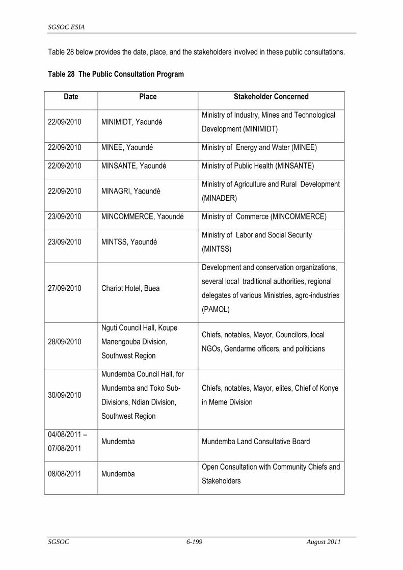
SGSOC ESIA
SGSOC 6-199 August 2011
Table 28 below provides the date, place, and the stakeholders involved in these public consultations.
Table 28 The Public Consultation Program
Date Place Stakeholder Concerned
22/09/2010 MINIMIDT, Yaoundé Ministry of Industry, Mines and Technological
Development (MINIMIDT)
22/09/2010 MINEE, Yaoundé Ministry of Energy and Water (MINEE)
22/09/2010 MINSANTE, Yaoundé Ministry of Public Health (MINSANTE)
22/09/2010 MINAGRI, Yaoundé Ministry of Agriculture and Rural Development
(MINADER)
23/09/2010 MINCOMMERCE, Yaoundé Ministry of Commerce (MINCOMMERCE)
23/09/2010 MINTSS, Yaoundé Ministry of Labor and Social Security
(MINTSS)
27/09/2010 Chariot Hotel, Buea
Development and conservation organizations,
several local traditional authorities, regional
delegates of various Ministries, agro-industries
(PAMOL)
28/09/2010
Nguti Council Hall, Koupe
Manengouba Division,
Southwest Region
Chiefs, notables, Mayor, Councilors, local
NGOs, Gendarme officers, and politicians
30/09/2010
Mundemba Council Hall, for
Mundemba and Toko Sub-
Divisions, Ndian Division,
Southwest Region
Chiefs, notables, Mayor, elites, Chief of Konye
in Meme Division
04/08/2011 –
07/08/2011 Mundemba Mundemba Land Consultative Board
08/08/2011 Mundemba Open Consultation with Community Chiefs and
Stakeholders

SGSOC ESIA
SGSOC 6-200 August 2011
6.4 Summary of Consultations
The main concerns of the stakeholders included:
Concern Response
Confusion about whether or not the outcome of the land lease was still pending
The land lease is inclusive of the Establishment Convention and provides a secure 99-year lease which was communicated at the open consultation.
Palm plantations may decrease the biodiversity of the surrounding area
While the palm plantation will create a monoculture within much of the Concession land, the surrounding areas will be protected through buffer zones, mitigation initiatives, and conservation efforts.
Potential overlap areas between community forest for which the Nguti Council has applied and the Concession
The borders of the Concession purposefully go around or identify the existing areas of community forest to avoid overlap between the two.
The rate of conversion of land into plantations is not clear
The land will be cleared in four phases, beginning with land near the nursery sites and roads, as laid out in this document.
The demarcation strategy and criteria were still not clear, particularly in regards to the creation of the nursery at Talangaye
SGSOC, the communities and the Government of Cameroon are in the process of jointly developing a long term strategy for the demarcation of existing and future farmland to ensure proper boundaries are always respected. It is SGSOC‘s policy to minimize its impact on the existing community boundaries.
Primary forest and species of high conservation value may be lost
SGSOC is committed to protecting HCV areas and species and has undertaken multiple environmental studies to understand and identify potential HCV zones. Any HCV zones identified will be demarcated and protected or mitigated appropriately in accordance with RSPO, IFC, and other internationally recognized best practice guidelines
There was concern that terms of the MOU were not being respected
It is SGSOC‘s priority to follow the terms and conditions contained within the MOU and related documents. SGSOC has hired community representatives (Community Development Officers, or CDOs) from every clan with whom community members can communicate as part of the grievance policy laid out in Section 8.3.
The previous socioeconomic survey was not properly done
SGSOC had discussed this survey with the local communities and learned that the contractor did not visit every community as agreed. SGSOC undertook a new socioeconomic survey with a new contractor in order to obtain a better survey data set about the local communities and their needs.

SGSOC ESIA
SGSOC 6-201 August 2011
Concern Response
Land ownership issues are very complex
SGSOC recognizes legal land ownership rights, but will not attempt to establish or formalize them, as it recognizes those decisions are the priority of the local communities and Government. Demarcation activities identifying current village areas and growth zones and palm oil land will be done in close consultation with the villages and Government officials to obtain their approval and agreement.
SGSOC should employ the local population before the non-locals
SGSOC will have a wide range of positions for its operations which it will fill predominantly with individuals from the local population; SGSOC has already done so at the nursery sites and in its management group. To date, SGSOC has employed only 0.01% of its planned workforce, the majority of which come from the local communities. SGSOC will not, however, make a policy of excluding workers from other parts of Cameroon.
Confusion in regards to the company‘s names and their respective meanings (Sithe Global, Herakles Farms, and SGSOC)
The name of the local company is SG Sustainable Oils, Cameroon, Ltd. (SGSOC). SGSOC is owned by the American company, Herakles Farms. Sithe Global is related to Herakles Farms only in that it shares some of the same senior management, but it is no longer associated with SGSOC or Herakles Farms.
Whether or not the MOU is the ideal step towards addressing the community‘s needs
The MOU is a strong first step for developing a long and cooperative relationship between SGSOC and the local communities in which both groups are positioned to respond to one another‘s needs. CDOs, formal discussions, and informal conversations will help complement and shape the mechanisms guiding this long-term relationship.
Overlap of SGSOC‘s Project Area with farmlands and issues of compensation
The development of the plantation will not require the relocation of existing farms or houses. The boundaries of the Project are being established in the jointly drafted demarcation plan.
Diseases non-locals may bring to the population.
Part of SGSOC‘s commitment to the local communities and employees is to establish a healthcare system that focuses on illness prevention and treatment, which should mitigate this concern.
Some recommendations by the Government of Cameroon to SGSOC during the consultations included:
obtain information about similar projects being carried out in Cameroon and how those projects
handle community engagement, as well as social and environmental issues (to help inform best
practices);
obtain permits from MINEE to exploit water and to discharge waste water;
write to MINSANTE for support and guidance from some of their funded programs;
SGSOC ESIA
SGSOC 6-202 August 2011
consult with various regional delegations of the Ministries, which are well placed to assist with some
practical recommendations; and,
parents should start training their children in certain strategic fields linked to the Project.
The public consultation process is ongoing and will continue throughout Project implementation.
6.5 Planned Consultations
SGSOC has held several consultations with various stakeholders such as those outlined in Table 7-1.
Upcoming activities are listed below.
Recruit CDOs from each of the clans representing the entire Concession. This will enhance
communication about the Project activities and plans, as well as provide feedback about from the
local communities about the concerns and needs of the population.
SGSOC will participate in the public review of the ESIA in the local communities.
SGSOC will actively participate in the Governmental review of the ESIA such as the MINEP, MINEE
and other Government agencies.
An SGSOC representative will accompany the Divisional Officer (DO) from Nguti on his
introductory tour of the local villages.
SGSOC will host a meeting in Mundemba with village Chiefs and Government officials.
SGSOC is committed to transparent communications with the local communities, Government
and other stakeholders. In addition to the multiple informal interactions, SGSOC will arrange
formal discussions at the commencement or completion of major activities.

SGSOC ESIA
SGSOC 7-203 August 2011
7 Environmental and Social Management Plan
7.1 Introduction
The chapter will assist in summarizing the possible preventive, remedial or compensatory measures for
each of the adverse impacts evaluated as significant in Section 5. The implementation of the mitigation
measures will be ensured through the Environmental and Social Management Plan (ESMP), as outlined
in this section.
The objective of the ESMP (sometimes called the ―Environmental and Social Action Plan‖) is to outline
the arrangements relating to:
the identification of environmental and social impacts arising from SGSOC‘s activities;
proposed mitigation measures corresponding to each of the impacts identified, and the
implementation of such mitigation measures;
the program to monitor proposed mitigation measures; and
the budgetary allocations for the implementation.
The ESMP is conceived to ensure that the impact mitigation measures proposed in the ESIA are
effectively implemented and that the proposed measures are not just a statement of good will made by
SGSOC.
This ESMP contains descriptions of the mitigation and monitoring measures to be adopted by SGSOC,
which must be integrated into the Project‘s budget and implementation plan.
The ESMP is a living document, and as it is further developed, it will be presented in tabular format,
outlining each impact in accordance with the corresponding Project phase, mitigation measure, related
action, the person or entity responsible for implementing each measure or action, details of the
mechanisms that will be used to monitor each measure or action and the performance criteria to be
utilized in order to define or measure the success or failure of the measure or action.
To help implement the ESMP, HSE issues will be discussed at monthly staff meetings. The meetings
will address pertinent issues for the current phase of works, significant non-compliances with the ESMP,
and major actions needed to maintain compliance with the ESMP.

SGSOC ESIA
SGSOC 7-204 August 2011
In addition, each contractor working for SGSOC will be required to appoint a qualified Health, Safety
and Environment Officer (HSEO) prior to starting on-site work. This ESMP provides a framework for
plantation development activities from construction through operations. This framework must then be
updated and made site- and Project-specific prior to the start of on-site work.
The preparation of this ESMP takes into consideration and is based on:
the description of the environmental and social impacts identified in the ESIA;
the description of any mitigation measures recommended in the ESIA;
elements of Cameroon legislation that may be applicable; and
generally accepted best environmental and social practices as adopted by the World Bank, the
RSPO, the European Union, and the United States of America.
The monitoring program will be based upon the ESMP, be structured to ensure that mitigation measures
are having the anticipated and desired outcomes, and include the following:
the frequency and location of sampling that may be required;
the impact indicators;
the proposed procedures to be monitored, such as waste management; and
the need for written documentation to be available for future reference and guidance.
7.2 Organizational Responsibility
SGSOC retains ultimate responsibility for development and implementation of the ESMPs for the
Project. SGSOC will assign this responsibility to its Health, Safety, Environment, and Community
(HSEC) manager, who will report directly to the General Manager.
7.3 ESMP Measures
The following sections provide a framework for the content of the ESMPs envisioned for the Project. As
the Project progresses through development, these ESMPs will be expanded to include specific
procedures to guide implementation by Project personnel and contractors, and to provide for periodic
updating, as necessary.

SGSOC ESIA
SGSOC 7-205 August 2011
7.3.1 Flora and Fauna Management Plan
The primary purpose of the Flora and Fauna Management Plan is to protect the biodiversity of the area
from any unintended damage due to Project development and operation, and to protect Project
personnel from dangers associated with the native flora and fauna. This plan will include the following
provisions as well as others that may be identified as it is further developed:
Animals shall not be handled, removed, killed or unnecessarily disturbed by SGSOC or its
employees, or by SGSOC‘s contractors‘ or their subcontractors‘ employees.
SGSOC will not tolerate poaching of fauna or flora by its personnel or by any of its contractors or
subcontractors or suppliers on the Concession.
SGSOC will ensure through a HCV study that all HCVF sites are properly marked and left
untouched.
SGSOC will create a buffer zone of about 3 km between its plantation and the KNP to protect the
KNP and help maintain the integrity and quality of biodiversity in that legislatively protected area.
The BMW Sanctuary has no management plan and no formal buffer zone. SGSOC will create a
new, 100 m buffer zone in its Concession between the Sanctuary and the plantation, and will use
that buffer zone along with the Mbu River to help maintain the integrity and quality of biodiversity in
the Sanctuary.
SGSOC will also work closely with the KNP and BMW Sanctuary management to help minimize the
impacts of the SGSOC plantation on these protected sites.
SGSOC identified the presence of eight tree species on the IUCN Red List, with six being classified
as VU, one EN, and one as NT. All of these species are abundant in the lowland rain forest region
of Cameroon and are not endemic to the Concession. Since the resulting impact will be minor,
mitigation measures will consist of identifying locations of the one endangered species, collecting
seeds, if practical before it is cut, and distributing those seeds in suitable sections of HCVF within
the Concession.
Land clearing operations are expected to drive wildlife away from the clearing operations, however,
if any species classified as EN by IUCN or otherwise protected by the Cameroon Wildlife Law
moves from the protected areas into the Concession and is trapped or hurt during land clearing
operations, the MINFOF Divisional Wildlife Services will be informed to determine whether trans-
location or other actions are required to save the individual. SGSOC will allocate funds for such an
eventuality.

SGSOC ESIA
SGSOC 7-206 August 2011
SGSOC will manage the potential human–elephant conflict by using the WWF Better Management
Practice (Source: Chong Kah Fui, 2005). These practices may include some or all of the following
depending on the site-specific requirements:
establishment of a buffer zone as proposed for both KNP and the BMW Sanctuary;
establishment of a corridor to facilitate elephant movement;
installation of electric fences that do not cause harm to the elephants‘ health;
establishment of trenches that do not endanger the elephants (see figure 8-1 on the
next page);
use of repellents that are safe for the environment and the health of elephants; and,
a careful watch over the plantation.
The SGSOC Concession is 73,086 hectares. The development of this area is to occur over a period
of four phases. SGSOC should plan its development in advance to minimize the impact on the
fauna, help identify and control impacts such as flood zones and to result in a lower amount of
biomass to manage.
SGSOC shall monitor the general condition of the aquatic habitat downstream of its nurseries to
ensure that its water withdrawals are not creating significant stresses to that habitat and if so,
SGSOC shall develop plans to install wells to replace enough of the surface water usage to mitigate
the significant impacts.
SGSOC shall ensure that the site is kept clean, tidy and free of garbage that would attract animals.
In order to reduce the risk from invasive species, the monitoring program for the Project should
track what types of invasive species occur, where they occur, how they were most likely introduced
to the area, how they were eradicated, and the success of the various eradication measures. If the
Project identifies a continuing problem with invasive species, it should determine the root cause of
that problem and investigate additional measures to address that root cause.
In order to decrease the demand for local bush meat, SGSOC should take the following measures:
decrease hunting pressure in the Concession by ensuring that adequate supplies of
meat other than local bush meat as well as other protein sources are available in stores
and markets within the Concession;
educate its employees on the adverse impacts of hunting and consuming bush meat;

SGSOC ESIA
SGSOC 7-207 August 2011
to the degree possible, prohibit and enforce prohibitions on hunting inside the
Concession;
sponsor education programs in local villages about the adverse impacts of hunting and
consuming bush meat; and
sponsor programs to transition hunters to other, sustainable livelihood activities.
SGSOC will work with conservation groups and other stakeholders around the Project Area to
help prevent poaching. Initiatives may include hiring guards, posting signs among others.
[Source: WWF Better Management Practice (Chong Kah Fui, 2005)]
Figure 28 Typical Elephant Trench
7.3.2 Waste Management Plan
The primary purpose of the Waste Management Plan is to ensure that wastes are minimized and any
wastes that are generated are properly managed and disposed to avoid damage to the environment.
This process can be expressed as follows:
minimize waste production as much as possible;
if waste is produced, reuse or recycle that waste as much as possible;
if reuse or recycling is not possible, the waste should be treated, neutralized, or transformed into inert materials; and

SGSOC ESIA
SGSOC 7-208 August 2011
if this is not possible, the waste must be disposed in a way not harmful to the environment or to human beings.
The following summarize important elements of a Waste Management Plan:
the plan must establish the responsibility for waste management at each department level (e.g.
plantation, mill, workshops) and appoint an overall Waste Management Supervisor, who must be
fully trained in the implementation of the Waste Management Plan;
the Project must develop a list of all wastes generated at the different facilities with estimated
quantities of each on a monthly basis or other time interval, particularly Hazardous Wastes;
the Project must provide well labeled storage bins for the different categories of waste in specially
designed plastic or metal bins so that each type of waste can be treated or disposed of as
necessary;
Hazardous Wastes must be properly disposed based on their specific properties as noted in
Material Safety Data Sheets (MSDS) and may not be disposed with non-hazardous wastes;
Hazardous Waste at the Project is expected to be primarily composed of the following:
empty agrochemical substances containers (e.g. fertilizers, pesticides, fungicides);
empty petrochemical substances containers (e.g. oil, grease, lubricants);
used lubricants; and
used towels soaked with oil and grease or lubricants;
Hazardous Wastes cannot be mixed unless specifically noted in the plan;
the Project must establish a list of accredited waste disposal contractors and obtain a Certificate of
Accreditation from each to ensure that they are operating legally;
the Project must have accredited waste disposal contractors for the following items and activities:
used engine oil recycling contractor/facility;
lead and lead battery recycling contractor (also other heavy metal pollutants);
tire and rubber recycling contractor;
plastic recycling contractor, particularly for plastic containers which must be rinsed prior
to disposal (note – do not burn PVC in open air because dioxins and furans can be
generated);
SGSOC ESIA
SGSOC 7-209 August 2011
used batteries (not car and equipment batteries) and e-waste (electronic waste)
recycling/exporting contractor;
Hazardous Waste incineration contractor (for incineration at high temperatures in
specially constructed incinerators); and
domestic waste collection contractor;
the Project must track all hazardous waste disposal activities using an appropriate Waste Manifest
Form and all completed forms shall be kept for record purposes;
the Project should periodically (e.g. every six months) reconcile its estimated disposal quantities
with the waste manifests and other records of actual wastes generated, and investigate any
significant discrepancies;
the Waste Management Supervisor must ensure that periodic inspections are conducted of waste
management practices to ensure compliance with this plan.
7.3.3 Erosion and Sedimentation Management Plan
The Erosion and Sedimentation Management Plan will provide guidance to control soil erosion and the
transport of sediment to surface waters. Soil erosion is a major soil degradation process affecting the
soil quality not only by directly reducing nutrients and organic matter levels, but also by affecting soil
properties such as infiltration rates.
Erosion could occur during forest clearing and plantation establishment when the soil is left uncovered.
Related activities that could cause this erosion include establishment of the base camps, construction of
access roads and development of drainage works. The top layer of soil is the most vulnerable and
unfortunately tends to be the most fertile soil.
Soil suspended as solids in the water column can physically enter waterways and obstruct them. Soil
erosion can also transport agrochemicals such as fertilizers and pesticides, which adhere to the
suspended solids.
All exposed soil areas in the Project will be managed through a diversified set of measures and
strategies that minimize the risk of erosion and run-off, control the flow of storm water over exposed soil
areas, retain sediments within the cleared areas as much as possible, and control erosion and run-off
downstream of the cleared areas. These measures are grouped and presented below.
SGSOC ESIA
SGSOC 7-210 August 2011
The Company will monitor effectiveness of erosion and run-off control through systematic verification of
compliance with control measures implemented through monitoring of impacts to surface water quality
downstream (turbidity) and run-off accumulation at streams and natural drainage channels downstream
of construction fronts.
Erosion and runoff will be minimized through the implementation of the following types of measures:
Vegetated buffer zones will be protected along streams to help control sedimentation.
Leguminous cover crops will be used to help minimize soil erosion, and assist soil conservation and
moisture retention by intercepting rainfall (absorbing the energy of the raindrops, thus reducing
runoff), decreasing surface velocity, restraining soil movement, improving soil porosity, and,
increasing biological activity in the soil.
Site clearing operations will progress in a gradual and phased manner to ensure there are no large
increases in sediment discharge.
While vegetation clearing and earthmoving activities are in progress and permanent erosion control
devices cannot be implemented, temporary erosion control devices will be used.
As a rule, the only rainwater that will be allowed to flow over cut and fill slopes is that which falls
directly on them. All exposed soil working surfaces will be tilted towards the base of cut slopes and,
where this is not possible, measures such as berms will be installed at the upper limits of fill slopes
to minimize uncontrolled storm water flow over them.
Slopes of all cut and fill areas will be rigorously controlled and will at no time be allowed to be
greater than the slope established in the final design.
Temporary protection of exposed soil surfaces with measures such as plastic film, bio-membranes
or other means, will be implemented whenever necessary.
Permanent erosion control on may be achieved through measures such as terracing along with a
re-vegetation program. The terraces would consist of low, broad-based earth levees constructed
approximately parallel to the contours designed to intercept overload flow before it achieves great
erosive force and to conduct it to a suitable discharge point.
Erosion protection such as riprap, or sacked concrete may be used around culvert entrances.
Inlet structures used to collect storm run-off will be constructed of any suitable construction material.
The structures will ensure efficient removal of design-storm runoff in order to avoid interruption of
SGSOC ESIA
SGSOC 7-211 August 2011
construction during or following storms and to prevent erosion resulting from overtopping of the
inlet.
Piles of soil or other materials will be allowed for short periods of time and will be located only in flat
areas and away from any stormwater courses. Only topsoil piles will be allowed to remain for
extended periods and will be protected from rainfall.
Stormwater will be controlled through the implementation of the following types of measures:
All flow of storm water over exposed soil surfaces will be along pre-established paths that will not
interfere with vehicle and equipment circulation and will contain breakers and other devices to
control flow velocity. Hydraulic stairs, drop structures or other energy dissipation structures will be
used when necessary to convey storm water to lower grounds.
Temporary ditches will be used to facilitate construction drainage. Careful considerations will be
given to the drainage of all access roads, equipment areas, borrow pits, and surplus soil deposit
areas.
All storm drainage will be discharged via surface drainage systems. Maximum use of natural
drainage features will be used. Runoff from cleared areas will be collected in open channels or
ditches for removal from the immediate area. The use of buried pipe will be minimized and buried
pipes will be day-lighted to open channel drains as soon as practical.
7.3.4 Employment, Training, and Awareness Management Plan
The Employment, Training, and Awareness Management Plan will be required both during the
implementation phase and operations. For both phases, the following will be incorporated, as
appropriate:
During the new employee orientation process, all workers will receive health and safety training on
standard work processes and other health and safety requirements applicable to their work
activities.
All workers at work fronts will receive weekly safety orientations that last at least 15 minutes. If
significant accidents occur or other health and safety issues arise, these orientations may be
supplemented.
The training status for all workers will be recorded.

SGSOC ESIA
SGSOC 7-212 August 2011
Health and safety training will be detailed in the Integrated Health and Safety Plan (IHSP) that will
specify the contents, target groups, frequency and forms of evaluation of each type of training to be
applied. It will include at least the following modules:
Induction health and safety training;
Community relations training;
First aid;
Venomous animals;
Use of PPE; and
Safe Work Procedures.
7.3.5 Water Management Plan
The Water Management Plan will address water conservation, protection of water resources,
responsibly using surface water and groundwater for plantation and mill purposes, and practicing rainfall
harvesting, if appropriate. The important aspects of this plan will be:
training of all workers to ensure that they understand the significance of protecting all water
sources;
implementation of measures contained in the Erosion and Sedimentation Management Plan to
control sedimentation of surface water resources and minimize the loss of nutrients and therefore
the need for chemical fertilizers;
implementation of the measures contained in the Chemical Management Plan to ensure that all
chemicals used on the site are used properly and in the minimum necessary quantities to control
adverse impacts to surface- and groundwater;
implementation of the measures contained in the Waste Management Plan to ensure that all wastes
generated on the site are properly stored and disposed to control adverse impacts to surface- and
groundwater by liquid effluents or by leachate from solid wastes;
monitoring significant effluent streams on a periodic basis to ensure that they meet applicable
discharge requirements;
developing and implementing a site-specific water quality monitoring plan for both surface water and
groundwater to ensure that management measures are achieving the desired results;
SGSOC ESIA
SGSOC 7-213 August 2011
monitoring water quantity downstream of nurseries to ensure that withdrawals for nursery watering
needs do not significantly affect downstream aquatic environment or human users; and
development of parameters for the installation of water wells to ensure that the wells meet all
applicable national standards and that they do not have significant adverse impacts on other
groundwater users.
7.3.6 Chemical Management Plan
The Chemical Management Plan will provide details for the acquisition, storage, application, use, and
disposal of all pesticides, herbicides, fertilizers, and other chemicals used in the nurseries, plantations,
mills and other Project infrastructure.
Improper usage and application of fertilizers can pollute the soil and the waterways in the area. The
effect of fertilizer runoff is ―euthrophication‖ or increased growth of vegetation that can affect aquatic life.
This program will use chemical, cultural, biological, and physical practices to control the infestations.
High levels of other chemicals (e.g. pesticides, insecticides, and fungicides) in the waterways can affect
the aquatic life and even the supply of freshwater for human use.
This Chemical Management Plan will be developed to ensure that chemical use is minimized, and when
chemicals are used, that they are used safely and responsibly. For pest control, SGSOC will utilize a
specially created Integrated Pest Management Program. Decisions on schedule, application process
and quantities of chemicals applied, if they are necessary, will be based on detailed analysis of soil
characteristics, existing and likely pests, bio-control options, and safe and available chemical control
options. It will include requirements for worker training and safe application practices for workers, the
environment, and surrounding communities. The use of agrochemicals is resource extensive. Thus,
the application of fertilizer should be based strictly on the analysis requirements. Mulch from the
decomposed biomass can be used as fertilizer, as well as the EFB and the POME. The use of organic
fertilizer will minimize the impacts of the chemicals in the soil and the waterways.
Fuel dispensers must be used by well-trained personnel to prevent accidental spillage.
Chemical usage for weed control will be minimize using the following types of practices for immature
plantings (Years 1-3):
palm circles should be kept weed-free through manual weeding;

SGSOC ESIA
SGSOC 7-214 August 2011
hormonal herbicides (e.g. 2,4-D amine and triclopyr) will be avoided;
excessive spray drift and scorching on lower fronds will be avoided through careful control of areas
that are sprayed; and
spraying will be limited to the minimum amount required to treat specifically identified weed
problems.
The Chemical Management Plan will include the following important aspects:
agrochemicals should be properly stored and handled to avoid spills;
workers will be informed of the danger of agrochemicals and trained on the proper methods to
handle, use, and dispose of the chemicals and their used containers incorporating all appropriate
elements of the IFC guide for ―Pesticide Handling and Application‖;
the application of pesticides and fertilizers will be in strict accordance with the manufacturers‘
instructions and generally established safety procedures;
every chemical product will have its own Material Safety Data Sheet (MSDS);
SGSOC will not make use of Persistent Organic Pollutants (POP) banned under the Stockholm
Convention, which came into force on the 17th of May 2004 and which Cameroon subscribed to on
the 5th of October 2001. This International Convention banned:
Aldrin;
Chlordane;
Dieldrin;
Dioxinx (PCDDs);
DDT;
Endrin;
Furans;
Heptachlor;
Hexachlorobenzene;
Mirex;
Polychlorinated biphenyls; and,
Toxaphen.

SGSOC ESIA
SGSOC 7-215 August 2011
SGSOC will install an oil/water separator for the workshop drainage system where it has the
potential to convey petroleum products or wastes;
SGSOC will implement a proper Monitoring and Surveillance System (MSS) for pests. The MSS
will provide information on the pests‘ presence and activity to determine the right time to control a
particular pest. This systematic pest control strategy will result in effective control with minimal
chemical usage and minimal damage to other living organisms and the environment.‖
7.3.7 Air Quality Management Plan
The Air Quality Management Plan will include the following important aspects:
noise levels in mills and other Project areas will meet Cameroonian requirements;
all boilers used in the Project will be of modern construction to minimize emissions of NOx and other
pollutants;
all Project vehicles used for transportation will be properly maintained and fitted with standard
pollution control equipment to minimize emissions;
SGSOC will study the potential for capturing methane from the breakdown of POME and use that
methane for energy production at its mills to decrease emissions to the atmosphere;
SGSOC will avoid the use of ozone depleting substances for uses such as coolants or cleaning
operations;
7.3.8 Vegetation Clearing and Biomass Management Plan
The Vegetation Clearing and Biomass Management Plan will ensure that all vegetation clearing and
biomass management for all aspects of the Project will be conducted in accordance with detailed
procedures that will meet the requirements of Cameroon as well as best practices outlined by RSPO.
Site clearing for access road development, nursery establishment, plantation development, mill
development, and infrastructure development can damage the habitats of terrestrial flora and fauna
species. If clearing is not done properly, it could result in the removal of ecologically important habitats
and species. The conversion of forests, even secondary, to oil palm plantations reduces biodiversity,

SGSOC ESIA
SGSOC 7-216 August 2011
with species reductions occurring for insects, birds, reptiles, and soil microorganisms. SGSOC, being a
member of the RSPO and abiding by its Principles and Criteria, will not develop HCVF areas.
This plan will include procedures for the following:
delineating areas to be cleared;
delineating areas to be protected;
specifying methods for clearing in various types of areas or terrain, including methods to allow fauna
to relocate out of the area to be cleared;
specifying methods for best utilization of merchantable timber;
specifying procedures for ensuring that non-timber forest products are reasonably utilized by local
villagers before or immediately after areas are cleared; and
specifying procedures for utilizing and/or disposing of the biomass generated by the clearing
activities.
This plan will be used on conjunction with the Employment, Training, and Awareness Management Plan
and the Erosion and Sedimentation Management Plan to ensure that workers, the environment, and
surrounding communities are protected.
7.3.9 Emergency Response and Incident Management Plan
The Emergency Response and Incident Management Plan will include procedures for addressing all
reasonably foreseeable and possible emergencies such as:
fires;
floods;
spills or releases of hazardous chemicals or wastes to the ground or water;
medical emergencies; and,
other weather-related emergencies.
The Emergency Response and Incident Management Plan will define the methods of intervention and
required resources to be implemented by SGSOC in the event of an accident to protect staff and
SGSOC ESIA
SGSOC 7-217 August 2011
property and to prevent harmful effects on the local population and the environment. As part of the plan,
SGSOC will facilitate the alert of rescue services and inform the competent relevant authorities.
Spills are the release of substances (solids or liquids) in a magnitude that could cause substantial
negative effects to the system receiving it; the system in question could be, for example, soil, river, lake,
sea or the atmosphere. The spill response aspects of the plan will be outlined for all employees and
relevant employees will be trained in specific spill response procedures for the substances for which
they are responsible. The impacts of spills can have very adverse effects on the environment and
humans.
Spills can occur during many of the typical operations such as: refueling of equipment, painting,
changing oil, during transfer of the liquids or solid from container to another, rinsing drums containing
liquid or solid that is harmful; they may also occur as a result of a burst hose or pipe, the malfunctioning
of an overflow valve of a tank or road accident of a fuel tanker.
The Emergency Response and Incident Management Plan will include the following features to address
spills or releases of hazardous materials:
identify the SGSOC personnel responsible in the event of a spill as well as a hierarchy for
notifications both within SGSOC as well as Government and emergency response personnel;
provide the structure for a spill response organization;
characterize the different types of materials and potential quantities of spills that could occur on as a
result of the Project;
outline spill response procedures as well as equipment, protective equipment, supplies, and
materials to support the response;
provide specific training guidelines and procedures for personnel to ensure a safe and effective
response to potential spill events; and
provide training guidelines for recovery and disposal of all materials contaminated in the event of a
spill.
The Emergency Response and Incident Management Plan will also define the procedures, training,
supplies, and materials for designated personnel to respond to fires, medical emergencies, and other
significant emergencies or incidents during both construction and operations.

SGSOC ESIA
SGSOC 7-218 August 2011
7.3.10 Cultural Heritage Management Plan
The Cultural Heritage Management Plan will ensure that known cultural sites are identified and
adequately protected, and that a procedure is in place for identifying any unknown or unmarked sites
that may be encountered during development (Chance Find Procedure).
In order to mitigate impacts to known sites, SGSOC will demarcate, along with each affected village, the
cultural and sacred sites used by that village for traditional practices, so that those sites can be
excluded from any vegetation clearing or other construction activities.
During the course of construction, if any artifact or human remains are discovered, work in the
immediate vicinity shall be stopped immediately and SGSOC will implement a Chance Find Procedure
that will include the following:
SGSOC‘s HSE coordinator shall take reasonable precautions to prevent any person from removing
or damaging any such item;
all work will be moved at least 30 m away from the artifact, or outside the boundaries of the site
containing the artifact;
the local village Chiefs and Government Officials will be notified of the find to determine whether it is
significant from a cultural perspective;
if the artifact appears to be pre-historic, the national museum will be notified; and,
appropriate actions will be taken after consultations with the relevant authorities.
7.3.11 Traffic and Vehicle Management Plan
The Traffic and Vehicle Management Plan will include the following provisions:
SGSOC will place speed limits and appropriate road signage along all Project roads;
SGSOC will enforce speed limits for safety, air quality, and noise purposes both on the Project site
and outside the Concession;
all SGSOC drivers should be trained by a road safety specialist; and,
all vehicles should be properly maintained and undergo periodic safety inspections.

SGSOC ESIA
SGSOC 7-219 August 2011
7.3.12 Social Investment Plan
The Social Investment Plan outlines the types of measures that SGSOC will consider as it develops the
Project to assist the communities in and around the Project area to benefit from the presence of the
Project. As a basis, SGSOC will sign Memorandums of Understanding (MOU) with villages to ensure
that there is no loss of village farms or plantations (e.g. oil palm, cocoa, and banana) and will provide for
farmland for future generations to avoid impacts related to food insecurity. SGSOC will demarcate such
farmland for each village in coordination with a team to be composed of the villagers, SGSOC personal,
Subdivision Farm Council, and Regional Delegation of the Ministry of State Property and Land Tenure.
Some of the programs being considered by SGSOC as part of its Social Investment Plan include:
assisting in the creation of ranches or farms to provide workers and villagers with meat (e.g. cows,
goats, sheep, poultry) and to decrease the hunting pressure on wild animals;
using a portion of the agri-waste (fiber and nut shells) as fuel for cooking (e.g. compacting into
briquettes) to decrease the need for fuel wood from the forests;
providing technical assistance to outgrowers as well as a market for FFBs grown on village
plantations;
improving the provision of health care services to both its workers and the broader community in the
Project area;
improving the provision of potable water to both its workers and the broader community in the
Project area;
improving the provision of educational services to both its workers and the broader community in
the Project area;
providing excess electricity to communities nearby its mills at low cost;
providing scholarships for deserving local students; and,
providing priority for employment to local residents.
7.3.13 Health, Safety, and Security Management Plan
The Health, Safety, and Security Management Plan for the Project will comply with all Cameroonian
requirements as well as international best practices. It will address measures for hygiene, health, and

SGSOC ESIA
SGSOC 7-220 August 2011
safety at the work place and include an ongoing training program for all employees. SGSOC will
provide the necessary safety equipment to its employees. The plan will address issues such as:
the proper provision and use of personnel protective equipment (PPE) such as safety boots,
respirators, eye protection, hearing protection, gloves, and hardhats;
analysis of risks associated with job activities in order to develop standard requirements for PPE on
a job-specific and station-specific basis;
provision of training on the proper use of PPE and penalties for the improper use of PPE;
training on the proper and safe use of all equipment in workshops, garages, the plantation,
nurseries, and mills;
physical barriers so that unauthorized personnel are not admitted to areas where dangerous
equipment is in use;
training related to job-specific risks and activities, including:
electrical installations (e.g. electric shock on direct contact with conductors and indirect
contact with masses powered up, burns, fire and explosion);
mechanical equipment (e.g. tool blasting or matter risk, crushing of fingers, wounds,
equipment shock);
lifting devices (e.g. crushing risk, injury caused by appurtenances, falling, collision);
machinery and vehicles (e.g. risk of accident on contact with other materials, collision
with or knocking down of persons, obstacle shock, fall by the operator, collision with a
vehicle or machine);
hand tools, electric or other welding equipment (e.g. risk of injury, electrocution,
poisoning, dazzle);
workshops and garages (e.g. risk of mechanical injury, shock and collision with
machines);
sterilizers and boilers (e.g. risk of burns due to heat and steam from furnace, explosion
risk); and,
power plant, processing lines and workshops (e.g. noise-related risks, electrocution
risk).
provision of properly trained and equipped first aid personnel including a well-stocked pharmacy, a
treatment room with beds, and an ambulance for any worksite injuries

SGSOC ESIA
SGSOC 7-221 August 2011
properly trained fire-fighters and rescue workers based on a risk assessment conducted for the
Project;
security guards integrated into the emergency response team;
staff representatives appointed to a Project Occupational Health and Safety Committee; and,
an Occupational Health and Safety Officer responsible for the continuous update and
implementation of the Health, Safety, and Security Management Plan.
7.3.14 Community Health & Safety Plan
The purpose of the Community Health and Safety Plan is to address the potential of impacts on the
human population living in and around the Concession. These mitigation measures include:
construction activities can draw significant numbers of single men and others attracted by the
opportunity to provide goods and services to construction workers with disposable income. Some of
these activities such as alcohol, drugs, and sex trade can lead to increased crime and diseases,
including HIV/AIDS, so SGSOC will attempt to recruit most of its construction workers from the
immediate area, thus minimizing the number of single men migrating for work;
SGSOC will also ensure that it and its contractors provide adequate training and enforcement of
codes of conduct to minimize worker participation in risky activities such as sex trade, drugs, and
alcohol;
SGSOC will conduct sensitization of local communities regarding potential impacts from
construction workers and inform those communities about the terms and conditions of SGSOC‘s
Worker Code of Conduct;
SGSOC will conduct community training and awareness programs to ensure that the local
population understands the risks of participating in risky economic activities for short-term economic
gain;
SGSOC will coordinate with local Government Officials to ensure that they fully understand the risks
of large-scale construction activities and support SGSOC‘s efforts from a law enforcement
perspective;
SGSOC will work closely with the health districts of the Ministry of Public Health and promote
sensitization campaigns to help the local population avoid risky activities; and
SGSOC ESIA
SGSOC 7-222 August 2011
SGSOC will work closely with the health districts to monitor the incidence of diseases and other
health measures that would indicate a need for further intervention to protect community health and
safety.
7.3.15 Stakeholder Engagement Plan
SGSOC has been implementing its Stakeholder Engagement Plan since the inception of the Project. It
includes the following major considerations:
identification of Project stakeholders;
summary of past consultation efforts;
planned consultation efforts to prepare for construction activities;
stakeholder engagement during construction;
stakeholder engagement during operations;
resources for stakeholder engagement; and,
monitoring and reporting on stakeholder engagement.
In coordination with its Stakeholder Engagement Plan, SGSOC will develop and implement a Grievance
Procedure that will include the following components:
anyone may contact the Project, in person, by email, or by telephone to submit a grievance;
contacts about grievances may be by the affected person or through an agreed local liaison
committee;
all complaints will be documented by SGSOC and tracked to resolution, and information on the
status will be available to the person making the complaint;
SGSOC will investigate the complaint, using technical assistance if necessary, and determine the
response including, if applicable, proposed actions;
SGSOC will inform the person making the complaint, either verbally or in writing, of SGSOC‘s
response and proposed actions (if any);
prior to construction, SGSOC will work with stakeholders to develop a binding arbitration system for
resolving complaints;

SGSOC ESIA
SGSOC 7-223 August 2011
the grievance mechanism will inform complainants of their options if the complaint cannot be
resolved;
SGSOC will strive to investigate and resolve complaints promptly;
there will be no cost to the person presenting the complaint;
all complaints will be treated with appropriate confidentiality;
complaints will be investigated and resolved without retribution to the complainant or other persons;
and,
project personnel, especially those who have contact with the public, will be briefed/trained about
the grievance procedure, including who to contact within the Company or the Government of
Cameroon about a complaint.
7.3.16 Resettlement Action Plan
The Project will not require any involuntary resettlement, therefore there is no need for a Resettlement
Action Plan framework. Any resettlement activity will be on a voluntary basis, however, if the Project
and local villagers do agree to a mutually agreeable resettlement program, SGSOC will ensure that any
such program is consistent with the principles and guidelines of Cameroonian Law and the IFC.
7.3.17 Conceptual Closure and Reclamation Plan
The Conceptual Closure and Reclamation Plan will outline the anticipated process for closure of the
plantation, palm oil mills, and associated infrastructure. The plantation is expected to be productive for
at least 25-30 years and would be revitalized with a continuous, sustainable re-planting program to
maintain it as an ongoing concern for the foreseeable future beyond that point. As such, the Conceptual
Closure and Reclamation PlanConceptual Closure and Reclamation Plan will be a living document that
will be updated approximately every five years until it appears that closure is a realistic option at which
point it would be updated every two years until closure occurs.
The plan would include concept-level planning for:
retrenchment of employees;
conversion of social services provided or funded by the Project (e.g. education, health care) from
Project funding to Government funding;

SGSOC ESIA
SGSOC 7-224 August 2011
conversion of civil infrastructure provided of funded by the Project (e.g. roads, water supply,
wastewater treatment) from Project funding to Government funding; and,
restoration of plantation land to either native species or other agricultural or forestry use as
determined appropriate at the time.
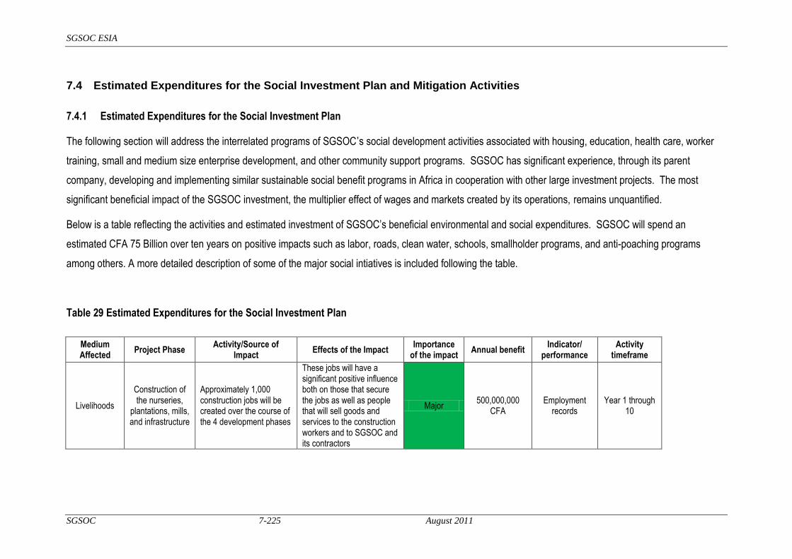
SGSOC ESIA
SGSOC 7-225 August 2011
7.4 Estimated Expenditures for the Social Investment Plan and Mitigation Activities
7.4.1 Estimated Expenditures for the Social Investment Plan
The following section will address the interrelated programs of SGSOC’s social development activities associated with housing, education, health care, worker
training, small and medium size enterprise development, and other community support programs. SGSOC has significant experience, through its parent
company, developing and implementing similar sustainable social benefit programs in Africa in cooperation with other large investment projects. The most
significant beneficial impact of the SGSOC investment, the multiplier effect of wages and markets created by its operations, remains unquantified.
Below is a table reflecting the activities and estimated investment of SGSOC‘s beneficial environmental and social expenditures. SGSOC will spend an
estimated CFA 75 Billion over ten years on positive impacts such as labor, roads, clean water, schools, smallholder programs, and anti-poaching programs
among others. A more detailed description of some of the major social intiatives is included following the table.
Table 29 Estimated Expenditures for the Social Investment Plan
Medium Affected
Project Phase Activity/Source of
Impact Effects of the Impact
Importance of the impact
Annual benefit Indicator/
performance Activity
timeframe
Livelihoods
Construction of the nurseries,
plantations, mills, and infrastructure
Approximately 1,000 construction jobs will be created over the course of the 4 development phases
These jobs will have a significant positive influence both on those that secure the jobs as well as people that will sell goods and services to the construction workers and to SGSOC and its contractors
Major 500,000,000
CFA Employment
records Year 1 through
10

SGSOC ESIA
SGSOC 7-226 August 2011
Medium Affected
Project Phase Activity/Source of
Impact Effects of the Impact
Importance of the impact
Annual benefit Indicator/
performance Activity
timeframe
Livelihoods
Construction of the nurseries,
plantations, mills, and infrastructure
Approximately 1,000 construction jobs will be created over the course of the 4 development phases
Construction jobs secured by local people will provide experience and skills beneficial to secure permanent employment
Moderate NA Training practices
Year 1 through 10
Livelihoods Operation of all
the facilities
Approximately 7,500 people will be employed by the Project when fully operational
These jobs will have a significant positive influence both on those that secure the jobs as well as people that will sell goods and services to the workers and to SGSOC during operations
Major 4,500,000,000
CFA Employment
records Year 3 through
10
Education Operation of Infrastructure
facilities
Educational opportunities will be provided to the children of plantation workers for free and may be extended to children of non-workers that live within the Concession depending on cost-sharing arrangements with the Government
These opportunities will greatly expand both the numbers of people that will have access to education as well as the quality of that education; transition to a more cash-based economy will also decrease the need for children to choose between school and working on family farms
Major 100,000,000
CFA
Social assessment
survey
Year 3 through 10
Health, Safety & Security
Operations of infrastructure
facilities
Improved health care facilities will be provided to the plantation workers and may be extended to non-workers that live within the Concession depending on cost-sharing arrangements with the Government
These opportunities will greatly expand both the numbers of people that will have access to health care as well as the quality of that care; it may include immunizations, medications, health education, malaria abatement, HIV prevention, etc.
Major 565,000,000
CFA
Social assessment
survey
Year 3 through 10

SGSOC ESIA
SGSOC 7-227 August 2011
Medium Affected
Project Phase Activity/Source of
Impact Effects of the Impact
Importance of the impact
Annual benefit Indicator/
performance Activity
timeframe
Infrastructure improvements
Roads
Roads will be improved to allow for smooth communication and transportation between the concession area and markets
Local inhabitants will benefit from improved roads which will allow for easier commercial and social travel and communication
Major 945,000,000
CFA Year round use
of roads Year 1 through
10
Health, Safety & Security
Wells and piped water
Installation one well in each village
Provide access to safe drinking water
Moderate 32,500,000 CFA
Social assessment
survey; percent of population
with access to safe drinking
water
Year 1 through 4
Livelihoods Agricultural
support activities
Local inhabitatnts will receive support for smallholder outgrower programs and local agricultural production in the form of technical assistance, training, and subsidized inputs
Improved household income and quality of life through greater productivity on existing farmland
Moderate 87,500,000 CFA
Social assessment
survey; average household
income
Year 3 through 10
Livelihoods Local business development
support programs
Local inhabitatnts will receive training, micro-finance, and long term contracts to support the development of secondary markets
Establishment of self-sufficient local businesses
Moderate 12,500,000 CFA Number of new
businesses Year 2 through
10
Livelihoods Community
discretionary funds
Community‘s will receive monthly payments to be used at their discretion
Communities will have the ability to identify and fund projects viewed as valuable to their development
Moderate 110,400,000
CFA Accounting
tracking Year 3 through
10
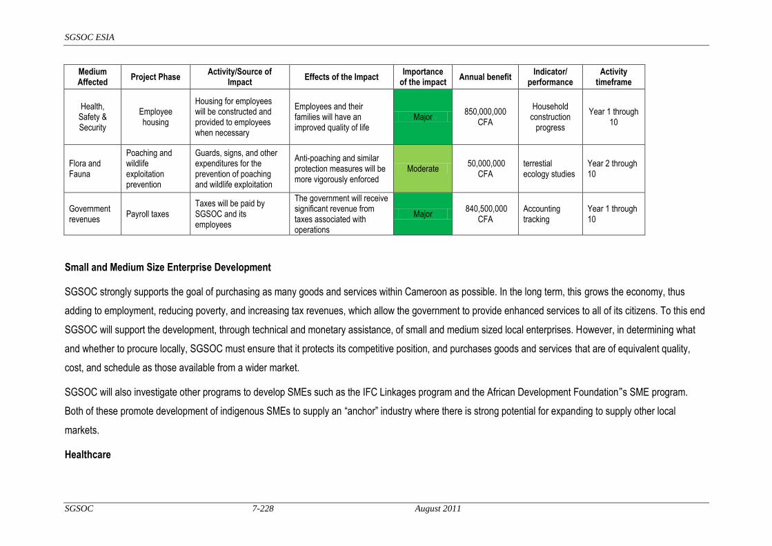
SGSOC ESIA
SGSOC 7-228 August 2011
Medium Affected
Project Phase Activity/Source of
Impact Effects of the Impact
Importance of the impact
Annual benefit Indicator/
performance Activity
timeframe
Health, Safety & Security
Employee housing
Housing for employees will be constructed and provided to employees when necessary
Employees and their families will have an improved quality of life
Major 850,000,000
CFA
Household construction
progress
Year 1 through 10
Flora and Fauna
Poaching and wildlife exploitation prevention
Guards, signs, and other expenditures for the prevention of poaching and wildlife exploitation
Anti-poaching and similar protection measures will be more vigorously enforced
Moderate 50,000,000
CFA terrestial ecology studies
Year 2 through 10
Government revenues
Payroll taxes Taxes will be paid by SGSOC and its employees
The government will receive significant revenue from taxes associated with operations
Major 840,500,000
CFA Accounting tracking
Year 1 through 10
Small and Medium Size Enterprise Development
SGSOC strongly supports the goal of purchasing as many goods and services within Cameroon as possible. In the long term, this grows the economy, thus
adding to employment, reducing poverty, and increasing tax revenues, which allow the government to provide enhanced services to all of its citizens. To this end
SGSOC will support the development, through technical and monetary assistance, of small and medium sized local enterprises. However, in determining what
and whether to procure locally, SGSOC must ensure that it protects its competitive position, and purchases goods and services that are of equivalent quality,
cost, and schedule as those available from a wider market.
SGSOC will also investigate other programs to develop SMEs such as the IFC Linkages program and the African Development Foundation‟s SME program.
Both of these promote development of indigenous SMEs to supply an ―anchor‖ industry where there is strong potential for expanding to supply other local
markets.
Healthcare
SGSOC ESIA
SGSOC 7-229 August 2011
The health of its employees and their families is of great importance to SGSOC from both a moral and business perspective. SGSOC will provide health facilities
on site for its employees and assistance to its employees and their families for accessing health care off of the Project site. In addition, SGSOC will focus on
disease prevention and treatment, particularly for malaria and HIV/AIDS, which is essential to a healthy and successful population. Health education programs
focused on these diseases as well as sanitation, nutrition and maternal/child health will be a key component of health coverage for employees and their families.
SGSOC will also work with national and local health authoritie,s as well as international development agencies, to strengthen the health care delivery system
serving the general population in the Project area.
Education
An educated and trained workforce is critical for SGSOC to compete on the world market. SGSOC knows that many Cameroonians have not had access to or
the opportunity for education to fully utilize their talents. In addition to the training that SGSOC will provide so that its employees can perform their work in a safe,
environmentally responsible, and efficient manner, SGSOC will provide literacy training so that its employees can fully avail themselves of the opportunities for
advancement within the Company.
A properly operated palm oil project can produce indefinitely; therefore, SGSOC will require many generations of increasingly educated workers to efficiently
operate the Project in what will become an increasingly competitive world market. SGSOC will work with national and local education authorities as well as
international development agencies to strengthen the education system serving the general population and SGSOC employees. SGSOC‘s support of the
education system will include, for example, improving access education by providing college scholarships for meritous students.
7.4.2 Estimated Expenditures of Mitigation Activities
As discussed in section 7.3, SGSOC will undertake a number of mitigation plans and activities to limit adverse impacts of the Project‘s activities. The table below provides an initial summary and estimate of the mitigation activities associated with the major and moderate adverse impacts of the Project.

SGSOC ESIA
SGSOC 7-230 August 2011
Table 30 Estimated Expenditures of Mitigation Activities
Medium Affected
Project Phase Activity/Source of
Impact Effects of the
Impact Importance of
the impact Mitigations of the
impacts Annual cost
Indicator/ performance
Activity timeframe
Air Quality
Nursery, plantation, mill
and infrastructure development
Combustion emissions and clearing of biomass
Creation of GHG from certain combustion gases as well as clearing of biomass that will either decay or be burned, and will therefore contribute to climate change on a global scale until the plantation areas are replanted
Major
1. Zero burning practice
No cost Air quality
assessment Year 1
through 10
2. Air Quality management plan
3. Vegetation clearing and biomass
management plan
Air Quality
Nursery, plantation, mill
and infrastructure development
Dust and noise due to vehicle and equipment use, and dust due to removal of vegetation
Nuisances in the immediate area of the activity
Moderate
1. Apply dust sepression practices
60,000,000 CFA
Air quality assessment
Year 1 through 10
2. Air Quality management plan
3. Vegetation clearing and biomass
management plan
4. Traffic and vehicle management plan
Air Quality Oil mill and
infrastructure operations
Combustion emissions due to vehicles, and burning mostly of biomass with some secondary fossil fuel for steam and electricity generation; also process emissions
Air pollution in the form of combustion gases and particulates, which will affect the immediate area before being adequately dispersed
Moderate
1. Combustion control and flu gas
treatment
2,500,000 CFA
Results of atmospheric
testing
Biannually ongoing
2. Air Quality management plan
3. Vegetation clearing and biomass
management plan
4. Traffic and vehicle management plan

SGSOC ESIA
SGSOC 7-231 August 2011
Medium Affected
Project Phase Activity/Source of
Impact Effects of the
Impact Importance of
the impact Mitigations of the
impacts Annual cost
Indicator/ performance
Activity timeframe
Air Quality Oil mill and
infrastructure operations
Combustion emissions and production of palm oil that could offset burning of fossil fuels; use of biomass for steam and electricity generation; digestion of POME, which will create methane and CO2, both GHGs
Creation of GHG that will contribute to climate change on a global scale, but with offsets due to use of biomass for electricity and steam generation, and possible use of palm oil as fossil fuel replacement
Major
1. Methane may be captured from digesters and
cleaned of sulfer and moisture before being used to
generate power
250,000,000 CFA
Results of atmospheric
pollution testing
Alternating years 4
through 12
2. Air Quality management plan
Water Quality and
Quantity
Construction of the nursery,
plantation, mills and
infrastructure
Construction activities including equipment operation, vegetation clearing, and earth
moving
Surface water quality could be impacted by erosion, whose potential will be increased, but controlled by implementation of appropriate measures
Moderate
1. Water management plan including a buffer around river and
streams NA Ongoing water
quality assessment
Year 1 through 10
2. Vegetation clearing and biomass
management plan
Water Quality and
Quantity
Nursery and plantation operations
Application of pesticides, herbicides, and fertilizers, and potential for runoff to surface water sources
Surface and shallow groundwater quality can be affected by runoff containing chemicals or petroleum products
Moderate
1. Mulch from decomposed
biomass can be used as fertilizer as can
empty fruit bunches from the Palm Oil
Mill. 17,500,000
CFA
Ongoing water quality
assessment
Year 1 through 10 2. Integrated pest
management plan
3. Chemical management plan
4. Construction of bunds around storage areas
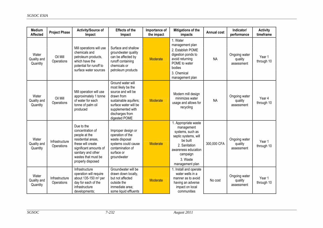
SGSOC ESIA
SGSOC 7-232 August 2011
Medium Affected
Project Phase Activity/Source of
Impact Effects of the
Impact Importance of
the impact Mitigations of the
impacts Annual cost
Indicator/ performance
Activity timeframe
Water Quality and
Quantity
Oil Mill Operations
Mill operations will use chemicals and petroleum products, which have the potential for runoff to surface water sources
Surface and shallow groundwater quality can be affected by runoff containing chemicals or petroleum products
Moderate
1. Water management plan
NA Ongoing water
quality assessment
Year 1 through 10
2. Establish POME digestion ponds to avoid returning POME to water bodies
3. Chemical management plan
Water Quality and
Quantity
Oil Mill Operations
Mill operation will use approximately 1 tonne of water for each tonne of palm oil produced
Ground water will most likely be the source and will be drawn from sustainable aquifers; surface water will be supplemented with discharges from digested POME
Moderate
Modern mill design minimizes water
usage and allows for recycling
NA Ongoing water
quality assessment
Year 4 through 10
Water Quality and
Quantity
Infrastructure Operations
Due to the concentration of people at the residential areas, these will create significant amounts of sanitary and other wastes that must be properly disposed
Improper design or operation of the waste disposal systems could cause contamination of surface or groundwater
Moderate
1. Appropriate waste management
systems, such as septic systems, will
be built 300,000 CFA
Ongoing water quality
assessment
Year 1 through 10 2. Sanitation
awareness education campaign
3. Waste management plan
Water Quality and
Quantity
Infrastructure Operations
Infrastructure operation will require about 135-150 m3 per day for each of the infrastructure developments;
Groundwater will be drawn down locally, but not affected outside the immediate area; some liquid effluents
Moderate
1. Install and operate water wells in a
manner as to avoid having an adverse
impact on local communities
No cost Ongoing water
quality assessment
Year 1 through 10
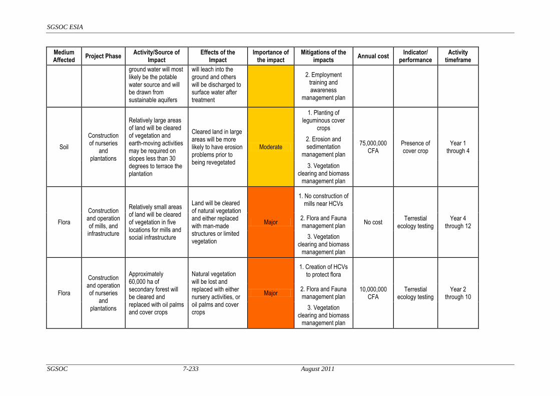
SGSOC ESIA
SGSOC 7-233 August 2011
Medium Affected
Project Phase Activity/Source of
Impact Effects of the
Impact Importance of
the impact Mitigations of the
impacts Annual cost
Indicator/ performance
Activity timeframe
ground water will most likely be the potable water source and will be drawn from sustainable aquifers
will leach into the ground and others will be discharged to surface water after treatment
2. Employment training and awareness
management plan
Soil
Construction of nurseries
and plantations
Relatively large areas of land will be cleared of vegetation and earth-moving activities may be required on slopes less than 30 degrees to terrace the plantation
Cleared land in large areas will be more likely to have erosion problems prior to being revegetated
Moderate
1. Planting of leguminous cover
crops
75,000,000 CFA
Presence of cover crop
Year 1 through 4
2. Erosion and sedimentation
management plan
3. Vegetation clearing and biomass
management plan
Flora
Construction and operation of mills, and infrastructure
Relatively small areas of land will be cleared of vegetation in five locations for mills and social infrastructure
Land will be cleared of natural vegetation and either replaced with man-made structures or limited vegetation
Major
1. No construction of mills near HCVs
No cost Terrestial
ecology testing Year 4
through 12
2. Flora and Fauna management plan
3. Vegetation clearing and biomass
management plan
Flora
Construction and operation of nurseries
and plantations
Approximately 60,000 ha of secondary forest will be cleared and replaced with oil palms and cover crops
Natural vegetation will be lost and replaced with either nursery activities, or oil palms and cover crops
Major
1. Creation of HCVs to protect flora
10,000,000 CFA
Terrestial ecology testing
Year 2 through 10
2. Flora and Fauna management plan
3. Vegetation clearing and biomass
management plan
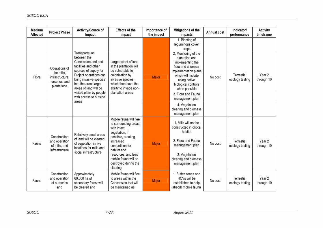
SGSOC ESIA
SGSOC 7-234 August 2011
Medium Affected
Project Phase Activity/Source of
Impact Effects of the
Impact Importance of
the impact Mitigations of the
impacts Annual cost
Indicator/ performance
Activity timeframe
Flora
Operations of the mills,
infrastructure, nurseries, and
plantations
Transportation between the Concession and port facilities and other sources of supply for Project operations can bring invasive species into the area; large areas of land will be visited often by people with access to outside areas
Large extent of land in the plantation will be vulnerable to colonization by invasive species, which then have the ability to invade non-plantation areas
Major
1. Planting of leguminous cover
crops
No cost Terrestial
ecology testing Year 2
through 10
2. Monitoring of the plantation and
implementing the flora and chemical
implementation plans which will include
using native biological controls
when possible
3. Flora and Fauna management plan
4. Vegetation clearing and biomass
management plan
Fauna
Construction and operation of mills, and infrastructure
Relatively small areas of land will be cleared of vegetation in five locations for mills and social infrastructure
Mobile fauna will flee to surrounding areas with intact vegetation, if possible, creating increased competition for habitat and resources, and less mobile fauna will be destroyed during the clearing
Major
1. Mills will not be constructed in critical
habitat
No cost Terrestial
ecology testing Year 2
through 10
2. Flora and Fauna management plan
3. Vegetation clearing and biomass
management plan
Fauna
Construction and operation of nurseries
and
Approximately 60,000 ha of secondary forest will be cleared and
Mobile fauna will flee to areas within the Concession that will be maintained as
Major
1. Buffer zones and HCVs will be
established to help absorb mobile fauna
No cost Terrestial
ecology testing Year 2
through 10

SGSOC ESIA
SGSOC 7-235 August 2011
Medium Affected
Project Phase Activity/Source of
Impact Effects of the
Impact Importance of
the impact Mitigations of the
impacts Annual cost
Indicator/ performance
Activity timeframe
plantations replaced with oil palms and cover crops
conservation zones, or, if possible, will flee outside the Concession to either Protected Areas or other secondary forest where they will compete with existing fauna for habitat; less mobile fauna will be destroyed during the clearing
2. Phased development of the plantation to allow
mobile fauna to evacuate clearing
areas
3. Flora and Fauna management plan
4. Vegetation clearing and biomass
management plan
Fauna
Construction and operation of nurseries
and plantations
Concentration of fauna in protected areas within the Concession will create easier hunting opportunities for local hunters
Hunting pressure for bush meat will increase in the protected areas within the Concession
Major
1. Alternative protein sources will be
available in local markets which
inhabitants will be able to access due to
payroll from operations
No cost Terrestial
ecology testing Year 2
through 10
2. Flora and Fauna management plan
3. Vegetation clearing and biomass
management plan
Biodiversity
Construction and operation of the mills,
infrastructure, nurseries, and
plantations.
Approximately 60,000 ha of secondary forest will be transformed into palm plantation along with the development of some industrial, commercial, and
The conversion will significantly reduce existing biodiversity in about 75% of the Concession; stresses will be placed on the remaining 25% of the Concession as well
Major
1. Alternative protein sources will be
available in local markets which
inhabitants will be able to access due to
payroll from operations
10,000,000 CFA
Social assessment
survey
Year 3 through 10

SGSOC ESIA
SGSOC 7-236 August 2011
Medium Affected
Project Phase Activity/Source of
Impact Effects of the
Impact Importance of
the impact Mitigations of the
impacts Annual cost
Indicator/ performance
Activity timeframe
residential/social infrastructure
as the areas immediately surrounding the Concession due to the increased demand on habitats both from fauna fleeing into it and higher concentrations of hunting pressure
2. An agricultural program for NTFPs (e.g. bush mango,
bush pepper, country onion)
3. Agricultural technical assistance
programs will increase the
productivity of agricultural activities
4. Vegetation clearing and biomass
management plan
Biodiversity
Construction and operation of the mills,
infrastructure, nurseries, and
plantations
Approximately 60,000 ha of secondary forest will be transformed into palm plantation along with the development of some industrial, commercial, and residential/social infrastructure
Protected species can be disturbed or destroyed if adequate mitigation measures are not implemented throughout the development process; protected species outside the Concession could be disturbed by fauna migration outside the Concession
Major
1. Buffer zones and HCVs will be
established to help absorb mobile fauna
No cost Terrestial
ecology testing Year 2
through 10
3. Vegetation clearing and biomass
management plan
Health, Safety & Security
Construction of all facilities
Construction activities are likely to use significant numbers of single men from outside the area
Single men with disposable income increase the potential for health concerns including alcohol, drugs, and sex trade that can expose the local communities to
Moderate
1. Awareness program for local communities and
employees NA
Social assessment survey; HIV
incidence rate
Year 2 through year
10 2. Employment training and awareness management plan

SGSOC ESIA
SGSOC 7-237 August 2011
Medium Affected
Project Phase Activity/Source of
Impact Effects of the
Impact Importance of
the impact Mitigations of the
impacts Annual cost
Indicator/ performance
Activity timeframe
higher incidences of crime and communicable diseases, including HIV/AIDS
3. Health safety and security management plan
4. Community health and safety plan
Livelihood activities
Construction and operation of the mills, infrastructure, nurseries, and plantations
Clearing of land for the plantation can take land currently used for traditional livelihood activities such as agriculture, collection of NTFPs, and hunting
Local population will lose
Major
SGSOC will support the growth of those products in an agricultural setting as part of its agricultural support program
This cost is included in the beneficial social development activities
Social assessment survey
Year 2 through 10
7.5

SGSOC ESIA
SGSOC 7-238 August 2011
7.6 Training Programs
SGSOC will develop, implement, and track training programs as noted in Section 7.3 above to include:
the benefits of protecting local fauna and alternatives to activities such as hunting for local
bushmeat;
the need for waste management and how to implement the Waste Management Plan;
the need for proper selection, handling, storage, application, use, and disposal of all hazardous
materials and chemicals used in the Project in accordance with the Chemical Management Plan;
implementation of all emergency response procedures as identified in the Emergency Response
and Incident Management Plan;
implementation of the Cultural Heritage Management Plan and associated Chance Find Procedure;
implementation of the Health, Safety, and Security Management Plan for all employees;
specific programs identified in the Community Health and Safety Plan; and,
executive management.
7.7 Monitoring
The Project will develop a detailed Environmental and Social Monitoring Plan to monitor key elements of
both the biophysical and human environments. The purpose of this monitoring will be to ensure that
significant impacts were correctly identified in the assessment process, then to monitor the effectiveness
of the mitigation measures. The results of monitoring activities will be regularly reviewed to determine if
existing management measures are adequate, or if those measures should be revised, deleted, or
supplemented.
Monitoring will include aspects such as:
water quality of the effluent streams discharged from plantations, workers‘ housing, nurseries, and
palm oil mills;
water quality and general aquatic health of streams receiving effluents from plantations, workers‘
housing, nurseries, and palm oil mills;

SGSOC ESIA
SGSOC 7-239 August 2011
invasive species;
bushmeat sales in local markets;
interactions between local fauna such as the forest elephant and the plantation to determine if
additional mitigation measures are required and if implemented, how effective they are working;
the effectiveness of waste management activities;
the effectiveness of sediment and erosion control measures and of stormwater management
measures;
all clearing activities for compliance with the Vegetation Clearing and Biomass Management Plan;
implementation of the Cultural Heritage Management Plan and associated Chance Find Procedure;
compliance with the Traffic and Vehicle Management Plan;
health and safety indicators, including accidents, for all workers working on the Project;
grievances of workers and the local community;
health indicators in the local communities to inform any modifications to the Community Health and
Safety Plan; and,
flora and fauna in the Project Area.
7.8 Implementation Schedule
Detailed ESMPs for the relevant aspects of work will be developed based on the above-described
frameworks starting before plantation development (e.g. Vegetation Clearing and Biomass Management
Plan) and continuing to commissioning of the palm oil mills and the specific worker health and safety
issues associated with the mills. The tentative schedule for this development is included in the below
table.

SGSOC ESIA
SGSOC 7-240 August 2011
Table 31 Tentative ESMP Development Schedule
Plan Name Date
Flora and Fauna Management Plan One month before the start of clearing
for the plantation
Waste Management Plan
One month before the start of clearing
for the plantation for clearing
activities
Erosion and Sedimentation Management Plan One month before the start of clearing
for the plantation
Employment, Training, and Awareness
Management Plan
One month before the start of clearing
for the plantation for clearing
activities
Water Management Plan
Immediately for nursery activities and
one month prior to any well
development
Chemical Management Plan
Immediately for nursery activities and
one month before plantation clearing
activities
Air Quality Management Plan One month before clearing activities
Vegetation Clearing and Biomass Management
Plan One month before clearing activities
Emergency Response and Incident Management
Plan
Immediately for nursery activities and
one month before clearing activities.
Cultural Heritage Management Plan One month before clearing activities
Traffic and Vehicle Management Plan One month before clearing activities
Social Investment Plan Within six months of the start of
plantation development
Health, Safety, and Security Management Plan
Immediately for nursery operations
and one month before the start of
clearing activities
Community Health and Safety Plan One month before the start of clearing
activities
Stakeholder Engagement Plan Ongoing updates
Resettlement Action Plan At least three months prior to any
resettlement
Conceptual Closure and Reclamation Plan Within one year of the start of clearing
activities

SGSOC ESIA
SGSOC 8-241 August 2011
8 Conclusion
The objective of SGSOC is to develop and manage a sustainable oil palm project in the Southwest Region of
Cameroon. This Project will directly provide thousands of long-term jobs for the local communities, as well as act
as a catalyst for secondary commercial and agricultural markets. SGSOC will maintain the highest standards in
sustainable practices, worker welfare, social benefit and environmental impact throughout the Project development
and operations. A significant additional benefit of the Project includes its ability to mitigate Cameroon‘s
dependence on expensive imported palm oil and food insecurity.
With its proven track record in Africa, the SGSOC management team is well-positioned to develop a large-scale
sustainable oil palm project which will result in significant employment generation and production of a local food
staple. The Southwest region, and the Project Area in particular, is an ideal location for oil palm development due
to soil and climate conditions. Furthermore, there is a need in the region for income generating activities, social
infrastructure, and basic health and educational services which would receive significant investment from the
development and operation of the Project.
SGSOC is working with the local communities, the Government of Cameroon, non-governmental organizations,
other stakeholders and expert consultants to ensure that any potential negative impacts are either avoided or
mitigated, and that potential benefits are realized and enhanced. For instance, SGSOC is committed to complying
with the RSPO Principles and Criteria and best practices in the development and operation of the Project. SGSOC
has also budgeted CFA 75 billion to be spent over a period of 10 years on positive impacts such as roads,
employment ,clean water availability, schools, health centers, smallholder development programs, anti-poaching
programs among others. Numerous studies, surveys and reviews have been conducted to evaluate current social
and environmental baseline data required for these goals, and SGSOC is working with Community Development
Officers throughout the Project Area to help the company better understand local needs and preferences and
communicate its activities.
SGSOC‘s corporate mission is to address the complex issues of food security through sustainable agriculture
initiatives. Working in partnership with the people of Cameroon, the company believes this Project is an excellent

SGSOC ESIA
SGSOC 8-242 August 2011
opportunity to achieve this mission and deliver substantial long-term benefits such as economic opportunity,
poverty reduction, improved education, wider availability of health care among others.
SGSOC ESIA
SGSOC 9-243 August 2011
9 References
Amiet, J.L. (1978) Les amphibiens anoures de la region de Mamfe (Cameroun). Ann. Fac. Sci. Yaounde, 25: 189-219. André, P., C.E. Delisle et J.P. Revéret 2003. Évaluation des impacts sur l‘environnement. Processus, acteurs et pratique pour un développement durable. 2ème édition, Presses Internationales Polytechnique, École Polytechnique de Montréal, 519 pages. Anye D, N, and Andrew A. Allo (Ed.) REPORT Impact assessment of Fauna and Flora in the support zones of Korup National Park and the Nguti area of Cameroon Bearder, S.K. and P.E. Honess (1992) A Survey of Nocturnal Primates and Other Mammals in Korup National Park, Cameroon. Korup Forest Research Project: Research Report #2. WCI and USAID. Asian Development Bank, ADB. 2006. Technology overview– palm oil waste management-Appendix VII. http://www.adb.org/Documents/Reports/Consultant/36557-INO/36557-INO-TACR-AppendixVII.pdf Bechem, M.E. and Nchangi, A. C. (2001) Large Mammals of Banyang-Mbo Wildlife Sanctuary. Unpublished report for Wildlife Conservation Society, Cameroon. 33pg. BirdLife International (2009) Important Bird Area factsheet: Banyang Mbo Wildlife Sanctuary, Cameroon. Downloaded from the Data Zone at http://www.birdlife.org Bob Broz, Don Pfost and Allen Thompson. 2003. Controlling Runoff and Erosion at Urban Construction Sites. Biological Engineering Department and MU Outreach and Extension. muextension.missouri.edu Butcher, C. (1997) Village Information Database: a survey of the villages in the support zone of Korup Project. DFID and Korup Project. CHUYONG G, B and SAINGE M, N, Nicolas C. SONGWE (Ed.) (2010). REPORT FLORA SURVEY IN THE MUNDEMBA, TOKO AND NGUTI SG-SOC PROJECT AREA. Daniel Chong Kah Fui and Dayang Norwana Binti Awang Ali Bema. 2005. Guidelines on the Best Management Practices for the Mitigation and Management of Human-Elephant conflict in and around Oil-Palm Plantations in Indonesia and Malaysia. WWF. Devitt, P. (1988) The People of the Korup Project Area: Report on Phase I of the Socioeconomic Survey. WWFUK. Gartlan, J.S. (1985) The Korup Regional Management Plan: Conservation and Development in the Ndian Division of Cameroon. A WWF Report supported by WWF, Gland, Switzerland. IUCN/WWF Project 3206 and Earthlife Foundation, London. Publication #25-106 of the Wisconsin Regional Primate Research Centre.
SGSOC ESIA
SGSOC 9-244 August 2011
Geze, B. (1943) Geographie physique et geologie du Cameroun occidental. These.Fac. Sci.Univ.Toulouse.Quoted in Gartlan (1985). GTZ. Environmental Management Guideline for the Palm Oil Industry. 1997. Thailand. Hutterer, R.E. and D.A. Schlitter (1991) Shrews of Korup National Park, Cameroon, with the description of a new Sylvisorex (Mammalia: Soricidae). Infield, M. (1988) Hunting, trapping and fishing in villages within and at the periphery of Korup National Park. WWF Publication Number No.3206/A9.6. IRAF-ONAREST (1980) Soils survey and land evaluation for the extension of Ndian Oil Palm Estate. Technical Report No. 12, Soil Science Department, IRAF-ONAREST, Ekona, Cameroon. Quoted in Gartlan (1985). Larsen, T.B. (1997) Biodiversity writ large. Report to Korup Project, Mundemba, Cameroon. Lawson, D.P. (1993): The reptiles and amphibians of the Korup National Park Project, Cameroon. Herpetological Natural History 1: 27-90 Lawson, D.P. (1992) Inventory and Status of Herpetofauna of Korup Rainforest National Park, Cameroon. Lawson, D.P. (2000) Local harvest of Hingeback Tortoises, Kinixys erosa and K. homeana in Southwestern Cameroon. Chelonian Conservation and Biology 3(4): 722-729. LEJOLY, J., 1996. Synthèse regionale sur la biodiversité végétale des ligneux dans les 6 sites du Projet ECOFAC en Afrique Centrale, 49 p. Leopold, L. B., F. E. Clarke, B. B. Hanshaw, and J. E. Balsley. 1971. A procedure for evaluating environmental impact. U.S. Geological Survey Circular 645, Washington, D.C. Letouzey, R. (1985) Notice de la Carte Phytogeographique du Cameroun. Domaine de la foret dense humide toujours vert. Ma, A.N., 1999. Treatment of palm oil mill effluent. In: Singh, G., Lim, K.H., Leng, T., David, L.K. (Eds.), Oil Palm and the Environment: A Malaysian Perspective. Malaysia Oil Palm Growers_ Council, Kuala Lumpur, pp. 113–126. Ma, A. N., 2000. Environmental management of the palm oil industry. Palm Oil Dev., 30: 1-10. Maley, J. (1996) The African Forest – main characteristics of changes in vegetation and climate from the uppoer Cretaceous to Quatenary. Proceedings of the Royal Society of Edinburgh, 104B, 31-73. Maley, J. and P. Brenac (1998) Vegetation dynamics, paleo-environments and climatic changes in the forest of western Cameroon during the last 28,000 years B.P. Review of Paleobotany and Palynology 99: 157-187. Malleson, R. (2000) Forest Livelihoods in SW Province, Cameroon: an evaluation of the Korup experience. Submitted for the Degree of Ph.D., Dept of Anthropology, University College London.

SGSOC ESIA
SGSOC 9-245 August 2011
Management Plan of Korup National Park and its Peripheral Zone (2008-2013). Ministry of Forestry and Wildlife. Management Plan of Korup National park and its Peripheral Zone 2008-2012: First Draft MINPAT (1989) The Korup Project. Plan for Developing the Korup National Park and its support zone. WWF, CEC and ODNRI. Newbery, D.M., I.J. Alexander and J.A. Rother (1997) Phosphorus dynamics in a lowland African rain forest: the influence of ectomycorrhizal trees. Ecological Monographs 67, 367-409. MPRD (1989) Republic of Cameroon, the Korup Project: Plan for the Developing the Korup National park and its support zones. Ministry of Plan and Regional Development with support form the WWF, Commission of the European Communities and Overseas Development Natural Resource Institute. Arch Press. London. Nambu, D. M. (2001) Botanical Inventory of the Banyang-Mbo Sanctury , South West reg Province . Final report for the Wildlife Conservation Society; Cameroon Biodiversity program. Newbery, D.M., N.C. Songwe and G.B. Chuyong (1998) Phenology and dynamics of an African rainforest at Korup, Cameroon. In Dyanmics of tropical communities (ed. D.M. Newbery, H.H.T. Prins and N.D. Brown). Blackwell Science. Nkwatoh, A.F. (1995) Production and marketing of non-timber forest products in the Ejagham Forest Reserve and its surrounding villages including the cross-border trade in NTFPs with Nigeria. Nguti Council Forest (2007) Preliminary technical note for the gazettement of Nguti Council forest. 14 page report. Normes Environnementales et Procédure d‘Inspection des installations industrielles et Commerciales au Cameroon. Perret, J.L. (1966) Les Amphibiens du Cameroun. Doctoral dissertation, Université de Neuchatel, Switzerland. Powell, J. L. (1997) The Ecology of the Forest Elephant (L. Africana cyclotis Matschie 1900) in Mbanyang –Mbo Sanctuary and Korup Forest, Cameroon with particular reference to their role in seed dispersal agents. PhD thesis. University of Cambridge, UK 334 pp. Powell, J.A., P. Elkan, L. Usongo and M.D. Powell (1994) Korup National Park: report onresearch and conseravtion activities of the Cameroon Biodiversity Project. Report prepared for the Biodiversity Support Program and US Agency for International Development, Cameroon Mission. Wildlife Conservation Society, New York. Richards, P.W. (1952) The Tropical Rain Forest. An Ecological Study. Cambridge University Press. Reid, G.M. (1989) The Living Waters of Korup Rainforest. WWF-UK. Rodewald, P.D., Dejaifve, P.A. and Green, A.A. (1994): The birds of the Korup National Park and Korup Project Area, Southwest Province, Cameroon. Bird Conservation International 4: 1-68. RSPO Principles and Criteria for Sustainable Palm Oil Production. Guidance Document. March 2006

SGSOC ESIA
SGSOC 9-246 August 2011
Sanderson, I.T. (1936) The Amphibians of the Mamfe Division, Cameroons. II, Ecology of the Frogs. Proc. Zool. Soc. London, 1936:135-163. Scholes, A.J. (1989) Bats and Small Mammals Survey of Korup National Park. Operation Raleigh Expedition, Korup National Park, Cameroon. Stucki-Stirn, M.C. (1979) Snake Report 721. Herpeto-Verlag, Teuffenthal, Switzerland. 650 pp. Reid, J.C. (1989): Floral and fauana richness of Oban Division of the Cross National Park and list of flora and fauna of the Calabar Oban Area. Appendix 7 of the cross river National Park (Oban Division): plan for developing the park and its support zones. godalming, surry: wwf-uk Schliewen, U. (1996) Ichthyological Survey of Rumpi Hill Waters. A report to GTZ. Steiner, C. (2001) The drill, an endangered species and a natural resource in Korup Project Area, Cameroon. Cuviller, Gottingen, Germany. Thani, M.I.R.H., W.W.R. Ibrahim and M.S. Sulaiman, 1999. Industrial processes and the environment (Handbook No. 3) Crude palm oil industry. Department of Environment, Malaysia. Thomas, D. (1995) Botanical Survey of the Rumpi Hills and Nta Ali. Report to Korup Project. Thomas, D. (1997) Botanical Survey of the Ejagham Forest Reserve, Cameroon. Report to Korup Project. Usongo, L. (1995) Biological and socioeconomic survey of Rumpi and Nta-Ali Forest Reserves. Report to Korup Project. Vabi, M. (1999) Socioeconomic Surveys of Human Use Inside and Within 3 kilometres of Korup National Park. Waltert, M. (2000) Biomonitoring in the support zone of Korup National Park, SW Province, Cameroon. Results on Primate Populations and Recommendations after the First Phase, April 1999-May 2001. Report to Korup Project and GTZ. Zimmermann, L. (2000) A comparitive study of growth and mortality of trees in caesalp dominated lowland African rainforest at Korup, Cameroon.

SGSOC ESIA
SGSOC 9-247 August 2011
Internet sites references:
cdm.unfccc.int/EB/015/eb15repan4.pdf
www.dieselnet.com/standards/us/nonroad.php
www.dieselnet.com/standards/eu/hd.php
www.thepostwebedition.com/Content.aspx?ModuleID=1&ItemID=4172
wwf.panda.org/what_we_do/footprint/agriculture/palm_oil/solutions/roundtable_on_sustainable_palm_
oil/better_management_practices/eliminate_burning/
www.ramsar.org/wn/w.n.cameroon_bird_census.htm
www.ramsar.org/wn/wn.cmeroon_coast_survey.pdf
www.ramsar.org/.../ramsar...cameroonnewsite/.../ramsar/1-26-45-437%5E24629_4000_0