Embed Size (px)
Citation preview

Session 16: Distribution of Geospatial Data
1
Distribution of Geospatial Data in the Public Environment
Hazard Mapping and Modeling

Session 16: Distribution of Geospatial Data
2
Objectives
• Understand the purposes, uses and risks associated with the distribution of geospatial data in the public environment.
• Explain the basis and nature of concerns raised by public, private and non-profit organizations in the distribution of geospatial data used in disaster preparedness, response, recovery and mitigation.
• Understand a methodology for balancing agency security risks and the benefits of geospatial data dissemination in a public environment.

Session 16: Distribution of Geospatial Data
3
The Need for Geospatial Information
• Timely, accurate geospatial information, and available to federal, state and local political jurisdictions is critical to effective decision making for emergency planning, response, and recovery.
• Geospatial Data– identifies the geographic location and characteristics
(attributes) of natural or constructed features and boundaries on the earth.
– derived from remote sensing, mapping, and surveying technologies.

Session 16: Distribution of Geospatial Data
4
The Need for Dissemination of Data
• Public, private and non-profit organizations collect, use, store and disseminate geospatial data.
• Organizations see that the sharing and distribution of data is critical to their mission success.
• Jurisdictions can not justify "going-their-own-way.“
• Public private sharing of information is significant since some data sets may not be in the public sector.
Session 16: Distribution of Geospatial Data
5
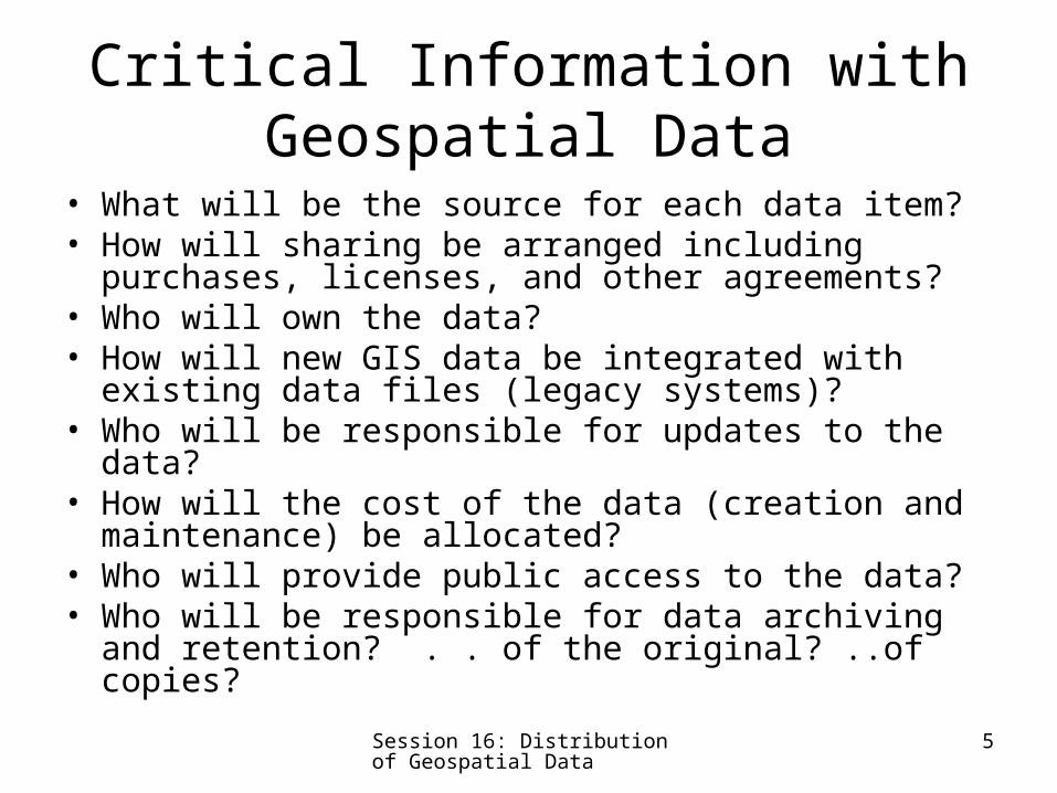
Critical Information with Geospatial Data
• What will be the source for each data item? • How will sharing be arranged including purchases,
licenses, and other agreements? • Who will own the data? • How will new GIS data be integrated with existing data
files (legacy systems)? • Who will be responsible for updates to the data? • How will the cost of the data (creation and maintenance)
be allocated? • Who will provide public access to the data? • Who will be responsible for data archiving and retention?
. . of the original? ..of copies?

Session 16: Distribution of Geospatial Data
6
Uses of Geospatial Data
• Detection of threats or identification of hazards• Identification of features at the local level or sites
that are vulnerable to hazards. Geo-spatial information is thus critical in emergency planning.
• Used to prevent threats from hazards. • Used to protect sites from threats or hazards.• Used in response and recovery operations.

Session 16: Distribution of Geospatial Data
7
Real Time Access to Geospatial Data
• During Hurricane Katrina, response agencies made extensive use of updated requests for rescue.
• The U.S. Coast Guard use geospatial data to identify the location of water craft blocking waterways.
• Cleanup operations in the Gulf States used geospatial data in managing debris removal.

Session 16: Distribution of Geospatial Data
8
Releasing Geospatial Data
• The release of geospatial information may present the possibility of harm to an individual, family or an organization.
• The release of data poses a security risk.
• Critical infrastructure information may be too sensitive to be released to the public.

Session 16: Distribution of Geospatial Data
9
QUESTION:
• What types of data might be extremely sensitive and not made available to the public?

Session 16: Distribution of Geospatial Data
10
The National Geospatial Data Clearinghouse.
• Federal agencies that produce geospatial data must document these new data sets
• Metadata must be made available through the National Geospatial Data Clearinghouse.
• The Clearinghouse may be searched to determine what geo-spatial data exists, the nature and condition of the data and how to access the data.
• Some states also have identical requirements.

Session 16: Distribution of Geospatial Data
11
Handling Sensitive Data
• Agencies must have guidelines in the handling and release of sensitive data.
• Coordination of geospatial data is essential and requires extensive planning and preparedness.
• Providing access presents critical security issues.
• The goal is to provide quality data but also to ensure that safeguards are present to protect organizational security.

Session 16: Distribution of Geospatial Data
12
Value of Data to Other Organizations
• Our goal is to “build once and share or use many times”
• Support accomplishing operational missions. • Allow for the free flow of information between the
public, private and non-profit entities as well as the public.
• Supports informed public participation in decision-making and private reuse of government information

Session 16: Distribution of Geospatial Data
13
Key Terms
• Open-source Information
• Originating Organization
• Restrict
• Safeguard

Session 16: Distribution of Geospatial Data
14
Concerns Raised by the Distribution of Geospatial Data.
• Computer information technology allows organizations to take advantage of geospatial data
• Used in mapping, modeling, and communications.
Session 16: Distribution of Geospatial Data
15
Geospatial Data and Vulnerability Assessment
• Identify and repair the weakest links
• Takes advantage of tools such as firewalls, passwords, separate storage areas
• Build security into basic systems.
• Builds flexibility into systems.
• Allows users access to information that is appropriate for their needs.

Session 16: Distribution of Geospatial Data
16
QUESTION:
• Should any of the following types of information be restricted and limited access be made to the public or other agencies?
• Would any of the information be provided to other entities or the public but not the entire agency record?– 911 emergency calls– Immunization records for students or public
employees – Home inspection damage assessment reports

Session 16: Distribution of Geospatial Data
17
Systems Theory & Vulnerability
• Supports understanding our vulnerabilities to terrorist threats
• Can clarify the potential impacts of breakdowns or failures in our networks, information systems and operational procedures.

Session 16: Distribution of Geospatial Data
18
Distribution of Geospatial Data
• Authority of the agency to apply safeguards to geospatial data.
• The necessity to apply safeguards to the geospatial data.
• Safeguards are authorized and justified.

Session 16: Distribution of Geospatial Data
19
QUESTIONS:
• Assume that you have had a natural disaster in your community that involves fatalities. The news media want copies of all the 911 communication calls including the name and address of the caller and the nature of the call.
• Using the “Decision Tree,” would you release the data and if so in what form and with any restrictions?
• If the situation was a hazardous materials release that involved an accidental release of a toxic substance and fatalities occurred in the community, would the data from the 911 communications center be released?

Session 16: Distribution of Geospatial Data
20
Decision Tree for Providing Appropriate Access to Geospatial Data in
Response to Security Concerns

Session 16: Distribution of Geospatial Data
21
QUESTION:
• Your community has leased property on a navigable waterway to a private contractor.
• The operator of your port handles all the shipping and receiving and transfers the shipments to rail and motor carrier transporters.
• You are asked by a local community group in a public meeting to release information on the hazardous materials shipments at the port and explain how much of the substances are on the site.
• What information would you give them?

Session 16: Distribution of Geospatial Data
22
Questions:
• Why is it so important to document your decisions as you progress through this decision tree?
• How can we insure that public agencies do not restrict data that ought to be made available to the public?