Embed Size (px)
Citation preview

Fugro Geospatial: Turning Spatial Data intoKnowledge2016

www.fugro.com‹#›
Fugro Geospatial, GIS and Consultants Locations

www.fugro.com‹#›
Variety of Collection Platforms

www.fugro.com‹#›
TraditionalMapping

www.fugro.com‹#›
Traditional Mapping – Imagery
Photogrammetric Aerial ImageryAll Major Satellite ProvidersLeica Push-broom SensorsDMC Frame Based SensorsDigital Oblique Sensors
ProductsOrthoimageryTopographic and Planimetric MappingLand Use Land Cover MappingHabitat MappingChange DetectionEnvironmental StudiesGeoHazard MappingImperviousness MappingBenthic Mapping

www.fugro.com‹#›
Traditional Mapping - Lidar
Typical LiDAR Products Include:● LAS Point Cloud● Hydro Flattened DEM● Hydro Enforced DEM● Intensity Imagery● Contours● Hillshades● GeoHazard Mapping● Fault Line Delineation● Change Detection● Slope Analysis● Lidar-grammetry (Mapping)● View sheds● Fire Fuel Analysis● Biomass Calculation● Aviation Obstruction● Communication Tower Placement● 3D Modeling● Power line Assessment

www.fugro.com‹#›
Traditional Mapping - Geohazards
• Slope instability• Active tectonics• Landscape evolution• Slope processes• Sedimentology• Surface fault rupture
hazards• Liquefaction• Lateral Spread
Identify, characterize and map geohazards

www.fugro.com‹#›
Land and
Property

www.fugro.com‹#›
Oblique Technology

www.fugro.com‹#›
Oblique Technology

www.fugro.com‹#›
Oblique Technology

www.fugro.com‹#›
Oblique Imagery Digital Surface Models

www.fugro.com‹#›
Viewshed Analysis

www.fugro.com‹#›
Flood Management

www.fugro.com‹#›
Coastal Monitoring with Oblique Imagery Technology

www.fugro.com‹#›
Roames
www.fugro.com‹#›
rawData
rawData
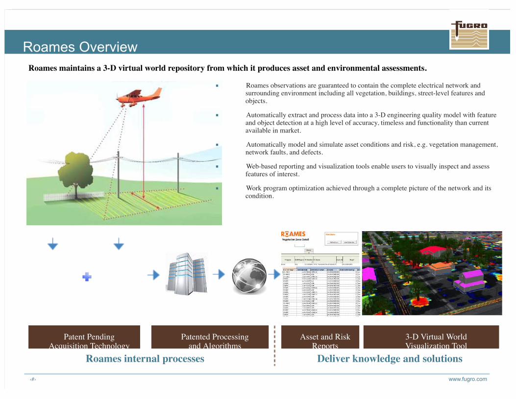
■ Roames observations are guaranteed to contain the complete electrical network andsurrounding environment including all vegetation, buildings, street-level features andobjects.
■ Automatically extract and process data into a 3-D engineering quality model with featureand object detection at a high level of accuracy, timeless and functionality than currentavailable in market.
■ Automatically model and simulate asset conditions and risk, e.g. vegetation management,network faults, and defects.
■ Web-based reporting and visualization tools enable users to visually inspect and assessfeatures of interest.
■ Work program optimization achieved through a complete picture of the network and itscondition.
Roames maintains a 3-D virtual world repository from which it produces asset and environmental assessments.
Roames Overview
Roames internal processes Deliver knowledge and solutions
Patent PendingAcquisition Technology
Patented Processingand Algorithms
3-D Virtual WorldVisualization Tool
Asset and RiskReports

www.fugro.com‹#›
Detailed Elevation Data for Mapping Networks

www.fugro.com‹#›
Detailed Modeling for Change Analysis

www.fugro.com‹#›
GeoSAR

www.fugro.com‹#›
The GeoSAR System
GeoSAR is an Interferometric Synthetic Aperture Radar System (IFSAR) that operates in twofrequency bands. Employed from Fugro’s Gulfstream G-II aircraft, it is a one-of-a-kind system,operational since 2003.
X-band antennas Antenna positioning measurement unit
P-band antennas

www.fugro.com‹#›
● X-band (yellow) reflects off of thefirst surface
– Produces DSM and magnitudeimage of surface features(vegetation, houses, roadways)
● P-band (green) penetrates
vegetation, ice, dry soil, to collectterrain features
– Basis for DTM and magnitudeimage of underlying features(paths, cultural features,fences, geologic features, mostmetallic features, wetlands)
X-bandP-band
GeoSAR – X- and P-band Description

www.fugro.com‹#›
GeoSAR Data Products
Orthorectified Radar Imagery (ORI)• Radar surface reflectance• Visualization, mapping,
Digital Surface Model (DSM) X-band• Orthorectified intensity model• Surface reflectance elevation• Detailed visualization and analysis
Digital Elevation Model (DEM) P-band• Represents near bare-earth• Derived layers (e.g., slope,
contours)
Digital Terrain Model (DTM) X/P Hybrid• Represents bare-earth

www.fugro.com‹#›
Roadware
www.fugro.com‹#›
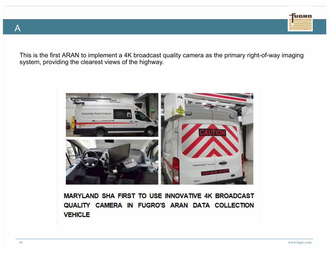
A
This is the first ARAN to implement a 4K broadcast quality camera as the primary right-of-way imagingsystem, providing the clearest views of the highway.

www.fugro.com‹#›
Off-shoreSurvey
www.fugro.com‹#›
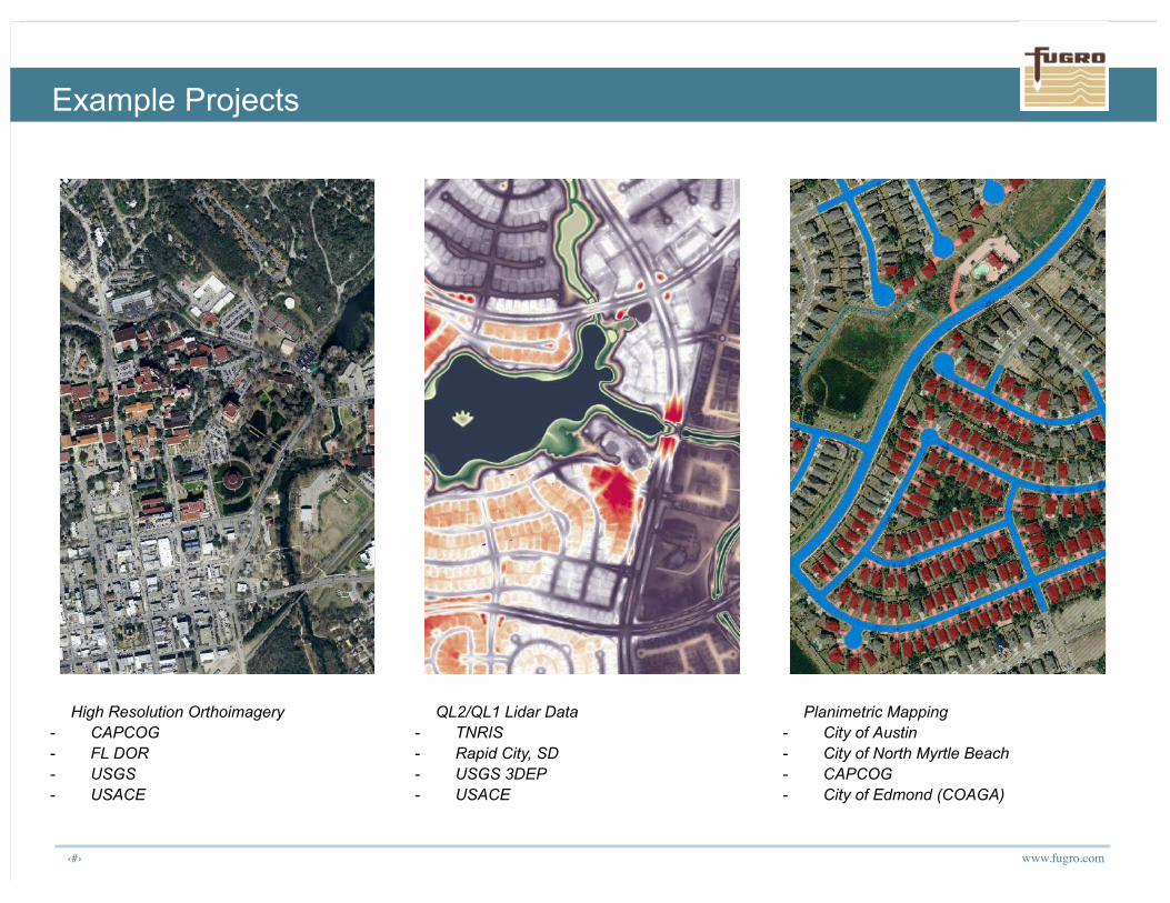
High Resolution Orthoimagery- CAPCOG- FL DOR- USGS- USACE
QL2/QL1 Lidar Data- TNRIS- Rapid City, SD- USGS 3DEP- USACE
Planimetric Mapping- City of Austin- City of North Myrtle Beach- CAPCOG- City of Edmond (COAGA)
Example Projects

www.fugro.com‹#›
PG&E Power Distribution Line Mapping PanoramiX – High Resolution ObliqueImagery Program
Vegetation Related Mapping Projects- USDA FIA Plots- Fort Bragg Tree Classification
Example Projects

www.fugro.com‹#›
California Coast Coastal Data Merge Sea grass Mapping
Example Projects

www.fugro.com‹#›
Search for MH370 ROCIS – Ocean Current MonitoringRemote Ocean Current Imaging System
Alaska GeoSAR
Example Projects

Thank you!Keith Owens – Technical and Business Development Manager(301) 948-8550 | [email protected]