Embed Size (px)
Citation preview
Maine State LibraryDigital Maine
Transportation Documents Transportation
2008
Sensible Transportation: A Handbook for Localand Inter-Community Transportation Planning inMaine, 2008Maine Department of Transportation
Follow this and additional works at: https://digitalmaine.com/mdot_docs
This Text is brought to you for free and open access by the Transportation at Digital Maine. It has been accepted for inclusion in TransportationDocuments by an authorized administrator of Digital Maine. For more information, please contact [email protected].
Recommended CitationMaine Department of Transportation, "Sensible Transportation: A Handbook for Local and Inter-Community TransportationPlanning in Maine, 2008" (2008). Transportation Documents. 24.https://digitalmaine.com/mdot_docs/24

A Handbook for Local and Inter-CommunityTransportation Planning in Maine
Implementing Maine’s Sensible Transportation Policy Act through Coordinated Transportation and Land Use Planning
Maine Department of Transportation
June 2008
SenSible TranSporTaTion


1 / 1
Implementing Maine’s Sensible Transportation Policy Act through Coordinated Transportation and Land Use Planning
By Evan Richert, AICPPaul Godfrey, HNTB Corp.Kevin Hooper, Kevin Hooper & AssociatesCarol Morris, Morris Communications
Illustrations by C. Michael LewisDesign by Lynn Ericson, Ericson Mitchell Design & Marketing
Handbook for Local and Inter-Community Transportation Planning in Maine
Maine Department of TransportationJune 2008
Sensible Transportation

1 / 2

1 / 3
Steering Committee
Gerry Audibert, MaineDOT
Jeff Austin, Maine Municipal Association
Stacy Benjamin, State Planning Office
Don Craig, Androscoggin Valley Council of Government
Kat Fuller, MaineDOT
Jim Fisher, Hancock County Planning Commission
Linda Johns, City of Brewer
Jonathan LaBonte, Maine Turnpike Authority
Chris Mann, MaineDOT
Noel Musson, Maine Association of Planners
Conrad Welzel, Maine Turnpike Authority
The authors extend their appreciation to Kat Fuller, Chief of the MaineDOT’s
Bureau of Transportation Systems Planning, for her tireless efforts to bring
transportation and land use planning into alignment with each other; to
Gerry Audibert for his management of this project; and to the entire Steering
Committee, whose guidance shaped both the approach and the content of
this handbook.

1 / 4

1 / 5
Introduction ................................................................................................................................ iChapter 1. Background ................................................................................................................................. 1 / 1
Two Laws, Common Goals.......................................................................................................................1 / 2
How to Get Started ................................................................................................................................... 1 / 3
Chapter 2. Partnerships ............................................................................................................................... 2 / 1
MaineDOT .................................................................................................................................................... 2 / 1
Metropolitan Planning Organizations ..................................................................................................... 2 / 4
Maine Turnpike Authority ......................................................................................................................... 2 / 5
Regional Planning and Development Organizations ........................................................................... 2 / 6
Chapter 3. The Transportation-Land Use Connection ....................................................3 / 1
Three Geographic Levels ..........................................................................................................................3 / 1
The Four Ds .................................................................................................................................................. 3 / 3
Applying the 4Ds at the Three Geographic Levels ............................................................................. 3 / 8
Chapter 4. Public Participation ...........................................................................................4 / 1
Get the Right People Involved ................................................................................................................. 4 / 1
A Continuous Process ............................................................................................................................... 4 / 2
Agree on the Problems First .................................................................................................................... 4 / 3
But Do Get to Vision and Goals Soon Thereafter ............................................................................. 4 / 4
Involve the Public in Hands-on Work .................................................................................................... 4 / 4
Chapter 5. Taking Stock .......................................................................................................5 / 1
The Inventories ............................................................................................................................................5 / 1
Maps ................................................................................................................................................................ 5 / 2
Elements of the Inventory .........................................................................................................................5 / 2
The Neighborhood Audit: a Public Participation Tool ...................................................................... 5 / 7
Analysis .......................................................................................................................................................... 5 / 8
Chapter 6. Imagining the Future .........................................................................................6 / 1
Three Good “Visioning” Tools ................................................................................................................ 6 / 2
Before Moving On to Solutions ............................................................................................................... 6 / 4
Chapter 7. Policies and Strategies.......................................................................................7 / 1
A Brief “How-To” for Establishing Policies ........................................................................................... 7 / 1
What the STPA Requires .......................................................................................................................... 7 / 2
Menu of Strategies (Turning Policy into Action) ................................................................................. 7 / 5
Chapter 8. Implementation ........................................................................................................................8 / 1
Capital Investment Plan ............................................................................................................................. 8 / 1
Financing Approaches ................................................................................................................................. 8 / 2
Regulatory Approaches ............................................................................................................................. 8 / 5
Regional Approaches .................................................................................................................................. 8 / 6
Appendix A. Common Transportation – Land Use Issues .............................................A / 1
Appendix B. Menu of Strategies ......................................................................................... B / 1
Appendix C. Inventory Forms ............................................................................................C / 1
Appendix D. Internet Links .................................................................................................D / 1
Appendix E. Glossary and Acronyms .................................................................................E / 1
contents

1 / 6

1 / 7
TABLES
2-1 Examples of basic vs. a higher level of consistency
2-2 Regional planning and development organizations
3-1 Design features for streets in a growing suburb/small service center
3-2 Design features for community streets
3-3 Design features for regional roads and highways
5-1 Local transportation self-audit for growing suburban towns
B-1 Species of concern
FIGURES
3-1 Walking/bicycling to local store, Midcoast Maine
3-2 Measures of density
3-3 Links-to-nodes ratio
3-4 Evolution of street layouts
3-5 An outdoor room
3-6 Streetscape proportions
3-7 An interconnected neighborhood
3-8 Example of an outdoor room
3-9 Dimensions of a neighborhood street
3-10 Downtown Belfast: FAR=0.75
3-11 Dimensions of low speed arterials
3-12 A conservation subdivision
3-13 Dimensions of high speed arterials
4-1 Continuous public participation
5-1 Citizens and GIS: Ellsworth’s inventory of bike/ped conditions
6-1 Envisioning the future through a build-out map
6-2 Taking the measure of things
B-1 Well-defined growth areas along numbered highways
B-2 Frontage roads and shared access
B-3 Links-to-nodes ratio
B-4 Engineered community septic system
B-5 Off-Street bicycle paths
B-6 Park and ride lot system
B-7 Mixed-use redevelopment on Saco Island, site of new train station
B-8 Cross-section of an “outdoor room”
B-9 Context sensitive design
B-10 Sampling of traffic calming designs
B-11 Improving highway commercial design
B-12 Example of road corridor visual assessment map
figures/tables

1 / 8
i
introduction
Welcome to Maine’s community transportation planning handbook. This handbook provides local planners with the information they need to prepare transportation plans – or transportation chapters of comprehensive plans – that are consistent with the State’s Sensible Transportation Policy Act and rule and the transportation element of the State’s Growth Management Program.
How to USe tHiS Handbook
The manual is divided into 8 chapters plus several appendices. Chapters 1 and 2 provide the legal context for community transportation planning and background on the agencies that communities can call upon for assistance. Chapter 3 walks the reader through the basics of transportation-land use planning, focusing on the “4 Ds” (density, distance, diversity, and design) that are the hinges between these two closely related fields. Chapters 4 through 8 represent the guts of a commu-nity transportation plan: public participation, inventories, vision, the required minimum policies and strategies, and implementation.
The workhorses of the handbook may be Appendices A and B. Taken together, these appendices provide a menu of strategies that may be helpful in preparing a community transportation plan. Appendix A offers a number of transportation-land use planning issues that are common to many municipalities in Maine. For each issue, we then list few of the possible strategies to address it. These strategies are individually described, typically on a single page, in Appendix B. The reader need only spot the strategy or suite of strategies in Appendix A that may be of interest to him or her, and turn to the referenced pages in Appendix B for summaries of the strategies.
The descriptions of the strategies should be considered introductory. The informa-tion contained in them may be sufficient for your community to decide whether to include one or more of the strategies in its transportation plan. However, if your community wants to pursue implementation of the strategies, it may well need to consult with MaineDOT, its regional council, or others to fully scope them out.

ii
SHort-CUtS
Good news! You don’t have to read this handbook cover-to-cover in order to use it. If you are thinking:
“I don’t want to do a whole plan right now – just want to understand if my commu-nity is making the connection between transportation and land use,” go to Chapter 3.
“I’d like to know how to inventory what our transportation system consists of,” go to Chapter 5.
“I’d like some specific benchmarks to compare my town’s practices with best prac-tices in transportation-land use planning,” go to Chapter 5, Table 5-1, page 9.
“I want to know what my town needs as the minimum statements of policy and strategies to include in the transportation chapter of the comprehensive plan,” go to Chapter 7, page 2.
“I’d like an idea of the kinds of standards that would make us eligible for incentives for transportation improvements from MaineDOT,” go to Chapter 2, Table 2-1, page 3.
“I want a general idea of the financing and regulatory approaches to implement a transportation plan,” go to Chapter 8.
“I want to review the common transportation-land use issues that towns like mine commonly face, and the packages of strategies that might be useful to address them” go to Appendix A.
“I’d like a few strategies to:• Preventcongestionandpreservemobility,”go to Appendix B, pages B3-B13.• Enhance the form and pattern of development,” go to Appendix B, pages B14-B22. • Introduceorexpandmodesofpassengertransportation,”go to Appendix B,
pages B23-B30. • Protectandgetthemostoutofregionaltransportationfacilities,”go to
Appendix B, pages B31-B35. • Maintainqualityofplace,”go to Appendix B, pages B36-B48.
“I want to get in touch with the Regional Council that serves my town,” go to Chapter 2, page 7.
1 / 1
Transportation is nothing more or less than the means to connect Land Use A to Land Use B: home to work, manufacturer to supplier, or skier’s residence to ski resort. This means that transportation and land use planning are tightly bound. Transportation systems influence most important land use decisions, and thus shape communities, regions, and their economies. In turn, if a transportation system is not working well, there often is something wrong with the arrangement of land uses. To paraphrase a common saying, if the transportation (or land use) system sneezes, the land use (or transportation) system catches a cold.
The nation made huge investments in the highway system during the 20th Century, and use of the automobile, a marvel of personal transportation, re-shaped metropolitan areas and regional landscapes. But now we have an expansive – and aging – infrastructure to maintain and insufficient funding to do so. As a result, expansion of the system will become less common in the foreseeable future and will increasingly have to compete with maintenance needs.
So transportation planners are focusing more sharply than ever on trying to manage demands on the system – and this leads back to land use. More efficient land use translates into a smaller burden on the state highway system.
But aligning transportation and land use decisions is tricky, partly because these decisions are made in very different ways. The backbone of the transportation network – arterial and collector roads, interchanges, freight systems, sea ports and airports – is by nature regional, and State and Federal policies, programs, and funds drive decisions about the network. Land use decisions, on the other hand, are made one at a time, parcel by parcel, and are by their nature local. They are largely in the hands of individual property owners and local officials.
These two ways of making decisions often ricochet off each other, producing powerful impacts on communities and transportation systems alike, but without fully anticipating the effects. Now, in the face of energy costs, the costs of maintaining the transportation system, and frequent conflicts over land use and quality of life, it is urgent that each takes the other into full account.
baCkgroUndTwo Laws, Common Goals
chapter 1

1 / 2
two LawS, Common goaLS
In 1991 Maine voters adopted the Sensible Transportation Policy Act (STPA)1 to help reduce demands on the highway system. In 2003 and 2007, the State Legislature amended the Act to mandate a better connection between transportation and land use planning – and, specifically, between the STPA and the State’s Growth Management Act.2 The common goals of the two laws include facilitating orderly growth and development, promoting economic development, reducing impacts on natural and cultural resources, and providing better solutions to transportation problems. Importantly, both laws recognize that transportation and land use patterns operate at a regional scale, and both encourage inter-community planning, financing, and regulation.
Sensible transportation Policy act
When transportation mobility needs arise, the Sensible Transportation Policy Act (as well as federal law) requires an evaluation of a full range of alternatives before choosing to expand the capacity of the highway system. It gives preference to options like managing traffic and providing public transportation if those options are available and feasible. It requires the integration of land use planning with transportation planning, and promotes energy efficiency. And it directs decision-makers to take into account the transportation needs of both urban and rural areas, and of people of different ages and means.
While in place since 1991, the Act and its implementing rule now affect communities much more directly. First, its rule has become the guiding document for the transportation section of local comprehensive plans. It sets the standards for the strategies that constitute an acceptable transportation section. This manual is offered to help communities meet the standards.
Second, as directed by the Legislature, MaineDOT has created incentives for community transportation planning. To be eligible, a municipality, on its own or preferably with neighboring communities, must adopt a Community Transportation Plan that clearly plans for development, especially where it impacts state transportation corridors. The land use strategies that are part of this plan must reduce the need to make costly transportation improvements – now and in the future – and must be incorporated into local ordinances. The Community Transportation Plan can stand alone, be part of a community’s own Comprehensive Plan, or be part of a multi-municipal Comprehensive Plan adopted under the Growth Management Act.------------------------------------------------------------------------------------------------------------------------
1 The Sensible Transportation Policy Act can be found at Title 23, MRSA, Section 73. The 2003 amendment
required the Department to adopt a rule in coordination with the State Planning Office that links transporta-tion and land use planning processes. The 2007 amendment provided for incentives to adopt local and regional community transportation plans that employ land use strategies to reduce pressure on state transportation corridors.2 Title 30-A, MRSA, Chapter 187

1 / 3
In addition, MaineDOT sponsors the creation of regional multi-modal corridor management plans where several municipalities along a transportation corridor may collaborate to identify the transportation and land use management priorities to keep the corridor functioning at an optimal level.
growth management act
Adopted in 1988 and amended several times since, the Growth Management Act and its implementing rule establish statewide goals and guidelines for preparing municipal and multi-municipal comprehensive plans. These plans provide the legal basis for local zoning and certain other land use ordinances. At the core of a town’s Comprehensive Plan is a Future Land Use Plan, which is meant to provide for orderly growth and development in the community and region.
As noted, the transportation element of the Comprehensive Plan can serve as the Community Transportation Plan. The transportation element and the Future Land Use Plan are intended to work in sync, with land use policies designed to reduce pressures on the transportation system and to create choices in how people move about a neighborhood, the community and region.
How to get Started
This handbook will provide you with the information you need to prepare a Community Transportation Plan, whether stand-alone or as an element of a Comprehensive Plan. Besides reading the handbook, a good place to get started is a consultation with your Regional Council, which has helped MaineDOT establish the transportation, land use and economic objectives of key transportation corridors in your region and serves as a state-local liaison (more on the Regional Councils can be found in Chapter 2). Technical assistance also is available from both MaineDOT:
Community Services DivisionBureau of Transportation Systems PlanningTel: 1-800-498-9133e-mail: [email protected]
and the Maine State Planning Office:
Land Use TeamTel: 1-800-662-4545 or (207) 287-6077www.maine.gov/spo/landuse/about/commentsform.htme-mail: [email protected].

1 / 4

2 / 1
Under the Sensible Transportation Policy Act (STPA), the major transportation agencies of the State are obligated to try to manage demand on the systems within their charge. As noted in the previous chapter, this is tricky because these agencies have very limited authority over the development that creates the demand. They thus must rely on a relationship with the entities that do have that authority, chief among them municipalities. And, because individuals and property owners are ultimate decision-makers about the use of land and transportation systems, the relationship is three-way: state-municipal-private.
MaineDOT is charged with the overall responsibility for the State’s transportation policy and planning. Metropolitan Planning Organizations (MPOs) are responsible for transportation planning in the urbanized portions of the Bangor, Lewiston-Auburn, and Portland-South Portland-Biddeford metropolitan areas, and the urbanized Maine portion of the Kittery-Portsmouth-Dover-Rochester metropolitan area. MPOs carry out their planning activities in cooperation with MaineDOT and are subject to the same planning policies, processes, and requirements as MaineDOT. The Maine Turnpike Authority (MTA) is responsible for the development, management and operation of the Turnpike and its connector roads.
Each has responsibilities under the STPA to work with municipalities as they develop plans and implement projects. In turn, municipalities are obligated to consider the impacts of land use decisions on transportation facilities. Municipalities also have opportunities to take advantage of incentives to prepare and implement community and regional transportation plans that will extend the life of the State’s transportation system.
mainedot
MaineDOT wants to work with municipalities on land use strategies that will preserve the capacities of highway corridors and will allow rural arterials to function as they were intended – able to move people and goods through the state as smoothly and safely as possible. And it wants to carry out its mission in a way that is consistent with local goals for economic growth and quality of life.
PartnerSHiPSEngaging the Transportation Planners
chapter 2

2 / 2
Important Point:
“Consistency” is at the
heart of the State’s
efforts to align transporta-
tion and land use plans.
The STPA and Growth
Management Act now point
to each other: for a local
comprehensive plan to be
deemed consistent under
the Growth Management
Act, it must be consistent
with the STPA. In turn, the
plans of MaineDOT (and
Maine Turnpike Authority
and MPOs) must be con-
sistent with the Growth
Management Act and seek
to resolve conflicts with
local comprehensive plans.
MaineDOT’s authority over land use is limited to access permits for driveways entering state roads outside of urban compact areas and to traffic movement permits for large-scale projects that generate 100 or more peak hour trips. Beyond these, the department relies on a two-way flow transportation-land use obligations and opportunities with municipalities. These can be grouped under five headings:
• Consistency: There are two types of consistency. First, as a matter of policy and law, transportation and land use planning at the local level must be consistent with the Growth Management Act. Second, when MaineDOT is considering projects that are either “significant” (because the project increases capacity of the highway system) or of “substantial public interest” (as requested by municipal officials, or any interchange project), it must evaluate each option in light of local long-range land use plans and make good faith efforts to resolve conflicts with them. In the case of interchange projects, the department (or MTA) must seek the advice of municipalities or the appropriate regional entity as to how to avoid, minimize or mitigate an inconsistency or adverse impact. • Preservation of System Capacity: Because funds to expand the capacity of the State’s road system are limited, preserving existing capacity is among the highest priorities of MaineDOT and was an impetus behind the STPA rule adopted in 2008. Under the rule, if MaineDOT undertakes a “significant” highway or an interchange project, and if it determines that a community’s land use policies will potentially reduce the transportation benefits of the project, the department may a) request that the host or affected municipalities enact land use management strategies to avoid or minimize activities that could reduce the transportation benefits, b) decide the loss of transportation benefits outweighs the cost and not build the project, or c) apply a surcharge through a local cost share to offset the loss of benefits.
• Corridors: Both in its long-range planning and planning for specific projects, corridors are important building blocks for MaineDOT. When studying options for “significant” transportation projects, the department considers the cumulative effects of projects in a corridor on patterns of development, especially sprawl. Conversely, it examines the cumulative effects of development on the mobility of the corridor. It (and MPOs and Regional Councils) may recommend land use strategies to municipalities to lessen the impacts of development on the workings of the corridor.
Important Point: For MaineDOT to take into account features that a community considers to be valuable, it is essential that towns document them in advance, as part of a comprehensive plan or community transportation plan adopted by the legislative body of the municipality. That puts the department on notice that it should include these in its project planning.

2 / 3
• Community Enhancements: When MaineDOT defines or scopes a transportation project, it will consider impacts on features that the community has documented to be important to its values and livability and will consider entering into a State-Local agreement to preserve or enhance these features. These may include, for example, facilities for pedestrians and bicycles, scenic vistas, historic districts or sites, street trees and tree lines, wildlife habitat, stone walls and similar landscape elements, and water quality concerns.
• Incentive-based Community Transportation Plans: MaineDOT uses the STPA rule as the basis for determining whether the transportation section of a municipal or multi-municipal comprehensive plan meets the goals of the Growth Management Act. In addition, based on 2008 amendments to the STPA, municipalities that use the STPA to guide their transportation chapters become eligible for transportation planning assistance and incentives for transportation investments. The incentives are competitive, based on a rating system to be established in a rule by MaineDOT, with funding commensurate with the merits of the community plan. The incentives increase if a municipality sets for itself a bar of consistency that is more than “basic,” and if two or more municipalities adopt a joint plan with complementary land use and transportation management strategies.
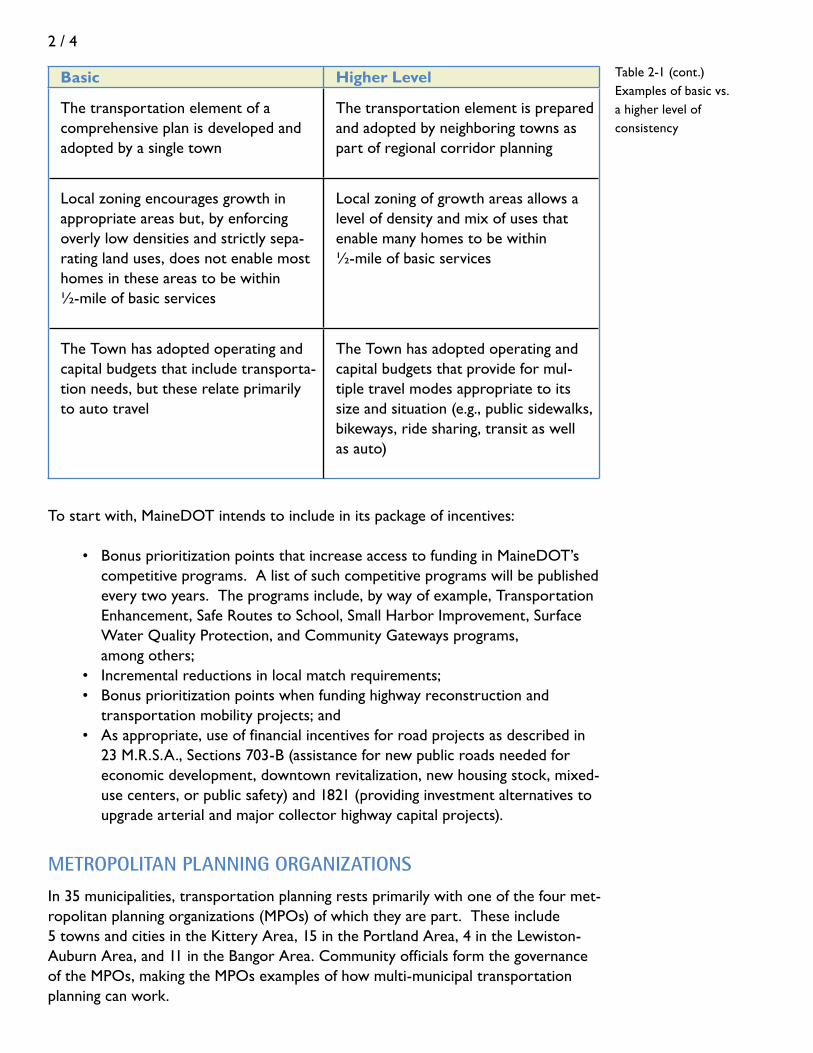
Basic Higher Level
Town has clearly designated growth areas in its comprehensive plan and has identified strategies to direct growth to them but hasn’t adopted the imple-menting strategies
Town has designated growth areas in the Comp Plan and has adopted imple-mentation measures that are likely to direct a majority of growth to them
Town has excluded substantial seg-ments of rural arterials from growth areas in its comprehensive plan, but land use regulations still allow signifi-cant development along them
In its ordinances, Town has reserved a majority of frontage along rural arteri-als for rural land uses, allowing for only limited development along them
Access management standards address design factors (such as sight distance) but do not limit the number, spacing, or width of access points along rural arterials and major collector roads.
Standards limit access points along ru-ral arterials and major collector roads to one per lot of record and prescribe distances between them based on speed limit. The width of access points is limited to assure safety.
Subdivision standards limit the length of new dead end roads and encourage but do not require the interconnection of streets within or between subdivisions
Subdivision standards require intercon-nections between streets in a subdivi-sion and provide for future rights of way to connect one subdivision to another
Table 2-1Examples of basic vs.
a higher level of consistency
2 / 4
Basic Higher Level
The transportation element of a comprehensive plan is developed and adopted by a single town
The transportation element is prepared and adopted by neighboring towns as part of regional corridor planning
Local zoning encourages growth in appropriate areas but, by enforcing overly low densities and strictly sepa-rating land uses, does not enable most homes in these areas to be within ½-mile of basic services
Local zoning of growth areas allows a level of density and mix of uses that enable many homes to be within ½-mile of basic services
The Town has adopted operating and capital budgets that include transporta-tion needs, but these relate primarily to auto travel
The Town has adopted operating and capital budgets that provide for mul-tiple travel modes appropriate to its size and situation (e.g., public sidewalks, bikeways, ride sharing, transit as well as auto)
Table 2-1 (cont.)Examples of basic vs. a higher level of consistency
To start with, MaineDOT intends to include in its package of incentives:
• BonusprioritizationpointsthatincreaseaccesstofundinginMaineDOT’s competitive programs. A list of such competitive programs will be published every two years. The programs include, by way of example, Transportation Enhancement, Safe Routes to School, Small Harbor Improvement, Surface Water Quality Protection, and Community Gateways programs, among others; • Incrementalreductionsinlocalmatchrequirements; • Bonusprioritizationpointswhenfundinghighwayreconstructionand transportation mobility projects; and • Asappropriate,useoffinancialincentivesforroadprojectsasdescribedin 23 M.R.S.A., Sections 703-B (assistance for new public roads needed for economic development, downtown revitalization, new housing stock, mixed- use centers, or public safety) and 1821 (providing investment alternatives to upgrade arterial and major collector highway capital projects).
metroPoLitan PLanning organizationSIn 35 municipalities, transportation planning rests primarily with one of the four met-ropolitan planning organizations (MPOs) of which they are part. These include 5 towns and cities in the Kittery Area, 15 in the Portland Area, 4 in the Lewiston-Auburn Area, and 11 in the Bangor Area. Community officials form the governance of the MPOs, making the MPOs examples of how multi-municipal transportation planning can work.

2 / 5
MPOs were established in Federal law, sub-ject to state DOT oversight. They do the same transportation planning work, includ-ing the prioritization and funding of trans-portation projects, for the urbanized por-tions of federally defined metropolitan areas as MaineDOT does for the rest of the State. Every two years, they receive an allocation of funds from MaineDOT for planning and to construct federally eligible projects.
MPOs are subject to the same STPA re-quirements as MaineDOT. In their long-range plans, they address multi-modal transportation (bicycling, walking, transit, and ride-sharing as well as highway proj-ects), and promote access management. The MPOs’ long-range plans are strongly encouraged to consider municipal or multi-municipal land use programs within the respective MPO planning areas. At a mini-mum, they should inventory and evaluate existing land use policies and document how existing policies affect the transportation system. MPO long-range plans may include transportation and land use planning poli-cies that guide MPO and MaineDOT capital investment decisions and planning process-es. MPO long-range plans may also include recommendations to MaineDOT and MPO area municipalities concerning land use and
transportation goals, policies, objectives and strategies that assure the long-term benefits of the regional transportation system.
When an MPO long-range plan includes recommendations for a project that adds new highway capacity, the plan may document existing land use conditions in the area affected by the proposed project and include land use policy recommendations to municipalities to preserve the added capacity.
maine tUrnPike aUtHority
The Maine Turnpike Authority (MTA), like MaineDOT, is subject to the terms of the STPA and, as part of projects that expand the capacity of the Turnpike, must consid-er the policies of affected local comprehensive plans and the Growth Management Act. If its preferred strategy conflicts with adopted land use plans, it must make a good faith effort to resolve the conflict.
PACTS’ Award Winning Long-Range Plan —Destination Tomorrow
In 2003, PACTS, the Greater Portland Area MPO, broke new ground for MPOs by explicitly tying its long-range transportation plan to land use objectives, namely: • Maintainthehistoricpatternofvillagesandurban centers separated by rural countryside • Targetgrowthtocompact,mixed-usecenters • Preserveandcreatemixed-use,pedestrian-friendly neighborhoods • Engagethepublicinpursuitofsmartgrowth solutions • Providechoiceintransportation
Specifically, the PACTS Land Use Policy states that:
A transportation project that, by itself or as part of a program of improvements, will create significant new transportation capacity within a corridor, must be accompa-nied by an integrated transportation and land use plan that: • Preservescorridorcapacity; • Activelymanagescorridormobility; • Protectsthepublicinvestmentintheprovisionof infrastructure and public services; and, • Combatssprawlbypromotingcompact, transportation efficient corridor land-use.

2 / 6
Beyond this base requirement, MTA promotes alterna-tive modes of travel, such as commuter buses and ride-sharing, that can reduce demand on the Turnpike during peak travel periods. Understanding that the Turnpike feeds and interacts with many tributary communities, the MTA also reaches out to communities in at least three ways. First, it is a member of each of the MPOs and meets regularly with Regional Councils. Second, MTA of-ficials make annual visits to Turnpike corridor communi-ties and communities that are tributary to the Turnpike. And third, the Turnpike’s Board of Trustees meets twice a year – once in northern Maine and once in southern Maine – in public workshops with local officials.
regionaL CoUnCiLS
The State’s regional councils – the 10 regional planning councils and councils of government and one county planning office listed in Table 2-2 – are key supporting structures in the world of STPA. MaineDOT relies on them to be its regional eyes and ears for public outreach and to coordinate advice on transportation needs from parties of interest in their respective regions.
The organizations play front-line roles in identifying needs within Corridors of Regional Economic Significance for Transportation (CREST) around the state, and in developing multi-modal management plans for the corridors, which in turn serve as input to MaineDOT’s Long-Range Plan and in the development of multi-modal corridor management plans. In fact, it is likely that the majority of future, large-scale transportation projects of interest to communities will have to have been identified as part of mutli-modal corridor management plans. Objectives of these planning efforts are to preserve the capacity of the corridors to move people and freight, preserve and enhance regional economic assets, align transportation investments with the needs of communities, and preserve local quality of life.
At the local level, the regional councils assist municipalities in updating comprehen-sive plans and the transportation chapters of those plans and with ordinances and other actions to better align land use decisions with the transportation system. And they are MaineDOT’s conduit for delivering transportation planning data to com-munities who are undertaking transportation chapters of comprehensive plans (or want to prepare a stand-alone transportation plan). Early in their planning processes, communities should contact the regional council for data and guidance.
Important Point: Communities along or near the Turnpike corridor sometimes include in their comprehensive plans a desire for improved connections to the Turnpike. Such a policy must have a strong factual basis and should be developed only after close consulta-tion with MTA officials. (The same goes for connections to other limited access highways, which should involve close, early consultation with MaineDOT.)

2 / 7
TABLE 2-2. Regional Planning and
Development Organizations Androscoggin Valley Council of Governments125 Manley RoadAuburn, ME 04210(207) 783-9186http://www.avcog.org/index.php
Midcoast Regional Planning Commission166 Main Street, Suite 201Rockland, ME 04841(207) 594-2299http://www.midcoastplanning.org
Greater Portland Council of Governments68 Marginal Way, 4th FloorPortland, ME 04101(207) 774-9891http://www.gpcog.org
Northern Maine Development Commis-sion 302 Main StreetPO Box 779Caribou, ME 04736(800) 427-8736http://www.nmdc.org/indexv2.cfm
Hancock County Planning Commission395 State StreetEllsworth, ME 04605 (207) 667-7131 http://www.hpcme.org
Penobscot Valley Council of Governments 40 Harlow StreetBangor, ME 04401(800) 339-6389http://[email protected]
Kennebec Valley Council of Governments17 Main StreetFairfield, ME 04937(207) 453-4258 ext 25http://www.kvcog.org/kvcog.html
Southern Maine Regional Planning Commission21 Bradeen Street, Suite 304Springvale, ME 04083(207) 324-2952http://www.smrpc.org
Lincoln County Planning OfficeHigh StreetPO Box 249Wiscasset, ME 04578
Washington County Council of Govern-mentsPO Box 631Calais, ME 04619(888) 287-3006 http://www.wccog.net
Mid-Coast Council for Business Development and Planning7 Park StreetBath, ME 04530(207) 443-5790http://www.mcbdp.org

2 / 8

3 / 1
tHree geograPHiC LeveLS
The transportation system operates at three levels: the neighborhood, the com-munity, and the region. At each of these levels, transportation serves fundamentally different purposes – so each level must be designed accordingly.
At the neighborhood level, the transportation system connects land uses that are part of the personal territory of the neighborhood’s residents. These land uses — homes, elementary schools, convenience stores, personal services, parks, and the like — play a huge social role, and the transportation system has to be compatible with that purpose.
The neighborhood is connected to the community, usually by means of a larger col-lector road that conveys residents to local commercial centers, town institutions, and other areas of town. At this level, the transportation system serves economic and social purposes in equal measure, as reflected by its dominant land uses — downtowns and shopping centers, town halls, medical offices, and high schools, for example.
And the community is part of a still larger region, served by a transportation system that includes major collector roads and long-distance arterials, rail lines, cargo ports, and airports. It moves commuters, freight, and visitors through the region and beyond. The
regional transportation system plays mostly an eco-nomic role. It also provides access to one-of-a-kind land uses that rely on or serve large populations. The regional system provides access to and from major employers, distribution centers, regional malls, health care centers, tourist destinations, nature preserves, and regional transportation terminals and inter-changes. Throughout the state, MaineDOT and the state’s Regional Councils have identified “corridors of regional significance to transportation,” and the department has built much of its Long Range Plan around these corridors.
tHe tranSPortation-Land USe ConneCtionBasics of Transportation-Friendly Communities
W a lk in g /B ic y c lin g to L o c a l S to r e , M id c o a s t M a in e
0%10%20%30%40%50%60%70%80%90%
100%
. 25 m ior le ss
>. 25-. 5m i
>. 5 to 1m i
>1-2mis
>2 mis
P r o x im ity o f h o m e to s to r e
rarely or never
once in a while
at leas t weekly
daily
chapter 3
Figure 3-1

3 / 2
Though both the transportation system and land uses are very different at these three levels, in each case the ways that transportation and land use interact come down to four factors that help to define the environment that is built around us. These are the “4 D’s”: • Density • Distance • Diversity • Design
Can changing the built environment – that is, the 4 Ds – really make a difference in the safety, efficiency, enjoyment, and longevity of the transportation system? Using two measures of demands on the road system – vehicle miles traveled and vehicle hours traveled – the best evidence from both national data and surveys in Maine is that the built environment does make a difference. For example, more than 50% of resi-dents of the mid-coast who live within a quarter mile of a local store, and nearly half who live within a half-mile, walk or bicycle to the store daily or at least weekly. At more than a mile away, over half rarely or never walk or bicycle to a local store, and at more than 2 miles, over three-quarters rarely or never do. See Figure 3-1.
Strategies that make communities and regions friendlier to non-auto or shorter auto travel will shift some percentage of trips to walking, bicycling, ride-sharing and transit. Certainly auto travel will continue to dominate at all levels. But arranging the built environment in friendlier ways will bring balance into a system that has virtually eliminated choice in many communities and regions, with predictable effects on the highway system.
So, onto the 4 Ds.
Pricing vs. the Built Environment
Doesn’t the transportation–land use connection really come down to something other than the 4 Ds, namely a very big P -- pricing?
Transportation technology provides us with wide choices of where to live, work, and carry out the many activities of living. Except for the elevator, which carried people skyward and helped shape city centers, innovations from animal cart to electric rail and, above all, the automobile have increased our freedom to move horizontally. Towns, cities, and regions have spread out accordingly.
The ability of the average person and business to take ad-vantage of the widening circle of choices as to where to live and work requires public subsidies. For example, accord-ing to the Federal Highway Administration, auto and truck users pay about 60% of the costs of road construction and maintenance through fuel and vehicle taxes and tolls. Users, in the form of buyers of house lots, also pay for the construction of local roads in new subdivisions. But other taxes and fees are needed to supplement user revenues to maintain the system. In addition, taxes subsidize the “un-seen” costs of an expanding system, including extra public safety, public works, school busing and environmental costs.
This is not a handbook on transportation economics, but we note the phenomenon of subsidized transportation because many experts argue that the most effective way to bring transportation and land use into sync is through pric-ing, such as expanding toll systems, increasing fuel taxes or taxing vehicle miles traveled. Pricing, they argue, allows the marketplace to allocate scarce resources most efficiently and requires those who travel more to pay more toward the unseen costs. As a result, land use decisions would take into account the true costs of transportation.
We acknowledge the importance of pricing, but for the most part the decisions about pricing rest with state and federal governments, not municipalities. Municipalities do have some pricing tools, such as impact fees, at their dis-posal – and we will discuss these in this handbook. Howev-er, our focus is on the basics of the built environment that can bring transportation and land use into better harmony, and over which local governments have some control.

3 / 3
tHe FoUr d’S
density
Density helps determine how much choice in transportation may be available to an area. For example, at low densities, the automobile frequently is the only practical choice. At higher densities, other choices, such as walking or taking a bus, are more feasible. In residential areas, density is measured in dwelling units or population per acre. In commercial areas, it is measured in employees per acre or the number of square feet of commercial space per area of land (floor area ratio or FAR). See Figure 3-2.
Consider a neighborhood with a density of 3 dwelling units per acre and a school, a day care center, and a store nearby. Compare it with a neighborhood (of the same geographic size) with a density of 1 dwelling unit per acre and also a school, a day care center, and a store nearby. It is almost certain that the residents of the first neighborhood will walk or bicycle to nearby activities more frequently than those of
Figure 3-2.
Measures of Density
Residential density is num-ber of dwelling units per
acre. Floor area ratio (FAR) is a measure of commer-cial density. It is the total
square feet in a building (all floors) divided by the total
square feet of land in the lot. A one-story 10,000 sq. ft. building on a 10,000 sq. ft. lot has a FAR of 1.0. So
does a two-story building with 5,000
sq. ft. per floor on a 10,000 sq. ft. lot.
football field
one acre
0.5 units/acre
1 unit/acre
2 units/acre
3 units/acre
5 units/acre
Residential Density
Floor Area Ratio
2.0
0.2
0.4
0.7
= building area / lot area

3 / 4
the second. And the difference is magnified if residences are close to job centers. Equally important to choice in transpor-tation is that destinations outside of the neighborhood – like shopping areas and job centers – also have a degree of density. A single neighborhood settled at a moderately high density by itself has limited effect on transportation choice. It has to be con-nected to other neighborhoods, shopping areas and job centers that also exhibit some degree of density.
Density is not an easy topic to discuss. Too often, it conjures up worries about crowding and urbanization. At least in the context of the towns and cities of Maine, this is a bad rap: no community in Maine has high resi-dential densities (15+ units per acre over a large area), and outside of Portland’s peninsula and downtown, very few neighbor-hoods have even moderately high densities (5-15 units per acre). Fortunately, im-proving transportation choice requires only incremental increases in residential and commercial densities, even where densities must remain low because homes rely on septic systems and wells.
Even so, density alone is insufficient to create the environment for choice in transportation. Choice also relies on distance between activities, on the mix of those activities, and on whether a neighborhood or community is designed for choice. And that takes us to the other three Ds.
distance (or accessibility)
“Distance” is more accurately described as “accessibility” (but then we wouldn’t have 4 “D”s!). “Accessibility” refers to the ease with which a traveler can move from one point to another. It is measured by the distance between land uses and the time and cost of moving between them. If a child has to ride a school bus for 30 minutes at considerable cost to taxpayers to get from home to school, his ac-cessibility to the school is quite low. If a shopper can hop on an interchange near home, travel on an uncrowded highway and be at a regional mall in a matter of minutes, accessibility to the mall is quite high. If a tourist staying at a downtown inn can walk to a variety of attractions, she is enjoying an accessible location.
How Much Density Is Needed to Create Choice?
It depends. For carpooling, residential density does not matter as much as having a convenient parking area near a highway interchange or major intersection where many people can converge to share rides. For walking and bicy-cling and for certain types of transit, like demand-response services, a residential density of at least 1 to 2 units per acre can work (higher if public water and sewer allow it). For a fixed-route bus system with 20 runs per day, 3 to 5 units per residential acre appears to be the minimum at one end of the trip, with a commercial density at the other end of at least 700 square feet of building space (floor area) per 1,000 square feet of lot area (Floor Area Ratio = 0.7). These are modest levels of density, and some small towns have established centers that already are built to them.
Is There a Magic Distance?
For walking, the magic distance seems to be ¼-mile, or ½-mile at the outside. A good measure of the “walkability” of a neighborhood is the number of comple-mentary activities – playground, conve-nience store, coffee shop, school, etc. – that are within ¼ to ½-mile of most residences

3 / 5
diversity
Diversity refers to the variety of land uses accessible to each other at any of the geographic levels. It is an indicator of the number of activities that can be satisfied on a single trip with a given mode of travel. Studies show that the number of auto trips drops as the mix of compatible and complementary land uses in neighborhoods, downtowns, community shopping centers or job centers increases. Certain land uses are natural companions – such as homes, school, day care center, and stores like grocery, drug, and hardware, that sell everyday goods; or higher density housing, offices, restaurants, and financial services. If they are close together, a single trip cov-ers them all. Of course, a mix of land uses isn’t enough; they have to be close enough together and designed for easy accessibility to each other. If they are, the situation is ripe to “park once” on any given trip, or, in some places, not at all because a car was not needed in the first place.
On the flip side, a mix of land uses also is important to the operation of major transportation facilities, such as airports, rail lines, and major interchanges – but for the opposite reason. Here the goal is to encourage land uses that can take advan-tage of the facilities (such as manufacturers and distributors), while insulating the facilities from land uses that would consider them a nuisance.
design
Design is the glue that makes a comprehensive transportation-land use system work. Design covers a lot of ground: the geometry and interconnection of streets, the management of access between roads and adjacent properties, the “streetscapes” of neighborhoods, and the “context” or character of the place served by the transpor-tation system. Without good design, we find that distance, density, and diversity of land uses are less able to provide for choice, safety and efficiency of transportation.
• Geometry: Geometry refers to the basic dimensions and design of streets, sidewalks, bike paths, and trails. The critical dimensions include, among other things, width of right-of-way, width of paved surface, minimum and maximum grades, sight distances, and minimum and maximum radii of curves and intersections. Best engi-neering practices for the geometries of different classifications of streets are widely available and won’t be duplicated in this handbook. We will, however, refer to and make use of some of these best practices as they relate to transportation choice and “livability” in neighborhoods and communities.
• Interconnection: Interconnection refers to the links between streets in a neigh-borhood, village, or community. It is fundamental to the form and function of a place. The degree of interconnection is measured by the number of “links” (road sections between intersections) divided by the number of “nodes” (intersections and cul de sac heads). See Figure 3-3. The greater the number of links per node, the greater the choices of pathways to get from one place in the community to another. Emergency vehicles, public works, delivery services, demand-response transit

3 / 6
services, and utilities (for looping of lines) all benefit from interconnectivity of the transportation system. A well interconnected system allows residents, including children, to move about the neighborhood without venturing onto busy streets, en-ables short neighborhood auto trips that avoid arterials, and allows cross-town trips to use direct secondary roads. • Over the last century, the layout of neighborhood street systems has
evolved in several forms, with different levels of interconnection. These forms are loosely grouped as grids, modified grids, loops and lollipops, and lollipops on a stick. See Figure 3-4.
Grid Layout: 37 links, 25 nodes = ratio of 1.5 Modified Grid: 42 links, 32 nodes = ratio of 1.3
Figure 3.3 Links-to-nodes ratio
This ratio is a measure of interconnection of the street system and the choices people have to get from one place to another. In the example here, the grid layout is from a neigh-borhood in Brunswick, and the modified grid layout is from a neighborhood in Brewer. Each intersection, dead end, and cul-de-sac is a node. Each segment of street between nodes is a link. (Don’t count links that are running out of the frame of the diagram.) The more links per node, the greater the connectivity of the neighborhood or community. Sometimes when it is not pos-sible or desirable to create a street connection, a pedestrian or bicycle connection can serve a similar purpose.
192226 12INTERSECTIONS 8
GRID MODIFIED GRID MODIFIED GRID LOOPS & LOLLIPOPS LOLLIPOPS ON A STICK
141928 12BLOCKS 8
Figure 3-4 Evolution of neighborhood street layouts
Since the mid-20th Century, the layout of neighborhood streets has evolved from primarily interconnected with many internal blocks (grid) to primarily dead-end (lollipops on a stick) with few internal blocks.
From: Center for Urban Research; Florida Center: Transportation, Land Use and Sustainability
3 / 7
• Access Management: Access (not to be confused with “accessibility”) to public roads is achieved with driveways, private ways, and openings called “curb cuts” that connect property directly to the road. Access management refers to the need to manage the number, locations, and design of these points of access. Why is there a need to manage this? Because access to streets is both necessary and a source of friction. Access should be geared to the geographic level – or major purpose - of the area being served. A lot of interaction between land uses and the street is expected along many local streets. For example, each home typi-cally has a driveway. But along major collectors and arterial roads, whose func-tion is to move people and freight long distances as smoothly as possible, as the number of access points increase, the friction increases – as do congestion, crash rates, and the costs (for traffic signals, turning lanes, extra travel lanes, and similar measures) to deal with it.
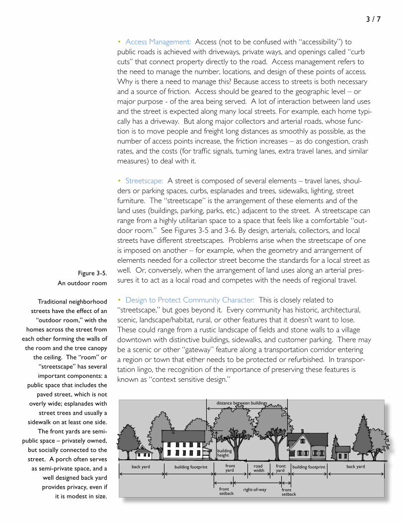
• Streetscape: A street is composed of several elements – travel lanes, shoul-ders or parking spaces, curbs, esplanades and trees, sidewalks, lighting, street furniture. The “streetscape” is the arrangement of these elements and of the land uses (buildings, parking, parks, etc.) adjacent to the street. A streetscape can range from a highly utilitarian space to a space that feels like a comfortable “out-door room.” See Figures 3-5 and 3-6. By design, arterials, collectors, and local streets have different streetscapes. Problems arise when the streetscape of one is imposed on another – for example, when the geometry and arrangement of elements needed for a collector street become the standards for a local street as well. Or, conversely, when the arrangement of land uses along an arterial pres-sures it to act as a local road and competes with the needs of regional travel.
• Design to Protect Community Character: This is closely related to “streetscape,” but goes beyond it. Every community has historic, architectural, scenic, landscape/habitat, rural, or other features that it doesn’t want to lose. These could range from a rustic landscape of fields and stone walls to a village downtown with distinctive buildings, sidewalks, and customer parking. There may be a scenic or other “gateway” feature along a transportation corridor entering a region or town that either needs to be protected or refurbished. In transpor-tation lingo, the recognition of the importance of preserving these features is known as “context sensitive design.”
frontsetback
frontsetback
right-of-way
roadwidth
frontyard
frontyard
back yardbuilding footprint back yard
buildingheight
distance between buildings
building footprint
Figure 3-5.
An outdoor room
Traditional neighborhood streets have the effect of an
“outdoor room,” with the homes across the street from
each other forming the walls of the room and the tree canopy
the ceiling. The “room” or “streetscape” has several important components: a
public space that includes the paved street, which is not
overly wide; esplanades with street trees and usually a
sidewalk on at least one side. The front yards are semi-
public space – privately owned, but socially connected to the street. A porch often serves
as semi-private space, and a well designed back yard provides privacy, even if
it is modest in size.
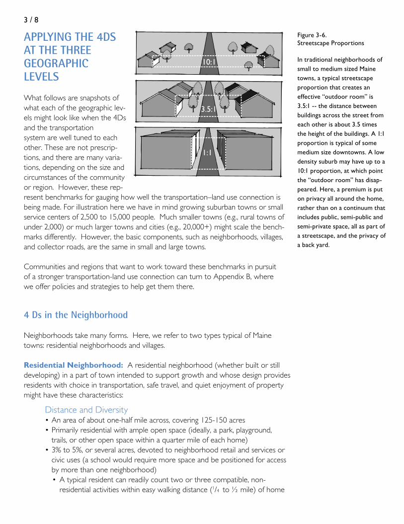
3 / 8
10:1
3.5:1
1:1
Figure 3-6. Streetscape Proportions
In traditional neighborhoods of small to medium sized Maine towns, a typical streetscape proportion that creates an effective “outdoor room” is 3.5:1 -- the distance between buildings across the street from each other is about 3.5 times the height of the buildings. A 1:1 proportion is typical of some medium size downtowns. A low density suburb may have up to a 10:1 proportion, at which point the “outdoor room” has disap-peared. Here, a premium is put on privacy all around the home, rather than on a continuum that includes public, semi-public and semi-private space, all as part of a streetscape, and the privacy of a back yard.
aPPLying tHe 4dS at tHe tHree geograPHiC LeveLS
What follows are snapshots of what each of the geographic lev-els might look like when the 4Ds and the transportation system are well tuned to each other. These are not prescrip-tions, and there are many varia-tions, depending on the size and circumstances of the community or region. However, these rep-resent benchmarks for gauging how well the transportation–land use connection is being made. For illustration here we have in mind growing suburban towns or small service centers of 2,500 to 15,000 people. Much smaller towns (e.g., rural towns of under 2,000) or much larger towns and cities (e.g., 20,000+) might scale the bench-marks differently. However, the basic components, such as neighborhoods, villages, and collector roads, are the same in small and large towns.
Communities and regions that want to work toward these benchmarks in pursuit of a stronger transportation-land use connection can turn to Appendix B, where we offer policies and strategies to help get them there.
4 ds in the neighborhood
Neighborhoods take many forms. Here, we refer to two types typical of Maine towns: residential neighborhoods and villages.
Residential Neighborhood: A residential neighborhood (whether built or still developing) in a part of town intended to support growth and whose design provides residents with choice in transportation, safe travel, and quiet enjoyment of property might have these characteristics:
Distance and Diversity • An area of about one-half mile across, covering 125-150 acres • Primarily residential with ample open space (ideally, a park, playground, trails, or other open space within a quarter mile of each home) • 3% to 5%, or several acres, devoted to neighborhood retail and services or civic uses (a school would require more space and be positioned for access by more than one neighborhood) • A typical resident can readily count two or three compatible, non- residential activities within easy walking distance (1/4 to ½ mile) of home

3 / 9
Density • If public sewer is available, a density of development that averages 3-5 dwelling units per residential acre, enough to support a variety of neighbor hood services (see also discussion of transit in Appendix B, Part 3) • If on-site wastewater disposal is used but the neighborhood is part of the Town’s growth area, a density of development that averages 1-2 dwelling units per residential acre, with frontages averaging 100 feet or less, creating a walkable scale despite low density
Design • An interconnection ratio of at least 1.3, and preferably 1.4 links per node or more, using dead end streets sparingly, and with block lengths of 600- 800 feet to slow auto speed and provide choices in pathways through the neighborhood (Figure 3-7) • Where dead ends are necessary, a pedestrian path connecting to the next street in the neighborhood • Neighborhood streets averaging under 500 vehicle trips per day (up to 1,000 trips is still okay for safety and quiet) • Speed limit set both for safety and to keep traffic noise levels in check (see Table 3-1) • A “streetscape” that feels like an “outdoor room,” (see Figures 3-5, 3-6, and 3-8) with the neighborhood street’s dimensions as shown in Table 3-1, and homes set back 15-20 feet, sufficient for privacy but close enough to the street so that the walls of the home create the “wall” of the “outdoor room.”
Str eet in photo below
-mile di ameter
Fi g ur e 3 -7. A n in t erc on ne c ted ne ig hb orhood
Fi g ur e 3 -8. Exa m p le of a n ou td oo r roo m , S o. P o rtl a nd
Figure 3-7. An interconnected neighborhood
Figure 3-8. Example of an outdoor room, So. Portland
1/2 mile diameter
street in photo at right
3 / 10
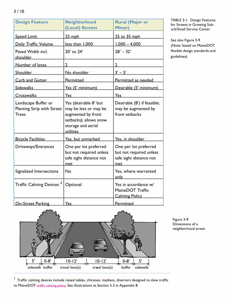
Design Feature Neighborhood (Local) Streets
Rural (Major or Minor)
Speed Limit 25 mph 25 to 35 mph
Daily Traffic Volume less than 1,000 1,000 – 4,000
Paved Width incl. shoulder
20’ to 24’ 28’ – 32’
Number of lanes 2 2
Shoulder No shoulder 3’ – 5’
Curb and Gutter Permitted Permitted as needed
Sidewalks Yes (5’ minimum) Desirable (5’ minimum)
Crosswalks Yes Yes
Landscape Buffer or Planting Strip with Street Trees
Yes (desirable 8’ but may be less or may be augmented by front setbacks); allows snow storage and aerial utilities
Desirable (8’) if feasible; may be augmented by front setbacks
Bicycle Facilities Yes, but unmarked Yes, in shoulder
Driveways/Entrances One per lot preferred but not required unless safe sight distance not met
One per lot preferred but not required unless safe sight distance not met
Signalized Intersections No Yes, where warranted only
Traffic Calming Devices 1 Optional Yes in accordance w/MaineDOT Traffic Calming Policy
On-Street Parking Yes Permitted
TABLE 3-1. Design Features for Streets in Growing Sub-urb/Small Service Center
See also Figure 3-9(Note: based on MaineDOT flexible design standards and
guidelines)
-------------------------------------------------------------------------------------------------------------------------------
1 Traffic calming devices include raised tables, chicanes, medians, diverters designed to slow traffic to MaineDOT traffic calming policy. See illustrations at Section 5.3 in Appendix B
5' 0-8' 10-12'
sidewalk buffer travel lane(s) travel lane(s) buffer sidewalk
5'0-8'10-12'
Figure 3-9. Dimensions of a neighborhood street

3 / 11
Village: A village with a commercial core and residential streets around it is of a scale similar to a residential neighborhood, but the interactions of transportation and land use differ in a few key ways: • The village core is 5% - 10% (several to 15 acres) of the neighborhood’s area, with residential uses and open space occupying the rest • Land uses in the core are varied, including civic, retail, services, and offices • Within the core, the non-residential floor area ratio (FAR) is 0.6 or greater (or 600 square feet of building space for each 1,000 square feet of lot area, including off-street parking areas) • The neighborhood extends about a quarter mile around each end of the core area • The core is concentrated along a low speed collector or arterial that connects the village to other parts of town; it carries heavier flows of traffic than the local streets in the surrounding neighborhood • Parking is on-street, or in one or more common off-street parking lots, or in small side lots • Buildings in the core front on sidewalks at least 5 feet wide • The surrounding neighborhood is well enough interconnected (link-to-node ratio of at least 1.4) that its residents do not have to turn onto the main street for every local trip • See residential neighborhoods above for characteristics of the residential portion of village neighborhoods
4 ds in the Community
A community with a sizeable downtown plus commercial uses along the road into town and designed for choice of transportation might have these characteristics:
Distance and Diversity • A downtown with several types of land use activities (including, for example, governmental or civic functions, fi nance, specialty retail, arts, education services, residential, restaurants, etc. – these vary from community to community) • Downtown is up to ½-mile from end to end. Many of the activities are within ¼-mile of each other • Where bus service is available or planned, public buildings and principal job and retail facilities are no more than ¼-mile from stops
Density • Downtown floor area ratio of at least 0.7 to 1.0 (70 to 100 square feet of building space per 100 square feet of land contained within lots, including parking lots). See Figure 3-10. • A range of residential densities, from low in designated rural areas of town, to 1 to 2 units per acre in growth areas that rely on septic systems, to moderately high near the center, including homes on small lots or apartments at 4 to 10 units per acre where public sewer is available.
Figure 3-10. Downtown Belfast: FAR=0.75

3 / 12
Design • Combination of rural collector roads and collectors and arterials that are more urban in nature • Speed limit along in-town collectors and low speed arterials is 25 to 35 mph • A continuous network of sidewalks, connecting neighborhoods and commercial areas in the town’s growth areas • In commercial districts outside of downtown along collectors and arterials, a floor area ratio of 0.4 or higher, with adjacent buildings and lots connected to one another at adjoining lot lines with pedestrian paths and connecting drives • Accommodations for safe bicycle travel, including shoulders along collector roads and arterials or dedicated bike/pedestrian paths that create a continuous network among neighborhoods, town center, and other destinations in the community
Table 3-2. Design Features for Com-munity Streets
See also Figure-3-11(Note: based on MaineDOT flexible design standards and guidelines)
Design Feature Urban Collector Roads Low Speed Arterials
Speed Limit 30 to 35 mph 25 to 35 mph
Daily Traffic Volume 1,000 to 4,000 4,000 to 10,000+
Paved Width/ incl. shoulder
30’ to 36’ 28’ – 32’
Number of lanes 2 2 to 4
Center turn lane widths (when needed)
11’ minimum 12’ minimum
Shoulder – each side 4’ – 6’ 4’ – 8’
Curb and Gutter Preferred Preferred
Sidewalks Yes (5’ minimum) Desirable (5’ minimum)
Crosswalks Yes Yes
Driveways/Entrances One per lot preferred but two may be OK
One per lot preferred but two may be OK. Re-quires local permit only in Urban Compact areas; also requires MaineDOT permit outside Urban Compact limits

3 / 13
Design Feature Urban Collector Roads Low Speed Arterials
Landscape Buffer or Planting Strip with Street Trees
Yes (3 - 5’ minimum); may be augmented by front setbacks
Recommended (5’ min); desirable but not always feasible – may be aug-mented by front setbacks
Bicycle Facilities In shoulder or exclusive bike lane IF there is a shoulder and/or adequate r/w to accom-modate
In shoulder or exclusive bike lane IF there is a shoulder and/or adequate r/w to accom-modate
Signalized Intersections2 Yes, when warranted Yes, when warranted; spacing as outlined in MaineDOT access regulations
Traffic Calming Devices3 Yes, see MaineDOT Traffic Calming Policy for options
Preferred at pedetrian crossings only – see MaineDOT Traffic Calming policy for arterial options
On-Street Parking Yes, 8’ width Permitted, 8’ width
4-8' 11-12' 11-12'5'
sidewalk buffer shoulder travel lane(s) travel lane(s) shoulder buffer sidewalk
5'0-8' 4-8' 0-8'
----------------------------------------------------------------------------------------------------------------------------
2 See State of Maine Access Management Regulations 3 Traffic calming devices include raised tables, chicanes, medians, diverters designed to slow traffic
according to MaineDOT traffic calming policy. See illustrations at Section 5.3 in Appendix B.
Figure 3-11.
Dimensions of low speed arterials

3 / 14
Figure 3-12. A Conservation Subdivision
4 ds in the region
Regions can be defined in different ways, but from a transportation point of view, they are especially aligned with labor market areas or a series of labor market areas connected by major transportation corridors. They thus cover a couple of hundred to several hundred square miles, may consist of several to 20 or more communities, and include corridors of 10 to 50 miles. A region with viable job, distribution, retail, and/or tourism centers, accessible to commuters and connected to other regions by a variety of regional transportation facilities, might have these characteristics:
Distance and Diversity • Possibly one dominant job and retail center, but more likely several impor tant centers in several communities, spaced 5 to 20 miles apart
Density • A contiguous rural swath separating the centers • Many undeveloped blocks of 500 acres and more, and overall actual density of development very low (less than 1 dwelling unit per 40 acres) • Where rural land between the built up or “growth” areas of communities is being developed, allowed residential densities are low: 1 unit per 5-7 acres, or less • New individual lots and driveways along major collector roads are discouraged • Where there are subdivisions, “conservation” subdivisions are preferred (homes are clustered within large area of open space – See Figure 3-12) • Regional balance between jobs and housing, with many of the jobs located in mixed use commercial cores with FARs of 0.6 or 0.7 or more, and many of the homes in neighborhoods arranged to allow transportation choice (see 4Ds in the Neighborhood)
Design • Communities connected by major collectors or arterials that are limited access or managed so that, in between the communities, the maximum number of access points for each mile is 30 on roads with 40 mph speed limits; 20 on roads with 45 mph speed limits; 15 on roads with 50 mph speed limits; and 10 on roads with 55 mph speed limits (access points that are directly across the road from each other and function as an intersection count as one) • Park-and-ride and vanpool lots located adjacent to highway interchanges or intersections of major state routes • Demand-response transit service available to most communities in the region • Regional fixed-bus service available on at least weekdays in communities with at least 1,000 people per square mile or, if connecting to a regional service center, at least 500 people per square mile
Photo by Terry DeWan

3 / 15
• May have designated truck routes to bypass neighborhoods and down towns • Residential development outside of noise and safety contours around regional airport • Land near rail lines with opportunities for sidings reserved for industrial and distribution purposes or with substantial setbacks, berms, and buffers required of residential activity that locates nearby
Design Feature Moderate Speed Rural Collector
Moderate Speed Arterial
High Speed Rural Arterial
Speed Limit 40 + mph 40 mph 45 to 55 mph
Daily Traffic Volume Less than 10,000 Over 10,000 Over 10,000
Paved Width 28’ to 36’ 44’ to 72’ 44’ to 72’
Number of lanes 2 2 to 4 lanes 2 to 4 lanes
Shoulder each side 3’ – 6’ 4’ - 8’ 6’- 10’
Curb and Gutter Not typical; usually ditch
Not typical; usually ditch
No
Sidewalks Off-road preferred Off-road preferred Off road only
Crosswalks No No Not permitted
Driveways / Entrances
Limited in number, and requires a permit from Maine-DOT
By local permit only in Urban Com-pact communities; MaineDOT (and possibly local) permit required outside urban compact limits
Limited in number, location, design with permit from MaineDOT outside Urban Compact limits; may also require local permit)
Landscape Buffer or Planting Strip
On backside of ditches
Recommended (5’ min) – depends on drainage, r/w and overhead utility needs
Recommended (5’ min) – depends on drainage, r/w and overhead utility needs
Bicycle Facilities Exclusive bike lane or shoulder recommended and evaluate separated facilities when warranted
Exclusive bike lane or shoulder recommended and evaluate separated facilities when warranted
Exclusive bike lane or shoulder recommended and evaluate separated facilities when warranted
Table 3-3. Design Features for
Regional Roads
and HighwaysSee also Figure 3-13
(Note: based on MaineDOT flexible
design standards and
guidelines 4 )
3 / 16
Design Feature Moderate Speed Rural Collector
Moderate Speed Arterial
High Speed Rural Arterial
Signalized Intersections
Yes, ½ mile spacing minimum when warranted – see access regs for limits
Yes, where war-ranted only
Yes, ½ mile (2600’) spacing minimum when warranted – see MaineDOT access regs for spacing based on speed limits
Traffic Calming Devices 5
Yes – see Maine-DOT policy
Yes but with some limits based on MaineDOT Traffic Calming policy
No
On-Street Parking Undesirable Undesirable No
-------------------------------------------------------------------------------------------------------------------------------
4 Each roadway is evaluated on a case by case to determine the best fit in view of many factors relating to land use, function and resources that might be affected. Exceptions to these basic standards are allowed when properly documented 5 Traffic calming devices include raised tables, chicanes, medians, diverters designed to slow traffic according to MaineDOT traffic calming policy. See illustrations at Section 5.3 in Appendix B.
shoulder travel lane travel lane travel lane travel lane shoulder
6-10' 12' 12' 12' 12' 6-10'
Figure 3-13. Dimensions of high speed arterials

4 / 1
PUbLiC PartiCiPation Get Out the Trial Balloons
chapter 4
Did you wake up this morning thinking “public participation”? If not, your plan may already be in trouble. And even if you did wake up thinking “public participation,” there never seems to be a completely adequate way to do it—other than simply to do it. Here are five guidelines that might help:
• Gettherightpeopleinvolvedintheplanning• Don’tthinkofpublicparticipationasaone-timetask,suchasapublic
workshop or set of public hearings, but as a continuous process• Don’tdiscussvision,goals,orsolutionsuntilthereiswideagreementonthe
problems• Butdogettovision,goalsandsolutionssoonafter• Involvethepublicinhands-onwork
get tHe rigHt PeoPLe invoLved
If your transportation plan is part of a larger Comprehensive Plan, the work probably is being directed by an advisory committee of citizens – a Comprehensive Plan Committee, a committee of the Planning Board, or similar group. (The make-up of a Comprehensive Plan Committee is discussed in detail in Comprehensive Planning: A Manual for Maine Communities.) If so, you may want to consider appointing a subcommittee that brings representatives of several parties of transportation interest into the process, including:
• Transportation-dependentbusinesses(suchasdistributorsandtrucking concerns or those that use air/sea ports and rail)
• Businesseslocatedbothindowntownsandalongdevelopingcorridors• Providersandusersoftransitservices• Socialserviceagencieswhoseclientsdependonthoseservices• Residentsofneighborhoodsconcernedwithtrafficissues
If your plan will stand alone, the Town should appoint a committee that includes others who are typically part of a Comprehensive Plan Committee, such as:
• Representativesofthe“officialtownfamily”–membersoftownboardsanddepartments involved with decisions affecting land use

4 / 2
• Citizenswithpositionsofleadershipinsectorsthatrepresent different points of view, different parts of town, and different demographic groups (and make sure to include people who are likely to be skeptical of changes in current policies and practices)
• Peoplerecognizedas“opinionleaders”–whomaynothold a formal position but whose voices are respected by affected businesses, in neighborhoods, in their interest group, etc.
• Othermembersofthegeneralpublicwhohaveabroad view of public interest and are not aligned with any particular point of view
If your transportation plan is a corridor plan involving other communities, the legislative bodies of the communities should agree on how each community will be represented and appoint people with whom town councils and boards of selectmen can easily communicate throughout the process. (See sidebar on Gateway 1.)
a ContinUoUS ProCeSS
Transportation engineers, as well as certain permit review processes (such as Environmental Impact Statements), used to follow a logical, straight-line process, with one step following another:
The public was involved at different points along the way – for example, to scope out the issues and to comment on the options. But as transportation issues have become more complex and contentious, and when land use is laid on top, the decision-making process is anything but a straight line. And if the public is only involved at a few points along the way, those who feel injured by the plan will find a way to block it. The public has to be an ever-present part of the process – both as advisors guiding the planning and as interested parties reacting to ideas as they emerge, not just when the ideas are nearly cooked.
An effective process looks more like an upward spiral (Figure 4.1) – where it can feel like you are going backwards (or not making much progress) at times, but in fact you are moving constantly toward choices that are acceptable to the community. You’re still going through the stages that are
Figure 4-1. Continuous public participation
Gateway 1 Corridor Project Steering Commit-tee
Gateway 1 covers 21 municipalities in a 100-mile Route 1 corridor from Brunswick to Prospect. A Memorandum of Understanding established that each of the 21 municipali-ties’ Councils or Boards of Selectmen would appoint one voting representative plus one alternate to a Steering Committee. In addi-tion, each municipality has the opportunity to name a Town Response Panel, from which the Steering Committee representative can obtain feedback. Finally, interested organizations were invited to register with the Steering Committee to be kept apprised of its meetings and to be invited to give input on issues of interest to them.
Identify Prob lem
State the G oals
Investigate the Options
Cho ose the Best One
Build Identify Problem
State theGoals
Investigate the Options
Choose the Best One
Build
4 / 3
part of the straight line (defining the problems, setting goals, considering options, choosing the preferred strategies). But the public – either through the citizens’ committee, outreach to the wider public, or both – is involved at each stage.
At each stage, following initial public input, consider floating the planning group’s thoughts as trial balloons. Think you’ve defined the problem (and its causes) appropriately? Float it as a trial balloon – and be prepared to reconsider if enough people with interest in the question have different ideas. Think you’ve set the right vision and goals? Make sure to get the public input first, then float them as a trial balloon. And so forth, right up to and including choosing the course of action and implementing it.
agree on tHe ProbLemS FirSt
Sometimes the planning process tries to set a vision and related goals for the community or region at the outset. This works when the problems confronting a community are obvious and widely shared.
But many land use-transportation problems are not obvious: they are hard to define with precision; there is disagreement about their causes; and solutions tend to threaten one group or another even as they may benefit the larger community. For example, downtown traffic problems, traffic cutting or speeding through neighborhoods, establishing or expanding regional transportation facilities, and large-scale retail development along commercial strips all can be issues of contentious debate.
In these cases, reaching a vision about the future before the nature, scale, and causes of the problem are deeply understood either may be so general as to be unhelpful in setting a path toward resolution, or so specific that it polarizes people with different interests into opposing camps.
Where transportation issues are contentious, take the time to convene parties with different interests and to jointly document the nature of the problem, its scale (how big or widespread is it?), and its causes. Often, if the parties of interest can agree there is a problem and acknowledge its causes, they can begin to hammer out a vision of a different future that acknowledges the trade-offs that will be required by the different parties.
The basis for defining the problems (and opportunities) in the transportation system is a fact-gathering process – an inventory and analysis – that is a required part of a Community Transportation Plan and the topic of Chapter 5.

4 / 4
bUt do get to viSion and goaLS Soon tHereaFter
A common vision that is described in terms of achievable, broad outcomes is indeed important to describe and document on paper. Getting there is the topic of Chapter 6.
invoLve tHe PUbLiC in HandS-on work
A good strategy for public participation uses multiple tools. The basics include a representative steering or advisory committee, public workshops and charrettes, and website feedback and other outreach. In addition, there are several especially good opportunities to involve interested persons in hands-on work. These include the use of a “neighborhood audit,” with the help of local volunteers, described in Chapter 5; and visual preference photography, described in Chapter 6. In some cases, deep public involvement may be necessary. For example, some transportation planners working on traffic calming strategies in neighborhoods not only involve a neighborhood planning committee but also put selected strategies to an informal vote of neighborhood residents, giving them veto authority if a majority and sometimes a super-majority do not approve the proposal.
The public participation process is described in more detail in Comprehensive Planning: A Manual for Maine Communities. Now, we will get right to the business of taking stock and identifying issues.

5 / 1
taking StoCk Identifying Problems and Opportunities
chapter 5
introductionHere we make two presumptions. No town is without a transportation shortcoming. And no town is without a transportation opportunity. Knowing whether and how to fix the problem or take advantage of the opportunity starts with documenting the current state of affairs. That is the purpose of inventories and analyses.
tHe inventorieSA basic inventory for each community transportation plan consists of data provided by State agencies, metropolitan planning organizations, and regional councils, plus local information collected by each municipality that clearly identifies current conditions and trends in transportation and land use. This data should be collected and updated every five years to track changes in conditions and to determine progress in addressing recommended improvements.
The inventory can be divided into seven parts for ease of collecting information and thinking about it (feel free to combine them if it is easier to do so). These are:
1. Roadways and bridges 2. Pedestrian and bicycle facilities 3. Parking, both on-street and major off-street 4. Other modes, including transit, rail, air, and, in coastal communities, ports 5. Land use 6. Special features to conserve 7. Environmental considerations
The detail of your inventories will depend on the size and circumstances of the community. Some of the information you will need is provided by MaineDOT; other information is only available if the town collects and maintains it. Many small, rural towns have limited transportation facilities and few perceived transportation problems. If one or more of the inventory areas is of little relevance to your community, document that and move on. Feel free to spend the time on the things that matter!

5 / 2
If the Community Transportation Plan is a chapter or section in a larger Comprehensive Plan, much of the land use inventory (item 5) will be included in a separate chapter, and the transportation section will build on that.
maPSStart out with one or more good base maps. A useful base map is a tax parcel map (at a scale of 1”= 1000’, for example) of the whole town or major sections of the town. It has the full highway and street network, water bodies, rail lines, airport and other regional facilities, and enough space for field notes, for identifying major land uses, for drawing in parking areas and sidewalks, noting bus routes and stops (if any), and for recording other information. Another helpful map is one showing the regional transportation network. Maps provided by MaineDOT or the Regional Councils and included in the Comprehensive Planning Resource Package from the State Planning Office may be used for this purpose. With the help of the Regional Council, this information can be converted into a layer in a geographic information system (GIS) for more formal mapping and analysis later on.
eLementS oF tHe inventory
Road and Bridge Inventory
MaineDOT has information on most arterial and state aid roads, which you can supplement as needed. Please ask MaineDOT for the following information, which it typically has on hand:
• Condition of roads and bridges This addresses the physical elements located within the boundaries of the right-of-way, including number of lanes in each direction, pavement and shoulder width, and pavement condition. The inventory of bridges should note their type, condition, and who is responsible for their maintenance. Note any closed or posted roads or bridges. In addition, this part of the inventory should make note of transportation-related maintenance concerns such as washouts, broken signage, loose railings or damaged guard rails. More information about maintenance issues and how to address them can be found in Working with the MaineDOT: A Guide for Municipal Officials. High priority problem areas along arterials and state aid roads that are identified in the community transportation plan – and that also are picked up as part of a regional plan – have the best chance of making their way into MaineDOT’s biennial capital work plan.
• Operations and safetyThis includes traffic volumes and types of traffic, the level of service and whether the road or bridge experiences congestion, and points of possible conflict, including the number and spacing of driveways entering the road, number and spacing of intersections, and presence and spacing of traffic signals and other traffic control devices. Other information about safety includes crash data, posted or measured

5 / 3
average speed, visual obstructions, and the visibility of speed limit signs. The presence or absence of sidewalks can be noted in this review, but details can be part of a companion inventory of pedestrian and bicycle facilities.
In addition to these state data, the inventory should review state and regional transportation plans that may affect the community, and potential impacts of those plans on the community and vice versa.
It is useful to include in the inventory the community’s own observations and analyses about the workings of the arterial and state aid road system. These might include local perceptions of speeding or safety hot spots, or of conflicting demands put upon the road system. For example, some roads are called upon to play two or more major roles, and in these cases conflicts are common. Does a major state or U.S. route intended to carry large flows of traffic pass through downtown, where it must also play a local service role? Does a local street end up serving also as an informal by-pass for through traffic? Does a collector road that serves mostly local purposes also serve as a truck route?
The road and bridge inventory should also address local streets. Although it is not necessary to inventory conditions on every local street, it is worthwhile to inventory known problem areas and a few “typical” streets that may represent conditions townwide. The inventory should also examine standards for new streets, usually contained in local subdivision regulation. These can be compared with the recommendations that were presented in Chapter 3 under Applying the 4Ds at the Three Geographic Levels.
For the street system located within established residential areas and the “growth” areas of the community, the inventory should include a calculation of the “interconnection” ratio – the ratio of “links” in the street system to the “nodes” in the system. See Figure 3.3 (which is repeated at Figure B.3 in Appendix B) for an illustration of how to calculate an interconnection ratio.
A Local Street Inventory form can be found in Appendix C.
Pedestrian and Bicycle Inventory
Bicycle and pedestrian access is vital to the transportation system. In neighborhoods, village and business centers, it is important to plan for sidewalks and safe crossings. On busy roads, away from activities that generate pedestrian traffic, a paved shoulder will suffice. The pedestrian and bicycle inventory records data about existing conditions and deficiencies for pedestrian and bicycle facilities. For facilities located off the pavement of the street, such as sidewalks and paths, the inventory includes location (one or both sides of roadway), width, material (concrete, brick, asphalt, other), condition, and presence of street trees, lighting and esplanade. For on-road facilities, the inventory includes width of shoulder, lighting if in built up areas, presence of pavement striping or bicycle lane signage, and location (one or both sides of roadways). The inventory should include an assessment of existing sidewalks and where sidewalks are needed to connect activities that generate

5 / 4
pedestrian traffic, such as schools, neighborhoods, commercial areas, and village centers.
A sample Pedestrian and Bicycle Inventory Form is included in Appendix C. As with other inventories, mapping information such as whether the path is used for walking and bicycling, the end points, availability of sidewalks and bicycle paths, and gaps in the system can reveal and communicate information better than words alone. See Figure 5-1.
Parking Inventory
The parking inventory is most important in downtowns and villages, near major generators of traffic, and in neighborhoods where parking demands often exceed the supply of spaces (the classic example is college towns). In these areas, the inventory should include both on-street and major off-street parking areas. An on-street parking inventory should include number and type (e.g., parallel or diagonal) of spaces along a roadway, presence of signage and pavement markings identifying parking spaces, parking duration, and presence of parking meters. An off-street parking inventory should include location, number of spaces, presence of signage directing users to parking areas, and presence of essential parking amenities such as pavement markings and lighting.
Along commercial strips, where ample off-street parking typically is connected to individual retail stores and offices, counts of spaces are less important than the land area devoted to the impervious area (and generating storm water runoff), the typical location and layout of the parking lots, the visual impact from public ways, and whether standards call for safe passage for travelers (on foot or by vehicle) going from parking areas and the stores and between one store and another.
A sample Parking Inventory Form is included in Appendix C.
Other Modes Inventory
Not every community has the population or conditions to support fixed bus route service or similar modes of transportation. As part of the inventory and analysis, it will be useful to consult MaineDOT’s report, An Analysis of Transit Provision in Maine (2002) to determine whether the community may be positioned to think about establishing or expanding such service. But most communities do participate in certain alternative modes, such as ride-sharing and demand-responsive services.
An inventory of other modes of transportation should include identification of bus services and routes (fixed route and demand-responsive, local and inter-city), shuttle services (private and public), freight and/or passenger rail if it is available, and ride-sharing (park-and-ride) lots within or adjacent to the community.
Where applicable, identify the location and known improvement needs of airports and seaports (including public ferry service and private boat transportation)

5 / 5
City of Ellsworth planners and the Hancock County Planning Commission met monthly with a citizen committee to prepare a Bicycle and Pedestrian Plan. Participants devoted several hours to identifying significant origins, destinations, and transportation and recreation routes within the City. Planning staff turned this information into GIS maps.
(See http://www.hcpcme.org/landuse/ellsworth/BikePed/images/origindestination.jpg) The maps were then compared with current bicycle and pedestrian infrastructure including side-walks, crosswalks, paved shoulders and trails to identify gaps in the system.
The resulting plan indicates critical infrastructure needs. The project proposals map has been placed online as a multi-layer PDF file. Browsers using more recent versions of Acrobat Reader can load the map and turn-on and off layers of interest to print custom maps.
(See http://www.hcpcme.org/landuse/ellsworth/BikePed/images/EllsworthBikePed-Projects.pdf)
Figure 5-1 Citizens and GIS:
Ellsworth’s Inventory of Bike/Ped Conditions

5 / 6
within a community or region. Most municipal airports have an airport Master Plan, which should be evaluated for incorporation into the Comprehensive Plan or Transportation Plan. Coastal communities should include in their inventories land-side and water-side facilities associated with a harbor or port, points of public access for users of marine waters and whether or not they are protected, and land uses in the vicinity of the port and whether the pattern of land use is consistent with state, regional, and local objectives for marine transportation and accommodations. MaineDOT’s Integrated Freight Plan and its Three Port Strategy (described in Connecting Maine) may be useful resources for this.
Because certain land use factors help to determine the feasibility and ease of bus or similar public service, it is useful here to identify neighborhoods or areas of Town being served by these modes, and to inventory the factors that can predict success of the system. These factors include the number of dwelling units per residential acre (residential density) within the area served, the amount of commercial floor space per lot area in downtowns (floor area ratio), and the street interconnection ratios in these areas. (Refer to Chapter 3 for discussion of the “4Ds.”)
A sample Alternative Modes Inventory form is included in Appendix C.
Land Use Inventory
The major land use inventory should identify (at a minimum) broad land use categories along roadways and include a list and location of any major traffic generators within a community or nearby that draw traffic into or through parts of the municipality. The inventory should include major employers (50 or more employees), downtowns, retail, commercial, and industrial developments, and land uses that generate truck traffic, and public service buildings and schools.
Where possible, put the inventory of major land uses into context with the larger transportation corridors beyond local boundaries. The major land uses along the corridor as it runs through your community probably are generating traffic that affects other communities, and vice versa. In some cases, the boundaries along commercial corridors between municipalities have become indistinguishable, as land uses in one community have spilled over into the next. Identifying these situations may lead to helpful regional discussions about how to best sustain the regional transportation system.
It is useful to include in this inventory a brief description of highway interchanges or major intersections located in or near the community, making note of the land use patterns that are evolving around them and what, if any, zoning or development standards are in place to manage the development.
This inventory is best done on a tax parcel base map, if one is available, or other map that shows the street system, augmented by appropriate summary tables.

5 / 7
Special Features Inventory
This inventory covers items that help to define the character of the community and, in the judgment of the community, should be considered and incorporated, preserved or enhanced as part of future transportation modernization or expansion projects. Examples include scenic vistas, rural features like stone walls, significant buildings, including historic structures, and related yards or landscaping features of importance to the community, public parks or monuments, rows or stands of significant roadside trees, public access points to water bodies, trails, conservation lands or other elements of the built or natural environment that are part of the community’s identity and that would create community backlash if threatened or ignored in a transportation project. Identifying these will help make sure that the MaineDOT is aware of them as it goes through its own planning processes.
No special form is needed for this inventory. It is best done on a map with good labels and annotations and summarized in a narrative in the plan.
Environmental Considerations
Transportation facilities have three characteristics that have implications for the environment: (1) they cross large expanses of landscape and thus inevitably intersect important elements of the natural environment, including streams, wildlife habitat, wetlands, and slopes; (2) they introduce a lot of impervious surfaces that increase storm water flows and nonpoint source pollution; and (3) they carry vehicles that are noisy and that themselves generate nonpoint pollution in the form of emissions to the air.
The inventory should identify areas where streets or other transportation facilities may be degrading the environment or that should receive special consideration as development and the associated transportation system expand. These might include stream crossings, vernal pools, wetlands and other significant wildlife habitat, areas where culverts are in poor condition and may be impeding proper water flow, and slopes steeper than 10%.
tHe neigHborHood aUdit: a PUbLiC PartiCiPation tooLAn optional but good tool to both directly involve citizens of the community and get insights that might not otherwise come to light is a “neighborhood audit.” This is essentially a one-day event (or multiple days if it involves different neighborhoods on different days) – an opportunity to invite interested citizens to systematically record information and thoughts about their neighborhoods, downtowns, or other areas of interest.
The neighborhood audit relies on citizens to identify and examine the existing conditions in their neighborhoods and communities. The audit should record not only the physical elements defined in the inventory section above, but also impressions of other conditions such as: how traffic flows and behaves, pedestrian

5 / 8
and bicycle activities and needs, speed of traffic, presence of trucks or other roadway noise generators, parking demand and availability, economic vitality, open space, visual resources, and community growth. A neighborhood audit involves a walking tour of the community or portions of the community, guided by local officials using the appropriate inventory forms. During the audit, participants are encouraged to describe and discuss problems or issues.
Strategies to conduct a successful neighborhood audit include:• Centralized Location. Depending on the size of the area to be audited (neighborhood, downtown, corridor), a centralized starting and ending location should be identified. Possible locations can include town hall, school, park, neighborhood entrance, or off-street parking area. • Timing. Audits should be conducted during convenient times to maximize participation. This can include weekend mornings, but may also be during specific times (such as weekday morning or evening hours) if a specific issue needs to be addressed or observed. Audits should always be conducted during daylight hours for safety purposes.
• Planned Route. Lead local officials or staff should plan the neighborhood audit route in advance. The route should be accessible for all participants and specifically cover areas of concern. Local law enforcement should be informed of the planned route and provide an escort in high traffic areas or difficult crossing locations. In high traffic areas especially, participants are encouraged to don safety vests; MaineDOT may be able to provide these on loan with advance scheduling.
• Advertising/PR. The audit should be properly advertised to maximize participation. This can include advertisements or press releases in local newspapers, community television, flyers, and notices at town official or planning board sessions.
anaLySiS
The Local Transportation Self Audit: Benchmarking Against the Best Transportation-Land Use Practices
Once the basic data inventory is completed and summarized for your community, it is useful to go through a self-audit to see how close conditions in the community match up with best transportation-land use practices. This self-audit can be done by members of the planning committee, staff, or consultants. It can be done by one person, or the planning committee can go through it as a group. The self-audit is a comparison between the profile of the community from the inventory to several of the basic ideas and design features detailed in Chapter 3, in the section “Applying the 4Ds at the Three Geographic Levels.” The following chart can be used as the basis for the self audit. The benchmarks are targeted to growing suburban towns. Many of the benchmarks apply to larger communities as well, although some, such as residential densities, would be higher.
Table 5-1. Local Transportation
Self-Audit for Growing Suburban Towns

5 / 9
Benchmark Actual
Does the Town’s Comprehensive Plan clearly designate non-rural growth areas:
-- for residences yes
-- for commerce yes
Roughly what percent of neighborhood and village households are located less than ½-mile by street or sidewalk of:
-- a school, place of worship, or other civic facility
60%+
-- a small grouping of local stores and services
60%+
-- a park or other public open space 60%+
Within settled or designated growth areas, what is the average residential density (units per residential acre) for areas:
-- served by public sewer 3 to 4+
-- served by on-site sewer (septic system) 1 to 2
Within downtowns or village centers with a business area, what is the overall floor area ratio
0.6+
Within developing residential areas, how interconnected is the:
-- local street system, as measured by link-to-node ratio 1
1.4+
-- sidewalk system continuous
Table 5-1. Local Transportation
Self-Audit for Growing Suburban Towns
1. See Figure 3.3 for an illustration of how to calculate the link-to-node (or interconnection) ratio
Sometimes, the transportation problems that a community may be experiencing can be traced, at least in part, to performance that falls short of these transportation-land use benchmarks.
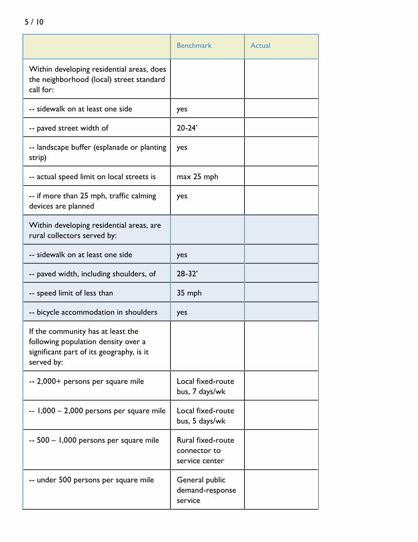
5 / 10
Benchmark Actual
Within developing residential areas, does the neighborhood (local) street standard call for:
-- sidewalk on at least one side yes
-- paved street width of 20-24’
-- landscape buffer (esplanade or planting strip)
yes
-- actual speed limit on local streets is max 25 mph
-- if more than 25 mph, traffic calming devices are planned
yes
Within developing residential areas, are rural collectors served by:
-- sidewalk on at least one side yes
-- paved width, including shoulders, of 28-32’
-- speed limit of less than 35 mph
-- bicycle accommodation in shoulders yes
If the community has at least the following population density over a significant part of its geography, is it served by:
-- 2,000+ persons per square mile Local fixed-route bus, 7 days/wk
-- 1,000 – 2,000 persons per square mile Local fixed-route bus, 5 days/wk
-- 500 – 1,000 persons per square mile Rural fixed-route connector to service center
-- under 500 persons per square mile General public demand-response service
5 / 11
identifying the Problems and opportunities
The information now in hand should allow you to confirm, modify, or even reject preconceived notions of issues. It may provide new insights about issues that are otherwise well recognized and may lead to entirely new identification of problems or opportunities. In any case, take time to mull the information. The immediate objective of analyzing the information is to reach clearly stated conclusions about the transportation problems and opportunities that may be in front of the community, either now or in the future, and their likely causes.
In stating the problems, draw directly upon the inventories. This will help to ensure that the stated problems trace back to the documentation in the inventories. And strive to express the needs of the community in specific, and even quantified, terms. For example: “Residents of the Willow Way area express a great deal of concern about safety of pedestrians. The inventories found that traffic in the area appears to be more than 1000 vehicles per day, and sidewalks are intermittent, with about a ½-mile of missing sidewalks between one end of the area and the local school and playground.”
“The number of driveways along the segment of Route 302 between Point X and Point Y is proliferating, and is now approaching 30 driveways per mile. In consultation with MaineDOT, we have determined that turning movements across traffic are increasing and that if current trends continue safety or congestion issues are likely to arise.”
“The inventories identified two failing culverts that appear to be exacerbating erosion problems along Riverview Avenue between Point A and Point B.”
Not every issue can be expressed statistically, but, as long as the documentation exists from the inventories, most can be explained clearly enough that future readers – and especially decision-makers who may be called upon to take action – will understand what is before them. And the issues should be stated clearly enough that the Committee can think about strategies that are well targeted to address them.
In Appendix A you can find a sample of common transportation-land use problems and opportunities that arise in many growing communities. For those that may be relevant to you, document and describe them in the detail that applies in your community. This appendix also points you to examples of strategies to address these common issues, which are summarized in Appendix B.

5 / 12

6 / 1
imagining tHe FUtUreWhat to Leave the Next Generation
chapter 6
introduction
Now comes the good part: thinking about the future—in fact, dreaming a bit about the future. You’ve done much of the hard part, having collected and sifted through a lot of information and described problems, issues, and opportunities as clearly as possible. All of that is a strong dose of reality, and a great foundation for what comes next.
Here you don’t want to lose touch with reality, but you want to unchain yourself from it long enough to ask: where does the community WANT to be 10, 20, or even 30 years from now? How should children and seniors be able to move around the community? What kind of transportation network should be available to businesses and commuters? What’s the collective vision? What are your goals? Goals, after all, are the desire side of problems –turning a problem inside out and imagining a future where it is solved.
A “vision” is an essential part of a transportation plan, but something different from the rest of it. The difference between the vision and the rest of the plan has been described like this:
This nice tête-á-tête is from the State Planning Office’s Community Visioning Handbook. That handbook is your complete guide to lead the community through the process of imagining the future -- and how to do so in a way that balances reality with justifiable aspirations.
The vision is a dream. The plan is the blueprint
The vision describes. The plan analyzes.
The vision is poetry. The plan is prose.
The vision is about possibilities. The plan is about policies.
The vision describes what. The plan shows how.
The vision is an aspiration. The plan is a legal document.
The vision appeals to imagination. The plan appeals to reason.
The vision is striven for. The plan is implemented.

6 / 2
The Community Visioning Handbook suggests several tools to help people express their desired future. Here, we put (what else?) a transportation twist on the tools. These may be tools you are already using as part of the overall comprehensive planning process, in which case you can simply make the transportation system one of the building blocks of the overall plan.
tHree good “viSioning” tooLS
The Build-out Map
A build-out map helps to visualize answers to questions like: Where would you put all the projected growth over the next 20 years in a way that preserves the special places of the Town, that expands the tax base and contributes to jobs in the region, and that doesn’t put a strain on transportation, police, fire, emergency and other services? In this vision of the future, how are homes, job centers, schools, and stores and services connected? Does this vision have room for choice in transportation?
A build-out map is a visual representation of the future distribution of development across the community. It often starts not with the ideal situation, but with the most likely situation: what would the town look like if existing patterns (such as mapped in Figure 6-1 in Woolwich as of 2005) were to continue without change in policies or market conditions? The results can be eye opening; they can also motivate a vision of the future. That future might show, for example, how the 4“D”s – distance, density, diversity of land uses, and design--might be arranged so your community will evolve into a place with transportation choices, employment centers, and open space.
A build-out mapping exercise requires preparation that often is part of a larger comprehensive planning process. This includes a base map that shows parcels, existing development and roads, and a companion “opportunities and constraints” map with environmental and other limitations, such as wetlands, poor soils, steep slopes, conservation and institutional ownership, and the like. The build-out process is described more fully in chapter 12 of Comprehensive Planning: a Manual for Maine Communities.
Visual Preference Photographs
Sometimes the best way to envision a desired future is to look closely at what you like best about the past. And a good way to do that is through photography. Arm volunteers with disposable cameras and ask each to photograph his or her favorite places to walk, bicycle, and drive. The reasons might be a scenic vista, the aesthetic quality of a street, the arrangement, character, and types of buildings along a street, the open spaces, the economic activity along a corridor or the bustle of a downtown, or the “gateway” feel of a place. Organize the photos into similar categories and, as a group or as part of a public workshop, analyze what makes these places rise to the top of people’s preferences. And think about whether some of those favorites might be able to be preserved or replicated in years to come; some of the strategies in Appendix B provide tips on how to do this.

6 / 3
Figure 6-1Envisioning the future through
a build-out map
In 2005 Woolwich had 1,654 buildings located as shown on this map. Based
on long-term growth trends, another 1,000 or so
residences – represented by the red dots in the lower
corner (each dot scaled to about ¾-acre)--could be
expected over 35 years. How might the Town envision
the location of this development to best meet
quality of life, economic, and transportation goals?
Map prepared by Robert Faunce and Sheepscot Valley
Conservation Association.

6 / 4
Livable Local Streets
This exercise extends the idea of identifying what people might like best about the existing living environment, with a focus at the neighborhood or local street level. As with visual preference photography, a very useful exercise is to ask the committee or members of the community to identify the local streets that are the very best in Town or a neighboring town. These might be in-town or suburban neighborhood streets, rural lanes, or country roads – just make sure they are streets or roads with homes along them.
Once a sample has been identified, grab a partner and a tape measure and go to the streets and start measuring. What is the width of the street? Is there a sidewalk, and if so, what are its dimensions? How far back are homes set back from pavement? What is the typical distance between homes? How many stories does the typical home have? How large are the lots (from tax map information)? How far is it from one intersection to the next? Do trees line the street or are they common in front yards, and if so, typically how tall are they? What you are doing is uncovering the dimensions that make the streets so attractive to people.
Those who have gone through this exercise in the past have sometimes found that the most appealing local streets have the character of an “outdoor room.” The elements of the street are organized so that the walls of the buildings and the canopies of large trees form the walls and ceiling of the outdoor room, and the “floor” of the room includes elements like a planting strip (esplanade) and sidewalk, as well as a street that is not overly wide. The dimensions of the “outdoor room” can be translated later into zoning and subdivision language for new development. See Figure 6-2.
beFore moving on to SoLUtionS
If the vision is a bit of a dream, it also is the backdrop for the goals and policies that will form the backbone of the transportation plan. Before moving on to solutions, take time to translate the vision into a series of goals – statements of where the community wants to be in 5 to 10 years with respect to the different elements of the vision. Whereas the vision statement is overarching, the goals are at one greater level of detail: still general but targeted at the key components of transportation-land use systems. They state the community’s desire for:
• Safeandefficientoperationsofarterialandcollectorroads • Safetyandqualityoflifeinneighborhoods • Choiceintransportation(fordifferentpopulationgroups,topromote
tourism, for walking and bicycling) • Theeconomicviabilityofdowntowns • Theoptimalaccommodationsforparking,balancingbusiness,aesthetic,and
environmental considerations • Takingadvantageofregionaltransportationfacilities–highwayinterchanges,
rail, airports, seaports – for economic development

6 / 5
• Thecommunity’squalityofplace(includingscenicqualities,historicand ultural features, rural lands)
• Theuseandexpansionofthetransportationnetworkinawaythatprotects the natural environment
• Regionalcooperationtomeetcorridor-wideneeds
As always, do not be limited by these – use your judgment, based on local knowledge and the results of the inventories and analyses, to set goals that meet your community’s needs.
Now, on to solutions.
35' 4' 24'
28'
50'
4' 4' 4' 35'
Streetscape Dimensions
Figure 6-2. Taking the
measure of things

6 / 6

7 / 1
PoLiCeS and StrategieS Setting the Course
chapter 7
a brieF “How-to” For eStabLiSHing PoLiCieS
A policy is a specific statement of principle or course of action. Whereas a “goal” is an end result for which the community is striving, a policy is a statement concerning how to reach that goal. For example, it may be a goal to sustain the capacity of Route 321, free of congestion. To try to meet that goal, a community might adopt policies such as, “The Town shall limit the number of new driveways along Route 321”; and “The Town shall designate the eastern end of Route 321 for economic development, while reserving the western end for rural land uses.”
Communities will customize policies to meet their needs, but here are some guidelines on how policies should be structured:
Guideline 1: To the greatest extent possible, policies should be “directive.” They should be an instruction to those who will be implementing the plan. Directive policies include the word “must” or “shall” or are presented as an imperative sentence. “The Town shall require sidewalks as part of subdivisions,” or “Extend Miller Road to open up land for a new industrial park” are examples of policies that direct or instruct. Not all policies are directive; some may be suggestions or general guidelines. These use “permissive” words like “should” or “encourage.” However, to be consistent with Maine’s STPA (and the companion Growth Management Act), most policies should be directive.
Guideline 2: Policies should be linked to issues that arise from inventories and analyses. For example, the inventory and analysis may have found that current land use patterns are not compatible with providing choice in transportation, because they don’t allow certain activities within walking distance of homes. Having made that finding, there should be a policy to address it, such as, “The Town’s land use ordinance shall be amended to allow for neighborhood business districts within one-half mile of residential areas.”
Guideline 3: Policies should be specific enough that there isn’t confusion about the direction the Town should take. A poorly written policy sometimes sounds like a restatement of the goal, offering no real direction for those who will be trying to implement the policy. For example, in striving to meet the goal of maintaining the capacity of a state highway to move people and freight, a policy statement such

7 / 2
as, “The Town should take steps to keep Route 321 free of congestion” isn’t very helpful. The committee may not have the expertise to spell out all the steps, nor does a policy statement have to be very detailed. But it should give firm direction, such as “To preserve the capacity of Route 321 while still allowing roadside development along it, the Town shall limit new driveways to one per lot of record.”
Guideline 4: Policies should be realistic. There should be some prospect of being able to carry out a stated policy. For example, a policy in a small town that says, “Implement a year-round local bus system to serve the village area” may be financially impossible. Alternatively, a policy that says, “Establish a rural feeder to the Service Center bus system” may be within the realm of possibility.
Guideline 5: Policies should not contradict each other. The transportation chapter of a comprehensive plan is tightly connected with other chapters of the plan, including, of course, the chapter on land use. It is easy to adopt policies in one chapter that are inconsistent with policies in another. For example, if the transportation chapter establishes a policy to “Introduce bus service in the community within five years,” but the land use policies don’t endorse land use densities greater than, say, one home per acre, there is a serious inconsistency: one-acre densities can never support bus service. Inconsistencies need to be resolved before signing off on the plan.
Guideline 6: Local policies should be consistent with state and regional policies. Every community is part of a region, and many are part of what MaineDOT has identified as “corridors of regional economic significance for transportation” (CREST). The Department, assisted by regional councils, is trying to balance a region’s growth objectives with the need to preserve the capacity of corridors to move people and goods through the region. Consult with your regional council to assure your local policies are consistent with – and helping to promote – the policies of the region of which the community is a part.
Policies can be constructed at different levels of detail. Sometimes the term “policy” is reserved for high-level statements of intent, while more detailed versions are called “strategies,” which are akin to actions to be taken to implement the higher level policy. But do not worry about these distinctions. Policy statements that meet the guidelines above will suffice at any level of detail.
wHat tHe StPa reqUireS
Minimum required policies: The STPA rule requires that each community transportation plan at a minimum adopt policies in five areas:
• Safe and efficient preservation or improvement of the transportation system This policy is aimed at preventing the overburdening of state and local roads through good design and wise investments. A community may choose to adopt a broader range of policies relating to preserving and improving

7 / 3
their transportation system. The menu of strategies presented in Appendix B provides a head start for thinking through approaches to implement this policy. See especially the strategies under the headings “strategies to relieve or prevent congestion and preserve mobility” and “strategies to protect and get the most out of regional transportation facilities.”
• Prioritized needs associated with safe, efficient, and optimal use of transportation systems This simply means that each community must identify which of its transportation needs are the highest priority, so that those implementing the plan have clear direction. • Promotion of public health, protection of natural and cultural resources, and enhanced livability This policy focuses on quality of life that transportation decisions either can enhance or compromise. There are two overall goals embedded in this policy: (1) minimize increases in vehicle miles traveled, thus reducing future burdens on the state and local road system and, in the process, creating more opportunities for a healthy lifestyle, and (2) preserve physical, natural, and scenic features that are of particular value to the workings of the environment and to the identity and enjoyment of the community. In Appendix B, the menu of strategies organized under the headings “strategies to enhance the form and pattern of development for optimal use of the transportation system” and “strategies to maintain quality of place” will be helpful in thinking through policies relevant to your community and region.
• Meeting the diverse transportation needs of both residents — including children, the elderly and people with disabilities — and through-travelers by providing choice in transportation This policy addresses alternative modes of transportation and the land use conditions that can help make alternatives to single-occupancy auto travel possible. In Appendix B, the menu of strategies organized under “strategies to introduce or expand modes of passenger transportation” will provide a starting point.
• Fiscal prudence by maximizing the efficiency of the state or state-aid highway network To the extent that this policy helps prevent the premature depreciation of the state’s highway network – for example, by prescribing and enforcing good land use management and access management along the highways – it overlaps with policies in other categories above. To the extent that these policies include fiscal actions to help pay for the management and upgrading of the transportation system, such as using local impact fees or preparing a capital investment plan, these are discussed in Chapter 8, Implementing the Transportation Plan.
7 / 4
Minimum required strategies: In addition, the STPA requires community transportation plans to include statements of strategy that reflect at least the following six items:
• Develop or continue to update a prioritized ten-year improvement, maintenance and repair plan for local/regional transportation system facilities that reflects community, regional and state objectives. Many communities develop local capital investment plans or capital improvement programs that include their anticipated expenditures on local roads and bridges or to fund the local match associated with a planned state investment. This strategy requires a community to consult regional transportation plans and build their transportation investment framework with consideration of overall regional objectives.
• Initiate or actively participate in regional and state transportation and land use planning efforts. A community might implement this strategy by participating in a regional corridor study or by appointing a local resident to follow and participate in one of MaineDOT’s long range planning processes. • Enact or amend local ordinances as appropriate to be consistent with local, regional and state transportation policies identified in this plan. This strategy refers to land use standards that affect transportation facilities. For example, a community may zone an area near an airport or rail line as residential, which will compete with the operational needs of those facilities and create a situation in which residents view the facilities as nuisances. Or a town may require large lot sizes not conducive to walking or transit, thereby assuring excessive trips on a roadway.
• Enact or amend local ordinances as appropriate to address or avoid conflicts with the following three state statutes: 1. Policy objectives of the Sensible Transportation Policy Act (23 MRSA §73); 2. State access management regulations pursuant to 23 MRSA §704 — Entrances to highways regulated; and 3. State traffic permitting regulations for large developments pursuant to 23 MRSA §704-A - Traffic movement permit.
For addressing or avoiding conflicts with the STPA policy objectives, access management regulations and traffic permitting regulations, make use of the incentive based strategies identified in Table 2-1 of Chapter 2, the 4-D guidelines in Chapter 3, and the benchmarks in Table 5-1 of Chapter 5, as well as the strategies outlined in Appendices A and B. Several model land use ordinances are available from the State Planning Office, including How to Write a Land Use Ordinance, Site Plan Review Handbook, Model Subdivision Regulations, and Performance Standards for Large-Scale Development.

7 / 5
• Enact or amend ordinance standards for subdivisions and for public and private roads as appropriate to foster transportation-efficient growth patterns and provide for future street and transit connections. Requiring interconnected streets, providing infrastructure for pedestrians, and requiring new large-scale commercial uses to provide for transit stops are examples of how a community might amend its subdivision and site plan ordinances.
• Work with the MaineDOT as appropriate to address deficiencies in the system or conflicts between local, regional and state priorities for the local transportation system. If conflicts or issues are identified during the planning process, assign responsibility for coordinating with MaineDOT and your regional council to the most appropriate entity (Road Commissioner, Select Board, Historic or Conservation Commission, etc.)
menU oF StrategieS (tUrning PoLiCy into aCtion)
In Appendix A, you will find a sample of transportation and transportation-related land use issues that are common to many communities in Maine. For each of the issues, a menu of strategies is introduced, some of which may work for your community. The strategies are then explained in more detail in Appendix B.
Consider these strategies to be a starting point. Your community may arrive at other strategies to meet its specific needs. For reference, the strategies are organized into the following parts:
Part 1. Strategies to relieve or prevent congestion and preserve mobility1.1 Contain development within well-defined growth area boundaries1.2 Limit the number of new driveways onto major collectors and arterials1.3 Retrofit the number, location, and design of existing driveways1.4 Provide for alternate routing of traffic1.5 Interconnect the local street system1.6 Institute turning controls1.7 Improve wayfinding1.8 Work toward jobs-housing balance
Part 2. Strategies to enhance the form and pattern of development for optimal use of the transportation system2.1 Diversify allowed land uses2.2 Locate residences and uses needed by neighborhood residents, such as elementary schools and stores with convenience goods and services, close to each other2.3 Increase density of development to expand transportation opportunities2.4 Create a community sanitary district for subsurface wastewater disposal

7 / 6
2.5 Prepare and adopt an “official map” for streets and other public improvements2.6 Modify use, supply, and location of public parking in village centers and downtowns2.7 Evaluate standards for single-parcel off-street parking2.8 Locate public buildings to meet LEED siting criteria
Part 3. Strategies to introduce or expand modes of passenger transportation3.1 Extend and connect the pedestrian network of sidewalks and cross-walks3.2 Provide for bicycle lanes3.3 Introduce or expand ride sharing3.4 Introduce or expand demand-response transit service3.5 Introduce or expand fixed-route bus service3.6 Prepare for passenger rail service
Part 4. Strategies to protect and get the most out of regional transportation facilities4.1 Anticipate regional transportation needs for an undeveloped or new growth area4.2 Allow for unimpeded operation and expansion of regional transportation facilities4.3 Upgrade connectivity between industrial areas and regional transportation facilities
Part 5. Strategies to maintain quality of place5.1 Design or retrofit streets for human scale5.2 Retrofit streets and highways using flexible, “context sensitive” design5.3 Institute traffic calming measures5.4 Conduct a safety audit5.5 Adopt performance standards, including for signs, parking, internal circulation and landscaping, for highway-oriented development5.6 Conduct a visual assessment and adopt view corridor standards5.7 Incorporate best management practices for erosion control and storm water management into subdivision and site plan review ordinances5.8 Assure proper design of culverts for streams with fish populations
Another category of strategies – financial – is discussed in Chapter 8, Implementation.

8 / 1
imPLementation From Policies to Action
chapter 8
introduction
Policies are a declaration of what a community intends to achieve. An implementation program sets out how the policies will be carried out, by whom, and over what timeframe.
There are potentially four parts to an implementation program:
• Capitalinvestmentplan • Financing • Regulation • Regionalcooperation
CaPitaL inveStment PLan
The Growth Management Act requires each community’s comprehensive plan to include a capital investment plan for financing the replacement and expansion of public facilities and services required to meet projected growth and development. In turn, the STPA requires municipalities to include in the transportation part of the plan a prioritized ten-year improvement, maintenance and repair plan. It is helpful to piggyback these two requirements on each other, both for convenience and so that transportation needs can be weighed by the community in combination with other public investment needs.
The capital investment plan identifies facilities needed to accommodate projected growth, assigns them priorities, and identifies possible funding sources. It also sets the stage for a formal Capital Improvements Program (CIP), a fiscal tool used by many communities to program large capital expenditures and to track the community’s debt, reserve funds, and other sources of revenue to pay for public improvements.
A formal CIP is a more detailed document that builds upon the capital investment plan: it includes detailed costs, often based on engineering, architectural, or other studies, and an actual capital budget for the upcoming year. The formal CIP usually spans a period of six years and is adopted by the town’s legislative body, with the first of the six years serving as the budget year and the other five as planning years.

8 / 2
From a transportation perspective, the capital investment plan will serve as a foundation for the more detailed CIP if it:
• Identifiestransportationfacilitiesthatwillbeneededtoaccommodateprojectedgrowth or to remedy existing problems. These needs should come directly from the earlier inventory and analysis and the stated policies or strategies. The capital investment items should be limited to proposed capital expenditures, not operating costs (although the latter should be addressed in the course of normal budgeting). Transportation capital improvements typically have a life expectancy of at least 10 years.
• Assignsgeneralprioritiesamongtheidentifiedcapitalinvestments.Eachmightbeassigned, for example, into categories such as “urgent,” “necessary,” “desirable,” and “deferrable.”
• Estimatescost.Apreciseestimateisusuallynotpossibleuntilengineeringandother analysis has been performed, and the cost of obtaining such services should also be identified. Nevertheless, using rules of thumb available from the public works director, consulting engineer, or MaineDOT, it is important to include an order-of-magnitude estimate in the plan.
• Estimatetiming,andwhethertheprojectshouldbeundertakenwithinashortterm (e.g., within 24 months), mid-term (2 to 5 years), or longer term (more than 5 years).
The State Planning Office’s Comprehensive Planning Manual provides further discussion of capital investment plans.
FinanCing
Possible sources of financing for both capital and operating costs include local tax revenues, local borrowing, MaineDOT investments, state and federal grants to local governments, and impact fees.
Local tax revenues and local borrowing: Tax revenues are the primary way to pay for the operating costs of local services, including transportation-related services. Borrowing, whether directly by the community or through the Municipal Bond Bank, is reserved for capital expenditures and is a primary way of financing the items identified in the capital investment plan and ultimately an adopted Capital Improvements Program.
State projects: Through its own, ongoing planning, MaineDOT creates a biennial plan for transportation system investments. Once commonly known as the BTIP, it now is referred to as the Biennial Capital Work Plan. Although this is a state function, it is of interest to municipalities because the projects often reflect local needs; and because certain projects of high priority to the municipality may require local matching funds.

8 / 3
This plan identifies funded projects expected to be undertaken within the two-year plan period. Additionally, MaineDOT generates a 6-Year Plan. As of 2008, this plan will consist of two parts: one that is cost-constrained to the level of anticipated funding, and the other that identifies additional transportation system needs that cannot be undertaken unless supplemental funding can be obtained. The 6-Year Plan, updated biennially, is also provided on a project-specific basis, listing candidate projects that MaineDOT is expecting to fund over the next three biennia within funding constraints.
Most projects in the Biennial Capital Work Plan will simply maintain the trans-portation system already in place through a variety of reconstruction and rehabilitation projects. These include highway paving (for maintenance or preservation), bridge reconstruction or rehabilitation, operational and safety improvements to bridges, safety and operations improvements to highways (e.g., intersection improvements, signage, guard rails) and investments in other modes of transportation. Depending on funding availability, urgency, and especially on whether the project will benefit regions as a whole, the biennial plan also may include transportation system improvements. Examples are highways in new locations (such as a bypass), improvements to highway mobility (such as a passing lane or turning lane), highway modernization or reconstruction, rail and marine freight investments, passenger rail improvements, transit capital, airport improvements, bicycle/pedestrian based projects, and park and ride lots. Large-scale projects typically must comply with planning processes and standards under the STPA and federal laws. Many of the transportation system improvement projects involve scoping sessions with local governments and the public, and some projects require local financial contributions. If you think your town or region has an urgent need that should be in the biennial plan, contact MaineDOT (or your Metropolitan Planning Organization) as early as possible, so that they can consider the request. It is increasingly important that the request be in the context of the larger corridor or region, so discussion of needs should also occur with your Regional Council.
State and federal funding and loans: MaineDOT has both formula-based and competitive programs for transportation improvements. A basic formula program is the Urban-Rural Initiative Program that provides capital funds to municipalities for work on a road or bridge that has a life expectancy of at least 10 years or restores load-carrying capacity. The funds are distributed based on a formula per lane mile of different types of roads. See Working with MaineDOT: A Guide for Municipal Officials or contact MaineDOT’s Community Services Division.
Examples of competitive programs that may be available if funded include:
• TransportationEnhancementProgram,afederal-andstate-fundedprogramrequiring a 20% local or private match. This program principally supports enhancements in connection with pedestrian and bicycle facilities, historic and environmental projects, and downtown revitalization initiatives as well as other investments that help to enhance a transportation system and the quality of a community’s environment. Projects have to be related to surface transportation.

8 / 4
• SafeRoutestoSchool,aprogramthatis100%federallyfunded.Whilenolocalmatch is required, proposed projects can receive a higher score if accompanied by local funds. Its focus is increasing bicycle, pedestrian, and traffic safety, within two miles of an elementary or middle school, making walking and bicycling to school more appealing. Project improvements typically include sidewalks, traffic calming, pedestrian crossings, off-road bicycle and pedestrian facilities.
• SmallHarbor(Transportation)ImprovementProgram(SHIP),which promotes public access and economic development and preserves infrastructure along the coast. These are state funds that require a 50% local match.
• NationalScenicBywaysProgram,whichrecognizesandtriesto preserve designated roads based on archeological, cultural, historic, natural, recreational or scenic qualities. It is typically an 80% federal, 20% other match program that provides resources to the byway communities to create and maintain a unique travel experience and enhanced local quality of life.
• IndustrialRailAccessProgram,whichisdesignedtoencourage economic development through increased use of rail. Most projects involve rail sidings and rail construction and improvement, and may also include those that enhance freight rail transportation without involving actual rail work.
• CommunityGatewayProgram,astate-fundedprogramdesigned to help communities enhance community corridors and landscapes. Grants are typically in the $5,000 to
$10,000 range.
• Othercompetitiveprogramsmaybeavailable,dependentonfunding.
For a full list of competitive grant programs, contact MaineDOT’s Bureau of Transportation Systems Planning.
Impact fees: Private funds for municipal capital costs incurred because of a specific development may be required of a developer in the form of an impact fee.
State law (Title 30-A, M.R.S.A., Section 4354) authorizes impact fees for off-site infrastructure such as transportation facilities, waste water collection and treatment facilities, water supplies, public safety equipment, fire protection facilities, parks, and school facilities. Impact fees cannot be used to pay for operating costs. Limitations on impact fees include:
• Theamountmustbereasonablyrelatedtothedevelopment’sshareofthecostof the facility made necessary by the development. The cost of the facility must
City of Brewer Development Policy
Brewer has adopted a multifaceted Development Policy that spells out how the City will work with “signifi-cant” development to assure capacity to serve the development. The policy covers impact studies, cost-sharing, tax increment financing, and impact fees. (Chapter 38, Article 1, Brewer City Ordinances)
Impact fees apply in Area Capital In-vestment Districts (ACIDs) for a range of infrastructure, including roads, traf-fic control devices, and public transit. The initial ACID covers an area of Wilson Street and Parkway South, where impact fees are helping to fund transportation improvements to sup-port new development. (Chapter 24, Article 12, Brewer City Ordinances)

8 / 5
be documented, and there must be a way to distribute the cost between the development and others that contribute to demand for the facility, including the public at-large.
• Fundsreceivedfromimpactfeescanbeusedonlyforspecifiedimprovements.
• Theremustbeareasonablescheduleformakingspecifiedimprovements,andfees must be refunded if improvements are not made according to schedule.
A thoughtful capital investment plan and annual Capital Improvements Program are foundations for impact fees. For more, see the Maine State Planning Office’s guide, Financing Infrastructure Improvements through Impact Fees.
regULationS
Implementing policies that will better align transportation and land use nearly always will involve some degree of regulation. Regulation may be required to:
• Guidedevelopmenttothepartsofacommunityorregionbestequippedtoserve it – in particular, to areas designated for growth in the Future Land Use Plan of the community’s Comprehensive Plan;
• Guidethenatureandmixofdevelopmentthatisoptimaltothefunctioningofthe transportation system and vice versa;
• Establishperformancestandardsthatenabledevelopmenttosmoothlyinteractwith the transportation system serving it. For example, driveways (“access management”), parking, pedestrian circulation and, where appropriate, bus stops all should meet standards of safety and efficiency;
• Establishstandardsforstreetdesign,construction,andoperations;and• Establishqualityofplacestandards,addressingscaleofdevelopmentand
environmental and scenic matters
The typical regulatory tools are zoning, subdivision, and site plan review ordinances. The types of regulation appropriate to each (or, in an integrated land use ordinance, to the zoning, subdivision, and site plan review sections of that ordinance) are:
Zoning: Establishes the allowable mix of uses within different districts of the community and the allowable density or intensity of use; incorporates dimensional standards for lots and structures; and establishes performance standards (such as environmental, public health, access management, off-street parking, and “good neighbor” such as noise and odors) that apply to all lots. Zoning or variations of it are fundamental to implementing a community’s Future Land Use Plan and other parts of a comprehensive plan.
Subdivision: Regulates the division of land into multiple lots according to state law (Title 30-A, sec. 4401 et seq.) and local zoning. Of importance to transportation, subdivision regulations establish the standards for design and construction of new
8 / 6
rights-of-way and the local roads, sidewalks, and utilities built within them. They thus have a direct bearing on the interconnectivity and design of new and expanding neighborhoods, and the resulting pressures on existing roads.
Site plan review: Regulates actual development of a lot to assure that driveways, parking, pedestrian circulation, drainage, erosion controls, utilities, buffers, lighting, and all other key elements of the site meet standards.
The policies of the community transportation plan should be specific in recommending the use of these tools to help achieve the desired transportation-land use outcome. The tools themselves are only that – tools. It is how they are used that help determine whether the transportation system will function well or under stress. The “4D”s – density, distance, diversity of use, and design – that are fundamental to transportation choice and to the way transportation and land use interact with each other rely heavily on making sure that appropriate standards are contained in these basic land use ordinances. The discussion in Chapter 3 on the “4D”s and many of the strategies in Appendix B offer guidance on which standards may be applied in your community.
regionaL CooPeration
The STPA expects communities to cooperate with other towns and cities in the transportation corridors they share to arrive at regional transportation and land use policies and implementation plans. Such regional planning for at least the transportation side of the equation already occurs through the Metropolitan Planning Organizations serving the Bangor, Lewiston-Auburn, Portland, and Kittery regions. More generally, MaineDOT is pursuing a strategy of multimodal, corridor management planning. Working with the regional planning councils, it has identified Corridors of Regional Economic Significance for Transportation (CREST). Building on the experience of a multimodal corridor planning process along Routes 1 and 90 in the mid-coast region – an initiative called Gateway 1 (see box next page) — the regional planning councils are being asked to assist groups of communities to jointly identify issues that affect large segments of these corridors, find land use strategies that will reduce future burdens on the state highway system, assess needs and opportunities for public transportation and non-highway modes both for passengers and freight, and discuss the governing mechanisms by which communities can coordinate land use decisions that affect each other.
The implementation of policies and strategies that the corridor plans may recommend likely will depend on a combination of approaches:
• Municipalitiesindividuallycommittingtoincorporatingjointlyagreed-to strategies into their own comprehensive plans and implementing those they can individually control through local investments, impact fees, and local zoning, subdivision, and site plan review.
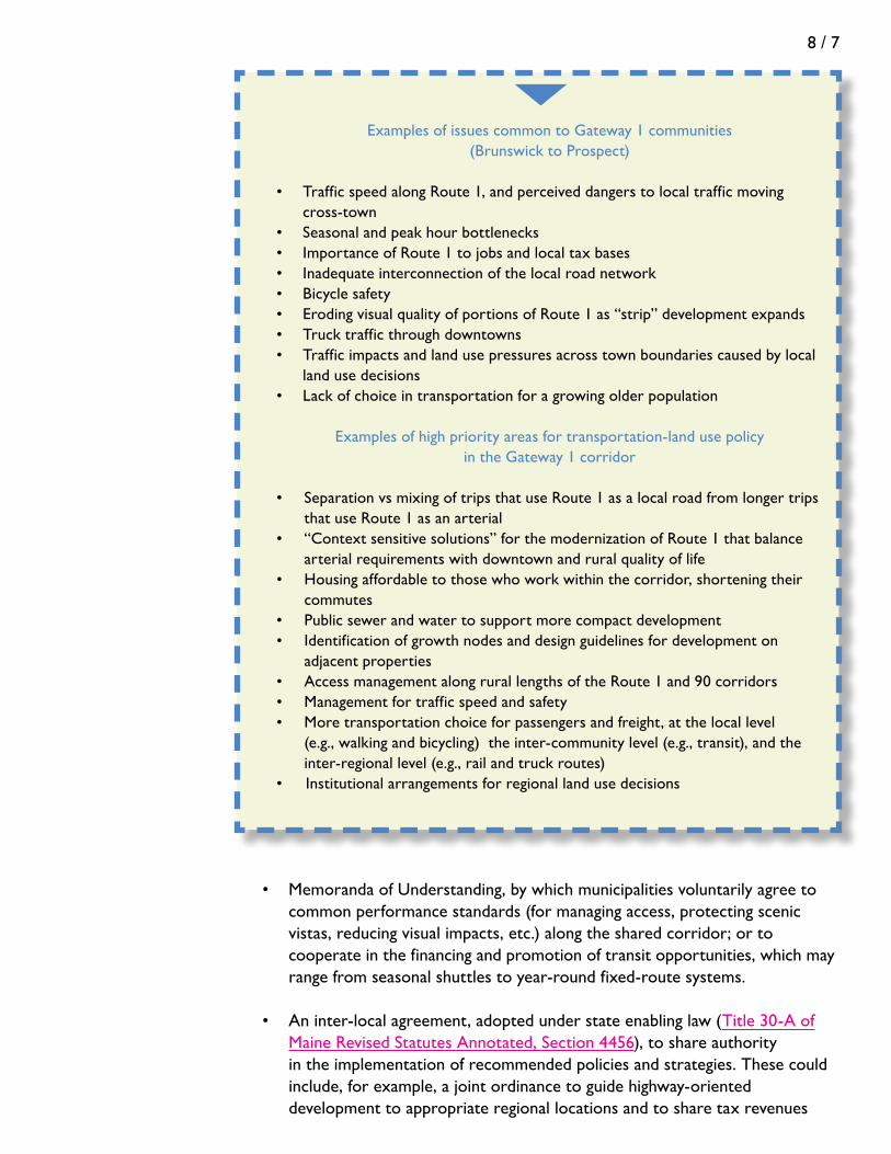
8 / 7
• MemorandaofUnderstanding,bywhichmunicipalitiesvoluntarilyagreeto common performance standards (for managing access, protecting scenic vistas, reducing visual impacts, etc.) along the shared corridor; or to cooperate in the financing and promotion of transit opportunities, which may range from seasonal shuttles to year-round fixed-route systems.
• Aninter-localagreement,adoptedunderstateenablinglaw(Title 30-A of Maine Revised Statutes Annotated, Section 4456), to share authority
in the implementation of recommended policies and strategies. These could include, for example, a joint ordinance to guide highway-oriented development to appropriate regional locations and to share tax revenues
Examples of issues common to Gateway 1 communities (Brunswick to Prospect)
• TrafficspeedalongRoute1,andperceiveddangerstolocaltrafficmoving cross-town• Seasonalandpeakhourbottlenecks• ImportanceofRoute1tojobsandlocaltaxbases• Inadequateinterconnectionofthelocalroadnetwork• Bicyclesafety• ErodingvisualqualityofportionsofRoute1as“strip”developmentexpands• Trucktrafficthroughdowntowns• Trafficimpactsandlandusepressuresacrosstownboundariescausedbylocal land use decisions• Lackofchoiceintransportationforagrowingolderpopulation
Examples of high priority areas for transportation-land use policy in the Gateway 1 corridor
• SeparationvsmixingoftripsthatuseRoute1asalocalroadfromlongertrips that use Route 1 as an arterial• “Contextsensitivesolutions”forthemodernizationofRoute1thatbalance arterial requirements with downtown and rural quality of life• Housingaffordabletothosewhoworkwithinthecorridor,shorteningtheir commutes• Publicsewerandwatertosupportmorecompactdevelopment• Identificationofgrowthnodesanddesignguidelinesfordevelopmenton adjacent properties• AccessmanagementalongrurallengthsoftheRoute1and90corridors• Managementfortrafficspeedandsafety• Moretransportationchoiceforpassengersandfreight,atthelocallevel (e.g., walking and bicycling) the inter-community level (e.g., transit), and the inter-regional level (e.g., rail and truck routes)• Institutionalarrangementsforregionallandusedecisions

8 / 8
generated by the development, or a joint body to promote transit alternatives, or an agreement to raise and invest a multi-town impact fee for transportation improvements benefiting the region.
Do not hesitate to consult with your regional council, the MaineDOT, or the State Planning Office on ways to initiate or cooperate in corridor planning efforts.
a Final word on implementation
The implementation program should be laid out clearly in the plan – whether as part of an overall implementation schedule for a comprehensive plan, or specific to the transportation element of the larger plan. The program should:
• Identifytheactiontobeimplemented; • Identifywhethertheactionisshort-term(e.g.,within24months),mid-term (e.g., 2 to 5 years), or longer term (e.g., more than 5 years); • Assignresponsibilitytoaspecificperson,department,oragency; • Identifylikelyobstaclesthatwillneedtobeovercomeandresourcesthatwill be needed to get the job done; and • Ifapplicable,developMemorandaofUnderstanding(e.g.,multi-municipal development agreements) to clarify roles and responsibilities for implementing a plan or program across municipal boundaries.

A / 1
Common tranSPortation-Land USe iSSUeS
appendix a
Some issues seem to be common to many types of communities. This appendix presents a list of some of the more typical ones. They are organized as follows:
A. Issues relating to traffic safety and congestionA. Issues relating to traffic safety and congestionA-1. Safety and traffic capacity along an almost fully developed commercial strip are deteriorating.A-2. The land along a state highway is ripening for development, and this could present both opportunity and problems• Communitycommercialdevelopment• “Bigbox”development• Residentialdevelopment
A-3. Traffic speed is a persistent problem along state highwaysA-4. The community is a job center, and the level of service along the major state highway into the community during peak commuting hours is worsening
B. Issues relating to safety and quality of life in neighborhoodsB-1. Traffic speed is a persistent problem in neighborhoodsB-2. “Smart growth” ideas like walkable neighborhoods near schools and local services seem to be out of our reach
C. Issues relating to expanding choice in transportationC-1. Local citizens have little choice in transportation•Elderlyanddemand-responsetransit•Fixedroutebusservice•Safewalkingandbicycling
C-2. The existing transportation network falls short of meeting tourist needs and is experiencing congestion
D. Issues relating to town centersD-1. Conflicts between downtown and the state highway that passes through it are causing problems for bothD-2. The Town lacks a recognizable center, but a key intersection, if developed properly, could fill that roleD-3. Parking in the town center is insufficient to meet the combined needs of customers and workersD-4. Trucks are rumbling through downtowns (or neighborhoods)

A / 2
These are by no means exhaustive. They are examples only. Your community probably has issues not listed here. Consider the inventory of information (including citizen impressions) gathered for your own community and state the issues in your own terms, as they seem to apply in your area. And, in any case, any one community likely will be experiencing only some of the issues listed here.
In the tables below, you’ll find a list of the common issues and possible strategies to address them. These are presented as a menu: select the ones that seem appropriate to your situation. Then move to the page indicated in Appendix B to get a summary description of the strategy. Note that any given problem or opportunity may employ two or more of the strategies, and also that any one strategy may be helpful in addressing more than one of the issues. And do not feel limited by this menu. Use the knowledge available to you to customize your own solutions.
In settling upon a statement of a problem, make sure you look back at the inventories and are able to document it. For example, if your community thinks it is experiencing a safety and capacity problem along a major road, document it through your inventories of traffic volumes, road conditions, traffic speed, the number and locations of driveways, crash data, and provisions for pedestrians and cyclists.
Finally, the menu of strategies listed here does not include financial strategies, such as grants, borrowing, impact fees, and pricing mechanisms. For those, please see Chapter 8, where financial strategies to implement plans are discussed.
E. Issues relating to taking advantage of regional transportation facilities for economic developmentE-1. A regional transportation interchange or facility is a vital part of the community but it is unclear how to take advantage of it
• Highwayinterchange• Railfacilities• Airport
E-2. Marine transportation facilities are threatened by rising coastal land values and non-marine land uses
F. Issues relating to preserving quality of placeF-1. A rural arterial does not meet modern standards for lane widths and shoulders, but there are features along the road we want to preserve if and when MaineDOT upgrades it
• Ruralfeatures• Villagefeatures
F-2. The main road into Town is a scenic gateway to the community, but it is deteriorating in the face of random developmentF-3. Complaints about traffic noise from the nearby highway are increasing
G. Issues relating to environmental conditionsG-1. New local road construction or upgrading of an existing local road will impact a stream and the municipal storm drainage system

A / 3
the Sample of Common issues
A. Relating to traffic safety and congestion
A-1. Safety and traffic capacity along an almost fully developed commercial strip are deteriorating
Situation: You are faced with a street that is lined with commercial development. It is congested at times, and motorists consider it confusing and unsafe because of traffic turning into and off of the street. The sidewalk system is fragmented, and pedestrians trying to cross driveways or the street think the environment is uninviting and unsafe.
Menu of strategies:
A-2. The land along a state highway is ripening for development, and this could present both opportunity and problems
Situation A – Community commercial growth: The community sees the two-lane state highway as the best location for commercial growth and expanding the tax base. Scattered development, mostly small scale, already is located here, along with a number of homes. The Town wants to allow more extensive development, but without seriously compromising traffic flow and safety along the road.
Menu of strategies:
1.1 Contain development within limited growth area boundaries p. B-1
1.3 Retrofit the number, location, and design of driveways p. B-6
1.4 Provide for alternate routing of traffic p. B-8
1.6 Institute turning controls within the roadway p. B-11
3.1 Extend and connect the pedestrian network of sidewalks and cross-walks
p. B-23
1.1 Contain development within limited growth area boundaries p. B-1
1.2 Limit the number of new driveways onto major collectors and arterials
p. B-5
2.1 Diversify allowed land uses p. B-14

A / 4
Situation B – “Big box” growth: The community is in the pathway of regional development, and one or more of its state roads could be targeted specifically for “big box” development. The Town is interested but also wants to minimize impacts to the character and functioning of this part of the community.
Menu of strategies:
Situation C – Residential growth: The community is experiencing lot-by-lot development along a moderately traveled state road outside of the village area. The number of driveways out to the road is increasing and may become a traffic safety problem. The Town wants this stretch of road to be part of its designated growth area but wants to avoid potential traffic and safety problems.
2.3 Increase density of development to expand economic and transportation opportunities
p. B-16
2.4 Create a decentralized community sanitary district for subsurface wastewater disposal
p. B-17
3.1 Extend and connect the pedestrian network of sidewalks and cross-walks
p. B-23
3.5 Introduce or expand fixed route bus service p. B-28
5.5 Adopt performance standards for signs, parking, and landscaping for highway-oriented development
p. B-43
1.1 Contain development within limited growth area boundaries p. B-1
1.2 Limit the number of new driveways onto major collectors and arterials
p. B-5
1.6 Institute turning controls p. B-11
2.3 Increase density of development to expand economic and transportation opportunities
p. B-16
4.1 Anticipate regional transportation needs for an undeveloped or new growth area
p. B-31
5.5 Adopt performance standards for signs, parking, and landscaping for highway-oriented development
p. B-43

A / 5
Menu of strategies:
A-3. Traffic speed is a persistent and growing problem along state highways
Traffic speed along a state highway that passes through the settled portion of the community poses perceived dangers for cars trying to cross from one side of town to the other. The needs for safety, community connections, and mobility have to be resolved.
Menu of strategies:
5.2 Retrofit streets and highways using flexible, “context sensitive” design
p. B-38
5.3 Institute traffic calming measures p. B-40
A-4. The community is a job and service center, and the level of service along the major state highway into the community during peak commuting hours is worsening.
Situation: The principal route into and out of the community is a state arterial, and the congestion during commuting hours is both worsening and lengthening in time. Level of service has been established by MaineDOT as “C”, but projections are that it will drop to unacceptable levels (“E” or “F”) in the next decade.
1.1 Contain development within limited growth area boundaries p. B-38
1.4 Provide for alternative routing of traffic p. B-8
1.5 Interconnect the local street system p. B-9
2.5 Prepare and adopt an “official map” for streets and other public improvements
p. B-18
3.1 Extend and connect pedestrian network of sidewalks and cross-walks
p. B-23
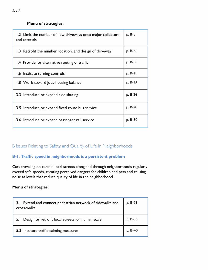
A / 6
Menu of strategies:
B Issues Relating to Safety and Quality of Life in Neighborhoods
B-1. Traffic speed in neighborhoods is a persistent problem
Cars traveling on certain local streets along and through neighborhoods regularly exceed safe speeds, creating perceived dangers for children and pets and causing noise at levels that reduce quality of life in the neighborhood.
Menu of strategies:
1.2 Limit the number of new driveways onto major collectors and arterials
p. B-5
1.3 Retrofit the number, location, and design of driveway p. B-6
1.4 Provide for alternative routing of traffic p. B-8
1.6 Institute turning controls p. B-11
1.8 Work toward jobs-housing balance p. B-13
3.3 Introduce or expand ride sharing p. B-26
3.5 Introduce or expand fixed route bus service p. B-28
3.6 Introduce or expand passenger rail service p. B-30
3.1 Extend and connect pedestrian network of sidewalks and cross-walks
p. B-23
5.1 Design or retrofit local streets for human scale p. B-36
5.3 Institute traffic calming measures p. B-40

A / 7
B-2. “Smart growth” ideas like walkable neighborhoods near schools and local services seem to be out of our reach
Situation: The Town wants to prevent sprawl in rural parts of the community and instead wants to steer at least some of that development into locations in designated growth areas, where homes can be closer to a school or local services. It likes the idea of traditional, small-town New England neighborhoods, but the development is typically small-scale, involves multiple property owners, and only evolves slowly over time. Further, the Town does not have public sewers, so development must rely on sub-surface wastewater disposal. It is unclear how to set the direction for traditional neighborhood development under these conditions.
Menu of strategies:
1.5 Interconnect the local street system
p. B-9
2.1 Diversify allowed land uses p. B-14
2.2 Locate residences and uses needed by neighborhood residents, such as elementary schools and stores with convenience goods and services, close to each other
p. B-15
2.3 Increase density of development to expand economic and transportation opportunities
p. B-16
2.4 Create a decentralized community sanitary district for subsurface wastewater disposal
p. B-17
2.5 Prepare and adopt an “official map” for streets and other public improvements
p. B-18
2.8 Locate public buildings to meet LEED siting criteria p. B-22
3.1 Extend and connect pedestrian network of sidewalks and cross-walks
p. B-23
5.1 Design or retrofit streets for human scale p. B-36

A / 8
C. Issues relating to expanding choice in transportation
C-1. Local citizens have little choice in transportation
Situation A – Elderly: The community currently has few choices to get to shopping, jobs, and services elsewhere in the region. The community can foresee that a growing elderly population may no longer be able to rely solely on their cars and wants to increase choices available to this population.
Menu of strategies:
Situation B – “Township of transit opportunity”: The community has enough population, employment, tourist activity, and/or institutional uses such as medical, governmental, or educational facilities that it could be a candidate for bus service. It is listed by MaineDOT as a “township of transit opportunity.” Certain segments of the population – elderly, households that cannot afford cars, tourists and other visitors, workers at major facilities – would find bus service either essential or desirable.
1.5 Interconnect the local street system
p. B-9
2.1 Diversify allowed land uses p. B-14
2.2 Locate residences and uses needed by neighborhood residents, such as elementary schools and stores with convenience goods and services, close to each other
p. B-15
2.8 Locate public buildings to meet LEED siting criteria p. B-22
3.1 Extend and connect pedestrian network of sidewalks and cross-walks
p. B-23
3.4 Introduce or expand demand-response transit service p. B-27
3.5 Introduce or expand fixed route bus service p. B-28
5.1 Design or retrofit streets for human scale p. B-36
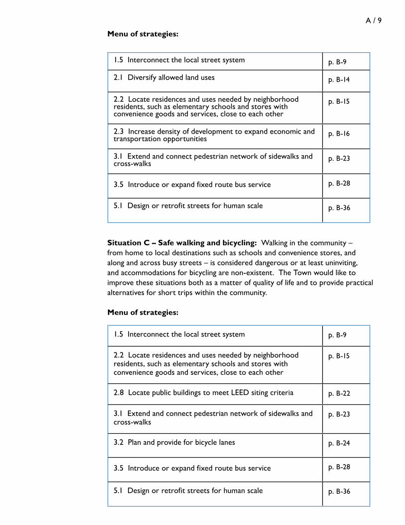
A / 9
Menu of strategies:
Situation C – Safe walking and bicycling: Walking in the community – from home to local destinations such as schools and convenience stores, and along and across busy streets – is considered dangerous or at least uninviting, and accommodations for bicycling are non-existent. The Town would like to improve these situations both as a matter of quality of life and to provide practical alternatives for short trips within the community.
Menu of strategies:
1.5 Interconnect the local street system
p. B-9
2.1 Diversify allowed land uses p. B-14
2.2 Locate residences and uses needed by neighborhood residents, such as elementary schools and stores with convenience goods and services, close to each other
p. B-15
2.3 Increase density of development to expand economic and transportation opportunities
p. B-16
3.1 Extend and connect pedestrian network of sidewalks and cross-walks
p. B-23
3.5 Introduce or expand fixed route bus service p. B-28
5.1 Design or retrofit streets for human scale p. B-36
1.5 Interconnect the local street system
p. B-9
2.2 Locate residences and uses needed by neighborhood residents, such as elementary schools and stores with convenience goods and services, close to each other
p. B-15
2.8 Locate public buildings to meet LEED siting criteria p. B-22
3.1 Extend and connect pedestrian network of sidewalks and cross-walks
p. B-23
3.2 Plan and provide for bicycle lanes p. B-24
3.5 Introduce or expand fixed route bus service p. B-28
5.1 Design or retrofit streets for human scale p. B-36

A / 10
C-2. The existing transportation network falls short of meeting tourist needs and is experiencing congestion.
Situation: The community is an established tourist town and wants to gain competitive advantage, as well as relieve seasonal traffic congestion, by making sure that visitors can easily reach a variety of destinations by different means of travel.
Menu of strategies:
D. Issues relating to town centers
D-1. Conflicts between downtown and the state highway that passes through it are causing problems for both
Situation: Downtown is an important part of the local economy and a source of pride. But it straddles a state highway, and increasing traffic is causing congestion, noise, vibrations, and an uncomfortable environment for pedestrians. There is talk of the need to better accommodate the traffic, and worry about losing parking spaces and the pedestrian-friendly atmosphere that is essential to the downtown.
Menu of strategies:
1.5 Interconnect the local street system
p. B-8
1.6 Provide for alternative routing of traffic p. B-11
1.7 Improve wayfinding p. B-12
3.1 Extend and connect pedestrian network of sidewalks and cross-walks
p. B-23
3.2 Plan and provide for bicycle lanes p. B-24
3.5 Introduce or expand fixed route bus service p. B-28
3.6 Introduce or expand passenger rail service p. B-30
1.4 Provide for alternative routing of traffic p. B-8
1.5 Interconnect the local street system
p. B-9
1.6 Provide for alternative routing of traffic p. B-11
2.7 Evaluate standards for on and off-street parking p. B-21
3.4 Introduce or expand demand-response transit p. B-27

A / 11
3.5 Introduce or expand fixed route bus service p. B-28
5.1 Design or retrofit streets for human scale p. B-36
5.2 Retrofit streets and highways using flexible, “context sensitive” design p. B-38
D-2. The Town lacks a recognizable center, but a key intersection, if developed properly, could fill that role.
Situation: We’re a small, rural town that wants to take advantage of a key intersection as an area for growth and development. We don’t have a strong town center at present (or would like to promote an additional one) and think this offers an opportunity.
Menu of strategies:
1.2 Limit the number of new driveways onto major collectors and arterials
p. B-5
1.5 Interconnect the local street system
p. B-9
2.1 Diversify allowed land uses p. B-14
2.2 Locate residences and uses needed by neighborhood residents, such as elementary schools and stores with convenience goods and services, close to each other
p. B-15
2.3 Increase density of development to expand economic and transportation opportunities
p. B-16
2.4 Create a decentralized community sanitary district for subsurface wastewater disposal
p. B-17
2.5 Prepare an “official map” for streets and other public improvements
p. B-18
2.8 Locate public buildings to meet LEED siting criteria p. B-22
3.1 Extend and connect pedestrian network of sidewalks and cross-walks
p. B-23

A / 12
D-3. Parking in the town center is insufficient to meet the combined needs of customers and workers
Situation: Most businesses and institutions rely on on-street parking in the town center, a modestly sized public parking lot, and a variety of small off-street lots. The available spaces are near capacity during peak hours on many business days.
Menu of strategies:
D-4. Trucks are rumbling through downtowns (or neighborhoods)
Situation: The road through downtown (or a residential area) is a truck route for delivery of freight that originates from beyond town boundaries and must pass through town to reach its points of delivery. The resulting noise, dust, and vibration are eroding quality of life.
Menu of strategies:
E. Issues relating to taking advantage of regional transportation facilities
E-1. A regional transportation interchange or facility is a vital part of the community but it is unclear how to take advantage of it
Situation A – Highway interchange: An undeveloped or underdeveloped area around a highway interchange or along a connection to the interchange offers an opportunity for business development. The road and interchange may be under-designed for intense development, and traffic on it is already fairly heavy. The community sees this area as possible growth area but is unsure how to move forward.
2.3 Increase density of development to expand transportation and economic opportunities
p. B-16
2.6 Modify use, supply, and location of public parking p. B-19
3.4 Introduce or expand demand-response transit service p. B-27
3.1 Extend and connect pedestrian network of sidewalks and crosswalks
p. B-23
3.5 Introduce or expand fixed route bus service p. B-128
1.4 Provide for alternate routing of traffic
p. B-8
1.6 Institute turning controls p. B-11
4.3 Upgrade connectivity between industrial areas and the regional transportation system
p. B-35

A / 13
Menu of strategies:
Situation B – Rail facilities: A rail line passes through Town, close to a port or industrial area, and in the past there were active industries with rail sidings to them. Some of these have fallen into disuse, and meanwhile other businesses that might be able to take advantage of rail have located some distance away. The Town would like to encourage expanded use of rail both to grow business and potentially to reduce the flow of truck traffic through the community and region.
Menu of strategies:
1.1 Contain development within limited growth area boundaries p. B-1
1.2 Limit the number of new driveways onto major collectors and arterials
p. B-5
1.4 Provide for alternative routing of traffic p. B-8
1.6 Institute turning controls p. B-11
2.3 Increase density of development to expand transportation and economic opportunities
p. B-16
3.5 Introduce or expand fixed route bus servicez p. B-28
4.1 Anticipate regional transportation needs for an undeveloped or new growth area
p. B-31
4.2 Allow for operation and expansion of regional transportation facilities
p. B-33
5.2 Retrofit streets and highways using flexible, “context sensitive” design
p. B-38
5.5 Adopt performance standards for signs, parking, and landscaping for highway-oriented development
p. B-43
4.2 Allow for operation and expansion of regional transportation facilities
p. B-33
4.3 Upgrade connectivity between industrial areas and the regional transportation system
p. B-35

A / 14
Situation C – Airport: A regional airport is located in the community with potential for growth. There are signs of increasing residential development in the area around the airport, and while this has not caused much of a problem so far, the Town can foresee a time when the growth of both the airport and residential development will be incompatible, possibly inhibiting airport expansion.
Menu of strategies:
E-2. Marine transportation facilities are threatened by rising coastal land prices and non-marine land uses.
Situation: Growth pressures around a marine transportation terminal are leading to replacement of traditional neighboring waterfront uses with residential development.
Menu of strategies:
F. Issues relating to preserving quality of place
F-1. A rural arterial does not meet modern standards for lane widths and shoulders, but there are features along the road we want to preserve if and when MaineDOT upgrades it
Situation A: Stands of trees, stone walls, and a scenic vista in a rural part of town are part of the Town’s identity, highly valued by residents. At the same time, the road is going to have to be upgraded sooner or later. The Town has included these in its inventory of special features and wants to make sure that they can be preserved.
Menu of strategies:
4.2 Allow for operation and expansion of regional transportation facilities
p. B-33
4.3 Upgrade connectivity between industrial areas and the regional transportation system
p. B-35
4.2 Allow for operation and expansion of regional transportation facilities
p. B-33
5.1 Design or retrofit streets for human scale p. B-36
5.2 Retrofit streets and highways using flexible, “context sensitive” design
p. B-38
5.6 Conduct a visual assessment and adopt view corridor standards p. B-45

A / 15
Situation B: The appeal of the village center includes its street trees, on-street parking, the relationship of the street to the buildings, some of which may be historic, and the ease of walking along the street and crossing it. However, if traffic volumes increase to the point that the arterial must be upgraded, lanes and shoulders may need to be widened, compromising each of these important features. Thus, it wants to manage traffic growth and impacts before reaching this point.
Menu of strategies:
F-2. The main road into Town used to be a scenic gateway to the community, but it is deteriorating in the face of random development
Situation: Until recently, the entry into Town – the first few miles before reaching the more settled part of the Town – was mostly in open space with a variety of fields, treelines, occasional homes, and views. But a somewhat hodge-podge assortment of development in random locations along this stretch of road is beginning to change the face of the community.
Menu of strategies:
1.5 Interconnect the local street system p. B-9
2.3 Increase density of development to expand economic and transportation opportunities
p. B-16
2.6 Modify use, supply, and location of public parking p. B-19
3.5 Introduce or expand fixed-route bus service p. B-28
5.1 Design or retrofit streets for human scale p. B-36
5.2 Retrofit streets and highways using flexible, “context sensitive” design
p. B-37
1.1 Contain development within limited growth area boundaries p. B-1
5.5 Adopt performance standards, including for signs, parking, and landscaping, for highway-oriented development
p. B-43
5.6 Conduct a visual assessment and adopt view corridor standards p. B-45

A / 16
G. Issues relating to environmental conditions
Note: Transportation systems affect and are affected by environmental conditions in many ways and thus are regulated by the Clean Water and Clean Air Acts, the National Environmental Policy Act (NEPA), and other statutes and rules. MaineDOT and the Maine Turnpike Authority, rather than communities, are the primary agencies working with these laws, and the environmental requirements are beyond the scope of this handbook. However, following is one type of common issue, presented for illustration, that communities may face.
G-1. New local road construction or upgrading of an existing local road will impact a stream and the municipal storm drainage system
5.7 Incorporate best management practices for erosion control and storm water management into subdivision and site plan review ordinances
p. B-47
5.8 Assure proper design of culverts for streams with fish populations
p. B-48

B / 1
menU oF tranSPortation – Land USe StrategieS
appendix b
Below is the list of strategies summarized in this appendix.
Part 1. Strategies to relieve or prevent congestion and preserve mobility
1.1 Contain development within limited growth area boundaries1.2 Limit the number of new driveways onto major collectors and arterials1.3 Retrofit the number, location, and design of existing driveways1.4 Provide for alternative routing of traffic1.5 Interconnect the local street system1.6 Institute turning controls1.7 Improve wayfinding1.8 Work toward job-housing balance
Part 2. Strategies to enhance the form and pattern of development for optimal use of the transportation system
2.1 Diversify allowed land uses2.2 Locate residences and uses needed by neighborhood residents, such as elementary schools and stores with convenience goods and services, close to each other 2.3 Increase density of development to expand transportation and economic opportunities2.4 Create a community sanitary district for subsurface wastewater disposal2.5 Prepare and adopt an “official map” for streets and other public improvements2.6 Modify use, supply, and location of public parking in village centers and downtowns2.7 Evaluate and consider standards for single-parcel off-street parking2.8 Locate public buildings to meet LEED siting criteria
Part 3. Strategies to introduce or expand modes of passenger transportation
3.1 Extend and connect the pedestrian network of sidewalks and cross-walks3.2 Provide for bicycle lanes3.3 Introduce or expand ride sharing3.4 Introduce or expand demand-response transit service3.5 Introduce or expand fixed-route bus service3.6 Prepare for passenger rail service

B / 2
Part 4. Strategies to protect and get the most out of regional transportation facilities
4.1 Anticipate regional transportation needs for an undeveloped or new growth area4.2 Allow for unimpeded operation and expansion of regional transportation facilities4.3 Upgrade connectivity between industrial areas and regional transportation facilities
Part 5. Strategies to maintain quality of place
5.1 Design or retrofit streets for human scale5.2 Retrofit streets and highways using flexible, “context sensitive” design5.3 Institute traffic calming measures5.4 Conduct a safety audit5.5 Adopt performance standards, including for signs, parking, internal circulation and landscaping, for highway-oriented development5.6 Conduct a visual assessment and adopt view corridor standards5.7 Incorporate BMPs for erosion control and stormwater management into subdivision and site plan review ordinances5.8 Assure proper design of culverts for streams with fish populations

B / 3
1-1. Contain development within limited growth area boundaries
Objective: to prevent continuous commercial strip development that introduces turning conflicts, increases congestion and crash rates, and changes the character of community.
Description: Maine’s Growth Management Act requires local comprehensive plans to designate growth areas, which are areas considered suitable for orderly residential, commercial, or industrial development and into which most development projected over 10 years is directed.
The Growth Management Act’s rule requires growth areas along arterials and mobility corridors to be configured to avoid strip development and promote nodes or clusters of development.
Thus, growth areas along arterial and collector roads should not be continuous. Unless circumstances clearly dictate otherwise, they should be limited to segments of roadway that are natural transitions between villages or town centers and rural portions of the corridor or around nodes at key intersections. These segments might extend, for example, to the limits of an urban compact boundary, as defined by MaineDOT, from a village area to a major intersection or interchange, or short distances from a key intersection. These segments should be limited to less than 1 mile, and preferably to about ½- mile. A commercial growth area or combination of commercial growth areas typically should encompass a relatively small percentage of the frontage of a corridor within a town or group of contiguous towns. Lincolnville’s comprehensive plan illustrates a series of well-defined growth areas centered on numbered highways. See Figure B-1. To the greatest extent possible, the growth areas should exclude stretches of undevelopable areas, such as wetlands, and avoid scenic stretches or areas with significant view corridors.
Note: The strategy of establishing limited growth area boundaries is not limited to arterials and mobility corridors. More generally, all growth areas, “to the greatest extent practicable, must be limited to an amount of land area and a configuration to encourage compact, efficient development patterns (including mixed uses) and discourage development sprawl and strip development.”
Having established limited growth area boundaries, there is a variety of techniques to successfully direct most growth into them. Some of these strategies are included in this Appendix (see, e.g., 1.5 Interconnect the local street system, 2.3 Increase density of development, 2.5 Prepare and adopt an “official map” for streets and other public improvements). A good discussion of directing growth into growth areas also is included in the State Planning Office’s report, Updating Your Comprehensive Plans: 50 Recommendations for Making Plan Updates More Effective. The most important ingredient, however, is local determination and commitment to achieve a relatively compact form of growth.
PART 1. Strategies to relieve or prevent congestion and preserve safe mobility

B / 4
4 miles long.7 miles ingrowth area
7.5 miles long1.8 miles ingrowth area
2.8 miles long1.6 miles ingrowth area
7.8 miles long2.8 miles ingrowth area
Figure B-1.
Well-defined growth areas along numbered highways

B / 5
1.2 Limit the number of new driveways onto major collectors and arterials
Objective: To minimize conflicts between turning and moving traffic and related crashes and congestion, while providing reasonable access to adjacent properties.
Description: Ideally, a community will take steps to limit the number of driveways along major collectors and arterials with posted speed limits of 45 mph (fewer if speed limit is higher) to about 20 per mile (curb cuts opposite each other count as one). A basic strategy to achieve this is to incorporate into the performance standards section of a zoning or land use ordinance a limit of one new curb cut per lot of record as of the date of adoption of the standard. The effect of this standard is to require owners of parcels with extensive frontage along a major collector or arterial to provide for internal circulation — such as shared driveways and frontage roads (see Figure B-2) — if and when they develop their properties in the future.
Short of this policy, communities can control curb cuts in several ways:• Withoutexplicitlylimitingnewcurbcutstooneperlotofrecord,a
community can require as part of its subdivision regulations that a developer demonstrate that a frontage road or shared access, rather than individual driveways to a collector or arterial, is not possible to achieve.
• Ifadditionalcurbcutstothecollectororarterialaredeemednecessary,include in the performance standards section of a zoning, land use, or site plan review ordinance a limit of one two-way driveway (or two one-way driveways) for most uses. High volume commercial uses may require two onto the collector or arterial, but make this a last resort if no other alternatives (sharing drives, two one-way operating drives, a second drive to a side street, etc.) are available.
Design standards should specify that driveways be spaced a sufficient distance apart based on the posted speed limit of the road in question, in accordance with MaineDOT guidelines, and that the geometry of the driveways – width, throat length, and curb return radius—also meet MaineDOT guidelines. See also Maine’s Site Plan Review Handbook.
PART 1. Strategies to relieve or prevent congestion and preserve safe mobility

B / 6
1.3 retrofit the number, location, and design of driveways
Objective: To reduce the number of existing access points along a roadway and to improve the design and operation of driveways that remain.
Description: By providing greater separation between access points, fewer access points, restriction of turning movements and use of auxiliary turn lanes, the rate of conflict experienced by motorists is reduced, thereby lowering crash rates and improving traffic flow. The proper balance and design benefits both property development and street function.
• Siteplanpermitting.Atthetimeofexpansionoralterationofuse,requireaspart of site plan permit a consolidation of exiting driveways and reconfiguration to meet MaineDOT geometric standards, including proper width, length, and curb return radius.
• Sharedaccess.Aspartofupgradingoftheroadway,conveneadjacentpropertyowners to identify means of providing shared access, removing driveways from the functional area of intersections, and reconfiguring driveways to enable safe and efficient movement of vehicles to and from parking areas. See Figure B-2.
• Removalofturningvehiclesfromthrough-trafficlanes.Provideturninglanes,both left and right, to allow drivers to decelerate gradually out of the through lane.
• Opportunitiestoreduceaccesspoints.Alternativesincludefrontagestreetsanda supporting road circulation system where access is provided on existing or new side streets.
PART 1. Strategies to relieve or prevent congestion and preserve safe mobility

B / 7
Figure B-2. Frontage roads and
shared access
Frontage roads parallel the main road, with limited ac-cess points. Each business has its own access off the frontage road. In shared access arrangements, the
development of a large parcel (or the retrofit of
an existing situation) is arranged so that there is
typically a single access from the main road, and then a controlled flow between
the individual lots or sites that were carved out from
the original parcel.
If a community enacts a strong access management
policy, whether for new development or to retrofit
an existing situation, alternatives to multiple
access points such as these are necessary. Frontage Roads
Shared Access
Multiple Access
PART 1. Strategies to relieve or prevent congestion and preserve safe mobility

B / 8
1.4 Provide for alternate routing of traffic
Objective: To provide relief to existing roads and sidewalks when they are at capacity or when there is conflict between types of traffic.
Description: Alternative routing can be very short-distance (e.g., to allow traffic to get from one commercial use to another without entering back onto an arterial) or long-distance (e.g., a regional bypass road.) The interconnection of local streets also is an alternative routing technique but has broader purposes and is discussed separately in the next strategy.
Approaches to alternate routing include:
• Frontageroads.Frontageroadsareshortroadwaysegmentsthatconnectadjacentparcels of commercial development and have limited access points along the parallel roadway. See Figure B-2. Frontage roads can be placed either in front of or behind commercial parcels. They can be specified within subdivision ordinances as a technique for complying with limits on curb cuts. (See 1.2 Limit the number of new driveways.)
• Bypasses.Bypassescanbeeitherlocalorregionalinnature.Localbypassescanprovide relief to short, congested sections of downtowns, while regional bypasses provide relief to longer sections of strip commercial development or overloaded commercial centers. Any bypass may be difficult to achieve because of right-of-way, neighborhood, and expense issues. But opportunities for local bypasses do exist. For example, unbuilt public ways may exist in a relatively rural part of town; or connection may be possible across public property; or two segments of an existing right-of-way may need only a modest connection to create a local bypass; or an existing road that is used as a de facto local bypass could be upgraded for that purpose, with accompanying revisions to zoning districts and performance standards.
• TruckRoutes.Designatedroutesfortruckscanbeestablishedtoreducenoise
impacts through downtowns or established neighborhoods. Truck routes can be established along existing street networks, new development infrastructure, or along bypasses. Particular attention needs to be paid to the established Heavy Haul Truck Network, the network of arterials that are part of Maine’s freight system.
• AlternativeTransportationFacilities.Alternateroutingcanalsoincludedevelopinginfrastructure for multimodal use, such as sidewalks, bike lanes, transit stops, and park and ride lots. These would be located at key points within a community to link to existing multimodal networks. A key purpose of interconnected local streets, for example, is to enable pedestrians and bicyclists to avoid travel along busy collectors or arterials. (See the full set of strategies on introducing or expanding alternative modes; see 1.5 Interconnect the local street network).
PART 1. Strategies to relieve or prevent congestion and preserve safe mobility

B / 9
1.5 interconnect the local street system
Objective: To provide a circulation system that allows neighborhood residents with a safe, convenient way to pass through a neighborhood to local destinations. This also provides options for emergency vehicles
Description: A local street system is interconnected if there is more than one way for autos, pedestrians, and bicycles to move from one street to another and to local destinations within the neighborhood without needing to go out onto collector streets or arterial roads.
A measure of interconnection is the “link-to-node ratio.” A “link” is a section of road between intersections. A “node” is an intersection or the head of a cul de sac or other dead end. The more links there are for each node, the greater the interconnection. Communities should strive for a ratio of 1.4 links per node within a given neighborhood, especially within designated growth areas, including downtowns and village centers. This may not be possible in areas with many veins of poor soils or other natural characteristics that limit street layout. But ratios of 1.2 or 1.3 should almost always be possible with reasonable planning. Where street connections are not possible, pedestrian or bicycle paths can provide some of the benefits of interconnection.
Where dead-end streets are prevalent, it is difficult to bring about interconnection unless the Town owns land that will enable linkages. However, this problem can be reduced in the future if the subdivision ordinance requires that any subdivision provide for a right-of-way connection from the proposed subdivision to any adjacent, vacant parcel. The right-of-way should be dedicated to town ownership as part of the subdivision plan. It would be converted to a road by the developer of the adjacent vacant parcel at the time of that parcel’s subdivision.
The best overall approach to assure the interconnection of local roads is through the preparation, in cooperation with owners of contiguous vacant lands, of an “official map” of streets and other public improvements. This official map will then be incorporated into the Town’s comprehensive plan. (See 2.5 Prepare and adopt an “Official Map”).
Note: in truly rural areas, where residential development is very low density (e.g., fewer than one unit per five acres), and conservation subdivisions are a required or common form of development, interconnection may be neither needed nor feasible.
PART 1. Strategies to relieve or prevent congestion and preserve safe mobility

B / 10
Grid Layout: 37 links, 25 nodes = ratio of 1.5 Modified Grid: 42 links, 32 nodes = ratio of 1.3
This ratio is a measure of interconnection of the street system and the choices people have to get from one place to another. In the example above, the grid lay-out is from a neighborhood in Brunswick, and the modified grid layout is from a neighborhood in Brewer. Each intersection, dead end, and cul-de-sac is a node. Each segment of street between nodes is a link. (Don’t count links that are running out of the frame of the diagram.) The more links per node, the greater the connectivity of the neighborhood or community. Sometimes when it is not possible or desirable to create a street connection, a pedestrian or bicycle connection can serve a similar purpose.
Figure B-3.Link-to-nodesratio
PART 1. Strategies to relieve or prevent congestion and preserve safe mobility

B / 11
1.6 institute turning controls
Objective: To reduce conflicts and improve safety for motorists, pedestrians, and bicyclists.
Description: Key to the process of selecting an appropriate method for controlling turns is defining the specific kinds of turns you need to control: left or right turns; into or out of driveways and sidestreets. The methods of controlling turns fall under four categories:
• Signage–installingNoLeftturnsigns;thisrequiresvoluntarycompliancebymotorists
• DrivewayDesign–designingadrivewaytoenterthestreetatanacuteanglethatonly permits right-turns; this is difficult to retrofit in existing driveways
• One-WayLinks–designateastreet/drivewayasone-wayenteringthemajorstreet and prohibit turns from the major street; however, one-way streets can be unexpected and confusing to motorists
• Non-TraversableMedian–aphysicalbarrierinthestreetthatseparatestraffictraveling in opposite directions, such as a concrete barrier or landscaped island; it should be a minimum 4 feet in width (or 6 feet if pedestrians are expected to wait on the median when crossing the street); requires additional width in the roadway cross-section
A non-traversable median is typically appropriate only in the following situations:
• OnamultilanestreetwithADTinexcessof24,000;• Atalocationwhereright-ins/right-outsatdrivewaysaretheonlymovements
deemed acceptable and reconstruction of driveways is not practical;• Onastreetwhereaestheticconsiderationsareahighpriority;• Onamultilanestreetwithahighlevelofpedestrianactivity;or• Atahighcrashlocationorareawhereitisdesirabletolimitleftturnsto
improve safety.
PART 1. Strategies to relieve or prevent congestion and preserve safe mobility

B / 12
1.7 improve wayfinding
Objective: To assist travelers in safely and efficiently finding their way to destinations in the community or region.
Description: “Wayfinding” is a succession of clues that allows someone to navigate to a desired destination. It is, in other words, a system of information that includes signs, landmarks, and maps. But it is more than that. It is also a continuous system of physical pathways, such as sidewalks and streets, that leads the traveler to the desired destination.
In a community, good wayfinding reduces confusion and unexpected moves by motorists. Conversely, it serves as an invitation to visitors and others unfamiliar with the area to relax as they move through the community.
Basic wayfinding techniques that a community might consider include:
• Aconsistentsystemofstreetsigns,withcommon,identifiablegraphicapproach• Clearsignageofone-waystreets• Useofoff-sitebusinesssignsalonghighwaysonapproachestointersections
where travelers must change direction or at the end of “T” intersections, meeting state Standards for Official Business Directional Signs (available for businesses, services, and points of interest within a 10-mile radius of the proposed location of the sign)
• Communitymapsthatincludestreetnames,landmarks,andcommondestinations, made available at the Town’s web site, at chambers of commerce, and other public venues
• Makingsurethatsidewalksandbicyclepathsarecontinuousinareasthatservebusinesses, governmental facilities, and key points of interest
• Providinglightingandarchitecturalordesignelementsalongcommonpathways
PART 1. Strategies to relieve or prevent congestion and preserve safe mobility

B / 13
PART 1. Strategies to relieve or prevent congestion and preserve safe mobility
1.8 work toward Jobs-Housing balance
Objective: To reduce vehicle miles and vehicle hours traveled and the related stresses on road systems and quality of life.
Description: Of all the land use-related measures that can reduce burdens on highway systems, achieving a balance between the number of jobs in an area and the number of homes to house the workers in those jobs is among the most effective. Jobs-housing balance means a rough parity between employment and housing at the range of prices affordable to persons with the skills to fill the area’s jobs.
Many labor market areas (areas defined by the Department of Labor to encompass job centers and their common commuting areas) almost by definition have jobs-housing balance. For example, the Brunswick Labor Market Area in 2005 had about 33,500 jobs and about 33,200 dwelling units. But this labor market area encompasses nearly 385 square miles – both the job centers and the far reaches of outlying rural towns, from which residents commute in single-occupant autos and put growing pres-sure on the road system. The challenge is to achieve balance near where the jobs are. Considering Bath and Brunswick by themselves, jobs outnumbered dwelling units almost 2-to-1. In the rest of the labor market area, dwelling units outnumbered jobs by nearly 2.5-to-1.
Alternatively, there might be a focused strategy to build job bases in the cores of growing suburban towns with large residential bases, as has happened, for example, in communities like Falmouth, Topsham, and Scarborough.
In any case, the keys to job-housing balance are:• Directinggrowthofbothjobsandhousingtocoreareas–inComprehensive
Planning lingo, to designated growth areas – and adopting this as a matter of policy in Comprehensive Plans (see 1.1 Contain development within limited growth area boundaries as well as several of the strategies in Part 2 of this Appendix);
• Assuringthatlotsizeanddensitystandardsinlanduseordinancesdonotposeartificial barriers to housing in the size and price ranges needed by workers in the community, and supplementing the market’s capacity to produce workforce housing with assistance from agencies like the Maine State Housing Authority;
• Planningutilitysystemssothattheywillhavethecapacitytohandlethisfocuseddevelopment; and
• Cooperatingwithneighboringcommunities–whetheragrowingsuburbthatstrives for a job base or a service center community with an established job base – to work toward complementary job, residential, and mixed-use centers that can be connected by public transportation (see strategies in Part 3 of this Appendix).

B / 14
2.1 diversify allowed land uses(Important companion strategy: 1.1 Contain development within limited growth area boundaries)
Objective: To enable a single auto trip to serve two or more purposes without additional auto travel.
Description: Diversity of land uses is one of the “D”s that brings transportation and land use into sync with each other by increasing choice of transportation. The appropriate mix of land uses depends on whether you are talking about a downtown, neighborhood, business park, or suburban shopping center. But in all cases, you should strive, within well-defined growth areas, to have a variety of compatible uses within ¼- to ½-mile of each other, as measured along vehicular or pedestrian pathways.
Downtowns are natural land use mixing areas, with a complement of retail, office, civic, and cultural uses. A fully diverse downtown allows residential uses at densities that include multifamily residential uses on upper floors and compact residential streets adjacent to it. In the case of a hamlet or similar rural settlement, a complement of residential uses may already exist within a ½-mile radius. Within this radius, zoning and subdivision standards should allow for easy “infill” of both non-residential and residential lots on vacant parcels to increase densities.
Zoning ordinances should require business and industrial parks to set aside at least 5%-10% of their space for limited retail activity, such as restaurants, financial services, and personal services, that serve the tenants of the parks. Where public sewer is available, multifamily residential uses also can be at the periphery of office parks, with potential for some workers to be located there and to add support to the retail and personal service businesses.
Similarly, suburban shopping centers should comprise not only the expected retail uses, but also office uses and personal service businesses located either within the centers or within ¼-mile of their front doors via shared driveways and internal circulation pathways. Zoning ordinances should require that centers of more than 25,000 square feet provide space for such uses.
PART 2. Strategies to enhance the form and pattern of development for optimal use of the transportation system
B / 15
PART 2. Strategies to enhance the form and pattern of development for optimal use of the transportation system
2.2 Locate residences and uses needed by neighborhood residents, such as elementary schools and stores with convenience goods and services, close to each other(Important companion strategy: 1.1 Contain development within limited growth area boundaries)
Objective: To provide residents with easy access to day-to-day services without undue burdens on collector and arterial roads.
Description: In residential areas, diversity of land use can be measured by the number of stores and services providing everyday needs that are located within ½-mile of most homes in a neighborhood. Typical, compatible uses include, for example, schools, places of worship, day care centers, small restaurants (no drive-through windows), banks, convenience food stores, local hardware stores, other retail stores of less than 5,000 square feet, hair salons, and small-scale professional and doctor’s offices of less than 2,500 square feet.
Typically we think of incorporating small-scale activity into or near an existing residential area. However, it works in the converse, too: if, for example, a school has been recently built in an outlying area of town, seriously consider whether homes can be consciously programmed to locate in the same vicinity, with good connections to the school.
Locating homes and neighborhood uses and facilities close to each other can be accommodated through zoning ordinances in several ways:• Someusescanbeallowedasconditionaluseswithintheresidentialzoning
district because they are basically compatible with residential uses. • AlloftheusescanbeallowedinaNeighborhoodBusinessDistrictembedded
within or adjacent to the residential district. These districts are geographically small, often no more than a few acres. They should be considered immune from concern about illegal “spot zoning” (a frequent worry about very small zoning districts), because they are meeting a public need.
• Finally,municipalitiescanusecontractorconditionalzoningasatooltoprovidepre-planned non-residential or mixed use development within or adjacent to a residential zoning district. This requires close consultation with the residential neighborhood.
In all cases, a non-residential use involving expansion or new construction should be subject to site plan review to assure proper arrangements for parking, drainage, lighting, and similar components of the site.

B / 16
PART 2. Strategies to enhance the form and pattern of development for optimal use of the transportation system
2.3 increase density of development to expand economic and transportation opportunities(Important companion strategy: 1.1 Contain development within limited growth area boundaries)
Objective: To achieve densities that can support choice in transportation and allow efficient economic growth.
Description: In most communities, only incremental increases in residential and commercial densities of development within identified growth areas are needed to make a difference in how people use the transportation system. Strive for the following minimum densities (which, in keeping with Maine’s small town environment, are still considered low to moderate):
• Residential,on-sitesewerandwater:Oneunitper20,000to30,000squarefeet(1.75 to 2 units per residential acre), the maximum allowed by the State’s Minimum Lot Size Law, in areas within ½-mile of town centers; combine this density with frontage requirements of no more than 100 feet to maintain a scale of walkability. (Also see the related strategy on decentralized community sanitary districts.)
• Residential,off-sitesewer:4unitsperresidentialacreinsingle-familyareaswithin½-mile of town centers and 8 units per residential acre in areas that allow multi-family housing. These densities, with proper design and street interconnections,
are highly walkable and increase the feasibility of transit service.
• Commercial,downtowns:Afloorarearatio(F.A.R.)ofatleast0.7,or700squarefeet of total floor area in buildings per 1,000 square feet of lot area, including space for parking lots. Many small city downtowns (such as Bath and Rockland) are in the range of 0.6 to 0.8. For reference, large downtowns, where bus service is more common, have a F.A.R. of over 1.5. Portland downtown’s F.A.R. is more than 2.0. See Figure 3-2 in Chapter 3.
• Commercial,suburbancenters:Afloorarearatioofatleast0.4.Thisismorethantwice the typical F.A.R. of most suburban shopping centers, where single-story buildings and expansive parking lots push the F.A.R. down to less than 0.2.
Communities can influence floor area ratios by keeping off-street parking requirements in check, and setting a maximum as well as a minimum number of parking spaces in highway commercial districts. In most downtowns, no or a minimal off-street parking requirement is appropriate. A combination of on-street parking and small public lots both serves merchants well and fosters higher FARs. In highway commercial districts, consider establishing a maximum at 80% of peak parking demand.

B / 17
2.4 Create a decentralized community sanitary district for subsurface wastewater disposal
Objective: To enable areas without public sewer to develop in a compact pattern, as encouraged by the Growth Management Act and the STPA.
Description: Maine law (Title 38, Section 1234) allows municipalities to create community sanitary districts – which is a smaller, limited version of regular sanitary districts – for the purpose of providing subsurface wastewater collection and treatment services to accommodate residential development. This tool was established in 2005 to make it easier for towns without centralized wastewater collection and treatment capacity to implement relatively compact growth areas. Engineered community subsurface wastewater systems are very reliable if properly designed, installed and maintained – tasks which become the responsibility of a community sanitary district.
This tool allows homes to be located on individual lots smaller than 20,000 square feet, using a community subsurface filter bed or system of beds that is professionally
maintained by the community sanitary district. The system can be installed and financed by a developer at the time of development, or in advance by the district. The district, like any sanitary district, charges an annual user fee to maintain the system in good working order. The overall density of development in the area still cannot be more than 1 unit per 20,000 square feet, but because the leach field is located away from the lots and wells, the lots themselves can be smaller and the development pattern more compact and walkable.
This approach is especially suited for use in communities that already have a sanitary district but whose public sewer system serves only a limited area. The sanitary district itself can oversee the development and assume responsibility for maintaining the community subsurface system, administering the system in the same way as it administers the regular public sewer system.
PART 2. Strategies to enhance the form and pattern of development for optimal use of the transportation system
common drainfields
common area
common area
Figure B-4. Engineered community septic
system
An engineered community septic system can enable a
neighborhood development in the absence of a public,
off-site sewer system. State law enables creation of a
simplified community sani-tary district for long-term
maintenance of the system, funded through user fees.

B / 18
PART 2. Strategies to enhance the form and pattern of development for optimal use of the transportation system
2.5 Prepare and adopt an “official map” of streets and other planned public improvements
Objective: To plan for an interconnected street, utility, and open space system within designated growth areas, or portions of growth areas, in a community.
Description: An “official map” is a map that gives notice to private landowners of where future streets and other public improvements, such as parks, playgrounds, and sewer lines, are to be located. It is usually adopted as part of a comprehensive plan. While there is no geographic limit on its use, it is best used within designated growth areas or part of a growth area where there is active interest in development.
An “official map” is best prepared in conjunction with groups of landowners with contiguous holdings. It creates several advantages for the landowners and the Town alike:
• ItletsbothlandownersandtheTownknowwherestreetandutility(andpotentially open space) systems should interconnect as development occurs independently on individual lots;
• Itstreamlinesthefuturesubdivisionreviewprocessforlandownersproposingstreets and utilities consistent with the official map;
• Ithelpstoassurethatindividualstructuresbuiltpriortoasubdivisionprocessare not inadvertently placed within the potential future rights-of-way; and
• Itcanbeastrongtooltoimplementthepatternofdevelopmentenvisionedinacomprehensive plan.
The official map needs to be prepared with reasonable (i.e., medium-intensity) analysis of wetlands and other restrictions to development. This information is largely available from governmental sources, such as the Office of Geographic Information Systems and the State Planning Office. However, site-level analysis is advisable at the points where proposed streets will meet at property lines to assure that the conditions are suitable for the planned connecting points. The more expensive site-level analysis otherwise can await the actual subdivision or site plan review process and be built into the developer’s design work.

B / 19
PART 2. Strategies to enhance the form and pattern of development for optimal use of the transportation system
2.6 modify supply, location, and use of public parking in village centers and downtowns
Objective:
• Toservetheneedsofmotoristsintermsofadequatemobilityandaccessibilityfor all motorist destinations
• Toservetheneedsofareabusinessesinprovidingadequateaccessibilityfortheircustomers (whether they stop for impulse shopping or for planned purchases)
• Toservetheneedsofareaandregionalbusinessesinprovidingadequatemobility and accessibility for the delivery of goods via truck and
• Toserve,ifdesiredforon-streetparking,asabufferbetweenmovingtrafficandpedestrians on sidewalks.
Description: Each of these interests must be understood, respected in the planning process, and reflected in any improvement proposals. Also, each parked vehicle represents one or more persons who are pedestrians, walking between the parked vehicle and one or more destinations.
With respect to on-street parking,
• Protectthecapacityforon-streetparking,identifyingacceptable“infill”spacesalong side streets as necessary
• Accepttheneedforgoodsnowremovalstrategiesaspartoftheoperatingnecessity of a viable downtown
• Keepspeedlimitsatlessthan30mphsothaton-streetparkingcanbesafelyretained
• Institutetimelimitsalonghighvaluefrontages• Designatespaces/areasthatshouldonlybeusedforshort-termparking• Designatespaces/areasthatshouldonlybeusedforcurbsideloading• Provideatleast7feetofstreetwidthforparallelparking• Evaluatewhethertruckdeliveriesfromthestreetatthefrontofbuildingsshould
be limited to off-hour periods
With respect to off-street parking,
• Especiallywherethevillageordowntowniscompactandwalkable,orifthereis bus service, preserve flexibility in off-street parking requirements, favoring, wherever conditions allow, no or limited off-street parking standard for downtown uses
• Placeoff-streetparkingprincipallytorearofbuildings,sothatbuildingscanbe uniformly pulled to the fronts of their lots; or single-loaded along sides of buildings so that buildings are not pushed overly far apart from each other

B / 20
PART 2. Strategies to enhance the form and pattern of development for optimal use of the transportation system
• Encourageemployeesandlong-termparkerstoparkinanoff-streetlot• Improvelandscaping,stallmarkings,andlightingwithinparkinglots• Improvesidewalks/pathwaysbetweenparkinglotsanddestinations• Improvesignagetoparkingfacilities

B / 21
2.7 evaluate and consider standards for single-parcel off-street parking
Objective:
• Toservetheneedsofmotoristsintermsofadequatemobilityandaccessibility;• Toprovideadequatemobilityandaccessibilityforthedeliveryofgoodsviatruck;• provideforsafeandefficientmovementforpedestrianswithintheparkinglot;
and• Tominimize,wherepossible,theamountofpavement,whichreduces
compactness and increases storm water runoff, for parking
Description: Potential means of accomplishing these objectives include:
• Updatecurrentparkingstandards,whichlikelyareaimedatinfrequentannualpeak periods. Consider setting the minimum standard for an average period rather than the seasonal peak. If alternative forms of transportation are available, or if more than one activity can easily share parking areas, consider setting a maximum parking standard for activities with seasonal peaks (such as allowing no more than 80% of parking needed during the seasonal peak)
• Allowparkingrequirementstobemetbysharingoff-streetparkingfacilities
between uses with different peak parking times. In new commercial subdivisions, establish a standard that requires shared parking between lots unless good reason can be shown that a separate parking area is necessary.
• Ensuresitedesignprovidesappropriateon-sitecirculationtoprevententeringvehicles from queuing into the street, and to ensure safe pedestrian pathways between parking lot and building and between commercial buildings on adjacent sites
• Designaccesspointstooperatesafelyandefficiently
• Provideappropriatelandscaping,stallmarkings,andlightingwithinparkinglots (see 5.5 Adopt performance standards for highway-oriented development)
PART 2. Strategies to enhance the form and pattern of development for optimal use of the transportation system

B / 22
2.8 Locate public buildings to meet Leed siting criteria
Objective: To site public buildings in locations that easily connect to other common services in village centers, downtowns or neighborhoods.
Description: LEED is the Leadership in Energy and Environmental Design Green Building Rating System. The U.S. Green Building Council created this voluntary, national rating system in 1998 to promote high-performance, sustainable buildings. To earn LEED certification, a building project must earn “credits” by meeting performance benchmarks in five areas: sustainable site development, water savings, energy efficiency, materials selection, and indoor environmental quality. Within the category of sustainable site development, credits can be earned for “development density and community connectivity.”
These credits are earned by either:
• constructingorrenovatingabuildingonapreviouslydevelopedsite and within an area with a minimum density of 60,000 sq. ft. per acre (equal to a floor area ratio of about 1.4), OR
• constructingorrenovatingabuildingonapreviouslydevelopedsite and within ½ mile of a residential zone or neighborhood with an average density of 10 units per acre (net of streets) and within ½ mile of at least 10 “basic services.”
Basic services include banks, places of worship, convenience grocer-ies, day care centers, cleaners, fire stations, beauty shops, hardware stores, laundries, libraries, medical or dental offices, senior care facilities, parks, pharmacies, post offices, restaurants, schools, supermarkets, theaters, community centers, fitness centers, and museums.
Orono Public Library
Community leaders in Orono
and their architectural design
team located the Town’s new
Public Library to earn certifi-
cation under LEED. The site
is next door to the Town’s
senior and community center
on a previously developed site,
near compact housing
development, and within
¼-mile of the Bangor Area
Transit (BAT) bus route and
close to local schools and a
variety of services.
PART 2. Strategies to enhance the form and pattern of development for optimal use of the transportation system

B / 23
PART 3. Strategies to expand or enhance modes of transportation
3.1 extend and connect the pedestrian network of sidewalks and cross-walks
Objective: To create a safe, pedestrian-friendly environment.
Description: Guidelines for sidewalks include:• Onresidentialstreets,atevenmodesturbandensities,sidewalksshouldideallybe
provided on each side of the street.• Ifthebuildingsinacommercialareaarelocatednearthestreetandencourage
pedestrian use, sidewalks on each side of the street are essential. No commercial area should be developed without sidewalks.
• Asidewalkshouldbeprovidedonatleastonesideofanindustrialstreetsothatpedestrians are not forced to share the street with large trucks.
Sidewalks should be continuous throughout most designated growth areas and should be required in these and other high traffic areas as part of subdivision and site plan review regulations.
Appropriate sidewalk widths are a function of their expected use. In a residential area, a 4-foot sidewalk is minimally sufficient and a 5-foot sidewalk is preferred. In a commercial area, there needs to be space for both walking and window-shopping.
It is usually desirable to locate the sidewalk back from the curb or road edge using a planting strip between the roadway and the path. Pedestrian scale lighting along side-walks improves actual and perceived safety for pedestrians.
A crosswalk is the portion of roadway designated for pedestrians to use in crossing the street. It may be marked or unmarked. A marked crosswalk serves two purposes:• towarnmotoriststoexpectpedestrianstocrossthestreetand• toindicatethepreferredpedestriancrossinglocation.
National guidelines (NCHRP Report 562) can be used to select pedestrian crossing treat-ments for unsignalized intersections and midblock locations. Quantitative procedures in the guidelines use key input variables (such as pedestrian volume, street crossing width, traffic volume, etc.) to recommend one of four possible crossing treatment categories: (1) marked crosswalk; (2) enhanced, high-visibility, or “active when present” traffic con-trol device; (3) red signal or beacon device; and (4) conventional traffic control signal.
A pedestrian refuge island, a raised island placed in the center of a street at an intersec-tion or mid-block crossing, can help protect pedestrians from moving vehicles.
See Improving Pedestrian Safety at Unsignalized Crossings. TCRP Report 112/NCHRP Report 562.

B / 24
PART 3. Strategies to expand or enhance modes of transportation
3.2 Provide for bicycle lanes
Objective: To create safe options for bicycles as an important means of transportation.
Description: Bike lanes are segments of a roadway designated by signing and pave-ment markings for exclusive bicycle use. Local streets and state highways need to provide safe travel and access for bicyclists. Only on neighborhood streets where speeds are 25 mph or lower should bicyclists share the same travel lane with cars. Otherwise, bike lanes should be considered where adequate right of way is available to better define travel lanes for bikes and cars.
Bike lanes not only provide a designated facility for bicyclists, but they also con-tribute to traffic calming by narrowing existing travel lanes and safety by increasing motorists awareness that bikes are allowed and encourages on the roadway. They create a more positive separation between bikes and cars within the roadway, and can also provide a barrier between cars and pedestrians on a sidewalk or path. Proper signage and pavement markings should be provided to inform motorists of designated bike lanes.
Elements of a bike lane within a right-of-way include:
• 5-6’wideshoulderforone-waymovement• 8’ormorefortwo-waymovementsseparatedbycurborislands• Propersignage• Distinctpavementmarkings• Shouldbeincrementallyaddedtostreetsandstatehighwayswhererightofway
permits and speed limit is 30 mph or greater• Bestprovidedifthestreetiscommonlyusedbybicyclists• Shouldincrementallyconnectexistingpathwaystootherdestinations
Figure B-5 shows dimensions of off-street bike paths.

B / 25
PART 3. Strategies to expand or enhance modes of transportation
width of bike path
10' recommended
2' graded area 4' graded
area
width of walking path
5' recommended 2' graded area
width of shared use path
10' recommended
2' graded area
2' graded area
width of bike path
10' recommended
2' graded area 4' graded
area
width of walking path
5' recommended 2' graded area
width of shared use path
10' recommended
2' graded area
2' graded area
Figure B-5
Dimensions of off-street bike paths.

B / 26
PART 3. Strategies to expand or enhance modes of transportation
3.3 introduce or expand ride-sharing
Objective: To relieve peak hour demands on roads and on parking lots serving employers, downtowns, and similar destinations; and provide transportation choice to commuters.
Description: Ride-sharing includes carpools, van pools, and shuttle buses spon-sored by employers or others. Carpooling requires conveniently located park-and-ride lots, which frequently also are used by van pools or shuttle buses.
Park and ride lots sponsored by the Maine Turnpike Authority and MaineDOT are located throughout the I-95 corridor and along a variety of state routes. Locations can be found at: http://www.exploremaine.org/parkandride/textlinks.htm.
If the community wishes to introduce a new park-and-ride lot, search for a site either adjacent to an interchange or close to a major intersection along a popular commuting route. If the community wishes to encourage greater use of existing park and ride lots due to congestion in town or city centers or to reduce the need for large off-street parking areas at major employer locations, consider an incen-tive program in which some of the off-street parking requirements are reduced if an employer or downtown district organization commits to programs that encourage use of ride sharing for employees. These programs might include sponsored shuttles and financial incentives that allow employees to share in savings from smaller parking lots.
Figure B-6.
Park-and-ride lotsystem as of 2008
B / 27
PART 3. Strategies to expand or enhance modes of transportation
3.4 introduce or expand demand-response transit service
Objective: To provide additional choice in transportation in rural areas and small towns with limited population.
Description: Demand-response transit is transit by appointment, with flexible routes and schedules. Demand-response programs are available to residents in a majority of the state’s communities, with a presence in every county of the state. They range from daily to once-a-week service, and from serving wide populations for multiple purposes to serving people with social service needs for specific pur-poses, such as medical appointments.
Each region of the state has at least one publicly funded transit service provider that operates or contracts for a demand-response system. Organizations that provide demand-response service are:
Aroostook Regional Transportation System (ARTS)Washington-Hancock Community Agency (WHCA) – social service onlyWest’s TransportationPenquis Community Action ProgramKennebec Valley Community Action Program – social service onlyCoastal TransWaldo County Committee for Social ActionRegional Transportation ProgramWestern Maine Transportation Services (WMTS)York County Community Action Corporation (YCCAC)
In addition, the Portland region is served by the innovative Independent Transportation Network (ITN), a community and market-based demand-response system for the senior population.
MaineDOT’s Analysis of Transit Provision in Maine (April 2002) identifies several opportunities to increase demand-response service, either by expanding the popula-tions covered or the level of service provided. Communities that can benefit from expanded service should consult with the regional provider in their area and address them in their transportation plans.
To be economical, a demand-response system needs to minimize miles traveled per passenger served and to minimize travel time and fuel costs. Therefore, this strat-egy should be combined with other strategies, including diversifying land uses (for example, enabling housing to be within short distances of medical services and shop-ping) and promoting an interconnected street system.

B / 28
PART 3. Strategies to expand or enhance modes of transportation
3.5 introduce or expand fixed-route bus service
Objective: To provide additional choice in transportation in areas with expanding urban and suburban populations.
Explanation: Fixed route bus service comes in the form of local service, rural/re-gional service to major service centers, intercity connections, and feeders to inter-city bus lines. Local fixed-route service can be either year-round or, in areas with small year-round populations but a large numbers of visitors, seasonal.
MaineDOT’s Analysis of Transit Provision in Maine (April 2002) identifies “town-ships of transit opportunity.” It classifies communities by the types of service that might be considered. A total of 54 communities are in classifications 1 through 4, which may warrant new or expanded fixed-route service. If your community is one of these 54 (or is growing to a point where it might be added to the list), the trans-portation plan should specifically address the level of current service and the pros-pect for introducing or expanding it.
If your community is a town with opportunity for fixed-route bus service, several associated strategies are important to consider. These are aimed at making bus service feasible for those with a need or a desire to take advantage of the service. In particular, passengers need to be able to walk to a convenient bus stop, and, once they have reached their destination, they need to be able to walk to a variety of activities.
Thus, compactness is a prerequisite for this service. Enough people have to live within ¼- to ½-mile of bus stops to make the service feasible, and enough activities (for example, places of employment, day care centers, medical and personal services) at the other end have to be within ¼- to ½-mile of each other to serve passengers’ needs. This translates into certain minimum levels of density. For residential areas, the minimum residential density is 3 to 5 dwelling units per resi-dential acre. In some communities, a major bus stop may become a focal point around which to create a “transit-oriented development.” At the commercial end, the apparent minimum density is a Floor Area Ratio of around 0.7, or 700 square feet of floor area per 1,000 square feet of lot area. Land use ordinances should be tuned to these densities.
Because passengers rely on walking at either end of the trip, interconnection of the residential street system and safe circulation within and between commercial activi-ties also are essential, so that the passengers can choose short paths to bus stops and to different activities. And, in turn, this means attention to pedestrian pathways. For towns preparing for choice in transportation, subdivision and site plan ordinanc-es should require sidewalks in developments within or near designated growth areas

B / 29
PART 3. Strategies to expand or enhance modes of transportation
(see 3.1 Expand and Connect the Pedestrian Network). They should also require, within commercial districts, that provision be made for safe and convenient bus stops and that internal site design includes sidewalks and safe circulation routes between businesses.
A major barrier to public bus systems is paying for operations and maintenance. Un-der existing financing arrangements, this almost always requires a large local contribution. But in some areas, such as the Mt. Desert Island area and the Bethel area, business contributions make the system possible.

B / 30
PART 3. Strategies to expand or enhance modes of transportation
3.6 Prepare for passenger rail service
Objective: To provide convenient transportation choice for intercity travel.
Description: Passenger rail can be light, commuter, or intercity rail. Light rail uses electric-powered rail cars along exclusive rights-of-way at ground level, on aerial structures, in subways, or occasionally in streets. Light rail in Maine ended with the demise of trolleys in the early 20th century and has not been reintroduced. Commuter rail can be either electric or diesel propelled. Its purpose is to provide short-distance travel between a central city and suburbs, with multiple runs each day. Maine has no commuter rail.
Intercity rail operates on heavy rail for longer haul, express train service between large cities, with intermittent stops. Intercity rail was reintroduced in Maine in 2001 between Portland and Boston. MaineDOT’s Long-Range Plan calls for extending intercity rail to Yarmouth and Auburn and to Brunswick and Rockland. It is different from commuter rail but many riders are commuters between the principal cit-ies. Intercity rail also is used for seasonal excursions, serving the tourist industry. This currently exists in Maine between Brunswick and Rockland.
For communities along the designated passenger rail corridors (including those used for excursions), the most important element of this strategy is to work closely with MaineDOT’s Office of Passenger Services to plan for the future service. Other important steps are:• Reservelandinthevicinityoffuturestationsforamixofnon-residential
development that can serve the needs of passengers boarding and disembarking. High density residential development also may be acceptable if buffered from the inevitable noise and fumes of idling trains. In general, however, it is essential that incompatible uses that eventually will object to the rail not be allowed in the immediate vicinity of the stations. (See 4.2 Allow for operation and expansion of regional transportation facilities)
• Planforintermodaltransfers–thatis,theabilitytomovefromtraintotaxi,bus,automobile, or ferry and vice versa. Co-locate the train station with terminals for other forms of transit.
Finally, if your community has rail that is not part of MaineDOT’s 20-year plan for extending passenger rail, but (a) serves or could serve seasonal excursion trains or (b) the community believes rail may be part of the region’s more distant future, take care not to allow land uses that would pre-empt those activities or vision; and encourage grassroots efforts to build support for rail.
Figure B-7.
Mixed use redevelopment on Saco Island, site of new train station

B / 31
PART 4. Strategies to protect and get the most out of regional transportation facilities
4.1 anticipate regional transportation needs for an undeveloped or new growth area
Objective: To develop a plan to implement needed transportation improvements based on anticipated growth within an undeveloped or newly defined, commercially-oriented growth area.
Description: First, a community should prepare a conceptual plan of how the area may evolve based on present zoning, comprehensive plan goals, and current market trends. Keep in mind other strategies that are part of an efficient transportation system (diversity of land use, reasonable commercial density, interconnection, etc.). Once a plausible growth scenario is identified, a regional traffic impact study should be conducted.
A regional traffic impact study describes how a development within a growth area is likely to affect the transportation system, and can also provide insight on how land use adjacent to the growth area may change as a result. Regional traffic impact studies can also be prepared for any development where traffic and anticipated land use impacts will affect more than one community, such as for big box stores, or large scale retail developments.
The MaineDOT reviews and issues permits for specific developments that gener-ate more than 100 peak hour trips (2,000 sf convenience/gas store, 30,000 sf retail store). However, most communities can conduct their own regional traffic impact studies to best plan for how, where, and when development should occur within their designated growth area.
The following guidelines should be used:
• EstimateSizeofDevelopment.Usingtheplausiblegrowthscenario,identifytheorder of magnitude acres or square feet of development that could be developed in the designated growth area.
• CalculatePeakHourandDailyTripEstimates.UsingInstituteofTransportationEngineers (ITE) standard trip generation rates and the square foot numbers from above, estimate the total peak hour and daily trip totals for the growth scenario. If the proposed growth area scenario will generate more than 200 peak hour trips (e.g. 130,000 sf of office space or 60,000 sf retail store), then the host community should initiate discussions with abutting communities during the development process. This may be as limited as coordination between town planner to more involved where joint municipal official meetings are held to scope out the study.

B / 32
PART 4. Strategies to protect and get the most out of regional transportation facilities
• AssessImpactsandRequiredMitigation.Basedontripestimatesforthegrowthscenario, determine the impacts to the regional roadway network and identify needed mitigation, including cost estimates. This is generally done by performing
level of service analysis at intersections and roadways within the region.
• PlanforImprovements.Eitherlocallyorincollaborationwithneighboringtowns, a plan to implement needed transportation improvements should be developed to coincide with milestones of development in the growth area.
All communities are encouraged to actively engage with neighboring or affected communities and MaineDOT by sharing results of traffic impact studies.

B / 33
PART 4. Strategies to protect and get the most out of regional transportation facilities
4.2 allow for operation and expansion of regional transportation facilities
Objective: To assure that regional transportation facilities are able to provide the required economic infrastructure to the State with as few conflicts as possible.
Description: Regional transportation facilities include: (1) Nearly 2,600 miles of inter-state and rural arterial roads, including the Maine Turnpike, and related interchanges, (2) 36 publicly owned airports, (3) three major cargo ports (Portland, Searsport, and Eastport), (4) 1100 miles of rail, used primarily by three major freight carriers, and by Amtrak between Portland and Boston (see strategy 3.6 Prepare for Passenger Rail), (5) intermodal terminals where trucks and rail can transfer freight, and (6) ferry terminals serving Maine’s islands and transportation to Maritime Canada. Communities should consult with MaineDOT and the Maine Turnpike Authority concerning any master plans that govern the growth and operations of these regional and statewide facilities. For example, MaineDOT has an Integrated Freight Plan, the State has identi-fied a Heavy Haul Truck Network, each airport maintains a master plan, and Explore Maine envisions an integrated transportation network for visitors.
At a minimum, community transportation plans should establish policies to:
• Limitlandusesinthevicinityofregionalfacilitiestothosethatarecompatiblewith their operational realities. Allowable uses should be only those for which noise, vibrations, and diesel fumes, for example, will not constitute a nuisance. Conversely, the regulations should promote uses that can create synergies with the regional facilities.
• Alongwaterfronts,considerzoningthatlimitsnon-marinelandusestoupperfloors. See the Maine Coastal Program web site for resources to help keep waterfronts in tact.
• Incorporatetheguidelinesthatmaybeincludedintheregionalfacilities’masterplans concerning land use. For example, local policies should steer residential land uses clear of threshold noise contours identified in airport master plans. Local land use plans should anticipate the expansion needs of the regional facilities.
• Establishgenerousbuffersbetweenresidentialusesandinterstateandarterialroads.
• Requirenewlandusesthatencroachwithintheimpactareasofregionaltransportation facilities to provide noise barriers or incorporate sound resistant construction standards into their plans.

B / 34
PART 4. Strategies to protect and get the most out of regional transportation facilities
• Where,duetothelegacyofexistinglanduses,expansionofregionalfacilitieswill create conflicts, (1) work with MaineDOT or other operator of the facility to establish an acceptable operating plan, and (2) formally recognize the need for a mediating process that will enable the facility to grow while minimizing the impacts on the existing uses.

B / 35
PART 4. Strategies to protect and get the most out of regional transportation facilities
4.3 Upgrade connectivity between industrial areas and the regional transportation system
Objective: To connect industrial activity to regional transportation facilities upon which the activity depends.
Description: Many communities have or are considering designated industrial areas that may or may not have appropriate connections to the regional transporta-tion system. Often access to industrial parks is through downtowns or along lo-cal streets as these are the only connections to areas suited for industrial park use (near rail lines, available space, etc.).
Communities can use the following approaches to provide connectivity between industrial areas and regional transportation systems.
• Identifyadesignated,preferredroutethathugsthestate’smappedHeavyHaulTruck Network and the closest route possible between the industrial area and the network. This route should be clearly designated on town maps, along the route itself, and should be identified to business owners within the industrial area. Once designated, communities can work independently or in collaboration with MaineDOT to upgrade connections (turning radii, pavement base, etc.) if necessary along the designated route. The identified route should avoid, to the extent possible, all downtown and neighborhood areas and should utilize the highest level roadway possible (arterials, connectors).
• Ifyourcommunityisashippingportorabaseofoperationsfortruck,railor air freight, identify potential “freight intermodal connectors.” These are typically short segments of roads that connect one mode of freight to another mode (e.g., sea to rail, rail to trucks). As listed in MaineDOT’s Integrated Freight Plan (2007), The Federal Highway Administration recognizes 14 freight intermodal connectors in Maine in Auburn, Bangor, and Portland. The State has recommended additions in Searsport, Eastport, and Brunswick.
• Designateindustrialareasadjacenttoregionaltransportationsystems
(interchanges, rail lines, ports). For communities looking to develop industrial areas, these should be located immediately adjacent to regional transportation system so that impacts to communities are limited. See also 4.2 Allow for operation and expansion of regional transportation facilities.
• EncouragebusinesseswithshippingneedstoworkwithMaineDOTforfundsunder the State’s Industrial Rail Access Program (IRAP). This program provides matching funds to businesses looking to upgrade siding, switches, and other rail infrastructure to move product by rail.

B / 36
PART 5. Strategies to maintain quality of place
5.1 design or retrofit streets for human scale(Important companion strategy: 1.1 Contain development within limited growth area boundaries)
Objective: To promote development that is compact, highly livable, and in an envi-ronment friendly to walking and bicycling.
Description: “Human scale” means that a developed area is catering to the innate human senses of sight and sound, to the innate emotional needs for security, privacy, and human interaction, and to the innate physical capacity of self-locomotion – that is, walking. Everything is scaled and arranged to be compatible with those human characteristics.
There are several well understood rules to achieve human scale. The first has to do with area: a neighborhood or a mixed-use center is about ½-mile across, encom-passing 125-150 acres. A second is that open space is within ¼-mile of every home. A third rule is that compatible destinations of value to residents are within ¼- to ½-mile of most residents, along safe pathways (usually within the street right-of-way). A fourth rule is that the street system is reasonably interconnected (see 1.5 Interconnect the local street system) to create multiple pathways. A fifth rule is that in residential areas the street network is arranged so that it does not serve as a short cut for through traffic.
And the sixth rule has to do with the street itself. It should be part of an “outdoor room.” The cross-section of the outdoor room for a residential neighborhood looks like this:
frontsetback
frontsetback
right-of-way
roadwidth
frontyard
frontyard
back yardbuilding footprint back yard
buildingheight
distance between buildings
building footprint
The arrangement of elements within the right-of-way, the esplanade with street trees, the front yard setbacks, the front wall of the homes, and the back yards achieve several things: a ratio of width-to-height that creates a welcome sense of enclosure, a continuum from public to semi-public/semi-private space in the front of the homes, and a private space in the rear. See also Figure 3-6 in chapter 3.
Figure B-8. Cross-section of an “outdoor room”

B / 37
PART 5. Strategies to maintain quality of place
The key to this strategy is to build dimensional standards into zoning and subdivi-sion ordinances that allow the creation of these spaces. A 50-foot right-of-way that includes a 24-foot paved width, 8-foot green planting strips or esplanades, and a 5-foot sidewalk on at least one side, combined with 15-20 foot front yard setbacks, will enable the room to be built. At 3 to 5 dwelling units per residential acre, this leaves ample backyard space for privacy.

B / 38
PART 5. Strategies to maintain quality of place
5.2 retrofit streets and highways using flexible, “context sensitive” design
Objective: To develop components of the transportation system in a way that fits the physical setting and preserves scenic, aesthetic, historic and environmental resources, while maintaining safety and mobility.
Description: Context sensitive solutions (CSS) is a collaborative, interdisciplinary approach that involves all stakeholders to develop a transportation facility that fits its physical setting and preserves scenic, aesthetic, historic and environmental re-sources, while maintaining safety and mobility.1
CSS can best be applied by incorporating flexible design standards along local streets or rural arterials into order to creatively preserve features of importance to the community’s quality of life, including landscape, architectural, special land use, down-town, and other features. When applied along state highways, it is essential to (1) have identified the special features in the community’s comprehensive plan and (2) consult early with MaineDOT in scoping or similar sessions. It is common for towns and MaineDOT to enter into a formal agreement that will specify the standards and assign maintenance responsibilities.
Flexible design can be applied to a range of roadway standards, the most common of which are:• Laneandshoulderwidth.Theuseof11’lanesisacceptableinurbanareaswhere
right-of-way and existing development are controlling factors provided alignment and safety records are satisfactory. Lanes 10’ wide are acceptable on low-speed facilities (<30 mph). Lanes 9’ wide are appropriate on low-volume roads in rural and residential areas (ADT<400). Shoulder widths should be a minimum of 4’ for two-lane roadways.
• Horizontalclearances.Horizontalclearancefromcurbtofaceofobjectshouldbe 1’ minimum in urban areas. In rural areas, clear zones may be limited to 30’ if previous experience with similar projects or designs indicates satisfactory performance.
• Levelofservice(LOS).Acommunitymaydecidethroughpublicinvolvementthat a lower LOS than normally provided for roadways or intersections is acceptable. Lesser LOS rates may be used for certain recreational routes or for environmental or land use planning reasons.
• Sightdistance.Itispermissibletousethelowestrecommendedstoppingsight distance in the range of values provided. Additionally, communities, in collaboration with MaineDOT, may consider lowering the design speed for an entire corridor.
--------------------------------------------------------------------------------------------------1 Source - FHWA

B / 39
PART 5. Strategies to maintain quality of place
Figure B-9. Example of Context
Sensitive Design
This example shows a hypothetical treatment of the upgrade of a Route 1
intersection in downtown Searsport, taking into
account the historic downtown setting of
the community.
Context Sensitive Design
Communities should collaborate with MaineDOT any time flexible design standards are being considered. They can also review AASHTO and MaineDOT Design Guide standards to understand the full range of flexible design standards available.

B / 40
PART 5. Strategies to maintain quality of place
5.3 institute traffic calming measures
Objective: To slow traffic speed in residential and other speed-sensitive areas.
Description: Traffic calming is the combination of primarily physical measures that reduce the negative effects of motor vehicle use, alter driver behavior and improve conditions for non motorized street users. Traffic calming measures should only be used on neighborhood or local street networks. Traffic calming measures should not be used on major collectors, arterials, or roadways where the posted speed limit is 45 mph or greater.
Traffic calming measures cover a broad range of categories and features. Applicable measures are summarized by category.
• VerticalMeasures.Thesemeasuresaredesignedtoslowtrafficandincludespeed humps, speed tables, and raised intersections. Speed humps and speed tables are generally the cheapest forms of traffic calming but can be undesirable due to noise and impacts on emergency vehicles.
• HorizontalMeasures.Thesemeasuresreducevehiclespeedsaswellasenhancemovement and safety for pedestrians. Horizontal measures include chicanes, offset intersections, and lateral shifts in roadway geometry. These are higher cost forms of traffic calming measures as they involve changes in curbing and drainage.
• RoadwayNarrowingmeasures.Thesemeasuresincludenarrowings,neckdowns,pinch points, islands, medians, and edge treatments. Roadway narrowing measures can be accomplished with or without physical changes to the roadway.
• Intersections.Thesemeasuresincluderoundaboutsandmini-circles(nottobeconfused with large traffic circles found on some high volume roads). These are the highest cost traffic calming measures, but often provide the greatest benefit by reducing the number of travel lanes and providing a more constant traffic flow.
• Streetscaping.Thesemeasurementsincludecreatinggateways,landscaping,pavement colors and textures, and street trees. Streetscaping can have a positive affect on vehicles speeds by enhancing the visual aspects of a neighborhood or local street.
A good reference for traffic calming is Traffic Calming: State of the Practice, ITE/FHWA, August 1999. A number of traffic calming designs are presented in Figure B-10 on the following pages.

B / 41
PART 5. Strategies to maintain quality of place
Figure B-10. Sampling of traffic
calming designs
Potholes
Partial closure
Forced turn islandsRoundabout Mini-Circle
Neckdown Raised crosswalk
Narrowing with chokerSpeed tableSpeed hump
Cobblestones Offset Chicane (just kidding!)

B / 42
PART 5. Strategies to maintain quality of place
5.4 Conduct a safety audit in your community
Objective: To reduce the number of crashes and reduce speed along local streets or rural arterials.
Description: A road safety audit will examine the reasons behind speed problems. The audit, done in conjunction with the MaineDOT, provides an opportunity to collect valu-able roadway data that can be used to determine the root causes of the issue and allow for an analysis of possible solutions.
The road safety audit is conducted by members of the community, other stakeholders, MaineDOT, and the Federal Highway Administration. The audit consists of the follow-ing steps:
• Gatherandreviewrelevantroadwaydata.Thisincludesgatheringcrashdata(eitherfrom local law enforcement or from MaineDOT) to identify the types and number of crashes occurring along a particular roadway, speed data, inventory of signs and pavement markings, roadway plans or aerials, and any other relevant roadway data (including adjacent land use information).
• Conductafieldvisit.Thebestwaytovalidateroadwaydataandtolookforother possible root causes of issues is to conduct a field visit along the roadway of concern. This should only be done in the presence of local law enforcement or with guidance of MaineDOT. Participants are encourages to mark up roadway plans or maps, noting placement and condition of signs, pavement markings, lighting, and also to make observations of how vehicle traffic is using this section of roadway (driving too fast, not heeding warning signs, etc.). This information should be carefully recorded and added to the roadway data collected.
• Determinerootcauses.Itmakesnosensetoapplysolutionsoftherootcauseisnot identified. Using the data collected in Steps 1 and 2, make practical assumptions as to the cause of the issue (e.g. Vehicles are being struck because there is limited sight distance at an intersection). MaineDOT and FHWA professionals can assist in this effort.
• Identifyarangeofsolutions.Sometimesittakesmorethanonetrytosolveaproblem. Don’t just identify a single solution – often a range of solutions provide the best approach to solving the problem. Solutions can also be categorized by cost (low, medium, high), and by who can implement (local community, MaineDOT, FHWA).
Results of a road safety audit should be well documented for future reference and for use in other communities.

B / 43
PART 5. Strategies to maintain quality of place
5.5 adopt performance standards, including for signs, parking, internal circulation and landscaping, for highway-oriented development
Objective: To preserve the visual quality of highway corridors while promoting development within designated growth areas.
Description: Visual quality of highway corridors changes with development, but it need not be seriously degraded. In addition to limiting the amount of strip commer-cial development (see 1.1 Contain development within limited growth area boundaries) and preserving scenic corridors (see 5.6 Conduct a visual assess-ment and adopt scenic corridor standards), a town can subject highway de-velopment to basic standards that simultaneously preserve visual quality and lessen pressures on the transportation system.
Performance standards for highway-oriented development typically are incorpo-rated into the performance standard section of a zoning ordinance. Most standards should apply to all development in the corridor, although some may apply specifically to large-scale development or development that generates large volumes of traffic. Two publications from the State Planning Office can walk you through the details: How to Write a Land Use Ordinance and Performance Standards for Large-Scale Development.
The standards address, among other things:
• Thelocationofparking–forexample,limitingparkinginthefrontofthebuildingto 10% of the total, or up to 50% if there is adequate screening from the public way; and, for large-scale developments, requiring segmentation of parking areas into smaller sections.
• Internalcirculation–forexample,toprovidelogicalautomobileconnectionbetween adjacent principal buildings, whether on the same or separate parcels; to provide safe pedestrian connections between parking and buildings and between principal buildings; and, where bus or other transit is available, to provide for safe and convenient drop-off and pick-up spots.
• Landscaping–forexample,providingplantingsalongthestreetfront,inislandsthat separate parking sections, and along pedestrian and bike ways to help separate and define them.
• Signs–forexample,limitingthenumberandcumulativeareaofsignfacestoavoid highway clutter.

B / 44
PART 5. Strategies to maintain quality of place
• Lighting–forexample,limitingpoleheights,requiringcut-offsthatpreventspillover to the public way, and prescribing low-profile lights for pedestrian paths.
See Figure B-11 for a sampling of details.
Shared Entry/ curb cuts
Vegetated buffer
Interconnection at rear
Interconnectedparking lots
FutureDevelopment
Bike lane
Sidewalk
Sign design standards
Architectural design standards
No Parking betweenR.O.W. and building
Street trees
Figure B-11. Improving highway commercial design

B / 45
PART 5. Strategies to maintain quality of place
5.6 Conduct a visual assessment and adopt view corridor standards
Objective: To create a foundation for saving special views that give a community or corridor its identity and “brand.”
Description: A visual assessment can create a summary of where special views exist, what opportunities to preserve views are available, and what standards a community should adopt to preserve these views.
The following steps should be taken as part of a community visual assessment
• Preparationmeeting.Thismeetingcanbeusedtoorientparticipantsonwhatdefines a special or significant views, and define and review inventory checklists.
• Inventoryviews.Identifydesirableandundesirableviews within a community. These views may be along rural roadways, within a downtown or village, or at the transitional areas (between downtown and rural areas).
• ConductAnalysis.Primarygoaloftheanalysisisto characterize areas according to the following: Preserve (maintain); Enhance (allow changes to improve or screen uses) and Mitigate – provide new scenic elements or remove existing eyesores. It is recommended that a visual analysis be conducted by a registered landscape architect in collaboration with community participants and municipal leaders. See Figure B-12. • PrepareandAdoptViewCorridorStandards.Basedonthe findings of the inventory and analysis, communities should adopt view corridor standards to address views that can be preserved, enhanced, and mitigated. The Maine State Planning office has sample standards for community use in: Protecting Local Scenic Resources: Community-Based Performance Standards. The visual assessment conducted by Holly Dominie for Gateway 1 (the 100-mile transportation-land use project in Mid-Coast Maine) includes a useful chapter on implementation (chapter 8 of Gateway 1 Visual Resource Assessment).
Purpose statement from the Route 7 Scenic Overlay District, Charlotte, VT
TABLE 2.9 ROUTE 7 SCENIC OVERLAY DISTRICT (R7O) (A) Purpose. The purpose of the Route 7 Scenic Overlay District is to protect scenic resources within a designated area along the Route 7 corridor which are identified in the Charlotte Town Plan as special features. The scenic resources of this section of the corridor are significant because of the high level of public and private invest-ment in conservation in this area, the openness of both easterly and westerly views to mountains, lake and fields, the importance of Route 7 as a major transportation artery and the additional importance of agricultural and historic resources in this area.

B / 46
D6
D4
W19
D7
D8
D3
D5
D9
W17
W17
W18
W19
Waldoboro
Warren
Union
Hope
Camden
Cushing
Bremen
Rockland
Owls Head
Thomaston
South Thomaston
!(23
!(26
!(25
!(22
!(24
!(27
!(21
Sub-Section Break
ScenicClass
Distinctive / Protection
Distinctive / Improvement
Noteworthy / ProtectionNoteworthy / Improvement
Common / Protection
Common / Improvement
Limited / ProtectionLimited / Improvement
ManagementClass
Town Center / Protection
1Mile
Foreground Views (<.5 Mies)
Midground Views (.5-3 Miles)
Long Views (>3 Miles)
Visual Character As Viewed from Route 1Rolling Hills
H. Dominie ConsultingGIS Mapping: HNTB / TRC
Date: Dec 06Minor Water/Landform View
Views of Water from Road
Views of Distant Landform/Features from Road
Warren
Brunswick
Lincolnville
Waldoboro
Belfast
Woolwich
Searsport
Newcastle
Northport
Rockport
Wiscasset
Camden
Nobleboro
Prospect
Bath
Edgecomb
Rockland
Stockton Springs
West Bath
Damariscotta
Thomaston
Long Views (>3 Miles)
Midground Views (.5-3 Miles)
Foreground Views (<.5 Mies)
Visual Character Section
Rivers and Marsh
Rolling Hills
Mountains and Harbors
Bays and Harbors
Rivers and Hills
Gateway 1 Regions
Region 1
Region 2
Region 3
Region 4
Region 5
±
View Extent
Expansive View
Limited View Section Label
Long View of the Road from the Road
PART 5. Strategies to maintain quality of place
Source: H. Dominie Consulting and Gateway 1
Figure B-12. Example of road corridor visual assesment map(Route 1 from Waldoboro to Thomaston)
B / 47
PART 5. Strategies to maintain quality of place
5.7 incorporate bmPs for erosion control and stormwater management into subdivision and site plan review ordinances
Objective: To enable extension of the transportation network and parking facilities without compromising water quality.
Description: State law requires developments that disturb one or more acres of vegetated land to meet standards for erosion control and stormwater management. Often, this one-acre threshold is triggered as the result of a new street serving a subdivision or a new or expanded parking lot. Municipalities should incorporate ref-erence to these rules and the best management practices (BMPs) manuals published by the State into local subdivision and site plan review ordinances. This will both assure consistency between local and state rules and address projects that may not trigger state permitting but still warrant use of BMPs.
The State laws, rules, and related BMP manuals are:
• Maine Stormwater Management Law, Title 38, M.R.S.A. § 420-D • Stormwater Management Rule, Chapter 500, Maine Department of
Environmental Protection • Urban Impaired Streams Rule, Chapter 502, Maine Department of
Environmental Protection
• Maine Erosion and Sediment Control Law, Title 38, M.R.S.A., § 420-C • Maine Erosion and Sediment Control Best Management Practices,
published by the Maine Department of Environmental Protection
Some municipalities in Maine are designated as Small Municipal Separated Storm Sewer System communities (or MS4s for short). These commu-nities are part of the Portland, Bangor, Lewiston-Auburn, and Kittery-Portsmouth urbanized areas, and they are required under the Clean Water Act to regulate the flow of storm water that enters their storm sewer systems (including open drainage channels). In addition to updating their local land use regulations with proper refer-ences to the rules and BMPs above, they will be required, starting in 2009, to monitor the perfor-mance of the BMPs over time. A model post-construction storm water monitoring ordinance is available from the Maine Department of Environmental Protection.
Sample Subdivision Ordinance Language for Erosion Control Plan
An erosion and sedimentation control plan consistent with the Maine Erosion and Sediment Control Law, Title 38, M.R.S.A., § 420-C, as the same may be amended from time to time, and employing the applicable best management practices as described in “Maine Erosion and Sediment Control Best Management Practices,” published by the Maine Department of Environmental Protection.

B / 48
PART 5. Strategies to maintain quality of place
5.8 assure proper design of culverts for streams with fish populations
Objective: To build stream crossings that do not interrupt the routine passage of fish and other aquatic organisms.
Description: The crossing of a stream with a road typically requires culverts, and if the stream is habitat for fish, the design and installation of the culvert should comply with standards contained in MaineDOT’s Fish Passage Policy and Design Guide.
According to this guide, culverts must (1) protect roads against peak flows, (2) prevent physical barriers to fish, such as a “hanging culvert” that is misaligned with the stream, and (3) assure that the hydraulics – velocity and depth of flow and total length of culvert – meet the needs of fish passage.
The peak flow for which a culvert is designed typically is the 50-year event for lengths of 10 feet or less, and 100-year for larger structures.
Ideally, culverts should reproduce, as nearly as possible, the natural hydraulic con-ditions of the stream. Velocity of flow through the culvert should not exceed the flow in natural conditions during periods in which fish are moving upstream. The minimum depth of water maintained in the culvert should represent natural low flow conditions when fish may be moving. And the culvert should maintain the channel elevation between the stream bed and pipe at both inlet and outlet so that fish can pass without excessive drops.
Table B-1. Species of Concern
Catadromous Species Anadromous Species Freshwater Species
American eel Rainbow smeltBlueback herringAlewifeAtlantic salmonAmerican shadSea run brook troutSea run brown troutSea lamprey
Rainbow smeltBrook troutBrown troutRainbow troutLandlocked salmonForage (resident) fishWhite sucker
Source: MaineDOT, Fish Passage Policy and Design Guide, Dec. 2004

C / 1
inventory FormS
appendix C

C / 2LOCAL STREET INVENTORY
(Select several “typical” local or neighborhood streets, and/or streets that appear to have issues that must be addressed)
NAME OF STREET OR ROADWAY:
BETWEEN WHAT INTERSECTIONS DOES THE FOLLOWING INVENTORY APPLY?
NUMBER OF LANES: 1 2 MORE THAN 2
PAVEMENT WIDTH (IN FEET):
PAVEMENT CONDITION GOOD ADEQUATE POOR
TRAFFIC VOLUMES (BOTH DIRECTIONS, AND PLEASE NOTE TIME WINDOW)(MaineDOT may have estimates of average traffic volumes; or your Regional Council can assist in translating counts into traffic volumes)
VOLUME ___________ VOLUME ___________ HOURS: HOURS:
AVERAGE SPEED IN MPH (ESTIMATE, UNLESS HELP IS PROVIDED BY LAW ENFORCEMENT) UNDER 25 25-35 35-45 MORE THAN 45
ON-STREET PARKING: NONE 1-SIDE 2-SIDES
SIDEWALKS: NONE 1-SIDE 2-SIDES
TYPE: ASPHALT CONCRETE BRICK OTHER:
CONDITION: GOOD ADEQUATE POOR
WIDTH (IN FEET):
IS THERE AN ESPLANADE (GREEN STRIP) BETWEEN THE STREET AND SIDEWALK? YES NO N/A
IF YES, HOW WIDE IS THE ESPLANADE?
ARE THERE STREET TREES? YES NO
AVERAGE DISTANCE FROM THE EDGE OF THE STREET TO HOUSES ON THE STREET:
AVERAGE DISTANCE BETWEEN DRIVEWAYS:
AVERAGE DISTANCE BETWEEN INTERSECTING STREETS:
IS THIS STREET SERVED BY PUBLIC WATER? YES NO PUBLIC SEWER? YES NO
COMMENTS: ADD YOUR OBSERVATIONS ABOUT THE SAFETY AND LIVABILITY OF THIS STREET, AND ANY COMMENTS THAT MAY HAVE BEEN OFFERED BY NEIGHBORHOOD RESIDENTS

C / 3PEDESTRIAN AND BICYCLE PATHS INVENTORY
NAME OR IDENTIFIER OF PEDESTRIAN OR BICYCLE PATH:
ORIGIN AND DESTINATION OF THE PATH:
POINTS OF INTEREST, NEIGHBORHOODS, OR ACTIVITY CENTERS ALONG THE PATH:
(It is helpful to highlight the path on a street map, showing connections between points of interest, neighborhoods, and activity centers. This will also show gaps in the network. Your Regional Council can assist in mapping the path(s) using a Geographic Information System for additional analysis.)
TYPE OF PATH: PEDESTRIAN BICYCLE SHARED
IS PATH ALONGSIDE A ROADWAY? YES NO
IF YES, LIST ROADS HERE:
ANSWER THE FOLLOWING IF THE PATH IS NOT ALONGSIDE A ROADWAY
TYPE: GRAVEL DIRT/MULCH BRICK OTHER:
CONDITION: GOOD ADEQUATE POOR
WIDTH (IN FEET):
DOES THE PATH NECESSITATE ROADWAY CROSSING BECAUSE OF DISCONTINUITY OF SHOULDER, SIDEWALK, OTHER? YES NO
DOES THE PATH HAVE SAFE ROADWAY CROSSINGS? CROSSWALKS, BIKE LANE MARKINGS, OTHER? YES SOMEWHAT NO
IS THE PATH WHEELCHAIR ACCESSIBLE? YES NO
IS THE PATH CLEARLY MARKED OR DELINEATED? YES NO

C / 4
PARKING INVENTORY
NAME OF NEIGHBORHOOD OR MAJOR EMPLOYMENT CENTER:
TYPE OF PARKING AVAILABLE: ON-STREET OFF-STREET BOTH
LIST ALL ON-STREET AND OFF-STREET PARKING SPACES AVAILABLE WITHIN A NEIGHBORHOOD, OR IF A MAJOR EMPLOYMENT CENTER LIST THE ON-SITE LOTS AND PARKING AREAS:
NUMBER OF PARKING SPACES
STREET OR LOT
TOTA
L
PER
PEN
-
ANG
LED
15 -
30M
IN.
1-2
HR
.
NO
TIM
E
MET
ER ARE SPACES MARKED?
SUFFICIENT SIGNAGE TO DIRECT MOTORISTS TO LOCATIONS OF PARKING? YES NO SOMEWHAT
ADEQUATE NUMBER OF SPACES AVAILABLE DURING A TYPICAL WEEKDAY? YES (PARKING IS LESS THAN 95% FULL) NO (PARKING IS MORE THAN 95% FULL)
ADEQUATE NUMBER OF SPACES AVAILABLE DURING A TYPICAL WEEKEND? YES (PARKING IS LESS THAN 95% FULL) NO (PARKING IS MORE THAN 95% FULL)
HOW MANY SPACES ARE AVAILABLE DURING THE WEEKEND WHICH ARE NOT AVAILABLE DURING THE WEEKDAYS (E.G. LOADING ZONES)?
SAFE PASSAGEWAYS FOR PEDESTRIANS FROM THE PARKING AREAS? YES NO
BICYCLE PARKING AVAILABLE? YES NO
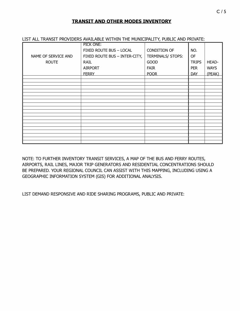
C / 5
TRANSIT AND OTHER MODES INVENTORY
LIST ALL TRANSIT PROVIDERS AVAILABLE WITHIN THE MUNICIPALITY, PUBLIC AND PRIVATE:
NAME OF SERVICE AND ROUTE
PICK ONE:FIXED ROUTE BUS – LOCALFIXED ROUTE BUS – INTER-CITY, RAILAIRPORTFERRY
CONDITION OF TERMINALS/ STOPS:GOOD FAIRPOOR
NO. OFTRIPS PER DAY
HEAD-WAYS (PEAK)
NOTE: TO FURTHER INVENTORY TRANSIT SERVICES, A MAP OF THE BUS AND FERRY ROUTES, AIRPORTS, RAIL LINES, MAJOR TRIP GENERATORS AND RESIDENTIAL CONCENTRATIONS SHOULD BE PREPARED. YOUR REGIONAL COUNCIL CAN ASSIST WITH THIS MAPPING, INCLUDING USING A GEOGRAPHIC INFORMATION SYSTEM (GIS) FOR ADDITIONAL ANALYSIS.
LIST DEMAND RESPONSIVE AND RIDE SHARING PROGRAMS, PUBLIC AND PRIVATE:

C / 6

D / 1
appendix d
web LinkS

D / 2Pa
geRe
fere
nce
Web
Add
ress
1-2
STPA
http
://ja
nus.s
tate
.me.
us/le
gis/
stat
utes
/23/
title
23se
c73.
htm
l
STPA
rul
eht
tp://
ww
w.m
aine
.gov
/mdo
t/pl
anni
ng-d
ocum
ents
/stp
a/in
dex.
htm
1-3
Gro
wth
Man
agem
ent A
ctht
tp://
janu
s.sta
te.m
e.us
/legi
s/st
atut
es/3
0-a/
title
30-A
ch18
7sec
0.ht
ml
Gro
wth
Mng
t Act
rul
eht
tp://
mai
ne.g
ov/s
po/la
ndus
e/do
cs/c
ompp
lann
ing/
spoc
riter
iaru
le.p
df
3-1
CR
ESTs
See
3-1,
Con
nect
ing
Mai
ne, M
aine
DO
T’s
Long
Ran
ge P
lan
3-1
Long
Ran
ge P
lan
(Con
nect
ing
Mai
ne)
http
://w
ww
.mai
ne.g
ov/m
dot-
stag
e/
3-10
, 3-
13, 3
-16
foot
note
sM
aine
DO
T Tr
affic
Cal
min
g Po
licy
http
://w
ww
.mai
ne.g
ov/m
dot/
mlrc
/tra
ffic-
issue
s/sp
eedh
umps
vsbu
mps
.php
4-1
Com
p Pl
anni
ng: A
Man
ual f
or M
E C
omm
uniti
es
http
://m
aine
.gov
/spo
/land
use/
docs
/com
ppla
nnin
g/20
05m
anua
l_lo
wre
s.pdf
4-4
Com
p Pl
anni
ng: A
Man
ual f
or M
E C
omm
uniti
es
See
4-1
5-2
Wor
king
with
Mai
neD
OT:
A G
uide
for
Mun
icip
al O
ffici
als
http
://m
aine
.gov
/mdo
t/w
orki
ng-w
ith-d
ot/p
df/2
007w
orki
ngw
ithm
aine
DO
T.pd
f
5-6
Con
nect
ing
Mai
neSe
e 3-
1
6-1
SPO
Com
mun
ity V
ision
ing
Han
dboo
kht
tp://
mai
ne.g
ov/s
po/la
ndus
e/do
cs/c
ompp
lann
ing/
visio
ning
6-2
Com
p Pl
anni
ng: A
Man
ual f
or M
E C
omm
uniti
es
See
4-1
7-2
CR
ESTs
See
3-1
7-2
STPA
Rul
eSe
e 1-
2
7-4
Entr
ance
s to
Hig
hway
s st
atut
e (A
cces
s M
anag
emen
t law
)ht
tp://
janu
s.sta
te.m
e.us
/legi
s/st
atut
es/2
3/tit
le23
sec7
04.h
tml

D / 37-
4Tr
affic
Mov
emen
t Per
mit
stat
ute
http
://ja
nus.s
tate
.me.
us/le
gis/
stat
utes
/23/
title
23se
c704
-A.h
tml
7-4
How
to W
rite
a La
nd U
se O
rdin
ance
ht
tp://
ww
w.m
aine
.gov
/spo
/land
use/
docs
/com
ppla
nnin
g/20
05m
anua
l_hi
ghre
s.pdf
7-4
Perf
orm
ance
Sta
ndar
ds fo
r La
rge-
Scal
e D
evel
opm
ent
http
://m
aine
.gov
/spo
/land
use/
docs
/com
ppla
nnin
g/ga
tew
ay1p
erfo
rman
ce_s
tand
ards
7-4
Site
Pla
n Re
view
Han
dboo
kht
tp://
ww
w.m
aine
.gov
/spo
/land
use/
docs
/site
plan
hand
book
/inde
x.ht
m
7-4
Mod
el S
ubdi
visio
n O
rdin
ance
http
://w
ww
.smrp
c.or
g/la
ndus
e/su
bord
/sub
ord.
htm
7-4
Perf
orm
ance
Sta
ndar
ds fo
r La
rge-
Scal
e D
evel
opm
ent
http
://m
aine
.gov
/spo
/land
use/
docs
/com
ppla
nnin
g/ga
tew
ay1p
erfo
rman
ce_s
tand
ards
7-4
Con
nect
ing
Mai
neSe
e 3-
1
8-2
Com
p Pl
anni
ng: A
Man
ual f
or M
E C
omm
uniti
es
See
4-1
8-2
Bien
nial
Cap
ital W
ork
Plan
http
://w
ww
.mai
ne.g
ov/m
dot/
plan
ning
-doc
umen
ts/b
cwp1
_06-
07.p
hp
8-3
6-Ye
ar P
lan
http
://w
ww
.mai
ne.g
ov/m
dot/
plan
ning
-doc
umen
ts/s
ixyr
-cip
.php
8-3
Wor
king
with
Mai
neD
OT:
A G
uide
for
Mun
icip
al O
ffici
als
See
5-2
8-4
Titl
e 30
-A, M
RSA
Sec
tion
4354
(Im
pact
Fe
es)
http
://ja
nus.s
tate
.me.
us/le
gis/
stat
utes
/30-
A/t
itle3
0-A
sec4
354.
htm
l
8-5
SPO
Fin
anci
ng In
fras
truc
ture
Im
prov
emen
ts t
hrou
gh Im
pact
Fee
sht
tp://
mai
ne.g
ov/s
po/la
ndus
e/do
cs/c
ompp
lann
ing/
impa
ctfe
eman
ual.p
df
8-5
Titl
e 30
-A M
RSA
Sec
tion
4401
et s
eq
(Sub
divi
sion
Law
)ht
tp://
janu
s.sta
te.m
e.us
/legi
s/st
atut
es/3
0-a/
title
30-a
sec4
401.
htm
l
8-6
CR
ESTs
See
3-1
8-6
Gat
eway
1ht
tp://
ww
w.g
atew
ay1.
org
8-7
Titl
e 30
-A M
aine
Rev
ised
Stat
utes
Ann
otat
ed, S
ectio
n 44
56ht
tp://
janu
s.sta
te.m
e.us
/legi
s/st
atut
es/3
0-a/
title
30-A
sec4
456.
B-3
Upd
atin
g Yo
ur C
ompr
ehen
sive
Plan
s: 50
Re
com
men
datio
ns h
ttp:
//ww
w.m
aine
.gov
/spo
/land
use/
docs
/com
ppla
nnin
g/up
date
man
ual.p
df

D / 4B-
5Si
te P
lan
Revi
ew H
andb
ook
http
://w
ww
.mai
ne.g
ov/s
po/la
ndus
e/do
cs/s
itepl
anha
ndbo
ok/in
dex.
htm
B-8
Hea
vy H
aul T
ruck
Net
wor
kht
tp://
ww
w.m
aine
.gov
/mdo
t/fr
eigh
t/co
mm
-veh
icle
-mai
ne.p
hp
B-12
Stan
dard
s fo
r O
ffica
l Bus
ines
s D
irect
iona
l Si
gns
http
://m
aine
.gov
/mdo
t/w
orki
ng-w
ith-d
ot/d
ocum
ents
/sec
tion3
B-17
Titl
e 38
, Sec
tion
1234
(Com
mun
ity
Sani
tary
Dist
ricts
)ht
tp://
janu
s.sta
te.m
e.us
/legi
s/st
atut
es/3
8/tit
le38
sec1
234.
htm
l
B-18
Offi
ce o
f Geo
grap
hic
Info
rmat
ion
Syst
ems
http
://w
ww
.mai
ne.g
ov/n
ewsle
tter
/july
2002
/mai
ne_o
ffice
_of_
gis_
.htm
B-18
Stat
e Pl
anni
ng O
ffice
http
://w
ww
.mai
ne.g
ov/s
po
B-22
LEED
http
://w
ww
.usg
bc.o
rg/D
ispla
yPag
e.as
px?C
MSP
ageI
D=
222
B-23
Impr
ovin
g Pe
dest
rian
Safe
ty a
t U
nsig
naliz
ed C
ross
ings
http
://on
linep
ubs.t
rb.o
rg/o
nlin
epub
s/nc
hrp/
nchr
p_rp
t_56
2.pd
f
B-27
Aro
osto
ok R
egio
nal T
rans
port
atio
n Sy
stem
http
://w
ww
.man
ta.c
om/c
oms2
/dnb
com
pany
_f3g
j2c
B-27
Was
hing
ton-
Han
cock
Com
mun
ity A
genc
yht
tp://
ww
w.w
hcac
ap.o
rg/
B-27
Wes
t’s T
rans
port
atio
nht
tp://
ww
w.e
llsw
orth
cham
ber.o
rg/c
ards
/wes
t_tr
ansp
orta
tion.
shtm
l
B-27
Penq
uis
Com
mun
ity A
ctio
n Pr
ogra
mht
tp://
ww
w.p
enqu
is.or
g/
B-27
Kenn
ebec
Val
ley
Com
mun
ity A
ctio
n Pr
ogra
mht
tp://
ww
w.k
vcap
.org
/
B-27
Coa
stal
Tra
nsht
tp://
coas
taltr
ans.o
rg/
B-27
Wal
do C
ount
y C
omm
ittee
for
Soci
al
Act
ion
http
://w
ww
.wal
doca
p.or
g/
B-27
Regi
onal
Tra
nspo
rtat
ion
Prog
ram
http
://w
ww
.rtp
rides
.org
/
B-27
Wes
tern
Mai
ne T
rans
port
atio
n Se
rvic
esht
tp://
ww
w.th
ecom
mun
ityco
nnec
tor.o
rg/S
how
List
ing.
asp?
List
ingI
D=
043
B-27
York
Cou
nty
Com
mun
ity A
ctio
n C
orpo
ratio
nht
tp://
ww
w.yc
cac.
org/
B-27
Inde
pend
ent T
rans
port
atio
n N
etw
ork
http
://w
ww
.itna
mer
ica.
org/

D / 5B-
33M
aine
DO
T In
tegr
ated
Fre
ight
Pla
nht
tp://
ww
w.m
aine
.gov
/mdo
t/fr
eigh
t/fr
eigh
t-ho
me.
php
B-33
Hea
vy H
aul T
ruck
Net
wor
kSe
e B-
7
B-33
Expl
ore
Mai
neht
tp://
expl
orem
aine
.org
/
B-33
Mai
ne C
oast
al P
rogr
amht
tp://
mai
ne.g
ov/s
po/c
oast
al/
B-35
Mai
neD
OT
Inte
grat
ed F
reig
ht P
lan
See
B-29
B-39
AA
SHTO
(Fl
exib
le)
Des
ign
Gui
deht
tp://
ww
w.te
chst
reet
.com
/cgi
-bin
/det
ail?p
rodu
ct_i
d=48
991
B-40
Traf
fic C
alm
ing:
Sta
te o
f the
Pra
ctic
e, IT
E/FH
WA
, Aug
ust 1
999
http
://sa
fety
.fhw
a.do
t.gov
/spe
ed_m
anag
e/do
cs/s
es1i
ntro
B-42
FHW
A R
oad
Safe
ty A
udits
http
://sa
fety
.fhw
a.do
t.gov
/rsa
/
B-43
How
to W
rite
a La
nd U
se O
rdin
ance
See
7-4
B-43
Perf
orm
ance
Sta
ndar
ds fo
r La
rge-
Scal
e D
evel
opm
ent
See
7-4
B-45
Prot
ectin
g Lo
cal S
ceni
c Re
sour
ces
htt
p://m
aine
.gov
/spo
/coa
stal
/doc
s/pr
otec
tingl
ocal
scen
icre
sour
ces.p
df
B-45
Ch.
8 o
f Gat
eway
1 V
isual
Res
ourc
e A
sses
smen
t h
ttp:
//ww
w.g
atew
ay1.
org/
new
/res
ourc
es/C
hapt
er%
208_
Pote
ntia
l%20
Inte
rven
tions
_HD
B-47
Mai
ne S
torm
wat
er M
anag
emen
t Law
http
://ja
nus.s
tate
.me.
us/le
gis/
stat
utes
/38/
title
38se
c420
-D.h
tml
B-47
Stor
mw
ater
Man
agem
ent R
ule
(Ch.
500
)ht
tp://
mai
ne.g
ov/d
ep/b
lwq/
rule
s/st
orm
wat
er/2
006/
ch50
0.pd
f
B-47
Urb
an Im
paire
d St
ream
s R
ule
(Ch.
502
http
://m
aine
.gov
/dep
/blw
q/ru
les/
stor
mw
ater
/200
6/ch
502.
B-47
Mai
ne E
rosio
n an
d Se
dim
ent C
ontr
ol L
awht
tp://
janu
s.sta
te.m
e.us
/legi
s/st
atut
es/3
8/tit
le38
sec4
20-C
.htm
l
B-47
Mai
ne E
rosio
n an
d Se
dim
ent C
ontr
ol B
est
Man
agem
ent P
ract
ices
http
://w
ww
.mai
ne.g
ov/d
ep/b
lwq/
docs
tand
/esc
bmps
/
B-48
Fish
Pas
sage
Pol
icy
and
Des
ign
Gui
deht
tp://
mai
ne.g
ov/m
dot/
pubs
/fina
lfish
pass
age2
003.

D / 6

E / 1
appendix e
gLoSSary
Access Management: This is the system by which mobility and safety are man-aged on the roads where conflicts with turning and entering traffic occur. Examples of access management tools include design and restriction of access points or curb cuts, traffic signals, turning lanes, non-traversable median openings, and frontage roads.
Access Points: Access points are those locations where vehicles can access a road carrying traffic: side streets, driveways, parking lot entrances, etc.
Acre: An acre is 43,560 square feet. For comparison, an American football field, including its end zones, is about 57,600 square feet, or about 1.3 acres.
Arterial: A major arterial in Maine is a divided highway such as I-295 or I-95. A mi-nor arterial is one that that should be expected to provide for relatively high overall travel speeds with minimum interference to through-traffic. Arterial roads should form a “continuous road network,” and these routes should be given preferential treatment over collector and local roads in the signing and signalizing of intersec-tions. The intersection of local roads directly with principal arterials should be discouraged. Local road access to an arterial should be provided primarily through the collector road network.
Berms: A low earthen wall designed to create a visual barrier or deflect traffic noise.
Big Box: A big box store is a term that refers to a style of physically large chain store, usually over 70,000 square feet. Big box stores frequently locate on high volume roadways.
Chicanes: A chicane is a sequence of tight serpentine curves (usually an S-shape curve) in a roadway, used to slow cars.
Collector Road: A collector road is an intermediary road providing service to rural areas. They carry internal traffic from areas having a predominant land use such as schools and shopping centers to more highly traveled arterial roads.
Commercial Strip: Commercial strip development is a pattern of development characterized by auto-oriented businesses located in a linear pattern along major roads and typically isolated from other types of uses. The businesses rely on surface
E / 2
parking lots, often large, that are intended for customers of one store or grouping of stores, multiple access points to the road, and a number and scale of signs typically greater than in other patterns of commercial development, such as a downtown pattern.
Context Sensitive Design (CSD): Also referred to as Context Sensitive Solu-tions (CSS), this is the art of creating public works projects that meet the needs of the users, the neighboring communities, and the environment. It integrates proj-ects into the context or setting through careful planning, consideration of differ-ent perspectives, and tailoring designs to particular project circumstances. From a transportation perspective, it preserves scenic, aesthetic, historic and environmental resources, while maintaining safety and mobility.
Culvert: A culvert is a conduit used to enclose a flowing body of water. It may be used to allow water to pass underneath a road, railway, or embankment for example.
Curb Cuts: A curb cut is a break in a sidewalk or curb for a ramp that leads smoothly to the street. Curb cuts include driveways that connect adjoining prop-erties to the street and ramps between sidewalks and streets to allow a smooth transition rather than having to go over a curb (important for ADA requirements and pedestrians). In access management programs, curb cuts refer to driveways to adjoining properties.
Curb Return Radius: A curb return radius determines the sharpness of a cor-ner—for example, at the intersection of streets. Mathematically, it is the radius of the circle, the arc of which is the curve of the corner. A small curb radius—for example, 10 feet or less—creates an almost 90 degree corner and is friendly to pedestrians, because it slows auto traffic and provides for a shorter distance to cross the street. A large curb radius—for example, 30 or more feet—enables traf-fic to make the turn at a higher speed. Local and pedestrian-oriented streets need small curb radii, while major collectors and arterials need larger ones.
Demand-Response: Non-fixed-route service that uses vans or buses with passen-gers who board and alight at pre-arranged times at any location within the system’s service area. It is essentially transit by appointment, with flexible routes and sched-ules, which can vary greatly depending on need.
Fixed Route Bus Service: This is bus service that travels a pre-scheduled route at pre-scheduled times. It can be either year-round or seasonal, and can be local or regional in nature.
Headway: The headway between vehicles in public transit systems is the time be-tween two vehicles passing the same point traveling in the same direction on a given route. A shorter headway signifies a more frequent service.

E / 3
Human Scale: This term is used to describe a developed area that caters to our innate sense of sight and sound, our innate emotional needs for security, privacy and human interaction, and our innate physical capacity for walking.
ITE Standards: These are standards set and tested by the prestigious Institute of Transportation Engineers.
Jobs-Housing Balance: Jobs-housing balance is a measure of the harmony be-tween employment and dwelling units in a specific area. The commonly used metric of this balance is the jobs/housing ratio, which is simply the number of jobs in a com-munity divided by the number of housing units in that community. A low jobs/hous-ing ratio indicates a housing-rich “bedroom community”, while a high jobs/housing ratio indicates an employment center. Research indicates that in areas where jobs and housing are in relative balance, people on average commute shorter distances and spend less time in their cars.
LEED Siting Criteria: LEED is the Leadership in Energy and Environmental De-sign Rating System. The LEED designation recognizes new or retrofitted buildings with reduced impacts on human health and the environment, including those sited near public transportation and/or complementary public uses, encompassing “devel-opment density and community connectivity.”
Level of Service (LOS): LOS is a standard measurement used by transportation officials to describe the relative ease of traffic flow on a scale of A to F. Road seg-ments that are free-flowing and intersections with little or no delay are rated LOS-A. Road segments that are highly congested and intersections with lengthy delays are rated LOS-F.
Local Roads: Local roads constitute all roads not classified as principal arterials, minor arterials or collectors.
Official Map: An official map is a document that has been developed and adopted by the municipality showing where future streets and other public improvements (parks, playgrounds, sewer lines) are to be located. It is usually part of a compre-hensive plan, typically for an in-town or designated growth area. Official maps are common in many states but have not been used much in Maine for several decades.
Ride Sharing: Ride Sharing includes carpools, and van pools or shuttle buses that are sponsored by employers and others. Formal car pooling requires park and ride lots that can also be used by the vans or shuttle buses.
Right of Way (ROW): The corridor of land acquired for or devoted to travel. A street or highway ROW may include space for travel lanes, shoulders, sidewalks, bike lanes and landscaping. The transportation network also may include railroad rights-of-way, off-road bike rights-of-way, and trail rights-of-way.

E / 4
Roadway Geometry: The design of the lane widths, shoulders, slope and curva-ture of a road, dictated by engineering principles based on mobility and safety.
Sight Distance: A safety-related measurement that establishes the minimum dis-tance that turning traffic must be able to see in either direction, based on the design speed of the road. This measure limits the location of driveways where curves, hills, or natural features limit visibility.
Square Mile: A square mile equals 640 acres.
Streetscape: A streetscape is the design and placement of all elements of a public right-of-way and of the immediately abutting yards and structures, and the manner in which these elements interrelate functionally and visually.
Throat Length: Throat length is the distance a driveway extends into the development site.
Traffic Calming: Traffic calming is a combination of primarily physical measures to reduce traffic speed and improve safety on certain streets, usually those with speed limits of under 45 miles per hour. The measures can be vertical, such as speed humps; horizontal, such as chicanes; road narrowing, such as neckdowns; intersec-tion-oriented, such as roundabouts; or “streetscaping”-based, such as landscaping.
Trip Generation Rates: These are the rates at which different land uses can be expected to generate traffic. Each coming and going of a vehicle to or from the land use is a “trip end,” and a trip generation rate is the total number of trip ends that can be expected for a given time period (peak hour, average day, etc.). For example, a single-family detached home on is projected to generate about 10 trip ends per weekday. These include all types of trips – delivery vehicles, guests, etc., as well as trips taken by residents of the home. The Institute of Transportation Engineers maintains a handbook of trip generation rates.
Turning Controls: Turning controls are regulatory devices or tools used at intersections to prohibit or designate specific turning movements. Specific tools used are signage, changing the angle of a connecting driveway or road so as to only accommodate a right turn, one-way street designations, and non-traversable medians.
Urban Compact: Urban compact municipalities are those in which the popula-tion exceeds 7,500 inhabitants, OR those in which the population is less than 7,500 inhabitants but more than 2,499 inhabitants and include a high ratio of people who both live and work in the municipality. Urban compacts areas are the built-up sec-tions in those communities, typically with a density of at least 1,000 people per square mile. Municipalities are responsible for the upkeep and maintenance of roads in urban compact areas.