Embed Size (px)
Citation preview

D R A F T
Semitropic Water Storage District
2012 Groundwater Management Plan Kern County, California

2 0 1 2 G R O U N D W A T E R M A N A G E M E N T P L A N
i
D R A F T
Table of Contents
1 Introduction 1 1.1 Overarching Goal 1 1.2 Management Area 2 1.3 California Water Code 6
1.3.1 Statutory Authority 6 1.3.2 Plan Requirements and Guidance 6
2 Groundwater Management 8 2.1 Neighboring Groundwater Management Plans 8 2.2 Regional Cooperation and Collaboration 10
2.2.1 County Of Kern 11 2.2.2 Kern County Water Agency 12 2.2.3 Semitropic Groundwater Monitoring Committee 12 2.2.4 Poso Creek Regional Water Management Group 13
3 The District 16 3.1 Formation 16 3.2 Land Use 16 3.3 Water Supplies and Use 18 3.4 Service Areas 20 3.5 Conjunctive Use 21
3.5.1 Groundwater Recharge 21 3.5.2 Groundwater Extraction 22
3.6 Water Banking 22 3.6.1 Semitropic Groundwater Banking Project 24 3.6.2 Kern Water Bank Authority 26 3.6.3 Pioneer Project 26 3.6.4 Semitropic-Rosamond Water Bank Authority 26
3.7 Conservation 27
4 The Basin 28 4.1 Groundwater Basin Characteristics 28
4.1.1 Perched Zone 29 4.1.2 Unconfined Zone 35 4.1.3 Production Zone 35 4.1.4 Transition Zone 35 4.1.5 Saline Zone 35
4.2 Recharge 35 4.3 Water Levels 36 4.4 Water Quality 37

2 0 1 2 G R O U N D W A T E R M A N A G E M E N T P L A N
ii
D R A F T
4.5 Subsidence 39
5 The Plan 43 5.1 Statutory Requirements 43
5.1.1 Public and Agency Involvement 43 5.2 Issues of Concern 44 5.3 Basin Management Objectives 46 5.4 Basin Management Strategies and Actions 47
5.4.1 New Basin Management Strategies 52 5.5 Conjunctive Use Accomplishments 54
6 Plan Implementation 59 6.1 Monitoring 59
6.1.1 Water Levels 60 6.1.2 Water Quality 63 6.1.3 Recharge and Pumpage 64 6.1.4 Land Subsidence 64
6.2 Data Management, Interpretation, and Reporting 65 6.3 Public and Agency Involvement 65 6.4 Plan Review 67
Tables Table 1: Potential Elements of a Groundwater Management Plan 7 Table 2: Summary of Adjoining Entities, Management Plans, and
Collaboration 15 Table 3: Monitoring Committee and Poso Creek RWMG Participants 44 Table 4: Management Strategies and Actions 49 Table 5: Summary of Monitor Wells 62
Figures Figure 1: Regional Location 3 Figure 2: Groundwater Basins 4 Figure 3: Kern County Groundwater Subbasin, Management Area, and other
Local Agencies 5 Figure 4: Cotton and Permanent Crop Acreage (1988-2012) 17 Figure 5: 2006 DWR Land Use 19 Figure 6: Water Service Areas 23 Figure 7: Illustrative Map of Effective Groundwater Basin 30 Figure 8: Regional West-to-East Cross Section A-A’ 31 Figure 9: Cross-Section B-B’ through Semitropic WSD 32 Figure 10: Cross-Section C-C’ through Semitropic WSD 33 Figure 11: Areas of Shallow Groundwater 34 Figure 12: Average Groundwater Level Fluctuations 37

2 0 1 2 G R O U N D W A T E R M A N A G E M E N T P L A N
iii
D R A F T
Figure 13: Water-Level Elevations for the Forebay Area and Lower Zone (Spring 2010) 38
Figure 14: Electrical Conductivity in Shallow Groundwater (2010) 40 Figure 15: Total Dissolved Solids in Deep Groundwater (2007) 41 Figure 16: Timeline of Selected Water Resource Management Actions 53 Figure 17: Development of Surface water Service Area 57 Figure 18: Surface Water Diversions 57 Figure 19: Groundwater Pumping Lifts 58 Figure 20: Monitor Wells 61
Appendices A Monitoring Program B Sampling Plan C CASGEM Monitoring Plan D Public Involvement Documentation

2 0 1 2 G R O U N D W A T E R M A N A G E M E N T P L A N
1
D R A F T
1 Introduction
In the fall of 2003, Semitropic Water Storage District (Semitropic or District) adopted a groundwater management plan (2003 Plan) under California Water Code §10750 et seq., which were added through enactment of AB-255 (1991), later replaced by AB-3030 (1992), and modified by SB-1938 (2002). To a very large degree, the 2003 Plan formalized the many groundwater management practices that had evolved over many years of operational experience with a significant conjunctive-use project. Further, it affirmed the District’s commitment to local control and management. The adopted plan included provision for periodic review, which was recently completed. This review resulted in revisions to the existing plan and adoption of this amended (or updated) groundwater management plan (Plan). Revisions included the following:
• Refine Basin Management Objectives.
• Expand basin management strategies and actions.
• Include accomplishments.
• Update text and figures as appropriate to reflect the most recent available data.
• Reorganize Plan.
Fundamentally, development of a groundwater management plan involves 1) setting an overarching goal; 2) identifying issues of concern within the context of that goal; 3) formulating basin management objectives that address the issues of concern; 4) establishing management strategies and actions to achieve the objectives; and 5) developing an implementation plan which tracks progress in meeting the basin management objectives. Development of this amended groundwater management plan was guided by this logically ordered list of fundamental elements. The remainder of this section addresses the Plan’s overarching goal; describes the management area; and includes discussion of statutory authority, requirements, and guidance respecting groundwater management planning.
1.1 Overarching Goal Preservation and enhancement of the groundwater resource is vital to sustaining the local economies which have been built up in reliance, in whole or in part, on this resource. The goals articulated in the District’s 2003 Plan are 1) to preserve the utility of the groundwater resource within its area, both in terms of quantity and quality, 2) to ensure the long-term

2 0 1 2 G R O U N D W A T E R M A N A G E M E N T P L A N
2
D R A F T
sustainability of its water resources, and 3) to preserve and enhance the groundwater resource for the benefit of its landowners . Fundamentally, the District’s goals remain unchanged; however, for the purpose of this amended plan, the overarching goal has been consolidated and restated as follows: to preserve the groundwater resource as an economically viable source of water supply to support overlying uses into the foreseeable future through local control and management. This goal is the point of beginning for the formulation of the amended groundwater management plan.
1.2 Management Area The Management Area is defined as the area within the boundaries of the Semitropic Water Storage District, which is that portion of the groundwater basin over which the District has jurisdiction to implement specific management practices. The Semitropic Water Storage District is located in north-central Kern County in the San Joaquin Valley, about 20 miles northwest of the City of Bakersfield (reference Figure 1). In response to a long-term decline in groundwater levels, Semitropic was organized in 1958 to provide supplemental water for irrigation within its boundaries. The total land area within Semitropic is approximately 221,000 acres (or 345 square miles), with about 125,000 acres (or 195 square miles) irrigated. It is noted that the irrigated area varies from year to year, depending on many factors.
The Semitropic Improvement District (reference Figure 1) includes the areas to which imported surface water supplies have been and are being delivered, and adjacent areas receiving benefits from the importation of surface water. The remainder of the District, outside the Improvement District and largely undeveloped for agriculture, receives a lesser benefit from District operations since no surface water is delivered in the area. In practice, the District is regarded as one management area, consisting of the entire District area.
Department of Water Resources (DWR) Bulletin No. 118 --- California’s Groundwater Update 2003 --- delineates the boundaries of groundwater basins and subbasins throughout California. The San Joaquin Valley portion of Kern County (or the Kern County subbasin) is located within the San Joaquin Valley Basin of the Tulare Lake Hydrologic Region, as shown on Figure 2. Figure 3 focuses on Kern County and shows the location of the District in relation to the groundwater basin boundary identified by DWR. In particular, Semitropic is located within DWR Groundwater Basin No. 5-22.14.
As suggested by the boundaries of the groundwater basin, the District shares a common (i.e., hydraulically connected) groundwater resource with neighboring water agencies. Accordingly, water management practices in Semitropic affect neighboring areas and vice versa. Although the District only has authority to enact specific management practices within its boundaries, the District may take actions to protect groundwater supplies from

California Aquedu ct
Ke rn Ri ver
Friant -Kern Canal
K ern River Canal
Kern Islan d Cana
l
California Aqueduct
Aleja
ndro
C ana
l
Arvin Edison Canal
Beardsley Canal
Cross Valley Canal
KWBACanal
Pond
-Poso
Cana
l
Le rd o Canal
Calloway Canal
Buttonwillow Ridge Canal
Cawe lo Canal
Lake Isabella
46
58
43
99
58
5
599
58
Semitropic W.S.D.
Taft
Arvin
Wasco
Delano
Shafter
Maricopa
Tehachapi
McFarland
Bakersfield
Lost Hills
Semitropic Water Storage District
2012 Groundwater Management PlanKern County, California REGIONAL LOCATION
SEPTEMBER 2012 FIGURE 1
21-S
ep-2
012
Z
:\Pro
ject
s\03
3741
_SW
SD
\Fig
1_R
egio
nalL
ocat
ion.
mxd
RS
10 0 105
MilesDRAFT
10N
11N
12N
32S
31S
30S
29S
28S
27S
26S
25S
14W15W16W17W18W19W20W21W22W23W24W
17E 18E 19E 20E 21E 22E 23E 24E 25E 26E 27E 28E 29E 30E 31E 32E 33E 34ETR
City
River, Canal
Township
Section
Semitropic W.S.D.

SOURCE: DWR Bulletin 118, v.3, 2003.
2012 Groundwater Management Plan
Semitropic Water Storage District
Groundwater Basins
March 2012 Figure 2

Berrenda Mesa W.D.
BuenaVistaW.S.D.
Cawelo W.D.
Delano-Earlimart I.D.
ImprovementDistrict No. 4
Kern Delta W.D.
Kern-Tulare W.D.Lost Hills W.D.
Semitropic W.S.D.
Shafter-Wasco I.D.
Southern SanJoaquin M.U.D.
North KernW.S.D.
Rosedale-Rio Bravo W.S.D.
BuenaVistaW.S.D.
California Aquedu ct
Ke rn Ri ver
Friant -Kern Canal
K ern River Canal
Kern Islan d Cana
l
California Aqueduct
Aleja
ndro
C ana
l
Arvin Edison Canal
Beardsley Canal
Cross Valley Canal
KWBACanal
Lerd o Canal
Calloway Canal
Pond
-Poso
Cana
l
Buttonwillow Ridge Canal
Cawe lo Canal
Lake Isabella
46
58
43
99
58
5
5
99
58
Taft
Arvin
Wasco
Delano
Shafter
Maricopa
Tehachapi
Bakersfield
McFarland
Lost Hills
Arvin-Edison W.S.D.
Belridge W.S.D.
Wheeler Ridge-Maricopa W.S.D.
Semitropic Water Storage District
2012 Groundwater Management PlanKern County, California
KERN COUNTY GROUNDWATER SUB-BASIN MANAGEMENTPLANNING AREA AND OTHER LOCAL AGENCIES
SEPTEMBER 2012 FIGURE 3
SOURCE: San Joaquin Valley Subbasin - DWR, Bulletin 118, Update 2003
21-S
ep-2
012
Z
:\Pro
ject
s\03
3741
_SW
SD
\Fig
3_S
ubB
asin
Mgm
t.mxd
RS
10 0 105
MilesDRAFT
10N
11N
12N
32S
31S
30S
29S
28S
27S
26S
25S
14W15W16W17W18W19W20W21W22W23W24W
17E 18E 19E 20E 21E 22E 23E 24E 25E 26E 27E 28E 29E 30E 31E 32E 33E 34ETR
City
River, Canal
Township
Section
Semitropic Groundwater Monitoring Committee Member District
San Joaquin Valley Subbasin

2 0 1 2 G R O U N D W A T E R M A N A G E M E N T P L A N
6
D R A F T
activities outside of its area. The Plan includes management goals that would affect the groundwater outside District boundaries. As a practical matter, the area of influence is primarily within the Kern County subbasin; however, parts of the Tule and Tulare Lake sub-basins may also be included.
1.3 California Water Code Part 2.75 of Division 6 of the California Water Code, titled Groundwater Management, is the result of legislation passed initially in 1991, and subsequently amended. Presently, Part 2.75 consists of Sections 10750 through 10755.4. In this planning document, specific reference is made to certain sections and some have been reproduced for ease of reference.
1.3.1 Statutory Authority
Development, adoption, and implementation of a groundwater management plan are voluntary. §10753(a) provides that a “local agency” may adopt and implement a groundwater management plan within its service area pursuant to Part 2.75 of the Water Code. Semitropic Water Storage District meets the definition of a “local agency” in that it is a “local public agency that provides water service” (§10752(g)). Implementation of a plan requires that the public agency have the necessary powers. In this regard, Water Code Sections 10750 et seq. provides some additional powers. Most of these powers are already provided under Water Storage District law (Division 14 of the Water Code) and many are already being exercised under the District-approved projects.
1.3.2 Plan Requirements and Guidance
For those agencies electing to develop and implement a groundwater management plan, the Water Code provides guidance respecting the content of a plan. Certain content is required if the agency intends to apply for funding administered by DWR that may be available from time to time; guidance respecting other content is discretionary. DWR Bulletin 118, California’s Groundwater Update 2003, provides a summary of the guidelines set forth in the Water Code, as well as additional suggestions. Table 1 presents a summary of these guidelines, along with the location in this report where each is addressed.

2 0 1 2 G R O U N D W A T E R M A N A G E M E N T P L A N
7
D R A F T
Table 1: Potential Elements of a Groundwater Management Plan
Components Location
Water Code Required Components [§10753.7(a)]
1. Basin Management Objectives (BMOs). Section 5
2. Monitoring and management of groundwater elevations, groundwater quality, inelastic land subsidence, and changes in surface water flows and quality that directly affect groundwater levels or quality or are caused by pumping.
Section 6
3. Plan to involve other agencies located in the groundwater basin. Sections 5 & 6
4. Map of groundwater basin boundary, as delineated by DWR Bulletin 118, with agency boundaries that are subject to GMP.
Section 1
5. Adoption of monitoring protocols. Section 6
6. Documentation of public involvement. Section 5 & Appendix D
Water Code Discretionary Components [§10753.8]
1. The control of saline water intrusion. N/A
2. Identification and management of wellhead protection areas and recharge areas. Section 5
3. Regulation of the migration of contaminated groundwater. Section 5
4. The administration of a well abandonment and well destruction program. Section 5
5. Mitigation of conditions of overdraft. Section 5
6. Replenishment of groundwater extracted by water producers. Section 5
7. Monitoring of groundwater levels and storage. Section 6
8. Facilitating conjunctive use operations. Section 5
9. Identification of well construction policies. Section 5
10. The construction and operation by the local agency of groundwater contamination cleanup, recharge, storage, conservation, water recycling, and extraction projects.
Section 5
11. The development of relationships with state and federal regulatory agencies. Section 5
12. The review of land use plans and coordination with land use planning agencies to assess activities which create a reasonable risk of groundwater contamination.
Section 5
DWR Bulletin 118 Suggested Components
1. Establish advisory committee of stakeholders. Section 5
2. Describe area to be managed. Sections 1, 3, and 4
3. Describe connection between BMOs, management actions, and water supply reliability.
Section 5
4. Periodic reports on basin conditions and management activities. Section 6
5. Periodic re-evaluation of Plan. Section 6

2 0 1 2 G R O U N D W A T E R M A N A G E M E N T P L A N
8
D R A F T
2 Groundwater Management
Groundwater management has been practiced in the San Joaquin Valley for decades, a fact that was documented in a 1979 report initiated by the San Joaquin Valley Agricultural Water Committee, Water Resources Management in the Southern San Joaquin Valley. As the report title suggests, groundwater management activities existed under the broader umbrella of water resources management. “Groundwater management plan” was codified in the 1990s with the passage of groundwater management legislation. Accordingly, many agencies who subsequently prepared groundwater management plans, including Semitropic, were formalizing in a standalone planning document many of the activities which had previously been referred to as simply “water resources management”.
The plan formulation process included identification and consideration of adjoining or overlapping agencies engaged in groundwater management. This section considers both individual agency groundwater management planning documents and regional management activities.
2.1 Neighboring Groundwater Management Plans Cal. Water Code §10750(a): The Legislature finds and declares that groundwater is a valuable natural resource in California, and should be managed to ensure both its safe production and its quality. It is the intent of the Legislature to encourage local agencies to work cooperatively to manage groundwater resources within their jurisdictions.
Similar to Semitropic, neighboring water districts operate conjunctive-use projects , with most based on the importation of supplemental water supplies from the State Water Project (SWP), the federal Central Valley Project (CVP), or the Kern River. Accordingly, groundwater management is on-going in these districts and is particularly relevant to this plan given the shared (i.e., hydraulically connected) groundwater resource. The status of groundwater management in adjoining or overlapping areas is summarized below by agency (reference Figure 3):
Shafter-Wasco Irrigation District: Groundwater Management Plan (July 2007)
• “The District’s objective is to preserve the utility of the groundwater resource, both in terms of quantity and quality at the least possible cost to sustain the agricultural production and support urban development within the boundaries of the District.” (p 1-1)

2 0 1 2 G R O U N D W A T E R M A N A G E M E N T P L A N
9
D R A F T
• “The Plan will enable the District to establish policies that will serve to enhance the overall management of the water supplies available to the District.” (p 2-1)
• The District’s Basin Management Objectives are:
o “To promote and realize groundwater resource protection;
o To facilitate groundwater resource sustainability;
o To develop groundwater resource understanding;
o To develop groundwater basin understanding; and
o To promote and facilitate information dissemination regarding the groundwater source.” (p 4-1)
• “Continued monthly monitoring of six (6) wells and semi-annual monitoring of 64 wells will assist in conclusions as to the status (availability) of the resource.” (p 4-3)
• “Documentation in the form of an annual report will be prepared as required to record the results of the management activities monitoring elements of the Plan.” (p 7-2)
North Kern Water Storage District: Groundwater Management Plan (July 1993)
• North Kern’s 1993 plan was prepared to 1) “preserve and enhance the groundwater resource for the benefit of its landowners”, 2) “coordinate its activities with those of its neighbors”, 3) “review and enhance its existing monitoring activities”, and 4) “help assure the long-standing practice of local management”. (p 1)
• North Kern is presently in the process of updating its groundwater management plan, which is expected to be complete in 2012.
Buena Vista Water Storage District: Groundwater Status and Management Plan (Revised May 2002)
• “It is the goal of Buena Vista Water Storage District to provide the landowners and water users of the District with a reliable, affordable, and usable surface and groundwater supply.” (p 1)

2 0 1 2 G R O U N D W A T E R M A N A G E M E N T P L A N
10
D R A F T
• “The District’s Groundwater Status and Management Plan describes the District’s plan to protect groundwater levels and quality in the present and over the long-term, keep groundwater use costs to a minimum, maintain groundwater control at the local level, document existing conditions, and initiate necessary programs and studies.” (p 1)
Rosedale-Rio Bravo Water Storage District: Groundwater Management Plan
• Rosedale’s plan was prepared to 1) “to preserve and enhance groundwater resources”, 2) “enhance existing monitoring activities”, and 3) “provide for the continuance of local management”. (p 2)
• Rosedale operates a direct recharge project on behalf of its landowners and provides water banking services to third parties. In this context, the District recently adopted a “Policy Regarding Sustainable Groundwater Banking Operations”.
City of Wasco: Urban Water Management Plan Update for 2010 (June 2011)
• “The City of Wasco currently has only one source of water available to it, groundwater.” (p 25)
• “The City of Wasco uses wastewater effluent for agricultural irrigation on City-owned land. The irrigation practice helps to replenish the area groundwater table through deep percolation and reduces groundwater overdraft.” (p 26)
• “The City of Wasco has not adopted a groundwater management plan. The City is currently seeking funding to develop its own groundwater management plan.” (p 28)
The above-referenced groundwater management planning documents were reviewed and considered in the formulation of this plan, and was a key step in coordinating with the planning efforts of other basin stakeholders. The only adjoining district without an adopted plan is the Southern San Joaquin Municipal Utility District. Summarized in Table 2, located at the end of this section, are the adjoining entities and their adopted management plans.
2.2 Regional Cooperation and Collaboration As noted near the beginning of this section, §10750(a) of the Water Code “encourage[s] local agencies to work cooperatively to manage groundwater resources”. In addition to coordinating with the individual efforts of the above-described districts, this section describes
2 0 1 2 G R O U N D W A T E R M A N A G E M E N T P L A N
11
D R A F T
overlapping agencies with regional extent as well as forums which include several groups of districts who have come together cooperatively and collaboratively for purposes related to groundwater management. Accordingly, the following subsections include discussion of the County of Kern, the Kern County Water Agency, the Semitropic Groundwater Monitoring Committee, and the Poso Creek Regional Water Management Group. Summarized in Table 2 (located at the end of this section) are the adjoining entities and their management plans, along with an indication of which districts are participants in the Semitropic Groundwater Monitoring Committee or the Poso Creek Regional Water Management Group.
2.2.1 County Of Kern
In May of 1989, the Kern County Board of Supervisors adopted Ordinance No. G-5006 concerning the regulation of wells and water systems. By reference, the Ordinance initially adopted certain standards contained in California State Department of Water Resources Bulletin No. 74-81, and Kern Health Department Handbook “UT 50”, which have been amended from time to time. This Ordinance governs the construction and reconstruction of wells, including protection of the well head, casing standards and seals between aquifers, as well as procedures to be followed upon abandonment, and is applicable to wells throughout the District and Kern County.
More recently, in a report to the Board of Supervisors regarding County-wide groundwater resource management (2011), the County’s Development Services Agency indicated its intent to undertake the following efforts:
• Schedule tri-annual meetings with the Kern County Water Agency staff and prepare water issue and program status reports for the Board of Supervisors.
• Continue to implement water laws and programs and comment on water planning proposals.
• Prioritized participation in water program meetings.
With regard to the last item, this same report listed a number of the local water meetings or forums, which included the Poso Creek Regional Water Management Group (reference Section 2.2.4). Though inactive for the last two to three years, Semitropic has been an active participant in the Water Resources Committee of Kern County, which is advisory to the Kern County Board of Supervisors. Finally, when requested by agencies of Kern County, the District reviews development plans and proposals within its boundaries.
2 0 1 2 G R O U N D W A T E R M A N A G E M E N T P L A N
12
D R A F T
2.2.2 Kern County Water Agency
Semitropic is a “member unit” of the Kern County Water Agency (KCWA), with whom Semitropic contracts for the importation of State Water Project water. Kern County Water Agency was created by special act in 1961 and has boundaries which are coincident with the County of Kern. Though the Kern County Water Agency (KCWA) has not developed a formal regional groundwater management plan, they have engaged in activities integral to groundwater management, which include the following (to name a few):
• Contracting vehicle for the importation of State Water Project Water to Kern County.
• Local clearinghouse for the collection and management of groundwater level data and, to a lesser extent, groundwater quality data.
• Prepares an annual water supply report which includes maps of groundwater levels and the concentration of total dissolved solids; selected groundwater level hydrographs; and estimates of total water supplies and uses.
• Cooperates with DWR in the semi-annual collection of groundwater level measurements in Kern County.
2.2.3 Semitropic Groundwater Monitoring Committee
Semitropic, along with neighboring districts (shown on Figure 3) --- each with its own conjunctive-use project, share a common groundwater basin. For this reason, a groundwater monitoring committee was formed in 1994 in response to implementation of the Semitropic Groundwater Banking Project. This committee includes representatives from Semitropic and five neighboring water agencies; Buena Vista Water Storage District, Rosedale-Rio Bravo Water Storage District, Shafter-Wasco Irrigation District, North Kern Water Storage District, and Southern San Joaquin Municipal Utility District (as shown on Figure 3). It is noteworthy that the committee includes users of State Water Project water, federal Central Valley Project water, and local Kern River water. The responsibilities of the committee are identified in the Memorandum of Understanding and are summarized following:
• Engage a professional groundwater consultant.
• Meet and confer periodically.
• Establish groundwater evaluation methodologies.
• Identify additional monitoring wells and that are considered necessary.

2 0 1 2 G R O U N D W A T E R M A N A G E M E N T P L A N
13
D R A F T
• Prepare annual water balance studies and other interpretive studies.
• Develop criteria for determining the conditions constituting a significant imbalance between the delivery of water for banking and/or nonbanking purposes and withdrawal for such purposes.
• Determine the impacts of the Project by evaluating with and without Project conditions.
• Develop procedures, review data, and recommend Project operational criteria for the purpose of identifying, verifying, avoiding, eliminating or mitigating to the extent practical, the creation of significant imbalances or significant adverse impacts.
The Committee has been meeting as necessary since its inception in 1994. Kenneth D. Schmidt and Associates serves as consultant to the Committee and has been responsible for preparation of a biennial monitoring report. The Committee’s consultant has also provided guidance on the location and construction of all of the District’s monitor wells.
2.2.4 Poso Creek Regional Water Management Group
In the spring of 2005, efforts were underway to bring several adjoining water agencies together for the purpose of developing an Integrated Regional Water Management Plan and, by early 2006, plan development had begun in earnest. By July 2007, the following water agencies had cooperated in the development of a Plan and the boards of directors of these same agencies had adopted the Plan.
• Cawelo Water District
• Delano-Earlimart Irrigation District
• Kern-Tulare Water District
• North Kern Water Storage District
• Semitropic Water Storage District
• Shafter-Wasco Irrigation District
These water agencies, together with the North West Kern Resource Conservation District and a representative of 16 economically-disadvantaged communities with the Poso Creek Region, make up the Poso Creek Regional Water Management Group. The purpose of the Poso Creek Integrated Regional Water Management Plan (Plan) is to provide a framework for (1) coordinating groundwater and surface water management activities through regional

2 0 1 2 G R O U N D W A T E R M A N A G E M E N T P L A N
14
D R A F T
objectives, and (2) implementing the measures necessary to meet those objectives. The Plan’s groundwater-related objectives include the following:
• Maintain groundwater levels at economically viable pumping lifts.
• Protect the quality of groundwater and enhance where practical.
• Enhance monitoring activities to meet groundwater level and water quality goals.
While the Plan includes a number of findings, the overriding conclusion is that surface water supplies available to the Region will be significantly reduced in the future (relative to historical conditions) and that there will be a corresponding decline in groundwater levels as groundwater is used to make up the reduction in surface water supplies if actions are not taken. Therefore, the Poso Creek Regional Water Management Group has recognized that it is imperative that the members work collaboratively to maximize the utility of limited water resources.

2 0 1 2 G R O U N D W A T E R M A N A G E M E N T P L A N
15
D R A F T
Table 2: Summary of Adjoining Entities, Management Plans, and Collaboration
Common Boundary or Overlap with Semitropic
Groundwater Management
Plan
Urban Water Management
Plan
Poso Creek Regional Water
Management Group
Semitropic Groundwater Monitoring Committee
North Kern Water Storage District
Rosedale-Rio Bravo Water Storage District
Shafter-Wasco Irrigation District
City of Wasco
Agency
Southern San Joaquin Municipal Utility District
Buena Vista Water Storage District
Cawelo water District
Delano-Earlimart Irrigation District
Kern County Water Agency (KCWA)
Kern-Tulare Water District

2 0 1 2 G R O U N D W A T E R M A N A G E M E N T P L A N
16
D R A F T
3 The District
Semitropic Water Storage District (Semitropic or District) includes a gross area of about 221,000 acres located in northwest Kern County. In any given year, about 125,000 acres are irrigated, which contributes to the $4 to $5 billion of annual agricultural production in Kern County ($4.75 billion in 2010, Kern County Agricultural Commissioner). This section provides background regarding Semitropic Water Storage District, including land use, water supplies, service areas, conjunctive use, water banking, and conservation.
3.1 Formation Prior to formation of the District and adoption and construction of a project, irrigated agricultural development relied completely on pumped groundwater. As in other areas developed in reliance on pumped groundwater, water levels declined as water was pumped for beneficial use on overlying lands. To address declining groundwater levels, the District was organized in 1958 to develop conjunctive use programs and facilities and, in particular, to import water to supplement the area’s water needs.
Groundwater management within the District, as in many areas of California, is rooted in the conjunctive use of surface water and groundwater resources, that is, water supplies from the two sources are integrated to accomplish optimum utilization of each. In the 1960s, District landowners approved implementation of a project, which included construction of main conveyance and distribution system facilities extending from the California Aqueduct (Governor Edmund G. Brown California Aqueduct) of the State Water Project (SWP) to farm delivery locations. The Project was predicated on the conjunctive use of imported SWP water with the underlying groundwater resource. Prior to construction of the facilities, irrigated crops within Semitropic were totally dependent on groundwater pumping. Since the imported water supply is erratic, the District devised a plan of conjunctive use, wherein the underlying groundwater reservoir continues to be used to meet demands for seasonal peaks and to provide irrigation water in times of limited surface supplies. Under the District’s Project, some lands received the imported water supply (the so-called Contract Water Service Area) and other lands remained solely dependent on pumped groundwater for irrigation, with the latter benefitting from improved groundwater conditions due to the importation of surface water.
3.2 Land Use Irrigated agricultural uses dominate the developed lands within Semitropic. Over the last ten years, the cropped farmland in any given year has varied from about 111,000 to 134,000 acres. For the most part, the remainder of the District’s 221,000 gross acres are either

2 0 1 2 G R O U N D W A T E R M A N A G E M E N T P L A N
17
D R A F T
grazing land; undeveloped; managed habitat located within the Kern National Wildlife Refuge; or developed to duck clubs.
Cropping patterns have varied over the years. At the time of Semitropic’s original project in the 1970s, the preponderance of the cropped acreage was in annual crops, principally cotton, alfalfa (and pasture), and grain. Since that time, there has been a shift away from annual crops in favor of permanent crops. In the 1970s, less than five percent of the cropped acreage was planted to permanent crops. Today, more than one-half of the cropped acreage is planted to permanent crops. As a generalization, the relatively large cotton acreage which persisted until the mid-1990s has since shifted to tree crops --- primarily almonds and pistachios. Figure 4 illustrates the annual changes in cotton acreage and permanent crop acreage over the last 25 years.
Figure 4: Cotton and Permanent Crop Acreage (1988-2012)
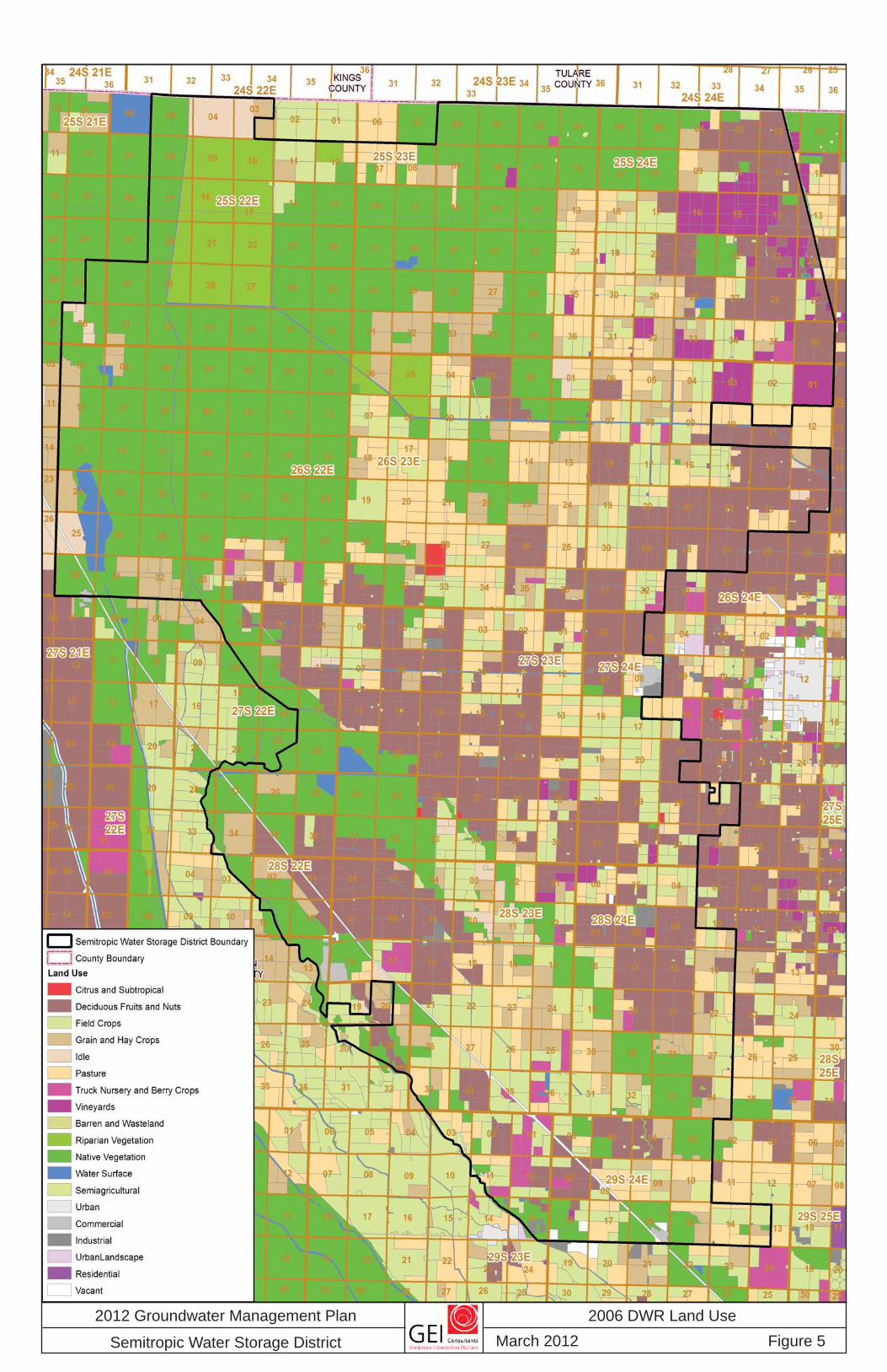
The last land use survey conducted by DWR was in 2006 and the resulting land use map is presented in Figure 5. Based on the District’s 2012 land use survey, cropped acreage was distributed among the following six crop types/categories:
Deciduous 53%
Alfalfa 18%
Grain/Pasture 16%
Cotton 5%
Vineyard 4%
Truck 3%

2 0 1 2 G R O U N D W A T E R M A N A G E M E N T P L A N
18
D R A F T
While the cropping pattern has changed over time, the total farmed acreage has gone up and down with the economics of farming. It is reasonable to anticipate that the farmed acreage will continue to fluctuate, without any increasing or decreasing trend; however, the significant percentage of permanent crops which has developed over the last several years may reduce the year-to-year fluctuations in farmed acreage going forward.
The largest city which is proximate to the District is the City of Wasco, which is centered just to the east of the District. Urbanization of District lands has not been an issue to date, and it is unlikely that this will change in the foreseeable future; however, it is noted that the Wasco State Prison is located within the District, and pays the General Project Service Charge in light of its reliance upon improved groundwater conditions as a result of the District’s Project.
3.3 Water Supplies and Use The District’s primary source of surface water is imported SWP water, which is conjunctively managed with the underlying groundwater. From time to time --- mostly during “wet” years --- other supplies have been diverted, including Poso Creek, Kern River, and Friant-Kern water. With regard to Poso Creek, the District holds a water rights permit and is party to an agreement with two other agencies (North Kern Water Storage District and Cawelo Water District) which addresses the management and sharing of this infrequent source of supply. Rainfall in the area of the District is minimal, averaging about six inches annually.
For many years, Semiropic’s contract with the Kern County Water Agency (KCWA) for SWP water amounted to 158,000 acre-feet of annual entitlement, this was subsequently reduced to 155,000 acre-feet in 1996 in exchange for the District’s interest in the Kern Water Bank Authority (which has greatly enhanced the District’s water management capabilities). With completion of the necessary diversion and distribution facilities, the District began importing SWP water in 1973; however, shortages in SWP supplies have been more frequent and larger than originally envisioned, owing to the incomplete status of the State Water Project facilities and new and unforeseen regulatory restrictions on export from the Sacramento-San Joaquin River Delta. In particular, the District’s SWP water supply has noteworthy restrictions including: (1) the conservation facilities to be constructed as part of the SWP have not been completed, which has the effect of reducing the yield of the District’s contract supply of SWP water; (2) Federal and State regulatory agencies have, particularly since the mid 1990s, placed additional constraints on pumping from the SWP’s Banks Pumping Plant, which were not contemplated, and have resulted in reductions in reliability and yield of the District’s contract supply of SWP water; (3) because the annual allocation of water from the SWP during a given year is a moving target until as late as August of that year, District growers must make decisions regarding annual plantings before knowing their water allocation; and (4) while CVP 215 water has been an infrequent and relatively small source of supply, recent actions to “restore” the San Joaquin River are expected to reduce the
2012 Groundwater Management Plan
Semitropic Water Storage District
2006 DWR Land UseMarch 2012 Figure 5

2 0 1 2 G R O U N D W A T E R M A N A G E M E N T P L A N
20
D R A F T
availability of such supplies in the future. However, any restrictions on the District’s surface water supplies that result in a decrease in the available surface water supplies for the year is offset by a commensurate increase in the use of groundwater to meet irrigation water requirements.
The District will continue to preserve and protect the contracts respecting its existing surface water supplies, and will continue to pursue opportunities to supplement these supplies. Additional opportunities could include "spot market" purchases of available surface supplies (which is the District's current practice), increasing the District's ability to import water during the wetter years (through institutional arrangements and/or construction of additional facilities), expanding the District's existing irrigation distribution system to include lands which rely principally on pumped groundwater (reference Section 3.4), acquisition of additional water supplies on a permanent or long-term basis, if and when available.
The total demand for irrigation water is on the order of 450,000 acre-feet each year. Any demand not met with imported supplies is met with pumped groundwater. “Land retirement” would result in a reduction in the demand for irrigation water and the use of pumped groundwater. The District’s current annual delivery capability is about 350,000 acre-feet and the ultimate objective is on the order of 400,000 are-feet. Farmers in the District’s surface water service areas maintain and use on-farm wells to meet irrigation water requirements to the extent that surface water deliveries are inadequate.
3.4 Service Areas Implementation of the District’s initial irrigation distribution system project in the 1970s involved construction of the facilities necessary to divert water from the California Aqueduct to about 43,000 acres, which is referred to as the Contract Water Service Area (CWSA). This is the area to which the District’s contract for SWP water is dedicated. The remaining irrigated lands continued to rely exclusively on pumped groundwater and were referred to as the Groundwater Service Area. Gradually, over time, improvements were made which provided for the delivery of surface water to about 20,000 acres within the Groundwater Service Area. In general, these lands were proximate to the District’s irrigation distribution system and required relatively modest improvements to “connect” to the District’s system. Deliveries to these lands is on an as-available basis and they are collectively referred to as the Temporary Water Service Area (TWSA).
Beginning with implementation of the Semitropic Groundwater Banking Program in the mid 1990s, new distribution systems have been constructed with revenue generated from the banking program to serve an additional 35,000 acres of land that had been in the Groundwater Service Area. Collectively, these lands are referred to as the Intermittent Water Service Area (IWSA). The absorptive capability corresponding to about two-thirds of this total (or about 23,000 acres) is first available for third-party banking, then for District water supplies, because of the enhancement in delivery capabilities of the area as a result of

2 0 1 2 G R O U N D W A T E R M A N A G E M E N T P L A N
21
D R A F T
investment of the banking program. Owing to the first priority for third-party banking, this is referred to as “contractual absorptive capability”. The absorptive capability corresponding to the remaining 12,000 acres is referred to as “discretionary absorptive capability”, i.e., priority for use of this capacity is completely at the District’s discretion.
Similar to the TWSA, surface water deliveries are on an as-available basis; however, surface water must be taken (when available) in lieu of pumping groundwater, and the District has the right to use the groundwater pumping facilities within this area when not needed to meet the irrigation water requirements of these lands. As a result of these improvements, the capability now exists to deliver surface water (as available) to more than 108,000 acres of the irrigated lands within the District in lieu of pumping groundwater. These service areas are shown on Figure 6. Collectively, these service areas, including the Groundwater Service Area, comprise all of the irrigated lands within the District. It is the District’s intent to continue to look for opportunities to expand its surface water distribution system in order to further reduce groundwater pumping in “wet” years when surface water is available.
3.5 Conjunctive Use Semitropic has conjunctively utilized imported surface water supplies with groundwater since completion of the District's original irrigation distribution system facilities in the mid 1970s. As discussed previously, the foundation of the District’s groundwater management is the conjunctive use of surface water and groundwater supplies; integrating the two sources of supply to achieve the optimal use of each. The particulars of the District's conjunctive use program reflect available facilities (for distribution, recharge, and recovery), groundwater basin characteristics, the availability of surface water supplies, and institutional considerations. The District's conjunctive use program includes surface water delivery in lieu of groundwater pumping, direct recharge, groundwater storage and recovery (water banking) for other agencies, water banking in out-of-District projects, as well as exchange arrangements with other water agencies. Further, it depends on available groundwater storage capacity to regulate “wet-year” surface water supplies to “dry” years when that water is necessary to supplement deficiencies in surface supplies.
3.5.1 Groundwater Recharge
Indirect recharge involves the delivery and use of surface water in lieu of pumped groundwater. Sometimes referred to as “in-lieu recharge”, this has been the District’s mainstay since the first SWP water was imported in the early 1970s. The District’s Groundwater Banking Program is also based on in-lieu recharge. The advantage of in-lieu recharge is that the recharge is essentially immediate, as the delivery of one acre-foot of water on the surface immediately displaces one acre-foot of groundwater pumping and does not depend upon percolation and the movement of water in the aquifer. One disadvantage is the fact that the surface water supply must be available on an irrigation demand schedule, with irrigation demands being relatively low during the winter months. In contrast, direct

2 0 1 2 G R O U N D W A T E R M A N A G E M E N T P L A N
22
D R A F T
recharge through water spreading ponds or basins can be accomplished during any time of the year, which increases the likelihood of being able to capture unregulated supplies that become available from time to time. Accordingly, Semitropic became a participant in two out-of-District water banking projects in the 1990s, both based on direct recharge (reference Section 3.6). Subsequently, in 2008, about 525 acres of spreading ponds were developed within the District (reference Figure 6).
3.5.2 Groundwater Extraction
Extractions within the District are by privately-owned wells and District-owned wells. Recall that about two-thirds of the District's irrigated area is capable of receiving surface water deliveries; however, landowners must maintain wells to meet irrigation demands when surface water supplies are limited or not available. The District maintains wells to supplement the available surface supply to some District lands and for recovery of previously banked water for return to banking partners in years of reduced surface water supplies. The remaining one-third of the District's irrigated area relies exclusively on pumped groundwater. The District's importation of surface water helps to support those landowners who continue to rely on pumped groundwater by reducing the District's overall reliance on the underlying groundwater.
Manage¬ment of groundwater extractions can be achieved through economic inducement policies. Presently, the District provides an indirect economic inducement through its water-pricing policies. In particular, surface water rates are set high enough to promote water conservation, yet reasonable enough to compete with groundwater pumping costs, and thereby discourage the use of groundwater when surface water is available. In addition, it is the District’s policy to not allow use of the District’s distribution facilities for the wheeling of landowner-pumped groundwater when there are surface water supplies available to turn off wells. The District’s General Project Service Charge (GPSC) is intended to result in comparable water costs to growers, whether pumping groundwater or receiving District-delivered water, i.e., such that there is no economic incentive to pump groundwater. Going forward, the District intends to explore more equitable methods to charge for groundwater used, as compared with the GPSC which is applied on a per-acre basis (reference Section 5.4).
In 2005 and 2006, District staff located all wells in the District, which numbered more than 1,240 wells at that time In order to keep this effort “current”, it will be necessary to work with the County of Kern to receive notice of permits to both construct and abandon wells.
3.6 Water Banking Water banking involves the regulation of wet-year surface water supplies in dewatered groundwater storage for subsequent recovery during times of water supply deficiencies. The storage is achieved through either indirect and direct recharge. Indirect recharge is based on the delivery of surface water for irrigation in lieu of pumping groundwater for irrigation.


2 0 1 2 G R O U N D W A T E R M A N A G E M E N T P L A N
24
D R A F T
The preponderance of direct recharge is based on the surface spreading and percolation of water supplies in basins or ponds. Surface delivery in lieu of groundwater pumping motivated the District to enter into long-term contracts for SWP water in the early 1970s. Deliveries made in this manner are also referred to as “in-lieu” recharge. This aspect of the District's program relies on its extensive system of irrigation distribution facilities (constructed specifically for the purpose of delivering the SWP water). In this regard, Semitropic has expanded its delivery capability from about one-third of the irrigated acreage (in the late 1970s) to about two-thirds at present, with plans to increase that percentage. In addition, the District banks water outside of its immediate (or Management) area through its participation in the Kern Water Bank and the Pioneer Project (both of these water banking projects are located on the Kern River fan). These projects rely on direct recharge and are used as an additional source of supply in “dry” years. In addition, the District is a majority participant in the development of the Semitropic-Rosamond Water Bank Authority. All of these banking projects are more particularly described in the subsections which follow.
3.6.1 Semitropic Groundwater Banking Project
In 1988, Semitropic initiated a study of a groundwater banking program which was ultimately included as a part of the District’s 1992 Improvements Project. This has developed into the Semitropic Groundwater Banking Project, which is a long-term water storage project designed to optimize the distribution and use of water resources between the District and its banking partners.
The original District projects were planned and designed to deliver supplemental surface water to farms relying exclusively on groundwater. Imported surface water from the SWP and the associated reduction in groundwater pumping have helped to stabilize groundwater conditions in Semitropic, which in turn have helped maintain a viable agricultural economy in the area. The Groundwater Banking Project is a continuation of Semitropic’s efforts to make the best use of the underlying groundwater resource, including unused storage capacity.
Semitropic has long-term contracts with several water banking partners; including the Metropolitan Water District of Southern California, Santa Clara Valley Water District, Zone 7 Water Agency, Alameda County Water District, Newhall Land and Farming Company, San Diego County Water Authority, and the City of Tracy. Semitropic receives SWP or CVP surface water from its banking partners in years of ample supplies and delivers it to landowners for irrigation use in lieu of groundwater pumping. Groundwater which otherwise would have been pumped remains in storage, credited to the account of the banking partner. In times of surface water shortages, the water may be withdrawn by the banking partner. At that time, Semitropic will return the banked water to the California Aqueduct, either from its supply of SWP water by exchange, and/or by pumping of District and landowner wells. At the end of 2011, the District held more than 900,000 acre-feet in groundwater storage on behalf of its banking partners. This storage has a significant, positive impact on groundwater levels.

2 0 1 2 G R O U N D W A T E R M A N A G E M E N T P L A N
25
D R A F T
Certain operational criteria have been put in place to assure that District landowners and landowners in neighboring districts are not adversely impacted as a result of the Project; these include the following:
• Only water stored under the banking agreement may be withdrawn from Semitropic’s groundwater basin. Water must first be stored before it is withdrawn.
• Semitropic will retain a minimum quantity of its SWP supply to maintain the quality of water delivered to farmers within its service area.
• The District will retain about ten percent of the water delivered as an allowance for aquifer and operational losses.
• The District will not pump more water from the wells on a given farm than the total of all prior surface water deliveries to that farm for banking purposes.
• A network of monitor wells, solely for monitoring purposes, has been constructed to supplement the network of production wells, and thereby enhance groundwater monitoring.
• Within a particular area, withdrawal of stored water is prohibited if such withdrawals would cause the average groundwater levels over a three-year period to be 15 feet lower than the average groundwater levels which would have prevailed without the project over the same three-year period, except for the Stored Water Recovery Unit, where this criteria can be exceeded with appropriate mitigation.
• Groundwater monitoring data are reviewed by a Monitoring Committee composed primarily of representatives from surrounding water districts.
As part of the Project, the District has constructed additional distribution facilities, new wells for recovery of stored groundwater, and facilities to transfer water back to the California Aqueduct. In particular, distribution facilities have been built to serve intermittent surface water supplies (for groundwater banking) to more than 23,000 acres. With regard to the recovery of stored groundwater, it is noted that the District has agreements in place for the use of a large network of privately-owned wells in order to supplement District-owned wells and to provide the operational flexibility necessary to spatially distribute the pumping to avoid impacts and to manage the quality of the water delivered into the California Aqueduct. In addition to the water banking aspects of the Project, distribution facilities which are being constructed as part of the Project can be used for non-banking purposes. In particular, these facilities will allow Semitropic to acquire KCWA Agricultural Pool Water, when available, and deliver it to District lands. The water banking facilities will also allow the District to

2 0 1 2 G R O U N D W A T E R M A N A G E M E N T P L A N
26
D R A F T
pump groundwater and deliver it for the benefit of farmers within Semitropic. On a limited basis, the District will be able to provide water to farmers who may have groundwater quality problems, peaking problems, well outages, and other emergency needs.
3.6.2 Kern Water Bank Authority
Upon implementation of the Monterey Agreement in 1996 by the California Department of Water Resources and the State Water Contractors, Semitropic obtained a 6.67 percent share of the Kern Water Bank Authority. With a gross area of about 20,000 acres, the Kern Water Bank is located to the south of the District, astride the Kern River. It is a direct recharge-based project, with about 7,000 acres of spreading basins. To the extent there has been unused recharge or recovery capacity, Semitropic has at times exercised considerably more than its share of this project’s capacity. 3.6.3 Pioneer Project
The Pioneer Project is operated by the Kern County Water Agency as a direct recharge-based water banking project, located on the Kern fan, adjacent to the Kern Water Bank. There are “recharge participants” and “recovery participants”; the former are vested with a first priority right to the use of the recharge facilities, and the latter are vested with a first priority right to the use of the recovery facilities. Semitropic is a “recovery participant” with a 14 percent share of the Project’s recovery capacity. This is a minimum amount; rather, to the extent there is unused capacity, it is also available for District use. Semitropic’s right to use of the Project’s recharge capacity is second to the “recharge participants”. 3.6.4 Semitropic-Rosamond Water Bank Authority
Formation of the Semitropic-Rosamond Water Bank Authority in 2007 had the effect of combining the assets of the Antelope Valley Water Bank (AVWB) with those of the Stored Water Recovery Unit (SWRU), which is an expansion of Semitropic’s Groundwater Banking Project. The AVWB is planned to provide up to 500,000 acre-feet of storage capacity, 100,000 acre-feet of delivery capacity annually, and 100,000 acre-feet of recovery and return capacity annually. The SWRU will provide up to 650,000 acre-feet of additional storage capacity, 50,000 acre-feet of delivery capacity annually, and 200,000 acre-feet of recovery and return capacity annually. Semitropic has a 57 percent share of the combined project, which is only partially built out at this time. The Antelope Valley operations are based on direct recharge through spreading ponds. Located at the south end of Kern County, the Antelope Valley provides some geographic diversification to the District’s water banking activities, and additional operational flexibility.

2 0 1 2 G R O U N D W A T E R M A N A G E M E N T P L A N
27
D R A F T
3.7 Conservation The District's water banking operations --- both in-District and out-of-District --- are based on regulating or conserving “wet-year” water for use during “dry” years. In addition, the District's conservation practices are evidenced in its water-pricing policies and in its financial support of water use education; for example, the Water Association of Kern County at the local level, and the Water Education Foundation at the State level. The water-pricing policies encourage the use of surface water supplies when available in lieu of pumped groundwater, thereby conserving the underlying groundwater resource. The District practices conservation in its operations and encourages and supports conservation at the on-farm level by providing financial support to the North West Kern Resource Conservation District-DWR Mobile Laboratory. In 2006, the District prepared an Agricultural Water Management Plan in accordance with guidelines prepared by the Agricultural Water Management Council, which considered a number of efficient water management practices identified by the Council. Most recently, the District participated in a Natural Resources Conservation Service program1 which provided financial assistance to District growers to implement on-farm water conservation measures. In this regard, there has been a considerable shift in irrigation practices to low-volume methods of application.
1 Environmental Quality Incentives Program (EQIP)
2 0 1 2 G R O U N D W A T E R M A N A G E M E N T P L A N
28
D R A F T
4 The Basin
As a prerequisite to developing a management plan --- with basin management objectives, strategies, and actions --- it is necessary to first characterize the basin, so as to set the stage for identification of issues of concern related to the groundwater management goal. Accordingly, this section includes discussion of the underlying aquifer system, recharge, water levels, water quality, and subsidence.
4.1 Groundwater Basin Characteristics Boundaries for California groundwater basins and subbasins are designated by Department of Water Resources (DWR) Bulletin No. 118, California’s Groundwater Update 2003. The portion of Kern County that lies within the San Joaquin Valley is designated as the Kern County subbasin (Groundwater Basin Number: 5-22.14). This subbasin is located in the part of the San Joaquin Valley Basin known as the Tulare Lake Hydrologic Region. The District position within the Tulare Lake Hydrologic Region is depicted on Figure 7. To the east of the District, a series of faults effectively prevent significant hydraulic connection between the valley aquifer and the groundwater in the dissected uplands. Historically, groundwater levels beneath the Kern River to the south, are sufficiently high enough to effectively keep groundwater south of the river from flowing across to the north. West of the District, a series of southeast-plunging anticlines extending from the Kettleman Hills to the Lost Hills has uplifted and exposed sediments with poor hydraulic characteristics to the surface. These uplifts appear to be preventing groundwater flow from the Antelope Plains to the valley aquifer. Semitropic and Buttonwillow ridges (Figure 7) are similar uplifted anticlines that occur within the District, but these ridges are still covered by permeable alluvial sediments allowing for groundwater flow. In the northern part of the District, clays of the Tulare Lakebed effectively create a groundwater flow barrier to the west and northwest. To the northeast, groundwater flows between the Kern County subbasin and the Tule subbasin and, to a lesser extent, to the Tulare Lake subbasin. The extent of the interconnection is not certain; however, groundwater elevations and a persistent groundwater depression in northern Kern County indicate that effective groundwater interaction does occur with areas located immediately north of the Kern County boundary.
Within the boundaries discussed above, several thousands of feet of sediments have been deposited in an asymmetrical northwest-to-southeast-trending trough, as shown on Figure 8 (reference the location of cross section A-A’ on Figure 7). Only the upper few thousand feet are considered aquifer material. The District is located at the axis of the main valley trough where two thick sequences of valley aquifer sediments interfinger; the Tulare and Kern River formations. The bases of these formations effectively define the lower extent of the aquifer; however, the lower portions contain brackish water, which is not considered suitable for

2 0 1 2 G R O U N D W A T E R M A N A G E M E N T P L A N
29
D R A F T
beneficial use. Poor quality saline groundwater occurs on the west-side of the District. This poorer water is probably structurally controlled and is typical of the lower part of the Tulare Formation, which surfaces on the west side. To the east, fresh water recharges the Kern River Formation, primarily from the Kern River, Poso Creek, Deer Creek, White River, and through extensive leakage from conveyance facilities which parallel the Friant-Kern Canal.
The Tulare Formation contains several thick, regionally extensive clay layers. The most extensive of the clay layers, the Corcoran member of the Tulare Formation, Corcoran Clay or E-clay, is sufficiently thick to create confining conditions below. A cross section (B-B’) through the District is shown in Figure 9 (reference Figure 7 for location). This cross section parallels the regional cross section (A-A’) shown in Figure 8 (reference Figure 7 for location), but shows more detail within the Tulare and Kern River formations. Groundwater within the District occurs in several different aquifers. Five major aquifers or zones are recognized. These are: shallow perched zones, an unconfined aquifer above the E-clay, a production zone of the “main” aquifer, a transition zone, and a lower saline aquifer (also reference Figure 10 for a northwest to southeast trending cross section, with location depicted on Figure 7).
The E-clay dips northwest and becomes over 100 feet thick and about 600 feet deep in the northwestern part of the District, where another regional clay, the A-clay, further splits the “unconfined” aquifer into a confined portion below and unconfined portion above. Where the E-clay exists, the aquifer below is referred to as the “main” aquifer (with an upper confined zone and a lower confined zone). In the southeast and east part of the District, the E-clay thins, splits as it nears the surface, and becomes hydraulically ineffective as it merges into the “forebay”- the unconfined part of the main aquifer that is hydraulically connected to the main confined aquifer. This important hydraulic connection causes changes in water levels in the forebay and hydraulic head in the main aquifer to affect each other. Were it not for this hydraulic connection, the confined aquifer would receive little recharge.
Regionally, the unconfined aquifer thins to the east and south, and the lower zones thicken. The dip is generally west-northwest. To the south and east, the E-clay is absent and the entire aquifer consists of a thickened production zone, primarily consisting of Kern River Formation sediments. The upper portions are unconfined, the lower portions are semi-confined, and the base of fresh water drops to about 1,800 feet below the surface.
4.1.1 Perched Zone
A 5-20 foot-deep, perched aquifer is located in the western part of the basin as shown on Figure 11 (i.e., the areas of shallow groundwater highlighted in color). The area affected by perched conditions changes yearly to some extent depending on hydrologic conditions. The extent of this zone in 2010 is shown on Figure 11. Some perching may occur on the A-clay.

2012 Groundwater Management Plan
Semitropic Water Storage District
Illustrative Map of Effective Groundwater Basin
March 2012 Figure 7
TULARE LAKE HYDROLOGIC REGION LEGEND:MAJOR ROAD
CITY OR TOWN
MAJOR STREAMS, CANALS OR WATERWAYS
SEMITROPIC WATER STORAGE DISTRICT
FEATURES:DISSECTED UPLANDS
SIERRA NEVADA BEDROCK
A-CLAY
E-CLAY (CONFINED IN DIRECTION OF ARROWS)
FAULT LINES
DWR SUB-BASINS
EFFECTIVE GROUNDWATER BASIN
UNCERTAIN HYDROLOGIC CONNECTION
CROSS SECTION LOCATION
GRAPHIC SCALE
BASEMAP IS FROM 100K USGS TOPOCALIFORNIA STATE PLANE, ZONE 5, NAD27, U.S. FEET
IN MILES

2012 Groundwater Management Plan
Semitropic Water Storage District
Regional West-to-East Cross Section A - A’
March 2012 Figure 8
SAN JOAQUIN VALLEY FRESH WATER

2012 Groundwater Management Plan
Semitropic Water Storage District
Cross-Section B - B’ Through Semitropic WSD
March 2012 Figure 9

2012 Groundwater Management Plan
Semitropic Water Storage District
Cross-Section C - C’ Through Semitropic WSD
March 2012 Figure 10

19E 25E24E23E22E21E20E 26E
22S29S
28S27S
26S25S
24S23S
31S30S
32S
2012 Groundwater Management Plan
Semitropic Water Storage District
Areas of Shallow Groundwater (2010)
March 2012 Figure 11

2 0 1 2 G R O U N D W A T E R M A N A G E M E N T P L A N
35
D R A F T
4.1.2 Unconfined Zone
The upper, unconfined aquifer when compared to the production zone consists of generally poor quality water. The unconfined aquifer lies above the E-clay which thickens with proximity to the Tulare Lakebed and is thin and indistinguishable from the sediments of the “main” aquifer in the forebay area along the eastern and southern boundaries of the District.
4.1.3 Production Zone
Beneath the E-clay is the District’s upper production zone of the “main” aquifer - a confined, fresh, sodium-bicarbonate aquifer. The production zone is approximately 325 feet thick and consists of oxidized sediments. The sediments are tan, yellow, olive-gray, and occasionally deep orange, indicating exposure to previous surface weathering. Most sand units are poorly to moderately well sorted sand, the coarsest size being small pebbles. The top and base sediments are thick, fining-upward sands with several discontinuous sands occurring between. The salinity is estimated at about 300 milligrams per liter (mg/l). There is a 50-foot geochemical transition zone where oxidized sediments interfinger with reduced sediments. Below 800 feet, reduced blue-gray to blue-green sediments dominate, and the lowest part contains characteristically green-black sediments. A 100-foot-thick, coarse-grained sand forms the base of the production zone. Salinity in the lower production zone ranges from 150 to 250 mg/l.
4.1.4 Transition Zone
Below the production zone is a couple of hundred feet of aquifer that ranges from about 500 mg/l sodium bicarbonate to about 2,000 mg/l chloride. Few wells within the District are constructed in this layer and it is not considered part of the “main aquifer”. The depth to the base of fresh water varies significantly along the western edge of the District and is as high as a few hundred feet in some locations. An aquifer test was conducted in the northwest part of the District (reference Figure 7, “Testwell”), with monitors placed in the upper, lower, and transition zones. Testing indicates that there is poor hydraulic connection between the transition layer and the main aquifer in that area.
4.1.5 Saline Zone
An 800-foot thick high sodium chloride aquifer underlies the transition zone. Below 1,250 feet, reduced black-green, coarse sediments dominate. Salinity grades from about 3,500 mg/l to over 5,000 mg/l. Little is known of the salinity of the deeper regions.
4.2 Recharge Replenishment of groundwater underlying the District occurs naturally and indirectly through the delivery of available surface water supplies in lieu of pumping groundwater (i.e., such

2 0 1 2 G R O U N D W A T E R M A N A G E M E N T P L A N
36
D R A F T
deliveries are to lands that have developed in reliance on pumped groundwater), referred to as in-lieu recharge. Additionally, irrigation water not consumed by evapotranspiration of cropped lands percolates to the underlying groundwater, referred to as return flows.
Recharge to both the confined and semi-confined aquifers occurs principally as subsurface inflow from the semi-confined aquifer forebay, located to the south and east of Semitropic. Recharge to the semi-confined aquifer system also includes deep percolation of excess applied irrigation water, and less frequently from Poso Creek surface flows during wet years. Deer Creek, the White River, and small drainages along the dissected hills also add a small amount of recharge to the valley aquifer. The importation of surface water to the forebay area has been ongoing for decades. Shallow clay layers, particularly in the northwest portion of the District, restrict the percolation of surface water, and have formed areas of perched water.
The principal component of recharge in “dry” years is seepage from irrigation water, whereas, in “wet” years, intentional surface recharge and in-lieu recharge are the principal components. As the number of groundwater recharge facilities increases over the years, the natural recharge becomes a smaller portion of total recharge. Programs developed throughout Kern County have contributed significantly to basin recharge, and are critical to maintaining groundwater levels and water quality. The District’s management goals reflect the continuing role of these programs in enhancing groundwater recharge to the basin.
4.3 Water Levels Long-term hydrographs indicate that relatively stable groundwater conditions prevailed in the District area until the mid 1940s. Subsequently, increased pumping caused water levels to decline at a rate of about 8 feet per year, with seasonal fluctuations approaching 100 feet per year. These declines continued until initiation of surface water deliveries in the mid 1970s. The commencement of groundwater banking activities in the early 1990s further enhanced groundwater recharge. Figure 12 illustrates the water level fluctuations averaged over the area of the District.
An elliptical, north-to-south groundwater low has formed along the basin axis beneath the District. Ridges of high groundwater are maintained east of the District and under the Kern River, however, these ridges appear to break down slightly in critically dry years. Groundwater levels have been relatively stable in recent years, with fluctuations of about 50 feet; declining during “dry” periods, and increasing during “wet” periods. Flow directions and water levels are shown on Figure 13 for Spring 2010 conditions.

2 0 1 2 G R O U N D W A T E R M A N A G E M E N T P L A N
37
D R A F T
Figure 12: Average Groundwater Level Fluctuations
4.4 Water Quality The main production zones beneath the District are of good water quality; however, three areas of potentially poor quality are found within the District and the groundwater basin; shallow groundwater, deep groundwater, and west-side groundwater. The high salinity shallow groundwater is only characteristic where there is perched water; however, the transition zone and saline water below the production zone are typical of the entire District. Prevention of migration from the poor quality areas to the high quality areas is a critical management goal of the District.
Groundwater of poor quality, typically a sodium chloride or sodium chloride-sulfate type with high concentrations of dissolved solids and chlorides, can be found extensively along the west side of the San Joaquin Valley. “Stabilization” of groundwater levels beneath most of the District has served to limit migration of poor quality groundwater into the District from the west.

2012 Groundwater Management Plan
Semitropic Water Storage District
Water-Level Elevations for the Forebay Area and Lower Zone (Spring 2010)
March 2012 Figure 13

2 0 1 2 G R O U N D W A T E R M A N A G E M E N T P L A N
39
D R A F T
Groundwater of poor quality also can be found in the unconfined aquifer, particularly with perched water. Figure 14 illustrates the electrical conductivity of shallow groundwater. Some areas of the unconfined aquifer are significantly saline, others brackish, due to “spills” from the perched zone, leakage through domestic well borings, and deep seepage of irrigation water. The E-clay largely prevents this water from entering the main aquifer. Accurate identification of the E-clay, proper and sufficient length of annular seals through the E-clay, and proper materials and methods of well construction are critical to maintaining good water quality in the main aquifer. Figure 15 shows the distribution of total dissolved solids concentrations in the main or deep zone.
Some groundwater of poor quality can be found in the main aquifer, principally in the deeper zones of the Tulare Formation. The depth to the base of fresh water varies significantly across the District. Pockets of connate saline water may also be trapped in shallower zones under the Buttonwillow and Semitropic ridges. The District has reviewed extensive geologic data and District wells are constructed sufficiently above the saline boundary to maintain water quality.
4.5 Subsidence Land subsidence in the Tulare Basin region has been caused primarily by the compaction of fine-grained sediments following long-term withdrawal of groundwater in excess of recharge. Land subsidence can be characterized as either elastic, which is related to coarse-grained materials, or non-elastic, which is related to fine-grained materials. Clay compaction is permanent (non-elastic subsidence) and aquifer storage is lost, while coarse-grained unconfined aquifer materials rebound (elastic subsidence). Non-elastic compaction appears to happen more readily when wells are perforated only in the confined part of the aquifer system, beneath a significant clay layer or layers, because a larger head differential is created which imparts greater stresses on the aquifer materials.
In the southern San Joaquin Valley, land subsidence has been studied in the area extending from Wasco on the south to Tulare on the north. The greatest amount of subsidence is along State Highway 99 between the communities of Pixley (to the northeast) and Delano (to the east). However, some historical subsidence is located just to the east of the District, principally in the area lying north of State Highway 46, where from 1926 to 1962, the maximum subsidence is indicated to be about four feet, with an average of about two and one-half feet over the area north of Highway 46 (USGS, 1969). In 1988, the California Department of Water Resources surveyed a line of benchmarks which included the alignment of Highway 46 east of the District. Based on this survey, subsidence for the period extending from 1962 to 1988 is suggested to have been about one foot near the intersection of Highways 46 and 99 and is essentially zero near Wasco (at the eastern edge of the District).

19E 25E24E23E22E21E20E 26E
22S29S
28S27S
26S25S
24S23S
31S30S
32S
2012 Groundwater Management Plan
Semitropic Water Storage District
Electrical Conductivity In Shallow Groundwater (2010)
March 2012 Figure 14

2012 Groundwater Management Plan
Semitropic Water Storage District
Total Dissolved Solids in Deep Groundwater (March - November 2007)
February 2012 Figure 15

2 0 1 2 G R O U N D W A T E R M A N A G E M E N T P L A N
42
D R A F T
In 1975, the San Joaquin Nuclear Project Feasibility Study Report (LADWP 1975) evaluated historical subsidence and the potential for future subsidence for an area in the west-central part of the District. The report concluded that about one foot of subsidence occurred from 1962 to 1974 as the confined aquifer water levels declined about 80 feet. Since 2006, the District has maintained a borehole extensometer located about five miles north of this area in order to be alerted to any future subsidence.

2 0 1 2 G R O U N D W A T E R M A N A G E M E N T P L A N
43
D R A F T
5 The Plan
Cal. Water Code §10752(d): "Groundwater management plan" or "plan" means a document that describes the activities intended to be included in a groundwater management program.
As previously stated, the overarching goal of formulating and implementing this plan is preservation of the groundwater resource as a source of water supply to support overlying uses into the future through local control and management. Consistent with this goal, this section articulates basin management objectives, strategies, and actions, which collectively comprise The Plan. Implementation of the plan is addressed in Section 6.
5.1 Statutory Requirements As noted in Section 1, the Water Code provides guidance respecting the content of a plan. DWR Bulletin 118, California’s Groundwater Update 2003, provides a summary of the guidelines set forth in the Water Code, as well as additional suggestions. Table 1 (located in Section 1) presents a summary of these guidelines, along with the location in this report where each is addressed. Not only do these guidelines address plan content, they also address public and agency involvement, which is discussed in the following subsection.
5.1.1 Public and Agency Involvement
Public involvement for developing this amended groundwater management plan included published notices in the Bakersfield Californian, the newspaper with the widest circulation in Kern County. In particular, these included the following:
• Notice of hearing to consider adoption of a Resolution of Intention to prepare an amended groundwater management plan. [CWC§10753.2(a)]
• Publish Resolution of Intention [CWC§10753.3(a)]
• Notice regarding how to participate in development of the plan [CWC§10753.4(b)]
• Notice of second hearing to consider adoption of an amended groundwater management plan. [CWC§10753.5(a)]
In addition, the District’s Board of Directors held regularly scheduled monthly meetings which were open to the public, with time set aside for public comment, and agendas are provided on the District’s website. The Proofs of Publication for the published Notices are located in Appendix D, along with copies of meeting minutes and other documentation related to the plan development and adoption process.

2 0 1 2 G R O U N D W A T E R M A N A G E M E N T P L A N
44
D R A F T
As discussed in Section 2, there are two principal forums for local agency involvement and collaboration; the Semitropic Groundwater Monitoring Committee and the Poso Creek Regional Water Management Group (RWMG). The following table indicates the member districts of each group:
Table 3: Monitoring Committee and Poso Creek RWMG Participants
Agency
Poso Creek Regional
Water Management
Group
Semitropic Groundwater Monitoring Committee
Buena Vista Water Storage District
Cawelo Water District
Delano-Earlimart Irrigation District
Kern-Tulare Water District
North Kern Water Storage District
North West Kern Resource Conservation District
Rosedale-Rio Bravo Water Storage District
Semitropic Water Storage District
Shafter-Wasco Irrigation District
Southern San Joaquin Municipal Utility District
16 Communities, including the City of Wasco
The locations of these agencies are shown on Figure 3. Collectively, these agencies represent over 500,000 acres overlying that portion of the Kern County groundwater subbasin lying north of the Kern River. This Plan update was included on the regular meeting agenda for each group and was addressed in noticed meetings of each. As noted in the above table, many of the districts are common to each group. Effectively, the two groups served the role of a “technical advisory committee”.
5.2 Issues of Concern Consideration of groundwater conditions in the basin has given rise to issues of concern, which include the following, and for the most part are described and discussed in further detail in Section 4:

2 0 1 2 G R O U N D W A T E R M A N A G E M E N T P L A N
45
D R A F T
Surface Water Supplies: Reduction in the historical amount of surface water diverted into the District and the Region. DWR Bulletin 160-092 articulated some of the “challenges” facing the Tulare Lake Basin, which include the following:
a. “Sacramento-San Joaquin River Delta water quality needs and environmental needs are reducing the export volume of water pumped and available in the Tulare Lake region ---the new biological opinions for endangered species in December 2008 reduced export pumping 20-30 percent.
b. Changes in the OCAP3 could worsen water delivery reliability issues of imported water from the CVP and SWP and along with the growing acreage of permanent crops.
c. The San Joaquin River Settlement will impact water diverted into the Friant-Kern Canal, possibly as much as 15 percent of supply [on average] as interim flows begin in fall 2009.”
Furthermore, according to the 2011 “Draft Delivery Reliability Report” as prepared by the State of California, Natural Resources Agency, Department of Water Resources, “Under future conditions the average annual delivery of Table A water estimated for this 2011 Report is 2,466 taf/year, about 1% less than the 2,487 taf/year estimate for the future conditions scenario presented in the 2009 report.” This is equivalent to a long-term future average reliability of 60 percent.
In addition, projects have been proposed which, if implemented, would have the effect of reducing the amount of Kern River water historically diverted into the Region.
Groundwater Levels: Decline in groundwater levels as a result of 1) reductions in historically available surface water supplies and a corresponding increase in the use of groundwater, particularly with the shift to permanent crops (both within the District and the region); and 2) increased groundwater pumping in unorganized areas adjacent to the District (generally located to the north and northeast, as well as to the east of the south part of the District) which rely exclusively on pumped groundwater for irrigation to support permanent crops.
Subsidence: Land surface subsidence which could be induced by the extraction of groundwater.
2 DWR, Bulletin 160-09, California Water Plan Update 2009, Tulare Lake, Integrated Water Management, Volume 3, Regional Reports 3 “OCAP” refers to Operations Criteria and Plan for the State Water Project and changes to the OCAP may be dictated by new biological opinions, such as those mentioned in item (a).

2 0 1 2 G R O U N D W A T E R M A N A G E M E N T P L A N
46
D R A F T
Salt Load: Increasing concentration of salts over time in the absence of a means to remove salts from the basin.
Water Banking: Balancing the positive effects of recharge with the additional pumping stress on the aquifer during times of recovery.4
Groundwater Quality: Migration of groundwater from areas of relatively poor water quality (generally from the west) to areas of relatively better water quality (at least in part as a result of reduced surface water supplies); and degradation of water quality from leakage through abandoned wells (which is being addressed through the Kern County well ordinance). Within the District, constituents of concern for agriculture are primarily related to TDS (and include chloride), while arsenic and nitrates are constituents of concern with regard to drinking water supplies.
5.3 Basin Management Objectives Cal. Water Code §10753.7(a)(1): Prepare and implement a groundwater management plan that includes basin management objectives for the groundwater basin that is subject to the plan. The plan shall include components relating to the monitoring and management of groundwater levels within the groundwater basin, groundwater quality degradation, inelastic land surface subsidence, and changes in surface flow and surface water quality that directly affect groundwater levels or quality or are caused by groundwater pumping in the basin.
In the above citation, the Water Code identifies five areas within which it is appropriate to consider and formulate objectives which are tailored to the specific management area. Given the Plan’s overarching goal and the issues of concern which have been identified, the following Basin Management Objectives (BMO) have been formulated for the District’s portion of the basin:
Groundwater Levels: Maintain groundwater levels at economically viable pumping lifts for the overlying agricultural uses.
Groundwater Quality: Protect groundwater quality in general and minimize increases
in salinity. Inelastic Land Surface Subsidence: Avoid conditions conducive to inelastic land
surface subsidence. Changes in Surface Flow: Protect and preserve surface water rights and contracts.
4 This is addressed in part by a Groundwater Rule which was adopted as part of the implementation of the District’s water banking project.

2 0 1 2 G R O U N D W A T E R M A N A G E M E N T P L A N
47
D R A F T
Changes in Surface Water Quality: Protect and preserve surface water quality.
It is the intent of this Plan that meeting these objectives would result in a sustainable groundwater resource for present and future beneficial uses. While the overall goal of the Plan may remain relatively unchanged over time, it is expected that the objectives will be revisited from time to time and modified as appropriate in response to changed conditions.
5.4 Basin Management Strategies and Actions In order to achieve the above-stated basin management objectives, consideration was given to numerous strategies, many of which are set forth in Cal. Water Code §10753.8.
Cal. Water Code §10753.8: A groundwater management plan may include components relating to all of the following:
(a) The control of saline water intrusion.
(b) Identification and management of wellhead protection areas and recharge areas.
(c) Regulation of the migration of contaminated groundwater.
(d) The administration of a well abandonment and well destruction program.
(e) Mitigation of conditions of overdraft.
(f) Replenishment of groundwater extracted by water producers.
(g) Monitoring of groundwater levels and storage.
(h) Facilitating conjunctive use operations.
(i) Identification of well construction policies.
(j) The construction and operation by the local agency of groundwater contamination cleanup, recharge, storage, conservation, water recycling, and extraction projects.
(k) The development of relationships with state and federal regulatory agencies.
(l) The review of land use plans and coordination with land use planning agencies to assess activities which create a reasonable risk of groundwater contamination.
Many of the above-listed strategies are applicable to the Semitropic management area, and a given strategy may support one or more of the basin management objectives. Further, each of these strategies requires that specific management actions be established. Based on consideration of available management strategies, specific management actions have been

2 0 1 2 G R O U N D W A T E R M A N A G E M E N T P L A N
48
D R A F T
established and are listed following, along with a notation as to which of the basin management objectives are supported by that action. In addition, each action is identified as either existing or planned (by the boxes and checkmarks in the margin). No priority is intended by the order in which the actions are listed.

Basin Management Objectives
Table 4. Management Strategies and Actions
Grou
ndwat
er Le
vels
Grou
ndwat
er Q
ualit
yLa
nd Su
bsid
ence
Surfa
ce W
ater
Flow
Surfa
ce W
ater
Qua
lity
Maximize use of available surface water supplies for irrigation and spreading; use water pricing, water exchanges, and water banking as appropriate.
Table 4. Management Strategies and Actions
Annually file statements of diversion and use of Poso Creek water with DWR.
Maximize use of available surface water supplies for irrigation and spreading; use water pricing, water exchanges, and water banking as appropriate.
Develop water exchanges and/or water banking arrangements that result in a net increase in District water supplies, i.e., over and above an allowance for "losses".
Formally request the U.S. Bureau of Reclamation to add Semitropic to their distribution list for any NEPA documents for projects located within the San Joaquin Valley portion of Kern County, and monitor their website for release of NEPA documents.
Actively participate in local water resource management forums, including the Semitropic Groundwater Monitoring Committee and the Poso Creek Regional Water Management Group.
Remain vigilant with respect to water transfer, exchange, and banking arrangements which have the potential to adversely affect the common groundwater resource.
Formally request local agencies to add Semitropic to their distribution list for any CEQA or NEPA documents.
Oppose proposed projects with the potential to adversely affect Poso Creek supplies in terms of quantity and quality (and the corresponding water rights).
Preserve the yield of the District's contract for imported State Water Project water through participation in the efforts of the Kern County Water Agency, the State Water Contractors, and the Coalition for a Sustainable Delta.
Protect the physical recharge interface in spreading ponds by minimizing vehicular travel and trampling, and by maintaining/mowing grass on the pond bottoms.
Operate and maintain District wells in a manner that protects the wellhead.
Promote water use efficiency through financial support of the North West Kern RCD-DWR Mobile Laboratory and by encouraging landowners to take advantage of this resource by requesting field irrigation evaluations.
Consider expanding the District's website to include data respecting groundwater levels and quality.
Request to receive copies of annual or other periodic reporting prepared by adjacent districts under their adopted groundwater management plans.

Basin Management Objectives
Table 4. Management Strategies and Actions
Grou
ndwat
er Le
vels
Grou
ndwat
er Q
ualit
yLa
nd Su
bsid
ence
Surfa
ce W
ater
Flow
Surfa
ce W
ater
Qua
lity
Table 4. Management Strategies and Actions
Continue the development of the District's water banking capabilities.
Continue to support the development of in-lieu recharge projects in order to accommodate the delivery and use of available surface water supplies in lieu of pumped groundwater, including expansion of main conveyance facilities to and from the California Aqueduct, as well as irrigation distribution system facilities.
Make guidelines available to landowners for well construction and maintenance methods to minimize risk of corrosion, encrustation, casing failure, siphoning of pesticides , wellhead spills of toxics and other actions that have potential to cause aquifer contamination.
Seek partners that would help finance the treatment of drainage water in localized areas and any otherwise "unusable" water, all with the objective of developing useable supplies.
Test water quality before completing new wells so that perforations are not placed in zones of poor water quality.
Encourage the use of surface water in lieu of pumped groundwater when available (e.g., through water-pricing policies and contracts for intermittent water deliveries).
Comply with, and encourage landowner compliance with, Kern County Ordinance No. G-5006, including sanitary well seal, annular well seal, and well abandonment requirements.
Participate in water banking projects located outside of the District's area which are based on direct recharge in order to provide a place to store and reregulate surface supplies that are available at times of relatively "low" irrigation demands.
Facilitate the importation of surface water supplies to neighboring water agencies relying on the common groundwater resource.
Purchase and import additional SWP water which is available from time to time (on an annual basis) through the Kern County Water Agency (KCWA). In this regard, support KCWA efforts to keep SWP entitlement within Kern County and available at a price affordable to agriculture.
Purchase wet-year water that is available from time to time, including SWP "Article 21" water, CVP-Friant "Section 215" water, and local Kern River water.
Support measures that will improve the reliability of the SWP. The District will continue to support the Bay-Delta Conservation Plan process to the extent that the solution is economically feasible for agriculture.

Basin Management Objectives
Table 4. Management Strategies and Actions
Grou
ndwat
er Le
vels
Grou
ndwat
er Q
ualit
yLa
nd Su
bsid
ence
Surfa
ce W
ater
Flow
Surfa
ce W
ater
Qua
lity
Table 4. Management Strategies and Actions
Maintain an existing agreement with two upstream water agencies (namely; North Kern Water Storage District and Cawelo Water District) for sharing of the waters of Poso Creek.
Provide redundancy and flexibility in groundwater production facilities so that the spatial distribution of pumping can be altered to some extent from year to year in response to observed fluctuations in groundwater levels.
Contact agencies north of the Kern County line to attempt to obtain the same level of information obtained in Kern County concerning groundwater quality, contaminant sites, water level and quality monitoring, and groundwater management.
Make technical information available to landowners which will help ensure that their operations protect the main aquifer from migration of poor quality water located to the west, above the E-clay, and below the production zone.
Contact Kern County Environmental Health on a regular basis to stay current with the status of known contaminant sites.
Continue gathering data to update and refine the estimate of the location of the base of fresh water and pockets of poor water quality, and to enhance the understanding of the hydrologic character of the western edge of the District.
Only water stored under a banking agreement may be withdrawn from Semitropic's groundwater basin. Water must first be stored before it is withdrawn.
Under its third-party water banking arrangements, Semitropic will retain a minimum quantity of its SWP supply to maintain the quality of water delivered to farmers.
The District will retain about ten percent of the water delivered for banking by third parties to account for aquifer and operational losses.
The District will not pump more water from the wells on a given farm than the total of all prior surface water deliveries to that farm for banking purposes.
Maintain the District's existing water diversion permit on Poso Creek, and convert it to a license at the appropriate time.
Construct monitor wells as necessary to monitor the in-District water banking operations.
Consider development of local shallow groundwater supplies with relatively "high" concentrations of nitrates for irrigation to reduce nitrates within the basin.
Consider blending groundwater with relatively "high" concentrations of TDS with other supplies such that the blended supply is useable for irrigated agriculture.

Basin Management Objectives
Table 4. Management Strategies and Actions
Grou
ndwat
er Le
vels
Grou
ndwat
er Q
ualit
yLa
nd Su
bsid
ence
Surfa
ce W
ater
Flow
Surfa
ce W
ater
Qua
lity
Table 4. Management Strategies and Actions
Evaluate alternative methods of levying the District's General Project Service Charge.
Withdrawal of previously banked water would be prohibited if such withdrawals would cause the average groundwater levels over a three-year period to be 15 feet lower than the average groundwater levels which would have prevailed without the project over the same three-year period, unless otherwise mitigated.
Encourage and support delivery of surface water supplies (when available) to largely unorganized lands located adjacent to the District which rely exclusively on pumped groundwater for irrigation.
Continue to support voluntary land retirement as a means of reducing local demands upon the groundwater basin.

2 0 1 2 G R O U N D W A T E R M A N A G E M E N T P L A N
52
D R A F T
Implementation of selected conjunctive-use measures and actions is illustrated on the timeline presented on Figure 16.
5.4.1 New Basin Management Strategies
Since adoption of the District’s 2003 Groundwater Management Plan, the District has commenced implementation of new strategies which include unbalanced water banking arrangements and land retirement. In addition, the District intends to explore an alternative method of levying its General Project Service Charge.
5.4.1.1 Unbalanced Water Banking Arrangements
With regard to unbalanced water banking arrangements, the District has “recently” entered into two water management programs whereby for every two acre-feet delivered for storage in Semitropic, the District is only obligated to return one acre-foot, which results in one acre-foot being left behind, thereby increasing Semitropic’s water supply; one such program is with neighboring Buena Vista Water Storage District (2011), and one with Kern-Tulare Water District. Under a balanced or bucket-for-bucket arrangement, ten percent has been left behind as an allowance for “losses”.
5.4.1.2 Land Retirement
Most of the District’s groundwater management strategies are focused on “supply”; in particular, maximizing the use of available surface water supplies in lieu of pumping groundwater. In contrast, “land retirement” is a strategy that is focused on “demand” for (or use of) water. Land retirement refers to permanently retiring land with a dependence upon groundwater from irrigated agricultural uses, thereby reducing groundwater pumping and conserving groundwater resources for the benefit of District landowners. This strategy has only recently been implemented in view of the significant regulatory constraints that have been placed on water deliveries from the Sacramento-San Joaquin River Delta, which is the District’s primary source of surface water supplies. The availability of supplies --- both SWP contract supplies and other supplies --- has been significantly impaired. Reductions in surface water supplies have resulted in a corresponding increase in the reliance on pumped groundwater to meet irrigation demands. Recall, from the discussion in Section 2, that this was identified in the Poso Creek IRWMP (2007) as the number one challenge facing the region, which caused it to be included in the issues of concern (presented in Section 5.2). As presently formulated, the District’s land retirement program is strictly voluntary (i.e., it is predicated on having a willing seller); applies only to land which overlies the useable groundwater basin and is developed to irrigated agricultural uses with a dependence upon groundwater; and depends on available funding to effect the purchase, as well as other alternatives available to the District at the time. In order to partially offset purchase costs, consideration will be given to the inclusion of purchased lands in a habitat conservation program or other beneficial uses not reliant upon groundwater.

100
150
200
250
300
350
400
450
500
550
600
Pum
p Li
ft (F
eet)
Con
stru
ctio
n A
ctiv
ities
Inst
itutio
nal A
ctiv
ities
??
?
?
?
??
?
?
?
?
?
?
?
?
??
??
? ?
1958 1959 1960 1961 1962 1963 1964 1965 1966 1967 1968 1969 1970 1971 1972 1973 1974 1975 1976 1977 1978 1979 1980 1981 1982 1983 1984 1985 1986 1987 1988 1989 1990 1991 1992 1993 1994 1995 1996 1997 1998 1999 2000 2001 2002 2003 2004 2005 2006 2007 2008 2009 2010 2011 2012
B-230 Irrigation Distribution System (8,950 AC)
Pionee
r Proj
ect P
articip
ant
P-384 Irrigation Distribution System (8,125 AC)
Monitor Wells (5)
P-923 Irrigation Distribution System (6,600 AC)
Formati
on of
Semitro
pic-R
osam
ond W
ater B
ank A
uthori
ty
Adopte
d Pos
o Cree
k IRWMP
- Form
ation
of Sem
itropic
GW M
onito
ring C
ommitte
e
- App
roval
of Sem
itropic
Grou
ndwate
r Ban
king P
rojec
t (1,00
0,000
AF)
- B-369 Irrigation Distribution System (2,800 Acs)
- CA Aqueduct Turnout No. 3 (650 cfs)
Monitor Wells (8)
- P-565 Irrigation Distribution System (3,600 Acs)
- Pond-Poso Spreading Grounds (525 Acs)
Monitor Wells (7)
Formati
on of
Kern W
ater B
ank
Adopte
d Grou
ndwate
r Man
agem
ent P
lan
P-1030 Irrigation Distribution System (4,200 Acs)
Connect Landowner Wells to the District’s System
Water B
ankin
g “Dem
onstr
ation
Projec
t” with
DWR (1
00,00
0 AF)
Supply Wells (12)
Tempo
rary W
ater B
ankin
g Prog
ram w
ith M
WD (50,0
00 AF)
- Monitor Wells (6)
- CA Aqueduct Turnout No. 2 (300 cfs)
Connection to Shafter-Wasco Irrigation District
Formati
on of
Semitro
pic W
ater S
torag
e Dist
rict
Adopto
n of G
enera
l Proj
ect S
ervice
Cha
rge (w
ater-p
ricing
initiati
ve)
First D
elive
ry of
SWP Wate
r
Irrigation Distribution System Facilities (43,000 AC)
2012 Groundwater Management Plan
Semitropic Water Storage District
Timeline of Selected Water Resource Management Actions
March 2012 Figure 16

2 0 1 2 G R O U N D W A T E R M A N A G E M E N T P L A N
54
D R A F T
5.5 Conjunctive Use Accomplishments The essence of the District’s conjunctive use strategies is to maximize the use of available surface water supplies in lieu of pumped groundwater, which is reflected in many of the above-listed management actions. Semitropic has implemented a number of conjunctive-use measures --- both structural and non-structural --- over and above the District’s original project, which was implemented in the 1970s. These measures include the following:
Increased In-Lieu Recharge Capability (i.e., turn off wells when surface water is available to maximize the use of surface water)
• Temporary Water Service Area (deliver non-contract surface water, when available, to lands outside of the Contract Water Service Area which are proximate to the District’s main conveyance facilities and require relatively modest improvements to effect surface water deliveries)
o 20,000 acres
• Construct additional irrigation distribution systems (to deliver surface water, when available, to lands otherwise reliant on pumped groundwater)
o 23,000 acres (“contractual absorptive capability”, i.e., first priority is third-party water banking)
o 12,000 acres (“discretionary absorptive capability”, i.e., District has first priority)
• Increase capacity to divert water from California Aqueduct (to support delivery of as-
available surface water supplies to an expanded surface water service area)
o SWP Turnout No. 2 (300 cfs) o SWP Turnout No. 3 (600 cfs)
• Increase main conveyance capacity (through canal enlargement, canal lining, and
enlargement of pipe siphons at canal road crossings) Increased Direct Recharge Capability (Direct recharge complements in-lieu recharge by providing a place to store water which is independent of irrigation demand, inasmuch as certain water supplies are often available at times of “low” irrigation demand.)
• Kern Water Bank (30,000 af/yr min.) • Pioneer Project (20,400 af/yr min.) • In-District spreading ponds (525 net acres existing; 980 acres planned)

2 0 1 2 G R O U N D W A T E R M A N A G E M E N T P L A N
55
D R A F T
Added Surface Storage Capability
• Goose Lake (4,000 – 5,000 af/yr) • Spreading Ponds (1,650 af existing; 3,050 af planned)
Added Inter-District Conveyance Capacity (To facilitate mutually beneficial water banking and exchange arrangements with neighboring water districts, including access to alternative sources of water supplies.)
• Buena Vista Water Storage District (60 cfs) • Shafter-Wasco Irrigation District (30 - 35 cfs each way) • North Kern Water Storage District (30 – 40 cfs each way)
Implemented Third-Party Water Banking (The District takes delivery of (i.e., banks) “wet-year” water which is used to turn off wells, and subsequently recovers and returns groundwater during “dry” years. Aside from banking revenues which have funded most the above-described physical improvements, there are water-level benefits as a result of water banking activity.)
• Ten percent leave behind (90 percent of gross deliveries for banking is subject to return, leaving 10 percent behind for the benefit of the basin)
• Water in storage (to the extent there is banked water in storage, there is a
corresponding water-level benefit, i.e., this is water that would not be in the basin were it not for water banking)
• “Wet-year” water purchases which are facilitated by water-banking revenues
Developed Well Assets
(Aside from supporting the District’s water banking program, well assets allow the District to maximize the import of available surface water supplies early in the year by providing the ability to meet water delivery obligations to the Contract Water Service Area later in the year, if required)
• District-owned wells • Landowner Pumping Agreements • Landowner wells in ILSA • Pioneer Project • Kern Water Bank
Three figures have been prepared to illustrate the accomplishments of the District’s conjunctive-use initiatives: 1) surface water service area over time (Figure 17), 2) annual diversion of surface water over time (Figure 18), and 3) groundwater pumping lifts over time (Figure 19).

2 0 1 2 G R O U N D W A T E R M A N A G E M E N T P L A N
56
D R A F T
As shown on Figure 17, the surface water service area has more than doubled from the original design and buildout of 43,000 acres. The District’s absorptive capability attributable to irrigation demand is directly proportional to the size of the surface water service area; accordingly, the absorptive capability attributable to irrigation has also more than doubled. The actual diversions of surface water for irrigation over time reflect both build up of the absorptive capability and the hydrology (or available supplies), and is illustrated on Figure 18 (with the line indicating the maximum annual diversion to date).

-
50,000
100,000
150,000
200,000
250,000
300,000
350,000
400,000
1970
1971
1972
1973
1974
1975
1976
1977
1978
1979
1980
1981
1982
1983
1984
1985
1986
1987
1988
1989
1990
1991
1992
1993
1994
1995
1996
1997
1998
1999
2000
2001
2002
2003
2004
2005
2006
2007
2008
2009
2010
2011
Amou
nts
in a
cre-
feet
per
yea
r
Surface Water Diversions to Semitropic WSD(1970 - 2005)
2012 Groundwater Management Plan
Semitropic Water Storage District March 2012
Figure 17: Development of Surface Water Service Area(1970 - 2010)
Development of Surface Water Service Area andService Water Diversions to Semitropic WSD
Figures 17 and 18
Figure 18: Surface Water Diversions to Semitropic WSD(1970 - 2011)

2 0 1 2 G R O U N D W A T E R M A N A G E M E N T P L A N
58
D R A F T
The fluctuation of groundwater levels over time is the ultimate measure of the effectiveness of the conjunctive-use measures which the District has implemented. Accordingly, Figure 19 illustrates the annual fluctuation of groundwater pumping lifts.
Figure 19: Groundwater Pumping Lifts
As shown on Figure 19, a steady decline in groundwater levels preceded the District’s importation of a supplemental surface water supply. Since that action and subsequent enhancements to the District’s conjunctive-use program, groundwater levels have been relatively stable in recent years; generally declining during “dry” periods, and increasing during “wet” periods. Owing to the significant capital costs involved in constructing additional irrigation distribution system facilities, expansion of the District’s surface water service area has been slowly occurring over time as funding has been available (reference Figure 6); more recently, in-District spreading capability has become operational. Accordingly, much of the benefit of these significant improvements in the District’s ability to absorb available supplies has yet to be realized. However, the benefits also depend on the availability of supplies, which has been adversely impacted --- primarily through judicial and regulatory actions.

2 0 1 2 G R O U N D W A T E R M A N A G E M E N T P L A N
59
D R A F T
6 Plan Implementation
Cal. Water Code §10752(e): "Groundwater management program" or "program" means a coordinated and ongoing activity undertaken for the benefit of a groundwater basin, or a portion of a groundwater basin, pursuant to a groundwater management plan adopted pursuant to this part.
Plan implementation includes the following elements, each of which is addressed in this section:
Monitoring
Reporting
Agency Coordination and Stakeholder Involvement
Plan Review and Update
6.1 Monitoring Management of the groundwater resource is dependent on good basic data respecting both geology and hydrology. The purpose of this element of the Management Plan is to characterize the conditions within the groundwater basin, both to provide a measure of the accomplishments relative to the Basin Management Objectives and to identify and implement specific programs that become needed in response to changing conditions in the basin. Monitoring includes collecting the basic data and analyzing these data to characterize the basin and would be subject to modification, as needed, to reflect changes or additions in the programs implemented under the Management Plan. Monitoring is essential to gauging Plan performance and making future management decisions.
Implementation of the Semitropic Groundwater Banking Project involved the establishment of a Groundwater Monitoring Committee (in 1994) to develop and oversee a groundwater monitoring program. The Monitoring Program addresses existing monitoring activities, proposed monitoring activities (at the time the document was prepared), and data management and interpretation (a copy of this Program is included in Appendix A). Subsequently, in 1996, a sampling plan was prepared for use by Semitropic and the adjoining districts. The sampling plan “…provides the acceptable procedures to be used for measuring water levels and collecting, preserving, and analyzing water samples …” (a copy of the sampling plan is included in Appendix B). In addition to Semitropic, the Committee includes representatives from five neighboring water agencies (reference Figure 4 for their relative

2 0 1 2 G R O U N D W A T E R M A N A G E M E N T P L A N
60
D R A F T
locations). The Kern County Water Agency and the California Department of Water Resources are interested parties and participate in Committee activities from time to time.
6.1.1 Water Levels
Groundwater level data are the most important singular barometer of the “health” of the basin. Selected District-owned and privately-owned supply wells have been routinely measured since commencement of District operations in the mid-1970s; however, the total number of wells measured in any given year has varied as a result of individual site conditions, which include access and whether the well is being pumped at the time of the field visit. Typically, water levels are measured twice a year, in both the “spring” and “fall”, with the timing of these measurements intended to capture the annual water level high and low, respectively. These data have been made available to the Kern County Water Agency and the Department of Water Resources.
For many years, the monitoring network consisted almost exclusively of supply wells, most of them active. In 1992, two monitor wells were constructed by the Department of Water Resources which are the southernmost monitor wells in the District. Since that time, the District has constructed 25 dedicated monitor wells at 16 sites (exclusive of those located in the spreading grounds) as shown on Figure 20. Most recently, 19 monitor wells were constructed at 5 sites within the District’s Pond-Poso Spreading Grounds. Table 5 summarizes the perforated intervals, installed equipment, and monitoring/sampling frequency for these monitor wells. The network will be reviewed periodically in order to provide sufficient areal coverage to prepare representative water-level elevation and depth contour maps. Measurement of water levels will continue to be performed in both spring and fall in order to show seasonal variations in water levels. Using the same wells for monitoring over a long-term period (to the extent practical), will facilitate the preparation of meaningful water-level change maps and hydrographs.
State legislation passed in 2009 resulted in the development and implementation of the California Statewide Groundwater Elevation Monitoring Program (CASGEM) by the Department of Water Resources. The Program is intended to annually collect and house sufficient water level data to identify seasonal and long-term trends in water levels throughout the State’s groundwater basins, and make that data readily available to the public. Semitropic responded to DWR’s solicitation for participating Monitoring Entities by preparing and submitting a monitoring plan. As a result, Semitropic is a CASGEM Monitoring Entity, with 22 monitor well sites in the Program. The locations of these wells are indicated on Figure 20 and the District’s CASGEM monitoring plan is included as Appendix C. Three of Semitropic’s immediate neighbors are also Monitoring Entities; Buena Vista Water Storage District, Rosedale-Rio Bravo Water Storage District, and Shafter-Wasco Irrigation District.

21E 22E 23E 24E 25E
24S25S
26S27S
28S29S
2012 Groundwater Management Plan
Semitropic Water Storage District
Monitor Wells
March 2012 Figure 20

2 0 1 2 G R O U N D W A T E R M A N A G E M E N T P L A N
62
D R A F T
Table 5: Summary of Monitor Wells
S-1 27S-22E-10J M 1994 2 1
S-2 27S-22E-24D M 1994 2 1
S-3 27S-22E-34A M 1994 2 1
S-4 28S-22E-3H M 1994 2 1
S-5 27S-23E-29M M 1994 2 1
S-6 25S-24E-36Q M 1995 381 - 431 2
S-7A 26S-24E-13N M 1995 550 - 600 2 1
S-7B 26S-24E-13N M 1995 330 - 380 2
S-8A 26S-24E-33D M 1995 637 - 687 2 1
S-8B 26S-24E-33D M 1995 392 - 432 2
S-9A 28S-24E-4L M 1995 660 - 690 2 1
S-9B 28S-24E-4L M 1995 357 - 407 2
420 - 460
S-10A 25S-22E-35B M 1999 490 - 700 2
740 - 890
S-10B 25S-22E-35B M 1999 1250 - 1260 2
S-10C 25S-22E-35B M 1999 1080 - 1090 2 1
S-11 26S-22E-2J M 2001 550 - 700 2
S-12 25S-22E-25L M 2001 510 - 740 2
25S-22E-27J S 2
S-13A 25S-24E-18D M 2003 660 - 690 2 1
S-13B 25S-24E-18D M 2003 390 - 430 2
PP1029 DGW 25S-24E-22N S 2
26S-23E-15A1 M 2
26S-23E-15A2 M 2
S-14A 26S-24E-16J M 2003 670 - 710 2 1
S-14B 26S-24E-16J M 2003 430 - 480 2
PP754 DGW 26S-24E-17B S 2
27S-22E-11A S 2
27S-22E-12J S 2
S-15A 27S-24E-16P M 2003 550 - 600 2 1
S-15B 27S-24E-16P M 2003 400 - 450 2
S-16A 26S-24E-27Q M 2003 620 - 670 2 1
S-16B 26S-24E-27R M 2003 370 - 410 2
S-23A 03M 50 26S24E17J001M M 30-50 4
S-23B 03M 90 26S24E17J002M M 70-90 4
S-23C 03M 300 26S24E17J003M M 280-300 4 4
S-23D 03M 800 26S24E17J004M M 780-800 4 4
S-24A 04M 50 26S24E17H002M M 30-50 4
S-24B 04M 90 26S24E17H003M M 70-90 4
S-24C 04M 300 26S24E17H004M M 280-300 4 4
S-24D 04M 800 26S24E17H005M M 780-800 4 4
S-27A 07M 50 26S24E09P001M M 30-50 4
S-27B 07M 90 26S24E09P002M M 70-90 4
S-27C 07M 300 26S24E09P003M M 280-300 4 4
S-27D 07M 800 26S24E09P004M M 780-800 4 4
S-28A 08M 50 26S24E16P001M M 30-50 4
S-28B 08M 90 26S24E16P002M M 70-90 4
S-28C 08M 300 26S24E16P003M M 280-300 4 4
S-28D 08M 800 26S24E16P004M M 780-800 4 4
S-29A MW1A 26S24E16F003M M 40-60 4
S-29B MW1B 26S24E16F002M M 80-100 4
S-29C MW1C 26S24E16F001M M 210-230 4
28S-23E-32A S 2
29S-23E-12J S 2
948L02 29S-24E-8L02 M 1992 525 - 625 6-12 2
948L03 29S-24E-8L03 M 1992 360 - 440 6-12 2
(1) Well Type: M = Monitor; S = Supply(2) Measurement and sampling frequencies are the number of times per year
Water Level SensorDistrict Well No. Location T-R-S Well Type Year
ConstructedSampling
Frequency
Water Level Measurement
Frequency
Perforated Interval (ft bgs)
Sampling Pumpaka

2 0 1 2 G R O U N D W A T E R M A N A G E M E N T P L A N
63
D R A F T
Water level data are used to evaluate groundwater movement, storage conditions, and pumping costs. Maps showing contours of equal water-level elevation indicate the direction of groundwater movement and (in conjunction with knowledge of the aquifer transmissivity) also can be used to quantify estimates of groundwater underflow entering and leaving the Management Area. Maps of depth to groundwater can provide insight into the distribution of pumping lifts (and so assist in estimating pumping costs). Maps showing changes in groundwater levels (when used in conjunction with data on specific yield) can be used to estimate changes in groundwater storage. In addition to these water level maps, hydrographs of water level fluctuations in selected wells provide information on seasonal and long-term fluctuations of water levels.
6.1.2 Water Quality
Water quality monitoring, including water sampling and testing, will identify the suitability of groundwater for various uses. Under the District’s current program, water samples are collected annually from all wells connected to the District system on a three-year cycle, whereby one-third of the wells is tested every year. Historically, water quality testing has been (typically) limited to standard agricultural-type analyses; however, in more recent years, additional testing (e.g., Title 22) has been included for some wells. Testing will become more extensive (both in terms of the number of tests and the constituents which are included in the tests) in the future to monitor the quality of water which is pumped into the California Aqueduct during periods of recovery and return of previously banked water. In this regard, the District has developed a (spreadsheet) model to manage the quality of the blended groundwater supply which is discharged into the Aqueduct (i.e, the discharge is the result of blending the pumpage from numerous wells located throughout the District). To support this management tool, the District developed a large water quality database in 2001, when water was being returned to the Aqueduct. Groundwater pumped into the District’s distribution system is also sampled and analyzed in order to monitor water quality at times when significant quantities of groundwater are being delivered by the District to its growers.
The collected data will not only be used to make real-time water management decisions during periods of groundwater discharge into the Aqueduct, but will provide the basis for identification of long-term water quality trends. If trends indicating degradation are suggested, the District would be in a position to identify the likely source(s) and significance of the degradation, and to make an assessment of whether arrest or correction of the degradation is within the District’s control. Significance would be a function of the constituent, the magnitude of the degradation, then current standards, and the areal extent of the degradation.
Similar to the water level network, the monitoring network for water quality consists of production wells, as well as dedicated monitor wells. The monitor wells shown on Figure 20 are used to monitor both water levels and water quality.

2 0 1 2 G R O U N D W A T E R M A N A G E M E N T P L A N
64
D R A F T
In recent years, water quality data have been managed through the use of electronic spreadsheets. With the significant increase in water quality data which will be developed in the future, a better data management system is needed to facilitate the analysis and interpretation of the collected data.
Additionally, the District is a member of the Kern River Watershed Coalition Authority, which is in turn a member of the Southern San Joaquin Water Quality Coalition, and in that capacity participates in, and contributes financially to, a Regional Water Quality Control Board program to monitor and improve surface water quality associated with agricultural activities. The Regional Board is in the process of promulgating a broader Irrigated Lands Regulatory Program (ILRP) to address both surface water and groundwater quality and, if Regional Board conditions are reasonable, the District may be involved in the future with implementation of the broader program.
6.1.3 Recharge and Pumpage
Data are collected annually that allow for quantification of the various elements of the hydrologic inventory, and support further analysis of the impact of management actions through the use of tools such as groundwater modeling. Principal components of the inventory include the amount of water recharged, and the quantity of groundwater pumped. The recharge is principally comprised of the deliveries of imported water, which are measured. Most of the groundwater pumping on the other hand, is not measured, with the exception of pumping by District-owned wells. Accordingly, data respecting crop acreages, crop evapotranspiration, and precipitation are collected to support a reasonable estimate of on-farm pumping.
6.1.4 Land Subsidence
Historically, the District did not attempt to measure land surface subsidence; rather, it relied on infrequent studies by state and federal agencies. The last such study was conducted by the Department of Water Resources in 1988, which involved releveling of an east-west line generally following the alignment of State Highway 46. This resurvey indicated that 1 to 2 feet of subsidence had occurred since 1962. Because subsidence observed between 1962 and 1970 was of this magnitude, it appears that reasonably “stable” conditions have resulted from the importation and delivery of surface water by the District, which commenced in the 1970s, as well as neighboring water agencies.
The District is considering an expansion of its groundwater banking project, which would include the construction and operation of a well field. In anticipation of this expansion, the District constructed a borehole extensometer in the area of the proposed well field with the help of grant funds under the Local Groundwater Assistance Act. At such time as this expansion goes forward, mitigation measures to address the potential for subsidence to occur during periods of significant, concentrated extraction will include land surface surveys across the well field and nearby areas prior to operation of the well field, and consultation with the

2 0 1 2 G R O U N D W A T E R M A N A G E M E N T P L A N
65
D R A F T
Department of Water Resources and other appropriate agencies to implement measures to mitigate subsidence should it be detected.
6.2 Data Management, Interpretation, and Reporting The Monitoring Program, included as Appendix A, addresses data management and interpretation and is not reproduced in this section. Rather, that discussion is supplemented in this section. In 2004, the District acquired the same database software which is used by the Kern County Water Agency to manage its groundwater data. This database was initially populated with the data in KCWA’s database for District’s area. Recall that the Semitropic Groundwater Monitoring Committee has retained a consulting hydrogeologist to annually prepare groundwater level and quality maps and hydrographs. Also with regard to data interpretation, the District has developed a groundwater flow model to assist in the evaluation of water level impacts of water management actions, considering both past and prospective actions.
Finally, documentation, in the form of a monitoring report, will be prepared as required to present the results of the monitoring program. The contents of the monitoring report could include:
Maps showing spring and/or fall water elevations;
Maps showing spring and/or fall depths to water;
Map showing change in water levels from spring of the current year to spring of the previous year;
Water-level hydrographs for selected key wells;
Map showing areas of impaired water quality;
Graphs of water quality over time for selected key wells;
Assessment of effectiveness of basin management objectives and other project activities.
Most of the above-cited items are addressed in a biennial report prepared by the Groundwater Monitoring Committee’s consulting hydrogeologist.
6.3 Public and Agency Involvement While the Management Area is limited to the boundaries of Semitropic, the underlying groundwater system is part of a much larger groundwater basin, i.e., it is hydraulically connected with the groundwater underlying neighboring water agencies. In particular, recall that Semitropic is situated within the Kern County subbasin of the San Joaquin Valley Basin

2 0 1 2 G R O U N D W A T E R M A N A G E M E N T P L A N
66
D R A F T
of the Tulare Lake Hydrologic Region. Figure 3 shows the boundary of the Kern County subbasin, along with the boundaries of Semitropic and neighboring water agencies. It is in this context that efforts respecting public and agency involvement are coordinated.
Going forward, public and agency involvement will be primarily coordinated through the following:
• District website
• District Board meetings
• Semitropic Groundwater Monitoring Committee
• Poso Creek Regional Water Management Group
The District’s Board of Directors holds regularly scheduled monthly meetings which are open to the public, with time set aside for public comment. The agendas and minutes for these meetings are posted on the District’s website (www.semitropic.com).
To date, the Monitoring Committee has coordinated the collection and presentation of water level and water quality data among the six participating water agencies. In this regard, the Committee has retained a consulting hydrogeologist to prepare both water level and water quality maps and hydrographs. These are reviewed at Committee meetings and ultimately included in a Biennial Monitoring Report. In addition, the Monitoring Committee has been, and will continue to be, a forum for discussion and consideration of proposed projects which may affect the common groundwater resource.
The Poso Creek Regional Water Management Group has been very effective in bringing several districts together in order to leverage their efforts on several water resources management fronts, but particularly with regard to improving water supply reliability. In this regard, all of the districts share a common groundwater basin and a common groundwater management strategy --- maximize the use of surface water supplies available to the districts in the region. The group completed and adopted an Integrated Regional Water Management Plan in 2007, and efforts are underway to update that plan. Aside from the participating water districts, cities within the region have been invited to participate more actively, including the City of Wasco. The Poso Creek RWMG has been meeting regularly and its meetings are open to the public.
Section 5 presented a number of management actions, several of which illustrate the inter-agency involvement and collaboration that are planned going forward:
Actively participate in the Poso Creek Regional Water Management Group.

2 0 1 2 G R O U N D W A T E R M A N A G E M E N T P L A N
67
D R A F T
Actively participate in the Semitropic Groundwater Monitoring Committee (which includes five neighboring water agencies).
Support the Poso Creek RWMG’s initiative to work with the U.S. Bureau of Reclamation on completing environmental documentation which will facilitate water banking and exchange arrangements in the region.
Seek support from neighboring water agencies for the cooperative development of a regional groundwater model.
Evaluate additional interties between the District’s conveyance and distribution system facilities and those of neighboring water agencies to enhance water exchange capabilities.
Share groundwater level and quality data with the Kern County Water Agency.
Support the Kern County Water Agency’s efforts to improve its groundwater database.
Participate in CASGEM as a monitoring entity.
Continue to coordinate the collection of water level and water quality data with neighboring water agencies through the Semitropic Groundwater Monitoring Committee. This would include following a uniform sampling and testing protocol.
Continue to participate in the Irrigated Lands Regulatory Program so long as Regional Board conditions are reasonable and in the best interest of the District and its landowners.
6.4 Plan Review The District’s Board of Directors will review the Groundwater Management Plan every five years, or sooner if indicated by basin monitoring or other changed conditions. While the Plan’s overarching goal would not likely change, basin management objectives may be refined and specific management actions could change.

2 0 1 2 G R O U N D W A T E R M A N A G E M E N T P L A N
A-1
Appendix A
A Monitoring Program

2 0 1 2 G R O U N D W A T E R M A N A G E M E N T P L A N
A-2
Appendix B
B Sampling Plan

2 0 1 2 G R O U N D W A T E R M A N A G E M E N T P L A N
A-3
Appendix C
C CASGEM Monitoring Plan

2 0 1 2 G R O U N D W A T E R M A N A G E M E N T P L A N
A-4
Appendix D
D Public Involvement Documentation