Embed Size (px)
Citation preview

Groundwater:
MinnesotaDepartment of Natural Resources
Waters
October 2009
Plan to Develop a Groundwater Level Monitoring Network for the 11-County Metropolitan Area

DNR Information Center:
Web Address: mndnr.gov/waters
DNR Waters500 Lafayette RoadSt. Paul, MN 55155-4032(651) 259-5700
Twin Cities: (651) 296-6157Minnesota Toll Free: 1-888-646-6367 (or 888-MINNDNR)Telecommunication Device for the Deaf: (TDD): (651) 296-5484TDD Toll Free: 1-800-657-3929
This information is available in an alternate format on request.Equal opportunity to participate in and benefit from programs of the Minnesota Department of Natural Resources is available regardless of race, color, national origin, sex, sexual orientation, marital status, status with regard to public assistance, age, or disability. Discrimination inquiries should be sent to Minnesota DNR, 500 Lafayette Road, St. Paul, MN 55155-4049; or the Equal Opportunity Office, Department of the Interior, Washington, DC 20240.
This information is available in an alternative format upon request© 2009 State of Minnesota, Department of Natural Resources
Kelton Barr BraunIntertec,MinneapolisMark CollinsHDREngineering,Inc.,MinneapolisTimothy CowderyU.S.GeologicalSurvey,MinnesotaWaterScienceCenter,MoundsViewChristopher ElvrumMetropolitanCouncil,St.PaulJay FrischmanMinnesotaDepartmentofNaturalResources,St.PaulDon HansenU.S.GeologicalSurvey,MinnesotaWaterScienceCenter,MoundsViewPrincesa VanBuren HansenMinnesotaDepartmentofAdministration,EnvironmentalQualityBoard,St.PaulSharon KroeningMinnesotaPollutionControlAgency,St.PaulJeanette LeeteMinnesotaDepartmentofNaturalResources,St.PaulDave Leuthe (Chair)MinnesotaDepartmentofNaturalResources,St.PaulShannon LotthammerMinnesotaPollutionControlAgency,St.Paul
ACKNOWLEDGEMENTS to the GROUNDWATER TECHNICAL WORKGROUPThefollowingcommittee,listedwiththeircurrentaffiliations,collaboratedto
producethetechnicalbackgroundofthismonitoringplan.
Joy LoughryMinnesotaDepartmentofNaturalResources,St.PaulMike MacDonaldMinnesotaDepartmentofNaturalResources,St.PaulBill OlsenDakotaCountyWaterResourcesDepartment,AppleValleyHans Olaf PfannkuchUniversityofMinnesota,Dept.ofGeologyandGeophysics,MinneapolisSteve RobertsonMinnesotaDepartmentofHealth,St.PaulLanya RossMetropolitanCouncil,St.PaulJim StarkU.S.GeologicalSurvey,MinnesotaWaterScienceCenter,MoundsViewBrian StenquistMinnesotaDepartmentofNaturalResources,St.PaulDan StoddardMinnesotaDepartmentofAgriculture,St.PaulAndrew StreitzMinnesotaPollutionControlAgency,DuluthBob TippingMinnesotaGeologicalSurvey,St.PaulRay Wuolo
BarrEngineeringCompany,MinneapolisThe cost of producing this report is $23,560.00.

1
EXECUTIVE SUMMARY
ThisreportisproducedinresponsetoMinnesotaSessionLaws2009Chapter37Section4Subd.3.,whichreadsinpart:
By October 1, 2009, the commissioner shall develop a plan for the development of an adequate groundwater level monitor-ing network of wells in the 11-county metropolitan area. The commissioner, working with the Metropolitan Council, the Department of Homeland Security, and the commissioner of the Pollution Control Agency, shall design the network so that the wells can be used to identify threats to groundwater quality and institute practices to protect the groundwater from degradation. The network must be sufficient to ensure that water use in the metropolitan area does not harm eco-systems, degrade water quality, or compromise the ability of future generations to meet their own needs. The plan should include recommendations on the necessary payment rates for users of the system expressed in cents per gallon for well drill-ing, operation, and maintenance.
BackgroundMinnesota’swatersupplyhaslongbeentakenforgranted.Thislegislationrecognizestheurgencyforsustainablewatermanagementandtheneedforanintegratedmonitoringnetworktohelpachievethatgoal.
Theaquifersunderlyingthe11-countymetropolitanareahaveprovidedarobustsupplyofwaterforanever-growingpopulationsincestatehood.Today,manycommunitiesinthemetropolitanareaare100%dependentongroundwaterfordrinkingwater(Figure1)anditisthesourceofdrinkingwaterforatleast75%ofallMinnesotans.Demandforgroundwaterforalluses,especiallypublicwatersupply,willcontinuetoincrease(Figure2).
Consideringtheknownrisksthreateningthesecriticalaquifers,moredecision-makersagreethatitisimperativetoincreaseeffortstolearnmoreaboutflowpathways,rateofwatermovementandothercharacteristicsofhowtheyfunction.Thecurrentmonitoringnetwork,basedlargelyonmonthlyindividualhandmeasurements,isinadequateforthelevelofunderstandingneeded.Automatedsystemscapableofmorefrequentmeasurementsareessential.Wecannotmanagewhatwedonotmeasure.
AdditionalinvestmentsareneededtounderstandandprotectgroundwatersystemssothatfuturegenerationswillalsohaveanabundantsourceofcleanwaterthatissointegraltoMinnesota’senviablequalityoflife.
Languageinthislawcoversmajorworkresponsibilitiesforseveralagencies,includingtheDepartmentofNaturalResources,the
PollutionControlAgency,theDepartmentofAgriculture,theDepartmentofHealthandtheMetropolitanCouncil.Priortopassageofthislaw,theseagenciesalongwithnumerousotherpartnerswerealreadyworkingtogethertoaddressmorecoordinatedapproachestosustainablewatermanagement.Thisreportwascollaborativelyproducedbytheseagencies.
Therearenumerousinitiativescurrentlyunderwaythat
Figure1:Dependencyongroundwaterfordrinkingwatersupplybymunicipalityasapercentoftotalwaterused.
Figure2:Groundwateruseinthe11-CountyMetropolitanAreainbillionsofgallons.

2
willcontinuetomovethestateforwardinaddressingtheveryissuesidentifiedinthislaw.Nevertheless,weappreciatethelegislativesupportanddirectionthislawbringstohelpkeepfocusontheimportanceofachievingsustainablewateruseinthegreatermetropolitanarea,aswellasstatewide.
Beginning with the first part of the legislative requirement:By October 1, 2009, the commissioner shall develop a plan for the development of an adequate groundwater level monitoring network of wells in the 11-county metropolitan area.
TheattachedreportentitledPlantoDevelopaGroundwaterLevelMonitoringNetworkforthe11-CountyMetropolitanAreaconstitutesthemajorbodyofworkrelatedtothisreport.Thisreportidentifiesalong-termplanforthedataandmonitoringsystemsneededtomorefullyunderstandtheseaquifersandflowpathways.Thatinformationwillultimatelyenableustobetterprotectlong-termsupplies,preventwaterqualitydegradation,andensurethatwaterusedoesnotharmecosystems.
Theplan,basedontheNationalFrameworkforGroundwaterMonitoringintheUnitedStates,istailoredtomeetMinnesota’sneeds.TheGroundwaterTechnicalWorkGroup,comprisedlargelyoftechnicalgroundwaterprofessionalsfromtheU.S.GeologicalSurvey,MinnesotaGeologicalSurvey,UniversityofMinnesota,MetCouncil,thedepartmentsofNaturalResources,PollutionControl,Health,andAgriculture,EnvironmentalQualityBoard,DakotaCountyandtheprofessionalconsultingfirmsofBarrEngineering,BraunIntertec,andHDR,provideddirection,input,contentreviewandguidanceinthedevelopmentofthisplan.
Additionally,weusedguidanceandrecommendationsfromGroundwaterWorkshopssponsoredbytheFreshwaterSocietyandtheUniversityofMinnesotaWaterResourcesCenter,theAmericanWaterResourcesAssociation,theEQB,andothernationallyrecognizedtechnicalreportsandpapersonthetopicofsustainablegroundwatermanagementinproducingthisplan.
Developinganintegratedmonitoringnetworkanddatamanagementsystemcalledforinthisplanwillrequirebothpublicandprivateinvolvementandinvestmentinordertoachievethedesiredgoals.Itisessentialtorecognizethattheseinvestmentswillbemuchsmallerthanthecostofmanagingsupplyconflicts,remediationofthreatstowaterqualityandecosystemhealth,andfuturetreatmentofimpairedgroundwatersuppliesifourcurrentamplesuppliesofrelativelycleanwaterarepermanentlyharmed.
Sinceanetworkmustbeviableforalongperiodoftime,dedicatedorendowedfundingisrecommendeddueto:
theextensiveamountofknowledgeneededtobecol-lectedaboutthesystemsthroughresearch,samplingandmonitoringpoints;
theresearchrequiredtogainagreaterunderstandingofthegeologicprocessesthatformedthemultipleaquiferlayersthatareburiedbeneathus;and
thedataandinformationsystemsthatmustbebuilttoenableeasyaccessto,andsharingof,historicinfor-mationinconjunctionwithnewdatastreamsthatwillbeaddedonanon-goingbasis.
The second part of the legislative requirement states:The commissioner, working with the Metropolitan Council, the Department of Homeland Security, and the commissioner of the Pollution Control Agency, shall design the network so that the wells can be used to identify threats to groundwater quality and institute practices to protect the groundwater from degradation.
Thegroundwaterlevelmonitoringnetworkplanidentifiedinthefirstpartwillnotreplacetheneedfortheexistingandseparateauthoritiesandprogramsthatareinplaceanddesignedtoidentifythethreatsandprotectgroundwaterfromdegradation.Multi-agencycoordinationisattheheartoftheGroundWaterProtectionActandishowagencieswilloperatetoamuchgreaterdegreegoingforward.Werecognizethatwemust“Dotogetherwhatwecan’tdoalone.”
LedbytheDepartmentofAgriculture,thePollutionControlAgencyandtheDepartmentofHealth,incollaborationwiththeDepartmentofNaturalResourcesandtheMetropolitanCouncil,aninteragencygroundwatermonitoringstrategyandgroundwaterprotectionstrategyareunderdevelopmentthatwillenhanceandsupportthisplanfromawaterqualitymanagementaspect.Allmonitoringwellsinstalledunderthisplanwillbesampledforabasicsetofwaterqualityparameters.
TheMPCAandMDAhaveplanstomeettheirstatutoryresponsibilitiestoimprovemonitoringtohelptrackbothknownandemergingthreatsinordertoprotectgroundwaterfromdegradation.Thoseplansshouldbeutilizedtoprovidethebasisforcontinuedsupportandfundingforwaterqualitymanagementbeyondneedsdescribedinthisplan.
Beyondagencyefforts,localgovernmentlandusemanagementdecisionsmustavoidand,wherepossible,reversetrendsthatthreatenouraquifers.Unsustainableusagedemandsandtheintroductionofpollutantswillultimatelyresultinlimitsonavailabilityandsignificantlyhigherlong-termtreatmentcostsforpresentsupplies.Successwillnotcomeuntilalldecision-makersunderstandtheimpactsoftheirdecisionsongroundwaterresources.

3
The third part of the legislative requirement states:The network must be sufficient to ensure that water use in the metropolitan area does not harm ecosystems, degrade water quality, or compromise the ability of future generations to meet their own needs.
Theultimatepurposeofthemonitoringnetworkanddatamanagementsystemistoprovidetheinformationthatwillenabledecision-makerstounderstandthethreatstoecosystemhealth,waterqualityandsustainablesuppliesforfuturegenerations.Welldatawillenableustobetterunderstandtheflowpathwaysandrateofwatermovementofwaterthroughsubsurfacelayers.Usingimprovedmodelsandactualmeasurementstounderstandtheamountandrateofwatermovementinto,throughandoutofthedifferentaquiferswillenableustobettermanagesupplyanddemand.Ecosystemmanagersandbothwaterqualityandwatersupplymanagersneedthisinformationtomakemoresustainabledecisions.Allwateruserswillbenefitfromasystematicprogramforlong-termcollectionofwaterlevelandchemicaldata.
Ecosystemimpactsaredifficulttomeasurefortwoprimaryreasons.First,thereisalackofknowledgeabouthowmuchgroundwaterflowsfromaquiferstosurfacewatersystems,exceptwhereintensivemonitoringhasbeenundertakentoaddressknownimpactsfrompumping.Second,wedonothavesufficientunderstandingofallthelifecyclewaterneedsofalltheplantsandanimalsthatmakeupanecosystemandhowchangesinvolumeofgroundwaterflowmightaffecttheirindividualorcollectivehealth.
Wewillcontinuetoimproveourunderstandingofsitespecificmanagementneeds,expandmonitoring,andrequirespecificstudieswheremodelinganddatasuggestecosystemharmmightoccurfromoveruseofanaquifer.Whereknownsensitiveresourcessuchascalcareousfens,troutstreams,lakes,wetlandsandstreamsareatpotentialriskbasedonouranalyses,DNRcurrentlyusesanadaptivemanagementapproach.Adaptivemanagementisastructured,iterativeprocessofdecisionmaking,withagoalofreducinguncertaintyviasystemmonitoring.Monitoringaccruesinformationneededtoimprovefuturemanagement.Adaptivemanagementcanbecharacterizedas“learningbydoing.”
TheDNRwillworktodevelopamonitoringplanoverthenextfewyearsthatwillbetteraddressecosystemhealth.Theestablishmentofthemonitoringnetwork,outlinedinourresponsetothefinallegislativerequirementbelow,willbeanimportantsteptoimproveourunderstandingofwatermovementinouraquifersasapredictivetoolforprotectingecosystemhealth.
The fourth and final part of the legislative requirement states:The plan should include recommendations on the necessary payment rates for users of the system expressed in cents per gallon for well drilling, operation, and maintenance.
Whilethefirstthreepartsofthelegislativerequirementaddressbroadconceptsonsustainablemanagementofourgroundwatersysteminthe11-countymetropolitanarea,thisfinalpartwillbelimitedtoworknecessarytounderstandandsustainablymanagethewatersupply.
Toaddressmonitoringneeds,a“backbonenetwork”forlong-termgroundwaterlevelmonitoringmustfirstbeestablishedforthe11-countymetropolitanareaandultimatelyexpandedstatewide.Thedesignofthisnetworkwillincludealong-termplanforthecollectionofdata,developmentofsystematicmonitoringsystems,andcreationofareal-timewaterlevelinformationdatamanagementsystemthatwillhelplocalandstatewatermanagersprotectlong-termsupplies.Developmentofthemonitoringsystemwilloccursequentiallyasdatafromeachsuccessiveyearinformandguideplacementofadditionalwellsinsubsequentyears.
Monitoringisasharedresponsibilityofallusers.Coordinationofmonitoringattheaquiferlevelratherthanjurisdictionallevelismoreappropriatesinceimpactsofgroundwaterusecanoccurfarfromthepointoftaking.Also,nojurisdictionalboundaries,notevenwatersheddistrictboundaries,arenecessarilyaccurateforpurposesofgroundwatermanagement.Whilethebackbonenetworkwillprovideessentialdataonhowwatermovesthroughtheaquifers,toplanforsustainablesupplieswewillalsoneedwateruserstoaccuratelyreportwaterlevelinformationfromtheirproductionwellsandlocalgroundwaterlevelmonitoringwellsforinclusioninthedatamanagementsystem.
Ourinitialestimationforanadequate“backbone”waterlevelmonitoringnetworkforthe11countymetropolitanareawillconsistofalluseableexistingmonitoringlocations,whichisestimatedat200sites.Itwillalsorequireestablishmentof60well“nests”consistingofaseriesofcloselylocatedwellsineachofthemonitoredsubsurfaceformationsataselectedlocation.Allwellswillneedtobeinstrumentedwithautomateddatasystemsandeachofthewellnestswillneedtobeinstrumentedwithreal-timeaccesstotheautomateddatasystems.
Costsincludewelldrillingandconstruction,monitoringequipmentandinstallation,ongoingoperationsandmaintenance,datastoragesystemcosts,landrightscostsforthewellnestlocations,andcostsforinterpretationandanalysisofthedata.Itisestimatedthiswillcost$8,861,150overafouryearperiod.Theannualon-goingcostforoperationandmaintenanceofthewaterlevelmonitoring

4
networkisestimatedtobe$825,000.Thefollowingtabledescribescostcomponentsforthefirstfouryearsofnetworkbuild-outandforsubsequentyears.
Anestimated140billiongallonsofgroundwaterperyearareusedinthe11-countymetropolitanarea.Duringthefouryearsofnetworkbuildout,thecostswillbe:
$8,861,750.00 /4 years = $2,215,437.50 per year
$2,215,437.50 per year / 140 billion gallons per year= $0.00001582 per gallon =
0.001582 cents per gallon, or
$15.82 per million gallons.
Table1:CostsfortheCreation,Maintenance,andOperationofaGroundwaterLevelMonitoringNetworkforthe11-CountyMetropolitanArea.
$825,000.00 per year
$825,000 per year / 140 billion gallons per year= $0.00000589 per gallon =
0.000589 cents per gallon, or
$5.89 per million gallons.
Oncethebackbonenetworkisestablished,costsforongoingoperationandmaintenancewillbe:
Year 1 Year 2 Year 3 Year 4Total
DevelopmentSubsequent
Years
Total Wells in Backbone Network 80 175 270 380 380 380
Backbone Network Establishment: Well Drilling, Easements, Instrumentation, Operation and Maintenance 1,083,400$ 1,310,750$ 1,440,600$ 1,627,000$ 5,461,750$ 627,000$
Technical Support / Quality Control / Groundwater Analysis 350,000$ 350,000$ 350,000$ 350,000$ 1,400,000$ 105,000$
Data Management and Access through Web Portal 500,000$ 500,000$ 500,000$ 500,000$ 2,000,000$ 93,000$
$ 1,933,400 $ 2,160,750 $ 2,290,600 $ 2,477,000 $ 8,861,750 $ 825,000
Dollars per Million Gallons 13.81$ 15.43$ 16.36$ 17.69$ 15.82$ 5.89$
Cents per Gallon 0.001381 0.001543 0.001636 0.001769 0.001582 0.000589
Notes: All values 2009 dollarsNotes: All values 2009 dollars
By the end of the fourth year of network build-out, the backbone network will consist of 60 nests for which data are transmitted real time (approx. 3 wells per nest) and 200 monitoring wells with dataloggers
5
INTRODUCTION
TheAmericanWaterResourcesAssociation(2009)identifiedthirteenwaterresourcechallengesfacingwaterprofessionalsinthenextdecade;sevenofwhicharelistedhere:
Developingmoderate,flexiblepoliciesaimedatrea-sonableuseofwaterresourcesinordertosustainwaterquality,andtosustaingroundwaterandsurfacewatersupplies.
Acquisitionofcrediblelong-termdataandassess-ments,andthedevelopmentofreliablepredictivemodels.
Integratingwatershed-levelthinkingintowaterre-sourcesmanagementdecisiondevelopment.
Developingstrategiestorespondtotheeffectsofcli-matechangeonwaterandtheenvironment.
Maintaining/upgradingthenation’sphysicalwaterin-frastructure.
Protecting/restoringthenaturalinfrastructure(water-sheds,springs,streams,floodplains,andwetlands).
Maintaining/enhancingin-streamwaterqualityforecosystemsupport.
EachofthesechallengesappliestoMinnesota.Allsevenchallengesmustbefacedinordertoaccomplishthegoalofcleanandplentifulwatersuppliesforfuturegenerations.Minnesota’sdependenceongroundwaterisgreat,eveninthe11-countyMetropolitanArea(metropolitanarea)wherebothMinneapolisandSt.Paulmakeuseofsurfacewater.Wateruseisrisingandthetrendisexpectedtocontinueduetopopulationgrowthdespiteconservationefforts.
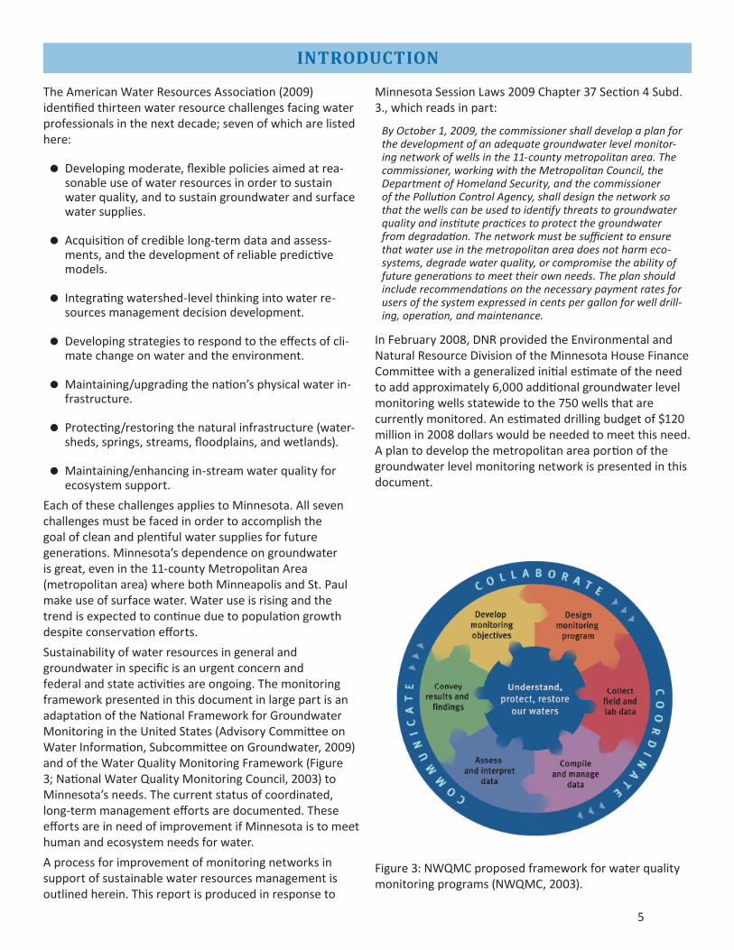
Sustainabilityofwaterresourcesingeneralandgroundwaterinspecificisanurgentconcernandfederalandstateactivitiesareongoing.ThemonitoringframeworkpresentedinthisdocumentinlargepartisanadaptationoftheNationalFrameworkforGroundwaterMonitoringintheUnitedStates(AdvisoryCommitteeonWaterInformation,SubcommitteeonGroundwater,2009)andoftheWaterQualityMonitoringFramework(Figure3;NationalWaterQualityMonitoringCouncil,2003)toMinnesota’sneeds.Thecurrentstatusofcoordinated,long-termmanagementeffortsaredocumented.TheseeffortsareinneedofimprovementifMinnesotaistomeethumanandecosystemneedsforwater.
Aprocessforimprovementofmonitoringnetworksinsupportofsustainablewaterresourcesmanagementisoutlinedherein.Thisreportisproducedinresponseto
MinnesotaSessionLaws2009Chapter37Section4Subd.3.,whichreadsinpart:
By October 1, 2009, the commissioner shall develop a plan for the development of an adequate groundwater level monitor-ing network of wells in the 11-county metropolitan area. The commissioner, working with the Metropolitan Council, the Department of Homeland Security, and the commissioner of the Pollution Control Agency, shall design the network so that the wells can be used to identify threats to groundwater quality and institute practices to protect the groundwater from degradation. The network must be sufficient to ensure that water use in the metropolitan area does not harm eco-systems, degrade water quality, or compromise the ability of future generations to meet their own needs. The plan should include recommendations on the necessary payment rates for users of the system expressed in cents per gallon for well drill-ing, operation, and maintenance.
InFebruary2008,DNRprovidedtheEnvironmentalandNaturalResourceDivisionoftheMinnesotaHouseFinanceCommitteewithageneralizedinitialestimateoftheneedtoaddapproximately6,000additionalgroundwaterlevelmonitoringwellsstatewidetothe750wellsthatarecurrentlymonitored.Anestimateddrillingbudgetof$120millionin2008dollarswouldbeneededtomeetthisneed.Aplantodevelopthemetropolitanareaportionofthegroundwaterlevelmonitoringnetworkispresentedinthisdocument.
Figure3:NWQMCproposedframeworkforwaterqualitymonitoringprograms(NWQMC,2003).

6
NETWORK DESIGN AND STANDARDS
Groundwatercannotbemanagedinisolation.Climateandsurfacewatermonitoringnetworksmustalsobeimprovedandsustained;worktodosohasbeenenhancedbyfundingprovidedundertheCleanWaterLegacyAct.Geologicandhydrogeologicmappingareindispensableandmoreofthismappingworkremainstobedonewithinthemetropolitanarea.Themajorityoftheareaisunderlainbyathicksequenceofproductiveaquifers(Figure4).MostofwhatisknownabouttheseaquifershasbeenlearnedaswellshavebeendrilledandpumpedandasinformationhasbeencompiledandanalyzedinCountyGeologicAtlases.Figure5showsareaslackingadequateinformationaboutaquifersfortheMetropolitanCouncil’sregionalgroundwatermodelingpurposes.Figure6showsprogresstowardcompletecoverageofthemetropolitanareawithCountyGeologicAtlases,whichwillprovideagreatportionofthenecessaryinformationforimprovingtheunderstandingofaquiferpropertiesandrelationshipsbetweenaquifersandsurfacewaterresources.
Thereistruthinthestatement“youcan’tmanagewhatyoudon’tmonitor”.Continuedmonitoringoverextendedtimecreatesthelongtermrecordsneededforresourcemanagement.“Typically,collectionofwater-leveldataoveroneormoredecadesisrequiredtocompileahydrologicrecordthatencompassesthepotentialrangeofwater-levelfluctuationsinanobservationwellandtotracktrendswithtime”(Figure7;TaylorandAlley,2001).Accuratewaterusedatamustalsobeavailable.
Climatenormsareestablishedover30-yeartimeintervals.Chemistryofgroundwatercanchangeoversimilartimescales.Similarly,observationwellrecordsincreaseinvalueasmorewellshavealengthofrecordofthirtyyearsormore.Agroundwaterlevelmonitoringnetworkthatismaintainedindefinitelythroughfundingcycleswillbeastablebackbonenetworkprovidinginformationneededforsustainablewatermanagement.
Network goalsDatacollectioneffortsthathavedefinedandacceptedknowledgegoals,documentednetworkdesign,andplansfordesignrevision,dataanalysisandusearepreferred.Minnesota’snetworkwillofnecessitybecomprisedofanetworkofnetworks.Wewillsharedataamongthesenetworksandusethemergednetworkstoformtheactivewaterlevelmonitoringsystem.
Knowledge goals
Fundamentalquestionsthatnetworkdesignmustberesponsivetoinclude:
Howdoesthisaquifersystemworkandhowmightweusethenetworktotestconceptualmodelsofthehydrogeologicsetting?
Whatistheunstressedconditionofthemonitoredaquifer?
Howcanweusethenetworktodefinethedirectionandgradientofgroundwaterflow?
Howisgroundwaterchemistrychangingovertime?
Whatarethesources/causesofthesechanges?
Howmightweusethenetworktoestablishback-groundlevelsofwaterqualityindicators?
Whatarethegroundwaterleveltrends?
Whatarethelong-termandannualchangesingroundwaterstorageduetoeffectsofclimateandofwithdrawals?
Howmuchgroundwatermovesthroughthesystem?
Howmuchgroundwatercontributionisneededbycriticalecosystemstomaintainminimum(non-lethal)andmaximum(successfulreproductionofsustainablepopulations)suitableconditions?
Whatistherelationshipbetweenclimate,groundwa-terstorage,groundwaterappropriations,andground-watercontributiontocriticalecosystems?
Whataretheeffectsofperiodsofdroughtandaboveaveragerainfall?
Whatarethelong-termeffectsofclimatechange?
Whataretheeffectsofgroundwaterwithdrawals?
Howdogroundwatermanagementeffortsimpactchemistry,recharge,discharge,ecosystems,etc.?
Design Criteria
Networkdesigndeterminesthesamplinglocations,frequencyofmonitoring,variablestomeasure,andthestandardsforday-to-dayoperationoftheentiresystem.Designcriteriashould:
Answertheknowledgegoalsdefinedabove.
Describeatransparentnetworkstructure.Itshouldbeclearhowthepartsfittogethertocreateawholesystemmoreusefulthantheindividualparts.
Clearlydefinebenefitsresultingfrominvolvementofmultipleagenciesandlocalunitsofgovernment.
Identifytheaquifersandaquifersystemstobemonitored.

7
Figure4:Extentofmajorbedrockaquifersinthemetropolitanarea.

8
Figure5:Areaslackingadequateaquiferinformationforgroundwatermodelingpurposes.

9
Figure6:StatusofCountyGeologicAtlases.

10
Figure7:Typicallengthofwater-level-datacollectionasafunctionoftheintendeduseofthedata(TaylorandAlley,2001).
Identifyadditionalnaturalfeaturestobemonitoredsuchassprings,stream,andlakes.
Incorporatemeasurementofthevolumesofwatermovingthroughthesystem(fluxmonitoring)intheformofstreamflows,springdischarge,rainfall,infil-tration,evapotranspirationandrelatedaspectsofthehydrologiccycle.
Incorporateinitialchemistrymonitoringtoimproveexistinggroundwaterqualitymonitoringnetworks.
Useastandardprocessbasedonaconceptualunderstandingoftheaquifersystemtoselectmoni-toringlocationsinthreedimensions.Wellscompletedatdifferentdepthsatacommonlocationarecalledwellnests.Wellnestsarethemostefficientmethodofmonitoringinthreedimensions.
Useaniterativeprocessthatincorporatestheresultsofhistoriclongtermmonitoring,synopticmeasure-mentsandregionalgroundwatermodelingtoguidenetworkdevelopmentandmonitoring.

11
Useastandardprocesstodeterminemonitoringfre-quenciesbasedonlocationandhydrogeologiccondi-tionsaswellasanyadditionalintendedusesofthewaterleveldata.
Establishaminimumgroundwaterlevelsamplingfre-quencyforthebackbonenetwork.Specialprojectsmayincreasesamplingfrequency.
Identifyrelevantdesignelementssuchaswellcon-structionthatimpactnetworkeffectiveness.
Establishstandardfieldandlabprotocolstoensurecomparabilityovertime.
Establishstandarddataexchangeprocesseswherebyallcooperatorsprovidestandardizeddatasubmis-sions.
Ensurethatmonitoringlocationsmeetthegoalsofmultiplenetworkpartners.
Establishstandardsforwellconstructionandmain-tenance,includinghydraulictestingandsurveyingofwaterlevelmeasurementpointsrelativetoperma-nentsurveyreferencepoints.
Createanaccessibledatamanagementsystemwithredundantback-upsthatwillallowcooperatorstouploadandverifyindi-vidualmeasurementsandelectronicfilesoftime-seriesdatacollectedbyautomateddataloggers.
Providedataimmediatelyforman-agementdecisionsandnetworkmain-tenancethroughweb-baseddataac-cessinmultipleformats(e.g.tabular,hydrograph,etc.)summarystatisticscalculatedoverselectableintervals,andallowdownloadingofthequality-controlleddata.
Analysis and Use of Monitoring Data
Dataanalysisandqualitycontrolprotocolswillbedevelopedforthebackbonenetworkandeachsubnetworkusingthebestavailableinformation.Suchprotocolswillbeincludedinthedesignandsubsequentredesignsoftheoverallnetwork.Provisionsmustbemadetoevaluatetheseprotocolsperiodically.
Reportingprotocolsshouldfollowasimilarmodelandincludepublicwebaccessreportingstandardswhichmustbeautomated.Userswillquerythedatasetandcreatesummariesandother
derivativenetworkproducts.Individualusersofwaterateveryscaleareaprimaryaudience;understandingandprotectingMinnesota’sgroundwaterresourcesforcurrentandfutureuseswilldependontheinvolvementofallusers.
Ascheduleforreviewandrefinementofnetworkdesignandprotocolsshouldbeestablishedattheonset.
Types of Networks and Monitoring CategoriesSeveralsetsofdefinitionsexistfordifferenttypesofmonitoring.Forexample,thetermsbaselinemonitoring,ambientmonitoring,andbackgroundmonitoringaresimilar.Monitoringcanbelongtermorshortterm,continuousintimeorcontinuousinspace,sampleselectioncouldberandomorpredetermined.Wedefinefourtypesofmonitoring:BaselineMonitoring,SurveillanceMonitoring,TrendMonitoringandSpecialStudyMonitoring.ThesetermsfollowtheusageintheNationalFrameworkforGround-WaterMonitoringintheUnitedStates(NationalFramework)(AdvisoryCommitteeonWaterInformation,SubcommitteeonGroundWater,2009;Figure8)anddefinepurposesformonitoring.Agivenwell’srecordofwaterlevelmeasurementsmaybeusedformultiplepurposesovertimeorsimultaneously.
Figure8:Networktypesandrelationshipsamongnetworks(NationalFrameworkforGround-WaterMonitoringintheUnitedStates,AdvisoryCommitteeonWaterInformationSubcommitteeonGroundWater,2009).

12
Werefertothemonitoringnetworkforthemetropolitanareaasa‘backbone’networkinparttoavoidtheinherentassumptionsandlimitationsincludedinusinganyoftheestablishedlabels.
Thisdiscussionfocusesonanetworkcreatedtomonitorwaterlevels,butthegoalisalsotoensurethatthenetworkwillbeusefulforwaterqualitymonitoringasneeded.
Baseline Monitoring
Baselinemonitoringmayalsobecalledbackgroundmonitoring,conditionmonitoring,orambientmonitoring.Itistypicallylongtermandcontinuousintime.Baselinemonitoringmaybeusedtoestablishwaterlevelsatalocationwithinanaquiferpriortotheinterventionofastressorimpact,i.e.priortoaquiferdevelopment.Baselinemonitoringtakesplaceatallmonitoringlocationsduringthefirstseveralyearsasthewaterlevelsaremeasuredandabaselinepatternisestablished.Inanothersense,somewellsmaybeselectedforbaselinemonitoringbecausetheyarenotexpectedtorespondtoananticipatedstressorimpact.Forwellsinstalledafterastressonthesystemhasbegun(inanexistingwellfield,forexample),‘baselinemonitoring’mayrevealanongoingtrendinwaterlevels.
Monitoring for Special Studies
RobertC.Ward,amonitoringnetworkexpertwhohaslongstruggledwiththeseissues,states:“Itisdifficultforonemonitoringsystemtoanswerthe“what”and“why”questionsatthesametime”(Ward,1989).Baseline,surveillance,andtrendmonitoringtypicallydealwiththe“what”question.Once,forexample,the“whatisthequalityofthewater”questionisansweredandrevealsaproblem,thenspecialstudymonitoringcancomeintoplaytoaddressthe“why”or“howfarhavewecomeinfixingthisproblem”questions.Thistypeofmonitoringisalsotermedtargetedmonitoring,compliancemonitoringoreffectivenessmonitoringandthenatureofthemonitoringisentirelydependentonthestudyparameters.
LimitationsTheultimatepurposeofmonitoringistoinformpolicydecisionsandmanagementactions.Groundwaterquantityandqualityinformationcannotpreventorsolveproblemsonitsown.Nosinglenetworkcanaddressallgroundwaterconcerns,butaregionalbackbonenetworkisextremelyimportantbecauseitcanprovideinformationontrends,dataformodeling,andassistinproblemidentification.Effortstoaddressspecificconcernswillusuallyrequirethatmoredetailedinformationbeaddedtothatwhichcanbeobtainedfromthebackbonenetwork.
Formanagementtobeeffective,anumberoffactorsoutsidethecontrolofgroundwaterspecialistsmustbeaddressed:
Ingeneral,thepublic’sunderstandingoftheground-waterresourceispoor.Groundwatersystemsarehid-denfromdirectmeasurementandobservation;theyaremoredifficulttoperceiveandunderstand.
Short-termsocialandeconomicissuesmustnotvetogroundwatermanagementdecisions.
Riskstohumanandecosystemhealthmustbeevalu-atedand,wherethereisuncertainty,humanandeco-systemhealthmusttrumpotherneeds.
Costsofchangesinwaterusethatmustoccurtoen-suresustainability,includingcoststhataccruewhenpumpingisrestricted,mustbeapportionedoverthosebenefittingfromwateruse.Minnesotawaterlaw,forexample,allowsforreductionsinpermittedwaterusevolumesinawateruseconflictareatopro-tecttheresourceandhighestpriorityuses.
Aregulatoryframeworkisinplacethatallowsman-agerstosuspend(foraseasonalimpact)orterminate(forapermanentimpact)waterwithdrawalsthatwillpotentiallyimpairecosystemservices.Ifadequatemonitoringofbothsurfaceandgroundwaterresourc-esisinplace,regulatorswillbeabletomanagetopre-ventunintendedimpacts.

13
Minnesotaemploysamulti-agencyapproachtogroundwatermonitoringandprotection.Ittakestheconcertedeffortofallagencies,alongwithlocalandfederalpartners,tobuildacomprehensivepictureofthestatusofthestate’sgroundwaterresources.Thesegroundwaterqualityandquantitydataareneededforwatersupplyplanning,permittingandotherregulatoryactions,bestmanagementpracticeimplementationandbetterunderstandingofsurfacewaterandgroundwaterinteractionsthathavethepotentialtoaffectwaterqualityandavailability.
A2004MemorandumofAgreement(MOA)betweentheMinnesotaPollutionControlAgency(MPCA),theMinnesotaDepartmentofAgriculture(MDA),andtheMinnesotaDepartmentofHealth(MDH)clarifiedtheagencies’respectiveroles(asspecifiedbystatestatute)inambientgroundwaterqualitymonitoring,andtheseagenciesoperateastatewideintegratedgroundwater-qualitymonitoringsystem.Figure9isagraphicaldepiction
ofagencyroles,includingthewaterquantitymanagementresponsibilityoftheMinnesotaDepartmentofNaturalResources(DNR).
OpportunitiestobetterconnecttheinformationcollectedbytheDNRforgroundwatermanagementwiththeMinnesotaPollutionControlAgency’s(MPCA’s)groundwaterqualitydatabase,theMinnesotaDepartmentofHealth’s(MDH’s)drinkingwaterwelldata,anddatacollectedbypublicandprivatewatersupplierstoenhancedataaccessibilityforgroundwatermanagementshouldbefurtherexplored.Amergeddatasetwillgivevaluetomanydifferentprograms.Therehasnotbeenadequatefundingtocompilecurrentandhistoricgroundwaterdatafromtheprogramsthatcollectit.Suchaneffortisapriorityforallstateagencies.Workhasbeguntorefinetheoptionsandcostsinvolvedincreatingacomprehensivegroundwaterdatamanagementsystemthatretrieves,validates,andbuildsonhistoricdatacollectionactivities.
SUMMARY OF MINNESOTA’S CURRENT NETWORKS
Figure9.Groundwatermonitoringrolesofthestateagencies.
DNR:Water supply/availabilityRecharge/infiltration
confining layer
confining layer
buried aquifer
bedrock aquifer
water tableaquifer
water table
water quality monitoring wells
water level monitoring wells
MPCA:Chemical releases Industrial pollutants
Agriculture:PesticidesFertilizer
MDH: Public water supply
Quality Quantity
Ground Water Monitoring Roles
water supply well water quality monitoring wells

14
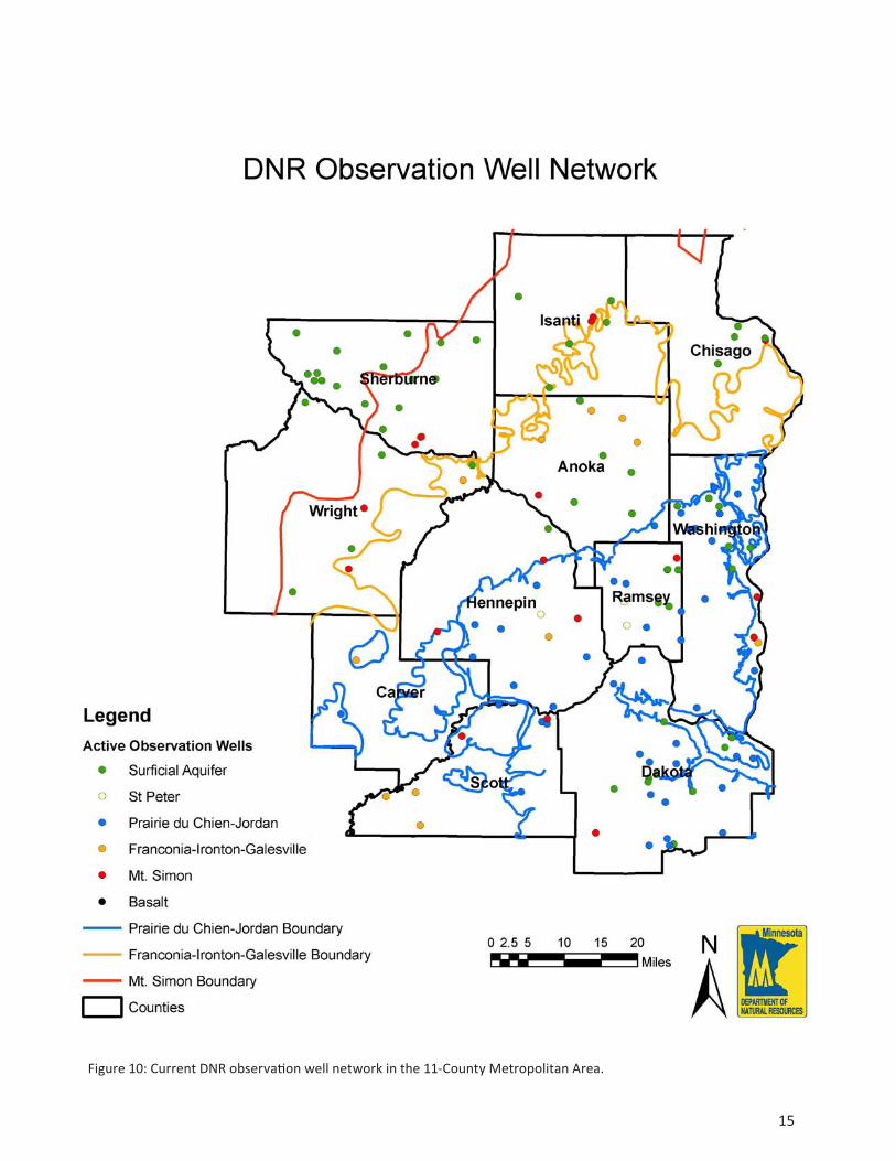
DNR – baseline, trend and surveillance monitoringDNR’sprimaryfocusisonwaterquantity.DNRmanagesacooperativewater-levelmonitoringnetworkcreatedinthe1930s(Figure10).Inthemetropolitanareathisnetworkconsistsof177wells.Itwasbuilt,withUSGSassistance,byincorporatingwellsusedforDNRandUSGSstudiesandwithsupplywellsthatarenolongerused.TheDNRandUSGSstudieswerenotdesignedtobepartofaregionalwater-levelmonitoringeffort.Manywellsarenotonlandunderpubliccontrolandcannotbeconsideredtobepermanentmonitoringlocations.SoilandWaterConservationDistrictsserveasdatacollectionagentsforthecurrentnetwork.
DNRhasagroundwatermonitoringworkgroupthatisinvolvedinplanningandguidanceforthecurrentnetwork.Oneimmediateconcernisthatthereiscurrentlynocomprehensiverepositoryforgroundwaterlevelmonitoringdata.TheDNRgroundwaterlevelmonitoringnetwork’sdatabaseisbeingreworkedtoprovideenhancedwebaccess,butdevelopmentofdatamanagement,processingandstoragetoolsfortimeseriesdataawaitsadequatefunding.
DNR’svisionforthefutureincludestheenhancementofthecurrentnetworkintoastate-of-the-art‘backbone’networkforgroundwaterlevelsandadatasystemorportalthatmeetstheneedsofthestate’swateragencies,othercooperatorsandthepublic.Thenetworkalsowillinformandprovidesupportforsubnetworks,includingsubnetworksbuiltprimarilyforwaterchemistryorqualitymonitoringgoals.
Tosupplementthecooperativenetwork,theDNRandpartnersconductedsynopticwaterlevelmeasurementsintheMetropolitanareaduringMarchandAugust2008(Figure11).Theresultsaresnapshotsofwaterlevelsandcanbecomparedseasonallyandwithothersynopticmeasurementstogainanunderstandingofmajorchangesingroundwaterstorageandflowovertime.Theseimagesfrom2008showthatgroundwaterwithdrawalshadcreatedaconeofdepressioninMt.Simonwaterlevelsandthatthisimpactwasmorepronouncedduringsummerwhenmorewaterwasbeingpumped.Synopticmeasurementsshouldberepeatedatfive-yearintervals.
OtherwaterlevelinformationcollectedbyandforDNRincludesaquifertestdataandpermit-requiredmonitoringdata:
DNR’saquifertestsareconductedtounderstandhowgroundwaterwithdrawalswillimpactthegroundwa-terresourcefromwhichthewaterisbeingpumped.Impactsonotherusersandothernaturalresourcesareevaluatedusingaquifertestinformation.ThesedataareprovidedtoMDHforsourcewaterprotec-tionplanning.
Permittedgroundwaterusers(Figure12)areoftenrequiredintheirpermittomeasureandreportwa-terlevelsinspecificwellswhenitisdeterminedthatmonitoringwillassisttheDNRinwatermanagement.Permit-requiredmonitoringdataareusedtoevalu-atewateravailabilityandpredictlong-termimpactsofgroundwaterwithdrawalsontheecosystemandonotherusers.
OngoingDNRgroundwaterlevelmonitoringnetworkprogramactivities:
ManywellsmeasuredaspartoftheDNRcooperativenetworkareinpoorconditionduetoage.Anongoinginventoryofwellsandwellconditionallowstheex-tentofdeferredmaintenancetobequantified(Table2).Somewellsneedtobereplacedandtheoldwellssealed;somewellsareinlocationsorarecon-structedtodepthswhichservedtheoriginalstudyneedsbutarenotneededforongoingmonitoringandshouldbesealed;somewellsneedpreventivemainte-nance.Allwellsshouldreceiveroutinemaintenance.
Wellplacementisbeingevaluated,bothtodeterminewhichofthewellsmentionedabovemayberedun-dantandtoproposelocationsfornewwells.Wheregapsareidentified,newwellsmustbedrilledorper-missiontomonitorappropriateexistingwellsmustbeobtained.MostrecentprogresshasfocusedontheMt.Simonaquifer;newwellshavebeensitedandmanyhavebeendrilled.
DNRstaffhavedevelopeddraftguidancedocumentsfortheimprovedDNRnetwork.Anynewwellsthatwillbedrilledandanyexistingwellsthatwillbepartofthe‘backbonenetwork’mustmeetthestandardsestablishedintheguidancedocumentsandbesuit-ableforlong-termmonitoringofatleasttwentyyears.Thesewellsmustalsobeconstructedtoal-lowforwaterqualitysampling.Abasicsuiteofwaterqualityparameters(pH,conductivity,temperature,cations,anions,tracemetals[includinglow-levelar-senic],tritium,andstableisotopesofhydrogenandoxygen),willberoutinelyanalyzedforeachwellwhenitiscompletedorwhenitisaddedtothenetwork.Repeatedsamplingandselectionofadditionalpa-rametersforanalysiswoulddependonthelocationandpossiblesubnetworktowhichawellmaybelong.MDHmonitoringwellfeesmustbepaidforallwells.
Waterlevelmonitoringtechnologyisimproving.Au-tomateddatacollectiontechnologywillallowbetterqualitydata(waterlevel,temperatureandconductiv-ity,forexample)tobecollectedatmorefrequentin-tervals.Thenominalone-monthsamplingintervalforwaterleveldataisnotadequateforsomeofthepur-posesforwhichthedatawillbeneeded,e.g.assess-mentofrecharge(DelinandFalteisek,2007).Timeandmoneymayultimatelybesavedbecausefewerroutinesitevisitswillberequired.
15
Figure10:CurrentDNRobservationwellnetworkinthe11-CountyMetropolitanArea.

16
Figure11:SynopticmeasurementresultsoftheMt.Simon-HinckleyAquiferfromMarchandAugustof2008.
Synoptic Water-Level Measurements Reveal Seasonal Changes
August,2008
March,2008

17
Figure12:Permittedgroundwaterusersbyaquifer.

18
Informationroutinelycollectedduringaquifertestsandthroughpermit-requiredmonitoringcannotcur-rentlybestoredinthedatabasethatholds‘tradition-al’DNRgroundwaterlevelmonitoringdata.Thedata-basestructuremustbechangedtoaccommodatethelargeramountsofinformationcollectedbydatalog-gers.Thenetworkupgradealsomustaddresscalibrationofdataloggerdata.
Thefollowingsectionsbrieflysummarizemonitoringeffortsbyotheragencies.Wewillcontinuetocloselycoordinatewiththeseeffortstocreateanintegratedwaterqualityandwaterquantitynetworkforthemetropolitanarea.
Table2:AllactivewaterlevelmonitoringwellsinthecurrentDNRCooperativenetworkwereevaluated.Seventy-sevenofthewellsneedmaintenanceorhaveaproblemthatmustberesolvedbeforethewellshouldbeconsideredforinclusioninthebackbonenetwork.Wellmaintenanceissuesarebeingaddressedasfundsallow.

19
MPCA – trend monitoring and special studiesUndertheMOAwithMDHandMDA,theMPCAengagesinwaterqualitymonitoringtoassessthestatusandtrendsofMinnesota’sgroundwatersystemfornon-agriculturalchemicals.Thedatainformdrinkingwaterprotectionandsupplyefforts,identifiesthreatstogroundwaterquality,andprovidesinformationforTotalMaximumDailyLoadstudies,andguidesdevelopmentofbestmanagementpracticestoavoidfuturegroundwaterimpacts.
Ambient(i.e.baseline)groundwaterqualitymonitoringhasbeenconductedbytheMPCAsince1978todocumentthequalityofthegroundwaterresourcesstatewideandidentifytrends.Site-specificinvestigations(i.e.specialstudies)alsoareconductedbytheagencytodeterminetheextentofnon-agriculturalpoint-sourcecontaminationtothegroundwater,suchasfrompetroleumspillsorlandfills.
TheMPCA’scurrentambientgroundwaterquality
monitoringnetworkfocusesonaquifersthataremostsusceptibletopollutionfromhumanactivities,namelythesurficialsandandgravelandPrairieduChien-Jordanaquifers.Byfocusingonvulnerableaquifers,thenetworkprovidesanearlywarningofcontaminationintroducedintothegroundwatersystemandallowsforearlierdetectionoftrendsingroundwaterquality.
TheMPCAisintheprocessofenhancingtheambientnetworktodiscerntheeffectsofurbanlandusesongroundwaterqualityconditions.Atotalof150additionalmonitoringwellsareneededtoallowassessmentofwater-qualityconditionsandtrendsbyland-usesetting.Figure13detailstheMPCA’sambientnetworkandplannedadditionsinthemetropolitanarea.TheMPCAisworkingcloselywithstateagenciesandlocalgovernmentstositeandinstallnewwellstomeetwaterqualitymonitoringandothermonitoringneeds.FundshavebeenappropriatedfromtheCleanWaterfundtoinstallatleast60oftheneededmonitoringwellsduringfiscalyears2010-2011.
Figure13:MPCAambientwelllocations(43wells)andproposedexpansion(89wells).

20
MDA – trend monitoring and special studiesThefocusofMDAmonitoringactivitiesisonwaterqualityimpactsfrompesticideuse.Specialstudymonitoringisprimarilyinresponsetosite-specificincidents.Baselinemonitoringforpesticidesisconductedthroughspeciallydesignedmonitoringwellinstalledadjacenttofarmfields.Dataareusedtoevaluatewaterqualityimpacts,theneedforalternativeapplicationmethodsandasameasureoftheoverallsuccessofchangesinpesticide
managementpractices.InthemetropolitanareatheMDAmonitorsgroundwaterimpactsfromagriculturalchemicalapplicationsintheruralfringesurroundingthesuburbanareaaswellasurbanpesticideuseimpactsincooperationwithMPCA.MDAalsoconductsorassistswithspecialstudiesofpesticidesindrinkingwaterwells.Figure14depictswellsthatarebeingsampledbyMDAinthemetropolitanarea.
Figure14:MDA2008groundwatersamplingsites.

21
MDH – baseline and trend monitoringMDHengagesinstatewidemonitoringtoevaluategroundwaterchemistryconditions,toaidinvestigationofspecificproblems,andtodemonstrateeffectivenessrelativetoestablishedstandards.ThismonitoringandrelatedactivitiesconductedbytheMPCAandtheMDAaredefinedbyaMemorandumofAgreement.MostofMDH’smonitoringisgearedtowardssafeguardinghumanhealth,especiallywithregardtodrinkingwaterprotection.Figure15showsthedistributionofpublicwatersuppliersinthemetropolitanarea.MDHhaswaterchemistrymonitoringresponsibilityforallpublicwatersupplies.
Specificexamplesofsomeofthesemonitoringactivitiesarelistedbelow:
Condition monitoring
Occurrenceanddistributionofnaturallyoccurringcontaminantssuchasarsenicandradium.
Characterizationofgeneralaquiferchemistrybysam-plingselectedpublicwatersupplywellsstatewide(2010).
Effectiveness (compliance) monitoring
SafeDrinkingWaterActcompliancesamplingofallpublicwatersupplysystemsinthestate.Frequencyofsamplingandcontaminantsofconcernvarydepend-ingonmanyparametersincludingvulnerabilitytocontaminationandsystemtype,e.g.community,non-community.
Figure15:MDHPublicWaterSupplyWells.

22
Arsenicandnitratesamplingofallnewwells.
Problem investigation monitoring
Perfluorinatedcompoundconcentrationanddistribu-tionintheeasternTwinCitiesmetropolitanarea;
Specialprojects,e.g.wellheadprotectionandhealthassessmentsofcontaminationsites.
WhilemostMDHgroundwatermonitoringactivitiesarefocusedonwaterquality,waterlevelinformationiscollectedaspartofaquifertestingprojectsforpublicwatersuppliers.Itisrecordedaspartofregulatoryprogramsassociatedwithwateruseandconstructionpermittingofnewwellsandthesealingofoldwells.
USGS - Aquifer monitoring and surveillance monitoringTheUnitedStatesGeologicalSurvey(USGS)monitorsthequantityandqualityofwaterinthenation’sriversand
aquifers,developstoolstoimprovetheapplicationofhydrologicalinformationandensuresthatitsinformationandtoolsareavailabletoallpotentialusers.MuchofitsmissionhasbeencarriedoutthroughtheCooperativeWaterProgram(CWP),acost-sharingpartnershipbetweentheUSGSandwater-resourceagenciesatthestateandlocallevel.Inthepast,especiallyinthe1960sand1970s,theUSGSconductedmanyCWPstudiesforwhichmonitoringwellsweredrilled.InmanycasesthewellsarenowbeingmeasuredaspartoftheDNRgroundwaterlevelmonitoringnetwork.TheUSGScurrentlymonitorslocationsinMinnesotaforgroundwaterlevelsandqualityinresponsetospecificrequestsforassistance,aspartofareal-timedatacollectionnetwork,andforspecialgroundwaterstudies.
OngoingUSGSspecialprojectmonitoringinthemetropolitanareainvolvesthenetworkofshallowwellsshowninFigure16.Thesewellsarebeingusedtoevaluatetheimpactsoflanduseongroundwaterquality.
During2008,theUSGSservedasleadagencyforthesynopticmeasurementofwellsintheTwinCitiesMetropolitanArea.
AsenvisionedintheNationalFramework,theUSGSshouldplayamajorroleincoordinationofthenationalgroundwatermonitoringnetworkfortheprincipalaquifersoftheUnitedStates.Anewfundingmodelisbeingdeveloped(NationalFrameworkforGround-WaterMonitoringintheUnitedStates,AdvisoryCommitteeonWaterInformation,SubcommitteeonGroundWater,2009),which,ifsuccessful,willallowUSGStomanagetheday-to-dayoperationsofthenationalnetworkandtofundlong-termmonitoringintheprincipalaquifersoftheUnitedStates.
Figure16:USGSmonitoringwellssampledtodetectimpactsoflanduseonwaterquality.

23
Local Governments - trend monitoring and spe-cial studiesMonitoringisongoingatmanylevelsofgovernment.Severalcountiesareactivelyinvolvedinassessmentandmonitoringofgroundwaterresourcesasarewatersheddistricts,conservationdistrictsandothers.WashingtonCounty’sgroundwatermonitoringnetworkisshowninFigure17.ThenetworkconsistsofDNRandcountywells.
Themanagementgoalsofthestate’sgroundwaterlevelmonitoringnetworkwillbeattainableonlyifthebackbonenetworkisaugmentedbyhigh-qualitydatacollectedlocallyandsubmittedtothegroundwaterleveldatabase.Mostsuchdatawillbesuppliedbyusersunderconditionsoftheirpermits,therestwillcomefromsubnetworkssuchasWashingtonCounty’s.
Example of County Observation Well Network
Figure17:NorthernWashingtonCountygroundwatermonitoringnetwork(IntegratingGroundwaterandSurfaceWaterManagement-NorthernWashingtonCounty,EmmonsandOlivierResources,Inc.,2004).

24
NETWORK DESIGN FEATURES AND SPECIFICATIONS
Agroupoftechnicalexperts,theGroundwaterTechnicalWorkgroup,convenedtodiscussthesustainabilityofgroundwaterinMinnesotawasqueriedaboutMinnesota’sgroundwatermonitoringneedstoprovideforbettermanagement.Thediscussioncenteredonwaterquantitydataneeds,althoughallweremindfulthatwherepossible,needsformonitoringofotherwaterparametersshouldalsobemet.Theresponsesfellintothreemainthemes,asfollows:
More instrumentation on wells and collection of data on more parameters —
Useofautomaticlevelrecordersanddataloggersforcontinuousgroundwaterlevelmonitoring.Increaseduseoftelemetrywouldallownearreal-timeresponsetoproblemsincludingequipmentmaintenanceissues.
Requiringwateruserstocollectandreporthigh-qualityinformationaboutwaterlevelsandwateruse.Whereappropriate,continuouswaterleveldatashouldberecorded.
Routinecollectionoftemperatureandconductivityinformationconcurrentwithwaterlevelmeasure-mentswhereappropriate.
Additional well installations, preferably nests (which are multiple wells finished in different aqui-fers at a given location) —
Nearsurfacewatergagingstations,springs,andnearlakesandwetlandstoallowassessmentofground-water-surfacewaterinteraction.
Nearusersoflargequantitiesofwater,alongwithcontinuousrecordsofpumping.
Toassessverticalgradientsbetweenaquifersandinareaswherebedrocksubcropsbeneaththicklayersofunconfinedmaterial.
Includewellsinconfiningunitsbetweenaquifers.
Installedatapproximategroundwatersheddividesandregionaldischargeareasalongmajorriverstoenhanceunderstandingofbaseflowcontributingareas.
Existingdeepwellsingoodconditionwhichareproposedtobesealedshouldbeevaluatedforpossiblesuitabilityasobservationwellsunderthecriteriaestablishedforthenetwork.
New tools for working with data —
Softwareforworkingwithdata,especiallylongdurationtimeseriesdata.
Qualitycontroldataprocessingroutines.
Databaseanalysisroutinesthatscreenforanomalousdataentriesandassesstrendsinthedatabeingsub-mitted.
Asthegroundwaterlevelmonitoringnetworkisenhanced,allpartnerswillalsoworktoidentifyopportunitiesandneedsforexistingwaterqualitynetworksmanagedbyMPCA,MDAandMDH.
Monitoring Element GoalsQuantity (Levels, Flows, Rates of Use and Discharges)
Weatherandclimatedatausedtoestimatearealrainfallandevapotranspirationamountsareneededathighspatialresolutiontocomplementgroundwaterandsurfacewaterdata.Usersofgroundwaterannuallyreportmonthlywateruse.Surfacewaterelevationsarealsoneededathighresolutiontocomputechangesinstoragewhichisespeciallyimportantforcomputationsofbaseflowtostreamsandrivers.Thereisaneedtomonitorstreamflowsthroughthewinterforassessmentofthecontributiontobaseflowfromgroundwater.
Quality (Constituents of the Water)
Physical,chemical,andisotopicsamplingforage-datingandsourceassessmentshouldbeconductedonallwellsinthebackbonenetwork.Thissamplingshouldoccurwhenawellisconstructedor‘adopted’intothenetwork.Thisbaselinewaterqualitydatacanthenbeevaluatedbythegroundwatermonitoringworkgrouptodeterminethefrequencyandlistofconstituentsforanyadditionalqualitymonitoringneededtomeetspecificsubnetworkgoalsincludingspecialstudies.
Inadditionto“routine”monitoringofgroundwaterconditions,datashouldperiodicallybecollectedonthepresenceandtrendsofcontaminantsthatarejustbeginningtobeinvestigatedandarenotwellunderstood(suchasendocrinedisruptingcompounds).Thismonitoringshouldstartwherethedatawillbemostusefultoinformhealthriskassessmentsandpolicydevelopment.
Resources MonitoredTheprimarymanagementgoalistomonitorwaterlevelsinthemajoraquifersystemsinuseinthemetropolitanarea.Managementofaquifersystemsnecessarilyreliesonathoroughunderstandingofinputsandoutputs.Thuswemustalsohaveaccesstohighqualityinformationaboutstreamflowsinthemajorriversandstreamsinthemetropolitanarea.UndertheCleanWaterLegacyAct,theMPCAandDNRarecooperating(alongwithUSGS,theMetropolitanCouncilandlocalpartners)toenhancethecollectionandanalysisofstreamflowmonitoringdata.The

25
MetropolitanCouncilisproposingtousenewmethodsforstreamgagingthatmayallowgroundwatercontributionstostreamflowinmajorriverstobecalculated.Additionalstreamgagingsitesonmajorriversandtributarystreamsandtroutstreamsmayneedtobeestablishedtomeetthegroundwaterlevelmonitoringnetworkgoalofunderstandingwaterflowthroughtheaquifersystemsofthemetropolitanarea.
Waterlevelsinwetlandsandlakesinmanycasesreflectthewaterlevelofthesurficialaquifer.Lakelevelandwetlandlevelmonitoringsitesmayneedtobeenhancedtogatherdataaboutthesurficialaquifer.Figure18showsexistingsurfacewatermonitoringlocationsthatprovideimportantinformationforgroundwatermanagement.Systematicimprovementsinthedistributionandqualityof
thesemonitoringpointsareadvisable.
Springdischargecomesdirectlyfromaquifers.Theinventoryofspringsinthemetropolitanareaneedstobecompletedandspringdischargemonitoringatkeylocationsbegun.
Groundwater and Ecosystem FunctionGroundwaterbothinfluences,andisinfluencedby,ecosystemfunction.Groundwaterqualityandquantityinfluenceecosystemprocessesandservices,suchasplantproductivity,aswellasnativeplantandanimalcommunitycompositionandassociatedrarespecies.Functionalecosystems,in-turn,influencegroundwaterquality,suchasthroughbio-filteringprocessesandsedimentremovalthroughinfiltration,andinfluencegroundwaterquantity
Figure18:ActiveDNRsurfacewatermonitoringlocations.

26
byfacilitatinggroundwaterrechargeandminimizingvariabilityingroundwaterrechargerates.
Ecosystem influences on groundwater
Afunctionalecosystemiscriticalformaintaininggroundwaterqualityandquantity.Wetlandsandothernaturalplantcommunitiesinterceptprecipitationandoverlandflowingwater.Thesenaturalsystemsactasfilteringagents,removingpollutantsandsedimentfromwaterasitinfiltratestothegroundwater.Nativevegetationandintactcommunitiesattenuateoverlandflowofwatertoriversandstreamsandfacilitategroundwaterrecharge.Rechargeinfunctionalecosystemscanalsooccuratasteadierpace,minimizingvariabilityin
groundwateravailability.
Groundwater influences on ecosystem processes and services
Ecosystemservicesarebenefitsprovidedbyecosystemstohumans.AccordingtotheUnitedNations2004MilenniumEcosystemAssessment,ecosystemservicescanbegroupedintofourmajorcategories:“provisioning,suchasproductionoffoodandwater;regulating,suchascontrolofclimateanddisease;supporting,suchasnutrientcyclesandpollination;andcultural,suchasspiritualandrecreationalbenefits”.
GroundwaterisitselfanecosystemservicethatisdependeduponbymostmunicipalitiesintheTwinCities
Figure19:Mt.Simonboundarystudymonitoringwelllocations.

27
metroareaandthroughoutMinnesota.Thequantityandqualityofgroundwaterasadirectecosystemserviceisdiscussedinothersectionsofthisdocument.
Groundwater,inturn,affectsotherecosystemfunctionsandservices,suchasplantandanimalproductivity,andnutrientcyclingandtransport.Theinfluenceofgroundwaterontheseandotherecosystemcomponentsdependonahostofinterconnectedfactorsincludingtopography,soiltype,connectionsbetweenshallowwateranddeepwater,plantcommunitytype,watershedpositioninthelandscape,andpositionwithinawatershed.Thecombinationofthesefactorsmakecertainfeaturesofanecosystemmoredependentupongroundwaterfeatures.Monitoringmustaddressthesecomplexrelationships,andthefirststeptowardbetterunderstandingisinclusionofappropriatemonitoringsitesinthebackbonenetwork.
Monitoring Site Distribution GoalsThemonitoringnetworkmustcoverthearealextentofthemajoraquifersinthemetropolitanarea.Developmentofaconceptualmodelofthegroundwaterflowsystemineachmajoraquifermustunderliethenetworkdesign.Tothisend,wellsinthemajoraquifersthatextendoutsidethemetropolitanareamustalsobeincludedinthebackbonenetwork.Thesewellswillestablishboundaryconditionsformoredetailedassessmentsofwaterlevelchangeswithinthemetropolitanarea.Theongoingwell-drillingprogramtoexpandmonitoringoftheMountSimon-Hinckleyaquiferisanexampleofhowtheedgeof
amajoraquifercouldbemonitored(Figure19).AsimilareffortwillberequiredfortheedgeoftheFranconia-Ironton-Galesvilleaquifer(TunnelCity-Wonewocaquifer).Completionoftheremainingcountygeologicatlasesforthemetropolitanareaandupdatesforolderatlaseswillassistwiththiseffort.
Groundwatermonitoringlocationsmustbeadequateforregionalplanningandenoughdetailmustbeprovidedtoallowadaptivemanagementinresponsetoobservedchangesinwaterlevels.Groundwatermonitoringlocationsmustalsobeadequateforwatershed-levelassessmentofgroundwater–surfacewaterinteraction.
Monitoring Frequency GoalsTheDNRgroundwaterlevelmonitoringnetworkasitcurrentlyexistscollectsdatanominallyonamonthlybasis.Thenetwork’sdatabaseinfrastructureisnotoptimizedforstorageormanipulationoflargeamountsofdata.Ascurrentlystructured,itisdesignedtostoreonetoseveralmonthlywaterlevelmeasurementsperwell.Itisnowunderstoodthatmonthlymeasurementsarenotwhollyadequateforwaterlevelmonitoringinareaswheregroundwaterisextensivelyused.
Morefrequentmeasurementsofgroundwaterlevelsareappropriatewhereclimaticconditionsarevariable,wheretheaquiferssupplylargequantitiesofwater,whereshallowaquifersarepartofthemonitoringprogram,andwhererechargeratesarehigh(Figure20).
Figure21showsthedatarecordfromaDNRobservation
Figure20:Commonenvironmentalfactorsthatinfluencethechoiceoffrequencyofwater-levelmeasurementsinobservationwells(TaylorandAlley,2001).

28
wellinanareaofagriculturalirrigationwherewaterlevelsfluctuatedramaticallyoverthesummerirrigationperiod.Thisdatarecordisshownasrecordedbyadataloggerathighorcontinuousfrequency,andasitwasrecordedthroughmonthlyhandreadingsasisthecurrentstandard
forDNRobservationwells.Hydrographsmadefromcontinuousdataallowthebestestimatesofmaximumandminimumwaterlevelsintheaquifersandcanrevealtheimmediateimpactofgroundwaterwithdrawals.
Figure21:Observationwellwaterlevelspresentedascontinuoustransducerdatarecordedbyadataloggerandasperiodic(monthly)handreadings.ThisisasurficialaquiferwellinPopeCounty.

29
DATA STANDARDS AND DATA MANAGEMENT
Datastandardsanddatamanagementroutineshavebeendeterminedbyexpertpanelsinmorethanoneforum.ThisinformationisavailabletoMinnesota’sgroundwaterprofessionalsandwillbeadaptedtoMinnesota’sneedswithoutneedtorepeatthewholeeffort.AnexamplefromtheAdvisoryCommitteeonWaterInformation,SubcommitteeonGroundWater(2009)isintheAppendix.DocumentsthatwillbeadaptedforMinnesotaincludeguidancefor:
Standardpracticestoensurecomparability
Accessanddataexchange
Dataentryandqualitycontroltools,and
Analysistools
Software for Large Volume Data Management Continuous,i.e.highfrequency,monitoringisneededinthemetropolitanareatounderstandsystemresponse
tochange.Assessmentofgroundwaterrechargeisonlypossiblewherehigh-frequencymeasurementsofgroundwaterlevelsareavailable(LorenzandDelin,2007).Staffresourceswillquicklybeovermatchedunlessadequatesoftwareandnetworkinfrastructureareinplacetomanagethedata.
High Frequency Data CollectionThesoftwareandnetworkinfrastructureshouldbedesignedtobescalabletoaverylargenumberofmonitoringsitesthatcomprisestressedsubnetworks.Thequalityassuranceandqualitycontrolprocessesforindividualsiteswillbenefitfromusingdatafromadjacentsitestakenatequivalentfrequency,meaningthatideallyallsiteswouldbesampledatsimilarfrequencies.Thedataarchivingmethodswillstoredataatlowerorvariablefrequenciesifappropriate,andthedatadownloadmethodswillpermituserstorequestdataatanydesiredfrequency.Figure22isthedatamanagementanduseschematicasenvisionedintheNationalFramework.
Figure22:Awaterlevelmonitoringnetworkcansupportwaterqualitysubnetworksaspartofthemanagementsystem(AdvisoryCommitteeonWaterInformation,SubcommitteeonGroundwater,2009).
30
RECOMMENDATIONS FOR IMPLEMENTATION
CooperativeimplementationoftheNationalFrameworkforGroundwaterMonitoringintheUnitedStateswillresultinanimprovedDNRgroundwaterlevelmonitoringnetworkthatwillformthebackboneoftheregionalgroundwaterlevelmonitoringnetworkforthemetropolitanarea.Thisbackbonenetworkwillalsoprovideopportunitiesforexpandedmonitoringofwaterchemistry.Minnesotawillcontinuetofocusonnetworkenhancementswhileapplyingtobeapilotsiteforthefirststagesofnationalnetworkdevelopment.
Newmonitoringlocationswillberecommendedbyamulti-agencycoordinationworkgroupandanynetworkimprovementswillfocusonmeetingbothwaterqualityandquantitymonitoringneeds.Existingandnewsubnetworks,towhichothercooperatorsalsocontribute,willmeetspecialmonitoringstudyneedsandwillprovidesomeoftheexistingwellsthatwillbeselectedforregionalmonitoring.Theanticipatedworkgroupworkplantaskscorrespondwithactionsrequiredofpartnersinthenationalmonitoringnetwork:
Task 1:EvaluatepotentialmonitoringpointsinthecurrentDNRgroundwaterlevelmonitoringnetworkforinclusioninthebackbonenetwork.TheMetropolitanCouncil’sregionalgroundwatermodeland/oraconceptualmodelofgroundwaterflowwillprovidecontextfortheseevaluations.
Task 2:JointeffortsofDNR,MDH,MDA,andMPCAwillensurewheneverpossiblethatlocationswillbeusefulforassessingwaterquality.
Task 3:Evaluatethechosenpointstoseeifnetworkcoveragemeetsmonitoringgoalsbothforareaswherepumpingstressesareanticipatedandinareasthatareunstressed.Selectwellsofeachtypefortrendmonitoringinastressedsubnetworkandforbackgroundmonitoringinanunstressedsubnetwork.
Task 4:Evaluatethegapsinboththestressedandunstressedsubnetworksandsearchforwellownersorwateruserswhomayhavetheabilitytomonitorwaterlevelsandprovidewaterleveldatameetingthestandardsofthebackbonenetwork.Provideappropriatetechnicalassistancetomakecooperationamutuallyvaluableundertaking.
Task 5:Prioritizeinstrumentationandmaintenanceneedsandbeginaprogramtoaddressproblemsandcarryoutenhancements.
Task 6:Workwithpartnerstostructureadataportaltoincludeanalysis,storage,andretrievalofqualitycontrolledandrevieweddata.Thisessentialtaskwillrequireongoingdedicationofsignificantresources.
Task 7:Calculatecosttomaintainthenetworkindefinitely.
Metropolitan Area Groundwater Resource IssuesAgroundwatermodelofthemajoraquifersintheseven-countyTwinCitiesareawasdevelopedfortheMetropolitanCouncil’swatersupplyplanningefforts.Themodelisbeingusedtopredictthepossibilityofcertainwatersupply-relatedproblemsinthefuture.Becausetheinitialmodelcalibrationareaincludedareassurroundingthesevencountymetropolitanareaandbecausethegeologicsettingisquitesimilar,theMetropolitanCouncil’sresultscanbeextended,inageneralsense,totheexpanded(elevencounty)metropolitanareaandusedtodefinethescopeofnewmonitoring.Figures23and24showareaswhereaquiferlevelsmaydeclinesignificantlyovertimeandareaswheresurfacewaterresourcesmaybeimpactedbygroundwaterwithdrawals.
Otherknowngroundwatermanagement-relatedissuesarealsobeingevaluated.InFigure25,forexample,locationsofgroundwaterdependentresourcesareshown.Inmanycasesastressonthegroundwatersystemcanresultinanadverseimpacttotherelatedsurfacewaterresource.Thebackbonenetworkwillassistmanagerswithdecisionsaimedtowardprotectionofvaluedecosystems.Figure26showsthecurrentunderstandingofseveralcategoriesofvulnerabilitytocontamination.
Current DNR Network CoverageThestatewideinventoryandstatusassessmentofwellsintheexistingDNRgroundwaterlevelmonitoringnetworkwasacceleratedsothattheresultsshownpreviouslyinTable1forthemetropolitanareawouldbeavailableforthisreport.Thecurrentnetworkincludes177activelymonitoredwells.Waterlevelmeasurementsaremademonthlyforatleast8monthsperyear.ThedistributionofactivewellsbyaquiferisshowninFigures27through30.
Assessing the Gaps in CoverageManywellsintheexistingDNRgroundwaterlevelmonitoringnetworkare‘Baseline’monitoringwells,intentionallylocatedwheretheywere(atleastinitially)notaffectedbyshort-termstresses.Monitoringoftheconditionofthemajoraquifersisapublicresponsibility,whilemonitoringofwellsintendedtotrackimpactsofpumpingisaresponsibilitytobesharedmoredirectlybytheusers.Onceabaselinemonitoringwellbeginstoshowpumpingsignaturesfromincreasedwateruse,anew,moredistantwellmustthenbeinstalledtomeetthebaselinemonitoringneed.
Tomeettheneedforaccuratelypredictingtheresponsetocurrentandfuturestresses,additionstothenetwork

31
Figure23:AreaswheremunicipalpumpingmaycausesignificantaquiferdeclineaspredictedbytheMetroModel2(DataprovidedbytheMetropolitanCouncilMarch2009TwinCitiesMetropolitanAreaMasterWaterSupplyPlan,whichhasbeenprovisionallyapprovedbytheMetropolitanAreaWaterSupplyAdvisoryCommittee.Modelextentlimitedto7-CountyMetropolitanArea).

32
Figure24:AreaswheremunicipalpumpingmayadverselyaffectsurfacewateraspredictedbytheMetroModel2(DataprovidedbytheMetropolitanCouncilMarch2009TwinCitiesMetropolitanAreaMasterWaterSupplyPlan,whichhasbeenprovisionallyapprovedbytheMetropolitanAreaWaterSupplyAdvisoryCommittee.Modelextentlimitedto7-CountyMetropolitanArea).

33
Figure25:Areaswheremunicipalpumpingmayadverselyaffectgroundwaterdependentsurfacewaterfeatures.

34
Figure26:Areaswhereaquifersmaybevulnerabletocontamination(Source:MDH.ArsenicandRadiumDatabasedon2008MDHAnnualPWSComplianceReport.Nitrate-NitrogenresultsrestrictedtoSherburne,WashingtonandWrightCountiesbasedonavailabledata).

35
Figure27:Activesurficialaquiferobservationwelllocations.

36
Figure28:ActivePrairieduChien-Jordanobservationwelllocations.

37
Figure29:ActiveFranconia-Ironton-Galesvilleobservationwelllocations.

38
Figure30:ActiveMt.Simonobservationwelllocations.
39Figure31:SchematicofdataflowfromrawSCADAdatatoendusableproduct.
shouldalsobedesignedtomonitorstressesontheaquifersystemandmonitoringwellsshouldbelocatedinthefollowingtypesofhydrogeologicsettings:
Alongrivers(includingriverlevels).
Atperchedlakes(lakelevelandgroundwaterlevelbelow).
Nearhighcapacityproductionwells
Atthewatertableinrecharge/infiltrationareas.
Inornearsensitiveecosystems.
Acrossandwithinconfiningunits.
Attheedgesofconfiningunits(inburiedbedrockval-leys).
Along,oracross,orwithin,faultsorfaultzones.
Coordinationwithgoalsofallpartnersneededtoensurethenetworkgetsthemostpossibleinformationfromthefewestwells.Springandstreamflowmonitoringforassessmentofaquiferdischargefluxmustbeincludedinthisanalysis.Thedistributionofpermittedusersindicatesareasofongoingaquiferstress;populationgrowthforecastscanpredictfutureareasofaquiferstress.
Gaining Support and Acceptance of Monitoring PartnersAmonggroundwaterusersthereisarangeofmanagementapproachesandexpertise.Itwillbeimportanttoreachouttomajorwaterusers.Localgovernments,inparticular,canbeinvaluablepartnersinthecollectionofwaterlevelmonitoringdataandareinauniquepositiontobeabletoplanforsustainabilityoftheirowndrinkingwatersupplyonceadequatedataareavailable.Informationaboutaquifersystems,groundwaterlevelmonitoringandgroundwater-surfacewaterinteractionmustbereadilyavailabletolocaldecisionmakers.
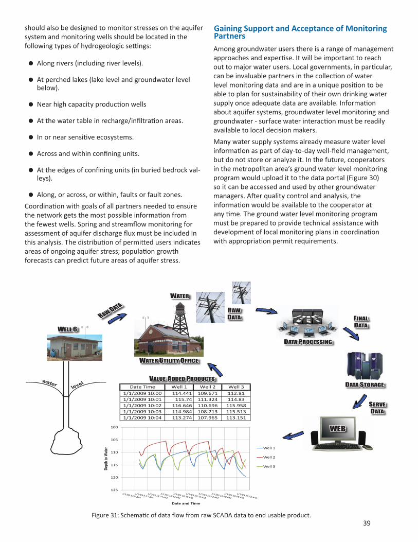
Manywatersupplysystemsalreadymeasurewaterlevelinformationaspartofday-to-daywell-fieldmanagement,butdonotstoreoranalyzeit.Inthefuture,cooperatorsinthemetropolitanarea’sgroundwaterlevelmonitoringprogramwoulduploadittothedataportal(Figure30)soitcanbeaccessedandusedbyothergroundwatermanagers.Afterqualitycontrolandanalysis,theinformationwouldbeavailabletothecooperatoratanytime.Thegroundwaterlevelmonitoringprogrammustbepreparedtoprovidetechnicalassistancewithdevelopmentoflocalmonitoringplansincoordinationwithappropriationpermitrequirements.
WEB
SERVE DATA
waterlev
el DATA STORAGE
DATA PROCESSING
FINAL DATA
RAW DATA
WELL 6
WATER UTILITY OFFICE
RAW DATA
WATER
VALUE-ADDED PRODUCTS

40
FUNDING NEEDS
Publicinvestmentisrequiredatalllevelsofgovernment.Privateinvestmentisrequiredofusersoflargequantitiesofwater,wherethedefinitionof‘large’mayvarybasedonthehydrogeologicsetting,totaldemand,andotherresourcesorecosystemservicesatrisk.Monitoringnetworksgainvalueaslengthofrecordgrows.Dedicated,predictablefundinglevelswillallowthenetworktofunctionasintendedandprovidevaluecommensuratewiththeinvestment.
Network infrastructure needsWellconstruction,maintenanceandsealingwillbeongoingactivities.Newwellinstallationsforthebackbonenetworkmustmeetconstructionstandardsintendedtomaximizeusefullife.Locationsmustbechosenwiththeintentiontomaintainthewellnestindefinitely,meaningthatpermanenteasementsorpurchaseofsmallparcelswillbenecessary.
CurrentmaintenanceneedsforexistingDNRgroundwaterlevelmonitoringwellsincludesealingwellsthatdonotmeetcurrentstandards,areredundantorthatneedreplacementduetoage.
Technology needsTechnologythatallowsdatafromgroupingsofwells(nests)totransmitdataasonestationtogethercanaddefficiency.AWi-Fibasednetwork,forexample,isacosteffectivemeansofcollectingdata.OnehasbeenbuiltbytheSaintAnthonyFallsHydraulicLaboratoryfortheMinnehahaWatershedDistrict.Cellphonedatatransmissionispracticalinthemetropolitanarea.
Sophisticatedandveryefficientdatainputproceduresmustbeattheforefrontofdatabasedevelopmentforthedatacominginfrombackbonenetworkwells,fortime-seriesdatasubmittedbysubnetworks,andfordatasubmittedbywaterappropriationpermitholders.Qualityassuranceandqualitycontrolproceduresfordatacomingfromstressmonitoringwillrequiresignificantlymorerobustproceduresthanarecurrentlyinplace.
Anaccessibleinternetportalmustbedeveloped.Thebestcurrentmodelforthistypeofportalexistsforstreamgagingdata.Automatedproductsderivedfromnetworkdatacanbelinkedtolocalwebpagessothatmembersofthepubliccanviewanduseinformationfromspecificsubnetworksormonitoringlocationsasneeded.Thisinformationcanalsobelinkedtoavailablewaterqualityandwellinformation,furtherenhancingdataavailability.
Funding modelThisreportisrequiredtodevelopacost-basisfornetworkestablishment,operationandmaintenanceforan
indefinitenetworkexistenceandtoestimatethiscostincentspergallonofgroundwaterusedinthemetropolitanarea.
Water Use Estimate
Theaveragenumberofgallonsofwaterusedannuallyinthemetropolitanareaoverthepastfouryears(Figure2)hasgrowntoapproximately140billiongallons.
Network Cost Estimates
BestestimatesencompassingallnetworkexpensesareshowninTable1,repeatedonthefacingpage.Theassumptionsmadeindevelopingthecostsestimatesaregivenbelow.
Theexpectationisthatthemetropolitanarea’sreal-timebackbonemonitoringneedswouldlikelybemetbyabout60sites,someofwhichwillbelocatedinthemajoraquifersoutsidethemetropolitanarea.Atotalofapproximately180wellswillbemonitoredinthiswayandthedatawillbeavailablealmostimmediatelyfromthewebportal.
Allotherwellsinthebackbonewaterlevelmonitoringnetworkwithinthemetropolitanareashouldbemonitoredwithautomatedwaterlevelmeasuringdevices.Theconversionshouldcommenceimmediatelyandbecompletedin4years.
Thisassessmentisbasedontheexistenceofasubnetworkofadditional,permit-mandated,monitoringlocations.Theburdenofpermit-requiredmonitoringwillbesignificantlylighterwhendatainput,analysisandreportingareaccomplishedthroughthestate’snewcomprehensivegroundwaterlevelmonitoringdatabase.
Deferredwellmaintenancewillbecarriedoutduringthefirstfouryears.WellsinthecurrentDNRgroundwaterlevelmonitoringnetworkthatprovetobeunsuitableforthebackbonenetworkwillbesealedorturnedovertocooperators.Somewellswillhavetobereplacedifmaintenancedoesnotrestorefunction.Routinemaintenancewillbepartofnormaloperationsofthebackbonenetwork.
Toimproveunderstandingofstratigraphyandaquiferandaquitardcharacteristics,allnewlyconstructedwellswillbeloggedwithboreholegeophysicalmethods(gamma,caliper,temperature,fluidresistivityandflowmeterlogs).Whereinterpretationofaquifercharacteristicswouldbeaided,asubsetofexistingwellsshouldbelogged.
Waterchemistrysamplingofabasicsetofanalytesmustbecarriedoutatwellinstallationandrepeatedatsetintervalsasinformedbynetworkgoalsandananalysisoftheinitialwaterqualitydataset.

41
Futurewellinstallationswillincludelandacquisitionorpermanenteasements.Thebackbonenetworkmustnotsufferfromabandonmentsforcedbylandownerdecisions.
Undercurrentfeestructures,monitoringwellfeesmustbepaidtoMDHorthelocalauthoritysothatnetworkwellsmaybesampled.
Databasedevelopmentandcreationofaninternetportaltootherdatasourceswhethertheinterfacefortechnicalusersisonacommercialplatformoronastate-developedplatform,shouldbeaccelerated,withcompletionwithinfouryears.Databasedevelopmentandcreationincludesdataentryviawebinterface,email,orupload;automaticdataprocessingandQA/QCroutines;dataanalysistools;web-baseddisplayandretrievalofdata;andtheabilitytoservethedatatocooperator’swebsitesinthecooperator’sdesiredformats.Ongoingsystemmaintenancewillberequired.
Advanceddataanalysisroutinestoincludederivationofaquifercharacteristicsfromtimeseriesdatawillbecreatedandaddedtothesuiteofavailabletools.
Cost in Cents per Gallon
Totalestimatedcostsforbuild-outofthenetworkoverfouryearstotal$8,861,150milliondollars.
$8,861,750.00 /4 years = $2,215,437.50 per year
$2,215,437.50 per year / 140 billion gallons per year= $0.00001582 per gallon =
0.0000001582 cents per gallon, or
$15.82 per million gallons.
Disclaimer:Therecommendationsinthisplanwillneedtobeadjustedinthefuturebecauseof
Constantlyevolvingmanagementneeds
Constantlyevolvingtechnology
Constantlyevolvinghuman-builtenvironment
Constantlyevolvingunderstandingoftheaquifersystem
Establishmentandmaintenanceofabackbonegroundwaterlevelmonitoringnetworkisthebestinsurancethatgroundwatermanagerswillhave,inlargepart,thedataneededtofacethedecisionsofthefuture,whatevertheymayturnouttobe.
Table1:CostsfortheCreation,Maintenance,andOperationofaGroundwaterLevelMonitoringNetworkforthe11-CountyMetropolitanArea.
Year 1 Year 2 Year 3 Year 4Total
DevelopmentSubsequent
Years
Total Wells in Backbone Network 80 175 270 380 380 380
Backbone Network Establishment: Well Drilling, Easements, Instrumentation, Operation and Maintenance 1,083,400$ 1,310,750$ 1,440,600$ 1,627,000$ 5,461,750$ 627,000$
Technical Support / Quality Control / Groundwater Analysis 350,000$ 350,000$ 350,000$ 350,000$ 1,400,000$ 105,000$
Data Management and Access through Web Portal 500,000$ 500,000$ 500,000$ 500,000$ 2,000,000$ 93,000$
$ 1,933,400 $ 2,160,750 $ 2,290,600 $ 2,477,000 $ 8,861,750 $ 825,000
Dollars per Million Gallons 13.81$ 15.43$ 16.36$ 17.69$ 15.82$ 5.89$
Cents per Gallon 0.001381 0.001543 0.001636 0.001769 0.001582 0.000589
Notes: All values 2009 dollarsNotes: All values 2009 dollars
By the end of the fourth year of network build-out, the backbone network will consist of 60 nests for which data are transmitted real time (approx. 3 wells per nest) and 200 monitoring wells with dataloggers

42
BIBLIOGRAPHY
AdvisoryCommitteeonWaterInformation,SubcommitteeonGroundWater,2009,NationalFrameworkforGroundwaterMonitoringintheUnitedStateshttp://acwi.gov/sogw/pubs/tr/sogw_tr1_Framework_june_2009_Final.pdf
AmericanWaterResourcesAssociatione-newsletter,August2009,WhatWaterResourcesChallengesDoWeFaceintheNextDecade?
Delin,G.N.,andFalteisek,J.D.2007,GroundWaterRechargeinMinnesota.USGSFactSheet2007-3002.http://pubs.usgs.gov/fs/2007/3002/pdf/FS2007-3002_web.pdf
FreshwaterSociety,2009,WaterforLife–SustainabilityofGroundWater,http://www.freshwater.org/images/stories/PDFs/publications/Sustainability-of-Ground-Water.pdf
Lorenz,D.L.,andDelin,G.N.,2007,Aregressionmodeltoestimateregionalground-waterrechargeinMinnesota:GroundWater,v.45,no.2.
MinnesotaPollutionControlAgency,2009,MPCA’sambientgroundwatermonitoringstrategyproposalfortheCleanWaterLandandLegacyAmendment.http://www.pca.state.mn.us/publications/leg-09sy1-11.pdf
NationalWaterQualityMonitoringCouncil,2003,SeekingaCommonFrameworkforWaterQualityMonitoring.SpecialIssueofWaterResourcesImpactVol.5No5,http://acwi.gov/monitoring/pubs/0309impact.pdf
CouncilofCanadianAcademies,2009,TheSustainableManagementofGroundwaterinCanada.http://www.scienceadvice.ca/documents/(2009-05-11)GWReport.pdf
Taylor,CharlesJ.andWilliamM.Alley,2001,Ground-Water-LevelMonitoringandtheImportanceofLong-TermWater-LevelData,USGSCircular1217.http://pubs.usgs.gov/circ/circ1217/pdf/circ1217_final.pdf
Ward,RobertC.,1989,WaterQualityMonitoring–ASystemsApproachtoDesign.PresentationattheInternationalSymposiumontheDesignofWaterQualityInformationSystems,USEnvironmentalProtectionAgencyandColoradoStateUniversity.

43
APPENDIX
TheGroundWaterLevelMonitoringWorkGroupwithinDNRWatershasbeguntheprocessofdraftingguidancedocumentsforthegroundwaterlevelmonitoringnetwork.Completeddraftsaddressthefollowingtopics:
NetworkGoalsandObjectives
PolicyandCriteriaforAcceptingExistingWellsintotheNetwork
PolicyandCriteriaforInstallingNewWellstoaddtotheNetwork
PolicyandCriteriaforRemovingWellsfromtheNetwork
PolicyandCriteriaforInstallationandUseofElectronicDataLoggingandTelemetryintheNetwork
PolicyandCriteriaforVibratingWireTransducerUseandInstallationinWellsoftheNetwork
FieldPracticesforGroundWaterDataCollection
Thedraftsweredevelopedtoservethemostimmediateoperationalneedsofthecurrentnetwork.Theintentionisthatallwillbecomecomponentsofafullydevelopedguidancedocument.
PresentedasexamplesbelowPolicy and Criteria for Accepting Existing Wells into the NetworkandField Practices for Ground Water Data Collection.
Policy and criteria for accepting existing wells into the NetworkThispolicyappliesto:
AcceptingexistingwellsfromotherentitiesintotheMinnesotaGroundWaterLevelMonitoring(GWLM)Network.OwnershipofthewellmayormaynotbetransferredtotheStateofMinnesota,DepartmentofNaturalResources,DivisionofWaters,dependingoncircumstances.
Background
Fromtimetotimeexistingwellsmaybecomeavailableforuseasmonitoringwells.Inmostcases,thewellisnolongerbeingusedbytheowner.Thereasonsthatawellisnolongerusedinclude:thecompletionofastudy,reuseofasite,orachangeoflandownership,amongothers.Ratherthansealthewell,andpossiblyincurconsiderableexpense,theowneroftheexistingwellmayapproachDNRWatersandproposethatthewellbecomepartoftheGWLMNetwork.TheactualownershipofthewellmayormaynotbetransferredtoDNRWaters.Potentialwellsforinclusioninthenetworkmayalsobeidentifiedin
otherways,suchassurveysofunusedorabandonedwellsbylocalgovernments.Historically,mostofthewellsinthecurrentnetworkwereaddedtothenetworkthroughformalorinformalaccessobtainedfromotherentities.InsomecasesDNRacceptedformalownershipofthewellfromanotherentity.
AddinganexistingwelltotheNetworkmaybeverybeneficialintermsofaddingvaluabledatatothenetworkwithouttheexpenseofactualinstallation.ExistingwellsthatareaddedtotheNetworkbyaccessagreementhaveownershipandfutureresponsibilityretainedbyanotherentity.However,iftheownershipofthewellistransferredtoDNR,thetransferbringswithitacommitmentbyDNRWaterstomaintainthesiteand,whennolongerneeded,tosealthewell.Potentialcoststosealawellcanbeconsiderable.
General Policy:
TheDivisionofWaterswilladdexistingwellstotheGWLMNetworktoimprovethequalityandquantityofgroundwaterdataandtoreducethecostofinstallingnewwells.
General Criteria:
AnexistingwellproposedtobeaddedtotheNetwork:
Mustfulfillamonitoringneed;
Shouldmonitoraknownaquiferorsystem;
Mustbeinconnectionwiththeaquifer;
Mustbeintendedforlong-termmeasurement;
MustmeetrequirementsoftheMinnesotaWellCode.
Technical Criteria
Theexistingnetworkshouldbereviewedtoidentifyaspecificneed.Forexample,thewellfillsagapthatex-istsinthenetworkorthewellcanreplaceanexistingnetworkwellthatisnolongerfunctioningproperlyandneedstobereplaced.
Theexistingwellshouldconnectwithanaquiferofsufficientextentandthicknesstohaveaneconomicorresourcevalueforasignificantarea.
Othergroundwaterlevelmonitoringnetworksshouldbereviewedsotheproposedwellisnotaduplicateofanexistingoperationalwell.Theproposedwellshouldalsosupportcomplementaryhydrologiccyclenetworkssuchasclimateandsurfacewater.
Wellsthatareproposedforownershiptransferto

44
DNRWatersshouldbelessthan25yearsoldandlessthan6inchesindiameter.ProposedwellsmustmeettherequirementsoftheMinnesotaWellCodeatthetimeoftransfer.
ProposedwellsforinclusionintheNetworkshouldbeatleast2inchesindiametertoaccommodatemea-surementdevices.
GWLMNetworkwellsshouldnotbeusedforpump-ing.Iftheproposedwellisusedforpumping,theef-fectsofthepumpingshallbeconsideredpriortoac-ceptingthewellintotheNetwork.
Thewellmusthaveproperdocumentationincludingawelllogand/orotherconstructiondatathatad-equatelydescribesthephysicalsettingandconstruc-tionofthewell.
Geophysicalandvideologsshouldbeconductedonallproposedwellstoverifytheconditionofthewellandconfirmthegeologyoftheareainwhichthewellisinstalled.
Pumpingand/orslugtestsshouldbeconductedtodemonstratefunctionalityofthewell.
Theconditionandsafetyoftheproposedwellmustbefield-verified.Thefieldverificationstepshouldalsochecklocation,use,pumps,orotherequipmentinthewell.
AnywellthatisopentomultipleaquiferscannotbeacceptedintotheNetworkunlessprovisionshavebeenmadetoproperlyrefitthewellforsingleaquiferuse.
Administrative Criteria
Therecordofownershipofeachwellproposedforin-clusionintheNetworkshouldbeconfirmed.WhetherthewellisaddedtotheNetworkbyaccessagreementortransfer,anaccessagreementortransferagree-ment,respectively,willneedtobeconcludedwiththewellowner.
Iftheproposedwellfortransferisnotanactivelyusedwell,anypumpsorstructuresinthewellshouldberemovedpriortoacceptingthewellfortransferintotheGWLMNetwork.Thisworkshouldbecon-ductedbytheprevious/existingownerofthewellpriortotheDNRWatersusingthewellaspartoftheNetwork.
ForwellsthatareaddedtotheNetworkbyaccessagreement,anaccessarrangementshallbeapprovedbetweenthepropertyownerandtheDNRWaterstoallowlong-termaccesstothewelllocationformoni-toringandmaintenance(asdefinedintheAccessAgreement).
Existingwellsthatareproposedforadditiontothe
DNRWatersGWLMNetworkshallhaveidentifica-tiontagsandimpactprotectioninstalledasneededtomeetMinnesotaWellCodeRequirementspriortoac-ceptingthewellintotheNetwork.
IfawellisunsuitableforaddingtoGWLMNetwork,theinformationaboutthewellshouldbestoredforpossiblefuturereviewandreconsideration.
EachproposedadditiontotheNetworkshouldbecarefullyreviewedandareviewmemoandrecom-mendationprepared.Thereviewshouldbeconduct-edbytheGroundwaterMonitoringWellCoordinatorandshouldaddressthecriteria(asoutlinedabove)usedtodetermineifawellshouldbeacceptedintotheGWLMNetworkasanobservationwell.Therec-ommendationwillbesubmittedtotheGroundWaterandHydrogeologySupervisorforreviewandcon-currance.ThedocumentationshouldbekeptintheGWLMNetworkwellfileandintheremarkssectionoftheGWLMNetworkdatabase.
Field Practices for Ground Water Data CollectionThese draft field practices are based on ‘Field Practices for Ground-Water Data Collection’, June 2009, Advisory Committee on Water Information, Subcommittee on Ground Water and on standard practices established for DNR and MPCA hydrologists.
Qualitydatadependonhighqualityconsistentfielddatacollectionprocedures.Importantelementstoensuredataqualityinclude:
Trainingofallstaffwhoareinvolvedindatacollection
Pre-visitfieldsitereviewandpreparationprocedure
Standardlistingofdataelementsthatmustbere-corded
Standardproceduretoprepareforwaterlevelmea-surementsatthefieldsite
Water-levelcollectionanddatarecordingprocedures
Field-samplingproceduresmusttaketheseelementsintoaccountinordertoensurethat:
Waterlevelsarebeingtakenatthecorrectlocation,fromthecorrectwellatthatlocation,andatthepropertime
Water-leveldataarerecordedandtransmittedaccu-rately
Informationrecordedduringmeasurementscontainsalloftheinformationneededtonormalizeandcom-pareanalysisresults
Measuresaretakentoensuretheaccuracyofthere-sult

45
Thisdocumentsetsmostoftheminimumstandardsforsuccessfulfieldworkforthebackbonenetwork.Elementsofthewater-levelmeasurementaspectsofsubnetworkdataacquisitionprogramsshouldalsobedefinedinawrittensetofproceduresspecifictothesubnetworkdatacollectiongoals.
Training
Trainingofstaffisnecessarypriortofieldcollectionofground-waterlevelstoensureconsistentdataquality.Thisdocumentandothergroundwaterlevelnetworkguidancedocumentscanserveasthefundamentalbasisforthattraining.Appropriatetrainingincludesformaltrainingclassesthroughuniversities,professionalassociations,orvendorsandhands-onfieldexperiencethroughmentoring,on-site(onthejob),andfollow-uptrainingtoensurethatdataarebeingcollectedconsistentlyandcorrectly.Exampletraininggoalsinclude:
FieldSafety
Howtoestablishwherethepropermeasuringpointis.
Howtomeasurewater-levelswithdifferenttypesofnetwork-standardequipment,includingelectricandsteeltapes.
Howtomeasurewaterlevelswithpressuretransduc-ersandhowtoensurethatthepressuretransducerreadingsareverifiedwithdirectmeasurements.
Howtomaintaindataloggerequipmentandtoensurethataccuratemeasurementsarerecordedatthecor-rectintervals.
Howtostoreanddecontaminatefieldequipment.
Howtorecordfielddataandtakeappropriatenotesaboutsiteconditions.
Howtotransferfielddataandnotestopermanentda-tabaseandfilearchive.
Pre-visit Field Site Review and Preparation Procedure
Preparationforwater-levelmeasurementsincludesthegatheringofequipmentandsupplies.Achecklistoftheequipmentandsuppliesneededforeachmeasurementtripwillhelpthemeasureravoiddelaysandpreventthecollectionofinvalidmeasurements.
Equipmentthatwillbeusedtocollectcontinuouswaterlevelsshouldbecalibratedandtestedbeforedeploymenttoensureaccuracy.
Decontaminationandcalibrationofsteelandelectrictapesshouldbeconductedasnearintimeaspracticaltofieldmeasurement.Arecordofdecontaminationand
calibrationshouldbemaintainedforallequipment.
Standarddatasheetsforrecordingwater-levelmeasurementswillincludeallappropriatedatafields(suchas:welluniquenumber,sitename,date,time,waterlevelbelowmeasurementpoint,landsurfacecorrection,elevationofmeasurementpoint,etc.
Arecommendedlistofequipmentandmaterialsformiscellaneouswater-levelmeasurementsfollows:asuitablemap(optionally,anaerialphotographandatownplat/lotnumbermap),compassorhandheldglobalpositioningsystem(GPS),siteformforrecordingsiteinformation,water-levelmeasurementform,steeltape(graduatedinfeet,tenths,andhundredthsoffeet)optionallywithanattachedweightmadeofbrass,steeloriron,asolidcakeofbluecarpenterschalk,cleanrags,anelectricwater-levelmeasurementtape,penandpencil,adjustablewrenches,allenwrenches,pipewrenches,hammer,socketset,orothertoolsneededforwellaccess,abottleofsodium-hypochloritefordisinfection,andlatex-freevinylgloves.
Copiesofdatasheetsfrompriorsitevisitsareveryusefulwhendeterminingtheapproximatedepthtowatertodeterminelengthofsteeltapetobechalked.
Minimum Data Elements
Eachwater-levelmeasurementsitehasinherentdataelementsthatneedtobeverifiedandrecorded,preferablypriortowater-levelmeasurements.Thepersonmakingthewater-levelmeasurementshouldchecktoensureminimumdataelementsareavailablepriortoconductingmeasurementstoensurethatitisaccurateanduptodatewheninthefield.Correctionsandupdatestotheinformationshouldbemadepriortomeasurement.
TheASTMhasarecommendedlistofminimumdataelementsforinclusioninaground-waterlevelnetworkasdoestheUSGS,USEPA,andotherregionalandStateagencies.
Onsite Preparation
Thefollowingactivitiesarecarriedoutinpreparationforawaterlevelmeasurement:
Siteverification.Thiscanbeaccomplishedinseveralwaysincludinghavingmadeapreviousvisittothesite,comparingthesitetoaknowngridreferenceus-ingGPSequipment,comparingphotographsofthelistedsitetotheactualsite,oridentifyingthesitebyaphysicallabelonthewellheadoridentifyingsign.
Equipmentdecontamination.Equipmentmustbede-contaminatedbetweenwater-levelcollectionstopre-ventcrosscontaminationbetweenwells.
Siteconditionnotations.Theseincludethedateandtimeofday,weatherconditions(rain,snow,etc.),measurement-pointcondition,damage,deterioration

46
andanyotherfactorsthatcouldaffecttheresultsofthecurrentwater-levelmeasurementorfuturemea-surements.
Siteaccess.Thismayincludeaccesstotheproperty(gateopening,etc.)andopeningthecaporshelterthatenclosesthewell.
Usesitereferencematerialstoverifythemeasuringpointforeachmeasurement.
Water-LevelMeasurements
Numeroustechnicalprocedureshavebeenwrittentodescribetheprocedurestousewhenmeasuringwaterlevels,eithermanuallyorwithrecordersdesignedtoautomaticallymeasurewaterlevelsonacontinuousbasis.ProceduresfromUSEPA,USGS,andASTM,amongothers,exist.Becausethesetechnicalproceduresdonotappreciablyvaryintermsofthequalityofdatathatwouldresult,thefollowingsectionsrefertothetechnicalproceduresalreadydocumentedbytheseorganizations.
Allmeasurementsshouldberecordedeitheronafieldcomputingdeviceoronnetworkstandardpaperforms.Ifelectronicrecordingofmeasurementsischosen,allinformationrequiredonthepaperformalsoshouldbeenterableelectronically.Electronicfilesshouldbedownloadedwhenreturningfromthefieldandarchivedasamethodforretainingoriginalfieldmeasurements.Fieldmeasurementsrecordedonpapershouldbeelectronicallyenteredintoavailabledatabasesshortlyafterreturningfromthefield.Paperformsshouldbescannedandarchivedappropriately.Nooriginaldocumentsaretobereturnedtothefield.
ManualWater-LevelMeasurements
Allmanualwater-levelmeasurementsshouldbedesignedtohaverepeatableandaccuratemethodsofdeterminingtheelevationofthewater-levelsurface.Manualwater-levelmeasurementscanbemadebyuseofseveralmethods;themostcommonarethegraduatedsteelorwettedtapemethodandtheelectric-tapemethod.
Themethodchosenatagivensitewilldependonsiteconditionsandwellconstruction.
AutomatedWater-LevelMeasurements
Automatedwater-levelmeasurementsaremadesothatacontinuous(ornear-continuous)recordofwaterlevelscanbemadewithminimalhumanintervention.Automated(continuousornear-continuous)water-levelmeasurementscanbemadewithpressuretransducersandothertechnologies.Regardlessofthemethodofmeasurement,careshouldbetakentoensurethattheentireexpectedrangeofwaterlevelscanbemeasuredwiththedeviceattheexpectedaccuracy.
Afterthewater-levelrecorderisplacedinawell,theresultingmeasurementsarecomparedtomanualwater-
levelmeasurementstocreateacalibratedrecordofwaterlevels.Documentationshouldbemaintainedtoensureaccuratemeasurements,includingdate/timeofcalibration;thetype,serialnumber,andrangeofmeasurementdevice;andwhatunitsarebeingmeasured.Afieldcopyofthenecessarycalibrationandequipmentinformationshouldbetakentothefieldeachvisit.
Minimum Data Standards
Thefollowingsectionoutlinesvariousstandardstowhichwater-levelmeasurementsshouldadhere,toensureconsistentdataquality.Varioustypesofwater-levelmeasurementscanbemadeandthestandardsvarywiththetypeofequipmentusedtomakethemeasurements.
ManualWater-LevelMeasurements
Severalmanualwater-levelmeasurementsshouldbemadeinshortsuccessiontoensurethemeasurementisaccuratetowithinatleast0.02ftbetweenconsecutivemeasurements.Forelectric-tapemeasurements,theUSGSrecommendsthatatleastthreemeasurementsbemade,withtwoconsecutivemeasurementswithin0.02ft.Somemethodsofmanualmeasurement(atflowingwells,forexample)willnothavethatlevelofrepeatability.Regardlessofthemethodofmeasurement,allmeasurementsshouldberecorded.Theaccuracyofthewater-levelmeasurements(basedontherepeatabilityofthemeasurements)shouldbedocumented.
AutomatedWater-LevelMeasurements
Theaccuracyofautomated(continuous)water-levelmeasurementsshouldbeatleast0.02ft.Instrumentdriftandfaultyinstrumentationcanaffecttheaccuracyofthedatacollected.
Thefrequencyatwhichthewater-levelrecordershouldbevisitedshouldbebasedonthestabilityofthetransducer,thestoragelimitationsoftherecordingdevice,andknowledgeoftheexpectedhydrographoftheaquifer.Fieldvisitsatintervalsof6-8weeksshouldbesufficientuntiltherequirementsoftheindividualsitearedetermined.Regardlessofthemeasurementdevice,measurementsshouldbemadeoftenenoughthattherecordingdevicesonsitewillnotrunoutofroominmemorytostoredataandsothattheaccuracyofthemeasurementsisnotcompromisedthroughexcessivedriftorrangeofwaterlevel.Alargeannualdrawdown/rechargecyclewouldnecessitateadditionalvisitstoallowresettingthetransducerfordifferentseasonsorduringclimaticextremes.Real-time(ornear-real-time)telemetrycanalsobeaddedtothewell;astablewelldisplayingreal-timedatamaybevisitedmuchlessfrequentlythanotherwells.
Instrumentdriftcorrections,calibrationcorrections,anddatumcorrectionsallcanaffecttheaccuracyofmeasurementsandshouldbeappliedafterdownloadingthedata.

47
Data Handling and Management
Extremeimportancemustbeplacedondocumentationoffieldandofficeprocedurestoensurethatthequalityofthedataismaintained.Thissectioncoverssomespecificdatahandlingandmanagementprocedures.
ElectronicEntryofData
Thefirststepinprocessingwater-leveldataisentryofthemeasureddata(measuredorcomputedvaluesassociatedwithaspecificinstantaneousdateandtime),fielddata,andrelatedinformationintoanelectronicdatabaseand/orprocessingsystem.
VerificationandEditingofData
Datamustbecheckedcarefullyandverifiedagainstfieldnotesorrecordsbeforebeingusedinfurtheranalysis.Suspiciousvaluesmayrequireinvestigation.Individualvaluesthatmightbeincorrectarecomparedtofieldmeasurementsortoknownextremesofrecord.Priortoediting,originalunitvaluesshouldbearchived;acopyoftheoriginaldatafileshouldbeedited,andthiscopyshouldalsobearchiveduponcompletionofediting.Variousissuescanariseinwaterleveldatasets,includingerrorswithtimesanddatesandinstrumentdriftordatumerrors.CurrentproceduresinplaceforentryofdataintothejointMPCA/DNRHydstradatasystemwillbedrawnuponforguidance.
Field-measurementdataincludesdiscretewater-levelmeasurements,well-constructiondata,andmiscellaneousfieldnotes.Field-measurementandrelateddatausuallyareenteredintotheelectronicsystemintheoffice,althoughsomedatacanbeenteredonportablefieldcomputers.Variouscomputationsandcomparisonsshouldbemadetoensureaccuracyofthedataandconsistencyoftheinformation
Arithmeticerrors,transcriptionerrors,andlogicerrors(suchasdepthofwelllessthandepthtowater),shouldallbecheckedandcorrectedbeforefinalentryintothedatabase.Alldatashouldbeenteredintothedatabasewiththesamesignificantdigitsasrecordedinthefield.Calculatedvaluesshouldberoundedtothesignificantdigitsrecordedinthefieldnotes.Measuringpointelevationsshouldbeapermanentdatummaintainedasaccuratelyaspossiblethroughoutthelifetimeoftheobservationwell.Surveyingorlevelingshouldbeperformedperiodicallytoensurethatcorrectionscanbemadetoadjustformovementofthedatum.
Originalpaperrecordsshouldnotbemodified,deletedorerased,orreturnedtothefieldbecausethisincreasesthechancetheywillgetdamagedorlost.Scanningandarchivingofnotesrecordedonpapernotesshouldbedonesothatalleditingoferrors,instrumentortimedriftcorrections,andsuchcanberecreatedifnecessary.

48