Embed Size (px)
Citation preview

Seismic-stratigraphic record of a deglaciation sequence: from themarine Laflamme Gulf to Lake Saint-Jean (late Quaternary,Québec, Canada)
ALEXIS NUTZ, JEAN-FRANÇOIS GHIENNE, MATHIEU SCHUSTER, RAPHAËL CERTAIN, NICOLAS ROBIN,CLAUDE ROQUIN, OLIVIER RAYNAL, FRÉDÉRIC BOUCHETTE, PHILIPPE DURINGER AND PIERRE A. COUSINEAU
Nutz, A., Ghienne, J.-F., Schuster, M., Certain, R., Robin, N., Roquin, C., Raynal, O., Bouchette, F.,Duringer, P. & Cousineau, P.A. 2014 (April): Seismic-stratigraphic record of a deglaciation sequence: from themarine Laflamme Gulf to Lake Saint-Jean (late Quaternary, Québec, Canada). Boreas, Vol. 43, pp. 309–329.10.1111/bor.12039. ISSN 0300-9483.
The stratigraphy of the last deglaciation sequence is investigated in Lake Saint-Jean (Québec Province, Canada)based on 300 km of echo-sounder two dimensional seismic profiles. The sedimentary archive of this basin isdocumented from the Late Pleistocene Laurentidian ice-front recession to the present-day situation. Ten seismicunits have been identified that reflect spatio-temporal variations in depositional processes characterizing differentperiods of the Saint-Jean basin evolution. During the postglacial marine flooding, a high deposition rate of mudsettling, from proglacial glacimarine and then prodeltaic plumes in the Laflamme Gulf, produced an extensive, upto 50 m thick mud sheet draping the isostatically depressed marine basin floor. Subsequently, a closing of thewater body due to glacio-isostatic rebound occurred at 8.5 cal. ka BP, drastically modifying the hydrodynamics.Hyperpycnal flows appeared because fresh lake water replaced dense marine water. River sediments were trans-ferred towards the deeper part of the lake into river-related sediment drifts and confined lobes. The closing of thewater body is also marked by the onset of a wind-driven internal circulation associating coastal hydrodynamicsand bottom currents with sedimentary features including shoreface deposits, sediment drifts and a progradingshelf-type body. The fingerprints of a forced regression are well expressed by mouth-bar systems and by theshoreface–shelf system, the latter unexpected in such a lacustrine setting. In both cases, a regressive surface oflacustrine erosion (RSLE) has been identified, separating sandy mouth-bar from glaciomarine to prodeltaic muds,and sandy shoreface wedges from the heterolithic shelf-type body, respectively. The Lake Saint-Jean record is anexample of a regressive succession driven by a glacio-isostatic rebound and showing the transition from late-glacial to post-glacial depositional systems.
Alexis Nutz ([email protected]), Jean-François Ghienne, Mathieu Schuster, Claude Roquin andPhilippe Duringer, Institut de Physique du Globe de Strasbourg, UMR 7516 CNRS-Université de Strasbourg, Ecoleet Observatoire des Sciences de la Terre,1 rue Blessig, 67084 Strasbourg, France; Raphaël Certain, Nicolas Robinand Olivier Raynal, CEFREM-Université de Perpignan Via Domitia, 52 avenue Paul Alduy, 66860 Perpignan Cedex9, France; Frédéric Bouchette, GEOSCIENCES-M, Université Montpellier II et CNRS, cc 60, Place EugèneBataillon, 34095 Montpellier cedex 5, France; Pierre A. Cousineau, Centre d’étude sur les Ressources minérales(CERM), Sciences de la Terre, Université du Québec à Chicoutimi, Chicoutimi, QC G7H 2B1, Canada; received15th January 2013, accepted 5th July 2013.
In eastern Canada, the Wisconsinan deglaciation ismarked by postglacial seas in lowland areas (e.g.Champlain Sea, Laflamme Gulf), which extended tensto hundreds of kilometres landward, compared withpresent-day marine shorelines (Bellair 1971; Dionne1972; Occhietti et al. 2004). Owing to glacio-isostaticuplift, some of these postglacial seas progressivelybecame isolated from the ocean and turned into lakes(e.g. Lake Champlain, Lake Saint-Jean; Tremblay1971; Hillaire-Marcel 1979; Cronin et al. 2008).
Based on the first very high-resolution (VHR) seismicsurvey of the Lake Saint-Jean deposits (Fig. 1A), thecharacterization of ten seismic units allows the infillsequence to be documented throughout the basin. Theup to 50 m thick sedimentary succession includes river-mouth deposits, as well as coastal and deeper systemsrelated to the post-glacial marine flooding up to thepresent-day lacustrine depositional settings. This studyaims at deciphering sedimentary processes occurringduring the deglaciation and their subsequent modifica-
tions through (i) the transition from marine to lacustrineenvironments and (ii) the transition from glacial topostglacial periods (i.e. when the Laurentide Ice Sheet(LIS) melted out of the Saint-Jean basin catchment).Emphasis is given to the Lake Saint-Jean sedimentaryevolution, which reveals the unexpected complexity ofsedimentary archives in lakes characterized by forced-regressive sedimentary architecture.
Regional setting
Lake Saint-Jean
Lake Saint-Jean is located in the south of Québec,Canada (Fig. 1B), at the northwestern end of theSaguenay graben (Fig. 1C). It extends from 48°20′ to48°45′N (about 40 km) and from 71°45′ to 72°20′W(about 45 km). Its mean (11.6 m) and maximum (65 m)depths are small in comparison to its size (area >1000km2). The three major tributaries (Péribonka,
bs_bs_banner
DOI 10.1111/bor.12039 © 2013 The Boreas Collegium

Fig. 1. Location maps of (A) the seismic sections and (B and C) the Lake Saint-Jean area. A. Bathymetric map of Lake Saint-Jean (CanadianHydrographic Service) and positions of the VHR seismic sections acquired from 28 June to 6 July 2011. Thick lines correspond to the seismicsections presented and discussed in this paper with reference to the corresponding figures. Sampling sites are marked by red-filled circles. B.Location map of the Saint-Jean basin in eastern Canada. C. Simplified geological setting of southern Québec. Dark grey, Grenvillianbasement; light grey, Appalachians basement; (after Tremblay et al. 2003, modified). Red lines correspond to ice-front locations at given ages(from Occhietti et al. 2011, modified). This figure is available in colour at http://www.boreas.dk
310 Alexis Nutz et al. BOREAS

Mistassini and Ashuapmushuan rivers), flowing fromthe north, are subjected to strong seasonal dischargefluctuations inducing lake-level variations. The lakeexperiences a rise of about 4 m, from the meanlowstand level in April (about 101 m a.s.l.) to thehighstand level in June (about 105 m a.s.l.). The meanannual discharge of 1528 m3 s−1 at the outlet, located inthe southeastern part of the lake (near Alma), leads toa lake water renewal rate of four to five times per year(Roy et al. 2011). Prevailing winds blow from the NWand west, and also from the SW during summer (Mete-orological Survey of Canada, http://www.climat-quebec.qc.ca). A similar predominant wind orientationfrom the NW is inferred during the Holocene from theorientation of fossil aeolian dunes (Côté et al. 1990;Daigneault et al. 2011), although their age is poorlyconstrained.
Geological setting
The bedrock of the Saint-Jean basin belongs to theProterozoic Grenville province (Rivers 1997; Hebert &
Van Breemen 2004) overlain by Ordovician limestones(Lavoie & Asselin 1998; Cousineau & Longuépée2003). The latter have been preferentially eroded byQuaternary ice sheets, resulting in an overdeepenedarea that roughly coincides with the Saint-Jean basin.No other strata older than the Late Pleistocene(Wisconsinan) has been identified (Tremblay 1971).
Chronology of the Wisconsinan and of the ensuingpostglacial evolution is well-documented in NorthAmerica (e.g. Dyke 2004; Kleman et al. 2010) and espe-cially in the southern part of Québec (Fig. 2; Fultonet al. 1986; Syvitski & Praeg 1989; Dionne & Occhietti1996; Dionne 2000; Occhietti et al. 2001, 2004, 2011;Shaw et al. 2002; St-Onge et al. 2008; Duchesne et al.2010). From 12.7 to 11.55 cal. ka BP (Occhietti et al.2011), the margin of the retreating Laurentide Ice Sheet(LIS) was located on the north shore of the Saint-Lawrence estuary (Fig. 1C). Afterwards, five stages ofnorthward ice-front retreat occurred in the upperSaguenay fjord and the Saint-Jean areas (Tremblay1971). The ice-front recession experienced a stillstandwhen it reached the southeastern edge of the Saint-Jean
Fig. 2. Synthetic chronological framework of the Wisconsinan deglaciation of the southeastern Laurentide margin and palaeogeographicevolution of the Saint-Lawrence lowlands, Saint-Lawrence estuary and Saint-Jean basin areas.
Seismic-stratigraphic record of a deglaciation sequence, Québec, Canada 311BOREAS

basin at 10.8 cal. ka BP (Figs 1C, 2; Occhietti et al.2011) before a subsequent LIS retreating phase liber-ated the entire basin (Hillaire-Marcel 1979; Dionne& Occhietti 1996). Marine waters of the LaflammeGulf, a northwestern branch of the Goldthwait Sea(Laverdière & Mailloux 1956), invaded the formerlyice-covered, overdeepened and isostatically depressedlowlands along the Saguenay graben up to 50 km north-wards of the present-day Lake Saint-Jean shoreline(218 m a.s.l. elevation, Roy et al. 2011). Subsequently,the postglacial rebound forced the Laflamme Gulf toregression. The emergence of the Alma threshold closedthe connection with the Goldthwait Sea at about 8±0.64ka BP (Fig. 2; Roy et al. 2011) equivalent to 8.5±0.7 cal.ka BP. After the marine–lacustrine transition, theforced regression was essentially driven by glacio-isostatic differential uplift across the basin. Consideringthe ice-front location at 7.5 cal. ka BP given by Occhiettiet al. (2011), the LIS is expected to have retreatedoutside of the Saint-Jean catchment by this time. In1926, the regressive dynamic was interruptedby a dam construction at the Lake Saint-Jean outlet.
Onshore Quaternary sediments of the Saint-Jeanbasin have been mapped recently, identifying a late- topostglacial sedimentary succession, which includesfrom base to top: (i) Wisconsinan ice-contact coarse-grained sediments and landforms (tills, eskers, outwashfans), (ii) glaciomarine muds, (iii) sandy and gravelybeaches and deltas, overlain by (iv) aeolian sand dunes(Tremblay 1971; Daigneault et al. 2011).
Material and methods
Seismic data have been obtained with the user-friendlyparametric echo-sounder INNOMAR SES-2000Compact chirp sonar. Two signals of slightly different
frequencies interact in the water and generate a second-ary frequency in the 4–15 kHz range, able to penetratelake-floor sediments. The theoretical maximal resolu-tion is 0.05 m.
From June 28th to July 6th of 2011, 300 km of veryhigh resolution (VHR) seismic sections have beenacquired across Lake Saint-Jean (Fig. 1A). Navigationwas performed with the GPS mapping softwareMAXSEA. Seismic data have been collected thanks tothe SesWin software. Sound velocity in the water wasconsidered being at 1550 m s−1 and bathymetry wascross-checked using the Borealis ship (UQAC,Chicoutimi) sonar. Post-acquisition treatment carriedout with the INNOMAR software tool ISE 2.5 includesTVG (Time Varying Gain) filtering that enhances thelower frequency signals, swell filtering, noise removaland adjustment of smoothing and stacking patterns.The maximum penetration was up to 30 m below thelake floor but in most areas the lower boundary of thesediment pile could not be documented. Two large-scale transects (about 30 km in length) across the lakeoffer a synoptic view of the sedimentary infill through-out the basin (Fig. 3). Medium-scale transects(5–15 km in length) from the shore to the lake centrehighlight architectures resulting from cross-shore sedi-ment transfers. A selection of the most significant onesis presented herein.
In order to tie seismic to sedimentological data,records of lake-bottom sediments have been providedby 22 hand-made cores obtained by divers. The sam-pling plan (Fig. 1A) was designed only after the seismicdataset was analysed, guaranteeing at least one corefrom each identified seismic unit. Core lengths rangebetween 0.5 and 3 m. Lithofacies were examined atmacroscopic and microscopic (smear slides) scales dis-tinguishing muds (laminated or not), sands and gravels(Table 1). Selected core sections were X-radiographed.
Table 1. Lithofacies of seismic units (SU2–SU10) from 22 coring sites on the lake floor distributed along the seismic sections (Fig. 1A). Theheterolithic facies is composed of sand and mud alternations.
Sample S1 S1 S2 S3 S4 S5 S6 S7 S8
Lithology Mud Mud Laminatedmud
Laminatedmud
Laminatedmud
Laminatedmud
Laminatedmud
Laminatedmud
Laminatedmud
Seismic unit SU7 SU10 SU4 SU4 SU4 SU4 SU4 SU5 SU5
Sample S9 S10 S11 S12 S14 S14 S15 S15 S16
Lithology Laminatedmud
Laminatedmud
Laminatedmud
Laminatedmud
Heterolithic Mud Heterolithic Mud Heterolithic
Seismic unit SU5 SU6-type 1 SU6-type 2 SU6-type 2 SU7 SU10 SU7 SU10 SU7
Sample S16 S17 S18 S19 S20 S21 S25 S25 S26
Lithology Mud Heterolithic Mediumsand
Medium tocoarse sand
Laminatedmud
Laminatedmud
Laminatedmud
Coarse sandand pebbles(i.e. Artificial)
Pebbles andcobbles
Seismic unit SU10 SU8 SU8 SU9 SU5 SU3 SU3 SU10 SU2
312 Alexis Nutz et al. BOREAS

Fig
.3.
Lar
ge-s
cale
VH
Rse
ism
icse
ctio
nsac
ross
Lak
eSa
int-
Jean
illus
trat
ing
lake
-floo
rm
orph
olog
y.A
.NN
W–S
SEse
ctio
n,30
kmin
leng
th,p
aral
lelt
oth
ece
ntra
lrid
ge.B
.WSW
–EN
Ese
ctio
n,31
kmin
leng
th,c
ross
ing
the
wes
tern
and
east
ern
trou
ghs
(see
Fig
.1A
for
loca
tion
).T
wo
lake
-lev
elin
terv
als
are
give
non
each
seis
mic
sect
ion:
pair
edlin
esco
rres
pond
tose
ason
alw
ater
-lev
elva
riat
ions
befo
re(d
ashe
dlin
es)a
ndaf
ter
(ful
llin
es)d
amm
ing
in19
26.I
nco
mpa
riso
nw
ith
the
pre-
dam
min
gpe
riod
,res
ervo
irm
anag
emen
tled
toa
year
-ave
rage
dla
ke-l
evel
rise
of2
man
d0.
5m
for
the
spri
nglo
wst
and
and
sum
mer
high
stan
dle
vels
,res
pect
ivel
y(R
TA
;htt
p://w
ww
.ene
rgie
.alc
an.c
om).
Dur
ing
the
acqu
isit
ion,
the
lake
wat
erle
velw
as0.
6m
belo
wth
em
ean
high
stan
dle
vel.
Thi
sfig
ure
isav
aila
ble
inco
lour
atht
tp://
ww
w.b
orea
s.dk
Seismic-stratigraphic record of a deglaciation sequence, Québec, Canada 313BOREAS

Absolute ages based on the literature are all reservoir-corrected with 0.44 ka mean value (Mangerud &Gulliksen 1975) and calibrated from INTCAL09(Reimer et al. 2009).
Results
Bathymetry
The water body is bounded by shallow peripheralplatforms (Fig. 3). In the northern part, off thePéribonka, Mistassini and Ashuapmushuan rivermouths (Fig. 1A), the platform width extends up to20 km, with depth in the 0–10 m range (Fig. 3A). Alongthe northeastern (Pointe-Taillon) and southwestern(Roberval) shorelines, the platform width decreasesprogressively toward the SE. In the southeastern partof the lake, the platform width is reduced to a fewhundred metres, but is prolonged by a deeper shelf(10–20 m) with a shelf break at 6 km away from thecurrent shoreline. The lake-centre morphology is char-acterized by a spindle-shaped ridge (NW–SE) con-nected to the northern shallow platform and separatingtwo troughs merging at the southeastern end of thecentral ridge (Figs 1A, 3B). The western trough, ori-ented NW–SE, is deeper (68 m maximum depth), com-pared with the eastern trough, oriented NNW–SSE(55 m).
Rocky coasts occur along the southern shore ofthe lake. Ordovician limestones crop out on thewest side of the Pointe-Chambord and glaciated
basement rocks to the SE, close to the lake outlet(Fig. 1A).
Lake-floor characteristics
The VHR seismic sections highlight geometrical rela-tionships between the water–sediment interface andreflections in the underlying sediments. Three distinctlake-floor types distributed according to bathymetryhave been identified (Fig. 4). In the 6–10 m depth range(Fig. 5), and down to 15 m depth in restricted areas(Figs 6, 7), the lake floor corresponds to a horizontal tosubhorizontal, planar surface. Toplap terminationsindicate truncation of the underlying strata and theerosive origin of the surface is ascribed to a matureerosion surface (MES). At greater depths (10–20 m),the lake floor is uneven. Although it mimics the under-lying stratal patterns, toplap terminations show evi-dence of erosion. This second type of lake floor isinterpreted as an immature erosion surface (IES)(Figs 4, 8, 9). At depths greater than 20 m, especiallywithin the two troughs, the water–sediment interface isparallel to the underlying strata. Here, the lake floor isa depositional surface (Figs 4, 8 and 10). In addition,narrow incisions several metres deep and severalhundred metres wide are observed in the axis of thepresent-day fluvial mouths (Fig. 5C). They correspondto erosional channels across the subaqueous deltaplains. Similar surface characteristics observed beneaththe present-day lake floor (Figs 6, 7, 9) point to formerlake-floor erosion surfaces (MES or IES) sealed byyounger deposits.
Fig. 4. Typical lake-floor morphology andupper sediment seismic pattern recognizedat increasing depth in Lake Saint-Jean:mature erosion surface (MES) mainlyobserved in the 6–10 m depth range;immature erosion surface (IES) mainlyobserved in the 10–25 m depth range; non-erosive surface observed below 25 mdepth.
314 Alexis Nutz et al. BOREAS

Fig. 5. Raw and interpreted VHR seismic sections. A. Stratigraphic relationships of SU1, SU2 and SU3 in the southwestern coastal domainof the lake. B. Stratigraphic relationships of SU1, SU3, SU5 and SU9 in the marginal part of the lake from the coastal domain to deeper part.C. Stratigraphic relationships of SU3, SU5, SU8 and SU10 on the northern shallow platform (see Fig. 1A for location). This figure is availablein colour at http://www.boreas.dk
Seismic-stratigraphic record of a deglaciation sequence, Québec, Canada 315BOREAS

Seismic units
The identification of seismic units (SU) is based onstratal patterns sensu Mitchum et al. (1977). In LakeSaint-Jean, nine seismic units (SU2–SU10) have beendistinguished, overlying an acoustic basement unit
(SU1). Cross-cutting relationships clearly indicate thatSU2 and SU3 are the two oldest seismic units overlyingthe basement rocks (most often SU1) and that SU10 isthe youngest one. The relative ages of SU4 to SU9 aredifficult to assess because those units are essentiallylaterally juxtaposed. Thus, the numbering aims at
Fig. 6. Raw and interpreted VHR seismic sections. Stratigraphic relationships of SU3, SU7, SU9 and SU10 from the southern shelf platformto the shelf-edge break domain. This figure is available in colour at http://www.boreas.dk
Fig. 7. Raw and interpreted VHR seismic sections. A. Stratigraphic relationships of SU3, SU7, SU9 and SU10 from the shore zone to theshelf-edge break. B. Close-up on the stratigraphic sequences constituting SU7. Note the general ascending trajectory of the shelf-edge break,organized in three subunits. This figure is available in colour at http://www.boreas.dk
316 Alexis Nutz et al. BOREAS

Fig. 8. Raw and interpreted VHR seismic sections. A and B. Stratigraphic relationships of SU3 and SU4 across the western trough. Notetypical characteristics of SU4: onlap onto SU3, with lateral pinching out and vertical compensation. This figure is available in colour athttp://www.boreas.dk
Seismic-stratigraphic record of a deglaciation sequence, Québec, Canada 317BOREAS

labelling different units rather than at establishing arelative chronology.
SU1. – Seismic unit SU1 consists of transparent seismicfacies. Its upper boundary is either transitional orappears as an irregular surface at varying depth range.It locally crops out at the lake floor (Fig. 5A, B), butdisappears laterally under the sedimentary cover.
SU1 corresponds to Proterozoic igneous or Ordovi-cian sedimentary rocks and its upper surface is gener-ally related to the Wisconsinan glacial erosion surface(Tremblay 1971; Daigneault et al. 2011). However, insome seismic sections, transparent seismic facies corre-spond to the sediments of SU2 or to the deeper part ofa thick mud-layer cover (SU3) resulting from thelimited depth range of the seismic acquisition.
SU2. – Located in the lower part of the succession, SU2is composed of coarse sands, pebbles and cobbles(sample S26, Table 1). External form is a wedge 7–10 mthick (Fig. 5C), including chaotic reflection patterns.Its lower boundary could not be observed on the VHRsections. In places, the upper boundary corresponds to
the lake floor (e.g. Fig. 5A). SU2 is conformably over-lain by SU3, as suggested by reflections that are parallelto the overlying contact (Fig. 5A).
Except where it corresponds to the lake floor(Fig. 5A), the conformable upper boundary of SU2shows that related external forms correspond to primarydepositional architectures suggesting large-scale iso-lated clastic wedges of glacigenic origin by comparisonwith sand bodies recognized onshore (Daigneault et al.2011).
SU3. – Observable throughout the basin, this unit con-stitutes the major part of the Saint-Jean basin infill.SU3 is made of normal-graded millimetre- tocentimetre-scale layers of mud (Fig. 11A; sample S21:Table 1). It is characterized by a wavy reflection con-figuration within a sheet-drape external form. Themaximum thickness of this unit reaches several tens ofmetres. The base of SU3 is rarely observed. Profiles 5Band 10C show in addition lenses 100–200 m long and5–7 m thick that are characterized by very low-amplitude (Fig. 5B) or by wavy high-amplitude reflec-tions (Fig. 10C), interbedded with laminated mud.
Fig. 9. Raw and interpreted VHR seismic sections. A. Stratigraphic relationships of SU3, SU8 and SU10 across the northern shallow platformof the lake. B. Close-up of the clinoform geometry in the distal part of SU8. C. Close-up displaying the distal SU8 termination and contactswith the underlying SU3. This figure is available in colour at http://www.boreas.dk
318 Alexis Nutz et al. BOREAS

SU3 was deposited in a low-energy environment pre-dominantly by a settling process, which resulted in thepurely aggrading geometry. Its undulated configurationis inherited from the draping of underlying topography(SU1 or SU2; Fig. 5A). The interbedded lenses withinSU3 are interpreted as slump features (Figs 5B, 10C).
SU4. – Seismic unit SU4 is composed of laminated mud(samples S2, S3, S4, S5 and S6: Table 1), occasionallywavy and interbedded by millimetre-scale mud-clastlayers (Fig. 11B). SU4 was deposited in the westerntrough in sheet-drape form including a wavy reflection
configuration extending more than 10 km apart in the20–75 m depth range with a maximum thickness of10–15 m. SU4 drapes SU3 in the troughs and thinslaterally upslope their flanks, before it progressivelypinches out at both ends on the trough shoulders(Fig. 8). In places, SU4 drapes SU3 up to the top of thecentral ridge (Fig. 8A). SU4 is also identified in theeastern trough and at the trough junction. This unit isconformable to the underlying SU3 in trough centres,but may show laterally onlap terminations onto SU3(Fig. 8). From its lower bounding surface up to the lakefloor, the wavy reflection configuration is attenuated,
Fig. 10. Raw and interpreted VHR seismic sections displaying two types of SU6. A and B. SU6-type-1 structure overlying SU3 onto thecentral ridge. C and D. SU6-type-2 structure overlying SU3 in the troughs. This figure is available in colour at http://www.boreas.dk
Seismic-stratigraphic record of a deglaciation sequence, Québec, Canada 319BOREAS

marking a vertical compensation in places resultingfrom the progressive sealing of the topography (Fig. 8).
Lithofacies indicate a mixed contribution ofchannelized flows in the form of bedload transport(aligned clast deposition) and settling processes (muddeposition). Related flows are essentially confined into
the troughs but overflows may occasionally occur overtrough margins. The physiography of Lake Saint-Jeanstrongly suggests a genetic connection with fluviallyderived underflows from the river mouths to the NW(Fig. 1C). SU4 features are attributed to confined lobesfed by underflows.
Fig. 11. Sedimentary facies from photograph and X-radiographed core sections. Lighter colour is silt, darker colour is clay. A. S21 X-raysection (left side) representing sharply stacked mud beds. Grading from silt to clay is highlighted by smear slides images (LPA, ×40) that displayupward-decreasing amount and size of quartz content in beds of SU3. B. S6 X-ray raw core section (left side) and X-ray annotated section(right side) displaying millimetre-scale mud beds occasionally interbedded with fine sand and aligned mud-clast layers in SU4 that suggestlateral transport. C. S11 X-ray core section (left side) and X-ray annotated section (right side) showing millimetre- to centimetre-scale mudbeds in SU6-type-1. Erosion surface suggests bedload while variations in bed thickness are ascribed to ripples. D. S16 core photographdisplaying heterolithic facies made of mud and sand alternations in SU7. Sand lenses and asymmetric mounds are interpreted as currentripples.
320 Alexis Nutz et al. BOREAS

SU5. – Seismic unit SU5 is composed of laminatedmud (samples S7, S8 and S9: Table 1) deposited intolarge remnant 1–10 km depressions above SU3, andassociated with channel structures. SU5 correspondsto trough infill. It includes divergent reflection con-figurations that are laterally affected by an erosionalchannel form (Fig. 5C). In front of Roberval, off theSW shore of the lake, SU5 is associated with construc-tive channel structures (Fig. 5B). The lower boundaryof SU5 is subconformable upon SU3. Above the first-order inherited concave palaeobathymetry, deposi-tional geometries show the progressive developmentof two prograding–aggrading sigmoidal configura-tions converging from both sides toward the channelaxis (Fig. 5B).
SU5 therefore includes channel infills in relativelyshallow parts of the lake. Accretion associated withwell-preserved channel forms suggests a contributionof both channelized flows and suspension settlingprocesses.
SU6. – Seismic unit SU6 includes individual sedimen-tary bodies made of laminated mud (samples S10, S11and S12: Table 1) displaying internal erosive contactsand wavy beds (Fig. 11C). On the X-ray core section(Fig. 11C), wavy laminae suggest ripples. SU6 bodieshave a conformable lower contact on SU3 (Fig. 10).Two types of SU6 subunits are differentiated based ontheir locations in the basin: type 1 consists of asymmet-ric mounds, 2–3 m thick and more than 0.5 km long(Fig. 10A, B), which are located on the central ridge inthe 20–30 m depth range; type 2 corresponds tomounds (2–3 m thick, 0.2 km long) or wedges (5–10 mthick, more than 1 km long), respectively positioned inthe trough (Fig. 10C) or in the 15–30 m depth range onthe trough flanks (Fig. 10D).
The asymmetry of the sedimentary bodies, theirrestricted areal extent, internal erosion and ripplessuggest (i) deposition by bottom currents, (ii) the occur-rence of erosional events generating reactivation sur-faces in deep areas and (iii) a significant contribution ofbedload transport. SU6 features are attributed to sedi-ment drifts. In the case of individual sedimentarybodies distributed over the central ridge axis (type-1),the flow is probably related to bottom currents circu-lating along the lake floor rather than to channelizedcurrents (i.e. SU5). In the case of bodies locatedalong the troughs and trough flanks (type-2), morechannelized flows are suggested and connection withfluvial-derived underflows from the river mouths to thenorth (Fig. 1C) is envisaged.
SU7. – Seismic unit SU7 is composed of heterolithicfacies including muds and sands deposited from currentripples (samples S14, S15 and S16: Table 1, Fig. 11D).The unit corresponds to sediment accumulation inwedges, including sigmoidal reflection patterns, located
in relatively deep parts of the lake (15–30 m depthrange). SU7 consists of clinoforms 10–15 m high andup to 4 km long that are oriented basinward (Figs 6, 7).Overlaying SU3, the SU7 lower bounding surface isnon-erosional. Three subunits (Fig. 7B), defined byclinoform organizations, succeed from the inner plat-form up to the shelf break. Low-angle clinoforms char-acterize subunit 7.1, which show truncations beneath aMES that is sealed by a thin veneer of sediment (SU10).Subunit 7.2 has steeper clinoforms, with an upward-migrating break of slope and topset reflectionsonlapping subunit 7.1 strata (Fig. 7B). Sub-unit 7.3 haslow-angle clinoforms similar to those of subunit 7.1,with topset onlaps upon subunit 7.2. Basinward,clinoforms have a smoothly undulated draping con-figuration that is the result of topography compensa-tion from the top of SU3.
SU7 reflects shelf-type progradation from the south-eastern shoreline, toward deeper parts of the basin nearthe trough junction. Subunits reflect a distinct sedimen-tation regime during the development of an overallprograding shelf. Subunit 7.1 is characterized by anaggrado-prograding configuration, whereas subunit 7.2is essentially aggrading. Subunit 7.3 records initially amajor progradation, but the uppermost reflections indi-cate that aggradation of the shelf-edge break was sub-sequently renewed (Fig. 6). It is worth noticing thesystematic onlap terminations upon non-erosional con-tacts of subunit 7.2 onto subunit 7.1 and of subunit 7.3onto subunit 7.2, suggesting continuous depositionthroughout the prograding–aggrading shelf. In theabsence of connection with a river mouth, SU7 corre-sponds to a thick (up to 20 m) sediment wedge built upby basinward bottom currents downslope of a by-passsurface (MES) (Fig. 7).
SU8. – Evidenced in the NW part of the lake, SU8consists of large (up to 10 km long) and thin (up to 5 mthick) banks, mainly composed of sand (sample S18:Table 1) with a progressive enrichment in mudsbasinward (sample S17: Table 1). In places, small-scaleclinoforms are observed (Fig. 9). SU8 thins from theshore zone and wedges out at about 10–12 m depths(Figs 5C, 9). It seals an MES (Fig. 9B) at less than 10 mdepth, and an IES at deeper depths (Fig. 9C). Both theerosional surfaces truncate reflections in the underlyingSU3 (Fig. 9). The upper boundary of SU8 is an irregu-lar surface, sealed by SU10 (Figs 5C, 9).
SU8 is interpreted as prograding sand bodies in frontof river mouths. This depositional system is interpretedas a foreset–bottomset combination (Fig. 9B, C),resulting from predominant tractional processes inriver mouth environments. Basinward termination ofriver mouths reaches up to 7 km off the present-dayLake Saint-Jean shoreline.
SU9. – Seismic unit SU9 is composed of medium tocoarse sand (sample S19, Table 1) in bank architecture
Seismic-stratigraphic record of a deglaciation sequence, Québec, Canada 321BOREAS
including oblique reflection patterns. In the southernpart of the lake, SU9 corresponds to a bank 2 km longand tens of metres thick observed in the 2–10 m depthrange (Figs 6, 7A). In the western part of the lake, SU9includes thin wedges sealing a MES and characterizedby faint internal configurations pinching out basinward(Fig. 5B) at about 4.5 m depth. Downslope, detachedprograding sedimentary bodies, a few hundred metreslong and 1–3 m thick, include distinctive small-scaleclinoform geometries (Fig. 5B).
Sand in SU9 was emplaced within progradingsystems. Located in areas without any significant fluvialinput, these systems are controlled by coastal dynam-ics. This is supported by the kilometric-scale sedimen-tary body in the southeastern part of the lake (Figs 6,7A) that extends onshore to form the Saint-Gédéon spitthat enclosed a backshore lagoon (Fig. 1C).
SU10. – Seismic unit SU10 is composed of mud(samples S1, S7, S8, S9) or gravelly sand (sample S25:Table 1). SU10 forms an extensive sheet, 0.1–0.5 mthick draping the underlying seismic units. The SU10lower boundary seals the upper boundary of SU5(Fig. 5B), the erosive channels (Fig. 5C) and shallowbut extensive areas formerly characterized by anerosion surface (either MES or IES) in the 5–20 mdepth range (Figs 6, 7B, 9). In addition, SU10 sealsremnant irregular topographies at the top of SU8(Figs 5C, 9A).
The stratigraphic position of SU10, which seals ero-sional (IES and MES) or depositional surfaces, indi-cates that this sediment veneer is the last emplaced unit.Coarse material of SU10 overlying the muddy SU3and, in contrast, fine material overlying the heterolithicSU7 together indicate a major change in Lake Saint-Jean development. SU10 registers a recent disequilib-rium in the basin-scale sedimentary development ofLake Saint-Jean suspected to be related to the lakelevel rise in 1926.
Synthesis of sedimentary processes inthe Saint-Jean basin
Deglaciation succession. – Glacial landforms areobserved onshore forming large roches moutonnéesthat are partly buried by the postglacial sedimentarysuccession (Daigneault et al. 2011). The irregular, upperbounding surface of SU1 mainly reflects such glaciallandforms, which are usually directly draped oronlapped by SU3 (Fig. 5A, B). The chaotic internalconfiguration of SU2 and its spatial connection onshorewith sand-dominated depositional wedges indicate thatthis intervening unit represents glaciogenic accumula-tions such as eskers or subaqueous ice-contact fans. Amore or less continuous till is not inferred from theVHR sections. Where observed, SU2 deposits are con-formably (or at least, paraconformably) overlain by
aggrading muds of SU3. Normal graded mud layers inSU3, that are common in deposits from meltwaterplumes (Ó Cofaigh & Dowdeswell 2001), and the sig-nificant thick succession (up to 50 m) permit correlationof SU3 with the extensive Laflamme Mud Formation,usually interpreted as a glaciomarine unit (Tremblay1971; Daigneault et al. 2011), but also probably includ-ing early fluviodeltaic plume sediments fed by a retreat-ing continental ice front.
All other seismic units (SU4–SU10) systematicallyoverlay SU3 and thus represent younger depositionalwedges. From then on, depositional patterns includeevidences for (i) lateral transport on the basin floorforming isolated mud bodies (SU4, SU5 and SU6) and(ii) progradations (SU7, SU8 and SU9), which togetherstrongly contrast with older widespread and aggradingmud deposition that previously involved prevailingsettling processes (SU3).
Shoreface and foreshore sediment wedges. – Sedimenttransport and deposition in the shoreface and foreshoredomains resulted in a variety of prograding wedges.SU8 and SU9 represent sand-dominated wedges depos-ited in river-mouth and coastal environments, respec-tively. SU8 wedges are located in front of the northernriver mouths. There, riverine flow expansion resulted inextensive bedload deposition represented by kilometric-scale mouth-bar systems (SU8), including low-angleclinoforms 4–5 m high (Fig. 9A, B) comparable to thosedescribed by Enge et al. (2010) and Schomaker et al.(2010). Mouth-bar development has ceased today asindicated by SU10 locally overlying SU8.
SU9 characterizes the southern and southwesternnearshores, which do not have a significant riverinesediment source. East of Roberval, SU9 includes adetached sand body with a MES developed upslope(Fig. 5B). Its internal architecture including clinoformsis strikingly similar to the infralittoral prograding wedgedescribed by Hernandez-Molina et al. (2000) along theAtlantic coast. The authors interpret this feature asa sediment body deposited at depths between thefairweather- and storm-wave bases in a high-energy,wave-dominated setting. SU9 deposits are also spatiallyassociated with the Saint-Gédéon spit along the south-ern shore of the lake (Fig. 1C); internal foresets in itssubaqueous segment are also similar to those docu-mented in coastal open-marine spits (Mäkinen &Räsänen 2003; Nielsen & Johannessen 2009; Raynalet al. 2009; Lindhorst et al. 2010; Ryabchuk et al. 2011).The VHR profiles therefore suggest that Lake Saint-Jean belongs to a class of enclosed and relatively shallowwater bodies, characterized by high-energy nearshorehydrodynamics (Davidson-Arnott & Van Heyningen2003; Ashton et al. 2011).
Sedimentary processes in the central part of theSaint-Jean basin. – Sedimentary bodies occurring indeep areas constitute two groups: (i) SU4, SU5 and
322 Alexis Nutz et al. BOREAS

SU6-type-2 are associated with channelized and/orconfined flows at least partly controlled by the lake-floor topography; (ii) SU6-type-1 and SU7 relate tosediment constructions by bottom currents.
Sediment bodies of SU4 and SU6-type-2 are spatiallyrestricted to the troughs. Located downstream of theerosive channels connecting river mouths and troughs,isolated bottom structures (SU6-type-2) are interpretedeither as elongated–separated (Fig. 10C) or plastered–separated (Fig. 10D) drift structures (Faugères et al.1999). These sediment bodies document underflowsthat we ascribe to the continuation of former riverineinflows. Further downslope, deposition of SU4 (Fig. 8)occurred in the most distal part of the troughs. Evi-dences for underflows such as erosional processesbeyond fluvial mouths, sediment bodies from spatiallyrestricted flow-paths up to the deepest part of the basin(SU6-type-2) together point to hyperpycnal flow events(e.g. Mulder et al. 2003; Zavala et al. 2010). Resultingarchitectures contrast with the extensive draping geom-etries of SU3, typical of deposition through prevailingsettling processes. The relatively large amount of sedi-ments in SU4 bodies up to 15 m thick suggests thathyperpycnal flows were/are a major depositionalprocess in the Saint-Jean basin. The constructivechannel east of Roberval (SU5, Fig. 5B) is spatiallyconnected to the small Ouiatchouane river mouth(Fig. 1C). This structure can be attributed either torelatively recent deposition at the river mouth or tomuch older hyperpycnal flows similar to those relatedto SU4 bodies occurring when this particular deposi-tional area was formerly deeper and the river moreactive.
In the deeper part of Lake Saint-Jean, a secondgroup comprises the SU6-type-1 and SU7 sedimentbodies. Whereas the SU6-type-1 is mostly located onthe central ridge (Fig. 8A, B), SU7 characterizes thesouthern part of the basin where no major river existsthat could have fed this voluminous prograding system(Fig. 1C). In both cases, their location does not supporta genetic link with river flows and/or hyperpycnal flowevents. Lateral transport and erosional processes(Fig. 11C) are attributed to bottom currents. SU6-type-1 (Fig. 10A, B) is interpreted as elongated sepa-rated drift (Faugères et al. 1999; Manley et al. 2012;elongated sediment drift sensu Rebesco et al. 2007)that, in a marine setting, are formed by bottom cur-rents. In the southern part of the lake we interpret thethick (10–20 m) and extensive SU7, marked by promi-nent clinoforms and heterolithic lithofacies (Fig. 7;Table 1) as a sedimentary body generated bynorthwestward-oriented cross-shore bottom currentsremobilizing sands and muds from the shoreface offthe Saint-Gédéon spit system.
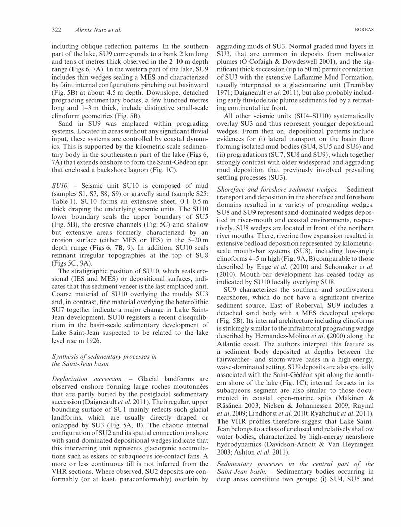
Synthetic view of the Lake Saint-Jean infill. – Threesynthetic profiles (Fig. 12A) compile the information
about the Lake Saint-Jean sedimentary architecturebased on the distribution of sediment bodies in theVHR sections. Extrapolating this spatial distributionfrom observed bathymetric patterns throughout thelake floor, a synthetic map is also proposed (Fig. 12B)that is an attempt to represent the inferred sedimentorganization prior to SU10 deposition.
Discussion
Based on the VHR profiles, our study evidences a majorchange in the Saint-Jean infill succession at the transi-tion from the extensive SU3 unit where settling pro-cesses prevailed to the overlying units (SU4 to SU9),which correspond to juxtaposed sedimentary bodiesincluding a significant contribution of hyperpycnalflows and bottom currents. In this section, we firstexplore the origin of this change in the temporal frame-work of the glacial to postglacial evolution character-ized by (i) the transition from a marine (Laflamme Gulfsensu stricto) to a lacustrine (Lake Saint-Jean sensustricto) setting and (ii) the retreat of the Laurentidian icefronts out of the Saint-Jean catchment. Then, the archi-tecture of mouth-bar and shelf-type bodies is discussedin the context of forced regression.
Onset of hyperpycnal flows
Erosive channels, SU4, SU5 and the SU6-type-2(Figs 5B, C, 8, 10C, D) have been interpreted asrelated to river-derived hyperpycnal flows. Hyper-pycnal flow events at river mouths necessitate a high,incoming riverine sediment load flowing into a rela-tively low-density water body (Mulder et al. 2003).During the Laflamme Gulf lifespan, and despite apossible connection with ice fronts, the sediment-charged river waters were probably not dense enoughto plunge beneath the cold marine waters that inhib-ited or at least minimized occurrences of hyperpycnalflows events (e.g. Mulder et al. 2003; St-Onge et al.2004). Owing to the marine to lacustrine transition at8.5±0.7 cal. ka BP, low-density fresh waters replacedmarine waters, leading to favourable conditions forthe genesis of hyperpycnal flows during a period withstill high glacier-derived sediment supply. Thus, theinception of hyperpycnal flow events should corre-spond to the early lacustrine period. Afterwards, whenthe ice-sheet disappeared from the Saint-Jean basincatchment, river discharge and sediment supply weredrastically reduced, probably resulting in less frequenthyperpycnal flow events. This model therefore consid-ers that a significant part of the SU4 bodies wouldhave been emplaced relatively early in the Lake Saint-Jean development (i.e. essentially between 8.5±0.7 cal.ka BP and 7.5 cal. ka BP).
The sharp stratigraphic relationships between SU3and the overlying units (SU4, SU5 and SU6-type-2)
Seismic-stratigraphic record of a deglaciation sequence, Québec, Canada 323BOREAS
indicate that SU3 deposition stopped before the incep-tion of hyperpycnal flow events in the Saint-Jean basin.The Laflamme Mud Formation is expected to be olderthan 8.5±0.7 cal. ka BP.
Extent of the wind-driven hydrodynamics inLake Saint-Jean
SU9 relates to coastal hydrodynamics. Some erosionsurfaces, SU6-type-1 and SU7 bodies are evidence forbottom currents over extensive surfaces of the lakefloor that have not been affected by fluvially derivedunderflows. The distribution of related deposits indi-cates processes occurring above the wave base, wherethe wind-driven hydrodynamics is strong enough togenerate erosion surface and to remobilize sediment.Bottom currents in deeper domains of the lake,however, require further clarifications.
The wave base in Lake Saint-Jean. – In the VHR pro-files, impact of wave action is poorly decipherable innorthern river mouths, moderate on the west coast(Fig. 5B) and stronger along the southern coast,where it resulted in a well-defined sand spit (Figs 6, 7).Today, active shoreline retrogradation occurs along
the northeastern shores (Pointe Taillon, Fig. 1A;Denis 1992). These contrasted evolutions can beattributed to (i) enhanced sediment supply andmouth-bar building in front of the Peribonka,Mistassini and Ashuapmushuan rivers, (ii) virtuallyno sediment supply along the southern lake shore and(iii) a regional wind regime with prevailing NW–SEorientations, generating a higher fetch at the south-eastern downwind shore of the lake. The infralittoralprograding wedge (Hernandez-Molina et al. 2000)identified in Lake Saint-Jean off Roberval (SU9,Fig. 5B) suggests current fairweather- and storm-wavebase limits at ∼5 and ∼7 m, respectively. Consideringthe minimum 2 m anthropogenic lake level rise in1926, the former wave bases would have been in the7–9 m depth interval relative to the present-day meanhighstand lake level. As a consequence, the develop-ment of mature erosion surfaces (MES) in the 0–10 mdepth range (Fig. 5B, C) is attributed to the present-day and pre-1926 shoreface hydrodynamics. A directwave action is, however, not responsible for erosionsurfaces observed at deeper (>10 m) depths.
Bottom currents. – Bottom currents inferred from SU6-type-1 and SU7 architectures not related to fluvially
Fig. 12. Synthetic morphosedimentary block diagram (A) and map (B) of Lake Saint-Jean. A. Synthetic basin-scale cross-sections showing thespatial organization of the seismic units, based on the interpretation of VHR sections (SU10 is not represented). Note that the morphology ofthe upper boundary of the basement is extrapolated from the draping pattern of SU3, the thickness of which might be locally overestimated.B. Synthetic map of sedimentary facies distribution before the 1926 anthropogenic transgression of Lake Saint-Jean. This figure is availablein colour at http://www.boreas.dk
324 Alexis Nutz et al. BOREAS

derived underflows are firm evidence for a wind-driveninternal water circulation in Lake Saint-Jean, as evi-denced for other lacustrine systems (Botte & Kay 2002;Steissberg et al. 2005; Bouchette et al. 2010). Internalwater circulation has to relate to the 90% of meanannual times of potential wind action over the LakeSaint-Jean surface (Meteorological Survey of Québec;http://www.climat-quebec.qc.ca).
Long-lasting wind-driven internal circulation led to(i) erosion and by-pass processes at the lake floor atdepths greater than 10 m, (ii) remobilization of sedi-ments and (iii) their redeposition in the form of SU6-type-1 (elongated separated drift bodies) and SU7(heterolithic shelf-type structure) sedimentary bodies.Both the marine Laflamme Gulf and the ensuing LakeSaint-Jean experience(d) a wind-driven circulation.However, the closing of the water body at the marine tolacustrine transition probably enhanced internal circu-lation patterns. Surface waters pushed by prevailingnorth or NW winds generated downwelling at thenewly formed southeastern lakeshore, resulting innorthwestward-oriented bottom currents. Water strati-fication induced by the previous estuary-type circula-tion that may have prevailed in the Laflamme Gulfshould have disappeared afterwards. In addition to theonset of hyperpycnal flow events off the river mouths,we thus suggest that the marine to lacustrine transitionalso strongly impacted the internal hydrodynamics,which generated bottom currents at the lake floor.
Stratigraphic signature of the postglacial rebound
The Saint-Jean system is an appropriate place to test,more specifically at the VHR seismic scale, if sequencestratigraphic concepts derived from marine shelvesenduring forced regression are applicable to Holocenebasins in which glacio-isostatic uplift occurs (Hart &Long 1996; Mäkinen & Räsänen 2003; Fraser et al.2005; Cummings et al. 2011; Eilertsen et al. 2011).
The signature of forced regression, i.e. regressioninduced by a relative base-level fall, is well-documentedin the geological record (e.g. Posamentier et al. 1992;Schwarz et al. 2006). A falling-stage system tract(FSST) sometimes has been determined (Hunt &Tucker 1992; Plint & Nummedal 2000; Catuneanuet al. 2009) that includes all the sediments depositedduring the fall of the base level, above a basal surfaceof forced regression (BSFR of Hunt & Tucker 1992;corresponding to the correlative conformity ofPosamentier & Allen 1999). The FSST, which is char-acterized by prograding and offlaping geometries,includes two internal erosional surfaces. The deeperone is formed in the lower shoreface and is attributed toa regressive surface of marine erosion (RSME). It isgenetically related to the wave action in an attempt tomaintain the concave-up equilibrium profile of theshoreface. At shallower depths, the surf diastem (SD) is
an erosion surface related to the seaward shift of thesurf zone (Swift et al. 2003). As a result, forced regres-sive sedimentary records in wave-dominated settingsmay include three successive depositional systems andtwo intervening erosional surfaces. Swift et al. (2003)distinguished from base to top: (i) a regressive shelfsystem, which is truncated upward by a regressiveravinement surface; (ii) an overlying regressiveshoreface system, truncated upward by a surf diastem;and (iii) ultimately a regressive strandplain system isdeposited above. Both the surf diastem and the regres-sive ravinement surface (here ascribed to a RSME) areerosion surfaces related to the descending shoreline tra-jectory (Helland-Hansen & Hampson 2009) and there-fore develop diachronously basinward.
In the Saint-Jean basin, active forced regression hasaffected the Laflamme Gulf (Roy et al. 2011) since theglaciomarine ice-front retreat. The entire Saint-Jeansedimentary succession thus is corresponding to afalling stage system tract, even if rates of base-level falldecreased drastically after threshold emergence (seeGeological setting section). The basal surface of forcedregression is essentially superimposed with the LatePleistocene glacial erosion surface. Based on distinctivestacking patterns on the VHR sections, we specificallyinvestigate hereafter forced-regressive architectures inthe mouth-bar domain in the north (Figs 5C, 9) and inthe spit–shelf domain in the SE (Figs 6, 7).
The mouth-bar domain. – The shallow, northern part ofthe lake was and is still submitted to the highest upliftrates. Here, the regressive succession relates to a rapidbasinward mouth-bar development that resulted fromrapidly decreasing accommodation space and highrates of sediment supply from the three major tributar-ies (Fig. 13A; see also Eilertsen et al. 2011). Relateddeposits sealed immature erosion surfaces (IES;Fig. 9B, C) due to high rates of delta progradationinhibiting the formation of a mature erosion surface(MES). In a sequence stratigraphic framework, imma-ture erosion surfaces (IES) are here similar to regressivesurfaces of marine erosion (RSME).
The spit–shelf domain. – In the southeastern downwindpart of the lake, SU7 and SU9 have been interpretedas shelf-type and shoreface constructions, respectively(Figs 6, 7). SU7 is bounded upward by a MESpresently sealed by SU10. This erosion surface thatlaterally merges into the lower boundary of SU9, cor-responds to a typical regressive ravinement surface(Fig. 13B), with a regressive shelf system below and aregressive shoreface system above (sensu Swift et al.2003). However, in Lake Saint-Jean, the erosionalsurface is too deep (>15 m) to be related to shorefaceerosion. Its origin is understood as related to bottom-current activity induced by wind-driven downwelling.The underlying shelf-type structure distinctively dis-
Seismic-stratigraphic record of a deglaciation sequence, Québec, Canada 325BOREAS
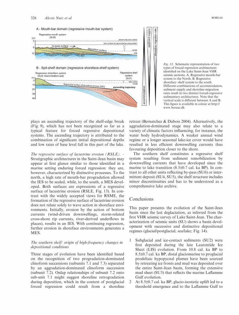
plays an ascending trajectory of the shelf-edge break(Fig. 9), which has not been recognized so far as atypical feature for forced regressive depositionalsystems. The ascending trajectory is attributed to thecombination of significant initial depositional depthsand low rates of base level fall in this part of the lake.
The regressive surface of lacustrine erosion (RSLE). –Stratigraphic architectures in the Saint-Jean basin mayappear at first glance similar to those identified in amarine setting enduring forced regression: they are,however, characterized by distinctive processes. To thenorth, a high rate of mouth-bar progradation allowedthe IES to be sealed, while, to the south, a MES devel-oped. Both surfaces are expressions of a regressivesurface of lacustrine erosion (RSLE, Fig. 13). In con-trast with the widely accepted views for RSME, theformation of the regressive surface of lacustrine erosiondoes not relate solely to wave action in shoreface envi-ronments. Initially, erosion by the action of bottomcurrents (wind-driven downwellings, storm-relatedcross-shore rip currents, river-derived underflows inplaces), results in an IES. With continuing regression,further erosion in shoreface environments generates aMES.
The southern shelf: origin of high-frequency changes indepositional conditions
Three stages of evolution have been identified basedon the recognition of two progradation-dominatedclinoform successions (subunits 7.1 and 7.3) separatedby an aggradation-dominated clinoform succession(subunit 7.2). Onlap relationships of subunit 7.2 ontosub-unit 7.1 might suggest shoreline retrogradationduring deposition, which in the context of postglacialforced regression could result from a shoreline
retreat (Bernatchez & Dubois 2004). Alternatively, theaggradation-dominated stage may also relate to avariety of climatic factors influencing, for instance, thewater body hydrodynamics. A weaker annual windregime or a longer seasonal lake-ice cover would haveresulted in less efficient downwelling currents thusfavouring deposition closer to the shore.
The southern shelf constitutes a regressive shelfsystem resulting from sediment remobilization bydownwelling currents that have developed since themarine to lake transition (8.5±0.7 cal. ka BP). In con-trast to all other units reflecting by-pass (SU6) or inter-mittent deposit (SU4, SU5), the shelf structure includesminor discontinuities and has to be understood as acomprehensive lake archive.
Conclusions
This paper presents the evolution of the Saint-Jeanbasin since the last deglaciation, as inferred from thefirst VHR seismic survey of Lake Saint-Jean. The char-acterization of seismic units (SU) shows a basin devel-opment with successive and distinctive depositionalregimes (glacial/postglacial; sea/lake; Fig. 14).
1 Subglacial and ice-contact sediments (SU2) werefirst deposited during the late Laurentide IceSheet (LIS) evolution. From 10.8 cal. ka BP to8.5±0.7 cal. ka BP, distal glaciomarine to proglacialprodeltaic hypopycnal plumes have been sourcedby retreating ice fronts and mud was deposited overthe entire Saint-Jean basin, forming the extensivemud sheet (SU3) that reflects the marine LaflammeGulf evolution.
2 At 8.5±0.7 cal. ka BP, glacio-isostatic uplift led to athreshold emergence and to the Laflamme Gulf to
Fig. 13. Schematic representation of twotypes of forced regression architecturesidentified on the Lake Saint-Jean VHRseismic sections. A. Regressive mouth-barsystem to the North. B. Regressiveshoreface–shelf system to the south.Different combinations of accommodation,sediment supply and shoreline migrationrates result in two distinct forced-regressivesedimentary architectures. Note that thevertical scale is different between A and B.This figure is available in colour at http://www.boreas.dk
326 Alexis Nutz et al. BOREAS

Lake Saint-Jean transition. Fresh water replacingdenser marine water favoured hyperpycnal flowevents, which transferred, via river systems, a largeamount of sediment from the continental LIS icefronts into the lake. Sediment drift (SU6-type-2),infill channel (SU5) and confined lobes (SU4) areinterpreted to have been essentially emplacedduring the c. 1000 years following the marine tolacustrine transition. The hydrodynamics of theenclosed water body were also profoundly modi-fied, initiating internal circulation patterns charac-terized by bottom currents and leading to thedevelopment of sediment drifts (SU6-type-1), aswell as the construction of the prograding shelf-typebody (SU7).
3 At 7.5 cal. ka BP, the disappearance of the LIS fromthe Lake Saint-Jean catchment resulted in anabrupt decrease of sediment supply, the diminutionof hyperpycnal flows events in magnitude and/orfrequency, and a relatively enhanced sedimentreworking. Sediment transfers linked to reworkingwere responsible for the development of erosionalsurfaces (MES, IES), enhanced sediment drift(SU6-type-1) and progradation of the shelf-typeprogradation (SU7) at the downwind side of the
lake. Hyperpycnal flows continued to feed confinedlobes (SU4) and constructive channels (SU5), evenif they represent subordinate systems at that time.
The Saint-Jean basin displays a comprehensive sedi-mentary record of a marine to lacustrine transition inthe context of a glacio-isostatically forced regression.This record shows how sediment can be deposited andremobilized during a complete deglaciation sequenceand may be an analogue for any studies focusing onforced regressive successions driven by either tectonicor climatic forcings, in Quaternary or older sedimen-tary successions. Although wind influence on lacustrinesystems and, more generally, on enclosed water bodieshas already been proposed, modelled or monitored,this study focusing on the Lake Saint-Jean evolutiondocuments at basin-scale a valuable set of spatiallydiversified architectures specifically reflecting wind-driven hydrodynamics and interactions with fluvio-deltaic depositional systems.
Acknowledgements. – We are grateful to the Parc national de laPointe-Taillon/Sépaq (D. Crépin and colleagues) for ideal workingfacilities and to Rio Tinto Alcan (R. Larouche and C. Jolette) forinterest and data. We are grateful to D. Roy’s tremendous knowledgeof the Lake Saint-Jean area and to the divers, Claude and Serge Gilly.
Fig. 14. Emplacement chronology of the different seismic units (SU). SU are related to variations in base-level fall, sediment supply andaccumulation rate which are estimated from the main depositional environment modifications in the Saint-Jean basin. 10.8 cal. ka BP: theLaurentidian ice-front is located at the present-day Alma town location; 8.5±0.7 cal. ka BP: threshold emergence that marks the emplacementof Lake Saint-Jean; 7.5 cal. ka BP: the ice-front retreat of the Saint-Jean catchment; 1926: dam construction at the Lake Saint-Jean outlet;1952: dam construction upstream of Lake Saint-Jean along the Peribonka river.
Seismic-stratigraphic record of a deglaciation sequence, Québec, Canada 327BOREAS

The seismic campaign was made possible thanks to the support of theGladys project and Université du Québec à Chicoutimi (Borealis shipand captain P. Nadeau). We acknowledge financial support from theCNRS-INSU (action SYSTER).
References
Ashton, A. D., Murray, A. B., Littlewood, R., Lewis, D. A. & Hong,P. 2011: Fetch-limited self-organisation of elongate water bodies.Geology 37, 187–190.
Bellair, P. 1971: Deglaciation, glacioeustatisme, isostasie: les mers duPost-glaciaire Canadien. Bulletin de l’Association française pourl’étude du Quaternaire 8, 51–55.
Bernatchez, P. & Dubois, J.-M. 2004: Bilan des connaissances de ladynamique de l’érosion des côtes du Québec maritime laurentien.Géographie physique et Quaternaire 58, 45–71.
Botte, V. & Kay, A. 2002: A model of the wind-driven circulationin Lake Baikal. Dynamics of Atmospheres and Oceans 35, 131–152.
Bouchette, F., Schuster, M., Ghienne, J.-F., Denamiel, C., Roquin,C., Moussa, A., Marsaleix, P. & Duringer, P. 2010: Hydrodynam-ics in Holocene Lake Mega-Chad. Quaternary Research 73, 226–236.
Catuneanu, O., Abreu, V., Bhattacharya, J. P., Blum, M. D.,Dalrymple, R. W., Eriksson, P. G., Fielding, C. R., Fisher, W. L.,Galloway, W. E., Gibling, M. R., Giles, K. A., Holbrook, J. M.,Jordan, R., Kendall, C. G. S. C., Macurda, B., Martinsen, O. J.,Miall, A. D., Neal, J. E., Nummedal, D., Pomar, L., Posamentier,H. W., Pratt, B. R., Sarg, J. F., Shanley, K. W., Steel, R. J.,Strasser, A., Tucker, M. E. & Wincker, C. 2009: Towards thestandardization of sequence stratigraphy. Earth-Science Reviews92, 1–33.
Côté, D., Dubois, J.-M. & Nadeau, L. 1990: Les dunes du Québecméridionale: contribution à l’étude des vents dominants durantl’Holocène. The Canadian Geographer 34, 49–62.
Cousineau, P. A. & Longuépée, H. 2003: Lower Paleozoic configu-ration of the Quebec reentrant based on improved along-strikepaleogeography. Canadian Journal of Earth Sciences 40, 207–219.
Cronin, T. M., Manley, P. L., Brachfeld, S., Manley, T. O., Willard,D. A., Guilbaut, J., Rayburn, J. A., Thunell, R. & Berke, M.2008: Impacts of lake drainage events and revised chronologyof the Champlain Sea episode 13-9 ka. Palaeogeography,Palaeoclimatology, Palaeoecology 262, 46–60.
Cummings, D. I., Gorrell, G., Guilbault, J., Hunter, J. A., Logan, C.,Ponomarenko, D., Pugin, J.-M., Pullan, S. E., Russell, H. A. J. &Sharpe, D. R. 2011: Sequence stratigraphy of a glaciated basin fill,with a focus on esker sedimentation. Geological Society of AmericaBulletin 123, 1478–1496.
Daigneault, R.-A., Cousineau, P. A., Leduc, E., Beaudoin, G.,Milette, S., Horth, N., Roy, D. W., Lamothe, M. & Allard, G.2011: Rapport final sur les travaux de cartographie des formationssuperficielles réalisés dans le territoire municipalisé du Saguenay-Lac-Saint-Jean (Québec) entre 2009 et 2011. Ministère desRessources naturelles et de la Faune, GM 65970.
Dansgaard, W., Johnsen, S. J., Clausen, H. B., Dahl-Jensen, D.,Gundestrup, N. S., Hammer, C. U., Hvidberg, C. S., Steffensen, J.P., Sveinbjornsdottir, A. E., Jouzel, J. & Bond, G. 1993: Evidencefor general instability of past climate from a 250-kyr ice-corerecord. Nature 364, 218–220.
Davidson-Arnott, R. G. D. & Van Heyningen, A. G. 2003: Migrationand sedimentology of longshore sandwaves, Long Point, LakeErie, Canada. Sedimentology 50, 1123–1137.
Denis, R. 1992: Etudes géomorphologiques des berges. 20 pp. Parc deconservation de la Pointe-Taillon, Alma.
Dionne, J.-C. 1972: La dénomination des mers du postglaciaire auQuébec. Cahiers de Géographie du Québec 16, 483–487.
Dionne, J.-C. 2000: Données complémentaires sur les variations duniveau marin relatif, à l’Holocène, à l’Anse de Bellechasse, sur lacôte sud du moyen estuaire du Saint-Laurent. Géographie physiqueet Quaternaire 54, 119–122.
Dionne, J.-C. & Occhietti, S. 1996: Aperçu du Quaternaire àl’embouchure du Saguenay, Québec. Géographie physique etQuaternaire 50, 5–34.
Duchesne, M. J., Pinet, N., Bédard, K., St-Onge, G., Lajeunesse, P.,Calvin Campbell, D. & Bolduc, A. 2010: Role of the bedrocktopography in the Quaternary filling of a giant estuarine basin: theLower St. Lawrence Estuary, Eastern Canada. Basin Research 22,933–951.
Dyke, A. S. 2004: An outline of North American Deglaciation withemphasis on central and northern Canada. In Ehlers, J. & Gibbard,P. L. (eds.): Quaternary Glaciations – Extent and Chronology, PartII, 373–424. Elsevier, Amsterdam.
Eilertsen, R. S., Corner, G. D., Aasheim, O. & Hansen, L. 2011:Facies characteristics and architecture related to palaeodepth ofHolocene fjord-delta sediments. Sedimentology 58, 1784–1809.
Enge, H. D., Howell, J. A. & Buckley, S. J. 2010: The geometry andinternal architecture of stream mouth bars in the Panther tongueand the Ferron sandstones members, Utah, U.S.A. Journal of Sedi-mentary Research 80, 1018–1031.
Faugères, J.-C., Stow, D. A. V., Imbert, P. & Viana, A. 1999: Seismicfeatures diagnostic of contourite drifts. Marine Geology 162, 1–38.
Fraser, C., Hill, P. R. & Allard, M. 2005: Morphology and faciesarchitecture of a falling sea level strandplain, Umiujaq, HudsonBay, Canada. Sedimentology 52, 141–160.
Fulton, R. J., Karrow, P. F., LaSalle, P. & Grant, D. R. 1986:Summary of Quaternary stratigraphy and history, eastern Canada.Quaternary Science Reviews 5, 211–228.
Hart, B. S. & Long, B. F. 1996: Forced regressions and lowstanddeltas: Holocene Canadian examples. Journal of SedimentaryResearch 66, 820–829.
Hebert, C. & Van Breemen, O. 2004: Mesoproterozoic basement ofthe Lac St. Jean Anorthosite Suite and younger intrusions in theSaguenay region, Quebec: Structural relationships and U-Pbgeochronology. In Tollo, R. P., Corriveau, L., McLelland, J. &Bartholomew, M. J. (eds.): Proterozoic Tectonic Evolution of theGrenville Orogen in North America: Boulder, Colorado, 65–79. Geo-logical Society of America, Memoir 197. Geological Society ofAmerica, Boulder, CO.
Helland-Hansen, W. & Hampson, G. J. 2009: Trajectory analysis:concepts and applications. Basin Research 21, 454–483.
Hernandez-Molina, F. J., Fernandez-Salas, L. M., Lobo, F.,Somoza, L., Diaz-del-Rio, V. & Alveirinho Dias, J. M. Z. 2000:The infralittoral prograding wedge: a new large-scale progra-dational sedimentary body in shallow marine environments.Geo-Marine Letters 20, 109–117.
Hillaire-Marcel, C. 1979: Les Mers Post-glaciaires du Québec:Quelques Aspects. Ph.D. thesis, Université Pierre et Marie Curie,293 pp.
Hunt, D. & Tucker, M. E. 1992: Stranded parasequences and theforced regressive wedge systems tract: deposition during base-levelfall. Sedimentary Geology 81, 1–9.
Kleman, J., Jansson, K., De Angelis, H., Stroeven, A. P.,Hättestrand, C., Alm, G. & Glasser, N. 2010: North American IceSheet build-up during the last glacial cycle, 115-21 kyr. QuaternaryScience Reviews 29, 2036–2051.
Laverdière, C. & Mailloux, A. 1956: Etat de nos connaissances d’unetransgression marine post-glaciaire dans les régions du Haut-Saguenay et du Lac Saint-Jean. Revue Géographique de Montréal10, 201–220.
Lavoie, D. & Asselin, E. 1998: Upper Ordovician facies in theLac Saint-Jean outlier, Quebec (Eastern Canada): palaeo-environmental significance for Late Ordovician oceanography.Sedimentology 45, 817–832.
Lindhorst, S., Fürstenau, J., Hass, H. C. & Betzler, C. 2010:Anatomy and sedimentary model of a hooked spit (Sylt, southernNorth Sea). Sedimentology 57, 935–955.
Mäkinen, J. & Räsänen, M. 2003: Early Holocene regressivespit-platform and nearshore sedimentation on a glaciofluvialcomplex during the Yoldia Sea and the Ancylus Lake phasesof the Baltic Basin, SW Finland. Sedimentary Geology 158, 25–56.
328 Alexis Nutz et al. BOREAS

Mangerud, J. & Gulliksen, S. 1975: Apparent radiocarbon ages ofrecent marine shells from Norway, Spitzbergen, and ArcticCanada. Quaternary Research 5, 143–172.
Manley, P. L., Manley, T. O., Hayo, K. & Cronin, T. 2012: Small-scale lacustrine drifts in Lake Champlain, Vermont. Journal ofGreat Lakes Research 38, 88–100.
Mitchum, R. M., Vail, P. R. & Thompson, S. 1977: Seismic stratig-raphy and global changes of sea level; Part 2, The depositionalsequence as a basic unit for stratigraphic analysis. In Payton, C. E.(ed.): Seismic Stratigraphy; Applications to Hydrocarbon Explora-tion, 53–62. American Association of Petroleum Geologists Memoir26. AAPG, Tulsa, OK.
Mulder, T., Syvitski, J. P. M., Migeon, S., Faugères, J.-C. & Savoye,B. 2003: Marine hyperpycnal flows: initiation, behavior and relateddeposits. A review. Marine and Petroleum Geology 20, 861–882.
Nielsen, L. H. & Johannessen, P. T. 2009: Facies architecture anddepositional processes of the Holocene – recent accretionaryforced regressive Skagen spit system, Denmark. Sedimentology 56,935–968.
Ó Cofaigh, C. & Dowdeswell, J. A. 2001: Laminated sediments inglacimarine environments: diagnostic criteria for their interpreta-tion. Quaternary Science Reviews 20, 1411–1436.
Occhietti, S., Govare, E., Klassen, R., Parent, M. & Vincent, J.-S.2004: Late Wisconsinan – early Holocene deglaciation of Québec-Labrador. In Ehlers, J. & Gibbard, P. L. (eds.): Quaternary Gla-ciations – Extent and Chronology, Part II, 243–273. Elsevier,Amsterdam.
Occhietti, S., Parent, M., Lajeunesse, P., Robert, F. & Govare, E.2011: Late Pleistocene-early Holocene Decay of the Laurentide icesheet in Québec-Labrador. In Ehlers, J., Gibbard, P.L. & Hughes,P.D. (eds.). Developments in Quaternary Science 15, 601–630.
Occhietti, S., Parent, M., Shilts, W. W., Dionne, J.-C., Govare, E. &Harmand, D. 2001: Late Wisconsian glacial dynamics,deglaciation, and marine invasion in southern Quebec. GeologicalSociety of America, Special Paper 351, 243–270.
Parent, M. & Occhietti, S. 1999: Late Wisconsinan deglaciation andglacial lake development in the Appalachians of southeasternQuébec. Géographie physique et Quaternaire 53, 117–135.
Plint, A. G. & Nummedal, D. 2000: The falling stage systems tract:recognition and importance in sequence stratigraphy analysis. InHunt, D. & Gawthorpe, R. L. (eds.): Sedimentary Response toForced Regression, 1–17. Geological Society, London, Special Pub-lication 172.
Posamentier, H. W. & Allen, G. P. 1999: Siliciclastic sequence stra-tigraphy: concepts and applications. Concepts in Sedimentologyand Paleontology 7, 210 pp.
Posamentier, H. W., Allen, G. P., James, D. P. & Tesson, M. 1992:Forced regressions in a sequence stratigraphic framework: con-cepts, examples, and exploration significance. American Associa-tion of Petroleum Geologists Bulletin 76, 1687–1709.
Rasmussen, S. O., Andersen, K. K., Svensson, A. M., Steffensen, J.P., Vinther, B. M., Clausen, H. B., Siggaard-Andersen, M. L.,Johnsen, S. J., Larsen, L. B., Dahl-Jensen, D., Bigler, M.,Rothlisberger, R., Fischer, H., Goto-Azuma, K., Hansson, M. E.& Ruth, U. 2006: A new Greenland ice-core chronology for thelast glacial termination. Journal of Geophysical Research 111, 1–15.
Raynal, O., Bouchette, F., Certain, R., Séranne, M., Dezileau, L.,Sabatier, P., Lofi, J., Bui Xuan Hy, A., Briqueu, L., Pezard, P. &Tessier, B. 2009: Control of alongshore-oriented sand spits on thedynamics of a wave-dominated coastal system (Holocene deposits,northern Gulf of Lions, France). Marine Geology 264, 242–257.
Rebesco, M., Camerlenghi, A., Volpi, V., Neagu, C., Accettella, D.,Lindberg, B., Cova, A., Zgur, F. & the Magico Party 2007: Inter-action of processes and importance of contourites: insights fromdetailed morphology of sediment Drift 7, Antarctica. In Viana,A. R. & Rebesco, M. (eds.): Economic and Palaeoceanographic
Significance of Contourite Deposits, 95–110. Geological Society,London, Special Publication 276.
Reimer, P. J., Baillie, M. G. L., Bard, E., Bayliss, A., Beck, J. W.,Blackwell, P. G., Bronk Ramsey, C., Buck, C. E., Burr, G. S.,Edwards, R. L., Friedrich, M., Grootes, P. M., Guilderson, T. P.,Hajdas, I., Heaton, T. J., Hogg, A. G., Hughen, K. A., Kaiser, K.F., Kromer, B., McCormac, F. G., Manning, S. W., Reimer, R.W., Richards, D. A., Southon, J. R., Talamo, S., Turney, C. S. M.,van der Plicht, J. & Weyhenmeyer, C. E. 2009: INTCAL09 andMARINE09 radiocarbon age calibration curves, 0–50,000 yearsCal BP. Radiocarbon 51, 1111–1150.
Rivers, T. 1997: Lithotectonic elements of the Grenville Province:review and tectonic implications. Precambrian Research 86, 117–154.
Roy, D. W., Beaudoin, G., Leduc, É., Rouleau, A., Walter, J.,Chesnaux, R. & Cousineau, P. A. 2011: Isostasie postglaciairedifférentielle au lac-Saint-Jean (Québec). GeoHydro 2011, JointMeeting of Canadian Quaternary Association (CANQUA) andCanadian Chapter of the International Association ofHydrogeologists (IAH-CNC), August 28–31, 2011. Quebec City.
Ryabchuk, D., Leont’yev, I., Sergeev, A., Nesterova, E.,Sukhacheva, L. & Zhamoida, V. 2011: The morphology of sandspits and the genesis of longshore sand waves on the coast of theeastern Gulf of Finland. Baltica 24, 13–24.
Schomaker, E. R., Vestheim Kjemperud, A., Nystuen, J. P. &Sigurd Jahren, J. 2010: Recognition and significance of sharped-based mouth-bar deposits in the Eocene Green River Formation,Uinta Basin, Utah. Sedimentology 57, 1069–1087.
Schwarz, E., Spaletti, L. A. & Howell, J. A. 2006: Sedimentaryresponse to a tectonically induced sea-level fall in a shallow back-arc basin: the Mulichinco Formation (Lower Cretaceous),Neuquén Basin, Argentina. Sedimentology 53, 55–81.
Shaw, J., Gareau, P. & Courtney, R. C. 2002: Palaeogeography ofAtlantic Canada 13-0 kyr. Quaternary Science Reviews 21, 1861–1878.
Steissberg, T. E., Hook, S. J. & Schladow, S. G. 2005: Characterizingpartial upwellings and surface circulation at Lake Tahoe,California–Nevada, USA with thermal infrared images. RemoteSensing of Environment 99, 2–15.
St-Onge, G., Lajeunesse, P., Duchesne, M. J. & Gagné, H. 2008:Identification and dating of a key Late Pleistocene stratigraphicunit in the St. Lawrence Estuary and Gulf (Eastern Canada). Qua-ternary Sciences Reviews 27, 2390–2400.
St-Onge, G., Mulder, T., Piper, D. J. W., Hillaire-Marcel, C. &Stoner, J. S. 2004: Earthquake and flood-induced turbidites in theSaguenay Fjord (Québec): a Holocene paleoseismicity record.Quaternary Science Reviews 23, 283–294.
Swift, D. J. P., Parsons, B. S., Foyle, A. & Oertel, G. F. 2003:Between beds and sequences: stratigraphic organization at inter-mediate scales in the Quaternary of the Virginia coast, USA.Sedimentology 50, 81–111.
Syvitski, J. P. M. & Praeg, D. B. 1989: Quaternary sedimentation inthe St. Lawrence Estuary and adjoining areas, eastern Canada:an overview based on high-resolution seismo-stratigraphy.Géographie physique et Quaternaire 43, 291–310.
Tremblay, A., Long, B. & Massé, M. 2003: Supracrustal faults of theSt-Lawrence rift system, Quebec: kinematics and geometry asrevealed by field mapping and marine seismic reflection data.Tectonophysics 369, 231–252.
Tremblay, G. 1971: Géologie et Géomorphologie quaternaires à l’Estdu Lac-Saint-Jean (Québec, Canada). Ph.D. thesis, Université deParis, 360 pp.
Zavala, C., Arcuri, M., Di Meglio, M., Gamero, H. & Contreras, C.2010: A genetic facies tract for the analysis of sustainedhyperpycnal flow deposits. In Slatt, M. & Zavala, C. (eds.): Sedi-ment Transfer from Shelf to Deep Water – Revisiting the DeliverySystem, 1–21. American Association of Petroleum GeologistsStudies in Geology 61. AAPG, Tulsa, OK.
Seismic-stratigraphic record of a deglaciation sequence, Québec, Canada 329BOREAS