Embed Size (px)
Citation preview

i
DRAFT
Section 2: Description of Plan Area Groundwater Sustainability Plan for
Santa Rosa Plain Groundwater Subbasin
Table of Contents 2 DESCRIPTION OF PLAN AREA (23 CCR 354.8 b) ............................................................... 2-1
2.1 General Setting and Jurisdictional Areas (23 CCR 354.8 b) .......................................... 2-1
2.2 General Land Use Characteristics (23 CCR 354.8 b) ..................................................... 2-6
2.3 Water Source Types and Water Use Sectors (23 CCR 354.8 b) .................................... 2-6
2.3.1 Groundwater ...................................................................................................... 2-11
2.3.2 Imported Surface Water .................................................................................... 2-13
2.3.3 Local Surface Water ........................................................................................... 2-13
2.3.4 Recycled Water .................................................................................................. 2-13
2.4 Existing Monitoring Programs and Networks (23 CCR 354.8 c, d, e) ......................... 2-13
2.4.1 Groundwater-level Monitoring .......................................................................... 2-13
2.4.2 Groundwater Quality Monitoring ...................................................................... 2-17
2.4.3 Climate Monitoring ............................................................................................ 2-18
2.4.4 Surface Water Monitoring ................................................................................. 2-18
2.4.5 Land Surface Subsidence Monitoring ................................................................ 2-21
2.5 Existing Management Programs and Studies (23 CCR 354.8 c, d, e) ......................... 2-21
2.5.1 Santa Rosa Plain Groundwater Management Program ..................................... 2-21
2.5.2 Urban Water Management Planning ................................................................. 2-22
2.5.3 North Coast Resource Partnership .................................................................... 2-24
2.5.4 Climate Change Studies and Planning ............................................................... 2-24
2.5.5 Groundwater Banking Feasibility Study ............................................................. 2-25
2.5.6 Water Conservation ........................................................................................... 2-25
2.5.7 Stormwater Management ................................................................................. 2-28
2.6 General Plan and Related Plan Land Use Categories ................................................. 2-30
2.6.1 General Plans ..................................................................................................... 2-31
2.6.2 Specific Area Plans ............................................................................................. 2-36
SECTION 2 — DESCRIPTION OF PLAN AREA (23 CCR 354.8 b) Santa Rosa Plain Subbasin GSP
ii
2.6.3 Sonoma County Local Agency Formation Commission ..................................... 2-36
2.7 Well Permitting Policies and Procedures ................................................................... 2-36
Tables
Table 2-1. Summary of Municipal General Plan Policies Specific to Groundwater ................... 2-34
Figures
Figure 2-1. Plan Area .................................................................................................................... 2-2 Figure 2-2. Elevation and Surface Water Features ...................................................................... 2-3 Figure 2-3. Jurisdictional and Protected Areas ............................................................................ 2-5 Figure 2-4a. Land Use (1999) ....................................................................................................... 2-7 Figure 2-4b. Land Use (2012) ....................................................................................................... 2-8 Figure 2-4c. Land Use, Crops, and Vegetation (2013) ................................................................. 2-9 Figure 2-5. Water Sector and Water Use ................................................................................... 2-10 Figure 2-6. Water Wells ............................................................................................................. 2-12 Figure 2-7a. Santa Rosa Plain Groundwater-Level Monitoring Network – Shallow Wells
(<200 ft) ..................................................................................................................... 2-15 Figure 2-7b. Santa Rosa Plain Groundwater-Level Monitoring Network – Deep Wells
(>200 ft) ..................................................................................................................... 2-16 Figure 2-7c. Climate Stations ..................................................................................................... 2-19 Figure 2-7d. Streamflow Monitoring Network .......................................................................... 2-20 Figure 2-8. General Plan Land Use Zoning ................................................................................. 2-33 Figure 2-9. County of Sonoma Groundwater Availability Classifications .................................. 2-38

2-1
2 DESCRIPTION OF PLAN AREA (23 CCR 354.8 B) This section provides a description of the area covered by the GSP (Plan Area), including the Santa Rosa Plain Groundwater Subbasin’s (Subbasin) general physical setting and jurisdictional areas; topography and surface water features; land use characteristics; water source types and uses; existing monitoring and management programs; applicable land use plans; and the well permitting process. The numbers in parentheses in each subheading indicate the applicable SGMA regulation.
2.1 General Setting and Jurisdictional Areas (23 CCR 354.8 b) The Plan Area for this GSP is the entire 80,000-acre Subbasin, which lies within the Coast Ranges geomorphic province and is one of three coastal alluvial subbasins of the Santa Rosa Valley Groundwater Basin (that is, Santa Rosa Plain, Healdsburg Area, and Rincon Valley) in the North Coast Hydrologic Region (Figure 2-1). It is generally bounded on the west by low-lying hills of the Mendocino Range and on the east by the Sonoma Mountains and Mayacamas Mountains. The Subbasin is approximately 22 miles long and the width varies from approximately 9 miles through the Santa Rosa area to 6 miles at the south end of the valley near the City of Cotati and narrows greatly at its northern end. The Subbasin includes the Town of Windsor, Cities of Cotati, Rohnert Park, Santa Rosa, and Sebastopol, and areas of unincorporated rural communities. Outside city limits, the Subbasin is characterized by native vegetation, rural properties, and agriculture – primarily vineyards but also nurseries, dairies, and row crops. The principal streams in the Subbasin are Mark West Creek, Santa Rosa Creek, and Laguna de Santa Rosa (Figure 2-2), which drain a combined watershed area of approximately 251 square miles.
Adjacent groundwater basins and subbasins are also shown on Figure 2-1 and include the very low-priority Healdsburg Area Subbasin (designated as basin 1-55.02 by DWR) to the north, the very low-priority Wilson Grove Formation Highlands Basin (designated as basin 1-059 by DWR) to the west, and the medium-priority Petaluma Valley Basin (designated as basin 2-001 by DWR) to the south. The very low-priority Alexander Area Subbasin (designated as basin 1-054.01 by DWR) and the very low-priority Rincon Valley Subbasin (designated as basin 1-054.03 by DWR) both abut a small eastern segment of the Subbasin boundary. The only adjacent GSA is the Petaluma Valley GSA, which formed in June 2017 and is responsible for implementing SGMA in the Petaluma Valley Basin. As very low-priority groundwater basins/subbasins, the Healdsburg Area, Wilson Grove Formation Highlands, Alexander Valley, and Rincon Valley are not required to form GSAs or develop GSPs; only high- and medium-priority basins are required to meet SGMA mandates.
Available technical information related to the hydrologic connection between the Santa Rosa Plain Subbasin and adjacent basins and subbasins is included in Section 3 (Basin Setting) and provisions for coordinating with applicable GSAs and other local agencies within neighboring basins and subbasins are described in Section 7 (Implementation Plan).

SECTION 2 — DESCRIPTION OF PLAN AREA (23 CCR 354.8 b) Santa Rosa Plain Subbasin GSP
2-2
Figure 2-1. Plan Area

SECTION 2 — DESCRIPTION OF PLAN AREA (23 CCR 354.8 b) Santa Rosa Plain Subbasin GSP
2-3
Figure 2-2. Elevation and Surface Water Features
SECTION 2 — DESCRIPTION OF PLAN AREA (23 CCR 354.8 b) Santa Rosa Plain Subbasin GSP
2-4
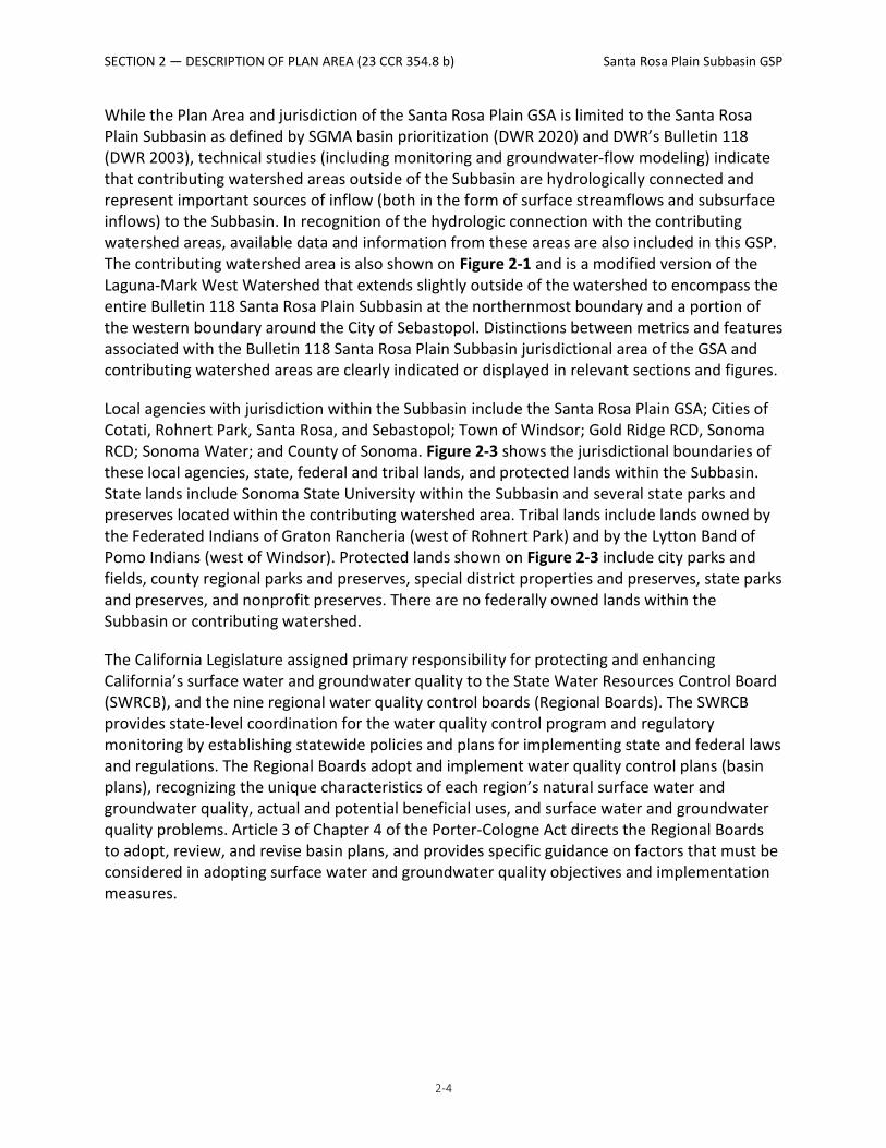
While the Plan Area and jurisdiction of the Santa Rosa Plain GSA is limited to the Santa Rosa Plain Subbasin as defined by SGMA basin prioritization (DWR 2020) and DWR’s Bulletin 118 (DWR 2003), technical studies (including monitoring and groundwater-flow modeling) indicate that contributing watershed areas outside of the Subbasin are hydrologically connected and represent important sources of inflow (both in the form of surface streamflows and subsurface inflows) to the Subbasin. In recognition of the hydrologic connection with the contributing watershed areas, available data and information from these areas are also included in this GSP. The contributing watershed area is also shown on Figure 2-1 and is a modified version of the Laguna-Mark West Watershed that extends slightly outside of the watershed to encompass the entire Bulletin 118 Santa Rosa Plain Subbasin at the northernmost boundary and a portion of the western boundary around the City of Sebastopol. Distinctions between metrics and features associated with the Bulletin 118 Santa Rosa Plain Subbasin jurisdictional area of the GSA and contributing watershed areas are clearly indicated or displayed in relevant sections and figures.
Local agencies with jurisdiction within the Subbasin include the Santa Rosa Plain GSA; Cities of Cotati, Rohnert Park, Santa Rosa, and Sebastopol; Town of Windsor; Gold Ridge RCD, Sonoma RCD; Sonoma Water; and County of Sonoma. Figure 2-3 shows the jurisdictional boundaries of these local agencies, state, federal and tribal lands, and protected lands within the Subbasin. State lands include Sonoma State University within the Subbasin and several state parks and preserves located within the contributing watershed area. Tribal lands include lands owned by the Federated Indians of Graton Rancheria (west of Rohnert Park) and by the Lytton Band of Pomo Indians (west of Windsor). Protected lands shown on Figure 2-3 include city parks and fields, county regional parks and preserves, special district properties and preserves, state parks and preserves, and nonprofit preserves. There are no federally owned lands within the Subbasin or contributing watershed.
The California Legislature assigned primary responsibility for protecting and enhancing California’s surface water and groundwater quality to the State Water Resources Control Board (SWRCB), and the nine regional water quality control boards (Regional Boards). The SWRCB provides state-level coordination for the water quality control program and regulatory monitoring by establishing statewide policies and plans for implementing state and federal laws and regulations. The Regional Boards adopt and implement water quality control plans (basin plans), recognizing the unique characteristics of each region’s natural surface water and groundwater quality, actual and potential beneficial uses, and surface water and groundwater quality problems. Article 3 of Chapter 4 of the Porter-Cologne Act directs the Regional Boards to adopt, review, and revise basin plans, and provides specific guidance on factors that must be considered in adopting surface water and groundwater quality objectives and implementation measures.

SECTION 2 — DESCRIPTION OF PLAN AREA (23 CCR 354.8 b) Santa Rosa Plain Subbasin GSP
2-5
Figure 2-3. Jurisdictional and Protected Areas

SECTION 2 — DESCRIPTION OF PLAN AREA (23 CCR 354.8 b) Santa Rosa Plain Subbasin GSP
2-6
The North Coast Regional Water Quality Control Board (NCRWQCB) implements water quality regulations in the watershed, including establishing Total Maximum Daily Loads for water quality impairments within the Laguna de Santa Rosa watershed, adopting General Waste Discharge Requirements for agricultural lands, dairies, recycled water , and for stormwater and wastewater discharges. The NCRWQCB and the California Department of Toxic Substances Control (DTSC) are responsible for regulating the cleanup of contaminant sites and contaminated groundwater; the GSA has no authority to regulate groundwater contaminant site cleanups or the migration of plumes.
2.2 General Land Use Characteristics (23 CCR 354.8 b) Land use maps for 1999, 2012, and 2013 within the Subbasin are shown on Figures 2-4a, 2-4b, and 2-4c, respectively. Land use mapping over the past several decades provides a measure of growth and land use changes in the Subbasin, which includes increases in residential and commercial land uses and irrigated agriculture and a resulting decrease in native vegetation or water (Figures 2-4a and 2-4b). Figure 2-4c presents more detailed classification of vegetation types within the Subbasin and contributing watershed areas from the Sonoma County Light Detection and Ranging (LiDAR) and Vegetation Mapping Program.
Existing land use conditions correlate most closely with the 2012 land use survey (DWR 2012) (Figure 2-4b), which indicates the Subbasin is primarily comprised of urban, residential, commercial, and industrial land uses (36 percent), and native vegetation or water (35 percent) with irrigated and non-irrigated agriculture making up approximately 26 percent of the land uses. The major urban and residential areas in the Subbasin include the Cities of Cotati, Rohnert Park, Santa Rosa, and Sebastopol, the Town of Windsor, several unincorporated communities, and areas of rural and semirural residential development.
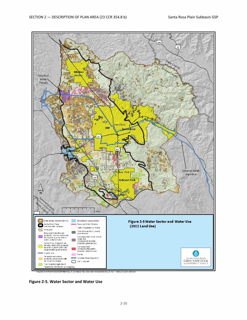
2.3 Water Source Types and Water Use Sectors (23 CCR 354.8 b) This GSP recognizes that the efficient use and conjunctive management of the various available water sources is integral to achieving sustainable groundwater management in the Subbasin. The Subbasin has four primary water sources: groundwater, imported surface water, local surface water, and recycled water. An overview of the spatial distribution of the reliance on the four primary water source types by primary water use sectors in the Subbasin is shown on Figure 2-5 and provided in Sections 2.4.1 through 2.4.4. Additional details on water uses associated with the Subbasin water budget are described in Section 3 (Basin Setting) and additional information on the availability and feasibility for future uses is included in Section 6 (Projects and Actions).
Initially, communities in the Santa Rosa Plain relied completely on abundant springs and surface water during its settlement and early growth period. Census information for Sonoma County indicates relatively flat population growth from 1890–1940, then growth increased until about 2000. Since then growth has slowed and has remained relatively constant. Local surface water supply accounted for approximately 3 percent of the water supply in the Subbasin in 2020.

SECTION 2 — DESCRIPTION OF PLAN AREA (23 CCR 354.8 b) Santa Rosa Plain Subbasin GSP
2-7
Figure 2-4a. Land Use (1999)

SECTION 2 — DESCRIPTION OF PLAN AREA (23 CCR 354.8 b) Santa Rosa Plain Subbasin GSP
2-8
Figure 2-4b. Land Use (2012)

SECTION 2 — DESCRIPTION OF PLAN AREA (23 CCR 354.8 b) Santa Rosa Plain Subbasin GSP
2-9
Figure 2-4c. Land Use, Crops, and Vegetation (2013)
SECTION 2 — DESCRIPTION OF PLAN AREA (23 CCR 354.8 b) Santa Rosa Plain Subbasin GSP
2-10
Figure 2-5. Water Sector and Water Use

SECTION 2 — DESCRIPTION OF PLAN AREA (23 CCR 354.8 b) Santa Rosa Plain Subbasin GSP
2-11
Historically, the Santa Rosa Plain relied completely on its local groundwater and surface water resources until 1959 with the completion of the Santa Rosa Aqueduct and initiation of Russian River-imported surface water deliveries resulting in a mix of imported surface water and groundwater to meet water supply demands. Deliveries to the City of Santa Rosa have been between 5,000 and 6,000 acre-feet per year (AFY) over the past 25 years. With the completion of the Russian River-Cotati Intertie pipeline in 1975, deliveries of Russian River-imported surface water began flowing to Cotati and the City of Rohnert Park. Deliveries to City of Rohnert Park ranged between 2,600 and 2,900 AFY between 1996 and 2003, a period of localized groundwater declines, increased to more than 4,000 AFY for a number of years, and has ranged between 2,200 and 3,000 AFY in more recent times. Deliveries to City of Cotati have ranged between roughly 400 and 800 AFY, and for the Town of Windsor ranged between 500 and 700 AFY over the same time period. Russian River-imported water supply accounts for about 45 percent of the Subbasin water supply today.
Growth in the wine industry and increasing vineyards in the Santa Rosa Plain accounts for most of the agricultural demand expansion, from about 2,500 acres of vineyards in 1974 to about 9,700 acres of vineyards in the Subbasin in 2016. Groundwater pumping for irrigated crops in the Subbasin was estimated through the groundwater model, ranging from 5,700 AFY to 13,900 AFY with a median of 9,000 AFY. Urban and private systems groundwater demands did not begin to ramp up until later due in part to the Santa Rosa Aqueduct imported water supplements beginning in the 1960s, followed by the Russian River-Cotati Intertie. Urban and small system groundwater pumping has ranged from 4,800 AFY to 11,100 AFY with a median of 8,000 AFY. Rural residential well pumping has ranged from 2,000 AFY to 2,900 AFY with a median of 2,600 AFY. Today, groundwater accounts for approximately 35 percent of the overall Subbasin water supply.
Deliveries of recycled water commenced in 1990 and is used for landscape and agricultural irrigation. An estimated 10,200 AFY has been used for the irrigation of vineyards, replacing groundwater pumping. Recycled water accounts for about 20 percent of the water supply in the Subbasin.
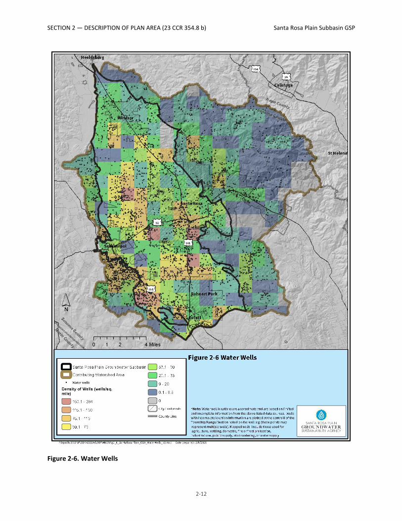
2.3.1 Groundwater Groundwater is the primary water supply for irrigated agriculture (where access to recycled water is not available), rural residential properties (including many mutual water companies), commercial and industrial users in unincorporated areas, and the City of Sebastopol. Groundwater is also the primary source of supply for California American Water Company’s Larkfield District, which also utilizes imported surface water as a source of secondary supply. Groundwater is also an important supplemental or backup source of supply for many of the municipal water purveyors, including Sonoma Water; the Cities of Santa Rosa, Rohnert Park, and Cotati, all of which operate municipal wellfields within the Subbasin and contributing watershed areas. Figure 2-6 shows the approximate location and density of water wells within the Subbasin and contributing watershed areas based on available data from DWR.
SECTION 2 — DESCRIPTION OF PLAN AREA (23 CCR 354.8 b) Santa Rosa Plain Subbasin GSP
2-12
Figure 2-6. Water Wells
SECTION 2 — DESCRIPTION OF PLAN AREA (23 CCR 354.8 b) Santa Rosa Plain Subbasin GSP
2-13
2.3.2 Imported Surface Water Imported water consists of Russian River water sourced from Sonoma Water’s production facilities located outside of the Subbasin that is delivered via aqueduct to the cities within the Subbasin. Imported surface water represents the primary source of water for urban residents and businesses that are served by the Cities of Cotati, Rohnert Park, and Santa Rosa, and the Town of Windsor.
2.3.3 Local Surface Water Local surface water from Mark West Creek, Santa Rosa Creek, and Laguna de Santa Rosa (Figure 2-2) and their tributaries represents an important source of supply for some water users. Information on the approximate amounts of surface water is available through reported surface water diversions filed with the California SWRCB (2018).
2.3.4 Recycled Water Recycled water is treated to tertiary standards by wastewater treatment plants operated by the Town of Windsor, the City of Santa Rosa, and Airport Larkfield (Figure 2-1), which is used for crop and landscape irrigation in lieu of using groundwater or imported water. Recycled water produced from the City of Santa Rosa’s Laguna Treatment Plant (serving Santa Rosa, Cotati, Rohnert Park, and Sebastopol) and the Town of Windsor’s Wastewater Treatment Facility is also delivered for energy generation to the Geysers Geothermal Steamfield located in the Mayacamas Mountains outside of the contributing watershed.
2.4 Existing Monitoring Programs and Networks (23 CCR 354.8 c, d, e) Existing monitoring programs and networks within the Subbasin have been developed and implemented by many agencies, organizations, and volunteers for a variety of purposes. This section provides a description of the existing monitoring programs and networks. An assessment of the existing monitoring networks and programs for their suitability to comply with DWR’s GSP Regulations, including identification of data gaps, is described in Section 5 (Monitoring Plan).
2.4.1 Groundwater-level Monitoring Numerous organizations within the Subbasin and contributing watershed areas collect groundwater-level measurements, including DWR; Sonoma Water; the Sonoma and Gold Ridge RCDs; the Cities of Cotati, Rohnert Park, and Santa Rosa; the Town of Windsor; Sonoma State University; and many operators of small mutual water systems. Permit Sonoma administers the Use Permit Groundwater Monitoring Program, which requires the measurement and reporting of groundwater levels on a quarterly or monthly basis for commercial and industrial projects requiring a use permit and using more than 0.5 AFY of water. Groundwater levels are measured from a combination of private wells, dedicated monitoring wells, and inactive and active public water supply wells.
The Groundwater-level Monitoring Network expanded significantly under the voluntary Santa Rosa Plain Groundwater Management Program (SRPGMP 2016) through public outreach and

SECTION 2 — DESCRIPTION OF PLAN AREA (23 CCR 354.8 b) Santa Rosa Plain Subbasin GSP
2-14
education to private well owners who volunteered to have their wells monitored. The majority of wells monitored in the program are voluntary private domestic and agricultural wells, with a smaller but significant portion of publicly owned water supply wells and dedicated monitoring wells.
Groundwater-level monitoring is generally conducted twice a year, in the spring and fall, at 134 groundwater-level monitoring program wells within the watershed, as shown on Figures 2-7a and 2-7b. A subset of the wells is monitored on a more frequent basis, including continuous monitoring using pressure transducers. The 134 wells in the existing monitoring program were subdivided according to their well-screen depth or total depth, where known, into the following categories:
• Less than 200 feet deep • 200 to 500 feet deep • Greater than 500 feet deep • Unknown well-screen and depth
DWR has measured groundwater levels in a network of wells within the Subbasin for decades. Most of these wells were incorporated into DWR’s monitoring network between the mid-1950s and 1981. Measurements are generally collected from these wells semiannually in the spring and fall, although a subset of wells are monitored monthly.
Groundwater-level data are available to the public from DWR, SWRCB, and the U.S. Geological Survey (USGS). The DWR California statewide Groundwater Elevation Monitoring (CASGEM) Program is a state program to compile groundwater-level monitoring data statewide from local monitoring programs. A subset of the Subbasin groundwater-level monitoring data is reported by Sonoma Water to the CASGEM program. The SWRCB GeoTracker program provides groundwater-level monitoring data on a number of soil and groundwater cleanup sites in the Subbasin. The USGS operates the National Water Information System (NWIS; https://waterdata.usgs.gov/nwis), which is a database of surface water and groundwater data.

SECTION 2 — DESCRIPTION OF PLAN AREA (23 CCR 354.8 b) Santa Rosa Plain Subbasin GSP
2-15
Figure 2-7a. Santa Rosa Plain Groundwater-Level Monitoring Network – Shallow Wells (<200 ft)

SECTION 2 — DESCRIPTION OF PLAN AREA (23 CCR 354.8 b) Santa Rosa Plain Subbasin GSP
2-16
Figure 2-7b. Santa Rosa Plain Groundwater-Level Monitoring Network – Deep Wells (>200 ft)
SECTION 2 — DESCRIPTION OF PLAN AREA (23 CCR 354.8 b) Santa Rosa Plain Subbasin GSP
2-17
2.4.2 Groundwater Quality Monitoring Groundwater quality data has been collected through many different programs and initiatives described in Sections 2.5.2.1 through 2.5.2.5. The synthesis and evaluation of results from the below-water quality monitoring programs are described in Section 3 (Basin Setting).
2.4.2.1 Public Water Supply Well Monitoring The SWRCB’s Division of Drinking Water (DDW) monitors public water system wells for compliance with California Code of Regulations (CCR) Title 22 requirements for drinking water standards. Title 22 includes standards relative to levels of organic and inorganic compounds such as metals, microbial compounds, and radiological analytes. Data are available for active and inactive drinking water sources, for water systems that serve the public, and wells defined as serving 15 or more connections, or more than 25 people per day. In the Subbasin, DDW wells were monitored for Title 22 requirements, including pH, alkalinity, bicarbonate, calcium, magnesium, potassium, sulfate, barium, copper, iron, zinc, and nitrate.
2.4.2.2 SWRCB Groundwater Ambient Monitoring and Assessment Program Established in 2000, the Groundwater Ambient Monitoring and Assessment (GAMA) Program monitors groundwater quality throughout the State of California. GAMA is intended to create a comprehensive groundwater monitoring program and increase public access to groundwater quality and contamination information. GAMA receives data from a variety of monitoring entities, including DWR, USGS, and the SWRCB.
2.4.2.3 Water Data Library DWR monitors groundwater quality data and reports the results through the Water Data Library. Samples are collected from a variety of well types including irrigation, stock, domestic, and some public-supply wells. Wells are not sampled regularly, and most wells have only 1 or 2 days’ worth of sampling measurements and large temporal gaps between the results. Constituents most frequently monitored include chloride, sodium, calcium, boron, magnesium, and sulfate. Measurements taken include conductance, pH, total alkalinity, and hardness. Additional dissolved nutrients, metals, and total dissolved solids (TDS) are also sampled but have fewer sample results available.
2.4.2.4 Santa Rosa Plain Salt and Nutrient Management Plan The Santa Rosa Plain Salt and Nutrient Management Plan (SNMP) was prepared in 2013 (City of Santa Rosa 2013a) in accordance with California’s Recycled Water Policy of 2009 (as amended in 2013 and 2018, SWRCB 2018) by the City of Santa Rosa in collaboration with partner agencies (Cities of Cotati, Sebastopol, Rohnert Park; Town of Windsor; and Sonoma Water). Santa Rosa submitted the final SNMP in 2013 and the NCRWQCB approved the SNMP in a letter dated September 1, 2015. The SNMP proposed a conceptual monitoring framework and implementation plan that the NCRWQCB approved as part of the SNMP review and approval process. A Revised Monitoring and Reporting Program (MRP) was submitted to the NCRWQCB in August 2021 and is currently being reviewed by the NCRWQCB (City of Santa Rosa 2021). Developed to comply with the SNMP, the MRP is proposed to include monitoring of TDS and

SECTION 2 — DESCRIPTION OF PLAN AREA (23 CCR 354.8 b) Santa Rosa Plain Subbasin GSP
2-18
nitrate using laboratory methods and pH, temperature, and electrical conductivity (EC) using field methods from six monitoring wells in an area of high recycled water application with higher potential risk to water quality in the central portions of the Subbasin. Upon the implementation of the MRP, monitoring efforts will be coordinated and, where possible, combined with the monitoring program described in Section 5 (Proposed Monitoring Program).
2.4.2.5 U.S. Geological Survey Special studies conducted by the USGS within the Santa Rosa Plain Subbasin have included the collection and analysis of groundwater quality data. Water quality analyses have included major ions, trace elements, nutrients, stable isotopes (oxygen-18 and deuterium), tritium, the radioactive isotope of carbon (carbon-14), and the stable isotope of carbon (carbon-13). Data collected by the USGS through these studies are available on the NWIS database (USGS 2021).
2.4.3 Climate Monitoring Climate-monitoring stations in the watershed provide part of the information necessary for forecasting weather conditions, flood preparedness, drought preparedness, water-supply planning, and for determining the Subbasin water budget. Climate-monitoring stations may include sensors to collect data on rainfall, air temperature, relative humidity, wind speed and direction, solar radiation, soil temperature, and moisture. Climate data (Figure 2-7c) in the Subbasin are collected by several stakeholders, agencies, and tools, including:
• Western Weather Group (http://www.westernwx.com/sonoma) • Community Collaborative Rain, Hail and Snow Network (CoCoRaHS 2021) • Sonoma Water, OneRain program (https://sonoma.onerain.com/home.php) • California Irrigation Management Information System (CIMIS; DWR 2021) • National Weather Service’s MesoWest gages • Pepperwood Preserve • National Oceanic and Atmospheric Administration’s (NOAA’s) National Climate Data Center
The primary weather station in the Subbasin, which has been used to calculate mean annual rainfall, is Climate Station Sonoma County Airport (National Climatic Data Center #7965). The station is located at the Charles M. Schulz Sonoma County Airport. Data are available from 1903 to the present at this station; however, the station dataset does not contain a complete record of daily rainfall.
2.4.4 Surface Water Monitoring Existing continuous surface water monitoring in the watershed includes nine stream gaging stations operated by the USGS, seven gages operated by Sonoma Water, and one stream gage operated by the Pepperwood Preserve (Figure 2-7d). Most streamflow records within the Plan Area date back to Water Year (WY) 1999 through the present. Data collection by Sonoma Water began in 2018.

SECTION 2 — DESCRIPTION OF PLAN AREA (23 CCR 354.8 b) Santa Rosa Plain Subbasin GSP
2-19
Figure 2-7c. Climate Stations

SECTION 2 — DESCRIPTION OF PLAN AREA (23 CCR 354.8 b) Santa Rosa Plain Subbasin GSP
2-20
Figure 2-7d. Streamflow Monitoring Network

SECTION 2 — DESCRIPTION OF PLAN AREA (23 CCR 354.8 b) Santa Rosa Plain Subbasin GSP
2-21
2.4.5 Land Surface Subsidence Monitoring There are two primary systems for monitoring land surface subsidence in the Subbasin, described as follows:
• To support the implementation of SGMA, subsidence is currently estimated every month by DWR using Interferometric Synthetic-Aperture Radar (InSAR) data. The InSAR data are spatially extensive (covering nearly the entire Subbasin) with data available monthly going back to 2015.
• In the Subbasin, global positioning system (GPS) stations monitored by the University NAVSTAR Consortium’s (UNAVCO) Plate Boundary Observatory (PBO) program are currently used as an indicator of subsidence. There are currently no regularly scheduled theodolite or total station surveys and no extensometers in the Subbasin. The UNAVCO PBO network consists of a network of about 1,100 continuous GPS and meteorology stations in the western United States used to monitor multiple pieces of information, including subsidence. There is one station in the Subbasin and two in the contributing watershed: (1) P197, located on Highway 12 at Fulton Road; (2) P196, located along Meacham Road southeast of Cotati, and (3) P201, located on the ridgetop just north of Mark West Quarry.
2.5 Existing Management Programs and Studies (23 CCR 354.8 c, d, e) There are many existing and previous water management programs, studies, and initiatives covering the Subbasin that have been developed for a variety of purposes by multiple agencies and organizations. This section summarizes those deemed most relevant to groundwater management planning and indicates the type of information from these plans that is incorporated into subsequent sections of this GSP.
2.5.1 Santa Rosa Plain Groundwater Management Program The USGS completed two groundwater studies of the Santa Rosa Plain Watershed in collaboration with Sonoma Water; the Cities of Cotati, Rohnert Park, Santa Rosa, and Sebastopol; the Town of Windsor; Sonoma County; and the California American Water Company (Nishikawa 2013; Woolfenden and Nishikawa 2014).
These studies formed the basis of the 2014 Santa Rosa Plain Watershed Groundwater Monitoring Plan, developed for the Santa Rosa Plain Watershed under the leadership of a Basin Advisory Panel, composed of a diverse group of local stakeholders. The Groundwater Monitoring Plan was prepared under the authority of the Groundwater Management Act, California Water Code (Water Code) Section 10750 et seq., originally enacted as Assembly Bill (AB) 3030 in 1992 to encourage voluntary, nonregulatory groundwater management at the local level.
The Groundwater Monitoring Plan goal was to locally and voluntarily manage, protect, and enhance groundwater resources for all beneficial uses in a sustainable, environmentally sound, economical, and equitable manner for generations to come. This plan identified a range of voluntary water management actions, including groundwater recharge, groundwater banking,

SECTION 2 — DESCRIPTION OF PLAN AREA (23 CCR 354.8 b) Santa Rosa Plain Subbasin GSP
2-22
increased water-use efficiency, and greater use of recycled water to reduce demand for groundwater. Key information, tools, and outcomes from these previous groundwater management planning activities include the following:
• Technical information on the Subbasin hydrology, hydrogeologic framework, water chemistry and source, surface water and groundwater interaction monitoring, and records of groundwater levels.
• Significant expansion of monitoring activities.
• Initiation of studies for groundwater banking and stormwater recharge.
• Initial scoping of projects and actions to sustain groundwater resources in the Santa Rosa Plain.
• Engagement of local stakeholders in local groundwater planning and management.
Concurrently, the USGS and Sonoma Water entered into a cooperative agreement for the development of an integrated computer model (GSFLOW) of surface water and groundwater systems in the Subbasin and contributing watershed area.
In 2017, as the Santa Rosa Plain GSA was forming and beginning to assume management responsibilities for the Subbasin under SGMA, the Basin Advisory Panel and Technical Advisory Committee dissolved.
2.5.2 Urban Water Management Planning Municipalities and other urban water providers regularly assess future water supplies, through both mandated Urban Water Management Plans (UWMPs) and other documents or processes.
UWMPs are prepared every 5 years by California's urban water suppliers to support long-term resource planning and ensure adequate water supplies are available to meet existing and future water demands. Every urban water supplier that either provides more than 3,000 AFY of water or serves more than 3,000 customers is required to assess the reliability of its water sources over a 20-year planning horizon considering normal, dry, and multiple dry years. The plans are submitted to DWR, which then reviews the submitted plans to ensure they have completed the requirements identified in the Urban Water Management Planning Act (Division 6 Part 2.6 of the Water Code Sections 10610–10656).
Within the Subbasin, UWMPs are prepared by Sonoma Water (as a wholesaler) and the Cities of Cotati, Rohnert Park, and Santa Rosa, and the Town of Windsor (as water retailers). The City of Sebastopol currently serves fewer than 3,000 customers and supplies less than 3,000 AFY and is, therefore, not required to prepare an UWMP. California American Water Company’s Larkfield District has not historically prepared a UWMP because it serves fewer than 3,000 customers, but is preparing one in 2021. The UWMPs discuss and describe the following:

SECTION 2 — DESCRIPTION OF PLAN AREA (23 CCR 354.8 b) Santa Rosa Plain Subbasin GSP
2-23
• Existing water supplies and infrastructure
• Projected water demands over the next 20 years, based on population growth projections, land use designations and growth policies in city and county general plans
• Projected water supplies available over the next 20 years, the reliability of that supply, and general plans for water supply projects
• Current and planned water conservation activities, targets, and compliance
• A water shortage contingency analysis
• A comparison of water supply and water demand over the next 20 years under different hydrological assumptions (normal year, single dry year, and four consecutive dry years)
Because local groundwater makes up a portion of the water supply for urban purveyors within the Subbasin, the UWMPs also discuss and describe groundwater production facilities, historical and projected groundwater use, and the conditions of the groundwater basin. Thus, UWMPs serve as a routine mechanism for local urban water providers to coordinate and plan for future urban groundwater use. The most recent projections for future urban groundwater use are incorporated into the projected water budget described in Section 3 (Basin Setting). However, it is noted that UWMPs do not consider rural residential, agricultural and small municipal/mutual water systems.
In addition to the state-required UWMPs, many local urban water providers perform other water supply planning activities related to groundwater, including the development of water master plans, preparation of water-supply assessments for larger proposed developments (more than 500 dwelling units or equivalent), updates of city and county general plans as described above, and other activities. Information regarding some of these activities is summarized as follows:
• The Cities of Cotati (Cotati 2011), Santa Rosa (City of Santa Rosa 2014), Sebastopol (City of Sebastopol 2005), and the Town of Windsor (Town of Windsor 2011) have developed Water Master Plans, which assess water-supply needs and describe planned projects.
• The City of Santa Rosa adopted a Groundwater Master Plan (City of Santa Rosa 2013c) to provide strategic direction for managing the groundwater resources within the urban growth boundary of the city. The master plan integrates groundwater and surface water protection and management with water conservation and reuse to increase groundwater reliability and sustainability. The master plan includes the following:
o Recommendations for an emergency groundwater supply plan
o Development of a key well monitoring network
o Conceptual evaluation of aquifer storage and recovery (ASR)
SECTION 2 — DESCRIPTION OF PLAN AREA (23 CCR 354.8 b) Santa Rosa Plain Subbasin GSP
2-24
o Recommended groundwater policies designed to guide the future role of groundwater and promote balanced use and sustainability for the groundwater resources available to the city
o Identification of specific groundwater projects and programs based on these recommended policies
• Sonoma Water has developed a Water Supply Strategies Action Plan in coordination with its water contractors to increase water supply system reliability, resiliency, and efficiency in the face of limited resources, regulatory constraints, and climate change uncertainties (Sonoma Water 2018).
• Beginning with passage of SB 610 in 2002, water-supply assessments must be furnished to local governments for inclusion in any environmental documentation for certain projects that are subject to CEQA (as defined in Water Code 10912[a]). The water-supply assessments are required to determine water-supply sufficiency for a 20-year projection in addition to the demand of existing and other planned future uses.
2.5.3 North Coast Resource Partnership In 2002, the California State Legislature approved the Integrated Regional Water Management Planning Act (SB 1672). The implementation of the Act facilitates regional cooperation in water resources planning, and along with the passage of Propositions 50, 84, 1E, and 1, has provided grant funding for projects identified in a regional plan, referred to as an Integrated Regional Water Management Plan (IRWMP).
The North Coast IRWMP was formed in 2004 as a voluntary, nonregulatory, stakeholder-driven planning meant to emphasize shared priorities and local autonomy, authority, knowledge, and approaches to achieving tribal, state, regional, and local priorities related to North Coast water infrastructure, watersheds, public health, and economic vitality. The North Coast IRWMP changed its name in early 2013 to the North Coast Resource Partnership (NCRP). The NCRP continues to focus on areas of common interest and concern to North Coast stakeholders, and on attracting funding to the North Coast Region, and recognizes unique local solutions in different parts of the region (https://northcoastresourcepartnership.org).
The NCRP serves as a comprehensive planning tool that links other water resources management plans and programs through collaborative processes, coordination, and communication.
2.5.4 Climate Change Studies and Planning Projected changes in climate include increased variability in precipitation and rises in air temperature, resulting in a shorter wet season, longer dry season, more droughts, and more extreme high flows. To face these potential changes in climate, local organizations are working with federal and state partners, including the USGS, DWR, NOAA, and the U.S. Army Corps of Engineers to advance the science in our region in an effort to plan for and adapt to predicted changes. Local agencies have also partnered to form the Sonoma County Regional Climate
SECTION 2 — DESCRIPTION OF PLAN AREA (23 CCR 354.8 b) Santa Rosa Plain Subbasin GSP
2-25
Protection Authority and developed a regional Climate Action Plan (Sonoma County Regional Climate Protection Authority 2016). Findings and results from these efforts are described in Section 3 (Basin Setting) and incorporated into future model projections in this GSP. In addition, the City of Santa Rosa has prepared two Climate Action Plans: the communitywide Climate Action Plan (City of Santa Rosa 2012) and the Municipal Operations Climate Action Plan (City of Santa Rosa 2013b).
2.5.5 Groundwater Banking Feasibility Study Because of uncertainties in the reliability of regional future water supplies (both surface water and groundwater), Sonoma Water; the Cities of Rohnert Park, Cotati, and Sonoma; Valley of the Moon Water District; and the Town of Windsor conducted the Groundwater Banking Feasibility Study for a regional groundwater banking program to investigate the viability of enhancing the conjunctive management of surface water and groundwater resources (GEI Consultants, Inc. et al. 2013).
Conceptually, the groundwater banking program would involve the diversion and transmission of surplus Russian River water produced at existing drinking water production facilities during wet weather conditions (that is, the winter and spring seasons) for storage in the Santa Rosa Plain Groundwater Subbasin and/or Sonoma Valley Groundwater Subbasin. The stored water would then be available for subsequent recovery and use during dry weather conditions (that is, the summer and fall seasons) or emergency situations. The Groundwater Banking Feasibility Study provided an evaluation of the regional needs and benefits, source water availability and quality, regional hydrogeologic conditions, and alternatives for groundwater banking.
Based on the findings from the study, pilot studies to further assess the technical feasibility of ASR as a method for groundwater banking were recommended and currently are being pursued in the City of Sonoma, where a pilot project was completed in fall of 2018. The pilot project resulted in the empirical verification of specific hydrogeologic and water quality factors. The next steps are a technical and economic viability assessment of ASR technology in the region. If deemed feasible, the pilot project results could be used to complete environmental documentation and design for a full-scale or permanent ASR project in the region. Results from the pilot project also provided information on the technical feasibility for ASR in Sonoma Valley to other local agencies.
2.5.6 Water Conservation Numerous regional and local water conservation programs are operational in the Plan Area including the Sonoma-Marin Saving Water Partnership, the LandSmart Program, and the Sustainable Winegrowing Program.
These programs are described in Sections 2.6.6.1, 2.6.6.5, and 2.6.6.6, respectively, however, it is anticipated that changes will likely occur as a result of sweeping legislation approved in 2018: AB 1668 (Friedman) and SB 606 (Hertzberg), which lay out a new long-term water conservation framework for California. The framework addresses both the urban and agricultural sectors, with goals to establish long-term improvements in water conservation and drought planning

SECTION 2 — DESCRIPTION OF PLAN AREA (23 CCR 354.8 b) Santa Rosa Plain Subbasin GSP
2-26
that recognize the need to adapt to climate change and the resulting longer and more intense droughts in California. The development of programs and initiatives is organized around four primary goals as follows:
1. Use water more wisely 2. Eliminate water waste 3. Strengthen local drought resilience 4. Improve agricultural water-use efficiency and drought planning
To fully plan, develop, and implement the new framework, DWR and the SWRCB are working together in collaboration with stakeholders to develop new standards for the following:
• Indoor residential water use
• Outdoor residential water use
• Commercial, industrial, and institutional (CII) water use for landscape irrigation with dedicated meters
• Water loss
Based on these standards, urban water suppliers will be required to stay within annual water budgets for their service areas. In addition, water suppliers will need to report on implementation of new performance measures for CII water use.
The legislation also made important changes to existing urban and agricultural water management planning, and enhanced drought preparedness and water shortage contingency planning for both urban water suppliers and small water systems and rural communities. Currently, state agencies are conducting needed studies and investigations, and developing standards and performance measures, web-based tools and calculators, data and data platforms, reports, and recommendations for adoption of new regulations.
2.5.6.1 Sonoma-Marin Water Saving Partnership The Sonoma-Marin Saving Water Partnership represents 10 water utilities in Sonoma and Marin counties that are signatories to the California Water Efficiency Partnership and have joined to create a regional approach to water-use efficiency. Within the Subbasin, these utilities include the Cities of Cotati, Rohnert Park, and Santa Rosa; the Town of Windsor; California American Water Company’s Larkfield District and Sonoma Water. Water conservation and water-use efficiency program elements specific to the Sonoma-Marin Saving Water Partnership include the following:
• Establishing a conservation coordinator and water waste prohibition, assistance, and water loss control programs (audits, leak detection, and repair).
• Metering urban water and conservation pricing (tiered structure).

SECTION 2 — DESCRIPTION OF PLAN AREA (23 CCR 354.8 b) Santa Rosa Plain Subbasin GSP
2-27
• Developing and maintaining public information and school education programs on water and conservation.
• Increasing conservation through specific urban residential programs for increasing indoor (high-efficiency toilets, fixtures, and washers) and outdoor (landscaping assistance, surveys, and retrofits) conservation.
• Increasing conservation through specific industrial and large-landscape assistance, surveys, and retrofits.
• Initiating rebate programs for high-efficiency appliances and fixtures.
• Training for qualified water efficient landscapers that provides education on proper plant selection for local climates, irrigation-system design and maintenance, and irrigation-system programming and operation.
• Offering an online water wise gardening website that offers a Mediterranean and native plant list, design and garden installation tips, and irrigation-system design and maintenance information.
• Providing a green business program that provides businesses with water and energy conservation information and incentives, to reduce waste and prevent pollution.
In addition to the partnership, its member agencies and the City of Sebastopol have water conservation programs to assist their communities in improving water-use efficiency to reduce water waste.
2.5.6.2 Windsor Pay as You Save Windsor Efficiency “pay as you save” is a mechanism to provide efficiency upgrades for Town of Windsor home and apartment occupants. Examples of water efficiency measures eligible under the program are high-efficiency showerheads, toilets, faucet aerators, drought-resistant landscaping, and high-efficiency clothes washers.
2.5.6.3 Model Water Efficient Landscape Ordinances Governor Brown’s Drought Executive Order of April 1, 2015 (EO B-29-15) directed DWR to update the state’s Model Water Efficient Landscape Ordinance (MWELO) through expedited regulation. Local agencies must adopt the MWELO or adopt a local ordinance that must be at least as effective in conserving water as MWELO by December 1, 2015. Executive Order B-29-15 and the revised ordinance require that local agencies report on the implementation and enforcement of their single agency Local Ordinances to DWR by December 31, 2015. Reporting for all agencies is due by January 31 of each year thereafter.
The county and cities have all developed individual water efficient landscape ordinances. The new water efficient landscape ordinances require a landscape plan check for certain projects, as

SECTION 2 — DESCRIPTION OF PLAN AREA (23 CCR 354.8 b) Santa Rosa Plain Subbasin GSP
2-28
described in each ordinance. It includes requirements for landscape water budgets, landscape and irrigation design, and irrigation scheduling.
2.5.6.4 Rural Landowner Programs There are also resources for implementing water conservation practices for rural landowners not connected to city water utilities or who are ineligible for urban water conservation program rebates. These include the following:
• A water conservation and stormwater management guide for all types of landowners is called Slow it. Spread it. Sink it. Store It! produced by the Sonoma RCD (2015). This homeowner’s and landowner’s guide offers many ideas and tips on practices that can help to protect and replenish groundwater resources, reduce erosion and pollution, prevent flooding, and increase water conservation and stormwater management.
• A guide focusing on rainwater catchment systems called Roof Water Harvesting for a Low Impact Water Supply, Featuring the Brazilian Ball Pre-Filter System: A Case Study produced by the Occidental Arts and Ecology Center’s WATER Institute (2008).
2.5.6.5 LandSmart Program The Sonoma RCD, Napa RCD, and the U.S. Department of Agriculture (USDA) Natural Resources Conservation Service developed the LandSmart Program to promote productive lands and thriving streams through planning and on-the-ground implementation of beneficial management practices, including efficient irrigation. LandSmart Plans are developed by the agricultural producer, who can also seek certification from the RCD's certification team once plans are complete. Plan templates and guidance materials are designed to assess current practices and identify recommendations for other practices that would benefit natural resources such as water quantity and quality. Practices are prioritized and tracked over time. Information on the LandSmart Program is available at www.LandSmart.org.
2.5.6.6 Sustainable Winegrowing Members of Wine Institute and the California Association of Winegrape Growers introduced the Code of Sustainable Winegrowing Practices Self-Assessment Workbook in 2002 (updated in 2006, 2013, and 2020) to promote environmental stewardship and social responsibility in the California wine industry (California Sustainable Winegrowing Alliance 2020). The workbook addresses a number of criteria for measuring performance, including Vineyard Water Management and Winery Water Conservation and Quality. More information on sustainable winegrowing practices is available at http://www.sustainablewinegrowing.org/. Additionally, the Sonoma County Winegrowers have developed a Sustainability Certification Program for vineyards, which includes water conservation assessments.
2.5.7 Stormwater Management The need for integrating appropriate stormwater management practices while protecting and preserving groundwater resources is increasingly recognized by decision makers and such practices have been integrated into several initiatives and planning efforts.

SECTION 2 — DESCRIPTION OF PLAN AREA (23 CCR 354.8 b) Santa Rosa Plain Subbasin GSP
2-29
2.5.7.1 Storm Water Resources Plans Storm Water Resources Plans (SWRPs) are required by Senate Bill 985 (Pavley 2014) to be eligible to seek funding from any future state bond measures for stormwater projects. A SWRP is a nonregulatory, watershed-based, and stakeholder-driven plan that builds on local stormwater management objectives and identifies and prioritizes projects that capture, treat, or reuse stormwater and dry weather runoff. The Russian River Storm Water Resource Plan was developed by the Russian River Watershed Association for the Russian River Watershed (which includes the Subbasin) with support from local agencies and partners to identify and prioritize stormwater management projects (Russian River Watershed Association 2018). These projects must provide at least two benefits, which may include environmental enhancement, flood protection, groundwater recharge, water quality improvement, and/or recreational opportunities. The Russian River SWRP provides a framework for submitting, quantifying, scoring, and ranking future projects in an objective and data-driven format.
2.5.7.2 Stormwater Management-Groundwater Recharge Sonoma Water conducted scoping studies in three of its flood zones to identify opportunities to alleviate flooding, while possibly recharging groundwater aquifers or providing other benefits. The Stormwater Management-Groundwater Recharge study (Sonoma Water 2012) assessed the feasibility of projects in Laguna-Mark West watershed (subwatershed of the Santa Rosa Plain Watershed), which informed the development of the Russian River SWRP.
Local growers have also been investigating the feasibility of performing on-farm recharge projects within the Subbasin through the performance of pilot studies and field investigations.
2.5.7.3 Municipal Stormwater Permit Program California’s Municipal Storm Water (MS4) Permitting Program regulates stormwater discharges through a permitting program under the National Pollution Discharge Elimination System (NPDES). Sonoma Water is a co-permittee with the City of Santa Rosa and the County of Sonoma inside the same MS4 permit boundary, incorporating most of the Subbasin. The City of Santa Rosa and unincorporated areas near the Cities of Healdsburg, Santa Rosa, Rohnert Park, Cotati, and Sebastopol, and the Town of Windsor are included in the permit.
In early 2013, jurisdictions that had been designated as Phase II municipalities within the Russian River watershed were provided an option to align with the Phase I program in an effort for watershed-wide consistency and collaboration. The Cities of Cloverdale, Cotati, Rohnert Park, Healdsburg, Sebastopol, Ukiah, and the Town of Windsor, and the Phase II-designated portions of the County of Sonoma elected to participate in the Phase I program as Co-Permittees.
To comply with the MS4 permit, the City of Santa Rosa and County of Sonoma developed a Low Impact Development Technical Design Manual (2011), which provides technical guidance for project designs that require the implementation of permanent stormwater best management practices (BMPs). Low-impact development, as it relates to stormwater, aims for a design to mimic the hydraulic function of an undeveloped site by capturing, treating, and infiltrating
SECTION 2 — DESCRIPTION OF PLAN AREA (23 CCR 354.8 b) Santa Rosa Plain Subbasin GSP
2-30
stormwater as close to the source as possible, and locating small scale landscape-based features throughout the project site. Each Co-Permittee is responsible for applying these permit requirements in conformance with this manual, at a minimum, to new development, retrofit projects, and applicable infrastructure improvement projects within their jurisdiction.
2.5.7.4 Water Smart Development Guidebook Sonoma Water developed the Water Smart Development Guidebook (2013) to provide Sonoma County land developers; city and county planning officials; and environmental-regulatory agencies with a reference guide that can help them avoid and minimize potential adverse impacts on water resources from development projects. The guidebook provides guidance for planning and designing water resource-related project elements for residential and commercial developments. The three core guidebook sections focus on ways to increase water conservation and water reuse and reduce stormwater impacts.
2.6 General Plan and Related Plan Land Use Categories Existing city and county planning activities that are directly or indirectly linked with water supply and groundwater management include general plans, and specific plans, which are described in Section 2.2.1 through 2.2.2. and UWMPs, Under SGMA, cities and counties retain their land use authorities; however, in recognizing the linkages between land use and water management, SGMA does require increased coordination between land use planners and GSAs. Cities and counties must now refer proposed general plan changes to GSAs, and similarly GSPs must consider “the most recent planning assumptions stated in local general plans of jurisdictions overlying the basin” (CWC Section 10726.9). In addition, Government Code Section 65350.5 stipulates that before general plans are adopted other GSPs must be reviewed and considered.
Future land use planning and associated growth projections are incorporated into the analysis of the projected water budget, over the planning and implementation horizon (Section 3, Basin Setting).
The Cities of Cotati, Rohnert Park, Santa Rosa, and Sebastopol, the Town of Windsor, and Sonoma County general plans and specific plans provide growth estimates that are used in the UWMPs and in this GSP to project future water demands. These growth estimates are incorporated into the sustainable management criteria and metrics, including measurable objectives and interim milestones, the sustainability goal, proposed projects, and management actions. Projections of future groundwater availability and planned projects and actions needed for sustaining groundwater resources in the Subbasin will be shared with city and county planners for incorporation into their respective land use planning and decision-making.
In addition to coordinating on activities within the Subbasin, coordination and information sharing between the GSA and land use planning agencies will be needed for the contributing watershed areas located outside of the GSA’s jurisdiction, as described in Section 7 (Implementation Plan). These areas primarily fall within the purview of the Sonoma County General Plan.

SECTION 2 — DESCRIPTION OF PLAN AREA (23 CCR 354.8 b) Santa Rosa Plain Subbasin GSP
2-31
2.6.1 General Plans Counties and cities are required to develop and adopt comprehensive general plans to guide future local physical development, as required in California State Government Code Title 7, Division 1, Article 5, Section 65300 et seq. Each general plan must contain a statement of policies, including maps or diagrams and text, setting forth objectives, principles, standards, and plan proposals. City general plans are focused on providing guidance on growth and development in the urban setting, while the county general plan focuses on the unincorporated areas of the county. Developing and updating general plans involves significant community involvement through workshops, hearings, and public review of draft plans and policies.
General plans include eight mandatory elements, including land use, circulation, housing, conservation, open space, noise, safety, and environmental justice. Optional elements can also be included; as described herein, the County of Sonoma has included an optional water resource element in its general plan.
Land use elements must reflect the content of the other general plan elements and must account for “rivers, creeks, streams, flood corridors, riparian habitats, and land that may accommodate floodwater for purposes of groundwater recharge and stormwater management…” as identified in the conservation element (Government Code Section 65302[d][3]). Land use elements must designate the type and density of land uses within the jurisdictional boundaries of the General Plan. The housing elements must be updated on an 8-year cycle to correspond with state regional housing needs allocations (Government Code Section 65584[b]).
The Subbasin includes areas covered by the Sonoma County General Plan and the general plans of the Cities of Cotati, Rohnert Park, Santa Rosa, Sebastopol, and the Town of Windsor. Government Code Section 65350.5 stipulates that before general plans are adopted, they must review and consider GSPs.
2.6.1.1 Sonoma County General Plan 2020 In recognition of the importance of water resources within unincorporated areas of the county, an optional new water resource element (WRE) was developed and included in the Sonoma County General Plan 2020 (Sonoma County 2008). The main purpose of the WRE is to ensure that Sonoma County’s water resources are sustained and protected. To achieve this main purpose, the WRE states that water resource management should consider the amount of quality water that can be used without exceeding the replenishment rates over time or causing long-term declines or degradation in available surface water or groundwater resources.
The WRE includes goals, objectives, and policies for water quality; groundwater; public water systems; conservation and reuse; importing and exporting; and watershed management. These goals, objectives, and policies include supporting local groundwater studies and management programs, and encouraging activities that protect natural groundwater recharge areas. The WRE for the Sonoma County General Plan 2020 can be reviewed at https://sonomacounty.ca.gov/PRMD/Long-Range-Plans/General-Plan/Water-Resources/.

SECTION 2 — DESCRIPTION OF PLAN AREA (23 CCR 354.8 b) Santa Rosa Plain Subbasin GSP
2-32
Specific WRE goals related to groundwater include the following:
• Protect, restore, and enhance the quality of surface and groundwater resources to meet the needs of all reasonable beneficial uses.
• Manage groundwater as a valuable and limited shared resource.
• Assure that new proposals for surface and groundwater imports and exports are consistent with Sonoma County’s ability to sustain an adequate supply of high-quality water for all its water uses and dependent natural resources.
• Improve understanding, valuation, and sound management of the water resources in Sonoma County’s diverse watersheds.
Other water-related topics incorporated in the Sonoma County General Plan 2020 include water availability as a factor in land use map densities addressed in the Land Use Element. Land use designations based on Sonoma County’s General Plan 2020 are shown on Figure 2-8. The open space and resource conservation element addresses riparian corridors, wetlands, wildlife protection, tree protection, fishery resources and other biotic resources, water-oriented recreation, soil erosion, forestry, and mineral resources. The public facilities and services element addresses connections to public water systems. The public safety element addresses flood hazards, fire suppression, and hazardous materials. The county’s General Plan 2020 also includes a policy for the designation of community separators, which are rural open space and agricultural and resource lands that separate cities and other communities, prevent sprawl, protect natural resources, and provide city and community identity by providing visual relief from continuous urbanization.
It is anticipated that the next Sonoma County General Plan update will begin in 2022 and conclude in 2028.
2.6.1.2 Municipal General Plans City general plans guide growth and development in the urban community, and typically involve an urban growth boundary. The UWMPs and general plans are clearly linked: UWMPs calculate future water demand based on growth and development projected in the general plan. The status of municipal general plans is as follows:
• City of Cotati – General Plan Update 2015 (City of Cotati 2015).
• City of Rohnert Park – General Plan Update 2000 – (City of Rohnert Park 2000) update in process.
• City of Santa Rosa – General Plan 2035 Update 2009 (City of Santa Rosa 2009). The city’s General Plan 2050 is in development and slated for final review in fall 2022.
• Town of Windsor – General Plan 2040 (Town of Windsor 2018).
• City of Sebastopol – General Plan Update 2016 (City of Sebastopol 2016).

SECTION 2 — DESCRIPTION OF PLAN AREA (23 CCR 354.8 b) Santa Rosa Plain Subbasin GSP
2-33
Figure 2-8. General Plan Land Use Zoning

SECTION 2 — DESCRIPTION OF PLAN AREA (23 CCR 354.8 b) Santa Rosa Plain Subbasin GSP
2-34
The Cities of Cotati, Rohnert Park, Santa Rosa, Sebastopol, and the Town of Windsor general plan documents contain Community Development, Environmental Resources, Local Economy, Circulation, Public Safety, Noise and Housing Elements. Each element contains goals, policies, and implementation measures that set a course for future land use in the city. Goals summarize how development and future growth should be directed to achieve the general plan vision by identifying physical, economic, and/or social ends that the community wishes to achieve.
In addition, municipal general plans includes specific goals and policies related to groundwater, as shown in Table 2-1.
Table 2-1. Summary of Municipal General Plan Policies Specific to Groundwater Municipality General Plan Goals or Policies Specific to Groundwater
Cotati • Support conjunctive groundwater use • Coordinate with and participate in planning efforts for the Santa Rosa Plain Groundwater
Management Plan • Protect groundwater quality through appropriate design of septic and sewer systems • Encourage the use of flood and/or stormwater retention facilities for groundwater recharge
Rohnert Park • Utilize purchased water supplies and reduce reliance on groundwater drawn from municipal wells, except for emergency use.
• Ensure that groundwater withdrawal does not exceed safe yield. • Monitor the operation of the municipal well field on a monthly basis to ensure that
production does not exceed the recharge rates quantified in the study so as to result in a substantial lowering of groundwater levels in the vicinity of the Urban Growth Boundary (Policy PF-11).
• Develop a monthly municipal wellfield monitoring program that (i) identifies points of compliance; (ii) establishes the factors to be considered in determining when production which exceeds the recharge rates will result in a substantial lowering of groundwater levels ("thresholds"); and (iii) includes any information necessary to implement PF-11.
• In the event that the monthly municipal wellfield monitoring program concludes that a substantial lowering of groundwater levels in the vicinity of the Urban Growth Boundary will occur because development proposed in the area outside the existing City limits as of July 1, 2000 requires production that exceeds the appropriate recharge rates, the City shall either disapprove such development or deny such development connection to the water system until such time that the program concludes that the City is in compliance with the standard established in PF-11.
• Continue to collect and analyze monthly groundwater-level data to assist in management and operation of Rohnert Park's municipal wellfield. Coordinate with other agencies on regional drawdown impacts.
Santa Rosa • Consider development of additional sources of water supply, possibly including utilization of the city’s groundwater resources.
• Protect groundwater recharge areas, particularly creeks and riparian corridors. Identify and protect other potential groundwater recharge areas.
• Require provision of open space areas for storm water retention and infiltration and opportunities for groundwater recharge.
• Adhere to all state, federal and regional laws and regulations to avoid groundwater contamination.
• Require remediation and cleanup, and evaluate risk prior to reuse, in identified areas where hazardous materials and petroleum products have impacted soil or groundwater.

SECTION 2 — DESCRIPTION OF PLAN AREA (23 CCR 354.8 b) Santa Rosa Plain Subbasin GSP
2-35
Municipality General Plan Goals or Policies Specific to Groundwater
Sebastopol • Groundwater should be managed as part of a broader integrated approach that includes surface water, conservation, water quality, reuse, environmental stewardship, and other water management strategies.
• Operate the City’s well system in such a manner as to not exceed the sustainable yield of the local groundwater aquifer.
• Encourage new groundwater recharge opportunities and protect existing groundwater recharge areas throughout the Sebastopol Planning Area.
• Promote the use of permeable surface materials and provide for ample areas of open space and naturalized land in order to decrease surface runoff and promote groundwater recharge.
• Seek opportunities to expand the groundwater recharge capacity of City-owned parcels throughout Sebastopol.
• Implement water conservation measures as a key strategy in sustainably managing local groundwater supplies.
• Implement greenhouse gas reduction measures and participate in regional efforts to study the effects of climate change on precipitation levels as a key strategy in sustainably managing local groundwater supplies.
• Continue to encourage and support federal, state, and local research on and monitoring of local groundwater conditions, aquifer recharge, watersheds and streams where needed to assess groundwater quantity and quality.
• Protect the water quality obtained from City wells. • Reduce agricultural and pharmaceutical contamination of potable water supplies in the
local aquifer.
Windsor • Protect, manage, and improve natural creek habitats and the quality of the Town’s surface water and groundwater resources.
• The Town should actively support Federal and State laws pertaining to the Clean Water Act, Porter-Cologne Water Quality Control Act, and Sustainable Groundwater Management Act in attainment of water quality standards and management of surface water and groundwater.
• The Town shall continue to properly abandon municipal wells that are no longer serving backup or monitoring roles and shall continue to cooperate with Sonoma County on the proper abandonment of private wells by private property owners in order to eliminate a potential pathway to contaminate the groundwater.
• The Town shall operate its wells in compliance with the Sustainable Groundwater Management Act.
• The Town shall determine and review alternative groundwater sources that can adequately supply the town with water during an ongoing drought.
• The Town shall strive to ensure that important groundwater recharge areas are maintained as open space.
• The Town has prepared a Local Hazard Mitigation Plan that contains a climate vulnerability assessment and strategies to address climate change adaptation.
• The Town shall encourage the development of groundwater recharge projects of all scales to increase groundwater supplies.
• The Town shall encourage rainwater harvesting design options in new development and retrofitting in existing development.
• The Town shall encourage the use of low-impact development techniques for both public and private sites to aid in groundwater retention and infiltration.

SECTION 2 — DESCRIPTION OF PLAN AREA (23 CCR 354.8 b) Santa Rosa Plain Subbasin GSP
2-36
2.6.2 Specific Area Plans Specific area plans are planning documents that guide the development of a particular geographic area within the county. Any new developments or subdivisions within the defined area must be consistent with the general plan and specific plan.
2.6.3 Sonoma County Local Agency Formation Commission The Sonoma County Local Agency Formation Commission (LAFCO) is a state-created regulatory agency that approves or disapproves proposals to expand municipal water and wastewater services outside of existing service areas. Through this power, the LAFCO is an important agency in proposals to offset groundwater use with urban water for both new and existing development in the county.
LAFCO has responsibility in four areas affecting local government in Sonoma County as follows:
1. To review and approve or disapprove proposals for changes in the boundaries and organization of the 9 cities and 54 special districts within Sonoma County including incorporations of new cities, formation of new special districts and mergers, consolidations or dissolutions of existing cities, and special districts
2. To conduct studies, including municipal service reviews, of existing local government services with the goal of improving the efficiency of providing services
3. To establish spheres of influence, which are plans for the probable physical boundaries of each local agency, for cities and special districts within the county and to review and update those spheres of influence every 5 years
4. To assist the public and other government agencies concerning changes in local government boundaries and organization
2.7 Well Permitting Policies and Procedures Permit Sonoma is the Sonoma County agency responsible for administering permits for wells within the Subbasin. The purpose of the county’s well-construction policies is to provide for the location, construction, repair, reconstruction, destruction, and addressing of the abandonment of all wells to protect the groundwater resource of the county because contamination may cause serious public health, safety, or economic problems. Permit Sonoma reviews all development proposals within unincorporated areas that will rely on wells for water supply.
The Sonoma County Well Ordinance contains regulations and requirements for constructing wells to prevent groundwater contamination from the surface, and between multiple water bearing zones in (Ordinance 25B). The well-construction standard does not regulate flow volumes or rates, nor does it evaluate water availability or local hydrogeology.
Permit Sonoma has developed a four-tier classification system, based on geologic information and water yields, to designate general areas of groundwater availability (Figure 2-9). Class 1 areas are Major Groundwater Basins, Class 2 areas are Major Natural Recharge Areas, Class 3

SECTION 2 — DESCRIPTION OF PLAN AREA (23 CCR 354.8 b) Santa Rosa Plain Subbasin GSP
2-37
areas are Marginal Groundwater Availability Areas, and Class 4 areas are Areas with Low or Highly Variable Water Yield (Permit Sonoma 2016).
Permit Sonoma uses this groundwater classification system map for reviewing certain development and building permit applications. Discretionary applications in Class 3 and 4 areas and in SGMA medium- and high-priority basins are required to include hydrogeologic reports to establish that groundwater quality and quantity are adequate and will not be adversely impacted by the cumulative developments and uses allowed in the area. The aim is to avoid causing or exacerbating an overdraft condition in a groundwater basin or subbasin. In addition, discretionary applications in Class 4 areas are required to complete an aquifer pumping test.
Additionally, the county commissioned a pilot study of three areas it determined to have relatively scarce groundwater, including portions of the contributing watershed areas of the Subbasin (Bennett Valley and Mark West Study Areas). The study examined climate, land use, and the depths of wells drilled over time (Sonoma County 2003). Based on this pilot study, Permit Sonoma established permit requirements and guidelines for performing pumping tests on new water wells in water-scarce areas. The study also recommended further studies of these three water-scarce areas.
Since 2004, Permit Sonoma has required groundwater-level measurement and volume reporting on a quarterly or monthly basis from commercial and industrial projects requiring a use permit and using more than 0.5 AFY of water.

SECTION 2 — DESCRIPTION OF PLAN AREA (23 CCR 354.8 b) Santa Rosa Plain Subbasin GSP
2-38
Figure 2-9. County of Sonoma Groundwater Availability Classifications