Embed Size (px)
Citation preview
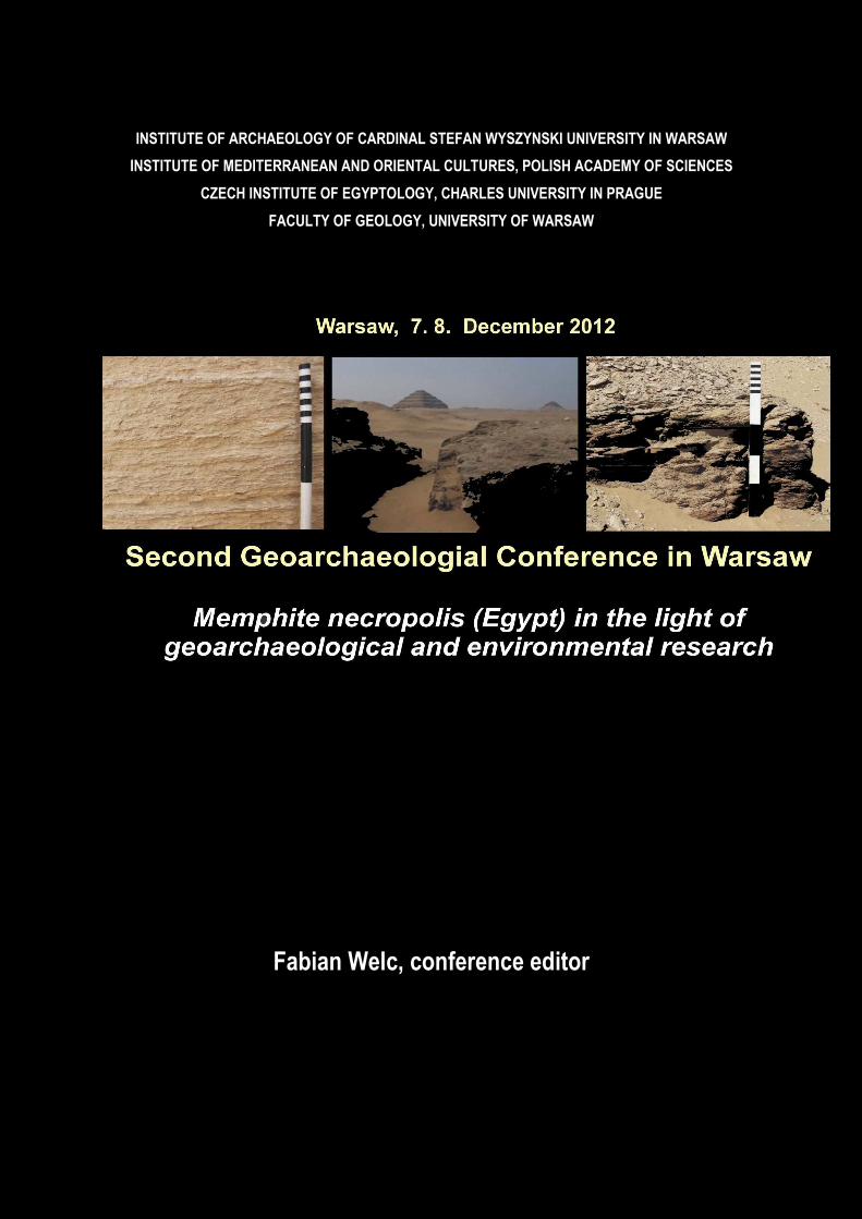
INSTITUTE OF ARCHAEOLOGY OF CARDINAL STEFAN WYSZYNSKI UNIVERSITY IN WARSAW
INSTITUTE OF MEDITERRANEAN AND ORIENTAL CULTURES, POLISH ACADEMY OF SCIENCES
CZECH INSTITUTE OF EGYPTOLOGY, CHARLES UNIVERSITY IN PRAGUE
FACULTY OF GEOLOGY, UNIVERSITY OF WARSAW
Fabian Welc, conference editor
2
Second Geoarchaeological Conference in Warsaw
Memphite necropolis (Egypt) in the light of
geoarchaeological and environmental research
Institute of Archaeology Cardinal Stefan Wyszynski University in Warsaw
7-8 December 2012, Warsaw, Poland
ABSTARCTS
Fabian Welc
Editor of the conference
3
CONTENT
Karol Myśliwiec, introduction speech
Nicole Alexanian, Wiebke Bebermeier, Dirk Blaschta, Arne Ramisch, Geoarchaeological
Research at the Necropolis of Dahshur
Miroslaw Bárta
Long-term or short-term? The nature of the climate depredation towards the end of
the Old Kingdom (4,2 ky BCE)
Judith Bunbury
Geomorphological development of the Memphite floodplain over the past 6,000 years
Pedro Manuel Lourenço Gonçalves
From the Old Kingdom to the Middle Kingdom – Understanding Memphis landscapes
using borehole sampling data
Tomasz Herbich
From Alexandria to Bernike: some aspects of geophysical surveying in Egypt
Dietrich Klemm, Rosemarie Klemm
Dependency of the OK pyramid’s building stones on the regional geology
Dietrich Klemm, Rosemarie Klemm
Geomorphological dependency of the Old Kingdom’s artificial pyramid harbours
Michał Kobusiewicz, Przemysław Bobrowski, Maciej Jórdeczka, Marek Chłodnicki
What forced the prehistoric cattle-keepers to emigrate from the Red Sea Mountains
Sebastian Kowalczyk, Fabian Welc, Jerzy Trzciński, Radosław Mieszkowski
Geophysical researches (Ground Penetrating Radar) on the Polish archeological
concession in West Saqqara
4
Agnese Kukela, Valdis Seglins
Non-destructive methods for evaluation of the state of preservation in historical
stone monuments: the case study of the Step Pyramid
Paul T. Nicholson
The Catacombs of Anubis, Saqqara
Campbell Price
Recent Results of the Saqqara Geophysical Survey Project
Małgorzata Radomska
Saqqara: Some Remarks on Flora from Funerary Contexts
Romuald Schild
Early and Middle Holocene Paleoclimates in the South Western Desert of Egypt. The
World Before Unification
Karin Sowada
Evidence for late third millennium weather events from an Old Kingdom tomb in the
Teti Cemetery at Saqqara
Fabian Welc
Anatomy of the Third Dynasty quarry in West Saqqara
Fabian Welc, Jerzy Trzcinski
Geoarcheological studies of the Polish – Egyptian mission in West Saqqara
Fabian Welc, Leszek Marks
4,2 ky BP global abrupt climatic change (Bond 3. climatic event) – new evidence from
Saqqara
5
Karol Myśliwiec
introduction speech
Institute of Mediterranean and Oriental Cultures, Polish Academy of Sciences, e –mail: [email protected]
Nicole Alexanian, Wiebke Bebermeier, Dirk Blaschta, Arne Ramisch
Geoarchaeological Research at the Necropolis of Dahshur
Alexanian, Nicole, German Archaeological Institute, e-mail: [email protected]
Bebermeier, Wiebke, Institute of Geographical Sciences, Free University Berlin, e-mail: wiebke.bebermeier@fu-
berlin.de
Blaschta, Dirk, Egyptological Institute, University of Leipzig, e-mail: [email protected]
Ramisch, Arne, Institute of Geographical Sciences, Free University Berlin, e-mail: [email protected]
Since 2000, the German Archaeological Institute, in cooperation with Freie
Universität Berlin, has carried out archaeological and geomorphological
investigations within the necropolis of Dahshur and its surroundings. Since 2008,
geoarchaeological research has been systematically undertaken in a joint project
with the Physical Geography section of the Institute of Geographical Sciences of
Freie Universität Berlin. Dahshur belongs to a vast cemetery and settlement system
in the so-called Memphite region and is located approximately 30 km south of
Cairo.
The aim of our investigations is to understand the Memphite region as a
system of cemeteries, settlements, temples, working areas, fields, routes and
water resources. Dahshur provides us with an opportunity to work in a relatively
untouched landscape. It includes two very well preserved pyramid complexes built
by King Sneferu (about 2600 BCE) and seven slightly damaged pyramid complexes
constructed during the Middle Kingdom and the Second Intermediate Period (about
1900-1700 BCE).
At the beginning of the last decade we successfully located the pyramid
town of the Red Pyramid by prospecting the area at the escarpment east of the
Pyramid. We found the Old Kingdom settlement layers covered by 5-6 m of alluvial
and aeolian deposits which indicated fundamental changes of the ancient
6
landscape over the past 4600 years. Since 2008 we have investigated the area east
of the Bent Pyramid and tried to locate the southern pyramid of Sneferu by
sondages with a hand auger. Although we could not prove the position of the
pyramid town, we traced some remains of rural habitation situated on a wadi fan.
In the further course of our work, we carried out a geophysical survey, drill
sondages and an excavation in the wadi to the east of the temple of the Bent
Pyramid. It became clear that the so far unexcavated lower causeway of the Bent
Pyramid continues up to a length of 148 m and ends in an U-shaped structure of 90
x 145 m which we interpret as harbor basin. To our surprise we found that the
mud-brick walls of the lower causeway and the harbor basin are preserved to a
height of up to 3 m; the walls are covered by 3 m thick sand deposits.
Consequently the level of the ancient surface compared to the recent surface level
differs 6-7 m at the eastern entrance of the lower causeway. Aeolian and fluvial
processes leveled the landscape mainly in the channel beds. However, the
landscape of Dahshur was not only modified by natural processes but also in large
parts by human impact. Extensive areas around the pyramids were modified by
mining. The wadi in front of the Bent Pyramid has been straightened by its use as
transportation road for building material or by direct anthropogenic shaping.
Miroslaw Bárta
Long-term or short-term? The nature of the climate depredation
towards the end of the Old Kingdom (4,2 ky BCE)
Czech Institute of Egyptology, Charles University in Prague, e- mail: [email protected]
There was a considerable climate change during the third millennium B.C.
Egypt. The steadily deteriorating climate reached an apogee around 2200 B.C. and
it led to a demise of the Old Kingdom empire. During the same period we can
observe major changes in tomb decoration which reflected different priorities of
the day. Among the most important scenes categories belonged the desert scenes.
These scenes occur sporadically from the Fourth Dynasty onwards and appear most
frequently after the king Nyuserra in the second part of the Fifth Dynasty. Their
importance will be assessed in this contribution.
7
Judith Bunbury
Geomorphological development of the Memphite floodplain over
the past 6,000 years
Department of Earth Sciences, Cambridge, e- mail: [email protected]
Around 4000 BCE the Memphis area started to become important in Egypt.
The Nile valley at this time was marshy as a result of sea-level rising after the end
of the last ice-age. Correspondingly the evidence for habitation in this area, which
is at the neck where the cliffs of the Nile valley edge fan out into the area of the
delta, is confined mainly to cemeteries at the edge of the valley. Early dynastic
cemeteries flank the site that later became Memphis on the wadi fans that empty
into the Nile Valley. The wadis, remnants of an earlier tributary system to the Nile,
were, by the Early Dynastic period filled with sand and gravels that flowed down
into the Nile during periods of rainfall. The predominance of wood in the tomb
architecture of the time suggests that the wadis may have also been partially
vegetated and the toes of these sediment fans reached out into the Nile valley,
inter-fingering with the dark river sediments of the Nile. As climate changed and
the summer monsoon failed, the wadis became unstable and the Nile valley,
responding to stable sea-level began to infill the marshes. With increasing
stabilization of the delta, the distributary network changed so that river traffic
from the delta was funneled through Memphis making the city of greater strategic
importance. During this period the channels of the Nile also stabilised and formed
two distinct limbs with long low swelling levees that meant that settlement could
move into the Valley by the Old Kingdom and yet avoid flooding during the
summer. At this time proto-Memphis was already established (see the work of
Pedro Gonçalves).
The subsequent development of Memphis was dominated by the migration
of the two channels around the city. Initially flanked by one channel on each side,
by the Middle Kingdom the western channel was minimized, perhaps due to human
activity further south, and the eastern channel became the main river that we see
today. During Roman times, the remaining channel flanked Memphis to the East
8
and, since that time, has migrated further eastwards. Eventually, the city,
abandoned by the river, shifted its focus north to the site of Cairo.
Pedro Manuel Lourenço Gonçalves
From the Old Kingdom to the Middle Kingdom –
Understanding Memphis landscapes using borehole sampling data
E-mail: [email protected]
The Mît Rahîna Field School 2011 (organized by the AERA for inspectors of
the Egyptian Ministry of State for Antiquities) provided the opportunity to dig six
boreholes at the Survey of Memphis’ sites FAC and FAD at Kôm al-Fakhry (south-
western part of the Memphis Ruin Field). FAC and FAD sites are still the oldest in
situ remains found at Memphis and reveal an undisturbed cemetery of the First
Intermediate Period or early Middle Kingdom together with two phases of a Middle
Kingdom settlement. The obtained data complemented the information provided
by almost 200 cores that have been drilled in the area of Memphis by the Survey of
Memphis over the last 30 years under the direction of Dr. David Jeffreys for The
Egyptian Exploration Society in order to understand the location, development, and
history of the old capital of Egypt.
Five major units were recognized in the sedimentary matrix. They support
the idea of a Proto-Memphis founded on an island or on a natural levee during or
even before the Early Dynastic Period located ca. Kôm Fakhry, Kôm Rabi’ and Kôm
Mît Rahîna, an area of probable higher ground on these local palaeo islands. This
settlement was easterly bordered by a river channel before or during the Old
Kingdom. Since then, this channel had moved eastward, with a slow infilling of its
eastern margin at this area that lasted until the Middle Kingdom, at least. The
cores reveal a progressive lost of fluvial influences and this eastward movement of
the channel may have been partially a consequence of human activities – a result
of infilling of the margin by loose detritus.
Nevertheless the overall progressive lost of fluvial conditions, this area
seems to have been more prone to inundation not early than the beginning of the
Middle Kingdom, probably a consequence of higher floods and of Memphis’s
9
decadence (and its protections against floods) during the First Intermediate Period
and the early Middle Kingdom. Another explanation can also be the transformation
of the valley’s environment: the apex of the delta may have moved southward
during these historical periods, transforming the previous alluvial valley into a
more deltaic marshy environment. Later, after those wetter conditions, this
specific area seems to have been recovered for settlement and construction during
the Middle Kingdom.
Tomasz Herbich
From Alexandria to Bernike: some aspects of geophysical surveying
in Egypt
Institute of Archaeology and Ethnology, Polish Academy of Sciences, e-mail: [email protected];
Already lasting longer than one and a half decades, the geophysical "boom"
in Egyptian archeology allows us to make some general observations on the
usefulness of geophysical methods and the relationship between the method, the
measurement methodology and the type of site, its geology and conservation
status. These observations are based on the author’s experience gained while
conducting research at more than 60 sites in Egypt. These observations include the
following:
1. Test survey as an essential element in the evaluation of the usability of the
method chosen for the research;
2. Improving the quality of the survey result through the development of
measurement methodology and the use of various instruments;
3. The use of different geophysical methods at the research of one site;
4. Identification of the material used for the construction;
5. On the superiority of geophysical survey over excavation (!).
The observations are illustrated with examples of research of sites from different
Egyptian historical periods and located in various geographical zones in Egypt.
ad. 1. A theoretical analysis of the method’s usefulness, without carrying out
field tests, can give completely wrong conclusions. The magnetic survey in Buto
and Berenike is an example of that, where the theoretical assumptions pointed to
10
the uselessness of the method but the survey yielded valuable results. Magnetic
susceptibility measurements can be extremely useful in the initial assessment of
the magnetic method's suitability (as in the case of Marea).
ad. 2. Depending on the type of instrument and the methodology of
measuring, one can get better information on the settlement’s layout and
individual buildings or on the shallow geology. The measurement methodology
using different types of magnetometers (caesium and fluxgates) was developed
during the research at Tell el- Dabca.
ad. 3. The joint use of the electrical resitivity method (vertical sounding
version) and the magnetic method can give good results in studies on the
reconstruction of paleolandscapes. In the first phase of this kind of research, a
quick identification of structures takes place (using the magnetic method) and in
the second phase, the nature of these structures can also be identified. The
identification of the structures’ characteristics gives a much better basis for their
correct interpretation (e.g., research of small harbors at Tell el-Dabca)
ad. 4. Identification of the construction material may be obtained by the
joint analysis of the results given by both the resistivity and magnetic methods (as
in the case of Ayn Birbiyeh in Dakhleh oasis).
ad. 5. The magnetic method allows to register structures, which due to a
very poor state of preservation, cannot be observed when using conventional
methods of excavation. This observation has been made while researching the Deir
al-Barsha necropolis.
Dietrich Klemm, Rosemarie Klemm
Dependency of the OK pyramid’s building stones on the regional
geology
Dietrich Klemm, Dept. of Environmental Geosciences, University of Munich, e-mail: [email protected]
Rosemarie Klemm, e-mail: [email protected]
The aim of this investigation is focused on the provenance determination of
both core and casing material of the Old Kingdom stone pyramids and their temple
11
complexes by means of petrographical and geochemical analyses. Special emphasis
is placed on the pyramids of the Memphitic district.
Rock samples in statistical sufficient number from the pyramids’
construction blocks were systematically taken. These pyramid specimens were
compared with rock samples from known or assumed quarry sites in the surrounding
area of the pyramids. In addition, especially for the casing and backing stones,
comparing samples were taken from the extended quarry sites at the eastern
escarpment of the Nile valley.
Dietrich Klemm, Rosemarie Klemm
Geomorphological dependency of the Old Kingdom’s artificial
pyramid harbours
Dietrich Klemm, Dept. of Environmental Geosciences, University of Munich, e-mail: [email protected]
Rosemarie Klemm, e-mail: [email protected]
Recent excavations in the forefront of the Giza pyramids lead to discovery
of a quay-side belonging to the entire complexes of Khufu and Khafre (Hawass,
1997). Thus, the question rises whether comparable harbour constructions
existed individually for each pyramid.
An attempt to localize such artificial harbours by means of studying the
geomorphology of the various sites along the Memphite escarpment with the aid
of high resolution topographic maps, aerial and satellite imagery, and field
observations resulted in appropriate positions for candidates of such harbour
constructions.
Such reconstruction efforts may make sense under the condition of a Nile
course closer to the western escarpment (Jeffreys, 1994) and a morphological
feature of the landscape to ease the excavation work of harbour construction
including the causeway towards the particular pyramid.
12
Michał Kobusiewicz, Przemysław Bobrowski, Maciej Jórdeczka, Marek
Chłodnicki
What forced the prehistoric cattle-keepers to emigrate from the
Red Sea Mountains
Michał Kobusiewicz, Institute of Archaeology and Ethnology, Polish Academy of Sciences (Poznań Branch),
Poland, e-mail: [email protected]
The aim of this paper is to show how the geoarchaeology can help to resolve
the problems concerning the chronology of the prehistoric rock art concentration
lately found in Sudan. The Polish team of archaeologist investigate the very rich
concentration of prehistoric petroglyphs discovered in Bir Nurayet in the Red Sea
Mountains in northeastern Sudan. The by far the most numerous representation of
engravings is cattle present on hundreds images on the slopes of sand stone rocks.
The images are situated in the close vicinity of the steep, conical, lonely mountain
of phallic shape called Gebel Magardi protruding out in the middle of the sandy
bottom of the large Wadi Diib. With high probability we can state that the art
resulted from the fertility cult practiced by the prehistoric population, maybe the
ancestors of the now day Bedja, with regard to the cattle as well as to humans.
Although we possess some premises for dating the rock art based on the
thermoluminescence dates obtained from silts covering some engravings, their
chronology is still vague. Today the nearest cattle can be seen seven hundred
kilometers south of Bir Nurayet. The local inhabitants of the area, the Bedja, keep
the camels only. The climatological changes, probably the drought, must have
forced the cattle to move to the south. The moment of the disappearance of cows
from Bir Nurayet would be the terminus post quem for the rock art representing
cattle. But the environmental changes in the Red Sea Mountains are not well
recognized. The climatological circumstances here are, most probably, different
than these known from Egyptian deserts or from the Nile Valley where these events
are relatively well studied and known. The intensive, multidisciplinary
geoarchaeological research is necessary to shed light on this problems. Its result
will permit us to appoint the date of the end of the cattle-keeper period of the
rock art in Bir Nurayet.
13
Sebastian Kowalczyk, Fabian Welc, Jerzy Trzciński, Radosław
Mieszkowski
Geophysical researches (Ground Penetrating Radar) on the Polish
archeological concession in West Saqqara
Fabian Welc, Institute of Archeology, Cardinal Wyszyński University in Warsaw, e-mail: [email protected]
Sebastian Kowalczyk, Faculty of Geology Warsaw University, e-mail: [email protected]
Jerzy Trzciński, Faculty of Geology Warsaw University, e – mail: [email protected]
Radosław Mieszkowski, Faculty of Geology Warsaw University, e – mail: [email protected]
Geophysical survey was one of the important objectives during the last
archeological campaign of the Polish – Egyptian mission in West Saqqara directed by
K. Myśliwiec. The main aim of this research was to determine the relationship
between the geology of the West Saqqara limestone plateau and archeological
structures located there, especially that which remain buried under sand.
During the course of the geophysical work GPR (Ground Penetrating Radar)
was used. GPR is a modern geophysical method that uses radar pulses to create
images of the subsurface structures, especially on archeological sites. This
nondestructive method uses electromagnetic radiation in the microwave band
(UHF/VHF frequencies) of the radio spectrum to detect the reflected signals from
subsurface structures. In archaeology this technology is very useful to locate
underground structures, such as shafts and burial chambers.
As it was mentioned, GPR uses high-frequency radio waves transmittable
directly into the ground. When the wave hits a buried object with different
dielectric constants, the receiving antenna records variations in the reflected
return signal. Due to special software the GPR operator can see on the monitor all
underground structures with exact depth given. The depth - range penetration of
GPR is limited by the electrical conductivity of the searched ground, transmitted
frequency center and radiated power. As conductivity increases, the penetration
depth decreases. This is because the electromagnetic energy is more quickly
decapitated into heat, causing a loss in signal strength at depth. Higher frequencies
do not penetrate as far as lower frequencies, but give better resolution.
In Saqqara, optimal depth penetration was achieved due to the dry sandy
layers and monolithic structure of the limestone outcrop on which ancient
14
cemetery was located. Using antenna of 100 MHz the depth of penetration was up
to 45 m, with antenna 250 MHz up to 15 meters (it means that Saqqara limestone
plateau is almost an ideal site for using GPR surveying technology).
During the geophysical survey in Saqqara the Swedish MALÅ GPR X3M system
was used, that is based on the MALÅ GPR X3M Control Unit and MALÅ GPR and
Shielded Antennas 100 - 250 MHz. The MALÅ GPR X3M control unit is an integrated
ground penetrating remote, fitted directly onto a shielded antenna and powered
externally. The built-in electronic design results in a complete ground penetrating
system that is light and very compact and easy to transport, assemble and operate.
The convenience of this flexible and modular design means that the MALÅ GPR X3M
system can be quickly and easily configured for use across a wide range of mid-
range applications. Depending on the application, the MALÅ GPR X3M System is
typically configured as either a push- or a pull-system.
GPR Ramac X3M system used in Saqqara included: 1 x Control unit Ramac
X3M, 1 x 250 and 1 x 100 MHz shielded antennas, computer Panasonic CF-29,
distance measuring wheel 250-800 MHz (encoder wheel).
In methodological term, more than 30 areas were selected for geophysical
survey in Saqqara, all of them in the boundary of the Polish archeological
concession. A total of 25 areas were located in the southern part of the concession
and the remainder in northern one. Most of the areas were straight strips of
approximately 75 meters in length and 7 meters in width, orientated in accordance
to the cardinal directions.
During the survey the Ground Penetrating Remote antennas were generally
in contact with the ground for the strongest signal strength. Obtained
electromagnetic profiles were initially archived by using special software - Ground
Vision programme. In the next stage, all profiles will be transformed into
professional GPR software – Reflex View.
The GPR profiles collected over the surveyed area in Saqqara will be used to
construct three-dimensional or tomographic images. The data may be presented as
three-dimensional blocks, or as horizontal or vertical slices. Horizontal slices
(known as "depth slices" or "time slices") are essentially plain view maps isolating
specific depths. Time-slicing has become standard practice in archaeological
15
applications, as horizontal patterning is often the most important indicator of
archaeological activities.
Agnese Kukela, Valdis Seglins
Non-destructive methods for evaluation of the state of
preservation in historical stone monuments: the case study of the
Step Pyramid
University of Latvia, Faculty of Geography and Earth Sciences, e-mail: [email protected]
All stone monuments, irrespective of the building material and its initial
quality, are exposed to the environmental impact affecting their state of
preservation. Generally, stone monument studies are aiming to determine
potential threats and facilitate the elaboration of appropriate monument
conservation strategy. Most of the existing weathering assessment methods and
classifications are time consuming, expensive and require direct contact with the
surface for application of instrumental investigations or to take samples for
analysis. However, these methods can be adjusted and developed as non-
destructive by creating custom classification of weathering forms and their
intensities using detailed monument photo documentation data.
Such study was carried out in Saqqara, appraising stone material weathering
on the facades of the Step Pyramid of king Djoser. By analyzing photographic data
obtained starting from the year 2006, three main stone material weathering forms
and five weathering intensities were identified. The investigation was performed
analyzing the surface of each construction block allowing, if necessary, to increase
the number of diagnostic features in the future.
In order to facilitate visual interpretation of the data, the 3D model of the
Step Pyramid using Micro Station V8i software was created. The integration of the
data into the 3D model allowed us to make number of conclusions regarding the
structure of the Djoser’s pyramid, potential threats to its stability, stone material
used for the construction of the pyramid and differences in quality of the mortar
applied. The results of this study denote high potential of this methodology for its
application in preliminary studies of the stone monuments on Memphite necropolis
16
area to contribute the elaboration of future preservation and conservation
strategy.
Paul T. Nicholson
The Catacombs of Anubis, Saqqara
Cardiff University, e-mail: [email protected]
This paper examines the Catacombs of Anubis at Saqqara. The site has been
known since the late 19th Century and since sometime in the early 20th Century has
been used by the S.C.A. for the storage of antiquities. However, the site has never
been properly investigated by archaeologists.
Since 2009 a Cardiff University expedition has been examining the Catacomb
with a view to making an accurate survey of the monument, examining its
deterioration and examining the remains of the animals interred within it. The
project has been able to examine the more recent history of the monument as well
as its ancient history; the latter suggests that the monument may have been
deliberately emptied, in parts, during the late 19th or early 20th Century.
Examination of the mummified animals in the catacomb shows that they are
not all dogs and jackals, as one might have expected, but include felines,
ichneumon and other creatures. It is estimated that as many as 8,000,000 animals
may be interred in the catacomb based on the volume of the galleries and the
minimum number of animals collected in a 15 litre sample.
Such great numbers of animals have implications for their procurement and
it is suggested that there may have been a dedicated breeding programme for
these animals.
Campbell Price
Recent Results of the Saqqara Geophysical Survey Project
The Manchester Museum, University of Manchester, e-mail: [email protected]
17
Since 1990 a Scottish mission, the Saqqara Geophysical Survey Project
(SGSP), has been engaged in producing a comprehensive and up-to-date subsurface
map of the Saqqara Necropolis. The Project was founded by Ian Mathieson, who
pioneered a range of geophysical techniques for use at Saqqara, and in the
Memphite area more broadly.
Most recently, the Project surveyed the zone south of the Unas causeway, in
the area of several well-known New Kingdom tombs. This paper presents several
previously unidentified structures, and evaluates them in relation to archaeological
work carried out by other missions. Following the sad death of Ian Mathieson in
June 2010, the SGSP hopes to continue his valuable work at the site. Future
directions for research will be suggested, focusing on completing gradiometery
survey around the area of the Serapeum Way and applying the selective use of
ground penetrating radar along its length.
Małgorzata Radomska
Saqqara: Some Remarks on Flora from Funerary Contexts
Institute of Mediterranean and Oriental Cultures, Polish Academy of Sciences, e –mail: [email protected]
The impact of the natural environment on human thinking and action goes
without question and ancient Egypt was no exception. Geologists and geophysicists
studying morphological changes of the ground in Saqqara have contributed to a
reconstruction of processes taking place in the natural environment during the long
existence of the necropolis.
The aim of this paper is to reconstruct certain aspects of this environment in
the Memphite region, based on an identification of plant remains discovered by the
Polish-Egyptian mission excavating in Saqqara in 1996-2012. All of the finds have
come from funerary context.
The following issues will be addressed: What was the significance of plants
interred with the deceased? Was the choice of a specific plant of importance for
the afterlife? What species of flowers and vegetables grew in the environs of the
necropolis, making them easily accessible for burial purposes? What ancient
18
Egyptians beliefs regarding plant symbolism are confirmed on the grounds of the
finds from Saqqara?
Numerous garden and field plants are represented as food offerings for the
deceased in the relief’s from the walls of individual cult chapels, but it is essential
also to study the actual finds of vegetables, fruit and other plants from funerary
contexts in order to understand and reconstruct contemporary flora of the period.
The burial contexts, which will be studied, were discovered for the most part in
the burial ground to the west of the Djoser pyramid enclosure in Saqqara. Two
distinct levels of this cemetery were identified: the so-called Upper Necropolis
from the Ptolemaic Period and the Lower Necropolis, which is directly below the
Upper one and which can be dated to the Old Kingdom. Substantially more plant
remains have been attested in layers belonging to the older cemetery.
Grave furnishings are mostly absent from the Upper Necropolis burials (and it
should be kept in mind that most of the interments were disturbed by ancient
robbers), but despite the limitations resulting from the nature of available data, it
is still possible to identify the species of plants placed in the grave together with
the body of the deceased. The present paper will concentrate on plant remains
found in the burials of the Upper Necropolis in Saqqara.
Romuald Schild
Early and Middle Holocene Paleoclimates in the South Western
Desert of Egypt. The World Before Unification
Institute of Archaeology and Ethnology, Polish Academy of Sciences [email protected]
In the field seasons of 1990 to 2008 the Combined Prehistoric Expedition
conducted an extensive archaeological, archaeozoological, archaeobotanical and
geomorphological field work in the Nabta, Kassiba and Gebel El Sheb Areas, South
Western Desert of Egypt, which has helped to develop a long chronological
sequence of climatic changes in the area. The field and laboratory work has been
supported by over 300 14C and OSL assays that permitted place most of the
climatic events in a firm chronological frame.
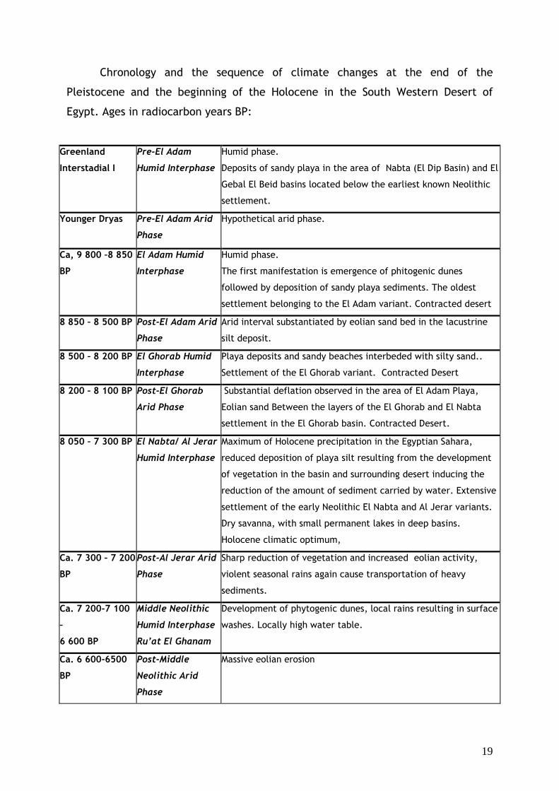
19
Chronology and the sequence of climate changes at the end of the
Pleistocene and the beginning of the Holocene in the South Western Desert of
Egypt. Ages in radiocarbon years BP:
Greenland
Interstadial I
Pre-El Adam
Humid Interphase
Humid phase.
Deposits of sandy playa in the area of Nabta (El Dip Basin) and El
Gebal El Beid basins located below the earliest known Neolithic
settlement.
Younger Dryas Pre-El Adam Arid
Phase
Hypothetical arid phase.
Ca, 9 800 –8 850
BP
El Adam Humid
Interphase
Humid phase.
The first manifestation is emergence of phitogenic dunes
followed by deposition of sandy playa sediments. The oldest
settlement belonging to the El Adam variant. Contracted desert
8 850 – 8 500 BP Post-El Adam Arid
Phase
Arid interval substantiated by eolian sand bed in the lacustrine
silt deposit.
8 500 – 8 200 BP El Ghorab Humid
Interphase
Playa deposits and sandy beaches interbeded with silty sand..
Settlement of the El Ghorab variant. Contracted Desert
8 200 – 8 100 BP Post-El Ghorab
Arid Phase
Substantial deflation observed in the area of El Adam Playa,
Eolian sand Between the layers of the El Ghorab and El Nabta
settlement in the El Ghorab basin. Contracted Desert.
8 050 – 7 300 BP El Nabta/ Al Jerar
Humid Interphase
Maximum of Holocene precipitation in the Egyptian Sahara,
reduced deposition of playa silt resulting from the development
of vegetation in the basin and surrounding desert inducing the
reduction of the amount of sediment carried by water. Extensive
settlement of the early Neolithic El Nabta and Al Jerar variants.
Dry savanna, with small permanent lakes in deep basins.
Holocene climatic optimum,
Ca. 7 300 – 7 200
BP
Post-Al Jerar Arid
Phase
Sharp reduction of vegetation and increased eolian activity,
violent seasonal rains again cause transportation of heavy
sediments.
Ca. 7 200-7 100
–
6 600 BP
Middle Neolithic
Humid Interphase
Ru’at El Ghanam
Development of phytogenic dunes, local rains resulting in surface
washes. Locally high water table.
Ca. 6 600-6500
BP
Post-Middle
Neolithic Arid
Phase
Massive eolian erosion
20
Ca. 6500-5800
BP
Late Neolithic
Humid Interphase,
Ru’at El Baqar
Summer rains, sandy alluvial deposits in wadis and closed basins
Ca. 5800-5750
BP
Post Late
Neolithic Arid
Phase
Deflational basins
Ca. 5750-4800
BP
Final Neolithic
Humid Interphase
Bunat El Asnam
Summer rains and alluvial washes
Ca. 4500-4200 Early Post-
Neolithic
Settlements
Sparse human occupation
Ca. 4200-3900 Hyper Arid Desert No traces of Human occupation
Ca. 3900-3150 Weak Humid
Interphase
local rains
C-Group
Traces of occupation, houses and domestic animals
Karin Sowada
Evidence for late third millennium weather events from an Old
Kingdom tomb in the Teti Cemetery at Saqqara
Macquarie University, Sydney, e-mail: [email protected]
During excavations in 1996 by the Australian Centre for Egyptology
(Macquarie University) on a tomb in the Teti Cemetery at Saqqara, evidence of a
major ancient weather event was revealed. The tomb belonged to a high official
called Inumin, who late in his career served as vizier of King Pepy I of the Sixth
Dynasty. Over a metre of laminated mud deposits in the subterranean burial
chamber were the result of sustained rainfall over a short period of time. This
event is dated on stratigraphic grounds to the Late Old Kingdom – early First
Intermediate Period, and is regarded as part of the same weather event recorded
during recent archaeological work near the enclosure of Netjerykhet Djoser.
21
Fabian Welc
Anatomy of the Third Dynasty quarry in West Saqqara
Institute of Archeology, Cardinal Wyszyński University in Warsaw, e-mail: [email protected]
One of the main objectives of geoarchaeological research of the Polish –
Egyptian mission in West Saqqara is a reconstruction of the original topography of
the area in question and tracing past transformations of a natural as well as
anthropogenic nature. Field observations a few years back had already suggested
that part of the necropolis searched by polish team did not slope gently to the
west, as it can be seen on the ground, instead, it descended in a series of rock
terraces which had become covered thickly with sand and rock debris. Already at
the time this ground structure was linked with the building activity of the pharaoh
Netjerykhet of the Third Dynasty.
In the 2009 field season the area of the necropolis uncovered down to the
rock was sufficiently big to enable us to verify our previous determinations. Field
observations coupled with topographical and geodetic measurements have
demonstrated that the area in question comprises at least four rock terraces
extending for about 30 m. The terraces differ in their width from step to step, the
latter being aligned usually north-south and measuring each approx. 2 m in height.
Examination of the geological evidence has left no doubt that the lower three of
these terraces were made by man quarrying beds of the local Eocene limestone.
This open quarry was exploited on a grand scale during the Third Dynasty. Its
operations should be linked with the development of the funerary complex of the
pharaoh Netjerykhet and it is likely that the quarry was abandoned when the work
on the complex was interrupted. There is no evidence for any form of human
activity in this area during the Fourth and Fifth Dynasties.
The terraced structure of the old quarry must have provided excellent
conditions for all kinds of building activities. This must have been a decisive factor
in choosing it for the location of a new necropolis at the end of the Old Kingdom
Period. The rock walls were perfectly suited for cutting the facades and interiors of
funerary chapels. The work consisted mainly of surface leveling of the rock to
22
create appropriately smooth faces for the facades and a shallow depression in front
of the entrance for the cult courtyard.
Limestone started to be quarried again in the area in the late Old Kingdom,
but it seems that the purpose was no longer building material. The stonecutters
appear to have been producing elements necessary for the furnishing of the tombs,
such as appropriately big slabs for covering the burial pits.
Fabian Welc, Jerzy Trzcinski
Geoarcheological studies of the Polish – Egyptian mission in West
Saqqara
Institute of Archeology, Cardinal Wyszyński University in Warsaw, e-mail: [email protected]
Jerzy Trzcinski, Faculty of Geology Warsaw University, e – mail: [email protected]
Geoarchaeological research has been part of the program of the Polish
archaeological and conservation mission at Saqqara from the very beginning, that
is, from 1998, when Elżbieta Mycielska-Dowgiałło and Barbara Woronko carried out
a series of sedimentological and petrographic analyses on the site. The main
objective is to study the interdependence between ancient structures and the
geomorphology of the land site. The results are used in reconstructing the
morphogenetic processes and climatic changes that shaped the development of the
Saqqara necropolis over the ages, but especially during the Old Kingdom. The most
important paleoclimatic data referring to the early Old Kingdom came from layers
deposited directly under the foundation of the Step Pyramid enclosure wall. The
undisturbed sequence of mainly natural layers proved to be of key importance. We
could distinguish two thick and heavily concreted layers of red color mixed with
pebbles, separated by a thin layer of melted marl limestone. Detailed examination
of these deposits demonstrated that the soc called red layers originated in effect
of intensive mud and rock flows caused by heavy raining. This episode should be
connected with the beginning of the first half of the Third Dynasty.
Examination of cross – sections and fill of the burial shafts from the terminal
Sixth Dynasty has provided proof of next episode of very intensive rainfall. The
area of the necropolis suffered from mud and rock flows that effectively destroyed
23
many burial structures. Coincidentally, this was a period of massive plundering in
the necropolis. The shafts and chambers left practically empty by the thieves were
quickly filled with the mud and rock carried by flash floods. An extreme case in
point is shaft 57 explored in the 2009 season. It was completely filled with heavily
cemented rubble mixed with dried mud which had entered the shaft with flowing
water. Layers higher up in the profile, dated by the finds to the transition from the
Old Kingdom to the First Intermediate Period, have been found to contain seasonal
rainfall water reservoirs of varying size.
Closing the stratigraphical sequence of accumulations is a thick layer of
aeolian sand which started to form most probably in at the beginning of the second
First Intermediate Period. It proves that the gradual drying of the climate, which is
still ongoing, started at about this time.
Fabian Welc, Leszek Marks
4,2 ky BP global abrupt climatic change (Bond 3. climatic event) –
new evidence from Saqqara
Fabian Welc, Institute of Archeology, Cardinal Wyszyński University in Warsaw, e-mail: [email protected]
Leszek Marks, University of Warsaw, Department of Climate Geology, Polish Geological Institute – National
Research Institute, e-mail: [email protected]
The paper present compiled geological and geoarcheological data, based on
results of the Polish – Egyptian excavations at the Saqqara necropolis (headed by
prof. K. Myśliwiec), to specify a climate variability in Egypt mostly at the end of
Old Kingdom period (ca. 4200 B.P).
A climate change in that time was seen expressed firstly by aridification and
low floods of the Nile but also by occasional heavy rainfalls in northern Egypt. Low
floods of the Nile were probably a consequence of decreased summer precipitation
in the Ethiopian Highlands that resulted in catastrophically low discharges in the
Blue Nile drainage basin. These weaker summer monsoons in Ethiopia and gradual
aridification in Egypt from about 5000 yrs BP were coincident with a southward
shift of the summer Intertropical Convergence Zone (ITCZ) in Africa. Simultaneous
intensive rainfalls resulted in wide-spread sheet-flood accumulations in northern
Egypt. These rainfalls were presumably triggered by variation of the North Atlantic

24
Oscillation (NAO), dependent in turn on the oceanic thermohaline circulation. All
these reasons caused a rapid collapse of the Old Kingdom at about 4200-4100 yrs
BP.

25