Embed Size (px)
Citation preview

Scottish MPA network -
Parliamentary Report
December 2018
1
Ministerial Foreword
The Scottish Government has a vision of clean, healthy, safe, productive, and
biologically diverse marine & coastal environment, managed to meet the long-term
needs of nature and people. The creation and maintenance of the Marine Protected
Area (MPA) network is an integral part of achieving that vision by safeguarding
marine biodiversity. It is evident from this report that Scotland has made excellent
progress against international commitments to create an MPA network.
Since 2012 the MPA network has almost doubled in size and in doing so a broader
range of habitats and species are now protected. This means that as a whole the
MPA network is able to make a greater contribution to maintaining the ecosystem
services we all depend upon. A total of 42 MPAs have been added to the network
since 2012 providing new sites for nature conservation, protection of the historic
environment, and for demonstration and research purposes. Good progress has
also been made with implementation of specific site management measures.
I also recognise the significant contributions made by stakeholders over the last six
years. Your engagement has helped shape the MPA network into what it is today. I
hope you all continue to provide that input as we attempt to complete the network
and put the necessary management measures in place.
Looking forward, the next six years will focus on completing the network and
implementing management measures as required. Alongside this monitoring and
assessment of what the network is achieving for biodiversity will continue. I hope
that by the next report the network will be complete, well managed, and results will
show that the objectives of the network are being achieved.
Mairi Gougeon MSP
Minister for Rural Affairs and the Natural Environment

2
Contents
Ministerial Foreword ................................................................................................... 1
Purpose of report ....................................................................................................... 3
Glossary ..................................................................................................................... 4
Our seas ..................................................................................................................... 6
The Scottish MPA Network ...................................................................................... 11
Changes to the Scottish MPA network since 2012 report ........................................ 12
Scotland’s contribution to other MPA networks ........................................................ 14
Contribution to the UK network of conservation sites ............................................... 15
Spatial protection measures under the Marine Strategy Framework Directive ......... 17
Contribution to international MPA networks ............................................................. 19
Managing the Scottish MPA Network ....................................................................... 23
Monitoring the Scottish MPA network ....................................................................... 25
Looking ahead to the next six years ......................................................................... 26
Introduction to the Annexes ...................................................................................... 27
Annex 1 MPAs designated since last report ....................................................... 28
Annex 2 Administrative Changes to the MPA network ........................................ 30
Annex 3 Other Area Based Measures ................................................................ 31
Annex 4 Scottish MPA network Statistics ........................................................... 32
Annex 5 Feature replication in the MPA network ................................................ 34
Annex 6 MPA objectives and progress towards them ......................................... 40
Annex 7 Management measures ........................................................................ 49

3
Purpose of report This aim of the document is to report to Parliament on progress being made in
implementing a Marine Protected Area (MPA) network. This report is a requirement
of Section 103 of the Marine (Scotland) Act 2010 and Section 124 of the Marine and
Coastal Access Act 2009. The MPA network supports the Scottish Government’s
vision of clean, healthy, safe, productive, biologically diverse marine & coastal
environment, managed to meet the long-term needs of nature and people.
In addition Other Area Based Measures which contribute to the conservation of our
seas are also included. These areas contribute to the spatial protection measures
that meet the obligations of the EU Marine Strategy Framework Directive.
The previous report to Parliament in 2012 is available at:
http://www.gov.scot/Topics/marine/marine-
environment/mpanetwork/MPAParliamentReport
This report does not consider socio-economic effects, or any analysis of compliance
with management measures. This was considered separately in 2016 by another
report. See https://www.gov.scot/publications/scottish-marine-protected-areas-
socioeconomic-monitoring/ for details. A further analysis of this nature will be
undertaken in 2019.

4
Glossary
Convention on Biological Diversity (CBD) - It has 3 main objectives; the
conservation of biological diversity; the sustainable use of the components of
biological diversity; and, the fair and equitable sharing of the benefits arising out of
the utilization of genetic resources
Ecosystem services - Processes by which the environment produces resources
utilised by humans, such as clean air, water. Can also be referred to as benefits.
EU Habitats Directive aims to achieve favourable conservation status for a range of
vulnerable habitats and species of European importance
EU Marine Strategy Framework Directive (MSFD) aims to achieve Good
Environmental Status by ensuring that adverse effects from human activities are
avoided.
EU Wild Birds Directive aims to maintain populations of vulnerable and migratory
species and ensure sufficient diversity and area of habitats essential to their
conservation.
Good Environmental Status (GES) means seas which are clean, healthy and
productive within their intrinsic conditions, and the use of the marine environment is
at a level that is sustainable, thus safeguarding the potential for uses and activities
by current and future generations.
Marine Protected Area (MPA) means one of three types of MPA in Scotland;
Demonstration and research to test novel approaches to marine management;
Historic to protect marine wrecks and artefacts; Nature conservation to protect
biodiversity. The term can also be used generically to describe any marine protected
area.
Network of conservation sites is used in the Marine and Coastal Access Act 2009
to describe sites designated to protect marine biodiversity – MPAs, Ramsar, SACs,
SPAs, SSSIs,
OSPAR - The Convention by which fifteen Governments, together with the European
Union, cooperate to protect the marine environment of the North-East Atlantic.
Other Area Based Measures – Spatial zones which contribute to the protection of
marine biodiversity but are not set up specifically for nature conservation purposes.
Ramsar - the Convention for the conservation and wise use of all wetlands

5
Representation – Ensuring the MPA network covers the range of habitats and
species that make up the biological diversity of our seas.
Replication – A feature being in more than one MPA in the network or within defined
regions.
Scottish MPA Network – A collective term to describe all of the conservation sites
plus Demonstration and Research MPAs, Historic MPAs, and Other Area Based
Measures
Site of Special Scientific Interest (SSSIs) - protect nationally important habitats,
species and geological features found above the mean low water mark.
Special Areas of Conservation (SACs) are protected areas for habitats and
species listed in the EU Habitats Directive, such as reefs and bottlenose dolphin.
Special Protection Areas (SPAs) are protected areas for wild birds listed in the EU
Wild Birds Directive, or for regularly occurring migratory species.
Sustainable Development Goals (SDG) - A series of interconnected goals
adopted by the United Nations which are designed to mobilize efforts to end all forms
of poverty, fight inequalities and tackling climate change and environmental
protection. Goal 14 relates to “life below water”.
The Marine Acts – A collective term used to describe the Marine (Scotland) Act
2010 and The Marine and Coastal Access Act 2009.
The Marine and Coastal Access Act 2009 – The Act of the UK Parliament which
gives the Scottish Ministers the power to designate MPAs in Scottish Offshore
Waters.
The Marine (Scotland) Act 2010 – The Act of the Scottish Parliament which gives
the Scottish Ministers the power to designate MPAs in Territorial Waters.

6
Our seas
Scotland’s position at the edge of the north-west
European continental shelf has a huge influence on
our coasts and seas. Our marine environment has
been shaped by wind, water, and ice over thousands
of years, creating productive and abundant marine
life.
The meeting and mixing of nutrient-rich waters
provides the perfect home for sea life to thrive.
Scotland is of international importance for marine
biodiversity providing the ideal environment for our
spectacular birds, marine mammals and fish as well
as for the habitats that are hidden on the seabed.
The productive nature of our marine environment
also supports a wide range of industries, which
benefit from the natural resources that our seas
provide. Safeguarding the continued supply of these
natural benefits is one of the reasons for having the
Scottish MPA network.
Coastal habitats support a wealth of plants and
animals including marine birds and seals. Saline
lagoons and estuarine habitats mark the transition
from freshwater to seawater, with specialist plants
and animals able to cope with the dramatic changes
in salinity and temperature. Many bird species come
to these areas as a safe haven for the winter months.
The complex and variable coastline is mirrored by a
diversity of productive habitat forming species such as
kelps, seagrasses, blue mussels and maerl. These
habitats support a rich diversity of other species and
also capture and store carbon.
7
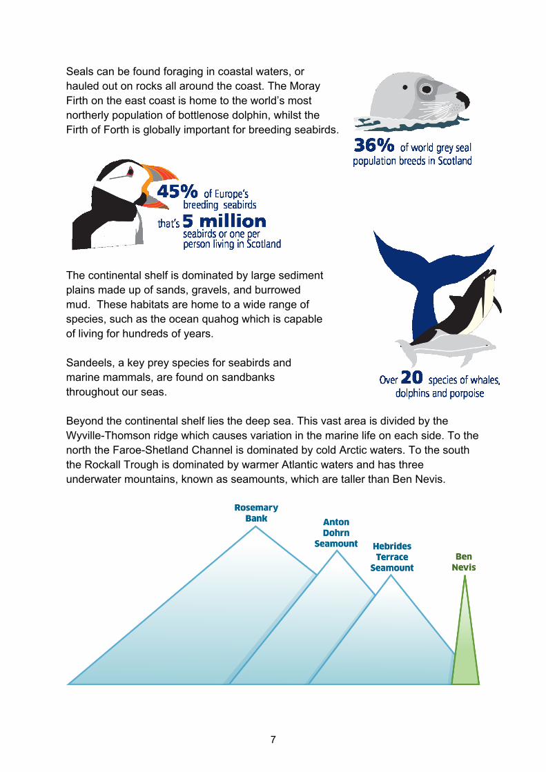
Seals can be found foraging in coastal waters, or
hauled out on rocks all around the coast. The Moray
Firth on the east coast is home to the world’s most
northerly population of bottlenose dolphin, whilst the
Firth of Forth is globally important for breeding seabirds.
The continental shelf is dominated by large sediment
plains made up of sands, gravels, and burrowed
mud. These habitats are home to a wide range of
species, such as the ocean quahog which is capable
of living for hundreds of years.
Sandeels, a key prey species for seabirds and
marine mammals, are found on sandbanks
throughout our seas.
Beyond the continental shelf lies the deep sea. This vast area is divided by the
Wyville-Thomson ridge which causes variation in the marine life on each side. To the
north the Faroe-Shetland Channel is dominated by cold Arctic waters. To the south
the Rockall Trough is dominated by warmer Atlantic waters and has three
underwater mountains, known as seamounts, which are taller than Ben Nevis.

8
The history of Scotland’s seas survives
underwater in the form of wrecks of boats,
aircraft, or artefacts from submerged pre-
historic landscapes. This cultural heritage
helps us to appreciate the importance of our
seas throughout Scotland’s history. This
combination of natural and cultural heritage
enhances the distinctiveness of our special seas.
Our seas remain at the forefront of our food and energy needs, through fishing,
aquaculture, oil and gas, and renewable energy. They are also important for
recreation and marine tourism. The fishing industry in Scotland has strong cultural
and historical links with our seas. As an island nation being able to trade goods
through marine transportation provides links to other nations.
The productivity of fish stocks is closely linked to the quality of the marine
environment and the supply of fresh fish and shellfish is an important service that
the marine environment provides to the Scottish economy.
Scotland also has the largest wave, tidal and offshore wind resource in Europe.
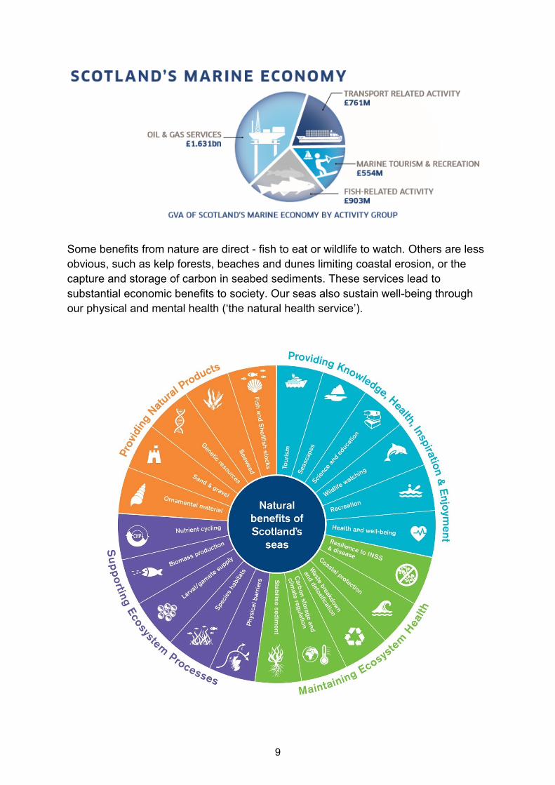
In 2016 the Scottish Marine Economy (excluding oil and gas extraction) generated
£3.8 billion GVA (Gross Value Added), providing employment for over 75,000
people.
9
Some benefits from nature are direct - fish to eat or wildlife to watch. Others are less
obvious, such as kelp forests, beaches and dunes limiting coastal erosion, or the
capture and storage of carbon in seabed sediments. These services lead to
substantial economic benefits to society. Our seas also sustain well-being through
our physical and mental health (‘the natural health service’).

10
Looking after our seas requires a range of different management approaches. This
includes marine planning and licensing together with various different statutory and
voluntary codes and good practice. Doing so is vital to ensuring that society can
continue to derive the many natural benefits that our seas provide.
MPAs also have an important role to play in conserving our seas. They enable the
focused protection of habitats and species which are essential to the marine
ecosystem. This facilitates an increase in ecosystem resilience and recovery of
habitats and species where required.
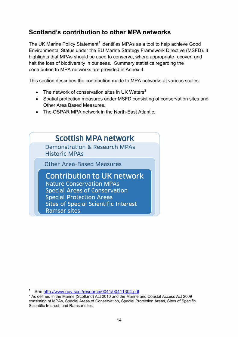
The Scottish MPA network consists of nature conservation sites designated under
various legislative frameworks. These protect a wide range of habitats and species.
It also includes other areas which deliver nature conservation benefits, known as
Other Area Based Measures. Also included are sites designated to protect our
historic environment and for demonstration and research purposes.

11
The Scottish MPA network
There are now 217 sites in the Scottish MPA network for nature conservation
purposes. In addition there is one demonstration and research MPA, eight historic
MPAs, and five Other Area Based Measures recognised as part of the Scottish MPA
network, making a total of 231 sites distributed across our seas.

12
Changes to the Scottish MPA network since 2012 report
The Scottish MPA network has changed considerably since the last report to
Parliament in 2012, and now better reflects the variety of life found in our seas. In
total these 231 MPAs protect 22% of our seas, which represents a considerable step
forward from the position in 2012.
A total of 42 new MPAs have been designated to protect marine habitats, wildlife,
geology, undersea landforms, historic shipwrecks, and to demonstrate sustainable
management of the sea. In addition, two existing sites have been extended to better
protect seabed habitats. All of the new sites and changes are listed in Annex 1.
The new sites mean that more features are now protected within the Scottish MPA
network. These include black guillemot, flame shell beds, common skate,
seamounts, warships and merchant trading vessels. From a nature conservation
perspective this makes the Scottish MPA network more representative of the range
of habitats and species found in our seas.
Some changes have been made in how sites in the Scottish MPA network are
counted since the last report, and these are listed in Annex 2. This has resulted in
MPAs for otters and some intertidal areas being included in the network. These
changes have not changed the protected status of any sites. The change is only one
of recognition of being considered part of the Scottish MPA network.
13
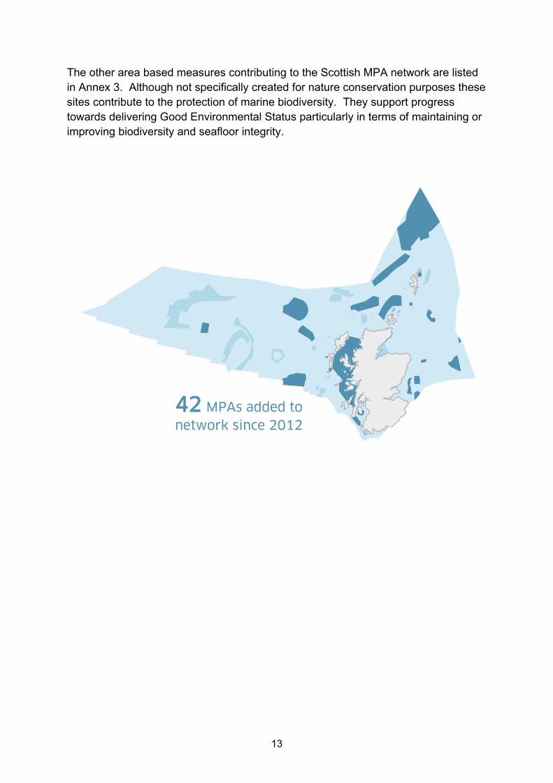
The other area based measures contributing to the Scottish MPA network are listed
in Annex 3. Although not specifically created for nature conservation purposes these
sites contribute to the protection of marine biodiversity. They support progress
towards delivering Good Environmental Status particularly in terms of maintaining or
improving biodiversity and seafloor integrity.
42 MPAs added to
network since 2012
14
Scotland’s contribution to other MPA networks The UK Marine Policy Statement1 identifies MPAs as a tool to help achieve Good
Environmental Status under the EU Marine Strategy Framework Directive (MSFD). It
highlights that MPAs should be used to conserve, where appropriate recover, and
halt the loss of biodiversity in our seas. Summary statistics regarding the
contribution to MPA networks are provided in Annex 4.
This section describes the contribution made to MPA networks at various scales:
The network of conservation sites in UK Waters2
Spatial protection measures under MSFD consisting of conservation sites and
Other Area Based Measures.
The OSPAR MPA network in the North-East Atlantic.
1 See http://www.gov.scot/resource/0041/00411304.pdf 2 As defined in the Marine (Scotland) Act 2010 and the Marine and Coastal Access Act 2009
consisting of MPAs, Special Areas of Conservation, Special Protection Areas, Sites of Specific Scientific Interest, and Ramsar sites.

15
Contribution to the UK network of conservation sites
In Scottish Waters there are currently 217 MPAs for nature conservation purposes
forming part of the UK network of conservation sites3, which consists of 666 MPAs in
total. These numbers are different to those presented in the UK Government report,
because they have excluded certain site types from their statistics that they didn’t
count in their previous report in 2012.
The area contributed to the UK network of conservation sites by these 217 MPAs
exceeds 108,000 Km2 which is approximately 18% of Scotland’s seas, and
represents 52% of the total UK Network.
3 Does not include MPAs for demonstration & research or historic purposes, or other area based
measures
52% of the UK MPA
network is within
Scottish waters

16
The Marine Acts include three conditions that the network must achieve:
Contribute to the conservation or improvement of the marine environment.
Represent the range of features present in the UK marine area.
Reflect that the conservation of a feature may require the designation of more
than one MPA.
Marine Act conditions
Contribution made by Scottish MPA network Progress
Contribute to conservation or improvement of marine environment
Scotland’s seas host 217 out of a total of 666 MPAs UK waters and 52% by area. All MPAs contribute to towards conservation. 24 MPAs in Scotland include objectives to restore or recover features and therefore also contribute to improvement.
Represent the range of features present in Scottish waters
The network includes all widely distributed habitats and all rare, threatened and/or declining habitats for which MPAs could be identified.
The network includes mobile species4 (marine mammals, birds and fish) and fronts. Potential new MPAs are being progressed for mobile species (see Looking ahead section).
Reflect that the conservation of a feature may require the designation of more than one MPA
There is replication of all the widely distributed habitats on a regional basis. The network has replication of all the rare, threatened and/or declining habitats.
There is replication of 55 of the 67 species represented in the Scottish MPA network. Potential new MPAs are being progressed for mobile species (see Looking ahead section).
Key:
Achieved work in progress to achieve this Further details on how habitats and species are represented and replicated is
provided in Annex 5. This demonstrates the coherence of the Scottish MPA
network, and the significant range of biodiversity now protected.
4 Species for which MPAs are considered an appropriate conservation tool

17
Spatial protection measures under the Marine Strategy Framework Directive
The EU Marine Strategy Framework Directive (MSFD) is focused on achieving Good
Environmental Status by ensuring that adverse effects from human activities are
avoided. There is an obligation to deliver spatial protection measures for
biodiversity. Our seas are within the Celtic Seas and Greater North Sea sub-regions
of the Atlantic.
For the purposes of this assessment all of the nature conservation sites are included.
The five other area based measures are also included because they contribute to the
conservation of marine biodiversity, and therefore help progress towards Good
Environmental Status. We have implemented spatial protection measures for marine
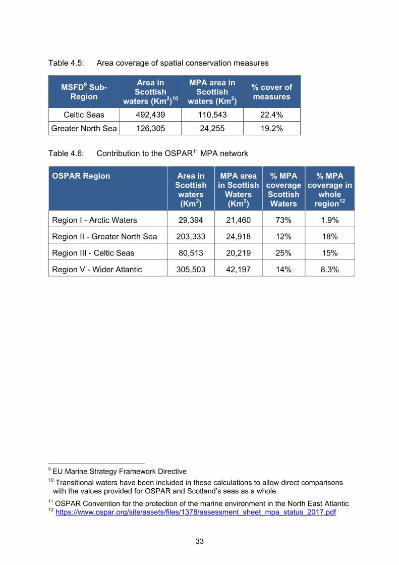
biodiversity in 22% of the Celtic Seas and 19% of the Greater North Sea.

18
These spatial protection measures are well distributed across our seas and are
representative of the wide range of habitats and species present. This is a significant
contribution towards achieving Good Environmental Status, which will be further
enhanced by completing delivery of management measures. Further details on
representation and replication of habitats and species in the Scottish MPA network
can be found in Annex 5.
19
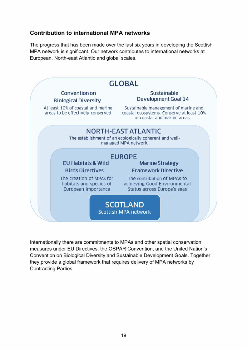
Contribution to international MPA networks The progress that has been made over the last six years in developing the Scottish
MPA network is significant. Our network contributes to international networks at
European, North-east Atlantic and global scales.
Internationally there are commitments to MPAs and other spatial conservation
measures under EU Directives, the OSPAR Convention, and the United Nation’s
Convention on Biological Diversity and Sustainable Development Goals. Together
they provide a global framework that requires delivery of MPA networks by
Contracting Parties.

20
Scotland is largely meeting or exceeding these international commitments. In area
terms our network exceeds any of the targets set by a considerable margin. In
addition the Scottish MPA network is broadly representative of the habitats and
species found in our seas. Ongoing work to complete the network is primarily
focused on improving the representation of habitats and species, and delivery of any
required management measures.
Table 2: Scotland’s progress towards international commitments
Measure Description Progress
What percentage of sea has spatial protection?
10% of coastal and marine areas
UN Sustainable Development Goal 14
Convention on Biological Diversity Aichi Target 11
22% of Scotland’s seas are in the MPA network.
Which features are represented?
Bird species
EU Wild Birds Directive
Once work on new MPAs for birds is complete, all but Roseate Tern will be included within the Scottish MPA network. Roseate Tern does not breed in Scotland and is therefore not a gap in the network.
Habitats and other species
EU Habitats Directive
MPAs designated for all seven habitats and all five species relevant to Scotland.
Threatened and declining habitats and species
The OSPAR list
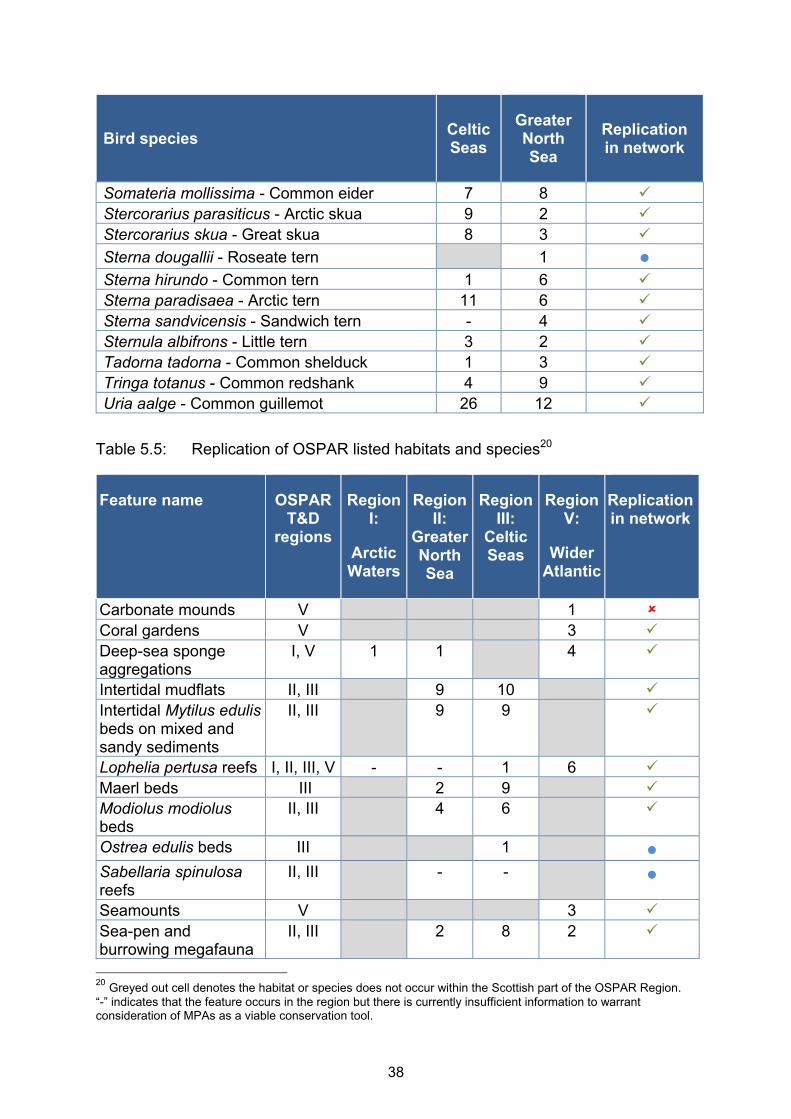
MPAs designated for all 12 listed habitats and seven of the eight listed species relevant to Scotland. MPA proposal being progressed for the remaining species, basking shark.
Key:
Achieved
A key aim of the Scottish Government has been to make a significant contribution to
the OSPAR5 MPA network in the North-east Atlantic. The OSPAR maritime area is
split up into regions which are different from those defined under the Marine Strategy
Framework Directive, even though the names are the same in some cases.
5 The OSPAR Convention for the protection of the marine environment in the North East Atlantic

21
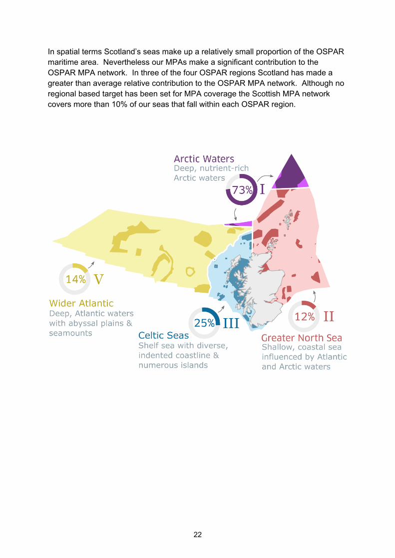
Scotland has waters within four OSPAR regions enabling an assessment of relative
contribution of Scottish MPAs to each of those. These regions are:
Region 1: Arctic Waters
Region 2: Greater North Sea
Region 3: Celtic Seas
Region 5: Wider Atlantic
22
In spatial terms Scotland’s seas make up a relatively small proportion of the OSPAR
maritime area. Nevertheless our MPAs make a significant contribution to the
OSPAR MPA network. In three of the four OSPAR regions Scotland has made a
greater than average relative contribution to the OSPAR MPA network. Although no
regional based target has been set for MPA coverage the Scottish MPA network
covers more than 10% of our seas that fall within each OSPAR region.

23
Managing the Scottish MPA network
The Scottish MPA network covers a diverse array of marine habitats, wildlife,
geology, landforms and historic shipwrecks. Various approaches to management are
needed to ensure we realise the benefits of these MPAs. Work continues to develop
and implement any necessary management measures.
The following principles guide management of the Scottish MPA network:
Supporting the sustainable use of Scotland’s seas
Following a risk-based approach
Using the precautionary principle when required
Providing opportunities for stakeholder involvement
Adopting an adaptive approach i.e. responding as our knowledge evolves
Adopting an ecosystem-based approach
Objectives have been agreed for the Scottish MPA network. These objectives
describe what the sites are trying to achieve, and are used to determine whether
new activities or development can be consented. In future the results of monitoring
will help measure whether the objectives are being achieved. A summary of the
objectives for each MPA designated under the Marine Acts is provided in Annex 6,
along with details of progress towards achieving them.
For each site consideration of the need for specific management, over and above the
general protective provisions provided by the Marine Acts, is undertaken. A total of
seven Marine Conservation Orders, under s85 of the Marine (Scotland) Act 2010,
have been implemented since the last report to Parliament in 2012 as detailed in
Annex 7. Currently four remain in force. No management schemes have been
established for any MPA designated under the Marine (Scotland) Act 2010.
The potential impact of developments and activities that require consents has been
taken into account for all MPAs since before they were designated. It is the
responsibility of all public authorities to ensure that MPAs are not placed at
significant risk through their decision making. This applies equally to their own
functions as well as when determining whether to consent activities which they
regulate.
This location specific approach does not work for fisheries because licences are
issued to enable activity at a broad geographic scale. Progress has been made
since 2012 in implementing fisheries management measures in MPAs, using both
Marine Conservation Orders and Inshore Fisheries Orders to deliver them.

24
There are now 27 MPAs that have specific fisheries measures in place. Further
measures are currently being developed in partnership with the fishing industry,
other stakeholders, including fishermen and governments in other European
countries too. In total, these new measures will cover a further 39 MPAs. Beyond
this the Scottish Government anticipates receiving specific advice from Scottish
Natural Heritage for a small number of the other existing sites.
Tools have been developed to help support management of MPAs and are available
online via the Marine Scotland, Historic Environment Scotland, SNH and JNCC
websites.
Tool What the tool provides
FeAST - Feature Activity
Sensitivity Tool
Information on the sensitivity of habitats and species to
pressures from human activity.
Fisheries Guidance
Notes
Evidence on the interaction between fishing gears and
specific habitats and species.
Marine Heritage web
pages
Advice and support on protecting Scotland’s marine
heritage, including information on Historic MPAs.
Scottish Government
MPA web pages
Information on the approach taken to develop and
implement MPA management.
Marine Scotland Maps
(NMPi)
Viewing the MPA network, management measures, and
data on marine habitats and species.
Natural Spaces To download boundaries of MPAs.
Site Information Centres Information on the MPAs designated in Scottish offshore
waters.
SiteLINK Information on the MPAs designated in Scottish territorial
waters.
.

25
Monitoring the Scottish MPA network
In 2017, the Scottish MPA Monitoring Strategy6 was published. The Strategy sets out
our approach to monitoring the Scottish MPA network. At the moment establishing
condition and status baselines with MPAs is the priority. Studies to explore the
effectiveness of new fisheries management measures are also underway. Historic
Environment Scotland undertakes periodic monitoring work on Historic MPAs to
maintain a register of survival and site condition.
A preliminary assessment of progress towards objectives of the MPAs, designated
under the Marine Acts, is provided in Annex 6. We expect to be able to provide more
comprehensive assessments in future reports (from 2024 onwards) once repeated
surveys have taken place.
MPA monitoring includes collaboration with other stakeholders and citizen science.
Examples of this are provided in the MPA Monitoring Strategy. Historic Environment
Scotland receives reports from diving clubs and archaeologists who help to monitor
historic shipwreck sites. Promoting sustainable visitor access is essential, with the
creation of a visitor trail on the Duart Point Historic MPA7 a positive example.
6 https://www2.gov.scot/Topics/marine/marine-environment/mpanetwork/MPAmonitoring
7 https://www.nauticalarchaeologysociety.org/duart-point-dive-trail
77 MPAs surveyed
since 2012

26
Looking ahead to the next six years
Great progress has been made in developing the Scottish MPA network over the last
six years. For the next six years the focus will be on finishing ongoing actions to
complete the Scottish MPA network, deliver any necessary management measures,
and continue our monitoring programme. Our aim is to be able to report more
authoritatively on MPA status in 2024.
In order to complete the Scottish MPA network the following work is ongoing:
Nature conservation proposals are being progressed for seabirds, waders and
seaducks, basking shark, Risso’s dolphin and minke whale.
Progressing assessment of historic wrecks - The Queen of Sweden wreck
near Shetland, and the wartime history of Scapa Flow. A small number of
other assessments may be anticipated as new discoveries come to light.
Development of a Deep Sea Marine Reserve to safeguard marine life that is
under threat in deeper waters across the North-east Atlantic.
In order to ensure the Scottish MPA network is well-managed the following work is
also ongoing:
Progressing further fisheries measures as required to achieve site objectives.
Ensuring that Public Authorities get clear advice to inform their decision
making where an MPA may be affected.
Trialing innovative approaches to MPA management planning, working with
local communities and other stakeholders to develop these.
We will continue to implement the
Scottish MPA monitoring strategy to
improve the evidence base. Over time
this will enable better assessments of
progress towards achieving site
objectives to be made. Additional data
needs to be collected to build a time
series that enables any change in
condition to be determined. This means
that future reports will be able to provide
greater clarity on the ecological benefits
of the Scottish MPA network.
27
Introduction to the annexes
The tables in these annexes provide information required under Section 103 of the
Marine (Scotland) Act 2010 and Section 124 of the Marine and Coastal Access Act
2009. Narrative regarding the creation of a network of conservation sites is provided
in the main body text of this document.
Further information on individual MPAs can be accessed in the following ways:
Inshore waters via SNH Sitelink pages
https://gateway.snh.gov.uk/sitelink/
Offshore waters via JNCC Offshore MPA Site Information Centres
http://jncc.defra.gov.uk/default.aspx?page=6895
The MPAs can be viewed through the Marine Scotland Maps (NMPi) portal
https://marinescotland.atkinsgeospatial.com/nmpi/
Fully attributed GIS site boundary files for all sites in the network are available
from SNH Natural Spaces
https://gateway.snh.gov.uk/natural-spaces/index.jsp
MPAs in UK waters via JNCC’s MPA mapper portal
http://jncc.defra.gov.uk/page-5201

28
Annex 1 MPAs designated since last report
The tables below list sites designated since 01 January 2013.
Table 1.1: Sites designated under the Marine (Scotland) Act 2010
Purpose Name Size (Km2)
Nature conservation
Clyde Sea Sill 712
East Caithness Cliffs 114
Fetlar to Haroldswick 216
Loch Carron 23
Loch Creran 12
Loch Sunart 49
Loch Sunart to the Sound of Jura 741
Loch Sween 41
Lochs Duich, Long and Alsh 37
Monach Isles 62
Mousa to Boddam 13
Noss Head 8
Papa Westray 33
Small Isles 803
South Arran 280
Upper Loch Fyne and Loch Goil 88
Wester Ross 599
Wyre and Rousay Sounds 16
Demonstration and
research Fair Isle 157
Historic
Drumbeg 0.05
Mingary 0.17
Kinlochbervie 0.22
Out Skerries 0.19
Dartmouth 0.008
Duart Point 0.013
Campania 0.07
Iona I 0.025

29
Table 1.2: Sites designated under the Marine and Coastal Access Act 2009
Name Size (Km2)
Central Fladen 925
East of Gannet and Montrose Fields 1,839
Faroe-Shetland Sponge Belt 5,278
Firth of Forth Banks Complex 2,130
Geikie Slide and Hebridean Slope 2,215
Hatton-Rockall Basin 1,256
North-east Faroe-Shetland Channel 23,682
North-west Orkney 4,365
Norwegian Boundary Sediment Plain 164
Rosemary Bank Seamount 6,927
The Barra Fan and Hebrides Terrace Seamount 4,373
Turbot Bank 251
West Shetland Shelf 4,083
Table 1.3: Sites designated under The Conservation (Natural Habitats, &c.)
Regulations 1994
Name Size (Km2)
Inner Hebrides and the Minches 13,802
Sound of Barra 125
Table 1.4: Sites amended under the Marine (Scotland) Act 2010
Site Name Reason for amendment
Fetlar to Haroldswick Both sites were re-designated to correct errors in the site
boundary description. This did not change the accepted
boundary, the area, or the protected features at either site. Small Isles
Table 1.5: Sites amended under The Conservation of Offshore Marine Habitats and
Species Regulations 2017
Site name Size (Km2) Amendments
Braemar Pockmark 11 Site increased in size by 6.25 Km2
Scanner Pockmarks 7 Site increased in size by 3.39 Km2

30
Annex 2 Administrative changes to the MPA network
This annex lists the administrative changes to the MPA network caused by updating the counting methodology, clarifying overlap with the marine area, and in the case of Ramsar sites completing assessment of their potential inclusion. This does not affect the protection status of any site named in the tables, and does not include the sites in Annex 1.
Table 2.1: Sites now counted in the MPA network
Site type Names Reason
SAC [count 10]
Rum; Taynish and Knapdale; Durness; Hascosay; Glen Beasedale; Inverpolly; Kinloch and Kyleaking Hills; Mull Oakwoods; Ardvar and Loch a' Mhuilinn Woodlands; Tayvallich and Juniper Coast
Inclusion of existing sites where otters use intertidal and/or subtidal habitat.
SPA [count 2]
Sleibhtean agus Cladach Thiriodh; Ythan Estuary, Sands of Forvie and Meikle Loch
Inclusion of existing sites where birds are using intertidal habitat.
SSSI [count 4]
Culbin Sands, Culbin Forest and Findhorn Bay; Kinloch and Kyleakin Hills; Yell Sound Coast; Southannan Sands
Inclusion of existing sites where otters or birds use intertidal habitat. Inclusion of existing site for plants in the intertidal.
Ramsar [count 16]
Cromarty Firth; Dornoch Firth and Loch Fleet; East Sanday Coast; Firth of Forth; Firth of Tay and Eden Estuary; Gruinart Flats, Islay; Inner Clyde; Inner Moray Firth; Loch an Duin; Montrose Basin; Moray and Nairn Coast; North Uist Machair and Islands; Sleibhtean agus Cladach Thiriodh (Tiree Wetlands and Coast); South Uist Machair and Lochs; Upper Solway Flats and Marshes; Ythan Estuary and Meikle Loch
Work to identify Ramsar sites contributing to the Scottish MPA network was not complete in 2012.

31
Annex 3 Other area based measures
These are the other area based measures considered to be part of the Scottish MPA network because they contribute to the protection of biodiversity but were not set up specifically for nature conservation purposes. Table 3.1: Other area based measures in the Scottish MPA network
Site name Size (Km2) Purpose
East Coast of Scotland (Sandeels)
21,320 Conservation of sandeels
West Of Scotland
(Blue Ling)
6,009 Conservation of blue ling
Rosemary Bank
(Blue Ling)
8,955 Conservation of blue ling
West Rockall Mound 5,124 Conservation of vulnerable marine ecosystems
North West Rockall8 346 Conservation of vulnerable marine ecosystems
8 Excludes spatial overlap with North West Rockall SAC
32
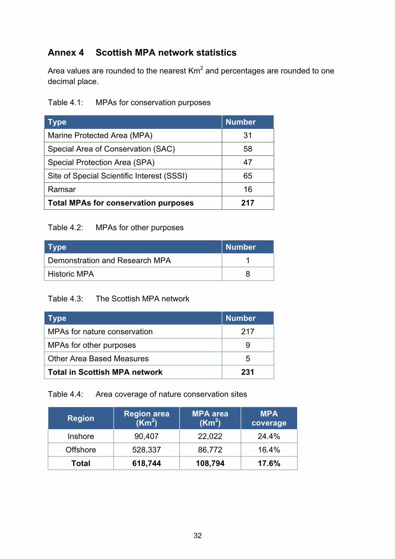
Annex 4 Scottish MPA network statistics
Area values are rounded to the nearest Km2 and percentages are rounded to one
decimal place.
Table 4.1: MPAs for conservation purposes
Type Number
Marine Protected Area (MPA) 31
Special Area of Conservation (SAC) 58
Special Protection Area (SPA) 47
Site of Special Scientific Interest (SSSI) 65
Ramsar 16
Total MPAs for conservation purposes 217
Table 4.2: MPAs for other purposes
Type Number
Demonstration and Research MPA 1
Historic MPA 8
Table 4.3: The Scottish MPA network
Type Number
MPAs for nature conservation 217
MPAs for other purposes 9
Other Area Based Measures 5
Total in Scottish MPA network 231
Table 4.4: Area coverage of nature conservation sites
Region Region area
(Km2) MPA area
(Km2) MPA
coverage
Inshore 90,407 22,022 24.4%
Offshore 528,337 86,772 16.4%
Total 618,744 108,794 17.6%
33
Table 4.5: Area coverage of spatial conservation measures
MSFD9 Sub- Region
Area in Scottish
waters (Km2)10
MPA area in Scottish
waters (Km2)
% cover of measures
Celtic Seas 492,439 110,543 22.4%
Greater North Sea 126,305 24,255 19.2%
Table 4.6: Contribution to the OSPAR11 MPA network
OSPAR Region Area in Scottish waters (Km2)
MPA area in Scottish
Waters (Km2)
% MPA coverage Scottish Waters
% MPA coverage in
whole region12
Region I - Arctic Waters 29,394 21,460 73% 1.9%
Region II - Greater North Sea 203,333 24,918 12% 18%
Region III - Celtic Seas 80,513 20,219 25% 15%
Region V - Wider Atlantic 305,503 42,197 14% 8.3%
9 EU Marine Strategy Framework Directive
10 Transitional waters have been included in these calculations to allow direct comparisons with the values provided for OSPAR and Scotland’s seas as a whole.
11 OSPAR Convention for the protection of the marine environment in the North East Atlantic
12 https://www.ospar.org/site/assets/files/1378/assessment_sheet_mpa_status_2017.pdf

34
Annex 5 Feature replication in the MPA network
This annex details the replication of features within the MPA network. It considers broad scale habitats, as well as habitats and species listed by EU Directives and the OSPAR convention.
The symbols in the “replication in network” column mean the following:
Protected in more than one site in Scottish waters
● Protected in more than one site in UK waters
Not replicated in UK waters
Table 5.1: Replicates of EUNIS level 3 habitats by MSFD sub-region13
Broad-scale habitat EUNIS Code
Celtic Seas
Greater North Sea
Replication in network
High energy littoral rock A1.1 14 4
Moderate energy littoral rock A1.2 15 3
Low energy littoral rock A1.3 17 5
Littoral coarse sediment A2.1 8 3
Littoral sand and muddy sand A2.2 20 11
Littoral mud A2.3 11 8
Littoral mixed sediments A2.4 8 6
Littoral sediments dominated by aquatic angiosperms
A2.6 5 10
Littoral biogenic reefs A2.7 11 8
High energy infralittoral rock A3.1 14 3
Moderate energy infralittoral rock A3.2 18 4
Low energy infralittoral rock A3.3 19 4
High energy circalittoral rock A4.1 13 5
Moderate energy circalittoral rock A4.2 16 4
Low energy circalittoral rock A4.3 12 3
Sublittoral coarse sediment A5.1 13 4
Sublittoral sand A5.2 14 5
Sublittoral mud A5.3 20 5
Sublittoral mixed sediments A5.4 20 2
Sublittoral macrophyte-dominated sediment
A5.5 17 2
Sublittoral biogenic reefs A5.6 13 5
Deep-sea rock and artificial hard substrata
A6.1 8
13
Greyed cells indicate that the feature is not characteristic of the region. Count includes OABMs

35
Broad-scale habitat EUNIS Code
Celtic Seas
Greater North Sea
Replication in network
Deep-sea mixed substrata A6.2 11
Deep-sea sand A6.3 5
Deep-sea muddy sand A6.4 6
Deep-sea mud A6.5 6
Deep-sea bioherms A6.6 10
Raised features of the deep-sea bed A6.7 8
Table 5.2: Replicates for relevant listed14 seabed habitats by MSFD sub-region15
Habitat Celtic Seas
Greater North Sea
Replication in network
Blue mussel beds 10 9
Carbonate mounds 1
Coral gardens 3
Deep-sea sponge aggregations 6
Flame shell beds 6
Lophelia pertusa reefs 7
Maerl beds 10 1
Modiolus modiolus beds 7 3
Northern sea fan and sponge communities 4 1
Ostrea edulis beds 1 ●
Seagrass beds / Zostera beds 18 12
Seamounts 3
Sea-pen and burrowing megafauna communities
11 1
Serpulid reefs/aggregations 2
Coastal lagoons 7 0
Estuaries 1 2
Large shallow inlets and bays 4 0
Mudflats and sandflats 6 2
Reefs 24 5
Sandbanks 6 3
Submarine structures made by leaking gases 0 2
Submerged or partially submerged sea caves 3 2
14
Listed as Priority Marine Feature, or Annex II of EU Habitats Directive, or OSPAR threatened and/or declining list 15
Greyed cells indicate that the habitat is not present in the region
36
Table 5.3: Replicates for relevant listed16 species by MSFD sub-region17
Species Celtic Seas
Greater North Sea
Replication in network
Bottlenose dolphin - Tursiops truncatus 0 1 ●
Harbour porpoise - Phocoena phocoena 1 0 ●
Risso's dolphin - Grampus griseus 0 0
Minke whale - Balaenoptera acutorostrata 0 0
Grey seal - Halichoerus grypus 7 3
Harbour seal - Phoca vitulina 7 5
Otter - Lutra lutra 15 4
Basking shark - Cetorhinus maximus 0 0
Common skate - Dipturus spp. complex 1 0 ●
Orange roughy - Hoplostethus atlanticus 1
Blue ling - Molva dypterygia 2**
Sand eels - Ammodytes marinus / A. tobianus 1 2
Sea lamprey - Petromyzon marinus 1 1
Smelt (Sparling) - Osmerus eperlanus 1 0
Ocean quahog - Arctica islandica 10 4
Fan mussel - Atrina fragilis 1 0 ●
Flat/native/European oyster - Ostrea edulis 1 0 ●
Spiny lobster - Palinurus elephas 0 0 ●
Table 5.4: Replicates for relevant bird species18 by MSFD sub-region7,19
Bird species Celtic Seas
Greater North Sea
Replication in network
Alca torda - Razorbill 11 8
Anas acuta - Northern pintail 1 1
Anas crecca - Eurasian teal 1 2
Anas penelope - Eurasian wigeon - 6
Arenaria interpres - Ruddy turnstone 3 4
Aythya marila - Greater scaup 2 6
Branta bernicla - Brent goose 1 - ●
16
Listed as Priority Marine Feature, or Annex II of EU Habitats Directive, or OSPAR threatened and/or declining list 17
Greyed cells indicate that the species is not present in the region. Count includes OABMs. 18
Listed in EU Wild Birds Directive, migratory or MPA search feature 19
- Species not a significant presence in sub-region

37
Bird species Celtic Seas
Greater North Sea
Replication in network
Bucephala clangula - Common goldeneye 4 5
Calidris alba - Sanderling 3 1
Calidris alpina - Dunlin 3 6
Calidris canutus - Red knot 1 4
Calidris maritima - Purple sandpiper 2 3
Cepphus grylle - Black guillemot 4 3
Charadrius hiaticula - Ringed plover 5 2
Chroicocephalus ridibundus - Black-headed gull
1 1
Clangula hyemalis - Long-tailed duck 4 4
Fratercula arctica - Atlantic puffin 15 5
Fulmarus glacialis - Northern fulmar 19 10
Gavia arctica - Black-throated diver 2 -
Gavia immer - Great northern diver 6 2
Gavia stellata - Red-throated diver 7 5
Haematopus ostralegus - Eurasian oystercatcher
4 7
Hydrobates pelagicus - European storm-petrel
8 2
Larus argentatus - Herring gull 3 7
Larus canus - Common gull 1 1
Larus minutus - Little gull - 1 ●
Limosa lapponica - Bar-tailed godwit 2 6
Limosa limosa - Black-tailed godwit - 1 ●
Melanitta fusca - Velvet scoter 1 4
Melanitta nigra - Common scoter 1 3
Mergus merganser - Goosander 1 2
Mergus serrator - Red-breasted merganser 6 7
Morus bassanus (syn. Sula bassana) - Northern gannet
7 4
Numenius arquata - Eurasian curlew 1 6
Oceanodroma leucorhoa - Leach's storm petrel
6 -
Phalacrocorax aristotelis - European shag 9 7
Phalacrocorax carbo - Great cormorant 4 5
Pluvialis squatarola - Grey plover 1 2
Podiceps auritus - Slavonian grebe 5 4
Podiceps cristatus - Great crested grebe 1 1
Puffinus puffinus - Manx shearwater 2 2
Rissa tridactyla - Black-legged kittiwake 22 10
38
Bird species Celtic Seas
Greater North Sea
Replication in network
Somateria mollissima - Common eider 7 8
Stercorarius parasiticus - Arctic skua 9 2
Stercorarius skua - Great skua 8 3
Sterna dougallii - Roseate tern 1 ●
Sterna hirundo - Common tern 1 6
Sterna paradisaea - Arctic tern 11 6
Sterna sandvicensis - Sandwich tern - 4
Sternula albifrons - Little tern 3 2
Tadorna tadorna - Common shelduck 1 3
Tringa totanus - Common redshank 4 9
Uria aalge - Common guillemot 26 12
Table 5.5: Replication of OSPAR listed habitats and species20
Feature name OSPAR T&D
regions
Region I:
Arctic Waters
Region II:
Greater North Sea
Region III:
Celtic Seas
Region V:
Wider Atlantic
Replication in network
Carbonate mounds V 1
Coral gardens V 3
Deep-sea sponge aggregations
I, V 1 1 4
Intertidal mudflats II, III 9 10
Intertidal Mytilus edulis beds on mixed and sandy sediments
II, III 9 9
Lophelia pertusa reefs I, II, III, V - - 1 6
Maerl beds III 2 9
Modiolus modiolus beds
II, III 4 6
Ostrea edulis beds III 1 ●
Sabellaria spinulosa reefs
II, III - - ●
Seamounts V 3
Sea-pen and burrowing megafauna
II, III 2 8 2
20
Greyed out cell denotes the habitat or species does not occur within the Scottish part of the OSPAR Region.
“-” indicates that the feature occurs in the region but there is currently insufficient information to warrant consideration of MPAs as a viable conservation tool.

39
Feature name OSPAR T&D
regions
Region I:
Arctic Waters
Region II:
Greater North Sea
Region III:
Celtic Seas
Region V:
Wider Atlantic
Replication in network
communities
Zostera beds II, III 15 15
Arctica islandica - Ocean quahog
II 6 8
Ostrea edulis - Flat oyster
II - 1 ●
Cetorhinus maximus - Basking shark
I, II, III, V - - 0 -
Common skate I, II, III, V - - 1 - ●
Hoplostethus atlanticus - Orange roughy
V 1
Petromyzon marinus - Sea lamprey
II, III 1 1
Phocoena phocoena - Harbour porpoise
II, III - 0 1 - ●
Rissa tridactyla - Black-legged kittiwake
I, II - 19 10 -
Sterna dougallii - Roseate tern
II, III, IV, V
0 ●

40
Annex 6 MPA objectives and progress towards them
The table below provides a description of the symbols used in this annex.
Symbol Meaning Application in terms of implementation of measures and achievement of objectives
Yes
Specific fisheries measures are implemented. Other licensable activities controlled through regulatory processes.
Protected features are improving in condition or have achieved conservation objectives.
Partial
Specific fisheries measures are in the process of being implemented. Other licensable activities controlled through regulatory processes.
Some protected features are improving in condition or have achieved conservation objectives. Others are not improving in condition or status is unknown.
Unknown
It is uncertain if there is sufficient management in place to address identified threats or pressures.
There is not sufficient data to determine if there is progress towards achieving the conservation objectives.
Table 6.1: Progress towards MPA21 objectives for nature conservation
MPA name Objectives (COs)
Are measures in place
Have COs have been achieved?
Comments including any further steps required
Central Fladen
Conserve –
all features
The implementation of fisheries management measures should improve conservation status of burrowed mud.
Clyde Sea Sill
Conserve –
all features
Black guillemot declining since site designation. The implementation of fisheries management measures should improve feature status.
East Caithness Cliffs
Conserve -
Monitoring required to assess progress towards objectives.
21
This table only considers MPAs that have been designated under the Marine Acts.

41
MPA name Objectives (COs)
Are measures in place
Have COs have been achieved?
Comments including any further steps required
East of Gannet and Montrose Fields
Conserve –
all features
The implementation of fisheries management measures is expected to improve the conservation status of the protected features. At present it is unknown whether the conservation objectives are being achieved.
Faroe-Shetland Sponge Belt
Conserve –
all features
The implementation of fisheries management measures should improve the conservation status of the habitats protected within the site.
Fetlar to Haroldswick
Conserve –
all features
Some fisheries measures already in place for some fisheries which are helping some features to meet their objectives. Additional measures are being progressed and should further improve feature status.
Firth of Forth Banks Complex
Conserve –
all features
The implementation of fisheries management measures should improve the conservation status of the habitats protected within the site.
Geikie Slide and Hebridean Slope
Conserve - all features
The implementation of fisheries management measures should improve the conservation status of the habitats protected within the site.
Hatton-Rockall Basin
Conserve - all features
Fisheries is managed under regulation by the North East Atlantic Fisheries Commission. Whilst all management measures are in place, there is limited information to comment on the degree to which conservation objectives are being achieved.
Loch Carron
Recover - flame shell beds
Loch Carron MPA was designated on an urgent basis in May 2017 with associated management measures. Recovery of the flame shell beds feature is expected to take up to 10 years.

42
MPA name Objectives (COs)
Are measures in place
Have COs have been achieved?
Comments including any further steps required
Loch Creran
Conserve - all features
Required measures were implemented in 2016 enabling the achievement of objectives.
Loch Sunart Conserve - all features
The serpulid aggregations have significantly declined likely due to natural processes. Required measures were implemented in 2016 enabling the achievement of objectives for other features.
Loch Sunart to the Sound of Jura
Conserve - all features
Required measures were implemented in 2016. Research and monitoring activities are ongoing to determine progress towards objectives.
Loch Sween
Conserve - all features
Required measures were implemented in 2016 and the features are considered to be achieving their objectives.
Lochs Duich, Long and Alsh
Conserve - all features
Required measures were implemented in 2016 and the features are considered to be achieving their objectives.
Monach Isles
Conserve - all features
Black guillemot declining since site designation. The implementation of fisheries management measures should improve feature status.
Mousa to Boddam
Conserve - all features
Features are considered to be meeting their objectives. Management measures being progressed for overlapping SAC.
North-east Faroe-Shetland Channel
Conserve - all features
The implementation of fisheries management measures should improve the conservation status of the habitats protected within the site.
North-west Orkney
Conserve - all features
The protected features are considered to be in favourable condition.

43
MPA name Objectives (COs)
Are measures in place
Have COs have been achieved?
Comments including any further steps required
Norwegian Boundary Sediment Plain
Conserve - all features
The implementation of fisheries management measures is expected to improve the conservation status of the protected features. At present, it is unknown if the conservation objectives for Ocean quahog aggregations are being achieved.
Noss Head
Conserve - horse mussel beds
Required measures were implemented in 2016 and the features are considered to be achieving their objectives.
Papa Westray
Conserve - all features
Black guillemot declining since site designation. The implementation of fisheries management measures should improve feature status. Geodiversity features achieving their objectives.
Rosemary Bank Seamount
Conserve - all features
The implementation of fisheries management measures should improve the conservation status of the habitats protected within the site.
Small Isles Conserve - all features
The implementation of fisheries management measures should improve feature status.
South Arran
Recover - maerl beds
Conserve - all other features
Measures were introduced in 2016 and features progressing towards achieving objectives. Recovery of maerl beds is likely to take a considerable period of time.
The Barra Fan and Hebrides Terrace Seamount
Conserve - all features
The EU deep-sea trawling ban is considered sufficient to enable the protected features of the site to reach favourable condition.
Turbot Bank Conserve - sandeels
The absence of a sandeel fishery means the site is likely to be in favourable condition.

44
MPA name Objectives (COs)
Are measures in place
Have COs have been achieved?
Comments including any further steps required
Upper Loch Fyne and Loch Goil
Recover - flame shell beds
Conserve - all other features
Management is in place and working towards the objectives. It remains unclear how long flame shell bed recovery with take. Future monitoring will determine progress towards objectives.
West Shetland Shelf
Conserve -
Existing fisheries measures are contributing towards achieving conservation objectives although habitat status needs to be confirmed through monitoring.
Wester Ross
Recover - flame shell beds, maerl beds
Conserve - all other features
Management is in place and working towards the objectives. The recovery of maerl beds and flame shell beds is likely to take considerable time.
Wyre and Rousay Sounds
Conserve - all features
Required measures were implemented in 2016 and the features are considered to be achieving their objectives.

45
Table 6.2: Progress towards purpose of the Demonstration and Research MPA
MPA name Purpose Comments on progress
Fair Isle To demonstrate and research the use of an ecosystem approach, which includes the following -
(a) the environmental monitoring of seabirds and of other mobile marine species;
(b) the environmental monitoring of the factors which influence the populations of seabirds and of other mobile species;
(c) the development and implementation of a local sustainable shellfish fishery;
(d) the development of a research programme into local fisheries which includes research on species composition, size, distribution and temporal and spatial changes in fish stocks;
(e) based upon the research undertaken under sub-paragraph (d), the development of a sustainable-use management programme for local fisheries.
A Steering Group has been set up including the local community and representatives of other stakeholders. A research sub-group has been established to help prioritise and co-ordinate research and monitoring relating.
In addition to the specific preservation objectives set out in table 6.3 which vary
between MPAs depending on what is appropriate and practicable; all Historic MPAs
have the following objectives:
to prevent the removal, wholly or partly, of the marine historic asset from
within the Historic MPA, except where the Scottish Ministers are satisfied that
this is desirable for the purpose of making a significant contribution to the
protection of the marine historic asset or to knowledge about marine cultural
heritage; and
to prevent the commercial exploitation of the marine historic asset for trade,
speculation or its irretrievable dispersal other than provision of professional
archaeological or public access which is consistent with other preservation
objectives.
46
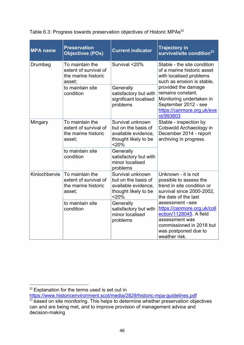
Table 6.3: Progress towards preservation objectives of Historic MPAs22
MPA name Preservation Objectives (POs)
Current indicator Trajectory in survival/site condition23
Drumbeg To maintain the extent of survival of the marine historic asset;
Survival <20% Stable - the site condition of a marine historic asset with localised problems such as erosion is stable, provided the damage remains constant.
Monitoring undertaken in September 2012 - see https://canmore.org.uk/event/993803
to maintain site condition
Generally satisfactory but with significant localised problems
Mingary To maintain the extent of survival of the marine historic asset;
Survival unknown but on the basis of available evidence, thought likely to be <20%
Stable - inspection by Cotswold Archaeology in December 2014 - report archiving in progress.
to maintain site condition
Generally satisfactory but with minor localised problems
Kinlochbervie To maintain the extent of survival of the marine historic asset;
Survival unknown but on the basis of available evidence, thought likely to be <20%
Unknown - it is not possible to assess the trend in site condition or survival since 2000-2002, the date of the last assessment –see https://canmore.org.uk/collection/1128045. A field assessment was commissioned in 2018 but was postponed due to weather risk.
to maintain site condition
Generally satisfactory but with minor localised problems
22
Explanation for the terms used is set out in https://www.historicenvironment.scot/media/2829/historic-mpa-guidelines.pdf 23
Based on site monitoring. This helps to determine whether preservation objectives can and are being met, and to improve provision of management advice and decision-making

47
MPA name Preservation Objectives (POs)***
Current indicator Trajectory in survival/site condition24
Out Skerries To maintain the extent of survival of the marine historic asset;
Survival <20% Stable - i.e. the extent of survival/ site condition of a marine historic asset(s) shows little or no sign of active deterioration either recent or mid-term. The site condition of a marine historic asset with localised problems such as erosion is stable, provided the damage remains constant.
Monitoring and interventions since 2016 have addressed localised exposures of potentially vulnerable material at some locations on this site.
For June 2014 monitoring
inspections see -
https://canmore.org.uk/eve
nt/1030846 and
https://canmore.org.uk/eve
nt/1030783.
May-June 2016 - Monitoring and artefact recording/recovery operation by Wessex Archaeology (report archiving in progress).
to maintain site condition
Generally satisfactory but with minor localised problems
24
Based on site monitoring. This helps to determine whether preservation objectives can and are being met, and to improve provision of management advice and decision-making

48
MPA name Preservation Objectives (POs)***
Current indicator Trajectory in survival/site condition25
Dartmouth To maintain the extent of survival of the marine historic asset;
Survival - estimated at 10-20%
Stable/declining - monitoring visit in 2014 identified evidence of a small extent of exposed hull structure around the main anchor which may lead to the degradation of the surviving hull.
December 2014 monitoring inspection by Cotswold Archaeology (report archiving in progress).
to maintain site condition
Optimum condition
Duart Point To maintain the extent of survival of the marine historic asset;
Survival 21-40% Stable.
December 2014 monitoring inspection by Cotswold Archaeology (report archiving in progress).
to maintain site condition
Optimum condition
Campania To minimise loss of the marine historic asset within the area;
Survival - estimated at 41-60%
Unknown - it is not possible to assess the trend in site condition or survival since 2004 as a field assessment has not been made since then.
August 2004 monitoring report see - https://canmore.org.uk/collection/1319203
to minimise deterioration of site condition
Generally unsatisfactory with major localised problems
Iona I To minimise loss of the marine historic asset within the area;
Survival - estimated at 41-60%
Unknown - it is not possible to assess the trend in site condition or survival since 2009 as a field assessment has not been made since then.
March 2009 monitoring
report see -
http://canmore-
pdf.rcahms.gov.uk/wp/00/
WP000733.pdf
to minimise deterioration of site condition
Extensive problems
25
Based on site monitoring. This helps to determine whether preservation objectives can and are being met, and to improve provision of management advice and decision-making

49
Annex 7 Management measures
This annex details the specific management measures implemented to further the
objectives of nature conservation sites in the Scottish MPA network. These
measures are either Marine Conservation Orders or Inshore Fisheries Orders.
There are no current Marine Conservation Orders specifically to support
Preservation Objectives for Historic MPAs or the stated purpose of demonstration
and research MPAs
Table 7.1: Marine Conservation Orders for nature conservation sites
SSI26
number
Name Notes Status
2014/260 The South Arran Marine
Conservation Order 2014
Amended by SSI
2014/297 and
continued by SSI
2015/303
All revoked
by SSI
2015/437
2105/302 The Wester Ross Marine
Conservation Order 2015
Revoked by
SSI 2016/88
2015/437 The South Arran Marine
Conservation Order 2015
In force
2016/88 The Wester Ross Marine
Conservation Order 2016
In force
2016/90 The Loch Sunart to Sound of
Jura Marine Conservation Order
2016
In force
2017/158 The Loch Carron Urgent Marine
Conservation Order 2017
Revoked by
SSI
2017/205
2017/205 The Loch Carron Urgent Marine
Conservation (No. 2) Order 2017
Continued by SSI
2018/100
In force
Table 7.2 Inshore fisheries orders which are in force
SSI27
number
Name
2015/435 The Inshore Fishing (Prohibition of Fishing and Fishing Methods)
(Scotland) Order 2015
2105/436 The Inshore Fishing (Prohibited Methods of Fishing) (Luce Bay) Order
2015
26
Scottish Statutory Instrument

w w w . g o v . s c o t
© Crown copyright 2018
This publication is licensed under the terms of the Open Government Licence v3.0 except where otherwise stated. To view this licence, visit nationalarchives.gov.uk/doc/open-government-licence/version/3 or write to the Information Policy Team, The National Archives, Kew, London TW9 4DU, or email: [email protected]
Where we have identified any third party copyright information you will need to obtain permission from the copyright holders concerned.
This publication is available at www.gov.scot
Any enquiries regarding this publication should be sent to us at The Scottish GovernmentSt Andrew’s HouseEdinburghEH1 3DG
ISBN: 978-1-78781-497-4 (web only)
Published by The Scottish Government, December 2018
Produced for The Scottish Government by APS Group Scotland, 21 Tennant Street, Edinburgh EH6 5NAPPDAS512806 (12/18)