Embed Size (px)
Citation preview

1
SB 037, The Fort Gut Ridge site: An Archaeological Survey and
limited excavations
By Ryan Espersen, RMA (SABARC)
Principal Investigators: Dr. Jay B. Haviser (SABARC) Ryan Espersen (Sabarc)
08 July, 2014

2
Acknowledgements
The Saba Archaeological Center (SABARC) would like to thank the Saba Island Government and
the Saba Electric Company for their support and patience throughout this endeavour. We would also
like to thank Stacey Simmons for putting up with a less than desirable car interior from repeated
occupation by soiled archaeologists. Furthermore, we would like to express our gratitude to the people
of Saba for their continued interest and support.

3
Table of Contents
Page
Project Overview 5
Administrative Data 6
Reason for Survey 8
Research Goals 8
Field Research Timeline 8
Introduction
Geographical Context 9
Geologic Context 10
(Pre) historical Context 11
Past Research 14
Research Methods 14
Fieldwork results
Shovel test pits 16
Structure 1 16
Structure 2 18
Structure 3 21
Shovel Test Pits 22
1m x 1m Test Pits 22
Machine Excavator Trenches 23
5m x 10m Excavator Pit 24
Conclusions 32
Recommendations 34
References 35
Appendix 1: 37

4
List of Tables Page
Table 1: Population of Saba 13
Table 2: Artifacts by Type Recovered from 5m x 10m Excavator Unit, “Above Black” 25
Table 3: Artifacts by Type Recovered from 5m x 10m Excavator Unit, “Black” 29
Table 4: Faunal Remains Recovered from Unit 7D, “Below Black” 31
List of Figures
Figure 1: Archaeological site map, SB 037 16
Figure 2: Trench 1 soil profile map 23
Figure 3: Artifact Distribution Map, 5m x 10m Excavator Unit, “Black” 28
List of Photos
Photo 1: SB 037, full site 5
Photo 2: Structure 1 (cistern) 17
Photo 3: Cistern hatch and trough 17
Photo 4: Structure 2 19
Photo 5: Ceramic, Unit 10B, “Above Black” 20
Photo 6: Ceramic, Unit 10B, “Above Black” 20
Photo 7: Structure 3 21
Photo 8: Andesite chopper, Unit 5E “Black” 26
Photo 9: Andesite chopper, Unit 5E “Black” 26
Photo 10: 5m x 10m Excavator Unit, “Black” 27
Photo 11: Soil profile, Unit 7D “Below Black” 30

5
Project Overview
The area of SB 037 is of particular historical and cultural significance to Saba as it is the only
known site on the island with three distinct occupation periods by different cultures. It consists of a
large Archaic Amerindian component, a less intensive ceramic-‐age Amerindian component, and
terminating with an early colonial occupation from the late seventeenth to late eighteenth century.
The most significant find from this survey is the extent of the Archaic-‐age occupation, which itself is only
the second known site of its kind on the island, next to Plum Piece.
Photo 1: SB 037 as seen from atop Fort Hill, facing north. Red outline indicates area of investigation.

6
Administrative Data
Site name: The Fort Bay Trifecta site, Saba, Dutch Caribbean
Site number: SB 037
Title: “The Fort Bay Trifecta Site: An Archaeological Survey”, SABARC report 001-‐2014
Year of Research and Publication: 2014
Author: Ryan Espersen
Principal Investigators: Jay Haviser, Ryan Espersen
Executive Archaeological Organization: Saba Center for Archaeological Research (SABARC)
Contact information:
Saba Archaeological Center, Windwardside, Dutch Caribbean. Postcode: 00000
Developers: Saba Electric Company
Developer contact information: Saba Electric Company
9 Samuel A. Charles St.
P.O. Box 43
The Bottom, Saba, Dutch Caribbean
Postcode: 00000
Data and artifact archive: Saba Archaeological Center, Windwardside, Dutch Caribbean.
Postcode: 00000

7
Site Description
Site Name: The Fort Bay Trifecta, Saba, Dutch Caribbean
Site Number: SB 037
Current Use: Vacant; landscaping for Saba Electric Company begins 1 July 2014. Diesel generator plant
to be constructed in 2015.
Planned Development: Landscaping, construction of diesel generator plant.
Research Area: Approximately 60m x 60m
Elevation: Approximately 88m
Site type: Two ruined colonial structures, two subsurface Amerindian occupation periods.
Geographical Characteristics: Thin topsoil layer of sandy loam, quickly transitioning to coarse infertile
sand with many andesite inclusions of varying size. Black loam lens at approximately 80cm found
throughout the surveyed area, transitioning again to coarse, infertile sand with fewer andesite
inclusions. Fine sand layers found below 120cm. A certain proportion of the site, respecting all
occupation periods, has been lost from cliff-‐side erosion.
Archaeological Expectation: Early colonial artifacts, Ceramic-‐age and archaic-‐age Amerindian artifacts.
Possible habitation site during one or both Amerindian occupation periods.

8
Introduction
Reason for Research
The land which composes the surveyed area belonged to a branch of the Simmons family, who
then sold to the Saba Electric Company. The company wants to dismantle the existing diesel generator
plant at Fort Bay, and construct a new, more efficient diesel generator plant upon the aforementioned
location, as it will then allow the shoreline of Fort Bay to be developed, free of air and noise pollution.
Research Goals
The survey intended to discover the presence and extent of any human occupation or
environmental modification within the zones affected by the construction of the diesel generator plant.
The survey and excavations were conducted in May and June 2014 within the affected area delineated
by maps from the Department of Public Works on Saba. Given the site’s relatively flat terrain, its
defensible, elevated position, and its proximity to the freshwater spring and shoreline at Fort Bay, a high
probability of human occupation was expected.
Field Research Timeline
Following informal consultations with the Island Government of Saba in June and July of 2013,
Ryan Espersen was informed that the site SB 037 was selected as the location for a new diesel generator
plant for the company then known as GEBE. At the time, he was conducting an archaeological field
school for Bachelor students from Leiden University as part of his own PhD research at the same
institution. Since no formal archaeological mitigation framework had been established on the island at
the time, Espersen led a team of one Masters and four Bachelor students (Charlotte de Hoogd, Endie
Warners, Ninke Veer, Mike de Booij, and Hylke Tromp) to survey SB 037, and expose part of the ruins
which now form Structure 1, a large cistern with a flagstone catchment. Structure 2 was identified, and
based upon surface collections, a Ceramic-‐age Amerindian occupation was surmised. Radiocarbon dates
obtained from shell tools found by Roobol & Smith (1980) provided a date of 1205 +/-‐ 65 years BC,
potentially giving the site an archaic occupation as well, should it have proved to not be a chance find.
For three days in January 2014, the extents of Structure 1 were discovered and excavated, and
two 1m x 1m test pits were excavated by Espersen and Heli Boehm. Due to time constraints, the units

9
were only able to be excavated to a depth of 50cm, though they clearly demonstrated both a colonial
occupation during the eighteenth century, and a ceramic-‐age Amerindian component as well. In May
2014 six 50cm x 50cm shovel test pits were excavated by Espersen and Johan Schaeffer determine the
best locations for machine excavator survey trenches. Between 30 May to 3 June, Structure 2, Test
Units 3 and 4, and the remainders of Test Units 1 and 2 were excavated by Jay Haviser, Ryan Espersen,
and Johan Schaeffer. On 12 June, machine excavator trenches were dug under the supervision of Ryan
Espersen, and a 5m x 10m x 60cm (depth) area around Test Unit 4 as a means to reveal the extent of the
Archaic-‐age occupation visible at the bottom of Test Units 1 and 4. The 5m x 10m pit was excavated by
Espersen and Schaeffer from 13-‐22 June, and in-‐situ artifacts and the remainder of site features mapped
in with a Trimble GeoXH centimeter edition differential GPS the following day.
Geography
Saba is the northernmost stratovolcanic island in the active arc of the Lesser Antilles group,
situated at approximately 17.38 degrees North, and 63.14 degrees West, measuring about thirteen
square kilometers, and approximately 890 meters in elevation. Saba is a rhomb-‐shaped single volcano
rising to a central dome-‐capped peak (Roobol & Smith 2004:31). It has a population of about 1500
people (2014), residing across four main settlements; The Bottom, which is the administrative center of
the island, St. John's, Windwardside, and Hell's Gate. The island receives an average of 1,041mm of rain
per year (Nielsen 2007:21), however the higher elevations receive more precipitation than those lower.
The site SB 037 is located at the foot of Bunker Hill in the southwest of the island at approximately
17’37’07N and 63’15’04W, half way up the road between the Fort Bay Harbour and The Bottom. Its
proximity to Parish Hill and Great Hill, two young volcanic domes, may have impacted its pre-‐Columbian
occupation history through volcanic events. The vegetation at SB 037 consists mainly of grasses, the
Croton flavens L.). invasive Euphorbia tithymaloides, and “Maraun bush” (
Three distinct occupation periods characterize SB 037, including the early colonial period, the
Amerindian Ceramic-‐age, and the Amerindian Archaic-‐age. There is no other investigated site which has
seen such repeated use Saba, save perhaps The Bottom. Its location is ideal in that it is situated upon a
plateau above a small cliff over the Fort Bay Gut, which prior to the 1940’s would have been much
narrower than it presently is. Erosion along the current cliff edge is evident, and extends right up to the
edge of Structure 1, which is an early colonial period cistern. Given that early colonists would have had
the foresight to have not have originally constructed the cistern to the cliff edge, the site would have

10
projected further out towards Fort Bay Gut, extending farther somewhat proportionate to time past.
Therefore SB 037, in its present state, is only the surviving portion of what existed in previous times.
Fort Bay, Ladder Bay, and Wells Bay are the only reliable anchorage points on Saba, aided in part
by the sheltered position of the western waters around Saba from the northeast trade winds. A small
freshwater spring is present at Fort Bay, which has been used since the early colonial period of Saba,
and almost certainly during the Amerindian period. The only easy access to The Bottom is through the
Fort Bay Gut. Given the elevated position of SB 037 over the Fort Bay Gut, the site would not only have
been highly defensible, but it allowed occupants to control access to The Bottom. This was known to
the early colonists of Saba; before 1689 and into the early eighteenth century, the Fort Bay Gut was
described as a “zigzag route, scratched into the rock, into a completely impregnable natural fortress, the
narrow way still lined by planks filled with rocks” (Crane 1971:12; Labat 1742:287). This defense system
was used to repulse an invasion by French buccaneers led by a certain Pinel in 1689 (ibid). Given the
proximity to the shoreline at Fort Bay, the Fort Bay freshwater spring, and the defensiveness of its
location, it is no small wonder that the site saw occupation throughout the pre-‐Columbian and colonial
eras.
Geology
The area of SB 037 consists mainly of unlithified andesite block and ash flow deposits (Roobol &
Smith 2004:Plate 2). On average across the site, at 80cm depth, a 40cm thick lens of loam and sandy
loam is present, overlain with a 50cm – 60cm thick inorganic deposit of loamy sand with many poorly
sorted andesite boulder inclusions. Below the loam lens is a deposit of coarse sand and gravel, with the
same proportion of andesite inclusions. The 40m machine excavator trench revealed a deep deposit of
fine sand beginning at a depth of approximately 120cm, and extending down past 200cm, with
noticeably small presence of andesite.
Prehistoric Context
The earliest Amerindian occupations on Saba are known from Plum Piece, a seasonal and
uniquely inland Archaic period site dating to approximately 1,350BC (Hofman & Hoogland 2003).
Roobol & Smith (1980) radiocarbon dated a shell adze found on the surface of SB 037 to 1,200BC ± 65
years; however, due to the poor context in which the tool was discovered, it could not be reliably
associated with the site. Ceramic-‐age occupation sites on Saba range from 400AD – 1400AD. Kelbey’s
Ridge I and Spring Bay 1a date to the early Ceramic-‐age, around 400AD, and are characterized by the
11
Cedrosan Saladoid subseries of artifacts (Hofman & Hoogland 2003:15). The period between 800AD –
1200AD is the most intense Ceramic-‐age Amerindian occupation period on Saba, known from St. John’s,
The Bottom, Spring Bay 1b, 2, and 3 (ibid), and Spring Bay Flat (Hoogland 1996). All the known Ceramic-‐
age sites were oriented primarily towards marine resource exploitation (Hofman & Hoogland 2003:12-‐
13). An Amerindian occupation at the western end of Windwardside is known from a small collection of
ceramics, and other sites may possibly exist around Middle Island and The Ladder, due to small,
repeated finds of red, burnished ceramics in these areas.
Colonial Period Context
Saba was colonized by Dutch settlers from St. Eustatius around 1640AD, primarily due to the
island’s proximity to the Saba Bank for fishing. There is no documentation supporting a permanent
Amerindian presence on Saba during this time, however, the island, particularly Spring Bay, was still
probably frequented by Caribs. The “Tale of Johnny Frau”, an oral history account that circulates on
Saba, describes a fight between a “Big Injun” and an early colonist, Johnny Frau, over the spring at
Spring Bay (Johnson 1994:13). A census taken by the English in 1665 notes two Indians on the island,
but they may have been Amerindians from elsewhere in the Caribbean or the north coast of South
America, as they were known to have been employed or resident on European buccaneer ships for their
knowledge on how survive off the land and at sea (Esquemeling 2007). There were already Europeans
living on the island by the time the first Dutch colonists arrived, being a potpourri of English, Irish,
Scottish, and French refugees following the Spanish siege of St. Christopher in 1629 (Johnson 2013;
Espersen 2009). The first settlement on the island is purported to have been in the area of Tent Bay,
according to oral history accounts from Sabans. This is likely given that the namesake for Fort Bay was
in fact a small fort situated at the foot of Bunker Hill which was destroyed by a landslide in 1651 (Hartog
1975:17). The area was also ideal for early settlement due to its proximity to a small, potable spring at
Fort Bay, and the anchorage available at Wells Bay, Ladder Bay, and Fort Bay; save perhaps for Spring
Bay, no other safe anchorage exists around the island. Seventeenth century ceramics have also been
found among terraces above Ladder Bay which suggests that this area was occupied during this period
as well. The earliest homesteads on Saba appear to have been non-‐nucleated, evidenced by ruins found
in remote areas such as the top of Paris Hill, and even as far as Great Point. The Bottom would have
been settled by the last third of the seventeenth century, followed closely by St. John’s and
Windwardside. By 1665 Saba had a population of just 226 residents. The island was captured that year
by the English by the privateer Edward Morgan, uncle of the more famous Henry Morgan, in retaliation

12
for the Dutch Admiral Michiel de Ruyter’s attack on Barbados, but was returned to the United Provinces
in October of the same year (Hartog 1975:23). All Dutch residents were deported to St. Maarten, except
for a few families that swore an oath of fealty to the King of England. Their enslaved Africans were
captured and shipped to Jamaica for sale, which indicates that sugar production was probably already
active on the island before this period. The island was captured again by the English in 1672, and held
until 1679, when it was again returned to the Dutch (ibid). Saba was not captured again 1781, when it
was captured again by the English under Lt. James Cockburn, sent by Admiral George Brydges Rodney
following his capture of St. Eustatius. This was a turbulent time for the political and social environment
of the island, as Saba experienced two major hurricanes in 1772 and 1780, the latter known as the
“Great Hurricane” across the Caribbean, which resulted in over 30,000 fatalities. The former hurricane,
though, was more damaging to Saba, resulting in the loss of 140 houses from a total of 180, with reports
of cows being carried away from their stakes (National Archives, The Hague 1.05.06.13:1094-‐1154). This
reduced many on the island to destitution, and some took to living “under rocks and caves of the earth,
half naked and famishing with hunger; unable to help themselves and others by reason of the universal
nature of the calamity being unable to render them any effectual relief” (ibid). It was also during this
time that the villages of Palmetto Point (also known as Mary’s Point) and Middle Island were settled.
Saba alternated between English and French control until 1816, when it was given to the newly formed
Kingdom of The Netherlands.
Saba never developed a plantation economy to the degree of the “sugar islands” of the
Caribbean, due to its small size and rugged topography. The economy on Saba from the seventeenth to
early eighteenth century consisted of domestic and small-‐scale industrial sugar and molasses
production, indigo production, cotton and textile production, and, curiously, shoe manufacturing, which
by 1701 nearly every adult resident partook in, including the governor (Labat 1742:208). During this
time the sugar boiling houses at Spring Bay and likely The Bottom were operational, followed by those
at Flat Point and Spring Bay Flat by the mid eighteenth century. Indigo production took place at Spring
Bay, Core Gut Bay, Cove Bay, and probably Spring Bay Flat. By the late eighteenth century only about
20% of the enslaved Africans resident on the island were labouring in sugar plantations; the rest
laboured in non-‐industrial contexts such as domestic servants, field hands, tradespeople, and deckhands
aboard ships (Saba census 1780; National Archives, The Hague 2.02.09.08:247). Following the
hurricanes of the late eighteenth century, sugar production declined on the island, followed not
coincidentally by the first documented free people of African descent on Saba by 1780 (National
Archives, The Hague 1.05.13.1:542). By 1816 only the sugar boiling house in The Bottom was

13
operational, producing just 25,000lbs of sugar annually, none of which was exported as it was consumed
locally (National Archives, The Hague 1.05.06:213.2). During the early nineteenth century, the only
recorded exports from Saba were live cattle (National Archives, The Hague 1.05.13.01:319). From
around 1819 to 1834, Saba participated in an illegal trade network centered on St. Eustatius involving
the governors of both islands, merchants in St. Eustatius, ships involved in the African slave trade, South
American privateers from the Wars of Independence, and the latter who continued plundering following
the expiration of their letters of marque (Espersen 2013). Many Saban men took to sea during the late
eighteenth century to the twentieth century as captains, pilots, and sailors, while others worked abroad
in other islands such as St. Thomas and Bermuda, and later Aruba and Curacao, giving Saba the
reputation among foreigners for being an “island of women” (Raynal, 1782/V: 147). Table 1, below,
outlines the island’s population from 1665 to 1937 (Espersen 2009:57, with additions).
The economic state of the island continued to decline as the nineteenth century progressed, and the
population continued to rise, peaking at 2,488 residents by 1915. The island was increasingly dependent
on remittances sent over from Sabans working abroad, and most residents took to subsistence
agriculture. Emancipation in 1863 did not change the social and economic environment of Saba as
radically as was experienced in Surinam or Curacao as most enslaved Africans were labouring under
111 22
6 90
45
3 577
513
1301
12
60
1145
11
45
1200
16
17
1674
16
63
1663
17
09
1771
18
26
1826
18
77
1809
17
94
1832
18
63
1883
2072
19
55 22
02 24
58
1883
20
29 2179
21
89
2265
19
96
2387
24
47
2449
24
88
2229
16
61
1665
16
15
1597
15
99
1494
14
39
1408
1660
14
57
1510
14
95
1483
14
16
1403
0
500
1000
1500
2000
2500
3000
1659
16
65
1678
16
99
1705
17
15
1780
18
15
1816
18
17
1829
18
47
1849
18
50
1852
18
54
1857
18
60
1861
18
63
1865
18
66
1869
18
70
1872
18
78
1880
18
82
1888
18
90
1894
18
98
1900
19
02
1908
19
10
1913
19
14
1915
19
18
1920
19
23
1924
19
25
1926
19
27
1928
19
29
1930
19
31
1932
19
33
1934
19
35
1936
Pop'
n
Year
Population of Saba, 1659-1937

14
subsistence agriculture along with their owners, under somewhat less hierarchical relations than a
plantation setting. Shortly after oil refineries opened in Aruba and Curacao in the early twentieth
century, Saba experienced a dramatic decline in population, reaching a nadir of just 981 residents in
1960. The development of a small tourist industry beginning in the 1980’s, combined with the
establishment of the Saba School of Medicine during this time, has helped the island recover
economically.
Past Research
The first archaeological excavations on Saba were carried out by Josselin de Jong of Leiden
University in 1923 in The Bottom, around the area of Newtown and the Saba School of Medicine, but
the results were not published until 1947. Jay Haviser (1985) conducted an archaeological survey of
Saba in 1983 and documented Amerindian and colonial period archaeological sites below an elevation of
300 meters. This was followed by Amerindian-‐period excavations at Spring Bay and Kelbey’s Ridge by
Corinne Hofman and Menno Hoogland between 1987 and 1992 (Hofman 1993; Hoogland 1996;
Hoogland & Hofman 1993, 1999), and at Plum Piece in 2002 (Hofman & Hoogland 2003). Frans Brugman
(1995) completed an architectural survey of historical structures on Saba. Jay Haviser, Grant Gilmore,
and Joanna Gilmore excavated nineteenth century burials in Windwardside in early 2011 at the request
of the Peterson family prior to the construction of the Breadline Plaza. Ryan Espersen (2009) conducted
excavations and archival research concerning Palmetto Point between 2008 and 2009, and lived on Saba
between 2011-‐2013 while conducting colonial-‐period excavations at Flat Point, Spring Bay, Spring Bay
Flat, Middle Island, and The Bottom as part of his PhD research.
Research Methods
Two pedestrian surveys with surface collections were carried out at SB 037, one by Espersen and
a crew of Leiden University students in July 2013, and a second by Haviser, Espersen, and Schaeffer in
late May, 2014. The first survey identified Structure 1 and twinned face stone walls to its west.
Structure 1 was partially excavated in July 2013 by shovel through removing an average of 5cm of
topsoil to reveal the cistern catchment and its relative extents. In January 2014, Espersen and Boehm
exposed the extents of the flagstone cistern catchment in the same fashion. In the May-‐June 2014 work
period, four 1x1 test pits were excavated by trowel by arbitrary 10cm levels on the lowest level of SB
037, near the cliff edge, in order to determine the extent of occupation in this area. Upon the start of a
new 10cm layer, photos of each were taken from the vantage point of the four cardinal directions using

15
a Sony A57 DSLR camera with a Minolta AF 28-‐85 lens. Six 50cm x 50cm shovel test pits were excavated
by Espersen and Schaeffer on the second level of SB 037, just below the road leading to the incinerator,
but turned up no material. All hand-‐excavated units were sieved with a plastic 5mm mesh. The top
10cm of soil was removed from within the surmised extents of Structure B in the expectation of a
cobblestone floor, which was followed by two 1m x 1m trowel-‐excavated test units (Units 3A1 and 3AB)
on opposite sides of the western face stone wall. A machine excavator was hired on 12 June to excavate
a 40m trench running north to south on the second level, and a 10m trench perpendicular to this,
running east. The first 60cm of excavated material was put to one side of the trench, while the soils
below 60cm were deposited on the opposite end, in order to understand occupational sequences from a
basic stratigraphy. While little archaeological material was expected from the machine excavator
trenches due to the lack of artifacts from the shovel test pits, this was the area that would sustain the
most impact from the construction of the diesel generator plant, therefore it was given survey priority.
Based upon the results of Test Units 1 and 4, which revealed Ceramic-‐age Amerindian artifacts and a
potential Archaic-‐age layer at 80cm, the machine excavator was directed to remove the top 60cm of soil
from a 5m x 10m area extending from Test Unit 4. This was done in the interest of time, since only
Espersen and Schaeffer were available to excavate from 3-‐30 June, and the Archaic layer was given
priority since it is only the second such site known on the island. The remainder of the soil layer above
the Archaic level was excavated by trowel until the top of the black, sandy loam context with the Archaic
material was visible. This was designated as the “above black” context. Any artifacts verifiably in the
Archaic context were left in situ until the “above black” context was fully removed. Artifacts recovered
from the machine excavator piles adjacent to the 5m x 10m pit were dubbed “spoil pile”. The in situ
artifacts from the Archaic layer were individually mapped with a Trimble GeoXH centimeter edition
differential GPS to an average RTK (real time kinematic) correction of 3cm, along with a corresponding in
situ photo. The site and structures were mapped using this device as well. Narrated video
documentation was taken of the site following the completion of excavations was done with a Sony HDR
PJ580 video camera.

16
Figure 1: Map of SB 037 (see Appendix 1 for key coordinates)
Results
Structure 1 (Cistern)
The cistern is located at the extreme southwest corner of SB 037, in an area that has been
protected by the Saba Electric Company, designated as a zone that will not be impacted by the
construction of the generator. It has an architecture that has not been seen elsewhere on Saba. The
cistern is domed by Issel brick construction, with an off centered square top hatch and an adjacent
watering basin for livestock. Most striking is the use of large, flat slabs of basalt collected from the cliff
side of Fort Hill on the opposite side of the modern road to serve as a rain water catchment surface for
the cistern. These were set over top of the expanse of the cistern, and extending north of it an average
of 1.5m, into a bowl shape, with the drain located in the center-‐south of the cistern. The area north of
the cobbled catchment consists of rounded stones averaging 8cm in diameter that were set into the
ground with a fine plaster laid overtop to extend the catchment area. This area ends just 2-‐3 meters
south of Structure 2. Notably, the plaster used as catchment for this cistern differs significantly from
that used at Spring Bay Flat (SB 007) and Spring Bay (004), both which would have been contemporary

17
with SB 037 throughout its occupation. The plaster at the former two sites included locally sourced trass
as a means of making the plaster more water resistant and giving a better bond. This also resulted
giving this plaster an orange hue. Trass was not incorporated into the plastered catchment north of the
cobblestones, which is also evidenced by the lack of any continuous plastered surface over the small,
bedded rocks. The cobbled catchment area of the cistern measures 30.32 m2, while the mortared
catchment measures 30.50 m2, for a total catchment area of about 60.82 m2. The cistern basin
measures 7.37m east to west, and approximately 3m north to south. The basin’s depth could not be
determined as it was filled with sediment, nearly to the top.
Photo 2 (above): Cistern, facing east.
Photo 3 (below): Cistern watering trough and hatch, facing northwest.

18
Structure 2
Structure 2 is defined primarily by two parallel walls of face stones, flat sides aligned
northwards, joined by unmodified, flat stones on their east and west flanks. Only three unmodified
stones on the east flank extend northward to suggest the presence of a former house foundation. A
section measuring 3.12m x 5.24m was delineated adjacent to the northern two of the face stone walls
as the approximate limits of the structure. Within this area, and between the face stone walls, the top
10cm of fill was removed to reveal the remains of a structure such as a foundations or a tile floor.
Within these bounds, 1,656g of mortar was removed, scattered evenly across the area. Several chunks
were bonded to orange floor tile fragments. A total of eight orange tile fragments were recovered,
measuring 23mm thick, and one brick, 30mm thick. Few ceramics were recovered; these included two
sherds of Creamware, one sherd of Chinese porcelain, and one sherd of Staffordshire combed slipware.
Three sand temper brown hollowware Amerindian sherds were also recovered, one of which was
burnished in the interior. Other artifacts included a sherd of green glass, one sherd of a lantern globe,
three Citarium pica shell fragments, and eleven pieces of coral.
Approximately 11.5m southwest of Structure 2 lies an area of scattered rubble, comprised of
large conglomerates of brick and mortar. The brick is a mix of Issel and orange brick identical to that
found within the Structure 2 fill, but most of the bricks are broken. The lack of foundations, the
preponderance of mortar, and the rubble concentration suggests that Structure 2 was either destroyed,
scavenged for bricks, floor tiles and other salvageable materials, or both. This was a common practice
on Saba, to the point where the only standing ruins with salvageable material left on Saba are those of
the sugar boiling house at Spring Bay (SB 004), and to a lesser extent the remains of the same at SB 007,
which are both situated in locations which would otherwise make for arduous salvage efforts. In the
1850’s, the Catholic Church in Windwardside was constructed by salvaging bricks and face stones from
the Big House and sugar boiling house at Spring Bay Flat (Will Johnson, personal communication 2013).
Wood structure houses were rarely left abandoned; if the residents moved to another location on the
island, they were often dismantled and transported piecemeal to the new location, which occurred most
notably at Palmetto Point (Espersen 2009).

19
Photo 4: Structure 2, showing twinned face stone walls and Units 3A1 and 3A2, facing east.
In order to determine functional and structural differences within Structure 2, one 1m x 1m unit
was excavated between the face stone walls, and a second was placed adjacent and north of this unit.
These were named Unit 3A1 and 3A2, respectively. Both were excavated to a depth of 50cm in 10cm
intervals, until large, immovable, and impassible rocks were encountered which terminated both units.
The artifact assemblage from Unit 3A1 consisted mainly of mortar fragments, totalling 125 with a weight
of 2,491g. This also included an orange brick fragment, one orange tile fragment, a grey tile fragment
27mm thick, and five wrought nails. Ceramics included five sherds of Creamware, one sherd of
Westerwald stoneware, one sherd of hand painted floral tin enamel ware, and three Amerindian sherds;
two sand tempered, brown burnished sherds, and one identical but unburnished.
Unit 3A2 contained somewhat less mortar, with a total of 125 fragments weighing in at 1,830g.
Somewhat curiously, though, most of the ceramics recovered from this unit were Amerindian rather

20
than colonial. Eight Amerindian sherds were found, with an MNI of 5. The two colonial consisted of just
Staffordshire slipware and Chinese porcelain.
Photo 5 and 6: Flat, burnished-‐rim Amerindian ceramic from Unit 10B.

21
Structure 3
Structure 3 consists of a boulder with a natural depression which collects rain water, surrounded
to the west and south by aloe. The boulder’s penchant for collecting precipitation was improved by an
early colonist by setting two face stones into the lowest lip of the depression with mortar in order to
increase the hollow’s volume. This provided short-‐term source of potable water for residents, or may
have instead been used as a watering hole for livestock.
Photo 7: Structure 3, facing southwest.
Shovel Test Pits
The six shovel test pits excavated by 10cm arbitrary levels on the second level of SB 037 turned
up no artifacts. Shovel Test Pits (STP) 1, 2, 3, 5, and 6 were excavated across the extent of Level 2 of the
site to a depth of 60cm, at which point immovable rocks were encountered. STP 4 was excavated to
90cm, and a 5cm thick organic lens of sandy loam was encountered at a depth of 85cm, which
demonstrated the extent of this layer which was originally encountered at Level 1.

22
1m x 1m Test Units
Four 1m x 1m test units were instrumental in determining activity areas of the site, and for
gaging the relative longevity of human occupation periods. Test units 2 and 3, unfortunately, did not
extend past 60cm due to large and immovable boulders in this layer. It appears that during the colonial
era, the area which featured these test units were part of a plow zone, since eighteenth century artifacts
such as Creamware were found to a depth of 60cm – 70cm, while Amerindian ceramics extended from
the surface to the same level. Importantly, though, this plow zone did not extend past this depth, as the
black layer, which begins at approximately 80cm across the site, never contained colonial artifacts or
Amerindian ceramics. The colonial ceramics from these units consisted primarily of Creamware and Tin
Enamel ware, with smaller proportions of White Salt Glaze Stoneware. All dated to from the
seventeenth century to the late eighteenth century. Mortar fragments and some red and Issel brick
were recovered as well in all the test units, which supports the notion that Structure 2 was scavenged
for brick and other salvageable materials after its abandonment. Six wrought nails were found between
the units as well. Relatively few faunal remains were recovered in the layers above 80cm. These
consisted mostly of fragments of long bones, presumably from dietary remains from the colonial
homestead’s inhabitants. No fish remains were recovered above 80cm, but this could be due to their
fragility within a plow zone. Shell remains were few, and consisted of 10 unidentifiable fragments, and
one Potamopyrgus coronatus, obtained from the rocky shorelines of the island. The Amerindian
assemblage collected from above the 80cm level was small, and consisted of just 11 ceramics and one
transluscent, tan coloured chert uniface flake. These can be divided into two basic types: unburnished,
brown hollowwares with sand temper (7 sherds), and burnished, bright red ceramics with reduced cores
and sand temper (2 sherds).
At 70cm, the soil begins transitioning from an infertile sandy clay to a more fertile sandy loam,
becoming black sandy loam at 80cm with significant proportions of black ash, but remarkable absence of
charcoal. A whole Strombus pugilis, and one modified shell were found in this layer at the bottom of
Test Unit 2. In Test Unit 4, at 80cm, a thermally altered black chert flake was found, along with half of a
large stone grinding platform, and the top of a large brain coral cobble. Deeper excavations in Test Unit
1 to 80cm subsequently demonstrated the extent of this layer. This featured three black chert flakes
and two large stones used as grinding platforms, evidenced by their very smooth, flat surface textures,
and usewear hollows on this face from repeated striking. Based on these results, test Unit 4 was
selected as an anchor point for creating a 5m x 10m machine excavator pit to reveal the top of the
archaic layer. As such it was renamed Unit 4A as part of the matrix of units within this area.

23
Machine Trench Units
Two trenches were dug by the machine excavator, averaging 100cm wide down to a depth of
approximately 120cm on the second plateau of SB 037, across the area that will be most impacted by
the construction of the generator plant. The largest of these measured 40m long, running east to west,
and the second was 20m long, running north to south, joining the longer trench approximately in the
middle. The first level of each trench was excavated to a depth of 60cm; the fill from this top layer was
set to one side of the respective trench, while the soil removed from the deeper layer was set to the
opposite side, in order to derive a basic stratigraphic sequence from any artifacts recovered from the
spoil piles. The soil profile for the deepest section of Trench 1 is displayed in Figure 2 below.
All layers save for the lowest layer of sand contained poorly sorted andesite cobbles and boulders. Only
the largest of these were featured in the profile for the sake of legibility. The sandy layer, interestingly,
contained noticeably fewer cobbles and boulders than the upper layers. It is notable that the same
layer of dark brown loam seen in Test Unit 1 and the 5m x 10m excavator pit is present across the
expanse of the second plateau, with an average depth of 40cm before transitioning quickly into sand.
There were few artifacts found in the spoil piles from the trench units. In the top layer (less
than 60cm depth), only three unidentifiable long bone fragments and one unidentifiable tarsal were
recovered, along with two fragments of coral, all found around the middle of Trench 1. The far easterly
end of Trench 1 at depths greater than 60cm, though, had a small concentration of artifacts found in
piles of dark brown loam. This included one Citarium pica shell, two unidentifiable columella (shell)

24
fragments, one modified shell, one shell adze, an oval hammer stone, and a cobble of mottled brown
and black chert, probably from Antigua. This cluster of artifacts at the eastern extreme of Trench 1,
relative to the dearth of artifacts elsewhere, suggests some form of site use in this area by Amerindian
during either the Ceramic-‐age or Archaic-‐age. No artifacts were recovered from Trench 1 save for three
coral fragments from the second layer. This strongly suggests that the majority of the second plateau,
save perhaps for the eastern extreme of Trench 1, represents the periphery of an occupation area
located on or near the lowest (first) plateau of SB 037.
5m x 10m Excavator Unit
Having noted the potential for a deep Archaic-‐age layer based on results from Test Units 1 and
4, in the interest of time, a 5m x 10m area was excavated 60cm deep by a machine excavator with an a
shallow, non-‐toothed bucket to enable a large swath of the Archaic layer to be carefully exposed by
trowel and shovel. The spoil pile from the excavator was combed through by rake and shovel over the
following two weeks, and any artifacts recovered were given the context “Above Black General”. A
string grid of 1m x 1m units was established, spanning numerically 1-‐10 from north to south along the
10m extent, and alphabetically from A-‐E from east to west along the 5m expanse. Unit 1A was situated
in the extreme northwest, while its counterpart Unit 10E was located in the southeast. Due to time
constraints, the southern wall was not able to be expanded to correct the angle approached by the
machine excavator; as such, Units 10C, 10D were only partially excavated by hand, and Unit 10E was not
excavated. Excavations by shovel and trowel progressed on a unit-‐by-‐unit basis, removing soil until the
dark, sandy loam layer which characterizes the Archaic layer was exposed. The soil removed from this
procedure was all sifted and bagged per unit as the “Above Black” context, or by the acronym “AB”.
Artifact counts by basic typologies are listed below on Table 2.

25
Above Black context
The faunal count is somewhat exaggerated as nearly half of it consists of a single cow or horse
that was mostly removed by the machine excavator, located primarily in units 1C and 2C. This is located
in a curious are spanning Units 1 C-‐E and Units 2 C-‐E, as 20cm, rounded depressions were appearing in
the Archaic layer, with some large faunal remains found in the fill over top. This indicates a colonial
period intrusion into this section of the Archaic layer, probably impressions created by removed
boulders while a pit was dug to bury the remains of this large animal. The colonial ceramics recovered
from the units consists of Creamware, Tin-‐enamel wares, White Salt Glaze Stoneware, Whieldon ware,
and the molded foot of a seventeenth century orange-‐bodied lead glaze coarse earthenware pot. One
very small fragment of transfer print Pearlware was found, but notably, this is the only sherd of
pearlware recovered from the site, and represents the latest colonial ceramic type in the assemblage.
The stone tools consist of six rounded hammer stones with visible usewear on narrowed
extremities, likely used for processing food, one rounded andesite chopping tool, and one andesite axe.
261
134
33 28 21 17 10 10 2 0
50
100
150
200
250
300
Quanq
ty
SB 037 Arqfacts by Type, 5x10 Excavator Unit, AB

26
Photo 8, 9: Andesite chopper from Unit 5E, Black context
Unfortunately, since these were recovered outside of a closed archaeological context, they cannot be
directly attributed to either the Ceramic-‐age or Archaic-‐age.
The pre-‐Columbian coarse earthenware assemblage was small, consisting of just 16 sherds with
sand temper, half of which were burnished either red or brown. None bore any evidence of surface
decoration. This type of ceramic probably dates between 400A.D. – 800A.D. In unit 9A, three of these
sherds, brown burnished in the interior, were found in association with a rounded, slightly triangular
hammer stone at a depth of 70cm just 10cm away in Unit 10A. Two more hammer stones were
recovered from Unit 10A at the same depth.
A total of 33 chert fragments and one core recovered were all in various states of debitage,
mostly secondary cortex flakes. None were readily identifiable as tools; this will require usewear
analysis under a microscope. Chert is not locally available on Saba, and so it was imported to the island
either directly or through trade. Sixteen of these were jet black in color, eleven and the one core were
mottled in shades of black, grey, brown, and tan, and the rest were either brown or tan with some
translucence. The mottled flakes and the core are identifiable as Antigua chert, while the brown and

27
black flakes are likely from there as well, being fragments from the respective mottled portions of a
cobble (Jay Haviser, personal communication 2014).
Black context
The completion of the Above Black excavation revealed the surface of the “Black” context,
which consisted of a dark brown loam layer which spanned all units. This is the same layer which was
also revealed in Trenches 1 and 2. A considerable quantity of large artifacts were exposed in-‐situ on
within the surface of the “Black” context, with higher concentrations visible in the southern half of the
pit (Unit series 6, 7, 8, 9, and 10).
Photo 10: 5m x 10m excavator unit, Black layer, prior to the excavation of the “E” series of units, looking
north. Photo taken after precipitation to show contrast.
A total of 359 artifacts were recovered from the surface of the Black layer, consisting of shell,
shell tools and implements, chert fragments, stone tools for processing food, coral cobbles, and coral
fragments. Importantly, no ceramics were found in this context. The locations of artifacts exposed,
save for small artifacts that were recovered from sifting, such as faunal remains and chert fragments,

28
were mapped in-‐situ using a Trimble GeoXH Centimeter edition differential GPS, with 3cm RTK accuracy.
The artifact distribution by type is displayed below on Figure 3, followed by a count of artifacts on Table
3.
Figure 3: Artifact Distribution Map, 5m x 10m Excavator Unit, Black context
29
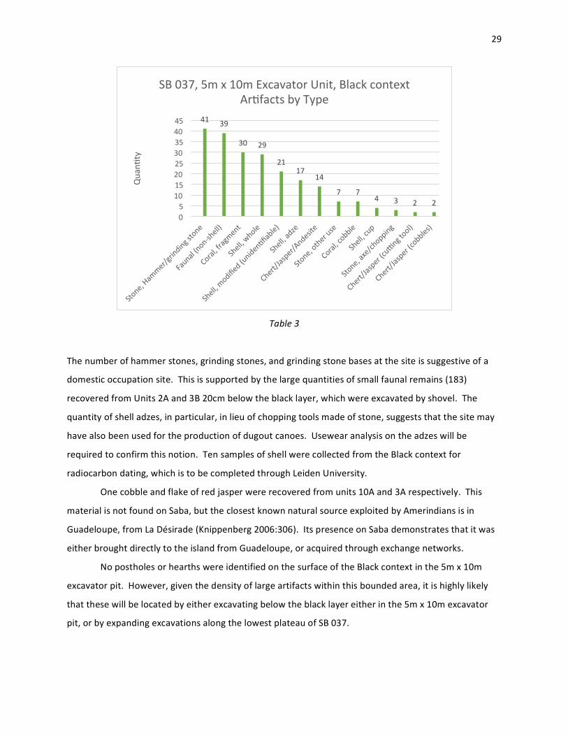
Table 3
The number of hammer stones, grinding stones, and grinding stone bases at the site is suggestive of a
domestic occupation site. This is supported by the large quantities of small faunal remains (183)
recovered from Units 2A and 3B 20cm below the black layer, which were excavated by shovel. The
quantity of shell adzes, in particular, in lieu of chopping tools made of stone, suggests that the site may
have also been used for the production of dugout canoes. Usewear analysis on the adzes will be
required to confirm this notion. Ten samples of shell were collected from the Black context for
radiocarbon dating, which is to be completed through Leiden University.
One cobble and flake of red jasper were recovered from units 10A and 3A respectively. This
material is not found on Saba, but the closest known natural source exploited by Amerindians is in
Guadeloupe, from La Désirade (Knippenberg 2006:306). Its presence on Saba demonstrates that it was
either brought directly to the island from Guadeloupe, or acquired through exchange networks.
No postholes or hearths were identified on the surface of the Black context in the 5m x 10m
excavator pit. However, given the density of large artifacts within this bounded area, it is highly likely
that these will be located by either excavating below the black layer either in the 5m x 10m excavator
pit, or by expanding excavations along the lowest plateau of SB 037.
41 39
30 29
21 17
14
7 7 4 3 2 2
0 5
10 15 20 25 30 35 40 45
Quanq
ty
SB 037, 5m x 10m Excavator Unit, Black context Arqfacts by Type

30
Unit 7D, Below Black
Unit 7D was randomly selected for further excavations by trowel in 10cm arbitrary levels, in
order to determine the depth of Archaic-‐age deposits. This context was designated as “Below Black”.
Excavation proceeded to a depth of 60cm, to a layer of infertile, compacted sand which began at 45cm.
Between 0-‐30cm, the soil remained a dark brown loam, while transitioning to a sandy loam to loamy
sand to 42cm. Not coincidently, the 40-‐42cm layer is the deepest from which artifacts were recovered.
Soil samples were collected for each 10cm interval from 0cm – 60cm.
Photo 11: Soil profile of Unit 7D, Below Black

31
A total of 615 artifacts were recovered between 0-‐42cm in Unit 7D Below Black, mostly small
faunal remains. Lithics included one oval hammer stone from 10cm – 20cm, 12 Antiguan chert flakes,
two small cobbles of Antiguan chert, and one slender chert blade measuring 29mm in length. From this
total, only two chert flakes were recovered from the 30cm – 40cm level, and none from the 40cm –
50cm level. The remainder were evenly distributed between the top three layers. Shells and shell
fragments were also proportionately distributed between 0-‐30cm, including two Strombus pugilis, and
two Citarium pica. One of the former and two of the latter were saved for radiocarbon dating each
10cm level between 0cm – 30cm Below Black. A total of 46 Chiton sp. links were found throughout the
layers, increasing in frequency with depth. A large shell adze was recovered from a depth of 30cm,
which was also saved for radiocarbon dating.
The faunal remains found in the Below Black layer in Unit 7D were separated by basic taxonomy,
and identified in certain cases where they were readily identifiable. These are listed on Table X below.
Table 4: Faunal remains from Unit 7D, Below Black
Small fish clearly formed an important staple of the Archaic-‐age residents throughout the occupation
period of the site. Notable, though, is the increase in crab consumption relative to depth. The dactyl
remains are almost exclusively small, ranging between 10mm – 15mm, and are likely the remnants of
Coenobita clypeatus, also commonly known as the soldier crab.
Two concretions of minerals were recovered from 0cm – 10cm and 10cm – 20cm which are local
to Saba but not known to be available in the immediate area of the site. In the upper layer, a 63g
concretion harboring what appears to be sulphur was found, and in the layer below a 17g mineral
conglomerate consisting primarily of hematite was found. Sulphur can be found in the area of the old
Sulphur Mine in the northeast of Saba, and both can be found in certain sections between Fort Bay and
Gile’s Quarter (Roobol & Smith 2004). It is possible that sulphur deposits may also be found around SB
037; in the northwestern section of the site where the trail intersects with the Fort Bay road, the author
has smelled strong sulphurous fumes on several occasions, which may be due to the presence of a vent
QTY Weight MNI QTY Weight MNI QTY Weight MNI QTY Weight MNI QTY Weight MNI QTY Weight MNIARTIFACT TYPE
BoneCraniata sp.Vertebra 24 5.00 2 10 4.00 3 12 4.00 4 7 3.00 2 1 1.00 1Brachyura sp.dactyl 3 0.50 1 6 4.00 2 19 7.00 4 44 20.00 11 7 3.00 2 7 5 2Unidentifiable Small faunal remains. 53 10.00 1 87 18.00 1 118 29.00 1 83 16.00 1 7 3.00 2 7 3 1Microfaual several birds? Wet sieve 1 0.00 0Unidentifiable 2 0.50 1
30cm feature fill 40-42cm0-10cm 10-20cm 20-30cm 30-40cm
32
in this area. Archaeologically, their presence together in the same unit is curious, as they may have
been valued as a pigment for use as body paint.
At 30cm a feature was noted as a somewhat circular area of loam, approximately 10cm in
diameter. However, it only extended down to a depth of 4cm. Artifacts recovered from this feature
included 7 Bachurya sp. dactyls, 7 unidentifiable small faunal remains, one secondary flake of black
chert, and two Chiton sp. links.
Conclusions
SB 037 is a unique site to Saba, spanning three distinct occupation periods. A certain proportion
of the site has already been destroyed to natural and anthropogenic erosion, and likely accelerated after
the 1940’s following the construction of the road from Fort Bay to The Bottom. The location of the site
is ideal: it is defensibly situated above the Fort Bay Gut, which is the only easy access to The Bottom
starting from the sea; it is close to the freshwater spring at Fort Bay, and it is close to the shoreline for
trade, fishing, and foraging. It is no coincidence that the site was selected for occupation by Archaic-‐age
Amerindians, Ceramic-‐age Amerindians, and later European colonists.
SB 037, Colonial Period Interpretation
The colonial period occupation of SB 037 consisted of a homestead which included a house, a
large cistern, aloe fields, livestock, and a boulder modified into a watering hole. It was in use from the
seventeenth century to the late eighteenth century; it may have actually been one of the 140 houses of
the island’s total of 180 destroyed by the hurricane of 31 August, 1772, or later by the “Great Hurricane”
which ravaged the eastern Caribbean in 1780. This is strongly supported by absence of any colonial
ceramic dating later than Creamware, save for one tiny piece of transfer print Pearlware, which is
probably incidental. The depth of the colonial deposits testifies both to the rate of erosion due to the
expansion of agriculture which occurred across Saba during the colonial period, and ploughing across
the site which resulted in Ceramic-‐age artifacts being found in context with colonial artifacts. Colonial
ceramics were found to a depth of 60cm – 70cm in some instances, even though the depth of this
deposit only represents approximately 400 years. The house, either the foundations or in whole, was
constructed of locally sourced and cobbled face stones, and imported Issel and red-‐colored brick. The
southern quarter of Structure 2, between the two lines of face stones, was set with grey and orange
tiles. The house fell into ruins, and was evidently scavenged for bricks and tiles, leaving some traces of

33
rubble just south of Test Unit 3. The presence of Whieldon ware and early Creamwares, especially
between 1762 to the 1770’s when Creamware was fashionable and thus priced accordingly,
demonstrates that the residents were not poor by Saban standards, and had some degree of disposable
income. The presence of aloe fields indicates that this was intentionally cultivated, likely by the former
residents of the site. The two water basins, one adjacent to the cistern hatch, and the other as a
modified depression in a boulder, both attest to the presence of livestock during this period as well.
SB 037, Ceramic-‐age Amerindian Interpretation
Based upon then Amerindian artifacts recovered from the “Above Black” context in the 5m x
10m excavator pit relative to the “Black” and “Below Black” contexts, the Ceramic-‐age Amerindian
occupation period at SB 037 was smaller and less prolonged compared to the Archaic-‐age use of the
site. Based upon the ceramic assemblage, the occupation spanned sometime between 400AD – 800AD.
Further, controlled excavations proceeding by 10cm intervals will be required at surviving portions of
the site in order to better understand this period.
SB 037, Archaic-‐age Amerindian Interpretation
What remains of the Archaic component of SB 037 is a fraction of what would have existed
during its actual occupation due to erosion. The site would have extended out southwards towards the
Fort Bay Gut, providing a commanding and defensible position. The Archaic-‐age component of SB 037 is
the most significant and prolonged human occupation period at SB 037. A radiocarbon date of a shell
adze by Roobol and Smith (1980) provides a guideline of 1205 +/-‐ 65 years for the Archaic-‐age
occupation of the site. The depth range of the artifacts, 42cm, testifies to a long occupation; as there
was little or no horticulture on Saba during this time, the accumulation of this soil occurred over a much
longer period relative to the comparable accumulation experienced after European colonization. Based
upon the limited excavations conducted at the site, an activity area could be identified at the 5m x 10m
excavator pit, while the trenches on the second plateau indicate that this upper level functioned as a
periphery, with the possible exception of the far western edge of Trench 1. A comparison of
radiocarbon dates from shells collected from the Black layer compared to the shell adze recovered from
the 30cm Below Black level in Unit 7D will provide a relative range of dates for the Archaic period at SB
037.

34
Based upon faunal remains, the diet of Archaic-‐age residents consisted of small reef fish likely
caught from either around the island or from the Saba Bank, soldier crabs, and birds. The grinding and
hammer stones were almost certainly used to grind edible grains, seeds, nuts, mollusks, fish, and animal
remains; starch-‐grain and other types of microscopic analyses on these artifacts will be required to
determine specifically what these were. The quantity of shell adzes recovered from the site may be
evidence of dugout canoe construction; again, microscopic analysis of usewear and fibre remains within
the tools are required to confirm or refute this notion.
Future Research
Given the depth and expanse of the Archaic-‐age component of SB 037, it is unfortunate that a
portion of the lowest plateau will be destroyed during the construction of the generator plant. The
Archaic-‐age occupation of SB 037 was long, and very likely residential. Future excavations within the
area of the 5m x 10m excavator pit are necessary to determine the presence of postholes, fire pits, and
burials. In particular the location of Archaic-‐age burials are desirable as a wealth of information can be
obtained, ranging from burial practices, to determining the source of food eaten by the individual
through Strontium isotope analysis. Further analysis on a variety of artifacts recovered from these initial
excavations will be necessary, as for the moment only basic site interpretations are possible. As
previously mentioned, Radiocarbon dating on shells from different contexts is necessary to determine
the length of occupancy. Phytolith analysis on soil samples collected from all 10cm levels from the first
plateau will be used for paleoenvironmental reconstruction, in order to understand how the plant
environment on Saba changed over time as a result of natural and human causes, and to identify
differences in land use and activity areas across SB 037. An analysis of the faunal remains by an expert
will be required to better understand the diet of Archaic-‐age Amerindians at SB 037, and starch-‐grain
analysis of grinding stones will identify grains and other plant-‐based food sources consumed as well.
Mass spectrometry analysis of the lithic remains will allow the reconstruction of travel and trade
networks, as the chert fragments can be traced back to an original source.
Recommendations
The Saba Electric Company has already designated an area surrounding Structure 1 as zone
protected from the construction of the generator plant. It is highly recommended that the first plateau,
comprising Structure 1, Structure 2, and the 5m x 10m excavator pit be impacted by construction as
little as possible, since this site features a very important Archaic-‐period occupation. It is understood
35
that a portion of the first plateau will be overfilled with soil and rocks in order to bring the northern
portions of it level with the second plateau, and that a retaining wall will be constructed as a brace for
this fill which will stretch east to west across the first plateau, running through most of Structure 2. If
any penetration of the soil beyond 80cm has to occur during the construction of the retaining wall, it is
requested that a SABARC staff member be present during this time to recover all artifacts removed from
this layer. It is also requested that Leiden University be allowed to continue excavations at SB 037 in
December 2014 and January 2015, between the completion of landscaping and before the construction
of the generator plant, in order understand the scope and significance of the Archaic-‐age occupation not
only within Saba, but the greater Caribbean as well. A display of artifacts recovered from all occupation
periods from the site will be organized and displayed at the upcoming Saba Heritage Center in
Windwardside.
References
Brugman, Frans H. 1995. The Monuments of Saba: The Island of Saba, a Caribbean Example. Uitgeversmaatschappij Walburg Press, Zutphen. Crane, Julia. 1971. Educated to Emigrate. Van Gorcum & Comp, Assen.
Espersen, Ryan. 2009. From Folklore to Folk History: Contextualizing Settlement at Palmetto Point, Saba, Dutch Caribbean. Unpublished MA thesis, Leiden University, Leiden. 2013. “Spoils on the Unspoiled Queen: Known and Potential Underwater Cultural Heritage Of Saba, Dutch Caribbean.” Proceedings of the XV Congress of the International Association Of Caribbean Archaeologists. Esquemeling, John. 2007 (1684). The Buccaneers of America. Cosimo Classics, New York. Hartog, Johannes. 1975. History of Saba. Van Guilder N.V. Haviser, J. B. 1985. An Archaeological Survey of Saba, Netherlands Antilles. Phase I. Reports of the Archaeological and Anthropological Institute of the Netherlands Antilles No. 3, Curaçao. Hofman, C.L. 1993. In Search of the Native Population of Pre-‐Columbian Saba (400 -‐ 1450 A.D.), Part One: Pottery Styles and their Interpretations. Unpublished Ph.D. dissertation, Leiden University, Leiden. Hoogland, M.L.P. 1996. In Search of the Native Population of pre-‐Columbian Saba (400 -‐ 1450 A.D.), Part Two: Natural and Social Environment. Unpublished Ph.D. dissertation, Leiden University, Leiden.
36
Hoogland, M.L.P., and C.L. Hofman. 1993. Kelbey's Ridge 2. “A 14th century Taino settlement on Saba, Netherlands Antilles.” In C. Bakels (ed.), The end of our third decade: Papers written on the occasion of the 30th anniversary of the Institute of Prehistory (II), Analecta Præhistorica Leidensia 26, 163-‐181.
1999. “Expansion of the Taino Cacicazgos towards the Lesser Antilles. The case of Saba, N.A.” Journal de la Société des Américanistes 85:93-‐113. 2003. “Plum Piece: Evidence for Archaic Seasonal Occupation on Saba, Northern Lesser Antilles Around 3300BP.” Journal of Caribbean Archaeology (4:12-‐27).
Josselin de Jong, J.P.B. de. 1947. “Archaeological material from Saba and St.Eustatius, Lesser Antilles”. Mededelingen voor het Rijksmuseum voor Volkenkunde, No. 1, Leiden. Johnson, Will. 2013, 1994. Saban Lore: Tales From my Grandmother’s Pipe. Self-‐published. Knippenberg, Sebastian. 2006. Stone Artefact Production and Exchange Among the Northern Lesser Antilles. PhD Thesis, Leiden University, Leiden. Labat, J. B. 1724 (1931). Nouveau Voyages aux Isles de l’Amerique. Editions Duchartre, Paris.
Nielsen, Suzanne. 2007. Folk Remedies on a Caribbean Island: The Story of Bush Medicine on Saba. Drukkerij Haarmans Beverwijk bv, Netherlands.
Roobol M.J., and A.L. Smith. 1980. “Archaeological implications of some radiocarbon dating on Saba and St. Kitts.” Proceedings of the VIIIth International Congress for the Study of the Pre-‐Columbian Cultures of the Lesser Antilles (St. Kitts 1979), 168-‐176. Arizona State University Anthropological Research Papers, No. 22, Tempe.
2004. Volcanology of Saba and St. Eustatius: Northern Lesser Antilles. Royal Netherlands Academy of Arts and Sciences, Amsterdam.
Raynal, G. F. 1782. Histoire Philosophique et Politique des Établissements et de Commerce des Européens dans les Deux Indes, vol V. Paris.

37
Appendix 1: Coordinates for key points, UTM, SB 037
° ° NW corner of Structure 2: 17 37'07.89842"N, 63 15'02.59854"W
° ° SE corner of Structure 2: 17 37.07.74400"N, 63 15'02.42977"W
° ° NW corner of 5x10m pit: 17 37'07.95006"N, 63 15'02.17211"W
° ° SW corner of 5x10m pit: 17 37'07.61569"N, 63 15'02.11709"W
° ° SE corner of 5x10m pit: 17 37.07.68299"N, 63 15'01.93419"W
° ° NE corner of 5x10m pit: 17 37'07.96777"N, 63 15'02.00780"W
° ° N corner U2: 17 37'07.42668"N, 63 15'02.01207"W
° ° E corner U2: 17 37'07.39792"N, 63 15'01.99854"W
° ° S corner U2: 17 37'07.38354"N, 63 15'02.03341"W
° ° W corner U2: 17 37'07.41181"N, 63 15'02.05007"W