Embed Size (px)
Citation preview
Satellite gravity drilling the Earth
R.R.B. von Frese': L.V. Poffs2; T.E. Leftwish'; H.R. Kim3, SH, Han2, P.T. Tay!~?,
and M.F. Ashgharzadeh'
[ 1 ] { Dept. of Geological Sciences. The Ohio State University, Columbus, Ohio}
['I { Laboratory for Space Geodesy & Remote Sensing Research, The Ohio State University,
Columbus, Ohio ]
[3] (NASA Geodynamics Branch, Goddard Space Flight Center, Greenbelt, Maryland}
Correspondence to: R.R.B. von Frese ([email protected])
Abstract
Amlysis of satellite-measured gravity and topography can provide crust-to-core mass
variafion models for new insi@t on the geologic evolution of the Earth. The internal structure
of the Earth is mostly constrained by seismic observations and geochemical considerations.
We susgest that these constraints may be au-wented by gravity drilling that interprets satellite
altitude fie-air gravity observations for boundary undulations of the internal density layers
related to mass flow. The approach invoh-?s separating h e free-air momdies into terrain-
torrelafed and -decorrelated components based on the co~elrttion spec*mni Setween the
anomalies and the gravity effects of the terrain. The terrain-decorrelated gravity anomalies
=e largely devoid of the long wavelength interfering effects of the terrain gravity and thus
protide enhanced constraints for modeling mass variations of the mantle and core. For the
Earth, subcrustal interpretations of the terrain-decorrelated anomalies are constrained by
radially stratified densities inferred from seisnlic observations. These anomalies, with
frequencies that clearly decrease as the density contrasts deepen. facilitate mapping mass flow
panems related to the Wrmodqmmic state and evolution of the Earth's interior
1 Introduction
The internal structures of terrestrial planets are comnlonly constrained by seismic data and
geochemical considerations. We suggest that these constraints may be au-gnented by gravity
drilling that focuses on interpreting satellite altitude free-air gravity observations for boundary
1
https://ntrs.nasa.gov/search.jsp?R=20050156655 2018-06-23T04:04:55+00:00Z
undulations of the internal density layers related to mass flow. This approach involves
separating the free-air gravity anomalies into terrain-correlated and -decorrelated components
based on the correlation spectrum between the anomalies and the gra\;ity effects of the terrain
(Potts & von Frese. 2003). The terrain-decorrelated gravity anomalies are largely devoid of
the long wavelength interfering effects of the terrain gravity and hence provide enhanced
constraints for modeling mass variations of the mantle and core. For the Earth, subcrustal
interpretations of the terrain-decorrelatd anomalies are constrained by radially stratifid
densities inferred from seismic observations (e.g., Potts et al., 2003; Bott, 1982). For other
mass differentiated bodies like the Moon, Mars and Venus. seismic soundings are largely
lacking. Here, geochemical and moment-of-inertia considerations must be invoked to
constrain the radial density structures in interpreting the terrain-decorrelated free-air
morndies. These anomalies, w7ith frequencies that clearly decrease as the density contrasts
deepen, facilitate mapping mass flow patterns related to the thermodynamic state and
evolution of the planetary interiors.
2 Methodology
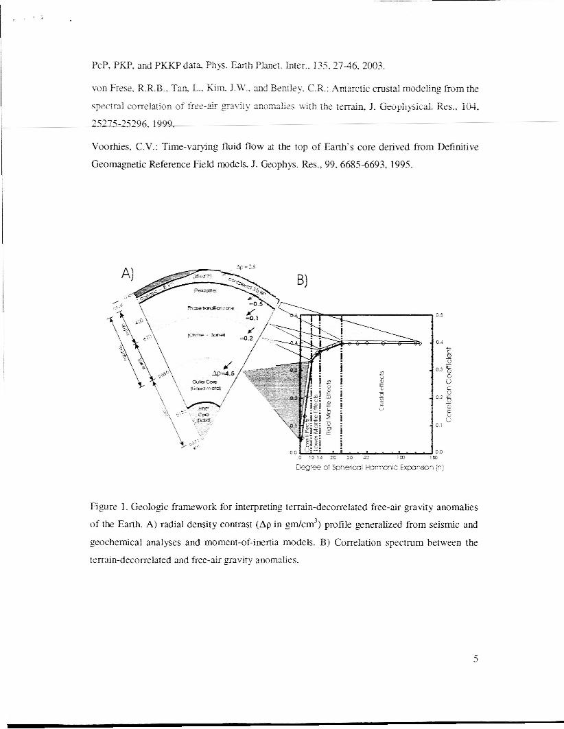
Gravity drilling was first implemented for mapping lunar intracrustal and subcrustal mass
variations using the correlation spectrum between the Lunar Prospector satellite free-air
gravity estimates and the terrain-decorrelated anomaly components at 100-lan altitude (Potts
& von Frese, 2003). Folloiwng this approach, we interpreted the EGM96 terrain-decorrelated
free-air anomaly components for the Earth at 100-km latitude as shown in Figure 1. The
related correlation spectrum in Figure 1B reveals several branches for separating the terrain-
decorrelated anomalies into core, mantle and crustal components. The steepest branch marked
by the red shaded triangle, for example, identifies the terrain-decorrelated components that are
positively correlated with the free-air anomalies up through spherical harmonic degree 10 that
may be interpreted for possible undulations of the Earth's core-mantle boundary. Similarly,
the two middle branches of the correlation spectrum for the anomaly components from
degrees 11 through 14 (orange shaded triangle) and degrees 15 through 25 (green shaded
triangle) can be related to density undulations of the middle, and upper mantle, respectively.
Furthemiore, the relatively flat branch for the anomaly components at degree 26 and higher
(grey shaded trapezoid) can reflect the effects of uncompensated crustal density contrasts.
These interpretations of the terrain-decorrelated anomalies can be readily tested against
2

standard geological models of the Earth's interior by inversions of the extracted crustal and
subcrustal components. Similar modeling of terrain-decorrelated anomalies using inferred
radial density profiles of the Moon. Mars, and Venus may estimate the related core-mantk
boundaries and undulations of stratified mantle components that reflect mass flow patterns to
help explain the development of surface tectonic features.
3 Discussion
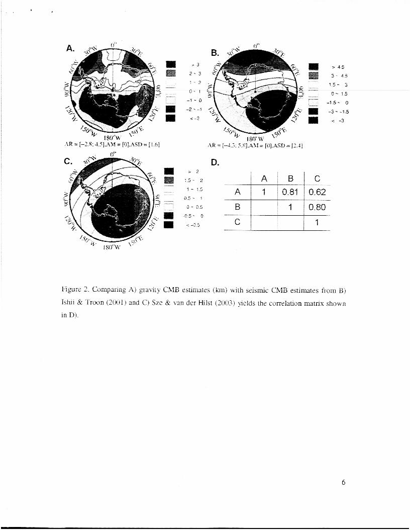
Fcnre 2 illustrates the potential for extracting subcrustal information from satellite-observed
free-air anomalies. In this Antarctic elrample, the terrain-decorrelated anomalies from (von
Frese et al., 1999) that are positively correlated with EGM96 free-air anomalies up to degree
4 at satellite altitude were modeled for the relief of the core-mantle boundary (CEVIB). The
CMB was estirn&d by least squares inversion usins Gauss-Lengendre quadrature integration
with a 4-_gm/cm3 contrast in density of the core relative to the mantle across the seismically
determined m a n core &us of 2,900 km. To first order, these CMB estimates may reflect
strongly subductins lithospheric flow in the Pacific (Ronxmowicz & Gung, 2002). However,
the estimates also can constrain core flow, topographic core-mantle coupling, core-mtle
thermal coupling and torques that may lenbghen the day, and the non-dipolar properties of the
core field ( eg . Voorhies, 1995).
Dee EGM96 free-air gravity estimates 07;s the polar regiors are seriously incomplaz due to
the lack of gravity observations. Hence, we expect to improve significantly the CMB
estimares in Figure 2.A using the enhsnetd gavity anomalies mapped by the CHAMP and
GRACE missions. These results can offer new insights on the Earth's deep interior to
complement more conventional constraints like the seismic CMB estimates shown in Figures
2.B and 2.C. For example, the correlation matrix in Figure 2D reveals that our results favor
most strongly the seismic CMB estimates of Figure 2.B relative to the CMB estimates in
Figure 2.C.
4 Conclusions
Gravity drilling of mass differentiated planets such as Earth provides a useful and
alternate approach to modeling subcrustal mass variations. Most terrestrial planets, other than
the Earth and to a limited extent the Moon, lack seisnlic data but have global coverage of
3
sareEse pavjty and topO_mphy data. AlThoagh lacking seis-nic data, interior mss
differentiation models from joist analysis of gavity and roposaphy data can provide ~ e w
insighls for understanding &e evolution of their surhcr trctnnic f rg t~r rs For oxsmple, the
comlation s p e c ~ n ~ ~ o ~ V ~ u s s h ~ s ~ R o ~ e c ~ ~ d ~ ~ ~ a ~ ~ ~ ~ ~ ~ ~ ~ ~ s
compared to Earth suggesting that mass flow in the Venusian mantle is limited compared to
vigorous m t l e dyattrllics os Earth (Potts et a]., 2003). Also, dxe utility of this approach can
provide further insishts on fluctuations in planetary rotation rates over decadal scales due to
the topographic couplings between their respective cores and mantles (Hide & M a h , 1970).
Ekrnenrs of tplis research were supported by NSF grmr OPP-0338005. The editor thanks A.
Reviewer and B. Reviewer for assisting in evaluating this paper.
Bon, M.: The Inmior of the Earth: Its Structure. Constitution, and Evolution. Elsevier, New
York. 1982.
!%de, R., and M a h , S.R.C.: Nove! com1a:ions betwces global femres of the Exth’s
yravitixiona4 and magnetic fields. Name. 225. 603-609. 1970
Islii, M.. and Troo3. 2.: Even-degree laterai vixizliom in the Embs xantle constrained by
free oscillations and the free-air gravity 2nonu.iy. Geophys. j . hl.. 145,77-96, 2001.
Potts, L.V., and von Frese. R.R.B.: Coinprehensive mass modeling of the Moon from
spxtrally correlated free-air and terrain gravity data, J . Geophys. Res., 108(E4), 5024,
doi:lO.1029/2000J~001~, 2003.
Po?ts, L.V., Ixfrwich, T.E., Kim, K.R.,, Wan, S-C., and von Frese, R.R.B., Gravity drilling of
m2ss differentiated planets. In bJmr Planetary Science XXXIV, Abstract #I 934. Lunar
Plsnetary Institme, Houston, (CD-ROM), 2003.
Romanowicz. B., and Gung, ai.: Superplilmes from the core-mmtle boundary to the
lithosphere: Liip!ication for hear flux. Science. 296, 513-516. 2002.
Sze, E.K.M., and van der filst, R.D.: Core mantle boundary topography from short period
4
PcP, PKP. and PKKP d3t;t Phys. Earth Planet. Inter., 135.2746. 2003.
von Frese. R.R.B.. Taa L.. Kim J.W.. and Benzley. C.R.: Antarctic crustal modeling from the
c;prctral ~~rre!.fcc cf f ~ ~ e - g r ~ 2 ~ i t ~ a~cr;.,&2s ~ i t h ;he ieii&n, J. Gwpilyjicai. Xes., I&,
252752536, 1999.
Voorhies, C.V.: Time-varying fluid flow ar the top of Earth’s core derived Erom Definitive
Geomagnetic Reference Field models, J. Geophys. Res., 99,66854693, 1995.
Figur? Geologic framework for interpreting terrain-decorrelated free-air gravity anomalies
of the Earth. A) radial density contrast (Ap in gdcm’) profile generalized from seismic and
geochemical analyses and moment-of-inertia models. B) Correlation spectrum between the
ten-uin-decorrelated and free-air gravity anomalies.
5
0 - 1 5
> 2
:.5- 2
D.
A I 1 i 0.81 I 0.62 1 - ! . S
0'- 1 I I I
Figure 2. Comparing A) gravity CMB estimates ( h j with seismic CMB estimates from Bj
Ishii & Troon (2OOlj and C) Sze lk van der Hilst (2003) pelds the correlation matrix shown
i n D).
6

Satellite gravity drilling the Earth-One page summary for public reiease R.R.B. von Frese‘, L.V. Potts’, 9.E. Leftwich’, H.R. Kim3, S-H. Han2, P.T. Taylsr’, and A.F. Ashgharzadeh’ [ 11 { Dept. of Geological Sciences, The Ohio State University, Columbus, Ohio} [2] {Laboratory for Space Geodesy & Remote Sensing Research, The Ohio State University, Columbus, Ohio} [3] { NASA Geodynamics Branch, Goddard Space Flight Center, Greenbelt, Maryland} Correspondence to: R.R.B. von Frese ([email protected])
The internal structures of terrestrial planets are commonly constrained by seismic data and geochemical considerations. We suggest that these constraints may be augmented by “gravity drilling” that focuses on interpreting satellite altitude gravity observations for variations of the internal density structure. In this method we divide the satellite altitude gravity observations into two groups, those that are related to the Earth’s topography and those that are not. Obviously the gravity signals related to the topography are produced by these surface features while those gravity signals that are not related to the topography, or are de-correlated with topography, are produces by deeper sources. In the de-correlated signals the ones with the longer wavelength are interpreted as coming from deeper sources in the Earth. By studying the longest wavelengths we may be able to study the deepest parts of the Earth, even the core-mantle boundary.